foreshore condition survey and management recommendations
TRANSCRIPT


Foreshore condition survey and management recommendations for Collier River and Butler’s Creek
Looking after all our water needs
Department of Water
February 2009

Department of Water 168 St Georges Terrace Perth Western Australia 6000 Telephone +61 8 6364 7600 Facsimile +61 8 6364 7601 www.water.wa.gov.au
© Government of Western Australia 2009
February 2009
This work is copyright. You may download, display, print and reproduce this material in unaltered form only (retaining this notice) for your personal, non-commercial use or use within your organisation. Apart from any use as permitted under the Copyright Act 1968, all other rights are reserved. Requests and inquiries concerning reproduction and rights should be addressed to the Department of Water.
ISBN 978-1-921549-47-2 (online)
Acknowledgements
The Department of Water would like to thank the following for their contribution to this river action plan:
• Kirsten Murray for undertaking the fieldwork and preparing the plan • the Shire of Manjimup and Department of Environment and Conservation
(Frankland District) for providing information to help with the plan’s development
• Rae Warr for assisting with fieldwork • landholders for providing access to the waterways.
This project has been funded by South Coast Natural Resource Management Inc. through the Natural Heritage Trust and National Action Plan for Salinity and Water Quality, both of which are supported by the Australian and Western Australian governments.
For more information about this report, contact:
Rivercare Officer South Coast Region 5 Bevan Street Albany WA 6330

Department of Water iii
Contents Contents ...................................................................................................................... iii Summary .....................................................................................................................iv 1 Introduction.............................................................................................................. 1
2 Aim of the study....................................................................................................... 2 3 The catchments ....................................................................................................... 3
3.1 Study area ......................................................................................................................... 3 3.2 Hydrology .......................................................................................................................... 4 3.3 Land use............................................................................................................................ 4 3.4 Rare and declared flora and fauna.................................................................................... 5 3.5 Aboriginal significance....................................................................................................... 5
4 Methods................................................................................................................... 6 5 Results..................................................................................................................... 7
5.1 Foreshore condition........................................................................................................... 7 5.2 Water quality ..................................................................................................................... 8
6 Management recommendations ............................................................................ 10 6.1 Riparian zone .................................................................................................................. 10 6.2 Fire .................................................................................................................................. 10 6.3 Erosion ............................................................................................................................ 10 6.4 Dams ............................................................................................................................... 11 6.5 Weeds ............................................................................................................................. 12
7 Conclusion............................................................................................................. 13 Appendices ................................................................................................................ 14
References ................................................................................................................ 36
Appendices
Appendix 1.— Foreshore assessment of Collier River and Butler’s Creek ............... 14 Appendix 2.— Total foreshore condition of Collier River and Butler’s Creek ............ 32
Appendix 3.— Recommended plant species for revegetation in the Collier River and Butler’s Creek catchments..................................................................................... 32
Appendix 4.— Weed species of Collier River and Butler’s Creek catchments .......... 33 Appendix 5.— Foreshore condition form ................................................................... 33

Collier Butler river action plan
iv Department of Water
Summary The Collier River and Butler’s Creek are located directly north and north-east of Walpole on Western Australia’s South Coast. Both systems flow into the Walpole Inlet, which has been proposed as a Marine Conservation Class A reserve. Preserving the high ecological and social values of the Walpole and Nornalup inlets relies on maintaining the health of the water bodies that feed them.
The endangered Engaewa walpolea (Walpole freshwater burrowing crayfish) and the declared-rare Reedia spathacea (reedia), along with the priority-listed Setonix brachyurus (quokka), Isoodon obesulus (quenda) and Pleurophascum occidentale (western giant-leaved moss) have been located, or are thought to exist, within the catchment’s boundaries. Each of these species relies heavily on the health of the waterways and surrounding riparian zone.
The Collier River is in very good health with approximately 75 per cent of the riparian vegetation along the river considered to be in A-grade condition. In the lower reaches of Butler’s Creek the riparian vegetation is in excellent condition, while 64 per cent of the riparian vegetation in the whole catchment is considered to be A-grade.
The catchment’s hydrology has been altered through construction of more than 22 on-stream dams within the catchment. In winter the dams only absorb small flow amounts and allow them to pass through; however, in summer/autumn they take a much greater proportion of the flows, therefore causing a perennial system to become ephemeral.
Moderate levels of nitrogen and low levels of phosphorous have been recorded in the water flowing from the Collier River into the Walpole Inlet. Both nutrient levels were below the Australian and New Zealand Environment Conservation Council (2000) guidelines for a lowland river in south-western Australia.
Management recommendations for the catchment include fencing creek lines to exclude stock, weed control and widening the riparian buffer. The Department of Water has made funding available to help landholders implement these recommendations.
Across the catchment photo points have been selected which represent the catchment’s current health and will allow ongoing monitoring.

Department of Water 1
1 Introduction The Walpole and Nornalup inlets have been widely recognised as having high ecological and social values. They have also been documented as biologically diverse compared with most estuarine systems in south-west Western Australia: the inlets and the tidal reaches of the Frankland, Deep and Walpole rivers have been proposed as a Marine Conservation Class A reserve.
Maintaining the integrity of this highly valued ecosystem requires a better understanding of the greater catchment and the waterways that discharge into the inlets. The condition of the Frankland, Deep, Junior and Walpole rivers, as well as their impact on the inlets, has been documented. However, those waterways in close proximity to the inlets, such as the Collier River and Butler’s Creek, are the last remaining waterways to be assessed.

Collier Butler river action plan
2 Department of Water
2 Aim of the study This report’s focus is to determine the general condition of the Collier River and Butler’s Creek, and in doing so, identify any potential impacts of the catchment on the Walpole and Nornalup inlets. Specifically, the report will:
• assess the condition of the riparian vegetation on private land • assess the bank and stream degradation in areas of cleared land • gain an understanding of the water quality in the catchments • provide a preliminary series of recommendations for rehabilitation work along
the foreshore.
The foreshore survey has been restricted to areas of private land, as the remaining part of the catchment is within a National Park and is presumed to be in pristine condition. The survey and the resulting recommendations are intended to provide direction and advice to landholders and managers.

Department of Water 3
3 The catchments
3.1 Study area
The town of Walpole is located on Western Australia’s South Coast approximately 110 km west of Albany on the South Coast Highway. The catchments of Collier River and Butler’s Creek are located directly north and north-east of Walpole (Figure 1).
The Collier River is further to the east and has a catchment area of 834 ha, with 30.7 km of waterways; while Butler’s Creek has a catchment area of 209 ha and takes in 3.3 km of waterways.
Figure 1: The catchment areas of Collier River and Butler’s Creek.
Collier Butler river action plan
4 Department of Water
3.2 Hydrology
Walpole has a temperate climate characterised by warm, dry summers and cool, wet winters. The long-term average annual rainfall for Walpole is 1321 mm. The average rainfall from 1974 to 1998 was 1251 mm, which amounted to a statistically significant reduction in streamflow (WRC 1998). The Collier River is considered to be a perennial system, although 80 per cent of river flow occurs between June and October.
The hilly terrain of the surrounding catchment means that the upper third of the catchment sits relatively high in the landscape – in comparison with surrounding catchments – with the highest point in the catchment being 195 AHD. The upper catchment is defined by steep gullies and narrow floodplains. The middle third of the catchment has well-defined channels with broader floodplains than the upper catchment. The lower third meanders in an ad hoc manner through the low-lying floodplain of the inlet foreshore zone.
3.3 Land use
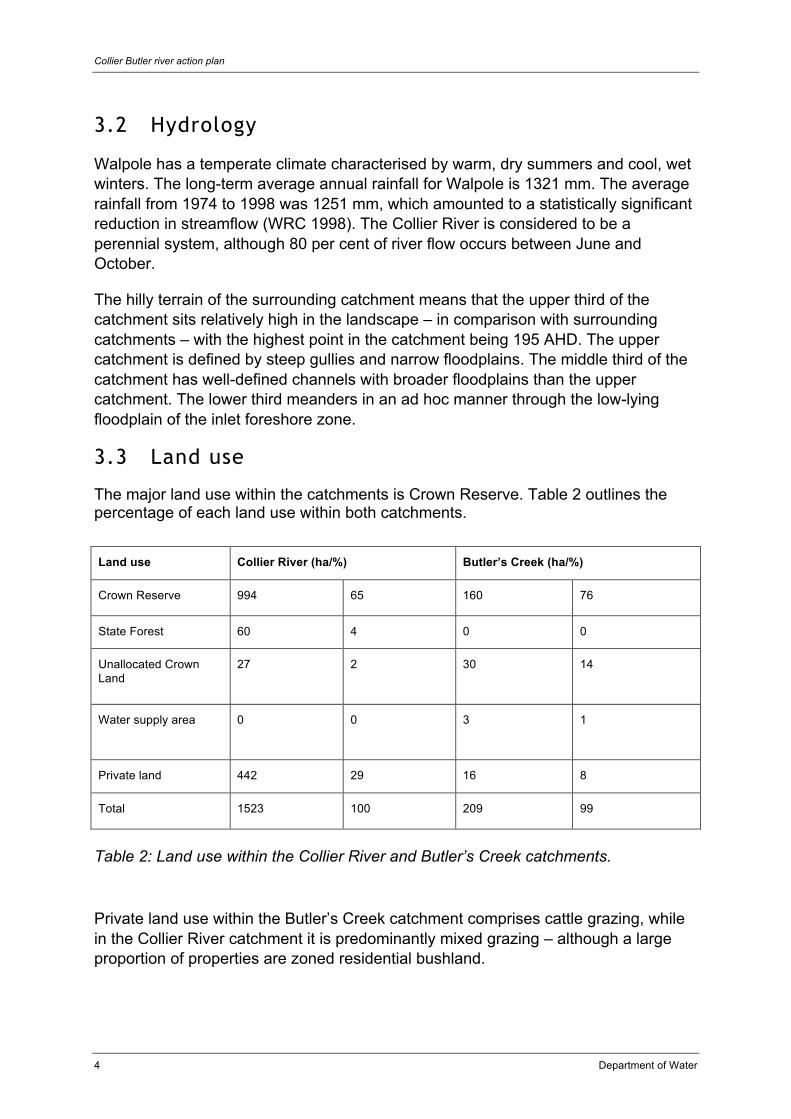
The major land use within the catchments is Crown Reserve. Table 2 outlines the percentage of each land use within both catchments.
Land use Collier River (ha/%) Butler’s Creek (ha/%)
Crown Reserve 994 65 160 76
State Forest 60 4 0 0
Unallocated Crown Land
27 2 30 14
Water supply area 0 0 3 1
Private land 442 29 16 8
Total 1523 100 209 99
Table 2: Land use within the Collier River and Butler’s Creek catchments.
Private land use within the Butler’s Creek catchment comprises cattle grazing, while in the Collier River catchment it is predominantly mixed grazing – although a large proportion of properties are zoned residential bushland.

Department of Water 5
3.4 Rare and declared flora and fauna
The climatic conditions of the south-west corner have resulted in a high degree of endemism of flora and fauna. The Department of Environment and Conservation (DEC) has developed rigorous procedures to conserve threatened species and ecological communities, including declaration of those species or communities under the Wildlife Conservation Act 1950 (WA). Bain (2008) states that the DEC has located or predicted (based on habitat type) that several rare species exist within the catchments’ boundaries. Each species is outlined below.
• Reedia spathacea – declared-rare flora and proposed threatened ecological community (Figure 3). The community occurs in peat paluslopes associated with the creek lines. The species is sensitive to nutrients, hydrological changes (e.g. drains, drawdown cones, surface-water interception such as dams) and physical disturbance to the peat substrate.
• Pleurophascum occidentale – a priority-listed moss species sensitive to chemicals and altered hydrological conditions.
• Setonix brachyurus (quokka) and Isoodon obesulus (quenda) habitat – quokkas are listed as vulnerable fauna and quenda are priority-listed fauna. Both use the riparian zone and rely on its density and relative health for survival and refuge from introduced predators. Often these species also use the riparian systems as corridors to move between habitat patches and for gene flow (Figure 4).
• Engaewa walpolea (Walpole freshwater burrowing crayfish) – is listed as an endangered crustacean and occurs in peaty habitat. The species is very sensitive to hydrological changes, nutrient enrichment, chemical runoff, physical disturbance to the peaty sediment, erosion and siltation processes. These crustaceans have very poor dispersal abilities and are therefore relatively sedentary.
3.5 Aboriginal significance
Waterways are significant places in Aboriginal heritage. Although no registered sites of importance were identified within the catchments of Collier River and Butler’s Creek, the Walpole and Nornalup inlets have been acknowledged as the location of Aboriginal heritage sites (Department of Indigenous Affairs 2008).

Collier Butler river action plan
6 Department of Water
4 Methods The riparian zones of the Collier River and Butler’s Creek were assessed using the Pen and Scott foreshore assessment technique. This technique classifies the foreshore condition of streams and rivers into A, B, C or D grade, each of which is outlined below: A pristine – healthy riparian vegetation with no weeds or evidence of impacts
caused by human activities (Figure 5) B slightly disturbed – where the riparian vegetation has been invaded by weed
species C disturbed – riparian zone supports only over storey and pasture or only pasture D drain – where the stream is little more than an eroding drain.
Figure 5: An example of A-grade and C-grade foreshore conditions on Collier River.
The dominant species in each section of the surveyed waterways was also noted, along with the occurrence of any weed species.
The presence or absence of fencing that excluded stock from the waterways was recorded.
Photo points for each site were selected to represent the general condition of the site.

Department of Water 7
5 Results
5.1 Foreshore condition
Each property has been assessed individually and a detailed description of each length of creek can be found in Appendix 1.
The foreshore assessment identified that the Collier River is in very good condition, with approximately 75 per cent of the riparian vegetation along the river considered to be in A-grade condition. As Figure 6 indicates, 8 km is B-grade, 6 km is C-grade and 10 km is D-grade.
The sections of river considered to be less-than-pristine occurred on properties that were either stocked, had a limited riparian buffer or had been dammed.
Figure 6: The foreshore condition of the Collier River and Butler’s Creek (Blue A, Green B, Red C and Brown D).
The riparian vegetation in the lower reaches of Butler’s Creek is in excellent condition. However, much of the upper catchment is degraded because of a combination of weed invasion, damming of the creek and historical stock access

Collier Butler river action plan
8 Department of Water
(Figure 6). Sixty four per cent of the creek has an A-grade foreshore and 24 per cent is D-grade.
5.2 Water quality
In 2007 the Department of Water undertook a ‘snap shot’ monitoring program in the lower reaches of the waterways that feed into the Walpole and Nornalup inlets. The Collier River was sampled as part of this program and four sites across the catchment were tested for total nitrogen (TN), total phosphorus (TP), total suspended solids (TSS), turbidity, pH and dissolved oxygen (DO).
The sites were located where the river intersects with Allen Road, Gully Road, Cemetery Road and the South Coast Highway. All sites were sampled in both May and August of 2007.
The highest levels of both TN and TP were recorded at the Allen Road site (Figure 7). The increased quantities of nutrients – in comparison with the other sites – is likely to be a result of surrounding land uses. The concentration of TN and TP at the South Coast Highway site, which of the four sites is closest to the Walpole Inlet, provides some indication of the quality of the water entering the inlet. Compared with the Australian and New Zealand Environment Conservation Council’s guidelines, the TN and TP levels are considered to be moderate and low respectively.
Figure 7: Total nitrogen levels in comparison with ANZEEC guidelines.

Department of Water 9
Figure 8: Total phosphorus levels in comparison with ANZECC guidelines.
The water sampled at the South Coast Highway site recorded an acidic pH of 5.5 and 4.2, although this is likely to be naturally occurring. The water was moderately oxygenated, which indicates a healthy balance of primary production in the system. The turbidity of the water was low, which means that few suspended solids (such as soil) exist in the water column.
Collier Butler river action plan
10 Department of Water
6 Management recommendations The condition of riparian vegetation along a catchment’s streams is one of the most important factors influencing the ecological functioning of a catchment system. Degradation of this vegetation increases the risk of stream-bed and bank erosion, infilling of pools with sediment, deteriorating water quality and loss of biodiversity – both terrestrial and aquatic (Janicke 2005).
Site-specific management recommendations have been made for each property to help restore the Collier River and Butler’s Creek. These can be found in Appendix 1.
6.1 Riparian zone
Removing stock from the riparian zone is the most important factor in river restoration. Several sections of creek line have been degraded by stock access. Fencing the creek line to exclude access ensures that vegetation is not damaged and prevents stock from directly defecating into the water. A wide riparian buffer allows the ecosystem to function correctly. Many factors such as shading, leaf matter, woody debris and a complex plant community make up a healthy waterway ecosystem. A buffer also protects the waterway from surrounding and upstream land uses by filtering out pollutants such as sediments and nutrients.
A healthy riparian buffer along the whole of the system ensures appropriate habitat for species such as the quenda and quokka, both of which use the riparian zone to forage and travel through the landscape.
6.2 Fire
Fires in the riparian zone should only be deliberately lit for regeneration purposes. Frequent fires should be avoided because they eliminate native plant species that take longer to produce flowers and set seeds. The timing of any regeneration fires should be based on the life cycles of the plants within the riparian community (the ideal time is usually autumn).
It is important that weed species are controlled before a burn is undertaken. As weeds are usually opportunistic species, they are likely to be the initial germinates after a fire.
Fires should be restricted where peat soils occur because they are sensitive areas and also provide habitat to rare flora and fauna (WRC 2000).
6.3 Erosion
Degradation of the channel and banks of the Collier River and Butler’s Creek has occurred in sections where stock have had access or the riparian zone has been

Department of Water 11
cleared. It is important to prevent erosion, because fixing the erosion itself is very difficult.
Erosion has both upstream and downstream impacts: it can move in both directions and result in soil settling in pools and infilling important habitats.
6.4 Dams
On-stream dams greatly alter the flow regime of a system. Although they may only absorb a small amount of the winter flow and allow flow to pass through, they take a much greater proportion of the summer/autumn flows. This has downstream impacts – where a once-perennial system is changed to an annually flowing system. Several downstream species, such as the Walpole freshwater burrowing crayfish, are particularly sensitive to changes in the natural flow regime (Bain 2008).
Figure 8: An on-stream dam.
Dams also dramatically alter the habitat of the original riparian ecosystem (Figure 8). Although fringing vegetation may establish along the edge and some fauna species may be able to use a dam, it can only go a small way toward compensating for the loss of a highly complex creek ecosystem (Pen 1999). The construction of on-stream dams is not recommended and their necessity should be thoroughly investigated.

Collier Butler river action plan
12 Department of Water
If construction of an on-stream dam affects native vegetation by direct clearing or from secondary impacts such as drowning, then under the Environmental Protection Act 1986 (WA), a Native Vegetation Clearing Permit is required from the Department of Environment and Conservation (DEC). Refer to the DEC website <www.dec.wa.gov.au> for further information.
6.5 Weeds
Weeds are plant species that are not native to a particular region and are usually opportunistic or aggressive species. It is considerably easier to control weeds during their initial establishment than when they have grown in numbers and size. Weeds in the riparian zone are easily spread as seeds or spores that can be carried downstream.
Blackberry, Taylorina, willows, tree ferns and grasses have been found in the riparian zone in the catchments, but occur in relatively small numbers (Figure 9). It is essential that control is undertaken as soon as possible. Both blackberry and willow are listed as Weeds of National Significance and should be removed as a matter of priority.
Figure 9: Taylorina and tree fern.
The DEC is actively controlling tree ferns in the Walpole region and is interested in working with landholders to control the weed. This program was initiated because tree ferns have established groves in areas inhabited by the Walpole freshwater burrowing crayfish (Manning 2008). Tern ferns near waterways spread easily since the spores are carried downstream.

Department of Water 13
7 Conclusion The Collier River and Butler’s Creek are generally in good condition, although several sections of the creek line require restoration work. Landholders who undertake restoration projects – such as fencing to exclude stock from the waterway, constructing crossings and installing off-stream watering points – will greatly reduce the impact of the surrounding land uses.

Collier Butler river action plan
14 Department of Water
Appendices
Appendix A.— Foreshore assessment of Collier River and Butler’s Creek
Lot 1 (roadside assessment)
Average: A; Best: A; Worst: A
Vegetation
The over storey is dominated Taxandria linearifolia, Taxandria flexuosa, Callistachys lanceolate, Eucalyptus diversicolor and Lepidosperma effusum.
Weeds
Unknown.
Degradation issues
Unknown.
Fencing status
Unknown.
Management recommendations
Continue current management practice.
Photo point
Easting 478177.79
Northing 6132336.41
Direction Upstream
Lot 5 Average: D; Highest: A; Lowest: D
Vegetation
The over storey consists of Callistachys lanceolate, Corymbia calophylla, Taxandria linearifolia and Taxandria parviceps. The middle and lower storey is dominated by Boronia graeilipes, Pteridium esculentum, Lepidosperma effusum and Lepidosperma tetraquetrum.

Department of Water 15
Weeds
Annual grasses.
Degradation issues
Two dams have been constructed on the creek line, significantly altering the channel form, riparian habitat and flow of the river.
The overflow channel from the downstream dam has been directed down the firebreak; however, no defined channel has formed. The firebreak is mowed on a regular basis and therefore no riparian vegetation exists.
Fencing
None, but property is not stocked.
Management recommendations
The section of firebreak that the river flows through should be not be cleared as a firebreak and an exception should be sought from the Shire of Manjimup. This area should then be allowed to regenerate or be restored with endemic species as outlined in Appendix 2.
Photo point
Easting 478646.66
Northing 6132455.22
Direction Downstream
Lot 9
Average: A; Best: A; Worst: B
Vegetation
The over storey of the riparian zone is dominated by Taxandria linearifolia and Taxandria parviceps, with a middle storey of Paraserianthes lophantha. The under storey consists of Lepidosperma effusum, Gahnia decompistia and Pteridium esculentum.
Weeds
None.
Degradation issues
None.
Fencing
None, but property is not stocked.

Collier Butler river action plan
16 Department of Water
Management recommendations
Maintain current practice. If the property is stocked then the riparian zone should be fenced to exclude access.
Photo point
Easting 479060.62
Northing 6132427.32
Direction Upstream
Lot 12
Average: A; Highest: A; Lowest: D
Vegetation
The riparian vegetation consists of an upper storey of Taxandria linearifolia and Taxandria parviceps. The middle storey is dominated by Melaleuca microphylla and the understorey by Lepidosperma effusum.
Weeds
Eucalyptus globulus
Annual grasses.
Degradation issues
The section of creek upstream from the dam has very little remnant vegetation remaining. Low stocking rates on the property have meant that no erosion of the bank has occurred.
A dam has been constructed on the creek line, significantly altering the channel form, riparian habitat and flow of the river.
Fencing status
None.
Management recommendations
Remove stock access to the creek line and create a vegetative buffer at least 10 m wide to better control nutrient runoff. A substantial buffer will also reduce the invasion of grass into the creek line.
Allow the banks and floodplain area to regenerate with native species or revegetate using species listed in Appendix 2.
Initial control of grass species will be required until the native vegetation is established; after this, the grass will eventually be shaded out.

Department of Water 17
Gemination of Eucalyptus globulus should be monitored even though it is not considered a highly invasive species.
Photo point
Easting 479582.92
Northing 6132297.31
Direction Downstream
Lot 13
Average: A; Best: A; Worst: A
Vegetation
The over storey is dominated by Callistachys lanceolate, Taxandria linearifolia and Taxandria parviceps. The middle storey is dominated by Paraserianthes lophantha and Melaleuca microphylla. The under storey is dominated by Lepidosperma effusum and Gahnia decompistia.
Weeds
None.
Degradation issues
None.
Fencing status
None, but property not stocked.
Management recommendations
Maintain current practice. If the property is stocked then the riparian zone should be fenced to exclude access.
Photo point
Easting 479551.34
Northing 6131806.69
Direction Upstream
Lot 14 Average: A; Best: A; Worst: D

Collier Butler river action plan
18 Department of Water
Vegetation
The over storey consists of Callistachys lanceolate, Corymbia calophylla, Taxandria linearifolia and Taxandria parviceps. The lower storeys are dominated by Pteridium esculentum, Lepidosperma effusum and Lepidosperma tetraquetrum.
Weeds
Annual grasses.
Degradation issues
A dam has been constructed on the creek line, significantly altering the channel form, riparian habitat and flow of the river. Additional issues are unknown.
Fencing status
None.
Management recommendations
If the property is stocked then the remaining riparian vegetation should be protected by fencing. Areas where the vegetative buffer is thin should be extended to a minimum of 10 m and revegetated with species listed in Appendix 2.
Photo point
Easting 479640.50
Northing 6131369.66
Direction Across
Lot 15
Average: B; Best: A; Worst: C
Vegetation
The over storey consists of Callistachys lanceolate, Corymbia calophylla, Taxandria linearifolia and Taxandria parviceps. The lower storeys are dominated by Boronia graeilipes, Pteridium esculentum, Lepidosperma effusum and Lepidosperma tetraquetrum.
Weeds
Annual grasses.
Degradation issues
Stock access to the riparian zone and creek line has caused significant erosion and pugging; it has also degraded the middle and under storey of the vegetation.

Department of Water 19
Annual grasses have invaded the riparian zone in areas where stock have had access or the vegetative buffer is thin.
Fencing status
None.
Management recommendations
Fence the riparian zone to remove stock access to the creek line. The fence should follow the existing vegetation at least 10 m from the bank.
Allow the banks and floodplain area to regenerate with native species or revegetate using species listed in Appendix 2.
Initial control of grass species will be required until the native vegetation is established; after this, the grass will eventually be shaded out.
Photo point
Easting 479573.98
Northing 6131474.93
Direction Downstream
Lot 23
Average: B; Best: A; Worst: C
Vegetation
The over storey consists of Callistachys lanceolate, Corymbia calophylla, Taxandria linearifolia and Taxandria parviceps. The lower storeys are dominated by Boronia graeilipes, Paraserianthes lophantha, Pteridium esculentum, Lepidosperma effusum and Lepidosperma tetraquetrum.
Weeds
Annual grasses.
Degradation issues
Stock access to the riparian zone and creek line has caused significant erosion and pugging; it has also degraded the middle and understorey of the vegetation.
Annual grasses have invaded the riparian zone in areas where stock have had access or the vegetative buffer is thin.
Fencing status
None.
Collier Butler river action plan
20 Department of Water
Management recommendations
Fence the riparian zone to remove stock access to the creek line. The fence should follow the existing vegetation at least 10 m from the bank.
Allow the banks and floodplain area to regenerate with native species or revegetate using species listed in Appendix 2.
Initial control of grass species will be required until the native vegetation is established; after this, the grass will eventually be shaded out.
Photo point
Easting 478939.13
Northing 6131452.27
Direction Cross/downstream
Lot 24 (roadside assessment)
Average: D; Best: B; Worst: D
Vegetation
The over storey is dominated by Callistachys lanceolate and Taxandria linearifolia. The lower storeys consist of Juncus pallidus and Pteridium esculentum.
Weeds
Grass spp.
Degradation issues
A dam has been constructed on the creek line, significantly altering the channel form, riparian habitat and flow of the river. Additional issues are unknown.
Management recommendations
If the property is stocked then the remaining riparian vegetation should be protected by fencing. Areas where the vegetative buffer is thin should be extended to a minimum of 10 m and revegetated with species listed in Appendix 2.
Photo points
Easting 478158.48
Northing 6131351.89
Direction Downstream

Department of Water 21
Lot 25 (roadside assessment)
Average: A; Best: A; Worst: D
Vegetation
The riparian vegetation consists of Taxandria linearifolia, Callistachys lanceolate, Melaleuca rhaphiophylla and Juncus pallidus.
Weeds
Grass spp.
Degradation issues
A dam has been constructed on the creek line, significantly altering the channel form, riparian habitat and flow of the river.
The eastern tributary of the creek is severely degraded with no existing riparian vegetation and no defined channel. Kikuyu is also well established.
Fencing status
None, but the property is not stocked.
Management recommendations
The eastern arm should be restored with native species listed in Appendix 2. The kikuyu needs to be controlled to allow the riparian zone to regenerate.
If the property is stocked then the remnant vegetation should be fenced to exclude access.
Photo points
Easting 478276.01
Northing 6131688.46
Direction Upstream
Lot 26
Average: A; Best: A; Worst: B
Vegetation
The over storey consists of Taxandria flexuosa, Taxandria linearifolia and Allocasuarina fraseriana. The middle and under storey is dominated by Paraserianthes lophantha, Hibbertia cuneiformis, Lepidosperma tetraquetrum and Lepidosperma effusum.
Collier Butler river action plan
22 Department of Water
Weeds
None.
Degradation issues
None.
Fencing status
None.
Management recommendations
Maintain current practice. If the property is stocked then the riparian zone should be fenced to exclude access.
Photo point
Easting 478125.37
Northing 6131982.58
Direction Upstream
Lot 27 (roadside assessment)
Average: D; Best: A; Worst: D
Vegetation
The over storey is dominated Taxandria linearifolia, Taxandria flexuosa, Callistachys lanceolate, Eucalyptus diversicolor and Lepidosperma effusum.
Weeds
Unknown.
Degradation issues
The middle and under storey has been extensively cleared and no riparian vegetation exists. The removal of the vegetation has caused localised erosion, loss of habitat and altered the form of the channel.
Fencing status
None, but the property is not stocked.

Department of Water 23
Management recommendations
The riparian zone needs to be restored with species listed in Appendix 2. It is estimated that the riparian zone on this property is approximately 5 m outwards from the channel.
If the property is stocked then the riparian zone should be fenced to exclude access.
Photo point
Easting 478094.08
Northing 6132287.39
Direction Across
Lot 32
Average: A; Best: A; Worst: A
Vegetation
The over storey is dominated by Taxandria linearifolia and Callistachys lanceolate. The middle and under storeys are dominated by Paraserianthes lophantha and Lepidosperma effusum.
Weeds
None.
Degradation issues
None.
Fencing status
None, but property is not stocked.
Management recommendations
Maintain current practice.
Photo point
Easting 478873.08
Northing 6132284.47
Direction Downstream

Collier Butler river action plan
24 Department of Water
Lot 33 (roadside assessment)
Average: A; Best: A; Worst: D
Vegetation
The over storey is dominated by Taxandria linearifolia and Callistachys lanceolate. The middle and under storeys are dominated by Paraserianthes lophantha and Lepidosperma effusum.
Weeds
Unknown.
Degradation issues
A dam has been constructed on the creek line, significantly altering the channel form, riparian habitat and flow of the river. Additional issues are unknown.
Fencing status
None, but property is not stocked.
Management recommendations
Maintain current practice.
Photo point
Easting 478873.08
Northing 6132284.47
Direction Upstream
Lot 34 Average: B; Best: A; Worst: D
Vegetation
The dominant over storey species is Callistachys lanceolate. The middle storey consists of Taxandria parviceps and Taxandria linearifolia. The lower storey is dominated by Lepidosperma tetraquetrum and Lepidosperma effusum.
Weeds
None.

Department of Water 25
Degradation issues
The main channel of the creek flows down the firebreak on the boundary of the property. The firebreak is also kept clear to ‘encourage’ flow. Erosion is evident as the creek line enters the roadside drain and there is no riparian vegetation.
Fencing status
None, but property is not stocked.
Management recommendations
The section of firebreak that the river flows through should be not be cleared as a firebreak and an exception should be sought from the Shire of Manjimup. This area should then be allowed to regenerate or be restored with endemic species as outlined in Appendix 2. The progress of the erosion should be monitored and if it begins to headcut upstream, then action will be needed to stop its progress.
Photo point
Easting 479102.53
Northing 6132422.76
Direction Upstream
Lot 35 (roadside assessment)
Average: A; Best: A; Worst: unknown
Vegetation
The dominant over storey species is Callistachys lanceolate. The middle storey consists of Taxandria parviceps and Taxandria linearifolia. The lower storey is dominated by Lepidosperma tetraquetrum and Lepidosperma effusum.
Weeds
None.
Degradation issues
A dam has been constructed on the creek line, significantly altering the channel form, riparian habitat and flow of the river. Additional issues are unknown.
Fencing status
Unknown.

Collier Butler river action plan
26 Department of Water
Management recommendations
Maintain current practice.
Photo point
Unknown.
Lot 36
Average: A; Best: A; Worst: A
Vegetation
The riparian vegetation consists of an upper storey of Taxandria linearifolia and Taxandria parviceps. The middle storey is dominated by Melaleuca microphylla and the under storey by Lepidosperma effusum.
Weeds
Taylorina.
Degradation issues
None.
Fencing status
None, but property is not stocked.
Management recommendations
Remove Taylorina plants and ensure ongoing control of any new seedlings.
Photo point
Easting 479364.76
Northing 6132355.24
Direction Downstream
Lot 45 (roadside assessment)
Average: D; Best: A; Worst: D
Vegetation
The dominant species are Taxandria linearifolia, Taxandria parviceps, Callistachys lanceolate and Lepidosperma effusum.

Department of Water 27
Weeds
Grass spp.
Degradation issues
A dam has been constructed on the creek line, significantly altering the channel form, riparian habitat and flow of the river.
Fencing status
Unknown.
Management recommendations
If the property is stocked then the remaining riparian vegetation should be protected by fencing. Areas where the vegetative buffer is thin should be extended to a minimum of 10 m and revegetated with species listed in Appendix 2.
Photo point
Easting 478724.20
Northing 6132114.22
Direction Downstream
Lot 51 Average: C; Highest: B; Lowest: D
Vegetation
The riparian vegetation consists of an over storey of Corymbia calophylla, Taxandria linearifolia and Callistachys lanceolate. The middle storey is dominated by Melaleuca microphylla and the under storey by Gahnia decomposita and Lepidosperma effusum.
Weeds
South Australia river gum
Willows
Grasses.
Degradation issues
Stock access to the creek line has caused pugging of the floodplain and bank collapses in some sections. Constant grazing pressure has also reduced the ability of the immediate riparian zone to regenerate naturally.
Collier Butler river action plan
28 Department of Water
Willow is a Weed of National Significance and entry into the state and the trade, sale or movement of plants or their seeds is strictly prohibited by law. The Walpole climate is considered to be highly suited to willows.
For the majority of the property, a buffer of riparian vegetation only exists on one side of the creek until its lower section – which reduces the ability of the creek to buffer itself against impacts from the surrounding catchment.
A dam has been constructed on the creek line, significantly altering the channel form, riparian habitat and flow of the river.
Fencing status
None.
Management recommendations
Remove stock access to the creek line and create a vegetative buffer at least 10 m wide to better control nutrient runoff. A substantial buffer will also reduce the invasion of grass into the creek line.
Allow the banks and floodplain area to regenerate with native species or revegetate using species listed in Appendix 2.
Initial control of grass species will be required until the native vegetation is established; after this, the grass will eventually be shaded out of the riparian zone.
Photo point
Easting 478650.88
Northing 6131916.51
Direction Downstream
Lot 10188 Average: A; Best: A; Worst: C
Vegetation
The riparian vegetation is dominated by Taxandria linearifolia, Callistachys lanceolate, Taxandria parviceps, Eucalyptus diversicolor, Lepidosperma tetraquetrum, Lepidosperma effusum and Juncus pallidus.
Weeds
Grass spp.
Blackberry

Department of Water 29
Degradation issues
Stock access to the creek line is resulting in bank slumping and erosion of the channel. Grass species have also invaded the riparian zone at points where stock have access.
Fencing status
None.
Management recommendations
The existing riparian vegetation should be fenced to exclude stock access. In areas where the width of the vegetation is less than 10 m, the fence should be located wider and the enclosed area revegetated or allowed to regenerate.
The blackberry should be controlled and is likely to require ongoing management to ensure successful elimination.
Photo point
Easting 477501.15
Northing 6132143.91
Direction Downstream
Lot 10189
Average: A; Best: A; Worst: C
Vegetation
The dominant species are Taxandria linearifolia, Taxandria parviceps, Callistachys lanceolate, Lepidosperma tetraquetrum, Gahnia decompistia and Juncus pallidus.
Weeds
Annual grasses
Kikuyu
Clover spp.
Degradation issues
Stock access to the creek in the bottom paddock has caused severe pugging of the creek channel, which is no longer defined. Very little riparian vegetation exists and kikuyu is well established.
In the upper section, stock access to the creek line is causing the banks to slump – resulting in severe erosion at those points. Access to the adjacent floodplain is also causing pugging and soil erosion. Weed species have invaded the riparian zone where stock have degraded the creek line.

Collier Butler river action plan
30 Department of Water
Fencing status
None.
Management recommendations
Fence the creek line to exclude stock. In the upper section, fencing around the existing vegetation will provide an adequate buffer to protect the creek from the effects of surrounding land uses. In the lower section, a buffer of at least 10 m is required and the riparian zone needs to regenerated with native species from Appendix 2.
Weed control will be required for several years until the area regenerates and is able to shade out the weed species.
Construct fords or culvert-style crossings if fencing of the creek will hinder access to other paddocks and install off-stream watering points if required.
Photo point
Easting 477959.83
Northing 6131438.81
Direction Downstream
Lot 12428
Average: C; Best: C; Worst: D
Vegetation
The dominant species is Melaleuca rhaphiophylla. Other species present include Taxandria linearifolia, Taxandria parviceps, Callistachys lanceolate, Lepidosperma tetraquetrum and Gahnia decompistia.
Weeds
Thistle
Kikuyu
Clover spp.
Tree fern
Degradation issues
Historical clearing of the riparian zone has resulted in the loss of the vegetative buffer and allowed the invasion of weed species. Stock access has not caused significant damage to the creek channel but is likely to have stopped the regeneration of native species.
Several drainage lines have been constructed such that water from the surrounding catchment is being diverted away from the natural creek line.

Department of Water 31
Fencing status
The natural channel of the creek has been fenced on one side, allowing for a buffer of approximately 4 m. The drains have not been fenced.
Management recommendations
Fence the remaining creek line allowing for a buffer of at least 10 m. The area will benefit from revegetation with the native species listed in Appendix 2. The weed species will need to be controlled for several years until the native seedlings have established themselves. A 10 m buffer should allow grass species to be shaded out before they reach the creek channel.
Ideally, the drains should be treated in the same manner as the creek line.
Photo point
Easting 478294.50
Northing 6131249.18
Direction Downstream

Collier Butler river action plan
32 Department of Water
Appendix B.— Total foreshore condition of Collier River and Butler’s Creek
Foreshore condition grade
Collier River (km/%) Butler’s Creek (km/%)
A 23 75 2.1 64
B 2.5 8 0.2 6
C 1.9 6 0.2 6
D 3.3 10 0.8 24
Appendix C.— Recommended plant species for revegetation in the Collier River and Butler’s Creek catchments
Common name Species Location
Swamp peppermint Taxandria linearifolia U, M, L
Peppermint Taxandria flexuosa M
Karri Eucalyptus diversicolor U, M
Wonnich Callistachys lanceolate U, M ,L
Marri Corymbia calophylla U, M
White tea tree Taxandria parviceps U, M, L
Paperbark Melaleuca rhaphiophylla L
Pale rush Juncus pallidus M, L
Sword sedge Lepidosperma effusum U, M, L
U – Upper catchment, M – Middle catchment, L – Lower catchment

Department of Water 33
Appendix D.— Weed species of Collier River and Butler’s Creek catchments
Common name Species Status
Blackberry Rubus anglocandicans Weed of National Significance
Taylorina Psoralea pinnata –
Willow Salix spp. Weed of National Significance
Tree fern –
Grass –
Appendix E.— Foreshore condition form
Col l ie r R iver fo reshore su rvey fo rm
Date:
Recorder’s name:
Property name:
Landholder:
Location number:
Length of section:
A-grade foreshore B-grade foreshore C-grade foreshore D-grade foreshore
A1 pristine B1 degraded – weed
infested
C1 erosion prone D1 ditch – eroding
A2 near pristine B2 degraded – heavily
weed infested
C2 soil exposed D2 ditch – freely eroding
A3 slightly disturbed B3 degraded – weed
dominant
C3 eroded D3 drain – weed
dominant
Best: Worst: Average:

Collier Butler river action plan
34 Department of Water
Buffer width
LH bank (looking downstream)
RH bank (looking downstream)
Over storey Middle storey Under storey
Dominant species
present
Weeds present (total
percentage and species)
(Health: 1 = healthy, 2 = some sick trees, 3 = many sick or dying trees, 4 = some dead trees, 5 = many dead trees.)
Fencing status
Fenced (Y/N):
Condition (good, medium, poor):
Approximate distance (m) from bank: LB: RB:
Years fenced:
Regeneration present (Y/N):
Stock access to foreshore (Y/N):
Crossing point (Y/N):

Department of Water 35
On map locate:
• points of erosion and sedimentation • weed species e.g. bracken • location of fencing • photo points.
Comments
Management
recommendations
Collier Butler river action plan
36 Department of Water
References Australian and New Zealand Environment Conservation Council 2000, Australian and
New Zealand Guidelines for Fresh and Marine Water Quality. Available online at: http://www.mincos.gov.au/publications/australian_and_new_zealand_guidelinesor_fresh_and_marine_water_quality
Australian Weeds Committee 2008, Weeds of National Significance Strategies, Resources and Comments. Available online at: http://www.weeds.org.au/natsig.htm
Bain K 2008, personal communication, November.
Department of Indigenous Affairs 2008, Register of Aboriginal Health. Available online at: http://www.dia.wa.gov.au/Heritage--Culture/Heritage-management/Register-of-Aboriginal-sites/
Department of Water 2006, Walpole Weir and Butler’s Creek Dam Catchment Area Drinking Water Source Protection Plan, Water and Rivers Commission, Western Australia.
Department of Water 2007, The Capacity for Waterways Management in the coastal catchments of the Walpole-Nornalup Estuary, Department of Water, Western Australia.
Janicke, S 2005, ‘Riparian vegetation condition of the coastal parts of the Walpole-Nornalup estuary catchment’. Unpublished.
Manning J 2008, personal communication, December.
Pen L 1999, Managing our rivers – A guide to the nature and management of the streams of the south-west Western Australia, Water and Rivers Commission, Western Australia.
Water and Rivers Commission 1998, ‘Proposed Harvey Basin Surface Water Allocation Plan’, Water Resource Allocation Report 14, Water and Rivers Commission, Western Australia.
Water and Rivers Commission 2000, Water notes – Wetlands and fire.
Viv Reed & Associates 1993, Evaluation of Agricultural Land Resources for the Walpole-Tingledale Land Conservation District.