for the cascade creek - amazon web services...page 5 of 26 central council tlingit and haida tribes...
TRANSCRIPT
APPLICATION FOR PRELIMINARY PERMIT BEFORE THE FEDERAL ENERGY REGULATORY COMMISSION
For The
Cascade Creek Hydroelectric Project
Petersburg, Alaska
Submitted by:
Hydro Development, LLC 928 Thomas Road
Bellingham, Washington 98226
February 2, 2012

Page 1 of 26
INITIAL STATEMENT
Before the FEDERAL ENERGY REGULATORY COMMISSION
Application for Preliminary Permit
(1) Name of Applicant.
Hydro Development, LLC (“Applicant”) applies to the Federal Energy Regulatory
Commission (“FERC”) for a preliminary permit for the proposed Cascade Creek Hydroelectric
Project ("Project"), as described in the attached Exhibits. This application is made in order that
the Applicant may secure and maintain priority of application for a license for the Project under
Part 1 of the Federal Power Act while obtaining the data and performing the acts required to
determine the feasibility of the Project and to support an application for a FERC license.
The Applicant is submitting this application for a preliminary permit in an effort to
establish priority of license application while completing the necessary work to develop a final
license application to submit to FERC.

Page 2 of 26
(2) The location of the proposed Project is:
State: Alaska County: Located in an unorganized borough Nearby Town: Petersburg, Alaska Stream or other body of water: Cascade Creek, Swan Lake and Falls Lake. Cascade Creek passes through both lakes.
(3) The exact name, business address, and telephone number of the Applicant are:
Hydro Development, LLC 928 Thomas Road Bellingham, WA 98226 Phone: (360) 733-3332 FAX: (360) 671-9462
The exact name, business address and phone of each person authorized to act as agent for the Applicant in this application are:
Mr. Corky Smith Hydro Development, LLC 928 Thomas Road Bellingham, WA 98265 Phone: (360) 733-3332 FAX: (360) 671-9462 Email: [email protected]
(4) Hydro Development, LLC, is a domestic corporation organized and existing in the State of
Alaska, and is not claiming preference under section 7(a) of the Federal Power Act.
(5) The proposed term of the requested Preliminary Permit is 36 months.
(6) There are no existing dams, or other existing Project facilities.

Page 3 of 26
Distribution: (1) For a preliminary permit or l icense, identify every citizen, association of
citizens, domestic corporation. municipality or state who has or intends to obtain proprietary right to the site:
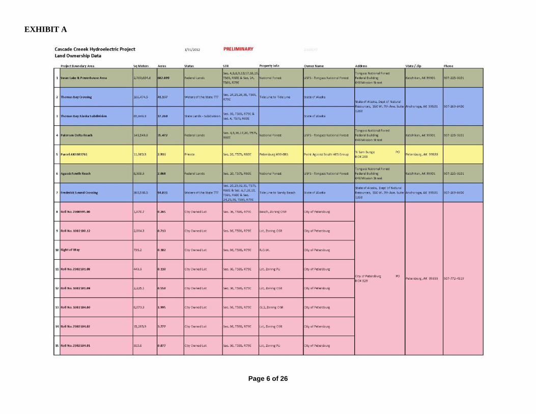
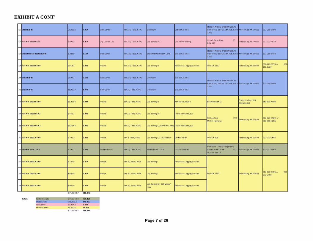
Included as Exhibit A
(2) Names and mailing addresses of:
(i) Any Federal facilities that would be used by the project:
U.S. Forest Service Roads- US Forest Service Petersburg Ranger District PO Box 1328, Petersburg, AK 99833
(ii) Every irrigation district, drainage district, or similar special purpose political subdivision.
None
(iii) Every other political subdivision in the general area of the project that
there is reason to believe would likely be interested in, or affected by, the application.
City of Petersburg Kathy O'Rear, City Clerk P.O. Box 329 Petersburg, AK 99833 (907)772-4519
City of Wrangell Christine Jamison, City Clerk P.O. Box 531 Wrangell, AK 99929
City of Kake Mayor Henrich Kadake P.O. Box 500 Kake, AK 99830 (907)785-3804

Page 4 of 26
City of Ketchikan Ketchikan Public Utilities Karl Amylon 334 Front Street Ketchikan, AK 99901 (907)874-2381
City of Angoon Mayor Albert Howard P.O. Box 189 Angoon, AK 99820
City of Kupreanof Bob Dolan, Mayor
PO Box 50 Petersburg AK, 99833
Eric Wolfe Southeast Alaska Power Agency 1900 First Ave. Suite 318 Ketchikan, AK 99901
Thomas Bay Power Authority PO Box 1318 4.5 Mile Zimovia Highway Wrangell, AK 99929
(iv) All Indian tribes that may be affected by the Project:
Organized Village of Kake Gary Williams, Executive Director P.O. Box 316 Kake, AK 99830-0316
Wrangell Cooperative Association Tom Gillen Sr., President PO Box 868 Wrangell, AK 99829
Petersburg Indian Association Will Ware, Tribal Administrator P.O. Box 1418 Petersburg, AK 99833

Page 5 of 26
Central Council Tlingit and Haida Tribes of Alaska Edward K. Thomas, President 320 W. Willoughby Ave., Suite 300 Juneau, AK 99801 Sealaska Heritage Institute Dr. Rosita Worl, President One Sealaska Plaza, Suite 301 Juneau, AK 99801
Sealaska Corporation Chris E. McNeil, Jr., President One Sealaska Plaza, Suite 400 Juneau, AK 99801
Kootznoowoo Incorporated Peter Naoroz, General Manager 8585 Old Dairy Road, Suite 201 Juneau, Alaska 99801
Kake Tribal Corporation Howard Martin, President P.O. Box263 Kake, AK 99830
Page 6 of 26
EXHIBIT A
Page 7 of 26
EXHIBIT A CONT’

Page 8 of 26
THE FOLLOWING EXHIBITS ARE FILED HEREWITH AND ARE HEREBY MADE A PART OF THIS APPLICATION:
EXHIBIT 1 DESCRIPTION OF THE PROJECT
EXHIBIT 2 DESCRIPTION OF STUDIES
EXHIBIT 3 COSTS AND FINANCING
EXHIBIT 4 PROJECT MAPS

Page 10 of 26
EXHIBIT 1 - DESCRIPTION OF THE PROJECT (1) PROJECT FEATURES
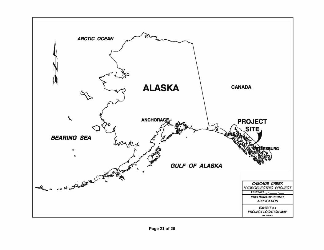
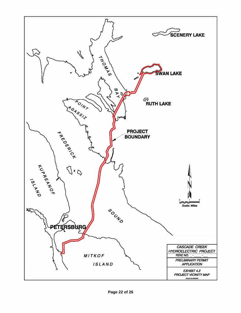
The proposed Cascade Creek Hydroelectric Project (“Project”) is located on Swan Lake, Cascade Creek,
and Thomas Bay, approximately 15 miles northeast of Petersburg, Alaska in the Tongass National Forest
(“Tongass”), administered by the United States Forest Service (“USFS”). Hydro Development, LLC
(“Applicant”) proposes to construct a lake siphon at Swan Lake, with a gatehouse and valve entry to an
approximately three mile long power conduit including a tunnel complex of horizontal and vertical shafts, and a
buried penstock. The power conduit leads to a powerhouse near tidewater on Thomas Bay, which will
accommodate three turbine generator units for a total capacity of approximately 70 megawatts (MW). A 138-
kilovolt (kV) transmission line, comprised of overland and undersea cable, would extend approximately 18.7
miles from the powerhouse to an interconnection point near Petersburg.
Dam.
No dam is anticipated as part of this proposal. Spillway.
An outlet control structure would consist of a small, low-head weir approximately 6-ft-high above the
lowest elevation of the lake outlet. The weir would include a 3-ft high by 50-ft wide crest gate that could be
lowered during extreme high flows to maintain lake levels at or below the natural high level. An outlet control
building would house the mechanical and electrical equipment required to remotely control the crest gate and
bypass valve. The weir would serve several purposes: minimize outflow leakage through the shallow substrata,
provide for minimum in-stream flow contribution if required; facilitate lake level management by adding the
ability to store or release water as necessary in drought or flood conditions to help maintain the desired lake
level; and allow for emergency overflow discharge to the stream outlet of Swan Lake.
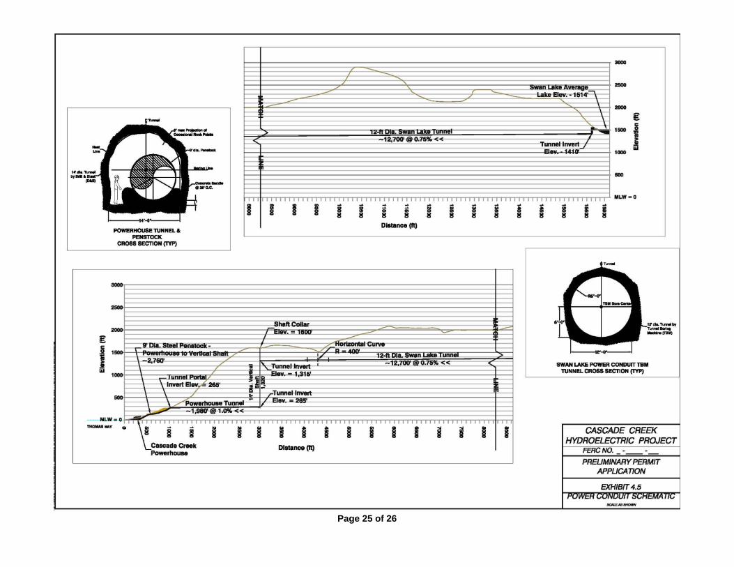
Penstock/Power Conduit.
Water would be delivered to the powerhouse from the lake siphon via a tunnel and penstock power
conduit. An unlined 12-ft-diameter low pressure tunnel would originate at a tunnel invert elevation of 1,419-ft
near the gatehouse, and would extend 12,700-ft at a slope of 0.75 percent. From this point, it would drop into
an unlined 1,320-ft-long 14-ft-diameter vertical shaft/vent. The shaft would be connected at the bottom end to a
14-ft diameter by 1,980-ft-long tunnel at a slope of 1 percent that would terminate at the lower tunnel portal at
El 265-ft. A 9-ft-diameter steel penstock would be installed within the entire length of the lower tunnel
segment. A 9-ft-diameter buried steel penstock would extend approximately 780-ft from the lower tunnel portal
to the powerhouse at El 46-ft (turbine centerline) near tidewater on Thomas Bay.
Page 11 of 26
Powerhouse.
The powerhouse, located at tidewater on Thomas Bay, would consist of a concrete and metal building,
approximately 140-ft-long by 80-ft-wide, embanked by rock fill on the east side. Its foundation would be cast-
in-place concrete, founded on bedrock. The superstructure would be reinforced pre-cast concrete tilt-up with a
sloped metal roof. Applicant proposes to site the structure at least 200-ft off the shoreline to provide an
aesthetic vegetative buffer and avoid effect to the coastal zone. Inside the powerhouse, an overhead service
crane would provide access to place and maintain the turbine generating equipment. The turbine housings
would be cast in the concrete substructure. It would house three generating units, and water would drop
vertically from the units to the tailrace below.
Tailrace. The tailrace is proposed as a low gradient open stream riprap-armored trapezoidal channel
approximately 450-ft-long and 40-ft-wide, discharging as a new outlet to Thomas Bay. It would exit the
powerhouse in a southern direction for approximately 300-ft and then turn west to Thomas Bay for
approximately 150-ft in order to maintain a tree screen to visually hide the powerhouse from Thomas Bay. The
tailrace would be designed to deter use by anadromous fish.
Dock. There will be no road access to the proposed hydroelectric facility location as the site is isolated from
the nearest town of Petersburg. Access for both construction and long-term operation and maintenance of the
Project will be by boat, barge, or aircraft. Applicant proposes to construct a new marine access facility on
Thomas Bay, immediately adjacent to the powerhouse site. A new dock would be approximately 290-ft-long on
a fixed pier with a 60-ft-long ramp down to a 60-ft by 30-ft float stationed to piling. The dock and adjacent
barge landing ramp would provide direct access to the site during construction and operations. Applicant
intends to make the new dock available to the public after the Project begins commercial operation, barring any
legal obstacles or stipulations from the USFS, as it has the potential to provide the public safe landing access for
any upland use purposes.
Access Roads. The Project is separated from the nearest town of Petersburg by Frederick Sound. This gives no
opportunity for road access to the Project from a nearby town. There will be no road access to the proposed
hydroelectric facility location. The only access for both construction and long-term operation and maintenance

Page 12 of 26
of the Project would be via boat or aircraft. Access for both construction and long term operation and
maintenance of the Project will be by boat, barge or aircraft.
Other Structures. Flow to the powerhouse would be drawn from Swan Lake through a lake siphon. The submerged lake
siphon inlet, equipped with intake screens, would be placed at an approximate depth of 40-ft. A 58-ft-long, 49-
ft-wide, and 25-ft-high underground gatehouse would be constructed near the shore of Swan Lake and would
house the vacuum pump, vacuum receiver tank, and valve system to control water flow to the power conduit. A
26-ft by 26-ft by 98-ft deep concrete lined vertical shaft below the gatehouse would house the vertical portion of
the 10-ft diameter siphon piping and siphon shutoff valve. The intake structure is located at latitude 57° 01’ 41”,
longitude 132° 44’ 11”.
Two proposed housing units would be located north of the powerhouse to house workers during
construction of the Project. The houses would remain after construction for use by plant operators and
maintenance crews. Water, wastewater, and waste management will be compliant with Alaska Department of
Environmental Conservation standards. Systems will be closed tank/containers if onsite development is not
feasible. The proposed housing buildings would be separate from other structures and would be surrounded by
proposed and existing vegetative screening. Localized transportation from the housing units to the powerhouse
site would be by vehicle or by foot.
(2) RESERVOIR
The Project would utilize the natural impoundment of Swan Lake, a high alpine, glacially-fed water
body with a surface area of approximately 574 acres and an approximate usable stored capacity of 22,500 acre-
ft (af), assuming a 40-ft operational drawdown. The water surface elevation of Swan Lake naturally fluctuates
within an approximate maximum 8-ft range, and an annual natural fluctuation within an average 6-ft range.
Applicant does not propose to impound Swan Lake above its natural ordinary high water elevation. The Project
will withdraw lake water for power generation in a manner that will provide for forecasted energy shortfall in
Southeast Alaska and possibly other areas.
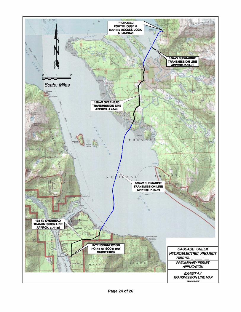
(3) TRANSMISSION LINE
A 138-kV transmission line would extend underground approximately 560-ft from the powerhouse
substation to tide water near the marine access facility, then cross Thomas Bay as a 2.8-mile-long undersea
cable. The cable would be “jetted in,” or buried in the near-shore areas. The transmission line would then
transition to an overhead vertical design on single wood poles, and extend overland approximately 4.5-miles
from the shoreline of Thomas Bay across the Patterson Delta to the shoreline of Frederick Sound. It would then

Page 13 of 26
transition back to an undersea cable and continue 7.7-miles to the shoreline of Mitkof Island. The cable would
be “jetted in,” or buried in the near-shore areas. From here, the line would transition back to an overhead
design and continue overland 3.7-miles to the interconnection point at the existing Scow Bay substation near
Petersburg.
There would be a switchyard/transformer/circuit breaker on site at the powerhouse; however, Applicant
is not proposing to construct new interconnect facilities and/or substations at the point of interconnection.
Applicant anticipates working through existing system upgrade requirements prior to and during
interconnection discussions, which will occur post-licensing.
Page 14 of 26
(4) INSTALLED CAPACITY AND ENERGY PRODUCTION. Average Annual Energy Production.
The total average annual energy production is estimated to be 200 gigawatt hours (GWh), depending on
installed capacity and final design.
Installed Capacity.
The project would be constructed in phases. Phase I would be one of three turbine generators with a capacity of 23.3 megawatts (MW). The total proposed installed capacity of all completed phases would be 70 MW. Hydraulic Head.
The gross hydraulic head for estimating capacity would be 1,471-ft. Turbines and Generators.
Three 23.3 MW vertical shaft, 5 jet impulse (Pelton) type turbines will be used, for a combined power
plant capacity of 70 MW. Each turbine will produce 31,246 hp at a gross head of 1,471-ft and a rated flow of
223 cfs. The turbine rotational speed will be 600 rpm. The generators will be a synchronous type rated at
approximately 26,000 kVA at a .9 power factor, 6,900 volt, 3 phase, 60 Hz, and will be provided with a
brushless excitation system. Generating equipment specifications are subject to change based on detailed
engineering design and consultation with equipment suppliers.
(5) AFFECTED LANDS OF THE U. S. GOVERNMENT
The Project boundary, less the land occupied by the transmission line, is located entirely within the
Tongass. The Tongass is owned by the United States of America and administration of these lands is delegated
to the USFS. As such, these National Forest System lands are managed according to the USFS’s land use plans
and other directives. The total acreage of U.S. lands within the Project boundary is estimated at 721.2 acres as
shown in Table A-1.
There is a Power Withdrawal P.S.C. # 9 Swan Lake dated August 20, 1921 encompassing 1,400 acres
around Swan Lake and Cascade Creek for the purpose of constructing a hydroelectric power facility as further
described in paragraph 6 below.
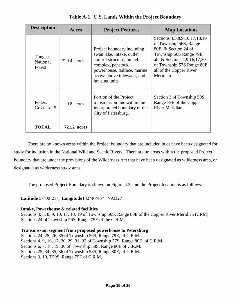
Page 15 of 26
Table A-1. U.S. Lands Within the Project Boundary
Description Acres Project Features Map Locations
Tongass National Forest
720.4 acres
Project boundary including swan lake, intake, outlet control structure, tunnel complex, penstock, powerhouse, tailrace, marine access above tidewater, and housing units.
Sections 4,5,8,9,10,17,18,19 of Township 56S, Range 80E & Section 24 of Township 56S Range 79E, all & Sections 4,9,16,17,20 of Township 57S Range 80E all of the Copper River Meridian
Federal Govt. Lot 5
0.8 acres
Portion of the Project transmission line within the incorporated boundary of the City of Petersburg.
Section 3 of Township 59S, Range 79E of the Copper River Meridian
TOTAL 721.2 acres
There are no known areas within the Project boundary that are included in or have been designated for
study for inclusion in the National Wild and Scenic Rivers. There are no areas within the proposed Project
boundary that are under the provisions of the Wilderness Act that have been designated as wilderness area, or
designated as wilderness study area.
The proposed Project Boundary is shown on Figure 4.3, and the Project location is as follows:
Latitude 5700’21”, Longitude13246’45” NAD27
Intake, Powerhouse & related facilities Sections 4, 5, 8, 9, 10, 17, 18, 19 of Township 56S, Range 80E of the Copper River Meridian (CRM) Sections 24 of Township 56S, Range 79E of the C.R.M. Transmission segment from proposed powerhouse to Petersburg Sections 24, 25, 26, 35 of Township 56S, Range 79E, of C.R.M. Sections 4, 9, 16, 17, 20, 29, 31, 32 of Township 57S, Range 80E, of C.R.M. Sections 6, 7, 18, 19, 30 of Township 58S, Range 80E of C.R.M. Sections 25, 34, 35, 36 of Township 58S, Range 80E, of C.R.M. Sections 3, 10, T59S, Range 79E of C.R.M.
Page 16 of 26
(6) HOW THE PROJECT WOULD DEVELOP, CONSERVE, AND UTILIZE IN THE PUBLIC INTEREST IN THE WATER RESOURCES OF THE REGION.
The Applicant proposes to construct and operate the proposed Project within Power Site Classification
No. 9 established by Order of the Secretary of the Department of the Interior on August 20, 1921. The lands
within the Power Site Classification No. 9 have been ordered (Interpretation No. 174, August 20, 1931) to be
construed as describing the following area:
TONGASS NATIONAL FOREST
In Power—Site Classification No. 9
All lands below the 1,650 foot contour above sea level which drain into Swan Lake, located in the Cascade
Creek Basin about 2.5 miles inland from the east shore of Thomas Bay, Alaska; all lands south of Cascade
Creek within one mile of the middle of said creek, and all lands north of Cascade Creek within one-eighth of a
mile of the middle of said creek, extending from Swan Lake to the shore of Thomas Bay.
There is an anticipated increased energy demand in Southeast Alaska as a result of four major factors:
1) slow load growth increase; 2) a continued trend of fuel oil heat to electric heat conversion as the price of fuel
oil increases; 3) the introduction of electric vehicles offsetting petroleum fuel in towns with short drive
distances and high fuel prices; and 4) implementation of connecting large cruise ships to shore power in lieu of
onboard diesel generation. All of these trends have resulted in substantially revised power need forecasts for
Southeast Alaska. The Applicant anticipates the regional energy demands to increase from 279,058 MWh in
2013 to 538,770 MWh in 2028. If no other hydroelectric facilities are approved and constructed, existing plant
generation of approximately 268,000 MWh will be unable to meet this demand. Additional energy needs will
continue to require fossil fuel generation (primarily diesel).
The Project will fulfill the public interest for reasonably priced, reliable, and environmentally sound
source of renewable energy. The approval of this Project would reduce greenhouse gas releases associated with
fossil fuel generation.

Page 17 of 26
EXHIBIT 2 - DESCRIPTION OF STUDIES (1) PROPOSED STUDIES, INVESTIGATIONS, TESTS AND SURVEYS. Environmental Study Planning and Study Conduct
The applicant anticipates studies related to the following topics: Survey of existing and/or pending water, mineral, timber, access, utility and conservation rights. Tribal interests including usual and accustomed treaty rights, historical and special use interests. General history of land uses, existing structures, artifacts and potential archeological interests. Precipitation, hydrology, discharge and water quality studies. Surface mapping of topography, soils, geology, slope stability, bedrock & subsurface analysis. Fish & wildlife inventories, utilization, presence/absence surveys, critical habitat identification. Vegetation & wetland system mapping, rare plant survey, noxious weed inventory. Recreational uses inventory, user surveys, feature mapping, demand forecast, mitigation. Scenic and aesthetic resources and potential effects thereupon. Community concerns, construction & operational impacts, potential changes, sights & sounds. Project design and engineering, cost estimating, feasibility analysis, decommissioning issues.
Need for Power Analysis A future need for power analysis for the region has been completed as the Draft Southeast Integrated
Resources Plan prepared by Black & Veatch, January 2012 for the Alaska Energy Authority. The results of the
analysis will be used to supplement the Applicant’s license application for the Project.
Economic Analysis An economic analysis of the proposed Project will be completed by the Applicant in 2012, The analysis
will be used to supplement the Applicant’s license application for the Project.
Engineering Design A preliminary Supporting Design Report will be submitted with the Applicant’s final license
application.
NEW ROADS for CONDUCTING STUDIES.
The Applicant expects no new roads to be required for conducting required field studies. (2) WORK PLAN FOR NEW DAM CONSTRUCTION.
The Applicant is planning a lake siphon, which would not require new dam construction or its
application.
Page 18 of 26
EXHIBIT 3 - COSTS AND FINANCING (1) ESTIMATED COSTS AND FINANCING
Engineering and Economic Evaluation Costs.
Based on review of existing information and data, the Applicant expects engineering and economic
evaluation costs to be between $50,000 and $150,000.
Environmental Consultation and Study Costs.
Based on review of planned work, the Applicant expects environmental consultation, studies, and
preparation of the final license application to cost between $1,000,000 and $2,000,000.
(2) FINANCING
The Applicant intends to obtain the capital requirements for Project licensing through private financing.
(3) MARKET FOR POWER GENERATED
The Project will be owned and operated by the Applicant. Energy generated will be sold at wholesale
price to local and regional markets, aggregators, or other wholesale purchasers of electric generation.
The Project will fulfill the public interest for reasonably priced, reliable, and environmentally sound
sources of renewable energy. The approval of the Project would also help in reducing acid rain and greenhouse
effects associated with coal and oil-fired generation.
The Southeast Alaska communities of Petersburg (pop. 3,000), Wrangell (pop. 2,300) and Ketchikan
(pop. 14,500) are electrically connected by the Southeast Intertie, operated by the Southeast Alaska Power
Authority (SEAPA). The community of Kake (pop. 650) is proposed to be connected with a new northern
extension of the Southeast Intertie, which is currently under study by the USFS as lead NEPA agency. SEAPA
also provides generation to the connected region from two existing hydro projects, Tyee Lake 22.5 MW and
Swan Lake near Ketchikan 22.5 MW. Along with the SEAPA hydro projects, Ketchikan Public Utilities owns
and operates the Silvas Lake, Beaver Falls, and Ketchikan Lakes hydropower projects. Petersburg owns the
Crystal Lake hydropower project. Each community also has additional diesel generation plants for back-up or
prime use. Power in Kake is presently diesel generation only. There are no other connections to any generation
or load facilities. A proposal to connect the Southeast Intertie to B.C. Canada and the North American Grid has
been studied and placed under future planning consideration by the Alaska Energy Authority, a state agency.

Page 19 of 26
Community leaders in Kake, Wrangell and Ketchikan have all declared that a source of additional,
affordable power will be necessary to support economic development as well as meet future energy needs.
There is an anticipated increased energy demand in Southeast Alaska because of four major categories:
1) slow load growth increase; 2) a continued trend of fuel oil heat to electric heat conversion as the price of fuel
oil increases; 3) the introduction of electric vehicles offsetting petroleum fuel in towns with short drive
distances and high fuel prices; and 4) implementation of connecting large cruise ships to shore power in lieu of
onboard diesel generation. All of these trends have resulted in substantially revised power need forecasts for
Southeast Alaska. The Applicant anticipates energy demands to increase from 279,058 MWh in 2013 to
538,770 MWh in 2028. If no other hydroelectric facilities are approved and constructed, existing plant
generation of approximately 268,000 MWh will be unable to meet this demand. Additional energy needs will
continue to require fossil fuel generation (primarily diesel).
The Project will fulfill the public interest for reasonably priced, reliable, and environmentally sound
sources of renewable energy. The approval of this Project would reduce greenhouse gas releases associated
with fossil fuel generation.
Use of Energy By The Applicant.
The Applicant would not use the Project’s energy on-site other than for station service as required.

Page 20 of 26
EXHIBIT 4: PROJECT MAPS
4.1 PROJECT LOCATION MAP
4.2 PROJECT VICINITY MAP
4.3 PROJECT BOUNDARY & FACILITIES MAP
4.4 PROJECT TRANSMISSION LINE MAP
4.5 POWER CONDUIT
Page 21 of 26
Page 22 of 26
Page 23 of 26
Page 24 of 26
Page 25 of 26