flying in denmark - a brief introduction to rules and regulations for foreign military aircrews...
TRANSCRIPT

Flying in Denmark- a brief introduction to rules and regulations for foreign
military aircrews flying in Danish airspace.
Last update: 2010-07-29.Prepared by TACDEN Flight Information.

Copenhagen FIR
North Sea
FL195-FL660
3500FT-FL660
Vertical limits: Ground/Sea level to infinity
Controlled airspace:

Copenhagen AreaCopenhagen Area extends vertically from
1500/2500 FT to FL195.
If a flight, or part of a flight, takes place within or above Copenhagen Area, clearance shall be obtained from Copenhagen Approach or ACC Copenhagen respectively.

Airspace classification
Class A: Not applicable in Denmark
Class B: Not applicable in Denmark
Class C : Copenhagen Area and TMA’s within Copenhagen Area All airspace above FL195
Class D : All CTR’s and TMA’s outside Copenhagen Area
Class E : Airspace between 3500 FT MSL and FL 195, except North Sea within Copenhagen FIR, and Copenhagen areaClass F : Not applicable in Denmark
Class G : 1. Airspace from GND/SL to 3500 FT MSL, except Copenhagen Area.
2. North Sea from SL to FL195.
3. TIZ’s and TIA’s.
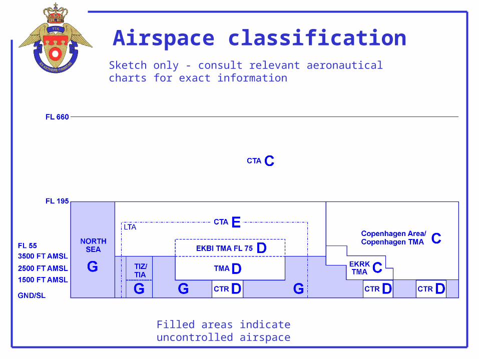
Airspace classification
Filled areas indicate uncontrolled airspace
Sketch only - consult relevant aeronautical charts for exact information

Visual Flight Rules (VFR)
1. For all aircraft operating at 250 KIAS or more, a flight visibility of 8 KM
or more is required, except in airspace class G during daylight, when flying at or below 3000 FT MSL or 1000 FT AGL, whichever is the higher2. Helicopters may operate VFR if flight visibility is equal to, or greater than
800 M, if manoeuvering at a speed that will give adequate opportunity to observe other traffic or obstructions in time to avoid collosion.3. Flight visibility at night will be at least:
8 KM for fighters and other aircraft exceeding 140 KIAS5 KM for aircraft operated at 140 KIAS or less3 KM for helicopters operated at 140 KIAS or less

Visual Flight Rules (VFR)
Airspace class C, E, G and D (TMA)
Altitude Airspace class
Flight visibility
Distance from cloud
At or above FL 100 CDEG 8 KM 1500 M horizontally1000 FT vertically
Below FL 100 and above3000 FT AMSL, or above1000 FT above terrain,whichever is the higher
CDEG 5 KM 1500 M horizontally1000 FT vertically
At and below 3000 FT AMSL, or above 1000 FTover terrain, whicheveris the higher
CDE 5 KM 1500 M horizontally1000 FT vertically
G 5 KM
3 KM/140 KT
Clear of cloud and withthe surface in sight

Visual Flight Rules (VFR)
VFR flights in Control Zones require meteorological conditions equal to or better than:
Control Zones (Airspace Class D):
Visibility: 8 KM at day and night for fighter aircraft
Ceiling 1500 FT
5 KM at day and 8 KM at night for other aircraft
(When ceiling is between 1500 FT and 2500 FT, separation will be established between military VFR flights and civil IFR and special VFR flights.)

Special VFR
Aircraft type Meterologicalvisibility
Day/night
Ceiling Distance fromclouds
Fighters and other aircraft exceeding 140 KIAS
5KM / 8KM 1000 FT 1) Clear of clouds
Aircraft operating at 140 KIAS or less
3KM / 5KM 500 FT Clear of clouds
Clear of cloudsHelicopters operating at 140 KIAS or less
800M / 3KM 3) 500 FT 2, 3)
- may be approved by ATC in a Control Zone, provided meterological conditions are equal to or better than:

Special VFR
Note 1: For fighter and other aircraft operating at 140 KIAS or more, ceiling may be reduced to 500 FT AGL in connection with take off and departure via specific routes during daylight hours.Note 2: For helicopters operating at 140 KIAS or less, ceiling may
be reduced to 300 FT AGL in connection with lift off, departure and approach via specific routes during daylight hours.Note 3: In connection with NVG flying visibility may be reduced to 1500 meters and ceiling to 300 ft AGL provided that the crew is able to transition to IFR flight.

General Information
Flying with transport- or jet aircraft, below 2000 FT AGL, is not allowed, except when specifically ordered in the Airtask or Exercise Order.
600 metres600 metres
Min 2000 FT
Min 500 FT
Light aircraft and helicopters,
Transport and jet aircraftMinimum altitude over towns, recreational areas etc. shall always be 2000 FT above highest obstacle within 600 metres.
Exempted are light aircraft and helicopters which are allowed down to 500 FT above the highest obstacle within 600 metres. (1000 ftover towns, recreational areas etc.)

General Information
Supersonic flying (M .97+) is prohibited, unless specifically ordered, or:
1. Flying above FL100, 10-35 NM off the coast, heading away from the coast line
2. Flying above FL100, 35 NM+ from the coast, no heading restrictions.
Use of afterburner below 5000 ft AGL/ASL is prohibited, except:
1. Flying over the Sea, minimum 2 kilometres off the coast
2. During take-off, touch and go, overshoot
3. During emergencies
4. Attack exercises on shooting ranges or air bases (prior permission from ATC is required!)

Altitude restrictions
Over land: Not lower than 500 FT AGL
Over towns and recreational areas: Not lower than 2000 FT AGL
Over the sea more than 2 km off the coast: I.a.w. national regulations
Simulated attacks:
Military airfields inside perimeter fence: Not lower than 300 FT AGL
Ground targets in civilian terrain: Not lower than 500 FT AGL

Airspeed restrictions
The following maximum airspeeds are to be observed over land, including the sea within 2 kilometres off the coast:
Above 2000 FT AGL: Subsonic
1000-2000 FT AGL: 500 KT (GS)
500-1000 FT AGL: 480 KT (GS)
Below 500 FT AGL: 450 KT (GS)

Flight Plan
1. A complete ICAO flight plan must be filed for:- flights outside Copenhagen FIR- flights landing on a civil airfield
- IFR flights- night VFR flights above 3000 ft MSL
2. In all other cases, file a reduced flight plan containing: - Callsign /SSR code- Number and type of aircraft- ETD- EET- Mission and area/route- Endurance- Name of Aircraft Commander
- flights departing from a civil airfield

VFR flying above 3500 FTMilitary aircraft flying over Danish territory above 3500 ft, are to contact an Aircraft Controlling Unit (ACU) or ATS unit for flight following/flight information service.
Separation to non-operational air traffic:
FL460
FL195
min. 5 NM, or min. 1000FT
IFR or Controlled VFR only

Search and Rescue
EH-101 or S-61SAR helicopters are based at Skrydstrup (EKSP), Aalborg (EKYT) and Roskilde (EKRK). Crews are on alert H24.
Guard frequency is monitored at all military ATS-units and ACU units during their hours of operation.

Bird intensity
Bird migration occurs during the whole year, but culminates in the periods end of March to Mid-May (spring migra-tion) and beginning of September to Mid-November (autumn migration).
Flying below 1500 FT will involve increased risk of bird strike.
Due to technical reasons bird intensity cannot be obtained for København FIR. Crews should follow STANAG 3879 or national procedures for flight in bird migration periods and/or bird contration areas.

ECM
ECM guidelines/restrictions in Copenhagen FIR include:
1. Self-protection chaff may be used within the exercise area
2. Chaff longer than 50 cm. must not fall on land including the sea within 2 km off the coast.
3. Active ECM against radar installations will not be employed within 12 NM of any NATO border.
4. The use of IR-flares is not allowed over land including the sea within 2 km off the coast.

Miscellaneous
1. Overdue ATC will start communication search if an aircraft is overdue on ETA + 5 minutes. CALL ATC IF DELAYED, and extend flightplan
2. Radio contact Call ATC 25 NM out for clearance, prior to entering TIA’s, TIZ’s, CTR’s, TMA’s and Copenhagen Area. Maintain listening watch at all times.3. Transition from VFR to IFR: If unable to maintain VMC in uncontrolled airspace, and unable to obtain IFR clearance prior to going IMC:
Climb to and maintain 2500FT until VFR or an IFR clearance is obtained. Request IFR-clearance from Copenhagen ACC or any near-by ATC unit.

Emergency procedures
All pilots must be familiar with standard emergency procedures for radio failure and the use of MAYDAY and PAN calls.
1. Triangular patterns can be used in Denmark. Reduced chance of being seen without IFF/SIF:
A. Transmitter out, receiver OK: Right hand patternB. Transmitter out, receiver out: Left hand patternSquawk EMERGENCY. If possible, fly at FL250 or above at contrail altitude. Await interception.
2. VMC approach with radio U/S:Transmit blind position reports. Squawk 7600 mode 3.Approach via IP, 500 FT AGL, Light flashing, wings rocking. Fly along RWY in use on right side, pull up to downwind at far end, and look for light signals from TWR

Emergency procedures
3. GCA lost communication procedure:
If radio contact is lost for more than 1 minute in pattern or five seconds on final approach, climb to MSA on last given heading and contact APPROACH. If landing clearance has been received, land using other NAV AID if applicable.
4. IFF/SIF YES/NO procedure:ATC will ask specific questions which can be answered YES or NO. Squawk Ident for YES, nothing if NO.
Emergency procedures
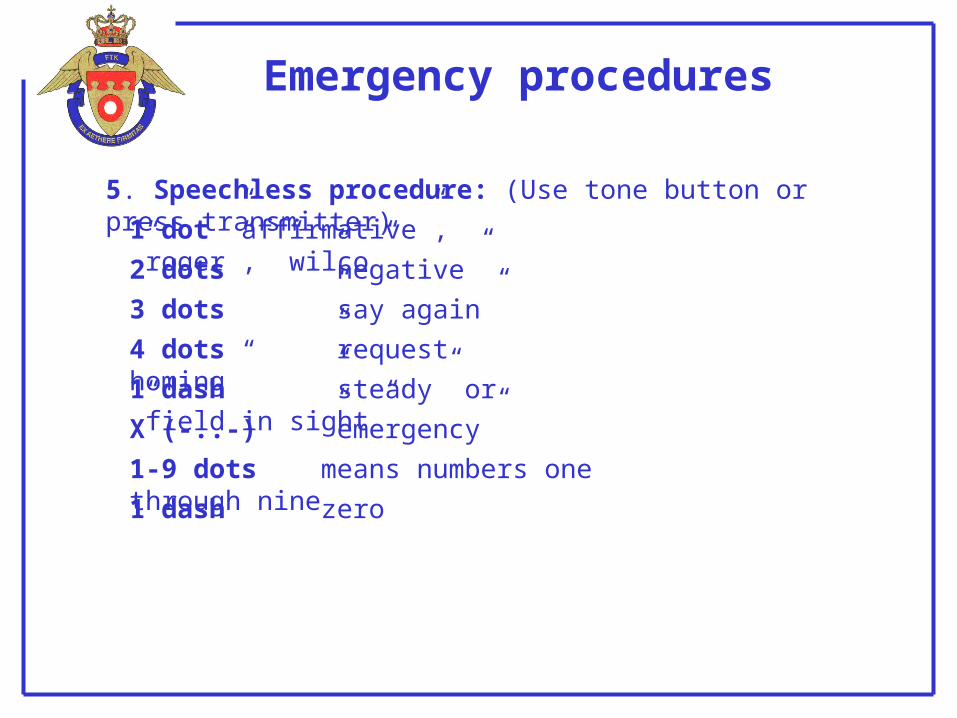
5. Speechless procedure: (Use tone button or press transmitter)
1 dot ”affirmative”, ”roger”, ”wilco”
2 dots ”negative”
3 dots ”say again”
4 dots ”request homing”
1 dash ”steady” or ”field in sight”
X (-..-) ”emergency”
1-9 dots means numbers one through nine
1 dash zero

Restricted airspaceRestricted,- and Danger areas are annonunced active on a day-to-day basis by NAV WARNING SUMMARY FOR COPENHAGEN FIR AND ADJACENT WATERS.

Danish bases
Runways:
Landing aids:
Communication:Arrester gear:
Karup (EKKA)
09R/27L (main) 9607 x 150 FT
PAR, ILS, TACAN, LOCATOR
VHF/UHF for TWR, APP, ARR and PARPrimary: Bak 12/14 in both ends of 09R/27L
09L/27R (parallel) 9816 x 75 FT04/22 2818 x 50 FT 14/32 2152 x 75 FT
Secondary: None
34D-1F in both ends of 09L/27R

Danish bases
Runways:
Landing aids:
Communication:
Arrester gear:
Skrydstrup (EKSP)
11L/29R (main) 9863 x 150 FT
11R/29L (parallel) 9750 x 80 FT
PAR, ILS , VORTAC
VHF/UHF for TWR, APP, ARR and PAR
Primary: Bak 12/14 in both ends of 11L/29RSecondary: 34D-1F (MOD) in both ends of 11R/29L
34D-1F in both ends of 11L/29R

Danish bases
Runways:
Landing aids:
Communication:
Arrester gear:
Aalborg (EKYT)
08L/26R (main) 8707 x 148 FT
08R/26L (parallel) 8364 x 75 FT
ILS, VORTAC, LOCATOR
VHF/UHF for TWR, APP, ARR
Primary: Bak 12/14 in both ends of 08L/26R
34D-1SF in both ends of 08R/26L
Secondary: None

Flight Information
The following publications, with relation to general flying in Denmark, are published by TACDEN:
1. Flying in Denmark: Small pamphlet giving foreign aircrews the most basic information on rules and regulations when flying in Danish airspace.
2. Military Aeronautical Information Publication Denmark (MIL AIP Denmark). Detailed information on airspace, routes, exercise areas e.t.c.
3. Royal Danish Air Force Flight Information Publication. Contains instrument departure and approach procedures for all danish military bases and 12 civilian airports. Procedures are gradually being transitioned from TERPS design criteria to PANS OPS (MIPS) criteria. In the transition period both types may be found in the FLIP. It is clearly marked in the header of each procedure whether it is a TERPS procedure or a PANS OPS/MIPS procedure.
4. Low Flying Chart 1:500.000 Denmark. Standard VFR navigation chart.

Flight Information
MIL AIP Denmark, NOTAMS and Daily Navigational Warnings may be found on the internet at:
http://www.flv.dk/milais
