fluvial architecture as a response to two-layer lithospheric
TRANSCRIPT
Fluvial architecture as a response to two-layer lithospheric subsidence during the Permian and Triassic in the Iberian Basin, eastern Spain
Jose L6pez-G6mez a,*, Alfredo Arche a, Henar Vargas b, Mariano Marzo C
• Instituto de Geologfa Economica, CSIC-UCM, Facultad de Geologfa, Universidad Complutense, Antonio Novr'iis 2, 28040 Madrid, Spain
b Repsol YPE Paseo de la Castellana 280, 28046 Madrid, Spain
C Departament d'Estratigrafia, Paleonto[ogfa i Geocifmcies Marines, Facultat de Ge%gfa, Universitat de Barcelona, Zona Universitaria de Pedralbes, 08071 Barcelona, Spain
ARTICLE INFO
Article history:
Received 3 November 2008 Received in revised form 16 November 2009 Accepted 27 November 2009
Keywords:
Fluvial architecture Subsidence Stretching factor Permian Triassic Tectonic controls
1. Introduction
ABSTRACT
The stratigraphy of a sedimentary basin is mainly the result of the long-term response of a depositional
surface to prolonged subsidence. However, the real nature of interrelations between fluvial architecture and
subsidence is still unknown. Herein, we present new data on these relationships by combining the results of
detailed sedimentological field work with data acquired through automated fOlward modelling and
backs tripping for the alluvial Permian and Triassic sediments of the SE Iberian Ranges. Using this
methodology, we determined tectonic subsidence of the basin by means of backs tripping analysis and crust
and litho spheric mantle stretching factors (6 and {3, respectively) using forward modelling technique. Results
indicated that a configuration of two individual and independent layers during lithospheric subsidence for
each tectonic phase fit better for this time of the studied basin evolution than the assumption of subsidence
due to a single layer spanning the whole lithosphere.
For this study, we simplified fluvial geometries as two main types: isolated (I) and amalgamated (A), with
subtypes in each case. Different order bounding surfaces (b.s.) were distinguished in the field, although we
only selected those affecting the whole basin under study. These included those b.s. of clear tectonic origin,
ranging from individual basin boundary-fault pulses produced over periods of approximately 1 My to those
arising from major tectonic events, such as the beginning of extension in the basin, causing major changes in
basin geometry over periods of 3-5 My.
The comparison of 6 and {3 values and fluvial geometries for each identified tectonic phase in the basin
evolution, revealed some possible relationship between subsidence and fluvial geometry: Sections showing
the most varied fluvial architectural geometries, including ribbon and nested forms, were related to higher
{3 and 6 stretching factors values indicating tectonic phases of greater stretching and subsidence. When both
stretching factors were similar and close to 1, fluvial geometry was basically reduced to amalgamated
geometry type. Wider ranging of fluvial geometries was associated with stages of basin development in
which crust and upper mantle activities differed, that is, showing larger differences of {3 and 6 stretching
factors values. The related slope changes are proposed as the main surface control of fluvial styles.
Combination of subsidence with other possible controlling factors such as avulsion rate, climate or budget of
sediments, gives rise to the definitive alluvial architecture of a basin.
Sedimentary basins form by deformation of the lithosphere, and
their stratigraphical record is the sum of a number of geological
processes, mainly allogenic (basically climate and tectonics), which
interact with each other through time and may cause relative sea
level changes. Thus, a long-term response of the depositional surface
to prolonged subsidence will determine the stratigraphy of a
sedimentary basin.
Stratigraphical modelling techniques developed over the last three
decades have provided geologists with a powerful tool for examining
and comparing the different processes that lead to the sedimentary
record of a particular basin. The basic assumption of basin analysis
techniques is that similar genetic processes show a consistent vertical
pattern in their sedimentary evolution.
Studies since the seventies on lithosphere deformation by
stretching and rapid cooling have been conducted in practical
synchrony with those evaluating intracontinental rifts and passive
margins. Rifts were soon related to thermal anomalies existing at
depth. Convection appears to be sufficiently rapid to explain rift
uplifts when the basal heat flow from the asthenosphere is several
times higher than the normal rate (Allen and Allen, 1 990). However, * Corresponding author.
E-mail address: [email protected] 0. L6pez-G6mez).
recent results also suggest there is no need in some cases to invoke
hypothetical plume activity to explain the mechanism destabilizing
the lower lithosphere, and that passive-driven intraplate extension
provides an efficient alternative (Huismans et al., 2001).
Whichever the case, lithosphere deformation is a prerequisite for
basin formation and subsequent refilling. Deformations caused by
stretching of the lithosphere are normally explained by assuming the
crust and lithospheric mantle extend by similar amounts (uniform
stretching) (McKenzie, 1978) or by non-uniform amounts (Salveson,
1 976, 1978; Royden and Keen, 1980), whereby stretching is then
depth-dependent. The latter mechanism is based on a different
rheological response of the crust and lithospheric mantle to stretch
ing, and thus a different stretching factor is proposed for each one
(8 and f3 respectively). In contrast, the uniform stretching theory only
requires one factor (f3) for calculations referring to a uniform
lithosphere. A more complete idea of the stretching changes produced
in a basin was developed by Steckler (1981), who suggested several
short extensional phases followed by cooling in the general extension
process. It is important to stress that the amount of subsidence is not
the unique factor controlling fluvial styles, as sediment supply,
hydraulic regime and climate also must be considered. However,
subsidence rate is the main control on the general configuration of
extensional sedimentary basins and a major factor creating surperfi
cial topographic gradients and, consequently, fluvial styles in the
sedimentary record.
Basins of similar genetic type may show a consistent pattern in
their sedimentary development. Accordingly, a formative mechanism
of a basin such as subsidence has predictive power in assessing basin
fill (Allen and Allen, 1 990). Works relating subsidence changes in rift
basins to their refill style involve detailed field work based on well
exposed outcrops, such as those described by Alexander and Leeder
(1987), Leeder (1993) and Steel and Ryseth (1990), among others.
Several related models have been proposed to explain the architec
tural arrangement of channel stacking patterns in alluvial sequences.
Some of these models (e.g., Allen, 1978; Bridge and Leeder, 1979)
have been widely used to quantify relationships between subsidence
and large-scale fluvial architecture in sedimentary basins, although
none of them can be taken as definitive. One of the reasons for this is
that we have no precise models to quantify results when various
autocyclic processes act at the same time in different ways.
Furthermore, results from experiments conducted in laboratories
are commonly inconsistent and also conflict with the results obtained
by introducing data from processes such as avulsion in the analysis
(see e.g., Heller and Paola, 1996; Ashworth et al., 2004). As will be
discussed later on, it seems that the interrelation between subsidence
and large-scale fluvial architecture should be approached with
caution, because there is no direct link between this tectonic process
and the 3-D configuration of the sediments. As mentioned above,
topographic gradient and its changes are the primary controlling
factor (largely, but not exclusively, of tectonic origin).
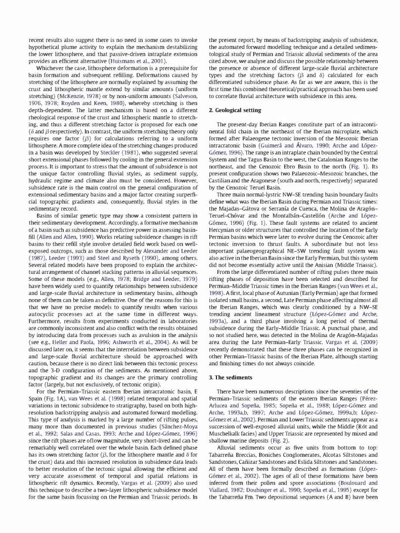
For the Permian-Triassic eastern Iberian intracratonic basin, E
Spain (Fig. lA), van Wees et al. (1998) related temporal and spatial
variations in tectonic subsidence to stratigraphy, based on both high
resolution backstripping analysis and automated forward modelling.
This type of analysis is marked by a large number of rifting pulses,
many more than documented in previous studies (Sanchez-Moya
et al., 1992; Salas and Casas, 1993; Arche and Lopez-Gomez, 1 996)
since the rift phases are oflow magnitude, very short-lived and can be
remarkably well correlated over the whole basin. Each defined phase
has its own stretching factor (f3, for the lithosphere mantle and 8 for
the crust) data and this increased resolution in subsidence data leads
to better resolution of the tectonic signal allowing the efficient and
very accurate assessment of temporal and spatial relations in
lithospheric rift dynamics. Recently, Vargas et al. (2009) also used
this technique to describe a two-layer lithospheric subsidence model
for the same basin focussing on the Permian and Triassic periods. In
the present report, by means of backstripping analysis of subsidence,
the automated forward modelling technique and a detailed sedimen
tological study of Permian and Triassic alluvial sediments of the area
cited above, we analyse and discuss the possible relationship between
the presence or absence of different large-scale fluvial architecture
types and the stretching factors (f3 and 8) calculated for each
differentiated subsidence phase. As far as we are aware, this is the
first time this combined theoretical/practical approach has been used
to correlate fluvial architecture with subsidence in this area.
2. Geological setting
The present-day Iberian Ranges constitute part of an intraconti
nental fold chain in the northeast of the Iberian microplate, which
formed after Palaeogene tectonic inversion of the Mesozoic Iberian
intracratonic basin (Guimera and Mvaro, 1 990; Arche and Lopez
Gomez, 1996). The range is an intraplate chain bounded by the Central
System and the Tagus Basin to the west, the Catalonian Ranges to the
northeast, and the Cenozoic Ebro Basin to the north (Fig. 1). Its
present configuration shows two Palaeozoic-Mesozoic branches, the
Castilian and the Aragonese (south and north, respectively) separated
by the Cenozoic Teruel Basin.
Three main normal-lystric NW-SE trending basin boundary faults
define what was the Iberian Basin during Permian and Triassic times:
the Majadas-Gatova or Serranta de Cuenca, the Molina de Aragon
Teruel-Chovar and the Montalban-Castellon (Arche and Lopez
Gomez, 1 996) (Fig. 1). These fault systems are related to ancient
Hercynian or older structures that controlled the location of the Early
Permian basins which were later to evolve during the Cenozoic after
tectonic inversion to thrust faults. A subordinate but not less
important palaeogeographical NE-SW trending fault system was
also active in the Iberian Basin since the Early Permian, but this system
did not become essentially active until the Anisian (Middle Triassic).
From the large differentiated number of rifting pulses three main
rifting phases of deposition have been selected and described for
Permian-Middle Triassic times in the Iberian Ranges (van Wees et al.,
1998). A first, local phase of Autunian (Early Permian) age that formed
isolated small basins, a second, Late Permian phase affecting almost all
the Iberian Ranges, which was clearly conditioned by a NW-SE
trending ancient lineament structure (Lopez-Gomez and Arche,
1993a), and a third phase involving a long period of thermal
subsidence during the Early-Middle Triassic. A punctual phase, and
so not studied here, was detected in the Molina de Aragon-Majadas
area during the Lite Permian-Early Triassic. Vargas et al. (2009)
recently demonstrated that these three phases can be recognized in
other Permian-Triassic basins of the Iberian Plate, although starting
and finishing times do not always coincide.
3. The sediments
There have been numerous descriptions since the seventies of the
Permian-Triassic sediments of the eastern Iberian Ranges (Perez
Arlucea and Sopefia, 1985; Sopefia et al., 1988; Lopez-Gomez and
Arche, 1 993a,b, 1997; Arche and Lopez-Gomez, 1999a,b; Lopez
Gomez et al., 2002). Permian and Lower Triassic sediments appear as a
succession of well-exposed alluvial units, while the Middle (Rot and
Muschelkalk facies) and Upper Triassic are represented by mixed and
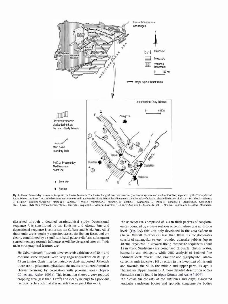
shallow marine deposits (Fig. 2).
Alluvial sediments occur as five units from bottom to top:
Tabarrefia Breccias, Boniches Conglomerates, Alcotas Siltstones and
Sandstones, Cafiizar Sandstones and Eslida Siltstones and Sandstones.
All of them have been formally described as formations (Lopez
Gomez et al., 2002). The ages of all of these formations have been
inferred from their pollen and spore associations (Boulouard and
Viallard, 1982; Doubinger et al., 1990; Sopefia et al., 1 995) except for
the Tabarrefia Fm. Two depositional sequences (A and B) have been
Elevated Paleozoic blocks during Late Permian - Early Triassic
Main basin boundary fault
PMCL: Present-day Mediterranean coast line
+ Borehole
• Section
G F
A
Present-day basins and ranges
o � []]]]]
N
� Cenozoic
Mesozoic Variscan Basement
150 Km
.....--- Major Alpine thrust fronts
Late Permian-Early Triassic
o 60 Km Zaragoza
Fig. 1. Above: Present-day basins and Ranges in the Iberian Peninsula The Iberian Range shows two branches (north or Aragonese and south or castilian) separated by the TertiatyTeruel Basin. Below: Location of the studied sections and ooreholes and Late Permian-EarJyTriassic fault lineaments basin boundatyfaults and elevated Paleozoic blocks. 1 -Torralba. 2 -Alhama. 3- ElHito. 4-MolinadeArag6n.5 -Majadas.6 -canete. 7 -Teruel. 8 -Montalban.9 -Miranbel. 10- Chelva.11 -Manzanera. 12-Jerica.13 -Bobalar.14-Salsadella.15 -Gatova.and 16 -Chovar-Eslida. Main tectonic lineaments: A -TerueL B -Requena. C- Valencia-Caste1l6n. D -Cafiete-Sagunto. E- Molina-Teruel. F -Alhama-Oropesa. and G -Ateca-Montalban.
discerned through a detailed stratigraphical study. Depositional
sequence A is constituted by the Boniches and Alcotas Fms and
depositional sequence B comprises the Cafiizar and Eslida Fms. All of
these units are irregularly deposited across the Iberian Basin, and are
clearly conditioned by a significant basal palaeorelief and subsequent
synsedimentary tectonic influence as will be discussed later on. Their
main stratigraphical features are:
The Tabarreiia unit. This unit never exceeds a thickness of 30 m and
contains scree deposits with very angular quartzite clasts up to
45 cm in size. Clasts may be matrix- or clast-supported. Although
there are no palaeontological data, the unit is considered Autunian
(Lower Permian) by correlation with proximal areas (L6pez
G6mez and Arche, 1 993a). This formation shows a very reduced
cropping area (less than 1 km2) and clearly belongs to a previous
tectonic cycle, such that it is outside the scope of this work.
The Boniches Fm. Comprised of 3-4 m thick packets of conglom
erates bounded by erosive surfaces or centimetre-scale sandstone
levels (Fig. 3A), this unit only developed in the area Cafiete to
Chelva. Overall thickness is less than 88 m. Its conglomerates
consist of subangular to well-rounded quartzite pebbles (up to
40 cm) organized in upward-fining composite sequences about
1.2 m thick. Sandstones are comprised of quartz, phyllosilicates,
haematite and feldspars, while XRD analysis of isolated fine
sediment levels reveals illite, kaolinite and pyrophyllite. Palaeo
current trends indicate a NE direction in the lower part of this unit
and towards the SE in the middle and upper parts. Its age is
Thiiringian (Upper Permian). A more detailed description of this
formation can be found in L6pez-G6mez and Arche (1 997).
The Alcotas Fm consists of red siltstones and clays, associated
lenticular sandstone bodies and sporadic conglomerate bodies

NW
•
11
FORMATIONS 6 I
I I
10 12 16 SE I t t
Muschelkalk Facies ��� Rot I I ')..:Eslida F .-.
ICanizar Fm.1 I� c •
�� �. ( <:::£:::2:Z;> -== IAlootas Fm. - --�· . . o . <>: ...
� Boniches Fm.
0 0 • 0 •
�/
AGES
Ladinian 0
239.' -en Anisian en
<! -241.1 0::
Scythian f-
- --24' I--Z ThOnngian <! -::;; 0:: w D-
L _L _l _._ L..L. __ L..L.. _______ L.. L r nri -- - ----
I 268.8
Trrl' r Autunian
Fig. 2. Late Permian-EarJyTriassic stratigraphy of the studied area Studied formations are: Boniches, Alcotas, (aftizar and Eslida Locations: 6 - (afiete, 10 -Cheiva, 12 -Jerica, and 16 - Chovar-Eslida See Fig. 1 for their locations. Ages from Gradstein et al. (1995).
(Fig. 3B). This formation appears throughout the study area and
can attain a thickness of 170 m. Sandstones are mainly arkoses and
the clay fraction mainly consists of illite and quartz. Sandstone and
conglomerate bodies constitute upward-thinning and -fining
sequences generally less than 1 m thick. When well-developed,
these bodies show an erosive base and never exceed a few
hundred meters in width, whilst small bodies have a planar base
and never surpass a hundred meters. Palaeocurrents consistently
trend towards the SW. Its age is Thiiringian (Upper Permian). This
formation is described in detail in L6pez-G6mez and Arche
(1993a).
The Cafiizar Fm. This formation, comprised of red pink sandstones,
appears across the whole study area and can reach 170 m in
thickness. Sandstones are compositionally arkoses, illite and quartz
cemented with K-feldspar. Palaeocurrent trend analyses consistently
indicate SE. Sandstone bodies consist of upward-thinning and -fining
sequences, tens of centimetres thick that constitute up to six packets
of some 20 m in thickness separated by major boundary surfaces
(Fig. 3C). The top of the formation is dated Anisian (Middle Triassic)
but the base is less well constrained and could be Scythian (Induan or
Olenekian, Lower Triassic). This would indicate a long period of slow,
intermittent deposition. This formation is described in detail in
L6pez-G6mez and Arche (1993b).
The Eslida Fm. Comprising red siltstones and intercalated decimetre
scale sandstone bodies of arkosic composition, this formation only
crops out in a narrow area of the SE Iberian Ranges but can attain a
thickness of 660 m. Intercalated sandstone bodies show different
Fig. 3. Field photographs of the studied formations: A - Boniches Fm .. B - Alcotas Fm .. C - Cafiizar Fm .. and D - Eslida Fm.
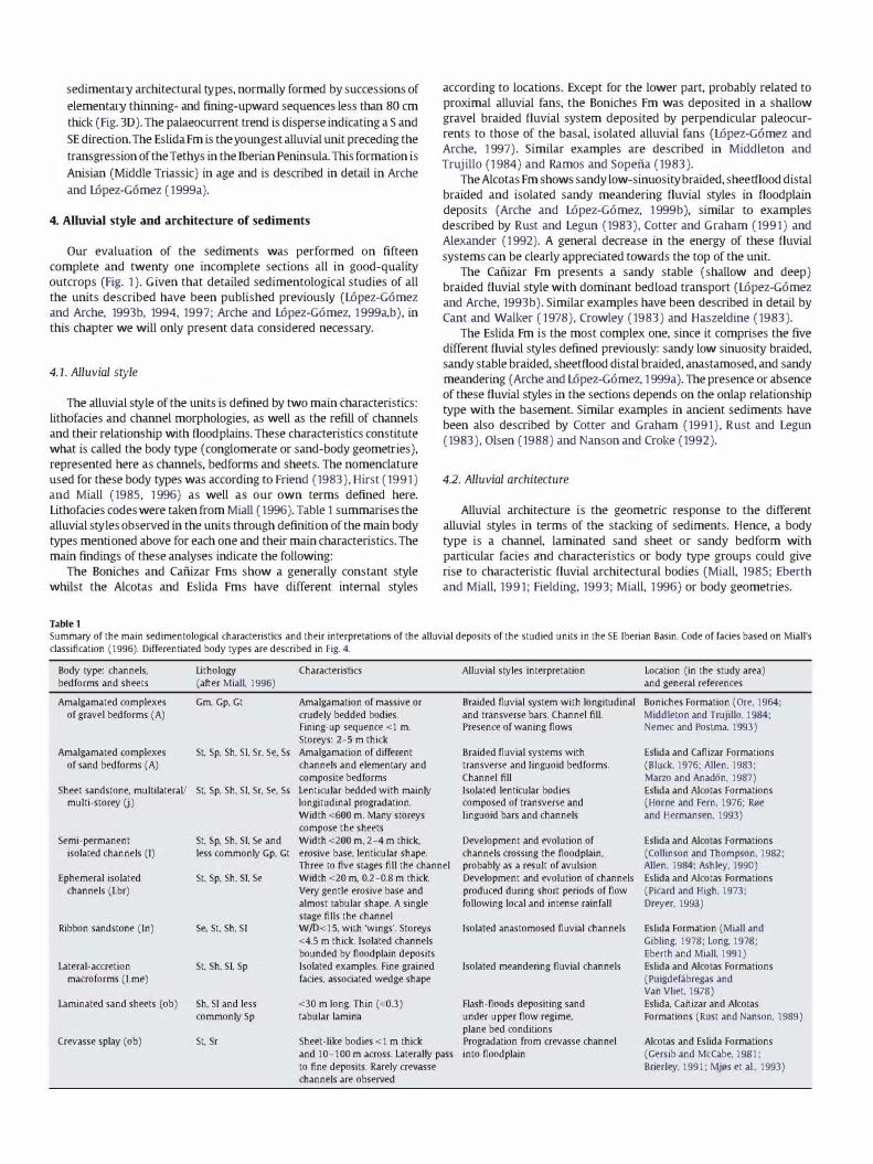
sedimentary architectural types, normally formed by successions of
elementary thinning- and fining-upward sequences less than 80 cm
thick (Fig. 3D). The palaeocurrent trend is disperse indicating a S and
SE direction. The Eslida Fm is the YOlll1gest alluvial unit preceding the
transgression of the Tethys in the Iberian Peninsula. This formation is
Anisian (Middle Triassic) in age and is described in detail in Arche
and L6pez-G6mez (1999a).
4. Alluvial style and architecture of sediments
Our evaluation of the sediments was performed on fifteen
complete and twenty one incomplete sections all in good-quality
outcrops (Fig. 1). Given that detailed sedimentological studies of all
the units described have been published previously (L6pez-G6mez
and Arche, 1993b, 1994, 1997; Arche and L6pez-G6mez, 1 999a,b), in
this chapter we will only present data considered necessary.
4.1. Alluvial style
The alluvial style of the units is defined by two main characteristics:
lithofacies and channel morphologies, as well as the refill of channels
and their relationship with flood plains. These characteristics constitute
what is called the body type (congiomerate or sand-body geometries),
represented here as channels, bedforms and sheets. The nomenclature
used for these body types was according to Friend (1983), Hirst (1991)
and Miall (1985, 1 996) as well as our own terms defined here.
Lithofacies codes were tal<en from Miall (1996). Table 1 summarises the
alluvial styles observed in the units through definition of the main body
types mentioned above for each one and their main characteristics. The
main findings of these analyses indicate the following:
The Boniches and Cafiizar Fms show a generally constant style
whilst the Alcotas and Eslida Fms have different internal styles
Table 1
according to locations. Except for the lower part, probably related to
proximal alluvial fans, the Boniches Fm was deposited in a shallow
gravel braided fluvial system deposited by perpendicular paleocur
rents to those of the basal, isolated alluvial fans (L6pez-G6mez and
Arche, 1 997). Similar examples are described in Middleton and
Trujillo (1 984) and Ramos and Sopefia (1983).
The Alcotas Fm shows sandy low-sinuosity braided, sheetflood distal
braided and isolated sandy meandering fluvial styles in floodplain
deposits (Arche and L6pez-G6mez, 1 999b), similar to examples
described by Rust and Legun (1983), Cotter and Graham (1991) and
Alexander (1 992). A general decrease in the energy of these fluvial
systems can be clearly appreciated towards the top of the unit.
The Cafiizar Fm presents a sandy stable (shallow and deep)
braided fluvial style with dominant bed load transport (L6pez-G6mez
and Arche, 1993b). Similar examples have been described in detail by
Cant and Walker (1978), Ccowley (1983) and Haszeldine (1983).
The Eslida Fm is the most complex one, since it comprises the five
different fluvial styles defined previously: sandy low sinuosity braided,
sandy stable braided, sheetflood distal braided, anastamosed, and sandy
meandering (Arche and L6pez-G6mez, 1 999a). The presence or absence
of these fluvial styles in the sections depends on the onlap relationship
type with the basement. Similar examples in ancient sediments have
been also described by Cotter and Graham (1991), Rust and Leglll1
(1983), Olsen (1988) and Nanson and Ccoke (1992).
4.2. Alluvial architecture
Alluvial architecture is the geometric response to the different
alluvial styles in terms of the stacking of sediments. Hence, a body
type is a channel, laminated sand sheet or sandy bedform with
particular facies and characteristics or body type groups could give
rise to characteristic fluvial architectural bodies (Miall, 1985; Eberth
and Miall, 1991; Fielding, 1993; Miall, 1 996) or body geometries.
SummalY of the main sedimentological characteristics and their interpretations of the alluvial deposits of the studied units in the SE Iberian Basin. Code of fades based on Miall's classification (1996). Differentiated body types are described in Fig. 4.
Body type: channels, bedforms and sheets
Amalgamated complexes of gravel bedforms (A)
Amalgamated complexes of sand bedforms (A)
lithology (after Miall, 1996)
Gm, Gp, Gt
St, Sp, Sh, SI, Sr, Se, Ss
Sheet sandstone, multilateral! St, Sp, Sh, SI, Sr, Se, Ss multi-storey (j)
Semi-permanent isolated channels (I)
Ephemeral isolated channels (I.br)
Ribbon sandstone (In)
Lateral-accretion macroforms (I.me)
Laminated sand sheets (ob)
Crevasse splay (ob)
St, Sp, Sh, SI, Se and less commonly Gp, Gt
St, Sp, Sh, SI, Se
Se, St, Sh, SI
St, Sh, SI, Sp
Sh, SI and less commonly Sp
St, Sr
Characteristics
Amalgamation of massive or crudely bedded bodies. Fining-up sequence <1 m. Storeys: 2-5 m thick Amalgamation of different channels and elementalY and composite bedforms Lenticular bedded with mainly longitudinal progradation. Width <600 m. Many storeys compose the sheets Width <200 m, 2-4 m thick, erosive base, lenticular shape. Three to five stages fill the channel Width <20 m, 0.2-0.8 m thick. VelY gentle erosive base and almost tabular shape. A single stage fills the channel W /D<15, with 'wings'. Storeys <4.5 m thick. Isolated channels bounded by flood plain deposits Isolated examples. Fine grained fades, assodated wedge shape
<30 m long. Thin «0.3) tabular lamina
Sheet-like bodies <1 m thick and 10-100 m across. Laterally pass to fine deposits. Rarely crevasse channels are observed
Alluvial styles interpretation
Braided fluvial system with longitudinal and transverse bars. Channel fill. Presence of waning flows
Braided fluvial systems with transverse and Iinguoid bedforms. Channel fill Isolated lenticular bodies composed of transverse and Iinguoid bars and channels
Development and evolution of channels crossing the floodplain, probably as a result of avulsion Development and evolution of channels produced during short periods of flow following local and intense rainfall
Isolated anastomosed fluvial channels
Isolated meandering fluvial channels
Flash-floods depositing sand under upper flow regime, plane bed conditions Progradation from crevasse channel into floodplain
Location (in the study area) and general references
Boniches Formation (Ore, 1964: Middleton and Trujillo, 1984: Nemec and Postma, 1993)
Eslida and (aflizar Formations (Bluck, 1976: Alien, 1983: Marzo and Anad6n, 1987) Eslida and Alcotas Formations (Home and Fern, 1976: R0e and Hermansen, 1993)
Eslida and Alcotas Formations (Collinson and Thompson, 1982: Alien, 1984: Ashley, 1990) Eslida and Alcotas Formations (Picard and High, 1973: Dreyer, 1993)
Eslida Formation (Miall and Gibling, 1978: Long, 1978: Eberth and Miall, 1991) Eslida and Alcotas Formations (Puigdefabregas and Van Vliet, 1978) Eslida, Caf'iizar and Alcotas Formations (Rust and Nanson, 1989)
Alcotas and Eslida Formations (Gersib and Mc(abe, 1981: BrierIey, 1991: Mj0s et al., 1993)
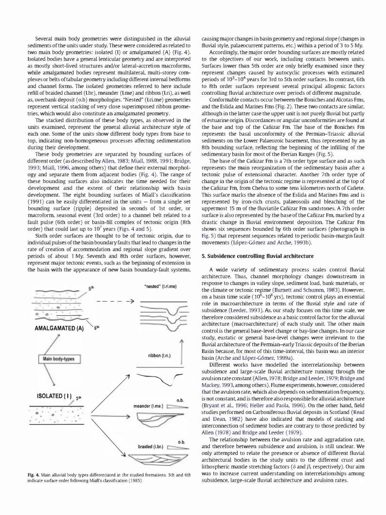
Several main body geometries were distinguished in the alluvial
sediments of the units under study. These were considered as related to
two main body geometries: isolated (I) or amalgamated (A) (Fig. 4).
Isolated bodies have a general lenticular geometry and are interpreted
as mostly short-lived structures and/or lateral-accretion macroforms,
while amalgamated bodies represent multilateral, multi-storey com
plexes or belts of tabular geometry including different internal bedforrns
and channel forms. The isolated geometries referred to here include
refill of braided channel (I.br), meander (I.me) and ribbon (I.ri), as well
as, overbank deposit (o.b) morphologies. "Nested" (I.ri.me) geometries
represent vertical stacking of very close superimposed ribbon geome
tries, which would also constitute an amalgamated geometry.
The stacked distribution of these body types, as observed in the
units examined, represent the general alluvial architecture style of
each one. Some of the units show different body types from base to
top, indicating non-homogeneous processes affecting sedimentation
during their development.
These body geometries are separated by bounding surfaces of
different order (as described by Allen, 1983; Miall, 1988, 1991; Bridge,
1993; Miall, 1 996, among others) that define their external morphol
ogy and separate them from adjacent bodies (Fig. 4). The range of
these bounding surfaces also indicates the time needed for their
development and the extent of their relationship with basin
development. The eight bounding surfaces of Miall's classification
(1991) can be easily differentiated in the units - from a single set
bounding surface (ripple) deposited in seconds of 1st order, or
macroform, seasonal event (3rd order) to a channel belt related to a
fault pulse (6th order) or basin-fill complex of tectonic origin (8th
order) that could last up to 1 07 years (Figs. 4 and 5).
Sixth order surfaces are thought to be of tectonic origin, due to
individ ual pulses of the basin boundary faults that lead to changes in the
rate of creation of accommodation and regional slope gradient over
periods of about 1 My. Seventh and 8th order surfaces, however,
represent major tectonic events, such as the beginning of extension in
the basin with the appearance of new basin boundary-fault systems,
"nested" (1.rLme)
---- -':>
� AMALGAMATED (A) '" 6"
ribbon (tri.)
ISOLATED ( I) 5" f /�. meander (Lme.) =
> � � ob � bra;ded (Lbr.) ==--
o o
Fig. 4. Main alluvial body types differentiated in the studied formations. 5th and 6th indicate surface order following Miall's classification (1985).
causing major changes in basin geometry and regional slope (changes in
fluvial style, palaeocurrent patterns, etc.) within a period of 3 to 5 My.
Accordingly, the major order bounding surfaces are mostly related
to the objectives of our work, including contacts between units.
Surfaces lower than 5th order are only briefly examined since they
represent changes caused by autocyclic processes with estimated
periods of 103_1 04 years for 3rd to 5th order surfaces. In contrast, 6th
to 8th order surfaces represent several principal allogenic factors
controlling fluvial architecture over periods of different magnitude.
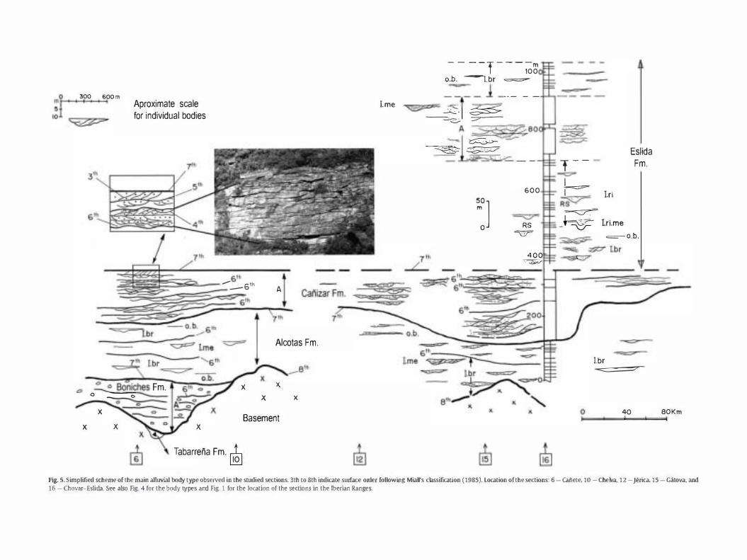
Conformable contacts occur between the Boniches and Alcotas Fms,
and the Eslida and Marines Fms (Fig. 2). These two contacts are similar,
although in the latter case the upper unit is not purely fluvial but partly
of estuarine origin. Discordances or angular unconformities are found at
the base and top of the Cafiizar Fm. The base of the Boniches Fm
represents the basal lll1conformity of the Permian-Triassic alluvial
sediments on the Lower Palaeozoic basement, thus represented by an
8th bounding surface, reflecting the beginning of the infilling of the
sedimentary basin for most of the Iberian Ranges (Fig. 5).
The base of the Cafiizar Fm is a 7th order type surface and as such
represents the main reorganization of the sedimentary basin after a
tectonic pulse of extensional character. Another 7th order type of
change in the origin of the tectonic regime is represented at the top of
the Cafiizar Fm, from Chelva to some tens kilometres north of Cafiete.
This surface marks the absence of the Eslida and Marines Fms and is
represented by iron-rich crusts, palaeosoils and bleaching of the
uppermost 15 m of the fluviatile Cafiizar Fm sandstones. A 7th order
surface is also represented by the base of the Cafiizar Fm, marked by a
drastic change in fluvial environment deposition. The Cafiizar Fm
shows six sequences bounded by 6th order surfaces (photograph in
Fig. 5) that represent sequences related to periodic basin-margin fault
movements (L6pez-G6mez and Arche, 1 993b).
5. Subsidence controlling fluvial architecture
A wide variety of sedimentary process scales control fluvial
architecture. Thus, channel morphology changes downstream in
response to changes in valley slope, sediment load, bank materials, or
the climate or tectonic regime (Bumett and Schumm, 1983). However,
on a basin time scale (106_108 yrs), tectonic control plays an essential
role in macroarchitecture in terms of the fluvial style and rate of
subsidence (Leeder, 1993). As, our study focuses on this time scale, we
therefore considered subsidence as a basic control factor for the alluvial architecture (macroarchitecture) of each study lll1it The other main
control is the general base-level change or bay-line changes. In our case
study, eustatic or general base-level changes were irrelevant to the
fluvial architecture of the Perrnian-early Triassic deposits of the Iberian
Basin because, for most of this time-interval, this basin was an interior
basin (Arche and L6pez-G6mez, 1 999a).
Different works have modelled the interrelationship between
subsidence and large-scale fluvial architecture running through the
avulsion rate constant (Allen, 1978; Bridge and Leeder, 1 979; Bridge and
Mackey, 1993, among others). Flume experiments, however, considered
that the avulsion rate, which also depends on sedimentation frequency,
is not constant, and is therefore also responsible for alluvial architecture
(Bryant et al., 1996; Heller and Paola, 1996). On the other hand, field
studies performed on Carboniferous fluvial deposits in Scotland (Read
and Dean, 1 982) have also indicated that models of stacking and
interconnection of sediment bodies are contrary to those predicted by
Alien (1978) and Bridge and Leeder (1979).
The relationship between the avulsion rate and aggradation rate,
and therefore between subsidence and avulsion, is still unclear. We
only attempted to relate the presence or absence of different fluvial
architectural bodies in the study units to the different crust and
lithospheric mantle stretching factors (0 and p, respectively). Our aim
was to increase current understanding on interrelationships among
subsidence, large-scale fluvial architecture and avulsion rates.
o
,�f 300 600 m I I Aproximate scale
for individual bodies
x
==
:::""'0 Bonich� Fm. o 0 �
x x x
6th
......... _Gill
A
Ih
Alcotas Fm.
x x x x
Basement
Tabarreiia Fm . ..i. l!QJ
I.me
7th
----
T----m 100
o.b. �.br �
� �-:-t -� ----.o.....:.. . �
__ �_. � ::;;:>;;:-.c..-_ A �80
��"" . ----.,.,j � .. � _l.� __
�] 600
"'=C7'" RS
-=v=
400 �
T--'"""'""
Eslida Fm.
� I I.ri � --<J" J� I.ri.me
G :::?
o
=-o.b.
= I.br -==-=-=-
40 80Km ! I
FIg. S.Simplified scheme of the main alluvial body type observed in (he studied sections. 3th [0 8th indicate surface order following Miall's classification (1985). Location of the sections: 6 - canere, 10 -Chelva. 12 -Jerica, 15 - Gatova. and 16 -Chovar-Eslida. See also Fig. 4 for the body types and Fig. 1 for rhe location of the sections in the Iberian Ranges.
6. Depth-dependent subsidence analysis
6.1. Methodology
Changes in basin subsidence during the Permian and Mesozoic
were analysed by the backstripping technique (Steckler and Watts, 1978; Bond and Kominz, 1 984) on data obtained from complete wells
and stratigraphic sections. To isolate the effect of tectonics on
subsidence history, we had to correct for the effects of superimposed
eustatic oscillations, palaeobathymetry changes and sediment com
paction with increasing loading.
Palaeobathymetry was estimated from sedimentary facies, fossils
and depositional environments as always less than 75 m for the
different middle Mesozoic to Cenozoic marine intervals. Eustatic sea
level variations for the marine intervals were not introduced since
estimated fluctuations are less than 100 m and would similarly affect
all the wells and sections. The possible upstream effects of these
variations in post-Triassic sediments are of no concern for this paper.
The Permian and Early Triassic basins were far away from the
Paleotethys sea and were not affected by sea-level fluctuations.
Porosity-depth relations used for compaction corrections were
defined according to Sclater and Christie (1980).
Since during the Cenozoic, tectonic patterns other than rifting
(basin inversion in the Iberian Basin and foreland sedimentation in
the Ebro Basin) and flexural and topographical effects took place
(van Wees and Beekman, 2000), we omitted this period from our
study.
After constructing total subsidence and air-loaded tectonic
subsidence curves by backstripping and defining extensional phases
in the tectonic subsidence curves, we calculated stretching factors
(0 for the crust, f3 for the lithospheric mantle) for each synrift and
postrift phase and for each section or well by forward modelling (van
Wees et al., 1 996). Using this model, an unlimited number of
stretching phases can be introduced and the model automatically
finds the best fit stretching parameters for the subsidence data, that is, f3 = 0 or f3;;j::. o. This means that subsidence is conditioned by
mechanisms corresponding to either a single layer (i.e., the crust
and lithospheric mantle show a similar rheological response) or two
layers (i.e., the crust and lithospheric mantle show a different
rheological response). We do not provide the calculus method in
this paper, since it is well described in van Wees et al. (1998), Vargas
(2002) and Vargas et aL (2009).
For the forward modelling, we assumed an initial crustal thickness
of 32 km corresponding to its present-day value beneath the Iberian
Massif (Banda et al., 1983), a thickness also adopted for the Iberian
Ranges by Salas and Casas (1993), van Wees and Stephenson (1995)
and van Wees et al. (1998), and an initial lithospheric thickness of
1 1 0 km used for the Iberian Basin by Morgan and Fernandez (1992),
van Wees and Stephenson (1 995) and van Wees et al. (1998). The
other parameters used in the model shown in Table 2 were obtained
from van Wees and Stephenson (1995).
Table 2 Parameters used in the fOlward model (obtained from van Wees and Stephenson. 1995).
Parameter
Initial crust thickness Initial lithospheric thickness Asthenospheric temperature Thermal diffusivity Surface crustal density Surface mantle density Water density Thermal expansion coefficient
Value
32 km 110 km 1333 QC 1x10⁶m2s-1 2800 kg m-3 3400 kg m-3 1030 kg m-3 3.2x10-sQC
6.2. Subsidence curves and phases
To obtain a wide range of subsidence data, we selected and analysed
eleven sections and five bore holes. Sections are mainly located in the
centre of the study area, while boreholescorrespond to the western and
northeastern flanks of the Permian-Triassic basin (Fig. 1), where the
Cenozoic cover does not allow for direct observation.
Fig. 6 shows the tectonic subsidence curves obtained for each section
or well. Most of these computations as well as the phases observed in
the subsidence analysis for the whole Permian and Triassic of this basin
were described in van Wees etal. (1998), Vargas (2002) and Vargas et al.
(2009), so the details can be found in these bibliographic references. Our
subsidence analysis indicates that the Iberian Basin experienced a
number of pulsating phases of rapid tectonic subsidence followed by
slower thermal subsidence phases from the Late Permian to Lower
Triassic (Fig. 7). These changes in subsidence rate can, in most cases, be
correlated over the entire study area.
There are two zones (Molina de Arag6n and Cafiete) in which
extension started during the Lower Permian (Autunian phase) (290-
290 285 275 265 255 245 PERMIA
:Vertical: : scale:
, , Om :
100 :
200 : , 300 :
400 : , , 500 : , 600 ' 62Q :
235 225 RI
215 205.7 M.a.
Torr·1 ---'h--��--; Ahl.
El Hilo '-:-----O�__.j Mol.
Maj.
Cama.
Teruel
Mont.
Miram. Chalva
Manzan.
Jenca
Boba.-2 Salsad.
Gtltova
�--+-�"--,o-OCh6-Esl
Ag. 6. Tectonic subsidence curves for the different studied sections for the PermianTriassic interval. See Fig. 1 for the location of the sections.
NW. SE.
Torr-1 Alh. El Hito Mol. Maj. Ca. Ter. Mont. Mir. Chel. Man. Jerica 80-2 Sals. Gat. Ch-Es.
Q Lad. U �r-- ---:! Anis. go!s" ::: :: ::::::ll:
ThOr.
r--����� z :> " '" w a.. Aut.
• •
I
Legend
• Synrift Autunian phase
• Synrift ThOringian phase
I!ISynrift ThOr-Scythian phase
o Synrifl Scythian-Ladinian phase o Synrift Lad. phase (Torr-1 well)
� Poslrift phases
Fig. 7. Synrift and postrift identified phases in the different studied sections for the Permian-Middle Triassic interval. See Fig. 1 for the location of the sections.
270 M.a.). However, the first generalized phase for most of the study
area (Thiiringian phase) (255-254 M.a.) was short in time and
includes most of the Late Permian sediments of the study area
represented by the Boniches and Alcotas Fms. A punctual (not studied
here) phase (Thiiringian-Scythian) (244.8-238.5 M.a.) was differen
tiated for the Molina de Aragon-Majadas area. The last phase studied
(Scythian-Lldinian) is related to the Cafiizar and Eslida Fms. This
phase was interrupted in some areas (e.g., Chelva and Cafiete) or
linked to a "postrift" phase (e.g., Montalban, Chovar-Eslida) (Fig. 7).
6.3. Crust and lithospheric mantle stretching factors
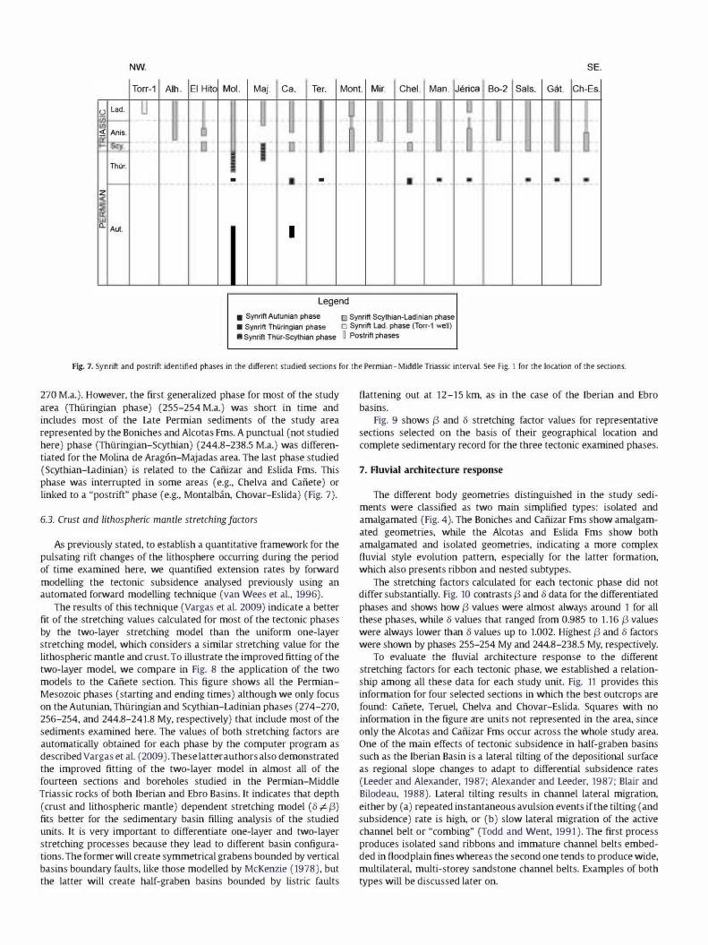
As previously stated, to establish a quantitative framework for the
pulsating rift changes of the lithosphere occurring during the period
of time examined here, we quantified extension rates by forward
modelling the tectonic subsidence analysed previously using an automated forward modelling technique (van Wees et al., 1996).
The results of this technique (Vargas et al. 2009) indicate a better
fit of the stretching values calculated for most of the tectonic phases
by the two-layer stretching model than the uniform one-layer
stretching model, which considers a similar stretching value for the
lithospheric mantle and crust. To illustrate the improved fitting of the
two-layer model, we compare in Fig. 8 the application of the two
models to the Cafiete section. This figure shows all the Permian
Mesozoic phases (starting and ending times) although we only focus
on the Autunian, Thiiringian and Scythian-Ladinian phases (274-270,
256-254, and 244.8-241.8 My, respectively) that include most of the
sediments examined here. The values of both stretching factors are
automatically obtained for each phase by the computer program as
described Vargas et al. (2009). These latter authors also demonstrated
the improved fitting of the two-layer model in almost all of the
fourteen sections and boreholes studied in the Permian-Middle
Triassic rocks of both Iberian and Ebro Basins. It indicates that depth
(crust and lithospheric mantle) dependent stretching model (8#:{3)
fits better for the sedimentary basin filling analysis of the studied
units. It is very important to differentiate one-layer and two-layer
stretching processes because they lead to different basin configura
tions. The former will create symmetrical grabens bounded by vertical
basins boundary faults, like those modelled by McKenzie (1978), but
the latter will create half-graben basins bounded by listric faults
flattening out at 12-15 km, as in the case of the Iberian and Ebro
basins.
Fig. 9 shows {3 and 8 stretching factor values for representative
sections selected on the basis of their geographical location and
complete sedimentary record for the three tectonic examined phases.
7. Fluvial architecture response
The different body geometries distinguished in the study sedi
ments were classified as two main simplified types: isolated and
amalgamated (Fig. 4). The Boniches and Cafiizar Fms show amalgam
ated geometries, while the Alcotas and Eslida Fms show both
amalgamated and isolated geometries, indicating a more complex
fluvial style evolution pattern, especially for the latter formation,
which also presents ribbon and nested sub types.
The stretching factors calculated for each tectonic phase did not differ substantially. Fig. 10 contrasts {3 and 8 data for the differentiated
phases and shows how {3 values were almost always around 1 for all
these phases, while 8 values that ranged from 0.985 to 1.16 {3 values
were always lower than 8 values up to 1.002. Highest {3 and 8 factors
were shown by phases 255-254 My and 244.8-238.5 My, respectively.
To evaluate the fluvial architecture response to the different
stretching factors for each tectonic phase, we established a relation
ship among all these data for each study unit. Fig. 11 provides this
information for four selected sections in which the best outcrops are
found: Cafiete, Teruel, Chelva and Chovar-Eslida. Squares with no
information in the figure are units not represented in the area, since
only the Alcotas and Cafiizar Fms occur across the whole study area.
One of the main effects of tectonic subsidence in half-graben basins
such as the Iberian Basin is a lateral tilting of the depositional surface
as regional slope changes to adapt to differential subsidence rates
(Leeder and Alexander, 1987; Alexander and Leeder, 1987; Blair and
Bilodeau, 1988). Lateral tilting results in channel lateral migration,
either by (a) repeated instantaneous avulsion events if the tilting (and
subsidence) rate is high, or (b) slow lateral migration of the active
channel belt or "combing" (Todd and Went, 1991). The first process
produces isolated sand ribbons and immature channel belts embed
ded in flood plain fines whereas the second one tends to produce wide,
multilateral, multi-storey sandstone channel belts. Examples of both
types will be discussed later on.

IBERIAN RANGE TWO LAYERS CAIliETE
300 250 200 ISO 100 50 0
0 PER IAN TRIASSIC JURASSIC CRETACEOUS TERCIARY
100
200 � 300 • observed
400
...-.-'00
600 beg. age final age • b,ta delta 274 270 1,001 1,002
700 256 254 1 1,027 244,8 241,8 1 1,01
800 238,3 227,4 1,001 1,026 209,6 180.1 0,88 1,017
900 127 126 1,004 1,014 98,9 88 0,997 1,027
ONE LAYER CAIliETE 300 250 200 150 100 50 0
0 " "N TRIASSIC JURASSIC CRETACEOUS TERCIARY
100
200 � 300 • observed
400 • • • •
500 • I .
600 beg. age final age bela delta 700
274 270 1,003 1,003 256 254 1,033 1,033
244,8 241,8 1,01 1,01 800 238,3 227.4 1.028 1,028
209,6 180,1 1,028 1,028 900 127 126 0,997 0,997
98,9 88 1,035 1,035
Fig. 8. Comparison of the application of both two-layer and uniform (one-layer) stretching models to the (afiete section to demonstrate the better fit of the first one.
Tectonic phase 244.8-241.8 My is the only one showing amalgam
ated forms as the only geometry. For this case, f3 and 0 values are similar
and very close to 1, indicating that extension was short and that the
lithosphere deformed as a single layer instead of two differentiated
layers corresponding to the crust and lithospheric mantle.
�s Autunian Wells 0 �
Torr-1 ... ... 0
...
P l .I
"9
. ,
Legend o SC),lian·Ladinian Phase !J. Thilringian-(Sc)'lian) Phase • Thnringian Phase
Autunian Phase
"8�------�-------,-------, 0.9 1 .1 1.2 S
Fig. 10. Contrasted values of j3 and {; factors for the differentiated phases.
Sections showing the most varied architectural geometries,
including ribbon and nested forms, corresponded to the highest f3 and 0 factors (Chovar-Eslida section of the Cafiizar and Eslida Fms),
also reflecting tectonic phases of greater stretching and subsidence. In
contrast, the same amalgamated geometry type observed in the
Cafiizar and Eslida Fms, both consisting of sandstones of similar
characteristics and thicknesses, could have formed over short and
long periods of time, i.e., less than 1 My for the Eslida Fm and more
than 3 My for the Cafiizar Fm.
Tectonic phases with a wider variety of fluvial geometries, such as
phases 244.8-227.4 and 244.8-238.5 My, showed a greater difference
in f3 and 0 factors, indicating stages of basin development related to
different crust and lithospheric mantle activity. Conversely, when the f3 and 0 factors were close (phase 244.8-241.8 My), a reduced
tendency to show different geometries was observed.
Collectively, our field and laboratory data suggest that although
general subsidence in some way controls the resultant fluvial
geometry of the Permian and Triassic alluvial sediments of the Iberian
Ranges, there is no simple direct relationship between the two factors.
The only correlation found was between crustal and lithospheric
mantle activity - reflected by their stretching factors - and fluvial
geometry. It would appear that, besides subsidence, we need to
consider a combination of other factors such as the rate of avulsion,
climate, or budget of sediments to predict the alluvial architecture of a
basin.
Rates of avulsion are predicted to be high if rates of subsidence and
induced lateral tilting are high. This is the case of the Eslida Fm. (Middle
Triassic, Anisian) in the central-SE Iberia, especially in the lower two
thirds of the formation (Arche and L6pez-G6mez, 1 999a,b), where four
superimposed sedimentary cycles of coarsening-thickening type show
isolated fluvial channel sandstone bodies, paleocurrent dispersion
ThUringian Scytian-Ladinian � 0 �
... ... . ..
Mol 1.03 0.989 1.01 1 1 .026 1 .042 0.996
Alh ... ... ... ... 1 .022 0.87
Ca 1.002 1 .001 1 .027 1 1.01/1 .026 111.001
Te' ... ... 1 .04 0.997 1 .056 0.992
Chel ... ... 1 .02 1 .002 1 .005/1 .025 1 .001/0.998
Ch-Esl ... ... 1.017 0.984 1 .067/1 .009 1 .00210.915
Fig. 9. Values of j3 and {; factors calculated for the differentiated phases in the selected most representative sections.

I� F O R M A T I O N S Bonlches Fm. Alcotas Fm.
256-254 &=1 .027 �=l �� .s � c � <.>
' . . \-?'7???
255-254 not represented in 0=1.04 13=0.997
0; 2 this section
�<= U) ,!! z 0 � -I-<.J 256-254 w � 0=1.02 1\=1.002 U) .2: � � �c:: <.>
. . . -....... � ' . .
255-254 � &=1.017 �=0.985 :!! not represented in 0; w this section
=<c:: � � � � <.>
CaiUzar Fm.
244.8-241.8 l)=I.Ol �=I
244.8-227.4 5=1.057 �=0.992
244.8-241.8 0=1.005 � 1.001
244.8-238.5 0=1.081 1\=1.003
Eslida Fm.
not represented in this section
� --+ c: ---� '.:"':' " ':" :
... : . . . .. . --+ �
not represented in this section
..... . . . .. . <::@ � ::,.:,:.:. ":
---
"-=if � � ", .: . . . . ' , --+ \ -"?'?7??'
Fig. 11. Contrasted synrift phases, j3 and {j stretching factors values and alluvial body types for the studied units in the most representative sections. See Fig. 4 for the classification (meaning) of the body types.
ranging from gog to 140c degrees and channeljfioodplain rates lower
than 1 0%, all consistent with high rates of subsidence and lateral tilting
of the flood plain surface.
The rapid changes in basin configuration due to active subsidence
in a half-graben basin in this period is well illustrated in Arche and
L6pez-G6mez (1 999a,b), especially the lateral onlapping on the
basement of the Eslida Formation.
A contrasting case, where low rates of subsidence and of lateral
tilting lead to a "combing" process of sedimentation resulting in
amalgamated multilateral, multi-storey fluvial sandstone fluvial
sandstone bodies are found in the Cafiizar Sandstone Formation
(L6pez-G6mez and Arche, 1 993a) and the upper third of the Eslida
Formation, also displaying a narrowed paleocurrent dispersion (60g-
90g). The internal major bounding erosional surfaces are interpreted
as rapid geomorphic response to tectonic subsidence pulses in the
basin boundary fault.
8. Discussion
The vertical alluvial record of the Permian-Early Triassic period in
the SE Iberian Basin and the geometry and internal structure of the
alluvial sandstone bodies is the result of the complex interaction
between two main factors: subsidence (a pure tectonic process) and
changes in the regional and/or general base level (a mixed climatic
tectonic process) (Schumm, 1977; Bull, 2007). Avulsion rate is
another independent factor controlling the character of the alluvial
vertical succession for Heller and Paola (1 996).
Sea-level changes (general sea-level changes) are irrelevant in our
case because the alluvial sediments studied here were deposited in
continental interior basins (Permian), hundreds of kilometres away
from the Paleothethys sea (Triassic) (Arche and L6pez-G6mez, 1996,
1999a.b). Subsidence is the main control of the overall vertical successions
and sandstone body geometries in the studied sediments. Amalgam-
ated, complex tabular geometries are formed only with values of f3 and
8 very close to 1 (very slow subsidence) both in the Cafiizar Fm. for a
period of about 3 M Y and the top of the Eslida Fm., for a much shorter
time span (Fig. 1 1 ). In the former case, the synrift period was one of
very low extension rate and subsequent small creation of accommo
dation, whereas the latter is situated at the end of the synrift period,
when extension rates seemingly decreased significantly. In both cases,
factors f3 and 8 have values lightly > 1 .
An important aspect of our study is that, in the interpreted two
layer configuration of the extensional lithospheric mechanism, the
variations of the f3 factor, that is, of the behaviour of the lower part of
the lithospheric plate, do not have any influence on the vertical
stacking and the internal geometry of the alluvial sediments in our
case, because any configuration can be found with f3 values > 1 or <1 .
For example, ribbon and isolated geometries in the Alcotas and Eslida
Fms. or amalgamated geometries in the Cafiizar Fm. (Fig. 1 1). Instead,
this two-layer stretching process is responsible of the large half
graben configuration of the Permian-Triassic Iberian Basin.
As a consequence, we can affirm that only the 8 factor is relevant in
the analysis of the tectonic control of the vertical successions and
internal geometries of the alluvial sediments studied in this paper
and, may be, in other similar sediments; that is, that only the
mechanical behaviour of the upper lithospheric layer has influence on
the alluvial succession geometries. The importance of tectonic
subsidence in fluvial styles on semi-arid enclosed basins is well
illustrated, for example, by Lopez et al. (2008) in the Lower Permian
Lodeve Basin, SE France. Lateral tilting caused by subsidence is the
direct factor controlling fluvial architecture in these basins.
Values of the 8> 1.017 lead to isolated sandstone body geometries
with different types of internal refill: braided (I.br.), meandering (I.me)
and ribbon (I.ri.) in the Alcotas and Eslida Fms (Figs. 5 and 1 1) probably
due mainly to multiple changes of regional slope and subsequent
increased instability and avulsion events. The importance of regional
slope changes in avulsion processes is pointed out by Mackey and Bridge
(1995) and Slingerhand and Smith (1 998), but is considered as
secondary factor by Heller and Paola (1996).
Here it is necessary to consider the combined importance of
climatic factor in avulsion processes leading to the creation of
multiple, isolated sandstone bodies embedded in floodplain-lacus
trine siltstones. Heller and Paola (1 996) stress that avulsion frequency
is more strongly controlled by variations in sedimentation rate that by
the total amount of sediments entering the basin. The climate was
strongly seasonal in the Iberian Basin in this period (Arche and Lopez
Gomez, 1 999a,b), favouring sudden rain outburst that caused crevasse
splays and the initiation of avulsion processes, already propitiated by
regional slope changes of tectonic origin.
The isolated sandstone body geometries compare well with the
configurations of ribbon bodies described by M6ring et al. (2000) in
the late Oligocene Guadalupe-Matarrefia system of the Ebro basin,
Spain, in which there are also examples of the "nested" geometries in
some ribbons. These latter geometries result from repeated re
occupation of the abandoned channel tracts by new, active stream
sections emplaced in the flood plain after an avulsion episode, as
illustrated by present-day examples of western Brazil (Assine, 2005)
and NE India Gain and Sinha, 2003, 2004).
The overall vertical record of the alluvial sediments of the Permian
Early Triassic period of the Iberian Basin is controlled by changes in the 8
factor of the crustal basement during synrift periods, that induce lateral
tilting of the floodplain surface at different rates, whereas the internal
geometry of the infilling of the isolated sandstone bodies can be the
results of combined tectonic and climatic factors.
9. Conclusions
Our study is centred on the alluvial Permian and Triassic sediments
of the SE Iberian Ranges and represents a first attempt at evaluating
relationships between fluvial architecture and subsidence through
detailed sedimentological field data and backstripping automated
forward modelling. Using this combined approach, we were able to
relate fluvial geometries to crust and lithospheric mantle stretching
factors (8 and 13 respectively). The main conclusions to be drawn from
our findings are:
- Depending on the tectonic phase, subsidence differently affected
the two lower and upper layers of the lithosphere, rather than
similarly affecting homogeneously the entire lithosphere. This two-layer configuration explains the half-graben nature of the
Iberian Basin in the Permian-Triassic times.
- A complex interaction between subsidence and changes in
regional base level (including its control by avulsion and climatic
factors) is the cause of the vertical alluvial record and the
geometry and internal structure of the conglomerate and
sandstone bodies of the Permian-Early Triassic sediments in the
SE Iberian Basin.
- Regional base-level changes in the Permian-Early Triassic Iberian
Basin were created by tectonic movements that induced lateral
tilting of the floodplain surface while sea-level changes were
irrelevant to the nature of the alluvial record.
- Amalgamated, complex tabular geometries in the alluvial sediments
are formed only with 13 and 8 very close to 1 (but > 1) values (very
slow subsidence), in the Cafiizar and Eslida Fms. showing similar
characteristics and thicknesses. Although extension rates were
different in each case, this suggests that extension was limited,
short-lived and that the lithosphere moved as a single layer.
- This same amalgamated geometry types observed in the Cafiizar
and Eslida Fms were deposited over both long (about 3 My) and
short (less than 1 My) periods of time, respectively. This might
imply that some geometries are not always time-dependent.
- Variations in the lower part of the lithospheric plate (13 factor), in
our case, do not have any relevance on the vertical stacking and the
internal geometry of the alluvial sediments but only on the general
configuration of the sedimentary basin. Any configuration (ribbon,
isolated, amalgamated geometries) can be found with 13 values > 1
or <1 . Only the extension rates of the upper crust (8 factor) are
relevant on the vertical stacking and the internal geometry of the
alluvial sediments.
- Values of 8 factor > 1.017, in our study, led to isolated sandstone
bodies geometries, including different types of internal refill
(braided, meandering, and ribbon). Multiple changes of regional
slope led to an increase in the instability of fluvial channels and
avulsion events. A climate control, superimposed to the tectonic
component, could exert some control on the type of internal refill.
- Sections showing the most varied architectural geometries,
including ribbon and nested forms, are related to higher 13 and 8
factors indicating tectonic phases of greater stretching and
subsidence values.
- Tectonic phases of wider ranging fluvial geometries were
associated with more largely differing 13 and 8 factors which also
suggests stages of basin development in which crust and upper
mantle activities differed. Conversely, closer 13 and 8 factors were
related to a tendency towards amalgamation and reduced
variation in fluvial geometries.
Acknowledgements
Tectonic subsidence and forward modelling were conducted at the
Faculteit der Aardwetenschappen, Vrije Universiteit, Amsterdam in
collaboration with Drs. SAP.L. Qoetingh, J.D. van Wees and J. Gaspar
Esaibano. We thank these colleagues for their help and kind hospitality
during the stay of Dr. Vargas at the Vrije Universiteit. This research was
supported by projects CGL2005-01520BTE and CGL2008-00093BTE. We
would like to thank the commentaries of Gert Jan Weltje and an
anonymous reviewer that improved an earlier version of this manu
script. We also thank Ana Burton for reviewing the English.
References
Alexander.].. 1992. Nature and origin ofa laterally extensive alluvial sandstone bodie in the Middle Scalby Formation. J. Geol. Soc. Land. 149. 431-441.
Alexander.].. Leeder. M.R. 1987. Active tectonic control on alluvial architecture. In: Ethridge, F.G., Flores, RM. (Eds.J, Spec. Pub. Soc. Econ. Paleon. Miner., vol. 39, pp. 243-252.
Allen,J.R.L., 1978. Studies in fluvial sedimentation: an exploratory quantitative model for the architecture of avulsion-controlled alluvial studies. Sediment. Geol. 21, 129-147.
Allen,j.R.L, 1983. Gravel overpassing on humpback bars supplied with mixed sediment: examples from the Lower Old Red Sandstone, southern Britain. Sedimentology 30, 285-294.
Alien, j.R.L., 1984. Sedimentary Structures: Their Character and Physical Basis. Development in Sedimentology 30. Elsevier, Amsterdam. 663 pp.
Alien, P.H., Alien, j.R., 1990. Basin Analysis. Principles & Applications. Blackwell Scientific Publications, Oxford. 404 pp.
Arche, A., Uipez-G6mez,].. 1996. Origin of the Permian-Triassic Iberian Basin, centraleastern Spain. Tectonophysics 266, 443-464.
Arche, A., L6pez-G6mez,].. 1999a. Tectonic and geomorphic control on the fluvial styles of the Eslida Formation, Middle Triassic, Eastern Spain. Tectonophysics 315, 187-207.
Arche, A., L6pez-G6mez, ].. 1999b. Subsidence rates and fluvial architecture of riftrelated Permian and Triassic alluvial sediments of the southeast Iberian Range, eastern Spain. Spec. Publ. Int. Assoc. Sedimentol. 28, 183-304.
Ashley. G.M., 1990. Oassification of large-scale subaqueous bedforms: a new look at an old problem. J. Sediment. Petrol. 60, 160-172.
Ashworth, P.J., Best, j.L, jones, M., 2004. Relationship between sediment supply and avulsion frequency in braided rivers. Geology 32, 21-24.
Assine, M.L, 2005. River avulsions on the Taquari megafan, Pantanal wetland. Brazil. Geomorphology 70, 357-371.
Banda, E., Udias, A., Mueller, S., Mezcua, ].. Boloix, M., Gallart, ].. Aparicio, A., 1983. Crustal structure beneath Spain from deep seismic sounding experiments. Phys. Earth Planet. Inter. 31, 277-280.
Blair, T.C, Bilodeau, W.L., 1988. Developments of tectonic cyc10therms in rift, pull-apart and foreland basins: tectonic response to episodic tectonism. Geology 16, 7-16.
Bluck, B.J., 1976. Sedimentation in some Scottish rivers of low sinuosity. Trans. R. Soc. Edimb. Earth Sci. 69, 425-456.
Bond, G., Kominz, MA, 1984. Construction of tectonic subsidence curves for the Early Paleozoic miogeoc1ine, southern canadian Rocky Mountains: implications for subsidence mechanisms, age of break up, and crustal thinning. Geol. Soc. Amer. Bull 95, 155-173.
Boulouard, Ch" Viallard, p" 1982, Reduction ou lacune du Tias Inferieur sur la bordure mediterranne de la Chaine Iberique: Arguments palynologiques, C R. Acad, Sci. Paris 295, 803-808.
Bridge, J,S" 1993, The Interaction Between Channel GeometIY, Water Flow, Sediment Transport and Deposition in Braided Rivers, In: Best, J,L, Bristow, CS, (Eds,), Braided Rivers: GeoL Soc., London, Spec. PubL, voL 75, pp, 13-71,
Bridge,j's" Leeder, M,R, 1979, A simulation model of alluvialstratigraphy, Sedimentology 26, 617-644,
Bridge, jS, Mackey, S,D" 1993, A Revised Alluvial Stratigraphy Model. In: Marzo, M" Puigdefabregas, C (Eds,), Alluvial Sedimentation: Inter. Assoc, Sediment , Spec. Publ, voL 17, pp, 319-336,
Brieriey, GJ" 1991, Floodplain sedimentology of the Squamish river, British Columbia: relevance of element analysis, Sedimentology 38, 735-750,
BIYant, M, Falk, p" Paola, Ch" 1996, Experimental study of avulsion frequency and rate of deposition, Geology 23, 365-368.
Bull, W,B" 2007, Tectonic Geomorphology of the Mountains, Blackwell, Oxford, 316 pp, Burnett, AW" Schumm, SA, 1983, Alluvial river response to neotectonic deformation
in Louisiana and Mississippi, Science 222, 49-50, cant, DJ" Walker, R.G" 1978. Fluvial processes and facies sequences in the sandy
braided South Saskatchewan River, canada, Sedimentology 25, 625-648. Collinson, J,D" Thompson, D,B" 1982, Sedimentary Structures2nd, Unwin & Hyman,
London, 207 pp, Cotter, E" Graham,J,R., 1991, Coastal plain sedimentation in the Late Devonian of southern
Ireland: hummocky cross-stratification in fluvial deposits, Sediment Geol 72, 210-224,
Crowley, KD" 1983, Large-scale bed configurations (macroforms), Platte River Basin, Colorado and Nebraska: primaIY structures and formative processes, GeoL Soc. Amer. Bull. 94, 117-133,
Doubinger,J" L6pez-Gomez, j" Arche, A, 1990, Pollen and spores from the Permian and Triassic sediments of the Iberian Ranges, Cueva de Hierro (Cuenca) to ChelvaManzanera (Valencia) region, Spain, Rev, Paleobot PalynoL 6, 25-45,
Dreyer. T., 1993, Quantified Fluvial Architecture in Ephemeral Stream Deposits of the Esplugafedra Formation (Paleogene), Tremp-Graus Basin, Northern Spain, In: Marzo, M, Puigdefabregas, C (Eds,), Alluvial Sedimentation: Inter. Assoc. Sediment, Spec. PubL, voL 17, pp, 337-362,
Eberth, DA, Miall, AD" 1991, Stratigraphy, sedimentology and evolution of a vertebrate bearing, braided to anastomosed fluvial system, Cutler Formation (Permian-Pennsylvanian), north-central New Mexico, Sediment GeoL 72, 225-252,
Fielding, Ch" 1993, A review of recent research in fluvial Sedimentology, Sediment GeoL 85, 3-14,
Friend, p" 1983, Towards the Field Classification of Alluvial Architecture or Sequence, In: Collinson, J,D" Lewin, J,L (Eds,), Modern and Ancient Fluvial Systems: Spec. PubL Int Assoc. SedimentoL, voL 6, pp, 345-354,
Gersib, GA, McCabe, PJ" 1981, Continental Coal-bearing Sediments of the Port Hood Formation (Carboniferous), Cape Linzee, Nova Scotia, Canada, In: Ethridge, F,G" Flores, R. (Eds,), Recent and Ancient Nonmarine Depositional Environments: Model for Exploration: Spec. PubL Soc. Econ, Paleont Miner., voL 31, pp, 95-108,
Gradstein, F.M" Agterberg, F.P" Ogg, J,G" HardenboL j" Van Veen, p" ThierIY, Huang, j" 1995, Geochronology, time scales and global stratigraphic correlation, SEPM Spec. PubL 54, 95-126,
Guimera, J" Alvaro, M, 1990, Structure et evolution de la compresion alpine dans la Chaine Iberique et de la Chaine Cotiere Catalane (Espagne), Bull. Soc. GeoL France 6, 339-348.
Haszeldine, 1983, Descending Tabular Cross-bed Sets and Bounding Surfaces From a Fluvial Channel in the Upper Carboniferous Coalfield of Northeast England, In: Collinson, J,D" Lewin, J,L (Eds,), Modern and Ancient Auvial Systems: Spec. PubL Int Assoc. SedimentoL, voL 6, pp, 449-456,
Helier, p" Paola, e, 1996, Downstream changes in alluvial architecture: and exploration of controls on channel-stacking patterns, J, Sediment Res, 2, 297-306,
Hirst, J,P,P" 1991, Variations in Alluvial Architecture Across the Oligo-Miocene Huesca Fluvial System, Ebro Basin, Spain. In: Miall, AD" Tyler, N, (Eds,), The ThreeDimensional FaciesArchitecture ofTerrigenous Oastic Sediments, and its Implications for Hydrocarbon DiscoveIY and RecoveIY: Concepts in Sedimentology and Sedimentology 3, Soc, Econ, Paleont Miner" pp, 111-121,
Horne,J,e, Fern,J,e, 1976, carboniferous Depositional Environments in the Pocahontas Basin, Eastern Kentuky and Southern West Virginia, Guidebook Department of Geology, University of South Carolina, Columbia, 62 pp,
Huismans, R.S" Podladchikov, Y.Y., Ooetingh, S,' 2001, Transition from passive to active rifting: relative importance of asthenospheric doming and passive extension of the lithosphere,J, Geophys, Res, 106, 11271-11291,
jain, v., Sinha, R., 2003, Hyperavulsive, anabranching Bajhmati river system, north Bihar plains, Eastern India, Z, Geomorphologie N,F. 47, 101-116,
jain, V" Sinha, R, 2004, Fluvial dynamics of an anabranching river system in Himalayan foreland basi, Baghnati river, north Bihan Plains, India, Geomorphology 60, 147-170,
Leeder, MR., 1993, Tectonic Controls Upon Drainage Basin Development, River Channel Migration and Alluvial Architecture: Implications for Hydrocarbon Reservoir Development and Characterization, In: North, CP" Prosser, DJ, (Eds,), Characterization of Auvial and Aeolian Reservoirs: GeoL Soc. Spec. Pub" voL 73, pp, 7-22,
Leeder, M, Alexander, J" 1987, The origin and tectonic significance of asymmetrical meanderbelts, Sedimentology 34, 217-226,
Long, D,G,F., 1978. Proterozoic Stream Deposits: Some Problems of Recognition and Interpretation of Ancient Sandy Auvial Systems, In: Miall, AD, (Ed,), Fluvial Sedimentology: Mem, can, Soc. Petrol. GeoL, voL 5, pp, 313-342,
Lopez, M,L, Gand, G" Garric,j" Kolmer, F" Schneider,]., 2008. The playa environments of the Lodeve Permian basin (Languedoc, France), J, Iber. GeoL 34 (1), 29-56,
Lopez-Gomez,]., Arche, A, 1993a, Sequence stratigraphic analysis and paleogeographic interpretation of the Buntsandstein and Muschelkalk facies (Permo-Triassic) in the SE Iberian Range, E, Spain, Palaeogeogr. PalaeoclimatoL PalaeoecoL 103, 179-201,
Lopez-Gomez, j" Arche, A, 1993b, Architecture of the Cafiizar fluvial Sheet Sandstones, In: Marzo, M, Puigdefabregas, C (Eds,), Alluvial Sedimentation: Spec. PubL Int Assoc. SedimentoL, voL 17, pp, 317-381,
Lopez-Gomez, ]., Arche, A, 1994, La Formacion Brechas de Tabarrefia (Permico Inferior): DepOsitos de flujos con densidad variable al SE de la Cordillera Iberica, Espafia, BoL R. Soc. Esp, Hist Nat 89, 131-144,
Lopez-Gomez,j" Arche, A, 1997, The Upper Permian Boniches Conglomerates Formation: evolution from alluvial fan to fluvial system environments and accompanying tectonic and climatic controls in the southeast Iberian Ranges, Central Spain, Sediment GeoL 114, 267-294,
Lopez-Gomez,]., Arche, A, Perez-L6pez, A, 2002, Permian and Triassic. In: Gibbons, W,' Moreno, T. (Eds,), The Geology of Spain, Geological Society, London, pp, 185-212,
Mackey, S,D" Bridge, jS, 1995, Three-dimensional model of alluvial stratigraphy: theoIY and applications, J, Sediment Research 65, 7-31,
Marzo, M" Anadon, p" 1987, EvoluciOn y caracteristicas sedimentolOgicas de las facies fluviales basales del Buntsandstein de Olesa de Montserrat (Provincia de Barcelona), Cuad, GeoL Iber. 4, 211-222,
McKenzie, D" 1978. Some remarks on the development of sedimentary basins, Earth Planet Sci. Lett 40, 25-31,
Miall, AD" 1985, Architectural-element analysis: a new method of facies analysis applied to fluvial deposits, Earth Sci. Rev, 22, 261-308.
Miall, AD" 1988. Reservoir heterogeneities in fluvial sandstones: lesson from outcrop studies, Bull. Am. Assoc. Petrol. GeoL 72, 682-697,
Miall, AD" 1991. Sedimentology of Sequence BoundaIY Within the Nonmarine Torrivio Member, Gallup Sandstone (Cretaceous), Sanjuan Basin, New Mexico, In: MialL AD" Tyler, N, (Eds,), The Three Dimensional Facies Architecture of Terrigenous Oastic Sediments and its Implications for Hydrocarbon DiscoveIY and RecoveIY, Concepts in Sedimentology and Palaeontology, Soc, Econ, PalaeontoL Miner. 3, 224-232,
Miall, AD" 1996, The Geology of Fluvial Deposits, SedimentaIY Facies, Basin Analysis and Petroleum Geology, Springer Veriag, New York 582 pp,
Miall, AD" Gibling, M.R., 1978. The Siluro-Devonian clastic wedge of Somerset Island, Artic canada, and some regional paleogeographic implications, Sediment GeoL 21, 85-127,
Middleton, G,V" Trujillo, A, 1984, Sedimentology and Depositional Setting of the Upper Proterozoic Scanlan Conglomerate, Central Arizona, In: Kostner, EH" Steel. R. (Eds,), Sedimentology of Gravel and Conglomerates: Mem. Can, Soc. Petrol. GeoL, voL 10, pp, 189-201,
Mjos, R., Walderhaug, 0" Prestholm, E, 1993, Crevasse Splay Sandstone Geometries in the Middle jurassic Ravenscar Group of Yorkshire, UK In: Marzo, M" Puigdefabregas, C (Eds,), Alluvial Sedimentation: Int Assoc. SedimentoL Spec. PubL, voL 17, pp, 167-184,
Morgan, p" Fernandez, M" 1992, Neogene vertical movements and constrains on extension in the catalan Coastal Ranges, Iberian Peninsula, and the Valencia through (western Mediterranean), Tectonophysics 203, 185-201,
Moring, D" Helier, P.L, Paola, C, Lyons, W.L, 2000, Interpreting avulsion process from ancient alluvial sequences: Guadalope-Matarrafia system (Northern Spain) and Wasatch Formation (Western Colorado), G,SA Bull. 112, 1787-1803,
Nanson, W" Croke, J,e, 1992, A genetic classification of floodplain, Geomorphology 4, 459-486,
Nemec, W" Postma, G" 1993, QuaternaIY Alluvial Fans in Southwestern Creta: Sedimentation, Processes and Geomorphic Evolution, In: Marzo, M, Puigdefabregas, C (Eds,), Alluvial Sedimentation: Int Assoc. SedimentoL Spec PubL, voL 17, pp, 235-276,
Olsen, K, 1988. The architecture of a sandy braided-meandering river system: an example from the Lower Triassic Solling Formation (M Buntsandstein) in W-Germany, GeoL Rundsch, 77, 797-814,
Ore, HT, 1964, Some criteria for recognition of braided stream deposits, Wyo, Contrib, GeoL 3, 1-14,
Perez-Arlucea, M, Sopefia, A, 1985, Estudio estratigrafico y sedimentologico de los materiales permicos y triasicos en el noroeste de la Sierra de Albarracin (Provincia de Guadalajara), Estud, GeoL 39, 329-343,
Picard, M,D" High, LR, 1973, Sedimentary Structures of Ephemeral Streams, Elsevier. Amsterdam. 325 pp,
Puigdefabregas, e, Van Vliet, A, 1978. Meandering Stream Deposits from the TertiaIYof the Southern Pyrenees, In: Miall, AD, (Ed,), Fluvial Sedimentology: Mem. Ca, Soc. Petrol. GeoL, voL 5, pp, 469-485,
Roe, S,-L, Hermansen, M" 1993, Processes and Products of Large, Late Precambrian Sandy Rivers in Northern NOlway, In: Marzo, M., Puigdefabregas, C (Eds,), Alluvial Sedimentation: Int Ass, SedimentoL Spec. PubL, voL 17, pp, 151-166,
Ramos, A, Sopefia, A, 1983, Gravel Bars in Low-sinuosity Streams (Permian and Triassic, Central Spain), In: Collinson, J,D" Lewin, J, (Eds,), Modern and Ancient Auvial Systems: Spec. PubL Int Assoc. SedimentoL, voL 6, pp, 301-312,
Read, WA, Dean, J,M" 1982, Quantitative relationships between numbers of fluvial cycles, bulk lithological composition and net subsidence in Scottish Namurian Basin, Sedimentology 29, 181-200,
Royden, L, Keen, CE, 1980, Rifting process and thermal evolution of the continental marginof eastern canada determined from subsidence curves, Earth Planet Sci. Lett 51, 343-361,
Rust, B,R, Legun, AS, 1983, Modern Anastomosing-fluvial Deposits in Arid Central Australia, and a carboniferous Analogue in New Brunswick, Canada In: Collinson,J,D" Lewin, J, (Eds,), Modern and Ancient Fluvial Systems: Spec. PubL Int Assoc. SedimentoL, voL 6, pp, 385-392,

Rust, R.B .. Nanson. G.C. 1989. Bedload transport of mud as pedogenic aggregates in modern and ancient rivers. Sedimentology 36. 291-306.
Salas. R .. Casas. A. 1993. Mesozoic extensional tectonics. stratigraphy and crustal evolution during the Alpine cycle of the eastern Iberian Basin. Tectonophysics 228. 33-56.
Salveson, ].0., 1976. Variations in the Oil and Gas Geology of Rift Basins. Egyptian General Petrol Corp., 5th Explor. Sem., Cairo, Egypt, pp. 25-27.
Salveson, ].0., 1978. Variations in the geology of rift basins - a tectonic model. Rio Grande Rift Symposium. Abstract. Santa Fe, New Mexico, 82-86.
Sanchez-Moya, Y., Sopefia, A., Mufioz, A., Ramos, A., 1992. Consideraciones te6ricas sobre el analisis de la subsidencia: aplicaci6n a un caso real en el borde de la cuenca Triasica Iberica. Rev. Soc. Geol. Espafia 5 (3-4), 21-39.
Schumm, SA, 1977. The Fluvial System. John Wiley & Sons, New York. 338 pp. Sciater, ].G., Christie, PAF., 1980. Continental stretching: an explanation of the post
Mid-Cretaceous subsidence of the Central North Sea Basin. ]. Geophys. Res. 85, 3711-3789.
Slingerhand, R., Smith, N.D., 1998. Necessary conditions for a meandering-river avulsion. Geology 26. 435-438.
Sopefia, A, L6pez-G6mez,J.. Arche, A., Perez-Arlucea, M., Ramos, A., Virgili, C, Hernando, S., 1988. Permian and Triassic Rift Basins of the Iberian Peninsula. In: Manspeizer, W. (Ed.). Triassic-Jurassic Rifting. Continental Breakup and the Origin of the Atlantic Ocean and Passive Margins. Developments in Geotectonics, 22B, Elsevier, Amsterdam, 757-786.
Sopefia, A., Doubinger, J.. Ramos, A., Perez-Arlucea, M., 1995. Palynologie du Permien et du Triassique dans le centre de la Peninsule Iberique. Sci. Geol., Bull. 48, 119-157.
Steckler, M.S., 1981. Thermal and mechanical evolution of Atlantic-type margins. Unpublished Ph.D Dissertation, Columbia University, New York. 261p.
Steckler, M.S., Watts, A.B., 1978. Subsidence of the Atlantic-type continental margin of New York. Earth Planet. Sci. Lett. 41, 1-13.
Steel. R., Ryseth, A, 1990. The Triassic-EarJy Jurassic Succession in the Northern North Sea: Megasequence Stratigraphy and Intra-Triassic Tectonics. In: Hardmann, R.F.P., Brooks, J. (Eds.), Tectonic Events Responsible for Britain's Oil and Gas Reserves: Geol. Soc. Lond. Spec. Publ., vol. 55, pp. 139-168.
Todd, S.P., Went, DJ., 1991. Lateral migration of sand-bed rivers: the Devonian Glashabeg Formation, SW Ireland and the cambrian Alderney Sandstone Formation, Channel Islands. Sedimentology 38, 997-1020.
Van Wees, ].D., Beekman, F., 2000. Lithosphere rheology during intra plate basin extension and inversion. Inferences from automated modelling of four basins in western Europe. Tectonophysics 320, 219-242.
Van Wees, ].D., Stephenson, RA, 1995. Quantitative modelling of basin and rheological evolution of the Iberian Basin (Central Spain): implications for lithospheric dynamics of intraplate extension and inversion. Tectonophysics 252, 163-178.
Van Wees, ].D., Stephenson, RA, Stovba, S.M., Shymanovsky, v.A., 1996. Tectonic variation in the Dniepr-Donets Basin from automated modelling of backstripped subsidence curves. Tectonophysics 268, 257-280.
Van Wees,].D., Arche, A, Beijdorff, CG., L6pez-G6mez,J.. Cloetingh, SA.P.L., 1998. Temporal and spatial variations in tectonic subsidence in the Iberian Basin (eastern Spain): inferences from automated fOlward modelling of high-resolution stratigraphy (Permian-Mesozoic). Tectonophysics 300, 285-310.
Vargas, H., 2002. Analisis y comparaci6n de la subsidencia entre las cuencas Iberica y Ebro Central durante el Permico yTriasico y su relaci6n con el relleno sedimentario. Unpublished Ph.D Dissertation. Universidad Complutense, Madrid.
Vargas, H., Gaspar-Escribano, J.. L6pez-G6mez, J.. Van Wees, ].D., Cloetingh, S., De la Horra, R., Arche, A., 2009. Comparison of the Iberian and Ebro basins during the Permian and Triassic, eastern Spain: a quantitative subsidence modelling approach. Tectonophysics 474. 160-183.