miall fluvial
DESCRIPTION
código de fácies fluviaisTRANSCRIPT
9
2.1 Introduction
In Sect. 2.3.1 I pose the question: why do petroleum geologists worry about fluvial style? and provide the answer: it is because it has long been assumed that reservoir architecture is the key to reservoir performance. In this chapter we discuss some of the difficulties in the reconstruction of fluvial style and facies architecture from the ancient rock record. It is important to note, however, that reservoir architecture, as such, may not be the critical key to reservoir performance that it has commonly been thought to be. As Larue and Hovadik (2008) have demonstrated, from their series of numerical experiments, facies variation along the flow paths, and its con-trol on permeability, is of the greatest practical importance. The most important control on reservoir performance is sand body connectivity (the “sand fairway”), which may only be loosely dependent on reservoir architecture. Channel density and stacking pattern, regardless of the style of the channels, are the key controls on connectivity. Sand body connectivity is discussed in Sect. 3.7.
2.2 Depositional Scales
One of the most distinctive features of the earth sciences is the wide range of scales with which we have to deal (Fig. 2.1). The concept of deep time is a con-cern of earth scientists, theoretical physicists and astronomers. On Earth we deal with 4.5 billion years of time (about one third of the duration of the universe), but we deal with it in different ways on different time scales that vary over sixteen orders of magnitude:
– The formation of continents, basins and basin-fill successions over millions to as much as a billion years;
– The effects of tectonism and climate change on time scales of 104–107 years;
Chapter 2The Facies and Architecture of Fluvial Systems
A. Miall, Fluvial Depositional Systems, Springer Geology, DOI: 10.1007/978-3-319-00666-6_2, © Springer International Publishing Switzerland 2014
10 2 The Facies and Architecture of Fluvial Systems
– The evolution of depositional systems, a geomorphic process that addresses pro-cesses over a time scale of tens to hundreds of thousands of years;
– The formation of bedforms and local aggradational cycles in response to daily and seasonal processes and to dynamic events (e.g., the 100-year flood). These processes are observable in present-day depositional systems, but for the pur-pose of understanding the ancient record we need to be aware that most of what we observe is geologically ephemeral.
It has become a geological truism that many sedimentary units accumulate as a result of short intervals of rapid sedimentation separated by long intervals of time when little or no sediment is deposited (Ager 1981, 1993). It is also now widely realized that rates of sedimentation measured in modern depositional environ-ments or the ancient record vary in proportion to the time scale over which they are measured. Sadler (1981) documented this in detail, and showed that measured sedimentation rates vary by eleven orders of magnitude, from 10−4 to 107 m/ka (Fig. 1.1). This wide variation reflects the increasing number and length of inter-vals of nondeposition or erosion factored into the measurements as the length of the measured stratigraphic record increases. Breaks in the record include such
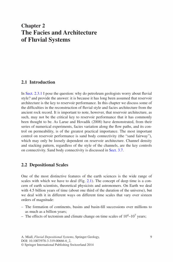
Fig. 2.1 Hierarchies of scale and time in fluvial deposits (Leeder 1993)
11
events as the nondeposition or erosion that takes place in front of an advancing bedform (a few seconds to minutes), the nondeposition due to drying out at ebb tide (a few hours), up to the major regional unconformity generated by orogeny (millions of years).
The variation in sedimentation rate also reflects the variation in actual rates of continuous accumulation (fifteen orders of magnitude in total), from the rapid sandflow or grainfall accumulation of a cross-bed foreset lamina (time measured in seconds, or 10−6 years), and the dumping of graded beds from a turbidity cur-rent (time measured in hours to days), to the slow pelagic fill of an oceanic abyssal plain (undisturbed in places for hundreds or thousands of years, or more), to the development of a major structural-stratigraphic province, which could represent hundreds of millions of years. There clearly exists a wide variety of time scales of sedimentary processes (Figs. 2.1, 2.2, 2.3).
There also exists a hierarchy of physical scales, which the same two exam-ples illustrate—the cross-bed foreset at one extreme to the basin-fill at the other extreme (Fig. 2.1). At least fifteen orders of magnitude are represented, from the few square centimeters in area of the smallest scale of ripple foreset, to the tens of thousands of square kilometers of a major sedimentary basin. At the scale of the bedform, physical scales are constant, because they reflect invariant processes of
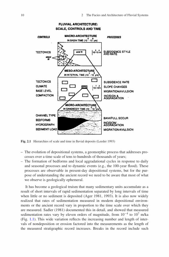
Fig. 2.2 The hierarchy of depositional units in a fluvial complex. This diagram was developed primarily to assist in the explanation of sequence-stratigraphic terms and concepts (Kendall 2008; sepmstrata.org)
2.2 Depositional Scales
12 2 The Facies and Architecture of Fluvial Systems
the physics of sedimentation. However, at other levels of the hierarchy the scales may show wide variation, such as the scales of fluvial channels (Fig. 2.4).
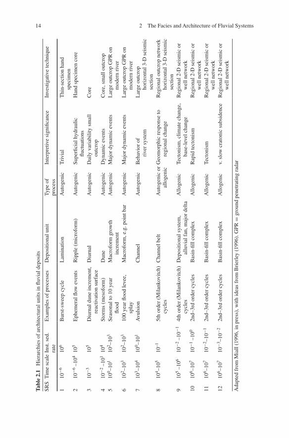
The ways by which earth scientists study sedimentary processes and the result-ant depositional products vary according to the scale of interest (Table 2.1). Bedforms in flumes are studied during experimental runs of, at most, few days duration. Nonmarine and marginal-marine sediments and processes have been much analyzed in modern environments, using studies of surface processes, and by sampling the sediments themselves in trenches and shallow cores. The use of old maps and aerial photographs extends the record as far back as about 100 years.
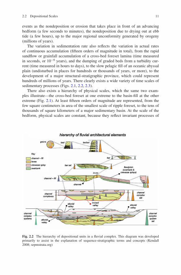
Fig. 2.3 The hierarchy of depositional units in a fluvial system. Circled numbers indicate the ranks of bounding surfaces, using the classification of Miall (1996)
13
Optically stimulated luminescence (OSL) can provide age information for the 300-100,000-BP time span. 14C dates may enable stratigraphic records of the last few tens of thousands of years to be calibrated. Many sedimentological studies draw on geomorphological work on landforms and Recent sediments. However, such work is hampered by the specific, and possibly non-generalizable nature of the Recent record, such as the Holocene deglaciation, climatic change, and rapid rise of global sea levels. Stratigraphic studies typically deal with much longer time periods, as represented by the deposits of basin fills, which may have taken hundreds of thou-sands to millions of years to accumulate. Intermediate scales, represented by such major depositional elements as large channels and bars, delta lobes, draas, coastal barriers and shelf sand ridges, which may represent thousands to tens of thou-sands of years of accumulation, are particularly difficult to document in the ancient record and to analyze in modern environments. The time scales of the relevant sed-imentary processes are difficult to resolve, and the physical scale of the deposits falls between the normal size of large outcrops and the well spacing or the scale of geophysical resolution in the subsurface. Yet it is this scale of deposit that is of particular interest to economic geologists, representing as it does the scale of many stratigraphic petroleum reservoirs and their internal heterogeneities (Table 2.2).
Figures 2.2 and 2.3 represent two different ways of illustrating the hierarchical nature of stratigraphic accumulations. Most of the problems faced by geologists attempting to wrestle with field-scale heterogeneities relate to the intermediate scales shown on these diagrams, the channel fill and channel complex of Fig. 2.2, and the units shown in diagrams B, C, and D of Fig. 2.3. We return to these scale issues in a discussion of reservoir problems, in the next section.
Geomorphologists have devoted considerable attention to the problem of time scales and their effects on analysis and prediction (Cullingford et al. 1980;
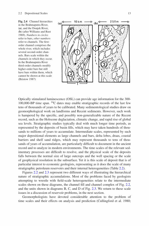
Fig. 2.4 Channel hierarchies in the Brahmaputra River, (a), and the Donjek River, (b) (after Williams and Rust 1969). Numbers in circles refer to bars, other numbers refer to channels. The first-order channel comprises the whole river, which includes several second-order chan-nels. Bars scale within the channels in which they occur. In the Brahmaputra River third-order channels modify higher-order bars but still have bars within them, which cannot be shown at this scale (Bristow 1987)
2.2 Depositional Scales
14 2 The Facies and Architecture of Fluvial Systems
Tabl
e 2.
1 H
iera
rchi
es o
f ar
chite
ctur
al u
nits
in fl
uvia
l dep
osits
SRS
Tim
e sc
ale
Inst
. sed
. ra
teE
xam
ples
of
proc
esse
sD
epos
ition
al u
nit
Type
of
pr
oces
sIn
terp
retiv
e si
gnifi
canc
eIn
vest
igat
ive
tech
niqu
e
110
−6
106
Bur
st-s
wee
p cy
cle
Lam
inat
ion
Aut
ogen
icT
rivi
alT
hin-
sect
ion
hand
sp
ecim
en2
10−
6 –1
0410
5E
phem
eral
flow
eve
nts
Rip
ple
(mic
rofo
rm)
Aut
ogen
icSu
perfi
cial
hyd
raul
ic
fluct
uatio
nsH
and
spec
imen
cor
e
310
−3
105
Diu
rnal
dun
e in
crem
ent,
reac
tivat
ion
surf
ace
Diu
rnal
Aut
ogen
icD
aily
var
iabi
lity
smal
l ou
tcro
pC
ore
410
−2
–101
104
Stor
ms
(mes
ofor
m)
Dun
eA
utog
enic
Dyn
amic
eve
nts
Cor
e, s
mal
l out
crop
510
0 –10
110
2 –10
3Se
ason
al to
10
year
flo
odM
acro
form
gro
wth
in
crem
ent
Aut
ogen
icM
ajor
dyn
amic
eve
nts
Lar
ge o
utcr
op G
PR o
n m
oder
n ri
ver
610
2 –10
310
2 –10
310
0 ye
ar fl
ood
leve
e,
spla
yM
acro
form
, e.g
. poi
nt b
arA
utog
enic
Maj
or d
ynam
ic e
vent
sL
arge
out
crop
GPR
on
mod
ern
rive
r7
103 –
104
100 –
101
Avu
lsio
nC
hann
elA
utog
enic
Beh
avio
r of
rive
r sy
stem
Lar
ge o
utcr
op
hori
zont
al 3
-D s
eism
ic
sect
ion
810
4 –10
510
–15t
h or
der
(Mila
nkov
itch)
cy
cles
Cha
nnel
bel
tA
utog
enic
or
allo
geni
cG
eom
orph
ic r
espo
nse
to
regi
onal
cha
nge
Reg
iona
l out
crop
net
wor
k ho
rizo
ntal
3-D
sei
smic
se
ctio
n9
105
–106
10−
2 –1
0−1
4th
orde
r (M
ilank
ovitc
h)
cycl
esD
epos
ition
al s
yste
m,
allu
vial
fan
, maj
or d
elta
Allo
geni
cTe
cton
ism
, clim
ate
chan
ge,
base
-lev
el c
hang
eR
egio
nal 2
-D s
eism
ic o
r w
ell n
etw
ork
1010
6 –10
710
−1
–100
2nd–
3rd
orde
r cy
cles
Bas
in-fi
ll co
mpl
exA
lloge
nic
Rap
id te
cton
ism
Reg
iona
l 2-D
sei
smic
or
wel
l net
wor
k11
106 –
107
10−
2 –10
−1
2nd–
3rd
orde
r cy
cles
Bas
in-fi
ll co
mpl
exA
lloge
nic
Tect
onis
mR
egio
nal 2
-D s
eism
ic o
r w
ell n
etw
ork
1210
6 –10
710
−3 –
10−
22n
d–3r
d or
der
cycl
esB
asin
-fill
com
plex
Allo
geni
cv.
slo
w c
rato
nic
subs
iden
ceR
egio
nal 2
-D s
eism
ic o
r w
ell n
etw
ork
Ada
pted
fro
m M
iall
(199
6, in
pre
ss),
with
idea
s fr
om B
rier
ley
(199
6). G
PR =
gro
und
pene
trat
ing
rada
r

15
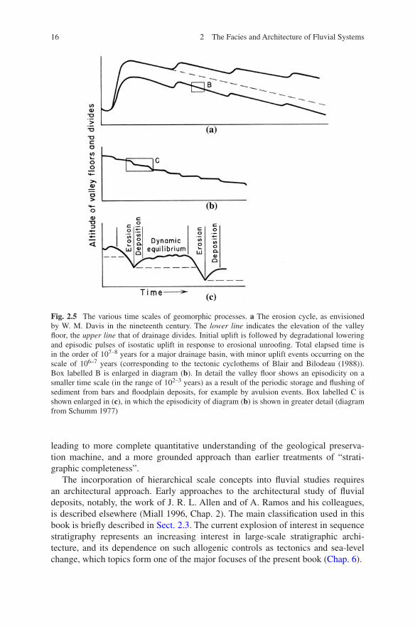
Hickin 1983; Schumm 1985a). As Hickin (1983, p. 61) has stated, “time-scale selection largely determines the questions that we can ask.” Schumm (1985a) showed that the significance of an event diminishes as the time-scale increases. Thus, an individual volcanic eruption, a spectacular geological event at the time of its occurence (a “megaevent”, to use Schumm’s term), diminishes in geological importance as the millenia go by and other eruptions take place, until eventually, after perhaps millions of years, all evidence of the eruption is lost (it becomes a “nonevent”) as a result of erosion or burial of the rocks and landforms formed by the eruption. Events that seem random in the short term (such as turbidity-current events) may assume a regular episodicity, or even cylicity, with definable recur-rence intervals, if studied over a long enough time scale. Many events occur only when some critical threshold has been passed, such as the buildup of deposits on a depositional slope leading to gravitational instability and failure. In several essays, Schumm (1977, 1979, 1985a, 1988; Schumm and Brakenridge, 1987) has discussed the concept of “geomorphic thresholds” and their impact on sedimen-tary processes. Such thresholds reflect both autogenic and allogenic processes, and are characterized by a wide range of time scales (Fig. 2.5) and scales of cyclicity (Fig. 2.6).
The accumulation of information relating to sedimentation rates and its inter-pretation based on fractal theory has led to two important developments: (1) The realization that the stratigraphic record is far more fragmentary than has hitherto been appreciated (Miall, in press); and (2) The realization that many processes are scale independent. This has been argued from the perspective of sequence stratig-raphy (Posamentier et al. 1992; Catuneanu 2006). It has also been argued from the basis of experimental and theoretical considerations that small-scale experi-ments, such as those carried out in the Experimental Earthscape Facility (XES) at University of Minnesota can be used to explore full-scale sedimentological pro-cesses that take place over geologically significant periods of time (Paola et al. 2009).
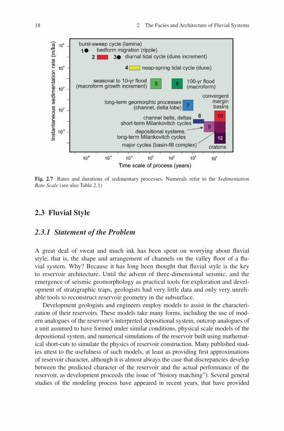
Miall (in press) proposed the definition of a suite of Sedimentation Rate Scales to encompass the range of time scales and processes that can now be recognized from modern studies of the stratigraphic record (Table 2.1, Fig. 2.7). Assignment of stratigraphic units to the appropriate scale should help to initiate a potentially rich new form of debate in which tectonic and geomorphic setting, sedimentary processes and preservation mechanisms can be evaluated against each other,
Table 2.2 Classification of fluvial-channel bodies and fluvial-valley fills according to size and form (Gibling 2006)
Width (m) Thickness (m) Width/Thickness Area (km2)
Very wide > 10,000 Very thick > 50 Very broad Sheets > 1,000 Very large > 10,000Wide > 1,000 Thick > 15 Broad sheets > 100 Large > 1,000Medium > 100 Thick > 15 Narrow sheets > 15 Medium > 100Narrow > 10 Thin > 1 Broad ribbons > 5 Small > 10Very narrow < 10 Very thin < 1 Narrow ribbons < 5 Very small < 10
2.2 Depositional Scales
16 2 The Facies and Architecture of Fluvial Systems
leading to more complete quantitative understanding of the geological preserva-tion machine, and a more grounded approach than earlier treatments of “strati-graphic completeness”.
The incorporation of hierarchical scale concepts into fluvial studies requires an architectural approach. Early approaches to the architectural study of fluvial deposits, notably, the work of J. R. L. Allen and of A. Ramos and his colleagues, is described elsewhere (Miall 1996, Chap. 2). The main classification used in this book is briefly described in Sect. 2.3. The current explosion of interest in sequence stratigraphy represents an increasing interest in large-scale stratigraphic archi-tecture, and its dependence on such allogenic controls as tectonics and sea-level change, which topics form one of the major focuses of the present book (Chap. 6).
Fig. 2.5 The various time scales of geomorphic processes. a The erosion cycle, as envisioned by W. M. Davis in the nineteenth century. The lower line indicates the elevation of the valley floor, the upper line that of drainage divides. Initial uplift is followed by degradational lowering and episodic pulses of isostatic uplift in response to erosional unroofing. Total elapsed time is in the order of 107–8 years for a major drainage basin, with minor uplift events occurring on the scale of 106–7 years (corresponding to the tectonic cyclothems of Blair and Bilodeau (1988)). Box labelled B is enlarged in diagram (b). In detail the valley floor shows an episodicity on a smaller time scale (in the range of 102–3 years) as a result of the periodic storage and flushing of sediment from bars and floodplain deposits, for example by avulsion events. Box labelled C is shown enlarged in (c), in which the episodicity of diagram (b) is shown in greater detail (diagram from Schumm 1977)
172.2 Depositional Scales
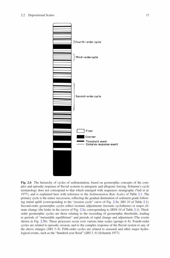
Fig. 2.6 The hierarchy of cycles of sedimentation, based on geomorphic concepts of the com-plex and episodic response of fluvial systems to autogenic and allogenic forcing. Schumm’s cycle terminology does not correspond to that which emerged with sequences stratigraphy (Vail et al. 1977), and is explained here with reference to the Sedimentation Rate Scales of Table 2.1. The primary cycle is the entire succession, reflecting the gradual diminution of sediment grade follow-ing initial uplift (corresponding to the “erosion cycle” curve of Fig. 2.5a; SRS 10 of Table 2.1). Second-order geomorphic cycles reflect isostatic adjustments (tectonic cyclothems) or major cli-mate change (the kinks in the curves of Fig. 2.5a; corresponding to SRS8-10 of Table 2.1). Third-order geomorphic cycles are those relating to the exceeding of geomorphic thresholds, leading to periods of “metastable equilibrium” and periods of rapid change and adjustment (The events shown in Fig. 2.5b). These processes occur over various time scales (groups 6–8). Fourth-order cycles are related to episodic erosion, and to the complex response of the fluvial system to any of the above changes (SRS 5–8). Fifth-order cycles are related to seasonal and other major hydro-logical events, such as the “hundred-year flood” (SRS 5, 6) (Schumm 1977)
18 2 The Facies and Architecture of Fluvial Systems
2.3 Fluvial Style
2.3.1 Statement of the Problem
A great deal of sweat and much ink has been spent on worrying about fluvial style, that is, the shape and arrangement of channels on the valley floor of a flu-vial system. Why? Because it has long been thought that fluvial style is the key to reservoir architecture. Until the advent of three-dimensional seismic, and the emergence of seismic geomorphology as practical tools for exploration and devel-opment of stratigraphic traps, geologists had very little data and only very unreli-able tools to reconstruct reservoir geometry in the subsurface.
Development geologists and engineers employ models to assist in the characteri-zation of their reservoirs. These models take many forms, including the use of mod-ern analogues of the reservoir’s interpreted depositional system, outcrop analogues of a unit assumed to have formed under similar conditions, physical scale models of the depositional system, and numerical simulations of the reservoir built using mathemat-ical short-cuts to simulate the physics of reservoir construction. Many published stud-ies attest to the usefulness of such models, at least as providing first approximations of reservoir character, although it is almost always the case that discrepancies develop between the predicted character of the reservoir and the actual performance of the reservoir, as development proceeds (the issue of “history matching”). Several general studies of the modeling process have appeared in recent years, that have provided
Fig. 2.7 Rates and durations of sedimentary processes. Numerals refer to the Sedimentation Rate Scale (see also Table 2.1)
19
excellent introductions to the strengths and limitations of the various approaches (e.g., Alexander 1993; Bryant and Flint 1993; Geehan 1993; North 1996).
In a lengthy and thorough review of the area of modeling and prediction of sub-surface fluvial reservoirs, North (1996) emphasized the complexity and variability of fluvial successions and the difficulties in predicting fluvial architecture in the sub-surface. He discussed the various conceptual approaches that have been used to sys-tematize our understanding of fluvial systems, including vertical-profile-based facies modeling, architectural-element analysis and sequence stratigraphy. He noted the problems caused by the simultaneous actions of the various autogenic and allogenic sedimentary controls. He demonstrated that limits of vertical seismic resolution and the limits imposed by a borehole network, even within a mature basin, may limit the ability of the geologist to accurately define and predict fluvial architecture with the quantitative rigour required by development engineers. Ethridge (2011) likewise, in an appraisal of the methods of sedimentological interpretation of ancient fluvial sys-tems, reviewed the many attempts to classify fluvial channels and channel systems, pointing out the inconsistencies in terminology and the fact that such classifications have not, in fact, assisted greatly with the interpretation of the ancient record.
North (1996, p. 451) suggested that the computer models of flow in channels (as recently summarized by Bridge, 2003), which provide predictions of vertical profile and paleocurrent variations, are valuable, as providing the basis for more reliable reconstructions of channel form and style than earlier, descriptive models, but acknowledged that sufficient data would rarely be available from the subsur-face to make this a practical tool. These numerical models are based on geomor-phic data bases of channel dimensions, from which sets of equations have been derived that express the relationships between such parameters as channel width, depth, meander wavelength, discharge, etc. (e.g., Ethridge and Schumm 1978; Bridge and Mackey 1993b). North (1996, p. 452) noted the inadequacy of the data base on which paleohydraulic reconstructions have been based, the large errors inherent in the standard equations, and the procedural errors involved in using the output from one equation as the input for another. Many studies, including that of Bridge and Mackey (1993b), have addressed the issue of the paucity of data, but the conceptual question discussed by Alexander (1993) and Geehan (1993) remains: how do we know we are using the right analogue?
Weissmann et al. (2011) offered an even more fundamental criticism of the data base of fluvial studies on which modern fluvial sedimentology rests: they argued that most of the modern river systems, the descriptive features of which have been used to construct modern facies models, are located in degradational settings. They asserted that these studies are of limited relevance in the interpretation of ancient successions which, by their very existence, indicate the long-term persis-tence of aggradational environments. They stated (p. 330):
We believe that these studies of fluvial systems in degradational settings have validity in terms of channel processes and products at the scale of bar forms, macroforms, and chan-nel belts. However, they do not inform us about the way the macroform-scale deposits stack into overall 3D basin-fill architecture.
I address this argument in Sect. 7.3.2.
2.3 Fluvial Style
20 2 The Facies and Architecture of Fluvial Systems
A theme throughout the discussions by North (1996) and the concluding remarks in the book of which that paper is a part (Carling and Dawson 1996) is the lack of information about modern rivers, a refrain expressed many times by J. S. Bridge, as well. For example, Mackey and Bridge (1995, p. 28) concluded that “There is a critical need for more comprehensive architectural data from mod-ern fluvial systems, especially data related to processes controlling floodplain geometry and channel pattern over periods of thousands of years.” They called for more comprehensive physical models of flow, sediment transport, channel geom-etry and the effects of tectonism and base level change. However, the usefulness of such models would still be questionable, for the reasons discussed below. North (1996, p. 399) noted that:
The geological emphasis needed is often determined by the economic and engineering parameters of the project. So in a hydrocarbon reservoir analysis, for example, while the geologist may be fretting over the sinuosity of the ancient river, the engineer may be much more concerned by the impact on channel-sand permeability and porosity of the variations in diagenesis.
Tye (2004) argued that the documentation of surface form, without the need for subsurface analysis, could provide an invaluable input into reservoir studies by providing constraints on the scale, orientation and interrelationships between res-ervoir components, such as channels and bars, so long as the appropriate modern analogue had been selected from which modeling input data was derived. He illus-trated his argument with examples of the use of measurements on selected modern rivers and deltas as input into an object-based three-dimensional reservoir model. He acknowledged, however, that his “geomorphology” approach could not take account of the erosional relationships between successive channel-belt units. This is where knowledge of the subsurface architecture must be added in.
The problem of documenting fluvial architectures from modern river systems has largely been solved by the development of ground-penetrating radar (GPR). This geophysical technique is superbly adapted to documenting the shallow sub-surface, providing high-resolution architectural data that can be related precisely to the surface channel and bar morphology (e.g., excellent case studies were provided by Best et al. (2003), Lunt and Bridge (2004)). Both the value and the limitations of modern architectural studies using GPR are well illustrated by the detailed study of the Sagavanirktok gravelly braided river in Alaska by Lunt and Bridge (2004) and Lunt et al. (2004). These papers contain detailed documenta-tion of the channel and bar architecture, documented with numerous GPR pro-files. From the GPR data the authors extracted a set of “vertical logs of typical sequences through different parts of compound bar deposits and channel fills” (Lunt et al. 2004, Fig. 24d). They also developed a table relating “stratal thick-nesses measured in boreholes” to the “widths of different scales of stratasets” (Lunt et al. 2004, p. 410 and Table 2.3). They stated that this “quantitative three-dimensional depositional model … will allow prediction of the dimensions and spatial distributions of different scales of stratification …” However, they then go on to say that “reconstructing the origin and evolution of compound bar deposits from only recent aerial photographs or cores is impossible. It is also impossible to
21
determine from core whether a compound bar was a point bar or a braid bar.” They also assembled some modern data relating to the width-depth relationships for the channel belt deposits of recent braided and meandering rivers and concluded that this ratio is widely variable and that there may be very little difference between the two river styles in terms of the channel-belt deposits currently accumulating.
Here, then, is the first of the two major problems with modern analogues for interpreting the ancient record: snapshots of a modern river (surface maps, aerial photographs) do not necessarily reveal the internal structure of the bars and chan-nel deposits beneath the surface. For example, an apparently simple point bar in a braided system may, upon dissection or GPR surveying, reveal an internal struc-ture partly composed of the remnants of a different type of bar, or of an earlier point bar with a different orientation, upon which the modern bar form has been superimposed by the latest configuration of the adjacent active meander bend. Best et al. (2003) documented the evolution of a single large braid bar in the Jamuna (Brahmaputra) River in Bangladesh. This bar, 1.5 km long in a downstream direc-tion, migrated downstream a distance equal to its own length in a little over a year, and temporarily doubled in downstream length. How relevant to the study of the ancient record is the detailed documentation of such an ephemeral feature, other than to illustrate short-term bar-forming processes? How much of this bar is likely to make it into the preserved record?
In its simplest condition, the evolution of a braided channel can be consid-ered as the development of opposite-facing low-sinuosity meanders migrating away from a central (mid-channel) bar (Bridge 1993). The work of Ashworth et al. (2000) explicitly ruled out this mode of evolution in the case of the bar they studied, although they made a comparison with the small bar in the Calamus River, Nebraska, analyzed by Bridge et al. (1998), which the latter demonstrated to have grown by a comparable pattern of lateral and downstream accretion from an upstream nucleus. Where bar migration is symmetrical, as proposed by Bridge (1993), channel scour would be expected to sweep out an erosional channel form approximating the width of two channels plus the intervening bar. Assuming two channels of second-order Brahmaputra scale (in the terminology of Bristow (1987)), each 2 km wide, and a mid-channel bar also 2 km wide, if both chan-nels were filled prior to abandonment this could theoretically generate a second-order sand body bounded by a fifth-order surface (the numbering refers to the channel-scale bounding surface classification of Miall (1988, 1996, 2010a)) in the order of 6 km wide. With an average depth of 12 m such a sand body would have a W/D ratio of 500. However, this scenario is quite speculative. Several groups of researchers have demonstrated patterns of active anabranch migra-tion and bar growth and erosion in the Brahmaputra/Jamuna River (Thorne et al. 1993; Ashworth et al. 2000), which indicate that sand bodies of the full theoreti-cal width estimated here may never develop. Sand bodies bounded by surfaces of fifth-order rank are likely to be substantially less than 6 km wide. The final pre-served architecture of sand bodies of the type described by Ashworth et al. (2000) would depend on the balance between (1) lateral growth of the bar under condi-tions of anabranch migration, and (2A) erosional incision brought about by events
2.3 Fluvial Style
22 2 The Facies and Architecture of Fluvial Systems
of avulsive anabranch switching, or (2B) migration and lateral erosion of an ana-branch from another location within the channel belt. Final preserved sand body widths are presumably somewhere between the hypothetical maximum of 6 km and the width of individual bars—a minimum of 1 km. How useful are estimates with such wide error margins? I return to this question in Sect. 7.4, where the Brahmaputra/Jamuna River is discussed as a possible analog for the interpretation of the Hawkesbury Sandstone, Australia.
The second of the major problems is that well data (including core logs) relating to the internal architecture may be as poor a guide as surface form as a diagnostic tool for reservoir body evaluation. Lunt et al. (2004) reconfirmed the point argued many years ago (e.g., see Miall 1980; Collinson 1986) that vertical profiles are not reliably diagnostic of fluvial style, let alone of bar character within a river of known style. Even with a detailed core record it may be difficult to impossible to determine whether a particular vertical profile relates to a single channel-fill record or to super-imposed fragments of several or many channel and bar deposits, such as the one documented by Best et al. (2003). Interpretations derived from core should therefore include the development of several alternative scenarios for further testing.
The demonstration of statistical relationships between channel thickness and width may be useful for characterizing individual rivers, but such relationships should be used with great caution in examining the ancient record. The problem is that even detailed GPR documentation of a modern river system relates only to the present-day snapshot of the deposits. On the short term (decades to hundreds of years) the architecture relates to the preservation of fragments of bars and channels formed, modified and eroded under the existing channel pattern. But none of this present-day deposit has yet made it into the geological record (this is, in part, what Weissmann et al. objected to, as noted above). On the longer term (from thousands of years up to geological time scales) the pattern of preservation is influenced by subsidence rates and climate change. In addition to the fragmenting of channels and bars within the short-term time frame of channel migration and avulsion there may be erosional incision caused by channel systems at much later time periods, which may partially or completely remove the earlier deposits and which may demonstrate different styles because of changes in long-term allogenic controls. Given slow subsidence rates it is quite conceivable that a given stratigraphic unit could contain the amalgamated, mutually incised fragmentary deposits of different river styles that were active tens to hundreds of thousands of years apart and which could have generated channel and bar deposits with significantly different internal character and thickness-depth relationships (e.g., see Blum and Törnqvist 2000; Ethridge and Schumm 2007; Sheets et al. 2008). In Chap. 6 we address the issue of the relationship between alluvial architecture and accommodation generation.
Shanley (2004, pp. 171–172) argued that although much geomorphic infor-mation is available from studies of modern rivers, “the interplay of subsidence, base level, and magnitude of sediment supply exerts a far greater control on the degree to which fluvial [channel] deposits are amalgamated or isolated than the many short-term processes commonly viewed in the study of modern analogs.” Gibling (2006) has documented with a thoroughness not previously attempted the
23
enormous range in the dimensions of channel bodies in the modern and ancient record, the variability in sedimentary controls, and the difficulties inherent in inter-preting and modeling fluvial systems from limited data. As Ethridge and Schumm (2007) noted: “Because several controls can produce the same effect (conver-gence) and one control may produce different effects (divergence), unambiguous interpretations [of the ancient record] are not possible.”
Given the normal variability of geological processes, the assumption of archi-tectural complexity and variability should be the null hypothesis for the purpose of exploration and development. For these reasons, it is suggested that the statistical relationships developed for reservoir body dimensions and the numerical models that are based on them (e.g., Bridge and Mackey 1993a, b; Mackey and Bridge 1995) are most appropriately used only in a very preliminary fashion as guides to the development of several alternative scenarios for reservoir interpretation and development. Shanley (2004) demonstrated this approach with the use of an array of different equations for the estimation of sand-body widths from log- and core-derived thickness data.
Modern sedimentological interpretations began in the 1950 s with the recogni-tion of the value of the “vertical profile” as a diagnostic feature of depositional environment, a development largely attributable to the work of Esso and Shell Development geologists, who recognized the repeated nature of certain profiles on wireline logs (Nanz 1954) and compared these to profiles obtained from the study of selected modern environments, including fluvial point bars (Bernard et al. 1962). At about the same time, Allen (1963, 1964, 1965a, b) working largely in the Devonian Old Red Sandstone of the Anglo-Welsh borderlands area, began to establish the link between meander migration, point bar formation, and the rela-tionship between width, depth and other channel attributes as preserved in the rock record. Leeder (1973) noted a useful relationship between the geometry of point bar deposits and the dimensions of meandering channels. Geomorphologists, such as S. A. Schumm, provided much food for thought from their study of mod-ern river systems (e.g., Schumm, 1977) and the several generations of numerical models that have been developed, most recently (Bridge and Mackey 1993a, b; Mackey and Bridge 1995) have built on all this earlier work to simulate alluvial architectures based on selected input data and sets of geomorphic equations based largely on observations of the fluvial styles of modern rivers. This history (up to the mid 1990s) is recounted in some detail in the history chapter of “The geology of fluvial deposits” (Miall 1996, Chap. 2).
Amongst the foundational work necessary for modeling have been attempts to document and categorize fluvial deposits based on their interpreted fluvial style, major milestones in this progress being the papers of Fielding and Crane (1987) and Robinson and McCabe (1997) (e.g., see Fig. 2.8), and culminating in the authoritative compilation by Gibling (2006), the last word in empirical data col-lection on the size and shape of all types of preserved sandstone and conglomer-ate body in the ancient record. The hope has been that from all this generalization would emerge patterns that would enable reservoir geologists to take the very few bits of information that are normally available from subsurface exploration, such
2.3 Fluvial Style
24 2 The Facies and Architecture of Fluvial Systems
as sand-body thickness and lateral extent (based on sometimes questionable strati-graphic correlation exercises), and from these develop reservoir models that could be simply handed over as end products to the production engineer.
The effort, which has now been underway for more than half a century, to docu-ment and categorize fluvial facies models is still not complete. Miall (1985) sum-marized architectural work that had led to the recognition of 12 distinctive styles, and this was later (Miall 1996, Chap. 8) expanded to 16. Long (2011) succeeded in identifying examples of most of these in the Precambrian and Early Paleozoic rock record. Nonetheless, some workers have argued that additional models are still nec-essary. Fielding et al. (2009, 2011) defined a new model for tropical rivers charac-terized by seasonal, semiarid to subhumid conditions, and applied this model to an interpretation of the Upper Paleozoic record of Atlantic Canada (Allen et al. 2011). Such criteria as “Sandstone bodies with complex and abrupt lateral variations of sandstone and pedogenically modified mudstone” or “Paucity of lateral or down-stream accreting macroforms” are cited as features that characterize high-discharge rivers in such settings. However, as noted in Sect. 5.2.2, the climatic interpreta-tion in this study depended largely on paleobotanical and paleosoil evidence. Most of the facies and architectural features that are asserted to be characteristic of the sandstones formed in this climatic setting are common in sandstones deposited in
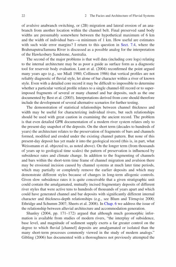
Fig. 2.8 The relationship between channel width and depth for various fluvial styles. Adapted by Robinson and McCabe (1997) from an earlier synthesis by Fielding and Crane (1987). AAPG © 1997. Reprinted by permission of the AAPG whose permission is required for further use
25
many depositional settings, and it seems very unlikely that the climatic setting of a fluvial deposits could be unambiguously interpreted based solely on the lithofacies assemblage or architecture of the clastic components of the succession.
On the other hand, North and Davidson (2012) pointed out a number of mis-conceptions in the use of terms relating to unconfined flow and the resulting deposits. They demonstrated that such terms as “sheetflood” and “sandflat” are poorly defined and have been used in incorrect ways through much of the sedi-mentological literature. This has important implications for interpretations of the subsurface. For example, fluvial deposits characterized by a predominance of plane bedding (lithofacies Sh, architectural element LS of Miall (1985)) have in many cases been described as the product of sheetfloods. The implication is that plane beds develop beneath bodies of water than may be described as sheet-like in geometry—lacking bedforms—but the interpretation commonly includes the implication that such flow conditions are most characteristic of high-discharge events that overtop river banks and spread out onto the floodplain as a fluvial “sheet”. The condition of high-discharge sedimentation across the floodplain is well described by the term “unconfined flow”, but this does not necessarily imply the plane-bed flow-regime condition. Indeed, unconfined flow may include a wide range of deposits and, conversely, the plane-bed condition may be devel-oped in channelized flow and has recently been cited (Allen et al. 2011) as one of the characteristics of seasonal tropical rivers. Given that the term “sheetflood” carries definite implications as to geometry—a criterion of key importance to the reservoir geologists, such distinctions in terminology are of more than academic importance. As North and Davidson (2012) note, the term “sandflat” is even more poorly defined.
Increasing knowledge of the variety of fluvial depositional environments is leading to a re-evaluation of some earlier facies interpretations. Even the famous “fining-upward cycles” of the Old Red Sandstone of Britain are falling victim to this phenomenon. These cycles, as exposed along coastal cliffs in South Wales, were amongst the first to be interpreted as the product of point-bar sedimentation (Allen 1963b). An increase in our knowledge of dryland environments, particu-larly the Eyre Basin of interior Australia, has led to a reinterpretation of exposures of these rocks in Pembrokeshire, in South Wales, as the deposits of ephemeral systems, in which lateral point-bar migration comprised a very minor component (Marriott et al. 2005).
2.3.2 Facies Models and the Subsurface
Has the work of facies analysis done what it set out to do—assist the subsurface geologist to map and assess the reservoir potential of fluvial sandstone and con-glomerate bodies? After a half century of research the answer has to be, not really.
Consider Figs. 2.9 and 2.10. Figure 2.9 established three basic models for developing reservoir simulations. The layer-cake model is one that might be
2.3 Fluvial Style
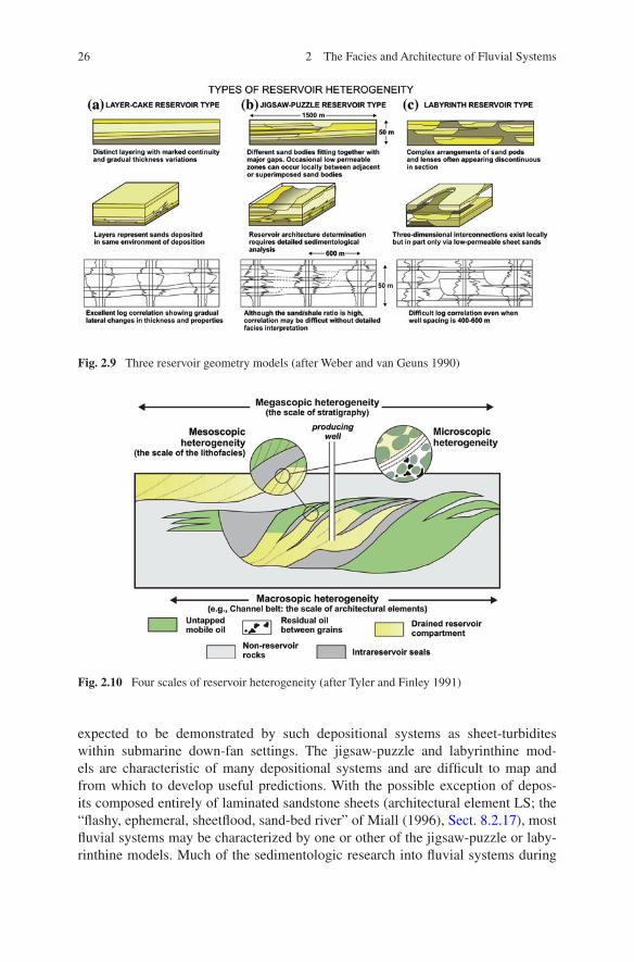
26 2 The Facies and Architecture of Fluvial Systems
expected to be demonstrated by such depositional systems as sheet-turbidites within submarine down-fan settings. The jigsaw-puzzle and labyrinthine mod-els are characteristic of many depositional systems and are difficult to map and from which to develop useful predictions. With the possible exception of depos-its composed entirely of laminated sandstone sheets (architectural element LS; the “flashy, ephemeral, sheetflood, sand-bed river” of Miall (1996), Sect. 8.2.17), most fluvial systems may be characterized by one or other of the jigsaw-puzzle or laby-rinthine models. Much of the sedimentologic research into fluvial systems during
Fig. 2.9 Three reservoir geometry models (after Weber and van Geuns 1990)
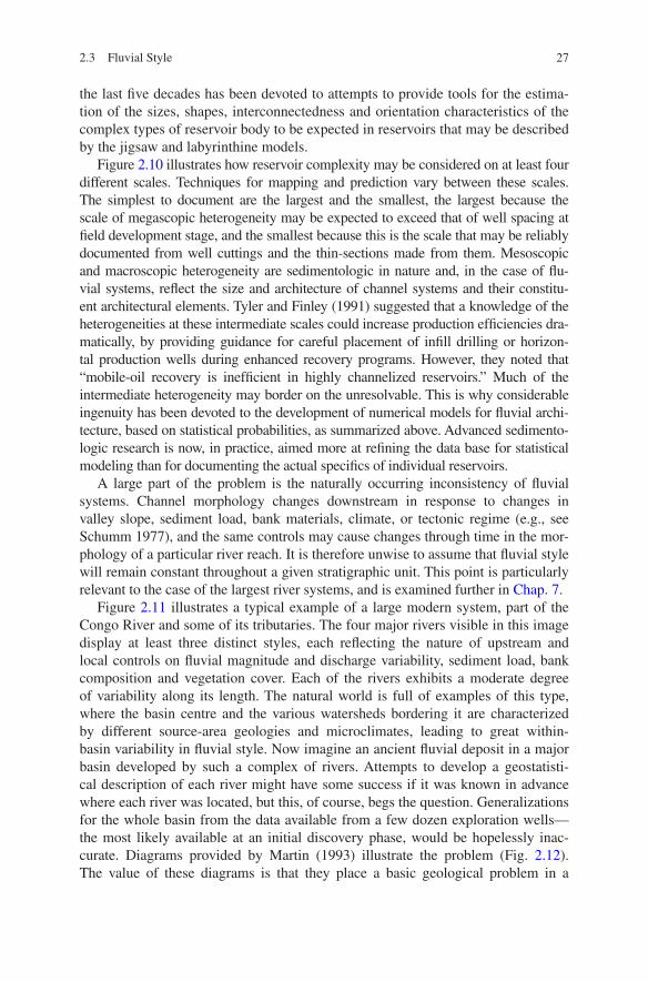
Fig. 2.10 Four scales of reservoir heterogeneity (after Tyler and Finley 1991)
27
the last five decades has been devoted to attempts to provide tools for the estima-tion of the sizes, shapes, interconnectedness and orientation characteristics of the complex types of reservoir body to be expected in reservoirs that may be described by the jigsaw and labyrinthine models.
Figure 2.10 illustrates how reservoir complexity may be considered on at least four different scales. Techniques for mapping and prediction vary between these scales. The simplest to document are the largest and the smallest, the largest because the scale of megascopic heterogeneity may be expected to exceed that of well spacing at field development stage, and the smallest because this is the scale that may be reliably documented from well cuttings and the thin-sections made from them. Mesoscopic and macroscopic heterogeneity are sedimentologic in nature and, in the case of flu-vial systems, reflect the size and architecture of channel systems and their constitu-ent architectural elements. Tyler and Finley (1991) suggested that a knowledge of the heterogeneities at these intermediate scales could increase production efficiencies dra-matically, by providing guidance for careful placement of infill drilling or horizon-tal production wells during enhanced recovery programs. However, they noted that “mobile-oil recovery is inefficient in highly channelized reservoirs.” Much of the intermediate heterogeneity may border on the unresolvable. This is why considerable ingenuity has been devoted to the development of numerical models for fluvial archi-tecture, based on statistical probabilities, as summarized above. Advanced sedimento-logic research is now, in practice, aimed more at refining the data base for statistical modeling than for documenting the actual specifics of individual reservoirs.
A large part of the problem is the naturally occurring inconsistency of fluvial systems. Channel morphology changes downstream in response to changes in valley slope, sediment load, bank materials, climate, or tectonic regime (e.g., see Schumm 1977), and the same controls may cause changes through time in the mor-phology of a particular river reach. It is therefore unwise to assume that fluvial style will remain constant throughout a given stratigraphic unit. This point is particularly relevant to the case of the largest river systems, and is examined further in Chap. 7.
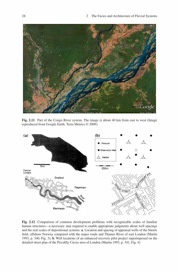
Figure 2.11 illustrates a typical example of a large modern system, part of the Congo River and some of its tributaries. The four major rivers visible in this image display at least three distinct styles, each reflecting the nature of upstream and local controls on fluvial magnitude and discharge variability, sediment load, bank composition and vegetation cover. Each of the rivers exhibits a moderate degree of variability along its length. The natural world is full of examples of this type, where the basin centre and the various watersheds bordering it are characterized by different source-area geologies and microclimates, leading to great within-basin variability in fluvial style. Now imagine an ancient fluvial deposit in a major basin developed by such a complex of rivers. Attempts to develop a geostatisti-cal description of each river might have some success if it was known in advance where each river was located, but this, of course, begs the question. Generalizations for the whole basin from the data available from a few dozen exploration wells—the most likely available at an initial discovery phase, would be hopelessly inac-curate. Diagrams provided by Martin (1993) illustrate the problem (Fig. 2.12). The value of these diagrams is that they place a basic geological problem in a
2.3 Fluvial Style
28 2 The Facies and Architecture of Fluvial Systems
Fig. 2.11 Part of the Congo River system. The image is about 40 km from east to west (Image reproduced from Google Earth. Terra Metrics © 2009)
Fig. 2.12 Comparison of common development problems with recognizable scales of familiar human structures—a necessary step required to enable appropriate judgments about well spacings and the real scales of depositional systems. a. Location and spacing of appraisal wells of the Snorre field, offshore Norway compared with the major roads and Thames River of east London (Martin 1993, p. 340, Fig. 3); b. Well locations of an enhanced recovery pilot project superimposed on the detailed street plan of the Piccdilly Circus area of London (Martin 1993, p. 341, Fig. 4)
29
recognizable human-scale context. It is commonly far too difficult to make the necessary scale comparison between a poorly known basin and actual depositional systems. Diagrams like this are a great help. More on this topic in Sect. 7.3.2.
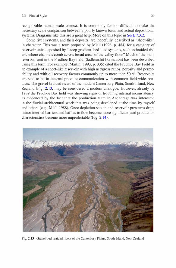
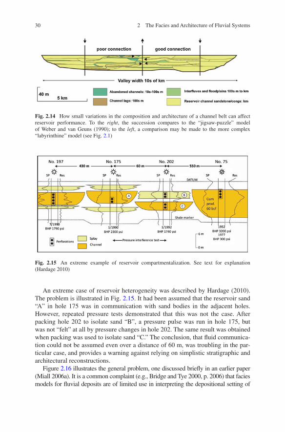
Some river systems, and their deposits, are, hopefully, described as “sheet-like” in character. This was a term proposed by Miall (1996, p. 484) for a category of reservoir units deposited by “steep-gradient, bed-load systems, such as braided riv-ers, where channels comb across broad areas of the valley floor.” Much of the main reservoir unit in the Prudhoe Bay field (Sadlerochit Formation) has been described using this term. For example, Martin (1993, p. 335) cited the Prudhoe Bay Field as an example of a sheet-like reservoir with high net/gross ratios, porosity and perme-ability and with oil recovery factors commonly up to more than 50 %. Reservoirs are said to be in internal pressure communication with common field-wide con-tacts. The gravel-braided rivers of the modern Canterbury Plain, South Island, New Zealand (Fig. 2.13, may be considered a modern analogue. However, already by 1989 the Prudhoe Bay field was showing signs of troubling internal inconsistency, as evidenced by the fact that the production team in Anchorage was interested in the fluvial architectural work that was being developed at the time by myself and others (e.g., Miall 1988). Once depletion sets in and reservoir pressures drop, minor internal barriers and baffles to flow become more significant, and production characteristics become more unpredictable (Fig. 2.14).
Fig. 2.13 Gravel-bed braided rivers of the Canterbury Plains, South Island, New Zealand
2.3 Fluvial Style
30 2 The Facies and Architecture of Fluvial Systems
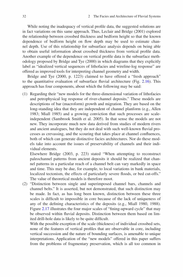
An extreme case of reservoir heterogeneity was described by Hardage (2010). The problem is illustrated in Fig. 2.15. It had been assumed that the reservoir sand “A” in hole 175 was in communication with sand bodies in the adjacent holes. However, repeated pressure tests demonstrated that this was not the case. After packing hole 202 to isolate sand “B”, a pressure pulse was run in hole 175, but was not “felt” at all by pressure changes in hole 202. The same result was obtained when packing was used to isolate sand “C.” The conclusion, that fluid communica-tion could not be assumed even over a distance of 60 m, was troubling in the par-ticular case, and provides a warning against relying on simplistic stratigraphic and architectural reconstructions.
Figure 2.16 illustrates the general problem, one discussed briefly in an earlier paper (Miall 2006a). It is a common complaint (e.g., Bridge and Tye 2000, p. 2006) that facies models for fluvial deposits are of limited use in interpreting the depositional setting of
Fig. 2.14 How small variations in the composition and architecture of a channel belt can affect reservoir performance. To the right, the succession compares to the “jigsaw-puzzle” model of Weber and van Geuns (1990); to the left, a comparison may be made to the more complex “labyrinthine” model (see Fig. 2.1)
Fig. 2.15 An extreme example of reservoir compartmentalization. See text for explanation (Hardage 2010)

31
reservoir bodies because they are incomplete or misleading. In fact, all that such models were ever intended for was general guidance, to serve as “norms” and “predictors,” to use Walker’s (1976) terms. Bridge (2003, p. 222) correctly stated that channel patterns cannot be deduced from vertical profile data alone, thereby confirming earlier observa-tions by others who also dealt with the ambiguities of vertical profile data (e.g., Miall 1980, 1985, p. 263; 1996, p. 38–42; Collinson 1986, p. 59–60; Shanley 2004).
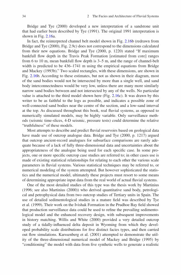
Fig. 2.16 Three interpretations of the braided-fluvial deposits of the Travis Peak Formation, Zone 1 (Early Cretaceous, East Texas). a Initial interpretation, by Tye (1991), based on detailed core and isopach mapping study. Arbitrary equal well-spacing is used in this and the subsequent diagrams. b A reinterpretation by Bridge and Tye (2000), based on assumptions of narrower channel belts. Rectangular boxes at the base of this panel indicate range of channel-belt sizes predicted from estimated bankfull depth, using the equations of Bridge and Mackey (1993b). Their own model, shown here, does not make use of this range of values;.c. An alternative model developed by the present writer (Miall 2006a), based on two basic guidelines for interpreting petrophysical logs: (a) channels normally have flat bases, and (b) the main sand bodies are indi-cated only by blocky-shaped, low-value gamma ray signatures
2.3 Fluvial Style
32 2 The Facies and Architecture of Fluvial Systems
While noting the inadequacy of vertical profile data, the suggested solutions are in fact variations on this same approach. Thus, Leclair and Bridge (2001) explored the relationship between crossbed thickness and bedform height so that the known dependence of bedform height on flow depth may be used to estimate chan-nel depth. Use of this relationship for subsurface analysis depends on being able to obtain useful information about crossbed thickness from vertical profile data. Another example of the dependence on vertical profile data is the subsurface meth-odology proposed by Bridge and Tye (2000) in which diagrams that they explicitly label as “idealized vertical sequences of lithofacies and wireline-log response” are offered as improved tools for interpreting channel geometry and width.
Bridge and Tye (2000, p. 1223) claimed to have offered a “fresh approach” to the quantitative evaluation of subsurface fluvial architecture (Fig. 2.16). This approach has four components, about which the following may be said:
(1) Regarding their “new models for the three-dimensional variation of lithofacies and petrophysical log response of river-channel deposits.” These models are descriptions of bar (macroform) growth and migration. They are based on the long-standing idea that they are independent of channel planform (e.g., Allen 1983; Miall 1985) and a growing conviction that such processes are scale-independent (Sambrook Smith et al. 2005). In that sense the models are not new. They incorporate much new data derived from studies of modern rivers and ancient analogues, but they do not deal with such well-known fluvial pro-cesses as crevassing, and the scouring that takes place at channel confluences, both of which can generate distinctive facies architectures. Nor do these mod-els take into account the issues of preservability of channels and their indi-vidual elements.Elsewhere Bridge (2003, p. 223) stated “When attempting to reconstruct paleochannel patterns from ancient deposits it should be realized that chan-nel patterns in a particular reach of a channel belt can vary markedly in space and time. This may be due, for example, to local variations in bank materials, localized tectonism, the effects of particularly severe floods, or bed cut-offs.” The value of theoretical models is therefore moot.
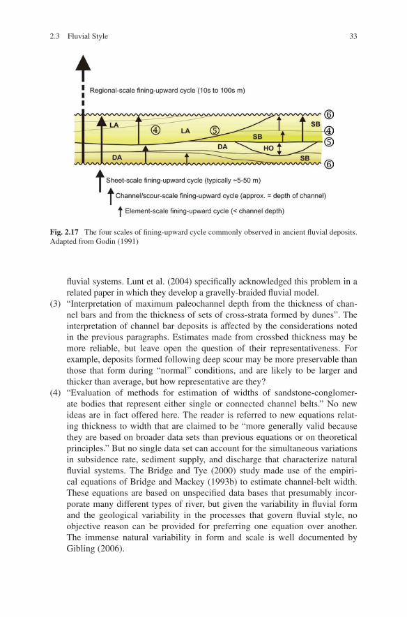
(2) “Distinction between single and superimposed channel bars, channels and channel belts.” It is asserted, but not demonstrated, that such distinction may be made. In fact, as has long been known, distinction between these three scales is difficult to impossible in core because of the lack of uniqueness of any of the defining characteristics of the deposits (e.g., Miall 1980, 1988). Figure 2.17 illustrates the four major scales of “fining-upward cycle” that may be observed within fluvial deposits. Distinction between them based on lim-ited drill-hole data is likely to be quite difficult.With the possible exception of the scale (thickness) of individual crossbed sets, none of the features of vertical profiles that are observable in core, including vertical succession and the nature of bounding surfaces, is amenable to unique interpretations. Application of the “new models” offered in this paper suffers from the problems of fragmentary preservation, which is all too common in
33
fluvial systems. Lunt et al. (2004) specifically acknowledged this problem in a related paper in which they develop a gravelly-braided fluvial model.
(3) “Interpretation of maximum paleochannel depth from the thickness of chan-nel bars and from the thickness of sets of cross-strata formed by dunes”. The interpretation of channel bar deposits is affected by the considerations noted in the previous paragraphs. Estimates made from crossbed thickness may be more reliable, but leave open the question of their representativeness. For example, deposits formed following deep scour may be more preservable than those that form during “normal” conditions, and are likely to be larger and thicker than average, but how representative are they?
(4) “Evaluation of methods for estimation of widths of sandstone-conglomer-ate bodies that represent either single or connected channel belts.” No new ideas are in fact offered here. The reader is referred to new equations relat-ing thickness to width that are claimed to be “more generally valid because they are based on broader data sets than previous equations or on theoretical principles.” But no single data set can account for the simultaneous variations in subsidence rate, sediment supply, and discharge that characterize natural fluvial systems. The Bridge and Tye (2000) study made use of the empiri-cal equations of Bridge and Mackey (1993b) to estimate channel-belt width. These equations are based on unspecified data bases that presumably incor-porate many different types of river, but given the variability in fluvial form and the geological variability in the processes that govern fluvial style, no objective reason can be provided for preferring one equation over another. The immense natural variability in form and scale is well documented by Gibling (2006).
Fig. 2.17 The four scales of fining-upward cycle commonly observed in ancient fluvial deposits. Adapted from Godin (1991)
2.3 Fluvial Style
34 2 The Facies and Architecture of Fluvial Systems
Bridge and Tye (2000) developed a new interpretation of a sandstone unit that had earlier been described by Tye (1991). The original 1991 interpretation is shown in Fig. 2.16a.
In fact, the reinterpreted channel belt model shown in Fig. 2.16b (redrawn from Bridge and Tye (2000), Fig. 2.9c) does not correspond to the dimensions calculated from their new equations. Bridge and Tye (2000, p. 1220) stated “If maximum bankfull flow depth in the Travis Peak Formation [estimated from core] ranges from 6 to 10 m, mean bankfull flow depth is 3–5 m, and the range of channel-belt width is predicted to be 436–1741 m using the empirical equations from Bridge and Mackey (1993b).” Two scaled rectangles, with these dimensions, are shown in Fig. 2.16b. According to these estimates, but not as shown in their diagram, most of the sand bodies would not be intersected by more than a single well, and sand body interconnectedness would be very low, unless there are many more similarly narrow sand bodies between and not intersected by any of the wells. No particular value is attached to the third model shown here (Fig. 2.16c). It was drawn by this writer to be as faithful to the logs as possible, and indicates a possible zone of well-connected sand bodies near the centre of the section, and a low-sand interval at the top. As discussed throughout this book, real fluvial systems, as opposed to numerically simulated models, may be highly variable. Only surveillance meth-ods (seismic time-slices, 4-D seismic, pressure tests) could determine the relative “truthfulness” of these models.
Most attempts to describe and predict fluvial reservoirs based on geological data have made use of outcrop analogue data. Bridge and Tye (2000, p. 1217) argued that outcrop ancient-record analogues for subsurface comparisons are rarely ade-quate because of a lack of fully three-dimensional data and uncertainties about the appropriateness of the analogue being used for each specific case. In some pro-jects, one or more specific outcrop case studies are referred to; in other cases use is made of existing statistical relationships for relating to each other the various scale parameters in fluvial systems. Various statistical techniques may be referred to, or numerical modeling of the system attempted. But however sophisticated the statis-tics and the numerical model, ultimately these projects must resort to some means of determining appropriate input data from the real world of actual fluvial systems.
One of the most detailed studies of this type was the thesis work by Martinius (1996; see also Martinius (2000)) who derived quantitative sand body, petrologi-cal and petrophysical data from two outcrop studies of Tertiary units in Spain. The use of detailed sedimentological studies in a mature field was described by Tye et al. (1999). Their work on the Ivishak Formation in the Prudhoe Bay field showed that production surveillance data could be used to refine the prevailing sedimento-logical model and the enhanced recovery design, with subsequent improvements in history matching. Willis and White (2000) provided a very detailed outcrop study of a tidally-influenced delta deposit in Wyoming from which they devel-oped probability scale distributions for five distinct facies types, and then carried out flow simulations. Karssenberg et al. (2001) attempted to demonstrate the util-ity of the three-dimensional numerical model of Mackey and Bridge (1995) by “conditioning” the model with data from five synthetic wells to generate a realistic
35
simulation. Yu et al. (2002) studied a large outcrop of a Jurassic fluvial system in China and developed from this some generalizations about fluvial architecture and petrophysics that they offered as an analogue for interpreting producing reservoirs in east China. Svanes et al. (2004) defined “genetic types” of sedimentological objects in vertical profile, and used these in conjunction with 3-D seismic data to develop a fluid drainage model in a producing field. They pointed out the difficul-ties in making adjustments to a stochastic reservoir model to accommodate new input from well data or surveillance data (the “conditioning problem”).
Sand body architecture is a product of fluvial style and accumulation processes. In other words, it’s all about the nature of the surface fluvial system—the size, shape and orientation of channels and their component architectural elements (including bars and crevasse splays)—and about how these fluvial systems behave over time—the nature of lateral channel movement and rates of subsidence. In the next section we examine the issue of fluvial style. In Chap. 3 we discuss autogenic controls on the accumulation of fluvial systems over time, with a particular focus on the process of avulsion. With this information in mind, we can then focus on the issue of sand body architecture. Section 3.7 reviews modeling work in this area that has been carried out with a view to understanding sand body connectedness—the key issue in maximizing the productivity of fluvial reservoirs.
2.3.3 Controls of Fluvial Style
One of the major problems with the study of fluvial style is that the terms used to describe style are not mutually exclusive; indeed they describe different con-ditions and different process entirely. The term meandering, originally derived from the name of the Buruk Menderes River in Turkey, refers to the pattern of sinuous river bends that characterizes many rivers, especially (but not exclusively) those carrying a relatively fine-grained bedload or suspended sediment load. (The Buruk Menderes River is now in effect an underfit stream because of large-scale water diversion for irrigation. Classic meandering channel and point-bar surface form representing pre-modern fluvial architectures is visible as textural patterns in aerial imagery of the floodplain, [e.g., on Google Earth] which has now been entirely developed for mixed-crop farming). The term braiding refers to a pattern of multiple channels separated by bars and temporary islands. For many years the term anastomosing was considered to be synonymous with the term braiding, but it is now recommended that the term be restricted to rivers characterized by a network of stable channels of low- to high-sinuosity (Miall 1996, p. 15). Nanson and Knighton (1996) and Knighton (1998) use the term anabranching as a catch-all term for a range of similar channel styles, of which the anastomosing style of Smith and Smith (1980) is the most well known. In contrast to braided rivers, anastomosed rivers are typically characterized by stable, vegetated floodplains. Braiding and meandering describe processes that can occur at the same time in the same river, with the result that some rivers can be described using both terms,
2.3 Fluvial Style
36 2 The Facies and Architecture of Fluvial Systems
and this is one of the reasons why attempts by geomorphologists and geologists to classify and explain fluvial styles are still in a state of flux.
How did these terms develop, what do they tell us and, following on from that, how does a determination of fluvial style assist with the problem of subsurface mapping?
Much of the early history of development of ideas about fluvial style, including the work of Davis, Chamberlin and others, has been summarized elsewhere (Miall 1996, Chap. 2). The various classification systems of Schumm and others are also discussed in that chapter. In the discussion that follows here an attempt is made to point out the confusions that are still present in much modern analyses, with the aim of arriving at some concepts and ideas that are useful to the geologist working with the ancient record.
Friedkin (1945) was probably the first worker to examine the issue of fluvial style systematically. He carried out a much-cited series of large-scale experiments to model meandering and braiding in a large flume. He attributed meandering to bank erosion, but did not explain why this occurs and why it is characterized by regularity. He agreed with the term “overloaded river” for braided rivers (Friedkin 1945, p. 16) and attributed the braided character to bank erosion and bedload dep-osition enhanced by easily eroded bank materials.
Leopold and Wolman (1957) demonstrated that at least nine variables inter-act to determine the nature of the resulting stream channel. They include discharge (amount and variability), sediment load (amount and grain size), width, depth, veloc-ity, slope and bed roughness. Schumm (1968a) later showed that the amount and type of vegetation growth also will affect stream type and, therefore, climatic and geological factors must also be considered. It is still not possible to define the ranges of values that will invariably produce ariver of a given type although, as noted below, certain interrelationships between the variables are now well enough understood for some generalizations to be made. Leopold and Wolman (1957, pp. 72–73) stated:
Channel patterns, braided, meandering, and straight, each occurs in nature throughout the whole range of possible discharges. Some of the largest rivers in the world are braided; for example, the lower Ganges and Amazon. More are meandering, of which the lower Mississippi is the best known example. Meanders are common in very small creeks and braids are common in many small ephemeral streams… [It has been observed that] a given channel can change in a short distance from a braid to a meander or vice versa, that the divided channels of a braid may meander, and that a meandering tributary may join a braided master stream. Such changes in a given channel or such different channels in jux-taposition can be attributed to variations in locally independent factors.
In what was for many years the standard textbook on fluvial geomorphology, Leopold et al. (1964, p. 281) made this general statement regarding river styles:
River patterns represent an additional mechanism of channel adjustment which is tied to channel gradient and cross section. The pattern itself affects the resistance to flow, and the existence of one or another pattern is closely related to the amount and character of the available sediment and to the quantity and variability of the discharge. … separation of distinctive patterns is somewhat arbitrary.
Leopold and Wolman (1957) and Leopold et al. (1964, pp. 284–288) reported on a by-now famous experiment to simulate mid-channel braid-bar formation

37
(a process summarized by Miall (1977, pp. 12–14)). They stated (Leopold and Wolman 1957, p. 50): “Braiding is developed by sorting as the stream leaves behind those sizes of the load which it is incompetent to handle… if the stream is competent to move all sizes comprising the load but is unable to move the total quantity provided to it, then aggradation may take place without braiding”.
Leopold et al. (1964, p. 282) discussed braiding in this way:
Braided or anastomosing channels are often but not always associated with sandy or fri-able bank materials. Also, vegetation has similar effects; a change from non-braided to braided character is sometimes associated with a change from dense vegetation along the channel banks to sparse or no vegetation. Whether these coincident changes are causally related cannot usually be ascertained, although the coincidence is suggestive.
Note the by-now abandoned use of the term anastomosing in this quote.Leopold et al. (1964, pp. 292–295) were very clear about the relationship
between sediment load and fluvial style:
Although the channels may meander at low stages, at overbank flow the braided river often moves nearly straight down its valley. … when two rivers of a given size of river (same discharge) are compared, braided channels occur on steeper slopes than meanders. Steeper slopes contribute to sediment transport and to bank erosion and are often asso-ciated with coarse heterogeneous materials. All these are conditions which contribute to braiding.
Where coarse material is available, braiding may result from the selective deposition of the coarser material, causing formation of a central bar and thus diverting the flow and increasing erosional attack on the banks. This was observed in the flume, in the grav-elly channels studied by us in Wyoming, and in braided proglacial rivers described by Fahnestock (1963) and others. Even in fine material, however, irregular deposition of bars and bank erosion may produce a braided pattern. The shifting channel may move gradu-ally during low flows, but during floods major changes in the position of the thalweg can be produced. Because deposition is essential to formation of the characteristic braided pat-tern, it is clear that sediment transport is essential to braiding. It is also evident, however, that if the banks were unerodible and the channel width confined, the capacity of the reach for the transport of sediment would be increased, reducing the likelihood of deposition. In addition, any bars which formed would be removed as flow increased, since bank erosion could not take place. Thus, for the bars to become stable and divert the flow, the banks must be sufficiently erodible so that they rather than the incipient bar give way as the flow is diverted around the depositing bar. Sediment transport and a low threshold of bank erosion provide the essential conditions of braiding. Rapidly fluctuating changes in stage contribute to the instability of the transport regime and to erosion of the banks; hence they also provide a contributory but not essential element of the braiding environment. Heterogeneity of the bed material in the same way creates irregularities in the movement of sediment and thus also may contribute to braiding.
Schumm (1977, p. 106) similarly emphasized issues of sediment load and dis-charge variability in the development of the braided pattern:
Although the records are short, they indicate that rivers with high ratios of peak to mean discharge are morphologically different from rivers with low ratios, In a general way this is substantiated … for two rivers in Jamaica. In this case the only factor that can explain the difference between the braided Yallahs River and the narrower, more sinuous Buff Bay River is the marked seasonality of precipitation in the Yallahs River drainage basin. Annual precipitation is similar in both drainage basins, but larger floods occur in the
2.3 Fluvial Style
38 2 The Facies and Architecture of Fluvial Systems
braided Yallahs channel. There have not been systematic studies of the influence of flood peaks or of the ratio of peak to mean discharge on channel morphology, but this is an area that warrants further attention.
And again, on p. 108:
In addition to the size of the sediment transported, the relative amounts of bed load and suspended load also significantly influence themorphology of sand-bed streams. For example, along the Smoky Hill-Kansas River system in Kansas, discharge increases in a downstream direction, but channel width decreases from about 300 feet to less than 100 feet in central Kansas. Farther east there is a marked increase in channel width. These and other changes are attributed to changes in the type of sediment load introduced by major tributary streams (Schumm 1968b). Tributaries introduce large suspended-sediment loads where the width decreases, and large bed-loads or sand loads are added where width increases.
Elsewhere, Schumm (1977, p. 121) noted the importance of vegetation on the channel banks in stabilizing the channel. The action of depositing the coarser bed-load initiates mid-channel bar formation. In rivers of highly variable dis-charge competency will be similarly variable, and there will be long periods of time throughout which the river will be unable to move at least the coarsest part of its bed-load. The incidence of bar initiation, flow diversion and the creation of new channels (braiding) will thus be high. During high discharge events in streams with high stream power, “bank erosion is vigorous, and a wide braided channel forms” (Schumm 1977, p. 129). The conditions of abundant, coarse, non-cohesive bed-load, strongly fluctuating discharge and steep slope are not typical of any par-ticular tectonic or climatic setting.
Parker (1976) carried out a theoretical examination of the conditions of mean-dering, braiding and anastomosis. He noted (pp. 476–477) that
It has traditionally been held that braiding is caused by sediment loads so high that the river cannot carry the total amount, resulting in deposition on the bed as internal bars and general channel aggradation. On the other hand, the mechanism causing meandering is typically identified as secondary flow associated with channel curvature. If the causes of meandering and braiding were so different a unified approach would be impossible. In fact both these theories are demonstrably incorrect. The first theory implies that braided channels can never be in an equilibrium, or graded state, whereby the load supplied from upstream of a point is balanced by the load transported downstream. Presumably, then, aggradation occurs until a higher equilibrium slope is obtained, at which point braiding must stop. However, slope increases are in fact observed to exacerbate braiding rather than damp it. Furthermore, many braided rivers do not aggrade. … As regards meander-ing, it has been shown herein that the channel curvature needed to induce secondary flow is a result rather than a cause of initial meandering tendencies in straight channels, a fact that has been experimentally verified.
Parker (1976, p. 477) went on to note that “most streams have a tendency to form bars even though they are in a graded state. If the slope and the width-depth ratio at formative discharges are sufficiently low, meandering is favoured”; and further, “that aggradation, by increasing the slope and forcing the channel out of its banks, can lead to a transition from a meandering to a braided state, or can increase the tendency for braiding.
39
Friend and Sinha (1993) carried out careful measurements of sinuosity and a braid-ing index (of their own devising) on three river reaches in India. They averaged these readings over 10-km reaches, measuring up to 28 individual reaches for the three riv-ers. The data showed considerable variation in these two parameters, which they attrib-uted to variability in the availability of bed-load sediment, reflecting local controls of tributary and bank materials. These results are consistent with the earlier conclusions of Carson (1984), who demonstrated that bed load grain-size influences the meander-ing-braided transition, with coarser bed load causing the transition to occur at higher slopes and/or stream power. As Schumm (1981, pp. 26–27) noted, quite minor varia-tions in sediment load, which could reflect changing tributary or bank conditions, may cause local abrupt temporal or downstream changes in fluvial style from braided to meandering, or the reverse. In a simulation experiment, Stølum (1996) demonstrated that the sinuosity of a meandering river varies between about 2.5 and 4 as a result of continuous changes in the sinuosity of individual channels and the effects of meander cutoffs, which locally, temporarily reduce sinuosity.
An alluvial data base compiled by Coleman and Wright (1975, Table 2.1) shows that on a world-wide basis braided rivers are equally as common as mean-dering rivers in Arctic, temperate, dry tropical and humid tropical regions. There are two main reasons for this:
(1) The sediment load and discharge characteristics of a river may partially reflect the climate and relief of a source area many hundreds of kilometres distant; for exam-ple tropical rivers such as the Ganges, Brahmaputra and Mekong, all of which are strongly braided, have headwaters located in the Himalayan Mountains.
(2) The causes of a high bed-load and a fluctuating discharge are diverse. The fol-lowing are some of the main ones:(a) Alpine source areas provide strong relief and a predominance of mechan-
ical over chemical weathering for the generation of coarse clastic debris. Discharge is markedly peaked during periods of spring snow melt. Glacial outwash streams are almost invariably braided. The deposits they form are referred to as sandurs (and were the subject of several excellent studies of braided-stream sedimentation: see Miall 1977).
(b) Marked discharge fluctuations also are characteristic of Arctic, arid and monsoonal climatic areas.
(c) A lack of vegetation in a drainage basin means a lack of water and sed-iment-storage capacity, and consequent immediate response to storms in the form of flash floods. The degree of vegetation cover in an area is mainly controlled by climate, but removal of the cover by deforestation or fire can produce the same catastrophic flooding effects as characterize arid regions (Chawner 1935).
(d) During most of geological time, until the Early or Middle Devonian, land vegetation had a very restricted distribution (Seward 1959; Davies and Gibling 2010a, b). Sediment transportation characteristics would, therefore, have been similar to those of modem arid regions—a predominance of bed-load rivers with strongly fluctuating discharges (Schumm 1968a, p. 1583).
2.3 Fluvial Style
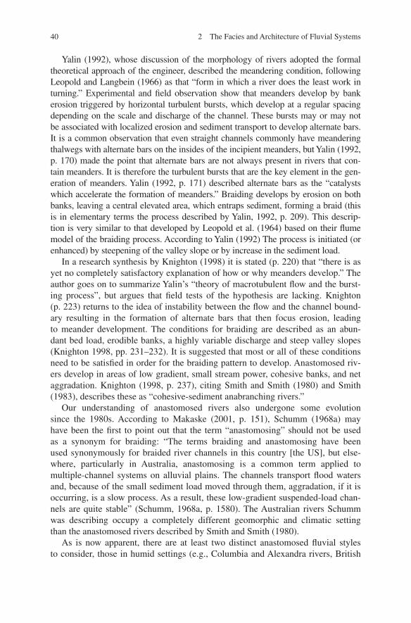
40 2 The Facies and Architecture of Fluvial Systems
Yalin (1992), whose discussion of the morphology of rivers adopted the formal theoretical approach of the engineer, described the meandering condition, following Leopold and Langbein (1966) as that “form in which a river does the least work in turning.” Experimental and field observation show that meanders develop by bank erosion triggered by horizontal turbulent bursts, which develop at a regular spacing depending on the scale and discharge of the channel. These bursts may or may not be associated with localized erosion and sediment transport to develop alternate bars. It is a common observation that even straight channels commonly have meandering thalwegs with alternate bars on the insides of the incipient meanders, but Yalin (1992, p. 170) made the point that alternate bars are not always present in rivers that con-tain meanders. It is therefore the turbulent bursts that are the key element in the gen-eration of meanders. Yalin (1992, p. 171) described alternate bars as the “catalysts which accelerate the formation of meanders.” Braiding develops by erosion on both banks, leaving a central elevated area, which entraps sediment, forming a braid (this is in elementary terms the process described by Yalin, 1992, p. 209). This descrip-tion is very similar to that developed by Leopold et al. (1964) based on their flume model of the braiding process. According to Yalin (1992) The process is initiated (or enhanced) by steepening of the valley slope or by increase in the sediment load.
In a research synthesis by Knighton (1998) it is stated (p. 220) that “there is as yet no completely satisfactory explanation of how or why meanders develop.” The author goes on to summarize Yalin’s “theory of macrotubulent flow and the burst-ing process”, but argues that field tests of the hypothesis are lacking. Knighton (p. 223) returns to the idea of instability between the flow and the channel bound-ary resulting in the formation of alternate bars that then focus erosion, leading to meander development. The conditions for braiding are described as an abun-dant bed load, erodible banks, a highly variable discharge and steep valley slopes (Knighton 1998, pp. 231–232). It is suggested that most or all of these conditions need to be satisfied in order for the braiding pattern to develop. Anastomosed riv-ers develop in areas of low gradient, small stream power, cohesive banks, and net aggradation. Knighton (1998, p. 237), citing Smith and Smith (1980) and Smith (1983), describes these as “cohesive-sediment anabranching rivers.”
Our understanding of anastomosed rivers also undergone some evolution since the 1980s. According to Makaske (2001, p. 151), Schumm (1968a) may have been the first to point out that the term “anastomosing” should not be used as a synonym for braiding: “The terms braiding and anastomosing have been used synonymously for braided river channels in this country [the US], but else-where, particularly in Australia, anastomosing is a common term applied to multiple-channel systems on alluvial plains. The channels transport flood waters and, because of the small sediment load moved through them, aggradation, if it is occurring, is a slow process. As a result, these low-gradient suspended-load chan-nels are quite stable” (Schumm, 1968a, p. 1580). The Australian rivers Schumm was describing occupy a completely different geomorphic and climatic setting than the anastomosed rivers described by Smith and Smith (1980).
As is now apparent, there are at least two distinct anastomosed fluvial styles to consider, those in humid settings (e.g., Columbia and Alexandra rivers, British
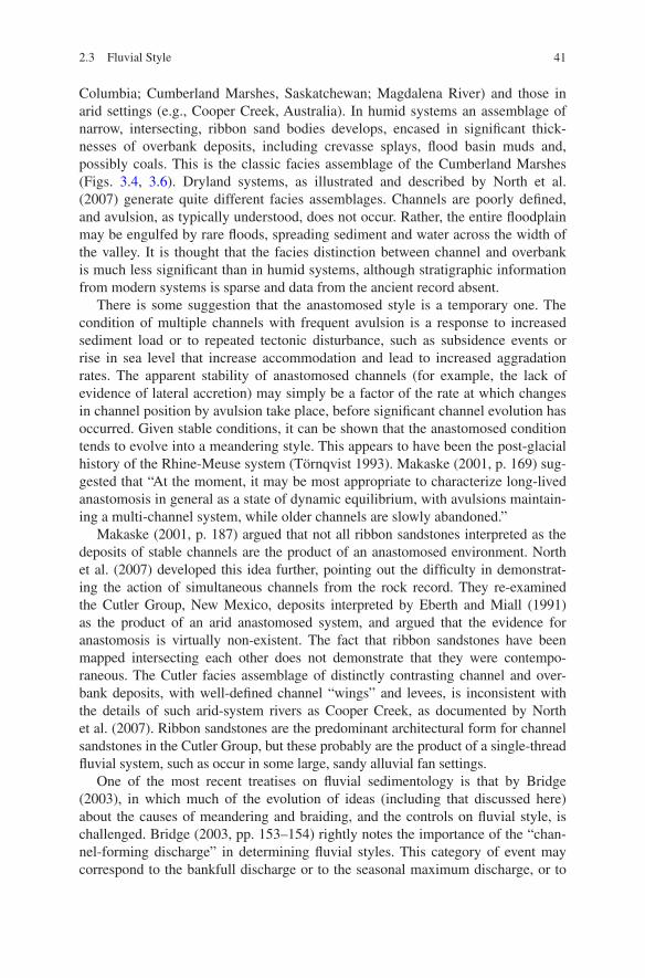
41
Columbia; Cumberland Marshes, Saskatchewan; Magdalena River) and those in arid settings (e.g., Cooper Creek, Australia). In humid systems an assemblage of narrow, intersecting, ribbon sand bodies develops, encased in significant thick-nesses of overbank deposits, including crevasse splays, flood basin muds and, possibly coals. This is the classic facies assemblage of the Cumberland Marshes (Figs. 3.4, 3.6). Dryland systems, as illustrated and described by North et al. (2007) generate quite different facies assemblages. Channels are poorly defined, and avulsion, as typically understood, does not occur. Rather, the entire floodplain may be engulfed by rare floods, spreading sediment and water across the width of the valley. It is thought that the facies distinction between channel and overbank is much less significant than in humid systems, although stratigraphic information from modern systems is sparse and data from the ancient record absent.
There is some suggestion that the anastomosed style is a temporary one. The condition of multiple channels with frequent avulsion is a response to increased sediment load or to repeated tectonic disturbance, such as subsidence events or rise in sea level that increase accommodation and lead to increased aggradation rates. The apparent stability of anastomosed channels (for example, the lack of evidence of lateral accretion) may simply be a factor of the rate at which changes in channel position by avulsion take place, before significant channel evolution has occurred. Given stable conditions, it can be shown that the anastomosed condition tends to evolve into a meandering style. This appears to have been the post-glacial history of the Rhine-Meuse system (Törnqvist 1993). Makaske (2001, p. 169) sug-gested that “At the moment, it may be most appropriate to characterize long-lived anastomosis in general as a state of dynamic equilibrium, with avulsions maintain-ing a multi-channel system, while older channels are slowly abandoned.”
Makaske (2001, p. 187) argued that not all ribbon sandstones interpreted as the deposits of stable channels are the product of an anastomosed environment. North et al. (2007) developed this idea further, pointing out the difficulty in demonstrat-ing the action of simultaneous channels from the rock record. They re-examined the Cutler Group, New Mexico, deposits interpreted by Eberth and Miall (1991) as the product of an arid anastomosed system, and argued that the evidence for anastomosis is virtually non-existent. The fact that ribbon sandstones have been mapped intersecting each other does not demonstrate that they were contempo-raneous. The Cutler facies assemblage of distinctly contrasting channel and over-bank deposits, with well-defined channel “wings” and levees, is inconsistent with the details of such arid-system rivers as Cooper Creek, as documented by North et al. (2007). Ribbon sandstones are the predominant architectural form for channel sandstones in the Cutler Group, but these probably are the product of a single-thread fluvial system, such as occur in some large, sandy alluvial fan settings.
One of the most recent treatises on fluvial sedimentology is that by Bridge (2003), in which much of the evolution of ideas (including that discussed here) about the causes of meandering and braiding, and the controls on fluvial style, is challenged. Bridge (2003, pp. 153–154) rightly notes the importance of the “chan-nel-forming discharge” in determining fluvial styles. This category of event may correspond to the bankfull discharge or to the seasonal maximum discharge, or to
2.3 Fluvial Style
42 2 The Facies and Architecture of Fluvial Systems
some rarer, larger-scale event, depending on the river system. Bridge (2003, pp. 154–155) argues that “the degree of braiding and the width/depth of channels increase as water discharge is increased for a given slope and bed-sediment size, or as slope is increased for a given water discharge and bed-sediment size”, a state-ment which encapsulates the conclusions of the earlier generation of geomorpholo-gists (Leopold and Wolman 1957; Leopold et al. 1964). However, Bridge then goes on to categorize as myths several long-held conclusions regarding fluvial style:
A common myth is that discharge variability is greater for braided rivers than for single-channel rivers. This myth probably originated from the early studies of proglacial braided rivers in mountainous regions of North America, where discharge varied tremendously during snowmelt. In contrast, many single-channel rivers were studied in temperate low-land regions where discharge variations were moderated by groundwater supply. It is very clear, however, that discharge variability does not have a major influence on the exist-ence of different channel patterns, because they can all be formed in laboratory channels at constant discharge, and many rivers with a given discharge regime show along-stream variations in channel pattern (Bridge 2003, p. 156).
This statement seriously oversimplifies the earlier examinations of the causes of braiding. Discharge variability, as noted in earlier paragraphs, is only one of several key variables that cause braiding. The nature of bed and bank materials, the influence of merging tributaries, and the bedrock control of valley slope, are all contributing factors; so, yes, channel style may vary along a river that is charac-terized by the same discharge pattern throughout, because, for example, the bank stability varies with varying sediment composition.
A little further on, Bridge (2003, p. 157) claims that “the correlation between sediment load, and bank stability is not generally supported by data, as recognized implicitly by Schumm (1981, 1985) in his more recent classifications of chan-nel patterns.” However, Schumm’s classification, which is reproduced here (as Fig. 2.18) from Knighton’s book, where it is described favorably as encompassing much of the full range of natural variability, makes it very clear that stability, sedi-ment load and sediment size are all important influences on fluvial style. It is the combination of variables that controls channel style, not any single parameter in isolation. This is one reason why interpretations of channel style in the rock record are so difficult to make and so difficult to interpret.
Jerolmack and Mohrig (2007) employed two relationships to generate a descrip-tive discrimination between the main fluvial styles (Fig. 2.19). They turned to Parker’s (1976) stability criterion to assess whether a river should be braided or meandering (single-channel with multiple high-velocity threads, or single-thread with straight to sinuous planform). This criterion, ε is defined as ε = S√(ghB4)/Q, where S = water slope, g = gravitational acceleration, h = channel depth, B = chan-nel width, Q = formative water discharge. The Mobility number, M, is defined as the ratio of avulsion and lateral-migration time scales M = TA/TC. Rivers consisting of a single channel that sweep across a flood plain, reworking the floodplain by lateral erosion and deposition have a value of M ≫ 1. In these cases, avulsion is infrequent. Where rivers are undergoing active aggradation, with frequent avulsion, several channels may be active at once. Such systems have values of M ≪ 1.
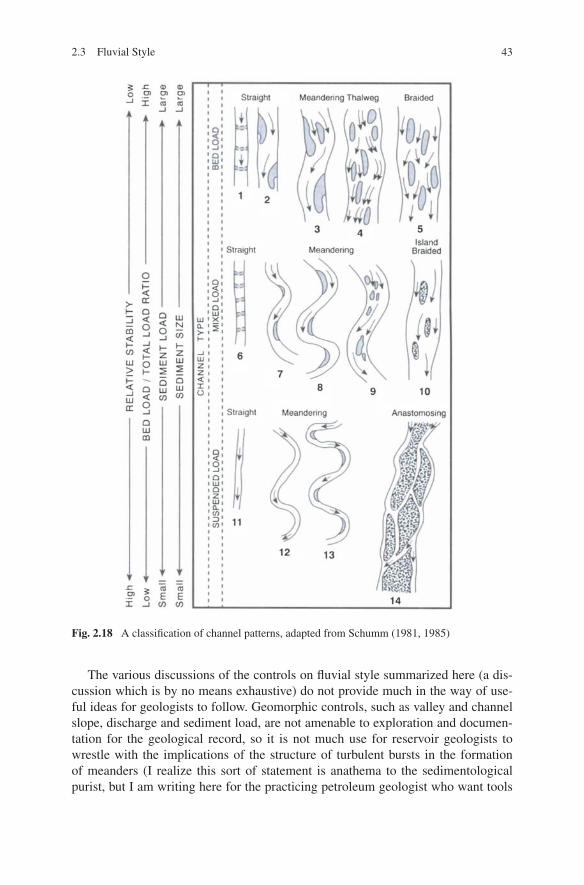
43
The various discussions of the controls on fluvial style summarized here (a dis-cussion which is by no means exhaustive) do not provide much in the way of use-ful ideas for geologists to follow. Geomorphic controls, such as valley and channel slope, discharge and sediment load, are not amenable to exploration and documen-tation for the geological record, so it is not much use for reservoir geologists to wrestle with the implications of the structure of turbulent bursts in the formation of meanders (I realize this sort of statement is anathema to the sedimentological purist, but I am writing here for the practicing petroleum geologist who want tools
Fig. 2.18 A classification of channel patterns, adapted from Schumm (1981, 1985)
2.3 Fluvial Style
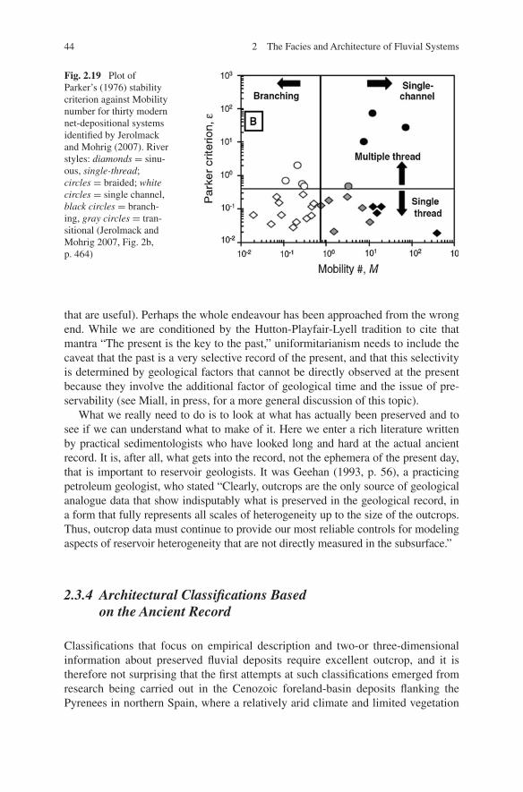
44 2 The Facies and Architecture of Fluvial Systems
that are useful). Perhaps the whole endeavour has been approached from the wrong end. While we are conditioned by the Hutton-Playfair-Lyell tradition to cite that mantra “The present is the key to the past,” uniformitarianism needs to include the caveat that the past is a very selective record of the present, and that this selectivity is determined by geological factors that cannot be directly observed at the present because they involve the additional factor of geological time and the issue of pre-servability (see Miall, in press, for a more general discussion of this topic).
What we really need to do is to look at what has actually been preserved and to see if we can understand what to make of it. Here we enter a rich literature written by practical sedimentologists who have looked long and hard at the actual ancient record. It is, after all, what gets into the record, not the ephemera of the present day, that is important to reservoir geologists. It was Geehan (1993, p. 56), a practicing petroleum geologist, who stated “Clearly, outcrops are the only source of geological analogue data that show indisputably what is preserved in the geological record, in a form that fully represents all scales of heterogeneity up to the size of the outcrops. Thus, outcrop data must continue to provide our most reliable controls for modeling aspects of reservoir heterogeneity that are not directly measured in the subsurface.”
2.3.4 Architectural Classifications Based on the Ancient Record
Classifications that focus on empirical description and two-or three-dimensional information about preserved fluvial deposits require excellent outcrop, and it is therefore not surprising that the first attempts at such classifications emerged from research being carried out in the Cenozoic foreland-basin deposits flanking the Pyrenees in northern Spain, where a relatively arid climate and limited vegetation
Fig. 2.19 Plot of Parker’s (1976) stability criterion against Mobility number for thirty modern net-depositional systems identified by Jerolmack and Mohrig (2007). River styles: diamonds = sinu-ous, single-thread; circles = braided; white circles = single channel, black circles = branch-ing, gray circles = tran-sitional (Jerolmack and Mohrig 2007, Fig. 2b, p. 464)
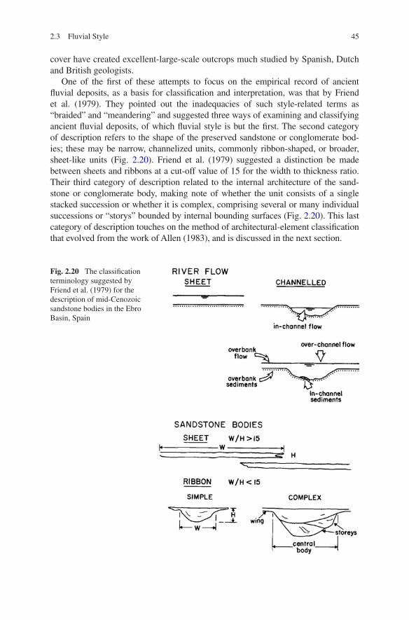
45
cover have created excellent-large-scale outcrops much studied by Spanish, Dutch and British geologists.
One of the first of these attempts to focus on the empirical record of ancient fluvial deposits, as a basis for classification and interpretation, was that by Friend et al. (1979). They pointed out the inadequacies of such style-related terms as “braided” and “meandering” and suggested three ways of examining and classifying ancient fluvial deposits, of which fluvial style is but the first. The second category of description refers to the shape of the preserved sandstone or conglomerate bod-ies; these may be narrow, channelized units, commonly ribbon-shaped, or broader, sheet-like units (Fig. 2.20). Friend et al. (1979) suggested a distinction be made between sheets and ribbons at a cut-off value of 15 for the width to thickness ratio. Their third category of description related to the internal architecture of the sand-stone or conglomerate body, making note of whether the unit consists of a single stacked succession or whether it is complex, comprising several or many individual successions or “storys” bounded by internal bounding surfaces (Fig. 2.20). This last category of description touches on the method of architectural-element classification that evolved from the work of Allen (1983), and is discussed in the next section.
Fig. 2.20 The classification terminology suggested by Friend et al. (1979) for the description of mid-Cenozoic sandstone bodies in the Ebro Basin, Spain
2.3 Fluvial Style
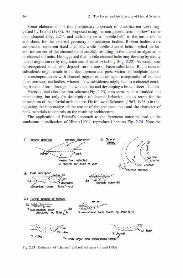
46 2 The Facies and Architecture of Fluvial Systems
Some elaborations of this preliminary approach to classification were sug-gested by Friend (1983). He proposed using the non-genetic term “hollow” rather than channel (Fig. 2.21), and added the term “mobile-belt” to the terms ribbon and sheet, for the external geometry of sandstone bodies. Ribbon bodies were assumed to represent fixed channels, while mobile channel belts implied the lat-eral movement of the channel (or channels), resulting in the lateral amalgamation of channel-fill units. He suggested that mobile channel belts may develop by steady lateral migration or by migration and channel switching (Fig. 2.22). As would now be recognized, much also depends on the rate of basin subsidence. Rapid rates of subsidence might result in the development and preservation of floodplain depos-its contemporaneous with channel migration, resulting in a separation of channel units into separate bodies, whereas slow subsidence might lead to a channel comb-ing back and forth through its own deposits and developing a broad, sheet-like unit.
Friend’s final classification scheme (Fig. 2.23) uses terms such as braided and meandering, but only for description of channel behavior, not as terms for the description of the alluvial architecture. He followed Schumm (1963, 1968a) in rec-ognizing the importance of the nature of the sediment load and the character of bank materials as controls on the resulting architecture.
The application of Friend’s approach to the Pyrenean outcrops lead to the sandstone classification of Hirst (1991), reproduced here as Fig. 2.24. Note the
Fig. 2.21 Definition of “channel” and related terms (Friend 1983)
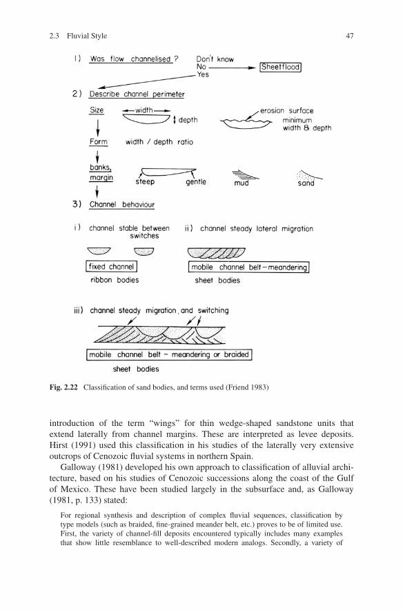
47
introduction of the term “wings” for thin wedge-shaped sandstone units that extend laterally from channel margins. These are interpreted as levee deposits. Hirst (1991) used this classification in his studies of the laterally very extensive outcrops of Cenozoic fluvial systems in northern Spain.
Galloway (1981) developed his own approach to classification of alluvial archi-tecture, based on his studies of Cenozoic successions along the coast of the Gulf of Mexico. These have been studied largely in the subsurface and, as Galloway (1981, p. 133) stated:
For regional synthesis and description of complex fluvial sequences, classification by type models (such as braided, fine-grained meander belt, etc.) proves to be of limited use. First, the variety of channel-fill deposits encountered typically includes many examples that show little resemblance to well-described modern analogs. Secondly, a variety of
Fig. 2.22 Classification of sand bodies, and terms used (Friend 1983)
2.3 Fluvial Style
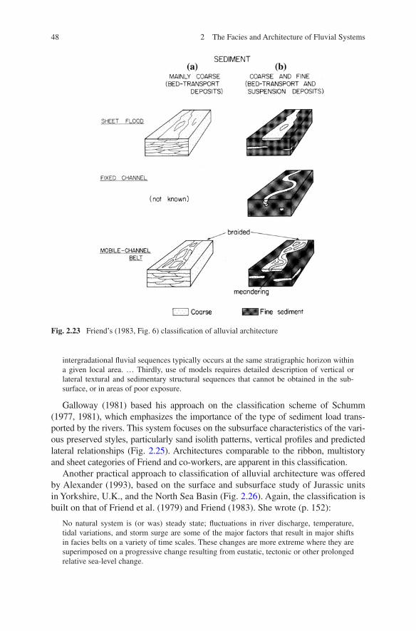
48 2 The Facies and Architecture of Fluvial Systems
intergradational fluvial sequences typically occurs at the same stratigraphic horizon within a given local area. … Thirdly, use of models requires detailed description of vertical or lateral textural and sedimentary structural sequences that cannot be obtained in the sub-surface, or in areas of poor exposure.
Galloway (1981) based his approach on the classification scheme of Schumm (1977, 1981), which emphasizes the importance of the type of sediment load trans-ported by the rivers. This system focuses on the subsurface characteristics of the vari-ous preserved styles, particularly sand isolith patterns, vertical profiles and predicted lateral relationships (Fig. 2.25). Architectures comparable to the ribbon, multistory and sheet categories of Friend and co-workers, are apparent in this classification.
Another practical approach to classification of alluvial architecture was offered by Alexander (1993), based on the surface and subsurface study of Jurassic units in Yorkshire, U.K., and the North Sea Basin (Fig. 2.26). Again, the classification is built on that of Friend et al. (1979) and Friend (1983). She wrote (p. 152):
No natural system is (or was) steady state; fluctuations in river discharge, temperature, tidal variations, and storm surge are some of the major factors that result in major shifts in facies belts on a variety of time scales. These changes are more extreme where they are superimposed on a progressive change resulting from eustatic, tectonic or other prolonged relative sea-level change.
Fig. 2.23 Friend’s (1983, Fig. 6) classification of alluvial architecture
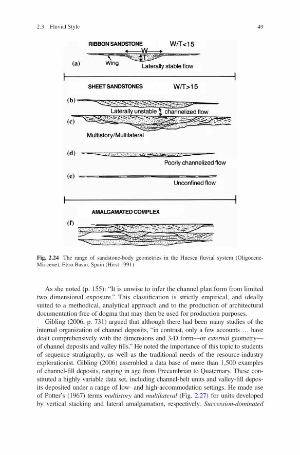
49
As she noted (p. 155): “It is unwise to infer the channel plan form from limited two dimensional exposure.” This classification is strictly empirical, and ideally suited to a methodical, analytical approach and to the production of architectural documentation free of dogma that may then be used for production purposes.
Gibling (2006, p. 731) argued that although there had been many studies of the internal organization of channel deposits, “in contrast, only a few accounts … have dealt comprehensively with the dimensions and 3-D form—or external geometry—of channel deposits and valley fills.” He noted the importance of this topic to students of sequence stratigraphy, as well as the traditional needs of the resource-industry explorationist. Gibling (2006) assembled a data base of more than 1,500 examples of channel-fill deposits, ranging in age from Precambrian to Quaternary. These con-stituted a highly variable data set, including channel-belt units and valley-fill depos-its deposited under a range of low- and high-accommodation settings. He made use of Potter’s (1967) terms multistory and multilateral (Fig. 2.27) for units developed by vertical stacking and lateral amalgamation, respectively. Succession-dominated
Fig. 2.24 The range of sandstone-body geometries in the Huesca fluvial system (Oligocene-Miocene), Ebro Basin, Spain (Hirst 1991)
2.3 Fluvial Style
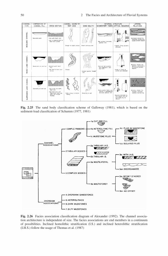
50 2 The Facies and Architecture of Fluvial Systems
Fig. 2.26 Facies association classification diagram of Alexander (1992). The channel associa-tion architecture is independent of size. The facies associations are end members in a continuum of possibilities. Inclined homolithic stratification (I.S.) and inclined heterolithic stratification (I.H.S.) follow the usage of Thomas et al. (1987)
Fig. 2.25 The sand body classification scheme of Galloway (1981), which is based on the sediment-load classification of Schumm (1977, 1981)
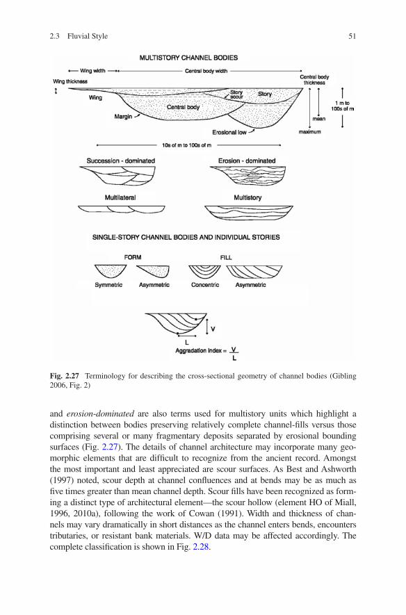
51
and erosion-dominated are also terms used for multistory units which highlight a distinction between bodies preserving relatively complete channel-fills versus those comprising several or many fragmentary deposits separated by erosional bounding surfaces (Fig. 2.27). The details of channel architecture may incorporate many geo-morphic elements that are difficult to recognize from the ancient record. Amongst the most important and least appreciated are scour surfaces. As Best and Ashworth (1997) noted, scour depth at channel confluences and at bends may be as much as five times greater than mean channel depth. Scour fills have been recognized as form-ing a distinct type of architectural element—the scour hollow (element HO of Miall, 1996, 2010a), following the work of Cowan (1991). Width and thickness of chan-nels may vary dramatically in short distances as the channel enters bends, encounters tributaries, or resistant bank materials. W/D data may be affected accordingly. The complete classification is shown in Fig. 2.28.
Fig. 2.27 Terminology for describing the cross-sectional geometry of channel bodies (Gibling 2006, Fig. 2)
2.3 Fluvial Style
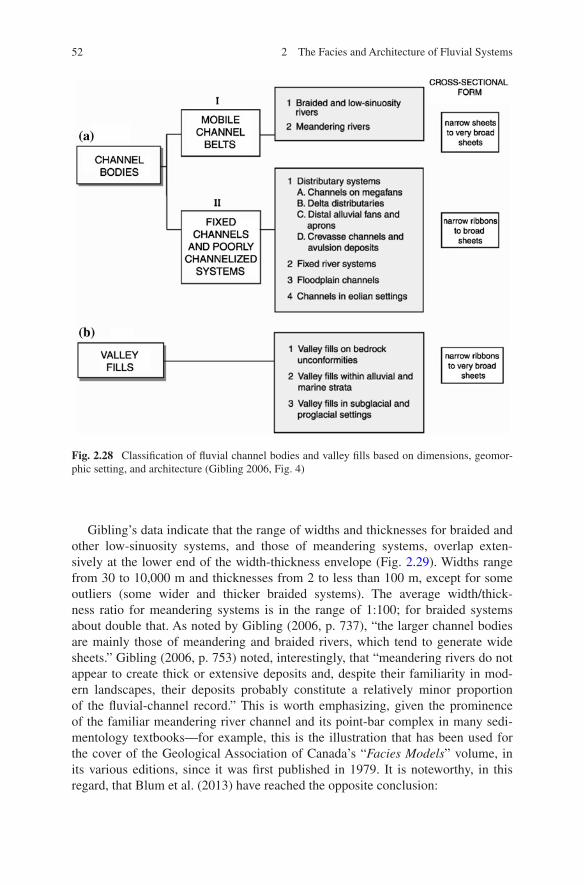
52 2 The Facies and Architecture of Fluvial Systems
Gibling’s data indicate that the range of widths and thicknesses for braided and other low-sinuosity systems, and those of meandering systems, overlap exten-sively at the lower end of the width-thickness envelope (Fig. 2.29). Widths range from 30 to 10,000 m and thicknesses from 2 to less than 100 m, except for some outliers (some wider and thicker braided systems). The average width/thick-ness ratio for meandering systems is in the range of 1:100; for braided systems about double that. As noted by Gibling (2006, p. 737), “the larger channel bodies are mainly those of meandering and braided rivers, which tend to generate wide sheets.” Gibling (2006, p. 753) noted, interestingly, that “meandering rivers do not appear to create thick or extensive deposits and, despite their familiarity in mod-ern landscapes, their deposits probably constitute a relatively minor proportion of the fluvial-channel record.” This is worth emphasizing, given the prominence of the familiar meandering river channel and its point-bar complex in many sedi-mentology textbooks—for example, this is the illustration that has been used for the cover of the Geological Association of Canada’s “Facies Models” volume, in its various editions, since it was first published in 1979. It is noteworthy, in this regard, that Blum et al. (2013) have reached the opposite conclusion:
Fig. 2.28 Classification of fluvial channel bodies and valley fills based on dimensions, geomor-phic setting, and architecture (Gibling 2006, Fig. 4)
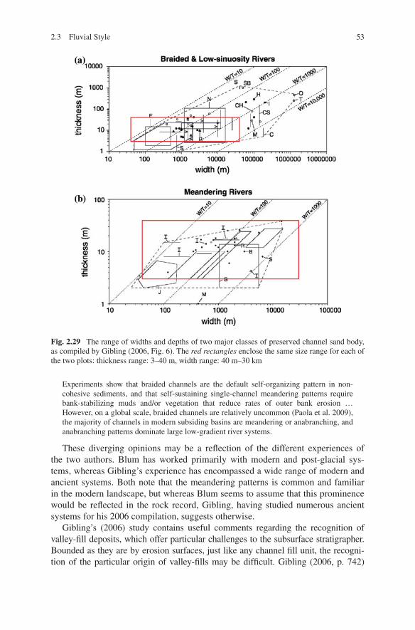
53
Experiments show that braided channels are the default self-organizing pattern in non-cohesive sediments, and that self-sustaining single-channel meandering patterns require bank-stabilizing muds and/or vegetation that reduce rates of outer bank erosion … However, on a global scale, braided channels are relatively uncommon (Paola et al. 2009), the majority of channels in modern subsiding basins are meandering or anabranching, and anabranching patterns dominate large low-gradient river systems.
These diverging opinions may be a reflection of the different experiences of the two authors. Blum has worked primarily with modern and post-glacial sys-tems, whereas Gibling’s experience has encompassed a wide range of modern and ancient systems. Both note that the meandering patterns is common and familiar in the modern landscape, but whereas Blum seems to assume that this prominence would be reflected in the rock record, Gibling, having studied numerous ancient systems for his 2006 compilation, suggests otherwise.
Gibling’s (2006) study contains useful comments regarding the recognition of valley-fill deposits, which offer particular challenges to the subsurface stratigrapher. Bounded as they are by erosion surfaces, just like any channel fill unit, the recogni-tion of the particular origin of valley-fills may be difficult. Gibling (2006, p. 742)
Fig. 2.29 The range of widths and depths of two major classes of preserved channel sand body, as compiled by Gibling (2006, Fig. 6). The red rectangles enclose the same size range for each of the two plots: thickness range: 3–40 m, width range: 40 m–30 km
2.3 Fluvial Style
54 2 The Facies and Architecture of Fluvial Systems
suggested three diagnostic criteria for valley-fills: (1) the presence of a widespread basal erosion surface; (2) the dimension of the valley-fill are an order of magni-tude larger than any component or otherwise correlatable channel deposit; (3) the scale of erosional relief at the base is several times that of the typical channel fill. As Posamentier (2001) and Miall (2002) demonstrated, incised valleys may be flanked by incised tributaries and gullies (e.g., Fig. 4.43). The development of valley-fills may be a consequence of base-level change or climate change, and their analysis then becomes an integral part of the study of sequence stratigraphy (Chap. 6).
Gibling (2006, p. 760) noted the importance, in general, of allogenic controls on alluvial architecture. For example, “For single-story channel bodies with a given ini-tial aspect ratio, the balance between bank migration rate and channel aggradation rate determines to a first approximation the channel-body geometry.” Aggradation rate, which depends on base-level change and sediment supply considerations, is also a major control on avulsion, and therefore on the rate of initiation of new chan-nels. Drawing on the results of this study, and the results of modeling experiments (e.g., Paola 2000), Gibling (2006, p. 763) concluded that these observations “tend to suggest that fluvial channel bodies in the geological record represent a geomorphic spectrum and that alluvial basin-fill stratigraphy is largely controlled by these fac-tors and not by channel morphology.” The importance of this conclusion cannot be over-emphasized. Since sedimentologists first began relying on the process-response model they (we!) have been obsessed with surface form of depositional systems, notably the familiar shapes and textures of modern rivers as seen from above. In my first paper on architectural-element analysis (Miall 1985, p. 266) I noted “It is the plan view of … macroform elements that generates the familiar fluvial channel styles, so commonly illustrated by low-level aerial photographs of modern rivers.” However, it has now been demonstrated that these geomorphic features are of secondary impor-tance and must be supplemented by considerations of allogenic processes, using sequence-stratigraphic concepts, for a full understanding of alluvial architecture.
2.4 Architectural Element Analysis
Difficulties with the standard facies models began with braided systems which, by their nature, tend to be complex and less predictable than the standard “fin-ing-upward” point-bar successions of the basic meandering-stream model. Allen (1983, p. 237) pointed out that “Channel behaviour and type can practically never be predicted unambiguously from vertical sequences, if only because each kind of stream is capable of generating a wide variety of local sedimentological pat-terns.” He argued that increasing attention was being paid to the shape and inter-nal architecture of channelized units. In a study of the sandy-braided deposits of the Devonian Brownstones Formation in the English-Welsh border area, he noted the predominance of complex, interbedded, lenticular units clearly representing the deposits of various types of in-channel bar and minor channel, and this led to the recognition of “eight kinds of depositional features” or “internal architectural ele-ments” (Fig. 2.30).
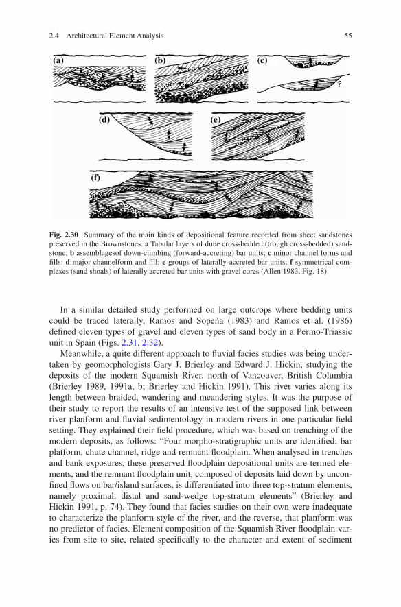
55
In a similar detailed study performed on large outcrops where bedding units could be traced laterally, Ramos and Sopeña (1983) and Ramos et al. (1986) defined eleven types of gravel and eleven types of sand body in a Permo-Triassic unit in Spain (Figs. 2.31, 2.32).
Meanwhile, a quite different approach to fluvial facies studies was being under-taken by geomorphologists Gary J. Brierley and Edward J. Hickin, studying the deposits of the modern Squamish River, north of Vancouver, British Columbia (Brierley 1989, 1991a, b; Brierley and Hickin 1991). This river varies along its length between braided, wandering and meandering styles. It was the purpose of their study to report the results of an intensive test of the supposed link between river planform and fluvial sedimentology in modern rivers in one particular field setting. They explained their field procedure, which was based on trenching of the modern deposits, as follows: “Four morpho-stratigraphic units are identified: bar platform, chute channel, ridge and remnant floodplain. When analysed in trenches and bank exposures, these preserved floodplain depositional units are termed ele-ments, and the remnant floodplain unit, composed of deposits laid down by uncon-fined flows on bar/island surfaces, is differentiated into three top-stratum elements, namely proximal, distal and sand-wedge top-stratum elements” (Brierley and Hickin 1991, p. 74). They found that facies studies on their own were inadequate to characterize the planform style of the river, and the reverse, that planform was no predictor of facies. Element composition of the Squamish River floodplain var-ies from site to site, related specifically to the character and extent of sediment
Fig. 2.30 Summary of the main kinds of depositional feature recorded from sheet sandstones preserved in the Brownstones. a Tabular layers of dune cross-bedded (trough cross-bedded) sand-stone; b assemblagesof down-climbing (forward-accreting) bar units; c minor channel forms and fills; d major channelform and fill; e groups of laterally-accreted bar units; f symmetrical com-plexes (sand shoals) of laterally accreted bar units with gravel cores (Allen 1983, Fig. 18)
2.4 Architectural Element Analysis
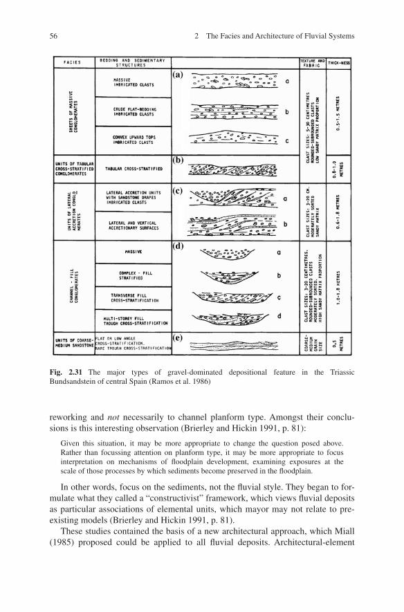
56 2 The Facies and Architecture of Fluvial Systems
reworking and not necessarily to channel planform type. Amongst their conclu-sions is this interesting observation (Brierley and Hickin 1991, p. 81):
Given this situation, it may be more appropriate to change the question posed above. Rather than focussing attention on planform type, it may be more appropriate to focus interpretation on mechanisms of floodplain development, examining exposures at the scale of those processes by which sediments become preserved in the floodplain.
In other words, focus on the sediments, not the fluvial style. They began to for-mulate what they called a “constructivist” framework, which views fluvial deposits as particular associations of elemental units, which mayor may not relate to pre-existing models (Brierley and Hickin 1991, p. 81).
These studies contained the basis of a new architectural approach, which Miall (1985) proposed could be applied to all fluvial deposits. Architectural-element
Fig. 2.31 The major types of gravel-dominated depositional feature in the Triassic Bundsandstein of central Spain (Ramos et al. 1986)
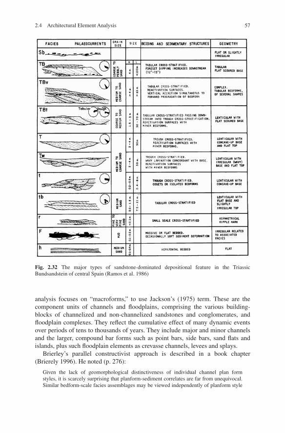
57
analysis focuses on “macroforms,” to use Jackson’s (1975) term. These are the component units of channels and floodplains, comprising the various building-blocks of channelized and non-channelized sandstones and conglomerates, and floodplain complexes. They reflect the cumulative effect of many dynamic events over periods of tens to thousands of years. They include major and minor channels and the larger, compound bar forms such as point bars, side bars, sand flats and islands, plus such floodplain elements as crevasse channels, levees and splays.
Brierley’s parallel constructivist approach is described in a book chapter (Brierely 1996). He noted (p. 276):
Given the lack of geomorphological distinctiveness of individual channel plan form styles, it is scarcely surprising that planform-sediment correlates are far from unequivocal. Similar bedform-scale facies assemblages may be viewed independently of planform style
Fig. 2.32 The major types of sandstone-dominated depositional feature in the Triassic Bundsandstein of central Spain (Ramos et al. 1986)
2.4 Architectural Element Analysis
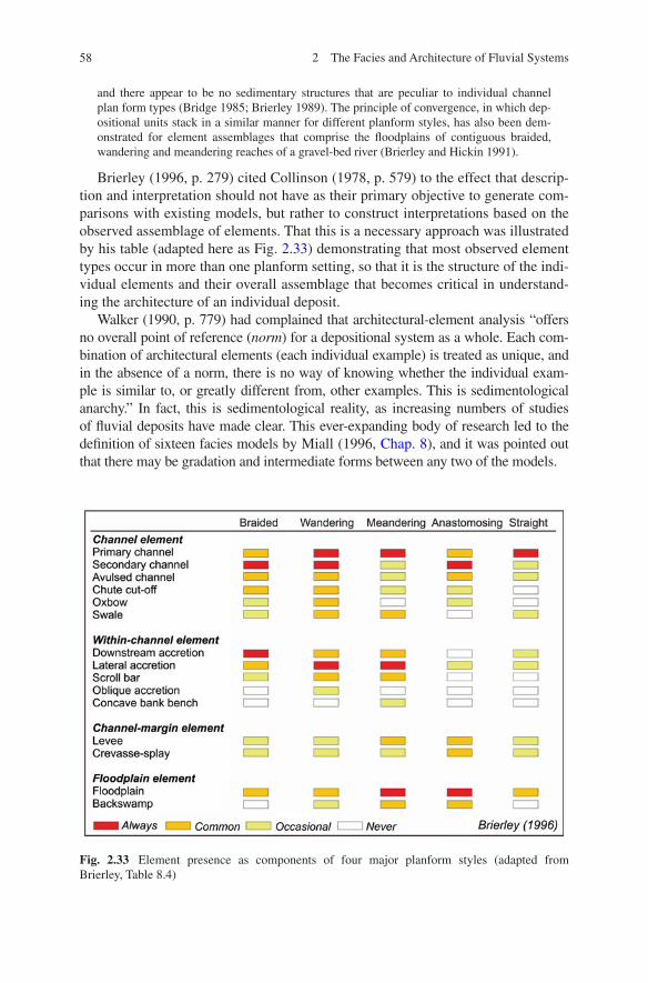
58 2 The Facies and Architecture of Fluvial Systems
and there appear to be no sedimentary structures that are peculiar to individual channel plan form types (Bridge 1985; Brierley 1989). The principle of convergence, in which dep-ositional units stack in a similar manner for different planform styles, has also been dem-onstrated for element assemblages that comprise the floodplains of contiguous braided, wandering and meandering reaches of a gravel-bed river (Brierley and Hickin 1991).
Brierley (1996, p. 279) cited Collinson (1978, p. 579) to the effect that descrip-tion and interpretation should not have as their primary objective to generate com-parisons with existing models, but rather to construct interpretations based on the observed assemblage of elements. That this is a necessary approach was illustrated by his table (adapted here as Fig. 2.33) demonstrating that most observed element types occur in more than one planform setting, so that it is the structure of the indi-vidual elements and their overall assemblage that becomes critical in understand-ing the architecture of an individual deposit.
Walker (1990, p. 779) had complained that architectural-element analysis “offers no overall point of reference (norm) for a depositional system as a whole. Each com-bination of architectural elements (each individual example) is treated as unique, and in the absence of a norm, there is no way of knowing whether the individual exam-ple is similar to, or greatly different from, other examples. This is sedimentological anarchy.” In fact, this is sedimentological reality, as increasing numbers of studies of fluvial deposits have made clear. This ever-expanding body of research led to the definition of sixteen facies models by Miall (1996, Chap. 8), and it was pointed out that there may be gradation and intermediate forms between any two of the models.
Fig. 2.33 Element presence as components of four major planform styles (adapted from Brierley, Table 8.4)
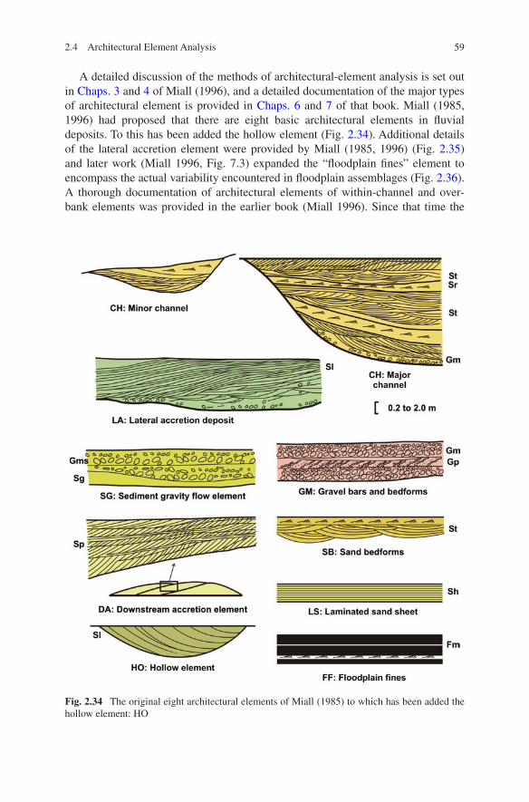
59
A detailed discussion of the methods of architectural-element analysis is set out in Chaps. 3 and 4 of Miall (1996), and a detailed documentation of the major types of architectural element is provided in Chaps. 6 and 7 of that book. Miall (1985, 1996) had proposed that there are eight basic architectural elements in fluvial deposits. To this has been added the hollow element (Fig. 2.34). Additional details of the lateral accretion element were provided by Miall (1985, 1996) (Fig. 2.35) and later work (Miall 1996, Fig. 7.3) expanded the “floodplain fines” element to encompass the actual variability encountered in floodplain assemblages (Fig. 2.36). A thorough documentation of architectural elements of within-channel and over-bank elements was provided in the earlier book (Miall 1996). Since that time the
Fig. 2.34 The original eight architectural elements of Miall (1985) to which has been added the hollow element: HO
2.4 Architectural Element Analysis
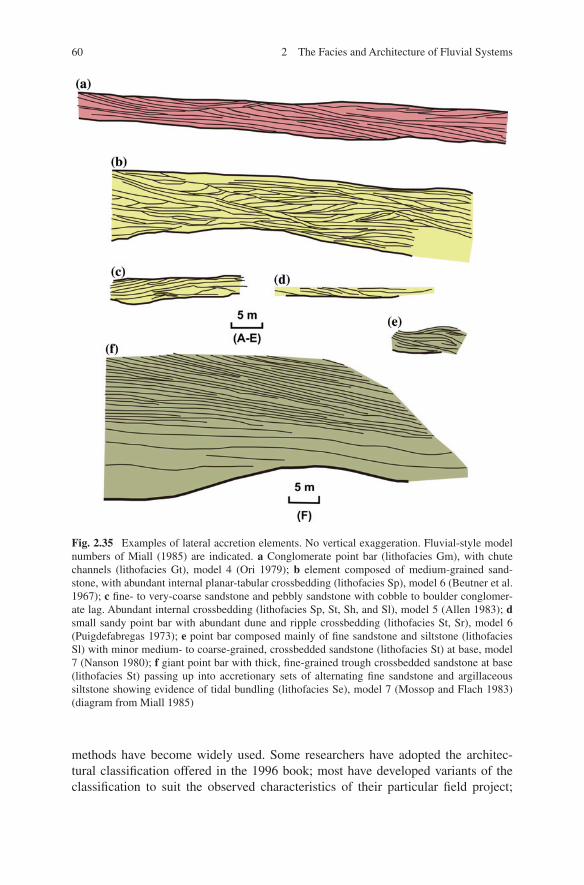
60 2 The Facies and Architecture of Fluvial Systems
methods have become widely used. Some researchers have adopted the architec-tural classification offered in the 1996 book; most have developed variants of the classification to suit the observed characteristics of their particular field project;
Fig. 2.35 Examples of lateral accretion elements. No vertical exaggeration. Fluvial-style model numbers of Miall (1985) are indicated. a Conglomerate point bar (lithofacies Gm), with chute channels (lithofacies Gt), model 4 (Ori 1979); b element composed of medium-grained sand-stone, with abundant internal planar-tabular crossbedding (lithofacies Sp), model 6 (Beutner et al. 1967); c fine- to very-coarse sandstone and pebbly sandstone with cobble to boulder conglomer-ate lag. Abundant internal crossbedding (lithofacies Sp, St, Sh, and Sl), model 5 (Allen 1983); d small sandy point bar with abundant dune and ripple crossbedding (lithofacies St, Sr), model 6 (Puigdefabregas 1973); e point bar composed mainly of fine sandstone and siltstone (lithofacies Sl) with minor medium- to coarse-grained, crossbedded sandstone (lithofacies St) at base, model 7 (Nanson 1980); f giant point bar with thick, fine-grained trough crossbedded sandstone at base (lithofacies St) passing up into accretionary sets of alternating fine sandstone and argillaceous siltstone showing evidence of tidal bundling (lithofacies Se), model 7 (Mossop and Flach 1983)(diagram from Miall 1985)
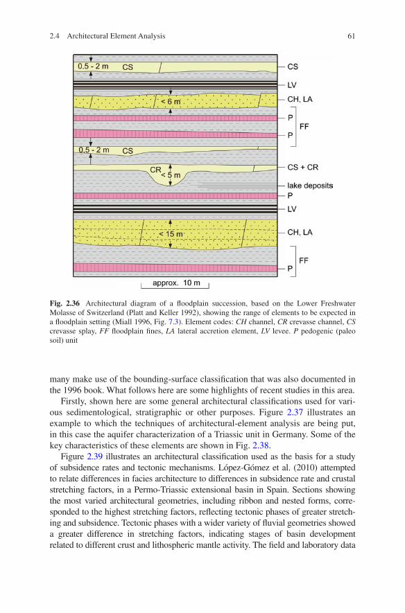
61
many make use of the bounding-surface classification that was also documented in the 1996 book. What follows here are some highlights of recent studies in this area.
Firstly, shown here are some general architectural classifications used for vari-ous sedimentological, stratigraphic or other purposes. Figure 2.37 illustrates an example to which the techniques of architectural-element analysis are being put, in this case the aquifer characterization of a Triassic unit in Germany. Some of the key characteristics of these elements are shown in Fig. 2.38.
Figure 2.39 illustrates an architectural classification used as the basis for a study of subsidence rates and tectonic mechanisms. López-Gómez et al. (2010) attempted to relate differences in facies architecture to differences in subsidence rate and crustal stretching factors, in a Permo-Triassic extensional basin in Spain. Sections showing the most varied architectural geometries, including ribbon and nested forms, corre-sponded to the highest stretching factors, reflecting tectonic phases of greater stretch-ing and subsidence. Tectonic phases with a wider variety of fluvial geometries showed a greater difference in stretching factors, indicating stages of basin development related to different crust and lithospheric mantle activity. The field and laboratory data
Fig. 2.36 Architectural diagram of a floodplain succession, based on the Lower Freshwater Molasse of Switzerland (Platt and Keller 1992), showing the range of elements to be expected in a floodplain setting (Miall 1996, Fig. 7.3). Element codes: CH channel, CR crevasse channel, CS crevasse splay, FF floodplain fines, LA lateral accretion element, LV levee. P pedogenic (paleo soil) unit
2.4 Architectural Element Analysis
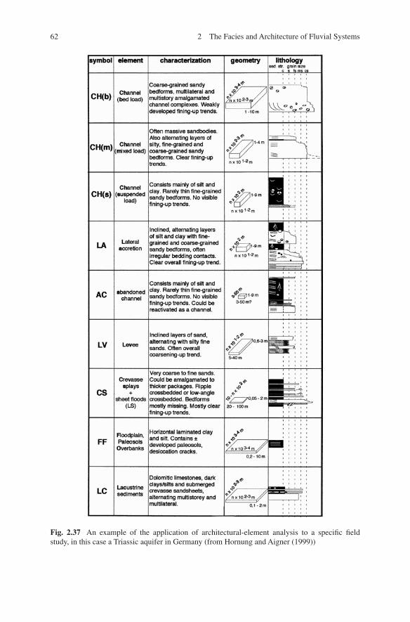
62 2 The Facies and Architecture of Fluvial Systems
Fig. 2.37 An example of the application of architectural-element analysis to a specific field study, in this case a Triassic aquifer in Germany (from Hornung and Aigner (1999))
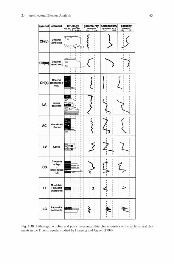
63
Fig. 2.38 Lithologic, wireline and porosity–permeability characteristics of the architectural ele-ments in the Triassic aquifer studied by Hornung and Aigner (1999)
2.4 Architectural Element Analysis
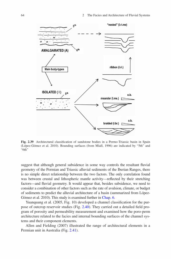
64 2 The Facies and Architecture of Fluvial Systems
suggest that although general subsidence in some way controls the resultant fluvial geometry of the Permian and Triassic alluvial sediments of the Iberian Ranges, there is no simple direct relationship between the two factors. The only correlation found was between crustal and lithospheric mantle activity—reflected by their stretching factors—and fluvial geometry. It would appear that, besides subsidence, we need to consider a combination of other factors such as the rate of avulsion, climate, or budget of sediments to predict the alluvial architecture of a basin (summarized from López-Gómez et al. 2010). This study is examined further in Chap. 6.
Yuanquang et al. (2005, Fig. 10) developed a channel classification for the pur-pose of outcrop reservoir studies (Fig. 2.40). They carried out a detailed field pro-gram of porosity and permeability measurement and examined how the poro-perm architecture related to the facies and internal bounding surfaces of the channel sys-tems and their component elements.
Allen and Fielding (2007) illustrated the range of architectural elements in a Permian unit in Australia (Fig. 2.41).
Fig. 2.39 Architectural classification of sandstone bodies in a Permo-Triassic basin in Spain (López-Gómez et al. 2010). Bounding surfaces (from Miall, 1996) are indicated by “5th” and “6th”
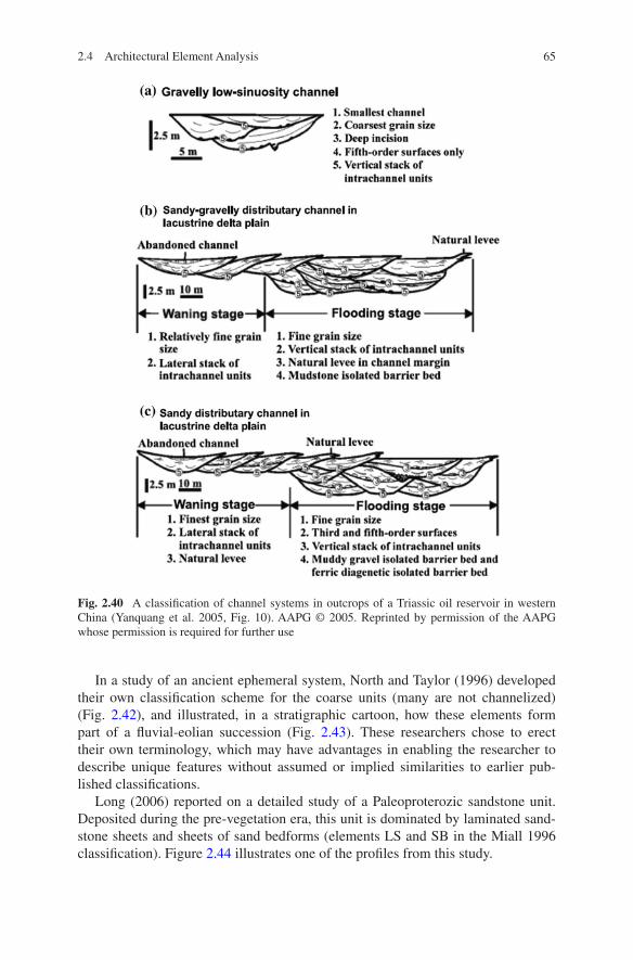
65
In a study of an ancient ephemeral system, North and Taylor (1996) developed their own classification scheme for the coarse units (many are not channelized) (Fig. 2.42), and illustrated, in a stratigraphic cartoon, how these elements form part of a fluvial-eolian succession (Fig. 2.43). These researchers chose to erect their own terminology, which may have advantages in enabling the researcher to describe unique features without assumed or implied similarities to earlier pub-lished classifications.
Long (2006) reported on a detailed study of a Paleoproterozic sandstone unit. Deposited during the pre-vegetation era, this unit is dominated by laminated sand-stone sheets and sheets of sand bedforms (elements LS and SB in the Miall 1996 classification). Figure 2.44 illustrates one of the profiles from this study.
Fig. 2.40 A classification of channel systems in outcrops of a Triassic oil reservoir in western China (Yanquang et al. 2005, Fig. 10). AAPG © 2005. Reprinted by permission of the AAPG whose permission is required for further use
2.4 Architectural Element Analysis
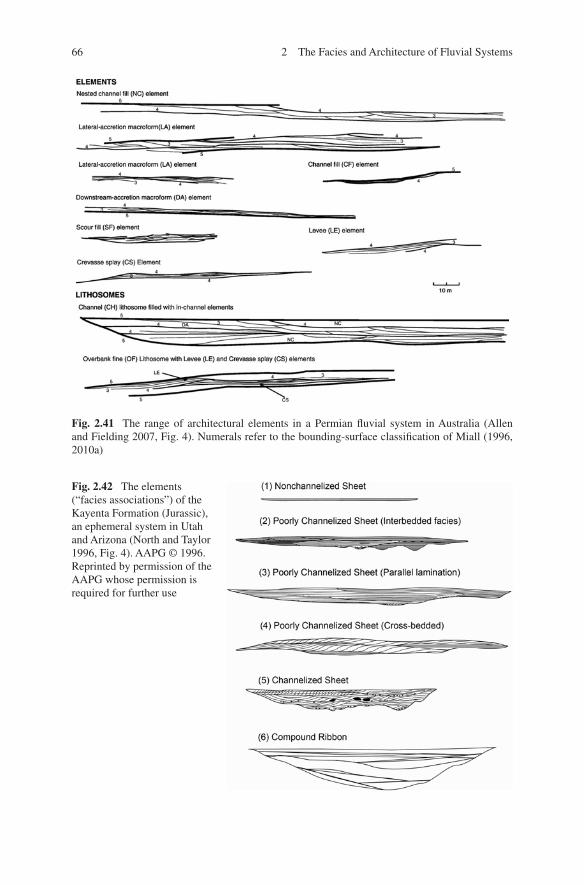
66 2 The Facies and Architecture of Fluvial Systems
Fig. 2.42 The elements (“facies associations”) of the Kayenta Formation (Jurassic), an ephemeral system in Utah and Arizona (North and Taylor 1996, Fig. 4). AAPG © 1996. Reprinted by permission of the AAPG whose permission is required for further use
Fig. 2.41 The range of architectural elements in a Permian fluvial system in Australia (Allen and Fielding 2007, Fig. 4). Numerals refer to the bounding-surface classification of Miall (1996, 2010a)
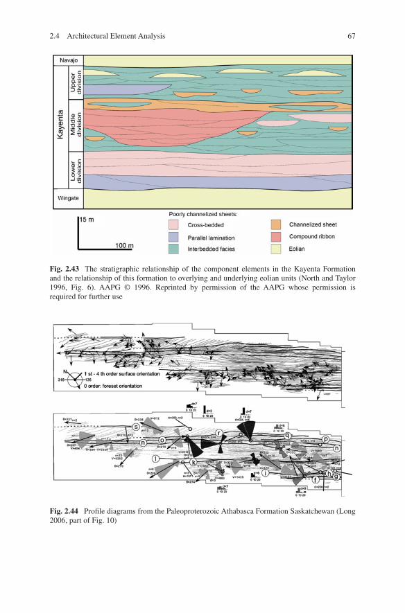
672.4 Architectural Element Analysis
Fig. 2.43 The stratigraphic relationship of the component elements in the Kayenta Formation and the relationship of this formation to overlying and underlying eolian units (North and Taylor 1996, Fig. 6). AAPG © 1996. Reprinted by permission of the AAPG whose permission is required for further use
Fig. 2.44 Profile diagrams from the Paleoproterozoic Athabasca Formation Saskatchewan (Long 2006, part of Fig. 10)
68 2 The Facies and Architecture of Fluvial Systems
Many other examples of architectural documentation and classification could be cited. The point is that the message about the three-dimensional nature of flu-vial architecture has clearly been heard in the sedimentological and petroleum-geology community. There are four obvious applications of this approach:
(1) The increased ability to reconstruct convincing depositional environments provided by architecturally documented two- and three-dimensional outcrop panels.
(2) The method provides a basis for the understanding of the relationship of porosity–permeability structures in aquifers and reservoir units to primary depositional fabrics. On a larger scale, the same methods help to evaluate the nature of jigsaw-puzzle and labyrinth-type reservoir units. Application of the methods is necessary for any advanced “analog” studies of reservoirs, offering the advantage of the preserved record as a basis for comparison, rather than the commonly ephemeral features observable in modern rivers.
(3) The method is a necessary basis for studies of sequence stratigraphy in non-marine rocks because any exploration of the dependence of fluvial architec-ture on allogenic controls, such as tectonism and base-level change, requires a systematic analysis of depositional architecture. Such architectural character-istics as channel-stacking patterns (for example) are clearly related to rates of change of base level or source-area uplift.
(4) Basin evolution is commonly documented using such devices as subsidence plots. This type of basic regional information may be usefully supplemented by architectural studies, which help to reveal how depositional systems respond to different patterns of basin uplift, subsidence or tilting (while bear-ing in mind the necessary caveats regarding time scale of accommodation generation versus the times scales of fluvial processes; see Chap. 6).

http://www.springer.com/978-3-319-00665-9