fire regimes in nahanni nationalpark and the mackenzie
TRANSCRIPT
43
FIRE REGIMES IN NAHANNI NATIONAL PARK AND THEMACKENZIE BISON SANCTUARY,
NORTHWEST TERRITORIES, CANADA
P.M. Bothwell, W.J. de Groot, and D.E. DubéCanadian Forest Service, 5320 - 122 Street, Edmonton, AB T6H 3S5, Canada
T. ChownsResources, Wildlife, and Economic Development, Box 4354, Hay River, NWT X0E 1G3, Canada
D.H. Carlsson and C.N. StefnerCanadian Forest Service, 5320 - 122 Street, Edmonton, AB T6H 3S5, Canada
ABSTRACT
Nahanni National Park and the Mackenzie Bison Sanctuary are ecologically important areas in the Northwest Territories. Firehistory data in Nahanni National Park and the Mackenzie Bison Sanctuary were used for a comparative analysis in order toidentify the most influential characteristics of their respective fire regimes. The Mackenzie Bison Sanctuary is located on theTaiga Plains and is surrounded to the east and south by Great Slave Lake. Nahanni National Park is located in the MackenzieMountains, approximately 500 km west of the Mackenzie Bison Sanctuary. Elevation relief in the Mackenzie Bison Sanctu-ary is 160–260 m, and in Nahanni National Park is 180–2,640 m. Fuels are similar in both study areas and are dominated bylow-density coniferous forest. Nahanni National Park has a significantly higher mean annual occurrence of very high andextreme classes of Canadian Fire Weather Index System codes and indices. Fire scar data indicate weighted mean fire returnintervals (MFRIs) of 28 years and 27 years, respectively, for Nahanni National Park and the Mackenzie Bison Sanctuary. Areaburned totals from a national database of fires greater than 200 ha in area suggest a fire cycle of 1,142 years and 199 years,respectively, for Nahanni National Park and the Mackenzie Bison Sanctuary. Differences in average fire size (1,149 ha inNahanni National Park and 7,806 ha in the Mackenzie Bison Sanctuary) are partially attributed to topographic differencesbetween the two areas.
keywords: boreal, fire frequency, fire history, fire regime, mean fire return interval, Northwest Territories, topography.
Citation: Bothwell, P.M., W.J. de Groot, D.E. Dubé, T. Chowns, D.H. Carlsson, and C.N. Stefner. 2004. Fire regimes inNahanni National Park and the Mackenzie Bison Sanctuary, Northwest Territories, Canada. Pages 43–54 in R.T. Engstrom,K.E.M. Galley, and W.J. de Groot (eds.). Proceedings of the 22nd Tall Timbers Fire Ecology Conference: Fire in Temperate,Boreal, and Montane Ecosystems. Tall Timbers Research Station, Tallahassee, FL.
INTRODUCTION
Nahanni National Park and the Mackenzie BisonSanctuary are two ecologically important areas innorthwestern Canada. As in much of the boreal forest,disturbance by fire has historically been a prominentprocess in defining the ecosystems and their structuraldistribution in both areas. Resource managementobjectives are based on policy and science-relatedguidelines, and a clear understanding of historical fireregimes will contribute to successful managementplanning in the future. Describing and understandingthe fire regime of an area requires defining character-istics such as the fire cycle, fire interval, fire season,and the number, type, and intensity of fires that char-acterize the given areas (Merrill and Alexander 1987).
Fire weather, fuels, topography, and ignition patternsplay a prominent role in defining the characteristicsassociated with the fire regime. A comparative studyof the fire history was conducted at these two region-al locations in order to estimate these characteristicsand the influence of fire weather and fuels.
STUDY AREAS
Nahanni National Park
Nahanni National Park Reserve was established in1972 to preserve the ecologically significant NahanniRiver and Flat River watersheds. The 4,766-km2
reserve is characterized by mountainous topography,with elevations ranging from 180 m to 2,640 m abovesea level (asl). Two major rivers, the Nahanni River

44 BOTHWELL ET AL.
and the Flat River, flow through the valleys of thereserve and were used by aboriginal peoples as accessto the region for the past 10,000 years. Recent Euro-pean settlement initiated exploitation of valuable furresources and promoted further occupation of theremote area (Parks Canada 2001).
Nahanni National Park is located in the southwesterncorner of the Northwest Territories (62°00′N,127°30′W to 61°05′N, 123°45′W) (Figure 1) and occu-pies the Alpine Forest–Tundra forest section of theBoreal Forest Region (Rowe 1972). This section ischaracterized by low-density stands of coniferous for-est, predominantly black spruce (Picea mariana) andwhite spruce (Picea glauca), as well as smaller propor-tions of deciduous forest including aspen (Populustremuloides), balsam poplar (Populus balsamifera),and birch varieties (Betula spp.). Stands of tamarack(Larix laricina) and subalpine fir (Abies lasiocarpa)are found on the lowlands and higher elevations,respectively. Scotter (1974) reported extensive standsof lodgepole pine (Pinus contorta var. latifolia)throughout the southern portion of the park boundary,particularly along the Flat River. The distribution ofjack pine (Pinus banksiana) is limited to the easternboundary of the park, with lodgepole–jack pine hybridscommon where the species’ distributions overlap.
The region’s climate can be summarized as coldcontinental, with large fluctuations resulting from themountainous terrain. The long-term weather stationnearest to Nahanni National Park is located about 225km southwest at Watson Lake, Yukon (689 m asl)
(Figure 1). The average maximum July temperature atWatson Lake is 21.1 °C, while the average minimumJanuary temperature is –30.0 °C. Average annual pre-cipitation as rainfall is 256.7 mm and as snowfall is218.9 mm (water equivalent). The region experiencesan average of 12 thunderstorms annually, primarilyduring June and July (Environment Canada 1993).
Mackenzie Bison Sanctuary
The Mackenzie Bison Sanctuary was established tomeet the objectives of wood bison (Bison bisonathabascae) management in the Mackenzie Region ofthe Northwest Territories. The area used for this study(61°00′N, 114°00′W to 63°00′N, 118°00′W) extendsbeyond the defined boundaries of the Mackenzie BisonSanctuary and encompasses about 11,150 km2. Eleva-tion relief in the Mackenzie Bison Sanctuary is mini-mal, ranging from 160 to 260 m asl.
Rowe (1972) classifies this area as part of the North-western Transition Section of the Boreal Forest Region.This transition area joins the higher-density coniferousforest in the south to the tundra in the north and is pri-marily composed of low-density coniferous forest, bog,muskeg, and barren rock. Harsh climatic conditions andfrequent fire events result in limited vegetation success,distribution, and dwarfed growth patterns. The mostcommon tree species include black spruce, whitespruce, paper birch (Betula papyrifera var. papyrifera),tamarack, jack pine, aspen, and balsam poplar.
The climate in this area is strongly influenced byGreat Slave Lake and seasonal averages are similar tothose in Nahanni National Park. The nearest long-term
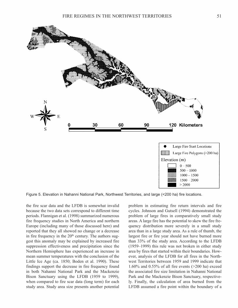
Figure 1. Study area locations in Nahanni National Park and the Mackenzie Bison Sanctuary, Northwest Territories.
45FIRE REGIMES IN THE NORTHWEST TERRITORIES
weather station is located about 50 km south at HayRiver (164 m asl) (Figure 1) and reports an averagemaximum July temperature of 20.9 °C and an averageminimum January temperature of –29.3 °C. Precipita-tion as rainfall averages 194.2 mm and as snowfallaverages 158.5 mm annually (water equivalent). Theregion experiences an average of 8 thunderstormsannually, primarily during June, July, and August(Environment Canada 1993).
METHODS
Fire Weather
Fire weather parameters were collected from thenearest representative Atmospheric Environment Ser-vice weather stations (Environment Canada) and usedto derive parameters of the Canadian Fire WeatherIndex (FWI) System (Van Wagner 1987). Fire Weath-er Index System values for the Fine Fuel MoistureCode (FFMC), Initial Spread Index (ISI), BuildupIndex (BUI), and the Fire Weather Index were catego-rized into five relative classes (Table 1) and the rela-tive frequency of occurrence was determined.
The Watson Lake station was used for NahanniNational Park because of its long-term records(1953–1992) and mountainous topography. Long-term(1953–1995) weather data from the Hay River stationwas used for the Mackenzie Bison Sanctuary. The FWISystem codes and indices were used to compare fireweather severity between the two weather stations.Paired t-tests and Friedman Two-Way Analysis of Vari-ance tests (SYSTAT 2000) were performed on eachFWI System parameter in order to determine if theannual average number of days in the very high andextreme classes were significantly different betweenthe two weather stations. In order to accommodate thestatistical tests it was necessary to standardize the databy setting the seasonal start date of each year at 25 Mayand the end date at 30 September. Weather data from1953 to 1992 were used for this analysis.
Data from the Watson Lake and Hay River weatherstations were also used to document the fire weatherevents that occurred during the days and years knownto have fire activity from the Large Fire Database(Stocks et al. 2002). Nahanni National Park and theMackenzie Bison Sanctuary were analyzed separatelyusing a two-sample t-test to determine if years withfire activity had a higher mean Seasonal Severity Rat-ing (SSR) (Van Wagner 1970) than years without fireactivity.
Fuels
A vegetation inventory was not readily available toderive fuel classifications for either area. Instead, fueltype classifications were derived using data collectedby the National Oceanic and Atmospheric Administra-tion Advanced Very High Resolution Radiometer. Thissatellite collects data at a 1-km resolution. Data wereinterpreted using the Normalized Difference Vegeta-tion Index to derive a land cover classification ofCanada for 1995 (Beaubien et al. 1997). This spatialdatabase of land cover was then used to estimate thearea of various fuel types as described by the Canadi-an Forest Fire Behavior Prediction (FBP) System(Forestry Canada Fire Danger Group 1992).
Fire History Sampling
Field sampling for fire history data was performed inboth Nahanni National Park and the Mackenzie BisonSanctuary. Tree discs were collected; fire scars andstand origins were dated from numerous sample sites.Disc preparation and tree-ring analysis methods weresimilar to those described by Arno and Sneck (1977).
Sample collection for fire scar and stand origin datain Nahanni National Park occurred during the sum-mers of 1977 and 1978, and in the Mackenzie BisonSanctuary throughout 1991 to 1993. Sample sites wereselected based on numerous conditions including veg-etation type, topography, aspect, evidence of fireoccurrence, and access considerations. A total of 62
Table 1. Relative classes for various Fire Weather Index System codes and indices used in the fire weather analysisfor Nahanni National Park and the Mackenzie Bison Sanctuary, Northwest Territories.
Fire Weather Index System component
Class Fine Fuel Moisture Code Buildup Index Initial Spread Index Fire Weather Index
Low 0–79 0–24 0–2 0–4Moderate 80–84 25–40 3–4 5–10High 85–87 41–60 5–9 11–18Very High 88–89 61–89 10–16 19–29Extreme 90–101 90+ 17+ 30+
46 BOTHWELL ET AL.
sites were sampled in Nahanni National Park equalinga sampling intensity of 1 site per 51.6 km2 (5,160 ha).A total of 216 sites were sampled in the MackenzieBison Sanctuary equaling a sampling intensity of 1site per 34.8 km2 (3,480 ha). Sample intensities werecalculated based on forested area.
At each site, between 1 and 16 trees were sampled inorder to collect fire-year data. The age and species ofeach tree were determined and recorded. Ground veg-etation, fuel loading, and other stand characteristicdata were also recorded at each site. A fire masterchronology (Wagener 1961, Arno and Sneck 1977,Johnson and Gutsell 1994) was developed from thetree disc samples after lab analysis. Fire scar data wereused to estimate composite mean fire return intervals(MFRI) (Tande 1979, Romme 1980) at each samplesite according to the following equation:
(1)
where (Ti + 1 – Ti) = interval between any 2 consecutivefire years at a sample site, and N = number of intervalsidentified for a site.
The MFRI was calculated two ways. First, MFRIswere calculated using fire scar data only and therefore asite required at least two different fire scars to calculatean interval. This method caused sites with fewer thantwo scars to be omitted. The second method used jackpine and lodgepole pine origin data to increase the num-ber of intervals used in the calculation by deriving anorigin to first scar (OS) interval. This method resulted infewer sites being omitted. The interval from the mostrecent fire scar date to the sampling date (time-since-fire) was not included due to its open-ended nature. Aweighted MFRI (Baker and Ehle 2001) was calculatedfor the entire study area using site MFRIs from eachstudy area according to the following equation:
Weighted MFRI =
(2)
where MFRI1 … MFRIn = the MFRIs from each sam-ple site, and N1 … Nn = the number of intervals at eachstudy site.
Large Fire Database
The Canadian Forest Service Large Fire Database(LFDB) (Stocks et al. 2002) was used to provide addi-tional and more recent fire history information for thisstudy. The LFDB point data used for this study con-sists of fires >200 ha that have been reported in Cana-da from 1959 to 1999. A point indicating the startinglocation can be spatially displayed for each fire. TheLFDB includes information on fire size, start date,
location, cause, and other fire-related characteristics.The average annual area burned (AAB) for each studyarea for the period 1959 to 1999 was determined. Thepercent AAB and fire cycles were calculated accord-ing to the following equations:
Percent AAB = AAB/forested area × 100, (3)Fire Cycle = forested area/average AAB. (4)
RESULTS
Fire Weather
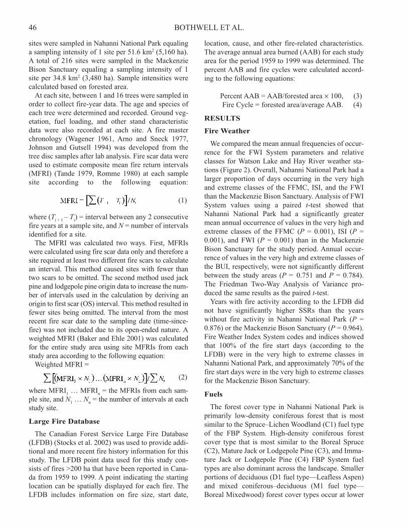
We compared the mean annual frequencies of occur-rence for the FWI System parameters and relativeclasses for Watson Lake and Hay River weather sta-tions (Figure 2). Overall, Nahanni National Park had alarger proportion of days occurring in the very highand extreme classes of the FFMC, ISI, and the FWIthan the Mackenzie Bison Sanctuary. Analysis of FWISystem values using a paired t-test showed thatNahanni National Park had a significantly greatermean annual occurrence of values in the very high andextreme classes of the FFMC (P = 0.001), ISI (P =0.001), and FWI (P = 0.001) than in the MackenzieBison Sanctuary for the study period. Annual occur-rence of values in the very high and extreme classes ofthe BUI, respectively, were not significantly differentbetween the study areas (P = 0.751 and P = 0.784).The Friedman Two-Way Analysis of Variance pro-duced the same results as the paired t-test.
Years with fire activity according to the LFDB didnot have significantly higher SSRs than the yearswithout fire activity in Nahanni National Park (P =0.876) or the Mackenzie Bison Sanctuary (P = 0.964).Fire Weather Index System codes and indices showedthat 100% of the fire start days (according to theLFDB) were in the very high to extreme classes inNahanni National Park, and approximately 70% of thefire start days were in the very high to extreme classesfor the Mackenzie Bison Sanctuary.
Fuels
The forest cover type in Nahanni National Park isprimarily low-density coniferous forest that is mostsimilar to the Spruce–Lichen Woodland (C1) fuel typeof the FBP System. High-density coniferous forestcover type that is most similar to the Boreal Spruce(C2), Mature Jack or Lodgepole Pine (C3), and Imma-ture Jack or Lodgepole Pine (C4) FBP System fueltypes are also dominant across the landscape. Smallerportions of deciduous (D1 fuel type—Leafless Aspen)and mixed coniferous–deciduous (M1 fuel type—Boreal Mixedwood) forest cover types occur at lower
47FIRE REGIMES IN THE NORTHWEST TERRITORIES
and middle elevations. The Mackenzie Bison Sanctu-ary has a similar forest composition, with a slightlyhigher proportion of low-density coniferous (C1) fueltype, and slightly lower proportions of high-density(C2, C3, and C4) fuel types. The proportion of totallandbase composed of the deciduous (D1) and variousconiferous–deciduous (M1) fuel types is very similarto Nahanni National Park. Both study areas have a rel-atively large proportion of landbase in non-fuel vege-tation classes, which are primarily wetlands, shrub-lands, and rock. Figure 3 compares the various fueltype proportions between Nahanni National Park andthe Mackenzie Bison Sanctuary and indicates relative-ly small differences between the two study areas. Thetotal vegetated area is 319,660 ha and 751,988 ha,respectively, for Nahanni National Park and theMackenzie Bison Sanctuary.
Fire Scar Data
Without including jack pine and lodgepole pine OSdata, fire scar data from Nahanni National Park indi-cated a weighted MFRI of 21.7 years associated withthe period 1813 to 1974 (162 years). Using OS datathe weighted MFRI was 28.3 years associated with theperiod 1731 to 1974 (244 years). These estimatesshould be considered conservative for this periodbecause evidence of fire disappears through time (VanWagner 1978). Three or more different sites wereburned in 1907, 1915, 1925, 1937, 1940, and 1949(Figure 4) and indicate relatively major fire years.Without OS data from jack pine, fire scar data for theMackenzie Bison Sanctuary produced a weightedMFRI of 23.3 years for the period 1771 to 1977 (207years). With OS data the weighted MFRI was 27.1years for the period 1765 to 1977 (213 years). These
Figure 2. Frequency distribution (mean ± SD) of Fire Weather Index codes and indices for Nahanni National Parkand the Mackenzie Bison Sanctuary, Northwest Territories.

48 BOTHWELL ET AL.
estimates should also be considered conservative.Major fire years occurred in 1878, 1916, 1927, 1930,1939, 1942, 1946, and 1949 (Figure 4) when morethan 10 different sites per year burned.
Large Fire Database
Analysis of the LFDB for the study areas producedconflicting results when compared to MFRIs from thefire scar data. Area burned during the period of 1959to 1999 (41 years) indicated that about 11,494 haburned in Nahanni National Park. This period had atotal of 11 fires, 4 of which burned in 1983, and 3 ofwhich (27%) had suppression action. Fire frequency is0.084 large (>200 ha) fires/year per 100,000 ha. Allfires were caused by lightning ignitions. Annual areaburned for this period is 280 ha/year and correspondsto a percent AAB of 0.09. The fire cycle calculatedfrom this percent AAB is 1,142 years. In the Macken-zie Bison Sanctuary, the area burned from 1959 to1999 was 154,764 ha. This period had a total of 18fires, 3 of which occurred in 1972 and 2 of whichoccurred in 1994. Three of these fires (17%) werehuman-caused ignitions, 14 fires (78%) were causedby lightning, and the cause of 1 fire was unknown.Finally, suppression action was applied to 10 of thesefires (56%). Fire frequency is 0.056 large (>200 ha)fires/year per 100,000 ha. The AAB during the periodis 3,775 ha/year and corresponds with a percent AABof 0.50. The fire cycle calculated from the percentAAB is 199 years. The average fire size and standarddeviations for the two study areas according to theLFDB are in Table 2.
DISCUSSION
Comparisons of fire weather from the Watson Lakeand Hay River weather stations indicate that NahanniNational Park is characterized by more severe fireweather than the Mackenzie Bison Sanctuary. Thehigher occurrence of days in the very high andextreme classes of the various FWI System codes andindices suggest that there is a higher ignition potential(FFMC), higher fire spread potential (ISI), and a high-er overall fire intensity in Nahanni National Park (VanWagner 1987). Fire weather in Nahanni National Parkis subject to large variation because of the many com-plex variables in the mountainous fire environment,including fuel moistures and atmospheric characteris-tics that change according to aspect and elevation.
The SSR is calculated by averaging the Daily Sever-ity Rating (DSR), which is derived from the FWIvalue of the FWI System, and provides a method ofmeasuring the fire severity for an entire fire season
Figure 3. Fuel type distribution in Nahanni NationalPark and the Mackenzie Bison Sanctuary, NorthwestTerritories.
Figure 4. Frequency of fire scars among sample sitesin Nahanni National Park and the Mackenzie BisonSanctuary, Northwest Territories.

49FIRE REGIMES IN THE NORTHWEST TERRITORIES
(Van Wagner 1970). However, because the SSR is anaverage of the DSR it has the characteristic of offset-ting higher DSR values with lower DSR values, andtherefore does not identify fire seasons that may havehad high fire weather severity in the beginning of thefire season and low fire weather severity in the end (orvice versa). The SSRs in years of fire activity accord-ing to the LFDB on average were not higher than yearswithout fire activity. It is therefore possible that thiscould be partially explained by the inability of the SSRto detect seasonal variation in fire weather patterns.Analysis of individual FWI System parameters on firestart dates (according to the LFDB) discovered, by andlarge, that most fire start dates had FWI System valuesin the very high and extreme classes despite the geo-graphic differences between the weather stations andthe study areas. This indicates FWI System parameterswere generally applicable over a large geographic area(within 100–200 km) given similar topography andland features (e.g., Great Slave Lake).
The fuels within Nahanni National Park and theMackenzie Bison Sanctuary were very similar andtherefore not considered important in explaining thedifferences in fire regime characteristics. However,differences in fuel continuity, as it is influenced bytopography and elevation, can potentially play animportant role in fire spread and size patterns and willbe discussed later. Experimental fires have been con-ducted in the various coniferous and deciduous fueltypes common to the study locations (Stocks 1987,1989; Alexander and Sando 1989; Alexander et al.1991; Quintilio et al. 1991). Coniferous fuels in theboreal forest typically burn at higher intensities thandeciduous fuels. Most area burned in the Canadianboreal forest burns as high-intensity crown fires,though high variation in fire intensity within each fireis also common.
Estimates of MFRIs are subject to various interpre-tations. Ideally the weighted MFRI and fire cycleshould be the same, despite the fundamental differ-ences in the approach, methodology, and data used tocalculate them (Baker and Ehle 2001). Mean fire
return intervals are often calculated at a point withoutknowing the actual size of the fire that is being record-ed (temporal). In contrast, the area of past fire eventsare most often used to estimate fire cycles (spatial).Theoretically, each unit of area within a study area willexperience an average of 1 fire during a period equalto 1 fire cycle, though some units will experience moreor less. The weighted MFRI provides a way to esti-mate the fire cycle without knowing actual fire sizes(Baker and Ehle 2001). Mean fire return interval esti-mates from fire scar data are subject to numeroussources of error including missed scars, incorrect den-drochronology, loss of fire scar evidence over time,fire events that do not leave scars, and often inappro-priate sampling intensities over a large study area.However, estimating fire cycles from known fire areasprovides a method that is able to avoid many of thesesources of error.
Our study used composite MFRIs and we assumedthat all fire scars at one sample site, even though theymay not all be found on any single tree, had burned theentire site. This is an advantageous method in borealforest because individual trees missing fire scars arelikely common. Unfortunately, composite MFRIs arealso biased because they become smaller as the studyarea becomes larger (Arno and Petersen 1983). Due tothe various sources of bias and a low sampling inten-sity for fire scar analysis, the weighted MFRI may notbe a reliable estimate of the fire cycle for the studyareas.
Inclusion of OS data for calculation of compositeMFRIs has not been a common method in many firehistory studies because sporadic or delayed regenera-tion following fire makes determining the exact timesince last fire difficult (Houston 1973). Lodgepolepine and jack pine are fire-adapted species and typi-cally have a serotinous cone that requires heat to open.In mature jack pine and lodgepole pine stands, coneserotiny typically gives way to abundant and rapidcolonization of burned sites (Horton 1956, Chro-sciewicz 1988). Use of OS data from jack pine andlodgepole pine may not be as accurate as using fire
Table 2. Fire characteristics from the Large Fire Database for Nahanni National Park and the Mackenzie BisonSanctuary, Northwest Territories, 1959–1999.
Fire size characteristics
Study area Forested area (ha) Number of fires Average (ha) SD (ha)
Nahanni National Park 319,660 11 1,149 954
Mackenzie BisonSanctuary 751,988 18 7,806 13,767
50 BOTHWELL ET AL.
scar data for dating fires; however, the additionalinterval provides more data and may outweigh theconsequences of fire intervals being slightly shorterthan they actually are. Baker and Ehle (2001) suggestthat OS data should be included because it is the mostancient and often the longest interval in the fire histo-ry record.
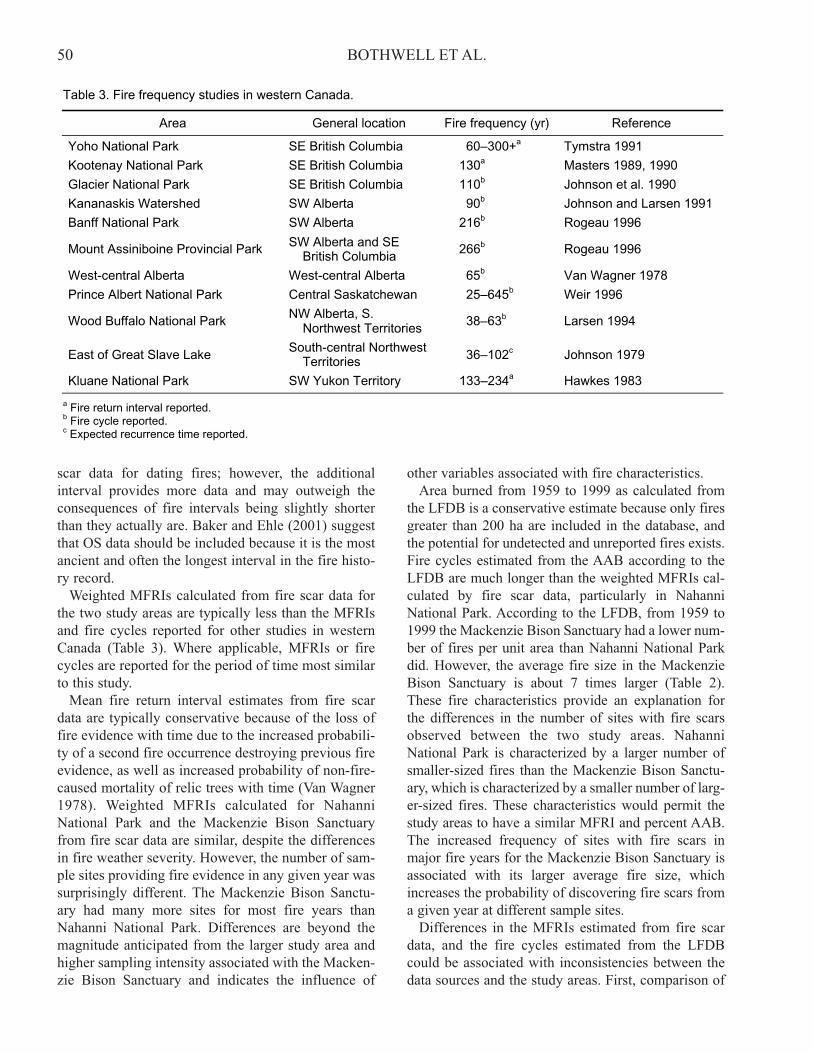
Weighted MFRIs calculated from fire scar data forthe two study areas are typically less than the MFRIsand fire cycles reported for other studies in westernCanada (Table 3). Where applicable, MFRIs or firecycles are reported for the period of time most similarto this study.
Mean fire return interval estimates from fire scardata are typically conservative because of the loss offire evidence with time due to the increased probabili-ty of a second fire occurrence destroying previous fireevidence, as well as increased probability of non-fire-caused mortality of relic trees with time (Van Wagner1978). Weighted MFRIs calculated for NahanniNational Park and the Mackenzie Bison Sanctuaryfrom fire scar data are similar, despite the differencesin fire weather severity. However, the number of sam-ple sites providing fire evidence in any given year wassurprisingly different. The Mackenzie Bison Sanctu-ary had many more sites for most fire years thanNahanni National Park. Differences are beyond themagnitude anticipated from the larger study area andhigher sampling intensity associated with the Macken-zie Bison Sanctuary and indicates the influence of
other variables associated with fire characteristics. Area burned from 1959 to 1999 as calculated from
the LFDB is a conservative estimate because only firesgreater than 200 ha are included in the database, andthe potential for undetected and unreported fires exists.Fire cycles estimated from the AAB according to theLFDB are much longer than the weighted MFRIs cal-culated by fire scar data, particularly in NahanniNational Park. According to the LFDB, from 1959 to1999 the Mackenzie Bison Sanctuary had a lower num-ber of fires per unit area than Nahanni National Parkdid. However, the average fire size in the MackenzieBison Sanctuary is about 7 times larger (Table 2).These fire characteristics provide an explanation forthe differences in the number of sites with fire scarsobserved between the two study areas. NahanniNational Park is characterized by a larger number ofsmaller-sized fires than the Mackenzie Bison Sanctu-ary, which is characterized by a smaller number of larg-er-sized fires. These characteristics would permit thestudy areas to have a similar MFRI and percent AAB.The increased frequency of sites with fire scars inmajor fire years for the Mackenzie Bison Sanctuary isassociated with its larger average fire size, whichincreases the probability of discovering fire scars froma given year at different sample sites.
Differences in the MFRIs estimated from fire scardata, and the fire cycles estimated from the LFDBcould be associated with inconsistencies between thedata sources and the study areas. First, comparison of
Table 3. Fire frequency studies in western Canada.
Area General location Fire frequency (yr) Reference
Yoho National Park SE British Columbia 60–300+a Tymstra 1991
Kootenay National Park SE British Columbia 130a Masters 1989, 1990
Glacier National Park SE British Columbia 110b Johnson et al. 1990
Kananaskis Watershed SW Alberta 90b Johnson and Larsen 1991
Banff National Park SW Alberta 216b Rogeau 1996
Mount Assiniboine Provincial Park SW Alberta and SEBritish Columbia 266b Rogeau 1996
West-central Alberta West-central Alberta 65b Van Wagner 1978
Prince Albert National Park Central Saskatchewan 25–645b Weir 1996
Wood Buffalo National Park NW Alberta, S.Northwest Territories 38–63b Larsen 1994
East of Great Slave Lake South-central NorthwestTerritories 36–102c Johnson 1979
Kluane National Park SW Yukon Territory 133–234a Hawkes 1983
a Fire return interval reported.b Fire cycle reported.c Expected recurrence time reported.
51FIRE REGIMES IN THE NORTHWEST TERRITORIES
the fire scar data and the LFDB is somewhat invalidbecause the two data sets correspond to different timeperiods. Flannigan et al. (1998) summarized numerousfire frequency studies in North America and northernEurope (including many of those discussed here) andreported that they all showed no change or a decreasein fire frequency in the 20th century. The authors sug-gest this anomaly may be explained by increased firesuppression effectiveness and precipitation since theNorthern Hemisphere has experienced an increase inmean summer temperatures with the conclusion of theLittle Ice Age (ca. 1850; Boden et al. 1990). Thesefindings support the decrease in fire frequency foundin both Nahanni National Park and the MackenzieBison Sanctuary using the LFDB (1959 to 1999),when compared to fire scar data (long term) for eachstudy area. Study area size presents another potential
problem in estimating fire return intervals and firecycles. Johnson and Gutsell (1994) demonstrated theproblem of large fires in comparatively small studyareas. A large fire has the potential to skew the fire fre-quency distribution more severely in a small studyarea than in a large study area. As a rule of thumb, thelargest fire or fire year should not have burned morethan 33% of the study area. According to the LFDB(1959–1999) this rule was not broken in either studyarea by fires that started within their boundaries. How-ever, analysis of the LFDB for all fires in the North-west Territories between 1959 and 1999 indicate that1.60% and 0.55% of all fire events (>200 ha) exceedthe associated fire size limitation in Nahanni NationalPark and the Mackenzie Bison Sanctuary, respective-ly. Finally, the calculation of area burned from theLFDB assumed a fire point within the boundary of a
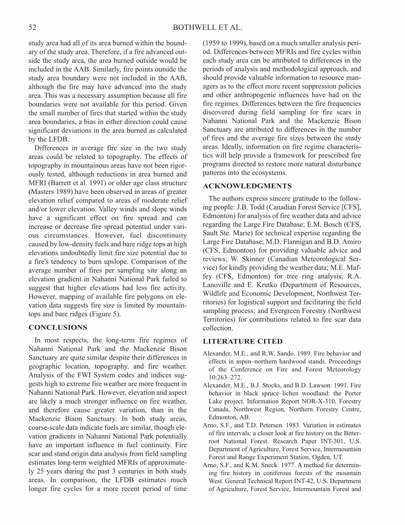
Figure 5. Elevation in Nahanni National Park, Northwest Territories, and large (<200 ha) fire locations.
52 BOTHWELL ET AL.
study area had all of its area burned within the bound-ary of the study area. Therefore, if a fire advanced out-side the study area, the area burned outside would beincluded in the AAB. Similarly, fire points outside thestudy area boundary were not included in the AAB,although the fire may have advanced into the studyarea. This was a necessary assumption because all fireboundaries were not available for this period. Giventhe small number of fires that started within the studyarea boundaries, a bias in either direction could causesignificant deviations in the area burned as calculatedby the LFDB.
Differences in average fire size in the two studyareas could be related to topography. The effects oftopography in mountainous areas have not been rigor-ously tested, although reductions in area burned andMFRI (Barrett et al. 1991) or older age class structure(Masters 1989) have been observed in areas of greaterelevation relief compared to areas of moderate reliefand/or lower elevation. Valley winds and slope windshave a significant effect on fire spread and canincrease or decrease fire spread potential under vari-ous circumstances. However, fuel discontinuitycaused by low-density fuels and bare ridge tops at highelevations undoubtedly limit fire size potential due toa fire's tendency to burn upslope. Comparison of theaverage number of fires per sampling site along anelevation gradient in Nahanni National Park failed tosuggest that higher elevations had less fire activity.However, mapping of available fire polygons on ele-vation data suggests fire size is limited by mountain-tops and bare ridges (Figure 5).
CONCLUSIONS
In most respects, the long-term fire regimes ofNahanni National Park and the Mackenzie BisonSanctuary are quite similar despite their differences ingeographic location, topography, and fire weather.Analysis of the FWI System codes and indices sug-gests high to extreme fire weather are more frequent inNahanni National Park. However, elevation and aspectare likely a much stronger influence on fire weather,and therefore cause greater variation, than in theMackenzie Bison Sanctuary. In both study areas,coarse-scale data indicate fuels are similar, though ele-vation gradients in Nahanni National Park potentiallyhave an important influence in fuel continuity. Firescar and stand origin data analysis from field samplingestimates long-term weighted MFRIs of approximate-ly 25 years during the past 3 centuries in both studyareas. In comparison, the LFDB estimates muchlonger fire cycles for a more recent period of time
(1959 to 1999), based on a much smaller analysis peri-od. Differences between MFRIs and fire cycles withineach study area can be attributed to differences in theperiods of analysis and methodological approach, andshould provide valuable information to resource man-agers as to the effect more recent suppression policiesand other anthropogenic influences have had on thefire regimes. Differences between the fire frequenciesdiscovered during field sampling for fire scars inNahanni National Park and the Mackenzie BisonSanctuary are attributed to differences in the numberof fires and the average fire sizes between the studyareas. Ideally, information on fire regime characteris-tics will help provide a framework for prescribed fireprograms directed to restore more natural disturbancepatterns into the ecosystems.
ACKNOWLEDGMENTS
The authors express sincere gratitude to the follow-ing people: J.B. Todd (Canadian Forest Service [CFS],Edmonton) for analysis of fire weather data and adviceregarding the Large Fire Database; E.M. Bosch (CFS,Sault Ste. Marie) for technical expertise regarding theLarge Fire Database; M.D. Flannigan and B.D. Amiro(CFS, Edmonton) for providing valuable advice andreviews; W. Skinner (Canadian Meteorological Ser-vice) for kindly providing the weather data; M.E. Maf-fey (CFS, Edmonton) for tree ring analysis; R.A.Lanoville and E. Krutko (Department of Resources,Wildlife and Economic Development, Northwest Ter-ritories) for logistical support and facilitating the fieldsampling process; and Evergreen Forestry (NorthwestTerritories) for contributions related to fire scar datacollection.
LITERATURE CITED
Alexander, M.E., and R.W. Sando. 1989. Fire behavior andeffects in aspen–northern hardwood stands. Proceedingsof the Conference on Fire and Forest Meteorology10:263–272.
Alexander, M.E., B.J. Stocks, and B.D. Lawson. 1991. Firebehavior in black spruce–lichen woodland: the PorterLake project. Information Report NOR-X-310, ForestryCanada, Northwest Region, Northern Forestry Centre,Edmonton, AB.
Arno, S.F., and T.D. Petersen. 1983. Variation in estimatesof fire intervals: a closer look at fire history on the Bitter-root National Forest. Research Paper INT-301, U.S.Department of Agriculture, Forest Service, IntermountainForest and Range Experiment Station, Ogden, UT.
Arno, S.F., and K.M. Sneck. 1977. A method for determin-ing fire history in coniferous forests of the mountainWest. General Technical Report INT-42, U.S. Departmentof Agriculture, Forest Service, Intermountain Forest and

53FIRE REGIMES IN THE NORTHWEST TERRITORIES
Range Experiment Station, Ogden, UT.Baker, W.L., and D. Ehle. 2001. Uncertainty in surface-fire
history: the case of ponderosa pine forests in the westernUnited States. Canadian Journal of Forest Research31:1205–1226.
Barrett, S.W., S.F. Arno, and C.H. Key. 1991. Fire regimesof western larch–lodgepole pine forests in GlacierNational Park, Montana. Canadian Journal of ForestResearch 21:1711–1720.
Beaubien, J., J. Cihlar, Q. Xiao, J. Chen, K. Fung, and P.Hurlburt. 1997. A new, nationally consistent, satellite-derived land cover of Canada: a comparison of 2 method-ologies. In Proceedings of the international symposiumon Geomatics in the era of Radarsat [CD-ROM]. NaturalResources Canada, Ottawa, ON.
Boden, T.A., P. Kanciruk, and M.P. Farrell. 1990. Trends’90: a compendium of data on global change.ORNL/CDIAC-36, Department of Energy, Washington,D.C.
Chrosciewicz, Z. 1988. Jack pine regeneration followingpostcut burning under seed trees in central Saskatchewan.Forestry Chronicle 64:315–319.
Environment Canada. 1993. Canadian climate normals,1961–90. Volume 3: Yukon and the Northwest Territories.Canadian Climate Program, Environment Canada, Atmo-spheric Environment Services, Ottawa, ON.
Flannigan, M.E., Y. Bergeron, O. Engelmark, and B.M.Wotton. 1998. Future wildfire in circumboreal forests inrelation to global warming. Journal of Vegetation Science9:469–476.
Forestry Canada Fire Danger Group. 1992. Developmentand structure of the Canadian Forest Fire Behavior Pre-diction System. Information Report ST-X-3, ForestryCanada, Ottawa, ON.
Hawkes, B.C. 1983. Fire history and management study ofKluane National Park. Report for Parks Canada, PrairieRegion, Winnipeg, MB.
Horton, K.W. 1956. The ecology of lodgepole pine in Alber-ta and its role in forest succession. Technical Note 45,Canadian Department of Northern Affairs and NaturalResources, Forest Research Division, Ottawa, ON.
Houston, D.B. 1973. Wildfires in northern YellowstoneNational Park. Ecology 54:1111–1117.
Johnson, E.A. 1979. Fire recurrence in the subarctic and itsimplications for vegetation composition. Canadian Jour-nal of Botany 57:1374–1379.
Johnson, E.A., G.I. Fryer, and M.J. Heathcott. 1990. Theinfluence of man and climate on frequency of fire in theinterior wet belt forest, British Columbia. Journal of Ecol-ogy 78:403–412.
Johnson, E.A., and S.L. Gutsell. 1994. Fire frequency mod-els, methods and interpretations. Advances in EcologicalResearch 25:239–287.
Johnson, E.A., and C.P.S. Larsen. 1991. Climaticallyinduced change in fire frequency in the southern Canadi-an Rockies. Ecology 72:194–201.
Larsen, C.P.S. 1994. Spatial and temporal variations in fire
frequency in the boreal forest of northern Alberta. Ph.D.Thesis, McMaster University, Hamilton, ON.
Masters, A.M. 1989. Forest fire history of Kootenay Nation-al Park, British Columbia. Internal report, Canadian ParksService, Kootenay National Park, Radium Hot Springs,BC.
Masters, A.M. 1990. Changes in forest fire frequency inKootenay National Park, Canadian Rockies. CanadianJournal of Botany 68:1763–1767.
Merrill, D.F., and M.E. Alexander (eds.). 1987. Glossary offorest fire management terms. Fourth edition. CanadianCommittee on Forest Fire Management, NationalResearch Council of Canada, Ottawa, ON.
Parks Canada. 2001. Nahanni National Park Reserve ofCanada. http://www2.parkscanada.gc.ca/parks/nwtw/nahanni/nahanni_e.htm
Quintilio, D., M.E. Alexander, and R.L. Ponto. 1991. Springfires in a semimature trembling aspen stand in centralAlberta. Information Report NOR-X-323, Forestry Cana-da, Northwest Region, Northern Forestry Centre, Edmon-ton, AB.
Rogeau, M.-P. 1996. Understanding age-class distributionsin the Southern Canadian Rockies. M.Sc. Thesis, Univer-sity of Alberta, Edmonton.
Romme, W. 1980. Fire history terminology: report of the adhoc committee. Pages 135–137 in M.A. Stokes and J.H.Dieterich (technical coordinators). Proceedings of theFire History Workshop. General Technical Report RM-81, U.S. Department of Agriculture, Forest Service,Rocky Mountain Forest and Range Experiment Station,Fort Collins, CO.
Rowe, J.S. 1972. Forest regions of Canada. Publication No.1300, Department of the Environment, Canadian ForestryService, Ottawa, ON.
Scotter, G.W. 1974. Distribution of pine (Pinus spp.) in theSouth Nahanni and Flat Rivers Region, Northwest Terri-tories. Canadian Journal Forest Research 4:555–557.
Stocks, B.J. 1987. Fire behavior in immature jack pine.Canadian Journal of Forest Research 17:80–86.
Stocks, B.J. 1989. Fire behavior in mature jack pine. Cana-dian Journal of Forest Research 19:783–790.
Stocks B.J., J.A. Mason, J.B. Todd, E.M. Bosch, B.M. Wot-ton, B.D. Amiro, M.D. Flannigan, K.G. Hirsch, K.A.Logan, D.L. Martell, and W.R. Skinner. 2002. Large for-est fires in Canada, 1959–1997. Journal of GeophysicalResearch—Atmospheres 107, 8149,doi:10.1029/2001JD000484 [printed 108(D1), 2003].
SYSTAT. 2000. SYSTAT. Version 10. SYSTAT, Inc., Chica-go, IL.
Tande, G.F. 1979. Fire history and vegetation pattern ofconiferous forests in Jasper National Park, Alberta. Cana-dian Journal of Botany 57:1912–1931.
Tymstra, C. 1991. Fire history of Yoho National Park,British Columbia and implications for fire management.M.Sc. Thesis, University of Alberta, Edmonton.
Van Wagner, C.E. 1970. Conversion of Williams’ severityrating for use with the fire weather index. Information

54 BOTHWELL ET AL.
Report PS-X-21, Canadian Forestry Service, PetawawaForest Experiment Station, Chalk River, ON.
Van Wagner, C.E. 1978. Age-class distribution and the for-est fire cycle. Canadian Journal of Forest Research8:220–227.
Van Wagner, C.E. 1987. Development and structure of theCanadian Forest Fire Weather Index System. Forestry Tech-nical Report 35, Canadian Forest Service, Ottawa, ON.
Wagener, W.W. 1961. Guidelines for estimating the survivalof fire-damaged trees in California. Miscellaneous PaperNo. 60, U.S. Department of Agriculture, Forest Service,Pacific Southwest Forest and Range Experiment Station,Berkeley, CA.
Weir, J.M.H. 1996. Fire frequency in the boreal mixed-wood. M.Sc. Thesis, University of Calgary, AB.