final neosho river logjam feasibility study
TRANSCRIPT
2008
FEASIBILITY STUDY (RESTORATIONAND MAINTENANCE OF THE ACCESSTO THE NEOSHO RIVER AT JACOBSCREEK-JOHN REDMOND RESERVOIR)

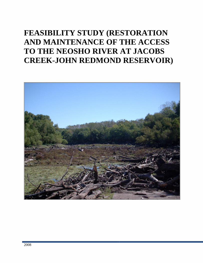
Cover Page Photo: Neosho River Logjam from Jacobs Landing
Prepared for
Kansas Water Office901 South KansasTopeka, KS 66612
Prepared by
Watershed Institute, Inc.1200 SW Executive Dr.Topeka, KS 66615
www.watershedinstitute.biz
FEASIBILITY STUDY — NEOSHO RIVER LOGJAM ASSESSMENT
i
TABLE OF CONTENTS
INTRODUCTION....................................................................................................................................... 1
BACKGROUND INFORMATION........................................................................................................... 2
PROJECT SETTING ............................................................................................................................... 2
Neosho River Logjam.......................................................................................................................... 4
NEOSHO RIVER RESEARCH............................................................................................................... 4
Natural and Regulated Flows/Historical Droughts ............................................................................ 4
High-Flow Frequency/Channel Geometry .......................................................................................... 5
Geomorphic Effects/Overflow Dams................................................................................................... 5
Channel Stability Downstream from John Redmond Dam ................................................................. 5
Flint Hills National Wildlife Refuge/Comprehensive Conservation Plan........................................... 5
U.S. Highway 59 Crossing .................................................................................................................. 5
Lowhead Dams/Freshwater Mussels .................................................................................................. 6
Gravel Sources .................................................................................................................................... 6
Biological Condition ........................................................................................................................... 6
Bathymetric Study ............................................................................................................................... 6
Stream Stability ................................................................................................................................... 6
PREVIOUS NEOSHO RIVER LOGJAM ASSESSMENTS .................................................................. 7
U.S. Army Corps of Engineers Environmental Impact Statement (USACE 2002).............................. 7
Kansas Department of Health & Environment Preliminary Ecological Evaluation (Satterthwaite
2004) ................................................................................................................................................... 8
The Masters Dredging Company, Inc .Assessment (MDC 2004)........................................................ 8
U.S. Army Corps of Engineers, Tulsa District Initial Appraisal (USACE 2005)................................ 9
U.S. Army Corps of Engineers, Tulsa District JRR Watershed Feasibility Study (USACE 2006).... 10
U.S. Army Corps of Engineers, Tulsa District JRR Watershed Feasibility Study (USACE 2008) ... 10
LOGJAM CHARATERIZATION .......................................................................................................... 13
ON-STIE FIELD ACTIVITIES............................................................................................................. 13
Logjam Composition and Condition ................................................................................................. 13
Cross Section Surveys ....................................................................................................................... 16
Channel Profile ................................................................................................................................. 17
Wood Census..................................................................................................................................... 18
AERIAL RECONNAISSANCE............................................................................................................ 20
VOLUME ESTIMATION ..................................................................................................................... 20
GROWTH RATE................................................................................................................................... 24
STORED SEDIMENT........................................................................................................................... 24
LOGJAM REMOVAL RESEARCH ...................................................................................................... 24
RED RIVER, LOUISIANA................................................................................................................... 25
GRAND RIVER, MICHIGAN.............................................................................................................. 26
YALOBUSHA RIVER, MISSISSIPPi .................................................................................................. 27

FEASIBILITY STUDY — NEOSHO RIVER LOGJAM ASSESSMENT
ii
SOUTH GRAND RIVER, MISSOURI ................................................................................................. 28
DESCHUTES RIVER, WASHINGTON .............................................................................................. 28
CHIKASKIA RIVER, OKLAHOMA ................................................................................................... 30
SOLOMON RIVER, KANSAS............................................................................................................. 31
POTENTIAL ALTERNATIVES............................................................................................................. 32
ALTERNATIVE 1: NO ACTION......................................................................................................... 33
ALTERNATIVE 2: REMOVE LOGJAM AND DREDGE LAKE ...................................................... 33
ALTERNATIVE 3: REMOVE LOGJAM WITH NO LAKE DREDGING ......................................... 34
ALTERNATIVE 4: EXCAVATE CHANNEL AROUND LOGJAM AND DREDGE LAKE............ 34
ALTERNATIVE 5: EXCAVATE CHANNEL AROUND LOGJAM WITH NO LAKE DREDGING
............................................................................................................................................................... 35
ALTERNATIVE 6: REMOVE LOGJAM ABOVE JACOBS LANDING AND EXCAVATE
CHANNEL DOWNSTREAM TO LAKE WITH LAKE DREDGING ................................................ 35
ALTERNATIVE 7: REMOVE LOGJAM ABOVE JACOBS LANDING AND EXCAVATE
CHANNEL DOWNSTREAM TO LAKE WITHOUT LAKE DREDGING........................................ 36
ALTERNATIVE 8: REMOVE LOGJAM ABOVE JACOBS LANDING ........................................... 36
ALTERNATIVE 9: REMOVE LOGJAM ABOVE JACOBS LANDING AND DREDGE/CLEAR
EAGLE CREEK .................................................................................................................................... 36
ALTERNATIVES CONSIDERED BUT ELIMINATED..................................................................... 37
POTENTIAL ALTERNATIVE EVALUATION................................................................................... 37
ENVIRONMENTAL PERMITTING REQUIREMENTS .................................................................... 37
EVALUATION CRITERIA .................................................................................................................. 39
Cost ................................................................................................................................................... 39
Social Acceptability........................................................................................................................... 40
Technical Feasibility ......................................................................................................................... 41
Environmental Impacts ..................................................................................................................... 44
Sediment Transport ........................................................................................................................... 45
Recreation ......................................................................................................................................... 46
Maintenance...................................................................................................................................... 46
ALTERNATIVE SCORING.................................................................................................................... 47
ALTERNATIVE 1: NO ACTION......................................................................................................... 47
ALTERNATIVE 2: REMOVE LOGJAM AND DREDGE LAKE ...................................................... 47
ALTERNATIVE 3: REMOVE LOGJAM WITH NO LAKE DREDGING ......................................... 48
ALTERNATIVE 4: EXCAVATE CHANNEL AROUND LOGJAM AND DREDGE LAKE............ 48
ALTERNATIVE 5: EXCAVATE CHANNEL AROUND LOGJAM WITH NO LAKE DREDGING
............................................................................................................................................................... 48
ALTERNATIVE 6: REMOVE LOGJAM ABOVE JACOBS LANDING AND EXCAVATE
CHANNEL DOWNSTREAM TO LAKE WITH LAKE DREDGING ................................................ 48
ALTERNATIVE 7: REMOVE LOGJAM ABOVE JACOBS LANDING AND EXCAVATE
CHANNEL DOWNSTREAM TO LAKE WITHOUT LAKE DREDGING........................................ 49
ALTERNATIVE 8: REMOVE LOGJAM ABOVE JACOBS LANDING ........................................... 49

FEASIBILITY STUDY — NEOSHO RIVER LOGJAM ASSESSMENT
iii
ALTERNATIVE 9: REMOVE LOGJAM ABOVE JACOBS LANDING AND DREDGE/CLEAR
EAGLE CREEK .................................................................................................................................... 49
PUBLIC INPUT TO ALTERNATIVES ............................................................................................... 51
CONCLUSION ......................................................................................................................................... 51
REFERENCES.......................................................................................................................................... 52

FEASIBILITY STUDY — NEOSHO RIVER LOGJAM ASSESSMENT
1
INTRODUCTION
The Kansas Water Office (KWO) contracted with the Watershed Institute, Inc. (TWI) to complete a
feasibility study for the restoration and maintenance of the access to the Neosho River at Jacobs Creek –
John Redmond Reservoir (JRR). Currently a large logjam extends approximately two and one-quarter
miles upstream from the reservoir completely obstructing recreational access to the river. This study is
part of the John Redmond Dam and Reservoir, Kansas Watershed Feasibility Study (John Redmond
Feasibility Study) building upon the U.S. Army Corps of Engineers (USACE) initial review of the logjam
(USACE 2005).
As part of this feasibility report, TWI characterized the current logjam conditions, identified and
evaluated options for logjam removal and disposal, and recommended remediation/restoration strategies.
Specifically, TWI completed the following actions:
Conducted an aerial reconnaissance of the project area to determine the logjam extent, identify
general topographic, landscape, and landcover features. In addition, TWI completed aerial
reconnaissance on the Neosho and Cottonwood Rivers documenting in-channel sediment sources
and large woody debris (LWD) recruitment.
Conducted a thorough on-site investigation establishing river channel dimensions and profiles,
degree of siltation within the logjam, trends in logjam size, composition and conditions of the
logs and other materials, relative land elevations, land uses, characteristics or adjacent landcover,
and habitat features.
Researched similar projects throughout the United States, Australia, and Europe to assemble
information on successful solutions to logjam removal and channel restoration. In addition, TWI
reviewed LWD research as it pertains to channel morphology, aquatic and terrestrial habitat,
quantifying LWD, and removal guidelines. Also, TWI examined existing data, documents, and
reports specific to the Neosho River with particular emphasis on the logjam. Sources included
federal and state agencies and private entities.
Received public input on potential alternatives through two public meetings.
Identified and described potential logjam removal alternatives and associated costs. TWI
developed alternatives from research review, on-site field investigations, and public input.
From these alternatives, TWI developed criteria and specific objectives to evaluate the
alternatives based on feasibility, social acceptability, permit requirements, cost effectiveness,
environmental impact, recreation, reservoir sedimentation, and maintenance.
Identified the alternatives most likely to meet the developed criteria and objectives.
This feasibility report is organized into sections that provide background information on the Neosho
River and logjam, reports the on-site field methods and findings TWI used for the logjam
characterization, summarizes logjam removal research, identifies potential alternatives, and prioritizes
alternatives.

FEASIBILITY STUDY — NEOSHO RIVER LOGJAM ASSESSMENT
2
BACKGROUND INFORMATION
PROJECT SETTING
Originating in central Kansas, the Neosho River generally flows southeast approximately 470 miles to its
confluence with the Arkansas River in northeast Oklahoma (Juracek and Perry 2005). The roughly
12,400 square mile watershed covers parts of Arkansas, Missouri, Oklahoma, and Kansas (see Appendix
A, Figure 1). In Kansas, the upper one-third of the watershed is in the Flint Hills Upland Ecoregion, with
the lower two-thirds located in the Central Irregular Plains Ecoregion (see Appendix A, Figure 2).
Predominant land cover within the watershed is a mix of agricultural crops and grasslands with wooded
corridors bordering the major streams. The Neosho River floodplain is relatively straight and oriented
northwest to southeast (Rasmussen and Perry 2000). In some locations, floodplain levees parallel the
main channel to protect agricultural fields from high flow events. The meandering channel drops
approximately 1.5 feet/mile with typical substrates of bedrock, cobble, gravel, clay, sand, and silt (Kansas
Water Resource Board 1961; Carswell and Hart 1985).
John Redmond Dam lies at river mile 343.7, approximately three miles northwest of the City of
Burlington in Coffey County, Kansas (see Appendix A, Figure 3) (USACE 2008). The watershed above
the dam drains 3,015 square miles including portions of Butler, Chase, Coffey, Greenwood, Harvey,
Lyon, McPherson, Marion, Morris, Osage and Wabaunsee counties (see Appendix A, Figure 4) (KWO
2008). Completed for flood control operation in 1964, the dam provides a multipurpose pool of 8,084
surface acres with 59 miles of shoreline (KWO 2008). Covering a broad and relatively flat floodplain, the
reservoir is shallow averaging 6.2 feet in depth with a maximum depth of 12 feet (KWO 2008) Though
designed for a 50-year sediment storage capacity within the multipurpose pool, the allotted capacity filled
by 1988 (24 years) (KWO 2008). The rapid and uneven sedimentation reduced the conservation pool
leading to storage reallocation in 1977. The USACE raised the conservation pool elevation from 1036 to
1039 to increase water storage capacity. Due to continued sediment problems, the USACE recently
completed a second storage reallocation study with a new conservation pool elevation of 1041 (USACE
2002).
Established in 1966, the Flint Hills National Wildlife Refuge (FHNWR) straddles the Neosho River at the
upper end of JRR (see Appendix A, Figure 5). The land is owned by the USACE and is managed by the
U.S. Fish and Wildlife Service (USFWS) under a cooperative agreement (USFWS 2000). The entire
logjam length is within the FHNWR. Covering 18,463 acres, FHNWR contains significant aquatic and
terrestrial habitats including 4,572 acres of wetlands, 1,400 acres of open water, 599 acres of riparian
wetlands, 3,200 acres of grassland, 2,400 acres of woodland, 2,255 acres of brushland, and 3,917 acres of
cropland (USFWS 2000). USFWS manages FHNWR primarily to benefit migrating and wintering
waterfowl in the Central Flyway. Species of particular interest include the recently de-listed peregrine
falcon (Falco peregrinus) and bald eagle (Haliaeetus leucocephalus), and the federally-threatened
Neosho madtom (Noturus placidus). Other species of concern known to occur in Coffey County are
listed in Table 1. In addition to FHNWR, the Kansas Department of Wildlife & Parks (KDWP) manages
the 1,637-acre John Redmond Wildlife Area (JRWA). Leased from the USACE in 1964, JRWA includes
Otter Creek which flows into JRR from the southwest (see Appendix A, Figure 5). JWRA contains
approximately 200 acres of riparian woodland, 970 acres of native grasses, and 465 acres of cropland.
KDWP manages JRWA habitats to provide hunting, fishing and other outdoor opportunities for the
FEASIBILITY STUDY — NEOSHO RIVER LOGJAM ASSESSMENT
3
general public. Significant acres within both public areas experience recurring and prolonged flooding
making it difficult to maintain perennial vegetation cover.
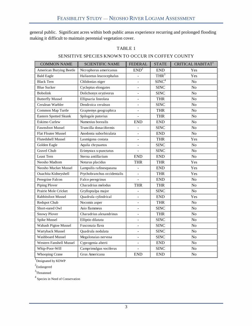
TABLE 1
SENSITIVE SPECIES KNOWN TO OCCUR IN COFFEY COUNTY
COMMON NAME SCIENTIFIC NAME FEDERAL STATE CRITICAL HABITAT1
American Burying Beetle Nicrophorus americanus END2 END Yes
Bald Eagle Haliaeetus leucocephalus - THR3 Yes
Black Tern Chlidonias niger - SINC4 No
Blue Sucker Cycleptus elongates - SINC No
Bobolink Dolichonyx oryzivorus - SINC No
Butterfly Mussel Ellipsaria lineolata - THR No
Cerulean Warbler Dendroica cerulean - SINC No
Common Map Turtle Graptemys geographica - THR No
Eastern Spotted Skunk Spilogale putorius - THR No
Eskimo Curlew Numenius borealis END END No
Fawnsfoot Mussel Truncilla donaciformis - SINC No
Flat Floater Mussel Anodonta suborbiculata - END No
Flutedshell Mussel Lasmigona costata - THR Yes
Golden Eagle Aquila chrysaetos - SINC No
Gravel Chub Erimystax x-punctatus - SINC No
Least Tern Sterna antillarium END END No
Neosho Madtom Noturus placidus THR THR Yes
Neosho Mucket Mussel Lampsilis rafinesqueana - END Yes
Ouachita Kidneyshell Ptychobranchus occidentalis - THR Yes
Peregrine Falcon Falco peregrinus - END No
Piping Plover Charadrius melodus THR THR No
Prairie Mole Cricket Grylloptalpa major - SINC No
Rabbitsfoot Mussel Quadrula cylindrical - END Yes
Redspot Chub Nocomis asper - THR No
Short-eared Owl Asio flammeus - SINC No
Snowy Plover Charadrius alexandrinus - THR No
Spike Mussel Elliptio dilatata - SINC No
Wabash Pigtoe Mussel Fusconaia flava - SINC No
Wartyback Mussel Quadrula nodulata - SINC No
Washboard Mussel Megalonaias nervosa - SINC No
Western Fanshell Mussel Cyprogenia aberti - END No
Whip-Poor-Will Camprimulgus vociferus - SINC No
Whooping Crane Grus Americana END END No1Designated by KDWP
2Endangered
3Threatened
4Species in Need of Conservation

FEASIBILITY STUDY — NEOSHO RIVER LOGJAM ASSESSMENT
4
Neosho River Logjam
From 1964 to approximately 1991, boat access to JRR from the Neosho River was open. In the early
1970’s, LWD—that typically floated into the reservoir—began to collect at the mouth of the Neosho
River as sedimentation created mudflats at the upper end of John Redmond (USACE 2005). The logjam
originally formed above an island in the Neosho River—known locally as the “horseshoe”—which causes
the river to fork into two channels. Since 1991, the logjam has prohibited boating from the river to the
reservoir. Local residents first expressed concern about the logjam during public comment periods for the
first storage reallocation study (1975-1976). Local residents again expressed concerns during pubic
comment for the second storage reallocation study (2001). As USACE considered the logjam cost
prohibitive to remove, local citizens attempted to burn the logjam during the summer of 1999, but the wet
wood would not carry the fire (FHNWR 2000). USACE (2002) considered the logjam to be
economically unfeasible to remove by demolition or mechanical means noting the river may eventually
form a new channel around this location, south of the existing channel. Prior to 2004, residents estimated
the logjam at approximately 0.38 mile long. However, an abundance of downed wood—from a 2002 ice
storm—and heavy spring runoff doubled the logjam length. In August 2004, The Master’s Dredging
Company, Inc. (MDC) documented the logjam at approximately 1.5 miles long and extending past the
Jacob’s Creek Landing boat ramp (MDC 2004). Wood continues to accumulate rapidly and TWI
estimated the rate of growth from 2001 to 2007 at 1,397 feet annually. As of December 2007, the logjam
was two and one-quarter miles in length.
Currently, periodic clearing of the boat ramp at Jacob’s Creek Landing allows access to only 1,300 feet of
the Neosho River due to upstream and downstream log rafts. To provide additional river access, the
USFWS constructed a temporary gravel boat ramp on Eagle Creek in 2004. However, sediment
accumulation at the mouth of Eagle Creek—approximately 1.0 mile upstream of Jacob’s Creek
Landing—and two logjams now block access to the river. Based on aerial reconnaissance, TWI identified
one 250 feet long logjam and one 410 feet long logjam located approximately 1,200 feet and 3,430 feet
respectively, downstream from the Eagle Creek boat ramp. The closest usable river access to Jacob’s
Creek Landing is approximately 8.0 miles upstream at Hartford, Kansas.
NEOSHO RIVER RESEARCH
TWI reviewed several publications related to the Neosho River to gain insight on watershed context and
potential contributing factors to logjam development. Eleven publications are summarized here; however,
little information directly related to the logjam was uncovered in this review.
Natural and Regulated Flows/Historical Droughts
U.S. Geological Survey (USGS) and the KWO investigated the effects of three historical droughts (1933-
36, 1953-57, and 1963) on multiple-use and water quality minimum streamflows available for instream
use on the lower Neosho River. They used a reservoir-routing model to determine if the natural
streamflows occurring during the three historic droughts would maintain sufficient storage in JRR to
satisfy the recommended multiple-use and water quality streamflows at the Iola and Parsons gages. Only
the 1953-57 drought failed to maintain storage requirements to satisfy multiple-use streamflows at the
Parsons gage. USGS/KWO estimated 15,400 additional acre-feet of storage were needed (Hart and Stiles
1984).

FEASIBILITY STUDY — NEOSHO RIVER LOGJAM ASSESSMENT
5
High-Flow Frequency/Channel Geometry
USGS investigated the effects of John Redmond Dam on the Neosho River streamflow regime. Trends at
two gaging stations closest to the dam show that stages are declining at the higher discharges and not at
the lower discharges. USGS noted that these trends may result from either channel widening or increased
flow velocity. Through statistical analysis, USGS determined that climactic effects do not account for the
changes in high-flow frequencies and attributed the changes to John Redmond Dam. Consistent with this
assessment, USGS documented a decrease in the magnitude of the trends with increasing distance
downstream of the dam (Studley 1996)
Geomorphic Effects/Overflow Dams
USGS used aerial photographs and on-site inspection to assess the geomorphic effects of 12 concrete
overflow dams on the lower Neosho River channel. USGS analyzed photograph-derived channel
characteristics to estimate the upstream and downstream changes attributed to each dam. From this
analysis, USGS concluded that most of the overflow dams have had substantial geomorphic effects on the
Neosho River channel. Typical effects included channel widening and the presence of gravel bars
immediately downstream from the majority of the dams (Juracek 1999a).
Channel Stability Downstream from John Redmond Dam
USGS investigated channel stability of the Neosho River downstream from John Redmond Dam using
multi-date aerial photography. Results indicated that the overall channel response to the altered
streamflow regime has been minor (localized widening). USGS suggested that the lack of pronounced
post-dam channel changes may be attributable to a combination of several factors: a substantial reduction
in the magnitude of annual peak flows; resistance of the bed and bank materials; previous over-widening
by large, pre-dam floods (Juracek 1999b).
Flint Hills National Wildlife Refuge/Comprehensive Conservation Plan
This document serves as the primary management tool to be used by the Refuge staff and its partners in
the preservation and restoration of the ecosystem functions and natural resource values of the area. This
Plan provides Refuge goals and objectives to guide management decisions over the period 2000 – 2015
(USFWS 2000).
U.S. Highway 59 Crossing
USGS modeled water surface elevations for present conditions—an overflow dam, a railroad crossing,
two highway crossings, and numerous levees on both sides of the river—to determine backwater
characteristics of the Neosho River at the U.S. Highway 59 bridge crossing. Modeling indicated that
levees near the bridge are overtopped by discharges over 37,000 cubic feet per second (cfs). At
discharges of 82,000 and 111,000 cfs the entire river valley conveys water and the backwater from U.S.
59 bridge embankment is 1.0 to 1.2 feet deep respectively. USGS simulated various modifications to
hydraulic structures near the U.S. 59 crossing and found no clear solution to prevent water overtopping
the levee upstream of the bridge (Rasmussen and Perry 2000).

FEASIBILITY STUDY — NEOSHO RIVER LOGJAM ASSESSMENT
6
Lowhead Dams/Freshwater Mussels
Emporia State University (ESU) tested the effects of two lowhead dams (Correll Dam and Emporia City
Dam) on freshwater mussel assemblages in the Neosho River above JRR. ESU sampled two sites
upstream (reference and treatment) and two sites downstream (reference and treatment) from each dam.
ESU found that upstream treatment sites had significantly fewer species than upstream reference sites
attributing differences to the ponded conditions (deeper water, lower velocity, silty substrates) created by
the dams. Though downstream treatment sites showed lower mussel abundance and fewer species
compared to downstream reference sites, the differences were not statistically significant. Based on these
samples, ESU concluded that lowhead dams have a negative impact on freshwater mussel assemblages
noting that the large number of lowhead dams in the Neosho River likely have widespread impacts (Dean
et al. 2002).
Gravel Sources
USGS used aerial photography, onsite inspection, and gravel bar samples to identify gravel sources for
the Neosho River. From the available evidence, USGS determined that basal gravel deposits—of alluvial
origin—in the channel banks are the major present-day sources. Tributaries do not provide substantial
gravel inputs to the main channel. USGS suggested that erosional and depositional processes are
primarily responsible for gravel bar formation and that JRR has little effect on gravel sources downstream
(Juracek and Perry 2005).
Biological Condition
KDWP summarized biological—fish and macroinvertebrate—data collected at 153 stream sites in seven
HUC-8 sub-watersheds of the Neosho River basin. Seven of the 153 sites were on the Neosho River
mainstem. KDWP used several indices to determine the biologic conditions of the sub-watersheds: Index
of Biotic Integrity (fish), Macroinvertebrate Biotic Index, and insect richness. KDWP considered all sub-
watersheds to be in “good health” based on the collected data (KDWP 2006).
Bathymetric Study
Kansas Biological Survey (KBS) performed a bathymetric survey of JRR and compared 2007 contours to
a 1957 pre-impoundment topographic map. The comparison shows that sediment accumulation has
reduced reservoir volume by 37% since 1957. Current lake depth where the Neosho River enters JRR is
less than 1.0 foot—based on a lake elevation of 1038.55 (0.45 feet below conservation pool). KBS
determined that this area accumulated 1.1 – 2.0 feet of sediment between 1957 and 2007 (KBS 2007).
Stream Stability
KWO contracted with the TWI to complete a riparian area and stream channel assessment for the John
Redmond Feasibility Study. TWI performed this study to provide a means of assessing channel condition
and contribution of streambanks as a source of reservoir sediment loading. TWI conducted detailed
fluvial geomorphology surveys and interpreted aerial photographs at ten locations based on KWO
targeted stream reaches. At each survey location, TWI estimated bank erosion potential using the Bank
Erodibility Hazard Index (BEHI) and channel health using the Pfankuch stream stability evaluation. In
FEASIBILITY STUDY — NEOSHO RIVER LOGJAM ASSESSMENT
7
addition, TWI documented general riparian corridor conditions within the survey reach as well as
adjacent reaches upstream and downstream. TWI found that most streams have a low bankfull width to
depth ratio indicating a narrow and deep channel. TWI identified and predicted erosion rates for 27 bank
conditions within the ten sites. Based on BEHI scores and near bank stress calculations, TWI estimated an
erosion average of 0.20 tons/year/foot. The Pfankuch stream stability evaluations ranged from fair to
poor. In comparison to healthy riparian corridors, survey reaches suffer from excessive cutting, mass
wasting, and debris jam potential. TWI also examined 1991 and 2006 rectified aerial photographs to
identify “hotspots” or areas with accelerated streambank erosion. TWI identified 13.4 miles of channel
with significant erosion over the 15-year period. Based on measured bank lengths and estimated bank
height from the fluvial geomorphology surveys, TWI estimates that 2.54 tons/year/foot of sediment erode
from these streambank “hotspots.” Most of these sites have narrow riparian corridors or none at all (TWI
2007).
PREVIOUS NEOSHO RIVER LOGJAM ASSESSMENTS
TWI reviewed all known studies containing information about the logjam. Six studies, including their
findings and recommendations, are summarized in the following sections. These studies were conducted
by state and federal agencies, and one private company.
U.S. Army Corps of Engineers Environmental Impact Statement (USACE 2002)
The USACE prepared an Environmental Impact Statement (EIS) for the JRR water supply reallocation
study. The EIS identified the following effects of the logjam:
An impediment to navigation by boat between the lake and upriver sites. Slowing or dissipation of Neosho River flows resulting in some backwater formation. Diversion of water over the access road to the Jacob’s Creek Landing boat ramp during high-flow
events for the Neosho River. Aggradation—raising—of the riverbed due to accumulation of sediment; the sediments also serve
to anchor the logjam into the river bed. Dropping of sediments within the John Redmond flood control pool rather than the conservation
pool. Formation of a structure resistant to erosion, much like a geologic feature might be. Future island formation or formation of a cut-off oxbow when sediment deposition is sufficient. A source for driftwood to accumulate and possibly float into the reservoir and against the dam
structure during flood events.
In addition to the effects listed above, the EIS suggested the following research to benefit future logjam
removal analysis: 1) determination of other, similar examples of large wood debris accumulation for other
reaches of the Neosho River and the effect, 2) study the effects of raising the reservoir water level to
1,041.0 feet on debris accumulation and navigation at the logjam site, 3) an economic analysis of logjam
removal, hauling, storage, and disposal versus other alternatives, such as opening a new, more direct
channel into the reservoir, and 4) examination of different forms of LWD management, including upriver
prevention measures.
Additionally, the EIS provided a synopsis of logjam comments spoken by attendees of a public meeting
held in Burlington, Kansas:
FEASIBILITY STUDY — NEOSHO RIVER LOGJAM ASSESSMENT
8
Remove the logjam at Jacob’s Creek. Cut a channel around the logjam. Logjam creates a higher pool in the upper reaches of the lake. Removal of the logjam would permit water to enter the conservation pool. Operations Division should clean out logjam, as done in early years. Logjam is causing increased flooding off USACE property upstream of JRR, around flood pool
lands, and upstream to Emporia, KS.
Appendix A of the EIS contains the verbal and written comments related to the logjam, including a
petition signed by 101 individuals from Jacobs Creek, Burlington, Emporia, Hartford, and Neosho
Rapids, Kansas. The petition requests the removal of a logjam 0.9 miles east of the Jacobs Creek (Strawn)
boat ramp. The petitioners stated that the logjam is causing road and property flooding.
The EIS concluded that water supply reallocation and a phased rise in the conservation pool would have
negligible effects on the logjam, but would likely result in increased sedimentation of the area as a result
of elevated backwater effects.
Kansas Department of Health & Environment Preliminary Ecological Evaluation (Satterthwaite 2004)
The Kansas Department of Health & Environment (KDHE) conducted a preliminary evaluation of
ecological issues related to the logjam. The KDHE used aerial photographs to estimate logjam lengths in
1991, 2002, and 2004. Additionally, KDHE coordinated a field visit with the Kansas Department of
Agriculture to identify potential ecological concerns associated with the logjam. KDHE contracted the
Kansas Biological Survey-Kansas Applied Remote Sensing Program (KBS-KARS) to use aerial imagery
(spectral band reflectance) to identify solid waste within the logjam and riparian conditions associated
with the logjam. KBS-KARS found no concentration of solid waste items and estimated approximately
one item per 18,604 ft2. From this, KDHE assumed that there were no major illegal dumps and that solid
waste posed little health threat. KBS-KARS determined that the spectral band reflectance technology did
not adequately discern riparian management conditions. KDHE developed the following
recommendations:
Short-Term – coordinate with the USACE on a logjam study; consider additional state action
based on the study findings; provide findings of the current report (potential health risks, riparian
condition) to local stakeholders.
Long-Term – tap into WRAPS for financial and technical assistance; use conservation buffers to
address timber management and harvest, and solid waste issues; confer with the State Forester for
assistance with a timber stand inventory.
The Masters Dredging Company, Inc .Assessment (MDC 2004)
MDC—a private firm—conducted a study of the logjam at the request of local citizens and elected
officials. Using satellite imagery, aerial observation, and onsite observation by airboat, MDC estimated
the logjam length to be 1.5 miles long and contain between 80,000 and 120,000 cubic yards (yd3) of
wood. MDC offered two alternatives:
FEASIBILITY STUDY — NEOSHO RIVER LOGJAM ASSESSMENT
9
1. Dislodge and ferry logs into side channels (locally known as the “Horseshoe”). Bermed sidechannel openings would contain the wood and prevent reentry into the lake or reservoir. MDCestimated 6 - 8 months and $1.0 - $1.5 million to implement this option.
2. Dislodge and ferry logs to several points along the river bank. Removed by crane or backhoe andpiled for burning. MDC estimated 6 - 8 months and $1.5 - $2.2 million to implement this option.
Additionally, MDC suggested in-lake dredging at the Neosho River entrance to improve flow and provide
a silt basin for river sediments. MDC estimated removing 1 million yd3 at a cost of $5.5 - $8.0 million.
MDC anticipated dredging to take 18 - 24 months.
U.S. Army Corps of Engineers, Tulsa District Initial Appraisal (USACE 2005)
The USACE, Tulsa District conducted an initial appraisal of the logjam in 2005. The USACE found no
conditions created by the logjam that required modification of JRR structures or operations. The USACE
examined four maintenance measures—near term solutions that are within the operational authority of the
project—and seven alternatives—long term solutions requiring feasibility study—to address the logjam.
Additionally, USACE considered a no action option along with a voluntary buyout and relocation of
Jacob’s Creek property owners. The mitigation measures and associated costs include:
1. Remove the logjam in the vicinity of Jacob’s Creek Landing boat ramp. The total estimated costis $370,000 plus $25,000 annual maintenance.
2. Remove the logjam at the mouth of Eagle Creek and construct a permanent access road and boatramp on Eagle Creek. The total estimated cost is $180,000 plus $25,000 annual maintenance.
3. Construct a permanent boat ramp on the Neosho River at Neosho Rapids. The total estimated costis $70,000 plus $25,000 annual maintenance.
4. Develop and implement a long-term Neosho River debris and sediment removal plan. The totalestimated cost is $3.3 million plus $50,000 annual maintenance.
Alternatives include:
1. Clear the Neosho River logjam in the vicinity of the Jacob’s Creek boat ramp to a locationdownstream on the Neosho River (for example, 200 yards downstream). To provide a temporarystorage area for future debris while minimizing the initial costs of removal, allow a new riverchannel to form. The total estimated cost is $1 million plus $50,000 annual maintenance.
2. Excavate a pilot channel to the Reservoir avoiding the logjam. Extend the pilot channel throughthe in-lake mudflat by dredging. Leave the balance of the logjam in place and abandon theJacob’s Creek boat ramp. The total estimated cost is $730,000 plus $75,000 annual maintenance.
3. Clear the Jacob’s Creek Landing ramp and downstream reach and create a pilot channel into thelake, dredge through the in-lake mudflat, but leave the balance of the logjam in place. The totalestimated cost is $1,570,000 plus $75,000 annual maintenance.
4. Clear the logjam from the existing Neosho River channel and dredge through the in-lake mudflat.The total estimated cost is $5,200,000 plus $100,000 annual maintenance.
5. Clear roughly one-half of the width of the existing logjam by stacking the removed debris on topof the remaining debris in the channel, dredge through the in-lake mudflat, and initiate an annualdredging program to maintain the river channel. The USACE did not estimate cost of this optiondue to risk of failure.
6. Clear the logjam from within the existing Neosho River channel through the in-lake mudflat andinitiate a long-term program of dredging to both maintain the river channel and revitalize thereservoir’s water resources. The total estimated cost is $65,000,000 plus $200,000 annualmaintenance.
FEASIBILITY STUDY — NEOSHO RIVER LOGJAM ASSESSMENT
10
7. Offer voluntary buyout and relocation assistance for Jacob’s Creek Landing property owners.The USACE did not estimate this cost due to the required detail of real estate proposals.
8. Clear a 100-foot wide working area along the south side of the river and use an excavator andother necessary equipment to remove the logjam from the channel and stockpile the debris alongthe working area for drying and later burning. The total estimated cost is $5,400,000 plus$100,000 annual maintenance.
The USACE determined that all long-term alternatives were not appropriate for recommendation to
Congress for modification of the John Redmond Dam and Reservoir. However, the District found that all
four maintenance measures are within project authority and recommended that the Tulsa District’s budget
for Fiscal Years 2007 through 2012 include Maintenance Measure 3 for implementation.
U.S. Army Corps of Engineers, Tulsa District JRR Watershed Feasibility Study (USACE 2006b)
KWO requested that the USACE conduct a feasibility Study for the JRR watershed. In cooperation with
KWO, the USACE prepared a Project Management Plan (PMP) to describe the scope, schedule, and
budget for accomplishing feasibility study tasks. The PMP identifies the KWO as the primary agency for
assessment of the logjam alternatives and identification of the most cost-effective means of wood debris
removal.
U.S. Army Corps of Engineers, Tulsa District JRR Watershed Feasibility Study (USACE 2008)
KWO requested that the USACE conduct a feasibility Study for the JRR watershed. The study area
covers approximately 2,500 square miles and includes the Neosho River from John Redmond Dam
upstream to the Council Grove Dam, and the Cottonwood River from its confluence with the Neosho
River upstream to Marion Dam. The recently completed study included measures and alternatives to
provide flood risk and stream corridor management, ecosystem restoration and protection, water
conservation and supply, water quality improvement, aquifer recharge, and other related purposes and
benefits to the study area. The study identifies the logjam as a concern of KWO stating “the logjam on the
Neosho River just north of the upper end of the JRR is restricting flow into the reservoir and recreational
traffic.” The USACE listed the same alternatives developed in their initial appraisal (USACE 2005);
however, approximated cost estimates were different:
Alternative 1 = $1,016,000 Alternative 2 = $1,165,000 Alternative 3 = $1,703,000 Alternative 4 = $9,884,000 Alternative 5 = $7,483,000 Alternative 6 = $64,900,000 Alternative 7 = $4,813,000 Alternative 8 = $5,440,000
The USACE screened each logjam alternative against the feasibility goals and objectives to determine the
probability (high, medium, low) of the alternative to meet each goal or objective. Table 2 provides
USACE determinations. Identified goals and objectives were:

FEASIBILITY STUDY — NEOSHO RIVER LOGJAM ASSESSMENT
11
Goal 1: Meet the Federal objective of a management measure capable of producing a NationalEconomic Development Plan.
Goal 2: Contribute to the National Ecosystem Restoration by making improvements to the nation’secosystems through preservation and restoration efforts.
Objective 1: Preserve storage in JRR for flood control, water supply, and other authorized purposes.Objective 2: Revitalize JRR for flood control, water supply, and other authorized purposes.Objective 3: Reduce watershed contributions of sediment and harmful chemicals into JRR.Objective 4: Restore riparian habitat that improves the value and function of the ecosystem.Objective 5: Restore wetlands that improve the value and function of the ecosystem.Objective 6: Restore aquatic riverine habitat that improves the value and function of the ecosystem.Objective 7: Preserve riparian habitat essential to the value and function of restored habitat.Objective 8: Preserve wetlands essential to the value and function of the restored habitat.Objective 9: Preserve aquatic habitat essential to the value and function of the restored habitat.Objective 10: Protect public resources and utilities (including power, water, and transportation) from
the impacts of flooding, bank erosion, channel changes, and storage losses.Objective 11: Protect wetland and grasslands from invasive plant species.Objective 12: Reduce urban flood damages.
In addition to the goals and objectives, the USACE identified seven constraints—restrictions that should
not be violated—to feasibility study planning and implementation:
1. Avoid negative impacts to threatened or endangered species.2. Avoid or minimize negative impacts to historic, cultural, and archaeological resources.3. Avoid negative impacts to wetlands.4. Avoid negative impacts to bottomland hardwoods.5. Minimize temporary negative impacts to water quality, particularly turbidity.6. Avoid long-term water quality impacts.7. Minimize negative implementation impacts to landowners, agricultural interests and the auxiliary
agricultural, municipal, and industrial infrastructure.
The USACE determined that all eight logjam alternatives met constraints 1, 2, 5, 6, and 7; however, no
alternative met constraints 3 and 4. The feasibility study recommended further development and
evaluation of all logjam alternatives due to local interest and state concerns.

12
FEASIBILITY STUDY — NEOSHO RIVER LOGJAM AT JACOBS LANDING
TA
BL
E2
CO
MP
AR
ISO
NO
FA
LT
ER
NA
TIV
ES
TO
FE
AS
IBIL
ITY
ST
UD
YG
OA
LS
&O
BJ
EC
TIV
ES
1
1 Mod
ifie
dfr
omT
able
1,J
ohn
Red
mon
dD
aman
dR
eser
voir
–K
ansa
sW
ater
shed
Inte
rim
Fea
sib
ilit
yS
tud
y,U
SA
CE
,T
uls
aD
istr
ict,
Janu
ary
18
,20
08.
AL
TE
RN
AT
IVE
GL
1G
L2
OB
J1
OB
J2
OB
J3
OB
J4
OB
J5
OB
J6
OB
J7
OB
J8
OB
J9
OB
J1
0O
BJ
11
OB
J1
2
1L
OW
LO
W/
ME
DL
OW
LO
WL
OW
LO
WL
OW
LO
WL
OW
LO
WM
ED
ME
DL
OW
LO
W
2L
OW
LO
W/
ME
DL
OW
LO
WL
OW
LO
WL
OW
LO
WL
OW
LO
WM
ED
ME
DL
OW
LO
W
3L
OW
LO
W/
ME
DL
OW
LO
WL
OW
LO
WL
OW
LO
WL
OW
LO
WM
ED
ME
DL
OW
LO
W
4L
OW
LO
W/
ME
DL
OW
LO
WL
OW
LO
WL
OW
LO
WL
OW
LO
WM
ED
ME
DL
OW
LO
W
5L
OW
LO
W/
ME
DL
OW
LO
WL
OW
LO
WL
OW
LO
WL
OW
LO
WM
ED
ME
DL
OW
LO
W
6L
OW
LO
W/
ME
DL
OW
LO
WL
OW
LO
WL
OW
LO
WL
OW
LO
WM
ED
ME
DL
OW
LO
W
7L
OW
LO
W/
ME
DL
OW
LO
WL
OW
LO
WL
OW
LO
WL
OW
LO
WM
ED
ME
DL
OW
LO
W
8L
OW
LO
W/
ME
DL
OW
LO
WL
OW
LO
WL
OW
LO
WL
OW
LO
WM
ED
ME
DL
OW
LO
W

FEASIBILITY STUDY — NEOSHO RIVER LOGJAM AT JACOBS LANDING
13
LOGJAM CHARACTERIZATION
To characterize the logjam, TWI completed on-site field investigations, aerial reconnaissance, and aerial
photograph interpretation. TWI used this information to predict a net wood volume, logjam growth rate,
and estimate the volume of stored sediment.
ON-SITE FIELD ACTIVITIES
During October 1-5, 2007 and January 7-10, 2008, TWI conducted on-site field investigations. The
investigations included assessing the composition and condition of logs, surveying cross sections,
collecting stream profile information, completing a streambank and riparian area wood census, and
evaluating the adjacent landcover and habitat features.
Logjam Composition and Condition
Riparian vegetation is often the source of LWD recruitment (Keller and Swanson 1979, Gurnell et al.
2002). Floodplain and terrace vegetation often contributes wood in rivers during large storms by
blowdown or ice loading (Keller and Swanson 1979, Gregory et al. 1993, Webb and Erskine 2003).
Fluvially transported wood is typically torn and broken making it difficult to identify (Piégay and Gurnell
1997). Based on visual reconnaissance, TWI found the majority of LWD to be common Kansas riparian
woodland species. This includes eastern cottonwood (Populus deltoides), sycamore (Platanus
occidentalis), silver maple (Acer saccharinum), Siberian elm (Ulmus pumila), and black willow (Salix
nigra). Other likely Kansas floodplain and terrace woody species found in the logjam include burr oak
(Quercus macrocarpa), black walnut (Juglans nigra), green ash (Fraxinus pennsylvanica), and hackberry
(Celtis occidentalis).
Wood quantity and recruitment in large rivers is related to geomorphic process (Keller and Swanson
1979, Down and Simon 2001, Gurnell et al. 2002). Keller and Swanson (1979) concluded that lateral
stream erosion delivers the most organic material in low-gradient streams. In particular, wood quantities
can be much greater in large rivers having high lateral channel mobility (Piégay and Gurnell 1997).
Lassettre et al. (2007) found a link between sinuosity and wood storage as a major factor in explaining the
presence of wood. Cordova et al. (2007) found that narrower and deeper streams had more wood due to
lateral channel mobility.
In a related geomorphic study, TWI (2007) surveyed several reaches on the Neosho and Cottonwood
Rivers and tributaries to the Neosho River. From survey information, TWI classified most reaches as E6
channels based on the Rosgen stream classification system (see Appendix A, Figure 6) (Rosgen 1994).
E6 streams are hydraulically efficient because they require the least cross-sectional area per unit discharge
(Rosgen 1996). Rosgen (1996) also stated that E6 channels are typically stable unless they have disturbed
streambanks and changes in sediment supply and/or streamflow. For the Neosho and Cottonwood Rivers,
TWI identified 71 highly disturbed streambanks that have eroded approximately 2,172,207 yd3 since 1991
(TWI 2007).
In many situations, LWD—from streambank erosion—falls and travels a short distance and orients
downstream forming backwater pools along channel margins (Naiman et al. 2002). Whether LWD moves
downstream is a function of stream power and water depth (Keller et al. 1995). Braudrick and Grant

FEASIBILITY STUDY — NEOSHO RIVER LOGJAM AT JACOBS LANDING
14
(2000) used models and flume experiments to conclude that log transport is a function of piece angle
relative to flow direction, whether or not a log had a root wad, log density, and the ratio of piece size to
channel dimensions. Furthermore, Braudrick and Grant (2000) concluded LWD will move further if 58%
of the active channel area is deeper than the buoyant depth of a LWD piece. Montgomery et al. (2003)
determined LWD will be more likely loose and susceptible to transport when the log diameter/mean
bankfull depth and log length/bankfull with ratios are less than 1.0. In large rivers, the stream power and
water depth can move and sort debris into distinct accumulations or jams (Keller et al. 1995).
Large rivers—like the Neosho and Cottonwood Rivers—have the ability to transport a large amount of
wood. TWI (2007) calculated bankfull dimensions for two segments of the Neosho and Cottonwood
Rivers. For the Neosho River, TWI calculated a bankfull mean depth of 9.6 feet and width of 122 feet
above Emporia and a bankfull mean depth of 12.8 feet and width of 151 feet downstream of Emporia
(TWI 2007). For the Cottonwood River, TWI surveyed two reaches upstream of Emporia. TWI
determined bankfull mean depth of 16.4 and 15.7 with bankfull widths of 204 and 213 feet, respectively.
Based on these channel dimension and wood transport research, these rivers are able to transport
significant amounts of wood. Furthermore, regulated flow from Marion Reservoir and Council Grove
Lake prolong high, in-channel flows that promote LWD transport. Photos 1 and 2 shows LWD—
upstream of the logjam— with the potential to move during future high flow events.
PHOTO 1
LWD ON NEOSHO RIVER
PHOTO 2
LWD ON COTTONWOOD RIVER
LWD is typically and most efficiently transported through the thalweg—the line connecting the deepest
portion of a stream (Abbe et al. 2003). Abbe and Montgomery (2003) used aerial photographs and field
surveys to classify different types of LWD jams. For the Neosho River logjam, it is representative of a
transport jam where LWD is moved downstream by fluvial process until discharge decreases or material
comes to rest on channel obstructions (Abbe and Montgomery 2003). Currently, the logjam extends
approximately 2.25 miles upstream from a feature named the “horseshoe” (see Appendix A, Figure 7).
By reducing stream velocities and inducing sediment deposition, JRR becomes the initial channel
obstruction leading to LWD accumulation. KBS (2007) recently completed a bathymetric survey of JRR
and found that the lake at the Neosho River confluence is approximately 1 foot deep near the conservation
FEASIBILITY STUDY — NEOSHO RIVER LOGJAM AT JACOBS LANDING
15
pool lake elevation. The Neosho River cannot move large material efficiently past this location, creating
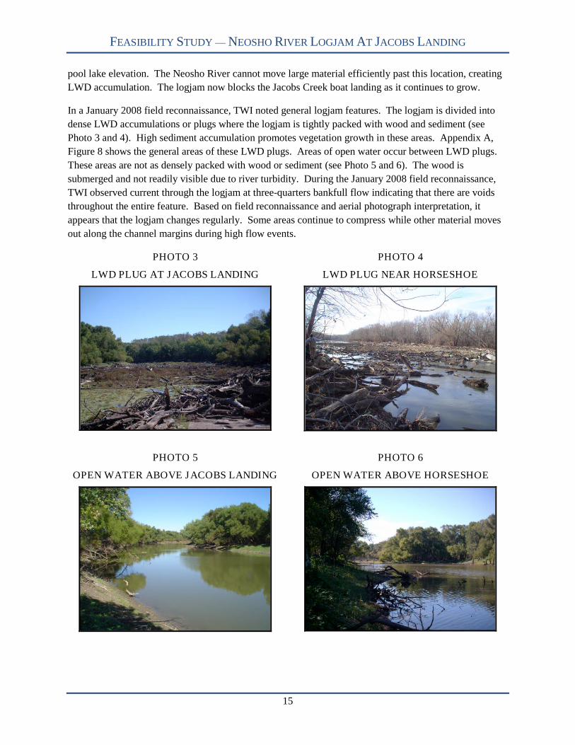
LWD accumulation. The logjam now blocks the Jacobs Creek boat landing as it continues to grow.
In a January 2008 field reconnaissance, TWI noted general logjam features. The logjam is divided into
dense LWD accumulations or plugs where the logjam is tightly packed with wood and sediment (see
Photo 3 and 4). High sediment accumulation promotes vegetation growth in these areas. Appendix A,
Figure 8 shows the general areas of these LWD plugs. Areas of open water occur between LWD plugs.
These areas are not as densely packed with wood or sediment (see Photo 5 and 6). The wood is
submerged and not readily visible due to river turbidity. During the January 2008 field reconnaissance,
TWI observed current through the logjam at three-quarters bankfull flow indicating that there are voids
throughout the entire feature. Based on field reconnaissance and aerial photograph interpretation, it
appears that the logjam changes regularly. Some areas continue to compress while other material moves
out along the channel margins during high flow events.
PHOTO 3
LWD PLUG AT JACOBS LANDING
PHOTO 4
LWD PLUG NEAR HORSESHOE
PHOTO 5
OPEN WATER ABOVE JACOBS LANDING
PHOTO 6
OPEN WATER ABOVE HORSESHOE
FEASIBILITY STUDY — NEOSHO RIVER LOGJAM AT JACOBS LANDING
16
Cross Section Surveys
On October 4, 2007, TWI surveyed six cross sections on the Neosho River (see Appendix B). Cross
section 1 through 4 are located upstream of the logjam and are intended to depict geomorphic channel
dimensions not influenced by the logjam (see Appendix A, Figure 9). TWI surveyed each cross section
using a total station. With assistance from USFWS, TWI used a boat to document channel dimensions
since water depth exceeded appropriate wading depths. TWI surveyed each cross section from left-top-of
bank to right-top-of-bank.
TWI also completed cross section surveys (5 and 6) within the logjam (see Appendix A, Figure 9). TWI
chose the two locations because the wood density was much less. Most of the logjam is too hazardous to
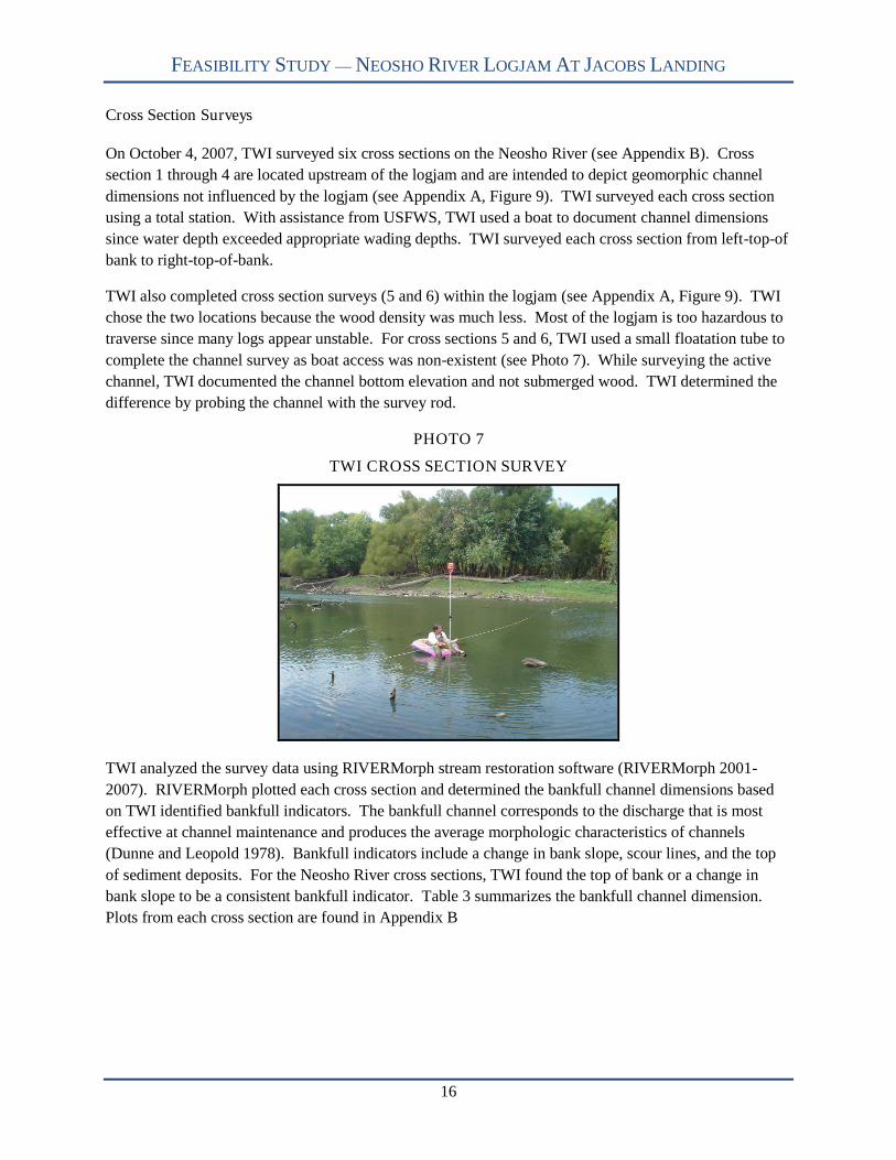
traverse since many logs appear unstable. For cross sections 5 and 6, TWI used a small floatation tube to
complete the channel survey as boat access was non-existent (see Photo 7). While surveying the active
channel, TWI documented the channel bottom elevation and not submerged wood. TWI determined the
difference by probing the channel with the survey rod.
PHOTO 7
TWI CROSS SECTION SURVEY
TWI analyzed the survey data using RIVERMorph stream restoration software (RIVERMorph 2001-
2007). RIVERMorph plotted each cross section and determined the bankfull channel dimensions based
on TWI identified bankfull indicators. The bankfull channel corresponds to the discharge that is most
effective at channel maintenance and produces the average morphologic characteristics of channels
(Dunne and Leopold 1978). Bankfull indicators include a change in bank slope, scour lines, and the top
of sediment deposits. For the Neosho River cross sections, TWI found the top of bank or a change in
bank slope to be a consistent bankfull indicator. Table 3 summarizes the bankfull channel dimension.
Plots from each cross section are found in Appendix B

FEASIBILITY STUDY — NEOSHO RIVER LOGJAM AT JACOBS LANDING
17
TABLE 3
CROSS SECTION BANKFULL DIMENSIONS
Cross Section Width (Ft) Mean Depth (Ft) MaximumDepth (Ft)
Cross Section
Area (Ft2)
1 156 16.2 20.9 2,5192 175 18.9 26.1 3,307
3 257 14.9 21.2 3,766
4 254 13.0 19.5 3,298
5 230 12.4 16.7 2,857
6 230 10.3 18.0 2,372
The results from Table 3 show that the channel capacity is less in the downstream cross sections—5 and
6—when compared to cross section 2, 3, and 4. Cross Section 1 is unique from the other cross section in
that it is influenced by bedrock. The other cross sections are dominated by silt/clay materials. Appendix
B also shows an overlay plot of cross section 4, 5, and 6 with elevations normalized to the October 4,
2007 lake level. TWI surveyed cross section 4 just upstream of the logjam. Based on the channel
dimensions, cross section 5 area is 440 square feet (ft2) less than cross section 4. This is a reduction in
bankfull channel capacity of over 13%. Furthermore, cross section 6 area is 925 ft2 less than cross section
4 equating to a channel capacity reduction of 28%. TWI believes the lost area is made up of stored
sediment deposited in response to the logjam.
LWD can often lead to sediment accumulation upstream of the obstruction (Keller et al. 1995, Thompson
1995, Montgomery et al. 2003). In much smaller LWD accumulations, Magilligan et al. (2007) found
that 5-20% of LWD surveyed served some function of sediment storage. In Midwestern streams,
Cordova et al. (2007) summarized that LWD jams generally store sediment. The amount of sediment
accumulation is dependent on the LWD blockage ratio—wood area/cross section area—and channel
morphology. Dudley et al. (1998) found that woody debris in test channels increased Manning’s n value
39% when compared to cleared test channels. Any time LWD increases flow resistance, sediment
transport capacity will decrease. For the Neosho River logjam, the accumulation is large enough to create
backwater conditions and sediment deposition. Moreover, the reservoir also creates an additional
depositional environment producing overall an effective sediment trap.
Channel Profile
During the week of January 7, 2008, TWI established elevation for cross section 5 referenced from
USACE siltation range 3A benchmark monument station 0+00 (1070.37 feet above mean sea level). TWI
used survey elevation at cross section 5 and used lake levels to establish cross section 6 elevations to
estimate stream slope. TWI assumed that the water surface elevation at cross section 6 was equal to lake
levels due to its close proximity to JRR. Using the two cross sections, TWI calculated the average water
surface slope based on bankfull indicators. The average water surface slope equals 0.00029 or a drop of
1.5 feet for every river mile. TWI feels this slope represents “normal” conditions—not influenced by
JRR—since the profile information is based on land elevations that have not changed considerably since
reservoir impoundment.
FEASIBILITY STUDY — NEOSHO RIVER LOGJAM AT JACOBS LANDING
18
TWI also examined detailed land surveys in conjunction with the USACE reallocation study (USACE
2002). Based on the survey data, TWI calculated the water surface slope at 0.00012 equating to an
elevation drop of 0.6 feet per river mile. The localized decrease in water surface slope is explained by the
backwater effect of the logjam. This is a 58% reduction in stream slope. During TWI’s October 2007
survey, TWI calculated a logjam backwater effect as high as 1.63 during low flow conditions.
Additionally, TWI calculated a logjam backwater influence as much as 3.7 feet during a high, in-channel
flow. During large flow events when the river occupies the floodplain, the logjam backwater effect will
be negligible since water is able to spread out over a wide area.
Similar conclusions are found in other logjam studies. Shields and Smith (1992) found flood control
benefits modest when the bankfull flow was reduced by one-quarter. Their study compared streams rich
in LWD with similar reaches where debris was removed recently (Shields and Smith 1992). Similarly,
Gipple (1995) concluded that LWD has minimal effects on water levels during large flood events. Young
(1991) also mentions that LWD seldom causes significant effects on flood levels unless unusually high
densities of LWD constrict the channel. Webb and Erskine (2003) noted that high LWD blockages result
in relatively frequent overbank flows.
TWI observed overbank flows during the January 2008 field reconnaissance. During this time, the
Neosho River was flowing approximately three-quarters bankfull. Water level increases from the logjam
caused the river to leave the channel via overflow channels at three locations. Most of the flow was
concentrated within channels scattered throughout the riparian corridor. In several areas, overbank flows
widened and ponded within the riparian corridor. All flow moved towards the southeast where it entered
JRR (see Appendix A, Figure 10).
Due to frequent overbank flows—from logjam backwater effects—the Neosho River is developing new
channels. Channel cutoffs are a fluvial process that can happen when the channel area is constricted by
LWD. Keller and Swanson (1979) noted that large organic debris in low-gradient meandering streams
can affect channel form and process by developing meander cutoffs. A river will develop meander
cutoffs by diverting water across the floodplain (Keller and Swanson 1979). Likewise, Gurnell et al.
(2002) state that complete blockage can favor cutoff development. Webb and Erskine (2003) found that
LWD accumulations with high blockage ratios led to the initiation of chutes across the neck of meander
bends. Currently, the Neosho River logjam blocks enough channel to initiate chutes across the
floodplain. The Neosho River will continue toward cutoff development to reestablish a stream slope
similar to pre–logjam conditions. It is important to note that the final course is not known due to the
current number of overflow channels and the riparian vegetation influence on channel formation (see
Appendix A, Figure 10). The time it will take to achieve this cutoff is also unknown and is dependent on
future logjam conditions as well as the frequency of future high flow events.
Wood Census
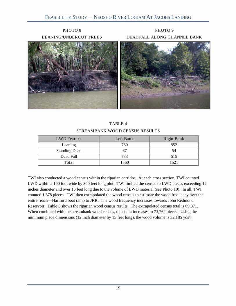
In addition to assessing in-channel conditions, TWI documented LWD along the banks and riparian areas
from the Hartford boat ramp to JRR. The purpose for this assessment was to estimate the amount of
LWD that is readily available to the river and likely to contribute more material to the logjam. TWI
counted—on both banks—the number of leaning trees, standing dead trees, and deadfall on the bank
slopes and on top of undercut banks (see Photo 8 and 9). Table 4 shows the results of the wood census.
FEASIBILITY STUDY — NEOSHO RIVER LOGJAM AT JACOBS LANDING
19
PHOTO 8
LEANING/UNDERCUT TREES
PHOTO 9
DEADFALL ALONG CHANNEL BANK
TABLE 4
STREAMBANK WOOD CENSUS RESULTS
LWD Feature Left Bank Right Bank
Leaning 760 852
Standing Dead 67 54
Dead Fall 733 615
Total 1560 1521
TWI also conducted a wood census within the riparian corridor. At each cross section, TWI counted
LWD within a 100 foot wide by 300 feet long plot. TWI limited the census to LWD pieces exceeding 12
inches diameter and over 15 feet long due to the volume of LWD material (see Photo 10). In all, TWI
counted 1,378 pieces. TWI then extrapolated the wood census to estimate the wood frequency over the
entire reach—Hartford boat ramp to JRR. The wood frequency increases towards John Redmond
Reservoir. Table 5 shows the riparian wood census results. The extrapolated census total is 69,871.
When combined with the streambank wood census, the count increases to 73,762 pieces. Using the
minimum piece dimensions (12 inch diameter by 15 feet long), the wood volume is 32,185 yds3.

FEASIBILITY STUDY — NEOSHO RIVER LOGJAM AT JACOBS LANDING
20
PHOTO 10
LWD WITHIN RIPARIAN CORRIDOR
TABLE 5
RIPARIAN WOOD CENSUS RESULTS
CrossSection 1
CrossSection 2
CrossSection 3
CrossSection 4
CrossSection 5
CrossSection 6
Count 39 109 53 164 197 816
AERIAL RECONNAISSANCE
On December 4, 2007, TWI completed an aerial reconnaissance using Hawkeye Helicopter, Inc. Assisted
by Ron Frank, professor of Communications at Kansas State University, TWI videotaped the logjam and
upstream reaches of the Neosho and Cottonwood Rivers. To document logjam conditions, Hawkeye
Helicopter made multiple passes over the area. Additionally, TWI collected aerial video of the Neosho
River overflow channels and Eagle Creek from its confluence with the Neosho River upstream to the boat
ramp. The aerial video and photographs provided TWI and other interested parties with a unique and
useful perspective of the logjam. Furthermore, TWI taped channel conditions upstream to document
circumstances that may impact the logjam and JRR.
In all, TWI videotaped 72 miles of the Neosho River, 39 miles of the Cottonwood River, and 1.6 miles of
Eagle Creek (see Appendix A, Figure 11). Appendix C provides specific information TWI documented
during the aerial reconnaissance. TWI time stamped each item of interest and grouped them by DVD and
river. All eleven DVDs are included at the end of the report.
VOLUME ESTIMATION
In order to provide a defensible estimate of wood volume, TWI researched techniques used in other
studies. Harmon et al. (1986) concluded that studying LWD is difficult because it varies widely in space
and time, creates sampling difficulties, makes manipulative experiments difficult, and requires long
periods of observations. In particular, LWD jams have extreme heterogeneity making it difficult to rely
on a simple sampling method or universal logjam model (Thevenet et al. 1998). Nonetheless, studies in
FEASIBILITY STUDY — NEOSHO RIVER LOGJAM AT JACOBS LANDING
21
LWD commonly use volume estimation techniques that include line-intersect techniques, wood census
and measurement surveys, aerial reconnaissance survey, and fixed-plot estimations.
Line-intersect sampling techniques are used to estimate logging residue (De Vries 1974). For LWD
studies in streams, the line-intersect technique is used to estimate wood volume (Wallace and Benke
1984, O’Connor 1992, Gippel et al. 1996, Warren et al. 2008). Line-intersect sampling involves
measuring specific attributes of LWD pieces that are crossed by a line transect (Marshall et al. 2000). De
Vries (1974) assumed that the population sampled is in random order. If not, this technique might obtain
biased results (De Vries 1974).
These studies often group wood measurements into height categories. Wallace and Benke (1984) found
that the stem abundance decreased considerably from stream bottom through increasing heights. The line
intersect technique is advantageous because it requires sampling just at random transects thus reducing
time and effort. However, this technique does create sampling difficulties for large rivers and logjams.
O’Connor (1992) had to increase the number of sampling transects to avoid volume errors within debris
jams. Wallace and Benke (1984) attempted to measure submerged wood by snorkeling but stopped
because situations became hazardous. Samplers had problems with reduced vision and limitation on
sampling depth (Wallace and Benke 1984). Some studies found that line-intersect sampling over-
estimated LWD volumes (Gippel et al. 1996, Warren et al. 2008). Conversely, line-intersect sampling in
large rivers underestimated LWD volumes due to the lack of submerged wood measurements (Wallace
and Benke 1984, Warren et al. 2008). Most importantly, line-intersect sampling relies on measuring
randomly distributed LWD, but streams often arrange wood in non-random orientations or distributions
(Warren et al. 2008).
Wood census surveys are another technique used to quantify wood and commonly found throughout
LWD research (Bilby and Ward 1989, Keller et al. 1995, Baillie and Davies 2002, Collins et al. 2002,
Collins and Montgomery 2002, Kraft and Warren 2003, Young et al. 2006, Daniels 2006, Comiti et al.
2006, Lassettre et al. 2007, Cordova et al. 2007, Magilligan et al. 2007, Warren et al. 2008). Census
measurements involve counting and measuring individual LWD pieces. Measurements often include
LWD length and diameter of pieces greater than 0.1 meter in diameter. Sometimes, multiple diameters
are measured and key LWD pieces that provide the framework in logjams (Bilby and Ward 1989, Collins
and Montgomery 2002). Volumes are determined by the summation of LWD cylinder volumes derived
from field diameter and length measurements. Wood census surveys are the most accurate since it
involves numerous detailed measurements. However, census surveys are time consuming and difficult to
complete in large rivers due to turbidity, water depth, and high wood frequencies (Gipple et al. 1996,
Thevenet et al. 1998, Warren et al. 2008). Gipple et al. (1996) recommended that census surveys are best
for wadeable streams.
Some studies use aerial photographs and helicopter reconnaissance to study LWD (Abbe and
Montgomery 2003, Lassettre et al. 2007). The use of aerial reconnaissance for determining LWD
frequency is more suited for large rivers. Both Abbe and Montgomery (2003) and Lassettre et al. (2007)
completed census surveys to determine LWD sizes and LWD frequency through aerial reconnaissance.
With the combination of size and frequency data, they extrapolated wood volumes.
There is one consistent disadvantage for each of the sampling techniques. All mentioned techniques do
not adequately incorporate submerged wood in large river systems. Quantitative techniques and studies

FEASIBILITY STUDY — NEOSHO RIVER LOGJAM AT JACOBS LANDING
22
are scarce on large rivers (O’Connor 1992, Gipple et al. 1996) and Piégay stated (personal
communication, March 25, 2008) submerged wood quantification is complicated and hard to calibrate.
Quantity data is sometimes visually estimated or assumed based on LWD abundance in measureable river
sections (Shields Jr. and Gippel 1995, Benke et al. 1984). Piégay (personal communication April 11,
2008) recommended measuring LWD quantities along channel margins and determine a wood volume per
unit area and extrapolate the ratio over the total logjam area. One other technique TWI explored was
fixed area plots to determine the volume of wood accumulations (Marshall et al. 2000).
Fixed area plots are the gross dimensions of air-wood volume. By extrapolating cross section surveys and
elevations of LWD features, TWI calculated the logjam fixed area plot at 642,886 yds2. TWI then
researched appropriate air volumes in logjams. Thevenet et al. (1998) defined LWD structures—isolated
trunks, jam accumulations, and shrubs—and determined the proportion of air in jams is 90% in relatively
small accumulations. Other volume estimation procedures are based on calculating logging residue
volumes. Little (1982) calculated wood volumes based on dimensions and geometric shapes of pile (see
Appendix A, Figure 12). One shape, a half cylinder, is similar to a stream channel. Little (1982)
calculated both pile shape and net wood volumes and determined a ratio estimator of 0.348 for wood
volume to shape volume. Hardy (1986) also developed guidelines for estimating volume for piled slash.
Hardy (1986) used similar techniques as Little (1982) but derived different conclusions. Hardy (1986)
concluded that much of a pile volume is occupied by air and that a wood volume to total pile volume or
packing ratio must be applied to determine net wood volume. Based on previous packing ratio research,
Hardy (1986) determined the net volume can range from 6% to 26%. Hardy (1986) stated that only
professional judgment can be used to determine packing ratios but did suggest high compacted clean piles
with larger logs can have packing ratios as high as 25%.
TWI realizes that there is a level of uncertainty determining the LWD volume due to the logjam’s
complexity and size. Therefore, TWI has provided a table with incremental packing ratios from the range
reported in the literature (see Table 6). TWI has also provided volume ranges for the entire logjam and
just upstream of Jacobs Landing. This table provides a very broad range of volume estimates. To refine
volume estimates, TWI applied different packing ratios to the previously identified logjam features. TWI
used a packing ratio of 25% for the areas identified as plugs since they are densely packed and appear to
be mostly large logs. Lassettre et al. (2007) stated that trunks represented 70% of the observed wood
deposits. TWI concludes that the plugs reasonably represent highly compacted, clean piles with large
logs as identified in Hardy (1986), thus a packing ratio of 25%. The areas of open water appear to be less
dense with LWD submerged or just above the base flow water elevation. TWI treated each area of open
water as a smaller, separate LWD accumulation and assigned a packing ratio of 10%. TWI feels this is a
reasonable estimate based from Thevenet et al. (1998). Using a combination of the two packing ratios—
adjusted for the measured areas of plug and open water—TWI calculates the overall net wood volume to
be 20%.
FEASIBILITY STUDY — NEOSHO RIVER LOGJAM AT JACOBS LANDING
23
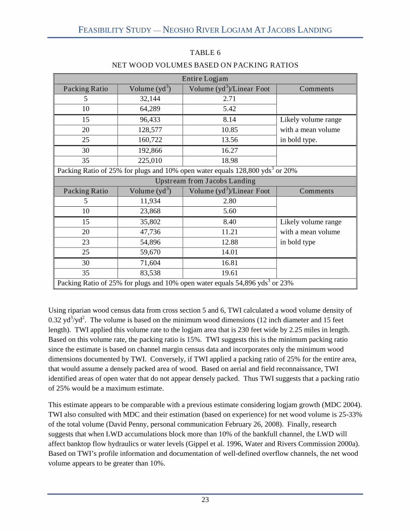
TABLE 6
NET WOOD VOLUMES BASED ON PACKING RATIOS
Entire Logjam
Packing Ratio Volume (yd3) Volume (yd3)/Linear Foot Comments
5 32,144 2.71
10 64,289 5.42
15 96,433 8.14 Likely volume range
20 128,577 10.85 with a mean volume
25 160,722 13.56 in bold type.
30 192,866 16.27
35 225,010 18.98
Packing Ratio of 25% for plugs and 10% open water equals 128,800 yds3 or 20%
Upstream from Jacobs Landing
Packing Ratio Volume (yd3) Volume (yd3)/Linear Foot Comments
5 11,934 2.80
10 23,868 5.60
15 35,802 8.40 Likely volume range
20 47,736 11.21 with a mean volume
23 54,896 12.88 in bold type
25 59,670 14.01
30 71,604 16.81
35 83,538 19.61
Packing Ratio of 25% for plugs and 10% open water equals 54,896 yds3 or 23%
Using riparian wood census data from cross section 5 and 6, TWI calculated a wood volume density of
0.32 yd3/yd2. The volume is based on the minimum wood dimensions (12 inch diameter and 15 feet
length). TWI applied this volume rate to the logjam area that is 230 feet wide by 2.25 miles in length.
Based on this volume rate, the packing ratio is 15%. TWI suggests this is the minimum packing ratio
since the estimate is based on channel margin census data and incorporates only the minimum wood
dimensions documented by TWI. Conversely, if TWI applied a packing ratio of 25% for the entire area,
that would assume a densely packed area of wood. Based on aerial and field reconnaissance, TWI
identified areas of open water that do not appear densely packed. Thus TWI suggests that a packing ratio
of 25% would be a maximum estimate.
This estimate appears to be comparable with a previous estimate considering logjam growth (MDC 2004).
TWI also consulted with MDC and their estimation (based on experience) for net wood volume is 25-33%
of the total volume (David Penny, personal communication February 26, 2008). Finally, research
suggests that when LWD accumulations block more than 10% of the bankfull channel, the LWD will
affect banktop flow hydraulics or water levels (Gippel et al. 1996, Water and Rivers Commission 2000a).
Based on TWI’s profile information and documentation of well-defined overflow channels, the net wood
volume appears to be greater than 10%.

FEASIBILITY STUDY — NEOSHO RIVER LOGJAM AT JACOBS LANDING
24
GROWTH RATE
TWI used aerial photographs to determine a logjam growth rate. The earliest rectified aerial photograph
TWI used was from 1991 (U.S. Geological Survey [USGS] 1991). The photo showed little woody debris
except at the lake confluence. This feature—approximately 700 feet in length—was locally referred to as
the “plug.” Next, TWI obtained a 2001 aerial photograph USACE used for the reallocation study
(USACE 2002), a 2002 U.S. Geological Survey rectified aerial photograph (USGS 2002), and U.S.
Department of Agriculture National Agriculture Imagery Program (USDA NAIP) 2003-2006 aerial
photographs (USDA NAIP 2003-2006). TWI used information gathered in field activities to determine
the 2007 logjam upstream extent.
Figure 13, Appendix A shows the upstream extent of the logjam for each year identified above. The
logjam increased considerably between 1991 and 2001. Wood accumulation most likely collected from
several large floods during the time period. During the past seven years, the logjam grew steadily with an
average annual increase of 1,397 feet (see Table 7). The greatest increase occurred between 2003 and
2004 due to wood loading after a severe ice storm. Conversely, the smallest change occurred between
2005 and 2006 with an increase of 420 feet. It is evident that the logjam efficiently traps fluvially
transported wood and further increases are expected. TWI expects an increase in wood recruitment and
loading from the December 2007 ice storm.
TABLE 7
LOGJAM GROWTH RATE SUMMARY (in Feet)
Year Logjam Length Growth Rate Year Logjam Length Growth Rate
1991 700 -- 2004 9,030 4,630
2001 2,270 1,570 2005 9,680 650
2002 3,600 1,330 2006 10,100 420
2003 4,400 800 2007 12,050 1,950
STORED SEDIMENT
Based on cross section surveys 4, 5, and 6, TWI extrapolated the loss of channel area over the logjam
reach. TWI estimated the amount of stored sediment at 250,000 yd3. Above Jacobs Landing, TWI
estimates 75,000 yd3 of stored sediment. Research shows that wood accumulations influence sediment
storage (Bilby and Ward 1989, Nakamura and Swanson 1993, Thompson 1995, Brummer et al. 2006).
This influence can be temporary or for large logjams, permanent. While TWI’s estimate is based on the
loss of channel capacity, it does not account for sediment stored within the logs as this quantity is difficult
to determine, and would likely be removed if the logjam were removed.
LOGJAM REMOVAL RESEARCH
TWI conducted a literature search to identify similar projects throughout the United States, Australia, and
Europe to assemble information on successful solutions to logjam removal and channel restoration.
Though logjams are a frequent component of fluvial systems, few published reports exist on removal
techniques, costs, and success. More often the research literature documents the success or failure of
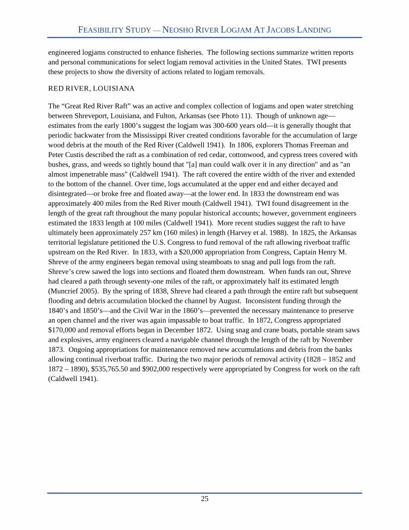
FEASIBILITY STUDY — NEOSHO RIVER LOGJAM AT JACOBS LANDING
25
engineered logjams constructed to enhance fisheries. The following sections summarize written reports
and personal communications for select logjam removal activities in the United States. TWI presents
these projects to show the diversity of actions related to logjam removals.
RED RIVER, LOUISIANA
The “Great Red River Raft” was an active and complex collection of logjams and open water stretching
between Shreveport, Louisiana, and Fulton, Arkansas (see Photo 11). Though of unknown age—
estimates from the early 1800’s suggest the logjam was 300-600 years old—it is generally thought that
periodic backwater from the Mississippi River created conditions favorable for the accumulation of large
wood debris at the mouth of the Red River (Caldwell 1941). In 1806, explorers Thomas Freeman and
Peter Custis described the raft as a combination of red cedar, cottonwood, and cypress trees covered with
bushes, grass, and weeds so tightly bound that "[a] man could walk over it in any direction" and as "an
almost impenetrable mass" (Caldwell 1941). The raft covered the entire width of the river and extended
to the bottom of the channel. Over time, logs accumulated at the upper end and either decayed and
disintegrated—or broke free and floated away—at the lower end. In 1833 the downstream end was
approximately 400 miles from the Red River mouth (Caldwell 1941). TWI found disagreement in the
length of the great raft throughout the many popular historical accounts; however, government engineers
estimated the 1833 length at 100 miles (Caldwell 1941). More recent studies suggest the raft to have
ultimately been approximately 257 km (160 miles) in length (Harvey et al. 1988). In 1825, the Arkansas
territorial legislature petitioned the U.S. Congress to fund removal of the raft allowing riverboat traffic
upstream on the Red River. In 1833, with a $20,000 appropriation from Congress, Captain Henry M.
Shreve of the army engineers began removal using steamboats to snag and pull logs from the raft.
Shreve’s crew sawed the logs into sections and floated them downstream. When funds ran out, Shreve
had cleared a path through seventy-one miles of the raft, or approximately half its estimated length
(Muncrief 2005). By the spring of 1838, Shreve had cleared a path through the entire raft but subsequent
flooding and debris accumulation blocked the channel by August. Inconsistent funding through the
1840’s and 1850’s—and the Civil War in the 1860’s—prevented the necessary maintenance to preserve
an open channel and the river was again impassable to boat traffic. In 1872, Congress appropriated
$170,000 and removal efforts began in December 1872. Using snag and crane boats, portable steam saws
and explosives, army engineers cleared a navigable channel through the length of the raft by November
1873. Ongoing appropriations for maintenance removed new accumulations and debris from the banks
allowing continual riverboat traffic. During the two major periods of removal activity (1828 – 1852 and
1872 – 1890), $535,765.50 and $902,000 respectively were appropriated by Congress for work on the raft
(Caldwell 1941).
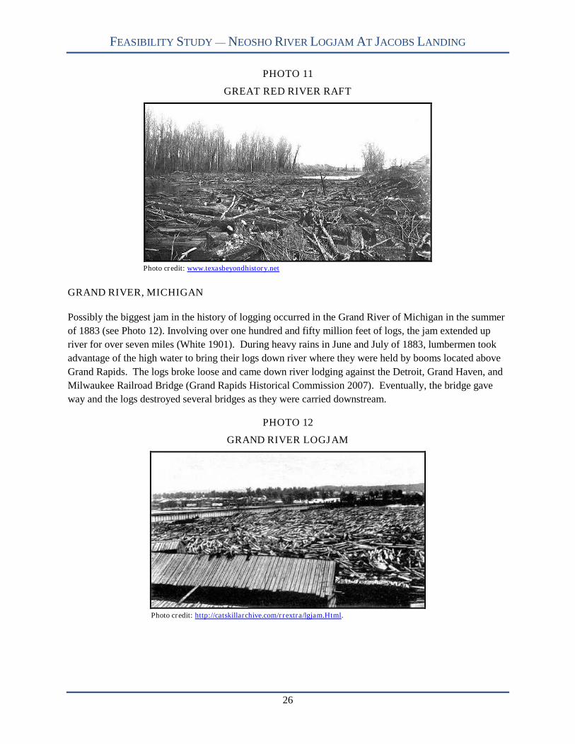
FEASIBILITY STUDY — NEOSHO RIVER LOGJAM AT JACOBS LANDING
26
PHOTO 11
GREAT RED RIVER RAFT
Photo credit: www.texasbeyondhistory.net
GRAND RIVER, MICHIGAN
Possibly the biggest jam in the history of logging occurred in the Grand River of Michigan in the summer
of 1883 (see Photo 12). Involving over one hundred and fifty million feet of logs, the jam extended up
river for over seven miles (White 1901). During heavy rains in June and July of 1883, lumbermen took
advantage of the high water to bring their logs down river where they were held by booms located above
Grand Rapids. The logs broke loose and came down river lodging against the Detroit, Grand Haven, and
Milwaukee Railroad Bridge (Grand Rapids Historical Commission 2007). Eventually, the bridge gave
way and the logs destroyed several bridges as they were carried downstream.
PHOTO 12
GRAND RIVER LOGJAM
Photo credit: http://catskillarchive.com/rrextra/lgjam.Html.

FEASIBILITY STUDY — NEOSHO RIVER LOGJAM AT JACOBS LANDING
27
YALOBUSHA RIVER, MISSISSIPPI
The Yalobusha watershed encompasses 661 mi2 that went through extensive channelization during the
1960s. As a result, the watershed—downstream of channelization—experienced increased flooding, loss
or temporary closure of transportation routes, alteration of water regime, and reduction of channel
conveyance capacity (Gulf Engineers and Consultants [GEC] 2002). In particular, a debris plug formed
constricting most of the channel (see Photo 13). A study by Down and Simon (2001) found that sediment
and LWD recruitment was most influenced by mass streambank failure, a geomorphological process.
They estimated an annual recruitment of 833,000 tons of sediment and 100 trees to the stream system
(Down and Simon 2001).
USACE, Vicksburg District contracted for an Environmental Impact Statement (EIS) to assess watershed
rehabilitation alternatives and determine subsequent mitigation requirements. From a public scoping
meeting, USACE found that there was a strong, local desire to remove the plug, but with caution.
Concerns included: contamination within the debris plug; increased sediment loading to Granada Lake
from channel clean-out; and potential impacts to water quality, wetlands, aquatics, terrestrial habitats,
waterfowl, cultural resources, endangered species, and prime farmland (GEC 2002). Consensus among
participants determined that a watershed approach would be best to enhance the river.
Based on this input, GEC (2002) identified four alternatives and determined mitigation requirements. All
alternatives (except the no-action alternative) incorporate grade stabilization and flood retarding
structures as watershed enhancements. The alternatives differ with respect to the debris plug. The first
alternative recommended a phased debris plug removal. Phase 1 included channel cleanout and
excavation of 13,120 feet of channel centerline. GEC selected this first phase to improve channel
conveyance. Phase 2 included entire clean-out for 32,800 feet of channel. This alternative required 785
acres of migration and involved the least disturbance to habitats. The second alternative and third
alternatives involved the construction of by-pass channels. These alternatives disturbed more terrestrial
habitats and therefore not preferred.
After a hazardous, toxic, and radioactive waste study was completed, USACE awarded a contract to
remove the debris plug as outlined in the first alternative. The contractor removed the plug using
conventional excavation equipment. The contractor buried LWD under the stored sediment adjacent to
the river. USACE (personnel communication, May 12, 2008) accepted the completed work in 2004 with
a total removal cost of $1,129,499.52. Mitigation involved reforestation of 785 acres of frequently
flooded agriculture land (GEC 2002).

FEASIBILITY STUDY — NEOSHO RIVER LOGJAM AT JACOBS LANDING
28
PHOTO 13
YALOBUSHA RIVER DEBRIS PLUG
Photo credit: USDA ARS National Sediment Laboratory
SOUTH GRAND RIVER, MISSOURI
TWI obtained the following information through personal communication with Bud Hayes (Kaysinger
Basin Regional Planning Commission) and Joe Wilson (Wilson Hydro, LLC). In 2001, Henry County,
Missouri, undertook removal of multiple log rafts from approximately 7,000 feet of the South Grand
River above Truman Reservoir. Previous efforts to burn the logjam failed due to saturated conditions and
sediment-laden material. The County received a total of $800,000 from a Community Development
Block Grant and state appropriations for the project. Environmental coordination for the project required
approximately one year and permitting agencies restricted removal activity to the period of October
through April to protect the endangered Indiana bat. Additional mitigation requirements mandated that
the County replant trees in areas cleared for access roads and material burial. During feasibility analysis,
the County determined that constructing roads along the river banks and trucking removed material off-
site were not economically feasible. Ultimately the County’s contractor used two trackhoes to remove the
wood and bury the material in trenches excavated at multiple points along the river. The County’s
contractor completed removal within the six month activity window. The County continues ongoing
maintenance to remove woody debris before logjams develop.
DESCHUTES RIVER, WASHINGTON
In 2002, Thurston County, Washington, reviewed alternatives to address a 1,350 feet long logjam in the
Deschutes River (see Photo 14). The County’s contractor developed a preliminary cost estimate of
$1,640,000 for complete removal plus $270,000 for annual maintenance costs (GeoEngineers 2002).
After reviewing various alternatives, the County determined that neither complete nor partial removal was
feasible. The County noted the following reasons for their determination: lack of legal responsibility,
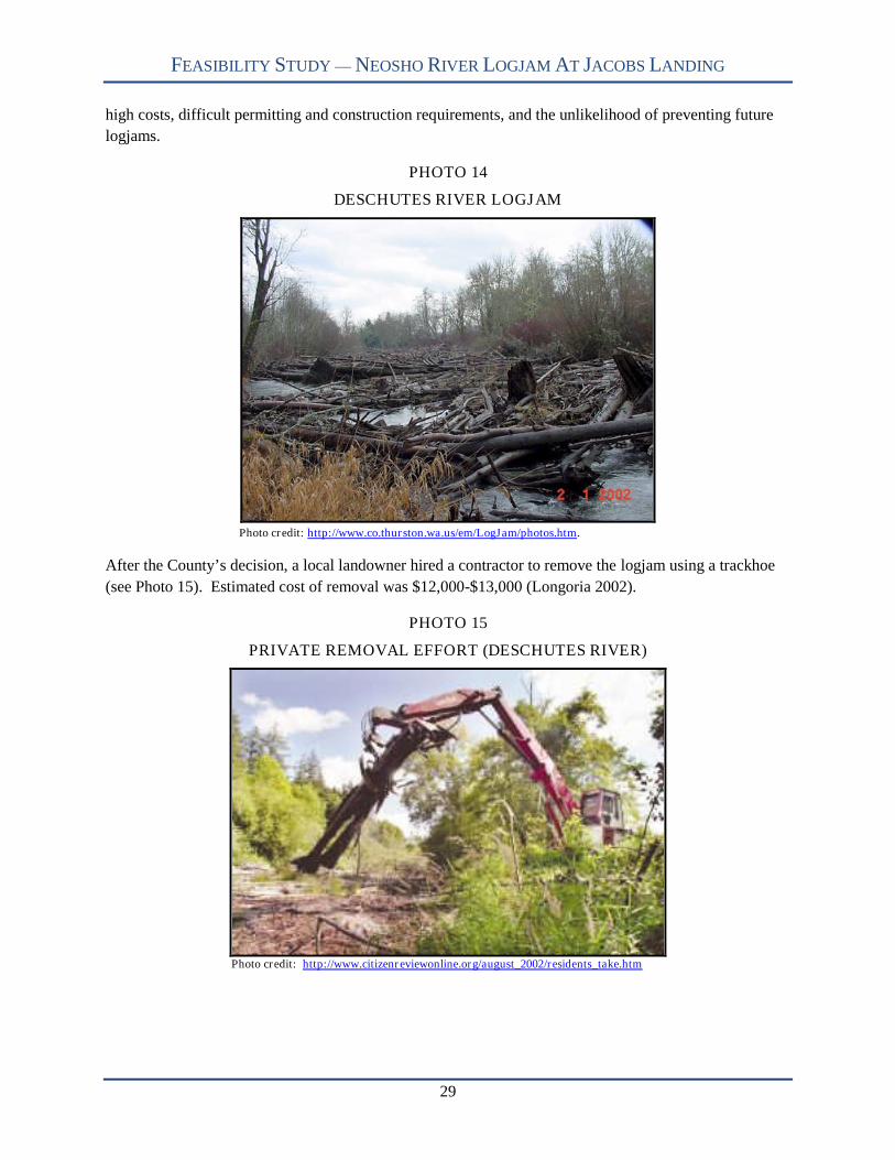
FEASIBILITY STUDY — NEOSHO RIVER LOGJAM AT JACOBS LANDING
29
high costs, difficult permitting and construction requirements, and the unlikelihood of preventing future
logjams.
PHOTO 14
DESCHUTES RIVER LOGJAM
Photo credit: http://www.co.thurston.wa.us/em/LogJam/photos.htm.
After the County’s decision, a local landowner hired a contractor to remove the logjam using a trackhoe
(see Photo 15). Estimated cost of removal was $12,000-$13,000 (Longoria 2002).
PHOTO 15
PRIVATE REMOVAL EFFORT (DESCHUTES RIVER)
Photo credit: http://www.citizenreviewonline.org/august_2002/residents_take.htm
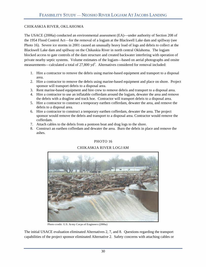
FEASIBILITY STUDY — NEOSHO RIVER LOGJAM AT JACOBS LANDING
30
CHIKASKIA RIVER, OKLAHOMA
The USACE (2006a) conducted an environmental assessment (EA)—under authority of Section 208 of
the 1954 Flood Control Act—for the removal of a logjam at the Blackwell Lake dam and spillway (see
Photo 16). Severe ice storms in 2001 caused an unusually heavy load of logs and debris to collect at the
Blackwell Lake dam and spillway on the Chikaskia River in north central Oklahoma. The logjam
blocked access to gate controls of the dam structure and created backwater interfering with operation of
private nearby septic systems. Volume estimates of the logjam—based on aerial photographs and onsite
measurements—calculated a total of 27,800 yd3. Alternatives considered for removal included:
1. Hire a contractor to remove the debris using marine-based equipment and transport to a disposalarea.
2. Hire a contractor to remove the debris using marine-based equipment and place on shore. Projectsponsor will transport debris to a disposal area.
3. Rent marine-based equipment and hire crew to remove debris and transport to a disposal area.4. Hire a contractor to use an inflatable cofferdam around the logjam, dewater the area and remove
the debris with a dragline and track hoe. Contractor will transport debris to a disposal area.5. Hire a contractor to construct a temporary earthen cofferdam, dewater the area, and remove the
debris to a disposal area.6. Hire a contractor to construct a temporary earthen cofferdam, dewater the area. The project
sponsor would remove the debris and transport to a disposal area. Contractor would remove thecofferdam.
7. Attach cables to the debris from a pontoon boat and drag logs to the shore.8. Construct an earthen cofferdam and dewater the area. Burn the debris in place and remove the
ashes.
PHOTO 16
CHIKASKIA RIVER LOGJAM
Photo credit: U.S. Army Corps of Engineers (2006a)
The initial USACE evaluation eliminated Alternatives 2, 7, and 8. Questions regarding the transport
capabilities of the project sponsor eliminated Alternative 2. Safety concerns with attaching cables or

FEASIBILITY STUDY — NEOSHO RIVER LOGJAM AT JACOBS LANDING
31
dragline to the logs from a boat eliminated Alternative 7. Alternative 8 was dropped because heat from
the burning debris could damage the concrete dam. The USACE developed preliminary costs for
Alternatives 1, 3, 4, 5, and 6. Significantly higher costs eliminated Alternative 3 from further
consideration. The USACE calculated total implementation cost for the four alternatives to be:
Alternative 1 = $526,200 ($18.93/yd3) Alternative 4 = $528,700 ($19.02/yd3) Alternative 5 = $639,800 ($23.01/yd3) Alternative 6 = $621,700 ($22.36/yd3)
The USACE chose Alternative 1 as the recommended plan.
SOLOMON RIVER, KANSAS
Located near Minneapolis, Kansas, the Solomon River logjam initially formed in 1995 when trees killed
during 1993 floods accumulated in a sharp bend of the river (see Photo 17). At its largest extent, the
logjam covered 3.5 acres and filled 1,300 feet and 110,740 yd3 of river channel. Overtime, the Solomon
River eroded around the logjam threatening residential infrastructure. Ongoing landowner efforts to burn
the logjam—and natural decay—eventually reduced its length to approximately 700 feet and 29,815 yd3.
PHOTO 17
SOLOMON RIVER LOGJAM
In 2005, the Kansas Alliance for Wetlands and Streams (KAWS) approved funding to remove the
remaining length of jam and stabilize the streambanks. TWI surveyed the site in September 2005 and
developed a stabilization design based on utilizing the removed logs. Contractors, using hydraulic
excavators, began removal in May, 2006. With a goal to provide an 80 feet wide channel, contractors
drove excavators onto the logjam, picking up and positioning individual logs along the eroding
streambank (see Photos 18 and 19). The contractor completed work within two weeks at a cost of
$28,000 (see Photo 20).
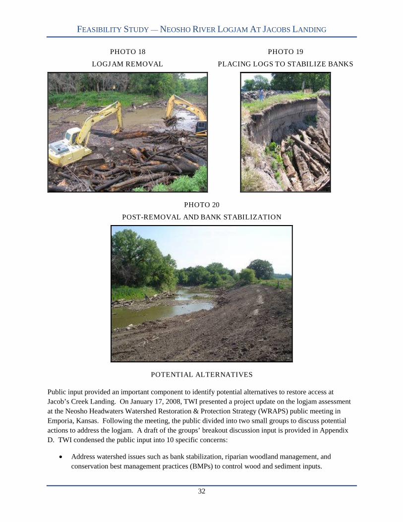
FEASIBILITY STUDY — NEOSHO RIVER LOGJAM AT JACOBS LANDING
32
PHOTO 18
LOGJAM REMOVAL
PHOTO 19
PLACING LOGS TO STABILIZE BANKS
PHOTO 20
POST-REMOVAL AND BANK STABILIZATION
POTENTIAL ALTERNATIVES
Public input provided an important component to identify potential alternatives to restore access at
Jacob’s Creek Landing. On January 17, 2008, TWI presented a project update on the logjam assessment
at the Neosho Headwaters Watershed Restoration & Protection Strategy (WRAPS) public meeting in
Emporia, Kansas. Following the meeting, the public divided into two small groups to discuss potential
actions to address the logjam. A draft of the groups’ breakout discussion input is provided in Appendix
D. TWI condensed the public input into 10 specific concerns:
Address watershed issues such as bank stabilization, riparian woodland management, and
conservation best management practices (BMPs) to control wood and sediment inputs.

FEASIBILITY STUDY — NEOSHO RIVER LOGJAM AT JACOBS LANDING
33
Recreation is important for the area. Attempts should be made to restore fisheries, increase
recreation potential, and provide access to the river and lake.
Cut a new channel mechanically.
Remove as much of the logjam as possible.
The logjam removal is a waste of time and money.
Pay attention to wildlife impacts.
Burn the logjam.
Expressed social concerns (mosquito populations and West Nile virus, poor water quality, and
lower property values).
Should incorporate annual management/maintenance plan.
Removal action should contain dredging component.
Based on the public input, on-site field activities, aerial reconnaissance, and research, TWI has
recommended the following alternatives to address the logjam. The alternatives are listed in no particular
order.
ALTERNATIVE 1: NO ACTION
With this alternative, no restoration or maintenance measures will commence. TWI expects the logjam to
increase as well as the current floodplain overflow channels. The current natural tendency for the river is
to change course since the logjam occupies a significant proportion of channel area. The channel change
or avulsion will cause the river to flow southeast from its current location into JRR.
ALTERNATIVE 2: REMOVE LOGJAM AND DREDGE LAKE
The second alternative is to remove the entire logjam and implement a dredging operation for a small
portion of John Redmond Reservoir. Within this alternative, TWI evaluated removal options using land
and marine-based equipment. For both removal options, TWI used the likely range of wood volumes
presented in Table 6. Use of a land-based removal approach will require a construction easement along
the right bank to haul away LWD. The haul road will encompass 20.8 acres of which 20.6 are identified
on the National Wetland Inventory (NWI) maps. Table 8 provides a breakdown of NWI wetlands
affected by the haul road. A marine-approach would not require a haul road paralleling the entire removal
area but a discrete collection area. TWI recommends using Jacobs Landing as the collection point to take
advantage of the existing infrastructure. Either approach is expected to take 6 to 10 months to remove the
entire logjam.

FEASIBILITY STUDY — NEOSHO RIVER LOGJAM AT JACOBS LANDING
34
TABLE 8
NWI WETLANDS AFFECTED BY HAUL ROAD CONSTRUCTION FOR ALTERNATIVE 2
NWI Wetland AcresLacustrine Limnetic Unconsolidated Bottom
Permanently Flooded Diked/Impounded (L1UBHh)2.0
Lacustrine Littoral Unconsolidated ShoreTemporarily Flooded Diked/Impounded (L2USAh)
1.0
Palustrine Forested Temporarily FloodedDiked/Impounded (PFOAh)
10.9
Palustrine Scrub-Shrub Temporarily FloodedDiked/Impounded (PSSAh)
6.7
TWI has incorporated a dredging operation to deepen the lake area at the river/lake confluence. This will
improve the conveyance of water through the river into the lake. Also, the dredging will increase the
conservation pool capacity. TWI is using a dredging quantity of 740,000 cubic yards. This volume is
based on dredging out into JRR until reaching lake depths (at conservation pool level) of four feet This
would provide a more gradual decrease in depth that would reduce the LWD trapping potential and
increase recreational access. The dredging component is expected to take 18 to 24 months. Figure 14,
Appendix A provides a conceptual drawing of major activities.
ALTERNATIVE 3: REMOVE LOGJAM WITH NO LAKE DREDGING
Since large scale dredging is a significant and costly undertaking, TWI evaluated the same removal
methods outlined in Alternative 2 without the dredging component (see Appendix A, figure 14). As
discussed, TWI used a land and marine-based approach. For the land-based approach, a construction
easement with haul road will parallel the entire channel impacting the same wetlands outlined in Table 8.
Removal of the entire logjam is expected to last 6 to 10 months.
ALTERNATIVE 4: EXCAVATE CHANNEL AROUND LOGJAM AND DREDGE LAKE
This alternative involves excavating a channel, by-passing the entire logjam. In order to construct a
channel to similar upstream dimensions, TWI calculates excavating 1,110,000 yd3 over 1.7 miles of new
channel. This alternative also allows either a land or marine-based approach. For the land-based
approach, a construction easement with haul road will parallel the entire channel. Between the channel
and road, the channel and road footprint would encompass nearly 66.0 acres of which 96% is identified
by NWI as wetlands. Table 9 shows the breakout of wetland types. TWI estimates it will take 17 months
to complete this alternative using a land-based approach.
TABLE 9
NWI WETLANDS (ACRES) AFFECTED BY CHANNEL EXCAVATION AND HAUL ROADCONSTRUCTION FOR ALTERNATIVE 4
Activity L1UBHh L2USAh PSSAhChannel Excavation 1.9 22.6 23.1
Road Easement - 7.7 8.1
FEASIBILITY STUDY — NEOSHO RIVER LOGJAM AT JACOBS LANDING
35
A marine approach requires hydraulic dredging of the lake’s mudflat and only in-channel disturbances.
TWI estimates that a marine approach will take 24 months to complete. Additionally, this alternative
incorporates the same dredging component as in Alternative 2 but located at the new river/lake
confluence. TWI suggests 900,000 cubic yards be dredged to open the river/channel confluence. The
dredging component would take 18 to 24 months to complete. Figure 15 in Appendix A depicts a
conceptual outline of Alternative 3 activities.
ALTERNATIVE 5: EXCAVATE CHANNEL AROUND LOGJAM WITH NO LAKE
DREDGING
TWI is evaluating the same activities as Alternative 4 without the dredging component (see Appendix A,
Figure 15). Again, TWI estimates that a land-based approach would take 17 months to complete, while a
marine-based approach would take 24 months.
ALTERNATIVE 6: REMOVE LOGJAM ABOVE JACOBS LANDING AND EXCAVATE
CHANNEL DOWNSTREAM TO LAKE WITH LAKE DREDGING
Alternative 6 evaluates both logjam removal and channel excavation. Currently, the river is working
toward creating a new channel. A series of floodplain overflow channels are located just downstream of
Jacobs Landing and flow southeast (see Appendix A, Figure 10). TWI suggests channel excavation begin
where the overflow channels diverts water onto the floodplain and continue excavating a channel
resembling the anticipated avulsion. TWI estimates channel excavation volume to be 643,000 yd3.
Upstream of the excavation, a contractor would remove the logjam. To estimate costs, TWI will use a
wood volume range between 44,594 and 68,462 yd3. Based on field investigations, TWI suggests that
LWD densities increase in a downstream direction. This approach would by-pass areas that appear
densely packed with LWD.
TWI considered both land and marine-based approaches. A land-based approach requires an easement
and haul road paralleling the entire removal/excavation area. Between the channel excavation and road
easement, the area encompasses 45.2 acres of which nearly all identified as wetlands by NWI. Table 10
shows the wetland types and respected areas affected by restoration measures. TWI estimates it will take
13 to 15 months to complete this alternative using a land-based approach.
TABLE 10
NWI WETLANDS (ACRES) AFFECTED BY CHANNEL EXCAVATION AND HAUL ROADCONSTRUCTION FOR ALTERNATIVE 6
Activity L1UBHh L2USAh PFOAh PSSAhChannel Excavation 0.5 18.7 4.2 4.4
Road Easement 0.6 6.5 2.3 7.9
A marine-based approach would hydraulically dredge the mudflat within the excavation area. Once the
channel excavation is complete, the dredge would then work to dislodge LWD to the upstream extent.
TWI estimates that a marine-based approach would take 18to 20 months to complete. Additionally, this
alternative incorporates dredging (900,000 cubic yards) at the proposed lake/river confluence. The
FEASIBILITY STUDY — NEOSHO RIVER LOGJAM AT JACOBS LANDING
36
dredging component will take approximately 18 to 24 months. Figure 16 in Appendix A provides a
conceptual outline of the alternative.
ALTERNATIVE 7: REMOVE LOGJAM ABOVE JACOBS LANDING AND EXCAVATE
CHANNEL DOWNSTREAM TO LAKE WITHOUT LAKE DREDGING
Alternative 7 incorporates the same aspects of alternative 6 without the dredging component (see
Appendix A, Figure 16).
ALTERNATIVE 8: REMOVE LOGJAM ABOVE JACOBS LANDING
Alternative 8 is logjam removal upstream of Jacobs Landing to provide river access. TWI also suggests
removing a small portion of the logjam downstream from Jacobs Landing to provide some additional
open channel in the boat ramp vicinity (see Appendix A, Figure 17). TWI estimates the wood volume to
range from 40,729 to 64,597 yd3. A land-based approach requires a haul road easement paralleling the
entire removal, disturbing 8.6 acres. Almost all of this area is classified as NWI wetlands. Both a land-
based and marine-based approach will take approximately 3 to 5 months to complete. Table 11 shows the
wetlands affected by this alternative.
TABLE 11
NWI WETLANDS (ACRES) AFFECTED BY HAUL ROAD CONSTRUCTION FORALTERNATIVE 8
L1UBHh L2USAh PFOAh PSSAh0.6 0.7 6.2 1.0
ALTERNATIVE 9: REMOVE LOGJAM ABOVE JACOBS LANDING AND
DREDGE/CLEAR EAGLE CREEK
This alternative removes the logjam in a similar fashion as alternative 8. Additionally, this alternative
incorporates channel dredging and LWD removal for Eagle Creek (see Appendix A, Figure 18).
Currently, 1,650 feet of Eagle Creek—upstream from Neosho River confluence—is silted in prohibiting
boat passage. TWI also identified two small logjams between the Eagle Creek boat ramp and the Neosho
River confluence. TWI estimates an excavation volume 50,000yd3 based on aerial photo interpretation
and Neosho River cross section data. Using a wood density of 0.32 yd3/yd2, TWI estimates the wood
volume to 2,700 yd3.
For land-based removal approach, the road easement needed would be 1.13 miles long encompassing 11.9
acres. All of this area is identified as NWI wetlands. In addition to the wetlands affected in Alternative 8,
Table 12 summarizes affected wetlands for the Eagle Creek area. A marine-based approach would
require pumping dredged material a long distance but would require few construction roads. TWI
estimates both approaches to take 6 to 8 months to complete.
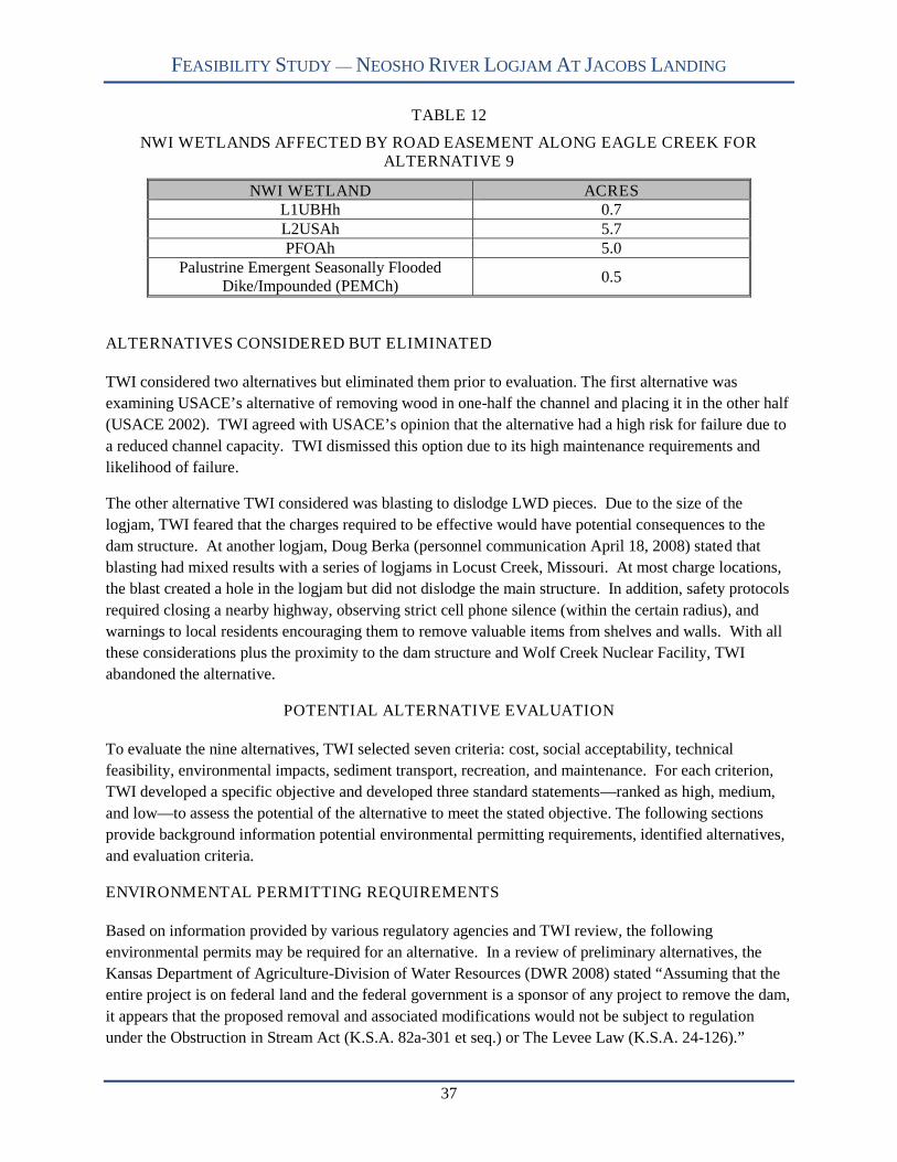
FEASIBILITY STUDY — NEOSHO RIVER LOGJAM AT JACOBS LANDING
37
TABLE 12
NWI WETLANDS AFFECTED BY ROAD EASEMENT ALONG EAGLE CREEK FORALTERNATIVE 9
NWI WETLAND ACRESL1UBHh 0.7L2USAh 5.7PFOAh 5.0
Palustrine Emergent Seasonally FloodedDike/Impounded (PEMCh)
0.5
ALTERNATIVES CONSIDERED BUT ELIMINATED
TWI considered two alternatives but eliminated them prior to evaluation. The first alternative was
examining USACE’s alternative of removing wood in one-half the channel and placing it in the other half
(USACE 2002). TWI agreed with USACE’s opinion that the alternative had a high risk for failure due to
a reduced channel capacity. TWI dismissed this option due to its high maintenance requirements and
likelihood of failure.
The other alternative TWI considered was blasting to dislodge LWD pieces. Due to the size of the
logjam, TWI feared that the charges required to be effective would have potential consequences to the
dam structure. At another logjam, Doug Berka (personnel communication April 18, 2008) stated that
blasting had mixed results with a series of logjams in Locust Creek, Missouri. At most charge locations,
the blast created a hole in the logjam but did not dislodge the main structure. In addition, safety protocols
required closing a nearby highway, observing strict cell phone silence (within the certain radius), and
warnings to local residents encouraging them to remove valuable items from shelves and walls. With all
these considerations plus the proximity to the dam structure and Wolf Creek Nuclear Facility, TWI
abandoned the alternative.
POTENTIAL ALTERNATIVE EVALUATION
To evaluate the nine alternatives, TWI selected seven criteria: cost, social acceptability, technical
feasibility, environmental impacts, sediment transport, recreation, and maintenance. For each criterion,
TWI developed a specific objective and developed three standard statements—ranked as high, medium,
and low—to assess the potential of the alternative to meet the stated objective. The following sections
provide background information potential environmental permitting requirements, identified alternatives,
and evaluation criteria.
ENVIRONMENTAL PERMITTING REQUIREMENTS
Based on information provided by various regulatory agencies and TWI review, the following
environmental permits may be required for an alternative. In a review of preliminary alternatives, the
Kansas Department of Agriculture-Division of Water Resources (DWR 2008) stated “Assuming that the
entire project is on federal land and the federal government is a sponsor of any project to remove the dam,
it appears that the proposed removal and associated modifications would not be subject to regulation
under the Obstruction in Stream Act (K.S.A. 82a-301 et seq.) or The Levee Law (K.S.A. 24-126).”

FEASIBILITY STUDY — NEOSHO RIVER LOGJAM AT JACOBS LANDING
38
However, “if the project requires the use of surface water or groundwater for hydraulic dredging,
dewatering, construction, or other beneficial uses, and if those uses cannot be covered under an existing
water right or an existing permit to appropriate water, an application must be filed with DWR pursuant to
the Kansas Water Appropriation Act (K.S.A. 82a-701 et seq.).”
Other potential permits include:
USACE – Authorization to conduct dredge and fill activities through Section 404 of the CleanWater Act (CWA). Section 404 requires a permit before dredged or fill material may bedischarged into waters of the United States, unless the activity is exempt from Section 404regulation. No discharge of dredged or fill material may be permitted if: (1) a practicablealternative exists that is less damaging to the aquatic environment or (2) the nation’s waterswould be significantly degraded. Permit applicants must show they have taken steps to avoidwetland impacts, or minimized potential impacts on wetlands and provided compensation for anyremaining unavoidable impacts.
Kansas Department of Health and Environment (KDHE) – Water Quality Certification underSection 401 of the CWA. Concurrent with the 404 permitting process, the WatershedManagement Section of KDHE prepares Section 401 water quality certifications to assure that thepermitted activity will not violate Kansas water quality standards. The USACE will not issue aSection 404 permit until the State releases a statement certifying the activity is not likely toviolate Kansas water quality standards.
KDHE – Stormwater Construction Permit. Any project or combination of projects disturbing one(1) or more acres must have authorization to discharge stormwater runoff under the constructionstormwater general permit S-MCST-0701-1.
KDWP – Action Permit to protect threatened and endangered species. All lands and waters thatlie within 5 air miles of public lands around JRR are designated critical habitat for the bald eagle(Haliaeetus leucocephalus). Bald eagles are protected by the Kansas Nongame and EndangeredSpecies Conservation Act and are common winter visitors to JRR and the Neosho River. KDWPsurveys in January 2005 documented 10 adult and 21 immature bald eagles along the NeoshoRiver on the Flint Hills National Wildlife Refuge and around JRR (http://www.kdwp.state.ks.us/news/other_services/threatened_and_endangered_species/mid_winter_bald_eagle_survey).Likewise, TWI observed 4 mature and 3 immature bald eagles near the Jacobs Creek Landing inJanuary 2008.
Based on likely habitat impacts from alternative implementation, mitigation requirements are expected for
both the Section 404 and Action Permits. While not stating specific permit requirements, the USFWS
(2008) noted that “Executive Order 13112, Section 2(3) directs federal agencies to not authorize, fund, or
carry out actions that it believes are likely to cause or promote the introduction or spread of invasive
species.” Of particular concern are the zebra mussel (Dreissena polymorpha), Eurasian milfoil
(Myriophyllum spicatum), purple loosestrife (Lythrum salicaria), Johnson grass (Sorghum halepense),
sericea lespedeza (Lespedeza cuneata), salt cedar (Tamarix spp.) and reed canary grass (Phalaris
arundinacea). To meet this Executive Order, the USFWS recommends implementing the following best
management practice:
“All equipment brought on site will be thoroughly washed to remove dirt, seeds, andplant parts. Any equipment that has been in any body of water within the past 30 dayswill be thoroughly cleaned with hot water greater than 140ºF and dried for a minimum offive days before being used at this project site. In addition, before transportingequipment from the project site all visible mud, plants and fish/animals will be removed,
FEASIBILITY STUDY — NEOSHO RIVER LOGJAM AT JACOBS LANDING
39
all water will be eliminated, and the equipment will be thoroughly cleaned. Anythingthat came into contact with water will be cleaned and dried following the aboveprocedure.”
Additionally, the USFWS provided information related to the Migratory Bird Treaty Act (MTBA), which
“prohibits the taking, killing, possession, transportation, and importation of migratory birds, their eggs,
parts, and nests, except when specifically authorized by the Department of Interior.” As “takings” can
result from projects conducted in wetlands and woodlands—during the general period of April 1 to July
15—the USFWS recommended a field survey of the affected habitats to identify the presence of active
nests prior to alternative implementation. A copy of each regulatory agency’s response letter TWI
received is provided in Appendix D.
EVALUATION CRITERIA
This section provides background information, the specific objective, and assessment standards for the
seven criteria. To guide alternative selection, TWI weighted the assessment standards so that each
alternative will receive a final numerical score, with higher scores indicating greater potential to meet the
stated criteria objectives. Criteria with a “low” standard received 0 points, while “medium” and “high”
standards received 1 and 2 points respectively. Total alternative score reflects the sum of all criteria
assessment standard scores for that alternative, with 14 being the highest possible score.
Cost
TWI used a variety of sources to develop cost estimates. Sources included private contractors and
manufacturers, county officials, and Reed Construction Data, Inc. (2006). Due to the uncertainty of wood
volume, TWI used the likely range of volumes identified in Table 6. Also, Rick Thomas (personnel
communication April 24, 2008) indicated USACE may require the disposal of all excavated materials to
be outside the flood pool elevation. Therefore, TWI prepared costs to dispose of all material above the
flood pool elevation. At this point there are many unknowns and TWI made general assumptions to
prepare cost estimates. The prices reflect the following activities; environmental impact statement, tree
removal, road construction, logjam removal/channel excavation, wood chipping and hauling, land
acquisition, and dredging (if applicable). Table 13 summarizes the costs for each alternative.

FEASIBILITY STUDY — NEOSHO RIVER LOGJAM AT JACOBS LANDING
40
TABLE 13
COST ESTIMATES FOR ALTERNATIVES (in millions)
AlternativeRemoval Activities
Dredging TotalLand-Based Marine-Based1 0 0 0 0
2 2.3-3.4 2.5-4.0 11.213.5-14.6 (Land)
13.7-15.2 (Marine)
3 2.3-3.4 2.5-4.0 -2.3-3.4 (Land)
2.5-4.0 (Marine)
4 12.7 27.7 12.725.4 (Land)
40.4 (Marine)
5 12.7 27.7 -12.7 (Land)
27.7 (Marine)
6 8.4-9.0 17.8-18.5 12.721.1-21.7 (Land)
30.5-31.2 (Marine)
7 8.4-9.0 17.8-18.5 -8.4-9.0 (Land)
17.8-18.5 (Marine)
8 1.4-2.0 1.8-2.5 -1.4-2.0 (Land)
1.8-2.5 (Marine)
9 2.1-2.6 3.1-3.8 -2.1-2.6 (Land)
3.1-3.8 (Marine)
Currently, a detailed chemical analysis is unknown for JRR sediments including within the logjam.
Further knowledge is required to comply with the Clean Water Act and National Environmental Policy
Act (NEPA) before dredging or removal commences. Similarly, TWI did not develop mitigation costs for
the specific alternatives due to permitting uncertainties. However, mitigation requirements to offset
habitat losses are expected. To comply, an environmental impact statement is needed to address the
environmental consequences of a dredging project (USACE 2007). Prices can increase one to two orders
in magnitude if problem constituents are found that require special handling or disposal (USACE 2007).
OBJECTIVE — The alternative minimizes state/federal funding requirements. (TWI evaluated the
costs by the level of effort and type to activity required to complete each alternative.)
HIGH: Costs do not exceed $4 millionMEDIUM: Costs range from $4 to $20 millionLOW: Costs exceed $20 million
Social Acceptability
Many residents of Jacobs Creek are passionate about removing the logjam or excavating a new channel to
by-pass the logjam. During John Redmond Reservoir literature review, TWI found the logjam to be a
significant focus for the John Redmond Reservoir Reallocation Study (USACE 2002). The March 29,
2001 public meeting revealed 6 of the 19 concerns expressed where related to the logjam (USACE 2002).
Of particular concern is that the logjam creates adverse impacts and locals desire removal. USACE
(2002) also documented a written comment stating local residents are concerned with the logjam and
favored removal. In 2001, 101 people—mostly local residents—submitted a written petition to USACE
FEASIBILITY STUDY — NEOSHO RIVER LOGJAM AT JACOBS LANDING
41
requesting logjam removal because of flood damage to roads, homes, and farm ground, as well as,
eliminating reservoir and river access at Jacobs Landing.
Residents have also informed local, state, and federal officials, representatives, and senators about the
situation (Wistrom 2005). Wistrom (2005) stated that trash, contaminants, and even animal carcasses are
often found within the logs. TWI’s first visit to Jacobs Creek Landing involved meeting some local
residents who took time to guide us throughout the site. In summary, the local residents would like to
restore to reservoir and river access and the aesthetic value of the Neosho River.
This sentiment was reiterated during the January 17, 2008 public meeting. Within the breakout
discussions, local residents voiced displeasure at the lack of progress and reinforced their opinions to have
the logjam removed or mechanically cut a new channel. One issue raised was the increase in mosquito
populations and concern about West Nil Virus. TWI followed up with KDHE and Kansas State
University about recent mosquito sampling near Jacobs Creek. Dr. Ludek Zurek (personnel
communication February 11, 2008) stated the traps did not have numbers higher than average and that the
species consisted mostly of woodland species; not a main vector of West Nile Virus. However, the
sampling was not comprehensive and Dr. Zurek mentioned that further sampling will be incorporated into
the 2008 statewide mosquito study. Dr. Zurek verified that off-channel depressions or debris that hold
water are ideal breeding habitats. While conducting October 2007 field activities, TWI encountered high
numbers of mosquitoes.
Not all public input is in support of logjam removal or new channel excavation. There was input from the
recent public meeting that the logjam removal is a waste of time and money. Comments provided to TWI
indicate that logjam removal actions are not a worthwhile taxpayer expense. People outside the local area
tend not to value the recreational and aesthetic value as much as local residents. For example, residents
further downstream from JRR value the dam for reducing flooding (USACE 2002).
OBJECTIVE — The alternative addresses the majority of the 10 concerns expressed at publicinformation meetings (see page 32).
HIGH: Meets greater than 66% of the publicly expressed concerns.MEDIUM: Meets between 34% and 66% of the publicly expressed concerns.LOW: Meets less than 34% of the publicly expressed concerns.
Technical Feasibility
TWI examined land-based and marine-based approaches as options to remove LWD or excavate a new
channel. A land-based approach for LWD removal would require multiple large track excavators. TWI
recommends at least three machines to build working pads with LWD, dislodge material, and track it to
shore. A construction road will be needed throughout the removal area to facilitate LWD removal. The
road can then be utilized for annual maintenance work and removals. TWI recommends building a road
with a 12-inch base (3-inch d50) with a three-inch gravel overlay. Once on shore, TWI suggests chipping
LWD using a large, self propelled track drive chipper. Chipping will reduce the volume of material and
make transport easier. Chipped material will be hauled off-site to a disposal area where it can be sold or
composted. Land based techniques will be able to remove most of the logjam, but large, waterlogged
pieces will most likely be left. Also, this approach will not be able to remove much of the stored

FEASIBILITY STUDY — NEOSHO RIVER LOGJAM AT JACOBS LANDING
42
sediments efficiently due to the size of the Neosho River channel. Finally, the reservoir levels will need
to be low in order to complete this approach.
For logjam removal, the marine-based approach TWI recommends mimics the technique outlined by
MDC’s white paper (MDC 2004). A hydraulic dredge will be used to dislodge the logjam. A boat would
then ferry the dislodged pieces to a collection point where a crane or backhoe would transfer the LWD
onto shore. TWI recommends that all LWD be chipped and transported off-site in the same fashion
mentioned in the land-based approach. TWI expects that large, water-logged pieces will remain
submerged and unlikely transported. In these cases, the hydraulic dredge would remove sediment
underneath the LWD until the LWD would be deep enough to restore the channel area. A marine-
approach is more flexible in regards to reservoir levels. That is, construction activities could continue if
lake levels increased causing water to back up within the channel area.
For removal and excavating alternatives, less likelihood for future LWD jams exist if the alternative
contains a dredging component. Currently, the lake is approximately one foot deep at conservation pool
lake levels. In comparison, cross section 6 is eight-feet deep at similar lake levels. Thus, the water depth
decreases rapidly creating favorable conditions for LWD jam formation. In addition to conveyance,
dredging can improve recreation access to JRR and increase conversation pool volume.
To gain a perspective for dreading Kansas reservoirs, TWI reviewed a recent USACE report entitled;
Walnut River Basin, Kansas Feasibility Report-El Dorado Lake, Kansas Watershed Management Plan
(USACE 2007). USACE evaluated dredging for El Dorado Lake and provided a perspective for dredging
in all Kansas federal reservoirs. USACE (2007) stated that whole reservoir revitalization by dredging is a
largely untested for federal reservoirs and not economically feasible. Alternatively, dredging smaller,
shallower areas is a more feasible undertaking (USACE 2007).
To develop a detailed cost estimate would require more information that is currently available. USACE
(2007) states the following information is necessary for detailed cost estimates:
Type of sediments
Chemical constituents within sediment
Type of dredge and volume
Disposal locations and real estate costs
Water treatment for dewatering basin
Time frame related to fuel costs
The type of sediment can impact the dredging productivity. Free flowing granular materials are easier to
dredge than clay materials. Also, it is important to note whether a dredge operations will excavate
deposited sediment or pre-impounded soils. Based on estimations from recent bathometry and pre-
impoundment topography, upper portions of JRR have accumulated from zero to four feet of sediment
outside the original channel (KBS 2007). As a result, dredging operations would most likely excavate
some pre-impoundment soils. Pre-impoundment soils are typically denser and more difficult to dredge
than deposited sediments. Lake bottom conditions can also affect dredging productivity. Trees, stumps,
or smooth bottoms are examples that sometimes decrease productivity by a factor of two to four (Allen
Plumber Associates, Inc. [APA] 2005).

FEASIBILITY STUDY — NEOSHO RIVER LOGJAM AT JACOBS LANDING
43
There are a variety of dredges available for reservoirs. Dredges are divided into hydraulic or mechanical
dredges. Hydraulic dredges are further grouped into cutterhead, dustpan, and hopper dredges (USACE
2007). Cutterhead dredges use a rotating cutter to dig material around an intake end of a hydraulic
suction pipe (APA 2005). These dredges are considered to be the most efficient and versatile since they
can pump all types of alluvial materials (APA 2005). Dustpan dredges are a hydraulic suction dredge
well suited for removing free-flowing granular materials (USACE 1986). Hopper dredges drag a large,
flat draghead and use hydraulic suction to remove the disturbed material (USACE 1986). Hopper dredges
are not as efficient with smooth, compact materials compared to cutterhead dredges.
Mechanical dredges excavate using a scoop or bucket from either a barge or along the shoreline (USACE
2007). Mechanical dredges are not as efficient as hydraulic dredges and generally are effective in smaller
reservoirs or small, narrow portions of large reservoirs (USACE 2007). Typically, dredged materials are
handled more times. Materials are first dredged, and then hauled to a disposal area where materials are
turned and dried (USACE 2007). For JRR, the facility includes a designated pool for flood control
storage; therefore, dredged material must be disposed above the flood control pool (USACE 2007).
An important environmental impact from dredging is resuspension of sediments and potential
contaminants into the water column. There will always be some resuspension during dredging operations,
but hydraulic dredges produce much less sediment resuspension than mechanical dredges (USACE 1986,
USACE 2007). TWI recommends—if dredging operations commence—using a hydraulic cutterhead
dredge given its efficiency. Additionally, the wide, shallow lake morphology does not favor mechanical
dredging techniques. Hydraulic dredges, however, are not as readily available and pumped water must be
treated to comply with federal law (USACE 1986).
TWI recommends dredging out into JRR until the lake is four feet deep at conservation pool. This will
decrease the river depth gradually allowing for easier conveyance. The dredging location will vary based
on alternatives since dredging should be located at the river/lake confluence. Whether the location is at
the current river/lake confluence or at the proposed excavated channel outlet, the dredged material must
be pumped a long distance to a disposal area above the flood pool elevation.
Since the disposal area is above the flood pool elevation, it will be located on private land. As a result,
land acquisition is necessary and can be a negative social impact. The size of the disposal area varies
depending on containment dike height (USACE 1989a). APA (2005) sizes dewatering basins based on
the assumption that the sediment basin will achieve a density of 70 pounds per cubic foot, higher than
“natural” lake bottom sediments of 50 pounds per cubic foot. Since it is likely that pre-impoundment
soils will be dredged, TWI assumes that the difference in density is negligible. Based on an ultimate
sediment depth of eight feet, the disposal area will encompass 77.5 acres. TWI also recommends a 100
foot buffer around the basin for the dike and machinery access, equating to a total disposal area of 95
acres. USACE (1989b) figured disposal areas ranging from 150-280 acres for an ultimate sediment depth
of two feet. This range was based dredging around 1.0 million cubic yards of sediments. Raising the
ultimate settling depth will reduce the amount of land acquisition. Normally, disposal areas treat water by
dewatering—allowing the sediments to fall out of suspension and the water is released back to the
reservoir. If other treatment actions are required based on chemical constituents of dredged materials, the
dredging costs will dramatically increase.

FEASIBILITY STUDY — NEOSHO RIVER LOGJAM AT JACOBS LANDING
44
Finally, fuel costs need to be factored for the project duration. With a high global demand for diesel fuel,
dredging operations will be more expensive.
OBJECTIVE — The technology needed for alternative implementation exists and is readily available
through experienced local contractors.
HIGH: Experienced local contractors—having the appropriate heavy equipment—are located with50 miles of John Redmond Reservoir.
MEDIUM: Experienced local contractors—having the appropriate heavy equipment—are located with100 miles of John Redmond Reservoir.
LOW: Experienced local contractors—having the appropriate heavy equipment—are locatedfarther than 100 miles from John Redmond Reservoir.
Environmental Impacts
The Neosho River logjam presents a complex environmental situation where the ecological benefits of
large woody debris (LWD) must be balanced against the consequences of channel blockage and the
habitat loss incurred with removal activities. Scientific literature suggests that debris jams help maintain
healthy aquatic ecosystems. In a review of the literature, Piégay and Gurnell (1997) determined that
LWD should be left alone because its environmental benefits and high removal costs outweigh the
hydraulic benefits. From an ecological standpoint, LWD can add considerable physical habitat diversity
and store nutrients for food webs of aquatic and riparian ecosystems (Sedell et al. 1988; Shields and
Smith 1992; Lisle 1995, Kail 2003). As noted by Piégay and Gurnell (1997), LWD removal has caused
reductions in invertebrate and fish diversity, density, and biomass. The known habitat values of LWD
include:
Roosting, preening, and feeding sites for birds (Water and Rivers Commission 2000b). Food production, feeding areas, predation and velocity cover for fish (O’Connor 1992; Jungwirth
1993; Water and Rivers Commission 2000b). Nutrient source, cover, and stable substrate for macroinvertebrates (Jungwirth 1993; Water and
Rivers Commission 2000b).
Conversely, LWD jams create a physical barrier that can prevent fish from passing to upstream spawning
locations (Swanson et al. 1976). Leonard Jirak—District Fisheries Biologist with the Kansas Department
of Wildlife & Parks—indicates (personnel communication April 18, 2008) that white bass (Morone
chrysops) movement to upstream spawning areas is hindered by the Neosho River logjam. According to
Mr. Jirak, during spawning runs white bass tend to congregate at the lower end of the jam rather than
move upstream to historic spawning sites near Hartford. Likewise, the USFWS states that “white bass
runs have been greatly eliminated or greatly reduced by the logjam and fishing success for white bass has
been significantly reduced because of elimination of the runs” (USFWS 2008). While not the sole
reason—others being reservoir sedimentation and loss of upstream riffle habitat ( Leonard Jirak,
personnel communication April 18, 2008)—for poor white bass populations, the logjam contributes to the
problem.
All potential logjam alternatives—with the exception of no action—will impact these habitats to various
degrees. Established forested and shrub wetlands occur along the Neosho River and in the JRR flood
pool. USFWS has classified the wetlands in the area of the log jam under NWI. Correspondence with

FEASIBILITY STUDY — NEOSHO RIVER LOGJAM AT JACOBS LANDING
45
Kansas regulatory agencies (KDWP, USFWS, and KDA-DWR) on potential alternatives highlighted the
need to avoid habitat impacts. As noted by KDWP:
“All of the proposed actions seem likely to destroy wetlands, riparian vegetation, and increasethe sediment load entering John Redmond Reservoir. The current log-jam, while inconvenientfor the purpose of recreation, represents a refuge for fish and wildlife and a trap for sediment.The log-jam also appears to have created or enlarged numerous upstream wetlands, which areimportant habitat for numerous herpetofauna and birds” (KDWP 2008).
OBJECTIVE — The alternative minimizes impacts to existing habitats and sensitive species.
HIGH: The alternative negatively impacts less than 20 acres of aquatic and terrestrial habitat.MEDIUM: The alternative negatively impacts 20 – 40 acres of aquatic and terrestrial habitat.LOW: The alternative negatively impacts over 40 acres of aquatic and terrestrial habitat.
Sediment Transport
Studies reveal that massive accumulations of LWD are a significant channel-altering mechanism in large
rivers, directly influencing sediment transport, channel avulsion, and floodplain formation (Abbe and
Montgomery 1996). Multiple authors note that instream wood can change local sediment transport
capacity and supply by increasing hydraulic roughness and impounding sediment behind and within
logjams (Shields and Gippel 1995; Montgomery et al. 1996; Buffington and Montgomery 1999; Manga
and Kirchner 2000). As stated by Brummer et al. (2006), sediment deposit behind a logjam initiates a
positive feedback whereby a reduced transport capacity drives additional sediment deposition and slope
reduction. Similarly, Thomas et al. (2002) noted that a debris jam on the Yalobusha River in Mississippi
produced slower water velocities causing greater than normal rates of sedimentation. In some systems,
sediment storage associated with wood exceeds the annual sediment yield by 10-fold (Montgomery et al.
2003). Likewise, various research studies document that the presence of large woody debris in a stream
facilitates deposition of sediment and accumulation of finer organic matter, and dramatic increases in
sediment and organic matter export occur immediately following removal or disturbance of the debris
(Shields and Smith 1992; Smith et al. 1993; Keller et al. 1995; Bilby and Bisson 1998; Montgomery et al.
2003; Cordova et al. 2007). Following LWD removal, Beschta (1979) documented increased turbidity
and suspended sediments during several storms with the greatest measurable increase observed during the
first several storm events. Though the rate of sediment transport increased after removal, the author noted
that the magnitude and rate of change was often unpredictable. Other studies corroborate this work
noting that logjam removal leads to channel incision and downstream sedimentation (Bilby 1981;
Megahan 1982; Montgomery et al. 1996).
Typically, the Neosho River is turbid, carrying silt and sediments from tributary drainages and
agricultural lands upriver. A large amount of sediment is delivered to John Redmond Reservoir as a
result of erosion from riverbanks, construction sites, and farmlands within the watershed. While removal
of the logjam—combined with dredging JRR at the entry point of the Neosho River—would result in a
navigable channel from Jacobs Creek Landing to JRR, it would likely result in the down-cutting and
transport of stored sediments to the conservation pool of JRR.
If the logjam where removed, the stored sediment would most likely be flushed during first few high flow
events. Once flushed, the Neosho River would efficiently convey sediments to the conservation pool.

FEASIBILITY STUDY — NEOSHO RIVER LOGJAM AT JACOBS LANDING
46
TWI expects that long-term sediment transport would continue to deliver more sediment to the
conservation pool compared to current conditions. If current watershed conditions remain, excess
sediments from streambank erosion, uplands, and construction activities will pass through the river
channel where they are likely trapped today.
OBJECTIVE — The alternative does not increase sediment transport to JRR.
HIGH: The alternative does not increase sediment transport to JRR.MEDIUM: The alternative increase sediment transport from future flow events.LOW: The alternative increases sediment transport from stored sediment within logjam and future
flow events.
Recreation
Visitor use and recreation data in this section were reported by Smith and Leatherman (2008) for the time
period of October 2006 to September 2007. During this period, the USACE reported 50,146 visitor-days
spent fishing and boating on JRR. Total visitor hours for all recreation activities at JRR equaled
1,193,936, ranking JRR 15 of 17 USACE reservoirs. In 2003, KDHE (2003a, 2003b) designated JRR an
impaired water body from siltation and eutrophication. Steady inflow of sediment from the Neosho River
results in high turbidity—dominated by inorganic materials—and nutrient loads in JRR (KDHE 2003a,
2003b). Leonard Jirak (personal communication, April, 18, 2008) and KDHE (2003a, 2003b) state both
impairments limit “aquatic life support” inhibiting fish populations and negatively influencing
recreational use of the reservoir. Recent fishing reports for the JRR area reveal angling for white bass and
flathead catfish (Pylodictis olivaris) to be poor while channel catfish (Ictalurus punctatus) and crappie
(Pomoxis spp.) are considered fair
(http://kdwp.state.ks.us/news/fishing/where_to_fish_in_kansas/fishing_locations_public_waters/region_5/
john_redmond_reservoir). Though these factors negatively influence angling and boating use in the area,
the logjam contributes to the problem by limiting boat access.
OBJECTIVE — The alternative maximizes recreational access to the Neosho River and John RedmondReservoir from Jacobs Creek Landing.
HIGH: The alternative provides access to both the Neosho River and JRR from Jacobs CreekLanding.
MEDIUM: The alternative provides access to the Neosho River upstream of Jacobs Creek Landing butnot to JRR.
LOW: The alternative provides minimal access to the Neosho River.
Maintenance
If the logjam was removed or a channel cut around the logjam, a maintenance plan must be implemented
to insure the removal/excavation is a long term solution and not a short tem solution. The alternatives
that restore the channel area and dredge the reservoir to provide a gradual decrease in depth will require
less maintenance than alternatives to remove/excavate with no dredging. LWD will likely snag if the
water depth is less than the tree diameter. Therefore, if the channel area is restored and the lake remains
about one foot deep at conservation pool, a rigorous maintenance plan must be implemented to prevent
LWD accumulations.

FEASIBILITY STUDY — NEOSHO RIVER LOGJAM AT JACOBS LANDING
47
TWI estimates that Alternatives 3,5,7,8 and 9 will require an annual maintenance budget of $150,000.
TWI bases the price on removing a quantity similar to the average annual logjam growth rate since 2001.
These alternatives will require a maintenance plan and dedicated funding to deal with a large LWD
accumulation. For Alternatives 2, 4, and 6, TWI recommends an annual maintenance budget of $50,000
since LWD will be less likely to snag, and removal efforts will not be necessary every year.
OBJECTIVE — The alternative minimizes long-term maintenance costs.
HIGH: The alternative requires no long-term maintenance.MEDIUM: The alternative requires debris removal every 3 to 5 years or only after major flood
events.LOW: The alternative requires annual debris removal consistent with calculated yearly
accumulation rates.
ALTERNATIVE SCORING
For every alternative, TWI evaluated its potential—high, medium, or low—to meet the stated objective
for each criterion. Criteria with a “low” standard received 0 points, while “medium” and “high” standards
received 1 and 2 points respectively. The total alternative score reflects the sum of all criteria assessment
standard scores for that alternative, with 14 being the highest possible score. Table 14 presents the
evaluation of each alternative by assessment criteria and the total score. Four of the seven criteria have
two ranks. Non-parenthetical ranks are for land-based removal actions while rankings in parentheses are
for marine-based removal. Alternatives 1 and 8 (land-based) received the highest scores—10 points—
while Alternative 5 (marine-based) scored lowest with 4 points. Other higher scoring Alternatives
included 9—with 9 points—and 2 (marine-based), 3 (marine-based), 8 (marine-based), and 9 (marine-
based) all with 8 points. Alternatives 3 (land-based), 4 (both options), 5 (land-based), 6 (both options),
and 7 (both options) fell within the 5 to 7 point range.
ALTERNATIVE 1: NO ACTION
Alternative 1 received 10 points, tying with Alternative 8 (land-based) as the highest scoring alternative.
For this alternative, TWI ranked all criteria as having high potential to meet the stated objective with the
exception of social acceptability and recreation. For social acceptability, only 1 of 10 (10%) public
concerns was met by the “no action” alternative. Similarly, this alternative provides no recreational
access from the Jacob’s Creek Landing boat ramp. TWI expects the logjam to grow and eventually, the
Neosho River’s natural tendency will be to develop a channel around the logjam. This will provide an
open channel to JRR, but the specific location and the temporal scale are unknown at this time. Once
adjusted, the likelihood exists that Jacobs Landing will not provide river access. Even after the river
develops a new course, conditions will still be favorable for LWD accumulation.
ALTERNATIVE 2: REMOVE LOGJAM AND DREDGE LAKE
This alternative received 6 points for a land-based removal and 8 points for marine-based removal. Land-
based removal ranked high in technical feasibility as contractors with appropriate equipment are available
locally. Contractors with marine removal equipment are located over 100 miles from the project area
making the ranking low. Land-based ranked low in technical feasibility—due to the lake dredging
component—and sediment transport; medium in the total cost, social acceptability, environmental impact,

FEASIBILITY STUDY — NEOSHO RIVER LOGJAM AT JACOBS LANDING
48
and maintenance criteria; and high in recreation as it provides access to both the Neosho River and JRR
from Jacob’s Creek Landing boat ramp. Sediment transport ranked low due to the short-term potential
mobilization of sediments accumulated above and within the logjam and the long-term movement
suspended sediments in the free-flowing river. Marine-based removal ranked low only in technical
feasibility—again due to lake dredging. In contrast to land-based removal, marine-based ranked high for
environmental impact—less habitat disturbed—and medium in sediment transport as sediments will be
removed with the wood. Land-based removal disturbs more habitats due to the need for an access road—
requiring clearing riparian timber—along one high bank throughout the project length. All other criteria
ranked equally between the two.
ALTERNATIVE 3: REMOVE LOGJAM WITH NO LAKE DREDGING
This alternative received 7 points for a land-based removal and 8 points for marine-based removal.
Differences between the two removal options lie with technical feasibility, environmental impact, and
sediment transport. Land-based removal ranked high in technical feasibility as contractors with
appropriate equipment are available locally. Contractors with marine removal equipment are located over
100 miles from the project area making the ranking low. The differences between the environmental
impact and sediment transport rankings are the same as identified in Alternative 2. Both options ranked
high in total cost and medium in recreation as access to JRR will be difficult due to very shallow water in
the upper end of the reservoir. Both options ranked low in maintenance as shallow water will again trap
LWD at the lake-river confluence.
ALTERNATIVE 4: EXCAVATE CHANNEL AROUND LOGJAM AND DREDGE LAKE
Both the land- and marine-based removal options scored 5 points. Both were ranked equally in all criteria
receiving low for cost, technical feasibility, and environmental impact; medium in social acceptability,
sediment transport, and maintenance; and high only in recreation.
ALTERNATIVE 5: EXCAVATE CHANNEL AROUND LOGJAM WITH NO LAKE
DREDGING
This alternative received 6 points for a land-based removal and 4 points for marine-based removal. TWI
found differences between the cost and technical feasibility criteria for the two options. Cost ranked
medium for the land-based and low for marine-based removal. Technical feasibility ranked high for the
land-based and low for marine-based due to proximity of potential contractors. Both options ranked low
in environmental impact—due to the amount of habitat disturbance—and maintenance as shallow water at
the river/lake confluence will catch LWD. This alternative ranked medium in recreation as access to JRR
will be difficult due to very shallow water in the upper end of the reservoir.
ALTERNATIVE 6: REMOVE LOGJAM ABOVE JACOBS LANDING AND EXCAVATE
CHANNEL DOWNSTREAM TO LAKE WITH LAKE DREDGING
Land-based removal received 5 points while marine-based removal received 6 points. TWI found a
difference in sediment transport between the two options. Land-based ranked low while marine-based
ranked medium. TWI ranked land-based sediment transport low due to the short-term mobilization of
sediments accumulated above and within the logjam and the long-term movement of suspended sediments

FEASIBILITY STUDY — NEOSHO RIVER LOGJAM AT JACOBS LANDING
49
through the free-flowing river and newly excavated channel. Marine-based activities ranked medium as
sediments from the upper reach will be removed with the wood. Both options ranked low for total cost
and environmental impact; medium for social acceptability, environmental impact, and maintenance; and
high in only recreation.
ALTERNATIVE 7: REMOVE LOGJAM ABOVE JACOBS LANDING AND EXCAVATE
CHANNEL DOWNSTREAM TO LAKE WITHOUT LAKE DREDGING
This alternative received 6 points for a land-based removal and 5 points for marine-based removal. TWI
found differences in the cost, technical feasibility, and sediment transport criteria between the two
options. Cost ranked medium for the land-based and low for marine-based removal. Technical feasibility
ranked high for the land-based and low for marine-based due to proximity of potential contractors.
Sediment transport ranked low and medium for the land- and marine-based options respectively due to
reasons identified in Alternative 5. Both options ranked low in maintenance as shallow water at the
river/lake confluence will catch LWD; medium in social acceptability and environmental impact. This
alternative ranked medium in recreation as access to JRR will be difficult due to very shallow water in the
upper end of the reservoir.
ALTERNATIVE 8: REMOVE LOGJAM ABOVE JACOBS LANDING
Land-based removal received 10 points—tied for the highest score with Alternative 1—while marine-
based removal received 8 points. The only difference between the two is in the technical feasibility with
land-based ranked high and marine-based low. This alternative received high ranks in total cost,
environmental impact, and sediment transport; medium in social acceptability and recreation; and low in
maintenance due to the need to frequently clear the Jacob’s Creek Landing boat ramp of accumulating
LWD. If this reach is maintained, the Neosho River will continue to work towards cutting a new channel
southeast of its current location. Thus, the long term result would be an open channel to JRR. Again,
TWI emphasizes that the time it will take for this process to be completed is unknown.
ALTERNATIVE 9: REMOVE LOGJAM ABOVE JACOBS LANDING AND
DREDGE/CLEAR EAGLE CREEK
Land-based removal received 9 points and marine-based 8. TWI found differences in the technical
feasibility and environmental impact criteria between the two options. Technical feasibility ranked high
for the land-based and low for marine-based due to proximity of potential contractors. Environmental
impact ranked medium for the land-based and high for the marine-based removal options. Land-based
removal disturbs more habitats due to the need for an access road—requiring clearing riparian timber—
along one high bank throughout the project length. This alternative ranked high in the total cost and
sediment transport criteria; medium in social acceptability and recreation; and low in maintenance.
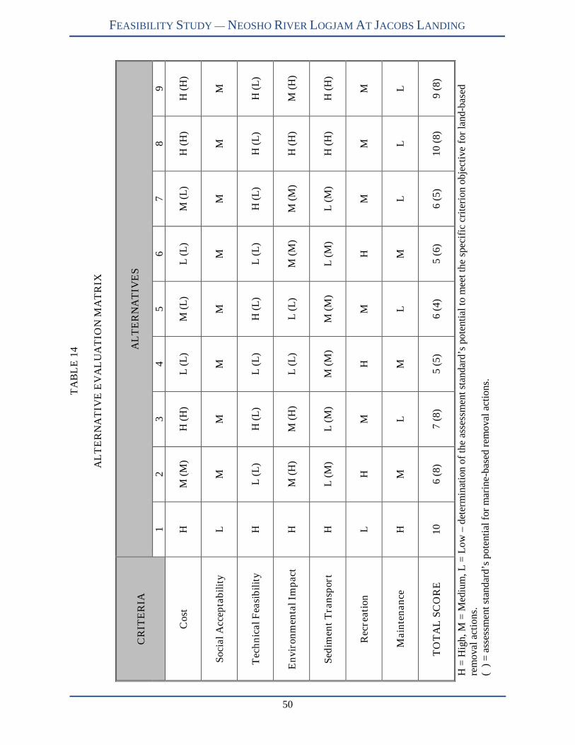
50
FEASIBILITY STUDY — NEOSHO RIVER LOGJAM AT JACOBS LANDING
TA
BL
E14
AL
TE
RN
AT
IVE
EV
AL
UA
TIO
NM
AT
RIX
CR
ITE
RIA
AL
TE
RN
AT
IVE
S
12
34
56
78
9
Cos
tH
M(M
)H
(H)
L(L
)M
(L)
L(L
)M
(L)
H(H
)H
(H)
Soc
ial
Acc
epta
bil
ity
LM
MM
MM
MM
M
Tec
hn
ical
Fea
sib
ilit
yH
L(L
)H
(L)
L(L
)H
(L)
L(L
)H
(L)
H(L
)H
(L)
En
viro
nm
enta
lIm
pac
tH
M(H
)M
(H)
L(L
)L
(L)
M(M
)M
(M)
H(H
)M
(H)
Sed
imen
tT
ran
spor
tH
L(M
)L
(M)
M(M
)M
(M)
L(M
)L
(M)
H(H
)H
(H)
Rec
reat
ion
LH
MH
MH
MM
M
Mai
nte
nan
ceH
ML
ML
ML
LL
TO
TA
LS
CO
RE
106
(8)
7(8
)5
(5)
6(4
)5
(6)
6(5
)1
0(8
)9
(8)
H=
Hig
h,M
=M
ediu
m,L
=L
ow–
dete
rmin
atio
nof
the
asse
ssm
ent
stan
dard
’spo
tent
ial
tom
eet
the
spec
ific
crit
erio
no
bjec
tive
for
lan
d-b
ased
rem
oval
acti
ons.
()
=as
sess
men
tst
anda
rd’s
pote
ntia
lfo
rm
arin
e-ba
sed
rem
oval
acti
ons.
FEASIBILITY STUDY — NEOSHO RIVER LOGJAM AT JACOBS LANDING
51
PUBLIC INPUT TO ALTERNATIVES
On May 14, 2008, TWI presented the nine alternatives to the public in Emporia, Kansas. The meeting’s
purpose was to provide an opportunity for the public to comment on the alternatives. Participants
reiterated many of the concerns introduced at the January 17, 2008 public meeting during the discussion
period. The public did not propose any new alternatives, and typically favored logjam removal with a
dredging component (Alternative 2). KWO provided comment sheets to participants as well as an e-mail
address specifically created for feasibility study comments. KWO encouraged comment submission by
May 23, 2008 for incorporation into the final feasibility study report.
By May 23, 2008, TWI received one comment asking for more study on the water quality, property
values, and quality of life of local residents. Although such a study is outside of this project’s scope,
KWO and KDHE will to respond to these suggestions.
Finally, it was brought to TWI and KWO’s attention that there are additional LWD accumulations located
on smaller tributaries within federal easement property. TWI visited a LWD accumulation that has nearly
blocked a culvert under the old railroad bed. The blockage causes water to pond upstream of the railroad
bed while it slowly seeps into the Neosho River. TWI provided KWO with photos and information
regarding the site visit.
CONCLUSION
Two Alternatives—1, No Action and 8 (land-based), Remove Logjam Above Jacob’s Creek Landing—
scored 10 points. A third—Alternative 9, Remove Logjam Above Jacob’s Creek and Clear Eagle
Creek—scored 9 points. Based on this evaluation, TWI recommends the Kansas Water Office consider
Alternatives 1 and 8 (land-based) for potential implementation. In considering between the two, cost is an
obvious difference. Though both ranked high in this criterion, Alternative 8 will cost between $1.4 and
$2.0 million while Alternative 1 has zero direct cost. Alternative 9 will cost approximately $600,000 more
than Alternative 8 but open a second boat ramp—on Eagle Creek—for access to the Neosho River.
Social acceptability for Alternative 1 is low, as seen by the public concerns expressed through both the
USACE Reallocation Study and recent public meetings, though a few expressed comments state that
logjam removal is a waste of time and money. Alternative 8 will have greater social acceptability as it
addresses 4 of the 10 primary concerns (noted on page 32). Both 1 and 8 (land-based) ranked high for the
environmental impact criteria; however, Alternative 8 disturbs 8.6 wetland acres with the construction of
an access road, while Alternative 1 has no direct wetland disturbance. Though Alternative 1 continues
existing environmental impacts (i.e. disrupting white bass spawning migrations), there are no additional
environmental impacts from no action. Sediment transport ranks high for both alternatives as the logjam
below Jacob’s Creek Landing will continue to accumulate sediments, including those remobilized by
LWD removal upstream. Alternative 1 ranks low in recreation as it allows only unpredictable access to
the Neosho River from the Jacob’s Creek Landing boat ramp. Alternative 8 ranks medium as it allows
unrestricted access upstream of Jacob’s Creek Landing. Maintenance ranked high for Alternative 1 and
low for Alternative 8. TWI estimates that Alternative 8 will require annual maintenance actions and
costs—approximately $150,000/year—to remove ongoing LWD accumulations. For the immediate
future, TWI recommends a more diligent LWD maintenance directive within the federal easement as well
as encourages the public to participate in the Neosho Headwaters WRAPS.

FEASIBILITY STUDY — NEOSHO RIVER LOGJAM AT JACOBS LANDING
52
REFERENCES
Abbe, T.M., Books, A.P., and D.R. Montgomery. 2003. “Wood in river rehabilitation and management.”
in The Ecology and Management of Wood in World Rivers. Editors Gregory, S., Boyer, K., and
A. Gurnell. American Fisheries Society, Bethesda, Maryland. pp. 367-391.
Abbe, T.B. and D.R. Montgomery. 1996. “Large woody debris jams, channel hydraulic and habitat
formation in large rivers.” Regulated Rivers: Research & Management. Vol. 12:210-221.
Abbe, T.B. and D.R. Montgomery. 2003 “Patterns and processes of wood debris accumulation in the
Queets River basin, Washington.” Geomorphology. Vol. 51: 81-107.
Alan Plumber Associates, Inc. (APA). 2005. “Dredging vs. New Reservoirs.” Texas Water Development
Board TWDB Contract #2004-483-534. December.
Baillie, B.R. and T.R. Davies. 2002. “Influence of large woody debris on channel morphology in native
forest and pine plantation stream in the Nelson region, New Zealand.” New Zealand Journal of
Marine and Freshwater Research. Vol. 36: 763-774.
Benke, A.C., Van Arsdall, T.C., Gillespie, D.M., and F.K. Parrish. 1984. “Invertebrate productivity in a
subtropical blackwater river: the importance of habitat and life history.” Ecological Monographs.
Vol. 54: 25-63.
Beschta, R.L. 1979. “Debris removal and its effects on sedimentation in an Oregon coast range stream.”
Northwest Science. Vol. 53(1): 1-7.
Bilby, R.B. 1981. “Role of organic debris dams in regulating the export of dissolved organic and
particulate matter from a forested watershed.” Ecology Vol. 62: 1234-1243.
Bilby, R.E., Bisson, P.A., 1998. “Function and distribution of large woody debris in Pacific coastal
streams and rivers.” In: Naiman, R.J., Bilby, R.E. (Eds.), River Ecology and Management Lessons
from the Pacific Coastal Ecoregion. Springer, New York, pp. 324–346.
Bilby, R.B. and J.W. Ward. 1989. “Changes in characteristics and function of woody debris with
increasing size of streams in western Washington.” Transactions of the American Fisheries
Society. Vol. 118: 368-378.
Braudrick, C.A. and G.E. Grant. 2000. “When do logs move in rivers?” Water Resources Research.
Vol. 36 (2): 571-583.
Brummer, C.J., Abbe, T.B., Sampson, J.R., and D.R. Montgomery. 2006. “Influence of vertical channel
change associated with wood accumulations on delineating channel migration zones, Washington,
USA.” Geomorphology. Vol. 80: 295-309.
Buffington, J.M. and D.R. Montgomery. 1999. “Effects of hydraulic roughness on surface textures of
gravel-bed rivers.” Water Resources Research. Vol. 35: 3507-3521.
Caldwell, N.W. 1941. “The Red River raft.” Chronicles of Oklahoma. 19(3):253-268, September.

FEASIBILITY STUDY — NEOSHO RIVER LOGJAM AT JACOBS LANDING
53
Carswell, W.J. and R.J. Hart. 1985. “Transit losses and travel times for reservoir releases during drought
conditions along the Neosho River from Council Grove Lake to Iola, east-central Kansas: U.S.”
Geological Survey Water Resources Investigations Report 85-4003. 40pp.
Collins, B.D. and D.R. Montgomery. 2002. “Forest development, wood jams, and restoration of
floodplain rivers in the Puget Lowland, Washington.” Restoration Ecology. Vol. 10(2): 237-247.
Collins, B.D., Montgomery, D.R., and A.D. Haas. 2002. “Historical changes in the distribution and
functions of large wood in Puget Lowland rivers.” Canadian Journal of Fisheries and Aquatic
Sciences. Vol. 59:66-76.
Comiti, F., Andreoli, A., Lenzi, M.A., and L. Mao. 2006. “Spatial density and characteristics of woody
debris in five mountain rivers of the Dolomites.” Geomorphology. Vol. 78(1-2): 44-63.
Cordova, J.M., Rosi-Marshall, E.J., Yamamuro, A.M., and G.A. Lamberti. 2007. “Quantity, controls and
functions of large woody debris in Midwestern USA streams.” River Research and Applications.
Vol. 23: 21-33.
Daniels, M.D. 2006. “Distribution and dynamics of large woody debris and organic matter in a low-
energy meandering stream.” Geomorphology. Vol. 77: 286-298.
De Vries, P.G. 1974. “Multi-stage line intersect sampling.” Forest Science. Vol. 20(2): 129-133.
Dean, J., D. Edds, D. Gillette, J. Howard, S. Sherraden, and J. Tiemann. 2002. “Effects of lowhead dams
on freshwater mussels in the Neosho River, Kansas.” Transactions of the Kansas Academy of
Science. 105(3-4):232-240.
Down, P.W. and A. Simon. 2001. “Fluvial geomorphological analysis of the recruitment of large woody
debris in the Yalobusha River network, Central Mississippi, USA.” Geomorphology. Vol. 37:
65-91.
Dudley, S.J., Fischenich, J.C., and S.R. Abt. 1998. “Effect of woody debris entrapment on flow
resistance.” Journal of the American Water Resources Association. Vol. 34(5): 1189-1197.
Dunne, T. and L.B. Leopold. 1978. Water in Environmental Planning. W.H. Freeman and Co. San
Francisco, California.
GeoEngineers, Inc. 2002. Response to commissioner’s questions and preliminary options evaluation.
Accessed online at: http://www.co.thurston.wa.us/em/LogJam/797000501%20Report.pdf.
Gippel, C.J. 1995. “Environmental hydraulics of large woody debris in streams and rivers.” Journal of
Environmental Engineering. Vol. 121(5): 388-395.
Gippel, C.J., Finlayson, B.L., and I.C. O’Neil. 1996. “Distribution and hydraulic significance of large
woody debris in a lowland Australian River.” Hydrobiologia. Vol. 318(4): 179-194.
Grand Rapids Historical Commission. 2007. The Grand River: friend and foe. Accessed online at
http://www.historygrandrapids.org/explore.php?cat=3&essay=9.

FEASIBILITY STUDY — NEOSHO RIVER LOGJAM AT JACOBS LANDING
54
Gregory, K.J., Davis, R.J., and S. Tooth. 1993. “Spatial distribution of coarse woody debris dams in the
Lymington Basin, Hampshire, UK.” Geomorphology. Vol. 6: 207-224.
Gulf Engineers and Consultants, Inc. (GEC). 2002. Environmental impact statement Yalobusha River
watershed demonstration erosion control project Yazoo Basin, Mississippi. Prepared for USACE
Vicksburg District.
Gurnell, A.M., Piégay, H., Swanson, F.J., and S.V. Gregory. 2002. “Large wood and fluvial processes.”
Freshwater Biology. Vol. 47: 601-619.
Hardy, C.C. 1986. “Guidelines for estimating volume, biomass, and smoke production for piled slash.”
General Technical Report PNW-GTR-364. Portland, OR: Department of Agriculture, Forest
Service, Pacific Northwest Research Station. 17p.
Harmon, M.E., Franklin, J.F., Swanson, F.J., Sollins, S., Gregory, S.V., Lattin, J.D., Anderson, N.H.,
Cline, S.P., Aumen, N.G., Sedell, J.R., Lienkaemper, G.W., Cromack, Jr., K., and K.W.
Cummins. 1986. “Ecology of coarse woody debris in temperate ecosystems.” Advances in
Ecological Research. Vol. 15: 133-302.
Hart, R.J. and T.C. Stiles. 1984. “Availability of natural and regulated streamflows for instream uses
during historical droughts, lower Neosho River, Southeastern Kansas.” USGS Water Resources
Investigations Report 84-4292. 42 pp.
Harvey, M.D., D.S. Biedenharn, and P. Combs. 1988. “Adjustments of the Red River following removal
of the Great Raft in 1873.” Eos, Vol. 69, No. 18, May 3, 1988. (Abs)
Jungwirth, M., O. Moog, and S. Muhar. 1993. “Effects of river bed restructuring on fish and benthos of a
fifth order stream, Melk, Austria.” Regulated Rivers: Research &r Management Vol. 8:195-204.
Juracek, K.E. 1999a. “Geomorphic effects of overflow dams on the lower Neosho River, Kansas.” USGS
Water Resources Investigations Report 99-4147. 6 pp.
Juracek, K.E. 1999b. “Channel stability of the Neosho River downstream from John Redmond Dam,
Kansas.” USGS Fact Sheet FS-088-99. 4 pp.
Juracek, K.E. and C.A. Perry. 2005. “Gravel sources for the Neosho River in Kansas, 2004.” U.S.
Geological Survey Scientific Investigations Report 2005-5282. 36pp.
Kail, J. 2003. “Influence of large woody debris on the morphology of six central European streams.”
Geomorphology. Vol. 51: 207-223.
Kansas Biological Survey. 2007. Bathymetric survey of John Redmond Reservoir, Coffey County, Kansas.
Lawrence, Kansas. 21 pp.
Kansas Department of Agriculture-Division of Water Resources (DWR). 2008. Letter from Matt A.
Scherer, Water Structures Program Manager, to Chris Mammoliti, Aquatic Biologist, Watershed
Institute, Inc. March 18, 2008.
FEASIBILITY STUDY — NEOSHO RIVER LOGJAM AT JACOBS LANDING
55
Kansas Department of Health & Environment (KDHE). 2003a. Neosho River Basin Total Maximum
Daily Load: John Redmond Lake – Siltation. Accessed on-line at:
http://www.kdheks.gov/tmdl/netmdl.htm. 15pp.
Kansas Department of Health & Environment (KDHE). 2003b. Neosho River Basin Total Maximum
Daily Load: John Redmond Lake – Eutrophication. Accessed on-line at:
http://www.kdheks.gov/tmdl/netmdl.htm. 21pp.
Kansas Department of Wildlife & Parks. 2006. Stream Assessment and Monitoring Program, Sub-
watershed Report. Environmental Services Section, Pratt, Kansas. 294 pp.
Kansas Department of Wildlife & Parks (KDWP). 2008. Letter from James Larson, Aquatic Ecologist, to
Chris Mammoliti, Aquatic Biologist, Watershed Institute, Inc. March 2008.
Kansas Water Office (KWO). 2008. John Redmond Lake: Reservoir fact sheet. Accessed on-line at:
http://www.kwo.org/ReservoirInformation/Reservoir%20Information.htm
Kansas Water Resource Board. 1961. State water plan studies, Part A, preliminary appraisal of Kansas
water problems, Section 7, Neosho Unit. Topeka, Kansas. 135pp.
Keller, E.A. and F.J. Swanson. 1979. “Effects of large organic material on channel form and fluvial
processes.” Earth Surface Processes. Vol. 4: 361-380.
Keller. E.A., MacDonald, A., Tally, T., and N.J. Merrit. 1995. “Effects of large organic debris on channel
morphology and sediment storage in selected tributaries of Redwood Creek, northwestern
California.” in: Nolan, K.M., H.M. Kelsey, and D.C. Marron, eds., Geomorphic processes and
aquatic habitat in the Redwood Creek basin, Northwestern California. U.S. Geological Survey
Professional Paper 1454: P1-P29.
Kraft, C.E. and D.R. Warren. 2003. “Development of spatial pattern in large woody debris and debris
dams in streams.” Geomorphology. Vol. 51: 127-139.
Lassettre, N.S., Piégay, H., Dufour, S., and A. Rollet. 2007. “Decadal changes in distribution and
frequency of wood in a free meandering river, the Ain River, France.” Earth Surface Processes
and Landforms. doi: 10.1002/esp.1605.
Little, S.N. 1982. “Estimating the volume of wood in large piles of logging residue.” General Technical
Report PNW-1. Pacific Northwest Forest and Range Experiment Station, Forest Service, USDA.
7 pp.
Longoria, R. 2002. “Residents take logjam into their own hands- County said it wouldn’t help; job gets
done for far less than feared.” The Olympian. Accessed online at:
http://www.citizenreviewonline.org/august_2002/residents_take.htm.
Magilligan, F.J., Nislow, K.H., Fisher, G.B., Wright, J., Mackey, G., and M. Laser. 2007. “The
geomorphic function and characteristics of large woody debris in low gradient rivers, coastal
Maine, USA.” Geomorphology. doi: 10.1016/j.geomorph.2007.08.016.
FEASIBILITY STUDY — NEOSHO RIVER LOGJAM AT JACOBS LANDING
56
Manga. M. and J.W. Kirchner. 2000. “Stress partitioning in streams by large woody debris.” Water
Resources Research Vol. 36: 2373-2379.
Marshall, P.L., Davis, G., and V.M. LeMay. 2000. “Using line intersect sampling for coarse woody
debris.” Forest Research Technical Report TR-003. Vancouver, BC, Canada. British Columbia
Ministry of Forests, Vancouver Forest Region Research Section.
Master’s Dredging Company. 2004. Project to remove the Neosho River logjam at the entrance to John
Redmond Reservoir. Unpublished report. 14 pp.
Megahan, W.F. 1982. “Channel sediment storage behind obstructions in forested drainage basins draining
the granitic bedrock of the Idaho batholith.” In: Swanson, F.J., R.J. Janda, T. Dunne, and D.N.
Swanston (Eds.), Sediment Budgets and Routing in Forested Drainage Basins. USDA Forest
Service General Technical Report PNW 141: 114-121.
Montgomery, D.R., T.M. Abbe, N.P. Peterson, J.M Buffington, K. Schmidt, and J.D. Stock. 1996.
“Distribution of bedrock and alluvial channels in forested mountain drainage basins.” Nature Vol.
381: 587-589.
Montgomery, D.R., Collins, B.D., Buffington, J.M., and T.B. Abbe. 2003. “Geomorphic effects of wood
in rivers.” in The Ecology and Management of Wood in World Rivers. Editors Gregory, S.,
Boyer, K., and A. Gurnell. American Fisheries Society, Bethesda, Maryland. pp. 1-27.
Muncrief, D. 2005. The great Red River raft. Accessed online at:
http://www.rootsweb.ancestry.com/~okmurray/stories/great_red_river_raft.htm. 4 pp.
Naiman, R.J., Balian, E.V., Bartz, K.K., Bilby, R.E., and J.J. Latterell. 2002. “Dead wood dynamics in
stream ecosystems.” in Proceedings of the Symposium on the Ecology and Management of Dead
Wood in Western Forests. Technical Coordinators Laudenslayer, W.F., et al. General Technical
Report PSW-GTR-181. Pacific Southwest Research Station, U.S. Forest Service. Pp 23-48.
Nakamura, F. and F.J. Swanson. 1993. “Effects of coarse woody debris on morphology and sediment
storage of a mountain stream system in Western Oregon.” Earth Surface Processes and
Landforms. Vol. 18: 43-61.
O’Connor, N.A. 1992. “Quantification of submerged wood in a lowland Australian stream system.”
Freshwater Biology. Vol. 27: 387-395.
Piégay, H. and A.M. Gurnell. 1997. “Large woody debris and river geomorphological pattern: examples
from S.E. France and S. England.” Geomorphology. Vol. 19: 99-116.
RIVERMorph, LLC. 2001-2007. Stream Restoration Software. Louisville, Kentucky.
Rasmussen, P.P. and C.A. Perry. 2000. “Hydraulic analysis of U.S. Highway 59 crossing of the Neosho
River near Erie, southeast Kansas.” USGS Open-File Report 00-210. 17pp.
Reed Construction Data, Inc. 2006. RSMeans Building Constrution Cost Data. 65th Annual Edition.
Kingston, MA.

FEASIBILITY STUDY — NEOSHO RIVER LOGJAM AT JACOBS LANDING
57
Rosgen, D.L. 1994. “A Classification of National Rivers.” Catena. Vol. 22: 169-199.
Rosgen, D.L. 1996. Applied River Morphology. Wildland Hydrology Books. Ft. Collins, Colorado.
Satterthwaite, S.L. 2004. Ecological issues evaluation results of the Jacob’s Creek Landing Neosho River
logjam. Kansas Department of Health & Environment, Bureau of Water, Watershed Management
Section, Topeka, KS. PowerPoint presentation, 17 pp.
Sedell, J.R., P.A. Bisson, F.J. Swanson, and S.V. Gregory. 1988. “What we know about large trees that
fall into streams and rivers.” Pages 47-81 In From the Forest to the Sea: A Story of Fallen Trees.
General Technical Report PNW-GTR-229. USDA Forest Service, Portland, Oregon.
Smith, C.M. and J.C. Leatherman. 2008. Economic contribution of recreation at John Redmond Lake.
Report prepared for the John Redmond Lake WRAPS project. Department of Agricultural
Economics, Kansas State University, Manhattan, Kansas. 7 pp.
Smith, R.D., R.C. Sidle, P.E. Porter, and J.R. Noel. 1993. “Effects of experimental removal of woody
debris in the channel morphology of a forest gravel bed stream.” Journal of Hydrology Vol.
152:153-178.
Shields Jr., F.D. and C.J. Gippel. 1995. “Prediction of effects of woody debris removal on flow
resistance.” Journal of Hydraulic Engineering Vol. 121(4): 341-354.
Shields Jr., F.D. and R.H. Smith. 1992. “Effects of large woody debris removal on physical
characteristics of sand-bed rivers.” Aquatic Conservation: Marine and Freshwater Ecosystems.
Vol. 2(2): 145-163.
Studley, S.E. 1996. “Changes in high-flow frequency and channel geometry of the Neosho River
downstream from John Redmond Dam, southeastern Kansas.” USGS Water Resources
Investigations Report 96-4243. 16 pp.
Swanson, F.J., G.W. Lienkaemper, J.R. Sedell. 1976. “History, physical effects and management
implications of large organic debris in western Oregon streams.” USDA Forest Service, General
Technical Report PNW-56. 15pp.
Thevenet, A., Citterio, A., and H. Piégay. 1998. “A new methodology for the assessment of large woody
debris accumulations on highly modified rivers (example of two French piedmont rivers).”
Regulated Rivers: Research & Management. Vol. 14: 467-483.
Thomas, R.E., E.J. Langendoen, R.L. Binger, and A. Simon. 2002. “Channel responses and management
strategies in disturbed channels: a numerical simulation approach.” in Proceedings of the 2002
Conference on Water Resources Planning and Management. Roanoke, Virginia, May 19-22.
American Society of Civil Engineers, Reston, Virginia.
Thompson, D.M. 1995. “The effects of large organic debris on sediment processes and stream
morphology in Vermont.” Geomorphology. Vol. 11(3): 235-244.

FEASIBILITY STUDY — NEOSHO RIVER LOGJAM AT JACOBS LANDING
58
U.S. Army Corps of Engineers. (USACE). 1986. Environmental Effects of Dredging Technical Notes:
Guide to Selecting a Dredge for Minimizing Resuspension of Sediment. EEDP-09-1. U.S. Army
Engineer Waterways Experiment Station. Vicksburg, MS.
U.S. Army Corps of Engineers. (USACE). 1989a. Environmental Effects of Dredging Technical Notes:
Economic Optimization of Confined Disposal Area Dimensions. EEDP-6-5. U.S. Army Engineer
Waterways Experiment Station. Vicksburg, MS.
U.S. Army Corps of Engineers. (USACE). 1989b. Environmental Effects of Dredging Technical Notes:
Dredged Material Containment Area Management Practices for Increasing Storage Capacity.
EEDP-6-6. U.S. Army Engineer Waterways Experiment Station. Vicksburg, MS.
U.S. Army Corps of Engineers. (USACE). 2002. Supplement to the final environmental impact statement
(draft), prepared for the: reallocation of water supply storage project - John Redmond Lake,
Kansas (2 volumes). Southwestern Division, Tulsa District Office, Tulsa, Oklahoma. 37 pp.
U.S. Army Corps of Engineers. (USACE). 2005. Initial appraisal of the Neosho River logjam: John
Redmond Reservoir, Kansas. Southwestern Division, Tulsa District Office, Tulsa, Oklahoma. 37
pp.
U.S. Army Corps of Engineers. (USACE). 2006a. Final environmental assessment: Blackwell Lake
clearing and snagging project, Chikaskia River Blackwell, Oklahoma. Southwestern Division,
Tulsa District Office, Tulsa, Oklahoma. 58 pp.
U.S. Army Corps of Engineers. (USACE). 2006b. Project management plan: John Redmond Dam and
Reservoir, Kansas, watershed feasibility study. Southwestern Division, Tulsa District Office,
Tulsa, Oklahoma. 44 pp.
U.S. Army Corps of Engineers. (USACE). 2007. Walnut River Basin, Kansas Feasibility Report – El
Dorado Lake, Kansas Watershed Management Plan. Southwestern Division, Tulsa District
Office, Tulsa, Oklahoma. 376 pp.
U.S. Army Corps of Engineers. (USACE). 2008. John Redmond Dam and Reservoir, Kansas: Watershed
interim feasibility study. Southwestern Division, Tulsa District Office, Tulsa, Oklahoma. 51 pp.
U.S. Department of Agriculture Farm Service Agency National Agriculture Imagery Program. 2003-
2006. Coffey County Digital Orthophoto. Aerial Photography Field Office. Salt Lake City.
Accessed on-line at: http://www.kansasgis.org
U.S. Fish & Wildlife Service. 2000. Flint Hills National Wildlife Refuge: Comprehensive Conservation
Plan. 123pp.
U.S. Fish & Wildlife Service. 2008. Letter from Mike LeValley, Field Supervisor, Kansas Ecological
Services Office, to Chris Mammoliti, Aquatic Biologist, Watershed Institute, Inc. March 13,
2008.
U.S. Geological Survey. 1991. Coffey County Digital Orthophoto. Accessed on-line at:
http://www.kansasgis.org

FEASIBILITY STUDY — NEOSHO RIVER LOGJAM AT JACOBS LANDING
59
U.S. Geological Survey. 2002. Coffey County Digital Orthophoto. Access on-line at:
http://www.kansasgis.org
Wallace, J.B. and A.C. Benke. 1984. “Quantification of wood habitat in subtropical coastal plain
streams.” Canadian Journal of Fisheries and Aquatic Sciences. Vol. 41: 1643-1652.
Warren, R.W., Keeton, W.S., and C.E. Kraft. 2008. “A comparison of line-intercept and census
techniques for assessing large wood volume in streams. “ Hydrobiologia. Vol. 598: 123-130.
Water and Rivers Commission. 2000a. “The management and replacement of large woody debris in
waterways.” Water Notes WN13. Water and Rivers Commission, Perth, Western Australia.
Water and Rivers Commission. 2000b. “The value of large woody debris in streams and rivers.” Water
Notes WN9. Water and Rivers Commission, Perth, Western Australia.
Watershed Institute, Inc. (TWI). 2007. Enhanced riparian area/stream channel assessment. Report
prepared for the Kansas Water Office, Topeka, Kansas. 168 pp.
Webb, A.A. and W.D. Erskine. 2003. “Distribution, recruitment, and geomorphic significance of large
woody debris in an alluvial forest stream: Tonghi Creek, southeastern Australia.’
Geomorphology. Vol. 51: 109-126.
Wistrom, D. 2005. “The Neosho River Logjam.” Planet Kansas Feb/Mar.
White, S.E. 1901. The great logjam. Popular Monthly Vol. LII. No. 3. July, 1901. Accessed online at
http://catskillarchive.com/rrextra/lgjam.Html.
Young, W.J. 1991. “Flume study of the hydraulic effects of large woody debris in lowland rivers.”
Regulated River: Research & Management. Vol. 6(3): 203-211.
Young, M.K., Mace, E.A., Ziegler, E.T., and E.K. Sutherland. 2006. “Characterizing and contrasting
instream and riparian coarse wood in western Montana basins.” Forest Ecology and
Management. Vol. 226: 26-40.
APPENDIX A
FIGURES
Figure 1: Neosho River Basin...................................................................................................................A-1
Figure 2: Neosho River Basin Ecoregions (Kansas).................................................................................A-2
Figure 3: Site Location Map .....................................................................................................................A-3
Figure 4: John Redmond Reservoir Watershed ........................................................................................A-4
Figure 5: Public Lands at John Redmond Reservoir.................................................................................A-5
Figure 6: Rosgen Stream Classification System of Natural Rivers ..........................................................A-6
Figure 7: Site Layout Map ........................................................................................................................A-7
Figure 8: Location of LWD Plugs.............................................................................................................A-8
Figure 9: Cross Section Survey Locations................................................................................................A-9
Figure 10: Observed Overflow Channels................................................................................................A-10
Figure 11: Aerial Reconnaissance Coverage ..........................................................................................A-11
Figure 12: General Shapes and Dimensions of Wood Piles (from Little 1982) .....................................A-12
Figure 13: Logjam Upstream Extent (2001-2007)..................................................................................A-13
Figure 14: Alternative 2 and 3 Conceptual Drawing ..............................................................................A-14
Figure 15: Alternative 4 and 5 Conceptual Drawing ..............................................................................A-15
Figure 16: Alternative 6 and 7 Conceptual Drawing ..............................................................................A-16
Figure 17: Alternative 8 Conceptual Drawing ........................................................................................A-17
Figure 18: Alternative 9 Conceptual Drawing ........................................................................................A-18

APPENDIX B
CROSS SECTION SURVEYS
Figure 1: Cross Section 1.......................................................................................................................... B-1
Figure 2: Cross Section 2.......................................................................................................................... B-2
Figure 3: Cross Section 3.......................................................................................................................... B-3
Figure 4: Cross Section 4.......................................................................................................................... B-4
Figure 5: Cross Section 5.......................................................................................................................... B-5
Figure 6: Cross Section 6.......................................................................................................................... B-6
Figure 7: Cross Section 4, 5, and 6 Overlay ............................................................................................. B-7

APPENDIX C
DVD AERIAL RECONNAISSANCE MAPS
Figure 1: DVD # 1 Key............................................................................................................................. C-1
Figure 2: DVD # 2 Key............................................................................................................................. C-2
Figure 3: DVD # 3 Key............................................................................................................................. C-3
Figure 4: DVD # 4 Key............................................................................................................................. C-4
Figure 5: DVD # 5 Key............................................................................................................................. C-5
Figure 6: DVD # 6 Key............................................................................................................................. C-6
Figure 7: DVD # 7 Key............................................................................................................................. C-7
Figure 8: DVD # 8 Key............................................................................................................................. C-8
Figure 9: DVD # 9 Key............................................................................................................................. C-9
Figure 10: DVD # 10 Key....................................................................................................................... C-10
Figure 11: DVD # 11 Key....................................................................................................................... C-11
APPENDIX D
REGULATORY AGENCY REPSONSES TO PROPOSED ALTERNATIVES
(seven pages)