final draft executive summary report 30% basis of...
TRANSCRIPT

Mid-Barataria Sediment Diversion Final Draft Executive Summary Report 30% Basis of Design
Coastal Protection and Restoration Authority of Louisiana
October 2014


Mid-Barataria Sediment Diversion Final Draft Executive Summary Report 30% Basis of Design
Prepared for Coastal Protection and Restoration Authority of Louisiana 450 Laurel Street, 11th Floor Baton Rouge, Louisiana 70804
Prepared by HDR Engineering, Inc. 201 Rue Iberville, Suite 115 Lafayette, Louisiana 70508
October 2014
Preliminary Documents Not to be used for construction, conveyance, sales or as the basis for permit issuance. Robert J. Beduhn LA38502


Final Draft Executive Summary Report
Contents
1 Introduction ......................................................................................................................................................... 1
2 Executive Summary ............................................................................................................................................ 1
3 Summary of 30% Design Project Efforts ............................................................................................................ 7 3.1 Mid-Barataria Sediment Diversion, Alternative 1, Base Design Report, 30% Basis of Design,
July 2014 .................................................................................................................................................. 7 3.2 Mid-Barataria Sediment Diversion, Value Engineering Report, 30% Basis of Design,
July 2014 ................................................................................................................................................ 12 3.3 Mid-Barataria Sediment Diversion, Geotechnical Report, 30% Basis of Design, July 2014................. 16 3.4 Mid-Barataria Sediment Diversion, Environmental Memoranda, July 2014 ......................................... 18 3.5 Hydraulics and Sediment ....................................................................................................................... 23
4 Conclusion ........................................................................................................................................................ 26
5 References ......................................................................................................................................................... 28
Tables
Table 1. Engineering support for alternative refinement and environmental process ................................................... 4 Table 2. MBSD base design elements (Alternative 1) .................................................................................................. 8 Table 3. Overhead and administrative costs ............................................................................................................... 12 Table 4. MBSD alternatives and VE concepts ............................................................................................................ 14 Table 5. MBSD cost summary, with VE concepts enacted ........................................................................................ 16
Information for Client Review: Information is strictly confidential and not intended for public distribution. October 2014 | iii

Mid-Barataria Sediment Diversion
Figures
Figure 1. Refinement of selected preliminary concept to base design alternative (Alternative 1) ................................ 8 Figure 2. Conceptual inlet channel and diversion structure ........................................................................................ 10 Figure 3. Conceptual diversion channel, transition structure, transition walls, and outlet channel ............................ 10 Figure 4. Conceptual guide levees, LA 23 bridge, rail bridge, and diversion structure .............................................. 11 Figure 5. Conceptual outfall area, transition walls, and back structure ...................................................................... 11 Figure 6. MBSD adaptive approach ........................................................................................................................... 13 Figure 7. Future without project projects for consideration ........................................................................................ 21 Figure 8. Conceptual project features screening ......................................................................................................... 23 Figure 9. Summary of draft cost curve ....................................................................................................................... 26 Figure 10. Potential deposition greater than 0.5 feet in total depth ............................................................................ 27
Appendixes
Appendix A. List of Deliverables .............................................................................................................................. A-1
Information for Client Review: Information is strictly iv | October 2014 confidential and not intended for public distribution.

Final Draft Executive Summary Report
1 Introduction HDR was retained by the Coastal Protection and Restoration Authority of Louisiana (CPRA) to provide engineering and environmental support for a 75,000 cubic feet per second (cfs) diversion (Alternative 1, base design concept) at river mile 60.7 of the Mississippi River in accordance with CPRA’s 2012 Master Plan for a Sustainable Coast (Coastal Master Plan). Specifically, HDR was directed to advance the design and permitting of the work presented in Myrtle Grove Delta Building Diversion Modeling Effort in Support of the LCA Medium Diversion at Myrtle Grove with Dedicated Dredging Project – Data Collection, Preliminary Design and Modeling Initiative (CPRA 2011). Included in that study was a report entitled Conceptual Designs, Myrtle Grove Diversion Structure, by BCG Engineering & Consulting, Inc., published in June 2009.
In addition, HDR applied an adaptive design process to generate value engineering (VE) ideas and alternative design concepts that differed in terms of size (flow rate) and configuration of the proposed Mid-Barataria Sediment Diversion (MBSD). The hydraulics, sediment performance, and construction costs of these alternatives were evaluated.
The project will be subject to federal Clean Water Act Section 404/10 regulatory programs and 33 United States Code Section 408 approvals to modify federal projects. CPRA has submitted a Clean Water Act permit application to the U.S. Army Corps of Engineers (USACE). USACE has determined that an environmental impact statement (EIS) is required for National Environmental Policy Act (NEPA) compliance. Baseline environmental documentation has been prepared to support the NEPA process, including preliminary information for protected species, wetlands and waters of the U.S., and vegetation/marsh community types. Preliminary assessments of future without project (FWOP) considerations and alternatives screening frameworks have also been submitted to support the NEPA process.
2 Executive Summary The MBSD, as envisioned in the Alternative 1 base design and the VE alternatives, would function as an artificial crevasse—transferring river power, sediment, and freshwater into a tidally influenced deltaic plain within Barataria Basin. The Barataria Basin deltaic plain was formed by the intersection of the Lafourche, St. Bernard, and Plaquemines delta lobes of the Mississippi River. More specifically, the Basin formed through delta creation and abandonment. The Basin resides between natural levees of the current Mississippi River and the abandoned Bayou Lafourche distributary (Conner and Day 1987). The Barataria Basin is in the process of collapsing from a deltaic plain to a brackish estuary primarily because of human intervention, which has prevented the discharge of sediment, nutrients, and freshwater into the system.
Design flows evaluated as part of the 30% MBSD design and VE effort range from 80,000 to 32,000 cfs. Hydraulic modeling of this flow range indicates water levels throughout the Basin would be within +0.25 to +2 feet above normal tidal ranges throughout most of the Basin with the project operating during the initial 5 years. An initial operating plan was applied to synthetic Mississippi River hydrographs (Meselhe et al. 2014) that operate the diversion
Information for Client Review: Information is strictly confidential and not intended for public distribution. October 2014 | 1

Mid-Barataria Sediment Diversion
anytime Mississippi River flows exceed 600,000 cfs and that close when river flows drop below that level. For the diversions modeled (75,000. 50,000, 35,000, and 25,000 cfs), a dendritic network of distributary channels would be created and new land areas would emerge above elevation 0 feet within the first 5 years of operation. It is anticipated that ongoing deltaic processes would further alter water level and flow distributions during subsequent MBSD operational cycles. Further development of operating scenarios or inlet configurations could alter these initial results. However, modeling beyond 5 years has not yet been completed.
Five alternatives and two VE design versions were evaluated. Cost ranges were established for low, most likely, and high ranges based on uncertainty in quantities and unit prices. For the alternatives evaluated, the project construction cost would range from a low of $369 million to a high of $930 million. The most likely cost range of alternatives evaluated is $460 million to $750 million. Evaluation of costs indicates that cost estimates are highly dependent on flow range and design features.
An initial evaluation of the effects of the project on oceangoing vessels in the Mississippi River has been conducted. Vessels would have to adjust to changes to river currents during project operation; however, those changes are within the normal operating range of such vessels. Temporary shoaling is expected downstream of the diversion intake; however, the shoaling should not impede navigation and should dissipate during periods when the diversion is closed. Evaluation of the effects on barges and smaller vessels has not been completed. The project would require a Section 408 permit and would be reviewed for alterations to two federal projects: the Mississippi River and Tributary levee/navigation channel and the New Orleans to Venice/Non-Federal Levee (NOV/NFL) system. Engineering analysis suggests that the diversion components can be designed and constructed to secure Section 408 approvals and to meet or exceed performance of the existing infrastructure. The Section 408 review process will subject the MBSD design to extensive USACE and third-party review. The existing performance of infrastructure (roads, rail, utilities, drainage) to be altered by the MBSD could be maintained or improved through design.
Clear and objective environmental outcomes and constraints of the MBSD and its operation have not been established. The operating plan used in the 30% design assessment envisions opening the diversion when Mississippi River flows are above 600,000 cfs and closing the diversion when flows fall below that level. This operating plan was used for all alternatives to maximize sand capture while minimizing diversion of freshwater. The project is in need of a process to establish desired outcomes and operational constraints in order to select a preferred alternative.
Delta formation modeling of an 8-square-mile outfall area demonstrated formation of distributary channels and deposition of new material below and above sea level within the first 5 years of operation. The initial Basin-side hydraulic model indicates the MBSD would affect the hydraulic gradient and water levels throughout the Basin. The Basin’s hydraulic and sediment response to the MBSD would be highly dependent on the amount of river power diverted, the shear strength of Basin soils, and the sediment concentration and sediment particle size distribution in the diverted flows. Once the desired outcomes and operational constraints are defined, evaluating the human and natural environment effects will be possible and a preferred alternative can be developed.
Information for Client Review: Information is strictly 2 | October 2014 confidential and not intended for public distribution.

Final Draft Executive Summary Report
The analysis to date suggests that:
• Sediment capture from the Mississippi River can be maximized through design and operation of an appropriate inlet configuration.
• Land loss is reversible, and deltaic formation processes can be reestablished within the Barataria Basin.
• The existing federal and non-federal levee systems and the associated level of protection can be maintained.
Additional analysis is needed to determine whether the MBSD would:
• contribute to increased protection from subsidence, sea level rise, and storm surge
• increase productivity of fisheries, improve habitats, and encourage biological diversity
• reduce risks to Louisiana’s coastal industries and culture
• produce unavoidable effects that are unacceptable
To answer these questions and to continue the orderly collection of information prior to and during the EIS process, Table 1 was prepared to provide an overview of the recommended engineering work, modeling, and environmental analysis to be completed at each phase of the EIS process.
Based on information generated for the 30% design effort, the MBSD is technically feasible and would restore deltaic processes in the Barataria Basin. As with any deltaic process, variations to hydraulic gradients, salinity gradients, water levels, distributary channels, and other aquatic and terrestrial natural resources should be expected. Review of the HEC-RAS two-dimensional modeling and Delft3D 5-year modeling suggests effects on the human and natural environment would occur; however, such effects would be consistent with natural fluctuations commonly observed in delta systems.
Information for Client Review: Information is strictly confidential and not intended for public distribution. October 2014 | 3

Mid-Barataria Sediment Diversion
Table 1. Engineering support for alternative refinement and environmental process
Pre-NEPA Phase 1 NEPA scoping
Phase 2 Draft EIS
Phase 3 Start Final EIS
Phase 4 Finish Final EIS
Phase 5 Record of Decision/
Permit
Geotechnical
• Geomorphic mapping
• Site characterization • Design model
development • Data report
submittal to USACE • Typical design
section
• Submit report to USACE on site characterization design criteria and design parameters
• Create workplan for preferred alternative investigation
• Establish final design section and typicals
• Submit 408 package for preferred alternative
• Respond to 408 comments
• Advance design to 90%
• 100% plans and specifications
• Final 408 submittal • Response to
comments and close out
Civil
• Topographic and bathymetric mapping
• Critical infrastructure identification
• Constructibility • Inlet configuration • Channel/guide
levee section • Cost engineering • Contracting
alternatives
• Advance preferred alternative
• Cost estimates • Specifications • Draft contract
documents
• Submit 408 package for preferred alternative
• Respond to 408 comments
• Advance design to 90%
• 100% plans and specifications
• Final 408 submittal • Response to
comments and close out
• Final procurement plan
Structural
• Not applicable • Wall system refinement
• Precast design analysis
• Back structure design
• Final structure models
• Prepare 60% plans • Specifications
• Submit 408 package for preferred alternative
• Respond to 408 comments
• Advance design to 90%
• 100% plans and specifications
• Final 408 submittal • Response to
comments and close out
Information for Client Review: Information is strictly 4 | October 2014 confidential and not intended for public distribution.

Final Draft Executive Summary Report
Table 1. Engineering support for alternative refinement and environmental process
Pre-NEPA Phase 1 NEPA scoping
Phase 2 Draft EIS
Phase 3 Start Final EIS
Phase 4 Finish Final EIS
Phase 5 Record of Decision/
Permit
Pump station
• Inverted siphon detailed analysis for drainage
• NOV/NFL design coordination
• Advance to 60% design
• Submit 408 package for preferred alternative
• Respond to 408 comments
• Advance design to 90%
• 100% plans and specifications
• Final 408 submittal • Response to
comments and close out
Numerical and environmental modeling
• CRMS tidal statistics • Wind and weather
effects on operations
• Basin water level statistics
• Water level model calibration and verification
• Inlet configuration • Basin
hydrodynamics • Numerical
boundary conditions
• Define area of potential effect and study area
• Refined operating plans based on water levels and sediment discharge
• Final inlet hydraulics • Final boundary
conditions • Final hydraulic
design data • Biological modeling
• Preferred alternative operational plan modeling
• Final Basin-side modeling
• Final river-side modeling
• Ongoing scenario modeling
• Final conformed operational model
Operations
• Refine operating plan
• Define adaptive management decision criteria
• Establish preliminary water level criteria
• Draft project descriptions
• Incorporate water levels and sediment discharge into operating plan
• Final project descriptions
• Evaluate weather and seasonal factors
• Establish final adaptive management and operation plan
• Respond to Final EIS comments
• Incorporate into final permit application
• Include Record of Decision-specific requirements
Information for Client Review: Information is strictly confidential and not intended for public distribution. October 2014 | 5

Mid-Barataria Sediment Diversion
Table 1. Engineering support for alternative refinement and environmental process
Pre-NEPA Phase 1 NEPA scoping
Phase 2 Draft EIS
Phase 3 Start Final EIS
Phase 4 Finish Final EIS
Phase 5 Record of Decision/
Permit
Road and rail
• Advance submerged inlet box design and cost engineering
• General coordination
• Cost engineering
• Advance 60% design for the preferred alternative
• Advance design to 90%
• Address department of development and transportation and railroad comments
• 100% plans and specifications
• Final agency submittal
Notes: CRMS = Coastwide Reference Monitoring System, EIS = environmental impact statement, NEPA = National Environmental Policy Act, NFL = Non-Federal Levee, NOV = New Orleans to Venice, USACE = U.S. Army Corps of Engineers
Information for Client Review: Information is strictly 6 | October 2014 confidential and not intended for public distribution.

Final Draft Executive Summary Report
3 Summary of 30% Design Project Efforts HDR’s 30% design effort produced six major project deliverables:
• Mid-Barataria Sediment Diversion , Alternative 1, Base Design Report, 30% Basis of Design, July 2014
• Mid-Barataria Sediment Diversion, Value Engineering Report, 30% Basis of Design, July 2014
• Mid-Barataria Sediment Diversion, Geotechnical Report, 30% Basis of Design, July 2014
• Mid-Barataria Sediment Diversion, Alternative 1 Civil Drawings, 30% Basis of Design, July 2014
• Mid-Barataria Sediment Diversion, Environmental Memoranda, July 2014
• Mid-Barataria Sediment Diversion, Hydraulic Report, 30% Basis of Design and Value Engineering, August 2014
In addition to the HDR reports, our project partners produced other major deliverables. These deliverables include work from:
• GeoEngineers, Inc.
• The Water Institute of the Gulf
• John Chance Land Surveys, Inc.
• Moffat & Nichol
• Waterway Simulation Technology, Inc.
Appendix A contains a list of deliverables prepared by HDR and the project team for the MBSD. The sections below describe several of the major deliverables in greater detail, providing a summary of the most pertinent findings.
3.1 Mid-Barataria Sediment Diversion, Alternative 1, Base Design Report, 30% Basis of Design, July 2014 To establish a basis of design, the proposed MBSD would have a 75,000 cfs target maximum design flow when the Mississippi River flows are greater than 1 million cfs. This target maximum design flow was chosen after modeling efforts conducted as part of the CPRA and nongovernmental organization initiative led to the following conclusion:
The results also show that the 75,000 cfs diversion had a favorable sediment/water ratio (9.77% of sand from the river and 8.7% of the river water). This favorable SWR ratio (higher than 1) is encouraging as it implies very little to no potential problems with shoaling in the river as a result of the diversion. (CPRA 2011)
Figure 1 illustrates the refinement of the selected preliminary concept from CPRA’s December 2011 report to the current Alternative 1 base design concept (January 2014).
Information for Client Review: Information is strictly confidential and not intended for public distribution. October 2014 | 7

Mid-Barataria Sediment Diversion
Figure 1. Refinement of selected preliminary concept to base design alternative (Alternative 1)
Table 2 and Figures 2 to 5 summarize the major design elements and their physical location on the landscape.
Table 2. MBSD base design elements (Alternative 1)
Project feature/system Physical situation
Inlet channel Inlet would be located at elevation –40 feet, approximately 10 feet above the top of the sand bar, as shown in Figure 2. The walls of the inlet channel slope would match the slope of the revetment.
Inlet channel Inlet channel would have a bottom invert of –40 feet and would convey diverted sediment and water through the batture and levee section to the gated diversion structure.
Diversion structure
The diversion structure would be incorporated into the federal MR&T project as a primary component. It would be set back from the current MR&T alignment because of stability concerns associated with the underlying geologic formation.
Foundation systems
Geotechnical explorations indicate that, overall, the site soils are young, provide relatively low bearing strengths, and necessitate the use of pile foundations to support structural components. Pile systems are generally 24-inch pipe pile founded to approximately elevation –70 to –125 feet in the Pleistocene layer.
Information for Client Review: Information is strictly 8 | October 2014 confidential and not intended for public distribution.

Final Draft Executive Summary Report
Table 2. MBSD base design elements (Alternative 1)
Project feature/system Physical situation
Outlet channel Outlet channel would convey flow from diversion structure to transition structure.
Transition structure
Modeling has shown that an invert elevation of –40 feet would optimize sediment capture. Sediment transport and flow efficiency are optimized with a transition structure.
Transition walls To maintain sediment capture efficiency, trapezoidal sections would preserve river power and provide the most efficient channel for sediment transport. Transitioning flow both vertically and horizontally would be required at the transition structure.
Diversion channel
The diversion channel would have a 300-foot bottom with an invert elevation of –25 feet, 4.5:1 side slopes, a setback berm between the top of channel and toe of guide levee, and the guide levee. The channel would cut through a complex geologic environment that includes point bar deposits, abandoned distributary channels, and marsh deposits, among others. Soil data indicate the presence of highly dispersive clays.
Potential rail bridge and alignment
A railroad siding is currently located along the land side toe of the MR&T. The rail authority is proposing extension of the rail line to the south.
LA 23 bridge The LA 23 corridor is an existing state highway and serves as the principal ingress and egress for the parish. It contains several power, fiber optic, and water utilities.
Guide levees The guide levees would constrain project flows and act as part of the diversion channel. They are a linear feature and would extend over complex geology ranging from point bar deposits, natural levees, distributary channels, to swamp deposits. Significant settlement and consolidation is anticipated under the levee footprint.
Back structure The western end of the MBSD site is currently protected by the NFL, which is being redesigned by USACE as part of NOV Back Levee. The site sits on reclaimed marsh deposits with very low strengths.
Transition walls These walls are situated in an area that is likely to experience high relative settlement, significant velocity and wave forces, and inundation during large hurricanes.
Pump station The project area has a forced drainage system operating through canals and the Wilkinson Pump Station. Construction of the MBSD would bifurcate the drainage system, and a pump station is needed to manage interior drainage in the area north of the MBSD.
Outfall area The outfall area is the Barataria Basin, which is the degraded coastal wetland area the MBSD is intended to benefit. The Basin has been highly altered through saltwater intrusion and oil and gas extraction. Soils in the outfall area, in general, contain 2 to 6 feet of peat, 3 to 10 feet of highly plastic organic soil, and a 1- to 2-foot layer of fat clay. Soils are underlain by low plasticity clay at a depth of approximately –16 feet.
Notes: cfs = cubic feet per second, LA 23 = Belle Chasse Highway, MBSD = Mid-Barataria Sediment Diversion, MR&T = Mississippi River and Tributary, NFL = Non-Federal Levee, NOV = New Orleans to Venice, USACE = U.S. Army Corps of Engineers
Information for Client Review: Information is strictly confidential and not intended for public distribution. October 2014 | 9

Mid-Barataria Sediment Diversion
Figure 2. Conceptual inlet channel and diversion structure
Figure 3. Conceptual diversion channel, transition structure, transition walls, and outlet channel
Information for Client Review: Information is strictly 10 | October 2014 confidential and not intended for public distribution.

Final Draft Executive Summary Report
Figure 4. Conceptual guide levees, LA 23 bridge, rail bridge, and diversion structure
Figure 5. Conceptual outfall area, transition walls, and back structure
HDR has prepared an opinion of probable construction cost for the base design project. This estimate includes normal and customary construction costs, overhead, and profit. It does not include environmental or land rights mitigation costs. Positive and negative unit cost ranges were applied to the construction base cost to derive an upper and lower range of potential construction cost and quantities. The most probable construction cost of the base design project is $750 million, with an upper range of $930 million and a lower range of $605 million.
Information for Client Review: Information is strictly confidential and not intended for public distribution. October 2014 | 11

Mid-Barataria Sediment Diversion
In addition to construction costs, CPRA provided HDR with information on other overhead and administrative costs for implementing the MBSD, summarized in Table 3. HDR recommends that—upon completion of the NEPA scoping process—a more formal cost risk analysis be conducted to address contingencies and overhead cost control and to control and identify other potential cost risks and mitigation strategies. The subsequent analysis would also address initial construction costs and operations and maintenance costs on an annualized basis.
Table 3. Overhead and administrative costs
Item Cost ($ millions)
Engineering and design 41.0
NEPA and third-party contractors 10.0
USACE 214 agreement 1.5
Direct land acquisition 12.0
Construction administration 37.0
Total other costs $101.5
Notes: NEPA = National Environmental Policy Act, USACE = U.S. Army Corps of Engineers
3.2 Mid-Barataria Sediment Diversion, Value Engineering Report, 30% Basis of Design, July 2014 The 30% design and site characterization effort revealed extremely challenging soil conditions that greatly increased construction costs using “traditional” design and construction methods, compared with previous CPRA estimates for similarly sized diversions. The engineering team developed a revised design process to align design efforts with CPRA’s planning and the MBSD EIS process. Figure 6 illustrates the approach that was used to refine and optimize design development to support CPRA’s decision making.
A VE evaluation that included consideration of several design alternatives to the base design was conducted. A design alternative generally refers to a targeted design flow and inlet configuration, while a design version refers to a group of VE concepts applied to that alternative.
Information for Client Review: Information is strictly 12 | October 2014 confidential and not intended for public distribution.

Final Draft Executive Summary Report
Figure 6. MBSD adaptive approach
In total, eight diversion alternatives/versions were evaluated for cost estimating. The eight alternatives are summarized below:
• Alternative 1, Version 1 – base design concept, 75,000 cfs peak flow design, 300-foot bottom width channel, three open-channel inlets with gated structure, seven-bay gated back structure (described in detail in Mid-Barataria Sediment Diversion, Alternative 1, Base Design Report, 30% Basis of Design)
• Alternative 2, Version 1 – 50,000 cfs peak flow design, 200-foot bottom width channel, two open-channel inlets with gated structure, five-bay gated back structure
• Alternative 3, Version 1 – 35,000 cfs peak flow design, 100-foot bottom width channel, one open-channel inlet with gated structure, three-bay gated back structure
Subsequent VE versions (designated with the “X.2” suffix in the drawing packages) included the following alternatives:
• Alternative 1, Version 2 – open channel inlet, three-gate diversion structure, 300-foot channel bottom width, seven-gate back structure, 75,000 cfs
• Alternative 2, Version 2 – open channel inlet, two-gate diversion structure, 200-foot channel bottom width, five-gate back structure, 50,000 cfs
Information for Client Review: Information is strictly confidential and not intended for public distribution. October 2014 | 13

Mid-Barataria Sediment Diversion
• Alternative 3, Version 2 – two immersed tunnel inlets, two-gate diversion structure, 100-foot channel bottom width, three-gate back structure, 35,000 cfs
• Alternative 4, Version 2 – three-bay immersed tunnel inlet, three-gate structure, three box structures outlet, 100-foot channel bottom width, three-gate back structure, 35,000 cfs
• Alternative 5, Version 2 – three-bay immersed tunnel inlet, three-gate structure, three bored tunnels outlet, 100-foot channel bottom width, three-gate back structure, 25,000 cfs
Given the sheer size of the MBSD project, the three major cost reduction opportunities are (1) minimizing redundant construction (separate temporary and permanent features), such as the inlet channel; (2) modifying the design and construction assumptions of the conveyance channel and guide levees to eliminate double handling of materials; and (3) potentially leaving the railroad and perhaps the road along the current alignment if conveyance can occur under pressure in a tunnel. Table 4 summarizes the application of more detailed VE concepts to selected alternatives for the MBSD. The resultant cost reductions achieved through application of the VE concepts is summarized in Table 5. Alternatives 1, 2, 4, and 5 would result in a reduced project construction cost, ranging from approximately $502 million to $570 million (compared with the project construction cost range of $608 million to $750 million under version 1 of the alternatives).
Table 4. MBSD alternatives and VE concepts
Alternative
VE 1: Construct in
the Wet
VE 2: Convey Flow in
Pressure Conduit
VE 3: Reduce
Surcharge/Eliminate
ACBM
VE 4: Reduce or Eliminate Transition
Walls
VE 5: Optimize
Inlet Efficiency
VE 6: Eliminate
Top 15 feet of Channel Built in Dry
Alternative 1, Version 2, open channel inlet, –40 feet msl invert (peak Q of 75,000 cfs)
Remove cast-in-place inlet channels; rely on coffer cellular walls with tremie floor for inlet channel
Not applicable
Set levee back farther from channel to reduce wick drains and surcharge volume
Modify diversion structure and back structure transition to eliminate wall systems
Not applicable
Applied
Alternative 2, Version 2, open channel inlet, –40 feet msl invert (peak Q of 50,000 cfs)
Remove cast-in-place inlet channels; rely on coffer cellular walls with tremie floor for inlet channel
Not applicable
Set levee back farther from channel to reduce wick drains and surcharge volume
Modify diversion structure and back structure transition to eliminate wall systems
Not applicable
Applied
Information for Client Review: Information is strictly 14 | October 2014 confidential and not intended for public distribution.

Final Draft Executive Summary Report
Table 4. MBSD alternatives and VE concepts
Alternative
VE 1: Construct in
the Wet
VE 2: Convey Flow in
Pressure Conduit
VE 3: Reduce
Surcharge/Eliminate
ACBM
VE 4: Reduce or Eliminate Transition
Walls
VE 5: Optimize
Inlet Efficiency
VE 6: Eliminate
Top 15 feet of Channel Built in Dry
Alternative 4, Version 2, immersed tube tunnel, –60 feet msl invert (peak Q of 25,000 to 35,000 cfs)
Cellular coffer system to support excavation; prefab tunnel sections barge-delivered; foundation system built in the wet or use prefab steel frame to sink in place and tremie concrete to form immersed tube tunnel
Eliminate rail bridge by maintaining existing rail right-of-way; use an immersed tube tunnel to transition flow in tunnel from –60 to –25 feet prior to diversion structure
Set levee back to reduce amount of wick drains and surcharge required
Modify diversion structure and back structure transition to eliminate wall systems
Modeling indicates immersed tube tunnel would extract more water from over sandbar and lower elevations in river, increasing sediment capture
Applied
Alternative 5, Version 2, –60 feet msl inverta (peak Q of 25,000 cfs)
Cellular coffer system to support excavation; prefab tunnel sections barge-delivered; foundation system built in the wet or use prefab steel frame to sink in place and tremie concrete to form immersed tube tunnel
Receiving pit/lift gate structure constructed in line with MR&T; tunnel used to convey flow under both rail and roadway, eliminating both bridges
Levees set back to reduce amount of surcharge; wick drains and erosion protection required
Tunnel system would use a different inlet/outlet system that would be constructed as part of receiving pits to create transitions
Immersed tube inlet efficiency is improved over open channel inlet
Applied
Notes: ACBM = articulated concrete block mat, cfs = cubic feet per second, MR&T = Mississippi River and Tributary, msl = mean sea level, VE = value engineering a Other VE concepts for Alternative 5 include eliminating the pump station and integrating the back structure into the outlet transition from tunnel to open channel.
Information for Client Review: Information is strictly confidential and not intended for public distribution. October 2014 | 15

Mid-Barataria Sediment Diversion
Table 5. MBSD cost summary, with VE concepts enacted
Item
Alternative 1, Version 2,
three-bay system, 75,000 cfs
Alternative 2, Version 2,
two-bay system, 50,000 cfs
Alternative 4 Version 2,
flared immersed tube tunnel
Alternative 5, Version 2, flared immersed tube tunnel inlet with
tunnel conveyance
Base construction cost $570,000,000 $502,000,000 $506,000,000 $546,000,000
It is realistic to consider that a design alternative under $500 million is possible depending on inlet type and a flow range of 25,000 to 40,000 cfs. All project costs estimates include the cost of rail improvements.
Selection of the appropriate contractor and project delivery method can have a significant impact on the project cost risk profile and overall cost and value. CPRA is provided significant project delivery flexibility under Louisiana R.S. Title 49, Chapter 214.6.2. HDR conducted an integrated delivery analysis of the MBSD to determine which project elements would most benefit from use of integrated delivery. The conclusion of the analysis is that the roadway, rail, bridge, and pump station can be considered stand-alone facilities, are low-risk, and can be built using traditional construction methods.
In contrast, the inlet and control structures, conveyance channel, levees, back structure, and outfall have a much higher risk profile, would be built using specialized construction means and methods, and would benefit from collaboration and innovation. HDR recommends that progressive design-build be used to deliver these aspects of the project.
3.3 Mid-Barataria Sediment Diversion, Geotechnical Report, 30% Basis of Design, July 2014 Louisiana’s southern coast has been formed over many thousands of years in discernible deltaic lobes. The MBSD site is located in the Plaquemines complex lobe and is estimated to be only a few hundred years old. As discussed by Gagliano et al. (2003), a series of growth faults have developed in underlying Pleistocene and older basement soils as the Mississippi River Delta has progressed southward. The resultant self weight, young age, and movement of the growth faults is causing subsidence reported to be at a rate of 2 to 4 feet per century.
As discussed in the GeoEngineers, Inc., geotechnical data report (2014), eight major geologic deposits were identified at the site, either by geologic maps or through field investigation. The eight identified deposits are:
1. Point Bar
2. Natural Levee
3. Nearshore Gulf
4. Abandoned Distributary
Information for Client Review: Information is strictly 16 | October 2014 confidential and not intended for public distribution.

Final Draft Executive Summary Report
5. Undifferentiated Interdistributary/Intradelta
6. Prodelta
7. Pleistocene
8. Marsh
The MBSD site can be characterized/divided into four major geomorphologic areas/reaches progressing from east to west:
• Point Bar
• Abandoned Distributary Channel(s)
• Interdistributary/Intradelta
• Marsh/backland area
The site is located between the Mississippi River and the Barataria Basin. Both water surfaces are typically higher in elevation than the site ground surface elevations. Groundwater is maintained at or below the ground surface by a number of drainage ditches and collection canals that cross the site. Pump stations remove water from the drainage ditches to the Basin. Pump test results indicated that given the high groundwater table, groundwater levels would reestablish to their current levels quickly following dewatering. Therefore, given the high groundwater, it is anticipated that the conveyance channel would be constructed in the wet by dredging methods.
A number of geotechnical site constraints must be incorporated into the civil, structural, hydraulic, and construction engineering and design. The primary geotechnical site conditions include:
• presence of the very soft to soft, compressible and weak foundation conditions across the entire conveyance complex alignment
• occurrence of high groundwater, and engineering challenges that this would pose on constructibility and long-term performance of the project
• occurrence of long-term regional subsidence that must be factored into setting the conveyance complex levee and structure crown/top elevations
• potential geologic fault activity
The geotechnical characterization and design effort was based on 80 exploration locations spread over the project area, review of readily available reports and geologic maps, and meetings with local agencies. The project site presents design and site conditions that the MBSD designers must address; these include:
• weak and compressible soil
• water surface elevations
• foundation support
• staged construction
• seepage
Information for Client Review: Information is strictly confidential and not intended for public distribution. October 2014 | 17

Mid-Barataria Sediment Diversion
• stability
• settlement
• lateral and uplift pressures
• side slopes
• borrow materials
• dispersive soils
The site would require staged placement of fills, consideration of large lateral loads, and pile foundations for larger structures. Given the distances between exploration locations and the regional level of available information, the data presented are considered appropriate for a 30% design only. The next phase of investigations should consider issues such as anticipation of settlements, pile foundations, and structural tie-ins. Geotechnical analysis should be continued in critical areas subject to the Section 408 review and to areas yet to be investigated, such as the pump station and borrow areas. HDR also recommends including full pile tests (compression and tension) within the critical areas of pile-supported structures. In addition, test fills with wick drains and settlement monitoring should be constructed. These two site-specific testing programs, along with continued site characterization, will provide designers with site-specific data that will be used in full design and 408 permitting and should reduce the overall project budget while improving the project schedule.
3.4 Mid-Barataria Sediment Diversion, Environmental Memoranda, July 2014 CPRA has submitted a Clean Water Act Section 404/10 permit application to USACE for the proposed MBSD. USACE has determined that an EIS is needed for NEPA compliance. To support the NEPA process, HDR prepared five environmental memoranda:
• CRMS Vegetation and Salinity Memorandum
• Potential Waters of the U.S., Including Wetlands Memorandum
• Protected Species Memorandum
• Future without Project Memorandum
• Alternative Screening Framework Memorandum
Wetlands in mid-Barataria Basin are deteriorating for several reasons: (1) subsidence, (2) lack of sediment and nutrient deposition, (3) erosion through tidal exchange, (4) channelization, (5) saltwater intrusion, (6) lack of freshwater, and (7) sea level rise (USACE and CPRA 2011a). The hydrologic balance of marsh within Barataria Basin has been disturbed, and present conditions allow water to rapidly pass through the system, making it easier for saltwater to quickly reach intermediate marshes in the mid-portion of the Basin. Levees along the Mississippi River restrict natural dispersion of sediment to the marshes during high-flow conditions, preventing accretion. This, along with other alterations, leads to loss of vegetation, erosion, and, ultimately, conversion of wetland and marshes to open water.
Information for Client Review: Information is strictly 18 | October 2014 confidential and not intended for public distribution.

Final Draft Executive Summary Report
To further understand the threat to the Barataria Basin and the species that reside in it, HDR evaluated the Coastwide Reference Monitoring System (CRMS) and U.S. Geological Survey (USGS) vegetation and salinity data. Based on the USGS evaluation of historic land loss in the coastal zone, the study area is estimated to have lost approximately 55 to 60 percent of coastal wetland habitats in the mid-Barataria Basin. However, some localized portions of the Basin have lost over 90 percent of wetlands since the 1930s.
The analysis of recent CRMS salinity and vegetation data, in conjunction with the USGS mapping, suggests that existing conditions of the marsh within the mid portion of Barataria Basin can be characterized as a transitional zone of intermediate and brackish marsh community types. Dominant vegetation types from 2013 and salinity from 2009 to 2013 CRMS readings were characteristic of intermediate and brackish marsh types. As described in the CRMS Vegetation and Salinity Memorandum, data indicate a high variability of salinity in the vicinity of MBSD on an average annual basis. In general, conditions in mid-Barataria Basin provide an opportunity for the system to react favorably to the reintroduction of sediment and freshwater. The transitional zone will allow intermediate marsh to establish well, whereas saline marsh would struggle to establish in the organic soils found in this portion of the Basin.
Wetland habitats were assessed within the footprint of the MBSD and in the immediate outfall area. In total, 102.5 acres of aquatic habitats were found that are considered potential waters of the U.S., including wetlands. As noted in the Potential Waters of the U.S., Including Wetlands Memorandum, this acreage consisted of 10 acres of forested wetland, 85.2 acres of emergent wetlands, and 7.3 acres of open water/canals. A 35,000-acre diversion outfall area (HUC #080903010408) was used for the initial assessment of potential waters of the U.S. within the outfall area. These data are primarily based on detailed National Wetland Inventory mapping with minor modifications. They likely overestimate the current extent of emergent marsh habitat types (20,489 acres) and underestimate open water (10,348 acres) and vegetated shallows (1,849 acres). As development of alternatives and modeling efforts progress, a potential area of effect can be more clearly defined and wetlands and waters of the U.S. within a refined study area can be further evaluated.
In addition to wetland habitats, there is the potential for threatened and endangered species, state protected species, federal candidate species, and species proposed for listing to occur within the MBSD potential area of effect. Until that area of effect can be more clearly defined, all such species potentially occurring within Barataria Basin and the adjacent Mississippi River were identified. A summary of state and federal protected species potentially occurring within this area is provided in the Protected Species Memorandum. These species should be considered moving forward in the evaluation of potential project-related impacts, agency coordination or consultation, and in consideration of compliance with state and federal laws. The species list should be refined as the alternatives analysis and modeling efforts allow improved delineation of the potential area of effect.
The FWOP scenario provides a basis of comparison in the evaluation of alternatives with regard to project-related effects and must take into consideration other projects that are in place or will be in place, regardless of whether or not the proposed action is implemented. Although modeling efforts have been implemented to assist in refining preliminary design alternatives, alternative development and hydrologic and hydraulic modeling must be more refined in order to more clearly define the MBSD area of potential effect. Thus, consideration of the FWOP included the entire Barataria Basin. This area should be refined as the project
Information for Client Review: Information is strictly confidential and not intended for public distribution. October 2014 | 19

Mid-Barataria Sediment Diversion
progresses. Additionally, because the primary focus of current efforts has been potential scouring and land building effects within the Basin, the description of FWOP conditions is focused on the Basin rather than the Mississippi River.
The projects recommended for future consideration in FWOP evaluations are listed in Table 1 of the Future without Project Memorandum. These projects were identified as constructed or likely to be constructed during the MBSD period of analysis (under construction, permitted, and/or funded). Considering those projects presented on Figure 7, a FWOP analysis was conducted to identify future Basin conditions. The analysis of FWOP conditions at this time used data provided by CPRA from the 2012 Coastal Master Plan that was used for predictive modeling of future land loss. CPRA’s predictive modeling considered varying rates of land loss (scenarios S12, S13, and S14) to support various planning efforts. Factors evaluated under the land loss scenarios included varying rates of sea level rise, subsidence, storm intensity and frequency, river nutrient concentrations, rainfall, evapotranspiration, and marsh collapse thresholds. For the purposes of the FWOP evaluation, the S13 value was carried forward.
Under the S13 scenario, over 150,900 acres of land is predicted to be lost within Barataria Basin by 2060, a 15 percent change in land area within the Basin over a 50-year period. Under the FWOP conditions, over the next 50 years a substantial portion of saline, brackish, and intermediate marsh in Barataria Basin would be lost (USACE and CPRA 2011b). The majority of the wetland loss without action is predicted to occur in the areas of intermediate to saline marsh, indicating that the central area of Barataria Basin is likely to experience the most significant loss in the near term. The substantial fluctuations in salinity and occurrence of continued land loss indicate this system is experiencing stress attributable to both salinity fluctuations and submergence. All combined factors indicate that Barataria Basin is at high risk for further marsh degradation and loss.
Opportunities exist for restoring the Mississippi River’s connection to the Barataria Basin for the purpose of building and sustaining land. There is a diverse and extensive history of alternatives analysis related to the MBSD diversion. The development of alternative configurations for this restoration location and feature stretches over a decade and is the result of several efforts. The USACE Coastal Wetlands Planning, Protection, and Restoration Act and the Louisiana Coastal Area Ecosystem Restoration Study both consider a diversion near Myrtle Grove. In 2007, the Coastal Wetlands Planning, Protection, and Restoration Act Myrtle Grove Project was transferred to the Louisiana Coastal Area Ecosystem Restoration Study. In addition, a third study, the Louisiana State and nongovernmental organization Myrtle Grove Delta Building Diversion, was initiated to support the Louisiana Coastal Area Ecosystem Restoration Study. These studies identified mid-Barataria Basin (and specifically river mile 60.7) as the preferred location for a sediment diversion. Historically dominated by fresh and intermediate marsh types, the potential conversion to “fresher” vegetation and habitat resulting from the MBSD in mid-Barataria Basin would be consistent with historical conditions for the area. The Naomi Siphon (located approximately 3 miles upstream from the MBSD) is a diversion project currently in place and operating in mid-Barataria Basin. Fresh and intermediate marsh types surrounding the outfall of the diversion have responded well and are healthy.
Information for Client Review: Information is strictly 20 | October 2014 confidential and not intended for public distribution.

Final Draft Executive Summary Report
Figure 7. Future without project projects for consideration
Information for Client Review: Information is strictly confidential and not intended for public distribution. October 2014 | 21

Mid-Barataria Sediment Diversion
Placement of the MBSD at river mile 60.7 would maximize sediment capture and reduce potential for downstream shoaling in the Mississippi River. Thus, moving forward from the current project status, based on the findings in the Alternatives Screening Framework Memorandum, the evaluation of potential alternatives should focus on issues other than location because river mile 60.7 has been identified as the location to best achieve project objectives and meet the project’s purpose and need.
A screening of project alternatives will be performed by USACE to investigate engineering alternatives to be evaluated in the EIS to support USACE’s decision regarding issuing permits for construction of the MBSD. The Alternative Screening Framework Memorandum identified a proposed framework for the alternatives screening that will be conducted for the NEPA process. An important step in developing the screening process is to define screening criteria that can be applied to alternative project features being considered. Example project features are construction methodologies, diversion capacity, and operation scenarios. Screening of project features facilitates identification of reasonable and practical alternatives that meet the purpose and need and will be evaluated in the EIS. Screening criteria for the project should take into consideration the project purpose and need and objectives. Given this, logical criteria are:
• Builds Wetlands: Does the option build land within Barataria Basin to reduce effects of land loss?
• Sustains Wetlands: Does the option allow for sustainability of wetlands created?
• Maximizes Sediment Capture: Does the option efficiently capture the amount of sediment from the Mississippi River to facilitate building wetland?
• Implementation Goal: Is the option capable of being implemented within the first Implementation Period (10 to 20 years)?
• Levee Integrity: Does the option compromise any levees (existing or known future) that could affect flood protection?
• Reconnection to the Mississippi River: Does the option reconnect the Mississippi River to Barataria Basin in a manner than enhances the natural deltaic wetland formation?
Figure 8 illustrates the conceptual project features screening framework proposed by HDR. Implementation of the proposed screening framework should facilitate development of alternatives to be evaluated in the EIS in compliance with the NEPA process. Following agency and public scoping, the conceptual project features and screening criteria should be reevaluated, taking relevant comments into consideration. Additionally, as development of potential construction alternatives progresses and modeling efforts move forward, features and criteria taken into consideration should be further refined.
Information for Client Review: Information is strictly 22 | October 2014 confidential and not intended for public distribution.

Final Draft Executive Summary Report
Figure 8. Conceptual project features screening
3.5 Hydraulics and Sediment The hydraulics and sediment dynamics of the MBSD are a major driving force in the design and environmental effects of the project. The 30% MBSD modeling effort has resulted in six major findings that are informing the selection of a preferred MBSD design flow and inlet configuration. The design flow and inlet configuration are directly tied to the outcomes and effects in the Basin and have a strong feedback loop to the project cost. Optimizing desired project outcomes and project costs are driven by:
• hydraulic profile
• design flow rate
• sediment capture and retention efficiency
• infrastructure costs
• river response
• Basin response
Tailwater elevations in the Barataria Basin during normal MBSD operating time frames can vary significantly. Normal tidal fluctuations range from 1 to 2 feet mean sea level (msl) with wind and storm surge elevation overtopping the back levee during surge events. Recent
Information for Client Review: Information is strictly confidential and not intended for public distribution. October 2014 | 23

Mid-Barataria Sediment Diversion
modeling by HDR (documented in Mid-Barataria Sediment Diversion Hydraulic Report, 30% Basis of Design and Value Engineering, August 2014) indicates likely tailwater created by MBSD on the order of 4 feet using the HEC-2D model. The Water Institute of the Gulf reports expected tailwaters using Delft3D on the order of 2.5 to 3.5 feet msl, depending on flow rate. Major differences in the HEC-2D modeling and Delft3D modeling include boundary conditions and the use of a fixed bed model with HEC-2D, which may explain the discrepancies in results. The tailwater elevations estimated by this analysis are generally 2 to 3 feet lower than early assessments of likely operating tailwaters. Improvements in the bathymetry, boundary conditions, and use of moveable bed model explain the lowering of the tailwater condition.
The MBSD design flows are controlled by tailwater in the Barataria Basin, headwater in the Mississippi River, and the physical size of the diversion. During operation, the headwater, tailwater, and flow relationship would constantly adjust to climatic conditions in the river and the Basin. The modeling efforts have demonstrated a need for establishing criteria for setting Basin hydrodynamic conditions so that a consistent approach is used by all modeling teams in establishing Basin stillwater elevations to size the project’s hydraulic features. HDR recommends that mean lower low water (MLLW) be used in subsequent analysis to establish the design flow and size hydraulic features for the MBSD. The MLLW is the average of the lower low water height of each tidal day observed over the National Tidal Datum Epoch. An epoch is a 19-year tidal cycle used to calculate datums. Using this value will produce the maximum rated discharge for each diversion alternative and will provide a reliable comparison between different model runs and operating scenarios.
Also, a maximum operating tailwater in the immediate vicinity of the outfall should be established such that the project will cease operation when that level is reached. This decision will most likely be based on the final design height of the NOV levee in the vicinity of the MBSD project. The HEC-2D model can prove to be a valuable tool to quickly evaluate operating triggers throughout the Basin once they are established by CPRA.
The operating flow rate is a factor in the project cost, but is more closely related to the amount of river power diverted from the river into the Basin. A close interface exists between flow rate, sediment transfer from the river to the Basin, and Basin response. Delft3D modeling found that sediment retention within an initial 8-mile boundary condition improved 4 to 6 percent when the design flow was lowered from 75,000 to 50,000 cfs. The HEC-RAS two-dimensional modeling found that a design flow of 80,000 cfs produced a nearly 2-foot rise above background tidal levels in Basin water levels throughout most of the upper Barataria Basin, whereas a 15,000 cfs diversion was on the order of 0.25 to 0.5 feet depending on location. It would be reasonable to expect that a diversion design flow of 40,000 cfs or under would produce a water level rise of approximately 1 foot throughout the Basin. Important next steps in the project development are hydraulic characterization of the Basin, establishment of preliminary target induced water levels in the Basin, and development of design modeling criteria.
These water level and sediment results are based on an evaluation of a very simple operating plan that assumed opening the MBSD when Mississippi River flows exceed 600,000 cfs and closing it when flows are below 600,000 cfs. The Water Institute of the Gulf created a 5-year hydrograph for the Delft3D analysis. The hydrograph includes one wet year, one dry year, and three intermediate years. In general, an operating hydrograph has two peaks per year, with the average total operating time in a given year between 100 and 120 days. For example,
Information for Client Review: Information is strictly 24 | October 2014 confidential and not intended for public distribution.

Final Draft Executive Summary Report
in the dry year, the project would operate in two 50-day operating cycles, whereas in the wet year, it would open and remain open continuously for over 120 days. This operating plan essentially establishes a new stillwater elevation within the Basin. When the gates are open, the HEC-2D modeling indicates a north-to-northwest flow of water that fills the Basin to an equilibrium value. Once the storage in the Basin is satisfied, it begins to back out across the tidal boundary into the Gulf. While not explicitly modeled, an impact on the flow regime of the intercoastal waterway would likely result from MBSD operation and should be explored further in the next modeling effort.
The sediment capture efficiency is driven by the inlet configuration, the design flow rate, and sediment dynamics of the Mississippi River. FLOW-3D modeling results by HDR and The Water Institute of the Gulf have shown that a closed conduit inlet would preferentially capture water that contains a higher sand and silt content. However, use of an immersed tube tunnel inlet is complicated by establishment of the appropriate inlet elevation, debris management, and maintenance concerns. There is concern that a submerged inlet that is too low may get blocked by moving bed forms (sand dunes) along the sand bar. However, it would provide significant cost benefits. Currently, Delft3D cannot model sediment transport through a pressure conduit.
An open channel inlet is preferable from a debris management standpoint, but can result in a net cost increase given the need to relocate rail and roadways. The initial 5-year Delft3D modeling of the open channel inlet produced positive land building with a sediment-water ratio on the order of 0.6. Targeting a sediment-water ratio above 1.0 is a benefit to reduce shoaling effects in the Mississippi River, but does not appear to be a controlling factor in the ability of the MBSD to create new land. Once a preferred alternative in terms of flow rate is determined, numerical and physical model studies and detailed cost estimating will be needed to confirm the optimum inlet configuration. The lack of clear Basin-side criteria complicates refinement of the inlet design.
Within Delft3D, it is necessary to provide critical shear stress erosion values for the fine (clay) material. Two layers of spatially uniform thickness were used for the receiving basin in the Delft3D model. The details of the selection process are described in Mid-Barataria Sediment Diversion Report (Draft), by The Water Institute of the Gulf (Meselhe et al. 2014). The conclusion of the effort was to test the Basin response using shear strength values against erosion ranging from 0.1 to 1.0 Pa. The response of the Basin to these two values at a 75,000, 50,000, 35,000, and 25,000 cfs flow were tested. In all the runs, some silt and clay leave the 8-mile system and deposit elsewhere in the Barataria Basin. In addition, all the sand size particles are deposited in the 8-mile limit regardless of the flow rate or shear strength of the soil. Retention rates for the 0.1 Pa runs ranged from 35 to 42 percent for the 75,000, 50,000, 35,000, and 25,000 cfs runs. Retention rates for the 1.0 Pa runs ranged from 87 to 94 percent. The sensitivity runs demonstrated that if the clays in the Basin are generally weaker on average, significant development of distributary channels and redistribution of clay materials would occur in the Basin during the first 5 years of operation because almost all the material loss was the result of clay transport as new channels formed. A stronger clay would resist the scouring force of the water, create more sheet flow, and retain more material within the 8-mile limit. Given the variable nature of materials in the Basin, additional data collection on shear strength values is warranted. HDR geotechnical review of the shear stress valves suggests that a three-layer sediment model may be more appropriate for the Barataria Basin.
Information for Client Review: Information is strictly confidential and not intended for public distribution. October 2014 | 25

Mid-Barataria Sediment Diversion
The Delft3D modeling also suggests another benefit of the MBSD site—its location in the Basin. The project is located in the middle of the Basin and is a significant distance from the Gulf of Mexico. The shallow Basin depths would create land faster than deeper sites. In addition, HEC-RAS two-dimensional modeling suggests an initial northward movement of water as storage is filled in the upper part of the Basin when the diversion is open, potentially providing Basin-wide nourishment of wetlands and freshwater benefits toward Bayou Lafourche. The distance from the project location to the Gulf creates numerous settling opportunities. It is reasonable to conclude that very little sediment resources would be lost to the Gulf of Mexico by selecting this site, thereby enhancing the land building potential of this diversion.
4 Conclusion There is little doubt that the MBSD project site has significant infrastructure and cost challenges as well as significant land building and ecological benefits. The environmental baseline and FWOP assessments demonstrate that the Barataria Basin is at dire risk of losing its ability to provide its ecological values from a habitat, economic, and flood protection standpoint. Collapse of the marsh complex and loss of soils because of tidal influx will continue, even with currently anticipated non-diversion restoration measures enacted. The Delft3D and HEC-RAS two-dimensional modeling of the Basin, coupled with study findings documented in the Mid-Barataria Sediment Diversion, Value Engineering Report, 30% Basis of Design, point to the ability to create a modular design with gated control to achieve both cost and restoration objectives.
Reasonable cost curves for various sizes and configurations of diversions ranging from 25,000 to 75,000 cfs have been developed. A construction cost curve exists that provides a reasonable range of anticipated construction costs from which to make decisions at this juncture in the project. Figure 9 provides a summary of a draft cost curve based on costs summarized in published reports referenced in the summary.
Figure 9. Summary of draft cost curve
Note: OPCC = opinion of probable construction cost
Information for Client Review: Information is strictly 26 | October 2014 confidential and not intended for public distribution.
Final Draft Executive Summary Report
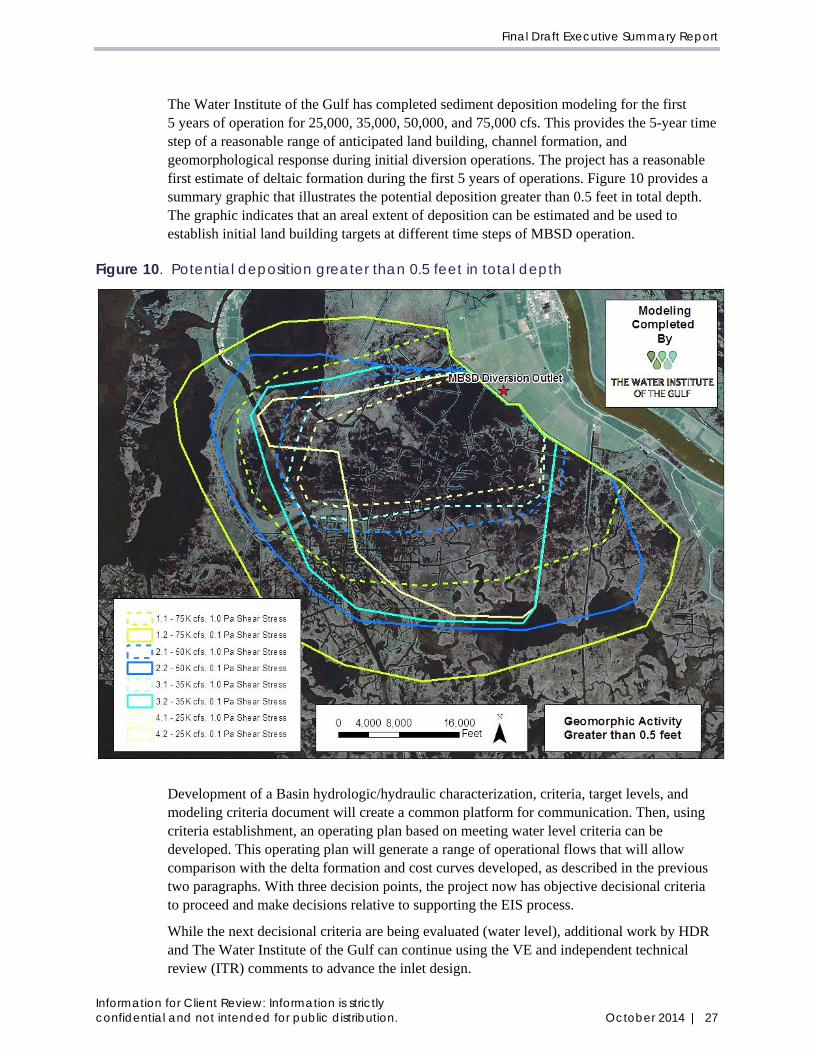
The Water Institute of the Gulf has completed sediment deposition modeling for the first 5 years of operation for 25,000, 35,000, 50,000, and 75,000 cfs. This provides the 5-year time step of a reasonable range of anticipated land building, channel formation, and geomorphological response during initial diversion operations. The project has a reasonable first estimate of deltaic formation during the first 5 years of operations. Figure 10 provides a summary graphic that illustrates the potential deposition greater than 0.5 feet in total depth. The graphic indicates that an areal extent of deposition can be estimated and be used to establish initial land building targets at different time steps of MBSD operation.
Figure 10. Potential deposition greater than 0.5 feet in total depth
Development of a Basin hydrologic/hydraulic characterization, criteria, target levels, and modeling criteria document will create a common platform for communication. Then, using criteria establishment, an operating plan based on meeting water level criteria can be developed. This operating plan will generate a range of operational flows that will allow comparison with the delta formation and cost curves developed, as described in the previous two paragraphs. With three decision points, the project now has objective decisional criteria to proceed and make decisions relative to supporting the EIS process.
While the next decisional criteria are being evaluated (water level), additional work by HDR and The Water Institute of the Gulf can continue using the VE and independent technical review (ITR) comments to advance the inlet design.
Information for Client Review: Information is strictly confidential and not intended for public distribution. October 2014 | 27

Mid-Barataria Sediment Diversion
Establishing water level criteria in the Basin is directly related to design water surface elevations for the channel. Cost savings from establishing desired tailwater conditions will bring more clarity to the cost estimate.
Some additional work on the back structure is warranted given the high cost and the VE and ITR comments. The back structure is a major cost item that has not been designed to any significant degree.
Several VE and ITR design comments warrant further work to confirm cost savings and feasibility, such as the inverted siphon design for drainage, use of deep soil mixing instead of pile foundations, and modular structural components.
5 References BCG Engineering & Consulting, Inc. 2009. Conceptual Designs, Myrtle Grove Diversion Structure. June.
Coastal Protection and Restoration Authority of Louisiana (CPRA). 2011. Myrtle Grove Delta Building Diversion Modeling Effort in Support of the LCA Medium Diversion at Myrtle Grove with Dedicated Dredging Project – Data Collection, Preliminary Design and Modeling Initiative. December.
Coastal Protection and Restoration Authority of Louisiana (CPRA). 2012. Louisiana’s Comprehensive Master Plan for a Sustainable Coast.
Conner, W. H., and J. W. Day, Jr. 1987. The Ecology of Barataria Basin, Louisiana: An Estuarine Profile. U.S. Fish and Wildlife Service. Biological Report 85(7.13). July.
Gagliano et al. 2003. Active Geologic Faults and Land Change in Southeastern Louisiana. Prepared for the U.S. Army Corps of Engineers. Contract No. DACW 29-00-C-0034.
GeoEngineers, Inc. 2014. Geotechnical Data Report for 30% Design, Mid Barataria Diversion (BA-153), Plaquemines Parish, Louisiana. January.
Meselhe, Ehab, João Pereira, Hoon-Shin Jung, Ashok Khadka, and Sadid Kazi. 2014. Mid-Barataria Sediment Diversion Report (Draft). Prepared by The Water Institute of the Gulf for HDR and the Coastal Protection and Restoration Authority of Louisiana. Revised September 30.
U.S. Army Corps of Engineers (USACE) and Coastal Protection and Restoration Authority of Louisiana (CPRA). 2011a. Louisiana Coastal Area (LCA). Medium Diversion at Myrtle Grove with Dedicated Dredging, Conceptual Ecological Model. July 11.
U.S. Army Corps of Engineers (USACE) and Coastal Protection and Restoration Authority of Louisiana (CPRA). 2011b. Louisiana Coastal Area (LCA) Ecosystem Restoration Study. Draft Integrated Construction Report and Supplemental Environmental Impact Statement for the Medium Diversion at Myrtle Grove with Dedicated Dredging. Plaquemines Parish, Louisiana.
Information for Client Review: Information is strictly 28 | October 2014 confidential and not intended for public distribution.

Final Draft Executive Summary Report
Appendix A. List of Deliverables
Information for Client Review: Information is strictly confidential and not intended for public distribution. October 2014 | A-1

Mid-Barataria Sediment Diversion
This page is intentionally left blank.
Information for Client Review: Information is strictly A-2 | October 2014 confidential and not intended for public distribution.

Final Draft Executive Summary Report
List of Deliverables
Reports prepared by HDR
• Coastal Protection and Restoration Authority of Louisiana. 2013. Mid-Barataria Sediment Diversion, Channel Configuration Analysis Report, 15% Basis of Design. Prepared by HDR Engineering, Inc. September.
• Coastal Protection and Restoration Authority of Louisiana. 2013. Mid-Barataria Sediment Diversion, Channel Geometry Geotechnical Analysis Report, 15% Basis of Design. Prepared by HDR Engineering, Inc. September.
• Coastal Protection and Restoration Authority of Louisiana. 2013. Mid-Barataria Sediment Diversion, Channel Geometry Hydraulic and Sediment Analysis Report, 15% Basis of Design. Prepared by HDR Engineering, Inc. September.
• Coastal Protection and Restoration Authority of Louisiana. 2014. Mid-Barataria Sediment Diversion, Alternative 1, Base Design Report, 30% Basis of Design. Prepared by HDR Engineering, Inc. July.
• Coastal Protection and Restoration Authority of Louisiana. 2014. Mid-Barataria Sediment Diversion, Environmental Memoranda. Prepared by HDR Engineering, Inc. July.
• Coastal Protection and Restoration Authority of Louisiana. 2014. Mid-Barataria Sediment Diversion, Geotechnical Report, 30% Basis of Design. Prepared by HDR Engineering, Inc. July.
• Coastal Protection and Restoration Authority of Louisiana. 2014. Mid-Barataria Sediment Diversion, Value Engineering Report, 30% Basis of Design. Prepared by HDR Engineering, Inc. July.
• Coastal Protection and Restoration Authority of Louisiana. 2014. Mid-Barataria Sediment Diversion, Hydraulic Report, 30% Basis of Design and Value Engineering. Prepared by HDR Engineering, Inc. August.
Reports prepared by others
• Coastal Protection and Restoration Authority of Louisiana. 2013. Survey Report, Mid Barataria Diversion Project (BA-153) Design Phase Topographic & Bathymetric Surveys. Prepared by John Chance Land Surveys, Inc. October.
• Coastal Protection and Restoration Authority of Louisiana. 2014. Geotechnical Data Report for 30% Design, Mid Barataria Diversion (BA-153), Plaquemines Parish, Louisiana. Prepared by GeoEngineers, Inc., for HDR Engineering, Inc. January.
• Coastal Protection and Restoration Authority of Louisiana. 2014. Geotechnical Baseline Report for 30% Design, Mid Barataria Diversion (BA-153), Plaquemines Parish, Louisiana. Prepared by GeoEngineers, Inc., for HDR Engineering, Inc. February.
Memorandums
• Coastal Protection and Restoration Authority of Louisiana. 2013. Mid-Barataria Sediment Diversion, Memorandum, Back Structure Evaluation and Cost Estimate. Prepared by HDR Engineering, Inc. September.
Information for Client Review: Information is strictly confidential and not intended for public distribution. October 2014 | A-3

Mid-Barataria Sediment Diversion
• Coastal Protection and Restoration Authority of Louisiana. 2013. Mid-Barataria Sediment Diversion Draft Inlet Channel and Control Structure Technical Memorandum, 15% Basis of Design. Prepared by HDR Engineering, Inc. September.
• Coastal Protection and Restoration Authority of Louisiana. 2013. Mid-Barataria Sediment Diversion, Memorandum, 15% Data Availability and Design of Disposal Area. Prepared by HDR Engineering, Inc. October.
• Coastal Protection and Restoration Authority of Louisiana. 2013. Mid-Barataria Sediment Diversion, Memorandum, Chenier Traverse Pumping Station Design Status. Prepared by HDR Engineering, Inc. October.
• Coastal Protection and Restoration Authority of Louisiana. 2013. Mid-Barataria Sediment Diversion, Memorandum, 408 Process and Review. Prepared by HDR Engineering, Inc. November.
• Coastal Protection and Restoration Authority of Louisiana. 2013. Mid-Barataria Sediment Diversion, Memorandum, Project Alternatives and Quality Control Plan. Prepared by HDR Engineering, Inc. November.
• Coastal Protection and Restoration Authority of Louisiana. 2014. Mid-Barataria Sediment Diversion, Water Quality Resources Summary of Findings Draft Memorandum. Prepared by HDR Engineering, Inc. July.
Information for Client Review: Information is strictly A-4 | October 2014 confidential and not intended for public distribution.