figure 3-99 zone 3 land cover types - placer.ca.gov/media/cdr/planning/pccp/backgrounddata... ·...
TRANSCRIPT

Natural Resources Setting Chapter 3
PCWA Natural Resources 3-101 April 2009 Management Plan
FI
GU
RE
3-99
ZO
NE
3 LA
ND
CO
VER
TYP
ES
Chapter 3 Natural Resources Setting
April 2009 3-102 PCWA Natural Resources Management Plan
This page left blank intentionally.
Natural Resources Setting Chapter 3
PCWA Natural Resources 3-103 April 2009 Management Plan
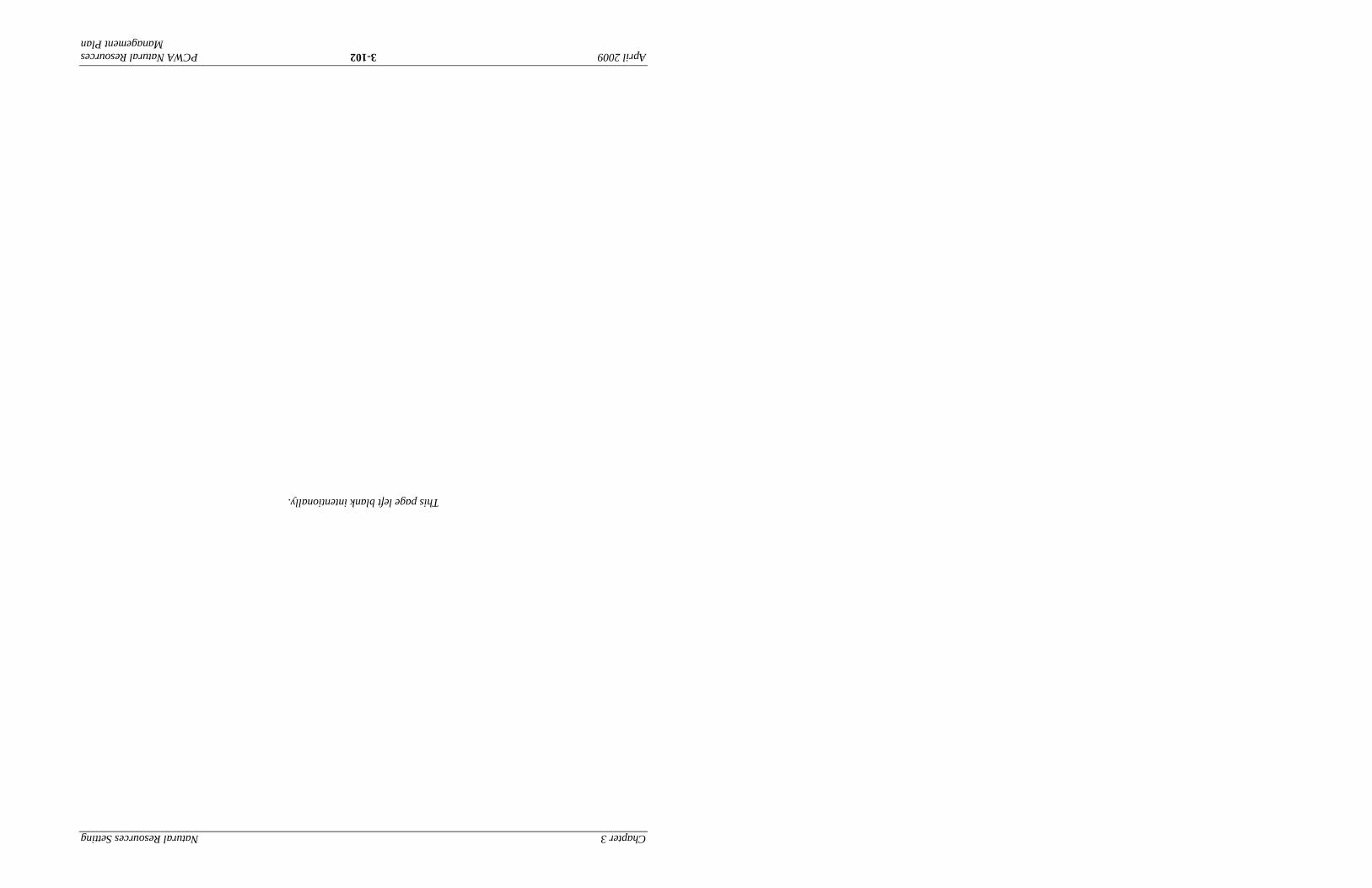
FIGURE 3-100
UPPER ZONE 1 LAND COVER TYPES
Chapter 3 Natural Resources Setting
April 2009 3-104 PCWA Natural Resources Management Plan
This page left blank intentionally.

Natural Resources Setting Chapter 3
PCWA Natural Resources 3-105 April 2009 Management Plan
FIGURE 3-101
LOWER ZONE 1 LAND COVER TYPES

Chapter 3 Natural Resources Setting
April 2009 3-106 PCWA Natural Resources Management Plan
This page left blank intentionally.
Natural Resources Setting Chapter 3
PCWA Natural Resources 3-107 April 2009 Management Plan
FI
GU
RE
3-10
2
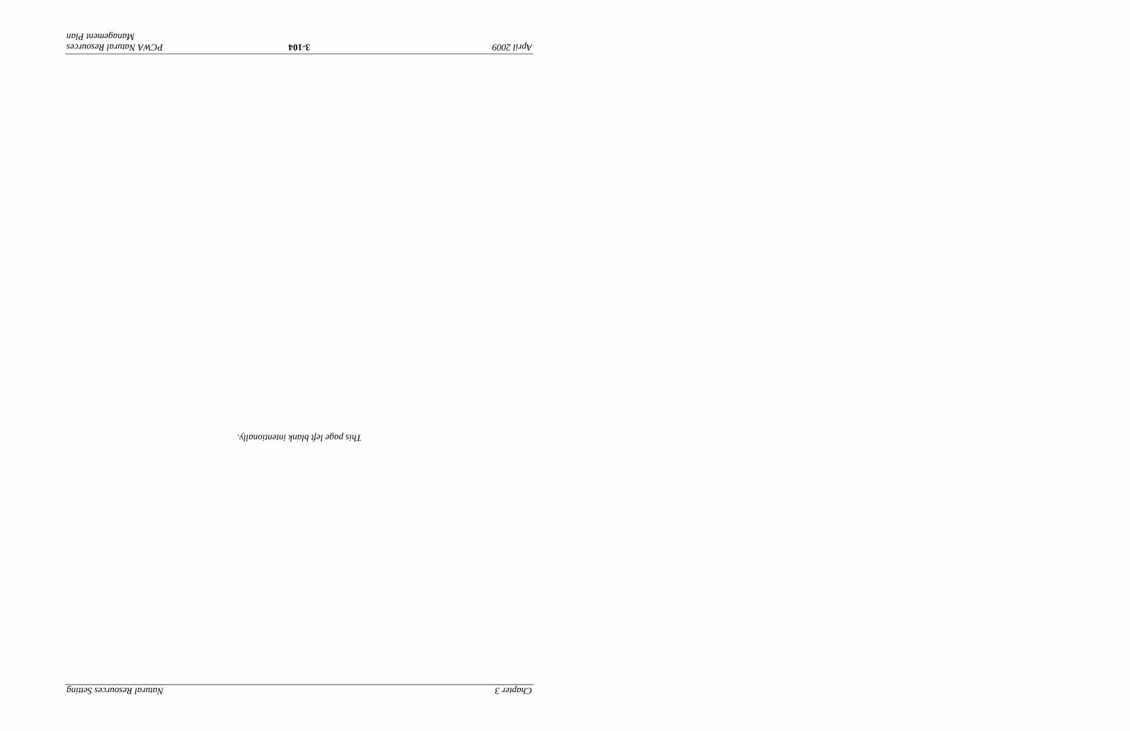
ZON
E 5
LAN
D C
OVE
R T
YPES
Chapter 3 Natural Resources Setting
April 2009 3-108 PCWA Natural Resources Management Plan
This page left blank intentionally.
Natural Resources Setting Chapter 3
PCWA Natural Resources 3-109 April 2009 Management Plan
3.3.2 Aquatic Habitat and Species
Studies in Zones 1, 3, and 5 of the PCWA regarding aquatic habitat conditions and species evaluations have primarily focused on fish communities, including anadromous fall-run Chinook salmon and Central Valley steelhead. Fish observed in the canal system by PCWA enter the canals from the PG&E reservoirs and canals that supply PCWA, and include brown trout (Salmo trutta), rainbow trout (Oncorhychus mykiss), catfish (Ictalurus or Ameiurus sp.), Sacramento sucker (Catostomus occidantalis), and Sacramento pikeminnow (Ptychocheilus grandis) (PCWA 2004). The canals within PCWA’s raw water distribution system, however, are not believed to provide consistent suitable habitat for these species.
3.3.2.1 Zone 3
Although no substantial data was found on aquatic habitat and species conditions specific to Canyon Creek, the creek may include aquatic habit and species common to Sierra Nevada montane hardwood streams. Canyon Creek is at approximately 3,543 feet msl in a relatively rural area composed of hiking trails and campgrounds. Several large dams located downstream (Nimbus and Folsom dams on the Lower American River) prohibit potential access to Canyon Creek by Chinook salmon or steelhead. Fish observed in the North Fork American River would likely be found in Canyon Creek, such as the rainbow trout, riffle sculpin, Sacramento sucker, and speckled dace. Nonnative brown trout may also be found in Canyon Creek. The elevation of the creek is too high for fish such as pikeminnow to be present.
3.3.2.2 Zone 1
Unregulated outlet releases and seepage along the canal system may contribute to flows in natural watercourses in the basin. Secret Ravine and Miners Ravine are recognized by DFG as the primary production areas in the Dry Creek drainage for fall-run Chinook salmon and Central Valley steelhead (DFG 2001). In the Dry Creek watershed, these ravines appear to be especially important for spawning and rearing of these anadromous fishes (DFG 2001).
Auburn Ravine Watershed
The artificially high flows in Auburn Ravine during summer months due to water supply conveyances from PCWA, PG&E, and NID support more aquatic habitat than would be maintained under natural hydrologic conditions (Placer County Planning Department 2002). Portions of Auburn Ravine are designated as Critical Habitat for Central Valley steelhead (70 Code of Federal Regulations (CFR) 52488, September 2, 2005). Efforts are currently underway to improve habitat conditions in Auburn Ravine for salmonids and other native fishes.
Auburn Ravine’s characteristics dramatically vary between its headwaters and the East Side Canal. Fall-run Chinook salmon and Central Valley steelhead spawn and rear in upstream reaches (between its headwaters at the City of Auburn to the City of Lincoln), but the quality of migration habitat for salmonids has been substantially reduced by beaver dams, numerous water diversions, and their associated diversion structures (Placer County Planning Department 2002). On behalf of PCWA, South Sutter District installs two seasonal diversion dams in Auburn
Chapter 3 Natural Resources Setting
April 2009 3-110 PCWA Natural Resources Management Plan
Ravine, Moore Dam and Pleasant Grove Dam, where flows are diverted to the Moore and Pleasant Grove canals, respectively. NID Auburn Ravine 1 Dam is a year-round barrier to migration. Also, NID Hemphill Dam (a seasonal diversion dam) and NID gaging station impair migration of salmonids during most flow conditions. Since water deliveries to agricultural water users are curtailed during the fall, generally before fall-run Chinook salmon attempt to migrate upstream to spawn, the depth of water in the stream channel below some flow-control structures is often insufficient to facilitate adult fish passage.
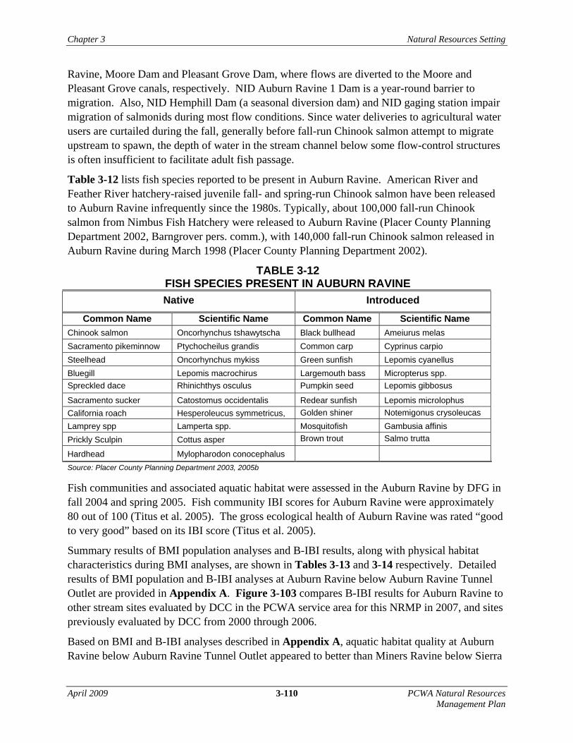
Table 3-12 lists fish species reported to be present in Auburn Ravine. American River and Feather River hatchery-raised juvenile fall- and spring-run Chinook salmon have been released to Auburn Ravine infrequently since the 1980s. Typically, about 100,000 fall-run Chinook salmon from Nimbus Fish Hatchery were released to Auburn Ravine (Placer County Planning Department 2002, Barngrover pers. comm.), with 140,000 fall-run Chinook salmon released in Auburn Ravine during March 1998 (Placer County Planning Department 2002).
TABLE 3-12 FISH SPECIES PRESENT IN AUBURN RAVINE Native Introduced
Common Name Scientific Name Common Name Scientific Name Chinook salmon Oncorhynchus tshawytscha Black bullhead Ameiurus melas Sacramento pikeminnow Ptychocheilus grandis Common carp Cyprinus carpio Steelhead Oncorhynchus mykiss Green sunfish Lepomis cyanellus Bluegill Lepomis macrochirus Largemouth bass Micropterus spp. Spreckled dace Rhinichthys osculus Pumpkin seed Lepomis gibbosus
Sacramento sucker Catostomus occidentalis Redear sunfish Lepomis microlophus California roach Hesperoleucus symmetricus, Golden shiner Notemigonus crysoleucas Lamprey spp Lamperta spp. Mosquitofish Gambusia affinis Prickly Sculpin Cottus asper Brown trout Salmo trutta
Hardhead Mylopharodon conocephalus
Source: Placer County Planning Department 2003, 2005b
Fish communities and associated aquatic habitat were assessed in the Auburn Ravine by DFG in fall 2004 and spring 2005. Fish community IBI scores for Auburn Ravine were approximately 80 out of 100 (Titus et al. 2005). The gross ecological health of Auburn Ravine was rated “good to very good” based on its IBI score (Titus et al. 2005).
Summary results of BMI population analyses and B-IBI results, along with physical habitat characteristics during BMI analyses, are shown in Tables 3-13 and 3-14 respectively. Detailed results of BMI population and B-IBI analyses at Auburn Ravine below Auburn Ravine Tunnel Outlet are provided in Appendix A. Figure 3-103 compares B-IBI results for Auburn Ravine to other stream sites evaluated by DCC in the PCWA service area for this NRMP in 2007, and sites previously evaluated by DCC from 2000 through 2006.
Based on BMI and B-IBI analyses described in Appendix A, aquatic habitat quality at Auburn Ravine below Auburn Ravine Tunnel Outlet appeared to better than Miners Ravine below Sierra

Natural Resources Setting Chapter 3
PCWA Natural Resources 3-111 April 2009 Management Plan
College Boulevard, as shown in Table 3-13. The Auburn Ravine below the Auburn Ravine Tunnel Outlet had a B-IBI score of 41, which is considered to be “fair,” as shown in Figure 3-103.
TABLE 3-13 BENTHIC INDEX OF BIOTIC INTEGRITY FOR SITES AT AUBURN RAVINE, SECRET
RAVINE, AND MINERS RAVINE
Auburn Ravine below
Auburn Ravine Tunnel Outlet
Secret Ravine at Loomis Basin Park
Miners Ravine below Sierra College Blvd
Coleoptera taxa 4 4 0 EPT taxa 5 6 5 Predator Taxa 2 5 4 Collectors (%) 5 5 4 Intolerant (%) 1 2 1 Non-Insect (%) 4 7 2 Tolerant (%) 8 7 5 Total 29 36 21
B-IBI Score 41 51 30
Ranking Fair Fair Poor
TABLE 3-14
PHYSICAL HABITAT SCORES FOR BENTHIC MACROINVERTEBRATE ANALYSES AT AUBURN RAVINE, SECRET RAVINE, AND MINERS RAVINE
Auburn Ravine below
Auburn Ravine Tunnel Outlet
Secret Ravine at Loomis Basin Park
Miners Ravine below Sierra College Blvd
Flow (cfs) 9.6 3.0 1.7 Temperature (oF) 57.4 55.8 55.2 Habitat Types, % Riffle
41 15 11
Slope (average %) 2.5 0.5 1.4 Instream Habitat1 14 11 5 Sediment Deposition1 19 11 5 Channel Alteration1 15 11 18 Note: 1Score is out of possible 20.

Chapter 3 Natural Resources Setting
April 2009 3-112 PCWA Natural Resources Management Plan
FIGURE 3-103
COMPARISON OF BENTHIC INDEX OF BIOTIC INTEGRITY SCORES AT STREAM SITES IN THE PCWA SERVICE AREA
As for physical habitat, there is a high percentage of riffle habitat, and the cobble and gravel substrate within the segment sampled had very little sediment, as shown in Table 3-14. Detailed results of physical habitat analyses at Auburn Ravine below Auburn Ravine Tunnel Outlet are provided in Appendix A.
Clover Valley Creek Watershed
Studies of aquatic habitat and species conditions in Clover Valley Creek are very limited. Clover Valley Creek is not included in the designated Critical Habitat for Central Valley steelhead (Placer County 2006). An impassable culvert blocks access of salmonids to Clover Valley Creek (Placer and Sacramento Counties 2003). The lack of deep pools and clean riffle habitat limits the potential for biodiversity, which tends to limit food and preferred habitat for rearing salmonids. The potential for salmonid rearing is considered to exist in lower portions of the creek.
In general, substrate and habitat conditions in Clover Valley Creek are considered unsuitable for rearing salmonids (Placer County 2006). Common substrate in the creek consists of fine sediments (sand and silt) with very little gravel and cobbles, particularly in downstream areas. High sediment loads and sediment deposition, degraded water quality, invasive species, and lack
0
20
40
60
80
100
Aubu
rn R
avin
e be
low
Aub
urn
Rav
ine
Tunn
el O
utle
t
Clo
ver
Val
ley
Cre
ekup
stre
am f
rom
Gol
f cou
rse
Ant
elop
e C
reek
at K
ing
Rd
Ant
elop
e C
reek
at
Atla
ntic
Ave
Min
ers
Rav
ine
at D
ick
Coo
k R
d
Min
ers
Ravi
ne b
elow
S
ierr
a C
olle
ge B
lvd
Min
ers
Rav
ine
at S
ecre
t Ra
vine
Sec
ret R
avin
eat
Loo
mis
Bas
in P
ark
Sec
ret R
avin
eat
Sie
rra
Col
lege
Blv
d
Sec
ret R
avin
eat
Min
ers
Ravi
ne
Dry
Cre
ek a
bove
Rio
Lin
da B
lvd
Bri
dge
Ben
thic
Inde
x of
Bio
tic In
tegr
ity (B
-IBI)

Natural Resources Setting Chapter 3
PCWA Natural Resources 3-113 April 2009 Management Plan
of riparian vegetation contribute to degraded aquatic habitat conditions in Clover Valley Creek. Lower Clover Valley Creek is highly channelized and sometimes impounded.
Although suitable habitat conditions for some salmonid life stages may exist in Clover Valley Creek, there are many significant barriers to upstream passage of anadromous salmonids (City of Rocklin 2006), including an impassable culvert just upstream of its confluence with Antelope Creek (Placer and Sacramento Counties 2003). The Argonaut Bridge crossing, an impoundment structure at Cimarron Court, and an instream impoundment downstream of Midas Way and Rawhide Drive Bridge are all barriers along Clover Valley Creek (City of Rocklin 2006). The total flow of the creek passes through a 30-foot-long culvert, approximately 2 feet in height, and about 3 feet wide. On the downstream side, the culvert hangs 2 feet over the streambed. Migrating salmonids reportedly cannot swim through the flow from the culvert because of its relatively small opening and high flow velocity (Placer and Sacramento Counties 2003).
Because Clover Valley Creek is a tributary to Antelope Creek, fish species present in Clover Valley Creek are likely comparable to the fish species present in Antelope Creek, described below. An Aquatic Habitat Survey and Fisheries Assessment was conducted by ECORP Consulting, Inc. on Clover Valley Creek on June 16 and 19, 2006 (ECORP 2006). The fish community in Clover Valley Creek was found to be dominated by native minnow and hitch (Lavinia exilicauda), particularly in the upper portion of the creek. The nonnative western mosquitofish (Gambusia affinis) and green sunfish (Lepomis cyanellus) were observed in the lower portions of the creek. No salmonids were observed during the survey. The native Sacramento sucker was also found along Clover Valley Creek. Hitch and Sacramento sucker both prefer low-gradient streams with slow water velocities and sandy to gravel substrates, as do green sunfish and mosquitofish. All four species are tolerant of the warm water temperatures characteristic of Clover Valley Creek, particularly during summer and fall.
Based on BMI analyses conducted by DCC (Figure 3-103), the site at Clover Valley Creek upstream from the Sunset Whitney Country Club on Midas Avenue in Rocklin had a B-IBI score of 23, which is considered to be “poor,” likely due to presence of organisms tolerant to water quality pollutants and a general lack of benthic macroinvertebrate species diversity.
Antelope Creek Watershed
Antelope Creek is not as well studied as other headwater tributaries of Dry Creek (Secret Ravine and Miners Ravine). Although fall-run Chinook have been periodically documented over the past 40 years to use parts of the watershed for spawning, there is no reliable data on whether steelhead are currently present in the watershed. Similar to Clover Valley Creek, Antelope Creek is not designated as critical habitat for Central Valley steelhead.
Aquatic habitat in Antelope Creek is characterized as low in diversity, generally consisting of flatwater (i.e., shallow run and shallow glide) habitat (Placer and Sacramento Counties 2003). Use of Antelope Creek by anadromous salmonids is generally considered to be limited to occasional stray adults during years of at least moderate streamflow during the migration period. Two potential spawning areas have been identified in Antelope Creek, but the associated habitat is generally not favorable to salmonids (Placer and Sacramento Counties 2003). Juvenile
Chapter 3 Natural Resources Setting
April 2009 3-114 PCWA Natural Resources Management Plan
salmonid habitat is generally limited to shallow pool habitat during years of at least moderate streamflow. Low streamflows in Antelope Creek could impede adult anadromous fish passage during critical periods of the year (Sierra Business Council 2003).
Antelope creek is located in a primarily urban and suburban area. Past and ongoing construction activities adjacent to the creek have resulted in significant upland disturbance and sediment contribution to the stream. Accumulated sediment is common in the lower portion of Antelope Creek. Several portions of the creek are incised (City of Roseville 2005), and vulnerable to erosion. Accumulated sediments, such as sand, small cobbles, and exposed granite, are common in the lower portion of Antelope Creek (Placer and Sacramento Counties 2003). A spawning gravel study conducted by Jones & Stokes in 2004 found that 77 percent of substrate in Antelope Creek was fine sediment, in which fish eggs and larvae would unlikely survive (Placer County Planning Department 2005b).
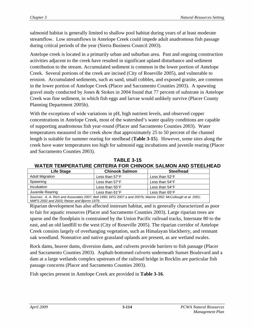
With the exceptions of wide variations in pH, high nutrient levels, and observed copper concentrations in Antelope Creek, most of the watershed’s water quality conditions are capable of supporting anadromous fish year-round (Placer and Sacramento Counties 2003). Water temperatures measured in the creek show that approximately 25 to 50 percent of the channel length is suitable for summer rearing for steelhead (Table 3-15). However, some sites along the creek have water temperatures too high for salmonid egg incubations and juvenile rearing (Placer and Sacramento Counties 2003).
TABLE 3-15 WATER TEMPERATURE CRITERIA FOR CHINOOK SALMON AND STEELHEAD
Life Stage Chinook Salmon Steelhead Adult Migration Less than 57°F Less than 52°F Spawning Less than 57°F Less than 54°F Incubation Less than 55°F Less than 54°F Juvenile Rearing Less than 61°F Less than 65°F Sources: A. A. Rich and Associates 2007; Bell 1990; DFG 2007 a and 2007b; Marine 1992; McCullough et al. 2001; NMFS 2002 and 2003; Reiser and Bjornn 1979;
Riparian development has also affected instream habitat, and is generally characterized as poor to fair for aquatic resources (Placer and Sacramento Counties 2003). Large riparian trees are sparse and the floodplain is constrained by the Union Pacific railroad tracks, Interstate 80 to the east, and an old landfill to the west (City of Roseville 2005). The riparian corridor of Antelope Creek consists largely of overhanging vegetation, such as Himalayan blackberry, and remnant oak woodland. Nonnative and native grassland uplands are present, as are wetland swales.
Rock dams, beaver dams, diversion dams, and culverts provide barriers to fish passage (Placer and Sacramento Counties 2003). Asphalt-bottomed culverts underneath Sunset Boulevard and a dam at a large wetlands complex upstream of the railroad bridge in Rocklin are particular fish passage concerns (Placer and Sacramento Counties 2003).
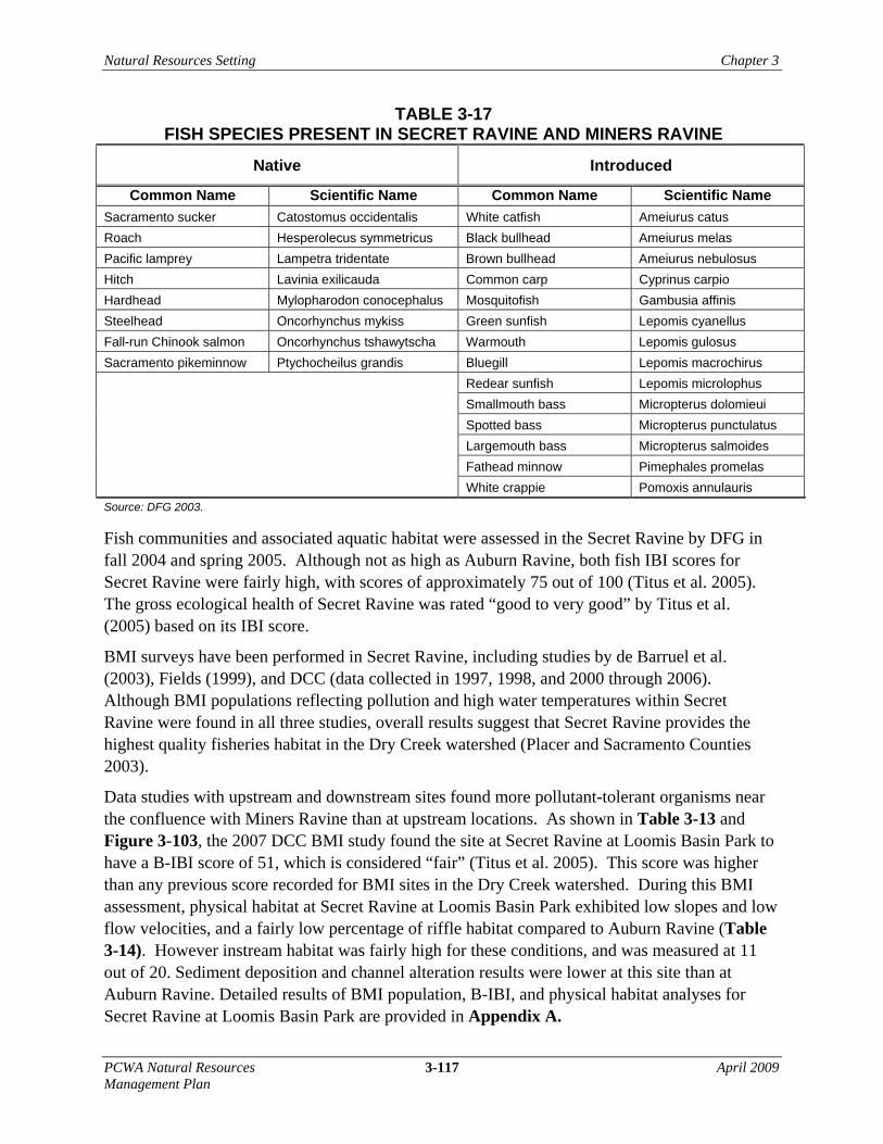
Fish species present in Antelope Creek are provided in Table 3-16.
Natural Resources Setting Chapter 3
PCWA Natural Resources 3-115 April 2009 Management Plan
TABLE 3-16 FISH SPECIES PRESENT IN ANTELOPE CREEK Native Introduced
Common Name Scientific Name Common Name Scientific Name Fall-run Chinook salmon Oncorhynchus tshawytscha Black bullhead Ameiurus melas Hitch Oncorhynchus mykiss Brown bullhead Ameiurus nebulosus Sacramento sucker Lavinia exilicauda Common carp Cyprinus carpio Sacramento pikeminnow Catostomus occidentalis Mosquitofish Gambusia affinis Speckled dace Ptychocheilus grandis Green sunfish Lepomis cyanellus Rhinichthys osculus Golden shiner Notemigonus crysoleucas
Micropterus spp.
Source: Sierra Business Council, 2003
Note: A general siting of both Trout and Bass was reported during the 1959 DFG survey, but specific species were not identified (DFG, 1959)
The BMI community observed at Antelope Creek during previous studies was primarily composed of organisms that are moderately to highly tolerant of impaired water quality conditions. BMI analyses were conducted at two sites (King Road and Atlantic Avenue) along the Antelope Creek by the DCC in 2000. As shown in Figure 3-103, the I-IBI score for the upstream site at King Road was 30, and the score for the downstream site at Atlantic Avenue was 27, both of which are considered to be “poor.” The limited aquatic insect populations found resulted in the “poor” rating at both sites. The data also indicate a high percentage of pollutant-tolerant organisms, with few BMI taxa associated with cleaner waters (Placer and Sacramento Counties 2003). The combination of high seasonal flow fluctuations, water quality conditions, and high sediment loads in the creek may have contributed to the observed results (Placer and Sacramento Counties 2003).
Secret Ravine Watershed
Secret Ravine is a major tributary of Dry Creek, and is designated as Critical Habitat for Central Valley steelhead (70 CFR 52488, September 2, 2005). Secret Ravine is said to be the most productive stream within the Dry Creek watershed for Central Valley fall-run Chinook salmon and Central Valley steelhead, despite urban encroachment and other human-influenced impacts (Fields 1999). Surveys conducted for steelhead in the Dry Creek watershed have shown that most of the suitable spawning and rearing habitat occurs in Secret Ravine (Placer County Planning Department 2005b).
Both fall-run Chinook salmon and steelhead have been documented spawning in Secret Ravine (Placer County Planning Department 2005b). Based on a 2005 survey, estimated spawning habitat area for spawning in Secret Ravine totaled 1,175 square feet, with the capacity for 21 potential redds (nests) for steelhead and 12 potential redds for Chinook salmon (Placer County Planning Department 2005b). Since the late 1990s, an average of 160 adult fish per year have been observed in Secret Ravine (Placer and Sacramento Counties 2003). Juvenile steelhead have

Chapter 3 Natural Resources Setting
April 2009 3-116 PCWA Natural Resources Management Plan
been observed rearing in Secret Ravine near the headwaters around Gilardi Road and downstream to the Brace Road crossing (Sierra Business Council 2003).
Water temperatures in Secret Ravine have been documented as warmer than ideal and suitable ranges for steelhead rearing (Table 3-15), which would have a particular effect on juvenile steelhead (Placer County Planning Department 2005b). Water temperatures measured at Gilardi Road during October 2003 to March 2004 (incubation period) were generally lower than criteria identified in Table 3-15 for sensitive life stages (Sierra Business Council 2003b). Rearing habitat is limited around Sierra College because of high water temperatures and limited thermal refugia are present in the summer. Chinook salmon, however, typically leave within a few months of hatching.
The 2004 spawning gravel study found the amount of fines measured to range from 51 to 82 percent for Secret Ravine (Placer County Planning Department 2005). Adult Chinook salmon and steelhead clean fine sediments from the gravel with their caudal fins during spawning, and as long as fine sediment does not overwhelm the redd, egg and larvae survival is possible.
Well-established beaver dams, from 0.6 to 1.2 meters (2 to 4 feet), were observed during salmonid spawning gravel surveys in Secret Ravine (Placer County Planning Department 2005b). If these observed dams remain intact during the salmonid migration period, then they could represent significant passage impediments or complete passage barriers. Steelhead, however, tend to migrate in winter months when flows are higher, and obstacles are less of a factor to passage. There is also at least one permanent barrier created by a pipeline, and several utility pipe crossings that may be additional obstacles to fish migration (Placer and Sacramento Counties 2003).
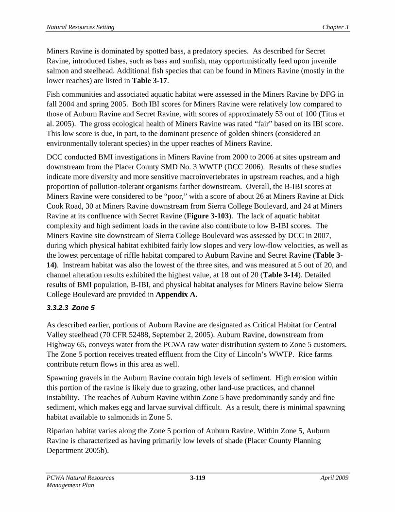
Additional fish species that can be found in Secret Ravine (mostly the lower reaches) are listed in Table 3-17. The impact of introduced fishes on fall-run Chinook salmon and steelhead in Secret Ravine is not known. However, bass and sunfish (especially spotted bass) are highly predatory species and could be expected to opportunistically feed on rearing and emigrating juvenile Chinook salmon and steelhead. The degree to which this occurs in Secret Ravine, however, is unknown.
Natural Resources Setting Chapter 3
PCWA Natural Resources 3-117 April 2009 Management Plan
TABLE 3-17 FISH SPECIES PRESENT IN SECRET RAVINE AND MINERS RAVINE
Native Introduced
Common Name Scientific Name Common Name Scientific Name Sacramento sucker Catostomus occidentalis White catfish Ameiurus catus Roach Hesperolecus symmetricus Black bullhead Ameiurus melas Pacific lamprey Lampetra tridentate Brown bullhead Ameiurus nebulosus Hitch Lavinia exilicauda Common carp Cyprinus carpio Hardhead Mylopharodon conocephalus Mosquitofish Gambusia affinis Steelhead Oncorhynchus mykiss Green sunfish Lepomis cyanellus Fall-run Chinook salmon Oncorhynchus tshawytscha Warmouth Lepomis gulosus Sacramento pikeminnow Ptychocheilus grandis Bluegill Lepomis macrochirus
Redear sunfish Lepomis microlophus Smallmouth bass Micropterus dolomieui Spotted bass Micropterus punctulatus Largemouth bass Micropterus salmoides Fathead minnow Pimephales promelas White crappie Pomoxis annulauris
Source: DFG 2003.
Fish communities and associated aquatic habitat were assessed in the Secret Ravine by DFG in fall 2004 and spring 2005. Although not as high as Auburn Ravine, both fish IBI scores for Secret Ravine were fairly high, with scores of approximately 75 out of 100 (Titus et al. 2005). The gross ecological health of Secret Ravine was rated “good to very good” by Titus et al. (2005) based on its IBI score.
BMI surveys have been performed in Secret Ravine, including studies by de Barruel et al. (2003), Fields (1999), and DCC (data collected in 1997, 1998, and 2000 through 2006). Although BMI populations reflecting pollution and high water temperatures within Secret Ravine were found in all three studies, overall results suggest that Secret Ravine provides the highest quality fisheries habitat in the Dry Creek watershed (Placer and Sacramento Counties 2003).
Data studies with upstream and downstream sites found more pollutant-tolerant organisms near the confluence with Miners Ravine than at upstream locations. As shown in Table 3-13 and Figure 3-103, the 2007 DCC BMI study found the site at Secret Ravine at Loomis Basin Park to have a B-IBI score of 51, which is considered “fair” (Titus et al. 2005). This score was higher than any previous score recorded for BMI sites in the Dry Creek watershed. During this BMI assessment, physical habitat at Secret Ravine at Loomis Basin Park exhibited low slopes and low flow velocities, and a fairly low percentage of riffle habitat compared to Auburn Ravine (Table 3-14). However instream habitat was fairly high for these conditions, and was measured at 11 out of 20. Sediment deposition and channel alteration results were lower at this site than at Auburn Ravine. Detailed results of BMI population, B-IBI, and physical habitat analyses for Secret Ravine at Loomis Basin Park are provided in Appendix A.

Chapter 3 Natural Resources Setting
April 2009 3-118 PCWA Natural Resources Management Plan
DCC also conducted BMI sampling in 2000 and 2001 at two downstream locations along the creek: Secret Ravine at Sierra College Boulevard and Secret Ravine at its confluence with Miners Ravine. The Sierra College Boulevard site received a B-IBI score of 46, which is considered “fair,” and the Secret Ravine at Miners Ravine received a rating of 31, which is considered “poor.” Results from these studies indicated a high percentage of pollutant-tolerant organisms with almost no taxa associated with cleaner waters. A BMI survey was conducted at Secret Ravine just downstream from Sierra College (upstream site) and at Secret Ravine just upstream from its confluence with Miners Ravine (downstream site) (de Barruel and West 2003). In this study, the percentage of pollutant-tolerant BMI organisms at the downstream site were found to be significantly higher than at the upstream site, indicating higher perturbation and pollution at the downstream site (de Barruel and West 2003).
Miners Ravine Watershed
Like Secret Ravine, Miners Ravine is a major tributary of Dry Creek, and is also designated as Critical Habitat for Central Valley steelhead (70 CFR 52488, September 2, 2005). Both fall-run Chinook salmon and steelhead have been observed spawning in Miners Ravine (DWR 2002). In the 1950s, up to 100 adult Chinook salmon were estimated to occur in Miners Ravine; however, there is little current information regarding the spawner abundance of Chinook salmon in Miners Ravine, though the Dry Creek Conservancy conducts spawning surveys on up to several days per season (Bates pers. com). During some years in the 1980s and 1990s, DFG planted as many as 100,000 juvenile Chinook salmon from the Feather River hatchery in the lower reaches of Miners Ravine. Although mostly inaccessible to salmonids, aquatic habitat along Miners Ravine was observed to be of highest quality upstream of Cottonwood Dam, near Dick Cook Road, where there is a high canopy cover, deep pools, and higher concentrations of spawning gravel (DWR 2002).
Summer water temperatures in Miners Ravine have been documented as higher than the suitable ranges for steelhead rearing (Table 3-15). However, deep pools and cool groundwater accretion could provide thermal refugia for juvenile steelhead. Water temperature data was not recorded during the periods when Chinook salmon would be present in Miners Ravine.
Livestock grazing and riparian vegetation removal have caused increased erosion along banks. Substrate found in Miners Ravine was dominated by fines, such as silt, and clay (DWR 2002), with fine sediment measured between 50 and 75 percent. With the ability of adult Chinook salmon and steelhead to clean fine sediments from the gravel during spawning, egg and larvae survival is still possible if the fines are not reintroduced into the redd.
Many barriers in Miners Ravine reduce the quality of migration habitat. These barriers include six road crossings, one culvert, eight dams, and three natural barriers. Cottonwood Dam, built in the 1950s, is considered to be the uppermost limit to anadromous species in Miners Ravine, but steelhead may be able to pass during flood flows (Placer County Planning Department 2005a, Placer and Sacramento Counties 2003). Additionally, 80 beaver dams were observed in Miners Ravine in one survey (DWR 2002).
Natural Resources Setting Chapter 3
PCWA Natural Resources 3-119 April 2009 Management Plan
Miners Ravine is dominated by spotted bass, a predatory species. As described for Secret Ravine, introduced fishes, such as bass and sunfish, may opportunistically feed upon juvenile salmon and steelhead. Additional fish species that can be found in Miners Ravine (mostly in the lower reaches) are listed in Table 3-17.
Fish communities and associated aquatic habitat were assessed in the Miners Ravine by DFG in fall 2004 and spring 2005. Both IBI scores for Miners Ravine were relatively low compared to those of Auburn Ravine and Secret Ravine, with scores of approximately 53 out of 100 (Titus et al. 2005). The gross ecological health of Miners Ravine was rated “fair” based on its IBI score. This low score is due, in part, to the dominant presence of golden shiners (considered an environmentally tolerant species) in the upper reaches of Miners Ravine.
DCC conducted BMI investigations in Miners Ravine from 2000 to 2006 at sites upstream and downstream from the Placer County SMD No. 3 WWTP (DCC 2006). Results of these studies indicate more diversity and more sensitive macroinvertebrates in upstream reaches, and a high proportion of pollution-tolerant organisms farther downstream. Overall, the B-IBI scores at Miners Ravine were considered to be “poor,” with a score of about 26 at Miners Ravine at Dick Cook Road, 30 at Miners Ravine downstream from Sierra College Boulevard, and 24 at Miners Ravine at its confluence with Secret Ravine (Figure 3-103). The lack of aquatic habitat complexity and high sediment loads in the ravine also contribute to low B-IBI scores. The Miners Ravine site downstream of Sierra College Boulevard was assessed by DCC in 2007, during which physical habitat exhibited fairly low slopes and very low-flow velocities, as well as the lowest percentage of riffle habitat compared to Auburn Ravine and Secret Ravine (Table 3-14). Instream habitat was also the lowest of the three sites, and was measured at 5 out of 20, and channel alteration results exhibited the highest value, at 18 out of 20 (Table 3-14). Detailed results of BMI population, B-IBI, and physical habitat analyses for Miners Ravine below Sierra College Boulevard are provided in Appendix A.
3.3.2.3 Zone 5
As described earlier, portions of Auburn Ravine are designated as Critical Habitat for Central Valley steelhead (70 CFR 52488, September 2, 2005). Auburn Ravine, downstream from Highway 65, conveys water from the PCWA raw water distribution system to Zone 5 customers. The Zone 5 portion receives treated effluent from the City of Lincoln’s WWTP. Rice farms contribute return flows in this area as well.
Spawning gravels in the Auburn Ravine contain high levels of sediment. High erosion within this portion of the ravine is likely due to grazing, other land-use practices, and channel instability. The reaches of Auburn Ravine within Zone 5 have predominantly sandy and fine sediment, which makes egg and larvae survival difficult. As a result, there is minimal spawning habitat available to salmonids in Zone 5.
Riparian habitat varies along the Zone 5 portion of Auburn Ravine. Within Zone 5, Auburn Ravine is characterized as having primarily low levels of shade (Placer County Planning Department 2005b).