field trip mangrovesstorage.googleapis.com/.../mangoves_field_trip.pdf · 2015-07-08 · geobill...
TRANSCRIPT
Geobill 2012 1
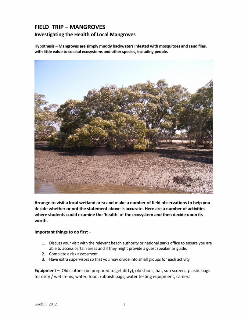
FIELD TRIP – MANGROVES Investigating the Health of Local Mangroves
Hypothesis – Mangroves are simply muddy backwaters infested with mosquitoes and sand flies, with little value to coastal ecosystems and other species, including people.
Arrange to visit a local wetland area and make a number of field observations to help you decide whether or not the statement above is accurate. Here are a number of activities where students could examine the ‘health’ of the ecosystem and then decide upon its worth.
Important things to do first –
1. Discuss your visit with the relevant beach authority or national parks office to ensure you are able to access certain areas and if they might provide a guest speaker or guide.
2. Complete a risk assessment 3. Have extra supervisors so that you may divide into small groups for each activity
Equipment – Old clothes (be prepared to get dirty), old shoes, hat, sun screen, plastic bags for dirty / wet items, water, food, rubbish bags, water testing equipment, camera

Geobill 2012 2
Suggested activities to do on the day - Sketch a rough map of where key features are located.
Where permitted, walk through the mud flats and boardwalks to observe the many species of plants and wildlife. Make a list of plant and animal species you saw. Photograph examples of mangroves and marine species.
Draw a field sketch showing the main features of a mud flats or mangrove forests.
Do some simple water quality tests
Make notes on the inter-relationships between plant and animal species.
List ways that some species have adapted to the wetland environment. This could be shown by completing a table like the one below or insert the correct answer:
CONDITION ADAPTATION
1. High levels of salty air
2.Waterlogged roots and salt build up
3.Anaerobic (low oxygen) condition due to compacted mud
4.Effect of waves and tidal flow
Which form of adaptation fits? A. A seedling stem (hypocotyl) forms below the fruit and germinates on the parent. When it falls, it
anchors into the mud, takes root and grows almost immediately. B. Develop thick buttress or stilted roots to give added support to the tree. C. Develop thick, waxy leaves which reduce water loss as well as storing salt. This allows salt to be
removed when leaves die and fall off. D. Have ‘breathing roots’ (pneumatophores) that stick up through the mud.
TASK ONE – Human Impact Survey Complete a human impact survey of the area like the one below:
Compare your results with others in the class. Use your data to make a comparison pie graph or bar graph
EVIDENCE TALLY TOTAL % OF TOTAL
Eg. Plastic /// 3 10
Cans
Polystyrene
Paper packaging
Paper
Tins, wire, metal
Other

Geobill 2012 3
TASK TWO – Transect sketch showing features from HWM to LWM
Sketch a transaction of the inter-tidal zone (High water mark to Low Water mark) to show features such as trees, other plant species, macro-organisms, ground cover, leaf litter, pneumatophores, detritus, splash zone, rubbish and flotsam. Do a detailed quadrat analysis (e.g. one metre square) at regular intervals along your transection line.
*** A quadrat analysis is where you make a detailed examination of a sample area (say 1 metre by 1 metre). Look for details of species, density of plants, diversity of species, thickness of detritus, examples of pollution, and so on.
Enter your quadrat data on a table like below -
Analysis
25m from LWM
50m from LWM
75m from LWM
100m from LWM
pH of top mud layer
Area exposed mud (%)
Count of pneumatophores
Depth of detritus
Evidence of living fauna
Evidence of human impact
Geobill 2012 4
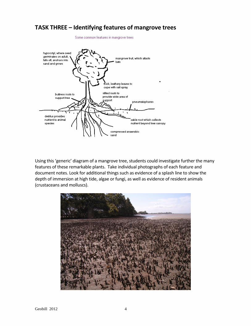
TASK THREE – Identifying features of mangrove trees
Using this ‘generic’ diagram of a mangrove tree, students could investigate further the many features of these remarkable plants. Take individual photographs of each feature and document notes. Look for additional things such as evidence of a splash line to show the depth of immersion at high tide, algae or fungi, as well as evidence of resident animals (crustaceans and molluscs).

Geobill 2012 5
TASK FOUR – Complete a water quality assessment Investigate the water quality by taking some simple tests –
physical state of water such as temperature and turbidity
chemical tests such as salinity, pH, BOD, phosphate and nitrate level
Biological tests like evidence of worms, crustaceans, fish, birds, etc
Test 1 – Temperature Take the temperature of the water. Is it too hot or too cold? What is a suitable temperature for most organisms to survive? What may happen if the temperature range increases too much? Test 2 - Turbidity Test the water’s turbidity? What is a suitable level? What does this mean for plants or creatures that depend upon sunlight? Test 3 – Salinity (salt composition) Test the water for saltiness? How might this affect the ability for plants or animals to survive? How much is too much? Test 4 – pH (level of acidity) What is the pH reading? Mark it on the scale below. 3________4________5________6________7_________8________9________10___ Is it acidic, neutral or basic? How does pH affect living things? Test 5 – Level of nitrates What amount of nitrates is evident in this water? Is this a satisfactory level? Explain. Test 6 – Level of phosphates What amount of phosphates was found? What is a possible source of these chemicals? How does an excess of certain chemicals affect the marine environment?

Geobill 2012 6
TASK FIVE – Complete a COMPARISON MATRIX ...... to compare features and attributes of
(a) High Energy Coastline eg sandy beach with dunes (b) Low Energy Coastline eg mud flats / mangroves
Characteristics HIGH ENERGY COASTLINE LOW ENERGY COASTLINE
Location and general
physical appearance
Main landform features
Dominant physical process
eg erosion, deposition, etc
Vegetation and wildlife
Human impact and effects

Geobill 2012 7
TASK SIX – Complete a wildlife study using a checklist Before going on the trip, find out the names of common birds, fish and crustaceans that occupy the mangroves. You may have to obtain a brochure of local fauna and bird life for your study area and design a checklist. Check to see if it is a Ramsar site; if there is a local ornithology club in the area, ask for their assistance.
Sample Checklist –- Birds (do a similar list for other living or non-living components of area)
Living Fauna
Type
Location / Activity Total
Mudflats In Flight Perched Birds Cormorant
Curlew
Egret
Godwit
Gull (silver)
Heron
Ibis
Kingfisher
Kite
Osprey
Pelican
Sandpiper
Spoonbill
Tern
Other

Geobill 2012 8
TASK SEVEN – Draw a field sketch of the study area (sample)
*** If students do not have time to complete field sketch on-site, the next best thing is to take panoramic photographs and sketch the detail back at school.
TASK EIGHT – Investigate indigenous links to the area Mangrove areas were important hunting and gathering sites to indigenous people because of the abundance of crustaceans, fish and birds. Today, some wetland / mangrove areas have special items of interest and totems of cultural significance preserved so they may be seen and appreciated by visitors. The Boondall Wetlands on the northern outskirts of Brisbane has a series of cultural trails that celebrate the life of local indigenous people through its Nurri Millen Totem Trail. This series of totems, sculptures and information boards informs visitors that before settlement, Aborigines gathered slender grape fruits and rock fig, used paper bark for shelter and cooking, collected local honey, trapped yabby, hunted quail, squirrel gliders and small macropods for food throughout these wetlands. Find out the indigenous cultural history of your field site by contacting the national parks office. Ask for a local indigenous elder or representative to assist you with your visit.

Geobill 2012 9
BACK AT SCHOOL
1. Review your field work and research those areas where more information is needed eg what is a RAMSAR site? Which birds use these flyways?
2. In groups, present your findings to the class. Design a short seminar or power point
presentation that either agrees with or disagrees with the hypothesis. Base it on these key questions -:
What are mangroves? What are the roles of mangroves?
Where are they found? What are their patterns of distribution?
How has human development affected mangrove ecosystems?
What is the future of mangroves? How should we protect them? To find out more about wetlands - www.biodiversity.environment.gov.au/environm/wetlands/