field operations manual - sccwrpftp.sccwrp.org/.../bight03/bight03_field_manual.pdf · field...
TRANSCRIPT
Southern California Bight 2003 Regional Marine Monitoring Survey
(Bight’03)
Field Operations Manual
Prepared by: Bight’03 Field Sampling & Logistics Committee
Prepared for: Commission of Southern California Coastal Water Research Project
7171 Fenwick Lane Westminster, CA 92683
July 2003
Bight’03 Field Operations Manual
i
SOUTHERN CALIFORNIA BIGHT 2003 REGIONAL MARINE MONITORING SURVEY FIELD SAMPLING & LOGISTICS COMMITTEE FIELD COORDINATOR/COMMITTEE CHAIR Mike Kelly - City of San Diego, Metropolitan Wastewater Department COMMITTEE CO-CHAIR Bill Power - Los Angeles County Sanitation Districts FIELD SAMPLING & LOGISTICS COMMITTEE MEMBERS Dr. M. James Allen - Southern California Coastal Water Research Project Art Barnett - MEC Analytical Systems, Inc. Dario W. Diehl - Southern California Coastal Water Research Project Doug Diener – MEC Analytical Systems, Inc. Brian Edwards – United States Geological Survey Sarah Fangman - Channel Islands National Marine Sanctuary Scott Johnson - Aquatic Bioassay and Consulting Laboratories Michael Machuzak - Aquatic Bioassay and Consulting Laboratories Mike Mengel - Orange County Sanitation District David E. Montagne - Los Angeles County Sanitation Districts Tony Phillips - City of Los Angeles, Environmental Monitoring Division Ananda Ranasinghe - Southern California Coastal Water Research Project George Robertson - Orange County Sanitation District Jim Roney - City of Los Angeles, Environmental Monitoring Division Ken Schiff - Southern California Coastal Water Research Project
Bight’03 Field Operations Manual
ii
TABLE OF CONTENTS Page Table of Contents ii List of Tables v List of Figures vi Appendices vii Acknowledgements viii I. INTRODUCTION 1 A. Background 1 II. OVERVIEW OF FIELD SURVEY 3 A. Sampling period 3 B. Sampling design 3 C. Indicators of ecosystem health 3 III. DESCRIPTION OF FIELD TEAMS AND ACTIVITIES 4 A. Personnel 4 B. Chain-of-Command 4 C. Station Assignments 5 D. Equipment 6 E. Weekly Communications 7 F. Important Telephone Numbers 7 IV. SAFETY 8 V. QUALITY ASSURANCE/QUALITY CONTROL PROCEDURES 9 A. Protocol Calibration/Quality Assurance Procedures 9 VI. FIELD COMPUTER 13 A. General Requirements 13 VII. SAMPLING LOGISTICS 14 A. Navigation 14 B. Sampling Schedule 14 C. Station Types 14 D. Site acceptability criteria 14 E. Site rejection strategy 15
Bight’03 Field Operations Manual
iii
VIII. BENTHIC SAMPLING 19 A. Sampling Effort 19 B. Van Veen Grab 19 C. Grab Sampling Procedures 19 D. Priority of Grab Sampling 19 E. Criteria for Acceptable Grab Samples 20 F. Benthic Sampling Event 21 G. Sediment Description 22 H. Sample Processing 22 IX. TRAWL SAMPLING 27 A. Purpose 27 B. Sampling Effort 27 C. Collection Permits 27 D. Otter-Trawl Specifications 27 E. Trawl Data Flow and Responsibilities 29 F. Trawl Sampling Event Data 31 G. Net Preparation 31 H. Station Occupation 31 I. Pre-trawl Survey 32 J. Trawling 33 K. Criteria for Accepting a Trawl 33 L. Sample Processing 34 M. Fish Samples for bioaccumulation/Biomarker Studies 42 N. Quality Assurance/Quality Control Procedures 43 O. Voucher Collection 44 X. LABELING AND SHIPPING OF SAMPLES AND FIELD DATA SHEETS 45 A. Sample Labels/Tracking 45 B. Labels 45 C. Field Data Sheets 45 D. Shipping of Samples 45 E. Chain of Custody Forms 45 XI. CONTINGENCY PLANS 47 A. Purpose 47 B. Adverse weather conditions 47 C. Station Inaccessibility 47 D. Lost Gear 47 XII. WASTE DISPOSAL 48 A. Routine Garbage 48 B. Detergent Washes 48 C. Chemicals 48 D. Fish Waste 48

Bight’03 Field Operations Manual
iv
XIII. BIGHT’03 PROGRAM ORGANIZATION 49 IX. LITERATURE CITED 51
Bight’03 Field Operations Manual
v
LIST OF TABLES
Table 1. Number of stations (by sample type) to be sampled by organizations participating in the Bight’03 study, summer 2003 (excludes totals for estuaries and special studies).
Table 2. Recommended scope and length of wire for trawling at different depths in
the Southern California Bight. Table 3. Age size classes (cm) for bioaccumulation target fish species.
Bight’03 Field Operations Manual
vi
LIST OF FIGURES
Figure 1. Benthic sampling site and sample acceptance process. Figure 2. Trawl sampling site and sample acceptance process. Figure 3. Examples of acceptable and unacceptable grab sample condition (from
Tetra Tech 1986). Figure 4. Semi-balloon otter trawl recommended for marine receiving water
monitoring programs in southern California (modified from Mearns and Allen, 1978).
Figure 5. View of an otter board of a semiballoon otter trawl with recommended
numbers of chain (5-mm or 3/16in. diameter) links (modified from Mearns and Allen, 1978).
Figure 6. Trawl Data Flow and Responsibilities. Figure 7. Endpoints for maximum Standard Length (SL) and Total Length (TL) for
bony fish. Figure 8. Endpoints for Wingspan (WS), Board Standard Length (SL), and Total
Length for measuring the length of bony and cartilaginous fishes. Figure 9. Relationship of centimeter size classes to millimeter values using
centimeter and millimeter marks on a meter stick where size class 20 is defined as 19.1 to 20.0mm.
Bight’03 Field Operations Manual
vii
APPENDICES APPENIX 1 Bight ’03 Station Location Charts APPENDIX 2 Bight’03 Field Sampling Organizations and Station Draw Information APPENDIX 3 Bight’03 Sample Processing Analytical Laboratories APPENDIX 4 Bight’03 Field Sampling Equipment and Supply Lists APPENDIX 5 Bight’03 Field Sampling Vessel Specifications APPENDIX 6 Bight’03 Field Sampling Data Sheets APPENDIX 7 Bight’03 Field Sampling QA/QC Data Sheets APPENDIX 8 Bight’03 Field Sampling Organization Contacts APPENDIX 9 Bight’03 Field Sample Shipping Information
Bight’03 Field Operations Manual
viii
ACKNOWLEDGEMENTS
This document was developed by the Bight’03 Field Sampling and Logistics Committee. Mike Kelly (City of San Diego, Metropolitan Wastewater Department) was Field Logistics Coordinator and lead editor, and Bill Power (County Sanitation Districts of Los Angeles County) was Co-Chair. Other members of the Bight’03 Field Sampling and Logistics Committee who contributed to this effort included M. James Allen, Dario Diehl, and Ananda Ranasinghe (Southern California Coastal Water Research Project), Art Barnett and Doug Diener (MEC Analytical Systems, Inc.), Brian Edwards (United States Geological Survey), Sarah Fangman (Channel Islands National Marine Sanctuary), Scott Johnson and Michael Machuzak (Aquatic Bioassay and Consulting Laboratories), Mike Mengel and George Robertson (Orange County Sanitation District), David E. Montagne (County Sanitation Districts of Los Angeles County) and Tony Phillips and Jim Roney (City of Los Angeles, Environmental Monitoring Division). Additional contributors included Larry Cooper, Ken Schiff and Steve Bay (Southern California Coastal Water Research Project).
1
I. INTRODUCTION A. Background The Southern California Bight Pilot Project (SCBPP) was conducted in 1994 to begin addressing regional monitoring concerns. This project was the largest regional survey of environmental conditions on the mainland shelf in the Southern California Bight (SCB). It capitalized on the interest and cooperation existing in southern California and the resources available in current monitoring programs to develop an integrated and coordinated regional monitoring program that addressed the needs of the participating local, state, and federal agencies, and provided new management information. The SCBPP provided a much needed first Asnapshot@ of the state of the SCB. The SCBPP resulted in consistent regionwide data sets for describing pollution exposure and biological resources within the SCB. Twelve participating agencies sampled 261 sites on the mainland shelf which provided an unprecedented assessment of pollutant exposure, the status of biological resources, species diversity, and the presence of marine debris in the SCB. Four years later, the next regional survey of the SCB, Bight'98, continued the development of regional scale management information and followed the general plan of the SCBPP. Participation in Bight'98 increased to 64 agencies and the number of sites sampled grew to 416. New indicators, such as a shoreline microbiology component and analysis of biomarkers in fish, were incorporated into the study, and the strata were expanded to include San Diego Bay, Catalina Island, the Channel Islands, and historically sampled reference sites. The following questions were posed and formed the basis of the investigation: 1) What was the extent and magnitude of change in an indicator measured in the SCB?; 2) Was the degree of change similar throughout the SCB, or was it more severe in particular areas?; 3) Were observed changes associated with identifiable sources of pollution, such as municipal wastewater outfalls, rivers, or harbors?; and 4) Were the associations identified similar throughout the SCB? Bight’03 continues to build on the cooperative interaction developed during the previous surveys. In addition to having more participants involved in the program, new habitats will be surveyed using more parameters and new sampling methods. There are approximately 60 organizations who will be either directly involved with collecting data in the field, or who have contributed resources to the project. The habitats of interest have been expanded this time to include coastal estuaries, the upper continental slope (200-500 m), and the lower slope and inner basin (500-1000 m). Bight‘03 is organized into three technical components: 1) coastal ecology; 2) shoreline microbiology; and 3) water quality. As with the former studies, the goal of the project is to assess the condition of the bottom environment and the health of the biological resources of the SCB. To accomplish this goal, the project will focus on two primary objectives: 1) estimate the extent and magnitude of ecological change in the SCB; and 2) determine the mass balance of pollutants that currently reside within the SCB. Unites States Geological Survey (USGS) will conduct the sampling in the lower slope and inner
Bight’03 Field Operations Manual
2
basin areas and they will use standard operating procedures (SOP) developed independently of the Southern California Bight projects. Their SOP documents will be referenced, rather than included in this manual. The microbiology and water quality surveys will be conducted throughout the following year and will supplement the Bight'03 summer field study. These studies will be conducted according to protocols described in appendices produced by the Microbiology and Water Quality working groups. The Bight'03 coastal ecology field sampling component will be conducted from July through September of 2003. The purpose of this document is to provide detailed instructions on all field sampling methods that will be used to conduct this study.
Bight’03 Field Operations Manual
3
II. OVERVIEW OF FIELD SURVEY A. Sampling Period The index period for the Bight'03 study will extend from July 14 to September 5, 2003. B. Sampling Design The Bight'03 study will continue to use a probability-based sampling design developed by EMAP that combines the strengths of systematic and random sampling. This sampling design consists of a grid of tessellated hexagons with a station selected at random within each hexagon. Sampling can be intensified in areas of special interest by decreasing the size of the hexagons, thereby increasing the number of hexagons in an area. Bight'03 has identified 10 different strata of stations that will be sampled in this survey. These strata are classified as follows: Channel Islands, shallow offshore (5-30 m), mid depth offshore (30-120 m), deep offshore (120-200 m), continental slope (200-500 m), lower slope and inner basin (500-1000 m), small POTW outfalls, large POTW outfalls, marinas, ports/bays/harbors, and estuaries. C. Indicators of Ecosystem Health The primary goal of Bight’03 is to provide an assessment of the overall ecosystem condition of the SCB. To accomplish this goal, the following indicators of ecosystem health will be examined:
• Benthic - sediment characteristics, sediment contamination, infaunal assemblages, and sediment toxicity;
• Demersal fish and invertebrate assemblages, gross fish pathology,
biomarkers, and bioaccumulation
• Marine debris (including plastic, lumber, vegetation, glass, etc.)
Bight’03 Field Operations Manual
4
III. DESCRIPTION OF FIELD TEAMS AND ACTIVITIES A. Personnel All field sampling will be conducted by personnel knowledgeable in field sampling (e.g., benthic sampling, trawling, etc.). Teams of field personnel will be on each research vessel participating in the sampling effort. These groups will vary in size depending on which organization is doing the field sampling. The main requirements are that the personnel on board the vessel:
• Have a good working experience with the different types of sampling devices;
• Have the knowledge and experience necessary for conducting the field collection and analysis of benthic invertebrates and sediments, and trawl-caught demersal fish and megabenthic invertebrates;
• Are able to troubleshoot problems when they arise.
B. Chain-of-Command The following chain-of-command is recommended to avoid confusion, identify responsible parties, and ensure that proper sampling protocols and information flow are followed by each organization:
1) The Lead Scientist will be an organization’s primary contact regarding all survey and field-related matters;
2) A Boat Captain will not only be responsible for piloting the sampling vessel each
day, but will also be the sole authority regarding decisions on whether to cease or continue sampling operations when conditions at sea are judged to be unsafe;
3) The Cruise Leader is a person designated prior to each sampling day who will be
responsible for supervising the scientific crew and sampling operations aboard a particular sampling vessel. This person will have the final decision on whether to abandon or sample a station, and will be responsible for assuring the quality of the data. At the end of each sampling day, they will make sure that all field data and samples are delivered to the appropriate processing personnel in a timely manner. Cruise Leaders are not required to be the same person from field day to field day;
4) Significant changes to the established logistical plan that are outside of the
jurisdiction of the Lead Scientist will be communicated to either the Field Logistics Coordinator (Mike Kelly), or the Project Manager (Ken Schiff) before any change is implemented. The teams will accept technical direction from no other authority. All changes to the sampling plan that occur during the field surveys must be documented;
Bight’03 Field Operations Manual
5
5) All technical matters, such as equipment problems, questions regarding station locations, sampling schedules, etc., will be addressed to the Field Logistics Coordinator by the Lead Scientist AS SOON AS POSSIBLE;
6) The Lead Scientist of an organization having completed a pre-survey field audit
will be informed of any procedural and/or taxonomic deficiencies field operations by the Auditor. The Lead Scientist will be expected to take the appropriate action to correct the situation as soon as possible.
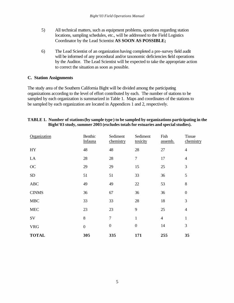
C. Station Assignments The study area of the Southern California Bight will be divided among the participating organizations according to the level of effort contributed by each. The number of stations to be sampled by each organization is summarized in Table 1. Maps and coordinates of the stations to be sampled by each organization are located in Appendices 1 and 2, respectively. TABLE 1. Number of stations (by sample type ) to be sampled by organizations participating in the
Bight'03 study, summer 2003 (excludes totals for estuaries and special studies). Organization
Benthic Infauna
Sediment chemistry
Sediment toxicity
Fish assemb.
Tissue chemistry
HY
48
48
28
27
4
LA
28
28
7
17
4
OC
29
29
15
25
3
SD
51
51
33
36
5
ABC
49
49
22
53
8
CINMS
36
67
36
36
0
MBC
33
33
28
18
3
MEC
23
23
9
25
4
SV
8
7
1
4
1
VRG
0 0 0 14 3
TOTAL
305
335
171
255
35
Bight’03 Field Operations Manual
6
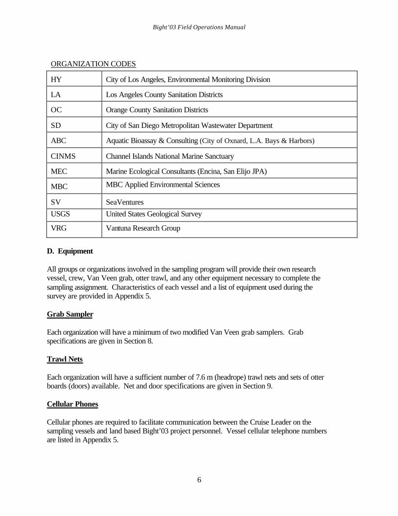
ORGANIZATION CODES HY
City of Los Angeles, Environmental Monitoring Division
LA
Los Angeles County Sanitation Districts
OC
Orange County Sanitation Districts
SD
City of San Diego Metropolitan Wastewater Department
ABC
Aquatic Bioassay & Consulting (City of Oxnard, L.A. Bays & Harbors)
CINMS
Channel Islands National Marine Sanctuary
MEC
Marine Ecological Consultants (Encina, San Elijo JPA)
MBC MBC Applied Environmental Sciences SV
SeaVentures
USGS United States Geological Survey
VRG Vantuna Research Group
D. Equipment All groups or organizations involved in the sampling program will provide their own research vessel, crew, Van Veen grab, otter trawl, and any other equipment necessary to complete the sampling assignment. Characteristics of each vessel and a list of equipment used during the survey are provided in Appendix 5. Grab Sampler Each organization will have a minimum of two modified Van Veen grab samplers. Grab specifications are given in Section 8. Trawl Nets Each organization will have a sufficient number of 7.6 m (headrope) trawl nets and sets of otter boards (doors) available. Net and door specifications are given in Section 9. Cellular Phones Cellular phones are required to facilitate communication between the Cruise Leader on the sampling vessels and land based Bight’03 project personnel. Vessel cellular telephone numbers are listed in Appendix 5.
Bight’03 Field Operations Manual
7
E. Weekly Communications Each week a representative from each participating organization will communicate to SCCWRP (ATTENTION: Larry Cooper) a schedule of proposed sampling days during the upcoming week, operations to be conducted, and general areas where sampling is likely to occur. Project QA/QC Auditors can also use this information to schedule when they can conduct field audits for a particular organization. Prior to a QA/QC audit, the auditor will contact a Lead Scientist to verify that their proposed schedule is still in place. Each organization will also be required to make weekly electronic submissions of the Bight’03 station occupation and event table information (i.e. grab and trawl) at the end of every sampling week. This information will be used to both track the overall progress of the project, and verify that each field team is accurately and completely sampling each station. F. Important Telephone Numbers The names and phone numbers of appropriate personnel and emergency services are listed in Section 13 and Appendix 8. If a particular individual cannot be reached at the listed number, the caller should contact SCCWRP, where an attempt will be made to provide an alternate means by which the individual can be reached.
Bight’03 Field Operations Manual
8
IV. SAFETY
Sample collection at sea is inherently hazardous and this danger is greatly compounded in bad weather. Thus, the safety of the crews and equipment is of paramount importance throughout the project. Each person working on board a vessel during the project should take personal responsibility for their own safety. Many accidents at sea are preventable. Safety awareness by the Boat Captain and all crew members is the greatest single factor that will reduce accidents at sea. Each field crew should follow all established rules and provisions within their respective organization's safety program. Sampling should be canceled or postponed during hazardous weather conditions. The final decision shall be made by the Boat Captain, who is responsible for the safety of everyone on board. As with any field program, the first priority is the safety of the people on board, followed by the safety of the equipment, and then the recovery of the data.

Bight’03 Field Operations Manual
9
V. QUALITY ASSURANCE/QUALITY CONTROL PROCEDURES A. Protocol Calibration/Quality Assurance Procedures The Bight’03 survey will be conducted cooperatively by a number of organizations which routinely monitor the marine environment according to established protocols. It is important to the success of the Bight’03 study that comparable data are collected by each organization. This Field Operations Manual will provide information on how field operations will be conducted to meet this requirement. The Lead Scientists and Boat Captains will be instructed on the field procedures to be followed during the survey and they, in turn, will instruct their field personnel on the proper procedures for the survey. The Lead Scientist of each organization is responsible for distributing the Bight’03 Field Operations Manual to all field personnel and ensuring that their staff understands and uses the protocols detailed in the manual. Lead Scientist/Boat Captain Protocol Orientation Meeting Lead Scientists and Boat Captains of all organizations participating in the survey will be required to attend a protocol calibration meeting, conducted prior to the survey on June 24, 2003. The goals and objectives of the project will be discussed at this meeting, as will the responsibilities of the Bight03 field personnel. Each participant will be provided with a Bight’03 Coastal Ecology Workplan, a Field Operations Manual and will be instructed on field procedures to be used during the survey. The discussion will also include instruction on proper data entry into the field computers and on field data forms. The meeting will emphasize decision making procedures for determining station and/or sample acceptability, and the conditions that must be met before a station is abandoned. Lines of communication within the project and QA/QC activities occurring on the boat during the survey will also be discussed. Scientific Team Training The Lead Scientist from each organization will be responsible for ensuring that their field personnel have been trained properly on all field methods and procedures that will be used during the survey. It will be their responsibility to review the Coastal Ecology Workplan and Field Operations Manual with their field crews, and to make sure that each person understands that these procedures must be followed during the survey. Personnel that cannot perform a required operation will not participate in conducting that operation. Benthic Sampling (See Section 8) The participation of several different vessels and field sampling teams in Bight’03 requires that uniform procedures be followed in the field to ensure high quality samples and consistent results. All field personnel will be provided with the Bight’03 Field Operations Manual and will be instructed on sampling procedures, application of sample acceptance criteria, sample processing, and the use of field data forms. All participants are expected to understand and properly carry
Bight’03 Field Operations Manual
10
out all steps in the collection, screening, relaxation, and fixation of infaunal samples. They must also understand the techniques related to the subsampling of sediment, and the handling of sediment chemistry and toxicity samples. Where necessary, pre-survey field audits will be conducted in an attempt to ascertain a particular organization’s field sampling capability and their adherence to standard sampling and sample procedures. These audits will be conducted by representatives who have participated in past regional surveys and whose organization has adopted the prescribed field methods as standard operating procedures for routine monitoring. An audit will be completed for organizations that either did not participate in the Bight’98 field effort, or for organizations that did, but have undergone a significant turnover in personnel since that time. During the field audits, an Auditor will observe the field crews perform the required field sampling procedures and processing, and as necessary, provide corrective instruction. The Auditor may also conduct subsequent audits on benthic sampling procedures for all participants during the Bight'03 survey to ensure that sampling is conducted in a uniform manner and that all required information is recorded by the field crews. The goal of the Bight'03 survey is to collect grabs at all sites. However, a Measurement Quality Objective (MQO) of 90% has been established for completeness for the collection of the benthic samples. This completeness goal was established to derive the maximum statistical power of the sampling design and was not set at 100% in recognition that some sites will be difficult, if not impossible, to sample with a Van Veen grab. Nevertheless, field crews are expected to strive to collect samples at 100% of the stations. Trawl Sampling (See Section 9) Demersal fish and invertebrate assemblage data (species identification, enumeration, biomass, and length) are greatly influenced by the collection methods. Therefore, strict adherence to prescribed sampling protocols is critical. Fish catches are influenced by gear type and deployment, tow duration, and towing speed. All organizations collecting samples in the field must use standard nets and follow standard trawling procedures to ensure that comparable samples are collected. Field personnel will be provided with the Bight'03 Field Operations Manual. The Lead Scientist of each organization must make sure that his or her staff understands and uses the protocols as detailed in the manual. Several QA/QC activities will help to ensure the quality of the trawl survey data. These include intercalibration cruises, checks of equipment, sample processing, and taxonomic identification. Trawl equipment, deployment, and sample processing protocols will be checked during pre-survey and in-survey visits to each vessel by the QA/QC Auditors. The Auditors will ensure that the methods used are those prescribed in the Field Operations Manual. The QA/QC Auditor will check trawling procedures and equipment to ensure that trawling is conducted in the same manner by each organization and that the appropriate data is recorded on a Field QA/QC Checklist (Appendix 7). The Auditor will check to make sure that the net is rigged properly, that the appropriate data are recorded, that the trawl is deployed and retrieved properly, and that the catch is properly processed. A check will also be made to see that the scales are calibrated at the
Bight’03 Field Operations Manual
11
start of each day, that other pertinent processing equipment are on board, and that processing is conducted according to methods described in the field manual (Appendix 7). The Lead Scientist will be notified of the audit results so that any problems can be corrected prior to sampling. Pre-survey trawl field audits will be necessary for organizations that either did not participate in Bight’98, or did, and have since undergone a significant turnover in field personnel. The audits will be conducted by an Auditor prior to the survey to assess equipment, vessels, standard protocols, and, if necessary, to instruct the crew on the trawling procedures described in the manual. Audit data will be recorded on a Field QA/QC Checklist (Appendix 7). Lead Bight'03 fish and invertebrate taxonomists will be designated prior to the sampling period. In addition, each organization will identify lead fish and invertebrate taxonomists that will participate in their part of the survey. These individuals must have the required expertise in field identification of trawl-caught fishes and/or invertebrates of coastal southern California in depths ranging between 5-500 m. They will be responsible for providing accurate identifications of species collected during the survey and will complete/oversee a review of the voucher collections before they are shipped to SCCWRP. While it is expected that the lead taxonomists of each organization will have a wide range of knowledge of the common caught trawl species, it is not expected that all persons making field identifications will know every species. It is, therefore, very important that guessing be avoided when it comes to finalizing any particular identification. An error made in the identification of an organism may result in an irretrievable error in the database because most of the organisms that are identified in the field are returned to the sea. If no one onboard knows the identity of a specimen, that specimen shall be returned to the laboratory for final identification. Once the final identity of any specimen has been ascertained in the organization's laboratory, that change will be made on either the trawl fish, or the invertebrate species sheets by crossing out the original name (do not erase the original name) and writing the correct name. Conversely, if it has been determined that a species cannot be identified at the organization's laboratory, it should be sent to SCCWRP along with the voucher specimens for identification. Three QA/QC activities will help to ensure accurate taxonomic identification of fishes and invertebrates by providing training and intercalibration among organizations: 1) Prior to the survey, a list of recommended taxonomic identification aids will be
distributed to participating organizations. Lists of trawl-caught fish and invertebrate species for southern California will also be distributed. A reference collection of voucher specimens of species collected during the SCBPP and Bight’98 surveys is available at SCCWRP for individuals wishing to see species likely to be encountered in Bight’03. In addition, it is recommended (but not required) that field taxonomists attend one or more of the pre-survey information transfer meetings given at SCCWRP on the identification of expected trawl species;
2) Taxonomists from every field sampling organization will be required to
participate in at least one pre-survey intercalibration cruise to ensure that
Bight’03 Field Operations Manual
12
identifications of commonly occurring species are standardized.
3) Taxonomists from each organization will also be required to participate in another pre-survey intercalibration exercise meant to assess the probability of taxonomic error in the field. In this exercise, a bucket of fish and a bucket of invertebrates will be passed between all participating organizations prior to the survey. The taxonomists will identify specimens of representative trawl-caught species in each bucket to the lowest taxon possible. A numbered tag will be attached to each organism so that the identifications can be checked against the correct specimens. This exercise will focus on identification errors. Correct identifications or "Return for Further Identification" (FID) are acceptable. FID indicates that the specimen would have been returned to the laboratory (where additional information or expertise can be found) for final identification. Organizations with more than 5% misidentifications (fish and invertebrates combined) will redo the exercise with a different bucket of organisms. If an organization cannot meet this requirement on the second attempt, a qualified taxonomist from another organization must be on board when trawl sampling is conducted.
Measurement Quality Objectives (MQOs) for the trawl fish and invertebrate sampling effort are defined in terms of accuracy, precision, and completeness. Acceptability criteria have been established for trawl sample collections. The goal of the Bight'03 trawl survey is to collect samples at all designated trawl stations to identify all of the organisms correctly, and to obtain accurate counts, measurements, and weights on all species. However, the MQOs will be set at lower values in recognition of the realities of field sampling. Because some stations may occur on rocky bottom, the MQOs for the study completeness objective for trawl sample collection will be 90%. Of the samples collected, 100% will be processed, identified, counted, measured, and weighed. Accuracy expectations for the crew performance are 95% for identification and 90% for counting, lengths, and biomass. The precision objectives are 90% for fish lengths and within 0.2 kg for biomass.
Bight’03 Field Operations Manual
13
VI. FIELD COMPUTER A. General Reqiurements A field computer will be used whenever possible to collect station occupation/visual observation data during the Bight’03 survey. If a field computer cannot be used, all required sampling event information must be recorded on Bight’03 field data sheets and subsequently loaded into Microsoft Excel data files for submission to the Bight’03 Information Manager. Data submission formats and standards are described in the Bight’03 Information Management Plan. Bight’03 Field Data System Version 2.0 A field data acquisition application has been developed by SCCWRP for use during the Bight’03 survey. This system facilitates the collection of all the required station occupation and field sampling event information (e.g., grab sampling, trawls, and water quality sampling events). This system has been designed to use laptop computers and has an instruction manual for training and reference. Use of the Bight’03 Field Data System is strongly recommended as the system of choice during the survey. The Field Data System has the following characteristics and features: • Runs in Windows NT, XP, ME or 98 OS environments; • Stores data in an MS Access 2000 application (requires Access 2000); • Receives direct input of data from DGPS through serial port assuring that all samples are
associated with accurate location information and eliminating transcription error associated with hand-written entry of these data;
• Provides data entry templates for all sampling event information required by Bight’03 Information Management Plan;
• Employs drop down lists of acceptable values for many entry fields, thereby reducing entry time and assuring accuracy and compliance with Bight’03 data standards;
• Capable of producing fully completed hardcopy Bight’03 field sampling data sheets which can be used for data backup;
• Produces export data files of all sampling event information in Bight’03 compliant Microsoft Excel files suitable for direct submission to the project Information Manager;
• Capable of being used as simple data entry system for information collected at sea on paper field sampling data sheets, or may be used as a primary data collection tool.
Bight’03 Field Operations Manual
14
VII. SAMPLING LOGISTICS A. Navigation Accurate location of sampling sites is crucial to the success of the Bight'03 survey. Station charts and coordinates (latitude and longitude) are located in Appendices 1 through 3. Vessel positioning will be determined by means of a Differential Global Positioning System (DGPS). If, during the course of a field sampling day, the differential signal is interrupted or lost, sampling may continue using standard GPS. B. Sampling Schedule The benthic and trawl surveys may begin July 14, 2003. All field work may be completed in the order that each organization sees fit, as long as the survey is completed by September 5, 2003. All samples will be collected between sunrise and sunset, with the exception of sediment chemistry and sediment toxicity; those samples may be collected anytime throughout the 24 hour period. Otter trawl samples must be collected between one hour after sunrise and one hour before sunset. C. Station Types Ten different strata of stations will be sampled during the survey. These strata are classified as follows: Channel Islands, shallow offshore (5-30 m), mid depth offshore (31-120 m), deep offshore (121-200 m), continental slope (201-500 m), lower slope and inner basin (501-1000 m), small POTW outfalls, large POTW outfalls, marinas, ports/bays/harbors and estuaries. The project sampling station/stratum information is listed in Appendix 2. In the event that relocating a station moves the station into a different sampling stratum, the station will still be sampled and the new stratum will be noted in the comments section of the field data sheet. D. Site Acceptability Criteria The location of each sampling site will be designated in advance as a set of coordinates (latitude and longitude). Upon arrival at the site, the depth will be determined by fathometer. This will be regarded as the target depth for all subsequent sampling at the site during the survey and will be used for determining site acceptability. While all sites are single points defined by latitude and longitude, occupation within a specified distance (i.e. the radius limit) of the target coordinates will be considered acceptable. This radius limit will be 100 m for all sites except those within the island stratum, where the radius limit will be 200 m because of the greater extent of rocky bottoms surrounding the Channel Islands Sampling may not be possible at some sites for a variety of reasons (e.g., kelp beds, rocky bottom, falling outside depth range of stratum, otherwise obstructed or unapproachable, etc. Sites may be abandoned if they fail to meet site acceptability criteria, or if samples at the site fail
Bight’03 Field Operations Manual
15
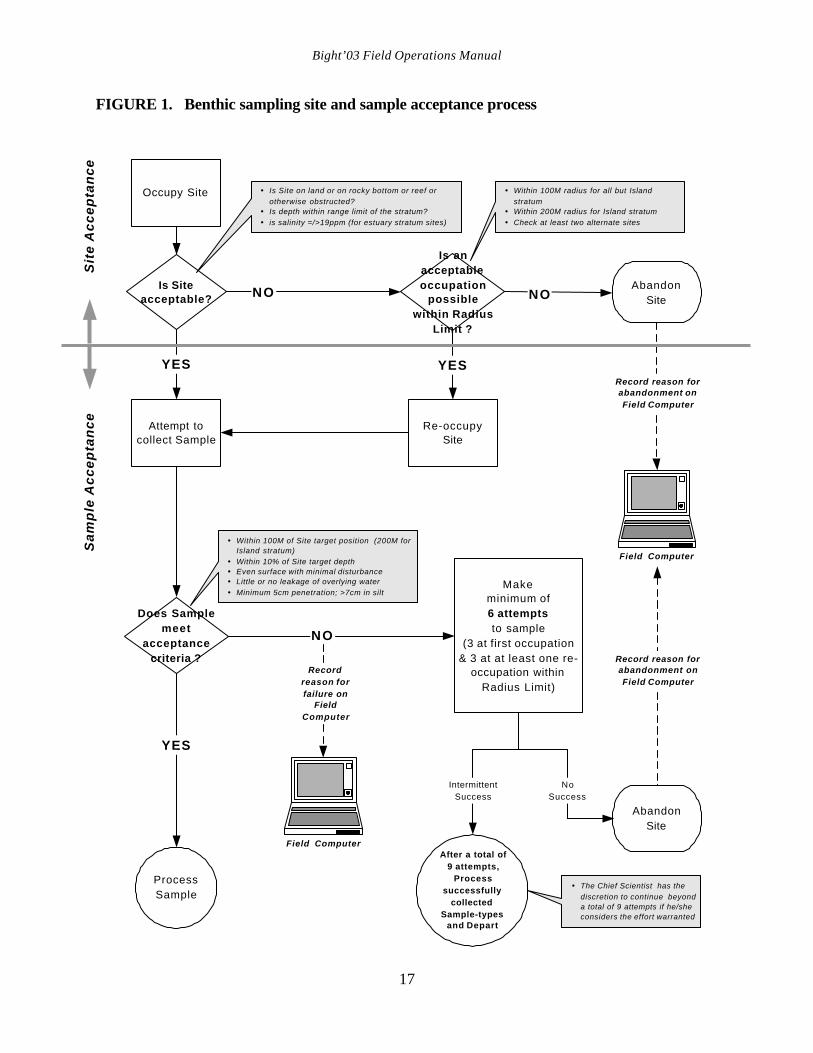
to meet sample acceptance criteria. The criteria and process guiding this assessment are described below and summarized as a decision tree in Figure 1 (benthic sites) and Figure 2 (trawl sites).
1. Occupy the target coordinates as closely as possible. 2. If occupation is not possible within the radius limit due to physical obstructions
(e.g., harbor facilities), or access prohibitions (e.g., harbor security closures), or if the site target coordinates fall on land, or if the salinity is < 19 ppt (at estuary stratum sites), abandon the site and record the reason for abandonment in the field computer or on a field data sheet.
3. For benthic sites, if occupation is possible but target coordinates lie over bottom
that cannot be sampled (e.g., rocky reef or within kelp bed, outside depth limits of stratum, etc.) as determined by visual observation and fathometer survey, attempt to find an acceptable occupation within the radius limits. Check at least two sites. If an acceptable occupation is not possible, abandon site, recording the reason for abandonment in field computer or on field data sheet.
4 For trawl sites, a pre-trawl survey using a fathometer should be conducted to
determine if a trawlable track of approximately 600 m passes the target site within the radius limits. If that survey identifies unsuitable substrate or if the site is deemed otherwise unsuitable for trawling by the Cruise Leader the site should be abandoned.
5. If an acceptable occupation is possible, proceed with sampling. 6. Sample acceptance criteria are described for benthic sampling in Section 8 and for
trawling in Section 9 and are summarized in the decision tree Figures 1 and 2. E. Site Rejection Strategy A sampling site may be rejected if any of the following occurs:
1. If the location places the site on land or in an obviously unsuitable location. 2. If the site exceeds the depth boundaries (+/- 10 %) established depth boundary and
within 1 m in estuaries. 3. For benthic sites, if sampling looks possible, but suitable substrate cannot be found
after three consecutive unsuccessful grab attempts at the nominal location, and after another three consecutive unsuccessful attempts at second location, the station will be abandoned completely. Adequately record the reason(s) for abandonment in the field computer, or on the field data sheet.
4. For trawl sites, if the fathometer survey identifies unsuitable substrate at three

Bight’03 Field Operations Manual
16
locations within the radius limit, if any equipment is lost or damaged, or if the site is deemed unsuitable by the Cruise Leader, the site will bandoned completely. Adequately record the reason(s) for abandonment in the field computer, or on the field data sheet.
Bight’03 Field Operations Manual
17
FIGURE 1. Benthic sampling site and sample acceptance process
Occupy Site
Is Siteacceptable?
Is anacceptableoccupation
possiblewithin Radius
Limit ?
Does Samplemeet
acceptancecriteria ?
Attempt tocollect Sample
Re-occupySite
YES
NO
Record reason forabandonment onField Computer
YES
NO
YES
AbandonSite
AbandonSite
NO
ProcessSample
Recordreason forfailure on
FieldComputer
� Is Site on land or on rocky bottom or reef orotherwise obstructed?
� Is depth within range limit of the stratum?� is salinity =/>19ppm (for estuary stratum sites)
� Within 100M of Site target position (200M forIsland stratum)
� Within 10% of Site target depth� Even surface with minimal disturbance� Little or no leakage of overlying water� Minimum 5cm penetration; >7cm in silt
� Within 100M radius for all but Islandstratum
� Within 200M radius for Island stratum� Check at least two alternate sites
Sit
e A
cc
ep
tan
ce
Sa
mp
le A
cc
ep
tan
ce
Field Computer
Makeminimum of6 attemptsto sample
(3 at first occupation& 3 at at least one re-
occupation withinRadius Limit)
NoSuccess
IntermittentSuccess
After a total of 9 attempts,
Processsuccessfully
collectedSample-types
and Depart
� The Chief Scientist has thediscretion to continue beyonda total of 9 attempts if he/sheconsiders the effort warranted
Field Computer
Record reason forabandonment onField Computer

Bight’03 Field Operations Manual
18
FIGURE 2. Trawl sampling site and sample acceptance process
Occupy site
Is siteacceptable?
Does Trawlmeet
acceptancecriteria ?
Attempttrawl
Repeat Trawl
NO
Record reason forabandonment onField Computer
NO
YES
AbandonSite
ProcessSample
Record reasonfor failure on
Field Computer
� Is site on land or on rocky bottom or reef orotherwise obstructed?
� Does pre-trawl survey indicate bottom is safeto trawl?
� Is depth within range limit of the stratum?
� Track passes within 100M of Site targetposition (200M for Island stratum)
� Within 10% of Site target depth� Net not fouled� Evidence that net was on bottom (catch in net)� Scope, speed & duration within limits
GearDamaged ?
AbandonSite
NO
YES
Recordreason for
abandonmenton
FieldComputer
Re-occupySite
YES
Is anacceptableoccupation
possiblewithin Radius
Limits ?
� Within 100M radius for all but Island stratum� Within 200M radius for Island stratum� Check at least two alternate sites
Field Computer
YES
Tra
wl
Ac
ce
pta
nc
eS
ite
Ac
ce
pta
nc
e
NO
Field Computer
Trawl Duration Limits
Depth =/<300M� Duration of 10 mins (+/- 1 min) measured from Lock down of winch to Start
of retrieval (in Bays and Harbors, 5 mins is accepatable if 10 mins notpossible due to obstruction)
Depth >300M� Examine LOTEK record immediately upon retrieval of net to determine
actual bottom time.
� If actual bottom time <8 mins or >15 mins, repeat trawl adjusting duration(Lock down of winch to Start of retrieval) to achieve an actual bottom timebetween 8 and 15 mins.
� If the out-of-limit trawl contains demersal fish and/or invertebrates, processcatch following standard procedures while re-trawling site.
Bight’03 Field Operations Manual
19
VIII. BENTHIC SAMPLING A. Sampling Effort A total of 330 benthic stations will be sampled during the survey. Table 1 and Appendices 1 and 2 provide information on the total number of stations and the parameters that will be sampled by each participating organization. B. Van Veen Grab A 0.1 m2 modified Van Veen grab will be used to collect sediment samples for physical, chemical, and infaunal analyses (Stubbs et al. 1987). This device is manufactured by Kahl Scientific Instrument Corporation, PO Box 1166, El Cajon, California 92022-1166 (619/444-2158) [email protected]. The grab may be galvanized, stainless steel, or Teflon-coated. All surfaces of the grab must be clean and free of rust. Either single or tandem Van Veen grabs are acceptable. C. Grab Sampling Procedures Prior to deployment, the grab is cocked with the safety key in place. The grab is then hoisted over the side, the safety key is removed. The grab is lowered at up to 2 m/sec until it is approximately 5 m above the bottom, then lowered at 1 m/sec to minimize the effects of bow wave disturbance of the surface sediment. In water depths greater than 300 m, the rate of deployment may have to be reduced to <1 m/sec in order to avoid “kiting” of the grab and/or premature tripping in the water column. After bottom contact has been made (indicated by slack in the winch wire), the tension on the wire is slowly increased, causing the lever arms to close the grab. Once the grab is back on board, the top doors are opened for inspection. While a radius limit of 100 m (200 m for island stratum) has been established for site occupancy, once sampling has begun, the Cruise Leader will ensure that the vessel is maintained on station with as much precision as conditions allow. Because analytical results from separate grab samples will be used to characterize the benthic community biointegrity, contaminant load and, in many cases, toxicity of the sediment, each successive grab must be collected as close as possible to the others. D. Priority of Grab Sampling The priority of sampling at a site is 1) infauna, 2) sediment chemistry and grain size, and 3) sediment toxicity. If it is impossible to obtain all three sample types at a station, those samples successfully collected shall be processed and retained. Only those samples meeting the sample acceptance criteria and sample volume requirements (for sediment chemistry and toxicity) are considered to be successfully sampled.
Bight’03 Field Operations Manual
20
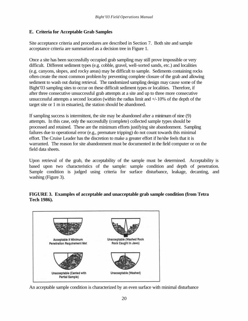
E. Criteria for Acceptable Grab Samples Site acceptance criteria and procedures are described in Section 7. Both site and sample acceptance criteria are summarized as a decision tree in Figure 1. Once a site has been successfully occupied grab sampling may still prove impossible or very difficult. Different sediment types (e.g. cobble, gravel, well-sorted sands, etc.) and localities (e.g. canyons, slopes, and rocky areas) may be difficult to sample. Sediments containing rocks often create the most common problem by preventing complete closure of the grab and allowing sediment to wash out during retrieval. The randomized sampling design may cause some of the Bight’03 sampling sites to occur on these difficult sediment types or localities. Therefore, if after three consecutive unsuccessful grab attempts at a site and up to three more consecutive unsuccessful attempts a second location (within the radius limit and +/-10% of the depth of the target site or 1 m in estuaries), the station should be abandoned. If sampling success is intermittent, the site may be abandoned after a minimum of nine (9) attempts. In this case, only the successfully (complete) collected sample types should be processed and retained. These are the minimum efforts justifying site abandonment. Sampling failures due to operational error (e.g., premature tripping) do not count towards this minimal effort. The Cruise Leader has the discretion to make a greater effort if he/she feels that it is warranted. The reason for site abandonment must be documented in the field computer or on the field data sheets. Upon retrieval of the grab, the acceptability of the sample must be determined. Acceptability is based upon two characteristics of the sample: sample condition and depth of penetration. Sample condition is judged using criteria for surface disturbance, leakage, decanting, and washing (Figure 3). FIGURE 3. Examples of acceptable and unacceptable grab sample condition (from Tetra Tech 1986).
An acceptable sample condition is characterized by an even surface with minimal disturbance
Bight’03 Field Operations Manual
21
and little or no leakage of the overlying water. Heavily canted samples are unacceptable. Samples with a large amount of "humping" along the midline of the grab, which indicates washing of the sample during retrieval, are also unacceptable. While some humping will be evident in samples taken from firm sediment where penetration has been poor, this is can be due to the closing action of the grab and is not necessarily evidence of unacceptable washing. If the sample condition is acceptable, the overlying water is drained off and the depth of penetration determined by insertion of a plastic (rather than metal) ruler vertically along the grab midline and measuring to the nearest 0.5 cm. Sediment penetration depth must be at least 5 cm: however, penetration depths of 7-10+ cm should be obtained in silt (fine sand to clay). In habitats where sediments are unusually soft (e.g., some estuary muds), it may be necessary to remove the lead weights to prevent over-topping the grab. Extra caution should be taken to drain the overlying water from the grabs for chemistry and toxicity samples. It is recommended that a siphon be employed for these grabs to avoid disturbance and loss of the surface sediments. The overlying water in grabs intended for infaunal samples may be drained by slightly opening the jaws of the grab and allowing the water to run off, as long as all drained water is captured for screening with the sediments (see Sample Processing below). If both sample condition and penetration are acceptable in the first grab, sampling at the station will proceed with the collection of chemistry and then sediment toxicity samples from successive grabs. It is required that all of the grabs taken at a station be of similar sediment type and depth penetration. F. Benthic Sampling Event Data The Cruise Leader is responsible for collecting all of the required information associated with each station occupation and each grab sampling event. A software application has been developed to facilitate the capture and entry of these data (Section 6). Alternatively, paper data forms may be used (Appendix 6). The required station occupation information includes: • Station ID • Date • Time of day • Agency code • Vessel name • System used for Navigation • Weather and sea conditions • Salinity (at sites in the Estuary stratum) • Station fail code (if site is abandoned) The required grab event information includes: • Time of day for event (when grab on bottom) • Latitude and Longitude at time of event (when grab on bottom) • Depth of water (when grab on bottom)
Bight’03 Field Operations Manual
22
• Distance from station target location (when grab on bottom) • Fail code (if sample fails to meet sample acceptance criteria, see Field Sheets or Information
Management Plan for codes) • Penetration • Sediment composition (type) • Sediment odor • Sediment color • Presence of shell hash • Sample types produced from sediment grab G. Sediment Description The field description of sediments is required following measurement of penetration depth. The sediment should be characterized as being coarse sand, fine sand, silt or clay, gravel, or of a mixed type. The presence of petroleum tar and shell hash should also be recorded. Obvious odors, such as hydrogen sulfide (the odor of rotten eggs), petroleum, other odors, or a lack of noticeable odors should be recorded. General sediment colors (i.e., black, green, brown, red, olive, or gray) should also be recorded. H. Sample Processing Benthic Infaunal Samples After the sample description has been completed, the sediment sample intended for biological analysis is washed from the grab and screened. Raw water used to wash the samples is to be filtered in some fashion to prevent the accidental introduction of surface-water organisms. Thoroughly wash the sediment from the grab and transfer it to a sediment-washing table for screening. In the estuary stratum, the necessity of sampling from small craft may not permit onboard screening of the sediment. In these cases the samples may be screened and processed on land at a screening station temporarily established near the sampling location. To assure that the sample does not deteriorate, such “off-site” screening must be completed as soon as possible and no longer than 90 minutes after sample collection. A means of capturing all water drained from the grab, the grab sample, and the wash water must be used. Typically, a tub (>70 L capacity) is positioned under the grab. The use of a sediment-washing table is recommended, but not required. The table is useful in that provides a flat, smooth surface over which to spread and wash the sample, thereby providing a means of gently breaking up the sediment before it runs off the end of the table into the screen box. The screening box must be equipped with a stainless steel mesh with 1.0-mm openings. Wire diameter should be similar to that found in the U.S. Standard 1.00 mm Sieve (i.e., 0.58 mm). The surface area of the screen should be adequate to easily accept the sample without build up. Typical surface areas used in surveys in the Bight are 1500 to 2100 cm2. While washing the sample, control the water pressure to avoid damaging the organisms. Minimize direct application of water from the hose to the material and organisms collecting on the screen.
Bight’03 Field Operations Manual
23
Once the sample has been washed through the screen, transfer the material (debris, coarse sediment, and organisms) retained on the screen to a sample container. Label the sample container with an external label containing the sampling agency name, station name, sample type, date, and "split number" (i.e. 1 of 1, 2 of 3, etc.) if required. An internal label bearing the same information is placed inside the infaunal samples. This label can be written in pencil or indelible ink on 100% rag paper, poly-paper, or other paper of a quality suitable for wet labels. The sample container must have a screw-cap closure and be sufficiently large to accommodate the sample material with a head-space of at least 30% of the container volume. A sample may be split between two or more containers. However, each container must have external and internal labels (as described above) with the appropriate "split number" clearly marked. Field crews should have a broad range of sample container sizes available to them, with none less than 16 oz (0.47 L) capacity. Gently remove the material retained on the screen, taking care to avoid damaging the organisms. The sample container should be filled to approximately 50 to 70% of capacity with screened material. After the bulk of material has been transferred to the container, closely examine the screen for any organisms caught in the mesh. Remove any organisms with forceps and add them to the sample container. Thoroughly wash the screen box and scrub the mesh before the next sample is screened. All infaunal samples will be treated with a relaxant solution for approximately 30 minutes prior to fixation. Either an Epsom salts (MgSO4) solution or a propylene phenoxytol solution (formulations below) may be used for this purpose. Relaxant solutions may be used as the diluent water for the fixative, or may be decanted after exposure and replaced with diluted fixative. If it is used as diluent water, fill the sample container to 85 to 90% of its volume, close the container and invert it several times to distribute the solution. Leave the sample in the relaxant for 30 minutes. After 30 minutes, top off the container with enough sodium borate buffered formaldehyde to achieve a 10% formalin solution. Close the container, once again, and invert it several times to assure mixing. Store the sample for return to the laboratory. If the relaxant solution is not used as the diluent water, the relaxant must be removed from the sample container and replaced with 10% buffered formalin. After the 30 minutes of treatment, decant the relaxant from the sample through a screen with a mesh size of 1.0 mm or less. Insure that all animals are removed from the screen and placed in the sample container. Fill the container with sodium borate buffered 10% formalin rather than undiluted formaldehyde, then close the container, invert it several times and store it for return to the laboratory. Relaxant and fixative stock solution alternatives are as follows:
1) Epsom salts relaxant solution: 1.5 kg Epsom salts (MgSO4 @ 7H2O) per 20 L of freshwater.
2) Propylene phenoxytol solution: 30 ml propylene phenoxytol to 20 L of
seawater.
3) Buffered formalin solution: 50 g sodium borate (Na2B4O7) per liter of
Bight’03 Field Operations Manual
24
formalin. 4) Buffered 10% formalin solution: 1 part buffered formalin to 9 parts fresh or
salt water. At the end of the sampling day the samples will be returned to the laboratory and stored in fixative for no less than 72 hours. Within two weeks of collection they will then be washed and transferred to preservative according to the procedures described in section 1 of the Bight’03 Macrobenthic (Infaunal) Sample Analysis Laboratory Manual (2003). If the samples will be analyzed by other laboratories, they will be transported (in preservative) to SCCWRP for later distribution. It is recommended that SCCWRP (Darrin Greenstein, 714/372-9224) be contacted prior to delivery of samples so that arrangements can be made to transfer custody. A completed chain of custody form must accompany all shipments of samples (Appendix 6). Allow time for verification of the chain of custody. Sediment Chemistry Samples Following collection of benthic infauna, the next grab(s) will be taken for sediment chemistry samples. More than one grab may be necessary to meet the sample volume requirements of this sample type. If a second grab is necessary, the sediment from each grab will be distributed evenly among the individual sample containers. Sediment samples will be collected by randomly sub-sampling the top 2 cm of the undisturbed surface material with a stainless steel scoop (a plastic scoop is acceptable for TOC and grain size samples). At the very minimum, scoops will be washed with soap and water and rinsed with de-ionized (DI) water between stations. Use of a new scoop with each sample is also acceptable. Sediment in contact with or within 1 cm of the metal sides of the grab will be avoided to prevent sample contamination. The target volume for the sediment chemistry samples is 100 grams for grain size and 200 grams for the other three analytes. The goal is to collect enough sediment at each site to satisfy the target volumes for these samples. If conditions are particularly difficult at any sampling site and nine grabs have been attempted with only intermittent success, the minimum acceptable volume for the sediment chemistry samples is 100 grams. If less than 100 grams has been collected for any of the analytes, the samples will be discarded and the reasons for incomplete sampling at the site will be recorded. The following container types, samples sizes, and storage requirements will be used with the analytical laboratory supplying all sample containers for all parameters:
1) Sediment Grain Size – Using a stainless steel or plastic scoop, approximately 100 g of sediment material will be collected at each station. The sample shall be placed in a 4-oz (118 mL) whirlpak, plastic, or glass container, taking care to leave an air space at the top. Samples should be stored at approximately 4o C by placing them on wet ice or in a refrigerator until returned to the laboratory. Do not freeze these samples. They should be returned to the analytical laboratory within a week of sampling.

Bight’03 Field Operations Manual
25
2) Total Organic Carbon -- Using a stainless steel scoop, approximately
200 g of sediment material will be collected at each station. The sample shall be placed in an 8-oz (~250 mL) glass container, with a Teflon-lined lid filling the container 80% full, taking care to leave an air space at the top. A minimum of 100 g is acceptable but only if sampling cannot otherwise be completed at site.
Samples should be stored at <4° C by placing them on wet ice or in a refrigerator, but must be frozen within 24 hours. If frozen, they should be returned to the laboratory within a week; if not, they should be returned to the analytical laboratory within 24 hours.
3) Trace Metals -- Using a plastic or stainless steel scoop, approximately 200 g of
sediment material will be collected at each station. The sample shall be placed in a 8-oz (~250 mL) plastic or glass container, with a Teflon-lined lid filling the container 80% full, taking care to leave an air space at the top. A minimum of 100 g is acceptable but only if sampling cannot otherwise be completed at site.
Samples should be stored at <4° C by placing them on wet ice or in a refrigerator but must be frozen within 24 hours. If frozen, they should be returned to the laboratory within a week; if not, they should be returned to the analytical laboratory within 24 hours.
4) Trace Organics -- Using a stainless steel scoop, approximately 200 g of
sediment material will be collected at each station. The sample shall be placed in a 8-oz (~250 mL) glass container, with a Teflon-lined lid filling the container 80% full, taking care to leave an air space at the top. A minimum of 100 g is acceptable but only if sampling cannot otherwise be completed at site.
Samples should be stored at <4° C by placing them on wet ice or in a refrigerator but must be frozen within 24 hours. If frozen, they should be returned to the laboratory within a week. If not frozen, they should be returned to the analytical laboratory within 24 hours.
If any samples need to be transported to another organization for processing, they should be packed in dry ice and shipped to SCCWRP via overnight express, or a local carrier. Labeling of sample containers will be the responsibility of the field sampling crew. The following minimum information will be required on each sample label: 1) sampling agency name; 2) station number; 3) sampling date; and 4) parameter.
Samples that will be analyzed by the organization conducting the field collection will be returned to their laboratory by the field crew. Samples to be analyzed by other laboratories will be transported to SCCWRP for later distribution. It is recommended that SCCWRP (Darrin Greenstein, 714/372-9224) be contacted prior to delivery of samples so that arrangements can be made to transfer custody (Appendix 6). A completed chain of custody form must accompany
Bight’03 Field Operations Manual
26
all shipments of samples. Allow time for verification of the chain of custody. Sediment Toxicity Samples Following the collection of sediment chemistry samples, grabs will be taken for sediment toxicity analysis. More than one grab may be necessary to meet the sample volume requirements of this sample type. If a second grab is necessary, the sediment from each grab will be distributed evenly among the individual sample containers. Sediments will not be homogenized in the field.
Sediment samples will be collected by randomly sub-sampling the top 2 cm of the undisturbed surface material with a plastic scoop. At the very minimum, the scoop will be washed with soap and water and rinsed with de-ionized (DI) water between stations. Use of a new scoop with each sample is also acceptable. Sediment within 1 cm of the metal sides of the grab will be avoided to prevent sample contamination. High-density polyethylene (HDPE) containers will be used for collection of sediment toxicity samples. The toxicity laboratories performing the required analysis will provide sample containers.
Sample volume requirements for sediment toxicity samples are:
• 2.5 liters of sediment is the target volume at stations where sediment collection is not problematic. However, if after nine grab attempts at a site yielding intermittent success insufficient sample volume is available, 1.0 liter of sediment will satisfy the minimum sampling requirement. Sample volumes less than 1.0 L will be considered unacceptable, the sample will be discarded and the reason for incomplete sampling at the site will be recorded. The 2.5 L of sediment will be distributed among three high-density polyethylene (HDPE) containers with Teflon-lined lids. Each labeled container should then be refrigerated, or placed on wet ice. Do not freeze these samples. Samples may be held in the field, or laboratory, on wet ice, or in a refrigerator at 4o C, for no more than three days before transport to the laboratory or SCCWRP. The transport time will not exceed 24 hours and storage temperature will not exceed 4o C.
Labeling of sample containers will be the responsibility of the field sampling crews with the following minimum information required on each sample label: 1) station number; 2) sampling date; 3) parameter; and 4) split (if required). If the samples will be analyzed by other laboratories, they will be transported to SCCWRP for later distribution. It is recommended that SCCWRP (Darrin Greenstein, 714/372-9224) be contacted prior to delivery of samples so that arrangements can be made to transfer custody. A completed chain of custody form must accompany all shipments of samples (Appendix 6). Allow time for verification of the chain of custody. .
Bight’03 Field Operations Manual
27
IX. TRAWL SAMPLING A. Purpose The purpose of trawl sampling is to obtain data on the abundance, biomass, diversity, and disease prevalence of demersal fish and invertebrate assemblages. It is also used to collect fish and invertebrates for tissue contaminant analysis. This information is useful in characterizing possible anthropogenic effects on demersal fish and invertebrate populations. Mearns and Allen (1978) provide a comprehensive description of how small otter trawls should be designed and used for conducting biological surveys in coastal waters. B. Sampling Effort A total of 268 trawl stations will be sampled during the survey. Information regarding trawl stations and the corresponding parameters that will be sampled by each organization at each of these sites are listed in Table 1 and Appendix 1. C. Collection Permits Prior to collecting fish and invertebrate specimens in the field, each organization must contact their local office of the California Department of Fish and Game (CDFG). The caller will be asked for his or her name, scientific collector's permit number, date, time, and area of sampling, type of gear to be used, vessel size, color, CF number (or documentation), number of persons in party, and organisms targeted for collection. This information can also be faxed to the local CDFG office prior to sampling. Both the permit and the permit holder must be onboard during sampling and it must be presented to any CDFG warden, or personnel who request to see it. The phone//FAX numbers of the local offices of the CDFG are as follows: San Diego, (858) 467-4201/(858) 467-4299; Los Alamitos, (562) 342-7108/(562) 342-7139. D. Otter-Trawl Specification A semiballoon otter trawl (Figure 4) will be used to collect epibenthic invertebrates and demersal fish. Net dimensions are as follows: 7.6-m headrope (25 ft); 8.8-m footrope (29 ft); 3.8-cm (1.5 in) body mesh; and a 1.3-cm cod-end mesh (0.5 in). This net will have 22.9-m (75 ft) long bridles made of 1.0-1.6 cm (3/8 to 5/8 in) diameter rope (e.g., Samson braid). Typical otter boards (doors) will have a width of 76 cm (30 in), height of 50 cm (20 in), and a suggested weight of 16 kg (35 lb) (Figure 5). Slight deviations (< 10%) from the dimensions are acceptable. The door chains should be 5-mm (3/16 in) in diameter and should have the following numbers of links: front top -- 12; front bottom -- 11; back top -- 17; back bottom -- 16. The actual specifications of how any trawl door is set up may depend on the manufacturer of the otter trawl, but the user of the equipment should be sure to follow the factory recommended set-up procedures to ensure that the net fishes appropriately in the field. The Bight'03 survey will require two additions to the trawl specifications: 1) Non-crushable floats are required for any nets used to trawl deeper than 300 m; and 2) Lotek archival tags will
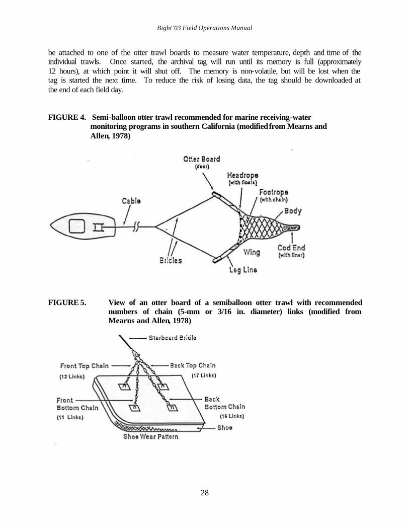
Bight’03 Field Operations Manual
28
be attached to one of the otter trawl boards to measure water temperature, depth and time of the individual trawls. Once started, the archival tag will run until its memory is full (approximately 12 hours), at which point it will shut off. The memory is non-volatile, but will be lost when the tag is started the next time. To reduce the risk of losing data, the tag should be downloaded at the end of each field day. FIGURE 4. Semi-balloon otter trawl recommended for marine receiving-water
monitoring programs in southern California (modified from Mearns and Allen, 1978)
FIGURE 5. View of an otter board of a semiballoon otter trawl with recommended numbers of chain (5-mm or 3/16 in. diameter) links (modified from Mearns and Allen, 1978)
Bight’03 Field Operations Manual
29
E. Trawl Data Flow and Responsibilities Unlike benthic infauna and sediment chemistry, the collection of trawl data (identifications, measurements, etc.) is largely a field activity for which there is little opportunity to clarify or correct errors. Therefore, it is important that the field personnel appreciate the ultimate fate of the data records they are creating and assure that their field records support subsequent steps in the data creation process. For example, specimens collected as vouchers or as FID specimens must be labeled under the same name as recorded on the field data sheet. This allows these specimens to be unambiguously associated with the data records for purposes of data QC or revision.
In addition, each organization conducting trawling must complete all stages of sample analysis (lab Ids, voucher confirmation, data sheet revisions, etc.) prior to submitting data and voucher specimens to the project for further review. The flow of data from the trawl to final data set and the parties responsible for completion of each stage is summarized in Figure 6.

Bight’03 Field Operations Manual
30
Figure 6. Trawl data flow and responsibilities
Fish &Invert
CommunityTrawl
Field DataSheet
VoucherSpecimenCollection
FIDSpecimenCollection
notecollection ondata sheet
notecollection ondata sheet
SubmitVouchers
forVerification
Perform LabIDs of FIDspecimens
Field QCchecks
Field DataSheet
(Revised)
VoucherVerification
Enter Data
Submit Data file &Final Revised Field Data Sheets
to IMO(Keep copies of Field Data
sheets)
IMO Format& RangeChecks
Tech.CommitteeSynoptic
Data Review
IMO FinalData Edit
Indiv Orgsinformed of changes
DATA SETFINALIZED
INDIVIDUALORGANIZATION RESPONSIBILITIES
BIGHT'03GROUP RESPONSIBILITIES
FIELDACTIVITIES
"LAB"ACTIVITIES
Correct Data& resubmitas needed
Correct FieldData sheetas needed
Correct FieldData sheetas needed
ConfirmVoucher IDs
Correct FieldData sheetas needed
FinalField Data
Sheet(Revised)
ProblemResolution
mayinvolvereviewof datasheets
orspecimen vouchers
Bight’03 Field Operations Manual
31
F. Trawl Sampling Event Data The Cruise Leader is responsible for collecting all of the required information associated with each station occupation and each trawl sampling event. A software application has been developed to facilitate the capture and entry of these data (Section 6). Alternatively, paper data forms may be used (Appendix 6). The required station occupation information includes: • Station ID • Date • Time of day • Agency code • Vessel name • System used for Navigation • Weather and sea conditions • Station fail code (if site is abandoned) The required trawl event information includes: • Time of day at for marks during event (net over, start trawl, end trawl, on deck) • Latitude and longitude at each time-marks during event • Depth of water at Start Trawl and End Trawl time-marks • Distance from station target at closest point of passage • Fail code (if sample fails to meet sample acceptance criteria, see Field Sheets or Information
Management Plan for codes) • Wire Length • Whether Lotek Information was Collected • Type of Trawl (community or tissue) G. Net Preparation The trawl components should be properly prepared prior to trawling so that the trawl can be deployed in an orderly and safe manner upon arrival at a station. The net should be laid out and stacked on the stern of the vessel in the same configuration that it will be deployed: cod-end to the stern, floats up, and foot rope down. The trawl net should be checked to make sure that the cod-end is tied correctly, the doors should be connected properly to the leg lines, and the bridles should be securely fastened to the doors and to the tow wire. H. Station Occupation Every effort should be taken to ensure that any particular trawl track passes the station coordinates at a distance of no greater than 100 m (200 m for Island stratum), and that the trawl course varies no more than +/- 10% of the target depth (Figure 2). The trawl track can be plotted prior to sampling so that a successive series of waypoint locations along the track can be obtained. These coordinates can then be entered into the DGPS and then retrieved at the time of sampling to ensure that the vessel maintains its course along the trawl track.
Bight’03 Field Operations Manual
32
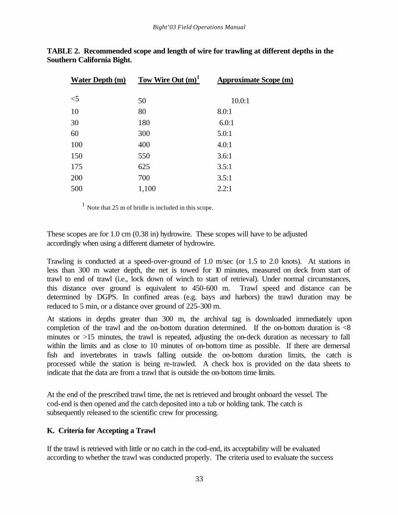
I. Pre-Trawl Survey Prior to trawling at a new station, it is important to conduct a pre-trawl survey of the trawl course. Trawl gear is likely to be lost if it becomes snagged on bottom obstructions and replacement of nets can be costly. The trawl course at a previously unsampled station should be evaluated by use of a fathometer. This pre-trawl survey can enable the navigator to avoid uncharted reefs and other obstacles. If obstacles are encountered, resurvey a new trawl course. The Cruise Leader alone has the authority to decide whether to trawl or abandon an unknown station. This survey should always be conducted at a new sampling site to determine whether the station is acceptable or if it should be abandoned. The pre-trawl survey should follow the expected trawl course along the isobath and the fathometer will be examined for evidence rocks and other obstacles. If the first run indicates that a particular site is unacceptable, another survey will be conducted within 100 m or the original location and within +/-10% of the original depth. If this attempt is unsuccessful, a third attempt will be conducted at a different location using the same protocols (100 m of the original location, and +/-10% of original depth). The site will be abandoned after three unsuccessful attempts (Figure 2). J. Trawling Trawls will be towed along, rather than across, isobaths. While the vessel is underway the net and doors are placed in the water. It is important that the floats skim the surface and that the net is not entangled (e.g., crossed leg lines, bunched or hooked portions of the net) prior to paying out the bridles. This small step could mean the difference between a successful or unsuccessful trawl. The bridles should be paid out by personnel on either side of the net, so as to avoid becoming entangled in the rigging during deployment. Use of the proper scope (i.e., length of hydrowire paid out versus the water depth) is important for successful trawls. After the net touches the bottom, a sufficient length of hydrowire (towing wire) should be paid out to ensure that the net is pulled from a horizontal rather than a vertical position. Insufficient scope will prevent the net from consistently fishing the bottom and will result in a no-catch, or a short-catch situation. In general, the required scope declines with increasing depth because the additional weight of the hydrowire enhances the horizontal component of the towing forces (Table 2).
Bight’03 Field Operations Manual
33
TABLE 2. Recommended scope and length of wire for trawling at different depths in the Southern California Bight.
Water Depth (m)
Tow Wire Out (m)1
Approximate Scope (m)
<5
50
10.0:1
10
80
8.0:1
30
180
6.0:1
60
300
5.0:1
100
400
4.0:1
150
550
3.6:1
175
625
3.5:1
200
700
3.5:1
500
1,100
2.2:1
1 Note that 25 m of bridle is included in this scope. These scopes are for 1.0 cm (0.38 in) hydrowire. These scopes will have to be adjusted accordingly when using a different diameter of hydrowire. Trawling is conducted at a speed-over-ground of 1.0 m/sec (or 1.5 to 2.0 knots). At stations in less than 300 m water depth, the net is towed for 10 minutes, measured on deck from start of trawl to end of trawl (i.e., lock down of winch to start of retrieval). Under normal circumstances, this distance over ground is equivalent to 450-600 m. Trawl speed and distance can be determined by DGPS. In confined areas (e.g. bays and harbors) the trawl duration may be reduced to 5 min, or a distance over ground of 225-300 m.
At stations in depths greater than 300 m, the archival tag is downloaded immediately upon completion of the trawl and the on-bottom duration determined. If the on-bottom duration is <8 minutes or >15 minutes, the trawl is repeated, adjusting the on-deck duration as necessary to fall within the limits and as close to 10 minutes of on-bottom time as possible. If there are demersal fish and invertebrates in trawls falling outside the on-bottom duration limits, the catch is processed while the station is being re-trawled. A check box is provided on the data sheets to indicate that the data are from a trawl that is outside the on-bottom time limits.
At the end of the prescribed trawl time, the net is retrieved and brought onboard the vessel. The cod-end is then opened and the catch deposited into a tub or holding tank. The catch is subsequently released to the scientific crew for processing. K. Criteria for Accepting a Trawl If the trawl is retrieved with little or no catch in the cod-end, its acceptability will be evaluated according to whether the trawl was conducted properly. The criteria used to evaluate the success

Bight’03 Field Operations Manual
34
of any trawl include making sure that proper depth, scope, speed, and distance (or duration) were maintained, whether the net was fouled (net tangled), and whether the catch shows evidence that it was on the bottom (e.g., rocks, benthic invertebrates, benthic fish) (Figure 2). If any of trawl procedures were not followed, if the net was fouled or torn (the tear must be sufficient to allow escapement), or if there was no evidence of contact with the bottom (downloading the Lotek information can be useful), the trawl will be considered unacceptable and the site will be retrawled. When evaluating the situation to decide whether to abandon or retrawl a station, the Cruise Leader should keep in mind that the goal is to collect the best sample possible. If a retrieved net has been torn sufficiently to allow escapement during the course of a trawl, the station will be abandoned. If the trawl hangs up on the bottom, the site can be resampled or abandoned at the discretion of the Cruise Leader. If retrawling that station proves unsuccessful after another two attempts, the site will be abandoned (Figure 2). L. Sample Processing Sorting The trawl catch will be sorted on deck into containers. The catch should initially be rough sorted into major categories (e.g., urchins, shrimp, other invertebrates, flatfishes, rockfishes, other fishes). The categories used are not important, but it is more efficient to sort into rough categories before identifying organisms to species. Trawl debris should also be sorted into containers for processing. Trawl Debris Debris collected during any trawl should be quantified by recording the specific types of material and their quantities on the Trawl Debris Data Sheet (Appendix 6). Trawl debris volumes are quantified using the following categories: present (1); low (2-10); moderate (11-100); and high (>100). The approximate weight of each type should also be estimated using these categories: trace (<0.1 kg); low (approx. 0.1-1.0 kg); moderate (approx. 1.1-10.0 kg); and high (>10.0 kg). Identification The goal is to provide species-level identifications for all fish and invertebrates captured in the trawl. Most, if not all, of the trawl-caught organisms should be identifiable to species in the field using the recommended taxonomic keys and field guides. Species of fish and invertebrates that cannot be reliably identified to species in the field should be returned to the laboratory for further identification. In these instances, it is better that the field crew recognize their taxonomic limitations, record "FID" (further identification) on the field sheet and include descriptions of any attributes that may later aid in the identification of that specimen. Under no circumstances should an organism be discarded if the identity is in question. When the “FID” organisms have finally been identified, the correct identity of the species should be recorded on the original data sheet. If the laboratory identity differs from that recorded in the field, the original name should be crossed out with a single line only; do not erase the original
Bight’03 Field Operations Manual
35
name. If a specimen cannot be identified by the sampling organization, it will be sent to SCCWRP for further analysis. Although all fish collected during Bight’03 will be identified to the lowest possible taxon (either in the field or in the laboratory), only certain trawl-caught invertebrates meeting very specific criteria will need to be identified to that level. There are likely to be many small infaunal and pelagic species that will be taken incidental to the trawl catch. These need not be processed or documented. Only epibenthic invertebrate organisms greater than 1 cm in any dimension will be included in the data. Colonial and pelagic organisms will be noted, but do not need to be enumerated. The presence of obvious fish parasites, such as leeches or cymothoid isopods, should be noted. A recommended list of field guides and taxonomic aids for identifying fish and invertebrates will be distributed to all of the participating organizations prior to the survey. The most basic and comprehensive guides for fish are Miller and Lea (1972) and Eschmeyer et al. (1983). Allen (1977) provides information for identifying juvenile rockfishes (Sebastes spp.), while Orr et al. (2000) and Love et al. (2002) provide keys to larger rockfishes. Kramer et al. (1995) provides information for identifying flatfishes. Generally, there are no widely comprehensive guides to the epibenthic invertebrates. Either common or scientific names of fish may be used in the field, however, in the case of invertebrates, only scientific names are permissible. Use standard common and scientific names of fishes and scientific names of invertebrates given in a list of trawl-caught species of fishes and invertebrates in southern California that have been distributed to organizations prior to the survey. For species not in these lists, use only standard common and scientific names of fishes given in Robins et al. (1991), or scientific names of fishes from Eschmeyer (1998), and common names of invertebrates from SCAMIT (2001). For every species caught, each organization will provide at least one representative of that species to the Bight'03 voucher collection (see Voucher Collection) Each organization should have a kit containing a variety of tools which will aid in field identification. The kit should include forceps (small with sharp points and large with blunt points), a hand lens, dividers or calipers, dissecting needles, scalpels with scalpel blades, probes, and plastic rulers (marked in millimeters). Length Measurement All fish species will either be measured on measuring boards or, for very large specimens, by a meter stick or tape measure. A measuring board typically consists of either a flat or trough shaped board with a part of a meter stick running down the middle. A smaller board (cross board) is attached across the zero-end of the meter stick. Centimeter size-classes are marked along the side of the measuring board with the number of the size class marked next to the appropriate centimeter. When measuring a fish, the head should be pushed against the cross board at the zero-end of the
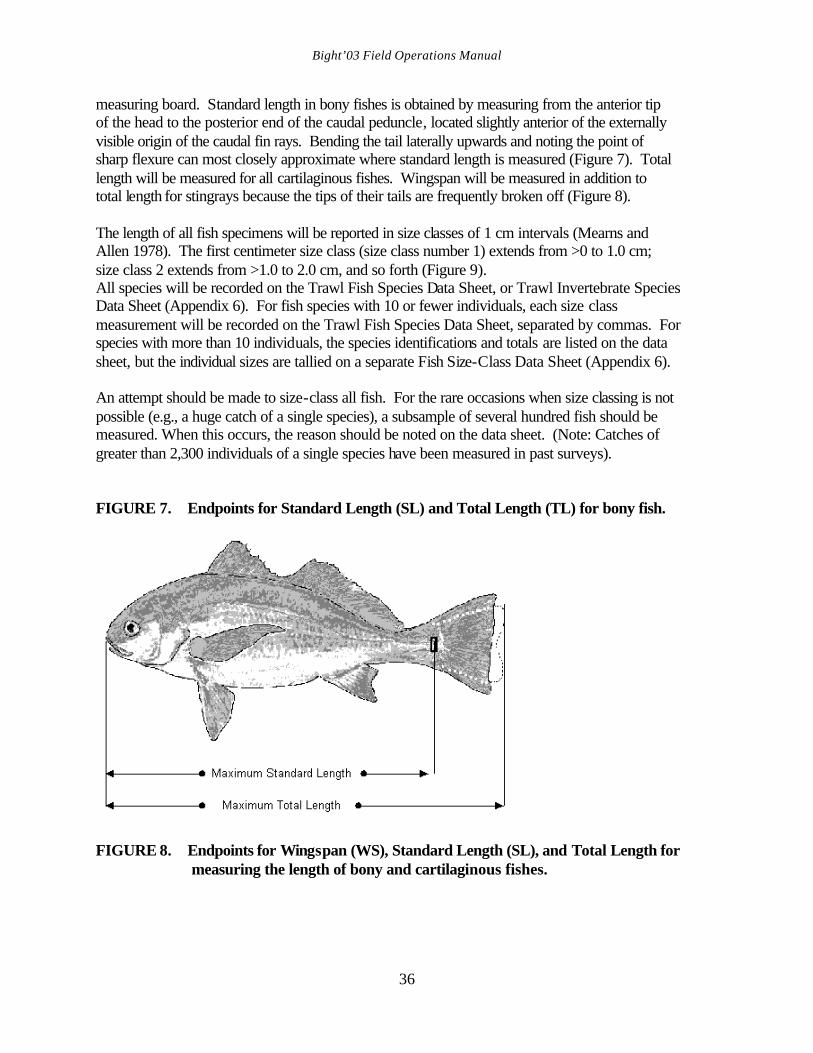
Bight’03 Field Operations Manual
36
measuring board. Standard length in bony fishes is obtained by measuring from the anterior tip of the head to the posterior end of the caudal peduncle, located slightly anterior of the externally visible origin of the caudal fin rays. Bending the tail laterally upwards and noting the point of sharp flexure can most closely approximate where standard length is measured (Figure 7). Total length will be measured for all cartilaginous fishes. Wingspan will be measured in addition to total length for stingrays because the tips of their tails are frequently broken off (Figure 8). The length of all fish specimens will be reported in size classes of 1 cm intervals (Mearns and Allen 1978). The first centimeter size class (size class number 1) extends from >0 to 1.0 cm; size class 2 extends from >1.0 to 2.0 cm, and so forth (Figure 9). All species will be recorded on the Trawl Fish Species Data Sheet, or Trawl Invertebrate Species Data Sheet (Appendix 6). For fish species with 10 or fewer individuals, each size class measurement will be recorded on the Trawl Fish Species Data Sheet, separated by commas. For species with more than 10 individuals, the species identifications and totals are listed on the data sheet, but the individual sizes are tallied on a separate Fish Size-Class Data Sheet (Appendix 6). An attempt should be made to size-class all fish. For the rare occasions when size classing is not possible (e.g., a huge catch of a single species), a subsample of several hundred fish should be measured. When this occurs, the reason should be noted on the data sheet. (Note: Catches of greater than 2,300 individuals of a single species have been measured in past surveys). FIGURE 7. Endpoints for Standard Length (SL) and Total Length (TL) for bony fish.
FIGURE 8. Endpoints for Wingspan (WS), Standard Length (SL), and Total Length for
measuring the length of bony and cartilaginous fishes.
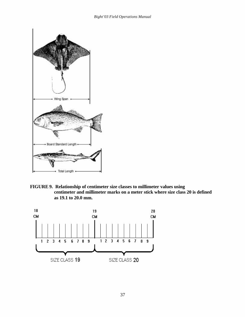
Bight’03 Field Operations Manual
37
FIGURE 9. Relationship of centimeter size classes to millimeter values using
centimeter and millimeter marks on a meter stick where size class 20 is defined as 19.1 to 20.0 mm.
Bight’03 Field Operations Manual
38
Weighing Weight data collected from fish and invertebrate species will be used to estimate the total biomass of the catch and for each species where practical. Each organization should have a range of spring scales that are capable of weighing to the nearest 0.1 kg. The scales should be calibrated at the start of each trawling day using a standard set of at least three weights. Weighing will be done using a pre-weighed tare bucket, or another suitable container (e.g., plastic net bags). If a tare bucket is used, the bottom should have many holes drilled through it to allow any excess liquid to drain off before the weight is recorded. Tare buckets should be washed periodically to remove the accumulated slime. The total biomass of each species will be measured with a spring scale. Species with a biomass greater than 0.1 kg will be recorded to the nearest 0.1 kg. The tare container weight will be subtracted from the gross weight (species plus tare container) to give the weight of the species (net weight). Tare and gross weight can be recorded on the data sheet but are not required. Small species weighing less than 0.1 kg will be recorded as <0.1 kg. These will be set aside and weighed together to provide a composite weight. Composite weights greater than 0.1 kg will be recorded to the nearest 0.1 kg. Composite weights of less than 0.1 kg will not be rounded; they are to be recorded as <0.1 kg. There will be one composite weight for fish and one composite weight for invertebrates. These weights will assist in calculating the total biomass of the catch. Large organisms may be weighed individually. Individual weights of smaller specimens may also be collected using a range of scales capable of weighing to the nearest 0.1 g. Enumeration Fish are enumerated while measuring them. The total number of each species (including size-classed species) should be recorded on not only the Fish Species Data Sheet, but also the Fish Size-Class Data Sheets for species represented by more than 10 individuals. Most invertebrates will be enumerated following identification. However, the number of individuals in particularly abundant species may be estimated from the total biomass of the species at a later time. First, the number of individuals that comprise a minimal weight can be used to provide a "number of individuals per kilogram" coefficient. The total biomass of a species divided by the number of individuals per kilogram yields the total number of individuals in the sample. The aliquot of specimens that will be used to determine weight for a species should be sufficiently large (e.g., several kilograms) so that it falls within the mid to upper range of the spring scale being used; this prevents the inherent inaccuracy of the spring scale at the low end from being multiplied throughout the entire biomass calculation. Examination for Gross Pathology During the identification and measurement procedures, fish and invertebrates will be examined for gross pathology. This entails a scan of an individual organism for anomalies and noting the type of pathology (by abbreviation) next to the length of organisms (for fish) during measurement on the appropriate data sheet. The following anomalies will be noted for fish:
Bight’03 Field Operations Manual
39
1) fin erosion 2) tail erosion 3) tumors 4) external parasites (e.g., copepods, isopods, leeches) 5) eye parasites (i.e. Phrixocephalus) 6) color anomalies (ambicoloration, albinism) (Mearns and Haaker 1973) 7) skeletal deformities (Valentine 1975) 8) lesions 9) other anomalies
An observation should be noted next to the individual length on the Fish Species Data Sheet and described in the comments section. For invertebrates, burnspots, parasites, and other anomalies will be noted in the comment section of the Trawl Invertebrate Species Sheet (Appendix 6). Fin erosion can be found on the dorsal, anal, and caudal fins of flatfishes, and on the lower caudal fin and pelvic fins of bilaterally symmetrical fishes. Tail erosion occurs on the top and bottom of the caudal fin or along the entire posterior caudal fin of bilaterally symmetrical fishes. Tumors can be smooth and rounded (angioepithelial nodules) or furrowed (epidermal papillomas). Externally obvious copepod parasites occur on the eye, fins, or body of fish. Cymothoid isopods occur in the gill cavities of fish or on the body; they often fall off. Leeches occur on the body of some flatfishes. Skeletal deformities include crooked backs, snub noses, or bent fin rays. Lesions include sores that do not appear to be caused by net damage. Burnspot disease is found on crabs and some shrimps; its lesions resemble cigarette burns. Parasites of invertebrates include bopyrid isopod parasites of shrimp. Representatives of fish and invertebrates exhibiting each new instance of disease or which have a different parasite should be returned to the laboratory and vouchered. Processing Stage Monitoring Accidental omissions can occasionally be made if a bucket of organisms is not processed. This can be avoided by attaching a colored rubber tag (made of a square with a slit in one side) to the handle of each bucket to indicate a particular stage of processing. For instance, different tags can represent that the bucket is ready for identification, measurement, weighing, preservation, or discarding. As the bucket progresses to the next stage, the current tag can be pulled off and a new tag can be added. This procedure is not necessary for small catches but may be helpful when catches are large. Tags with commonly caught species names can also be temporarily attached to buckets to facilitate sorting and processing. Safe Handling of Organisms Field personnel are likely to encounter a variety of organisms that are potentially harmful. California scorpionfish (Scorpaena guttata) have venomous fin spines that can cause severe
Bight’03 Field Operations Manual
40
pain. This species should be handled with leather gloves and/or pliers. Hot water, meat tenderizer or ammonia should be applied to any puncture wound inflicted by this fish; heat is useful in breaking down the protein in the venom. Several species of rockfishes and the spotted ratfish (Hydrolagus colliei) also have mildly venomous spines which can cause a burning sensation. The round sting ray (Urobatis halleri), the California butterfly ray (Gymnura marmorata), and the bat ray (Myliobatis californica) all have venomous spines on their tails. The Pacific electric ray (Torpedo californica) can emit a very strong electric shock. If you must handle this species, wear rubber gloves and hold it by the tail. Do not grasp the disk with both hands! Pacific angel sharks (Squatina californica), spiny dogfish (Squalus acanthias), spotted ratfish, Pacific electric rays, and California halibut (Paralichthys californicus) all have sharp teeth that can result in painful bites if they are not handled properly. Care must also be taken in handling the blueleg mantis shrimp (Hemisquilla ensigera). This species is capable of severely cutting a person with its raptorial appendages. Care should also be taken in handling any of the large crabs and octopus. Preservation of Specimens Voucher specimens, incompletely identified fish and invertebrate specimens, and those with diseases that require further examination should be returned to the laboratory. Fish and invertebrate specimens may be preserved or documented for QC or identification purposes in one of three ways: 1) fixing in buffered formalin-seawater; 2) freezing; 3) photographing. However, all such specimens should be fixed in buffered formalin-seawater unless they are absolutely too large for preservation in this manner in the field. The preferred method for preserving small specimens is to fix them in 10% buffered formalin-seawater. Specimens with fin erosion, tumors, or lesions will be fixed in this manner. Buffered formalin is made by mixing 50 g Na2B4O7 (sodium borate) per liter of formaldehyde or 5 g per liter of 10% formalin. The body cavities of fish greater than 60 mm in length should be slit with a scalpel on the right (for most bilaterally symmetrical fish), the blind side (for flatfish), or ventral side (for dorsoventrally flattened fish, such as rays) before the specimen is placed in formalin. The slit allows preservative to enter the body cavity and preserve the internal organs. Note that by convention, bilaterally symmetrical fish are photographed or drawn with their heads facing left and dissections or gut cavity incisions are conducted only on the right side of the fish.
Bight’03 Field Operations Manual
41
Fish and invertebrates will be placed in plastic bags or plastic jars and fixed in 10% buffered formalin-seawater. Fish should be inserted tail-first into jars so that they can be removed easily without destroying the fin rays or spines. Fish should remain in formalin for no more than a week before being transferred to a freshwater bath. It is recommended that fish specimens soak in the water for at least two days. The water should be changed at least once during that period. The fish should then be transferred to a solution of 50% isopropanol (isopropyl alcohol), or 70% ethanol for preservation. Trawl-caught invertebrates will also be fixed in 10% buffered formalin-seawater and preserved in 70% ethanol. Voucher specimens should not be submitted to SCCWRP until they have been transferred to alcohol. Larger specimens can be placed in plastic bags and frozen on dry ice if excessively large quantities of formalin would be required to fix the specimen in the field. These can then be thawed and fixed in the laboratory with a 10% buffered formalin solution. If possible, large specimens with tumors, fin erosion, or lesions should be fixed in the field with formalin rather than frozen. Do not freeze specimens that can otherwise be preserved in the field in formalin-seawater. Small invertebrates (e.g., nudibranchs) may be kept cold in seawater and returned alive to the lab for identification. Only large specimens of fish and invertebrates can be vouchered in the field by photographing them in color. If a photograph is used for a voucher of a species, it should show the overall appearance of the specimen, and all important identifying features. If characters necessary for the identification of a species cannot be seen in the photograph, the photograph will not be accepted as a voucher. Colorful fishes may also be photographed in addition to providing a preserved specimen to aid in identification of the voucher. Photographs of unidentified rockfishes, in particular, should be taken as soon as possible after capture because their color, which is an important taxonomic character, fades during preservation. Bilaterally symmetrical fish and dorsoventrally flattened fish (skates, rays) should be photographed facing left. Flatfish should be photographed with the eyed side up. The left-eyed species should be photographed facing to the left and the right-eyed species should face to the right (Note: The gill cover should cut the lower profile of the body). If an anomaly or important character occurs on the opposite side of the recommended profile for a particular type of fish, a photo should also be taken of the afflicted side. All specimens should be photographed on a light background with a meter stick along side and a label giving date, station number, and species in large bold letters. Notes should be made of character states that can aid in identification (e.g., counts of fin rays, gill rakers, and scales). Specimens preserved for further identification must be noted on the field data sheet. Note whether the organism is fixed, frozen, or photographed. A photograph log should be kept during the survey, documenting species name, the frame number, the date and the station location of each photograph.
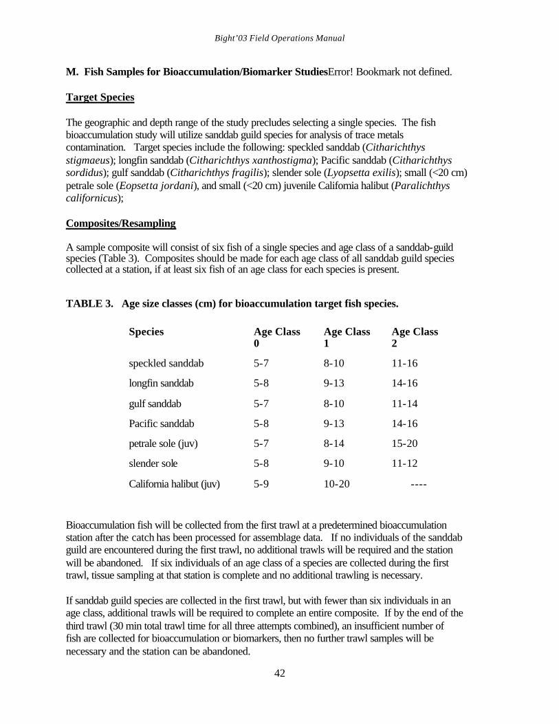
Bight’03 Field Operations Manual
42
M. Fish Samples for Bioaccumulation/Biomarker StudiesError! Bookmark not defined. Target Species The geographic and depth range of the study precludes selecting a single species. The fish bioaccumulation study will utilize sanddab guild species for analysis of trace metals contamination. Target species include the following: speckled sanddab (Citharichthys stigmaeus); longfin sanddab (Citharichthys xanthostigma); Pacific sanddab (Citharichthys sordidus); gulf sanddab (Citharichthys fragilis); slender sole (Lyopsetta exilis); small (<20 cm) petrale sole (Eopsetta jordani), and small (<20 cm) juvenile California halibut (Paralichthys californicus); Composites/Resampling A sample composite will consist of six fish of a single species and age class of a sanddab-guild species (Table 3). Composites should be made for each age class of all sanddab guild species collected at a station, if at least six fish of an age class for each species is present. TABLE 3. Age size classes (cm) for bioaccumulation target fish species.
Species Age Class 0
Age Class 1
Age Class 2
speckled sanddab
5-7
8-10
11-16
longfin sanddab
5-8
9-13
14-16
gulf sanddab
5-7
8-10
11-14
Pacific sanddab
5-8
9-13
14-16
petrale sole (juv)
5-7
8-14
15-20
slender sole
5-8
9-10
11-12
California halibut (juv)
5-9
10-20
----
Bioaccumulation fish will be collected from the first trawl at a predetermined bioaccumulation station after the catch has been processed for assemblage data. If no individuals of the sanddab guild are encountered during the first trawl, no additional trawls will be required and the station will be abandoned. If six individuals of an age class of a species are collected during the first trawl, tissue sampling at that station is complete and no additional trawling is necessary. If sanddab guild species are collected in the first trawl, but with fewer than six individuals in an age class, additional trawls will be required to complete an entire composite. If by the end of the third trawl (30 min total trawl time for all three attempts combined), an insufficient number of fish are collected for bioaccumulation or biomarkers, then no further trawl samples will be necessary and the station can be abandoned.
Bight’03 Field Operations Manual
43
At the end of trawling at a station, all complete composites should be saved for all sanddab guild species (i.e. any age of any species with six fish). This will be done because the best combination of species and age classes for chemical analysis will not be known until the end of the survey. Incomplete composites will not be retained for analysis. Preservation Whole fish age-class composite samples for each species will be packaged in Ziploc plastic bags and placed on dry ice, or in a freezer. Fish samples (composites) will be recorded on the Trawl Cover Sheet (Appendix 6). A label including the agency name, date, station, species, age class and number collected should be placed in each bag and the bag should be labeled with the same information on the outside with a felt-tip marker. All the samples will be shipped to SCCWRP within one week of collection. It is recommended that SCCWRP (Darrin Greenstein, 714/372-9224) be contacted prior to delivery of samples so that arrangements can be made to transfer custody. A completed chain of custody form must accompany all shipments of samples (Appendix 6). Allow time for verification of the chain of custody. N. Quality Assurance/Quality Control Procedures In addition to the pre-survey QA/QC protocols, the following QC measures will check on the accuracy of taxonomic identifications and counts made during the survey:
1) During the survey, taxonomic identifications will be checked during at least one visit to each vessel by Bight'03 designated taxonomists. They will observe species identification by each organization in the field and record the data on a Taxonomy QA/QC Data Sheet (Appendix 7). Their duties include rechecking the identifications of at least 25% of the species collected during the day and noting any problems with the identification of pathologies. The Lead Scientist will be informed of any problems and the field personnel will be instructed regarding the appropriate identifications as needed. Each vessel will be expected to have appropriate taxonomic identification aids during the survey.
2) During the survey, QA/QC data will also be collected on variability in trawl data collection. On each survey day, the Cruise Leader (or delegate), will reprocess two randomly selected fish species (of at least 10 fish) that have already been counted, measured, and weighed. These species will be recounted, reweighed, and remeasured. A record of the counts, weights, and lengths of these quality control checks along with the original values will be maintained on a separate size class data sheet Bight’03 Demersal Fish, Quality Control Form and a note will be made in the trawl comments on the original trawl data sheet that the recount was taken (Appendix 6).
3) Voucher specimens of each species collected by each organization will be
preserved and returned to SCCWRP during the survey (see Voucher Collection below). The identification of these specimens will be checked by a qualified
Bight’03 Field Operations Manual
44
taxonomist following the survey to further ensure that identifications were made correctly. Errors in species identifications must be corrected in the data. Anomalies will be verified by a qualified pathologist.
O. Voucher Collection The Bight'03 voucher collection of trawl organisms will be developed during the course of the survey and will be housed at SCCWRP. This collection will document the species taken during the survey and what names were applied to each. It will also document the types of diseases or anomalies found in the gross pathology examinations. Voucher specimens should be preserved in an appropriate manner and clearly labeled as to identity, collection date, site name, site location, and depth. It is also recommended that each organization develop a voucher collection at their organization. The voucher collection will consist of preserved organisms and photographs of organisms. Each organization will be provided with a list of trawl fish and invertebrate species. For every species caught, each organization will provide at least one representative of that species to the Bight'03 voucher collection. Thus for many species, the Bight'03 voucher collection will contain representatives from all organizations involved in data collection. As species are collected, they will be checked off the list. Each organization will give specimens to the Bight'03 voucher collection before including them in their own collection. Specimens requiring further identification should be identified by the collecting organization and data should be corrected as appropriate on the field data sheet. Do not submit such specimens to SCCWRP unless the specimens cannot be identified by taxonomists at that organization. Any particular specimen in an organization’s voucher collection will represent organisms with the same name that have been collected during Bight’03. Thus it is very important that all specimens be correctly identified.

Bight’03 Field Operations Manual
45
X. LABELING AND SHIPPING OF SAMPLES AND FIELD DATA SHEETS A. Sample Labels/Tracking Each sample will be identified and tracked by the station, parameter, date sampled, and split number if required. Individual log numbers may be used at the discretion of the sampling organization. Sample log numbers will be handled by SCCWRP for the samples shipped to SCCWRP that are not run by the organization that collected them in the field. B. Labels Labels will be printed by the organization responsible for field sampling prior to the survey and will include, at a minimum, the station number, parameter, date, and split (i.e., 1 of 1, 2 of 3, etc.). Dates will be reported as day/month/year. External labels should be covered with clear postal tape to prevent them from falling off the container if they will not stick on some surfaces. C. Field Data Sheets If a field computer has not been used during any part of the Bight’03 sampling, then benthic data sheets and cruise logs will be retained by the sampling organization until sampling is completed. Trawl data sheets will be returned to the organization’s laboratory and held there until all species identifications are complete. Data on species identified in the laboratory must be added to the data sheets and verified within the laboratory. Upon completion of laboratory identifications, copies of the field data sheets will be sent to SCCWRP with the originals retained by the sampling organization. Trawl fish and invertebrate data will be submitted electronically and as hardcopies to SCCWRP as soon as the data sheets are complete. D. Shipping of Samples All sediment chemistry, tissue, and toxicity samples not analyzed by the field sampling organization’s laboratory will be shipped to SCCWRP within the prescribed holding time. All shipping of samples will be the responsibility of the field sampling organizations. See Appendix 9 for detailed SCCWRP shipping information. Voucher collections will be shipped to SCCWRP at some point after an organization has completed trawling and the specimens have been properly preserved. E. Chain of Custody Forms Chain of custody forms (Appendix 6) are to be filled out at the end of each sampling day detailing the transfer of samples from the vessel crew to the laboratory, or to delivery personnel. A form is to be filled out for each set of samples that will be transferred to a specific location. The sample and container type is to be included on the form to identify the samples being transferred. This form is to be signed by the crew member transferring the samples and the laboratory staff member receiving them. A copy of the form is to be kept and the original form

Bight’03 Field Operations Manual
46
with signatures will accompany the samples. If samples are shipped by carrier, a copy of the chain of custody form is to be faxed to SCCWRP for tracking purposes.
Bight’03 Field Operations Manual
47
XI. CONTINGENCY PLANS A. Purpose Any field program can be affected by factors outside the control of the sampling crews. Weather, equipment failure, errors in designating station locations, and accidents can all prevent the field crews from obtaining samples at one or more stations. Contingency plans made in advance of the survey can greatly facilitate decision-making in the field. It is the responsibility of the Cruise Leader to make most of these decisions in the field, based on the protocol described below. If there is any question regarding which protocol to follow, the Field Coordinator should be notified immediately. B. Adverse Weather Conditions In the event that the weather conditions deteriorate during any sampling day, it is the responsibility of both the Boat Captain and the Cruise Leader to determine if the conditions are sufficiently bad to prevent further sampling. The Cruise Leader should evaluate all alternatives, such as changing the sampling plan to more protected areas or returning to the prescribed schedule when the weather improves. Every attempt should be made to avoid wasting the entire day. However, the safety of the crew is the number one priority. C. Station Inaccessibility Stations can be inaccessible because 1) they were incorrectly positioned on land, 2) they were located in water too shallow for the boat, or 3) they cannot be sampled for unforeseen circumstances. If it cannot be sampled, the sampling site will be moved to a location within 100 m horizontal distance from the original site, staying within +/-10% of the depth of the original site. If it still cannot be sampled, the station will be abandoned. No station should be sampled in less than 5 m (3 m for bays and harbors; < 0.5 m for estuaries) or more than 1000 m. D. Lost Gear Lost gear can potentially have a significant effect on the sampling program. Equipment can be expensive and replacements may not be obtained in a timely manner. Crews should take every precaution against the loss of gear by properly tightening shackles and other connectors. If important gear is lost, notify the Boat Captain immediately, so he can record the position using the vessel’s navigation system. If possible, deploy a buoy at that exact location so relocation is made easier. Attempt to recover the equipment for a reasonable amount of time. If unsuccessful, use spare equipment (when available) or continue sampling without that particular equipment and/or notify the Field Coordinator.
Bight’03 Field Operations Manual
48
XII. WASTE DISPOSAL Proper disposal of all waste is an important component of field activities. At no time will any waste be disposed of improperly. The proper methods of waste disposal are outlined below: A. Routine Garbage Regular garbage (paper towels, paper cups, etc.) is placed in trash containers on board the boats. It can then be disposed on land in public receptacles or recycled. B. Detergent Washes Biodegradable detergents are recommended for cleaning the Van Veen grab, or deck surfaces. C. Chemicals Acetone, formalin, hexane and methylene chloride are hazardous materials and should be disposed of by following all appropriate hazardous materials regulations. They should never be disposed at sea. D. Fish Waste After each trawl catch has been processed completely, the remaining catch should be disposed of at sea. Use discretion when discarding the catch. For sampling conducted nearshore or in bays and harbors, return only live fish and invertebrates to the area where trawling occurred. All of the remaining fish should be disposed of offshore. Under no circumstances should fish be given to the public.
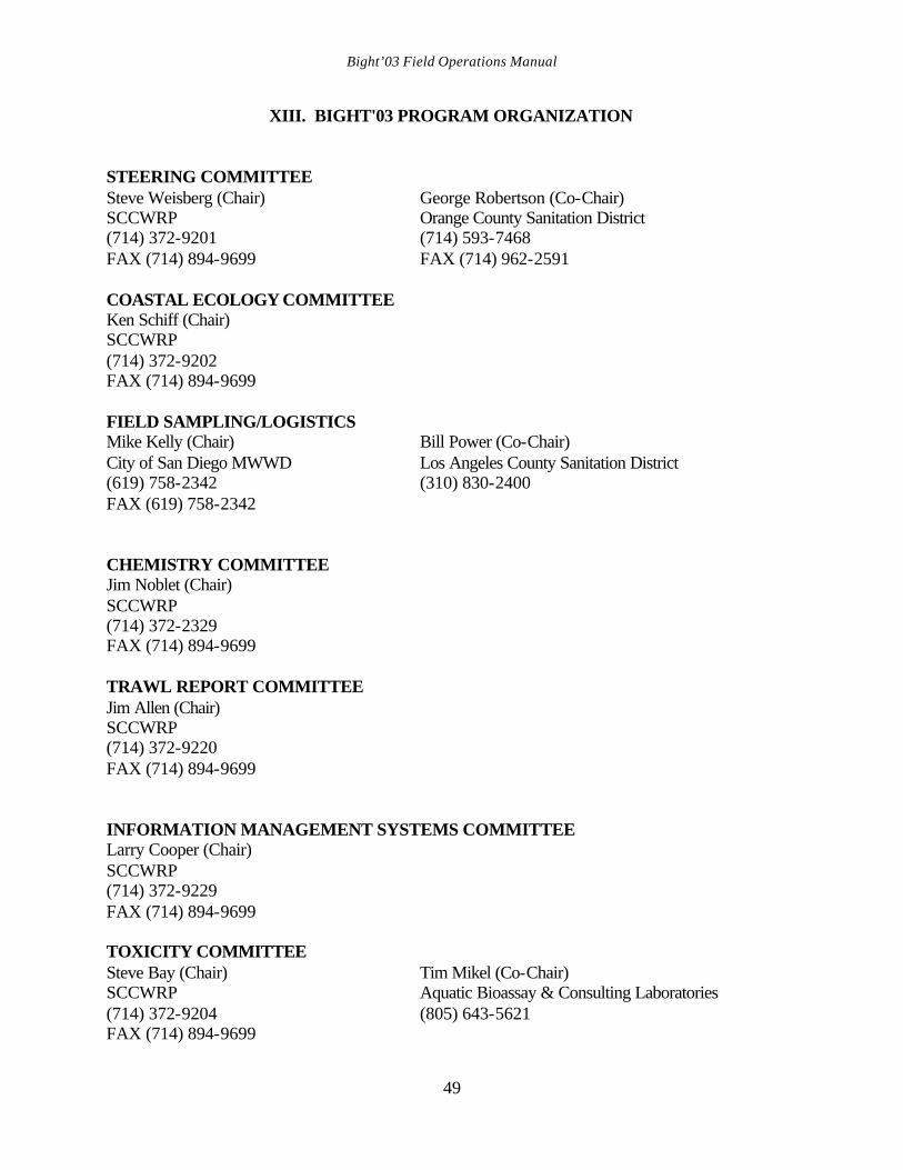
Bight’03 Field Operations Manual
49
XIII. BIGHT'03 PROGRAM ORGANIZATION STEERING COMMITTEE Steve Weisberg (Chair) George Robertson (Co-Chair) SCCWRP Orange County Sanitation District (714) 372-9201 (714) 593-7468 FAX (714) 894-9699 FAX (714) 962-2591 COASTAL ECOLOGY COMMITTEE Ken Schiff (Chair) SCCWRP (714) 372-9202 FAX (714) 894-9699 FIELD SAMPLING/LOGISTICS Mike Kelly (Chair) Bill Power (Co-Chair) City of San Diego MWWD Los Angeles County Sanitation District (619) 758-2342 (310) 830-2400 FAX (619) 758-2342 CHEMISTRY COMMITTEE Jim Noblet (Chair) SCCWRP (714) 372-2329 FAX (714) 894-9699 TRAWL REPORT COMMITTEE Jim Allen (Chair) SCCWRP (714) 372-9220 FAX (714) 894-9699 INFORMATION MANAGEMENT SYSTEMS COMMITTEE Larry Cooper (Chair) SCCWRP (714) 372-9229 FAX (714) 894-9699 TOXICITY COMMITTEE Steve Bay (Chair) Tim Mikel (Co-Chair) SCCWRP Aquatic Bioassay & Consulting Laboratories (714) 372-9204 (805) 643-5621 FAX (714) 894-9699
Bight’03 Field Operations Manual
50
BENTHIC COMMITTEE Ananda Ranasinghe Dave Montagne (Co-Chair) SCCWRP Los Angeles County Sanitation District (714) 372-9218 (562) 699-7411 x 2805 FAX (714) 894-9699 WATER QUALITY COMMITTEE Paul DiGiacomo (Chair) NASA Jet Propulsion Laboratory 818-354-8189 FAX (818) 393-6720 MICROBIOLOGY COMMITTEE Steve Weisberg (Chair) SCCWRP (714) 372-9201 FAX (714) 894-9699
Bight’03 Field Operations Manual
51
IV. LITERATURE CITED Allen, M. J. 1977. Southern California trawl-caught juvenile rockfishes (Preliminary). S. Calif. Coastal Water Res. Proj., El Segundo, CA. Proc. Taxonomic Standardization Program 5 (4): 25-32. Bight’03 Benthic Committee. 2003. Southern California Bight 2003 Regional Marine Monitoring Survey Macro Benthic (infaunal) Sample Analysis Laboratory Manual. 31 p. Eschmeyer, W. N. 1998. Catalog of fishes. California Academy of Sciences. San Francisco, CA. 2905 p. Eschmeyer, W. N., E. S. Herald, and H. Hammann. 1983. A field guide to Pacific Coast fishes of North America. Houghton Mifflin Co., Boston, MA. 336 pp. Kramer, D. E., W. H. Barss, B. C. Paust, and B. E. Bracken. 1995. Guide to northeast Pacific flatfishes. University of Alaska, Fairbanks, Alaska Sea Grant College Program, Fairbanks, AK. 104 pp. Kramer, D. E., W. H. Barss, B. C. Paust, and B. E. Bracken. 1995. Guide to northeast Pacific flatfishes. University of Alaska, Fairbanks, Alaska Sea Grant College Program, Fairbanks, AK. 104 pp. Love, M.S., M. Yoklavich, and L. Thorsteinson. 2002. The rockfishes of the Northeast Pacific. University of California Press. Berkeley, CA. 404 p. Mearns, A. J., and M. J. Allen. 1978. Use of small otter trawls in coastal biological surveys. U. S. Environ. Prot. Agcy., Environ. Res. Lab., Corvallis, OR. EPA-600/3-78-083. 33 pp. Mearns, A. J., and P. L. Haaker. 1973. Identifying and coding color anomalies in flatfishes. S. Calif. Coastal Water Res. Proj., El Segundo, CA. TM 200. 6 pp. Miller, D. J., and R. N. Lea. 1972. Guide to the coastal marine fishes of California. Calif. Dep. Fish Game, Fish. Bull. 157. 249 pp.(addendum in 1976). Orr, J. W., M. A. Brown, and D. C. Baker. 2000. Guide to rockfishes (Scorpaenidae) of the genera Sebastes, Sebastolobus, and Adelosebastes of the Northeast Pacific Ocean. Second edition. NOAA Technical Memorandum NMFS-AFSC-117. 47 p. Robins, C. R., R. M. Bailey, C. E. Bond, J. R. Brooker, E. A. Lachner, R. N. Lea, and W. B. Scott. 1991. Common and scientific names of fishes from the United States and Canada. 5th edition. Am. Fish. Soc., Spec. Publ. 20. 183 pp. SCAMIT. See Southern California Association of Marine Invertebrate Taxonomists. Southern California Association of Marine Invertebrate Taxonomists.2001. A taxonomic listing of soft bottom macro and megainvertebrates from infaunal and epibenthic monitoring programs
Bight’03 Field Operations Manual
52
in the Southern California Bight. Edition4. S. Calif. Assoc. Mar. Invert. Tax., San Pedro, CA. 192 pp. Stubbs, H. H., D. W. Diehl, and G. P. Hershelman. 1987. A Van Veen grab sampling method. S. Calif. Coastal Water Res. Proj., Long Beach, CA. Tech. Rep. 276. 4 pp. Tetra Tech. 1986. Quality Assurance and Quality Control for 301(h) Monitoring Programs: Guidance on field and laboratory methods. Final report prepared for U. S. Environ. Prot. Agency, MOD/OMEP. Contract No. 68-01-6938.

APPENDICES

APPENDIX 1
Bight’03 Station Location Charts
34 N
25 50
Point ConceptionSanta Barbara
4003
4007
4011
4015
4019
4023
4027
40294031
40354039 4043
4047
4051
40554059
4063
4067
4071
4075
4079
4083
40914095
4099
4107
4111
4115
4121
4123
4125
41274131
4135
4143
4147
4155
4159
4163
4167
4171
4175
4179
4187
4189
4191
4195
4199
4211
4219
4223
4231
4235
4237
4239
4243
4255
4263
4267
4275
42794283
4285
4287
4295
4299
4307
4311
4315
43174319
4323
43274331
4335
4339
4343
4347
4351
43554359
4363
4367
4371
4377
4379
4383
4401
4417
Bight' 03 Sampling Stations
Point Dume
Los Angeles
4002
4003
4005
4006
4010
40114013
4014
4019
4021
4022
4025
4026
4029
4037
4038
4042
4045
4046
4050
4054
4056
4057
4058
4061
4069
4074
4075
40864089
4090
4093
4098
4101
4102
4106
4109
4121
4122
4124
4125
4131
4133
4146
4147
4153
4163
4173
41814185
4186
4188
4189
4197
4198
4202
4230
4233
4234
4237
4249
4252
4254
4261
4262
4269
4275
4281
4285
42904294
4317
4330
4331
4342
4345
4357
4371
4377
4380
4382
4389
4401
4446
Bight' 03 Sampling Stations
N E C o r
Pacific
NE Cor
N W C o r
Pacific Ocean
33 N
118
W
Los Angeles
Dana Point
4001
4002
4008
4009
4010
4014
4016
40174026
4030
4032
4038
4040
4041
4042
4046
4048
4050
4054
4058
4060
4062
40654073
4074
4080
4088
4090
4098
4100
4102
4105
4106
4110
4112
41134122
4124
4126
4128
4134
4144
4146
41524160
4169
4186
4188
4190
4192
4198
4201
4202
4208
4216
4220
4224
4234
4240
4246
4254
4290
4297
4318
4326
43444352
4361
4362
4368
4374
4382
Bight' 03 Sampling Stations
33 N
117
W
118
W
4000
4001
4004
4008
4012
4016
4020
4024
4028
4032
4036
4040
4044
4048
4052
4060
4068
4076
4080
4088
4092
4100
4105
4112
4126
4128
4132
4144
4148
4160
4164
4172
4192
4196
4208
4216
4220
42244240
4292
4300
4316
4324
43444352
4356
4361
4368
4388
4426
Bight' 03 Sampling Stations
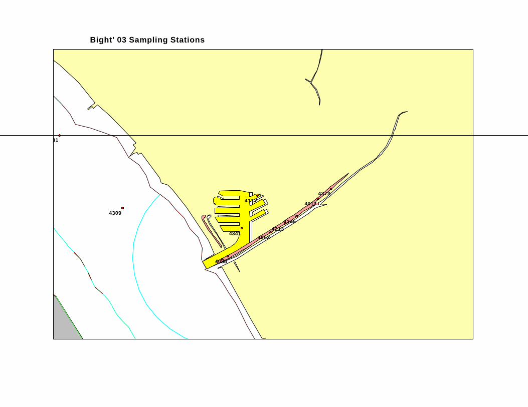
4013
4053
4085
4117
4181
42134245
4309
4341
4373
Bight' 03 Sampling Stations
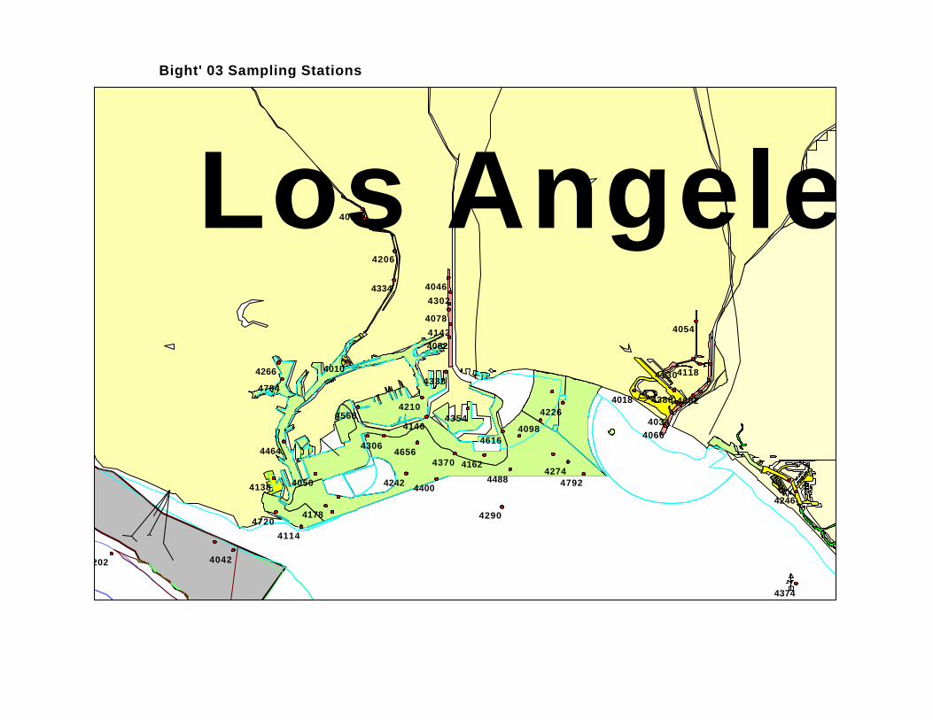
0 3
Los Angeles
4002
4010
4014
4018
4034
4042
4046
4050
4054
4066
4078
4082
4098
4114
41184130
4138
4142
4146
4162
4178
4202
4206
4210 4226
4242
4246
4266
4274
4290
4302
4306
4334
4338
4354
4370
4374
4386
4400
4464
4488
4568
46164656
4720
4784
4792
Bight' 03 Sampling Stations
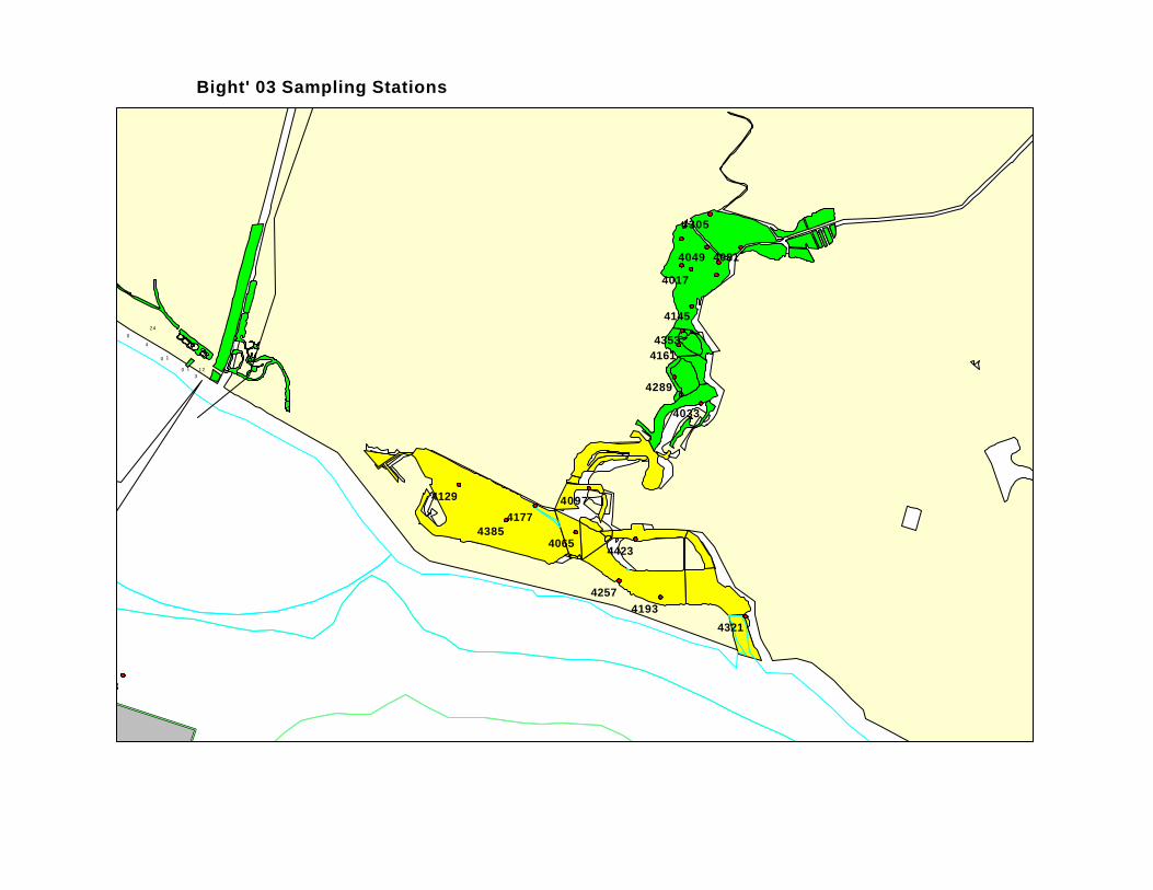
0
3
10
Bro
okhu
rst S
t.
Mag
nolia
St.
Talbert Channel
San
ta A
na R
iver
4
80
1
12
24
4017
4033
4049
4065
4081
4097
4113
4129
4145
4161
4177
41934257
4289
4305
4321
4353
4385
4423
Bight' 03 Sampling Stations

4004
4012
4020
4028
4036
4044
4052
4076
4084
4092
4108
41164120
4148
4156
4164
4172
4180
4184
4204
4228
42364244
4276
4300
4308
4312
4332
4340
4348
4372
4376
4442
4458
Bight' 03 Sampling Stations
APPENDIX 2
Bight’03 Field Sampling Organizations
and station Draw Information
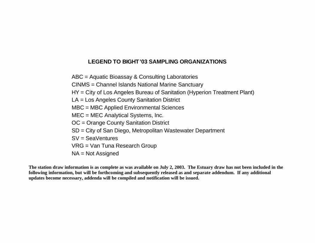
LEGEND TO BIGHT’03 SAMPLING ORGANIZATIONS
ABC = Aquatic Bioassay & Consulting Laboratories CINMS = Channel Islands National Marine Sanctuary HY = City of Los Angeles Bureau of Sanitation (Hyperion Treatment Plant) LA = Los Angeles County Sanitation District MBC = MBC Applied Environmental Sciences MEC = MEC Analytical Systems, Inc. OC = Orange County Sanitation District SD = City of San Diego, Metropolitan Wastewater Department SV = SeaVentures VRG = Van Tuna Research Group NA = Not Assigned
The station draw information is as complete as was available on July 2, 2003. The Estuary draw has not been included in the following information, but will be forthcoming and subsequently released as and separate addendum. If any additional updates become necessary, addenda will be compiled and notification will be issued.
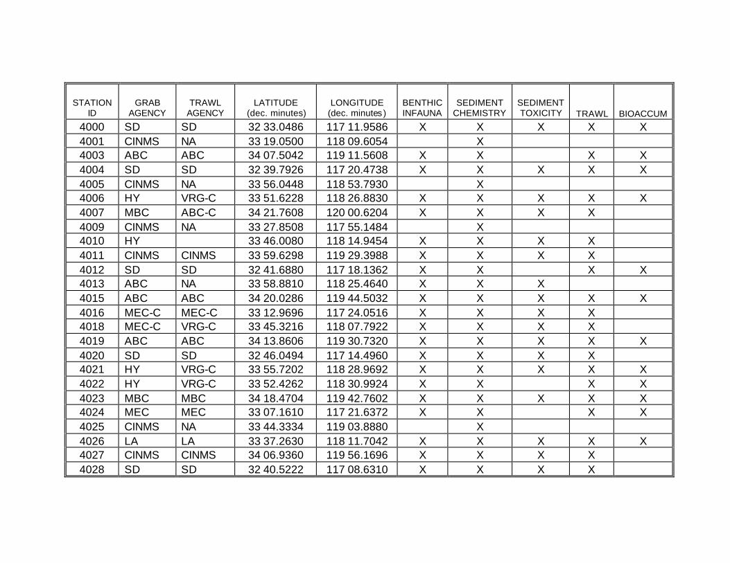
STATION ID
GRAB AGENCY
TRAWL AGENCY
LATITUDE (dec. minutes)
LONGITUDE (dec. minutes)
BENTHIC INFAUNA
SEDIMENT CHEMISTRY
SEDIMENT TOXICITY TRAWL BIOACCUM
4000 SD SD 32 33.0486 117 11.9586 X X X X X 4001 CINMS NA 33 19.0500 118 09.6054 X 4003 ABC ABC 34 07.5042 119 11.5608 X X X X 4004 SD SD 32 39.7926 117 20.4738 X X X X X 4005 CINMS NA 33 56.0448 118 53.7930 X 4006 HY VRG-C 33 51.6228 118 26.8830 X X X X X 4007 MBC ABC-C 34 21.7608 120 00.6204 X X X X 4009 CINMS NA 33 27.8508 117 55.1484 X 4010 HY 33 46.0080 118 14.9454 X X X X 4011 CINMS CINMS 33 59.6298 119 29.3988 X X X X 4012 SD SD 32 41.6880 117 18.1362 X X X X 4013 ABC NA 33 58.8810 118 25.4640 X X X 4015 ABC ABC 34 20.0286 119 44.5032 X X X X X 4016 MEC-C MEC-C 33 12.9696 117 24.0516 X X X X 4018 MEC-C VRG-C 33 45.3216 118 07.7922 X X X X 4019 ABC ABC 34 13.8606 119 30.7320 X X X X X 4020 SD SD 32 46.0494 117 14.4960 X X X X 4021 HY VRG-C 33 55.7202 118 28.9692 X X X X X 4022 HY VRG-C 33 52.4262 118 30.9924 X X X X 4023 MBC MBC 34 18.4704 119 42.7602 X X X X X 4024 MEC MEC 33 07.1610 117 21.6372 X X X X 4025 CINMS NA 33 44.3334 119 03.8880 X 4026 LA LA 33 37.2630 118 11.7042 X X X X X 4027 CINMS CINMS 34 06.9360 119 56.1696 X X X X 4028 SD SD 32 40.5222 117 08.6310 X X X X
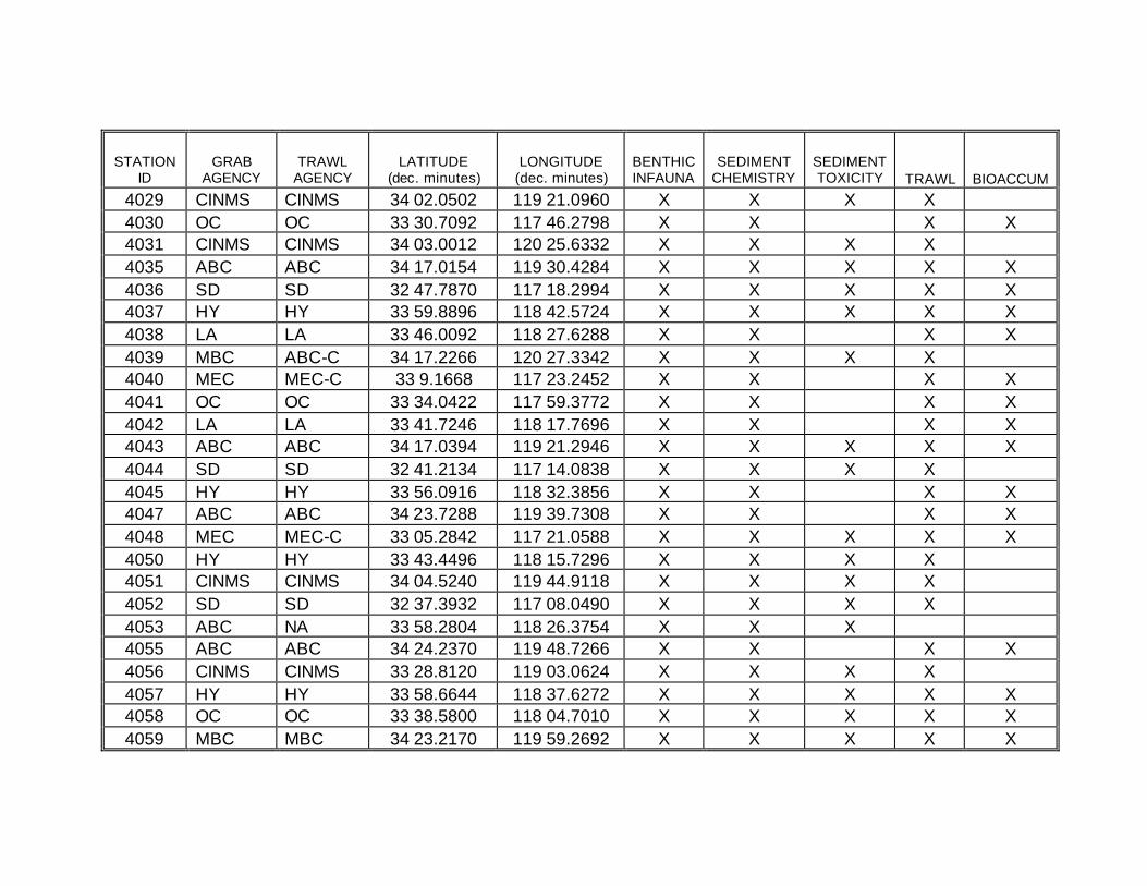
STATION ID
GRAB AGENCY
TRAWL AGENCY
LATITUDE (dec. minutes)
LONGITUDE (dec. minutes)
BENTHIC INFAUNA
SEDIMENT CHEMISTRY
SEDIMENT TOXICITY TRAWL BIOACCUM
4029 CINMS CINMS 34 02.0502 119 21.0960 X X X X 4030 OC OC 33 30.7092 117 46.2798 X X X X 4031 CINMS CINMS 34 03.0012 120 25.6332 X X X X 4035 ABC ABC 34 17.0154 119 30.4284 X X X X X 4036 SD SD 32 47.7870 117 18.2994 X X X X X 4037 HY HY 33 59.8896 118 42.5724 X X X X X 4038 LA LA 33 46.0092 118 27.6288 X X X X 4039 MBC ABC-C 34 17.2266 120 27.3342 X X X X 4040 MEC MEC-C 33 9.1668 117 23.2452 X X X X 4041 OC OC 33 34.0422 117 59.3772 X X X X 4042 LA LA 33 41.7246 118 17.7696 X X X X 4043 ABC ABC 34 17.0394 119 21.2946 X X X X X 4044 SD SD 32 41.2134 117 14.0838 X X X X 4045 HY HY 33 56.0916 118 32.3856 X X X X 4047 ABC ABC 34 23.7288 119 39.7308 X X X X 4048 MEC MEC-C 33 05.2842 117 21.0588 X X X X X 4050 HY HY 33 43.4496 118 15.7296 X X X X 4051 CINMS CINMS 34 04.5240 119 44.9118 X X X X 4052 SD SD 32 37.3932 117 08.0490 X X X X 4053 ABC NA 33 58.2804 118 26.3754 X X X 4055 ABC ABC 34 24.2370 119 48.7266 X X X X 4056 CINMS CINMS 33 28.8120 119 03.0624 X X X X 4057 HY HY 33 58.6644 118 37.6272 X X X X X 4058 OC OC 33 38.5800 118 04.7010 X X X X X 4059 MBC MBC 34 23.2170 119 59.2692 X X X X X
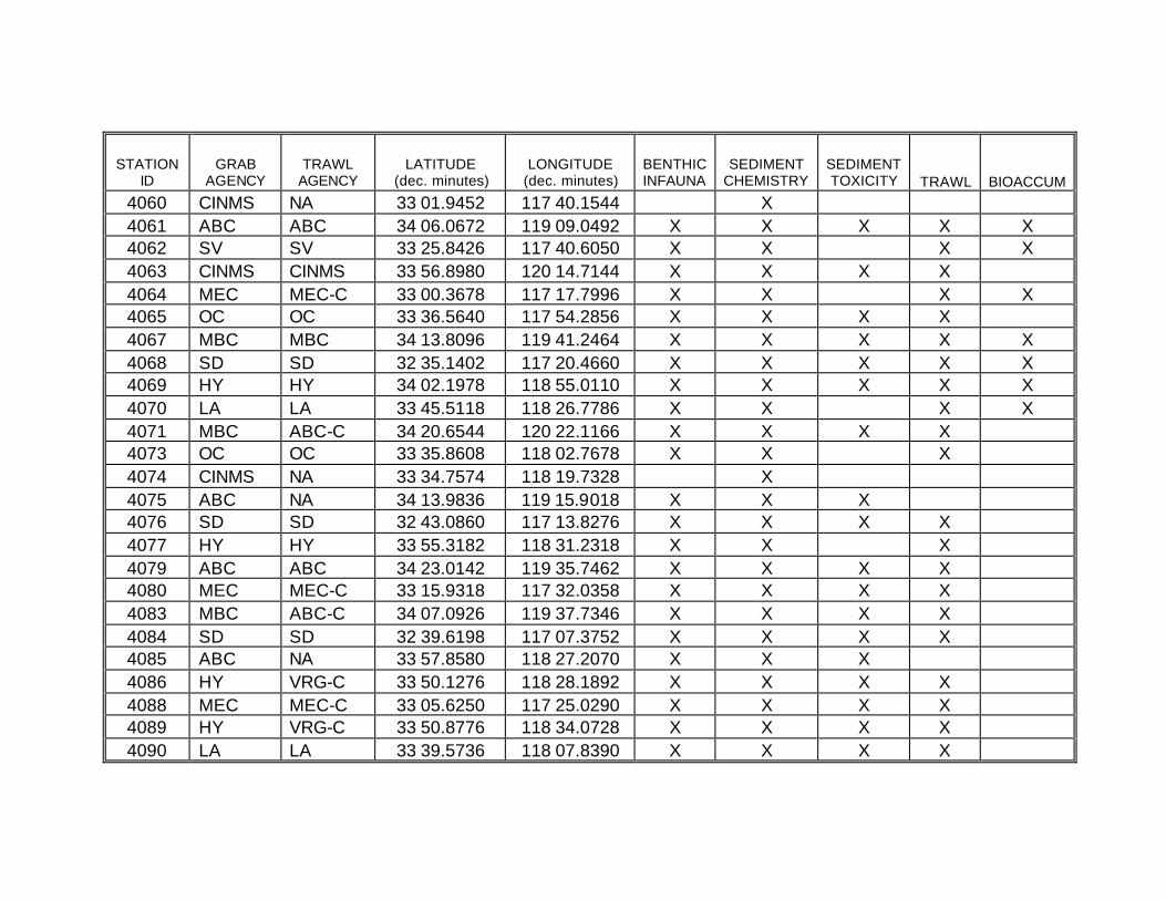
STATION ID
GRAB AGENCY
TRAWL AGENCY
LATITUDE (dec. minutes)
LONGITUDE (dec. minutes)
BENTHIC INFAUNA
SEDIMENT CHEMISTRY
SEDIMENT TOXICITY TRAWL BIOACCUM
4060 CINMS NA 33 01.9452 117 40.1544 X 4061 ABC ABC 34 06.0672 119 09.0492 X X X X X 4062 SV SV 33 25.8426 117 40.6050 X X X X 4063 CINMS CINMS 33 56.8980 120 14.7144 X X X X 4064 MEC MEC-C 33 00.3678 117 17.7996 X X X X 4065 OC OC 33 36.5640 117 54.2856 X X X X 4067 MBC MBC 34 13.8096 119 41.2464 X X X X X 4068 SD SD 32 35.1402 117 20.4660 X X X X X 4069 HY HY 34 02.1978 118 55.0110 X X X X X 4070 LA LA 33 45.5118 118 26.7786 X X X X 4071 MBC ABC-C 34 20.6544 120 22.1166 X X X X 4073 OC OC 33 35.8608 118 02.7678 X X X 4074 CINMS NA 33 34.7574 118 19.7328 X 4075 ABC NA 34 13.9836 119 15.9018 X X X 4076 SD SD 32 43.0860 117 13.8276 X X X X 4077 HY HY 33 55.3182 118 31.2318 X X X 4079 ABC ABC 34 23.0142 119 35.7462 X X X X 4080 MEC MEC-C 33 15.9318 117 32.0358 X X X X 4083 MBC ABC-C 34 07.0926 119 37.7346 X X X X 4084 SD SD 32 39.6198 117 07.3752 X X X X 4085 ABC NA 33 57.8580 118 27.2070 X X X 4086 HY VRG-C 33 50.1276 118 28.1892 X X X X 4088 MEC MEC-C 33 05.6250 117 25.0290 X X X X 4089 HY VRG-C 33 50.8776 118 34.0728 X X X X 4090 LA LA 33 39.5736 118 07.8390 X X X X
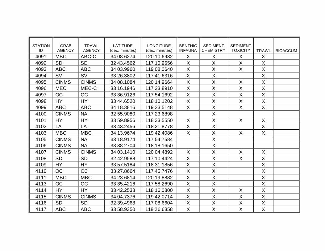
STATION ID
GRAB AGENCY
TRAWL AGENCY
LATITUDE (dec. minutes)
LONGITUDE (dec. minutes)
BENTHIC INFAUNA
SEDIMENT CHEMISTRY
SEDIMENT TOXICITY TRAWL BIOACCUM
4091 MBC ABC-C 34 08.6274 120 10.6932 X X X X 4092 SD SD 32 43.4562 117 10.9656 X X X X 4093 ABC ABC 34 03.9960 119 08.0640 X X X X 4094 SV SV 33 26.3802 117 41.6316 X X X 4095 CINMS CINMS 34 08.1084 120 14.9664 X X X X 4096 MEC MEC-C 33 16.1946 117 33.8910 X X X X 4097 OC OC 33 36.9126 117 54.1692 X X X X 4098 HY HY 33 44.6520 118 10.1202 X X X X 4099 ABC ABC 34 18.3816 119 33.5148 X X X X 4100 CINMS NA 32 55.9080 117 23.6898 X 4101 HY HY 33 59.8956 118 33.5550 X X X X 4102 LA LA 33 43.2456 118 21.8778 X X X 4103 MBC MBC 34 13.9674 119 42.4086 X X X X 4105 CINMS NA 33 18.9174 117 54.7584 X 4106 CINMS NA 33 38.2704 118 18.1650 X 4107 CINMS CINMS 34 03.1410 120 04.4892 X X X X 4108 SD SD 32 42.9588 117 10.4424 X X X X 4109 HY HY 33 57.5184 118 31.1856 X X X 4110 OC OC 33 27.8664 117 45.7476 X X X 4111 MBC MBC 34 23.6814 120 19.8882 X X X 4113 OC OC 33 35.4216 117 58.2690 X X X 4114 HY HY 33 42.2538 118 16.0800 X X X X 4115 CINMS CINMS 34 04.7376 119 42.0714 X X X X 4116 SD SD 32 39.4968 117 08.6604 X X X X 4117 ABC ABC 33 58.9350 118 26.6358 X X X X
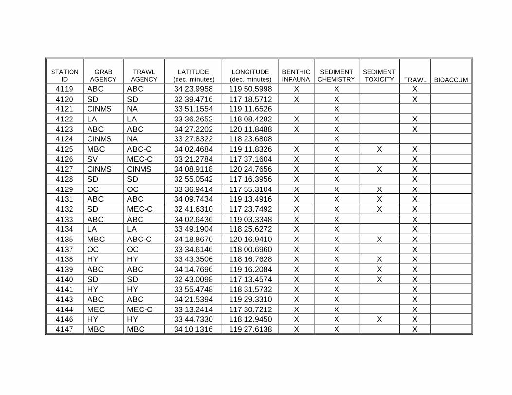
STATION ID
GRAB AGENCY
TRAWL AGENCY
LATITUDE (dec. minutes)
LONGITUDE (dec. minutes)
BENTHIC INFAUNA
SEDIMENT CHEMISTRY
SEDIMENT TOXICITY TRAWL BIOACCUM
4119 ABC ABC 34 23.9958 119 50.5998 X X X 4120 SD SD 32 39.4716 117 18.5712 X X X 4121 CINMS NA 33 51.1554 119 11.6526 X 4122 LA LA 33 36.2652 118 08.4282 X X X 4123 ABC ABC 34 27.2202 120 11.8488 X X X 4124 CINMS NA 33 27.8322 118 23.6808 X 4125 MBC ABC-C 34 02.4684 119 11.8326 X X X X 4126 SV MEC-C 33 21.2784 117 37.1604 X X X 4127 CINMS CINMS 34 08.9118 120 24.7656 X X X X 4128 SD SD 32 55.0542 117 16.3956 X X X 4129 OC OC 33 36.9414 117 55.3104 X X X X 4131 ABC ABC 34 09.7434 119 13.4916 X X X X 4132 SD MEC-C 32 41.6310 117 23.7492 X X X X 4133 ABC ABC 34 02.6436 119 03.3348 X X X 4134 LA LA 33 49.1904 118 25.6272 X X X 4135 MBC ABC-C 34 18.8670 120 16.9410 X X X X 4137 OC OC 33 34.6146 118 00.6960 X X X 4138 HY HY 33 43.3506 118 16.7628 X X X X 4139 ABC ABC 34 14.7696 119 16.2084 X X X X 4140 SD SD 32 43.0098 117 13.4574 X X X X 4141 HY HY 33 55.4748 118 31.5732 X X X 4143 ABC ABC 34 21.5394 119 29.3310 X X X 4144 MEC MEC-C 33 13.2414 117 30.7212 X X X 4146 HY HY 33 44.7330 118 12.9450 X X X X 4147 MBC MBC 34 10.1316 119 27.6138 X X X
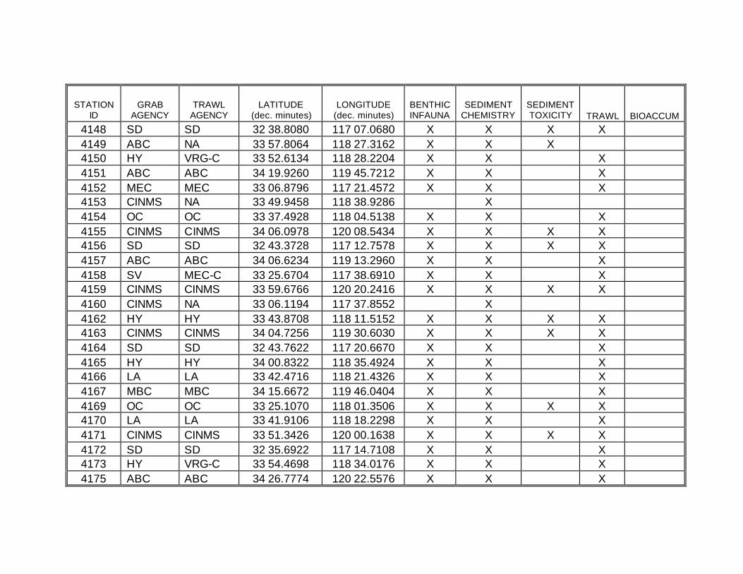
STATION ID
GRAB AGENCY
TRAWL AGENCY
LATITUDE (dec. minutes)
LONGITUDE (dec. minutes)
BENTHIC INFAUNA
SEDIMENT CHEMISTRY
SEDIMENT TOXICITY TRAWL BIOACCUM
4148 SD SD 32 38.8080 117 07.0680 X X X X 4149 ABC NA 33 57.8064 118 27.3162 X X X 4150 HY VRG-C 33 52.6134 118 28.2204 X X X 4151 ABC ABC 34 19.9260 119 45.7212 X X X 4152 MEC MEC 33 06.8796 117 21.4572 X X X 4153 CINMS NA 33 49.9458 118 38.9286 X 4154 OC OC 33 37.4928 118 04.5138 X X X 4155 CINMS CINMS 34 06.0978 120 08.5434 X X X X 4156 SD SD 32 43.3728 117 12.7578 X X X X 4157 ABC ABC 34 06.6234 119 13.2960 X X X 4158 SV MEC-C 33 25.6704 117 38.6910 X X X 4159 CINMS CINMS 33 59.6766 120 20.2416 X X X X 4160 CINMS NA 33 06.1194 117 37.8552 X 4162 HY HY 33 43.8708 118 11.5152 X X X X 4163 CINMS CINMS 34 04.7256 119 30.6030 X X X X 4164 SD SD 32 43.7622 117 20.6670 X X X 4165 HY HY 34 00.8322 118 35.4924 X X X 4166 LA LA 33 42.4716 118 21.4326 X X X 4167 MBC MBC 34 15.6672 119 46.0404 X X X 4169 OC OC 33 25.1070 118 01.3506 X X X X 4170 LA LA 33 41.9106 118 18.2298 X X X 4171 CINMS CINMS 33 51.3426 120 00.1638 X X X X 4172 SD SD 32 35.6922 117 14.7108 X X X 4173 HY VRG-C 33 54.4698 118 34.0176 X X X 4175 ABC ABC 34 26.7774 120 22.5576 X X X
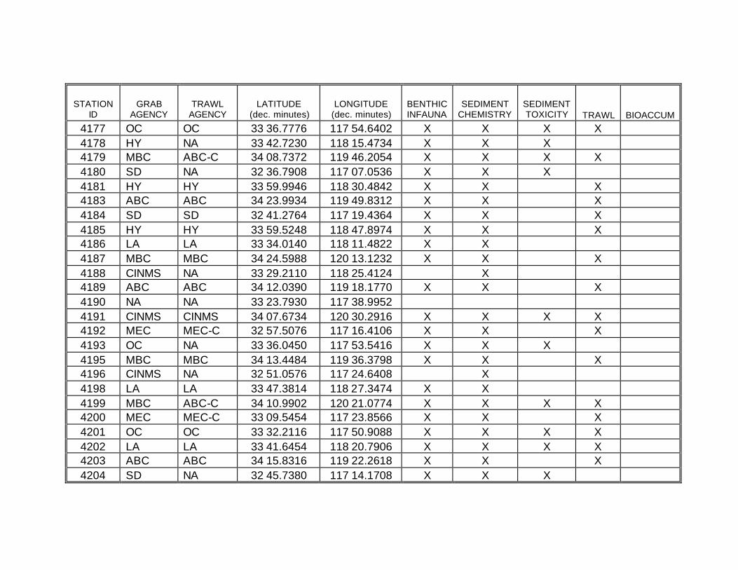
STATION ID
GRAB AGENCY
TRAWL AGENCY
LATITUDE (dec. minutes)
LONGITUDE (dec. minutes)
BENTHIC INFAUNA
SEDIMENT CHEMISTRY
SEDIMENT TOXICITY TRAWL BIOACCUM
4177 OC OC 33 36.7776 117 54.6402 X X X X 4178 HY NA 33 42.7230 118 15.4734 X X X 4179 MBC ABC-C 34 08.7372 119 46.2054 X X X X 4180 SD NA 32 36.7908 117 07.0536 X X X 4181 HY HY 33 59.9946 118 30.4842 X X X 4183 ABC ABC 34 23.9934 119 49.8312 X X X 4184 SD SD 32 41.2764 117 19.4364 X X X 4185 HY HY 33 59.5248 118 47.8974 X X X 4186 LA LA 33 34.0140 118 11.4822 X X 4187 MBC MBC 34 24.5988 120 13.1232 X X X 4188 CINMS NA 33 29.2110 118 25.4124 X 4189 ABC ABC 34 12.0390 119 18.1770 X X X 4190 NA NA 33 23.7930 117 38.9952 4191 CINMS CINMS 34 07.6734 120 30.2916 X X X X 4192 MEC MEC-C 32 57.5076 117 16.4106 X X X 4193 OC NA 33 36.0450 117 53.5416 X X X 4195 MBC MBC 34 13.4484 119 36.3798 X X X 4196 CINMS NA 32 51.0576 117 24.6408 X 4198 LA LA 33 47.3814 118 27.3474 X X 4199 MBC ABC-C 34 10.9902 120 21.0774 X X X X 4200 MEC MEC-C 33 09.5454 117 23.8566 X X X 4201 OC OC 33 32.2116 117 50.9088 X X X X 4202 LA LA 33 41.6454 118 20.7906 X X X X 4203 ABC ABC 34 15.8316 119 22.2618 X X X 4204 SD NA 32 45.7380 117 14.1708 X X X
STATION ID
GRAB AGENCY
TRAWL AGENCY
LATITUDE (dec. minutes)
LONGITUDE (dec. minutes)
BENTHIC INFAUNA
SEDIMENT CHEMISTRY
SEDIMENT TOXICITY TRAWL BIOACCUM
4205 HY HY 33 55.6710 118 32.6256 X X X 4207 ABC ABC 34 23.9460 119 39.6042 X X X 4208 MEC MEC-C 33 20.3592 117 31.3314 X X X 4210 HY 33 45.1644 118 13.0638 X X X 4211 MBC ABC-C 34 09.5016 119 49.6578 X X X X 4212 SD NA 32 37.5516 117 08.1084 X X X 4213 ABC NA 33 58.4340 118 26.1030 X X X 4214 NA NA 33 50.5092 118 33.6042 4215 ABC ABC 34 24.1470 119 48.7188 X X X 4216 CINMS NA 33 16.4502 118 05.1528 X 4217 NA NA 33 59.0910 118 40.2204 4218 LA LA 33 36.4302 118 07.4772 X X 4219 CINMS NA 34 12.7554 119 56.7252 X 4220 CINMS NA 33 06.4956 117 54.0756 X 4221 ABC NA 34 06.3900 119 07.3434 X X X 4222 SV SV 33 25.6920 117 41.4210 X X X 4223 CINMS CINMS 34 08.5014 120 20.2554 X X X X 4224 CINMS NA 33 09.0486 117 35.0724 X 4226 HY 33 45.0504 118 09.5658 X X X 4227 MBC MBC 34 12.4062 119 34.0488 X X X 4228 SD NA 32 47.0634 117 12.9300 X X X 4229 NA NA 33 59.0790 118 36.3354 4230 HY HY 33 53.8758 118 30.0804 X X X 4231 NA NA 34 17.5878 119 39.6474 4232 MEC MEC 33 06.4350 117 21.4434 X X X
STATION ID
GRAB AGENCY
TRAWL AGENCY
LATITUDE (dec. minutes)
LONGITUDE (dec. minutes)
BENTHIC INFAUNA
SEDIMENT CHEMISTRY
SEDIMENT TOXICITY TRAWL BIOACCUM
4233 CINMS NA 33 47.3574 118 59.1432 X 4234 LA LA 33 40.3074 118 15.8868 X X 4235 CINMS CINMS 33 53.1906 120 00.6048 X X X X 4236 SD NA 32 40.7334 117 10.1550 X X X 4237 MBC ABC-C 34 07.6326 119 24.1080 X X X X 4238 OC OC 33 29.9850 117 45.1266 X X X 4239 MBC ABC-C 34 20.3796 120 26.5338 X X X X 4240 MEC MEC-C 33 07.7046 117 24.7218 X X X X 4241 OC OC 33 36.1770 118 02.1612 X X X 4242 HY NA 33 43.4526 118 13.4538 X X X 4243 CINMS CINMS 33 57.9408 119 36.2892 X X X X 4244 SD SD 32 40.9458 117 16.9182 X X X 4245 ABC NA 33 58.5636 118 25.8714 X X X 4247 ABC ABC 34 23.5584 119 40.2882 X X X 4248 SD SD 32 40.7604 117 16.9272 X X X 4249 CINMS NA 33 59.7570 119 07.4268 X 4250 LA LA 33 34.6128 118 12.6168 X X 4251 MBC MBC 34 23.8170 120 01.8630 X X X 4252 CINMS NA 33 36.7920 118 43.1850 X 4253 ABC ABC 34 07.2204 119 11.3772 X X X 4254 LA LA 33 30.8088 118 10.7178 X X X X 4255 CINMS CINMS 34 03.1146 120 33.4812 X X X X 4256 SD SD 32 35.3730 117 13.6860 X X X 4257 OC NA 33 36.1758 117 53.9058 X X X 4259 ABC ABC 34 08.1042 119 11.6286 X X X
STATION ID
GRAB AGENCY
TRAWL AGENCY
LATITUDE (dec. minutes)
LONGITUDE (dec. minutes)
BENTHIC INFAUNA
SEDIMENT CHEMISTRY
SEDIMENT TOXICITY TRAWL BIOACCUM
4260 SD SD 32 39.5310 117 20.1594 X X X 4261 HY HY 34 00.9936 119 03.4998 X X X X 4262 LA NA 33 50.5830 118 23.7474 X X X 4263 MBC ABC-C 34 12.4974 120 17.9928 X X X X 4265 OC OC 33 35.4882 118 01.5954 X X X 4266 HY HY 33 45.9738 118 16.6392 X X X X 4267 ABC ABC 34 18.7794 119 26.0082 X X X 4268 SD NA 32 43.1208 117 13.2018 X X X 4269 HY HY 33 57.4266 118 35.5818 X X X 4271 NA NA 34 21.8922 119 31.8480 4274 HY 33 43.7142 118 09.4332 X X X 4275 NA NA 34 11.7540 119 27.2424 4276 SD NA 32 47.1672 117 15.0390 X X X 4277 HY HY 33 54.5760 118 29.9802 X X X 4278 HY VRG-C 33 52.6842 118 32.6544 X X X 4279 MBC MBC 34 16.6686 119 43.0962 X X X X 4280 MEC MEC 33 06.8886 117 20.8860 X X X 4281 NA NA 33 52.6824 118 34.2462 4282 LA LA 33 38.1468 118 11.8638 X X 4283 CINMS NA 34 17.1234 120 04.9794 X 4284 SD NA 32 43.6152 117 12.1236 X X X 4285 MBC MBC 34 06.4302 119 19.1412 X X X 4286 OC OC 33 30.2010 117 45.8988 X X X 4287 CINMS CINMS 34 00.8106 120 10.0074 X X X X 4290 LA LA 33 42.6996 118 11.0754 X X X
STATION ID
GRAB AGENCY
TRAWL AGENCY
LATITUDE (dec. minutes)
LONGITUDE (dec. minutes)
BENTHIC INFAUNA
SEDIMENT CHEMISTRY
SEDIMENT TOXICITY TRAWL BIOACCUM
4291 ABC ABC 34 18.2730 119 24.8226 X X X 4292 SD SD 32 50.3916 117 17.8938 X X X 4294 LA LA 33 44.1438 118 24.5814 X X X 4295 MBC ABC-C 34 18.8280 119 53.0526 X X X X 4296 MEC MEC-C 33 09.1164 117 22.9992 X X X 4297 OC OC 33 31.6224 117 53.7660 X X X X 4298 CINMS NA 33 38.2800 118 18.6048 X 4299 CINMS CINMS 33 52.4832 119 56.8656 X X X X 4300 SD SD 32 38.5164 117 13.2822 X X X 4301 HY HY 33 53.8086 118 32.4138 X X X 4303 NA NA 34 25.9746 120 21.2238 4306 HY NA 33 44.3004 118 14.0046 X X X 4307 CINMS CINMS 34 2.2170 119 53.1840 X X X X 4308 SD NA 32 37.8480 117 07.3452 X X X 4309 HY HY 33 58.7082 118 29.2584 X X X 4311 NA NA 34 22.5426 119 47.6034 4312 SD SD 32 41.4564 117 20.1570 X X X 4313 NA NA 33 59.7408 118 44.9610 4314 LA LA 33 36.3828 118 11.4414 X X 4315 ABC ABC 34 27.9174 120 07.7766 X X X 4316 CINMS NA 32 52.4472 117 34.9248 X 4317 ABC ABC 34 10.9656 119 21.2190 X X X 4318 SV NA 33 27.7938 117 42.2292 X X X 4319 CINMS CINMS 34 09.7638 120 30.6222 X X X X 4320 MEC MEC-C 32 59.6322 117 17.4030 X X X
STATION ID
GRAB AGENCY
TRAWL AGENCY
LATITUDE (dec. minutes)
LONGITUDE (dec. minutes)
BENTHIC INFAUNA
SEDIMENT CHEMISTRY
SEDIMENT TOXICITY TRAWL BIOACCUM
4321 OC NA 33 35.8914 117 52.7964 X X X 4323 MBC MBC 34 11.8656 119 37.7490 X X X 4324 NA NA 32 33.9864 117 15.4548 4325 NA NA 34 00.5826 118 45.6468 4326 LA LA 33 44.5812 118 25.4280 X X X 4327 MBC ABC-C 34 16.1292 120 18.3912 X X X X 4328 MEC MEC-C 33 09.7194 117 23.1570 X X X 4329 OC OC 33 33.3750 118 01.3524 X X X X 4330 LA LA 33 36.9984 118 15.5850 X X 4331 ABC ABC 34 15.2964 119 19.5024 X X X 4332 SD SD 32 46.4406 117 16.4388 X X X 4333 NA NA 33 57.2862 118 34.2480 4335 NA NA 34 20.9886 119 34.1556 4336 SV MEC-C 33 21.2670 117 35.9298 X X X 4338 HY 33 45.7494 118 12.4656 X X X 4339 CINMS CINMS 33 57.1908 119 41.2110 X X X X 4340 SD NA 32 40.7346 117 07.6602 X X X 4341 ABC NA 33 58.3518 118 26.9382 X X X 4342 NA NA 33 50.4042 118 31.3296 4343 MBC MBC 34 21.0150 119 51.7770 X X X 4344 NA NA 33 12.3090 117 27.2898 4345 CINMS NA 33 54.3534 118 49.0830 X 4346 LA LA 33 36.1296 118 07.0002 X X 4347 CINMS CINMS 34 06.7800 120 01.5588 X X X X 4348 SD NA 32 42.3882 117 10.7820 X X X
STATION ID
GRAB AGENCY
TRAWL AGENCY
LATITUDE (dec. minutes)
LONGITUDE (dec. minutes)
BENTHIC INFAUNA
SEDIMENT CHEMISTRY
SEDIMENT TOXICITY TRAWL BIOACCUM
4349 ABC ABC 34 06.3018 119 11.7306 X X X 4350 SV SV 33 25.6800 117 41.1600 X X X 4351 CINMS CINMS 34 04.2672 120 19.7376 X X X X 4352 CINMS NA 33 12.6600 117 45.3354 X 4354 HY 33 44.9196 118 11.9202 X X X 4355 NA NA 34 15.5190 119 36.7356 4356 SD MEC-C 32 44.4894 117 25.6170 X X X X 4357 NA NA 34 00.5448 118 38.4504 4358 HY VRG-C 33 52.8972 118 32.0922 X X X 4361 CINMS NA 33 15.2502 117 47.5836 X 4362 LA LA 33 38.2302 118 14.8848 X X 4363 CINMS CINMS 33 58.6494 119 55.2918 X X X X 4364 SD NA 32 40.7574 117 09.9036 X X X 4365 HY HY 33 57.6240 118 31.7622 X X X 4366 OC OC 33 30.4356 117 45.6078 X X X 4367 ABC ABC 34 27.7200 120 17.4672 X X X 4368 CINMS NA 33 07.6758 117 32.6058 X 4369 OC OC 33 34.5060 117 59.0934 X X X 4370 HY 33 43.9008 118 12.2490 X X X 4371 CINMS CINMS 34 03.2058 119 31.7556 X X X X 4372 SD NA 32 36.5022 117 07.5036 X X X 4373 ABC NA 33 59.0562 118 25.2030 X X X 4374 OC OC 33 40.9704 118 03.7536 X X X 4375 ABC ABC 34 23.4618 119 40.6248 X X X 4376 SD SD 32 40.8030 117 19.4358 X X X
STATION ID
GRAB AGENCY
TRAWL AGENCY
LATITUDE (dec. minutes)
LONGITUDE (dec. minutes)
BENTHIC INFAUNA
SEDIMENT CHEMISTRY
SEDIMENT TOXICITY TRAWL BIOACCUM
4377 CINMS NA 33 57.3942 119 15.4590 X 4378 LA LA 33 32.7876 118 13.6296 X X X X 4379 MBC MBC 34 24.3648 120 06.3600 X X X 4380 CINMS NA 33 36.8550 118 35.4696 X 4381 ABC ABC 34 07.7946 119 11.2530 X X X 4382 LA LA 33 31.8024 118 13.7076 X X X X 4383 CINMS CINMS 34 09.6918 120 35.6454 X X X X 4384 MEC MEC-C 32 59.9334 117 18.0696 X X X 4385 OC NA 33 36.6588 117 54.8958 X X X 4386 MEC-C VRG-C 33 45.3240 118 06.7974 X X X 4387 ABC NA 34 10.4424 119 13.4910 X X X 4388 SD SD 32 35.5572 117 23.4540 X X X 4389 HY HY 33 59.4360 119 01.6266 X X X 4400 HY VRG-C 33 43.3320 118 12.7014 X X X X 4401 CINMS CINMS 34 01.3290 119 30.3228 X X X X 4404 OC OC 33 43.3116 118 03.9216 X X X X 4408 HY VRG-C 33 45.3042 118 09.8316 X X X X 4417 CINMS CINMS 33 53.3760 120 04.9242 X X X X 4418 SD SD 32 40.7988 117 10.3956 X X X X 4419 MBC MBC 34 07.3686 119 19.8774 X X X 4421 CINMS CINMS 33 59.2782 120 22.8048 X X X X 4423 OC OC 33 36.5088 117 53.7624 X X X X 4424 MEC-C VRG-C 33 45.0696 118 06.7242 X X X X 4425 MBC MBC 34 13.2750 119 38.5170 X X X 4426 SD SD 32 49.5264 117 21.9594 X X X
STATION ID
GRAB AGENCY
TRAWL AGENCY
LATITUDE (dec. minutes)
LONGITUDE (dec. minutes)
BENTHIC INFAUNA
SEDIMENT CHEMISTRY
SEDIMENT TOXICITY TRAWL BIOACCUM
4442 SD SD 32 38.0352 117 08.1858 X X X X 4446 CINMS CINMS 33 27.0348 119 04.1562 X X X X 4453 CINMS CINMS 33 56.9862 120 14.2284 X X X X 4458 SD SD 32 35.8620 117 21.0750 X X X 4481 CINMS CINMS 34 05.7858 120 07.4310 X X X X

APPENDIX 3
Bight’03 Sample Processing
Analytical Laboratories
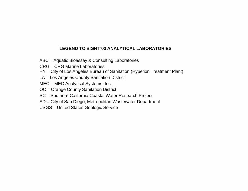
LEGEND TO BIGHT’03 ANALYTICAL LABORATORIES
ABC = Aquatic Bioassay & Consulting Laboratories CRG = CRG Marine Laboratories HY = City of Los Angeles Bureau of Sanitation (Hyperion Treatment Plant) LA = Los Angeles County Sanitation District MEC = MEC Analytical Systems, Inc. OC = Orange County Sanitation District SC = Southern California Coastal Water Research Project SD = City of San Diego, Metropolitan Wastewater Department USGS = United States Geologic Service

ANALYTICAL LABORATORIES
Station ID
Grab Agency
Infauna Analysis Lab
Grain Size Analysis Lab
Metals Analysis Lab
Organics Analysis Lab
TOC Analysis Lab
Toxicity Analysis Lab
4000 SD SD SD SD SD SD MEC-C 4001 CINMS NA SD SD SD SD NA 4002 MBC MEC-C SD CRG CRG SC MEC-C 4003 ABC ABC HY CRG CRG SC NA 4004 SD SD SD SD SD SD MEC-C 4005 CINMS NA SD SD SD SD NA 4006 HY HY HY HY HY SC MEC-C 4007 MBC SD SD SD CRG SD ABC 4008 MEC MEC-C SD CRG CRG SC MEC-C 4009 CINMS NA SD SD SD SD NA 4010 HY HY HY HY HY SC MEC-C 4011 CINMS MEC-C SD SD SD SD MEC-C 4012 SD SD SD SD SD SD NA 4013 ABC ABC HY CRG CRG SC ABC 4014 MBC MEC-C SD CRG CRG SC MEC-C 4015 ABC ABC HY CRG CRG SC ABC 4016 MEC-C MEC-C SD CRG CRG SC MEC 4017 MEC MEC-C SD CRG CRG SC MEC-C 4018 MEC-C MEC-C SD CRG CRG SC MEC 4019 ABC ABC HY CRG CRG SC ABC 4020 SD SD SD SD SD SD MEC-C 4021 HY HY HY HY HY SC MEC-C 4022 HY HY HY HY HY SC NA

ANALYTICAL LABORATORIES
Station ID
Grab Agency
Infauna Analysis Lab
Grain Size Analysis Lab
Metals Analysis Lab
Organics Analysis Lab
TOC Analysis Lab
Toxicity Analysis Lab
4023 MBC HY SD SD CRG SD ABC 4024 MEC MEC SD MEC MEC SC NA 4025 CINMS NA SD SD SD SD NA 4026 LA LA HY LA LA SC ABC 4027 CINMS MEC-C SD SD SD SD MEC-C 4028 SD SD SD SD SD SD MEC-C 4029 CINMS MEC-C SD SD SD SD MEC-C 4030 OC OC SD OC OC SC NA 4031 CINMS MEC-C SD SD SD SD MEC-C 4032 MEC MEC-C SD CRG CRG SC MEC-C 4033 MEC MEC-C SD CRG CRG SC MEC-C 4034 MBC MEC-C SD CRG CRG SC MEC-C 4035 ABC ABC HY CRG CRG SC ABC 4036 SD SD SD SD SD SD MEC-C 4037 HY HY HY HY HY SC MEC-C 4038 LA LA HY LA LA SC NA 4039 MBC MEC-C SD SD CRG SD ABC 4040 MEC MEC SD MEC MEC SC NA 4041 OC OC SD OC OC SC NA 4042 LA LA HY LA LA SC NA 4043 ABC ABC HY CRG CRG SC ABC 4044 SD SD SD SD SD SD MEC-C 4045 HY HY HY HY HY SC NA
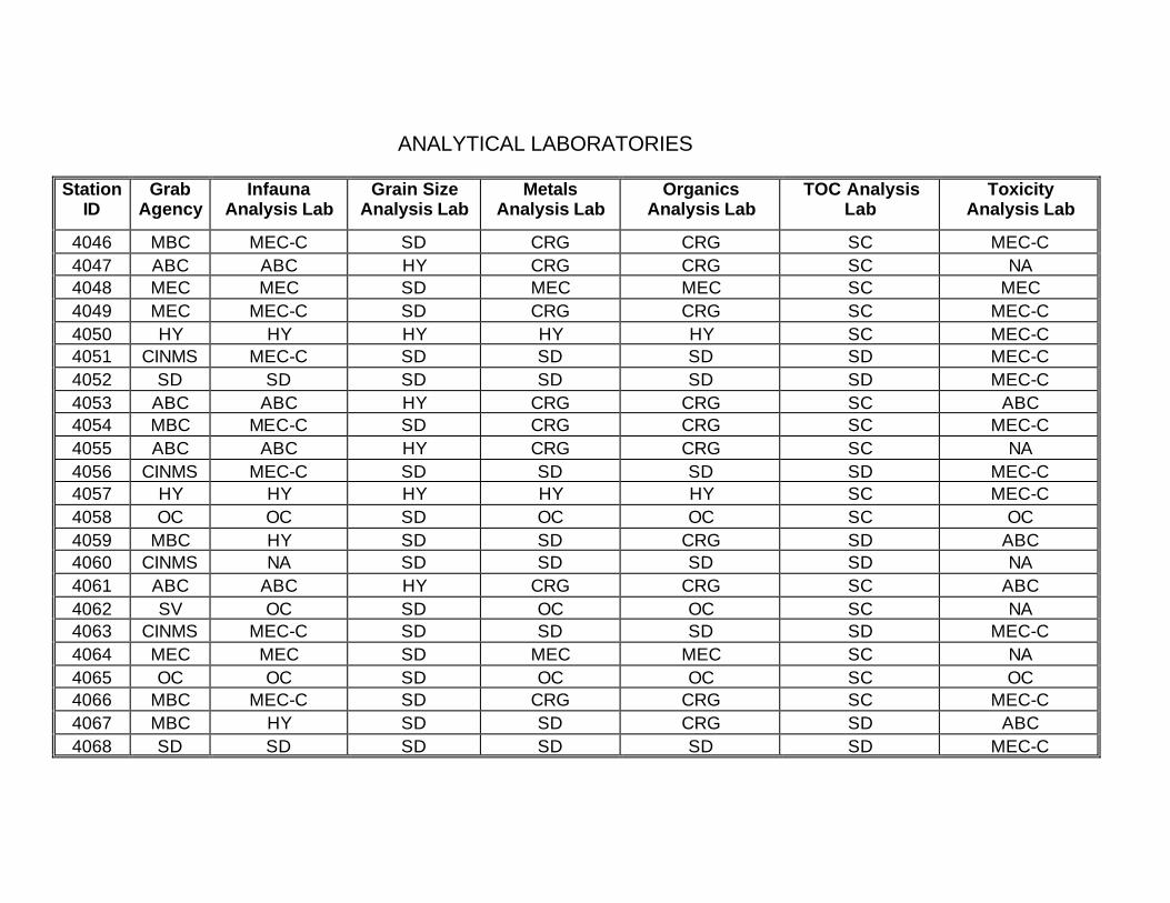
ANALYTICAL LABORATORIES
Station ID
Grab Agency
Infauna Analysis Lab
Grain Size Analysis Lab
Metals Analysis Lab
Organics Analysis Lab
TOC Analysis Lab
Toxicity Analysis Lab
4046 MBC MEC-C SD CRG CRG SC MEC-C 4047 ABC ABC HY CRG CRG SC NA 4048 MEC MEC SD MEC MEC SC MEC 4049 MEC MEC-C SD CRG CRG SC MEC-C 4050 HY HY HY HY HY SC MEC-C 4051 CINMS MEC-C SD SD SD SD MEC-C 4052 SD SD SD SD SD SD MEC-C 4053 ABC ABC HY CRG CRG SC ABC 4054 MBC MEC-C SD CRG CRG SC MEC-C 4055 ABC ABC HY CRG CRG SC NA 4056 CINMS MEC-C SD SD SD SD MEC-C 4057 HY HY HY HY HY SC MEC-C 4058 OC OC SD OC OC SC OC 4059 MBC HY SD SD CRG SD ABC 4060 CINMS NA SD SD SD SD NA 4061 ABC ABC HY CRG CRG SC ABC 4062 SV OC SD OC OC SC NA 4063 CINMS MEC-C SD SD SD SD MEC-C 4064 MEC MEC SD MEC MEC SC NA 4065 OC OC SD OC OC SC OC 4066 MBC MEC-C SD CRG CRG SC MEC-C 4067 MBC HY SD SD CRG SD ABC 4068 SD SD SD SD SD SD MEC-C
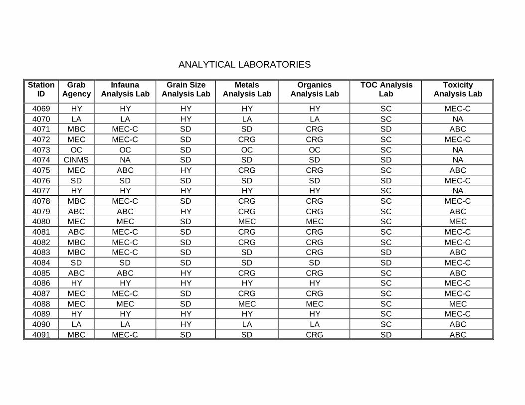
ANALYTICAL LABORATORIES
Station ID
Grab Agency
Infauna Analysis Lab
Grain Size Analysis Lab
Metals Analysis Lab
Organics Analysis Lab
TOC Analysis Lab
Toxicity Analysis Lab
4069 HY HY HY HY HY SC MEC-C 4070 LA LA HY LA LA SC NA 4071 MBC MEC-C SD SD CRG SD ABC 4072 MEC MEC-C SD CRG CRG SC MEC-C 4073 OC OC SD OC OC SC NA 4074 CINMS NA SD SD SD SD NA 4075 MEC ABC HY CRG CRG SC ABC 4076 SD SD SD SD SD SD MEC-C 4077 HY HY HY HY HY SC NA 4078 MBC MEC-C SD CRG CRG SC MEC-C 4079 ABC ABC HY CRG CRG SC ABC 4080 MEC MEC SD MEC MEC SC MEC 4081 ABC MEC-C SD CRG CRG SC MEC-C 4082 MBC MEC-C SD CRG CRG SC MEC-C 4083 MBC MEC-C SD SD CRG SD ABC 4084 SD SD SD SD SD SD MEC-C 4085 ABC ABC HY CRG CRG SC ABC 4086 HY HY HY HY HY SC MEC-C 4087 MEC MEC-C SD CRG CRG SC MEC-C 4088 MEC MEC SD MEC MEC SC MEC 4089 HY HY HY HY HY SC MEC-C 4090 LA LA HY LA LA SC ABC 4091 MBC MEC-C SD SD CRG SD ABC
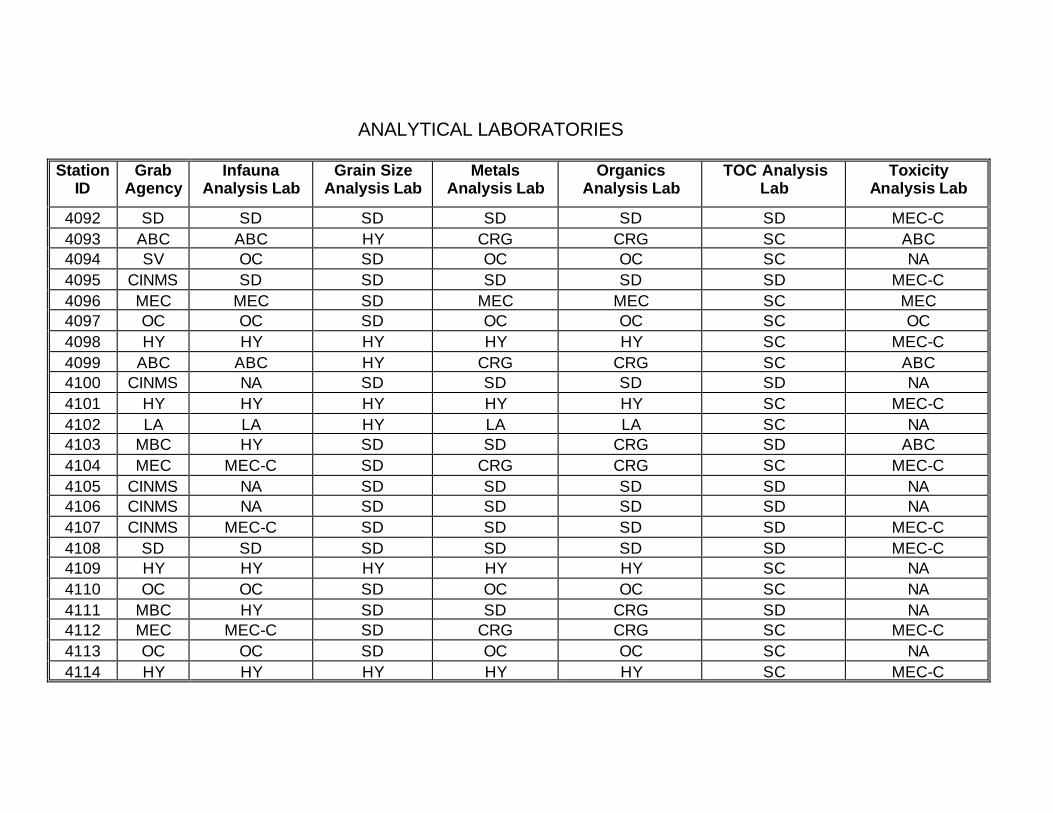
ANALYTICAL LABORATORIES
Station ID
Grab Agency
Infauna Analysis Lab
Grain Size Analysis Lab
Metals Analysis Lab
Organics Analysis Lab
TOC Analysis Lab
Toxicity Analysis Lab
4092 SD SD SD SD SD SD MEC-C 4093 ABC ABC HY CRG CRG SC ABC 4094 SV OC SD OC OC SC NA 4095 CINMS SD SD SD SD SD MEC-C 4096 MEC MEC SD MEC MEC SC MEC 4097 OC OC SD OC OC SC OC 4098 HY HY HY HY HY SC MEC-C 4099 ABC ABC HY CRG CRG SC ABC 4100 CINMS NA SD SD SD SD NA 4101 HY HY HY HY HY SC MEC-C 4102 LA LA HY LA LA SC NA 4103 MBC HY SD SD CRG SD ABC 4104 MEC MEC-C SD CRG CRG SC MEC-C 4105 CINMS NA SD SD SD SD NA 4106 CINMS NA SD SD SD SD NA 4107 CINMS MEC-C SD SD SD SD MEC-C 4108 SD SD SD SD SD SD MEC-C 4109 HY HY HY HY HY SC NA 4110 OC OC SD OC OC SC NA 4111 MBC HY SD SD CRG SD NA 4112 MEC MEC-C SD CRG CRG SC MEC-C 4113 OC OC SD OC OC SC NA 4114 HY HY HY HY HY SC MEC-C

ANALYTICAL LABORATORIES
Station ID
Grab Agency
Infauna Analysis Lab
Grain Size Analysis Lab
Metals Analysis Lab
Organics Analysis Lab
TOC Analysis Lab
Toxicity Analysis Lab
4115 CINMS MEC-C SD SD SD SD MEC-C 4116 SD SD SD SD SD SD MEC-C 4117 ABC ABC HY CRG CRG SC ABC 4118 MBC MEC-C SD CRG CRG SC MEC-C 4119 ABC ABC HY CRG CRG SC NA 4120 SD SD SD SD SD SD NA 4121 CINMS NA SD SD SD SD NA 4122 LA LA HY LA LA SC NA 4123 ABC ABC HY CRG CRG SC NA 4124 CINMS NA SD SD SD SD NA 4125 ABC-C SD SD SD CRG SD ABC 4126 SV OC SD OC OC SC NA 4127 CINMS MEC-C SD SD SD SD MEC-C 4128 SD SD SD SD SD SD NA 4129 OC OC SD OC OC SC OC 4130 MBC MEC-C SD CRG CRG SC MEC-C 4131 ABC ABC HY CRG CRG SC ABC 4132 SD SD SD SD SD SD MEC-C 4133 ABC ABC HY CRG CRG SC NA 4134 LA LA HY LA LA SC NA 4135 MBC SD SD SD CRG SD ABC 4136 ABC MEC-C SD CRG CRG SC MEC-C 4137 OC OC SD OC OC SC NA
ANALYTICAL LABORATORIES
Station ID
Grab Agency
Infauna Analysis Lab
Grain Size Analysis Lab
Metals Analysis Lab
Organics Analysis Lab
TOC Analysis Lab
Toxicity Analysis Lab
4138 HY HY HY HY HY SC MEC-C 4139 ABC ABC HY CRG CRG SC ABC 4140 SD SD SD SD SD SD MEC-C 4141 HY HY HY HY HY SC NA 4142 MBC MEC-C SD CRG CRG SC MEC-C 4143 ABC ABC HY CRG CRG SC NA 4144 MEC MEC SD MEC MEC SC NA 4145 MEC MEC-C SD CRG CRG SC MEC-C 4146 HY HY HY HY HY SC MEC-C 4147 ABC-C HY SD SD CRG SD NA 4148 SD SD SD SD SD SD MEC-C 4149 ABC ABC HY CRG CRG SC ABC 4150 HY HY HY HY HY SC NA 4151 ABC ABC HY CRG CRG SC NA 4152 MEC MEC SD MEC MEC SC NA 4153 CINMS NA SD SD SD SD NA 4154 OC OC SD OC OC SC NA 4155 CINMS MEC-C SD SD SD SD MEC-C 4156 SD SD SD SD SD SD MEC-C 4157 ABC ABC HY CRG CRG SC NA 4158 SV OC SD OC OC SC NA 4159 CINMS MEC-C SD SD SD SD MEC-C 4160 CINMS NA SD SD SD SD NA
ANALYTICAL LABORATORIES
Station ID
Grab Agency
Infauna Analysis Lab
Grain Size Analysis Lab
Metals Analysis Lab
Organics Analysis Lab
TOC Analysis Lab
Toxicity Analysis Lab
4161 MEC MEC-C SD CRG CRG SC MEC-C 4162 HY HY HY HY HY SC MEC-C 4163 CINMS MEC-C SD SD SD SD MEC-C 4164 SD SD SD SD SD SD NA 4165 HY HY HY HY HY SC NA 4166 LA LA HY LA LA SC NA 4167 MBC MEC-C SD CRG CRG SD NA 4168 MEC MEC-C SD CRG CRG SC MEC-C 4169 OC OC SD OC OC SC OC 4170 LA LA HY LA LA SC NA 4171 CINMS MEC-C SD SD SD SD MEC-C 4172 SD SD SD SD SD SD NA 4173 HY HY HY HY HY SC NA 4174 MBC MEC-C SD CRG CRG SC MEC-C 4175 ABC ABC HY CRG CRG SC NA 4176 ABC MEC-C SD CRG CRG SC MEC-C 4177 OC OC SD OC OC SC OC 4178 HY HY HY HY HY SC MEC-C 4179 MBC SD SD SD CRG SD ABC 4180 SD SD SD SD SD SD MEC-C 4181 HY HY HY HY HY SC NA 4182 MBC MEC-C SD CRG CRG SC MEC-C 4183 ABC ABC HY CRG CRG SC NA

ANALYTICAL LABORATORIES
Station ID
Grab Agency
Infauna Analysis Lab
Grain Size Analysis Lab
Metals Analysis Lab
Organics Analysis Lab
TOC Analysis Lab
Toxicity Analysis Lab
4184 SD SD SD SD SD SD NA 4185 HY HY HY HY HY SC NA 4186 LA LA HY LA LA SC NA 4187 MBC HY SD SD CRG SD NA 4188 CINMS NA SD SD SD SD NA 4189 ABC ABC HY CRG CRG SC NA 4190 NA NA NA NA SC NA NA 4191 CINMS MEC-C SD SD SD SD MEC-C 4192 MEC MEC SD MEC MEC SC NA 4193 OC OC SD OC OC SC OC 4194 MBC MEC-C SD CRG CRG SC MEC-C 4195 MBC HY SD SD CRG SD NA 4196 CINMS NA SD SD SD SD NA 4197 MEC MEC-C SD CRG CRG SC MEC-C 4198 LA LA HY LA LA SC NA 4199 MBC SD SD SD CRG SD ABC 4200 MEC MEC SD MEC MEC SC NA 4201 OC OC SD OC OC SC OC 4202 LA LA HY LA LA SC ABC 4203 ABC ABC HY CRG CRG SC NA 4204 SD SD SD SD SD SD MEC-C 4205 HY HY HY HY HY SC NA 4206 MBC MEC-C SD CRG CRG SC MEC-C

ANALYTICAL LABORATORIES
Station ID
Grab Agency
Infauna Analysis Lab
Grain Size Analysis Lab
Metals Analysis Lab
Organics Analysis Lab
TOC Analysis Lab
Toxicity Analysis Lab
4207 ABC ABC HY CRG CRG SC NA 4208 MEC MEC SD MEC MEC SC NA 4209 MEC MEC-C SD CRG CRG SC MEC-C 4210 HY HY HY HY HY SC MEC-C 4211 MBC LA SD SD CRG SD ABC 4212 SD SD SD SD SD SD MEC-C 4213 ABC ABC HY CRG CRG SC ABC 4214 NA NA NA NA SC NA NA 4215 ABC ABC HY CRG CRG SC NA 4216 CINMS NA SD SD SD SD NA 4217 NA NA NA NA SC NA NA 4218 LA LA HY LA LA SC NA 4219 CINMS NA SD SD SD SD NA 4220 CINMS NA SD SD SD SD NA 4221 MEC ABC HY CRG CRG SC ABC 4222 SV OC SD OC OC SC NA 4223 CINMS MEC-C SD SD SD SD MEC-C 4224 CINMS NA SD SD SD SD NA 4225 MEC MEC-C SD CRG CRG SC MEC-C 4226 HY HY HY HY HY SC MEC-C 4227 MBC HY SD SD CRG SD NA 4228 SD SD SD SD SD SD MEC-C 4229 NA NA NA NA SC NA NA
ANALYTICAL LABORATORIES
Station ID
Grab Agency
Infauna Analysis Lab
Grain Size Analysis Lab
Metals Analysis Lab
Organics Analysis Lab
TOC Analysis Lab
Toxicity Analysis Lab
4230 HY HY HY HY HY SC NA 4231 NA NA NA NA SC NA NA 4232 MEC MEC SD MEC MEC SC NA 4233 CINMS NA SD SD SD SD NA 4234 LA LA HY LA LA SC NA 4235 CINMS MEC-C SD SD SD SD MEC-C 4236 SD SD SD SD SD SD MEC-C 4237 ABC-C SD SD SD CRG SD ABC 4238 OC OC SD OC OC SC NA 4239 MBC SD SD SD CRG SD ABC 4240 MEC MEC SD MEC MEC SC MEC 4241 OC OC SD OC OC SC NA 4242 HY HY HY HY HY SC MEC-C 4243 CINMS MEC-C SD SD SD SD MEC-C 4244 SD SD SD SD SD SD NA 4245 ABC ABC HY CRG CRG SC ABC 4246 MEC-C MEC-C SD CRG CRG SC MEC-C 4247 ABC ABC HY CRG CRG SC NA 4248 SD SD SD SD SD SD NA 4249 CINMS NA SD SD SD SD NA 4250 LA LA HY LA LA SC NA 4251 MBC HY SD SD CRG SD NA 4252 CINMS NA SD SD SD SD NA
ANALYTICAL LABORATORIES
Station ID
Grab Agency
Infauna Analysis Lab
Grain Size Analysis Lab
Metals Analysis Lab
Organics Analysis Lab
TOC Analysis Lab
Toxicity Analysis Lab
4253 ABC ABC HY CRG CRG SC NA 4254 LA LA HY LA LA SC ABC 4255 CINMS MEC-C SD SD SD SD MEC-C 4256 SD SD SD SD SD SD NA 4257 OC OC SD OC OC SC OC 4258 MBC MEC-C SD CRG CRG SC MEC-C 4259 ABC ABC HY CRG CRG SC NA 4260 SD SD SD SD SD SD NA 4261 HY HY HY HY HY SC MEC-C 4262 LA LA HY LA LA SC ABC 4263 MBC SD SD SD CRG SD ABC 4264 MEC MEC-C SD CRG CRG SC MEC-C 4265 OC OC SD OC OC SC NA 4266 HY HY HY HY HY SC MEC-C 4267 ABC ABC HY CRG CRG SC NA 4268 SD SD SD SD SD SD MEC-C 4269 HY HY HY HY HY SC NA 4270 MBC MEC-C SD CRG CRG SC MEC-C 4271 NA NA NA NA SC NA NA 4272 MEC MEC-C SD CRG CRG SC MEC-C 4273 MEC MEC-C SD CRG CRG SC MEC-C 4274 HY HY HY HY HY SC MEC-C 4275 NA NA NA NA SC NA NA
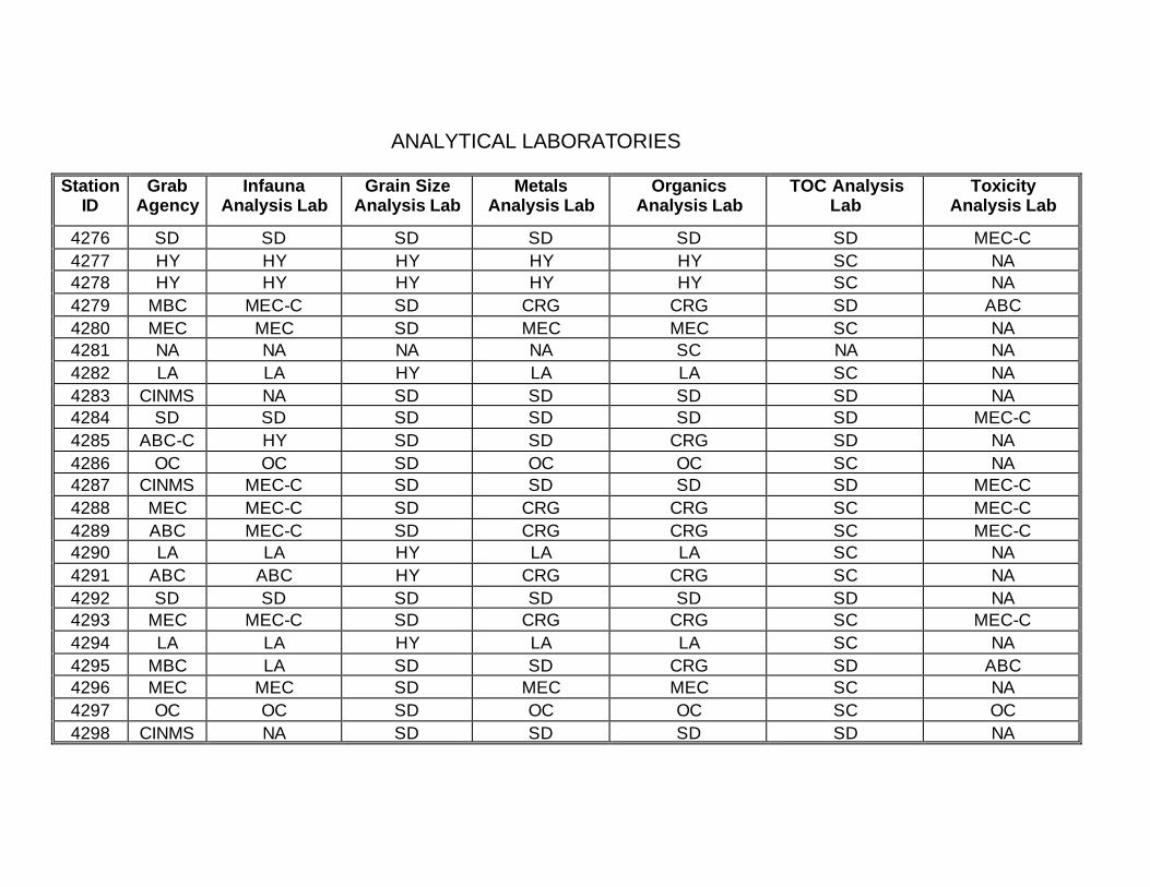
ANALYTICAL LABORATORIES
Station ID
Grab Agency
Infauna Analysis Lab
Grain Size Analysis Lab
Metals Analysis Lab
Organics Analysis Lab
TOC Analysis Lab
Toxicity Analysis Lab
4276 SD SD SD SD SD SD MEC-C 4277 HY HY HY HY HY SC NA 4278 HY HY HY HY HY SC NA 4279 MBC MEC-C SD CRG CRG SD ABC 4280 MEC MEC SD MEC MEC SC NA 4281 NA NA NA NA SC NA NA 4282 LA LA HY LA LA SC NA 4283 CINMS NA SD SD SD SD NA 4284 SD SD SD SD SD SD MEC-C 4285 ABC-C HY SD SD CRG SD NA 4286 OC OC SD OC OC SC NA 4287 CINMS MEC-C SD SD SD SD MEC-C 4288 MEC MEC-C SD CRG CRG SC MEC-C 4289 ABC MEC-C SD CRG CRG SC MEC-C 4290 LA LA HY LA LA SC NA 4291 ABC ABC HY CRG CRG SC NA 4292 SD SD SD SD SD SD NA 4293 MEC MEC-C SD CRG CRG SC MEC-C 4294 LA LA HY LA LA SC NA 4295 MBC LA SD SD CRG SD ABC 4296 MEC MEC SD MEC MEC SC NA 4297 OC OC SD OC OC SC OC 4298 CINMS NA SD SD SD SD NA
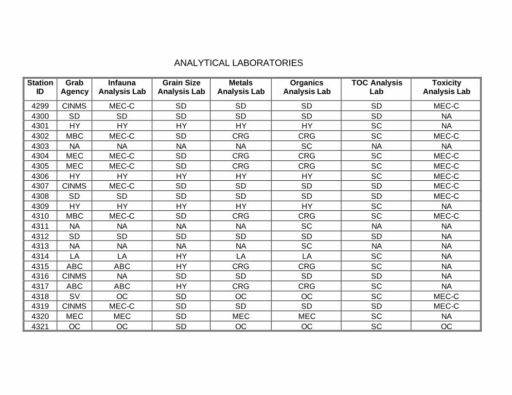
ANALYTICAL LABORATORIES
Station ID
Grab Agency
Infauna Analysis Lab
Grain Size Analysis Lab
Metals Analysis Lab
Organics Analysis Lab
TOC Analysis Lab
Toxicity Analysis Lab
4299 CINMS MEC-C SD SD SD SD MEC-C 4300 SD SD SD SD SD SD NA 4301 HY HY HY HY HY SC NA 4302 MBC MEC-C SD CRG CRG SC MEC-C 4303 NA NA NA NA SC NA NA 4304 MEC MEC-C SD CRG CRG SC MEC-C 4305 MEC MEC-C SD CRG CRG SC MEC-C 4306 HY HY HY HY HY SC MEC-C 4307 CINMS MEC-C SD SD SD SD MEC-C 4308 SD SD SD SD SD SD MEC-C 4309 HY HY HY HY HY SC NA 4310 MBC MEC-C SD CRG CRG SC MEC-C 4311 NA NA NA NA SC NA NA 4312 SD SD SD SD SD SD NA 4313 NA NA NA NA SC NA NA 4314 LA LA HY LA LA SC NA 4315 ABC ABC HY CRG CRG SC NA 4316 CINMS NA SD SD SD SD NA 4317 ABC ABC HY CRG CRG SC NA 4318 SV OC SD OC OC SC MEC-C 4319 CINMS MEC-C SD SD SD SD MEC-C 4320 MEC MEC SD MEC MEC SC NA 4321 OC OC SD OC OC SC OC
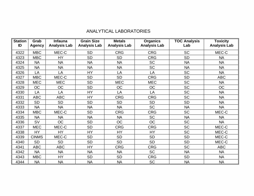
ANALYTICAL LABORATORIES
Station ID
Grab Agency
Infauna Analysis Lab
Grain Size Analysis Lab
Metals Analysis Lab
Organics Analysis Lab
TOC Analysis Lab
Toxicity Analysis Lab
4322 MBC MEC-C SD CRG CRG SC MEC-C 4323 MBC HY SD SD CRG SD NA 4324 NA NA NA NA SC NA NA 4325 NA NA NA NA SC NA NA 4326 LA LA HY LA LA SC NA 4327 MBC MEC-C SD SD CRG SD ABC 4328 MEC MEC SD MEC MEC SC NA 4329 OC OC SD OC OC SC OC 4330 LA LA HY LA LA SC NA 4331 ABC ABC HY CRG CRG SC NA 4332 SD SD SD SD SD SD NA 4333 NA NA NA NA SC NA NA 4334 MBC MEC-C SD CRG CRG SC MEC-C 4335 NA NA NA NA SC NA NA 4336 SV OC SD OC OC SC NA 4337 MEC MEC-C SD CRG CRG SC MEC-C 4338 HY HY HY HY HY SC MEC-C 4339 CINMS MEC-C SD SD SD SD MEC-C 4340 SD SD SD SD SD SD MEC-C 4341 ABC ABC HY CRG CRG SC ABC 4342 NA NA NA NA SC NA NA 4343 MBC HY SD SD CRG SD NA 4344 NA NA NA NA SC NA NA
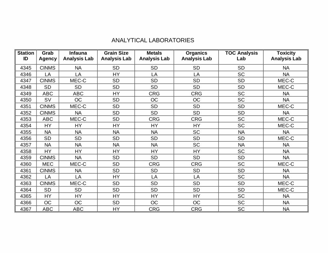
ANALYTICAL LABORATORIES
Station ID
Grab Agency
Infauna Analysis Lab
Grain Size Analysis Lab
Metals Analysis Lab
Organics Analysis Lab
TOC Analysis Lab
Toxicity Analysis Lab
4345 CINMS NA SD SD SD SD NA 4346 LA LA HY LA LA SC NA 4347 CINMS MEC-C SD SD SD SD MEC-C 4348 SD SD SD SD SD SD MEC-C 4349 ABC ABC HY CRG CRG SC NA 4350 SV OC SD OC OC SC NA 4351 CINMS MEC-C SD SD SD SD MEC-C 4352 CINMS NA SD SD SD SD NA 4353 ABC MEC-C SD CRG CRG SC MEC-C 4354 HY HY HY HY HY SC MEC-C 4355 NA NA NA NA SC NA NA 4356 SD SD SD SD SD SD MEC-C 4357 NA NA NA NA SC NA NA 4358 HY HY HY HY HY SC NA 4359 CINMS NA SD SD SD SD NA 4360 MEC MEC-C SD CRG CRG SC MEC-C 4361 CINMS NA SD SD SD SD NA 4362 LA LA HY LA LA SC NA 4363 CINMS MEC-C SD SD SD SD MEC-C 4364 SD SD SD SD SD SD MEC-C 4365 HY HY HY HY HY SC NA 4366 OC OC SD OC OC SC NA 4367 ABC ABC HY CRG CRG SC NA
ANALYTICAL LABORATORIES
Station ID
Grab Agency
Infauna Analysis Lab
Grain Size Analysis Lab
Metals Analysis Lab
Organics Analysis Lab
TOC Analysis Lab
Toxicity Analysis Lab
4368 CINMS NA SD SD SD SD NA 4369 OC OC SD OC OC SC NA 4370 HY HY HY HY HY SC MEC-C 4371 CINMS MEC-C SD SD SD SD MEC-C 4372 SD SD SD SD SD SD MEC-C 4373 ABC ABC HY CRG CRG SC ABC 4374 OC OC SD OC OC SC NA 4375 ABC ABC HY CRG CRG SC NA 4376 SD SD SD SD SD SD NA 4377 CINMS NA SD SD SD SD NA 4378 LA LA HY LA LA SC ABC 4379 MBC HY SD SD CRG SD NA 4380 CINMS NA SD SD SD SD NA 4381 ABC ABC HY CRG CRG SC NA 4382 LA LA HY LA LA SC ABC 4383 CINMS MEC-C SD SD SD SD MEC-C 4384 MEC MEC SD MEC MEC SC NA 4385 OC OC SD OC OC SC OC 4386 MEC-C MEC-C SD CRG CRG SC MEC 4387 ABC ABC HY CRG CRG SC ABC 4388 SD SD SD SD SD SD NA 4389 HY HY HY HY HY SC NA 4391 USGS NA TBD TBD TBD TBD NA
ANALYTICAL LABORATORIES
Station ID
Grab Agency
Infauna Analysis Lab
Grain Size Analysis Lab
Metals Analysis Lab
Organics Analysis Lab
TOC Analysis Lab
Toxicity Analysis Lab
4400 HY HY HY HY HY SC MEC-C 4401 CINMS MEC-C SD SD SD SD MEC-C 4404 MEC-C OC SD OC OC SC OC 4408 HY HY HY HY HY SC MEC-C 4417 CINMS MEC-C SD SD SD SD MEC-C 4418 SD SD SD SD SD SD MEC-C 4419 ABC-C MEC-C SD CRG CRG SD NA 4421 CINMS MEC-C SD SD SD SD MEC-C 4422 ABC MEC-C SD CRG CRG SC MEC-C 4423 OC OC SD OC OC SC OC 4424 MEC-C MEC-C SD CRG CRG SC MEC 4425 MBC HY SD SD CRG SD NA 4426 SD SD SD SD SD SD NA 4442 SD SD SD SD SD SD MEC-C 4444 USGS NA TBD TBD TBD TBD NA 4446 CINMS MEC-C SD SD SD SD MEC-C 4453 CINMS MEC-C SD SD SD SD MEC-C 4458 SD SD SD SD SD SD NA 4460 USGS NA TBD TBD TBD TBD NA 4464 MLML NA NA NA NA NA NA 4472 MLML NA NA NA NA NA NA 4481 CINMS MEC-C SD SD SD SD MEC-C 4488 MLML NA NA NA NA NA NA
ANALYTICAL LABORATORIES
Station ID
Grab Agency
Infauna Analysis Lab
Grain Size Analysis Lab
Metals Analysis Lab
Organics Analysis Lab
TOC Analysis Lab
Toxicity Analysis Lab
4494 MEC MEC-C SD CRG CRG SC MEC-C 4495 USGS NA TBD TBD TBD TBD NA 4504 MLML NA NA NA NA NA NA 4511 USGS NA TBD TBD TBD TBD NA 4527 USGS NA TBD TBD TBD TBD NA 4568 MLML NA NA NA NA NA NA 4616 MLML NA NA NA NA NA NA 4632 MLML NA NA NA NA NA NA 4656 MLML NA NA NA NA NA NA 4695 MEC MEC-C SD CRG CRG SC MEC-C 4720 MLML NA NA NA NA NA NA 4744 MLML NA NA NA NA NA NA 4760 MLML NA NA NA NA NA NA 4784 MLML NA NA NA NA NA NA 4792 MLML NA NA NA NA NA NA 4999 ABC MEC-C SD CRG CRG SC MEC-C 5014 MEC MEC-C SD CRG CRG SC MEC-C 5301 MEC MEC-C SD CRG CRG SC MEC-C 5336 ABC MEC-C SD CRG CRG SC MEC-C
BRI-01 ABC MEC-C SD CRG CRG SC MEC-C BRI-02 ABC MEC-C SD CRG CRG SC MEC-C BRI-03 HY MEC-C SD CRG CRG SC MEC-C BRI-04 HY MEC-C SD CRG CRG SC MEC-C
ANALYTICAL LABORATORIES
Station ID
Grab Agency
Infauna Analysis Lab
Grain Size Analysis Lab
Metals Analysis Lab
Organics Analysis Lab
TOC Analysis Lab
Toxicity Analysis Lab
BRI-05 HY MEC-C SD CRG CRG SC MEC-C BRI-06 HY MEC-C SD CRG CRG SC MEC-C BRI-07 OC OC SD OC OC SC OC BRI-08 OC OC SD OC OC SC OC BRI-09 OC OC SD OC OC SC OC BRI-10 OC OC SD OC OC SC OC BRI-11 MEC MEC-C SD CRG CRG SC MEC-C BRI-12 MEC MEC-C SD CRG CRG SC MEC-C BRI-13 MEC MEC-C SD CRG CRG SC MEC-C BRI-14 MEC MEC-C SD CRG CRG SC MEC-C BRI-15 SD MEC-C SD CRG CRG SC MEC-C BRI-16 SD MEC-C SD CRG CRG SC MEC-C BRI-17 SD MEC-C SD CRG CRG SC MEC-C BRI-18 SD MEC-C SD CRG CRG SC MEC-C BRI-19 SD MEC-C SD CRG CRG SC MEC-C BRI-20 SD MEC-C SD CRG CRG SC MEC-C
APPENDIX 4
Bight’03 Field Sampling
Equipment and Supply List
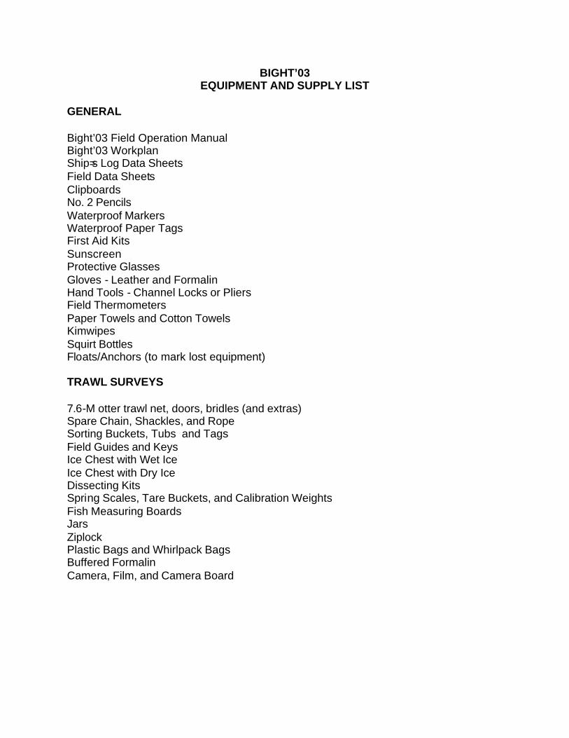
BIGHT’03 EQUIPMENT AND SUPPLY LIST
GENERAL Bight’03 Field Operation Manual Bight’03 Workplan Ship=s Log Data Sheets Field Data Sheets Clipboards No. 2 Pencils Waterproof Markers Waterproof Paper Tags First Aid Kits Sunscreen Protective Glasses Gloves - Leather and Formalin Hand Tools - Channel Locks or Pliers Field Thermometers Paper Towels and Cotton Towels Kimwipes Squirt Bottles Floats/Anchors (to mark lost equipment) TRAWL SURVEYS 7.6-M otter trawl net, doors, bridles (and extras) Spare Chain, Shackles, and Rope Sorting Buckets, Tubs and Tags Field Guides and Keys Ice Chest with Wet Ice Ice Chest with Dry Ice Dissecting Kits Spring Scales, Tare Buckets, and Calibration Weights Fish Measuring Boards Jars Ziplock Plastic Bags and Whirlpack Bags Buffered Formalin Camera, Film, and Camera Board
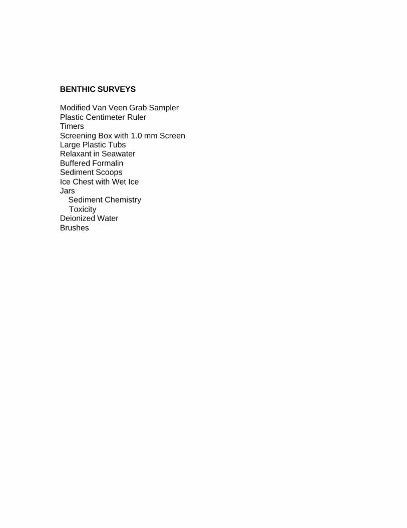
BENTHIC SURVEYS Modified Van Veen Grab Sampler Plastic Centimeter Ruler Timers Screening Box with 1.0 mm Screen Large Plastic Tubs Relaxant in Seawater Buffered Formalin Sediment Scoops Ice Chest with Wet Ice Jars Sediment Chemistry Toxicity Deionized Water Brushes
APPENDIX 5
Bight’03 Sampling Vessel Specifications
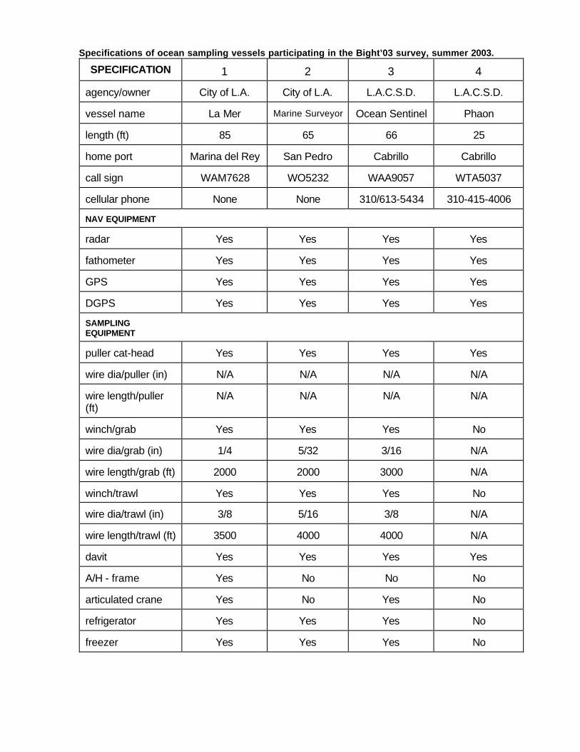
Specifications of ocean sampling vessels participating in the Bight’03 survey, summer 2003.
SPECIFICATION
1
2
3
4
agency/owner
City of L.A.
City of L.A.
L.A.C.S.D.
L.A.C.S.D.
vessel name
La Mer
Marine Surveyor
Ocean Sentinel
Phaon
length (ft)
85
65
66
25
home port
Marina del Rey
San Pedro
Cabrillo
Cabrillo
call sign
WAM7628
WO5232
WAA9057
WTA5037
cellular phone
None
None
310/613-5434
310-415-4006
NAV EQUIPMENT
radar
Yes
Yes
Yes
Yes
fathometer
Yes
Yes
Yes
Yes
GPS
Yes
Yes
Yes
Yes
DGPS
Yes
Yes
Yes
Yes
SAMPLING EQUIPMENT
puller cat-head
Yes
Yes
Yes
Yes
wire dia/puller (in)
N/A
N/A
N/A
N/A
wire length/puller (ft)
N/A
N/A
N/A
N/A
winch/grab
Yes
Yes
Yes
No
wire dia/grab (in)
1/4
5/32
3/16
N/A
wire length/grab (ft)
2000
2000
3000
N/A
winch/trawl
Yes
Yes
Yes
No
wire dia/trawl (in)
3/8
5/16
3/8
N/A
wire length/trawl (ft)
3500
4000
4000
N/A
davit
Yes
Yes
Yes
Yes
A/H - frame
Yes
No
No
No
articulated crane
Yes
No
Yes
No
refrigerator
Yes
Yes
Yes
No
freezer
Yes
Yes
Yes
No
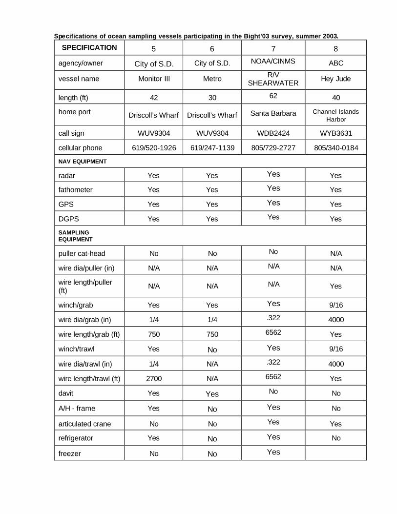
Specifications of ocean sampling vessels participating in the Bight’03 survey, summer 2003.
SPECIFICATION
5
6
7
8
agency/owner
City of S.D.
City of S.D. NOAA/CINMS
ABC
vessel name
Monitor III
Metro R/V
SHEARWATER
Hey Jude
length (ft)
42
30 62
40
home port
Driscoll’s Wharf
Driscoll’s Wharf Santa Barbara Channel Islands
Harbor call sign
WUV9304
WUV9304 WDB2424
WYB3631
cellular phone
619/520-1926
619/247-1139 805/729-2727
805/340-0184
NAV EQUIPMENT
radar
Yes
Yes Yes
Yes
fathometer
Yes
Yes Yes
Yes
GPS
Yes
Yes Yes
Yes
DGPS
Yes
Yes Yes
Yes
SAMPLING EQUIPMENT
puller cat-head
No
No No
N/A
wire dia/puller (in)
N/A
N/A N/A
N/A
wire length/puller (ft)
N/A
N/A N/A
Yes
winch/grab
Yes
Yes Yes
9/16
wire dia/grab (in)
1/4
1/4 .322
4000
wire length/grab (ft)
750
750 6562
Yes
winch/trawl
Yes
No Yes
9/16
wire dia/trawl (in)
1/4
N/A .322
4000
wire length/trawl (ft)
2700
N/A 6562
Yes
davit
Yes
Yes No
No
A/H - frame
Yes
No Yes
No
articulated crane
No
No Yes
Yes
refrigerator
Yes
No Yes
No
freezer
No No Yes

Specifications of ocean sampling vessels participating in the Bight‘03 survey, summer 2003. SPECIFICATION
9 10
11
12
agency/owner
MBC MEC
SeaVentures
So. Cal. Mar. Inst.
vessel name
Westwind Zephyr
Early Bird
Yellowfin
length (ft)
50 44
32
70
home port
Newport Beach Ventura
Dana Point
Terminal Island
call sign
WYZ9810 WBZ3687
WAR 6030
WCW2778
cellular phone
714/321-8204 510/914-0157
949/637-2433
310/560-9917
NAV EQUIPMENT
radar
Yes Yes
Yes
Yes
fathometer
Yes Yes
Yes
Yes
GPS
Yes Yes
Yes
Yes
DGPS
Yes Yes
Yes
Yes
SAMPLING EQUIPMENT
puller cat-head
Yes No Yes
Yes
wire dia/puller (in)
N/A N/A
N/A
N/A
wire length/puller (ft)
N/A N/A
N/A
N/A
winch/grab
Yes Yes
Yes
Yes
wire dia/grab (in)
1/4 1/4
1/4
7/16
wire length/grab ft)
5000 3000
2000
14000
winch/trawl
Yes Yes
Yes
Yes
wire dia/trawl (in)
1/4 3/8
1/4
7/16
wire length/trawl (ft)
5000 14000
2000
14000
davit
No Yes
No
No
A/H - frame
Yes Yes
Yes
Yes
articulated crane
No No
No
Yes
refrigerator
Yes Yes
Yes
Yes
freezer
Yes Yes
Yes
Yes
Specifications of ocean sa mpling vessels participating in the Bight‘03 survey, summer 2003.
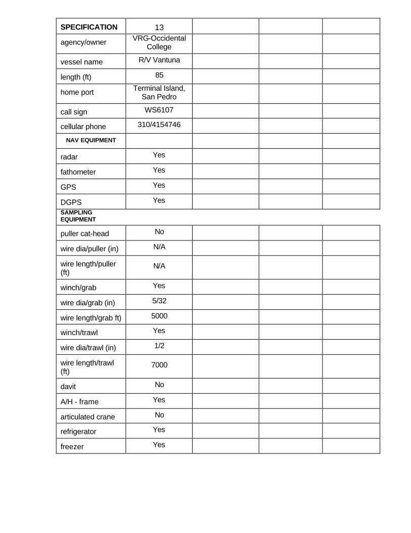
SPECIFICATION
13
agency/owner VRG-Occidental
College
vessel name R/V Vantuna
length (ft) 85
home port Terminal Island,
San Pedro
call sign WS6107
cellular phone 310/4154746
NAV EQUIPMENT
radar Yes
fathometer Yes
GPS Yes
DGPS Yes
SAMPLING EQUIPMENT
puller cat-head No
wire dia/puller (in) N/A
wire length/puller (ft)
N/A
winch/grab Yes
wire dia/grab (in) 5/32
wire length/grab ft) 5000 winch/trawl Yes
wire dia/trawl (in) 1/2
wire length/trawl (ft)
7000
davit No
A/H - frame Yes
articulated crane No
refrigerator Yes
freezer Yes
APPENDIX 6
Bight’03 Field Sampling
Data Sheets
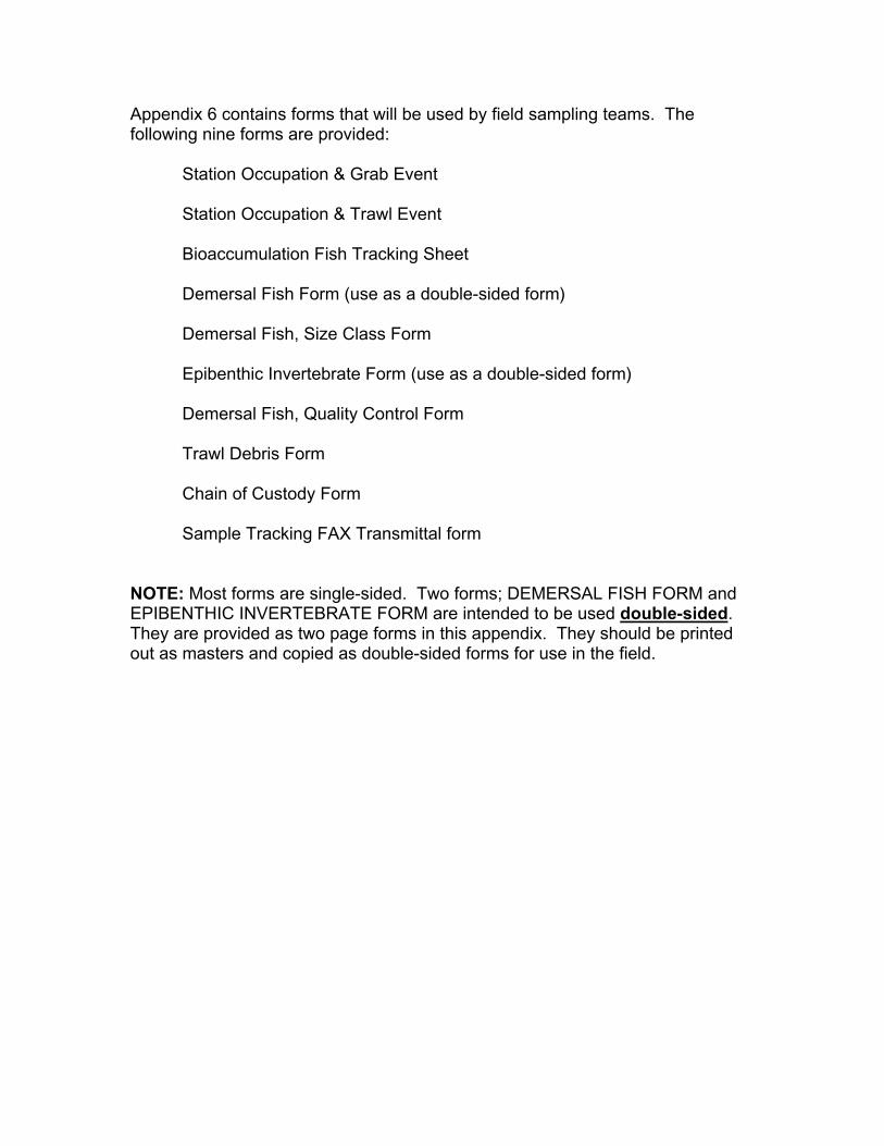
Appendix 6 contains forms that will be used by field sampling teams. Thefollowing nine forms are provided:
Station Occupation & Grab Event
Station Occupation & Trawl Event
Bioaccumulation Fish Tracking Sheet
Demersal Fish Form (use as a double-sided form)
Demersal Fish, Size Class Form
Epibenthic Invertebrate Form (use as a double-sided form)
Demersal Fish, Quality Control Form
Trawl Debris Form
Chain of Custody Form
Sample Tracking FAX Transmittal form
NOTE: Most forms are single-sided. Two forms; DEMERSAL FISH FORM andEPIBENTHIC INVERTEBRATE FORM are intended to be used double-sided.They are provided as two page forms in this appendix. They should be printedout as masters and copied as double-sided forms for use in the field.
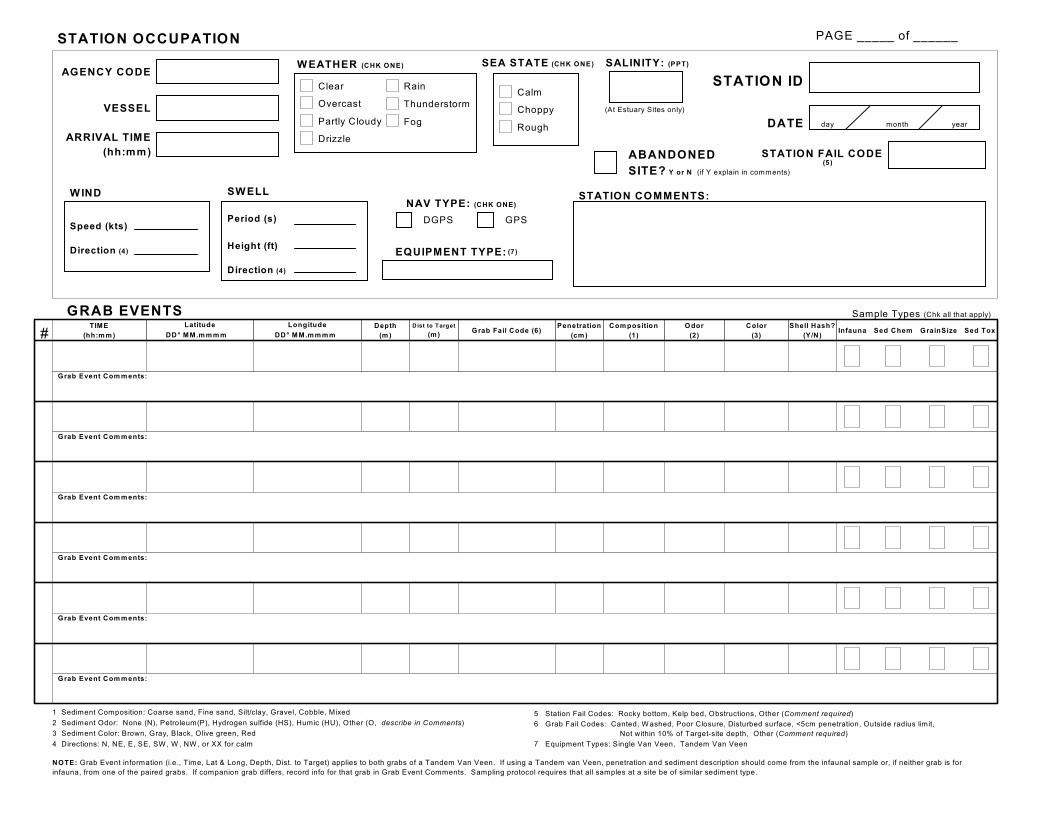
STATION OCCUPATION
AGENCY CODE
VESSEL
ARRIVAL TIME(hh:mm)
Speed (kts)
Direction (4)
Period (s)
Height (ft)
Calm
Choppy
Rough
SEA STATE (CHK ONE)
STATION ID
DATE day month year
SALINITY: (PPT)
EQUIPMENT TYPE: (7)
W IND SW ELL
Direction (4)
DGPS GPS
NAV TYPE: (CHK ONE)STATION COMMENTS:
ABANDONEDSITE? Y or N (if Y explain in comments)
(At Estuary Sites only)
TIME(hh:m m )
Depth(m )
Dist to Target
(m )G rab Fail Code (6)
Penetration(cm )
Com position(1)
Odor(2)
Color(3)
Shell Hash?(Y/N)
Infauna Sed Chem GrainSize Sed Tox
Sample Types (Chk all that apply)
LongitudeLatitude
DD° MM.m m m m DD° M M.m m m m
Grab Event Com m ents:
Grab Event Com m ents:
Grab Event Com m ents:
Grab Event Com m ents:
Grab Event Com m ents:
GRAB EVENTS
Grab Event Com m ents:
1 Sediment Composition: Coarse sand, Fine sand, Silt/clay, Gravel, Cobble, Mixed
2 Sediment Odor: None (N), Petroleum(P), Hydrogen sulfide (HS), Humic (HU), Other (O, describe in Comments)
3 Sediment Color: Brown, Gray, Black, Olive green, Red
4 Directions: N, NE, E, SE, SW , W , NW , or XX for calm
5 Station Fail Codes: Rocky bottom, Kelp bed, Obstructions, Other (Comment required)
6 Grab Fail Codes: Canted, W ashed, Poor Closure, Disturbed surface, <5cm penetration, Outside radius limit, Not within 10% of Target-site depth, Other (Comment required)
STATION FAIL CODE(5)
7 Equipment Types: Single Van Veen, Tandem Van Veen
NOTE: Grab Event information (i.e., Time, Lat & Long, Depth, Dist. to Target) applies to both grabs of a Tandem Van Veen. If using a Tandem van Veen, penetration and sediment description should come from the infaunal sample or, if neither grab is forinfauna, from one of the paired grabs. If companion grab differs, record info for that grab in Grab Event Comments. Sampling protocol requires that all samples at a site be of similar sediment type.
PAGE _____ of ______
#
Clear
Overcast
Partly Cloudy
Drizzle
Rain
Thunderstorm
Fog
W EATHER (CHK ONE)
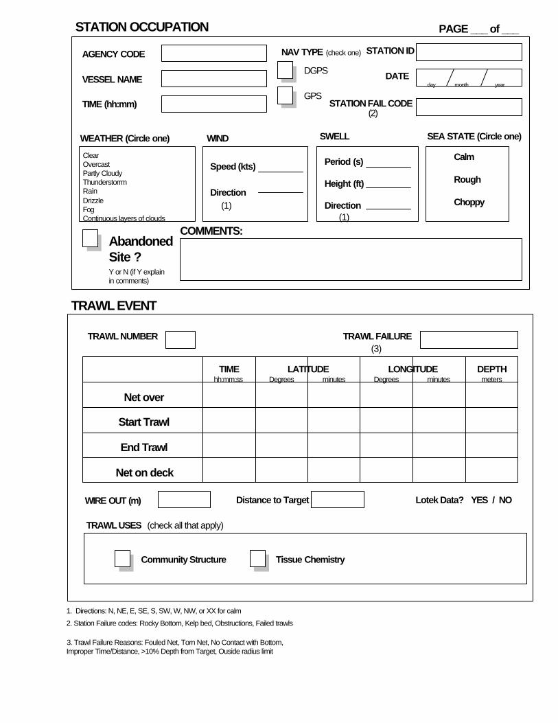
STATION OCCUPATION
STATION ID
DATE
PAGE ___ of ___
AGENCY CODE
VESSEL NAME
TIME (hh:mm)
WEATHER (Circle one)
ClearOvercastPartly CloudyThunderstorrmRainDrizzleFogContinuous layers of clouds
WIND
Speed (kts)
Direction
SWELL
Period (s)
Height (ft)
Direction
SEA STATE (Circle one)
Calm
Rough
Choppy
COMMENTS:
STATION FAIL CODE
day month year
TRAWL EVENT
NAV TYPE
DGPS
GPS
Net over
Start Trawl
End Trawl
Net on deck
TIME LATITUDE LONGITUDE DEPTH
TRAWL NUMBER
metersDegrees Degrees minutesminuteshh:mm:ss
TRAWL FAILURE
WIRE OUT (m)
TRAWL USES
Community Structure Tissue Chemistry
Lotek Data? YES / NO
(check all that apply)
(check one)
AbandonedSite ?
Distance to Target
1. Directions: N, NE, E, SE, S, SW, W, NW, or XX for calm
2. Station Failure codes: Rocky Bottom, Kelp bed, Obstructions, Failed trawls
3. Trawl Failure Reasons: Fouled Net, Torn Net, No Contact with Bottom,Improper Time/Distance, >10% Depth from Target, Ouside radius limit
(1)(1)
(2)
(3)
Y or N (if Y explainin comments)
BIGHT’03 BIOACCUMULATION FISH TRACKING SHEET AGENCY: DATE: ________________________________ STATION: COMPLETED BY: ___________________________
Age Class__ _ SANDDAB GUILD SPECIES 0 1 2
Size Class
5 - 7
8 - 10
11 - 16
speckled sanddab Number
Size Class
5 - 8
9 - 13
14 - 16
longfin sanddab Number
Size Class
5 - 8
9 - 13
14 - 16
Pacific Sanddab Number
Size Class
5 - 7
8 - 9
10 -14
gulf sanddab Number
Size Class
5 - 8
9 - 10
11 - 12
slender sole Number
Size Class
5 - 9
10 - 20
California halibut (juv)
Number
Size Class
5 - 7
8 - 14
15 - 20
petrale sole Number
Target 6 individuals per age class for each species. If 6 individuals are collected in 1 age class of 1 species, then no additional trawls are required. For all species, save all age classes with 6 individuals.
COMMENTS: __________________________________________________________________________________________
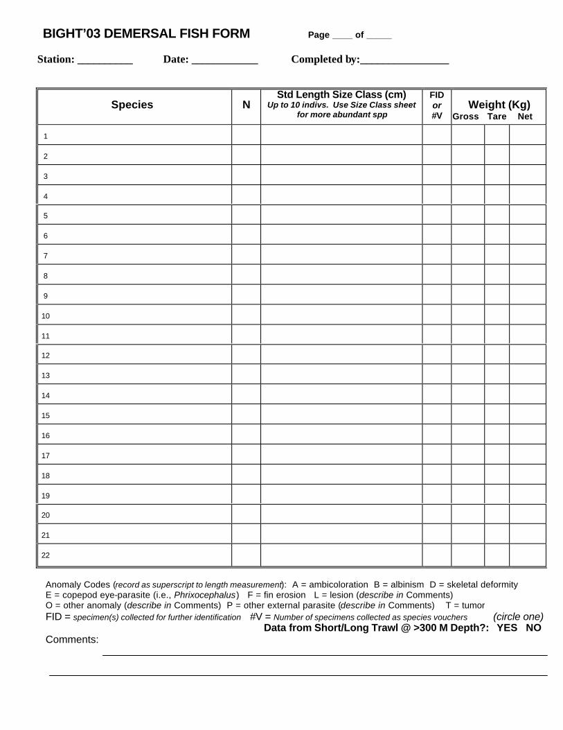
BIGHT’03 DEMERSAL FISH FORM Page ____ of _____ Station: __________ Date: ____________ Completed by:________________
Anomaly Codes (record as superscript to length measurement): A = ambicoloration B = albinism D = skeletal deformity E = copepod eye-parasite (i.e., Phrixocephalus) F = fin erosion L = lesion (describe in Comments) O = other anomaly (describe in Comments) P = other external parasite (describe in Comments) T = tumor FID = specimen(s) collected for further identification #V = Number of specimens collected as species vouchers (circle one) Data from Short/Long Trawl @ >300 M Depth?: YES NO Comments:
Species
N
Std Length Size Class (cm) Up to 10 indivs. Use Size Class sheet
for more abundant spp
FID or #V
Weight (Kg)
Gross Tare Net 1
2
3
4
5
6
7
8
9
10
11
12
13
14
15
16
17
18
19
20
21
22
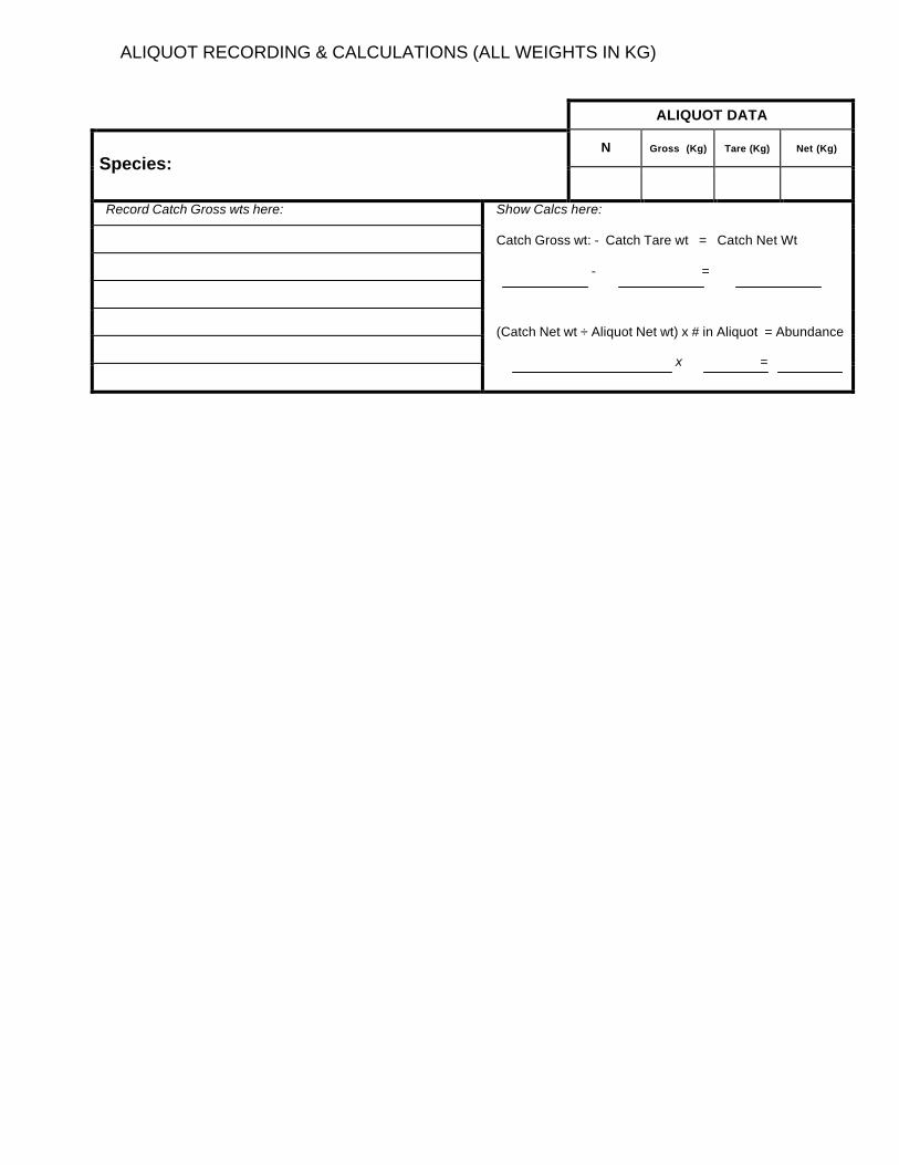
ALIQUOT RECORDING & CALCULATIONS (ALL WEIGHTS IN KG)
ALIQUOT DATA
N Gross (Kg) Tare (Kg) Net (Kg)
Species:
Record Catch Gross wts here:
Show Calcs here: Catch Gross wt: - Catch Tare wt = Catch Net Wt - = (Catch Net wt ÷ Aliquot Net wt) x # in Aliquot = Abundance x =
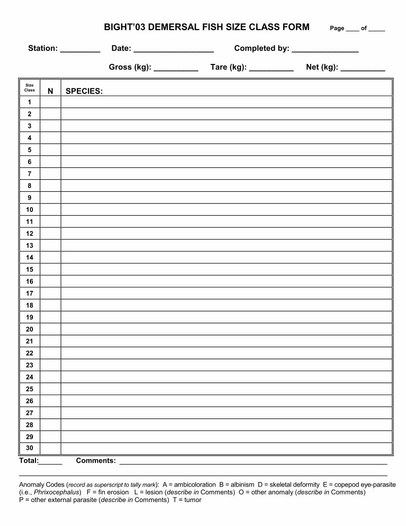
BIGHT’03 DEMERSAL FISH SIZE CLASS FORM Page ____ of _____
Station: _________ Date: __________________ Completed by: _______________
Gross (kg): __________ Tare (kg): __________ Net (kg): __________
SizeClass N SPECIES:1
2
3
4
5
6
7
8
9
10
11
12
13
14
15
16
17
18
19
20
21
22
23
24
25
26
27
28
2930
Total: Comments:
Anomaly Codes (record as superscript to tally mark): A = ambicoloration B = albinism D = skeletal deformity E = copepod eye-parasite(i.e., Phrixocephalus) F = fin erosion L = lesion (describe in Comments) O = other anomaly (describe in Comments)P = other external parasite (describe in Comments) T = tumor
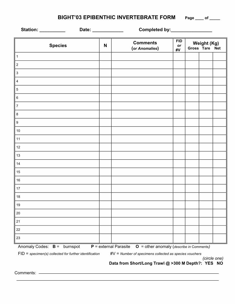
BIGHT’03 EPIBENTHIC INVERTEBRATE FORM Page ____ of _____
Station: __________ Date: ____________ Completed by:________________
Species N Comments(or Anomalies)
FIDor
#VWeight (Kg)
Gross Tare Net
1
2
3
4
5
6
7
8
9
10
11
12
13
14
15
16
17
18
19
20
21
22
23
Anomaly Codes: B = burnspot P = external Parasite O = other anomaly (describe in Comments)FID = specimen(s) collected for further identification #V = Number of specimens collected as species vouchers
(circle one) Data from Short/Long Trawl @ >300 M Depth?: YES NO
Comments:
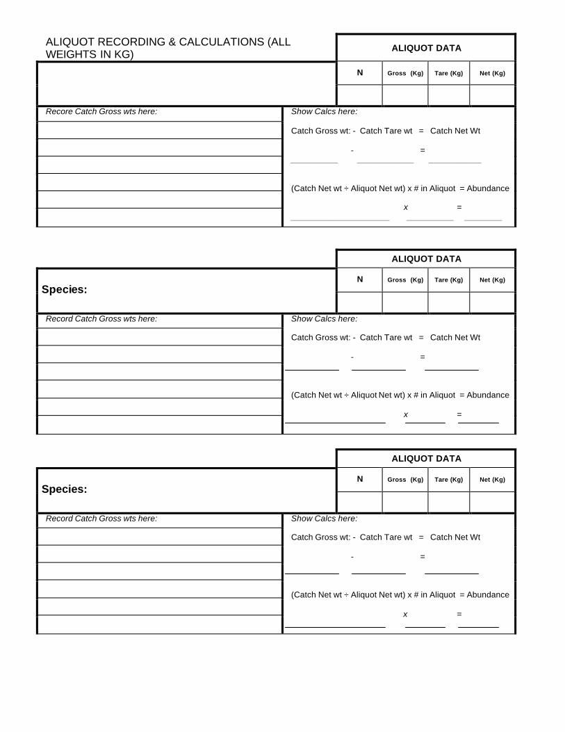
ALIQUOT RECORDING & CALCULATIONS (ALL WEIGHTS IN KG)
ALIQUOT DATA
N Gross (Kg) Tare (Kg) Net (Kg)
Recore Catch Gross wts here:
Show Calcs here: Catch Gross wt: - Catch Tare wt = Catch Net Wt - = __________ ____________ ___________ (Catch Net wt ÷ Aliquot Net wt) x # in Aliquot = Abundance x = _____________________ __________ ________
ALIQUOT DATA
N Gross (Kg) Tare (Kg) Net (Kg)
Species:
Record Catch Gross wts here:
Show Calcs here: Catch Gross wt: - Catch Tare wt = Catch Net Wt - = (Catch Net wt ÷ Aliquot Net wt) x # in Aliquot = Abundance x =
ALIQUOT DATA
N Gross (Kg) Tare (Kg) Net (Kg)
Species:
Record Catch Gross wts here:
Show Calcs here: Catch Gross wt: - Catch Tare wt = Catch Net Wt - = (Catch Net wt ÷ Aliquot Net wt) x # in Aliquot = Abundance x =
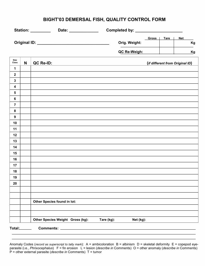
BIGHT’03 DEMERSAL FISH, QUALITY CONTROL FORM
Station: _________ Date: _____________ Completed by: _____________________
Gross Tare NetOriginal ID: ________________________________ Orig. Weight: Kg
QC Re-Weigh: Kg
SizeClass N QC Re-ID: (if different from Original ID)1
2
3
4
5
6
7
8
9
10
11
12
13
14
15
16
17
18
19
20
Other Species found in lot:
Other Species Weight Gross (kg): Tare (kg): Net (kg):
Total: Comments:
Anomaly Codes (record as superscript to tally mark): A = ambicoloration B = albinism D = skeletal deformity E = copepod eye-parasite (i.e., Phrixocephalus) F = fin erosion L = lesion (describe in Comments) O = other anomaly (describe in Comments)P = other external parasite (describe in Comments) T = tumor

BIGHT’03 TRAWL DEBRIS FORM Page ____ of _____ Station: __________ Date: ____________ Completed by:________________
Debris Type
Estimated Number
Estimated Weight Rocks
Terrestrial Vegetation
Marine Vegetation
Lumber
Plastic
Metal Debris
Cans
Glass Bottles
Fishing Gear
Tires
Other (describe in Comments )
Number Codes:
Weight Codes:
Present, P = 1
Trace, T = 0.0-0.1 kg
Low, L = 2-10
Low, L = 0.2-1.0 kg
Moderate, M = 11-100
Moderate, M = 1.1-10 kg
High, H =/> 100
High, H =/> 10 kg
(circle one) Data from Short/Long Trawl @ >300 M Depth?: YES NO
Comments:

BIGHT’03 CHAIN OF CUSTODY FORM AGENCY: _____________________ CONTACT NAME/NUMBER: ________________________ SAMPLED BY: ______________________________________ DATE: _____________________
STATION SAMPLE TYPE CONTAINER TYPE # CONTAINERS
Relinquished by: __________________________ Accepted By: __________________________ Agency: _________________________________ Agency: ______________________________
Signature: ___________________________ Signature:_____________________________
Date: _________________________ Time: ________________________
Comments: _______________________________________________________________________________
BIGHT'03 SAMPLE TRACKING FAX TRANSMITTAL FORM
AGENCY: _______________________ DATE: ___________________________ NAME/NUMBER: _____________________________ PAGE: __________ OF ___________ Station1 Sample Description Sample Disposition
1- Include all stations that have been abandoned during the sampling day(s) and describe the reason for each instance of abandonment.

APPENDIX 7
Bight’03 Field Sampling QA/QC Sheets
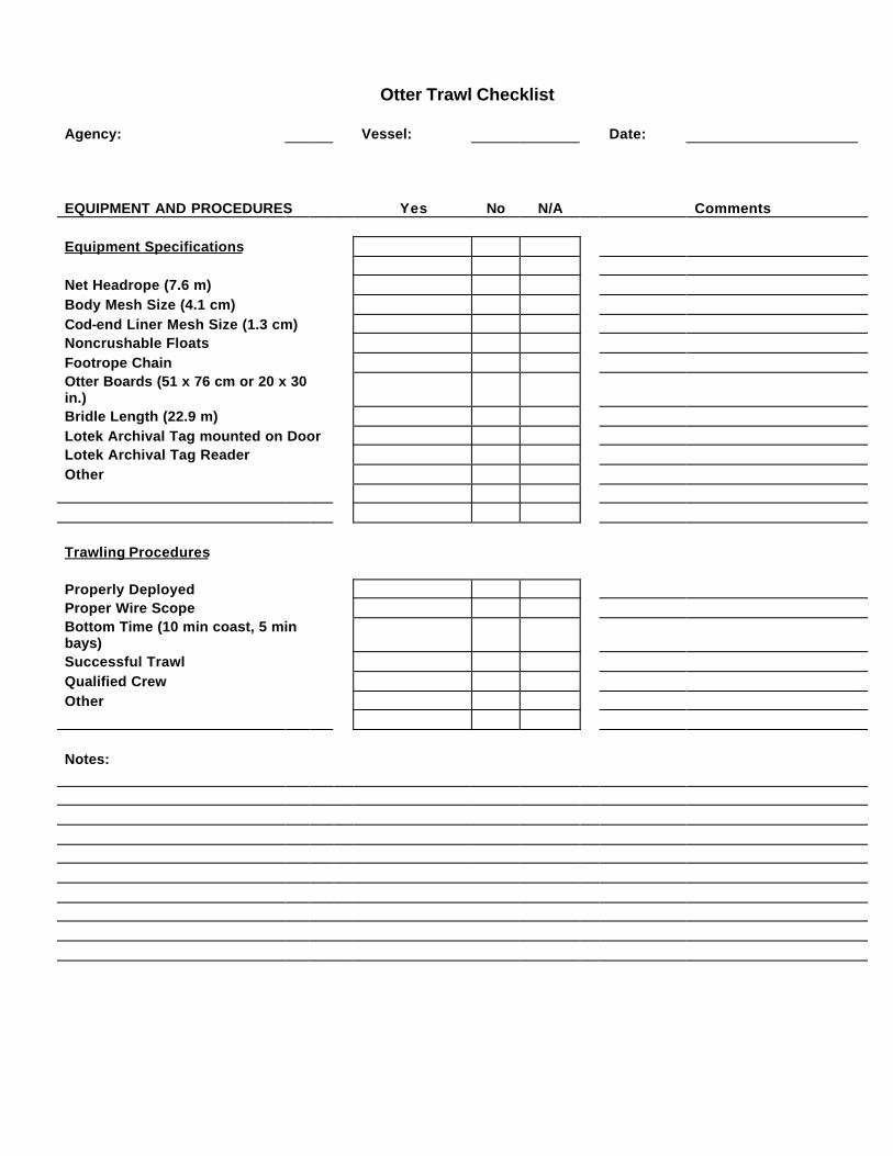
Otter Trawl Checklist Agency: Vessel: Date: EQUIPMENT AND PROCEDURES Yes No N/A Comments Equipment Specifications Net Headrope (7.6 m) Body Mesh Size (4.1 cm) Cod-end Liner Mesh Size (1.3 cm) Noncrushable Floats Footrope Chain Otter Boards (51 x 76 cm or 20 x 30 in.) Bridle Length (22.9 m) Lotek Archival Tag mounted on Door Lotek Archival Tag Reader Other Trawling Procedures Properly Deployed Proper Wire Scope Bottom Time (10 min coast, 5 min bays) Successful Trawl Qualified Crew Other Notes:
BIGHT'03 FIELD QA/QC
Trawl Processing Equipment Checklist Agency: Vessel: Date: EQUIPMENT Yes No N/A Comments Sorting Buckets/Trays Live Holding Tanks (optional) Measuring Boards Data Sheets Trawl Cover Sheets Trawl Fish Species Sheets Trawl Fish Size Class Sheets Trawl Invertebrate Species Sheets Trawl Debris Sheets Tare Container Spring Scales 3 kg 15 kg Other Other Field Guides and Aids Miller and Lea (1972) Eschmeyer et al. (1983) Kramer et al. (1995) (flatfishes) Allen (1977) (juvenile rockfishes) Orr et al. (2000) rockfishes Other Field ID Tool Kit Wide-mouth Jars (Plastic) Plastic Bags 10% Buffered Formalin Freezer or Ice Chest Other SPRING SCALE CALIBRATION CHECK Weight (kg) Test Weight Scale A Scale B Scale C Scale D Scale E 0.15 kg 0.30 kg 0.45 kg
BIGHT'03 FIELD QA/QC
Trawl Processing Procedures Checklist Agency: Vessel: Date: EQUIPMENT Yes No N/A Comments Proper Trawl Acceptance Removal of All Organisms from Net Species Identifications: Qualified Staff Accurate ID of Common Species Return of Difficult Species to Lab Length Measurement: Proper Designation of Size Class Proper Data Sheet Recording for <10 Fish Proper Recording on Size Class Data Sheet Bony Fish (Standard Length) Sharks, Rays, Ratfish (Total Length) Stingrays (Wingspan) Weight Measurement: Scales Calibrated Tare Bucket Weight Checked Proper Weighing Procedures: Species Greater than 0.1 kg Species Less than 0.1 kg Invertebrate Counts Made Invertebrate Counts from Weights Anomaly Examination Conducted Proper Anomaly Identifications Proper Anomaly Notation on Data Sheets Debris Assessment Conducted FID/Voucher Preservation 10% Buffered Formalin Slitting Body Cavity of Fish Proper Labeling Proper Photographic Techniques Photo Log Completion of Data Sheets Trawl Cover Sheets Trawl Fish Species Sheets Trawl Fish Size Class Sheets Trawl Invertebrate Species Sheets Trawl Debris Data Sheets Tissue Sampling: Proper Choice of Species Proper Labeling Proper Freezing Techniques

BIGHT'03 FIELD QA/QC
Fish and Invertebrate Identification and Processing Audit Agency: ___________ Vessel: Date: Trawls Species Identification Attempted Number Species Examined Successful Number Species Correct Percent Percent Species Correct Incorrect ID Correct ID Anomaly Identification No. Anomalies Examined No. Anomalies Correct % Anomalies Correct Problem Anomalies: Incorrect ID Correct ID Count Size Weight(kg)
Species Listed Audited % Diff. Listed Audited %Diff. Listed Audited %Diff.
1 2 3 4 5 6 7 8 9
10 Comments Completed by
BIGHT'03 Form Date 26JUN03
FIELD QA/QC BENTHIC SAMPLING CHECKLIST Page 1 of 2
Agency: _________________ Vessel: ____________________Date: _____________________
PART 1 BENTHIC SAMPLE PROCESSING EQUIPMENT
Van Veen Grab YES NO COMMENTS
Grab in good condition?
Tight closures, no gaps, clean & free of rust
Benthic Infaunal Samples
Catchment for grab overlying and wash waters
Plastic ruler (mm)
Wash table (recommended)
Screen box with 1.0mm mesh screen
Borate buffered Formalin (50 g/L undiluted formalin)
Relaxant Solution (check one) ____MgSO4 (1.5 kg/20 L fresh water)
____Propylene phenoxytol (30 ml/20 L seawater)
Data sheets/field computer
BIGHT'03 format sample labels (external & internal)
Forceps for picking screen
Scrub brush for cleaning screen
Sample containers (none <16 oz capacity)
Adequate size range of sample containers
Sediment Chemistry & Toxicity Samples
Correct scoop material for sub-sampling
Soap & water wash for scoop
scoop rinse (circle one or more) DI water methanol acetone hexane methylene chloride
BIGHT'03 format sample labels (external)
4 oz plastic or glass containers or whirlpak for Grain Size
8 oz pre-cleaned glass containers with
TFE lined lids for TOC
8 oz pre-cleaned plastic containers with
TFE lined lids for Trace Metals
8 oz pre-cleaned glass containers with
TFE lined lids for Trace Organics
1 liter pre-cleaned HDPE containers
(supplied by SCCWRP) for Sed Tox
Refrigerator or wet ice for cooling
Freezer or dry ice for freezing
Comments:
BIGHT'03 Page 2 of 2
FIELD QA/QC BENTHIC SAMPLING CHECKLIST
PART 2 BENTHIC SAMPLE PROCESSING PROCEDURES
Infaunal Sample Acceptance and Screening YES NO
Properly applies sample acceptance criteria
Means of collecting wash water/sample
Penetration depth properly measured (plastic ruler)
Filters wash water
Uses wash table (recommended)
Screen mesh size = 1.0 mm
Screen surface area adequate for washing
Gentle treatment of sample during washing & screening
Thorough removal of sample from screen
Screen washed and scrubed between samples
Infaunal Sample Handling
Labeling requirements met
Sample container <70% full of sample material
Adequate volume of relaxant used (85-90% jar volume)
Sample agitated to assure exposure to relaxant solution
Proper duration of exposure to relaxant (approx. 30 mins)
Measures to avoid environmental extremes during
sample relaxation
Adequate fixative added to achieve approx. 10% Formalin
Sample agitated to assure exposure to fixative
Complete data entry
Sediment Chemistry & Toxicity Sample Handling
Properly applies sample acceptance criteria (sample must
be similar to infaunal sample)
Appropriate care draining overlying water from grab
(use of siphon recommended)
Avoids potential sources of contamination (deck surface,
winch wire, engine exhaust, cooling ice, etc)
Correct scoop used on Chemistry samples
TOC (SS), Metals (Plastic or SS), Organics (SS), Tox (plastic)
Subsamples to specified depth (top 2 cm)
Avoids scoop contact with sides of grab
Labeling requirements met
Sample holding conditions met
Washes scoop between stations
Complete data entry
Comments:
BIGHT'03 Benthic QA Specialist: __________________Agency Cruise Leader: ___________________
Send copies to: Agency Chief Scientist, BIGHT'03 Field CoordinatorForm Date 26JUN03

APPENDIX 8
Bight’03 Sampling Organization and Analytical Laboratory Contacts

SAMPLING ORGANIZATION CONTACTS Aquatic Bioassay and Consulting Laboratories 29 North Olive St., Ventura, CA 93001 Michael Machuzak (805) 643-5621 [email protected] Channel Islands National Marine Sanctuary 113 Harbor Way Santa Barbara, CA 93109 Sarah Fangman (805) 884-1473 [email protected] CRG Marine Laboratories 2020 Del Amo Blvd., Suite 200 Torrance, CA 90501 Richard Gossett (310) 533-5190 Los Angeles County Sanitation Districts Ocean Monitoring & Research Group 1955 Workman Mill Road, Whittier, CA 90601
Dave Montagne (562) 699-7411 x 2805 [email protected] City of Los Angeles, Environmental Monitoring Division 12000 Vista del Mar, Playa del Rey, CA 90293 Ann Dalkey (310) 648-5544 [email protected] MEC Analytical Systems, Inc. 2433 Impala Drive Carlsbad, CA 92008-7227 Douglas Diener (760) 931-8081 [email protected] Orange County Sanitation District 10844 Ellis Ave., Fountain Valley, CA 92728-7018 George Robertson (714) 593-7468 [email protected]
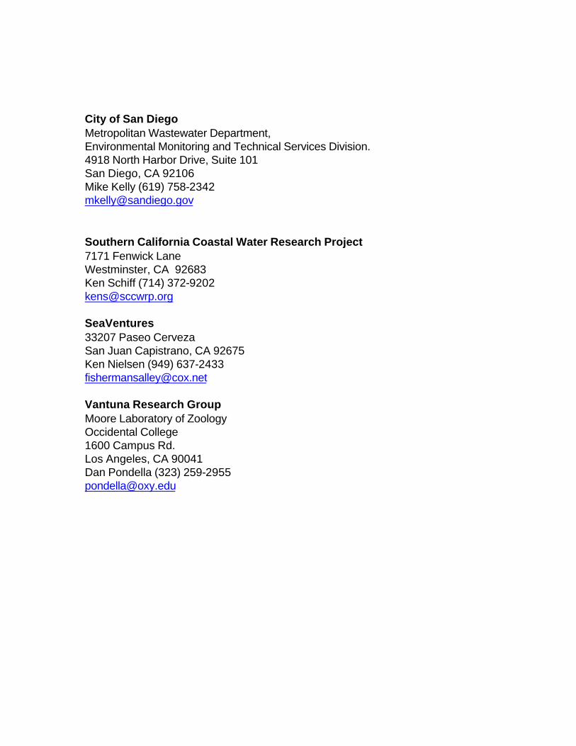
City of San Diego Metropolitan Wastewater Department, Environmental Monitoring and Technical Services Division. 4918 North Harbor Drive, Suite 101 San Diego, CA 92106 Mike Kelly (619) 758-2342 [email protected] Southern California Coastal Water Research Project 7171 Fenwick Lane Westminster, CA 92683 Ken Schiff (714) 372-9202 [email protected] SeaVentures 33207 Paseo Cerveza San Juan Capistrano, CA 92675 Ken Nielsen (949) 637-2433 [email protected] Vantuna Research Group Moore Laboratory of Zoology Occidental College 1600 Campus Rd. Los Angeles, CA 90041 Dan Pondella (323) 259-2955 [email protected]
APPENDIX 9
Bight’03 SCCWRP Sample Shipping Information
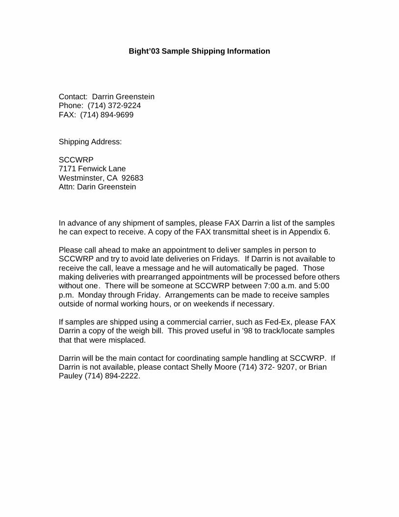
Bight’03 Sample Shipping Information
Contact: Darrin Greenstein Phone: (714) 372-9224 FAX: (714) 894-9699 Shipping Address: SCCWRP 7171 Fenwick Lane Westminster, CA 92683 Attn: Darin Greenstein In advance of any shipment of samples, please FAX Darrin a list of the samples he can expect to receive. A copy of the FAX transmittal sheet is in Appendix 6. Please call ahead to make an appointment to deli ver samples in person to SCCWRP and try to avoid late deliveries on Fridays. If Darrin is not available to receive the call, leave a message and he will automatically be paged. Those making deliveries with prearranged appointments will be processed before others without one. There will be someone at SCCWRP between 7:00 a.m. and 5:00 p.m. Monday through Friday. Arrangements can be made to receive samples outside of normal working hours, or on weekends if necessary. If samples are shipped using a commercial carrier, such as Fed-Ex, please FAX Darrin a copy of the weigh bill. This proved useful in ’98 to track/locate samples that that were misplaced. Darrin will be the main contact for coordinating sample handling at SCCWRP. If Darrin is not available, please contact Shelly Moore (714) 372- 9207, or Brian Pauley (714) 894-2222.

NOTES

NOTES

NOTES