field development plan for omerelu - cl
DESCRIPTION
dfTRANSCRIPT
FIELD DEVELOPMENT PLAN FOR OMERELU.
EXECUTIVE SUMMARY:
The Omerelu field was discovered by exploration well Omerelu -1 spudded in January 1975 by the then Gulf Oil Company Nigeria Limited now transformed to Chevron Nigeria Limited. The field is located in OML 53 about 42 kilometers as the crow flies North West of Port Harcourt in Rivers State, Nigeria. Omerelu-1 is the only well drilled in the field to date.
In 1996, following the promulgation of the Marginal Field Decree, by the Nigerian Government, some marginal fields were relinquished to the Department of Petroleum Resources. Niger Delta Petroleum Resources Limited, the operator of the Ogbele Marginal field was given the first Right of Refusal for the assessment of Omerelu field. The company exercised the Right in 1996 and has since concluded the Farm-out Agreement with Chevron. NAPIMS gave approval to commence active operation of the field in XXXXXX, 2011.
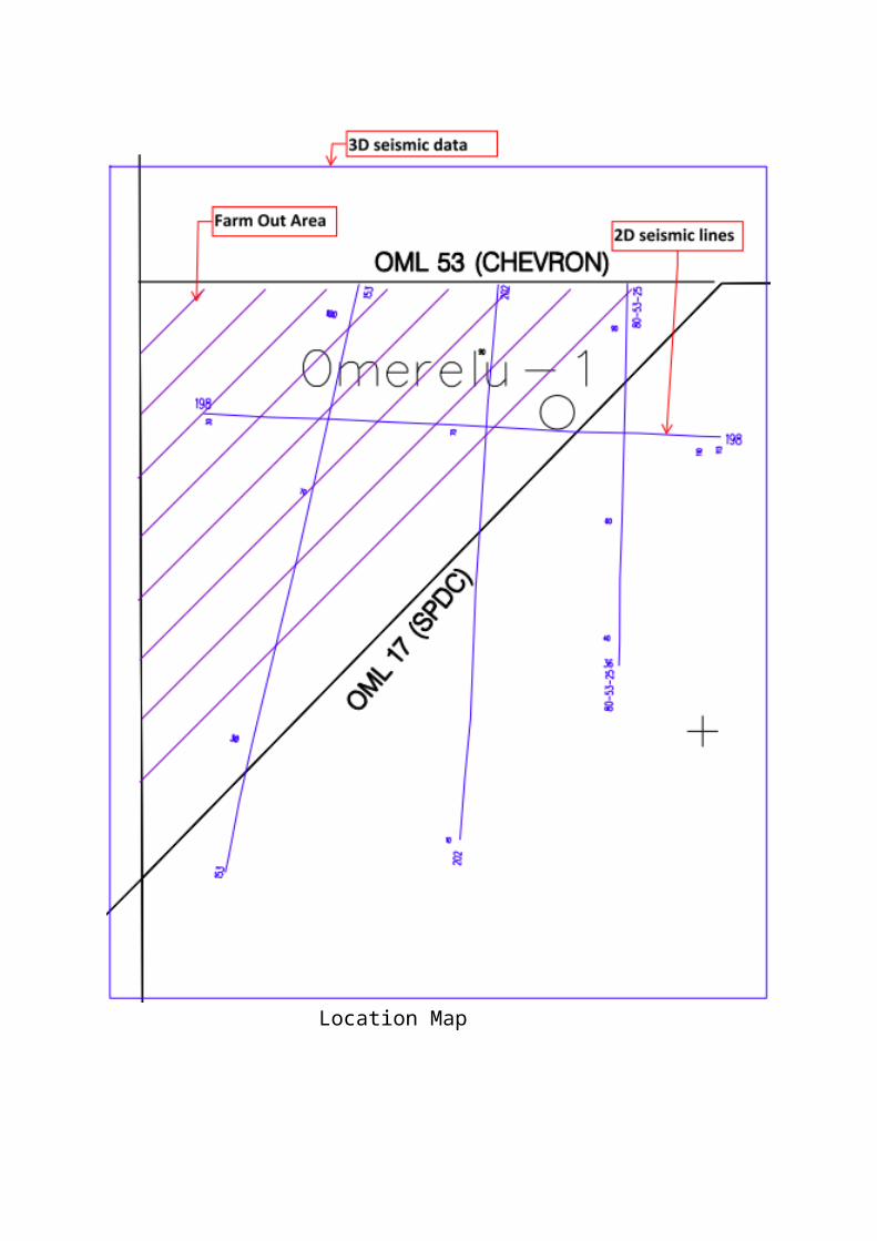
Location Map

The Evaluation of Omerelu field showed that Omerelu-1 well encountered five hydrocarbon sands (AA4, A1, A2, A4 and A7, in depth order). The A1 is interpreted to be gas bearing with the possible presence of downdip oil, while the A2 reservoir has been interpreted and tested oil bearing with the possible presence of updip free gas. Of the remaining reservoirs, the AA4 and the A7 have been interpreted as oil-bearing while the A4 has been interpreted as gas bearing.
Omerelu Field is estimated (expectation case) to contain 42 MMSTB STOIIP with corresponding solution gas of 26.7 BSCF. The initial free gas (gas cap) volume is estimated at 59 BSCF. The field ‘expected’ ultimate recoveries are estimated at 21.1 MMSTB oil, 13.4 BSCF solution gas, and 35.6 BSCF of free gas. The A2 reservoir is estimated to contain 85% of the field STOIIP and represents 90% of the oil ultimate recovery. The A1 reservoir contains 73% of the free gas representing 72% of the fields free gas recovery.
The structural interpretation of the field is based only on four 2D seismic lines of 1980 vintage, well data and data from offset wells in Shell’s Enwhe and Rumuekpe fields. The current structural interpretation shows two dominant faults bounding the field to the north and south/southeast forming a simple rollover on a growth fault in the southwestern part of the field. We hope that a recently acquired 3D seismic data of 2010 vintage will improve the structural interpretation of the Omerelu field before any new drilling prospect is carried out.
Field Development Plan will be premised on Ogbele experience but not necessarily the “poor boy” approach. The 3D seismic workstation ready data plus all the log information and petrophysical data will be used to reinterpret the structural attitude of the field and to recalculate the reserve volumes. While the reinterpretation is going on, the civil works will be commenced inclusive of the access road, the rehabilitation of the location and the negotiation of the global memorandum of understanding (MOU) with the host communities will be going on. Environment Impact Assessment (EIA) will be conducted prior to active operations.
Omerelu 1 will be reentered to test the proven oil reservoirs and assess the integrity of the completion jewelry. The results of the test will determine the
mode of development, whether to shoot for full Flowstation facility or plan for Early Production Facility ( EPF). In tandem with the reentry of the well will be the seismic reinterpretation of the well, this will help define how many drainage points will be required to efficiently produce the field and thus determine how many wells will be drilled, how and when these will be put on production. The main targets for the well will be the A1 and A2, however, for oil development; the primary oil reservoirs will be the AA4, A2 and the A7.
The closest Flowstation facility is located about 13km Northwest of Omerelu at Shell’s Ahia field which evacuates its crude through the Egbema-Rumuekpe pipeline.

Topographic map

Omerelu 1 is not as prolific in gas as Ogbele field therefore the strategy for gas development will be carefully evaluated, most importantly however, consideration will be given to compliance with the Federal Government gas flare out policy.
INTRODUCTION:
History and Status:
The Omerelu field is located in Chevron’s OML 53 in Rivers State in the SouthSouth Geographical zone of Nigeria some 42 kilometers (as the crow flies) northwest of Port Harcourt. The field was discovered by the exploration well Omerelu-1 spudded in January, 1975 by Chevron. Omerelu-1 is the only well to date in the field. In 1996, following the promulgation of the marginal Field Decree by the Nigerian Government, some marginal oil fields were relinquished to the Department of Petroleum Resources. Niger Delta Petroleum Resources Ltd. (NDPR), the operator of Ogbele Marginal Oil Field was given the first Right of Refusal for the assessment of the Omerelu Field.
NDPR has since exercised the First Right of Refusal and has negotiated the Farm-Out Agreement with Chevron and received the approval to operate Omerelu as the company’s second marginal field.
The Evaluation of Omerelu field showed that Omerelu-1 well encountered five hydrocarbon sands (AA4, A1, A2, A4 and A7, in depth order). The A1 is interpreted to be gas bearing with the possible presence of downdip oil, while the A2 reservoir has been interpreted and tested oil bearing with the possible presence of updip free gas. Of the remaining reservoirs, the AA4 and the A7 have been interpreted as oil-bearing while the A4 has been interpreted as gas bearing.
Omerelu Field is estimated (expectation case) to contain 42 MMSTB STOIIP with corresponding solution gas of 26.7 BSCF. The initial free gas (gas cap) volume is estimated at 59 BSCF. The field ‘expected’ ultimate recoveries are estimated at 21.1 MMSTB oil, 13.4 BSCF solution gas, and 35.6 BSCF of free gas. The A2 reservoir is estimated to contain 85% of the field STOIIP and
represents 90% of the oil ultimate recovery. The A1 reservoir contains 73% of the free gas representing 72% of the fields free gas recovery.
The structural interpretation of the field is based only on four 2D seismic lines of 1980 vintage, well data and data from offset wells in Shell’s Enwhe and Rumuekpe fields. The current structural interpretation shows two dominant faults bounding the field to the north and south/southeast forming a simple rollover on a growth fault in the southwestern part of the field. We have incorporated the recently acquired 3D seismic data of 2010 vintage, the petrophysical data plus other log information data in the current structural interpretation of the Omerelu field as part of this Field Development Plan. This re-interpretation of the field, will help in the recalculation of the reserve volumes.
Field Development Plan will be premised on Ogbele experience but not necessarily the “poor boy” approach. While the reinterpretation is going on, the civil works will be commenced inclusive of the access road, the rehabilitation of the location and the negotiation of the global memorandum of understanding (MOU) with the host communities will also be initiated. Environment Impact Assessment (EIA) will be conducted prior to active operations.
OBJECTIVE AND CHALLENGES:
The objective of the Omerelu Field Development is to overcome the challenges experienced in Ogbele field development, to deploy the technical expertise and operational excellence acquired in the Ogbele field development to deliver Omerelu to First Oil in a record time and within reasonable budget. We do not perceive acquiring new Geological and Geophysical data for more detailed re-evaluation of the field as critical to bringing the field on production as we have all the well information and the 3D seismic data recently acquired and processed in 2010. The funding challenges which prevented the early operations in Ogbele may not be a major contributing factor in bringing Omerelu to first oil, since as a producing oil and gas company, NDPR is now able to secure loans and bank financing with relative ease.
FIELD OVERVIEW.
GEOLOGY AND GEOPHYSICS
The Niger Delta Complex began to develop in the Paleocene/Eocene times. The progradation of the delta continued until the Plio-Pleistocene at which time the shoreline (sub-serial delta) reached its maximum extent. A subsequent rise in sea level caused the sea to transgress over the Plio-Pleistocene shoreline to its current position. The Present day Niger Delta is believed once again to be prograding, controlled by diapiric uplift on the delta front.
Sedimentation during the period (Paleocene to present day) has been strongly diachronous, and three main formations are recognized- the marine Akata Formation (silts, clays and shales), the paralic (marginal marine) Agbada Formation (interbedded sands and shales) and the continental Benin Formation (sands and gravels). At every stage of the development, Akata sediments have been deposited in front of the shoreline, Agbada sediments have been deposited around the delta shoreline while Benin sediments have been laid down on the landward side.
The deeper water Akata Formation is the main source rock for the Niger Delta Complex and is thought, because of its diachronous nature, to underlie the whole of the Tertiary Niger Delta. Hydrocarbon generation into structures within OML 53 has been proven by Omerelu discovery well.
The Niger Delta has been consistently sand-rich system since the Cenozoic and so reservoir quality is generally of secondary issue to development of sand bodies, which occur either as stacked channels or laterally continuous barrier bar sands.
Sands are often poorly consolidated and can have porosities up to 40% in oil bearing reservoirs. Decrease in porosity with depth is gradual, but two distinct porosity changes can be mapped regionally. Sands shallower than 3000m (9480ft) have porosities over 15%, while those below 4000m ( 13,120ft) are generally less than 15%.
Intraformational seals are dominant, formed by the interdigitation of shales and sands, with shale smear common along the downthrown sides of the listric faulting.
GEOPHYSICS:
The Omerelu field, pre the 3D seismic data of 2010 vintage, had only four 2D seismic data- 3 diplines and one strike line: 72-53-153, 72-53-198, 72-53-202 and 80-53-25. The 3D seismic lines cover the entire Omerelu field of 35.80 sq. km while the farm out area is 11.16 sq. km. The data set is of reasonably good quality and has a depth penetration of over 3.5 seconds
DATA INVENTORY FROM CHEVRON:
The following data and reports have been received from Chevron.
1. Daily drilling reports2. Daily drilling mud reports3. Drilling plan4. Exploration well summary5. Geochemical report6. Geophone survey report7. Mud report8. Petrophysical data sheet9. Sidewall sample description10. Preliminary basic well data11. Depth structure maps12. Well approval13. Notice of suspension14. Authority for expenditure15. Well log in PDF and LAS format16. 3D Seismic data17. Velocity Model in ASCII format18. Well checkshot in ASCII format19. Formation interval tester results
20. Core sample taker results.

Location Map of Omerelu Field in relation to Rumuekpe etc.
Petrophyiscal Interpretation
Available wireline log data.
(Paste interpretation by Laz Nwaozor)
(Paste log sections of relevant reservoirs)
Seismic Interpretation and Structure Maps: (Jide Aworanti)
The construction of the structure maps and the seismic interpretation was based on the workstation ready 11.16 sq.km of 3D data supplied by Chevron, the check shot survey, velocity information and the suite of logs from the discovery well.
Time and Depth structure maps were constructed on the pay reservoirs encountered by Omerelu -1, these include:
Top of AA4 Oil sand --------------
Top of A1 Gas sand-----------------
Top of A2 Oil sand ----------------
Top of A4 Gas sand---------------
Top of A7 Oil sand-----------------
(Paste Maps from Jide and the figure numbers).
(Paste Key Seismic Lines, interpreted and uninterpreted)
Comments and Recommendations/Leads (by Jide Aworanti)
VOLUMETRICS: Basis and Method of Determination: (Jide & Festus)
RR –chapter 4
RESERVOIR ENGINEERING:
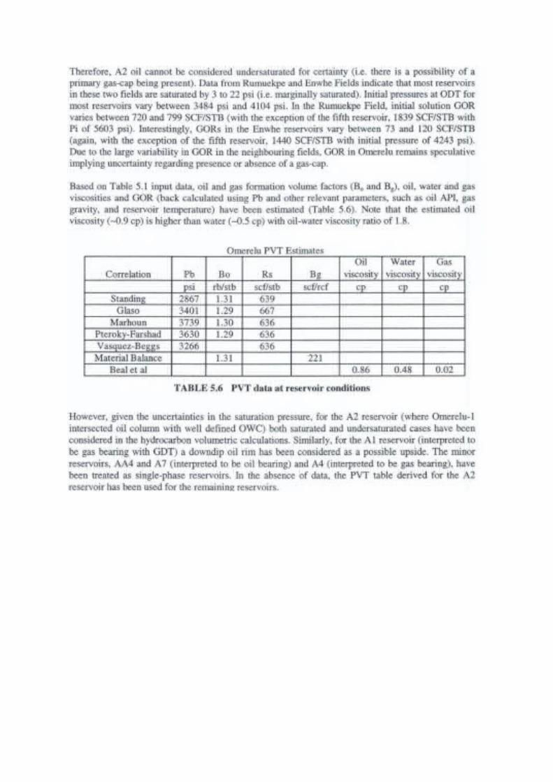
The main objective of the reservoir engineering analysis is to determine reservoir pressure and temperature, PVT properties and finally oil and gas recovery factors.

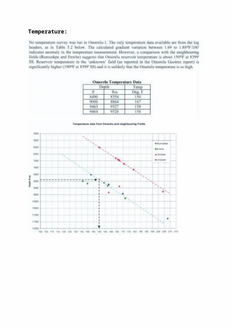
No reservoir engineering data, (RFT, DST, Production Test, Pressure buildup test, pressure or temperature surveys, PVT and SCAL) are available for Omerelu Field. Data availability is limited to only the FIT tests in Omerelu-1. In the absence of sufficient field data, analysis is based largely upon analogy from the neighboring fields and fields in the Niger Delta in general and empirical analytical correlations.
Pressure
The only static pressure data available is from Omerelu -1 FTT.----------


Temperature:

PVT Analysis

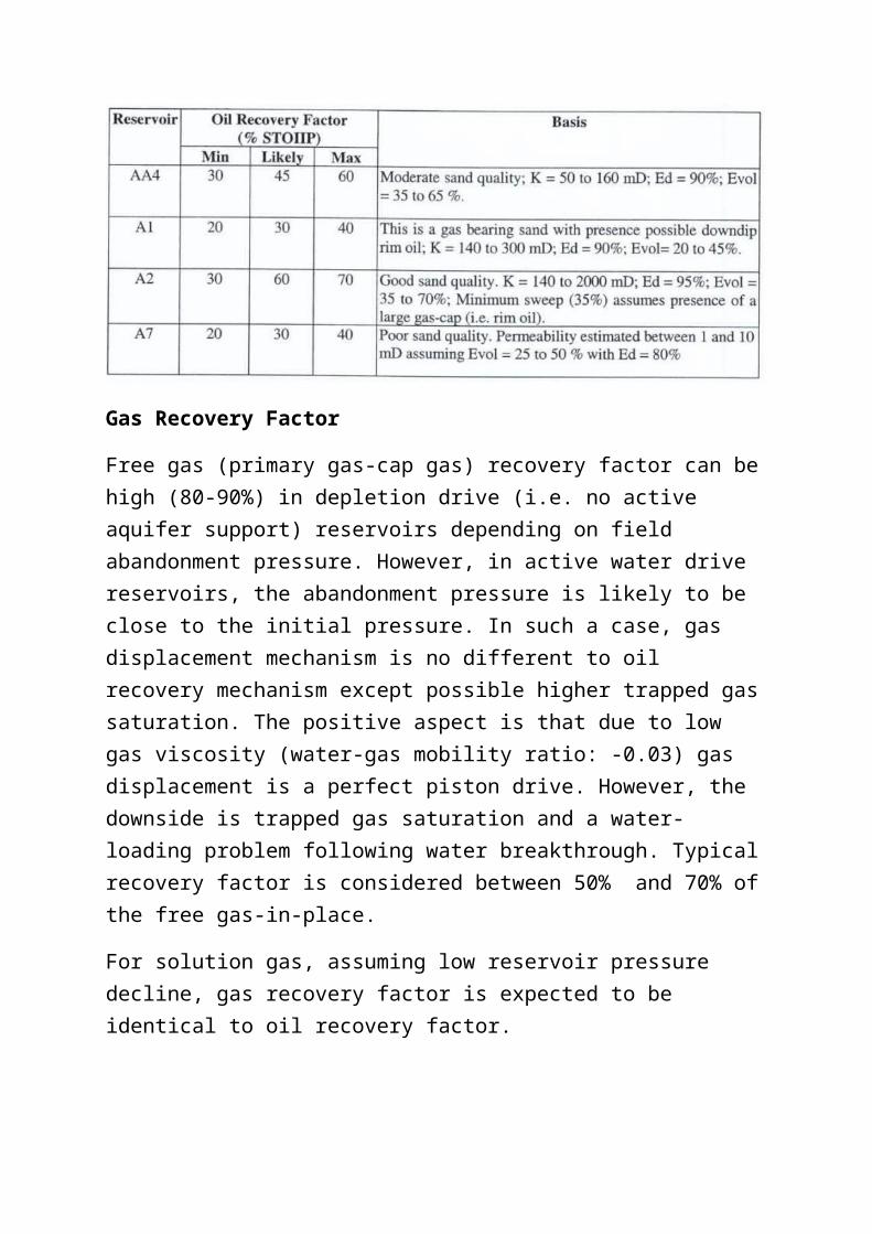
RECOVERY FACTOR (RF)
Oil Recovery factor for a given reservoir depends on three main factors. These are primarily:
Drive mechanism Displacement efficiency and Areal and vertical ( i.e. volumetric) sweep efficiency. Sweep efficiency, in
turn, is controlled by a number of factors: Mobility Ratio Reservoir permeability and heterogeneity Net pay thickness Net to gross ratio Edge vs bottom water drive Height of oil column ( particularly in the presence of gas-cap and Well spacing.
Given the number of parameters (and associated uncertainty) that control sweep efficiency, there is no analytical method to estimate sweep efficiency (and therefore recovery factor RF) for a given reservoir. Numerical simulation (not within the scope of Omerelu study) can give meaningful results if reservoir description and characterization are established; however, simple techniques have been applied to determine a possible range of recovery factors for Omerelu.
Oil Recovery Factor:
Gas Recovery Factor
Free gas (primary gas-cap gas) recovery factor can be high (80-90%) in depletion drive (i.e. no active aquifer support) reservoirs depending on field abandonment pressure. However, in active water drive reservoirs, the abandonment pressure is likely to be close to the initial pressure. In such a case, gas displacement mechanism is no different to oil recovery mechanism except possible higher trapped gas saturation. The positive aspect is that due to low gas viscosity (water-gas mobility ratio: -0.03) gas displacement is a perfect piston drive. However, the downside is trapped gas saturation and a water-loading problem following water breakthrough. Typical recovery factor is considered between 50% and 70% of the free gas-in-place.
For solution gas, assuming low reservoir pressure decline, gas recovery factor is expected to be identical to oil recovery factor.
PRODUCTION TECHNOLOGY:
Well Performance, well completion (Roland )
*OPERATING/MAINTENANCE PHILOSOPHY ? (EJA, NUHU)
SURFACE FACILITIES/SURFACE ENGINEERING:
Surface Separation of Produced Fluids:
Omerelu field has only one well drilled and suspended in 1975 with the well suspension cap being the only external equipment on the location. The well encountered five reservoirs- three oil and two gas and initial evaluation showed a recoverable reserve of 21.6 million barrels. The development philosophy will be to reenter the discovery well and flow-test the reservoirs to determine the optimum production rates. This will determine the kind of surface facilities that will be required to process the fluid produced.
Provisionally, the field is planned for the installation of a single train of 15mbpd (gross) gas/liquid separation facility which is expected to last through the life span of the field. The train will consist of inlet manifold, test, HP and LP

separators, surge vessels and transfer pumps. A two stage degassing process is planned for the HP and LP separators prior to final stabilization in the surge vessel. The stabilized crude is then pumped via the delivery line into the nearest trunk line, in this case the Ahia flowstation about 13km northwest of the Omerelu-1 location and evacuated through the Rumuekpe-Egbema trunk line enroute to Bonny terminal. The inlet manifolding arrangements will be such that each well can be produced to any selected vessel and a well test can be carried out while producing others. However, the result of the well test will determine whether a full flowstation will be constructed or an Early Production Facility (EPF) will be preferable.
Crude Evacuation Scheme:
Several crude evacuation scenarios are being considered, however, the best option will be to construct a 13km pipeline from Omerelu to Shell’s Ahia platform to join the Rumuekpe/Egbema crude stream to Bonny Terminal. A pipeline tariff will have to be negotiated with Shell at a suitable rate to make this option feasible.
Gas Utilization:
Omerelu is credited with gas volumes of 85.7 Bscf composed of 26.7bscf of solution gas and 59bscf of free gas-in-place. The expected ultimate recoverable is estimated as 13.4bscf of solution gas and 35.6bscf of free gas. It has to be decided whether these gas reserves are enough to warrant the construction of a gas scrubbing unit. Options on how to handle the gas in the field has to be considered and before the commencement of the field since the Federal Government will not allow any gas to be flared.
Artificial Lift:
Available data on the crude characteristics of the A2 oil reservoir show that under appropriate aquifer support, the wells should be able to sustain natural flow and thus artificial gas lift may not be required. However, artificial lift should be incorporated in the detailed design should the need arise in the future.
FIELD DEVELOPMENT PLAN: (EJA)
Subsurface development Development Strategy Hydrocarbon recovery plan OOIP Reserves Production Forecast, (Roland) Evaluation Requirement (Roland) Hydrocarbon Distribution chart. (Roland/Laz)
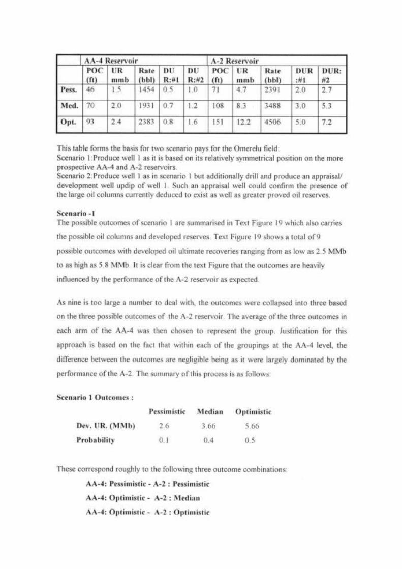
Based on the Omerelu-1 log interpretation, sidewall core data and FTT results, five hydrocarbon bearing sands (AA4, A1, A2, A4, AND A7) have been identified. The significant reservoirs are the A1 ( interpreted as gas bearing with possible downdip oil) and A2 (interpreted as oil bearing with possible updip gas). The initial plan will be to reenter the discovery well and test the oil sands- A2, AA4 and A7, in tandem with the reentry operations, will be the reinterpretation of the field using the 3D recently acquired seismic data and the generation of depth maps on these pay sands. This will provide information on the drainage points and how many new wells may be drilled.
To reduce uncertainty about the reservoir properties and geometry, we plan to cut conventional cores on these main reservoirs to enable conventional and special core analysis to be conducted. Sedimentological and paleocurrent analysis be performed on the cores and/or image logs to help define the depositional environments and predict the geometries of the reservoirs. In addition, a full suite of wireline logs, including at a minimum, caliper, GR, SP, Resistivity, Density-Neutron and Sonic logs should be run on future wells over all the potential reservoirs.
Development Strategy:

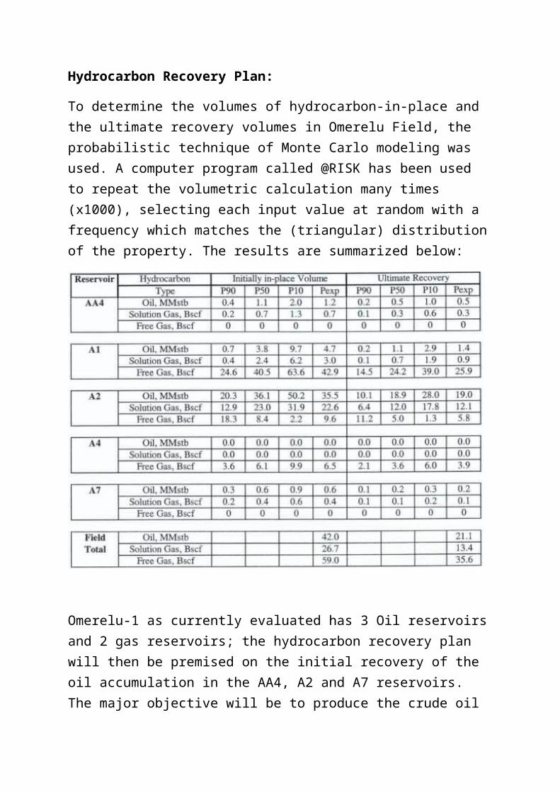
Hydrocarbon Recovery Plan:
To determine the volumes of hydrocarbon-in-place and the ultimate recovery volumes in Omerelu Field, the probabilistic technique of Monte Carlo modeling was used. A computer program called @RISK has been used to repeat the volumetric calculation many times (x1000), selecting each input value at random with a frequency which matches the (triangular) distribution of the property. The results are summarized below:
Omerelu-1 as currently evaluated has 3 Oil reservoirs and 2 gas reservoirs; the hydrocarbon recovery plan will then be premised on the initial recovery of the oil accumulation in the AA4, A2 and A7 reservoirs. The major objective will be to produce the crude oil from the AA4 and A2, the best reservoirs (A2 has been ascribed with 85% of the Omerelu oil reserves and 90% of the field oil recovery). As such, the well completion shall be designed to ensure that the delivery is at a maximum oil rate under the prevailing surface and subsurface engineering conditions.

To achieve this, well completions must have the following considerations:
Tubing size optimization Artificial lift optimization ( where applicable) Proper stimulation Perforation optimization.
We believe that for Omerelu, the best completion design will be Two strings Dual Zone (TSD); we complete on the AA4 and A2. The A2 is produced through the long string and the AA4 produced through the short string. A parker is used to isolate the two intervals, while a dual-completion packer is used to isolate the two intervals from the rest of the well above them. Sand control will be required since the reservoirs are shallow.
The gas sands- the A1 and the A4 development/utilization and Associated Gas handling will be integrated with the oil development since no flaring will be allowed.
PROPOSED COMPLETION STATUS DIAGRAM (Draw. not to scale!) WELL: OMERELU-IX
CASINGSize Grade WT/ft Depth Cement Dept CHH 13-5/8 x13-3/8 3K Vetco20" H40 94 500 Surface THS 13-5/8 x11 3 x 5k Vetco
13-3/8" K55 54.5 3200 Surface Xmas 3-1/8x3-1/8 5K TBD9-5/8" N80 47 8924 TBD
String Size Weight Grade Depth TBS after Drilling. 17 1/2" Drilled All 4/6/'80 L/S 3 1/2" HCS 9.3 N80 8500 DFE: TBD 12 1/4" Drilled Jan-12 S/S 3-1/2 HCS 9.3 N80 7,750 ORDF-CHH: TBD SANDS SAND PERFORATIONS STR. OD" ID" DEPTH DESCRIPTION
S 3 2.992 17 ft Hgr. Npl,3 1/2"CSp x 3-1/2"HCSpxp
L 3.92 2.992 17 ft Hanger Nipple, 3 1/2" HCS pxp
S 5.85 2.813 91 ft. OTIS -WRSCSSSV, 3-1/2"" HCS
L 5.85 2.813 123 ft. OTIS -WRSCSSSV, 3-1/2" HCS
20" Conductor Shoe @ 500 ft.
13 3/8" Casing. Shoe @ 3200 ft.
L S Snap latch seal Nipple
L/S Baker 9 5/8" A5 Dual Packer
S 2.38 1.996 9400ft 2-3/8" Mule shoeBaker GP Packer
L 4.25 2.75 10,806 ft. Otis XA sleeve, 3 1/2" HCS
L 4.00 2 992 10,842 ft. Mid Blast Joint x 20', 3 1/2" HCS.
AA4 TBD Blast joint x 40ft x 3-1/2" HCS
No go Landing NippleG' Locator seal assembly, 80-40
Baker FBG_1 Packer 85-40
11510ft
A-02 TBD No go Landing Nipple
L Mule shoe L 3.5 2.992 10900 Mule shoe
8875 Cement retainer 9 5/8" Casing
at 8924ft
10267 TD
WELL HEAD
AA4,A02
TD 8-1/2" @ 10267ft
Completion design schematics
Original Oil-In-Place (OOIP):
In order to deal with the uncertainties involved in assessing the volumes of hydrocarbon in-place in Omerelu, a Monte Carlo modeling was used. This method involves:
Selection of minimum( MIN), most likely (ML) and maximum (MAX) input values for all the key volumetric factors: gross rock volume (GRV), net to gross ratio (NTG), porosity, hydrocarbon saturation, hydrocarbon formation volume factors (Bo and Bg) and recovery factor to estimate recoverable resources.
A computer program- @RISK is then used to repeat the volumetric calculation has been used to repeat a number of times (1000 in this case), selecting each input value at random but with a frequency which matches the triangular distribution (MIN, ML and MAX) of the property.
Because of poor porosity and water saturation correlation, the variables have been treated independently. It is well known that field size occurrence follow a log-normal distribution in a given petroleum province or basin, but the concept does not strictly apply when it comes to estimating volume of a given reservoir in isolation.
The software outputs the Probability Distribution of the hydrocarbon-in-place and the potentially recoverable resources. The P90, P50 and P10 are normally reported.
The following definitions apply:
P90. There is a 90% probability that the actual quantity will equal or exceed the estimate quoted.
P50. There is a 50% probability that the actual quantity will equal or exceed the estimate quoted.
P10. There is a 10% probability that the actual quantity will equal or exceed the estimate quoted.
Based on this Probabilistic method, Omerelu Field is estimated (expectation case) to contain 42 MMSTB STOIIP with corresponding solution gas of 27 BSCF. The initial free-gas volume is estimated at 59 BSCF.
COMMUNITY DEVELOPMENT PROGRAM:
Niger Delta Petroleum Resources limited (NDPR) as Operator of the Ogbele field for over six years, has developed a Community Affairs template which ensured cordial relationship with our host community resulting in six year of relatively problem free operation for the company. The company recognizes the values of the host communities, governments, the employees and shareholders of NDPR as well as those of Joint Venture Partners as important stakeholders, whose active support is critical to the pioneering efforts and success of NDPR as a company.
The company is determined to build on this policy and the experience of Ogbele community relations management to craft the host community Memorandum of Understanding with Omerelu Host communities for the mutual benefit of both parties.
Sheidu to provide the company’s general community relations policy and how this can work in Omerelu:
HEALTH, SAFETY AND ENVIRONMENT:
NDPR is committed to complying with all applicable Federal, State and Local Government Laws, Regulation and industry standards on Safety, Health, and Environment (HSE) and insist that all its contractors be similarly bound. The company’s commitment to these critical aspects of the Oil and Gas industry operation is an integral part of our business.
Mr. Emmanuel Obasi to provide the write up on the company’s current HSE policy:
SECURITY MANAGEMENT:
Sheidu and Nikoro to provide write up on this aspect of our operation:
RISKS AND UNCERTAINTIES:
Omerelu field suffers severely from lack of data to justify a firm commercial development plan:
No temperature survey was carried out in the field No pressure survey was conducted None of the reservoirs in Omerelu was sampled for fluid analysis
therefore no laboratory PVT properties is available for the field thus: There are uncertainties about reservoir properties and geometry There are uncertainties about fluid content, properties and contacts
In addition to uncertainties associated with G&G, Security risks have become major issues of concern in operations within the Niger Delta especially on land operations. These are managed at a high financial cost to operators.

CAPITAL INVESTMENT/FUNDING COST:
CRUDE OIL ASSUMPTIONS
Average crude oil production days per year
325
Overriding Royalty Interest 5.25%Crude oil (US$/bbl) $90
Fixed opex/ bbl of liquids 12%Variable opex/bbl of liquids 8%Inflated Operating costs 2% of Variable opexCommunities' Share of 'Ogbele Farm Out' Cash Flow
5% of Net Cashflow Operations
NDDC levy (projected cost of Work Program)
3%
Education tax (2% of assessable profit)
2%
PPT of taxable oil profit 65.75%
Graduated royalty payable to Government Daily Production0 - 5,000 2.50%5,001 - 10,000 7.50%10,001 - 15,000 12.50%15,001 - 25,000 18.50%25,001 - no limit unless renegotiated 18.50%
Capex for crude oilTangible (of total capex) 60%Intangible (of total capex) 40%
Crude Capex 0 1 2 3 4 5Tangible CAPEX Flow station (18,000,000) (18,000,000) Gas Project (21,000,000) Site Preparation (1,200,000) Civil Works (6,000,000) Omerelu 1 (9,000,000) Omerelu Well 2 (9,000,000) (9,000,000) Omerelu Well 3 (9,000,000) Omerelu 4 (9,000,000) (9,000,000) Omerelu 5 (9,000,000) (9,000,000) Omerelu Wells 6 + 7 (18,000,000) Omerelu Well 8 (9,000,000)Total Tangible Crude CAPEX (46,200,000) (27,000,000) (18,000,000) (18,000,000) (9,000,000) - (118,200,000)Intangible CAPEX Flow station (12,000,000) (12,000,000) Gas Project (14,000,000) Site Preparation (800,000
) Civil Works (4,000,000) Seismic (12,000,000) (12,000,000) Omerelu 1 (6,000,000) Omerelu Well 2 (6,000,000) (6,000,000) Omerelu Well 3 (6,000,000) Omerelu 4 (6,000,000) (6,000,000) Omerelu 5 (6,000,000) Omerelu Wells 6 + 7 (12,000,000) (12,000,000) Omerelu Well 8 (6,000,000)Total Intangible Crude CAPEX (42,800,000) (18,000,000) (12,000,000) (12,000,000) (6,000,000) - (90,800,000)Total CAPEX (a. + b.) (89,000,000) (45,000,000) (30,000,000) (30,000,000) (15,000,000) - (209,000,000)

2012 2013 2014 2015 2016 2017 TOTAL Year 0 1 2 3 4 5
Omerelu crude oil production in barrels per year 1,591,633 3,553,333 4,949,303 4,743,630 3,731,520 18,569,419 Average crude production per day 325 4,897 10,933 15,229 14,596 11,482 11,427 less CNL royalty taken in kind -5.25% (83,561) (186,550) (259,838) (249,041) (195,905) (974,895) Net crude production per year 1,508,072 3,366,783 4,689,464 4,494,590 3,535,616 17,594,525 Crude oil (US$/bbl) 90 90 90 90 90 90 Crude revenue net of CNL royalty 135,726,521 303,010,482 422,051,774 404,513,057 318,205,396 1,583,507,230 Graduated royalty payable to Government (10,158,170) (22,704,467) (31,632,564) (30,317,161) (23,844,086) (118,656,449) Fixed opex 12% (17,189,639) (38,375,998) (53,452,467) (51,231,205) (40,300,420) (200,549,728) Variable opex 8% (11,459,759) (25,583,998) (35,634,978) (34,154,137) (26,866,946) (133,699,819) Inflated Operating Costs 2% (229,195) (511,680) (712,700) (683,083) (537,339) (2,673,996) Capex for crude oil (89,000,000
)(45,000,000) (30,000,000) (30,000,000) (15,000,000) 0 (209,000,000)
Loss b/f 0 Net cashflow operations (89,000,000) 51,689,758 185,834,338 270,619,064 273,127,472 226,656,605 1,007,927,238 Communities' Share of 'Omerelu Farm Out' Cash Flow
-5% (2,631,097) (9,332,915) (13,568,300) (13,694,288) (11,373,536) (50,600,136)
NDDC levy 3% projected cost of Work Program 3% (1,350,000) (900,000) (900,000) (450,000) 0 (3,600,000)Abandonment Provision 1,020,000 1,020,000 1,020,000 1,020,000 1,020,000 5,100,000 Income before education tax 48,728,661 176,621,424 257,170,764 260,003,184 216,303,069 958,827,102 Education tax (2% of assessable profit) -3% (1,433,196) (5,194,748) (7,563,846) (7,647,152) (6,361,855) (28,200,797) Assessable oil profit (a) (89,000,000) 47,773,197 173,158,258 252,128,200 254,905,083 212,061,832 940,026,571 Capital and investment tax allowances (82,350,000) (15,540,000) (19,140,000) (20,490,000) (19,488,000) (157,008,000) Taxable oil (34,576,803) 157,618,258 232,988,200 234,415,083 192,573,832 783,018,571 PPT 65.75% of taxable oil profit (b) -
65.75%0 (103,634,005) (153,189,742) (154,127,917) (126,617,295) (537,568,959)
After-tax cash flow (89,000,000) (34,576,803) 53,984,254 79,798,459 80,287,166 65,956,538 156,449,612 Bank loan 0 0 0 0 0 0 flare penalty (non-PPT deductible) (87,814) (196,046) (273,065) (261,718) (205,877) (1,024,520) net after-tax, after-investment cash flow (89,000,000) (34,664,617) 53,788,208 79,525,394 80,025,448 65,750,661 155,425,093 Intangible capex b/f cumulative cash flow (89,000,000) (123,664,617) (69,876,410) 9,648,984 89,674,432 155,425,093
NPV 14% $50,165,279
Obazu Ilesanmi and Ghene to provide Project cost estimates and Cash Flows:
ATTACHMENT/ENCLOSURES: