feasibility study and environmental assessment of 3 ... · 8/17/1999 · ice . age . national...
TRANSCRIPT

- 10 shy
FEASIBILITY STUDY
AND
ENVIRONMENTAL ASSESSMENT
OF
3 RAILWAY PURCHASES
- 11 shy
TABLE OF CONTENTS
page
EXECUTIVE SUMMARy 4
INTRODUCTION 5
NEEDS ANAL YSIS 5
PROPOSED DESIGNATION 6
PROJEct DESCruPTION 7
GOAL STATEMENT 14
PROPOSED MANAGEMENT 14
COSTS 14
PUBLIC INVOL VEMENT 15
ENVIRONMENTAL ANALySIS 15
ALTERNATIVES 17
ENVIROMENTAL ANALYSIS DECISION bullbullbullbullbullbullbullbullbullbullbullbullbullbullbullbullbullbullbullbullbull 19
Figure 1 - 12 shy
Wisconsin State Parks Forests Trails and Recreatiol1 Areas
+ N
N StatraiLshpN State trail State park or reaearion area
State forest County
Notes The Brule River NortbemHigbland-Amricanlegion GovemorKoowles FlanDeauRiver and BIackRiverStatcForests are administered bythe DNRBureau ofForestryand the QUwewaB bythe Bureau ofFacilities and Lands The Ice Age National Scenic Trail not shown is also designated as aa DNRBureau ofParla amp Recreation 812199
- 13 shy
EXECUTIVE SUMMARY
This feasibility study and environmental analysis examines potential DNR purchase of three railway corridors owned by the Department of Transportation 1) Burlington to Elkhorn (126 miles) 2) Amery to Almena (178 miles) and 3) Gillett to Wabeno (445 miles) The three segments are no longer active railroad operations
The DNR proposes to manage each corridor as a recreational trail under a cooperative agreement with the county or a local nonprofit conservation organization Potential uses includes walking hiking jogging running biking snowmobiling cross-country skiing horseback riding and ATV operations
The Amery to Almena segment is called the Cattail Trail and is currently countyshyoperated as a recreational trail by agreement between the DOT and PolklBarron counties The Gillett to Wabeno segment is called the Nicolet Trail and is also county-operated as a recreational trail by agreement between the DOT and Oconto County The Burlington to Elkhorn segment will be called the White River Trail and provides snowmobiling on the eastern four miles through an agreement between the DOT and a local snowmobile club
Public support of the Cattail and Nicolet trails is widespread and includes local use organizations area businesses and local governmental units The White River Trail has strong support from snowmobile users and local governmental organizations have expressed supportive views of a recreational trail in this locale Recreational trails continue to be in high demand by the public nationwide
- 14 shy
RAILWAY CORRIDOR FEASIBILITY STUDY
Introduction The Wisconsin Department ofNatural Resources (DNR) is authorized to acquire land for a variety ofpublic purposes under ss 2309(2) and (10) 2311 2314 tnd 2701 (2)(a) of the Wisconsin Statutes Such lands are administered consistent with Natural Resources Board Policy established in Chapter One ofthe Wisconsin Administrative Code A FiveshyYear Land Acquisition Plan approved by the Natural Resources Board in May 1996 identifies all new land acquisition projects expected to be subject to feasibility study through the year 2000 Abandoned railway corridors are among those approved projects
In 1965 the DNR was the first state in the nation to purchase an abandoned railroad rightshyof-way for recreational trail purposes and developed the Elroy-Sparta Trail Currently 26 state trails totaling 9541 miles are developed on fonner railway corridors County or local governments operate twelve of these trails under agreement with the DNR
Current DNR land acquisition policy is to acquire various segments of railway from the Department ofTransportation as soon as they are available provided they are located in priority areas identified by each DNR Region Those priority areas have been consolidated into a draft State Trails Network Plan not yet processed administratively nor reviewed by the public The three railway segments examined in this study are included in the draft plan
Needs Analysis Recreational trail needs in Wisconsin continue to grow with its popUlation Trail-related recreation is recognized as a high priority need in most county state and federal comprehensive planning efforts Walking continues to be one of the nations most popular outdoor pursuits greatly out-distancing camping fishing hunting and other traditional outdoor activities Other trail use demands including biking horseback riding snowmobiling A TV operations cross-country skiing and wildlife watching continue to show long-tenn growth trends nationwide as well as in Wisconsin
Economic benefits from trail-associated recreation are significant locally as well as statewide Nationwide the purchase ofhiking shoes and boots alone generates over $1 billion in sales In Wisconsin 50000 users ofthe Elroy-Sparta State Trail spent over $1200000 locally just in July and August (1989 survey) With 28 trails in the current state trails network (Figure 1) and use levels ofmore than one-half million visitors each year the economic impacts to Wisconsin are very positive
Statewide needs for recreational trails are identified in a variety ofplanning documents The 1991-96 Statewide Comprehensive Outdoor Recreation Plan and its May 1999 draft revision identify the need for additional trails to accomodate increasing public needs Hiking walking and running rank high on the list ofsurvey participants Other
- 15 shy
trail uses including bicycling snowmobiling and A TV operations continue to be popular While horseback riding is a low-use activity user days have nearly tripled in the 1990s
Planning reports including the Regional Bicycle and Pedestrian Facilities Plan for Southeastern Wisconsin Regional Planning Commission reports DNRs Northern Initiatives Report DNR State Trails Strategic Plan DNR Regional Recreation Trail feasibility studies and the draft DNR State Trails Network Plan as well as Comprehensive Outdoor Recreation Plans for Barron Polk Oconto Forest Walworth and Racine counties all reflect similar priorities for trail-related recreation
Human populations continue to grow in each county associated with the railways examined in this study Annual recreational demands are increasing at a higher rate than the population perhaps reflecting increased leisure time and mobility ofWisconsin residents as well as nonresidents who continue to fmd this states resources highly attractive for vacationing While an aging population shows trends away from more rigorous activities like jogging running and cross-country skiing other options including walking and hiking are growing in popUlarity
Several agency policies establish the impetus for continuing state trail system expansion 1 Acquire lands that are threatened by development and meet environmental protection and recreation needs 2 Create new park and recreation lands in urban centers for close-to-home day-use recreation such as relaxing hiking picnicking trail and water uses 3 Acquire most abandoned rail corridors for trail and future transportation use 4 Provide overall coordination of trails in the state S Work cooperatively to develop more trails Trails should be operated by the entity which can most efficiently and effectively do so 6 Establish parkways trails and environmental corridors linking existing urban and suburban parks as well as state and multi-county trails to one another
Proposed Designation The linear nature ofrailroad corridors makes these areas ideal purchases as state trails under s 2309(2)(d)(12) The trails will be classified as Park Trails per ch 130(1)(e) as authorized by s 2701 This designation enables the DNR and cooperating counties municipalities and nonprofit conservation organizations to develop facilities for exercise walking hiking jogging running bicycling snowmobiling cross-country skiing horseback and all-terrain vehicle (ATV) riding nature study and interpretation roller blading and other forms ofoutdoor recreation
Typically railroad corridors purchased by the Department ofTransportation (DOT) are first offered for sale or gift to the DNR before other public agencies are contacted Most rail lines are categorized as Rails to Trails Program transactions meaning the rail corridor is still considered active and that ifeconomic conditions and transportation needs ever warrant the return of a railroad the corridor reverts to the DOT
- 16 shy
Description Burlington-Elkhorn Trail (White River Trail) This railway corridor in southeastern Wisconsin is on the western edge ofRacine County and extends into Walworth County (Figure 2) The corridor is 126 miles in length and contains 15273 acres It is part ofa larger 45-mile corridor located between the City of Racine in Racine County and the Village of Darien in Walworth County identified in the state trails plan as a later target of acquisition The City ofBurlington (population 8851) is the eastern trailhead and the City ofElkhorn (population 5337) is the western terminus of the portion of the rail corridor being acquired The trail passes through the Town ofLyons (population 2579) five miles west ofBurlington
The original rails were laid down in this part ofWisconsin in the late 1800sThe segment proposed for acquisition was abandoned as an active line in 1986 and became owned by the Department ofTransportation Ownership instruments include Warranty Deeds and Quit Claim deeds for lands varying from 10 to 198 feet in width Most deeds include land between 66- and 99-foot widths
The Darien to Elkhorn portion lies west ofthe portion of the corridor being acquired and is an active line operated by the Wisconsin and Southern Railroad The Burlington to Racine portion lies to the east and is active for the Canadian Pacific Railroad Most of the railroad ties and rails are still in place between Burlington and Elkhorn (the portion being acquired) but trees and brush have become established in parts of the corridor
The railway is constructed on top ofNiagara escarpment dolomite a limest~ne ridge extending along Lake Michigan from Racine to Door counties as well as into most of the Great Lakes area The previous actions of the glacier 13000 years ago flattened the topography in Racine and Walworth counties Soils in the railway corridor are comprised mainly ofsilty clay loams and silt loams
Vegetative cover is primarily mixed deciduous trees including boxelder black cherry slippery elm and a variety ofoaks The understory contains a mixture ofsumac and honeysuckle along with several species of forbs domestic grasses and prairie grasses An area knoWn as the Burlington Railroad Prairie is located near the Walworth-Racine county line It is identified in the Natural Heritage Inventory as locally significant No populations of endangered or species of special concern plant species are known to be found in the area but three state-threatened plant species have been found 1) kitten tails 2) prairie milkweed and 3) small white ladys-slipper
Wildlife found along this narrow corridor are typical ofwhat is found in southeast Wisconsin Larger mammals include white-tailed deer red and gray fox raccoon striped skunk woodchuck and opossum Other mammals commonly found are gray squirrel fox squirrel cottontail rabbit eastern chipmunk and a large variety of rodents Birds include the ring-necked pheasant bobwhite quail kestrel red-tailed hawk barred owl great-homed owl red-winged blackbirds and several species ofsparrows vireos warblers thrushes and woodpeckers Some nesting waterfowl use the corridor including
--
Figure 2
JEfftRSDII co ~ - Town of COld SprIt19
I
UIJIpoundSIIA C
R-IH rown ot Palmyra
+II R-Il-E it I 01 EOQIe
I
j+ s l-rN
j
1+- I ~ STAlE iI LLIIlaquolIS +
White River Trail (Burlington to Elkhorn)
+I I-j-H
J
(
8 s
II lr
LEGEND rbullbullwoy ____~ 0 UoSQt $TO____ NOIOl1ai ______bull +
CQuntlrlft( l___ _ lftr
To- ROOd jjrporT
Fi1 CounTy SM bull ~YIIOtWl Df ____ untllCOtDClrQtN VI~ bull
In~ ~ I HQyen _ Hanway SItPQ4tton __ I~ Cam ______ 4shy10 11i9JllWOY NCh- f94 tII)IC HutI~ 011 tan Groa _
U$IlttQfIIWOY ItO ___reg-Y ~c CCIIIlO l Plenc GrCSL_ A $0 Mlon_oy ______ Flcnow StGflon t COWRY Hiionwoy au _ (] 50 er __c-__ t
middot07middot0 bull
rOOd --c-_ 4shy
___ __ bull _______ 6CcunY ~y____-- -
ClltnTown ~ ___
$cfIOt liM s- o-f $ CotQoru Uflllfl____~ - ~________w NOn Stoy bullbullcr 8rwry_~ - bull ~ --- bull ___Nr__Q)
F ~bullbull of IMOoMc lNa 0Id ftlllV OI~
~ contact TN oocrt 01 1ItI)1UltI R_NUCbullbull
==== ____ r_----shyro IlIt~tt __
___ ruor __ ---shy
WALWORTH CO
~_f
- 18 shy
mallard wood duck and blue-winged teal No populations ofendangered threatened or special concern wildlife are known to use the area
The trail corridor crosses one river and one creek but is not directly associated with any fisheries However it lies within three miles ofnine lakes which offer an abundance of water-related recreation One DOT rental in Burlington allows a private building to exist in the railroad rights-of-way Several trespassing circumstances also exist mostly landowners maintaining lawns in the corridor
Numerous village city and county parks are located near the trail corridor Larger nearby state-owned properties include Big Foot Beach State Park (271 acres) Bong State Recreation Area (4515 acres) and the Southern Unit ofthe Kettle Moraine State Forest (20133 acres) No archaeological or historic sites are found in or adjacent to the railway
The trail is surfaced with crushed rock and has 12 road crossings which provide excellent access along its entire length Major road access on the east includes State Trunk Highways 1136 and 83 The primary western access is Interstate 43 US Highway 12 and State Trunk Highway 11 Major large population centers with a combined population exceeding 15 million within a one-hour drive of the trail include Milwaukee Kenosha Waukesha Beloit Whitewater and Lake Geneva Madison and Chicago are within li two-hour drive of the trail
Amery to Almena Trall (Cattail Trail) This railway corridor in northwestern Wisconsin is located on the eastern edge ofPolk County and extends into western Barron County (Figure 3) This segment is a countyshyoperated recreational trail 178 miles in length and containing 21575 acres The City of Amery (population 2812) is the western trailhead and the Village ofAlmena (population 625) is the eastern terminus The trail also passes through the Village of Turtle Lake (population 591) five miles west ofAlmena It is part ofa larger 210-mile potential trail between Dresser and Cavour identified in the draft state trails plan
The original rails were laid down in this area in 1884 The segment was abandoned as an active railroad operation and acquired by the Department ofTransportation by Quit Claim Deed in 1990 The corridor varies between 100 and 200 feet in width and all of the rails and ties have been removed The western segment of the rail corridor from Dresser to Amery (1525 miles) has also been abandoned but the DNR has not been able to meet the railroads (Wisconsin Central) asking price East of Almena the line to Barron (nine miles) is active and is also operated by Wisconsin Central
This portion ofWisconsin is divided primarily between forested and agricultural cover types Rural residential development is common in the area The railway is constructed on flat to gently rolling lands which include terminal moraine pitted outwash and ground moraine Soils are predominantly silty and sandy loarns Vegetative cover includes a mixture ofaspen elm birch and oak trees in the overstory with sumac alder forbs and
- 19 shy
Figure 3
) i
I ~- -
POLK co --shy-_ I BARRON CO I
(--~~-eJ
I ---- -
- 20 shy
grasses underneath Several marshes containing cattail sedges and canary grass are scattered along the way
Wildlife found throughout the corridor include white-tailed deer black bear red and gray fox raccoon opossum striped skunk cottontail rabbit gray and fox squirrel beaver mink muskrat otter and a large variety ofrodents Birds include ruffed grouse bald eagle great homed owl rough-legged hawk kestrel several species of sparrows vireos warblers thrushes and woodpeckers Nesting waterfowl associated with the wetlands include mallards blue-winged teal and wood ducks No endangered or threatened species are known to use the area
The trail corridor crosses wetland areas using six bridges and numerous culverts No DOT-owned buildings exist within the corridor Several private properties were observed infringing on DOT ownership boundaries (illegal fences foundations buildings lawns etc) No archaeological or historic sites are found within the corridors boundaries but one Indian encampment has been located in an adjacent area
The trail surface is comprised mostly ofold crushed rock and gravel from the original railroad operation The usable surface is 10 to 12 feet wide between Amery and Turtle Lake but shrinks to barely a six-foot width in the lighter used section between Turtle Lake and Almena
The trail has 18 road crossings along its entire length representing excellent access Major road access on the west is State Trunk Highway 46 offUS Highway 8 The primary access on the east is State Trunk Highway 63 and US Highway 8 The Twin Cities with a popUlation ofmore than 23 million and Eau Claire (population 55120) are within a one-hour drive of the trail Spooner Rice Lake Barron and New Richmond are within 30 minutes of the trail
Current recreational use is estimated at 3500 user-days per year with summer ATV use and winter snowmobiling the most popular activities Other uses include walking hiking snowshoeing cross-country skiing jogging running and horseback riding The trail ismiddot closed to hunting
Gillett to Wabeno Trail (Nicolet Trail) This railway corridor in northeastern Wisconsin is located in Oconto County and extends into the southern edge ofForest County (Figure 4) It is a county-operated recreational trail 445 miles in length and containing 5394 acres The City of Gillett (population 1303) is the southern trailhead and the Town ofWabeno (population 1958) is the northern terminus The trail passes through or very near Suring (population 626) Breed (population 564) Mountain (population 357) Lakewood (population 607) and Townsend (population 715) The northern half of the trail is surrounded by the 667400shyacre Nicolet National Forest
------
Figure 4 21 shy
FOREST CO
-0 1- -~shy----- _----shy--===-----shy
J _OL
---=--=-= +--------shy
-+1
) II
I
_OL z
J- bull -+ I _H
+shy
rTmiddotmiddotmiddotmiddotmiddotmiddotmiddotmiddotmiddotj _OL
--~-j - shyf+ j
OCONTO CO -~ampshy ~1IfUS _ ----shyC~I~~T -shy
_OL
- 22 shy
As in the previously-described corridors the rails were first laid down in the late 1800s This segment ceased as an active railroad and was purchased by the DOT by Quit Claim Deed in 1979
The region containing this corridor is underlain by pre-Cambrian granite and undifferentiated igneous and metamorphic rock Past glaciers covered these rock layers with glacial drift ofvarying depths Most of the soils are silt and sandy loams produced by the weathering glacial drift The wildlife and vegetation is similar to the Cattail Trail area but more wetlands including some high quality sedge meadows and northern wet forest communities are found along the trail
Two state-threatened plant species--Brauns holly-fern and fairy slipper--as well as two special concern plants--variegated horsetail and skillet clubtail--are found in the trail vicinity The state-endangered loggerhead shrike and western ribbon snake along with state-threatened Blandings turtle may also occur in this part of the state
The trail involves at least 15 stream and 5 river crossings Most ofthe streams contain trout Numerous small ponds and lakes add to the diversity of this landscape Farmland and forests are the dominant land types interspersed somewhat evenly along the corridor Each municipality along the trail contains park facilities and the large Nicolet National Forest offers a great variety ofpublic recreational opportunities Numerous state-owned properties are also scattered throughout the area
The trail is surfaced with crushed rock for most of its length A small portion on the west edge ofGillett (estimated at 2000 feet) is sod-covered Several small bridges (not inventoried) and numerous culverts are the primary improvements within the corridor
At least 45 road crossings offer easy access to the trail State Trunk Highway 32 is parallel to the trail for most ofits length and State Trunk Highway 64 crosses east to west near the trai1s center The closest population center is Rhinelander (population 7382) an hour west ofWabeno Green Bay and the Fox River Valley with a total popUlation exceeding 200000 are within a one-hour drive east of Gillett
No archaeological sites are found within the corridors boundaries but two Indian encampments are located on adjacent lands One historic site a railroad trestle has been identified by the Wisconsin State Historical Society for preservation
Current recreational use is estimated to exceed 5000 user days per year with A TV riding and snowmobiling the most popular uses Horseback riding bicycling hiking and crossshycountry skiing are also common activities but at lower use levels Other recreation occurring includes wildlife watching snowshoeing jogging running and picnicking Hunting is not allowed but fishing is associated with most water access points
- 23 shy
Goal Statement The proposed goal is to provide trail-based outdoor recreation for activities commonly found on trail corridors
Proposed Management After purchase each corridor will be managed as a state trail for mUltiple public recreational opportunities in cooperation with the county other municipality or nonprofit conservation organization The specific forms ofrecreation to be provided and the types of development required are established through a property master plan
Because the Cattail and Nicolet trails are already operational under county agreements those operations likely will continue with few changes required The master planning process will serve to review recreational use and property management with the public State-required signing bridge standards boundary maintenance parking facilities and other support facilities will be coordinated through a memorandum of understanding with the county operator
The White RiverTrail will require the DNR staff to develop an operational agreement with some local entity The DOT will likely sell the corridors rails and ties sometime between the fall of 1999 and the spring of2000 enabling trail surfacing to start as soon as an operational agreement has been established Signing bridge inspectionsrepairs some brushingtree removal and parking lot construction will begin immediately because of public safety considerations Other facility construction and habitat work such as prescribed burning plantings and exotic vegetation removal will be established after master planning is completed
All three trails will be impacted by the DOTs rails to trails requirements This means that if the states needs change in the future and public transportation becomes feasible in any corridor ownership would be returned to the DOT and rail development would again be established
Costs Land acquisition costs established by appraisals or administratively by the DOT are as follows
Cattail Trail (178 miles 21576 acres)-$55475 Nicolet Trail (445 miles5394 acres)-$lOO White River (126 miles 15273 acres)-$lOO
The Cattail and Nicolet Trails require little development and maintenance to operate at current conditions Signing is cost-shared through local snowmobiling organizations On the Cattail Trail the county periodically uses a side-mounted mower to cut brush invading the trail edges The Nicolet uses the county work crew and volunteers to control vegetation Signing litter pickup summer mowing and occasional grading to maintain the trail tread is estimated at $50 per mile or a total of $32000 per year
- 24 shy
The White River Trail will need considerable brushing and tree removal on most of the trail tread before surfacing can take place Surfacing signing boundary marking parking lot construction and bridge plankingrailing will be major development activities with costs ranging from $3000 to $10000 per mile depending on the scope ofwork It is estimated that the total development cost will be $100000 Annual maintenance will cost about $200 per mile or about $3400 per year
The Department estimates property tax payments of$5000
Public Involvement News media announcements combined with several public meetings established considerable public support for the establishment of the Cattail and Nicolet trails by the DOT and cooperating counties Economic benefits occurring as a result ofuse by residents along the trail and tourists attracted to the region added support by area businesses Since change in ownership from the DOT to the DNR will not result in any appreciable change in trail management only public notices and letters to local officials and legislative representatives were used to publicize this document (feasibility study) The Polk County Board of Supervisors passed a resolution on August 17 1999 to accept responsibility for maintenance and development of the Cattail Trail contingent upon the Departments continued financial support The Board ofSupervisors ofForest County passed a resolution on June 14 1999 in support ofthe Department purchasing five miles of the corridor in Forest County from Wabeno to the Forest-Oconto County line for recreational trail purposes The Town ofWabeno also passed official support of the purchase through the township on June 16 1999
The White River Trail was first announced to local officials and legislative representatives in the early 1990s in the fonn ofa longer trail from Darien to Racine The DOT staff received strong local support for the establishment of such a trail The DNR staff also received similar support when talking to local officials through 1995 While DNR did not pursue acquisition fonnally until 1999 local snowmobile clubs maintained steady interest in a recreational trail for this area and used the eastern four miles ofthe corridor each winter through an agreement with the DOT Again only news media announcements were used by the DNR to announce the potential land acquisition No objections or requests for public meetings were received
Environmental Effects and Their Significance The environmental impacts associated with railway corridor acquisition by the DNR are very positive State ownership of the land assures natural habitat protection the protection ofunique plant and wildlife communities and the opportunity for the public to participate in a variety of outdoor recreational activities The rails to trails feature of the DNR purchase guarantees the public that the original transportation purpose can be restored if the need arises in the future
- 25 shy
Modest increases in recreation can be expected in the two northern Wisconsin corridors as publicity occurs and improvements are implemented over time The new White River Trail is expected to attract a higher use level because of its location near large numbers of people However the increased recreation is not expected to harm wildlife or the vegetation ofthe trail corridor To the contrary increased agency inventories and monitoring efforts as well as future habitat improvements are expectedto provide benefits for plant and animal communities
Significance of Cumulative Effects The acquisition ofthese lands by the DNR protects additional fish and wildlife habitat natural aesthetics archaeological site a historic bridge and water quality improving the overall quality of the natural and human environment Additional projects of this type will preserve and improve wildlife and fisheries habitat protect other archaeological and historic sites as well as protecting natural aesthetics which contribute directly to the quality of life for living things
The cooperative effort and communication a project like this stimulates between local state and federal levels ofgovernment coupled with the support from private organizations communities and individuals is extremely beneficial socially and politically This cooperative spirit also improves governmental efficiency and cost effectiveness
Some may view the additional purchase of land by the state as unnecessary and an additional burden to state taxpayers The thought is that not only do taxpayers pay the bill for this land but as more land is taken off the tax rolls property taxes are adjusted upward and an already high tax bill goes higher (Note While property tax is affected since all property taxpayers share in the bill the increase from this purchase is only a few cents per taxpayer Several independent tax studies have concluded not only is there little or no impact on the local tax base but often the public land itself generates dollars for local businesses)
Significance of Risk There is little or no risk associated with the purchase of these lands by the DNR or its subsequent management However there is a distinct risk that if the lands are not acquired by the DNR development to farm land home site use or commercial use will destroy or negatively impact the natural features of this property
There is a clear risk that certain portions of the corridor could be sold to private commercial rail operations delaying or permanently eliminating recreational trail operations as demonstrated between Wabeno and Cavour Partial private ownership between other public ownership could prevent recreational trail operations entirely
Endangered threatened or special concern plant and animal species would also be at risk ifdevelopment to contrary uses should occur That likelihood is great or at least more favorable if the lands should pass on to the private sector
- 26 shy
Recreational opportunities for the public would be gained under the DNRs ownership but greatly reduced in private ownership One risk is illegal trespass and landowner service requests would be expected to increase for local county state and federal workers when private lands adjoin public property
Significance of Precedent This land acquisition is not precedent setting in that the DNR has purchased railway corridors for recreational trail purposes for more than 24 years It is also common for the Department to purchase land and turn over development maintenance and management responsibilities to some other entity
Land acquisition by the DNR has occurred in each ofthe counties involved in this purchase but some townships would experience the DNRs ownership for the first time This is not judged significant because of the DNRs practice of paying full property taxes on its ownership and the excellent communications they maintain with local officials and landowners
Significance of Controversy Over Environmental Effects No public controversy has surfaced during recent years or during the period of this study which cuIminated with a published public notice Local officials and legislators either have indicated support for the project or simply didnt express any opposition to the DNRs land purchase proposal Local citizens and various recreational organizations have been very supportive of the project
Alternatives No Action The DNR would not protect the property through ownership and cooperative management Public recreation and natural resources would be at risk unless some other public service entity acquired the land
Private ownership of the corridor for farming or forestry practices likely would have negative impacts on natural resources and eliminate most public recreation Poor land use practices would have an even greater impact because water quality would be affected and the resultant environmental impact would affect a much greater area
Reduced State Ownership Because of the contiguous nature oftrail-related recreation the purchase ofanything less than full ownership is not conceivable ifonly the DNR is a participant A partnership with or complete ownership by local municipalities counties or nonprofit conservation organizations offers an alternative but is very complex and time-consuming to coordinate It is not a very practical alternative but can be used if the preferred alternative fails
Expanded State Ownership
- 27 shy
Since other railroad corridor lands are not for sale except west of the Cattail Trail this type of expansion is not availabie The Cattail Trail west addition was not viable because the asking price by the owner greatly exceeds market value and therefore the DNR cannot purchase the land
The DNR could attempt to purchase other lands from private landowners and create a separate corridor ofits own However this effort would involve hundreds oflandowners over many years which would greatly increase the risk offailure as well as cost
Purchase All DOT Offers For Sale (Preferred Alternative) This alternative is described and analyzed in the body of this report Public support and past negotiations with the DOT led to identification of this alternative in the DNRs Strategic Trails Plan (1993) and the draft State Trails Plan (1999)
- 28 shy
Environmental Analysis Decision (This decision is not final until certified by the appropriate DNR authority)
In accordance with s 111 Wis Stats and Ch NR 150 Wis Adm Code the Department is authorized and required to detennine whether it has complied with these cited regulations (Check 1 or 2 below)
1 EIS process not required ( ) Analysis of the expected impacts of this proposal is of sufficient scope and detail to conclude that this is not a major action that would significantly affect the quality of the h~ environment In my opinion therefore an environmental impact statement is not required prior to fmal action by the Department on this project
2 Major action requiring the full EIS process ( ) The proposal is of such magnitude and complexity with such considerable and important impacts on the quality of the human environment that it constitutes a major action significantly affecting the quality of the h~ environment
Evaluators Signature
Bureau Director
Copy ofnews release or other public notice attached ltI) Yes ( ) No Number of responses to the notice 3 Public response log attached ltX) Yes ( ) No
Certified in complian~p~ 1Director ofBBAR Signature ~ Date Signed ~9
Notice of Appeal Rights Ifyou believe that you have a right to challenge this decision you should know that Wisconsin law and administrative rules establish time periods within which requests to review Department decisions must be filed
For judicial review ofa decision pursuant to s 22752 and 22753 Stats you have 30 days after the decision is mailed or otherwise served by the Department to file your petition with the appropriate circuit court and serve the petition on the Department Such a petition for judicial review shall name the Department of Natural Resources as the respondent
To request a contested case hearing pursuant to s 22742 you have 30 days after the decision is mailed or otherwise served by the Department to serve a petition for hearing on the Secretary of the Department of Natural Resources The filing of a request for a contested case hearing is not a prerequisite for judicial review and does not extend the 30-day period for filing a petition for judicial review
This notice is provided pursuant to section 22748 (2) Wis Stats
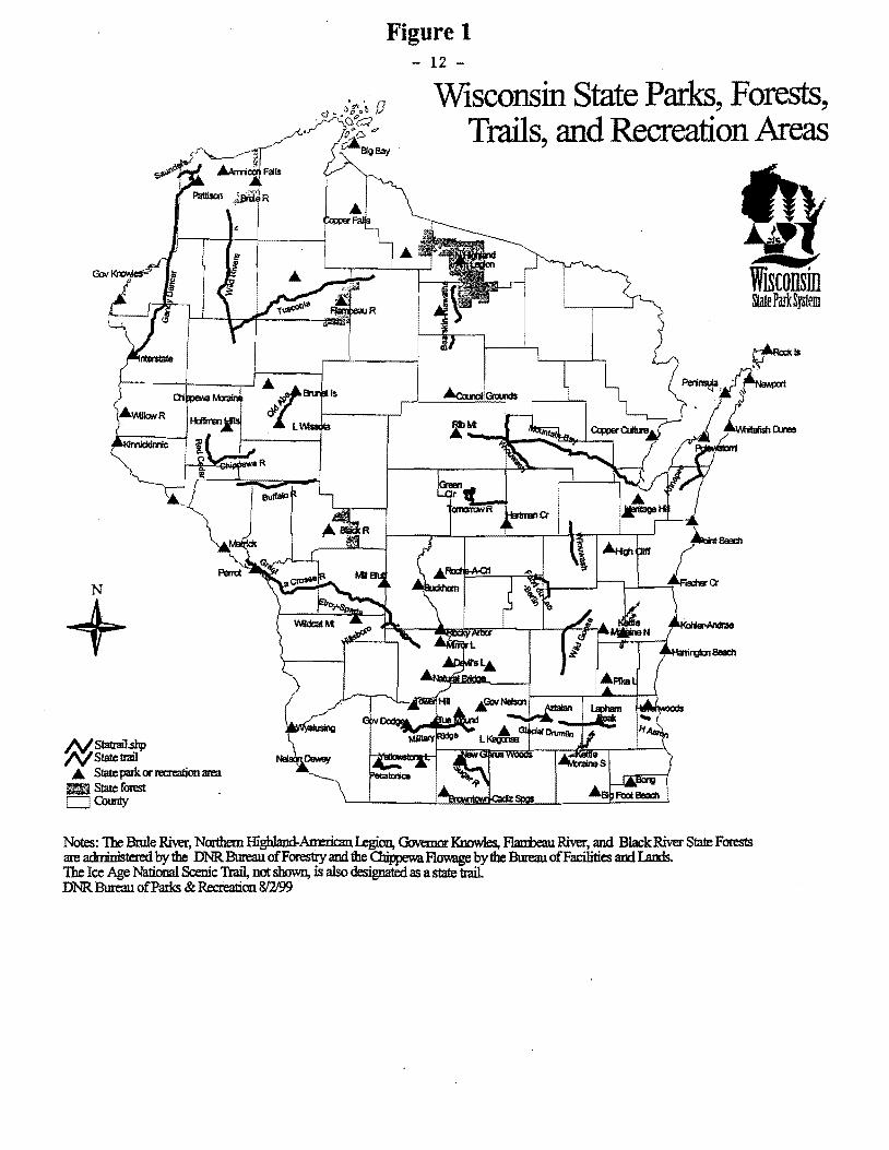
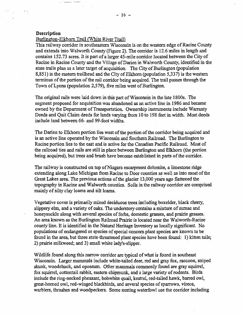
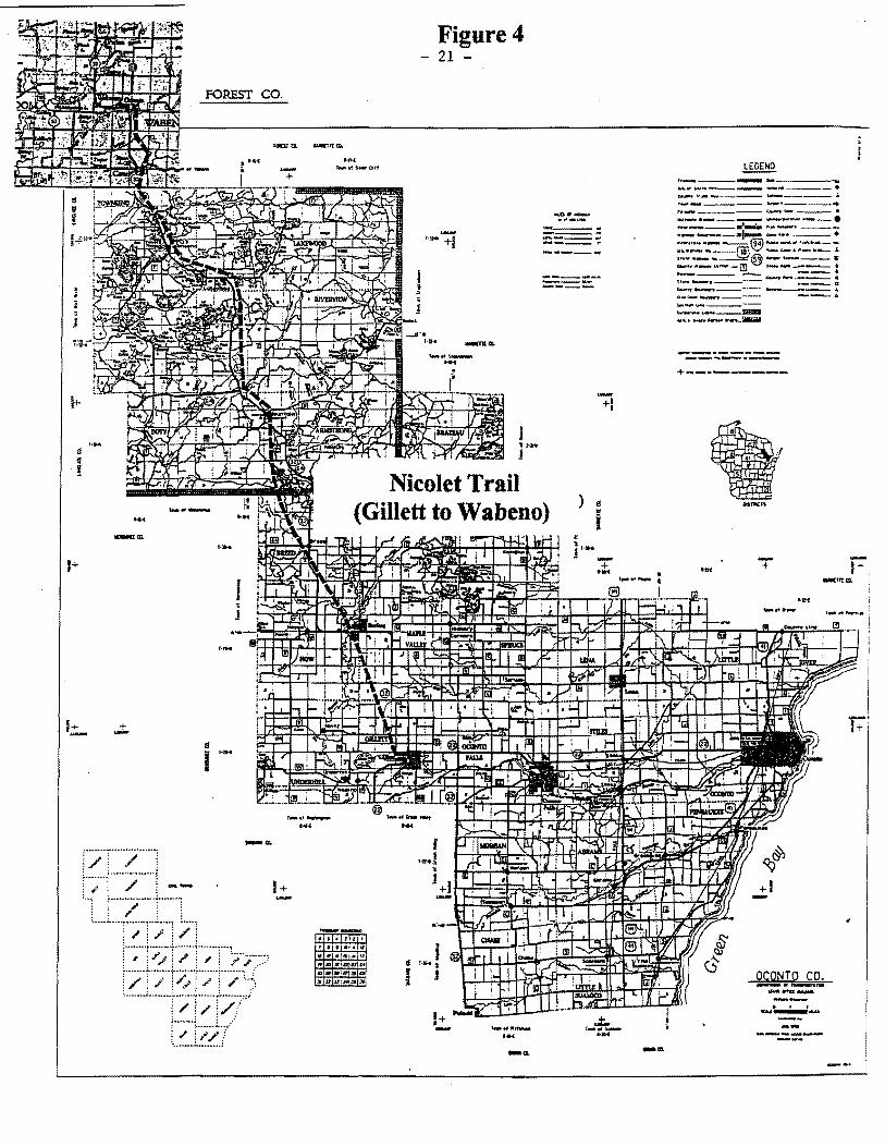