factors affecting students walking to school: case study
TRANSCRIPT

University of Nebraska - Lincoln University of Nebraska - Lincoln
DigitalCommons@University of Nebraska - Lincoln DigitalCommons@University of Nebraska - Lincoln
Community and Regional Planning Program: Student Projects and Theses Community and Regional Planning Program
Spring 5-2013
Factors Affecting Students Walking to School: Case Study of Two Factors Affecting Students Walking to School: Case Study of Two
Middle Schools in Lincoln, Nebraska Middle Schools in Lincoln, Nebraska
Nivin S. Khalil University of Nebraska-Lincoln, [email protected]
Follow this and additional works at: https://digitalcommons.unl.edu/arch_crp_theses
Part of the Urban, Community and Regional Planning Commons, and the Urban Studies and Planning
Commons
Khalil, Nivin S., "Factors Affecting Students Walking to School: Case Study of Two Middle Schools in Lincoln, Nebraska" (2013). Community and Regional Planning Program: Student Projects and Theses. 18. https://digitalcommons.unl.edu/arch_crp_theses/18
This Article is brought to you for free and open access by the Community and Regional Planning Program at DigitalCommons@University of Nebraska - Lincoln. It has been accepted for inclusion in Community and Regional Planning Program: Student Projects and Theses by an authorized administrator of DigitalCommons@University of Nebraska - Lincoln.

Factors Affecting Students Walking to School
Case Study of Two Middle Schools in
Lincoln, Nebraska
By
Nivin S. Khalil
A Thesis
Presented to the faculty of
The Graduate College at the University of Nebraska
In Partial Fulfillment of Requirements
For the Degree of Master of Community and Regional Planning
Major: Community and Regional Planning
Under the Supervision of Professor Yunwoo Nam
Lincoln, Nebraska
May 2013

Factors Affecting Students Walking to School
Case Study of Two Middle Schools in
Lincoln, Nebraska
Nivin S. Khalil, M.C.R.P.
University of Nebraska, 2013
Advisor: Yunwoo Nam
Physical activity, including walking, can be a very healthy and sustainable mode
of transportation. Children walking to their schools can get a lot of benefits from
acquiring good habits that can be carried through their adulthood. Also, walking to school
can reverse the trend of increasing obesity rates among children in the United States. This
study is trying to identify the effect of urban form, presented in the distances between
residences and schools, on the children’s behavior whether they walk to school or not
depending on different urban forms around their schools. Two middle schools in Lincoln,
Nebraska were selected as case studies using network analysis in Geographic Information
System (GIS). These schools featured diverse socioeconomic status and urban form
characteristics for their surrounded neighborhoods. A survey was conducted on a sample
of one hundred and sixteen students from both schools. From our results, we found that
21.8% of the sample in Lefler School use active modes of transportation to their school
located near the city center, where the school is built in a traditional neighborhood
featuring grid street system and high connectivity. Only 6.7% of the sample in Scott

School bike to school, and nobody walks to it, since Scott School is located in a late-
modern neighborhood on the city’s fringes built in the 1990s, and features dead-end
streets and low connectivity. We concluded that distances seem to increase in the latter
neighborhood resulting in diminishing the number of students willing to walk or bike to
their school. Other factors like parents’ and children’s perceptions about safety, traffic,
convenience, and strangers might have an influence on determining the child’s behavior
whether to walk to school or not.

iii
Copyright 2013, Nivin S. Khalil

iv
Dedication
This thesis is dedicated to my husband, Peter William, my kids, Ethan and Emma, and
my parents for their support and love during my graduate studies in the program.
Acknowledgments
I would like to express my deepest appreciation for my advisor, Professor Yunwoo Nam,
for his help, guidance, and support during my thesis and throughout my graduate
coursework.
Also, I would like to thank my master’s committee members, Professor Gordon Scholz,
and Professor Rodrigo Cantarero for their support, their valuable comments, and the time
they spent reviewing my thesis.
I would like to recognize all the participants who facilitate the progress of my
experimental study (survey). Special thanks to Rachel Wenzl from the Institutional
Review Board at the University of Nebraska-Lincoln, and to Dave Knudsen and Kelly
Schrad, the schools’ principals.

v
Table of Contents
List of Figures ......................................................................................................... vii
List of Tables ......................................................................................................... viii
Chapter 1: Introduction ........................................................................................ 1
Research Question .............................................................................. 3
Research methodology ....................................................................... 3
Chapter 2: Literature Review ............................................................................... 4
Walkability ......................................................................................... 4
Walking to school ............................................................................... 6
Schools locations ................................................................................ 9
Factors affecting children’s walking behavior ................................. 10
Policies and programs adopted to promote children’s safe and active
travel ................................................................................................. 15
Chapter 3: Analysis and Results ........................................................................ 18
Case study selection ......................................................................... 18
Differences between the two neighborhoods ........................ 22
Differences between the two schools .................................... 25
Survey ............................................................................................... 26
Analysis of the Results ..................................................................... 28
Chapter 4: Discussion and Conclusion .............................................................. 41
Discussion of results......................................................................... 41
Conclusion ........................................................................................ 44
Further research ................................................................................ 45
Limitations of the study: .................................................................. 46
Chapter 5: Implications for planners and policymakers .................................... 47

vi
References .......................................................................................................... 49
Appendix A.1: The cover letter attached with the survey ...................................... 52
Appendix A.2: Parental informed consent form that was sent in the package ...... 53
Appendix A.3: The child assent form sent in the package ..................................... 55
Appendix B: Demographic differences between the two neighborhoods .............. 57
Appendix C: Survey used for Lefler and Scott Middle Schools ............................ 58
Appendix D.1: A detailed cross tabulation for Lefler Middle School ................... 63
Appendix D.2: A detailed cross tabulation for Scott Middle School ..................... 64
Appendix E: A table to summarize what children see on their way to school ....... 65
Appendix F: A table to summarize what makes walking or biking to school better .
.......................................................................................................... 66

vii
List of Figures
Figure 3.1 A map showing the polygons around Lincoln middle schools. ............ 19
Figure 3.2 A map for driving distances to Lefler Middle School .......................... 20
Figure 3.3 A map for driving distances to Scott Middle School ............................ 21
Figure 3.4 Lefler Middle School – Attendance area boundary by Census Tracts . 22
Figure 3.5 Scott Middle School – Attendance area boundary by Census Tracts ... 23

viii
List of Tables
Table 3.1 Differences between the two schools ..................................................... 26
Table 3.2 Frequency distributions of demographic data ........................................ 29
Table 3.3 Frequency distributions of how far children live away from school and
how they usually get to school ............................................................................... 30
Table 3.4 Cross tabulation for how students usually get to school related to the
distance to Lefler Middle School ........................................................................... 31
Table 3.5 Cross tabulation for how students usually get to school relate to the
distance to Scott Middle School ............................................................................. 31
Table 3.6 Cross tabulation with percentages for the students’ grades and the means
of transportation used to get to Lefler School ........................................................ 32
Table 3.7 Cross tabulation with percentages for the students’ grades and the means
of transportation used to get to Scott School .......................................................... 33
Table 3.8 The destination of the driver after dropping off the children ................. 34
Table 3.9 Frequency distributions of school bus, bicycle and car availability ...... 35
Table 3.10 How students feel about walking to school. ......................................... 36
Table 3.11 Frequency distributions for the presence of continous sidewalks and
their ratings. ............................................................................................................ 37
Table 3.12 Cross tabulation for means of transportation and rating the sidewalks
for Lefler School ..................................................................................................... 38
Table 3.13 Cross tabulation for means of transportation and rating the sidewalks
for Scott School ...................................................................................................... 38
Table 3.14 Frequency distribution for students’ chances whether to walk or bike to
school if the route to school was improved to be safer. ......................................... 40

1
Chapter 1: Introduction
Physical activity, including walking, was proved to have excellent benefits for the
body and the mental health of human beings. It is a form of relaxation which helps the
person to lower his tension and to get rid of stress and fatigue. Walking began to receive
a great attention in the 1990s due to the new recommendations that encouraged moderate-
intensity physical activity. Moreover, the increased rates of overweight children,
adolescents and adults alarmed the public health officials to perform researches and carry
out some programs to encourage students to improve their physical activity level,
especially walking to school (McDonald 2007, 509).
Active transportation, through walking to school, is considered a form of
reintroducing regular physical activity into the lives of today’s children. Active children
in their childhood are more likely to carry healthy behaviors and activity habits and
routines into their adulthood. They may also encourage other members in their families to
perform more physical activities in their day. Walking to school enables children to
socialize with friends and develop independence and confidence.
The prevalence of children walking to school has declined in the last four
decades. Data from the National Personal Transportation Survey conducted by the U.S.
Department of Transportation showed that 40.7 percent of students used to walk or bike
to school in 1969. However, this percentage dropped to 12.9 percent in 2001.
Distance to schools seems to have the greatest influence on the likelihood of
walking and biking to school. It is affected by the urban form of the neighborhood,

2
whether it is a traditionally designed one (built early in the 1900s near the city center),
early-modern (built soon after World War II near the city center), or late-modern
neighborhood (built in the past two decades near the urban fringe) (McMillan 2005, 446).
The fields of urban design and public health have been connected together in the past few
years recognizing their common interest of having walkable communities that favor
residents’ health (Ewing and Handy 2009, 65).
Urban form also has a strong relation with the increase of distances between
households and different community buildings and services. Distances to shopping areas
impact the frequency of walking trips among residents of those neighborhoods. Mixed
land use, site design (including pedestrian facilities, block size, and sidewalk length) and
the route directness (representing accessibility) also affect walkability.
A new trend took place in the United States that has resulted in building new
schools in the suburban areas on the fringes of the cities. These new suburban areas do
not promote walkability due to their design that is formed of cul-de-sacs, curves, and
dead ends, unlike the old grid street system that generated shorten distances between
destinations and encourages walking behavior.
Research has been performed to find out how we can improve the paths and
routes to schools in order to encourage children to walk to school. Federal and state
governments are also adopting programs to boost children to walk to their schools by
providing a safer, more convenient physical environment for them.

3
Research Question
This thesis hypothesizes that a grid street system network around schools,
increases the students’ chances to have more active transportation to their schools. Other
factors, like the socioeconomic status of households in the census tracts around the
schools, are included in the study.
Research methodology
This study aims to compare two middle schools in Lincoln, Nebraska as case
studies. The two schools are located in different urban form areas, with relative
differences in some demographic factors. Schools were selected based on Network
analysis using the Geographic Information System (GIS).
A survey was conducted on a sample of students from these schools. The
University of Nebraska Institutional Review Board (IRB) approved the instrument and
protocol used for this study after submitting a copy of the survey, parental informed
consent form, child assent form, and other information. A copy of these forms is included
in Appendix A. Surveys were sent home with the students through the school system,
along with parental informed consent form, child assent form, and a letter explaining the
study. Eight hundred and forty students were invited to participate in the study from the
6th
, 7th
and 8th
grade. Children had the chance to discuss with their parents whether to
participate or not. One hundred and thirty-six surveys were returned. However, only 85
percent of these responses were usable and have the required signed consents and assents.
The final response rate was 13.8 percent.

4
Chapter 2: Literature Review
Walkability
In the last 20 years, the United States faced a period of rapid suburbanization,
economic growth, and an increase in vehicle ownership and use. Urban sprawl increased
by having low-density neighborhoods, with separated uses, and low street connectivity.
Smart growth and New Urbanism emerged as a reaction to sprawl. Those trends
aim to improve air quality, solve traffic congestion, and promote better overall quality of
life. They are trying to reduce traffic by reducing car dependence and promoting
walkability.
Land use regulations and zoning codes are being adjusted in order to increase the
development’s density, mix of land uses, and provide pedestrian facilities (Moudon, et al.
1997, 48) and to recreate the best of the United States pre-sprawl, small-town past. In the
walkable community terms, neighborhood plans should provide local destinations within
reasonable walkable distances for residents who want to walk.
Smart growth and New Urbanism support the idea of building schools within
walking or biking distance of the majority of the population they are meant to serve. This
concept will decrease the need for resources such as school buses or parent’s time and
private cars transporting children to and from school (McMillan 2005, 444).
Moreover, the increase in using private vehicles as a main option for transporting
children to school contributes to traffic congestion, air pollution, and the risk of injury

5
and death to road users, especially around schools. Shifting this behavior to walking and
biking poses little risk to others and provides great opportunities for physical activities.
In a study that included four case studies of neighborhoods in the San Francisco
Bay Area, Handy (1996) found that the numbers of walking trips to different destinations
increase as the distances are shorter. Also, the presence of street design elements such as
narrow streets, shaded sidewalks, and front porches increased the perceived level of
accessibility. The study also found that the percentage of people walking to commercial
areas in a specific period of time was higher in the traditionally designed neighborhoods
compared to the modern neighborhoods built soon after World War II (Handy 1996).
Pedestrian facilities in the form of sidewalks, paths, and crosswalks were
normally constructed in any residential or commercial area, until World War II. Then,
after the widespread use of private cars, these facilities were not built as before, which
led the developers to diminish their efforts on providing a safe pedestrian environment in
their new developments (Moudon et al. 1997, 48).
A published article by Saelens et al. (2003) focused on neighborhood environment
characteristics that may have an influence on the choices of people whether to walk or
not, such as connectivity and proximity. They define connectivity as the directness or
ease of travel between two points. They also define proximity as the straight-line distance
between different land uses such as residential, office, retail, and commercial activities
(Saelens et al. 2003, 81). Based on this study, proximity can be determined by two land
use variables, which are the density or compactness of land uses, and the land use mix
shown in the level of integration within a given area of different types of uses. The

6
traditional old neighborhoods were characterized by having high mixed use within a
small area, while in modern suburbs, different land uses are separated. Furthermore, old
neighborhoods were characterized by having grid street system that is known for high
connectivity and the presence of fewer barriers between origins and destinations, while
modern suburbs have low connectivity with low density of intersections, long blocks, and
barriers to direct travel (Saelens et al. 2003, 82). Saelens’s study found that the frequency
of walking trips per week is relatively low regardless of the neighborhood environment,
compared to other travel modes. However, the number of walking trips per week for
residents in higher connectivity neighborhoods is higher than those living in low
connectivity neighborhoods (Saelens el al. 2003, 83).
In other research that was done by Moudon (1997) in Washington, the study
indicated that the pedestrian low frequency walking trips, even in mixed-use, medium-
density environments, is due to inadequate site design and low connectivity represented
in lack of direct, continuous, and safe pedestrian systems holding all other factors
constant (Moudon et al. 1997, 54).
Walking to school
Walking to school is an environmentally clean mode of transportation that is
affordable to everybody. Active children in their childhood are more likely to carry
healthy behaviors and activity habits and routines into their adulthood. Exposing children
at early ages to healthy modes of transportation, like walking and biking, may be a
successful strategy to encourage them to increase physical activity among adults, and to

7
use these active modes later in their life. They may live longer, healthier lives than less
active individuals (Schlossberg et al 2006, 338; Heelan et al. 2005, 341).
Walking to school simply increases the physical activity of the children and
reduces the incidence of obesity rates and overweight children. Reduced physical activity
among children can result in a number of diseases in their adulthood. These diseases can
include, but are not limited to, major risk factor for cardiovascular disease, stroke,
diabetes, hypertension, and obesity. In addition, depression and anxiety can be
contributing factors that have an impact on the mental and emotional health of children
(Ziviani et al. 2006, 27).
A number of studies and surveys were conducted by the Federal Highway
Administration in order to understand residents’ travel behavior. From the results, it was
found that in 1969, about half of all students walked or bicycled to school (FHWA Safety
Program n.d.). In the 1995 Nationwide Personal Transportation Survey (NPTS), which
was also conducted by The Federal Highway Administration (FHWA), it was indicated
that children aged 5 to 15 made most of their trips (69 percent) by a private car. Twenty-
six percent of these trips were travelling to school. Only 10.5 percent of children aged 5
to 9 walked to school, 52.8 percent were driven, 30.2 percent rode a school bus, and 6.5
percent traveled to school with other modes (McMillan 2005, 441). The same study
indicated that most of the trips transferring children to school, social events, or health
care are done by women in the household (McMillan 2005, 451).
In the Greater Toronto Area, Canada’s largest city-region, the percentages of
students walking to school also decreased over decades. For children aged 11-13 years,

8
53 percent used to walk to their schools in 1986, compared to 42.5 percent in 2006. For
children aged 14-15 years, 38.6 percent of children used to walk compared to 30.7
percent over the same period (Buliung et al. 2009, 509).
Wong et al. conducted a study in Ontario, Canada in 2009 addressing the mode
shifting in school travel mode for children reported to be actively transported to school.
The results indicated that for elementary school students 38 percent of the sample was
active in the morning (going to school), while the percentage increased to 47 percent in
the afternoon (returning home). For the high school students, only 23 percent were active
in the mornings compared to 32 percent in the afternoons (Wong et al. 2011, 5). The
authors pointed out that those percentages are higher than those reported in the United
States, similar to percentages in Australia and New Zealand, but lower than European
countries. The results were expected for the authors because of the wide existence of
neighborhood schools within neighborhoods established in the 19th
century, before the
car invention and its widespread after that. These neighborhoods were characterized by
their grid street system and high land use density that encouraged the active modes of
transportation (Wong et al. 2011, 9).
McDonald (2007) analyzed data from the 1969, 1977, 1983, 1990, 1995, and
2001 National Personal Transportation Surveys (NPTS) conducted by the U.S.
Department of Transportation to document the active transportation changes and trends.
The study indicated that in 1969, 66 percent of students lived less than 3 miles away from
school, while in 2001 it is only 49.5 percent of students, which means that the distances
between households and schools increased over the decades (McDonald 2007, 512). In
the same study, McDonald stated that 85.9 percent of children living within one mile of

9
school used to walk or bike, compared to 49.9 percent in 2001 (McDonald 2007, 512). In
Heelan’s study, based on the 1995 NPTS, he stated that only 28 percent of children aged
5-15 years living within 1 mile of school used to walk in 1995. Furthermore, only 2.2
percent of children living within two miles of school biked to and from school (Heelan et
al. 2005, 342). Thus, distances to schools appear to influence the likelihood of walking to
and from the school.
Walking to school increases the physical activity done by children and helps
reduce the childhood obesity that has more than tripled in the past 30 years. The Centers
for Disease Control and Prevention (CDC) stated that the percentage of obese children
aged 6-11 years in the United States increased from 7 percent in 1980 to nearly 20
percent in 2008. In the same manner, the percentage of obese adolescents aged 12-19
years increased from 5 percent to 18 percent over the same period (Centers for Disease
Control and Prevention n.d.)
The practice of encouraging or even allowing children to walk to school has
declined in some cities. This has been a result of considering walking to be a sign of low
status, or an anti-cultural activity, despite of all the health benefits that walking provide to
children and adults (Kearns, Collins and Neuwelt 2003, 286). Moreover, the increase in
private car ownership has an effect on decreasing the children’s freedom of movement
and choosing the travel mode they prefer (Kearns, Collins and Neuwelt 2003, 286).
Schools locations
A new trend in the United States and Canada took place following World War II
which aimed at constructing spacious homes and buildings, separating work places from
10
homes, and extremely depending on cars even for local neighborhood trips. These
postwar suburbs were known to be “designed for cars, not for people” (Randall and Baetz
2001, 1). During the same time, more than 50 years ago, the same trend encouraged
building new larger schools in areas with low housing densities and low street network
connectivity. This shifting happened due to the demand of having larger sport fields in
the schools, which is difficult to have in older school’s neighborhoods (Schlossberg et al.
2006, 337). In addition, the only available large space is usually near the fringes of the
cities. Most of the time, it is agricultural land being converted to residential purposes,
with lower densities. These schools are built near high-capacity roads, which ease the car
access to schools, as opposed to walking or biking access. However, many states have
implemented new strict minimum acreage requirements for building new schools (Zhu
and Lee 2009, S178).
Developers and planners tend to plan those new communities in favor of
curvilinear patterns and cul-de-sacs that made these suburbs substantially distinct from
older urban neighborhoods. They provided expansive residential lots, with obvious large
houses, and boulevards (Randall and Baetz 2001, 2). As a result of this trend, distances to
schools substantially increased, which resulted in a shift in the travel mode of children to
schools.
Factors affecting children’s walking behavior
The primary factor discussed in this study is the effect of the urban form of our
communities on the children’s travel behavior. Urban form fundamentals include block

11
lengths, street widths, and presence of sidewalks may have a direct influence on walking
and bicycling behavior in children. The increasing distances associated with different
urban forms is also considered a main factor affecting the children’s choices.
In a study that was done in Belgium by D’Haese et.al, a criterion distance was
indicated for walking and biking to school for 11-12 year old children. The study
included a sample of 696 parents from randomly selected 44 classes in elementary
schools in Belgium. The results indicated that almost 60 percent of the total sample
commuted actively to school, whether by walking or biking. The standard distance was
set to be 1.5 kilometers (almost 1 mile) for walking, and 3 kilometers (almost 1.9 miles)
for biking to school among the 11-12 years old Belgian children. The study also showed
that in the range of 2 to 2.5 kilometers distance from school, the number of passive
commuters (using inactive modes of transportation) exceeded the number of the active
ones. D’Haese et al. suggested that improvements should be done in this criterion
distances to promote more active commuting among the rest of the children living within
this distance to school (D'Haese, et al. 2011, 4). The researchers also suggested that for
children living more than 3 kilometers away from school, a possible way to promote
active commuting is to drop off their kids at a reasonable distance (for example 1.5
kilometers) away from school, where they can meet other children, teachers, or
volunteers and walk to school with them to ensure safety for children (D'Haese, et al.
2011, 7).
Parents’ perceptions regarding safety are also very crucial in determining whether
their children can walk to school or not. Traffic safety, accidents, and presence of
strangers on the way to school were the main concerns addressed in most studies

12
(McDonald and Aalborg 2009, 336; Ziviani, Kopeshke and Wadley 2006, 31). Parents
presume streets closest to schools to be the most dangerous locations for students walking
or biking as a result of the school rush hour, and the traffic volumes at specific times
(McMillan 2005, 441). Due to the same reason, children are having less independent play
outside. However, the urban form may have an influence on some of the parents’
decisions and perceptions about traffic safety, by constructing sidewalks or marking
bicycle lanes.
Socioeconomic status seems to have an effect on parents’ decision whether to
allow their kids to walk to school or even have an outside activity or not. In a research
article that used data collected by the Millennium Cohort Study (MCS)1, results found
that as the socioeconomic status increased for the primary care provider for children, it
was less likely that they walk to school. The socioeconomic status determined in this
study was measured depending on the parental income and length of time in education.
However, it was more likely that children will walk to school if the family does not have
a private car, if one of the parents is not working, or if they live in an urban area. Yet,
children are also more likely to walk to school if their families have high income but
physically active and allow them to participate in organized sports. In general, depending
on this study, income plays an important role in determining the children behavior at
young age, where one of the parents usually walks with them, but it may not have the
same effect on older children. However, the cohort study did not measure the distance to
school, which may be an important determinant than income (Brophy, et al. 2011, 2).
1 The Millennium Cohort Study (MCS) is a study that follows the lives of a sample of 18,552 babies born
between 1 September 2000 and 31 August 2001 in England and Wales, and between 22 November 2000
and 11 January 2002 in Scotland and Northern Ireland.

13
Ethnicity of families was also addressed in many studies. Although some of the
studies indicated that low-income or minority children walk more often to school, other
studies indicated that these factors are not significant. However, other factors like crime
rate and neighborhood safety can be related to lower-income districts, and results in
affecting the rates of children who can walk safely to their schools (Zhu and Lee 2008,
282). Zhu and Lee (2008) led a study trying to understand the relationship between
ethnicity and children’s behavior. Their analysis for their case studies suggested that
Hispanic children tend to live closer to school; they have more sidewalks in their
neighborhoods, and may tend to use active transportation as a mode to get to school, as
they might not have other options, depending on their socioeconomic status. However,
safety in those neighborhoods may alter the children’s and their parents’ decisions. Thus,
ethnicity might not be one of the effecting factors on the choice of whether to walk to
school or not (Zhu and Lee 2008, 289).
McDonald prepared a comparable study using data from the 2001 National
Household Travel Survey2, to document rates of walking and biking to school among
low-income and minority youth in the U.S. The results found that race and income have
significant effect on rates of active transportation. For example, Hispanics were more
likely to walk to and from school than others. Also, students from higher-income families
(earning more than $60,000) were less likely to actively commute to school compared to
students from lower-income families (earning less than $30,000). However, these results
are affected with other explanatory factors, such as that whites are the least likely to live
2 The 2001 National Household Travel Survey is a population based survey conducted by the U.S.
Department of Transportation that collects information on all trips undertaken by members of selected
households on a randomly assigned survey day.

14
within a half-mile distance from school, they have higher incomes, high levels of vehicle
access, and live in lower-density areas, which may explain the lowest rates of walking
and biking to school between the Whites. Moreover, this study confirms that distance is
greatly associated with choosing to actively commute to school or not. Students living
within half-mile of school were more likely to walk or bike across all groups (McDonald
2008, 342, 343).
In another study that was done in Canada by Pabayo et al. (2011), the data used
was from a study conducted by the Canadian National Longitudinal Study of Children
and Youth (NLSCY)3. The study aimed the socio-demographic factors affecting the
likelihood of active transportation to school across time. The results showed that children
are more likely to walk at age 6, and peak at age 10 years, and then their active
transportation decrease throughout the teenage years. It is believed that when children are
more than 10 years old, they move to middle and high schools, which can be located
further away from home, and so they need a different kind of transportation, which in
turn show that distance to school is related to active transportation to school (Pabayo,
Gauvin and Barnett 2011, e408, e409). Also, the study’s results showed that income and
marital status of the parents can have an influence on the children’s behavior. Income
inadequacy (depending on the income and number of people in the household) and single
parenthood were significant determinants for increasing likelihood for children to walk to
school. Those families may have limited transportation alternatives, which led to more
3 The Canadian National Longitudinal Study of Children and Youth (NLSCY) was conducted by statistics
Canada in 1994 and 1995 among 22,831 children aged 0 to 11 years from the 10 provinces of Canada. The
study followed the development and well-being of children every 2 years done on 4 cycles.

15
active behavior in their children. Also, having older siblings in the household increased
the chances of walking to school (Pabayo, Gauvin and Barnett 2011, e408, e410).
Few studies aimed the active commuting for adolescents. Babey et al. led a study
that addressed adolescents aged 12-17 years. The research used data from the 2005
California Health Interview Survey for 3,983 adolescents. The study found that males,
adolescents from lower-income families, those who have no adult present at home most
of the time, and those attending public school are more likely to actively commute to
school. Also, those who live in urban areas were more likely to walk or bike to school
than those living in rural or suburban areas (Babey, et al. 2009, S209).
Policies and programs adopted to promote children’s safe and active travel
Federal and state governments are adopting some policies and programs to alter
the trend of having parents driving their kids to school. One of these programs is Safe
Routes to School (SRTS). It is a Federal-Aid program of the U.S. Department of
Transportation’s Federal Highway Administration (FHWA) (FHWA Safety Program
n.d.). SRTS is a national and international movement directly aiming the child’s trip to
school. The program is trying to create a safe, convenient, and fun opportunities for
children to walk and bike to and from their schools, and reverse the decline in children
walking and biking to schools, along with reversing the alarming nationwide trend
toward childhood obesity and inactivity. Their goal is to make walking and biking to
school a safe routine activity once again on an everyday basis. The funding for the
program is used to build safer environment and safer street crossings to encourage
children and parents to walk or bike safely to school (FHWA Safety Program n.d.).

16
Safe Routes to School programs comprise the five E’s which are education (for
the child and driver on road safety), encouragement, engineering and infrastructure,
enforcement of traffic laws around schools, and evaluation, in order to have successful
program (Safe Routes to School National Partnership n.d.).
SRTS vision focuses on having a safer way to get to school. This concept can be
performed by:
Building sidewalks, bicycle paths and pedestrian-friendly infrastructure
Reducing speeds in school zones & neighborhoods
Addressing distracted driving among drivers of all ages
Educating generations on pedestrian & bicycle safety
Also, they focus on having a healthier way for children to start their day. They
emphasize the healthy benefits gained from walking, rolling and biking to school like
increasing the daily physical activity, and arriving at school energized and ready to learn.
SRTS highlights one more benefit from walking to school which is building relationships
and the sense of neighborhood (National Center for Safe Routes to School n.d.).
The International Walk to School Day is also a good presentation of how
important it is for children to walk to their schools. It first began in the United States in
1997 as a one-day event aimed at building awareness for the need of having walkable
communities. The United Kingdom and Canada joined the move in 2000. Nowadays
thousands of schools across the United States participate in this day along with more than
40 countries worldwide (Walk Bike to School n.d.).

17
Walking school bus (WSB) is another implemented program addressing children
and encouraging them to walk to school. The idea is very simple. Walking school bus is a
group of children walking to school with one or more adults. It can be a small bus of two
families taking turns, or a structured big one with meeting points and picking up
additional children along the way. It is considered an attempt to reduce the risks of
children walking to and from schools. The idea of WSB started in 1998 in a school in
England. It reduced the car travel to this school by 30 percent in one year. Then the idea
was transferred to the rest of the countries (Kearns, Collins and Neuwelt 2003, 286).
Children usually like the idea of the walking school bus. Children being
independent promotes both personal and environmental health. Besides, it is a practical
education on how to cross the road safely (Kearns, Collins and Neuwelt 2003, 287). WSB
allows children to engage in exercise, helps them explore their surrounding environment,
and promotes social interaction. However, many American school districts refuse to
sponsor the Walking School Bus due to liability. It is a main concern for schools to be
liable for any injuries that may occur during the walk to school (McDonald and Aalborg
2009, 338).

18
Chapter 3: Analysis and Results
Case study selection
Geographic Information System (GIS) is now widely used in many applications.
This research utilized Network analysis as one of the tools used to select two middle
schools in Lincoln, Nebraska as case studies so that they are located in different urban
neighborhoods. We selected to perform the analysis on the middle school children for the
following reasons: the students are big enough to walk themselves to school, parents have
more confidence regarding the safety of their older children walking to school, and the
children are mature enough to answer the survey questions themselves.
By using Network analysis, four polygons were created around Lincoln’s middle
schools. These polygons define four walking/driving distances around those schools. This
analysis used the network data set of streets. Figure 3.1 is a map that shows the polygons
around Lincoln middle schools.
The polygons represent the distances of a quarter mile, a half mile, three quarters
of a mile, and a one mile driving distances around middle schools. By assuming that all
streets have sidewalks (on either side or both) that students can use to walk to their
schools, we accept those polygons to present the walking distance as well.
From Figure 3.1, we can realize that there are some clear differences between the
shapes and areas of those polygons. The schools that are constructed in a grid system
neighborhood type have regular shaped polygons that look more like rhombus, where
their two diagonals are perpendicular. While polygons around schools constructed in
Lincoln’s suburbs, near its city limits, may look different.

19
Figure 3.1 A map showing the polygons around Lincoln middle schools.

20
Two middle schools were selected, based on this approach, with different
polygons shapes. The first is Lefler Middle School; it is located at Randolph and 48th
Streets, near the city center. The second is Scott Middle School; it is located at Pine Lake
and 22nd
Streets close to Lincoln’s city limits. Figure 3.2 and Figure 3.3 show a closer
look at those two schools.
A buffer zone of one mile was also created around each of those schools. With a
quick comparison between the two schools, it was found that the polygons around Scott
middle school (Figure 3.3) seem to be irregular compared to those around Lefler middle
school (Figure 3.2).
Figure 3.2 A map for driving distances to Lefler Middle School

21
Lefler Middle School is located in the center of Lincoln, Nebraska with a grid
street system around it, and high level of connectivity. This grid system justifies the
regularity in the polygons, and indicates that the distances to the school can be shorter
and more direct.
Scott Middle School is located near the city limits, with fewer numbers of streets
from the west and south sides. Streets located on the north and east sides of the school
contain numbers of cul-de-sacs and dead-end streets that lack connectivity. Those kinds
of streets seem to increase the walking/driving distance for those residents, either to reach
the nearest school or the nearest community facility.
Figure 3.3 A map for driving distances to Scott Middle School
City Limits

22
Differences between the two neighborhoods
By looking at the 2011 – 2012 middle school attendance areas map provided by
Lincoln Public Schools, it was found that there are six census tracts surrounding Lefler
Middle School, and there are five census tracts surrounding Scott Middle School. Those
census tracts are considered the attendance areas for our selected schools. Figure 3.4 and
Figure 3.5 show these census tracts and one mile buffer zone around those two schools.
Figure 3.4 Lefler Middle School – Attendance area boundary by Census Tracts

23
Figure 3.5 Scott Middle School – Attendance area boundary by Census Tracts
From the literature review, we found that income and education attainment could
be good measures of socioeconomic status. We examined those factors for the census
tracts available around those schools. From Census 2010, it was found that the average
median household income for census tracts 7, 13.01, 14, 15, 16, and 18, where Lefler
middle school is located, is $40,036. While for census tracts 36.05, 36.07, 36.09, 37.08,
and 37.16, where Scott middle school is located, the average median household income is
$81,193 based on the data collected by the American Community Survey for 5-year
estimates (American Fact Finder n.d.).

24
Also, educational attainment data were gathered from Census 2010 for those
census tracts. It was found that the percentage of population 25 years and over that holds
a bachelor’s degree or higher differs from one neighborhood to another. For the census
tracts located at the attendance area of Lefler School, the average percentage was 34.5
percent for the whole population 25 years and over. However, it was 58.4 percent for the
census tracts located around Scott School, based on the data collected by the American
Community Survey for 5-year estimates (American Fact Finder n.d.).
By looking at the 2010 census summary file 1 of the general housing
characteristics data available from the U.S. Census Bureau, it was found that the average
percentage for owner occupied housing units is 46 percent from the total housing units
for census tracts surrounding Lefler School, compared to 73.8 percent for census tracts
surrounding Scott School (American Fact Finder n.d.).
In addition, from Census 2010, it was found that the median year that structures
were built in these census tracts are different. The average median year for structures
built in attendance area around Lefler School is 1958; while the average median year for
available data for structures built around Scott School is 1990. These data illustrate the
huge difference between the ages of the buildings in those two areas based on the data
collected by the American Community Survey for 5-year estimates (American Fact
Finder n.d.).
All the data gathered for the surrounding neighborhoods and census tracts give us
an idea that the two neighborhoods are different in many ways. The socioeconomic status
seems to be higher for Scott Middle School boundaries, depending on the data for median

25
household income and the level of education achieved. Moreover, from the general
housing characteristics data, we found that the percentage of owners occupying housing
units is higher for Scott School boundaries than Lefler School boundaries. Even the
structures built around Scott School are newer than those around Lefler School. A
detailed table for these data is presented at Appendix B.
Differences between the two schools
More data was gathered about those two schools from the facilities section of the
annual statistical handbook prepared by Lincoln Public Schools. It was found that the
original building of Lefler Middle School was built at 1955. Its area was 83,498 square
feet on two floors. Three additions were added later to reach a total of 130,580 square
feet. The site area is 12.28 acres. The number of students in Lefler Middle School is 591
students. The area for each student is 221 square feet per student from the total building
area, and about 905 square feet per student (0.02 acre per student) from the total site area
(Annual Statistical Handbook 2011-2012).
The original building of Scott Middle School was built at 1996. Its area was
154,404 square feet on one level. The first addition was added in 2008 to reach a total of
159,255 square feet. The site area is 20.47 acres. The number of students in Scott Middle
School is 924 students. The area for each student is 172 square feet per student from the
total building area, and about 965 square feet per student (0.022 acre per student) from
the total site area (Annual Statistical Handbook 2011-2012). Table 3.1 summarizes these
differences.

26
Table 3.1 Differences between the two schools
Year built Acres Square footage Student capacity
Lefler Middle
School 1955 12.28 acres
130,580
square feet 591 students
Scott Middle
School 1996 20.47 acres
159,255
square feet 924 students
From the literature review, we found that newer schools tend to be bigger in area,
and require more space for each student. In our case study, the site area of Scott School is
larger than that of Lefler School, due to its location near Lincoln suburbs and the city
limits. However, the number of students in the first is bigger than the latter, which
justifies the insignificant differences between the actual areas per student in both schools.
However, on the contrary, the student area in the building itself is more in Lefler Middle
School.
From the student section of the annual statistical handbook prepared by Lincoln
Public Schools, we found that 53.5 percent of the students at Lefler Middle School are
participating in the free or reduced price lunch program during the 2011-2012 school
year, compared to only 13 percent at Scott Middle School (Annual Statistical Handbook
2011-2012). This information settles the idea that Scott School has a higher
socioeconomic status than Lefler School.
Survey
Another aspect of this research was conducting a survey for the students from
both schools. As it was indicated before that we selected middle school children (aged 11
to 14 years old) to perform this analysis as they are big enough to walk to school and
understand the safe issues that may impede their way.

27
All the surveys’ packages were sent to the principals of the schools in February
2012. The principals were responsible for distributing the surveys among their students in
different grades. The researcher had no control after handling the surveys to the
principals. The principals received all the completed surveys and sent them to the
researcher in May 2012. The survey conducted took approximately 15 minutes to be
completed. It included 17 questions which required either a multiple choice response or a
judgment using a rating scale.
The first section in the survey asked basic demographic questions, including the
student’s grade, gender, and race. The second section is the research data needed. It
contains questions about distances between schools and residences (from the child
perspective). A map was provided with the survey for both schools, showing different
buffer distances around schools to help students answer this question as accurate as they
can to their best knowledge. The maps used are in Appendix C. Questions also were
asked on how they usually get to school and the child’s preferred choice whether to walk,
bike, use a bus, or any other form of transportation on a good weather day. More
questions in this section were about the availability of a private car, school bus, or a
bicycle.
The third section in the survey is about the child’s perceptions about walking to
school. The children were asked how do they feel about walking to school, whether it is
fun, boring, safe, unsafe, healthy, not healthy, and whether it saves time or not. Also,
there were questions asking about the availability of continuous sidewalks all the way to
school and rating those sidewalks around the school, along with describing the
surrounding environment. Appendix C includes the survey questions that were used.

28
Analysis of the Results
One hundred and thirty-six surveys were returned from eight hundred and forty
sent to students. Only one hundred and sixteen of these responses were usable and have
the required signed consents and assents. The sample size from Lefler Middle School is
56, while the sample size from Scott Middle School is 60.
Descriptive statistics were calculated using SPSS. Frequency distributions
summarized the majority of the data. Chi-squared tests were also performed to test the
relationship between the distances from home to school and type of transportation that
student usually choose to get to school.
Table 3.2 summarizes the demographic division of the sample we have got from
both schools. From Table 3.2, we can tell that 50% of the responses came from grade 8;
however we are not sure that the surveys were evenly distributed between the 3 grades in
the schools. From our sample size, 47.4 % were males and 51.7 % were females. Students
who responded to the survey reflect percentages from all races joining the two schools.
As would be expected from a Lincoln-based sample, 81.9 % from our sample are White/
Caucasian, 4.3 % are Asian, 2.6 % are Black/ African American, and other races also
responded to our survey.
Table 3.3 shows the frequency distributions of how far our sample lives away
from school, and how they usually get to school. We can see that 28.3% of our sample in
Scott Middle School live more than 2 miles away from school compared to only 10.7 %
at Lefler Middle School. Also, from Table 3.3, we found that the largest portion of
students (75.9%) is usually driven to school by either their parents, or someone else. 69.6

29
% of students are driven to Lefler Middle School, while 81.7 % are driven to Scott
Middle School.12.5% of the sample at Lefler School walk to their schools, while nobody
walks to Scott Middle School. These findings matched those from the literature review
found in McDonald’s, Heelan’s and McMillan’s studies (McDonald 2007; Heelan, et al.
2005; McMillan 2005).
Table 3.2 Frequency distributions of demographic data
Total Lefler Middle
School
Scott Middle
School
n= 116 % n=56 % n=60 %
Grade
6 47 40.5 % 29 51.8 % 18 30 %
7 11 9.5 % 11 19.6 % 0 0 %
8 58 50 % 16 28.6 % 42 70 %
Gender
Male 55 47.4 % 29 51.8 % 26 43.3 %
Female 60 51.7 % 26 46.4 % 34 56.7 %
Unanswered 1 0.9 % 1 1.8 % 0 0 %
Race
White/Caucasian 95 81.9 % 41 73.2 % 54 90 %
Black/African American 3 2.6 % 2 3.6 % 1 1.7 %
American Indian/Alaska Native 1 0.9 % 0 0% 1 1.7 %
Asian 5 4.3 % 3 5.4 % 2 3.3 %
Other 10 8.6 % 8 14.3 % 2 3.3 %
Prefer not to answer 2 1.7 % 2 3.6 % 0 0 %
A detailed cross tabulation for Lefler and Scott Middle Schools for how the
students usually get to their schools in relationship with how far away they live from
school is shown in detailed tables in Appendix D. It is noticeable that no matter what the
distance was between homes and school, students are used to be driven.

30
Table 3.3 Frequency distributions of how far children live away from school and how they usually get to school
Total Lefler Middle
School
Scott Middle
School
n=116 % n=56 % n=60 %
Distance from School
Less than 1/4 mile 6 5.2 % 3 5.4 % 3 5.0 %
1/4 mile to 1/2 mile 7 6 % 4 7.1 % 3 5.0 %
1/2 mile to 1 mile 24 20.7 % 14 25.0 % 10 16.7 %
1 mile to 2 miles 55 47.4 % 28 50.0 % 27 45.0 %
More than 2 miles 23 19.8 % 6 10.7 % 17 28.3 %
Left unanswered 1 0.9 % 1 1.8 % 0 0%
Usually get to school
Walk 7 6 % 7 12.5 % 0 0 %
Bike 8 6.9 % 4 7.1 % 4 6.7 %
School Bus 5 4.3 % 0 0 % 5 8.3 %
Parents Drive 72 62.1 % 34 60.7 % 38 63.3 %
Older brother/sister drive 4 3.4 % 0 0 % 4 6.7 %
Someone else drives 12 10.4 % 5 8.9 % 7 11.7 %
Ride city bus 7 6 % 5 8.9 % 2 3.3 %
Skate board 1 0.9 % 1 1.8 % 0 0 %
To simplify the data we have, the categories were combined together so that the
active types of transportations like walking, biking, and skate boarding are regrouped.
Also, other types of driving, like parents driving, or someone else driving, were
combined in one category. Table 3.4 and Table 3.5 illustrate the results we got.

31
Table 3.4 Cross tabulation for how students usually get to school related to the distance to Lefler Middle School
Lefler School How do students usually get to school
Total Active Driving
Ride city
bus
Distance from School Less than ¼ mile 1 2 0 3 (5.5%)
¼ mile to ½ mile 2 2 0 4 (7.3%)
½ mile to 1 mile 3 11 0 14 (25.5%)
1 mile to 2 miles 6 19 3 28 (50.9%)
More than 2 miles 0 5 1 6 (10.9%)
Total 12
(21.8%)
39
(70.9%)
4
(7.3%)
55
(100%)
Table 3.5 Cross tabulation for how students usually get to school relate to the distance to Scott Middle School
Scott School How do students usually get to school
Total Active Driving
School
Bus
Ride city
bus
Distance from School Less than ¼ mile 1 2 0 0 3 (5%)
¼ mile to ½ mile 1 2 0 0 3 (5%)
½ mile to 1 mile 0 10 0 0 10 (16.7%)
1 mile to 2 miles 1 24 0 2 27 (45%)
More than 2 miles 1 11 5 0 17 (28.3%)
Total 4
(6.7%)
49
(81.7%)
5
(8.3%)
2
(3.3%)
60
(100%)
From Table 3.4 and Table 3.5, we found that 21.8% of students are usually active
going to Lefler School, while only 6.7% of the Scott Middle School sample is active.
However, the largest share is for driving to both schools.
By performing Chi-Square analysis on the data obtained from Scott Middle
School, the observed value of Pearson Chi-Square X² is 23.878, the asymptotic p- value
is 0.021, and the exact p-value is 0.041. Therefore, there is a statistically significant
32
relationship between the distances from home to Scott Middle School and type of
transportation that student usually choose. While for Lefler Middle School the
relationship was not statistically significant with asymptotic p-value 0.625, exact p-value
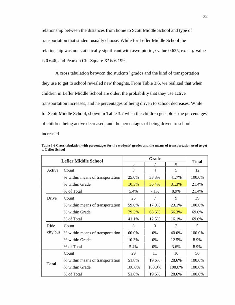
is 0.646, and Pearson Chi-Square X² is 6.199.
A cross tabulation between the students’ grades and the kind of transportation
they use to get to school revealed new thoughts. From Table 3.6, we realized that when
children in Lefler Middle School are older, the probability that they use active
transportation increases, and he percentages of being driven to school decreases. While
for Scott Middle School, shown in Table 3.7 when the children gets older the percentages
of children being active decreased, and the percentages of being driven to school
increased.
Table 3.6 Cross tabulation with percentages for the students’ grades and the means of transportation used to get
to Lefler School
Lefler Middle School Grade
Total 6 7 8
Active Count 3 4 5 12
% within means of transportation 25.0% 33.3% 41.7% 100.0%
% within Grade 10.3% 36.4% 31.3% 21.4%
% of Total 5.4% 7.1% 8.9% 21.4%
Drive Count 23 7 9 39
% within means of transportation 59.0% 17.9% 23.1% 100.0%
% within Grade 79.3% 63.6% 56.3% 69.6%
% of Total 41.1% 12.5% 16.1% 69.6%
Ride
city bus
Count 3 0 2 5
% within means of transportation 60.0% 0% 40.0% 100.0%
% within Grade 10.3% 0% 12.5% 8.9%
% of Total 5.4% 0% 3.6% 8.9%
Total
Count 29 11 16 56
% within means of transportation 51.8% 19.6% 28.6% 100.0%
% within Grade 100.0% 100.0% 100.0% 100.0%
% of Total 51.8% 19.6% 28.6% 100.0%

33
Table 3.7 Cross tabulation with percentages for the students’ grades and the means of transportation used to get
to Scott School
Scott Middle School Grade
Total 6 8
Active Count 2 2 4
% within means of transportation 50.0% 50.0% 100.0%
% within Grade 11.1% 4.8% 6.7%
% of Total 3.3% 3.3% 6.7%
Drive Count 13 36 49
% within means of transportation 26.5% 73.5% 100.0%
% within Grade 72.2% 85.7% 81.7%
% of Total 21.7% 60.0% 81.7%
School bus Count 2 3 5
% within means of transportation 40.0% 60.0% 100.0%
% within Grade 11.1% 7.1% 8.3%
% of Total 3.3% 5.0% 8.3%
Ride city bus Count 1 1 2
% within means of transportation 50.0% 50.0% 100.0%
% within Grade 5.6% 2.4% 3.3%
% of Total 1.7% 1.7% 3.3%
Total Count 18 42 60
% within means of transportation 30.0% 70.0% 100.0%
% within Grade 100.0% 100.0% 100.0%
% of Total 30.0% 70.0% 100.0%
When asking about the students’ choice on how to get to school on a good
weather day, they were allowed to select all that they like. The answers varied a lot. For
Lefler Middle School, only 28.6 % selected walking as their primary choice, while 48.2%
selected biking as their first or second choice on how to get to school. While considering
skate boarding, and roller blading active types of transportation, 9% selected those types
as their first choice. However, 35.7 % selected driving as their first and second choices to
get to school.

34
For Scott Middle School, the results came to be very close to Lefler’s. Only
28.3% selected walking as their primary choice, which is exactly the same percentage as
Lefler’s. 35% selected biking as their first or second choice, while 45% selected driving
as their primary choice to get to school.
The responses of this question gave us an idea that a good percentage of students
may prefer to walk or bike to school, while there may be other barriers preventing them.
We can also realize that a bigger percentage in Scott Middle School decided to be driven
anyway. That may be due to the longer distances to school.
One of the questions that were asked in the survey is about the direction of the
driver after dropping off the students in school. In Table 3.8, we found that for Lefler
School, 53.6 % of the drivers, either parents or someone else, were going somewhere else
after that, while only 35.7% were going back home. For Scott School, the percentage for
drivers going somewhere else was higher (71.7 %). The missing data from both schools
were for students walking, riding a city bus, or riding the school bus in the case of Scott
School. For both schools, these high percentages indicate the convenience of the drivers
just to drop off the students on their way to work or any other place.
Table 3.8 The destination of the driver after dropping off the children
Lefler Middle School Scott Middle School
n=56 % n=60 %
Going somewhere else 30 53.6 % 43 71.7%
Going home 20 35.7 % 11 18.3 %
Left unanswered 6 10.7 % 6 10 %
Total 56 100 % 60 100 %

35
The data collected from the two schools also contained the availability of owning
a bicycle, parents owning private cars, and school bus availability. The data presented in
Table 3.9 shows that more than 75% of the students own bicycles, although, from table
3.3, only less than 8% use them to bike to school. More than 94% of the parents own a
private car. By checking the transportation services on the Lincoln Public schools
website, it was found that there is no regular school bus for Lefler Middle School, while
there is a regular one for Scott Middle School, which agrees with the results we got from
our survey.
Table 3.9 Frequency distributions of school bus, bicycle and car availability
Lefler Middle School Scott Middle School
n=56 % n=60 %
School bus availability Yes 4 7.1 % 23 38.3 %
No 50 89.3 % 36 60 %
Unanswered 2 3.6 % 1 1.7 %
Bicycle owned Yes 43 76.8 % 53 88.3 %
No 12 21.4 % 6 10 %
Unanswered 1 1.8 % 1 1.7 %
Car availability Yes 53 94.6 % 59 98.3 %
No 2 3.6 % 0 0 %
Unanswered 1 1.8 % 1 1.7 %
Table 3.10 shows how students feel about walking to school. More students in
Lefler School feel that walking to school is fun. Although more students in Scott School
feel that walking to school is safe, their percentage of being active going to school is
lower than that of Lefler School.

36
Table 3.10 How students feel about walking to school.
How do you feel about walking Lefler Middle School Scott Middle School
n=56 % n=60 %
So Fun 11 19.6 % 8 13.3 %
Fun 22 39.3 % 16 26.7 %
Neutral 12 21.4 % 25 41.7 %
Boring 11 19.6 % 8 13.3 %
So Boring 0 0 % 3 5.0 %
Very Safe 9 16.15 % 21 35.0 %
Safe 25 44.6 % 20 33.3 %
Neutral 19 33.9 % 13 21.7 %
Unsafe 2 3.6 % 4 6.7 %
Very unsafe 1 1.8 % 2 3.3 %
Very Healthy 39 69.6 % 49 81.7 %
Healthy 11 19.6 % 7 11.7 %
Neutral 3 5.4 % 1 1.7 %
Unhealthy 2 3.6 % 2 3.3 %
Very unhealthy 1 1.8 % 0 0 %
Left unanswered 1 1.7 %
So Cool 9 16.1 % 8 13.3 %
Cool 18 32.1 % 23 38.3 %
Neutral 23 41.1 % 24 40.0 %
Uncool 5 8.9 % 1 1.7 %
So uncool 1 1.8 % 3 5.0 %
Left unanswered 1 1.7 %
Very Time saving 1 1.8 % 2 3.3 %
Time saving 4 7.1 % 8 13.3 %
Neutral 21 37.5 % 9 15.0 %
Not time saving 13 23.2 % 13 21.7 %
Does not save time at all 17 30.4 % 28 46.7 %

37
More than 90% of the students in both schools agreed that walking to school is
healthy. However, 4.3 % of students in both schools indicated that walking is unhealthy.
The latter percentage indicated that there should be more educational programs in schools
explaining the benefits of walking in general, and its importance for kids and adults of all
ages. A high percentage of students agreed that walking to school is not time saving. It is
believed that their answers depend on how far they live from school.
Table 3.11 displays the students’ answers about having continuous sidewalks all
their way to school, and their rating to those sidewalks. The results came to be good
where more than 65% indicated that there are continuous sidewalks to both schools, with
average good rating. The strange results were that 65% of our sample from Scott Middle
School indicated that the sidewalks are good, while only 6.7% shows active going to
school. Also, 46.6% from Lefler School indicated that the sidewalks are good. It is
believed that for Scott Middle School having been located in a newer developed area,
compared to the area surrounding Lefler Middle School, is why the sidewalks are good.
Table 3.11 Frequency distributions for the presence of continous sidewalks and their ratings.
Lefler Middle
School
Scott Middle
School
n=56 % n=60 %
Continuous Sidewalks Yes 37 66.1 % 44 73.3 %
No 18 32.1 % 15 25 %
Unanswered 1 1.8 % 1 1.7 %
Rating Sidewalks Very bad 2 3.6 % 2 3.3 %
Bad 8 14.3 % 2 3.3 %
Not bad or good 18 32.1 % 14 23.3 %
Good 20 35.7 % 23 38.3 %
Very good 6 10.7 % 16 26.7 %
Unanswered 2 3.6 % 3 5 %

38
A cross tabulation between the means of transportation of children and their rating
for the sidewalks led to a new assumption. We noticed from Table 3.12 and Table 3.13
that a big number of students who are driven to both schools confirmed that the
sidewalks’ conditions are either good or very good.
Table 3.12 Cross tabulation for means of transportation and rating the sidewalks for Lefler School
Lefler Middle School Means of transportation
Total Active Drive Ride city bus
Rate sidewalks Very bad 1 1 0 2
Bad 4 3 1 8
Not bad or good 4 10 4 18
good 2 18 0 20
very good 1 5 0 6
Total 12 37 5 54
Table 3.13 Cross tabulation for means of transportation and rating the sidewalks for Scott School
Scott Middle School Means of transportation
Total Active Drive School bus Ride city bus
Rate sidewalks Very bad 1 0 1 0 2
Bad 0 2 0 0 2
Not bad or good 2 10 1 1 14
good 1 22 0 0 23
very good 0 14 1 1 16
Total 4 48 3 2 57
Students were asked what they see on their way to school. They had the
opportunity to select all that apply. More than 75% answered that they see trees, occupied
buildings, neighbors and strangers on their way to Lefler School. However, more than
50% answered that they see parks, dogs, gas stations, parking areas, and trash. For Scott
School, more than 75% answered that they see trees, occupied buildings, dogs, neighbors,

39
strangers, along with parking areas. However, more than 50 % added that they see
apartment buildings, stores, gas stations, and construction areas. Fewer parks are seen on
the students’ way to Scott School, along with more empty lots than Lefler School.
Around 30% of students see vacant buildings during their trip to both schools. Only 3%
indicated that they see crimes on their way to both schools. That is why crime data was
not included in this study. It seems not to be a problem or an obstacle that prevents
children from walking to their schools. The collected data is included in Appendix E.
Similarly, students were asked what would make walking or biking to school
more achievable. More than 70% from our sample in both schools answered that walking
or biking with friends would increase the fun of walking to school. More than 30% in
both schools selected that less cars on the roads near the school along with sidewalks
clear of snow will also help. Some students indicated that having safe places to cross the
road is also important. However, a larger percent from Scott School pointed out that
nothing will improve their experience to walk or bike to school, since they live too far to
walk. The collected data is included in Appendix F.
The last question in the survey was asking the students about how likely they
would walk or bike to school if the route to school was improved so they felt safer. Table
3.14 displays the frequency distribution for the answers of students of both schools. The
chances that students will walk or bike is higher (60.7 %) in Lefler Middle School, while
in Scott Middle School, the chances were only 46.6 %. The students who answered that
they are definitely not going to walk or bike to Scott School were 30% of our sample,
while it was only 10.8 % for Lefler School. It is believed that this is due to the longer

40
distance between homes and Scott School. Some of the students stated that no matter
what improvements were done, they live so far away to walk or bike.
Table 3.14 Frequency distribution for students’ chances whether to walk or bike to school if the route to school
was improved to be safer.
Walk or Bike if it is safer Lefler Middle School Scott Middle School
n=56 % n=60 %
Definitely will not walk 3 5.4 % 9 15 %
Will not walk 3 5.4 % 9 15 %
May be 15 26.8 % 13 21.7 %
Will walk 19 33.9 % 14 23.3 %
Definitely will walk 15 26.8 % 14 23.3 %
Left unanswered 1 1.8 % 1 1.7 %

41
Chapter 4: Discussion and Conclusion
Discussion of results
The primary focus of this study was to determine if children going to a school
built in a traditionally old neighborhood will be more likely to walk or bike to school than
those attending a school in a new development in suburbs. By comparing the two case
studies we selected in Lincoln, Nebraska, we found that more students (21.8 %) use
active transportation modes to go to Lefler Middle School, located near the center of
Lincoln, whereas, less than 7 % were actively going to Scott Middle School, located near
the city limits. It is a low incidence in all the active modes of transportation, from
walking, biking, and skating for both schools.
As with other studies discussed in the literature review, the car was the most
common mode of transport used in travelling to school. More than 70 % of students were
driven by either their parents or someone else, regardless of the distances from residences
to schools.
In D’Haese’s study in Belgium, they set a criterion distance for walking that was
1 mile, and almost 2 miles for biking to school among the 11-12 years old Belgian
children (D'Haese, et al. 2011). According to our case study, nearly half students (47.5%)
live within 1 to 2 miles away from school. For Lefler School, 21% of those living within
1 to 2 miles are being active, while it is only 3% in the sample of those living within the
same distance from Scott School. If more analysis were done, we will find that other
factors are also behind this big difference between those percentages.

42
More students (28.3 %) in Scott School live more than 2 miles away than students
attending Lefler School (10.7 %), which may be a result of the urban form for the two
neighborhoods where the schools are located, which in turn increases the distances to
schools. However, our sample is not large enough to use this finding as a conclusion. One
more explanation can be that Scott School is located south of Lincoln, near the city
limits, to serve a bigger widespread area, not like Lefler School which is serving a limited
area around it. Again, it is one of the consequences for cities sprawl.
Race and ethnicity were changeable factors in the literature review. Some studies
indicated that low-income and minority children walk more to school, while others
indicated that they are not significant. In our case study, race was found not to be
statistically significant with the mode of children’s transportation.
The analysis for the neighborhoods surrounding the schools has revealed that they
are different in many ways. The socioeconomic status for the attendance area of schools,
measured by the income and education attainment, was higher for Scott Middle School.
The average median household income for census tracts surrounding Scott School is
twice that for Lefler School census tracts. Even the educational attainment measure
shows that more people from Scott School neighborhood hold a bachelor’s degree or
higher from the population 25 years and over.
From the findings, as an another measure for socioeconomic status of schools, the
percentage of students who are participating in the free or reduced price lunch program
were higher (53.5 %) at Lefler School compared to Scott School (13%). These
percentages confirmed that Scott School has higher socioeconomic status overall.

43
The average median years that the structures were built are also dissimilar. The
median years structures were built within one mile of Lefler School were 1944 and 1956,
which means right before and after the trend that took place in the United States after
World War II that targeted constructing spacious homes and buildings. Thus, we can
consider this area as an early-modern that is built near the city center. By looking at the
street system in this area, we can see that it is more like a grid street system, with high
connectivity, yet with longer block length in some of the newer parts.
The available data for census tracts around Scott School indicate that most
structures were built in the 1990s or after, which means they are characterized by features
of the late-modern era. By looking at the maps of these areas, we can realize that the
streets are formed of cul-de-sacs, dead-ends, and that they lack connectivity.
Similar to previous studies, Scott School square footage area and site acreage are
larger than that of Lefler School, since it is newer and built in a new development.
However, the increasing number of students in the first corresponds and equates to these
bigger areas.
Nearly 28% from students of both samples selected walking to be their mode of
transportation to school on a good weather day. However, the actual percentage walking
to both schools is far less than that, which might indicate that more barriers are facing
those students. By analyzing more survey answers, we found that those barriers can be
parents’ convenience to drop off their children at the morning on their way to somewhere
else. Also, many students indicate that walking to school does not save time. Parents are
the main decision makers regarding whether their children can walk to school or not.

44
Thus, parents’ perceptions and beliefs about distance to school and time saving may
become the main obstacle in front of children who needs to walk.
Other perceptions can be related to safety and traffic around schools. Number of
students indicated that they would walk to school if there are fewer cars on the roads near
the schools. These findings are consistent with literature review. When more students are
driven to school with private cars, more transportation problems are created around those
schools, which increase the risk affecting pedestrians and bicyclists around schools.
Furthermore, 70% of students in both schools proclaimed that they might walk or
bike to school if friends are available to walk or bike with them. As expected, walking to
school increase socialization between children and build independence and self-
confidence.
Conclusion
From the literature review, it is assumed that the grid street system decreases the
distances and encourages more walking and that the urban form plays an important role
determining children’s decisions whether to walk to school or not depending on the
distance to school. From our findings, household distance from school came to be the
most important predictor for shaping the travel mode to school. Usually distance causes
effects on other factors like time saving, convenience, and having fun if the distance is
not too big. Walking in straight connected streets appears to be more exciting than going
in curved closed ended streets, without any shortcuts, in order to reach to the main artery.
Although not all the findings regarding the relationship between distance and modes of

45
transportation were statistically significant, the percentage of children using more active
types of transportation was higher in Lefler Middle School.
The children’s travel needs should be considered in the development of new land
uses related to children’s services. More children are travelling with cars, which creates
transportation problems around schools, air pollution, and may increase pedestrian and
bicyclist collisions around schools. Interventions and improvements should be focusing
on children living within 2 miles from school since they are more likely to walk or bike
to school. Programs and policies should address changing the behavior of those who live
close enough to walk, but are currently driven. Programs like Walking School Bus can be
implemented easily in Lincoln elementary and middle schools since it does not need any
funding.
Lincoln, Nebraska is blessed by having a very good trail system. South Pointe
trail is adjacent to Scott Middle School, and is connected to other trails in the
neighborhoods around Scott School, which should in turn increase all the active
transportation modes from walking, biking, skating, and others.
Further research
Future research should separate analysis of modes of transportation for children
going to school from their modes coming back home. Literature reviews indicated that
there might be mode shifting depending on some factors, such as whether the parents are
working full-time or whether an adult is available to pick up children after school or not.

46
Limitations of the study:
The low response rate we received from the survey, resulted in a small sample
size, was a main limitation in our study. Another limitation was that we did not have
access to exact home addresses. Students self-reported the distance between their homes
and school, depending on a map that was provided with the survey. The distance may not
be very accurate, but it is believed they answered to their best knowledge. If we have got
the exact addresses, we could have geocoded them, using GIS, and determined the exact
distances and had more analysis done using GIS.
Since we questioned the students, we did not have a chance to ask about the
socioeconomic status for parents in their households.

47
Chapter 5: Implications for planners and policymakers
The study is providing some suggestions for planners and policymakers in order
to provide a better environment for children to encourage them to walk to school. First,
based on literature reviews, they need to pay attention to the new schools’ site locations.
Locating a new school on the city’s fringe may have a diverse effect on the development
around it. A new school attracts people to buy houses around it, even if they are too far
from all other services. This act increases the sprawl of the city and may later lead to
leap-frog urban sprawl.
Another suggestion is to pay attention to planning of new developments and to
make sure the new streets inside the developments will have good level of connectivity,
and that the urban design applied promotes walkability. Urban form may increase the
distances, which may result in decreasing the number of people walking to any place in
their neighborhood.
Having continuous sidewalks with good quality, and crossing signals on most of
the paths from homes to schools should in turn increase the possibility of having more
children to actively commute to their schools. Parents will be more assured that their kids
are walking or biking in a safe route, instead of going in streets with high or even
medium traffic that may endanger their lives. But these improvements should work along
with ensuring an appropriate school location and a walkable distance. “Walking School
Bus” should also gain more attention and support, providing that they overcome some of
the parental and children’s safety concerns.

48
Public health organizations need to organize educational classes or workshops for
children at schools to educate them about the benefits of walking, biking and having a
regular routine of physical activity in their lives. They should also be educated on the
risks of being inactive, and what diseases can result from that including being overweight
and its problems and dangers. Walking to school can be very useful for everybody’s
health with just a simple routine every day.

49
References
American Fact Finder. n.d.
http://factfinder2.census.gov/faces/tableservices/jsf/pages/productview.xhtml?pid
=ACS_10_5YR_S1903&prodType=table (accessed September 2012).
Annual Statistical Handbook. Lincoln: Lincoln Public Schools, 2011-2012.
Babey, Susan H., Theresa A. Hastert, Winnie Huang, and E. Richard Brown.
"Sociodemographic, Family, and Environmental Factors Associated with Active
Commuting to School among US Adolescents." Journal of Public Health Policy
30, no. SI (2009): S203-S220.
Brophy, Sinead, Roxanne Cooksey, Ronan A Lyons, Non E Thomas, Sarah E Rodgers,
and Michael B Gravenor. "Parental factors associated with walking to school and
participation in organised activities at age 5: Analysis of the Millennium Cohort
Study." BMC Public Health, 2011: 1-9.
Buliung, Ron N., Raktim Mitra, and Guy Faulkner. "Active school transportation in the
Greater Toronto Area, Canada: An exploration of trends in space and time (1986–
2006)." Preventive Medicine 48 (2009): 507-512.
Centers for Disease Control and Prevention. n.d.
http://www.cdc.gov/healthyyouth/obesity/facts.htm (accessed September 2012).
D'Haese, Sara, Femke De Meester, Ilse De Bourdeauduij, Benedicte Deforche, and Greet
Cardon. "Criterion distances and environmental correlates of active commuting to
school in children." International Journal of Behavioral Nutrition and Physical
Activity 8 (2011): 1-10.
Ewing, Reid, and Susan Handy. "Measuring the Unmeasurable: Urban Design Qualities
Related to Wallkability." Journal of Urban Design 14, no. 1 (February 2009): 65-
84.
FHWA Safety Program. n.d. http://safety.fhwa.dot.gov/saferoutes/ (accessed September
2012).
Handy, Susan L. "Understanding the Link Between Urban Form and Nonwork Travel
Behavior." Journal of Planning Education and Research 15 (1996): 183-198.
Heelan, K.A., J.E. Donnelly, D.J. Jacobsen, M.S. Mayo, R. Washburn, and L. Greene.
"Active commuting to and from school and BMI in elementary school children -
preliminary data." Child: Care, Health & Development 31, no. 3 (2005): 341-349.

50
Kearns, Robin A, Damian C A Collins, and Patricia M Neuwelt. "The walking school
bus: extending children's geographies?" Area 35, no. 3 (2003): 285-292.
Kouri, Christopher. "Wait for the Bus: How Lowcountry School Site Selection and
Design Deter Walking to School and Contribute to Urban Sprawl ." 1999.
McDonald, Noreen C. "Active Transportation to School: Trends Among U.S.
Schoolchildren, 1969–2001." American Journal of Preventive Medicine 32, no. 6
(2007): 509-516.
McDonald, Noreen C. "Critical Factors for Active Transportation to School Among Low-
Income and Minority Students. Evidence from the 2001 national Household
Travel Survey." American Journal of Preventive Medicine 34, no. 4 (2008): 341-
344.
McDonald, Noreen C., and Annette E. Aalborg. "Why Parents Drive Children to School.
Implications for Safe Routes to School Programs." Journal of the American
Planning Association 75, no. 3 (2009): 331-342.
McMillan, Tracy E. "Urban Form and a Child's Trip to School: The Current Literature
and a Framework for Future Research." Journal of Planning Literature 19, no. 4
(May 2005): 440-456.
Moudon, Anne Vernez, Paul M. Hess, Mary Catherine Snyder, and Kiril Stanilov.
"Effects of Site Design on Pedestrian Travel in Mixed-Use, Medium-Density
Environments." Transportation Research Record, 1997, 48-55.
Napier, Melissa A., Brown,Barbara B., et al. "Walking to school: Community design and
child and parent barriers." Journal of Environmental Psychology, 2010: 1-7.
National Center for Safe Routes to School. n.d. http://www.saferoutesinfo.org/ (accessed
September 2012).
Pabayo, Roman, Lise Gauvin, and Tracie A. Barnett. "Longitudinal Changes in Active
Transportation to School in Canadian Youth Aged 6 Through 16 Years."
Pediatrics 128, no. 2 (August 2011): e404-e413.
Randall, Todd A., and Brian W. Baetz. "Evaluating Pedestrian Connectivity for Suburban
Sustainability." Urban Planning and Development, 2001: 1-15.
Rodriguez, Ariel, and Chistine A Vogt. "Demographic, Environmental, Access, and
Attitude Factors that Influence Walking to School by Elementary School-Aged
Children." Journal of School Health, 2009: 255-261.

51
Saelens, Brian E., James F. Sallis, and Lawrence D. Frank. "Environmental Correlates of
Walking and Cycling: Findings From the Transportation, Urban Design, and
Planning Literatures." Annals of Behavioral Medicine 25, no. 2 (2003): 80-91.
Safe Routes to School National Partnership. n.d. http://saferoutespartnership.org/
(accessed September 2012).
Schlossberg, Marc, Jessica Greene, Page Paulsen Phillips, Bethany Johnson, and Bob
Parker. "School Trips: Effects of Urban Form and Distance on Travel Mode."
Journal of the American Planning Association 72, no. 3 (2006): 337-346.
Walk Bike to School. n.d. http://www.walkbiketoschool.org (accessed September 2012).
Wong, Bonny Yee-Man, Guy Faulkner, Ron Buliung, and Hyacinth Irving. "Mode
shifting in school travel mode: examining the prevalence and correlates of active
school transport in Ontario, Canada." BMC Public Health 11 (2011): 1-12.
Zhu, Xuemei, and Chanam Lee. "Correlates of Walking to School and Implications for
Public Policies: Survey Results from Parents of Elementary School Children in
Austin, Texas." Public Health Policy, 2009: S177-S202.
Zhu, Xuemei, and Chanam Lee. "Walkability and Safety around Elementary Schools:
Economic and Ethnic Disparities." American Journal of Preventive Medicine,
2008: 282-290.
Ziviani, Jenny, Raymond Kopeshke, and David Wadley. "Children walking to school:
Parent perceptions of environmental and psychosocial influences." Australian
Occupational Therapy Journal, 2006: 27-34.

52
Appendix A.1: The cover letter attached with the survey
Nivin Khalil
402-xxx-xxxx
February 13th
, 2012
Dear Parents,
You are invited to permit your child to participate in a research study. The following
information is provided in order to help you make an informed decision whether or not to
allow your child to participate.
In this study, a survey is going to be conducted on children of two different middle
schools. The purpose of this study is to investigate how urban designs and distances
between residences and schools affect the choices and behavior of children whether to
walk or bike to their schools, along with trying to understand their perceptions about
walking to schools. This study will take approximately 15 minutes of your child’s time.
Please find enclosed the parental informed consent forms, the child assent forms, the
survey questions, and an envelope. If you allow your child to participate in this study,
you will need to enclose in the provided envelope one signed copy of the parental consent
form, and one signed copy of the child assent, along with the survey answers, seal it, and
return it back to the school to be collected by the class teacher.
One participant from each school will be randomly selected to receive a 20 dollar gift
card from Wal-Mart. The winner will be mailed the gift card if an address is provided in
the returned package.
Please feel free to contact me with any questions. Your contribution is appreciated and is
very valuable for the study required for my Master’s thesis.
Sincerely,
Nivin Khalil
Graduate Student
Community and Regional Planning Program
School of Architecture
University of Nebraska-Lincoln

53
Appendix A.2: Parental informed consent form that was sent in the
package
PARENTAL INFORMED CONSENT FORM
IRB # 12109
THE URBAN FORM AFFECTING CHILDREN’S
BEHAVIOR WHETHER TO WALK TO SCHOOL OR NOT
You are invited to permit your child to participate in this research study. The following
information is provided in order to help you to make an informed decision whether or not
to allow your child to participate. If you have any questions please do not hesitate to ask.
In this study, a survey is going to be conducted on children of two different middle
schools. Your child is eligible to participate in this study. Your child will also be asked if
he/she is willing to participate.
The purpose of this study is to investigate how urban designs and distances between
residences and schools affect the choices and behavior of children whether to walk or
bike to their schools, along with trying to understand their perceptions about walking to
schools.
This study will take approximately 15 minutes of your child’s time. The survey is
attached if you would allow your child to participate. There are no known risks
associated with this research. The information obtained from this study may help us to
better understand the impact of urban designs’ forms on limiting children’s behaviors for
commuting to their schools.
Any information obtained during this study will not be shared with others, and will be
only used for research purposes. The information may be published in a Master’s thesis.
No names or contact information for participants will be obtained. The data obtained will
be kept for 3 years at University of Nebraska-Lincoln.
One participant from each school will be randomly selected to receive a 20 dollar gift
card from Wal-Mart. The winner will be mailed the gift card if an address is provided.
Your child will have a one in 100 chance to win the gift card.
Your child’s rights as a research participant have been explained to you. You may ask
any questions concerning this research and have those questions answered before
agreeing to participate in the study. Or you may call the investigator at any time,
(402) xxx-xxxx.
Please contact the investigator:
If you want to voice concerns or complaints about the research

54
Please contact the University of Nebraska-Lincoln Institutional Review Board at
(402) 472-6965 for the following reasons
• You wish to talk to someone other than the research staff to obtain answers to questions
about your rights as a research participant
• To voice concerns or complaints about the research
• To provide input concerning the research process
• In the event the study staff could not be reached
Participation in this study is voluntary. You are free to decide not to enroll your child in
this study.
DOCUMENTATION OF INFORMED CONSENT
YOU ARE VOLUNTARILY MAKING A DECISION WHETHER OR NOT TO
ALLOW YOUR CHILD TO PARTICIPATE IN THE RESEARCH STUDY.
YOUR SIGNATURE CERTIFIES THAT YOU HAVE DECIDED TO ALLOW
YOUR CHILD TO PARTICIPATE HAVING READ AND UNDERSTOOD THE
INFORMATION PRESENTED. YOU MAY KEEP ONE OF THE COPIES OF
THIS CONSENT FORM FOR YOUR RECORDS.
____________________________________ Child’s Name
____________________________________ ______________
Signature of Parent Date
IDENTIFICATION OF INVESTIGATORS PRIMARY INVESTIGATOR: Nivin S. Khalil, Graduate Student: 402-xxx-xxxx,
ADVISOR: Yunwoo Nam, Assistant Professor: 402-472-9279, [email protected]

55
Appendix A.3: The child assent form sent in the package
CHILD ASSENT FORM
IRB # 12109
THE URBAN FORM AFFECTING CHILDREN’S
BEHAVIOR WHETHER TO WALK TO SCHOOL OR NOT
We would like to invite you to take part in this study.
In this study, a survey is going to be conducted on students of two different middle
schools. The purpose of this study is to investigate how urban designs and distances
between residences and schools affect the choices and behavior of students whether to
walk or bike to their schools, along with trying to understand their perceptions about
walking to schools.
Your parents will also be asked to give their permission for you to take part in this study.
Please talk this over with your parents before you decide whether or not to participate.
You do not have to be in this study if you do not want to. If you decide to participate in
the study, you can just answer the questions in this survey. This study will take
approximately 15 minutes of your time.
One participant from each school will be randomly selected to receive a 20 dollar gift
card from Wal-Mart. The winner will be contacted by mail if you provide an address.
You have a one in 100 chance to win the gift card.
If you have any questions at any time, please contact the researcher.
IF YOU SIGN THIS FORM IT MEANS THAT YOU HAVE DECIDED TO
PARTICIPATE AND HAVE READ EVERYTHING THAT IS ON THIS FORM.
YOU MAY KEEP ONE OF THE COPIES OF THIS FORM FOR YOUR
RECORDS.
___________________________________________ ______________
Signature of Student Date

56
IDENTIFICATION OF INVESTIGATORS
PRIMARY INVESTIGATOR
Nivin S. Khalil, Graduate Student: 402-xxx-xxxx, [email protected]
ADVISOR:
Yunwoo Nam, Assistant Professor: 402-472-9279, [email protected]

57
Appendix B: Demographic differences between the two neighborhoods
Lefler School Boundaries
Census Tracts 7 13.01 14 15 16 18 Average
Median Household
income 25,182 53,333 41,473 47,952 49,220 23,056 $40,036
Education Attainment 47.4 % 45.9 % 30.8 % 29.7 % 41.7 % 11.5 % 34.5 %
Owner Occupied
Housing units 15.6 % 60.4 % 63.3 % 64.9 % 60.8 % 11.1 % 46 %
Median Year Built 1977 1974 1956 1956 1944 1939 1958
Scott School Boundaries
Census Tracts 36.05 36.07 36.09 37.08 37.16 Average
Median Household
income 56,476 70,667 116,708 72,979 89,135 $81,193
Education Attainment 36.9 % 55 % 60.7 % 68.1 % 71.3 % 58.4 %
Owner Occupied
Housing units 77.9 % 66.8 % 84.5 % 65.7 % 74.2 % 73.82 %
Median Year Built 1975 - 1994 - 2000 1990
Source: American Community Survey for 5-year estimates – Census 2010

58
Appendix C: Survey used for Lefler and Scott Middle Schools
THE URBAN FORM AFFECTING CHILDREN’S
BEHAVIOR WHETHER TO WALK TO SCHOOL OR NOT
Demographic data:
1. What grade are you in?
a. 6 b. 7 c. 8
2. Are you:
a. Male b. Female
3. What is your race?
a. White/Caucasian
b. Black/African American
c. American Indian/Alaska
Native
d. Asian
e. Other
f. Prefer not to answer
Research data:
4. How far do you live from school? (Select one after referring to the map on page 4)
a. Less than ¼ mile
b. ¼ mile to ½ mile
c. ½ mile to 1 mile
d. 1 mile to 2 miles
e. More than 2 miles
5. How do you usually get to school? (Select one)
a. Walk
b. Bike
c. School bus
d. Parents drive
e. Older brother/sister drive
f. Someone else drives
g. Ride city bus
h. Roller blade
i. Skate board
6. If you had a choice, on a good weather day, how would you most like to get to
school? (Select all that you like)
a. Walk
b. Bike
c. School bus
d. Parents drive
e. Older brother/sister drive
f. Someone else drives
g. Ride city bus
h. Roller blade
i. Skate board

59
7. If you travel by car to school, is the driver usually: (Select one)
a. Going somewhere else after they drop you off
b. Taking you to school and then going back home
8. Who usually accompany you to school? (Select all that apply)
a. By myself
b. With friends or neighbors
c. With a parent or adult
d. With brother or sister
9. Is there a school bus that can pick you up and take you to school? (Select one)
a. Yes
b. No
10. Do you have a bicycle that you can ride to school? (Select one)
a. Yes
b. No
11. Do your parents/guardians have a car they can use? (Select one)
a. Yes
b. No
Perceptions:
12. Please rate how do you feel about walking.
1 2 3 4 5
Fun Boring
1 2 3 4 5
Safe Not safe
1 2 3 4 5
Healthy Not healthy
1 2 3 4 5
Cool Not cool
1 2 3 4 5
Time saving Does not save time

60
13. Are there continuous sidewalks all the way to school?
a. Yes
b. No
14. How do you rate those sidewalks?
1 2 3 4 5
Very bad very good
15. What do you see on your way to school? (select all that you see from home to school)
a. Parks
b. Trees
c. Dogs
d. Houses where people live
e. Houses or buildings that are
empty
f. Apartment buildings
g. Neighbors/ people that you
know
h. Strangers/ people that you do
not know
i. crime
j. Stores
k. Gas stations
l. Factories
m. Parking areas
n. Empty lots
o. Trash
p. Construction areas
q. Farmland
r. Other -------------
16. What would make walking or biking to school better? (Select all that you think
apply)
a. Adults to walk or bike with
b. Friends to walk or bike with
c. Less cars on the roads near the
school
d. Less cars in the school parking
lot
e. Sidewalks all the way to school
f. Bike racks/ a safe place to leave
my bike
g. No strangers along the way to
school
h. Nothing – my parents will not
let me walk
i. More crossing guards
j. Sidewalks clear of snow
k. Safe places to cross the road
l. No bullies along the way to
school
m. No crime along the way to
school
n. Nothing – I live too far to walk
o. Other -------------
17. How likely would you walk or bike to school if your route to school was improved so
you felt safer?
1 2 3 4 5
Definitely
will not walk
Definitely
will walk

61

62

63
Appendix D.1: A detailed cross tabulation for Lefler Middle School
A cross tabulation for how students usually get to school related to the distance to school, for Lefler Middle
School.
Lefler
School
How do students usually get to school
Total Walk Bike
School
Bus
Parents
drive
Older
brother
/sister
drive
Some-
one
else
drives
Ride
city
bus
Skate
board
Distance from
School
Less than
¼ mile 1 0 0 2 0 0 0 0 3
¼ mile to
½ mile 2 0 0 2 0 0 0 0 4
½ mile to
1 mile 1 1 0 9 0 2 0 1 14
1 mile to
2 miles 3 3 0 16 0 3 3 0 28
More than
2 miles 0 0 0 5 0 0 1 0 6
Total 7 4 0 34 0 5 4 1 55
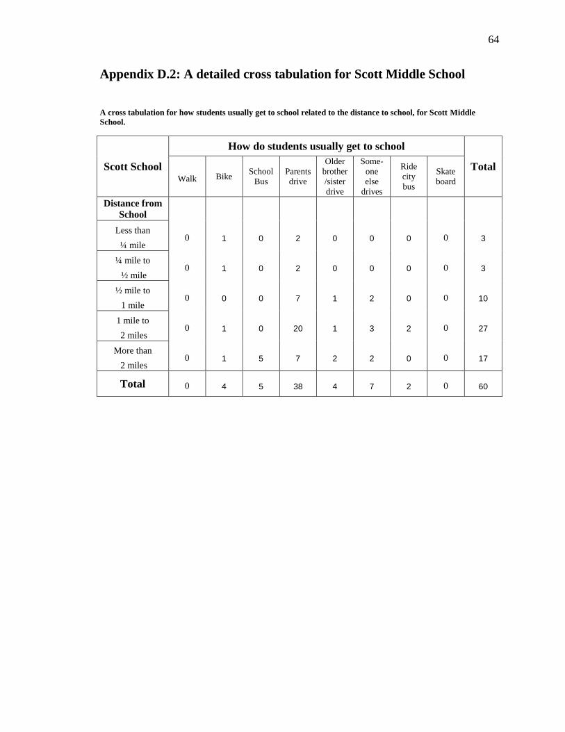
64
Appendix D.2: A detailed cross tabulation for Scott Middle School
A cross tabulation for how students usually get to school related to the distance to school, for Scott Middle
School.
Scott School
How do students usually get to school
Total Walk Bike
School
Bus
Parents
drive
Older
brother
/sister
drive
Some-
one
else
drives
Ride
city
bus
Skate
board
Distance from
School
Less than
¼ mile 0 1 0 2 0 0 0 0 3
¼ mile to
½ mile 0 1 0 2 0 0 0 0 3
½ mile to
1 mile 0 0 0 7 1 2 0 0 10
1 mile to
2 miles 0 1 0 20 1 3 2 0 27
More than
2 miles 0 1 5 7 2 2 0 0 17
Total 0 4 5 38 4 7 2 0 60

65
Appendix E: A table to summarize what children see on their way to
school
What you see on your way to
school
Lefler Middle
School
Scoot Middle
School
Parks 32 57% 18 30%
Trees 55 98% 56 93%
Dogs 37 66% 48 80%
Houses where people live 55 98% 58 97%
Houses or buildings that are empty 18 32% 21 35%
Apartment buildings 17 30% 36 60%
Neighbors/ people that you know 45 80% 50 83%
Strangers/ people that you do not know 49 88% 49 82%
Crime 2 4% 2 3%
Stores 20 36% 43 72%
Gas stations 31 55% 37 62%
Factories 1 2% 1 2%
Parking areas 38 68% 48 80%
Empty lots 13 23% 24 40%
Trash 39 70% 21 35%
Construction areas 14 25% 35 58%
Farmland 0 0% 13 22%

66
Appendix F: A table to summarize what makes walking or biking to
school better
What makes walking or biking to
school better
Lefler Middle
School
Scoot Middle
School
Adults to walk or bike with 1 2% 5 8%
Friends to walk or bike with 39 70% 45 75%
Less cars on the roads near the school 19 34% 23 38%
Less cars in the school parking lot 5 9% 3 5%
Sidewalks all the way to school 11 20% 11 18%
Bike racks/ a safe place to leave my bike 12 21% 7 12%
No strangers along the way to school 12 21% 14 23%
Nothing – my parents will not let me walk 5 9% 1 2%
More crossing guards 2 4% 10 17%
Sidewalks clear of snow 21 38% 21 35%
Safe places to cross the road 14 25% 13 22%
No bullies along the way to school 9 16% 8 13%
No crime along the way to school 7 13% 8 13%
Nothing – I live too far to walk 5 9% 16 27%