exsm 11-01 draft2 - plan hillsborough · vicinity of north dale mabry highway and west palmira...
TRANSCRIPT

601 E. Kennedy, 18th Floor
P.O. Box 1110Tampa, FL 33601-1110
813/272-5940FAX 813/272-6258FAX 813/272-6255
www.theplanningcommission.org
Hillsborough County
City-County
Planning
Commission
EXECUTIVE SUMMARY
Meeting Date: June 13, 2011 – Public Hearing
Agenda Item: Tampa: TA/CPA 11‐01
Presenter: J. Collins, AICP Ext: 335
Action Necessary: Yes
SUMMARY
The Planning Commission will be reviewing and making a recommendation to
Tampa City Council on a privately initiated map amendment request to change
a parcel’s Future Land Use designation from Residential‐6 (6 du/ga) to
Residential‐20 (20 du/ga).
The Planning Commission is required to make recommendations to the Tampa
City Council on all proposed changes to the City of Tampa Comprehensive Plan
pursuant to Chapter 163, Part II, Florida Statutes and Chapter 97‐351 Laws of
Florida, as amended.
BACKGROUND
This privately initiated map amendment is located at 3723 West Palmira
Avenue on the northeast corner of North Dale Mabry Highway and West
Palmira Avenue in the South Tampa Planning District. The applicant has
requested the change as the current Residential‐6 designation does not permit
the type of intensity or density the applicant desires for the site.
The Residential‐6 category allows consideration of low density single family
detached residential development and does not permit any type of commercial
consideration. The Residential‐20 category allows consideration of single
family, two‐family and multi‐family residential development, as well as limited
neighborhood commercial and office uses for properties which meet the
locational criteria as outlined in the Tampa Comprehensive Plan. The request does
not meet the intent or furthers the goals, objectives and policies of the Tampa
Comprehensive Plan, regarding protection of residential neighborhoods further
details of the consistency finding are outlined in the staff report.
RECOMMENDATION
It is recommended that the Planning Commission APPROVE the attached
resolution finding the proposed map amendment, TA/CPA 11‐01,
INCONSISTENT with the Tampa Comprehensive Plan Building Our Legacy A
Livable City and forward this recommendation to the Tampa City Council.
Attachments: Resolution, Staff Report, Map Series, Agency Comments
Date Prepared: May 24, 2011

This Page Intentionally Left Blank

601 E. Kennedy, 18th Floor
P.O. Box 1110Tampa, FL 33601-1110
813/272-5940FAX 813/272-6258FAX 813/272-6255
www.theplanningcommission.org
RESOLUTION ITEM: Tampa: CPA 11-01 Future Land Use Map Amendment
Located at the northeast corner of North Dale Mabry Highway and West Palmira Avenue
AYE
NAY
ABSENT
DATE:
June 13, 2011
Edward F. Giunta, II Chair Frank M. Chillura Vice-Chair Derek L. Doughty Member-at-Large
Edward F. Giunta II, Chair
Jill Buford Bruce P. Cury
Brian P. Hollands Vivian M. Kitchen Hung T. Mai Gary D. Sears Ray Young
Robert B. Hunter, Executive Director
Robert B. Hunter, FAICP Executive Director
On motion of Seconded by .
The following resolution was adopted:
WHEREAS, the Hillsborough County City‐County Planning
Commission has developed a Comprehensive Plan for the City of
Tampa entitled Tampa Comprehensive Plan Building Our Legacy A
Livable City, pursuant to the provisions of Chapter 163.3161, Florida
Statutes, which was adopted by Tampa City Council on February 9,
2009, as amended; and;
WHEREAS, Tampa City Council adopted the Procedures Manual
and Fee Schedule for Amendments to the Tampa Comprehensive Plan
on October 9, 1986 and subsequently amended; and
WHEREAS, the Hillsborough County City‐County Planning
Commission has received a privately‐initiated request for
amendment to the Future Land Use Map of the Tampa Comprehensive
Plan Building Our Legacy: A Livable City by the March 2011 submittal
deadline; and
WHEREAS, the Hillsborough County City‐County Planning
Commission has received and has reviewed a request to amend the
Tampa Comprehensive Plan Building Our Legacy A Livable City Future
Hillsborough County
City-County
Planning
Commission

RESOLUTION PAGE 2 Tampa: CPA 11‐01 Map amendment located at the northeast corner of North Dale Mabry Highway and
West Palmira Avenue June 13, 2011
Land Use Plan Map from Residential‐6 to Residential‐20 in the
vicinity of North Dale Mabry Highway and West Palmira Avenue (on
approximately .23 acres); and
WHEREAS, the Hillsborough County City‐County Planning
Commission staff has reviewed the proposal, has considered existing
and expected future development patterns and community facilities
in the respective area, as well as the following adopted goals,
objectives and policies of the Tampa Comprehensive Plan Building Our
Legacy A Livable City as stated in the staff report:
Policy 1.2.2: The City shall preserve, protect, and enhance
single family neighborhoods by providing sensitive transitions
between these neighborhoods and adjoining areas, and requiring new
development, both private and public, to respect and respond to
those existing physical characteristics— buildings, streetscapes, open
spaces, and city form—that contribute to the overall character and
livability of the neighborhood.
Policy 13.3.9: Transitions in Scale. The City shall require that
the scale and massing of new development in higher‐densities centers
and corridors provide appropriate transitions in building height and
bulk that are sensitive to the physical and visual character of
adjoining neighborhoods that have lower development intensities
and building heights.
Goal 14: A city of compact, higher‐density development
within business districts, mixed use corridor villages and transit
stations to conserve land resources, protect single family detached
neighborhoods, natural habitat, support transit, reduce vehicle trips,
improve air quality, conserve energy and water, and diversify
Tampa’s housing stock.
Policy 14.1.1: The City shall encourage compact, higher‐density
development that is compatible with its surrounding character.
Policy 14.1.4: Use limited land resources more efficiently and
pursue a development pattern that is more economically sound, by
encouraging infill development on vacant and underutilized sites.

RESOLUTION PAGE 3 Tampa: CPA 11‐01 Map amendment located at the northeast corner of North Dale Mabry Highway and
West Palmira Avenue June 13, 2011
Objective 16.1: The transformation of major corridors to include
a broader mix of uses, both horizontal and vertical, that provides
opportunities for medium and higher density housing, while also
addressing local and citywide demand for retail and services.
Policy 16.1.1: Redeveloping Automobile‐oriented Corridors –
The City shall promote redevelopment of existing automobile‐
oriented corridors and the upgrading of existing commercial
development to create vibrant, mixed‐use boulevards that balance
efficient movement of motor vehicles with the creation of attractive
pedestrian‐friendly districts that serve the adopting neighborhoods as
well as passing motorists.
Policy 16.1.13: Mixed Use Corridors Defined – Generally the
boundaries of a Mixed Use Corridor Village are defined by the
existing, adopted future land use boundaries of the mixed use plan
categories on the future land use map. That includes: Suburban
Mixed Use‐3, Suburban Mixed Use‐6, Community Mixed Use‐35,
Community Commercial‐35, Urban Mixed Use‐60 and Regional
Mixed Use‐100. Changes to these boundaries may be considered
during the neighborhood planning process (through form based
codes) to develop a secondary plan for each particular village.
Neighborhood planning processes to develop these secondary plans
must include citizen participation from the residential neighborhoods
adjoining the mixed use corridor village.
Objective 18.3: Ensure that there is an adequate amount of land
planned for residential purposes to accommodate the projected
population. The following policies will implement this objective.
Policy 18.3.1: Protect, promote and maintain residential
neighborhoods, in order to preserve an adequate amount of
residential land for existing and future population growth.

RESOLUTION PAGE 4 Tampa: CPA 11‐01 Map amendment located at the northeast corner of North Dale Mabry Highway and
West Palmira Avenue June 13, 2011
NOW, THEREFORE, BE IT RESOLVED, that the Hillsborough
County City‐County Planning Commission finds the proposed map
request from Residential‐6 to Residential‐20 for Tampa
Comprehensive Plan Amendment TA\CPA 11‐01 located in the
vicinity of North Dale Mabry Highway and West Palmira Avenue
INCONSISTENT with the Tampa Comprehensive Plan Building Our
Legacy A Livable City.

LIVABILITY, PROSPERITY, RESPECT, RESILIENCE.
TA/CPA 11‐01 1
Tampa Comprehensive Plan Building Our Legacy: A Livable City
Plan Amendment Report TA/CPA 11-01 A map amendment located in the vicinity of
Dale Mabry Highway and West Palmira Avenue Residential-6 to Residential-20
Description of Request
This is a small scale privately‐initiated plan amendment located at the northeast corner
of Dale Mabry Highway and West Palmira Avenue. The applicant is requesting a land
use plan amendment for a total of 0.23 acres, from Residential‐6 (R‐6) to Residential‐
20 (R‐20). A single‐family home currently sits on the parcel. The current land use
category does not permit the potential range or intensity of uses desired by the
applicant for the site.
Amendment Site looking Northeast Amendment Site looking Northwest
from Dale Mabry Highway from Palmira Avenue towards
Dale Mabry Highway
Future Land Use Categories
Neighborhood Plan (Residential) Categories
Neighborhood plan categories and their supporting policies provide for the protection,
maintenance and enhancement of the city’s residential neighborhoods, assuring that
new development complements and reinforces their unique characteristics through
sensitive infill and transitions in scale from adjacent neighborhood centers and
transportation and business corridors. They provide for residential neighborhoods that

LIVABILITY, PROSPERITY, RESPECT, RESILIENCE.
TA/CPA 11‐01 2
contain a diversity of housing types and for the development of more complete
neighborhoods that incorporate supporting and complementary uses such as
neighborhood‐serving commercial, schools, parks, community meeting facilities, and
comparable uses.
CURRENT LAND USE PROPOSED LAND USE
Residential‐6 Residential ‐ 20
Primary Use Primary Use
Single family detached permitted; Accessory second units may be
considered; Compatible public, quasi-public,
and special uses allowed;
Provides for uses between lower and medium intensity uses, including:
Small-lot single family units (duplexes, condominiums, townhomes) ;
Multifamily dwellings; Limited neighborhood-serving
commercial uses consistent with Locational Criteria for Neighborhood Commercial and Residential Office uses
Form Guidelines Form Guidelines
Maximum Density 6 Units/Net Acre; Lot coverage that generally does
not exceed 45%; Building heights that generally
range from 1 to 3 stories; No FAR
Maximum Density 20 Units/Net Acre; Lot coverage that generally does not
exceed 65%; Limited neighborhood-serving
commercial uses consistent with Locational Criteria for Neighborhood Commercial and Residential Office uses outlined in Chapter 9;
Intensity: FAR 0.5
LIVABILITY, PROSPERITY, RESPECT, RESILIENCE.
TA/CPA 11‐01 3
Tampa Comprehensive Plan Context
Tampa’s Comprehensive Plan Building Our Legacy: A Livable City was adopted in
February, 2009. The Plan articulates a vision for how Tampa will accommodate the
growth of the city to include 92,000 additional residents and 132,000 new jobs over the
next 20 years, while promoting the values of its citizens:
LIVABILITY (Tampa is a place where diverse people find it easy, safe and enjoyable to
live.)
PROSPERITY (A Tampa that is focused on the quality of life for all its people must be a
Tampa that is economically healthy, with a broad mix of good jobs.)
RESPECT (The living systems which support us are taken care of and passed on to future generations in better shape.)
RESILIENCE (The systems that support our day to day living can deal with uncertainty
and cope with the shifts and shocks we face in the future.)
The Plan’s vision articulates the growth management strategy by first organizing the
city in Planning Districts and encouraging most new growth to locate in places
designated as Business Centers, Urban Villages or Mixed Use Corridor Villages. Each
Business Center and Urban Village has a secondary plan that indicates the amount of
growth the City is planning in the next 20 years. The Plan also includes policies that
describe how the City intends to serve this growth with mobility options and other
infrastructure.
The “Big Picture” Tampa Vision Map – Area Description and Characteristics
Strategy 1: Organizing Planning Districts – Getting Transit Ready
Goal 1: Tampa: A Livable city of diverse communities and neighborhoods
interconnected through walking, bicycling, and transit, where public
spaces are beautiful, and well‐designed, the economy thrives and our
heritage is celebrated.
Objective 1.1: Designate 5 planning districts: University, Central Tampa, Westshore,
New Tampa and South Tampa as an opportunity to build a livable and
sustainable city.

LIVABILITY, PROSPERITY, RESPECT, RESILIENCE.
TA/CPA 11‐01 4
Policy 1.1.2: Foster a vibrant urban lifestyle through mixed use development with
entertainment and cultural facilities.
Policy 1.1.12: The City shall consider the development of strategically located mixed use
neighborhood centers that accommodate local serving commercial,
employment, and entertainment uses; provide diverse housing
opportunities; and are efficiently served by transit in the New Tampa and
South Tampa Districts.
South Tampa Planning District Map
The proposed plan amendment area is located in the South Tampa Planning District.
Defined by water this District consists of Tampa’s Interbay Peninsula, generally
described as being those areas south of Kennedy Boulevard between Old Tampa Bay
and Hillsborough Bay. The amendment site is a few miles north of MacDill Air Force
Base, a major employment generator and lies between the Kennedy and Gandy
Boulevard commercial corridors. The surrounding area is home to residential enclaves,
TA/CPA 11‐01

LIVABILITY, PROSPERITY, RESPECT, RESILIENCE.
TA/CPA 11‐01 5
major transportation corridors, medium density office and commercial development,
and lies just south of the Westshore Business District.
Opportunities
The South Tampa District offers many opportunities to becoming a more livable and
sustainable part of the City, including:
Maintaining Neighborhood Stability. Changing demographics, rising energy costs and
environmental concerns will increase the importance of having safe, affordable and
convenient mobility and housing options. Aging residents and changes in the number
of children per household will change the kinds of public and private goods and
services required to meet residents’ needs. A more sustainable mix of uses that provide
goods and services within walking distance of residents is another way to enhance
neighborhood livability and stability.
Fostering Compatible Infill to Improve Mobility and Sustainability. An essential part
of achieving more sustainable and livable neighborhoods will be providing more
convenient access to goods and services. Residents are likely to resist perceived
commercial encroachment into the edges of neighborhoods unless they are confident
that the scale, design and use of facilities will not erode the quality of life in the
neighborhood.
Strategy 2: Strengthening our Diverse Neighborhoods
Objective 1.2: A City of diverse, distinct, and well‐structured neighborhoods that meet
the community’s needs for complete, sustainable, and high quality living
environments from the historic downtown core to well integrated new
growth areas.
Policy 1.2.1: Recognizing Tampa’s neighborhoods are the basic living environments
that make‐up the City’s urban fabric, the City shall through its planning
preserve and enhance all neighborhoods’ distinctiveness, identity, and
livability.
Policy 1.2.2: The City shall preserve, protect, and enhance single family neighborhoods
by providing sensitive transitions between these neighborhoods and
adjoining areas, and requiring new development, both private and public,
to respect and respond to those existing physical characteristics—
buildings, streetscapes, open spaces, and city form—that contribute to the
overall character and livability of the neighborhood.

LIVABILITY, PROSPERITY, RESPECT, RESILIENCE.
TA/CPA 11‐01 6
Development patterns in the general area surrounding the subject site include:
commercial and institutional uses to the north along Dale Mabry Highway represented
by the Community Mixed Use–35 and Public/Semi‐Public Land Use Categories.
Residential development, consisting of mostly single family detached houses and
residential support uses found within the Residential–6, Residential–10 and
Residential–20 Land Use Categories, south (approximately 4 blocks) approaching the
neighborhood node at Bay to Bay Avenue.
Dale Mabry Highway, since its inception, has experienced tremendous growth and
commercial development. Originally constructed in 1943 to connect MacDill Air Force
Base with Drew Field (now Tampa International Airport), Dale Mabry Highway was
named after Dale Mabry, a Florida native and World War I aviator. Dale Mabry runs
along what was originally called Vera Avenue according to land plots from the
Hillsborough County Property Appraiser. The residential area adjacent to Dale Mabry
was first platted between 1915‐1925. The highway has seen many changes throughout

LIVABILITY, PROSPERITY, RESPECT, RESILIENCE.
TA/CPA 11‐01 7
the years, including an extension to US 41 in Pasco County, and major widening
projects throughout the City of Tampa and unincorporated Hillsborough County.
This section of Dale Mabry Highway has remained relatively unchanged over the past
30 years, as the Residential–6 land use only allows the consideration of single family
housing and some limited residential support uses, such as churches. While commercal
and institutional properties have seen a considerable amount of redevelopment and
intensification along this commercial corridor, the surrounding neighborhoods have
remained relatively stable with the exception of several residential infill
redevelopments allowed under the existing land use and zoning districts.

LIVABILITY, PROSPERITY, RESPECT, RESILIENCE.
TA/CPA 11‐01 8
The Small Picture: Neighborhoods
Neighborhoods
Neighborhoods are the places we call home, the places where we live. Residents of the
City of Tampa depend on their neighborhoods more than on any other part of the city
for the quality of their lives. Throughout the city, residents are very protective of the
quality of life in their neighborhoods, which accounts both for the pride that is
everywhere evident and for the occasional tensions when change occurs.
The amendment site is located at the convergence of three neighborhoods Palma Ceia,
Palma Ceia West and Virginia Park (all platted during the early part of the 20th century).
These neighborhoods are predominately residential with commercial and office uses
found along certain major roadways such as Mixed Use Corridor Villages or arterials
which lie along the edges of these neighborhoods. The neighborhoods in the area were
developed in an east/west fashion as development spread from Bayshore Boulevard.
Vern Avenue which later was renamed Dale Mabry Highway was primarily a
residential street with neighborhood nodes at particular intersections much like todays
MacDill Avenue prior to WWII. The amendment is adjacent to Plant High School. The
school, first constructed in 1926, has expanded greatly over the years, presently
enrolling more than 2,200 students on 27 acres. The school has nearly 1,000 feet of
frontage on Dale Mabry Highway directly north of the subject site.
While the character of Dale Mabry has undergone significant redevelopment changes in
intensity and use, this small portion has remained relatively unchanged with the
surrounding residential character being stable. The evolution of Dale Mabry has
provided many opportunities for economic development and the creation of jobs;
however, the challenge now is how those commercial uses on this corridor properly
transition into the residential neighborhood without disrupting there stability must be
properly addressed.

LIVABILITY, PROSPERITY, RESPECT, RESILIENCE.
TA/CPA 11‐01 9
Plan Amendment Issues/Impacts
Future Land Use Impacts:
From:
Residential‐6 (R‐6)
To:
Residential‐20 (R‐20)
Maximum FAR* Not Applicable 0.5 FAR
Maximum Density Up to 6 dwelling units per
acre may be considered
Up to 20 dwelling units per
acre may be considered
Maximum # of Units using
density calculations based
on 0.23 acres
1 unit 4 units
Maximum square footage of
building based on .23 acres
Not Applicable 4,944 sq. ft
*Floor Area Ratio (ratio of building to land; 10,000 sq. ft. of building on 10,000 sq. ft. of land
equals an FAR of 1.0)
The petitioner’s site is located within the City of Tampa’s Coastal Planning Area and is
subject to the provisions of the Policy mentioned below requiring proposed
amendments that would increase residential densities to demonstrate no negative
impacts on hurricane evacuation times, routes or shelter demands.
Policy 41.2.6: Proposed plan amendments which would increase densities within the Coastal
Planning Area shall demonstrate no negative impacts on hurricane evacuation times, routes and
shelter demands. Proposed plan amendments that will increase hurricane evacuation times shall
mitigate impacts (such as, but not limited to, providing transportation improvements,
agreements with HART to provide emergency evacuation service, or emergency van pools).
A number of agencies/departments were part of the review process and requested to
submit feedback on the amendment. Their responses are included in Attachment A of
this report. The reviewing agencies/departments include the following:
City of Tampa – Land Development Coordination
City of Tampa – Water Department
City of Tampa – Wastewater Department
City of Tampa – Solid Waste Department
City of Tampa – Stormwater Department
City of Tampa – Transportation Department
City of Tampa – Parks and Recreation Department

LIVABILITY, PROSPERITY, RESPECT, RESILIENCE.
TA/CPA 11‐01 10
Hillsborough County School Board
The Environmental Protection Commission (EPC)
Metropolitan Planning Organization (MPO)
Hillsborough Area Regional Transit Authority (HART)
The City of Tampa has _objected to the proposed amendment: please see the attached
comments in Attachment A.
The Hillsborough County School Board has NO OBJECTIONS.
The Environmental Protection Commission has NO OBJECTIONS
Hillsborough Area Regional Transit Authority has NO OBJECTIONS.
The Metropolitan Planning Organization has NO OBJECTIONS.
Relationship to the Comprehensive Plan
Elements of City Form: Development Components
Growth Management Solution
The physically built environment called the ‘City Form’ has nine (9) major components
including the following:
Business Centers
Urban Villages
Mixed‐use Corridor Villages
Transit Stations
Urban Neighborhoods
Traditional Neighborhoods
Suburban and Contemporary Neighborhoods
The Waterfront
Rural Areas/neighborhoods
Neighborhoods make up the majority of these nine components. There are five types of
residential neighborhoods that can be found in the City of Tampa. Palma Ceia, where
LIVABILITY, PROSPERITY, RESPECT, RESILIENCE.
TA/CPA 11‐01 11
this plan amendment request is located, is a Traditional Neighborhood within a
suburban land use pattern bordered to the west by a Mixed Use Corridor Village.
In keeping with the vision for a more Livable City, future growth will be steered to
areas and locations that are well served by transit or the existing road network and
which have a number of properties with redevelopment potential. Generally growth
areas are locations where good transit access can be provided along bus and future rail
transit routes, and at future transit stations. The growth areas envisioned in this plan
are:
Business Centers
Mixed Use Corridor Villages
Transit Stations
Urban Villages
The role of these areas should ensure that spaces for economic activities are not
displaced by residential development and that residential neighborhoods are not
destabilized by inappropriate commercial encroachment.
A Mixed Use Corridor Village is an area identified as having the opportunity to support
the gradual transformation of its road corridor where intensification is possible and
encouraged to create new housing and employment opportunities while improving the
pedestrian environment, the look of the street, shopping opportunities and transit
service for residents, employees of the area and those who may visit the area.
Each corridor is different in terms of lot sizes and configurations, street widths, existing
uses, neighborhood uses, neighboring uses, transit services and streetscape potential.
There is no uniform program for transforming the corridor villages. Further, segments
within the corridor can vary greatly as scales of transition will change as corridors
intersect other corridors, travel through urban villages or business centers and interact
with land uses along the corridor that are not prescribed as mixed use in nature
(Residential, Industrial, Public/Semi‐Public, Recreation/Open Space). A framework of
change will be tailored to the individual corridors through studies and or “community
planning through form‐based code” processes that involve local residents, businesses
and other stakeholders.
Generally, the boundaries of a Mixed Use Corridor Village are those properties abutting
the roadway that are defined by an existing, adopted future land use that calls for

LIVABILITY, PROSPERITY, RESPECT, RESILIENCE.
TA/CPA 11‐01 12
mixed use development and a more intense commercial development then is permitted
under Residential Land Use Categories that meet locational criteria.
Policy 16.1.13: Mixed Use Corridors Defined – Generally the boundaries of a Mixed Use
Corridor Village are defined by the existing, adopted future land use
boundaries of the mixed use plan categories on the future land use map.
That includes: Suburban Mixed Use‐3, Suburban Mixed Use‐6,
Community Mixed Use‐35, Community Commercial‐35, Urban Mixed
Use‐60 and Regional Mixed Use‐100. Changes to these boundaries may be
considered during the neighborhood planning process (through form based
codes) to develop a secondary plan for each particular village.
Neighborhood planning processes to develop these secondary plans must
include citizen participation from the residential neighborhoods adjoining
the mixed use corridor village.
Properties with a Residential Land Use Classification are found along three of Tampa’s
Mixed Use Corridor Villages: Dale Mabry Highway, Armenia and Howard Avenues.
Extensive stretches of Residential Land Use Classifications can also be found along
MacDill and Manhattan Avenues as well as Westshore Boulevard functionally classified
as arterials (not Mixed Use Corridor Villages) within the South Tampa Planning
District. Many of the Residential Land Use Categories found along these arterials meet
locational criteria for non‐residential consideration. If this property is granted a land
use change it will meet such criteria were currently the subject property and all such
properties within the City are prohibited from commercial or office consideration.
Residential uses regardless of the Land Use Category can be found along numerous
Mixed Use Corridor Villages and other thoroughfares.
Goal 16: Mixed Use Corridor Villages ‐ Major corridors transformed into vibrant
pedestrian‐friendly environments that serve as gathering places for
adjacent neighborhoods.
Objective 16.1: The transformation of major corridors to include a broader mix of uses,
both horizontal and vertical, that provides opportunities for medium and
higher density housing, while also addressing local and citywide demand
for retail and services.

LIVABILITY, PROSPERITY, RESPECT, RESILIENCE.
TA/CPA 11‐01 13
Policy 16.1.1: Redeveloping Automobile‐oriented Corridors – The City shall promote
redevelopment of existing automobile‐oriented corridors and the
upgrading of existing commercial development to create vibrant, mixed‐
use boulevards that balance efficient movement of motor vehicles with the
creation of attractive pedestrian‐friendly districts that serve the adopting
neighborhoods as well as passing motorists.
This plan amendment request is located in a Traditional Neighborhood along a
Mixed‐Use Corridor Village, a development pattern and prevailing urban form that
exists throughout much of city developed and redeveloped decades ago. This three (3)
block stretch of Dale Mabry Highway is the only segment of a Mixed Use Corridor
Village within the City of Tampa that contains the Residential‐6 land use category
directly along its frontage. The intended use of this category does not permit
commercial or office consideration and is completely out of character with those
existing uses along Dale Mabry. The interior sections of these neighborhoods contain
the Residential ‐ 6 Land Use Category for several blocks in all directions. To the north,
east and west of this site, the Residential‐6 category directly abuts Community Mixed
Use – 35, a category which creates an immediate escalation of considerable intensity and
density.
The Residential‐20 Land Use Classification found south of the neighborhood node at
Bay to Bay and Dale Mabry, transitioning to Residential‐10 within the internal sections
of the residential neighborhood. There are several examples of low intensity office uses
along that segment. The Residential‐20 category offers a more sensitive transition than
those properties to the north along the corridor.
While the Residential‐20 offers a viable alternative to the Residential‐6 category, this
particular request, which amounts to a spot zoning, does not meet the intent and
purpose of the Mixed Use Corridor Village concept as defined in the Comprehensive
Plan, as it does not truly address the larger issue at hand, the transformation of the
corridor. At the very least, this segment of Dale Mabry should be studied to determine
if all twelve parcels currently designated Residential–6 should be changed to better
accommodate a transition. Several of these parcels are currently vacant and could be
considered casualties of the economic downturn. The study could provide a
LIVABILITY, PROSPERITY, RESPECT, RESILIENCE.
TA/CPA 11‐01 14
recommendation that offers a highest and best use proposal for these parcels but still
creates a logical transition of intensity into these traditional neighborhoods, preserving
their residential character, and would involve all stakeholders.
The potential change of all of the Residential‐6 parcels along this portion of Dale Mabry
should be, supported by a recommended study, would be more comprehensive,
efficient and less time consuming versus the scenario of the remaining parcels coming
in piecemeal if this amendment were to be singularly approved.
In reviewing the proposed plan amendment for consistency with the Tampa
Comprehensive Plan Building Our Legacy: A Livable City, staff has determined that the
following plan goals, objectives, and policies are relevant. Policy 1.2.2: The City shall preserve, protect, and enhance single family neighborhoods
by providing sensitive transitions between these neighborhoods and
adjoining areas, and requiring new development, both private and public,
to respect and respond to those existing physical characteristics—
buildings, streetscapes, open spaces, and city form—that contribute to the
overall character and livability of the neighborhood. Policy 13.3.9: Transitions in Scale. The City shall require that the scale and massing of
new development in higher‐densities centers and corridors provide
appropriate transitions in building height and bulk that are sensitive to
the physical and visual character of adjoining neighborhoods that have
lower development intensities and building heights.
Goal 14: A city of compact, higher‐density development within business districts,
mixed use corridor villages and transit stations to conserve land resources,
protect single family detached neighborhoods, natural habitat, support
transit, reduce vehicle trips, improve air quality, conserve energy and
water, and diversify Tampa’s housing stock.
Policy 14.1.1: The City shall encourage compact, higher‐density development that is
compatible with its surrounding character.
Policy 14.1.4: Use limited land resources more efficiently and pursue a development
pattern that is more economically sound, by encouraging infill
development on vacant and underutilized sites.

LIVABILITY, PROSPERITY, RESPECT, RESILIENCE.
TA/CPA 11‐01 15
Objective 18.3: Ensure that there is an adequate amount of land planned for residential
purposes to accommodate the projected population. The following policies
will implement this objective.
Policy 18.3.1: Protect, promote and maintain residential neighborhoods, in order to
preserve an adequate amount of residential land for existing and future
population growth.
The aforementioned Goals, Objectives and Policies promote neighborhood protection
and appropriate infill and redevelopment to further the livable city. Dale Mabry
Highway has experienced a tremendous amount of change since the amendment site
and the surrounding neighborhood were first platted prior to WWII. The urban form
along this Corridor and throughout the City is important, so much so, that the
Comprehensive Plan calls for specific corridor plans to consider “form based codes” to
develop the corridor in a way that promotes its redevelopment while encouraging the
basic tenants of the livable city. The situation here is unique and justifies further study
of this segment of the corridor and its relationship to the neighborhoods that flank it, so
as to provide a more complete picture of the Comprehensive Plan’s dual personality of
Neighborhood Protection and Corridor infill and redevelopment.
Review Criteria for Plan Amendment Requests
In considering a plan amendment, City Council shall review the following criteria:
1. The requested land use category meets the intent of the general character description
of the City Form component in which it is being requested and is otherwise consistent
with the Comprehensive Plan.
2. In approving any request for a land use category that provides for an increase in
density, intensity or for a broader range of uses, than the existing land use category,
City Council shall determine whether:
a. a land use category of similar density or intensity is located on at least one side
of the subject site, and
b. the subject site is within 1320’ (1/4 mile) of a designated transit station or
designated transit corridor, and
c. if the subject parcel is located adjacent to a parcel which has a land use
classification of R‐6 or R‐10, the subject site is located within 660’ (1/8 mile) of a
designated transit station or designated transit corridor.
LIVABILITY, PROSPERITY, RESPECT, RESILIENCE.
TA/CPA 11‐01 16
3. In the event that City Council determines that the above criteria are not met, then
City Council may deny the amendment or make a determination that the existing land
use classification is no longer in the best interests of the public. In this event, then City
Council may approve the amendment or direct the local planning agency to propose an
alternative amendment to the existing land use classification.
If a land use is changed based on this criteria, the property owner shall process through
a site plan district and, if provided for in the City’s land development regulations, shall
meet the “Development Performance Incentive Criteria,” unless the development is
within an approved Community Planning Area/Adopted Form Based Code Area, in
which case a site plan zoning may not be required, as provided for in the specific plan
in the land development regulations.
The requested land use category meets the intent of the general character description of
the City Form component in which it is being requested. The proposed land use is of a
similar density or intensity when compared to the current adopted land uses within the
contiguous area. All zoning classifications allowing non‐residential uses under the
Residential–20 land use classification must be rezoned using a site plan controlled
zoning district.

LIVABILITY, PROSPERITY, RESPECT, RESILIENCE.
TA/CPA 11‐01 17
Conclusions
The requested land use designation does not meet the intent of nor furthers the
following Comprehensive Plan, components:
The amendment does not further Strategy 1: Organizing Planning Districts –
Getting Transit Ready
The amendment does not further Strategy 2: Strengthening Diverse
Neighborhoods
The amendment does not further the Growth Management Solution
The amendment does meet the provisions laid out in the section titled “Review
Criteria for Plan Amendments” within Chapter 9
Recommendation
Staff recommends that the Planning Commission approve the attached resolution,
finding the proposed land use designation change for Plan Amendment PA11‐01,
INCONSISTENT with the Tampa Comprehensive Plan Building Our Legacy: A Livable City
and forward this recommendation to Tampa City Council.
LIVABILITY, PROSPERITY, RESPECT, RESILIENCE.
TA/CPA 11‐01 18
This Page Left Blank Intentionally

LIVABILITY, PROSPERITY, RESPECT, RESILIENCE.
TA/CPA 11‐01 19
Attachment A
Agency Comments
City of Tampa – Comments (Objection)
Environmental Protection Commission – No Comments
Hillsborough Area Regional Transit Authority – No Comments
Metropolitan Planning Organization – Comments (No Objection)
School District of Hillsborough County – Comments (No Objection)

This Page Intentionally Left Blank

CITY OF TAMPA
Bob Buckhorn, Mayor Land Development Coordination
April 27, 2011
City of Tampa Staff Report
CPA 11‐01 Future Land Use Map change Small Scale Map Amendment 3723 West Palmira Avenue
From R‐6 to R‐20 City Staff Recommendaton The City Staff does not support the proposed plan amendment. Staff maintains that the current R‐6 designation is the appropriate designation for the site. The petitioner is requesting a change in use for consideration of professional office on the site. The subject site is located along South Dale Mabry Highway at the edge of a residential neighborhood that has historically developed as single family residential and maintained as residential for well over 75 years. The proposed amendment introduces into this established development pattern, an office use and increased intensity, which could, over time, unduly impact the stability of the surrounding residential areas. Please refer to the response from Land Development Coordination. The proposed change in use will have a small impact on stormwater systems as outlined below and should be considered when evaluating the best use for the parcel. The MPO should be consulted on the impact on the transportation network for the change in use. The portion of Dale Mabry in which the site is located is a designated Primary Transit Corridor, currently operating as a failed roadway (per Transportation Division comments). Under the provisions of the Comprehensive Plan, development is not required to complete a transportation study and mitigate impacts (development will, however, be required to address site access and pay an impact fee). If the transportation analysis reveals a significant trip impact that is not consistent with the Long-Range Transportation Plan, then this would be cause for concern. City Staff Comments
1. Land Development Coordination – See Attached Memo.
306 East Jackson Street. 8E Tampa, Florida 33602 -- 813-274-8694 FAX: 274-7327

306 East Jackson Street. 8E Tampa, Florida 33602 -- 813-274-8694 FAX: 274-7327
2. Stormwater Department ‐ The stormwater runoff from the subject property is serviced
by either the City of Tampa drainage ditch along the northern property boundary, or by the existing drainage system owned and maintained by the Florida Department of Transportation located within the right of way of Dale Mabry Highway. The proposed change in land use will potentially increase the amount of stormwater runoff which these facilities will need to accommodate. Because the City of Tampa Stormwater Technical Standards does not effectively address the increase in runoff resulting from the commercial development of small parcels, the Division would prefer the subject property remain as residential use. In addition, this property is presently on the Red‐Line List because there is no recorded easement for aforementioned drainage ditch. This easement has recently been secured from Plant High School and the subject property will be removed from the list.
3. Wastewater Department ‐ The current land use for this property, the estimated
wastewater generated from the parcels will be 0.0003 MGD. Based on the potential build‐out allowed under the proposed land use category, the estimated wastewater generated will be 0.0012 MGD, which results in a net increase in flow 0.0009 MGD. The wastewater generated will discharge into the Interbay District. The current available capacity for this District is 28.8 MGD. The proposed amendment will not impact the level of service established in the Wastewater Element of the City’s Comprehensive plan. There is adequate capacity in the existing 36‐inch gravity sewer located along Palmira Avenue for the potential build‐out of the property.
4. Water Department – The Water Department (TWD) has reviewed the November Plan
Amendment. The water demands will increase with the planned amendment and this location is within the Downtown and South Tampa Contribution in Aid of Construction (CIAC) area. CIAC fees will be applicable in addition to any standard fees associated with water service. There is an 8‐inch water main along Palmira Avenue. It is likely that the existing 8‐inch main is sufficient as long as water service is provided from Palmira Avenue. City of Tampa will continue to obtain potable water supply from Tampa Bay Water in the event of self water supply shortfall.
5. Transportation Division ‐ The proposed plan amendment is located on a failed segment
of Dale Mabry Hwy and will be subject to Transportation Impact Analysis and Mitigation Plan Procedures.

CITY OF TAMPA
Growth Management & Development Services
Bob Buckhorn, Mayor
MEMORANDUM
TO: Randy Goers, Urban Planning Coordinator CC: Gloria Moreda, Land Development Manager
Cathy Coyle, Zoning Administrator Julia Mandell Cole, Senior Assistant City Attorney
FROM: Abbye Feeley, Planning & Development Coordinator DATE: April 21, 2011 SUBJECT: Comprehensive Plan Amendment Review (Small Scale) I. Overview
TA/CPA11-01 (Virginia Park)
Existing Land Use: Residential 6 (R-6)
Requested Land Use: Residential 20(R-20) The subject property consists of one parcel totaling .23 acres located at the northeast corner of S. Dale Mabry Highway and W. Palmira Avenue. The property is currently zoned RS-100, which is one of the City’s largest residential zoning districts, requiring a minimum lot width of 100’ x 100’ (for a total of 10,000 SF lot area). The subject property is adjacent to Plant High School to the north and single family residential to the east, west, and south. The character of the surrounding neighborhood is primarily single-family residential. Please see Attachment “A” for additional information concerning the Residential 6 Land Use Category. II. Existing Future Land Use Designation The current Future Land Use designation of Residential 6 (R-6) allows solely for single family residential zoning districts including RS-75 (minimum lot dimensions of 75’ (width) x 100’ (depth)), RS-100 (minimum lot dimensions of 100’ (width) x 100’ (depth)) and RS-150 (minimum lot dimensions of 150’ (width) x 100’ (depth)). Other permissible uses under these zoning districts include Congregate Living Facility (6 beds or less), Daycare/Nursery (maximum 5 children), Temporary Film Production and Public use Facility. Special Uses which could be applied for under the R-6 and are approvable subject to the satisfaction of the special use criteria as identified in the zoning code include:
Cemetery Congregate Living Facility: Small Group Care Facility

2
Extended Family Residence Home Occupation Private Pleasure Craft used as a residence Place of Religious Assembly Recreation Facility, Private School Public Service Facility Utility Transmission Site
III. Proposed Future Land Use Designation The proposed future land use category of Residential 20 (R-20) would allow for a variety of zoning districts, including single and multi-family residential (RS-60, RS-50, RM-12, RM-16, and RM-18), residential office (RO and RO-1) and commercial neighborhood (CN). The most intensive uses allowed under the most intensive zoning district of Commercial Neighborhood (CN), would include the following:
Bed and Breakfast Cemetery Clinic Club Daycare (max 5 children) Place of Religious Assembly Public Cultural Faciltiy (i.e. library, museum) Bank Catering Shop Interim Parking Office, Business/Professional Personal Services Pharmacy Public Service Facility Public Use Facility Recreation Facility, Private Restaurant Retail Sales, Convenience Goods
It is important to review the current request in relation to those uses currently permitted and the intensification of the property that could occur if the future land use designation is changed to the R-20. IV. Evaluation of Historic Development Pattern Based on an evaluation of the future land use designations in the area and the existing development pattern, there is a clear delineation along the segment of S. Dale Mabry Boulevard from San Jose Street south to Bay to Bay Boulevard of residential development. Based on the year improved, the properties along this segment of S. Dale Mabry were developed in between the 1920’s and 1950’s as single family residential homes including Palma Ceia United Methodist which was constructed in 1951 and Smith & Associates located at S. Dale Mabry and Bay to Bay whose original structure was constructed in 1925. The development within this area of the City preceded the City’s first modern zoning regulations which were first adopted in January 1956.
3
The subject site is one property in a segment of this corridor and surrounding neighborhood that has historically been developed as single family residential and maintained as residential for well over 75 years. The allowance of this modification will allow for the introduction of non-residential uses and the potential intensification of such uses that is patently inconsistent with the existing development pattern of the surrounding area. If considered appropriate by City Council (under Criteria for Review below) perhaps the modification should be examined for all properties fronting S. Dale Mabry Highway from San Jose Street to Bay to Bay Boulevard, which appears to be approximately 12 zoning lots. This historical residential area and its unique character should be protected, consistent with the following objectives and policies of the City’s Comprehensive Plan. Neighborhood Stability (Chapter 2, Page 30) Objective 1.2: A City of diverse, distinct, and well-structured neighborhoods that meet the community’s needs for complete, sustainable, and high quality living environments from the historic downtown core to well integrated new growth areas.
Policy 1.2.1: Recognizing Tampa’s neighborhoods are the basic living environments that make-up the City’s urban fabric, the City shall through its planning preserve and enhance all neighborhoods’ distinctiveness, identity, and livability.
Policy 1.2.2: The City shall preserve, protect, and enhance single family neighborhoods by providing sensitive transitions between these neighborhoods and adjoining areas, and requiring new development, both private and public, to respect and respond to those existing physical characteristics—buildings, streetscapes, open spaces, and city form—that contribute to the overall character and livability of the neighborhood. V. Review Criteria for Plan Amendment Requests City Council must consider the following criteria as set forth in the City of Tampa Comprehensive Plan when deciding the request for a Comprehensive Plan Amendment; both staff’s professional opinion and factual information is provided in bold-italics below:
1. The requested land use category meets the intent of the general character description of
the City Form component in which it is being requested and is otherwise consistent with the Comprehensive Plan. Per the Comprehensive Plan excerpts provided below, “What is Tampa’s specific ‘City Form’? (Chapter 3, Pages 49 – 50)”, the proposed future land use change does not meet the intent of the City Form for this segment of S. Dale Mabry Highway.
What is Tampa’s specific ‘City Form’? (Chapter 3, Pages 49 – 50) Tampa’s form is and will continue to be shaped by historical development patterns. The City has developed over the span of 150 years, and is influenced by the building patterns that occurred during three significant periods of time as described below.
In general, Tampa has developed and redeveloped as an urban city, with a defined urban core, regional and community centers, and established residential neighborhoods. As an urban city, Tampa has a defined city form that encompasses many components,

4
such as business centers, urban villages, mixed-use corridor villages, transit stations and neighborhoods.
The growth management strategy established in this Plan focuses on establishing sustainable and livable environments in areas with diverse needs. This will require sustained efforts to improve the mix of land uses. The sustainability and livability of Tampa’s city form relating to future growth and further redevelopment relies heavily on the natural evolution of all of the city form components, coupled with survival and protection of the established residential neighborhoods.
2. In approving any request for a land use category that provides for an increase in density,
intensity or for a broader range of uses, than the existing land use category, City Council shall determine whether: a. a land use category of similar density or intensity is located on at least one (1) side of
the subject site, and There is no R-20 land use category on any side of the subject site. The closest R-20 designation is at the northwest corner of S. Dale Mabry Boulevard and Bay to Bay Boulevard which is approximately 800’ from the subject site.
b. the subject site is within 1320’ (1/4 mile) of a designated transit station or designated transit corridor, and Dale Mabry Boulevard is a designated transit corridor from Gandy Boulevard north to the City limits.
c. if the subject parcel is located adjacent to a parcel which has a land use classification of R-6 or R-10, the subject site is located within 660’ (1/8 mile) of a designated transit station or designated transit corridor. The site is adjacent to an R-6 land use category on the east but is located within 1/8 mile of a designated transit corridor having frontage directly on S. Dale Mabry Highway.
3. In the event that City Council determines that the above criteria are not met, then City
Council may deny the amendment or make a determination that the existing land use classification is no longer in the best interests of the public. In this event, then City Council may approve the amendment or direct the local planning agency to propose an alternative amendment to the existing land use classification. Based on the historical development pattern of the area, the age of the structures, and the location of the subject parcel in relation to a core neighborhood of the City, staff believes that the R-6 land use category is remains in the best interest of this neighborhood and the City as a whole. The modification would allow for the introduction of substantially more intense uses into a predominately single family residential neighborhood.
4. If a land use is changed based on this criteria, the property owner shall process through a
site plan district and, if provided for in the City’s land development regulations, shall meet the “Development Performance Incentive Criteria,” unless the development is within an approved Community Planning Area/Adopted Form Based Code Area, in which case a site plan zoning may not be required, as provided for in the specific plan in the land development regulations.

Attachment A
5
How Plan Categories Work with Neighborhoods (Chapter 3, pg. 115) Neighborhood plan categories and their supporting policies provide for the protection, maintenance, and enhancement of the city’s residential neighborhoods, assuring that new development complements and reinforces their unique characteristics through sensitive infill and transitions in scale from adjacent Centers and Corridors. They provide for residential neighborhoods that contain a diversity of housing types and for the development of more complete neighborhoods that incorporate supporting and complementary uses such as neighborhood-serving commercial, schools, parks, community meeting facilities, and comparable uses.
Contemporary Low Density Suburban Neighborhoods (Chapter 3, pg 119) Low and Very Low Density Suburban Residential City Form Guidelines A significant percentage of the populated portion of the City of Tampa, especially areas annexed in the last 50 years, is in the suburban category. This applies primarily to areas covered by future land use designations of two (2) to six (6) dwelling units per acre. Key city form characteristics of very low and low suburban residential development in suburban neighborhoods include: Less compact and intense than the urban pattern; Development may include residential subdivisions, community and neighborhood-serving
commercial (oriented to the surrounding neighborhood and at an appropriate scale), agricultural uses (North of Fletcher Avenue only), environmental areas, and regionally oriented employment centers;
Neighborhood Activity Centers are smaller in scale and may be located farther apart; Architectural styles may vary throughout each neighborhood, typically larger scale homes
on large lots; An automobile dominant transportation system that may be constrained due to sprawl
and forced infill redevelopment in older areas of the City; Pedestrian-scale development blocks that are easy to navigate; Neighborhood services, transit, parkland, and schools typically accessed by automobile; Street design that typically provides pedestrian paths, but may have limited areas for
bicycle travel; When appropriate, traffic-calming measures are used to promote pedestrian safety and
reduce automobile pedestrian conflicts; The pattern is more dependent on the automobile for most trips; and There can and may be transit service.
Low Density Suburban Neighborhood City Form Guidelines (Residential 6) This designation provides for low intensity residential uses, including: Single family detached permitted; Accessory second units may be considered; Compatible public, quasi-public, and special uses allowed; Maximum Density 6 Units/Net Acre Lot coverage that generally does not exceed 45%; Building heights that generally range from 1 to 3 stories; Neighborhoods are likely to be more homogeneous in size, form and type; Use of front-load garages and/or curb cuts along the lot frontage is common

This Page Intentionally Left Blank

COMMISSION Kevin Beckner - Chairman lesley "les" Miller - Vice Chairman Victor Crist Ken Hagan AI Higinbotham Sandy Murman Mark Sharpe
VIA EMAIL
April 14,2011
The Planning Commission Mr. Tony LaColla [email protected] 601 E. Kennedy Blvd. 18lh Floor Tampa, FL 33602
Executive Director Richard D. Garrity, Ph.D.
Roger P. Stewart Center 3629 Queen Palm Dr. Tampa, Fl33619
Ph: (813'627-2600
Fax Numbers (813': Admin 627-2620 Waste 627-2640 legal 627-2602 Wetlands 627-2630 Water 627-2670 Air 627-2660 IJIb 635-8061
Subject: EPC Comments - Comprehensive Plan Amendment City of Tampa CPA 11-01
Staff from the Environmental Protection Commission of Hillsborough County (EPC) has conducted a review of the subject Comprehensive Plan Amendment City of Tampa CPA 11-01 and does not object to the amendments as proposed.
If you have any further questions, please contact me at 813-627-2600, extension 1299 or at [email protected].
Sin, relY,
~/~~ Sean P. MC::C::M Environmental Specialist III Air Division, Enforcement and Analysis
An agency with values of environmental stewardship, integrity, honesty, and a culture of fairness and cooperation. www.epchc.org
E-Mail: [email protected] AN AFFIRMATIVE ACTION - EQUAL OPPORTUNITY EMPLOYER

This Page Intentionally Left Blank


This Page Intentionally Left Blank
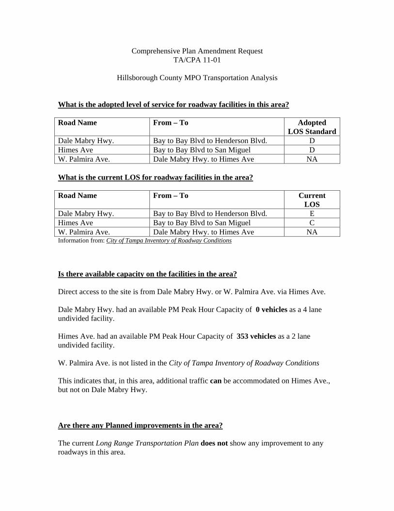
Comprehensive Plan Amendment Request TA/CPA 11-01
Hillsborough County MPO Transportation Analysis
What is the adopted level of service for roadway facilities in this area? Road Name From – To Adopted
LOS StandardDale Mabry Hwy. Bay to Bay Blvd to Henderson Blvd. D Himes Ave Bay to Bay Blvd to San Miguel D W. Palmira Ave. Dale Mabry Hwy. to Himes Ave NA What is the current LOS for roadway facilities in the area? Road Name From – To Current
LOS Dale Mabry Hwy. Bay to Bay Blvd to Henderson Blvd. E Himes Ave Bay to Bay Blvd to San Miguel C W. Palmira Ave. Dale Mabry Hwy. to Himes Ave NA Information from: City of Tampa Inventory of Roadway Conditions Is there available capacity on the facilities in the area? Direct access to the site is from Dale Mabry Hwy. or W. Palmira Ave. via Himes Ave. Dale Mabry Hwy. had an available PM Peak Hour Capacity of 0 vehicles as a 4 lane undivided facility. Himes Ave. had an available PM Peak Hour Capacity of 353 vehicles as a 2 lane undivided facility. W. Palmira Ave. is not listed in the City of Tampa Inventory of Roadway Conditions This indicates that, in this area, additional traffic can be accommodated on Himes Ave., but not on Dale Mabry Hwy. Are there any Planned improvements in the area? The current Long Range Transportation Plan does not show any improvement to any roadways in this area.

Are there any Programmed improvements in the area? The current 5 year Transportation Improvement Program does not include any capacity improvements in this area. What is the impact of the proposed plan amendment? The proposal is to change approximately .23 acres from Residential-6 to Residential-20 Existing Scenario Maximum Buildout: Residential-6
Maximum Allowed - Existing Category PM Peak Hr Trip 1 Dwelling Unit of Single Family Detached Housing (ITE 210)
1
Proposed Scenario Maximum Buildout - Residential-20
Maximum Allowed - Proposed Category PM Peak Hr Trips 4 Dwelling Units of Residential Condominium/Townhouse (ITE 230) or
2
4.944 Th.Sq.Ft. of General Office Building (ITE 710)
7
Based upon maximum buildout scenarios, the existing land use category could generate up to 1 PM Peak Hr Trips with Residential-6. Based upon maximum buildout scenarios, the proposed land use category could generate up to 7 PM Peak Hr Trips with Residential-20. Assuming that access is from either Dale Mabry Hwy. or W. Palmira Ave. via Himes Ave., the maximum trips generated by the proposed scenarios would not cause Himes Ave. to operate at a deficient level of service. Any additional trips added to Dale Mabry Hwy. however, could further degrade the deficient level of service on this roadway.

Raymond O. Shelton School Administrative Center • 901 East Kennedy Blvd. • Tampa, FL 33602-3507
Phone: 813-272-4004 • FAX: 813-272-4002 • School District Main Office: 813-272-4000
P.O. Box 3408 • Tampa, FL 33601-3408 • Website: www.sdhc.k12.fl.us
MEMORANDUM
To: Tony LaColla, AICP
From: David Borisenko, AICP
Department Manager, Planning and Facilities Siting
Date: March 31, 2011
Re: City of Tampa Comprehensive Plan Amendment
CPA 11-01
CPA 11-01
Amendment 11-01 would convert a .23 acre parcel from Residential-6 (R-6) to Residential-20 (R-20). Up
to 4 multi-family dwelling units could potentially be developed on the site. Based on adopted Student
Generation Rates the amendment could potentially generate 1 student in the kindergarten through 5th
grade level, 1 student at the 6th through 8th grade level, and 1 student at the high school level.
The amendment area will be served by Roosevelt Elementary School, Coleman Middle School and
Plant High School. The capacity and projected enrollments at the three schools are as follows:
School
FISH
Capacity
Reserved
for
concurrency
Students
generated
by
amendment
2010-11
Enrollment
2010-11
Available
Capacity
2014-15
Projected
Enrollment
2014-15
Available
Capacity
Roosevelt
Elementary 745 0 1 677 67 713
31
Coleman
Middle 949 0 1 949 -1 915
33
Plant High
School 2410 0 1 2054 355 2312
97
Roosevelt and Plant currently have adequate capacity to absorb the student that may be generated by
the amendment. Enrollment at Coleman is currently at capacity and the projected student would be
School Board
Doretha W. Edgecomb, Chair Candy Olson, Vice Chair April Griffin Carol W. Kurdell Jack R. Lamb, Ed.D. Susan L. Valdes Stacy White, Pharm. D.
Superintendent of Schools MaryEllen Elia
Deputy Superintendents Kenneth R. Otero Daniel J. Valdez
Chief Facilities Officer Cathy L. Valdes

over the limit. All three schools appear to have sufficient capacity to absorb the additional projected
students based on enrollment projected for 2014-15.
If there are no available student stations at Coleman at the time the potential middle school student is
generated, it will be necessary to assign the student to an adjacent middle school attendance zone.
Current and projected enrollment at adjacent attendance zones is as follows:
School
FISH
Capacity
Reserved
for
concurrency
Students
generated
by
amendment
2010-11
Enrollment
2010-11
Available
Capacity
2014-15
Projected
Enrollment
2014-15
Available
Capacity
Madison Middle 952 8 1 784 159 736
207
Roland Park
Middle 931 0 1 532 398 616
314
Wilson Middle 582 0 1 619 -38 570
11
It appears possible based on projections that there will be sufficient capacity available in the future to
accommodate the projected middle school enrollment from the proposed amendment. However,
enrollment capacity will be assessed at the time of permitting and it may be necessary to reassign
students to adjacent attendance zones or employ other forms of mitigation identified in the City of
Tampa School Concurrency Ordinance if sufficient student stations are not available at that time.
LIVABILITY, PROSPERITY, RESPECT, RESILIENCE.
TA/CPA 11‐01 21
Attachment B
Map Series
1) TA/CPA 11‐01 – Aerial Map
2) TA/CPA 11‐01 – Existing Land Use Map
3) TA/CPA 11‐01 – Adopted Future Land Use Map
4) TA/CPA 11‐01 – Proposed Future Land Use Map

This Page Intentionally Left Blank
AUHTOR: C.WELSHDATE:04/25/11
G:\GISROOT\PROJECTS\CATHY\ARCMAP\HCPA\TCPA1101AERIAL_LARGER_WINDOW.MXD
μ
0 400 800 1,200 1,600200
Feet
W WATROUS AVE
W SAN LUIS ST
W CORONA ST
W LEONA ST
S A
RD
SL
EY
ST
S O
AK
MO
NT
ST
S VIR
GINIA
CT
S GOLF VIEW ST
S C
LE
AR
VIE
W A
VE
S F
RA
NK
LA
ND
RD
W ANGELES ST
W SAN JOSE ST
W ZELAR ST
W SAN RAFAEL ST
W SAN MIGUEL ST
HENDERSON BLV
DW ESTRELLA ST
S C
LA
RK
AV
E
W LEONA ST
W NEPTUNE ST
W SAN LUIS ST
W CORONA ST
S H
IME
S A
VE
W EMPEDRADO ST
W BARCELONA ST
W SAN PEDRO ST
W PALMIRA AVE
W SANTIAGO ST
W SAN JUAN ST
W GRANADA ST
S C
HU
RC
H A
VE
W OBISPO ST
W TACON ST
S L
OIS
AV
E
CR
OS
STO
WN
EX
PY
W
CITY OF TAMPAAERIAL PHOTOGRAPHY
PA 11-01
2015 FUTURE LAND USE: Hillsborough County City-County Planning Commission. Originally Adopted - October 27, 1994. Jurisdicitonalareas updated by plan amendment. Effective to present.
CHHA: Tampa Bay Regional Planning Council, June 12, 2006. The Coastal High Hazard Area as shown on the Future Land Use map is ageneral depiction as per HB1359, which is the area below the elevation of the category 1 storm surge line as established by the SLOSHcomputerized storm surge model. More specific information can be obtained by reviewing the TBRPC's computerized storm surge model.
URBAN SERVICE AREA BOUNDARIES: Hillsborough County City-County Planning Commission. Effective to Present.
MAJOR ROADS: Metropolitan Planning Organization 2010 Long Range Transportation Plan. See Adopted MPO Long Range TransportationPlan for specific improvements.
ACCURACY: It is intended that the accuracy of the base map comply with U.S. map accuracy standards. However, such accuracy is notguaranteed by the Hillsborough County City-County Planning Commisiion.
REPRODUCTION: This sheet may not be reproduced in part or full for sale to anyone without specific approval of the Hillsborough CountyCity-County Planning Commission.
PLAN AMENDMENT AREA
ROADS AND BOUNDARY LINES
COUNTY BOUNDARY
JURISDICTION BOUNDARY
TAMPA SERVICE AREA
URBAN SERVICE AREA
COASTAL HIGH HAZARD AREA BOUNDARY

AUHTOR: C.WELSHDATE:04/12/11
G:\GISROOT\PROJECTS\CATHY\ARCMAP\HCPA\TCPA1101ELU_LARGER_WINDOW.MXD
µ
0 440 880 1,320 1,760220Feet
W SAN LUIS ST
W CORONA ST
W LEONA ST
S ARD
SLE Y
S T
S OAK
MONT
ST
S VIRGINIA CT
S GOLF VIEW ST
S CLE
ARVIE
W AV
E
S FRA
NKLA
ND R
D
W ANGELES ST
W SAN JOSE ST
W ZELAR ST
W SAN RAFAEL ST
W SAN MIGUEL ST
HENDERSON BLVDW ESTRELLA ST S C
LARK
AVE
W LEONA ST
W NEPTUNE ST
W SAN LUIS ST
W CORONA ST
S HIM
ES AV
E
W EMPEDRADO ST
W BARCELONA ST
W SAN PEDRO ST
W PALMIRA AVE
W SANTIAGO ST
W SAN JUAN ST
W GRANADA ST
S CHU
RCH
AVE
W OBISPO ST
W TACON ST
S LOI
S AVE
CROS
STOW
N EXP
Y W
CITY OF TAMPAEXISTING LAND USE
PA 11-01
COASTAL HIGH HAZARD AREA (CHHA) DISCLAIMER: Source: Tampa Bay Regional Planning Council,January 2000. The Coastal High Hazard Area, as shown on the Future Land Use Map (FLUE), is a general depiction of the area defined in the most current regional hurricane evacuation study as requiring evacuation during a category one hurricane. More Specific information can be obtained by reviewing the Tampa Bay Regional Planning Council's Hurricane Evacuation Map.MAJOR ROADS: See Adopted MPO Long Range Transportation Plan for specific improvements.DATA SOURCES: Basemap, roads, water (1985 aerials, as updated) from Hillsborough County Engineering Services. Parcel lines and data from Hillsborough County Property Appraiser. Wetlands from SWFWMD, Significant Wildlife Habitat from Planning and Growth Management based on satellite imagery. Only Wetlands greater than 40 acres are depicted.REPRODUCTION: This sheet may not be reproduced in part or full for sale to anyone without specific approval of the Hillsborough County City-County Planning Commission.ACCURACY: It is intended that the accuracy of the base map comply with U.S. national map accuracy standards. However, such accuracy is not guaranteed by the Hillsborough County City-County Planning Commission. This map is for illustrative purposes only for the cities of Tampa, Temple Terrace and Plant City.LEGENDS: The Future Land Use designations on this legend depict valid land use colors and codes for UNINCORPORATED HILLSBOROUGH COUNTY only. The incorporated area colors do not correspond with the legend. Please contact the Hillsborough County City-County Planning Commission for specific Future Land Use maps of the cities.INSET ON COUNTYWIDE: EGMONT KEY is not shown in exact location.
SINGLE FAMILY / MOBILE HOMETWO FAMILYMULTI-FAMILYMOBILE HOME PARKVACANTPUBLIC / QUASIPUBLIC / INSTITUTIONSPUBLIC COMMUNICATIONS / UTILITIESRIGHT OF WAY/ROADS/HIGHWAYSEDUCATIONALHEAVY COMMERCIALLIGHT COMMERCIALHEAVY INDUSTRIALLIGHT INDUSTRIALMININGRECREATION / OPEN SPACEAGRICULTURALNATURALWATERUNKNOWNNOT CLASSIFIED
ROADS AND BOUNDARY LINESCOCKROACH BAY AQUATIC PRESERVE BOUNDARYCOUNTY BOUNDARYJURISDICTION BOUNDARYTAMPA SERVICE AREAURBAN SERVICE AREAEXISTING MAJOR ROAD NETWORKLIMITED ACCESS ROADSCOASTAL HIGH HAZARD AREA BOUNDARYSTUDY AREA BOUNDARY
AUHTOR: C.WELSHDATE:04/22/11
G:\GISROOT\PROJECTS\CATHY\ARCMAP\HCPA\TCPA1101ADOPTEDFLU_LARGE_WINDOW.MXD
µ
0 440 880 1,320 1,760220Feet
CROS
STOW
N EXP
Y W
S LOI
S AVE
W TACON ST
W OBISPO ST
S CHU
RCH
AVE
W GRANADA ST
W SAN JUAN ST
W SANTIAGO ST
W PALMIRA AVE
W SAN PEDRO ST
W BARCELONA ST
W EMPEDRADO ST
S HIM
ES AV
E
W CORONA ST
W SAN LUIS ST
W NEPTUNE ST
W LEONA ST
S CLA
RK AV
E
W ESTRELLA ST
HENDERSON BLVD
W SAN MIGUEL ST
W SAN RAFAEL ST
W ZELAR ST
W SAN JOSE ST
W ANGELES ST S FRA
NKLA
ND R
D
S CLE
ARVI
EW AV
E
S GOLF VIEW ST
S VIRGINIA CT S OAK
MONT
ST
S ARD
SLEY
ST
W LEONA ST
W CORONA ST
W SAN LUIS ST
W SAN LUIS ST
W CORONA ST
W LEONA ST
S ARD
S LE Y
ST
S OAK
MONT
ST
S VIRGINIA CT
S GOLF VIEW ST
S CLE
ARVIE
W AV
E
S FRA
NKLA
ND R
D
W ANGELES ST
W SAN JOSE ST
W ZELAR ST
W SAN RAFAEL ST
W SAN MIGUEL ST
HENDERSON BLVDW ESTRELLA ST S C
LARK
AVE
W LEONA ST
W NEPTUNE ST
W SAN LUIS ST
W CORONA ST
S HIM
ES AV
E
W EMPEDRADO ST
W BARCELONA ST
W SAN PEDRO ST
W PALMIRA AVE
W SANTIAGO ST
W SAN JUAN ST
W GRANADA ST
S CHU
RCH
AVE
W OBISPO ST
W TACON ST
S LOI
S AVE
CROS
STOW
N EXP
Y W
CITY OF TAMPAADOPTED 2025 FUTURE LAND USE
PA 11-01
2015 FUTURE LAND USE: Hillsborough County City-County Planning Commission. Originally Adopted - October 27, 1994. Jurisdicitonalareas updated by plan amendment. Effective to present.CHHA: Tampa Bay Regional Planning Council, June 12, 2006. The Coastal High Hazard Area as shown on the Future Land Use map is ageneral depiction as per HB1359, which is the area below the elevation of the category 1 storm surge line as established by the SLOSHcomputerized storm surge model. More specific information can be obtained by reviewing the TBRPC's computerized storm surge model.URBAN SERVICE AREA BOUNDARIES: Hillsborough County City-County Planning Commission. Effective to Present.MAJOR ROADS: Metropolitan Planning Organization 2010 Long Range Transportation Plan. See Adopted MPO Long Range TransportationPlan for specific improvements.ACCURACY: It is intended that the accuracy of the base map comply with U.S. map accuracy standards. However, such accuracy is notguaranteed by the Hillsborough County City-County Planning Commisiion.REPRODUCTION: This sheet may not be reproduced in part or full for sale to anyone without specific approval of the Hillsborough CountyCity-County Planning Commission.
CITY OF TAMPA
HEAVY INDUSTRIALMAJOR RECREATIONAL/OPEN SPACEMAJOR PUBLIC/SEMI - PUBLICMAJOR ENVIRONMENTALLY SENSITIVE AREASCENTRAL BUSINESS DISTRICTMACDILL AIR FORCE BASEWATERRIGHT OF WAYTRANSITIONAL AREA (DUE TO ANNEXATION)
GENERAL MIXED USE -24
AIRPORT COMPATIBILITYCOMMUNITY COMMERCIAL - 35LIGHT INDUSTRIAL
REGIONAL MIXED USE - 100TRANSITIONAL USE - 24
SUBURBAN MIXED USE - 3SUBURBAN MIXED USE - 6
URBAN MIXED USE - 60COMMUNITY MIXED USE - 35
RURAL ESTATE - 10
RESIDENTIAL - 6
RESIDENTIAL - 83RESIDENTIAL - 50
RESIDENTIAL - 10RESIDENTIAL - 20RESIDENTIAL - 35
RESIDENTIAL - 3
(1.5 FAR)
(3.5 FAR)(1.5 FAR)
(.25 FAR)(.50 FAR)
(3.25 FAR)(2.0 FAR)
(.65 FAR)(1.0 FAR)
(.35 FAR)(.50 FAR)(.60 FAR)
(.25 FAR)(.35 FAR)
(1.5 FAR)
(2.0 FAR)(1.5 FAR)
PLAN AMENDMENT AREA
ROADS AND BOUNDARY LINESCOUNTY BOUNDARYJURISDICTION BOUNDARYTAMPA SERVICE AREAURBAN SERVICE AREAEXISTING MAJOR ROAD NETWORK
LIMITED ACCESS ROADSCOASTAL HIGH HAZARD AREA BOUNDARY

AUHTOR: C.WELSHDATE:04/23/11
G:\GISROOT\PROJECTS\CATHY\ARCMAP\HCPA\TCPA1101PROPOSEDFLU.MXD
µ
0 350 700 1,050 1,400175Feet
S LOI
S AVE
W TACON ST
W OBISPO ST
S CHU
RCH
AVE
W GRANADA ST
W SAN JUAN ST
W SANTIAGO ST
W PALMIRA AVE
W SAN PEDRO ST
W BARCELONA ST
W EMPEDRADO ST
S HIM
ES AV
E
W CORONA ST
W SAN LUIS ST
W NEPTUNE ST
W LEONA ST
S CLA
RK AV
EW ESTRELLA ST
HENDERSON BLVD
W SAN MIGUEL ST
W SAN RAFAEL ST
CROS
STOW
N EXP
Y W
W ZELAR ST
W SAN JOSE ST
W ANGELES ST S FRA
NKLA
ND R
D
S CLE
ARVIE
W AV
E
S GOLF VIEW ST
S VIRGINIA CT S OAK
MONT
ST
S AR D
SLEY
S T
W LEONA ST
W CORONA ST
W SAN LUIS ST
CITY OF TAMPAPROPOSED 2025 FUTURE LAND USE
PA 11-01FROM: RESIDENTIAL 6TO: RESIDENTIAL 20
2015 FUTURE LAND USE: Hillsborough County City-County Planning Commission. Originally Adopted - October 27, 1994. Jurisdicitonalareas updated by plan amendment. Effective to present.CHHA: Tampa Bay Regional Planning Council, June 12, 2006. The Coastal High Hazard Area as shown on the Future Land Use map is ageneral depiction as per HB1359, which is the area below the elevation of the category 1 storm surge line as established by the SLOSHcomputerized storm surge model. More specific information can be obtained by reviewing the TBRPC's computerized storm surge model.URBAN SERVICE AREA BOUNDARIES: Hillsborough County City-County Planning Commission. Effective to Present.MAJOR ROADS: Metropolitan Planning Organization 2010 Long Range Transportation Plan. See Adopted MPO Long Range TransportationPlan for specific improvements.ACCURACY: It is intended that the accuracy of the base map comply with U.S. map accuracy standards. However, such accuracy is notguaranteed by the Hillsborough County City-County Planning Commisiion.REPRODUCTION: This sheet may not be reproduced in part or full for sale to anyone without specific approval of the Hillsborough CountyCity-County Planning Commission.
CITY OF TAMPA
HEAVY INDUSTRIALMAJOR RECREATIONAL/OPEN SPACEMAJOR PUBLIC/SEMI - PUBLICMAJOR ENVIRONMENTALLY SENSITIVE AREASCENTRAL BUSINESS DISTRICTMACDILL AIR FORCE BASEWATERRIGHT OF WAYTRANSITIONAL AREA (DUE TO ANNEXATION)
GENERAL MIXED USE -24
AIRPORT COMPATIBILITYCOMMUNITY COMMERCIAL - 35LIGHT INDUSTRIAL
REGIONAL MIXED USE - 100TRANSITIONAL USE - 24
SUBURBAN MIXED USE - 3SUBURBAN MIXED USE - 6
URBAN MIXED USE - 60COMMUNITY MIXED USE - 35
RURAL ESTATE - 10
RESIDENTIAL - 6
RESIDENTIAL - 83RESIDENTIAL - 50
RESIDENTIAL - 10RESIDENTIAL - 20RESIDENTIAL - 35
RESIDENTIAL - 3
(1.5 FAR)
(3.5 FAR)(1.5 FAR)
(.25 FAR)(.50 FAR)
(3.25 FAR)(2.0 FAR)
(.65 FAR)(1.0 FAR)
(.35 FAR)(.50 FAR)(.60 FAR)
PLAN AMENDMENT AREA
ROADS AND BOUNDARY LINESCOUNTY BOUNDARYJURISDICTION BOUNDARYTAMPA SERVICE AREAURBAN SERVICE AREAEXISTING MAJOR ROAD NETWORK
LIMITED ACCESS ROADSCOASTAL HIGH HAZARD AREA BOUNDARY
(.25 FAR)(.35 FAR)
(1.5 FAR)
(2.0 FAR)(1.5 FAR)