exhibit d - texas
TRANSCRIPT

PRELIMINARY WORKING DRAFT Exhibit D
Exhibit D
PRELIMINARY WORKING DRAFT Data Submittal Guidelines
for Regional Flood Planning
March 2021
First Cycle of Regional Flood Plan Development (2020–2023)

PRELIMINARY WORKING DRAFT Exhibit D
This page is intentionally left blank
PRELIMINARY WORKING DRAFT Exhibit D
March 18, 2021 1
Table of Contents
Background ................................................................................................................................................... 4
Purpose ......................................................................................................................................................... 4
1 General Data Requirements ................................................................................................................. 5
2 Formats for Electronic Data .................................................................................................................. 5
2.1 Introduction .................................................................................................................................. 6
2.2 File Formatting .............................................................................................................................. 6
2.2.1 Accessibility ........................................................................................................................... 6
2.2.2 PDF and MS Word Specifications .......................................................................................... 6
2.2.3 Image formatting .................................................................................................................. 7
2.2.4 Correspondence Specifications ............................................................................................. 7
2.2.5 Hydrologic and Hydraulic (H&H) Models .............................................................................. 7
2.3 File Structure ................................................................................................................................. 7
2.4 GIS Data Requirements ................................................................................................................. 8
2.4.1 Metadata ............................................................................................................................... 8
2.4.2 Projection .............................................................................................................................. 8
2.4.3 Tabular Data .......................................................................................................................... 9
2.4.4 ArcMap Documents .............................................................................................................. 9
2.4.5 Data Deliverables .................................................................................................................. 9
3 Required Spatial Data ......................................................................................................................... 10
3.1 Entities [Entities] ......................................................................................................................... 17
3.2 Watersheds [Watersheds] .......................................................................................................... 18
3.3 Existing Flood Infrastructure ....................................................................................................... 18
3.3.1 Polygon [Exist_Fld_Infra_Poly] ........................................................................................... 18
3.3.2 Line [Exist_Fld_Infra_Line] .................................................................................................. 20
3.3.3 Point [Exist_Fld_Infra_Pt] ................................................................................................... 21
3.4 Proposed and Ongoing Flood Mitigation Projects [Ongoing_Fld_Projs] .................................... 24
3.5 Existing Condition Flood Risk Analysis ........................................................................................ 25
3.5.1 Existing Condition Flood Hazard [Exist_Fld_Hazard] .......................................................... 25
3.5.2 Existing Condition Flood Exposure ...................................................................................... 27
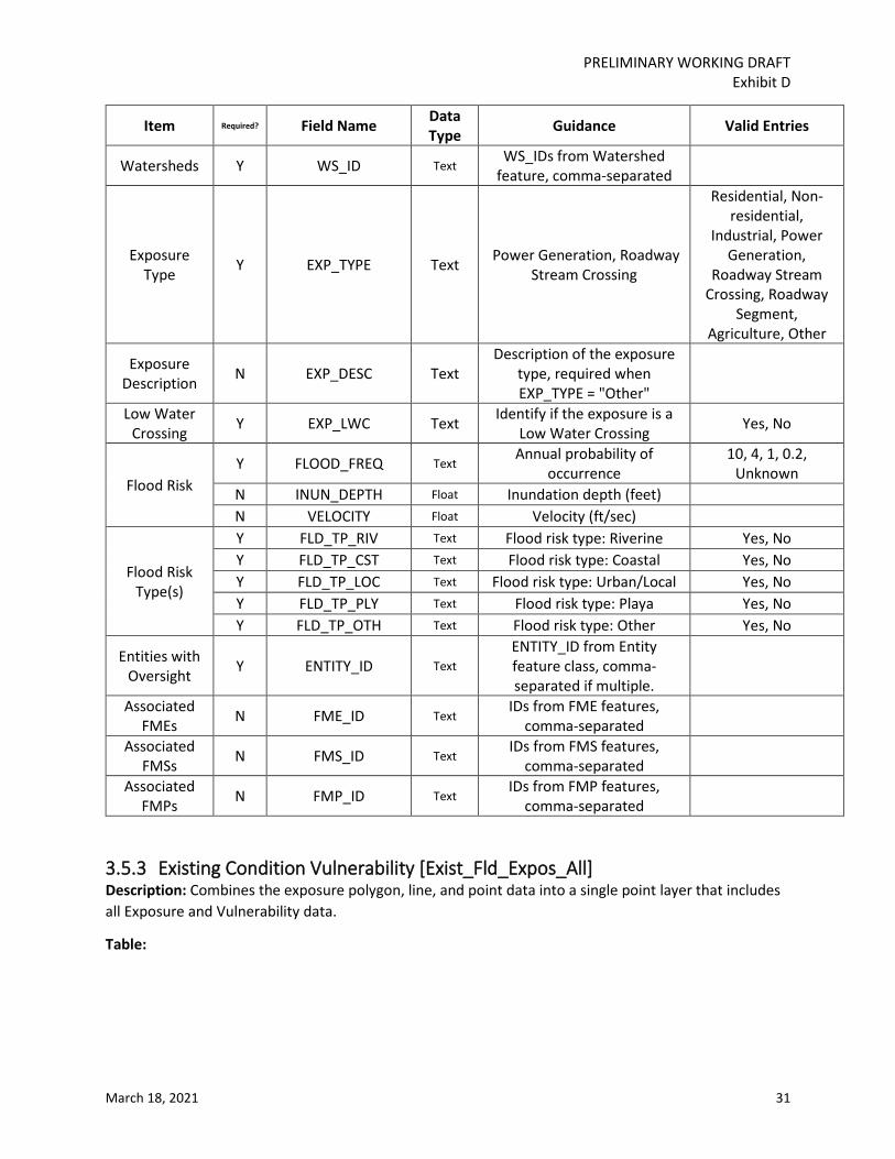
3.5.3 Existing Condition Vulnerability [Exist_Fld_Expos_All] ....................................................... 31
3.6 Future Condition Flood Risk Analysis .......................................................................................... 33

PRELIMINARY WORKING DRAFT Exhibit D
March 18, 2021 2
3.6.1 Future Condition Flood Hazard [Fut_Fld_Hazard] .............................................................. 33
3.6.2 Future Condition Flood Exposure ....................................................................................... 35
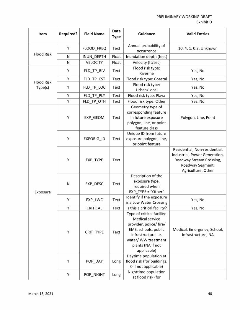
3.6.3 Future Condition Vulnerability [Fut_Fld_Expos_All] ........................................................... 39
3.7 Existing Floodplain Management Practices [ExFpMP] ................................................................ 41
3.8 Regional Flood Planning Goals [Goals] ....................................................................................... 42
3.9 Regional Flood Planning Streams [Streams] ............................................................................... 43
3.10 Flood Management Evaluation [FME] ........................................................................................ 45
3.11 Flood Mitigation Project ............................................................................................................. 48
3.11.1 Project Service Area [FMP] ................................................................................................. 48
3.11.2 Post-Project Flood Hazard [FMP_Post_Hazard] ................................................................. 53
3.11.3 Project Details [FMP_Details] ............................................................................................. 54
3.12 Flood Management Strategy [FMS] ............................................................................................ 54

PRELIMINARY WORKING DRAFT Exhibit D
March 18, 2021 3
List of Tables
Table 1 Required Spatial Data ..................................................................................................................... 10 Table 2 Unique ID Guidance ....................................................................................................................... 16 Table 3: List of Fields for ‘Entities’ .............................................................................................................. 17 Table 4: List of Fields for ‘Watersheds’ ....................................................................................................... 18 Table 5: List of Fields for ‘Exist_Fld_Infra_Poly' .......................................................................................... 18 Table 6: List of Fields for ‘Exist_Fld_Infra_Line' .......................................................................................... 20 Table 7: List of Fields for ‘Exist_Fld_Infra_Pt' ............................................................................................. 21 Table 8: List of Fields for ‘Ongoing_Fld_Projs' ............................................................................................ 24 Table 9: List of Fields for ‘Exist_Fld_Hazard' ............................................................................................... 25 Table 10: List of Fields for ‘Fld_Map_Gaps' ................................................................................................ 26 Table 11: List of Fields for ‘Exist_Fld_Expos_Poly' ...................................................................................... 28 Table 12: List of Fields for ‘Exist_Fld_Expos_Line' ...................................................................................... 29 Table 13: List of Fields for ‘Exist_Fld_Expos_Pt' ......................................................................................... 30 Table 14: List of Fields for ‘Exist_Fld_Expos_All'......................................................................................... 32 Table 15: List of Fields for ‘Fut_Fld_Hazard' ............................................................................................... 34 Table 16: List of Fields for ‘Fut_Fld_Expos_Poly' ........................................................................................ 35 Table 17: List of Fields for ‘Fut_Fld_Expos_Line' ........................................................................................ 37 Table 18: List of Fields for ‘'Fut_Fld_Expos_Pt' ........................................................................................... 38 Table 19: List of Fields for ‘Fut_Fld_Expos_All' ........................................................................................... 39 Table 20: List of Fields for ’ ExFpMP’ .......................................................................................................... 41 Table 21: List of Fields for ‘Goals' ............................................................................................................... 42 Table 22: List of Fields for ‘Streams' ........................................................................................................... 43 Table 23: List of Fields for ‘FME' ................................................................................................................ 45 Table 24: List of Fields for ‘FMP’ ................................................................................................................. 48 Table 25: List of Fields for ‘FMP_Post_Hazard’ ........................................................................................... 53 Table 26: List of Fields for ‘FMS' ................................................................................................................. 55
PRELIMINARY WORKING DRAFT Exhibit D
March 18, 2021 4
Background The TWDB designated 15 regional flood planning areas each of which formed a regional planning group that will develop a regional flood plan for their region by January 2023. The TWDB will bring the regional flood plans together to produce the first state flood plan by September 1, 2024. While the development of the regional flood plans will be directed by the flood planning groups, in order to ensure the regional flood plans will follow consistent approach, TWDB staff prepared the following data submittal guidelines to assist with the regional plan submission process. These guidelines are in addition to the administrative rules and other technical guidance documents that are part of the regional flood planning grant contracts.
Purpose These guidelines provide additional information on the required format of data to be submitted with each Regional Flood Plan (RFP), in alignment with rule and contractual requirements including the Scope of Work. The Exhibit D data submittal guidelines are complimentary to the Exhibit C guidance document and are intended to assist the RFPGs in carrying out their work, developing related information, and in organizing and delivering information to meet contract requirements.
The Initially Prepared Plans (IPPs) and the final adopted RFPs will be reviewed by TWDB based on statute, regional flood planning rules, as well as requirements in this and all other contract documents including the Scope of Work (SOW).
This document summarizes data deliverable requirements for developing and delivering RFPs for the current planning cycle. These guidelines include specific “must” requirements that must be complied with by RFPGs as they prepare the RFP. This guidance includes some may or consider language that leaves certain considerations to the discretion of the RFPGs.
This document augments existing statute and rules that govern regional flood planning. Provisions of Title 31 of TAC Chapters 361, and 362 that serve as the foundation for guidance in this document and are not superseded or abridged by anything contained within or excluded from this guidance document.

PRELIMINARY WORKING DRAFT Exhibit D
March 18, 2021 5
1 General Data Requirements The TWDB will provide a GIS geodatabase template for the RFPGs to fill in with region-specific data. The geodatabase template will be pre-populated with all feature classes and fields, but will not have any data. The RFPGs and their consultants must not alter the geodatabase in any way that would alter or otherwise degrade the quality or configuration of the intended data collection or formats etc. in any manner. The geodatabase must be intact when delivered back to the TWDB, populated with regional flood planning data. The RFPGs may add additional fields in feature classes to address region specific needs with prior approval from the TWDB.
All data must conform and comply with all 31 TAC § 361 & §362 rules. The data should also be developed based on the guidance in subsequent sections of this document and the most current Technical Guidelines for First Cycle of Regional Flood Plan Development (Exhibit C).
All required spatial data for the Flood Planning Region (FPR) will be submitted in a single geodatabase in a template geodatabase provided by the TWDB. The template geodatabase is comprised of 25 feature classes and tables which are listed and described in the Table 1 of this document.
Evaluations should consider existing flood infrastructure, hazard areas, flood exposure (current and future condition), vulnerability, and identify potential flood management evaluations (FME), flood mitigation projects (FMP), and flood management strategies (FMS)along with any other relevant flood planning data and studies available.
In addition:
1. The submitted information must be accurate and based on the best data and science practicable;
2. potential interregional conflicts should be identified and resolved prior to data being submitted by the RFPG;
3. RFPGs must enter information in all fields of the geodatabase provided unless otherwise stated in this data submittal guidance;
4. data provided must follow specified units of measure or quantification (as identified in Sections 3);
5. spelling, word order, and proper names must be used consistently and correctly when submitting data; this is important for purposes of cross-referencing and consistency.
6. proper names used in the RFPs should match those submitted in data deliverables; 7. RFPGs must use the same reporting conventions for data shared by more than one region; 8. RFPGs that have shared interest in datasets must agree on underlying data (e.g. H&H models)
prior to submittal by either region.
If there are any questions regarding the submission process, contact the TWDB Flood Planning - Flood Data (FP-FD) staff early in the process to obtain assistance. This will help to prevent inadvertent creation of errors that could be difficult to correct. FP-FD staff contact information can be found on the TWDB website (https://www.twdb.texas.gov/flood/planning-staff.asp).
2 Formats for Electronic Data All final versions of files acquired or developed for the 2023 RFPs are considered joint property of the TWDB and are required to be submitted to the TWDB. All electronic files submitted to the TWDB by

PRELIMINARY WORKING DRAFT Exhibit D
March 18, 2021 6
RFPGs must be provided using flash drive or DVD and be in a ready-to-use format which should accompany each hard copy of the reports. Electronic data is also to be submitted similarly to TWDB at key planning milestones (Technical Memo, Draft Regional Plan, Final Regional Plan) through an online file transfer system. Further details on the submission process will be provided by TWDB.
This includes but is not limited to all written technical reports, including the full regional flood plan document and any appendices (MS Word and PDF), MS Excel files, hydrological and hydraulic models (H&H) as applicable and input/output/supporting data files, GIS, CAD, and image-formatted data. Files required for delivery to the TWDB must be in an approved format as specified in this document. Alternative software or delivery methods will be allowed with pre-approval from the TWDB if these requirements present a significant burden on the RFPG or as technology changes.
2.1 Introduction Formats of all computer files provided to the TWDB should be compatible with widely distributed versions of the following software:
1. Microsoft Word (MS Office 2010 or newer versions) 2. Microsoft Excel (MS Office 2010 or newer versions) 3. Microsoft Access (MS Office 2010 or newer versions) 4. ArcGIS (10.0 or newer versions) 5. Internet Explorer (11 or newer versions) 6. Adobe Acrobat (2015 or newer versions)
2.2 File Formatting
2.2.1 Accessibility The digital copy of the final RWP must comply with the requirements and standards specified in 1 TAC § 213, Subchapter B (Electronic and Information Resources Accessibility Standards for State Agencies) and the Contract.
All figures must have alternative text descriptions, except for decorative elements, which should be tagged as artifacts or background elements. The file must be titled and language specified. In addition, the document must establish a logical reading order through the consistent use of styles and headings. Non-accessible elements such as text boxes should be avoided.
2.2.2 PDF and MS Word Specifications All PDFs intended for online publication must be tagged for accessibility and reflow. All electronic Adobe PDF files must use embedded fonts with electronically searchable text. Hyperlinks should be live and bookmarks used in a consistent manner to provide easy navigation. Reading order should be evaluated and tab order correctly set. PDFs must pass the Acrobat accessibility full check. It is recommended that PDF files be a size of 50 MB or less to minimize the amount of time it will take to download from the TWDB website. However, if a larger file size is necessary, please ensure that the PDF file is no greater than a file size of 100 MB.
PRELIMINARY WORKING DRAFT Exhibit D
March 18, 2021 7
2.2.3 Image formatting All drawings and graphs included in reports should also be provided separately to the TWDB in Encapsulated PostScript (EPS) or Tagged Image Format (TIFF) format. Color model should be CMYK and resolution should be 300 dpi.
2.2.4 Correspondence Specifications All relevant email correspondence of significance must be saved as PDF files and adhere to the PDF specifications in Section 2.2.2.
2.2.5 Hydrologic and Hydraulic (H&H) Models Any relevant H&H model files should be complete, include only relevant scenarios and files, properly named with associated description in the model, different scenario should be clearly identified, and include appropriate metadata. For the 2D models, files required to run the model and the output file containing results for relevant scenarios will be sufficient. All models should be submitted with appropriate metadata and associated reports.
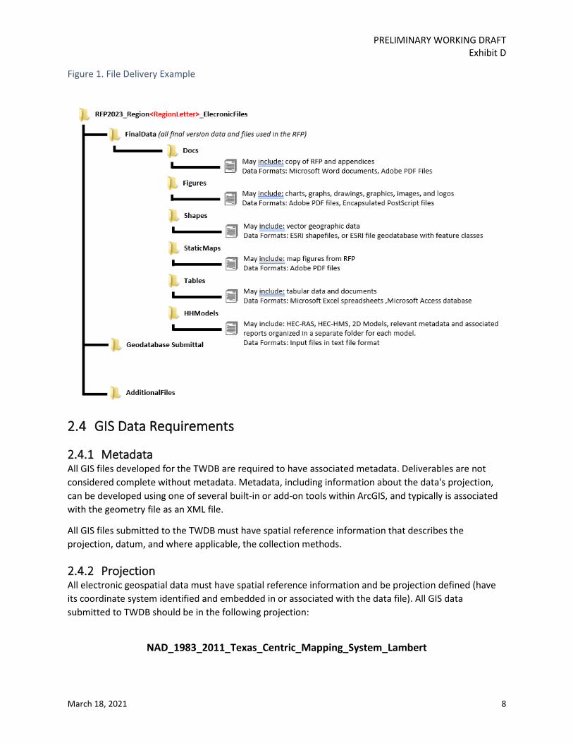
2.3 File Structure For the required files discussed in sections 3, follow the appropriate file naming convention identified therein. For all other files, a standard naming convention should be used consistently for all file names and include the region number, data type, and figure title when relevant. It is preferred that “camel case” be used for file name formatting, which is a formatting style that capitalizes the first letter of each word. File names should not contain spaces, or special characters except for underscores. See Figure 1 for an example of how data delivery folders should be structured. Contact the TWDB FP-FD team if you would like to receive a folder containing the preferred folder structure. It is not necessary to include files that were provided by the TWDB as supporting materials if their use is clearly documented and referenced.
PRELIMINARY WORKING DRAFT Exhibit D
March 18, 2021 8
Figure 1. File Delivery Example
2.4 GIS Data Requirements
2.4.1 Metadata All GIS files developed for the TWDB are required to have associated metadata. Deliverables are not considered complete without metadata. Metadata, including information about the data's projection, can be developed using one of several built-in or add-on tools within ArcGIS, and typically is associated with the geometry file as an XML file.
All GIS files submitted to the TWDB must have spatial reference information that describes the projection, datum, and where applicable, the collection methods.
2.4.2 Projection All electronic geospatial data must have spatial reference information and be projection defined (have its coordinate system identified and embedded in or associated with the data file). All GIS data submitted to TWDB should be in the following projection:
NAD_1983_2011_Texas_Centric_Mapping_System_Lambert

PRELIMINARY WORKING DRAFT Exhibit D
March 18, 2021 9
Raster data, such as aerial photographs may be submitted in their native projection, and maps must be in the appropriate projection/coordinate system for the area depicted.
All CAD data must be in known real world coordinate space, ideally in geographic/decimal degrees/NAD83, and must NOT be in page space or a custom site-specific projection.
2.4.3 Tabular Data Should tabular data be appropriate to connect location information with attribute information, then documentation specifying the primary and foreign keys is required (see Section 3 for guidance on required spatial deliverables). Should coordinate information be provided in tabular format it should contain at minimum the following fields:
1. ID: a unique identifier given to each feature 2. Latitude: the Y-coordinate in decimal degrees 3. Longitude: the X-coordinate in decimal degrees 4. Datum: the horizontal datum of the coordinates
2.4.4 ArcMap Documents All ArcMap documents (.mxd) or equivalent map document formats used in final map production are also required for delivery to the TWDB with accompanying data in a stand-alone directory structure. Map document formats also need to be configured to use relative paths and not be set to use a printer-specific paper setting.
2.4.5 Data Deliverables Each RFPG is responsible for submitting all required GIS data in a single geodatabase. The file geodatabase format is recommended for large datasets.
Sections 3 further specifies what data is required and the proper format for all required data. The Geodatabase should be named using the following naming convention – “RR_RFP_GIS_Data”. The “RR” is the two-digit RFPG number (for example, Region 2 geodatabase should be “02_RFP_GIS_Data”.
PRELIMINARY WORKING DRAFT Exhibit D
March 18, 2021 10
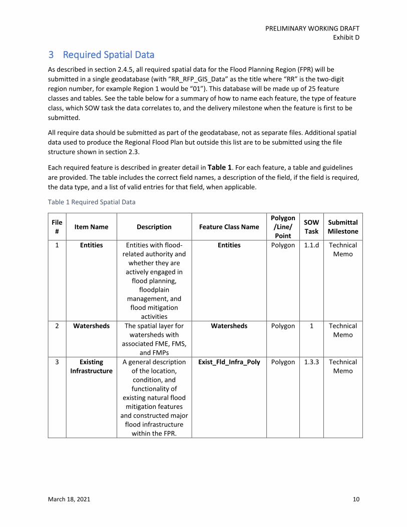
3 Required Spatial Data As described in section 2.4.5, all required spatial data for the Flood Planning Region (FPR) will be submitted in a single geodatabase (with “RR_RFP_GIS_Data” as the title where “RR” is the two-digit region number, for example Region 1 would be “01”). This database will be made up of 25 feature classes and tables. See the table below for a summary of how to name each feature, the type of feature class, which SOW task the data correlates to, and the delivery milestone when the feature is first to be submitted.
All require data should be submitted as part of the geodatabase, not as separate files. Additional spatial data used to produce the Regional Flood Plan but outside this list are to be submitted using the file structure shown in section 2.3.
Each required feature is described in greater detail in Table 1. For each feature, a table and guidelines are provided. The table includes the correct field names, a description of the field, if the field is required, the data type, and a list of valid entries for that field, when applicable.
Table 1 Required Spatial Data
File # Item Name Description Feature Class Name
Polygon /Line/ Point
SOW Task
Submittal Milestone
1 Entities Entities with flood-related authority and
whether they are actively engaged in
flood planning, floodplain
management, and flood mitigation
activities
Entities Polygon 1.1.d Technical Memo
2 Watersheds The spatial layer for watersheds with
associated FME, FMS, and FMPs
Watersheds Polygon 1 Technical Memo
3 Existing Infrastructure
A general description of the location, condition, and functionality of
existing natural flood mitigation features
and constructed major flood infrastructure
within the FPR.
Exist_Fld_Infra_Poly Polygon 1.3.3 Technical Memo

PRELIMINARY WORKING DRAFT Exhibit D
March 18, 2021 11
File # Item Name Description Feature Class Name
Polygon /Line/ Point
SOW Task
Submittal Milestone
4 A general description of the location, condition, and functionality of
existing natural flood mitigation features
and constructed major flood infrastructure
within the FPR.
Exist_Fld_Infra_Line Line 1.3.3 Technical Memo
5 A general description of the location, condition, and functionality of
existing natural flood mitigation features
and constructed major flood infrastructure
within the FPR.
Exist_Fld_Infra_Pt Point 1.3.3 Technical Memo
6 Proposed or Ongoing
Flood Mitigation
Projects
Proposed or ongoing flood mitigation
projects currently under construction, being implemented; and with dedicated funding to construct
and the expected year of completion.
Ongoing_Fld_Projs Polygon 1.6 Technical Memo
7 Existing Flood Hazard
Perform existing condition flood hazard analyses to determine
the location and magnitude of both
1.0% annual chance and 0.2% annual
chance flood events
Exist_Fld_Hazard Polygon 2A.1 Technical Memo
8 Flood Mapping
Gaps
Gaps in inundation boundary mapping
Fld_Map_Gaps Polygon 2A.1.e
Technical Memo

PRELIMINARY WORKING DRAFT Exhibit D
March 18, 2021 12
File # Item Name Description Feature Class Name
Polygon /Line/ Point
SOW Task
Submittal Milestone
9
Existing Exposure
Develop high-level, region-wide, and largely GIS-based existing condition
flood exposure analyses using the
information identified in the flood hazard analysis to identify
who and what might be harmed within the
region for, at a minimum, both 1.0% annual chance and
0.2% annual chance flood events
Exist_Fld_Expos_Poly Polygon 2A.2 Technical Memo
10 Develop high-level, region-wide, and largely GIS-based existing condition
flood exposure analyses using the
information identified in the flood hazard analysis to identify
who and what might be harmed within the
region for, at a minimum, both 1.0% annual chance and
0.2% annual chance flood events
Exist_Fld_Expos_Line Line 2A.2 Technical Memo

PRELIMINARY WORKING DRAFT Exhibit D
March 18, 2021 13
File # Item Name Description Feature Class Name
Polygon /Line/ Point
SOW Task
Submittal Milestone
11 Develop high-level, region-wide, and largely GIS-based existing condition
flood exposure analyses using the
information identified in the flood hazard analysis to identify
who and what might be harmed within the
region for, at a minimum, both 1.0% annual chance and
0.2% annual chance flood events
Exist_Fld_Expos_Pt Point 2A.2 Technical Memo
12 Combines the Exposure Poly, Line, and Point data into a single master layer,
also includes Vulnerability data
Exist_Fld_Expos_All Point 2A.2 Technical Memo
13 Future Flood Hazard
Perform future condition flood hazard analyses to determine
the location and magnitude of both
1.0% annual chance and 0.2% annual
chance flood events
Fut_Fld_Hazard Polygon 2B.1 Technical Memo
14
Future Exposure
Perform future condition flood
exposure analyses using the information identified in the flood
hazard analysis to identify who and what
might be harmed within the region for, at a minimum, both 1.0% annual chance
and 0.2% annual chance flood events
Fut_Fld_Expos_Poly Polygon 2B.2 Technical Memo

PRELIMINARY WORKING DRAFT Exhibit D
March 18, 2021 14
File # Item Name Description Feature Class Name
Polygon /Line/ Point
SOW Task
Submittal Milestone
15 Perform future condition flood
exposure analyses using the information identified in the flood
hazard analysis to identify who and what
might be harmed within the region for, at a minimum, both 1.0% annual chance
and 0.2% annual chance flood events
Fut_Fld_Expos_Line Line 2B.2 Technical Memo
16 Perform future condition flood
exposure analyses using the information identified in the flood
hazard analysis to identify who and what
might be harmed within the region for, at a minimum, both 1.0% annual chance
and 0.2% annual chance flood events
Fut_Fld_Expos_Pt Point 2B.2 Technical Memo
17 Combines the Exposure Poly, Line, and Point data into a single master layer,
also includes Vulnerability data
Fut_Fld_Expos_All Point 2B.2 Technical Memo
18 Existing Floodplain
Management Practices
Identify areas with existing floodplain
management practices, identify
common and compare contrasting practices
within the region, and acknowledge locations
that may lack floodplain
management.
ExFpMP
Point 3A Technical Memo

PRELIMINARY WORKING DRAFT Exhibit D
March 18, 2021 15
File # Item Name Description Feature Class Name
Polygon /Line/ Point
SOW Task
Submittal Milestone
19 Goals Identify specific and achievable flood mitigation and
floodplain management goals along with target years by which to meet those goals
Goals Table 3B Technical Memo
20 Streams Shows the streams to be studied by FMEs,
and those relevant to FMS and FMPs, when
applicable.
Streams Line 4B Technical Memo
21 Flood Management Evaluations
Flood Management Evaluations will identify areas
requiring flood risk evaluation.
FME Polygon 4B Technical Memo
22 Flood Mitigation
Projects
Flood Mitigation Projects reduce flood risk through a variety of approaches. The service area is the
region impacted by the project.
FMP Polygon 4B Technical Memo
23 Post-project Hazard
Project specific features showing an updated hazard area that accounts for the impact of the project
FMP_Post_Hazard Polygon 5.2 Draft Plan
24 Table of Project Details
A table included in the .gdb but built using the Project Details
excel template. The table includes more detailed analysis of
the project.
FMP_Details Table 5.2 Draft Plan
25 Flood Management
Strategies
Flood Management Strategies can be a
broad array of policy or other strategies
that aid in flood management.
FMS Polygon 4B Technical Memo
PRELIMINARY WORKING DRAFT Exhibit D
March 18, 2021 16
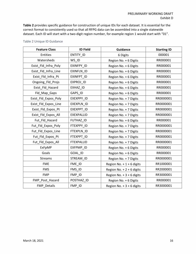
Table 2 provides specific guidance for construction of unique IDs for each dataset. It is essential for the correct format to consistently used so that all RFPG data can be assembled into a single statewide dataset. Each ID will start with a two-digit region number, for example region 1 would start with “01”.
Table 2 Unique ID Guidance
Feature Class ID Field Guidance Starting ID Entities ENTITY_ID 6 Digits 000001
Watersheds WS_ID Region No. + 6 Digits RR000001 Exist_Fld_Infra_Poly EXINFPY_ID Region No. + 6 Digits RR000001 Exist_Fld_Infra_Line EXINFLN_ID Region No. + 6 Digits RR000001 Exist_Fld_Infra_Pt EXINFPT_ID Region No. + 6 Digits RR000001 Ongoing_Fld_Projs EXPROJ_ID Region No. + 6 Digits RR000001 Exist_Fld_Hazard EXHAZ_ID Region No. + 6 Digits RR000001 Fld_Map_Gaps GAPS_ID Region No. + 6 Digits RR000001
Exist_Fld_Expos_Poly EXEXPPY_ID Region No. + 7 Digits RR0000001 Exist_Fld_Expos_Line EXEXPLN_ID Region No. + 7 Digits RR0000001 Exist_Fld_Expos_Pt EXEXPPT_ID Region No. + 7 Digits RR0000001 Exist_Fld_Expos_All EXEXPALLID Region No. + 7 Digits RR0000001
Fut_Fld_Hazard FUTHAZ_ID Region No. + 6 Digits RR000001 Fut_Fld_Expos_Poly FTEXPPY_ID Region No. + 7 Digits RR0000001 Fut_Fld_Expos_Line FTEXPLN_ID Region No. + 7 Digits RR0000001 Fut_Fld_Expos_Pt FTEXPPT_ID Region No. + 7 Digits RR0000001 Fut_Fld_Expos_All FTEXPALLID Region No. + 7 Digits RR0000001
ExFpMP EXFPMP_ID Region No. + 6 Digits RR000001 Goals GOAL_ID Region No. + 6 Digits RR000001
Streams STREAM_ID Region No. + 7 Digits RR0000001 FME FME_ID Region No. + 1 + 6 digits RR1000001 FMS FMS_ID Region No. + 2 + 6 digits RR2000001 FMP FMP_ID Region No. + 3 + 6 digits RR3000001
FMP_Post_Hazard POSTHAZ_ID Region No. + 6 Digits RR000001 FMP_Details FMP_ID Region No. + 3 + 6 digits RR3000001
PRELIMINARY WORKING DRAFT Exhibit D
March 18, 2021 17
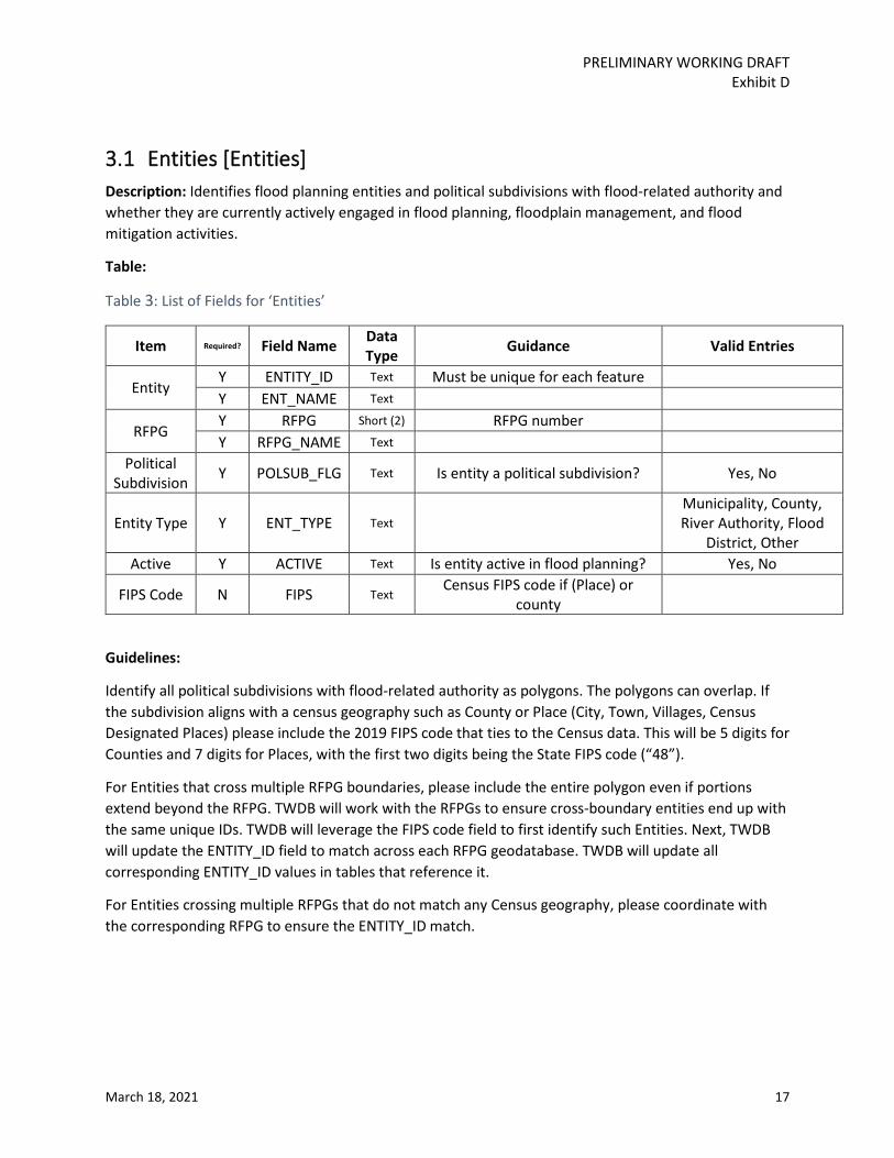
3.1 Entities [Entities] Description: Identifies flood planning entities and political subdivisions with flood-related authority and whether they are currently actively engaged in flood planning, floodplain management, and flood mitigation activities.
Table:
Table 3: List of Fields for ‘Entities’
Item Required? Field Name Data Type Guidance Valid Entries
Entity Y ENTITY_ID Text Must be unique for each feature Y ENT_NAME Text
RFPG Y RFPG Short (2) RFPG number Y RFPG_NAME Text
Political Subdivision Y POLSUB_FLG Text Is entity a political subdivision? Yes, No
Entity Type Y ENT_TYPE Text Municipality, County, River Authority, Flood
District, Other Active Y ACTIVE Text Is entity active in flood planning? Yes, No
FIPS Code N FIPS Text Census FIPS code if (Place) or
county
Guidelines:
Identify all political subdivisions with flood-related authority as polygons. The polygons can overlap. If the subdivision aligns with a census geography such as County or Place (City, Town, Villages, Census Designated Places) please include the 2019 FIPS code that ties to the Census data. This will be 5 digits for Counties and 7 digits for Places, with the first two digits being the State FIPS code (“48”).
For Entities that cross multiple RFPG boundaries, please include the entire polygon even if portions extend beyond the RFPG. TWDB will work with the RFPGs to ensure cross-boundary entities end up with the same unique IDs. TWDB will leverage the FIPS code field to first identify such Entities. Next, TWDB will update the ENTITY_ID field to match across each RFPG geodatabase. TWDB will update all corresponding ENTITY_ID values in tables that reference it.
For Entities crossing multiple RFPGs that do not match any Census geography, please coordinate with the corresponding RFPG to ensure the ENTITY_ID match.

PRELIMINARY WORKING DRAFT Exhibit D
March 18, 2021 18
3.2 Watersheds [Watersheds] Description: Identifies watersheds for the FPR.
Table:
Table 4: List of Fields for ‘Watersheds’
Item Required? Field Name Data Type Guidance Valid Entries
Watershed Y WS_ID Text Must be unique for each feature Y WS_NAME Text
RFPG Y RFPG Short (2) RFPG number Y RFPG_NAME Text
Counties Y COUNTY Text County name, without "County",
comma-separated if multiple.
HUC8s Y HUC8 Text NHD HUC8 numbers, comma-
separated
HUC12s Y HUC12 Text NHD HUC12 numbers, comma-
separated
Guidelines: The purpose of this layer to identify local watersheds smaller than the HUC-12 level. All watersheds should be no larger than the HUC-12 level and no smaller than 1 square mile. Within this range the scale for this layer is flexible and at the discretion of each FPR. Urban areas may require smaller scale watersheds while rural area watersheds may be larger. This layer should cover the entire FPR and should not have overlapping features.
3.3 Existing Flood Infrastructure Description: A general description of the location, condition, and functionality of existing natural flood mitigation features and constructed major flood infrastructure within the FPR.
Guidelines: Since infrastructure exhibit diverse geometries, three separate existing flood infrastructure feature classes will be submitted – polygon, line, and point. See below for Tables for each feature class. The “_type” fields identify the discrete types of infrastructure to be included, with both constructed and natural types allowed. Storm drain systems are to include only pipes over 12 inches, culverts, and inlets.
3.3.1 Polygon [Exist_Fld_Infra_Poly] Table:
Table 5: List of Fields for ‘Exist_Fld_Infra_Poly'
Item Required? Field Name Data Type Guidance Valid Entries
Existing Infrastructure
Y EXINFPY_ID Text Must be unique for each feature Y NAME Text Name of feature

PRELIMINARY WORKING DRAFT Exhibit D
March 18, 2021 19
Item Required? Field Name Data Type Guidance Valid Entries
Polygon Feature Y DESCR Text
A brief description of the infrastructure
RFPG Y RFPG Short (2) RFPG number Y RFPG_NAME Text
Counties Y COUNTY Text County name, without "County",
comma-separated if multiple.
HUC8s Y HUC8 Text NHD HUC8 numbers, comma-
separated
HUC12s Y HUC12 Text NHD HUC12 numbers, comma-
separated
Watersheds Y WS_ID Text WS_IDs from Watershed
features, comma-separated
Infrastructure Type Y INFRA_TYPE Text
Functioning floodplains, wetlands, playa lakes, sinkholes, alluvial fans, vegetated dunes,
dams that provide flood protection, detention and
retention ponds.
Floodplain, Wetland, Playa, Sinkhole, Fan, Dunes, Dam, Pond,
Other
Natural or Constructed? Y NATBUILT Text Natural, Constructed,
Combination Construction
Date N DT_CONST Date
Infrastructure Dimensions
N DIAMETER Float Pipe diameter (feet)
N HEIGHT Float Height of dam or levee, sea barrier, tunnel, pipe, culvert
(feet)
N WIDTH Float (feet) N LENGTH Float (feet)
N AREA Float Area of detention pond, functioning floodplains,
wetlands, playa lakes (acres)
Condition Y CONDITION Text Functional, Non-functional, Unknown
Level of Service Y LOS Text
2-year, 10-year, 25-year, 50-year, 100-year,
500-year, Unknown
Deficiency Y DEF_TYPE Text Deficient, Non-
deficient, Unknown Y DEF_DESCR Text Deficiency Description
Population Protected by Infrastructure
N POP_PROTEC Long
Owning Entity Y OWN_ENT Text
ENTITY_ID from Entity feature class, comma-separated

PRELIMINARY WORKING DRAFT Exhibit D
March 18, 2021 20
Item Required? Field Name Data Type Guidance Valid Entries
Operating Entity Y OPER_ENT Text
ENTITY_ID from Entity feature class, comma-separated
Associated FMEs N FME_ID Text
IDs from FME features, comma-separated
Associated FMSs N FMS_ID Text
IDs from FMS features, comma-separated
Associated FMPs N FMP_ID Text
IDs from FMP features, comma-separated
3.3.2 Line [Exist_Fld_Infra_Line] Table:
Table 6: List of Fields for ‘Exist_Fld_Infra_Line'
Item Required? Field Name Data Type Guidance Valid Entries
Existing Infrastructure Line Feature
Y EXINFLN_ID Text Must be unique for each feature Y NAME Text Name of feature
Y DESCR Text A brief description of the
infrastructure
RFPG Y RFPG Short (2) RFPG number Y RFPG_NAME Text
Counties Y COUNTY Text County name, without "County",
comma-separated if multiple.
HUC8s Y HUC8 Text NHD HUC8 numbers, comma-
separated
HUC12s Y HUC12 Text NHD HUC12 numbers, comma-
separated
Watersheds Y WS_ID Text WS_IDs from Watershed
features, comma-separated
Infrastructure Type Y INFRA_TYPE Text
See Valid Entries. Dams are those that provide flood protection
River, Tributary, Levee, Sea Barrier, Sea Wall,
Revetment, Tidal barrier, Tidal Gate,
Stormwater Tunnel, Stormwater Canal,
Dam, Weir, Storm Drain System, Other
Natural or Constructed? Y NATBUILT Text Natural, Constructed,
Combination Construction
Date N DT_CONST Date
N DIAMETER Float Pipe diameter (feet)

PRELIMINARY WORKING DRAFT Exhibit D
March 18, 2021 21
Item Required? Field Name Data Type Guidance Valid Entries
Infrastructure Dimensions
N HEIGHT Float Height of dam or levee, sea barrier, tunnel, pipe, culvert
(feet)
N WIDTH Float (feet) N LENGTH Float (feet)
Condition Y CONDITION Text Functional, Non-functional, Unknown
Level of Service Y LOS Text
2-year, 10-year, 25-year, 50-year, 100-year,
500-year, Unknown
Deficiency Y DEF_TYPE Text Deficiency Type Deficient, Non-
deficient, Unknown Y DEF_DESCR Text Deficiency Description
Population Protected by Infrastructure
N POP_PROTEC Long
Owning Entity Y OWN_ENT Text
ENTITY_ID from Entity feature class, comma-separated
Operating Entity Y OPER_ENT Text
ENTITY_ID from Entity feature class, comma-separated
Associated FMEs N FME_ID Text
IDs from FME features, comma-separated
Associated FMSs N FMS_ID Text
IDs from FMS features, comma-separated
Associated FMPs N FMP_ID Text
IDs from FMP features, comma-separated
3.3.3 Point [Exist_Fld_Infra_Pt] Table:
Table 7: List of Fields for ‘Exist_Fld_Infra_Pt'
Item Required? Field Name Data Type Guidance Valid Entries
Existing Infrastructure Line Feature
Y EXINFPT_ID Text Must be unique for each feature Y NAME Text Name of feature
Y DESCR Text A brief description of the
infrastructure
RFPG Y RFPG Short (2) RFPG number Y RFPG_NAME Text
Counties Y COUNTY Text County name, without "County",
comma-separated if multiple.
HUC8s Y HUC8 Text NHD HUC8 numbers, comma-
separated

PRELIMINARY WORKING DRAFT Exhibit D
March 18, 2021 22
Item Required? Field Name Data Type Guidance Valid Entries
HUC12s Y HUC12 Text NHD HUC12 numbers, comma-
separated
Watersheds Y WS_ID Text WS_IDs from Watershed
features, comma-separated
Infrastructure Type Y INFRA_TYPE Text
See Valid Entries. Dams are those that provide flood protection
River, Tributary, Levee, Sea Barrier, Sea Wall,
Revetment, Tidal barrier, Tidal Gate,
Stormwater Tunnel, Stormwater Canal,
Dam, Weir, Storm Drain System, Other
Natural or Constructed? Y NATBUILT Text Natural, Constructed,
Combination Construction
Date N DT_CONST Date
Infrastructure Dimensions
N DIAMETER Float Pipe diameter (feet)
N HEIGHT Float Height of dam or levee, sea barrier, tunnel, pipe, culvert
(feet)
N WIDTH Float (feet) N LENGTH Float (feet)
Condition Y CONDITION Text Functional, Non-functional, Unknown
Level of Service Y LOS Text
2-year, 10-year, 25-year, 50-year, 100-year,
500-year, Unknown
Deficiency Y DEF_TYPE Text Deficiency Type Deficient, Non-
deficient, Unknown Y DEF_DESCR Text Deficiency Description
Population Protected by Infrastructure
N POP_PROTEC Long
Owning Entity Y OWN_ENT Text
ENTITY_ID from Entity feature class, comma-separated
Operating Entity Y OPER_ENT Text
ENTITY_ID from Entity feature class, comma-separated
Associated FMEs N FME_ID Text
IDs from FME features, comma-separated
Associated FMSs N FMS_ID Text
IDs from FMS features, comma-separated
Associated FMPs N FMP_ID Text
IDs from FMP features, comma-separated

PRELIMINARY WORKING DRAFT Exhibit D
March 18, 2021 23

PRELIMINARY WORKING DRAFT Exhibit D
March 18, 2021 24
3.4 Proposed and Ongoing Flood Mitigation Projects [Ongoing_Fld_Projs]
Description:
Proposed or ongoing flood mitigation projects currently under construction, being implemented; and with dedicated funding to construct and the expected year of completion.
Table:
Table 8: List of Fields for ‘Ongoing_Fld_Projs'
Item Required? Field Name Data Type Guidance Valid Entries
Existing Project Y EXPROJ_ID Text
Must be unique for each project
Y EXPRJNAME Text Project name Y EXPRJDESC Text Project description
RFPG Y RFPG Short
(2) RFPG number
Y RFPG_NAME Text
Counties Y COUNTY Text County name, without
"County", comma-separated if multiple.
HUC8s Y HUC8 Text NHD HUC8 numbers, comma-
separated
HUC12s Y HUC12 Text NHD HUC12 numbers,
comma-separated
Watersheds Y WS_ID Text WS_IDs from Watershed
features, comma-separated
Project Status Y STATUS Text Proposed, Ongoing Cost Y COST Float
Dedicated Funding for Construction Y FUNDING Text Yes, No
Expected Completion Year Y COMP_YR Short
Associated Hazard Y EXHAZ_ID Text
This is to be populated once existing condition flood
hazard analysis is completed. EXHAZ_IDs from Existing
Hazard feature class, comma-separated if multiple.
Guideline:
All proposed and ongoing projects should be represented in at least a single polygon in this feature class. The service area will most likely be a single contiguous polygon, though it is possible for a project

PRELIMINARY WORKING DRAFT Exhibit D
March 18, 2021 25
to have discontinuous polygons represented the service area. In this case, the service area should still be represented by a single record in this feature set. The areas should include contributing drainage areas to the project.
3.5 Existing Condition Flood Risk Analysis
3.5.1 Existing Condition Flood Hazard [Exist_Fld_Hazard] Description: Perform existing condition flood hazard analyses to determine the location and magnitude of both 1.0% annual chance and 0.2% annual chance flood events. This task also includes identification of flood prone areas. These areas can be identified in the ‘Annual Probability’ field what a value of ‘Unknown’.
Table:
Table 9: List of Fields for ‘Exist_Fld_Hazard'
Item Required? Field Name Data Type Guidance Valid Entries
Existing Hazard Y EXHAZ_ID Text
Must be unique for each feature
RFPG Y RFPG Short (2) RFPG number Y RFPG_NAME Text
Counties Y COUNTY Text County name, without
"County", comma-separated if multiple.
HUC8s Y HUC8 Text NHD HUC8 numbers, comma-
separated
HUC12s Y HUC12 Text NHD HUC12 numbers,
comma-separated
Watersheds Y WS_ID Text WS_IDs from Watershed
feature, comma-separated
Flood Risk Type(s)
Y FLD_TP_RIV Text Flood risk type: Riverine Yes, No Y FLD_TP_CST Text Flood risk type: Coastal Yes, No Y FLD_TP_LOC Text Flood risk type: Urban/Local Yes, No Y FLD_TP_PLY Text Flood risk type: Playa Yes, No Y FLD_TP_OTH Text Flood risk type: Other Yes, No
Annual Probability Y FLOOD_FREQ Text
Annual probability of occurrence
10, 4, 1, 0.2, Unknown
Area Y AREA_SQMI Float Hazard area (sqmi)
Data Source Y SOURCE Text N SRC_DATE Date N SRC_LINK Text URL
Model Dates N HYDRO_DATE Date Date of existing hydrologic
model
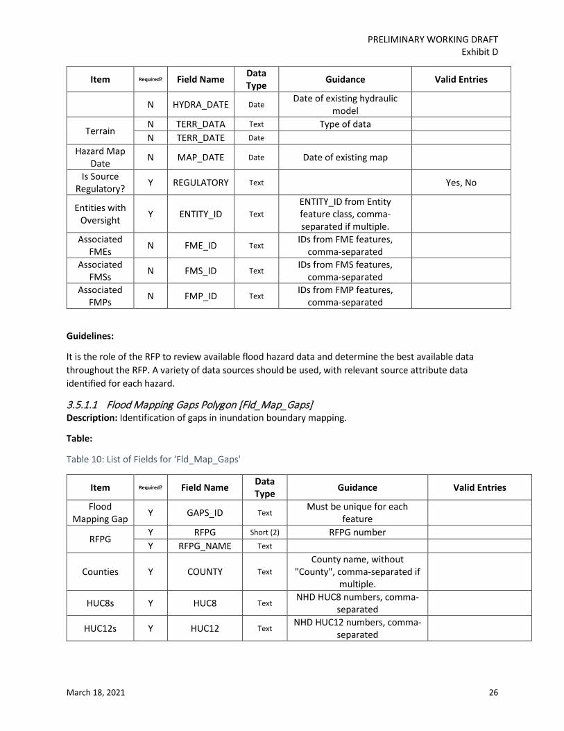
PRELIMINARY WORKING DRAFT Exhibit D
March 18, 2021 26
Item Required? Field Name Data Type Guidance Valid Entries
N HYDRA_DATE Date Date of existing hydraulic
model
Terrain N TERR_DATA Text Type of data N TERR_DATE Date
Hazard Map Date N MAP_DATE Date Date of existing map
Is Source Regulatory? Y REGULATORY Text Yes, No
Entities with Oversight Y ENTITY_ID Text
ENTITY_ID from Entity feature class, comma-separated if multiple.
Associated FMEs N FME_ID Text
IDs from FME features, comma-separated
Associated FMSs N FMS_ID Text
IDs from FMS features, comma-separated
Associated FMPs N FMP_ID Text
IDs from FMP features, comma-separated
Guidelines:
It is the role of the RFP to review available flood hazard data and determine the best available data throughout the RFP. A variety of data sources should be used, with relevant source attribute data identified for each hazard.
3.5.1.1 Flood Mapping Gaps Polygon [Fld_Map_Gaps] Description: Identification of gaps in inundation boundary mapping.
Table:
Table 10: List of Fields for ‘Fld_Map_Gaps'
Item Required? Field Name Data Type Guidance Valid Entries
Flood Mapping Gap Y GAPS_ID Text
Must be unique for each feature
RFPG Y RFPG Short (2) RFPG number Y RFPG_NAME Text
Counties Y COUNTY Text County name, without
"County", comma-separated if multiple.
HUC8s Y HUC8 Text NHD HUC8 numbers, comma-
separated
HUC12s Y HUC12 Text NHD HUC12 numbers, comma-
separated

PRELIMINARY WORKING DRAFT Exhibit D
March 18, 2021 27
Item Required? Field Name Data Type Guidance Valid Entries
Watersheds Y WS_ID Text WS_IDs from Watershed
feature, comma-separated
Annual Probability Y FLOOD_FREQ Text
Annual probability of occurrence 10, 4, 1, 0.2, Unknown
Entities with Oversight Y ENTITY_ID Text
ENTITY_ID from Entity feature class, comma-separated if
multiple
Associated FMEs N FME_ID Text
IDs from FME features, comma-separated
Hazard Map Date N MAP_DATE Date
The date the hazard map was produced, if applicable
Guidelines:
Flood mapping gaps are areas without sufficient or outdated mapping data. Existing maps covering the area may be out of date or lacking in analytical rigor. The minimum feature size is one watershed, which should be no smaller than 1-square mile. RFPGs are to utilize their own discretion to decided which maps are outdated since this will depend or various factors including but not limited to date of existing H&H models and mapping, change of land use and impervious cover in the area, change in rainfall pattern and availability of updated hydrology information.
3.5.2 Existing Condition Flood Exposure Description: Develop high-level, region-wide, and largely GIS-based existing condition flood exposure analyses using the information identified in the flood hazard analysis to identify who and what might be harmed within the region for, at a minimum, both 1.0% annual chance and 0.2% annual chance flood events
Guidelines:
Since flood exposure exhibits diverse geometries, three separate existing flood exposure feature classes will be submitted – polygon, line, and point. See below for Tables for each feature class. Exposure feature layers should be created by intersecting the flood hazard layer with feature layers including but not limited to buildings, infrastructure, roadways, land area etc. The “_type” fields identify the discrete types of exposure to be included. Every exposure must be represented by a single record in the ‘Exist_Fld_Expos_All’ feature layer.
3.5.2.1 Polygon [Exist_Fld_Expos_Poly] Table:

PRELIMINARY WORKING DRAFT Exhibit D
March 18, 2021 28
Table 11: List of Fields for ‘Exist_Fld_Expos_Poly'
Item Required? Field Name Data Type Guidance Valid Entries
Existing Exposure Polygon Feature
Y EXEXPPY_ID Text Must be unique for each
feature
RFPG Y RFPG Short (2) RFPG number Y RFPG_NAME Text
Counties Y COUNTY Text County name, without
"County", comma-separated if multiple.
HUC8s Y HUC8 Text NHD HUC8 numbers, comma-
separated
HUC12s Y HUC12 Text NHD HUC12 numbers,
comma-separated
Watersheds Y WS_ID Text WS_IDs from Watershed
feature, comma-separated
Exposure Type Y EXP_TYPE Text
Residential, Non-residential, Industrial, Power Generation,
Agriculture
Residential, Non-residential,
Industrial, Power Generation,
Roadway Stream Crossing, Roadway
Segment, Agriculture, Other
Exposure Description N EXP_DESC Text
Description of the exposure type, required when EXP_TYPE = "Other"
Low Water Crossing Y EXP_LWC Text
Identify if the exposure is a Low Water Crossing Yes, No
Population Y POP_DAY Long
Daytime population at flood risk
Y POP_NIGHT Long Nighttime population at flood
risk
Flood Risk Y FLOOD_FREQ Text
Annual probability of occurrence
10, 4, 1, 0.2, Unknown
N INUN_DEPTH Float Inundation depth (feet) N VELOCITY Float Velocity (ft/sec)
Flood Risk Type(s)
Y FLD_TP_RIV Text Flood risk type: Riverine Yes, No Y FLD_TP_CST Text Flood risk type: Coastal Yes, No Y FLD_TP_LOC Text Flood risk type: Urban/Local Yes, No Y FLD_TP_PLY Text Flood risk type: Playa Yes, No Y FLD_TP_OTH Text Flood risk type: Other Yes, No

PRELIMINARY WORKING DRAFT Exhibit D
March 18, 2021 29
Item Required? Field Name Data Type Guidance Valid Entries
Entities with Oversight Y ENTITY_ID Text
ENTITY_ID from Entity feature class, comma-separated if
multiple.
Associated FMEs N FME_ID Text
IDs from FME features, comma-separated
Associated FMSs N FMS_ID Text
IDs from FMS features, comma-separated
Associated FMPs N FMP_ID Text
IDs from FMP features, comma-separated
3.5.2.2 Line [Exist_Fld_Expos_Line] Table:
Table 12: List of Fields for ‘Exist_Fld_Expos_Line'
Item Required? Field Name Data Type Guidance Valid Entries
Existing Exposure Polygon Feature
Y EXEXPPY_ID Text Must be unique for each
feature
RFPG Y RFPG Short (2) RFPG number Y RFPG_NAME Text
Counties Y COUNTY Text County name, without
"County", comma-separated if multiple.
HUC8s Y HUC8 Text NHD HUC8 numbers, comma-
separated
HUC12s Y HUC12 Text NHD HUC12 numbers,
comma-separated
Watersheds Y WS_ID Text WS_IDs from Watershed
feature, comma-separated
Exposure Type Y EXP_TYPE Text Roadway segments
Residential, Non-residential,
Industrial, Power Generation,
Roadway Stream Crossing, Roadway
Segment, Agriculture, Other
Exposure Description N EXP_DESC Text
Description of the exposure type, required when EXP_TYPE = "Other"

PRELIMINARY WORKING DRAFT Exhibit D
March 18, 2021 30
Item Required? Field Name Data Type Guidance Valid Entries
Low Water Crossing Y EXP_LWC Text Identify if the exposure is a
Low Water Crossing Yes, No
Population Y POP_DAY Long
Daytime population at flood risk
Y POP_NIGHT Long Nighttime population at flood
risk
Flood Risk Y FLOOD_FREQ Text
Annual probability of occurrence
10, 4, 1, 0.2, Unknown
N INUN_DEPTH Float Inundation depth (feet) N VELOCITY Float Velocity (ft/sec)
Flood Risk Type(s)
Y FLD_TP_RIV Text Flood risk type: Riverine Yes, No Y FLD_TP_CST Text Flood risk type: Coastal Yes, No Y FLD_TP_LOC Text Flood risk type: Urban/Local Yes, No Y FLD_TP_PLY Text Flood risk type: Playa Yes, No Y FLD_TP_OTH Text Flood risk type: Other Yes, No
Entities with Oversight Y ENTITY_ID Text
ENTITY_ID from Entity feature class, comma-separated if
multiple.
Associated FMEs N FME_ID Text
IDs from FME features, comma-separated
Associated FMSs N FMS_ID Text
IDs from FMS features, comma-separated
Associated FMPs N FMP_ID Text
IDs from FMP features, comma-separated
3.5.2.3 Point [Exist_Fld_Expos_Pt] Table:
Table 13: List of Fields for ‘Exist_Fld_Expos_Pt'
Item Required? Field Name Data Type Guidance Valid Entries
Existing Exposure
Point Feature Y EXEXPPT_ID Text
Must be unique for each feature
RFPG Y RFPG Short (2) RFPG number Y RFPG_NAME Text
Counties Y COUNTY Text County name, without
"County", comma-separated if multiple.
HUC8s Y HUC8 Text NHD HUC8 numbers, comma-
separated
HUC12s Y HUC12 Text NHD HUC12 numbers,
comma-separated
PRELIMINARY WORKING DRAFT Exhibit D
March 18, 2021 31
Item Required? Field Name Data Type Guidance Valid Entries
Watersheds Y WS_ID Text WS_IDs from Watershed
feature, comma-separated
Exposure Type Y EXP_TYPE Text
Power Generation, Roadway Stream Crossing
Residential, Non-residential,
Industrial, Power Generation,
Roadway Stream Crossing, Roadway
Segment, Agriculture, Other
Exposure Description N EXP_DESC Text
Description of the exposure type, required when EXP_TYPE = "Other"
Low Water Crossing Y EXP_LWC Text Identify if the exposure is a
Low Water Crossing Yes, No
Flood Risk Y FLOOD_FREQ Text
Annual probability of occurrence
10, 4, 1, 0.2, Unknown
N INUN_DEPTH Float Inundation depth (feet) N VELOCITY Float Velocity (ft/sec)
Flood Risk Type(s)
Y FLD_TP_RIV Text Flood risk type: Riverine Yes, No Y FLD_TP_CST Text Flood risk type: Coastal Yes, No Y FLD_TP_LOC Text Flood risk type: Urban/Local Yes, No Y FLD_TP_PLY Text Flood risk type: Playa Yes, No Y FLD_TP_OTH Text Flood risk type: Other Yes, No
Entities with Oversight Y ENTITY_ID Text
ENTITY_ID from Entity feature class, comma-separated if multiple.
Associated FMEs N FME_ID Text
IDs from FME features, comma-separated
Associated FMSs N FMS_ID Text
IDs from FMS features, comma-separated
Associated FMPs N FMP_ID Text
IDs from FMP features, comma-separated
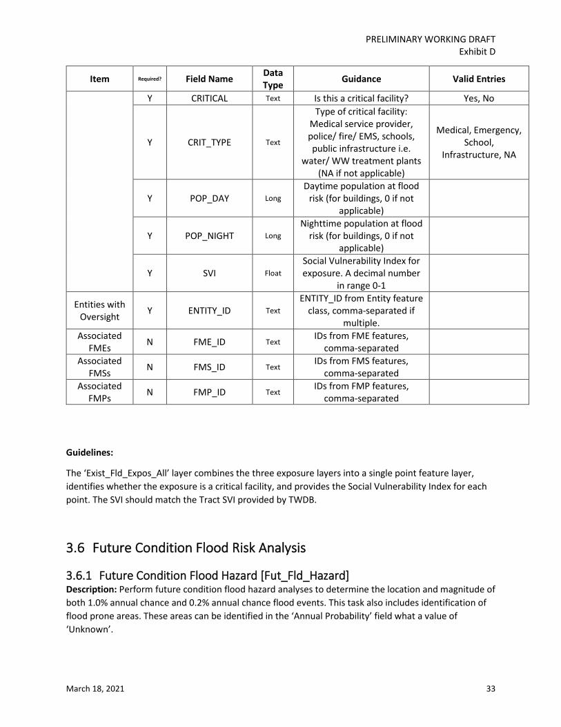
3.5.3 Existing Condition Vulnerability [Exist_Fld_Expos_All] Description: Combines the exposure polygon, line, and point data into a single point layer that includes all Exposure and Vulnerability data.
Table:

PRELIMINARY WORKING DRAFT Exhibit D
March 18, 2021 32
Table 14: List of Fields for ‘Exist_Fld_Expos_All'
Item Required? Field Name Data Type Guidance Valid Entries
Existing Exposure
Converted to Point
Y EXEXPALLID Text Must be unique for each
feature
RFPG Y RFPG Short (2) RFPG number Y RFPG_NAME Text
Counties Y COUNTY Text County name, without
"County", comma-separated if multiple.
HUC8s Y HUC8 Text NHD HUC8 numbers, comma-
separated
HUC12s Y HUC12 Text NHD HUC12 numbers,
comma-separated
Watersheds Y WS_ID Text WS_IDs from Watershed
feature, comma-separated
Flood Risk Y FLOOD_FREQ Text
Annual probability of occurrence
10, 4, 1, 0.2, Unknown
N INUN_DEPTH Float Inundation depth (feet) N VELOCITY Float Velocity (ft/sec)
Flood Risk Type(s)
Y FLD_TP_RIV Text Flood risk type: Riverine Yes, No Y FLD_TP_CST Text Flood risk type: Coastal Yes, No Y FLD_TP_LOC Text Flood risk type: Urban/Local Yes, No Y FLD_TP_PLY Text Flood risk type: Playa Yes, No Y FLD_TP_OTH Text Flood risk type: Other Yes, No
Exposure
Y EXP_GEOM Text
Geometry type of corresponding feature in
existing exposure polygon, line, or point feature class
Polygon, Line, Point
Y EXPORIG_ID Text Unique ID from existing
exposure polygon, line, or point feature
Y EXP_TYPE Text
Residential, Non-residential, Industrial,
Power Generation, Roadway Stream
Crossing, Roadway Segment, Agriculture,
Other
N EXP_DESC Text Description of the exposure
type, required when EXP_TYPE = "Other"
Y EXP_LWC Text Identify if the exposure is a
Low Water Crossing Yes, No
PRELIMINARY WORKING DRAFT Exhibit D
March 18, 2021 33
Item Required? Field Name Data Type Guidance Valid Entries
Y CRITICAL Text Is this a critical facility? Yes, No
Y CRIT_TYPE Text
Type of critical facility: Medical service provider, police/ fire/ EMS, schools, public infrastructure i.e.
water/ WW treatment plants (NA if not applicable)
Medical, Emergency, School,
Infrastructure, NA
Y POP_DAY Long Daytime population at flood
risk (for buildings, 0 if not applicable)
Y POP_NIGHT Long Nighttime population at flood
risk (for buildings, 0 if not applicable)
Y SVI Float Social Vulnerability Index for exposure. A decimal number
in range 0-1
Entities with Oversight Y ENTITY_ID Text
ENTITY_ID from Entity feature class, comma-separated if
multiple.
Associated FMEs N FME_ID Text
IDs from FME features, comma-separated
Associated FMSs N FMS_ID Text
IDs from FMS features, comma-separated
Associated FMPs N FMP_ID Text
IDs from FMP features, comma-separated
Guidelines:
The ‘Exist_Fld_Expos_All’ layer combines the three exposure layers into a single point feature layer, identifies whether the exposure is a critical facility, and provides the Social Vulnerability Index for each point. The SVI should match the Tract SVI provided by TWDB.
3.6 Future Condition Flood Risk Analysis
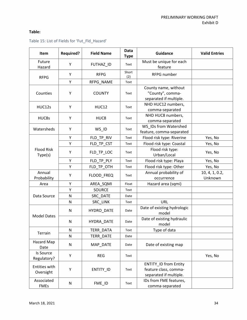
3.6.1 Future Condition Flood Hazard [Fut_Fld_Hazard] Description: Perform future condition flood hazard analyses to determine the location and magnitude of both 1.0% annual chance and 0.2% annual chance flood events. This task also includes identification of flood prone areas. These areas can be identified in the ‘Annual Probability’ field what a value of ‘Unknown’.
PRELIMINARY WORKING DRAFT Exhibit D
March 18, 2021 34
Table:
Table 15: List of Fields for ‘Fut_Fld_Hazard'
Item Required? Field Name Data Type Guidance Valid Entries
Future Hazard Y FUTHAZ_ID Text
Must be unique for each feature
RFPG Y RFPG Short
(2) RFPG number
Y RFPG_NAME Text
Counties Y COUNTY Text County name, without
"County", comma-separated if multiple.
HUC12s Y HUC12 Text NHD HUC12 numbers,
comma-separated
HUC8s Y HUC8 Text NHD HUC8 numbers,
comma-separated
Watersheds Y WS_ID Text WS_IDs from Watershed
feature, comma-separated
Flood Risk Type(s)
Y FLD_TP_RIV Text Flood risk type: Riverine Yes, No Y FLD_TP_CST Text Flood risk type: Coastal Yes, No
Y FLD_TP_LOC Text Flood risk type:
Urban/Local Yes, No
Y FLD_TP_PLY Text Flood risk type: Playa Yes, No Y FLD_TP_OTH Text Flood risk type: Other Yes, No
Annual Probability Y FLOOD_FREQ Text
Annual probability of occurrence
10, 4, 1, 0.2, Unknown
Area Y AREA_SQMI Float Hazard area (sqmi)
Data Source Y SOURCE Text N SRC_DATE Date N SRC_LINK Text URL
Model Dates N HYDRO_DATE Date
Date of existing hydrologic model
N HYDRA_DATE Date Date of existing hydraulic
model
Terrain N TERR_DATA Text Type of data N TERR_DATE Date
Hazard Map Date N MAP_DATE Date Date of existing map
Is Source Regulatory? Y REG Text Yes, No
Entities with Oversight Y ENTITY_ID Text
ENTITY_ID from Entity feature class, comma-separated if multiple.
Associated FMEs N FME_ID Text
IDs from FME features, comma-separated

PRELIMINARY WORKING DRAFT Exhibit D
March 18, 2021 35
Item Required? Field Name Data Type Guidance Valid Entries
Associated FMSs N FMS_ID Text
IDs from FMS features, comma-separated
Associated FMPs N FMP_ID Text
IDs from FMP features, comma-separated
Guidelines:
It is the role of the RFP to review available flood hazard data and determine the best available data throughout the RFP. A variety of data sources should be used, with relevant source attribute data identified for each hazard.
3.6.2 Future Condition Flood Exposure Description: Perform future condition flood exposure analyses using the information identified in the flood hazard analysis to identify who and what might be harmed within the region for, at a minimum, both 1.0% annual chance and 0.2% annual chance flood events
Guidelines:
Since flood exposure exhibits diverse geometries, three separate future flood exposure feature classes will be submitted – polygon, line, and point. See below for Tables for each feature class. Exposure feature layers should be created by intersecting the flood hazard layer with feature layers including but not limited to buildings, infrastructure, roadways, land area etc. The “_type” fields identify the discrete types of exposure to be included. Every exposure should be represented by a single record in the ‘Fut_Fld_Expos_All’ feature layer.
3.6.2.1 Polygon [Fut_Fld_Expos_Poly] Table:
Table 16: List of Fields for ‘Fut_Fld_Expos_Poly'
Item Required? Field Name Data Type Guidance Valid Entries
Future Exposure Polygon Feature
Y FTEXPPY_ID Text Must be unique for each
feature
RFPG Y RFPG Short (2) RFPG number Y RFPG_NAME Text
Counties Y COUNTY Text County name, without
"County", comma-separated if multiple.

PRELIMINARY WORKING DRAFT Exhibit D
March 18, 2021 36
Item Required? Field Name Data Type Guidance Valid Entries
HUC8s Y HUC8 Text NHD HUC8 numbers,
comma-separated
HUC12s Y HUC12 Text NHD HUC12 numbers,
comma-separated
Watersheds Y WS_ID Text WS_IDs from Watershed
feature, comma-separated
Exposure Type Y EXP_TYPE Text
Residential, Non-residential, Industrial,
Power Generation, Agriculture
Residential, Non-residential,
Industrial, Power Generation,
Roadway Stream Crossing, Roadway
Segment, Agriculture, Other
Exposure Description N EXP_DESC Text
Description of the exposure type, required when EXP_TYPE = "Other"
Low Water Crossing Y EXP_LWC Text Identify if the exposure is a
Low Water Crossing Yes, No
Population Y POP_DAY Long
Daytime population at flood risk
Y POP_NIGHT Long Nighttime population at
flood risk
Flood Risk Y FLOOD_FREQ Text
Annual probability of occurrence
10, 4, 1, 0.2, Unknown
N INUN_DEPTH Float Inundation depth (feet) N VELOCITY Float Velocity (ft/sec)
Flood Risk Type(s)
Y FLD_TP_RIV Text Flood risk type: Riverine Yes, No Y FLD_TP_CST Text Flood risk type: Coastal Yes, No
Y FLD_TP_LOC Text Flood risk type:
Urban/Local Yes, No
Y FLD_TP_PLY Text Flood risk type: Playa Yes, No Y FLD_TP_OTH Text Flood risk type: Other Yes, No
Entities with Oversight Y ENTITY_ID Text
ENTITY_ID from Entity feature class, comma-separated if multiple.
Associated FMEs N FME_ID Text
IDs from FME features, comma-separated
Associated FMSs N FMS_ID Text
IDs from FMS features, comma-separated
Associated FMPs N FMP_ID Text
IDs from FMP features, comma-separated
PRELIMINARY WORKING DRAFT Exhibit D
March 18, 2021 37
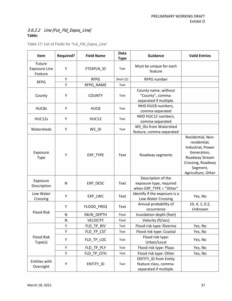
3.6.2.2 Line [Fut_Fld_Expos_Line] Table:
Table 17: List of Fields for ‘Fut_Fld_Expos_Line'
Item Required? Field Name Data Type Guidance Valid Entries
Future Exposure Line
Feature Y FTEXPLN_ID Text
Must be unique for each feature
RFPG Y RFPG Short (2) RFPG number Y RFPG_NAME Text
County Y COUNTY Text County name, without
"County", comma-separated if multiple.
HUC8s Y HUC8 Text NHD HUC8 numbers,
comma-separated
HUC12s Y HUC12 Text NHD HUC12 numbers,
comma-separated
Watersheds Y WS_ID Text WS_IDs from Watershed
feature, comma-separated
Exposure Type Y EXP_TYPE Text Roadway segments
Residential, Non-residential,
Industrial, Power Generation,
Roadway Stream Crossing, Roadway
Segment, Agriculture, Other
Exposure Description N EXP_DESC Text
Description of the exposure type, required
when EXP_TYPE = "Other"
Low Water Crossing Y EXP_LWC Text Identify if the exposure is a
Low Water Crossing Yes, No
Flood Risk Y FLOOD_FREQ Text Annual probability of
occurrence 10, 4, 1, 0.2,
Unknown N INUN_DEPTH Float Inundation depth (feet) N VELOCITY Float Velocity (ft/sec)
Flood Risk Type(s)
Y FLD_TP_RIV Text Flood risk type: Riverine Yes, No Y FLD_TP_CST Text Flood risk type: Coastal Yes, No
Y FLD_TP_LOC Text Flood risk type:
Urban/Local Yes, No
Y FLD_TP_PLY Text Flood risk type: Playa Yes, No Y FLD_TP_OTH Text Flood risk type: Other Yes, No
Entities with Oversight Y ENTITY_ID Text
ENTITY_ID from Entity feature class, comma-separated if multiple.

PRELIMINARY WORKING DRAFT Exhibit D
March 18, 2021 38
Item Required? Field Name Data Type Guidance Valid Entries
Associated FMEs N FME_ID Text
IDs from FME features, comma-separated
Associated FMSs N FMS_ID Text
IDs from FMS features, comma-separated
Associated FMPs N FMP_ID Text
IDs from FMP features, comma-separated
3.6.2.3 Point [Fut_Fld_Expos_Pt] Table:
Table 18: List of Fields for ‘'Fut_Fld_Expos_Pt'
Item Required? Field Name Data Type Guidance Valid Entries
Future Exposure
Point Feature Y FTEXPPT_ID Text
Must be unique for each feature
RFPG Y RFPG Short (2) RFPG number Y RFPG_NAME Text
Counties Y COUNTY Text County name, without
"County", comma-separated if multiple.
HUC8s Y HUC8 Text NHD HUC8 numbers,
comma-separated
HUC12s Y HUC12 Text NHD HUC12 numbers,
comma-separated
Watersheds Y WS_ID Text WS_IDs from Watershed
feature, comma-separated
Exposure Type Y EXP_TYPE Text
Power Generation, Roadway Stream Crossing
Residential, Non-residential,
Industrial, Power Generation,
Roadway Stream Crossing, Roadway
Segment, Agriculture, Other
Exposure Description N EXP_DESC Text
Description of the exposure type, required when EXP_TYPE = "Other"
Low Water Crossing Y EXP_LWC Text Identify if the exposure is a
Low Water Crossing Yes, No
Flood Risk Y FLOOD_FREQ Text
Annual probability of occurrence
10, 4, 1, 0.2, Unknown
N INUN_DEPTH Float Inundation depth (feet) N VELOCITY Float Velocity (ft/sec)

PRELIMINARY WORKING DRAFT Exhibit D
March 18, 2021 39
Item Required? Field Name Data Type Guidance Valid Entries
Flood Risk Type(s)
Y FLD_TP_RIV Text Flood risk type: Riverine Yes, No Y FLD_TP_CST Text Flood risk type: Coastal Yes, No
Y FLD_TP_LOC Text Flood risk type:
Urban/Local Yes, No
Y FLD_TP_PLY Text Flood risk type: Playa Yes, No Y FLD_TP_OTH Text Flood risk type: Other Yes, No
Entities with Oversight Y ENTITY_ID Text
ENTITY_ID from Entity feature class, comma-separated if multiple.
Associated FMEs N FME_ID Text
IDs from FME features, comma-separated
Associated FMSs N FMS_ID Text
IDs from FMS features, comma-separated
Associated FMPs N FMP_ID Text
IDs from FMP features, comma-separated
3.6.3 Future Condition Vulnerability [Fut_Fld_Expos_All] Description: Combines the future polygon, line, and point data into a single point layer that also includes Vulnerability data.
Table:
Table 19: List of Fields for ‘Fut_Fld_Expos_All'
Item Required? Field Name Data Type
Guidance Valid Entries
Future Exposure
Converted to Point
Y FTEXPALLID Text Must be unique for each feature
RFPG Y RFPG_NUM Short
(2) RFPG number
Y RFPG_NAME Text
Counties Y COUNTY Text County name, without
"County", comma-separated if multiple
HUC8s Y HUC8 Text NHD HUC8 numbers, comma-separated
HUC12s Y HUC12 Text NHD HUC12 numbers, comma-separated
Watersheds Y WS_ID Text WS_IDs from
Watershed feature, comma-separated
PRELIMINARY WORKING DRAFT Exhibit D
March 18, 2021 40
Item Required? Field Name Data Type
Guidance Valid Entries
Flood Risk Y FLOOD_FREQ Text Annual probability of
occurrence 10, 4, 1, 0.2, Unknown
N INUN_DEPTH Float Inundation depth (feet)
N VELOCITY Float Velocity (ft/sec)
Flood Risk Type(s)
Y FLD_TP_RIV Text Flood risk type: Riverine Yes, No
Y FLD_TP_CST Text Flood risk type: Coastal Yes, No
Y FLD_TP_LOC Text Flood risk type: Urban/Local Yes, No
Y FLD_TP_PLY Text Flood risk type: Playa Yes, No Y FLD_TP_OTH Text Flood risk type: Other Yes, No
Exposure
Y EXP_GEOM Text
Geometry type of corresponding feature
in future exposure polygon, line, or point
feature class
Polygon, Line, Point
Y EXPORIG_ID Text Unique ID from future exposure polygon, line,
or point feature
Y EXP_TYPE Text
Residential, Non-residential, Industrial, Power Generation,
Roadway Stream Crossing, Roadway Segment, Agriculture, Other
N EXP_DESC Text
Description of the exposure type, required when
EXP_TYPE = "Other"
Y EXP_LWC Text Identify if the exposure is a Low Water Crossing Yes, No
Y CRITICAL Text Is this a critical facility? Yes, No
Y CRIT_TYPE Text
Type of critical facility: Medical service
provider, police/ fire/ EMS, schools, public
infrastructure i.e. water/ WW treatment
plants (NA if not applicable)
Medical, Emergency, School, Infrastructure, NA
Y POP_DAY Long Daytime population at
flood risk (for buildings, 0 if not applicable)
Y POP_NIGHT Long Nighttime population at flood risk (for

PRELIMINARY WORKING DRAFT Exhibit D
March 18, 2021 41
Item Required? Field Name Data Type
Guidance Valid Entries
buildings, 0 if not applicable)
Y SVI Float
Social Vulnerability Index for exposure. A
decimal number in range 0-1
Entities with Oversight Y ENTITY_ID Text
ENTITY_ID from Entity feature class, comma-separated if multiple.
Associated FMEs N FME_ID Text IDs from FME features,
comma-separated
Associated FMSs N FMS_ID Text IDs from FMS features,
comma-separated
Associated FMPs N FMP_ID Text IDs from FMP features,
comma-separated
Guidelines:
The ‘Exist_Fld_Expos_All’ layer combines the three exposure layers into a single point feature layer, identifies whether the exposure is a critical facility, and provides the Social Vulnerability Index for each point. The SVI should match the Tract SVI provided by TWDB.
3.7 Existing Floodplain Management Practices [ExFpMP] Description:
Identify areas with existing floodplain management practices, identify common practices within the region, and acknowledge locations that may lack floodplain management.
Table:
Table 20: List of Fields for ’ ExFpMP’
Item Required? Field Name Data Type Guidance Valid Entries
Entity Y ENTITY_ID Text
This ID should match the ENTITY_ID from the Entities
feature class
Y ENT_NAME Text
RFPG Y RFPG_NUM Short (2) RFPG number Y RFPG_NAME Text
PRELIMINARY WORKING DRAFT Exhibit D
March 18, 2021 42
Item Required? Field Name Data Type Guidance Valid Entries
Floodplain Management Regulations
Y FLD_REG Text Does entity have floodplain management regulations? Yes, No, Unknown
Meets Minimum
Code 16.3145 Y MIN_CODE Text
Has the entity adopted minimum regulations pursuant to Texas Water Code Section 16.3145?
Yes, No
NFIP Y NFIP Text Is the entity an NFIP participant? Yes, No Higher
Standards N HIGHER Text Are higher standards adopted? Yes, No
Level of Enforcement N LEV_ENFRC Text
Level of enforcement of practices
High, Moderate, Low, None
Regulations N REG_URL Text URL for entity regulations
Guidelines:
This file will be included as a table in the geodatabase, not as a feature class. However, it can be mapped using the link to the Entity feature class.
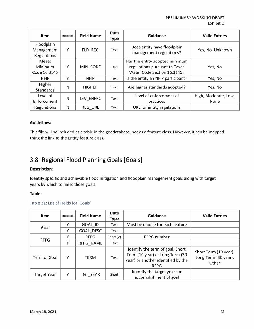
3.8 Regional Flood Planning Goals [Goals] Description:
Identify specific and achievable flood mitigation and floodplain management goals along with target years by which to meet those goals.
Table:
Table 21: List of Fields for ‘Goals'
Item Required? Field Name Data Type Guidance Valid Entries
Goal Y GOAL_ID Text Must be unique for each feature Y GOAL_DESC Text
RFPG Y RFPG Short (2) RFPG number Y RFPG_NAME Text
Term of Goal Y TERM Text
Identify the term of goal: Short Term (10 year) or Long Term (30 year) or another identified by the
RFPG
Short Term (10 year), Long Term (30 year),
Other
Target Year Y TGT_YEAR Short Identify the target year for
accomplishment of goal

PRELIMINARY WORKING DRAFT Exhibit D
March 18, 2021 43
Item Required? Field Name Data Type Guidance Valid Entries
Extent Y EXTENT Text
Identify the extent of geographic area to which goal applies (such
as entire RFPG or HUC 8 number(s))
Overarching Goal Y OVER_GOAL Text GOAL_ID of overarching goal
Other Associated
Goals Y ASSC_GOALS Text
GOAL_IDs of associated goals, comma-separated if multiple
Guidelines:
This is not a spatial layer and will be included in the geodatabase as a table only. Each goal should be represented as a single record in the table.
3.9 Regional Flood Planning Streams [Streams] Description:
Shows the streams to be studied by FMEs, and those relevant to FMS and FMPs, when applicable.
Table:
Table 22: List of Fields for ‘Streams'
Item Required? Field Name Data Type Guidance Valid Entries
Stream Y STREAM_ID Text Must be unique for each feature Y STR_NAME Text
RFPG Y RFPG Short (2) RFPG number Y RFPG_NAME Text
Counties Y COUNTY Text County name, without "County",
comma-separated if multiple.
HUC8s Y HUC8 Text NHD HUC8 numbers, comma-
separated
HUC12s Y HUC12 Text NHD HUC12 numbers, comma-
separated
Watersheds Y WS_ID Text WS_IDs from Watershed feature,
comma-separated
Reach Codes Y REACH_CODE Text One or more 14-digit NHD reach
codes (comma-separated)
Length Y LEN_MILES Float Stream length in miles Associated
FMEs N FME_ID Text IDs from FME features, comma-
separated

PRELIMINARY WORKING DRAFT Exhibit D
March 18, 2021 44
Item Required? Field Name Data Type Guidance Valid Entries
Associated FMSs N FMS_ID Text
IDs from FMS features, comma-separated
Associated FMPs N FMP_ID Text
IDs from FMP features, comma-separated
Guidelines:
Stream features are to be included for all FMEs, and for FMS and FMPS as needed. The National Hydrology Database (NHD) stream layer provided by TWDB should be a starting point, with l stream features pointing back to NHD reach codes. Local entities will often have better stream network information which will supersede the NHD network. Different features can overlap if stream segments contribute to different FME, FMS, or FMPs that have overlapping service areas.

PRELIMINARY WORKING DRAFT Exhibit D
March 18, 2021 45
3.10 Flood Management Evaluation [FME] Description:
Flood Management Evaluations will identify areas requiring flood risk evaluation.
Table:
Table 23: List of Fields for ‘FME'
Item Required? Field Name Data Type Guidance Valid Entries
Flood Management
Evaluation
Y FME_ID Text Must be unique for each
feature
Y FME_NAME Text
Y DESCR Text Description of evaluation to be
conducted
Associated Goal Y GOAL_ID Text GOAL_ID from Goal feature
RFPG Y RFPG Short
(2) RFPG number
Y RFPG_NAME Text
Counties Y COUNTY Text County name, without
"County", comma-separated if multiple
HUC8s Y HUC8 Text NHD HUC8 numbers, comma-
separated
HUC12s Y HUC12 Text NHD HUC12 numbers, comma-
separated
Watersheds Y WS_ID Text WS_IDs from Watershed
feature, comma-separated
Area Y AREA_SQMI Float Size of area to be evaluated, in
square miles
Flood Risk Type(s)
Y FLD_TP_RIV Text Flood risk type: Riverine Yes, No Y FLD_TP_CST Text Flood risk type: Coastal Yes, No Y FLD_TP_LOC Text Flood risk type: Urban/Local Yes, No Y FLD_TP_PLY Text Flood risk type: Playa Yes, No Y FLD_TP_OTH Text Flood risk type: Other Yes, No
Sponsor Y SPONSOR Text ENTITY_ID of study sponsor Entities with
Oversight Y ENTITY_ID Text IDs from Entities features,
comma-separated
Emergency Need Y EMER_NEED Text Does this project/strategy meet an emergency need? Yes, No
Study Type Y FME_TYPE Text See section 3.3 in Exhibit C for
full listing.
Watershed Planning, Project Planning,
Preparedness, Other Estimated Study
Cost Y FME_COST Float

PRELIMINARY WORKING DRAFT Exhibit D
March 18, 2021 46
Item Required? Field Name Data Type Guidance Valid Entries
Funding Sources Y FUND Text
Is there potential for federal funding or other funding
sources? Yes, No
N FUND_SRC Text Sources of funding N FUND_AMNT Float Amount of available funding
Flood Risk
Y EXP_STRUCT Long Estimated number of
structures at flood risk
Y HAB_STRUCT Long Habitable structures at flood
risk
Y POP Long Population at flood risk Y CRIT_NUM Long Critical facilities at flood risk
Y LWC_NUM Long Number of low water crossings
at flood risk
Y ROAD_CLOSE Long Estimated number of road
closures
Y ROAD_MILES Float Estimated miles of roads at
flood risk
Y FARMACRE Float Estimated active farm and ranch land at flood risk, in
acres
New Model Y NEW_MODEL Text Will this project include a new hydrologic or hydraulic model? Yes, No
Existing or Anticipated
Models
Y MODEL_EXST Text
Whether hydrologic and or hydraulic models exist or are anticipated in the near future that could be used in the FME
Yes, No
N MODEL_DESC Text Description of such models
N HYDRO_DATE Date Date of existing hydrologic
model
N HYDRA_DATE Date Date of existing hydraulic
model
Existing or Anticipated Maps
Y MAP_EXST Text Whether maps exist or are
anticipated in the near future Yes, No
N MAP_DESC Text Description of such maps N MAP_DATE Date Date of existing map
Data Source
Y SOURCE Text N SRC_DATE Date N SRC_LINK Text URL Y REG Text Is source regulatory? Yes, No
Terrain N TERR_DATA Text Type of data N TERR_DATE Date
RFPG Recommendation
Y REC Text Is this FME recommended by RFPG for this planning cycle? Yes, No
Y REC_DESC Text Reason for recommendation

PRELIMINARY WORKING DRAFT Exhibit D
March 18, 2021 47
Guidelines:
All FMEs should be represented in this feature class. FME polygons should match known hydrological units. The appropriate size of FMEs varies from individual watersheds to larger HUCs.

PRELIMINARY WORKING DRAFT Exhibit D
March 18, 2021 48
3.11 Flood Mitigation Project
3.11.1 Project Service Area [FMP] Description:
Flood Mitigation Projects reduce flood risk through a variety of approaches. The service area is the region impacted by the project.
Table:
Table 24: List of Fields for ‘FMP’
Item Required? Field Name Data Type Guidance Valid Entries
Flood Mitigation Project
Y FMP_ID Text Must be unique for each feature
Y FMP_NAME Text Name of project
Y FMP_DESCR Text
Description of evaluation to be
conducted
RFPG Y RFPG_NUM Short (2) RFPG number Y RFPG_NAME Text
Counties Y COUNTY Text County name, without
"County", comma-separated if multiple.
HUC8s Y HUC8 Text NHD HUC8 numbers, comma-separated
HUC12s Y HUC12 Text NHD HUC12 numbers, comma-separated
Watersheds Y WS_ID Text WS_IDs from Watershed
features, comma-separated
Associated Goals GOAL_ID Text GOAL_IDs from Goal
feature, comma separated if multiple
Area Y AREA_SQMI Float Project area in square
miles
Flood Risk Type(s)
Y FLD_TP_RIV Text Flood risk type: Riverine Yes, No Y FLD_TP_CST Text Flood risk type: Coastal Yes, No
Y FLD_TP_LOC Text Flood risk type: Urban/Local Yes, No
Y FLD_TP_PLY Text Flood risk type: Playa Yes, No Y FLD_TP_OTH Text Flood risk type: Other Yes, No
Sponsor Y SPONSOR Text ENTITY_ID of study sponsor
Entities with Oversight Y ENTITY_ID Text
ENTITY_IDs from Entities features,
comma-separated

PRELIMINARY WORKING DRAFT Exhibit D
March 18, 2021 49
Emergency Need Y EMER_NEED Text
Does this project/strategy meet an emergency need?
Yes, No
N EMER_DESC Text Description of emergency need
Project Type Y FMP_TYPE Text See section 3.3 in Exhibit C for full listing.
LWC upgrade, Infrastructure, Channel, Detention Pond, Storm Drain, Reservoir, Dam,
Flood Walls and Levees, Coastal, Natural, Comprehensive,
Property Acquisition, Property Elevation,
Preparedness, Other Project Cost Y FMP_COST Float Total project cost
Recurring Cost Y RECUR_COST Float Estimated recurring cost
Funding Sources
Y FUND Text Is there potential for
federal funding or other funding sources?
Yes, No
N FUND_SRC Text Sources of funding
N FUND_AMNT Float Amount of available funding
Flood Risk
Y AREA_100 Float Area of 100-year
floodplain in square miles
Y AREA_500 Float Area of 500-year
floodplain in square miles
Y AREA_PRONE Float Area of flood prone area in square miles
Y STRUCT_100 Long Number of structures at 100-year flood risk
Y STRUCT_500 Long Number of structures at 500-year flood risk
Y HABUNIT Long Number of habitable,
equivalent living units in 100-year flood risk
Y POP_DAY Long Daytime population at flood risk
Y POP_NIGHT Long Nighttime population at flood risk
Y POP Long
Population estimate in 100-year flood risk
(maximum between day and night)

PRELIMINARY WORKING DRAFT Exhibit D
March 18, 2021 50
Y CRITFAC Long Critical facilities in 100-year flood risk
Y LWC Long Number of low water crossings at 100-year
flood risk
Y RDLEN Long Estimated length of
roads at 100-year flood risk (in miles)
Y RDCLSIN10 Long
Estimated number of road closure
occurrences in the past 10 years
Y FRMACRE Float
Acres of active farm and ranch land at 100-year
flood risk
N FATAL Long
Estimated total historic fatalities (if available)
N INJURY Long Estimated total historic
injuries (if available)
N DAMAGE Float
Estimated annual damages to residential, commercial, and public
property
Flood Risk Reduction
Y REDSTRC100 Long Number of structures
removed from 100-year flood risk
Y REDSTRC500 Long Number of structures
removed from 500-year flood risk
Y REDHABUNIT Long
Number of habitable, equivalent living units
removed from 100-year flood risk
Y REDPOP Long Population estimate
removed from 100-year flood risk
Y REDCRITFAC Long Number of critical
facilities removed from 100-year flood risk
Y REDLWC Long Number of low water
crossings removed from 100-year flood risk
Y REDRDLEN Long
Estimated length of roads removed from
100-year flood risk (in miles)

PRELIMINARY WORKING DRAFT Exhibit D
March 18, 2021 51
Y REDROADCLS Long Estimated reduction in
number of road closures over 10 years
Y REDFRMACRE Float Acres of active farm and
ranch land removed from 100-year flood risk
N REDFATAL Long Estimated reduction in number of fatalities (if
available)
N REDINJR Long Estimated reduction in number of injuries (if
available)
Y REDDAMAGE Float
Estimated reduction in annual damages to
residential, commercial, and public property
Cost per Structure Removed
Y COSTSTRUCT Float Cost per structure
removed from 100-year flood risk
Benefit-Cost Ratio Y BC_RATIO Float
Other Benefits Y OTH_BENEFT Text
Other benefits as deemed relevant by the
RFPG including environmental benefits
and other public benefits
Negative Impact
Y NEG_IMPACT Text
Will this project/strategy have negative impact' on neighboring areas?
Yes, No
Y NEG_DESC Text Description of negative impact
N NEG_MITIG Text Measures to mitigate negative impact
Water Supply
Y WATER_SUP Text Does this project
contribute to the water supply?
Yes, No
N WSUP_DESCR Text
Description of contribution to water supply. List relevant
evaluations and describe consistency
with state water plan.

PRELIMINARY WORKING DRAFT Exhibit D
March 18, 2021 52
Residual Risks Y RISKS Text
A description of residual, post-project, and future risks associated, including the risk of potential catastrophic failure and the potential for future increases to these risks due to lack of maintenance
Nature-Based Y GREEN Float Percent nature-based
solution by cost
Traffic Count N TRAFFIC Long Traffic count for low water crossings
Associated FMEs, FMSs, FMPs
Y ASSOCIATED Text
Are there associated FMEs, FMSs, or FMPs? Must account for any
interdependencies
Yes, No
N ASSCFME_ID Text FME IDs of strategies compared, comma-
separated if multiple
N ASSCFMS_ID Text FMS IDs of strategies compared, comma-
separated if multiple
N ASSCFMP_ID Text
FMP IDs of strategies and projects compared,
comma-separated if multiple
N ASSC_DESC Text
A description of the how associated FME, FMS,
and FMPs related to this FMP. Must include any
interdependencies.
Associated Post-Project Hazard N ASSCPOSTHZ Text
POSTHAZ_IDs from FMP_Post_Hazard,
comma-separated if multiple
Implementation Issues Y ISSUES Text
Implementation issues including those related to right-of-way, permitting, acquisitions, relocations, utilities and transportation
RFPG Recommendation Y REC Text
Is this FMP recommended by RFPG for this planning cycle?
Yes, No

PRELIMINARY WORKING DRAFT Exhibit D
March 18, 2021 53
Y REC_DESC Text Reason for recommendation
Guidelines:
All FMPs should be represented in at least a single polygon in this feature class. The service area will most likely be a single contiguous polygon, though it is possible for a project to have discontinuous polygons represented the service area. In this case, the service area should still be represented by a single record in this feature set. The FMP areas should include contributing drainage areas to the project.
3.11.2 Post-Project Flood Hazard [FMP_Post_Hazard] Description:
Project specific features showing an updated hazard area that accounts for the impact of the project
Table:
Table 25: List of Fields for ‘FMP_Post_Hazard’
Item Required? Field Name Data Type Guidance Valid Entries
Post-Project Hazard Y POSTHAZ_ID Text
Must be unique for each feature
RFPG Y RFPG Short (2) 1 to 15 Y RFPG_NAME Text
Counties Y COUNTY Text County name, without
"County", comma-separated if multiple.
HUC8s Y HUC8 Text NHD HUC8 numbers,
comma-separated
HUC12s Y HUC12 Text NHD HUC12 numbers,
comma-separated
Watersheds Y WS_ID Text WS_IDs from Watershed
feature, comma-separated
Flood Risk Type(s)
Y FLD_TP_RIV Text Flood risk type: Riverine Yes, No Y FLD_TP_CST Text Flood risk type: Coastal Yes, No
Y FLD_TP_LOC Text Flood risk type:
Urban/Local Yes, No
Y FLD_TP_PLY Text Flood risk type: Playa Yes, No Y FLD_TP_OTH Text Flood risk type: Other Yes, No
Annual Probability Y FLOOD_FREQ Text
Annual probability of occurrence
10, 4, 1, 0.2, Unknown
Data Source Y SOURCE Text N SRC_DATE Date N SRC_LINK Text URL

PRELIMINARY WORKING DRAFT Exhibit D
March 18, 2021 54
Item Required? Field Name Data Type Guidance Valid Entries
Model Dates N HYDRO_DATE Date
Date of existing hydrologic model
N HYDRA_DATE Date Date of existing hydraulic
model
Terrain N TERR_DATA Text Type of data N TERR_DATE Date
Hazard Map Date N MAP_DATE Date Date of existing map Is source
regulatory? Y REG Text Yes, No
Entities with Oversight Y ENTITY_ID Text
IDs from Entities features, comma-separated
Associated FMEs N FME_ID Text IDs from FME features,
comma-separated
Associated FMSs N FMS_ID Text IDs from FMS features,
comma-separated
Associated FMPs N FMP_ID Text IDs from FMP features,
comma-separated
Guidelines:
This feature class represents the updated hazard condition as reduced by a given FMP. This should include post -project 1% and 0.2% annual chance hazard boundaries at a minimum. The RFPGs may flood hazard boundaries for additional frequencies at their discretion. Be sure to identify the data sources that were used to determine the post-project hazard area.
3.11.3 Project Details [FMP_Details] Description: a database table within the RFPG geodatabase that ties via the FMP_ID to the Service Area. The table includes detailed data that will be used to rank the FMPs.
Table:
See the ProjectDetailsTemplate.xls template for a full list of fields.
Guidelines:
The Project Details table is first developed within the .xls template provided by TWDB. Once all project data has been entered into the .xls file, the Data Entry sheet is to be converted into a table within the geodatabase that uses the field list above. See the .xls template for detailed instructions on use of the template.
An important component of the Project Details template are several metrics that will eventually be used to rank the FMPs. Guidance on these metrics is provided in Section 3.10.C in Exhibit C.
3.12 Flood Management Strategy [FMS] Description:

PRELIMINARY WORKING DRAFT Exhibit D
March 18, 2021 55
Flood Management Strategies can be a broad array of policy or other strategies that aid in flood management.
Table:
Table 26: List of Fields for ‘FMS'
Item Required? Field Name Data Type Guidance Valid Entries
FMS Y FMS_ID Text
Must be unique for each feature
Y FMS_Name Text Y DESCR Text
Associated Goal GOAL_ID Text GOAL_ID from Goal feature, comma-separated if multiple
RFPG Y RFPG Short
(2) RFPG number
Y RFPG_NAME Text
Counties Y COUNTY Text County name, without
"County", comma-separated if multiple.
HUC8s Y HUC8 Text NHD HUC8 numbers, comma-
separated
HUC12s Y HUC12 Text NHD HUC12 numbers,
comma-separated
Watersheds Y WS_ID Text WS_IDs from Watershed
feature, comma-separated
Area Y AREA_SQMI Float Strategy area, in square miles
Flood Risk Type(s)
Y FLD_TP_RIV Text Flood risk type: Riverine Yes, No Y FLD_TP_CST Text Flood risk type: Coastal Yes, No Y FLD_TP_LOC Text Flood risk type: Urban/Local Yes, No Y FLD_TP_PLY Text Flood risk type: Playa Yes, No Y FLD_TP_OTH Text Flood risk type: Other Yes, No
Sponsor Y SPONSOR Text ENTITY_ID of study sponsor Entities with
Oversight Y ENTITY_ID Text IDs from Entities features,
comma-separated
Emergency Need Y EMER_NEED Text Does this project/strategy meet an emergency need? Yes, No

PRELIMINARY WORKING DRAFT Exhibit D
March 18, 2021 56
Item Required? Field Name Data Type Guidance Valid Entries
Strategy Type Y FMS_TYPE Text
Property Acquisition and Structural
Elevation, Infrastructure
Projects, Education and Outreach, Flood Measurement and
Warning, Regulatory and Guidance, Other
Funding Sources Y FUND Text
Is there potential for federal funding or other funding
sources? Yes, No
N FUND_SRC Text Sources of funding N FUND_AMNT Float Amount of available funding
Flood Risk
Y AREA_100YR Float Area of 100-year floodplain in
square miles
Y AREA_500YR Float Area of 500-year floodplain in
square miles
Y AREA_FLPRN Float Area of flood prone area in
square miles
Y STRUCT_100 Long Number of structures at 100-
year flood risk
Y STRUCT_500 Number of structures at 500-
year flood risk
Y HABUNIT100 Long Number of habitable,
equivalent living units in 100-year flood risk
Y POP_100 Long Population estimate in 100-
year flood risk
Y CRITFAC100 Long Critical facilities in 100-year
flood risk
Y LWC_100 Long Number of low water
crossings at 100-year flood risk
Y RDLEN100 Long Estimated length of roads at
flood risk (in miles)
Y RDCLSIN10 Long Estimated road closure
occurrences in the past 10 years
Y FRMACRE100 Float Acres of active farm and ranch land in flood risk
N FATAL Long Estimated fatalities (if
available)

PRELIMINARY WORKING DRAFT Exhibit D
March 18, 2021 57
Item Required? Field Name Data Type Guidance Valid Entries
N INJURY Long Estimated injuries (if
available)
N DAMAGE Float Estimated annual damages to residential, commercial, and
public property
Flood Risk Reduction
Y REDSTRUCT Long Number of structures
removed from 100-year flood risk
Y REDHABUNIT Long Number of habitable, equivalent living units
removed from flood risk
Y REDRESPOP Long Residential population
number removed from flood risk
Y REDCRITFAC Long Critical facilities removed
from flood risk
Y REDRDCLOSE Long Estimated reduction in road
closure occurrences
Y REDFRMACRE Float Acres of active farm and
ranch land removed from flood risk
N REDFATAL Long Estimated reduction in fatalities (if available)
N REDINJR Long Estimated reduction in
injuries (if available)
Y REDDAMAGE Float
Estimated reduction in annual damages to residential, commercial, and public
property
Other Benefits Y OTH_BENEFT Text
Other benefits as deemed relevant by the RFPG
including environmental benefits and other public
benefits
Negative Effects
Y NEG_EFFECT Text Will this project/strategy have negative effects on
neighboring areas? Yes, No
Y NEG_DESC Text Description of negative
impact
N NEG_MITIG Text Measures to mitigate
negative impact
Nature-Based Y GREEN Float Percent nature-based
solution by cost
Traffic Count N TRAFFIC Long Traffic count for low water
crossings
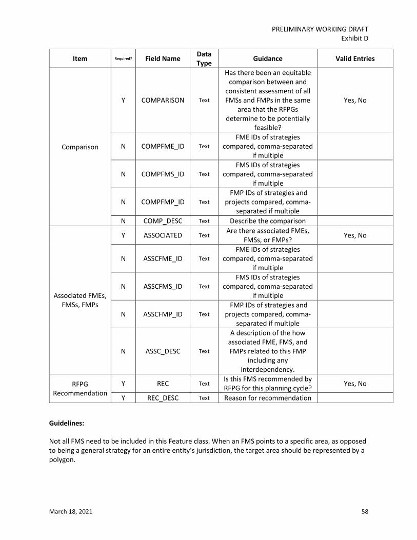
PRELIMINARY WORKING DRAFT Exhibit D
March 18, 2021 58
Item Required? Field Name Data Type Guidance Valid Entries
Comparison
Y COMPARISON Text
Has there been an equitable comparison between and
consistent assessment of all FMSs and FMPs in the same
area that the RFPGs determine to be potentially
feasible?
Yes, No
N COMPFME_ID Text FME IDs of strategies
compared, comma-separated if multiple
N COMPFMS_ID Text FMS IDs of strategies
compared, comma-separated if multiple
N COMPFMP_ID Text FMP IDs of strategies and
projects compared, comma-separated if multiple
N COMP_DESC Text Describe the comparison
Associated FMEs, FMSs, FMPs
Y ASSOCIATED Text Are there associated FMEs,
FMSs, or FMPs? Yes, No
N ASSCFME_ID Text FME IDs of strategies
compared, comma-separated if multiple
N ASSCFMS_ID Text FMS IDs of strategies
compared, comma-separated if multiple
N ASSCFMP_ID Text FMP IDs of strategies and
projects compared, comma-separated if multiple
N ASSC_DESC Text
A description of the how associated FME, FMS, and FMPs related to this FMP
including any interdependency.
RFPG Recommendation
Y REC Text Is this FMS recommended by RFPG for this planning cycle? Yes, No
Y REC_DESC Text Reason for recommendation
Guidelines:
Not all FMS need to be included in this Feature class. When an FMS points to a specific area, as opposed to being a general strategy for an entire entity’s jurisdiction, the target area should be represented by a polygon.