evaluating and adapting multidisciplinary landscape assessment
TRANSCRIPT
CIFOR MLA Testing Project Report Version 2-pub, 15 November 2005 Page 1 of 36
Evaluating and Adapting
Multidisciplinary Landscape Assessment
in Forest-Dependent Communities in the
Northern Bolivian Amazon Kristen Evans, Wil de Jong, Patricia Miranda, Peter Cronkleton
May – June 2005
Project: Stakeholders and Biodiversity in the Forest at the Local Level
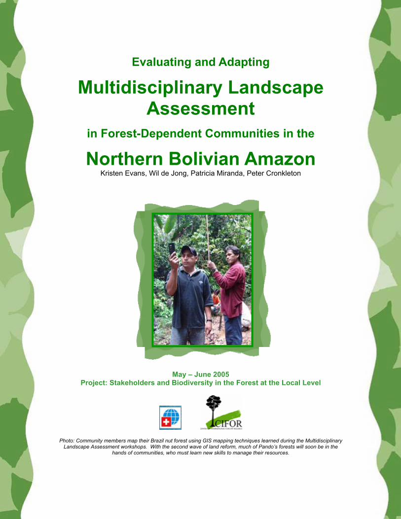
Photo: Community members map their Brazil nut forest using GIS mapping techniques learned during the Multidisciplinary Landscape Assessment workshops. With the second wave of land reform, much of Pando’s forests will soon be in the
hands of communities, who must learn new skills to manage their resources.
CIFOR MLA Testing Project Report Version 2-pub, 15 November 2005 Page 2 of 36
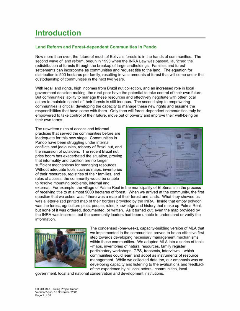
Introduction Land Reform and Forest-dependent Communities in Pando Now more than ever, the future of much of Bolivia’s forests is in the hands of communities. The second wave of land reform, begun in 1993 when the INRA Law was passed, launched the redistribution of forests through the breakup of large landholdings. Families and forest settlements can incorporate as communities and request title to the land. The equation for distribution is 500 hectares per family, resulting in vast amounts of forest that will come under the custodianship of communities in the next two years. With legal land rights, high incomes from Brazil nut collection, and an increased role in local government decision-making, the rural poor have the potential to take control of their own future. But communities’ ability to manage these resources and effectively negotiate with other local actors to maintain control of their forests is still tenuous. The second step to empowering communities is critical: developing the capacity to manage these new rights and assume the responsibilities that have come with them. Only then will forest-dependent communities truly be empowered to take control of their future, move out of poverty and improve their well-being on their own terms. The unwritten rules of access and informal practices that served the communities before are inadequate for this new stage. Communities in Pando have been struggling under internal conflicts and jealousies, robbery of Brazil nut, and the incursion of outsiders. The recent Brazil nut price boom has exacerbated the situation, proving that informality and tradition are no longer sufficient mechanisms for managing resources. Without adequate tools such as maps, inventories of their resources, registries of their families, and rules of access, the community would be unable to resolve mounting problems, internal and external. For example, the village of Palma Real in the municipality of El Sena is in the process of receiving title to at almost 9000 hectares of forest. When we arrived at the community, the first question that we asked was if there was a map of their forest and lands. What they showed us was a letter-sized printed map of their borders provided by the INRA. Inside that empty polygon was the forest, agriculture plots, people, rules, knowledge and history that make up Palma Real, but none of it was ordered, documented, or written. As it turned out, even the map provided by the INRA was incorrect, but the community leaders had been unable to understand or verify the information.
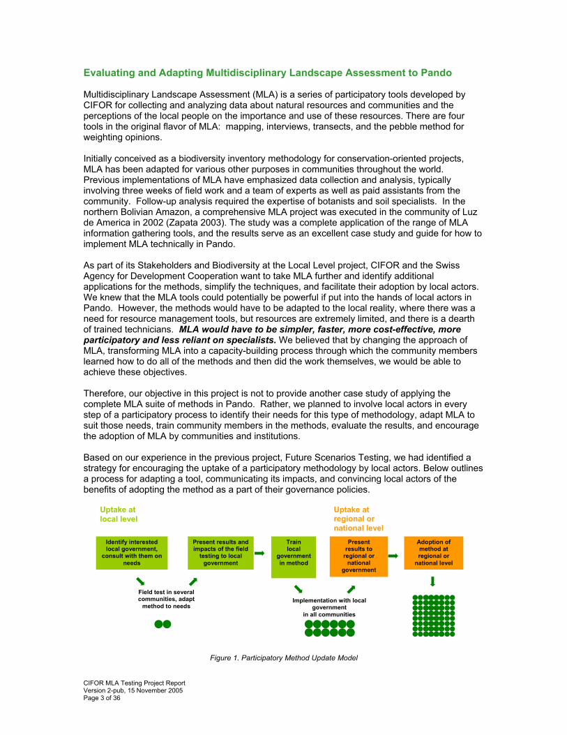
The condensed (one-week), capacity-building version of MLA that we implemented in the communities proved to be an effective first step towards developing necessary management mechanisms within these communities. We adapted MLA into a series of tools –maps, inventories of natural resources, family register, participatory workshops, GPS, transects, interviews – which communities could learn and adopt as instruments of resource management. While we collected data too, our emphasis was on developing capacity and listening to the evaluations and feedback of the experience by all local actors: communities, local
government, local and national conservation and development institutions.
CIFOR MLA Testing Project Report Version 2-pub, 15 November 2005 Page 3 of 36
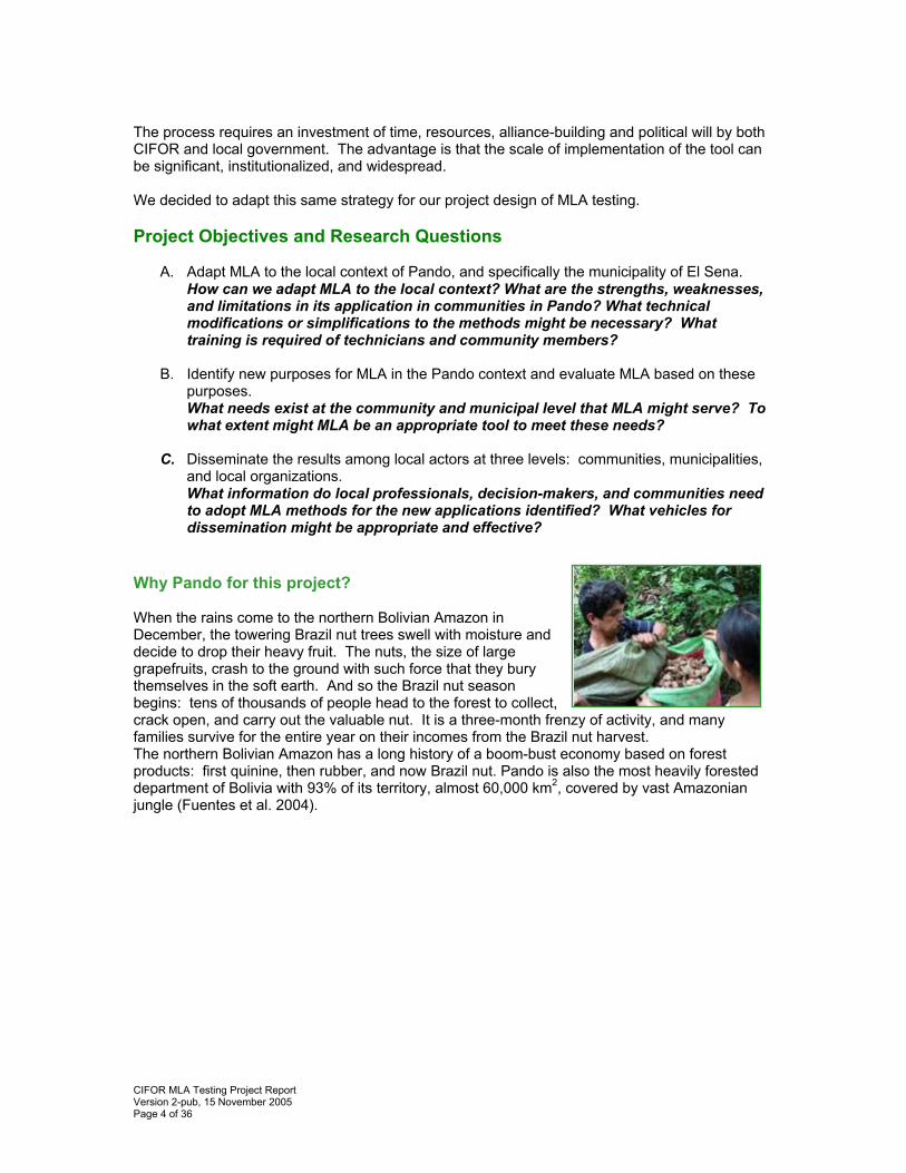
Evaluating and Adapting Multidisciplinary Landscape Assessment to Pando Multidisciplinary Landscape Assessment (MLA) is a series of participatory tools developed by CIFOR for collecting and analyzing data about natural resources and communities and the perceptions of the local people on the importance and use of these resources. There are four tools in the original flavor of MLA: mapping, interviews, transects, and the pebble method for weighting opinions. Initially conceived as a biodiversity inventory methodology for conservation-oriented projects, MLA has been adapted for various other purposes in communities throughout the world. Previous implementations of MLA have emphasized data collection and analysis, typically involving three weeks of field work and a team of experts as well as paid assistants from the community. Follow-up analysis required the expertise of botanists and soil specialists. In the northern Bolivian Amazon, a comprehensive MLA project was executed in the community of Luz de America in 2002 (Zapata 2003). The study was a complete application of the range of MLA information gathering tools, and the results serve as an excellent case study and guide for how to implement MLA technically in Pando. As part of its Stakeholders and Biodiversity at the Local Level project, CIFOR and the Swiss Agency for Development Cooperation want to take MLA further and identify additional applications for the methods, simplify the techniques, and facilitate their adoption by local actors. We knew that the MLA tools could potentially be powerful if put into the hands of local actors in Pando. However, the methods would have to be adapted to the local reality, where there was a need for resource management tools, but resources are extremely limited, and there is a dearth of trained technicians. MLA would have to be simpler, faster, more cost-effective, more participatory and less reliant on specialists. We believed that by changing the approach of MLA, transforming MLA into a capacity-building process through which the community members learned how to do all of the methods and then did the work themselves, we would be able to achieve these objectives. Therefore, our objective in this project is not to provide another case study of applying the complete MLA suite of methods in Pando. Rather, we planned to involve local actors in every step of a participatory process to identify their needs for this type of methodology, adapt MLA to suit those needs, train community members in the methods, evaluate the results, and encourage the adoption of MLA by communities and institutions. Based on our experience in the previous project, Future Scenarios Testing, we had identified a strategy for encouraging the uptake of a participatory methodology by local actors. Below outlines a process for adapting a tool, communicating its impacts, and convincing local actors of the benefits of adopting the method as a part of their governance policies.
Figure 1. Participatory Method Update Model
Identify interested local government,
consult with them on needs
Field test in several communities, adapt
method to needs
Present results and impacts of the field
testing to local government
Train local
government in method
Implementation with local government
in all communities
Present results to
regional or national
government
Adoption of method at regional or
national level
Uptake at local level
Uptake at regional or national level
CIFOR MLA Testing Project Report Version 2-pub, 15 November 2005 Page 4 of 36
The process requires an investment of time, resources, alliance-building and political will by both CIFOR and local government. The advantage is that the scale of implementation of the tool can be significant, institutionalized, and widespread. We decided to adapt this same strategy for our project design of MLA testing. Project Objectives and Research Questions
A. Adapt MLA to the local context of Pando, and specifically the municipality of El Sena. How can we adapt MLA to the local context? What are the strengths, weaknesses, and limitations in its application in communities in Pando? What technical modifications or simplifications to the methods might be necessary? What training is required of technicians and community members?
B. Identify new purposes for MLA in the Pando context and evaluate MLA based on these
purposes. What needs exist at the community and municipal level that MLA might serve? To what extent might MLA be an appropriate tool to meet these needs?
C. Disseminate the results among local actors at three levels: communities, municipalities,
and local organizations. What information do local professionals, decision-makers, and communities need to adopt MLA methods for the new applications identified? What vehicles for dissemination might be appropriate and effective?
Why Pando for this project? When the rains come to the northern Bolivian Amazon in December, the towering Brazil nut trees swell with moisture and decide to drop their heavy fruit. The nuts, the size of large grapefruits, crash to the ground with such force that they bury themselves in the soft earth. And so the Brazil nut season begins: tens of thousands of people head to the forest to collect, crack open, and carry out the valuable nut. It is a three-month frenzy of activity, and many families survive for the entire year on their incomes from the Brazil nut harvest. The northern Bolivian Amazon has a long history of a boom-bust economy based on forest products: first quinine, then rubber, and now Brazil nut. Pando is also the most heavily forested department of Bolivia with 93% of its territory, almost 60,000 km2, covered by vast Amazonian jungle (Fuentes et al. 2004).
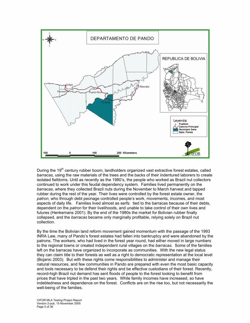
CIFOR MLA Testing Project Report Version 2-pub, 15 November 2005 Page 5 of 36
During the 19th century rubber boom, landholders organized vast extractive forest estates, called barracas, using the raw materials of the trees and the backs of their indentured laborers to create isolated fiefdoms. Until as recently as the 1980’s, the people who worked as Brazil nut collectors continued to work under this feudal dependency system. Families lived permanently on the barracas, where they collected Brazil nuts during the November to March harvest and tapped rubber during the rest of the year. Their lives were controlled by the forest estate owner, the patron, who through debt peonage controlled people’s work, movements, incomes, and most aspects of daily life. Families lived almost as serfs: tied to the barracas because of their debts, dependent on the patron for their livelihoods, and unable to take control of their own lives and futures (Henkemans 2001). By the end of the 1980s the market for Bolivian rubber finally collapsed, and the barracas became only marginally profitable, relying solely on Brazil nut collection. By the time the Bolivian land reform movement gained momentum with the passage of the 1993 INRA Law, many of Pando’s forest estates had fallen into bankruptcy and were abandoned by the patrons. The workers, who had lived in the forest year round, had either moved in large numbers to the regional towns or created independent rural villages on the barracas. Some of the families left on the barracas have organized to incorporate as communities. With the new legal status they can claim title to their forests as well as a right to democratic representation at the local level (Bojanic 2003). But with these rights come responsibilities to administer and manage their natural resources, and few communities in Pando are prepared with even the most basic capacity and tools necessary to be defend their rights and be effective custodians of their forest. Recently, record-high Brazil nut demand has sent floods of people to the forest looking to benefit from prices that have tripled in the past two years. While family incomes have increased, so have indebtedness and dependence on the forest. Conflicts are on the rise too, but not necessarily the well-being of the families.
CIFOR MLA Testing Project Report Version 2-pub, 15 November 2005 Page 6 of 36
However, communities need to be prepared. The process of decentralization of natural resources to the local level will entrust more than 1.8 million hectares of forests to communities within the next few years. These new benefits demand new responsibilities: Communities now must assume the role of true stewards of their forests. MLA and Local Government Municipalities in forested areas are mandated to establish a Municipal Forestry Unit (UFM for its acronym in Spanish) to serve as a forestry extension service for communities. However, the reality is that the UFMs are often staffed by untrained or unsupervised technicians who have little experience working with communities. The UFMs are, however, the most important local institution to strengthen in order to make a lasting impact on the community forest management. Therefore, we invited the new forestry engineer of the UFM to assist us with the fieldwork in the communities and the training workshops, in order to learn the MLA methods with us. He was an invaluable part of our team. It was also important to continue building on the relationship with the local government that we had established during Future Scenarios testing by involving them in every step of the process. We planned the fieldwork program in concert with the mayor and the municipal council. Local government officials also participated in the workshops and presentations. The CIFOR Team The CIFOR Poverty and Decentralization project1 is investigating the impact of local governments in Pando on poverty alleviation under the new decentralized governance structure. This project is part of a three-year comparative study in the municipalities of El Sena and Bolpebra of the ability of municipal governments to understand and respond to the needs of the forest-dependent poor. The Poverty and Decentralization team provided us with invaluable assistance: introductions to local government actors, site selection advice, an understanding of the local context, and collaborative input into the design of our research. The CIFOR field research team was composed of two professionals: Patricia Miranda Fuentes is a Bolivian sociologist with six years experience working with rural and forest-dependant communities. She is a specialist in community workshop facilitation. Kristen Evans is an American and former Peace Corps volunteer with several years of experience working with indigenous communities in Forest Management Plans. The international project coordinator is Dr. Wil de Jong. Dr. Peter Cronkleton is coordinator of CIFOR-Bolivia. Assisting the team were Rolando Haches, agronomist, and Marco Antonio Albornoz, forester.
1 The Poverty and Decentralization Bolivia project team is co-coordinated by Peter Cronkleton and Wil de Jong. It is a collaborative project between CIFOR, BMZ (Federal Ministry for Economic Cooperation and Development), and the University of Freiburg.
CIFOR MLA Testing Project Report Version 2-pub, 15 November 2005 Page 7 of 36
Methods Our project included five stages over the course of three months.
1. Selecting Communities 2. Developing the Evaluation Methodology 3. MLA Field Testing in Two Communities and MLA Training Workshop in El Sena 4. Disseminating Results and Evaluating the Tool with Local Government and Local and
National Institutions 5. Analyzing Impacts, Lessons Learned and Next Steps
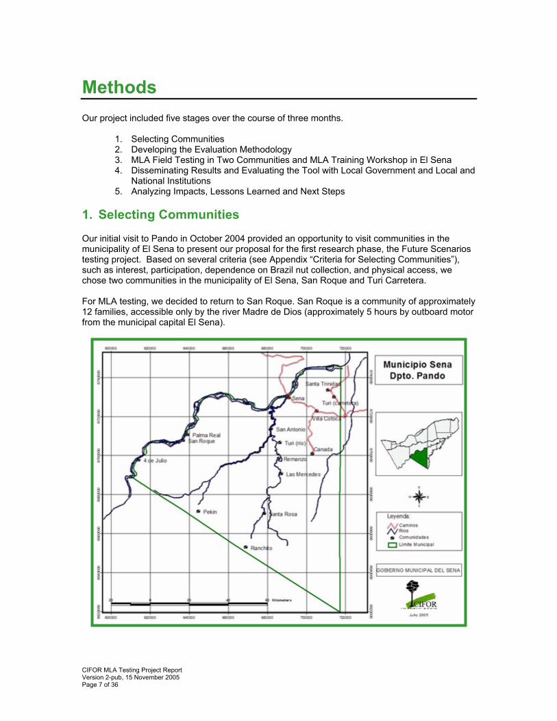
1. Selecting Communities Our initial visit to Pando in October 2004 provided an opportunity to visit communities in the municipality of El Sena to present our proposal for the first research phase, the Future Scenarios testing project. Based on several criteria (see Appendix “Criteria for Selecting Communities”), such as interest, participation, dependence on Brazil nut collection, and physical access, we chose two communities in the municipality of El Sena, San Roque and Turi Carretera. For MLA testing, we decided to return to San Roque. San Roque is a community of approximately 12 families, accessible only by the river Madre de Dios (approximately 5 hours by outboard motor from the municipal capital El Sena).
CIFOR MLA Testing Project Report Version 2-pub, 15 November 2005 Page 8 of 36
We also chose to test MLA in Palma Real, a neighboring community to San Roque. Palma Real, 30 families, had demonstrated interest in Future Scenarios (although we initially did not select them) and had been a very enthusiastic partner community with the CIFOR project “Poverty and Decentralization.” What’s more, community members had expressed significant concern about the distribution and access to their Brazil nut stands among the families. Internal conflict in the community was escalating in concert with the rising Brazil nut prices. Both communities are almost entirely dependent on the Brazil nut harvest for their income. Subsistence agriculture provides some staple foods—rice, manioc, corn. Hunting and fishing are important meat sources in addition to low levels of animal husbandry, mostly raising chickens and pigs. The families are the descendants are siringueros, rubber tappers, brought to Pando at the turn of the century to work in the barracas. A common situation in rural Pando, both communities were actually founded by a single man who had arrived 90 years ago from Colombia to tap rubber. Spanish is the only language spoken. 2. Developing the Evaluation Methodology The evaluation of MLA was a process of consultation, feedback and dissemination involving several key groups: community participants, the UFM of El Sena, El Sena community leaders, and local and national institutions. Community Participants
UFM El Sena
El Sena Community Leaders
Local and National Institutions
• Participated in activities
• Learned methods • Evaluated methods
following each activity
• Trained other community leaders in methods
• Assisted with the fieldwork
• Learned methods • Trained community
members in methods • Evaluated the
methods
• Attended mini MLA training workshop
• Evaluated the methods
• Attended presentations of results
• Provided feedback and evaluations
What part was difficult? What could the method be used for? Could you do this again on your own?
What are your impressions of the methods? What would you change or improve and why? Would you use these methods in your work? What are the strengths and weaknesses of the methods?
How would you use these methods in your community? What are the most important or useful aspects of the methods?
What are the strengths and weaknesses of the method? If you could adapt the method, how would you? What type of information is valuable for you in your work? What is MLA useful for in the Pando context?
CIFOR MLA Testing Project Report Version 2-pub, 15 November 2005 Page 9 of 36
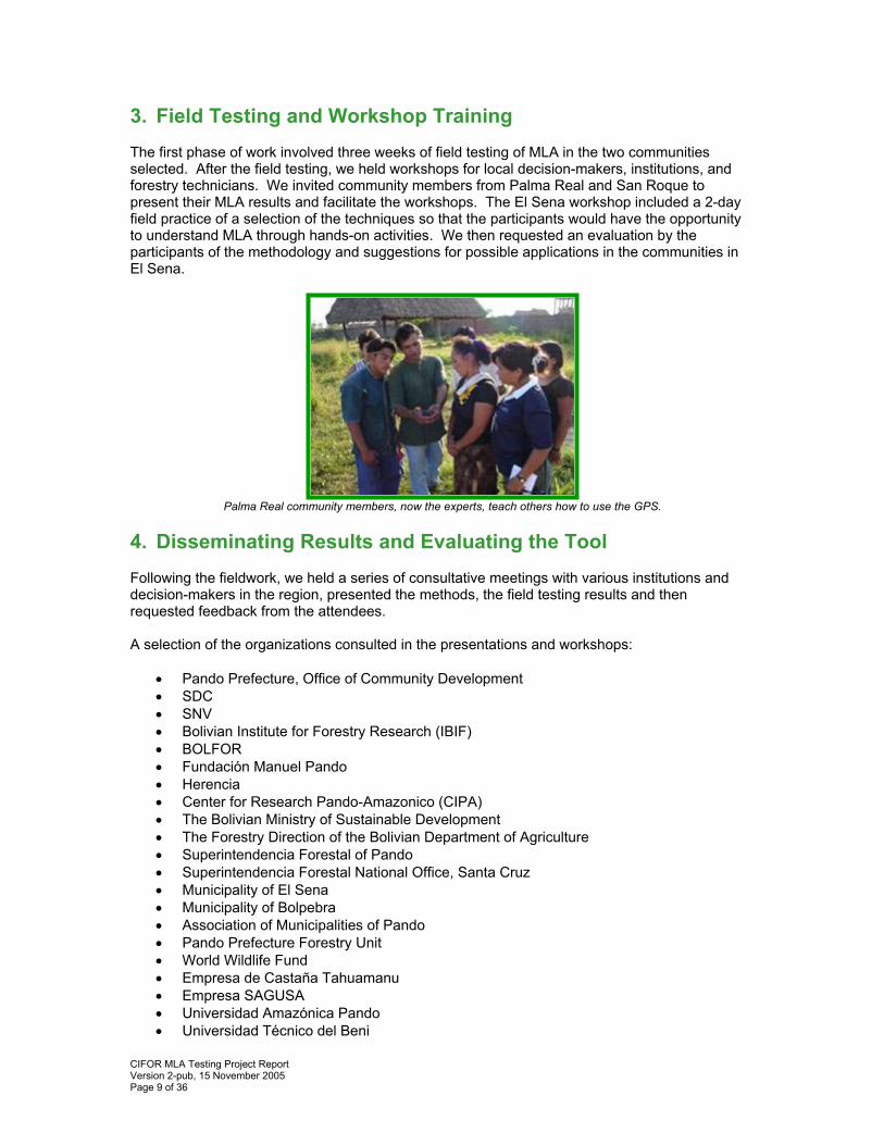
3. Field Testing and Workshop Training The first phase of work involved three weeks of field testing of MLA in the two communities selected. After the field testing, we held workshops for local decision-makers, institutions, and forestry technicians. We invited community members from Palma Real and San Roque to present their MLA results and facilitate the workshops. The El Sena workshop included a 2-day field practice of a selection of the techniques so that the participants would have the opportunity to understand MLA through hands-on activities. We then requested an evaluation by the participants of the methodology and suggestions for possible applications in the communities in El Sena.
Palma Real community members, now the experts, teach others how to use the GPS.
4. Disseminating Results and Evaluating the Tool Following the fieldwork, we held a series of consultative meetings with various institutions and decision-makers in the region, presented the methods, the field testing results and then requested feedback from the attendees. A selection of the organizations consulted in the presentations and workshops:
• Pando Prefecture, Office of Community Development • SDC • SNV • Bolivian Institute for Forestry Research (IBIF) • BOLFOR • Fundación Manuel Pando • Herencia • Center for Research Pando-Amazonico (CIPA) • The Bolivian Ministry of Sustainable Development • The Forestry Direction of the Bolivian Department of Agriculture • Superintendencia Forestal of Pando • Superintendencia Forestal National Office, Santa Cruz • Municipality of El Sena • Municipality of Bolpebra • Association of Municipalities of Pando • Pando Prefecture Forestry Unit • World Wildlife Fund • Empresa de Castaña Tahuamanu • Empresa SAGUSA • Universidad Amazónica Pando • Universidad Técnico del Beni
CIFOR MLA Testing Project Report Version 2-pub, 15 November 2005 Page 10 of 36
• CEADES • CEJIS • IPHAE • The Nature Conservancy • Wildlife Conservation Society
We presented the results in El Sena, Cobija, Santa Cruz, La Paz, and Riberalta. These events served to disseminate the results of the MLA field testing and also as evaluations. After the presentations, we had workgroup discussion about the results, requesting an evaluation by the workgroups, suggestions how to improve dissemination of the results, and next steps for adapting MLA to Pando. 5. Analyzing Impacts, Lessons Learned, and Next Steps We included several samples of data in this report to demonstrate the type of information collected, however, it is only a small percentage of the information collected and prepared for the communities. Our primary goal for this project was evaluating and adapting MLA. Because of the tremendous amount of data that we collected from doing MLA in two communities, we limited our processing of the data to the most relevant information for the communities. And due to time limitations, we also did not translate all data into English. See the appendix for a complete description of our implementation of MLA with samples of the results. We follow with a discussion of lessons-learned, impacts and local uptake of the methods, and our suggestions for next steps.
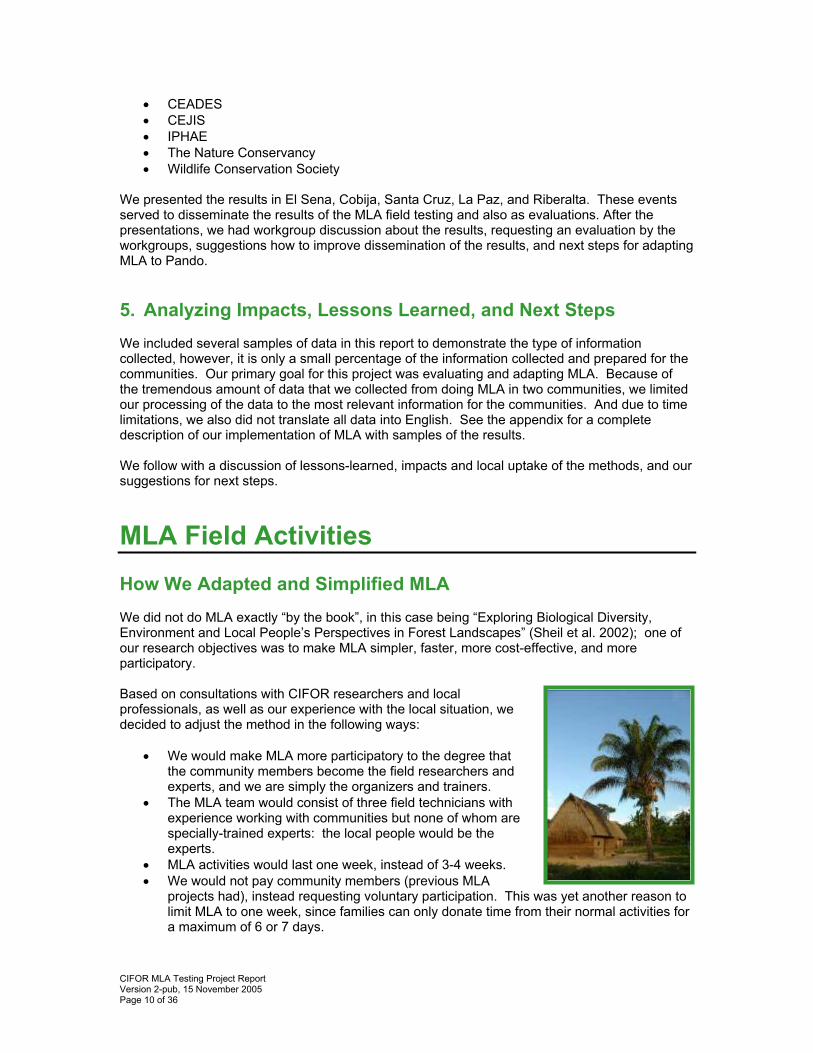
MLA Field Activities How We Adapted and Simplified MLA We did not do MLA exactly “by the book”, in this case being “Exploring Biological Diversity, Environment and Local People’s Perspectives in Forest Landscapes” (Sheil et al. 2002); one of our research objectives was to make MLA simpler, faster, more cost-effective, and more participatory. Based on consultations with CIFOR researchers and local professionals, as well as our experience with the local situation, we decided to adjust the method in the following ways:
• We would make MLA more participatory to the degree that the community members become the field researchers and experts, and we are simply the organizers and trainers.
• The MLA team would consist of three field technicians with experience working with communities but none of whom are specially-trained experts: the local people would be the experts.
• MLA activities would last one week, instead of 3-4 weeks. • We would not pay community members (previous MLA
projects had), instead requesting voluntary participation. This was yet another reason to limit MLA to one week, since families can only donate time from their normal activities for a maximum of 6 or 7 days.
CIFOR MLA Testing Project Report Version 2-pub, 15 November 2005 Page 11 of 36
• We would eliminate two activities that required costly follow-up analysis: soil analysis and botanical analysis.
• We would only do one or two transects. • We would limit and adapt the Pebble Method activities. • We would add a new tool for the communities to document important data about the
families: the Family Register. • We would use GIS mapping, training community members how to use a GPS and map
the geo-referenced coordinates. We planned a series of MLA activities in the two communities with a follow-up presentation and workshop in the municipal capital El Sena. Please see the appendix for the complete calendar of activities, an overview of the workshop methods, and a selection of the results.
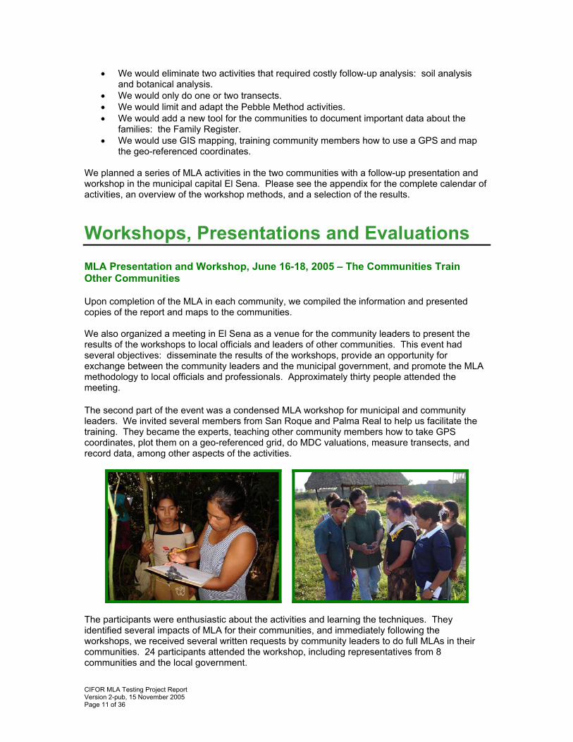
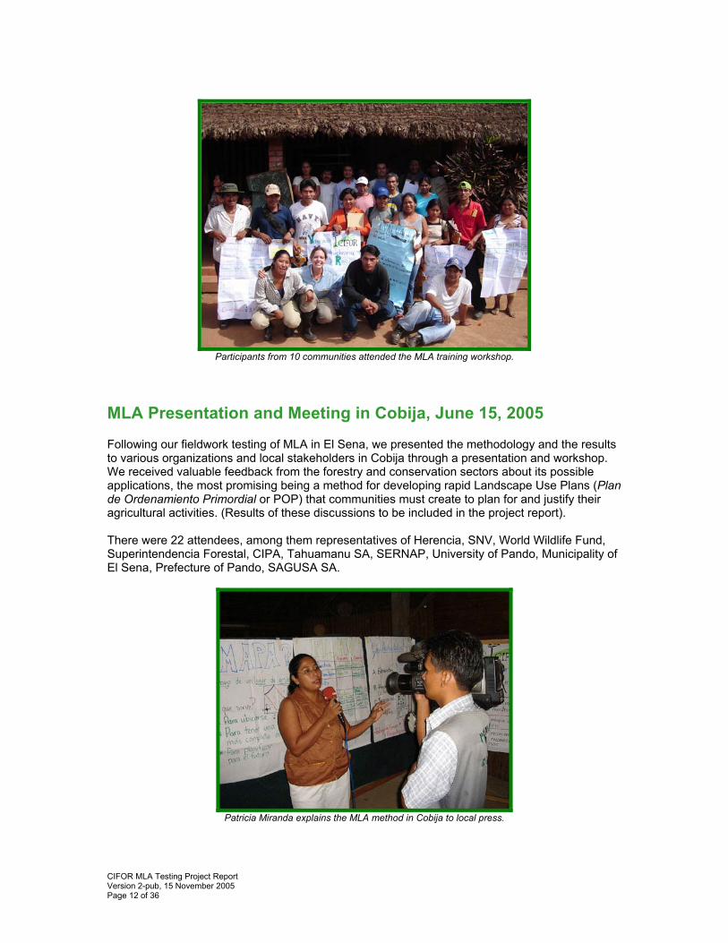
Workshops, Presentations and Evaluations MLA Presentation and Workshop, June 16-18, 2005 – The Communities Train Other Communities Upon completion of the MLA in each community, we compiled the information and presented copies of the report and maps to the communities. We also organized a meeting in El Sena as a venue for the community leaders to present the results of the workshops to local officials and leaders of other communities. This event had several objectives: disseminate the results of the workshops, provide an opportunity for exchange between the community leaders and the municipal government, and promote the MLA methodology to local officials and professionals. Approximately thirty people attended the meeting. The second part of the event was a condensed MLA workshop for municipal and community leaders. We invited several members from San Roque and Palma Real to help us facilitate the training. They became the experts, teaching other community members how to take GPS coordinates, plot them on a geo-referenced grid, do MDC valuations, measure transects, and record data, among other aspects of the activities.
The participants were enthusiastic about the activities and learning the techniques. They identified several impacts of MLA for their communities, and immediately following the workshops, we received several written requests by community leaders to do full MLAs in their communities. 24 participants attended the workshop, including representatives from 8 communities and the local government.
CIFOR MLA Testing Project Report Version 2-pub, 15 November 2005 Page 12 of 36
Participants from 10 communities attended the MLA training workshop.
MLA Presentation and Meeting in Cobija, June 15, 2005 Following our fieldwork testing of MLA in El Sena, we presented the methodology and the results to various organizations and local stakeholders in Cobija through a presentation and workshop. We received valuable feedback from the forestry and conservation sectors about its possible applications, the most promising being a method for developing rapid Landscape Use Plans (Plan de Ordenamiento Primordial or POP) that communities must create to plan for and justify their agricultural activities. (Results of these discussions to be included in the project report). There were 22 attendees, among them representatives of Herencia, SNV, World Wildlife Fund, Superintendencia Forestal, CIPA, Tahuamanu SA, SERNAP, University of Pando, Municipality of El Sena, Prefecture of Pando, SAGUSA SA.
Patricia Miranda explains the MLA method in Cobija to local press.
CIFOR MLA Testing Project Report Version 2-pub, 15 November 2005 Page 13 of 36
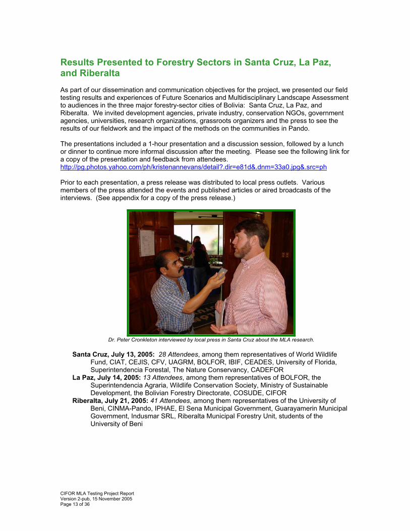
Results Presented to Forestry Sectors in Santa Cruz, La Paz, and Riberalta As part of our dissemination and communication objectives for the project, we presented our field testing results and experiences of Future Scenarios and Multidisciplinary Landscape Assessment to audiences in the three major forestry-sector cities of Bolivia: Santa Cruz, La Paz, and Riberalta. We invited development agencies, private industry, conservation NGOs, government agencies, universities, research organizations, grassroots organizers and the press to see the results of our fieldwork and the impact of the methods on the communities in Pando. The presentations included a 1-hour presentation and a discussion session, followed by a lunch or dinner to continue more informal discussion after the meeting. Please see the following link for a copy of the presentation and feedback from attendees. http://pg.photos.yahoo.com/ph/kristenannevans/detail?.dir=e81d&.dnm=33a0.jpg&.src=ph Prior to each presentation, a press release was distributed to local press outlets. Various members of the press attended the events and published articles or aired broadcasts of the interviews. (See appendix for a copy of the press release.)
Dr. Peter Cronkleton interviewed by local press in Santa Cruz about the MLA research.
Santa Cruz, July 13, 2005: 28 Attendees, among them representatives of World Wildlife
Fund, CIAT, CEJIS, CFV, UAGRM, BOLFOR, IBIF, CEADES, University of Florida, Superintendencia Forestal, The Nature Conservancy, CADEFOR
La Paz, July 14, 2005: 13 Attendees, among them representatives of BOLFOR, the Superintendencia Agraria, Wildlife Conservation Society, Ministry of Sustainable Development, the Bolivian Forestry Directorate, COSUDE, CIFOR
Riberalta, July 21, 2005: 41 Attendees, among them representatives of the University of Beni, CINMA-Pando, IPHAE, El Sena Municipal Government, Guarayamerin Municipal Government, Indusmar SRL, Riberalta Municipal Forestry Unit, students of the University of Beni
CIFOR MLA Testing Project Report Version 2-pub, 15 November 2005 Page 14 of 36
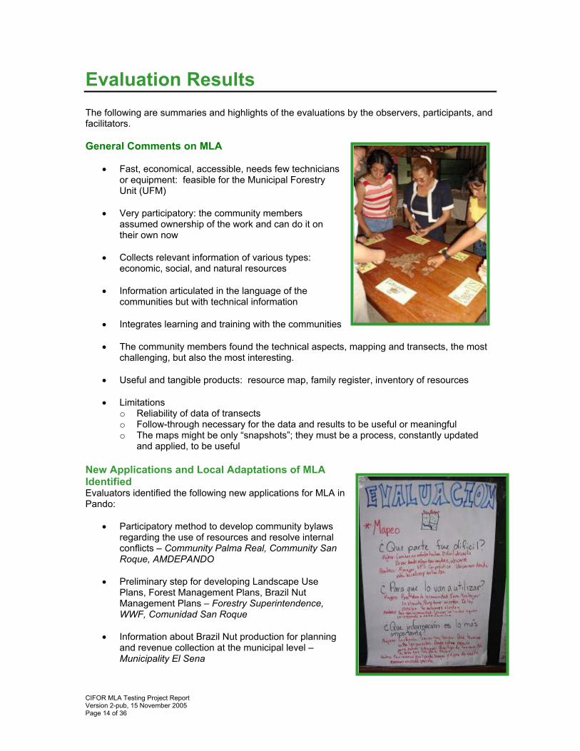
Evaluation Results The following are summaries and highlights of the evaluations by the observers, participants, and facilitators. General Comments on MLA
• Fast, economical, accessible, needs few technicians
or equipment: feasible for the Municipal Forestry Unit (UFM)
• Very participatory: the community members
assumed ownership of the work and can do it on their own now
• Collects relevant information of various types:
economic, social, and natural resources • Information articulated in the language of the
communities but with technical information • Integrates learning and training with the communities • The community members found the technical aspects, mapping and transects, the most
challenging, but also the most interesting.
• Useful and tangible products: resource map, family register, inventory of resources • Limitations
o Reliability of data of transects o Follow-through necessary for the data and results to be useful or meaningful o The maps might be only “snapshots”; they must be a process, constantly updated
and applied, to be useful New Applications and Local Adaptations of MLA Identified Evaluators identified the following new applications for MLA in Pando:
• Participatory method to develop community bylaws regarding the use of resources and resolve internal conflicts – Community Palma Real, Community San Roque, AMDEPANDO
• Preliminary step for developing Landscape Use
Plans, Forest Management Plans, Brazil Nut Management Plans – Forestry Superintendence, WWF, Comunidad San Roque
• Information about Brazil Nut production for planning
and revenue collection at the municipal level – Municipality El Sena
CIFOR MLA Testing Project Report Version 2-pub, 15 November 2005 Page 15 of 36
• Baseline information for the Municipal Forestry Units to begin work with the communities – UFM El Sena
• Territory information to resolve conflicts and disputes with local stakeholders – Forestry Superintendence
• Effective training for the communities to be able to oversee and control the land reform
process. – Centro de Investigación Juridica y Social (CEJIS) Evaluation by Institutions
What are the strengths and weaknesses of MLA?
What type of information that MLA generates is most useful? • CIPA: Transects • HERENCIA: Mapping and Transects • PREFECTURA: Interview and mapping • SAGUSA: Mapping • WWF: Identifying conservation goals for natural resources, Brazil Nut Management
Plans, and other uses • SUPERFORESTAL: All of the methods for establishing rules and regulations
How would you adapt the method? • Longer time period • Would adapt the method to collect information about necessities • Would adapt the method to make a prioritization of demands during the development
of the municipal Annual Operating Plans and Five-Year Municipal Development Plans. • Would adapt the method for Integrated Productivity Projects • Adaptable to the requirements of each institution
Weaknesses: • Transect samples are not
representative • Communities might not accept
MLA • Must change name of the Brazil
Nut Method • Is it causing conflicts? • Long-term follow-up? • The discussion on problems
should focus on how to prevent them, not just solutions
• Doubts about the reliability of the GPS and transect data
Strengths: • Identify and understand territory • Attitude and participation of the
community • Thinking about natural resource use• Organizing the social network of the
community • Community teamwork • Practical method • Fast method • Participatory • Low cost • Generates general information • Tool for Landscape Use Plans
What application might MLA have in Pando? • Understand the natural resources of Pando • Improve participation by the community members • Application in the land reform process to identify and solve issues of borders of the
communities • Serves as a baseline for developing Landscape Use Plans and Municipal Development
Plans
CIFOR MLA Testing Project Report Version 2-pub, 15 November 2005 Page 16 of 36
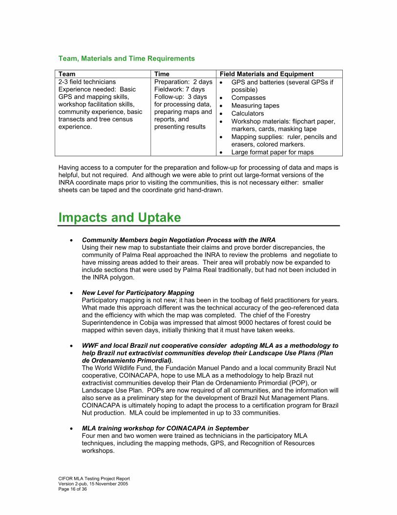
Team, Materials and Time Requirements Team Time Field Materials and Equipment 2-3 field technicians Experience needed: Basic GPS and mapping skills, workshop facilitation skills, community experience, basic transects and tree census experience.
Preparation: 2 days Fieldwork: 7 days Follow-up: 3 days for processing data, preparing maps and reports, and presenting results
• GPS and batteries (several GPSs if possible)
• Compasses • Measuring tapes • Calculators • Workshop materials: flipchart paper,
markers, cards, masking tape • Mapping supplies: ruler, pencils and
erasers, colored markers. • Large format paper for maps
Having access to a computer for the preparation and follow-up for processing of data and maps is helpful, but not required. And although we were able to print out large-format versions of the INRA coordinate maps prior to visiting the communities, this is not necessary either: smaller sheets can be taped and the coordinate grid hand-drawn.
Impacts and Uptake • Community Members begin Negotiation Process with the INRA
Using their new map to substantiate their claims and prove border discrepancies, the community of Palma Real approached the INRA to review the problems and negotiate to have missing areas added to their areas. Their area will probably now be expanded to include sections that were used by Palma Real traditionally, but had not been included in the INRA polygon.
• New Level for Participatory Mapping
Participatory mapping is not new; it has been in the toolbag of field practitioners for years. What made this approach different was the technical accuracy of the geo-referenced data and the efficiency with which the map was completed. The chief of the Forestry Superintendence in Cobija was impressed that almost 9000 hectares of forest could be mapped within seven days, initially thinking that it must have taken weeks.
• WWF and local Brazil nut cooperative consider adopting MLA as a methodology to
help Brazil nut extractivist communities develop their Landscape Use Plans (Plan de Ordenamiento Primordial). The World Wildlife Fund, the Fundación Manuel Pando and a local community Brazil Nut cooperative, COINACAPA, hope to use MLA as a methodology to help Brazil nut extractivist communities develop their Plan de Ordenamiento Primordial (POP), or Landscape Use Plan. POPs are now required of all communities, and the information will also serve as a preliminary step for the development of Brazil Nut Management Plans. COINACAPA is ultimately hoping to adapt the process to a certification program for Brazil Nut production. MLA could be implemented in up to 33 communities.
• MLA training workshop for COINACAPA in September Four men and two women were trained as technicians in the participatory MLA techniques, including the mapping methods, GPS, and Recognition of Resources workshops.
CIFOR MLA Testing Project Report Version 2-pub, 15 November 2005 Page 17 of 36
• Communities Request MLA Other leaders in El Sena, upon attending the presentation of the results workshops, requested MLA for their communities too. The communities of Canadá and El Sena submitted letters to the Mayor for MLA workshops in their community.
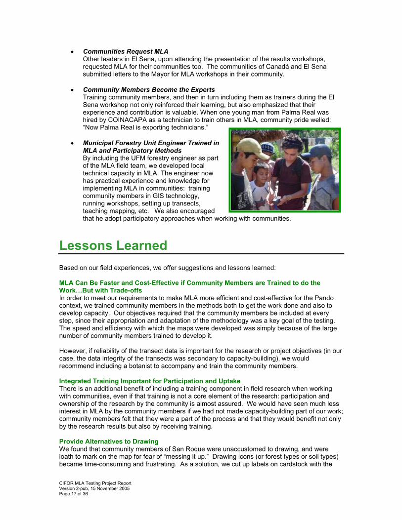
• Community Members Become the Experts Training community members, and then in turn including them as trainers during the El Sena workshop not only reinforced their learning, but also emphasized that their experience and contribution is valuable. When one young man from Palma Real was hired by COINACAPA as a technician to train others in MLA, community pride welled: “Now Palma Real is exporting technicians.”
• Municipal Forestry Unit Engineer Trained in MLA and Participatory Methods By including the UFM forestry engineer as part of the MLA field team, we developed local technical capacity in MLA. The engineer now has practical experience and knowledge for implementing MLA in communities: training community members in GIS technology, running workshops, setting up transects, teaching mapping, etc. We also encouraged that he adopt participatory approaches when working with communities.
Lessons Learned Based on our field experiences, we offer suggestions and lessons learned: MLA Can Be Faster and Cost-Effective if Community Members are Trained to do the Work…But with Trade-offs In order to meet our requirements to make MLA more efficient and cost-effective for the Pando context, we trained community members in the methods both to get the work done and also to develop capacity. Our objectives required that the community members be included at every step, since their appropriation and adaptation of the methodology was a key goal of the testing. The speed and efficiency with which the maps were developed was simply because of the large number of community members trained to develop it. However, if reliability of the transect data is important for the research or project objectives (in our case, the data integrity of the transects was secondary to capacity-building), we would recommend including a botanist to accompany and train the community members. Integrated Training Important for Participation and Uptake There is an additional benefit of including a training component in field research when working with communities, even if that training is not a core element of the research: participation and ownership of the research by the community is almost assured. We would have seen much less interest in MLA by the community members if we had not made capacity-building part of our work; community members felt that they were a part of the process and that they would benefit not only by the research results but also by receiving training. Provide Alternatives to Drawing We found that community members of San Roque were unaccustomed to drawing, and were loath to mark on the map for fear of “messing it up.” Drawing icons (or forest types or soil types) became time-consuming and frustrating. As a solution, we cut up labels on cardstock with the
CIFOR MLA Testing Project Report Version 2-pub, 15 November 2005 Page 18 of 36
names of the types of resources to locate on the map. People were much more comfortable sticking the labels on the map. Later, after the workshop, someone could return to the map drawing the icons in place of the labels if necessary. Maps can be Instruments of Conflict Resolution The process of developing the map together provided a mechanism for resolving conflicts which had simmered among community members for some time. In one such instance, two brothers had been arguing about the boundary between their Brazil nut areas. One brother then drew a larger area on the map to mark his claim on the forest of the other brother. When we asked them where the border should be drawn, they both replied midway between their two Brazil nut collecting centers. We then pulled out a ruler and measured exactly half the distance between the two areas. The brothers could then use the coordinate on the map to establish the border in the forest, resolving equitably the conflict. Both were satisfied with the solution. Maps can Create Confrontations While a correct map will not generally create problems that did not already exist, it can expose them and invite confrontation. MLA practitioners and community members need to be prepared to deal with issues that will arise from the map-making process, as borders become delineated and conflicting interests confirmed. These situations must be handled openly, using the map as a tool to resolve them. In one situation in Palma Real, several families without Brazil nut areas became upset when they realized from the map that the village founder had been renting out sections of good Brazil nut forest to a local merchant for harvesting. Naturally the situation became tense when the size of the area became evident. But the map also served as a tool for resolving the problem: the community identified that rented out area as a “free area” to be distributed to those families. It is important to emphasize that a correct map doesn’t make problems; it will simply bring to light existing ones. Involve all Local Stakeholders We tried to include as many local stakeholders in the MLA workshops as possible. However, one significant group that we should have involved more is the barraqueros, the landholders of the large forest estates. Since they share borders with the communities, their presence at the presentations and workshops would have opened opportunities for dialogue and negotiation. One Week is the Limit Families can generally only donate about one week of time with their daily activities to be able to participate voluntarily (i.e. without pay) in workshops and trainings. For this reason we worked to condense MLA to not more than seven days. New Name in Spanish Because of translation difficulties of the word “Landscape” into Spanish, we changed the name to Valoración Multidisciplinaria de Recursos.”

CIFOR MLA Testing Project Report Version 2-pub, 15 November 2005 Page 19 of 36
CIFOR MLA Testing Project Report Version 2-pub, 15 November 2005 Page 20 of 36
Conclusions and Next Steps MLA is a Field-tested, Participatory, Cost-Effective Information-gathering Tool We adapted MLA into a one-week series of tools –maps, inventories of natural resources, family register, participatory workshops, GPS, transects, interviews – which communities and local government could learn in order to document and understand their natural and human resources. Our participatory MLA approach, where the community members become the field researchers and technical team, made MLA feasible for the isolated, resource-challenged municipalities of Pando. This condensed, capacity-building version of MLA could prove to be an effective first step towards developing future management mechanisms within the communities. The enthusiasm for MLA demonstrates that the method fills a need for the communities, local government, and institutions, providing diagnostic and assessment tools for gathering technical and social information that that they lacked. The information generated during the activities will equip the communities to negotiate for land and government services more effectively. It will be helpful when dealing with border conflicts, for distributing their resources internally more equitably, and for planning for future use of their resources. The information may also serve as a preliminary step for the Landscape Use Plans and Brazil Nut Management Plans now required by the government. However, we made tradeoffs in the methodology to make it more cost-effective and participatory, particularly in the accuracy of the transect data. Each field application will require deciding the balance in the marriage between precision and comparability of data with participation. Confirming the Uptake Process for Participatory Tools During Future Scenarios testing, we had identified a consultative process for encouraging the adoption of a participatory tool by local government actors (see Figure 1). MLA testing confirmed these same steps for adapting a tool, proving its usefulness, training local stakeholders, and encouraging its uptake. The CIFOR Bolivia office has continued the uptake process with the WWF-COINACAPA project. Based on their efforts, MLA might be adopted among several municipalities in Pando. MLA is great…But now what? MLA provides communities with maps and information about their resources, which doubtless will serve them in myriad ways. However, MLA is not meant to be a stand-alone tool; it is valuable and relevant when it is part of a process that leads to decision-making and management. Tropical forests and the people who live in them do not have the luxury of information-gathering for its own sake, because time is ticking and resources are limited. As some community members and institutions commented: “MLA is great….but now what?” MLA should be included as part of a larger process or context that includes planning, management and monitoring. We have provided some suggestions in the following section. Suggested Next Steps
1. The Full Circle After discussions with the CIFOR and SDC team, we concluded that MLA, an information-gathering and diagnostic tool, might be integrated with a suite of participatory tools that can equip communities with a full complement, the “full circle,” of best-practices participatory methods for community forest management. Together with Future Scenarios, MLA might complete the first steps of CFM. The focus of the follow-up Phase III of this project could then be the identification and integration of additional tools to complete the “full circle.” Full Circle would be envisioned as a cycle of CFM best
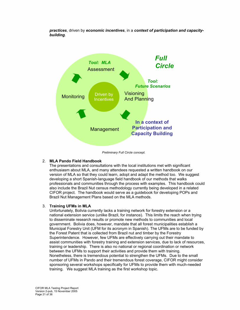
CIFOR MLA Testing Project Report Version 2-pub, 15 November 2005 Page 21 of 36
practices, driven by economic incentives, in a context of participation and capacity-building.
Preliminary Full Circle concept.
2. MLA Pando Field Handbook The presentations and consultations with the local institutions met with significant enthusiasm about MLA, and many attendees requested a written handbook on our version of MLA so that they could learn, adopt and adapt the method too. We suggest developing a short Spanish-language field handbook of our methods that walks professionals and communities through the process with examples. This handbook could also include the Brazil Nut census methodology currently being developed in a related CIFOR project. The handbook would serve as a guidebook for developing POPs and Brazil Nut Management Plans based on the MLA methods.
3. Training UFMs in MLA
Unfortunately, Bolivia currently lacks a training network for forestry extension or a national extension service (unlike Brazil, for instance). This limits the reach when trying to disseminate research results or promote new methods to communities and local government. Bolivia does, however, mandate that all forest municipalities establish a Municipal Forestry Unit (UFM for its acronym in Spanish). The UFMs are to be funded by the Forest Patent that is collected from Brazil nut and timber by the Forestry Superintendence. However, few UFMs are effectively carrying out their mandate to assist communities with forestry training and extension services, due to lack of resources, training or leadership. There is also no national or regional coordination or network between the UFMs to support their activities and provide them with training. Nonetheless, there is tremendous potential to strengthen the UFMs. Due to the small number of UFMs in Pando and their tremendous forest coverage, CIFOR might consider sponsoring several workshops specifically for UFMs to provide them with much-needed training. We suggest MLA training as the first workshop topic.
Full Circle Assessment
Visioning And Planning
Management
Monitoring
Driven byIncentives
In a context of Participation and Capacity Building
Tool: MLA
Tool: Future Scenarios
CIFOR MLA Testing Project Report Version 2-pub, 15 November 2005 Page 22 of 36
4. Presenting Results to MAP MLA will be useful to communities not only in northern Bolivia but also for the entire MAP tri-country region (Madre de Dios, Acre, Pando). We suggest presenting MLA results at the next appropriate MAP event to disseminate the methodology.
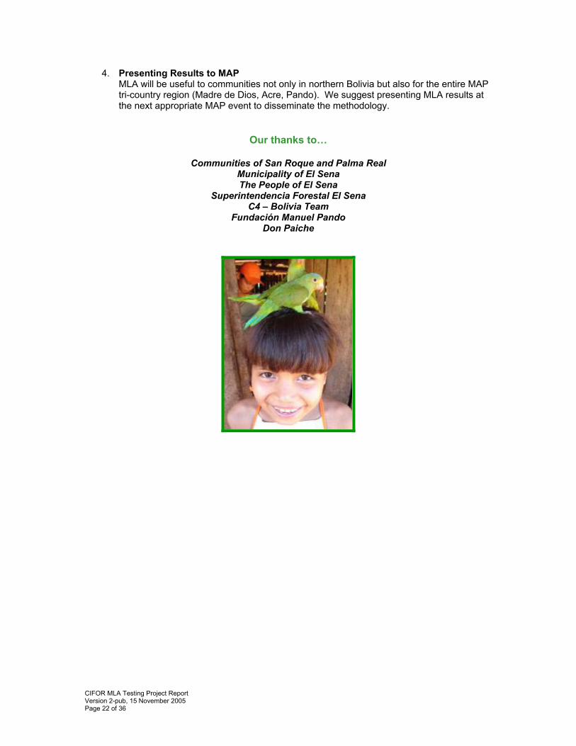
Our thanks to…
Communities of San Roque and Palma Real Municipality of El Sena The People of El Sena
Superintendencia Forestal El Sena C4 – Bolivia Team
Fundación Manuel Pando Don Paiche
CIFOR MLA Testing Project Report Version 2-pub, 15 November 2005 Page 23 of 36
Appendices and Links
I. Photo Gallery Please visit the online photo gallery (no sign-in necessary). http://pg.photos.yahoo.com/ph/kristenannevans/album?.dir=e81d&.src=ph&store=&prodid=&.done=http%3a//photos.yahoo.com/ph//my_photos
II. MLA Fieldwork in the Communities: Calendar, Methods and Results
Activity Calendar Community San Roque
Dates Activity Duration Participants May 16 Meeting with community leaders
to plan the week’s activities. 2 hours Community leaders
GPS and Mapping Practice 5 hours 6 Adults May 17 Household interviews 2 Families Household interviews 4 Families May 18 Workshop: Recognition of Resources
3 hours 16 Adults
GPS Coordinates and Mapping 5 hours 3 Adults Household Interviews 3 Families Workshop: GPS for Young People
3 hours 6 Young people
May 19
Focus Group: Recognition of Resources
3 hours 6 Adults
Transects 5 hours 11 Adults May 20 Community Leader Interview 2 hours 1 Family Household Interviews 5 hours 4 Families May 21 Workshop: Method of the Castaña and Family Register
2 hours 15 Adults
May 22 Workshop: Mapping and Evaluation
5 hours 13 Adults
Community Palma Real
Dates Activity Duration Participants May 22 Meeting with community leaders
to plan the week’s activities 2 hours Community leaders
GPS and Mapping Workshop 5 hours 16 Adults May 23 MLA Activity Planning with Entire Community
2 hours 18 Adults
Household interviews 4 Families GPS and Mapping Fieldwork 5 hours 3 Adults
May 24
Community Leader Interview 2 hours 2 Families GPS and Mapping Fieldwork 5 hours 3 Adults Household Interviews 3 Families
May 25
Workshop I: Recognition of Resources
3 hours 30 Adults
May 26 Transects 5 hours 34 Adults
CIFOR MLA Testing Project Report Version 2-pub, 15 November 2005 Page 24 of 36
Community Leader Interview 2 hours 2 Families Focal Group: Recognition of Resources
2 hours 14 Adults
Household Interviews 5 hours 7 Families May 28 Workshop II: Method of the Castaña and Family Register
2 hours 20 Adults
Workshop III: Mapping, Brazil nut Plot Registry, and Evaluation
3 hours 44 Adults
Household Interviews 5 hours 8 Families
May 29
Key Informants: Mapping 3 hours 8 Adults May 30 Workshop III Cont.: Mapping and
Close of Activities 3 hours 30 Adults
El Sena
Dates Activity Duration Participants May 8 Planning meetings with the Mayor, Municipal Council and the UFM May 15 Planning meeting with the UFM June 17-18 Presentation of Results of MLA
and MLA Mini-Workshop 2 days 24 Participants
representing Local Government and 8 Communities
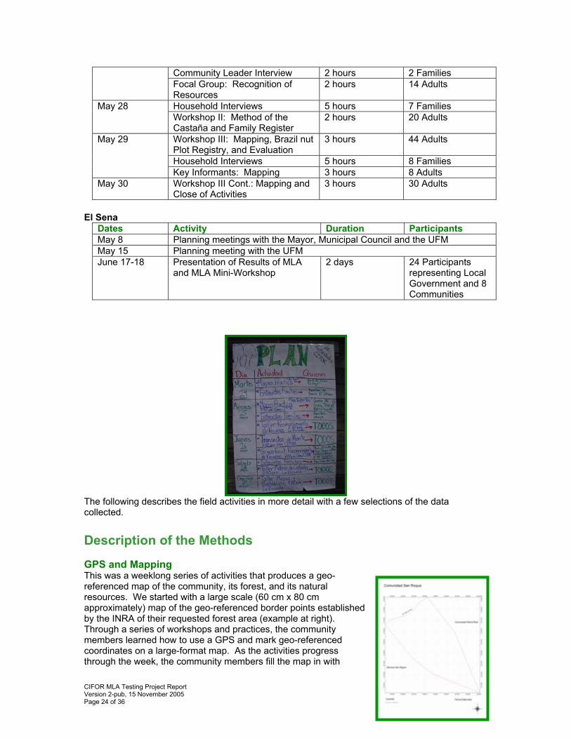
The following describes the field activities in more detail with a few selections of the data collected. Description of the Methods GPS and Mapping This was a weeklong series of activities that produces a geo-referenced map of the community, its forest, and its natural resources. We started with a large scale (60 cm x 80 cm approximately) map of the geo-referenced border points established by the INRA of their requested forest area (example at right). Through a series of workshops and practices, the community members learned how to use a GPS and mark geo-referenced coordinates on a large-format map. As the activities progress through the week, the community members fill the map in with
CIFOR MLA Testing Project Report Version 2-pub, 15 November 2005 Page 25 of 36
information from the fieldwork and from the other MLA workshops: geo-referenced landmarks, land use, types of soil, types of forest, Brazil nut plots, paths, roads,
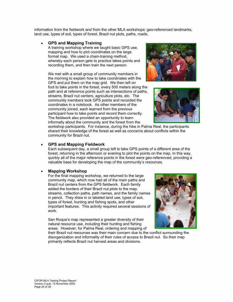
• GPS and Mapping Training A training workshop where we taught basic GPS use, mapping and how to plot coordinates on the large format map. We used a chain-training method, whereby each person gets to practice takes points and recording them, and then train the next person. We met with a small group of community members in the morning to explain how to take coordinates with the GPS and put them on the map grid. We then left on foot to take points in the forest, every 500 meters along the path and at reference points such as intersections of paths, streams, Brazil nut centers, agriculture plots, etc. The community members took GPS points and recorded the coordinates in a notebook. As other members of the community joined, each learned from the previous participant how to take points and record them correctly. The fieldwork also provided an opportunity to learn informally about the community and the forest from the workshop participants. For instance, during the hike in Palma Real, the participants shared their knowledge of the forest as well as concerns about conflicts within the community for Brazil nut.
• GPS and Mapping Fieldwork
Each subsequent day, a small group left to take GPS points of a different area of the forest, returning in the afternoon or evening to plot the points on the map. In this way, quickly all of the major reference points in the forest were geo-referenced, providing a valuable base for developing the map of the community’s resources.
• Mapping Workshop For the final mapping workshop, we returned to the large community map, which now had all of the main paths and Brazil nut centers from the GPS fieldwork. Each family added the borders of their Brazil nut plots to the map, streams, collection paths, path names, and the family names in pencil. They drew in or labeled land use, types of soil, types of forest, hunting and fishing spots, and other important features. This activity required several sessions of work. San Roque’s map represented a greater diversity of their natural resource use, including their hunting and fishing areas. However, for Palma Real, ordering and mapping of their Brazil nut resources was their main concern due to the conflict surrounding the disorganization and informality of their rules of access to Brazil nut. So their map primarily reflects Brazil nut harvest areas and divisions.
CIFOR MLA Testing Project Report Version 2-pub, 15 November 2005 Page 26 of 36
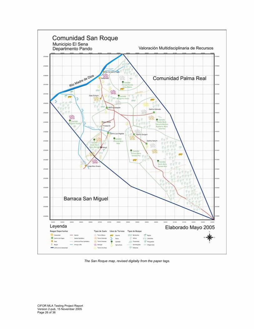
The San Roque map, revised digitally from the paper tags.
CIFOR MLA Testing Project Report Version 2-pub, 15 November 2005 Page 27 of 36
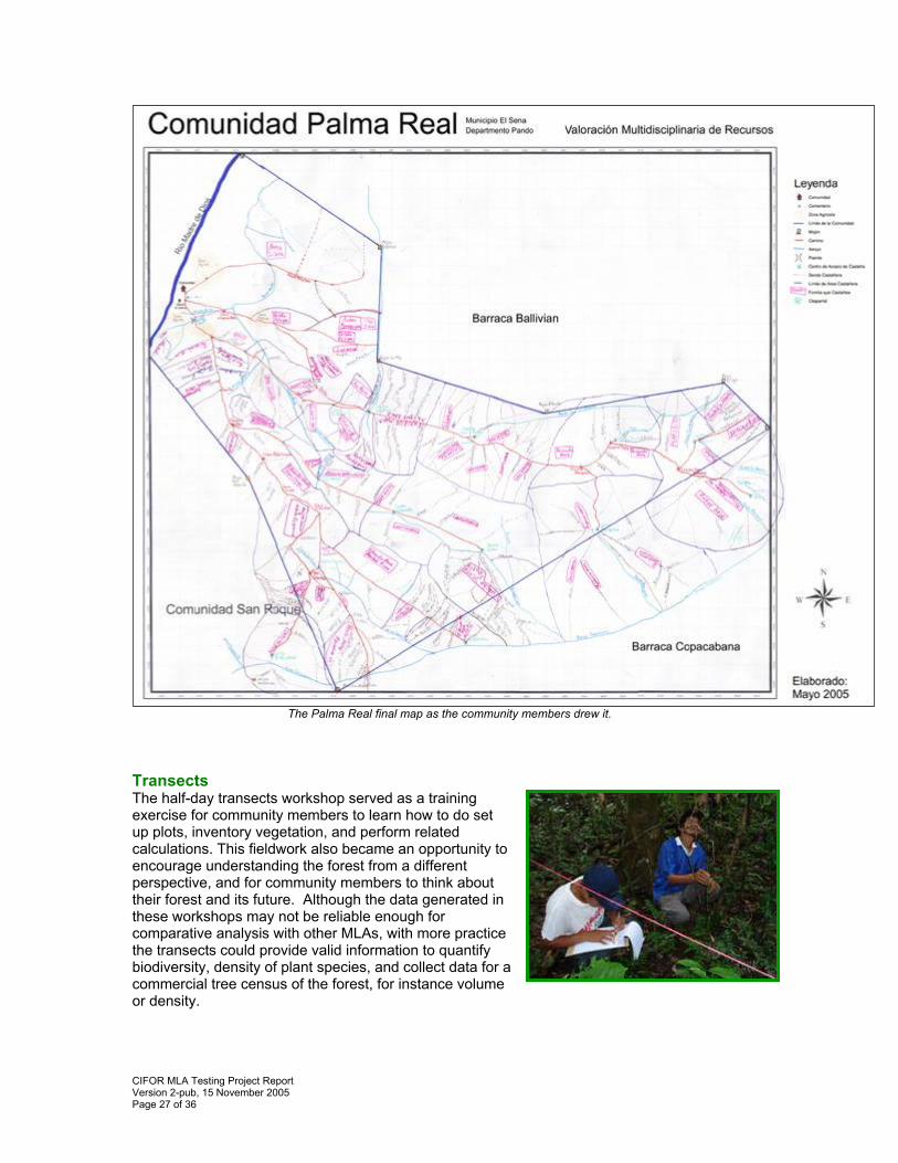
The Palma Real final map as the community members drew it.
Transects The half-day transects workshop served as a training exercise for community members to learn how to do set up plots, inventory vegetation, and perform related calculations. This fieldwork also became an opportunity to encourage understanding the forest from a different perspective, and for community members to think about their forest and its future. Although the data generated in these workshops may not be reliable enough for comparative analysis with other MLAs, with more practice the transects could provide valid information to quantify biodiversity, density of plant species, and collect data for a commercial tree census of the forest, for instance volume or density.
CIFOR MLA Testing Project Report Version 2-pub, 15 November 2005 Page 28 of 36
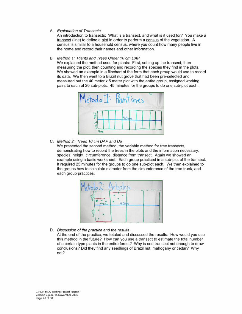
A. Explanation of Transects An introduction to transects: What is a transect, and what is it used for? You make a transect (line) to define a plot in order to perform a census of the vegetation. A census is similar to a household census, where you count how many people live in the home and record their names and other information.
B. Method 1: Plants and Trees Under 10 cm DAP We explained the method used for plants: First, setting up the transect, then measuring the plot, then counting and recording the species they find in the plots. We showed an example in a flipchart of the form that each group would use to record its data. We then went to a Brazil nut grove that had been pre-selected and measured out the 40 meter x 5 meter plot with the entire group, assigned working pairs to each of 20 sub-plots. 45 minutes for the groups to do one sub-plot each.
C. Method 2: Trees 10 cm DAP and Up We presented the second method, the variable method for tree transects, demonstrating how to record the trees in the plots and the information necessary: species, height, circumference, distance from transect. Again we showed an example using a basic worksheet. Each group practiced in a sub-plot of the transect. It required 25 minutes for the groups to do one sub-plot each. We then explained to the groups how to calculate diameter from the circumference of the tree trunk, and each group practices.
D. Discussion of the practice and the results At the end of the practice, we totaled and discussed the results: How would you use this method in the future? How can you use a transect to estimate the total number of a certain type plants in the entire forest? Why is one transect not enough to draw conclusions? Did they find any seedlings of Brazil nut, mahogany or cedar? Why not?
CIFOR MLA Testing Project Report Version 2-pub, 15 November 2005 Page 29 of 36
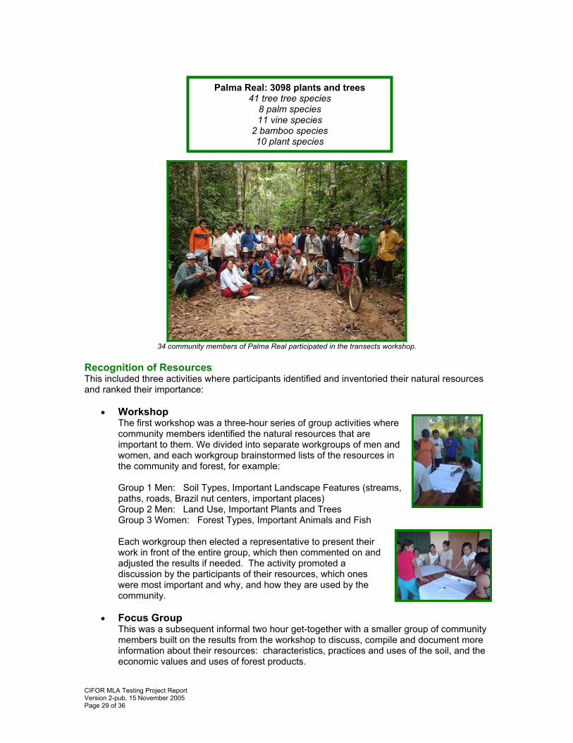
34 community members of Palma Real participated in the transects workshop.
Recognition of Resources This included three activities where participants identified and inventoried their natural resources and ranked their importance:
• Workshop The first workshop was a three-hour series of group activities where community members identified the natural resources that are important to them. We divided into separate workgroups of men and women, and each workgroup brainstormed lists of the resources in the community and forest, for example:
Group 1 Men: Soil Types, Important Landscape Features (streams, paths, roads, Brazil nut centers, important places) Group 2 Men: Land Use, Important Plants and Trees Group 3 Women: Forest Types, Important Animals and Fish
Each workgroup then elected a representative to present their work in front of the entire group, which then commented on and adjusted the results if needed. The activity promoted a discussion by the participants of their resources, which ones were most important and why, and how they are used by the community.
• Focus Group
This was a subsequent informal two hour get-together with a smaller group of community members built on the results from the workshop to discuss, compile and document more information about their resources: characteristics, practices and uses of the soil, and the economic values and uses of forest products.
Palma Real: 3098 plants and trees 41 tree tree species
8 palm species 11 vine species
2 bamboo species 10 plant species
CIFOR MLA Testing Project Report Version 2-pub, 15 November 2005 Page 30 of 36
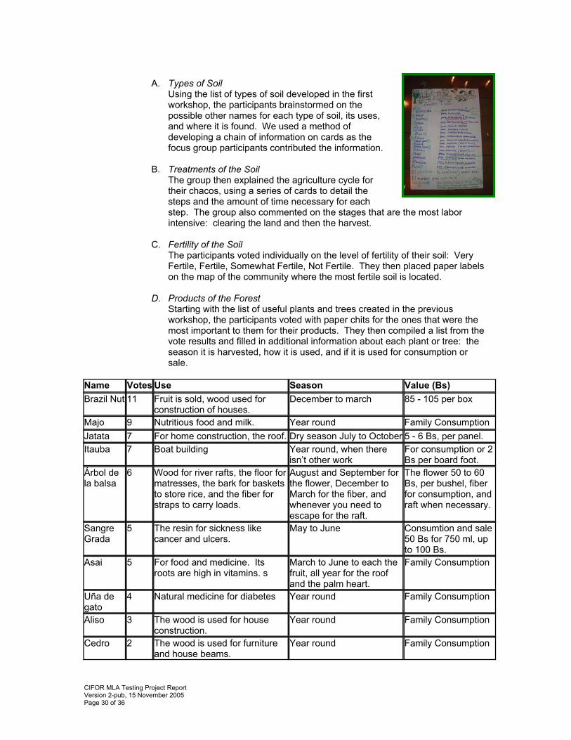
A. Types of Soil
Using the list of types of soil developed in the first workshop, the participants brainstormed on the possible other names for each type of soil, its uses, and where it is found. We used a method of developing a chain of information on cards as the focus group participants contributed the information.
B. Treatments of the Soil The group then explained the agriculture cycle for their chacos, using a series of cards to detail the steps and the amount of time necessary for each step. The group also commented on the stages that are the most labor intensive: clearing the land and then the harvest.
C. Fertility of the Soil The participants voted individually on the level of fertility of their soil: Very Fertile, Fertile, Somewhat Fertile, Not Fertile. They then placed paper labels on the map of the community where the most fertile soil is located.
D. Products of the Forest Starting with the list of useful plants and trees created in the previous workshop, the participants voted with paper chits for the ones that were the most important to them for their products. They then compiled a list from the vote results and filled in additional information about each plant or tree: the season it is harvested, how it is used, and if it is used for consumption or sale.
Name Votes Use Season Value (Bs) Brazil Nut 11 Fruit is sold, wood used for
construction of houses. December to march 85 - 105 per box
Majo 9 Nutritious food and milk. Year round Family Consumption Jatata 7 For home construction, the roof. Dry season July to October 5 - 6 Bs, per panel. Itauba 7 Boat building Year round, when there
isn’t other work For consumption or 2 Bs per board foot.
Árbol de la balsa
6 Wood for river rafts, the floor for matresses, the bark for baskets to store rice, and the fiber for straps to carry loads.
August and September for the flower, December to March for the fiber, and whenever you need to escape for the raft.
The flower 50 to 60 Bs, per bushel, fiber for consumption, and raft when necessary.
Sangre Grada
5 The resin for sickness like cancer and ulcers.
May to June Consumtion and sale 50 Bs for 750 ml, up to 100 Bs.
Asai 5 For food and medicine. Its roots are high in vitamins. s
March to June to each the fruit, all year for the roof and the palm heart.
Family Consumption
Uña de gato
4 Natural medicine for diabetes Year round Family Consumption
Aliso 3 The wood is used for house construction.
Year round Family Consumption
Cedro 2 The wood is used for furniture and house beams.
Year round Family Consumption
CIFOR MLA Testing Project Report Version 2-pub, 15 November 2005 Page 31 of 36
Cusi 1 The leaf for roof thatch. Dry season Family Consumption Tajibo 2 The wood can be sold or used
in home construction. Year round Family Consumption
Sucuva 1 Medicine to cure malaria. Year round Family Consumption Copaibo 1 Its oil is a medicine to cure
colds and apply to wounds. Dry season 30 Bs. for 750ml.
Tumi 1 Construction of homes, beams, boats, and furniture.
Year round Family Consumption
Chamairo 1 Medicine for stomach ache, diarrhea and for making coca bola.
Year round 60 Bs. Per bushel
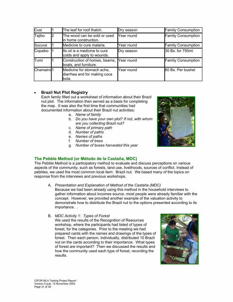
• Brazil Nut Plot Registry
Each family filled out a worksheet of information about their Brazil nut plot. The information then served as a basis for completing the map. It was also the first time that communities had documented information about their Brazil nut activities:
a. Name of family b. Do you have your own plot? If not, with whom
are you collecting Brazil nut? c. Name of primary path d. Number of paths e. Names of paths f. Number of trees g. Number of boxes harvested this year
The Pebble Method (or Método de la Castaña, MDC) The Pebble Method is a participatory method to evaluate and discuss perceptions on various aspects of the community, such as forests, land use, livelihoods, sources of conflict. Instead of pebbles, we used the most common local item: Brazil nut. We based many of the topics on response from the interviews and previous workshops.
A. Presentation and Explanation of Method of the Castaña (MDC) Because we had been already using this method in the household interviews to gather information about incomes source, most people were already familiar with the concept. However, we provided another example of the valuation activity to demonstrate how to distribute the Brazil nut to the options presented according to its importance. .
B. MDC Activity 1: Types of Forest We used the results of the Recognition of Resources workshop, where the participants had listed of types of forest, for the categories. Prior to the meeting we had prepared cards with the names and drawings of the types of forest. Then each person, individually, distributed 10 Brazil nut on the cards according to their importance: What types of forest are important? Then we discussed the results and how the community used each type of forest, recording the results.
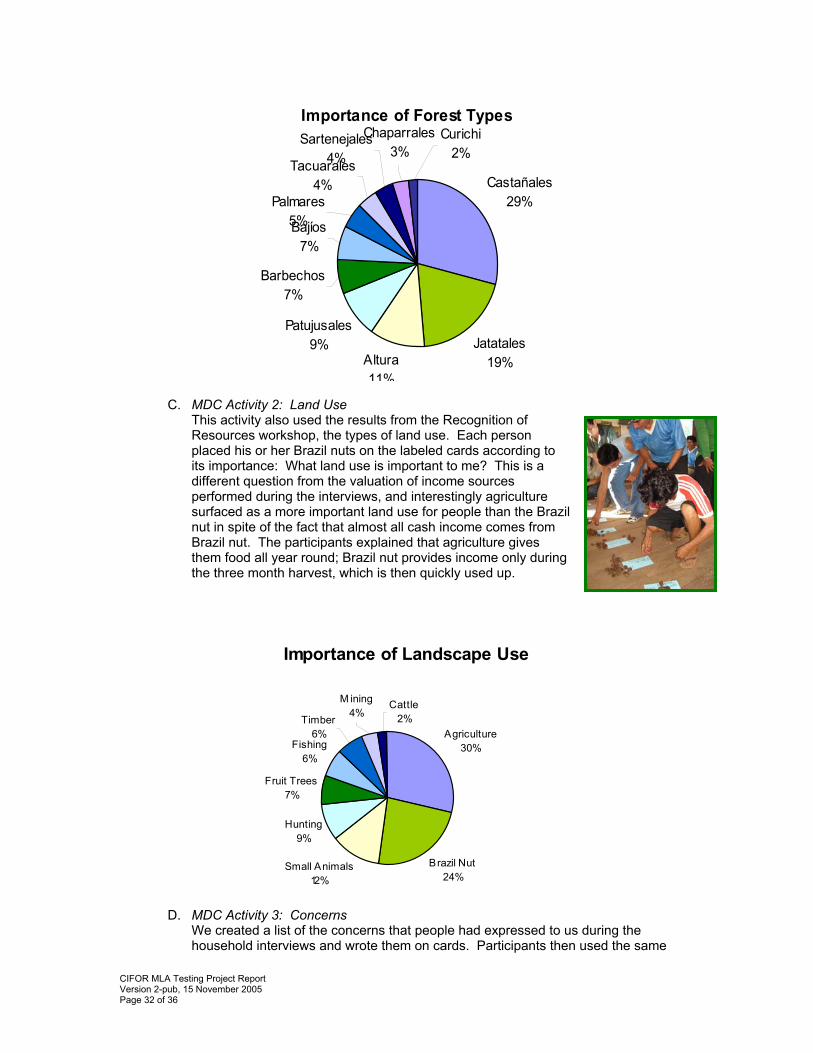
CIFOR MLA Testing Project Report Version 2-pub, 15 November 2005 Page 32 of 36
Importance of Forest Types
Castañales29%
Jatatales19%Altura
11%
Patujusales9%
Barbechos7%
Bajíos7%
Curichi2%
Chaparrales3%
Sartenejales4%Tacuarales
4%Palmares
5%
C. MDC Activity 2: Land Use This activity also used the results from the Recognition of Resources workshop, the types of land use. Each person placed his or her Brazil nuts on the labeled cards according to its importance: What land use is important to me? This is a different question from the valuation of income sources performed during the interviews, and interestingly agriculture surfaced as a more important land use for people than the Brazil nut in spite of the fact that almost all cash income comes from Brazil nut. The participants explained that agriculture gives them food all year round; Brazil nut provides income only during the three month harvest, which is then quickly used up.
Importance of Landscape Use
Fishing6%
Fruit Trees7%
Hunting9%
Timber6%
M ining4%
Cattle2%
Agriculture30%
Brazil Nut24%
Small Animals12%
D. MDC Activity 3: Concerns
We created a list of the concerns that people had expressed to us during the household interviews and wrote them on cards. Participants then used the same
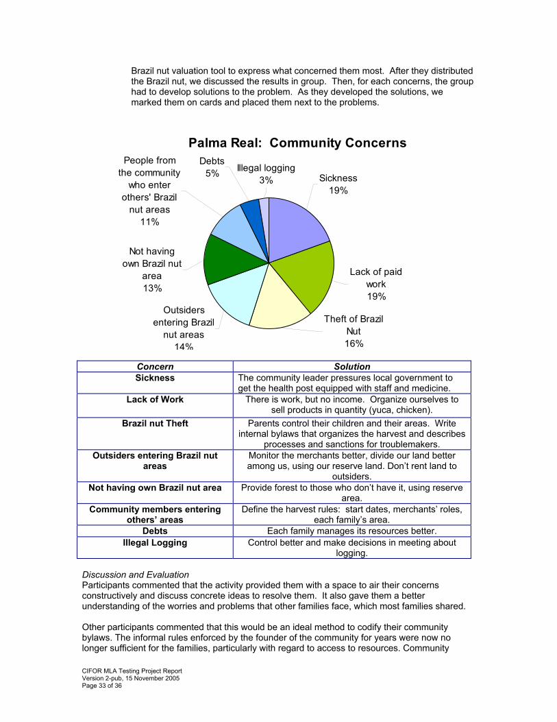
CIFOR MLA Testing Project Report Version 2-pub, 15 November 2005 Page 33 of 36
Brazil nut valuation tool to express what concerned them most. After they distributed the Brazil nut, we discussed the results in group. Then, for each concerns, the group had to develop solutions to the problem. As they developed the solutions, we marked them on cards and placed them next to the problems.
Palma Real: Community Concerns
Illegal logging3%
Debts5%
People from the community
who enter others' Brazil
nut areas11%
Not having own Brazil nut
area13%
Outsiders entering Brazil
nut areas14%
Theft of Brazil Nut16%
Lack of paid work19%
Sickness19%
Concern Solution Sickness The community leader pressures local government to
get the health post equipped with staff and medicine. Lack of Work There is work, but no income. Organize ourselves to
sell products in quantity (yuca, chicken). Brazil nut Theft Parents control their children and their areas. Write
internal bylaws that organizes the harvest and describes processes and sanctions for troublemakers.
Outsiders entering Brazil nut areas
Monitor the merchants better, divide our land better among us, using our reserve land. Don’t rent land to
outsiders. Not having own Brazil nut area Provide forest to those who don’t have it, using reserve
area. Community members entering
others’ areas Define the harvest rules: start dates, merchants’ roles,
each family’s area. Debts Each family manages its resources better.
Illegal Logging Control better and make decisions in meeting about logging.
Discussion and Evaluation Participants commented that the activity provided them with a space to air their concerns constructively and discuss concrete ideas to resolve them. It also gave them a better understanding of the worries and problems that other families face, which most families shared. Other participants commented that this would be an ideal method to codify their community bylaws. The informal rules enforced by the founder of the community for years were now no longer sufficient for the families, particularly with regard to access to resources. Community
CIFOR MLA Testing Project Report Version 2-pub, 15 November 2005 Page 34 of 36
members had frequently voiced their frustrations with the lack of written rules and the need to document community bylaws in order to clarify and enforce them more equitably. Household Interviews Throughout the week we visited each family for unstructured interviews, informal chats to collect information about their perspectives on the forest, their future, economic activities, community organization, and concerns. We also conducted interviews with community leaders to record information on the history of the community. The interviews were useful in understanding the reality and context of the community and the social dynamics among the families, and the visits motivated the participation of all of the community members. Much of the information that we gathered during these informal encounters would not have been shared in a group environment.
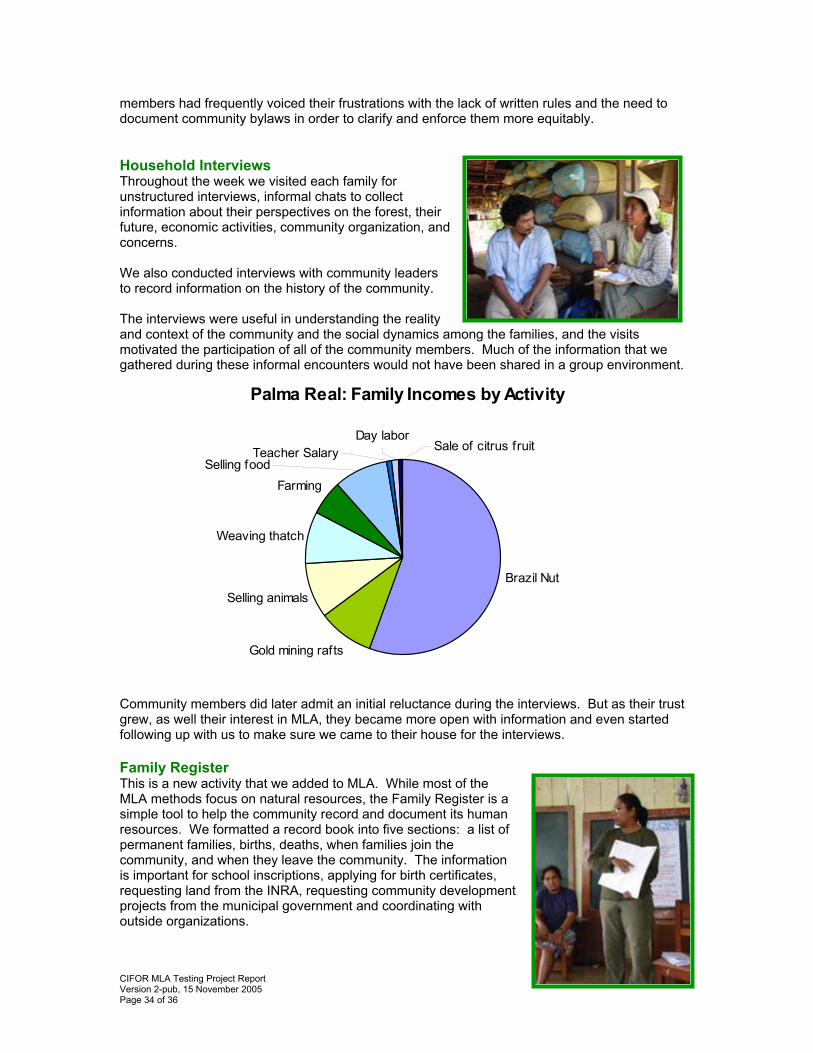
Palma Real: Family Incomes by Activity
Farming
Weaving thatch
Selling animals
Gold mining rafts
Brazil Nut
Sale of citrus fruitDay labor
Selling food Teacher Salary
Community members did later admit an initial reluctance during the interviews. But as their trust grew, as well their interest in MLA, they became more open with information and even started following up with us to make sure we came to their house for the interviews. Family Register This is a new activity that we added to MLA. While most of the MLA methods focus on natural resources, the Family Register is a simple tool to help the community record and document its human resources. We formatted a record book into five sections: a list of permanent families, births, deaths, when families join the community, and when they leave the community. The information is important for school inscriptions, applying for birth certificates, requesting land from the INRA, requesting community development projects from the municipal government and coordinating with outside organizations.
CIFOR MLA Testing Project Report Version 2-pub, 15 November 2005 Page 35 of 36
The community designated a representative to complete the book and keep the entries current. This community member was also responsible for bringing the Family Register to official events when such documentation and information was needed.
III. References Bojanic Helbingen, A.J. (2001). Balance is beautiful: Assessing sustainable development in the rain forests of the Bolivian Amazon. (PhD thesis Utrecht University). PROMAB Scientific Series 4. Utrecht: PROMAB. Fuentes, D., Haches, R. Maldonado R. Albornoz, M., Cronkleton, P., de Jong, W. Becker, M. 2005. Pobreza, descentralización y bosques en el norte amazonico boliviano. Center for Internacional Forestry Research, Santa Cruz, Bolivia. Henkemans, A.B. (2001). Tranquilidad and hardship in the forest. Livelihoods and perceptions of Camba forest dwellers in the northern Bolivian Amazon. (PhD thesis Utrecht University). PROMAB Scientific Series 5. Utrecht: PROMAB. Sheil, D. , R. K. Puri, I. Basuki, M. van Heist, Syaefuddin, Rukmiyati, M.A. Agung Sardjono, I. Samsoedin, K. Sidiyasa, Chrisandini, E. Permana, E. Mangopo Angi, F. Gatzweiler, B. Johnson & A. Wijaya (2002). Exploring biological diversity, environment and local people's perspectives in forest landscapes. Methods for a multidisciplinary landscape assessment. CIFOR, Bogor, Indonesia. Sheil, D. & Lawrence, A. (2004). Tropical biologists, local people and conservation: new opportunities for collaboration. In: Trends in Ecology and Evolution, 19:634-638. Sheil, D., N. Liswanti, M. van Heist, I. Basuki, et al. (2003). Local priorities and biodiversity in tropical forest landscapes: asking people what matters . Tropical Forest Update Vol.13 nr. 1, Yokohama, Japan. Stoian, Dietmar and Arienne B. Henkemans. Between Extractivism and Peasant Agriculture: Differentiation of Rural Settlements in the Bolivian Amazon. International Tree Crops Journal, 2000, Volume 10, pp 299-319. http://www.cifor.cgiar.org/mla/_ref/publication/luz_de_america.htm Zapata, D.M.O., González, L.A., Larrea, J.F., González, B., Silva, E., Arellanos, A., Meo, S. and Jong, W. de (2003). Luz de América: Comunidad y Biodiversidad Amazónica. CIFOR, Bogor, Indonesia.
CIFOR MLA Testing Project Report Version 2-pub, 15 November 2005 Page 36 of 36
IV. Press Release distributed prior to the Presentations in Santa
Cruz, La Paz and Riberalta El Centro de Investigación Forestal Internacional (CIFOR) realizará una serie de presentaciones para dar a conocer los resultados de sus métodos participativos en comunidades forestales de la Amazonía boliviana. Dichas presentaciones tendrán lugar el día miércoles 13 de julio en la ciudad de Santa Cruz (Hotel Cortéz, 10 am -12 pm), el jueves el 14 de julio en La Paz (Hotel Presidente, 10 am -12 pm) y en Riberalta en el Centro Japonés, el lunes 19 de julio de 10 am a 12 pm. Las ponencias tratarán sobre la adaptación e impactos de dos métodos en comunidades extractivistas de Pando, parte de un proyecto de investigación financiado por la Agencia Suiza para la Cooperación y el Desarrollo (COSUDE). Los métodos fueron aplicados en varias comunidades que dependen de la recolección de la castaña, tienen la particularidad de ser relativamente nuevas y encontrarse en proceso de solicitar sus territorios por lo que enfrentan desafíos organizativos y en el manejo de sus recursos. Ambos métodos tienen una visión única: El método de Valoración Multidisciplinaria de Recursos permite un levantamiento de información amplia sobre los recursos naturales y territoriales ya que utiliza una serie de herramientas que conlleva a la participación plena y activa de la comunidad. Esta información resulta clave en la gestión de la normatividad interna, el uso de recursos y la distribución territorial. Es un método rápido y económico donde la gente de las comunidades se apropia del proceso para elaborar un mapa territorial basado en información GIS (Sistema de Información Geográfica), transectos de vegetación, un registro familiar, y valoración e identificación de especies importantes del bosque. El método de Escenarios del Futuro facilita el desarrollo organizativo a través de un proceso participativo donde se identifican necesidades y deseos para la toma de decisiones y planificación para el futuro. En este momento, el municipio El Sena en la provincia Madre de Dios del departamento de Pando está utilizando este método como parte del proceso de planificación participativa en el contexto de elaboración de su plan de desarrollo municipal. El Dr. Peter Cronkleton, coordinador de CIFOR Bolivia, invita a las instituciones y ONGs de los ámbitos de desarrollo comunitario, forestaría comunitaria, y conservación a participar en los eventos que se realizarán en las ciudades antes mencionadas. Las presentaciones estarán a cargo de las investigadoras Patricia Miranda, socióloga, y Kristen Evans, bióloga.
El Centro Internacional para la Investigación Forestal es una institución internacional que realiza investigaciones en diferentes países del mundo para mejorar la calidad de vida de la gente que depende de los bosques y para conservar los bosques tropicales. El centro es miembro del Grupo Consultivo para la Investigación Agrícola Internacional (CGIAR por sus siglas en inglés) y su sede en Bolivia está en la ciudad Santa Cruz mientras que la sede principal en Bogor, Indonesia.
Para mayor información, sírvase contactar a Kristen Evans y Fabiola Roca al teléfono 03-348-0766.