ego (european) everyone’s gliding observatories action es0904 start date: 15/07/2010 end date:...
TRANSCRIPT
EGO(European) Everyone’s Gliding Observatories
Action ES0904Start date: 15/07/2010End date: 14/07/2014Year: 4
Pierre TestorChair
LOCEAN-CNRS / France
The Economist, 2012/06/09

22
worldwide efforts in the context of climate change
• Role of the ocean in climate: the ocean is a “buffer” of atmospheric global change and transports heat from the tropics to the poles monitoring
• worldwide efforts for the global ocean observation (physical and biogeochemical): satellites and in-situ
• Data + numerical modeling : analyses and forecast of the ocean (FP7 MyOcean) → science AND societal needs (climate, … marine resources, security)

Courtesy of H. Freeland,
• in-situ system today : profiles T & S on [0-2000m] • automatic measurements, transmitted in real-time• « 300km x 300km – 10 days »
Global numerical models (~6 km res.)
MyOcean
http://www.argo.net
Climate Research and the Global Ocean Observation System (GOOS)

44
Gliders = new platforms and sampling capabilities
Data Center
Land Station
1km
Measure: - currents (averaged over the
dives)- physical/biogeochemical
properties
Steerable, can be deployed by numbers.
Scientific community, operational
models
U ~ 20-40 km/dayEndurance: ~2-11 months
~2-5 km between surfacing

55
Scientific context and objectives (1/2)• Background / Problem statement: [What is the scientific context and what
challenges are the Action addressing?] The ocean interior is still under sampled. The glider technology can help fill the gaps left by the other observing systems (ships, satellites, moorings, floats, drifters). Testor et al, 2010.
• Brief reminder of MoU objectives: [What are the Action’s objectives?] The main objective is the European coordination of ongoing research using gliders, and the conception of future research.
The aim is to build the capacity to operate fleets of autonomous underwater gliders at the international level, providing cost-effective methods for the discovery and monitoring of the ocean at global, regional and coastal scales, for the benefit of both marine research and operational applications for marine activities
- climate - «green» objectives - security - end-users (GEO,GMES, MSFD…)
Scale
inter
actio
n
s
Global scale
mesoscale
submesoscale
Oceanic Processes
seasonal
Regional scale

66
Scientific context and objectives (1/2)• Background / Problem statement: [What is the scientific context and what
challenges are the Action addressing?] The ocean interior is still under sampled. The glider technology can help fill the gaps left by the other observing systems (ships, satellites, moorings, floats, drifters). Testor et al, 2010.
• Brief reminder of MoU objectives: [What are the Action’s objectives?] The main objective is the European coordination of ongoing research using gliders, and the conception of future research. The aim is to operate fleets of autonomous underwater gliders at the international level, providing cost-effective methods for the discovery and monitoring of the ocean at global, regional and coastal scales, for the benefit of both marine research and operational applications for marine activities
Satellite image sea color - surface Chl
mesoscale (10-100 km)
submesoscale (1-10 km)
300km
Vertical structure?!?

149
1816
9
2
6
77
Scientific context and objectives (2/2)• Research directions:• [How are the objectives of the MoU being achieved? Recall briefly the approach and methodology
as stated in the MoU.]
1. build a capacity at the scientific, technological, and organizational levels through a tight network of laboratories/institutions,
2. strengthen the interdisciplinary research environment, make researchers and engineers in marine sciences, as well as those interested in robotics work together around glider operations, sensors, data analysis.• [Highlight the Action’s innovative work—what is its unique contribution that is not
duplicated elsewhere?]
New technology, attempt to avoid early fragmentation of the activity. Development of the concept of a glider research infrastructure
1) having a global range (distributed network of ‘gliderports’, common tools/procedures, formats) and 2) developing synergies with the other ocean observing systems (ships, profiling floats, moorings…)
~80 EU gliders + ~20 teams (and downstream infrastructures)

88
Working groups1. Support for glider deployments and data dissemination data flow and
management - international infrastructure (steering team, technical coordinators, etc) to develop the community consensus. Legal framework.
2. Glider vehicle, sensors, and “gliderports” infrastructures possible technical developments on platforms and sensors (physical, bio-optical, acoustics, video). Best performances (calibration, consumption,…). Main gliderports design/networking (infrastructure for preparation, maintenance and evolution, logistics, computing facilities). Development of a network of worldwide local supports or “secondary” gliderports. Training support activity.
3. Piloting gliders and artificial intelligence “24/7” control of the gliders. Develop easy and ergonomic access to piloting facilities, auto-pilot systems, flight control systems, automated fault diagnosis and environment information systems. Interactions between distributed services. Interoperability of the different glider types.
4. Networks, links with the other observing systems and OSSEs “how gliders can be optimally combined with other observing systems” can be answered by using Observing System Simulation Experiments and “network design” methodologies which can assess the feasibility and optimality of possible configurations.
5. High resolution 4D oceanic measurements and process studies 4D oceanic estimates with fleets and repeat-sections for large scale or regional budgets. Investigation of mesoscale and submesoscale processes, using for instance adaptive sampling techniques (WG3). and numerical simulations (WG4). Detailed post processing of scientific data.

99
YR 1 YR 2 YR 3 YR 4
8
0
15
1
16
3
16
30
5
10
15
20
Parties Non-COST Countries
Grant Holder:
OC-UCY (Oceanography Center - University of Cyprus)
Gregory Konnaris
Cyprus
Action PartiesAction Parties
1010
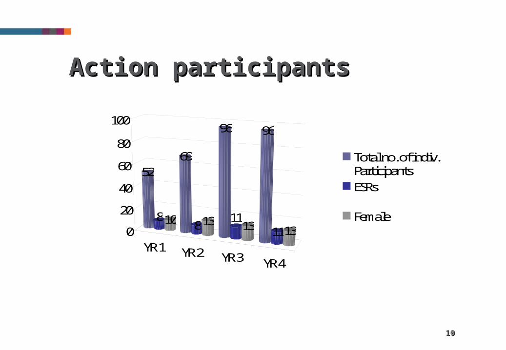
YR 1 YR 2 YR 3 YR 4
52
810
69
813
96
1113
96
11130
20
40
60
80
100
Total no. of indiv.ParticipantsESRs
Female
Action participantsAction participants

1111
Use of COST Instruments
Activity (No.) Year 1 Year 2 Year 3 Year 4
MC/WG Meetings 1 5 6 3
STSMs 0 5 9 11 (+3)
Training Schools 0 0 0 0
Workshops or Conferences
1 0 0 (1)
Joint Publications 0 2 0 (1)

1212
Use of COST Instruments• MC/CG/WG meetings:
• 1 MC meeting + WG1 meeting, Trieste, Italy, 03-06/06/2013 (GROOM general assembly)
• 1 WG meetings:
• WG2/5: glider CTD workshop, Geesthacht, germany
EU/international coordination + solve a previously identified issue
• STSMs:
Address specific S/T topics + share know-how and expertise
• Joint publications
will be the final outcome of the Action.

1313
Results vs. Objectives• [progress towards reaching the Action scientific objectives during the past year.]
International coordination (mainly EU, USA, AUS). Strengthening of the EU network. Glider data management. Demonstration of glider capabilities to observe mesocale and submesocale features.
So, this year it mainly concerned WG1, WG2, and WG5. Better understanding of the oceans and building glider capacities:
31 (78 in total) publications + 31(247 in total) communications:
– (sub)mesoscale processes in the ocean, – seasonal cycle; – optimal sampling; – robotic characterization; – Risk assessment– Definition of common formats.
• [added value of networking, i.e. what could not have been achieved without the Action’s research network.]
Our Action has strengthened the glider community in Europe. A distributed infrastructure is being set up. Information circulates. Duplication of efforts is avoided. Dissemination is coordinated. Spin-off of EU and national projects.

1414
Significant Highlights in Science or Networking (1/2): international coordination and data management
• The joint EGO WG1 meeting and GROOM GA in June 2013 (Trieste, Italy) allowed us to continue to interact with our USA and Australian colleagues (mainly).
• The implementation of the EGO gliders into a sustained component of the GOOS, in conjunction with other systems such as the Argo profiling floats, the OceanSites moorings…
• A first common data format was issued in the 3 main poles of glider activity (EU, USA and AUS).
FP7 Design Study: Gliders for Research, Ocean Observation and Management, 19 partners (9 countries)
http://www.groom-fp7.eu

149
1816
9
2
6
A regional approach for the GOOS: ROOS (Regional Ocean Observing System)
~80 EU gliders +
~20 teams (and downstream
infrastructures)
A Research Infrastructure distributed in 6 ROOSes (+global: GOOS)
In connection with: Marine Board, EuroGOOS
and similar EU projects: Jerico, EuroArgo, EuroSites,
Eurofleets, MyOcean, Seadatanet, EMODNET,…
Significant Highlights in Science or Networking (1/2): international coordination and data management
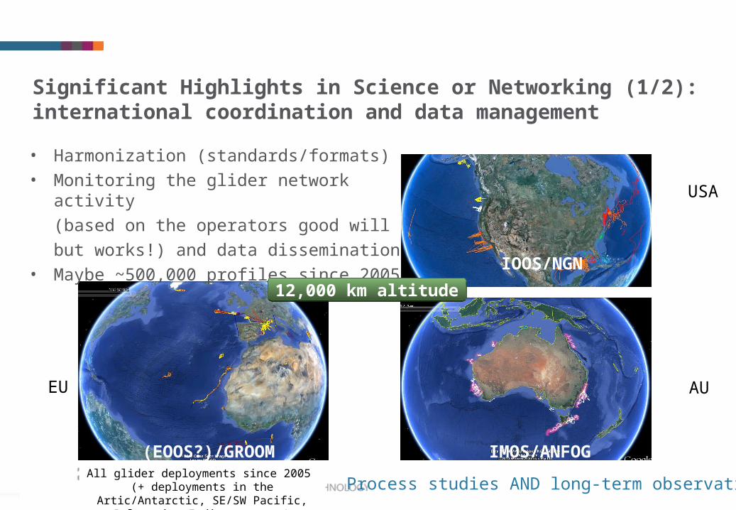
USA
AUEU
• Harmonization (standards/formats)
• Monitoring the glider network activity
(based on the operators good will
but works!) and data dissemination
• Maybe ~500,000 profiles since 2005
All glider deployments since 2005 (+ deployments in the Artic/Antarctic, SE/SW
Pacific, Polynesia, Indian ocean,…)
12,000 km altitude
IOOS/NGN
IMOS/ANFOG(EOOS?)/GROOM
Process studies AND long-term observations
Significant Highlights in Science or Networking (1/2): international coordination and data management

1717
Significant Highlights in Science or Networking (2/2):
Advances in Marine Sciences•[Please see previous instruction slide.]
• There have been significant breakthroughs in particular in the analysis of mesoscale and submesoscale processes in the ocean based on glider data.
0 90 18045 135
Distance (km)
Have a significant influence on the intermediate and deep circulationBosse et al. (2014): Spreading of Levantine Intermediate Water by Submesoscale Coherent Vortices in The Northwestern mediterranean Sea as observed with gliders
Anticyclonic, D~10km, U ~ 10cm/sSeveral months lifetime

1818
Challenges• [Were there any significant deviations from the work
plan in the past year (e.g. new research directions)?]asked for a 1-year extension. Did not work.
• [What are critical phases to be implemented or topics to be addressed for the upcoming months?]– Organize the (anticipated) Final Symposium in June 2014
– Prepare the (anticipated) final outcome of the Action (problem of schedule with GROOM end in Nov 2014)
– Find a way to continue our networking activities. This is clearly vital for our distributed network of gliderports and teams to avoid fragmentation (entropy increases)
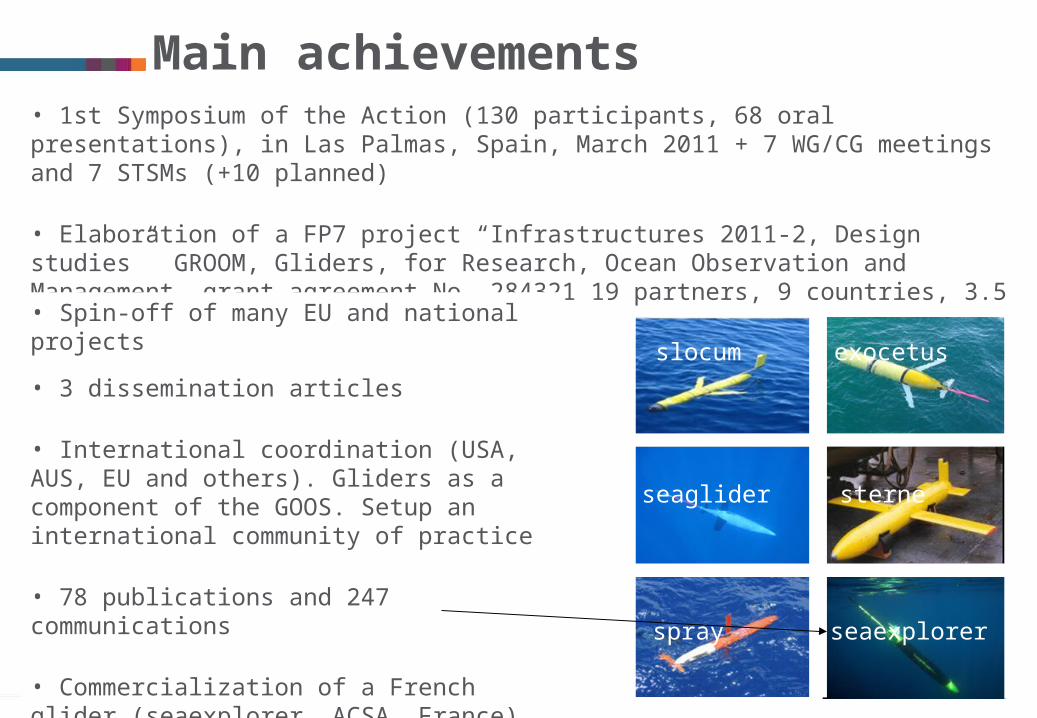
• 1st Symposium of the Action (130 participants, 68 oral presentations), in Las Palmas, Spain, March 2011 + 7 WG/CG meetings and 7 STSMs (+10 planned)
• Elaboration of a FP7 project “Infrastructures 2011-2, Design studies” GROOM, Gliders, for Research, Ocean Observation and Management, grant agreement No. 284321 19 partners, 9 countries, 3.5 MEuro.
slocum exocetus
seaglider
spray
sterne
seaexplorer
• Spin-off of many EU and national projects
• 3 dissemination articles
• International coordination (USA, AUS, EU and others). Gliders as a component of the GOOS. Setup an international community of practice
• 78 publications and 247 communications
• Commercialization of a French glider (seaexplorer, ACSA, France)
• Final symposium to organize and final outcome to write
Main achievements
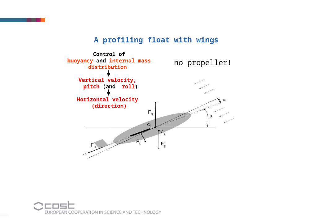
Control ofbuoyancy and internal mass
distribution
Vertical velocity, pitch (and roll)
Horizontal velocity (direction)
no propeller!
A profiling float with wings

Best practice for gliders !
the formation of the global glider system;
the adoption of standards and a “Argo” like data system for gliders;
the setup of a network of shared resources and expertise;
to establish the adoption of a common and accessible portal for glider data.
A glider component in the GOOS
The challenge: bidirectional communications
“main” gliderports
distributed over the world
• Development of Operational Oceanography (EU Seas + adjacent oceans)• Systematic and long-term measurements, rapid interpretation and dissemination