edm height traversing levelling survey report · pdf filetemporary holding marks mar101,...
TRANSCRIPT
Majuro, Marshall Islands, October 2010
N. J. Brown, A. Lal
Record
2012/29
EDM Height Traversing Levelling Survey Report
GeoCat # 73808
APPLYING GEOSCIENCE TO AUSTRALIA’S MOST IMPORTANT CHALLENGES
G E O S C I E N C E A U S T R A L I A


EDM Height Traversing Levelling Survey Report
Majuro, Marshall Islands, October 2010 GEOSCIENCE AUSTRALIA RECORD 2012/29 N. J. Brown1, A. Lal2
1. National Geospatial Reference System, Minerals and Natural Hazards Division, Geoscience Australia GPO Box 378 Canberra
ACT 2601 2. Secretariat of the Pacific Islands Applied Geoscience Commission (SOPAC)

Department of Resources, Energy and Tourism Minister for Resources and Energy: The Hon. Martin Ferguson, AM MP Secretary: Mr Drew Clarke Geoscience Australia Chief Executive Officer: Dr Chris Pigram
© Commonwealth of Australia (Geoscience Australia) 2012 With the exception of the Commonwealth Coat of Arms and where otherwise noted, all material in this publication is provided under a Creative Commons Attribution 3.0 Australia Licence (http://creativecommons.org/licenses/by/3.0/au/) Geoscience Australia has tried to make the information in this product as accurate as possible. However, it does not guarantee that the information is totally accurate or complete. Therefore, you should not solely rely on this information when making a commercial decision. ISSN 1448-2177 ISBN 978-1-922103-05-5 GeoCat # 73808 Bibliographic reference: Brown, N. J. & Lal, A., 2012, EDM Height Traversing Levelling Survey Report: Majuro, Marshall Islands, October 2010. Geoscience Australia, Record 2012/29. 28pp.

EDM Height Traversing Levelling Survey Report: Majuro, Marshall Islands, October 2010
iii
Contents
Introduction...........................................................................................................................................1
The Survey............................................................................................................................................1
Bench Mark Locations..........................................................................................................................2
The Marshall Islands Datum.................................................................................................................2
Equipment.............................................................................................................................................3
Method..................................................................................................................................................3
Survey Support .....................................................................................................................................3
Issues.....................................................................................................................................................4
Comparisons between 2010 and 2009 EDM Surveys...........................................................................5
Combined Comparisons 1993 to 2010..................................................................................................6
Time Series of Bench Mark Movement................................................................................................7
Deep Bench Mark Locality Diagrams ................................................................................................11
Temporary Holding Marks Locality Diagrams...................................................................................18
Reference Mark Locality Diagrams....................................................................................................26
References...........................................................................................................................................30

EDM Height Traversing Levelling Survey Report: Majuro, Marshall Islands, October 2010
iv

EDM Height Traversing Levelling Survey Report: Majuro, Marshall Islands, October 2010
1
Introduction This report outlines the high precision level survey completed between the SEAFRAME tide gauge and continuous GPS station in Majuro, Marshall Islands from 20 – 30 October 2010. Personnel involved in the survey were Nicholas Brown, Project Officer, Geoscience Australia and Andrick Lal, Surveyor, Secretariat of the Pacific Islands Applied Geoscience Commission (SOPAC). The EDM height traversing levelling technique was employed to observe differences in height between the deep bench mark arrays in Majuro, which runs approximately 4 km from the tide gauge sensor to the continuous GPS antenna. Previous levelling surveys using this technique have been conducted along the route using this technique in 2006, 2007 and 2009. In addition, precise differential levelling surveys were performed along the deep bench mark (BM) array from 1993 to 2006 by the National Tidal Centre (NTC). This report contains a comparison between the 2010 and 2009 EDM height traversing results as well as a combined comparison since the first levelling survey in 1993.
The Survey The EDM height traversing levelling survey was carried out between the SEAFRAME tide gauge sensor, continuous GPS station and the deep driven bench marks: MAJUBM – GPS Benchmark MAR 13 - Project plaque at tide gauge MAR 14 - SEAFRAME sensor benchmark MAR 3 - Deep Driven BM MAR 15 - Deep Driven BM MAR 50 - Deep Driven BM MAR 51 - Deep Driven BM MAR 52 - Deep Driven BM MAR 100 - Deep Driven BM MAR 107 - Deep Driven BM All the deep bench marks were located and found in good order and undisturbed, including MAR3 which is located within a shop out the front of Robert Reimers Hotel. Also included in the survey were permanent holding marks MAR25, MAR31, MAR36, MAR40, MAR44, MAR54 and temporary holding marks MAR101, MAR102, MAR103, MAR104, MAR105, MAR106, MAR108, MAR109, MAR110, MAR112, MAR113. The EDM height traversing levelling technique was performed to the Class L2A specifications (ICSM, Standards and Practices for Control Surveys). After reduction an internal precision of 1mm√K or better was achieved (zero order); well within the specifications of the project which is 2√K where K is the distance in kilometres. A table of results and comparisons and the 2010 reduced levels are detailed later in this report.
EDM Height Traversing Levelling Survey Report: Majuro, Marshall Islands, October 2010
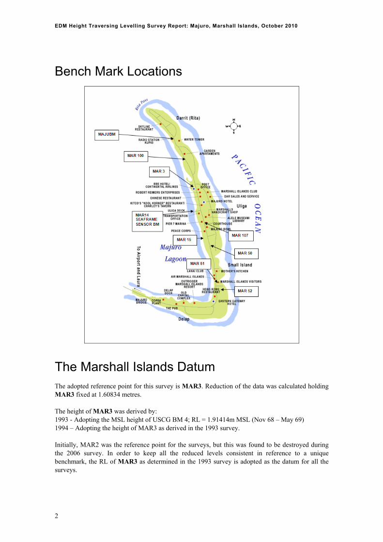
Bench Mark Locations
The Marshall Islands Datum The adopted reference point for this survey is MAR3. Reduction of the data was calculated holding MAR3 fixed at 1.60834 metres. The height of MAR3 was derived by: 1993 - Adopting the MSL height of USCG BM 4; RL = 1.91414m MSL (Nov 68 – May 69) 1994 – Adopting the height of MAR3 as derived in the 1993 survey. Initially, MAR2 was the reference point for the surveys, but this was found to be destroyed during the 2006 survey. In order to keep all the reduced levels consistent in reference to a unique benchmark, the RL of MAR3 as determined in the 1993 survey is adopted as the datum for all the surveys.
2

EDM Height Traversing Levelling Survey Report: Majuro, Marshall Islands, October 2010
Equipment Leica total station model TCA1800 Leica precision prisms GPH1P (2). Leica rigid tripod. Stainless steel target poles supported by Leica telescopic bi-poles (2). Shortened stainless steel target pole for the SEAFRAME sensor BM connection. Leica cast iron change plates (2). Kestral 4000 pocket weather tracker
Method The “Leap-Frog” EDM-height-traversing technique was employed for the Majuro tide gauge levelling survey. The "Leap-Frog" EDM-height-traversing technique involves setting up a total station (TCA1800) midway between two target/reflectors (on reflector rods with struts). The targets remain at a particular change point for the back-sight and fore-sight observations. The instrument measures slope distances (±1mm) and vertical angle (1”) to derive height differences (between the instrument’s trunnion axis and the reflectors). In support of the slope distance observations, the ambient temperature, pressure and humidity are recorded (Kestral 4000 pocket weather tracker) and input into the instrument to apply the first velocity correction to the observed distances (Rüeger & Brunner 1982). Several rounds (four) of observations are taken to the back-sight and fore-sight targets from each instrument setup. All levelling bays started and finished with the same reflector and reflector rod, i.e. an even number of setups when the two reflector rod configuration was used – this eliminates any reflector rod zero error. Results can also be gained with the EDM Height Traversing method by using a single set-up / single rod configuration. This “single set-up / single rod” configuration is particularly useful when levelling between bench marks which are close together e.g. between the CGPS RMs. Reduction of the digital data was computed by the Geoscience Australia levelling program “leveling1.exe”. This program computes the height difference between the two reflectors at any one set-up.
Survey Support The survey team very much appreciated the assistance from Meteorological Office, Survey Department and Marshall Islands National Telecommunications Authority (NTA). Personnel consulted during the visit were:
Mr. Lee Jacklick – Meteorological Office Mr. Reginald White – Meteorological Office Mr. Melvin Aliven – NTA Mr Wase Hackney – Survey Department
Both departments have a keen interest in the SPSLCMP and are always supportive with any associated project matters.
3
EDM Height Traversing Levelling Survey Report: Majuro, Marshall Islands, October 2010
Issues As mentioned in the 2009 report, MAR3 is now inside a building located on the street outside the Robert Reimers Hotel. In the last visit, permission for occupying the benchmark was obtained from the then owner Mr. Rodrigeuz Reimers, (email: [email protected]) to occupy the site. During this visit however, it appears there are new owners of the building and it was in the process of being converted to a supermarket. The Project should probably develop a plan to shift the datum reference point to another site as it seems it will become more and more difficult to access this mark in the coming years. Access to the deep benchmark, MAR15, is also restricted as it is in the Mobile Depot compound; therefore approval to survey the benchmark is necessary from the security gate at the depot. Another concern is that the CGPS monument and the three RM’s inside the NTA facility at Rita are collocated with several TV satellite dishes and care must be taken during the reference mark monitoring survey to ensure clear line of sight. Contact NTA personal for access into the compound and other survey related matters.
4

EDM Height Traversing Levelling Survey Report: Majuro, Marshall Islands, October 2010
5
Comparisons between 2010 and 2009 EDM Surveys
Table 1: Majuro, Marshall Islands 2010 EDM Height Traversing Levelling & Comparison 2010 - 2009. MAR3 - ADOPTED FIXED HEIGHT OF 1.60834 m
FROM TO Levelled Height
Difference
Reduced Level 2010
Misclose (mm)
Distance (km)
1mm√k Reduced
Level 2009
Difference (mm) 2010 - 2009
MAR3 1.6083 1.6083
MAR108 MAR108 0.13373 1.7421 0.09 0.019 0.140 1.7431 -0.98
MAR109 MAR109 0.00649 1.7486 0.34 0.198 0.445 1.7486 -0.03
MAR101 MAR101 0.04114 1.7897 0.01 0.205 0.452 1.7886 1.13
MAR100 MAR100 -0.30591 1.4838 0.43 0.241 0.491 1.4822 1.58
MAR110 MAR110 0.45160 1.9354 0.10 0.208 0.456 1.9357 -0.30
MAR102 MAR102 -0.15294 1.7825 -0.34 0.176 0.419 1.7871 -4.61
MAR112 MAR112 -0.07649 1.7060 0.24 0.234 0.484 1.7078 -1.88
MAJUBM MAJUBM 1.43688 3.1428 -0.04 0.081 0.285 3.1420 0.80
MAJU 0.94442 4.0873 0.03 0.020 0.142 4.0863 0.94
MAR54 1.8894 1.8886 0.84
MAR31 MAR31 -0.08972 1.7997 0.11 0.222 0.471 1.7999 -0.17
MAR108 -0.05763 1.7421 0.25 0.182 0.426 1.7431 -0.98
MAR54 1.8894 1.8886
MAR107 -0.22352 1.6659 0.06 0.056 0.236 1.6649 1.05
MAR54 1.8894 1.8886
MAR13 MAR13 -0.29601 1.5934 -0.08 0.168 0.410 1.5919 1.48
MAR14 0.20014 2.7934 0.03 0.012 0.110 2.7929 0.57
MAR15 1.7453 1.7436
MAR25 MAR25 0.16333 1.9086 0.06 0.031 0.176 1.9077 0.93
MAR103 MAR103 0.08880 1.9974 0.25 0.149 0.385 1.9962 1.20
MAR106 MAR106 -0.06416 1.9333 0.14 0.208 0.456 1.9321 1.21
MAR54 -0.04386 1.8894 -0.36 0.194 0.440 1.8886 0.84
MAR25 1.9086 1.9077 0.93
MAR104 MAR104 0.03674 1.9454 0.32 0.207 0.455 1.9443 1.03
MAR50 MAR50 -0.43384 1.5115 -0.01 0.045 0.212 1.5097 1.78
MAR36 MAR36 0.14954 1.6611 0.10 0.111 0.333 1.6605 0.52
MAR113 MAR113 0.12188 1.7829 -0.09 0.200 0.447 - -
MAR40 MAR40 -0.02343 1.7595 -0.36 0.209 0.457 1.7685 -9.03
MAR105 MAR105 0.07304 1.8326 -0.30 0.197 0.444 1.8321 0.44
MAR51 MAR51 -0.01088 1.8217 -0.29 0.111 0.333 1.8210 0.65
MAR44 MAR44 0.21728 2.0390 -0.29 0.147 0.383 2.0402 -1.21
MAR52 -0.70119 1.3378 0.01 0.187 0.433 1.3373 0.49
Misclose for all bays levelled = 0.40 4.017 2.004
All levelling was performed within the project specifications of 2√k
MAJUBM 3.14284
MAJU 0.94442 4.08727 0.03 0.020 0.142 4.0863 0.94
EDM Height Traversing Levelling Survey Report: Majuro, Marshall Islands, October 2010
MAJUBM
RM1 -1.8148 1.32809 1.3269 1.19
MAJUBM
RM2 -1.9613 1.18154 1.1807 0.84
MAJUBM
RM3 -2.1456 0.99728 0.9964 0.88
Combined Comparisons 1993 to 2010
Table 2: Majuro, Marshall Islands - Comparison of the RL's for Precise Differential Levelling (1992 - 2006) and EDM Height Traversing (2006 - 2010). Units are in metres.
DATUM YEAR MAR2 MAR3 MAR13 MAR14 MAR15 MAR50 MAR51 MAR52 MAJUBM MAJU MAR53 MAR2 1993.38 1.6025 1.6083 1.5923 2.7977 MAR2 1994.46 1.6025 1.6076 1.5925 2.7983 MAR2 1995.54 1.6025 1.6076 1.5919 2.7971 1.7510 MAR2 1996.96 1.6025 1.6069 1.5915 2.7973 1.7498 MAR2 1998.63 1.6025 1.6071 1.5912 2.7965 1.7495 MAR2 2000.30 1.6025 1.6068 1.5907 2.7955 1.7486 MAR2 2001.71 1.6025 1.6069 1.5909 2.7969 1.7483 MAR2 2003.13 1.6025 1.6063 1.5908 2.7911 1.7433 1.5079 1.8211 1.3321 1.4826
MAR3 2006 2006.34 1.6063 1.5909 2.7894 1.7415 1.5076 1.8225 1.3350 1.4858
MAR3 2006 2006.34 1.6063 1.5899 2.7881 1.7415 1.5079 1.8217 1.3332 1.4838
MAR3 2007 2007.79 1.6083 1.5922 2.7936 1.7424 1.5091 1.8186 1.3341 3.1417 4.0860
MAR3 2007 2009.20 1.6083 1.5919 2.7929 1.7436 1.5097 1.8210 1.3373 3.1420 4.0863
MAR3 2007 2010.82 1.6083 1.5934 2.7934 1.7453 1.5115 1.8217 1.3378 3.1428 4.0873
6
EDM Height Traversing Levelling Survey Report: Majuro, Marshall Islands, October 2010
7
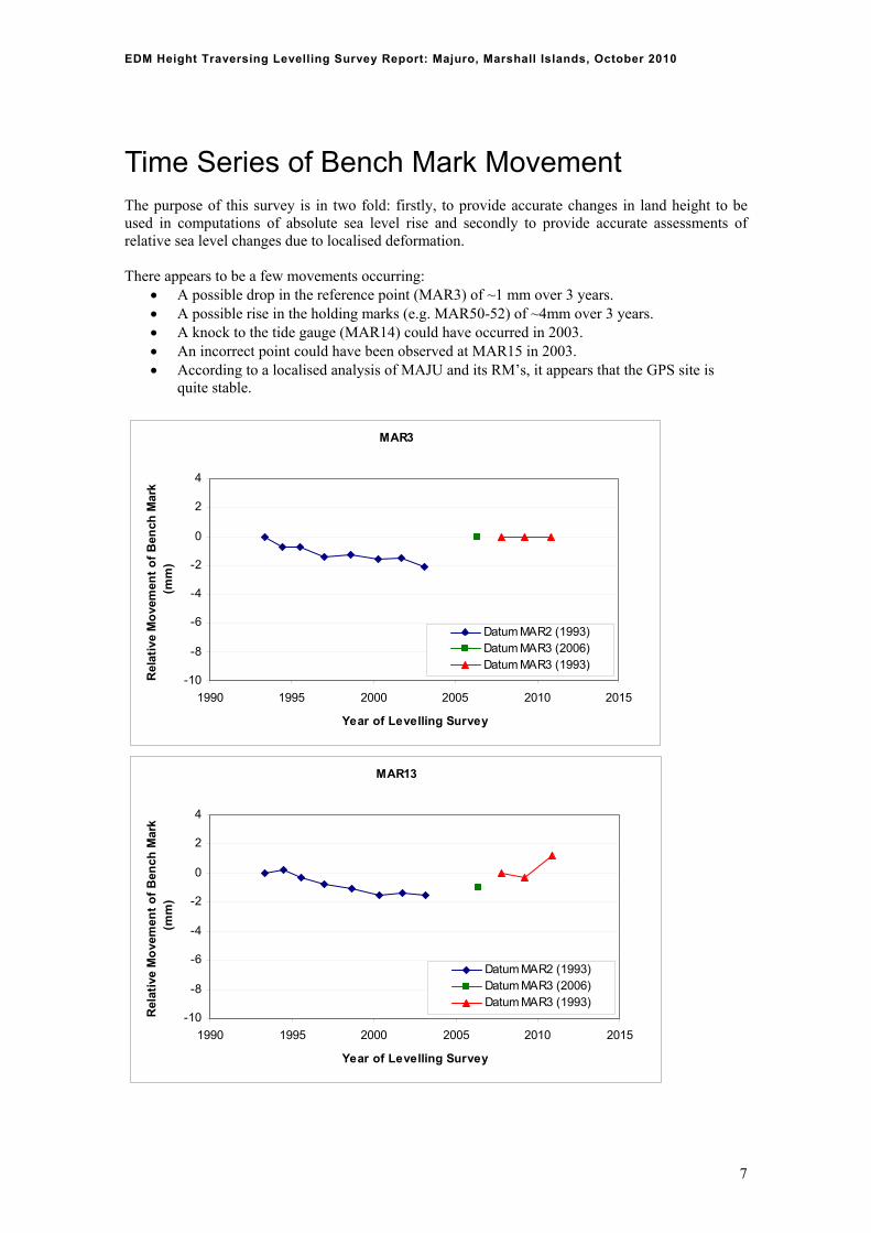
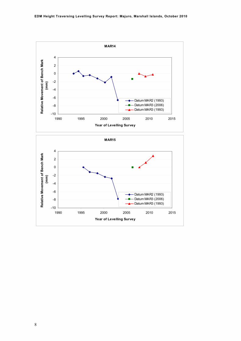
Time Series of Bench Mark Movement The purpose of this survey is in two fold: firstly, to provide accurate changes in land height to be used in computations of absolute sea level rise and secondly to provide accurate assessments of relative sea level changes due to localised deformation. There appears to be a few movements occurring:
A possible drop in the reference point (MAR3) of ~1 mm over 3 years. A possible rise in the holding marks (e.g. MAR50-52) of ~4mm over 3 years. A knock to the tide gauge (MAR14) could have occurred in 2003. An incorrect point could have been observed at MAR15 in 2003. According to a localised analysis of MAJU and its RM’s, it appears that the GPS site is
quite stable.
MAR3
-10
-8
-6
-4
-2
0
2
4
1990 1995 2000 2005 2010 2015
Year of Levelling Survey
Rel
ativ
e M
ove
men
t o
f B
ench
Mar
k (m
m)
Datum MAR2 (1993) Datum MAR3 (2006) Datum MAR3 (1993)
MAR13
-10
-8
-6
-4
-2
0
2
4
1990 1995 2000 2005 2010 2015
Year of Levelling Survey
Rel
ativ
e M
ove
men
t o
f B
ench
Mar
k (m
m)
Datum MAR2 (1993) Datum MAR3 (2006) Datum MAR3 (1993)
EDM Height Traversing Levelling Survey Report: Majuro, Marshall Islands, October 2010
MAR14
-10
-8
-6
-4
-2
0
2
4
1990 1995 2000 2005 2010 2015
Year of Levelling Survey
Rel
ativ
e M
ove
men
t o
f B
ench
Mar
k (m
m)
Datum MAR2 (1993) Datum MAR3 (2006) Datum MAR3 (1993)
MAR15
-10
-8
-6
-4
-2
0
2
4
1990 1995 2000 2005 2010 2015
Year of Levelling Survey
Rel
ativ
e M
ove
men
t o
f B
ench
Mar
k (m
m)
Datum MAR2 (1993) Datum MAR3 (2006) Datum MAR3 (1993)
8

EDM Height Traversing Levelling Survey Report: Majuro, Marshall Islands, October 2010
MAR50
-10
-8
-6
-4
-2
0
2
4
1990 1995 2000 2005 2010 2015
Year of Levelling Survey
Rel
ativ
e M
ove
men
t o
f B
ench
Mar
k (m
m)
Datum MAR2 (1993) Datum MAR3 (2006) Datum MAR3 (1993)
MAR51
-10
-8
-6
-4
-2
0
2
4
1990 1995 2000 2005 2010 2015
Year of Levelling Survey
Rel
ativ
e M
ove
men
t o
f B
ench
Mar
k (m
m)
Datum MAR2 (1993) Datum MAR3 (2006) Datum MAR3 (1993)
9

EDM Height Traversing Levelling Survey Report: Majuro, Marshall Islands, October 2010
MAR52
-10
-8
-6
-4
-2
0
2
4
1990 1995 2000 2005 2010 2015
Year of Levelling Survey
Rel
ativ
e M
ove
men
t o
f B
ench
Mar
k (m
m)
Datum MAR2 (1993) Datum MAR3 (2006) Datum MAR3 (1993)
10

EDM Height Traversing Levelling Survey Report: Majuro, Marshall Islands, October 2010
Deep Bench Mark Locality Diagrams
SOUTH PACIFIC SEA LEVEL &
CLIMATE MONITORING PROJECT
Survey Bench Mark Record
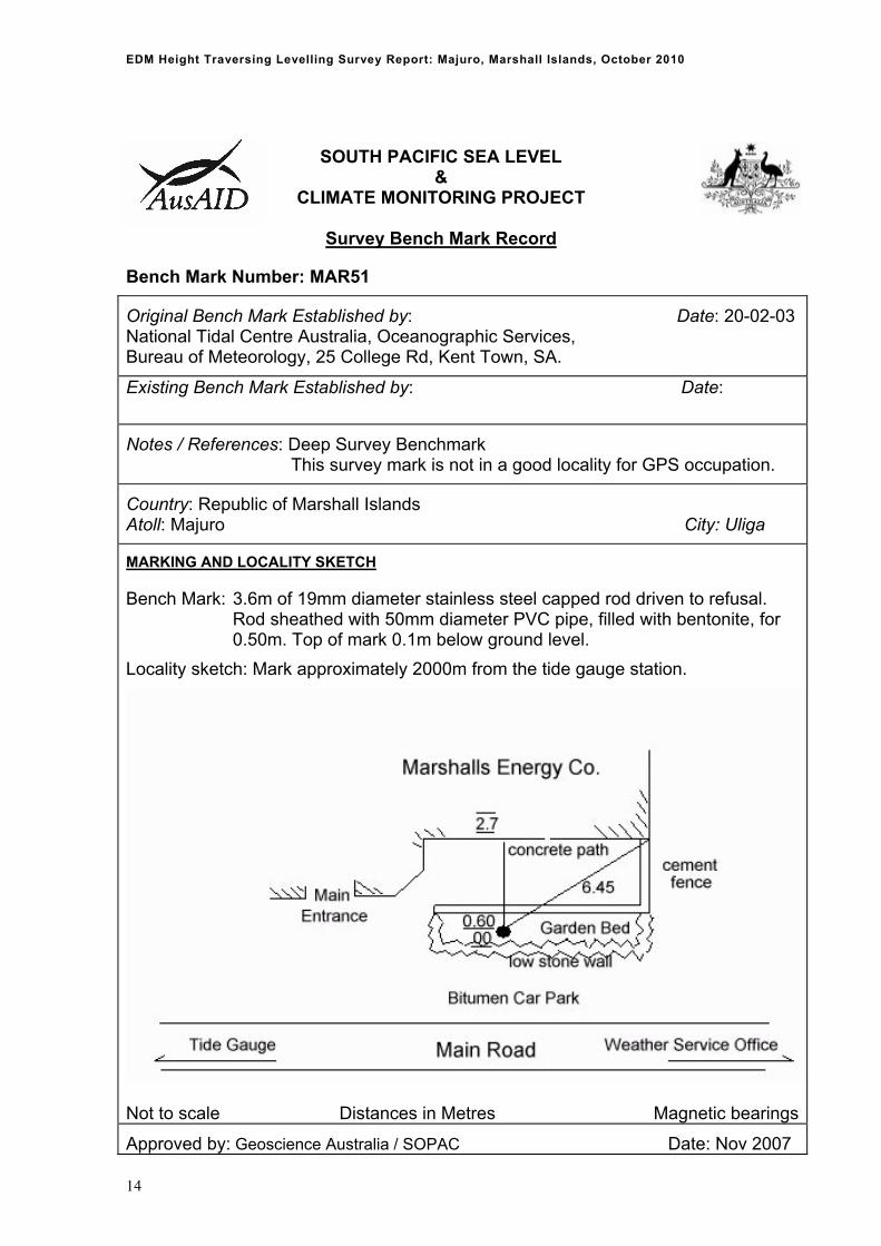
Bench Mark Number: MAR3
Original Bench Mark Established by: Date: 31-01-92 National Tidal Centre Australia, Oceanographic Services, Bureau of Meteorology, 25 College Rd, Kent Town, SA.
Existing Bench Mark Established by: Date:
Notes / References: Deep Survey Benchmark This survey mark is not in a good locality for GPS occupation.
Country: Republic of Marshall Islands Atoll: Majuro City: Uliga
MARKING AND LOCALITY SKETCH
Bench Mark: 2.6m of 19mm diameter stainless steel capped rod driven to refusal. Rod sheathed with 50mm diameter PVC pipe, filled with bentonite, for 1.0m. Top of mark 0.5m below ground level with mark cover exposed.
Locality sketch: Mark approximately 500m from the tide gauge station.
Not to scale Distances in Metres Magnetic bearings
Approved by: Geoscience Australia / SOPAC Date: Nov 2007
11

EDM Height Traversing Levelling Survey Report: Majuro, Marshall Islands, October 2010
SOUTH PACIFIC SEA LEVEL &
CLIMATE MONITORING PROJECT
Survey Bench Mark Record
Bench Mark Number: MAR15
Original Bench Mark Established by: Date: 30-06-95 National Tidal Centre Australia, Oceanographic Services, Bureau of Meteorology, 25 College Rd, Kent Town, SA.
Existing Bench Mark Established by: Date:
Notes / References: Deep Survey Benchmark This survey mark is good for GPS occupation.
Country: Republic of Marshall Islands Atoll: Majuro City: Uliga
MARKING AND LOCALITY SKETCH
Bench Mark: 2.6m of 19mm diameter stainless steel capped rod driven to refusal. Rod sheathed with 50mm diameter PVC pipe, filled with bentonite, for 1.0m. Top of mark 0.2m below ground level.
Locality sketch: Mark approximately 750m from the tide gauge station.
Not to scale Distances in Metres Magnetic bearings
Approved by: Geoscience Australia / SOPAC Date: Nov 2007
MAR15
MAR25
12

EDM Height Traversing Levelling Survey Report: Majuro, Marshall Islands, October 2010
SOUTH PACIFIC SEA LEVEL &
CLIMATE MONITORING PROJECT
Survey Bench Mark Record
Bench Mark Number: MAR50
Original Bench Mark Established by: Date: 20-02-03 National Tidal Centre Australia, Oceanographic Services, Bureau of Meteorology, 25 College Rd, Kent Town, SA.
Existing Bench Mark Established by: Date:
Notes / References: Deep Survey Benchmark This survey mark is not in a good locality for GPS occupation.
Country: Republic of Marshall Islands Atoll: Majuro City: Uliga
MARKING AND LOCALITY SKETCH
Bench Mark: 2.0m of 19mm diameter stainless steel capped rod driven to refusal. Rod sheathed with 50mm diameter PVC pipe, filled with bentonite, for 0.50m. Top of mark 0.1m below ground level.
Locality sketch: Mark approximately 1050m from the tide gauge station.
Not to scale Distances in Metres Magnetic bearings
Approved by: Geoscience Australia / SOPAC Date: Nov 2007
13
EDM Height Traversing Levelling Survey Report: Majuro, Marshall Islands, October 2010
SOUTH PACIFIC SEA LEVEL &
CLIMATE MONITORING PROJECT
Survey Bench Mark Record
Bench Mark Number: MAR51
Original Bench Mark Established by: Date: 20-02-03 National Tidal Centre Australia, Oceanographic Services, Bureau of Meteorology, 25 College Rd, Kent Town, SA.
Existing Bench Mark Established by: Date:
Notes / References: Deep Survey Benchmark This survey mark is not in a good locality for GPS occupation.
Country: Republic of Marshall Islands Atoll: Majuro City: Uliga
MARKING AND LOCALITY SKETCH
Bench Mark: 3.6m of 19mm diameter stainless steel capped rod driven to refusal. Rod sheathed with 50mm diameter PVC pipe, filled with bentonite, for 0.50m. Top of mark 0.1m below ground level.
Locality sketch: Mark approximately 2000m from the tide gauge station.
Not to scale Distances in Metres Magnetic bearings
Approved by: Geoscience Australia / SOPAC Date: Nov 2007
14

EDM Height Traversing Levelling Survey Report: Majuro, Marshall Islands, October 2010
SOUTH PACIFIC SEA LEVEL &
CLIMATE MONITORING PROJECT
Survey Bench Mark Record
Bench Mark Number: MAR52
Original Bench Mark Established by: Date: 20-02-03 National Tidal Centre Australia, Oceanographic Services, Bureau of Meteorology, 25 College Rd, Kent Town, SA.
Existing Bench Mark Established by: Date:
Notes / References: Deep Survey Benchmark This survey mark is not in a good locality for GPS occupation.
Country: Republic of Marshall Islands Atoll: Majuro City: Uliga
MARKING AND LOCALITY SKETCH
Bench Mark: 2.4m of 19mm diameter stainless steel capped rod driven to refusal. Rod sheathed with 50mm diameter PVC pipe, filled with bentonite, for 0.50m. Top of mark 0.3m below ground level.
Locality sketch: Mark approximately 2350m from the tide gauge station.
Not to scale Distances in Metres Magnetic bearingsApproved by: Geoscience Australia / SOPAC Date: Nov 2007
15
EDM Height Traversing Levelling Survey Report: Majuro, Marshall Islands, October 2010
SOUTH PACIFIC SEA LEVEL &
CLIMATE MONITORING PROJECT
Survey Bench Mark Record
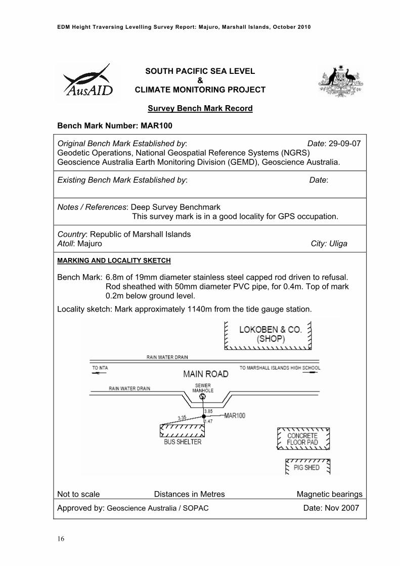
Bench Mark Number: MAR100
Original Bench Mark Established by: Date: 29-09-07 Geodetic Operations, National Geospatial Reference Systems (NGRS) Geoscience Australia Earth Monitoring Division (GEMD), Geoscience Australia.
Existing Bench Mark Established by: Date:
Notes / References: Deep Survey Benchmark This survey mark is in a good locality for GPS occupation.
Country: Republic of Marshall Islands Atoll: Majuro City: Uliga
MARKING AND LOCALITY SKETCH
Bench Mark: 6.8m of 19mm diameter stainless steel capped rod driven to refusal. Rod sheathed with 50mm diameter PVC pipe, for 0.4m. Top of mark 0.2m below ground level.
Locality sketch: Mark approximately 1140m from the tide gauge station.
Not to scale Distances in Metres Magnetic bearings
Approved by: Geoscience Australia / SOPAC Date: Nov 2007
16
EDM Height Traversing Levelling Survey Report: Majuro, Marshall Islands, October 2010
SOUTH PACIFIC SEA LEVEL &
CLIMATE MONITORING PROJECT
Survey Bench Mark Record
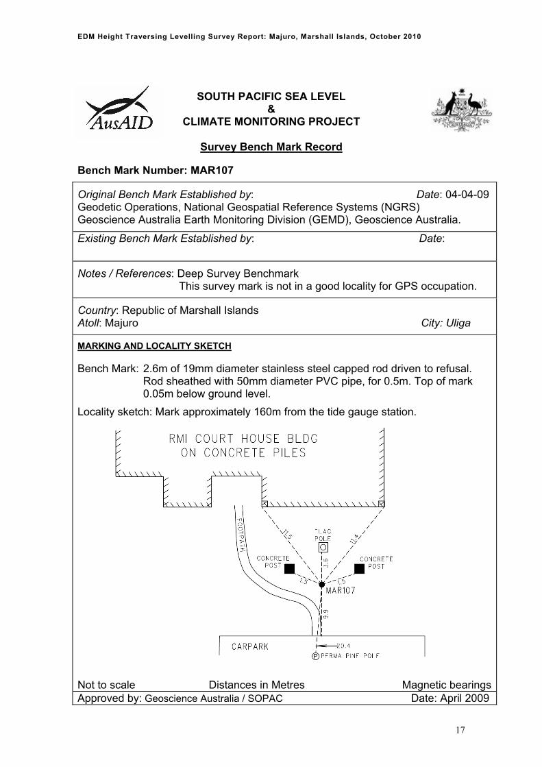
Bench Mark Number: MAR107
Original Bench Mark Established by: Date: 04-04-09 Geodetic Operations, National Geospatial Reference Systems (NGRS) Geoscience Australia Earth Monitoring Division (GEMD), Geoscience Australia.
Existing Bench Mark Established by: Date:
Notes / References: Deep Survey Benchmark This survey mark is not in a good locality for GPS occupation.
Country: Republic of Marshall Islands Atoll: Majuro City: Uliga
MARKING AND LOCALITY SKETCH
Bench Mark: 2.6m of 19mm diameter stainless steel capped rod driven to refusal. Rod sheathed with 50mm diameter PVC pipe, for 0.5m. Top of mark 0.05m below ground level.
Locality sketch: Mark approximately 160m from the tide gauge station.
Not to scale Distances in Metres Magnetic bearingsApproved by: Geoscience Australia / SOPAC Date: April 2009
17
EDM Height Traversing Levelling Survey Report: Majuro, Marshall Islands, October 2010
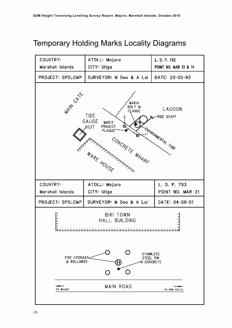
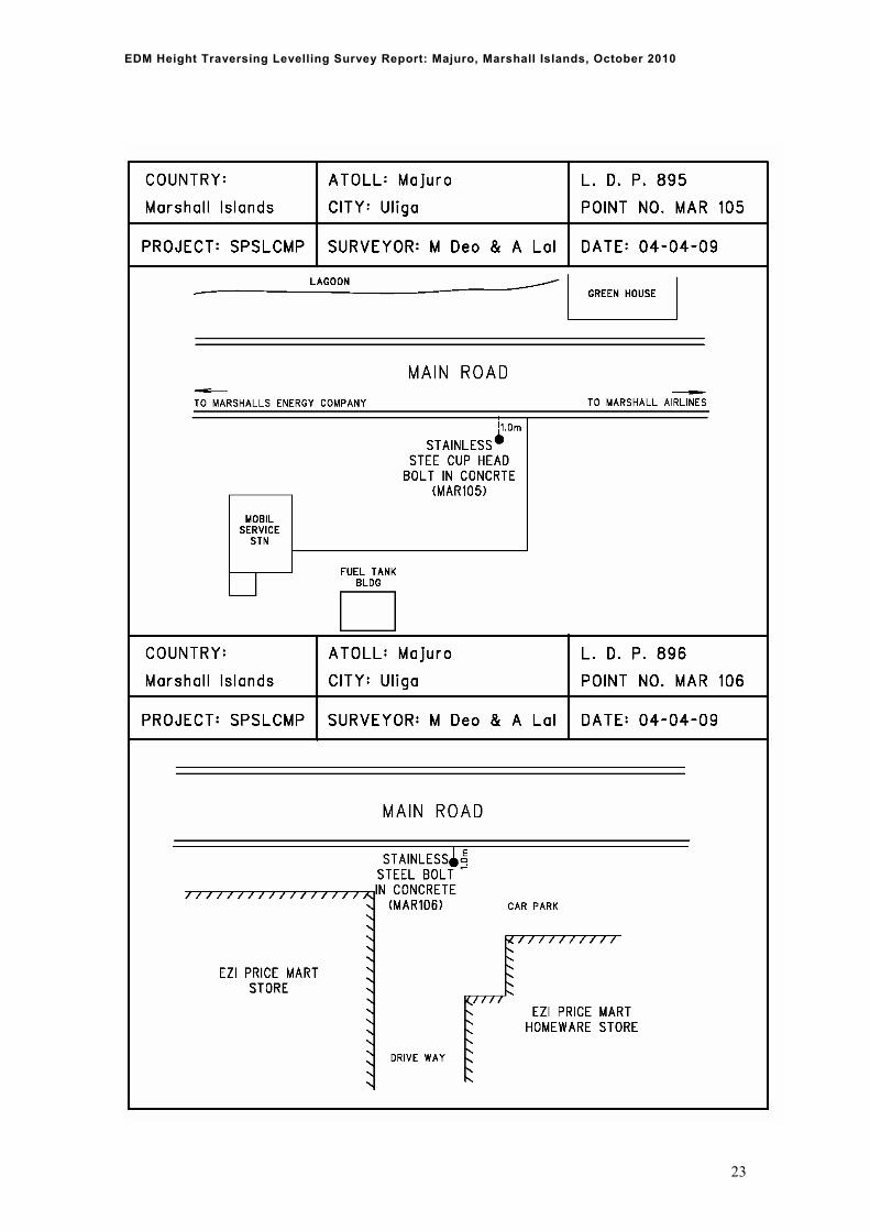
Temporary Holding Marks Locality Diagrams
18

EDM Height Traversing Levelling Survey Report: Majuro, Marshall Islands, October 2010
19

EDM Height Traversing Levelling Survey Report: Majuro, Marshall Islands, October 2010
20

EDM Height Traversing Levelling Survey Report: Majuro, Marshall Islands, October 2010
21

EDM Height Traversing Levelling Survey Report: Majuro, Marshall Islands, October 2010
22
EDM Height Traversing Levelling Survey Report: Majuro, Marshall Islands, October 2010
23

EDM Height Traversing Levelling Survey Report: Majuro, Marshall Islands, October 2010
24

EDM Height Traversing Levelling Survey Report: Majuro, Marshall Islands, October 2010
25

EDM Height Traversing Levelling Survey Report: Majuro, Marshall Islands, October 2010
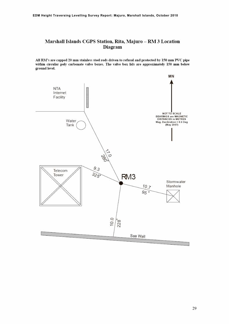
Reference Mark Locality Diagrams
26

EDM Height Traversing Levelling Survey Report: Majuro, Marshall Islands, October 2010
27

EDM Height Traversing Levelling Survey Report: Majuro, Marshall Islands, October 2010
28
EDM Height Traversing Levelling Survey Report: Majuro, Marshall Islands, October 2010
29
EDM Height Traversing Levelling Survey Report: Majuro, Marshall Islands, October 2010
30
References Rüeger, J.M. & Brunner, F.K. 1982, ‘EDM Height Traversing versus Geodetic Levelling’, The
Canadian Surveyor, vol. 36, no. 1, pp. 69-87. Inter-Government Committee on Surveying and Mapping (ICSM) 2002, Standards and Practices for
Control Surveys, SP1, Ver. 1.5, May 2002.