earth and planetary science letters - uc santa barbara...
TRANSCRIPT
Earth and Planetary Science Letters 317-318 (2012) 85–95
Contents lists available at SciVerse ScienceDirect
Earth and Planetary Science Letters
j ourna l homepage: www.e lsev ie r .com/ locate /eps l
Multi-phased uplift of the southern margin of the Central Anatolian plateau, Turkey:A record of tectonic and upper mantle processes
T.F. Schildgen a,⁎, D. Cosentino b,c, B. Bookhagen d, S. Niedermann e, C. Yıldırım e, H. Echtler e,a,H. Wittmann e, M.R. Strecker a
a Institut für Erd-und Umweltwissenschaften and DFG-Leibniz Center for Earth Surface and Climate Studies, Potsdam University, Karl-Liebknecht-Str. 24, Haus 27, 14476 Potsdam-Golm,Germanyb Dipartimento di Scienze Geologiche, Università degli Studi Roma Tre, Largo San Leonardo Murialdo 1, 00146 Rome, Italyc Istituto di Geologia Ambientale e Geoingegneria (IGAG-CNR) Area della Ricerca Roma 1 Montelibretti, Via Salaria Monterotondo Scalo, 00016 Rome, Italyd Department of Geography, 1832 Ellison Hall, University of Santa Barbara, Santa Barbara, CA 93106-4060, USAe Helmholtz-Zentrum Potsdam, Deutsches GeoForschungsZentrum (GFZ), Telegrafenberg, 14473 Potsdam, Germany
⁎ Corresponding author. Tel.: +49 3319775849; fax:E-mail address: [email protected] (T.F. Schild
0012-821X/$ – see front matter © 2011 Elsevier B.V. Aldoi:10.1016/j.epsl.2011.12.003
a b s t r a c t
a r t i c l e i n f oArticle history:Received 8 March 2011Received in revised form 30 November 2011Accepted 1 December 2011Available online xxxx
Editor: T.M. Harrison
Keywords:Central Anatolian plateauupliftfluvial strath terracescosmogenic nuclidesbiostratigraphychannel projection
Uplifted Neogene marine sediments and Quaternary fluvial terraces in the Mut Basin, southern Turkey, reveala detailed history of surface uplift along the southern margin of the Central Anatolian plateau from the LateMiocene to the present. New surface exposure ages (10Be, 26Al, and 21Ne) of gravels capping fluvial strath ter-races located between 28 and 135 m above the Göksu River in the Mut Basin yield ages ranging from ca. 25 to130 ka, corresponding to an average incision rate of 0.52 to 0.67 mm/yr. Published biostratigraphic data com-bined with new interpretations of the fossil assemblages from uplifted marine sediments reveal average up-lift rates of 0.25 to 0.37 mm/yr since Late Miocene time (starting between 8 and 5.45 Ma), and 0.72 to0.74 mm/yr after 1.66 to 1.62 Ma. Together with the terrace abandonment ages, the data imply 0.6 to0.7 mm/yr uplift rates from 1.6 Ma to the present. The different post-Late Miocene and post-1.6 Ma upliftrates can imply increasing uplift rates through time, or multi-phased uplift with slow uplift or subsidencein between. Longitudinal profiles of rivers in the upper catchment of the Mut and Ermenek basins show noapparent lithologic or fault control on some knickpoints that occur at 1.2 to 1.5 km elevation, implying atransient response to a change in uplift rates. Projections of graded upper relict channel segments to themodern outlet, together with constraints from uplifted marine sediments, show that a slower incision/upliftrate of 0.1 to 0.2 mm/yr preceded the 0.7 mm/yr uplift rate. The river morphology and profile projectionstherefore reflect multi-phased uplift of the plateau margin, rather than steadily increasing uplift rates.Multi-phased uplift can be explained by lithospheric slab break-off and possibly also the arrival of theEratosthenes Seamount at the collision zone south of Cyprus.
© 2011 Elsevier B.V. All rights reserved.
1. Introduction
Understanding the history of surface uplift at an orogen scale isamong the most challenging tasks in the geosciences, particularly interms of identifying the roles of crustal versus mantle processes inproducing and maintaining high topography. Paleoaltimetry studieshave demonstrated that the magnitude of surface uplift can oftenonly be estimated with large uncertainties (Quade et al., 2007;Riihimaki and Libarkin, 2007; Sahagian and Proussevitch, 2007).Higher precision estimates have been derived from uplifted, datablemarine and terrestrial reference surfaces (Abbott et al., 1997;Bookhagen et al., 2006a; Cosentino and Gliozzi, 1988; Cosentino etal., 2009; Dethier et al., 1995; Gardner et al., 1992; Jordan et al.,
+49 331 977 5700.gen).
l rights reserved.
2010; Melnick et al., 2009; Merritts and Bull, 1989; Perg et al., 2001;Westaway, 1993; Zazo et al., 2003), from fluvial strath terraces(Lavé and Avouac, 2001; Pazzaglia and Brandon, 2001; Schildgen etal., 2009a; Seyrek et al., 2008; Wegmann and Pazzaglia, 2009;Westaway et al., 2004), and from river incision through regionalpaleosurfaces (Clark et al., 2005; Gubbels et al., 1993; Schildgen etal., 2007, 2009b). River longitudinal profiles are also increasinglybeing used to infer changes in uplift (Barke and Lamb, 2006;Harkins et al., 2007; Hilley and Arrowsmith, 2008; Hoke et al., 2007;Kirby et al., 2003; Molin et al., 2004; Seeber and Gornitz, 1983;Wobus et al., 2006). Where channel forms can be calibrated to ero-sion or uplift rates, they can be used to semi-quantitatively assesschanges in uplift rates through time or space (Duvall et al., 2004;Kirby and Whipple, 2001; Lague and Davy, 2003; Snyder et al., 2000).
The southern margin of the Central Anatolian plateau (Fig. 1) isideally suited for surface uplift studies spanning multiple timescales.Miocene marine sediments onlap basement rocks at elevations up

0-1-2-3
Elevation(km)
1
Distance (km)
23
E-K
J
T
P
M1
M2
Pl-Q
0
1.0
2.0
3.0
Sur
face
ele
vatio
n (k
m)
Central Anatolianplateau
50
100
150
200
0
A B
Fig. 1. A: Regional simplified tectonic and topographic map and B: perspective view of topography across the Central Anatolian plateau and its southern margin with 7:1 verticalexaggeration, modified from Cosentino et al. (in press). Yellow pentagon in A indicates edges of the three-dimensional perspective topography in B, and yellow rectangle outlinesmap in Fig. 2A. Low topography within the yellow rectangle is the modern Mut Basin. NAF: North Anatolian Fault; EAF: East Anatolian Fault; DSF: Dead Sea Fault. In B, surface colorsindicate elevation, except for the green overlay, which indicates the outcrop pattern of Late Miocene marine sediments; outcrop pattern and bedrock cross-section interpreted from1:500,000 geology maps (Şenel, 2002; Ulu, 2002). Offshore cross-section and 200-m bathymetric contours based on Aksu et al. (2005). Yellow star indicates Calabrian (Early Pleis-tocene) marine section (Yıldız et al., 2003). C-O: Cambro-Orodivician; P: Permian; T: Triassic; J: Jurassic; E-K: Eocene to Cretaceous; M1: Miocene (pre-Messinian); M2: Miocene(Messinian); Pl-Q: Plio-Quaternary. (For interpretation of the references to color in this figure legend, the reader is referred to the web version of this article.)
86 T.F. Schildgen et al. / Earth and Planetary Science Letters 317-318 (2012) 85–95
to 2 km (Cosentino et al., in press), and Early Pleistocene marine sed-iments crop out as high as 1.2 km (Yıldız et al., 2003). In the samearea, fluvial strath terraces that are preserved between 28 and135 m above the Göksu River record the most recent river incision.However, the details of the younger uplift history and the mecha-nisms underlying regional uplift are not yet well understood. The An-atolian plateau lies at the intersection of a complex tectonic regime,just north of the triple junction between the Arabian, African, andEurasian plates (Fig. 1), where modern topography has likely inte-grated the effects of both tectonic processes (Clark and Robertson,2002, 2005; Jaffey and Robertson, 2005; Robertson et al., 2009;Şengör and Yılmaz, 1981) and upper mantle processes (Faccenna etal., 2006; Keskin, 2003; Şengör et al., 2003). As such, it representsan ideal testing ground for discerning the nature of geodynamic pro-cesses through reconstructions of surface uplift.
Our multidisciplinary approach to exploring surface uplift at thesouthern margin of the Central Anatolian plateau utilizes uplifted ma-rine sediments, fluvial strath terraces, and river profile analysis. Wereport the first strath terrace abandonment ages from the regionusing cosmogenic 10Be, 26Al, and 21Ne exposure dating of fluvialgravels capping the terraces. Ages of uplifted marine successions arederived from published data (Cosentino et al., in press; Yıldız et al.,2003) as well as our reinterpretations of microfossil assemblagesoriginally reported by Yıldız et al. (2003). We use uplift constraintsfrom the marine sediments and fluvial terraces to semi-quantitatively assess uplift rates that are recorded in relict portionsof channel profiles throughout our study area. Our integrated ap-proach provides an unprecedented look into surface uplift of thesouthern plateau margin over multiple timescales, as well as cluesto the mechanisms underlying uplift and plateau development.
2. Regional deformation and uplift
The modern topography of the Central Anatolian plateau is the re-sult of crustal-scale deformation with probable contributions frommantle and lithospheric-scale processes. The Central Taurides,which define the plateau's southern margin (Fig. 1), were accretedto crustal blocks to the north starting in the Eocene (Jaffey andRobertson, 2005; Pourteau et al., 2010; Robertson et al., 1996;
Şengör and Yılmaz, 1981; Şengör et al., 1984, 1985; Yılmaz et al.,1997), while closure of the Neotethys Ocean to the south and associ-ated Arabia–Eurasia collision (Ballato et al., 2011; Hüsing et al., 2009;Kelling et al., 1987; Robertson, 2000; Şengör et al., 1985; Williams etal., 1995) resulted in westward “escape” of the Anatolian microplatealong the North and East Anatolian faults (Dewey and Şengör, 1979;Şengör et al., 1985). Some uplift of Central Anatolia likely resultedfrom this plate-scale deformation, both along the southern marginprior to the Middle Miocene (Clark and Robertson, 2002, 2005;Jaffey and Robertson, 2005) and at the northern margin due to strainaccumulation along the broad restraining bend of the North AnatolianFault (Yıldırım et al., 2011).
Beyond these crustal-scale processes, seismic evidence for a thinor absent mantle lithosphere beneath Eastern Anatolia (Al-Lazki etal., 2003, 2004; Gök et al., 2003, 2007; Lei and Zhao, 2007) and re-gional volcanism close to the presumed onset of uplift (Pearce et al.,1990) inspired suggestions that slab steepening, delamination, andbreak-off induced Late Miocene uplift of Eastern Anatolia (Keskin,2003; Şengör et al., 2003). P-wave seismic tomography in Central An-atolia is consistent with a slab break-off beneath Eastern Anatoliaextending as far west as the longitude of Cyprus (Biryol et al., 2011;Gans et al., 2009) with a potential tear between the Cyprean and Ae-gean slabs (Biryol et al., 2011); subsequently, delamination (Bartol etal., 2011) and slab break-off (Cosentino et al., in press) have been sug-gested to explain surface uplift since the Late Miocene in Central An-atolia as well.
An additional phase of deformation affected the easternmost Med-iterranean (Cyprus, and areas to the north and east) since Early toMiddle Pleistocene time (Harrison et al., 2008; Kinnaird et al., 2011;Robertson, 1998; Schattner, 2010). The timing is broadly coincidentwith the arrival of the Eratosthenes seamount in the collision zonesouth of Cyprus, which currently separates the Eurasian (Anatolian)and African plates.
3. Setting of the Göksu River and the Mut Basin
The Göksu River, with its 11,200 km2 drainage basin, is the largestriver that crosses the southern margin of the Central Anatolian pla-teau. Along its course across the margin through the Mut Basin

0.4
0.8
1.2
1.6
050100150200250
Distance from outlet (km)
Ele
vatio
n (k
m)
2.0
0
A B
Fig. 2. A: Map of the Mut Basin, showing the main branch of the Göksu River (light blue) and positions of fluvial terraces and uplifted Pleistocene marine sediments. Topographyfrom 90-m resolution SRTM data (Jarvis et al., 2008) with 500 m contour intervals. B: River profile along the Göksu River, with projected positions of terraces and Pleistocenemarine sediments. Gray and black lines (with area shaded between) indicate mean and maximum elevation values from the swath profiles shown in A. (For interpretation ofthe references to color in this figure legend, the reader is referred to the web version of this article.)
87T.F. Schildgen et al. / Earth and Planetary Science Letters 317-318 (2012) 85–95
(Fig. 2), the river has exposed Oligocene to Early Miocene continentalsediments and Miocene to Pleistocene marine sediments that uncon-formably overlie Mesozoic and older basement lithologies. Cosentinoet al. (in press) reported a biostratigraphic age of ca. 8 Ma for marinesediments that cap the southern plateau margin at ca. 2 km elevationnear the town of Başyayla, revising estimates that marine sedimenta-tion had continued through at least Langhian (16 to 13.6 Ma, Bassantet al., 2005) or Serravallian (13.6 to 11.6 Ma, Tanar and Gökçen, 1990)time. The Late Miocene marine sediments are warped into a broad,100-km wide drape fold, with minor dip-slip and oblique normalfaulting (Cosentino et al., in press). The start of uplift can probablybe further limited by the 5.45 Ma onset of rapid subsidence and sed-imentation in the Adana Basin (Cosentino et al., 2010), south of theuplifted margin (Fig. 1). Considering that both ages limit the start ofuplift to between 8 and 5.45 Ma, the margin experienced an averagelong-term uplift rate of 0.25 to 0.37 mm/yr.
Southeast of the town of Mut (Fig. 2), younger marine sedimentsonlap the Middle to Late Miocene shallow- and deeper-water marinedeposits (Mut and Köselerli Formations, respectively). Uplift since de-position of the younger sequence has raised the onlap surface to1.2 km elevation. Micropaleontological investigations by Yıldız et al.(2003) on these deposits pointed to a Pliocene to Pleistocene sedi-mentation age, and to a Calabrian age (1.8 to 0.7 Ma) for the highestpart of the sections near the villages of Sarıkavak and Hacıahmetli(Fig. 2A).
4. Fluvial terraces of the Mut Basin
Fluvial terraces of the Göksu River record the most recent river in-cision through the older sedimentary units of the Mut Basin. The ter-race surfaces range from 200 to 30,000 m2 in extent at heightsbetween 28 and 135 m above the modern thalweg, between ca. 150and 50 km inland from the coast (Fig. 2). We identified terracesbased on the occurrence of fluvial gravels of relatively uniform thick-ness (typically 1.5 to 2.5 m) capping a beveled surface cut into theolder sedimentary sequence. These relatively thin gravels likely rep-resent the mobile alluvial cover of a bedrock channel (Pazzaglia andBrandon, 2001), which would imply that the beveled surfaces be-neath the gravels are “strath” terraces (Bull, 1991). No similar de-posits were identified within the older stratigraphy, except near the
basin margins, where finer grained sediments transition to coarsesandstones and pebbles. The fluvial gravels are dominated by carbon-ate clasts, with rare occurrences (ca. 1%) of red chert. The gravels aregenerally well-cemented, except for the lowest terrace gravels, whichshow carbonate accumulations on the undersides of clasts. Althoughmost of the gravels are not covered by finer sediments, in the centralportion of some terraces there is a ca. 10 to 30 cm thick deposit offine-grained sand and silt, which may be the remnant of an overbankdeposit.
The low (28 to 34 m) and intermediate (ca. 50 to 100 m) terracesexhibit relatively smooth, flat surfaces of cemented river gravels(Fig. 3A) generally 1.5 to 2.5 m thick. Preservation of the gravelsseems primarily controlled by erosion of the relatively soft sedimentsbeneath them, which results in the overlying gravels breaking off inblocks. In contrast, the 110-m terrace gravels (sample 09MUT17)are cemented, but with an irregular surface (Fig. 3B), a reduced thick-ness (ca. 0.5 to 1 m) and a higher concentration of chert (ca. 10%)compared to the lower terrace gravels, suggesting that the surround-ing carbonates may have been dissolved. The highest sample site(135 m, 09MUT18) contained no cemented gravels, but was a culti-vated surface with sparse, rounded chert clasts.
5. Methods and approaches
5.1. Samples for cosmogenic nuclide analysis
We collected chert samples for cosmic ray exposure dating (10Be,26Al, and 21Ne) from the surfaces of gravel deposits overlying fluvialstraths. Single amalgamated samples from each surface consisted of30 to 50 clasts between 1 and 3 cm in diameter, which should repre-sent the mean surface concentration (Repka et al., 1997). Details ofsample processing are given in the Supplementary material. Acceler-ator mass spectrometry measurements were made at Lawrence Liver-more National Laboratory. We rely on the original ICN standard(Nishiizumi et al., 2007). We calculated surface ages using the Cronusonline calculator version 2.2.1 (available at http://hess.ess.washington.edu/, with documentation in Balco et al., 2008), which in-cludes variations in altitude, latitude, and topographic shielding incalculating production rates from spallation and muons, and assumesreference 10Be production rates that depend on the selected scaling
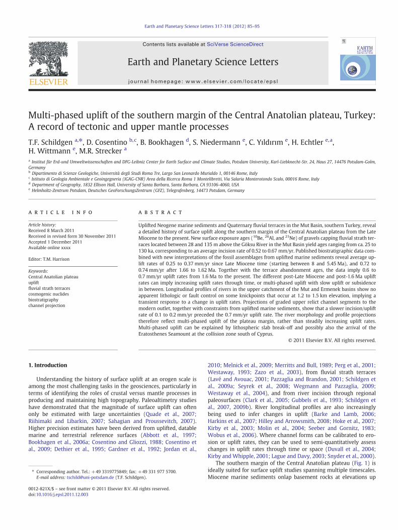
95-m terrace (close to 09MUT08) 53-m terrace
09MUT17
GöksuRiver
BA
Fig. 3. Gravel-capped fluvial strath terraces of the Mut Basin. A: Intermediate height terraces showing cemented, flat top surfaces with thin cap of fine-grained (overbank) material.B: Degraded surface of the 110-m terrace of sample 09MUT17.
88 T.F. Schildgen et al. / Earth and Planetary Science Letters 317-318 (2012) 85–95
scheme (Balco et al., 2008). Errors in the reference production ratesare estimated at ca. 10% (Balco et al., 2008). Table A1 lists sampleinput parameters and measured 10Be and 26Al concentrations withanalytical errors. Ages based on various production rate scalingschemes are summarized in Table A2. Although seasonal snow covercan shield surfaces from cosmogenic nuclide accumulation(Schildgen et al., 2005), such effects are insignificant at low elevationsof the Eastern Mediterranean. We calculated 21Ne production ratesusing a value of 0.232±0.009 for the ratio of 10Be/21Ne production(Goethals et al., 2009) to correspond to a 1.387 Ma 10Be half-life(Chmeleff et al., 2010; Korschinek et al., 2010), and using the 10Beproduction rates derived from the Lal (1991)/Stone (2000) constantproduction rate scaling with a total reference 10Be production rate(from spallation and muon production) of 4.58±0.43 atoms/(g yr).Stepwise heating Ne data are given in Table A3, and 21Ne ages aresummarized in Table A4.
In calculating corrections to exposure ages related to erosion ofmaterial above the sampled surfaces, we considered the relationship
P xð Þ ¼ Pn 0ð Þ exp −ρxΛn
� �þ Pμ 0ð Þ exp −ρx
Λμ
" #ð1Þ
where P(x) is production at depth×(cm), Pn(0) is the surface produc-tion rate for neutron spallation (atoms/(g yr)), ρ is the density of theoverlying material (g/cm3), Pμ(0) is the surface production rate formuons (atoms/(g yr)), calculated to be ca. 4% of total production atsurface using Cronus (version 2.2.1), Λn is the attenuation length forfast neutrons (160 g/cm2, Balco et al., 2008), and Λμ is the attenuationlength for muons. We combined the contributions from negativemuons and fast muons, as both can be reasonably described with anattenuation length of 1500 g/cm2 in the upper ca. 10 m of rock(Gosse and Phillips, 2001).
5.2. River profiles
Across a wide range of tectonic and climatic settings, river chan-nels tend to be characterized by the scaling relationship
S ¼ ksA−θ ð2Þ
where S is the slope (m/m), ks is the steepness index (m2θ), A is thedrainage area (m2), and θ is the concavity (Flint, 1974). Normalizedsteepness index values (ksn) are steepness indexes calculated usinga reference concavity (θref). An increase in uplift rate will produce adownstream increase in the channel gradient, and the “knickpoint”separating downstream and upstream reaches should migrate up-stream in a kinematic wave (Rosenbloom and Anderson, 1994). Thedownstream portion of the channel, which is adjusted to the new
uplift rate, is typically characterized by a higher ks (e.g., Snyder etal., 2000). In areas of relatively uniform climate and lithology andno dependence of θ on uplift rate, the vertical component of knick-point migration should be constant (Niemann et al., 2001). Observingknickpoints at a similar elevation within a drainage network is, there-fore, one line of evidence to support a past base level drop or increasein uplift rate (Crosby and Whipple, 2006; Wobus et al., 2006).
We extracted river profiles from 90-m resolution Shuttle RadarTopography Mission (SRTM) digital elevation model (DEM) data(Jarvis et al., 2008) using the Stream Profiler tool, available at www.geomorphtools.org, with procedures described in Wobus et al.(2006). Projection of the original DEM into the Universal TransverseMercater (UTM) system yielded a final pixel size of 110×110 m.
Because graded rivers have adjusted their incision rates to matchthe background uplift rate, a simple scaling relationship exists be-tween the change in channel elevations (ΔZ) upstream from a knick-point and the uplift rates prior to (Ui) and following (Uf) a suddenincrease in uplift (Whipple, 2001; Whipple and Tucker, 1999):
ΔZ ¼ Δt Uf–Ui
� �ð3Þ
where Δt is the time elapsed since the change in uplift rate. Inessence, the upper portion of the channel is passively uplifted at thenew uplift rate, but continues to incise at a rate that was set by theinitial uplift rate. We projected upper channel segments to the mod-ern outlet to determine ΔZ, such that we could explore relationshipsbetween Uf and Ui (Fig. 5C).To make this projection, we first appliedthe scaling relationship in Eq. (2) using the ks and θ of the upstreamchannel section (derived from a curve fit of slope versus area data)and the drainage area along the modern channel to calculate theslopes along a projection of the upper channel; we then used theslopes to determine successive drops in channel elevation down-stream from the knickpoint. Our final ranges of projected heights atthe outlet incorporate the best-fit θ value and 2σ errors in ks. Weselected channels for projection throughout the catchment that hadthe lowest errors on ks (based on the curve fit of the slope versusarea data) to find representative but precise estimates for ΔZ.
6. Results
6.1. Age of the youngest marine sediments in the Mut Basin
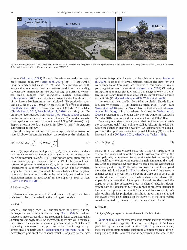
Yıldız et al. (2003) reported two stratigraphic sections containingPleistocene marine deposits close to the villages of Sarıkavak(600–650 m) and Hacıahmetli (1165 m) (Fig. 2A). Near Sarıkavak,the highest four samples in the section contain marker species for de-fining the age of the youngest marine sediments in the area. In the

0
-40
-80
-120
Sea level (m)3.03.54.04.55.0
δΟ 18 benthic
7e7c7a5e5c5aMIS: 3
0
20
40
60
80
100
120
140
Model exposure age (ka)
Terr
ace
grav
el h
eigh
t abo
ve r
iver
(m
)
0 25 50 75 100 125 150 175 200 225 250
a: y = 0.61x + 10.9b: y = 0.58x + 9.7
09MUT17
09MUT18
26 Al10Be21Ne
ab
c
d
c: y = 0.67x + 11.0d: y = 0.52x + 9.6
Fig. 4. Exposure ages for fluvial strath terraces of the Mut Basin. For 10Be and 26Al,boxes represent range of mean ages calculated using different scaling schemes (seeTable A2). Bars on symbols show full range of 2σ errors. Y-axis errors are smallerthan the symbol. Sea level variations from Bintanja et al. (2005) and δO18 data fromLisiecki and Raymo (2005). Odd-numbered marine isotope stages (MIS) are highlight-ed with gray shading. Ages of circled samples (09MUT17 and 09MUT18) are inter-preted as minimum ages (see text for explanation). Two solid gray lines show York(1969) regression fits to all data except the old 21Ne outlier and the two terraces
89T.F. Schildgen et al. / Earth and Planetary Science Letters 317-318 (2012) 85–95
reported list of the microfossils, it is worthy to note the occurrence ofGlobigerinoides tenellus in the planktonic foraminifera assemblages,and Calcidiscus macintyrei, Gephyrocapsa caribbeanica and Gephyro-capsa oceanica (medium Gephyrocapsa) in the calcareous nannofossilassemblages. In the Neogene Mediterranean biozonation (Iaccarino etal., 2007) the first occurrence (FO) of G. tenellus is at the base of theGlobigerina cariacoensis Zone (1.79–0.94 Ma, Lourens et al., 2004),which defines the Calabrian stage of the Early Pleistocene. The occur-rence of both C. macintyrei and medium Gephyrocapsa allow us to bet-ter constrain the age of the top of the Sarıkavak section. Because theFO of medium Gephyrocapsa is at 1.73 Ma (Raffi, 2002) and the lastoccurrence (LO) of C. macintyrei is calibrated at 1.66 Ma (Lourens etal., 2004), the Calabrian deposits of the Sarıkavak section shouldhave ages between 1.73 and 1.66 Ma.
The reported microfossil associations from the Hacıahmetli sec-tion include no planktonic foraminifera, although calcareous nanno-fossil assemblages were found in four out of five collected samples.The lowermost sample of the Hacıahmetli section still contains C.macintyrei, whereas in the upper part of the section, together withsmall Gephyrocapsa, only Calcidiscus leptoporus were found. Accord-ing to the calcareous nannofossil biochronology, the top of theHacıahmetli section should be younger than the LO of C. macintyreiand older than the FO of large Gephyrocapsa (1.62 Ma, Lourens et al.,2004). The uppermost marine deposits of the Hacıahmetli sectionare younger than the Calabrian sediments at the top of the Sarıkavaksection, and have ages between 1.66 and 1.62 Ma. Importantly, theseyoungest marine sediments, with their modern elevation of ca.1.2 km, point to a surface uplift rate of 0.72 to 0.74 mm/yr after 1.66to 1.62 Ma.
with minimum ages, with (a) using the maximum calculated ages, and (b) using theminimum calculated ages (see Tables A2 and A4). Dotted gray lines (c and d) outlinethe range of fits acceptable within a 95% confidence interval for both maximum andminimum calculated ages.
6.2. Exposure ages of gravels capping fluvial strath terraces
The exposure ages of the terrace-capping gravels cluster into twomain groups: gravels between 28 and 34 m above the river are ca. 20and 40 ka and those between 40 and 135 m above the river are ca. 70to 130 ka (Table A2, Fig. 4). These clusters correspond to relative sealevel high stands during Marine Isotope Stages 3 and 5 (Fig. 4). Al-though erosionmay have reduced the exposure ages of all the gravels,the highly degraded nature of the two highest gravel units (09MUT17and 09MUT18) implies that they are the most severely affected, andmay yield ages much younger than their true ages.
The relatively large uncertainties on 21Ne ages are related to highconcentrations of 20Ne, resulting in small excesses of 21Ne/20Ne inthe 400 and 600 °C temperature steps (Table A3). Samples analyzedfor 21Ne were also analyzed for 10Be and/or 26Al. Sample 09MUT12shows similar 10Be, 26Al, and 21Ne ages, but the 21Ne age of08TSERM04 is significantly older than its 10Be age. That 21Ne age isalso the single old outlier within the dataset, which we have removedfrom our curve-fitting analysis. For 09MUT08, the 26Al age overlapswithin error of the 21Ne age. This correspondence suggests that thesample may be a young outlier in the dataset, possibly as a result ofsurface erosion. During the stepwise heating of 09MUT08 and09MUT12, both the total Ne concentrations and the 21Ne excesseswere very low above 600 °C (Table A3), indicating that nucleogenic21Ne is insignificant and our concentration estimates for cosmogenic21Ne are robust within the stated error limits. In contrast, 08TSERM04released ~35% of the total 21Ne excess in the 800 °C step, so we can-not exclude a nucleogenic 21Ne contribution for this sample.
Excluding the two highest samples and the single old 21Ne result,we used the remaining ages and heights to determine average riverincision rates. We applied a York (1969) linear regression, includingerrors in calculated terrace abandonment ages (“external” uncer-tainties from the Cronus online calculator, Balco et al., 2008) and inmeasurements of terrace gravel height. Because different cosmogenicproduction rate scaling schemes yield slightly different calculated
ages (Table A2), we performed regressions on both the highest andlowest sets of calculated ages. The younger set of ages has a slopeof 0.60±0.06 mm/yr (2σ error), while the older set has a slope of0.58±0.06 mm/yr. Mean square weighted difference (MSWD) valuescalculated for both regressions are 1.9 and 0.96 for the lower andhigher calculated ages, respectively.
6.3. Potential errors and corrections on exposure ages
Surface erosion and nuclide inheritance complicate interpreta-tions of cosmogenic exposure ages of landforms (Anderson et al.,1996; Nishiizumi et al., 1986). Carbonate cementation of the gravelsis likely to have helped protect the gravel surfaces from post-depositional erosion. However, as carbonate is deposited first on theundersides of clasts, then progresses to fill voids within a deposit, me-teoric water percolation is reduced, resulting in facilitated removal ofany overlying material (Gile et al., 1966) and lower calculated expo-sure ages. Nonetheless, the ages should not be simply interpreted asminimum ages, as nuclides that accumulate in the gravels during ex-humation and transport through the catchment (“inherited” nu-clides) have the opposite effect of increasing calculated ages (Repkaet al., 1997).
We can estimate a maximum correction for erosion (or shielding)by assuming that overbank material was removed just prior to sam-pling, hence applying Eq. (1) to compare surface production rates torates beneath the surface. Correcting for the removal of 0.3 m of over-bank material with a density of 1.8 g/cm3 would decrease the produc-tion rates, and thus increase all ages by 28%, raising the ages of thelower terrace gravels by 7 to 10 ka and those of intermediate gravelsby 24 to 31 ka. A larger correction would be necessary for the highlydegraded, two highest terrace gravels. For example, if 1 or 2 m of

90 T.F. Schildgen et al. / Earth and Planetary Science Letters 317-318 (2012) 85–95
2.0 g/cm3 gravels were removed from above those samples just priorto sampling, ages would increase by 69% or 89%, respectively.
Nuclide inheritance can be assessed with depth profiles beneath alandform surface, as deep samples are largely shielded from post-depositional nuclide production (Anderson et al., 1996). The cemen-tation of the gravels and rare occurrence of chert in the Mut Basinprecluded such sampling. However, we can explore the inheritedcomponent of a four-sample depth profile (0- to 2-m-deep) fromgravels capping a terrace 150 m above the thalweg near the city ofAdana (Supplementary material Fig. A1, “ZIY” samples in Table A1).To do this, we modeled fits to the depth profile following the ap-proach of Braucher et al. (2003), testing reasonable values for erosionrate (5 to 12 m/Myr), surface age (50 to 300 ka), total erosion of thesurface (b1 m), and deposit density (1.8 to 2.0 g/cm3). Over the fullrange of erosion rates, χ2 values were minimized for an inheritedcomponent between ca. 88,200 and 91,100 10Be atoms/g (Table A5).If the inherited components are broadly similar for the two neighbor-ing catchments, we can use the modeled inheritance of the Adana ter-race to estimate a correction of 18.8 to 20.6 ka for the Mut Basinterraces.
Changes in terrace abandonment ages would be greatest if therewere erosion with no nuclide inheritance, or nuclide inheritancewith no erosion. Both scenarios are highly unlikely. We therefore con-sider that the estimated corrections should at least partly cancel oneanother. Furthermore, the general simplicity of the age–height rela-tionships of the uncorrected ages suggests that the magnitude ofnet corrections is relatively low. Considering the possible correctionsto the ages, low and intermediate gravels still likely fall within MarineIsotope Stages 3 and 5, and the highest gravels may fall within Stage7. Hence, the average slope of the age versus height plot (i.e., the in-cision rate) of 0.52 to 0.67 mm/yr is probably a fairly robust estimateof the latest Pleistocene to recent incision rates.
6.4. River profiles and channel projections
Most river profiles in the Mut Basin and the neighboring ErmenekBasin are characterized by downstream portions with high ksn values(e.g., >90 for θref=0.45) that are separated by one or more knick-points from upper sections with low ksn values (e.g., b60 forθref=0.45) (Fig. 5A). We consider a single knickpoint separatingthese two channel segments to be a “major” knickpoint. Throughoutthe catchment, major knickpoints generally occur at 1.2 to 1.5 km el-evation (Fig. 5B). They often correspond to the lithologic contact be-tween the limestone caprock (Mut Formation) and softer marls(Köselerli Formation) or continental clastics beneath (Fig. 5A, Supple-mentary material Fig. A2). Major knickpoints along streams in theupper parts of the catchment, which incise through Mesozoic base-ment carbonates, also occur at elevations of ca. 1.2 to 1.5 km. Theselatter knickpoints do not appear to have any lithologic or fault control(Fig. 5A) as the knickpoints do not align with any lithologic contactsor tectonic structures.
Downstream projections of the upper “relict” portions of channelsabove the knickpoints show variable results. Streams that incisethrough the Mut Formation limestone have concavities rangingfrom 0.42 to 0.80 and project to heights of 1145 to 1408 m abovethe modern outlet, while streams in the upper catchment that inciseonly basement have concavities of 0.51 to 0.70 and project to heightsof 950 to 1197 m above the outlet (Fig. 5C, Table 1). Considering thescaling relationship between uplift rates and changes in the relictchannel elevation (Eq. 3), we can use the projected heights abovethe outlet (ΔZ) to estimate initial uplift rates (Ui) prior to the onsetof faster uplift at ca. 1.6 Ma. If we assume an uplift rate of 0.74 mm/yr started at 1.63 Ma (based on the marine sediments uplifted to1.2 km), the relict stream segments on the Mut Formation yield arange of Ui between –0.13 and 0.03 mm/yr, and relict streams in thebasement yield Ui between 0.00 and 0.15 mm/yr (Table 1).
7. Discussion
7.1. Climatic and tectonic control on river incision and terrace formation
Clustering of the terrace abandonment ages during Marine IsotopeStages 3 and 5 (and possibly also 7) suggests that climate fluctuationsassociated with sea level oscillations and changes in base level playeda role in terrace development. Studies of dated terrace sequences inactive tectonic settings worldwide have noted that although sus-tained surface uplift is required for development of stepped strathterrace sequences, stages of individual terrace formation or abandon-ment tend to cluster during periods of known climate change (e.g.,Bookhagen et al., 2006b; Bridgland and Westaway, 2008; Bull, 1991;Fuller et al., 1998; Lavé and Avouac, 2001; Merritts et al., 1994; Panet al., 2003; Pazzaglia and Brandon, 2001; Pazzaglia and Gardner,1993; Schildgen et al., 2002; Wegmann and Pazzaglia, 2002, 2009).This clustering likely results from climate-induced changes in sedi-ment and water flux with associated changes between vertical andlateral channel incision, which has been shown to be necessary forstrath formation and abandonment (Bogaart et al., 2003; Hancockand Anderson, 2002; Meyer et al., 1995; Tucker and Slingerland,1997).
Climatic shifts or sea level change as a sole driver for terrace for-mation and long-term incision can be ruled out based on otherdated terrace sequences in the eastern Mediterranean region, whichrecord significantly lower incision rates over a similar time period.For example, along the Ceyhan River of southern Turkey, terraces be-tween 50 and 75 km to the east and southeast of the city of Adanayield incision rates between ca. 0.25 and 0.4 mm/yr since 270 ka(Seyrek et al., 2008). Along the Gediz River in western Turkey, inci-sion rates have been ca. 0.2 mm/yr since Middle Pleistocene time(Westaway et al., 2004). However, in southern Turkey, the similari-ties between fluvial incision rates (0.52 to 0.67 mm/yr) and post-1.6 Ma uplift rates constrained by the uplifted marine sediments(0.72 to 0.74 mm/yr) support the notion that relatively fast uplifthas characterized the region since 1.6 Ma, and was the main factordriving long-term river incision, despite fluctuations in incision ratethat could have resulted from glacial–interglacial cycles.
7.2. Changing uplift rates through time
Considering the elevations of the Late Miocene and Pliocene–Pleistocene marine sediments, the time-averaged uplift rate between8 and 1.6 Ma was 0.13 mm/yr, and increased to ca. 0.7 mm/yr from ca.1.6 Ma to the present. However, the marine sediments alone do notallow us to distinguish between surface uplift rates that steadily in-creased until 1.6 Ma, or multiple phases of uplift with intermittentquiescence or subsidence. The Pliocene–Pleistocene marine sedi-ments in the basin could imply that the region was undergoing subsi-dence during their deposition, perhaps during a hiatus betweendifferent uplift phases. Alternatively, the basin alone may have expe-rienced fault-controlled subsidence while the margin as a whole ex-perienced increasing uplift rates. We observed normal faulting alongthe basin margin that affected parts of the younger marine succes-sion, although the highest outcrop at 1.2 km elevation lies withinthe footwall of local normal faults. In yet another scenario, accommo-dation space may have been created following incision associatedwith the ca. 1.5 km drawdown of the Mediterranean Sea during theMessinian Salinity Crisis (5.96 to 5.33 Ma, e.g., Clauzon et al., 1996;Krijgsman et al., 1999) and associated isostatic effects (e.g., Govers,2009). The latter scenario would imply that the Pliocene–Pleistocenesection is at least partly a transgressive depositional sequence.
River profiles offer a test of the multi-phased uplift versus increas-ing uplift rate scenarios. To a first order, major knickpoints along riverchannels that are not controlled by faults or lithologic contacts implythat incision rates must have increased at some point in the past

0
0.5
1.0
1.5
2.0
Ele
vatio
n (k
m)
0501001502002500
0.5
1.0
1.5
2.0
Distance from outlet (km)
Ele
vatio
n (k
m)
A
B
C
Fig. 5. A: Map of channel steepness indexes that are normalized (ksn) to a reference concavity (θref) of 0.45 throughout the Mut and Ermenek basins, calculated using the streamprofiler tool (www.geomorphtools.org) with a smoothing window of 500 m. Geology from 1:500,000 scale maps (Şenel, 2002; Ulu, 2002). Channels with numbered labels wereused for projections. B: Longitudinal channel profiles with major knickpoints marked by circles. Knickpoints colored based on their position in the Mut or Ermenek sub-basin. C:Channel projections of upper, relict portions of channels to the position of the modern outlet. Ranges of final projected heights reflect 2σ errors in ks and a best-fit concavityvalue based on log (slope) versus log (area) plots of the upper channel segment.
91T.F. Schildgen et al. / Earth and Planetary Science Letters 317-318 (2012) 85–95
(Whipple and Tucker, 1999). The common occurrence of knickpointsat the lithologic contact between the Mut limestone and the underly-ing marls suggests we should use caution in interpreting uplift ratesderived from those channels. The basement channels, however,show no alignment of knickpoints with lithologic contacts or faults(Fig. 5A); they are thus more likely to reflect a transient incision/up-lift signal.
The change in elevation of graded upper channel segments scaleswith the final uplift rate minus the initial uplift rate (Eg. 3), offering asemi-quantitative record of uplift rates prior to when they increased.Because the upper channel segments are largely outside of the
modern basin, they should reflect uplift of the plateau margin itself,rather than being influenced by any fault-controlled subsidence with-in the basin. The widely varying projected channel heights demon-strate spatially variable uplift, and/or that the channels used forprojection may not all be graded, as is required for the method. Grad-ed channels should yield results that are broadly consistent with theuplift constraints from the marine sediments.
All projections from channels within the Mut Formation yield ini-tial uplift rates that are either negative or much lower than the aver-age 0.13 mm/yr uplift rate for the 8 to 1.6 Ma interval based on theuplifted marine sediments. Negative rates imply channel aggradation,

Table 1Initial uplift rates derived from channel projections⁎.
Channel#
Concavity ks kserror
ΔZhigha
ΔZhighb
Ui highc Ui lowd
(2σ) (m) (m) (mm yr−1) (mm yr−1)
Channels incising basement1 0.51 121 3 972 993 0.14 0.132 0.60 308 6 1189 1197 0.01 0.003 0.70 4655 214 1087 1109 0.07 0.064 0.51 46 4 950 982 0.15 0.13
Channels incising Mut Formation5 0.42 19.6 0.8 1145 1170 0.03 0.026 0.50 86 8 1246 1280 –0.03 –0.057 0.80 17 4 1353 1356 –0.09 –0.108 0.67 966 44 1393 1408 –0.12 –0.13
⁎ Assumes Uf=0.74 mm yr−1 and Δt=1.63 Ma.a From ks−2σ valueb From ks+2σ valuec Using low estimate for ΔZd Using high estimate for ΔZ
ca. 8 Ma
ca. 1.6 Ma, increase of uplift rate
Today
~0.8 km uplift
~1.2 km uplift
1.6 Mamarl
8 Malimestone
>8 MamarlBasementSea
Fig. 6. Schematic evolution of the southernmargin of the Central Anatolian plateau, illustrat-ing initial uplift of ca. 8 Mamarine sediments to an elevation of ca. 0.8 km followed by depo-sition of Pliocene–Pleistocene marine sediments, and an additional ca. 1.2 km of rapid uplift
92 T.F. Schildgen et al. / Earth and Planetary Science Letters 317-318 (2012) 85–95
while the very low rates may imply that the karst hydrology associat-ed with the Mut Formation has impacted the ability of those channelsto continue incising. Furthermore, the correspondence between themajor knickpoints along the channels in the Mut Formation and thelimestone caprock edges implies that those channel segments maynot be reliable recorders of the pre-1.6 Ma uplift rate.
In contrast, the initial uplift rates derived from basement channelsrange from 0.00 to 0.15 mm/yr (Table 1). Interestingly, only thosetwo basement channels with concavities of ca. 0.5 yield rates (0.13to 0.15 mm/yr) that are consistent with constraints from the upliftedmarine sediments, while those with higher concavities of 0.60 and0.70 yield rates that are apparently too low (0.00 to 0.07 mm/yr).Bedrock channels on uniform lithologies experiencing uniform upliftalong their length should theoretically have concavities between0.35 and 0.6, and most cluster very near 0.45 (Whipple and Tucker,1999). Higher concavities may indicate that the channels are no lon-ger graded after being affected by a downstream decrease in upliftrate or rock strength, transitions to alluvial conditions, or disequilib-rium conditions following a decrease in uplift rates (Whipple,2004). In summary, the high concavities of several upper channel seg-ments preclude their use for deriving accurate initial uplift rates, withonly a few “ideal” cases (stream channels in non-karstified bedrockwith moderate concavity values) where the results from channel pro-jections agree with the stratigraphic constraints on uplift. Nonethe-less, we emphasize that both the “ideal” channel projections andthe major knickpoints along the basement channels are most consis-tent with a multi-phased uplift history with slow uplift prior to1.6 Ma (Fig. 6), rather than steadily increasing uplift rates.
that continues to today. Channels within the basement respond to changing uplift rates,while channels in the Mut Formation (8 Ma limestones) are predominantly controlled bythe lithologic contact. U: uplift rate; I: incision rate; ksn: normalized steepness index.
7.3. Uplift mechanisms and predicted surface uplift patternsOur new data on the stratigraphic and geomorphic evolution ofthe southern margin of the Central Anatolian plateau can provide in-sight into the long-term deformation and uplift history of the region.Mechanisms that have been proposed to explain surface uplift in Cen-tral Anatolia or surrounding regions have some predictable effects onsurface uplift patterns, rates, and magnitudes. For example, slabbreak-off with or without preceding lithospheric delamination is pre-dicted to produce an asymmetric pattern of rapid km-scale surfaceuplift (within a few million years) with greatest uplift above theslab break-off (Duretz et al., 2011; Göğüş and Pysklywec, 2008), fol-lowed by slow thermal subsidence (on the order of 0.01 mm/yr) asthe mantle cools to form new lithosphere (Avigad and Gvirtzman,
2009). Cosentino et al. (in press) pointed out that differences in theonset of surface uplift between Eastern and Central Anatolia are con-sistent with the lateral propagation rate of slab break-off (e.g., vanHunan and Allen, 2011) from the Bitlis–Zagros suture zone to theMut Basin. If slab break-off induces changes in mantle flow patterns,this may also produce a distinct phase of uplift related only to mantleflow (e.g., Faccenna and Becker, 2011).
The potential for uplift in southern Turkey resulting from the ar-rival of the Eratosthenes Seamount at the collision zone south of Cy-prus is largely unknown. The seamount itself is underlain by ca.

93T.F. Schildgen et al. / Earth and Planetary Science Letters 317-318 (2012) 85–95
28 km of continental crust (Aal et al., 2001; Ben-Avraham et al.,2002), Cyprus is underlain by ca. 35 km of continental crust (Makriset al., 1983), and to the southeast of the seamount there is either oce-anic crust (Ben-Avraham et al., 2002) or highly attenuated continen-tal crust (Gardosh and Druckman, 2006). The collision zone, whichhas been described as a N-dipping subduction zone (Woodside,1977), has been more recently interpreted to be accommodating ini-tial collision between the African and Eurasian plates (Robertson,1998), possibly as a restraining bend along a continent–continent in-terface (Harrison et al., 2008). Uplift patterns that result from such acollision likely depend on local plate characteristics, and have not yetbeen explored in detail. Nonetheless, the prevalent Early to MiddlePleistocene structural modifications in the easternmost Mediterra-nean (see review by Schattner, 2010), including evidence for in-creased Pleistocene uplift rates in Cyprus (Kinnaird et al., 2011) andin southern Turkey, are broadly coeval with seamount collision withthe trench starting in Early to Middle Pleistocene time.
The multi-phased uplift of the southern margin of the plateaurevealed by our data helps to limit the possible processes that pro-duced uplift. A single mechanism may be invoked only if it can pro-duce multiple uplift phases; i.e., delamination and/or slab break-offcombined with changes in mantle flow patterns that result in distinctuplift phases. Alternatively, delamination and/or slab break-off mustbe invoked together with surface uplift resulting from collision ofthe Eratosthenes Seamount south of Cyprus, implying that deforma-tion associated with seamount collision extends at least 250 kmnorthward into southern Turkey.
8. Conclusions
Surface cosmogenic exposure ages of gravels covering strath ter-races from the Mut Basin at the southern margin of the Central Ana-tolian plateau yield an average incision rate of 0.52 to 0.67 mm/yrsince ca. 130 ka or potentially since as early as MIS7 (ca. 190 to245 ka). The incision rate agrees with the average post-1.66 to1.62 Ma uplift rate of 0.72 to 0.74 mm/yr based on uplifted marinesediments in the same area. The post-1.6 Ma uplift rate is 2 to 3times faster than the average post-Late Miocene surface uplift ratedocumented by 8-Mamarine sediments that cap the southern marginof the plateau at ca. 2 km elevation (Cosentino et al., in press) and theonset of rapid sedimentation south of the margin at 5.45 Ma(Cosentino et al., 2010). Our analysis of river profiles throughoutthe Mut–Ermenek Basin, including both the identification of majorknickpoints and channel projections, suggests that a slower phase ofuplift of 0.1 to 0.2 mm/yr preceded the start of faster (0.5 to0.7 mm/yr) uplift and incision at ca. 1.6 Ma.
We suggest a multi-phased scenario for growth of the southernmargin of the Central Anatolian plateau, involving (1) initial deforma-tion of the Tauride basement that created paleotopography ontowhich Miocene marine sediments were deposited; (2) a phase of ca.0.8 km of surface uplift starting between 8 and 5.45 Ma until1.6 Ma; and (3) a phase of rapid uplift starting at ca. 1.6 Ma that hasincreased the margin elevation by ca. 1.2 km and likely continues totoday. The uplift timing and magnitude can be constrained with theuplifted marine sediments, but they do not reveal the nature of anychanges in uplift rates through time. On the basis of our river profileanalysis and terrace abandonment ages, uplift clearly proceeded indistinct phases, rather than increasing steadily through time. The ca.0.8 km uplift may have occurred above delaminated lithosphericmantle (Bartol et al., 2011) and/or slab break-off (Cosentino et al.,in press), and the final ca. 1.2 km of uplift could be associated with ei-ther Early to Middle Pleistocene collision of the Eratosthenes Sea-mount (continental fragment) with the trench south of Cyprus(Robertson, 1998; Schattner, 2010), or uplift associated with modi-fied mantle flow patterns following slab break-off.
Supplementary materials related to this article can be found on-line at doi:10.1016/j.epsl.2011.12.003.
Acknowledgments
This work is part of the Vertical Anatolian Movements Project(VAMP), funded by the TOPO-EUROPE initiative of the European Sci-ence Foundation, with contributions by the Istituto di GeologiaAmbientale e Geoingegneria (IGAG-CNR com. TA.P05.009, mod.TA.P05.009.003) and the German Science Foundation (DFG: STR373/25-1; EC-138/5-1). TFS was supported by the Leibniz Center for Sur-face Processes and Climate Studies at Potsdam University (DFG:STR373/20-1) and the Alexander von Humboldt Foundation. BB wassupported with grants from NASA (NNX08AG05G) and NSF (EAR0819874). We thank Enzio Schnabel for performing noble gas ana-lyses, Eric Kirby, Dirk Scherler, Brian Clarke and Angela Landgraf forstimulating discussions, and Bora Rojay and Attila Çiner for logisticalhelp and discussions of regional geology. Alastair Robertson andMark Brandon provided detailed and constructive reviews thathelped to improve the manuscript.
References
Aal, A.A., Barkooky, A.E., Gerrits, M., Meyer, H.-J., Schwander, M., Zaaki, H., 2001. Tec-tonic evolution of the eastern Mediterranean Basin and its significance for the hy-drocarbon prospectivity of the Nile River deepwater area. GeoArabia 6, 363–384.
Abbott, L.D., Silver, E.A., Anderson, R.S., Smith, R., Ingle, J.C., Kling, S.A., Haig, D., Small,E., Galewsky, J., Sliter, W., 1997. Measurement of tectonic surface uplift rate in ayoung collisional mountain belt. Nature 385, 501–507.
Aksu, A.E., Calon, T.J., Hall, J., Mansfield, S., Yaşar, D., 2005. The Cilicia–Adana basincomplex, Eastern Mediterranean: Neogene evolution of an active fore-arc basinin an obliquely convergent margin. Mar. Geol. 221, 121–159.
Al-Lazki, A.I., Seber, D., Sandvol, E., Turkelli, N., Mohamad, R., Barazangi, M., 2003. To-mographic Pn velocity and anisotropy structure beneath the Anatolian plateau(eastern Turkey) and the surrounding regions. Geophys. Res. Lett. 30, 8043.doi:10.1029/2003GL017391.
Al-Lazki, A.I., Sandvol, E., Seber, D., Barazangi, M., Turkelli, N., Mohamad, R., 2004. Ontomographic imaging of mantle lid velocity and anisotropy at the junction of theArabian, Eurasian and African Plates. Geophys. J. Int. 158, 1024–1040.
Anderson, R.S., Repka, J.L., Dick, G.S., 1996. Explicit treatment of inheritance in datingdepositional surfaces using in situ 10Be and 26Al. Geology 24, 47–51.
Avigad, D., Gvirtzman, Z., 2009. Late Neoproterozoic rise and fall of the northern Arabi-an–Nubian shield: the role of lithospheric mantle delamination and subsequentthermal subsidence. Tectonophysics 477, 217–228.
Balco, G., Stone, J.O., Lifton, N.A., Dunai, T.J., 2008. A complete and easily accessiblemeans of calculating surface exposure ages or erosion rates from 10Be and 26Almeasurements. Quat. Geochronol. 3, 174–195.
Ballato, P., Uba, C.E., Landgraf, A., Strecker, M.R., Sudo, M., Stockli, D.F., Friedrich, A.,Tabatabaei, S.H., 2011. Arabia–Eurasia continental collision: insights from late Ter-tiary foreland-basin evolution in the Alborz mountains, northern Iran. Geol. Soc.Am. Bull. 123, 106–131.
Barke, R., Lamb, S., 2006. Late Cenozoic uplift of the Eastern Cordillera, Bolivian Andes.Earth Planet. Sci. Lett. 249, 350–367.
Bartol, J., Govers, R., Wortel, R., 2011. The Central Anatolian Plateau: relative timing ofuplift and magmatism. Geophys. Res. Abstr. 13 (EGU2011-10326).
Bassant, P., van Buchem, F.S.P., Görür, N., 2005. The stratigraphic architecture and evo-lution of the Burdigalian carbonate–siliciclastic sedimentary systems of the MutBasin, Turkey. Sediment. Geol. 173, 187–232.
Ben-Avraham, Z., Ginzburg, A., Makris, J., Eppelbaum, L., 2002. Crustal structure of theLevant Basin, eastern Mediterranean. Tectonophysics 346, 23–43.
Bintanja, R., van der Wal, R.S.W., Oerlemans, J., 2005. Modelled atmospheric tempera-ture and global sea levels over the past million years. Nature 437 (7055), 125–128.
Biryol, C.B., Beck, S.L., Zandt, G., Özacar, A.A., 2011. Segmented African lithosphere be-neath the Anatolian region inferred from teleseismic p-wave tomography. Geo-phys. J. Int. 184, 1037–1057.
Bogaart, P.W., Balen, R.T.V., Kasse, C., Vandenberghe, J., 2003. Process-based modellingof fluvial system response to rapid climate change II. Application to the River Maas(The Netherlands) during the last glacial–interglacial transition. Quat. Sci. Rev. 22,2097–2110.
Bookhagen, B., Echtler, H.P., Melnick, D., Strecker, M.R., Spencer, J.Q.C., 2006a. Usinguplifted Holocene beach berms for paleoseismic analysis of the Santa Maria Island,south-central Chile. Geophys. Res. Lett. 33 (15), L15302. doi:10.1029/2008jb005788.
Bookhagen, B., Fleitmann, D., Nishiizumi, K., Strecker, M.R., Thiede, R.C., 2006b. Holo-cene monsoonal dynamics and fluvial terrace formation in the northwest Hima-laya, India. Geology 34, 601–604.
Braucher, R., Brown, E.T., Bourlès, D.L., Colin, F., 2003. In situ produced 10Be measure-ments at great depths: implications for production rates by fast muons. Earth Plan-et. Sci. Lett. 211, 251–258.

94 T.F. Schildgen et al. / Earth and Planetary Science Letters 317-318 (2012) 85–95
Bridgland, D., Westaway, R., 2008. Climatically controlled river terrace staircases: aworldwide Quaternary phenomenon. Geomorphology 98, 285–315.
Bull, W.B., 1991. Geomorphic Response to Climatic Change. Oxford University Press,New York. 326 pp.
Chmeleff, J., von Blanckenburg, F., Kossert, K., et al., 2010. Determination of the 10Behalf-life by multicollector ICP-MS and liquid scintillation counting. Nucl. Instrum.Methods Phys. Res., Sect. B 268 (2), 192–199.
Clark, M.S., Robertson, A.H.F., 2002. The role of the Early Tertiary Ulukişla Basin, south-ern Turkey in suturing of the Mesozoic Tethys ocean. J. Geol. Soc. 159, 673–690.
Clark, M., Robertson, A.H.F., 2005. Uppermost Cretaceous–Lower Tertiary UlukişlaBasin, south-central Turkey: sedimentary evolution of part of a unified basin com-plex within an evolving Neotethyan suture zone. Sediment. Geol. 173, 15–51.
Clark, M.K., House, M.A., Royden, L.H., Whipple, K.X., Burchfield, B.C., Zhang, X., Tang,W., 2005. Late Cenozoic uplift of southeastern Tibet. Geology 33, 525–528.
Clauzon, G., Suc, J.-P., Gautier, F., Berger, A., Loutre, M.-F., 1996. Alternate interpretationof the Messinian salinity crisis: controversy resolved? Geology 24, 363–366.
Cosentino, D., Gliozzi, E., 1988. Considerazioni sulle velocità di sollevamento di depositieutirreniani dell'Italia meridionale e della Sicilia. Mem. Soc. Geol. Ital. 42, 653–665.
Cosentino, D., Cipollari, P., Di Bella, L., Esposito, A., Faranda, C., Giordano, G., Gliozzi, E.,Mat-tei, M., Mazzini, I., Porreca, M., Funiciello, R., 2009. Tectonics, sea-level changes andpalaeoenvironments in the early Pleistocene of Rome (Italy). Quat. Res. 72, 143–155.
Cosentino, D., Radeff, G., Darbas, G., Dudas, F.O., Gurbuz, K., Schildgen, T.F., 2010. LateMiocene geohistory of the Mut and Adana basins (southern Turkey): insight foruplift of the southern margin of the Central Anatolian Plateau. Tectonic Crossroads:Evolving orogens of Eurasia–Africa–Arabia, Middle East Technical University, An-kara, Turkey, pp. 4–8 (October, 2010).
Cosentino, D., Schildgen, T.F., Cipollari, P., Faranda, C., Gliozzi, E., Hudáčková, N., Luci-fora, S., Strecker, M.R., in press. Late Miocene surface uplift of the southern marginof the Central Anatolian plateau, Central Taurides, Turkey. Geol. Soc. Am. Bull.,doi:10.1130/B30466.1 (Electronic publication ahead of print October 21, 2011).
Crosby, B.T., Whipple, K.X., 2006. Knickpoint initiation and distribution within fluvialnetworks: 236 waterfalls in the Waipaoa River, North Island, New Zealand. Geo-morphology 82, 16–38.
Dethier, D.P., Pessl, F., Keuler, R.F., Balzarini, M.A., Pevear, D.R., 1995. Late Wisconsinanglaciomarine deposition and isostatic rebound, northern Puget lowland, Washing-ton. Geol. Soc. Am. Bull. 107, 1288–1303.
Dewey, J.F., Şengör, A.M.C., 1979. Aegean and surrounding regions: complex multi-plate and continuum tectonics in a convergent zone. Geol. Soc. Am. Bull. 90, 84–92.
Duretz, T., Gerya, T.V., May, D.A., 2011. Numerical modelling of spontaneous slabbreakoff and subsequent topographic response. Tectonophysics 502, 244–256.
Duvall, A., Kirby, E., Burbank, D., 2004. Tectonic and lithologic controls on bedrockchannel profiles and processes in coastal California. J. Geophys. Res. 109, F03002.doi:10.1029/2003jf000086.
Faccenna, C., Becker, T.W., 2011. Shaping mobile belts by small-scale convection.Nature 465 (7298), 602–605.
Faccenna, C., Bellier, O., Martinod, J., Piromallo, C., Regard, V., 2006. Slab detachmentbeneath eastern Anatolia: a possible cause for the formation of the North Anatolianfault. Earth Planet. Sci. Lett. 242, 85–97.
Flint, J.J., 1974. Stream gradient as a function of order, magnitude, and discharge. WaterResour. Res. 10, 969–973.
Fuller, I.C., Macklin, M.G., Lewin, J., Passmore, D.G., Wintle, A.G., 1998. River responseto high-frequency climate oscillations in southern Europe over the past 200 k.y.Geology 26, 275–278.
Gans, C.R., Beck, S.L., Zandt, G., Biryol, C.B., Ozacar, A.A., 2009. Detecting the limit of slabbreak-off in central Turkey: new high-resolution Pn tomography results. Geophys.J. Int. 179, 1566–1577.
Gardner, T.W., Verdonck, D., Pinter, N.M., Slingerland, R., Furlong, K.P., Bullard, T.F.,Wells, S.G., 1992. Quaternary uplift astride the aseismic Cocos Ridge, Pacificcoast, Costa Rica. Geol. Soc. Am. Bull. 104, 219–232.
Gardosh, M.A., Druckman, Y., 2006. Seismic stratigraphy, structure, and tectonic evolu-tion of the Levantine basin, offshore Israel. In: Robertson, A.H.F., Mountrakis, D.(Eds.), Tectonic Development of the Eastern Mediterranean Region: Geol. Soc.,Lond., Spec. Publ., 260, pp. 201–227.
Gile, L.H., Peterson, F.F., Grossman, R.B., 1966. Morphological and genetic sequences ofcarbonate accumulation in desert soils. Soil Sci. 101, 347–360.
Goethals, M.M., Hetzel, R., Niedermann, S., Wittmann, H., Fenton, C.R., Kubik, P.W.,Christl, M., von Blanckenburg, F., 2009. An improved experimental determinationof cosmogenic 10Be/21Ne and 26Al/21Ne production ratios in quartz. Earth Planet.Sci. Lett. 284, 187–198.
Göğüş, O.H., Pysklywec, R.N., 2008. Mantle lithosphere delamination driving plateauuplift and synconvergent extension in eastern Anatolia. Geology 36, 723–726.
Gök, R., Sandvol, E., Turkelli, N., Seber, D., Barazangi, M., 2003. Sn attenuation in the An-atolian and Iranian plateau and surrounding regions. Geophys. Res. Lett. 30, 8042.
Gök, R., Pasyanos, M.E., Zor, E., 2007. Lithospheric structure of the continent–continentcollision zone: eastern Turkey. Geophys. J. Int. 169, 1079–1088.
Gosse, J.C., Phillips, F.M., 2001. Terrestrial in-situ cosmogenic nuclides: theory andapplication. Quat. Sci. Rev. 20, 1475–1560.
Govers, R., 2009. Choking the Mediterranean to dehydration: the Messinian salinitycrisis. Geology 37 (2), 167–170.
Gubbels, T.L., Isacks, B.L., Farrar, E., 1993. High-level surfaces, plateau uplift, and fore-land development, Bolivian Central Andes. Geology 21, 695–698.
Hancock, G.S., Anderson, R.S., 2002. Numerical modeling of fluvial strath-terraceformation in response to oscillating climate. Geol. Soc. Am. Bull. 114, 1131–1142.
Harkins, N., Kirby, E., Heimsath, A., Robinson, R., Reiser, U., 2007. Transient fluvial inci-sion in the headwaters of the Yellow River, notheastern Tibet, China. J. Geophys.Res. 112 (F3), F03S04. doi:10.1029/2006jf000570.
Harrison, R., Newell, W., Panayides, I., Stone, B., Tsiolakis, E., Necdet, M., Batihanli, H.,Ozhur, A., Lord, A., Berksoy, O., Zomeni, Z., Schindler, J.S., 2008. Bedrock geologicmap of the Greater Lefkosia area, Cyprus, Scientific Investigations Map 3046, 1map, scale 1:25,000, 36-p. text.
Hilley, G.E., Arrowsmith, J.R., 2008. Geomorphic response to uplift along the Dragon'sBack pressure ridge, Carrizo Plain, California. Geology 36, 367–370.
Hoke, G.D., Isacks, B.L., Jordan, T.E., Blanco, N., Tomlinson, A.J., Ramezani, J., 2007. Geo-morphic evidence for post-10 Ma uplift of the western flank of the central Andes18 degrees 30′-22 degrees S. Tectonics 26, TC5021. doi:10.1029/2006tc002082.
Hüsing, S.K., Zachariasse, W.-J., van Hinsbergen, D.J.J., Krijgsman, W., Inceöz, M., Harzhau-ser, M., Mandic, O., Kroh, A., 2009. Oligocene Miocene basin evolution in SE Anatolia,Turkey: constraints on the closure of the eastern Tethys gateway. In: van Hinsbergen,D.J.J., Edwards,M.A., Govers, R. (Eds.), Collision and Collapse at theAfrica–Arabia–Eur-asia Subduction Zone: Geol. Soc., Lond., Spec. Publ., 311, pp. 107–132.
Iaccarino, S.M., Premoli, S.I., Biolz, M., Foresi, L.M., Lirer, F., Urco, E., Petrizzo, M.R., 2007.Practical manual of Neogene planktonic foraminifera. International School onPlanktonic Foraminifera. VI Course. Neogene, Perugia (Italy), pp. 1–181. Feb.19–23, 2007.
Jaffey, N., Robertson, A., 2005. Non-marine sedimentation associated with Oligocene–Recent exhumation and uplift of the Central Taurus Mountains, S Turkey. Sedi-ment. Geol. 173, 53–89.
Jarvis, A., Reuter, H.I., Nelson, A., Guevara, E., 2008. Hole-filled SRTM for the globe Ver-sion 4, available from the CGIAR-CSI SRTM 90m Database. http://srtm.csi.cgiar.org2008.
Jordan, T.E., Nester, P.L., Blanco, N., Hoke, G.D., Davila, F., Tomlinson, A.J., 2010. Uplift ofthe Altiplano–Puna plateau: a view from the west. Tectonics 29, TC5007.doi:10.1029/2010tc002661.
Kelling, G., Gökçen, S.L., Floyd, P.A., Gökçen, N., 1987. Neogene tectonics and plate con-vergence in the eastern Mediterranean: new data from southern Turkey. Geology15, 425–429.
Keskin, M., 2003. Magma generation by slab steepening and breakoff beneath a subduc-tion accretion complex: an alternative model for collision-related volcanism in East-ern Anatolia, Turkey. Geophys. Res. Lett. 30 (24), 8046. doi:10.1029/2003GL018019.
Kinnaird, C., Robertson, A.H.F., Morris, A., 2011. Timing of uplift of the Troodos massif(Cyprus) constrained by sedimentary and magnetic polarity evidence. J. Geol.Soc. 168, 457–470. doi:10.1144/0016-76492009-150.
Kirby, E., Whipple, K.X., 2001. Quantifying differential rock-uplift rates via stream pro-file analysis. Geology 29, 415–418.
Kirby, E., Whipple, K.X., Tang, W., Chen, Z., 2003. Distribution of active rock uplift alongthe eastern margin of the Tibetan Plateau: inferences from bedrock channel longi-tudinal profiles. J. Geophys. Res. 108, 2217. doi:10.1029/2001JB000861.
Korschinek, G., Bergmaier, A., Faestermann, T., et al., 2010. A new value for the half-lifeof 10Be by heavy-ion elastic recoil detection and liquid scintillation counting. Nu-clear Instruments and Methods in Physics Research Section B — Beam Interactionswith Materials and Atoms 268 (2), 187–191.
Krijgsman, W., Hilgen, F.J., Raffi, I., Sierro, F.J., Wilson, D.S., 1999. Chronology, causesand progression of the Messinian salinity crisis. Nature 400, 652–655.
Lague, D., Davy, P., 2003. Constraints on the long-term colluvial erosion law by analyz-ing slope–area relationships at various tectonic uplift rates in the Siwaliks Hills(Nepal). J. Geophys. Res. 108, 2129. doi:10.1029/2002jb001893.
Lal, D., 1991. Cosmic ray labeling of erosion surfaces: in-situ nuclide production ratesand erosion models. Earth Planet. Sci. Lett. 104, 424–439.
Lavé, J., Avouac, J.P., 2001. Fluvial incision and tectonic uplift across the Himalayas ofcentral Nepal. J. Geophys. Res. 106 (B11), 26,561–26,591.
Lei, J., Zhao, D., 2007. Teleseismic evidence for a break-off subducting slab under East-ern Turkey. Earth Planet. Sci. Lett. 257, 14–28.
Lisiecki, L.E., Raymo, M.E., 2005. A Pliocene–Pleistocene stack of 57 globally distributedbenthic δ18O records. Paleoceanography 20, PA1003. doi:10.1029/2004PA001071.
Lourens, L., Hilgen, F., Shackleton, N.J., Laskar, J., Wilson, J., 2004. Appendix 2. Orbitaltuning calibrations and conversions for the Neogene Period. In: Gradstein, F.M.,Ogg, J.G., Smith, A.G. (Eds.), A Geologic Time Scale 2004. Cambridge UniversityPress, Cambridge UK, pp. 469–471.
Makris, J., Ben-Avraham, Z., Behle, A., Ginzburg, A., Giese, P., Steinmetz, L., Whitmarsh,R.B., Eleftheriou, S., 1983. Seismic refraction profiles between Cyprus and Israel andtheir interpretation. Geophys. J. R. Astron. Soc. 75, 575–591.
Melnick, D., Bookhagen, B., Strecker, M.R., Echtler, H.P., 2009. Segmentation of mega-thrust rupture zones from fore-arc deformation patterns over hundreds to millionsof years, Arauco Peninsula, Chile. J. Geophys. Res. 114, B01407. doi:10.1029/2008jb005788.
Merritts, D., Bull, W.B., 1989. Interpreting Quaternary uplift rates at the MendocinoTriple Junction, northern California, from uplifted marine terraces. Geology 17,1020–1024.
Merritts, D., Vincent, K., Wohl, E.T., 1994. Long river profiles, tectonism, and eustasy: aguide to interpreting fluvial terraces. J. Geophys. Res. 99 (B7), 14031–14050.
Meyer, G.A., Wells, S.G., Jull, A.J.T., 1995. Fire and alluvial chronology in YellowstoneNational Park: climate and intrinsic controls on Holocene geomorphic processes.Geol. Soc. Am. Bull. 107, 1211–1230.
Molin, P., Pazzaglia, F.J., Dramis, F., 2004. Geomorphic expression of active tectonics in arapidly-deforming forearc, Sila Massif, Calabria, southern Italy. Am. J. Sci. 304,559–589.
Niemann, J.D., Gasparini, N.M., Tucker, G.E., Bras, R.L., 2001. A quantitative evaluation ofPlayfair's law and its use in testing long-term stream erosion models. Earth Surf.Process. Landforms 26, 1317–1332.
Nishiizumi, K., Lal, D., Klein, J., Middleton, R., Arnold, J.R., 1986. Production of 10Be and26Al by cosmic rays in terrestrial quartz in situ and implications for erosion rates.Nature 319, 134–136.

95T.F. Schildgen et al. / Earth and Planetary Science Letters 317-318 (2012) 85–95
Nishiizumi, K., Imamura, M., Caffee, M.W., Southon, J.R., Finkel, R.C., McAninch, J., 2007.Absolute calibration of 10Be AMS standards. Nucl. Instrum. Methods Phys. Res.,Sect. B 258, 403–413.
Pan, B.T., Burbank, D., Wang, Y.X., Wu, G.J., Li, J.J., Guan, Q.Y., 2003. A 900 ky record ofstrath terrace formation during glacial–interglacial transitions in northwestChina. Geology 31, 957–960.
Pazzaglia, F.J., Brandon, M.T., 2001. A fluvial record of long-term steady-state uplift anderosion across the Cascadia Forearc High, western Washington State. Am. J. Sci.301, 385–431.
Pazzaglia, F.J., Gardner, T.W., 1993. Fluvial terraces of the lower Susquehanna River.Geomorphology 8, 83–113.
Pearce, J.A., Bender, J.F., Delong, S.E., Kidd, W.S.F., Low, P.J., Guner, Y., Saroglu, F., Yilmaz,Y., Moorbath, S., Mitchell, J.G., 1990. Genesis of collision volcanism in Eastern Ana-tolia, Turkey. J. Volcanol. Geotherm. Res. 44, 189–229.
Perg, L.A., Anderson, R.S., Finkel, R.C., 2001. Use of a new 10Be and 26Al inventory meth-od to date marine terraces, Santa Cruz, California, USA. Geology 29, 879–882.
Pourteau, A., Candan, O., Oberhänsli, R., 2010. High-pressure metasediments in centralTurkey: constraints on the Neotethyan closure history. Tectonics 29, TC5004.doi:10.1029/2009TC002650.
Quade, J., Garzione, C., Eiler, J., 2007. Paleoelevation reconstruction using pedogeniccarbonates. Rev. Mineral. Geochem. 66, 53–87.
Raffi, I., 2002. Revision of the early–middle Pleistocene calcareous nannofossil biochro-nology (1.75–0.85 Ma). Mar. Micropaleontol. 45, 25–55.
Repka, J.L., Anderson, R.S., Finkel, R.C., 1997. Cosmogenic dating of fluvial terraces, Fre-mont River, Utah. Earth Planet. Sci. Lett. 152, 59–73.
Riihimaki, C., Libarkin, J., 2007. Terrestrial cosmogenic nuclides as paleoaltimetric prox-ies. Rev. Mineral. Geochem. 66, 269–278.
Robertson, A.H.F., 1998. Tectonic significance of the Eratosthenes Seamount: a conti-nental fragment in the process of collision with a subduction zone in the easternMediterranean (Ocean Drilling Program Leg 160). Tectonophysics 298, 63–82.
Robertson, A.H.F., 2000. Mesozoic–Tertiary tectonic–sedimentary evolution of a southTethyan basin and its margins in southern Turkey. In: Bozkurt, E., Winchester,J.A., Piper, J.D.A. (Eds.), Tectonics and Magmatism in Turkey and the SurroundingArea: Geol. Soc., Lond., Spec. Publ., 173, pp. 97–138.
Robertson, A.H.F., Dixon, J.E., Brown, S., Collins, S., Pickett, E., Sharp, I., Ustafmer, T.,1996. Alternative tectonic models for the Late Palaeozoic–Early Tertiary develop-ment of Tethys in the Eastern Mediterranean region. In: Morris, A., Tarling, D.H.(Eds.), Palaeomagnetism and Tectonics of the Mediterranean Region: Geol. Soc.,Lond., Spec. Publ., 105, pp. 239–263.
Robertson, A.H.F., Parlak, O., Ustaömer, T., 2009. Melange and ophiolite emplacementrelated to subduction of the northern margin of the Tauride–Anatolide continent,central and western Turkey. In: Van Hinsbergen, D.J.J., Edwards, M.A., Govers, R.(Eds.), Collision and Collapse at the Africa–Arabia–Eurasia Subduction Zone:Geol. Soc., Lond., Spec. Publ., 311, pp. 9–66.
Rosenbloom, N.A., Anderson, R.S., 1994. Evolution of the marine terraced landscape,Santa Cruz, California. J. Geophys. Res. 99, 14,013–14,030.
Sahagian, D., Proussevitch, A., 2007. Paleoelevation measurement on the basis of vesic-ular basalts. Rev. Mineral. Geochem. 66, 195–213.
Schattner, U., 2010. What triggered the early-to-mid Pleistocene tectonic transitionacross the entire eastern Mediterranean? Earth Planet. Sci. Lett. 289, 539–548.
Schildgen, T., Dethier, D.P., Bierman, P., Caffee, M., 2002. Al-26 and Be-10 dating of latePleistocene and Holocene fill terraces: a record of fluvial deposition and incision,Colorado Front Range. Earth Surf. Process. Landforms 27 (7), 773–787.
Schildgen, T.F., Phillips, W.M., Purvis, R.S., 2005. Simulation of snow shielding correc-tions for cosmogenic nuclide surface exposure studies. Geomorphology 64, 67–85.
Schildgen, T.F., Hodges, K.V., Whipple, K.X., Reiners, P.W., Pringle, M.S., 2007. Uplift ofthe western margin of the Andean plateau revealed from canyon incision history,southern Peru. Geology 35, 523–526.
Schildgen, T.F., Hodges, K.V., Whipple, K.X., Pringle, M.S., van Soest, M., Cornell, K.,2009a. Late Cenozoic structural and tectonic development of the western marginof the Central Andean Plateau in southwest Peru. Tectonics 28, TC4007.doi:10.1029/2008tc002403.
Schildgen, T.F., Ehlers, T.A., Whipp, D.M., van Soest, M.C., Whipple, K.X., Hodges, K.V.,2009b. Quantifying canyon incision and Andean Plateau surface uplift, southwestPeru: a thermochronometer and numerical modelling approach. J. Geophys. Res.114, F04014. doi:10.1029/2009jf001305.
Seeber, L., Gornitz, V., 1983. River profiles along the Himalayan Arc as indicators of ac-tive tectonics. Tectonophysics 92, 335–367.
Şenel, M., 2002. Geological Map of Turkey, Konya (No. 14): Maden Tetkik ve AramaGenel Müdürlüğü (MTA), M. Şenel, (Ed.) scale 1;500,000, 1 sheet.
Şengör, A.M.C., Yılmaz, Y., 1981. Tethyan evolution of Turkey: a plate tectonic ap-proach. Tectonophysics 75, 181–241.
Şengör, A.M.C., Yılmaz, Y., Süngürlu, O., 1984. Tectonics of the Mediterranean Cimmer-ides: nature and evolution of the western termination of Palaeo-Tethys. In: Dixon,J.E., Robertson, A.H.F. (Eds.), The Geological Evolution of the Eastern Mediterra-nean: Geol: Soc., Lond., Spec. Publ., 17, pp. 77–112.
Şengör, A.M.C., Görür, N., Saroglu, F., 1985. Strike-slip faulting and basin related forma-tion in zones of tectonic escape. Soc. Econ. Paleontol. Mineral. Spec. Publ. 37,227–440.
Şengör, A.M.C., Ozeren, S., Genç, T., Zor, E., 2003. East Anatolian high plateau as amantle-supported, north–south shortened domal structure. Geophys. Res. Lett.30, 8045. doi:10.1029/2003GL017858.
Seyrek, A., Demir, T., Pringle, M., Yurtman, S., Westaway, R., Bridgland, D., Beck, A.,Rowbotham, G., 2008. Late Cenozoic uplift of the Amanos Mountains and incisionof the Middle Ceyhan river gorge, southern Turkey; Ar–Ar dating of the Düziçi ba-salt. Geomorphology 97, 321–355.
Snyder, N.P., Whipple, K.X., Tucker, G.E., Merritts, D.M., 2000. Landscape response totectonic forcing: digital elevation model analysis of stream profiles in the Mendo-cino triple junction region, northern California. Geol. Soc. Am. Bull. 112,1250–1263.
Stone, J.O., 2000. Air pressure and cosmogenic isotope production. J. Geophys. Res. 105,23,753–23,759.
Tanar, U., Gökçen, N., 1990. Mut–Ermenek Tersiyer istifinin stratigrafisi ve mikropa-leontolojisi. Maden Tetkik ve Arama Genel Müdürlüğü (MTA) Dergisi, 110, pp.175–180.
Tucker, G.E., Slingerland, R., 1997. Drainage basin response to climate change. WaterResour. Res. 33, 2031–2047.
Ulu, Ü., 2002. Geological map of Turkey, Adana (No. 15): Maden Tetkik ve Arama GenelMüdürlüğü (MTA), ed. M. Şenel, scale 1;500,000, 1 sheet.
van Hunan, J., Allen, M.B., 2011. Continental collision and slab break-off: a comparisonof 3-D numerical models with observations. Earth Planet. Sci. Lett. 302, 27–37.
Wegmann, K.W., Pazzaglia, F.J., 2002. Holocene strath terraces, climate change, and ac-tive tectonics; the Clearwater River basin, Olympic Peninsula, Washington State.Geol. Soc. Am. Bull. 114, 731–744.
Wegmann, K.W., Pazzaglia, F.J., 2009. Late Quaternary fluvial terraces of the Romagnaand Marche Apennines, Italy: climatic, lithologic, and tectonic controls on terracegenesis in an active orogen. Quat. Sci. Rev. 28, 137–165.
Westaway, R., 1993. Quaternary uplift of southern Italy. J. Geophys. Res. 98 (B12),21741–21772.
Westaway, R., Pringle, M., Yurtmen, S., Demir, T., Bridgland, D., Rowbotham, G., Maddy,D., 2004. Pliocene and Quaternary regional uplift in western Turkey: the GedizRiver terrace staircase and the volcanism at Kula. Tectonophysics 391, 121–169.
Whipple, K.X., 2001. Fluvial landscape response time: how plausible is steady-state de-nudation? Am. J. Sci. 301, 313–325.
Whipple, K.X., 2004. Bedrock rivers and the geomorphology of active orogens. Annu.Rev. Earth Planet. Sci. 32, 151–185.
Whipple, K.X., Tucker, G.E., 1999. Dynamics of the stream-power river incision model:Implications for height limits of mountain ranges, landscape response timescales,and research needs. J. Geophys. Res. 104, 17,661–17,674.
Williams, G.D., Ünlügenç, U.C., Kelling, G., Demirkol, C., 1995. Tectonic controls onstratigraphical evolution of the Adana basin. J. Geol. Soc. 152, 873–882.
Wobus, C.W., Whipple, K.X., Kirby, E., Snyder, N., Johnson, J., Spyropolou, K., Crosby, B.,Sheehan, D., 2006. Tectonics from topography: Procedures, promise, and pitfalls.In: Willett, S.D., et al. (Ed.), Tectonics, Climate, and Landscape Evolution: Geol.Soc. Am. Spec. Pap., 398, pp. 55–74.
Woodside, J.M., 1977. Tectonic elements and crust of the eastern Mediterranean Sea.Mar. Geophys. Res. 3, 317–354.
Yıldırım, C., Schildgen, T.F., Echtler, H., Melnick, D., Strecker, M.R., 2011. Late Neogeneorogenic uplift in the Central Pontides associated with the North Anatolian Fault— implications for the northern margin of the Central Anatolian Plateau, Turkey.Tectonics 30, TC5005. doi:10.1029/2010TC002756.
Yıldız, A., Toker, V., Demircan, H., Sevim, S., 2003. Paleoenvironmental interpretationand findings of Pliocene–Pleistocene nannoplankton, planktic foraminifera, tracefossil in the Mut Basin. Yerbilimleri 28, 123–144.
Yılmaz, Y., Tüysüz, O., Yiğitbaş, E., Genç, S.C., Şengör, A.M.C., 1997. Geology and tectonicevolution of the Pontides. In: Robinson, A.G. (Ed.), Regional and Petroleum Geologyof the Black Sea and Surrounding Region: Am. Assoc. Petroleum Geologists Mem-oir, Tulsa, OK, 68, pp. 183–266.
York, D., 1969. Least squares fitting of a straight line with correlated errors. Earth Plan-et. Sci. Lett. 5, 320–324.
Zazo, C., Goy, J.L., Dabrio, C.J., Bardaji, T., Hillaire-Marcel, C., Ghaleb, B., Gonzalez-Delgado,J.A., Soler, V., 2003. Pleistocene raised marine terraces of the Spanish Mediterraneanand Atlantic coasts: records of coastal uplift, sea-level highstands and climatechanges. Mar. Geol. 194, 103–133.