early warning systems by using space and gis applications
TRANSCRIPT

GIS and Digital Earth
Technologies
for Disaster Management ---Towards Resilient and Sustainable Society
Dr. Hiromichi FUKUI
International Digital Earth Applied Science Research Center (IDEAS)
Joint Usage/ Research Center by MEXT
The First Pacific Regional Workshop on Multi-Hazard Risk Assessment and
Early Warning Systems by Using Space and GIS Applications
Conference Center, Tanoa International Hotel, Nadi, Fiji, 13 – 15 September 2016

Presentation Outline
• Introduction, Digital Earth
• Lessons from Case Studies
• Digital Asia
• Sentinel Asia
• EWS for GLOF in Himalaya
• UAV Systems
• Digital Earth/GI for Disaster Management development
• Concluding remarks

Where am I from IDEAS
(International Digital Earth Applied Sciences
Research Center) from 2011
Joint Research and Usage Center from 2014
The Geographic Approach, Spatial Thinking
Interdisciplinary approach for Sustainable Science by collaboration
Multi-scale Geospatial Design for Sustainable Development, think globally act locally
Making Livable Communities a Reality
Find solution for real problem and Action without words

4

The Digital Earth Vision
I believe we need a ‘ Digital Earth’, a multi-resolution, three-dimensional representation of the planet, into which we can embed vast quantities of geo-referenced data.
a ‘collaboratory’ for research scientists seeking to understand the complex interaction between humanity and our environment.
a ‘user interface’ -- a browsable, 3-D version of the planet available at various levels of resolution, a rapidly growing universe of networked geospatial information, and the mechanisms for integrating and displaying information from multiple sources.
(Gore,1998)

Pu
bli
c
Tools & Technology
Tools & Technology
Enabling Citizens
and Communities
Enabling Citizens
and Communities
Interoperability Interoperability
Collecting Data Collecting Data
EARTH EARTH
Pri
va
te
Digital Resources Digital Resources
Understanding Digital Earth
(White paper by NASA Digital Earth office, 2000)

Implementing Components of the DE Vision
•Technology
Visualization, high-speed computing, AI, real-time computing,
intelligent systems, search engines, data fusion, dynamic
modeling, 3D rendering, Grid Computing, et cetera
•Standards and Interoperability Protocols
FGDC, NSDI, GSDI, OGC, ISO, etc.
•Networks
ITC, W3C. Geography.net, UNEP.net, etc.
•Content
Clearinghouses, Global Databases, Global Map, etc.
•Applications
Weather, Land Cover, Health, Urban, Transport, et cetera

What Digital Earth is NOT
Fancy
3D
Viewer
Huge
Database

What Digital Earth Is (in part)
Map
Server
Map
Server Service
Repository Data
Server
Web
Viewer
Immersive
3D Viewer Wall-Sized
Museum Viewer
Desktop
GIS
Internet Catalog
Services
Shared Standards

10
Digital Earth (DE) History
International Symposium
1999 Beijing, CHINA
2001 Fredericton, CANADA
2003 Brno, CZECH
2005 Tokyo, JAPAN : DE Japan 2006 International Society for DE
2007 Berkley, USA 2008 International Journal of DE
2009 Beijing, CHINA
2011 Perth, AUSTRALIA
2013 Kuching, MALAYSIA
2015 Halifax, CANADA
Digital Earth Summit
2006 Auckland, NEW ZEALAND
2008 Berlin, GERMANY
2010 Nesebar, BULGARIA
2012 Wellington, NEW ZEALAND
2014 Nagoya, JAPAN
2016 Beijing, CHINA

Lead Actors Key
Drivers
Main Target
Audience
Implementation
mechanism
Spatial Data Inf.
Public sector Inform
policy
Analysts in
public
Sector
Legal
framework (not
always)
Geobrowsers
Private sector Market share +
Advertising
Revenue
Mass
market
Market +
voluntary
GEOSS Public sector Inform
policy
Scientists Voluntary +
political
Volunteered GI Individuals/
groups
Social
networking
Society Voluntary
Key features of recent developments
Craglia et al “Next-Generation Digital Earth”,
International Journal of Spatial Data Infrastructures Research, 2008 Vol.3.146-167
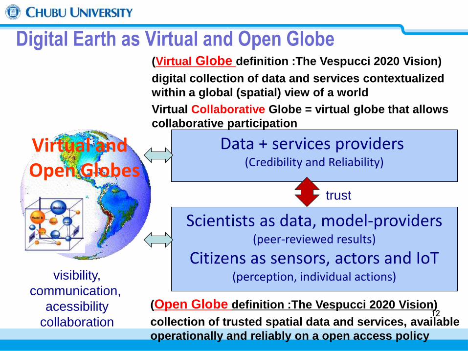
Digital Earth as Virtual and Open Globe
Data + services providers (Credibility and Reliability)
Scientists as data, model-providers (peer-reviewed results)
Citizens as sensors, actors and IoT (perception, individual actions) visibility,
communication,
acessibility
collaboration
Virtual and Open Globes
trust
(Open Globe definition :The Vespucci 2020 Vision)
collection of trusted spatial data and services, available
operationally and reliably on a open access policy
(Virtual Globe definition :The Vespucci 2020 Vision)
digital collection of data and services contextualized
within a global (spatial) view of a world
Virtual Collaborative Globe = virtual globe that allows
collaborative participation
12

13
Facilitate Open & Transparent Access to Data & Information
Integrate Spatial Information & Sustainable Development
Visualize Information for Decision Support
14
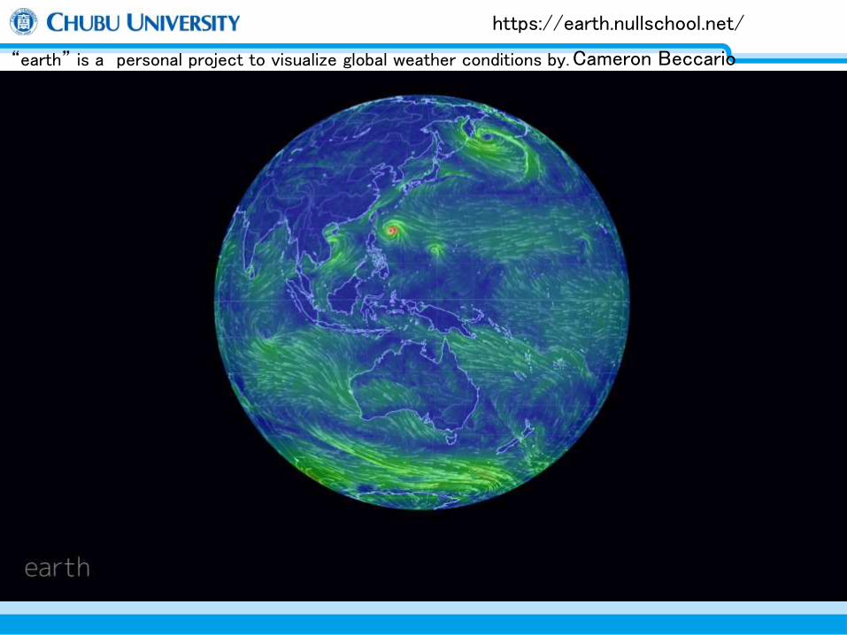
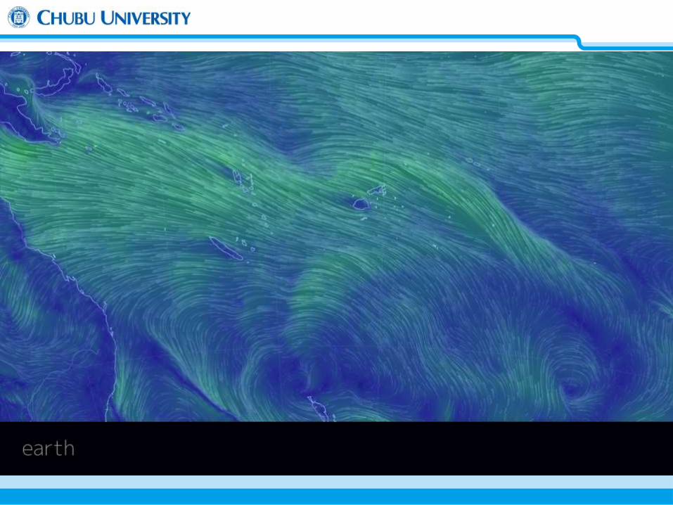
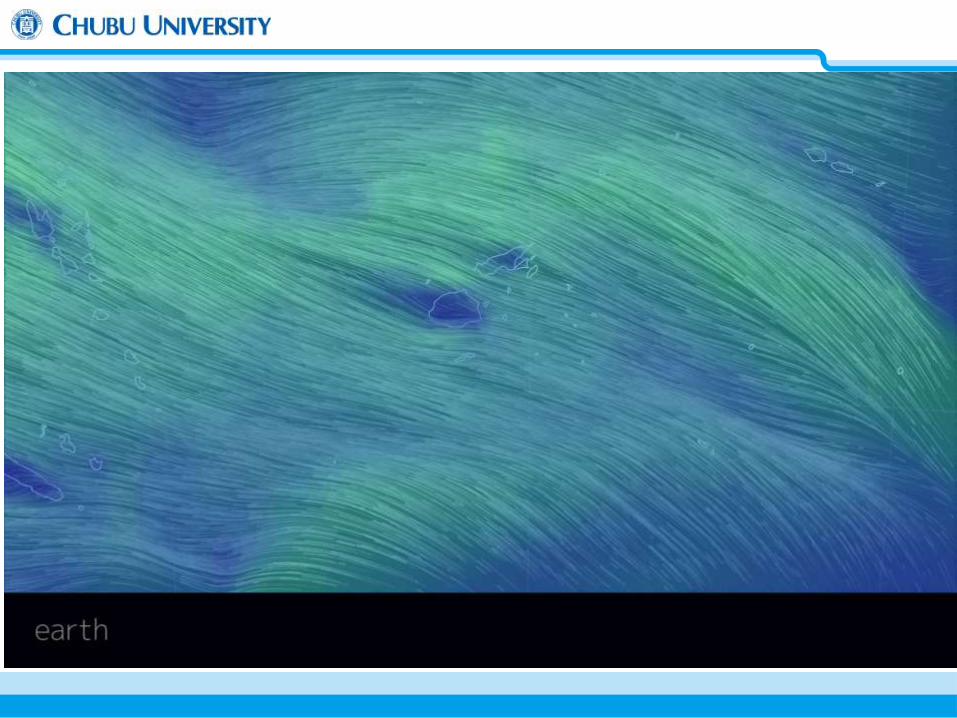
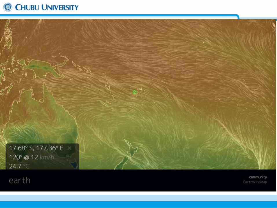
https://earth.nullschool.net/
“earth” is a personal project to visualize global weather conditions by. Cameron Beccario
15
16

17
18

19 Media Browser
Near Real time Monitoring
Remote Sensing
Data Processing
Digital Asia and Sentinel Asia Project
3D-Geo and Time Browser
Ubiquitous
Computing
Environment Ontological Crawler
Application Services
By Grid Computing
Social
Natural
Measuring the Real State of the World
Decoding the Earth and Human Evolution
Towards Intersubjectivities
Global Trends Data Resources
EO, SDI Spatial Statistics
News, Comments Web log
Digital Asia Research Centre for Strategic Design, Keio University Academic Frontier Project, Matching Fund Subsidy from MEXT(2004-2009)

20

Field Sensor Network
Remote Sensing
UAV
Weather Forecast
Flood
Simulation
EngineeringMachines
FMIS
Logistics
Evacuation
system
Damage Analysis
Emergency operation
Interoperable Information Platform
From vertical to horizontal
Distributed
DB
Distributed
DB Distributed
DB
Distributed
DB Distributed
DB
Appli 1
Field Sensor Network1
Visualization
Sensor
DB
Appli 2
Field Sensor Network2
Visualization
Sensor
DB
Standard / Common / Open API

22
Sentinel Asia (センチネルアジア)

23
Sentinel Asia
APRSAF*
Space Community
Satellite Image
Content
Promotion of Utilization
Capacity Building
Web-GIS Data / Meta Data Management
Information Sharing Platform
Content
Digital Asia
Digital Earth / Web-GIS Community
Digital Map Social / Economic Data Satellite Image
Disaster Reduction
Community
Disaster Information
Content
Utilization (User)
ADRC** Member Countries
UN / ESCAP ASEAN AIT etc.
International Community
International Cooperation
** Asian Disaster
Reduction Center
Joint Project Team (JPT) Join Project Team consists of total 52 organizations
including 45 agencies from 19 countries and 7
international organizations as of January 2007
* Asian Disaster
Reduction Center
* Asian-Pacific Regional
Space Agency Forum

Communication satellites
Earth observation satellites
Positioning satellites
Human network Capacity Building, Outreach
Concept of Sentinel Asia Step3 (2013 onwards)
Just after disaster Post-disaster
Information delivering to personal terminals
Pre-disaster
Monitoring Information/data
transmission
Information sharing (Web-GIS)
Response: Emergency observation
Mitigation: Community education
Preparedness: Hazard map Early warning system
Recovery: Monitoring
Disaster information

25
Sentinel Asia Step2 System
Data Provider Node (DPN)
Data Analysis Node (DAN)
Users
Satellite Data
JPT Member ADRC Member
Satellite Data
Analyzed Products
Analyzed Products
Other Information
Besides Sentinel Asia
Own Data
such as
Map,
Satellite
Data
Analyzed Products
JAXA, ISRO, GISTDA KARI, NARL
AIT, ADRC, ICIMOD LAPAN, MONRE, CRISP CEA, CAIAG, NCSRT Sri Lanka MoDM, SD BPPT, MO, etc.
Information using Web-GIS
Data/Information Sharing in Sentinel Asia
http://sentinel.tksc.jaxa.jp/
Public
EO Request

Wildfire WG -To contribute to the Asia-Pacific region with wildfire management -To contribution to REDD-plus -JST-JICA(*) project for wildfire and carbon management in a peatland in Kalimantan, Indonesia
Flood WG
-To contribute to the mitigation of flood disasters in Asia -Flood analysis using IFAS
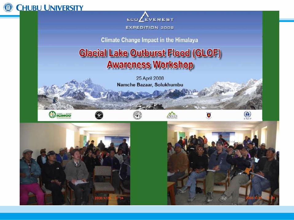
GLOF WG (Glacial Lake Outburst Flood)
-Monitor and establish early warning system in the risk areas -Local awareness and knowledge transfer through capacity building
Tsunami WG
-Tsunami early warning system
26
(*)JST: Japan Science and Technology Agency JICA: Japan International Cooperation Agency
Working Group Activities for Disaster Risk Reduction

Henri Poincare “We do not study nature because it is useful; we study it because we delight in it, and we delight in it because it is beautiful.”
“If nature were not beautiful, it would not be worth knowing, and if were not worth knowing, life would not be worth living”

Case Study on Imja Glacial Lake in Himalayan Range ( SRTM + ALOS )


© Pradeep Mool, ICIMOD

January 2015 2003 2008 2012 1995 1988
Landsat Image Date: January 2015
Resolution: 30 meters Source: Overlay footprint over World Map
View in Next ESA SAR Toolbox (NEST Version 5) Source: U.S. Geological Survey (USGS)

1993 1994 2000 2005
2006 2007 2008 2009 2010
1989
May


TerraSAR-X on Jan. 2008

ALOS
Networking of field sensor and transmission station in Mt. Everest region for the real time monitoring of Lake
Imja Tsho
Pangboche
Dingboche
Namche
bazaar
Chhukung Ri
Tengboche
Imja lake
Khumbu Glacier
Everest
25 Km


Real Time Sensing – Image, …
5/9 5/10 5/11 5/12

Solar energy-based systems to serve
as Early Warning System by Wireless Sensor Network
5
Wireless Base
Station
-Providing Internet as Social Infrastructure: Improve
Digital Divide
-Providing wireless sensor network for environmental
monitoring
-Providing early warning systems for Multi-Hazards, such
as GLOF
School
Residents
Hospital
Solar Power
Internet
Wireless Coverage site In Off-Grid Area
Environmental
Monitoring
Capacity Building
Local NGO, University,….
Climate Smart Village
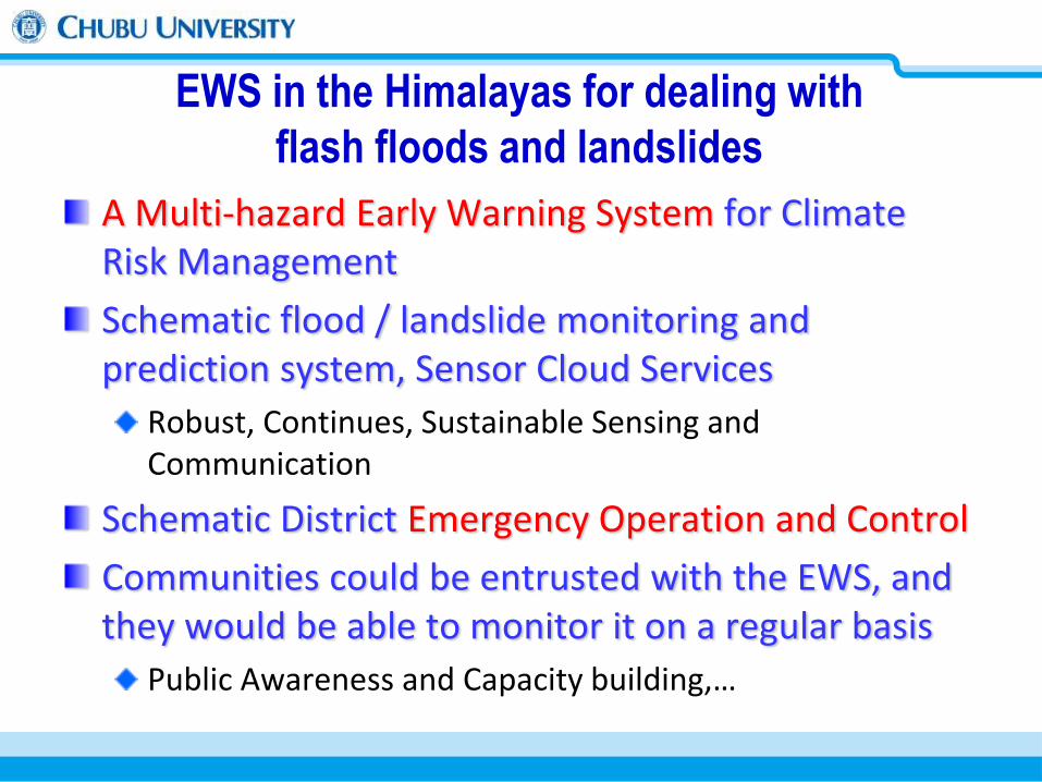
EWS in the Himalayas for dealing with
flash floods and landslides
A Multi-hazard Early Warning System for Climate Risk Management
Schematic flood / landslide monitoring and prediction system, Sensor Cloud Services
Robust, Continues, Sustainable Sensing and Communication
Schematic District Emergency Operation and Control
Communities could be entrusted with the EWS, and they would be able to monitor it on a regular basis
Public Awareness and Capacity building,…

Response Phase
Recovery Phase
Disaster Strike
Mitigation/Preparedness
Phase
Main Activities
・Capacity Building
・Success Story
・Pre-disaster Monitoring (*)
・Working Group
・Emergency Observation
・Data Analysis
・Emergency Operation Sys.(*)
・Recovery Support (*)
(*) under discussion
http://www.shin-godzilla.jp

Sentinel Asia Centre (24-hour operation)
AHA Centre (24-hour operation)
Damaged Area/district
UN and International Humanitarian
(WFP、OCHA, country)
Disaster response organization of damaged
Country (24 hours)
Disaster response activity information
Sentinel Asia Cloud Server System
DPN
P-DAN
DAN
DAN
DPN
DAN
DPN
Humanitarian Support
Sentinel Asia Step3 System Update
Steering Committee (SC)
Secretariat
WG WG WG
Disaster geographic information
WG WG
Legend: Management
GIS Operation
Humanitarian Support
ADRC UoT
Academy Researcher
NSDI
This is still Under Discussion

Concept for Sentinel Asia Centre
24 hours operation
EOR registration and communication between initiator during emergency operation
Observation request to DPN
DANs assignment for emergency analysis and communication between DANs for effective analysis to contribute to disaster response activity
Communication between AHA Centre for International humanitarian support
Emergency analysis support

45
ex. Global Warming ex. Resilient City
1. Collection and Storege of Information
and DataOntology, Clearing House, Meta Data Spatial
Information Global Discrete Grid VGI
Volunteered Geographic Information Open Data
Policy
2. Processing, Integration, Circulation of
Information and DataVisualization of Uncertainty, Inter-operability,
Assimilation of Spatio-temporal Information, Geo-
browser, Sensor Web Big Data Analysis
3. Dicision SupportVisualization of Multi-dimension and Multi-
resolution Information, Societal Implementation of
Risk Communication, Data Journalism
Phase I: Integration of Developments
Developments of
Digital Earth
Large Scale Small Scale
Phase II: to the Emerging Complex Systemic Programs
Science
Communication
System
Adoptation to
the Global Warming
Consensus Decision Making
about Atomic andRenewable Energy
Integration and
Visualization of
Realtime Sensing Data
Resilient and
Sustainable City
Vulnerability
Estimation
and Index Definition

46
ex. Global Warming ex. Resilient City
1. Collection and Storege of Information
and DataOntology, Clearing House, Meta Data Spatial
Information Global Discrete Grid VGI
Volunteered Geographic Information Open Data
Policy
2. Processing, Integration, Circulation of
Information and DataVisualization of Uncertainty, Inter-operability,
Assimilation of Spatio-temporal Information, Geo-
browser, Sensor Web Big Data Analysis
3. Dicision SupportVisualization of Multi-dimension and Multi-
resolution Information, Societal Implementation of
Risk Communication, Data Journalism
Phase I: Integration of Developments
Developments of
Digital Earth
Large Scale Small Scale
Phase II: to the Emerging Complex Systemic Programs
Science
Communication
System
Adoptation to
the Global Warming
Consensus Decision Making
about Atomic andRenewable Energy
Integration and
Visualization of
Realtime Sensing Data
Resilient and
Sustainable City
Vulnerability
Estimation
and Index Definition


49 Center of Excellence for integration and reorganization of knowledge using Digital Earth
Real time Simulation
Visualizing Uncertainty
Social
Geographic Engineering
Environment
Integration of Data (Knowledge)
Company
Local Government
Citizens, NGOs
City plan Hazard map etc
Evacuation Circumstance Individual information
Real-time Monitoring
Sensor・Special vehicle・UAV・Survey
Multi-monitor Conference room (Decision making team)
Smart grid Ubiquitous Sensor Infrastructure spatial data
University, Lab
Sensor data Sim data etc
Birds-eye-view Platform (Digital Earth)
(Citizens)
Instant understanding of circumstance Decision making, planning Offering information Statement/Discussion
Understanding Offering information Statement/Discussion
Cyber Conference room
Feedback
(Surveyor)
Specialist advice Explaining evidence Statement/Discussion
Technical info Supportive tech Hearing of needs
Internet
(Administrator)
Supplying the communication platform for various players
Supporting the decision making
International Rescue Base for Human Security
[Sensor city demonstration test] (Academic-Industrial alliance)
Feed
back
Hazard information Statement/Discussion
Devastation Data, etc
(Surveyor, Administrator)
Supporting the decision making
Evidence based Deliberation, gaming for Disaster/Risk Reduction

Extreme Whether Event and SNS as Citizen Sensor
0
2
4
6
8
10
12
14
0
20
40
60
80
100
120
16:0
0
16:1
0
16:2
0
16:3
0
16:4
0
16:5
0
17:0
0
17:1
0
17:2
0
17:3
0
17:4
0
17:5
0
18:0
0
18:1
0
18:2
0
18:3
0
18:4
0
18:5
0
19:0
0
19:1
0
19:2
0
19:3
0
19:4
0
19:5
0
20:0
0
20:1
0
20:2
0
20:3
0
20:4
0
20:5
0
21:0
0
21:1
0
21:2
0
21:3
0
21:4
0
21:5
0
22:0
0
2015/08/03
件数(件) 降水量(mm)
Number precipitation
2015/8/3 17:28
春日井 雹降ってる。 かなりデカイからボディボコボコいってる。('ω') Oh, it’s hailstorm in Kasugai, made big noise in my roof.
http://www.syobo.city.kasugai.aichi.jp/syobo/real/cgi/jihou.cgi

GIS car for emergency
UAV
Digital Earth Room
To Support Evidence based Deliberation
Digital Earth
Cloud Services

UAVs Application
Payload capability
Flying time 15minutes 1hour 4hours
20kg 3kg 500g
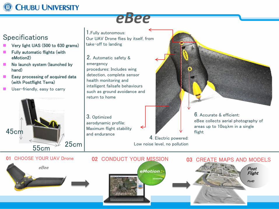
1.Fully autonomous: Our UAV Drone flies by itself, from take-off to landing
6. Accurate & efficient: eBee collects aerial photography of areas up to 10sq.km in a single flight
4. Electric powered: Low noise level, no pollution
3. Optimized
aerodynamic profile: Maximum flight stability and endurance
Specifications Very light UAS (500 to 630 grams)
Fully automatic flights (with eMotion2)
No launch system (launched by hand)
Easy processing of acquired data (with Postflight Terra)
User-friendly, easy to carry
55cm 25cm
45cm
2. Automatic safety & emergency procedures: Includes wing detection, complete sensor health monitoring and intelligent failsafe behaviours such as ground avoidance and return to home
eBee Post Flight
Pix4D
02 CONDUCT YOUR MISSION 01 CHOOSE YOUR UAV Drone 03 CREATE MAPS AND MODELS
eBee

Approx. 0.69 kg
96 cm (38in) EPP foam, carbon structure & Composite parts Electric pusher propeller, 160w brushless DC motor 11.1v 2150 mAh 16MP (XUS/ELPH) S110 RGB,therma Map 55x45X25cm
50 minutes 40-90km/h Upto 3km 12 sq.km (at 972 m AGL)
Up to 45km/h Down to 1.5cm per pixel 1-3x GSD Down to 3 cm 1-5 m Yes (inc mid-air collision avoidance) Yes
Approx.5 m
Weight (inc.Supplied Camera) Wingspan
Material
Propulsion Battery
Camera (supplied) Cameras (optional)
Carry Case Dimensions
Maximum flight time Normal cruise speed
Radio link range Maximum coverage(single flight)
Wind Resistance Ground Sampling Distance (GSD)
Relative Orthomosaic/3D Model Accuracy Absolute horizontal/vertical Accuracy (withGCPs) Absolute horizontal/vertical accuracy (no GCPs)
Multi UAV Drone operation Automatic 3D flight planning
Linear landing accuracy
HARDWARE
OPERATION
Technical Specification
• 2.4 GHz USB radio modem
for data link (includes USB
cable)
• Remote control & its
accessories for safety
pilots (if legally required)


Unmanned Aerial Vehicle (UAV), Sensor
eBee, Sensefly

Project ID:MANALI -01
Flight Altitude:230
Flight Lines:11
Total Photos: 88 photos
GSD: 13.95 cm
Area : 0.5932 km2 or
59.3217 ha
UAV Photo points
Project ID:MANALI -02
Flight Altitude:200 m
Flight Lines:7
Total Photos: 62 photos
GSD: 10.57 cm
Area :0.8216 km2/ 82.158 ha
2540m
2619m
Flying ebee in Indian Himalaya

5m Elevation Contour On ortho image

3D View

3D View

Research site in Maldives
Adaptation for Climate Change
61

62

63
型式/Model Terra-07
タイプ/Type Fixed Wing
重量/Weight 20kg
翼長/WingSpan 4m
全長/Full Length 3m
積載量/Peyload Capability
20kg
航続時間/Endurance 5hour-10hour
航続距離/Range 500km-1000km
航続速度/CruiseSpeed
40km/h-120km/h
推進装置/Propulsion Engine
http://terra-labo.jp/
Development the Long range UAV and System

64

65 Plan for UAV Test and Training Center for Disaster Management
管制圏
設置予定区域 大和村

Towards International Rescue Base
GIS Center
Disaster Medical
Care Center
Disaster
Equipment Center
Risk
Communication C.
Risk
Consultant Center
Cooperation
Collaboration C.
Thunderbird Rescue team ?
http://laird.fluid.energy.osakafu-u.ac.jp/Mworld/thunderbird/models-tb.html
Shift to more Operational MODE!


Summary and Next Step
The importance of DE, GIs and spatial planning is being recognized worldwide.
GI, with its ability to integrate various levels of data from many fields is acting as a bridge between various professional disciplines and citizens.
The Asia Pacific Region has a large and skilled pool of professional related GI. This region is geared to be the next destination for knowledge economy and Geo-enabling Society.
As for as Disaster Management,there is an urgent need of the shift to Operational Phase and Emergency Operation System based on SDI and Education, Capacity Building.

Digital Earth for Future Earth,
SDGs, ..
Call collaboration!