dss and maf (multi-agencies framework) for … and maf...dss and maf (multi-agencies framework) ......
TRANSCRIPT

International Environmental Modelling and Software Society (iEMSs) 2010 International Congress on Environmental Modelling and Software
Modelling for Environment’s Sake, Fifth Biennial Meeting, Ottawa, Canada David A. Swayne, Wanhong Yang, A. A. Voinov, A. Rizzoli, T. Filatova (Eds.)
http://www.iemss.org/iemss2010/index.php?n=Main.Proceedings
DSS and MAF (Multi-agencies framework) for
sustainable water management
Amgad Elmahdi1 and Don McFarlane2 Unit Head, Water Division- Bureau of Meteorology, Melbourne, Australi
[email protected] 2CSIRO land and water, Perth, Australia
Abstract: Water problems throughout the world can be seen as an issue of management, not a crisis of water shortage. Equitable allocation of groundwater resources is a growing challenge due to the increasing demand for water and the competing values placed on its use. Sustainable management of water resources comes with compromises and trade-offs of the other sub-systems (environment, economic and social) and almost ignores other stakeholders’ objectives and benefits. The aim of this paper is to present and discuss the hypothesis that “through multi-agency framework with supporting tools, such as a decision support system (DSS), a comprehensive framework can promote optimal, sustainable and equitable development and use of water resources for present and future generations.” Our framework has been successfully demonstrated in a case study at the Gnangara Mound groundwater system in Western Australia which showed what can be achieved with supporting DSS tools to facilitate and support the multi-agency framework and trade-offs analysis. DSS methods for assessing and planning the future are necessary to maintain the reliability and sustainability of water resource management in the long term. In addition, a DSS would assist the process of communicating the results with stakeholders, government and the community. Keywords: Sustainable management, trade-off analysis, multi-agency management, land use, integrated assessment, DSS 1. INTRODUCTION
A major challenge is to anticipate future water demands and supplies in a drying climate to accommodate the needs. In Australia, this challenge is very clear in Perth-Western Australia- Australia’s most rapidly growing city as the urban area extends onto the recharge area of the unconfined aquifer. The solution of sustainable water management problems is no longer seen as the exclusive responsibility of government. Rather, quasi-government organisations, the business community, civic organisations and citizens are demanding a greater voice in resource planning (e.g. Driessen and Glasbergen [2002]). Emergent forms of direct participation (e.g. interactive governance–participatory approach) by interested stakeholders in processes of collective decision-making are reducing the distance between government and their citizens. The participatory approach raises awareness of the importance of water among policymakers and the general public. Many studies have demonstrated how a participatory approach helps to develop the process of integrated water resource models (Giupponi et al. [2006], K’akumu [2008], Andreu et al.[2009], Frisvold and Caswell [2000]). The hypothesis presented and discussed in this paper is ‘that through multi-agency approach, a comprehensive framework can promote optimal, sustainable and equitable development and use of water resources for present and future generations could be guaranteed, with supporting tools such as a decision support system (DSS).’ To better understand the proposed approach, we present a case study that demonstrates implementation of the proposed framework. The case study site is the Gnangara Mound groundwater system, the most valuable and largest single source of water in Western

A. Elmahdi and D. McFarlane / DSS and Multi-agencies framework for sustainable water management
2
Australia (WA). Land use changes, climate change and many other factors have resulted in extreme recharge and discharge changes in the Gnangara Mound groundwater system, and the situation is no longer economically or socio-economically feasible. Raising awareness of sustainable groundwater is a crucial step (Elmahdi et al. [2006a]). Sustainability has become a major driving force for better water management systems (Elmahdi et al. [2006b]). Besides, current and future users need to be aware of and understand water system problems. Also, many private and public agencies and organisations question intensive management methods (many agencies involved) while they are using individual interest management methods (single agency/government department decision) (Dieme et al. [2002]). A history of using single agency decision-making approaches has resulted in imbalanced triple bottom line outcomes (environmental, economic and social). This has affected policy, legislation, production methods and costs, and marketability of products (Dieme et al. [2002]). Sustainable water management is necessary to match all stakeholders/agencies’ interests and profits. Thus, the main aim is to introduce and discuss the implementation of a multi-agency approach with DSS tool support and how it is critical for sustainable groundwater management processes, which we will demonstrate with a case study of the Gnangara Sustainability Strategy (GSS) project in WA. 2. CASE STUDY: GNANGARA MOUND GROUNDWATER SYSTEM The Gnangara Sustainability Strategy (GSS) is a cross-government initiative working on an action plan for sustainable use of water and protection of the environment. Seven government agencies have joined forces to form a taskforce group (TFG) to implement the GSS. The aim of the GSS is to ensure there is sufficient groundwater in the Gnangara Mound for drinking and commercial use, and to protect the environment — now and in the future. The Gnangara Mound is a large unconfined surface aquifer, supplies about 60% of Perth’s potable water supply (pop. 1.5 million), Australia’s most rapidly growing city (2.7% growth rate) and provides more than 85% of all water demand (e.g. irrigation of parks and gardens, industry and peri-urban horticulture).This groundwater system extends under the Swan Coastal Plain for approximately 2200 km2 north of the Swan River (Figure 1). Land use in the north is dominated by state-owned pine forests and natural bushland. South of the mound, the land is mainly urbanised with horticulture prominent.
Figure 1. Gnangara Mound area and common land use type
A. Elmahdi and D. McFarlane / DSS and Multi-agencies framework for sustainable water management
3
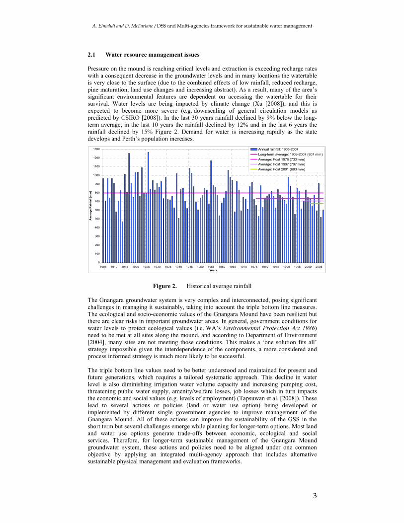
2.1 Water resource management issues Pressure on the mound is reaching critical levels and extraction is exceeding recharge rates with a consequent decrease in the groundwater levels and in many locations the watertable is very close to the surface (due to the combined effects of low rainfall, reduced recharge, pine maturation, land use changes and increasing abstract). As a result, many of the area’s significant environmental features are dependent on accessing the watertable for their survival. Water levels are being impacted by climate change (Xu [2008]), and this is expected to become more severe (e.g. downscaling of general circulation models as predicted by CSIRO [2008]). In the last 30 years rainfall declined by 9% below the long-term average, in the last 10 years the rainfall declined by 12% and in the last 6 years the rainfall declined by 15% Figure 2. Demand for water is increasing rapidly as the state develops and Perth’s population increases.
Figure 2. Historical average rainfall
The Gnangara groundwater system is very complex and interconnected, posing significant challenges in managing it sustainably, taking into account the triple bottom line measures. The ecological and socio-economic values of the Gnangara Mound have been resilient but there are clear risks in important groundwater areas. In general, government conditions for water levels to protect ecological values (i.e. WA’s Environmental Protection Act 1986) need to be met at all sites along the mound, and according to Department of Environment [2004], many sites are not meeting those conditions. This makes a ‘one solution fits all’ strategy impossible given the interdependence of the components, a more considered and process informed strategy is much more likely to be successful. The triple bottom line values need to be better understood and maintained for present and future generations, which requires a tailored systematic approach. This decline in water level is also diminishing irrigation water volume capacity and increasing pumping cost, threatening public water supply, amenity/welfare losses, job losses which in turn impacts the economic and social values (e.g. levels of employment) (Tapsuwan et al. [2008]). These lead to several actions or policies (land or water use option) being developed or implemented by different single government agencies to improve management of the Gnangara Mound. All of these actions can improve the sustainability of the GSS in the short term but several challenges emerge while planning for longer-term options. Most land and water use options generate trade-offs between economic, ecological and social services. Therefore, for longer-term sustainable management of the Gnangara Mound groundwater system, these actions and policies need to be aligned under one common objective by applying an integrated multi-agency approach that includes alternative sustainable physical management and evaluation frameworks.
0
100
200
300
400
500
600
700
800
900
1000
1100
1200
1300
1905 1910 1915 1920 1925 1930 1935 1940 1945 1950 1955 1960 1965 1970 1975 1980 1985 1990 1995 2000 2005Years
Ave
rag
e R
ain
fall
(mm
)
Annual rainfall: 1905-2007
Long-term average: 1905-2007 (807 mm)
Average: Post 1976 (733 mm)
Average: Post 1997 (707 mm)
Average: Post 2001 (683 mm)

A. Elmahdi and D. McFarlane / DSS and Multi-agencies framework for sustainable water management
4
3. MULTI-AGENCY FRAMEWORK Given the complexity and often contentious nature of resource allocation, success requires a process for the inclusive and transparent sharing of ideas complemented by tools to structure, quantify and visualise the collective understanding and data, providing an informed basis of dialogue, exploration and decision-making (Tidwell and Brink [2008], Cockerill et al. [2007]). The need for an integrated multi-agency approach is a logical approach or way forward to achieve sustainable groundwater management for longer-term planning. The potential advantage of the multi-agency framework over single-agency options is that it can avoid or minimise any obstacles or any factors that reduce the ability of a participating agency achieving its objectives. For example, proposed land use options after removal of pine plantations that can achieve positive economic objectives or outcomes could result in critical ecological outcomes and deteriorated water quality. Future objectives and actions should be addressed by many agencies to reach a reasonable agreement through each step of the multi-agency framework. A multi-agency approach and its framework have to be viewed as integral parts of land and water management planning processes. An integrated multi-agency approach for sustainable groundwater management requires a new framework and new tools for analysis and planning. The framework for a multi-agency approach to land and water management of the Gnangara Mound groundwater system is shown in Figure 3.
Figure 3. A multi-agency framework developed for the Gnangara Mound groundwater
management system, 2008
It has eight sequential steps that occur over two phases: the communication and problem statement phase, and the evaluation and recommendations phase. The communication and problem statement phase (phase 1) is where communication starts among stakeholders to articulate the problem and its main issues. This helps to develop a single, integrated objective and to define a set of proposed scenarios. In the evaluation and recommendations

A. Elmahdi and D. McFarlane / DSS and Multi-agencies framework for sustainable water management
5
phase (phase 2), a common objective is proposed either as part of an existing development plan or as a ‘next step’ following problem analysis for evaluation, and its impact assessment is communicated with the community and government agencies. The eight steps that define the process of the framework are as follows: Step 1: Develop a communication plan to facilitate communication and dialogue between all stakeholders and get them all together on one table. This also involves the modelling and database people. Step 2: Run several workshops to define the study area and its boundary, the problem statement and its main issues from the different perspectives held by different stakeholders. Describe the boundary conditions and scale for reporting, and the entry and exit points of water flow. Also at this step, analyse problems and opportunities of related water management options. Step 3: Through cross-agency dialogue, define a common objective or cross-agency option/objective to improve land and water use and plan for sustainable system management. Step 4: In consultation with policy and management experts and all stakeholders, define a list of scenarios or options for better land use and groundwater resource management. Scenarios or options (goods and services) can be implemented, preferably in a way that does not jeopardise the future potential of these options (i.e. environmental sustainability). This step feeds into modelling and developing the main database. Step 5: As each option can benefit and affect one or more groups of stakeholders, clarify each agency’s role and set a timeframe for each option with clear sharing and exchanging of information between agencies. This step can help to build a complete and integrated database that will feed into the decision support system (DSS) or modelling tool. Step 6: Evaluate each listed scenario or option in terms of its economic, social and environmental values/indicators such as total agricultural revenue, water opportunity cost per land use type, revenue per land use type, wetlands recreation values and augmentation cost, value per megalitre per user, groundwater level, etc. This step involves modelling (i.e. developing a dynamic DSS), including scenario analysis, sensitivity analysis, evaluation (using multi-criteria analysis) and better estimation of the trade-offs. Step 7: Deliver and communicate the preliminary outcomes of the analysis to the community. Organise several workshops to engage the community and communicate the outcomes from step 6 (evaluation of proposed scenarios or options) with clear discussion of the trade-offs. Step 8: Describe institutional gaps and needs to inform policymakers or high-level government. Based on the proposed options, feedback from the community and institutional requirements, define recommendations for effective implementation. These requirements and community feedback will identify gaps in the existing institutional arrangements and implementation mechanism. Also in this step, communicate the recommendations to governments and decision-makers. This multi-agency framework provides a tool to identify the needs from a stakeholder perspective. It can also be used to identify the institutional gaps and the arrangements necessary to address the issues pertaining to integrated sustainable groundwater resources management. 4. THE NEED FOR A DSS In the Gnangara Mound case study, application of the eight steps of the Integrated Multi-agency framework (Elmahdi and McFarlane [2009]) clearly demonstrated the need for a DSS tool to facilitate the process and to communicate the analysis with the community, researchers, stakeholders and water managers. There is a clear trade-off between the three

A. Elmahdi and D. McFarlane / DSS and Multi-agencies framework for sustainable water management
6
systems (environmental, social, economical), so they must be considered as sub-systems. Any maximisations or minimisations of a sub-system objective that does not consider the impacts on the others — although it may appear viable and worthwhile in the limited perspective in which it is considered — may severely damage the overall system (which has been taking place so far). In order to comply with the multi-agency framework, there is a need to pull together a structured but easy-to-understand platform (i.e. DSS) that addresses different key aspects, such as hydrological, hydraulic, environmental, socio-economic, finance-economic, institutional-legislative and political-strategic factors. This necessitates simultaneous accounting of many different and non-commensurable pieces of information. It is hugely difficult to perform this without a suitable computer-based tool. The simulation paradigm is now considered to be the best approach because simulation models can be more representative of reality and many of the decision variables are not under full control of the stakeholders. If the optimisation paradigm can be used, decisions would be assumed on behalf of other stakeholders. Therefore, optimisation will lead to isolation of the other stakeholders in the water resources planning process, rather than their involvement. Furthermore, dynamic simulation is much more transparent compared to optimisation techniques, which allows the user to understand the interaction and relationships among the different variables, especially the variables related to people. Apart from the difficulty of merging data and pieces of information of a diverse nature (often qualitative and incomplete) two other reasons prevail. The first is the need to comply with vast numbers of rules and regulations that are related to water resources planning and management but often are not provided in an integrated, harmonised and rational framework. The second reason is the increasing claim for community participation in decision-making processes. In summary, our view is that the most fruitful approach is to use computer-based tools (DSS) to predict and assess the effects of any actions by performing an integrated analysis of environmental and socio-economic aspects. This forecasting exercise may rely on a broad set of tools ranging from expert systems, expert-based value functions and empirical equations to complex mathematical models. All or most of these tools can be integrated into one computer-based tool to facilitate and support the multi-agency framework and trade-offs analysis. In addition, the DSS assists the process of communicating the results with stakeholders, government and the community (Zaman et al [2009], and Elmahdi and McFarlane [2009]). 4.1 DSS Criteria
DSS criteria developed and recommended by the task force group which can be considered as general criteria for DSS in land and water management and planning processes. Theses criteria consider the DSS potential use, development and future update. These criteria are summarized as follows:
1. The DSS should be able to assess land and water management options to provide quantitative assessment (with acceptable technical level)
2. It should be able to address several scenarios (climate, land uses, land management, water allocations)
3. It should be able to incorporate available economic, social and environmental data and values
4. It should be able to communicate scenarios (climatic/water and land) to managers and informed community members
5. It should be able to include spatially distributed information (but not dynamically linked to GIS at this stage) and not highly lumped
6. It should be able to incorporate other credited and available models such as PRAMS (regional groundwater model) / Local Area Model groundwater data but not be dynamically linked (at this stage)
7. It should be able to assess different scenarios using different time horizon (2110, 2020, 2030 and 2060) with more precision for 2005 to 2030 likely
8. It should be able to include Monthly time-step (to align with climate, PRAMS, groundwater monitoring, seasonal water use)

A. Elmahdi and D. McFarlane / DSS and Multi-agencies framework for sustainable water management
7
9. it should be structurally able to be adapted to incorporate more detail as required for specific areas/sub-area/ landuse as it becomes available
10. It should be well documented and clear so that it can be used and modified by many people for building capacity (i.e. not dependent on a single user)
4.1 DSS concept and design
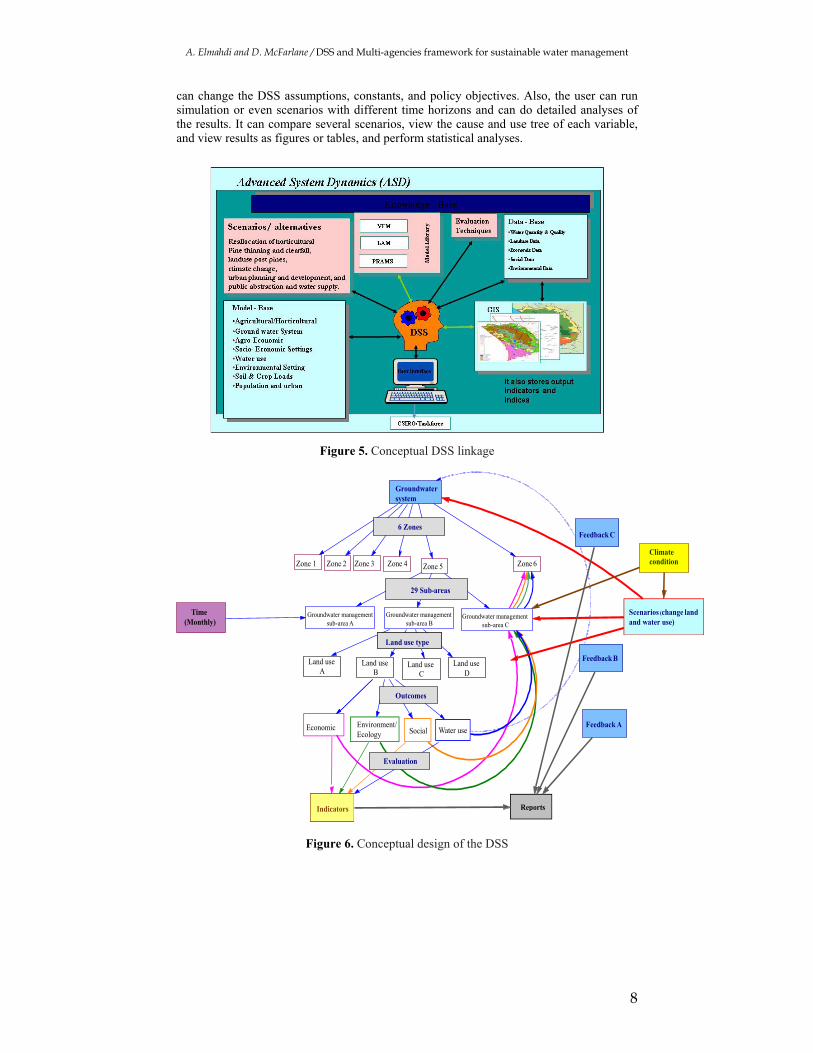
Given the complexity and often contentious nature of resource allocation, success requires a process for the inclusive and transparent sharing of ideas complemented by tools to structure, quantify and visualise the collective understanding and data, providing an informed basis of dialogue, exploration and decision-making (Tidwell and Brink [2008], Cockerill et al. [2007]). The need for an integrated multi-agency approach using a DSS is a logical approach to achieve sustainable groundwater management for longer-term planning (Elmahdi and McFarlane, [2009]). By utilising and integrating the expertise of multiple WA state agencies, we can develop and apply a DSS that integrates most of the available information. Without this integration, there is potential for greater conflict between agencies’ objectives and actions. The future analysis methodology or process used in this study is shown in Figure 4.The key focus of the Gnangara DSS is on the implementation of key identified actions by stakeholders in terms of landuse changes, water allocation and establishing groundwater dependent ecosystem requirements. To be successful it will require significant data and intellectual input from other projects under the GSS so that adaptive management options can be evaluated. The framework of the DSS and its linkage to other database and models such as PRAMS (regional groundwater model), LAM (local area model), VFM (Vertical flux model), and scenario development is shown in Figure 5. The boundary and the scale of the DSS have been determined by the task force group.
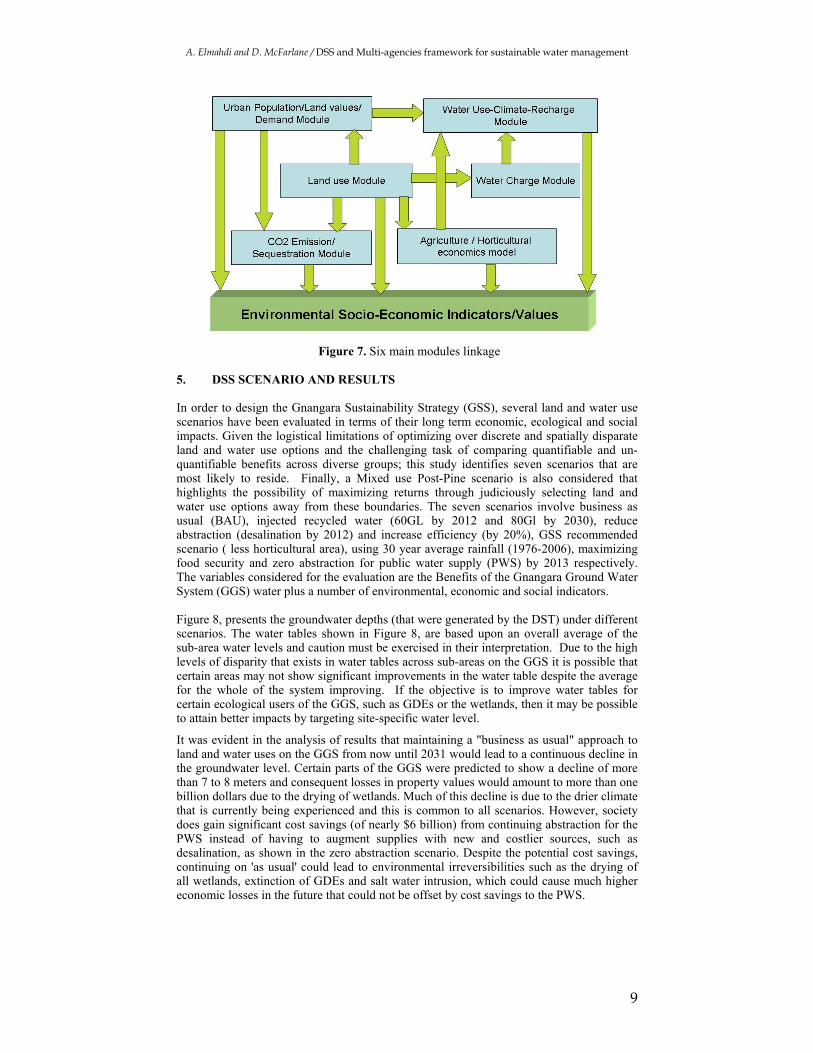
Figure 4. Conceptual approach (adopted from Conner et al 2009) A total of 29 sub-areas are modelled under six geographical zones. Each sub-area is modelled by the main interconnected six modules that lead to the quantitative indicators (environment, economic and social) values based on the land use type (see Figure 6). These six modules are tried to represent and mimic the most interdependencies between land use and system components (see Figure 7). There are several feedbacks built in the DSS to reflect from small scale/resolution to large? scale. All these scales can be tested with different climate condition and other land use scenarios. The developed GSS-DSS is used by TFG to readily set up scenarios in the DSS and analyse their impacts on Gnangara groundwater system and its values. This can be done by simple control screens; the user
A. Elmahdi and D. McFarlane / DSS and Multi-agencies framework for sustainable water management
8
can change the DSS assumptions, constants, and policy objectives. Also, the user can run simulation or even scenarios with different time horizons and can do detailed analyses of the results. It can compare several scenarios, view the cause and use tree of each variable, and view results as figures or tables, and perform statistical analyses.
Figure 5. Conceptual DSS linkage
Figure 6. Conceptual design of the DSS
Zone 6Zone 1 Zone 2 Zone 3 Zone 4 Zone 5
Groundwater system
Groundwater management sub-area A
Land use A
Economic Environment/Ecology Social Water use
Climate condition
Time (Monthly)
Feedback A
Feedback C
Feedback B
Scenarios (change land and water use)
Indicators Reports
6 Zones
29 Sub-areas
Land use typeLand use type
Outcomes
Evaluation
Groundwater management sub-area B
Groundwater management sub-area C
Land use B
Land use C
Land use D
A. Elmahdi and D. McFarlane / DSS and Multi-agencies framework for sustainable water management
9
Figure 7. Six main modules linkage
5. DSS SCENARIO AND RESULTS In order to design the Gnangara Sustainability Strategy (GSS), several land and water use scenarios have been evaluated in terms of their long term economic, ecological and social impacts. Given the logistical limitations of optimizing over discrete and spatially disparate land and water use options and the challenging task of comparing quantifiable and un-quantifiable benefits across diverse groups; this study identifies seven scenarios that are most likely to reside. Finally, a Mixed use Post-Pine scenario is also considered that highlights the possibility of maximizing returns through judiciously selecting land and water use options away from these boundaries. The seven scenarios involve business as usual (BAU), injected recycled water (60GL by 2012 and 80Gl by 2030), reduce abstraction (desalination by 2012) and increase efficiency (by 20%), GSS recommended scenario ( less horticultural area), using 30 year average rainfall (1976-2006), maximizing food security and zero abstraction for public water supply (PWS) by 2013 respectively. The variables considered for the evaluation are the Benefits of the Gnangara Ground Water System (GGS) water plus a number of environmental, economic and social indicators. Figure 8, presents the groundwater depths (that were generated by the DST) under different scenarios. The water tables shown in Figure 8, are based upon an overall average of the sub-area water levels and caution must be exercised in their interpretation. Due to the high levels of disparity that exists in water tables across sub-areas on the GGS it is possible that certain areas may not show significant improvements in the water table despite the average for the whole of the system improving. If the objective is to improve water tables for certain ecological users of the GGS, such as GDEs or the wetlands, then it may be possible to attain better impacts by targeting site-specific water level.
It was evident in the analysis of results that maintaining a "business as usual" approach to land and water uses on the GGS from now until 2031 would lead to a continuous decline in the groundwater level. Certain parts of the GGS were predicted to show a decline of more than 7 to 8 meters and consequent losses in property values would amount to more than one billion dollars due to the drying of wetlands. Much of this decline is due to the drier climate that is currently being experienced and this is common to all scenarios. However, society does gain significant cost savings (of nearly $6 billion) from continuing abstraction for the PWS instead of having to augment supplies with new and costlier sources, such as desalination, as shown in the zero abstraction scenario. Despite the potential cost savings, continuing on 'as usual' could lead to environmental irreversibilities such as the drying of all wetlands, extinction of GDEs and salt water intrusion, which could cause much higher economic losses in the future that could not be offset by cost savings to the PWS.

A. Elmahdi and D. McFarlane / DSS and Multi-agencies framework for sustainable water management
10
27
27.5
28
28.5
29
29.5
30
30.5
31
2008
2010
2012
2014
2016
2018
2020
2022
2024
2026
2028
2030
2032
2034
2036
2038
2040
2042
2044
2046
2048
2050
2052
2054
2056
2058
2060
Year
Gro
un
dw
ater
Lev
el (
m)
Injected recycled w ater
Reduce Abstraction and increase eff iciency
Business as Usual
GSS Recommended Scenario
30 Year Average Rainfall Scenario (1976-2006)
Figure 8. Groundwater depths
The key messages of the results and analysis of the other scenarios are:
1. The GSS recommended scenario improves the land uses in the post-pine areas by planting more bush corridors to enhance biodiversity; reduces PWS and bore abstraction; and significantly reduces horticultural uses of the GGS water. This leads to a net marginal improvement in the water table and gains to the environment through bush corridors.
2. the GSS recommended scenario does not help avoid the losses in wetlands as most of the suggested land and water use changes are not specifically targeted to positively influence the water table around wetlands.
3. If the 1976-2006 rainfall pattern were to repeat in the future, the sub-area water tables would improve all across the GGS. The average water table would fare much better than in the BAU and the GSS recommended scenarios. However, climate projections up to 2030 suggest that the magnitude of the projected rainfall changes in the south western part of WA is between -2 and -20 percent than that of 1960-1990 and increasing later in the century (Bates et al. 2008). This highlights the urgent need to move away from current land and water use practices if society is concerned about the sustainability of the GGS under an even more severe climate regime.
4. The increased allocation to commercial/industrial and urban (residential) land use are projected to generate additional employment of nearly 100,000 jobs by 2030, of which 27,000 is generated through urban (residential) and 71, 000 through commercial/industrial land uses.
5. Drastic measures, such as zero abstraction by all Gnangara water users, need not be taken as they are excessively costly to society ($11.5 billion of negative NPV for zero abstraction, $10 billion costlier than the BAU scenario), despite a significant rise projected in the water table over time. It is possible to reduce abstraction through a combination of low cost options and prevent excessive societal costs from zero abstraction.
5. Conclusion By utilising and integrating the expertise of multiple state agencies, we can develop and apply a potential sustainability framework. Without this integration or multi-agency planning dialogue (Elmahdi and McFarlane [2009]), there is potential for greater conflict between agencies’ objectives and actions. With MAF and DSS, allow thorough understanding of the triple bottom line Impacts and ease the selection of preferred options because of its trade-offs and outcomes are understood. In addition, the DSS has a number of other benefits as follow:

A. Elmahdi and D. McFarlane / DSS and Multi-agencies framework for sustainable water management
11
• DSS would assist the process of communicating the results with stakeholders,
government and the community.
• DSS methods for assessing and planning the future are necessary to maintain the reliability and sustainability of water resource management in the long term.
However, we need to consider some of the main issues with any tools and /or DSS:
1. Sometimes, the tools require a level of expertise or knowledge that users do not possess. For example, they may be comfortable dealing with technical information, but uncomfortable with socio-economic information.
2. The tools should be flexible for different people to use them in ways that suit them and meet their need.
3. The tools should be simplified to the end user to reduce the complexity. 4. The tools should be free of bugs. It doesn't take much of a bug for potential
users to lose confidence. 5. The tools should be well documented with adequate help facilities and not just
rely on one technical person. 6. At the end, the tools should be developed with adequate consultation and
collaboration with intended users.
ACKNOWLEDGMENTS This work was funded by the Gnangara Sustainability Strategy (GSS) and the CSIRO Water for a Healthy Country Flagship. The authors gratefully acknowledge the considerable advice and assistance from the members of the Gnangara Sustainability Strategy Taskforce. The authors would also like to thank the Water Division-Bureau of meteorology of supporting travel and writing paper times. REFERENCES Andreu, J., M. A. Pérez, J. Paredes, and A. Solera, (2009), “Participatory analysis of the
Jucar-Vinalopo (Spain) water conflict using a Decision Support System”, in 18th World IMACS/MODSIM Congress, Cairns, Australia, 13-17 July. http://mssanz.org.au/modsim09.
Bates, B.C., Hope, P. Ryan, B., Smith, I. and Charles, S. (2008) 'Key findings from the Indian Ocean Climate Initiative and their impact on policy development in Australia', Climate Change, 89: 339-354.
Cockerill K, Tidwell VC, Passell HD and Malczynski LA (2007). COMMENTARY: Cooperative modeling lessons for environmental management. Environmental Practice 9:28–41.
CSIRO (2008). Water availability in the Murray-Darling Basin. A report to the Australian Government from the CSIRO Murray-Darling Basin Sustainable Yields Project. CSIRO, Australia. 67pp.
Department of Environment (2004). Environmental Management of Groundwater Abstraction from the Gnangara Groundwater Mound, 2003–2004: Annual Compliance Report to the Environmental Protection Authority, WA Department of Environment, Perth.
Dieme J, Phillips R, and Hillon M, (2002). New Mexico Chile Task Force An Industry-UniversityResponse to Global Competition College of Agriculture and Home Economics Cooperative Extension Service-Agricultural Experiment Station
Driessen PPJ and P Glasbergen (2002). New directions in environmental politics —Concluding remarks. In: Greening Society: The Paradigm Shift in Dutch Environmental Politics, Driessen PPJ and Glasbergen P (eds), Kluwer Academic Publishers, The Hague, 245–262.
Elmahdi A, Kheireldin K.and Hamdy A (2006b). GIS and multi-criteria evaluation: Robust tools for integrated water resources management. IWRA 31(4).
A. Elmahdi and D. McFarlane / DSS and Multi-agencies framework for sustainable water management
12
Elmahdi A, Malano H, and Khan S (2006a).Using a system dynamics approach to model sustainability indicators for the irrigation systems in Australia. Natural Resource Modeling 19(4):465-481.
Elmahdi, A., and D. McFarlane, (2009), “A decision support system for a groundwater system Case Study: Gnangara Sustainability Strategy Western Australia”, in 18th World IMACS/MODSIM Congress, Cairns, Australia, 13-17 July. http://mssanz.org.au/modsim09
Frisvold GB and Caswell MF (2000). Transboundary water management Game-theoretic lessons for projects on the US–Mexico border. Agricultural economics 24(1):101–111.
Giupponi C, Crimi J and Mysiak J (2006). Participatory Approach in Decision Making Processes for Water Resources Management in the Mediterranean Basin. Fondazione Eni Enrico Mattei Working Papers. Working Paper 7. Fondazione Eni Enrico Mattei, Milano.
K'akumu O A (2008). Mainstreaming the participatory approach in water resource governance: The 2002 water law in Kenya. Development 51(1):56–62.
Tapsuwan S, Ranjan R, McFarlane D and Elmahdi A (2008). Economic and Social Values of Land and Water Uses on the Gnangara Groundwater System. WA Department of Water, Perth. Technical report, CSIRO: Water for a Healthy Country National Research Flagship, Canberra; 2008.
Tidwell VC and Brink C (2008). Cooperative modeling: linking science, communication, and ground water planning. Ground Water 46(2):174–182.
Xu C (2008) Modelling of Groundwater levels on the Gnangara mound. Version 2.0 produced by Strategic Issues Planning Infrastructure Planning Branch, Perth, WA 2008.