drones for disaster response and relief...
TRANSCRIPT

Drones for Disaster Response
and Relief Operations
APRIL 2015
Participation by:

Table of ContentsGlossary of Acronyms 3 ....................................................................................................................................................1. Executive Summary 4 ................................................................................................................................................
a) Policy Recommendations 5 ........................................................................................................................................................b) Use Cases 6 ....................................................................................................................................................................................c) Platforms, Payloads, Software 7 ................................................................................................................................................
2. Introduction 8 ...............................................................................................................................................................3. Policy Recommendations 9 .......................................................................................................................................4. Use Cases 12 ................................................................................................................................................................
a) Reconnaissance and Mapping 15 ..............................................................................................................................................b) Structural Integrity Assessment 17 ............................................................................................................................................c) Temporary Infrastructure / Supply Delivery 20 ......................................................................................................................d) Wildfire Detection and Extinguishing 21 ..................................................................................................................................e) High-Rise Building Fire Response 23 .......................................................................................................................................f) Chemical, Biological, Radiological, Nuclear, or Explosive (CBRNE) Events 25 ..............................................................g) Search and Rescue Operations 27 ............................................................................................................................................h) Insurance Claims Response and Risk Assessment 29 ........................................................................................................i) Logistics Support 32 ......................................................................................................................................................................
5. Platforms, Payloads, and Software 34 .....................................................................................................................a) Aerial Drone Types 34 ..................................................................................................................................................................
i) Group 1 34 ii) Group 2 35 iii) Group 3 35 iv) Group 4 36 v) Group 5 36
6. Payloads 37 ..................................................................................................................................................................a) Electro-Optical/Infrared (EO/IR) Sensors 37 ............................................................................................................................b) Mapping sensors 37 ......................................................................................................................................................................c) Communications Relay 38 ...........................................................................................................................................................d) Sniffers 38 e) Cargo Space / Personnel Capsule 38 ......................................................................................................................................f) Firefighting Tools 39 ......................................................................................................................................................................g) Other 39
7. Software 40 ..................................................................................................................................................................a) Software for Disaster Mitigation and Response Currently in Use 40 ...............................................................................
i) FEMA (Federal Emergency Management Agency) 40 .................................................................................................................ii) Crisis Mapping 40 ..................................................................................................................................................................................iii) Response Coordination 41 ...................................................................................................................................................................
b) Native Software Platforms Currently Used by Drone Manufacturers 41 .........................................................................i) 3D Robotics 41 ii) Airware 41 iii) Parrot 41
c) Software Solutions to Customize Drones for Disaster Response 42 ...............................................................................8. Representative Platforms and Payloads 43 ............................................................................................................
a) Group 1: Lockheed Martin Indago 43 ........................................................................................................................................b) Group 2: Boeing / Insitu ScanEagle 43 ....................................................................................................................................c) Group 3: Textron Shadow M2 44 ...............................................................................................................................................d) Group 4: Lockheed Martin K-MAX 45 .......................................................................................................................................e) Group 5: Aerovironment Global Observer 45 ........................................................................................................................
9. Drone Deployment Models 46 ..................................................................................................................................a) Privately-Owned Fleets 46 ..........................................................................................................................................................b) Public-Private Partnerships 47 ....................................................................................................................................................c) Drone as a Service® 47 .................................................................................................................................................................
10. Conclusion 49 ..............................................................................................................................................................11. Bibliography 50...........................................................................................................................................................
� 2

Glossary of Acronyms
Section 333 – Section 333 of the FAA Modernization and Reform Act of 2012 (FMRA) grants the Secretary of Transportation the authority to determine whether an airworthiness certificate is required for a UAS to operate safely in the National Airspace System (NAS).
C2 – Command and control. The data link between a drone and its operator that allows the operator to control the drone’s movements and actions.
COA – Certificate of Waiver or Authorization. Issued by the FAA Air Traffic Organization to an operator for a specific unmanned aircraft activity
CRASAR — Center for Robot-Assisted Search and Rescue. Headquartered at Texas A & M University, CRASAR is a leading research group in disaster robotics, which conducted test flights for this study.
EO sensor – Electro-optical sensor. On drones, most commonly a digital camera that detects light on the visual spectrum.
EO/IR – Dual electro-optical and infrared sensor.
IR – Infrared. The infrared spectrum refers to long-wave radiation beyond the visual spectrum of light. IR sensors can detect and visualize heat signatures.
LiDAR – LiDAR uses lasers to create high-resolution 3D maps.
NPRM – Notice of Proposed Rulemaking. Issued by a federal executive agency before a change to regulations, an NPRM is released to the public for comment before permanent rules are instituted. FAA released an NPRM for small UAS (under 55 lbs.) in February 2015.
SAR – Synthetic Aperture Radar. A form of radar that can create detailed 2D and 3D maps and cut through fog and smoke.
UAS – Unmanned aerial system. An unmanned aircraft and associated elements, including communication links and the components that control the unmanned aircraft they are required for the pilot in command to operate safely and efficiently in the national airspace system (P.L. 112-95, Section 331).
UA – Unmanned aircraft. Any aircraft that is operated without the possibility of direct human intervention from within or on the aircraft (P.L. 112-95, Section 331).
� 3

1. Executive Summary
Aerial drones are one of the most promising and powerful new technologies to improve disaster response and relief operations. Drones naturally complement traditional manned relief operations by helping to ensure that operations can be conducted safer, faster, and more efficiently.
When a disaster occurs, drones may be used to provide relief workers with better situational awareness, locate survivors amidst the rubble, perform structural analysis of damaged infrastructure, deliver needed supplies and equipment, evacuate casualties, and help extinguish fires—among many other potential applications.
In advance of an emergency, drones are able to assist with risk assessment, mapping, and planning. When individuals, businesses, and communities are able to understand and manage risks and plan effectively, they reduce overall damage and losses. Rebuilding and recovery are then able to begin more quickly and ultimately strengthening the resiliency of communities.
Drones have long been described as optimally suited to perform the “3-D” missions, often described as dirty, dull, and dangerous. They can provide needed aerial data in areas considered too hazardous for people on the ground or for manned aircraft operation, such as sites with nuclear radiation contamination or in close proximity to wildfires. Drones can also deliver needed supplies and relay Wi-Fi and cellular phone service when communications are needed the most.
This report will discuss how drones and the aerial data they collect can be used before, during, and after a disaster. It includes an overview of potential solutions and deployment models, as well as, recommendations on removing regulatory barriers to their use.
The American Red Cross, leading private sector companies, and federal agencies coordinated by Measure, a 32 Advisors Company, have come together to explore and explain how and why drones should be used in the wake of natural disasters and other emergencies that threaten widespread loss of life and property.
Project sponsors included:
• Guy Carpenter & Co., Inc. • IBM Smarter Cities • Insitu/Boeing • Lockheed Martin • UPS • USAA • Willis Group • Zurich North America
Key public sector participants included:
• FAA • FEMA • NEMA • U.S. Department of Homeland Security • U.S. Coast Guard
� 4

• Washington State • New York State • State of New Jersey • Disaster City @ Texas A&M Engineering Extension Service (TEEX) | Emergency Services
Training Institute
Work on this report began on November 12, 2014 at the American Red Cross headquarters in Washington, D.C. In the succeeding months, Measure has worked in close collaboration with the report’s sponsors and the American Red Cross, hosting weekly progress calls. In early 2015, the team met with staff from state emergency management offices in New Jersey, New York, and Washington State to discuss the agencies’ past drone use, determine alternate uses for drones in disaster relief, and consider deployment models. Test flights in support of this project would not have been possible without the partnership and support of Dr. Robin Murphy at the Center for Robot-Assisted Search and Rescue (CRASAR). Dr. Murphy is a professor of computer science and engineering and has extensive experience in disaster robotics. CRASAR has pioneered the use of robots in disaster response for years, sending search and rescue robots into 21 catastrophes around the globe over the last decade. CRASAR operated drones in the Ground Zero rubble after 9/11 and flew reconnaissance drone missions over New Orleans after Hurricane Katrina in 2005.
In March 2015, Measure, Dr. Murphy’s team, and the sponsors of this report successfully tested and demonstrated the capabilities of drones in a chaotic post-disaster simulation. The FAA-approved trial flights conducted at Disaster City®, Texas, a disaster-training site administered by the Texas A&M Engineering Extension Service, evaluated the accuracy and ability of drones in assessing damage to buildings and infrastructure. Our work since November 2014 has focused on the following three areas:
• Policy Recommendations • Use Cases • Platforms, Payloads, Software
a) Policy Recommendations
The Federal Aviation Administration (FAA), whose stated mission is “to provide the safest, most efficient aerospace system in the world,”1 has been understandably cautious in integrating drones into the national airspace. Nevertheless, considering the immediate benefits for civilians, communities, and first responders, integrating drones into emergency and disaster response protocols should be a top priority for the FAA and other federal, state, and local entities. At present, private sector companies, even with Section 333 exemptions, are unable to quickly respond to a disaster because of challenges associated with the COA process. This process may take up to 60 days, and if left unchanged would further delay the use of drones to collect aerial data for disaster response efforts. Due to the unique regulatory hurdles these private companies face, this report outlines policy recommendations that will address how to safely and more effectively integrate private drone operations into the emergency response regulatory framework.
� 5

The potential benefits that can come from collecting aerial data from drones in relief efforts warrant swift action on the part of regulators to create a sensible framework of rules that allow both the public and private sectors to get airborne.
Recommendations in this report are summarized here. Details on each recommendation can be found in Chapter 3:
1. Develop an emergency COA process for private sector and non-profit organizations that would allow for the on-demand operation of drones post-disaster and issue blanket approval for locations in which these entities can fly.
2. Permit small and microUAS operations in controlled airspace within disaster areas.
3. Permit commercial small and microUAS operations over populated areas during declared emergencies.
4. Accelerate the implementation of the new unmanned aircraft operator certificate requirement to the existing Section 333 exemption process.
5. Encourage data sharing between governments, the private sector, and commercial drone operators to maximize response strategy, speed, and efficiency.
6. Encourage the development and implementation of Privacy Best Practices for drone operations in accordance with Presidential Memorandum, “Promoting Economic Competitiveness While Safeguarding Privacy, Civil Rights, and Civil Liberties in Domestic Use of Unmanned Aircraft Systems.” Verify drone operators observe all applicable local, state, and federal privacy laws.
7. In the event of a disaster, have in place a defined process for scaling up FAA staff resources to process requests to fly so that they can be handled quickly.
8. Constantly adapt FAA drone regulations as airspace integration and deployment models evolve.
b) Use Cases
There are many compelling humanitarian, safety, and economic reasons to use drones before and after disasters, helping communities to recover and strengthening their resiliency:
• Drone technology can reduce disaster worker, claims adjuster, and risk engineer exposure to unnecessary danger.
• Drones enhance the effectiveness of responders. • Drones provide unique viewing angles not possible from manned aircraft. • Drone technology is highly deployable. • Drone technology is cost-efficient.
� 6

The use cases for drones in disaster prevention, planning, response, and rebuilding are quite expansive. Some of these overlap with missions typically performed by manned aircraft, but drones often outperform manned aircraft for the reasons listed above. Below are some of the most common and/or most promising use cases for drones in disaster relief:
• Reconnaissance and Mapping • Structural Assessment • Temporary Infrastructure / Supply Delivery • Wildfire – Detection and Extinguishing • High-Rise Building Fire Response • Chemical, Biological, Radiological, Nuclear, or Explosive (CBRNE) Event • Search and Rescue Operations • Insurance Claims Response and Risk Assessment • Logistics Support
c) Platforms, Payloads, Software
The variation in drone capability and design allows drone applications to be broad and flexible and also enables drones to accomplish unique and specific missions for emergency and disaster response and for loss prevention and mitigation.
While platforms dictate the ability of the drone to access certain environments, its payload often determines the type of data it can collect. Remote sensors like electro-optical and infrared (EO/IR) cameras can help to establish situational awareness while communications relay payloads can be used to broadcast wireless frequencies wherever the drone travels.
Drones are wedded to software capabilities that can streamline access to and sharing of data. It is the data from drones that holds great potential, for example, when integrated into crowd-sourced crisis maps and existing geographic information systems (GIS).
A list of the basic platform, payload, and software types is summarized in the report, followed by a series of five representative examples.
The report outlines how drones have the potential to revolutionize disaster planning, preparation, response, and reconstruction. However, for this potential to be fully realized, public, private, and non-profit organizations involved in emergency response must be aware of this utility on a granular level. Policies must also be implemented by lawmakers that ensure the safe integration of drones into the national airspace system while still being flexible enough to accommodate current and future drone deployment models. This report is an important first step in moving drones for disaster response and relief operations from a promising technology to a game-changing reality.
� 7

2. Introduction
On January 10, 2010, a massive 7.0 magnitude earthquake rocked the Haitian capital of Port-au-Prince. Countless buildings collapsed or suffered severe damage under the intense shaking, including the Presidential Palace and City Hall. All three Médecins Sans Frontières (Doctors Without Borders) locations around the city were damaged. 50 health care facilities and several major hospitals collapsed; rubble littered the streets, making passage with automobiles nearly impossible; the public telephone system shut down; two of Haiti’s major cellular phone service companies could not provide signal; the control tower at Toussaint L'Ouverture International Airport was seriously damaged; and the Port-au-Prince harbor was rendered unusable.
Amidst the chaos, emergency response teams were slow to reach many of the affected areas. Insufficient distribution of resources led to widespread looting and violence. City morgues were quickly overwhelmed as repeated aftershocks of 4.5 or greater on the Richter scale were measured. Mass graves were dug to accommodate the constant stream of bodies. In total, between 100,000-316,000 people lost their lives during the earthquake or in its aftermath.
Traditional disaster relief agencies struggled to respond to the massive humanitarian need caused by such an enormous disaster. Given these circumstances, some emergency response teams began to leverage crowd-sourced crisis mapping that incorporated real-time data such as text messages and Facebook posts sent from survivors’ cell phones. This information allowed responders to create maps of the areas most in need of support.
Today, organizations like the American Red Cross are eager to access more data including real time on-demand aerial data from drones.
A drone or unmanned aircraft is any aircraft that is operated without the possibility of direct human intervention from within or on the aircraft. Drones come in many different sizes and shapes and are designed to primarily collect data to meet a multitude of different tasks and applications. The lack of an onboard pilot means drones exist in a variety of sizes, from microUAVs that can be held in the palm of your hand to large aircraft and airships that rival the size and power of traditional piloted craft. Drone models include fixed-wing aircraft, rotary-wing, tilt-rotor, ducted fan, and even airships. This variety of sizes and forms offers a dizzying array of options for organizations involved with disaster mitigation and relief.
� 8

3. Policy Recommendations
The Federal Aviation Administration (FAA), whose stated mission is “to provide the safest, most efficient aerospace system in the world,” has been 1
understandably cautious in integrating drones into the national airspace. Nevertheless, considering the immediate benefits for civilians, communities, and first responders, integrating drones into emergency and disaster response protocols should be a top priority for the FAA and other federal, state, and local entities.
The FAA issues COAs to public entities on an emergency basis when: 1) a situation exists in which there is distress or urgency and there is an extreme possibility of a loss of life; 2) the proponent has determined that manned flight operations cannot be conducted efficiently; and 3) the proposed UAS is operating under a current approved COA for a different purpose or location. The FAA also uses the COA process to authorize operations for civil (non-governmental) aircraft that have an airworthiness certificate.
While the government leads disaster response efforts in the United States, the private sector has always played a significant role providing assistance in relief efforts. Insurance companies like Guy Carpenter & Co., USAA, Willis Group, Zurich North America, and others could use drones and the data they collect to support the claims process and enhance pre-disaster risk assessments for businesses and individuals. Insurers have an interest in developing quick acting response protocols and creating detailed maps. After a disaster occurs, communications companies could use drone platforms to provide critical temporary infrastructure like cellular phone signal and wireless Internet, while logistics companies like UPS could deliver needed equipment and supplies quickly and efficiently.
Unfortunately, emergency COAs are not available for private sector entities. The lead-time for a regular COA precludes these entities from participation in disaster relief activities. As Dr. Robin Murphy of Texas A&M University states, “The logarithmic heuristic developed by Haas, Kates, and Bowden posits that reducing the duration of each phase of disaster response reduces the duration of the next phase by a factor of 10. Thus, reducing the initial response phase by just 1 day reduces the overall time through the three reconstruction phases to complete recovery by up to 1,000 days.”
These policy recommendations will improve the ability of the private sector to safely and more effectively integrate into disaster and emergency response efforts.
https://www.faa.gov/about/mission/1
� 9
Quadcopter at Disaster City, TX

1. Develop an emergency COA process for private sector and non-profit organizations that would allow for the on-demand operation of drones post-disaster and issue blanket approval for locations in which these entities can fly.
An emergency COA process for private sector and non-profit organizations would grant authorization within 24 hours, allowing for rapid response in the wake of a disaster declared by a governor or other relevant state or territory authority, or FEMA.
As part of the Section 333 exemption process, permit the provision of an emergency COA or expedited COA for non-government drone operators performing disaster response operations in controlled airspace.
Allow for expedited processing of COA amendments for new geographic locations based on the disaster site.
2. Permit small and microUAS (drones under 4.4 lbs.) operations in controlled airspace within disaster areas.
Allow for commercial microUAS to operate in Class B, C, D, and E airspace for disaster response.
Prioritize other air traffic control requests for commercial drone operation in Class B, C, D, and E airspace for disaster response.
Drone operating limitations in controlled airspaces may include: providing advanced notice of flight, utilizing geo-fencing technology, filing flight plans, and enacting flight restrictions.
3. Permit commercial small and microUAS operations over populated areas during declared emergencies.
The newly released FAA notice of proposed rulemaking (NPRM) for small drones prohibits small drone use over any persons not directly involved in the operation.
The current FAA Section 333 exemption and COA process has not permitted any of the authorized drone operators to fly over congested or populated areas, or within 500 feet of any nonparticipating person, regardless of the size of the drone.
Natural disasters can have enormous impacts, particularly in highly populated areas. Limiting operation to remote locations will greatly reduce the benefit of operating drones for disaster relief efforts.
Drone operating limitations in controlled airspaces may include: providing advanced notice of flight, utilizing geo-fencing technology, filing flight plans, and enacting flight restrictions.
4. Accelerate the implementation of the new unmanned aircraft operator certificate requirement to the existing Section 333 exemption process.
Apply the new unmanned aircraft operator certificate requirement outlined in the NPRM to the current Section 333 exemption process.
� 10

5. Encourage data sharing among governments, the private sector, and commercial drone operators to maximize response strategy, speed, and efficiency.
To eliminate the need for drone flight operations from multiple responding organizations, best practices should be developed allowing for the sharing of aerial data in commonly used formats. Establishing “situational awareness” is a key goal of public emergency response agencies, humanitarian organizations, insurance companies, and construction and engineering firms alike. For drone deployment models using public/private partnerships, establish voluntary agreements on data usage, privacy controls, and security in advance.
6. Encourage the development and implementation of Privacy Best Practices for drone operations in accordance with Presidential Memorandum, “Promoting Economic Competitiveness While Safeguarding Privacy, Civil Rights, and Civil Liberties in Domestic Use of Unmanned Aircraft Systems.” Verify drone operators observe all applicable local, state, and federal privacy laws.
Ensure that aerial data from drones is used in a manner that places a high priority on privacy. President Obama’s February 15, 2015 Presidential Memorandum, orders all federal agency use of drone data to comply with the Privacy Act of 1974 and directs the Department of Commerce to create a framework for “privacy, accountability, and transparency for commercial and private” 2
drone use. This is a constructive first step towards comprehensive privacy protection.
7. In the event of a disaster, have in place a defined process for scaling up FAA staff resources to process requests to fly so that they can be handled quickly.
As drones become increasingly common in the national airspace and in disaster and relief operations, it is essential that the FAA be prepared to handle the influx of request to fly drones during and after a disaster.
8. Constantly adapt FAA drone regulations as airspace integration and deployment models evolve.
Given the dynamic evolution of drone technology and the number of new applications for drones being discovered every day, it is important that FAA is continuously working to craft the most modern, up-to-date set of regulations possible.
https://www.whitehouse.gov/the-press-office/2015/02/15/presidential-memorandum-promoting-economic-competitiveness-while-2
safegua
� 11

4. Use Cases
The disaster relief lifecycle can be split into four major stages: prevention, preparation, response, and recovery. Drones have applications in all four stages, though currently are used overwhelmingly in the response stage. Unfortunately, even in this state, drones are surprisingly underutilized. Emergency managers have employed robots sporadically to assist disaster response since the 1970s, when robots were used to investigate areas with high radioactivity during the Three Mile Island nuclear meltdown. However, the first reported instance of an unmanned vehicle involved in rescue operations did not occur until the Center for Robot-Assisted Search and Rescue (CRASAR) applied them to search for victims at Ground Zero in New York City after the September 11, 2001 terrorist attacks.
Through the first months of 2015, government approved drone operations have been used in 43 disasters in 13 countries. Of the drone missions performed, 23 have used ground-based systems, 7 maritime, and 21 aerial. Given the expansive use of drones by militaries around the world and the rapid advances made in drone technology over the past two decades, it is discouraging how infrequently drones are used to mitigate disasters.
Perhaps much of this hesitation can be attributed to skepticism over whether there is truly a utilitarian case for drones in emergency planning and response. Unmanned systems can be expensive, require knowledgeable operators and maintenance workers, and have a short track record of successful use in disaster relief. Integrating drone technology into operations may also seem like a logistical challenge that authorities do not want to take on during disasters when each moment may be the difference between life and death. Yet, there are a number of strong reasons for using drone technology instead of, or in combination with, traditional manned aircraft. Together, these make a compelling human and economic case for drone use before and after disasters.
• Drone technology can reduce disaster worker exposure to unnecessary danger. Drones function in environments that are unsafe for humans. The unmanned ground vehicles used after 9/11, for example, crawled through extremely small spaces in unstable rubble piles to reach victims. The Japanese Atomic Energy Agency is currently testing aerial drones that measure radiation being emitted from the Fukushima Daiichi plant. These drones can fly much lower than manned aircraft and eliminate the possibility of pilot irradiation. Drones also allow for assessment of buildings and structures that have been damaged and are unsafe for relief workers, engineers, and claims adjusters.
� 12

� 13
Global Drone Deployments (2005-2011) Credit: Dr. Robin Murphy

� 14
Global Drone Deployments (2011-2015) Credit: Dr. Robin Murphy

• Drones enhance the effectiveness of responders. In addition to relieving disaster responders from some of their most dangerous duties, drones can perform dull and dirty tasks to allow responders to focus on more important matters. For example, by providing situational awareness to disaster relief workers after Hurricane Katrina, drone technology allowed responders to focus on the tasks that needed attention immediately. Emergency managers in New Jersey and Washington have identified better situational awareness as an essential element that would have improved the response to Superstorm Sandy and the 2014 Oso mudslide.
• Drones provide unique viewing angles at low altitudes not possible from manned aircraft. For example, a team from several European universities, called NIFTi, used two small rotary-wing drones to assess damage to cathedrals in Mirandola, Italy, after an earthquake in 2012. Such an assessment is impossible with manned systems.
• Drone technology is highly deployable. Drones, particularly small models, can be launched in a variety of environments without the need for a runway. In the wake of Superstorm Sandy, FEMA satellite imagery of the disaster was not available on demand due to persistent cloud cover. Well-positioned drones can be deployed within minutes after disaster strikes and fly under the clouds.
• Drone technology is cost-efficient. While a robust drone system can require significant upfront capital cost, drones are still often cheaper than manned aircraft to purchase and operate. Furthermore, by developing relationships with drone service companies, emergency response organizations can pay only for the tools that they need before and after disasters, lowering costs.
Certainly, the wide variety of unmanned systems—including specialized combinations of air, ground, and marine vehicles—open up an expansive set of mission capabilities. To truly gain an appreciation for the ability of drones to improve disaster relief operations, it is necessary to examine use cases on a granular level at all four disaster stages (Prevention, Preparation, Response, Recovery). Accordingly, the major use cases for drones are discussed below. However, as drones are increasingly integrated into disaster response operations, new uses for these platforms will be discovered, further advancing their safety and effectiveness in disaster response and relief.
a) Reconnaissance and Mapping
The need for regular mapping of disaster-prone areas cannot be overstated. Flood maps help coordinate disaster response efforts after events like the Superstorm Sandy storm surge; 3D topographical mapping can help identify areas prone to mudslide; high-resolution visual imaging can help first responders flag critical infrastructure that needs to be secured immediately after a disaster; and advances in remote sensing technology have opened new possibilities in developing early warning signs for potential disasters. For example, British researchers operating in Malaysia have used drones to map patterns of deforestation that have been correlated with increased incidences of malaria.
� 15

Unfortunately, mapping via manned aircraft can be prohibitively expensive, while satellite maps often do not provide the high level of resolution required to be effective for disaster responders. These obstacles have prevented many local government agencies in the United States from regularly updating their disaster planning maps. Indeed, some states use flood maps that are many years old.
Maps constructed quickly in the wake of a disaster are also useful tools for identifying and assessing damage, especially when combined with images of the area before a disaster. For this to be most efficacious in assisting relief operations, “before” maps must be very recent, while “after” maps must be created as swiftly as possible.
Unfortunately, in the aftermath of a disaster, mapping may take too long using satellites or traditional manned aircraft. Satellite imaging technology cannot currently penetrate cloud cover, often leading to
delays in image capture after extreme weather events. After Superstorm Sandy, the New Jersey state Office of Emergency Management used imagery from FEMA satellites to coordinate actions, but could not use the images taken on many days because of persistent cloud cover. Manned aircraft can capture images below clouds, but in the case of a large-scale disaster, it may be difficult to organize enough aircraft to provide high-resolution, large-scale maps and airport runways may be unusable.
Drones offer numerous advantages in these cases. Drones are more readily deployable than satellites or manned aircraft and can create higher resolution maps. Researchers at the University of New Mexico and San Diego State University, for example, are developing a drone-based remote sensing suite that will detect very fine damage to transportation infrastructure after disasters like hurricanes, earthquakes, or floods. Some small drones can even be deployed while natural disasters are still taking place. NOAA (National Oceanic and Atmospheric Administration), for example, is currently testing a 7-pound drone dubbed the “Coyote,” that is dropped into a hurricane to transmit up-to-the-minute information about the storm’s speed and structure.
Rapid deployment of drone-based remote sensing systems after a disaster, combined with high-resolution “before” maps, will allow disaster relief groups to obtain situational awareness and know which infrastructure is at the greatest risk, allowing them to triage relief efforts to limit overall damages.
Drones can also be used to plan reconstruction activities. For example, after Typhoon Yolanda devastated many cities in the Philippines in 2013, humanitarian organizations trying to lead relief efforts soon discovered that up-to-date maps of the affected areas did not exist. To coordinate response efforts, the local community and international aid organizations were forced to rely upon hand-drawn maps or outdated Google satellite images. To solve this problem, the company Drone Adventures was hired to create detailed 2D and 3D maps of the Tacloban, Dulag, and Julita municipalities. They also used these maps to assess damage caused by the typhoon and to plan where to construct refuge shelters.
� 16
Quadcopter over Disaster City, TX

APPLICABLE DRONE PLATFORMS AND PAYLOADS FOR RECONNAISSANCE AND MAPPING
• Group 5: Long endurance, high altitude reconnaissance and surveillance (Aerovironment Global Observer)
‣ Wide-area imaging / mapping with heavy payloads
• Group 3: Long endurance, large payload drones (Textron Shadow) ‣ Localized imaging / mapping with heavy payloads
• Group 2: Long endurance reconnaissance and surveillance (Insitu ScanEagle) ‣ Wide-area imaging / mapping with light payload
• Group 1: Hand-launched, lightweight, low payload drones (LM Indago) ‣ Localized imaging / mapping with light payload
SCENARIO FOR RECONNAISSANCE AND MAPPING
In 2011, Thailand experienced vast amounts of rainfall during its monsoon season, nearly doubling the typical volume of rainfall at that time of year. Mismanagement of floodgates and dams due to low predictions of rainfall and fear for the water supply in the upcoming dry season led to devastating flooding that stretched into Bangkok. The World Bank estimated the damage caused by the event as upwards of $45.7 billion.
As the floods worsened, the Ministry of Science and Technology requested aerial images and video to predict ongoing flooding patterns and assess the current extent of flood damage. The team, led by Peter Srivaree-Ratana, used a Group 2 fixed-wing UAV (Siam UAV eSUAV600) to fly numerous missions over the course of 3 months, collecting geo-referenced data from an electro-optical camera payload. The data the team collected was of comparable quality with that taken simultaneously with manned aircraft and helped dictate the Thai government’s decisions on flood control. Ultimately, flood control efforts diverted water away from the center of the city, saving its commercially valuable core from inundation.
b) Structural Integrity Assessment
Natural disasters such as earthquakes, hurricanes, tornadoes, tsunamis, and floods, as well as manmade disasters such as explosions and arson, can all cause immense damage to the structural integrity of buildings and infrastructure. Even small-scale events can cause serious damage. For example, the 2011 Virginia Earthquake, though measuring only 5.8 on the Richter scale, caused significant structural damage to such famous landmarks as the Washington Monument and the National Cathedral.
� 17

Assessing structural damage after a disaster comes with many potential risks. Assessors may have to enter buildings in danger of collapse or access hard-to-reach places like the undersides of bridges. Drones have proven their usefulness in assessing structural damage over a wide area, locally, and even in building interiors.
For the purposes of this report, Measure conducted structural assessment test flights with drones at Disaster City, Texas A & M University, in coordination with Dr. Robin Murphy and the Center for Robot-Assisted Search and Rescue (CRASAR). Dr. Murphy is a professor of computer science and engineering and has extensive experience in disaster robotics. CRASAR has pioneered the use of robots in disaster response for years, sending search and rescue robots into Ground Zero rubble after 9/11 and flying reconnaissance drone missions over New Orleans after Hurricane Katrina in 2005.
Disaster City is a 52-acre training facility administered by the Texas A&M Engineering Extension Service. The facility includes life-size collapsible structures, an overturned train, and urban rubble piles to simulate a variety of disaster types with degrees of destruction. Over 170,000 fire and recue, law enforcement, and infrastructure and safety specialists including employees of DEMA and the Department of Homeland Security have trained at Disaster City.
In March 2015, Measure, Dr. Murphy’s team, and this report’s corporate sponsors successfully demonstrated the capabilities of drones to accurately assess damage to buildings and infrastructure in a chaotic post-disaster simulation. The team flew a multi-rotor Group 1 drone on multiple missions. As noted in the previous section, researchers at the University of New Mexico are conducting research with the aid of a two-year, $1.2 million grant from the U.S. Department of Transportation to develop a drone platform, payload, and software suite that will be able to detect damage such as
� 18
Dr. Robin Murphy and Measure President Justin Oberman at Disaster City, TX
Rotary-wing drone hovering over Disaster City, TX

deformations, shifts, and cracks in transportation infrastructure immediately after a disaster. This technology would further enhance the ability of drones to make wide-area damage assessments. Drones can also be used in the prevention and preparation stages of disasters. San Diego Gas & Electric (SDG&E), a major Southern Californian power utility, gained permission from FAA to fly drone missions over its 26,000 miles of transmission lines, assessing potential hazards like overhanging trees or rusting parts.
Small, Group 1 drones have been used to gain access to areas too dangerous for risk engineers and claims adjusters to enter. For example, structural engineers used a Parrot AR (Group 1, rotary-wing) drone to inspect the interior of the Christchurch Cathedral in New Zealand after the massive Christchurch earthquake in 2011. Also in 2011, a team from the University of Pennsylvania successfully flew a quad copter drone through the top three floors of a Tohoku University building in Sendai, Japan, creating a 3D map of the area to assess structural damage.
APPLICABLE DRONE PLATFORMS AND PAYLOADS FOR STRUCTURAL INTEGRITY ASSESSMENT
• Group 3: Long endurance, large payload drones (Textron Shadow) ‣ Wide-area airborne surveillance/monitoring of damage
• Group 2: Long endurance reconnaissance and surveillance (Insitu ScanEagle) ‣ Wide-area airborne surveillance/monitoring of damage
• Group 1: Hand-launched, lightweight, low payload drones (LM Indago) ‣ Local and interior airborne surveillance/monitoring of damage
SCENARIO FOR STRUCTURAL INTEGRITY ASSESSMENT
An F-5 tornado strikes Wichita, Kansas, in the early hours of a morning in May. The tornado leaves significant damage in its path, and the Sedgwick County Emergency Management team springs into action. The team’s director first orders several Textron Shadow (Group 3) drones fitted with high-resolution dual EO/IR sensors into the air to perform an initial assessment of the disaster area and identify any damaged critical infrastructure. The drones are also fitted with specialized “sniffer” units that can detect unusually high levels of methane in the air. Within an hour, the sniffers locate a breached gas line, and the director dispatches workers to shut down the line and fix the leak before it can cause an explosion.
After performing this initial assessment, the emergency management team begins to target specific critical infrastructure for a closer inspection. Using Lockheed Martin Indago rotary-wing aircraft (Group 1), the team inspects all of the bridges over the Arkansas River to ensure their stability.
While performing these surveys, the emergency management office receives a call from the Intrust Bank Arena, a 15,000 seat mixed-use arena in downtown Wichita. A section of the arena’s roof was torn off by the tornado, and the owners of the building fear that the roof could collapse. Since it is too dangerous to enter the arena itself, the emergency management team deploys a
� 19

set of Indagos, which fly up to the damaged roof. Using the real-time video feed and high-resolution images provided by the Indago, the emergency management team decides that the roof is not in immediate danger of collapse, and recommends bringing in a team of structural engineers, risk engineers, and claims adjusters to further assess and repair the damage to the roof.
c) Temporary Infrastructure / Supply Delivery
Severe weather events, earthquakes, sabotage and other natural and man-made disasters can destroy water lines, roadways, bridges, oil and gas pipelines, power plants, transmission lines, and other infrastructure. Disruptions in the usual operation of critical infrastructure can have significant impacts on the safety of people in the area and the economy. Possible impacts include:
• Loss of power to hospitals or businesses • Disruptions in water and gas distribution • Road destruction or blockages, affecting deliveries of
needed items (food, medicine, reconstruction gear) • Telecommunications interruptions
Drones not only have the ability to assess infrastructure damage, but they can also mitigate damage by providing temporary infrastructure and delivering needed supplies to survivors and disaster responders.
Drones have the capability of delivering needed supplies to make infrastructure repairs or to temporarily bypass damaged infrastructure by delivering supplies like food and water directly. Group 4 heavy-lift drones are particularly useful for these operations. Using drones for supply deliveries eliminates the risk to the crew of a manned aircraft flying in often-dangerous post-disaster environments.
Drones can also effectively act as temporary telecommunications infrastructure. Airborne drones could serve as temporary AWACS (airborne warning and control system) platforms, sending Wi-Fi and cell phone coverage across an area stricken by downed power lines and damaged cell towers.
After Superstorm Sandy, an estimated 20% of all cell towers serving 10 states were disabled. Thousands of people were left without phone service at a critical time. In some cases, 911 emergency service was also disabled when it could least afford the interruption. If drones were implemented as AWACS, cell phone and Internet service could have been restored promptly. In 2014, a team from the University of North Texas demonstrated a drone capable of supplying Wi-Fi to disaster areas with a range of up to 3.1 miles.
� 20
Group 4 heavy-lift drone in action

APPLICABLE DRONE PLATFORMS AND PAYLOADS FOR TEMPORARY INFRASTRUCTURE / SUPPLY DELIVERY
• UGV: Unmanned Ground Vehicles ‣ Transport of reconstruction materials within a worksite
• Group 4: Heavy lift (LM K-MAX) ‣ Transport of reconstruction materials to worksite ‣ Transport of Humanitarian Aid materials
• Group 3: Long endurance, large payload drones (Textron Shadow) ‣ Airborne surveillance/monitoring of damage and imaging
• Group 2: Long endurance reconnaissance and surveillance (Insitu ScanEagle) ‣ Airborne surveillance/monitoring of damage and imaging
• Group 1: Hand-launched, lightweight, low payload drones (LM Indago) ‣ Airborne surveillance/monitoring of damage and imaging
SCENARIO FOR TEMPORARY INFRASTRUCTURE / SUPPLY DELIVERY
A tsunami hits a coastal region along the Pacific Ocean. The local infrastructure is decimated, including water, power, and public transportation. To make matters worse, the local roads and ports have been destroyed, severely delaying transport of essential materials and supplies. International aid is requested and a team of reconstruction workers is sent in via ship. Establishing an offshore base, the team initiates a supply chain from the ship to shore utilizing unmanned cargo aircraft (Group 4). Initial supplies include humanitarian aid such as food, medicine, and essential infrastructure equipment (generators, pre-fab buildings, etc.).
On shore, the aid team launches surveillance drones (Groups 1 and 2) to conduct reconnaissance flights of the damage and map the local terrain. Utilization of unmanned assets relieves aid workers of repetitive tasks and provides options for entering dangerous or otherwise inaccessible areas, greatly increasing the effectiveness of the aid workers’ efforts.
d) Wildfire Detection and Extinguishing Current methods of wildfire detection and extinguishing rely heavily on human efforts close to powerful and highly volatile fires. According to the U.S. Fire Administration, in 2013 alone wildfires caused 34 firefighter deaths and 29,760 injuries. Unmanned aircraft systems can help reduce the frequency and proximity of contact firefighters need to make with wildfires. Drones also provide better situational awareness so firefighters avoid becoming trapped by enclosing flames or other dangers.
Manned aircraft are already used in many stages of wildfire detection and extinguishing, such as transporting firefighting crews, dropping chemical retardant and water on flames, and mapping fire progress. Yet drones provide numerous advantages over manned aircraft.
� 21

During wildfires, aircraft must operate at low altitudes in an extreme environment characterized by high temperatures, high winds, and low visibility. Flying under such conditions is inherently dangerous, and also puts a high stress load on the pilot, risking the safety of the entire crew. Drones eliminate this risk by allowing the pilot to operate from a safe distance. When applying retardants, this can also allow the drone to more directly engage the fire. Currently, airborne firefighting is conducted under visual flight rules, with no operations allowed in low visibility or at night. Using drones could drastically increase the amount of time that firefighters are able to directly engage the fire by flying in low visibility conditions.
Group 4 heavy lift drones can take on many of the firefighting roles that manned aircraft currently assume, including transport of people and supplies and application of fire retardant. Group 1 and 2 drones, outfitted with EO/IR cameras, could be deployed in large numbers, providing the command center with superior situational awareness at all times of the day and night. These smaller drones could also be fitted with communications relay systems, ensuring constant contact between the command center and the firefighters on the ground.
The U.S. Forest Service has already recognized the value of drones, and has been actively experimenting with drone technology to combat wildfires. Between 2006 and 2010, the USFS and NASA flew 14 missions with NASA’s Ikhana drone over 57 fires in the U.S., using a multispectral sensor to provide intelligence to firefighting teams.
APPLICABLE DRONE PLATFORMS AND PAYLOADS FOR WILDFIRE DETECTION AND EXTINGUISHING
• Group 4: Heavy lift (LM K-MAX) ‣ Hot Shot / smokejumper resupply & extraction ‣ 24/7 day/night fire suppression
• Group 3: Long endurance, large payload drones (Textron Shadow) ‣ Fire management / monitoring ‣ Hotspot identification and reporting ‣ Area communications relay
• Group 2: Long endurance reconnaissance and surveillance (Insitu ScanEagle)
� 22
LM K-MAX during firefighting demo

‣ Tactical situational awareness to Hot Shots / smokejumpers ‣ Area communications relay
• Group 1: Hand-launched, lightweight, low payload drones (LM Indago) ‣ Tactical situational awareness to Hot Shots / smokejumpers ‣ Area communications relay
• Unmanned ground vehicle (LM Squad Mission Support System [SMSS]) ‣ Cargo utility for firefighters ‣ Ground application of retardant
SCENARIO FOR WILDFIRE DETECTION AND EXTINGUISHING
Recognizing the severe threat of wildfire due to a long drought, local county officials utilize Group 3 drones (Textron Shadow or LM Fury) for monitoring and early detection of hot spots and small wildfires. The drones provide a multiple county sweep, providing near-real-time imaging of wildfire onset using infrared sensors. A fire is identified late in the evening, making it unwise to send in manned aircraft to address the fire. The firefighting detail decides to utilize its unmanned firefighting assets.
A Group 4 drone (K-MAX) launches and follows the optimum flight path to the fire area. A water source (lake, river, etc.) is located using a map and a dual electro-optical/infrared (EO/IR) sensor, above which the K-MAX descends and fills a Bambi bucket. The drone then flies to the fire area and, using its onboard infrared (IR) camera, identifies the optimum location to release its water payload. After the water is dumped on the flames, the IR camera is once again used to determine its effectiveness in extinguishing the blaze, and the command center decides that another water drop is required. The drone returns to the water source and repeats the process.
Operator situational awareness throughout the mission is maintained through the use of a Beyond Visual Line of Sight (BVLOS) data link that transmits video images to the operator. The operator is able to steer the camera, lock onto entities or reference points, and switch between EO and IR cameras.
Ground firefighters also utilize ground-based unmanned systems. A Lockheed Martin SMSS (Squad Mission Support System) has been modified to provide follow-me capability while carrying supplies needed for firefighting and long-term deployment in the woods. The specially designed SMSS is equipped with a powerful pump that can apply fire retardant at the fire location utilizing onboard stored retardant or a water source it can connect to via hoses.
e) High-Rise Building Fire Response
High-rise towers present unique challenges to firefighters. Many floors are too high to be reached by ground-based firefighting equipment (hook and ladder trucks, pumps, etc.). Additionally, intense conflagrations within buildings can trap occupants on floors above the fire. This will also prevent firefighters from accessing these higher floors to rescue survivors and spray retardant or water on the flames directly. Another issue is the fact that high-rise buildings are
� 23

typically located in dense, urban areas, making manned flight treacherous though the obstacle-filled landscape. Drones, given their ability to navigate complicated environments and deploy immediately without runways, can significantly mitigate many of these challenges.
The most applicable drone models for fighting high-rise fires are Group 1 (LM Indago) and Group 4 (LM K-MAX) rotary-wing drones. Rotary-wing propulsion allows these drones to hover in the air and maneuver more precisely amongst the many obstacles present during a high-rise fire.
Group 1 drones equipped with EO/IR camera payloads provide firefighters with real-time visual data from the fire to improve situational awareness. This same sensor can use the infrared spectrum to visualize temperature readouts coming from the fire. By positioning themselves above the roof of a building or alongside it, drones can identify where the fire is burning the most intensely. This will give firefighters critical information on which part of the building to target their efforts. Micro drones can even fly through interior environments, passing through floors to search for victims, assess structural damage, and map fire strength.
Group 4 drones, with heavy-lifting power, provide numerous complementary services, including spraying fire retardant directly into higher floors, delivering firefighters to floors above the fire, rescuing trapped survivors, and providing real-time video feeds. Outfitted with speakers, these drones can relay directions from fire command centers to trapped victims.
Many municipal fire departments around the country are already aware of the game-changing potential of drones. The Montgomery County, MD, Fire and Rescue Department, for example, invested in three drone systems in 2014 in part to provide real-time imagery from high-rise blazes that show fire strength and assess building structural integrity.
APPLICABLE DRONE PLATFORMS AND PAYLOADS FOR HIGH-RISE BUILDING FIRE RESPONSE
• Group 4: Heavy lift (LM K-MAX) ‣ Airborne delivery of fire retardant while hovering beside building ‣ Personnel extraction from rooftops ‣ Real-time imaging
• Group 1: Hand-launched, lightweight, low payload drones (LM Indago) ‣ Situational awareness of victim and rescue worker status within building by
remotely flying through floors identifying peoples’ locations
� 24
Drone application: High-rise firefighting

SCENARIO FOR HIGH-RISE BUILDING FIRE RESPONSE
The fire chief receives a 5-alarm fire notification – a high-rise has a fire on the 15th floor. People on the higher floors have already made cell phone calls to officials indicating that they are trapped and need help. The chief knows that the fire is higher than the ladder trucks can reach, and that the fire is spreading to multiple floors. She calls the airport immediately and orders the Firefighting K-MAX (Group 4) to speed to the fire location. A support team is also sent to the site with optional equipment for the Firefighting K-MAX, including long line personnel carriers, Bambi buckets, and an extendable hose for spraying fire retardant from the nose of the aircraft. As the fire chief arrives at the site of the blaze, she observes the Firefighting K-MAX fly onto the scene.
Upon assessing the situation, the chief orders the Firefighting K-MAX to land on the street, fill its self-contained water reservoir from a nearby fire hydrant, and apply a water jet onto the fire. The drone fills its reservoir and launches immediately. The drone hovers at the same level as the fire and applies a high-pressure water jet onto the hot spots, which it identifies with an infrared (IR) sensor. While applying the water, the drone operator is able to capture real-time video showing the extent of the fire. Using imaging from this video feed, the chief decides it is safe to send up the fire support team to rescue trapped personnel and continue firefighting efforts.
f) Chemical, Biological, Radiological, Nuclear, or Explosive (CBRNE) Events
Heavy industry and power generation relies on hazardous chemicals and fuels, including fissile material to create nuclear power. Malfunctions in factories or power plants, accidents while transporting hazardous materials, terrorism and criminal sabotage all have the potential to create unexpected chemical, biological or nuclear disasters. These devastating events require fast and effective disaster response and relief efforts, but by their nature are extremely unsafe for relief workers. Characteristics of CBRNE events are:
• Toxic / radioactive / explosive environments
• Unprepared / disrupted surfaces • Rapidly changing environmental
situations • Lack of information and data on the
extent of the disaster
� 25
Drone option in nuclear disaster area

Drones significantly reduce human exposure to unsafe environments while providing continuous monitoring and data validation in the most extreme conditions. Sending drones into a CBRNE area can help rescue workers quickly and safely locate sources of contamination/danger and the scope of the damage, providing invaluable situational awareness. Drones can also be used to repair damage, quickly deliver needed equipment to disaster teams, and apply chemical retardants or dispersants. Additionally, most drones can be deployed from unimproved locations, ensuring that even if airfields are not present or are unusable, aircraft can still be deployed to the area.
There are multiple examples of drones being used in CBRNE environments, handling both wide-area and local-area operations. After the 2011 Fukushima Daiichi nuclear power plant meltdown in Japan, survey teams used a Honeywell T-Hawk to track the radiation plume and perform general inspection of the structural integrity of the plant.
On a smaller scale, drones were deployed at a naval base in Cyprus in 2011 to assess damage caused by a massive explosion of fuel tanks. The explosion crippled a power plant supplying roughly half of the island’s electricity. A team of engineers and disaster response experts drew up the drones’ flight objectives and carried out low altitude flights to assess roofs, load-bearing structures, and other areas deemed too risky for human responders to enter.
While drones have been used primarily in post-CBRNE disaster damage assessment and establishing situational awareness, the uses of drones in these environments are nearly endless. For example, drones could have been used to distribute goods to the family of Thomas Duncan, the man infected with the Ebola virus in Liberia, who returned to Dallas, Texas, in fall 2014. Drones have many uses in the preparedness and prevention stages of disaster, as well. For instance, drones fitted with methane sniffers could detect a gas leak in a storage tank before it ignited.
APPLICABLE DRONE PLATFORMS AND PAYLOADS FOR CBRNE EVENTS
• Group 4: Heavy Lift (LM K-MAX) ‣ Airborne dispersion of chemical and/or neutralizing agents ‣ Resupply and distribution of protective gear to remote locations ‣ Delivery of ground robots for site inspection
• Group 3: Long endurance, large payload drones (Textron Shadow) ‣ Airborne dispersion of chemical and/or neutralizing agents ‣ Airborne surveillance / monitoring of damage and imaging ‣ Provision of long range / long haul communications from the disaster site
(including satellite communications and voice relay over satellite)
• Group 2: Long endurance reconnaissance and surveillance (Insitu ScanEagle) ‣ Day and night, long endurance surveillance of the disaster site ‣ Air quality and environmental monitoring
• Group 1: Hand-launched, lightweight, low payload drones (LM Indago) ‣ Airborne surveillance / monitoring of damage and imaging ‣ Rapid deployment of surveillance capabilities for dynamically changing situations
� 26

• UGV: Unmanned Ground Vehicles ‣ Map out levels of contaminants within buildings and on ground ‣ Provide imagery of areas not accessible to air reconnaissance ‣ Assist in emergency evacuation of personnel
SCENARIO FOR CBRNE EVENTS
The Fukushima Daiichi nuclear plant experienced a near meltdown after the March 2011 earthquake and tsunami. As a result, significant nuclear material was released, leading authorities to evacuate all workers from the facility and residents from surrounding villages. Mortally dangerous levels of contamination were measured as far as 50 km from the site. The investigation and discovery of the extent of the disaster took many weeks; during that time it was unsafe to send in ground crews to conduct an assessment.
Unmanned vehicles, both ground-based and airborne, were utilized to survey the facility and determine the extent of the damage. In the years following the disaster, many unmanned vehicles have continued to be used to support radiation monitoring, repair of damaged areas, and reconstruction efforts. The use of unmanned vehicles has greatly reduced worker exposure to the nuclear fallout over this period.
In the immediate aftermath of the earthquake and tsunami, much of Northeastern Japan’s buildings and infrastructure were crippled, including the road network. This complicated missions to provide survivors with food, medical supplies, and basic necessities. Normal methods of providing these goods were disrupted as a result of the disaster. An unmanned Group 4 drone with a heavy cargo payload could have been deployed to conduct basic deliveries to the people in need. These drones could also have been used to swiftly deliver relief supplies, ground-based monitoring equipment, repair tools, spare parts, and other important materials to the relief workers and environmental cleanup crews.
g) Search and Rescue Operations
Many dynamic tactical challenges accompany search and rescue operations. Searching for people or wreckage over vast areas like deserts, oceans, rugged mountainous and forested terrain can be very time consuming and difficult. This can lead to crew fatigue, decreasing their effectiveness in searching and increasing the likelihood of pilot error. Furthermore, once survivors are located, many rescue / evacuation operations must be carried out in hazardous environments (CBRNE, low visibility, rugged terrain, etc.). The use of unmanned systems in these situations allows operations to be conducted without exposing a flight crew to unnecessary danger. Search and rescue operations often embody the “3-D” model (Dull, Dirty, Dangerous) of missions best suited to drones.
Drones have already proven their worth in search and rescue operations in multiple missions around the world. In 2014, amateur drone operator David Lesh used aerial imagery from his octocopter to find 82-year-old Guillermo DeVenecia alive in a 200-acre bean field. Mr. DeVenecia
� 27

had gone missing several days before, and three days of searching with dogs, hundreds of volunteers, and a helicopter had not been able to locate him.
In 2012, the Texas-based search and rescue group EquuSearch used a drone to locate the remains of a missing 2-year-old boy in a pond after an initial ground-based search failed. The ground search was especially dangerous due to the presence of alligators, wild hogs, and poisonous snakes in the surrounding bayou, and armed sharpshooters accompanied volunteers.
Both of the above missions were accomplished using high-resolution visual cameras. Researchers at Brigham Young University in partnership with the Utah County Search and Rescue team have also conducted experiments proving the ability of small and micro drones equipped with high-resolution video cameras to locate missing persons in simulations.
While smaller drones excel at locating people, heavy-lift drones like the LM K-Max can transport personnel and rescue survivors from a disaster site. This application is likely to grow exponentially with further technological refinement. U.S. based design firm “argodesign” has created an intriguing vision of one future use, creating video and images of an ambulance drone that would carry one EMT and medical necessities. A drone could reach and retrieve victims in much less time than ground-based vehicles, dramatically improving medical care.
APPLICABLE DRONE PLATFORMS AND PAYLOADS FOR SEARCH AND RESCUE OPERATIONS
• Group 5: Long endurance, high altitude reconnaissance and surveillance (Aerovironment Global Observer)
‣ EO/IR camera to locate survivors / detect hot spots / identify wreckage ‣ Suited for wide-area searches (e.g. high seas)
• Group 4: Heavy lift (LM K-MAX) ‣ Transport of people to/from disaster area ‣ Resupply and distribution of gear to remote locations
• Group 2: Long endurance reconnaissance and surveillance (Insitu ScanEagle) ‣ Situational awareness via real-time video link ‣ EO/IR camera to locate survivors/ detect hot spots
• Group 1: Hand-launched, lightweight, low payload (LM Indago)
� 28
Group 3 drone conducting personnel transport

‣ Situational awareness via real-time video link ‣ EO/IR camera to locate survivors / detect hot spots
SCENARIO FOR SEARCH AND RESCUE OPERATIONS
A team of smoke jumpers have radioed into command that they are trapped by a wildfire that surrounded them during a firefighting mission. They need immediate evacuation or run the risk of becoming overwhelmed by the fire. Road extraction is too dangerous, and would take too long, so rescue by air is the only viable solution. However, low visibility caused by smoke makes manned aircraft extraction untenable.
Unmanned extraction is necessary.
In this scenario two systems are used collaboratively. Given that the smoke jumpers are only 15km from safety, an Insitu ScanEagle (Group 2) is quickly launched to reach their site, providing situational awareness to the rescue command center via real time video link. This aircraft is outfitted with a dual EO/IR camera, and can thus simultaneously scan the surrounding area for fire “hot spots” that might be approaching the stranded personnel. The aircraft is employed within minutes of the call for help, and arrives in position above the jumpers soon thereafter.
A Lockheed Martin K-MAX (Group 4) has been assisting the firefighting operation by dropping suppressant on hot spots in the local area. The K-MAX is quickly reconfigured to fit a crew transport module (HeliBasket), capable of carrying 15 people. The module is quickly connected to the aircraft, and equipped with emergency gear for the team (oxygen masks, heat shields, food and water). Within minutes the aircraft departs for the extraction zone.
The team of smoke jumpers arrive at the specified extraction zone and identify the descending aircraft. Upon entering the transport module, the team utilizes onboard emergency gear and radios back to the command center to say they are safely in the module. The drone climbs out of the hazard area and delivers the crew to the nearest safe zone.
Meanwhile, the ScanEagle monitors the entire operation from above, giving the rescue command center a second set of eyes on the jumpers and allowing the K-MAX ground crew to concentrate on the evacuation.
h) Insurance Claims Response and Risk Assessment
Insurance companies play an invaluable role in assisting disaster relief efforts. When people lose their homes and possessions and when businesses suffer property damage and business interruption, insurance companies are there to provide them with the material support they need
� 29
Lockheed Martin Indago Group I drone

to begin the rebuilding process. Insurance coverage can help disaster-stricken areas recover much more quickly and comprehensively than would have been possible otherwise.
For these reasons, it is imperative that insurance companies act as effectively and efficiently as possible in the wake of a disaster. Insurance companies could use drones to fly over an affected area, assessing damage to insured property, developing situational awareness for deploying additional claims adjusters on the ground, and supporting the claims response process. Using drones will also reduce the inherent dangers of inspecting damaged properties. Drones provide more options to review properties, which otherwise would be inaccessible due to safety concerns.
Drones can also assist insurance companies in their initial response to an emergency. It is in both property owners’ and insurance companies’ interests to mitigate any damage that occurs in the wake of a disaster. By flying drones fitted with mapping sensors like LiDAR over a flooded area, for example, insurance companies can identify what properties and infrastructure have been flooded or are in the path of rising waters. For loss prevention, risk engineers working for insurance companies can better understand the factors leading to property damage and make recommendations for mitigating losses. Insurance companies can coordinate the most effective, efficient relief strategy, limiting damage in the most at-risk areas.
Additionally, insurance companies can aid pre-disaster planning with drones. To support claims assessments and help customers understand and mitigate risks from disasters, insurance companies would need drone-based high-resolution maps of communities with insured properties before a disaster. These maps can assist in identifying at-risk areas—for example, low-lying communities near rivers. This information will help create
the best disaster response protocols and pre-emergency plans.
Leading insurance companies have already begun conducting research and testing on the applications of drones to their business. USAA, for example, has conducted research on drones for nearly four years. In October 2014, USAA became the first insurance provider to submit an application for a Section 333 exemption and received approval from the FAA in April 2015. USAA will now test-fly drones to develop best practices and safety protocols in post-catastrophe claims response. Zurich North America’s Risk Engineering team has also conducted research, testing, and flights at customer properties in Canada and Spain using microdrones.
Another example is from global reinsurance broker, Guy Carpenter & Company, LLC. In February of 2014, Guy Carpenter launched a satellite-based catastrophe evaluation service, GC CAT- VIEW, to assist insurers affected by the 2014 UK Floods in developing loss estimations. The new service includes footage from drones along with satellite and radar imagery. This service was also recently deployed after the 2015 Malaysia Floods.
� 30
Drone and flight crew at Disaster City, TX

Finally, insurers have an important role to play in insuring commercial drone operations. Some companies have begun to insure drones for use in less restrictive regulatory environments outside of the United States. In April 2015, Zurich Canada announced that it will launch a new drone insurance package in collaboration with Global Aerospace, an aerospace insurance provider. The companies will also provide safety training tools and information for drone operators.
APPLICABLE DRONE PLATFORMS FOR INSURANCE PROCESSING
• Group 3: Long endurance, large payload drones (Textron Shadow) ‣ Localized imaging / mapping with heavy payload
• Group 2: Long endurance reconnaissance and surveillance (Insitu ScanEagle) ‣ Wide-area imaging / mapping with light payload
• Group 1: Hand-launched, lightweight, low payload drones (LM Indago) ‣ Localized imaging / mapping with light payload
SCENARIO FOR INSURANCE PROCESSING
A massive hurricane is heading straight for the port of Mobile, Alabama. As weather reports indicate the path of the storm will pass directly through the city, insurance companies spring into action. Using up-to-date flood maps of the city created by Group 2 drone-based LiDAR sensors, insurance firms provide advice to people with property in the most at-risk areas, helping them to prepare their homes and businesses and evacuate the area.
The hurricane hits a day later with tremendous force. A massive swell of water cascades through the city streets while high-speed winds whip through buildings, overturning cars and lifting roofs. Once the storm passes, the rescue and cleanup operations begin. As soon as the winds die down, insurance companies launch mapping drones to assess the damage. Insurance companies, relief workers, and local government officials immediately focus their efforts on the hardest-hit areas of the city and critical infrastructure.
Meanwhile, claims adjusters work round-the-clock to determine the extent of storm damage on insured property, helping customers access compensation for losses as quickly as possible. Using images from the drones, the companies more quickly settle claims and help customers get back in business. The owners of the damaged homes and businesses use this money to begin rebuilding efforts immediately, ensuring the community bounces back from the effects of the storm.
� 31

i) Logistics Support
The damage to infrastructure that occurs after major disasters is often one of the most significant obstacles to efficient disaster relief. Blocked roads, damaged rail, and destroyed sea and airports can severely curtail disaster recovery by delaying delivery of needed supplies and equipment. Drones provide an alternative for logistical support after a disaster. Drones can fly above destroyed infrastructure, and many, particularly rotary-wing craft, do not require runways for takeoff.
For example, after a hurricane many families may find it extremely difficult to leave their homes to buy food and supplies. Instead of risking movement through dangerous terrain, stranded people could place an order from a grocery store, which logistics experts such as UPS could then deliver promptly via drone. Drones could also deliver tools, building materials, survival gear, and any other materials needed. Additionally, real-time maps created by drone-based sensors can be used by logistics companies like UPS to determine the most efficient route for their ground-based vehicles to travel to make deliveries.
Major companies such as Amazon and Alibaba are already investigating the potential for drone package delivery. Both companies are testing drone delivery models, and in March 2015, Amazon received an experimental certificate from the FAA to test a model of its delivery drone in the United States.
Drone logistics support will also help disaster responders directly. Any extra time that disaster responders can devote to actively mitigating a disaster or searching for and rescuing survivors will save lives and reduce costs. Many rescue workers currently devote substantial time to establishing logistical support for other responders, ferrying equipment and essential supplies like food and water. Drones can help speed up this process. For example, using GPS waypoints Group 4 heavy lift drones can automatically fly back and forth between storage areas and distribution points, freeing up disaster responders to focus on more important operations. Rescue workers could also catch rides to and from these points on the drones. Highly deployable Group 1 lightweight drones could be useful if rescue workers need a small item like medicine in a very short timeframe.
APPLICABLE DRONE PLATFORMS AND PAYLOADS FOR LOGISTICS SUPPORT
• Group 4: Heavy Lift (LM K-MAX) ‣ Transport of equipment and supplies ‣ Transport of personnel
• Group 2: Long endurance reconnaissance and surveillance (Insitu ScanEagle) ‣ Wide-area imaging / mapping with light payload ‣ Establishing situational awareness
• Group 1: Hand-launched, lightweight, low payload drones (LM Indago) ‣ Transport of lightweight materials (e.g. medicine)
� 32

SCENARIO FOR LOGISTICS SUPPORT
After being engorged by torrential rains for several days straight, the Red River finally overcomes the levee system built to protect the city of Grand Forks, North Dakota. Water floods into the streets and through homes. The electricity grid goes down, and passage out of the city is impossible except by boat. The city declares a state of emergency and orders people not to attempt to leave their homes without assistance. Rains continue for several days, keeping floodwaters high. As emergency managers wait for the flood to subside so full-scale relief and reconstruction can begin, drones provide a number of temporary services.
Using their cellphones, stranded people order food and supplies from major retailers like Wal-Mart and Home Depot. The supplies are flown directly to the location of the order over the flooded streets of Grand Forks, ensuring that everyone receives needed supplies quickly and that traditional relief delivery services from the government are not overwhelmed.
Meanwhile, Lockheed Martin K-Max drones (Group 4) deliver necessary equipment directly to engineers attempting to fix the broken levees. The drones keep manned pilots from putting themselves in harm’s way unnecessarily in the low-visibility operating conditions. Meanwhile, stranded individuals with medical emergencies are airlifted from their homes with the use of other Group 4 drones. While this is occurring, drones operated by UPS are mapping the surrounding area, determining what the best route for its logistical support vehicles to travel will be once the floodwaters begin to recede.
After several days the rains subside and the floodwaters begin to diminish. The streets become navigable by ground vehicles again, though drones continue to assist delivering needed supplies. Grand Forks is able to recover with limited casualties thanks to the lifeline of supplies and medical help provided by drone support.
� 33

5. Platforms, Payloads, and Software
The vast spectrum of capabilities provided by drones enables them to accomplish unique missions for emergency and disaster response.
Drones range in size from small aircraft that fit in the palm of one’s hand to platforms that rival manned aircraft in wingspan, weight, and power. Drones also vary significantly in their design, including rotary-wing flight systems like quad copters, fixed-wing aircraft, and lighter-than-air vessels like tethered blimps.
Each type of drone has unique capabilities in different operating environments. While small quad copters are better at penetrating dense, urban disaster zones, larger fixed-wing aircraft are better suited for surveying wide swaths of terrain for damage after a hurricane.
While platforms dictate the ability of a drone to access certain environments, its payload often determines the type of task it can perform. Sensor payloads like high-resolution electro-optical cameras or infrared sensors assist the drone operator in establishing situational awareness and performing damage assessments or searching for survivors.
Communications relay payloads allow drones to act as mobile communications stations, beaming Wi-Fi Internet, cellular service, radio, and other important signals to relief workers and disaster survivors alike. Specially designed capsules can safely remove people from dangerous areas and deliver necessary supplies.
Finally, drones need to be paired with sophisticated software to improve the data link between the drone and its operator as well as streamline sharing of drone-collected data with other stakeholders. Data from drones can integrate into cutting-edge disaster relief mapping software, such as crowd sourced crisis maps and geographic information systems (GIS) providing actionable intelligence for disaster responders.
A list of the basic platform, payload, and software types is summarized below, followed by a series of five representative examples.
a) Aerial Drone Types
i) Group 1
Drones are generally categorized by size and altitude of operation. Group 1 drones are aircraft under 20lbs that operate at altitudes under 1,000 ft. These aircraft are often battery powered, carry small payloads only, and have short endurance (between 20 minutes and 2 hours), although some hand-launched Group 1 aircraft are able to achieve significantly higher endurance using fuel-cell technologies. The Lockheed Martin Stalker XE, for example, has an endurance of over 8 hours.
� 34Lockheed Martin Indago Group 1 drone

ii) Group 2
Group 2 aircraft weigh between 21 and 50 lbs. and operate at altitudes up to 3500 ft AGL. These aircraft normally employ a gas or diesel propulsion system and have endurances of up to 24 hours. With their relatively small size, they are limited in payload carrying capacity, although they can still carry a high quality electro-optic camera system, often with infrared for night operations, as well as a robust communications suite. The Boeing / Insitu ScanEagle is the most widely used aircraft of this type, carrying a significant payload with a robust line-of-sight communications system. ScanEagle and its larger version, “Integrator,” can achieve over 20 hours of flight duration, and have flown millions of hours in a variety of environmental conditions.
iii) Group 3
Group 3 aircraft are larger still, weighing up to 1320 lbs. and reaching altitudes of 18000 ft MSL. With their larger engines they often possess shorter endurance—between roughly 6 and 10 hours—but can carry significantly more payload than the Group 2 systems. Some newer aircraft are quite capable. For example, the Lockheed Martin Fury UAS can carry >100 lbs. of payload for over 15 hours. The expanded payload capability in this class of vehicle enables the carrying of multiple sensors, and in the case of Fury, even a satellite communications system for Beyond Visual Line of Sight (BVLOS) operations.
� 35
Textron Shadow Group 3 drone
Boeing Insitu ScanEagle Group 2 drone

iv) Group 4
Group 4 drones have gross weights exceeding 1320 lbs. Group 4 aircraft are “optionally piloted” craft that have been adapted from manned aircraft and “unmanned” with an autonomy kit aboard. The Lockheed Martin K-MAX is one such aircraft, which adapts the Kaman C1200 helicopter for unmanned use, making it the only unmanned aircraft built specifically for heavy lift operations.
v) Group 5
Group 5 aircraft are built specifically as unmanned vehicles, such as the General Atomics Predator and Reaper, which have been very successfully deployed by the United States military. With gross weights exceeding 1320 lbs, they are approximately the same size and have similar capabilities to traditional manned aircraft, but without a pilot aboard. The Aerovironment Global Observer is a representative Group 5 aircraft, purpose built for long endurance operations. With an extended wingspan, solar power assisted propulsion and a lightweight but rugged design, the Global Observer can fly for up to a week.
� 36
Aerovironment Global Observer Group 5 drone
LM K-MAX Group 4 drone

6. Payloads
Nearly all drones carry a payload that includes remote sensors of some type, from a simple video camera to a sophisticated multispectral imager. These assist in the navigation of the drone and also obtain valuable data from the ground. However, larger drones can be fitted with a number of different tools, including cargo capsules and flame retardant applicators. Numerous other payload possibilities exist, including communications relay technology and laser pointers.
a) Electro-Optical/Infrared (EO/IR) Sensors
EO/IR sensors are the workhorses of drone-based sensing technology. These sensors provide the most commonly used data collected from drone platforms.
• Electro-Optical – Mainly used for day operations, EO sensors are relatively cheap and widely available. They include video cameras and high-definition photography equipment.
• Infrared -- Excellent for night operations. Infrared sensors detect the heat signatures of various objects. This is particularly useful in disaster management for identifying hot spots from fires or for locating survivors at night and in large, open environments.
• Dual EO/IR – These sensors are often combined into a dual package that can be used for both day and night operations.
• EO900 – The EO900 enables EO intelligence, surveillance, and reconnaissance (ISR) support from a great distance, so its drone platform will not interfere with manned aircraft moving in and out of the disaster area.
b) Mapping sensors
Mapping sensors scan the ground and create 2D or 3D maps of the surrounding area. Much drone-based mapping is now geo-referenced, allowing it to be easily transposed onto existing geographical information systems (GIS).
• Hyper/Multi Spectral imagers – Spectral imagers could be used to identify chemical leaks/spillage or other dangerous substances.
• LiDAR – Creates highly detailed topographical maps and 3D maps of urban areas. These can be used to create highly precise flood maps.
• Synthetic Aperture Radar (SAR) – Provides detailed imagery of the ground day or night through cloud, fog, and smoke. SAR can detect metal and certain other types of materials very well. SAR can also detect changes that can help mitigate disasters in their early stages. For example, SAR can be used to monitor a swelling river before it floods, track receding floodwaters, or monitor a slow, but steadily advancing landslide.
� 37

c) Communications Relay
Given their ability to quickly reach high altitudes, and, in the case of rotary-wing platforms, hover in place for a prolonged period, drones provide ideal stopgap solutions when communications infrastructure is disrupted.
• UHF/VHF – Drones can broadcast basic UHF/VHF radio communications across a long distance.
• FM repeater – When local infrastructure is down, emergency radio stations could be broadcast through a drone with this capability.
• WaveRelay (IP network relay) -- WaveRelay provides a networking node in the sky for emergency management personnel, allowing for the transmission of data and voice communications. One of the biggest challenges in large-scale relief efforts is harmonizing interagency communications technology. IP networks could be the bridge between these organizations.
• Cell phone tower – Drones can act as a cellular tower in the sky to quickly reestablish cellular signal over an area that has experienced cellular infrastructure damage.
• Wireless ground sensors -- A drone could be a mobile data link to capture information from ground sensors and transmit it back to the command center, saving emergency response teams time and allowing them to avoid unnecessary danger by not having to visit each ground sensor individually. Ground sensors can be used to monitor water flow, water depth, motion detection for security, and the movement of earth in a landslide situation, amongst other applications.
d) Sniffers
Sniffers detect the presence of certain substances or radiation in the air. Mounted on drones, these are extremely useful in CBRNE situations.
• Methane Sniffer – These sniffers assess air quality to identify high concentrations of methane. This can alert personnel on the ground to a potentially explosive environment and can also help detect leaks in gas transportation infrastructure.
• Radiation Sensor – These sensors can detect the presence of high levels of radiation. They are important tools for safely monitoring high-radiation environments as well as alerting ground personnel to potentially dangerous radiation plumes.
e) Cargo Space / Personnel Capsule
• Cargo holds – Cargo space on larger drones can be used for the transport of large objects, including people. They can also use ropes and hooks to carry cargo capsules beneath the drone. Smaller drones can also use payload space to carry small, but important, items like medicine to people in need.
� 38

• Personnel Capsules – Specially designed chambers on larger drones, such as the Lockheed Martin K-MAX (essentially a retrofitted helicopter), can transport personnel as effectively and comfortably as space in manned aircraft. Personnel capsules can also be suspended below heavy-lift drones.
f) Firefighting Tools
• High-pressure hoses – Heavy-lift drones can be fitted with high-pressure hoses to spray flame retardant on fires.
• Bambi buckets – Heavy-lift drones can be equipped with Bambi buckets suspended beneath the aircraft. This will allow them to quickly gather water from a nearby source and dump it on approaching flames during wildfires.
g) Other
• Laser pointer – Fitted with a laser pointer, a drone can help direct emergency responders to the correct house or person for rescue/help.
� 39

7. Software
Disaster responders and emergency management teams use software solutions for various purposes such as creating a common operating picture, improving situational awareness, and communications. This section will outline the types of software solutions available for disaster response:
• The range of software that can be used for disaster mitigation or emergency response • Native software platforms currently used by drone manufacturers • Software solutions to customize drones for emergency response
a) Software for Disaster Mitigation and Response Currently in Use
This section highlights several of the cutting-edge software programs being used in disaster management today. While this software was not created explicitly for drones, there are many avenues to integrate drone-captured data into it.
i) FEMA (Federal Emergency Management Agency)
Hazus Multi-Hazard (Hazus-MH) – A free software application for government disaster planners, GIS specialists, emergency managers, and risk analysts. Hazus uses geographic information systems (GIS) to “estimate physical, economic, and social impacts of disasters.” The software 3
maps out areas at risk due to earthquakes, hurricanes, or flooding. Permanent geographic assets or resources for each specific disaster are recorded in spatial relation to populations. This visualization is an excellent tool for use not only in the preparation and prevention stages of the disaster lifecycle, but also response and reconstruction.
ii) Crisis Mapping
Crisis mapping combines mobile phone technology and Internet-based applications with digital maps and aerial imagery to create organic computational and statistical models to aid rapid response in emergencies. Crisis maps effectively leverage participatory crowdsourcing methods to create real-time information maps. This software was used successfully after the 7.0 magnitude earthquake that rocked Haiti in 2010. While not part of the traditional disaster response system, the Ushahidi crisis-mapping software program, developed in Kenya, was quickly adopted by responders. The software gathered information from social media, including Facebook, Twitter, blogs, and text messages sent by Haitians. Reports about medical emergencies, trapped survivors, and needs like food and water were plotted on constantly updated maps. Responders then used Ushahidi maps to prioritize their activities and determine logistics.
“https://www.fema.gov/hazus-quick-reference-guide 3
� 40

iii) Response Coordination
A range of commercial software products aim to provide reliable communication and seamless coordination between victims, families, and multiple service providers such as law enforcement, firefighters, hospital staff, government agencies, and non-governmental relief organizations.
One example is the StreetWise CADLink tablet-based software program. This program provides mapping, navigation, live unit locations, and fire hydrant data, amongst other features. This technology has been implemented with success by the Stafford, Texas Fire Department to facilitate communication between its permanent firefighters and numerous volunteer firefighters during emergencies.
b) Native Software Platforms Currently Used by Drone Manufacturers
This section will detail some of the software available on drones being currently manufactured. Certain software platforms can be used in drones from a number of different companies (e.g. Airware), while some are platform specific (e.g. Parrot).
i) 3D Robotics
3D robotics, the largest U.S.-based manufacturer of drones, recently announced the creation of a new open-source application-programming interface (API). An API is essentially a platform on which specific software applications can be built, allowing users to create customized programs for their drones.
3D Robotics’ new API, called “DroneKit,” will work with any drone that uses its APM autopilot suite of hardware, firmware, and software. APM controls both piloted and autonomous flight, including GPS waypoints, camera control, and automated takeoff and landing. According to 3D Robotics, DroneKit will further allow drone users to quickly create function-specific apps, including for agricultural surveys and search and rescue operations.
ii) Airware
Airware’s Aerial Information Platform includes basic drone hardware, software, and cloud services for the transmission and storage of drone-collected data. Like 3D Robotics, the operating system is customizable, allowing drone operators to adapt their drone system to suit specified commercial applications, including disaster response.
iii) Parrot
The Parrot AR drone is a favorite of hobbyists due to its durability and user-friendly controls. Nearly 500,000 of these drones have already been sold. The AR Drone software interface allows controllers to program automatic movements using a simple scripting software program and stream video recording directly to a smartphone.
� 41

Because of the Parrot AR’s great popularity, the European Space Agency (ESA) has tapped into drone-sourced data to improve the autonomous maneuvering capabilities of its air- and spacecraft. There is potential for emergency managers to use crowdsourcing methods from drone data after disasters, though airspace crowding may be a difficult obstacle to overcome.
c) Software Solutions to Customize Drones for Disaster Response
The development of drone software for disaster response operations is a very new field, and many programs are still in their infancy. Nevertheless, there are many promising programs being developed. Below is a representative sample of software solutions.
IBM RESEARCH: COMMAND AND CONTROL APP
An IBM team based in Haifa, Israel, has developed a command and control (C2) application for drones that seamlessly pairs high volumes of drone video data with metadata from the sensors’ geographic information system (GIS) while noting date and time. The application is called CARMEL, Context-Aware Rich-Media Extensible middLeware. This kind of labeling and mapping technology will help emergency managers immensely. If a drone spots a group of stranded survivors on a roof after a flood, for example, the emergency command center will know precisely where they are and what time they were spotted. They can also use GIS maps to determine the best route to reach the survivors. This will allow emergency managers to more efficiently deliver needed aid and rescue.
ORCHID
Orchid is a smart software and drone system being developed with a £10 million grant from the UK. Orchid will create 3D visualizations of disaster scenes to help emergency managers direct their resources to maximize efficiency and save more lives. The drones will carry video camera payloads, streaming imagery to servers that will combine it with other data, such as mobile phone pictures, tweets, and ground-based sensor readings. Within the Orchid system, drones could also be deployed to verify crowd-sourced data, which has a tendency to be exaggerated.
� 42
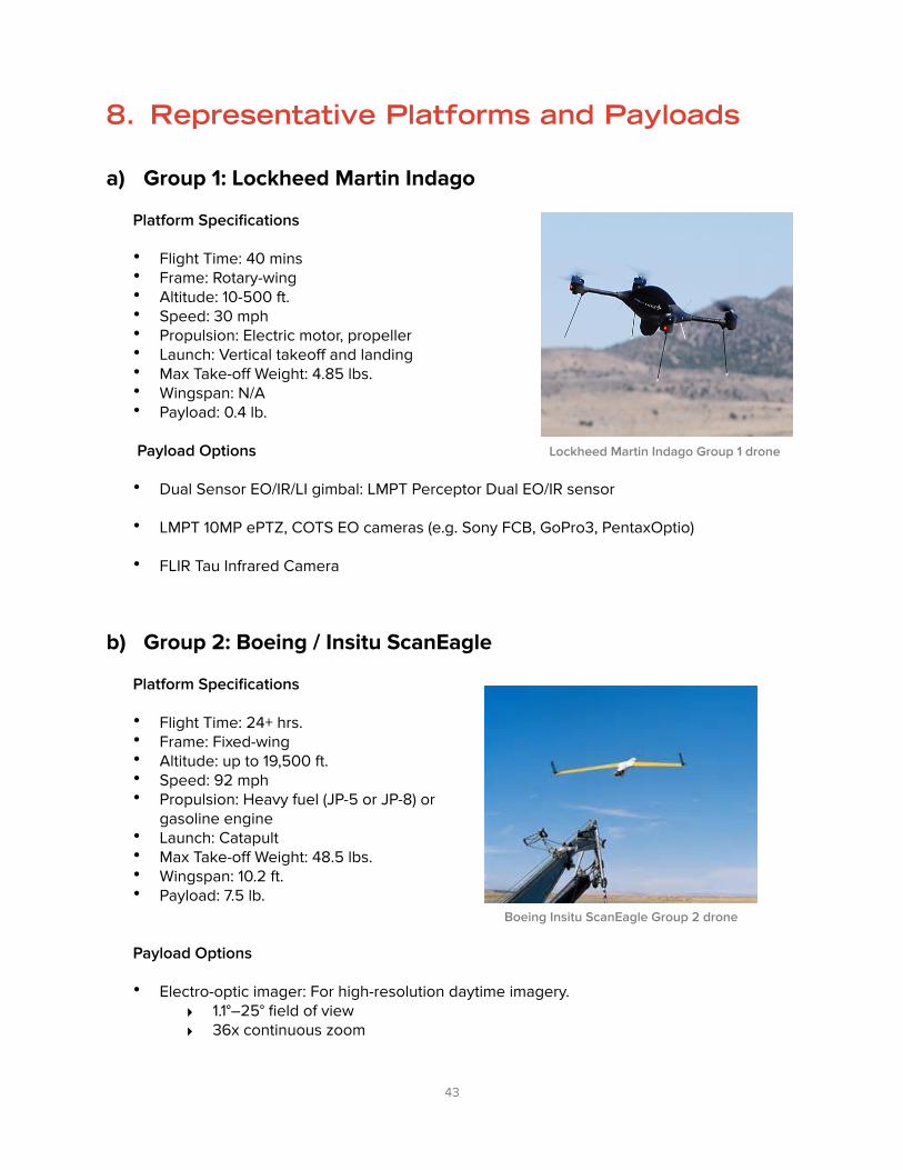
8. Representative Platforms and Payloads
a) Group 1: Lockheed Martin Indago
Platform Specifications
• Flight Time: 40 mins • Frame: Rotary-wing • Altitude: 10-500 ft. • Speed: 30 mph • Propulsion: Electric motor, propeller • Launch: Vertical takeoff and landing • Max Take-off Weight: 4.85 lbs. • Wingspan: N/A • Payload: 0.4 lb.
Payload Options
• Dual Sensor EO/IR/LI gimbal: LMPT Perceptor Dual EO/IR sensor
• LMPT 10MP ePTZ, COTS EO cameras (e.g. Sony FCB, GoPro3, PentaxOptio)
• FLIR Tau Infrared Camera
b) Group 2: Boeing / Insitu ScanEagle
Platform Specifications
• Flight Time: 24+ hrs. • Frame: Fixed-wing • Altitude: up to 19,500 ft. • Speed: 92 mph • Propulsion: Heavy fuel (JP-5 or JP-8) or
gasoline engine • Launch: Catapult • Max Take-off Weight: 48.5 lbs. • Wingspan: 10.2 ft. • Payload: 7.5 lb.
Payload Options
• Electro-optic imager: For high-resolution daytime imagery. ‣ 1.1°–25° field of view ‣ 36x continuous zoom
� 43
Boeing Insitu ScanEagle Group 2 drone
Lockheed Martin Indago Group 1 drone

• EO900 turret: Picture-in-picture daytime imagery from two imagers, allowing operators to focus on and maintain positive identity for objects of interest.
‣ .3°–48.7° field of view ‣ 170x continuous zoom from one high-resolution imager
• Mid-wave infrared (MWIR) camera: Quality thermal imaging for nighttime and low-visibility operations.
‣ 2°–25° field of view ‣ 12.5x continuous zoom
• Dual Imager turret: Includes an EO and MWIR camera and laser pointer for easy transition from daytime to nighttime missions.
‣ MWIR ▪ 2°–25° field of view ▪ 12.5x continuous zoom
‣ EO ▪ 1.1°–25° field of view ▪ 36x continuous zoom
c) Group 3: Textron Shadow M2
Platform Specifications
• Flight Time: 16 hrs. • Frame: Fixed-wing • Altitude: approx. 19,000 ft. • Speed: 129 mph • Propulsion: Combustion engine; propeller • Launch: Runway; Wheeled • Max Take-off Weight: 232 lbs. • Wingspan: 25 ft. • Payload: 125 lb.
Payload Options
• Dual payload bays for electro-optic/infrared/laser designation (EO/IR/LD), synthetic-aperture radar / ground moving target identification (SAR/GMTI), and special-purpose payloads.
• Satellite communications (SATCOM) data link integration for beyond-line-of-sight operations.
• Wing-mounted multi-mission payloads for signals intelligence, chemical / biological / radiological / nuclear detection, and more.
� 44
Textron Shadow Group 3 drone

d) Group 4: Lockheed Martin K-MAX
Platform Specifications
• Flight Time: 12 hrs. • Frame: Rotary-wing • Altitude: up to 15,000 ft. • Speed: 115 mph • Propulsion: Turbo Engine, Combustion Engine, Propeller • Launch: Vertical takeoff and landing • Max Take-off Weight: 12,000 lbs. • Wingspan: 48.23 ft. • Payload: 6000 lbs.
Payload Options
• Portable antennae for line-of-sight and satellite-based beyond line-of-sight data links.
• Four-hook carousel to carry multiple loads in a single flight.
e) Group 5: Aerovironment Global Observer
Platform Specifications
• Flight Time: 4-6 days • Frame: Fixed-wing • Altitude: 45,000-55,000 ft. • Speed: 26 mph • Propulsion: Liquid hydrogen
powered internal combustion power plant driving four high-efficiency electric motors.
• Launch: Runway • Max Take-off Weight: 12,000 lbs. • Wingspan: 175 ft. • Payload: 400 lbs.
Payload Options
• High-resolution electro-optical camera
• Communications relay (Internet, cellular)
� 45
LM K-MAX Group 4 drone
Aerovironment Global Observer Group 5 drone

9. Drone Deployment Models
According to research carried out by Dr. Robin Murphy of Texas A&M University, the average lag time for an unmanned system to be used after a disaster is currently 6.5 days. Given that most trapped survivors perish if not rescued within the first 48 hours of a disaster, this amount of time is unacceptable. However, if a relief organization owns an unmanned system or has a preexisting partnership with another organization that does, this response time is reduced to 0.5 days. If the organization does not, the response time is 7.5 days. Like any disaster response tool, drones are at their most effective when deployed as quickly as possible.
Therefore it is crucial that governments, relief organizations, insurance companies, and all other potential users of drone technology for disaster planning and response carefully consider how to deploy drones. This report considers the pros and cons of three different delivery models:
• Privately Owned Fleets • Public-Private Partnerships • Drone as a Service®
a) Privately-Owned Fleets
Given the high upfront capital costs associated with drone technology and the need to have experienced drone operators and maintenance specialists on hand, only a limited number of very large organizations that use drones frequently will find it preferable to own a fleet of drones. For example, some government agencies at the federal, state, and local level maintain drones for use in emergency response, though these are typically only Group 1 and 2 drones. Large insurance companies may also find it useful to maintain a small drone fleet near disaster-prone areas or high-density populations.
Staging Options
• Stage a larger number of drones closer to higher population areas • Stage drones in the proximity of known high-risk areas • Stage long-range drones in rural areas • Stage short-range or smaller size drones around urban areas • Create standard operating procedures that stipulate the process for introducing
unmanned aircraft into civil airspace during crisis situations • Consider drone maintenance requirements • Consider low priority missions during drone downtime • Consider leasing drone usage
Pre-Flight Parameters
• Create mission prioritization agreements between partners • Maintain certified drone operators • Maintain certified pre-flight inspection procedures • Assign defined roles and responsibilities to flight crewmembers • Execute live test exercises (pre-planned and unannounced) • Consider drone tracking tools
� 46

b) Public-Private Partnerships
The public sector is in a unique position to coordinate response efforts after a disaster. It is imperative that any disaster response by private entities is coordinated with the local government agencies managing a disaster site to be most effective and reduce the dangers of airspace overcrowding.
Moreover, to eliminate duplicate flights and expedite action by responding organizations, aerial imagery and other data should be shared and made available in usable formats. Establishing “situational awareness” is a key goal of all parties involved. A private drone company could provide a live data feed during an emergency situation, for example, allowing local responders to focus their efforts and equipment on mitigation and rescue operations. In combination, government agency and private sector aerial drone data will maximize disaster response strategy, speed, and efficiency.
For drone deployment models using public/private partnerships, agreements on data usage, privacy controls, and security should be established well in advance.
Staging Options
• Create standard operating procedures that stipulate the process for introducing unmanned aircraft into civil airspace during crisis situations
• Pre-negotiated contractual relationships with unmanned system service providers to facilitate rapid deployment of a variety of tailored system solutions
• Consider drone travel time to rendezvous points • Consider logistics of staging goods for drone transport
Pre-Flight Parameters
• Consider mission prioritization agreements between partners • Maintain certified drone operators • Maintain certified pre-flight inspection procedures • Assign defined roles and responsibilities to flight crewmembers • Execute live test exercises (pre-planned and un-announced) • Consider drone tracking tools.
c) Drone as a Service®
Instead of owning, maintaining, and operating a drone fleet, public and private organizations involved in disaster relief can make use of the Drone as a Service® model. This unique business model pioneered by Measure gives clients a turnkey drone solution, allowing them to pay only for acquisition, processing, and delivery of the data they need from drones. This eliminates the need for organizations to maintain a large fleet of drones that may be used only rarely. Drones also quickly become obsolete as the technology advances.
Insurance companies, relief organizations, and governments are already utilizing data from various satellite and manned aircraft-based aerial imaging companies. Drone technology can reduce the overall cost and increase the response time for acquiring large-scale pre- and post-
� 47

disaster imaging. Measure has the advantage of establishing the Drone as a Service® market and thus harnessing economies of scale to drive down the up-front costs associated with acquiring drone platforms.
Staging Options
• Draft Concepts of Operations built on identified requirements, this may include drone platforms, payloads, and software packages
• Ensure service contracts are in place
Pre-Flight Parameters
• Execute live test exercises (pre-planned and un-announced)
� 48

10.Conclusion
Drones have the potential to revolutionize disaster planning, preparation, response, and reconstruction. However, for this potential to be fully realized, public, private, and non-profit organizations involved in emergency response must be aware of this utility on a granular level. Policies must also be implemented by lawmakers that ensure the safe integration of drones into the national airspace system while still being flexible enough to accommodate current and future drone deployment models. This report is an important first step in moving drones for disaster response and relief operations from a promising technology to a game-changing reality.
This report could not have been completed without the contributions of Measure’s corporate sponsors including Boeing, Guy Carpenter & Co., IBM,, Lockheed Martin, UPS, USAA, Willis Group, Zurich North America, FAA, FEMA, DHS, Dr. Robin Murphy’s team at the Center for Robot-Assisted Search and Rescue (CRASAR) at Texas A&M University, and the American Red Cross. The team would also like to specifically recognize David Bowen on the Measure team for his drafting and editing of this report. Everyone’s assistance through six months of independent research, face-to-face meetings with emergency response managers, expert advice, and drone test flights in the field has been invaluable.
� 49

11.Bibliography
o Adams, Stuart M. and Carol J. Friendland. “Survey of UAV Usage for Imagery Collection in Disaster Research and Management.” https://blume.stanford.edu/sites/default/files/RS_Adams_Survey_paper_0.pdf
o Adams, Stuart M., Marc Levitan, and Carol Friendland. “High Resolution Imagery Collection Utilizing UAVs for Post-Disaster Studies.” http://www.nehrp.gov/pdf/UJNR_2013_Adams.pdf
o Akpan, Nsikan. “Drones are taking pictures that could demystify a Malaria surge” by at NPR, found @ http://www.npr.org/blogs/goatsandsoda/2014/10/22/357637900/drones-are-taking-pictures-that-could-demystify-a-malaria-surge
o Al-Tahir, Raid, Marcus Arthur, and Dexter Davis. “Low Cost Aerial Mapping Alternatives for Natural Disasters in the Caribbean.” https://www.fig.net/pub/fig2011/papers/ts06b/ts06b_altahir_arthur_et_al_5153.pdf
o Ambrosia, Vince. “UAVs for Disaster Management.” http://geo.arc.nasa.gov/sge/WRAP/projects/docs/ISRSE03_WKSHOP_PRESENTATI.PDF
o Ambrosia, Vince, et al. 2010. “The Ikhana unmanned airborne system (UAS) western states fire imaging missions: From concept to reality (2006– 2010).” Geocarto International 26 (2): 85– 101.
o Angermann, M., M. Frassl, and M. Lichtenstern. 2012. “Mission review of aerial robotic assessment—ammunition explosion Cyprus 2011.” In IEEE International Symposium on Safety, Security and Rescue Robotics.
o Ashour, Gal. “First Response Made Faster with Video Analytics.” IBM Research. http://ibmresearchnews.blogspot.com/search/label/GIS
o Boyle, Rebecca. “Smart visual algorithm lets unmanned drones perform autonomous search and rescue operations.” http://www.popsci.com/technology/article/2010-07/small-drones-could-replace-search-and-rescue-helos-making-hiker-rescue-faster-and-cheaper
o Carron, Cecilia. “A Drone that Finds Survivors Through Their Phones.” http://actu.epfl.ch/news/a-drone-that-finds-survivors-through-their-phones/
o Constine, Josh. “Airware’s Drone Operating System Gets Strategic Investment, Tech, Clients From GE Ventures.” TechCrunch. http://techcrunch.com/2014/11/19/airware-ge/
o Cornish, David. “ESA Launches Drone App to Crowdsource Flight Data.” ARS Technica. http://arstechnica.com/gadgets/2013/03/esa-launches-drone-app-to-crowdsource-flight-data/
o Domen, John. “Montgomery County Fire Department Using Drones.” CBSDC. http://washington.cbslocal.com/2014/05/05/montgomery-county-fire-department-using-drones/
o “’Drones’ saving lives thanks to Central Texas non-profit. KTBC Fox 7 Austin, Texas. http://www.myfoxaustin.com/story/21079431/drones-saving-lives-thanks-to-central-texas-non-profit
o “Drones to help assess post-disaster infrastructure damage.” Homeland Security News Wire. http://www.homelandsecuritynewswire.com/dr20150306-drones-to-help-assess-postdisaster-infrastructure-damage
o Ezequiel, Carlos. “UAV Aerial Imaging Applications for Post-Disaster Assessment, Environmental Management and Infrastructure Development.” https://www.academia.edu/7626741/
� 50

UAV_Aerial_Imaging_Applications_for_Post-Disaster_Assessment_Environmental_Management_and_Infrastructure_Development
o “Global Aerospace Partners with Zurich Canada to Provide Unmanned Aircraft Systems (UAS) Insurance Package.” http://www.global-aero.com/news/global-aerospace-partners-with-zurich-canada-to-provide-unmanned-aircraft-systems-uas-insurance-package/
o Goodrich, M. A., et al. 2008. “Supporting wilderness search and rescue using a camera-equipped mini UAV.” Journal of Field Robotics 25 (1– 2): 89– 110.
o Haas, J.E., R.W. Kates, and M.J. Bowden. Reconstruction Following Disaster, The Massachusetts Institute of Technology. 1977.
o “Hazus Quick Reference Guide,” FEMA. https://www.fema.gov/hazus-quick-reference-guide
o Heinzelman, Jessica and Carol Waters. “Crowdsourcing Crisis Information in Disaster-Affected Haiti.” United States Institute of Peace Special Report. http://www.usip.org/sites/default/files/resources/SR252%20-%20Crowdsourcing%20Crisis%20Information%20in%20Disaster-Affected%20Haiti.pdf
o Iranpour, Neda. “SDG&E Gets Ok to Use Drones to Check Power Lines.” San Diego 6. http://www.sandiego6.com/news/local/SDGE-gets-OK-to-test-drone-system-266837621.html
o Kelly, Heather. “Drones – the Future of Disaster Response.” http://whatsnext.blogs.cnn.com/2013/05/23/drones-the-future-of-disaster-response/
o Klaptocz, Adam. “Mapping the Philippines after Typhoon Haiyan.” Drone Adventures. http://blog.droneadventures.org/post/85863359885/mapping-the-philippines-after-typhoon-haiyan
o Kruijff, G.-J., et al. “Rescue robots at earthquake-hit Mirandola, Italy: A Field Report.” IEEE International Symposium on Safety, Security, and Rescue Robotics: 2012.
o Lavars, Nick. “New drone antenna expands Wi-Fi range for disaster-struck areas.” http://www.gizmag.com/drone-wi-fi-range-disaster-areas/33230/
o Marks, Paul. “Smart Software Uses Drones to Plot Disaster Relief.” New Scientist. http://www.newscientist.com/article/mg22029455.100-smart-software-uses-drones-to-plot-disaster-relief.html#.VR6v4hPF-e0
o Michael, N., et al. 2012. “Collaborative mapping of an earthquake-damaged building via ground and aerial robots.” Journal of Field Robotics 29 (5): 832–841.
o “Mission.” Template. https://www.faa.gov/about/mission/
o Moore, Jeanie. “Da Vinci’s Children Take Flight: Unmanned Aircraft Systems in the Homeland.”
o Murphy, Robin R. Disaster Robotics (Intelligent Robotics and Autonomous Agents series) The MIT Press: 2015.
o Newman, Lily Hay. “Drones Really Do Find People in Search-and-Rescue Missions.” Slate. http://www.slate.com/blogs/future_tense/2014/07/23/david_lesh_used_the_drone_from_his_small_business_to_find_a_missing_elderly.html
o Nicas, Jack. “Amazon Says FAA Approval to Test Delivery Drones Already Obsolete.” The Wall Street Journal. http://www.wsj.com/articles/amazon-says-its-approval-to-test-delivery-drones-already-obsolete-1427219327
� 51

o Pamintuan-Lamorena, Maan. “Drones used to measure radiation in Fukushima nuclear plant.” Japan Daily Press. http://japandailypress.com/drones-used-to-measure-radiation-in-fukushima-nuclear-plant-2743074/
o “Presidential Memorandum: Promoting Economic Competitiveness While Safeguarding Privacy, Civil Rights, and Civil Liberties in Domestic Use of Unmanned Aircraft Systems.” The White House. https://www.whitehouse.gov/node/322266.
o Olearczyk, Matt. “EPRI Flights Test “Drones” & Payloads for Power Restoration.” http://www.damagepreventionprofessional.com/PDFs_Articles/DPP_2013_Fall/DPP_2013_Fall_32_33.pdf
o Reich, Lia. “USAA Receives FAA Exemption to Fly PrecisionHawk Lancaster.” http://media.precisionhawk.com/topic/faa-approved-usaa-insurance-drone/
o Romero, Simon and Marc Lacey. “Looting Flares Where Authority Breaks Down.” The New York Times. http://www.nytimes.com/2010/01/17/world/americas/17looting.html?hp
o Sandvik, Kristin Bergtora and Kjersti Lohne. “The promise and perils of ‘disaster drones.’” http://www.odihpn.org/humanitarian-exchange-magazine/issue-58/the-promise-and-perils-of-disaster-drones
o “Section 333.” Template. https://www.faa.gov/uas/legislative_programs/section_333/.
o Sheridan, Michael. “Body of missing Texas 2-year-old boy, Devon Davis, found in pond.” New York Daily News. http://www.nydailynews.com/news/national/body-missing-texas-2-year-old-boy-devon-davis-found-pond-article-1.1054115
o Srivaree-Ratana, P. “Lessons learned from the Great Thailand Flood 2011: How a UAV helped scientists with emergency response and disaster aversion.” In AUVSI Unmanned Systems North America (CD only). Arlington, VA: AUVSI.
o “Tablet-Based Response Coordination: Leading the Way with StreetWise CADlink.” Fire Recue 1. http://www.firerescue1.com/fire-products/emergency-response-software/articles/1616372-Tablet-Based-Response-Coordination-Leading-the-Way-with-StreetWise-CADlink/
o “Unmanned Aerial Vehicles in Humanitarian Response” by UN Office for the Coordination of Humanitarian Affairs. https://docs.unocha.org/sites/dms/Documents/Unmanned%20Aerial%20Vehicles%20in%20Humanitarian%20Response%20OCHA%20July%202014.pdf
o “Unmanned Aircraft Systems (UAS) Operational Approval.” FAA Document N 8900.207. http://www.faa.gov/documentlibrary/media/notice/n%208900.207.pdf
o U.S. Fire Administration Statistics. http://www.usfa.fema.gov/data/statistics/#tabs2
o Warth, Gary. “Drones could detect disaster damage.” http://m.utsandiego.com/news/2015/feb/12/drones-aerial-response-disaster/
o Wilson, Mark. “This Drone Ambulance Is Totally Wild, And Totally Inevitable.” FastCo Design. http://www.fastcodesign.com/3041696/this-drone-ambulance-is-totally-wild-and-totally-inevitable?utm_source=mailchimp&utm_medium=email&utm_campaign=codesign-weekly&position=3&partner=newsletter&campaign_date=02032015#1
o Winfree, Greg. “UAVs hit the mark in disaster assessment.” United States Department of Transportation Website. http://www.dot.gov/fastlane/uavs-help-disaster-assessment
� 52