draft master plan amritsar 2010-2031 report new.pdf · draft master plan amritsar 2010-2031 sai...
TRANSCRIPT
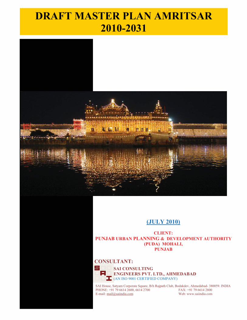
DRAFT MASTER PLAN AMRITSAR2010-2031
SAI CONSULTINGENGINEERS PVT. LTD., AHMEDABAD(AN ISO 9001 CERTIFIED COMPANY)
CONSULTANT:
SAI House, Satyam Corporate Square, B/h Rajpath Club, Bodakdev, Ahmedabad- 380059. INDIAPHONE: +91 79 6614 2600, 6614 2700 FAX: +91 79 6614 2800E-mail: [email protected] Web: www.saiindia.com
(JULY 2010)
CLIENT:PUNJAB URBAN PLANNING & DEVELOPMENT AUTHORITY
(PUDA) MOHALI, PUNJAB

Draft Master Plan for Amritsar
Client: Punjab Urban Planning and Development AuthorityConsultant: SAI Consulting Engineers Pvt. Ltd. Ahmedabad
CONTENTS
CHAPTER I: INTRODUCTION........................................................................1-16
1.1 INITIAL STEPS….................................................................................1
1.2 REGIONAL SETTING AND LINKAGES ....................................................9
1.3 PHYSICAL CHARACTERISTICS..............................................................11
1.4 HISTORICAL EVOLUTION ....................................................................11
CHAPTER 2: DEMOGRAPHIC PROFILE AND ECONOMIC BASE......................17-39
2.1 DEMOGRAPHIC CHARACTER................................................................17
2.2 ECONOMY AND EMPLOYMENT.............................................................24
CHAPTER 3: HERITAGE AND TOURISM ........................................................40-57
3.1 WALLED CITY: AMRITSAR....................................................................40
3.2 HERITAGE STRUCTURES IN MC AREA, AMRITSAR ..................................44
3.3 HERITAGE STRUCTURES IN AMRITSAR LPA AND IT’S SURROUNDINGS ........47
3.4 FAIRS AND FESTIVALS .........................................................................50
3.5 TOURISTS INFLOW ..............................................................................51
3.6 ONGOING PROJECTS/PROPOSALS.........................................................53
3.7 KEY ISSUES.........................................................................................55
CHAPTER 4: HOUSING AND URBAN POOR...................................................58-71
4.1 HOUSING SCENARIO ..........................................................................58
4.2 HOUSING SCHEMES............................................................................62
4.3 URBAN POOR AND SLUMS...................................................................66
CHAPTER 5: EXISTING LAND USE AND TRANSPORTATION NETWORK........72-107
5.1 PREPARTION OF BASE MAP ..................................................................72
5.2 ENHANCEMENT THROUGH FIELD SURVEYS- LAND USE AND ROAD
NETWORK..........................................................................................72
5.3 EXISTING LANDUSE PLAN.....................................................................73
5.4 TRAFFIC AND TRANSPORTATION..........................................................79
5.5 PUBLIC TRANSPORT.............................................................................96
5.6 ON GOING PROJECTS/PROPOSALS........................................................102
5.7 KEY ISSUES.........................................................................................106
CHAPTER 6: INFRASTRUCTURE AND SERVICE DELIVERY............................108-146
6.1 PHYSICAL INFRASTRUCTURE .............................................................108
6.2 SOCIAL INFRASTRUCTURE.................................................................131
Draft Master Plan for Amritsar
Client: Punjab Urban Planning and Development AuthorityConsultant: SAI Consulting Engineers Pvt. Ltd. Ahmedabad
CHAPTER 7: ENVIRONMENT.........................................................................147-159
7.1 ENVIRONMENTAL POLLUTION: GENERATION AND CONSEQUENCES…...147
7.2 DISASTER MITIGATION AND MANAGEMENT........................................157
CHAPTER 8: FINANCIAL ASPECT..................................................................160-173
8.1 MUNICIPAL CORPORATION, AMRITSAR ..............................................160
8.2 IMPROVEMENT TRUST.......................................................................166
8.3 AMRITSAR DEVELOPMENT AUTHORITY (ADA) ......................................170
CHAPTER 9: VISUALISING THE FUTURE ......................................................174-197
9.1 POPULATION PROJECTION ................................................................174
9.2 WORKFORCE PROJECTIONS...............................................................176
9.3 INFRASTRUCTURE PROJECTIONS.......................................................177
9.4 PARTICIPATORY APPROACH...............................................................186
9.5 S.W.O.T. ANALYSIS ...........................................................................187
9.6 VISION AND MISSION .......................................................................190
CHAPTER 10: THE MASTER PLAN, AMRITSAR..............................................198-265
10.1 COMPONENTS OF THE MASTER PLAN ................................................198
10.2 MASTER PLAN OBJECTIVES...............................................................198
10.3 BASIC CONSIDERATION FOR PROPOSALS..........................................200
10.4 PROPOSALS .....................................................................................201
10.5 PROPOSED LANDUSE PLAN ...............................................................211
10.6 PROPOSED TRAFFIC AND TRANSPORTATION PLAN ............................236
10.7 STRATEGY FOR OBTAINING LAND FOR PUBLIC PURPOSES..................255
10.8 SPACE NORMS AND STANDARDS .......................................................259
CHAPTER 11: DEVELOPMENT CONTROLS & ZONING REGULATIONS...........266-292
11.1 SECTION I: DEVELOPMENT CONTROL REGULATIONS…………………………266
11.2 SECTION II: ZONING REGULATIONS…………………………………………………277
11.3 ZONING REGULATIONS PROPOSED FOR ADOPTION IN LPA AMRITSAR.278
CHAPTER 12: INVESTMENT PLAN ................................................................293-297
12.1 INVESTMENT PLAN………………………………………………………………………….293
12.2 SECTOR WISE INVESTMENT NEED……………………………………………………294
ANNEXURES I to XIII

Draft Master Plan for Amritsar
Client: Punjab Urban Planning and Development AuthorityConsultant: SAI Consulting Engineers Pvt. Ltd. Ahmedabad
LIST OF TABLES
Table 1: Area and Population of different settlements in Amritsar District…......................... 8
Table 2: Contribution of Various Misls .............................................................................13
Table 3: Distribution of Urban Population in Major Towns of Amritsar District.....................17
Table 4: Hierarchy of Settlements in Amritsar LPA (both urban and rural) ..........................17
Table 5: Demographic Trend,Annual Growth Rate and Population Density in Amritsar LPA ..19
Table 6: Density in different wards of Amritsar City..........................................................20
Table 7 : Sex Ratio in Amritsar LPA ................................................................................20
Table 8: Literacy Rate in Amritsar LPA ............................................................................21
Table 9: SC Population in Amritsar LPA ...........................................................................21
Table 10: Total Migrants and Migrants in last 10 years by place of last residence to Amritsar
city (2001) ................................................................................................... 22
Table 11: Total Migrants by place of last residence from different states to Amritsar city
(2001) ..........................................................................................................23
Table 12: Migration of Workers by place of last residence to Amritsar city (2001)...............23
Table 13: Percentage of Workers and Non-Workers in Amritsar LPA,2001 ..........................24
Table 14: Occupational Structure of Amritsar LPA ............................................................25
Table 15: Industrial Classification of Main Workers in Amritsar City ...................................25
Table 16: Dependency Ratio for Different Settlements in Amritsar LPA ............................26
Table 17: Major Industrial locations in Amritsar City.........................................................27
Table 18: Comparison of Industrial Data at City and District Level, 2007............................28
Table 19: Details of Industrial Estates/Focal Points in Amritsar LPA ...................................29
Table 20: Major Specialized Markets in Amritsar City........................................................32
Table 21: Details of Informal Sector Stretches/Junctions in the City...................................33
Table 22: Information regarding Regulated Markets in District, 2006-07 ...........................36
Table 23: Details of Crop Arrivals Mandis coming within LPA limit......................................37
Table 24: Details of Livestock and Poultry in Amritsar District, 2007 ..................................38
Table 25: Details of animals slaughtered in Amritsar District, 2008....................................38
Table 26: Fairs and festivals of Rayya and its surrounding villages ....................................50
Table 27: Major Hotels in Amritsar..................................................................................51
Table 28: Comparison of Households Vs Occupied Residential Houses ...............................58
Table 29: Pattern of Use of Census houses category wise in Municipal Corporation, Amritsar
(2001) ..........................................................................................................60
Table 30: Distribution of Residential houses by their Type of Structure in Municipal
Corporation, Amritsar: 2001............................................................................60

Draft Master Plan for Amritsar
Client: Punjab Urban Planning and Development AuthorityConsultant: SAI Consulting Engineers Pvt. Ltd. Ahmedabad
Table 31: Details of Improvement Trust Schemes ..........................................................62
Table 32: Town Planning Schemes ...............................................................................62
Table 33: Details of Building Schemes.............................................................................63
Table 34: Details of P.U.D.A. Schemes/Colonies...............................................................63
Table 35: Details of OUVGL Schemes..............................................................................64
Table 36: Comparison of Various Schemes Implemented in Walled City Vs Total No. of
Schemes .......................................................................................................64
Table 37: Distribution of Slum Population to Amritsar M.C Population ................................67
Table 38: Slum Population Characteristics ......................................................................67
Table 39: Ownership of Land under Slums in Amritsar .....................................................68
Table 40: Basic Services & Amenities Existing in Slums of Amritsar ...................................69
Table 41: Details of Revised Project for construction of 1400 one room tenements by MCA.70
Table 42: Landuse Break up of Amritsar LPA, 2010..........................................................73
Table 43: Existing Landuse Plan for Amritsar City, 2010 ...................................................74
Table 44: Growth of Registered Vehicles in Amritsar City..................................................80
Table 45: Trend of Road Accidents in Amritsar, 1997-2008...............................................81
Table 46: Statement showing the details of Road Cross-Section and R/W of Inter and Intra
City Road falling in Amritsar LPA .....................................................................83
Table 47: List of O.D.R's falling in Amritsar LPA along with Cross-sectional Details..............84
Table 48: Length of Roads within Amritsar M.C (in kms)...................................................84
Table 49: Details of Various Road Cross-sections ............................................................86
Table 50: Parking Lots given on Contract Basis by Amritsar M.C........................................93
Table 51: Organized Parking Lots in Amritsar City ............................................................95
Table 52: Details of Bus-Routes from Amritsar to Other Places..........................................97
Table 53: Bus Service in Villages in Amritsar LPA .............................................................99
Table 54: Projects identified under JNNURM.................................................................. 102
Table 55: Total Number of Tube wells in Amritsar LPA ................................................... 108
Table 56: Water Supply Information in Amritsar (MC) .................................................... 109
Table 57: Water Supply Information in other Urban Settlements of Amritsar LPA ............. 110
Table 58: Water supply Network in Amritsar LPA .........................................................111
Table 59: Year-Wise Trend of Water Connections in Amritsar (MC) .................................111
Table 60: Number of Metered and Un-Metered Connections in Amritsar LPA ....................112
Table 61: Sewerage Details of Urban Settlements in Amritsar LPA ..................................114
Table 62: Details of Number of Sewerage Connections .................................................115
Table 63: Length of Drainage Network in Amritsar MCA ................................................ 119
Draft Master Plan for Amritsar
Client: Punjab Urban Planning and Development AuthorityConsultant: SAI Consulting Engineers Pvt. Ltd. Ahmedabad
Table 64: Generation of MSW in Amritsar LPA ...............................................................122
Table 65: Solid Waste Collection & Transport Infratructure in LPA Amritsar .....................125
Table 66: Details of Landfill sites in Amritsar Municipal Corporation Area ......................126
Table 67: Electric Supply in Amritsar M.C. and Amritsar LPA ...........................................129
Table 68: Electric Connections in Amritsar M.C and Urban Settlements in LPA .................. 129
Table 69: Level of Education Facilities in Amritsar LPA-Schools etc ..................................132
Table 70: Higher Level of Education Facilities in Amritsar LPA .........................................132
Table 71: Medical Infrastructure in Amritsar LPA ...........................................................136
Table 72: Veterinary Institutions in Amritsar LPA ...........................................................137
Table 73: Socio Cultural Facilities in Amritsar (MC).........................................................141
Table 74: Police Stations falling in Amritsar LPA.............................................................144
Table 75: Cremation and Burial grounds in Amritsar M.C ................................................ 145
Table 76: SPM, SO2 and NOx levels in Industrial Area of Amritsar at different Air Monitoring
Stations from 1997-2001 (Units: µg/m3)........................................................148
Table 77: Ground Water Quality at Five Sampling Stations of Amritsar city.......................154
Table 78: Noise Level (db) Monitoring during the year 2006 in Amritsar ..........................155
Table 79: Financial Status at a Glance ..........................................................................160
Table 80: Source-Wise Revenue Income ....................................................................... 162
Table 81: Income from Taxes ...................................................................................... 163
Table 82: Application of Funds by Heads of Account ......................................................163
Table 83: Details of Capital Account (in Lakhs. Rs.)........................................................165
Table 84: Financial Status at Glance .............................................................................166
Table 85: Source-Wise Revenue Income (in Rs. Lakhs.) .................................................167
Table 86: Application of Funds by Head of Account........................................................168
Table 87: Details of Capital Account .............................................................................168
Table 88: Scheme Wise Details of Development & Maintenance Expenditure....................169
Table 89: Details of Capital and Revenue Receipts of Amritsar Development Authority (ADA)
(in Rs. Lakhs.) .............................................................................................171
Table 90: Details of Expenditure on Development Works ................................................ 172
Table 91: Schedule of Establishment & Contingency Works ............................................172
Table 92: Population Projections for Amritsar City..........................................................174
Table 93: Population Projections: Jandiala.....................................................................175
Table 94: Population Projections: Rayya........................................................................175
Table 95: Population Projections: Majitha......................................................................175
Table 96: Population Projections: Rajasansi................................................................... 175

Draft Master Plan for Amritsar
Client: Punjab Urban Planning and Development AuthorityConsultant: SAI Consulting Engineers Pvt. Ltd. Ahmedabad
Table 97: Population Projections: Villages of LPA ...........................................................175
Table 98: Projected Population for Amritsar LPA ............................................................176
Table 99: Projected Population for Amritsar LPA for Infrastructure Requirements ............. 176
Table 100: Main Workers and Projected Workforce Category Wise of Amritsar M.C...........177
Table 101: Projections and Requirements of different aspects of Water Supply System.....178
Table 102: Projections and Requirements of different aspects of Sewerage System ..........179
Table 103: Projections and Requirements of different aspects of Drainage System ..........180
Table 104: Projections and Requirements of different aspects of Solid Waste Management .... 181
Table 105: Projections and Requirements of different aspects of Traffic & Transportation .183
Table 106: Power Requirements of Amritsar City 2010-2031...........................................184
Table 107: Projected Population and Density in Amritsar LPA..........................................213
Table 108: Proposed Land use Distribution for Amritsar LPA 2010-2031...........................213
Table 109: Net density in Residential Zones .................................................................. 215
Table 110: Planning Norms for Informal Sector .............................................................222
Table 111: Proposed Road Hierarchy LPA Amritsar.........................................................238
Table 112: Strategy for obtaining land for public purpose............................................... 258
Table 113: Norms for Education Facilities......................................................................260
Table 114: Permissible Levels of Educational Facilities.................................................... 261
Table 115: Norms for Health Facilities...........................................................................262
Table 116: Fire Station Norms...................................................................................... 263
Table 117: Police/Defence Norms................................................................................. 263
Table 118: Socio Cultural Norms ..................................................................................263
Table 119: Standards for Sports Activities .....................................................................264
Table 120: Postal Facilities Standards ...........................................................................264
Table 121: Standards for Telephone & Telegraph Services..............................................264
Table 122: Commercial Area Norms..............................................................................264

Draft Master Plan for Amritsar
Client: Punjab Urban Planning and Development AuthorityConsultant: SAI Consulting Engineers Pvt. Ltd. Ahmedabad
LIST OF FIGURES
Fig No.1: Methodology ................................................................................................... 5
Fig No.2: Local Planning Area, Amritsar ........................................................................... 9
Fig No.3: Location of Amritsar District in Punjab State......................................................10
Fig No.4: Amritsar in 1600 AD........................................................................................12
Fig No.5: Baba Atal Sahib Ji ...........................................................................................12
Fig No.6: Amritsar during Maharaja Ranjit Singh Period (1800 AD)....................................13
Fig No.7: Amritsar in 1850 AD........................................................................................14
Fig No.8: Amritsar in 1900 AD........................................................................................15
Fig No.9: Amritsar in Post Independence Period 1964 AD.................................................16
Fig No.10: Population Growth of Municipal Corporation Amritsar .......................................18
Fig No.11: Population Density in LPA Amritsar .................................................................19
Fig No.12: Alpha One on G. T. Road towards Jalandhar....................................................27
Fig No.13: Upcoming Mega Project Shubham Enclave ......................................................27
Fig No.14: Best Price on GT Road near Manawala……………………………………………………….….27
Fig No.15: Industries at the Focal Point, Mehta Road………………………………………………………27
Fig No.16: Poor infrastructure, water logging and open dumping of industrial waste in Focal
Point, Amritsar...............................................................................................29
Fig No.17: Electronics’ Market at Hall Bazaar ...................................................................32
Fig No.18: Readymade Cloth Market at Katra Jaimal Singh ...............................................32
Fig No.19: View of Shopping Complexes on Mall Road......................................................32
Fig No.20: District Shopping Complex at Ranjit Avenue ....................................................32
Fig No.21: Location of Informal Sector Stretches .............................................................35
Fig No.22: View of On- street parking and Informal Market opposite Baba Deep Singh
Gurudwara ...................................................................................................35
Fig No.23: Existing Grain Market at Bhagtanwala .............................................................37
Fig No.24: New Fruit & Vegetable market at Vallah..........................................................37
Fig No.25: Walled City 1849...........................................................................................41
Fig No.26: Walled City 1947...........................................................................................41
Fig No.27: Walled City 2009...........................................................................................41
Fig No.28: View of Jharokhas of Qila Ahluwalia................................................................41
Fig No.29: Golden Temple .............................................................................................42
Fig No.30: Mosque Khair-ud Din.....................................................................................42
Fig No.31: Mosque Mohammed Jan ................................................................................42
Fig No.32: Hall Gate......................................................................................................43

Draft Master Plan for Amritsar
Client: Punjab Urban Planning and Development AuthorityConsultant: SAI Consulting Engineers Pvt. Ltd. Ahmedabad
Fig No.33: Town Hall.....................................................................................................43
Fig No.34: Saint Paul Church..........................................................................................44
Fig. No.35: Bait-Al-Massih Church………………………………………………………………………………….44
Fig No.36: Durgiana Mandir ...........................................................................................44
Fig No.37: Khalsa College ..............................................................................................45
Fig No.38: Burj Baba Phula Singh ...................................................................................45
Fig No.39: Baba Atal Rai Tower......................................................................................45
Fig No.40: Gobindgarh Fort............................................................................................45
Fig No.41: District Court ................................................................................................46
Fig No.42: Head Post Office ...........................................................................................46
Fig No.43: Ram Bagh ....................................................................................................46
Fig No.44: Railway Station, Amritsar...............................................................................47
Fig No.45: Pul Kanjri .....................................................................................................47
Fig No.46: Ram Tirath ...................................................................................................48
Fig No.47: Sarai Amanat Khan................................................................................. 48
Fig No.48: Wagha Border ..............................................................................................49
Fig No.49: Shopping Complex ........................................................................................55
Fig No.50: Pul Kanjri under Renovation...........................................................................55
Fig No.51: Heritage building surrounded by Modern Architecture ......................................55
Fig No.52: Conversion of Building into Commercial Shops.................................................56
Fig No.53: Lakar Mandi..................................................................................................56
Fig No.54: Jhuggi-Jhoparis in Shivpuri ............................................................................57
Fig No.55: Poor Housing Condition, Poor Mass Space, Mesh of Wires and High Intensity of
Development in walled city Amritsar ..............................................................61
Fig No.56: View of planned housing area on Maqbool Road, Green Avenue and Ranjit Avenue..61
Fig No.57: View of new upcoming residential projects along Bye-Pass .............................61
Fig No.58: Housing condition in slum areas of Amritsar ....................................................68
Fig No.59: Infrastructure situation in slum areas of Amritsar.............................................69
Fig No.60: Growth of registered Vehicles in Amritsar........................................................80
Fig No.61: Canal office Chowk........................................................................................81
Fig No.62: Rambagh Chowk...........................................................................................81
Fig No.63: Railway Station Chowk .................................................................................89
Fig No.64: Putligarh Chowk............................................................................................90
Fig No.65: Kitchlu Chowk ..............................................................................................91
Fig No.66: Rattan Singh chowk ......................................................................................91
Draft Master Plan for Amritsar
Client: Punjab Urban Planning and Development AuthorityConsultant: SAI Consulting Engineers Pvt. Ltd. Ahmedabad
Fig No.67: On-Street parking of vehicles creating traffic bottlenecks .................................94
Fig No.68: Encroachment of footpath due to On-Street Parking ........................................94
Fig No.69: Multi Storied Parking on Bhandari Bridge.........................................................94
Fig No.70: Location of Organized Parking lots in Amritsar city ...........................................96
Fig No.71: Condition of parking within Walled City ...........................................................96
Fig No.72: Amritsar Bus Terminal ..................................................................................97
Fig No.73: Informal Markets outside Bus stand................................................................98
Fig No.74: Bus Terminal Baba Bakala..............................................................................99
Fig No.75: The Parking areas for trucks inside the Truck Terminal...................................100
Fig No.76: The auto/truck repair market inside Truck Terminal ......................................100
Fig No.77: Railway Station, Amritsar ............................................................................100
Fig No.78: The commercial activity outside Railway Station ...........................................101
Fig No.79: Traffic congestion at Liberty market outside Railway Station, Amritsar ............101
Fig No.80: Railway Hault Rayya Baba Bakala ................................................................101
Fig No.81: ROB under construction ..............................................................................101
Fig No.82: Bye Pass work under progress .....................................................................103
Fig No.83: Elevated road work under progress ..............................................................103
Fig No.84: ROB at Approach Road to Baba Bakala under progress...................................104
Fig No.85: Existing Status of Fish market parking ..........................................................105
Fig No.86: Entry Point of Railway Station ......................................................................106
Fig No.87: View of Blocked Sewer at Mahan Singh Gate .................................................114
Fig No.88: Year-wise Number of Sewer Connection in Amritsar (MC) ..............................115
Fig No.89: Disposal Work: Fatehpur..............................................................................116
Fig No.90: View of Ganda Nallah used for Disposal .......................................................116
Fig No.91: Water Logging outside Bus Stand .................................................................118
Fig No.92: Composition of Municipal Solid Waste ...........................................................123
Fig No.93: Garbage dumping along roadside .................................................................123
Fig No.94: Dumping of Garbage in open drain passing through Bangla Basti ....................123
Fig No.95: Existing transportation vehicles in use in the city ...........................................125
Fig No.96: Open dumping ground at Fatehpur...............................................................125
Fig No.97: Waste littering in Vacant Plots in city ............................................................126
Fig No.98: Dumping of waste along Bye-Pass ................................................................126
Fig No.99: View of School with no Area for Parking, Playground etc ................................ 133
Fig No.100: Good Condition of DAV Public School with all required facilities. ....................133
Fig No.101: Adequate parking facilities provided within BBKV DAV College for Women......134

Draft Master Plan for Amritsar
Client: Punjab Urban Planning and Development AuthorityConsultant: SAI Consulting Engineers Pvt. Ltd. Ahmedabad
Fig No.102: View of Spacious College Building of S.R. Govt College for Women................134
Fig No. 103: View of Hospital facility located in a residential area in walled city ................137
Fig No.104: Rambagh Garden ...................................................................................... 139
Fig No.105: Children’s Park at Gol Bagh ....................................................................... 140
Fig No.106: Open Space existing within walled city used as Playground...........................141
Fig No.107: H.P.O. on Court Road, Amritsar .................................................................143
Fig No.108: Shivpuri Cremation Ground ........................................................................145
Fig No.109: Industry releasing plume without adopting Pollution Control Devices ............. 147
Fig No.110: UBDC(1) near Mehta Road .........................................................................149
Fig No.111: UBDC(1) at Tarawala Pul ..........................................................................149
Fig No.112: Untreated industrial effluents of Khanna paper mill drain out into Ganda Nallah ..150
Fig No.113: Untreated industrial effluents of Shankar Textile Mill drain out into Nallah......150
Fig No.114: Groundwater Sample having objectionable colour, odour taste & suspended
solids........................................................................................................ 150
Fig No.115: Untreated industrial effluents pumped out near Verka Chowk created unbearable
odour ......................................................................................................151
Fig No.116: Villagers using untreated effluents of the drain for irrigating fields ................152
Fig No.117: Upstream of Patti Drain near Malhian village (Jandiala) showing excessive algae
growth......................................................................................................152
Fig No.118: Kasur Nallah flowing near village Manawala shows excessive eutrophication...152
Fig No.119: Gandha Nallah carrying untreated sewage, MSW and biomedical waste ......... 153
Fig No.120: High Traffic Volume and glaring horns by auto rickshaws causing Noise Pollution 155
Fig No.121: Earthquake Zoning of Punjab .....................................................................157
Fig No.122: Old Age buildings in dilapidated condition in the walled city, Amritsar ............157
Fig No.123: Trends in Municipal Corporation (MC) income and expenditure .....................161
Fig No.124: Revenue Account of Municipal Corporation .................................................161
Fig No.125: Source-wise Break up Revenue Income.......................................................162
Fig No.126 & 127: Percentage Share of General Department & Water Supply & Sewerage
(WSAS) department in Revenue Expenditure................................................164
Fig No.128: Capital Account of MC, Amritsar .................................................................164
Fig No.129: Financial Status of Improvement Trust (In Rs. Lakh) ...................................166
Fig No.130: Source-wise Break up of Revenue Income of Improvement Trust .................167
Fig No.131: Revenue & Capital Account of Amritsar Development Authority (ADA) ..........170
Fig No.132: Methodology for Defining Vision for Amritsar Metropolis 2009-2031 .............. 191
Fig No.133: Tourist Circuit 1 for Walled City Area, Amritsar ...........................................233

Draft Master Plan for Amritsar
Client: Punjab Urban Planning and Development AuthorityConsultant: SAI Consulting Engineers Pvt. Ltd. Ahmedabad
Fig No.134: Tourist Circuit within Amritsar LPA ..............................................................234
Fig No.135: Proposed Tourist Circuit Baba Bakala (Rayya) Region ...................................234
Fig No.136: Tourist Circuit 2 at Regional Level...............................................................235
Fig No.137: Tourist Circuit 3 at Regional Level...............................................................235
LIST OF MAPS
Map 1: Settlement Hierarchy-LPA Amritsar (2001) ......................................................17-18
Map 2: Growth rate of population in LPA Amritsar (1991-2001)....................................18-19
Map 3: Population Density-LPA Amritsar (2001).......................................................... 19-20
Map 4: Ward Wise Density-2001 ............................................................................... 20-21
Map 5: Housing Schemes of MC Area......................................................................... 62-63
Map 6: Development and Redevelopment Scheme of MC Area..................................... 64-65
Map 7: Location of Slums-MC Area (2010).................................................................. 67-68
Map 8: Traffic and Transportation- MC (2010)..............................................................81-8
Map 9: Traffic and Transportation Map- LPA Amritsar (2010)....................................... 83-84
Map 10: Water Supply Network-MC Area (2010)..................................................... 109-110
Map 11: Sewerage Network-MC Area (2010) .......................................................... 114-115
Map 12: Distribution of Electric Sub Station in MC Area (2010) ............................... 129-130
Map 13: Social Infrastructure-MC Area (2010) ....................................................... 131-132
Map 14: Amritsar Walled City- Heritage Zone ......................................................... 204-205
LIST OF PLANS
Existing Land use Plan - LPA, Amritsar (2010)- Drawing No. D.T.P (A) 2/2010 Dated 12/01/2010
Proposed Land use Plan - LPA, Amritsar (2010-2031) - Drawing No. D.T.P (A) 82/2010 Dated 26/03/2010
Existing Land use – LPA, Amritsar (Rayya Region 2010) - Drawing No. D.T.P (A) 2a/2010 Dated 12/01/2010
Proposed Land use – LPA, Amritsar (Rayya Region 2010-2031) - Drawing No. D.T.P (A) 82a/2010 Dated 26/03/2010
Proposed Traffic and Transportation Plan - LPA, Amritsar (2010-2031) - Drawing No. D.T.P (A) 82b/2010 Dated 26/03/2010
Draft Master Plan for Amritsar
Client: Punjab Urban Planning and Development AuthorityConsultant: SAI Consulting Engineers Pvt. Ltd. Ahmedabad
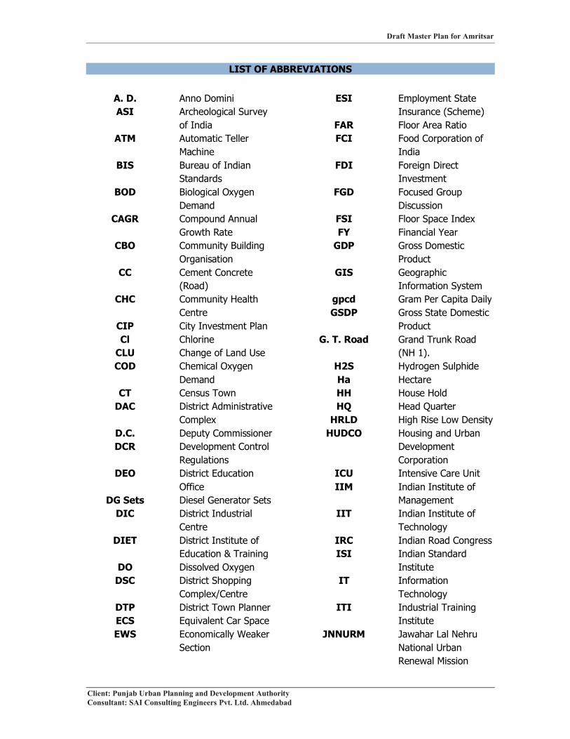
LIST OF ABBREVIATIONS
A. D. Anno DominiASI Archeological Survey
of IndiaATM Automatic Teller
Machine BIS Bureau of Indian
StandardsBOD Biological Oxygen
DemandCAGR Compound Annual
Growth RateCBO Community Building
OrganisationCC Cement Concrete
(Road)CHC Community Health
CentreCIP City Investment PlanCl Chlorine
CLU Change of Land UseCOD Chemical Oxygen
DemandCT Census Town
DAC District Administrative Complex
D.C. Deputy CommissionerDCR Development Control
RegulationsDEO District Education
OfficeDG Sets Diesel Generator Sets
DIC District Industrial Centre
DIET District Institute of Education & Training
DO Dissolved OxygenDSC District Shopping
Complex/CentreDTP District Town PlannerECS Equivalent Car SpaceEWS Economically Weaker
Section
ESI Employment State Insurance (Scheme)
FAR Floor Area RatioFCI Food Corporation of
IndiaFDI Foreign Direct
InvestmentFGD Focused Group
DiscussionFSI Floor Space IndexFY Financial Year
GDP Gross Domestic Product
GIS GeographicInformation System
gpcd Gram Per Capita DailyGSDP Gross State Domestic
ProductG. T. Road Grand Trunk Road
(NH 1).H2S Hydrogen SulphideHa HectareHH House Hold HQ Head Quarter
HRLD High Rise Low DensityHUDCO Housing and Urban
Development Corporation
ICU Intensive Care UnitIIM Indian Institute of
Management IIT Indian Institute of
TechnologyIRC Indian Road CongressISI Indian Standard
InstituteIT Information
TechnologyITI Industrial Training
InstituteJNNURM Jawahar Lal Nehru
National Urban Renewal Mission

Draft Master Plan for Amritsar
Client: Punjab Urban Planning and Development AuthorityConsultant: SAI Consulting Engineers Pvt. Ltd. Ahmedabad
KG Kilo GramKV Kilo Volt
KVA Kilo Volt AmpereKW Kilo Watt
LRHD Low Rise High DensityLIC Life Insurance
Corporation of IndiaLIG Low Income Group
LRLD Low Rise Low DensityLMD Low Rise Medium
DensityLPA Local Planning Area
LPCD Litre Per Capita Per Day
M. C. Municipal CorporationMDR Major District Road
MH Lamps Metal Halide LampsMINAR Monitoring of India
National Aquatic Resources
MLD Million Litres per DayMM Modified Mercalli
(Scale for Earthquakes)
MoEF Ministry of Environment and Forest
MORTH Ministry of Road Transport and Highways
MP Master PlanMT Metric Ton
MVL Mercury Vapour LampNBC National Building
CodeNGO Non Government
OrganizationNH National Highway
NH3 AmmoniaNIC National Industrial
ClassificationNIMBY Not In My Backyard
NO Nitrous OxideNO2 Nitrogen Dioxide
NP Nagar PanchayatNSDP Net State Domestic
ProductNTU Nephelometric
Turbidity UnitO & M Operation and
Management ODR Other District Road
OHSR Over Head StorageReservoir
OUVGL Optimum Utilisation of Vacant Government Land
PAU Punjab Agricultural University
PAPRA Punjab Apartment and Property Regulation Act, 1995
PEPSU Patiala and East Punjab State Union
pH Power of HydrogenPHC Primary Health CentrePIDB Punjab Infrastructure
Development BoardPPCB Punjab Pollution
Control BoardPPH Persons Per HectarePPP Public Private
PartnershipPRSC Punjab Remote
Sensing CentrePR & TP & Dev. Act/PRTPD Act
Punjab Regional and Town Planning and Development Act, 1995
PRTC Punjab RoadTransport Corporation
PSIEC Punjab Small Industries and Export Corporation Limited
PUDA Punjab Urban Planning and Development Authority

Draft Master Plan for Amritsar
Client: Punjab Urban Planning and Development AuthorityConsultant: SAI Consulting Engineers Pvt. Ltd. Ahmedabad
PWD (B & R) Public Works Department (Buildingand Roads)
PWSSB Punjab Water Supply & Sewerage Board
RCC Reinforced Cement Concrete
RD Residential DensityRSPM Respirable Suspended
Particulate MatterS.C.O. Shop cum Office
SC Sub Centre (Health Unit)
SCF Shop cum FlatSDP State Domestic
ProductSEZ Special Economic
ZoneSH State Highway
SHC Sub Health CentreSO2 Sulphur DioxideSPM Suspended Particulate
MatterSTP Sewerage Treatment
Plant
SVL Sodium Vapour LampSWOT Strengths,
Weaknesses, Opportunities and Threats
TCPO Town and Country Planning Organisation
TDR Transfer of Development Rights
TDS Total Dissolved SolidsUA Urban Agglomeration
UDPFI Urban Development Plans Formulation and Implementation (Guidelines)
UIDSSMT Urban Infrastructure Development Scheme for Small and Medium Towns
ULB Urban Local BodyWBM Water Bound
Macadem (Road)

Draft Master Plan for Amritsar
Client: Punjab Urban Planning and Development Authority Page 1Consultant: SAI Consulting Engineers Pvt. Ltd. Ahmedabad
CHAPTER 1INTRODUCTION
1.1 INITIAL STEPS
1.1.1 BACKGROUND
Urban areas in past have not received much attention in terms of their planning, development
and management despite the fact that cities and economic development are inextricably
linked. Because of high productivity of urban areas, economic development activities get
located in cities. Accordingly, it is desirable that human settlements are provided with
necessary planning and development inputs so that their orderly growth and development is
ensured. This would also be necessary for ensuring efficient functioning of human
settlements for improving their productivity and for providing desirable quality of life to its
residents in order to cater to their economic, physical and metaphysical needs. The urban
development strategy for any state thus assumes importance for not only its economic
emancipation but also its physical well-being.
Therefore, the real challenge before the planning and development of towns/cities is to have
balanced development in all spheres of urban life: physical, social and economic in a
comprehensive manner. There is need to make urban transition efficient, equitable and cost
effective by making policies and bringing out new projects/schemes. For this preparation of
Master Plan becomes the guiding principle for wiping out the deficits in urban infrastructure,
mining the problems and exploring the potentials of the city.
“Master Plan (MP)” is identified as a strategic tool to achieve the above objectives.
Considering the role and importance of rational and orderly growth of urban centers, the
Government of Punjab intends to streamline the development process in urban settlements to
ensure that these settlements continue to achieve their objectives of improved efficiency and
productivity. Accordingly, it is desirable to have a stringent check on haphazard development
and have an optimum land use plan for these cities/towns. In the process, the state
government has taken the decision to prepare Master Plans for all towns and cities for a
directed development and to provide world-class amenities to its people.
The Punjab Urban Planning and Development Authority (PUDA) is an apex institution
established in July 1995 for promoting the balanced urban growth in the State of Punjab.
PUDA has undertaken the task of providing planned residential, commercial and industrial
spaces incorporating the latest state of the art technology and town planning norms. In this
process, PUDA has taken up the preparation of the Master Plan for Local Planning Area

Draft Master Plan for Amritsar
Client: Punjab Urban Planning and Development Authority Page 2Consultant: SAI Consulting Engineers Pvt. Ltd. Ahmedabad
Amritsar to address the infrastructure and service delivery gaps in Amritsar and to make the
growth and development of Local Planning Area (LPA) rational. The key objective of the
Master Plan is to formulate a long-term vision and strategy to make the LPA vibrant, livable
and creditworthy. Besides rationalizing the land use pattern, the Master Plan will also
facilitate the identification of sectoral investments and reform areas needed to transform the
Local Planning Area Amritsar.
1.1.2 OBJECTIVES
The prime objective of the Master Plan is to promote, guide and rationalize the future growth
and development of urban centers. It will endorse growth in the desired direction, promote
economic development, improving service delivery and providing amenities to its people.
Master Plan ensures rational policy choices besides providing a flexible framework based on
ground realities for a defined time span.
Master Plan is an appropriate and scientific tool for promoting systematic & planned growth
of the city in the form of the following:
(i) Identifying existing gaps in physical and social infrastructure & to bridge those gaps
(ii) Making city assessment and to suggest strategies for its economic development.
(iii) Leveraging economy
(iv) Rationalization of land use and their interrelationships
(v) Minimizing haphazard and uncontrolled growth of town/cities and to achieve
planned growth and development in order to provide healthy living environment
(vi) Promote better urban governance and resource generation for planned urban
development.
(vii) Rationalizing the orderly movement of traffic and transportation within the town and
defining the area for laying down network of various services.
(viii) Indicating spatial distribution of physical/social infrastructure for optimum use
(ix) Ensuring systematic, balanced & integrated development
(x) Framing mechanism/strategies for solving out the core area problems
1.1.3 SCOPE OF WORK
The scope of Master Plan to be prepared covers the following aspects:
• Collection and review of available data, documents, reports, etc. and site visits.
• Sector studies in terms of demand, supply and identifying gaps in service delivery.
• Formulation of vision and working out strategy

Draft Master Plan for Amritsar
Client: Punjab Urban Planning and Development Authority Page 3Consultant: SAI Consulting Engineers Pvt. Ltd. Ahmedabad
• Formulation of concept plan and policies for growth centers, development corridors,
etc.
• Preparation of Integrated Infrastructure Plan for all areas constituting designated Local
Planning Area as per projected requirements.
• Preparation of detailed Zonal Development Plan including approximate location and
extent of land uses such as residential, industrial, commercial, etc. and Development
Control Regulations.
• Review of ongoing and proposed development projects and other schemes announced
by the govt. under JNNURM, UIDSSMT, OUVGL schemes etc. and to incorporate
them in the plan
• Incorporation of all the statutory provisions under “The PR & TP and Development
Act-1995 (as amended 2006)”
• Formulation of framework for implementation of the Master Plan and Development
Control Regulations
• Prioritizing the projects and formulation of Investment Plan
• Formulate Investment Plan with appropriate financing strategies.
• Focus on the reforms to be carried out at the State and District level in consonance with
the vision and strategic plan outlined to sustain the planned interventions.
1.1.4 LEGAL FRAMEWORK FOR MASTER PLAN
PREPARATION OF MASTER PLANS UNDER, “THE PUNJAB REGIONAL AND
TOWN PLANNING AND DEVELOPMENT ACT, 1995 (AMENDED 2006)”
To control and regulate the development of towns and cities in the state of Punjab, the Master
Plans are to be prepared as a statutory requirement. The procedure for preparing the Master
Plan under the Punjab Regional and Town Planning and Development Act, 1995 (hereinafter
called P.R.T.P.D Act 1995 (amended 2006)), has been defined in Chapter X of the said Act.
1.1.5 APPROACH TO THE MASTER PLAN
Approach to the preparation of Master Plan would involve outlining the critical issues of city
development, undertaking a demand supply gap analysis and formulating a management
framework including outlining strategies and guidelines for future growth and development
of LPA Amritsar. It will also include options for promoting rational development through the
introduction of a regulatory mechanism including realistic planning and management
interventions within the overall regulatory and institutional framework. A development action
Draft Master Plan for Amritsar
Client: Punjab Urban Planning and Development Authority Page 4Consultant: SAI Consulting Engineers Pvt. Ltd. Ahmedabad
plan comprising of implementation schedule, role of stakeholders, regulation and institutional
strengthening mechanism etc. will form an integral part of the Master Plan. The Master Plan
will take into account the current status of municipal services - its fiscal status, operational
and management procedures besides putting in place effective monitoring mechanism. The
preparation of the Master Plan will be based on existing trend of development taking into
account Development Plans/Schemes of public and private agencies operating in the city and
contributing towards its growth and development.
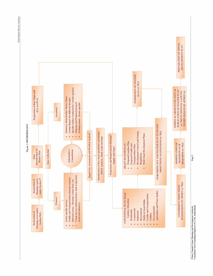
The detailed methodology for preparation of the Master Plan of L.P.A Amritsar includes data
collection, city assessment, identifying gaps in service delivery and infrastructure network,
identifying strengths, weaknesses, opportunities and threats, preparing Existing Land use
Plan, thematic maps, Proposed Land use Plan and Zonal Development Plan etc. as defined
below (Refer Fig No.1):
Dra
ft M
aste
r Pla
n fo
r Am
ritsa
r
Clie
nt: P
unja
b U
rban
Pla
nnin
g an
d D
evel
opm
ent A
utho
rity
Pag
e 5
Con
sulta
nt: S
AI C
onsu
lting
Eng
inee
rs P
vt. L
td. A
hmed
abad
Fig
no. 1
ME
TH
OD
OL
OG
Y
Seco
ndar
y
�St
atut
ory
Plan
s/E
arlie
r M
aste
r Pl
ans
�C
ensu
s Rep
ort f
or d
iffer
ent d
ecad
es�
Spec
ific
stud
ies c
ondu
cted
by
vari
ous a
genc
ies
�O
ngoi
ng a
nd P
ropo
sed
proj
ects
�E
xist
ing
stat
us-S
ecto
r sp
ecifi
c
Prim
ary
�Se
ctor
spec
ific
surv
eys
�T
raff
ic a
nd T
rans
port
atio
n si
tuat
ion
anal
ysis
�In
form
alse
ctor
-Hou
sing
, Urb
an P
oor,
etc.
�V
isua
l sur
veys
(Inf
rast
ruct
ure
such
as p
hysi
cal,
soci
al a
nd in
dust
ry)
Stak
ehol
der’
sC
onsu
ltatio
n
Dat
a C
olle
ctio
n
Dat
aId
entif
icat
ion
for
Mas
ter
Plan
Prep
arat
ion
of B
ase
Map
s and
E
LU
u/s
59
(1)
Dec
lara
tion
of
Plan
ning
Are
a un
der
Sect
ion
56(1
)
Dec
lara
tion
of
Plan
ning
Age
ncy
unde
r Se
ctio
n 57
Rap
id C
ity A
sses
smen
t and
Det
aile
d A
naly
sis
Proj
ectio
ns a
nd R
equi
rem
ents
(Dem
and
Supp
ly a
nd G
aps)
Iden
tific
atio
n of
Key
issu
es (p
robl
ems/
pot
entia
ls)-
SWO
T A
naly
sis,
Thi
nkT
ank
mee
tings
PUB
LIS
HIN
G E
LU
AN
D M
AST
ER
PL
AN
TO
INV
ITE
O
BJE
CT
ION
S/SU
GG
EST
ION
S u/
s 70(
3)
CO
NC
EPT
UA
L P
LA
N-B
road
L
andu
se A
lloca
tion
�R
esid
entia
l�
Com
mer
cial
�In
dust
rial
�R
ecre
atio
nal
�Pu
blic
& S
emi-P
ublic
�T
raff
ic a
nd T
rans
port
atio
n�
Util
ities
�G
over
nmen
tal
�A
gric
ultu
re a
nd W
ater
Bod
ies
DR
AFT
MA
STE
R P
LA
N�
Prop
osed
Lan
duse
Pla
n�
Prop
osed
Tra
ffic
and
T
rans
port
atio
n Pl
an�
Dev
elop
men
t Con
trol
and
Zon
ing
Reg
ulat
ions
�D
raft
Zon
al D
evel
opm
ent P
lans
CO
NSI
DE
RIN
G O
BJE
CT
ION
S/
SUG
GE
STIO
NS
ON
ME
RIT
u/s 7
0(4)
PRE
PAR
AT
ION
OF
ZO
NA
L
DE
VE
LO
PME
NT
PL
AN
APP
RO
VA
LFR
OM
ST
AT
E G
OV
T.&
PU
BL
ICA
TIO
N O
F M
AST
ER
PL
AN
u/s 7
0(5)
IN O
FFIC
IAL
GA
ZE
TT
E
WIT
HIN
30
DA
YS
OF
APP
RO
VA
L
MO
DIF
ICA
TIO
NO
F M
AST
ER
PL
AN
IF
RE
QU
IRE
D u
/s 7
0(4)
SUB
MIS
SIO
N O
F M
AST
ER
PL
AN
u/s 7
0(1)

Draft Master Plan for Amritsar
Client: Punjab Urban Planning and Development Authority Page 6Consultant: SAI Consulting Engineers Pvt. Ltd. Ahmedabad
1.1.6 METHODOLGY FOR MASTER PLAN
The various stages of preparation of Master Plan include:
1. Identification of Local Planning Area (as per the Government notification under
PRTPDA- 1995 (amended in 2006).
2. Preparation of Existing Land Use Plan
� Using Satellite Imageries
� Using Available Plans
� Ground Surveys
� Revenue Plans
3. Assessment and analysis of Local Planning Area in terms of
� Regional Setting
� Historical Evolution
� Demographic Studies
� Socio-Economic Studies
� Traffic & Transportation
� Physical Infrastructure (Water Supply, Sewerage, Solid Waste Management,
Electricity)
� Social Infrastructure (Educational, Medical, Recreational, Miscellaneous
Facilities)
� Environmental Studies
� Heritage and Tourism
� Growth Pattern
� Land use Studies
� Available studies and report
� Ongoing and Proposed Projects
4. Involving Stakeholders (through FGD’s and personal interviews)
� Meeting with experts
� Think Tank meetings
� NGOs/ Private agencies
� Public Representatives
5. Gaps and Problem Identification through
� Comparison with available norms and standards
� Identification of the critical problems and infrastructure gaps

Draft Master Plan for Amritsar
Client: Punjab Urban Planning and Development Authority Page 7Consultant: SAI Consulting Engineers Pvt. Ltd. Ahmedabad
6. Carrying out S.W.O.T analysis based upon
• Studies made and analysis carried on
• City Assessment
• Stakeholders’ Perception
• Identified problems and gaps
• Identifying major socio-economic drivers
7. Working out requirements
� Population Projections
� Norms and Standards
� Broad Land use Requirements.
8. Defining Conceptual Framework through
� Defining Vision for future growth and development
� Identifying broad objectives
� Laying down mission statements for critical areas
9. Preparation of Concept Plan
10. Evolving Proposed Land Use Plan and Traffic & Transportation Plan along with
Development Control Regulations (D.C.R)
� Based on existing land use plan
� Studies and assessment made
� Gaps and problems identified
� Stakeholders’ perception
� Objectives framed
� Future population growth
� Future infrastructure requirements
� Available land for development
11. Preparing Phasing and Investment Plan
12. Evolving Zonal Plans based on Proposed Land Use
1.1.7 LOCAL PLANNING AREA, AMRITSAR
The Local Planning Area (LPA) of Amritsar has been notified under section 56 (i) of the Punjab
Regional and Town Planning and Development Act, 1995 (amended 2006), vide notification no.
12/65/2006-4HGI/5599, dated 18th July, 2007. (Exercising the power vested under Section 56(7)
of the Act.) (Refer annexure no. I)

Draft Master Plan for Amritsar
Client: Punjab Urban Planning and Development Authority Page 8Consultant: SAI Consulting Engineers Pvt. Ltd. Ahmedabad
The Local Planning Area of Amritsar covers an area of 1,39,419 Hectares with a total population
of 16, 60,466 persons for preparation of the Master Plan. It consists of Municipal Corporation-
Amritsar with an area 142.37 sq.kms (including Amritsar Cantonment), four urban settlements
namely Jandiala (M.Cl), Majitha (M.Cl), Rayya (Nagar Panchayat) and Rajasansi (Nagar
Panchayat) and 310 rural settlements. The list of all settlements falling in L.P.A, Amritsar is
attached as annexure II showing area and population details.
While delineating the Local Planning Area of Amritsar, the following factors mentioned in rule
22 of the Punjab Regional and Town Planning and Development (General Rules 1995) have been
considered:
� Administrative/ Revenue boundaries of the villages/ urban centers
� Geographical features of the area including UBDC, minors, drains and other physical
features like roads and railway lines.
� Means of communication and accessibility
� Present and future growth trends and distribution of the population
� Industrial location and growth trends
� Economic base and commercial activities
� Preservation of historical and cultural heritage of the areas
� Urban expansion trends and management of peripheral areas
� Ecological and environmental balance
� Balanced regional development of the state
� Dispersal of economic activities to alleviate pressure on the Amritsar city
It has been observed that the Local Planning Area of Amritsar is 52.67% of the area and 76.98%
of the population of the district. (Refer table 1)Table 1: Area and Population of Different Settlements in Amritsar District
S. No. Settlement Area (Hectares) Population (2001)1 Amritsar M.C 14,237 10,16,0792 Jandiala (M. Cl) 1,454 23,8343 Rayya (N.P) 655 12,6314 Rajasansi (N.P) 1,551 12,1765 Majitha (M. Cl) 387 12,9926 Villages in LPA 1,21,135 5,82,7547 Total LPA 1,39,419 16,60,4668 Amritsar District 2,64,700 21,57,000
Source: PRSC Existing Landuse Map (ELU); Statistical Abstract of Punjab 2007; Census of India, 2001.
Note: Area of settlements falling in LPA is taken from ELU map prepared by PRSC, while Area of Amritsar District is taken from Statistical Abstract of Punjab, 2007. The population data is from Census of India, 2001.

Draft Master Plan for Amritsar
Client: Punjab Urban Planning and Development Authority Page 9Consultant: SAI Consulting Engineers Pvt. Ltd. Ahmedabad
Fig no. 2 Local Planning Area, Amritsar
1.2 REGIONAL SETTING & LINKAGES
This aspect is studied in order to view the developments taking place in Amritsar in regional
context and to evaluate the locational advantages and disadvantages of the city of Amritsar. In
the Master Plan, this aspect would help in proposing the activities that can be explored based
upon the regional potential and linkages. The location coordinates of Amritsar district lies
between 31° 29' and 32° 03' North latitudes and between 74° 29' and 75° 23' East longitudes. It is
the third largest border district of the state after Ferozepur and Gurdaspur. Tarn Taran is the
smallest among the four border districts.
Besides being the District Headquarter and an important tourist destination (due to the existence
of Golden Temple, Durgiana Mandir, Jallianwala Bagh, etc.), the regional importance of
Amritsar can be assessed as follows:
� The close proximity to the Indo Pak Border has given a great set back to the development
of the city. The border on one hand restricts growth in the North West direction of the
city and on the other hand makes it a point of tourist attraction being an “International
Border”.
� Amritsar is the second largest city of Punjab and a great centre of learning and literature.
It has number of educational institutions of regional importance, such as Guru Nanak Dev
Draft Master Plan for Amritsar
Client: Punjab Urban Planning and Development Authority Page 10Consultant: SAI Consulting Engineers Pvt. Ltd. Ahmedabad
University, Khalsa College, ten Degree Colleges, two B. Ed. colleges, two Engineering
Colleges, nine Nursing Colleges, two Polytechnics/Industrial Training Institutes, one
Medical College, one Ayurvedic College, two Dental Colleges and four distance
education centers.
� It has emerged as a magnificent centre of trade and industry. There are approximately
25,000 industrial units in the district Amritsar with major commodities of production and
export being woolen blankets, shawls, carpets, food items, such as papad, pickles, etc.
� At regional level, it has also emerged has a great centre of heritage and historical
significance. The history of Amritsar is more than 400 years old and is intricately
intertwined with the birth of Sikh religion.
� Presence of Rajasansi International Airport has also helped in giving it due importance at
regional level. At present, it handles approximately 150 commercial flights per week,
both domestic and international.
� Amritsar also enjoys regional importance as it has developed as the major centre for
agriculture and allied activities over the period. The Amritsar district has 8 mandi’s
namely, Amritsar, Rayya, Gehri, Ajnala, Mehta, Chogawan, Majitha and Attari. Out of
these, six mandi’s except Ajnala and Mehta, fall under L.P.A Amritsar.
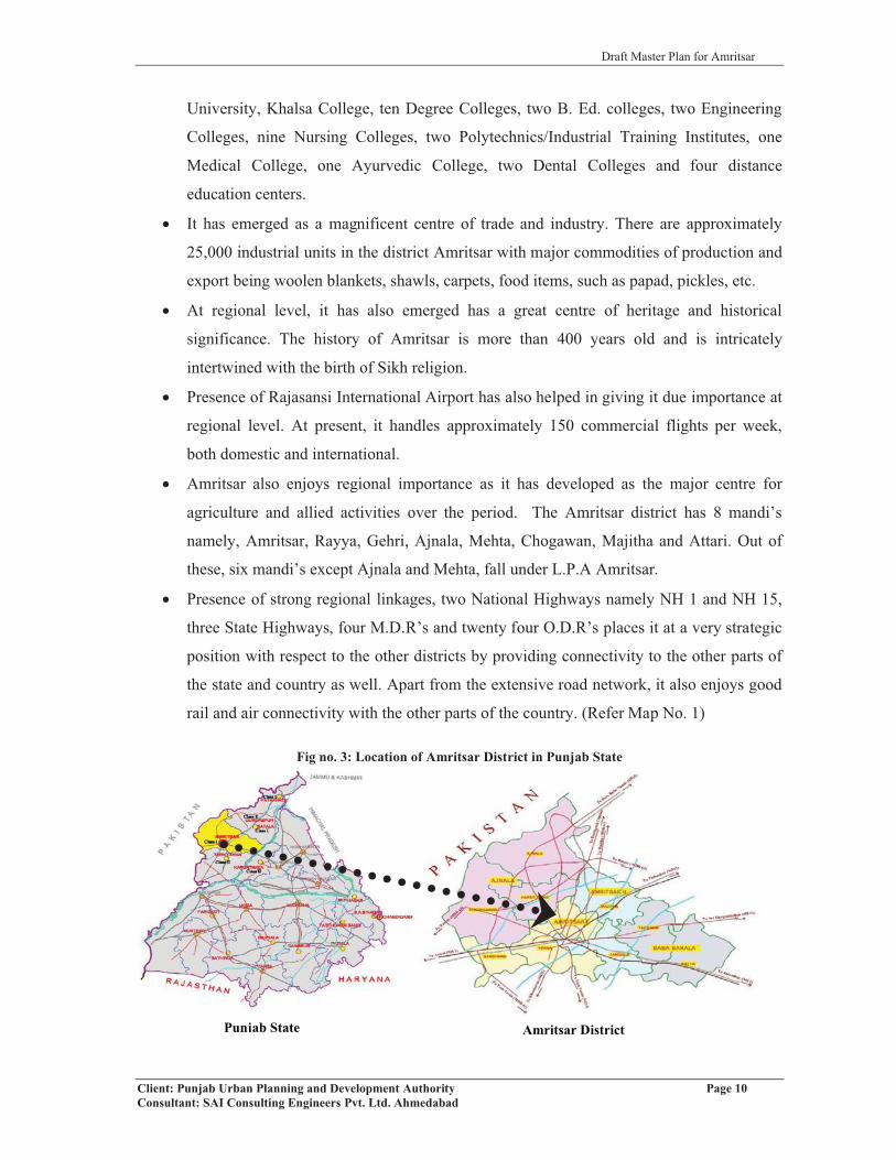
� Presence of strong regional linkages, two National Highways namely NH 1 and NH 15,
three State Highways, four M.D.R’s and twenty four O.D.R’s places it at a very strategic
position with respect to the other districts by providing connectivity to the other parts of
the state and country as well. Apart from the extensive road network, it also enjoys good
rail and air connectivity with the other parts of the country. (Refer Map No. 1)
Fig no. 3: Location of Amritsar District in Punjab State
Punjab State Amritsar District
Draft Master Plan for Amritsar
Client: Punjab Urban Planning and Development Authority Page 11Consultant: SAI Consulting Engineers Pvt. Ltd. Ahmedabad
1.3 PHYSICAL CHARACTERISTICS
1.3.1 TOPOGRAPHY
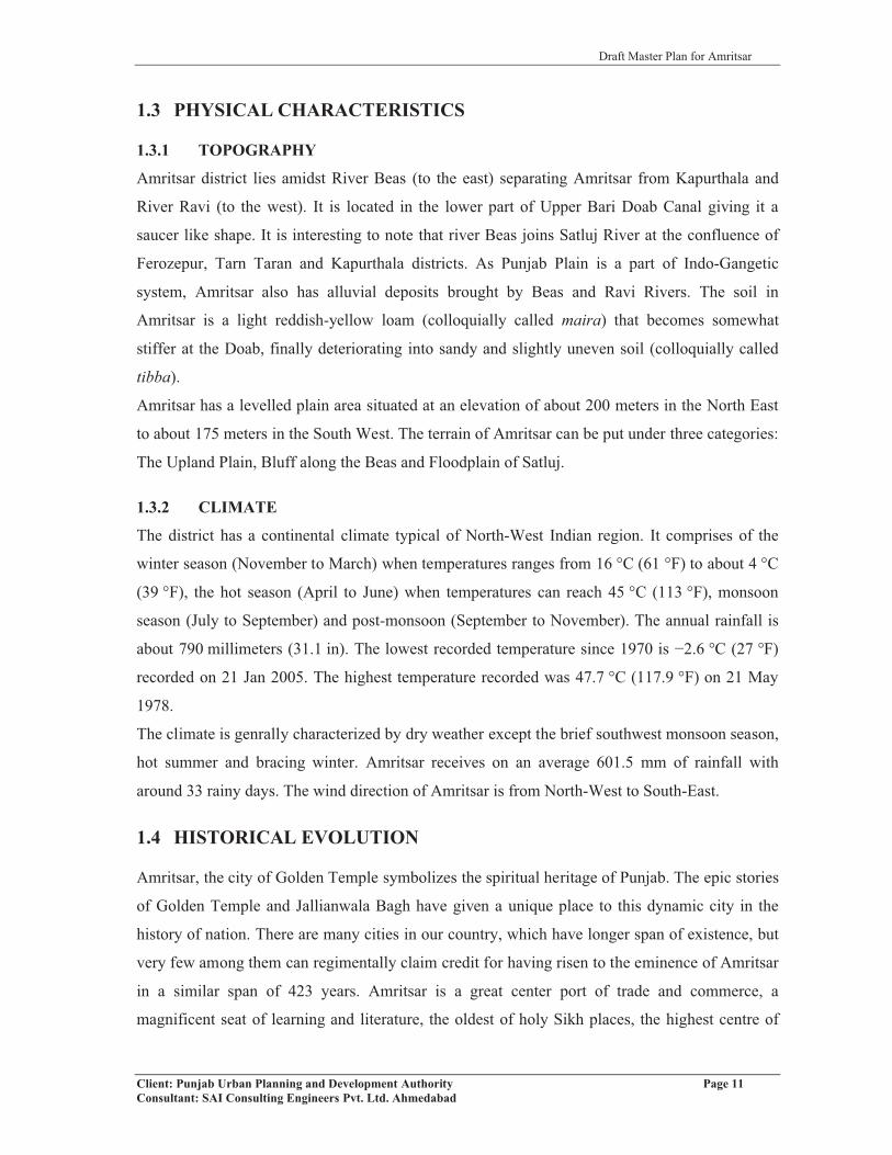
Amritsar district lies amidst River Beas (to the east) separating Amritsar from Kapurthala and
River Ravi (to the west). It is located in the lower part of Upper Bari Doab Canal giving it a
saucer like shape. It is interesting to note that river Beas joins Satluj River at the confluence of
Ferozepur, Tarn Taran and Kapurthala districts. As Punjab Plain is a part of Indo-Gangetic
system, Amritsar also has alluvial deposits brought by Beas and Ravi Rivers. The soil in
Amritsar is a light reddish-yellow loam (colloquially called maira) that becomes somewhat
stiffer at the Doab, finally deteriorating into sandy and slightly uneven soil (colloquially called
tibba).
Amritsar has a levelled plain area situated at an elevation of about 200 meters in the North East
to about 175 meters in the South West. The terrain of Amritsar can be put under three categories:
The Upland Plain, Bluff along the Beas and Floodplain of Satluj.
1.3.2 CLIMATE
The district has a continental climate typical of North-West Indian region. It comprises of the
winter season (November to March) when temperatures ranges from 16 °C (61 °F) to about 4 °C
(39 °F), the hot season (April to June) when temperatures can reach 45 °C (113 °F), monsoon
season (July to September) and post-monsoon (September to November). The annual rainfall is
about 790 millimeters (31.1 in). The lowest recorded temperature since 1970 is ���6 °C (27 °F)
recorded on 21 Jan 2005. The highest temperature recorded was 47.7 °C (117.9 °F) on 21 May
1978.
The climate is genrally characterized by dry weather except the brief southwest monsoon season,
hot summer and bracing winter. Amritsar receives on an average 601.5 mm of rainfall with
around 33 rainy days. The wind direction of Amritsar is from North-West to South-East.
1.4 HISTORICAL EVOLUTION
Amritsar, the city of Golden Temple symbolizes the spiritual heritage of Punjab. The epic stories
of Golden Temple and Jallianwala Bagh have given a unique place to this dynamic city in the
history of nation. There are many cities in our country, which have longer span of existence, but
very few among them can regimentally claim credit for having risen to the eminence of Amritsar
in a similar span of 423 years. Amritsar is a great center port of trade and commerce, a
magnificent seat of learning and literature, the oldest of holy Sikh places, the highest centre of

Draft Master Plan for Amritsar
Client: Punjab Urban Planning and Development Authority Page 12Consultant: SAI Consulting Engineers Pvt. Ltd. Ahmedabad
Fig no. 4: Amritsar in 1600 AD
Sikh politics and the strongest post on country’s northwestern frontier. The city itself is the most
prized endowment of our Gurus. The historical development of Amritsar can be traced back into
following periods:
1.4.1 GURU PERIOD (1577-1628)
The fourth guru, Sri Guru Ram Dass Ji in 1577 AD who had
shifted the seat of third guru from Goindwal, founded the
Amritsar, commonly known as “Pool of Nectar”. During this
period, Guru Ram Das Ji built a house for his residence
(Now called Gurudwara Guru-Ka-Mahal) and a number of
huts, which had grown nearby, formed a small village
settlement called Guru-Ka-Chak. Many khatri families were also settled there in order to
develop the trade and commercial activities. The Guru also started
with the work of excavation of a tank which could not be completed
by him.
After the death of Guru Ram Das Ji in 1588, his son and fifth guru of
Sikhs “Sri Guru Arjun Dev Ji” took up the task of completing the
tank. He also took interest in the extension of the settlement, which
now began to be called as Ramdaspura in the name of its founder.
Guru further took up the task of masonry work of the tank at Ramdas
Sarovar. Simultaneously, he started construction of Hari Mandir or
Temple of God in the centre of the tank.
The first brick of masonry foundation of Hari Mandir was laid on 1589 AD under the noble
guidance of Guru Arjun Dev Ji. Sri Hari Mandir Sahib was completed in 1604 AD. Later sixth
Guru laid the foundation of Akal Takhat, which became the political seat of the Sikhs. In the
west of the city he built, a small fortress called ‘Lohgarh’ by building a high wall around a raised
platform. The place where the young son of Guru Hargobind was cremated is the site where a
high tower called as Baba Atal was built later on. Hence, the limits of then Ramdaspura were as
below:
1. On the Eastern side, till the Shivala beyond which Jassa Singh Ahluwalia later built his
Katra Ahluwalia.
2. On the Southern side, it was Darshni Darwaza upto which Hari Mandir could be seen
without any obstacle.
3. Chaurasti Attari with its haveli was on the Western side of Hari Mandir.
Fig no.5: Baba Atal Sahib Ji

Draft Master Plan for Amritsar
Client: Punjab Urban Planning and Development Authority Page 13Consultant: SAI Consulting Engineers Pvt. Ltd. Ahmedabad
Fig no. 6: Amritsar during Maharaja Ranjit Singh Period (1800
AD)
4. On the North of Hari Mandir, Dharamshala of Bhai Salo was located.
1.4.2 PERIOD OF ANARCHY (1628-1765)
Though, Guru Period led to the development of settlement with many activities but Mughals
attacked Hari Mandir Sahib and the city several times. As a result, this period is considered as
the dark period for the city.
1.4.3 AMRITSAR UNDER SIKH MISLS (1764-1802)
With the establishment of number of independent misl’s (with power of Misldars) estates
surrounding Ramdaspura, it became a poly nucleated city. Function of the city predominantly
remained as a religious and pilgrimage centre. It also became capital of many misl estates.
The trade was limited to meet the local needs. The development during this period includes
Katras (neighborhood/ residential clusters), forts, havelis, bungas (rest places), gardens, tanks,
etc.The various Misl’s which contributed to the development of city are:Table 2: Contribution of Various MislsS. No Name of Misl Owned by/ Development Work
1. Ramgarhia Sardar Jassa Singh Ramgarhia - Converted fort of Ram Rauni to fort Ramgarh
- Katra Ramgarhia- Bunga Ramgarhia (only Bunga left
now) for defence of Harmandir Sahib2. Bhangian Qila Bhangian, Katra Hari Singh, Katra Desa Singh, Katra Bhag Singh, Katra Dulo,
Katra Chatar Singh, Tunda Talab area.3. Kanhaiya Sardar Jai Singh - Built fort, Katra Baggian, Katra
Jaimal Singh, Karmo Deouri4. Ahluwalia Sardar Jassa Singh Ahluwalia - Qila Ahluwalia, Katra Ahluwalia
5. Faizal Puria Nawab Kapoor Singh Faizal Puria Katra now known as Bazaar Kaserian got developed.
Source: District Gazetteer, Amritsar; Amritsar: A study in urban history (1840-1947); The city of Amritsar an Introduction by Fauja Singh
This period led to strengthening of the defense system for Hari Mandir Sahib as well as for the
city. Further, many activity areas in the form of Bazaars, Katras, etc. also were developed.
1.4.4 AMRITSAR UNDER MAHARAJA RANJIT SINGH (1802-1849)
Maharaja Ranjit Singh conquered Amritsar from Misl
Bhangian in 1802 and Misl Ramgarhia in 1816. Maharaja
gave special importance to Amritsar and it became his
second capital soon after Lahore. His contribution to
Amritsar can be seen in the form of various constructions.
The traditional character was depicted in the form of forts
(Gobindgarh Fort), gates, wall, gardens, havelis, akharas

Draft Master Plan for Amritsar
Client: Punjab Urban Planning and Development Authority Page 14Consultant: SAI Consulting Engineers Pvt. Ltd. Ahmedabad
Fig no.7: Amritsar in 1850 AD
like Balanand, Brahm Bareck (centre of learning) etc. A
massive wall around the city (25 yards broad and 7 yard
high) was constructed in 1925.
City Wall and Gates
The gates were named as:
1. Hall Gate (built in British Period)
2. Hathi Gate
3. Lohgarh Gate
4. Lahori Gate
5. Khazana Gate
6. Hakima Gate
7. Bhagtanwala Gate
8. Gilwali Gate
9. Chatiwind Gate
10. Sultanwind Gate
11. Ghee Mandi Gate
12. Sheranwala Gate
13. Mahan Singh Gate
14. Ram Bagh Gate
Out of these fourteen gates, only Ram Bagh Gate stands in its original exterior while all other
gates were demolished and rebuilt by the British during 1866-1868.
Many gardens like Ram Bagh were built during this period i.e in 1931. Ram Bagh Garden
consists of summer palace, which served as Maharaja’s residence. The layout of garden was
similar to that of Shalimar Garden based on the Mughal Garden Concept. The other gardens built
were Bagh Akalian, Shamsher Singh, Attar Singh in Katra Dal Singh, Bagh Santokhsar, Ralia
Ram and Bagh Ramanand.
Maharaja encouraged his sardar’s to expand the city. Sardar’s built their havelis and small
gardens around which katras got developed. The various katras developed were Katra Karam
Singh, Katra Hakima, Katra Khazana, Katra Dal Singh, Katra Mit Singh, Katra Garba Singh,
Katra Zamindar Khushal Singh and Katra Sher Singh.
The fortified city was having open spaces in the form of bagichas (gardens) inside the katras.
The various trades were assigned to different quarters. The rock salt trade centre was conducted
in Loon Mandi. Similarly, firewood, wool spinners, cotton weavers etc. occupied different areas
of the city. The retail trade was carried on in linear bazaars.
The city gave an appearance of garden city. Still many buildings are there which shows
craftsmen skills through its decorative elements, typical scale, size, colour, texture, building
material (nanakshahi brick, surkhi lime, etc). This shows the built heritage of the city. Thus, this
period is known as ‘Golden Period’ in the history of Amritsar.

Draft Master Plan for Amritsar
Client: Punjab Urban Planning and Development Authority Page 15Consultant: SAI Consulting Engineers Pvt. Ltd. Ahmedabad
Fig no. 8: Amritsar in 1900 AD
1.4.5 AMRITSAR UNDER THE BRITISH RULE (1849-1947)
This period is marked with various physical
developments with new technologies, craftsmanship
skills etc. Instead of Katras, Bunglows with setbacks
started coming up. The old wall (in western part of city)
was demolished and later a new masonry wall 14 feet
high was constructed along with new gates in 1866-
1868 from Lahori Gate to Ram Bagh, Gate. Outside the
walled city, parallel to the new walls, a road was constructed as Circular Road, which still exists.
As Municipal Committee was also set up at that time which gave much importance to water
supply, sanitation, streetlights, etc.
The other developments that undertook during the British period includes
� District Headquarter -1849 A. D.
� Civil Hospital outside Ram Bagh Gate- 1849
� Clock Tower in north of Golden Temple-1852
� Bait Al Masih Chruch-1852
� St. Paul’s Church- 1853
� Cantonment area- 1854
� Municipal Committee- 1868
� Hall Gate- 1876
� Hall Bazaar was laid to connect Town Hall with the civil lines.
� Distict Courts - 1877
� Khalsa College - 1892
� Sadar Police Station - 1907
� Victoria Jubilee Hospital renamed as Sh. Guru Teg Bahadhur Hospital - 1922-1924
� Head Post Office - 1925
� Medical College - 1929
� Railway Station - 1931
The architectural style, streetscapes, visual appearance of the city etc. was changed during this
period.
Draft Master Plan for Amritsar
Client: Punjab Urban Planning and Development Authority Page 16Consultant: SAI Consulting Engineers Pvt. Ltd. Ahmedabad
1.4.6 AMRITSAR IN POST INDEPENDENCE PERIOD (1947-1994)
The communal riots during the partition of India in 1947
led to large scale burning of the city. About one-fifth of
the walled city was burnt. To rebuild these damaged
areas Government of Punjab enacted a law ‘The Punjab
Development of Damaged Areas Act, 1951’. Amritsar
Improvement Trust was established in 1949 and framed
number of Development Schemes, notable among
them is widening of approach road to Golden Temple
within the walled city (widening up to 60 feet). This scheme changed the entire concept of
walled city from pedestrian to motorization, leading to many problems of today like traffic haos.
Further, Guru Nanak Dev University, an important landmark in the city was established in 1969.
In 1981, population of the Amritsar city grew to 5,89,229 persons and the city became congested
with commercial activities continuing still in the walled city area. In 1984, Operation Blue Star
did much loss to the Golden Temple Complex and its surroundings. Akal Takhat was demolished
completely with guns and mortars. The Watch Towers were also affected badly. In 1986 again,
Operation Black Thunder caused damage to Watch Towers and other buildings. Further, in order
to make for loss, the project for beautification of surroundings of Golden Temple was undertaken
commonly known as Galiara Scheme in which 30 meters of area around the Golden Temple
complex was acquired for the aforesaid purpose and were demolished (named as Corridor Plan
but the press called it Operation Demolition). It also took many historic buildings and
monuments in its folds. Some of them are Akhara Sangulwala, Burj Giania, Baradari near Baba
Atal, Akal Rest House, Akhara Beriwala, etc. Many traditional bazaars like Papran wala bazaar
etc. also bore the same fate. Coming to the present scenario, in the year 1988 & 1994, the area of
Municipal Corporation Amritsar was extended in accordance to the nature of development,
which was observed in NW & SE of the Amritsar Municipal Area. After this, in 2004-05 the
number of wards were increased to 65 from 60, but interesting fact is that the total area of city
remained same i.e. 142 sq km.
Fig no. 9: Amritsar in Post Independence Period 1964 AD

Draft Master Plan for Amritsar
Client: Punjab Urban Planning and Development Authority Page 17Consultant: SAI Consulting Engineers Pvt. Ltd. Ahmedabad
CHAPTER 2
DEMOGRAPHIC PROFILE AND ECONOMIC BASE2.1 DEMOGRAPHIC CHARACTER
Municipal Corporation, Amritsar has been found to be the most urbanized settlement of the LPA
comprising of 61% population of the LPA. Municipal Corporation, Amritsar constitutes 91.5%
of urban population of the Amritsar district. Among the other four major urban settlements
within LPA, Jandiala has 2.14% share of the urban population of the district and Rajasansi has
least urban population share of 1.1%. (Refer Table 3) Among the 310 rural settlements falling in
LPA Amritsar, Budha Theh is a census town according to census 2001. Table 3: Distribution of Urban Population in Major Towns of Amritsar District
Name Urban Population %age to District Urban PopulationAmritsar District 11,10,811 -
M. Corp. Amritsar * 10,16,079 91.50%Jandiala M. Cl 23,834 2.14%
Rayya N.P. 12,631 1.14%Majitha M. Cl 12,992 1.17%Rajasansi N.P. 12,176 1.10%
Source: Census of India, 2001* Population of Cantonment and Outgrowth is also included into the population of M. Corp. Amritsar.
Further, in order to determine the hierarchy of settlements (310 rural settlements and 5 urban
settlements) falling in LPA, they have been categorized into 6 broad groups (refer table 4).
47.62% of village settlements in Amritsar LPA fall under the population range 1000-3000
followed by 19% of the villages in the category of population range 500- 1000. Only 1.59 % of
the villages fall in the category of population above 10,000. (Refer map 1) Table 4: Hierarchy of Settlements in LPA Amritsar (both urban and rural)
Sr. No. Settlement Group No. of Settlements %age*1 Below 500 43 13.652 500-1000 59 18.733 1000-3000 150 47.624 3000-5000 42 13.335 5000-10,000 16 5.086 Above 10,000 5 1.59
Total 315 100.00Source: Census 2001 and Computed values*
From the map 1, it is evident that settlements with higher population are situated along the major
radial roads of LPA. As a result, greater accessibility is the major factor responsible for their
growth/ development. For example, Attari and Kathanian which have high population are located
on NH-1 towards Wagah Border. Similarly village Harsha Chhina lies on Ajnala Road (SH- 25)
and Chogawan on Amritsar-Ranian Road (M.D.R 65),village Sohian Kalan and Nag on Majitha
Draft Master Plan for Amritsar
Client: Punjab Urban Planning and Development Authority Page 18Consultant: SAI Consulting Engineers Pvt. Ltd. Ahmedabad
Road (MDR 64), village Warpal and Chabba on Tarn Taran Road (NH-15), village Baba Bakala
and Sathiala along Beas-Baba Bakala-Batala Road (MDR 66).
2.1.1 POPULATION GROWTH -AMRITSAR
Amritsar, the second metropolitan city of Punjab has a total population of 10, 16,079 persons
(including out growth) and ranked 33rd in the list of 35 metropolitan cities as per census 2001 and
ranks 274th in the world’s list of 1000 largest urban settlements (2005). The population growth rate
of Amritsar M.C. has been analyzed from time period of 1901 up to 2001 which is shown in the
figure below.Fig no.10 Population Growth of Municipal Corporation Amritsar
Source: Census of India, 2001
The rapid growth of the city has been observed since 1855, when the census was conducted for the
first time and the city recorded a population of 1,12,186 persons, emerging as the largest city of
Punjab which was overtaken by Lahore in the year 1881. Thereafter, a rapid upward trend was
observed with growth rate as high as 65.3% for 1921-1931 and 47.64% for 1931-1941. Spatially
the city grew from an area of 840 acres (walled city) in 1849 to about 8316.49 acres in the 1940’s.
The city had reached a population of nearly 4 lakhs and was ranked 9th largest city of un-divided
India as per census of 1941. It was also speculated that if the city had not suffered the partition
setback in 1947, Amritsar would have achieved metropolitan status decades ago. While population
growth dropped to -14.04%, a major slow down in physical growth was observed due to its close
proximity to the international border. Though in absolute terms population growth did occur but
the growth rate (16% for both decades 1951-1961, 1961-1971) was less than half the growth rate in
the decade from 1931-1941. The decade from 1931-1941 that was immediate before the partition
was also impacted by the two wars with Pakistan which again inflicted losses and slackened the
pace of development. However, in recent development of post 1990, the city has bounced, back to

Draft Master Plan for Amritsar
Client: Punjab Urban Planning and Development Authority Page 19Consultant: SAI Consulting Engineers Pvt. Ltd. Ahmedabad
make swift strides to become the second largest city of Punjab state after Ludhiana and achieving
the fastest growth rate (42.67%) amongst all the class I centers of Punjab for the decade 1991-
2001. Further within L.P.A Amritsar , it is observed that among the 4 other settlements (except
M.C.A), Rayya experiences the highest growth rate of the order of 38.5% and Majitha experienced
a growth rate of 31.1% in comparison to other two urban settlements namely: Jandiala and
Rajasansi which had comparatively lower growth rate of the order 23.5% and 21.7% respectively.
This implies that both these towns are being over shadowed by the growth of the metropolis of
Amritsar and will become part and parcel of the metropolis in near future. (Refer map 2)Table 5: Demographic Trend, Annual Growth Rate and Population Density in Amritsar LPA
CATEGORY OF THE
SETTELMENTS
TOTALPOPULATION
GROWTHRATE
POPULATION DENSITY (NO. OF PERSONS/SQ.KM)
1981 1991 2001 1991 2001 1981 1991 2001Amritsar (MC) 5,94,844 7,08,835 10,16,079 19.16 42.67 5,173 6,163 7,137
Rayya (NP) 7,049 9,122 12,631 29.4 38.5 1,007 1,303 1,928Majitha (M Cl) 8,729 9,912 12,992 13.6 31.1 2,910 3,304 1,113Jandiala (M Cl) 16,335 19,293 23,834 18.1 23.5 3,889 4,594 1,639Raja Sansi (NP) 8,107 10,008 12,176 19 21.7 2,027 2,502 785Villages (LPA) - 4,97,625 5,82,754 - 26.3 - 423 481
Source: Census of India 1981, 1991, 2001
*Areas of the settlements falling in LPA are as per PRSC map (Refer annexure no. II)
2.1.2 POPULATION DENSITY
The population density in L.P.A Amritsar was of the order of 1,190 persons/square kilometers in
2001 where as density in rural area stood at 481 persons/square kilometer. In comparison to that,
the population density of Amritsar city was 7,137 persons per sq.km, which is six times higher
than LPA. Among the 4 urban settlements, the density of Rayya stands at 1,113 per sq.km which
is highest with Rajasansi having the least population density of the order of 785 per sq.km.
(Refer map-3)Fig no.11 Population Density in L.P.A Amritsar
Source: Census of India-1981, 1991, 2001

Draft Master Plan for Amritsar
Client: Punjab Urban Planning and Development Authority Page 20Consultant: SAI Consulting Engineers Pvt. Ltd. Ahmedabad
Taking into consideration the ward wise density in Amritsar, the highest density is observed in
the 12 wards which fall within the walled city having density more than 300 persons per hectare
(PPH) whereas 7 wards falling outside walled city also have density in the range of 300 persons
per hectare and above. (Refer Table 6)Table 6: Density in Different Wards of Amritsar City
Density Range (PPH) No. of Wards %ageWalled City
High Above 300 12 20.00Medium I 100-200 1 1.67
Outside Walled CityHigh Above 300 7 11.67
Medium II 200-300 6 10Medium I 100-200 11 18.33
Low Less than 100 23 38.33Total 60 100
Source: Census of India, 2001 and PRSC data
*The area of wards is based on the map supplied by PRSC
The highest density observed within the wards is of ward no.21 and 4 where it is of the order of
860 persons per hectare and 740 persons per hectare respectively. The ward no. 4 is located
within the walled city area while ward no.21 is located adjoining the walled city in the southern
direction and have density approximately 10 times higher than the city’s gross density. The
lowest density is of ward no.18, which is of the order of 15 persons per hectare and is merely one
fourth of city’s gross density. Further, it has been analyzed that 56.3% of high-density area lies
within walled city Amritsar (Refer annexure no.III). This makes it crucial as walled city
constituting 1/41th (3.47 sq.km) of the total city area (142.37sq.km) houses 1/6th of the M.C.A
population (1, 60,000 persons approximately). Due to such high density, prevailing in the city
core poor quality of life and unhealthy living conditions have been witnessed which requires
special strategies. (Refer map 4)
2.1.3 SEX RATIO
The over all sex ratio for the LPA, Amritsar stands at 865 which is less than the district and state
figure of 872 and 876 females/1000 males respectively.Table 7: Sex Ratio in Amritsar LPA
Category of Settlements Sex Ratio (No. of Females/1000 Males)1981 1991 2001
Amritsar (MC) 853 883 865Majitha (M Cl) 896 869 889Jandiala (M Cl) 907 893 869Rayya (NP) 898 787 904Raja Sansi (NP) - 892 848Villages (LPA) 872Source: Census of India 1981, 1991, 2001

Draft Master Plan for Amritsar
Client: Punjab Urban Planning and Development Authority Page 21Consultant: SAI Consulting Engineers Pvt. Ltd. Ahmedabad
There has been decrease in the sex ratio of M.C Amritsar from 883 in 1991 to 865 in 2001. On
comparing the sex ratio in other four urban settlements in the LPA, it has been observed that
Rayya has the highest sex ratio of 904 and Rajasansi has the lowest sex ratio of 848. (Refer table
no.7 ). This decrease in sex ratio could be due to increasing male migration in the city for work
and other reasons.
Religious Composition: Hindus constitute 50.23% of total population of Amritsar city, while
47.92% are Sikhs and 1.85% are Christians and rest of the population belongs to other religions
including Muslims, Jains, Buddhist as per 2001 census.
2.1.4 LITERACY RATE Table 8: Literacy Rate in Amritsar LPA
Category of the Settlements Literacy Rate (in %Age)1991 2001
Amritsar (MC) 75.26 79.55Majitha (M Cl) 62.49 67.30Jandiala (M Cl) 67.25 75.26
Rayya (NP) 73.61 78.53Raja Sansi (NP) 57.40 63.67
Source: Census of India 1981, 1991, 2001
The literacy rate is highest in M.C Amritsar compared to other urban settlements in LPA which
stands at 79.55% as per census 2001 followed by Rayya which is 78.53% with the least being in
Rajasansi that is 63.67%. The literacy rate in M.C Amritsar is higher than the district literacy rate
of 70.4%.
It has also been observed that literacy rate has increased in all the five urban settlements in LPA
in 2001 from the year 1991. The maximum increase in the literacy rate has been observed in
Jandiala where the increase has been of the order of 8% followed by Rayya where it has
increased by 6.20%. (Refer table no.8)
2.1.5 SC/ ST COMPOSITION
The total SC population in the Amritsar city is 1, 82,261 persons which is 18.9% of the total
population in 2001.Table 9: SC Population in Amritsar LPA
Category of the Settlements %age of SC Population1981 1991 2001
Amritsar District - 28.00 27.34Amritsar (MC) 16.0 17.6 18.9Majitha (M Cl) 19.4 39.1 18.0Jandiala (M Cl) 26.5 29.9 32.6
Rayya (NP) 22.0 22.0 24.7Raja Sansi (NP) - 40.9 37.4Villages (LPA) - - 38.2
Source: Census of India 1981, 1991, 2001

Draft Master Plan for Amritsar
Client: Punjab Urban Planning and Development Authority Page 22Consultant: SAI Consulting Engineers Pvt. Ltd. Ahmedabad
Among the five urban settlements in LPA, Amritsar, Rajasansi has maximum percentage of SC
population, which stands at 37.4% followed by Jandiala with 32.6% share. Percentage share of
scheduled caste population in rural area of LPA Amritsar is 38.2%, which is highest, compared
to urban areas in LPA.
2.1.6 MIGRATION
Migration forms an important component of process of urbanization. Census of India defines the
migration in two ways viz.
Migrants by Place of Birth: Migrants by place of birth are those who are enumerated at a
village/town at the time of census other than their place of birth.
Migrants by Place of Last Residence: A person is considered as migrant by the place of last
residence, if the place in which he is enumerated during the census is other than his place of
immediate last residence.
Migration at Punjab Level: The migration data provided in the Migration Tables of Primary
Census Abstract by Place of Last Residence is of two types. The first one is related to all types
of migrants while the second one is concerned with migrants seeking work/employment. The
data available for both categories are for in-migrants and are for urban population of Amritsar
district. To calculate the data for Amritsar city, the share of Amritsar city population in the urban
population of Amritsar district is considered i.e. 91.5%, and the same is applied to take out the
number of in-migrants for Amritsar city from the in-migrants in urban population of district. The
migration data for all types of in-migrants for Amritsar city is given in the table below:Table 10: Total Migrants and Migrants in Last 10 Years by Place of Last Residence to Amritsar city (2001)
Last Residence Total Migrants(since 1971)
%age of Total
Migrants
Migrants in Last 10 Yrs
%age of Total
MigrantsElsewhere in the district of enumeration 1,78,628 55.13 30,097 38.25In other districts of the state of enumeration 57,716 17.81 16,702 21.22States in India beyond the state of enumeration 71,596 22.10 30,644 38.94Last residence outside India 16,086 4.96 1,245 1.58Total 3,24,026 100.00 78,688 100.00
Source: Census of India, 2001Note: Here “district of enumeration” term includes Tarn Taran District too.
The total number of migrants since 1971 to Amritsar city is around 3.2 lakhs, out of which more
than half had the last residence within the Amritsar District (includes Tarn Taran). Less than
1/5th of the migrants have moved from the other districts of the state only while more than 1/5th
come from the other states of the country. Only 1/20th migrants have migrated from outside
countries. In case of migration occurred in the last 10 years, almost 2/5th of the migration is of
intra district type showing a decline in percentage share in comparison to that of total data.

Draft Master Plan for Amritsar
Client: Punjab Urban Planning and Development Authority Page 23Consultant: SAI Consulting Engineers Pvt. Ltd. Ahmedabad
Almost the same numbers i.e. 30,644 are migrants from other states showing a substantial
percentage rise. On the other hand, the share of foreign in-migrants has fallen down drastically
to 1.58%.Table 11: Total Migrants by Place of Last Residence from different states to Amritsar City (2001)
StateFor All Years (since 1971) For Last 10 Years
No. of Migrants%age of Total
MigrantsNo. of
Migrants%age of Total
MigrantsUttar Pradesh 24,039 33.58 10,770 35.14Himachal Pradesh 9,414 13.15 2,967 9.68Bihar 9,277 12.96 5,202 16.98Haryana 4,657 6.50 1,710 5.58Delhi 3,957 5.53 1,373 4.48Jammu & Kashmir 3,282 4.58 1,288 4.20Rajasthan 3,238 4.52 1,250 4.08West Bengal 2,502 3.49 1,036 3.38Uttaranchal 2,234 3.12 981 3.20Others 8,992 12.56 4,067 13.27TOTAL 71,596 100 30,644 100.00Source: Census of India, 2001
While comparing the interstate migration, i.e. the migration happened within the country but
outside Punjab, the total number of migrants is 71,596. Out of these, 1/3rd alone is from Uttar
Pradesh while more than 1/10th is from Himachal Pradesh and Bihar, each. The other important
contributors with more than 3% share are Haryana, Delhi, J & K, Rajasthan, West Bengal and
Uttaranchal. The other states constitute more than 1/10th of the migrants.
In case of migration happened between 1991 and 2001, almost 30 thousand people are expected
to have come up in the city for work and other reasons. Out of these, again U. P. has the largest
share with more than 1/3rd of the migrant people. Bihar ranks second registering 1/6th migration,
while H. P. comes third with less than 1/10th migration to Amritsar city. The share of states other
than those listed above is again more than 1/10th of the migration happened in the last 10 years.Table 12: Migration of Workers by Place of Last Residence to Amritsar city (2001)Sr. No. Place of Last Residence No. of Migrant
Workers%age of Total
Migrant Workers1 Elsewhere in the district of enumeration 60,925 50.872 In other districts of the state of enumeration 18,819 15.713 States in India beyond the state of enumeration 34,221 28.574 Last residence outside India 5,806 4.85
Total 1,19,770 100.00Source: Census of India, 2001 Note: Here “district of enumeration” term includes Tarn Taran District too.
The migration of people seeking work or employment is the most important part of the total
migrants, as it is considered as the prime factor responsible for migration. The total number of
migrant workers in Amritsar city since 1971is more than 1lakh which forms 37% share of the
total migrant population in the city. More than half of the migrant workers are from within the
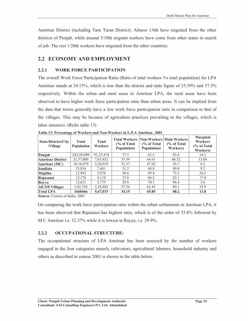
Draft Master Plan for Amritsar
Client: Punjab Urban Planning and Development Authority Page 24Consultant: SAI Consulting Engineers Pvt. Ltd. Ahmedabad
Amritsar District (including Tarn Taran District). Almost 1/6th have migrated from the other
districts of Punjab, while around 3/10th migrant workers have come from other states in search
of job. The rest 1/20th workers have migrated from the other countries.
2.2 ECONOMY AND EMPLOYMENT
2.2.1 WORK FORCE PARTICIPATION
The overall Work Force Participation Ratio (Ratio of total workers Vs total population) for LPA
Amritsar stands at 34.15%, which is less than the district and state figure of 35.39% and 37.5%
respectively. Within the urban and rural areas in Amritsar LPA, the rural areas have been
observed to have higher work force participation ratio than urban areas. It can be implied from
the data that towns generally have a low work force participation ratio in comparison to that of
the villages. This may be because of agriculture practices prevailing in the villages, which is
labor intensive. (Refer table 13)Table 13: Percentage of Workers and Non-Workers in L.P.A Amritsar, 2001
State/District/City/Village
TotalPopulation
TotalWorkers
Total Workers(% of Total Population)
Non-Workers(% of Total Population)
Main Workers(% of Total Workers)
MarginalWorkers
(% of Total Workers)
Punjab 243,58,999 91,27,474 37.5 62.5 85.8 14.2Amritsar District 21,57,000 7,63,452 35.39 64.61 86.32 13.68Amritsar (MC) 10,16,079 3,28,919 32.37 67.63 93.7 6.3Jandiala 23,834 7,441 31.2 68.8 90.8 9.2Majitha 12,992 3,978 30.6 69.4 75.5 24.5Rajasansi 12,176 4,118 33.8 66.2 82.1 17.9Rayya 12,631 3,775 29.9 70.1 96.4 3.6All 310 Villages 5,82,754 2,18,802 37.54 62.45 80.1 19.9Total LPA 1660466 5,67,033 34.15 65.85 88.2 11.8Source: Census of India, 2001
On comparing the work force participation ratio within the urban settlements in Amritsar LPA, it
has been observed that Rajasansi has highest ratio, which is of the order of 33.8% followed by
M.C Amritsar i.e. 32.37% while it is lowest in Rayya, i.e. 29.9%.
2.2.2 OCCUPATIONAL STRUCTURE:
The occupational structure of LPA Amritsar has been assessed by the number of workers
engaged in the four categories namely cultivators, agricultural laborers, household industry and
others as described in census 2001 is shown in the table below.

Draft Master Plan for Amritsar
Client: Punjab Urban Planning and Development Authority Page 25Consultant: SAI Consulting Engineers Pvt. Ltd. Ahmedabad
Table 14: Occupational Structure of Amritsar LPA Cultivators
(%)Agricultural
Labourers (%)Household
Industries (%)Others (%) Total (%)
Amritsar MC 3,004 (1) 6,213 (2) 12,317 (4) 2,86,663 (93) 3,08,197 (100)Urban Settlements in LPA 760 (4.53) 1,246 (7.42) 656 (3.9) 14,114 (84.15) 16,776 (100)
310 Villages in LPA 49,011 (27.98) 31,478 (17.97) 5,918 (3.38) 88,743 (50.67) 1,75,150 (100)
Total LPA 52,775 (10.55) 38,937 (7.78) 18,891(3.77) 3,89,523 (77.9) 5,00,123 (100)Source: Census of India, 2001
It has been observed that 93% of the workers in Amritsar city are engaged in other activities
(mainly tertiary activities), 4% in household industry and 3% in primary activities i.e cultivators
and agricultural laborers. Likewise, 77.9% of the working population in the LPA Amritsar is
engaged in the tertiary activities with 18.33% in primary activities. Table 15: Industrial Classification of Main Workers in Amritsar City
Classification
No.
NICCode
Type of worker 1991 2001Number of Workers
%age Number of Workers
%age
(I) PRIMARY-1 A & B Cultivators 4,603 2.16 3,004 0.972 Agricultural laborers 12,405 5.81 6,213 2.023 Plantation, Livestock, Forestry,
Fishing, Hunting and allied activities1,398 0.65 3,023 0.98
4 C Mining and Quarrying 9 0.00 212 0.07(II) SECONDARY-
5 (a) D Manufacturing processing and repairs industry (Household industry)
483 0.23 12,317 4.00
5 (b) Manufacturing processing and repairs industry (Other than Household)
60,678 28.43 67,632 21.94
E Electricity, Gas and Water Supply 3,592 1.176 F Constructions 6,957 3.26 20,989 6.81
(III) TERTIARY-7 G Whole sale and Retail trade 64,730 30.32 79,033 25.64
H Hotels and Restaurants 4,073 1.328 I Transport, Storage and
Communications15,903 7.45 24,595 7.98
9 J & K Financial Intermediation; Real Estate Renting and Business Activities.
46,293 21.69 19,814 6.43
L to Q Public Administration and Defence; Compulsory Social Security; Education; Health and Social Work; Other Community, Social and Personal Service Activities; Private Households with Employed Persons; Extra-Territorial Organisations and Bodies.
63,700 20.67
Total 2,13,459 100.00 3,08,197 100.00Source: Census of India-2001
The table above shows that the main workers in Amritsar city, classified into 9 categories as per
census 2001. It has been found that out of the total workers in Amritsar city, 26.96% of the

Draft Master Plan for Amritsar
Client: Punjab Urban Planning and Development Authority Page 26Consultant: SAI Consulting Engineers Pvt. Ltd. Ahmedabad
workers are engaged in Wholesale and Retail Trade followed by 21.94% in manufacturing,
processing &repairs industry and 20.67% in public administration and others since Amritsar is
the district head quarter. The increase in number of workers have been observed in the
construction, manufacturing processing and repair industry (household industry) and in the ninth
category which includes financial intermediaries, real estate renting and business activities and
public administration and defence services (J&K and L to Q).
2.2.3 DEPENDENCY RATIO
Dependency Ratio in any settlement/city is an indicator of total number of non-workers
dependant on total number of workers and is calculated as per 100 workers. Amritsar city has
dependency ratio higher (214) than that of state (167) and district (178). Further, it has been
analyzed that Rayya has highest dependency ratio standing at 235 followed by Majitha M.Cl that
is of the order of 227 per 100 workers. The villages on the other hand have comparatively lowest
share of dependency (168) in LPA. Overall, the dependency ratio in LPA Amritsar is of the order
196.Table 16: Dependency Ratio for Different Settlements in Amritsar LPA
State/District/Town/Village Dependency Ratio (Dependants/ 100 workers)Amritsar M.C. 214Jandiala M.Cl 220Majitha M.Cl 227
Raja Sansi N.P 196Rayya N.P 235
Villages 168Total LPA 196
Source: Census of India, 2001
2.2.4 EMERGING ECONOMIC DRIVERS OF LPA
Several economic drivers have been identified within the LPA, Amritsar. Recently, booming
real estate activities have been observed with the coming up of several residential colonies such
as Impact Gardens (a mega project), Garden Enclave, Shubham Enclave, Ansal City, Heritage
City etc and has played a great role in both the physical and economic development of the city.
Besides this, several shopping malls and multiplexes, like Celebration Mall, Alpha One, Trilium,
etc. have come up or are under construction in the Amritsar city along with commercial retail
chains like Bharti Walmart’s Best price on GT road near Manawala, Tata retail chain stores,
reliance retail chain stores etc., which when operational will contribute towards the economic
development. Further, there is proposal for establishment of World-Class Central University in
the Amritsar, which will give employment to large number of people.
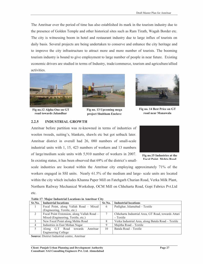
Draft Master Plan for Amritsar
Client: Punjab Urban Planning and Development Authority Page 27Consultant: SAI Consulting Engineers Pvt. Ltd. Ahmedabad
Fig no.15 Industries at the Focal Point, Mehta Road
Fig no.12 Alpha One on GT road towards Jalandhar
Fig no. 13 Upcoming mega project Shubham Enclave
The Amritsar over the period of time has also established its mark in the tourism industry due to
the presence of Golden Temple and other historical sites such as Ram Tirath, Wagah Border etc.
The city is witnessing boom in hotel and restaurant industry due to large influx of tourists on
daily basis. Several projects are being undertaken to conserve and enhance the city heritage and
to improve the city infrastructure to attract more and more number of tourists. The booming
tourism industry is bound to give employment to large number of people in near future. Existing
economic drivers are studied in terms of Industry, trade/commerce, tourism and agriculture/allied
activities.
2.2.5 INDUSTRIAL GROWTH
Amritsar before partition was re-knowned in terms of industries of
woolen tweeds, suiting’s, blankets, shawls etc but got setback later.
Amritsar district in overall had 26, 080 numbers of small-scale
industrial units with 1, 15, 423 numbers of workers and 13 numbers
of large/medium scale units with 5,910 number of workers in 2007.
In existing status, it has been observed that 69% of the district’s small-
scale industries are located within the Amritsar city employing approximately 71% of the
workers engaged in SSI units. Nearly 61.5% of the medium and large- scale units are located
within the city which includes Khanna Paper Mill on Fatehgarh Churian Road, Verka Milk Plant,
Northern Railway Mechanical Workshop, OCM Mill on Chheharta Road, Gopi Fabrics Pvt.Ltd
etc.Table 17: Major Industrial Locations in Amritsar CitySr.No. Industrial locations Sr.No. Industrial locations
1 Focal Point, along Vallah Road – Mixed (Engineering, Textile, etc.)
6 Putlighar, Islamabad – Textile
2 Focal Point Extension, along Vallah Road –Mixed (Engineering, Textile, etc.)
7 Chheharta Industrial Area, GT Road, towards Attari – Textile
3 New Focal Point along Mehta Road 8 Verka Industrial Area, along Batala Road – Textile4 Industries in East Mohan Nagar 9 Majitha Road – Textile5 Along G.T Road towards Amritsar
Engineering College10 Batala Road – Textile
Source: District Industrial centre, Amritsar
Fig no. 14 Best Price on GT road near Manawala

Draft Master Plan for Amritsar
Client: Punjab Urban Planning and Development Authority Page 28Consultant: SAI Consulting Engineers Pvt. Ltd. Ahmedabad
The spatial analysis highlights that except industrial focal points which are considered as planned
schemes, industries are scattered all along the major corridors of development. Industries
scattered all over in Amritsar city, which creates problem of non-compatibility as well as
pollution. There is an urgent need to develop industries in a comprehensive manner, they should
have specific zone with all state of art infrastructure needs to be identified.
INDUSTRIAL EMPLOYMENT AND PRODUCTION
Industrial employment from small scale/ medium/ large-scale industries in the Amritsar city has
been analysed from 2003 to 2007 in comparison to the Amritsar District, which is shown in the
table below:Table 18: Comparison of Industrial Data at City and District Level, 2007Area Small Scale Industries Medium/Large Scale Industries
No. ofUnits
No. ofEmployees
FixedCapital(Crores
Rs.)
Production(Crores
Rs.)
No. of medium/
largeUnits
No. of Employees
FixedCapital (Crores
Rs.)
Production(Crores
Rs.)
AmritsarDistrict 26,080 1,15,423 695.32 3,836.61 13 5,910 921.33 826.51
AmritsarCity 17,985 81,772 - - 8 4,091 - -
% share of City to District
68.96% 70.84% - - 61.5% 69.2% - -
Source: District Industries Centre, Amritsar
The table no 18 shows that the Amritsar city has the highest no. of small scale units (17,985
units) as compared to medium and large scale units which are only 8 in no. and also provides
highest employment (81,772), the share of employment in city comes to 70.84% of the district.
Keeping in view the positive contribution made by small-scale industrial units in the
employment generation, the similar contribution has been done in their investment as well as
production in the district. Looking at the fixed capital investment in the year 2007, the total
investment in case of small-scale industries was of the order of Rs 695.32 crores while in case of
large and medium scale industries, it was of the order of Rs 921.33 crores. Similarly, small-scale
industries also stand highest in case of production, in the year 2007, the production from small
scale units stands at Rs 3,836.61 crores as against the large / medium scale units Rs 826.51
crores.
INDUSTRIAL ESTATE/FOCAL POINT
Focal Points have been setup in the city of Amritsar by Department of Industries under State
Govt. Policy to facilitate industrial development in cities with potential for industrialization.

Draft Master Plan for Amritsar
Client: Punjab Urban Planning and Development Authority Page 29Consultant: SAI Consulting Engineers Pvt. Ltd. Ahmedabad
Fig no.16 Poor road infrastructure, water logging and open dumping of industrial waste in Focal Point, Amritsar
Amritsar with high potential for industrial growth has three focal points. The details of the focal
points and industrial estates in Amritsar city within LPA are given in the table below.Table 19: Details of Industrial Estates/Focal Points in Amritsar LPA
Sr.No.
Industrial Estate/Focal Point
Total Area(in Acres)
No. of Sheds/Plots
Allotted Vacant
Amritsar M.C.1 Focal Point, Vallah Road,
Amritsar City94.05 237 237 ___
2 Focal Point Extension, Vallah Road, Amritsar City
81.43 176 176 ___
3 New Focal point, Mehta Road, Amritsar
184.04 464 416 48
Total 359.52 877 829 484 Industrial Development
Colony, Chheharta, GT Road, Amritsar
23.09 55 52 ___
Total of M.C. 382.61 932 881 48Amritsar LPA
5 Rural Industrial Estate,Kathu Nangal
3.30 8 6 ___
Grand Total 385.91 940 887 48Source: District Industries Centre, Amritsar
Within Municipal Corporation, Amritsar, the three Focal Points cover a total area of 359.52 acres
with a total of 877 industrial sheds/ plots. A rural industrial estate also exists at Kathu Nangal
with an area of 3.30 acres. The existing focal points although have provision of water supply,
sewerage and storm water drainage but they lack maintenance. The internal roads in the old focal
point are not well maintained. Open disposal of hazardous waste and other industrial waste has
been observed which needs to be regulated.
A Sector specific Special Economic Zone (SEZ) dedicated to Textiles is coming up in Amritsar
at Khasa village on GT Road towards Attari. The Punjab-based Ishan Developers and
Infrastructure Limited, is developing The Integrated Textile Park on 100 hectares at village
Khasa in Amritsar with the investment of Rs 1,861 crores. The project is expected to provide
employment to 15,000 people.
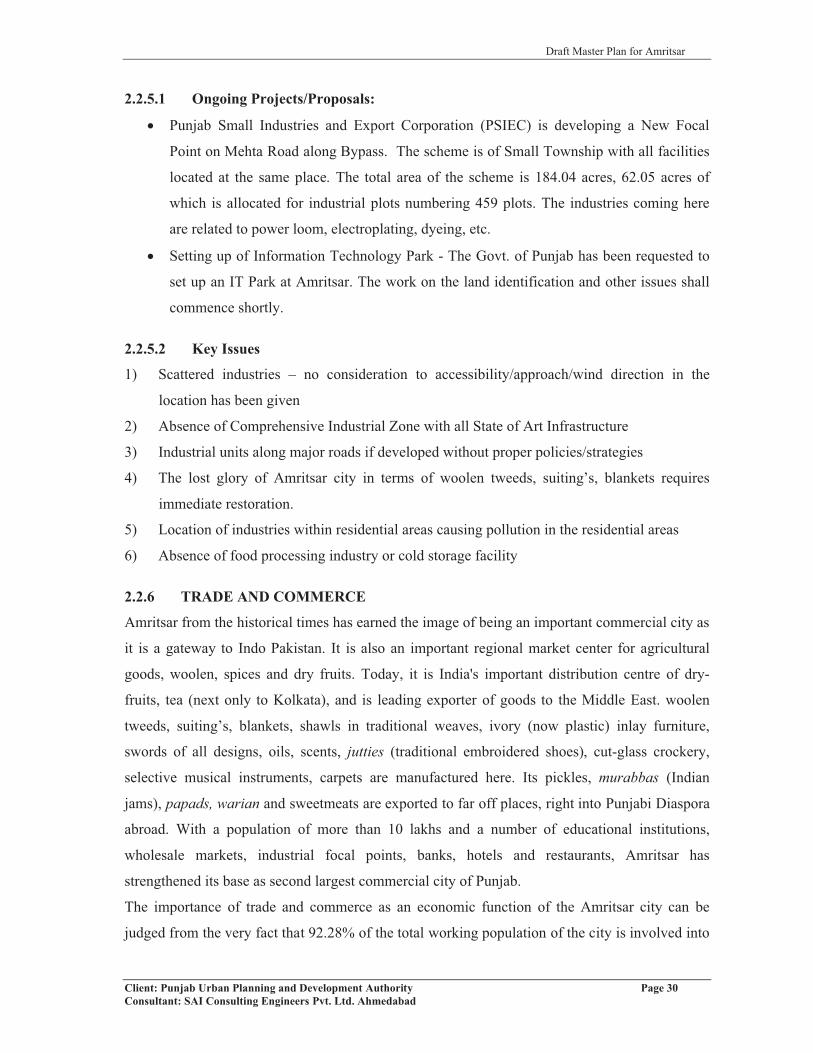
Draft Master Plan for Amritsar
Client: Punjab Urban Planning and Development Authority Page 30Consultant: SAI Consulting Engineers Pvt. Ltd. Ahmedabad
2.2.5.1 Ongoing Projects/Proposals:
� Punjab Small Industries and Export Corporation (PSIEC) is developing a New Focal
Point on Mehta Road along Bypass. The scheme is of Small Township with all facilities
located at the same place. The total area of the scheme is 184.04 acres, 62.05 acres of
which is allocated for industrial plots numbering 459 plots. The industries coming here
are related to power loom, electroplating, dyeing, etc.
� Setting up of Information Technology Park - The Govt. of Punjab has been requested to
set up an IT Park at Amritsar. The work on the land identification and other issues shall
commence shortly.
2.2.5.2 Key Issues
1) Scattered industries – no consideration to accessibility/approach/wind direction in the
location has been given
2) Absence of Comprehensive Industrial Zone with all State of Art Infrastructure
3) Industrial units along major roads if developed without proper policies/strategies
4) The lost glory of Amritsar city in terms of woolen tweeds, suiting’s, blankets requires
immediate restoration.
5) Location of industries within residential areas causing pollution in the residential areas
6) Absence of food processing industry or cold storage facility
2.2.6 TRADE AND COMMERCE
Amritsar from the historical times has earned the image of being an important commercial city as
it is a gateway to Indo Pakistan. It is also an important regional market center for agricultural
goods, woolen, spices and dry fruits. Today, it is India's important distribution centre of dry-
fruits, tea (next only to Kolkata), and is leading exporter of goods to the Middle East. woolen
tweeds, suiting’s, blankets, shawls in traditional weaves, ivory (now plastic) inlay furniture,
swords of all designs, oils, scents, jutties (traditional embroidered shoes), cut-glass crockery,
selective musical instruments, carpets are manufactured here. Its pickles, murabbas (Indian
jams), papads, warian and sweetmeats are exported to far off places, right into Punjabi Diaspora
abroad. With a population of more than 10 lakhs and a number of educational institutions,
wholesale markets, industrial focal points, banks, hotels and restaurants, Amritsar has
strengthened its base as second largest commercial city of Punjab.
The importance of trade and commerce as an economic function of the Amritsar city can be
judged from the very fact that 92.28% of the total working population of the city is involved into

Draft Master Plan for Amritsar
Client: Punjab Urban Planning and Development Authority Page 31Consultant: SAI Consulting Engineers Pvt. Ltd. Ahmedabad
tertiary activities while 75.22% of the total working population of Amritsar LPA is engaged into
tertiary sector. The larger share of working population in trade and commerce related to an
activity reflects that it is the mainstay of the people in the city.
MAJOR COMMERCIAL AREAS/MARKETS IN AMRITSAR
Commercial area in Amritsar constitutes 3% of the total city area. Apart from the conventional
specialized bazaar system existing in the walled city and civil lines area of the city such as that
on Queens Road, Court Road, M.M Malviya Road and Lawrence Road, the establishment of
District Shopping Complex at B Block, Ranjit Avenue (area 61 acre) and shopping complexes
along Lawrence Road, Mall Road and Ranjit Avenue provides residents with a whole new
experience of shopping in the city. This new concept of shopping malls/complexes and
multiplexes are fast catching up the city. In addition, large shopping areas have been developed
in the residential plots under the govt. policy of permitting change of landuse from residential to
commercial. Major residential areas impacted under this policy include Mall Road, Lawrence
Road, M.M. Malviya Road and residential areas located along major road networks of the city.
However, change of land use from residential to commercial without providing adequate parking
has adversely impacted the quality of life in these areas. Opening up of commercial areas along
all minor/major streets needs to be taken care off.
The walled city, Amritsar is the major commercial area or “CBD” of the city having many
specialized bazaars. The total character of the walled city is marked by mixed land use with
commercial use on the ground floor while with residential on the upper floors. However, with the
passage of time and commercial activities getting concentrated in the walled city, there is large-
scale conversion of residential areas into commercial use even on upper floors. This pattern is
more pronounced in the areas defined by Katra Ahluwalia, Karmon Deori, Shastri Market, Hall
Bazaar etc wherein the availability of space is a constraint and land prices are very high. Some of
the important specialized bazaars existing in the walled city, Amritsar are listed in the table no.
20. Outside Hall Gate & behind Municipal parking on Bhandri bridge exists the whole sale
market of tyres, batteries, private transport offices and eating joints also prevail in this market.
These specalised bazaars on one hand impact economy of the city whereas on the other hand
represents its specific medieval character.
New commercial areas have or are coming up in Amritsar city in the form of malls and
multiplexes primarily on Mall Road, Batala Road (Celebration Mall), G. T. Road (Alpha One)
and Circular Road (Trilium at Mental Hospital site with around 5.5 acres area by Tata Realty and
Infrastructure Limited). Where land use conversion has taken place from residential to

Draft Master Plan for Amritsar
Client: Punjab Urban Planning and Development Authority Page 32Consultant: SAI Consulting Engineers Pvt. Ltd. Ahmedabad
commercial hence pressurizing the infrastructure beyond its limits. Frequent traffic jams and on
street parking is a common character. Table 20: Major specialized Markets in Amritsar City
Sr. No. Name of Market Type of Goods Available Whole sale/Retail/Both1. Guru Bazaar Gold Jewellery Both 2. Bazaar Kesarian Steel and Brass Utensils Retail3. Katra Kathian Papads, Warian, Murabbas, Pickles, Aam Papad Both4. Mishri Bazaar Dry Fruits Whole sale5. Churi bazaar Glass Bangles Whole sale6. Katra Jaimal Clothes/Garments and Shoes Both7. Partap Bazaar Clothes/Wholesale Readymade Garments Both 8. Shastri Market Wholesale Woolen (Blankets, Shawls, etc.) and Sales Whole sale9. Katra Ahluwalia Wholesale Clothes Whole sale10. Bazaar Mai Sewan Wholesale Stationery Whole sale11. Hall Bazaar Electronics and Books Both12. Lawrence Road Garments and Restaurants Retail13. Majith Mandi Wholesale Dry Fruits and Spices Whole sale14. Dal Mandi Pulses and Spices Whole sale15. Dhab Basti Ram Soaps Whole sale16. Queens Road & Court Road Car Dealers Retail17. Malviya Road Readymade Garments Retail18. Katra Sher Singh Wholesale Medicines Whole sale19. Fish Market Fish Whole sale20. Pink plaza Garments Retail21. IDH Market (Behind bus
stand)Multipurpose Both
22. Putligarh market Garments , Mix RetailSource: Municipal Corporation, Amritsar
Fig no.17: Electronics’ Market at Hall Bazaar
Fig no.18: Readymade Cloth Market at Katra Jaimal Singh
Fig no.19: View of Shopping Complexes on Mall Road
Fig no.20: District Shopping Complex at Ranjit Avenue

Draft Master Plan for Amritsar
Client: Punjab Urban Planning and Development Authority Page 33Consultant: SAI Consulting Engineers Pvt. Ltd. Ahmedabad
INFORMAL SECTOR
In addition to these traditional markets and those provided under various schemes, city has large
number of informal markets. The genesis of these informal markets has its origin in the large
number of tourists and visitors coming to the city daily, lack of formal commercial spaces, high
land values and land disposal policy of the parastatal agencies. Most of these informal markets
are located around the major traffic nodes including railway station, bus stand and places of
tourist interest and religious centres including Golden Temple, Jallianwala Bagh, Durgiana
Mandir, Baba Atal etc., areas outside walled city to supplement the commercial requirements of
people living within the walled city and visitors to the city. Mushrooming of these informal
commercial markets have been witnessed in and around the health, education and recreational
facilities such as outside Rambagh Garden, Guru Nanak Hospital. Most of these informal
markets are located on road berms, vacant land/open spaces, parking lots etc. creating numerous
problems in the efficient functioning of the city including traffic and transportation. In order to
rationalize the growth and development of the city, informal sector needs to be made integral
part of the city planning and development process. Options for creating more affordable
commercial areas in terms of day markets needs to be explored in order to enable the informal
sector contribute to the economic growth of the city.
Informal sector, survey in the city has been conducted in order to have better understanding of
the exact nature and characteristics of these areas. The major considerations taken while
analyzing the informal activities in these stretch/junctions are surrounding land use, character of
land use activity, effective width of road reduced due to encroachments and informal activity.
The nature of informal activity, whether it is permanent, temporary or mobile, duration of time
and peak hours of informal activities, space occupied for particular use, availability of
infrastructure, source of electricity, mode of disposal generated by these informal vendors.
Informal parking and on- street parking. The following table no. 21 describes the location of
various stretches/junctions taken for study in the city.Table 21: Details of Informal Sector Stretches/Junctions in the city
Nam
eof
Stre
tch/
Junc
tions
Surr
ound
ing
Lan
dus
es
Maj
orC
hara
cter
istic
s
Enc
roac
hmen
t
No.
ofR
ehri
s
Infr
astr
uctu
reav
aila
ble
SWM Parking
Pede
stri
anFa
cilit
ies
Stre
etL
ight
MajithaRoad
Mixed land use Commercial yes 50 No
Collection bins of MCA
No No Yes
Guru Tegh Bahadur Hospital
Mixed land use Commercial yes 25 No
Collection bins of MCA
No No Yes

Draft Master Plan for Amritsar
Client: Punjab Urban Planning and Development Authority Page 34Consultant: SAI Consulting Engineers Pvt. Ltd. Ahmedabad
Nam
eof
Stre
tch/
Junc
tions
Surr
ound
ing
Lan
dus
es
Maj
orC
hara
cter
istic
s
Enc
roac
hmen
t
No.
ofR
ehri
s
Infr
astr
uctu
reav
aila
ble
SWM Parking
Pede
stri
anFa
cilit
ies
Stre
etL
ight
Guru Nanak Hospital
Mixed land use Commercial yes 20 No
Collection bins of MCA
No No Yes
Ram Bagh Mixed land use Commercial yes 50 No
Collection bins of MCA
Yes but on street
parking is seen
No Yes
Lawrence Road
Mixed land use Commercial yes 10 No
Collection bins of MCA
inadequate parking Yes Yes
Basant AvenueSchool
Mixed land use Commercial yes 12 public toilet
Collection bins of MCA
inadequate parking No Yes
Near Golden Temple
Mixed land use Commercial yes 50 Yes
Collection bins of MCA
Yes but on street
parking is seen
No Yes
Baba Deep Singh
Gurudawara
Mixed land use Commercial yes 40
The source of electricity
is From Nearby
shops and some from
rechargeable Batteries
Collection bins of MCA
inadequate parking Yes Yes
DurgianaTemple
Mixed land use Commercial yes 15
Church, Bus stop, Public toilet, Dust Bin (Iron),
Tourist Information Centre along the railway station and electricity
facility
Collection bins of MCA
Un-authorized
parking along the
roads
Yes Yes
Fish Market Mixed land use Commercial yes 12 No No No No Yes (out
of order)
Bus stand Mixed land use Commercial yes 28
Public toilet, Dust Bin
(Iron), and electricity
facility
Collection bins of MCA
Yes Yes Yes
Near Crystal Chowk
Mixed land use Commercial yes 25 No
Collection bins of MCA
Un-authorized
parking along the
roads
No Yes
Sultan wind Gate
Mixed land use Commercial yes 20 - - - - -
Lohgarh Gate
Mixed land use Commercial yes 30 No
Collection bins of MCA
No No Yes (out of order)
Source: Primary Survey, SAI Team, August 2009

Draft Master Plan for Amritsar
Client: Punjab Urban Planning and Development Authority Page 35Consultant: SAI Consulting Engineers Pvt. Ltd. Ahmedabad
Fig no.22: View of On-street parking and Informal Market opposite Baba Deep Singh Gurudwara
Fig no.21: Location of Informal Sector Stretches
The issue is to have formal spaces for such informal markets so that they don’t create problem
rather help in economic generation of the cities.
2.2.6.1 KEY ISSUES
� The markets of the walled city are highly congested and have high density. Due to
absence of adequate parking and organized commercial area the movement in these areas
has been hampered.
� The narrow streets and road encroachments have further degraded the aesthetic and
potential of the area. This has affected the trade of the markets and thus their existence.
� No institution dedicated to research and development of traditional industrial products of
the city, like shawls, is established to improve their quality, cost effectiveness and
marketing.
� No commercial complex for banking, insurance and share market exists in the city

Draft Master Plan for Amritsar
Client: Punjab Urban Planning and Development Authority Page 36Consultant: SAI Consulting Engineers Pvt. Ltd. Ahmedabad
2.2.7 AGRICULTURE AND ALLIED ACTIVITIES
District Amritsar has 84% of its total geographical area as “Net Sown Area” under various crops,
which is 5.32% of the net sown area in the state. The total cropped area in the district is 5.39%
of the state and ranks 8th among other districts. 100% of the gross cropped area in the district is
irrigated. 75.67% of the net sown area in the district is irrigated through tube wells and wells and
the remaining 24.33% of the area is irrigated through network of government canals in the
district i.e. Upper Bari Doab Canal.
PRINCIPAL CROPS
The principal crops in the Amritsar district are Wheat and Paddy as it ranks 8th in rice production
and 9th in wheat production among the districts of the state. Both these crops have largest area
under cultivation in the district, as yield per hectare of land is highest.
AGRICULTURAL MARKETSAmritsar district has total 8 regulated markets out of which 6 markets namely Amritsar,
Chogawan, Majitha, Attari, Rayya and Gehri fall within the Amritsar LPA. The other two
markets namely Ajnala and Mehta are in close proximity but fall out fall Amritsar LPA.Table 22: Information regarding Regulated Markets in District, 2006-07
DistrictNo. of Regulated
Markets
No. of Sub Yards attached with
Regulated Markets
Average No. of Villages served per Regulated Market
Average Area served per Regulated Market
(Sq. Km.)2005-06 2006-07 2005-06 2006-07 2005-06 2006-07 2005-06 2006-07
Punjab 145 145 294 294 85 85 347 347Amritsar 15 8 37 15 79 89 340 331
Source: Statistical Abstract of Punjab, 2008
There are three agricultural markets within the Amritsar city situated at Vallah, Bhagtanwala and
Chheharta. The market at Bhagtanwala is mainly the grain market located outside the walled
city, which deals with the procurement of food grains and cereals whereas the old fruit and
vegetable market was located outside the Hall gate. The agricultural market at Vallah- situated
on the Amritsar-Jalandhar Rail line opposite to Focal Point in an area of 102 acres, is the new
grain cum fruit & vegetable market. The reason behind locating of new site for grain cum fruit &
vegetable market is to shift wholesale markets existing within the city especially near the walled
city area as it caused lot of congestion due to heavy movement of trucks. The table below gives
details of the crop arrival along with the season and no. of villages served by the various mandi’s
falling within Amritsar LPA (refer table 23).

Draft Master Plan for Amritsar
Client: Punjab Urban Planning and Development Authority Page 37Consultant: SAI Consulting Engineers Pvt. Ltd. Ahmedabad
Fig no.24: New Fruit & Vegetable Market at Vallah
Fig no.23: Existing Grain Market at Bhagtanwala
Table 23: Details of Crop Arrivals Mandis coming within LPA limit
Mandi Area (Acres) PrincipalCrops
Annual Arrival (Metric Ton) Arrival Season No. of Villages
served
Amritsar 105
WheatRice
TomatoApple
BananaMango
Mausami
--
131031828501874486169312273
April-MaySep-DecAug-FebAug-FebAug-FebAug-FebAug-Feb
500
Gehri49.18 Wheat
SunflowerPaddy
53561174011915
May-JuneAug-Dec
32
Rayya 32
WheatSarsonPaddy
BasmatiToria
4000075
500006800
20
April-MayApril
Aug-OctApril
April-May
74
Chogawan WheatPaddy
9200032000
April-MayAug-Dec 132
Majitha 18.5
WheatPaddy
BasmatiFruit/Veg.
Wood
4301840382450
18001500
April-MaySep-Nov
DecJan-DecJan-Dec
97
Attari 20 WheatPaddy
7040642362
April-MaySep-Dec 71
Source: Punjab Mandi Board, 2008
It has been observed that new fruit and vegetable market at Vallah Mandi requires shifting as an
ammunition depot is situated close to it. As per the norms an area of approx 900mts around the
ammunition depot is to be declared as no construction zone wherein the fruit and vegetable
market at Vallah falls within this 900mts zone.
ALLIED ACTIVITIES
Allied activities such as dairying, animal husbandry, fisheries etc also form a strong economic
base for the Amritsar LPA apart from agriculture. Amritsar district has 2nd highest number of
livestock after Ludhiana in the state of Punjab. Amritsar district holds 1.44% of the total poultry

Draft Master Plan for Amritsar
Client: Punjab Urban Planning and Development Authority Page 38Consultant: SAI Consulting Engineers Pvt. Ltd. Ahmedabad
in the state of Punjab. The details of livestock and poultry in the district are shown in the table
no. 24.Table 24: Details of livestock and poultry in the Amritsar district, 2007
Livestock and Poultry in District Amritsar, 2007 (‘000)
Cat
tle
Buff
aloe
s
Don
keys
Hor
ses&
Poni
es
Mul
es&
poni
es
Shee
p
Goa
ts
Pigs
Tot
al
Poul
try
Punjab 1760.92 5035.65 4.83 29.82 9.69 210.61 286.39 24.99 7365.12 18899.7
AmritsarDistrict 101.09 298.01 0.64 2.47 0.63 8.18 11.27 0.82 423.83 271.65
%age 5.74 5.92 13.25 8.3 6.5 3.88 3.9 3.3 5.75 1.44Source: Statistical Abstract of Punjab, 2008
Amritsar district ranks 3rd in number of buffaloes in the Punjab State, hence is rich in milk and
milk products. Pertaining to higher number of livestock, poultry and fish; the district ranks 1st in
number of animals slaughtered. As shown in table no.25, 96.72% of the animals slaughtered in
the city are sheep and goats. Average no. of animals slaughtered per day is 208. This reflects
high demand of animal skin for the leather factories and also the demand of meat for
consumption.Table 25: Details of animals slaughtered in the Amritsar District, 2008
Slaughter Houses in Amritsar District (2008)No. of Recognized Slaughter
Houses (2007)Animals Slaughtered
Sheep & Goats Pigs TotalPunjab 87 3,37,922 26,023 3,63,945Amritsar District 3 78,444 91 78,535Amritsar M.C 1 75,878 0 75,878M.C as % of District 3.3 96.72 - 96.62Source: Statistical Abstract of Punjab, 2008
At present, there is only one slaughterhouse operational in the city located at Gumanpura. The
existing slaughterhouse is observed to be using old equipment and outdated technology. As many
activities causing environmental pollution are carried out in the slaughterhouse, they need to be
equipped with latest equipments and modern technology so that meat supplied to the city is
healthier and is as per the requirement “Prevention of Cruelty to Animals Rules 2001”. As
Amritsar district is observed to rank 1st in number of animals slaughtered, therefore it requires
establishment of institutions such as Carcass Utilization Centre and Leather Research Institute to
utilize the left over from the animal bodies for various other uses. Further, seeing the high
number of animals slaughtered in the city, an incineration plant is also required for disposal of
carcass of animals and birds due to infectious diseases like rabies and flu as per “Animal Birth
Control Rules-2000”.
Draft Master Plan for Amritsar
Client: Punjab Urban Planning and Development Authority Page 39Consultant: SAI Consulting Engineers Pvt. Ltd. Ahmedabad
2.2.7.1 Key Issues related To Slaughter House in Amritsar City
� Only one slaughter house in the city, which has low capacity and is not designed as per
concerned rules namely Prevention of Cruelty to Animals (Slaughter House) Rules- 2001
and it is not on modern lines.
� The city lacks incinerator plant for disposing animals & birds, which die due to infectious
diseases like rabies & bird flu
� Absence of Centre for Dead Animal Carcass Utilisation
� Slaughter houses leads to environmental pollution.
Lack of appropriate slaughtering facilities and unsatisfactory slaughtering techniques also causes unnecessary losses in meat.
2.2.8 ONGOING PROJECTS/PROPOSALS
� Setting up of Integrated Check Post at Attari-Wagha Border with cost out lay of Rs.130
Crores. 120 acres of land for ICP has been acquired during the year 2008 for the same.
� Integrated Check Post at Attari Railway Station spread in about 300 acres of land shall be
set up.

Draft Master Plan for Amritsar
Client: Punjab Urban Planning and Development Authority Page 40Consultant: SAI Consulting Engineers Pvt. Ltd. Ahmedabad
CHAPTER 3
HERITAGE AND TOURISMAmritsar with its rich history of cultural heritage has immense potential to grow as a major
tourist destination of the region. Amritsar city is famous as a religious centre due to the presence
of Golden temple, Durgiana temple and many other gurudwaras/temples/mosques, which makes
it a centre for religious tourism. Other than this, city has a vast treasure of historical buildings,
heritage structures/areas. Walled city itself is rich in heritage. All these can generate lot of
tourism potential, which has not been explored. It is said that about 1 lakh people visit Golden
temple everyday and this requires detailed planning, focused development and well defined
management strategies. Further, the share of Amritsar Rajasansi Airport in India in terms of
arrival of tourists was merely 2.2% (0.11 million) in the year 2007 (Source: India Tourism
Statistics 2007, Ministry of Tourism, Govt. of India). The heritage and tourism aspects of
Amritsar are very wide spread and are not limited to the city only. Accordingly, their potential
has been considered in three layers: (i) Walled City, (ii) Municipal Corporation, Amritsar
(MCA), area outside the walled city (iii) regional context (within LPA and its surroundings),
which are discussed as below.
3.1 WALLED CITY: AMRITSAR
The walled city is the most important place in the history of Amritsar where the fourth Guru
Ram Das Ji constructed the sacred Golden Temple. Though it constitutes only 2.44% of the total
MC area, yet it houses 1/6th of the total MC population.
The walled city Amritsar has a history spanning 433 years and is marked by the presence of
historical buildings with heritage elements such as Town Hall building, old hospital (Prince
Wales Zanana Hospital), etc. As per Municipal Corporation Amritsar, there are approximately 52
buildings within walled city (out of which 23 buildings are in Galiara) have been considered of
heritage value. Since rest of these buildings are privately owned and are in bad shape, hence their
conservation needs to be taken up on priority.
The origin of the walled city dates back to the sixteenth century. It had traditional spaces like
streets, squares and common courtyards. The architectural styles, materials used for different
purposes in different ways, like woodcarvings, jali work, etc. reflect the high level of
craftsmanship. The narrow winding streets with squares, buildings with domes and chattris have
the influence of Islamic Architecture and Rajputana style and are the major design heritage areas.

Draft Master Plan for Amritsar
Client: Punjab Urban Planning and Development Authority Page 41Consultant: SAI Consulting Engineers Pvt. Ltd. Ahmedabad
Fig no.26: Walled City 1947Fig no.25: Walled City 1849 Fig no.27: Walled City 2010
The walled city was built on human scale i.e. a pedestrian entity. The narrow zigzag street
pattern is a typical medieval planning concept and was not meant for vehicular movement. The
maximum distance from one corner to another is 3 km and almost every area around Golden
Temple (the nucleus of city) is within 1-2 km reach. So it could be visited by foot from the
remotest corner.
Initially, the walled city of Amritsar was marked with number of parks and open spaces, which
over the time have been used for commercial purpose. The area such as Hall gate, which at
present is acting as C.B.D., was initially a green open space. Likewise, Ramanand Bagh, Jhande
Wala Bagh, Kesari Bagh, Bagh Akalian, etc. have been exploited for commercial use. The maps
above show the walled city over a period of time. (refer figure no.22,23,24)
The figures above very well describe that how parks and open spaces of the city have been eaten
up by other development activities, majority of which are commercial in nature. Such conversion
has led to lack of breathing spaces within walled city. Strategies need to be evolved to stop future
conversion of landuse to commercial and to restore its old glory and provision of open spaces
wherever possible.
The walled city of Amritsar has a rich heritage in the
form of historical buildings/areas, gardens, artifacts,
townscape and streetscape. To quote Sir Bernard
Fielden, “A historical building is the one that gives us
a sense of wonder and makes us want to know more
about the people and culture. It has architectural,
aesthetical, historical, economical, social and
political values”. However, with the changing life
styles and priorities of the living community all are
in state of neglect. The threats posed to these areas and buildings are misuse, alteration in the
Fig no. 28: A view of the jharokhas of Qila Ahluwalia. It shows a hand in jaap mudra, an inherent feature in most buildings in the walled city.

Draft Master Plan for Amritsar
Client: Punjab Urban Planning and Development Authority Page 42Consultant: SAI Consulting Engineers Pvt. Ltd. Ahmedabad
Fig no.29: Golden Temple
architectural fabric, etc. So far, no effort has been made at the state or local level to preserve
them. The walled city must be considered as heart and soul of the Amritsar city and requires
major efforts as immediate actions.
Heritage Structures in the Walled City
Golden Temple
The highest seat of the Sikh religion, the holy Golden Temple is the
nucleus of the walled city. It was the place from where the
settlement originated. The living monument of spiritual and
historical traditions of the Sikhs, the Hari Mandir, popularly called
the Golden temple has been a source of inspiration for Sikh
community ever since it was founded.
At present various issues like parking, congestion on approach
roads have arisen. There is an immediate need of proposing pedestrianization, landuse freezing,
demolition of shops, etc., which in future may disturb the view/ aesthetics of Golden Temple.The
famous Galiara Project meant for the beautification of the surroundings of the temple has proved
highly beneficial in this regard.
Mosque of Khair-ud-Din
It was built in 1877 and is located in Hall bazaar. It is one of the
beautiful pieces of Islamic architecture. It has served as Jama
Masjid and it reminds the socio-cultural aspect of the city. Mosque
is well maintained, but it has been overshadowed by the high rise
structures.
Mosque of Mohammed Jan
Built in 1872, the mosque is now in a state of complete neglect. This
is also a good piece of Islamic architecture. If these mosques would
not be declared as the protected monument, they will have the same
fate like others, which have been converted into shops and
residences. This will mark the end of relics of Muslim architecture
in the walled city.
Fig no. 30: Mosque Khair-ud-Din
Fig no. 31: Mosque Mohammed Jan

Draft Master Plan for Amritsar
Client: Punjab Urban Planning and Development Authority Page 43Consultant: SAI Consulting Engineers Pvt. Ltd. Ahmedabad
Fig no. 32: Hall Gate
Gates and Walls
Massive wall (25 yards broad and 7 yards high) was constructed
in 1925 during Maharaja Ranjit Singh period. Around these walls,
moat had been constructed to protect from enemies which at
present is encroached upon by different acitivites. In today’s
context, historic character of wall has vanished largely due to
encroachments.
Area under wall in the south, it is largely encroached by govt. offices like police office and few
areas have been kept as green area. In the north and all along the moat, area is encroached by
different commercial activites, which needs to be conserved. There were initially 14 gates in the
city. Out of these, six gates have already been demolished which includes Beri Gate, Mahan
Singh Gate, Sheranwala Gate, Bhagtanwala Gate, Hakima Gate and Gilwali Gate. The remaining
gates need conservation. The Municipal Corporation, Amritsar has taken few steps on 9th Feb,
2010 by closing nearly 20 shops and removing encroachment along the walled city from Lohgarh
Gate to Beri Gate.
Town Hall:
This was built as an administrative nucleus in 1863 by the Britishers.
It is located on the southern end of Hall Bazaar. It is constructed
in red bricks with lime and surkhi as the binding material. It has
semi-circular arcades and a beautiful chhatri at the front entrance.
It has a flat roof made of timber planks and brick tiles. The
MC office located in this complex which is going to be shifted in a
short period and this building shall be used as a city museum.
The cracks in the structure have been filled with cement mortar, which destroys the historic
fabric of the structure. The growth of plants has taken place in the cracks, resulting in creating
dampness in the walls.
Chowk Passian:
The origin of Chowk Passian started from a settlement of huts around the residence of Guru
Ramdas Ji (Now known as Gurudwara Guru Ka Mahal). Gradually it also became one of the
commercial center of the city. It has narrow winding streets of medieval character. The houses
are generally three storied and ground floors are used for commercial purposes. The area is
Fig no. 33: Town Hall

Draft Master Plan for Amritsar
Client: Punjab Urban Planning and Development Authority Page 44Consultant: SAI Consulting Engineers Pvt. Ltd. Ahmedabad
incapable of accommodating the increasing vehicular traffic since; it was originally planned for
catering to pedestrian traffic only.
3.2 HERITAGE STRUCTURES IN MUNICIPAL CORPORATION AREA, AMRITSAR
Saint Paul’s Church
This church is located on Court Road adjacent to Head Post Office
and opposite New Rialto Cinema. It has a seating capacity of 200
persons. The church is in a comparatively good condition but its
surroundings are neglected.
Bait-Al-Massih Church
The church was built in 1852 and is located outside Rambagh
Gate. It is a fine piece of Victorian architecture. It is situated
outside the Rambagh Gate.
Durgiana Mandir
Built in 1924, Durgiana temple is an important religious center in
Amritsar. It is in close vicinity of Amritsar Railway Station & about
1.5 Km from the Bus Stand. There is not enough parking spaces for
the visitors. The encroachment on the katcha road constructed over
the Nallah passing adjacent to the temple is restricting from having
another access to the temple. The area around the temple,
especially along Shivpuri, is encroached upon by the jhuggi-jhoparis, which is also affecting the
aesthetics of the temple. A proper access and parking area is required for the temple having great
religious significance. Under the Durgiana Temple beautification scheme, Improvement Trust is
finding it difficult to locate the owners of 3.03 acres of the land, which is needed for the
beautification of the area.
Khalsa College
Khalsa College is a unique master piece of Sikh architecture. It was planned in 1892 by Sardar
Ram Singh of Maya School of Art. Its foundation stone was laid in 1904. The basis of planning
of this college has been taken from Harvard University of USA (H – shaped plan of main
Fig no.36: Durgiana Mandir
Fig no. 34: St. Paul’s Church
Fig no. 35: Bait-Al-Massih Church

Draft Master Plan for Amritsar
Client: Punjab Urban Planning and Development Authority Page 45Consultant: SAI Consulting Engineers Pvt. Ltd. Ahmedabad
Fig no.38: Burj Baba Phula Singh
building). The architectural style is a hybrid of Mughal and Rajputana architecture. There are
Mughal style Jharokhas, Jali work, Chattris and Rajputana style
arches and huge pillars. The campus has got well distributed and
spacious open spaces. The construction was made by renowned
contractor S. Dharam Singh, in whose memory Dharam Singh
Market near Golden Temple has been constructed by the
Improvement Trust.
Watch Towers:
Two watch towers were constructed by S. Jassa Singh Ramgarhia i.e., Burj Baba Phula Singh
and Baba Atal Rai Tower. These are octagon shaped minarettes with height of about 100 feet.
These are built in lime and surkhi with Nanak Shahi Bricks.
(i) Burj Baba Phula Singh
It was built in 1923 by Mahant Narain Singh. It is situated in front
of Bus Terminus near the city center. It is circular in shape, four
storied high with a chattri (dome) at the top. There are smaller
chattris on all four sides. It is constructed of red bricks in lime and
surkhi. The approach to the building is through the road leading to
truck terminal, which is in a worse condition due to the ongoing
construction of elevated road to Golden Temple.
(ii) Baba Atal Rai Tower
It is the place where Guru Hargobind took his last breath and tower
is named after Guru Hargobind’s son. It is one of the tourist
destination located in the vicinity of Golden Temple. It is
octagonal in shape and one has the distinction of being one of the
tallest buildings of Amritsar. It has great religious value.
(iii) Gobindgarh Fort:
It was built in 1809 by Maharaja Ranjit Singh and is located on the
western side of the Lohgarh Gate. The wall of the fort had
numerous bastions with guns fixed. It was used as a treasury of
Maharaja Ranjit Singh. It is constructed of red bricks mixed with
lime and surkhi. Earlier it was under the Indian army but now
Fig no.37: Khalsa College
Fig no. 40: Gobindgarh Fort
Fig no. 39: Baba Atal Rai Tower
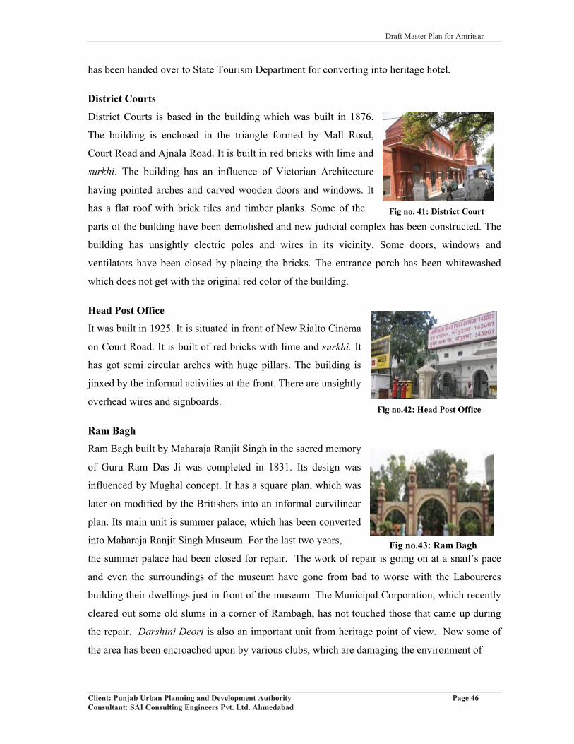
Draft Master Plan for Amritsar
Client: Punjab Urban Planning and Development Authority Page 46Consultant: SAI Consulting Engineers Pvt. Ltd. Ahmedabad
Fig no. 41: District Court
has been handed over to State Tourism Department for converting into heritage hotel.
District Courts
District Courts is based in the building which was built in 1876.
The building is enclosed in the triangle formed by Mall Road,
Court Road and Ajnala Road. It is built in red bricks with lime and
surkhi. The building has an influence of Victorian Architecture
having pointed arches and carved wooden doors and windows. It
has a flat roof with brick tiles and timber planks. Some of the
parts of the building have been demolished and new judicial complex has been constructed. The
building has unsightly electric poles and wires in its vicinity. Some doors, windows and
ventilators have been closed by placing the bricks. The entrance porch has been whitewashed
which does not get with the original red color of the building.
Head Post Office
It was built in 1925. It is situated in front of New Rialto Cinema
on Court Road. It is built of red bricks with lime and surkhi. It
has got semi circular arches with huge pillars. The building is
jinxed by the informal activities at the front. There are unsightly
overhead wires and signboards.
Ram Bagh
Ram Bagh built by Maharaja Ranjit Singh in the sacred memory
of Guru Ram Das Ji was completed in 1831. Its design was
influenced by Mughal concept. It has a square plan, which was
later on modified by the Britishers into an informal curvilinear
plan. Its main unit is summer palace, which has been converted
into Maharaja Ranjit Singh Museum. For the last two years,
the summer palace had been closed for repair. The work of repair is going on at a snail’s pace
and even the surroundings of the museum have gone from bad to worse with the Laboureres
building their dwellings just in front of the museum. The Municipal Corporation, which recently
cleared out some old slums in a corner of Rambagh, has not touched those that came up during
the repair. Darshini Deori is also an important unit from heritage point of view. Now some of
the area has been encroached upon by various clubs, which are damaging the environment of
Fig no.42: Head Post Office
Fig no.43: Ram Bagh

Draft Master Plan for Amritsar
Client: Punjab Urban Planning and Development Authority Page 47Consultant: SAI Consulting Engineers Pvt. Ltd. Ahmedabad
Fig no.44: Railway Station, Amritsar
Fig no. 45: Pul Kanjri
the garden. The Summer Palace and Ram Bagh Gate have been taken up by ASI as Protected
Monument as per the Ancient Monuments and Archaeological Sites and Remains Act, 1958 with
approximately 100 mt “No Construction Zone” and 200 mt as Regulated Area in its surroundings
(refer annexure IV and V). Accordingly, due care should be taken by the local government to
protect the area of 678 Kanals and 12 Marlas of these monuments as mentioned in the
notification, out of which 3 Kanals and 2 Marlas are handed over to ASI.
Guru Teg Bahadur Hospital
This hospital was previously known as Victoria Jubilee Hospital. The British built it in 1904. It is
situated in opposite direction to Ram Bagh with Cooper Road on the western side. It is built in
lime and surkhi with red bricks. It has pointed arches and small domes on the corners of the
building. The roof is made of timber planks and brick tiles. The building has beautiful glasswork
in doors and windows. Now this building is fast decaying due to lack of maintenance. Major
wards based in the building have been shifted to new medical complex called Guru Nanak
Hospital, which is located on Majitha road.
Railway Station
The Britishers constructed the Amritsar Railway station in 1931.
It was the first railway station in the whole of Punjab. It is built in
red bricks with lime and surkhi. It has an influence of Victorian
architecture with decorative jali work and arches. Recently, the
Indian Railway announced Amritsar Railway Station to be
upgraded and modernized as a World-Class station, having
shopping centers, food stalls, restaurants, book shops,
telephone and fax booths, medicine and variety stores and
budget hotels as well as underground parking.
3.3 HERITAGE STRUCTURES IN AMRITSAR LPA AND IT’S
SURROUNDINGS:Pul Kanjri
It is a historic Sikh Village, which is part of the Attari border
within the Indian Territory. It was Maharajah Ranjit Singh's
resting point while travelling between Lahore and Amritsar.
Ranjit Singh built a replica of Baradari building here. In 1971,

Draft Master Plan for Amritsar
Client: Punjab Urban Planning and Development Authority Page 48Consultant: SAI Consulting Engineers Pvt. Ltd. Ahmedabad
Fig no.46: Ram Tirath
Fig no.47: Sarai Amanat Khan
the Pakistani Army failed in their attempt to capture the Village from India. The Indians fought
off the Pakistani attack and successfully held Pul Kanjri. There is a war memorial, which
commemorates the brave defence of the village by the Indian jawans.
Preet Nagar
Preet Nagar is a socio cultural religious complex situtated in close vicinity of the Amritsar city. It
is situated in the village Lopoke about 2 kms from Ram Tirath Road. This was first planned rural
settlement of Punjab visioned by Sardar Gurbaksh Singh Preetladdi, who was a great writer of
Punjab. Before partition, Preet Nagar was an important socio-cultural center being equidistant
from Lahore and Amritsar but after partition has lost its glory. It has many important buildings
that require conservation strategies.
Ram Tirath
Approximately 11kms from Amritsar on Amritsar Chogawan
Road lies the holy place of Shri Ram Tirath. It’s a place of
historic significance as it is the place where Maharishi
Valmiki gave shelter and protection to Mata Sita. It is also
the birth place of Lav and Kush and a place where the epic
Ramayana was composed by Valmiki Ji. It holds great
importance for Hindus. The importance of this place has not been yet explored. Even the Lopoke
Road is required to be strengthened which acts as a major access to this spot.
Attari
General Sham Singh Fort and Haveli at Attari village near Wagha Border are the other places in
LPA, which needs to be preserved. General Sham Singh Attari was a valiant General of
Maharaja Ranjit Singh. He was the one under whose brave leadership in the Battle of Sabhraon
which panicked British Officers and made them shout' 'India lost'. The Samadhi of General Sham
Singh Attariwala’s is also located at Attari village. The potential of the spot is also required to be
developed and explored from tourism point of view.
Sarai Amanat Khan
Sarai Amanat Khan was built during the Mughal era. It acted
as medieval motel during that period, where all facilities like
prayer, food and drink for both people and animals were
available. It is located on Attari-Tarn Taran Road in Tarn

Draft Master Plan for Amritsar
Client: Punjab Urban Planning and Development Authority Page 49Consultant: SAI Consulting Engineers Pvt. Ltd. Ahmedabad
Fig no.48: Wagha Border
Taran District. The inn was built during the Mughal era to provide shelter to the tourists or
travelers. The ancient inn has an ornamented gateway decorated with glazed tiles. It is a
wonderful specimen of Mughal architecture. It has been declared as a “monument of national
importance” under the 'Ancient Monuments and Archaeological Sites and Remains Act 1958'.
Amanat Khan, the calligrapher of the famous monument Taj Mahal, constructed the sarai during
the Mughal period.
It has two fascinating gateways known as Lahori Darwza and Delhi Darwaza. Within its
courtyard, a mosque, a well and even open space to keep bullocks and horses has been provided.
Even though it has been declared as a heritage monument by the Archaeological Department, it
is not well maintained by the department. The sarai is presently in a dilapidated condition due to
the negligence of the department.
Baba Bakala
The historical gurudwara of Baba Bakala is situated at a distance of 45 kms from Amritsar. Its
importance lies in the fact that here Bhai Makhan Shah Lubana, a devotee in his search for the
true Guru, ultimately discovered him and declared the news yelling from the top of a house. This
eventually resulted in a beautiful and serene Gurudwara, a place of meditation of Guru Teg
Bahadur, and came to be known as Baba Bakala after the village where he was revealed for the
greater benefit of mankind. Beautiful paintings showcasing pictures from the history of the Sikhs
adorn the walls of the Baba Bakala Gurudwara. Each year in the month of March, people gather
at Baba Bakala to offer homage for the sacrifices made by him. It is a festive time for the Sikhs
Dera Baba Jaimal Singh
Dera Baba Jaimal Singh was founded by Baba Jaimal Singh in 1891, which is located on the
West bank of River Beas. It is also the headquarter for Radha Soami Satsang. Millions of Radha
Soami followers travel to Beas on Satsang days from all over the world.
Apart from the above mentioned heritage structures in Amritsar LPA and its surroundings,
Wagha Border is also one of the most visited tourist place after the
Golden Temple.
Wagha Border
The Wagha border is a ceremonial border on the India–Pakistan
Border where each evening a retreat ceremony called 'lowering of
the flags' is held. Soldiers from India and Pakistan perform a flag

Draft Master Plan for Amritsar
Client: Punjab Urban Planning and Development Authority Page 50Consultant: SAI Consulting Engineers Pvt. Ltd. Ahmedabad
march. Soldiers perform some drills and then gates between India and Pakistan are opened. To
experience the retreat ceremony about 15,000 to 20,000 people visit the border every week.
Wagha Border is located at a distance of 28 kilometers from Amritsar city.
3.4 FAIRS AND FESTIVALSAmritsar is known as city of “Fairs and Festivals”. Large number of festivals are celebrated in
the city to mark important social and religious events such as Baisakhi, Diwali, Hola Mohalla,
Dushehra, Ram Navami, Janmashtami, Guru Nanak Jayanti, Gurupurabs, Basant Panchami,
Amavasya and Sangrand. In addition, a Langoor Mela at Durgiana Mandir and Maghi are
celebrated with great gusto and fervor.
Major attractions include Diwali celebrations at Golden Temple, Baisakhi at Jallian wala Bagh
and Guru Nanak Jayanti and Prakash Utsav of Sri Guru Granth Sahib Ji. Almost 4-5 lakhs people
visit Golden Temple on Baisakhi, Diwali and Guru Nanak Jayanti. Apart from these, there is
always rush on Sangrand (the first day of Hindu month). A mela is celebrated in Ram Tirath too
for one week, which witnesses gathering of one lakh people daily. In addition to Hindus and
Sikhs, large number of Muslims and Christians also visit the city. St. Paul’s Church built in 1853
and Jama Masjid (Mosque of Khair-ud-Din) built in 1877 are the most prominent locations
frequented by them.
Rayya and its surrounding villages have special festivals, which are celebrated and many visitors
take part in these. The detail description is given below: Table 26: Fair and Festivals of Rayya and its surrounding villages
Town/village
Fair/ festival Date and duration
Significance and legend
Approximate number of visitors and
radius covered
Commodities sold
1 2 3 4 5 6Rayya Cattle fair On the 5th of
every Bikrami month six days
Commercial 200016 km
Cattle and other animals
Baba Bakala
Guru Teg Bahadur fair
Sawan Puranmashi (July-August)Three days
ReligiousThe fair is held in the sacred memory of Guru Tegh Bahadur who passed 26 years of his life in meditation here.
4000032kms
Religious books, earthen pots, kirpans, agricultural implements, utensils
Source: Punjab District Census Handbook No.13, Amritsar District, pp. 126-61

Draft Master Plan for Amritsar
Client: Punjab Urban Planning and Development Authority Page 51Consultant: SAI Consulting Engineers Pvt. Ltd. Ahmedabad
3.5 TOURISTS INFLOW Total number of tourists visiting Amritsar city by air were 0.11 million in the year 2007, which
works out to be 2.2% of the total country’s share. However, majority of visitors use rail and road
as mode of transport because of its high connectivity with other parts of the country. No. of
tourists visiting the Golden Temple has been estimated to be approx. 1 lakh per day. In addition,
large number of people visit the city to avail higher level of educational and healthcare
infrastructure. The total number of tourists and visitors coming to the city are estimated to be 36
million per annum.
Largely Punjab Tourism Development Corporation (PTDC) manages the tourist facilities. For
facilitating and guiding the tourists, the department has created Tourist Information Centres at
Amritsar Railway Station, Wagha Border and Airport. More than 50 personnels have been
engaged by the department to act as guide for the visitors. Most of the tourist guides are
positioned at major centers of tourist influx including Golden Temple, Bus Stand, Wagha
Border, Railway Station, Air Port and Durgiana Temple. In addition, SGPC also assists the
tourists visiting the Golden Temple. However, the existing infrastructure is not adequate keeping
in view the large influx of tourists.
3.5.1 HOTELS
There are more than 150 hotels in the city. Some of the prominent hotels of the city are MK
International, Ritz Plaza, Mohan International, Grand Legacy, Ranjit’s Svassa, etc. The city was
lacking a five star hotel within its area, which got fulfilled with the recent inauguration of Hotel
Ista. Lately, Hotel Best Western Marrion too has come up in District Shopping Complex in
Ranjit Avenue. Some more hotels are proposed in the city, around Airport area and along Airport
Road such as Raddison and Taj group along circular road at old mental hospital site. Major
hotels along with the number of rooms available are detailed below.Table 27: Major Hotels in Amritsar
Category Name of Hotel No. of Rooms5 star Hotel Ista 248 including 10 suites
4 star
M.K International 75Ritz Plaza 50Mohan International 76Grand Legacy 52P.R. Residency 49La Cascade 18
3 star
Shiraz Regency 35R.V. Continental 32City Heart 30Ishan Villa 27C.J International 25R.S Residency 21

Draft Master Plan for Amritsar
Client: Punjab Urban Planning and Development Authority Page 52Consultant: SAI Consulting Engineers Pvt. Ltd. Ahmedabad
Category Name of Hotel No. of Rooms
3 star
Raj Continental 23Randhawa International 38Heritage Inn 24Khyber Continental 36Sanjog Palace 30K.K. International 25Aay Kay International 30
Total 944Source: Tourism Department, 2009
The number of rooms available in the city is inadequate considering the large number of tourists.
In addition to hotels, religious institutions such as Golden Temple, Durgiana Mandir, etc.
provide affordable accommodation. There are five sarais (dharmshalas) providing lodging
facilities near Golden Temple by the Shiromani Gurudwara Prabandhak Committee (the
management authority of the Golden Temple). They are:
i) Sarai Shri Guru Ramdas
ii) Shri Guru Har Gobind Niwas
iii) Shri Guru Arjun Niwas
iv) Akal Rest House
v) Shri Guru Nanak Niwas
Despite the fact, there are 150 hotels, clubs and large number of dharamshalas in the city, the
available accommodation is inadequate to meet the needs of the tourists. Accordingly, large
number of residential houses within the walled city in general and around Golden Temple in
particular, have been converted into make shift hotels providing accommodation at a high cost.
There is urgent need for creating affordable and budget accommodation with quality facilities for
the tourists in the city. This would not only help the tourists but would also extend their stay in
the city. Further, most of the tourists halt at Amritsar as a transit destination before proceeding to
other areas like Vaishno Devi Temple. This makes their visit to the city of a very short duration.
However, considering the potential of Amritsar in terms of its connectivity and location of large
number of places of historical and tourist interest in the close vicinity, the stay of the tourist
could be increased from a single day to minimum 2-3 days. This would facilitate the city’s trade
and commerce and boost its economy.
3.5.2 CUISINE AS A PART OF HERITAGE/CULTURE
Amritsar - a traditional vibrant city – is known for its warmth & hospitality. Amritsaris are born
hosts, and are famous for having a palate for eating. This is perhaps because frequent ravages of
war shaped the Amritsari mindset where the dawn of the next day was not sure.
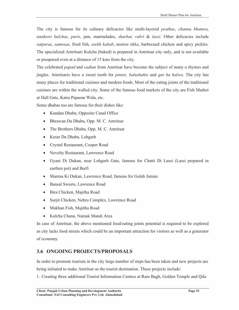
Draft Master Plan for Amritsar
Client: Punjab Urban Planning and Development Authority Page 53Consultant: SAI Consulting Engineers Pvt. Ltd. Ahmedabad
The city is famous for its culinary delicacies like multi-layered prathas, channa bhatura,
tandoori kulchas, puris, jam, marmalades, sharbat, rabri & lassi. Other delicacies include
satpuras, samosas, fried fish, seekh kabab, mutton tikka, barbecued chicken and spicy pickles.
The specialized Amritsari Kulcha (baked) is prepared in Amritsar city only, and is not available
or preapared even at a distance of 15 kms from the city.
The celebrated papad and vadian from Amritsar have become the subject of many a rhymes and
jingles. Amritsaris have a sweet tooth for pinnis, balushahis and gur ka halwa. The city has
many places for traditional cuisines and modern foods. Most of the eating joints of the traditional
cuisines are within the walled city. Some of the famous food markets of the city are Fish Market
at Hall Gate, Katra Paparan Wala, etc.
Some dhabas too are famous for their dishes like:
� Kundan Dhaba, Opposite Canal Office
� Bhrawan Da Dhaba, Opp. M. C. Amritsar
� The Brothers Dhaba, Opp. M. C. Amritsar
� Kesar Da Dhaba, Lohgarh
� Crystal Restaurant, Cooper Road
� Novelty Restaurant, Lawrence Road
� Gyani Di Dukan, near Lohgarh Gate, famous for Chatti Di Lassi (Lassi prepared in
earthen pot) and Barfi
� Sharma Ki Dukan, Lawrence Road, famous for Gulab Jamun
� Bansal Sweets, Lawrence Road
� Bira Chicken, Majitha Road
� Surjit Chicken, Nehru Complex, Lawrence Road
� Makhan Fish, Majitha Road
� Kulcha Chana, Namak Mandi Area
In case of Amritsar, the above mentioned food/eating joints potential is required to be explored
as city lacks food streets which could be an important attraction for visitors as well as a generator
of economy.
3.6 ONGOING PROJECTS/PROPOSALS
In order to promote tourism in the city large number of steps has been taken and new projects are
being initiated to make Amritsar as the tourist destination. These projects include:
1. Creating three additional Tourist Information Centres at Ram Bagh, Golden Temple and Qila
Draft Master Plan for Amritsar
Client: Punjab Urban Planning and Development Authority Page 54Consultant: SAI Consulting Engineers Pvt. Ltd. Ahmedabad
Gobindgarh.
2. Creating a new high-tech Office with all facilities at outer gate of the Railway Station.
3. Starting a train service from Amritsar on the pattern of Palace on Wheels covering the
important tourist destinations in the region.
4. Conservation and upgradation of 6 gates of the walled city namely Lahori Gate, Gate Hakima,
Hathi Gate, Hall Gate, Khazana Gate, and Sultanwind Gate at a cost of Rs. 40.00 lacs.
5. Renovating Ram Bagh Gate to its original shape (under construction) at a cost of Rs. 1crore.
6. Setting up of Heritage Village in Guru Nanak Dev University in an area of 10 acres. In
addition, 10 acres of area is further proposed for expansion of the Heritage Village. Govt. of
India has already sanctioned a sum of Rs. 6.84 Crore for setting up of Heritage Village in
GNDU Campus. Sh. Abhimanyu Dalal, a renowned Architect, has been appointed as
Consultant for the project.
7. The Government of Punjab has decided to shift the Municipal Corporation, Amritsar office
from the existing Town Hall building. A new 2-acre plot shall be notified for the construction
of new Municipal Corporation office in Ranjit Avenue.
8. Conservation of Town Hall building to be achieved at a cost of Rs.5.00 crores for creating
state level museum and cafeteria by renovation of Town Hall Building.
9. Gobindgarh Fort shall be open to public after completing the conservation of its buildings at a
cost of Rs.2.5 crore.
10. Light and Sound programme in Jallianwala Bagh.
11. Beautification of surroundings of Durgiana Temple after acquisition of necessary properties
shall be undertaken at a cost of Rs.29.00 crore. The main access of 16 feet to the temple shall
be widened to about 60 feet. The shopkeepers are proposed to be relocated by constructing a
commercial complex under the scheme. The existing Police Post and Post Office shall be
relocated.
12. Creating additional parking space at Wagha Border in an area of 10 acres for facilitating the
tourists (under construction).
13. Renovation of Maharaja Ranjit Singh building at Pul Kanjri near Wagha Border,
14. Providing additional man power for guiding the tourist including placing (12-15 personnel).
15. Starting specialized course in tourism for creating appropriate level of trained manpower
16. A Food Street with traditional food joints shall be set up in the city.
17. Village Kakkar in Block Chogawan shall be developed into a Model Village with concrete
roads, solar lights and 100% underground sewerage facilities at a total cost of Rs.1.50 crore.
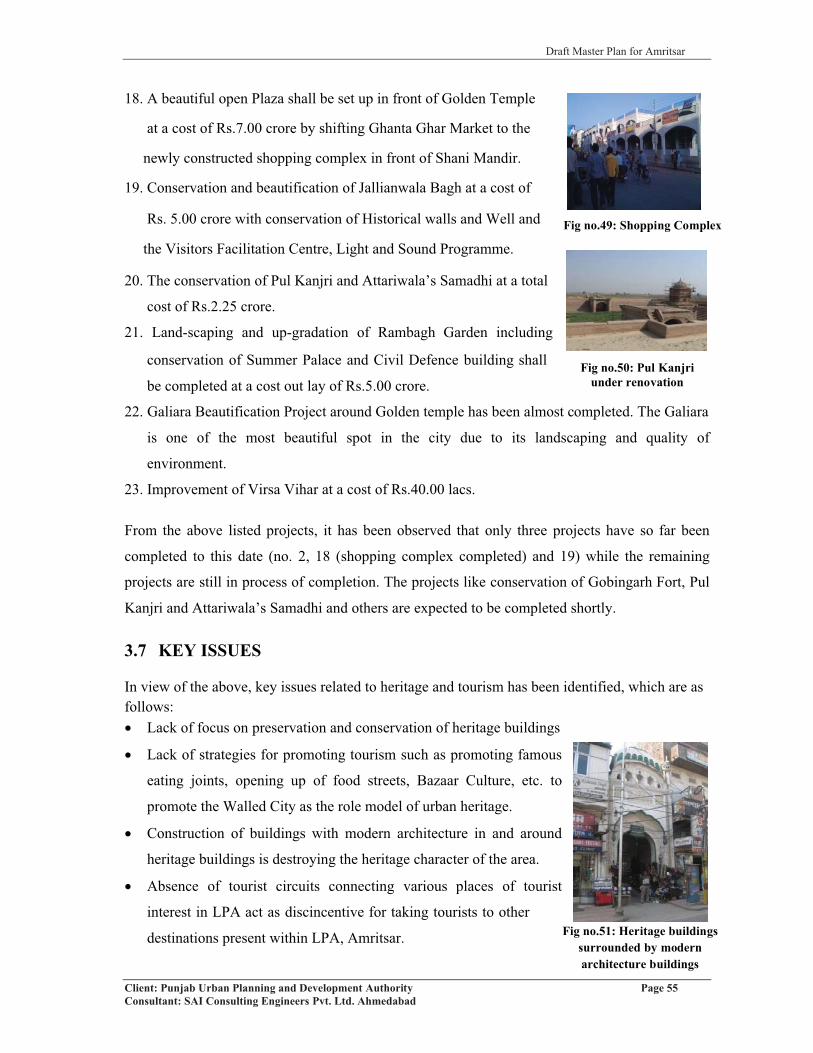
Draft Master Plan for Amritsar
Client: Punjab Urban Planning and Development Authority Page 55Consultant: SAI Consulting Engineers Pvt. Ltd. Ahmedabad
Fig no.49: Shopping Complex
Fig no.50: Pul Kanjri under renovation
18. A beautiful open Plaza shall be set up in front of Golden Temple
at a cost of Rs.7.00 crore by shifting Ghanta Ghar Market to the
newly constructed shopping complex in front of Shani Mandir.
19. Conservation and beautification of Jallianwala Bagh at a cost of
Rs. 5.00 crore with conservation of Historical walls and Well and
the Visitors Facilitation Centre, Light and Sound Programme.
20. The conservation of Pul Kanjri and Attariwala’s Samadhi at a total
cost of Rs.2.25 crore.
21. Land-scaping and up-gradation of Rambagh Garden including
conservation of Summer Palace and Civil Defence building shall
be completed at a cost out lay of Rs.5.00 crore.
22. Galiara Beautification Project around Golden temple has been almost completed. The Galiara
is one of the most beautiful spot in the city due to its landscaping and quality of
environment.
23. Improvement of Virsa Vihar at a cost of Rs.40.00 lacs.
From the above listed projects, it has been observed that only three projects have so far been
completed to this date (no. 2, 18 (shopping complex completed) and 19) while the remaining
projects are still in process of completion. The projects like conservation of Gobingarh Fort, Pul
Kanjri and Attariwala’s Samadhi and others are expected to be completed shortly.
3.7 KEY ISSUES
In view of the above, key issues related to heritage and tourism has been identified, which are as follows:� Lack of focus on preservation and conservation of heritage buildings
� Lack of strategies for promoting tourism such as promoting famous
eating joints, opening up of food streets, Bazaar Culture, etc. to
promote the Walled City as the role model of urban heritage.
� Construction of buildings with modern architecture in and around
heritage buildings is destroying the heritage character of the area.
� Absence of tourist circuits connecting various places of tourist
interest in LPA act as discincentive for taking tourists to other
destinations present within LPA, Amritsar. Fig no.51: Heritage buildings surrounded by modern architecture buildings

Draft Master Plan for Amritsar
Client: Punjab Urban Planning and Development Authority Page 56Consultant: SAI Consulting Engineers Pvt. Ltd. Ahmedabad
Fig no.53: Lakar Mandi
� Absence of organized mode of travel connecting different tourist sites/destinations within the
city and in its surroundings.
� Affordable tourist accommodation in the city leading to conversion of houses to make shift
hotels during peak season.
� Lack of public toilets and other civic amenities in the vicinity of majority of the tourist
destinations.
� Non-declaration of the Walled City as the Special Heritage Area is hampering the process to
introduce some innovative and urgently needed steps to be taken up like pedestrianisation,
concept of Group Visiting, adequate financial help and tax incentives to the owners of the
heritage buildings, etc.
� The location of Jewellery shops using coal within the Walled City
impacts the beauty of the Golden Temple and other old buildings.
The district administration has taken steps to convert the
surroundings of golden temple into smoke free zone with the
handing over of 86 new LPG connections to goldsmiths running
their shops near to it. This strategy is required to be implemented
in all such shops.
� Large-scale subdivision of buildings or open spaces within the Walled City to commercial
uses.
� The Fort requires to be developed as Heritage Museum to showcase city’s rich cultural
heritage.
� Some key issues related to Durgiana Temple are:
(i) Narrow approach road leading to Gobindgarh Fort from Bhandari Bridge is largely
encroached upon by the shopkeeper that is hindering the direct access to the temple.
(ii) Lack of parking spaces for the visitors. The land behind the
temple, currently used as lakkar mandi can be used for
providing parking.
(iii) Creating a new bridge instead of the age old Rigo Bridge is
not capable enough to bear the traffic moving to Gobindgarh
Fort and the Durgiana Temple from GT Road side. Heavy
vehicles are also not allowed on this bridge. Hence, a new
bridge needs to be constructed to ease the situation.
Fig no.52: Conversion of building into commercial
shops

Draft Master Plan for Amritsar
Client: Punjab Urban Planning and Development Authority Page 57Consultant: SAI Consulting Engineers Pvt. Ltd. Ahmedabad
Fig no.54: Jhuggi-Jhoparis in Shivpuri
(iv) The encroachment on the brick road constructed over the Nallah passing adjacent to the
temple is restricting from having another access to the temple. A wide road can be
constructed to overcome this problem. This will also solve the problem of foul smell coming
from the nallah.
(v) Removal of jhuggi-jhoparis present in the area around the
Durgiana temple, especially along Shivpuri which has been
encroached and is affecting the aesthetic encironment of the
area. Green belt is required to be developed by vacating the
land from jhuggi-jhoparis.

Draft Master Plan for Amritsar
Client: Punjab Urban Planning and Development Authority Page 58Consultant: SAI Consulting Engineers Pvt. Ltd. Ahmedabad
CHAPTER 4
HOUSING AND URBAN POOR4.1 HOUSING SCENARIO
4.1.1 EXISTING HOUSING STOCK
Looking at the growth of the occupied residential houses in the Amritsar city, it has been
observed that the number of occupied houses have grown by 13.74% in the decade from 1981-
1991 with highest growth observed in the decade from 1991-2001 which is of the order of
92.53%. The high growth rate of residential houses can be attributed to the rural migration to the
city of Amritsar for better educational and other facilities and better quality of life, being the
metropolitan city and district headquarters. On the contrary, villages in LPA and urban
settlements have observed a declining trend in growth of number of residential houses, which is a
result of increasing migration to the urban centers of the district. The descent has been steeper in
case of villages in LPA as compared to the urban settlements in LPA where the decrease has
been from 53.63% in 1991 to 19.74% in 2001 and 53.13% to 39.27% respectively.
It has been further analysed from the table no. 28 given below that growth in number of
households in Amritsar metropolis is keeping pace with the growth of number of occupied
residential houses. Highest growth rate in number of households has been observed in the decade
from 1991-2001 which is of the order of 41.79%, while a lower growth rate of the order 19.78%
was observed in decade from 1981-1991 (refer table no.28). During the same period, the
household size has remained constant at 5.6 in last two decades from 1981 to 2001. Table 28: Comparison of Households Vs Occupied Residential Houses
Year OccupiedResidential
Houses
Growth rate of ResidentialHouses (%)
No. of Households
%age Growth of
Households
HouseholdSize
AmritsarM.C.
1981 99140 - 105429 - 5.61991 114935 13.74 126283 19.78 5.62001 221282 92.53 179057 41.79 5.6
Villages in LPA
1981 53867 - 57194 - 6.21991 82716 53.63 82716 44.61 6.02001 99046 19.74 99046 19.74 5.9
UrbanSettlements
in LPA
1981 5091 - 5460 - 7.11991 7796 53.13 7979 46.14 6.12001 10858 39.27 10858 36.08 5.6
Total LPA1981 158071 - 168088 - -1991 205447 29.97 216978 29.08 -2001 331186 61.20 288961 33.17 -
Source: Census of India: 1981, 1991, 2001.
On the contrary, to the rising trend in growth of households in Amritsar metropolis, the urban
settlements and villages falling in LPA, Amritsar has observed a downward trend. Likewise, to

Draft Master Plan for Amritsar
Client: Punjab Urban Planning and Development Authority Page 59Consultant: SAI Consulting Engineers Pvt. Ltd. Ahmedabad
the growth of the occupied residential houses, the households and family size in urban
settlements and villages in LPA have observed the declining trend. The decrease in growth of
number of households has been more in case of villages in LPA in comparison to the urban
settlements. Similarly, the household size is highest in urban settlements in LPA, Amritsar,
which is 7.1 in the decade1971-1981 and had decreased to 5.6 in the decade 1991-2001. The
villages in LPA have also observed the decrease in the household size from 6.2 in 1971-1981 to
5.9 in 1991-2001. This shows that with the better economic conditions, the awareness about
better housing condition and trend towards nuclear families has been on rise.
4.1.2 PATTERN OF HOUSING
Further to this, housing pattern in Amritsar city has been studied in terms of density pattern,
plotted or flatted development and pattern of use of existing housing stock. The pattern of
housing within the different parts of the city has been studied based on the visual survey of the
city.
Looking at the pattern of housing, it has been analyzed that most of the housing whether under
various schemes or through private developers is in the form of plotted development. Flatted
development that exists in the city is majorly govt. housing for its employees such as housing
board colony, railway colony, custom colony etc. A portion of the flatted housing in the city is
created by the way of development schemes prepared by Amritsar Improvement Trust, which
includes flatted development in Ranjit Avenue Block B, development scheme of 340 acres and
Mall Mandi Scheme. Further, Amritsar Improvement Trust is considering two more proposals
for flatted development in the city. One is the extension of the existing Guru Teg Bahadur Nagar,
where an additional area of 5.50 acres is to be added under flatted development while the other is
covering an area of 11.25 acres at Bhai Gurdass Ji Nagar.
Further, the pattern of use of the existing housing stock is studied (refer table no.28). Out of total
237211 houses listed in census 2001, 159395 houses are being used as residential houses, which
comprise of nearly 2/3rd of the total housing stock (67.2%). Only 4.36% (10348) of the houses
have been observed to have mixed- use which is mainly concentrated in the walled city area of
the Amritsar. Approximately, 15.80% (37477) of the houses have been solely used for
commercial purposes such as shops and offices, 2.33% (5528) of the houses have been used for
factory, workshops and work sheds and nearly 2.57% (5998) of the census houses have been
used for other non-residential uses. The large number of vacant houses in the city is of the order
of 6.71% (15929), which can be attributed to the legal framework including the Rent Control
Act, which leads to unwillingness on the part of the owners to rent out the houses. Accordingly,

Draft Master Plan for Amritsar
Client: Punjab Urban Planning and Development Authority Page 60Consultant: SAI Consulting Engineers Pvt. Ltd. Ahmedabad
favorable environment needs to be created in order to minimize the number of vacant houses to
ensure the optimum use of the housing stock.Table 29: Pattern of Use of Census Houses Category wise in Municipal Corporation, Amritsar (2001)
S. No. Category No. of houses % age of total houses1. Residential 159395 67.192. Residential cum other use 10348 4.363. Shop cum office 37477 15.794. School/College 718 0.305. Hotel/Lodge/Guest House 289 0.126. Hospital/Dispensary 585 0.247. Factory/Workshop/Work shed 5528 2.338. Place of Worship 944 0.399. Other Non Residential uses 5998 2.57
10. Vacant houses 15929 6.71Total census houses 237211 100
Source: Census of India, 2001
4.1.3 HOUSING CONDITION
As per census 2001, 86.5% of the total households live in permanent and 11.3% in semi
permanent structures. Total 2.14% live in temporary structures out of which only 0.35% are non-
serviceable structures. (Refer table no. 30)Table 30: Distribution of Residential Houses by their Type of Structure in Municipal Corporation, Amritsar: 2001
Type ofStructure
Permanent Semi-permanent TemporaryUnclassifiableTotal Serviceable Non-
serviceableNo. Of houses 146805 19180 3642 3035 607 45%age of total 86.5 11.3 2.14 1.79 0.35 0.06
Source: Census of India, 2001
In case of urban settlements within Amritsar LPA, Rayya has maximum good condition housing
stock where in all the components i.e. roof, floor and walls are made up of pucca material which
is followed by Jandiala, Majitha and Rajasansi.
On the basis of visual survey of the housing condition in the city, it has been observed that the
housing existing in the walled city area of Amritsar is in dilapidated or poor condition
characterized by old age buildings with an average building height of G+3, 100% ground
coverage with no setbacks and narrow access roads with poor mass space relationship. These
areas have high intensity of development.

Draft Master Plan for Amritsar
Client: Punjab Urban Planning and Development Authority Page 61Consultant: SAI Consulting Engineers Pvt. Ltd. Ahmedabad
Fig No.55 Poor Housing Condition, Poor Mass Space Relationship, Mesh of Wire and High Intensity of development in walled city Amritsar
On the contrary, the area outside the walled city and within the northern bye-pass is
characterized as medium density built up area with medium to good housing condition. The
houses have 60 % -80 % ground coverage depending on the plot size with mainly front and side
setbacks and an average building height is G+1.
The Peri-urban area that is area outside the northern bye pass is characterized with low-density
development where in new approved housing colonies are coming. Therefore, the increasing
concentration of planned housing efforts in the north of the city has been observed which has
further aggravated the difference in quality of life between the north and south half of the city.
Fig no.56: View of planned housing area on Maqbool Road, Green Avenue and Ranjit Avenue
Fig no.57: View of new upcoming residential projects along Bye- Pass

Draft Master Plan for Amritsar
Client: Punjab Urban Planning and Development Authority Page 62Consultant: SAI Consulting Engineers Pvt. Ltd. Ahmedabad
4.2 HOUSING SCHEMES
4.2.1 IMPROVEMENT TRUST SCHEMES
The Improvement Trust, Amritsar has undertaken total of 84 schemes covering a total area of
3483.7acres in last six decades under the two heads namely, Re-Development Schemes and
Development Schemes. The details of the schemes are shown in the table below:Table 31: Details of Improvement Trust Schemes Type No. of Schemes %age of total schemes Area (in acres)Re-Development Schemes 41 48.81 137.46Development Schemes 43 51.19 3346.25Total 84 100 3483.71Source: Amritsar Improvement Trust, 2009
Nearly, 51% of the trust’s schemes undertaken are Development Schemes majorly concentrated
from north to south-east direction of the city. 41 schemes (49%) constitute Re-development
schemes over last 60 years in the walled city area as initiative to foster planned development in
the damaged area after the partition of the country but it covered only 137 acres. The nature of
the schemes undertaken by Improvement trust includes both residential and commercial. Some
of the important residential schemes undertaken are Mall Mandi Scheme, Green Avenue,
Kennedy Avenue, New Amritsar Scheme of 340 acres and commercial schemes includes bus
stand area scheme, grain market scheme, truck stand scheme, city center, Nehru shopping
complex and some of the new schemes to be undertaken includes approach road to Golden
Temple, beautification of Durgiana Mandir and development of 188 acres of residential area
adjoining New Amritsar.
4.2.2 TOWN PLANNING SCHEMES (T.P Schemes)
About 86 Town Planning Schemes have been prepared by the Municipal Corporation, Amritsar
(M.C.A), out of which about 72 have been sanctioned by the government covering an area of
751.4 acres. About 8 schemes out of the total have been converted into Re-Development
Schemes and handed over to Amritsar Improvement Trust. These schemes are located in the east
of the walled city area. Out of the remaining 6 schemes, 4 schemes are still pending at the govt.
level for approval and other 2 schemes have been dropped which includes scheme no. 63 and 64.
(Refer Table No.32) (Refer map no.5)Table 32: Town Planning Schemes Details about schemes No. of schemes Scheme No. Area in acresSanctioned Schemes by the Govt. 72 751.4
Dropped Schemes 2 Schemes No. 63,64 164Transferred to the other departments 8 Scheme No. 80,36,45,47,54,60,79,5 1179.3
Pending at the Govt. Level 3 Scheme No. 62,69,70 234.72

Draft Master Plan for Amritsar
Client: Punjab Urban Planning and Development Authority Page 63Consultant: SAI Consulting Engineers Pvt. Ltd. Ahmedabad
Details about schemes No. of schemes Scheme No. Area in acresPending with Distt. Town Planning 1 Scheme No.65 210
Total Number of Town Planning Schemes 86 3890.93
Source: Municipal Corporation of Amritsar, 2009
4.2.3 BUILDING SCHEMES
As many as 16 building schemes have been prepared and implemented in the city from last 7
decades. Maximum of 50% of building schemes were undertaken in the decade from 1971 to
1981 covering an area of 360 acres approximately. Thereafter, not much building schemes have
been undertaken in the last 3 decades. Table 33: Details of Building SchemesTime Period Total Area(in Acres) Total No. of Schemes %ageBefore 1951 18 2 12.51951-1961 90 2 12.51961-1971 45 2 12.51971-1981 359.76 8 501981-1991 4.26 1 6.251991-2001 100 1 6.252001 onwards 0 0 0Total 617.02 16 100Source: Amritsar Municipal Corporation, 2009
4.2.4 P.U.D.A SCHEMES
The table below gives details of PUDA schemes or colonies that have been undertaken in the
city. It reflects that about 76 percent of the total schemes/colonies covering an area of 824.32
Acres have been approved by the P.U.D.A and remaining 24 percent of the colonies are in the
process of approval. Table 34: Details of P.U.D.A Schemes/ ColoniesType of Schemes Total Area (in Acres) No. of Schemes %ageApproved PUDA Colonies 824.324 26 76Under process 748.015 8 24Total 1572.339 34 100Source: PUDA, 2009
The newly built and upcoming P.U.D.A approved colonies are spanning along the major radials
of the city such as Silver Oak Enclave along Loharka Road, S.G. Enclave along Majitha Road,
D.R City and Garden Enclave Ext II along Ajnala Road and Impact Gardens and Garden Enclave
Ext-I along Bye Pass Road, Ansal city and Dream City along G.T Road. This shows that the city
is expanding along its major radials in all directions with major concentration in North West to
South East direction of the city.
There are about eight colonies whose approval is still pending with the P.U.D.A. These are
located on outskirts of the city along the major radial G.T Road and along the bye pass. These

Draft Master Plan for Amritsar
Client: Punjab Urban Planning and Development Authority Page 64Consultant: SAI Consulting Engineers Pvt. Ltd. Ahmedabad
are being developed by private developers such as Vrindavan Gardens and Sahara City along
G.T. Road and Alpha International City and Shaurya Tower on Bye-Pass Road near Wallah
village.
4.2.5 OUVGL Schemes
Till date there are 6 OUVGL schemes (Optimum Utilization of Vacant Government Land) out of
which 3 schemes are on-going, 2 are sanctioned and still in the process of implementation and
there is proposal of one scheme. The table below lists the details of the OUVGL schemes in the
city. Total area covered under this scheme is 92.27 acres.Table 35: Details of OUVGL Schemes
Sr.No. OUVGL SchemeArea of Scheme
(in Acres)Ongoing Schemes 7.5
1 Sahej Enclave, Amritsar 62 Tehsil Complex, Amritsar 0.93 Bel-Aahata, Amritsar 0.6(i) Sanctioned and implemented schemes under process 36.4871 Residential cum commercial site, Canal Rest House 4.8872 Mental Hospital Surplus Site, Amritsar 31.6
(ii) Future Schemes1 Old Session Court Site 4.3
TOTAL 92.27Source: DTP Office
4.2.6 SCHEMES IMPLEMENTED IN WALLED CITY AREA
The table below describes the list of various schemes that have been implemented in the walled
city area. Out of the total schemes sanctioned and implemented, merely 20% of the schemes
have been undertaken in the walled city area.Table 36: Comparison of Various Schemes Implemented in Walled City Vs Total No. of Schemes
Schemes Total no. of Schemes
Total Area of Schemes (in Acres)
No. of Schemes inside walled city
Total Area of Schemes inside walled city
(in Acres)Town Planning Schemes 86 3891 3 (6.66%) 7.2
Building Schemes 16 617 1 (2.23%) 4Development Schemes 43 3346.25 0 0
Re-Development Schemes 41 137.5 41 (91.11%) 137.46P.U.D.A. Schemes 5 64.12 0 0
O.U.V.G.L. Scheme 3 7.5 0 0Private Promoters 77 30.56 0 0Total Area UnderVarious Schemes 271 8093.9 45 (100%) 148.66
Source: Amritsar Municipal Corporation, Amritsar Improvement Trust, PUDA, 2009
91 percent of the total schemes implemented in the walled city are Re-Development Schemes
undertaken by Amritsar Improvement Trust covering an area of 137.5 acres approximately.
These are spread over whole of the walled city area. The 6.66 percent of the schemes

Draft Master Plan for Amritsar
Client: Punjab Urban Planning and Development Authority Page 65Consultant: SAI Consulting Engineers Pvt. Ltd. Ahmedabad
implemented in the walled city are Town Planning Schemes and only 1 Building Scheme has
been undertaken which is inside Bhagtanwala Gate. Still the condition of walled city requires
very strong policies/ strategies in terms of Urban Renewal Programmes.
4.2.7 RURAL DEVELOPMENT SCHEMES
These are an initiative to promote rural development to improve overall quality of life of rural
people. Several centrally sponsored schemes have been formulated and implemented in rural
areas such as Swaranjayanti Gram Swarozgar Yojna, Indira Awas yojna, IWDP and NREGA.
The NREGA scheme was started in Amritsar district in 2007-08. During the last year, a total of
Rs 1,466.93 lakh was received for development, of which Rs 1,086.84 lakh has been utilized.
The district had issued 24,322 job cards to the villagers and generated work of 7.35 lakh person
days. The money has been used for de-siltation of village ponds and construction of retaining
walls with screening chambers around the village ponds. This has not only helped to maintain
sanitation in the village but also in the removal of encroachments from the village water bodies.
4.2.8 ONGOING PROJECTS/PROPOSALS
Govt. of India, Ministry of Housing and Poverty Alleviation approved Rs. 5.79 crores for
construction of 320 nos. of dwelling units for EWS section at village Rasoolpura under Basic
Services to Urban Poor. Out of Rs. 5.79 crores in the first phase, only work for construction of
80 nos. of Dwelling Units (including infrastructure) amounting to Rs. 2.80 crores has been
allotted.
4.2.9 KEY ISSUES
� 61% of the city area still remains unplanned
� 70.5% of the walled city area to be covered under various schemes.
� The role of Amritsar Improvement Trust in undertaking more and more schemes in the
city have been on decline as Punjab Govt. has decided not to acquire land without the
consent of landowners.
� Lot of upcoming colonies along the major radials of the city in a haphazard way.
� Increased pressure on the resources of the Amritsar metropolis due to steep increase in
number of households as a result of migration from rural areas.
� Negligible share of flatted development compared to the plotted development in the city
and in urban settlements in LPA.

Draft Master Plan for Amritsar
Client: Punjab Urban Planning and Development Authority Page 66Consultant: SAI Consulting Engineers Pvt. Ltd. Ahmedabad
� Lack of optimum utilization of the existing housing stock as 6.72% of the existing
housing stock is vacant.
� 76. 27% of the existing housing stock is permanent that is all the components are made of
pucca material. The remaining 23.73% of the housing requires up gradation.
� 13.5% of the households resides in poor condition housing in Amritsar metropolis.
� Among the urban settlements in Amritsar LPA, Rajasansi has minimum percentage of
permanent housing structures.
� Lack of planned housing efforts in the southern portion of the city, hence, increasing the
disparity in terms of overall living environment between the north and south portions of
the city.
Honorable Supreme Court has declared section 192, as void in 1994 held that 25% area for
public purpose cannot be acquired without compensation. So no Town Planning Schemes are
now been prepared
4.2.10 CONCLUSIONS
From the various development initiatives taken in form of T.P schemes, redevelopment schemes,
development schemes, building schemes and other schemes by various bodies have contributed
to make 49% of planned development in the the city which is too less. Rest of the city area is
still unplanned where proper development has to be infused by the way of these schemes.
4.3 URBAN POOR AND SLUMS
Urban poverty has emerged as one of the major challenges faced by policy planners and urban
planners in promoting the rational development of urban areas. Poverty refers to not only
deprivation of vital goods but also includes services determining the quality of life. In fact,
poverty amid plenty is the world’s greatest challenge.
4.3.1 DEMOGRAPHIC PROFILE
During the last 2 decades, number of slum dwellers in Amritsar has increased from 32,632
(1981) to 3, 04,824 (2001) recording more than nine fold increase in slum population. In 2001,
30% of the city population lives under slums i.e. every fifth household is slum. This indicates
fast deteriorating quality of life and acute shortage of housing and basic infrastructure in most of
the residential area of the city in Amritsar.

Draft Master Plan for Amritsar
Client: Punjab Urban Planning and Development Authority Page 67Consultant: SAI Consulting Engineers Pvt. Ltd. Ahmedabad
Table 37: Distribution of Slum Population to Amritsar M.C. PopulationYear City population Slum population % to City Population1981 589299 32632 5.531991 708835 123000 17.352001 1016079 304824 30.00
Source: CDP Amritsar and Census of India 2001
Other than this the demographic characteristics of slum in Amritsar is shown in table below.
Table indicates that the schedule caste population is placed at 35.54% indicating that every third
residence of the slum belongs to the category of schedule caste. Number of workers living in
slums constitute one fifth of the total work force of the city. Number of agricultural labourers has
been found to be quite high i.e. 38.5%. Average household size in slum areas has been found to
be 5.47 whereas in case of Amritsar metropolis, the size is 5.45. Table 38: Slum Population CharacteristicsSr.No. Item Urban Slum %age to total
population1 Total households 185268 419612 Total Population (including
institutional and houseless population)
1016079 304824 30.00
3 Population in the age group 0-6 121369 31581 26.024 Schedule caste population 198595 70610 35.545 Schedule tribes population - - -6 Literates 693139 141771 20.457 Total workers 322214 72777 22.588 Main workers 301827 67220 22.27
Cultivators 2900 796 27.44Agricultural Labourers 5897 2271 38.51Household industry workers 12260 2613 21.31Other workers 280770 61540 21.91
9 Marginal workers 20387 5557 27.25Cultivators 283 20 07.06Agricultural Labourers 1466 525 35.81Household Industry workers 1992 594 29.81Other workers 16646 4418 26.54
10 Non workers 678322 156826 23.11Source: Census of India-2001
4.3.2 SLUM LOCATION AND DISTRIBUTION
At present, 64 slums (Refer annexure VI ) exist in the city that has been notified by the
Municipal Corporation, Amritsar under the Punjab Slum Areas (Improvement and Clearance)
Act, 1961 covering a total area of 5.8 sq.kms constituting 4.26% of the area of the city (as per the
national urban information scheme for indicators produced by Municipal Corporation, Amritsar).
Largest number of slums was notified in 1986/87 i.e 32 (24 to 54) localities were declared as
slums.

Draft Master Plan for Amritsar
Client: Punjab Urban Planning and Development Authority Page 68Consultant: SAI Consulting Engineers Pvt. Ltd. Ahmedabad
Looking at the spatial distribution of slums, majority of slums are located in the southern part of
city in close vicinity of walled city, Amritsar. Concentration of slums on the southern part was
largely on account of haphazard and unplanned development in the area besides absence of any
major development scheme taken up by the Improvement Trust and Municipal Corporation. On
the other hand Northern side of city is better placed due to lesser number of slums. This is due to
the fact that majority of development schemes and better quality of development has taken place
in this areas. Accordingly, it is appropriate to rationalize the development of the Southern part of
the city outside walled area and particularly along the Tarn Taran railway line in order to
minimize the growth of slums.
Housing in Slums
Based on the visual survey of slums in Amritsar, it has been observed that housing condition in
these areas is poor. They are characterized as one-room tenements housing 6-7 people on an
average and are made up of semi permanent materials because of the cost factor as they do not
have fixed income and mainly work on daily wages.
Table 39: Ownership of Land under Slums in Amritsar S. No. Ownership of Slum Land No. of Slums %age
1 Public (MCA) 6 9.52 Private 56 893 Others 1 1.5
Total 63 100Source: Municipal Corporation-Amritsar, 2009
As per the information from Municipal Corporation Amritsar, 89% of the slums in the city exist
on the private land wherein some cases the land has been either encroached or has been
purchased from land owner and the remaining 11% of the slums exists on the MCA land which
are mainly located on the southern portion of the city.
4.3.3 AVAILABILITY OF URBAN BASIC SERVICES TO POOR
Basic services and amenities available in the slums in Amritsar are given below. It has been
found that 71.87% of the slum population has access to safe drinking water whereas 28.13%
population is still depended upon make shift arrangement.
Fig no. 58: Housing condition in slum areas of Amritsar
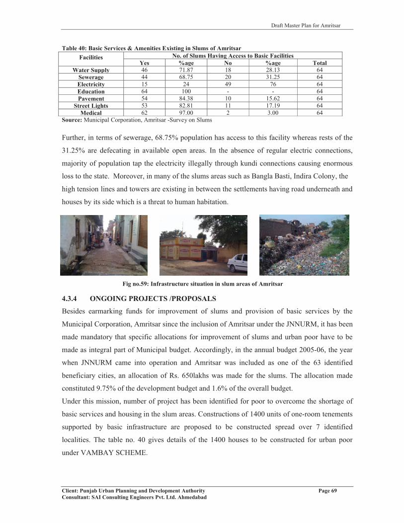
Draft Master Plan for Amritsar
Client: Punjab Urban Planning and Development Authority Page 69Consultant: SAI Consulting Engineers Pvt. Ltd. Ahmedabad
Table 40: Basic Services & Amenities Existing in Slums of AmritsarFacilities No. of Slums Having Access to Basic Facilities
Yes %age No %age TotalWater Supply 46 71.87 18 28.13 64
Sewerage 44 68.75 20 31.25 64Electricity 15 24 49 76 64Education 64 100 - - 64Pavement 54 84.38 10 15.62 64
Street Lights 53 82.81 11 17.19 64Medical 62 97.00 2 3.00 64
Source: Municipal Corporation, Amritsar -Survey on Slums
Further, in terms of sewerage, 68.75% population has access to this facility whereas rests of the
31.25% are defecating in available open areas. In the absence of regular electric connections,
majority of population tap the electricity illegally through kundi connections causing enormous
loss to the state. Moreover, in many of the slums areas such as Bangla Basti, Indira Colony, the
high tension lines and towers are existing in between the settlements having road underneath and
houses by its side which is a threat to human habitation.
4.3.4 ONGOING PROJECTS /PROPOSALS
Besides earmarking funds for improvement of slums and provision of basic services by the
Municipal Corporation, Amritsar since the inclusion of Amritsar under the JNNURM, it has been
made mandatory that specific allocations for improvement of slums and urban poor have to be
made as integral part of Municipal budget. Accordingly, in the annual budget 2005-06, the year
when JNNURM came into operation and Amritsar was included as one of the 63 identified
beneficiary cities, an allocation of Rs. 650lakhs was made for the slums. The allocation made
constituted 9.75% of the development budget and 1.6% of the overall budget.
Under this mission, number of project has been identified for poor to overcome the shortage of
basic services and housing in the slum areas. Constructions of 1400 units of one-room tenements
supported by basic infrastructure are proposed to be constructed spread over 7 identified
localities. The table no. 40 gives details of the 1400 houses to be constructed for urban poor
under VAMBAY SCHEME.
Fig no.59: Infrastructure situation in slum areas of Amritsar
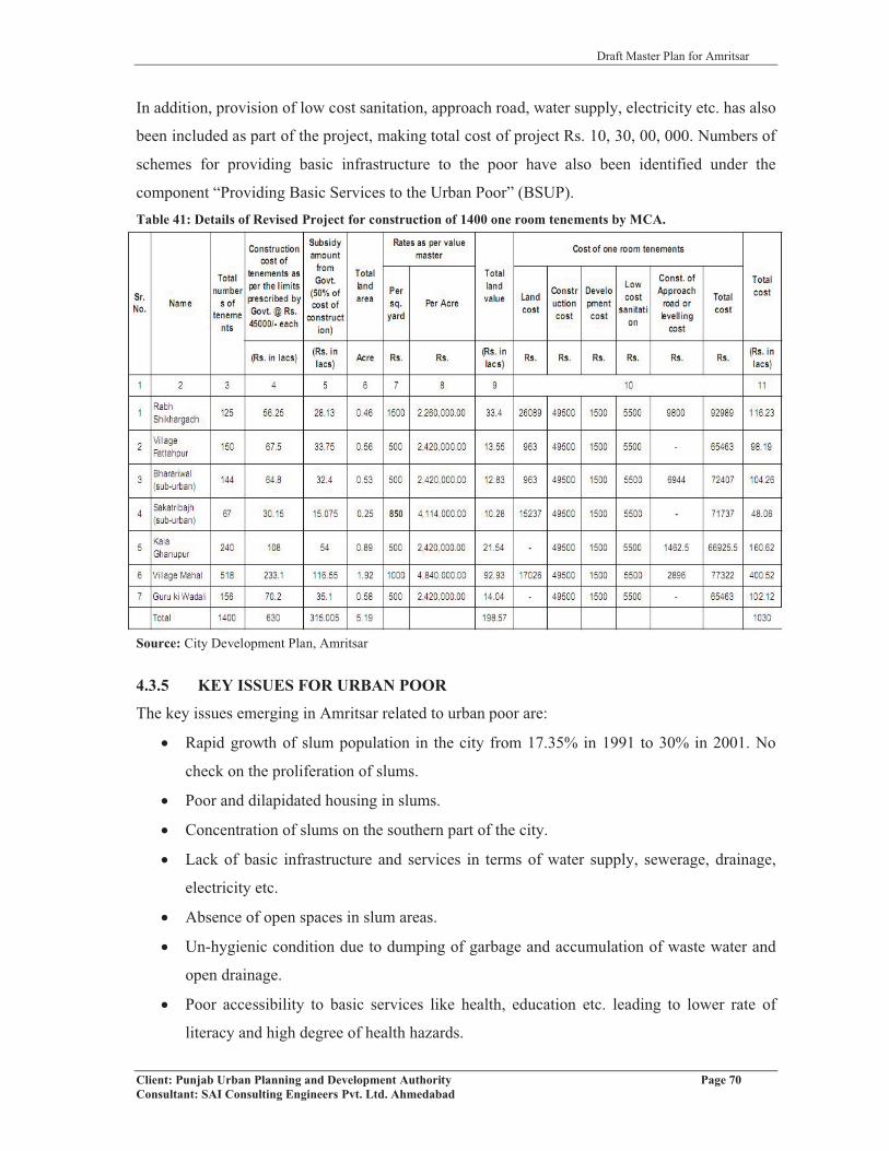
Draft Master Plan for Amritsar
Client: Punjab Urban Planning and Development Authority Page 70Consultant: SAI Consulting Engineers Pvt. Ltd. Ahmedabad
In addition, provision of low cost sanitation, approach road, water supply, electricity etc. has also
been included as part of the project, making total cost of project Rs. 10, 30, 00, 000. Numbers of
schemes for providing basic infrastructure to the poor have also been identified under the
component “Providing Basic Services to the Urban Poor” (BSUP). Table 41: Details of Revised Project for construction of 1400 one room tenements by MCA.
Source: City Development Plan, Amritsar
4.3.5 KEY ISSUES FOR URBAN POOR
The key issues emerging in Amritsar related to urban poor are:
� Rapid growth of slum population in the city from 17.35% in 1991 to 30% in 2001. No
check on the proliferation of slums.
� Poor and dilapidated housing in slums.
� Concentration of slums on the southern part of the city.
� Lack of basic infrastructure and services in terms of water supply, sewerage, drainage,
electricity etc.
� Absence of open spaces in slum areas.
� Un-hygienic condition due to dumping of garbage and accumulation of waste water and
open drainage.
� Poor accessibility to basic services like health, education etc. leading to lower rate of
literacy and high degree of health hazards.

Draft Master Plan for Amritsar
Client: Punjab Urban Planning and Development Authority Page 71Consultant: SAI Consulting Engineers Pvt. Ltd. Ahmedabad
� 76% of slum areas deprived of formal electric connections resulting into large scale theft
of electricity due to use of kundi connections.
� Poor quality of life emerging from absence of basic necessities of life.
� 89 % of the private land encroachment of by slums.
� 28.13% of slum population devoid of proper water supply facility i.e dependant on make
shift sources of supply such as hand pumps, public taps and wells.
� 31.25 % of slum population lacks access to sewerage.
� Lack of expertise with Municipal Corporation to evolve strategies for slum area
development.
� Non-involvement of poor in the formulation and implementation of schemes regarding
slum areas.
� Irrational identification of slum localities and beneficiaries.
� Lower share of overall budget i.e. 1.65% reserved to be spent on slums.
Draft Master Plan for Amritsar
Client: Punjab Urban Planning and Development Authority Page 72Consultant: SAI Consulting Engineers Pvt. Ltd. Ahmedabad
CHAPTER 5
EXISTING LAND USE AND TRANSPORTATION NETWORK5.1 PREPARATION OF BASE MAP
The work of preparation of base map for the Local Planning Area, Amritsar was assigned to
Punjab Remote Sensing Centre, P.A.U., Ludhiana. The base map of the core area is generated on
1:40,000 scale by very high and advanced satellite imagery using worldview data of .45m spatial
resolutions. The base map for rest of Local Planning Area, Amritsar is generated on 1:40,000
same scale but using Cartosat I data of 2.5m. The Cadastral maps of the villages falling in Local
Planning Area were procured from the State Revenue department by the office of District Town
Planner, Amritsar and these maps have been scanned in the office of PRSC, Ludhiana and
registered with Worldview data to demarcate village and musteel boundaries. The features like
roads, rails, high and low lands, drains etc. have been captured from satellite imagery data, by
the concerned agency and shown on the draft base map. After editing the map details, the
attributes to different features were assigned. The officials of DTP office verified the data
captured from satellite images & a non-spatial data was attached to it. The worldview data
(satellite imagery) has been received by the PRSC, Ludhiana from National Remote Sensing
Agency, Hyderabad.
5.2 ENHANCEMENT THROUGH FIELD SURVEYS-LAND USE AND ROAD NETWORK
The draft base map for the Local Planning Area, Amritsar and the densely built up areas (i.e.
core areas) received from Punjab Remote Sensing Centre, P.A.U., Ludhiana were updated
through ground truthing field survey by the office of D.T.P Amritsar. The various land uses have
been identified at the site and earmarked accordingly. Similarly, the road network, drains,
distributaries and other communication zones have been verified and checked at site. After
conducting field surveys, the necessary feedback was supplied to P.R.S.C Ludhiana, which were
ultimately incorporated and an updated base map was prepared by P.R.S.C, P.A.U Ludhiana.
The Office of D.T.P Amritsar again conducted second round of field verification (ground
truthing) and the updated (corrected) plans were then supplied to P.R.S.C, this exercise was
repeated several times and the field staff of D.T.P office personally assisted the concerned staff
of PRSC and a final Land Use map was thus prepared.

Draft Master Plan for Amritsar
Client: Punjab Urban Planning and Development Authority Page 73Consultant: SAI Consulting Engineers Pvt. Ltd. Ahmedabad
5.3 EXISTING LANDUSE PLAN
In order to understand, the breakup of the developed urban area of the Amritsar city and area
under various uses including residential, commercial, industrial, traffic and transportation,
recreational, utilities, public and semi-public uses; detailed analysis of the city structure has been
done on the basis of existing land use plan prepared by the Punjab Remote Sensing Centre,
Ludhiana. The Existing Land use Plan- 2010 for Local Planning Area, Amritsar, has been
detailed out in the in Drawing No. D.T.P (A) 2/2010, Dated: 12/01/2010 of the department of the
Town and Country Planning, Punjab. The detailed analysis is shown in the table given below. Table 42: Land use Break up of Amritsar LPA, 2010Land use Area (Ha) % of LPA AreaResidential 11333.45 8.13Residential 9254.79 6.64Plotted Land 2076.02 1.49Official Residence 2.64 0.00Mixed Landuse 66.91 0.05Commercial 658.58 0.47Retail and Wholesale Shopping 356 0.26Godowns, Warehouses, Regulated Markets 232.6 0.17Hotel and Marriage Palaces 69.98 0.05Industrial 949.65 0.68Brick Kilns 140.07 0.10Service & Light Industry 674.31 0.48Planned Industrial Areas 135.27 0.10Public-Semi Public 1090 0.78Educational and Research Institutions 652.05 0.47Medical & Health 86.84 0.06Social, Cultural & Religious 172.12 0.12Cremation & Burial Grounds 41.42 0.03Govt. Office 132.57 0.10Govt. Quarter 1.17 0.00Administrative Structure 3.83 0.00Government Land 2965.95 2.13Govt. Land (Use un- determined) 2965.95 2.13Utilities 98.27 0.07Water Works 28.47 0.02Electric Grid 48.3 0.03Sewage Disposal 11.23 0.01Solid Waste 9.82 0.01Communication 0.45 0.00Traffic & Transportation 4570.55 3.28Roads and Parking 3196.8 2.29Bus Terminal 6.54 0.00Railway station 94.29 0.07Railway 550.28 0.39Truck Terminus 0.63 0.00Airport 722.01 0.52Recreational 186.8 0.13Parks/Public Open Spaces 157.32 0.11Play Grounds 29.48 0.02Special Areas 22.67 0.02Heritage & Conservation Areas 22.67 0.02Agricultural 117476.62 84.26Agriculture 113089.63 81.11

Draft Master Plan for Amritsar
Client: Punjab Urban Planning and Development Authority Page 74Consultant: SAI Consulting Engineers Pvt. Ltd. Ahmedabad
Land use Area (Ha) % of LPA AreaWater Bodies 2098.6 1.51Plantation & Orchards 1549.87 1.11Dairy and Poultry Farms 24.36 0.02Vacant Land 714.16 0.51Total LPA 139419.45 100.00Source: PRSC, PAU-Ludhiana, 2010
Note: The notified total area of LPA, Amritsar is 137042 hectares, which is as per census of India 1991 whereas; the
area mentioned in the table above is 139419.45 hectares as calculated by P.R.S.C, P.A.U- Ludhiana. Therefore, for
further calculations in the master plan, the area figures given by PRSC have been considered.
LPA, Amritsar covers the revenue estates of 5 urban centers of Amritsar, Majitha, Rajasansi,
Jandiala, Rayya and 310 villages (Refer Plan 1). It has been observed that Local Planning Area
Amritsar is mainly agricultural covering 84.26% of the LPA area. Only 8.13% of the LPA area
is under residential use, 3.28% under traffic and transportation and 2.13% under Govt. Land
category. The detail of breakup of major existing land uses is given in the table above.
Existing Land use Amritsar M.C
The major urban settlements falling in the LPA Amritsar is Amritsar M.C having a total area of
14237.22 hectares in the year 2010. The detailed breakup of the existing land uses within the
M.C Limits is described in the table below:Table 43: Existing Landuse Plan for Amritsar City, 2010
Landuse Area (Ha) % of Developed Area % of M.C. AreaResidential 4245.08 50.94 29.82Residential 2927.22 35.12 20.56Plotted Land 1315.22 15.78 9.24Official Residence 2.64 0.03 0.02Mixed Land Use 66.48 0.80 0.47Commercial 393.22 4.72 2.76Retail and wholesale Shopping 261.79 3.14 1.84Godowns, Warehouses, Regulated Markets 98.73 1.18 0.69Hotel and Marriage Palaces 32.7 0.39 0.23Industrial 445.73 5.35 3.13Brick Kilns 9.15 0.11 0.06Service & Light Industry 341.1 4.09 2.40Planned Industrial Areas 95.48 1.15 0.67Public\Semi Public 738.22 8.86 5.19Educational and Research Institutions 482.08 5.78 3.39Medical & Health 64.82 0.78 0.46Social, Cultural & Religious 72.36 0.87 0.51Cremation & Burial Grounds 11.28 0.14 0.08Govt. Office 106.51 1.28 0.75Govt. Quarter 1.17 0.01 0.01Govt Land 882.14 10.58 6.20Govt. Land (Use un- determined) 882.14 10.58 6.20Utilities & Services 27.2 0.33 0.19Water Works 7.52 0.09 0.05Electric Grid 5.07 0.06 0.04Sewage Disposal 7.59 0.09 0.05Solid Waste 7.02 0.08 0.05
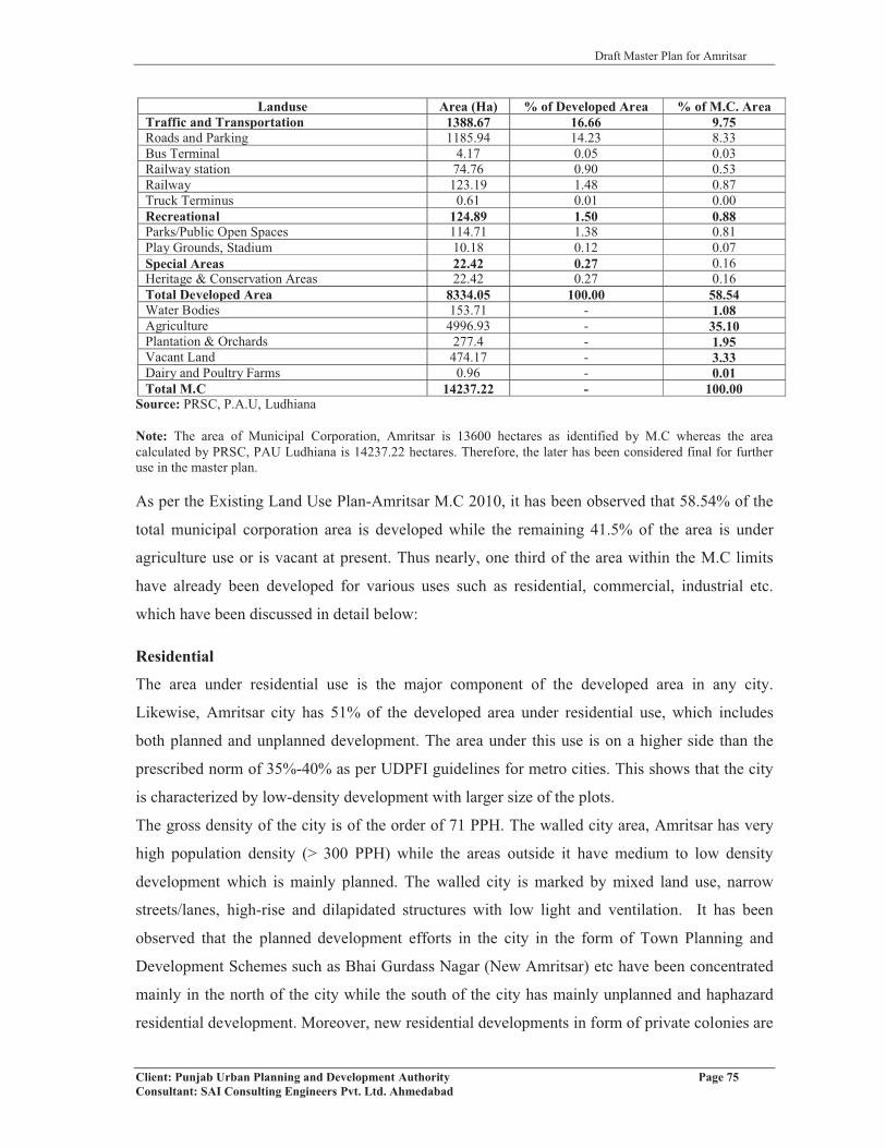
Draft Master Plan for Amritsar
Client: Punjab Urban Planning and Development Authority Page 75Consultant: SAI Consulting Engineers Pvt. Ltd. Ahmedabad
Landuse Area (Ha) % of Developed Area % of M.C. AreaTraffic and Transportation 1388.67 16.66 9.75Roads and Parking 1185.94 14.23 8.33Bus Terminal 4.17 0.05 0.03Railway station 74.76 0.90 0.53Railway 123.19 1.48 0.87Truck Terminus 0.61 0.01 0.00Recreational 124.89 1.50 0.88Parks/Public Open Spaces 114.71 1.38 0.81Play Grounds, Stadium 10.18 0.12 0.07Special Areas 22.42 0.27 0.16Heritage & Conservation Areas 22.42 0.27 0.16Total Developed Area 8334.05 100.00 58.54Water Bodies 153.71 - 1.08Agriculture 4996.93 - 35.10Plantation & Orchards 277.4 - 1.95Vacant Land 474.17 - 3.33Dairy and Poultry Farms 0.96 - 0.01Total M.C 14237.22 - 100.00
Source: PRSC, P.A.U, Ludhiana
Note: The area of Municipal Corporation, Amritsar is 13600 hectares as identified by M.C whereas the area calculated by PRSC, PAU Ludhiana is 14237.22 hectares. Therefore, the later has been considered final for further use in the master plan.
As per the Existing Land Use Plan-Amritsar M.C 2010, it has been observed that 58.54% of the
total municipal corporation area is developed while the remaining 41.5% of the area is under
agriculture use or is vacant at present. Thus nearly, one third of the area within the M.C limits
have already been developed for various uses such as residential, commercial, industrial etc.
which have been discussed in detail below:
Residential
The area under residential use is the major component of the developed area in any city.
Likewise, Amritsar city has 51% of the developed area under residential use, which includes
both planned and unplanned development. The area under this use is on a higher side than the
prescribed norm of 35%-40% as per UDPFI guidelines for metro cities. This shows that the city
is characterized by low-density development with larger size of the plots.
The gross density of the city is of the order of 71 PPH. The walled city area, Amritsar has very
high population density (> 300 PPH) while the areas outside it have medium to low density
development which is mainly planned. The walled city is marked by mixed land use, narrow
streets/lanes, high-rise and dilapidated structures with low light and ventilation. It has been
observed that the planned development efforts in the city in the form of Town Planning and
Development Schemes such as Bhai Gurdass Nagar (New Amritsar) etc have been concentrated
mainly in the north of the city while the south of the city has mainly unplanned and haphazard
residential development. Moreover, new residential developments in form of private colonies are

Draft Master Plan for Amritsar
Client: Punjab Urban Planning and Development Authority Page 76Consultant: SAI Consulting Engineers Pvt. Ltd. Ahmedabad
also making their way in the north of the city such as Impact Gardens, Impact Enclave, Global
City etc along the Northern Bye Pass, Holy City , Heritage City, Heritage Vihar along Ajnala
Road, S.G Enclave along Majitha Road, and Shubham Enclave, Dream city, Ansal City along
G.T Road.
Commercial
The area under commercial use constitutes 4.72% of the total developed area of Municipal
Corporation, Amritsar. The city has significant area under commercial use reflecting its
importance and contribution in the economy of the city. The walled city area having 22
specialized markets such as Hall Bazaar, Katra Sher Singh, Katra Jaimal Singh, Guru Bazaar, etc
of different nature is acting as the CBD. These are in the form of traditional bazaars spread along
the roads. It is not only serving the wholesale and retail commercial needs of the residents of the
city but also of the neighboring urban and rural settlements. These commercial areas have mixed
land use with commercial on the ground floor and residential on above floors. These areas lack
adequate parking spaces and public amenities/utilities.
Apart from the CBD, a city centre near Bus stand and District Shopping Complex is located at
Ranjit Avenue, which is serving the commercial needs of the people residing in the north of the
city and are also the major work areas in the city. The city also has commercial areas along
major roads in the city such as Queens Road, Cooper Road, Lawrence Road, Mall Road
etc.which have developed as major retail commercial markets in the city. All these markets
whether planned or unplanned have witnessed the informal commercial activities in form of
rehris, kiosks located outside bus stand, railway station and areas with major economic activities
creating chaotic situation.
The commercial activity also includes the area under grain market, fruit and vegetable market
located at Bhagtanwala and Vallah respectively.
Mixed Land Use
The walled city area of Amritsar is characterized by mixed land use that is with commercial use
on the ground floor and residential on the upper floors. The total area under mixed land use in
the city is 0.8% of the total developed area of the city.
Industry
The city of Amritsar houses large number of small-scale industrial units with 8 medium to large
scale industrial units covering total area of 445.73 hectares which is 5.35% of the developed area
and 3.13% of the M.C area of the city. Some of the major industrial units existing in the city

Draft Master Plan for Amritsar
Client: Punjab Urban Planning and Development Authority Page 77Consultant: SAI Consulting Engineers Pvt. Ltd. Ahmedabad
include Khanna Paper Mill, O.C.M, Amritsar Swadeshi Mills, Essma textiles, Partap steels and
Nijjar Agro Foods etc. Apart from these several other units in textile and engineering sector
exists in the city. Although, the city has scattered industrial development along major radials
such as Batala Road, G.T Road, Majitha Road and Tarn Taran Road etc, it also has planned
industrial areas such as Focal Point along Mehta Road and along Vallah Road, industrial estate
near Chheharta and East Mohan Nagar development schemes.
Recreational
The total area under recreational use in the city comes out to be 1.5% (124.89 ha) of the
developed area and 0.88% of the total M.C area. There are mainly three recreational spaces in
the city, namely, Ram Bagh Garden located in the north of the city, Gol Bagh and Saktri Bagh in
the south of the city. There is also one stadium commonly known as Gandhi Ground present in
the city located on M.M. Malviya Road. Apart from these two, there are small parks/
playgrounds located within the planned residential colonies/areas of the city. The area under this
use is much less than the prescribed norm of 20-25%, reflecting that the city badly lacks in the
provision of recreational spaces, which requires attention.
Traffic and Transportation
Nearly 1388.67 hectares of the area which is 16.66% of the total developed area and 9.75% of
the total municipal area of the city is under road network which comprises of roads, railway line,
terminals such as bus stand, truck stand, railway station, airport and parking lots/areas existing in
the Amritsar city. The existing area under this category is less than the prescribed norm of 15-
18% for the metro cities.
The city has 11 radials emerging out or leading to the Amritsar city, which are Ram Tirath Road,
Ajnala Road, Loharka Road, Fatehgarh Churian Road, Majitha Road, Batala Road, Sri
Hargobindpur Road, G.T Road towards Jalandhar, Tarn Taran Road, Jhabal Road and Attari
Road, which can be clearly identified on the Existing Land Use Plan drawing. Apart from these
major radials, there are intra city roads, which are connecting several important places within the
city such as Outer Circular Road, Mall Road, Lawrence Road etc and minor city roads existing in
the city. The major problems related to this aspect is that of traffic bottlenecks, road
encroachments, lack of parking areas resulting into on-street parking, lack of ROB’s and
underpasses for both pedestrian and vehicular movement etc. The details of existing road
network and other uses relating to traffic and transportation are shown in Existing Land Use
Plan- Amritsar (Refer Plan 1).
Draft Master Plan for Amritsar
Client: Punjab Urban Planning and Development Authority Page 78Consultant: SAI Consulting Engineers Pvt. Ltd. Ahmedabad
Public and Semi Public
This use comprises of the area under educational and research institutions, medical and health
institutions, social, cultural and religious buildings, cremation and burial grounds, Govt. /Semi
Govt. offices, Govt. lands etc. The city of Amritsar has 738.22 hectares which is 8.86% of the
total developed area and 5.19% of the total municipal area of the city under public and semi
public use (refer table no. 43). Existing Land use Plan, Amritsar shows the spatial location of the
educational, health, cultural and religious institutions existing in the city. It has the presence of
number of educational institutions such as Guru Nanak Dev University, Khalsa College, 9 other
degree colleges, 4 engineering colleges, 2 medical and dental colleges, nursing colleges and
polytechnics existing in the city. The health institutions in the city include Guru Nanak Dev
Hospital, Civil Hospital near Ram Bagh, S.G.T.B Hospital, ESI Hospital, Fortis-Escorts on
Majitha-Verka bye-pass and many others.
Being the administrative headquarter, Amritsar houses number of district and city level govt.
offices and quarters covering a total area of 107.68 hectares (0.77 % of total M.C area). It has
been observed that the area under this land use category is less than the prescribed norm of 14%
to 16% which shows that the city lacks in socio-cultural institutions/facilities such as libraries,
museums, exhibition halls, convention centre’s, music-dance and drama centre, meditation and
spiritual centre etc.
Govt. Land
In the Existing Land Use Plan-Amritsar 2010, the govt. land has been referred to be the land
under defense use. It covers a total area of 882.14 hectares that is 10.58% of the developed area
and 6.20% of the total municipal area of the city (14237.22 hectares). This huge chunk of land is
located on the west of the city that is at the backside of Guru Nanak Dev University and along
G.T Road towards Attari adjoining the Northern bye pass. It is also spread in the LPA covering
portion of the villages of Dhaul Khurd, Kotla Dal Singh and Saidopura etc.
To check the availability of government land in the region of Rayya, a detailed survey has been
conducted. The revenue department has supplied the information regarding government land,
which has been earmarked on the proposed land use plan (Refer Plan 4). Availability of
government land is checked so that it can be efficiently used for the development purposes, to
avoid large land acquisition and for public & semi public uses.

Draft Master Plan for Amritsar
Client: Punjab Urban Planning and Development Authority Page 79Consultant: SAI Consulting Engineers Pvt. Ltd. Ahmedabad
Utilities and Services
As given in the table above, 27.20 hectares of the area is under utilities and services which is
0.33% of the total developed area and 0.19% of the total municipal area of the city. The area
under utilities and services includes the area under water works, sewage disposal,
communication, electric grid/ sub-station, solid waste disposal etc. The spatial location of these
can be seen on the Existing Land Use Plan for Amritsar City-2010. For further details, refer
chapter urban infrastructure and service delivery.
Agriculture
Unlike Amritsar LPA wherein 81% of the area is under agricultural use, Amritsar M.C has 41.5
% area, which is approximately 5903.17 hectares under agricultural use. The area under this
category includes area under water bodies, vacant land, plantation, orchards and area under
agriculture/cropped land.
Special Areas
There are two prominent special areas existing in the Amritsar city that is ‘The Gobindgarh Fort’
which is declared as Protected Monument by the Archeological Survey of India and the other is
‘Jallianwala Bagh’ located near to Golden Temple. The Gobindgarh Fort is located opposite to
the Durgiana Temple, one of the most visited tourist destination in the city. The total area
covered under this use is about 22.42 hectares, which is 0.27% of total developed area and 0.16%
of the total municipal area of the city.
While analyzing the existing land use pattern for Amritsar city, it has been observed that city
requires rationalization of different land uses in order to bring it to the level of prescribed norms
as per UDPFI guidelines. The city requires creation of large number of recreational/ open spaces
and increased number of socio-cultural institutions that at present are absent in order to improve
the quality of living in the city. It also requires provision of larger area under industries and
traffic and transportation category
5.4 TRAFFIC AND TRANSPORTATION
For most inhabitants of the towns/cities of India, traffic hazards and the difficulties in
commuting from one place to any other is one of the prime concerns.

Draft Master Plan for Amritsar
Client: Punjab Urban Planning and Development Authority Page 80Consultant: SAI Consulting Engineers Pvt. Ltd. Ahmedabad
Fig no.60 Growth of registers Vehicle in Amritsar
5.4.1 VEHICULAR GROWTH
The table below shows the vehicular growth in
Amritsar city from the period 2003-04 to 2007-
08. The number of vehicles have increased on
an average growth rate of 6.5% per annum.
The passenger vehicles have greater share in
the total number of registered vehicles and are
observed to have increased every year although
by marginal rate from 88.85% in 2003-04 to
90.08% in the year 2007-08 (Refer figure no.56)Table 44: Growth of Registered Vehicles in Amritsar City Type of Vehicle 2003-04 2004-05 2005-06 2006-07 2007-08
Passenger VehiclesBuses/Mini Buses 2082 2182 2207 2289 2379Cars 42672 47199 50649 55232 63831Jeeps 2330 2863 3250 3814 44142-wheelers 385476 411877 431995 458202 492587
Goods Vehicles LTV 1668 2103 2340 2807 3244MTV 1524 1561 1574 1695 1845HTV 3671 3887 4011 4436 4883A/R 12149 12785 13298 14249 15176GV 21 39 43 72 92
OthersTractors 35249 35631 35914 36360 36690Combines 27 29 30 91 112Total 486869 520156 545311 579247 625253
Source: District Transport Office, Amritsar
The personalized modes of vehicle such as two wheelers and cars together hold approximately
99% of the total passenger vehicles with an average annual growth rate of 7%. Other important
issue is the increasing number of autorickshaws and their unregulated movement on all
major/minor roads of Amritsar city. Number of auto rickshaws in Amritsar rose from 12149 in
year 2003-04 to 15176 in year 2007-08. The percentage of these vehicles is 25% in year 2007-08
that proves their mushrooming growth in the city of Amritsar.
5.4.2 ROAD ACCIDENTS
Amritsar city is facing the problem of traffic so much that the ill effect of this is relevant from
the figures of Accidents. The unprecedented growth of vehicles coupled with the large number of
accidents may be seen in following table no.45.
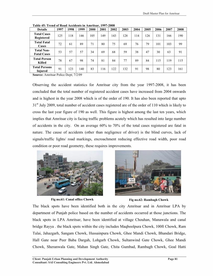
Draft Master Plan for Amritsar
Client: Punjab Urban Planning and Development Authority Page 81Consultant: SAI Consulting Engineers Pvt. Ltd. Ahmedabad
Fig no.62: Rambagh Chowk
Table 45: Trend of Road Accidents in Amritsar, 1997-2008Details 1997 1998 1999 2000 2001 2002 2003 2004 2005 2006 2007 2008
Total Cases Registered 125 118 146 105 149 143 128 114 126 131 166 190
Total Fatal Cases 72 61 89 71 80 75 69 76 79 101 103 99
Total Non-Fatal Cases 53 57 57 34 69 68 59 38 47 30 63 91
Total Person Killed 78 67 98 74 81 84 77 89 84 115 119 115
Total Persons Injured 91 123 140 83 116 122 132 91 98 80 123 161
Source: Amritsar Police Dept; 7/2/09
Observing the accident statistics for Amritsar city from the year 1997-2008, it has been
concluded that the total number of registered accident cases have increased from 2004 onwards
and is highest in the year 2008 which is of the order of 190. It has also been reported that upto
31st July 2009, total number of accident cases registered are of the order of 110 which is likely to
cross the last year figure of 190 as well. This figure is highest among the last ten years, which
implies that Amritsar city is facing traffic problems acutely which has resulted into large number
of accidents in the city. On an average 60% to 70% of the total cases registered are fatal in
nature. The cause of accidents (other than negligence of driver) is the blind curves, lack of
signals/traffic lights/ road markings, encroachment reducing effective road width, poor road
condition or poor road geometry, these requires improvements.
The black spots have been identified both in the city Amritsar and in Amritsar LPA by
department of Punjab police based on the number of accidents occurred at those junctions. The
black spots in LPA Amritsar, have been identified at village Chouhan, Manawala and canal
bridge Rayya . the black spots within the city includes Maqboolpura Chowk, 100ft Chowk, Ram
Talai, Jahazgarh, Sangam Chowk, Hussainpura Chowk, Ghee Mandi Chowk, Bhandari Bridge,
Hall Gate near Peer Baba Dargah, Lohgarh Chowk, Sultanwind Gate Chowk, Ghee Mandi
Chowk, Sheranwala Gate, Mahan Singh Gate, Chita Gumbad, Rambagh Chowk, Goal Hatti
Fig no.61: Canal office Chowk

Draft Master Plan for Amritsar
Client: Punjab Urban Planning and Development Authority Page 82Consultant: SAI Consulting Engineers Pvt. Ltd. Ahmedabad
Chowk, Bharawan Da Dhaba, Sadar Chowk, Chowk Office Neharwala, Ashoka Chowk, Mahal
Chowk, Fatehgarh Churian Road Byepass, Hukam Singh Road, Majitha Road Bye pass, Batala
Road and GT Road Daburji to Byepass India Gate via Taran-wala pul and Verka Chowk.
5.4.3 EXISTING ROAD NETWORK AND HIERARCHY
The road network of LPA, Amritsar & MC is primarily “Ring Radial” with an intense network of
eleven radial roads leading to core city like spokes of a wheel. There are 2 National Highways, 3
State Highways, 6 M.D.R’s and 24 ODR’s & number of other important roads passing through
the LPA & city providing stronger regional linkages (Refer map 8). Rayya and its surrounding
villages are well linked with NH-1 and LPA Amitsar is well linked with nearby settlements,
States and across border with these strong linkages. NH-1 acts as the central spine cutting the
city into two parts namely north and south. These eleven radials emerging out of the city have
acted as important nodes for the development.
The road network in the city has been studied in two parts: (i) walled city, (ii) outside walled city
(Refer map 9). Walled city carrying one-sixth of the city population is heart of Amritsar city as it
generated lot of trade activities, which on other hand generates lot of traffic. A wall and a
circular road that runs along the wall both outside and inside the wall bound the old city. There
are 14 entry points/ gates of the walled city leading to the various residential areas, specialized
bazaars, Golden Temple and other activities within walled city. It has a road network
characteristic to a typical medieval town of North India. Narrow winding streets characterize the
road network, lanes and by-lanes laid out into introvert planning units. This part of the city is
built on human scale with the major thoroughfares and surprising open spaces. The dense road
network with narrow width fails to meet the existing transit demands of multi-modal transport
with majority of motorized vehicles.
On the other hand, later development includes areas built outside the walled city i.e. north side of
the Amritsar – Jalandhar rail line which divides the city into two halves. It is characterized by
wide roads. The city does not have any distinct ring although the Circular Road as well as bye
pass exist in the northern portion of the city but it is completely absent in the southern portion.
The table below lists the important roads passing through the city along with details of road cross
sections and right of way.

Draft Master Plan for Amritsar
Client: Punjab Urban Planning and Development Authority Page 83Consultant: SAI Consulting Engineers Pvt. Ltd. Ahmedabad
Table 46: Statement showing the details of Road Cross-Section and R/W of Inter and Intra City Road Falling in Amritsar Local Planning AreaSr.No.
Categoryof Road
Name of Road
Width of Road (Mtrs) RemarksR/W L/B C\W R/B
National Highways
1 R1(NH-1)GT
Road(Lahore to Delhi)
1) 602) 62.703) 54.4
4) 613.5F
NA17.3524.30
252.62F
NA10+8+10
6.50+2+6.5108.26F
NA17.35*15.30*
252.62F
*Near village Dhodhiwind
*Dual carriage way Near Kot Khalsa
*Near Doburji Distributory
*Near Mehrabanpur
2 R1(NH-15)
Amritsar-Pathankot 30.48M 8.74 13 8.74 *Near village Alkare
3 R1 (NH-15)
Amritsar-Tarn Taran
Road 32.56M 11.00 10.06 11.5 * Near village Chabba
State Highways
4 R2 (SH-25)
Amritsar-Ajnala-Dera Baba Nanak
26.70 10.00 6.70 10.00 *Near village Nagal
5 R2 (SH-21)
Amritsar-Bhikhiwind-Khemkaran
27.95M 9.35 6.70 11.90 *Near village Bohru
6 R2(SH-22)
AmritsarSri Hargobind
Pur25.80M 9.70 6.40 9.70 *Near village Chapu
Ramsingh
Major District Roads
7 R3(MDR-65)
Amritsar-Chogawan-
Rania23.10 10.80 6.70 5.60
8R3
(MDR-64)
Amritsar-Fatehgarh Churian
24.10 4.5 (6.70+1.4+6.70) 4.8* Dual carriage way
Near MCA* Near Tungawala
9R3
(MDR-63)
Amritsar-Ajnala-
Chogawan32 11.15 9.70 11. 15 *Near UBDC
10R3
(MDR-61)
Attari-Jhabbal-Tarn
Taran-Goindwal
0 26.40 26.40 12 -
11R3
(MDR-66)
Rayya More-Baba
Bakala/Batala17.40 4.0 6.7 6.7 * Near Baba Bakala
12 R3
Link Road Between GT
Road & Ajnala Road
21.7 8.1 5.6 8.1 *Near village Chahia
Source: PWD office, Amritsar
Note: R/W- Right of Way, L/B-Left Berm, C/W-Carriage Way, R/B-Right Berm

Draft Master Plan for Amritsar
Client: Punjab Urban Planning and Development Authority Page 84Consultant: SAI Consulting Engineers Pvt. Ltd. Ahmedabad
Table 47: List of O.D.R’s falling in the Amritsar LPA along with Cross-sectional Details
S.No. Categoryof Road Name of Road Length
(kms)Metalled Width
(ft)1 R4 Jandiala to Tarn Taran 16.22 232 R4 Harsa Chhina-Fatehgarh Churian 16.38 12
3 R4 Beas-Dera Baba Jaimal Singh-Sathiala-Butala N.A5.72-33’9.60-18’4.80-10’
4 R4 Jandiala-Veroval 21.62 18’5 R4 G.T Road to Gehri Mandi Railway Crossing 3.10 18’6 R4 Gehri mandi Bazar 0.50 23’
7 R4 Chheharta Dhand Bir Road 17.15 15.80-18’1.35-22’
8 R4 Rajatal-Naushera Dhalla road 4.58 12’9 R4 Approach to Warrpal Rly Station from NH-15 2.41 12’
10 R4 Approach to Attari Rly Station from NH-1 1.80 18’11 R4 Majitha Bye pass 0.96 10’12 R4 Mall Road Amritsar 4.34 48’13 R4 Approach to Verka Railway station from NH-15 0.13 15’14 R4 GT Road to Govt. Polytechnic 0.85 10’15 R4 Albert Road, Amritsar 0.89 22’16 R4 Approach to Jaintipur Rly Station from NH-15 0.24 10’17 R4 Approach to Kathunangal Rly Station from NH-15 1.40 10’18 R4 G.T. Road to Khurmanian-Bopa Rai Baj Singh 6.15 12’19 R4 Rayya lidder jalalabad 16.76 18’20 R4 Old GT road with in Amritsar MC 1.85 22’
21 R4Mall Road Amritsar,Disst. Court to Lawerance Road XingLawerance road Xing to PWD complex
2.861.48
2x22’48’
22 R4 Amritsar Sohian Fatehgarh Churian road 23.05 18’23 R4 Fatehgarh Churian Ramdass road. 15.42 23’24 R4 Cheecha Hoshiar Nagar road. 6.52 12’
Source: P.W.D Office, Amritsar
The total length of roads existing in the Amritsar M.C. area is 495.20 kms in the year 2001,
which has increased to 524.41 kms in 2004 and 611.13 kms in 2006. There has been an increase
of 29.21 kms in the total road length in the city in the last four years and an increase of 87 kms in
past two years. This increase has been observed in the category of surfaced roads. Almost 90%
of the city roads are surfaced (metalled) roads, among which, 98% are Black Top roads with
remaining 2% as cement concrete and water bond macadam roads. The unsurfaced roads have
been sub-divided into Motorable and Non Motorable ones. Motorable roads have major share
among the unsurfaced roads, which is of the order of 95% in 2004. (Refer table no. 48).Table 48: Length of Roads within Amritsar M. C. (in kms)
YearTotal
Length(km)
Surfaced Roads (km) Unsurfaced Roads (km)Water Bond Macadam
BlackTop
Cement Concrete Total Motorable Non
Motorable Total
2001 495.20 3.40 431.45 7.60 442.45 48.00 4.75 52.752004 524.41 1.40 451.66 7.60 460.66 50.00 2.75 52.752006 611.13 10.70 527.03 13.40 551.13 55 5 60
Source: Municipal Corporation, Amritsar, Municipal Year Book (06-07)

Draft Master Plan for Amritsar
Client: Punjab Urban Planning and Development Authority Page 85Consultant: SAI Consulting Engineers Pvt. Ltd. Ahmedabad
5.4.3.1 Cross-sections of all Major Radial Roads and Inner City Roads
The laying of new road network in the city of Amritsar is the responsibility of PWD and
Municipal Corporation, Amritsar while the provision of roads outside the municipal limit, link
roads to the villages fall within the purview of PWD and that of the two National highways
passing through the city under N.H.A.I (National Highway Authority of India). The details of
cross sectional elements as supplied by PWD for these roads have been illustrated in the table no
48 as per the information provided, the width of the road varies from section to section especially
in case of G.T Road and there is no sort of encroachments on these roads.
Road Sections Details: Primary Survey
SAI team conducted primary survey of the important city roads and junctions to assess the
critical sections/junctions in the city. The cross sectional details of all major roads have been
assessed and encroachments along these roads has been identified and marked. It has been
observed that the right of way at many places is encroached by the informal activity such as
street hawkers, on street parking of vehicles, which has resulted in the reduction of effective road
width. Further it has been observed that all the major roads are flooded with traffic of
heterogeneous nature and the poor road geometry/elements has failed in alignment of different
modes for smooth flow of traffic. At few junctions like Kitchlu chowk, putligarh chowk,
Bhandari-Bridge, Hussainpura chowk and Railway Station chowk, pedestrian facilities are totally
missing. These kind of problems are not an exception anywhere in the city which requires due
consideration.
Elevated road is under construction from Hussainpura chowk to Bhandri Bridge, which will
directly pressurize Bhandri Bridge, as it will create bottleneck and jams as traffic terminates at
this point, which further creates congestion at various points like railway station, putligarh
chowk etc. The other route i.e from Bhandri Bridge to Rego- Bridge via Goal bagh can be
explored for releasing the pressure on Bhandri Bridge. The life of Rego- Bridge is expired and
has been declared unsafe for heavy vehicles by government of India. This bridge should be
reconstructed and widened. The elevated road is missing from Bhandri Bridge to Chheherta
chowk. As the volume of traffic near Y-Junction of Railway Station, Putligarh chowk near
Khalsa College and Chheherta chowk is very large, so elevated road from Bhandri Bridge to
chheherta chowk can take care of the traffic problems of the city.

D
raft
Mas
ter P
lan
for A
mrit
sar
Clie
nt: P
unja
b U
rban
Pla
nnin
g an
d D
evel
opm
ent A
utho
rity
Pag
e 86
Con
sulta
nt: S
AI C
onsu
lting
Eng
inee
rs P
vt. L
td. A
hmed
abad
Tab
le 4
9:D
etai
ls o
f Var
ious
Roa
d C
ross
-Sec
tions
Sr
.N
o.R
oad
Nam
eC
ross
Sec
tion
Rem
arks
1G
.T R
oad-
Nea
r Put
ligha
r
Cho
wk
(NH
-1)
�V
aria
tion
of c
ross
sect
ion
deta
ils o
f NH
1 be
caus
e of
enc
roac
hmen
t
�R
educ
tion
in e
ffec
tive
road
wid
th d
ue to
par
king
of v
ehic
les a
nd in
form
al se
ctor
�R
oad
cond
ition
rang
es fr
om m
oder
ate
to b
ad.
2G
.T R
oad-
In F
ront
of
Rai
lway
Sta
tion
(NH
-1)
�V
aria
tion
of c
ross
sect
ion
deta
ils o
f NH
1 be
caus
e of
enc
roac
hmen
t
�R
educ
tion
in e
ffec
tive
road
wid
th d
ue to
par
king
of v
ehic
les a
nd in
form
al se
ctor
�R
oad
cond
ition
rang
es fr
om m
oder
ate
to b
ad.
3V
erka
Bye
pass
Cho
wk
on
Am
ritsa
r-Pa
than
kot R
oad
(NH
-15)
�En
croa
chm
ent o
n its
bot
h sid
es b
y pa
rkin
g of
aut
oric
khsh
aw, r
icks
haw
, reh
ris,
khok
as.
�A
bsen
ce o
f any
ped
estri
an fa
cilit
y on
the
road
.
�M
oder
ate
to b
ad ro
ad c
ondi
tion
4A
jnal
a R
oad
-Nea
r
Dis
trict
Cou
rts (S
H-2
5)
�En
croa
chm
ent o
n its
bot
h si
des
by p
arki
ng o
f au
toric
khsh
aw, r
icks
haw
, re
hris
, kh
okas
�G
arba
ge d
umpi
ng a
long
side
road
redu
cing
road
wid
th
�M
oder
ate
road
con
ditio
n
5A
jnal
a R
oad
(Bye
pass
Cho
wk)
�C
omm
erci
al a
nd m
ix la
ndus
e on
bot
h si
des
�G
ood
road
con
ditio
n
�B
ridge
und
er c
onstr
uctio
n.
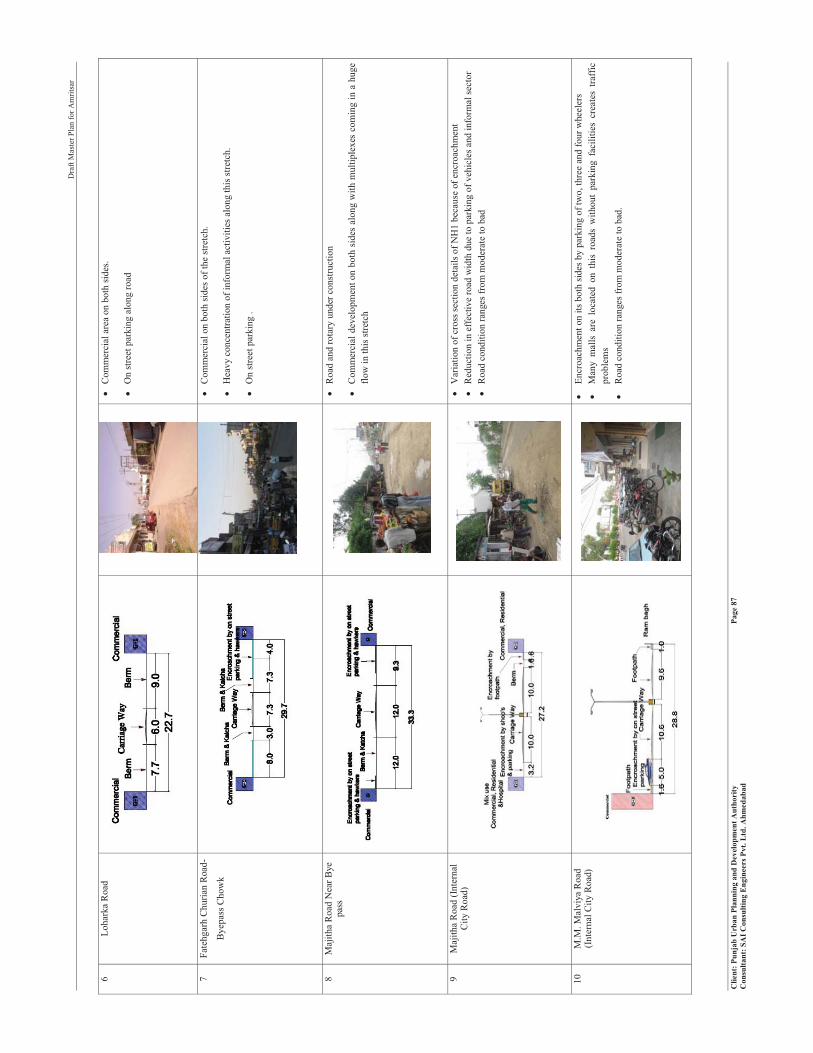
D
raft
Mas
ter P
lan
for A
mrit
sar
Clie
nt: P
unja
b U
rban
Pla
nnin
g an
d D
evel
opm
ent A
utho
rity
Pag
e 87
Con
sulta
nt: S
AI C
onsu
lting
Eng
inee
rs P
vt. L
td. A
hmed
abad
6Lo
hark
a R
oad
�C
omm
erci
al a
rea
on b
oth
side
s.
�O
n st
reet
par
king
alo
ng ro
ad
7Fa
tehg
arh
Chu
rian
Roa
d-
Bye
pass
Cho
wk
�C
omm
erci
al o
n bo
th si
des o
f the
stre
tch.
�H
eavy
con
cent
ratio
n of
info
rmal
act
iviti
es a
long
this
stre
tch.
�O
n st
reet
par
king
.
8M
ajith
a R
oad
Nea
r Bye
pa
ss�
Roa
d an
d ro
tary
und
er c
onst
ruct
ion
�C
omm
erci
al d
evel
opm
ent o
n bo
th s
ides
alo
ng w
ith m
ultip
lexe
s co
min
g in
a h
uge
flow
in th
is st
retc
h
9M
ajith
a R
oad
(Inte
rnal
C
ity R
oad)
�V
aria
tion
of c
ross
sect
ion
deta
ils o
f NH
1 be
caus
e of
enc
roac
hmen
t�
Red
uctio
n in
eff
ectiv
e ro
ad w
idth
due
to p
arki
ng o
f veh
icle
s and
info
rmal
sect
or�
Roa
d co
nditi
on ra
nges
from
mod
erat
e to
bad
10M
.M. M
alvi
ya R
oad
(Int
erna
l City
Roa
d)�
Encr
oach
men
t on
its b
oth
sides
by
park
ing
of tw
o, th
ree
and
four
whe
eler
s�
Man
y m
alls
are
loc
ated
on
this
roa
ds w
ithou
t pa
rkin
g fa
cilit
ies
crea
tes
traff
ic
prob
lem
s�
Roa
d co
nditi
on ra
nges
from
mod
erat
e to
bad
.

D
raft
Mas
ter P
lan
for A
mrit
sar
Clie
nt: P
unja
b U
rban
Pla
nnin
g an
d D
evel
opm
ent A
utho
rity
Pag
e 88
Con
sulta
nt: S
AI C
onsu
lting
Eng
inee
rs P
vt. L
td. A
hmed
abad
11La
wre
nce
Roa
d
(Int
erna
l City
Roa
d)
�Tr
affic
jam
s due
to in
form
al se
ctor
s, en
croa
chm
ent b
y th
e sh
ops a
nd o
n st
reet
pa
rkin
g on
its b
oth
side
s.�
Surr
ound
ing
Land
use
res
iden
tial c
um c
omm
erci
al (P
vt. C
olle
ge ,
man
y Pv
t. B
ank
and
offic
es o
n th
is ro
ad)
�La
ck o
f par
king
pla
ce le
ads
to O
n-st
reet
par
king
12M
all R
oad
(Int
erna
l City
Roa
d)
�C
onve
rsio
n of
surro
undi
ng la
nd u
se fr
om re
side
ntia
l to
com
mer
cial
.�
Encr
oach
men
t on
both
side
s of t
he ro
ad b
y O
n-st
reet
par
king
.�
Hap
h-ha
zard
par
king
in fr
ont o
f the
com
mer
cial
mal
ls le
adst
o tra
ffic
jam
s on
the
road
.
13H
all B
azaa
r
(Int
erna
l City
Roa
d)
�H
igh
Deg
ree
of ro
ad e
ncro
achm
ent o
n its
bot
h si
des b
y pa
rkin
g of
rick
shaw
, reh
ris,
khok
as a
nd fo
ur w
heel
ers.
�O
n st
reet
par
king
alo
ngsi
de ro
ad re
duci
ng ro
ad w
idth
�M
oder
ate
to b
ad ro
ad c
ondi
tion.

D
raft
Mas
ter P
lan
for A
mrit
sar
Clie
nt: P
unja
b U
rban
Pla
nnin
g an
d D
evel
opm
ent A
utho
rity
Pag
e 89
Con
sulta
nt: S
AI C
onsu
lting
Eng
inee
rs P
vt. L
td. A
hmed
abad
TO
CA
NA
L O
FF
ICE
TO RAILWAY STATION
TOCOURTROADM
ED
IAN
TA
LC
HO
WK
RI
BR
IDG
E
GT
RO
AD
(N
H 1
)
Rai
lway
Sta
tion
Cho
wk
5.4.
4 JU
NC
TIO
NS
DE
TA
ILS
Fig
no.6
3: R
ailw
aySt
atio
nC
how
k
�H
igh
Deg
ree
of ro
ad e
ncro
achm
ents
on
its b
oth
side
s by
park
ing
of r
icks
haw
, reh
ris, k
hoka
s , sh
ops a
nd h
eavy
mov
emen
ts o
f fou
r whe
eler
s and
M
ix tr
affic
�O
n st
reet
par
king
's al
ongs
ide
both
side
s of r
oad
redu
cing
roa
d w
idth
�La
ck o
f us
age
of fo
ot o
ver b
ridge
pre
sent
acr
oss t
he N
H1
near
railw
ay st
atio
n.
�M
oder
ate
to b
ad ro
ad c
ondi
tion
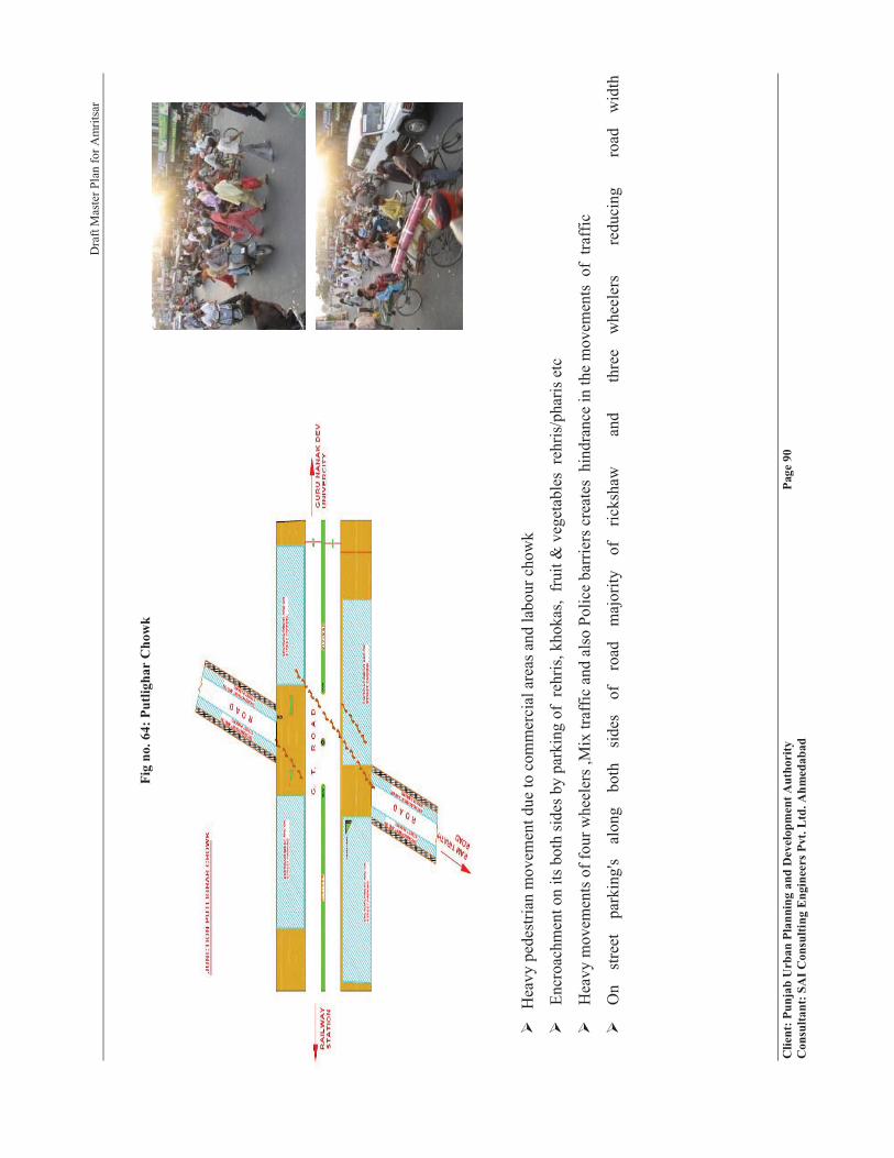
D
raft
Mas
ter P
lan
for A
mrit
sar
Clie
nt: P
unja
b U
rban
Pla
nnin
g an
d D
evel
opm
ent A
utho
rity
Pag
e 90
Con
sulta
nt: S
AI C
onsu
lting
Eng
inee
rs P
vt. L
td. A
hmed
abad
Fig
no. 6
4: P
utlig
har
Cho
wk
�H
eavy
ped
estri
an m
ovem
ent d
ue to
com
mer
cial
are
as a
nd la
bour
cho
wk
�En
croa
chm
ent o
n its
bot
h si
des b
y pa
rkin
g of
reh
ris, k
hoka
s, fr
uit &
veg
etab
les
rehr
is/p
haris
etc
�H
eavy
mov
emen
ts o
f fou
r whe
eler
s ,M
ix tr
affic
and
als
o Po
lice
barr
iers
cre
ates
hin
dran
ce in
the
mov
emen
ts o
f tra
ffic
�O
n st
reet
pa
rkin
g's
alon
g bo
th
side
s of
ro
ad
maj
ority
of
ric
ksha
w
an
d
thre
e w
heel
ers
re
duci
ng
ro
ad
wid
th

Draft Master Plan for Amritsar
Client: Punjab Urban Planning and Development Authority Page 91Consultant: SAI Consulting Engineers Pvt. Ltd. Ahmedabad
PETROLPUMP
Commercial
Residential Cum
Commercial
Residential Cum
Commercial
SESSIONCOURTS
SBI
Bank
Residential C
um
Com
mercial
Residential Cum
Commercial
Residential Cum
Commercial
Com
mercial
Residential Cum
Commercial Res
iden
tialC
um
Com
mer
cial
Residential CumCommercial
Residential CumCommercial
Encroachm
ent
En
cro
ach
men
t
En
cr o
ach
men
t
Encroachm
ent
En
cro
ach
men
t
RESID
ENTIA
L/CO
MM
ERIC
AL
RE
SI D
EN
TI A
L/C
OM
ME
RIC
AL
RE
SI D
EN
TI A
L/C
OM
ME
RIC
AL
CO
MM
ERIC
AL
En
cro
ach
men
t
Encroachm
ent
RATAN SINGH CHOWK
TOMENTAL HOSPITAL CHOWK
MA
QB
OO
LR
OA
D
TO
FA
TE
HG
AR
HC
HU
RIA
N
TOKACHERI CHOWK
Fig no.65: Kichlu Chowk
� Pedestrian movement all through the stretch and junction.
� Encroachment on both sides by parking of rehris, khokas
and shops
� Heavy movements of four wheelers, Mix traffic and also Police barriers creates hindrance in the movements of traffic
� Traffic mismanagement is observed
Fig no.66: Rattan Singh Chowk
� Pedestrian movement all through the stretch and junction.
� Encroachment on both sides by shopkeepers, by informal activities and onstreet parking of vehicles
� Mixing of fast and slow moving traffic
� Traffic mismanagement is observed
� Labour market (group of (100-150) labourers hinders the movement of traffic.
Refer Annexure XII for Junction survey

Draft Master Plan for Amritsar
Client: Punjab Urban Planning and Development Authority Page 92Consultant: SAI Consulting Engineers Pvt. Ltd. Ahmedabad
As per discussion with the police officials and FGDs conducted with various important
people during survey of the Rayya and its surrounding villages, some critical junctions have
been identified from accidents, blind cruves, and geometric design point of views. They are:-
� Rayya Canal Bridge
� Baba Bakala Entry gate
� Y-Junction at Sathiala College
� Entry of Baba Bakala From NH-1
� Under pass near Beas
� Umra Nangal Gate
The primary survey of important city roads, reveals that NH-1 is the major corridor for
movement of both inter and intra city traffic and hence caters to large traffic volume while all
the radial routes are catering to the regional traffic. The provision of byepass in the northern
half of the city has not been able to help much to relieve traffic problems in the city.
Major problem identified was lack of visibility of traffic signals from a distance. Traffic
signal type, spacing, phasing and offsets should be optimized for all modes of traffic on all
mobility corridors to ensure a speedy movement of traffic. Where possible actuated (demand
response) traffic signals must be provided.
In terms of supply of parking area along the various stretches, there is no formal authorized
parking space for any mode. Lack of Footpaths is also a major concern on all the stretches
and junctions. As cross conflict occurs between the pedestrians and moving vehicles on the
road, which may lead to accidents. At certain points/junctions, footpaths are present but have
been encroached by hawkers and rehriwala’s; as a result pedestrians have to walk on the road
leading to conflict with vehicles. At railway station and another at Baba Deep Singh Ji
Gurudwara, foot over bridges for movement of pedestrians have been provided but they are
not being used. Guard rails are present at the median but people tend to jump them and cross
the road. Planned parking spaces exists outside Golden Temple, Baba Deep Singh Ji
Gurudwara, Durgiana Mandir and at Lawrence road which are always full, hence forcing
people to park their vehicles on roads, thereby, reducing the effective width of the road.
Specific parking locations are required to be proposed for regulating the traffic and reducing
the On Street parking trend especially around Golden Temple and Durgiana Temple.

Draft Master Plan for Amritsar
Client: Punjab Urban Planning and Development Authority Page 93Consultant: SAI Consulting Engineers Pvt. Ltd. Ahmedabad
5.4.5 PARKING
Parking is another major area of concern for almost all towns/cities. With increasing number
of vehicles, narrow road networks, absence of parking lots/spaces within majority of built
spaces renders parking as a critical area for planning and development. Moreover, the local
government policy allowing conversion of residential building to commercial use without
taking in account adequate parking requirements has led to attracting large number of
vehicles on the roads. Even the norms for provision of parking areas in the city also needs to
be made more realistic as lack of proper norms leads to various parking related issues.
The city is observed to have a trend of on-street parking in general besides the provision of
parking lots at different locations in the city. The table below gives list of parking lots
demarcated by Municipal Corporation in the city of Amritsar. Most of these parking lots do
not have a separate space but instead have line demarcation on the road itself, which is a
regulated form of on-street parking that reduces the effective road width. This can be seen in
case of Court Road, at ICICI Bank-Mall Road, at Telephone Exchange parking lots.Table 50: Parking Lots Given on Contract Basis by Amritsar M.CSr.No. Parking Lot Name
1 Court Road/Civil Line2 Gol Bagh3 Fish market4 Telephone Exchange 5 Pandit Deen Diyal Parking Lot6 Dr. Daljit Singh Hospital7 Town Hall8 Guru Nanak Bhawan9 State Bank of India (Court Road)10 State Bank of India (Town Hall)11 Hartej Hospital12 Shashi Hospital13 Chatiwind Gate 14 Amandeep Hospital15 Mata Kaulan Hospital16 Sabzi mandi17 DTO office18 Dr. Navdeep Hospital19 ICICI Bank Mall Road20 Kakkar Hospital21 Madaan Hospital22 Chachhi Hospital
Source: Municipal Corporation, Amritsar
Along the major commercial areas such as Lawrence Road, Queens Road, Hall Bazaar etc.
there is no provision of organized parking spaces, hence results into on-street parking.

Draft Master Plan for Amritsar
Client: Punjab Urban Planning and Development Authority Page 94Consultant: SAI Consulting Engineers Pvt. Ltd. Ahmedabad
Fig no.68: Encroachment of footpath due to On-street Parking
Fig no.67: On Street Parking of vehicles creating traffic bottlenecks
The off-street parking has also been observed at different locations such as Hussainpura
Parking Lot, Railway Stations, Bus Terminal, Market complex at Mahan Singh Chowk and
opposite Bus Stand Exit. It is observed that the demand for car parking is high at Hall Bazaar
and stretch from the Town Hall to Golden Temple. The 2-Wheeler accumulation is high at
the Railway Station, Bus Terminal and the Town Hall Complex. The demand for off-street
parking of cycles is high at the Railway Station and Hall Bazaar. Further, another important
spot Durgiana Temple also requires multistoreyed parking in the surrounding to cater the
need of visitors.
Even the areas where organized parking spaces have been provided are still facing the
problem of traffic congestions and bottlenecks due to onstreet parking of vehicles. This is
seen on the stretch outside the Golden Temple, at Gurudwara Shaheed Ganj as the parking
provided in the lot is free which remains full. In the case of Pandit Deen Dayal Upadhya
Parking lot which have been constructed by the
Amritsar M.C to decongest the walled city traffic
especially Hall Bazaar and areas surrounding it, but it
is still lying vacant because people had to walk longer
distances to reach places. Number of parking lots have
been proposed or are under construction in different
areas of the city to solve parking related issues. The
table below lists the details of various organized
parking lots existing in the city.Fig no.69: Multi Storied Parking On
Bhandri Bridge
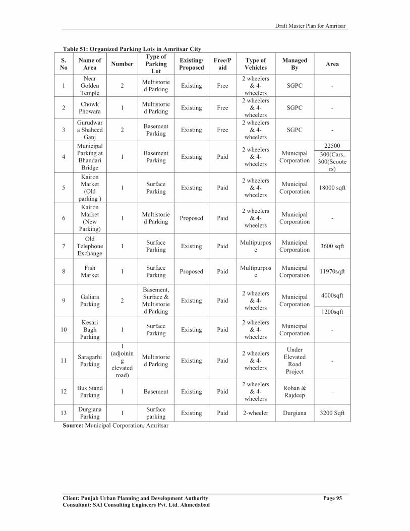
Draft Master Plan for Amritsar
Client: Punjab Urban Planning and Development Authority Page 95Consultant: SAI Consulting Engineers Pvt. Ltd. Ahmedabad
Table 51: Organized Parking Lots in Amritsar City
S.No
Name of Area Number
Type of Parking
Lot
Existing/Proposed
Free/Paid
Type of Vehicles
ManagedBy Area
1Near
Golden Temple
2 Multistoried Parking Existing Free
2 wheelers & 4-
wheelersSGPC -
2 Chowk Phowara 1 Multistorie
d Parking Existing Free2 wheelers
& 4-wheelers
SGPC -
3Gurudwara Shaheed
Ganj2 Basement
Parking Existing Free2 wheelers
& 4-wheelers
SGPC -
4
Municipal Parking at Bhandari Bridge
1 Basement Parking Existing Paid
2 wheelers & 4-
wheelers
Municipal Corporation
22500300(Cars,
300(Scooters)
5
Kairon Market
(Old parking )
1 Surface Parking Existing Paid
2 wheelers & 4-
wheelers
Municipal Corporation 18000 sqft
6
Kairon Market (New
Parking)
1 Multistoried Parking Proposed Paid
2 wheelers & 4-
wheelers
Municipal Corporation -
7Old
Telephone Exchange
1 Surface Parking Existing Paid Multipurpos
eMunicipal
Corporation 3600 sqft
8 Fish Market 1 Surface
Parking Proposed Paid Multipurpose
Municipal Corporation 11970sqft
9 Galiara Parking 2
Basement, Surface & Multistoried Parking
Existing Paid2 wheelers
& 4-wheelers
Municipal Corporation
4000sqft
1200sqft
10Kesari Bagh
Parking1 Surface
Parking Existing Paid2 wheelers
& 4-wheelers
Municipal Corporation -
11 Saragarhi Parking
1(adjoinin
g elevated
road)
Multistoried Parking Existing Paid
2 wheelers & 4-
wheelers
Under Elevated
Road Project
-
12 Bus Stand Parking 1 Basement Existing Paid
2 wheelers & 4-
wheelers
Rohan & Rajdeep -
13 Durgiana Parking 1 Surface
parking Existing Paid 2-wheeler Durgiana 3200 Sqft
Source: Municipal Corporation, Amritsar

Draft Master Plan for Amritsar
Client: Punjab Urban Planning and Development Authority Page 96Consultant: SAI Consulting Engineers Pvt. Ltd. Ahmedabad
Chheharta chowkPutli ghar chowk Railway station
chowk
Fate
hgar
h ch
uria
n ro
ad
Majh
ita ro
ad
Ram tirath road
Ajn
ala R
oad
Grand trunk road
Jalandhar road
Daburji bye pass
G.N.D.U.Khalsa college
Mall Road
Circular
Road
Guru NanakDev Hospital
Cannt Road
To Wagha border
To Path
anko
t
Tran Taran road
Khe
m k
aran
road
UBDC
Court Road
Walled City
Loha
rka
road
Sultanwind road
B.SFrom Lahore
To Jalandhar
From
Tra
n Ta
ran
Maq
bool
Roa
dM
M M
alvi
aR
oad
Queens Road Crystal Chowk
Lawe
rance
Roa
d
RAM BAGH
GOLDEN TEMPLE
Baba Deep SinghGurudawara
Sultanwind Gate
Durgiana Temple
Lohgarh Gate
Basant AvenueSchool
Fish Market
Hall Gate
Parking Lots
Basement Parking
Multi Soried Parking
Managed by SGPC
MC Managed parking
Fig no.71: Condition of parking with in Wall City
Fig no.70: Location of Organized Parking Lots in Amritsar City
Source: Municipal Corporation, Amritsar
Specifically for walled city though lot of parking lots
are provided but issue remains same. More parking
availability attracts more traffic in heart of Amritsar
(walled city) further creating problems. Further,
wholesale markets like fish & iron market, plywood &
furniture market of Katra Sher Singh, Bagh Akalian,
iron and steel market, Cheel Mandi timber market and
Bakarwala-ghee mandi-transport booking (loading &
unloading) and subdivision of landuse remains catalyst
in inviting traffic which requires urgent strategies on priority basis.
5.5 PUBLIC TRANSPORTThe city of Amritsar lacks in public transport facility for intra city operations. With complete
absence of formal public transport system, there is increase in personalized modes of
transport. The number of 3-wheelers in the city has increased at an average rate of 5.3% from
12149 in year 2003-04 to 15176 in year 2007-08 (Refer table no 44).

Draft Master Plan for Amritsar
Client: Punjab Urban Planning and Development Authority Page 97Consultant: SAI Consulting Engineers Pvt. Ltd. Ahmedabad
Three wheelers on one side are creating traffic problems but at the same time, many of these
use kerosene oil/diesel etc, which creates lots of environment degradations in terms of air
pollution and noise pollution as well.
The mini buses are also found to ply on all radial routes i.e they connect the city to the towns
and villages in the near vicinity of Amritsar such as Rajasansi, Majitha, Jandiala etc i.e
within the radius of 40 kms from Bus Stand. The frequency on all radial routes is high i.e 15
minutes.
Another form of public transport that exists in the city is free bus service from Railway
Station to Golden Temple and Vice-Versa. This service is provided in a frequency of one
hour by SGPC for tourists visiting Golden Temple.
Recently launched Mega Cabs in the city provides an intermediate private transport system in
the city. The service is provided within 40kms radius of the city but is expensive as it charges
at a rate of Rs.15 per kilometer. It provides pick up and drop services at any hour of the day
and from anywhere in the city.
Thus, as the planning and development is assumed for the year 2031 where population and
vehicular growth is an obvious feature, there is due need to think about the public transport
system in Amritsar to reduce the use of personalized modes of transport.
5.5.1 TERMINALS
The study of terminals is also important in traffic and transportation as these acts as nodal
points in transport network.
5.5.1.1 Bus Terminal
The Bus Terminal-Amritsar is located near the City
Centre on G.T Road (NH1). It is spread over an area of
8.5 acres with two entry and exit points. The average
number of daily passengers handled is 1, 25,000. Both
local and regional route buses originate from here. The
details of number of buses on different routes is given
below: - Fig no.72: Amritsar Bus terminal
Table 52: Details of Bus Routes from Amritsar to Other Places
S.No. Route Total No. of Buses Plying on Route
1 Amritsar-Ferozpur 612 Amritsar-Moga Route 793 Amritsar-Zira, Faridkot, Bathinda, Abohar Route 122
4 Amritsar-Tarn Taran, Chohla Sahib, Jalandhar, Kapurthala, Sultanpur Lodhi Route 159
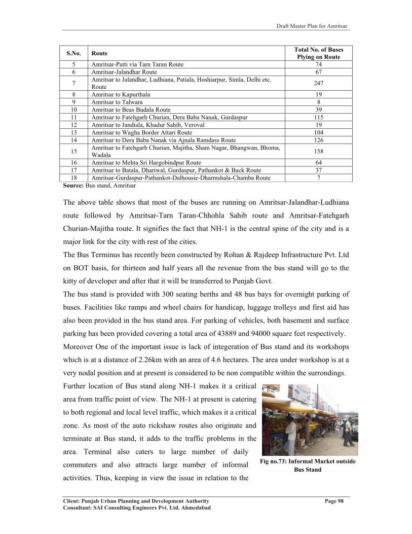
Draft Master Plan for Amritsar
Client: Punjab Urban Planning and Development Authority Page 98Consultant: SAI Consulting Engineers Pvt. Ltd. Ahmedabad
Fig no.73: Informal Market outside Bus Stand
S.No. Route Total No. of Buses Plying on Route
5 Amritsar-Patti via Tarn Taran Route 746 Amritsar-Jalandhar Route 67
7 Amritsar to Jalandhar, Ludhiana, Patiala, Hoshiarpur, Simla, Delhi etc. Route 247
8 Amritsar to Kapurthala 199 Amritsar to Talwara 810 Amritsar to Beas Budala Route 3911 Amritsar to Fatehgarh Churian, Dera Baba Nanak, Gurdaspur 11512 Amritsar to Jandiala, Khadur Sahib, Veroval 1913 Amritsar to Wagha Border Attari Route 10414 Amritsar to Dera Baba Nanak via Ajnala Ramdass Route 126
15 Amritsar to Fatehgarh Churian, Majitha, Sham Nagar, Bhangwan, Bhoma, Wadala 158
16 Amritsar to Mehta Sri Hargobindpur Route 6417 Amritsar to Batala, Dhariwal, Gurdaspur, Pathankot & Back Route 3718 Amritsar-Gurdaspur-Pathankot-Dalhousie-Dharmshala-Chamba Route 7
Source: Bus stand, Amritsar
The above table shows that most of the buses are running on Amritsar-Jalandhar-Ludhiana
route followed by Amritsar-Tarn Taran-Chhohla Sahib route and Amritsar-Fatehgarh
Churian-Majitha route. It signifies the fact that NH-1 is the central spine of the city and is a
major link for the city with rest of the cities.
The Bus Terminus has recently been constructed by Rohan & Rajdeep Infrastructure Pvt. Ltd
on BOT basis, for thirteen and half years all the revenue from the bus stand will go to the
kitty of developer and after that it will be transferred to Punjab Govt.
The bus stand is provided with 300 seating berths and 48 bus bays for overnight parking of
buses. Facilities like ramps and wheel chairs for handicap, luggage trolleys and first aid has
also been provided in the bus stand area. For parking of vehicles, both basement and surface
parking has been provided covering a total area of 43889 and 94000 square feet respectively.
Moreover One of the important issue is lack of integeration of Bus stand and its workshops
which is at a distance of 2.26km with an area of 4.6 hectares. The area under workshop is at a
very nodal position and at present is considered to be non compatible within the surrondings.
Further location of Bus stand along NH-1 makes it a critical
area from traffic point of view. The NH-1 at present is catering
to both regional and local level traffic, which makes it a critical
zone. As most of the auto rickshaw routes also originate and
terminate at Bus stand, it adds to the traffic problems in the
area. Terminal also caters to large number of daily
commuters and also attracts large number of informal
activities. Thus, keeping in view the issue in relation to the

Draft Master Plan for Amritsar
Client: Punjab Urban Planning and Development Authority Page 99Consultant: SAI Consulting Engineers Pvt. Ltd. Ahmedabad
existing Bus Stand, there is need to identify an appropriate location, mainly outside the city
area so as to minimize the regional traffic of buses entering the city and hence decongesting
the city.
There are only two bus terminal in whole of the region i.e. in
Baba Bakala (which is not functional) and Dera Baba Jaimal
Singh, other bus stops are along the road side and commuters
face lot of problems in boarding and alightening the buses ,lack
of bus-q- shelter is another problem which is faced by the
commuters.
Further, the bus connectivity to the villages in Amritsar LPA has also been observed and it
has been found that 87.1% (270 villages) of the villages out of the total of 310 have bus
service facility which implies that they are connected through bus route. Out of the remaining
12.9% villages, 2.9% villages are uninhabited and 10% of the villages do not have access to
bus service facility and have to travel a distance of 2 to 3 km to get an access to the bus
service.
Table 53: Bus Service in Villages in LPA, Amritsar
Villages in Amritsar LPA
Bus Service FacilityAvailable Not Available Uninhabited Villages Total
270 (87.1%) 31 (10%) 9 (2.9%) 310 (100%)Source: Town & Village Directory-Amritsar, 2001
5.5.1.2 Truck Terminal
The city has one truck terminal of an area of 28 hectares located at Jahajgarh, G.T road
adjacent to city centre. It has multiple entry and exit points. The truck terminal has all the
facilities such as truck parking areas, repair shops, offices of transport agencies/operators and
petrol pumps.
Existing Truck terminal is surrounded by the residential areas, which makes it a non-
compatible use. Further, it creates congestion on roads like G.T Road, Chamrang Road, by
unnecessary movements of trucks. Rather such kinds of facilities are required to be integrated
with the major trade/commerce and industrial activities.
Fig no.74: Bus Terminal Baba Bakala

Draft Master Plan for Amritsar
Client: Punjab Urban Planning and Development Authority Page 100Consultant: SAI Consulting Engineers Pvt. Ltd. Ahmedabad
Fig no.77: Railway Station, Amritsar
Huge truck traffic inflow is observed mainly on two routes namely G.T road and Tarn Taran
road. Mixing of heavy truck traffic and city traffic is observed to create congestion on both
G.T road and Tarn Taran road. Hence, it requires to be shifted and provision should be made
in integration with major trade & commerce and industrial activities in the city.
5.5.1.3 Railway Station
The city of Amritsar is well connected by broad gauge rail
network with other parts of country and with the neighboring
country of Pakistan via Attari rail link. Major links are from
Amritsar to Pathankot, Amritsar to New Delhi, Amritsar to
Patti & Amritsar to Attari link lines. There are total of 14
railway stations that are falling in Amritsar LPA. Out of this 10
railway stations fall outside the municipal limit of Amritsar
which are namely Beas, Rayya, Butari, Tangra, Jandiala, Manawala, Khasa, Majitha,
Jaintipura and Attari. The remaining 4 railway stations exist within municipal limit of
Amritsar namely Verka, Chheharta, Bhagtanwala and Amritsar. It is managed by Northern
Railways and caters to approximately 28,000 passengers daily. Approximately 40 passenger
trains both local and express and 9 goods trains originate or terminate at the Amritsar
Railway Station. It is marked by the presence of passenger’s facilities such as ramps and
wheel chairs for handicapped, stairs, tourist information centre and waiting halls etc.
The area surrounding railway station is commercial in nature consisting of scooter and cycle
repair market, tour and travel agents, hotels and eating joints. Apart from this, Liberty market
exists opposite to railway station, which also attracts large volume of people, and informal
activity, which occupies valuable road space, reducing the usable road width and in turn
creating traffic bottlenecks at places, which need rectification.
Fig no.76: The auto/ truck repair market inside Truck Terminal, Amritsar
Fig no.75: The parking areas for trucks inside Truck Terminal

Draft Master Plan for Amritsar
Client: Punjab Urban Planning and Development Authority Page 101Consultant: SAI Consulting Engineers Pvt. Ltd. Ahmedabad
As the railway lines on different routes pass through the
centre of the city and through different parts of LPA, it cuts
the road network at number of level crossings which act as
traffic bottlenecks. To provide smooth traffic flow, there is
need for construction of ROB’s /underpasses within LPA and
city at these crossings. There are about 30 manned crossings
in the city itself. Out of the 30 crossings only three have
ROB’s constructed to this date while other crossings such as
Shivala Railway crossing, Rambagh Railway Crossing, 22 no. crossing, crossing at
Islamabad area, Chheharta, Batala Road and Verka, Kot Khalsa, Vallah Sabji Mandi,
Chabbal Road, Jaura railway crossing, Jawala Flour Mill railway crossing require immediate
construction of ROB’s/ underpasses within the city. Beas is only railway station in this
region, which has a good regional connectivity. There is also a hault namely Rayya-Baba
Bakala in the area, which is functional but cannot be used as a railway station without up
gradation.
An ROB is under construction on Rayya- Baba Bakala Road,
which will be functional after the completion of the stetch
over railway line. But will not solve the problem of the
visitors visiting Baba Bakala during festive days as the road
on the other side (5 kms Stretch) is blocked for the motorized
traffic because of the rush during mela days, starting from
Rayya and uptill Sathiala. Visitors have to travel through
another route of 12 kms (via Beas-Dera Baba Jaimal Singh), which stretches the journey by
further 7 kms to reach Sathiala. Therefore, there is a need for secondary road or a kind of
Fig no.78: The commercial activity outside Railway Station
Fig no. 79: Traffic Congestion at Liberty market opposite Railway Station, Amritsar
Fig no.80: Railway Hault Rayya Baba Bakala
Fig no.81: ROB under construction

Draft Master Plan for Amritsar
Client: Punjab Urban Planning and Development Authority Page 102Consultant: SAI Consulting Engineers Pvt. Ltd. Ahmedabad
diversion along the existing used road, which can be used by the commuters during the
festive days.
5.5.1.4 Airport
The city of Amritsar has an international airport, namely “Rajasansi International Airport”
also known as Guru Ram Das International Airport or Amritsar International Airport. It is
located 11 kms North-West of the city of Amritsar on Ajnala Road near village Rajasansi.
The international airport serves not only the city of Amritsar but also the state of Punjab by
extensive network of highways. While private transport in form of automobiles is the most
popular way of reaching the airport, public transport infrastructure (with the exception of
taxis) has remained weak and needs to be strengthened.
The integrated terminal building at Amritsar have peak hour passenger handling capacity of
1200 passengers and annual handling capacity of 14.6 lakh passengers. It handles around 150
flights a week to different locations within India and abroad. The major destinations abroad
include London, Toronto, Abhu Dhabi, Dubai, Muscat, Sharjah, Doha, Tashkent, Ashgabat
etc. The apron area has been extended to cater to parking of total of 14 aircrafts instead of
ten earlier. Moreover, 44 acres of land area has been acquired by AAI for construction of
second runway. Keeping in view the international status of Amritsar Airport there is need to
think about its expansion keeping in mind the State of Art Infrastructure to be developed.
5.6 ON GOING PROJECTS/PROPOSALSElevated road project and other projects identified under JNNURM (As per CDP Amritsar)Table 54: Projects identified under JNNURMSr. No. Project Project Description Amount
(CroresRs.)
1 Accessible Amritsar (Walled City) 95.001 a Road Development/
PedestrianisationDeveloping ‘Pedestrian Friendly Precincts’ with the traffic being rerouted. Besides, 1.5-2 meter wide pedestrian pathway, 3.0/2.5 meter wide bicycle way and amenities sit-outs, toilets, trees and shrubs, street vending places, etc. Bus Stops, Benches, Dust Bins, Spittoons, Signages: directional, building wise and Information Kiosks.
15
1 b NMV Support Developing ‘No Vehicle Zones’ inside the walled city, facilities for non motorized mobility, demarcation of zones for informal activities and vendors so that traffic is not hindered.
10
1 c Parking Management Organised parking and multi storied parking lots to be introduced where possible, at present; about 4 such locations are under consideration.
30
1d Visual Intrusion (Cables, poles advt. etc.)
Making of overhead wires underground, removing of Electric/Telephone poles and street signages, etc.
40
2 Road Network Improvement at City level 17202 a Road Development Development of major roads of the city (Resurfacing, Paving
of pedestrian pathways, laying of Median, Introduction of traffic islands, etc. Feeder Roads to facilitate the transit)
100

Draft Master Plan for Amritsar
Client: Punjab Urban Planning and Development Authority Page 103Consultant: SAI Consulting Engineers Pvt. Ltd. Ahmedabad
Sr. No. Project Project Description Amount(Crores
Rs.)2 b Bridges/Culverts/ROB Construction of Bridges and Culverts 102 c Construction of Elevated
Road to i) Golden Temple and over G. T. Road, Phase I (Rs. 210 Crores)ii) G. T. Road Phase II (Rs. 300 Crores)
510
2 d Construction of ROB i) Near Emergency Wardii) Jora Phatakiii) Phatak No. 22iv) Chheharta Main Bazaarv) Near Sabji Mandi
100
2 e Construction of Southern Ring Road
1000
3 Mass Transit System Development 7523 a Appropriate System
DevelopmentDPR Preparation for technology chice and system design 2.0
3 b System Infrastructure Development
The focus is to enhance accessibility with the core area (Golden Temple) with other parts of the city
750
3 c System Operation PPP N. A.Urban Transport TOTAL 2567Source: CDP Amritsar
5.6.1 RECENTLY COMPLETED PROJECTS
� The multi storey parking lot in front of Municipal Corporation, Amritsar has
completed and opened for public last year.
5.6.2 ONGOING PROJECTS
� 4-laning from Dhilwan to Verka Chowk and from Verka Chowk to Attari-Wagha
Border is under progress.
� Elevated Road Project from Partap Avenue to Bhandari Bridge and to Golden Temple
is under construction. (Refer annexure X)
Fig no.82: Bye-pass work under progress Fig no.83: Elevated road work under progress

Draft Master Plan for Amritsar
Client: Punjab Urban Planning and Development Authority Page 104Consultant: SAI Consulting Engineers Pvt. Ltd. Ahmedabad
Fig no.84: ROB at Aproach road to Baba Bakala Under progress
� The Railway Over Bridge at Baba Bakala on the
Amritsar-Jalandhar Railway line is still under
progress.
� Acquisition of 10 acres of land at Attari for setting
up of parking lot.
� Project for the strengthening of rural link roads
started and more than 50% work has been
completed.
� Acquisition of 44 acres of land for Airport expansion is going on.
5.6.3 PROJECTS IN PIPELINE
� 4-laning of road from Amritsar to Pathankot has been finalized and the actual work
was will start later in this year.
� Parking lot at Attari-Wagha Border - with a view to provide proper parking place to
the public visiting Attari Border, a 10 acre land has been acquired and development of
which is under progress.
� Introduction of City Bus Service in the city.
� Berms of all the rural link roads shall be widened and upgraded with a view to
provide safe passage to the public.
� Completion of expansion plan of Attari Railway Station at the total out lay of
Rs.19.50 crores.
� Upgradation and modernization of Amritsar Railway Station as “Model Railway
Station” and expansion of number of platforms to 9 shall be taken on priority.
� The ROB at Jawala Floor Mill is also under construction. An ROB, on San Sahib
Road stemming out from Chheharta Railway Station too is proposed.
� Amritsar-Ferozepur Rail Link is to be established. The Ministry of Railways has
already completed the survey work. The construction work is likely to be started soon
this year.
� A brand new cargo handling facility at the airport due to increased demands from
exporters in Punjab, Haryana and H.P.
� The proposed site for the Permanent Perishable Cargo Centre is located close to the
air cargo complex, which has a capacity of 200 tonnes per day.

Draft Master Plan for Amritsar
Client: Punjab Urban Planning and Development Authority Page 105Consultant: SAI Consulting Engineers Pvt. Ltd. Ahmedabad
Fig no.85: Existing Status of Fish market Parking
� The much congested Bhandari Bridge will be redesigned and widened in the wake of
the extra traffic it may carry because of the under construction Elevated Road passing
through it.
� The improvement and widening of GT Road from Daburji Byepass to Naraingarh via
Railway Station with dedicated paths for pedestrians and cyclists. This stretch
includes the Elevated Road under construction.
� The Widening & construction of Canal Over Bridges on Taran Wala Pul and Tarn
Taran Road over UBDC.
� The widening and improvement of Circular Road around the Walled City in the form
of parking places, green belts, lamp posts, etc.
� The widening and improvement of various roads falling within the municipal limits,
like Mall Road, Airport Road, Approach
Roads to Golden Temple, Durgiana Temple
and other religious places. About 240 km of
roads of various widths will be covered under
this project. Apart from road surface, it will
cover roundabouts, central verges, footpaths
and entry gates to city.
� The construction of multi level car parking at
various places of the city to reduce traffic
congestion: a) Outside Hall Gate, b) Outside Durgiana Temple, c) Kairon Market, d)
Telephone Exchange and e) Fish Market.
� The construction of Foot Over Bridges and under passes with escalators at various
locations in the city for pedestrians a) Putlighar Chowk, b) Crystal Chowk, c)
Lawrence Road, d) Opposite General Bus Stand.
� The plantation of various types of ornamental trees on various roads of the city.
� The construction of concrete cement flooring on the roads in the internal wards of the
city.
� The construction of dry brick flooring on the roads in the external wards of the city.

Draft Master Plan for Amritsar
Client: Punjab Urban Planning and Development Authority Page 106Consultant: SAI Consulting Engineers Pvt. Ltd. Ahmedabad
Fig no.86: Entry Point of Railway station
5.7 KEY ISSUES� Increased number of registered vehicles in Amritsar, which have directly impacted
increasing road jams and accident cases. Most of these are private rather than being
public ones.
� There is no limit to the no. of licenses to the auto rickshaws, which are one of the
main pollutants of the city.
� However, the efforts are being taken to convert three wheelers into LPG but it
requires drive at Large scale.
� The entry of private heavy vehicles and four wheelers inside the Walled City is
creating lot of congestion on the roads. Not much parking provisions, like the one on
Bhandari Bridge, have been given outside the Circular Road running around the
Walled City to prevent the entry of this kind of traffic.
� Parking is a major problem in Amritsar city. On road parking is common, leading to
jams and delays.
� There is much of dust and pollution near bus stand, this is due to the slow progress of
Elevated road project, and whole city is getting affected due to this.
� Amritsar Railway station lies along the G.T. Road, which creates problem of traffic
congestion on the entry & exit of Railway Station. The countless number of auto
rickshaws adds to the problem.
� There is a major religious attraction in
Amritsar i.e. Golden temple, visitors/pilgrims
come here from all part of world, it is
observed that daily there is 1 lakh floating
population in Amritsar. There is lack of direct
connectivity of Hall Gate with Airport, which
is a major need of time.
� Amritsar Airport lies at distance of 11 Km from Amritsar city, which is in itself an
issue as there is no proper public transport connectivity.
� Bye-pass is towards North of Amritsar city, but there is no Bye-pass in Amritsar city
Southern side, so this directs passengers to pass through city to reach Airport,
passengers suffer from problems of long delays and congestions.
� The quality of roads is questionable as they can’t last even one rainy season.

Draft Master Plan for Amritsar
Client: Punjab Urban Planning and Development Authority Page 107Consultant: SAI Consulting Engineers Pvt. Ltd. Ahmedabad
� The width of most of the roads may not be sufficient for the traffic of 20-30 years,
keeping in view the existing trend of encroachment.
� Lack of any mass transit system within the Walled City. Trams or CNG run mini
buses may be introduced in this regard.
� Due to construction of elevated road traffic will increase tremendously at bridge. So it
requires redesigning and widening.
� Similarly Rego bridge has been declared unsafe it also requires redesigning and
widening and alternative route from Bhandari bridge to Rego bridge via goal bagh
area is also required.
� The elevated road should be exluded from Bhandari Bridge to Chheherta chowk to
release the congestion near Railway Station, Putligarh chowk, Khalsa college chowk
and Chheherta chowk.
� The problems of the region include poor connectivity to Baba Bakala from various
villages. In addition to this, the approach road to Gurudwara Baba Bakala is
congested, and therefore need to be widened and strengthened. The road condition of
approach roads leading to Village Baba Bakala is poor. There is also lack of a Ring
Road for better connectivity to Baba Bakala during mela days. Moreover, the region
lacks in terms of proper bus stops/bus stands/bus-q-shelter. Gurudwara Baba Bakala
being a religious important centre faces the problems of inadequate parking spaces
and resting places.

Draft Master Plan for Amritsar
Client: Punjab Urban Planning and Development Authority Page 108Consultant: SAI Consulting Engineers Pvt. Ltd. Ahmedabad
CHAPTER 6
INFRASTRUCTURE AND SERVICE DELIVERYThe sustainability and quality of life in urban centers is closely linked to the quality and
efficiency of physical as well as social infrastructure. Accordingly, providing better physical
and social infrastructure assumes critical importance.
6.1 PHYSICAL INFRASTRUCUTRE
6.1.1 WATER SUPPLY
6.1.1.1 Sources of Water Supply
All the urban and rural settlements falling in the LPA are dependent on the ground water as
the source for meeting their daily needs of water supply. The system of water supply in
Amritsar and settlements falling in the LPA is entirely based on ground water, which is
extracted through tube wells and supplied to the residents through a system of OHRs.
Initially, water supply in the walled city was based on a network of 40 khuhs (wells) located
outside the city through which water was extracted and supplied through a well designed and
properly laid down network. Over a period of time, numbers of tube wells have been installed
to extract ground water and meet the increased needs of its residents. This has resulted to
rapidly falling water table in the range of 180 to 460 feet. With the fast depletion of ground
water, shallow tube wells used for water extraction have to be abandoned.
In addition to piped water supply, the hand pumps, stand posts and wells are also used for
extracting the ground water essentially in the slum areas and the areas not covered by the
water supply network, especially the villages in LPA. Table 55: Total Number of Tube wells in Amritsar LPA
Amritsar Jandiala Majitha Rayya Rajasansi Villages in LPA300 4 3 3 3 196
Source: Punjab Water Supply and Sewerage Circle, Amritsar, 2008
In order to improve the status of ground water, it is important to consider other options of
water supply, including canal water and rejuvenation of 40 wells area that was earlier used
for city’s supply. In addition, the option of rainwater harvesting, recycling of the waste water,
minimizing the wastage in the water supply system and creating awareness among
community for water conservation needs to be explored to minimize the pressure on ground
water and recharge the ground water. At present, rainwater harvesting is practiced neither at
city level nor at individual house level as there are no guidelines for making this as

Draft Master Plan for Amritsar
Client: Punjab Urban Planning and Development Authority Page 109Consultant: SAI Consulting Engineers Pvt. Ltd. Ahmedabad
mandatory provision. So a minimum size of plot should be fixed for water harvesting and it
should be included in the building byelaws too.
6.1.1.2 Area and Population Coverage
MUNICIPAL CORPORATION AREA
Looking at the existing status of water supply within the corporation area, it has been
observed that out of the 142.37 sq. kms, which falls under the jurisdiction of local body, only
80% of the area is presently covered by water supply (Refer map 10). In terms of population
coverage, the network is serving 80% of total city population.
The population served by piped water supply includes service through the house connections,
stand posts and independent institutional set ups. Despite the fact, the water extracted is
higher (240 MLD) than the actual consumption (137.6 MLD), but the water available to the
residents is of much lower order due to high wastage (about 43%) of the water supply. Major
reason for wastage of water is leakage in the network, which is more than 50 years old, poor
maintenance and lack of awareness on the part of the community. Table 56: Water Supply information in Amritsar (MC)Items Percentage/No. RemarksArea Covered (MCA) 80%Population served (MCA) 80%Total No. of Wards Fully Covered 51 Total number of wards taken
are 60Total No. of Wards Partially Covered 9Total amount of ground water extracted 240 MLDTotal Average Daily Water Consumption 137.6 MLDWater Supplied per capita per day (By M. C.) 135 LPCD%age of water unaccounted 43Total No. of Tube Wells 300 Depth varying between 180-
460 feetNo. of O.H.S.R. 29 Capacity:23.15 MLDAverage running hours of water supply 12Population served by House Connection 856512Population served by Stand Post 31622Population served by Independent Institutional Set up 36750Source: Municipal Corporation Amritsar, 2007 Punjab; Water Supply and Sewerage Circle, Amritsar (2008)
OTHER URBAN SETTLEMENTS IN LPA
Among other four settlements, the population served by water supply is 85-90%, which
shows a good sign of development (Refer table 43). In terms of duration of water supply,
Rayya has the same level of service delivery as that of Amritsar, i.e. at the rate of 12 hours
per day, whereas in the case of Majitha and Jandiala, it is 10 hours per day. The minimum
supply hours have been observed in the case of Rajasansi, where the duration is hardly 6
hours a day.
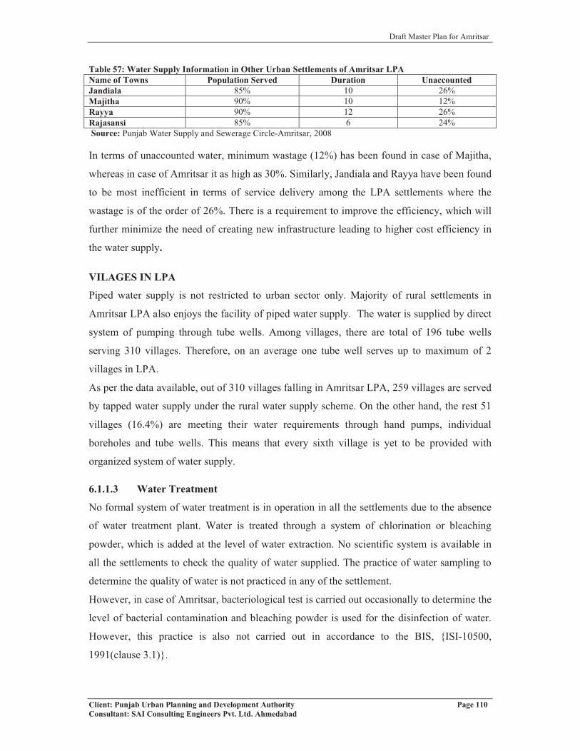
Draft Master Plan for Amritsar
Client: Punjab Urban Planning and Development Authority Page 110Consultant: SAI Consulting Engineers Pvt. Ltd. Ahmedabad
Table 57: Water Supply Information in Other Urban Settlements of Amritsar LPAName of Towns Population Served Duration UnaccountedJandiala 85% 10 26%Majitha 90% 10 12%Rayya 90% 12 26%Rajasansi 85% 6 24%Source: Punjab Water Supply and Sewerage Circle-Amritsar, 2008
In terms of unaccounted water, minimum wastage (12%) has been found in case of Majitha,
whereas in case of Amritsar it as high as 30%. Similarly, Jandiala and Rayya have been found
to be most inefficient in terms of service delivery among the LPA settlements where the
wastage is of the order of 26%. There is a requirement to improve the efficiency, which will
further minimize the need of creating new infrastructure leading to higher cost efficiency in
the water supply.
VILAGES IN LPA
Piped water supply is not restricted to urban sector only. Majority of rural settlements in
Amritsar LPA also enjoys the facility of piped water supply. The water is supplied by direct
system of pumping through tube wells. Among villages, there are total of 196 tube wells
serving 310 villages. Therefore, on an average one tube well serves up to maximum of 2
villages in LPA.
As per the data available, out of 310 villages falling in Amritsar LPA, 259 villages are served
by tapped water supply under the rural water supply scheme. On the other hand, the rest 51
villages (16.4%) are meeting their water requirements through hand pumps, individual
boreholes and tube wells. This means that every sixth village is yet to be provided with
organized system of water supply.
6.1.1.3 Water Treatment
No formal system of water treatment is in operation in all the settlements due to the absence
of water treatment plant. Water is treated through a system of chlorination or bleaching
powder, which is added at the level of water extraction. No scientific system is available in
all the settlements to check the quality of water supplied. The practice of water sampling to
determine the quality of water is not practiced in any of the settlement.
However, in case of Amritsar, bacteriological test is carried out occasionally to determine the
level of bacterial contamination and bleaching powder is used for the disinfection of water.
However, this practice is also not carried out in accordance to the BIS, {ISI-10500,
1991(clause 3.1)}.

Draft Master Plan for Amritsar
Client: Punjab Urban Planning and Development Authority Page 111Consultant: SAI Consulting Engineers Pvt. Ltd. Ahmedabad
6.1.1.4 Distribution System
At present 91% of water supply in the city is made through tube wells under direct supply
system and 9% is through 29 over head reservoirs (OHSR). Out of the total 29 OHSRs, only
19 are operational with total capacity of 17 MLD, whereas rest of 10 OHSRs are not working
due to problems related to leakage, structure, etc. On an average, each over head tank has a
capacity of 9 lakh liters. In the walled city, 4 OHSRs and 8 tube wells are in operation. Rest
of the tube wells and 25 OHSRs serve the population outside the walled city. Table 58: Water Supply Network in Amritsar LPA
Name Total length of Network (kms) No. of OHSR Capacity (MLD)Amritsar (M. C.) 990 29 23.15Jandiala (M. CI) 32 1 0.91Rayya (N. P.) 32.50 2 0.60Majitha (M. Cl.) 26.50 - -Rajasansi (N. P.) 36.50 1 0.23Source: Punjab Water Supply and Sewerage Circle, Amritsar
In case of other settlements falling in LPA, all have a system of OHSR except Majitha where
direct system is available.
The water supply to individual households, commercial establishments and industrial units is
made through water connections. The table below gives details of water connections in
Amritsar MC:Table 59: Year-Wise Trend of Water Connections in Amritsar (MC)
Year No. of Domestic
Connections
%agegrowth
No. of CommercialConnections
%age growth
Total Number of Connections
%age growth
2002 99451 - 11385 - 110836 -2003 104304 4.88 11497 0.98 115801 4.482004 107649 3.21 11571 0.64 119220 2.952005 111497 3.57 11667 0.83 123164 3.31
2006 115063 3.20 11754 0.75 126817 2.972007 118399 2.90 11830 0.65 130229 2.692008 130802 10.48 11950 1.01 142752 9.62
Source: Punjab Water Supply and Sewerage Circle, Amritsar
Due to rapid increase in population, there has been a simultaneous increase in water
connections for domestic use. Because of large number of commercial establishments in
Amritsar, number of connections in commercial categories has also been found to be very
high.
Further, a dual system of water supply is operational in Amritsar MC, which includes both
metered and un-metered water supply with majority of connections falling in the category of
metered connections (90.4%). The unmetered connections are only of the order of 9.6%. In
case of other settlements falling in LPA, the entire water supply is unmetered. In the absence

Draft Master Plan for Amritsar
Client: Punjab Urban Planning and Development Authority Page 112Consultant: SAI Consulting Engineers Pvt. Ltd. Ahmedabad
of metering system, major wastage of water has been observed. Accordingly, in order to
conserve the water and rationalizing the system of water charging, system of water metering
needs to be immediately put in place.Table 60: Number of Metered and Un-Metered Connections in Amritsar LPAName No. of Metered
ConnectionsNo. of Unmetered
ConnectionsTotal
Amritsar (M.C) 129005 13747 142752Jandiala (M. Cl) - 4600 4600Rayya (N. P.) - 2200 2200Majitha (M. Cl) - 2360 2360Rajasansi (N. P.) - 2300 2300Source: Punjab Water Supply and Sewerage Circle, Amritsar
Apart from the water connections, the supply system also includes 747 public stand posts,
which meet the water requirement of 31,622 persons, i.e. 3.5% of the total population of the
Amritsar Municipal Corporation.
6.1.1.5 Ongoing Projects/Proposals
Most of the proposed water supply schemes of corporation through tube wells and over head
supply reservoir (OHSR) fall in the periphery of city. Under JNNURM (Jawaharlal Nehru
National Urban Renewal Mission), most of the water supply projects are coming up in which
28 OHSRs, 20 tubewells and 77 km water supply lines will be laid down at the cost of Rs.
19.02 crores. The project is in advance stage and almost 60% work is completed. (1 OHSR
has capacity of 1 lakh gallons or 3.78 lakh liters).
6.1.1.6 Key Issues
� 20% of the population and area not covered by water supply network in Amritsar.
� Network problems due to obsolescence and aging (30 years).
� High wastage due to water leakage, i.e 43%.
� Fast depletion of ground water table. This can be lessened by drawing more water
from UBDC, which can be supplemented by discharging extra water into UBDC from
Madhopur Headworks.
� Limited water treatment based on chlorination.
� Wastage of water due to unmetered water supply.
� Absence of water treatment plant in Amritsar and urban settlements in LPA.
� Absence of check on quality of water.
� Intermittent water supply leading to higher wastage.
� Low overhead storage capacity.

Draft Master Plan for Amritsar
Client: Punjab Urban Planning and Development Authority Page 113Consultant: SAI Consulting Engineers Pvt. Ltd. Ahmedabad
� Large number of illegal connections.
� Poor maintenance of service network.
� Irrational water charges.
� Lack of use of rainwater harvesting techniques.
� Mixing of supply water with the sewage at several places because of breakages. In
some low lying localities people have illegal openings below meter lines even with
plugs remain opened. During the rainy season and in case of blockage of sewer lines,
sewer water & rain water get mixed in water supply lines. The reason being
inadequate gap between both lines as well as having a regular check up.
� Water released from tanks of Golden Temple and other religious institutions goes
waste, which otherwise can be used for irrigation and so can minimize the
exploitation of ground water.
� The water supply to the villages in Rayya and its surrounding villages is not efficient
enough, and most of the water supplied is through govt. tube wells and individual
hand pumps.
Considering the rapid growth of Amritsar metropolis, it becomes critical that alternative
source of water supply should also be explored, so as to minimize dependence on the ground
water and to minimize the fast depletion of water table. Appropriate strategies and
mechanism needs to be explored, including recycling of the waste water by the industry.
Mechanism of rainwater harvesting should also be encouraged at the
household/institutional/industrial level in order to reduce dependence on the ground water.
6.1.2 SEWERAGE SYSTEM
The disposal of sewage generated by industrial, commercial, domestic and institutions is also
one of the basic function of the local bodies. Providing sewage disposal network is mandated
due to its impact on the quality of life and quality of environment. Accordingly, sewage
disposal has also been considered as one of the critical component of urban infrastructure
determining the quality of life in urban sector. In this context, while preparing the future
planning framework for the city, it is important to examine the issues and status related to
sewerage in Amritsar and the urban settlements located in the LPA.

Draft Master Plan for Amritsar
Client: Punjab Urban Planning and Development Authority Page 114Consultant: SAI Consulting Engineers Pvt. Ltd. Ahmedabad
Fig no.87: View of Blocked Sewer at Mahan Singh Gate
6.1.2.1 Area and Population CoverageTable 61: Sewerage Details of Urban Settlements in Amritsar LPA
Name of Settlement
TotalPopulation(31.03.08)
Average Daily Sewage Flow
(MLD)
%age pop served PopulationServed by
sewerage System
PopulationServed by soakage
pits/septictanks
Amritsar 1159795 192 64.06% 743000 356500Jandiala 28385 - 03.50% 980 27405Majitha 15460 2.10 10.32% 1596 13864Rayya 15002 2.90 85.96% 12897 1502Rajasansi 13930 - 01.79% 250 13680 Source: Punjab Water Supply & Sewerage Circle, Amritsar
AMRITSAR MUNICIPAL CORPORATION
Nearly 70% of the area of Amritsar Municipal Corporation is
covered by sewerage network serving 64% of the city
population (Refer map 11 and table no.61). The remaining 30%
of area and 36% of the population is still devoid of the
provision of formal network. At present, 192 MLD of sewage is
generated on daily basis. The total length of sewerage network in
the city is of the order of 569kms. However, in the absence of
the formal network, the remaining population is dependent on the system of septic tanks/soak
pits and independent institutional set ups. Moreover, the people living in slums and
population below poverty line, who have no access to these facilities, either use the
community toilets created by local bodies or defecate in open fields.
OTHER URBAN SETTLEMENTS OF LPA
Looking at the pattern of sewerage system, it has been found that none of the urban
settlements falling in the Amritsar LPA has total coverage in terms of population and area.
The highest percentage of population covered by sewerage system has been observed in case
of Rayya, where it is of the order of 85.96%, and minimum in case of Rajasansi, where it is
of the order of 1.79%. However, the remaining population devoid of formal sewer facility in
these urban centers is being served by a system of septic tanks or soakage pits. Alternatively,
people defecates in open.
VILAGES OF LPA
Apart from the urban settlements in LPA, the villages falling in LPA also do not have proper
laid out sewerage network. They are dependent on the alternative system of septic
tanks/soakage pits. From the available data, it can be observed that despite the role and
Draft Master Plan for Amritsar
Client: Punjab Urban Planning and Development Authority Page 115Consultant: SAI Consulting Engineers Pvt. Ltd. Ahmedabad
importance of sewerage, provision of these services has been highly deficient calling for
major action by the local bodies in order to improve the status of sullage disposal.
6.1.2.2 Sewer Connections
URBAN SETTLEMENTS IN LPA
The details of the connections available in different settlements as on 31.3.2008 are given
below. With regard to number of sewer connections available in different towns, highest
number of connections have been made available in case of Amritsar, which is of the order of
1,18,005. Table 62: Details of Number of Sewerage ConnectionsName No. of Individual
ConnectionsNo. of Institutional
ConnectionsTotal Connections
Amritsar (MC) 1,18,000 5 1,18,005Jandiala (M Cl) - 2 2Rayya (N. P.) 2300 1 2301Majitha (M Cl) 191 3 194Rajasansi (N. P.) - 2 2Source: Punjab Water Supply & Sewerage Circle, Amritsar
Amritsar M.C.
With increase in population, number of sewer connections in the Amritsar has also shown an
increasing trend. Total number of connections have increased from 80945 in the year 2000-
2001 to 118000 in 2007-08, recording 40% growth in the last 8 years. The figure below
details the year wise growth of number of sewer connections. Fig no. 88: Year-Wise Number of Sewer Connections in Amritsar (MC)
Source: Amritsar Municipal Corporation, Amritsar
6.1.2.3 Sewerage Treatment and Disposal
Sewerage Treatment
The total quantity of daily sewage generated in the Amritsar city is of the order of 192 MLD,
whereas in the case of Rayya it is 2.90 MLD. The quantum of sullage generated in Majitha is

Draft Master Plan for Amritsar
Client: Punjab Urban Planning and Development Authority Page 116Consultant: SAI Consulting Engineers Pvt. Ltd. Ahmedabad
Fig no.89: Disposal Work, Fatehpur
Fig no.90: View of Ganda Nallah used for Disposal
2.10 MLD, whereas in case of Jandiala Guru and Rajasansi, there is no sullage collected due
to absence of sewerage system. Unfortunately, none of the urban settlements including
Amritsar, has a system of sullage treatment, hence untreated sullage is pumped into the
nearby drains or water bodies.
Seweage Disposal
In case of Amritsar, the entire city is divided into three
catchment zones for collecting the sullage. It includes
North Zone, South Zone and West Zone (Chheharta). The
North Zone includes the portion of the city falling on the
North of the Amritsar-Jalandhar Railway Line. The
sullage of this area is collected at Mahlan, from where it is
pumped for disposal. About 1/3rd (32%) of the sullage is collected at this station. The South
Zone includes most of the area falling on the southern side of the railway line. The sullage
collected in this zone is collected at the pumping station located at Fatehpur, from where it is
pumped into the Gandha Nallah. This zone generates the largest sullage, which is of the order
of 63%. The remaining 5% of the sullage is generated in Chheharta, which is the west zone of
the city. The sullage generated in this area is collected at the pumping station located at
Gumanpura, from where it is pumped into the Ganda Nallah.
In all, there are 20 pumping stations in Amritsar serving the
system of disposal. 11 of these stations have been designated
as Temporary Sewage Disposal Sites by the Municipal
Corporation Amritsar, which pumps sewage directly into the
nearby water course/storm water drainage or nallahs. Ganda
Nallah, Hudiara Drain and Tung Dhab Drain, which
ultimately meets the Hudiara Drain, are the three major drains
where the city’s sullage is disposed off. Remaining 9 pumping stations pump sewage into
other manholes. These pumping stations were primarily constructed during the last 15 years
in order to overcome the problem of sewage outflow. All these pumping stations are
manually operated working on three shifts a day.
All other settlements falling in LPA follow the system of pumping the untreated sullage into
the nearby water bodies/drains. In the absence of sewerage treatment plant in the Amritsar
city, all the sewage collected i.e. domestic and industrial, is being disposed off into the
Gandha Nallah without any treatment, which has caused high degree of soil and ground water

Draft Master Plan for Amritsar
Client: Punjab Urban Planning and Development Authority Page 117Consultant: SAI Consulting Engineers Pvt. Ltd. Ahmedabad
pollution in the city. In addition, large number of industrial units operating within and outside
walled city also discharge their effluents directly into the network without making any initial
treatment. All industries are required to treat their effluents to neutralize the chemicals before
discharging into the network. Presence of chemicals and toxins not only damages the network
but also creates numerous problems in treatment of sullage. All these industrial units need to
be brought under stringent controls as far as the discharge of their sullage/effluent into the
network is concerned.
Accordingly, it is important that sewerage treatment plants are installed on priority to treat
the sullage generated in order to minimize the pollution. However, three sewerage treatment
plants are proposed to be installed in Amritsar with a total capacity of 200 MLD. With the
construction and operationalisation of these plants, Amritsar will become one of the few
towns of the state having capacity of treating majority of the sullage generated. The total
installed capacity of these 3 plants is equal to the average daily sewerage flow. Therefore, in
order to serve the future population, the need will be to enhance the installed capacity or
setting up of new treatment plants.
6.1.2.4 Ongoing Projects/ Proposals
As already stated, in order to treat the sullage water generated in the case of Amritsar, it is
proposed to set up 3 Sewerage Treatment Plants under Sri Guru Ram Das Development
project for Sewerage Treatment Plants by JICA (Japan International Cooperation Agency).
Three sewerage treatment plants proposed will have a total installed capacity of 200 MLD.
These treatment plants are to be located at Mahal with a capacity of 80 MLD, Fatehpur with
95 MLD and Chheharta with 25 MLD. The plants are yet to start and are in the process of
finalization. The proposed sewerage project including its extension/upgradation & treatment
shall cost Rs. 360 crores and would be taken up jointly in collaboration with JBIC.
There is also a proposal for provision of sewerage network and sewerage treatment plant in
Majitha by the Punjab Water Supply and Sewerage Circle, Amritsar. The detailed report for
the project has been prepared and tenders for the projects are invited. Moreover, a project on
augmentation and replacement of sewerage in the Walled City is also approved under
JNNURM. A sum of Rs. 36.90 crores has already been approved for it.
6.1.2.5 Key Issues
Major issues involving Sewerage System in Amritsar and LPA are detailed below:
� 30% of the city area and 36% of the city population is uncovered.
� Partial coverage of population in Rayya & Majitha.

Draft Master Plan for Amritsar
Client: Punjab Urban Planning and Development Authority Page 118Consultant: SAI Consulting Engineers Pvt. Ltd. Ahmedabad
Fig no. 91: Water Logging outside Bus Stand
� Absence of sewerage system in Rajasansi & Jandiala.
� Absence of Sewerage Treatment Plant in Amritsar and in urban settlements of LPA.
� Use of drains/water bodies for disposal of untreated sullage.
� Absence of recycling and reuse of waste water techniques.
� Inadequate capacity of the existing network leading to overflow of sullage.
� Large scale usage of soak pits, septic tanks and open drains for sullage disposal.
� High degree of soil and water pollution of the Ganda Nallah, Tung Dhab Drain and
Hudiara Drain used for sewerage disposal. The practice of disposing untreated sewage
into these should be immediately stopped.
� Disposal of untreated industrial waste.
� Poor maintenance and upkeep of existing network, especially in the Walled City.
� Low efficiency of network in congested areas.
� The Rayya and its surrounding villages too lack in well developed sewerage network.
6.1.3 STORM WATER DRAINAGE NETWORK
With the creation of large area of hard surface by bringing agricultural land into urbanization,
large volume of storm water drainage is generated in urban areas. Draining the rain water
assumes importance because of the numerous problems created due to inefficient disposal of
storm water. Due to inefficient or non-existence of storm water drainage network, most of the
city now face a problem of water logging and flooding causing heavy loss to property and
human lives.
6.1.3.1 Area and Population Coverage
The city of Amritsar has high degree of deficiency in the
storm water network. Considering the existing status of storm
water network, it appears that this critical network has low
priority on the agenda of Municipal Corporation. At present
only 20% of the city area and population is covered under the
storm water network. This means that remaining 80% of the
city and population remains outside the purview of the storm
water network. The walled city, Amritsar has system of open drains while for the areas
outside it, the disposal of storm water is combined with sewerage network leading to choking
of the pipes, overflow of the sullage and backflow of the sewerage water. Storm water also
gets into low lying areas flooding them in the process. The problem of acute water logging

Draft Master Plan for Amritsar
Client: Punjab Urban Planning and Development Authority Page 119Consultant: SAI Consulting Engineers Pvt. Ltd. Ahmedabad
during heavy rains has been experienced in the entire city of Amritsar. This is mainly due to
the trough or saucer shape of the city, which requires adoption of specialized approach to
drain off the rainwater due to its typical topography. The network available is hardly 10 Kms
in length, which is highly inadequate considering the size of city. The details of population
and area coverage in Amritsar are given in table below:Table 63: Length of Drainage Network in Amritsar Municipal Corporation AreaItem Length (km) Area under
Coverage (%)Population under
Coverage (%)Storm Water Line 10 20% 20%Source: Municipal Corporation Amritsar, 2006-07.
6.1.3.2 Drainage Network
Amritsar M. C.
Amritsar has the advantage of having a network of both natural and manmade open
drains/nallahs, which have a general slope of East to West. The gradient of these drains is
shallow due to its flat topography. There are two major nallahs serving the city, namely
Ganda Nallah, located on the south of the city, whereas Tung Dhab is located on the northern
side of the city. Both these nallahs ultimately discharge into the Hudiara Drain, which is
located west to the city. Further, Hudiara Drain joins the river Ravi over the international
border with Pakistan and accordingly, storm water is released into the river Ravi. Thus,
Hudiara Drain remains most critical for discharging the storm water as well as sewage.
Despite the fact that there is a network of drains and nallahs available in Amritsar, most of
them are unfortunately used for carrying the untreated sullage and domestic refuse. Since the
area close to these nallahs/drains has been urbanized by mushrooming of residential colonies
including slums, most of the household waste and sullage is dumped into these nallahs/drains.
In the absence of any sewerage treatment plant in the Amritsar urban area, 20 temporary and
permanent pumping stations discharge the untreated sullage into these drains. This practice
has led to not only high degree of health hazard to the adjoining communities, but has
emerged as the major threat to environment and quality of life. These nallahs have become a
major eyesore and has led to high degree of pollution of ground water resource making it
unfit at most of the places for human consumption.
In view of the existing scenario, it becomes critical that practice of discharging untreated
sullage into the drains/nallahs should be immediately stopped and these drains/nallahs are
restored to their lost glory. The precious storm water should be harvested to be used as
alternative source of water supply reducing pressure on the vital ground water resources. The
institutions having large area like Guru Nanak Dev University, Khalsa College, Verka Milk

Draft Master Plan for Amritsar
Client: Punjab Urban Planning and Development Authority Page 120Consultant: SAI Consulting Engineers Pvt. Ltd. Ahmedabad
Plant, Grain Market and Defence area, which have large open land available with them
should be involved in the system of rain water harvesting. In addition, building byelaws of
the Municipal Corporation, Amritsar Development Authority and Improvement Trust, should
include rainwater harvesting as integral part of development of buildings and it should be
enforced strictly. Further individual households, industries and Development Authorities
should be actively involved in the rain water harvesting, so as to reduce/minimize the amount
of rain water generated, which require disposal and which can be used for different activities
reducing the quantum of water supply required to serve the city. The percolation wells for
rainwater harvesting could be considered along with the option of open trenches for
improving rainwater harvesting. In addition, existing drainage network should be preserved
as an integral part of development process by declaring them as protected areas. This would
help in preserving these natural resources besides helping in better management of storm
water drainage.
Other Urban Settlements in LPA
In all the other four urban settlements falling in LPA, none of them has storm water drainage
network. The towns like Rajasansi and Jandiala have absolutely no storm water drainage
network compared to Majitha, which has total of 27 kms of storm water drains. The length of
the major drains in Majitha is 2 kms, whereas that of minor drains is 25 kms. The town has
open drains, which are connected to nearby nallah for disposal. The underground sewerage
also exists in very small portion of the Majitha town. In case of Rajasansi, the laying of pucca
open drains is in progress.
Despite the fact that city is facing acute problem of flooding and water logging, still there is
no proposal for creating/augmenting storm water drainage network to solve the existing
problem of the city. In this context, it will be important to consider the option of making all
new development coming up within the urban settlements to provide for storm water drainage
network as integral part of urban development process. In addition, all Development
Authorities should be mandated to provide storm water drainage network in the area
undertaken by them as development projects. The rainwater harvesting at the
community/local level or at the scheme level should also be included for conserving water
and reducing the outflow of storm water. In the old areas, it will be appropriate to consider
levy of a cess on water/sewerage bills, so as to generate resources for improving the area and
population coverage under the drainage network. Efficient drainage of storm water would

Draft Master Plan for Amritsar
Client: Punjab Urban Planning and Development Authority Page 121Consultant: SAI Consulting Engineers Pvt. Ltd. Ahmedabad
also require the designing of road network in a manner that for shorter distances, roads should
act as drains and the slope provided should be able to drain off the water quickly.
6.1.3.3 Projects-Ongoing/Proposals
There is an ongoing project of laying of pucca and open storm water drains in the town of
Rajasansi. 50% of the work has already been completed. The covering and desilting of Ganda
Nallah from Bhadarkali Temple to Lahori Gate, and Annagarh to Bhagtanwala is also under
progress.
6.1.3.4 Key Issues
Looking at the existing status of storm water drainage, following major issues emerge;
� 80% of city area and population is devoid of storm water drainage facility.
� None of the urban settlements in Amritsar LPA has storm water drainage network.
� Acute water logging problems during heavy rainfall observed in majority areas of city
resulting to pot holes on many of the city roads and ultimately reducing their life.
� Lack of any proposal for augmentation or creation of storm water drainage network in
the city.
� Lack of new techniques, such as rainwater harvesting, which can help in conserving
the water. Hence, the outflow of storm water reduces.
� Disposal of domestic refuse and untreated sullage in the storm water drains has led to
high degree of health hazard, emerging as major threat to environment and quality of
life.
� Use of storm water drains/nallahs for disposal of sewerage.
� Encroachment of area around these drains reducing their capacity.
� Low gradient of drains/nallahs.
� Low capacity of the existing network.
� Lack of disiltation at proper interval of time.
� Theere is absence of drainage netwok in Rayya and its surrounding villages.
6.1.4 SOLID WASTE MANAGEMENT
Solid waste management is the prime responsibility of the Municipal Corporation Amritsar
involving collection, storage, segregation, transportation and disposal. Health Officer of the
Corporation has been vested with the overall responsibility for management of the solid
waste. He is assisted by Assistant Medical Officer of Health and other support staff.
Corporation organizes the collection and transportation of the solid waste through its own

Draft Master Plan for Amritsar
Client: Punjab Urban Planning and Development Authority Page 122Consultant: SAI Consulting Engineers Pvt. Ltd. Ahmedabad
conservancy workers and a fleet of vehicles deployed. In Amritsar urban limits, house to
house collection of the solid waste is carried out through a number of sanitary workers
deployed by the Municipal Corporation, payment of which is made on shared basis by
Corporation and Mohalla Sudhar Committee, which are constituted at Mohalla level and
support the system through household contributions. In all, there are more than 2406 sanitary
workers deployed, which include 1443 by the Corporation and 963 through Mohalla Sudhar
Committees. In addition, there are 51 drivers and 24 Sanitary Inspectors, besides 20 Sanitary
Jamadaars (Head of Sanitary workers), 7 Naib Darogas (Supervisors looking over the work
of Jamadaars and sanitary workers) and 4 Chief Sanitary Inspectors.
6.1.4.1 Generation
The total generation of solid waste in the city of Amritsar is estimated to be 600 tons per day
(TPD). This large amount of solid waste generated is disposed off on the landfill site located
outside Bhagtanwala. Seeing the large amount of generation of solid waste in the city,
Municipal Corporation of Amritsar has undertaken the project of Integrated Solid Waste
Management Project under JNNURM to scientifically dispose off the solid waste. This MSW
project is divided into two phases. The first phase of the project includes collection,
segregation, storage and transportation of the municipal solid waste, which has been accorded
to M/S Antony Waste Handling Cell, and the second phase of the project includes processing
and disposal of solid waste, which has been allotted to M/S AKC Developer Limited, Noida.
The first phase has been in operation since Feb ’09. The table below describes the generation
of solid waste in Amritsar LPA:Table 64: Generation of MSW in Amritsar LPA
Name Generation (TPD) Collection Area of existing Landfill Site (as on 31.12.05) Hectares
Amritsar (M. C.) 600 600 8.10Jandiala (M. Cl.) 2.25 2.25 3.00Rayya (N. P.) 3.00 3.00 1.40Majitha (M. Cl.) 4.00 4.00 0.60Rajasansi (N. P.) 2.00 2.00 1.50
Source: Municipal Corporation- Amritsar, Municipal Council Rajasansi, Draft Interim Report on Solid Waste Management at Majitha (Punjab)
It has been observed that there has been 100% collection of waste generated in all the towns
of LPA. Majitha has the largest amount of solid waste generated among the other four urban
settlements falling in Amritsar LPA but the least area under existing landfill site.

Draft Master Plan for Amritsar
Client: Punjab Urban Planning and Development Authority Page 123Consultant: SAI Consulting Engineers Pvt. Ltd. Ahmedabad
Fig no.94: Dumping of Garbage in open drain passing through Bangla
Basti
Fig no. 93: Garbage dumping along roadside
6.1.4.2 Composition
Solid waste comprises of waste generated from different sources. Major sources of generation
are individuals, households, industries, trade and commerce, hotels and restaurants,
healthcare institutions including dispensaries and hospitals, animals and floating populations
in terms of tourists, hawkers, etc. Solid waste generated can be broadly classified into four
categories i.e Organic Waste, which includes kitchen waste (food items), leaves, remains of
animals slaughtered, etc., Recyclable Waste, which includes paper, plastic, glass, metal,
rags, packing materials, twigs, bark, etc., Inert Waste including bricks, cement, building
debris, furniture waste, etc. and Industrial Waste, which includes the byproducts. In
addition, large amount of waste is also generated by number of hospitals, dispensaries and
other health care institutions, which are operational in the city. The current addition is E-
Waste generated from electronic products whose quantity is alarmingly increasing in the city.
In terms of waste generated, organic waste comprises of
more than half of the total waste whereas inert waste is
more than 1/4 of the total waste generated. Industrial waste
as well as recyclable waste comprises of approx 1/10th each
of waste generated. There is no segregation of waste at the
point of generation.
6.1.4.3 Collection, Storage and Transportation
COLLECTION & STORAGE
The present system of waste collection, storage and
transportation in the Amritsar Municipal Corporation
(MCA) is of primitive age old type. They are not in
compliance with MSW Rules 2000. The daily collection of
solid waste in the city is reported to be 100 percent, which is
not the case. Different methods of collection of solid waste
are practiced in the city. At the household level, Door to
Door collection of waste is practiced. Since household
waste has high contents of organic waste, no system of
segregation is used at the generation level. In the process,
the quality of recyclable material gets distorted due to
mixing of the dry and wet waste.
Fig no.92: Composition of Municipal Solid Waste
Draft Master Plan for Amritsar
Client: Punjab Urban Planning and Development Authority Page 124Consultant: SAI Consulting Engineers Pvt. Ltd. Ahmedabad
No house to house collection of solid waste was done in the LIG areas and in slum areas of
the city, such as Sultanwind and Fatehpur. In such areas, the solid waste is dumped mostly in
the available open lands, vacant plots and nearby low lying areas/water bodies. In addition,
people living in such areas also make use of community bins provided by the Corporation.
But launching of the MSW project in the city has ensured collection of waste from at least the
collection points.
For the house to house collection of waste, 500 waste collection trolleys, 120 rickshaw rehris
and tricycles having back space as storage bins are operational in Amritsar. The areas where
house to house collection system is not provided, community bins are strategically provided
by the corporation for their direct use by the surrounding inhabitants. The Corporation has
deployed about 125 metallic bins of 4.5 cu. m. and 10 bins of 10 cu. m. capacities for
community storage by the households and the sanitary workers. However, numbers of bins
provided by the Corporation are inadequate to take care of the waste generated and
accordingly, at many places open spaces and roadsides have emerged as the preferred
dumping sites.
In all the other four urban settlements, each ward has been considered as a zone for collection
of solid waste. The house to house or door to door collection of waste is done by the safai
sewaks (sanitary workers) in all the wards using hand carts or push carts or tricycles. The
collected waste is taken in a wheel barrow or in polythene bag and dumped on the designated
points, called as waste collection points or bins, which act as waste storage points from where
they are transported for final disposal to the landfill site.
SEGREGATION
Most of the city inhabitants carry out segregation at the household level by salvaging
resaleable material from waste such as newspaper, glass bottles, empty tins, plastic bags, old
cloths, etc. and sell it directly to Kabaris. In addition, rag pickers also take rounds of the
street and visit the collection centers for salvaging the recyclable waste for selling and
income generation. As such, segregation of organic and inorganic waste at the source or
generation point is not practiced.
TRANSPORTATION
For the transportation of the solid waste from the collection centre to the disposal site,
Amritsar M.C. has deployed number of vehicles including 76 tractor trolleys, 7 mini trucks
with a capacity of 4-5 tons and 3 large size trucks having a capacity of 10 tons (Refer table

Draft Master Plan for Amritsar
Client: Punjab Urban Planning and Development Authority Page 125Consultant: SAI Consulting Engineers Pvt. Ltd. Ahmedabad
Fig no.96: Open Dumping Ground at Fatehpur
no.65). These vehicles are used for primary collection of
waste from the community bins and its transportation to
designated landfill site. 7 front end loaders are also
operational in the city for loading waste into trailers by
lifting storage bins and emptying them into the tractor
trailers before transportation. The present collection
infrastructure and manpower available with MCA is
observed to be inadequate as per the requirement. Hence,
effective implementation of the Integrated Solid Waste Management Project for the city is
required to be done at the earliest, which has just begun.Table 65: Solid Waste Collection & Transport Infrastructure in Amritsar LPA
Name of the Settlement
Primary Collection TransportationGarbage Waste
CollectionPoints
Rickshaws
Trucks OpenBins
Trucks
Tractor + Trolleys
Dumper-Placer
WheelBarrows
Loaders
Amritsar (M.C.) - - - 11 15 76 8 - 7Jandiala (M. Cl.) 20 20 - - - - 1 25 -Rayya (N.P.) 13 - 20 - - 2 - 15 -Majitha (M. Cl.) 35 20 10 - - 2+2 - 26Rajasansi (N.P.) - - - - - 1+1 1 13 -Source: Municipal Corporation- Amritsar, Municipal Council Rajasansi, Draft Interim Report on Solid Waste Management at Majitha (Punjab)
6.1.4.4 Disposal
Amritsar Municipal Corporation practices open disposal of
waste without undertaking any pre-treatment of the waste.
MCA has identified three landfill sites for open disposal of
waste located outside Bhagtanwala Gate, village Fatehpur and
village Bharariwal. At present, waste is dumped at the
Bhagtanwala Gate site with occasional odour control
treatment. The site has been in operation from last 25 years and
can be used for another 15 years. The other two sites located at Fatehpur (5.8 Hectares) and
Bharariwal (2.65 Hectares) are new sites for which land has been recently acquired by the
MCA. In an effort to provide clean living environment to the nearby residents, the existing
site needs to be improvised as per the MSW Rules 2000 and as suggested in the “Integrated
Solid Waste Management Project-Amritsar”. Since the existing grain market is situated 100
mts from the dumping site, which is against the MSW Rules 2000, a buffer zone should be
provided. Details of the land fill sites for disposal of solid waste are given in table
below:
Fig no.95: Existing transportation vehicles in use in the city
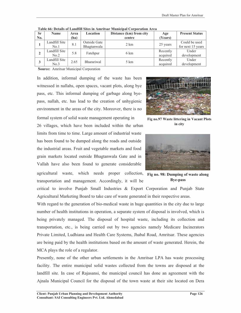
Draft Master Plan for Amritsar
Client: Punjab Urban Planning and Development Authority Page 126Consultant: SAI Consulting Engineers Pvt. Ltd. Ahmedabad
Fig no.97 Waste littering in Vacant Plots in city
Fig no. 98: Dumping of waste along Bye-pass
Table 66: Details of Landfill Sites in Amritsar Municipal Corporation AreaSrNo.
Name Area(ha)
Location Distance (km) from city centre
Age(Years)
Present Status
1 Landfill Site No.1 8.1 Outside Gate
Bhagtanwala 2 km 25 years Could be used for next 15 years
2 Landfill Site No.2 5.8 Fatehpur 6 km Recently
acquiredUnder
development
3 Landfill Site No.3 2.65 Bharariwal 5 km Recently
acquiredUnder
developmentSource: Amritsar Municipal Corporation
In addition, informal dumping of the waste has been
witnessed in nallahs, open spaces, vacant plots, along bye
pass, etc. This informal dumping of garbage along bye-
pass, nallah, etc. has lead to the creation of unhygienic
environment in the areas of the city. Moreover, there is no
formal system of solid waste management operating in
26 villages, which have been included within the urban
limits from time to time. Large amount of industrial waste
has been found to be dumped along the roads and outside
the industrial areas. Fruit and vegetable markets and food
grain markets located outside Bhagtanwala Gate and in
Vallah have also been found to generate considerable
agricultural waste, which needs proper collection,
transportation and management. Accordingly, it will be
critical to involve Punjab Small Industries & Export Corporation and Punjab State
Agricultural Marketing Board to take care of waste generated in their respective areas.
With regard to the generation of bio-medical waste in huge quantities in the city due to large
number of health institutions in operation, a separate system of disposal is involved, which is
being privately managed. The disposal of hospital waste, including its collection and
transportation, etc., is being carried out by two agencies namely Medicare Incinerators
Private Limited, Ludhiana and Health Care Systems, Jhabal Road, Amritsar. These agencies
are being paid by the health institutions based on the amount of waste generated. Herein, the
MCA plays the role of a regulator.
Presently, none of the other urban settlements in the Amritsar LPA has waste processing
facility. The entire municipal solid wastes collected from the towns are disposed at the
landfill site. In case of Rajasansi, the municipal council has done an agreement with the
Ajnala Municipal Council for the disposal of the town waste at their site located on Dera

Draft Master Plan for Amritsar
Client: Punjab Urban Planning and Development Authority Page 127Consultant: SAI Consulting Engineers Pvt. Ltd. Ahmedabad
Baba Nanak Road at an annual cost of Rs. 20,000. This has been done because of the
guidelines of the Airport Authority of India as per which there should not be any waste
disposal site in 10 kms radius of the Rajasansi Airport.
In order to effectively manage the solid waste, it will be important to involve all the
stakeholders and creating awareness among the masses to manage the waste and keep the city
clean. The best approach will be to ask people to generate as little waste as possible and to
segregate the waste at the household level itself. Critical points generating large volume of
waste should be identified and a separate strategy for collection and disposal of waste should
be formulated in consultation with the local community. Industrial Associations should also
be made partner in disposal and management of industrial waste. Further there should be
strategies to deal with generation of E-waste in the city with the coming up of IT/ITES parks
as envisioned.
6.1.4.5 Ongoing Projects/Proposal
In an effort to make Amritsar Metropolis a beautiful, clean and healthy city, Amritsar
Municipal Corporation has undertaken the project of “Integrated Solid Waste Management”
on PPP mode. The project is being divided into two phases, phase I comprising of collection,
segregation, storage and transportation which has been accorded to M/S Antony Waste
Handling Company, Mumbai, and phase II comprising of the processing and disposal has
been awarded to M/S AKC Developer, Noida. The phase I has already began operations in
Feb’2009, while phase II is yet to start.
6.1.4.6 Key Issues
Despite the fact that Municipal Corporation deploys the largest manpower and resources for
the solid waste management, heaps of stinking waste can be seen all over the city. Not only
households and individuals contribute to the present scenario, but manpower deployed has
also been a major contributor in making the city unhygienic. The removal of garbage is
carried out in arbitrary manner and cleaning of roads is done in most unprofessional manner.
Solid waste management has emerged as the most challenging task for all local bodies. Keys
issues involved in solid waste management in Amritsar Corporation area are:
� Absence of public participation and lack of public awareness.
� Absence of scientific collection and disposal.
� Absence of solid waste treatment plant in the city.

Draft Master Plan for Amritsar
Client: Punjab Urban Planning and Development Authority Page 128Consultant: SAI Consulting Engineers Pvt. Ltd. Ahmedabad
� Untrained and unqualified man power deployed in the process of solid waste
management.
� Absence of segregation of waste at the generation level. This is preventing the use of
degradable waste as manure.
� Inadequate and out dated collection and storage infrastructure in use by MCA.
� Unhygienic condition of dumping sites and absence of scientific system of landfill
management.
� Open dumping along roadsides, railway lines, vacant plots, drains/nallahs, mandis,
etc. The dumping of agricultural waste outside Bhagtanwala Gate is creating a lot of
menace.
� Absence of involvement of rag pickers in recovery of valuable recyclable waste.
� Absence of involvement of institutions involved in generation of large quantity of
waste.
� Mixing of industrial and toxic waste with the domestic waste.
� No proper system to collect and treat medical waste of the hospitals and nursing
homes.
� Lower level of collection of solid waste generated on daily basis.
� Absence of mechanisms for converting waste into wealth.
� Lack of MSW management compliances as per the MSW Rules 2000.
� Rayya and its surrounding villages are devoid of proper solid waste management
system and the waste is disposed off near the phirnis of villages
6.1.5 ELECTRICITY
6.1.5.1 Area and Population Coverage
The whole of the city of Amritsar is covered by electric supply. The Bhakra Nangal Dam,
Ranjit Sagar & Shanan Power Extension are the three important sources of power supply to
the city. The gap for electric demand and supply in the city of Amritsar is of the order of 34%
approximately, as the total electricity demand for the city is 6700 MKWH against which the
supply of 4400 MKWH is made. Looking at the consumption pattern, city has observed an
increasing trend at the rate of 4.3% every two years. (From 3733.65 MKWH in 2001 to
3896.78 MKWH in 2003 and 4072 in 2005).

Draft Master Plan for Amritsar
Client: Punjab Urban Planning and Development Authority Page 129Consultant: SAI Consulting Engineers Pvt. Ltd. Ahmedabad
6.1.5.2 Distribution Network
The electric supply to the city of Amritsar is made through two 220 KV power stations
located at Loharka and Khasa, which are now part of Amritsar city. Further, electric supply to
different parts of the city is made through nine 132 KV sub stations, which are located in the
four divisions namely Civil Line Division, which covers north-western parts, Hakima Gate
Division that covers southern-western parts, Industrial Division, which covers south-eastern
parts and City Central Division that covers central parts of the city. There are about 12
complaint centres in the city, which are strategically located to cover whole of the city. Each
zone has 3 complaint centres for the residents. The table below gives details of electric sub
stations along with their capacity and location both in the Amritsar M.C. area and Amritsar
LPA.Table 67: Electric Supply in Amritsar M.C and Amritsar LPA
Category Capacity Number LocationAmritsar M.C.
Power House/ Sub Station
220 KV 2 Civil Lines-Loharka, khasa
132 KV 9 Hakima Gate, Sakatri Bagh, GT Road, Mall Mandi, Verka, Power Colony, Naraingarh, Hall Gate, G.T. Road
66 KV 6 Hall gate, Golden Temple, Gawal Mandi, Hukam Singh Road-opp Dental College, Ranjit Avenue, OCM Mills
11 KV 106 Spread across the city (Refer map)
Complaint Centre 12
Hakima Gate, Golden Temple, Bazar Mai Sewan, Beri Gate, Ghee Mandi Gate, Hussainpura Chowk, Civil Lines, Rambagh Garden on M M Malviya Road, Tunda Talab, Hall Gate, Islamabad, Chatiwind Gate
Amritsar Local Planning Area
Power House/ Sub Station
132 KV 3 Jandiala, Tangra, Kathu Nangal
66 KV 14Dhadde, Rajasansi, Rajatal, Majitha, H. Chhina, Chogawan, Attari, Sangna, Chabba, Bundala, Nawan Pind, Manawala, Warpal, Mudohal
Source: Punjab State Electricity Board, Amritsar
In case of Amritsar LPA, it has been observed that the supply is also made through the three
132 KV sub stations, which are located at Jandiala, Tangra and Kathu Nangal while supply
within the villages is made through 66 KV sub stations which are spread across the LPA.
(Refer map 12)Table 68: Electric Connections in Amritsar M.C and Urban Settlements in LPA
Domestic Commercial Industrial Roads Others TotalAmritsar M.C. 172096 10777 52111 21430 221 256635Jandiala M.Cl. 3780 126 650 440 0 4996
Rayya N.P. 1330 125 812 121 0 2388Majitha M.Cl. 1760 14 558 16 150 2498Rajasansi N.P. 2428 28 608 0 0 3064
Source: Census of India, 2001

Draft Master Plan for Amritsar
Client: Punjab Urban Planning and Development Authority Page 130Consultant: SAI Consulting Engineers Pvt. Ltd. Ahmedabad
The table above gives details of number of electric connections in Amritsar M.C. and in
urban settlements of Amritsar LPA. Amritsar M.C has maximum number of electric
connections (256635), which are majorly domestic (172096) followed by industries (52111).
Among the urban settlements in Amritsar LPA, Jandiala has maximum domestic (3780) and
industrial connections (650) followed by Rajasansi. The lowest number of connections is
with Rayya.
6.1.5.3 Street Light
The provision of streetlight in the city of Amritsar falls within the purview of M.C. Amritsar.
The provision in the city is made based on the budget expenditures on street lights in a
particular year. 85% of the core city area is covered by street lights, while the remaining 15%
area still requires wiring and new fittings. In case of the area outside the walled city and civil
lines, only 50% of the area is served by street lights. Apart from this, there are abadi areas
outside the Amritsar M. C. such as Verka, Sultanwind, Chheharta, Dhapai, Naraingarh, Guru
Arjan Dev Nagar, village Bharariwal and village Mahal that requires provision of streetlights.
In case of villages in LPA, it has been observed that although all the villages have been
electrified but the street light facility exists in few of the villages only.
6.1.5.4 Ongoing Projects/Proposal
� Amritsar M.C. has proposed to cover certain areas within the city with the streetlights
which includes:
1. Sultanwind Road to UBDC
2. G. T. Road Jalandhar (Taranwala Bridge) to Amritsar M.C. Limit.
3. At central verge on Batala Road
� To upgrade the existing street light facilities and to ensure their better functioning,
MCA has proposed to replace the old wiring with new ones, which is of the order of
250 km of wires and requires placing of 3000 street light fittings and 500 electricity
poles with new electric connections.
� For better provisioning of street lights in the city, newly developed markets need to
have proper street light facility and as per the requirement decorative street lights is
also proposed to be placed in parks or wherever required.
� Shifting of high tension electric poles and transformers from the major approach roads
to Golden Temple and making them underground.

Draft Master Plan for Amritsar
Client: Punjab Urban Planning and Development Authority Page 131Consultant: SAI Consulting Engineers Pvt. Ltd. Ahmedabad
6.1.5.5 Key Issues
� 50% of outer part of walled city and civil lines is unserved with street light.
� Percentage of connection and consumption is rapidly increasing.
� Large number of illegal electricity connections in the city.
� Poor Maintenance of street lights.
� Most of the rural settlements lack street lights.
� Time duration for electricity supply is less, especially in rural areas of LPA.
� Irregular power supply is destroying the industries of the region, and promoting more
and more use of diesel through generators, including Rayya and its nearby villages.
� Limited use of renewable sources of energy, like Solar Power, for power generation.
� The crisscross of overhanging surface wires within the Walled City is destroying the
architectural beauty of the old buildings. It should be made underground.
6.2 SOCIAL INFRASTRUCTURE
Social infrastructure refers to the facilities and the process involved, which ensures education,
better health facilities and community development in any town. The Social Infrastructure
includes the education system, health care, social and cultural facilities, parks and open
spaces, etc. The different components of social infrastructure will help to know how well a
city or town is equipped with facilities. The provision of education, health, etc. defines the
quality of life. As the city expands and population increases, the gap between demand and
supply of these essential services increases, which deteriorates the quality of life in urban
areas.
Public Semi Public: Social infrastructure falls under the Public-Semi Public land use
classification as these areas are for common use of public and are easily accessible by all
strata of the society. Hence, education, health, recreational area, socio cultural areas, post
offices, cremation and burial grounds and religious sites together form part of social
infrastructure, which falls under the category of Public-Semi Public. (Refer map 13).
6.2.1 EDUCATION
Educational facilities define the level of development of a city. They are criticial for growth
of any settlement in terms of literacy rate, skill upgradation and improving quality of human
lives. Higher level of education facilities have been considered vital for economic growth and
development of any community or nation, besides improving the quality of life of human
beings. Education is found to be a major determinant and promoter of growth and

Draft Master Plan for Amritsar
Client: Punjab Urban Planning and Development Authority Page 132Consultant: SAI Consulting Engineers Pvt. Ltd. Ahmedabad
development of any settlement and nation. Accordingly, providing appropriate level of
education facilities is extremely important.
6.2.1.1 Institutional Network
The city of Amritsar has a well developed institutional network with one university namely
Guru Nanak Dev University, 10 colleges, 2 medical and dental colleges, 9 nursing institutes
and 4 engineering colleges, 2 B. Ed. colleges and 2 polytechnics. Apart from higher level
institutions, it is well equipped with 258 primary schools, 36 middle schools, 41 secondary
and 62 senior secondary schools. It strengthens the fact that Amritsar has developed its
importance as an educational centre in the region (Refer table no.69).Table 69: Level of Education Facilities in Amritsar LPA – Schools, etc
S.No. Name Primary
SchoolsMiddleSchools
Secondary Schools
SeniorSecondary Schools
Anganwari
Industrial School
Training
Schools
AdultLiterac
y Center
1 Amritsar 258 36 41 62 191 - - 462 Majitha 1 4 4 2 - - - -3 Rajasansi 1 3 2 2 - - - -4 Rayya 4 5 4 4 - - - -5 Jandiala 5 10 11 2 - - - -
6 Villagesin LPA 357 58 73 23 - 13 14 28
Source: District Education Office, Amritsar and Census 2001
Table 70: Higher Level of Education Facilities in Amritsar LPA
Name University Colleges Medical Dental Nursing Engineering B. Ed. Colleges Polytechnics
Distance Education
CentersAmritsar 1 10 2 2 9 4 2 2 4Majitha - - - - - - - - -Rajasans - - - - - - - - -Rayya - 2 - - - - - 2 -Jandiala - 1 - - - - - 1 -Villages in LPA - 3 - - - - - - -
Source: District Education Office, Amritsar and Census 2001
In case of other urban settlements falling in Amritsar LPA, it is found that they are self
sufficient in terms of basic educational facilities but for higher level facilities they are
dependant on city of Amritsar. In villages of LPA, It is noticed that each village is marked by
presence of a government elementary school, whereas middle school is provided for every
two villages, secondary school for every four villages and senior secondary school for every
thirteen villages. Higher-level facilities, such as 13 industrial schools, 14 training schools and
3 colleges exist in villages of LPA (Refer table no. 70).

Draft Master Plan for Amritsar
Client: Punjab Urban Planning and Development Authority Page 133Consultant: SAI Consulting Engineers Pvt. Ltd. Ahmedabad
Fig no.99: View of a school located on internal street with no separate area for
parking, playground etc
Fig no. 100: Good condition of DAV Public School building located on Lawrence Road
with all required facilities
6.2.1.2 Spatial Distribution
The matter of concern is the distribution pattern of these educational facilties, which is
uneven in the city. Moreover, these facilities are located on narrow roads/streets having
mixed land use, which creates traffic bottlenecks at peak hours because of the on street
parking of vehicles. This is because these educational facilities do not have sufficient land
area to provide parking as well as other required facilities to the students. As per the primary
survey of some schools and colleges in the city, it has been analysed that some private
schools are running in the residential complex located on internal city roads and do not have
separate area for parking, playground, library etc., whereas the city also has presence of some
schools, such as DAV Public School and Harkrishan Public School, which are run by trusts
and are in good condition with presence of all
the facilities for the students and staff and also have the provision of fire safety equipments
installed and ramps for handicapped children. (Refer figure no…)
On the survey of colleges, it has been found that colleges located in walled city area such as
DAV College at Hathi Gate and Hindu Sabha College at Dhab Khatikan are located on
narrow city roads and lacks in adequate areas for parking, playground, reading rooms etc.
Moreover, it has also been observed that govt. or semi govt colleges such as S.R Govt.
College for Women in Rani Ka Bagh and BBK DAV College for Women on Lawrence Road
in the city have all the adequate facilities while the private colleges such as SSSS College
lacks in adequate facilities.
Apart from these, Rayya and the surrounding villages have number of institutions, which
have regional level significance, like Shaheed Darshan Singh Pheruman College, Sacred
Heart Convent School, Mata Ganga Girls Sr. Sec School, Govt. ITI Baba Bakala, GTB Govt.
College Sathiala, etc.

Draft Master Plan for Amritsar
Client: Punjab Urban Planning and Development Authority Page 134Consultant: SAI Consulting Engineers Pvt. Ltd. Ahmedabad
6.2.1.3 Ongoing Projects/Proposals
� Govt. of India shall set up a World Class University at Amritsar for which Govt. of
Punjab is to procure 750 acres of land. The total cost of the project is estimated to be
Rs.1250 crore.
� Government College for Boys has been decided to be set up at Verka in Amritsar. The
12-1/2 acre land has been identified and the construction work shall start soon.
� Punjab state government has taken the initiative to set up 141 Adarsh schools (one in
each block) for poor students. Each school will be having an area of 10-12 acres and
capital cost of approximately 4-5 crores. Six more Adarsh Schools, at a cost of Rs.2.5
crores each in an area of 10 acres each, shall be set up in the district.
� One Navodaya Vidyalaya (Govt. of India Residential School) in an area of 18 acres
shall be set up at village Bhilowal (Chogawan) entirely for the students belonging to
Scheduled Caste category.
� Sarvashiksha Abhiyan under implementation.
� A Dairy Training Centre shall be set up in 1-1/2 acre of land at a cost of Rs.2.00
crores in Amritsar city. The land for the purpose has already been earmarked and
funds have been allotted.
� One private degree college shall be opened at Ramdas.
List of various projects that have been undertaken in the district of Amritsar in the year
2008
� One Adarsh School at Chogawan spread over 15 acre of land at the cost of Rs.2.5
crores has been set up.
Fig no.101: Adequate parking facilities provided within BBK DAV College for Women, Lawrence
Road
Fig no.102: View of spacious college building of SR Govt. College for Women

Draft Master Plan for Amritsar
Client: Punjab Urban Planning and Development Authority Page 135Consultant: SAI Consulting Engineers Pvt. Ltd. Ahmedabad
� Navodaya Vidyalaya at village Awan spread over 20 acres of land has been
commissioned. The school has already started functioning.
� Satya Bharti Elementary Schools set up for the rural areas at the cost of Rs.25.00 lacs
each.
6.2.1.4 Key Issues for Education
� The Education facilities are not well distributed over the city area.
� Traffic congestion and parking problem is caused by educational institutions.
� Lack of adequate playgrounds, parking areas, etc. in the institutions located in the
congested areas.
� Lack of higher-level facilities, such as colleges, in the LPA Amritsar creates pressure
on the existing educational infrastructure of the city.
6.2.2 HEALTH
There is critical need of improving the health of poor as there is lack of hygienic living
conditions in the slum colonies because of the open drain system, improper solid waste
disposal mechanism. Besides, there is a need to improve the basic human conditions in the
entire LPA, where there is a need of the health organizations for improving the existing
conditions along with the hospitals and dispensaries.
6.2.2.1 Institutional Network
Looking at the health institutional network in the city of Amritsar, it has been observed that
the city is served by 1 civil hospital, 154 other specialized hospitals and nursing homes (govt.
and private both), 8 Urban Family Welfare Centers, 6 MCW Centres, 5 satellite hospitals and
6 govt. dispensaries. It makes the city an emerging medical hub of the district Amritsar. It has
number of specialized hospitals such as Escorts for heart speciality, Ram Lal eye & E.N.T
Hospital, ESI Hospital, Guru Nanak Dev Hospital, Guru Ram Dass Dental Research Institute
cum Hospital, etc. The table below gives details of the various medical institutes located in
city of Amritsar and in urban settlements in LPA Amritsar.

Draft Master Plan for Amritsar
Client: Punjab Urban Planning and Development Authority Page 136Consultant: SAI Consulting Engineers Pvt. Ltd. Ahmedabad
Table 71: Medical Infrastructure in Amritsar LPA
Level Medical FacilityHospital PHC CHC/FWC / MCW Dispensaries
Amritsar MC 155 1 14 (16) 6 (16)Majitha M. Cl 1 (30) - 1 -Raja Sansi N.P 2 1 2 (36) -Jandiala M.Cl 9 1 1 1
Rayya N.P 2 - 2 1 (4)LPA villages 3 10 85 101
Total 172 12 153 109Source: Civil Surgeon Ofice, Amritsar, fig. in brackets () refers to no. of beds
Among the urban settlements in LPA, Rajasansi and Jandiala have Primary Health Centers
while Majitha has presence of Community Health Centre. Apart from the govt. health
institutions, there are number of private hospitals in each urban settlement to cater to the
needs of the population of the town. For higher level/specialized treatment, they are
dependent on city’s hospitals.
Among the villages in Amritsar LPA, only Baba Bakala is marked by the presence of Civil
Hospital while others have presence of either Dispensary or Family Welfare Centre or
Maternity and Child Welfare Centre or Maternity Home. (refer table no. )
The civil hospital “Guru Nanak Dev Hospital” in Amritsar is located adjacent to the Govt.
Medical College on Majitha Road with easy accessibility from all sides. The hospital (114
acres) together with Medical College is spread over an area of 163 acres having total bed
capacity of 1050 beds and serving 700 patients per day approximately. The institution apart
from serving the whole district’s population, has retained its eminence in providing medical
facilities to vast area of north India including Himachal Pradesh, J&K, Rajasthan, U.P., etc.
with its spacious OPD complex, emergency, surgery and super specialities viz. nephrology,
cardiology, plastic surgery, urology, neurology, cardiothoracic surgery, etc. It also houses
ultra modern operation theatre complex, ICU, ICCU, clinical laboratory, radiology,
sonography, de-addiction and mental health facilities, and blood transfusion and blood
component separation unit. Since the hospital is attached to the Medical College, nearly 320
students are trained every year in MBBS, BDS, nursing and MD/MS courses. The hospital is
observed to have sufficient medical, para medical and allied facilities. In terms of disposal of
bio-medical waste generated, the segregated waste is collected by a private agency namely
“Amritsar Health Care Systems” from hospitals in the city. The waste collected is incinerated
in an incinerator, which is located at the village Iban Kalan on Jhabal Road.

Draft Master Plan for Amritsar
Client: Punjab Urban Planning and Development Authority Page 137Consultant: SAI Consulting Engineers Pvt. Ltd. Ahmedabad
Fig no.103 View of Hospital facility located in a residential area in walled city, Asr
Table 72: Veterinary Institutions in Amritsar LPALevel Veterinary Institutions
Hospital Dispensary TotalAmritsar M.C 4 4 4Majitha M. Cl 1 - 1Raja Sansi N.P 1 - 1Jandiala M.Cl 1 - 1Rayya N.P 1 - 1LPA villages 34 58 92Total 42 62 100Source: Civil Surgeon, Amritsar
Besides this, there are 4 govt. veterinary hospitals and 4 govt. dispensaries existing in the city
of Amritsar. Each of the four urban settlements has one govt. veterinary hospital while the
other villages in LPA have veterinary dispensaries. Out of the total 310 villages,
approximately 30% of the villages have presence of veterinary dispensaries, while the rest are
dependent either on these villages with dispensaries or on the city of Amritsar.
6.2.2.2 Spatial Distribution
On primary survey of the health institutions in the
city, it has been found that private sector holds a
larger share in creation of health infrastructure in
the city. Although, govt. facilities do exist in the
city as well but requires considerable upgradation
for improving the desired level of services to the
people. Apart from this, number of hospitals and
nursing homes in private sector have been in
operation in the residential areas without adequate facilities in terms of parking areas and
quality health infrastructure. They have been observed to be functioning in every corner of
the city, which makes it evident that they are spread evenly throughout the city, especially in
walled city areas where these health institutions exist in the residential areas. Further to this,
it has also been observed that most of the medical facilities and specialized hospitals exist in
the northern side of the city. This reflects that people living in the northern half of the city
have better access to both private and govt. facilities while those in the south are devoid of
the same.
The hospital run by the Dera Baba Jaimal Singh situated in Budha Theh along NH 1 is the
major point of healthcare facilities for the nearby villages.

Draft Master Plan for Amritsar
Client: Punjab Urban Planning and Development Authority Page 138Consultant: SAI Consulting Engineers Pvt. Ltd. Ahmedabad
6.2.2.3 Ongoing Projects/Proposals
� Major upgradation of Medical College Amritsar under PMSSY has been approved
and the estimated cost of the project is Rs 120 crores.
� New multi specialty block inaugurated in Guru Nanak Dev Hospital.
� Upgradation of Guru Nanak Dev Hospital in Amritsar with capital outlay of Rs.75.39
crores shall be achieved with the following facilities to be set up:-
a) Bebe Nanki Centre for Mother & Child Care.
b) Swami Vivekanand Drug Deaddiction Centre.
c) Services Block.
d) Guru Teg Bahadur Block for imaging & diagnostic services with superspeciality.
e) Nursing College.
� With a view to provide artificial limbs to needy handicapped persons, District
Disability Rehabilitation Centre shall be set up in the District Red Cross Society,
Amritsar.
� District Red Cross Society shall launch a project of Health Care of Rural adolescent
students. The rural girl students shall be medically checked up with a view to improve
the health standards of especially anemic girls. The supplementary iron and other
mineral/vitamin doze shall be administered
List of various projects that have been undertaken in the district of Amritsar in the year
2008
� District Blood Transfusion Society set up with a view to improve the quality of
services at the Blood Bank. Blood Bank upgraded with the modern facilities.
� National Rural Health Scheme successfully implemented in the district with the view
to provide quality health services to the masses.
� Community Care Centre for HIV/AIDS patients was set up in the District Red Cross
Society with the help from State Aids Control Society.
� Bhangura Scheme for protection of unwanted newly born children inaugurated.
During the year, 8 newly born kids saved through Bhangura.
� Drug Deaddiction Control Committee formed.
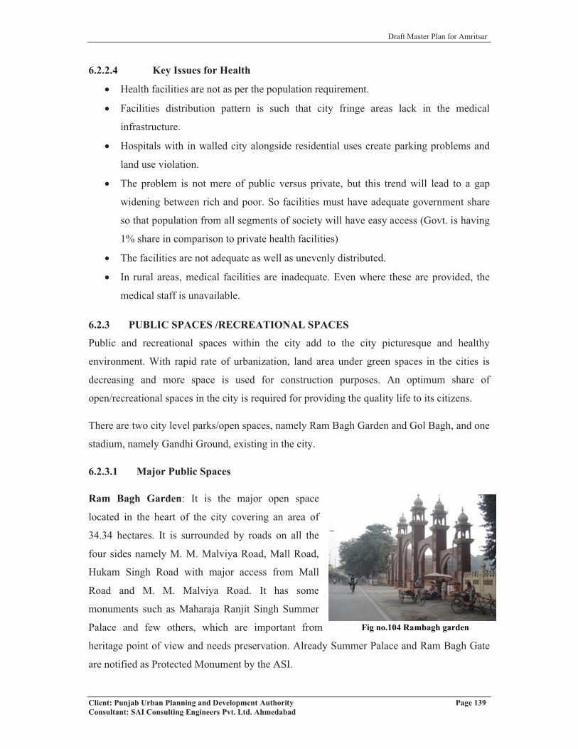
Draft Master Plan for Amritsar
Client: Punjab Urban Planning and Development Authority Page 139Consultant: SAI Consulting Engineers Pvt. Ltd. Ahmedabad
6.2.2.4 Key Issues for Health
� Health facilities are not as per the population requirement.
� Facilities distribution pattern is such that city fringe areas lack in the medical
infrastructure.
� Hospitals with in walled city alongside residential uses create parking problems and
land use violation.
� The problem is not mere of public versus private, but this trend will lead to a gap
widening between rich and poor. So facilities must have adequate government share
so that population from all segments of society will have easy access (Govt. is having
1% share in comparison to private health facilities)
� The facilities are not adequate as well as unevenly distributed.
� In rural areas, medical facilities are inadequate. Even where these are provided, the
medical staff is unavailable.
6.2.3 PUBLIC SPACES /RECREATIONAL SPACES
Public and recreational spaces within the city add to the city picturesque and healthy
environment. With rapid rate of urbanization, land area under green spaces in the cities is
decreasing and more space is used for construction purposes. An optimum share of
open/recreational spaces in the city is required for providing the quality life to its citizens.
There are two city level parks/open spaces, namely Ram Bagh Garden and Gol Bagh, and one
stadium, namely Gandhi Ground, existing in the city.
6.2.3.1 Major Public Spaces
Ram Bagh Garden: It is the major open space
located in the heart of the city covering an area of
34.34 hectares. It is surrounded by roads on all the
four sides namely M. M. Malviya Road, Mall Road,
Hukam Singh Road with major access from Mall
Road and M. M. Malviya Road. It has some
monuments such as Maharaja Ranjit Singh Summer
Palace and few others, which are important from
heritage point of view and needs preservation. Already Summer Palace and Ram Bagh Gate
are notified as Protected Monument by the ASI.
Fig-Ram Bagh Garden
Fig no.104 Rambagh garden
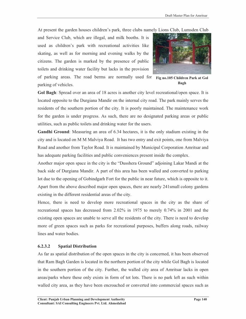
Draft Master Plan for Amritsar
Client: Punjab Urban Planning and Development Authority Page 140Consultant: SAI Consulting Engineers Pvt. Ltd. Ahmedabad
Fig no.105 Children Park at Gol Bagh
At present the garden houses children’s park, three clubs namely Lions Club, Lumsden Club
and Service Club, which are illegal, and milk booths. It is
used as children’s park with recreational activities like
skating, as well as for morning and evening walks by the
citizens. The garden is marked by the presence of public
toilets and drinking water facility but lacks in the provision
of parking areas. The road berms are normally used for
parking of vehicles.
Gol Bagh: Spread over an area of 18 acres is another city level recreational/open space. It is
located opposite to the Durgiana Mandir on the internal city road. The park mainly serves the
residents of the southern portion of the city. It is poorly maintained. The maintenance work
for the garden is under progress. As such, there are no designated parking areas or public
utilities, such as public toilets and drinking water for the users.
Gandhi Ground: Measuring an area of 6.34 hectares, it is the only stadium existing in the
city and is located on M M Malviya Road. It has two entry and exit points, one from Malviya
Road and another from Taylor Road. It is maintained by Municipal Corporation Amritsar and
has adequate parking facilities and public conveniences present inside the complex.
Another major open space in the city is the “Dusshera Ground” adjoining Lakar Mandi at the
back side of Durgiana Mandir. A part of this area has been walled and converted to parking
lot due to the opening of Gobindgarh Fort for the public in near future, which is opposite to it.
Apart from the above described major open spaces, there are nearly 241small colony gardens
existing in the different residential areas of the city.
Hence, there is need to develop more recreational spaces in the city as the share of
recreational spaces has decreased from 2.02% in 1975 to merely 0.74% in 2001 and the
existing open spaces are unable to serve all the residents of the city. There is need to develop
more of green spaces such as parks for recreational purposes, buffers along roads, railway
lines and water bodies.
6.2.3.2 Spatial Distribution
As far as spatial distribution of the open spaces in the city is concerned, it has been observed
that Ram Bagh Garden is located in the northern portion of the city while Gol Bagh is located
in the southern portion of the city. Further, the walled city area of Amritsar lacks in open
areas/parks where these only exists in form of tot lots. There is no park left as such within
walled city area, as they have been encroached or converted into commercial spaces such as

Draft Master Plan for Amritsar
Client: Punjab Urban Planning and Development Authority Page 141Consultant: SAI Consulting Engineers Pvt. Ltd. Ahmedabad
Fig no.106 open Space existing within the walled city area used
Bagh Akalian and Bagh Ramanand. Hence, the already
congested core with influx of commercial activities does
not provide for recreational requirements of its residents.
The only garden existing is Jallian Wala Bagh, which is a
tourist destination Hence its use for public in general is
debarred.
6.2.3.3 Ongoing Projects/Proposals
� Setting up of Amrit Bagh in 30 acres of land in Ranjit Avenue.
� A drive for plantation of 10 lacs trees in the district shall be undertaken.
� Landscaping and upgradation of Rambagh Garden including conservation of Summer
Palace and Civil Defence building at a cost out lay of Rs.5.00 crores.
6.2.3.4 Key Issues
� Decreased area under recreational use (0.74% of total land use in 2001from 2.)
� Lack of open areas in walled city, Amritsar
� Small colony gardens exist only in the planned colonies, which are mainly located in
the northern portion of the city.
� Improvement of Rose Garden at 40 Khuh (Wells).
� Only 1% of the total area of Rayya and its surrounding villages are under recreational
spaces. It especially lacks in terms of planned recreational areas.
6.2.4 SOCIO-CULTURAL FACILITIES
The presence of socio cultural facilities such as clubs, art galleries, public libraries, etc. in the
city provides avenues for its residents to spend their leisure time in a productive manner.Table 73: Socio Cultural Facilities in Amritsar (MC)
Sr. No. Facilities NumberAmritsar MC
1 Community Halls 32 Swimming Pool 43 Corporation Playgrounds 24 Gymnasium Hall 65 Public Library 46 Art Galleries 27 Museum 18 Cinema Hall 129 Open Air Theatre 1
Villages in LPA1 Recreational cum Cultural Facilities * 5912 Stadium cum Auditorium Facilities* 8
Source: Municipal Corporation, Amritsar; Census of India, 2001Note: * figures for LPA are no. of villages having such facilities

Draft Master Plan for Amritsar
Client: Punjab Urban Planning and Development Authority Page 142Consultant: SAI Consulting Engineers Pvt. Ltd. Ahmedabad
In terms of socio-cultural facilities, Amritsar lacks in the presence of sports facilities or
playground areas for hosting state or country level tournaments, etc. or even to train the
students. This can help in boosting the tourism in the city. Further, in terms of marriage
palaces, they are ample in number and are functioning with in residential areas or in
proximity to educational or health institutions, which are creating nuisance.
In case of urban settlements in Amritsar LPA, Rajasansi has presence of sports club while
Jandiala has a cinema hall, which is not in good condition. In case of villages in Amritsar
LPA, there are 8 villages having stadium cum auditorium facility. The facility is on a small
scale where village level sport events are conducted occasionally. Hence, the socio-cultural
needs of the population of these settlements are fulfilled by the city of Amritsar (Refer table
no.73).
6.2.4.1 Spatial Distribution:
The socio-cultural facilities are observed to be concentrated mainly in the northern portion of
the city. All the 3 recreational clubs existing in the city are located within Ram Bagh Garden,
which in turn is located in the northern half of the city. Likewise, cinema halls located on
M.M. Malviya Road, Taylor Road, Court Road, opposite bus stand are in good condition
while those located in the walled city and in the southern half of the city are not in good
condition and generally not preferred by residents for entertainment purpose. Moreover, the
socio-cultural facilities in the city are not in synchronization with the rising population needs.
Hence, development of more community rooms/halls, recreational clubs, meditation halls,
spiritual center, drama and dance center is required on priority basis. Recently two
multiplexes have opened up on Batala Road and Jalandhar Road to provide quality
entertainment facilities.
6.2.4.2 Ongoing Projects/ Proposals
� Beautification of surroundings of Durgiana Temple after acquisition of necessary
properties at a cost of Rs. 29.00 crores. The main access of 16 feet to the temple shall
be widened to about 60 feet. The shopkeepers are proposed to be relocated by
constructing a commercial complex under the scheme. The existing Police Post and
Post Office shall be relocated.
� Setting up of Heritage Village in Guru Nanak Dev University: - Govt. of India has
already sanctioned a sum of Rs. 6.84 Crores for setting up of Heritage Village in
GNDU Campus.

Draft Master Plan for Amritsar
Client: Punjab Urban Planning and Development Authority Page 143Consultant: SAI Consulting Engineers Pvt. Ltd. Ahmedabad
� Gobind Garh Fort shall be open to public after completing the conservation of its
buildings at a cost of Rs. 2.5 crores.
� A beautiful open Plaza shall be set up in front of Golden Temple at a cost of Rs.7.00
crore by shifting Ghanta Ghar market to the newly constructed shopping complex in
front of Shani Mandir.
6.2.4.3 Key Issues
� Lack of adequate socio-cultural facilities in the city.
� Concentration of existing socio-cultural facilities in the northern half of the city only.
6.2.5 CIVIC AMENITIES/SERVICES
The other amenities of the city include Post Offices, Fire Stations, Cremation Grounds, etc.
Each urban area must have these amenities to serve its growing population, as the
requirement of these amenities increases with the increase of city population and area.
6.2.5.1 Post Office/Fire Station/Police Station/Graveyard
POSTAL AND COMMUNICATION FACILITIES
Post offices are one of the essential services required by
residents of any city. The Amritsar city consists of 4 main
post offices located at different locations with one Head
Post Office located on Court Road. It is a heritage building
built during the time of British and is in good condition
having required facilities in terms of parking for the
employees and visitors, public toilets and drinking water.
All the four urban settlements falling in the Amritsar LPA are having branch post office on
which number of surrounding villages are dependent. Among, 310 villages falling in
Amritsar LPA, 98% of the villages (303) are having post and telegraph facilities while 33.5%
(104) villages are having post offices.
In terms of communication facilities, the city of Amritsar is equipped with 12 telephone
exchanges with 4.2 lacs landline connections, 5600 public telephones and 5.6 lacs mobile
connections in the city. There are nearly 12693 telephone connections in 310 villages of LPA
FIRE STATION
The city of Amritsar at present has four fire stations located at Town Hall, Beri Gate, Gilwali
Gate and Civil Lines. As per the UDPFI standards of one fire station for 2 lakh population,
Fig no. 107 Head Post office on Court Road, Amritsar

Draft Master Plan for Amritsar
Client: Punjab Urban Planning and Development Authority Page 144Consultant: SAI Consulting Engineers Pvt. Ltd. Ahmedabad
the city should have 5 fire stations to serve the population. Therefore, the city has a backlog
of one fire station. All the four fire stations are located on major city roads, which are wide
enough to allow free movement of these vehicles. The vehicles at the time of disaster are
available from these fire stations. The Civil Lines fire station serves the northern portion of
the city, while Town Hall, Beri Gate and Gilwali Gate fire stations serve the walled city area
and its surrounding that is the southern half of the city. Hence, it can be said that northern
portion of the city is served with only 1 fire station, which is insufficient and requires one
more fire station. Besides, the existing backlog of one fire station, there is also requirement of
another 5 fire stations in the city to cater the needs up to 2031.
Apart from four fire stations, city also has nearly 400 fire hydrants at different locations to
combat with the fire. The fire brigade wing in the city has total of 8 fire fighting vans and
total staff strength of 126 out of which 51 posts at present are vacant. This implies that the
city does not have required number of personnel, which needs to be taken care off. Moreover,
the existing fire fighting infrastructure needs upgradation as new buildings of greater height
are being constructed.
There is no provision of separate fire station or fire fighting facilities in either 4 urban
settlements or in 310 villages falling in LPA. They are dependant on Amritsar for fire
fighting facilities in case of any disaster. Therefore, it can be analysed that the existing fire
facilities in the city of Amritsar are over burdened that needs to be reduced.
POLICE STATIONS
There are total of 14 approved police stations in the district of Amritsar, out of which 11
police stations fall within the city and remaining 3 in LPA. The list of 11 police stations along
with their location is given in the table below:Table 74: Police Stations Falling in Amritsar LPA
S.No. Name of the Sub Division/ Police Station LocationPolice Stations in Amritsar M.C.
1 PS A-Division Near Ram Bagh Chowk2 PS B-Division Near Sultanwind Gate3 PS C-Division Near Gilwali Gate4 PS D-Division Near Lahori Gate5 PS E-Division Near Town Hall6 PS Civil Lines Near District Courts7 PS Sadar Near Petrol Pump, G.T. Road8 PS Islamabad Near Putlighar9 PS Chheharta Chheharta, Near Naraingarh10 PS Sultanwind Near Village Daburji11 Temp PS Majitha Road Near Guru Nanak Dev Hospital
Police Stations in Amritsar LPA12 PS Rajasansi Rajasansi, Amritsar-Ajnala Road13 PS Gharinda G.T. Road, Attari
Source: Police Dept. Amritsar

Draft Master Plan for Amritsar
Client: Punjab Urban Planning and Development Authority Page 145Consultant: SAI Consulting Engineers Pvt. Ltd. Ahmedabad
Fig no.108 Shivpuri Cremation ground
At present, there is backlog of 2 police stations within the city as per the UDFI guidelines
standard of one police station for 90,000 persons. Further, there is a demand for 12 more
police stations up to the year 2031 for the city of Amritsar.
CREMATION AND BURIAL GROUNDSTable 75: Cremation and Burial Grounds in Amritsar M.C
Type of Facility Number LocationCremation Ground 6 Shiv Puri-Near Durgiana Mandir,
Chatiwind Gate(Opp Shaheed Ganj Gurudwara), Kot Khalsa(2), Naraingarh-Chheharta, Wadali Guru-Chheharta
Burial Ground 3 Opp Shaheedan, Jhabal Road, Near Boharwala Phatak-IslamabadIslamabad Road, near Cantt area
Source: Municipal Corporation, Amritsar
The city of Amritsar is served by 6 cremation and 4 burial
grounds (Refer table no.75). The Shiv Puri Cremation
Ground near Durgiana Mandir is located on the circular
road adjoining walled city and serves the major Hindu
population of the city while the another cremation ground
at Chatiwind Gate-opposite Shaheedan serves the sikh
population of the city. The remaining 4 cremation
grounds are located in the west of the Amritsar city. All
these cremation grounds have been provided with
facility of public toilets and drinking water.
A burial ground for children is existing opposite Gurudwara Shaheed Ganj for both Hindu
and Sikh population of the city, while the remaining burial grounds are serving the Muslim
and Christian population in the city, which are in minority.
Looking at the spatial distribution of cremation and burial grounds, it has been observed that
they are concentrated in the central and western part of the city while eastern part of the city
lacks them. Further, there is demand for 2 more cremation grounds by 2031 to serve the
rising population needs.
There is one Electric Cremation Ground at Shivpuri, but it is not in function presently
because of the bad odour it produces during cremation. In spite of this electric crematorium,
an LPG/CNG based crematorium can be made.

Draft Master Plan for Amritsar
Client: Punjab Urban Planning and Development Authority Page 146Consultant: SAI Consulting Engineers Pvt. Ltd. Ahmedabad
6.2.5.2 Spatial Distribution
Out of the 11 police stations existing in the city, only one is situated inside the walled city
that is Police Station of E-Division at Town Hall, while 4 police stations are located on the
outer circular road adjoining walled city. The remaining 6 police stations are serving the area
outside the walled city area.
6.2.5.3 Ongoing Projects/Proposals
� Proposed opening of new fire stations at Ranjit Avenue, Batala Road and Focal Point.
The first 2 locations proposals have been sanctioned by Punjab government and the
location of fire station at Focal Point is under consideration
� Purchase of the 2 proposed fire tenders approved by Commissioner Corporation is
under process.
� Purchase of turntable ladder on hydraulic platform of 150 ft height is under
consideration.
6.2.5.4 Key Issues
� Lack of adequate civic amenities in the city.
� Fire department lacks disaster management equipments. The existing vehicles are not
able to serve the population in case of any disaster. No such vehicles exist to enter
narrow streets of walled city in case of huge fire in high rise buildings.
� Irrational distribution of fire stations in the city
� Lack of a Forensic Institute in the city to tackle the numerous cases happening in the
city and the surrounding areas.
� The rural area is also dependent upon city infrastructure in terms of fire stations and
recreation.

Draft Master Plan for Amritsar
Client: Punjab Urban Planning and Development Authority Page 147Consultant: SAI Consulting Engineers Pvt. Ltd. Ahmedabad
Fig no.109 Industry releasing plume without adopting pollution control devices
CHAPTER 7
ENVIRONMENT
Today's environmental problems faced by the inhabitants of Punjab, its causes and pressures
can easily be traced back directly or indirectly from urban areas. The forces and processes
that constitute urban activity have far-reaching and long-term effects not only on its
immediate boundaries, but also on the entire region in which it is positioned.
7.1 ENVIRONMENTAL POLLUTION: GENERATION AND
CONSEQUENCES
7.1.1 AIR POLLUTION: - One of the major areas of
environmental concern in the Amritsar city is that of rising air
pollution levels which are result of increasing personalized modes
of transport and intermediate modes of transport such as auto
rickshaws in the absence of efficient public transport system in the
city. 60% of goods vehicles are auto rickshaws (2.43% of total
registered vehicles). Most of them are using kerosene as the fuel
thus creating air pollution. The personalized vehicles (99.6% of
passenger vehicles) are 89.7% of total registered vehicles making congestion on roads and
creating pollution. Apart from this, narrow roads carrying high volume of traffic, frequent
jams, etc. have been observed creating air pollution along major roads such as Lawrence
Road, Cooper Road, Hall Bazaar and chowks such as Bhandari Bridge Chowk, Hussainpura
Chowk, O/s Bus Stand, O/s Hall Gate etc.
Apart from the automobile pollution, the other major source of air pollution in the city is
industrial emission of gases. The various industrial units like rice shellers situated on Tarn
Taran Road, units in industrial focal points and other scattered industries in the city releases
intensive air pollutants into the atmosphere, which affects the environment of the surrounding
residential areas. From planning point of view, neither any sufficient buffer zone nor any
landscape elements are provided there to reduce the impact of air pollutants.
The other sources of air pollution in the city include pollution from developmental activities,
handling and burning of municipal and domestic waste and from agriculture waste burning
etc. With a view to clearly assess and monitor the status & quality of ambient air in Amritsar,
several monitoring stations in different parts of the city i.e. industrial, residential and

Draft Master Plan for Amritsar
Client: Punjab Urban Planning and Development Authority Page 148Consultant: SAI Consulting Engineers Pvt. Ltd. Ahmedabad
commercial zones have been established by the Punjab Pollution Control Board. These
stations have been placed at the most vulnerable parts of the city, which not only carry large
volume of traffic but also have large number of industrial/residential/commercial units. The
data collected from these monitoring stations with respect to SPM, SO2 and NOx in the year
2006 reflects higher SPM levels in the air in both residential and commercial areas against
the permissible limit of 140μg/m3 indicating deteriorating quality of air in these areas. The
higher SPM levels have also been recorded in the industrial areas of the city then permissible
level of 360μg/m3 with monitoring stations located at Indian Textile - Amritsar, Mehta and
Avan. With regard to the level of SO2 and NOx, it has been found that the permissible limits
are well below the prescribed standards in all the areas. Table 76: SPM, SO2 and NOx levels in Industrial Area of Amritsar at different Air Monitoring Stations from 1997-2001 (Units: µg/m3)Year Indian Textile, Amritsar Mehta Avan
SPM SO2 NOx SPM SO2 NOx SPM SO2 NOx1997 440 17 44 - - - - - -1998 447 16 42 - - - - - -1999 439 20 43 389 18 40 446 20 402000 396 17 20 361 13 18 371 18 212001 - - - 373 11 16 443 12 18
Source: PPCB, Patiala
Although, the air monitoring stations have been established by PPCB but still there is no
continuous recording of database relating to air quality. Hence, it is required that these
monitoring stations should do monitoring on regular intervals.
7.1.2 WATER POLLUTION
7.1.2.1 Surface Water Sources & Pollution
Rapidly increasing urbanization and industrialization of Amritsar has not only adversely
impacted the quality of ambient air in the city but also has affected the city’s water resources.
There are two rivers, namely river Beas and Ravi, flowing in the catchment area of Amritsar
LPA and delimiting it. While river Beas forms the eastern boundary of the LPA, river Ravi
bounds the district from the western side. The upstream characteristics of the river Beas and
Ravi have been studied by PPCB in Dec 2000 under the Govt. of India scheme.
MINAR (Monitoring of India National Aquatic Resources) and it has been observed that all
parameters of surface water characteristics are within the permissible limits prescribed by
BIS (ISI) except BOD and total coliforms.
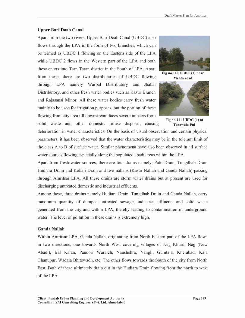
Draft Master Plan for Amritsar
Client: Punjab Urban Planning and Development Authority Page 149Consultant: SAI Consulting Engineers Pvt. Ltd. Ahmedabad
Fig no.111 UBDC (1) at Tarawala Pul
Upper Bari Doab Canal
Apart from the two rivers, Upper Bari Doab Canal (UBDC) also
flows through the LPA in the form of two branches, which can
be termed as UBDC 1 flowing on the Eastern side of the LPA
while UBDC 2 flows in the Western part of the LPA and both
these enters into Tarn Taran district in the South of LPA. Apart
from these, there are two distributaries of UBDC flowing
through LPA namely Warpal Distributory and Jhabal
Distributory, and other fresh water bodies such as Kasur Branch
and Rajasansi Minor. All these water bodies carry fresh water
mainly to be used for irrigation purposes, but the portion of these
flowing from city area till downstream faces severe impacts from
solid waste and other domestic refuse disposal, causing
deterioration in water characteristics. On the basis of visual observation and certain physical
parameters, it has been observed that the water characteristics may be in the tolerant limit of
the class A to B of surface water. Similar phenomena have also been observed in all surface
water sources flowing especially along the populated abadi areas within the LPA.
Apart from fresh water sources, there are four drains namely, Patti Drain, Tungdhab Drain
Hudiara Drain and Kohali Drain and two nallahs (Kasur Nallah and Ganda Nallah) passing
through Amritsar LPA. All these drains are storm water drains but at present are used for
discharging untreated domestic and industrial effluents.
Among these, three drains namely Hudiara Drain, Tungdhab Drain and Ganda Nallah, carry
maximum quantity of dumped untreated sewage, industrial effluents and solid waste
generated from the city and within LPA, thereby leading to contamination of underground
water. The level of pollution in these drains is extremely high.
Ganda Nallah
Within Amritsar LPA, Ganda Nallah, originating from North Eastern part of the LPA flows
in two directions, one towards North West covering villages of Nag Khurd, Nag (New
Abadi), Bal Kalan, Pandori Waraich, Naushehra, Nangli, Gumtala, Kherabad, Kala
Ghanupur, Wadala Bhitewadh, etc. The other flows towards the South of the city from North
East. Both of these ultimately drain out in the Hudiara Drain flowing from the north to west
of the LPA.
Fig no.110 UBDC (1) near Mehta road

Draft Master Plan for Amritsar
Client: Punjab Urban Planning and Development Authority Page 150Consultant: SAI Consulting Engineers Pvt. Ltd. Ahmedabad
Fig no.113 Untreated industrial effluents of Shankar Textile Mill
drained out into Nallah
Fig no.114 Groundwater Sample having objectionable colour, odour taste &
suspended solids
Fig no.112 Untreated industrial effluents of Khanna Paper Mill drain out into
Ganda Nallah
Existing Status
Gandha Nallah at present not only carries untreated industrial and domestic effluents, but also
dense weeds, shrubs, dumped industrial ash/soils, polythene bags, plastics, other domestic
refuse, hazardous waste, biomedical waste, heavy silts, mud, cow dung, etc. The numbers of
residential colonies developed along the nallah face the problem of foul smell and have
developed mosquito zones upto 1000 meters from it. Apart from these, there are number of
industrial units such as Khanna Paper Mill, Shankar Textile Mill, Kwality Pharmaceutical
Pvt. Ltd, etc., which are existing along the Gandha Nallah and discharging their untreated
industrial effluents into the nallah.
Due to discharge of untreated domestic and industrial effluents, the pollutants have leached to
the ground water table and have deteriorated the quality of ground water in the villages
situated along the nallah. The colour of water found is deep yellow, odour is strong and
suspended particles can be visualized by naked eyes,
rendering it unfit for potable use.
On the primary survey, the residents of the colonies or
villages situated along the nallah have claimed to be
suffering from various diseases such as gastroenteritis,
jaundice, diarrohea/ dysentery due to consumption of
contaminated water and malaria due to breeding of
mosquitoes around the Gandha Nallah.
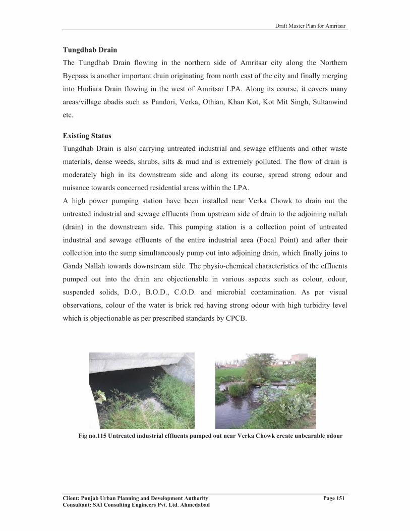
Draft Master Plan for Amritsar
Client: Punjab Urban Planning and Development Authority Page 151Consultant: SAI Consulting Engineers Pvt. Ltd. Ahmedabad
Tungdhab Drain
The Tungdhab Drain flowing in the northern side of Amritsar city along the Northern
Byepass is another important drain originating from north east of the city and finally merging
into Hudiara Drain flowing in the west of Amritsar LPA. Along its course, it covers many
areas/village abadis such as Pandori, Verka, Othian, Khan Kot, Kot Mit Singh, Sultanwind
etc.
Existing Status
Tungdhab Drain is also carrying untreated industrial and sewage effluents and other waste
materials, dense weeds, shrubs, silts & mud and is extremely polluted. The flow of drain is
moderately high in its downstream side and along its course, spread strong odour and
nuisance towards concerned residential areas within the LPA.
A high power pumping station have been installed near Verka Chowk to drain out the
untreated industrial and sewage effluents from upstream side of drain to the adjoining nallah
(drain) in the downstream side. This pumping station is a collection point of untreated
industrial and sewage effluents of the entire industrial area (Focal Point) and after their
collection into the sump simultaneously pump out into adjoining drain, which finally joins to
Ganda Nallah towards downstream side. The physio-chemical characteristics of the effluents
pumped out into the drain are objectionable in various aspects such as colour, odour,
suspended solids, D.O., B.O.D., C.O.D. and microbial contamination. As per visual
observations, colour of the water is brick red having strong odour with high turbidity level
which is objectionable as per prescribed standards by CPCB.
Fig no.115 Untreated industrial effluents pumped out near Verka Chowk create unbearable odour

Draft Master Plan for Amritsar
Client: Punjab Urban Planning and Development Authority Page 152Consultant: SAI Consulting Engineers Pvt. Ltd. Ahmedabad
Fig no.116 Villagers using untreated effluents of the drain
for irrigating fields
Hudiara Drain
The Hudiara Drain entering into the Amritsar LPA from North
Eastern side crosses a number of villages along its course in
LPA i.e. Nangal Pannuwan, Sohian Kalan, Birbalpura, Loharka
Kalan, Miran Kot Kalan, Sehchandar, Rudala, Kotla Dal Singh,
Dhaul Khurd, Kaler, Khiala Khurd, Khiala Kalan, Boparai
Khurd, Kaulowal, Nurpur, Chhiddan, Lohorimal, Gharinda,
Achint Kot, Hoshiar Nagar, Mahawa, etc. It leaves the LPA
from the south western side and enters into Tarn Taran district.
Existing Status
The Hudiara Drain, which at once was fresh water drain used for irrigation purpose, is now
carrying disposed untreated industrial and sewage effluents of the Amritsar LPA. At many
places, the water from the drain is used for irrigating the fields, which is harmful for
consumption.
Kasur Nallah and Patti Drain
Kasur Nallah and Patti Drain are the other two drains flowing through the Amritsar LPA.
Both these drains enter Amritsar LPA from North East direction and leaves LPA region from
south side to enter into the Tarn Taran district.
Both the drains carry untreated sewage and domestic effluents and refuses containing solid
waste, mud, silts and other waste materials from the number of villages from which it passes
before it enters Tarn Tarn district in the south. The nallah also carries storm water during
rainy season and also becomes eutrophic containing higher concentration of nutrients like
NPK. High level of eutrophication of nallah/drain favours the excessive breeding of
mosquitoes, which causes malaria and other water borne diseases.
Fig no.118 Kasur Nallah flowing near village Manawala shows excessive
eutrophication
Fig no.117 Upstream of Patti Drain near Malhian village (Jandiala) showing excessive algae growth
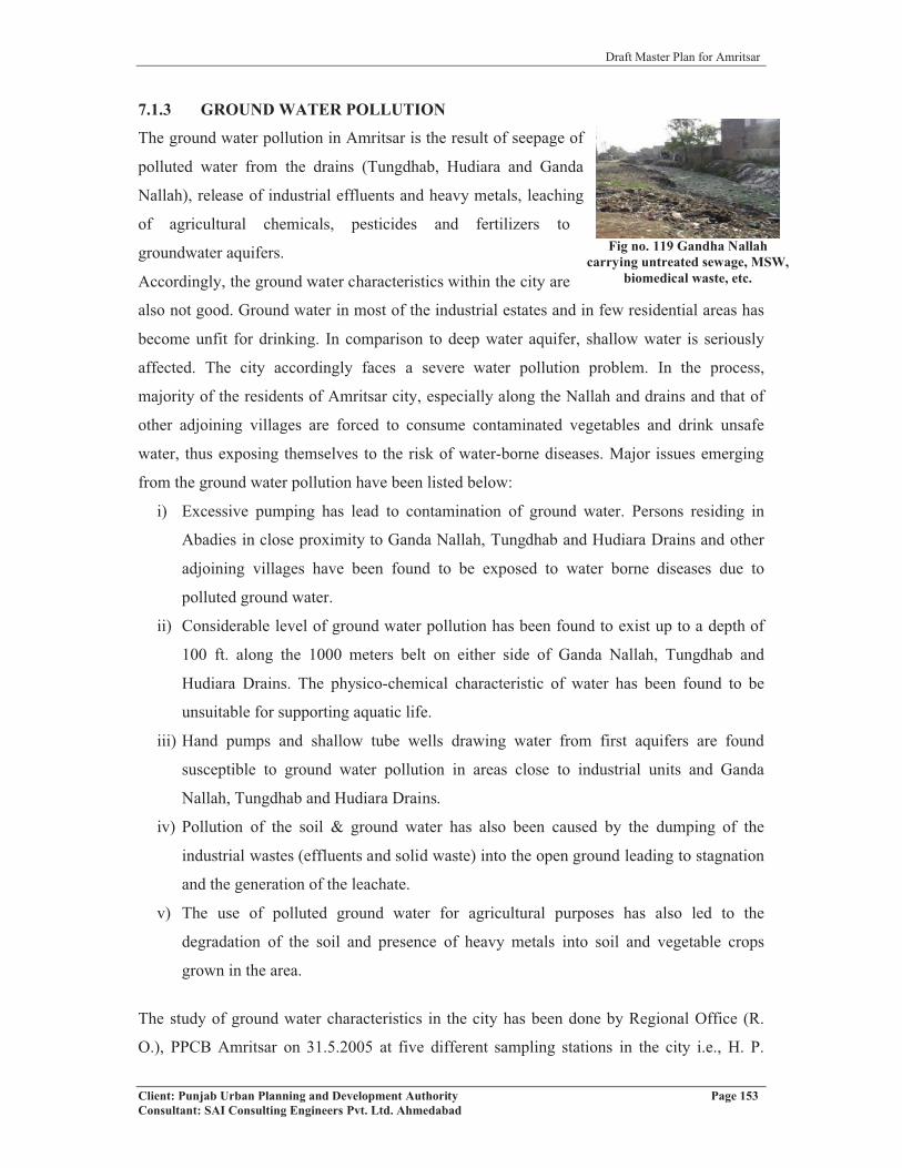
Draft Master Plan for Amritsar
Client: Punjab Urban Planning and Development Authority Page 153Consultant: SAI Consulting Engineers Pvt. Ltd. Ahmedabad
Fig no. 119 Gandha Nallah carrying untreated sewage, MSW,
biomedical waste, etc.
7.1.3 GROUND WATER POLLUTION
The ground water pollution in Amritsar is the result of seepage of
polluted water from the drains (Tungdhab, Hudiara and Ganda
Nallah), release of industrial effluents and heavy metals, leaching
of agricultural chemicals, pesticides and fertilizers to
groundwater aquifers.
Accordingly, the ground water characteristics within the city are
also not good. Ground water in most of the industrial estates and in few residential areas has
become unfit for drinking. In comparison to deep water aquifer, shallow water is seriously
affected. The city accordingly faces a severe water pollution problem. In the process,
majority of the residents of Amritsar city, especially along the Nallah and drains and that of
other adjoining villages are forced to consume contaminated vegetables and drink unsafe
water, thus exposing themselves to the risk of water-borne diseases. Major issues emerging
from the ground water pollution have been listed below:
i) Excessive pumping has lead to contamination of ground water. Persons residing in
Abadies in close proximity to Ganda Nallah, Tungdhab and Hudiara Drains and other
adjoining villages have been found to be exposed to water borne diseases due to
polluted ground water.
ii) Considerable level of ground water pollution has been found to exist up to a depth of
100 ft. along the 1000 meters belt on either side of Ganda Nallah, Tungdhab and
Hudiara Drains. The physico-chemical characteristic of water has been found to be
unsuitable for supporting aquatic life.
iii) Hand pumps and shallow tube wells drawing water from first aquifers are found
susceptible to ground water pollution in areas close to industrial units and Ganda
Nallah, Tungdhab and Hudiara Drains.
iv) Pollution of the soil & ground water has also been caused by the dumping of the
industrial wastes (effluents and solid waste) into the open ground leading to stagnation
and the generation of the leachate.
v) The use of polluted ground water for agricultural purposes has also led to the
degradation of the soil and presence of heavy metals into soil and vegetable crops
grown in the area.
The study of ground water characteristics in the city has been done by Regional Office (R.
O.), PPCB Amritsar on 31.5.2005 at five different sampling stations in the city i.e., H. P.
Draft Master Plan for Amritsar
Client: Punjab Urban Planning and Development Authority Page 154Consultant: SAI Consulting Engineers Pvt. Ltd. Ahmedabad
(handpump) outside Dhabha of Sh. Ramesh Chand, Fatehgarh Churian Road, H. P. near
Scooter Stand of Sh. Darbar Sahib, H. P. near Sangam Dhabha, Ajnala Road, H. P. near Sg.
Babu Ram Tea Stall opposite B. chemical and H. P. near Sacred Heart Day Boarding School.
The physico-chemical characteristics of ground water of all five different sampling stations
within the city areas were under permissible limit prescribed by IS 10500, 1991 (clause 3.1)
except total hardness of water of H. P. near Sacred Heart School, where it is of the order of
640 mg/l and exceeds the standard of below 600 mg/l prescribed by IS 10500, 1991 (clause
3.1). The colour of water at H. P. outside Dhabha of Sh. Ramesh Chand and H.P. near Sg.
Babu Ram Tea Stall is light yellow, which should be clear. The details are summarized in the
table no.77. Table 77: Ground Water Quality at Five Sampling Stations of Amritsar city
S.No.
Parameter Sampling StationH.P.* outside Dhabha of Sh.
Ramesh Chand, Fatehgarh
Churian Road
H.P. near Scoter Stand of Sh. Darbar
Sahib
H.P. near SangamDhabha
Ajnala road, Amritsar
H.P. Sg. Babu Ram Tea Stall
opposite B. Chemical
H.P. near Sacred
Heart Day Boarding
School1 PH 7.2 7.4 7.3 7.2 7.12 Colour Light Yellow Clear Clear Light Yellow Clear3 Cond (mho/cm 200 840 714 740 130 04 TSS mg/ ND ND ND ND ND5 Cl mg/l 70 60 62 70 406 SO4 mg/l 30 24 26 29 327 TDS mg/l 846 533 536 658 8208 F mg/l 0.4 0.6 0.3 0.4 0.29 T. Hard mg/l 530 440 420 510 64010 Ca mg/l 160 160 136 156 20011 Mg mg/l 31 10 19 29 9612 Zn mg/l ND ND ND ND ND13 Ni mg/l ND ND ND ND ND14 T. Alk mg/l 170 160 130 140 16015 Na mg/l 48 40 20 28 5216 K mg/l 12 10 9 10 1417 Fe mg/l 0.3 0.1 0.1 0.2 0.118 COD mg/l ND ND ND ND ND19 BOD mg/l ND ND ND ND ND20 T.Coli
MPN//100ND ND ND ND ND
21 F.Coli MPN//100
ND ND ND ND ND
Source: R.O., PPCB, Amritsar*Handpump
7.1.4 RAIN WATER HARVESTING
Ground water is the major source of water supply in the LPA region apart from the few
surface water sources. Increased dependency on the ground water due to rapid urbanization,
for industrial needs and agricultural practices has rendered its exploitation as inevitable in

Draft Master Plan for Amritsar
Client: Punjab Urban Planning and Development Authority Page 155Consultant: SAI Consulting Engineers Pvt. Ltd. Ahmedabad
Fig no.120 High Traffic Volume and glaring horns by auto rickshaws cause Noise
Pollution
Amritsar LPA. Accordingly, there is urgent need for conserving and recharging the ground
water table by using techniques such as Rain water Harvesting. At present, the use of this
technology is not popular among the residents due to lack of awareness. On discussion with
officials of the authority such as Improvement Trust, it has been quoted that rain water
harvesting has been implemented only in few government buildings and still not made
mandatory as part of Building Bye Laws and Development Control Regulations. This is
necessary for effective implementation of the technique that can help in longer run in
recharging the ground water. Proper guidance and financial assistance may be provided to the
citizens in this regard.
7.1.5 NOISE POLLUTION
Increasing urbanization, overcrowding, industrialization and
higher traffic volumes have resulted in increased noise levels in
Amritsar city leading to noise pollution. Construction work also
plays an important role in causing noise pollution.
The noise has already reached a level, high enough to cause
annoyance capable of creating temporary to permanent hearing
impairment, particularly to those people who remain exposed to
such noise level for longer duration of day. The street venders and shopkeepers doing
business along both sides of road have been found to be most vulnerable to this hazard.
Ambient Noise level in Various Zones (2006)
The study of ambient noise levels in industrial and commercial zones of Amritsar city have
been done by Punjab Pollution Control Board, Amritsar during the year 2006. The findings of
the study states that the noise levels in all the zones, residential, commercial and industrial,
were greater than the standards prescribed by the CPCB, New Delhi. The details of analyzed
noise level data are summarized in table no.78. Table 78: Noise Level (dB) Monitoring during the year 2006 in AmritsarRecording Zone Day Night
Standard Recorded Standard RecordedResidential 55 71 45 65Commercial 65 85 55 72Industrial 75 88 70 75Source: Pollution Control Board, Amritsar 2006
Further, it has been observed that the city lacks in computerized noise monitoring stations.
These stations are necessary to assess realistically the problem of noise pollution in different

Draft Master Plan for Amritsar
Client: Punjab Urban Planning and Development Authority Page 156Consultant: SAI Consulting Engineers Pvt. Ltd. Ahmedabad
areas of the city at different times of the day and can plan for appropriate intervention to
overcome the problem.
7.1.6 KEY ISSUES
Air Pollution
� All the zones, residential, commercial and industrial have higher levels of SPM in the
air against the permissible level.
� Heavy congestion in major areas of Amritsar city especially on Bhandari Bridge
Road, Hall Bazar, Lawrence Road, Crystal Chowk, etc. These areas are facing
intolerable impact from air pollutants (SO2 and NOx), SPM and RPM.
� Use of kerosene oil as fuel by auto rickshaw in the city has lead to the deterioration of
air quality.
� High smoke emission due to prolonged jams on railway crossings in absence of ROBs
and increased use of personalized vehicles.
Water Pollution:
� Discharge of untreated industrial and domestic effluents, solid and biomedical waste
into nallahs, drains and low lying areas of the city.
� Leaching of liquid from decomposed municipal solid waste to water table, and
agricultural chemicals, pesticides and fertilizers into aquifer.
� Unawareness among the residents for use of scientific techniques of water
conservation such as Rain water harvesting.
� Untreated sewage is disposed off into surface sources of Ganda Nallah, causing high
degree of environmental pollution.
� Water is polluted due to untreated industrial effluents disposed off into the nallah.
� Deterioration of ground water characteristics in the village abadis situated near to
nallah/drains have rendered it unfit for potable use and for irrigation purposes. The
use of such polluted water has resulted in people suffering from water borne diseases.
� Lack of periodic monitoring of water quality in different areas of the city.
Noise Pollution
� Lack of regular computerized noise as well as air and water monitoring stations in the
city to assess the levels in different areas at different times of the day. Moreover, no
regular publication of the data monitored to aware the public about it.

Draft Master Plan for Amritsar
Client: Punjab Urban Planning and Development Authority Page 157Consultant: SAI Consulting Engineers Pvt. Ltd. Ahmedabad
Fig no.122 Old age buildings in dilapidated condition in the
walled city
� Lack of delineation of Silence Zones covering education, health, etc. related buildings
which could be separated from other zones.
� Lack of administrative and political will to take stringent action against the parties
causing pollution.
Land Pollution
� Non compatibility of landuse is also creating land pollution.
� Lack of a mechanism to centrally dispose off used batteries, electronic waste, CFC
gases, fused tubes, CFL bulbs, etc. to control mercury and other emissions.
7.2 DISASTER MITIGATION AND MANAGEMENT
Disasters have always co-existed with civilization. With
technological advancement, development initiatives
resulted in the creation of lot of infrastructure and
permanent assets. Gradually material development
detached man from nature on one hand, and increased
vulnerability of the human population, on the other. The
progressive increase in loss of life, property and Fig. 121: Earthquake Zoning of Punjab
deleterious effect on environment due to disaster caused the international community to look
at disaster management in a new perspective, which transcends international barriers,
anticipates possible threats and enables tacking of disaster from the pre-stage. Disaster can be
classified as natural, industrial and manmade disasters. Natural disasters include earthquake,
flood, cyclone, landslide, tsunami, drought, etc. Industrial disasters include fire, chemical
hazard, etc. Manmade disaster includes accidents.
7.2.1 EARTHQUAKE
The whole of Amritsar district along with Amritsar city, which is
an important religious and cultural center of international repute,
falls in seismic zone IV. Amritsar district is situated in a region,
which is liable to slight to moderate damage due to earthquakes.
The Great Himalayan Boundary fault zone, which runs from
Assam to Kashmir, has witnessed some of the great Indian
earthquakes. It has also experienced occasionally the fringe effect
of the earthquakes originating in the Karakoram and Hindukush region.

Draft Master Plan for Amritsar
Client: Punjab Urban Planning and Development Authority Page 158Consultant: SAI Consulting Engineers Pvt. Ltd. Ahmedabad
7.2.2 FIRE
Apart from being the part of seismic zone IV, the city of Amritsar is also threatened by fire
hazard due to following reasons:
� Non- implementation of fire safety norms as part of building byelaws.
� Illegal and loose electric connections.
� Sub-standard wiring and over loading of electricity system.
� Illegal storage and hazardous commercial activities.
� Inadequate availability of special fire fighting equipments.
� No practice of Soil Test before construction by the individuals in spite of the region
being in the Seismic Zone IV.
Moreover, due care needs to be taken in designing storm water drains to control the flooding
during time of cloud burst or heavy rains. The buildings in this region should be designed
keeping in mind the wind speed of entire region, which is 47m/s (169km/hr as per IS 187
(part 3).
The district is having a District Disaster Management Committee, which involves all
important stakeholders of the District. The overall in charge of the committee is the Deputy
Commissioner, Amritsar. Important stakeholders for City Disaster Management Committee
includes representatives from M.C. Office, all Gazetted officers of DC office, PWD, NGOs,
etc. The Walled City area of Amritsar has been identified as critical in case of any disastrous
situation because of the age-old buildings. Further the new buildings being constructed
should be in compliance with the design parameters given under IS 1893 with taking due
consideration of prevailing housing constructions and development guidelines and National
Building Code.
To fight with disasters, the city has 13 zone level committees, which have been made to take
decisions at zonal level for disaster management. Each committee consists of ward
councilors, medical officers, fire officers, police in charge of divisions, civil defense officers,
NGOs etc. The responsibility of the committees is to identify volunteers within each zone and
carry out the training, and social and vulnerability mapping within each ward.
7.2.3 ONGOING PROJECTS/PROPOSALS
UEVRP (Urban Earthquake Vulnerability Reduction Project)
In terms of disaster management, city area is covered under the UEVRP project, which is
under Govt. of India-UNDP Disaster Risk Management Programme. The project is of
Ministry of Home Affairs in collaboration with UNDP, under which the funding to the nodal

Draft Master Plan for Amritsar
Client: Punjab Urban Planning and Development Authority Page 159Consultant: SAI Consulting Engineers Pvt. Ltd. Ahmedabad
agency (Amritsar District Administration) is from UNDP. The project initiated in the city in
2004. It involved five major components:
� Awareness Generation
� Earthquake Preparedness and Response Planning
� Training and Capacity Building
� Techno Legal Regime
� Networking
7.2.4 KEY ISSUES
Earthquake
• The LPA falls in Seismic Zone IV of Earthquake Zoning Map of India, with
possibility of quakes up to 7.9 Richter scale.
• Poor condition of building structures especially within the walled city area.
• Negligence of design parameters for construction of buildings as per compliance with
IS 1893.
• Insufficient attention to the implementation of earthquake safety measures while
construction/repairing of building.
Flood and Water Logging
• Poor condition of storm water drains & slow process of adopting Rainwater
Harvesting Technology within city & LPA to prevent city from water logging,
specially in low lying areas.
• Negligible measures taken up to prevent water logging, because of its concentration in
rainy season only.
Fire Hazard
• Non-implementation of fire safety norms as part of building byelaws.
• Illegal and loose electric connections & sub-standard wiring and over loading of
electricity system.
• Illegal storage of hazardous commercial activities & inadequate availability of special
fire fighting equipments.
Rainwater Harvesting
• Lack of awareness among the residents.
• Not made a part of Building Bye Laws and Development Control Regulations till
now.

Draft Master Plan for Amritsar
Client: Punjab Urban Planning and Development Authority Page 160Consultant: SAI Consulting Engineers Pvt. Ltd. Ahmedabad
CHAPTER 8
FINANCIAL ASPECTThe chapter details out the municipal finances of the Municipal Corporation and other entities
involved in the provision of services and outline the receipts and expenditure over the last
five years. The attempts have also been made to connect the financial income and
expenditure with the implementation part of planning aspects.
REVIEW OF EXISTING FISCAL AND FINANCIAL SITUATION
The purpose of this section is to review and analyze the existing financial situation in terms
of trends in revenues and expenditures and authorities concerned with the development of
city. The entities, which have been studied, are:
� Municipal Corporation Amritsar
� Amritsar Improvement Trust
� Amritsar Development Authority (ADA)
8.1 MUNICIPAL CORPORATION, AMRITSAR
The municipal finances of the Municipal Corporation, Amritsar have been reviewed for the
last five years, commencing from the financial year 2003-04 to 2007-08. The items of both
receipts and expenditure are classified under revenue and capital accounts as per their sources
and uses.
The revenue income of Municipal Corporation has grown to a level of Rs 10109.49 lakhs in
FY 2007-08 from Rs 8060.21 lakhs during FY 2003-04, registering a CAGR of 5.82 percent,
while revenue expenditure increased at a CAGR of 8.52 percent. It projects not a good
financial condition of Municipal Corporation. However, the pressure of capital expenses on
the revenue account is increasing year after year. This situation demands expenditure control
measures and planned capital investments on the part of Municipal Corporation.Table 79: Financial Status at a GlanceItem 2003-04 2004-05 2005-06 2006-07 2007-08 CAGRRevenue AccountOpening balance 147.22 244.38 719.56 420.9 147.76Income 8060.21 8316.78 10834.16 9411.6 10109.49 5.82Expenditure 6397.46 6962.69 7842.52 8047.95 8873.52 8.52Surplus 1809.97 1598.47 3711.2 1784.55 1383.73 (6.49)% of Revenue Surplus 22.4 19.2 34.2 19 14Capital AccountIncome 970.57 793.86 8506.50 1437.69 11162.69 84.15Expenditure 2943.05 2313.02 3857.17 7320.17 3501.51 4.43Surplus/Deficit (1972.48) (1519.16) 4649.33 (5882.48) 7661.18 0Source: Income & Expenditure Budget 2003-04 to 2007-08, Municipal Corporation

Draft Master Plan for Amritsar
Client: Punjab Urban Planning and Development Authority Page 161Consultant: SAI Consulting Engineers Pvt. Ltd. Ahmedabad
The capital income of Municipal Corporation comprises of loans, grants and internal transfers
from revenue to capital account for utilization towards asset creation. It is observed that
external sources in form of grants contribute in the capital income during the review period.Fig no.123: Trends in MC income and expenditure
The following sections provide in-depth review of the revenue account in order to assess the
Municipal Corporation fiscal status and to provide a base for determining the potential of
each source and the ability of Municipal Corporation to sustain the extent of planned
investments identified under the Master Plan.
8.1.1 REVENUE ACCOUNT
The revenue account comprises two components – revenue income and revenue expenditure.
Revenue income comprises internal resources in the form of tax and non-tax items and
external resources, which are constituted of shared taxes/transfers and revenue grants from
the State and Central Government. Revenue expenditure comprises expenditure incurred on
salaries, operation & maintenance cost, contributions and donations and debt servicing.Fig no. 124: Revenue Account of Municipal Corporation

Draft Master Plan for Amritsar
Client: Punjab Urban Planning and Development Authority Page 162Consultant: SAI Consulting Engineers Pvt. Ltd. Ahmedabad
A) Revenue Income
The revenue sources of Municipal Corporation can be broadly classified into own sources,
income from municipal properties, taxes etc. The source wise income generated during the
period is presented in table below:Table 80: Source-Wise Revenue Income
Financial Year 2003-04 2004-05 2005-06 2006-07 2007-08 CAGR % Share of total income
Own Sources 1976.97 2380.04 2592.44 1765.91 2111.58 1.66 23Income from
M.Property (excl. Sale of Land)
534.31 225.46 209.53 657.08 462.81 (3.52) 5
Taxes 5548.93 5711.28 8032.19 4525.14 2411.94 (18.80) 56Financial assistance (in
lieu of abolition of octroi)
0.00 0.00 0.00 2463.47 5123.16 0 16
Total 8060.21 8316.78 10834.16 9411.6 10109.49 (5.82)Source: Income & Expenditure Budget 2003-04 to 2007-08, Municipal Corporation
Fig no. 125: Source wise Breakup of Revenue Income
Own sources
Own sources income includes income from Revenue fee (slaughter house fee, copying fee,
building application fee, etc.), Revenue service account, income from Tehbazari etc. Income
from own sources is 23% of the revenue income, which shows that sources are not sufficient
to cover the expenses of corporation. So it depends highly on external resources for its
operations.
Taxes
The major source of income for MCA is taxes. It is decreasing at a rate of 18.8% and
contributing about 56% of total revenue income.

Draft Master Plan for Amritsar
Client: Punjab Urban Planning and Development Authority Page 163Consultant: SAI Consulting Engineers Pvt. Ltd. Ahmedabad
Table 81: Income from TaxesFinancial Year 2003-04 2004-05 2005-06 2006-07 2007-08 CAGR % Share
of total income
House Tax 560.19 633.41 656.11 729.44 998.69 15.55 14Excise Duty 161.81 171.41 2310.71 1393.11 624.52 40.16 18Octroi 4805.54 4878.06 5026.68 2329.68 652.86 (39.28) 67Other Taxes 21.39 28.4 38.69 72.91 135.87 58.75 1Total 5548.93 5711.28 8032.19 4525.14 2411.94 (18.80)Source: Income & Expenditure Budget 2003-04 to 2007-08, Municipal Corporation
� House Tax
The revenue income from House tax has grown to a level of Rs. 998.69 lakhs in FY 2007-08
from Rs 560.19 lakhs during FY 2003-04, registering a CAGR of 15.55 percent.
� Octroi
Another source of income for Municipal Corporation is Octroi registering a decreasing
CAGR of 39.28 percent.
Financial Assistance
Punjab Government has abolished Octroi on all goods except on petrol, diesel and electricity,
which had played an important role in income from Octroi. And in lieu of that, government
has make the provision of compensation in form of financial assistance against the loss of
income from octroi. This compensation is provided on the basis of octroi collected during last
five years. In year 2006-07, the financial compensation was Rs.2463.47, which increased to
Rs.5123.16 in year 2007-08. (Refer table no 80)
Income from Municipal Property:
Income from Municipal property accounts for about 5 percent of revenue income and has registered a decreasing CAGR of 3.52 percent
B) Revenue Expenditure
The revenue expenditure of M.C. has been analyzed based on expenditure heads. These are
broadly classified into two main heads General Department expenditure and Water Supply
and Sewerage Department expenditure.Table 82: Application of Funds by Heads of AccountFinancial Year 2003-04 2004-05 2005-06 2006-07 2007-08 % Share of
totalexpenditure
CAGR
General Department In Rs. LakhsEstablishment 3529.94 3982.05 4312.04 4463.19 5109.64 78 6.43Contingency 1007.92 1059.32 1394.25 1388.62 1279.67 22 4.83Total 4537.86 5041.37 5706.29 5851.81 6389.31 6.10

Draft Master Plan for Amritsar
Client: Punjab Urban Planning and Development Authority Page 164Consultant: SAI Consulting Engineers Pvt. Ltd. Ahmedabad
Financial Year 2003-04 2004-05 2005-06 2006-07 2007-08 % Share of total
expenditure
CAGR
WSAS DepartmentEstablishment 984.77 1067.64 1143.89 1184.61 1371.64 54 8.63Contingency 874.83 853.68 992.34 1011.53 1112.57 46 6.19Total 1859.6 1921.32 2136.23 2196.14 2484.21 7.50Grand Total 6397.46 6962.69 7842.52 8047.95 8873.52 8.52Source: Income & Expenditure Budget 2003-04 to 2007-08, Municipal Corporation
Fig no. 126 and 127 Percentage Share of General Deptt. and WSAS Deptt. in Revenue Expenditure
8.1.2 CAPITAL ACCOUNT:
The Municipal Corporation spends on capital works such as development of roads,
construction of streets and drains, slum improvement, etc.Figure No. 128 Capital Account of MC, Amritsar
A) Capital Income:
In general, the capital income of Municipal Corporation comprises of loans, grants,
contributions and transfers from revenue surplus. Sale proceeds contribute the major part in
Capital Income with 47 percent of total capital receipts during the review period, loans 46
percent and capital grants for the rest.

Draft Master Plan for Amritsar
Client: Punjab Urban Planning and Development Authority Page 165Consultant: SAI Consulting Engineers Pvt. Ltd. Ahmedabad
Table 83: Details of Capital Account (In lakhs Rs.)
Financial Year 2003-04 2004-05 2005-06 2006-07 2007-08 % Share of total income/expenditure CAGR
Capital Income (Rs. In Lakhs)CapitalGrants 0.00 0.00 0.00 1026.21 689.58 7 -
Loans 515.78 0.00 0.00 0.00 10000 46 109.83Sale Proceeds 454.79 793.86 8506.50 411.48 473.11 47 0.99
Total 970.57 793.86 8506.50 1437.69 11162.69 84.15Capital Expenditure
WSAS Department 1459.89 817.79 1342.25 1372.60 544.60 28 (21.84)
Development of Roads 375.46 301.03 686.72 1658.64 266.61 16 (8.20)
Mohalla Sudhar
Committees130.70 121.54 157.72 84.25 299.29 4 23.01
Construction of Streets &
Drains299.41 219.71 660.73 1082.57 379.80 13 6.12
Additional Street Lights 296.87 328.66 425 462.46 242.90 10 (4.89)
Slum Improvement 66.70 96.52 193.34 730.10 177.95 6 27.80
Others 314.02 427.77 391.41 1929.55 1590.36 23 50.01Total 2943.05 2313.02 3857.17 7320.17 3501.51 4.43
Source: Income & Expenditure Budget 2003-04 to 2007-08, Municipal Corporation
The figure presented in Table 83 indicates that about 87 percent of Municipal Corporation
capital expenditure during the review period is met from its capital receipts. The rest is
contributed by the revenue/municipal surpluses.
On an average, over the past five years, the majority of capital expenditure has been directed
towards public works. Major investments have been in the water supply & sewerage sector,
which accounted for 28 percent of the total investment. Despite the major investment, there
are no water treatment plants, which effect the quality of water. Also, there is no
new/upgradation of water pipelines, due to which there is huge loss of water. As a result,
10% of population is still uncovered by water supply network. On the other hand, only 36%
of population is covered by sewerage network with no facility for the Sewage Treatment
Plant. Next higher 23% of investment has been directed towards others works i.e. on public
toilets, sports activities & gymnasium, construction of municipal buildings, etc. Lastly, just
6% of investment has been spent on slum improvement.
In the overall municipal finance system, it is observed that Municipal Corporation has
generated 56% of total revenue income through Taxes (octroi, excise duty, etc.) and 47% of
total capital income comes from sale proceeds during last five years. The maximum revenue
expenditure is incurred on general administration i.e. 78%, and just 28% of total capital
expenditure is incurred by Water Supply & Sewerage Department on development works.
Draft Master Plan for Amritsar
Client: Punjab Urban Planning and Development Authority Page 166Consultant: SAI Consulting Engineers Pvt. Ltd. Ahmedabad
8.2 IMPROVEMENT TRUST
The financial position of the Improvement Trust has been reviewed for the last five years,
commencing from the financial year 2003-04 to 2007-08. The items of both receipts and
expenditure are classified under revenue and capital accounts as per their sources and uses.
The revenue income of Improvement Trust is reduced from a level of Rs. 1347.43 lakhs in
FY 2003-04 to Rs 846.47 lakhs during FY 2007-08, registering a decreasing CAGR of 10.97
percent, while revenue expenditure decreased at a CAGR of 8.55 percent. Revenue account is
registering a reducing revenue surplus at a decreasing CAGR of 23.12, which projects poor
financial management of Improvement Trust. However, the pressure of capital expenses on
the revenue account is increasing year after year. This situation demands expenditure control
measures and planned capital investments.Table 84: Financial Status at a Glance
Item 2003-04 2004-05 2005-06 2006-07 2007-08 CAGRRevenue Account Rs in LakhsOpening balance 849.54 254.62 233.74 155.73 203.01
Income 1347.43 424.96 395.82 559.12 846.47 (10.97)Expenditure 806.01 373.03 608.08 1943.03 563.6 (8.55)
Surplus 1390.96 306.55 21.48 (1228.18) 485.88 (23.12)% of Revenue Income 103 72 5.42 (220) 57.4 (13.59)
Capital AccountIncome 7406.96 1888.35 5146.41 8749.82 5279.57 (8.11)
Expenditure 8543.3 1961.16 5012.16 7318.63 5238.09 (11.51)Surplus/ Deficit (1136.3) (72.81) 134.25 1431.19 41.48 -
Source: Income & Expenditure Budget 2003-04 to 2007-08, Improvement Trust
The capital income of Improvement Trust comprises loans, grants and internal transfers from
revenue to capital account for utilization towards asset creation. It is observed that external
sources in form of grants contribute in the capital income during the review period.
Fig no.129 Financial Status of Improvement Trust (in Rs. Lakhs)
The following sections provide an in-depth review of the revenue account, in order to assess
the fiscal status and to provide a base for determining the potential of each of the sources and
the ability of Improvement Trust to sustain the extent of upcoming investments.

Draft Master Plan for Amritsar
Client: Punjab Urban Planning and Development Authority Page 167Consultant: SAI Consulting Engineers Pvt. Ltd. Ahmedabad
8.2.1 Revenue Account
The revenue account comprises two components - revenue income and revenue expenditure.
Revenue income comprises internal resources in the form of tax and non-tax items. External
resources constitute of shared taxes/transfers and revenue grants from the State and Central
Government. Revenue expenditure comprises expenditure incurred on salaries, operation &
maintenance cost, contributions and donations.
A) Revenue Income
The revenue sources of Improvement Trust can be broadly categorized into own sources,
investments, etc. The source wise income generated during the review period is shown in the
following table:Table 85: Source wise Revenue income (in Rs. Lakhs)
Item 2003-04 2004-05 2005-06 2006-07 2007-08 CAGR% Share of total income
Own Sources 1125.98 439.63 317.65 400.92 635.88 (13.31) 82Investments 62.73 3.60 20.74 11.87 13.44 (31.96) 3
Miscellaneous & Unclassified 158.72 (18.27) 57.43 146.33 197.15 5.57 15
Total 1347.43 424.96 395.82 559.12 846.47 (10.97)Source: Income & Expenditure Budget 2003-04 to 2007-08, Improvement Trust
Fig no. 130 Source wise Breakup of Revenue Income
Own sources
Own sources income includes income from fines & penalties, fees, interest on deposits,
income from earnest money, income from Cess charges, etc. Income from own sources is
82% of the revenue income.
Non-Tax Revenue (Miscellaneous & Unclassified)
Non-tax source include all non-tax revenue such as fees and charges levied. These sources
include income from recovery of advances, suspended account, etc. The non-tax income of
Improvement Trust contributes 15% of its total revenue income but it goes on increasing at a
CAGR of 5.57 percent.
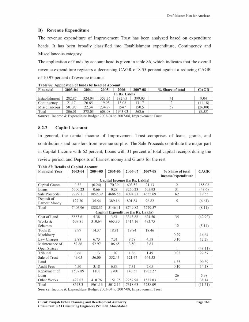
Draft Master Plan for Amritsar
Client: Punjab Urban Planning and Development Authority Page 168Consultant: SAI Consulting Engineers Pvt. Ltd. Ahmedabad
B) Revenue Expenditure
The revenue expenditure of Improvement Trust has been analyzed based on expenditure
heads. It has been broadly classified into Establishment expenditure, Contingency and
Miscellaneous category.
The application of funds by account head is given in table 86, which indicates that the overall
revenue expenditure registers a decreasing CAGR of 8.55 percent against a reducing CAGR
of 10.97 percent of revenue income. Table 86: Application of funds by head of Account Financial 2003-04 2004- 2005- 2006- 2007-08 % Share of total CAGR
In Rs. LakhsEstablishment 282.87 324.04 353.36 382.95 399.93 41 9.04Contingency 21.17 26.65 19.93 13.08 13.17 2 (11.18)Miscellaneous 501.97 22.34 234.79 1547 150.5 57 (26.00)Total 806.01 373.03 608.08 1943.03 563.6 (8.55)Source: Income & Expenditure Budget 2003-04 to 2007-08, Improvement Trust
8.2.2 Capital Account
In general, the capital income of Improvement Trust comprises of loans, grants, and
contributions and transfers from revenue surplus. The Sale Proceeds contribute the major part
in Capital Income with 62 percent, Loans with 31 percent of total capital receipts during the
review period, and Deposits of Earnest money and Grants for the rest.Table 87: Details of Capital AccountFinancial Year 2003-04 2004-05 2005-06 2006-07 2007-08 % Share of total
income/expenditureCAGR
Capital Income (In Rs. Lakhs)Capital Grants 0.32 (0.24) 70.39 603.52 21.13 2 185.06Loans 5000.23 0.66 0.28 3250.23 505.93 31 (43.6)Sale Proceeds 2279.11 1852.39 4686.58 4094.23 4655.69 62 19.55Deposit of Earnest Money 127.30 35.54 389.16 801.84 96.82 5 (6.61)
Total 7406.96 1888.35 5146.41 8749.82 5279.57 (8.11)Capital Expenditure (In Rs. Lakhs)
Cost of Land 5883.61 5.38 3.51 3343.88 624.50 35 (42.92)Works & Schemes
609.81 310.64 663.80 1414.16 493.7512 (5.14)
Tools & Machinery
9.97 14.37 18.81 19.84 18.460.29 16.64
Law Charges 2.88 6.73 7.31 8.58 4.58 0.10 12.29Maintenance of Open Spaces
52.86 52.97 106.65 3.50 3.831 (48.11)
Tribunal 0.66 1.13 1.07 1.36 1.49 0.02 22.57Sale of Trust Land
49.05 56.00 352.43 121.47 644.534.35 90.39
Audit Fees 4.50 3.18 6.83 7.31 7.65 0.10 14.18Repayment of Loan
1507.89 1100 2700 140.55 1902.2726 5.98
Other Works 422.07 410.76 1151.75 2257.98 1537.03 21 38.14Total 8543.3 1961.16 5012.16 7318.63 5238.09 (11.51)Source: Income & Expenditure Budget 2003-04 to 2007-08, Improvement Trust
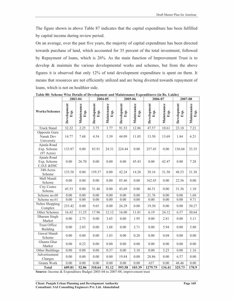
Draft Master Plan for Amritsar
Client: Punjab Urban Planning and Development Authority Page 169Consultant: SAI Consulting Engineers Pvt. Ltd. Ahmedabad
The figure shown in above Table 87 indicates that the capital expenditure has been fulfilled
by capital income during review period.
On an average, over the past five years, the majority of capital expenditure has been directed
towards purchase of land, which accounted for 35 percent of the total investment, followed
by Repayment of loans, which is 26%. As the main function of Improvement Trust is to
develop & maintain the various developmental works and schemes, but from the above
figures it is observed that only 12% of total development expenditure is spent on them. It
means that resources are not efficiently utilized and are being diverted towards repayment of
loans, which is not on healthier side. Table 88: Scheme Wise Details of Development and Maintenance Expenditures (in Rs. Lakhs)
Works/Schemes
2003-04 2004-05 2005-06 2006-07 2007-08
Dev
elop
men
tE
xp.
Mai
nten
ance
Exp
.
Dev
elop
men
tE
xp.
Mai
nten
ance
Exp
.
Dev
elop
men
tE
xp.
Mai
nten
ance
Exp
.
Dev
elop
men
tE
xp.
Mai
nten
ance
Exp
.
Dev
elop
men
tE
xp.
Mai
nten
ance
Exp
.
Truck Stand 32.22 2.25 3.75 1.77 91.53 12.86 47.57 10.61 23.18 7.21Opposite Guru
Nanak Dev University
14.77 7.68 4.54 5.39 44.09 11.05 13.50 13.69 1.84 6.21
Ajnala Road Exp. Scheme
(97 Acres)133.87 0.00 83.91 24.31 224.44 0.00 257.45 0.00 136.66 33.35
Ajnala Road Exp, Scheme C,D,E &DSC
0.00 26.70 0.00 0.00 0.00 45.43 0.00 42.47 0.00 7.28
340-Acres Scheme 133.58 0.00 159.37 0.00 42.24 14.28 39.16 31.50 48.53 31.38
Mall Mandi Scheme 0.00 0.00 0.00 0.00 85.46 0.00 162.45 0.00 22.56 0.00
City Centre Scheme 45.53 0.00 31.46 0.00 43.69 0.00 46.51 0.00 31.36 1.10
Scheme no.60 0.00 0.00 0.00 0.00 0.00 0.00 21.76 0.00 0.00 1.68Scheme no.61 0.00 0.00 0.00 0.00 0.00 0.00 0.00 0.00 0.00 9.71
Nehru Shopping Complex 233.42 0.00 9.65 0.00 26.29 0.00 19.30 0.00 0.00 30.27
Other Schemes 16.42 11.25 17.96 12.12 16.00 11.81 6.19 24.12 6.57 30.64Dharam Singh
Market 0.00 2.73 0.00 3.65 0.00 1.95 0.00 2.81 0.00 5.11
Trust Office Building 0.00 2.03 0.00 1.68 0.00 2.71 0.00 5.94 0.00 5.80
Gawal Mandi Scheme 0.00 0.00 0.00 1.83 0.00 0.20 0.00 0.04 0.00 0.00
Ghanta Ghar Market 0.00 0.22 0.00 0.00 0.00 0.00 0.00 0.00 0.00 0.00
Other Buildings 0.00 0.00 0.00 0.37 0.00 3.10 0.00 3.23 0.00 1.16Advertisement
Charges 0.00 0.00 0.00 0.00 19.84 0.00 28.86 0.00 6.57 0.00
Grants Work 0.00 0.00 0.00 0.00 0.00 0.00 637 0.00 48.46 0.00Total 609.81 52.86 310.64 51.12 593.58 103.39 1279.75 134.41 325.73 170.9
Source: Income & Expenditure Budget 2003-04 to 2007-08, improvement trust

Draft Master Plan for Amritsar
Client: Punjab Urban Planning and Development Authority Page 170Consultant: SAI Consulting Engineers Pvt. Ltd. Ahmedabad
8.3 AMRITSAR DEVELOPMENT AUTHORITY (ADA)
The Amritsar Development Authority (ADA) has come into existence on 16.07.2007 under
section 29(i) of The Punjab Regional Town Planning and Development Act, 1995. As the
Authority has recently come into existence, its last 5-year budget is not available. So only the
revised budget estimate for the year 2007-08 and budget for year 2008-09 are taken for study.
The object of framing Authority is proper development of area falling in and around Amritsar
city and particularly the jurisdiction of ADA.
8.3.1 REVENUE ACCOUNT AND CAPITAL ACCOUNT
The revenue account comprises of two components, revenue income and revenue
expenditure. Revenue income comprises of interest on installments received from houses,
residential plots, other revenue receipts, receipts from engineering wing, etc. Revenue
expenditure comprises of expenditure incurred on pays and allowances, in office
contingencies work and other miscellaneous expenditures. Capital account comprises of two
components, capital income and capital expenditure. Capital income comprises of receipts,
which is received from applicants for houses, plots, commercial and institutional plots,
receipts of fees, External Development Charges (EDC), etc.Fig no. 131: Revenue and Capital Account of ADA
A) Revenue Income and Capital Income:
Revenue income comprises of income from following sources:
1. Interest on installments, which is received from :
a.) Houses, residential plots, and commercial plots
2. Other revenue receipts, which is received from:
a.) Houses
b.) Plots
3. Receipts of engineering wing

Draft Master Plan for Amritsar
Client: Punjab Urban Planning and Development Authority Page 171Consultant: SAI Consulting Engineers Pvt. Ltd. Ahmedabad
4. Interest on FDRs
If we analyze the figures, it is observed that there is huge gap in figures of income of both the
years. Capital income is the income, which is received as 25% (earnest money) from
applicants for houses, plots, commercial and institutional plots.Table 89: The Details of Capital and Revenue Receipts of ADA are as follows:
S.NO Particulars Revised Estimates for 2007-08 (fig in lakhs)
Budget for year 2008-09 (fig in lakhs)
1 CAPITAL RECEIPTA i) 25% from applicants for Houses ….x…. 5.25
ii) 25% from applicants for plots 15.18 42.16iii) 25% from applicants for commercial &
institutional….x…. ….x…
Total 15.18 47.41B RECOVERIES (PRINCIPAL)
Houses F-1 16.11 7.25Residential Plots F-2 20.18 36.60Comm. & institutional F-3 2.67 4.57Total 38.96 48.42
C RECEIPT OF EDC/L FEE/CLU 749.25 1885.00Total 749.25 1885.00GRAND TOTAL (A+B+C) 803.39 1980.83
2 REVENUE RECEIPTD INTEREST ON INSTALLMENTS
Houses F-1 5.38 3.10Resi. Plots F-2 10.36 8.09Comm. & Institutional F-3 …x… 0.46Total 15.74 11.65
E OTHER REVENUE RECEIPTHouses 6.80 3.91Plots 11.60 15.20Total 18.40 19.11
F RECEIPT OF ENGINEERING WINGDivisional Engineer (w) 0.01 1.25Total 0.01 1.25
G INTEREST ON FDRs, ACA, ADA 0.35 65.00GRAND TOTAL(D+E+F+G) 34.50 97.01
Source: Income & Expenditure Budget 2007-08 to 2008-2009, ADA
B) Revenue and Capital Expenditure:Revenue expenditure is incurred on following areas:
1. On pays and allowances of staff members2. Leave, salary and pension3. Other miscellaneous expenditures.
In year 2007-08, the budget for this head is kept more as compared to revenue income i.e. 94.72 lakhs. Capital expenditure is expenditure which is incurred on developmental and maintenance of works and schemes. The details of Revenue and Capital Expenditures of ADA are as follows:

Draft Master Plan for Amritsar
Client: Punjab Urban Planning and Development Authority Page 172Consultant: SAI Consulting Engineers Pvt. Ltd. Ahmedabad
A) Capital ExpenditureTable 90: Details of Expenditure on Development Works
Sr. No Name of Scheme Revised estimate for 2007-08 (fig in lakhs)
Budget for 2008-09(fig in lakhs)
A DEVELOPMENT OF WORKSi) Divisional engineer 22.51 185.21
B Chief Administrator, ADA, Asr …x… 18.00C Addl. Chief Administrator ADA, Asr …x… 33.00
Total 22.51 236.21Source: Income & Expenditure Budget 2007-08 to 2008-2009, ADA
B) Revenue ExpenditureTable 91: Schedule of Establishment & Contingency Works
S. No. Particulars Revised Budget Estimate For Year 2007-08 (In Lakhs)
Budget For Year 2008-09(In Lakhs)
PAYS & ALLOWANCES1 Divisional Engineer 37.63 1.002 Estate Office, ADA 46.05 2.00
Total 83.68 3.00MEDICAL REMIBURSEMENT
1 Divisional Engineer …x… 4.002 Estate Office, ADA 1.75 …x…
Total 1.75 4.00TRAVEL ALLOWANCE
1 Divisional Engineer 0.57 0.202 Estate Office, ADA 0.40 …x…
Total 0.97 0.20LEAVE SALARY & PENSION
1 Divisional Engineer …x… …x..2 Estate Office, ADA 2.80 …x…
Total 2.80 …x...OFFICE CONTINGENCY
1 Divisional Engineer 2.89 3.702 Estate Office, ADA 2.22 5.40
Total 5.11 9.10MISC. EXPENDITURE
1 Divisional Engineer …x… 1.452 Estate Office, ADA 0.41 620
Total 0.41 7.65GRAND TOTAL 94.72 23.95
Source: Income & Expenditure Budget 2007-08 to 2008-2009, ADA
It is observed from above tables that budget is kept more for revenue expenditure. The reason
being that provision is kept more for establishment expenditure i.e. for pays and allowances,
for leave salary and medical reimbursement. The concerned authority should lessen the
amount of revenue expenditure and should utilize the same for development of works and
schemes for benefit of society.
Draft Master Plan for Amritsar
Client: Punjab Urban Planning and Development Authority Page 173Consultant: SAI Consulting Engineers Pvt. Ltd. Ahmedabad
8.4 KEY ISSUES � It is observed that authority’s revenue expenditure budget is more than its revenue
income. There is deficit, which is not on healthier side.
� Revenue expenditure is kept more for establishment expenses i.e. for pays & allowances
and not on development works.
� The budgeted figures of capital account are showing surplus indicating that there is under
utilization of funds available for carrying out the developmental works.
� No urban estate has been established. No town development scheme is there. Even then
funds for small development works are lacking, which needs to be strengthened.
In general, it can be said that the local bodies are not financially strong enough to carry out
all the development works of the city. There is overlapping of functions between the above
mentioned authorities. For smooth and longer running of these institutions, a transparent and
effective mechanism to collect taxes must be introduced as these bodies have enough
property within the city to generate resources.

Draft Master Plan for Amritsar
Client: Punjab Urban Planning and Development Authority Page 174Consultant: SAI Consulting Engineers Pvt. Ltd. Ahmedabad
CHAPTER 9
VISUALISING THE FUTUREAfter having in depth study and analysis of Amritsar Local Planning Area, the next step is to
project the future population upto the year 2031. This becomes important as projected
population is the prime factor for the judgement of Development Plan, since it defines
quantum of the existing extent of the development and future requirement by the projected
population. It also lays the basis for working out the future landuse and infrastructure
requirements for the Local Planning Area. For this purpose, the past trend of growth of
population in Amritsar city, four other urban settlements as well as rural settlements falling in
LPA has been considered.
9.1 POPULATION PROJECTION The prime objective of any Master Plan is to assess the present situation and project the
future population for plan period, and accordingly calculate the requirements of both physical
and social infrastructure in order to cater to the needs of such population. To arrive at a
conclusive projection figure, four methods of population projections have been used for the
Amritsar city as well as the whole LPA. The methods used for projecting population are:
1. Arithmetic Progression Method.
2. Geometric Progression Method.
3. Incremental Increase Method.
4. Exponential Method.
The projected figures came from these four projection methods are as follows:Table 92: Population Projection for Amritsar City S.No. Method 2001 2011 2021 2031
1 Arithmetic Progression Method 1016079 1172585 1329091 14855972 Geometric Progression Method 1016079 1275445 1601018 20096963 Incremental Increase Method 1016079 1253416 1571585 19705854 Exponential Method 1016079 1386729 1892587 2582974
Average 1016079 1272044 1598570 2012213
After calculating the projection figures from four methods for Amritsar city, it was found that
there is much variation in the projections. So, in order to eliminate this variation in the
population, the average of all figures is considered. Further, for evolving short term and long
term strategies, population projections for intermediate stages including 2011 and 2021,
besides 2031, have been calculated. Same procedure has been applied for all the towns of
Amritsar LPA, i.e. Jandiala, Rayya, Majitha and Raja Sansi, and the villages of LPA:

Draft Master Plan for Amritsar
Client: Punjab Urban Planning and Development Authority Page 175Consultant: SAI Consulting Engineers Pvt. Ltd. Ahmedabad
JANDIALATable 93: Population Projections: JandialaS. No. Method 2001 2011 2021 2031
1 Arithmetic Progression Method 23834 26814 29794 327732 Geometric Progression Method 23834 28308 33622 399333 Incremental Increase Method 23834 27612 32190 375654 Exponential Method 23834 28901 35045 42494
Average 23834 27909 32662 38191
RAYYATable 94: Population Projections: RayyaS. No. Method 2001 2011 2021 2031
1 Arithmetic Progression Method 12631 14027 15422 168182 Geometric Progression Method 12631 16926 22680 303913 Incremental Increase Method 12631 15196 18931 238364 Exponential Method 12631 17735 24901 34963
Average 12631 15971 20484 26502
MAJITHATable 95: Population Projections: MajithaS. No. Method 2001 2011 2021 2031
1 Arithmetic Progression Method 12992 14497 16002 175062 Geometric Progression Method 12992 15151 17668 206043 Incremental Increase Method 12992 14839 17029 195604 Exponential Method 12992 15324 18075 21319
Average 12992 14953 17193 19747
RAJASANSITable 96: Population Projections: RajasansiS. No. Method 2001 2011 2021 2031
1 Arithmetic Progression Method 12176 14207 16238 182692 Geometric Progression Method 12176 15934 20853 272893 Incremental Increase Method 12176 14430 16906 196054 Exponential Method 12176 16469 22276 30129
Average 12176 15260 19068 23823
Villages of LPATable 97: Population Projections: Villages of LPAS. No. Method 2001 2011 2021 2031
1 Arithmetic Progression Method 582754 625319 667883 7104482 Geometric Progression Method 582754 691146 819699 9721643 Incremental Increase Method 582754 653695 753012 8807064 Exponential Method 582754 703796 849978 1026524
Average 582754 668489 772643 897460
Further, it is assumed that the villages will grow at their own rate upto some extent in their
respective surroundings. Here also, the average of the projected population of the villages
falling in Amritsar LPA has been taken. Further, the total projected population of Amritsar
LPA is shown in the table below:

Draft Master Plan for Amritsar
Client: Punjab Urban Planning and Development Authority Page 176Consultant: SAI Consulting Engineers Pvt. Ltd. Ahmedabad
Table 98: Projected Population for Amritsar LPA S. No. NAME 2001* 2011 2021 2031
1 Amritsar(MC) 1016079 1272044 1598570 20122132 Raja Sansi (NP) 12176 15260 19068 238233 Majitha (M Cl) 12992 14953 17193 197474 Jandiala (M Cl) 23834 27909 32662 381915 Rayya (NP) 12631 15971 20484 265026 Villages (LPA) 582754 668489 772643 8974607 Projected Population for LPA 1660466 2014626 2460620 3017936
*Census of India, 1981, 1991 and 2001.
Thus the future planning for preparation of Amritsar Master Plan is taken assuming
Municipal Corporation Amritsar will raise to population of about 20 lakhs and total LPA
(including MCA, other four urban settlements and villages) to about 30 lakh. The above
projected population for the four other urban settlements and villages, and LPA as whole, is
calculated for decades 2011, 2021 and 2031 to have parity with census years. But for
calculating the infrastructure requirements, the base years have been taken as 2017, 2024 and
2031 to implement the proposals on short, medium and long term basis. Thus, the
infrastructure requirements have been calculated considering 2017, 2024 and 2031 as the
base years (Refer table no.99):Table 99: Projected Population for Amritsar LPA for Infrastructure Requirements
NAME 2010 2017 2024 2031Amritsar (MC) 1215655 1467960 1722663 2012213Raja Sansi (NP) 14591 17545 20495 23823Majitha (M Cl) 14539 16297 17959 19747Jandiala (M Cl) 27042 30761 34321 38191Rayya (NP) 15218 18678 22289 26502Villages (LPA) 649933 730981 810088 897460Projected Population for LPA 1936978 2282222 2627815 3017937Note: The population for the year 2010 has been projected from the census data
The infrastructure demand is taken out for each aspect on the basis of the population
projected above and the standards given in UDPFI and others. Finally, phase wise
requirement has been calculated taking the demand and the existing situation into
consideration.
9.2 WORKFORCE PROJECTIONS
The workforce projections for nine industrial workers classification has been made for
Amritsar M.C. based on the category wise employment data available for it from the census
2001. To estimate category wise employment for the year 2031, it has been assumed that the
employment pattern of Amritsar city will be same as observed in 2001. The category wise
employment data for 2001 and employment forecast for Amritsar M.C upto the year 2031 is
given in the table below:
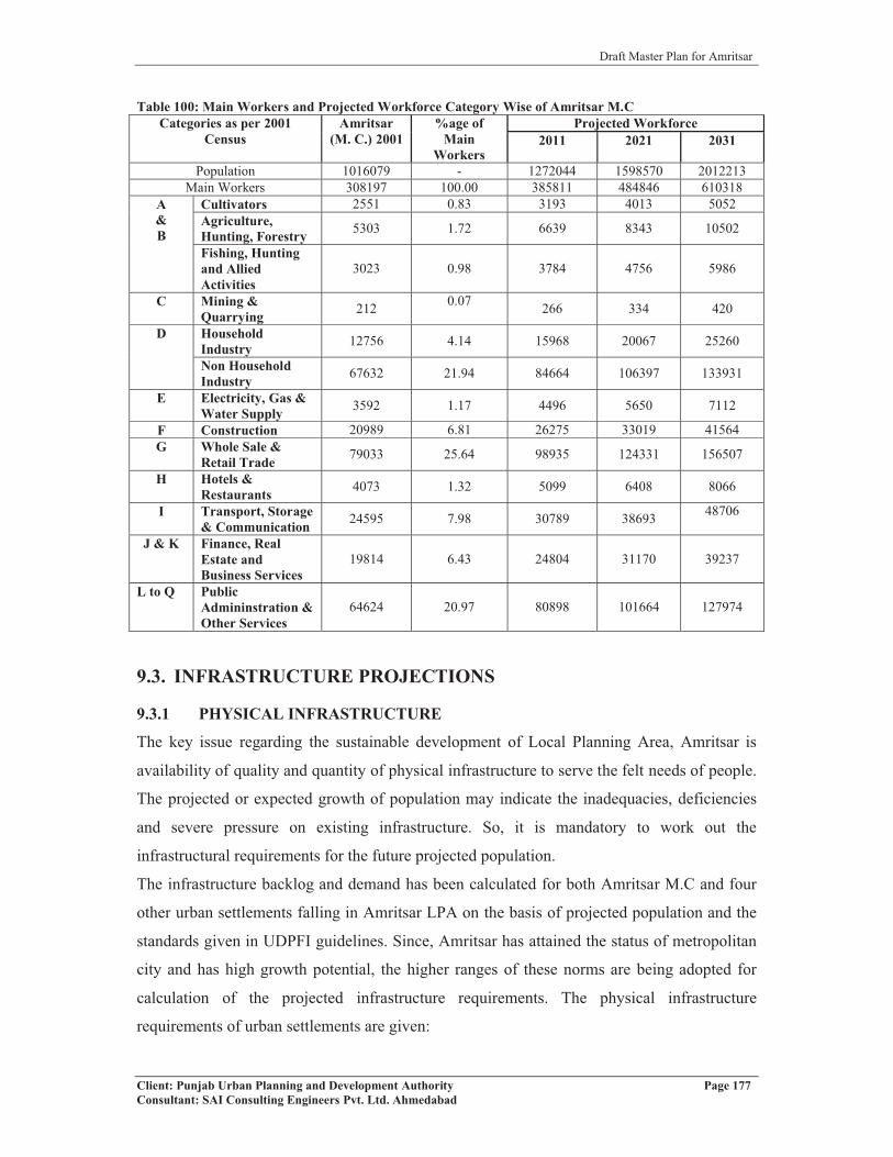
Draft Master Plan for Amritsar
Client: Punjab Urban Planning and Development Authority Page 177Consultant: SAI Consulting Engineers Pvt. Ltd. Ahmedabad
Table 100: Main Workers and Projected Workforce Category Wise of Amritsar M.CCategories as per 2001
CensusAmritsar
(M. C.) 2001%age of
MainWorkers
Projected Workforce2011 2021 2031
Population 1016079 - 1272044 1598570 2012213Main Workers 308197 100.00 385811 484846 610318
A&B
Cultivators 2551 0.83 3193 4013 5052Agriculture,Hunting, Forestry 5303 1.72 6639 8343 10502
Fishing, Hunting and Allied Activities
3023 0.98 3784 4756 5986
C Mining & Quarrying 212 0.07 266 334 420
D HouseholdIndustry 12756 4.14 15968 20067 25260
Non Household Industry 67632 21.94 84664 106397 133931
E Electricity, Gas & Water Supply 3592 1.17 4496 5650 7112
F Construction 20989 6.81 26275 33019 41564G Whole Sale &
Retail Trade 79033 25.64 98935 124331 156507
H Hotels & Restaurants 4073 1.32 5099 6408 8066
I Transport, Storage & Communication 24595 7.98 30789 38693 48706
J & K Finance, Real Estate and Business Services
19814 6.43 24804 31170 39237
L to Q PublicAdmininstration & Other Services
64624 20.97 80898 101664 127974
9.3. INFRASTRUCTURE PROJECTIONS
9.3.1 PHYSICAL INFRASTRUCTURE
The key issue regarding the sustainable development of Local Planning Area, Amritsar is
availability of quality and quantity of physical infrastructure to serve the felt needs of people.
The projected or expected growth of population may indicate the inadequacies, deficiencies
and severe pressure on existing infrastructure. So, it is mandatory to work out the
infrastructural requirements for the future projected population.
The infrastructure backlog and demand has been calculated for both Amritsar M.C and four
other urban settlements falling in Amritsar LPA on the basis of projected population and the
standards given in UDPFI guidelines. Since, Amritsar has attained the status of metropolitan
city and has high growth potential, the higher ranges of these norms are being adopted for
calculation of the projected infrastructure requirements. The physical infrastructure
requirements of urban settlements are given:

Draft Master Plan for Amritsar
Client: Punjab Urban Planning and Development Authority Page 178Consultant: SAI Consulting Engineers Pvt. Ltd. Ahmedabad
9.3.1.1 Water Supply
The estimated water demand for a city is broadly classified as domestic and non-domestic.
The domestic water demand includes per capita consumption and system losses, while non
domestic water demand includes industrial and commercial consumption, institutional
consumption and fire fighting demand.
Domestic Requirement
The domestic water requirement up to the year 2031for Amritsar metropolis have been
calculated by taking the desirable norm of 200 LPCD for large and metro cities as given in
UDPFI guidelines. The projections for water requirements in different phases have been
shown in the table below:Table 101: Projections and Requirements of Different Aspects of Water Supply System
Service Head
Existing/ Desired LevelService Levels, Demand and Gaps
Unit Existing(2010)
By Year 2017 By Year 2024 By Year 2031
Indi
cato
r
Cur
rent
leve
l
Des
ired
Lev
el
Dem
and
Req
uire
men
t
Dem
and
Req
uire
men
t
Dem
and
Req
uire
men
t
1 Daily SupplyPer-capita supply (LPCD)
130 200 MLD 137.6 293.6 156 344.5 50.9 402.4 57.9
2 Treatment
Treatment capacity against supply (%)
90.0 100.0 MLD 139.5 293.6 154.1 344.5 50.9 402.4 57.9
3 Distribution Network
Distribution Network length against road length (%)
196 85.00 KM 990.0 1197.9 207.9 1405.7 415.7 1642.0 236.3
4Elevated Storage Capacity
Elevated Storage Capacity w.r.t. Supply (%)
12.35 33.00 ML 17.0 96.9 79.9 113.7 16.8 132.8 19.1
5 Metering System/ Installation of water meters - - Nos 129055 293592 164537 344533 50941 402443 57910
Non-Domestic Requirement
Industrial Demand: Bulk water supplied to industrial establishment will be considered as per
specific requirement of each industry. However, the figure of 200 lpcd includes water
requirements for commercial, institutional and minor industries.
Fire Demand: As per CPHEEO recommendations, a provision of 100 kilo liter per day based
on formula of 100p, where P = population in thousands, shall be kept in mind.

Draft Master Plan for Amritsar
Client: Punjab Urban Planning and Development Authority Page 179Consultant: SAI Consulting Engineers Pvt. Ltd. Ahmedabad
Unaccounted For Water (UFW): As per Central Public Health and Environmental
Engineering Organization (CPHEEO) manual, a maximum provision of 15% towards
unaccounted water losses shall be made.
Hence, total water demand requirement for the city is of the order of 463MLD. Further, there
is no Water Treatment Plant existing in the city and all the water is treated either by
chlorination or bleaching powder. So, there is an urgent requirement of treatment plant in the
city for supply of potable water in future. While comparing the length of water supply lines
with that of the road length, the network boasts of a quite healthy state, i.e. 196%, in
comparison to the standard of 85%. By 2031, 1642.0 KM of water supply system will be
required. The demand in case of water storage capacity in Overhead Supply Reservoir
(OHSR) is of 132.8 MLD for 2031against current level is 17 MLD. Lastly, in case of water
meters, 1,29,055 meters are installed till 2009, while 4,02,443 meters in total will be required
for the M. C. population of 20,12,213, thus showing the additional requirement of 2,73,388
for the period of 2010 to 2031.
Thus, the water supply situation in case of Amritsar city shows a high demand in case of all
parameters, i.e. demand of water supply as well as water treatment, distribution network,
OHSR (or elevated storage capacity), installation of water meters etc. for the people.
9.3.1.2 Sewerage
With respect to the increase in population of the city, the requirement in sewerage sector has
been calculated in different sectors of sewerage system (Refer table no.102). Table 102: Projections and Requirements of different aspects of Sewerage System
Service Head
Existing/ Desired LevelService Levels, Demand and Gaps
Unit Existing(2010)
By Year 2017 By Year 2024 By Year 2031
Indi
cato
r
Cur
rent
leve
l
Des
ired
leve
l
Dem
and
Req
uire
men
t
Dem
and
Req
uire
men
t
Dem
and
Req
uire
men
t
1
System Coverage /Collection System
Collection Length against Road Length (%)
93.13 100 KM 611.13 1409.2 840.24 1653.7 244.51 1931.7 277.97
2 Treatment
Treatment capacity against supply (%)
0.00 100 MLD 0.00 234.87 34.87 275.63 40.76 321.95 46.33
Regarding coverage aspect, the existing length of sewerage system is 569 kms, which is
93.13% with respect to the road length in the city in comparison to the desired level of 100%.
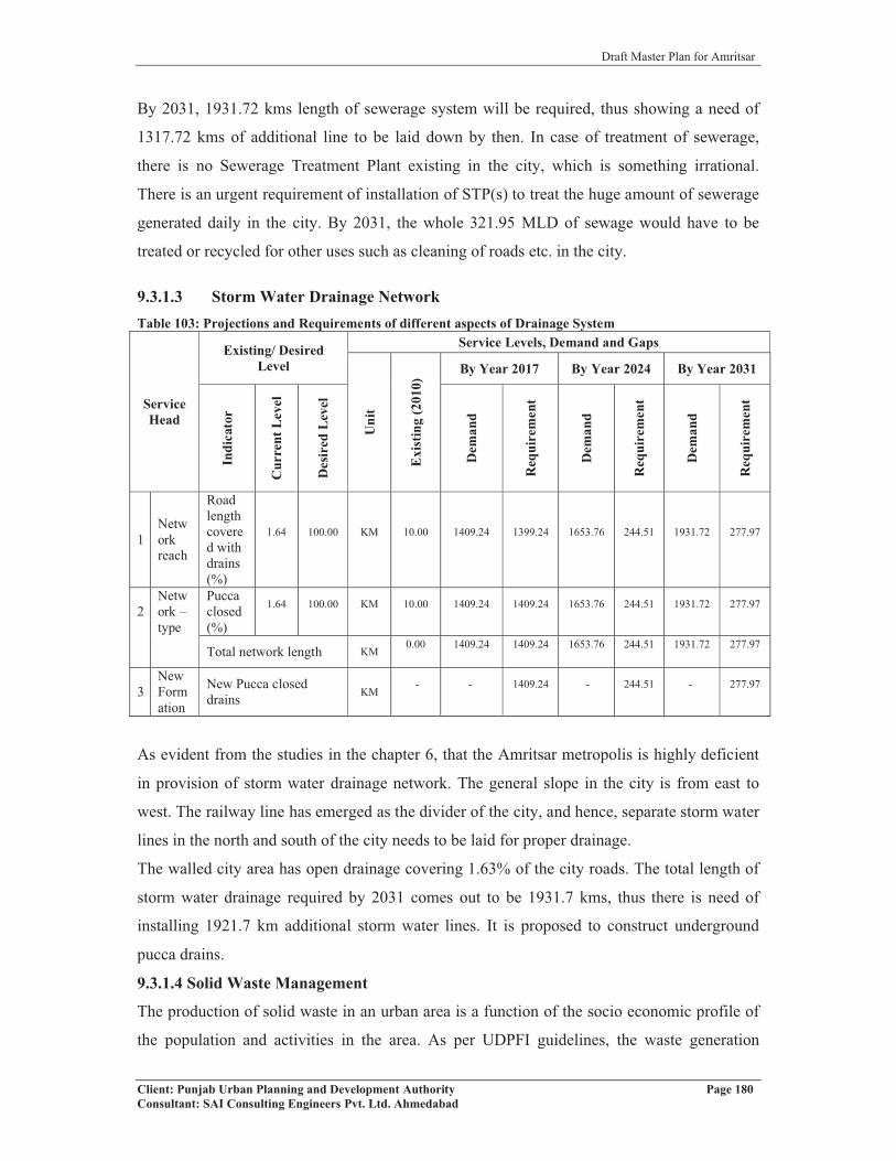
Draft Master Plan for Amritsar
Client: Punjab Urban Planning and Development Authority Page 180Consultant: SAI Consulting Engineers Pvt. Ltd. Ahmedabad
By 2031, 1931.72 kms length of sewerage system will be required, thus showing a need of
1317.72 kms of additional line to be laid down by then. In case of treatment of sewerage,
there is no Sewerage Treatment Plant existing in the city, which is something irrational.
There is an urgent requirement of installation of STP(s) to treat the huge amount of sewerage
generated daily in the city. By 2031, the whole 321.95 MLD of sewage would have to be
treated or recycled for other uses such as cleaning of roads etc. in the city.
9.3.1.3 Storm Water Drainage NetworkTable 103: Projections and Requirements of different aspects of Drainage System
ServiceHead
Existing/ Desired Level
Service Levels, Demand and Gaps
Uni
t
Exi
stin
g(2
010)
By Year 2017 By Year 2024 By Year 2031
Indi
cato
r
Cur
rent
Lev
el
Des
ired
Lev
el
Dem
and
Req
uire
men
t
Dem
and
Req
uire
men
t
Dem
and
Req
uire
men
t
1Network reach
Road length covered with drains (%)
1.64 100.00 KM 10.00 1409.24 1399.24 1653.76 244.51 1931.72 277.97
2Network –type
Pucca closed (%)
1.64 100.00 KM 10.00 1409.24 1409.24 1653.76 244.51 1931.72 277.97
Total network length KM0.00 1409.24 1409.24 1653.76 244.51 1931.72 277.97
3New Formation
New Pucca closed drains KM
- - 1409.24 - 244.51 - 277.97
As evident from the studies in the chapter 6, that the Amritsar metropolis is highly deficient
in provision of storm water drainage network. The general slope in the city is from east to
west. The railway line has emerged as the divider of the city, and hence, separate storm water
lines in the north and south of the city needs to be laid for proper drainage.
The walled city area has open drainage covering 1.63% of the city roads. The total length of
storm water drainage required by 2031 comes out to be 1931.7 kms, thus there is need of
installing 1921.7 km additional storm water lines. It is proposed to construct underground
pucca drains.
9.3.1.4 Solid Waste Management
The production of solid waste in an urban area is a function of the socio economic profile of
the population and activities in the area. As per UDPFI guidelines, the waste generation
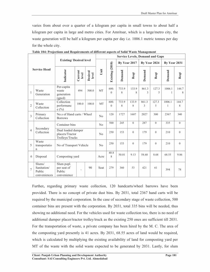
Draft Master Plan for Amritsar
Client: Punjab Urban Planning and Development Authority Page 181Consultant: SAI Consulting Engineers Pvt. Ltd. Ahmedabad
varies from about over a quarter of a kilogram per capita in small towns to about half a
kilogram per capita in large and metro cities. For Amritsar, which is a large/metro city, the
waste generation will be half a kilogram per capita per day i.e. 1006.1 metric tonnes per day
for the whole city.Table 104: Projections and Requirements of different aspects of Solid Waste Management
Service Head
Existing/ Desired levelService Levels, Demand and Gaps
Uni
t
Exis
ting
(201
0) By Year 2017 By Year 2024 By Year 2031In
dica
tor
Cur
rent
leve
l
Des
ired
leve
l
Dem
and
Req
t
Dem
and
Req
t
Dem
and
Req
t
1 Waste Generation
Per-capita waste generation (gpcd)
494 500.0 MT600.
0733.9
8133.9
8861.3
3127.3
51006.1
1144.7
8
2 Waste Collection
Collection performance (%)
100.0 100.0 MT 600.0
733.98
133.98
861.33
127.35
1006.11
144.78
3 Primary Collection
No.s of Hand carts / Wheel Borrows No 120 1727 1607 2027 300 2367 340
4 Secondary Collection
Container bins No 500 245 0 287 0 335 0
Dual loaded dumper placers/Tractor Trolleys/Trucks
No 250 153 0 179 0 210 0
5Waste transportation
No of Transport Vehicle No 250 153 0 179 0 210 0
6 Disposal Composting yard Acre40.8
8 50.01 9.13 58.68 8.68 68.55 9.86
7
Slums/ Sanitation/ Public conveniences
Slum popl. per seat of Public convenience
- 90 Seat 279 360 53 421 61 394 78
Further, regarding primary waste collection, 120 handcarts/wheel barrows have been
provided. There is no concept of private dust bins. By 2031, total 2367 hand carts will be
required by the municipal corporation. In the case of secondary stage of waste collection, 500
container bins are present with the corporation. By 2031, total 335 bins will be needed, thus
showing no additional need. For the vehicles used for waste collection too, there is no need of
additional dumper placer/tractor trolley/truck as the existing 250 ones are sufficient till 2031.
For the transportation of waste, a private company has been hired by the M. C. The area of
the composting yard presently is 41 acres. By 2031, 68.55 acres of land would be required,
which is calculated by multiplying the existing availability of land for composting yard per
MT of the waste with the solid waste expected to be generated by 2031. Lastly, for slum

Draft Master Plan for Amritsar
Client: Punjab Urban Planning and Development Authority Page 182Consultant: SAI Consulting Engineers Pvt. Ltd. Ahmedabad
dwellers, it is figured out that one public convenience would be needed on each 90 slum
dwellers. 279 such conveniences are available presently, and by 2031, 78 more will be
required (Refer table no.104).
Thus, there is a significant improvement in the solid waste management with the
implementation of phase I (collection, segregation, storage and transportation) of the system.
With privatization, the process of waste collection has improved. It is hoped that the demands
taken out for various aspects of solid waste management will be fulfilled with the
implementation of phase II (disposal and treatment).
9.3.1.5 Traffic &Transportation and Street Lights
The traffic and transportation is an important aspect because it provides connectivity between
different landuses/parts of an area. So, analysis of existing situation and planning for future is
the most vital part. The total municipal road length comes out to be 611.13 kms, with per
capita availability of 0.51 m against the standard of 0.96 m. The demand of road length
according to the standards is projected as 1932 kms by 2031. The average road width is 3.6 m
with respect to all types of roads available within the city, which is less than the desired level
of 7m. These roads are divided into 4 types, with bituminous roads forming the major share,
i.e 527.03 km out of 611.13km. The other three are concrete (13.40 km), earthen (60 km) and
WBM (10.70 km) roads. The projections are made taking the viewpoint that only two types
of roads should be built with major share to bituminous roads (85% of total roads), and the
rest 15% to concrete roads. Accordingly, 1641.97 km of roads is to be built under bituminous
roads and 289.76 km under concrete. While 60 kms of earthen road is proposed to be
converted to bituminous and 10.70 kms of WBM to concrete road, the rest of the demand will
be fulfilled by new constructions.
With regard to the street lights, the average spacing between two lamp poles comes out to be
37 m, which is calculated by dividing the total length of roads by the total no. of street lights.
By the year 2031, 64391 street lights will be required in number in comparison to 16514
presently, taking the standard spacing of 30 m between the two poles. Also, the share under
different types of lights will be changed with priority given to high power lamps, followed by
tubelights and high mast lamps. By the year 2031, more high power lamps (33466),
tubelights (14363) and 48 number of high mast lamps will be required.
Thus, there is a need of increase in roads by 1175 kms in the form of bituminous roads. In
case of street lights too, more high power lamps are proposed, with a substantial share to
tubelights too (Refer table no.105).
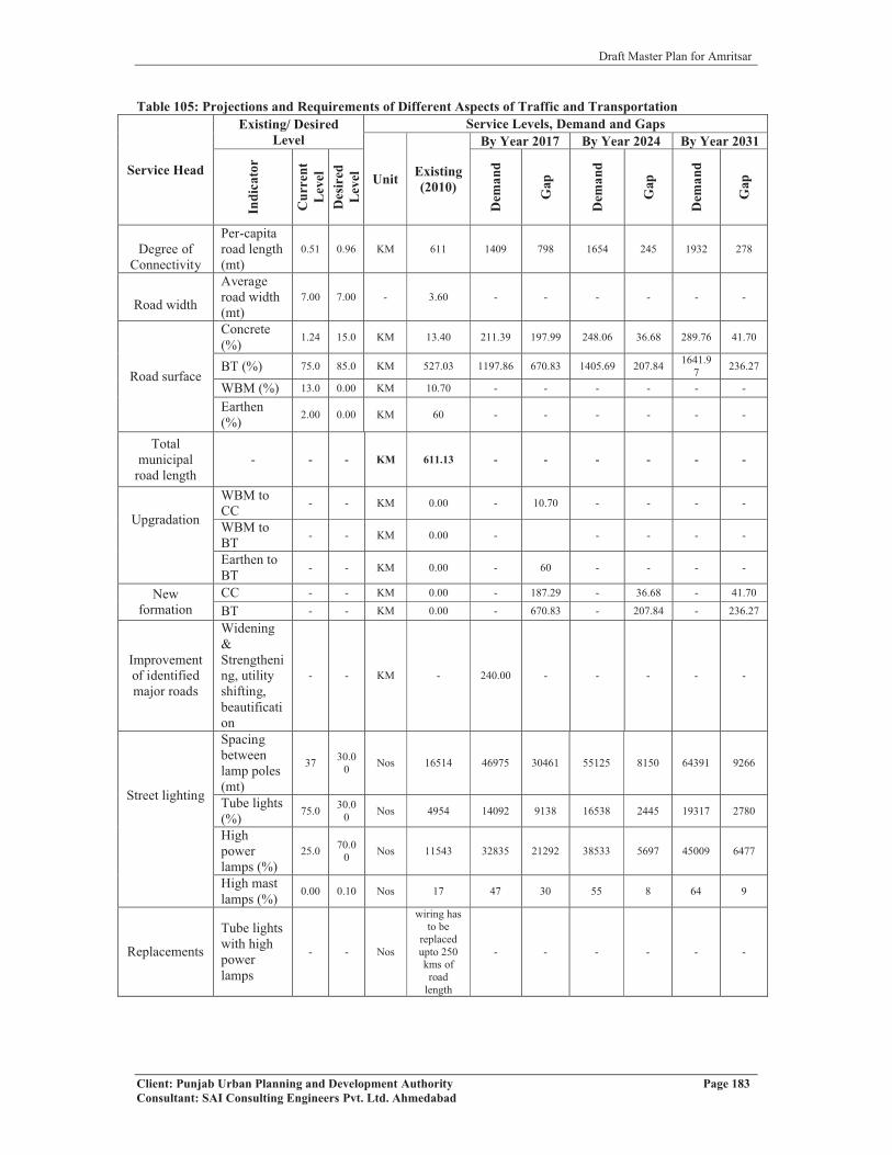
Draft Master Plan for Amritsar
Client: Punjab Urban Planning and Development Authority Page 183Consultant: SAI Consulting Engineers Pvt. Ltd. Ahmedabad
Table 105: Projections and Requirements of Different Aspects of Traffic and Transportation
Service Head
Existing/ Desired Level
Service Levels, Demand and Gaps
Unit Existing(2010)
By Year 2017 By Year 2024 By Year 2031
Indi
cato
r
Cur
rent
Lev
elD
esir
edL
evel
Dem
and
Gap
Dem
and
Gap
Dem
and
Gap
Degree of Connectivity
Per-capita road length (mt)
0.51 0.96 KM 611 1409 798 1654 245 1932 278
Road width
Average road width (mt)
7.00 7.00 - 3.60 - - - - - -
Road surface
Concrete (%) 1.24 15.0 KM 13.40 211.39 197.99 248.06 36.68 289.76 41.70
BT (%) 75.0 85.0 KM 527.03 1197.86 670.83 1405.69 207.84 1641.97 236.27
WBM (%) 13.0 0.00 KM 10.70 - - - - - -
Earthen (%) 2.00 0.00 KM 60 - - - - - -
Total municipal
road length- - - KM 611.13 - - - - - -
Upgradation
WBM to CC - - KM 0.00 - 10.70 - - - -
WBM to BT - - KM 0.00 - - - - -
Earthen to BT - - KM 0.00 - 60 - - - -
New formation
CC - - KM 0.00 - 187.29 - 36.68 - 41.70
BT - - KM 0.00 - 670.83 - 207.84 - 236.27
Improvement of identified major roads
Widening & Strengthening, utility shifting, beautification
- - KM - 240.00 - - - - -
Street lighting
Spacing between lamp poles (mt)
37 30.00 Nos 16514 46975 30461 55125 8150 64391 9266
Tube lights (%) 75.0 30.0
0 Nos 4954 14092 9138 16538 2445 19317 2780
High power lamps (%)
25.0 70.00 Nos 11543 32835 21292 38533 5697 45009 6477
High mast lamps (%) 0.00 0.10 Nos 17 47 30 55 8 64 9
Replacements
Tube lights with high power lamps
- - Nos
wiring has to be
replaced upto 250 kms of road
length
- - - - - -

Draft Master Plan for Amritsar
Client: Punjab Urban Planning and Development Authority Page 184Consultant: SAI Consulting Engineers Pvt. Ltd. Ahmedabad
New installations
Tube lights - - Nos
3000 new streetlights
and 500 new
electric poles to be
errected
- 9138 - 2445 - 2780
High Power Lamps
- - Nos - - 21292 - 5697 - 6477
High mast lamps - - Nos 8 - 30 - 8 - 9
9.3.1.6 Power
As per the standards given in UDPFI guidelines, the power consumption works out to be 2
KW per household at city level. Based on above, the power consumption for Amritsar city
has been calculated for different phases in the table 106 below: Table 106: Power Requirement of Amritsar City 2010-2031
Year 2001 2010 2017 2024 2031Population 1016079 1215655 1467960 1722663 2012213Household 184742 221028 266902 313211 365857Power consumption in MW 370 442 534 626.42 731.71No. of 11 KV Sub stations 106(68) 81 98 115 134
Regarding the requirements under electricity, one electric sub station of 11KV is required for
the population of 15000 persons as per the UDPFI guidelines. There are total of 106 sub
stations of capacity 11 KV, existing in Amritsar city against the demand of 81 in the year
2010. Hence, 9 sub stations of capacity 11 KV are required to be established by the year
2024 and another 19 by 2031.
9.3.2 SOCIAL INFRASTRUCTURE
9.3.2.1 Education
The Education sector caters to the young age group of the population and the projections
made are based on the norms and standards given in UDPFI guidelines, just like the norms of
different aspects of physical infrastructure. For social infrastructure, requirements of each of
the urban settlement and villages together have been calculated, though requirements only for
Amritsar M. C. have been discussed here. For the social infrastructure requirements (Refer
annexure no.XIII).
In case of Nursery Schools, the demand for 2031 comes out as 819 against the existing 191,
reflecting an additional requirement of 628 nursery schools. In the case of Primary Schools,
the additional requirement is 152 and for Senior Secondary Schools, it is 88. Likewise, there
will be demand of 20 each of Integrated Schools with and without hostel facility and 46
schools for handicapped children by the end of the planning period.

Draft Master Plan for Amritsar
Client: Punjab Urban Planning and Development Authority Page 185Consultant: SAI Consulting Engineers Pvt. Ltd. Ahmedabad
Coming to the higher level of education, UDPFI sets a standard of one college per 1,25,000
population. The city already has 10 colleges, so by 2031 there will be need of only 6 more
colleges. There will be no need of Technical Education Centres, as the existing 15
polytechnics and ITIs are more than enough even for 2031 population of the city. Similarly,
there will be no need of Technical Centres too, as the present 2 centres are sufficient. Same is
the case with university and Engineering Colleges. For Medical Colleges, the present no. of 5
is well enough to meet the requirement till 2031.
9.3.2.2 Health Care
In terms of health infrastructure, 2 General Hospitals of 300-500 beds capacity are prevailing
in the city, compulsing the need of another 6 such hospitals by 2031. There will be need of 20
each Intermediate Hospitals of 100-300 beds and 80 beds capacity by the end of planning
period. In case of polyclinics, including Community Health Centres and Primary Health
Centres, there would be no additional requirement as there are already 141 against 20
according to the UDPFI standards. This number includes the private hospitals and nursing
homes. Looking at the no. of health institutions dedicated to Maternity and Child Welfare,
and Family Welfare, the requirement comes out as 32. The last in the hierarchy, the
dispensaries would be needed in a much larger number, i.e. 131 as against of 6 according to
the UDPFI standards. In case of health facilities for the livestock of the city and the
surrounding areas, there will be requirement of 16 more veterinary dispensaries.
9.3.2.3 Socio Cultural Facilities
According to the UDPFI standards, 410 community rooms and 130 community halls and/or
libraries would be required by the planning year 2031. Presently, there is no facility of
community rooms in the city. 16 additional Recreational Clubs and 9 music cum drama
centres would be required for the population projected for 2031, while that for the meditation
centres and socio-cultural centres would be 20 and 1, respectively.
In case of sports facilities, 1 additional Divisional Sports Centre/Golf Course, 3 additional
District Sports Centre, 19 Community Sports Centre and 205 Neighbourhood Playgrounds
are needed. In addition, cremation grounds/burial grounds too are considered, though there is
no requirement as such for them till 2031.

Draft Master Plan for Amritsar
Client: Punjab Urban Planning and Development Authority Page 186Consultant: SAI Consulting Engineers Pvt. Ltd. Ahmedabad
9.3.2.4 Utilities/Services
Petrol Pump
Adhering the UDPFI guidelines, the requirement of petrol pump for residential areas in
Amritsar city by 2031comes out as 14, while that for the industrial areas is 33. 2 Petrol
pumps are needed in Freight Complex while 1 pump is reuired for District (Shopping)
Centre.
PoliceRegarding the facilities of police infrastructure, 15 police stations and 43 police posts would
be required in addition. As already there are two police districts (Amritsar Urban and Rural)
situated in the Amritsar district with head office in Amritsar, so there is no need of more
district office. There is also no need of Police Lines. In case of District Jail, the city would
need an additional jail by 2031 as well as one another Civil Defence and Home Guards
office.
Fire Station
Finally, 6 more fire stations would be required by the year 2031. This shall be reflected in the
process of planning the Zonal Plan of Amritsar city. Moreover, fire equipments of these
stations need to be modernized according to the increasing height of the buildings coming up
in the city.
9.4 PARTICIPATORY APPROACH
Apart from data collection from different offices, consultative meetings with different experts
or stakeholders become equally important for effective plan preparation. Likewise, for
effective city planning and development, meeting with different sector experts have been
conducted. A think tank under chairmanship of Honourable Deputy Commissioner has also
been constituted which consists of experts from various sectors to discuss the problems and
potentials of the city (Refer Annexure no.VII). During the process of preparation of master
plan, several consultative meetings have been held with elected representatives of the city
such as Member of Parliament - Navjot Singh Sidhu, Members of Legislative Assembly and
Councillors. The Head of Sri Guru Ramdas School of Planning and that of Architecture
Department of GNDU, and various Non-Government Organizations active in the city
development have also been consulted for better understanding the city problem and
potentials. For the details of meetings and suggestions, refer annexure no.VIII.

Draft Master Plan for Amritsar
Client: Punjab Urban Planning and Development Authority Page 187Consultant: SAI Consulting Engineers Pvt. Ltd. Ahmedabad
9.5 SWOT ANALYSIS Historically settlements positioned on hostile international boundaries invariably suffer from
perpetual neglect and lower level of investment and development. With redrawing the
boundaries in 1947, the geographical mosaic of India in general and state of Punjab in
particular, underwent drastic transformation. From a central location in North West India,
Punjab became a border state. In the process, Amritsar lost its prime position and emerged as
a border settlement. Partition of the country caused enormous damage to this historical city of
promise. With its role as economic capital getting diluted, city gradually lost its premier
position to Ludhiana where major industrialized growth got localized. With low investment
made in the city over a period of time, its edge in the area of employment and economy
generation also got blunted. Based on analytical study of the journey made in the realm of
growth and development during last four centuries of its existence, a SWOT analysis has
been carried out for the city of Amritsar illustrating its inherent strengths and weaknesses,
opportunities offered and threats faced by the city both from within and outside, which has
been used as a framework for redefining the agenda for future growth and development of the
city.
9.5.1 STRENGTHS
The strength of Amritsar Metropolis can be defined in terms of:
� Premier urban centre of the state having historical significance
� Rail and road gateway to the country for flow of goods and passenger traffic
� High degree of rail, road and air accessibility with all major destinations of the
country
� Religious capital of the state - having Golden Temple and Durgiana Mandir, an
international pilgrim destination
� Political capital of the State
� Cultural – historical magnet of international significance
� Tourist destination for both national and international visitors
� City of enormous heritage wealth
� Regional destination and prime distribution centre for goods and services for large
number of small and large urban & rural settlements.
� Hub of quality medical-cum-educational facilities of regional significance
� Textile hub of Northern India

Draft Master Plan for Amritsar
Client: Punjab Urban Planning and Development Authority Page 188Consultant: SAI Consulting Engineers Pvt. Ltd. Ahmedabad
� High degree of national and international air connectivity through international
airport, located at Raja Sansi.
� House of well known Indian food cuisines.
� One of the 35 metropolitan centres of the country
� Diversified economy-providing city with a high degree of buoyancy
� Industrial growth largely based on local skill and entrepreneurship having minimum
impact of economic cycles.
� High degree of workforce employed in manufacturing and trade & commerce.
9.5.2 WEAKNESSES
The city of Amritsar has also number of weaknesses, which can be enumerated in terms of:
� Border settlement with a track record of perpetual threat from hostile neighbor.
� Low level of investment both by parastatal agencies and private sector.
� City growth largely marked by haphazard, unplanned and unauthorized growth
leading to uneconomical use of land with remarkable loss of fertile land.
� Various development agencies operating with overlapping areas and functions, in an
uncoordinated manner.
� Absence of comprehensive statutory development plan leading to confused land use,
marked by extreme congestion in the core and sporadic development all around.
� Overcrowding of buildings on land and people in buildings with large scale
unauthorized and unplanned sub-divisions in walled city, in absence of clear policy
for the development of Walled City.
� Poor road geometry and inadequate capacity of existing road network.
� Extreme vehicular congestion and absence of parking within and outside the core area
of the city.
� Location of major rail and road network in close proximity and crossing each other
within the city causing traffic bottlenecks in the process.
� Mushrooming of unplanned and unauthorized colonies.
� Acute shortage of housing both qualitatively and quantitatively.
� Mushrooming of large number of slums.
� Absence of adequate infrastructure, facilities and amenities both social & physical
within the city.
� Absence of tourism related quality infrastructure.

Draft Master Plan for Amritsar
Client: Punjab Urban Planning and Development Authority Page 189Consultant: SAI Consulting Engineers Pvt. Ltd. Ahmedabad
� Existence of non-conforming land uses on a large scale due to mix of industrial and
residential areas besides undesirable location of hospitals and educational institutions.
� Absence of adequate number of open spaces within core area.
� High degree of road congestion caused by intermediate mode of transport and bus
stops.
� Lack of appreciation on conserving and preserving the valuable heritage.
� Absence of Storm Water Drainage, Sewerage Treatment Plant and poor Solid Waste
Management.
� High Degree of environmental pollution caused by industry and Kerosene used as a
fuel by the Autos.
� High degree of air, water, noise, visual and land pollution.
9.5.3 OPPORTUNITIES
With the softening and improved relationship with Pakistan, the city of hope and joy offers
enormous opportunities in terms of:
� Major international trade and commodity export centre, both by land and air, for
Pakistan, Afghanistan, Iran and other European countries.
� Attracting large investment and generating considerable employment.
� Emerging major tourist destination with large increased flow of tourists, both from
within and outside India.
� Regaining premier position and becoming the financial capital of the State of Punjab,
through rapid population growth.
� Becoming air cargo hub for northern India.
� Emerging growth of value added industries and hub of agro based food processing
industries catering to demand of neighboring countries.
� Rapid physical growth and expansion on the outskirts of city in radial directions
particularly along the G.T. Road towards Lahore (Pakistan) and the Amritsar
International Airport.
� Major demand growth for quality infrastructure in terms of education, health, tourism,
trade & commerce, entertainment, housing, etc.
� Major collection and distribution centres for goods and commodities and services of
the Northern region.

Draft Master Plan for Amritsar
Client: Punjab Urban Planning and Development Authority Page 190Consultant: SAI Consulting Engineers Pvt. Ltd. Ahmedabad
� Inclusion of the city in the list of 63 major settlements under Jawaharlal Nehru
National Urban Renewal Mission for leveraging reforms and resources for the growth
and development of the city.
� Leveraging on the city heritage and likelihood of its designation as World Heritage
City.
9.5.4 THREATS
Despite inherent strengths, existing weaknesses, available opportunities, city faces numerous
threats, which can be identified in terms of:
� Change in the existing geo-political goodwill scenario leading to emergence of a
hostile threat perception from the neighboring countries.
� Low level of investment by State and parastatal agencies in basic infrastructure.
� Absence of enabling environment for leveraging the involvement of private sector.
� Delay in evolving a comprehensive Master Plan and Regional Plan for promoting
orderly growth and development of city and region.
� Delay in putting in place an effective and efficient mechanism of urban governance
and eliminating multiplicity of agencies to check unauthorized, unplanned and
haphazard development within and outside the city.
� Delay in placing appropriate framework for proper, preservation and conservation of
valuable built heritage.
� Non-rationalization of inter and intra-city traffic and improving/upgrading
transportation network.
� Delay in creating appropriate infrastructures related to tourism, trade & commerce.
� Delay in decongesting the city core (walled city) and rationalizing policy for its
growth and development.
� Delay in bridging the existing gaps in basic infrastructures and services in and around
the city.
� Delay in addressing issues on priority related to slums, environment and urban
poverty.
9.6 VISION AND MISSION
Considering the role and importance of the cities in economic regeneration and launching
nation on the path of rapid development, it becomes critical that the urban centres be made
livable, sustainable providers of employment, generators of wealth, ensurers of high degree
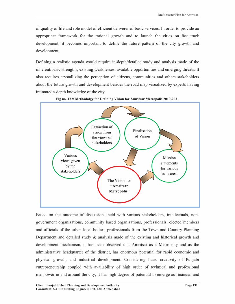
Draft Master Plan for Amritsar
Client: Punjab Urban Planning and Development Authority Page 191Consultant: SAI Consulting Engineers Pvt. Ltd. Ahmedabad
of quality of life and role model of efficient deliverer of basic services. In order to provide an
appropriate framework for the rational growth and to launch the cities on fast track
development, it becomes important to define the future pattern of the city growth and
development.
Defining a realistic agenda would require in-depth/detailed study and analysis made of the
inherent/basic strengths, existing weaknesses, available opportunities and emerging threats. It
also requires crystallizing the perception of citizens, communities and others stakeholders
about the future growth and development besides the road map visualized by experts having
intimate/in-depth knowledge of the city. Fig no. 132: Methodolgy for Defining Vision for Amritsar Metropolis 2010-2031
Based on the outcome of discussions held with various stakeholders, intellectuals, non-
government organizations, community based organizations, professionals, elected members
and officials of the urban local bodies, professionals from the Town and Country Planning
Department and detailed study & analysis made of the existing and historical growth and
development mechanism, it has been observed that Amritsar as a Metro city and as the
administrative headquarter of the district, has enormous potential for rapid economic and
physical growth, and industrial development. Considering basic creativity of Punjabi
entrepreneurship coupled with availability of high order of technical and professional
manpower in and around the city, it has high degree of potential to emerge as financial and
Finalisation of Vision
Various views given
by the stakeholders
Extraction of vision from the views of stakeholders
Mission statements for various focus areas
The Vision for “Amritsar
Metropolis”

Draft Master Plan for Amritsar
Client: Punjab Urban Planning and Development Authority Page 192Consultant: SAI Consulting Engineers Pvt. Ltd. Ahmedabad
religious capital as well as export hub of the State of Punjab, provided required level of
support systems, quality infrastructure, user friendly policy options, state of art
developmental and institutional mechanisms are put in place. In order to make Amritsar grow
and emerge as one of the most important humane, dynamic, productive, sustainable, eco-
friendly, pollution free and vibrant urban centre of the State of Punjab, the future of the city is
envisioned as:
� Amritsar metropolis to be developed as
o A multifunctional centre of repute.
o Financial Capital of the state.
o Industrially vibrant, eco-friendly city.
o Sustainable, inclusive and harmonious city.
o Providing assured quality of life to all its residents, including poorest of the poor.
� The desired quality of life in the city to be achieved by
o Putting in place a higher order of urban governance.
o Promoting high degree of operational efficiency.
o Ensuring environmental quality.
� Sustainability and inclusiveness in the city to be achieved through
o Assured gainful employment to all the stakeholders.
o Providing access to basic services and amenities of life at affordable cost.
o Ensuring high degree of efficiency in the service delivery.
o Making city free from slums.
o Actively involving all the stakeholders in the process of city planning,
development and management.
� In this process Amritsar city shall be planned, developed and leveraged as
o A National Heritage.
o A Tourist Hub of National and International Repute.
o An International Pilgrim Destination.
o A Cultural Hub.
o A Financial and Industrial Capital.
o A Medical-cum-Educational Destination of National Repute.
o A Role Model of Planned Urban Development in the State.

Draft Master Plan for Amritsar
Client: Punjab Urban Planning and Development Authority Page 193Consultant: SAI Consulting Engineers Pvt. Ltd. Ahmedabad
9.6.1 MISSION STATEMENT FOR FOCUSSED AREAS
In order to achieve the objectives and goals enshrined in the vision statement, mission
statement for various focused areas has been detailed out below:
a) GROWTH MANAGEMENT
• Promoting planned development through effective city planning.
• Rationalizing land use pattern for effective traffic management and provision of basic
services and amenities.
• Rationalizing the Peri-Urban Development.
• Minimizing haphazard, unplanned and sub standard growth.
• Making effective plan implementation and enforcement as integral part of city
planning and development process.
• Conserving and revitalizing the Walled City.
• Making growth management process more participatory.
• Preparing/Reviewing Master Plans on regular basis.
• Improving system of building plan approvals through use of IT and GIS.
• Making urban development self sustaining.
• Leveraging growth management process for resource generation.
• Removing all legal and administrative roadblocks in the efficient growth
management.
b) URBAN ENVIRONMENT
• Making urban environment integral and essential part of city development process.
• Making environment integral part of planning and decision making process.
• Treating effectively entire sewage generated within the city.
• Improving solid waste management through state of art technologies.
• Developing and improving existing gardens, parks and open spaces, besides creating
new open spaces to make Amritsar a city of gardens.
• Making city free from air, water, land and noise pollution.
• Promoting optimum use of available natural resources.
c) URBAN SERVICES
i) Water Supply
• Ensuring safe, equitable, reliable, adequate and quality water supply.
• Ensuring 100% coverage of the city and regulate water supply.

Draft Master Plan for Amritsar
Client: Punjab Urban Planning and Development Authority Page 194Consultant: SAI Consulting Engineers Pvt. Ltd. Ahmedabad
• Improving operational efficiency of water supply system by minimizing wastage and
leakage.
• Removing illegal water connections and public stand posts (PSP).
• Minimizing ground water consumption by promoting water conservation.
• Promoting rain water harvesting and recycling of water.
• Using canal water as additional source to meet the city demand.
• Making entire water supply based on metering system.
• Recycling the Sarovar water of Golden Temple, Durgiana Temple and other religious
institutions for meeting the agricultural needs.
ii) Sewerage and Drainage
• Ensuring total coverage of the city with sewerage and drainage system including
slums.
• Promoting eco-friendly decentralized treatment system.
• Minimizing sewerage generation through water saving appliances.
• Promoting recycling of sewage.
• Promoting protection of natural water bodies.
• Promoting optimum use of storm water as an alternate source of water supply for
irrigation.
• Promoting effective mechanism for disposal of treated sullage.
• Prohibiting disposal of untreated sullage into natural water bodies.
iii) Solid Waste Management
• Improving the solid waste management in the city using best practices.
• Using PPP model for solid waste management.
• Promoting effective “Recycling” of Solid Waste.
• Making solid waste management people centric.
• Integrating solid waste disposal and rag pickers for efficient solid waste management
and resource/employment generation for the poor.
• Creating awareness to minimize solid waste generation.
• Creating effective system for disposal of toxic waste generated by health sector and
industry.
• Making electronic waste disposal integral part of city management system.
• Minimizing use of non-degradable plastics.

Draft Master Plan for Amritsar
Client: Punjab Urban Planning and Development Authority Page 195Consultant: SAI Consulting Engineers Pvt. Ltd. Ahmedabad
iv) Storm Water Disposal
• Reviving the storm water disposal system of the city.
• Improving the capacity of water bodies existing within and outside the city.
• Making optimum use of storm water for reducing the demand for fresh water.
• Improving the natural water drainage channels by desilting and stopping the sewage
water from entering the water channels.
• Constructing storm water disposal channels and integrating each household with the
system.
• Integrating the storm water channels with the city development process using land
suitability analysis.
v) Traffic and Transportation
• Improving safety, mobility and efficiency of traffic within and outside the city.
• Segregating and rationalizing the inter and intra-city traffic.
• Improving road geometry and road capacity of existing network.
• Minimizing the use of private transport and to promote public transport.
• Using planning as a mechanism for rationalizing and minimizing traffic.
• Minimizing pollution caused by traffic and transportation.
• Creating new road network and to improve the existing network to promote
operational efficiency of traffic.
• Reviewing the existing activity pattern to rationalize the traffic.
• Providing adequate parking spaces to remove traffic bottlenecks.
• Creating a cost–effective and efficient mechanism of mass transportation.
• Minimizing traffic within the Walled City.
• Promoting pedestrianisation within the Walled city.
vi) Urban Poor
• Making urban poor integral part of the city planning, growth and development
process.
• Improving accessibility to basic services for the urban poor.
• Providing urban poor with better living environment.
• Creating enough employment opportunities for improving financial status of poor.
• Providing adequate opportunities for creating affordable shelter duly supported by
basic services.
• Empowering poor to be integral part of city development process.

Draft Master Plan for Amritsar
Client: Punjab Urban Planning and Development Authority Page 196Consultant: SAI Consulting Engineers Pvt. Ltd. Ahmedabad
• All poverty alleviation programmes to be made more focused and poor centric.
• Minimizing growth of slums/shanty towns and improving existing slums.
vii) Social Infrastructure
• Providing adequate sites based on norms, for creating/developing various social
infrastructures.
• Involving private and corporate sectors for providing, developing and maintenance of
social infrastructure.
• Making optimum use of mechanism of planned development for developing adequate
and quality infrastructure.
• Promoting community participation in maintenance and upkeep of social
infrastructure.
viii) Urban Governance
• Making Municipal Corporation a role model of good governance.
• Creating appropriate, effective and efficient mechanism for grievance redressal.
• Improving and strengthening the urban local body in terms of structure and quality
manpower and resources.
• Creating appropriate mechanism for promoting higher interface between ULB and
communities on regular basis at ward and city levels.
• Making urban governance citizen centric.
• Adopting best practices/systems for improving transparency, grievance redressal and
accountability.
• Promoting transparency and objectivity in all public transactions and decision
making.
• Involving effectively NGOs and CBOs in the poverty alleviation programmes.
ix) Finance
• Improving financial base for the city through broad, diversified and inflation protected
revenue base.
• Rationalizing the pricing of urban services on the principal of “USER MUST PAY”.
• Optimizing use of available resources through better prioritization of projects and
improved management.
• Improving financial management through adoption of standard accounting policies.

Draft Master Plan for Amritsar
Client: Punjab Urban Planning and Development Authority Page 197Consultant: SAI Consulting Engineers Pvt. Ltd. Ahmedabad
• Achieving continuous reduction in service delivery and overhead costs through better
financial management.
• Minimizing expenditure on manpower and non-plan activities.
• Promoting optimisation of available municipal land for generating resources for city
development.
• Making use of good practices in urban development for resource generation.
x) Heritage
• Identifying and documenting the entire manmade and natural heritage.
• Making heritage preservation and conservation integral part of city planning
development process.
• Creating awareness among the people about the role and importance of heritage
preservation and conservation.
• Making heritage preservation a people centric movement.
• Involving cultural bodies NGOs, CBOs, Educational Institutions and experts in the
process of heritage conservation.
• Putting in place dedicated set of building regulations for heritage area development.

Draft Master Plan for Amritsar
Client: Punjab Urban Planning and Development Authority Page 198Consultant: SAI Consulting Engineers Pvt. Ltd. Ahmedabad
CHAPTER 10
THE MASTER PLAN10.1 COMPONENTS OF THE MASTER PLANMaster Plan defines the broad proposals of city growth and development besides allocation of
land for various urban uses including residential, industrial, commercial, recreational, public
and semi-public etc. It also defines existing and proposed road network, street pattern and
traffic circulation system for the area included in the Master Plan; areas to be preserved and
conserved; development of areas of natural beauty and landscape together with preservation
of features, structures or places of historical, architectural interest and environmental value.
Master Plan also includes different zones into which city can be subdivided besides defining
Zonal Plan and zoning regulations for regulating development within each zone.
Accordingly, the Master Plan is an important instrument for guiding and regulating
comprehensive development of a city over a period of time and contributing to its rational
and planned development, both conceptually and operationally. In this context, Master Plan
of Amritsar Local Planning Area has been prepared for a period of 2010-2031. It comprises
of five major components that include:
� Existing Land use Plan.
� Proposed Land use Plan
� Proposed Traffic and Transportation Plan
� Report containing detailed study and analysis of existing status and future
development strategies for the city and Local Planning Area
� Development Control Regulations
10.2 MASTER PLAN OBJECTIVESFor achieving the long term, vision and mission defined in the Master Plan of Amritsar,
spatial land use planning, infrastructure planning, financing and implementation, effective
management and operation of infrastructure services and regulating and enforcing plan
proposals would be critical. The objective of the Master Plan is to create enabling Spatial and
Land Use Planning framework to achieve the desired vision for LPA, Amritsar. Following
are the set of objectives framed for LPA, Amritsar in specific:
� To create a well defined hierarchy of settlements in order to achieve rational and
planned growth.
� To promote rural-urban interface in order to promote sustainable growth.

Draft Master Plan for Amritsar
Client: Punjab Urban Planning and Development Authority Page 199Consultant: SAI Consulting Engineers Pvt. Ltd. Ahmedabad
� To promote compact development of the area by minimizing diversion of
agricultural to non-agricultural uses.
� To make land allocation for different urban uses in an environmentally
sustainable manner.
� To promote multi nodal development of urban settlements through planned
dispersal of economic activities.
� To make available adequate developed land for public purposes.
� To minimize haphazard, unplanned and sub-standard growth and to promote
planned development and quality environment.
� To effectively manage inter and intra city traffic and transportation through the
mechanism of rationalizing the land use.
� To plan a well-defined system of road hierarchy and providing the missing links
and creating new links for free flow movement of traffic.
� To minimize travel within the city by creating self -contained and self sufficient
communities through provision of good work place relationship.
� To create adequate parking spaces as an integral part of commercial, industrial
and institutional planning and development.
� To rationalize the distribution of physical and social infrastructure in order to
ensure appropriate quality of life.
� To make Amritsar as the most vibrant economic centre by providing state of art
infrastructure and allied activities for promoting balanced regional development.
� To promote, enhance, strengthen and enlarge the existing glory of the Walled City
and to make it hub of culture, trade and commerce, tourism and religious
activities.
� To promote tourism through development of tourism related infrastructure and
create a tourist circuit covering important destination within Amritsar LPA to
enhance the tourist potential of the city.
� To identify man-made and natural heritage and to make heritage conservation as
integral part of the city planning and development process.
Draft Master Plan for Amritsar
Client: Punjab Urban Planning and Development Authority Page 200Consultant: SAI Consulting Engineers Pvt. Ltd. Ahmedabad
10.3 BASIC CONSIDERATIONS FOR PROPOSALSWhile preparing the Proposed Land use Plan, a detailed study and critical analysis has been
made of the notified Local Planning Area of Amritsar in terms of the demographic profile,
economic status, social stratification, physical growth and available physical & social
infrastructure. Analysis has also been made of the existing land use besides the study of the
existing problems and future growth potential of the area. Accordingly, basic considerations
for formulating the Master Plan for the LPA, Amritsar revolve around:
� Integrating the development of urban and rural settlements in order to minimize
migration and to promote the economic and physical development of the urban and
rural settlements.
� To promote sustainable development of all urban and rural settlements based on a
well defined strategy.
� To improve quality of life and living environment within human settlements.
� To make urban settlements free of slums by a well defined and focused strategy of
creating shelter, providing basic amenities and creating employment.
� To make informal sector integral part of the city planning and development process.
� Leveraging the growth potential of Amritsar as the regional and metropolitan centre
besides the administrative status of city as District Head quarter.
� Rationalizing the existing land use pattern through a well defined system of land uses,
zoning regulations and development controls.
� Minimizing haphazard and unplanned growth through a well defined land use pattern.
� Promoting future growth of the city based on the principle of allocation of land uses
and principle of clustering.
� Adopting a strategy of compact development based on phasing in order to optimize
the available land resource and minimizing the cost of infrastructure.
� Adopting the well defined and stratified density pattern for different residential areas
with highest density allocated in the core and minimum density in the periphery of the
town.
� Decongesting the core area of the city (Walled City) by selective dispersal of
activities such as whole markets.
� Leveraging the potential of available regional road, rail and air linkages/ networks
within and outside the state and country, including NH 1, NH 15, Amritsar-Delhi Rail
Line and Airport.

Draft Master Plan for Amritsar
Client: Punjab Urban Planning and Development Authority Page 201Consultant: SAI Consulting Engineers Pvt. Ltd. Ahmedabad
� Rationalizing the traffic and transportation network including relocation of traffic
nodes within the planning area in order to minimize the conflict between inter and
intra city traffic.
� Redefining the hierarchy of roads in terms of Right of Way, structure of the road and
the amenities to be provided.
� Minimizing concentration and promoting equitable distribution of public amenities
and services in the planning area through well-defined norms.
� Minimizing impact of close proximity to international borders.
� Leveraging the industrial potential by providing appropriate area and supportive
infrastructure in the existing industrial focal points and by defining new industrial
areas.
� To leverage the strength of Amritsar in providing quality healthcare services and
promoting healthcare tourism.
� To make Amritsar as the educational hub, both in the area of higher and
technical/medical education,
� To promote heritage and religious tourism for leveraging the economy of Amritsar.
� To remove the mismatch in terms of development, traffic and transporation and
quality of life existing within the city.
� Defining the demographic profile including population distribution and redistribution
within the planning area for the target year of the Master Plan (2031).
� To define norms and standards for physical and social infrastructure based on the
population in terms of area and development norms.
10.4 PROPOSALSLooking critically at the existing morphology of urban settlements and in depth studies made
and detailed analysis carried out in terms of physical, socio-economic and demographical
profile of the planning area, it appears logical and rational that spatial planning framework
for the future growth and development of the Local Planning Area, Amritsar should be
defined in order to ensure the integrated growth of entire planning area and to launch
Amritsar and other settlements on the path of fast trajectory of growth and development.
Accordingly, LPA Amritsar covering an area of 139419 hectares has been visualized in the
four distinct layers that are described in detail below.
Draft Master Plan for Amritsar
Client: Punjab Urban Planning and Development Authority Page 202Consultant: SAI Consulting Engineers Pvt. Ltd. Ahmedabad
Layer I: Area Enclosed by Walled City, Amritsar
Layer II: Area Enclosed By Municipal Corporation, Amritsar
(a) Area North of Railway Line
(b) Area South of Railway Line
Layer III: Area outside M.C Limit and up to the Future Urbanisable Limit
Layer IV: Agricultural/Rural Area
10.4.1 LAYER I: AREA ENCLOSED BY WALLED CITY, AMRITSAR
The walled city has a total area of 350 hectares, which constitutes merely 2.5 percent of the
area of the Amritsar city. It houses approximately 16% of the population of the city.
However, the Walled City, Amritsar has a unique quality of growth and development. It has
the distinction of housing the major cultural and religious landmarks. In addition, it is also the
hub of trade and commerce and symbol of Amritsar City. Accordingly, Walled City has been
considered as the first layer of the entire planning area, being its heart and soul. Considering
the historicity of the area due to the presence of Golden Temple, Jallianwala Bagh, Durgiana
Mandir, Katras, Bungas, Havelis of historical times, narrow streets and specialized markets,
the zone is proposed for preservation, conservation and up-gradation of infrastructure in order
to make it a cultural hub of Amritsar. Considering the inherent strength and value of walled
city as the symbol of physical, social, economic and historical growth, it is proposed to be
developed and declared as “Heritage City to preserve the existing rich heritage.
Accordingly, following strategies are proposed for the walled city of Amritsar:
� To preserve, enhance and promote the basic character of the Walled City
� To promote quality of life by improving, upgrading and providing state of art
infrastructure and services.
� To undertake selective de-congestion of the walled city by shifting of wholesale and
bulk material markets including Fish/Iron Market, Cheel Mandi, Iron Market (Bagh
Akalian), Goldsmith Market, Ghee Mandi, Namak Mandi, wholesale medicine
market, building materials, etc. to identified planned areas outside the Walled City
near Bhagtanwala Gate/along the major road and rail networks.
� To promote de-congestion by eliminating sub-division of land and change of land use
from residential to commercial and others.
� To promote revitalization of walled city area by way of conservative surgery.
� To frame detailed “Urban Design Guidelines” for promoting and enhancing the
quality of urban spaces.

Draft Master Plan for Amritsar
Client: Punjab Urban Planning and Development Authority Page 203Consultant: SAI Consulting Engineers Pvt. Ltd. Ahmedabad
� Shifting of the Goldsmiths market/ activities operating near Golden Temple in order
to minimize the damage caused by them to the world heritage monument “Golden
Temple”
� To promote conservation and preservation of heritage buildings
� To promote Heritage Walk by developing processional route of Maharaja Ranjit
Singh from Ram Bagh Garden to Walled City and its surroundings areas.
� Provision/ Up-gradation of higher level of urban and tourist infrastructure
� To promote, preserve, enhance and augment the bazaar culture in the walled city in
order to make it a role model of urban heritage.
� To minimize vehicular pollution by promoting electric based mass transportation
system.
� Pedestrianization of the walled city in order to decongest and eliminate the traffic
problems due to lack of adequate road width/parking.
� To promote pedestrianization by building special walkways on the stretch from
Chowk Phowara to Golden Temple.
� Implementing time regulation for undertaking loading and unloading activity for
existing wholesale markets within walled city area.
� To identify, create and develop available open spaces through proper landscaping
within walled city.
Considering the critical role, historical importance and typical character of the walled city, it
is proposed that it shall be developed as a distinct entity. Accordingly, a specific, exclusive
and detailed plan for the development of walled city needs to be prepared. The plan should
be based on the prime consideration, having focus on Urban Design and Heritage
Conservation & Preservation. Such a plan would be critical in order to preserve, promote and
enhance the religious, cultural and commercial ambiance of the walled city besides
improving quality of life and productivity of Amritsar Metropolis. The preparation of urban
design/heritage development plan for the walled city needs to be taken up on priority on the
pattern followed for the preparation of Development Plan of Char Minar area of Hyderabad.
Already large numbers of development projects have been/ being taken up for the
development of walled city by various parastatal agencies without any integration. It will be
critical to integrate all these projects within a well defined framework. Accordingly,
preparation of such a Development Plan for walled city assumes importance considering the
Draft Master Plan for Amritsar
Client: Punjab Urban Planning and Development Authority Page 204Consultant: SAI Consulting Engineers Pvt. Ltd. Ahmedabad
huge amount of investments and number of development projects being taken up in the
walled city in isolation.
10.4.1.1 Heritage Zone
In addition to regulating and rationalizing the development of walled city of Amritsar, it has
been considered appropriate to focus on the development around Golden temple and
Jallianwala Bagh, which form the very heart and soul of Amritsar and around which entire
future growth and development of the metropolis would gravitate. However, it has been
observed that the areas around these icons are undergoing rapid change in terms of the
development and architectural vocabulary. The old buildings are being demolished and new
ones are constructed on such sites. The new construction does not gel with the existing
pattern of development and are fast emerging as eye sores. Pattern of designing is not based
on the vernacular architecture with buildings contructed are largely in concrete and glass.
Brick facades are being replaced by glass facades.
Further, the use of land is undergoing rapid transformation with residential areas being
converted into commercial complexes and hotels for catering to tourism and trade and
commerce. All these changes are taking place outside the framework of existing pattern of
development with the result historicity of the area is being marginalized and diluted. In
addition, large volume of built up spaces and change of use of land has resulted in creating
numerous developmental and traffic/transportation problems besides destroying the valuable
heritage which is the very basis of existence and development of Amritsar. Accordingly, it
is critical that the area around Golden Temple, Jallianwala Bagh, Town Hall, Gurudwara
Shaheedan, Gurudwara Ram Sar Sahib and Gurudwara Santokh Sar Sahib should be
carefully and thoughtfully preserved and conserved so that valuable heritage and historic
wealth of the city is not lost in the haze of unplanned and irrational development of the
walled city.
In order to achieve the objective, it is proposed to declare area around Golden Temple,
Jallianwala Bagh, Town Hall, Gurudwara Shaheedan, Gurudwara Ram Sar Sahib and
Gurudwara Santokh Sar Sahib as the Heritage Zone. The Heritage Zone has been identified
in the map of walled city and comprises of areas enclosed by Guru Bazaar, Chaurasti Attari,
Chowk Passian, Katra Jaimal Singh, Katra Baghian, Bazar Cheel Mandi, Bazar Mahan
Singh, Katra Mahan singh, Bazaar Ghee Mandi, Abadi Bagh Ramanand, Katra Himmat
Singh, Chhauni Nihanga, Circular Road, Chatiwind Gate, Bazar Chatiwind, Katra
Ramgarhian, Dhab Basti Ram, Namak Mandi, Katra Amar Singh, Katra Mohar Singh and

Draft Master Plan for Amritsar
Client: Punjab Urban Planning and Development Authority Page 205Consultant: SAI Consulting Engineers Pvt. Ltd. Ahmedabad
Bazar Tunda Talab. The area includes the most valuable heritage of the city including
Golden Temple, Jallianwala bagh, Gurudwara Shaheedan, Gurudwara Santokh Sar Sahib,
Gurudwara Ramsar Sahib besides Town Hall and other buildings. The area to be brought
under the Heritage Zone works out to be approximately 244 acres.
In addition to the Heritage Zone, it is also considered critical to safeguard, protect and
develop the most critical approach to these historic monuments and the Heritage Zone.
Accordingly, Hall Bazaar from Hall Gate to the Town Hall and to Darbar Sahib is also
included in the Heritage Zone so that approach road to these monuments is also
developed/regulated as integral part of the heritage conservation.
In order to protect and enhance the existing character of Heritage Zone, it is proposed to
adopt number of innovative steps, which would inter alia involve.
i) Prohibiting the change of land use and subdivision of land within the heritage zone.
ii) Framing exclusive development control regulation for the heritage zone.
iii) Using different controls in terms of:
a) Floor Area Ratio
b) Height controls
c) Land Use control
d) Set backs/projections
e) Façade control
f) Material control
iv) Using urban design as the mechanism to control and regulate development.
v) Constitution of High Powered Committee comprising of experts in Art,
Architecture, Town Planning, Heritage, History and Engineering to evolve
strategies for development of Heritage Zone including sanctioning of the building
plan falling in the said zone.
vi) Using Vernacular Architecture and the existing architectural features as integral
part of the building design.
vii) Rationalizing advertisement in the heritage zone through advertisement controls.
viii) Pedestrianisation of approach road to Golden Temple and Jallianwala Bagh from
Hall Gate to Town Hall to Jallianwala Bagh/ Golden Temple.
ix) Widening the scope of Galiara project for creating more open spaces/ public vistas
around Golden Temple/ Jallianwala Bagh
x) Shifting the Municipal Corporation office from the Town Hall and remodeling the
building to convert it into a Museum of Amritsar Heritage.

Draft Master Plan for Amritsar
Client: Punjab Urban Planning and Development Authority Page 206Consultant: SAI Consulting Engineers Pvt. Ltd. Ahmedabad
xi) Undertaking large-scale plantation of the available open spaces/ parks existing
within walled city
xii) Appropriately designed signage’s to be put in place at critical areas for
identification of areas of historical, architectural and tourist importance.
However, all the services laid down in the heritage zone shall be made underground
including, electrical, telephone etc. in order to minimize visual pollution. Display of
advertisement on the buildings and along the roads shall be regulated and made integral part
of buildings and available spaces. Special lighting arrangements shall be made to enhance the
visual effect of historic buildings and available spaces. Congestion shall be eliminated by
regulating the movements of vehicles and widening of the fore - courts of historic buildings.
All unauthorized constructions shall be removed, height of the buildings constructed in
heritage zone shall be regulated in order to ensure that no buildings is constructed more than
the existing height so that the ambience of Heritage building is not diluted. The use of
material on the façade shall be brick and wood with concrete and glass not permitted to be
used. Based on the above parameters, detailed strategies for the development of Heritage
Zone shall be prepared.
10.4.2 LAYER II: AREA ENCLOSED BY MUNICIPAL CORPORATION,
AMRITSAR
The area enclosed by the municipal limit but outside the walled city has been defined as the
second layer of Master Plan. This layer comprises of an area of 13887.22 hectares and houses
remaining 84% of the population of the city. This layer has distinct growth and development
which has largely taken place in the post 19th century. It is the layer which houses major
transportation linkages of rail and road besides the air. Its development is largely centered on
the major traffic arteries and nodes. Majority of the post independence development is also
concentrated in this layer. However, there are distinct variations in the quality and
development in this layer which are marked by contradictions and mismatch. Accordingly,
this layer has been further sub divided into two distinct layers because of possessing specific
character in terms of structure, morphology, problems and potential requiring well-defined
strategies for leveraging future growth and development.
10.4.2.1 Area North of Railway Line:
This sub-layer falls on the Northern side of Amritsar and includes the portion of Local
Planning Area between Jalandhar- Amritsar railway line and Municipal Limit on the northern
Draft Master Plan for Amritsar
Client: Punjab Urban Planning and Development Authority Page 207Consultant: SAI Consulting Engineers Pvt. Ltd. Ahmedabad
side of the city. This layer occupies 8075 hectares of Municipal Corporation Area of the city,
which is a part of English Legacy and largely houses and serves the elite class of the city. It
is characterized with low density and lower rise development. Most of the development in
this sub-layer is the outcome of Town Planning and Development Schemes undertaken by
the Municipal Corporation, Amritsar and Improvement Trust, Amritsar. Thus, majority of
the development is planned and has quality socio-economic infrastructure, large open spaces
planned as integral part of the residential development. In addition, all commercial areas
including Ranjit Avenue have been provided with large areas for parking. Number of
educational and institutional buildings is also available in the sub-layer. However, with the
policy of granting permissions for change of land use, the character of the sub-layer
including Mall Road, Lawrence Road etc is undergoing fast changes due to large-scale
conversion of land use from residential to commercial and from low rise to high-rise
developments creating numerous problems of urban design, traffic and transportation,
congestion etc. There are still large pockets lying vacant/ unplanned which needs to be taken
up for planning on priority. Large-scale development is also taking place in the area, which
needs to be regulated carefully and thoughtfully. The Southern belt of the Northern Bye-pass
is already planned but majority of the Northern belt is unplanned. Accordingly, it is proposed
that immediate steps should be taken to frame development scheme for this area in order to
minimize the loss of planned character of the area. In addition, the portion of Ajnala Road
leading to the Amritsar International Airport is also undergoing rapid sub-division and
unplanned development. The area is proposed to be developed to meet the international
standards of development besides providing essential infrastructure and services in terms of
Hotels, Multiplexes, Shopping Malls, Convention Centers, Golf Courses, Residential
Complexes, etc. The area around Khalsa College and Guru Nanak Dev University is
proposed to be developed as the Knowledge Centre by attracting quality institutions. It is also
proposed to improve, augment and enhance the ambience and to upgrade the infrastructure
existing in the railway station in order to make it a role model and state of art railway station.
Grand Trunk Road (NH-1), which links India with Pakistan, is also proposed to be developed
as the logistic hub providing for warehousing and other amenities subservient to trade and
commerce besides providing for amenities supporting the tourism. In order to preserve the
basic character of the area, it is proposed to put in place a well-defined system of controls for
growth and development of the area and its built environment. Therefore, in order to preserve
the basic character, it is proposed:

Draft Master Plan for Amritsar
Client: Punjab Urban Planning and Development Authority Page 208Consultant: SAI Consulting Engineers Pvt. Ltd. Ahmedabad
� To retain the basic character of the area as low density and low rise.
� To minimize the conversion of land use.
� To minimize the sub-division of land.
� To enhance and augment the quality of basic infrastructure.
� To regulate the future growth and development of the area without changing
the character of the area.
� To take up the development in pockets lying vacant/unused.
� To regulate the development along the Northern Bye-pass.
� Dhab Drain. To evolve a detailed scheme for shifting of the dairies located
along the Tung
� To clean the Tung Dhab Drain by eliminating all sources of pollution and
developing it as the Green Belt/Re-creational Zone for the city.
� To rationalize the development along the Ajnala Road leading to Airport.
� To promote amenities/infrastructure subservient to International/Local travel.
� To create a logistic hub along G.T. Road (towards Attari) and tourism related
infrastructure.
10.4.2.2 Area South of Railway Line Excluding Walled City
This sub-layer has an area of 6327 Hectares, which includes area south of Amritsar-Jalandhar
rail line up to the M.C limit on the southern side excluding the area of Walled City. This area
can primarily be seen as extension of the Walled City. The development in the area is largely
characterized by a distinct pattern, which is haphazard, sub-standard and unplanned.
Accordingly, the area has low quality development and low quality of life. Majority of city
poor are the inhabitants of this area. The level of available infrastructure is also of the lower
order. Area lacks basic infrastructure and services and contains majority of slums existing in
the city. The area lacks in open spaces and is marked by high degree of congestion. The area
does not have a well defined pattern of traffic and transportation network. Accordingly,
traffic congestions have emerged as the order of the day. There are very few planned schemes
taken up by the Municipal Corporation and the Improvement Trust. Most important schemes
in this area are city centre on the G.T. Road, industrial scheme of East Mohan Nagar,
Bhagtanwala Grain Market, Industrial Focal Point on Mehta and Sri Hargobindpur Road. It
also has large open areas lying vacant/ unused. This sub-layer possesses both rural and urban
character. Keeping in view the existing status of sub-layer in terms of unplanned
development, haphazard growth, substandard development, lack of basic amenities etc., the

Draft Master Plan for Amritsar
Client: Punjab Urban Planning and Development Authority Page 209Consultant: SAI Consulting Engineers Pvt. Ltd. Ahmedabad
area is proposed to be planned through a well defined and well focused development
strategies which would integrate this area with the overall pattern of development available
on the Northern sub-layer. The development strategies for this sub-layer would include:
� Providing improved basic urban infrastructure services.
� Promoting urban and rural integration.
� Creating higher degree of economic triggers for improving economy.
� Developing the area as hub for wholesale markets which are proposed to be shifted
from the Walled City.
� Formulation of more planned schemes by Improvement Trust/ Municipal
Corporation /Amritsar Development Authority / Private Sector Development.
� To rationalize the traffic and transportation by creating additional linkages.
� To rationalize inter and intra city traffic by creating Southern bye-pass.
� Making the area as economic and social hub for surrounding villages.
� Improving quality of life by providing quality physical and social infrastructure.
� Making the area slum free by creating affordable housing for the economically
weaker section of the society.
� To develop Bhagtanwala as the major transportation hub.
10.4.3 LAYER III: AREA OUTSIDE M.C LIMIT AND UP TO THE FUTURE
URBANISABLE LIMIT
This layer includes the area outside the M.C limit and up to the proposed Outer Ring Road,
which defines the outer limit of the urbanisable area of the Local Planning Area, Amritsar.
The layer houses the area of 51,426 hectares. This area is largely agriculture in character
dotted with rural settlements. It also has sporadic development, which is both unplanned and
haphazard. It also has ribbon development along the major arteries emanating from Amritsar
and providing linkages with the surrounding settlements. It is largely, a low density area
which is going to house majority of urban population coming in the Amritsar Metropolis.
The area also has number of quality housing development by the private developers and
promoters. It also has large number of marble shops located along the G.T. Road (NH-1)
between Amritsar and Jandiala. It also has higher level technical institutions including
Engineering College. Since the area is largely rural in character with low density, it offers
enormous opportunities for planned development. Accordingly, development in this area is
visualized by adopting following strategies:
Draft Master Plan for Amritsar
Client: Punjab Urban Planning and Development Authority Page 210Consultant: SAI Consulting Engineers Pvt. Ltd. Ahmedabad
� Promoting planned development through a well defined Road Network.
� Development to be focused in the urban settlements of Rajasansi and Jandiala by
providing better options for living, working and recreation.
� To make urban settlement self-contained and self-sustaining supported by basic
infrastructure.
� To promote interface between Amritsar and other urban settlements including Tarn
Taran, Rajasansi, Jandiala and Majitha for minimizing migration to Amritsar.
� Development to be highly compact for minimizing the conversion of agricultural
land to non-agricultural uses.
� Development pattern to promote high degree of interface between rural and urban
settlements
� Minimizing ribbon development along the important road network.
� Development option to promote self contained development with minimum
migration to Amritsar.
� Existing rural settlements to be planned and developed with provision of basic
infrastructure.
� All rural settlements to be retained and provided with areas for future expansions and
developed through a well defined strategies.
� To minimize land speculation by providing large amount of developed land required
for housing/working/re-creation for the future population to be housed in the LPA.
10.4.4 LAYER IV: AGRICULTURAL/RURAL AREA
This layer comprises of remaining area of Local Planning Area, Amritsar which includes the
area outside the Outer Ring Road but within the LPA boundary. The layer has the largest
area which is of the order of 87,993 hectares. The area is mainly agricultural in nature
containing village abadis. Since, this zone is basically rural in character; therefore it is
important to define the hierarchy of settlements based on the population, level of existing
infrastructure and connectivity. Further, the development is proposed to be made highly
compact, focusing on development of rural settlement area and provisioning of basic
infrastructure facilities and services. To retain the rural character of this layer, it is proposed
to prevent or minimize conversion of agricultural land into non agricultural use such as
residential, commercial, industrial, etc. Further, the development pattern in this layer is
proposed to promote high degree of interface between rural and urban settlements.
Considering the basic rural character of the area with high degree of land fertility, well laid
Draft Master Plan for Amritsar
Client: Punjab Urban Planning and Development Authority Page 211Consultant: SAI Consulting Engineers Pvt. Ltd. Ahmedabad
down drainage pattern and high availability of ground water, it is proposed to leverage the
growth and development of this area based on agriculture and small scale agro-based
industries within the area defined around the villages. The area would also be used for
providing basic day to day necessities of the urban population proposed to be housed in the
Local Planning Area. Accordingly, cash crops would be encouraged in the area so as to raise
income level of the rural population and their economic status. The development strategies
for this layer shall revolve around:
� To maintain, augment and enhance the existing rural/agricultural character of the
area.
� To promote high degree of rural-urban interface/integration for minimizing migration.
� To promote quality socio-economic development of the rural settlement for putting
them on fast trajectory of growth.
� To provide appropriate level of physical and social infrastructure for improving
productivity and quality of life.
� To promote agro-based industries for generating employment and value addition to
the agro-products.
� To promote planned development of rural settlements.
� To minimize conversion of agriculture land to non–agricultural uses
� To create a well defined hierarchy of rural settlement for providing different level of
amenities and services.
� To create appropriate level marketing network and agro related knowledge centers for
educating and ensuring optimum returns to the farmers.
� To create regional level recreational/entertainment activities.
10.5 PROPOSED LANDUSE PLAN
On the basis of the study of existing land use plan, analysis and population projections of
Amritsar Local Planning Area, followed by several discussions with DTP Amritsar and at
different levels within the Department of Town and Country Planning, Punjab and think tank
meetings held from time to time, the proposed land use plan for the Amritsar Metropolis has
been prepared for the period of 2010-2031. In the Proposed Land Use Plan for LPA, Amritsar
different land use zones such as residential, commercial, industrial, institutional, recreational,
public uses, agricultural, etc. have been earmarked based upon the computation of land use
requirements as stated in the UDPFI guidelines, the existing growth pattern and potentials

Draft Master Plan for Amritsar
Client: Punjab Urban Planning and Development Authority Page 212Consultant: SAI Consulting Engineers Pvt. Ltd. Ahmedabad
and desired vision for Amritsar Metropolis.(Refer Plan 2, Drawing no. D.T.P (A) 82/2010
Dated 26.03.2010)
After examining the various possibilities, the afore-said land use categories have been
adopted for the proposed land use plan. The other concerned aspects of these different land
uses have been detailed out in the following sub-heads. The proposals & land use mentioned
below may be read with Zoning Regulations, specified later in the chapter.
The proposed land use requirements for LPA, Amritsar has been worked out based on the
proposed density for Amritsar M.C area, four urban settlements and for rural area for the
targeted year 2031. On looking at the existing city structure, it has been observed that the city
is expanding along major radials with rapid developments along Ajnala Road leading to
Rajasansi International Airport and Amritsar-Jalandhar road. Therefore, it has been assumed
that the area up to these two urban settlements will be urbanized in near future and will
become part and parcel of Amritsar urban complex by the year 2031. Accordingly, the
projected population of these two urban settlements has also been included while calculating
the future urbanisable area for the Amritsar city.
On taking the Gross Developed Area Density of 125 P.P.H. (the minimum density given in
UDPFI for metro cities) for Amritsar M.C., the future urbanisable area calculated is of the
order of 16594 hectares. Although, the future urbanisable area required by 2031 is calculated
assuming gross developed area density but it is also important to take into account the
immense growth potential of Amritsar city because of its importance as religious and cultural
center, industrial and commercial hub, upcoming development spread over different parts of
the city and along the major road corridors, the city is expected to grow well beyond the
calculated areas. In other words, the area earmarked on the Proposed Land use Plan is more
than the area calculated as per requirements which is of the order of 65626 hectares (47% of
the total LPA Amritsar). (Refer Plan 2). Though, the growth is expected to come mainly
along the major roads, the area lying between these roads too has been taken up to prevent
unplanned and unregulated development. Finally, the Future Urbanisable Area for Amritsar
city is expected to grow up to the Outer Ring Road engulfing the two urban settlements of
Rajasansi and Jandiala in LPA. Taking that into consideration, the table given below
regarding the density wise area requirement does not include the urbanisable area
requirement of Jandiala and Rajasansi, as they are covered under the urbainsable area of
Amritsar city.

Draft Master Plan for Amritsar
Client: Punjab Urban Planning and Development Authority Page 213Consultant: SAI Consulting Engineers Pvt. Ltd. Ahmedabad
Table 107: Projected Population and Density in LPA Amritsar Settlement Projected
Population2031
ProposedGross
DevelopedArea Density
(PPH)
ProposedUrbanisable
Area Required by 2031 (Hect
ExistingUrbanized
Area2010 (Hect)
Additional Area
Requirement by 2031 (Hect)
Amritsar M.C.including Rajasansi and Jandiala
2074227 125 16594 9337.29 7256.71
Rayya 26502 75 353 206.19 146.81Majitha 19747 75 263 116.79 146.21Total 2120476 17210 9660.27 7549.73Source: Computed values
The total urbanisable area for Amritsar M.C works out to be 16594 hectares by the year 2031,
spreading in all directions and covering the urban settlements of Rajasansi and Jandiala. The
remaining two settlements of Rayya and Majitha will require 353 and 263 ha of future
urbanisable area respectively. Further, it has been observed that no additional area is required
for expansion of Majitha and Rayya as existing area of urban settlement is enough to
accommodate the needs of projected population.
Further, it is also assumed that the villages falling in LPA Amritsar will grow at their natural
growth rate. Hence, the area requirements for these have not been worked out. From the table
above, it is observed that nearly 12.3% of the area of LPA-Amritsar will be urbanized by the
year 2031 against the present area of 7%.
In addition to above, details of different land use areas proposed for the Urbanisable Area of
Amritsar city for 2031 have been worked out in order to quantify the total area required and
the additional area required to be developed for meeting the needs of future growth and
development of the projected population based on the prescribed UDPFI norms. The details
of the proposed land use areas are given below:Table108: Proposed Land use Distribution for Amritsar LPA, 2010-2031
Land useProposed % of Developed Area
Proposed Area (Ha)
Existing Area (Ha)
AdditionalArea
Required(Ha)Residential 43 7135.42 4311.56 2823.86Commercial 5 829.7 393.22 436.48Industrial 11 1825.34 445.73 1379.61Public and Semi Public
11 1825.34* 1669.98 155.36*GovernmentUtilities and ServicesRecreational 15 2489.1 124.89 2364.21Traffic and Transportation 15 2489.1 1388.67 1100.43Developed Area 100 16594 8334.05 8259.95Agriculture - - 5903.17 -Municipal Area - - 14237.22 -*However, it does not include the area which will be provided in the residential zone based on the norms and standards specified for public and semi public uses in the Master Plan

Draft Master Plan for Amritsar
Client: Punjab Urban Planning and Development Authority Page 214Consultant: SAI Consulting Engineers Pvt. Ltd. Ahmedabad
However, the land area that comes under the Optimum Utilization of Vacant Govt. Lands
(OUVGL) Scheme of the state govt., the use of such land/sites shall be determined by the
Govt. later on at any appropriate time, irrespective of their existing / proposed land use.
Similarly, in case of the land owned by the Amritsar Development Authority (ADA), its use
shall be as deternmined by the ADA/State Government, not withstanding the provisions of
these regulations/proposals shown in the Proposed Landuse Plan. The sites on which various
projects have been approved or whose change of land use has already been permitted by
competent authority/govt., such sites shall be deemed to be adjusted as sanctioned/permitted
in the plan.
10.5.1 AMRITSAR URBANISABLE AREA, 2010-2031
The LPA, Amritsar is spread over an area of 139419 hectares, out of which Amritsar
Municipal Corporation area is of the order of 14237 hectares. It constitutes 10.21% of the
total Local Planning Area. The urbanisable area for the target year 2031 is proposed to be
enlarged to 16594 hectares to accommodate the projected population of 2074227 persons.
The proposed ubanisable area of the city would comprise of the entire area which falls within
the urban limits of Amritsar Municipal corporation besides the area falling under the
jurisdiction of urban settlements of Jandiala and Rajasansi in the east and north directions
respectively.
The future urbanisable area required for 2031, has been worked out and earmarked taking
into consideration the existing pattern of growth and direction of development. It has been
observed that major development has been linear in character and is confined primarily along
major transport corridors. Growth and development has also been observed in the peri- urban
areas. Accordingly, the urbanisable area has been proposed to be extended beyond the limit
of Municipal Corporation, Amritsar in order to accommodate the future population and
development. While preparing the Proposed Land Use Plan for the Local Planning Area-
Amritsar, care has been taken to redefine the land uses in terms of residential, commercial,
institutional etc for meeting the land use requirement for different urban uses.
The land uses provided in the Master Plan has been detailed out below:
10.5.1.1 Residential
Residential land use is the major component of a city and accounts for majority of the total
urbanisable area. It shapes and defines the overall structure of the city including its built
mass. The residential zone is spread over the entire urbanisable area proposed in the Draft
Master Plan and includes both the existing residential areas available in the town as well as
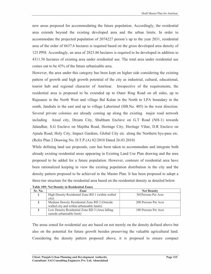
Draft Master Plan for Amritsar
Client: Punjab Urban Planning and Development Authority Page 215Consultant: SAI Consulting Engineers Pvt. Ltd. Ahmedabad
new areas proposed for accommodating the future population. Accordingly, the residential
area extends beyond the existing developed area and the urban limits. In order to
accommodate the projected population of 2074227 person’s up to the year 2031, residential
area of the order of 6637.6 hectares is required based on the gross developed area density of
125 PPH. Accordingly, an area of 2823.86 hectares is required to be developed in addition to
4311.56 hectares of existing area under residential use. The total area under residential use
comes out to be 43% of the future urbanisable area.
However, the area under this category has been kept on higher side considering the existing
pattern of growth and high growth potential of the city as industrial, cultural, educational,
tourist hub and regional character of Amritsar. Irrespective of the requirements, the
residential area is proposed to be extended up to Outer Ring Road on all sides, up to
Rajasansi in the North West and village Bal Kalan in the North to LPA boundary in the
south, Jandiala in the east and up to village Lahorimal (HB.No. 405) in the west direction.
Several private colonies are already coming up along the existing major road network
including Ansal city, Dream City, Shubham Enclave on G.T Road (NH-1) towards
Jalandhar, S.G Enclave on Majitha Road, Heritage City, Heritage Vihar, D.R Enclave on
Ajnala Road, Holy City, Impact Gardens, Global City etc. along the Northern bye-pass etc.
(Refer Plan 2 Drawing No. D.T.P (A) 82/2010 Dated 26.03.2010)
While defining land use proposals, care has been taken to accommodate and integrate both
already existing residential areas appearing in Existing Land Use Plan drawing and the area
proposed to be added for a future population. However, contours of residential area have
been rationalized keeping in view the existing population distribution in the city and the
density pattern proposed to be achieved in the Master Plan. It has been proposed to adopt a
three-tier structure for the residential area based on the residential density as detailed belowTable 109: Net Density in Residential ZonesSr. No. Zone Net Density
1 High Density Residential Zone RD 1 (within walled city)
301Persons Per Acre
2 Medium Density Residential Zone RD 2 (Outside walled city and within urbanisable limits)
200 Persons Per Acre
3 Low Density Residential Zone RD 3 (Area falling outside urbanisable limit)
100 Persons Per Acre
The areas zoned for residential use are based on not merely on the density defined above but
also on the potential for future growth besides preserving the valuable agricultural land.
Considering the density pattern proposed above, it is proposed to ensure compact

Draft Master Plan for Amritsar
Client: Punjab Urban Planning and Development Authority Page 216Consultant: SAI Consulting Engineers Pvt. Ltd. Ahmedabad
development of the city and accordingly, considerable proportion of the residential area
particularly on the periphery may remain undeveloped by 2031.
1) RD1- The core city area of the city (walled city) has high population density and is
accordingly highly congested with poor quality of living. Walled city has merely 2.6% of
the total area of Amritsar but it houses 16% of city population. In order to improve the
quality of life and to provide higher order of open spaces, it is proposed to be decongested
the walled city by reducing the net residential density to the level of 300 PPA from the
present density of more than 380PPA. However, the area under walled city would
continue to be categorized as high-density zone with density pegged at around more than
300 Persons per Acre.
2) RD2- Area already developed along all major roads and the area surrounding the high
density zone has been put in the category of medium density, where the density is
proposed to be of the order of 200 persons per acre. In order to make the use compatible,
the medium density zone has been provided in proximity to the existing residential area.
The net density has been kept high in order to preserve the valuable agricultural land and
to make the residential area more compact and energy efficient. This zone would also
provide additional infrastructure and services which are deficient in the core area of the
city. To encourage flattered residential development and to preserve the valuable
agricultural land, residential density @ 60 dwelling units per acre shall be permissible for
stand-alone group housing projects.
3) RD3- in order to have a well-defined hierarchy of residential areas, a density pattern that
gradually decreases from the core to the periphery has been adopted in the Master Plan.
Accordingly, the area outside the Outer Ring Road and the LPA boundary has been
earmarked for rural zone. In this zone, the residential development has been permitted
only to accommodate the natural growth and expansion of the rural settlements in the
shape of a belt varying from 50 to 100 meters around the abadi area depending upon the
size and population of rural settlements. All these zones have been placed in the category
of low density residential development, with density limited to 100 persons per acre in
order to preserve the basic rural character of low density low rise. It is also proposed that
all the villages falling outside the proposed urbanisable limit and within LPA boundary
shall also be developed in a planned manner.
The extent of residential area has been provided in order to achieve the objective of providing
“Affordable Shelter for all” defined in the National Housing and Habitat Policy, 2007
evolved by the govt. of India. For achieving the target of housing for all, the housing needs
Draft Master Plan for Amritsar
Client: Punjab Urban Planning and Development Authority Page 217Consultant: SAI Consulting Engineers Pvt. Ltd. Ahmedabad
for all income groups are to be assessed. Further, the existing structure of the city and its
housing profile also needs consideration. Since the city will be growing both horizontally and
vertically, therefore, residential development will be both in the category of plotted and
flatted development. Focus of residential development shall be providing shelter for the
economically weaker section of the society and low-income groups where the shortage has
been estimated as high as 98%.
In order to ensure the availability of developed land in adequate quantity and at affordable
price, it is proposed to leverage the active participation of private and co-operative sectors.
Accordingly, appropriate framework and the housing strategy will have to be such which
ensures active participation of public, private and cooperative sectors. While providing
affordable shelter to all, optimum utilization of land would form integral part of the
development strategy.
For development of new residential areas shall be based on well-defined norms in order to
provide housing for all sectors of society.
However, in order to minimize the mushrooming of unauthorized colonies in the LPA, care
will have to be taken to provide sufficient land at affordable cost to all categories of residents.
The existing unauthorized colonies would require review based on a well-defined policy,
which causes minimum hardship to the residents of the area without compromising with the
quality of life and basic essential of human living. The policy should aim at making the
existing development integral part of Master Plan proposals following the prescribed norms.
Housing for Economically Weaker Section
Housing strategies for the urban poor needs a holistic and multi-pronged approach. For
effectively addressing the issue, increased supply of developed land and its availability in
equitable and sustainable manner would be vital. The existing inequity in access of land to
poor has to be removed. Policies must free the restrictions on land supply and make the land
market efficient and sensitive to their demand. While proposing new residential area, housing
for the economical weaker section must be included as an essential ingredient of the Master
Plan considering that more than 98% of the housing shortage falls in the category of LIG and
EWS housing. It will be critical to provide adequate land for them at the most affordable
price.
In addition to providing majority of plots in this category, it will also be essential that certain
percentage of land/plots/flats are provided for LIG/EWS housing in all the housing projects
sanctioned by the State Government. In addition, existing slums would also require detailed

Draft Master Plan for Amritsar
Client: Punjab Urban Planning and Development Authority Page 218Consultant: SAI Consulting Engineers Pvt. Ltd. Ahmedabad
study and analysis before taking decision with regard to their up-gradation, relocation or
redevelopment. Considering the enormity and magnitude of problem, eradicating slums and
providing affordable shelter to poor will largely depend upon our capacity to leverage land in
right quantity, at right place and at right price. For providing affordable shelter, it will be
appropriate to consider the option of forming co-operatives of the slum dwellers for
leveraging their resources. Approach would have to change from subsidy- based to cost-
recovery housing for creating large number of houses for EWS/LIG categories. In addition,
options of creating night shelter and site and services would also be explored to provide
larger housing stock.
10.5.1.2 Commercial
Historically, Amritsar has always dominated the urban canvas as one of the most vibrant
centre of trade and commerce in the state of Punjab and continues to occupy the same status
even in the post-independence period. As Amritsar is an important commercial centre at both
local and regional level and will continue to function as a larger regional centre serving the
population even outside LPA, therefore, the city requires development of new commercial
centers or areas. Accordingly, sufficient area is proposed to be earmarked under this use in
the Local Planning Area. In order to meet the emerging requirement of commercial areas 5%
of the total urbanisable area has been proposed under this use. In all 829.7 hectares has been
proposed for commercial development. Existing commercial area has been estimated at
393.22 acres. It is proposed to develop an additional area of 436.48 hectares in a planned
manner. The existing area is proposed to be retained, developed, augmented and enhanced in
terms of infrastructure and services in order to enable it to cater to be needs of commercial
areas. Additional area proposed in the Master Plan will be essentially utilized for creating
state of art infrastructure for certain wholesale and bulk material markets such as fish market,
iron market, building materials market etc existing inside the walled city area which are to be
shifted outside the walled city. In addition, area will also be used for creating state of art
infrastructure and services in the commercial land use including multiplexes, shopping malls
etc. As the existing city is proposed to grow to 20.7 lakh persons approximately, therefore
three more district shopping centers are proposed to serve the commercial needs of the
projected population by 2031. In addition, commercial centers will also be developed as
integral part of new residential areas Planning and Development. Further, as per the
provisions of PAPR Act 1995 about 5% of residential colony is required to be provided for
commercial use, therefore as and when the new residential areas are developed in the future
the commercial areas will be ear marked based on the norms specified above.

Draft Master Plan for Amritsar
Client: Punjab Urban Planning and Development Authority Page 219Consultant: SAI Consulting Engineers Pvt. Ltd. Ahmedabad
The latest trend of commercial development in form of Shopping Malls and Multiplexes is
also being observed in Amritsar. Two multiplexes namely Celebration Mall on Batala Road
and Alpha G on G.T Road are operational and nearly 4 are under construction such as
Maiden Mall along Batala Road, Omaxe along Lawrence Road and Ajnala Road etc. and
numbers of shopping complexes are coming up along Mall Road. Considering the need of
quality commercial development, hotels, shopping malls and multiplexes, convention centers,
exhibition halls and golf clubs have been proposed along Ajnala Road because of nearness to
international airport.
In order to leverage on the strength of preparing delicacies it is proposed to set up Food
Courts in different parts of the city. This would help in not only promoting economy of the
city but also attract number of tourists to the city. Appropriate sites shall be identified within
and outside Walled City with adequate parking for setting up of Food Courts. Such Food
Courts should be set up near Hall Gate, GTB Hospital, Ajnala Road, Mall Road near old
Session Court, near existing Bus Stand/Railway Station and GNDU.
In addition, considering the requirement of large volume of export to Pakistan and other
neighboring countries, a trade and commerce zone including warehousing, godowns auto
repair centers, logistic park, freight complexes, cold storage etc has been proposed between
GT Road and railway line towards Attari, looking at its close proximity to the proposed
industrial zone, international airport and international border with Pakistan. Since there are
no norms available for this particular land use, a zone of 400 hectares has been earmarked.
Refer plan 2, Proposed Land Use Plan Drawing No. D.T.P (A) 82/2010 Dated 26.03.2010 to
see the spatial location of the zone in the LPA. In addition, it is proposed that the area should
also be utilised for setting up hotels and other support facilities for the tourists/traders coming
from Pakistan, besides providing major recreational acitivities including amusement parks
for catering to the needs of the residents/visitors going to the Wagah Border.
Further, the commercial area is proposed to be developed through a well-defined system of
zoning regulations and development control regulations provided in the Master Plan that
takes care of the needs of commercial area development. In order to overcome the perpetual
problem of parking in commercial area, providing adequate parking area has been made
integral part of commercial area planning. Well defined norms for parking has been provided
in the Development control Regulations appended in the Master Plan. Authorities must
ensure that adequate parking space is provided in the commercial areas and no vehicle is
allowed to use road as the parking space. Sites from multi level parking shall also be created
in various parts of the city.

Draft Master Plan for Amritsar
Client: Punjab Urban Planning and Development Authority Page 220Consultant: SAI Consulting Engineers Pvt. Ltd. Ahmedabad
At present, there are two wholesale markets in operation, i.e. Bhagtanwala Market and Vallah
Market. Both these markets are being administered by Punjab State Agriculture Marketing
Board. Vallah Mandi, because of its location near the ammunition depot providing for 900 m
no construction zone, has been asked to shift the mandi to a place outside the no construction
zone. If the foodgrains and fruit and vegetable trade is shifted from the Vallah Mandi, then
the land becoming available shall be used for relocating the cattle fare ground, which is being
operated from the site along northern byepass near Industrial Focal Point on Mehta Road.
Considering the nature and context of trade and its relationship with the city and its activities,
it is proposed to shift the wholesale food grain trade presently being carried out at
Bhagtanwala grain market, outside the city on the city ring road proposed in Master Plan.
Shifting of grain market from Bhagtanwala will help in minimizing the traffic congestion in
the city caused by influx of large number of vehicles including trucks, trolleys, rehras etc.
carrying food grains from villages for marketing. In addition to rationalizing the goods
traffic, shifting of food grain market will also help in shifting of wholesale food grain trade
presently being carried out within Walled city. It will accordingly help in decongesting the
Walled city, reliving it from major traffic blues. Locating wholesale food grain market
outside the city will also help farmers in easy marketing of their produce due to lesser
distance to be covered and better available accessibility. Considering the close proximity of
Bhagtanwala gate to Walled City, it is proposed to use the land thus becoming available due
to shifting Wholesale trade to be developed into a State of Art city centre providing for
shopping malls, multiplexes, hotels for tourists, eating joints, restaurant, banking, office
space, space for retail etc. This will provide a major economic boost to the city which lacks in
organized high end large scale economical development. In addition, it will decongest the
Walled City besides providing much needed fillip to the tourism.The Foodgrain Market shall
also cater to the requirement of marketing of foodgrains at Chheharta. The land thus
becoming available at Chheharta due to the shifting of foodgrains shall be used for
decongesting the city and creating public amenities/open spaces in which the area is deficit.
Within LPA, Seeing the importance of Rayya as an agricultural town and its strategic
location between the two important urban centers of Amritsar and Jalandhar along NH-1, it is
proposed to be developed as an agricultural marketing centre. Therefore, an agricultural
marketing center of an area 43 hectares has been proposed adjoining the existing grain market
on NH1. The proposed marketing centre will include Grain Market, Fruit & Vegetable
Market, Godowns/ Warehouses/Cold stores/Milk pasturing centre, Parking Areas, Truck
Terminal, Bulk Material Market, Public Toilets + Drinking Water, Rest rooms, Fire
Draft Master Plan for Amritsar
Client: Punjab Urban Planning and Development Authority Page 221Consultant: SAI Consulting Engineers Pvt. Ltd. Ahmedabad
Hydrants, E-Choupal areas. Further, it is also proposed to have agro-based industries in order
to ensure higher returns to the producers and improving the economy and productivity of the
area (Refer Plan 4, Drawing No. D.T.P (A) 82a/2010 Dated 26.03.2010)
Informal Sector
Informal sector has considerable role to play in meeting the basic needs of the resident
besides generating employment. Considering large number of visitors to the city and the
basic character prevailing in Amritsar, informal sector has been found to be playing active
part in meeting the commercial needs of the city. However, in the absence of any regulated
system, informal sector has been found to exist in majority of the city. Based on the primary
survey conducted for the informal sector in the city, it has been felt that organized sites for
informal sector are required to be created near the main city nodes such as Railway Station,
Bus stand, Hospitals, major institutions, District Courts and other transport nodes etc. It is
suggested that the organized well-planned sites for rehri markets shall be proposed in the new
planned colonies and provided for in the detailed zonal plans.
Policy for Existing Areas
With a view to make informal sector, an integral part of the planning process and keeping in
view the National Policy on Urban Street vendors, the following provisions are proposed to
be made for the informal sector:
The location/concentration of present stationary informal units shall be considered on case-
to-case basis and steps for relocation/improvement shall be taken. It should be ensured that
such activities do not spill over on the road network in the right of way. The Govt.
/concerned local agency would coordinate to achieve the objective. The areas of informal
sector shall have suitable public conveniences and solid waste disposal arrangements.
Formulation of guidelines for schemes would include ‘Hawking’ and ‘No Hawking’ zones.
Specific areas would be earmarked for stationary and mobile street vendors by the concerned
local authority.
The local authorities would take up new design of stalls, pushcarts and mobile vans of
various sizes and with cleaning facilities, giving due consideration to urban design
requirement of specific area, where informal shopping is being permitted. No informal unit
should be permitted along/near the intersection in order to avoid traffic congestion and
accidents. In addition, day market shall also be created and located within the city to meet the
space requirement of commercial areas.

Draft Master Plan for Amritsar
Client: Punjab Urban Planning and Development Authority Page 222Consultant: SAI Consulting Engineers Pvt. Ltd. Ahmedabad
Planning Norms for Informal Trade
As already stated, informal sector is proposed to be made an integral part of planning
process. Accordingly, the informal sector trade would be incorporated in the planned
development in various use zones. The provision of informal sector trade units should be
ensured at the time of sanction of layout plans as per the norms given in the table below:Table 110: Planning Norms for Informal SectorsSr. No. Use Zones/Use Premises No. of Informal Shops/Units
i Retail Trade:Metropolitan city centre, district centre, community centre, convenience shopping centre
3 to 4 units per 10 formal shops
ii Government and commercial offices 5 to 6 units per 1000 employeesiii Wholesale trade and freight complexes 3 to 4 units per 10 formal shopsiv Hospital 3 to 4 units per 100 bedsv Bus terminal 1 unit for 2 bus bayvi Schools
Primary /Secondary 3 to 4 unitsSenior secondary/integrated 5 to 6 units
vii ParksDistrict parks 8 to 10 units at each major entryNeighborhood parks 2 to 3 units at each major entry
viii Residential 1 unit/1000 populationix Industrial 5 to 6 units per 1000 employees
Source: UDPFI Guidelines
10.5.1.3 Mixed Land use:
Looking at the existing pattern of the growth and development, it has been observed that the
major road network existing in the Local Planning Area has attracted lot of haphazard,
unplanned and un-regulated growth in the shape of ribbon development. This pattern of road
has been observed both in within the M.C area and particularly in the area outside the
municipal limits. Despite the availability of legal framework prohibiting/restricting the
growth and development along the major road network, such developments have become an
integral part of Indian urban growth and development scenario. This pattern of development
has promoted numerous problems in terms of infrastructure, quality of development and for
the smooth movement of the traffic and transportation. In order to rationalize the growth and
to ensure provision of adequate parking and other supportive infrastructure, it is proposed to
permit mixed landuse development along the major road network as detailed below:
1. Outer Ring Road (R1): A 500 mts deep mixed landuse zone has been proposed
along the entire length of the proposed Outer Ring Road, outside/ beyond the
urbanisable area
2. Middle Ring Road (R2): A 500 mts deep mixed landuse zone on either side of
the road along the portion starting from Ajnala road to G.T road on the eastern

Draft Master Plan for Amritsar
Client: Punjab Urban Planning and Development Authority Page 223Consultant: SAI Consulting Engineers Pvt. Ltd. Ahmedabad
part of the city and from NH1 (from Atari) to Amritsar Ranian road in the
western part of the planning area.
3. City Ring Road (R2): A 300 mts deep mixed landuse zone on either side of the
road along the entire length of road starting from NH1 (existing northern
byepass) to NH1 (Atari road). This zone will be developed by Amritsar
Development Authority on the concept of Aero-city followed in SAS Nagar
by GMADA.
4. Other Roads (R2 & R3): All other roads falling in the category of R2 and R3
will have mixed landuse zone of 300 mts on either side of the road in the
portion falling between the urbanizable limit and the planning area boundary
in order to regulate/ minimize the haphazard and unplanned growth along
these roads.
The position of mixed landuse zones defined above has been indicated on the Proposed
Landuse Plan of Amritsar Master Plan bearing Drawing No. D.T.P(A) 82/2010, Dated: 26-
03-2010. The development along this road shall be governed by the Development Control
Regulations/ Detailed Schemes prepared for the zone. First right to develop the mixed
landuse zone on the pattern followed by GMADA for the development of the Aero-city in
Mohali shall rest with the Amritsar Development Authority. The detailed proposals for these
zones have also been provided in the Para 10.6.1 of the report.
However, in order to maintain the character and continuity of the belt, mixed landuse shall
continue to be permitted along these roads in the portion falling within the Municipal
Corporation limits. In the area zoned for mixed landuse, all kinds of landuses, which are
compatible, shall be permitted. However, the uses, which are not compatible, shall not be
permitted in this area. No polluting industries will be permitted in this zone. The proposed
mixed landuse will not only ensure dispersal of the economic activities in the various parts of
the areas but would also help in rational development of area along the major roads/corridors.
In addition, it will also promote better living-working relationship minimizing travel demand
in the city making it more energy efficient and environmental friendly. The area will be
developed through a well-defined system of zoning regulations and development control
regulations provided in the Master Plan, which would take care of the critical needs of
infrastructure/services including parking etc.

Draft Master Plan for Amritsar
Client: Punjab Urban Planning and Development Authority Page 224Consultant: SAI Consulting Engineers Pvt. Ltd. Ahmedabad
10.5.1.4 Industrial
With a view to provide fillip/boost to the economy of the city and to promote industrial
activity in the region, a sizeable area of the order of 11% of total urabanisable area has been
proposed for the industrialization. Accordingly, 1825.34 ha of the future urbanisable area
have been proposed under this use. Most of the industrial units existing in the city at present
are scattered all over the city with few of them located in the planned industrial areas such as
Industrial Focal Point along Mehta Road, East of Mohan Nagar etc. Moreover, the location
of these industrial focal points in the city is also not as per the principles defined for the
location for the industrial use. In order to overcome the problem of pollution and to create a
state of art industrial area having basic infrastructure and services, industrial zone having an
area of 1379.61 hectares has been proposed on southern side along Tarn Taran Road. The
area also meets the basic requirement of locating industries based on the prime consideration
of the prevailing wind direction (North-West to South-East). The proposed industrial zone
includes the existing industrial development along the Tarn Taran Road. It also includes
industrial development by way of providing developed plots with required basic
infrastructure. It is also proposed to include a truck terminal having booking agencies etc.
within the zone that will serve the proposed industrial development. Further, all the existing
industrial clusters identified in the city will be retained. Accordingly, existing industrial areas
on Majitha Road, Batala Road, East Mohan Nagar, on G.T Road towards Attari and
Industrial Focal Points have been retained in the Proposed Land Use Plan. (Refer Proposed
Land use Drawing No. D.T.P (A) 82/2010 Dated 26.03.2010). In addition, it has been
observed that large number of motor repair shops and related activities are spread over the
entire city creating numerous problems of pollution, parking and congestion. In order to
rationalize this activity, it is proposed to set up Auto Repair Complexes on the major traffic
arteries of the city in order to meet the needs of the residents and vehicles visiting the city.
These Auto Repair Complexes will provide for repair, sale of spare parts and other services
related to vehicles.
In order to promote quality environment, it is proposed to have a 15 meters wide green belt
of broad leaf trees to be developed within the industrial zone where it coincides with the
existing village settlement area. 7 village settlements have been identified for the same.
Further, all industrial units would also be required to plant trees in the setbacks provided
within the plots. Green belts would also be created as integral part of planning of industrial
areas and areas separating the residential and industrial zones. No polluting industries shall
be permitted within the industrial areas.

Draft Master Plan for Amritsar
Client: Punjab Urban Planning and Development Authority Page 225Consultant: SAI Consulting Engineers Pvt. Ltd. Ahmedabad
10.5.1.5 Public and Semi Public
In order to overcome the qualitative and quantitative deficiency of public and semi-public
uses, it is proposed to provide enough space under these uses. Accordingly, an area of
1825.34 hectares has been proposed under this land use that works out to be 11% of the
future urbanisable area. However, this area does not includes the area which will be available
under this use in the planning of the residential areas. All residential areas provided in the
Master Plan shall be planned to provide for all public and semi public uses based on the space
norms and standards specified in the Master Plan.
This zone will accommodate physical and social infrastructure including education, libraries
and health related institutions, government offices, socio-cultural and religious facilities,
utilities and services such as water treatment plant, sewerage treatment plant, solid waste
disposal sites etc. The sites already in operation, use and which have been proposed/approved
for the infrastructure network including STP, Solid Waste Disposal/Treatment Sites, Water
Works, Electric Grid Stations, etc. have been proposed to be retained as such in the Proposed
Land use Plan.
Amritsar has large number of prestigious institutions catering to all levels of education and
healthcare. Accordingly, in order to leverage on this strength it is proposed to create
knowledge centers in the city. Further, the area at the back side of Guru Nanak Dev
University-adjoining Ram Tirath Road, along Batala Road outside M.C area and along G.T
Road towards Jalandhar have enormous potential for development of educational and health
related institutions serving both the city, LPA and surrounding urban settlements. Further, it
is proposed that area adjoining G.T Road towards Jalandhar also has potential for
development as Educational Hub or Knowledge City that will have IT/ITES related
industries, research institutions and support infrastructure. A Medi-City is also proposed
along Majitha Road to cater to the higher medical needs of the city residents. The socio
cultural facilities like exhibition grounds, convention centers, music, art and drama center etc
is proposed to be developed along the Ajnala Road.
Further, considering the role and importance of Baba Bakala as Historic, Religious and
Administrative Centre falling in Raya complex an area of 11 hectares has been proposed
under public/semi public use in order to meet the emerging needs of social and physical
infrastructure. The area is proposed to be utilized for positioning various health related and
educational institutions besides housing government offices in order to meet the spatial needs
of housing, administrative staff of Baba Bakala tehsil. In addition, an area measuring 11
hectares has been proposed for Mela Ground in order to provide space/infrastructure and
Draft Master Plan for Amritsar
Client: Punjab Urban Planning and Development Authority Page 226Consultant: SAI Consulting Engineers Pvt. Ltd. Ahmedabad
facilities including as parking areas, resting places and other socio cultural facilities etc for
thousands of visitors attending various fairs and festivals that are held throughout the year
(Refer Plan 4, Drawing No. D.T.P (A) 82a/2010 Dated 26.03.2010)
Considering the existence of several numbers of regional level institutions including Shaheed
Darshan Singh Pheruman College, Sacred Heart Convent School, Mata Ganga Girls Sr. Sec
School, Govt. ITI Baba Bakala, GTB Govt. College Sathiala, it is proposed to make this area
as the institutional hub for the region. Accordingly, institutional/ educational zone has been
proposed near Sathiala College in order to use the existing potential of the area and to ensure
the optimum utilization of the available government land. Further, it is proposed to include
provisions of all public and semi public facilities as integral part of residential development
in order to make the residential areas self sufficient in basic needs and community facilities.
Accordingly, detailed planning and development norms for these facilities have been
provided in the Development Control Regulations. While sanctioning the residential
colonies, it will be ensured that all these facilities are provided based on the specified norms.
In case of Panchayat land of villages falling in Local Planning Area, these lands shall be used
exclusively for public and semi-public uses including utilities, services, physical and social
infrastructure, parks, open spaces, community facilities etc. and not for any other purpose.
10.5.1.6 Government Land
Amritsar being the historic city and a district headquarter, has large area owned by
Government. It also has large number of Government Offices. However, various offices of
the state government are located at different places in the city and accordingly people/
residents visiting these offices for work are required to travel from one place to another. In
addition to considerable inconvenience to the public, it also causes lack of co-ordination
between these offices due to scattered location. Due to location in the congested areas, it also
causes parking related problem. Considering the people’s convenience and for promoting
better coordination, state government has already proposed the setting up of an integrated
District Administrative Complex (DAC) in the city housing all the offices of local and state
government at a capital out lay of Rs. 35.00 crores. The new District Administrative Complex
is proposed to be set up at the existing District Court’s site. This proposal is retained as such
in the Master Plan. Further, the area available on shifting the district level offices will be used
as per the uses permitted in the zone in which they will be falling.
Moreover, Amritsar, being a border city has strategic importance from the point of view of
the defence. It has 882.14 hectares of city’s developed area owned by the Govt. of India.

Draft Master Plan for Amritsar
Client: Punjab Urban Planning and Development Authority Page 227Consultant: SAI Consulting Engineers Pvt. Ltd. Ahmedabad
Area is largely being used for residential and administrative purposes. The area is well
planned and has good quality infrastructure. However, due to location the area has problem
of integration with other land uses. It has been proposed to retain the existing area under
govt. land (for defence purposes) as such in the Proposed Land use Plan Drawing No. D.T.P
(A) 82/2010 Dated 26.03.2010. Further, in order to meet the future requirements for this use,
additional land has been zone for this purpose adjoining to the existing land.
Two ammunition depot sites are existing in Amritsar and Rayya. In Amritsar, it is located
within urban limits along the bye pass opposite village Vallah, whereas in case of Rayya it
falls in villages Waraich and Budha Theh (opposite to Dera Baba Jaimal Singh). As per the
notification of Govt. of India, a no construction zone of 900 meters around these sites is to be
earmarked where no activity relating to mining or construction is permitted. Accordingly, a
restricted zone of 900 meters has been marked in the proposed land use plan. (Refer Plan 2
and 4)
10.5.1.7 Recreation
As already explained, Amritsar badly lacks in the provision of green /recreational spaces in
the city which has affected adversely the quality of life prevailing in the city. Accordingly,
there is an urgent need to provide recreational area as per prescribed norms and standards. In
order to meet the deficiency of such activities, a recreational area have been proposed along
UBDC that is passing through north east of the LPA, Amritsar and entering Tarn Taran
district in the south of LPA. The proposed recreational area is located on the down-stream of
UBDC, i.e at the intersection of U.B.D.C and Tarn Taran Railway Line in the southwestern
side where already a large area under orchards is present. In addition, a 45 meters wide green
belt is also proposed along one side of the UBDC upto the proposed outer ring road in both
north and south directions is proposed to be developed as green belt/recreational area. with
road on the other side. While the 45 meters area on the both sides of the UBDC, outside the
proposed outer ring road and upto the LPA boundary in the north of LPA is proposed to be
developed as green belt. Further, for meeting the regional level requirements of recreation, a
Zoological Park is also proposed at Rakh Bhusian near Sarai Amanat Khan, which will help
in preserving precious but dwindling categories of birds and plants/trees. The total area
proposed under recreational use is 2489.1 hectares, which works out to be 15% of the total
urbanisable area of the city.
Recreational areas are also proposed to be carved out within the walled city and area
adjoining the walled city particularly in the southern part where, due to unplanned and
haphazard development, very little open spaces and recreational areas are available. The area

Draft Master Plan for Amritsar
Client: Punjab Urban Planning and Development Authority Page 228Consultant: SAI Consulting Engineers Pvt. Ltd. Ahmedabad
available within walled city from the process of decongestion and shifting of wholesale
markets is proposed to be used in majority of cases for creation of open spaces and
recreational area. In addition, area adjoining the walled city, which houses Roadways bus
depot, Lakkar Mandi, Dussehra Ground etc. is also proposed to be developed as major
recreational zone. Improvement Trust, Amritsar has also contributed in the development of
number of parks/open spaces as integral part of residential projects undertaken by it. A 30
acre park by the name ‘Amrit Anand’ is being developed in the Ranjit Avenue, Block E on
the Fatehgarh Churian Road, which will act as Mela Ground, Family Picnics, Heritage Court
and Children Play Area. All existing parks/ open spaces available within/ outside the Walled
City including Ram Bagh, Gol Bagh, Sakatri Bagh along Circular Road outside Walled City,
etc. shall be planned as landscape projects for development of green spaces. The old glory of
the Ram Bagh shall be restored by shifting all clubs operating within the Ram Bagh. In
addition, all the open spaces which are under encroachment shall also be identified, vacated
and developed.
The existing stadium on M.M. Malviya Road has been retained in the Master Plan and is
proposed to be upgraded, enhanced and further developed in terms of essential infrastructures
in order to meet the national/ international level needs of the sports/recreation. Further, new
site for sports complex of international standard is also proposed to be developed on the
southern part of the city along the City Ring Road in an area of 50-60 acres. Golf Course and
hotels for tourists are proposed to be located along the Ajnala Road leading to the Amritsar
International Airport. Convention Centre and Exhibition Ground of international standard is
also proposed to be developed in the close vicinity of Amritsar International Airport in D
Block, Ranjeet Avenue, along Ajnala Road with an approximate area of 30-40 acres (as
depicted on Proposed Landuse Plan of Amritsar LPA) in order to meet the future demand of
exhibition/ conventions/ stay of the tourist/ delegates attending such conferences/ visiting
exhibition.
In Amritsar, concept of ‘City Forest’ is proposed to be adopted under which available green
area at selected places shall be put under intensive plantation. This would not only increase
the green cover in the city, but would also improve the quality of environment besides
attracting large number of birds which would be living in these forests.
The Ganda Nallah and Tung Dhab Drain which are covering the major part of the length and
breadth of the city and have high degree of pollutants are proposed to be developed as the
leisure valleys of Amritsar. It is proposed that all sources of pollution along these Nallahs are
to be removed. The Nallahs are proposed to be developed as the channels carrying clean

Draft Master Plan for Amritsar
Client: Punjab Urban Planning and Development Authority Page 229Consultant: SAI Consulting Engineers Pvt. Ltd. Ahmedabad
water in order to improve the quality of ground water in the city. In addition, the walkways
are proposed to be planned along these Nallahs besides undertaking the landscaping. Further,
the Nallahs could also be used for draining the rain water of the city in order to minimize the
problem of water logging in the city. The development of Ganda Nallahs is to be taken up in
the shape of project on the pattern of what was done in Pune. The area presently under the old
water supply system known as 40 Khuh shall be developed as a major recreational area
catering to the Amritsar and the regional level requirement. A detailed scheme for the
development of this area shall be prepared as integral part of the Zoning Plan. No tree in this
area shall be permitted to be removed. In addition, a green belt of 10 meters have been
proposed along the drains/nallahs/distributaries flowing through out its length within the
LPA, Amritsar.
In addition, all the residential areas will be planned in such a manner that they have required
level of open, recreation and other spaces. Provision of such spaces shall be made integral
part of the planning of residential areas. Norms and standards have already been defined in
the Master Plan for these spaces. Accordingly, it will be ensured that all the residential
colonies conform to these norms of recreational activities. (Refer Plan 2)
10.5.1.8 Rural and Agricultural Zone
With the objective of preserving the valuable agricultural land and maintaining its basic rural
character, non-urbanisable area falling within Local Planning area has been proposed as
rural/agricultural zone. This zone comprises of the area between the outer ring road and local
planning area excluding the urbanisable area of urban settlement of Majitha and Rayya. This
zone comprises of 17210 hectares out of the total LPA area of 139419 hectares. Considering
the role and importance of agricultural land for the growth and economy of the area and
region, only 12.34% of total area is proposed to be urbanized by 2031 with remaining
87.66% of the area to be retained as rural and agricultural in character in Proposed Land Use
Plan. Area around rural settlement in the shape of belt will be permitted to be used for
meeting the shelter and other related needs of the population likely to be added by 2031. The
pattern of development shall be restricted to low density low rise. In order to promote
productivity and value addition in the agro-products, agro based knowledge centers and
marketing centers shall be set up. Emphasis shall be given on promoting agro-based industry
in the zone in order to create better employment opportunity for minimizing migration to the
urban centers. The zone will also be used for the production of day-to-day food related needs
of the residents of urban centers in order to promote the urban rural continuum and also
Draft Master Plan for Amritsar
Client: Punjab Urban Planning and Development Authority Page 230Consultant: SAI Consulting Engineers Pvt. Ltd. Ahmedabad
minimizing the needs of transportation of basic goods from other areas. Regional level
recreation spaces can also be located in this area having large area requirement with very
small built up areas. The zone will also be used for shifting large number of animals
including Gaushalas near Durgiana Temple, Ghee Mandi and large number of unaurthorised
dairies, which are being maintained within the urban limits/housing areas. These
Gaushalas/dairies are source of great nuisance causing numerous problems for the residents.
Accordingly, it is proposed that no milch animal should be permitted to be housed in the
residential area and all milch cattle should be shifted to the dairy complexes to be created in
the planning area outside the municipal limits on the sites identified in consultation with the
beneficiaries and Animal Husbandry Department of the state government/Municipal
Corporation, Amritsar. This will not only help in cleaning the city from the environmental
hazards created by the animals, but will also help in better management of animals and their
productivity benefitting the cattle owners both economically and operationally. Efforts
should be made to create cooperative societies of the cattle owners on the pattern followed in
the state of Gujarat in order to usher White Revolution in the state.
10.5.1.9 Conservation Areas:
a. Heritage Conservation
The city of Amritsar has rich heritage that needs to be preserved, conserved and promoted.
Accordingly, a well-defined strategy will have to be put in place in order to integrate them in
the future growth and development of LPA, Amritsar. Detailed proposals based on ground
realities and the special character of these structures needs to be prepared with sensitivity in
order to make them as an area of tourist attraction. Well-defined planning and development
norms around these heritage buildings will required to be evolved in order to minimize
haphazard, unplanned and substandard growth in the area. Few of the buildings or places
identified in the LPA Amritsar which are critical in the context of heritage conservation
includes:
1. Jallianwala Bagh
2. Golden Temple
3. Ram Tirath
4. Pul Kanjari
5. Samadh Attari
6. Sarai Amanat Khan
7. Railway station

Draft Master Plan for Amritsar
Client: Punjab Urban Planning and Development Authority Page 231Consultant: SAI Consulting Engineers Pvt. Ltd. Ahmedabad
8. Head Post Office
9. Saint Paul Church
10. City Wall and Gates
11. Gobindgarh Fort
12. Durgiana Mandir
Amritsar Protected Monuments
As per notification issued by the Govt. of India vide letter No. S.O. 1341 (E) dated 24th
November 2003 (Refer annexure IV), the Summer Place of Maharaja Ranjit Singh situated
inside Ram Bagh in Amritsar has been declared as an ancient monument under section 4 of
the Ancient Monuments and Archaeological Sites and Remains Act, 1958. As per this act,
the area of 3 kanals 2 marlas has been transferred in the name of Archaeological Survey of
India. Further to this, as per notification no. 1764 date 16-06-1992 issued by the Govt. of
India, the Central Government has declared area up to 100 meters as prohibited area from the
protected limits of the monument in all directions and in addition 200 meters as the regulated
area beyond the prohibited area in order to regulate and rationalize the growth and
development around these monuments. No construction, public projects within the prohibited
area of the protected monuments is permitted. In addition, it includes prohibition and
regulations of both mining and construction under the provisions of rule 32 of the Ancient
Monuments and Archaeological sites and Remains Rules, 1959. (Refer annexure V)
Accordingly, a 100 meters no construction zone has been earmarked around the protected
monument with the purpose of preserving the environment around the monument. In
addition, the area up to 200 meters beyond the prohibited zone is proposed to be regulated
area where no high-rise building would be allowed so that the pre-eminence of the building
may be maintained. All construction-taking place in the regulated zone shall be subject to the
detailed regulations to be defined for these. Besides this, Ram Bagh Deodi has also been
declared as protected monument under this Act and 100/200 meters no construction/regulated
zones have been earmarked.
However, proposed 100 meters no construction zone of the Summer Palace of Maharaja
Ranjit Singh include three recreational clubs namely: Service Club, Amritsar club and
Lumsden Club that need to be shifted from the garden complex on priority. Moreover,
several slums have cropped up in the vicinity of the monument, which largely belong to the
work force engaged in the restoration work of the monument but are indirectly causing harm
by defacing the monument. Hence, care needs to be taken to preserve the integrity and
environment around the monument. However, there are still large number of heritage

Draft Master Plan for Amritsar
Client: Punjab Urban Planning and Development Authority Page 232Consultant: SAI Consulting Engineers Pvt. Ltd. Ahmedabad
buildings existing in the city, which needs to be protected and preserved including the
Gobindgarh Fort, Wall and gates constructed around the city etc. Accordingly, a detailed
survey of the city heritage needs to be carried out by an inter-disciplinary group comprises
experts in order to identify its heritage. Further, effective steps needs to be taken on priority
in order to conserve, preserve and promote the ambiance of the heritage buildings and the
areas adjoining such buildings. Considering the special character of the walled city, special
development regulations needs to be framed on priority for the walled city and construction
taking place in the area in order to preserve its character and reduce further destruction.
10.5.1.10 Forest Area
As the LPA, Amritsar lacks in the provision of open and green spaces, therefore a zoological
park has been proposed at Rakh Bhusian near Sarai Amanat Khan, which has already been
declared as a protected forest. This would help in preserving the rare species of animals,
birds and plantations/trees, besides improving quality of environment in the area.
10.5.1.11 Tourism
The existence of Golden Temple, Jallianwala Bagh, Durgiana Mandir, Ram Bagh, etc. has
made Amritsar as the tourist centre of international repute and hub of religious and cultural
heritage. Accordingly, it attracts large number of tourists on day-to-day basis. In addition, it
has the distinct advantage of having a number of historical sites present within the LPA and
its surroundings, which offer enormous opportunities of development. These sites can be
effectively used and developed for leveraging the tourism potential and for providing and
required impetus to the tourism. Further, it has been observed that despite large no. of tourists
visiting the city, their actual stay is highly restricted. Most of the tourists stay only for a day.
In order to make tourism as the major economic driver for the area, it is proposed to extend
the stay of the tourists to two-three days. In addition, city has very limited accommodation
for catering to low budget tourists. Accordingly, it is also important that appropriate level of
budget hotels are created in the city. Scheme for accommodating tourists in the residential
houses (bed and breakfast) can also be considered as an option for providing affordable
accommodation to the tourists. Incentive based scheme will have to be framed for creating
appropriate level of budget accommodation. It is also proposed to provide numerous options
for the tourists by developing tourist circuits at three distinct levels as detailed below.
The entire approach to promote tourism shall revolve around provision of 4 As including
� Promoting high degree of accessibility,

Draft Master Plan for Amritsar
Client: Punjab Urban Planning and Development Authority Page 233Consultant: SAI Consulting Engineers Pvt. Ltd. Ahmedabad
� Providing comfortable and affordable quality accommodation, including low budget
accomodation
� Creating more opportunities for attracting tourists, and
� Providing state of art tourism related infrastructure and amenities.
1) Within Walled City
The tourist circuit which can be developed in the walled city area includes the processional
route of Maharaja Ranjit Singh starting from Ram Bagh Garden and terminating at Golden
temple. The route includes several important areas within the walled city such as Guru Bazar,
Shastri Market, Katra Ahluwalia, Bazar Mai Sewan and Bazar Mishrian. The route including
these areas can be developed based on the concept of Heritage walk for showcasing the rich
heritage of the city.Fig no.133 Tourist Circuit 1 for Walled City Area, Amritsar
2) Within Local Planning Area, Amritsar
Amritsar-Ram Tirath-Preet Nagar-Pul Kanjari- Wagha Border-Sarai Amanat Khan-Amritsar
tourist circuit has been identified for promoting tourism within the Local Planning Area,
Amritsar. The route within the city of Amritsar comprises of destinations such as Golden
Temple, Jallianwala Bagh, Durgiana Temple and Gobindgarh Fort. Within LPA, it covers
destinations such as Ram Tirath (which takes us back to the times of Ramayana), tomb at
Sarai Amanat Khan (a highway inn of the Mughul times) and Wagha Border, which is known
for the beating of the retreat ceremony on the International border with Pakistan.
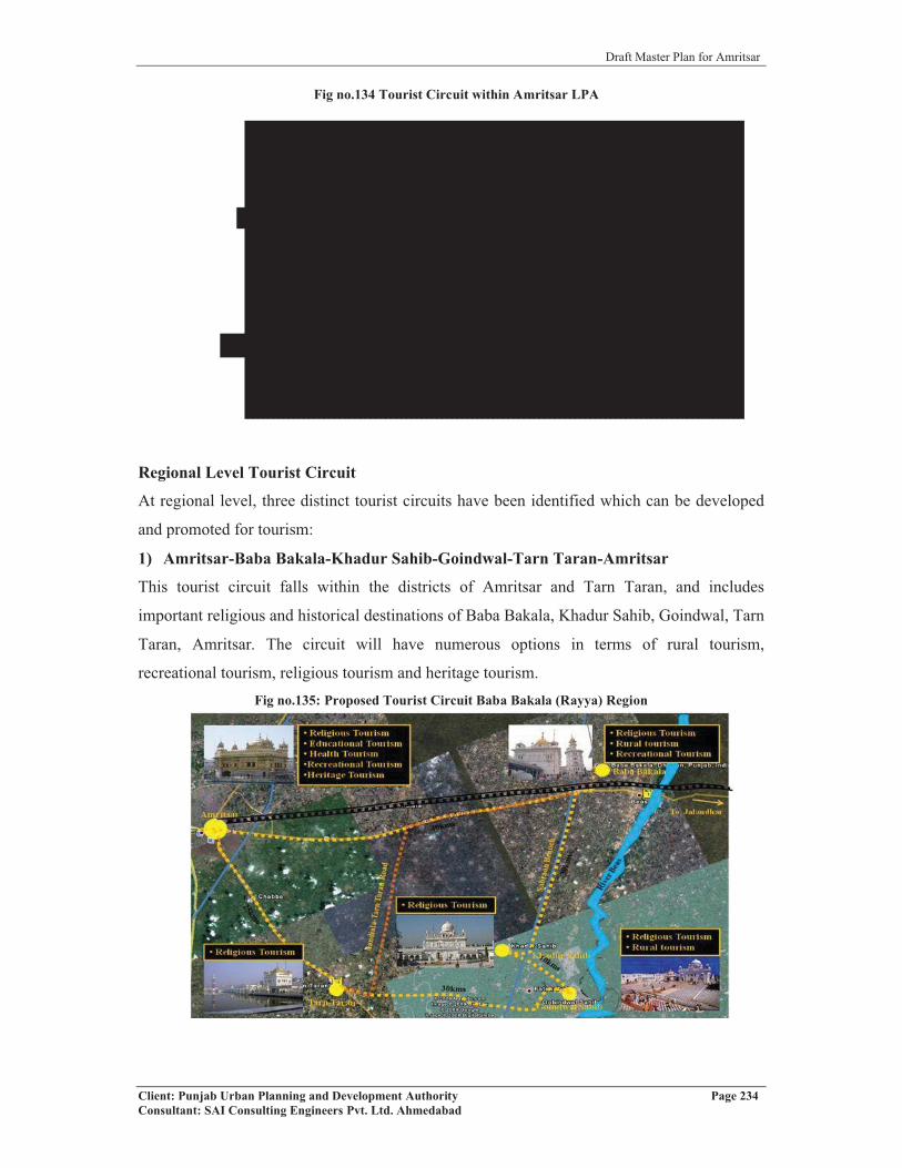
Draft Master Plan for Amritsar
Client: Punjab Urban Planning and Development Authority Page 234Consultant: SAI Consulting Engineers Pvt. Ltd. Ahmedabad
Regional Level Tourist Circuit
At regional level, three distinct tourist circuits have been identified which can be developed
and promoted for tourism:
1) Amritsar-Baba Bakala-Khadur Sahib-Goindwal-Tarn Taran-Amritsar
This tourist circuit falls within the districts of Amritsar and Tarn Taran, and includes
important religious and historical destinations of Baba Bakala, Khadur Sahib, Goindwal, Tarn
Taran, Amritsar. The circuit will have numerous options in terms of rural tourism,
recreational tourism, religious tourism and heritage tourism.Fig no.135: Proposed Tourist Circuit Baba Bakala (Rayya) Region
Fig no.134 Tourist Circuit within Amritsar LPA

Draft Master Plan for Amritsar
Client: Punjab Urban Planning and Development Authority Page 235Consultant: SAI Consulting Engineers Pvt. Ltd. Ahmedabad
Fig no.137 Tourist Circuit 3 at Regional Level
2) Amritsar-Dera Baba Nank- Kalanaur-Qadian-Gurdaspur-Pathankot
This circuit comprises of Amritsar (the seat of Sikh religion “Golden Temple”), Dera Baba
Nanak (a place where Guru Nanak Dev Ji spent last days of his
life), Kalanaur (where the emperor Akbar was coronated),
Qadian (home of the Ahmedyia Sect) and Pathankot (Gateway to
the States of Jammu and Kashmir and Himachal Pradesh). This
circuit includes both religious, historical and cultural centres of
tourist interests.
3) Amritsar-Tarn Taran-Hari Ke Pattan-Goindwal Sahib-Sultanpur Lodhi-
Kapurthala (Kanjli Lake)- Jalandhar
This circuit is a combination of religion, and
environment related places of importance. It includes a
majestic gurudwara with a golden dome and a large
holy pool having healing powers built at Tarn Taran in
the memory of 5th Sikh Guru, Sri Guru Arjan Dev Ji. It
also includes Hari-Ke-Pattan, which is the confluence
of Satluj and Beas, two major rivers of the state of
Punjab before entering Pakistan. It is a notified and
protected wetland of national importance is a wild life sanctuary of international fame. The
circuit also includes Goindwal Sahib, seat of Sikhism during the lifetime of the 3rd Sikh
Guru, Sri Guru Amar Dass Ji. It has a deep well with 84 steps. Sultanpur Lodhi, where the
founder of Sikhism, Sri Guru Nanak Dev ji spent 12 years in the service of Nawab Daulat
Khan Lodhi is also included in the circuit. It was from here in 1500 A.D. that Guru begun his
first holy travel towards the east and the south. The last destination in the circuit includes
Kapurthala, which is known for French pattern of city planning, beautiful palaces and
buildings. Kanjli Lake, another Wetland located near Kapurthala, is known for its scenic
beauty. It receives several species of migratory birds and is a fulfilling picnic spot.
For promoting tourism, number of projects have been proposed with few of them have
already been undertaken. 23 such projects, including setting up of Heritage Village in GNDU,
converting Town Hall as museum, upgrading Gobindgarh Fort, beautification of the
surrounding of Durgiana Temple, organizing light and sound programme in Jallianwala
Fig no.136 Tourist Circuit 2 at Regional Level

Draft Master Plan for Amritsar
Client: Punjab Urban Planning and Development Authority Page 236Consultant: SAI Consulting Engineers Pvt. Ltd. Ahmedabad
Bagh, etc. have already been identified in para 3.5 of the report and are included as integral
part of making Amritsar as the tourist destination.
In addition to above, it is also proposed that important entries to city including
1. Entry from international border from Attari side on GT Road,
2. Entry from International Airport on Ajnala Road, and
3. Entry from Delhi/Jalandhar side on GT Road
should be taken up for beautification through appropriate quality of landscaping, creation of
gates and through well designed lighting and water features/signages in order to accord a
warm welcome to the visitors to the city
10.6 PROPOSED TRAFFIC AND TRANSPORTATION PLANTraffic and Transportation is the most critical component of any city because it defines and
determines both existing and future patterns, typology of growth and development of the city.
Since, the traffic and transportation in any city is the function of landuse, accordingly traffic
and transportation network would be required to be integrated with the proposed landuse in
order to provide high degree of connectivity and travel options between various landuses. It
would also be critical to increase the operational efficiency of different urban centers.
Accordingly, traffic and transportation plan of Amritsar LPA up to the year 2031 has been
proposed based on the Proposed Landuse Plan for LPA, Amritsar.
The proposals related to Traffic and Transportation Plan as detailed, aims at rationalizing the
existing road network, creating a well defined hierarchy of roads, redesigning the critical
areas including road junctions, creating over-bridges, rationalizing the inter and intra city
traffic, creating adequate parking spaces, ensuring distribution and collection of traffic from
various parts of the city both in terms of existing and proposed development, developing well
defined interface between different land uses, improving efficiencies in traffic movement
within the city, minimizing delays etc in order to improve the operational efficiency and
productivity of the city and creating appropriate environment by minimizing vehicular
pollution. The proposed traffic and transportation plan defined in the proposed Landuse plan
will form the basis for promoting the rational and planned growth of the LPA, Amritsar.
The proposed network will also help in redefining the proposed urbanisable area in to
different development zones, which can be planned on the basis of self contained and self
sufficient neighborhood principles with convenience as a major objective. This would also
help in promoting communities and interlinking them to the basic framework of the city. In

Draft Master Plan for Amritsar
Client: Punjab Urban Planning and Development Authority Page 237Consultant: SAI Consulting Engineers Pvt. Ltd. Ahmedabad
addition, it will also help in redesigning the basic infrastructure and services essential for
basic sustenance of the people and the city.
10.6.1 PROPOSED ROAD NETWORK AND HIERARCHY
The proposed Traffic and Transportation Plan of LPA, Amritsar is based on a well-defined
road network of appropriate hierarchy in order to cater to the traffic needs of the urban
centers and population living and working there. It includes redefining, strengthening and
augmenting the existing road network and additional linkages to be created in order to
rationalize the traffic and transportation within the city and areas proposed to be brought
under urbanization. Keeping in view the future shape and size of Amritsar urbanisable area,
there is need for creating an efficient and effective system of transportation.
The existing road network in Amritsar has a distinct character dominated by a radial pattern.
It has been observed that all cities having radial road pattern needs to be supplemented with a
radial pattern of road network in order to rationalize the traffic movement and its equitable
distribution within different parts of the city. Ring and radial pattern has also been found to
have distinct advantage of positioning an effective system of rapid mass transportation by
using the rings and the radials to be used for running such services. Accordingly, Ring and
Radial pattern of road network has been proposed for LPA, Amritsar taking into account the
existing road pattern and proposed landuse pattern. Amritsar has a network of 11 radial roads
emanating from the centre of the city and serving different parts of the city and the adjoining
settlements. It has at present only one complete ring around the Walled City. The other ring
exists only in the northern part of the city known as the Northern Bye pass, whereas its
southern half has not been constructed. In order to rationalize the traffic and minimize
congestion and to cater to the increased volume of traffic in future, two additional ring roads
have been proposed besides completing the existing bye pass in the southern direction. The
Inner Ring Road is proposed to serve the city area proposed for urbanisation within existing
bye pass and proposed Outer Ring Road. The Outer Ring Road would provide high degree of
connectivity between urban nodes proposed in the Amritsar LPA, besides rationalizing the
regional traffic. (Refer plan 3, Drawing No. D.T.P (A) 82b/2010 Dated 26.3.2010)
The existing network of radial roads passing through LPA has been retained and it is
proposed for improvement/widening/strengthening. While demarcating the internal road
network within L.P.A, efforts have been made to make optimum use of available road
infrastructure and land available along the irrigation channels in order to minimize the cost of
development and to ensure easy availability of land for the proposed road network. The large
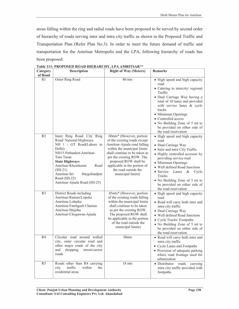
Draft Master Plan for Amritsar
Client: Punjab Urban Planning and Development Authority Page 238Consultant: SAI Consulting Engineers Pvt. Ltd. Ahmedabad
areas falling within the ring and radial roads have been proposed to be served by second order
of hierarchy of roads serving inter and intra city traffic as shown in the Proposed Traffic and
Transportation Plan (Refer Plan No.3). In order to meet the future demand of traffic and
transportation for the Amritsar Metropolis and the LPA, following hierarchy of roads has
been proposed:Table 111: PROPOSED ROAD HIERARCHY, LPA AMRITSAR**Categoryof Road
Description Right of Way (Meters) Remarks
R1 Outer Ring Road 80 mts � High speed and high capacity road
� Catering to intercity/ regional Traffic
� Dual Carriage Way having a total of 10 lanes and provided with service lanes & cycletracks
� Minimum Openings� Controlled access� No Building Zone of 5 mt to
be provided on either side of the road reservation
R2 Inner Ring Road/ City Ring Road/ National HighwaysNH 1 - GT Road(Lahore to Delhi)NH15-Pathankot-Amritsar-Tarn TaranState Highways Amritsar-Khemkaran Road(SH-21)Amritsar-Sri HargobindpurRoad (SH-22)Amritsar-Ajnala Road (SH-25)
60mts* (However, portion of the existing roads except Amritsar-Ajnala road falling within the municipal limits shall continue to be taken as per the existing ROW. The
proposed ROW shall be applicable in the portion of
the road outside the municipal limits)
� High speed and high capacity road
� Dual Carriage Way� Inter and intra City Traffic� Highly controlled accesses by
providing service road� Minimum Openings� Well defined Road Junctions� Service Lanes & Cycle
Tracks� No Building Zone of 5 mt to
be provided on either side of the road reservation
R3 District Roads includingAmritsar-Ranian/LopokeAmritsar-LoharkaAmritsar-Fatehgarh Churian Amritsar-MajithaAmritsar-Chogawan-Ajnala
45mts* (However, portion of the existing roads falling within the municipal limits shall continue to be taken as per the existing ROW. The proposed ROW shall
be applicable in the portion of the road outside the
municipal limits)
� High speed and high capacity road
� Road will carry both inter and intra city traffic
� Dual Carriage Way� Well defined Road Junctions� Cycle Tracks/ Footpaths� No Building Zone of 5 mt to
be provided on either side of the road reservation.
R4 Circular road around walledcity, outer circular road and other major roads of the city and shopping streets/sector roads
30mts � Road will carry both inter and intra city traffic
� Cycle Lanes and Footpaths� Provision of adequate parking
where road frontage used for urbanization
R5 Roads other than R4 carrying city traffic within theresidential areas
18 mts � Distributor roads carrying intra city traffic provided with footpaths
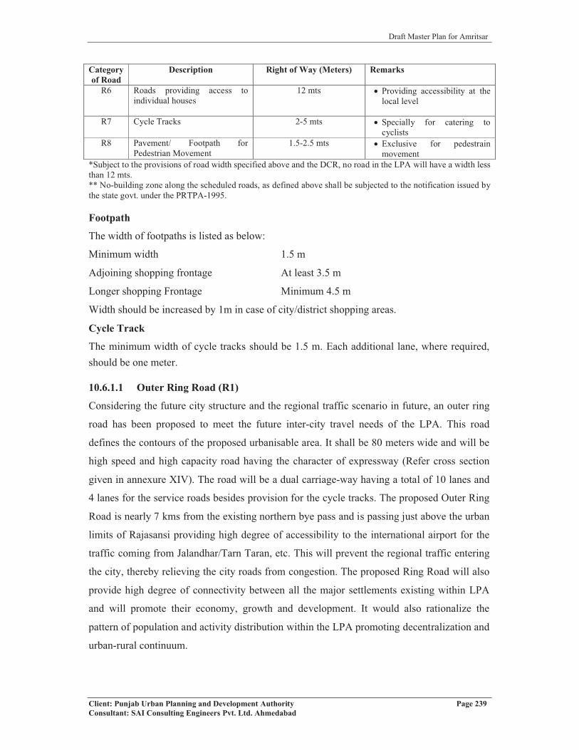
Draft Master Plan for Amritsar
Client: Punjab Urban Planning and Development Authority Page 239Consultant: SAI Consulting Engineers Pvt. Ltd. Ahmedabad
Categoryof Road
Description Right of Way (Meters) Remarks
R6 Roads providing access to individual houses
12 mts � Providing accessibility at the local level
R7 Cycle Tracks 2-5 mts � Specially for catering to cyclists
R8 Pavement/ Footpath forPedestrian Movement
1.5-2.5 mts � Exclusive for pedestrain movement
*Subject to the provisions of road width specified above and the DCR, no road in the LPA will have a width less than 12 mts.** No-building zone along the scheduled roads, as defined above shall be subjected to the notification issued by the state govt. under the PRTPA-1995.
Footpath
The width of footpaths is listed as below:
Minimum width 1.5 m
Adjoining shopping frontage At least 3.5 m
Longer shopping Frontage Minimum 4.5 m
Width should be increased by 1m in case of city/district shopping areas.
Cycle Track
The minimum width of cycle tracks should be 1.5 m. Each additional lane, where required, should be one meter.
10.6.1.1 Outer Ring Road (R1)
Considering the future city structure and the regional traffic scenario in future, an outer ring
road has been proposed to meet the future inter-city travel needs of the LPA. This road
defines the contours of the proposed urbanisable area. It shall be 80 meters wide and will be
high speed and high capacity road having the character of expressway (Refer cross section
given in annexure XIV). The road will be a dual carriage-way having a total of 10 lanes and
4 lanes for the service roads besides provision for the cycle tracks. The proposed Outer Ring
Road is nearly 7 kms from the existing northern bye pass and is passing just above the urban
limits of Rajasansi providing high degree of accessibility to the international airport for the
traffic coming from Jalandhar/Tarn Taran, etc. This will prevent the regional traffic entering
the city, thereby relieving the city roads from congestion. The proposed Ring Road will also
provide high degree of connectivity between all the major settlements existing within LPA
and will promote their economy, growth and development. It would also rationalize the
pattern of population and activity distribution within the LPA promoting decentralization and
urban-rural continuum.
Draft Master Plan for Amritsar
Client: Punjab Urban Planning and Development Authority Page 240Consultant: SAI Consulting Engineers Pvt. Ltd. Ahmedabad
At present, the traffic for International airport, Wagah Border, etc. coming from
Jalandhar/Tarn Taran has to pass through the city, thereby mixing of regional and local
traffic causing road blocks/congestions at various junctions in the city. At present, while
going to Amritsar Airport, one has to travel through the congested city roads to reach the
Airport on Ajnala Road. With the development of Outer Ring Road, the time taken to reach
the airport will not only be considerably reduced but it will also minimize the existing traffic
bottlenecks /traffic roadblocks within the city. Further, the proposed ring road will also cater
to the traffic going to Wagah Border from Airport, Jalandhar and Tarn Taran. The distance of
Wagah Border from the airport on the proposed outer ring road is 31.21 kms and that from
Tarn Taran Road intersection will be 35kms approximately.
The proposed Outer Ring Road also provide connectivity between 10 major roads passing
through the city including Amritsar-Sri Hargobindpur Road (SH 22), Batala Road (NH 15),
Majitha Road (MDR 64), Fatehgarh Churian Road, Loharka Road, Ajnala Road (SH 25),
Amritsar-Chogawan/Ranian Road (MDR65), G.T Road (NH 1), Amritsar-Khemkaran Road
(SH 21) and Amritsar-Tarn Taran Road (NH 15). The proposed Outer Ring Road has a
length of 101kms approximately, out of which about 79kms fall within LPA Amritsar and
about 22 kms fall outside LPA boundaries (Tarn Taran district). The portion of the Outer
Ring Road falling in the Tarn Taran Planning Area shall be incorporated in the Master Plan
of Tarn Taran LPA (Refer Proposed Traffic & Transportation Plan, Drawing No. D.T.P (A)
82b/2010 Dated 26.03.2010). Further, a 500 mts deep mixed landuse zone has been proposed
along the entire length of the proposed Outer Ring Road, outside/ beyond the urbanisable
area in order to regulate the haphazard growth and to control the use of land along the
proposed road. In addition, in order to promote higher order of development and to minimize
smaller division of land along the outer ring road, no development shall be permitted on a
plot having width less than 200 feet. The proposed zone has been shown in the proposed
landuse plan of Amritsar planning area contained in the Drawing No. D.T.P (A) 82/2010,
Dated: 26.03.2010. The development along this road shall be governed by the Development
Control Regulations/ Detailed Schemes prepared for the zone. First right to develop this zone
shall rest with the Amritsar Development Authority.
10.6.1.2 Middle Ring Road (R2)
The Inner Ring Road has been proposed for providing high degree of connectivity and
serving the residential and other uses provided between the Bye-pass and the proposed Outer
Ring Road. The Inner Ring Road will rationalize the distribution of traffic considering the

Draft Master Plan for Amritsar
Client: Punjab Urban Planning and Development Authority Page 241Consultant: SAI Consulting Engineers Pvt. Ltd. Ahmedabad
distance between the existing Bye pass and the proposed Outer Ring Road. The Inner Ring
Road will also define the limits of the city to be developed in the phased manner and for
making provisions for the mass transportation system. The road is supposed to be high
capacity and high volume road, with controlled accesses. It is proposed to have a total ROW
of 60 m. The total length of the inner road including the S.H 21 section is 79 kms. This road
has been aligned keeping in view the existing road network.
Considering the role and importance of the road, a 500 mts deep mixed landuse zone on
either side of the road along the portion starting from Ajnala road to G.T road on the eastern
part of the city and from NH1 (from Atari) to Amritsar Ranian road in the western part of the
planning area. This zone will be developed by Amritsar Development Authority on the
concept of Aero-city followed in SAS Nagar by GMADA. The proposed zone has been
shown in the proposed landuse plan of Amritsar planning area contained in the Drawing No.
D.T.P (A) 82/2010, Dated: 26.03.2010. The development along this road shall be governed
by the Development Control Regulations/ Detailed Schemes prepared for the zone.
10.6.1.3 Existing Northern Byepass
The northern bye pass existing in the city stretches from village Daburji in the east to
Naraingarh in the west with a total length of 22 kms. The existing northern bye pass has
attracted lot of developments that are mixed in nature and without observing the no-
construction zone along the byepass. Hence, a no construction zone has been proposed along
the existing northern byepass as per the provisions of the Punjab Regional and Town
Planning and Development Act-1995 (amended in 2006).
10.6.1.4 City Ring Road (R2)
The existing northern bye-pass in the city stretches from East to West direction having a total
length of 22 kms and is serving only the northern half of the city. It has been observed that in
the absence of the southern half of the bye pass, city faces high degree of congestion, traffic
bottlenecks and traffic related problems causing major inconvenience/road block to the
traffic going towards the south of the city. In the absence of southern part of the road, both
the regional and local traffic moving towards this part of the city has to pass through the city
roads, thereby causing traffic congestion on these roads. Hence, in order to rationalize the
inter and intra city traffic, a City Ring Road with a R.O.W of 60 meters has been proposed
starting from Daburji in the east and extending up to the northern bye pass in the west
direction. The total length of proposed City Ring Road is calculated to be 20kms. It

Draft Master Plan for Amritsar
Client: Punjab Urban Planning and Development Authority Page 242Consultant: SAI Consulting Engineers Pvt. Ltd. Ahmedabad
comprises of 14kms of road section between G.T Road towards Attari to T.T Road (NH 15)
and nearly 6 kms between sections from Tarn Taran Road to G.T Road towards Jalandhar.
Considering the role and importance of the road, a 300 mts deep mixed landuse zone on
either side of the road along the entire length of road starting from NH1 (existing northern
byepass) to NH1 (Atari road) as shown in Drawing No. D.T.P (A) 82/2010, Dated:
26.03.2010. This zone will be developed by Amritsar Development Authority on the concept
of Aero-city followed in SAS Nagar by GMADA. The development along this road shall be
governed by the Development Control Regulations/ Detailed Schemes prepared for the zone.
In addition, a 45 meters wide road has been proposed along the UBDC throughout its length
upto the proposed outer ring road in both directions on one side and 45 meters wide green
belt on the other side. The proposed road would provide high degree of connectivity between
the GT Road (NH 1) and Taran Taran Road (NH 15). The portion of the proposed road along
UBDC beyond the proposed outer ring road will be provided with a green belt upto the LPA
boundary as per the provisions contained in the D.C.R. Since large volume of traffic
presently meant for NH 15 is now passing through the southern part of the city causing major
traffic problems, provision of this Ring Road will help in rationalizing/diverting the traffic on
this road providing considerable relief for the area. Since the land is already available along
the UBDC, it is proposed to widen, augment and strengthen the existing road along the
UBDC for catering to the future traffic volume in the area. The Municipal Corporation of
Amritsar has already prepared a Detailed Project Report on the feasibility of constructing the
Ring Road along the UBDC based on the detailed surveys and studies carried out. The
Municipal Corporation Amritsar has already submitted the project report for funding of the
proposed portion of the Ring Road along UBDC. Further, this Ring Road has been proposed
to be extended up to the outer ring road in both the north east and south direction. This road
will connect all the three rings namely the existing byepass ring and the proposed southern
ring, proposed inner ring road and outer ring road.
10.6.1.5 Other Roads (R2)
The existing roads like G.T Road (NH 1), Batala Road (NH 15), Tarn Taran Road (NH 15),
Ajnala Road (SH 25), Sri Hargobindpur Road (SH 22) and Khemkaran Road (SH 21) have
been proposed as second hierarchy roads (R2) catering to the inter city traffic. It is proposed
to widen these roads up to 60 meters R.O.W. in the area outside the municipal limits.
However, these roads except Amritsar-Ajnala road will continue to have R.O.W within the
municipal limit as per the existing conditions. Considering the role and importance of

Draft Master Plan for Amritsar
Client: Punjab Urban Planning and Development Authority Page 243Consultant: SAI Consulting Engineers Pvt. Ltd. Ahmedabad
Amritsar-Ajnala road which provides accessibility to the Amritsar International Airport, it is
proposed to widen this road to 6 to 8 lanes, in order to cater to the heavy traffic flowing on
this road.
All these roads falling in the category of R2 and R3 will have mixed landuse zone of 300 mts
on either side of the road in the portion falling between the urbanizable limit and the planning
area boundary in order to regulate/ minimize the haphazard and unplanned growth along
these roads. The position of mixed landuse zone has been indicated on the Drawing No.
D.T.P (A) 82/2010, Dated: 26.03.2010. The development along this road shall be governed
by the Development Control Regulations/ Detailed Schemes prepared for the zone. First right
to develop this zone shall rest with the Amritsar Development Authority.
The lower hierarchy roads of R3 and R4 category have been proposed to provide
accessibility upto interior areas. These roads are mostly proposed either following the
existing link roads or along the water bodies/canals/drains proposing their widening and
strengthening. These roads would interlink the proposed Inner Ring Road and Outer Ring
Road besides the existing radial roads. Further, Rayya-Sathiala-Batala Road (ODR) falling in
Rayya region is also proposed to widen up to maximum of 45 meters R.O.W connecting to
R.O.B.
Within LPA, 4 road links have been proposed of hierarchy R-4 of which 2 roads links have
been upgraded (Rayya-Baba Bakala-Jalalpur Sathiala-Sathiala and Sathiala-Balsarai-Dera
Baba Jaimal Singh-Budha Theh connecting NH-1) and 2 new links have been proposed
connecting Rayya and Sathiala diverting from Baba Bakala which will act as diversion from
the existing Rayya-Baba Bakala-Sathiala Link. Another link proposed is from Rayya to SH-
22 along Sabroan Branch. The proposed road network explained above has been shown in
the map no. Further, the R3 and R4 category of roads demarcated in the plan would help in
delineation of different zones in the proposed landuse plan drawing.
Further, the roads of hierarchy R5 and R6 carrying traffic within the sector and providing
access to individual houses respectively will be demarcated at the zonal plan level. Besides
this, R6 category of roads will also form part of the colonies to be approved under PAPR Act
1995 and will be provided therein as part of these individual colonies. It is also proposed to
construct roads on abandoned distributories/water bodies and to remove the encroachment
existing on/along them as per details given in the zonal plan.
Further, in Rayya region falling within LPA, Amritsar, five links have been proposed to be
up-graded to the category of R-5 i.e. 18 meters R.O.W. (Refer Plan 4, Drawing No. D.T.P
(A) 82a/2010 Dated 26.3.2010)

Draft Master Plan for Amritsar
Client: Punjab Urban Planning and Development Authority Page 244Consultant: SAI Consulting Engineers Pvt. Ltd. Ahmedabad
It is proposed that tree plantation along the main roads such as R1, R2, R3 and R4 shall be
carried out in consultation with the landscape Architects, Horticulture Department and Forest
Department. On this line, there is already a proposal for creating a green belt along the G.T.
Road from Taranwala Pul to Gateway of Amritsar to beautify the entry road to Amritsar.
Further, as per the Punjab Govt. notification no. 1122 FT-58/1195, dated 3rd may 1958 (Refer
Annexure XI), the road side strips along the scheduled roads should be transferred to the
Forest department for plantation of trees and management. The selection of trees should be in
such a manner that flowering trees/ trees with large foliage may be planted along the roads.
In addition, no building zone/green belts required to be provided along the major road
networks also need to be taken up for extensive plantation on priority in order to minimize
the vehicular pollution, improving environment and minimizing noise. The list of trees
proposed for plantation is given in annexure IX.
10.6.2 PROPOSALS FOR URBAN ROADS (WIDENING/STRENGTHENING OF
EXISTING ROADS WITHIN LPA)
The study of existing city road network reveals that there are several roads which are
overcrowded carrying more volume of traffic than their carrying capacity. There is no
possibility or scope of widening of existing Right Of Way (R.O.W.) of these roads due to
thickly built up areas existing within the city. If the volume of traffic on a road section
exceeds the design capacity, the operating conditions will deteriorate. However, some
measures of road engineering can be adopted for improving the capacity of these roads as per
the guidelines defined by the Indian Road Congress for capacity enhancement of Urban
Roads. Some of the measures proposed for enhancement of road capacity are detailed below:
� Prohibiting on–street parking of vehicles and simultaneously developing off–street
parking facility;
� Segregating the bi-directional traffic flow by providing central verge/median;
� Provision of segregated Right–Of–Way for slow moving vehicles including
animal drawn carts, rickshaws/ tongas etc.;
� Imposing selective restrictions on the movement of animal drawn /other slow
moving vehicles and heavy commercial vehicles on the busy arterial/ sub-arterial
roads, especially during the peak hours;
� Reduction of road side friction through control of abutting land–use and roadside
commercial activity;
� Provision of adequate facilities for pedestrians and cycles;
Draft Master Plan for Amritsar
Client: Punjab Urban Planning and Development Authority Page 245Consultant: SAI Consulting Engineers Pvt. Ltd. Ahmedabad
� Rationalising conflicting movements at major intersections, particularly during
peak hours;
� Minimising the cross traffic and side–street traffic by regulating the gaps in the
medians; and
� Promoting traffic discipline such as proper lane use and over taking by involving
stakeholders, through appropriate road markings, education and publicity.
The following urban roads in Local Planning Area, Amritsar have been identified and
proposed for adopting the aforesaid traffic engineering measures.
� Queens Road
� Cooper Road (from Crystal Chowk to Bhandari Bridge)
� Lawrence Road
� Outer Circular Road
� Majitha Road
� Hall Bazaar
� Amritsar Tarn Taran Road
� Batala Road
� Fatehgarh Churian Road
� Ajnala Road
� M. M. Malviya Road
� Mall Road
� Circular Road (from Kitchlu Chowk to Rattan Singh Chowk to Medical College)
� Roads inside Walled City Area
In addition, all the road widening projects being undertaken within the Amritsar urban limits
shall form integral part of the road infrastructure development and shall be integrated with
the proposal defined above. It is also proposed to widen the existing Bhandari Bridge. With
the operation of the elevated road (which is under construction), it is going to become a very
critical junction catering to large volume of regional and local traffic. It is proposed to extend
the elevated road from Bhandari Bridge to the existing northern Bye pass on G.T Road
towards Attari so as to avoid congestion due to mixing up of local and regional traffic
especially traffic going to Wagah Border, Ram Tirath, Sarai Amanat Khan and Pul Kanjri
which have large volume of tourist traffic. Extending the elevated road to the existing
northern byepass will not only rationalize the traffic but will also help in minimizing the
construction of expensive over bridges at Railway Station, Putlighar and Chheharta. Further,
Draft Master Plan for Amritsar
Client: Punjab Urban Planning and Development Authority Page 246Consultant: SAI Consulting Engineers Pvt. Ltd. Ahmedabad
considering the future volume of traffic on the NH1 it is proposed that possibility of using
the space below the elevated road for traffic and transportation/ parking may also be
considered/ explored.
10.6.3 JUNCTION IMPROVEMENTS
In addition to inadequacy of road network in the Amritsar city, it has also been observed that
the majority of road junctions have not been properly planned, designed and constructed.
This has led to the creation of traffic bottlenecks at major junctions of the city besides
causing delays and inconvenience to the road users. Delay in movement leads to creation of
considerable pollution due to emission of smoke by the vehicles adversely impacting the
quality of life in the city. The congestion at few junctions has also led to large number of
accidents. In order to rationalize the flow of traffic and minimize conflicts at the junctions
carrying large volume of traffic, it is proposed to improve the road geometry at number of
junctions that have recorded high rate of accidents. The junctions proposed for immediate
improvement include Rattan Singh Chowk, Putlighar Chowk, Opposite Railway Station,
Bhandari Bridge, Majitha Road Byepass Junction, Fatehgarh Churian Road Bye pass
Junction, Kitchlu Chowk, Crystal Chowk, SSSS chowk, Novelty chowk, Queen road chowk,
Lohgarh Chowk, Sultanwind Gate Chowk, Chatiwind Gate Chowk, G.T Road Bye pass
junction at Daburji, Bhagtanwala Chowk, Ajanla Road byepass junction, Ghala Mala Chowk,
100 feet road junction, Ram Talai Chowk, Sangama Cinema Chowk, Jahazgarh, Hussainpura
Chowk, Ghas Mandi Chowk, Hall Gate near Peer Baba Dargah, Ghee Mandi Chowk,
Sheranwala Gate, Mahan Singh Gate, Chita Gumbad, Ram Bagh Chowk, Verka Chowk
Junctions identified for improvement within LPA, Amritsar includes T-junction at Manawala
(Amritsar Engineering College) Canal bridge-Rayya, Baba Bakala entry point (T-Junction),
Y –junction at Sathiala (Sathiala Bus Stop).
10.6.4 PROPOSAL FOR PUBLIC TRANSPORT
Rapidly increasing number of personalized vehicles has flooded the city roads in the absence
of efficient public transport system. As the city is growing in size and population, an efficient
public transport system is required to be put in place immediately in order to reduce
dependence on personalized vehicles and congestion on the existing city roads. Accordingly,
it is proposed to provide an efficient Bus Rapid Transport System (BRTS) in the city.
Amritsar Municipal Corporation has already prepared a detailed project report and has

Draft Master Plan for Amritsar
Client: Punjab Urban Planning and Development Authority Page 247Consultant: SAI Consulting Engineers Pvt. Ltd. Ahmedabad
submitted the proposal for funding under JNNURM. The routes proposed to be covered
include:
1. Amritsar-Verka-Batala
2. Amritsar-Jandiala
3. Amritsar-Tarn Taran
4. Amritsar-Ajnala
5. Amritsar-Fatehgarh Churian
6. Amritsar-Majitha
7. Amritsar-Khemkaran
8. Amritsar-Bir Baba Budha Sahib via Chheharta
9. Amritsar-Attari Border
10. Amritsar-Lopoke
11. Amritsar-Mehta
12. Outer Circular Road from Hall Gate-Khazana Gate-Chatiwind Gate-Rambagh Gate
13. Battery operated buses in the walled city and around Golden Temple
14. Amritsar-Daburji-Vallah-Verka-Majitha-Naraingarh Chowk on Byepass
Provision of public transport in the city would ensure reduced dependence on the
personalized modes of transport, thereby, relieving the city roads and improving the city
environment.
10.6.5 PROPOSED R.O.B’S AND R.U.B’S
Considering the existing city structure, it has been observed that railways have emerged as
the major divider in the city development as it is passing through the centre of the city. It has
led to the creation of traffic bottlenecks at major rail-road junctions leading to traffic
congestion/jams. Accordingly, construction of ROBs/RUBs would be essential to minimize
the conflict between the road and rail traffic. There are three R.O.B’s existing in the city i.e.
at Rego Bridge, Bhandari Bridge and at Hukam Singh Road on Amritsar-Jalandhar railway
line which are bridging the north and south halves of the city. Apart from these, two R.O.B’s
have been recently constructed on the Bye pass i.e. one on Amritsar-Pathankot Rail line and
the other on Amritsar Jalandhar Rail line. In addition, two more R.O.Bs are under
construction on Sann Sahib Road and Jwala Flour Mill which are near completion. It is also
proposed to reconstruct the Rego Bridge existing on Amritsar Jalandhar Railway Line which
at present has been rendered unsafe due to ageing of the bridge. The Rego Bridge is the most

Draft Master Plan for Amritsar
Client: Punjab Urban Planning and Development Authority Page 248Consultant: SAI Consulting Engineers Pvt. Ltd. Ahmedabad
important link between the north and south parts of the city and accordingly needs to be
taken on priority with large capacity in order to meet the merge volume of traffic it handles.
(Refer Plan 3)
Apart from these, 25 more R.O.B’s have been proposed to be constructed by the year 2031
over the proposed road network of LPA-Amritsar to ensure smooth flow of both regional and
local traffic. The R.O.Bs and R.U.Bs identified are listed below:
A) On Jalandhar-Attari Rail Line :
i) Joura Crossing-1
ii) Shivala Crossing-1
iii) Ram Bagh Gate Crossing-1
iv) 22 No. Crossing-1
v) Kot Khalsa Crossing-2
vi) Gumanpura Crossing-2
vii) Rego Bridge (Existing bridge to be widened)-1
viii) Bhandari Bridge (Existing bridge to be redesigned)-1
ix) Hukam Singh Road (Existing)
x) San Sahib Road (under construction)-1
xi) Shiv Nagar Railway Crossing (Near Bazaar Putlighar)-1
xii) Backside of Focal Point on Amritsar Jalandhar Railway Line (near fruit &
vegetable market)-1
xiii) Intersection of Proposed Sector Road and Amritsar Jalandhar Railway Line-2
xiv) Intersection of Proposed Outer Ring Road and Attari Railway Line-3
xv) Intersection of Proposed Inner Ring Road and Attari Railway Line-2
xvi) Intersection of Proposed Southern Bye pass and Attari Railway Line-1
xvii) Intersection of Proposed Outer Ring Road and Jalandhar Railway Line-3
xviii) Intersection of Proposed Inner Ring Road and Jalandhar Railway Line-2
B) On Tarn Taran Rail Line:
i) Jawala Flour Mill (under Construction)-1
ii) Indira Colony Railway Crossing on Khemkaran Road-2
iii) Bhagtanwala Mandi Crossing-1
iv) Crossing at Proposed Outer Ring Road and Tarn Taran Railway Line-3
v) Crossing at Proposed Inner Ring Road and Tarn Taran Railway Line-2

Draft Master Plan for Amritsar
Client: Punjab Urban Planning and Development Authority Page 249Consultant: SAI Consulting Engineers Pvt. Ltd. Ahmedabad
vi) Intersection of Proposed Southern Bye pass and Tarn Taran Railway Line-1
vii) Crossing at Proposed Road along UBDC and Tarn Taran Railway Line (Kot Mit Singh)-1
C) On Pathankot Rail Line :
i) Crossing at Proposed Outer Ring Road and Pathankot Railway Line-3
ii) Crossing at proposed Inner Ring Road and Pathankot Railway Line-2
iii) Intersection of Proposed Outer Ring Road and Amritsar-Dera Baba Nanak Railway Line-3
From the list of R.O.B’s proposed to be constructed, the R.O.B’s at Shivala Colony, Joura
Crossing, Backside of Focal Point near fruit and vegetable market, Ram Bagh Gate,
Bhagtanwala Mandi Crossing, 22 no. crossing and Shiv Nagar Railway Crossing, needs to be
taken up for construction on priority.
In addition to the R.O.B’s suggested above, it is proposed that all radial roads (R1, R2 & R3)
bisecting the Outer, Middle and Inner Ring road including junction at Tarawala Pul shall be
provided with R.O.B’s/ R.U.B’s based on the detailed studies and volume of traffic carried on
these junctions. The City Mobility Plan which is being prepared for the Amritsar metropolis
shall be integrated with the traffic and transportation network suggested above. In addition,
all the road improvement projects already undertaken/ to be undertaken under JNNURM shall
form part of the Master Plan proposals. The projects being undertaken by Amritsar Municipal
Corporation under JNNURM/ road improvement program have already been detailed in Para
5.6 of the report.
10.6.6 TERMINALS
10.6.6.1 Proposed Bus Terminal
Considering the present location of existing ISBT (Inter state bus terminal) within city it is
proposed to shift it to the city Ring Road proposed in the Southern part of the city. Relocating
ISBT from its present location will rationalize the inter and intra city traffic. It will also help
in ensuring that all inter city traffic carried by buses moves outside the city on the Ring road
and does not congest the city anymore. Shifting of existing ISBT will be supplemented by an
efficient system of mass transport and intermediate transport mechanism which will ensure
the smooth transfer of passengers to their destination in different parts of city. New ISBT
shall be constructed on an area of 25-30 acres as indicated on proposed Landuse Plan of
Amritsar LPA. However, the exact location of ISBT shall be subject to decision of the site
selection board ad department of transportation.

Draft Master Plan for Amritsar
Client: Punjab Urban Planning and Development Authority Page 250Consultant: SAI Consulting Engineers Pvt. Ltd. Ahmedabad
The existing site of bus stand is proposed to be used for the local city bus service (BRTS)
which is proposed taken up in near future.
The bus terminus for other towns falling within LPA shall be identified in consultation with
the transport department and keeping in view the traffic and transportation proposed for the
town besides considering the flow of traffic. In case of Rayya complex, a bus stand in an area
of 4 hectares has been proposed on the intersection of NH-1 and Umra Nangal-Baba Bakala-
Sathiala Road. The proposed bus stand would serve the needs of residents of Rayya and its
surrounding villages. (Refer plan 3 and 4)
10.6.6.2 Proposed Truck Terminal/ Transport Nagar
The existing truck terminal is also located at Jahazgarh on G.T Road causing the mixing of
heavy traffic with other regional and city traffic. Accordingly, it has been proposed to shift
the truck terminal to the proposed industrial zone located on the south of the city. The
proposed truck terminal/ transport nagar in an area of nearly100 acres has been proposed in
the industrial zone. This would also help in achieving integration of the terminal with the
existing trade and commerce and proposed industrial zone. It is proposed to use existing site
of truck stand for commercial purpose.
10.6.6.3 Up-gradation of Railway Station
There are 14 railway stations falling within L.P.A, Amritsar out of which 4 railway stations
are located within the Amritsar M.C limits. These include Amritsar Railway Station,
Bhagtanwala, Verka and Chheharta railway station. Considering the importance of Amritsar
as tourist, trade and commerce, healthcare and educational destination involving large influx
of tourist from both within the country and abroad, it is proposed to upgrade Amritsar
Railway Station as a model railway station. In then Railway Budget 2009, Amritsar railway
station has already been identified as one of the centre for development as a model railway
station in the country through innovative financing mechanism under Public-Private
Partnership mode. The proposed railway station will have modern shopping centers, food
stalls, restaurants, bookshops, telephone and fax booths, medicine and variety stores, budget
hotels as well as state of art infrastructure including underground parking. It is also proposed
to retain and preserve the existing structure of railway station that is a classical example of
colonial architecture, having high heritage value.

Draft Master Plan for Amritsar
Client: Punjab Urban Planning and Development Authority Page 251Consultant: SAI Consulting Engineers Pvt. Ltd. Ahmedabad
Further, it is proposed to develop Bhagtanwala railway station as the major traffic node-
handling loading and unloading of goods, food grains traffic etc. At present, this task is being
carried out at Amritsar railway station itself. This will help in not only decongesting the
existing Amritsar railway station but will also cater to the needs of goods traffic which is
likely to be generated near Bhagtanwala by shifting wholesale markets from walled city of
Amritsar.
In addition, it is proposed to develop and upgrade Khasa Railway Station for handling the
goods traffic related to import and export between India and Pakistan and the traffic
generated from the trade and warehousing zone proposed along the Amritsar-Attari road. It is
also proposed to create a dry port in this zone in order to give a boost/ promote import and
export from India. Khasa railway station can then be used for catering to the traffic generated
by the dry port and the international airport located at Rajasansi.
Creating Direct Rail Link Between Amritsar-Mumbai via Ferozepur
In order to give impetus to industry and export of goods from Amritsar and Tarn Taran, it is
proposed to provide direct railway link between Amritsar and Mumbai via Ferozepur. This
link is proposed to be created by providing the missing link from Muhalam to Garhiala
stations having a length of 20 kms. Providing this link will help in connecting Amritsar with
Mumbai through Ferozepur and Rajasthan. The link has the additional advantage because it
will reduce the distance between the Amritsar and Mumbai by minimum 240 kms. It will not
only lower down the transportation cost but wil also considerably reduce the pressure on the
trunk route of Amritsar-Mumbai via Delhi. Further, this will also provide direct rail
connectivity between Amritsar and Ferozepur by leveraging the economic growth and
development, promoting tourism, trade and commerce and industry in the southern parts of
the state. It will also expedite the import and export of goods and raw materials for the
industries besides the export of rice from Kandla Port. However, in order to cater to the
import and export of goods from the proposed rail link between Amritsar and Mumbai via
Tarn Taran, it is proposed to create handling facilities of higher order in the Tarn Taran LPA.
This will not only help in de-congesting and limiting the goods traffic between Amritsar and
Mumbai but will also help in rapid growth and development of Tarn Taran.
Developing Tunnel based Railway Network within the Urban Limits
In addition to strategies defined above for the development of the rail based transportation, it
is felt that railway lines passing through the Amritsar have emerged as major bottlenecks in

Draft Master Plan for Amritsar
Client: Punjab Urban Planning and Development Authority Page 252Consultant: SAI Consulting Engineers Pvt. Ltd. Ahmedabad
the smooth functioning and flow of traffic between different parts of the city. It has also lead
to division/dis-integration of the city into different parts creating numerous operational and
functional roadblocks. Despite the fact that number of R.O.B’s and R.U.B’s have been
proposed as one of the option for ensuring smooth flow of road based traffic between
different parts of the city, it is strongly felt that the option of taking railway lines
underground in the space being presently used by them, should also be given a serious
thought. The economic feasibility of the proposal of positioning railway lines underground
can be worked out in the context of the large investment going into the making of
R.O.B’s/R.U.B’s and the large area made available to the railway by shifting of railway line
below ground and using the same for large scale commercial, institutional and other urban
uses which can generate large amount of resources for funding the project. Shifting of
railway line underground will not only ensure integration of different parts of Amritsar
metropolis, making it compact city in process but will also go a long way in improving its
operational efficiency and overall productivity. It will also help in saving huge amount of
valuable fuel and time that are consumed by large population of the city while
travelling/crossing these railway lines. It will also make Amritsar cleaner and greener.
Considering the available advancement in the tunneling technology and the long term
benefits to the city/railways, the possibility of shifting the railway lines underground should
be given a serious thought and taken up on priority considering the role, importance and
stature of Amritsar as the historic city and religious/commercial capital of the state.
10.6.6.4 Air Terminal
The Rajasansi Airport located at Amritsar has the status of an International Airport, which
handles large volume of tourists’ traffic from both national and international destinations.
Looking, at the existing potential of Amritsar, as the fourth most preferred destination in
India and future tourist potential, it is estimated that the present number of tourists will
increase manifold in near future. At present 1.5 lakh, tourists visit the city on daily basis.
Though majority of the tourist coming to the city use rail and road as the preferred mode of
transportation, the air traffic has also shown considerable increase. With large number of
international flights proposed from Amritsar connecting different destinations in the world
housing large number of Punjabi’s, the number of tourists’ visiting the city using air as the
medium of transportation will also increase rapidly. Also considering the positioning of
Amritsar as the gateway to other countries, volume of cargo traffic is also likely to go up
sharply with volume of goods trade increasing rapidly. Amritsar is likely to emerge as one of

Draft Master Plan for Amritsar
Client: Punjab Urban Planning and Development Authority Page 253Consultant: SAI Consulting Engineers Pvt. Ltd. Ahmedabad
the most valuable destinations for both the tourist traffic and trade and commerce.
Accordingly, in order to cater to the emerging volume of future traffic, a zone measuring an
area of 1613.5 hectares has been reserved for expansion and up-gradation of infrastructure in
the existing Rajasansi International Airport which includes area of 8 villages besides are of
Rajasansi urban settlement. The villages included are Rudala, Dhaul Khurd, Dhaul Kalan,
Hier, Saidopura, Harsha Chhina and Gaunsabad. The Airport Authority of India has recently
acquired 44 acres of land for expansion for Rajasansi International Airport. (Refer plan 3)
10.6.7 PROPOSED PARKING LOT
With ever increasing urban population and increasing trends of vehicle ownership due to
improving economic status, the vehicular population in the Amritsar has been found to
increase at a rapid pace. Due to rapid growth of the city, most of the core areas still have road
network of narrow width, which is unable to accommodate large vehicular movement.
Accordingly, rapid growth of vehicle ownership has led to creation of major traffic
bottlenecks due to absence of adequate and well-defined parking spaces. In the absence of
such spaces most of the vehicles are parked on the roads leading to traffic congestion and
problems in smooth movement of vehicles. Accordingly, in order to rationalize the movement
of traffic in the city and to achieve the desired level of efficiency, in addition to creating new
linkages/widening of existing roads, it will be critical to provide adequate parking spaces in
the city.
For providing adequate parking, different strategies are proposed for area within walled city
and other areas. Considering the typical character and heritage value of the walled city, it has
already been proposed to decongest the core area by selective shifting of trade and commerce
including Fish Market, Loha Mandi, Cheel Mandi, building material markets etc. and
population. Numbers of parking spaces have been created within the walled city. Multistoried
Parking is also being constructed within the walled city near Dharam Singh Market. In order
to achieve the objective of decentralization, it is proposed to pedestrianize majority of area of
the walled city. Accordingly, it is proposed that no more multistoried/ surface parking should
be created within the walled city. In order to meet the parking requirements of the city, it is
proposed to create adequate parking spaces outside the walled city along the outer circular
road. These parking spaces shall be located opposite/in close vicinity to all the 14 gates of the
city, which provides accessibility to the walled city. These parking spaces shall be
constructed in the shape of multistoried building and would be sold to the residents
Draft Master Plan for Amritsar
Client: Punjab Urban Planning and Development Authority Page 254Consultant: SAI Consulting Engineers Pvt. Ltd. Ahmedabad
living/working in the walled city. Part of the funding of construction shall be sourced through
public-private partnership involving certain areas of multistoried parking for commercial use.
In case of areas outside the walled city, the spaces for creating parking shall be identified in
all commercial areas. Parking requirements of major commercial centers like District
Shopping Complex at Ranjit Avenue, City Centre shall be met within the area by redefining
uses of available areas with the Corporation/Improvement Trust to create multistoried
parking. The area available outside the Hall Gate by shifting of old fruit & vegetable market
shall also be made use for constructing multistoried parking. The area will also include food
court which will also be established in other parts of the city. In order to make optimum use
of the existing multistoried parking constructed by Municipal Corporation near Bhandari
Bridge, it is proposed to link both these parking lots by constructing the an underground
passage. In order to minimize the problem of parking in the city, particularly along the roads,
no change of land use from residential to commercial shall be permitted. All the new areas to
be developed shall have provision of parking based on the parking norms specified in the
D.C.R for different uses. Competent authorities sanctioning the different schemes shall
ensure the provision of parking in the area of the scheme. In addition, it is proposed that strict
vigilance will be exercised to ensure that parking spaces are not misused or abused. All
public-parking areas provided in the different schemes shall be ultimately transferred to the
Municipal Corporation for proper utilization. In order to minimize a problem of parking,
options of using a mechanism of metered parking/paid parking should also be considered and
used in order to rationalizing the parking demands in the city. Further, Municipal Corporation
should also consider the option of charging parking fees from all vehicle owners at the time
of registration of vehicle in order to generate funds for improving the road
capacity/infrastructure/creating new linkages and for making provision of parking.
Traffic nodes like Bus Stand, Railway Station, Airport and Truck Terminal are required to be
provided with adequate spaces both for motorized and non-motorized vehicles catering to the
needs of the residents of the city. In addition, sites should also be identified for the taxi
stands, rickshaw, auto rickshaw parking and should be leased out. Further, in order to reduce
the congestion of auto-rickshaws, it will be desirable to define routes for their operation
within the city.
10.6.8 PEDESTRIANIZATION OF WALLED CITY
Looking at the heritage and historical importance of the walled city-Amritsar, it has been
proposed to make Amritsar, a heritage city. Studies have already been made and reports have
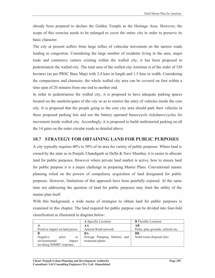
Draft Master Plan for Amritsar
Client: Punjab Urban Planning and Development Authority Page 255Consultant: SAI Consulting Engineers Pvt. Ltd. Ahmedabad
already been prepared to declare the Golden Temple as the Heritage Area. However, the
scope of this exercise needs to be enlarged to cover the entire city in order to preserve its
basic character.
The city at present suffers from large influx of vehicular movement on the narrow roads
leading to congestion. Considering the large number of residents living in the area, major
trade and commerce centers existing within the walled city, it has been proposed to
pedestrianize the walled city. The total area of the walled city-Amritsar is of the order of 350
hectares (as per PRSC Base Map) with 2.4 kms in length and 1.5 kms in width. Considering
the compactness and character, the whole walled city area can be covered on foot within a
time span of 20 minutes from one end to another end.
In order to pedestrianize the walled city, it is proposed to have adequate parking spaces
located on the outskirts/gates of the city so as to restrict the entry of vehicles inside the core
city. It is proposed that the people going to the core city area should park their vehicles in
these proposed parking lots and use the battery operated buses/cycle rickshaws/cycles for
movement inside walled city. Accordingly, it is proposed to build multistoried parking on all
the 14 gates on the outer circular roads as detailed above.
10.7 STRATEGY FOR OBTAINING LAND FOR PUBLIC PURPOSESA city typically requires 40% to 50% of its area for variety of public purposes. Where land is
owned by the state as in Punjab, Chandigarh or Delhi & Navi Mumbai, it is easier to allocate
land for public purposes. However where private land market is active, how to ensure land
for public purpose it is a major challenge in preparing Master Plans. Conventional master
planning relied on the powers of compulsory acquisition of land designated for public
purposes. However, limitations of this approach have been painfully exposed. At the same
time not addressing the question of land for public purposes may limit the utility of the
master plan itself.
With this background, a wide menu of strategies to obtain land for public purposes is
examined in this chapter. The land required for public purpose can be divided into four-fold
classification as illustrated in diagram below:A Specific Location B Flexible Location
A.Positive impact on land prices
AAArterial Road network
ABParks, play grounds, schools etc.
B.Negative price orenvironmental impact invoking NIMBY response.
BASewage Pumping Stations and treatment plants
BBSolid waste disposal sites

Draft Master Plan for Amritsar
Client: Punjab Urban Planning and Development Authority Page 256Consultant: SAI Consulting Engineers Pvt. Ltd. Ahmedabad
(In many cases necessity of a particular activity at the city scale is recognized e.g. solid waste
disposal site or a slaughterhouse, but they are locally undesirable and invoke “Not in My
Backyard” response.)
No single option can be used uniformly throughout the city. It has to be contextual,
considering the location and the local issues including core areas v/s outlying areas. Similarly
different alternatives may be suitable for different types of public purposes. The possible
options for securing land for public purposes such as roads, educational, health, parks, water
supply, sewerage, social and religious institutes, old age homes, community centers etc with
their limitations are listed below.
10.7.1 THROUGH O.U.V.G. L. SCHEME:
It is a scheme for identifying vacant government land (including municipal land) and using it
as source for providing land for public purposes. However given the need for using
government land for generating financial resources, entire stock of government land need not
be assigned to non-remunerative public purposes. In fact government land would offer many
opportunities for PPP where part of the land could be used for public purpose. For example a
plot of government land could be allocated for an intercity bus terminal with a budget hotel.
Rationalizing obsolete uses of public lands could be another way of putting public land to
more relevant public purpose. Old jail or an agricultural produce market in the congested part
of the city is common example. But for relocation of these activities requires availability of
adequate and suitable public land at other locations. In order to rationalize the land demand
and supply, specific designations of land for different uses in the master plan has to be made
before proceeding with compulsory acquisition of land. Impracticability of this option is too
well known to be recounted here. But this may be unavoidable in certain cases – particularly
'A' category public purpose. However, the use for these lands shall be as determined by the
State Government, irrespective of the use shown on the proposed land use plan. In case of
Panchayat land of villages falling in local planning area, these lands shall be used for creating
public utilities, services, physical and social infrastructure including parks, open spaces,
community facilities etc. and not for any other purpose. Similarly, in case of the land owned
by the Amritsar Development Authority (ADA), its use shall be as deternmined by the
ADA/State Government, not withstanding the provisions of these regulations/proposals
shown in the Proposed Landuse Plan.

Draft Master Plan for Amritsar
Client: Punjab Urban Planning and Development Authority Page 257Consultant: SAI Consulting Engineers Pvt. Ltd. Ahmedabad
10.7.2 THROUGH T.D.R.:Alternative to monetary compensation could be award of Transfer of Development Rights
either to remainder of the land or to a distant location. This could be in three generic cases
viz.
Roads and Road widening: Development rights calculated at the FAR permissible in
adjoining area may be allowed to be used in the remainder of the plot up to a limit.
Development rights that cannot be so consumed can be transferred elsewhere in receiving
areas. If FAR is related to width of the road, resistance to widening may get reduced.
Public purposes on open land or exclusive plots: Lands required for parks and playgrounds or
exclusive uses like secondary school, fire station etc can be obtained by providing TDRs in
lieu of compensation. However, price differentials in originating and receiving zones could
be considered as an incentive in such cases.
Public purposes that require built-up space but not necessarily exclusive plot: Examples of
this could be municipal vegetable market, library etc. In such cases, landowner may be
permitted to use the full potential of development in terms of FAR over the plot provided he
offers the built up space required for the public purpose to the local body.
10.7.3 THROUGH PAPR ACT 1995
Layout and Sub-division Regulations: These regulations, depending upon the total area of
colony, can provide for some reservation for public purpose including road network, parks,
open spaces, institutional buildings, water works, disposal works, community centers, etc. in
addition to local requirements. This mechanism is currently being used on a large scale in the
State of Punjab under the provisions of PAPRA Act, 1995. However, this process needs to be
promoted and augmented by providing appropriate policy framework in order to promote
planned development in the state and to make available land for public purposes without
involving any compulsory acquisition of land.
10.7.4 THROUGH LAND POOLING OR TOWN DEVELOPMENT SCHEMES: As per the provisions of section 91 (Chapter XII) of Punjab Regional and Town Planning &
Development Act, 1995, the concerned Authority may for the purpose of implementation of
the provision of the Master Plan or for providing amenities where the same are not available
or are inadequate, frame the Town Development Scheme and land for various amenities can
be earmarked as per the provisions of sub section 2(g) of section 91. The strategic approach
would relate to geographically depicting the sites required for public purpose and proposing
regulatory framework for obtaining the land for public purpose whether shown on the plan or

Draft Master Plan for Amritsar
Client: Punjab Urban Planning and Development Authority Page 258Consultant: SAI Consulting Engineers Pvt. Ltd. Ahmedabad
not. For this, master plan has to consider various options as defined below. However, these
options have their own limitations and have to be uses selectively based on the ground
reality, existing conditions, development potentials, involving private sector, etc. Table 112: Strategy for Obtaining Land for Public PurposeAlternative Land
Acquisition through 1894 Act
TDR Developmentof land through PAPR Act 1995, TDS under PRTPD Act 1995 and DevelopmentSchemes under PTI Act, 1922
Land Pooling Govt / Panchayat / Waqf Board lands
PlanProposal
Land designated for public purposes
Land designated for public purposes
Landdesignated for public purposes
Land designated for public purposes
Land designated for public purposes
Regulation No separate regulatory provisionnecessary
Regulationabout use of TDR on receiving plots is necessary
Certainproportion(about 40%) of land is dedicated for public purposes.
This requires a separate legal process to be followed for reconstitution of plots along with evaluation of compensation and betterment as provided in Chapter XII of the 1995 Act.
No separate regulatory provisionnecessary
Means of securingland
Compulsory acquisition by paying monetary compensation
Monetary compensation substituted by Transfer of DevelopmentRights (TDR)
Availability of land through layout plan provisions
-As Above- Land can be made available through transfer of ownership from one department to another. No monetary compensation is involved.
Limitations
Lack of finances forcompensation
Lack of finances forcompensation
This is the methodcurrently relied upon where minimumstipulated area for colony is 10 acres, as in case of PAPRA.
ComprehensiveLand Pooling Policy is required to be framed.
Locationaldisadvantages in certain cases.
Landowners’ resistance
Landowners’resistance
This is to be market driven and present response is said to be not so encouraging.
Difficulty in pooling of land of large number of owners.
Minimum area requirementmay not be fulfilled
Draft Master Plan for Amritsar
Client: Punjab Urban Planning and Development Authority Page 259Consultant: SAI Consulting Engineers Pvt. Ltd. Ahmedabad
Limitations
Inequitousdistribution of costs and benefits. Cost borne by those who lose land and benefits enjoyed by surrounding landowners
Iniquitousdistribution of costs and benefits. Cost borne by those who lose land and benefits enjoyed by surroundinglandowners
Time consuming and complicated process
Source of revenue for Panchayat Bodies / Waqf Board gets depleted.
But where real estate prices are high particularly where land price is several times the construction cost, chances of success are high.
Equitabledistribution of costs and benefits to different share holders.
Could also be used for heritage conservation.
New concept difficult to be implemented.
New concept difficult to be implemented.
Given the details included in the Master Plan, it is not possible to specify which of the above
techniques will be used for obtaining land for public purpose. This would be addressed in the
detailed zonal plans.
10.8 SPACE NORMS AND STANDARDS
For implementation of the Master Plan and for working out the requirements for different
amenities, space norms and standards have been defined for different socio-economic
infrastructure to be developed in the city including its spatial distribution in order to ensure
its equitable distribution within different parts of the city.
10.8.1 PLANNING NORMS FOR EDUCATIONAL INSTITUTIONS
For ascertaining the need and requirement of various levels and categories of educational
institutions in the context of the city, planning norms have been worked based on the basis of
population in order to ensure that educational facilities of desired quantity and quality are
available uniformly to the entire population including their spatial distribution. Further, the
norms have been defined in terms of areas to be provided under each unit. The level of
facilities to be provided have been categorized into general-purpose education at the school
level, undergraduate and post graduate level besides technical and professional institutions
and universities. Based on above, the norms for educational institutions have been detailed as
under:
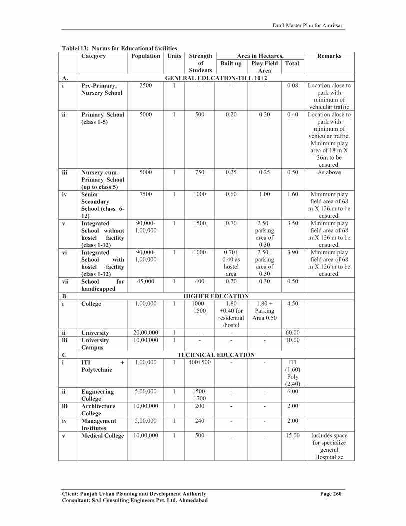
Draft Master Plan for Amritsar
Client: Punjab Urban Planning and Development Authority Page 260Consultant: SAI Consulting Engineers Pvt. Ltd. Ahmedabad
Table113: Norms for Educational facilitiesCategory Population Units Strength
ofStudents
Area in Hectares. RemarksBuilt up Play Field
AreaTotal
A. GENERAL EDUCATION-TILL 10+2i Pre-Primary,
Nursery School2500 1 - - - 0.08 Location close to
park with minimum of
vehicular trafficii Primary School
(class 1-5)5000 1 500 0.20 0.20 0.40 Location close to
park with minimum of
vehicular traffic. Minimum play area of 18 m X
36m to be ensured.
iii Nursery-cum-Primary School (up to class 5)
5000 1 750 0.25 0.25 0.50 As above
iv SeniorSecondarySchool (class 6-12)
7500 1 1000 0.60 1.00 1.60 Minimum play field area of 68
m X 126 m to be ensured.
v IntegratedSchool without hostel facility(class 1-12)
90,000-1,00,000
1 1500 0.70 2.50+parkingarea of 0.30
3.50 Minimum play field area of 68
m X 126 m to be ensured.
vi IntegratedSchool withhostel facility(class 1-12)
90,000-1,00,000
1 1000 0.70+0.40 as hostelarea
2.50+parkingarea of 0.30
3.90 Minimum play field area of 68
m X 126 m to be ensured.
vii School forhandicapped
45,000 1 400 0.20 0.30 0.50
B HIGHER EDUCATIONi College 1,00,000 1 1000 -
15001.80
+0.40 for residential
/hostel
1.80 + Parking
Area 0.50
4.50
ii University 20,00,000 1 - - - 60.00iii University
Campus10,00,000 1 - - - 10.00
C TECHNICAL EDUCATIONi ITI +
Polytechnic1,00,000 1 400+500 - - ITI
(1.60)Poly
(2.40)ii Engineering
College5,00,000 1 1500-
1700- - 6.00
iii ArchitectureCollege
10,00,000 1 200 - - 2.00
iv ManagementInstitutes
5,00,000 1 240 - - 2.00
v Medical College 10,00,000 1 500 - - 15.00 Includes space for specialize
generalHospitalize

Draft Master Plan for Amritsar
Client: Punjab Urban Planning and Development Authority Page 261Consultant: SAI Consulting Engineers Pvt. Ltd. Ahmedabad
Notes:
�� One crèche for a population of 25,000 in an area of 0.05 hectare shall be provided.
This could be made integral part of any category of educational institutions with
addition of the area of the crèche.
� Number of units in each category shall be based on the population prescribed above.
In case the population for the area works out to be merely 50% norms specified
above, in such cases individual sites in that category shall be provided. Additional
sites shall be provided in case balance population exceeds 50% of the standards
prescribed above.
� In case of higher student capacity, the built up and open area shall be increased
proportionately.
� In order to economize on the land and optimize the infrastructure, educational
institutions could be run on double shift basis.
� The open space shall be designed in a manner to ensure that they are also made
available to the community as play area during the time when it is not being used by
the institution.
� Adequate area for plantation shall also be earmarked in order to improve the quality
of environs and area under green cover.
� Adequate parking arrangement for buses, vehicles of students/staff shall be made.
� Unless specified in the zoning plan and building byelaws, the ground coverage, FAR,
height for various categories of buildings shall be as under.Table 114: Permissible levels of Education facilitiesCategory Maximum Ground
CoverageMaximum permissible
height (Meters)FAR
Nursery School 40% 8 0.75Primary School 40% 8 0.75Higher Sec.School 33% 15 1.00Colleges 33% 15 1.00Uni/Tech/Prof. Inst. 25% 20 1.00
Basement shall be allowed in each category of building under the built up area up to the
maximum extent of ground coverage. It shall be used for parking, services, storage etc. It
shall not be used for habitable purposes. No classes or other student’s activities shall be held
in the basement. Basement area shall not be counted towards FAR.
In case of large institutions, area for academics, residential, sports and cultural activities,
parks and landscape shall be clearly defined. The area shall not exceed 45% under academics,

Draft Master Plan for Amritsar
Client: Punjab Urban Planning and Development Authority Page 262Consultant: SAI Consulting Engineers Pvt. Ltd. Ahmedabad
and 25% under residential, whereas it shall not be less than 15% for sports and cultural
activities and 15% for parks and landscape
10.8.2 NORMS FOR THE HEALTH CARE FACILITIESHealth care facilities shall be provided and distributed in such a manner that it covers the
entire area and the population in order to make the facility available to every resident of the
town irrespective of his location or place of residence. It must cover all the land uses
including residential, commercial, industrial, institutional etc. A well-defined hierarchy will
be essential to meet both the basic and specialized needs of the health care. Appropriate
policy framework would be critical to provide for greater role of private sector in healthcare
by making available required proportion of site for the sector. The healthcare facilities of
various grades to be provided in the town/city shall be based on the following norms:Table 115: Norms for health facilitiesS.No. Category Population Unit Area (Hectares) Remarks
1. Nursing Home 7,500 1 0.10 Capacity of 5-10 beds
2. Dispensary 15,000 1 0.12-0.15 For outdoor treatment only
3 Health Centre 50,000 1 0.4 Capacity of 25-30 beds
4 Poly Clinic 1,00,000 1 0.4 with some observation beds
5 IntermediateHospital
(category B)1,00,000
1 0.1i)for hospital 0.6ii)for residential 0.4
capacity of 80 beds with initial provision
of 50 including 20 maternity beds
6. IntermediateHospital
(category A)1,00,000
1 3.70i)for hospital 2.70ii)for residential 1.0
capacity of 200 beds with initial provision
of 100 beds7.
General Hospital2,50,000 1 6.00
i)for hospital 4.00ii)for residential 2.00
capacity of 500 beds with initial provision
of 300 beds8. Multi Specialty
Hospital1,00,000 1 9.00
i)for hospital 6.00ii)for residential 3.00
capacity of 200 beds with initial provision
of 100 beds9.
Specialty Hospital 1,00,0001 3.70
i)for hospital 2.70ii)for residential 1.00
capacity of 200 beds with initial provision
of 100 beds
Note:� In case of specific requirements for medical facilities other than those indicated
above, additional sites may be provided for catering to specialize needs of
healthcare.
� All Medical colleges shall also include provision of medical hospital of 500 beds
as integral part of the complex.
� Additional sites may be provided in case of Regional/National level healthcare
institutes which are to be located as part of the city.
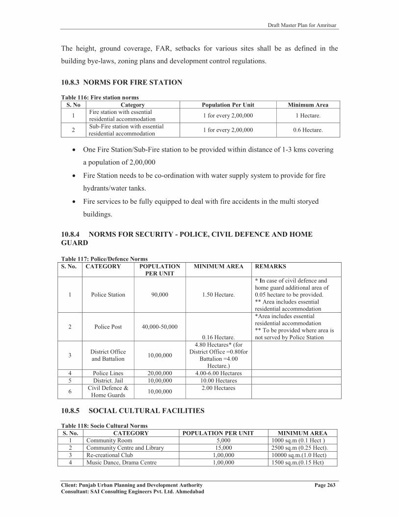
Draft Master Plan for Amritsar
Client: Punjab Urban Planning and Development Authority Page 263Consultant: SAI Consulting Engineers Pvt. Ltd. Ahmedabad
The height, ground coverage, FAR, setbacks for various sites shall be as defined in the
building bye-laws, zoning plans and development control regulations.
10.8.3 NORMS FOR FIRE STATION
Table 116: Fire station normsS. No Category Population Per Unit Minimum Area
1 Fire station with essential residential accommodation 1 for every 2,00,000 1 Hectare.
2 Sub-Fire station with essential residential accommodation 1 for every 2,00,000 0.6 Hectare.
� One Fire Station/Sub-Fire station to be provided within distance of 1-3 kms covering
a population of 2,00,000
� Fire Station needs to be co-ordination with water supply system to provide for fire
hydrants/water tanks.
� Fire services to be fully equipped to deal with fire accidents in the multi storyed
buildings.
10.8.4 NORMS FOR SECURITY - POLICE, CIVIL DEFENCE AND HOME GUARD
Table 117: Police/Defence NormsS. No. CATEGORY POPULATION
PER UNITMINIMUM AREA REMARKS
1 Police Station 90,000 1.50 Hectare.
* In case of civil defence and home guard additional area of 0.05 hectare to be provided.** Area includes essential residential accommodation
2 Police Post 40,000-50,000
0.16 Hectare.
*Area includes essential residential accommodation** To be provided where area is not served by Police Station
3 District Office and Battalion 10,00,000
4.80 Hectares* (for District Office =0.80for
Battalion =4.00 Hectare.)
4 Police Lines 20,00,000 4.00-6.00 Hectares5 District. Jail 10,00,000 10.00 Hectares
6 Civil Defence & Home Guards 10,00,000 2.00 Hectares
10.8.5 SOCIAL CULTURAL FACILITIES
Table 118: Socio Cultural NormsS. No. CATEGORY POPULATION PER UNIT MINIMUM AREA
1 Community Room 5,000 1000 sq.m (0.1 Hect )2 Community Centre and Library 15,000 2500 sq.m (0.25 Hect).3 Re-creational Club 1,00,000 10000 sq.m.(1.0 Hect)4 Music Dance, Drama Centre 1,00,000 1500 sq.m.(0.15 Hct)
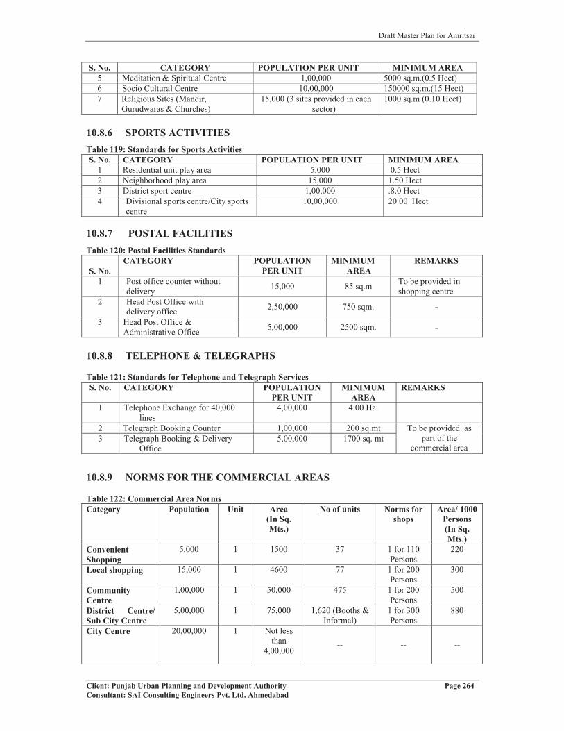
Draft Master Plan for Amritsar
Client: Punjab Urban Planning and Development Authority Page 264Consultant: SAI Consulting Engineers Pvt. Ltd. Ahmedabad
S. No. CATEGORY POPULATION PER UNIT MINIMUM AREA5 Meditation & Spiritual Centre 1,00,000 5000 sq.m.(0.5 Hect)6 Socio Cultural Centre 10,00,000 150000 sq.m.(15 Hect)7 Religious Sites (Mandir,
Gurudwaras & Churches)15,000 (3 sites provided in each
sector)1000 sq.m (0.10 Hect)
10.8.6 SPORTS ACTIVITIESTable 119: Standards for Sports ActivitiesS. No. CATEGORY POPULATION PER UNIT MINIMUM AREA
1 Residential unit play area 5,000 0.5 Hect 2 Neighborhood play area 15,000 1.50 Hect3 District sport centre 1,00,000 .8.0 Hect4 Divisional sports centre/City sports
centre10,00,000 20.00 Hect
10.8.7 POSTAL FACILITIESTable 120: Postal Facilities Standards
S. No.CATEGORY POPULATION
PER UNITMINIMUM
AREAREMARKS
1 Post office counter without delivery 15,000 85 sq.m To be provided in
shopping centre2 Head Post Office with
delivery office 2,50,000 750 sqm. -
3 Head Post Office & Administrative Office 5,00,000 2500 sqm. -
10.8.8 TELEPHONE & TELEGRAPHS
Table 121: Standards for Telephone and Telegraph ServicesS. No. CATEGORY POPULATION
PER UNITMINIMUM
AREAREMARKS
1 Telephone Exchange for 40,000 lines
4,00,000 4.00 Ha.
2 Telegraph Booking Counter 1,00,000 200 sq.mt To be provided as part of the
commercial area3 Telegraph Booking & Delivery
Office5,00,000 1700 sq. mt
10.8.9 NORMS FOR THE COMMERCIAL AREAS
Table 122: Commercial Area NormsCategory Population Unit Area
(In Sq. Mts.)
No of units Norms for shops
Area/ 1000 Persons(In Sq. Mts.)
Convenient Shopping
5,000 1 1500 37 1 for 110 Persons
220
Local shopping 15,000 1 4600 77 1 for 200 Persons
300
Community Centre
1,00,000 1 50,000 475 1 for 200 Persons
500
District Centre/ Sub City Centre
5,00,000 1 75,000 1,620 (Booths & Informal)
1 for 300 Persons
880
City Centre 20,00,000 1 Not less than
4,00,000-- -- --

Draft Master Plan for Amritsar
Client: Punjab Urban Planning and Development Authority Page 265Consultant: SAI Consulting Engineers Pvt. Ltd. Ahmedabad
Category Population Unit Area(In Sq. Mts.)
No of units Norms for shops
Area/ 1000 Persons(In Sq. Mts.)
Local Whole sale Market
10,00,000 1 1,00,000 -- -- --
Weekly Markets 1,00,000 1-2 4,000 300-400 Shops -- --Organizedinformal eating space
1,00,000 1 2,000
Hierarchy to be followed for Commercial Centre
�� Formal Shopping
� Convenient Shopping to be provided at cluster level
� Local shopping to be provided at sector level
� Community Centre to be provided for a group of sectors
� District Centre to be provided at the level of group of community centres
� Sub City Centre to be provided at the level of sub city
� City Centre to be provided at city level
� Local Wholesale Market to be provided at city level
� Informal shopping
� Weekly Markets to be provided for group of sectors
� Organized informal eating space to be provided at the traffic nodes
NOTE:Above hierarchy of commercial areas to be provided depending upon the size of the city.
� In case of small towns, shopping at housing cluster, sector and community levels shall
be provided.
� In case of medium towns, shopping at housing cluster, sector, community & district
levels shall be provided.
� In case of large towns/cities, shopping at housing cluster, sector, community, district,
sub – city & city levels shall be provided.
� All shopping areas are to be provided with adequate parking as per the prescribed
norms

Draft Master Plan for Amritsar
Client: Punjab Urban Planning and Development Authority Page 266Consultant: SAI Consulting Engineers Pvt. Ltd. Ahmedabad
CHAPTER 11
DEVELOPMENT CONTROLS AND ZONING REGULATIONS
11.1 SECTION I: DEVELOPMENT CONTROLS REGULATIONS
The purpose of the Development Control Regulations (DCR) is to assist all the stakeholders
including developers and end-users within the Local Planning Area, Amritsar to strive for a
sustainable, quality and environment friendly development.
These Development Control Regulations are applicable to the entire set of existing and
proposed developments that are going to come up within the Local Planning Area. The
developers are required to comply with the provisions of Zoning and Landuse Plans defined
in the Master Plan. However, Development Schemes/ Projects, which have already been
approved by the Competent Authority shall continue to be governed by the terms and
conditions stipulated for their approvals.
Chapter XI of the Punjab Regional and Town Planning and Development Act, 1995
(Amended 2006), provides for ‘Control of Development and Use of Land where Master Plan
is in Operation.’ The Chapter lays down the procedural framework for exercising the
development control. “Development” in the said act has been defined as:
Carrying out of building, engineering, mining, quarrying or other operation in, on,
over or under land or making of any structural or material changes in any building
or land including that which affects the appearance of any heritage site and includes
demolition of any part or whole of the building or change in use of any building or
land and also includes reclamation, redevelopment, a layout or sub-division of land.
In order to achieve the basic objectives of planned and orderly development within the
planning area, following Regulations have been stipulated:
11.1.1 RESIDENTIAL
The norms for residential plotted development and the group housing to be developed in the
Local Planning Area, Amritsar shall be as defined below:Category Minimum Area of colony*Group Housing **i.Outside Municipal limitsa)For General 5 Acres ( stand alone/ independent)b) For EWS 2.5 Acresii. Within Municipal limitsa) For all Categories 4000 Square meters
* Minimum area for a colony including plotted and group housing may be varied and shall be as notified by the State Government/Competent Authority from time to time.** The Norms for Group Housing shall be as defined in the Para 10.1.1.2 below

Draft Master Plan for Amritsar
Client: Punjab Urban Planning and Development Authority Page 267Consultant: SAI Consulting Engineers Pvt. Ltd. Ahmedabad
Note:
� Maximum area under residential and commercial use in residential colony shall not
exceed 55% subject to the condition that commercial component shall not exceed 5% of
total area.
� Maximum area under institutional / public buildings shall be restricted to 10% of total
area
� Minimum area under parks/open spaces, roads & parking lot shall not be less than 35% of
total area.
� Minimum road width within residential areas shall not be less than 40 feet (12mts). If the
existing road is less than 40 feet (12mts), then land on both sides of the road shall be
reserved for future expansion or widening to comply with the minimum requirement of
40 feet (12mts). The number of storeys in the buildings abutting on these roads, shall not
exceed three (G+ 2 storey).
Note: - Unless otherwise specified in the Development Regulations and provisions made in the Master Plan,
Floor Area Ratio, Height and Ground Coverage for individual residential plots within municipal areas shall be
governed by Municipal Building Byelaws. However, in case of area falling outside Municipal limits, the
Building Bye-laws of respective Development Authority/PUDA shall apply.
11.1.1.1 Parking Requirements for Plotted Developments
Provision for parking in the plotted development shall be governed by the following normsPlots size* Parking Requirements 85 sq m and less (100 sq yd and less) Parking spaces for 2 scooter86 – 168 sq m (101 – 200 sq yd) 1.5 car parking space within plot area169 – 425 sq m (201 – 500 sq yd) 2 car parking space within plot area425 sq m and more(500 sq yd and more) 3 car parking space within plot area
* Variations up to 10% may be permitted by the Competent Authority based on conditions / constraints arising from the site.
11.1.1.2 Group Housing
Provision of Group Housing within the Local Planning Area shall be subjected to following norms:
1 Minimum Plot sizeWithin MC limits 4000 square metersOutside MC limits
� For General Category� For EWS
5 acres2.5 acres
2 Minimum Road Width For group housing stand alone projects, minimum width of approach road shall be 60’. However, the promoter is required to leave space from his own land for widening the road to 80’ and the space so left shall be deemed to be public space meant for road widening. In case of approved colonies, no group housing shall be permitted on a road width less than 60’.

Draft Master Plan for Amritsar
Client: Punjab Urban Planning and Development Authority Page 268Consultant: SAI Consulting Engineers Pvt. Ltd. Ahmedabad
3 Minimum Frontage 20 meters4 Permissible FAR 1.755 Permissible Height There shall be no restriction on the height of building subject to
clearance from Air force Authorities and fulfillment of other rules such as setbacks, distance between buildings etc. However, structural safety and fire safety requirements shall be as per the National Building Codes.
6 Parking Provisions For group housing, parking norms shall not be less than 1.5 ECS per 100 sq m of covered area. The maximum provision allowable for group housing projects will be 3 ECS per dwelling unit.
Note:
� Construction of residential houses sold by promoters on the basis of different floors
shall also be considered as group/flatted housing development and provision of
parking to be made shall be as per the norms applicable to group housing.
� Size of front gate and construction of front boundary wall is optional to meet the
parking requirements.
� All projects for which CLU has been granted prior to the approval of the Master Plan
shall stand adjusted irrespective of the proposed land use subject to necessary
environmental safeguards, road networks etc. defined in the Master Plan.
11.1.1.3 Farm Houses
Provision of farm houses shall be governed by following planning area and coverage norms:Minimum Area 2.5 acresFAR 0.04Ground Coverage 2% or 200sqmts whichever is lessNumber of storeys Not to exceed 2Height a. In case of Single Storey building not to exceed 18’-0”
b. In case of Double Storey building not to exceed 28’-0”Hard Surface Not to exceed 10%
11.1.2 COMMERCIAL
Commercial uses in residential zones located within the Municipal Limits shall be permitted
on roads having minimum width of 80 feet and minimum plot frontage of 20 meters.
However, area requirements for such commercial developments shall be as per the Municipal
Bye-laws’s/ Master Plan Rules and Regulations as the case may be.
In case of stand–alone commercial complexes with height greater than three storeys within/
outside Municipal limits, area, height, F.A.R etc of such buildings shall be governed by
following norms:
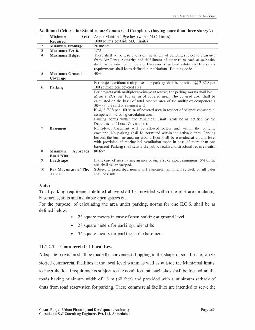
Draft Master Plan for Amritsar
Client: Punjab Urban Planning and Development Authority Page 269Consultant: SAI Consulting Engineers Pvt. Ltd. Ahmedabad
Additional Criteria for Stand–alone Commercial Complexes (having more than three storey’s) 1 Minimum Area
RequiredAs per Municipal Bye-laws(within M.C. Limits)1000 sq.mts (outside M.C. limits)
2 Minimum Frontage 20 meters3 Maximum F.A.R. 1.754 Maximum Height There shall be no restrictions on the height of building subject to clearance
from Air Force Authority and fulfillment of other rules such as setbacks, distance between buildings etc. However, structural safety and fire safety requirements shall be as defined in the National Building code.
5 Maximum Ground Coverage
40%
6 ParkingFor projects without multiplexes, the parking shall be provided @ 2 ECS per 100 sq m of total covered area For projects with multiplexes/cinemas/theatres, the parking norms shall be:a) @ 3 ECS per 100 sq m of covered area. The covered area shall be calculated on the basis of total covered area of the multiplex component + 30% of the said component and b) @ 2 ECS per 100 sq m of covered area in respect of balance commercial component including circulation areaParking norms within the Municipal Limits shall be as notified by the Department of Local Government.
7 Basement Multi-level basement will be allowed below and within the building envelope. No parking shall be permitted within the setback lines. Parking beyond the built up area on ground floor shall be provided at ground level with provision of mechanical ventilation made in case of more than one basement. Parking shall satisfy the public health and structural requirements.
8 Minimum Approach Road Width
80 feet
9 Landscape In the case of sites having an area of one acre or more, minimum 15% of the site shall be landscaped.
10 For Movement of Fire Tender
Subject to prescribed norms and standards, minimum setback on all sides shall be 6 mts.
Note:Total parking requirement defined above shall be provided within the plot area including basements, stilts and available open spaces etc. For the purpose, of calculating the area under parking, norms for one E.C.S. shall be as defined below:
� 23 square meters in case of open parking at ground level
� 28 square meters for parking under stilts
� 32 square meters for parking in the basement
11.1.2.1 Commercial at Local Level
Adequate provision shall be made for convenient shopping in the shape of small scale, single
storied commercial facilities at the local level within as well as outside the Municipal limits,
to meet the local requirements subject to the condition that such sites shall be located on the
roads having minimum width of 18 m (60 feet) and provided with a minimum setback of
6mts from road reservation for parking. These commercial facilities are intended to serve the

Draft Master Plan for Amritsar
Client: Punjab Urban Planning and Development Authority Page 270Consultant: SAI Consulting Engineers Pvt. Ltd. Ahmedabad
needs of local residents only and shall form part of the predominant residential land use
defined in the Master Plan.
11.1.2.2 Vehicular Access
No property located on the National Highway shall have a direct access from such roads.
Vehicular access to all such properties (within and outside the Municipal Limits) that abut
National Highways shall be through a service lane having a minimum width of 6 meter (20
feet). The front setback in case of these properties shall be:
a. Within Municipal Limits: 12 meters
b. Outside Municipal Limits: 30 meters (out of which 10 meter strip adjoining the
service road shall be developed as green belt).
11.1.3 INSTITUTIONAL:
Minimum area and size in case of institutional buildings shall be as per the affiliating
authority norms with minimum frontage of 20 meters and road width of 60 feet,(except in
case of nursery and primary schools) F.A.R., Ground Coverage, Height etc. of the building
shall be as defined in the approved Zoning plan. Zoning Plan of the site shall be approved
from the Competent Authority.
11.1.4 INDUSTRIALThe norms for the site coverage, parking and FAR for the industrial sites shall be as defined below:Size of Plot Site CoverageFor the first 2420 sq yds 50% of the siteFor the next 2420 sq yds 33% of the siteIn excess of 4840 sq yds 25% of the siteFAR 1Parking @ 1 ECS per 100 sq. mtr. of covered area* * The area of 1 ECS shall be as defined in the Para 10.1.2 above.
Note:� FAR Permitted: Industrial / I.T. Park shall have minimum 10 acres of area. In an
I.T. park, I.T. component shall have F.A.R. 2. In case of Industrial Park, for
industrial F.A.R permitted for an industrial component shall be 1 and other
components shall have F.A.R as mentioned for different land uses in Master Plan.
In industrial park, only green and orange industries shall be permitted.
� Residential Component: Residential component in the industrial plot / premises
shall not exceed 5% of the area of the site and shall form part of the maximum
permissible covered area.

Draft Master Plan for Amritsar
Client: Punjab Urban Planning and Development Authority Page 271Consultant: SAI Consulting Engineers Pvt. Ltd. Ahmedabad
� Height: There shall be no restrictions on height of the building subject to
clearance from Air Force Authority and fulfillment of other rules such as
setbacks, distance between buildings etc. However, structural safety and fire
safety requirements shall be as defined in the N.B.C (National Building code).
� Road width: The minimum road width within the industrial unit shall not be less
than 40 feet. In case, the existing road is less than 40’-0” in width, then it shall be
widened to 40’-0” by taking equal strip of land from both sides of the road.
� The construction activity along the Scheduled Roads and Bye-passes passing
through Local Planning Area, Amritsar shall be subject to the provisions of
Section 143 of the Punjab Regional and Town Planning and Development Act,
1995 as amended from time to time.
� The standards prescribed by Punjab Pollution Control Board from time to time
would have to be met by all industrial units in addition to other specific conditions
in terms of plot size, ground coverage, F.A.R., height, parking norms etc.
� Existing Industries:
The existing industries falling within conforming/non-conforming uses shall be
governed by following Regulations:
i) No polluting industry would be permitted within the existing focal points
and the industrial estates set up by the State Government or any
Development Agency. All existing polluting industries shall not be
allowed to expand their capacity and shall be regulated by the conditions
and comply with the stipulations made by the PPCB for such industries.
However, these industries shall be permitted to use their total F. A. R.
subject to the conditions specified above.
ii) All polluting industries existing in clusters located in
residential/commercial area shall not be allowed to expand in terms of
their capacity and shall be required to comply the conditions stipulated by
the PPCB for such industries. However, such industries would be
encouraged to shift to the designated industrial areas in the Master Plan
based on a scheme framed in this regard by the State Government. These
industries would be encouraged to use the land under industrial units for
conforming land uses.

Draft Master Plan for Amritsar
Client: Punjab Urban Planning and Development Authority Page 272Consultant: SAI Consulting Engineers Pvt. Ltd. Ahmedabad
iii) No polluting industry shall be permitted within the residential plots and
would be required to shift to the designated industrial zone within a period
of 10 years from date of publication of Master Plan. No such industrial
units shall be given any permission for enhancement of the capacity and
electric load.
iv) All industrial units falling in residential area shall be permitted to change
the nature of industries that are knowledge based and involve the use of IT
and ITES for which permission should be granted liberally subject to the
condition that location does not cause any congestion and traffic problems.
� Incentives for shifting of existing industries falling within non-conforming
zones:
In case of industries falling in the red category, which are in operation as on date
of Master Plan notification and are located in the non-conforming landuse zone, if
such industries shift outside this zone to any of the designated industrial zone
within the Master Plan of Amritsar /state of Punjab and generate at least the same
number of jobs at the new location, will be provided with following benefits:
1) No CLU, EDC or Licence Fee on the existing industrial site shall be charged if
used for plotted residential purposes provided the industry shifts within three
years of the notification of the Master Plan. If used for any permissible land use
other than plotted residential for which the prescribed CLU, EDC and Licence Fee
are higher, then the difference between CLU, EDC and Licence Fee of the
proposed land use and plotted residential has to be paid. In case that particular
land is put to a land use for which CLU, EDC or Licence Fee is less than the
plotted residential, the difference between these fees / charges for the plotted
residential and proposed land use shall not be payable by the Government / Urban
Development Authority.
2) If the industry shifts in the subsequent two years of the above mentioned period
of three years, it will enjoy only 50% reduction on CLU, EDC and Licence Fee on
the present site if used for plotted residential purposes. If used for any permissible
land use other than plotted residential, the difference between the CLU, EDC and
Licence Fee of the new land use and that of 50% of plotted residential has to be
paid. In case that particular land is put to land use for which CLU, EDC or
Licence Fee is less than the plotted residential, the difference between these fees /

Draft Master Plan for Amritsar
Client: Punjab Urban Planning and Development Authority Page 273Consultant: SAI Consulting Engineers Pvt. Ltd. Ahmedabad
charges for the plotted residential and proposed land use shall not be payable by
the Government / Urban development Authority.
3) No CLU, EDC or Licence fee on the new industrial site shall be payable if the
industry shifts within five years of the notification of the Master Plan.
11.1.5 ENVIRONMENTAL CONSIDERATIONS:
� All the textile / dying and electroplating units with in industrial zone shall be
required to set up treatment plants individually or collectively to achieve zero
liquid discharge and meet all the requirements laid down by Punjab Pollution
Control Board.
� Minimum green buffer of 15 meters depth in the shape of a belt comprising of
broad leaf trees shall be provided around the boundary of village abadies. Also
between residential areas and air polluting industries falling in industrial zone of
Master Plan located within 100 meters, shall be provided with a green buffer of
min. of 15 meters/max 50 meters depth all along the industrial/residential zone.
The provision of buffer strip shall be made by the owner of Land use, which
comes later.
� All residential colonies, commercial establishments like shopping malls,
multiplexes etc shall maintain a minimum distance of 250 meters from the
hazardous (maximum accident hazardous) industries notified by Director General,
Factory Advisor Service Labor Institute. The distance should be measured from
source of pollution / hazard in the industrial premises to the building lines as per
zoning plan of the colony / complex. However for specified type of industries
such as rice shellers/sela plant, brick kilns, stone crushers, hot mix plants etc.
standards prescribed by PPCB and concerned dept. shall be followed.
11.1.6 SAFETY
Fire
Fire services have to play pivotal role and be fully prepared in protecting people from fire
hazards, building collapse, road accidents and other unforeseen emergency etc. At present
there are five fire stations in city.

Draft Master Plan for Amritsar
Client: Punjab Urban Planning and Development Authority Page 274Consultant: SAI Consulting Engineers Pvt. Ltd. Ahmedabad
Planning norms and standards for safety/ fire facilitiesSr. No. Category Population/unit (approx.) Plot area
1 Fire post 3-4 Km radius 2000 sq. mt.2 Fire station 5-7 Kin radius 1.0 Ha.3 Disaster
managementcentre
1 in eachadministrative zone
1.0 Ha. along with suitable openarea (2 ha.) for soft parking,temporary shelter, parade groundetc.
4 Fire traininginstitute/ college
City level ( one site inurban extension)
3.0 Ha.
Development controls for safety/ fire facilities
As per Zoning Plan/Building Byelaws of the local body/any other concerned agency or as per
Govt. instructions issued from time to time.
Guidelines for locating fire stations & other fire fighting facilities in urban
extension:
i) Fire station should be so located that the fire tenders are able to reach any disaster
site immediately within minutes.
ii) Fire station shall be located on corner plots as far possible and main roads with
minimum two entries.
iii) In new layouts, concept of underground pipelines for fire hydrants on periphery,
exclusively for firefighting services should be considered.
iv) Fire stations are permitted in all land use zone/sectors except in Recreational use
zone.
v) Necessary provisions for laying underground/over ground fire fighting measures,
water lines, hydrants etc. may be kept wherever provision of fire station is not
possible.
vi) The concerned agencies shall take approval from Fire Department for
firefighting measures while laying the service for an area.
Disaster Management Centre
According to the Indian Seismic Zone Map, Amritsar is placed in Seismic Zone IV, which
means high damage risk zone. Such natural and manmade disasters neither can be prevented
nor predicted. However, with the technological advancement to some extent mechanism can
be developed to mitigate the after effects of the disaster. Areas of vulnerability can be
identified and necessary measures can be proposed by the concerned agencies. The
concerned local bodies should keep updating the building byelaws to safe guard against

Draft Master Plan for Amritsar
Client: Punjab Urban Planning and Development Authority Page 275Consultant: SAI Consulting Engineers Pvt. Ltd. Ahmedabad
disasters and ensure effective and impartial enforcement. Following policies and strategies
for disaster management are proposed:
1. Pre-Disaster Preparedness
(i) a) Micro-zonation surveys should be referred for land use planning and be considered
while preparing the sectors/Zonal Plans and Layout Plans.
� Seismic micro-zonation for selected areas having high growth rates should be
taken up on priority.
� On the basis of vulnerability studies and hazard identification, which includes soil
conditions, probable intensity of earthquake, physiographic conditions of the
area, fault traces, etc., local level land use zoning and planning should be
undertaken.
(b) Building byelaws should incorporate the aspects of Multi Hazard Safety, and
Retrofitting.
� Priority should be given to public buildings (such as hospitals, educational,
institutional, power stations, infrastructure, heritage monuments, lifeline structures and
those which are likely to attract large congregation) for their ability to withstand
earthquake of the defined intensity.
� Suitable action should be taken for retrofitting and strengthening of structures
identified as vulnerable as per earthquake manuals and National building code. A
techno-legal regime has to be adopted for provision Multi Hazard Safety
aspects.
(ii) Amritsar Fire Services being the nodal agency for disaster management should
identify vulnerable areas such as areas with high density and poor accessibility in the City
and propose suitable measures. Proposed Disaster Management Centres should be established
in every zone/sector to deal with the disasters, including bio-chemical and nuclear
disasters.
(iii) Sensitize people, particularly school children, about after effects of disaster.
(iv) Make people aware through media campaigns and advertisements about emergency
procedures and location of emergency shelters etc.
2. Post Disaster Management
(i) It has been observed that any disaster is generally followed by break down of
communication lines and disruption of essential services. Therefore, the key communication
centers should be protected from natural disasters i.e. flood, fire and earthquake etc. and

Draft Master Plan for Amritsar
Client: Punjab Urban Planning and Development Authority Page 276Consultant: SAI Consulting Engineers Pvt. Ltd. Ahmedabad
services restoration should be taken up on top most priority. Necessary setup should be
created in each of the concerned department for such eventualities.
(ii) Standard type designs and layout should be prepared by the local bodies and made
available to the people so that crucial time is not lost in approval of layout plans and building
plans after disaster.
Disaster Management Centers have been proposed to serve people in the case of disaster
and provide emergency shelters.
11.1.7 OTHER DEVELOPMENT CONTROLS AND GUIDELINES
� Regulation for village abadis: Special Building Regulations shall be prepared for the
development and regulation of an area falling within the Lal Dora or Phirni of the
villages falling in the Local Planning Area.
� All Panchayat land of villages falling in Local Planning Area shall be used
exclusively for public and semi-public uses including utilities, services, physical and
social infrastructure, parks, open spaces, community facilities etc. and not for any
other purpose.
� The existing High Tension lines shall be shifted along the road but outside the Right
of way to ensure unhindered ROW for traffic and other services for all times.
� The minor drains shall have minimum 10 meters wide green strips on either side of
the drain. Other major water bodies shall have minimum 30 meters green strips on
each side. Realignment of water bodies shall be permissible wherever feasible, subject
to the certification by the Engineering Department to ensure free flow of storm water.
� Contiguous expansion of village abadi’s in non-residential zones of Master Plan is
permissible up to the extent shown in the Proposed Land Use Plan. However, for the
village abadi falling in the residential zone of Master Plan, no such restrictions shall
be applicable.
11.1.8 TRANSFERABLE DEVELOPMENT RIGHTS
To facilitate development, it is necessary to accord top priority to the implementation of
public utilities and infrastructure (such as roads, parks, green belts etc.) which will in turn
encourage planned development/regulated urbanization. However, the respective technical
agency or authority will not be able to proceed with its implementation programmes until the
ownership of private land affected by these public utilities and infrastructure has been
Draft Master Plan for Amritsar
Client: Punjab Urban Planning and Development Authority Page 277Consultant: SAI Consulting Engineers Pvt. Ltd. Ahmedabad
transferred to the state or to the relevant authority(s).Acquisition of private land for this
purpose is proposed to be carried out through one of the following options:
� Cash compensation to be paid to affected land owners whose land is to be
acquired or
� A land-pooling scheme may be formulated and implemented.
Of these options, use of mechanism of TDR (Transfer of Development Rights) is
recommended due to the reasons specified below:
� It is relatively simple and direct mechanism to implement and execute.
� The requisite public infrastructure projects can be implemented quickly, thus
facilitating rapid urban development.
� The interests of affected landowners are protected.
The TDR scheme shall be restricted to development projects for public infrastructure and
facilities which shall be announced from time to time. The additional FAR shall not be
transferable from one LPA to another.
The Competent Authority on priority shall finalize detailed policy guidelines on the operation
and implementation of TDR Scheme.
11.2 SECTION II – ZONING REGULATIONSIn view of the above, Zoning Regulations proposed under this Master Plan are essentially
concerned with the control of land use. The proposed land use plan includes following land
use zones
� Residential
� Institutional
� Industrial
� Warehousing and Godowns/ Logistic hub
� Rural and Agricultural
In addition, specific area/network designations have been indicated in respect of proposed
arterial road network, existing rail network, transport terminals etc.
As defined earlier, since sub-division of land and design and construction of buildings is
being controlled by well established Regulations and concerned Competent Authorities,
Zoning Regulations under the Master Plan are seen as the reference point for these agencies
to ensure that the development permitted by them is within the framework of the Master
Plan.

Draft Master Plan for Amritsar
Client: Punjab Urban Planning and Development Authority Page 278Consultant: SAI Consulting Engineers Pvt. Ltd. Ahmedabad
11.3 THE ZONING REGULATIONS PROPOSED FOR ADOPTION IN LPA AMRITSAR ARE PRESENTED BELOW:
Zoning Regulations
The Chief Town Planner, Punjab being the Planning Agency designated under section 57 of
the Punjab Regional and Town Planning and Development Act, 1995 as amended in 2006,
for the Local Planning Area, Amritsar declared under section 56 of the said Act, following
the requirement under clause (d) of sub section 1 of section 70 of the said Act hereby makes
following Zoning Regulations as part of the Master Plan prepared for the Local Planning
Area, Amritsar.
11.3.1 SHORT TITLE, SCOPE, EXTENT & COMMENCEMENT
11.3.1.1 TitleThese Regulations shall be called the Zoning Regulations for Local Planning Area, Amritsar
2010 (hereinafter referred to as “Regulations”).
11.3.1.2 Scope of the Regulations
The scope of these regulations is limited to defining permissible land uses in various land use
zones depicted in the Proposed Land Use Plan forming part of the Master Plan. Other aspects
of “development” such as sub-division and layout of land or intensity of development
measured through FAR, ground coverage, parking requirements, building design and
construction etc. will be governed by other Acts and Regulations promulgated by
Government from time to time. Competent Authorities under such regulations shall ensure
that the developments permitted by them are in conformity with these Regulations.
11.3.1.3 Jurisdiction
These Regulations shall apply to all “development” in the Local Planning Area, Amritsar
declared under section 56 of the Punjab Regional and Town Planning and Development Act
1995 vide notification no 12/65/2006 – 4 HGI/5599 dated 18th July, 2007.
11.3.1.4 Date of Coming into Force
These Regulations shall come into force on the day on which the Designated Planning
Agency publishes the final Master Plan along with these Regulations in the Official Gazette
after obtaining the approval of the State Government under sub section (5) of section 70 of
the “Punjab Regional and Town Planning and Development Act 1995”.

Draft Master Plan for Amritsar
Client: Punjab Urban Planning and Development Authority Page 279Consultant: SAI Consulting Engineers Pvt. Ltd. Ahmedabad
Till such approval, the Authorities while considering the application for permission for
development shall have due regard to the draft proposals and provisions made in these
Regulations.
11.3.2 DEFINITIONS
For the purpose of these Zoning Regulations, the following definitions, unless the context otherwise requires, shall apply:1. “Act” means the Punjab Regional and Town Planning and Development Act, 1995
(Punjab Act No. 11 of 1995) as amended from time to time.
2. “Government” Means the Government of the State of Punjab.
3. “Chief Town Planner” Means the Chief Town Planner of the Department of Town &
Country Planning, Punjab or any other officer to whom his powers are delegated.
4. “Planning Agency ” means the Chief Town Planner Punjab designated as such
under Section 57 of the Punjab Regional and Town Planning and Development Act, 1995
(Punjab Act No. 11 of 1995) as amended from time to time for Local Planning Area
Amritsar.
5. “Existing Land Use Plan” Means the plan showing the different land use existing at the
time of preparation of the Existing Land Use Plan of Local Planning Area, Amritsar and
as indicated on Drawing No. D.T.P (A) 2/2010 Dated 12/01/2010.
6. “Local Planning Area” means the Local Planning Area Declared under section 56(1) of
the Punjab Regional and Town Planning and Development Act, 1995 (Punjab Act No. 11
of 1995) as amended from time to time, vide notification no. 12/65/2006 – 4 HGI/5599
dated 18th July, 2007.
7. “Non- Conforming Building or Use” means building/use in respect of any land or
building in the Local Planning Area, the existing use of which land or building is not in
conformity/contrary to the prescribed land use.
8. “Proposed Landuse Plan” means the plan showing the proposed any admissible uses of
different areas and Land use zones covered in the Local Planning Area, Amritsar and as
indicating on Drawing No. D.T.P (A) 82/2010 Dated 26.03.2010.
9. “Sector Plan” means the detailed plan of a part of Master Plan as delineated in the
Master Plan and approved by the Chief Town Planner, Punjab showing all or any of the
following:-
a) Layout of plots, streets, roads public open spaces, parking areas etc.
b) Area temporarily or permanently prohibited for the building operation.
Draft Master Plan for Amritsar
Client: Punjab Urban Planning and Development Authority Page 280Consultant: SAI Consulting Engineers Pvt. Ltd. Ahmedabad
c) Uses Permitted in respect of each or a group of plots into which the land may be
shown to be divided.
d) Any other detail provided in the Layout Plan.
10. “Zoning Plan” means the plan of area or part thereof or supplementary layout plan
approval by the Chief Town Planner and maintained in the office of Competent Authority
showing the permitted use of land and such other restrictions on the development of land
as may be prescribed in the Zoning Regulations, for any part or whole of the area such as
sub-division of plots, open spaces, streets, position of protected trees and other features in
respects of each plot, permitted land use of building/lands, height, coverage and
restrictions with regard to the use and development of each plot in addition to such other
conditions as laid down in these Regulations hereafter.
11. “Knowledge Park”: An area having all such uses and activities but does not include
commercial/industrial activities and which makes value addition to the society but are
absolutely non –polluting, non hazardous and Environment friendly, free from noise&
vibrations, having no polluting effects on air and water and causing no nuisance
whatsoever. Uses permitted in such parks will be as determined by Chief Town Planner,
Punjab from time to time.
12. “Farm House” Farm house means a building allowed on a holding of agricultural land
for residential and agricultural related activity of the land holder and shall be governed by
the regulations made specified in Para 10.1.1.3. The total floor area of such farm house
shall not exceed 2 per cent of the area of holding or 200sq.m.whichever is less.
13. “Atta Chakki”: Atta Chakki is categorized as service industry where:
� Grinding of only food grains is carried out through the process of crushing under
the load rotational movement of two plates or blocks and where maximum electric
load does not exceed 20 kW.
� The Atta Chakki shall be used for grinding food grains supplied by the consumers
only and no sale/ purchase of food grains/ flour be carried out by the Atta Chakki
owner at commercial level.
� The Atta Chakki shall only be permitted on roads having minimum right of way
of 13.5 m.
14. “House Hold Industry” House Hold Industry means house hold occupation/ industry
conducted only by family members/persons residing in the dwelling with or without
power and does not contravene the provisions of the Water Pollution (Prevention and

Draft Master Plan for Amritsar
Client: Punjab Urban Planning and Development Authority Page 281Consultant: SAI Consulting Engineers Pvt. Ltd. Ahmedabad
Control) Act 1974 Air pollution (prevention and Control) Act 1981 and Environment
(Protection) Act 1986.
15. “Cottage Industry”: Industrial units employing less than 10 workers, not creating
excessive traffic and not omitting fumes, noise and effluents injurious to the existing
sewers and not contrary to the provisions of the Water Pollution (Prevention and
Control) Act 1974, Air Pollution(Prevention and Control ) Act 1981 and Environments
(Protection) Act 1986.
16. “Micro, Small and Medium Enterprises engaged in manufacture or production of
goods” have the meaning assigned to them in clause (a) of sub-section (1) of section 7 of
Micro, Small and Medium Enterprises Development Act, 2006 of Government of India
17. Large Industries: Large Industries are the industries in which the investment in fixed
assets in plant and machinery is more than Rupees 10 crores or as defined from time to
time.
18. Public and Semi Public activities: Public and semi public activities means
governmental/ semi governmental offices, educational, medical institutions, recreational
and entertainment facilities, cultural and religious institutions etc.
Terms and phrases used, but not defined in these Regulations, shall have the same meaning
as assigned to them in the Act.
11.3.3 LAND USE ZONES
The proposed land use plan incorporated in the Master Plan of LPA, Amritsar depicts the
following land use zones
� Residential
� Industrial
� Warehousing
� Rural and Agricultural
11.3.4 LAND USE CLASSES For the purposes of these Regulations, various land uses are grouped into following land use classes.
Sr.No. Land Use Class Use Class Code1 Housing A2 Trade and Commerce B3 Manufacturing C4 Transport, Storage & Warehousing D5 Offices E6 Education, Training and Research Institutes F

Draft Master Plan for Amritsar
Client: Punjab Urban Planning and Development Authority Page 282Consultant: SAI Consulting Engineers Pvt. Ltd. Ahmedabad
Sr.No. Land Use Class Use Class Code7 Health Care Facilities G8 Recreation, Entertainment H9 Public Utilities and Services I
10 Agriculture, Forestry and Fishing J
11.3.5 USE PROVISIONS IN LAND USE ZONES
Following table describes the land use classes and their further sub-classes permitted in
various land use zones. The shaded cells in the table indicates that the use is generally
permissible. A number in the cell indicates the conditions listed at the end of the table subject
to which the use is permissible.
LAND USE ZONES AND PERMISSIBLE LAND USES
USECLASS
LAND USE ZONES
Sub Code Description
Res
iden
tial
Com
mer
cial
Indu
stri
al
War
ehou
sing
Rur
alan
dA
gric
ultu
ral
A Housing
A1 Residential houses in the form of plotted development, group housing, farm houses for customary residence including household industry, EWS housing
1 2
A2 Old Age Homes, Orphanages, Hostels for students, working women etc. 3
A3 Service Apartments, Hotels including Star Hotels, Motels, Guest Houses, Dharamshalas, Lodging Houses 4
A4 Jails, Asylums, Reformatories and the like
A5 Residences for watch and ward staff, residences for industrial workers/ management
A6 Housing not classified above
B Trade and Commerce
B1 Retail trade including markets for fruits and vegetables, meat and fish; super markets, informal shopping
B2 Department stores, Malls including super market, retail trade, restaurants and multiplexes
B3 Personal and Community Services like laundry, hair dressing, beauty parlors, tailoring, coaching classes, cyber cafes, Atta Chakki, Repair of Household Appliances, Bank Branches, ATM

Draft Master Plan for Amritsar
Client: Punjab Urban Planning and Development Authority Page 283Consultant: SAI Consulting Engineers Pvt. Ltd. Ahmedabad
LAND USE ZONES AND PERMISSIBLE LAND USES
USECLASS
LAND USE ZONES
Sub Code Description
Res
iden
tial
Com
mer
cial
Indu
stri
al
War
ehou
sing
Rur
alan
dA
gric
ultu
ral
B4 Wholesale trade with storage of commodities 5
B5 Filling Station **
B6 Kerosene Storage/Gas Godown and storage of fire works 8
B7 Gas Distribution (without storage of cylinders)
B8 Trade Fares, Exhibition and Conventional centers
B9 Showroom of Mills/ Factory Retail Outlets, Auto Showrooms and Auto Workshops
B10 Trade not classified above
C Manufacturing (NIC Section C) *
C1 Manufacture of Food Products (NIC Division 10)
C2 Manufacture of Beverages (NIC Division 11)
C3 Manufacture of Textiles (NIC Division 13)
C4 Manufacture of Wearing Apparel (NIC Division 14)
C5 Manufacture of leather and related products (NIC Division 15)
C6 Manufacture of wood and products of wood and cork, except furniture; (NIC Division 16)
C7 Manufacture of paper and paper products (NIC Division 17)
C8 Printing and Reproduction of Recorded Media (NIC Division 18)
C9 Manufacture of coke and refined petroleum products (NIC Division 19)
C10 Manufacture of chemicals and chemical products (NIC Division 20)
C11 Manufacture of pharmaceuticals, medicinal chemical and botanical products (NIC Division 21)
C12 Manufacture of rubber and plastics products (NIC Division 22)
C13 Manufacture of other non-metallic mineral products (NIC Division 23) 6
C14 Manufacture of Basic Metals (NIC Division 24)

Draft Master Plan for Amritsar
Client: Punjab Urban Planning and Development Authority Page 284Consultant: SAI Consulting Engineers Pvt. Ltd. Ahmedabad
LAND USE ZONES AND PERMISSIBLE LAND USES
USECLASS
LAND USE ZONES
Sub Code Description
Res
iden
tial
Com
mer
cial
Indu
stri
al
War
ehou
sing
Rur
alan
dA
gric
ultu
ral
C15 Manufacture of fabricated metal products, except machinery and equipment (NIC Division 25)
C16 Manufacture of computer, electronic and optical products (NIC Division 26)
C17 Manufacture of Electrical Equipment (NIC Division 27)
C18 Manufacture of Machinery and Equipment.(NIC Division 28)
C19 Manufacture of motor vehicles, trailers and semi-trailers (NIC Division 29)
C20 Manufacture of other transport equipment (NIC Division 30)
C21 Manufacture of Furniture (NIC Division 31)
C22 Other Manufacturing (NIC 32)
C23 Repair of Machinery and Equipment (NIC Division 33)
C24 Milk Chilling (independent plot), Pasteurization Plant, Cold Storage
C25 Rice Shellers, Processing of Farm Products, Brick Kilns, Lime/ Charcoal Kilns
C27 Cottage Industry, Repair of Household Articles, Cycles and scooters repair
C28 I.T. Parks, Knowledge Park & Industrial Park 10
C29 Cement, Sand and Concrete Mixing Plant(Batching plant),Bitumen, Sand, Concrete Mixing Plant (Hot Mix Plant)
D Transport Storage and Warehousing
D1 Warehousing and storage activities for transportation (NIC Division 52) and Loading & unloading yard 7
D2 Rail and Air Freight Terminals
D3 Truck Terminals
D4 Bus Terminals, Auto-Rickshaw/ Taxi Stand
D5 Warehousing, Logistic Park, Storage & Godowns, Freight complex, Container Yards

Draft Master Plan for Amritsar
Client: Punjab Urban Planning and Development Authority Page 285Consultant: SAI Consulting Engineers Pvt. Ltd. Ahmedabad
LAND USE ZONES AND PERMISSIBLE LAND USES
USECLASS
LAND USE ZONES
Sub Code Description
Res
iden
tial
Com
mer
cial
Indu
stri
al
War
ehou
sing
Rur
alan
dA
gric
ultu
ral
E Offices
E1 Publishing of Books, Periodicals and other publishing activities (NIC Group 581) Software publishing (NIC Group 582)
E2 Motion picture, video and television programme production, sound recording and music publishing Activities (NIC Division 59)
E3 Broadcasting and Programming Activities (NIC Division 60)
E4 Telecommunications (NIC Group 61), Govt./ Semi-Govt. / Private Business offices
E5 Computer Programming, consultancy and related activities (NIC Division 62)
E6 Information service activities (NIC Division 63)
E7 Finance, Banking and insurance (NIC Section K)
E8 Real estate activities (NIC Section L)
E9 Professional, scientific and technical activities (NIC Section M)
E10 Administrative and support services (NIC Section N)
E11 Public administration and defence; compulsory socialsecurity (NIC Section O)
E12 Professional Services like Lawyers, Accountants, Architects, Charted engineers
F Educational, Training and Research Institutes
F1 Pre-Primary Schools, Play schools, Kinder Garden
F2 Primary Schools,
F3 Secondary Schools, Colleges, Vocational Training Institutes,
F4 Research and Training Centres, Universities, Centres of Advanced Education and Training e.g. IIM or IIT

Draft Master Plan for Amritsar
Client: Punjab Urban Planning and Development Authority Page 286Consultant: SAI Consulting Engineers Pvt. Ltd. Ahmedabad
LAND USE ZONES AND PERMISSIBLE LAND USES
USECLASS
LAND USE ZONES
Sub Code Description
Res
iden
tial
Com
mer
cial
Indu
stri
al
War
ehou
sing
Rur
alan
dA
gric
ultu
ral
F5 Educational, Training and Research Institutes not classified above
G Health Care Facilities
G1 Medical and Dental Clinics and Dispensaries 9
G2 Hospitals (NIC Group 861) and Health Center 9
G3 Nursing Care Facilities (NIC Group 871) 9
G4 Residential care activities for Mental Retardation, MentalHealth and substance abuse (NIC Group 872)
G5 Residential care activities for the elderly and disabled (NIC Group 873)
G6 Veterinary services
G7 Health Care Facilities not classified above.
H Arts, Entertainment, Recreation, Cultural and Religious Activities
H1 Arts, Entertainment and Recreation (NIC Section R) and Multimedia
H2 Libraries, Archives, Museums and Other Cultural Activities (NIC Division 91)
H3 Gambling and betting activities (NIC Division 92)e.g. RaceCourse
H4 Sports activities, Amusement and Recreation activities (NIC Division 93), activities of membership organisations (clubs etc) (NIC division 94),tot-lots, playgrounds, stadia, golf courses etc.
H5 Places of Worship
H6 Marriage Palaces
H7 Arts, Entertainment and Recreation activities not classified above
I Public Utilities and ServicesI-1 Electricity, gas, steam and air conditioning supply (NIC
Section D),Telecom tower/antina
I-2 Water collection, treatment and supply (NIC Division 36)
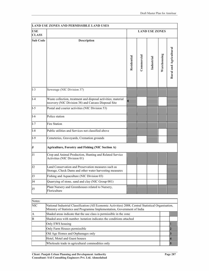
Draft Master Plan for Amritsar
Client: Punjab Urban Planning and Development Authority Page 287Consultant: SAI Consulting Engineers Pvt. Ltd. Ahmedabad
LAND USE ZONES AND PERMISSIBLE LAND USES
USECLASS
LAND USE ZONES
Sub Code Description
Res
iden
tial
Com
mer
cial
Indu
stri
al
War
ehou
sing
Rur
alan
dA
gric
ultu
ral
I-3 Sewerage (NIC Division 37)
I-4 Waste collection, treatment and disposal activities; material recovery (NIC Division 38) and Carcass Disposal Site 8
I-5 Postal and courier activities (NIC Division 53)
I-6 Police station
I-7 Fire Station
I-8 Public utilities and Services not classified above
I-9 Cemeteries, Graveyards, Cremation grounds
J Agriculture, Forestry and Fishing (NIC Section A)
J1 Crop and Animal Production, Hunting and Related Service Activities (NIC Division 01)
J2 Land Conservation and Preservation measures such as Storage, Check Dams and other water harvesting measures
J3 Fishing and Aquaculture (NIC Division 03)
J4 Quarrying of stone, sand and clay (NIC Group 081)
J5 Plant Nursery and Greenhouses related to Nursery, Floriculture
Notes:NIC National Industrial Classification (All Economic Activities) 2008, Central Statistical Organisation,
Ministry of Statistics and Programme Implementation, Government of India A Shaded areas indicate that the use class is permissible in the zoneB Shaded area with number /notation indicates the conditions attached
Only EWS housing 1Only Farm Houses permissible 2Old Age Homes and Orphanages only 3Hotel, Motel and Guest houses 4Wholesale trade in agricultural commodities only 5

Draft Master Plan for Amritsar
Client: Punjab Urban Planning and Development Authority Page 288Consultant: SAI Consulting Engineers Pvt. Ltd. Ahmedabad
Only Manufacture of Bricks, Earthen Pots, Country Tiles etc. 6Warehousing for agricultural commodities only. 7Only in Low Density Residential Zone 8Subject to fulfillment of conditions of Pb. Govt. Notification No. 17/17/5-Hg2/311 dated 11.01.08 and instructions issued from time to time 9
Only Knowledge Parks as defined at Sr. No. 11 above 10Except Milk chilling 11
* All types of industries permitted in the designated land use zone are subject to the fulfillment of requirements of different departments** The siting of petrol pumps shall be subject to instruction / guidelines of IRC/ MORTH/TCPO/Punjab govt. issued from time to time.C Minimum area required for Educational and Health care facilities shall be as prescribed by
government or the accrediting authorities from time to time
All developments will be subject to Environmental Clearance wherever required.Minimum width of the access road for all public places and involving “Assembly” occupancy shall be 18 m.Storage and manufacturing of firecrackers shall not be permitted in any habitable zone. However, it will be permitted in the rural and agricultural zone subject to the stipulation made for storage and manufacturing of firecrackers. Sale of firecrackers shall be permitted in the different zones subject to obtaining license from the competent authority and fulfilling the conditions for sale of firecrackers.The activities not mentioned in the table above but found compatible for particular land use zone shall be permissible with the approval of competent authority.
11.3.6 DESIGNATED AREAS
Following areas have been specifically designated in the proposed land use plan.
� Traffic and Transportation
� Utilities
� Public & Semi Public
� Recreational
� Protected Monuments/Conservation Sites
� Other Special Areas
� Prohibited Areas
� Forest Areas
USE PROVISIONS IN DESIGNATED AREAS
Following uses are permissible in the designated areas mentioned above.
� Traffic & Transportation: Permissible UsesRailway yards, Railway station & sidings, Transport Nagar (including, Post & Telegraph
offices & Telephone exchange, Dhabas, Labor yards, Areas for loading and unloading,
Stores, Depots, and Offices of goods booking agencies, Petrol Filling Station & Service

Draft Master Plan for Amritsar
Client: Punjab Urban Planning and Development Authority Page 289Consultant: SAI Consulting Engineers Pvt. Ltd. Ahmedabad
Garages, Parking spaces, public utilities and buildings) Bus Terminus & depot, Bus Stop
Shelter, Taxi/ Tonga/ Rickshaw/Scooter Stands, parking spaces.
� Utilities: Permissible UsesWater supply, drainage, storm water disposal, waste processing and disposal, electricity,
communication systems and related installations etc.
� Public and Semi-Public Activities: Permissible Uses
Governmental and semi governmental offices, Governmental administrative centres,
Secretariat, Educational- Cultural and Religious institutions including Theaters, Auditoriums
etc. Medical Health Institutions, Community Centres, Club, Orphanage, Old Age Home,
Banks, Police Stations etc.
� Recreational :Permissible Uses
Green Belt (Forest, Agriculture use, Vegetation belt, Wild life sanctuary, Bird sanctuary,
Biodiversity Park, Fire Post, Amenity Structure (List given in note ), Agro forestry,
Floriculture farm etc), Regional Park (Zoological Garden, Botanical Garden, Orchard, Plant
Nursery, Picnic Hut, Shooting Range etc), City Park (Aqua park/water sports park,
Amphitheatre, Open Playground,), District Park (Theme Park, Recreational club, National
Memorial, Open-air food court, Children Park, Area for water –harvesting, Archaeological
park, Specialized Park etc.) Local Parks, Sports Stadium/Complex, Cricket Stadium,
Sports Training Centres, Open Air Auditorium, Holidays Resorts with ground coverage not
exceeding 2%, Public Institutional Libraries, Swimming Pools with built up areas not
exceeding 2%, Music, Dance & Drama Training Centre, Yoga, Meditation, Spiritual &
Religious Centre, Recreational Club, Banquet Hall, Open Air Theatre, Auditorium, Museum,
Exhibition-cum-Fair Ground, Museum, exhibition centre & art gallery, auditorium & open air
theatre, Cultural & Information Centre, Social & Cultural Institute, International Convention
Centre, Planetarium.
Note:
� The following amenity structures are permissible in the above use premises except in
Central Vista and Heritage areas: Toilet blocks, Pump Room, Electric Room, Guard
Room and Equipment Room.
� Interpretation Centre and Administrative office is permissible only in Heritage Areas.

Draft Master Plan for Amritsar
Client: Punjab Urban Planning and Development Authority Page 290Consultant: SAI Consulting Engineers Pvt. Ltd. Ahmedabad
� Protected/ Conservation Sites: Permissible Uses
Only Protected Monument/ Heritage Building or conservation sites as notified by the
concerned authority and the related activities that are permitted. All other uses are prohibited.
� Others Special Areas: Permissible Uses
All the uses related to Defence Services and any other use as decided by the Ministry of
Defence. No other uses are permitted.
� Others Special Areas: Permissible Uses
All the uses related to Defence Services and any other use as decided by the Ministry of
Defence. No other uses are permitted.
� Prohibited Areas: Permissible Uses
The areas around the Protected Monument up to the distance of 100 meters from the
protected limits as describe in the notification no. S.O.1764 Dated 16th June, 1992 issued by
the Department of Culture, Archaeological Survey of India are to be prohibited areas and
beyond it up to 200 meters regulated areas for the purposes of both mining operation and
construction.
� Forest Areas: Permissible uses
This area indicates all Reserved Forests as notified by the Forest Department. No activity
other then Forest is permitted in this area unless expressly allowed by the Forest Department.
SPECIAL CONDITIONS
The sitting of Petrol Pump / Filling Stations shall be subject to instructions/guidelines of
IRC/MORTH/TCPO /Punjab Govt. issued from time to time.
� Minimum width of access road for warehousing uses shall be 80 feet.
11.3.8 EXCEPTIONS� Any use not listed above under a specific zone will not be permissible in the respective
zone
� Uses determined by the Chief Town Planner, Punjab as compatible with uses permissible
shall be allowed in respective zones. Use of land covered under Optimum Utilization of
Vacant Government Land (OUVGL) Scheme of the State Government shall be as
determined by the Government at any appropriate time not withstanding the provisions of
these regulations. Similarly, in case of the land owned by the Amritsar Development
Authority (ADA), its use shall be as deternmined by the ADA/State Government, not
withstanding the provisions of these regulations/proposals shown in the Proposed

Draft Master Plan for Amritsar
Client: Punjab Urban Planning and Development Authority Page 291Consultant: SAI Consulting Engineers Pvt. Ltd. Ahmedabad
Landuse Plan. Development Projects approved prior to coming into force of these
Regulations shall be deemed to be in compliance with these Regulations.
� In case of Defence Land, the extent of No Construction Zone around such lands shall be
as notified by the Central Government from time to time depending upon the nature of
the use of the land, irrespective of the fact whether such uses are indicated/not indicated
on the Proposed Landuse Plan.
� In case of any ambiguity/clarification regarding the interpretation of the Land Use Plan,
the Master copy of drawing based on GIS shall be referred.
11.3.9 RESIDENTIAL DENSITIES
The entire Residential zone for LPA, Amritsar has been defined in the Proposed Land Use
Plan Drawing No. D.T.P (A) 82/2010 Dated 26.03.2010. The Residential Zone has been
divided into two sub zones. Keeping in view the peculiar quality and pattern of development
within walled city, the area enclosed within the walled city has been designated as especially
residential zone whereas remaining residential area has been put into other category. The
maximum permissible residential density in the sub - zone other than the walled city shall be
200 persons per Acre. The gross density for the walled city shall not exceed 150 persons per
Acre.
11.3.10 WALLED CITY
Keeping in view the special character of the walled city and its pattern of development,
special regulations for the development of area falling within walled city shall be formulated
in order to ensure decongestion of population and decongestion of activities for creating
more open spaces and improving the quality of life by making available land for physical and
social infrastructure. Strategies would also include pedestrianisation of the congested area of
walled city, minimizing change of land use, minimizing sub-division of land, preserving and
enhancing the ambience of buildings of historical, cultural and religious importance besides
rationalizing the traffic and transportation.
11.3.11 IMPLEMENTATION OF THESE REGULATIONS
�� All authorities competent to grant permission for layout or sub-division of land or
construction of building or development of land in any other form shall ensure that the
permitted development is in compliance with these Regulations.

Draft Master Plan for Amritsar
Client: Punjab Urban Planning and Development Authority Page 292Consultant: SAI Consulting Engineers Pvt. Ltd. Ahmedabad
�� Landowners desirous of developing their land can obtain, by applying to the designated
authority in writing and giving details of their land along with necessary maps, a list of
permissible uses.
� Similarly, landowners proposing development of certain uses on their land can obtain
certificate of “Compliance with Master Plan” from a designated authority.
Draft Master Plan for Amritsar
Client: Punjab Urban Planning and Development Authority Page 293Consultant: SAI Consulting Engineers Pvt. Ltd. Ahmedabad
CHAPTER 12
INVESTMENT PLAN City Investment Plan has been prepared through a comprehensive process of gap assessment
in physical and social infrastructure sectors in alignment with identified vision for Amritsar
city. This assessment has also led to the identification of sector-specific strategies,
implementation actions and associated reforms with specific inputs from stakeholders. The
strategies adopted primarily have three dimensions - improving service delivery by efficiency
measures; improving service delivery by creating infrastructure assets; and improving the
governance aspects of the Corporation. This section summarises the capital investments
required for creating infrastructure assets and various strategic interventions required in the
implementation of such projects; these strategies are both investment-oriented and
administration-oriented.
Investment Plan for the city highlights broadly the investment required for physical
infrastructure such as water supply, sewerage, solid waste, etc. As far as social infrastructure
is concerned, it is assumed that the required facilities shall be developed through Govt. on the
basis of the latest PPP models.
12.1 INVESTMENT PLANThe City Investment Plan is the multi-year scheduling of identified and prioritized
investments. The scheduling or phasing of the Plan is based on studies of fiscal resources
availability (for new investments and O&M), technical capacity for construction and O&M,
and the choice of specific improvements to be carried out for a period of five years. The
Infrastructure Plan is needed for:
� Assessement of growth and accordingly meeting infrastructure needs (to be carried out
once every five years).
� Scheduling of investments of ongoing projects due to cost and/ or time overruns.
� Assigning of priorities within the constraints of available financial resources
12.1.1 INSTITUTIONALISING THE CIP PROCESS
The City Investment Plan is an important element of the Master Plan and is significant in
terms of the town’s management process and sustainability with regard to the delivery of
basic services. As a part of the Master Plan, the CIP prepared includes the following:
� Desired norms and standards for infrastructure services;

Draft Master Plan for Amritsar
Client: Punjab Urban Planning and Development Authority Page 294Consultant: SAI Consulting Engineers Pvt. Ltd. Ahmedabad
� Roles and responsibilities of various stakeholders in the implementation of identified
projects.
� Project phasing and strategies for implementation
Municipal Corporation, Amritsar is the primary agency responsible for delivering municipal
services and hence the proposals ought to be implemented by Corporation. The projects,
prioritization, investment phasing, strategies and action plan are framed accordingly. The CIP
involved the identification of public capital facilities to cater the demands of the city
populace by the year 2011 and 2031 according to their short, medium and long-term
infrastructure needs. The project identification has been done through a demand-gap analysis
of the services and DPRs available with the Corporation. Further, project prioritisation and
strategising of the investments/ phasing of investment are based on strategies, listed under
each service sector as identified through stakeholder consultations. The projects derived are
aimed at ensuring the optimal and efficient utilisation of existing infrastructure systems and
enhancing the capacity of the systems/ services to cater the demands of future population
additions. Certain other projects listed as part of the CIP include developmental projects other
than those addressing the core service sectors viz. system modernization etc.
The CIP and the forecasted future needs for provision of capital facilities under each
identified sector are presented below. These assets will help to universalise services for the
current population as well as accommodate the expected increase in population. In sectors
where long-term planning is required (for example, source development for water supply and
development of landfill site), the planning horizon till the year 2031 is considered. Assets
created in such sectors consider the projected population in this horizon.
12.2 SECTOR WISE INVESTMENT NEED12.2.1 Water Supply
Sector Strategies and requirement for InvestmentStrategy Identified To cover the uncovered area by water supply network by augmenting the present
distribution system network and to ensure equitable distribution of potable water to all through piped water supply ,and to provide a water treatment plant in the city.
Expected Outcome Assured ability to meet year 2031 demandTotal Investment Need Rs. 33117 lakhs
The total investment calculated is as per the detailed requirement (Component-wise) given below:Infrastructure Components Requirement Units Rate (lakhs) Cost (lakhs)
Treatment Plant 162 MLD 25 4050Network Distribution 652 km 25 16300OHT 83* Nos. 55 4565Metering System 273388 Nos. 0.03 8202Total 33117*1 OHT with 1 MLD capacity

Draft Master Plan for Amritsar
Client: Punjab Urban Planning and Development Authority Page 295Consultant: SAI Consulting Engineers Pvt. Ltd. Ahmedabad
The investment for various heads of water supply has been calculated for the year 2031 by
taking into account unit cost of each of the head as well as gap (requirements) identified
respectively. The total investment need for water sector by 2031 is estimated at Rs.33117
lakhs.
12.2.2 SEWERAGESector Strategies & Investment NeedStrategy Identified Capacity expansion and up gradation of the existing collection and conveyance
system to match additional water supply and provide for environmentally safe disposal
Expected Outcome Synchronisation with water supply capacityTotal Investment Need Rs. 56594 Lakhs
The total investment calculated is as per the detailed requirement (Component-wise) given below: Infrastructure Components Requirement Units Rate (lakhs) Cost (lakhs)Treatment Plant 41.47 MLD 50 2074Distribution Network 1363 km 40 54520Total 56594
The total investment need for sewerage sector by 2031 is estimated at Rs.56594 lakhs.
12.2.3 STORM WATER DRAINAGESector Strategies & Investment NeedStrategy Identified Laying down of closed pucca drains throughout the whole city and
providing it a separate distribution line other than the sewerage one.Expected Outcome Universal coverage and disposal capability, restrict sewerage flow into
storm water drainsTotal Investment Need Rs.480500 lakhs
The total investment calculated is as per the detailed requirement (Component-wise) given below: Infrastructure Components Requirement Units Rate (lakhs) Cost (lakhs)Network 1922 KM 250 480500Total 480500
The system plans to cover 100% of the road network for service efficiency. The total
investment need for drains sectors by 2031 is estimated at Rs.480500 lakhs.
12.2.4 SOLID WASTE MANAGEMENT (Door to door collection, Mechanical
sweeping, Collection through vehicles, landfill site development and incinerators etc)
Sector Strategies & Investment NeedStrategy Identified Source segregation and door-to-door collection, effective transportation
and environmentally safe disposalExpected Outcome Reduced waste generation, hygienic conditions and a clean cityTotal Investment Need Rs.18275 Lakhs
The total investment calculated is as per the detailed requirement (Component-wise) given below: Infrastructure Components Requirement Units Rate (Lakhs) Cost (lakhs)Collection, Transportation and Disposal 406110 KG 0.045 18275Total 18275

Draft Master Plan for Amritsar
Client: Punjab Urban Planning and Development Authority Page 296Consultant: SAI Consulting Engineers Pvt. Ltd. Ahmedabad
The total investment need for Solid Waste Management sector by 2031 is estimated at Rs.
18275 lakhs.
12.2.5 TRAFFIC AND TRANSPORTATION
Sector Strategies & Investment NeedStrategy Identified Increase carrying capacity through widening and improve riding quality Expected Outcome Hassle-free travel on the roads, safe driving during nightsTotal Investment Need Rs.388250 lakhs
The total investment calculated is as per the detailed requirement (Component-wise) given below: Infrastructure Components Numbers Units Rate (lakhs) Cost (lakhs)Roads 1321 km 250 330250ROBS 22 Nos. 2500 55000Flyovers and Bridges 1 Nos. 1000 1000Junction Improvement 20 Nos. 100 2000Total 388250
Identified investments based on the demand-gap assessment above presented are meant for
the up-gradation of existing un-surfaced roads; new road development; widening and
strengthening of major roads; implementation of the public transport system, traffic
management systems and junction improvements; provision of street lighting, etc. Improve
identified major roads and the construction of R.O.Bs at various critical intersections to
achieve an efficient traffic management system.
The total investment need for roads, transportation and traffic management sectors by
2031 is estimated at Rs. 388250 lakhs.
12.2.6 ELECTRICTY
Sector Strategies & Investment NeedStrategy Identified Installation of new electric sub stations as per the requirement by 2031,
minimize the transmission losses and laying down of new hierarchical electric distribution system
Expected Outcome Supply of regular uninterrupted electricity throughout the yearTotal Investment Need Rs.107200 Lakhs
The total investment calculated is as per the detailed requirement (component wise) given below: InfrastructureComponents Requirement Unit Rate (Lakhs) Cost (Lakhs)
Sub Station (11KV) 134 Nos 800 107200Total 107200
The total investment need for electricity sector by 2031 is estimated at Rs.107200 lakhs.

Draft Master Plan for Amritsar
Client: Punjab Urban Planning and Development Authority Page 297Consultant: SAI Consulting Engineers Pvt. Ltd. Ahmedabad
12.2.7 SUMMARY OF COST ESTIMATION FOR DIFFERENT SECTORS OF PHYSICAL INFRASTRUCTUREINFRASTRUCTURE COMPONENTS TOTAL EXPENDITURE (LAKHS)Water Supply 33117Sewerage 56594Storm Water Drainage 480500Solid Waste 18275Traffic and Transportation 388250Electricity 107200Grand Total 1083936 (LAKHS)
10839.36 (CRORES)
The total investment for physical infrastructure is approximately 11,000 Crores.

Draft Master Plan for Amritsar
ANNEXURE I
Notification of LPA, Amritsar

Draft Master Plan for Amritsar
ANNEXURE II
List of Settlements falling in LPA, Amritsar
Sr.No.
NAME H. B. No.
Area (ha) as per DTP
Office
Area (ha) as per PRSC
Population(2001)
1Amritsar (M.Corp + Outgrowth.) - 12055 14237 1016079
2 Jandiala (M Cl + R) - 1420 1454 245373 Majitha (M Cl) - 1168 387 129924 Raja Sansi (N P) - 1555 1551 121765 Rayya (N P) - 392 655 126316 Chak Kamal Khan 197 210 218 6817 Kotli Sakka 199 345 352 11958 Rakh Othian 202 227 227 2949 Chahia 208 87 166 7710 Othian 203 671 681 265011 Jauns 205 295 283 123512 Ugar Aulakh 213 527 536 179813 Bagga 316 1017 1011 318214 Salimpura 204 171 174 53615 Dadrai 308 250 253 147116 Bhala Pind 306 531 538 264917 Dalam 307 226 251 120018 Lalla Afganan 309 414 422 61919 Dhariwal 310 385 391 142920 Harse Chhina 311 1078 1079 657121 Bhitte Wadh 192 913 936 315622 Jhanjoti 317 386 297 281423 Nangal Tola 315 466 465 210424 Chainpur 319 279 282 124625 Teli Chak 318 161 268 Uninhabited26 Balaggan 320 334 338 135627 Saidopura 314 408 432 69128 Kotla Doom 321 518 547 168529 Kotla Dal Singh 351 250 247 23530 Rudala 313 473 486 105531 Dhaul Khurd 352 285 304 43232 Dhaul Kalan 350 378 367 218933 Wadala Bhitewadh 354 940 647 3042

Draft Master Plan for Amritsar
34 Gaunsabad 353 183 184 80035 Kherabad 349 281 286 202236 Mehlanwala 305 817 829 225637 Ghukeywali 296 234 255 131738 Sehnsra 304 1350 1353 456139 Kotli Sakkianwali 295 160 189 63540 Khatrai Khurd 293 236 241 65841 Kandowali 287 294 298 138742 Majjupura 282 199 202 99843 Chetanpura 283 158 160 171944 Saktu Nangal 286 134 138 86645 Jandiala 285 128 131 4646 Pathan Nangal 284 128 129 57047 Jagdev Kalan 297 1134 1129 480548 Malu Nangal 298 428 445 222349 Mughlani Kot 301 104 106 28750 Ranewali 302 228 285 86251 Ladhe 303 145 148 64952 Loharka Kalan 337 684 695 213653 Birbalpura 336 353 359 112054 Adliwala 300 708 720 368655 Bua Nangali 299 227 214 103456 Loharka Khurd 338 176 180 102357 Bal 345 144 200 62258 Sehchandar 346 195 140 154859 Miran Kot Kalan 344 780 795 380360 Miran Kot Khurd 343 172 175 122261 Muradpura 342 606 618 234762 Heir 347 536 538 317163 Kambo 348 398 407 68264 Gumtala 370 110 * Added to M. C.65 Bhade Wali 328 106 118 Uninhabited66 Dadupura 329 214 215 120367 Dadian 291 141 144 64968 Jathu Nangal 330 283 292 101069 Nangal Pannuwan 333 273 272 158570 Sohian Kalan 335 1480 1497 523471 Bal Khurd 339 405 1150 319872 Bal Kalan 340 729 * 394473 Bhaini Gillan 341 205 213 921
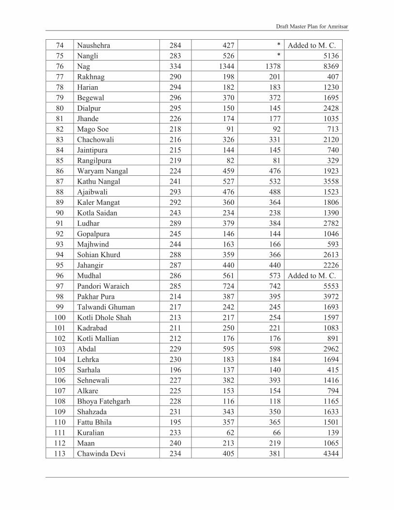
Draft Master Plan for Amritsar
74 Naushehra 284 427 * Added to M. C.75 Nangli 283 526 * 513676 Nag 334 1344 1378 836977 Rakhnag 290 198 201 40778 Harian 294 182 183 123079 Begewal 296 370 372 169580 Dialpur 295 150 145 242881 Jhande 226 174 177 103582 Mago Soe 218 91 92 71383 Chachowali 216 326 331 212084 Jaintipura 215 144 145 74085 Rangilpura 219 82 81 32986 Waryam Nangal 224 459 476 192387 Kathu Nangal 241 527 532 355888 Ajaibwali 293 476 488 152389 Kaler Mangat 292 360 364 180690 Kotla Saidan 243 234 238 139091 Ludhar 289 379 384 278292 Gopalpura 245 146 144 104693 Majhwind 244 163 166 59394 Sohian Khurd 288 359 366 261395 Jahangir 287 440 440 222696 Mudhal 286 561 573 Added to M. C.97 Pandori Waraich 285 724 742 555398 Pakhar Pura 214 387 395 397299 Talwandi Ghuman 217 242 245 1693
100 Kotli Dhole Shah 213 217 254 1597101 Kadrabad 211 250 221 1083102 Kotli Mallian 212 176 176 891103 Abdal 229 595 598 2962104 Lehrka 230 183 184 1694105 Sarhala 196 137 140 415106 Sehnewali 227 382 393 1416107 Alkare 225 153 154 794108 Bhoya Fatehgarh 228 116 118 1165109 Shahzada 231 343 350 1633110 Fattu Bhila 195 357 365 1501111 Kuralian 233 62 66 139112 Maan 240 213 219 1065113 Chawinda Devi 234 405 381 4344

Draft Master Plan for Amritsar
114 Kairon Nangal 232 159 159 686115 Darike 192 219 220 765116 Babowal 191 367 370 1993117 Dhadde 235 508 518 2096118 Ram Diwali Hinduan 237 219 237 1201119 Chogawan Roopowali 239 401 422 2299120 Kot Hride Ram 236 87 89 678121 Mian Pandher 177 108 86 854122 Mukandpura 178 110 114 208123 Bhullar Hans 176 208 213 755124 Manga Sarai 174 216 219 895125 Dudhala 238 198 201 950126 Jagatpur Bajaj 248 313 316 674127 Jethuwal 246 531 542 3807128 Mallowal 247 122 123 877129 Kotla Khurd 242 148 156 860130 Mahanian Koharan 249 276 281 1564
131Talwandi Dasaundha Singh 250 424 434 2547
132 Mehnian Brahmana 172 220 223 1240133 Makhan Windi 251 750 761 3698134 Raipur Kalan 171 306 311 711135 Nizampura 253 393 395 2800136 Fatehgarh Shukarchak 252 911 924 4840137 Othian 256 222 224 1419138 Chhapa Ramsingh 255 372 380 2220139 Fatehpur Rajputan 254 760 772 3797140 Nawan Pind 170 320 326 2961141 Qila Jiwan Singh 257 325 328 1957142 Khan Kot 279 395 402 Added to M. C.143 Nangal Dyal Singh 151 90 91 825144 Jand 150 166 173 1137145 Rasulpur Kalan 169 711 722 3669146 Khalhera 161 147 150 479147 Wadala Johal 153 720 732 3909148 Malakpur 152 152 156 1015149 Talwandi Dogran 148 314 315 1841150 Mehoka 258 237 240 1261151 Rakh Manawala 149 117 123 157152 Rakh Devi Dasspura 154 308 312 1145

Draft Master Plan for Amritsar
153 Wadali Dogran 147 190 195 1250154 Meharbanpur 146 285 290 1494155 Devi Dasspura 155 485 492 2695156 Bhamma 158 188 190 352157 Gadli 160 370 375 1810158 Bhangwan 159 489 498 2076159 Gehri 157 306 * 6222160 Dhirekot 156 248 564 1203161 Rana Kala 122 264 268 1263162 Baba Bakala 31 539 546 6996163 Balsarai 7 676 686 2323164 Banian 90 187 190 771165 Budha Theh (CT +R) 9 747 778 9772166 Butari 82 319 335 2135167 Chhapianwali 32 204 211 1693168 Chimabath 21 392 402 2322170 Danial 38 151 152 815171 Daulo Nangal 33 344 352 3128172 Dera Baba Jaimal Singh 428 162 152 3164173 Dhianpur 30 535 544 2073174 Jabbowal 123 813 827 3610175 Jalalpur Sathiala 37 234 237 163176 Jalluwal 34 161 165 1047177 Jharu Nangal 80 176 835 602178 Kaler Ghumman 29 329 345 1707179 Khalchian 83 478 470 4347179 Lakhuwal 35 172 176 851180 Loharanwala 27 65 67 254181 Lohgarh 28 293 298 1699182 Madehpur 89 85 86 511183 Madh 25 117 119 1054184 Muchhal 91 821 833 4088185 Naranjanpur Fattuwal 26 418 424 1952186 Padiana 23 40 41 206187 Sathiala 46 1435 1420 8702188 Thathian 36 372 376 2223189 Thothian 88 252 254 1696190 Umra Nangal 22 189 188 597191 Waraich 8 368 374 2902192 Naraingarh 124 146 149 593

Draft Master Plan for Amritsar
193 Balia Manjpur 129 508 516 2027194 Kotla Bathungarh 125 160 161 1319195 Tangra 126 528 433 2992196 Chhajjal Wadi 127 932 734 3984197 Bhaini Badeshan 87 239 247 698198 Timmowal 132 728 740 3366199 Khela 131 180 182 656200 Mallian 130 594 608 3747201 Taragarh 133 597 606 3320202 Gunowal 134 183 188 1503203 Jania 136 344 345 2133204 Nangal Guru 137 278 285 1938205 Bundala 138 2034 2055 9994206 Thathi 141 140 142 1396207 Nawan Kot 145 110 111 901208 Nijjarpura 144 175 179 1102209 Chauhan 128 457 457 2078210 Rakh Jhita 142 984 547 1115211 Shafipur 139 206 243 1074212 But 140 181 180 716213 Wanchari 265 442 451 1824214 Warpal 266 1372 1400 9072215 Pandori 264 257 261 1794216 Jhita Khurd 261 108 108 457217 Bashambarpura 143 123 125 1098218 Mehma 263 222 226 1297219 Jhita Kalan 262 771 457 1546220 Bhagtupura 260 187 * 691221 Manawala 259 847 854 4794222 Chatiwind 278 599 606 4138223 Mandiala 268 1002 1014 2178224 Bohru 269 397 412 3990225 Chabba 267 871 883 5782226 Bohad 276 100 103 142227 Iban Khurd 274 171 174 1378228 Iban Kalan 275 514 522 4034229 Gilwali 277 569 576 5007230 Mule Chak 376 262 269 Added to M. C.231 Sangna 270 607 610 3439232 Thanda 273 346 351 Added to M. C.
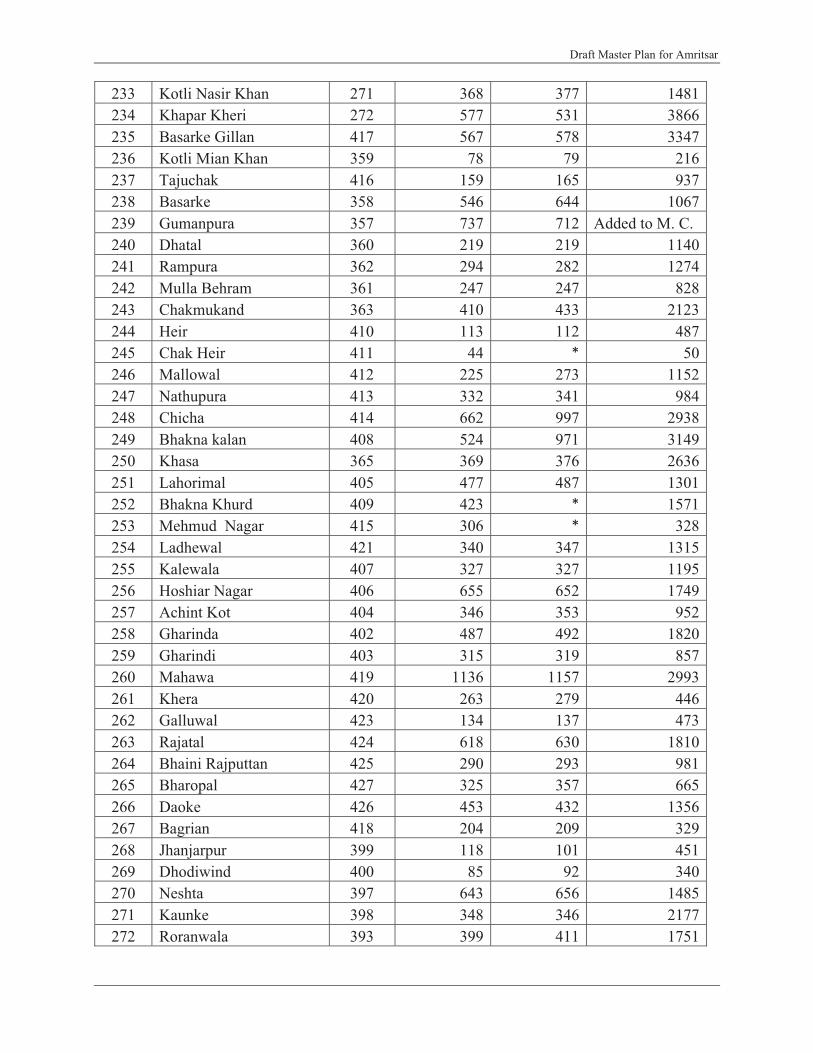
Draft Master Plan for Amritsar
233 Kotli Nasir Khan 271 368 377 1481234 Khapar Kheri 272 577 531 3866235 Basarke Gillan 417 567 578 3347236 Kotli Mian Khan 359 78 79 216237 Tajuchak 416 159 165 937238 Basarke 358 546 644 1067239 Gumanpura 357 737 712 Added to M. C.240 Dhatal 360 219 219 1140241 Rampura 362 294 282 1274242 Mulla Behram 361 247 247 828243 Chakmukand 363 410 433 2123244 Heir 410 113 112 487245 Chak Heir 411 44 * 50246 Mallowal 412 225 273 1152247 Nathupura 413 332 341 984248 Chicha 414 662 997 2938249 Bhakna kalan 408 524 971 3149250 Khasa 365 369 376 2636251 Lahorimal 405 477 487 1301252 Bhakna Khurd 409 423 * 1571253 Mehmud Nagar 415 306 * 328254 Ladhewal 421 340 347 1315255 Kalewala 407 327 327 1195256 Hoshiar Nagar 406 655 652 1749257 Achint Kot 404 346 353 952258 Gharinda 402 487 492 1820259 Gharindi 403 315 319 857260 Mahawa 419 1136 1157 2993261 Khera 420 263 279 446262 Galluwal 423 134 137 473263 Rajatal 424 618 630 1810264 Bhaini Rajputtan 425 290 293 981265 Bharopal 427 325 357 665266 Daoke 426 453 432 1356267 Bagrian 418 204 209 329268 Jhanjarpur 399 118 101 451269 Dhodiwind 400 85 92 340270 Neshta 397 643 656 1485271 Kaunke 398 348 346 2177272 Roranwala 393 399 411 1751
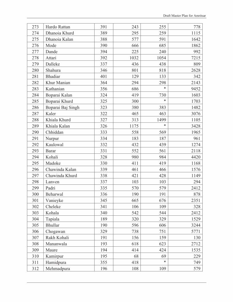
Draft Master Plan for Amritsar
273 Hardo Rattan 391 243 255 778274 Dhanoia Khurd 389 295 259 1115275 Dhanoia Kalan 388 577 591 1642276 Mode 390 666 685 1862277 Dande 394 225 240 992278 Attari 392 1032 1054 7215279 Dalleke 337 436 438 809280 Shahura 346 801 818 2628281 Bhadiar 401 129 133 342282 Khur Manian 364 294 298 2143283 Kathanian 356 686 * 9452284 Boparai Kalan 324 419 730 1603285 Boparai Khurd 325 300 * 1703286 Boparai Baj Singh 323 380 383 1482287 Kaler 322 465 463 3076288 Khiala Khurd 327 313 1499 1105289 Khiala Kalan 326 1175 * 3428290 Chhiddan 333 558 569 1965291 Nurpur 334 183 187 961292 Kaulowal 332 432 439 1274293 Barar 331 552 561 2118294 Kohali 328 980 984 4420295 Madoke 330 411 419 1168296 Chawinda Kalan 339 461 466 1576297 Chawinda Khurd 338 421 428 1149298 Lanven 337 103 103 294299 Padri 335 570 579 2412300 Beharwal 336 190 191 878301 Vanieyke 345 665 676 2351302 Cheleke 341 106 109 328303 Kohala 340 542 544 2412304 Tapiala 189 320 329 1529305 Bhullar 190 596 606 3244306 Chogawan 329 738 751 5771307 Rakh Kohali 191 156 159 130308 Mananwala 193 618 623 2712309 Maure 194 414 424 1535310 Kamirpur 195 68 69 229311 Hamidpura 355 418 * 749312 Mehmadpura 196 108 109 579

Draft Master Plan for Amritsar
313 Ranike 395 586 599 1541314 Jajja 198 153 * 452315 Rangarh 396 33 37 1038
TOTAL LPA 137042 139419 1660466*Area yet to be verified
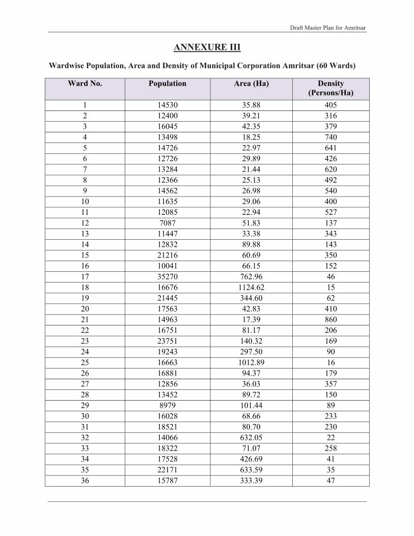
Draft Master Plan for Amritsar
ANNEXURE III
Wardwise Population, Area and Density of Municipal Corporation Amritsar (60 Wards)
Ward No. Population Area (Ha) Density(Persons/Ha)
1 14530 35.88 4052 12400 39.21 3163 16045 42.35 3794 13498 18.25 7405 14726 22.97 6416 12726 29.89 4267 13284 21.44 6208 12366 25.13 4929 14562 26.98 54010 11635 29.06 40011 12085 22.94 52712 7087 51.83 13713 11447 33.38 34314 12832 89.88 14315 21216 60.69 35016 10041 66.15 15217 35270 762.96 4618 16676 1124.62 1519 21445 344.60 6220 17563 42.83 41021 14963 17.39 86022 16751 81.17 20623 23751 140.32 16924 19243 297.50 9025 16663 1012.89 1626 16881 94.37 17927 12856 36.03 35728 13452 89.72 15029 8979 101.44 8930 16028 68.66 23331 18521 80.70 23032 14066 632.05 2233 18322 71.07 25834 17528 426.69 4135 22171 633.59 3536 15787 333.39 47

Draft Master Plan for Amritsar
37 15509 114.02 13638 17187 100.59 17139 31846 1771.87 1840 13571 75.43 18041 14688 124.82 11842 16311 181.60 9043 18843 347.83 5444 15026 158.28 9545 12979 179.66 7246 11952 25.90 46147 20469 227.43 9048 18782 195.73 9649 13740 112.75 12250 15327 53.63 28651 19845 63.30 31452 12057 27.52 43853 17854 372.70 4854 21777 120.94 18055 13570 59.28 22956 9029 385.06 2357 12275 164.23 7558 24473 540.71 4559 20207 1006.99 2060 12149 604.02 20
Amritsar (M Corp.) 966862 14022.33 69

Draft Master Plan for Amritsar
ANNEXURE IV
ASI Notification of Summer Palace, Ram Bagh

Draft Master Plan for Amritsar

Draft Master Plan for Amritsar
ANNEXURE V
ASI Notification for All Protected Monuments of Punjab
GOVERNMENT OF INDIA
No. 9-1/2005/M/CHD-2947 Dated: 15-Sep-2006
To
The Chief Town Planner, The Chief AdministratorGovt. of Punjab, PUDA.Plot No. 1B, Sec- 27 A, Mohali.Chandigarh.
Subject: Unauthorized construction around the centrally protected monuments – regarding.
Sir/Madam
I may inform that the Archaeological Survey of India have about 30 Nos of centrally protected monuments in the different districts of Punjab under administrative control of Chandigarh Circle, Chandigarh. Your kind attention is invited towards the Notification NO. 1764 date 16-06-1992 issued by the Govt. of India prohibiting constructions/ mining operations upto a distance of 100 mtrs in prohibited area and 200 m further beyond it in regulated area from the protection limits of the monuments (circulated earlier, copy enclosed). The main purpose of this Notification was to exercise effective control for preservation of environs around the monuments. The new constructions and other development activities are still taking place in the close proximities of protected monuments despite regularly writing to District Authorities. The plans of the buildings for construction around the monuments are wrongly passed by the local authorities which is creating unnecessary problems. Our field staff approach the local Police authorities to lodge the complaint /F.I.R. but no action is taken by the police and sometime even writing of F.I.R under the AM&AS&R Act 1958 and Rules 1959 as further amended in the year 1992.
I therefore request you to kindly look into the matter and instruct all concerned subordinate offices not to pass any building plans around the monuments in Punjab (copy enclosed) without the consent of the Archaeological Survey of India.
This may please be treated as most urgent.
Yours faithfully
Encl: As Above, Superintending Archaeologist
Copy to
1. Sr. Town Planner, Town & Country Planning, Jalandhar for information & necessary action.2. The District Town Planner, Jalandhar for information & necessary action.3. The Concerned Conservation Assistant for necessary action.
Superintending Archaeologist

Draft Master Plan for Amritsar
List of Centrally Protected Monuments under Chandigarh Circle
Punjab1. Gateway of Old Sarai Amanat Khan Tarantaran Amritsar2. Gateway of Old Sarai Fatehabad Fatehabad -do-3. Ram Bagh Gate (Deodi) Amritsar Amritsar -do-4. Fort Bhatinda Bhatinda Bhatinda5. Ancient site and Buddhist Sanghol Khamano Fatehgarh Stupa
Sahib6. Mound as Mud Fort Abohar Abohar Firozepur7. Baradari Anarkali Batala Batala Gurdaspur8. Shamsher Khan Tomb -do- -do- -do-9. Thakt-I-Akbari Kalanaur Kalanaur -do-10-13 Kos Minars Bir Pind & Dakhni Nakodar Jalandhar
Jahangir, Nakodar,Tut Kalan
14-16 Three Kos Minars Cheema Kalan, Nurmahal JalandharShampur, Uppal
17. Mughal Bridge Dakhni Nakodar -do-18. Sarai & Gateway -do- -do- -do-19. Mughal Kos Minar -do- -do- -do-20. Theh Gatti Mound Nagar Phillaur -do-21. Tomb of Mohd. Momin Nakodar Nakodar -do-
& Haji Jamal22. Sarai including Gateway Nurmahal Nurmahal -do-23. Ancient Mound Katpalon Phillaur -do-24. Kos Minars Ghungrali Rajputan Khanna Ludhiana25. Kos Minar Lashkari Khan -do- -do-26. Kos Minar Ludhiana Ludhiana -do-27. Kos Minar Sherpur Kalan -do- -do-28. Ancient Site Sunet -do- -do-29. Kos Minar Sanewal Sanewal -do-30. Ancient Site Ropar Rupnagar Rupnagar31. Summer Palace Maharaja Amritsar Amritsar Amritsar
Ranjit Singh

Draft Master Plan for Amritsar
ANNEXURE VI
List of Slums in Municipal Corporation Amritsar
S.No. Name of the Area Population1 Haripura 109082 Chhota Haripura 125003 Kishan kot 98004 o/s lahori Gate 100005 I/s Lahori Gate 98006 Gujjar Pura 25007 o/s Gilwali gate 50008 o/s bhagtanwala 50009 Guru Nank Pura 2405
10 Guru Arjan Dev Nagar 390111 Ranje DI Haveli 39212 Ram Talai 102613 Dhapai 557214 Karampura 800015 Faizpura 820016 Maqboolpura 700017 Ghas mandi 100018 Gawal mandi 1200019 Surat Singh Road 703320 Bhalla Colony, Chheharta 440421 Jagdish Newas, Chheharta 200022 Kartar Nagar, Chheharta 338023 Model Town, Chheharta 155624 Takia Chanan Shah 111725 Takia Fateh Shah Bukhari 100026 Indira Colony, o/s Khazana Gate 846527 Bangla Colony, o/s Khazana gate 600028 Annhgarh 750929 Bharariwal 502630 Fatehpura 1000031 o/s Gilwale Gate 500032 Fatti Balol Samudi (Subash Nagar) 520033 Ekta Nagar, Chamran 1000034 Kot Khalsa 1219435 Indra Colony, Majitha Road 5000

Draft Master Plan for Amritsar
36 Verka Pind 1567037 Vallah 840038 kala Ghanupur 800039 Ghanupur 40040 Tung Pain 1327541 Nehru Colony, Majitha Road 87442 Tung Bala 879643 Mohkum Pura 600044 Mustfabad 555045 Doburji 859346 Rasulpur 500047 Jagdambay Colony 800048 Judge Nagar
8000Krishan NagarDashmesh Nagar
49 Ganda Singh Wala 255950 Jawahar Nagar, Majitha Road 203051 Nanak Pura, Wadali Guru 600052 Zeenat Pura 306053 Abadi opp vill Annhgarh 500054 Adarsh Nagar 2000
Islamabad Road Abadies55 Gurbax nagar 500056 Abadi Nanaksar, Majitha Road
2000Kashmir Road57 Sundar Nagar
5477Sawan Nagar and AOI Abadi58 Vijay Nagar
12000Anand NagarGuru Nanak Nagar
59 Tandon Nagar
12189
Prem NagarGuru Gobind Singh NagarGopal NagarBhawani nagarShastri nagar
60Abadies abutting between SW Channel, SW Road and UBDC
1 Kot Harnam Singh
19000
2 Kot Salig Ram 3 Jaspal Nagar4 Partap Nagar

Draft Master Plan for Amritsar
5 Azad nagar6 Gobind nagar7 Shaheed Udham Singh Colony
61 Abadies Abutting SW Channel, TT Road and UBDC1 Guru Nanak Colony
80002 Sharma Colony3 Behind Old Octroi post
62 Abadi Kot Mit Singh 134063 Dr. Het Ram Colony
12000
NaraingarhKatcha Pacca QuartersAzad Road (both Sides), Chheharta
64 Ababdies abbuting on GT Road
3327
Chah-NihanganGuru Arjan Dev NagarMohni ParkTotal 407428

Draft Master Plan for Amritsar
ANNEXURE VII
List of Think Tank members constituted for Amritsar Master Plan

Draft Master Plan for Amritsar

Draft Master Plan for Amritsar
ANNEXURE VIII
Consultative Meetings
1. Meeting held on January 30, 2009 at Amritsar with Think Tank constituted for preparation of Amritsar Master Plan under the Chairmanship of D.C
During the course of deliberations, following major issues/ suggestions emerged:
� Considering acute shortage of open spaces within the city, there is an urgent need for creating appropriate hierarchy of open spaces at various levels to meet the public needs of the city.
� For addressing the issue of traffic congestion caused by the wholesale food grains market including Bhagtan wala market- shifting of such market to the area identified (63 acres) outside the city and using the valuable market area for commercial exploitations and funds raised in the process to be used for overall infrastructure development of the Amritsar city.
� There is an urgent need to control the increasing numbers of three wheelers in the city and to provide appropriate options for the public movement. Use of the personal vehicles needs to be discouraged to minimize the congestion due to lack of parking/ inadequate width of roads.
� Walled city should be declared as a special area and well defined set of developmental controls should be evolved for decongesting and restoring the lost glory of the city core.Proliferation of slums within/ outside the city needs to be urgently checked with existing slums upgraded to improve the quality of life of the residents of such colonies.
� Funds being made available under JNNURM need to be optimically utilized through formulating realistic and need based projects to improve the infrastructure and quality of life within the city.
� Integration of cantonment area with civil areas need to be made with sensitivity � Issues related to disaster due to Earthquake and Rain Water Harvesting should be made
integral part of Master Plans strategies.� Master Plan must focus on restoring the old glory of the Amritsar:Valuable built Heritage
including forts existing within and outside the city must be clearly identified and appropriately preserved and promoted to restore their lost glory.
� Existing Ganda nallahs in the city need to be cleaned and developed on priority in order to eliminate the pollution of sub-soil water and to save the city residents from health hazards emanating from the polluted water.
� Menace of Unauthorized, haphazard and unplanned development needs to be tackled on priority in order to improve/ rationalize the future growth of the city.
� State of Art Infrastructure needs to be provided to make Amritsar hub of medical and educational tourism.
Draft Master Plan for Amritsar
2. Meeting held on February 06, 2009 with Ar. Behl, Head Department of Architecture,
Guru Nanak Dev University, Amritsar, regarding growth and development of Amritsar
city.
Following were the suggestions made during the discussion:
� Priority to be given on rationalizing inter and intra city traffic.� Road network emanating from Amritsar to surrounding urban settlements and their junctions
with Bye Passes could be used as major economic nodes/ economics triggers for city.� Available Historical and Cultural Sites in the vicinity of the city, including Tarn Taran,
Batala, Preet Nagar, Baba Bakala , Pul Kanjri, Beas, Attari and Goindwal Sahib needs to be integrated with the city for promoting Tourism.
� Well planned tourism strategies need to be evolved and made operational in order to elongate the duration of stay of the tourists in the city from one night to minimum of 2-3 days in order to improve the economy of the city.
� Conservation and restoration of its heritage and Amritsar cuisine which is its speciality needs to be promoted in order to attract more and more tourists.
� Promoting urban and rural integration
3. Meeting held on February 6, 2009 with Dr. Sukhdev Singh, State Convener, INTACH on Amritsar Heritage at GNDU, Amritsar.
For preserving the valuable heritage of Amritsar following issues need to be addressed on
priority with appropriate strategies put in position.
� Municipal Corporation act, 1976 needs amendment on the pattern of Punjab Regional and Town Planning and Development Act, 1995 in order to include preservation and conservation of valuable Heritage of the city.
� Land Use Zoning needs to be done with sensitivity keeping in view the broad objectives of Heritage conservation.
� Heritage Commission needs to be set up for the city on priority in order to identify the Heritage of the city and evolve strategies for its preservation.
� Heritage building should be properly documented and notified as such with appropriate Heritage Regulation framed in order to minimize changes and for preserving their basic character.
� Permitting Change of Land Use within Walled city needs to be immediately stopped to minimize the conversion of residential building into commercial towers.
� Proper amenities and public utilities needs to be provided in close vicinity to historic/ heritage buildings attracting large number of visitors to prevent defacing.
Draft Master Plan for Amritsar
� Walled city should be declared as Heritage Zone in order to preserve the basic character of the core city.
� Mechanism of city to city heritage connectivity needs to be created and promoted for creating awareness among masses about the heritage wealth of the city.
� Heritage as an issue needs to be appropriately addressed within the Master Plan by providing an exclusive chapter dedicated to City heritage, its preservation and conservation.
� All development agencies operating within the city, experts, departments of Planning and Architecture of GND University, INTACH, NGO’s and Land owners and other Stakeholders within the City need to be actively involved in the process of identification, preservation, conservation and development of Heritage Sites, buildings and Precincts in the City.
� There is an urgent need of framing an Amritsar Charter in order to define the framework for city heritage, its conservation and preservation.
4. Meeting held on February 21, 2009 at Amritsar with sh. Parabhdial Singh Randhawa, General Secretary, Pollution Control Committee, Amritsar and Mr. B.S. Sekhon, School of Planning G.N.D. University, Amritsar
� Amritsar being a border city needs specialized treatment and incentives for maintaining and promoting its future growth and development.
� City must be divided into different zones and each zone must be treated on different footing as a part of master plan strategy. Silence Zone, covering education, health etc. related buildings, should be clearly defined and made integral part of planning process in order to create appropriate quality of life.
� Pedestrianisation needs to be encouraged within walled city in general and in the area around Golden Temple in particular. Mini buses run on CNG and electricity should only be permitted in the area. For large number of visitors, concept of Shardalu Yatra needs to be promoted to encourage pedestrianisation in the area with the support of SGPC.
� There is need to check mushroom, haphazard and unplanned location and growth of medical facilities in the city in order to minimize hazards emerging from bio-medical waste, parking etc. in the residential areas. Developing a state of the art “MEDI-CITY” will be critical to address this issue and leverage the medical tourism in the city.
� Amritsar must be made hub of quality education, both in School and higher education. It should also include setting up institutions dedicated to research and development in the area of bio-medicine, bio-technology etc. in order to make Amritsar centre of excellence in higher education and Research & Development.
� Considering the haphazard and scattered location of various offices of local administration, State and Central Government, a dedicated Administrative Compliance must be created within the city in order to rationalize traffic and minimize harassment to the public visiting these offices.

Draft Master Plan for Amritsar
� For rationalizing traffic, city would require a rail and road based mass transportation system to be placed in position on priority. Within Walled City introduction of Trams could also be considered as an option for rationalizing traffic.
� Large area falling under Amritsar Cantonment needs to be effectively integrated with overall planning and development of the city.
� Existing system of canal system based on UBDC should also be used effectively for augmenting water supply to the city ( which is now based exclusively on ground water) in order to minimize depletion of the ground water.
� Tung Dhab should be used for draining the storm water in order to minimize the repeated flooding of city, during the rains. Mechanism of rain water harvesting and ground water recharging should be taken up on priority in order to improve the status of ground water and minimize flooding in the city.
� For augmenting availability of water, remodeling/rejuvenating the abandoned project of “40 Wells” should be taken up on priority.
� Sewerage Treatment Plants involving latest technologies must be immediately constructed to treat the entire sewerage of the city in order to minimize pollution of ground water. The present practice of disposal of untreated sullage into the Hundiara Drain & Tung Dhab Drains should be stopped to minimize pollution of the water bodies.
� Amritsar suffers from absence adequate of open spaces and accordingly needs more such spaces to be planned as integral part of the city planning and growth. Large scale encroachments made on public land need to be removed and area developed as open spaces. Existing parks should also be developed to improve the city environs. Greening Amritsar as a public driven, mass movement based on low cost solution needs to be put in operation on priority to achieve the desired objectives.
� For improving economy of the city and the region, the inherent strength of Amritsar as the major Agro-Produce/Export Centre needs to be exploited by creating chain of storage and food processing industry in close vicinity of International Airport.
� Industrial Focal Point having state of art infrastructures and services need to be developed in order to provide required impetus to the industrial economy of the city.
� Air/Water/Noise pollution monitoring systems need to be upgraded and enlarged to have data on existing status and levels of pollution. Data needs to be published regularly for creating awareness among masses. Stringent action needs to be taken against individuals, industries, institutions etc. causing such pollution.
Figure No. Meeting with Mr. Prabhdial Singh Randhawa and Mr. BS. Sekhon

Draft Master Plan for Amritsar
Along with the above, continuous interaction with DTPs and STPs has been carried out in
relation to walled city strategies, finalization of contents for concept plan and master plan, future
concept plan, finalization of stakeholders list and status of environment in Amritsar city with
respect to unauthorized construction, ganda nallah, industrial development.
Also broad issues about master plan, such as contents of master plan and issues to be addressed for Amritsar city were discussed with the faculty of Guru Ram Das School of Planning, GNDU, Amritsar.
Figure No.Discussion with DTP and STP

Draft Master Plan for Amritsar
5. Meeting held on February1, 2010 at Amritsar with Think Tank constituted for preparation of Amritsar Master Plan under the Chairmanship of D.C. and various MLAs
� Sh. Bikramjit Singh Majithia, MLA and the Chairman asked that if proposals of Walled City
are implemented, how much area will be affected and what will be the number of commercial
units that will be affected. A list of all these should be prepared.
� He also suggested that keeping in view the importance of tourists, recreational and tourism
activities should be proposed towards Attari side on G.T road (NH1).
� He also suggested that as the Amritsar-Batala Road is being upgraded, so keeping in view the
importance and potential of this road, related land uses should be proposed along the road.
� He again suggested that as Amritsar-Loharka and Amritsar-Lopoke Roads are important
roads, so potential land uses should be proposed. Representatives of SAI told that they are
proposing the same, which will be earmarked on the plan.
� The Chairman and S. Majithia were of the view that as location of Raja Sansi Airport is very
important, so quality development should be done in this area. Representatives of SAI told
that they have proposed commercial, institutional and residential uses. Some other uses of
high quality are proposed to be added.
� Majithia also suggested that short term proposals should be identified and what will be its
effect should also be highlighted. Representatives of SAI told that for the effective
implementation of the Master Plan proposals phasing has been done in three phases i.e. 2017,
Discussion with Faculty of GRD School of Planning, GNDU, Amritsar
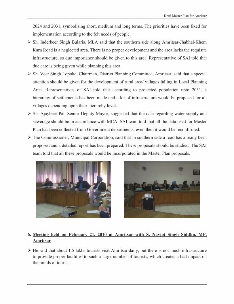
Draft Master Plan for Amritsar
2024 and 2031, symbolising short, medium and long terms. The priorities have been fixed for
implementation according to the felt needs of people.
� Sh. Inderbeer Singh Bularia, MLA said that the southern side along Amritsar-Jhabhal-Khem
Karn Road is a neglected area. There is no proper development and the area lacks the requisite
infrastructure, so due importance should be given to this area. Representative of SAI told that
due care is being given while planning this area.
� Sh. Veer Singh Lopoke, Chairman, District Planning Committee, Amritsar, said that a special
attention should be given for the development of rural area/ villages falling in Local Planning
Area. Representatives of SAI told that according to projected population upto 2031, a
hierarchy of settlements has been made and a kit of infrastructure would be proposed for all
villages depending upon their hierarchy level.
� Sh. Ajaybeer Pal, Senior Deputy Mayor, suggested that the data regarding water supply and
sewerage should be in accordance with MCA. SAI team told that all the data used for Master
Plan has been collected from Government departments, even then it would be reconfirmed.
� The Commissioner, Municipal Corporation, said that in southern side a road has already been
proposed and a detailed report has been prepared. These proposals should be studied. The SAI
team told that all these proposals would be incorporated in the Master Plan proposals.
6. Meeting held on February 21, 2010 at Amritsar with S. Navjot Singh Siddhu, MP, Amritsar
� He said that about 1.5 lakhs tourists visit Amritsar daily, but there is not much infrastructure to provide proper facilities to such a large number of tourists, which creates a bad impact on the minds of tourists.

Draft Master Plan for Amritsar
� He also said that considering the international historical/ religious importance of city, the traffic congestion and bad condition of roads creates problem for tourists. So to provide proper facilities and remove the bad impact, roads should be planned in a well-defined hierarchy for future development. These should be properly landscaped also.
� Present electric and other networks present an ugly picture of city, so these should be planned in underground.
� He highlighted the problems of water supply, sewerage and storm water. He pointed out that these are not properly maintained. Even there is no proper disposal of storm water, so city presents a dirty and ugly picture. People are devoid of pure water due to poor maintenance of these facilities. He suggested that keeping in view the present and future population of city, the infrastructure should be planned.
� He also suggested that if due to implementations of proposals of Master Plan, some people are to rehabilitated, it should be realistic and practical, so that these may be implemented easily.
� He also directed that practical problems and their solutions in form of proposals be prepared in a chart form, so that these may be discussed with learned persons/ representatives of people of various fields and they would also give their suggestions.
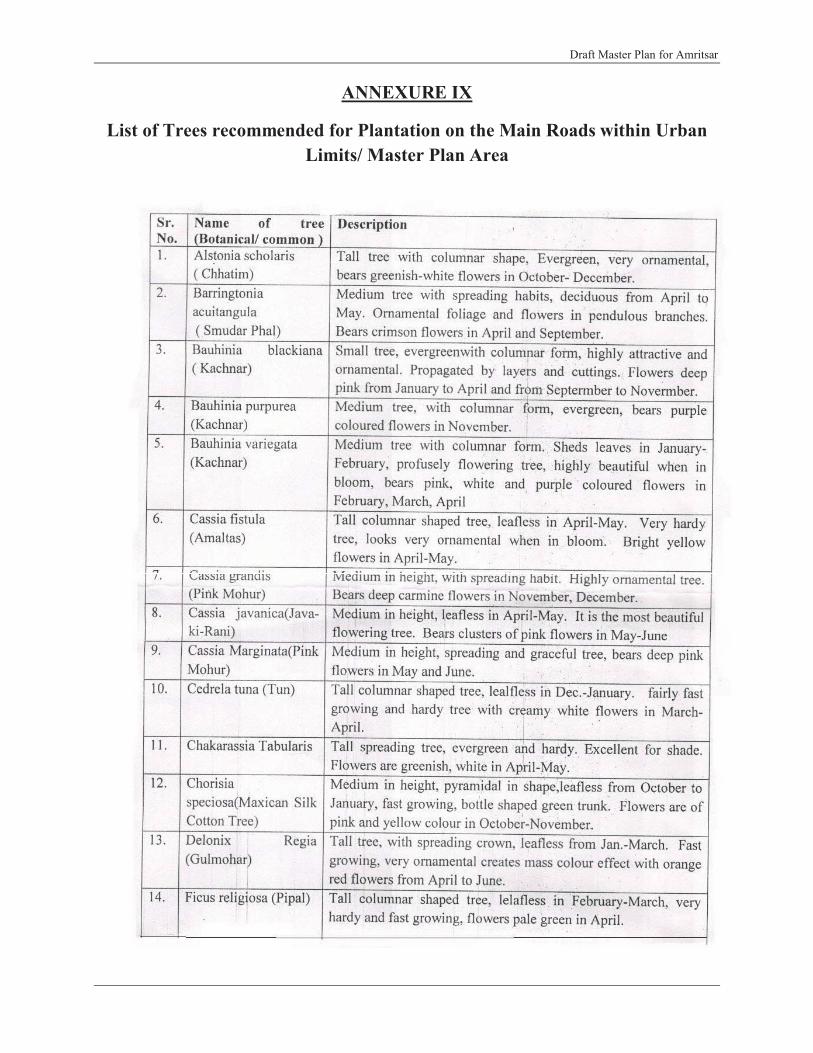
Draft Master Plan for Amritsar
ANNEXURE IX
List of Trees recommended for Plantation on the Main Roads within UrbanLimits/ Master Plan Area

Draft Master Plan for Amritsar
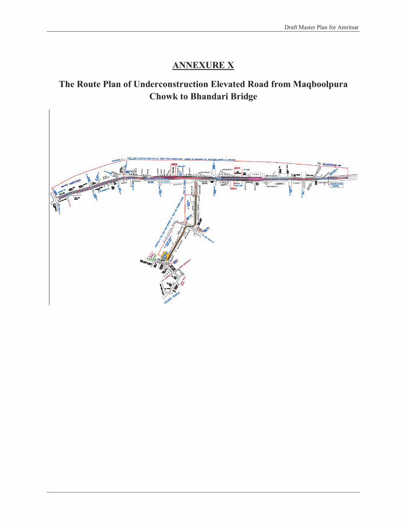
Draft Master Plan for Amritsar
ANNEXURE X
The Route Plan of Underconstruction Elevated Road from Maqboolpura Chowk to Bhandari Bridge

Draft Master Plan for Amritsar
Annexure XI
Notification Regarding Forest or Waste Land in Punjab

D
raft
Mas
ter P
lan
for A
mrit
sar
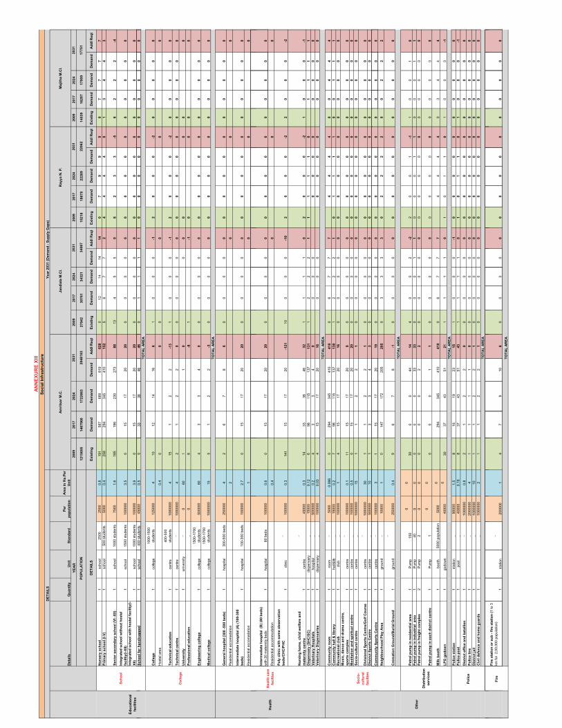
De
tail
sQ
ua
nti
ty
Un
itS
tan
da
rd
Pe
r
po
pu
lati
on
Are
a i
n H
a.P
er
Un
it
20
09
20
17
20
24
20
09
20
17
20
24
20
09
20
17
20
24
20
09
20
17
20
24
12
15
65
51
46
79
60
17
22
66
32
70
42
30
76
13
43
21
15
21
81
86
78
22
28
91
45
39
16
29
71
79
59
Ex
isti
ng
De
ma
nd
De
ma
nd
De
ma
nd
Ad
dl R
eq
tE
xis
tin
gD
em
an
dD
em
an
dD
em
an
dA
dd
l R
eq
tE
xis
tin
gD
em
an
dD
em
an
dD
em
an
dA
dd
l R
eq
tE
xis
tin
gD
em
an
dD
em
an
dD
em
an
dA
dd
l R
eq
t
Nu
rse
ry s
ch
oo
l 1
scho
ol25
0025
000.
819
158
768
981
96
28
012
1414
14
07
99
90
77
77
Pri
ma
ry s
ch
oo
l (I
-V)
1sc
hool
500
stud
ents
50
000.
425
829
434
541
01
52
56
77
24
44
40
13
44
3
Se
nio
r s
ec
on
da
ry s
ch
oo
l (V
I -X
II)
1sc
hool
1000
stu
dent
s 75
001.
618
519
623
027
38
813
45
50
82
33
-56
22
2-4
Inte
gra
ted
sc
ho
ol w
ith
ou
t h
os
tel
fac
ilti
y(I
-XII)
1sc
hool
1500
stu
dent
s 10
0000
3.5
015
1720
20
00
00
00
00
00
00
00
0
Inte
gra
ted
sc
ho
ol w
ith
ho
ste
l fa
cil
tiy
(I-
XII
)1
scho
ol10
00 s
tude
nts
1000
003.
90
1517
202
00
00
00
00
00
00
00
00
Sc
ho
ol fo
r h
an
dic
ap
pe
d
1sc
hool
400
stud
ents
45
000
0.5
033
3846
46
01
11
10
00
00
00
00
0
20
31
Sc
ho
ol
20
48
18
3
DE
TA
ILS
20
31
Ra
yy
a N
. P
.M
aji
tha
M.C
l.
17
75
12
20
62
Ed
uc
ati
on
al
fac
ilit
ies
PO
PU
LA
TIO
N
YE
AR
34
08
7
20
31
20
31
Am
rits
ar
M.C
.J
an
dia
la M
.Cl.
DE
TA
ILS
AN
NE
XU
RE
XII
I
So
cia
l In
frastr
uctu
re
Ye
ar
20
31
(D
em
an
d -
Su
pp
ly G
ap
s)
Sc
ho
ol fo
r h
an
dic
ap
pe
d
1sc
hool
400
stud
ents
45
000
0.5
033
3846
46
01
11
10
00
00
00
00
0
Co
lle
ge
1co
llege
1000
-150
0 st
uden
ts12
5000
410
1214
166
10
00
-12
00
0-2
00
00
0
Hos
tel a
rea
0.4
00
00
00
Te
ch
nic
al
ed
uc
ati
on
1
cent
re40
0-50
0 st
uden
ts10
0000
04
151
22
-13
10
00
-12
00
0-2
00
00
0
Te
ch
nic
al
ce
ntr
e
1ce
ntre
_10
0000
04
21
22
00
00
00
00
00
00
00
00
Un
ive
rsit
y1
univ
ersi
ty_
060
11
00
00
00
0
Pro
fes
sio
na
l e
du
ca
tio
n
_0
8-8
1-1
00
00
En
gin
ee
rin
g c
olle
ge
1co
llege
1500
-170
0 st
uden
ts50
0000
604
33
40
00
00
00
00
00
00
00
0
Me
dic
al
co
lle
ge
1
colle
ge15
00-1
700
stud
ents
1000
000
155
12
2-3
00
00
00
00
00
00
00
0
Ge
ne
ral
ho
sp
ita
l (3
00
-5
00
be
ds
)1
hosp
ital
300-
500
beds
25
0000
42
67
86
00
00
00
00
00
00
00
0
Res
iden
tial a
ccom
adat
ion
20
00
Inte
rme
dia
te h
os
pit
al (A
) (1
00
-30
0
be
ds
)1
hosp
ital
100-
300
beds
10
0000
2.7
015
1720
20
00
00
00
00
00
00
00
0
Res
iden
tial a
ccom
adat
ion
10
00
Co
lle
ge
TO
TA
L A
RE
A
TO
TA
L A
RE
A
Inte
rme
dia
te h
os
pit
al (
B)
(80
be
ds
)
with
20
mat
erni
ty b
eds
1ho
spita
l80
bed
s10
0000
0.6
015
1720
20
00
00
00
00
00
00
00
0
Res
iden
tial a
ccom
mod
atio
n 0.
40
00
Po
ly c
lin
ic w
ith
so
me
ob
se
rva
tio
n
be
ds
/CH
C/P
HC
1cl
inic
_10
0000
0.3
141
1517
20-1
21
100
00
-10
20
00
-22
00
0-2
Nu
rsin
g h
om
e,
ch
ild
we
lfa
re a
nd
ma
tern
ity
ce
ntr
e
1ce
ntre
_
4500
00.
314
3338
463
21
11
10
20
00
-21
00
0-1
Dis
pe
ns
ary
(S
HC
/SC
)1
disp
ensa
ry_
1500
00.
126
9811
513
71
31
12
22
11
11
10
11
11
Ve
teri
na
ry H
os
pit
als
1ho
spita
l_
5000
000.
24
33
40
00
00
00
00
00
0
Ve
teri
na
ry D
isp
en
sa
rie
s1
disp
ensa
ry_
1000
000.
034
1517
201
60
00
00
00
00
00
Co
mm
un
ity
ro
om
1
room
_50
000.
066
029
434
541
04
10
06
77
74
44
40
04
44
Co
mm
un
ity
ha
ll &
lib
rary
1ha
ll&lib
_15
000
0.2
798
115
137
13
01
22
21
01
11
10
01
11
Re
cre
ati
on
al
clu
b1
club
_10
0000
14
1517
201
60
00
00
00
00
00
00
00
Mu
sic
, d
an
ce
an
d d
ram
a c
en
tre
,
sp
ort
s c
om
ple
x1
cent
re_
1000
000.
111
1517
209
00
00
00
00
00
00
00
0
Me
dit
ati
on
an
d s
pir
itu
al
ce
ntr
e
1ce
ntre
_10
0000
0.5
015
1720
20
00
00
00
00
00
00
00
0
So
cio
-cu
ltu
ral
ce
ntr
e
1ce
ntre
_10
0000
015
11
22
10
00
00
00
00
00
00
00
Div
isio
na
l S
po
rts
Ce
ntr
e/G
olf
Co
urs
e1
cent
re_
1000
000
301
12
21
00
00
00
00
00
00
00
0
Dis
tric
t S
po
rts
Ce
ntr
e1
cent
re_
5000
0010
13
34
30
00
00
00
00
00
00
00
TO
TA
L A
RE
A
He
alt
h c
are
fac
ilti
es
He
alt
h
So
cio
-
cu
ltu
ral
fac
ilti
es
Co
mm
un
ity
Sp
ort
s C
en
tre
1ce
ntre
_10
0000
31
1517
201
90
00
00
00
00
00
00
00
Ne
igh
bo
urh
oo
d P
lay
Are
a1
grou
nd_
1000
01
014
717
220
52
05
03
33
30
22
22
00
22
2
Cre
ma
tio
n G
rou
nd
/Bu
ria
l G
rou
nd
1gr
ound
_
2500
000.
49
67
8-1
00
00
00
00
00
00
00
0
Pe
tro
l p
um
p i
n r
es
ide
nti
al
are
a1
Pum
p15
00
030
00
441
44
00
2-2
20
01
-11
00
10
Pe
tro
l p
um
p i
n i
nd
us
tria
l a
rea
1P
ump
400
00
00
333
30
00
11
00
01
10
00
11
Pe
tro
l p
um
p i
n f
reig
ht
co
mp
lex
2P
ump
20
00
00
22
00
00
00
00
00
00
00
0
Pe
tro
l p
um
p i
n e
ac
h d
istr
ict
ce
ntr
e
1P
ump
10
00
00
11
00
00
00
00
00
00
00
0
Mil
k b
oo
th
1bo
oth
5000
pop
ulat
ion
5000
029
434
541
04
10
06
77
74
44
40
34
44
LP
G g
od
ow
n
1go
dow
n 40
000
030
3743
512
11
11
10
10
11
01
00
0-1
Po
lic
e s
tati
on
1
stat
ion
_90
000
1.5
816
1923
15
10
00
-10
00
00
00
00
0
Po
lic
e p
os
t 1
post
_40
000
0.16
837
4351
43
11
11
01
01
10
10
00
-1
Dis
tric
t o
ffic
e a
nd
ba
tall
ion
1_
1000
000
0.8
21
22
00
00
00
00
00
00
00
00
Po
lic
e l
ine
1
_20
0000
04
11
11
00
00
00
00
00
00
00
00
Dis
tric
t ja
il
1_
1000
000
101
12
21
00
00
00
00
00
00
00
0
Civ
il d
efe
nc
e a
nd
ho
me
gu
ard
s1
_10
0000
02
11
22
10
00
00
00
00
00
00
00
TO
TA
L A
RE
A
TO
TA
L A
RE
A
TO
TA
L A
RE
A
Oth
er
Dis
trib
uti
on
se
rvic
es
Po
lic
e
Fir
e s
tati
on
or
su
b -
fir
e s
tati
on
(1
to 3
km
for
2,0
0,00
0 po
pula
tion)
1st
atio
n
_
2000
001
47
910
60
00
00
00
00
00
00
00
TO
TA
L A
RE
A
Fir
e

DE
TA
ILS
De
tail
sQ
ua
nti
ty
Un
itS
tan
da
rd
Pe
r
po
pu
lati
on
Are
a i
n H
a.P
er
Un
itT
OT
AL
LP
A U
NIT
TO
TA
L L
PA
AR
EA
(in
Ha
.)
20
09
20
17
20
24
20
09
20
17
20
24
20
31
20
31
14
59
11
75
45
20
49
56
49
93
37
30
98
18
10
08
82
97
97
30
29
79
73
0
Ex
isti
ng
De
ma
nd
De
ma
nd
De
ma
nd
Ad
dl R
eq
tE
xis
tin
gD
em
an
dD
em
an
dD
em
an
dA
dd
l R
eq
tT
ota
l A
dd
l R
eq
tT
ota
l A
dd
l R
eq
t
Nu
rse
ry s
ch
oo
l 1
scho
ol25
0025
000.
80
78
88
029
232
435
93
59
10
25
81
9.8
7
Pri
ma
ry s
ch
oo
l (I
-V)
1sc
hool
500
stud
ents
50
000.
41
44
43
357
146
162
179
-17
80
0.0
0
Se
nio
r s
ec
on
da
ry s
ch
oo
l (V
I -X
II)
1sc
hool
1000
stu
dent
s 75
001.
64
23
3-1
9697
108
120
24
93
14
9.2
5
Inte
gra
ted
sc
ho
ol w
ith
ou
t h
os
tel
fac
ilti
y(I
-XII)
1sc
hool
1500
stu
dent
s 10
0000
3.5
00
00
00
78
99
30
10
6.3
9
Inte
gra
ted
sc
ho
ol w
ith
ho
ste
l fa
cil
tiy
(I-X
II)
1sc
hool
1000
stu
dent
s 10
0000
3.9
00
00
00
78
99
30
11
8.5
4
Sh
lf
hd
id
1h
l40
0t
dt
4500
00
50
00
00
016
1820
20
68
33
77
VIL
LA
GE
S in
LP
A
89
74
60
20
31
20
31
Ra
jas
an
si
N. P
.
20
04
6
YE
AR
PO
PU
LA
TIO
N
DE
TA
ILS
Sc
ho
ol
AN
NE
XU
RE
XII
I
So
cia
l In
frastr
uctu
re
Sc
ho
ol fo
r h
an
dic
ap
pe
d
1sc
hool
400
stud
ents
45
000
0.5
00
00
00
1618
202
06
83
3.7
7
12
46
12
27
.82
Co
lle
ge
1co
llege
1000
-150
0 st
uden
ts12
5000
40
00
00
36
67
48
33
.27
Hos
tel a
rea
0.4
00
00
0.0
0
Te
ch
nic
al
ed
uc
ati
on
1
cent
re40
0-50
0 st
uden
ts
1000
000
41
00
0-1
281
11
-27
00
.00
Te
ch
nic
al
ce
ntr
e
1ce
ntre
_10
0000
04
00
00
00
11
11
14
.16
Un
ive
rsit
y1
univ
ersi
ty_
060
00
00
00
0.0
0
Pro
fes
sio
na
l e
du
ca
tio
n
_0
00
00
00
0.0
0
En
gin
ee
rin
g c
olle
ge
1co
llege
1500
-170
0 st
uden
ts50
0000
600
00
00
01
22
22
12
4.7
5
Me
dic
al
co
lle
ge
1
colle
ge15
00-1
700
stud
ents
1000
000
150
00
00
01
11
10
0.0
0
11
16
2
Ge
ne
ral
ho
sp
ita
l (3
00
-5
00
be
ds
)1
hosp
ital
300-
500
beds
25
0000
40
00
00
03
34
41
04
0.6
3
Res
iden
tial a
ccom
adat
ion
20
00
0.0
0
Inte
rme
dia
te h
os
pit
al (A
) (1
00
-30
0 b
ed
s)
1ho
spita
l10
0-30
0 be
ds
1000
002.
70
00
00
07
89
93
08
2.0
7
Res
iden
tial a
ccom
adat
ion
10
00
0.0
0
Inte
rme
dia
te h
os
pit
al (
B)
(80
be
ds
) w
ith 2
0 m
ater
nity
bed
s1
hosp
ital
80 b
eds
1000
000.
60
00
00
07
89
93
01
8.2
4
Res
iden
tial a
ccom
mod
atio
n 0.
40
00
0.0
0
Po
ly c
lin
ic w
ith
so
me
ob
se
rva
tio
n b
ed
s/C
HC
/PH
C1
clin
ic_
1000
000.
33
00
0-3
177
89
-80
0.0
0
Co
lle
ge
TO
TA
L A
RE
A
TO
TA
L A
RE
A
He
alt
hH
ea
lth
ca
re
fac
ilti
es
Ed
uc
ati
on
al
fac
ilit
ies
y1
clin
ic10
0000
0.3
30
00
-317
78
9-8
00
.00
Nu
rsin
g h
om
e,
ch
ild
we
lfa
re a
nd
ma
tern
ity
ce
ntr
e
1ce
ntre
_45
000
0.3
20
00
-285
1618
20-6
50
0.0
0
Dis
pe
ns
ary
(S
HC
/SC
)1
disp
ensa
ry_
1500
00.
120
11
11
101
4954
60-4
19
41
1.2
4
Ve
teri
na
ry H
os
pit
als
1ho
spita
l_
5000
000.
20
00
01
22
22
0.4
2
Ve
teri
na
ry D
isp
en
sa
rie
s1
disp
ensa
ry_
1000
000.
030
00
07
89
92
60
.79
19
31
53
Co
mm
un
ity
ro
om
1
room
_50
000.
066
04
44
413
014
616
217
95
04
78
31
.54
Co
mm
un
ity
ha
ll &
lib
rary
1ha
ll&lib
_15
000
0.2
01
11
143
4954
601
71
51
30
.26
Re
cre
ati
on
al
clu
b1
club
_10
0000
10
00
00
67
89
22
01
9.6
3
Mu
sic
, d
an
ce
an
d d
ram
a c
en
tre
, s
po
rts
co
mp
lex
1ce
ntre
_10
0000
0.1
20
00
-28
78
91
90
.91
Me
dit
ati
on
an
d s
pir
itu
al
ce
ntr
e
1ce
ntre
_10
0000
0.5
00
00
06
78
92
24
11
.81
So
cio
-cu
ltu
ral
ce
ntr
e
1ce
ntre
_10
0000
015
00
00
07
11
1-6
00
.00
Div
isio
na
l S
po
rts
Ce
ntr
e/G
olf
Co
urs
e1
cent
re_
1000
000
300
00
00
01
11
12
60
.38
Dis
tric
t S
po
rts
Ce
ntr
e1
cent
re_
5000
0010
00
00
00
12
22
55
0.2
5
Co
mm
un
ity
Sp
ort
s C
en
tre
1ce
ntre
_10
0000
30
00
00
07
89
92
98
8.1
9
Ne
igh
bo
urh
oo
d P
lay
Are
a1
grou
nd_
1000
01
02
22
20
7381
909
03
04
30
3.9
6
Cre
ma
tio
n G
rou
nd
/Bu
ria
l G
rou
nd
1gr
ound
_25
0000
0.4
00
00
00
33
44
31
.26
10
25
59
8
00
TO
TA
L A
RE
A
TO
TA
L A
RE
A
fac
ilti
es
So
cio
-cu
ltu
ral
fac
ilti
es
Pe
tro
l p
um
p i
n r
es
ide
nti
al
are
a1
Pum
p15
00
02
00
20
00
00
01
10
.00
Pe
tro
l p
um
p i
n i
nd
us
tria
l a
rea
1P
ump
400
00
00
11
00
00
03
70
.00
Pe
tro
l p
um
p i
n f
reig
ht
co
mp
lex
2P
ump
20
00
00
00
00
00
02
0.0
0
Pe
tro
l p
um
p i
n e
ac
h d
istr
ict
ce
ntr
e
1P
ump
10
00
00
00
00
00
01
0.0
0
Mil
k b
oo
th
1bo
oth
5000
pop
ulat
ion
5000
00
44
44
014
616
217
91
79
60
80
.00
LP
G g
od
ow
n
1go
dow
n 40
000
02
01
1-1
018
2022
22
41
0.0
0
69
90
Po
lic
e s
tati
on
1
stat
ion
_90
000
1.5
10
00
-10
89
101
02
43
5.6
6
Po
lic
e p
os
t 1
post
_40
000
0.16
10
11
018
2022
22
64
10
.24
Dis
tric
t o
ffic
e a
nd
ba
tall
ion
1_
1000
000
0.8
00
00
00
11
11
10
.83
Po
lic
e l
ine
1
_20
0000
04
00
00
00
00
00
12
.08
Dis
tric
t ja
il
1_
1000
000
100
00
00
01
11
12
20
.40
Civ
il d
efe
nc
e a
nd
ho
me
gu
ard
s1
_10
0000
02
00
00
00
11
11
24
.08
93
73
Oth
er
Dis
trib
uti
on
se
rvic
es
Po
lic
e
TO
TA
L A
RE
A
TO
TA
L A
RE
A
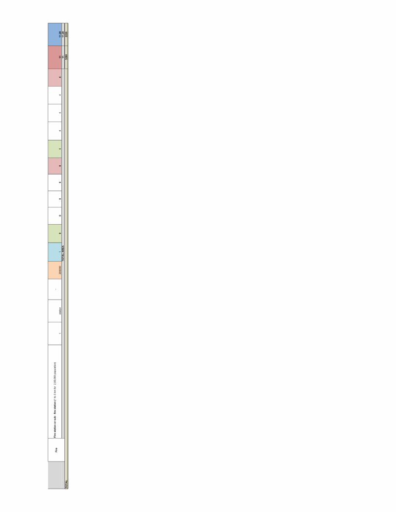
Fir
e s
tati
on
or
su
b -
fir
e s
tati
on
(1
to 3
km
for
2,0
0,00
0 po
pula
tion)
1st
atio
n
_
2000
001
00
00
00
44
44
11
11
.20
11
11
.20
TO
TA
L3
28
02
22
6
TO
TA
L A
RE
A
Fir
e

Roa
dJu
nctio
nsT
ype
Tra
ffic
L
ight
sC
ondi
tion
Tim
ings
No.
of
Arm
sC
ontr
olPa
rkin
gFo
othp
aths
Usa
ge o
f Fo
othp
aths
Con
dit
ion
Lan
eM
arki
ngs
Tra
ffic
Si
gns
Paym
ent
Ref
lect
ors
Slip
Roa
dPo
lice
Bar
rica
des
Lig
ht P
oles
on
the
Med
ian
Dab
urji
Bye
Pas
sT-
Junc
tion
No
--
3N
o C
ontro
lO
n st
reet
No
-N
oN
oN
o4
Yes
Tar
an W
ala
Pul
T-Ju
nctio
nN
o-
-3
No
Con
trol
On
stre
etN
o-
No
No
No
No
Maq
bool
pura
Cho
wk
T-Ju
nctio
nN
o-
-3
No
Con
trol
On
stre
etN
o-
No
No
No
No
100
Ft R
oad
Cro
ssJu
nctio
nN
o-
-4
No
Con
trol
On
stre
etN
o-
No
No
No
No
Rav
idas
Roa
dT-
Junc
tion
No
--
3N
o C
ontro
lO
n st
reet
No
-N
oN
oN
oN
oR
am T
alai
Roa
dT-
Junc
tion
No
--
3M
anua
lO
n st
reet
No
-N
oN
oN
oN
o
Bus
Sta
nd C
how
kT-
Junc
tion
No
--
3M
anua
lO
n st
reet
Yes
Encr
oach
edN
oN
oN
oN
oY
esH
ussa
inpu
raC
how
kR
otar
yN
o-
-3
Rot
ary
On
stre
etN
o-
No
No
No
No
Nan
dan
Cin
ema
Cho
wk
Cro
ssJu
nctio
nY
esN
otW
orki
ng-
4Si
gnal
ised
On
stre
etN
o-
No
No
No
No
Bha
ndri
Bri
dge
Rot
ary
No
--
4R
otar
yO
n st
reet
Yes
Encr
oach
edN
oN
oN
oN
o
Rai
lway
Sta
tion
T-Ju
nctio
nN
o-
-3
No
Con
trol
On
stre
etN
o-
No
No
No
No
Can
al O
ffic
eT-
Junc
tion
Yes
Wor
king
1min
3Si
gnal
ised
On
stre
etN
o-
No
No
No
2 Sl
ips
Tow
ards
New
Rea
ltoY
esR
ego
Bri
dge
T-Ju
nctio
nN
o-
-3
No
Con
trol
On
stre
etN
o-
No
No
No
2
Polic
e St
atio
n Sa
dar
T-Ju
nctio
nY
esW
orki
ng1m
in3
Sign
alis
edO
n st
reet
No
-N
oN
oN
o
2 To
war
ds
Ran
i ka
Bag
h
Ram
Tir
ath
Roa
dY
-Jun
ctio
nY
esN
otW
orki
ng-
3Si
gnal
ised
On
stre
etN
o-
No
No
No
No
Putli
garh
Cho
wk
Cro
ssJu
nctio
nY
esW
orki
ng-
4Si
gnal
ised
On
stre
etN
o-
No
No
No
No
Yes
Yes
Kha
lsa
Col
lege
C
how
kY
-Jun
ctio
nY
esN
otW
orki
ng-
3Si
gnal
ised
On
stre
etN
o-
No
No
No
1Y
esK
ot K
hals
aT-
Junc
tion
No
--
3N
o C
ontro
lO
n st
reet
No
-N
oN
oN
o1
GN
DU
Stag
gere
dJu
nctio
nN
o-
-4
Man
ual
On
stre
etN
o-
No
No
No
No
Poly
tech
nic
Roa
dT-
Junc
tion
No
--
3N
o C
ontro
lO
n st
reet
No
-N
oN
oN
oN
o
Che
hhar
ta C
how
kT-
Junc
tion
Yes
Not
Wor
king
-3
Sign
alis
edO
n st
reet
No
-N
oN
oN
o2
Yes
Byp
ass C
how
k (T
owar
ds W
agha
)Y
-Jun
ctio
nN
o-
-3
No
Con
trol
On
stre
etN
o-
No
No
No
No
Yes
NH-1
UnderElevatedRoadProject LayingInprocessNewlyBuilt
AN
NE
XU
RE
XII
Det
ails
of J
unct
ions
on
Maj
or R
oads
of t
he C
ity
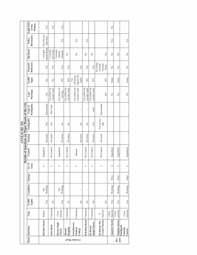
Roa
dJu
nctio
nsT
ype
Tra
ffic
L
ight
sC
ondi
tion
Tim
ings
No.
of
Arm
sC
ontr
olPa
rkin
gFo
othp
aths
Usa
ge o
f Fo
othp
aths
Lan
eM
arki
ngs
Tra
ffic
Si
gns
Paym
ent
Ref
lect
ors
Slip
Roa
dPo
lice
Bar
rica
des
Lig
ht P
oles
on
the
Med
ian
Kitc
hlu
Cho
wk
Rot
ary
Yes
Not
Wor
king
-6
Sign
alis
edO
n st
reet
Yes
Encr
oach
edN
oN
oY
es1
tow
ards
A
jnal
a R
oad
Yes
(On
one
side
arm
)Y
es
M.K
.Hot
elT-
Junc
tion
No
--
3N
o C
ontro
lO
n st
reet
Yes
Not
Use
dY
es (O
nly
On
circ
ular
road
)N
oY
es1
tow
ards
M
.k H
otel
Yes
Rat
tan
Sing
h C
how
kC
ross
Junc
tion
Yes
Not
Wor
king
-4
Sign
alis
edO
n st
reet
No
-Y
es (O
nly
On
one
leg)
NO
Yes
1 to
war
ds
Men
tal
Hos
pita
lY
esY
esM
enta
lH
ospi
tal
T-Ju
nctio
nN
o-
-3
No
Con
trol
On
stre
etN
o-
Yes
(Onl
y O
n ci
rcul
ar ro
ad)
NO
Yes
No
Gur
udaw
ara
Med
ical
Col
lege
T-Ju
nctio
n
No
--
3M
anua
l
On
stre
etN
o-
Yes
(Onl
y O
n ci
rcul
ar ro
ad)
Yes
(War
ning
Sign
al re
d lig
ht)
Yes
No
Yes
R.B
.Dun
i Roa
dT-
Junc
tion
No
--
3N
o C
ontro
lO
n st
reet
No
-Y
es (O
nly
On
circ
ular
road
)N
OY
esN
oY
esD
r.K
aran
Sing
h C
how
kT-
Junc
tion
No
--
3N
o C
ontro
lO
n st
reet
Yes
used
Yes
(Onl
y O
n ci
rcul
ar ro
ad)
NO
Yes
No
Dr.
Khe
tar
Pal
(Ver
ka C
how
k)Y
-Ju
nctio
nN
o-
-
3N
o C
ontro
lO
n st
reet
Yes
on
one
side
Encr
oach
ed
NO
NO
Yes
(Onl
y to
war
dsC
ircul
arR
oad
No
Aja
nala
Cho
wk
Cro
ssJu
nctio
nY
esW
orki
ng30
sec
4Si
gnal
ised
No
Som
eN
oN
oY
esN
o
Maj
itha
chow
kC
ross
junc
tion
Yes
Wor
king
45se
c4
Sign
alis
edN
oSo
me
No
No
Fate
hgar
hC
huri
anC
how
kC
ross
Junc
tion
Yes
Wor
king
30se
c4
Sign
alis
edN
oSo
me
No
No
Yes
CircularRoad
Bye
pass
AN
NE
XU
RE
XII
Det
ails
of J
unct
ions
on
Maj
or R
oads
of t
he C
ity

!
!
!
!
!!
!!
!
!
!
!
!!
!
!!! !
!
!
!
!
!
!
!
!
!!
! !!
!
!
!!
!
!!
!
!
!
!
!
!
!
!
!!
!
!!
!!
!
!
!
! !
!
!!
!!
!
!
!!
!
!
!!
!
!!
!
!
!!!
!!!
!
!
!
!
!
!
!
!
!
!
!
!
!
!!
!
!
!
!!
!
!
!!
!
!
!!
!!
!
!
!
!
!
!
!
!
!
!
!!
!
!
!
!!
!!!
!
!
!
!
!
!!
!
!
!!
!
!
!!
!
!
!
!!
!
!
! !
!
!
!
!
!
!
!
!
!
!
!!
!
!
!
!!!
!
!
!
!
!
!
!!
!!
!
!
!
!
!
!!
!
!
!
!
!
!!
!
!
!
!!
!!
!
!
!!!
!
!!
!
!
!
!
!
!
!
!
!
!
!
!
!
!!
!
!
!
!
!
!
!
!
!
!
!
!
!!
!
!
!
!
!
! !
!
!
!
!!
!
!
!
!!
!
!
!
!
!
!
!
!!
!
!!
!
!
!
!
!
!
!
!!
!! ! !
!
!
!
!
!
!
!
!
!
!
!
!
!
!
!
!
!!!
!
!
!!
!
!
!
!
!!!
!
!
!
TO AJNALA MDR
TO BATALA
MDRTO AJNALA
SH 25
FRO
M R
ANIA
NM
DRFROM JHABAL
SH 21
FROM VAIROWAL
ODRFR
OM
LA
HO
RE
NH
1
FROM TARN TARAN
BG
TO FATEHGARH CHURIANODR
TO P
ATHAN
KOT
NH 15
FRO
M L
AH
OR
EBG
TO MAJITHABG
TO JA
LAND
HAR
NH 1
FRO
M J
HAB
ALM
DR
TO P
ATHAN
KOT
BG
TO S
HR
I HA
RG
OB
IND
PU
R
SH 2
2
FROM KHADUR SAHIB
TO MAJITHA ROADMDR
FROM TARN TARANNH 15
TO JA
LAND
HAR
BG
TO LOHARKA ODR
AM
RIT
SAR
M.C
.
946
7
138
312
327
335
135
266
334
304
8091
332
419
339
297
8
311
392
268
316
41432
8 408
192
252
267
259
305
123
31
346
30
25425
1
344
329
132
127
153
324
169
300
83
337
390
203
345
285
397
406
354 35
8
26
395
424
193
342
270
130
133
278
190
21
229
388
335
417
24
286
357
277
333
36
156
331
142
321
340
246
347
306
213
241
272
33
275
235
29
129
82
402
155
293
405
313
339
315
322
128
262
265
28
298
287
332
347
250
363
126
314
426
239
309
330
393
253
348
289
323
88
234
255
271
365
160
296
191
195
336
427
37
404
199
231
273
136
413
216
189
257
407
170
403
32
248
171
352
287
36431
7
137
319
249
420
333
122
35
362
213
351
263
341
RIVER BEAS
159
194
224
338
269
214
227
310
87
350
288
292
421
398
320
148
154
425
330
146
90
302
205
22
412
318
264
389
296
391
308
307
34
361
217
139
293
394
258
243
237
279
38
211
202
256
172
192
174
240
360
197
329
299
176
418
282
238
290
345
147
336
158
295
134
334
353
230
294
131
140
338
25
144
226
212
274
204
150
208
244
416
125
283
191
232
242 15
2
225
198
428
349
161
124
303
295
215
245
291
141
346
196
286
42340
1
285
284
89
376
143
149
247
328
228
281
178
410
145
341
196
261
301
337
276
399
27
400
218
151
236
177
219
343
359
195
233
23
396
377
369
284 28
3340
415
411
326
325
157
409
AM
RI
TS
AR
LO
CA
L P
LA
NN
ING
AR
EA
SE
TT
LE
ME
NT
HIE
RA
RC
HY
(20
01
)
INSE
T M
AP
NO
TE:
This
dra
win
g is
bas
ed u
pon
the
Exi
stin
g La
nd U
se M
ap s
uppl
ied
by
DTP
offi
ce, A
mrit
sar
(Dra
win
g N
o. D
.T.P
. (A
) 02/
2010
dat
ed 1
2-01
-10)
MA
P N
O -
1
CON
SULT
AN
TS :
5,00
00
5,00
02,
500
Met
ersÊ
LEG
END
LO
CA
L PL
AN
NIN
G A
REA
BO
UN
DA
RY
M.C
BO
UN
DA
RY
VIL
LAG
E B
OU
ND
ARY
WAT
ER
BO
DIE
SR
OA
DS
RA
ILW
AY T
RA
CK
NO.
OF
PERS
ONS
!0
- 500
!50
1 - 1
000
! 1
001
- 300
0
! 3
001
- 500
0
! 5
001
- 100
00
!
1000
1 - 3
0000
MO
RE
THA
N 3
0,00
0
STU
DY A
REA
AMR
ITSA
R D
ISTR
ICT

946
7
138
312
327
335
135
266
334
304
8091
332
419
339
297
8
311
392
268
316
414328 40
8
192
252
267
259
305
123
3130
254251
344
329
132
127
153
324
169
300
83
337
390
203
345
285
397
354
2642
4
342
270
278
190
388
335
417
277
333
246
347
306
213
272
33
275
82
402
293
313
298
332
363
309
393
88
296
191
427
TO AJNALA MDRTO BATALA
MDR
TO AJNALASH 25
FROM JHABALSH 21
FROM VAIROWAL
ODR
FRO
M L
AH
OR
E
NH
1
FROM TARN TARAN
BG
TO FATEHGARH CHURIANODR
TO P
ATHANKOT
NH 15
FRO
M L
AH
OR
EBG
FROM TARN TA
RAN
ODRTO MAJITHABG
TO JA
LAND
HAR
NH 1
FRO
M J
HA
BAL
MD
R
TO P
ATHA
NKOT
BG
TO S
HR
I HAR
GO
BIN
DPU
R
SH 2
2
FROM KHADUR SAHIB
TO MAJITHA ROADMDR
FROM TARN TARANNH 15
TO JA
LAND
HAR
BG
TO LOHARKA ODR
RIVER BEAS
346
406
358
395
193
130
133
21
229
24
286
357
36
156
331
142
321
340
241
235
29
129
159
194
155
405
224
339
315
322
128
262
265
28
287
347
250
126
314
426
338
239
330
269
253
214
227
348
310
289
323
234
255
271
365
160
87
350
288
195
292
336
37
404
199
231
273
421
398
136
41332
0
216
189
257
407
170
403
32
248
148 15
4
171
352
287
36431
7
425
330
146
90
137
302
205
319
22
249
420
412
333
318
122
35
362
264
389
296
391
213
308
307
34
361
351
217
139
293
394
258
243
237
279
38
211
202
263
256
172
192
174
240
360
197
329
299
341
176
418
282
238
290
345
147
336
158
295
134
334
353
230
294
131
140
338
25
144
226
212
274
204
150
208
244
416
125
283
191
232
242 15
2
225
198
428
349
161
124
303
295
215
245
291 14
1
346
196
286
423401
285
284
89
376
14314
9
247
328
228
281
178
410
145
341
196
261
301
337
276
399
27
400
218
151
236 17
7
219
343
359
195
233
23
396
377
369
284 28
3340
415
411
326 32
5
157
409
AM
RI
TS
AR
LO
CA
L P
LA
NN
ING
AR
EA
GR
OW
TH
RA
TE
OF
PO
PU
LAT
ION
(199
1-20
01)
LEG
END
LO
CA
L PL
AN
NIN
G A
RE
A BO
UN
DA
RY
M.C
BO
UN
DAR
Y V
ILLA
GE
BO
UN
DA
RY
WAT
ER
BO
DIE
S R
OA
DS
RA
ILW
AY T
RA
CK
DEC
AD
AL
GR
OW
TH R
ATE
( %A
GE)
MO
RE
TH
AN
30
20-3
010
-20
0-10
NE
GAT
IVE
GR
OW
TH
INSE
T M
AP
NOTE
: Th
is d
raw
ing
is b
ased
upo
n th
e E
xist
ing
Land
Use
Map
sup
plie
d by
D
TP o
ffice
, Am
ritsa
r (D
raw
ing
No.
D.T
.P. (
A) 0
2/20
10 d
ated
12-
01-1
0)
MA
P N
O- 2
CO
NSU
LTA
NTS
:
5,00
00
5,00
02,
500
Met
ersÊ
STU
DY A
REA
AMR
ITSA
R D
ISTR
ICT

946
7
138
312
327
335
135
266
334
304
8091
332
419
339
297
8
311
392
268
316
41432
8 408
192
252
267
259
305
123
31
346
30
25425
1
344
329
132
127
153
324
169
300
83
337
390
203
345
285
397
406
354 35
8
26
395
424
193
342
270
130
133
278
190
21
388
335
417
24
286
357
277
333
3615
6
331
340
246
347
306
213
241
272
33
275
235
29
129
82
402
293
405
313
315
128
262
265
28
298
287
332
250
363
126
314
309
330
393
323
88
255
271
296
191
336
427
3741
340
7
171
420
TO AJNALA MDR
TO BATALA
MDRTO AJNALA
SH 25
FRO
M R
ANIA
NM
DR
FROM JHABALSH 21
FROM VAIROWAL
ODR
FRO
M L
AH
OR
E
NH
1
FROM TARN TARAN
BG
TO FATEHGARH CHURIANODR
TO P
ATHANKOT
NH 15
FRO
M L
AH
OR
EBG
TO MAJITHABG
TO JA
LAND
HAR
NH 1
FRO
M J
HA
BAL
MD
R
TO P
ATHA
NKOT
BG
TO S
HR
I HAR
GO
BIN
DPU
R
SH 2
2
FROM KHADUR SAHIB
TO MAJITHA ROADMDR
FROM TARN TARANNH 15
TO JA
LAND
HAR
BG
TO LOHARKA ODR
229
142
321
159
194
15522
4
339
322
347
426
338
239
269
253
214
227
348
310
289
234
365
160
87
350
288
195
292
404
199
231
273
421
398
136
320
216
189
257
170
403
32
248
148
154
352
287
36431
7
425
330
146
90
137
302
205
319
22
249
412
333
318
122
35
362
264
389
296
391
213
308
307
34
361
351
217
139
293
394
258
243
237
279
38
211
202
263
256
172
192
174
240
360
197
329
299
341
176
418
282
238
290
345
147
336
158
295
134
334
353
230
294
131
140
338
25
144
226
212
274
204
150
208
244
416
125
283
191
232
242 15
2
225
198
428
349
161
124
303
295
215
245
291
141
346
196
286
423401
285
284
89
376
14314
9
247
328
228
281
178
410
145
341
196
261
301
337
276
399
27
400
218
151
236
177
219
343
359
195
233
23
396
377
369
284 28
3340
415
411
326
325
157
409
RIVER BEAS
BYE
PASS
UBDC
AM
RI
TS
AR
LO
CA
L P
LA
NN
ING
AR
EA
PO
PU
LA
TIO
N D
EN
SIT
Y(
20
01
)
LEG
END
LOC
AL
PLA
NN
ING
AR
EA
BO
UN
DA
RY
M.C
BO
UN
DA
RY
VIL
LAG
E B
OU
ND
AR
YW
ATE
R B
OD
IES
RO
AD
SR
AIL
WAY
TR
AC
KPO
PU
LATI
ON
DEN
SITY
(PPH
)9-
366-
93-
6LE
SS
TH
AN
3A
MR
ITS
AR
MC
(71)
INSE
T M
AP
AM
RITS
AR
LOC
AL
PLA
NNIN
G A
REA
NOTE
: Th
is d
raw
ing
is b
ased
upo
n th
e E
xist
ing
Land
Use
Map
sup
plie
d by
D
TP o
ffice
, Am
ritsa
r (D
raw
ing
No.
D.T
.P. (
A) 0
2/20
10 d
ated
12-
01-1
0)
STUD
Y AR
EA MA
P N
O- 3
CO
NSU
LTA
NTS
:
5,00
00
5,00
02,
500
Met
ersÊ

39
18
25
59
17
35
32
6058
34
56
5343
19
36
24
47
48
42
45
57
44
23
41
54
37
49
2938
26
1428
3
22
312
40
133
30
16
51 156
55
50
5
912
87
20
4
27
CA
NTO
NM
EN
T
13
10
52
46
1121
FRO
M L
AH
OR
E
BG
FRO
M L
AH
OR
EN
H 1
TO P
ATHA
NKOT
BG
TO AJNALA
SH 25
TO P
ATHA
NKOT
NH 15
TO J
ALAN
DHAR
NH 1
TO J
ALAN
DHAR
BG
FRO
M R
ANI
ANM
DR
TO MAJITHA
MDRTO LOHARKA
ODR
FROM JHABALSH 21
TO S
HR
I HA
RG
OB
IND
PUR
SH 2
2
FROM TARN TARAN
NH 15TO FATEHGARH CHURIAN
MDR
TO DERA BABA NANAKBG
UBDC
DOBURJI DISTRIBUTARY
GA
ND
A N
ALL
AH
BYE
PA
SS
AM
RI
TS
AR
MU
NIC
IPA
L C
OR
PO
RA
TIO
NW
AR
D
WI
SE
DE
NS
IT
Y(
20
01
)
LEG
END
M.C
BO
UN
DAR
YW
AR
D B
OU
ND
AR
YR
OA
DS
RAI
LWAY
TR
ACK
WAT
ER B
OD
IES
POPU
LATI
ON
DEN
SITY
(PPH
)M
OR
E T
HAN
300
200-
300
100-
200
LES
S TH
AN
100
NOTE
: Th
is d
raw
ing
is b
ased
upo
n th
e E
xist
ing
Land
Use
Map
sup
plie
d by
D
TP o
ffice
, Am
ritsa
r (D
raw
ing
No.
D.T
.P. (
A)
02/2
010
date
d 12
-01-
10)
MA
P N
O -
4
CO
NSU
LTA
NTS
:
500
050
01,
000
1,50
02,
000
250
Met
ersÊ
INSE
T M
AP
STU
DY A
REA
AM
RIT
SA
R L
OC
AL
PL
AN
NN
ING
AR
EA
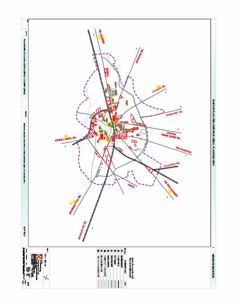


!!!!
! !!
!!
!
!
!
! !
!
!!
!
!!!
!!
!!
!! ! !
!
! !! !
!
!!
!
!!
!
!!
!!
!!
!
!
!!
! !
!
!
!
! !!!
!
!!
FRO
M L
AH
OR
E
BG
FRO
M L
AH
OR
EN
H 1
TO P
ATHA
NKOT
BG
TO AJNALA
SH 25
TO P
ATHA
NKOT
NH 15
TO J
ALAN
DHAR
NH 1
TO J
ALA
NDH
AR
BG
FRO
M R
ANIA
NM
DR
TO MAJITHA
MDRTO LOHARKA
ODR
FROM JHABALSH 21
TO S
HR
I HA
RG
OB
IND
PUR
SH 2
2
FROM TARN TARANNH 15
TO FATEHGARH CHURIANMDR
TO DERA BABA NANAKBG
98
765
43
21
5649
44
4741 4035
31
15
25
5814
36
37
4243
4846
5016
17
6361
3029
5328
26
38
19
1839 23
2262
33
4532
60
5912
11
13
10
UBDC
DOBURJI DISTRIBUTARY
GA
ND
A N
ALL
AH
525124
27
55
345457
20 21
NO
TE:
This
dra
win
g is
bas
ed u
pon
the
Exi
stin
g La
nd U
se M
ap s
uppl
ied
by
DTP
offi
ce, A
mrit
sar
(Dra
win
g N
o. D
.T.P
. (A
) 02/
2010
dat
ed 1
2-01
-10)
LEG
END
M.C
BO
UN
DA
RY
RE
SID
EN
TIA
L
WAT
ER
BO
DIE
S
RO
AD
S
RA
ILW
AY T
RA
CK
!SL
UM
MA
P N
O -
7
INSE
T M
AP
STUD
Y AR
EA
CO
NSU
LTA
NTS
:
500
050
01,
000
1,50
025
0
Met
ers
Ê
AM
RI
TS
AR
MU
NIC
IPA
L C
OR
PO
RA
TIO
N
LO
CA
TIO
N O
F S
LU
MS
(20
10
)
AMR
ITSA
R LO
CAL
PLA
NNIN
G A
REA

TO AJNALA MDR
TO BATALA
MDR
FRO
M R
ANIA
NM
DR
TO AJNALASH 25
FROM JHABALSH 21
FROM VAIROWAL
ODR
FRO
M L
AH
OR
E
NH
1
FROM TARN TARAN
BG
TO FATEHGARH CHURIANODR
TO P
ATHANKOT
NH 15
FRO
M L
AH
OR
EB
GFROM TARN TARAN
ODR
TO MAJITHABG
TO S
HR
I HA
RG
OB
IND
PUR
SH 2
2
TO J
ALAND
HAR
NH 1
TO P
ATHANKOT
BG
FRO
M J
HA
BA
LM
DR
FROM KHADUR SAHIB
TO MAJITHA ROADMDR
FROM TARN TARANNH 15
TO J
ALAND
HAR
BG
TO LOHARKA ODR
R.S
RIVER BEAS
AIR
POR
T
BYE
PASS T.T
B.T
UBDC
B.T
R.S
B.T
R.S
B.T
R.S
R.S
R.S
R.S
R.S
B.T
R.S
R.S
R.S
R.S
R.S
R.S
T.T
B.T
AM
RI
TS
AR
LO
CA
L P
LA
NN
ING
AR
EA
TRA
FFIC
AN
D T
RAN
SP
OR
TATI
ON
2010
INSE
T M
AP
NO
TE:
This
dra
win
g is
bas
ed u
pon
the
Exi
stin
g La
nd U
se M
ap s
uppl
ied
by
DTP
offi
ce, A
mrit
sar (
Dra
win
g N
o. D
.T.P
. (A
) 02/
2010
dat
ed 1
2-01
-10)
1 C
M =
300
BU
SE
S
LEG
END
LOC
AL
PLA
NN
ING
AR
EA
BO
UN
DAR
Y M
.C B
OU
ND
ARY
VILL
AG
E B
OU
ND
AR
YW
ATER
BO
DIE
STR
AFF
IC A
ND
TR
AN
SPO
RTA
TIO
N
RO
AD
S
RAI
LWAY
TR
AC
K T
ER
MIN
ALS
B
US
FLO
W
STUD
Y AR
EA
MA
P N
O -
9
CO
NS
ULT
AN
TS :
AM
RIT
SA
R D
ISTR
ICT
5,00
00
5,00
02,
500
Met
ersÊ

")!
! !!
! !!!!
!! ! !
!
!!
!!
!
!!!
!!
!
")
")
")
")")
")
")
")
")")")")")
")
")")
")") ")
")")
")
FRO
M L
AH
OR
E
BG
FRO
M L
AH
OR
EN
H 1
TO P
ATHA
NKOT
BG
TO AJNALA
SH 25
TO P
ATHA
NKOT
NH 15
TO J
ALAN
DHAR
NH 1
TO J
ALAN
DHAR
BG
FRO
M R
ANI
ANM
DR
TO MAJITHA
MDRTO LOHARKA
ODR
FROM JHABALSH 21
TO S
HR
I HA
RG
OB
IND
PUR
SH 2
2
FROM TARN TARAN
NH 15TO FATEHGARH CHURIAN
MDR
TO DERA BABA NANAKBG
R.S
UBDC
DOBURJI DISTRIBUTARY
GA
ND
A N
ALL
AH
R.S
R.S
R.S
R.S
BYE
PA
SS
T.T
T.T
B.T
R.S
LEG
END
M C
BO
UN
DAR
Y
WAT
ER
BO
DIE
S
RO
AD
S
RA
ILW
AY T
RAC
K
CO
NG
EST
ED
RO
AD
ON
STR
EE
T PA
RK
ING
TER
MIN
AL
")PA
RKI
NG
AR
EA
!AC
CID
EN
T S
PO
TS
")C
RIT
ICA
L JU
NC
TIO
NS
NO
TE:
This
dra
win
g is
bas
ed u
pon
the
Exi
stin
g La
nd U
se M
ap s
uppl
ied
by
DT
P o
ffice
, Am
ritsa
r (D
raw
ing
No.
D.T
.P. (
A)
02/2
010
date
d 12
-01-
10)
MA
P N
O-
8
AM
RI
TS
AR
MU
NIC
IPA
L C
OR
PO
RA
TIO
N
TRA
FFIC
AN
D T
RAN
SPO
RTA
TIO
N(2
010)
CO
NS
ULT
AN
TS :
500
050
01,
000
1,50
02,
000
250
Met
ersÊ
INSE
T M
AP
STU
DY
AR
EA
AMR
ITSA
R L
OCA
L PL
ANNI
NG A
REA

&")
& ")")&
& ")
& ")
") ") &&")& ")
&") ")
& ")&")
& ")
&")
& ")
&")")&") ")
&")
&") ")
& ")
&")
&") ")&") ")
& ")") &
& ")
&") ")
")
")
")
")")")
&&
&&
&
&
&
&&&
&
&
&
&&
&&
&
")&
&
&")
! " )
!" )" )
!!
!
" ) " )" )
" )" )
! " )" )
" )!
" )!" ) " )! " )" )
! " )" )! " )" )
!" ) " )
!" ) " )!" )" )
" )!" )!" )
" )! " ) " )
!" )
!" )
! " )
CA
NTO
NM
ENT
FRO
M L
AH
OR
E
BG
FRO
M L
AH
OR
EN
H 1
TO AJNALA
SH 25
TO P
ATHAN
KOT
BG
TO J
ALAN
DHAR
NH 1
TO P
ATHAN
KOT
NH 1
5
TO J
ALAN
DH
ARBG
FRO
M R
ANIA
NM
DR
TO MAJIT
HAMDR
TO LOHARKAODR
FROM JHABALSH 21
TO S
HR
I HA
RG
OB
IND
PU
R
SH 2
2
FROM TARN TARAN
NH 15TO FATEHGARH CHURIAN
MDR
TO DERA BABA NANAKBG
UBDC
DOBURJI DISTRIBUTARY
GA
ND
A N
ALL
AH
BYE
PA
SS
LEG
END
M.C
BO
UN
DA
RY
WAT
ER
BO
DIE
SR
OA
DS
RA
ILW
AY T
RA
CK
WAT
ER S
UPP
LY N
ETW
OR
K4" 6" 8" 10
"12
"14
"16
"C
OV
ER
ED
AR
EA
PRO
PO
SE
D A
RE
AU
ND
EV
ELO
PE
D A
RE
A
&O
HS
R
")TU
BE
WE
LL
!O
HS
R P
RO
PO
SE
D
" )TW
PR
OP
OS
ED
NOTE
: Th
is d
raw
ing
is b
ased
upo
n th
e E
xist
ing
Land
Use
Map
sup
plie
d by
D
TP o
ffice
, Am
ritsa
r (D
raw
ing
No.
D.T
.P. (
A) 0
2/20
10 d
ated
12-
01-1
0)
MA
P N
O -
10
CO
NSU
LTA
NTS
:
AM
RI
TS
AR
MU
NIC
IPA
L C
OR
PO
RA
TIO
N
WAT
ER
SU
PP
LY N
ETW
OR
K(2
010)
INSE
T M
AP
ST
UD
Y A
RE
AAM
RITS
AR L
OCA
L PL
ANNI
G A
REA
500
050
01,
000
1,50
02,
000
250
Met
ersÊ

! !!
!
!
!
!
!
!
!
!
!
!
")!
!!
!!
FATE
HPU
R
CA
NTO
NM
ENT
FRO
M L
AH
OR
E
BG
FRO
M L
AH
OR
E
NH
1
TO AJNALA
SH 25
TO P
ATHA
NKOT
BG
TO J
ALAN
DHAR
NH 1
TO P
ATHA
NKOT
NH 1
5
TO J
ALAN
DH
ARBG
FRO
M R
ANIA
NM
DR
TO MAJIT
HAMDR
TO LOHARKAODR
FROM JHABALSH 21
TO S
HR
I HA
RG
OB
IND
PU
R
SH 2
2
FROM TARN TARAN
NH 15
TO FATEHGARH CHURIANMDR
TO DERA BABA NANAKBG
UBDC
DOBURJI DISTRIBUTARY
GA
ND
A N
ALL
AH
BYE
PA
SS
LEG
END
M C
BO
UN
DAR
YW
ATE
R B
OD
IES
RO
AD
SR
AIL
WAY
TR
AC
K
SEW
ERA
GE
NET
WO
RK
12"
15"
16"
24"
30"
36"
39"
40"
42"
45"
48"
51"
54"
57"
63"
78"
CO
VE
RED
AR
EA
PR
OP
OSE
D A
REA
UN
DE
VEL
OPE
D A
REA
!TE
MPO
RA
RY
DIS
POS
AL
WO
RK
")PE
RM
ANE
NT
DIS
PO
SA
L W
OR
K
NOTE
: Th
is d
raw
ing
is b
ased
upo
n th
e E
xist
ing
Land
Use
Map
sup
plie
d by
D
TP o
ffice
, Am
ritsa
r (D
raw
ing
No.
D.T
.P. (
A)
02/2
010
date
d 12
-01-
10)
MA
P N
O -
11
AM
RI
TS
AR
MU
NIC
IPA
L C
OR
PO
RA
TIO
N
SE
WE
RA
GE
NE
TW
OR
K(2
01
0)
INSE
T M
AP
STU
DY
AREA
AMRI
TSAR
LO
CAL
PLAN
NING
ARE
A
CO
NSU
LTA
NTS
:
500
050
01,
000
1,50
025
0
Met
ers
Ê
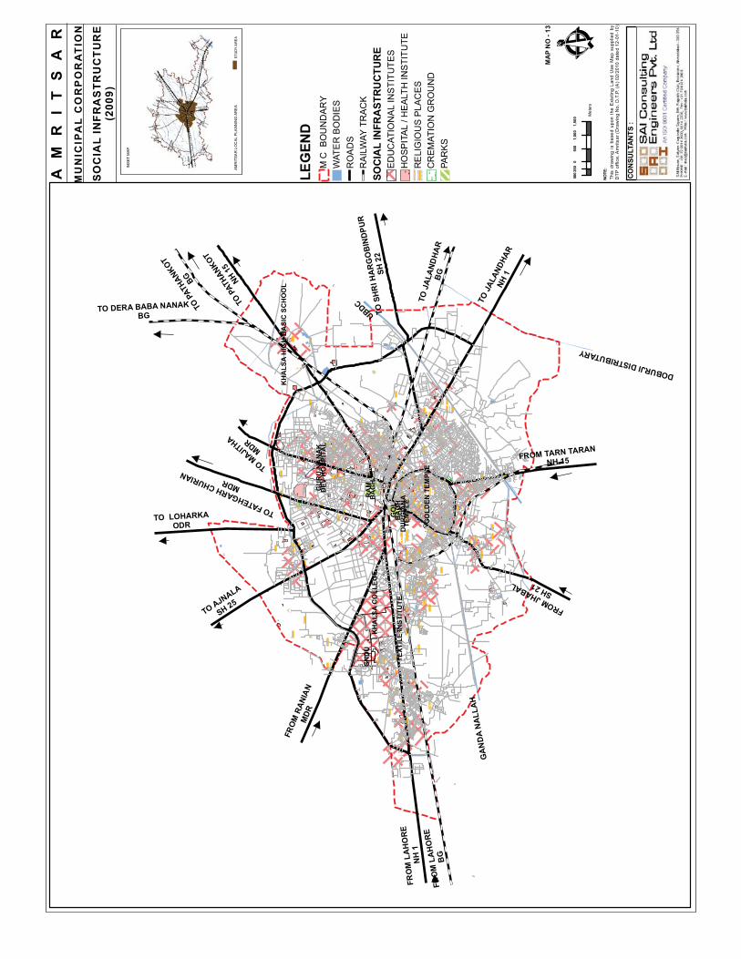
GN
DU
GO
LDEN
TEM
PLE
KH
ALS
A C
OLL
EGE
TEXT
ILE
INST
ITU
TE
KH
ALS
A H
IGH
BA
SIC
SC
HO
OL
FRO
M L
AH
OR
E
BG
FRO
M L
AH
OR
EN
H 1
TO P
ATHA
NKOT
BG
TO AJNALA
SH 25
TO P
ATHA
NKOT
NH 15
TO J
ALAN
DHAR
NH 1
TO J
ALA
ND
HA
RB
G
FRO
M R
ANIA
NM
DR
TO MAJITHA
MDRTO LOHARKA
ODR
FROM JHABALSH 21
TO S
HR
I HA
RG
OB
IND
PUR
SH 2
2
FROM TARN TARANNH 15
TO FATEHGARH CHURIANMDR
TO DERA BABA NANAKBG
UBDC
DOBURJI DISTRIBUTARY
GA
ND
A N
ALL
AH
GO
L
RA
MB
AG
H
BA
GH
TEM
PLE
DU
RG
IAN
A
GU
RU
NA
NA
KD
EV H
OSP
ITA
L
LEG
END
M C
BO
UN
DA
RY
WAT
ER
BO
DIE
SR
OA
DS
RA
ILW
AY T
RA
CK
SO
CIA
L IN
FRA
STR
UC
TUR
EED
UC
ATIO
NA
L IN
STI
TUTE
SH
OSP
ITAL
/ H
EAL
TH IN
STIT
UTE
RE
LIG
IOU
S P
LAC
ES
CR
EM
ATIO
N G
RO
UN
DPA
RK
S
NOTE
: Th
is d
raw
ing
is b
ased
upo
n th
e E
xist
ing
Land
Use
Map
sup
plie
d by
D
TP o
ffice
, Am
ritsa
r (D
raw
ing
No.
D.T
.P. (
A) 0
2/20
10 d
ated
12-
01-1
0)
MA
P N
O -
13
AM
RI
TS
AR
MU
NIC
IPA
L C
OR
PO
RA
TIO
N
SO
CIA
L IN
FRA
STR
UC
TUR
E(2
009)
INSE
T M
AP
STU
DY
AR
EA
AMR
ITSA
R L
OC
AL P
LAN
NIN
G A
RE
A
CON
SULT
ANTS
:
500
050
01,
000
1,50
025
0
Met
ersÊ

#
##
##
##
# #
##
#
#
## ##
##
## ##
#
#
# #
#
#
#
#
##
## #
#
#
#
# #
#
#
# ##
##
##
# # ##
## ##
#
# #
#
#
# #
##
##
###
#
##
#
##
#
#
###
#&
&
&&
&&
# # #
#
#
#
!.
!.
!.
##
## ##
#
&
!. ##
!.#
#
#
#& # #
#
")
FRO
M L
AH
OR
E
BG
FRO
M L
AH
OR
EN
H 1
TO P
ATHA
NKOT
BG
TO AJNALA
SH 25
TO P
ATHA
NKOT
NH 15
TO J
ALAN
DHAR
NH 1
TO J
ALA
ND
HA
RB
G
FRO
M R
ANIA
NM
DR
TO MAJITHA
MDRTO LOHARKA
ODR
FROM JHABALSH 21
TO S
HR
I HA
RG
OB
IND
PUR
SH 2
2
FROM TARN TARANNH 15
TO FATEHGARH CHURIANMDR
TO DERA BABA NANAKBG
UBDC
DOBURJI DISTRIBUTARY
GAN
DA
NAL
LAH
LEG
END
M.C
BO
UN
DA
RY
WAT
ER B
OD
IES
RO
AD
SR
AILW
AY T
RA
CK
DIV
ISO
N B
OU
ND
AR
YC
ITY
CEN
TRE
DIV
ISIO
NC
IVIL
LIN
E D
IVIS
ION
HAK
IMA
GAT
E D
IVIS
ION
IND
UST
RIA
L D
IVIS
ION
ELEC
TRIC
SU
B S
TATI
ON
")22
0 K
V
&13
2 K
V
!.66
KV
#11
KV
NO
TE:
This
dra
win
g is
bas
ed u
pon
the
Exi
stin
g La
nd U
se M
ap s
uppl
ied
by
DT
P o
ffice
, Am
ritsa
r (D
raw
ing
No.
D.T
.P. (
A)
02/2
010
date
d 12
-01-
10)
MA
P N
O -
12
INSE
T M
AP
STU
DY
AREA
AMRI
TSAR
LO
CAL
PLAN
NING
ARE
A
CO
NSU
LTA
NTS
:
500
050
01,
000
1,50
025
0
Met
ersÊ
AM
RI
TS
AR
MU
NIC
IPA
L C
OR
PO
RA
TIO
N
DIS
TRIB
UTI
ON
OF
ELE
CTR
IC S
UB
STA
TIO
N(2
010)

TOW
N H
ALL
GO
LDEN
TEM
PLE
G. R
AM
SAR
SA
HIB
G B
IBA
KSA
R S
AH
IB
JALL
IAN
WA
LA B
AG
H
G. S
HA
HEE
DA
N S
AH
IB
GALIARA
B. CHAT
IWIN
D
B. R
AM
GA
RIA
N
BAZAAR P
RAGDASS
B. NAT
HANWALA
B. C
HEEL M
ANDI
BAZA
AR M
ISRI
DHAB AHAT
A
GURU BAZA
AR
BAZAAR RAMGARIAN
BAZA
AR K
ASR
ERA
BAZA
AR G
HAN
TA G
HAR
B. G
HEE
MA
ND
I
BAZA
AR M
AHAN
SIN
GH
BAZA
AR K
HUSH
AL S
ING
H
BAZA
AR T
UNDA
TAL
AB
BAZA
AR P
APRA
N
BAZAAR KANHAYA
BAZAAR BAGHIAN
BAZAAR PARJA
BAZA
AR K
ANHIA
N
BAZAAR LAKAR M
ANDI
BAZAAR B
AGHIAN
SULT
ANW
IND
GATE
CHATIWIND GATE
HATHI
GAT
E
HALL
GAT
E
HAKIMA GATE
RAM BAGH GATE
GILWALI GATE
MAHAN
SIN
GH GAT
E
LOHG
ARH
GATE
LAHO
RI G
ATE
GH
EE M
AN
DI G
ATE
KHAZ
ANA
GATE
BAZAAR SANDOKAN
SHER
AN W
ALA
GAT
E
BHAGTANWALA GATE
ÊNO
TE:
This
dra
win
g is
bas
ed u
pon
the
Exi
stin
g La
nd U
se M
ap s
uppl
ied
by
DTP
offi
ce, A
mrit
sar
(Dra
win
g N
o. D
.T.P
. (A
) 02/
2010
dat
ed 1
2-01
-10)
MA
P N
O- 1
4
110
011
022
033
044
055
Met
ers
LEG
END
APP
RO
ACH
RO
AD
FR
OM
HA
LL G
ATE
HE
RIT
AGE
ZO
NE
GO
LDE
N T
EM
PLE
WIT
H G
ALI
AR
A
OTH
ER
IMP
OR
TAN
T P
LAC
ES
INSE
T M
AP
STU
DY
AR
EA
AMR
ITSA
R L
OCA
L PL
ANN
ING
AR
EA
AM
RI
TS
AR
WA
LL
ED
CIT
Y -
HE
RIT
AG
E Z
ON
E