draft grand pass conservation area - mdc.mo.gov · landtype consists of flat alluvial plains and...
TRANSCRIPT

DRAFT Grand Pass
Conservation Area
Ten-Year Area Management Plan FY 2019-2028
To submit a comment on this document, click on the following link: https://mdc.mo.gov/node/10013?ap=310996

October 2018 DRAFT Grand Pass Conservation Area Management Plan Page 2
OVERVIEW
• Official Area Name: Grand Pass Conservation Area, #8010 • Year of Initial Acquisition: 1980 • Acreage: 5,301 acres (205 acres under cooperative agreement with Teteseau Levee District) • County: Saline • Region: Northwest • Division with Administrative Responsibility: Wildlife • Division with Maintenance Responsibility: Wildlife • Statements of Purpose:
A. Strategic Direction Protect, restore, and manage fish, forest, and wildlife habitats, particularly wetlands and their associated plants and animals, emphasizing biodiversity and ecosystem integrity, while providing high-quality public use opportunities for hunting, fishing, and wildlife viewing.
B. Desired Future Condition The desired future condition of Grand Pass Conservation Area (CA) is a healthy, intensively managed wetland complex of seasonal, semi-permanent and permanently flooded habitats and associated bottomland forest adjacent to the Missouri River along with old fields and open fields to provide diverse habitats for a suite of game and non-game species.
C. Federal Aid Statement N/A
GENERAL INFORMATION AND CONDITIONS
I. Special Considerations A. Priority Areas: Missouri River Stream Reach Conservation Opportunity Area, Grand
Pass Wetland Complex Wetland Conservation Opportunity Area B. Natural Areas: None
II. Important Natural Features and Resources
A. Species of Conservation Concern: Species of conservation concern are known from this area. Area managers should consult the Natural Heritage Database annually and review all management activities with the natural history biologist.
B. Caves: None C. Springs: None D. Other: Occurs in the Central Dissected Till Plains Section, Missouri River Alluvial
Plain Subsection, Wakenda Missouri River Alluvial Plain Landtype Association. This

October 2018 DRAFT Grand Pass Conservation Area Management Plan Page 3
landtype consists of flat alluvial plains and infrequent terraces of the broader stream valleys. Historically, bottomland prairie, marshes, and bottomland forests dominated (Nigh & Schroeder, 2002).
III. Existing Infrastructure • Headquarters building: office/draw room/shop building, two grain bins, and one
chemical/fuel building • One privy (Americans with Disabilities Act [ADA]-accessible) • One waterfowl hunting blind (ADA-accessible) • One diesel pump-out building • One observation/wildlife viewing tower • Three-phase electric pump station with five submersible pumps. Contains two 75-
horsepower 10,100-gallon/minute pumps; two 145-horsepower 17,250-gallon/minute pumps; and one 140-horsepower 17,250-gallon/minute pump.
• One 60-foot well with 40-horsepower gearhead • Twenty-four parking lots (two ADA-accessible) • Ten gravel boat launching areas • Three designated primitive camping areas • Nineteen wetland pools with associated water control structures, roads, and levees • Teteseau Lake (25-acre fishing lake)
IV. Area Restrictions or Limitations
A. Deed Restrictions or Ownership Considerations: None B. Federal Interest: Federal funds may be used in the management of this land. Fish
and wildlife agencies may not allow recreational activities and related facilities that would interfere with the purpose for which the State is managing the land. Other uses may be acceptable and must be assessed in each specific situation.
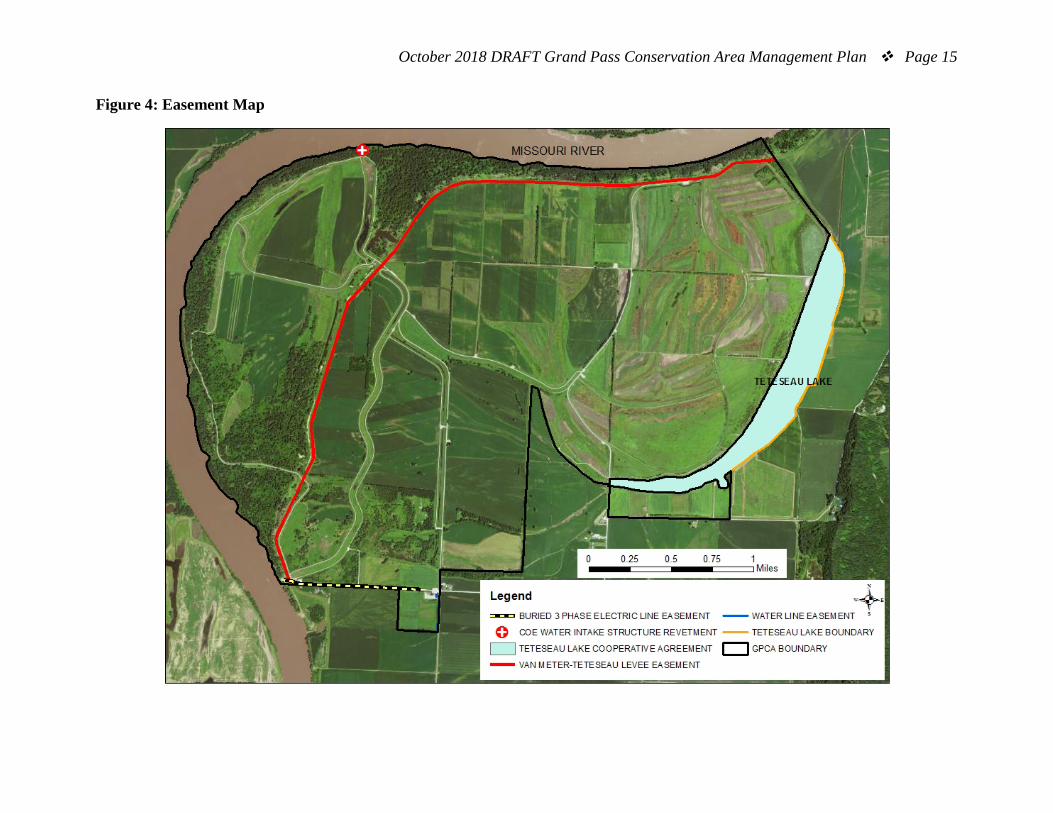
C. Easements: Teteseau Levee District levee, United States Corps of Engineers water intake structure revetment, electric, and water lines.
D. Cultural Resources Findings: Yes, records kept with the Missouri Department of Conservation (MDC) environmental compliance coordinators. Managers should follow best management practices for cultural resources found in the MDC Resource Policy Manual.
E. Endangered Species: Endangered species are known from this area. Area managers should consult the Natural Heritage Database annually and review all management activities with the natural history biologist.
F. Boundary Issues: Establishing accurate and identifiable boundary markers is a priority for this property.
October 2018 DRAFT Grand Pass Conservation Area Management Plan Page 4
MANAGEMENT CONSIDERATIONS
V. Terrestrial Resource Management Considerations
Manage floodplain/wetland habitats and restore additional habitat that supports a diversity of game and non-game species for the benefit of public use, where possible. Grand Pass CA contains 916 acres of bottomland forest and woodland habitats that covers approximately 17 percent of the area. Forested areas are split between mature cottonwood, silver maple, and sycamore stands and younger, second-growth cottonwood and silver maple. Other species present in these stands include elm, boxelder, green ash, willow, pecan, and pin oak.
Challenges and Opportunities:
1) Maintain high-quality waterfowl habitat and adequate waterfowl refuge needed to support abundant waterfowl populations during spring and fall migrations.
2) Maintain healthy wetland habitats for a broad suite of wetland-dependent species throughout the year.
3) Wetland plant community diversity is dependent on hydrology, soils, and gradient within individual wetland pools. The west and middle sections of the area have coarse soils with ridge/swale topography. Conversely, the eastern part of the area has soils with higher water holding capacity and very little gradient.
4) The area contains some of the best examples of wetlands that historically occurred in the lower Missouri River basin. Alterations, such as channelization, bank stabilization, upstream reservoir development, intensive federal and private levee system development, extensive conversion of bottomland forest, wet prairie, and wetlands to cropland, have altered flood frequency, duration, depth, siltation loading, and base flows, making wetland management restoration and management challenging.
5) Control invasive species on the area, particularly sericea lespedeza, reed canary grass, phragmites, sesbania, purple loosestrife, perennial smartweed, and Johnson grass.
6) Maintain forest health. 7) Maintain bottomland hardwoods and biodiversity. 8) Maintain and improve forested wildlife habitat.
Management Objective 1: Manage wetland pools primarily for moist-soil units.

October 2018 DRAFT Grand Pass Conservation Area Management Plan Page 5
Strategy 1: Manage pools using a variety of moist-soil management techniques, including but not limited to mowing, spraying, and disking. Manage water in spring and fall to promote native annual plants that are shallowly flooded and to provide interspersed open-water areas. (Wildlife) Strategy 2: Plant small- and large-grain crops on suitable sites to manage succession and provide high-energy food for wildlife. (Wildlife) Strategy 3: Drill, broadcast, or aerial seed small-seed cultivars when flooding significantly damages wetland habitat. Examples of cultivars to plant include, but are not limited to buckwheat, Japanese millet, proso millet, German foxtail millet, and pearl millet. (Wildlife) Strategy 4: Continue to provide high-quality inviolate refuge in support of seasonal concentrations of migratory waterfowl. Refuge pools will serve as resting and foraging areas to help migrating waterfowl build fat reserves and improve body condition. (Wildlife) Strategy 5: On suitable sites, manage water in late summer and spring to provide areas of shallowly flooded habitat, interspersed with mudflats to serve as forage and loafing areas for dabbling ducks and shorebirds. (Wildlife)
Management Objective 2: Manage Pool 7 and Teteseau Lake to promote diverse wetland communities, including moist soil interspersed with open water, emergent marsh, shrub swamp, and forested wetlands to provide for a broad range of wetland-dependent wildlife.
Strategy 1: Use a variety of management techniques in Pool 7 and Teteseau Lake, such as prescribed burning, herbicide applications, mowing, and disking to promote interspersion among vegetative communities. (Wildlife) Strategy 2: Strategically mimic historic floodplain connectivity throughout the year that promote seasonal/moist-soil, emergent marsh, and shrub swamp habitat for a broad range of wetland species. (Wildlife). Strategy 3: Retain spring and summer flood/rain water in borrow areas and across low floodplain areas to provide habitat for a broad suite of wetland species throughout the year, when consistent with other management objectives. (Wildlife)
Management Objective 3: Improve floodplain function and wetland resiliency. Strategy 1: As aging or failing infrastructure is replaced and as funding permits, use the latest wetland renovation technologies, for instance Light Detection and Ranging (LiDAR), soils data, and a stream-floodplain systems approach (also known as hydrogeomorphic based evaluation). Conduct renovations in accordance with Wetland Planning Initiative Strategic Guidance Document (MDC, 2015). (Wildlife)
October 2018 DRAFT Grand Pass Conservation Area Management Plan Page 6
Strategy 2: Control and setback woody succession using appropriate methods. (Wildlife)
Management Objective 4: Restore wet bottomland prairie natural communities, where practical.
Strategy 1: Reconstruct wet bottomland prairie, as funding becomes available, using native wet prairie seed on suitable areas that were formerly cropland on high terraces. (Wildlife)
Management Objective 5: Control invasive species. Strategy 1: Monitor invasive species. Spot treat, broadcast, or aerial spray invasive species, including, but not limited to, sericea lespedeza, reed canary grass, phragmites, sesbania, purple loosestrife, perennial smartweed, and Johnson grass. Natural communities, wetlands, and restored grasslands are prioritized for treatments. (Wildlife)
Management Objective 6: Manage forest communities to provide recreational opportunities and habitat for wildlife.
Strategy 1: Monitor for the presence of invasive forest pests and plants by means of routine inventory and area inspections to ensure a healthy, thriving forest habitat. (Forestry, Wildlife) Strategy 2: Conduct habitat management activities to manage any insect and disease issues, as needed. (Forestry) Strategy 3: Control invasive forest pests and plants, as needed, utilizing a variety of techniques, including, but not limited to, prescribed fire, chemical, and mechanical treatments. (Wildlife, Forestry) Strategy 4: Utilize best management practices during timber harvests, as described in MDC’s Missouri Watershed Protection Practice Recommended Practices for Missouri Forests: 2014 Management Guidelines for Maintaining Forested Watersheds to Protect Streams (MDC, 2014b) and Missouri Forest Management Guidelines: Voluntary Recommendations for Well-Managed Forests (MDC, 2014). (Forestry, Wildlife)
VI. Aquatic Resource Management Considerations
Challenges and Opportunities: 1) Landscape-scale alterations in the Lower Missouri River Basin have changed the
hydrology and habitat conditions instream and across the floodplain, threatening water quality, streambank stability and biodiversity on the area.

October 2018 DRAFT Grand Pass Conservation Area Management Plan Page 7
2) Federally endangered, state endangered, and Missouri species of conservation concern occur in the Missouri River.
3) Balance the need for wetland pumping with the need to maintain instream flow for aquatic resources
Management Objective 1: Manage the area’s streams and adjacent floodplain for a diversity of aquatic species, consistent with other management objectives.
Strategy 1: Maintain water in borrow areas on suitable sites until June 15 of each year, to benefit fish spawning and nurseries, when consistent with wetland management objectives. (Wildlife) Strategy 2: Hold spring and summer floodwater in borrow areas and across low floodplain areas to benefit fish spawning and nurseries throughout the year, when consistent with wetland management objectives. (Wildlife) Strategy 3: As old infrastructure is replaced, design new infrastructure and implement techniques to minimize seasonal mortality of native fish species in developed wetlands. (Wildlife, Fisheries, Design and Development)
Management Objective 2: Maintain an adequate forested riparian corridor along streams.
Strategy 1: Document and map key areas in need of riparian corridor enhancement to help reduce streambank erosion, excessive sedimentation, and nutrient loading to the streams. (Wildlife, Fisheries) Strategy 2: Where needed, expand the forested riparian zone by conducting tree/shrub plantings in identified areas. (Wildlife, Forestry) Strategy 3: Continue to manage riparian areas for streambank stability, which will help promote quality instream habitats for fish and other aquatic organisms, in accordance with MDC’s Watershed and Stream Management Guidelines for Lands and Waters Managed by Missouri Department of Conservation (MDC, 2009). (Wildlife)
Management Objective 3: Minimize impacts from wetland pumping to instream aquatic resources while balancing the needs of floodplain habitat and associated wetland resources.
Strategy 1: Limit pumping activity as needed during periods of extreme low flow on the Missouri River. (Wildlife, Fisheries)
VII. Public Use Management Considerations
Challenges and Opportunities:

October 2018 DRAFT Grand Pass Conservation Area Management Plan Page 8
1) The waterfowl hunting program on Grand Pass CA provides excellent opportunity on a large scale, while balancing hunter preferences for a range of hunting styles.
2) Deer hunting opportunities are extensive on the area. Area user conflicts arise due to access limitation, hunting pressure, differences in preferred hunting methods, and road or zone closures.
3) Access to the Missouri River and Teteseau Lake is provided for public fishing opportunities.
4) Access is somewhat limited on portions of the area. Maintenance of existing parking lots is a priority to provide opportunities for hunting, fishing, and nature viewing.
5) Work to build positive relationships with stakeholders (such as neighboring landowners and duck clubs) by providing timely assistance, if private access or public use issues develop.
6) The area’s size, habitat diversity, and proximity to highly populated areas provide educational and interpretive opportunities.
Management Objective 1: Provide a range of waterfowl hunting opportunities to meet the needs and preferences of waterfowl hunters. (Wildlife)
Strategy 1: Support the continuation of the managed hunt program for the waterfowl-hunting-only pools at Grand Pass CA. (Wildlife) Strategy 2: Determine the appropriate number of hunting positions allocated daily by considering the draw pool configurations and arrangements, Waterfowl Hunt Program guidelines (approximately 40 acres per party), and by hunter expectations for a quality hunting experience. (Wildlife) Strategy 3: Provide at least one ADA-accessible waterfowl hunting blind, when conditions allow. (Wildlife)
Management Objective 2: Manage non-wetland habitats to provide upland game hunting opportunities.
Strategy 1: Maintain the current Agriculture Crop Program to provide high-energy food sources for deer, turkey, quail, dove, rabbits, and other wildlife. (Wildlife)
Management Objective 3: Provide recreational fishing opportunities.
Strategy 1: Maintain bank-fishing access points and parking areas adjacent to Missouri River and Teteseau Lake through mowing. (Wildlife)
Management Objective 4: Provide wildlife viewing overlooks and parking areas that are informative and inviting to the public.
Strategy 1: Keep portions of the overlooks clear of trees for enhanced wildlife viewing opportunities. (Wildlife)

October 2018 DRAFT Grand Pass Conservation Area Management Plan Page 9
Strategy 2: Maintain all current parking lots to be inviting to the public. (Wildlife)
Management Objective 5: Foster positive relationships with neighboring landowners.
Strategy 1: Work with neighbors to prevent or resolve any ingress or egress issues, and boundary or trespass issues. (Wildlife, Protection)
Management Objective 6: Improve educational and interpretive opportunities.
Strategy 1: Make available taxidermy mounts of water birds in the public meeting room (draw room), as specimens and funding permits. (Wildlife) Strategy 2: As funding allows, repair and renovate observation tower at Teteseau Lake to ensure a safe, inviting wildlife viewing opportunity. (Design and Development) Strategy 3: Maintain signage in accordance with MDC policy. (Wildlife) Strategy 4: Update maps and information on the MDC Atlas database to inform public of area opportunities, as needed. (Wildlife) Strategy 5: Communicate the area’s educational programs to teachers and other youth leaders, as opportunities arise. (Outreach and Education)
VIII. Administrative Considerations
Challenges and Opportunities:
1) Maintain and clearly demarcate area boundary lines. 2) Evaluate land offered as additions to the area.
Management Objective 1: Clearly identify area boundaries.
Strategy 1: Submit a boundary survey request for segments that have no fence or delineation and never been surveyed. (Wildlife) Strategy 2: Maintain area boundary signs as needed. (Wildlife)
Lands Proposed for Acquisition:
When available, land may be considered for acquisition from willing sellers. Tracts that improve area access, provide public use opportunities, contain unique natural communities and/or species of conservation concern, or meet other MDC priorities, as identified in the annual MDC land acquisition priorities, may be considered.
MANAGEMENT TIMETABLE
All strategies for this plan are considered ongoing.
October 2018 DRAFT Grand Pass Conservation Area Management Plan Page 10
APPENDICES
Area Background: Grand Pass CA is in Saline County. The area consists of Missouri River bottomlands, including wetlands, adjacent river islands, agricultural units, and timber tracts. Six miles of the area fronts the Missouri River. The initial area purchase of 2,100 acres occurred in 1980. During 1984, 2,611 acres additional acres were purchased and in 1984 and 205 more acres were managed in 1986 as part of a cooperative management agreement with the Van Meter-Teteseau Levee District. The final addition made to the area was 385 acres in 1994 to form Grand Pass Conservation Area. Area development included establishment of levees and water-control structures. Waterways and pumps help manage these Missouri River wetlands and restore and maintain habitat on over 3,400 acres for migratory wetland species and associated resident wildlife. Wetland management consists of providing fall and spring flooded habitat for migratory birds and emergent marshes for resident and breeding wetland wildlife. Development also created waterfowl hunting opportunities for an ADA-accessible waterfowl hunting blind party and up to 40 parties of wade-and-shoot duck hunters per day. Grand Pass CA is within the Grand Pass Wetland Complex Wetland Conservation Opportunity Area, a broad reach of the Missouri River floodplain. Historically, the dynamic shifting of the Missouri River, with its braided channels and fluctuating water levels, created a mosaic of marshes and wet prairies here. This area has been designated by Audubon Missouri as an Important Bird Area. Important Bird Areas are sites that have been identified by Audubon as those that are the most crucial for bird populations, due to their abundance and/or diversity of birds present. The area is a stop on the Great Missouri Birding Trail. Grand Pass CA is a nationally recognized waterfowl hunting destination. Duck-use days on the area can range from six to almost 10 million per year, with peak waterfowl populations typically occurring in early December. The area provides opportunity for well over 5,000 hunter-use-days during most waterfowl seasons through a managed hunt program. The area also attracts numerous birders, fisherman, deer hunters, turkey hunters, dove hunters, and mushroom hunters.

October 2018 DRAFT Grand Pass Conservation Area Management Plan Page 11
Current Land and Water Types: Land/Water Type Acres % of Area Miles Wetlands 3,570 67 Woodland/Forest 916 17 Open Land 334 6 Infrastructure 292 6 Grassland 117 2 Old Field 69 1 Open Water 3 <1 Total 5,301 100 Stream Frontage 6.0
References: Missouri Department of Conservation. (2009). Watershed and stream management guidelines for lands and waters managed by Missouri Department of Conservation. Jefferson City, MO: Missouri Department of Conservation. Missouri Department of Conservation. (2014a). Missouri forest management guidelines: Voluntary recommendations for well-managed forests. Jefferson City, MO: Conservation Commission of the State of Missouri. Missouri Department of Conservation. (2014b). Missouri watershed protection practices recommended practices for Missouri forests: 2014 management guidelines for maintaining forested watersheds to protect streams. Jefferson City, MO: Conservation Commission of the State of Missouri. Missouri Department of Conservation. (2015). Wetland planning initiative strategic guidance document. Jefferson City, MO: Missouri Department of Conservation. Nigh, T. A., & Schroeder, W. A. (2002). Atlas of Missouri ecoregions. Jefferson City, MO: Missouri Department of Conservation. Maps: Figure 1: Area Map Figure 2: Aerial Map Figure 3: Land Cover Map Figure 4: Easement Map

October 2018 DRAFT Grand Pass Conservation Area Management Plan Page 12
Figure 1: Area Map

October 2018 DRAFT Grand Pass Conservation Area Management Plan Page 13
Figure 2: Aerial Map

October 2018 DRAFT Grand Pass Conservation Area Management Plan Page 14
Figure 3: Land Cover Map
October 2018 DRAFT Grand Pass Conservation Area Management Plan Page 15
Figure 4: Easement Map

October 2018 DRAFT Grand Pass Conservation Area Management Plan Page 16
To submit a comment on this document, click on the following link: https://mdc.mo.gov/node/10013?ap=310996