draft general management plan - clearzoning · draft general management plan muskallonge lake state...
TRANSCRIPT

Muskallonge Lake General Management Plan
Draft General Management Plan Muskallonge Lake State Park
Approved February 1 , 2017 Michigan DNR Parks and Recreation Division

Muskallonge Lake General Management Plan
Prepared with assistance of:
28 W. Adams | Suite #1200 Detroit, MI 48226
www.giffelswebster.com

Muskallonge Lake General Management Plan
MUSKALLONGE LAKE STATE PARK PLAN APPROVAL RECOMMENDATIONS:

Muskallonge Lake General Management Plan
The following dates reference when the plans were presented for recommendation. In some instances, additional time was allotted for plan review following the presentation with subsequent approval received by Email.
PRD – SECTION CHIEFS: 10/03/2016
Date PRD – MANAGEMENT TEAM: 10/27/2016 (via Email)
Date DNR – RESOURCE MANAGEMENT BUREAU: 11/03/2016 Date MSPAC – STEWARDSHIP SUBCOMMITTEE 11/07/2016 Date
NRC – MICHIGAN STATE PARKS ADVISORY COMMITTEE: 12/08/2016
Date
Muskallonge Lake General Management Plan
Resolution No. 12-2016-2
MICHIGAN STATE PARKS ADVISORY COMMITTEE (MSPAC)
RESOLUTION TO RECOMMEND APPROVAL OF THE “MUSKALLONGE LAKE STATE PARK GENERAL MANAGEMENT PLAN”
ADOPTED: December 8, 2016
WHEREAS, the Department of Natural Resources’ (DNR) Parks and Recreation Division has completed the General Management Plan for Muskallonge Lake State Park; and WHEREAS, the planning process reflects sensitivity to natural resource values, historic and cultural resource values, recreation and education opportunities, and is inclusive of all DNR programs and representative of eco-management; and WHEREAS, the planning process was further inclusive of stakeholder, constituent, and public input; and WHEREAS, the General Management Plan represents sound guidance for future planning phases that will be consistent with the mission of the DNR and the Parks and Recreation Division, and reflective of the purpose and significance of Muskallonge Lake State Park; and WHEREAS, the General Management Plan is consistent with the recommendations of the Michigan State Parks and Outdoor Recreation Blue Ribbon Panel report submitted to Governor Rick Snyder; and WHEREAS, the General Management Plan has been reviewed and recommended for approval by the Parks and Recreation Division and the MSPAC Stewardship Subcommittee. THEREFORE, BE IT RESOLVED, that the Michigan State Parks Advisory Committee recommends approval of the Muskallonge Lake State Park General Management Plan; and THERFORE, BE IT FURTHER RESOLVED that the Michigan State Parks Advisory Committee further recommends that the DNR Director approve the General Management Plan for Muskallonge Lake State Park; Submitted by: Chris Graham, Chair, MSPAC Stewardship Subcommittee Motioned by: Chris Graham Yeas: 9 Seconded by: Mike McDonald Nays: 0 Abstained: 0 Absent: 3

Muskallonge Lake General Management Plan
Intentionally left blank

Muskallonge Lake General Management Plan
Table of Contents
Executive Summary Chapter 1: Core Values & Guiding References
1.1 Mission Statements 1.2 Additional Guiding Resources 1.3 Summary of Legal Mandates
Chapter 2: Plan Process Overview
2.1 Planning Objectives 2.2 Planning Team 2.3 Outreach Strategies 2.4 Summary of Public Input Survey
Chapter 3: Purpose & Significance
3.1 Park Purpose 3.2 Statements of Significance 3.3 Public Affirmation of Statements 3.4 Relationship with the Local Community
Chapter 4: Management Zones
4.1 Developed Recreation Zone 4.2 Administrative Zone 4.3 Natural Resource Recreation Zone 4.4 High Risk Erosion Zone 4.5 Cultural Landscape Zone 4.6 Scenic Zone
Chapter 5: 10-Year Action Goals Appendices
Appendix A: Supporting Analysis including Resource Maps Appendix B: Public & Tribal Input Summary Appendix C: Planning Team Meeting Summary

Muskallonge Lake General Management Plan
Intentionally left blank

Muskallonge Lake General Management Plan 1
Executive Summary Muskallonge Lake State Park is located in northern Luce County, between the shores of Lake Superior and Muskallonge Lake in the Upper Peninsula of Michigan. The area is well known for its forests, lakes and streams. The 217-acre park is located 28 miles northwest of Newberry, which is the county seat. The historic village of Grand Marais, which is known as the eastern gateway to Pictured Rocks National Lakeshore, is 20 miles west from Muskallonge. Features of Muskallonge Lake State Park include two miles of Lake Superior frontage with bluffs and low, grass-covered dunes stretching off to the east and west, without any visible development in either direction. Muskallonge Lake is relatively shallow and is warm enough in the summer for comfortable swimming. The park also hosts the site of the former lumbering town called Deer Park, as well as remnants of a Coast Guard Life Saving Station that operated near the turn of the 20th century. The park offers scenic views of Lake Superior, as well as fishing, swimming, camping and hiking opportunities. A portion of the North Country National Scenic Trail (NCNST), a congressionally recognized trail that stretches 4,600 miles from New York to North Dakota, runs through the park. This trail is also part of the hiking route of Michigan’s Iron Belle Trail from Belle Isle Park in Detroit to Ironwood at the Michigan-Wisconsin state line. Future management of this park is guided by the General Management Plan (GMP), which serves two primary purposes. First, it establishes a 20-Year Management Zone Plan that provides specific guidance for development, stewardship, public use, education & interpretation and park operations & management at Muskallonge Lake State Park. Second, the Plan provides 10-Year Action Goals that address the desired future condition within each Management Zone. Overall, this Plan seeks to uphold the Parks and Recreation Division’s (PRD) Mission Statement: to acquire, protect, and preserve the natural and cultural features of Michigan’s unique resources, and to provide access to land and water based public recreation and educational opportunities. The Department of Natural Resources (DNR) oversaw the planning process. The Plan was developed with significant and valuable input from the Planning Team, stakeholders, and the public. Additionally, several existing planning documents, including the Michigan Statewide Comprehensive Outdoor Recreation Plan and the Michigan State Parks Outdoor Recreation Blue Ribbon Panel Report, were used as guiding references (See Chapter 1 for additional information on guiding references).
Sunset on Muskallonge Lake.

Muskallonge Lake General Management Plan 2
The Supporting Analysis, included as Appendix A of this plan, provides background information to inform this planning initiative. It includes a comprehensive review of the park settings, area demographics, history, land ownership, legal mandates, cultural, natural, and recreation resources. Significance of Muskallonge Lake State Park Each GMP developed by the PRD is built upon the park’s significant features that make it distinct from other parks in the state’s system. Muskallonge Lake State Park was determined significant due to the following: Remote Location Surrounded by the Lake Superior State Forest, the remote setting of Muskallonge Lake State Park offers a peaceful, unique getaway for visitors to step away from fast-paced urban areas and reconnect with nature. The nearest village to the park is 20 miles away, creating a secluded retreat in one of the least populated counties of the state. Contrasting Shorelines Located between Muskallonge Lake and Lake Superior, the park embodies two strikingly different environments. The warm, calm water of Muskallonge Lake contrasts with the harsh, untamed shore of Lake Superior. Destination for Rock Collectors A destination for agate collectors, Muskallonge Lake State Park attracts rockhounds from around the globe. The signature event, Rock On! With Lake Superior Agates, draws over 2,500 visitors each year to this remote park. Maritime History The park’s rich maritime history is evidenced by the remnants of one of the first Coast Guard Life Saving Stations on Lake Superior and the SS Cyprus shipwreck located off the shoreline. These reminders of Lake Superior’s “Shipwreck Coast”, along with oral and written histories, offer interesting interpretive and educational opportunities. Lumbering History Muskallonge Lake State Park includes the site of Deer Park, a lumbering town of the late 1800s situated between the lakes. Sawdust piles, dock pilings, partly submerged pine logs and narrow gauge rail beds are still visible today.
1946 Photo of Deer Park Life Saving Station that was in service from 1876 to 1930’s.

Muskallonge Lake General Management Plan 3
Hub for Diverse Recreation Opportunities Muskallonge Lake State Park serves as a basecamp for regional recreation opportunities including Tahquamenon Falls State Park, Pictured Rocks National Lakeshore, and the Grand Marais log slide. The park also provides a stopping point along the North Country National Scenic Trail, the hiking route of the Iron Belle Trail, and the Lake Superior East Water Trail. The park offers the rare opportunity for ORV camping in the State Park system. In winter months, when visitors are few, the park comes alive again as the host of the Tahquamenon Country Sled Dog Race. Fishing Anglers find the fishery of Muskallonge Lake plentiful year round for catches of Northern Pike, Yellow Perch, Walleye, and Rock Bass. Muskallonge Lake State Park provides anglers a central point from which to explore other fishing opportunities in close proximity. Management Zones A key goal in the development of this General Management Plan is to continue providing the opportunities and features that attract visitors to the park each year, while simultaneously protecting the park’s resources. Taking this into account, the Planning Team, with stakeholder and public input, established appropriate Management Zones for the park. From a palette of nine standard zones, six zones were applied to Muskallonge Lake State Park. The Management Zone Map and a thorough review of each Management Zone are found in Chapter 4 of this Plan. A condensed description of each of the applied Management Zones is as follows: Developed Recreation Zone comprises 29%, totaling approximately 69 acres of the park, and allows active recreation with high density of use conducted in areas not designated for natural resource significance. The zone is centrally located within the park and includes the park’s modern campground. Administrative Zone has been applied to 1%, totaling approximately 3 acres of the park, encompassing the developed areas required for program administration and operations. The zone includes the new park headquarters. Natural Resource Recreation Zone comprises 29%, totaling approximately 68 acres of the park, and permits active recreation with medium to high density of use conducted in natural areas. An area west of the campground, north and south of County Road 407, is located within this zone.
Public education on natural vegetation shoreline stabilization best management practices within park.

Muskallonge Lake General Management Plan 4
High Risk Erosion Zone has been applied to 12%, totaling approximately 29 acres of Muskallonge Lake State Park. The zone manages erosion issues while allowing continued recreational use. Further development of infrastructure and structures are restricted in this zone Cultural Landscape Zone has been applied to 24%, totaling approximately 55 acres of Muskallonge Lake State Park. Management within the Cultural Landscape Zone highlights the preservation and protection of the cultural resources, including the historic evidence of the area’s lumbering history and the Coast Guard Life Saving Station. Scenic Zone comprises 5%, totaling approximately 11 acres of Muskallonge Lake State Park, encompassing the entire Lake Superior shoreline and the Lake Superior overlook in recognition of its natural beauty. 10-Year Action Goals The General Management Plan identifies 10-Year Action Goals that the Planning Team believes are necessary to guide management and development of the park in order to achieve the desired user experience and natural resource protection. Action goals are categorized under General Action Goals if they pertain to the entire park or under specific zones, which are identified on the Management Zone Map. They address natural and cultural resource protection and management, recreation opportunities, education/ interpretation opportunities, management focus and development. The goals are listed in Chapter 5 of this plan.
Cultural remnants from the Deer Park lumbering town located in the park in the 1800s.

Muskallonge Lake General Management Plan 5
1. Core Values and Guiding Resources Core values are the foundation upon which the General Management Plan is based. Core values are derived from the mission statements of the Department of Natural Resources (DNR) and Parks & Recreation Division (PRD), as well as the priorities of the Director, to ensure that the state will acquire, preserve, and protect 1) natural resources and 2) cultural resources, and continue to provide 3) public recreation and 4) educational opportunities throughout the state park system. 1.1 Mission Statements DNR Mission Statement The Michigan Department of Natural Resources is committed to the conservation, protection, management, use and enjoyment of the state’s natural and cultural resources for current and future generations. PRD Mission Statement The Parks & Recreation Division’s mission is to acquire, protect, and preserve the natural and cultural features of Michigan’s unique resources, and to provide access to land and water based public recreation and educational opportunities. Five Goals of the DNR 1. Protect the natural and cultural resources 2. Ensure sustainable recreation use and enjoyment 3. Enable strong and natural resource-based economies 4. Improve and build strong relationships and partnerships 5. Foster effective business practices and good governance
The calm water of Muskallonge Lake.
“When you visit Michigan’s state parks and are
surrounded with our forests, rivers, lakes and streams that have been here for
thousands of years, it’s hard to imagine that changes ever
occur here. As the world gets more hectic, we think
Michigan residents will continue to turn to their
state parks as a resource for rest and renewal.”
-Ron Olson (2013), DNR-PRD Chief

Muskallonge Lake General Management Plan 6
1.2 Additional Guiding Resources The General Management Planning process is guided and shaped by several resources developed to provide recommendations for managing Michigan’s park and recreation system. In particular, these resources have helped shape the 10-Year Action Goals established in this Plan. Michigan Statewide Comprehensive Outdoor Recreation Plan (SCORP) (2013-2017) SCORP is a five-year strategic plan that shapes investment by the state and local communities in priority outdoor recreation infrastructure and programming. The Plan’s overarching goal is to utilize Michigan’s diverse and abundant natural assets to meet the fun, relaxation, and health needs of Michigan’s residents and visitors, and the economic development needs of the state and local communities, by:
• Collaboration and cooperation • Maintenance and continuous improvement of facilities • Access to and connectivity between facilities • Integration with economic development plans • Effective marketing • Protection and interpretation of natural resources
Michigan State Parks & Outdoor Recreation Blue Ribbon Panel Report (2012) The Blue Ribbon Panel’s report to Governor Snyder identifies a number of recommendations for system-wide changes to
programs, management, infrastructure type, and investment strategies that set up the visionary framework for the next 30-50 years of park and outdoor recreation management in Michigan. The recommendations in the report include:
• Identify and protect important natural, cultural, historic, and prehistoric resources • Diversify funding and use new criteria to target investments • Prioritize development of statewide and regional systems of connected trail networks • Encourage greater connections between communities and their recreational assets to strengthen
regional identities • Use parks and recreation areas as a key tool for revitalizing Michigan’s core urban areas • Integrate tourism and economic development marketing • Prioritize investment in parks and recreation

Muskallonge Lake General Management Plan 7
Michigan Comprehensive Trail Plan (2013 - 2018) The Trail Plan, developed by an 11-member committee appointed by Governor Snyder, includes eight priority recommendations with associated key actions that should be implemented to assist in achieving the vision of establishing a high quality, nationally-recognized, state-wide trail system. The eight recommendations are as follows:
• Maintain trails to ensure a sustainable and quality trail system • Expand trails and trail experiences and opportunities to ensure accessibility to trail systems,
outdoor recreation opportunities and natural and cultural resources • The Michigan Trails Advisory Council leads the effort to maintain and enhance Michigan’s
reputation as the trail state • Link trails, trail users and adjoining towns to create memorable trail experiences and enhance
economic prosperity • Develop, enhance and celebrate partnerships and collaborations • Implement a marketing plan including an electronic portal that allows citizens and visitors to be
aware of all trails and related amenities • Develop funding sources and mechanisms for trail maintenance, acquisition and development • Ensure that the state’s trail system compliments other plans and planning efforts
PRD Strategic Plan (2009-2019) The PRD Strategic Plan, approved in 2009, was developed to establish one cohesive plan for the division that spells out long-range goals, objectives, actions, and specific tasks for Michigan’s state park and recreation system. General Management Plans are a defined process in the strategic plan. Managed Public Land Strategy (2013) The DNR-Managed Public Land Strategy provides a framework for the continued conservation, use and management of public lands to provide an enhanced quality of life for Michigan residents, create jobs and protect the essence of Michigan, its woods, waters, wildlife and other natural and cultural assets. The Strategy identifies three broad goals with desired outcomes, metrics, and measurable objectives identified for each goal. These goals are to:
• Provide quality outdoor public recreation opportunities • Foster regional economic prosperity • Protect natural and cultural resources for future generations

Muskallonge Lake General Management Plan 8
1.3 Summary of Legal Mandates For all park General Management Plans, legal mandates are identified that serve to further guide the development of the General Management Plan and subsequent Action Plans. For our planning purposes, the term “Legal Mandates” refers to not only state law, but also the administrative tools of “Policy” and “Directive” of the Natural Resource Commission, the Department of Natural Resources, and the Parks & Recreation Division. There are several general and site specific legal mandates applicable to Muskallonge Lake State Park listed in Appendix A: Supporting Analysis. The legal mandates that most directly impact planning and management of Muskallonge Lake State Park focus on the following areas:
• Endangered species protection (Endangered Species Act, 1973) • The piping plover nesting habitat is addressed as a part of the Director’s Land Use Order. • Natural Resources and Environmental Protection Act (NREPA) and amendments. • PA 35 of 2010, Part 741 Recreation Passport. A Passport is required for entry into the park. • Entrance to and departure of off-road vehicles from Muskallonge Lake State Park. • National Trails System Act, 1968 (P.L. 90-543, as amended through P.L. 111-11, March 30, 2009)
The Lake Superior shoreline.

Muskallonge Lake General Management Plan 9
2. Plan Process Overview 2.1 Planning Objectives Park planning is not a new concept. The DNR has developed Master Plans in the past for many of Michigan’s state parks. Most of these plans are now 20-40 years old and do not reflect today’s realities or desires of recreational users. Furthermore, past plans put a strong emphasis on development and did not often include stewardship of natural and cultural features or opportunities for education and interpretation. The General Management Planning (GMP) process provides a fresh approach to planning for a park. The GMP sets out a framework for protecting park resources while providing for meaningful visitor experiences. The long-range vision and management objectives for the park are derived from applicable legal directives, the purpose of the park, and the park’s significant natural and cultural resources. A GMP is the first of a series of planning steps. Each step builds upon the previous, and action goals focus on (1) the mission of the Parks & Recreation Division (PRD), and (2) the specific purpose and significance of the park. There are three stages of planning, which are undertaken in the following order:
1. General Management Plan (GMP) that presents a 20-Year Management Zone Plan used to guide park planning decisions and a 10-Year Action Goals Plan that establishes specific action strategies within each management zone.
2. 5-Year Implementation Plan outlines specific actions to implement based on the realities of staffing and funding opportunities.
3. Annual Work Plan addresses what will be done during a given year, and what progress was made throughout the previous year.
In order for a plan to be successful it must allow for some degree of flexibility to adapt to changes that cannot be predicted 10-20 years out. The GMP will be reviewed every five years to ensure it is still meeting its intended purpose. The objective of the General Management Plan is to bring together Parks & Recreation Division staff, staff from other Divisions, stakeholders, and the public into a planning process that defines and clarifies the unique “Purpose and Significance” of Muskallonge Lake State Park. Collectively, those attributes will be reinforced in the planning and management decisions that impact the park through the implementation of the Management Zone Plan and Action Goals. 2.2 Planning Team
Planning Team members tour the park.

Muskallonge Lake General Management Plan 10
The General Management Plan would not exist without the valuable input and expertise provided by all members of the Planning Team. Representatives from each of the DNR's resource divisions are invited to participate. This enables the planning team to review the issues at hand from many different perspectives, representing the diverse interests of the public. Please refer to the Appendix for summaries of all Planning Team meetings.
DNR Staff Name Title Division Debbie Jensen Management Plan Administrator PRD James Dzelak Unit Supervisor PRD Tom Paquin EUP District Supervisor PRD Keith Cheli Regional Planner PRD Jeff Freeborn Park Ranger PRD Ray Fahlsing Stewardship Unit Manager PRD Lisa Gamero Cultural Resources Analyst
PRD
Paul Gaberdiel Trails Specialist PRD Cory Kovacs Fisheries Biologist Fisheries Amy Douglass Forester Forestry Sherry MacKinnon Wildlife Ecologist Wildlife Sgt. Mike Hammill Area Supervisor Law Enforcement Theresa Neal Coordinator Explorer Program Marketing and Outreach Peter Rose Geologist Minerals Management Dean Anderson State Archaeologist MSHDA
Giffels Webster Consultants David Birchler, AICP, Partner Emeritus Jason Bibby, AICP, Senior Planner Karen Zarowny, Staff Planner Sheila Starks, GIS Specialist 2.3 Outreach Strategies

Muskallonge Lake General Management Plan 11
The Planning Team utilizes several methods in collecting information to inform the development of the General Management Plan. To gather public input, the Planning Team developed and collected information through an online survey and received over 450 responses. The survey was advertised through a DNR press release, newsletter bulletin and an email blast to registered campers. The DNR informed Tribal Governments of the planning process and invited them to meet with the DNR to discuss the General Management Plan and provide input. Stakeholders and the public were invited to open houses where they could provide verbal and written comments regarding the General Management Plan. The draft plan was also available for review on the project website, and the public was invited to email, call or mail questions or comments concerning this initiative. Upon compiling the input, the Planning Team discussed and refined the plan as appropriate. A summary of all these outreach efforts and input received is documented in Appendix B. 2.4 Summary of Public Input Survey
Muskallonge Lake General Management Plan 12
Understanding the important role of the public in developing this plan, the Planning Team applied a variety of methods to collect feedback and input from Muskallonge Lake State Park users. In particular, the public input survey was used to gather general information about visitors, how they use the park, as well as recommendations for improving features and amenities offered. The survey was available for five (5) weeks beginning November 30, 2015. It was advertised by a DNR Press Release and an Email bulletin sent to nearly 21,450 individuals registered to receive state park news, as well as visitors known to have camped at Muskallonge Lake State Park. Over 450 individuals responded to the survey and provided input. See Appendix B: Public & Tribal Input Summary for more survey results. The public input survey provided the following information to the Planning Team:
• The type of visitors using the state park (ex: age, distance traveled…etc.) • The activities that visitors participate in at the park and at the surrounding community • The preferences of campers and fishing enthusiasts • Additional amenities or improvements that visitors would like to see prioritized
Section Qn #s Type of Questions About You 1-6 &
33-36 The beginning and end sections asked general questions about the respondent including age, zip code, number of visits per year, reasons for not visiting, characteristics of people accompanying the respondent on their visit, and the season of year that they visit.
Activities 7-10 This section asked respondents to identify their favorite activities and their personal description of the State Park.
Campers 11-17 Campers were asked about their typical length of stay and to provide feedback on improvements they would like to see.
Fishing Experience 18-22 Anglers were asked about their fishing preferences. Water Trail Users 23-24 This section asked respondents about canoe/kayak experiences
along Lake Superior Water Trail. General Comments 25-28 The section asked respondents to provide comments on the current
condition of the park and if they would like to see any other improvements and amenities.
Community Interaction
29-31 Respondents were asked if they belonged to conservation/recreation associations, visited other attractions in the area, along with sharing thoughts on any additional preferred local services in the community or at the State Park.
Wrap Up 30 This section asked respondents to provide any additional comments they have about the State Park or General Management Planning process.
About You

Muskallonge Lake General Management Plan 13
Respondents of all ages completed the survey, with 50 to 64 year olds being the largest cohort (42%). Most visited the park one to two times a year, with summer (72%) and fall (33%) being the most popular seasons. Most visited the park accompanied with family (38%), followed by couples (28%) and family and friends (21%). Less than half of the respondents are accompanied by children when visiting the park. Of those travelling with children, 5 to 12 year olds represent the largest age group. Survey respondents resided throughout the state, however, the highest locational concentration of respondents reside in Luce County. Activities The most popular undertaken by survey respondents are camping (88%), hiking (69%), rock collecting (64%), nature viewing/study (53%), and fishing (45%). Other popular activities include swimming, boating/kayaking/paddling, picnicking, and birding. When asked which activity park-goers favored the most, most frequently mentioned was camping (42%), rock collecting (17%), and hiking (10%). Comments also included the signature event, Rock On! with Lake Superior Agates, which draws over 2,500 visitors each year.
Campers Nearly 90% all respondents camp at Muskallonge Lake State Park, with over half staying three to six nights (54%), followed by approximately one-fifth of visitors camping for one to two nights (21%). Only 30% of campers indicated they would prefer full utility hookup at their campsite over a common restroom/shower facility. Campers overwhelmingly supported restrictions on using only local firewood in the park to protect forest health. The top reasons for camping at Muskallonge Lake were proximity to Lake Superior, the beautiful setting, and the remote and quite location for camping. Fishing Experience
0% 10% 20% 30% 40% 50% 60% 70% 80% 90% 100%
Rock On! Event
Birding
Picnicking
Boating/kayaking/ paddling
Swimming
Fishing
Nature viewing/study
Rock Collecting
Hiking
Camping
Muskallonge State Park Activities by Popularity

Muskallonge Lake General Management Plan 14
44% of respondents fish at Muskallonge Lake. The majority fish by boat (71%) compared to shoreline fishing (29%). Anglers indicated they were not particular on their catch, though Perch was the most popular species. The majority of respondents (87%) indicated an average 1-10 days per year fishing at Muskallonge Lake. Many commented on regulating the size of fish caught and considering the stocking of more fish in the lake. Water Trail Users Approximately one-quarter of respondents canoe or kayak the Lake Superior shoreline known as the Lake Superior Water Trail at Muskallonge Lake State Park (24%). Comments indicated that easier access to the lake was needed. Some suggested easier lake access as an amenity for any park improvements associated with canoe and kayak users. Others like the undeveloped shoreline as it is. General State Park Comments Overall, the comments expressed were positive. Over half of respondents who answered the question regarding if they were satisfied with their visits were very satisfied. Respondents also said they were very satisfied with access to Lake Superior and the Lake Superior scenic overlook, directional signage to the park and within the facility itself, and overall maintenance. Respondents indicated favorably (60%) that they would be interested in interpretive/nature programs at the park. The most popular response for suggesting park improvements was related to road repaving and grade repair. Respondents also expressed concern for necessary campground facility improvements and alleviating campsite congestion. Finally, respondents were asked to provide any additional comments they have about the State Park or General Management Planning process. Participants pointed out the statewide importance of the Iron Belle and North Country National Scenic Trail system hosted in the park. Community Interaction Over one-quarter of respondents indicated that they belonged to conservation, nature, or recreation association (27%). Campers overwhelmingly (96%) indicated they visited other nearby attractions when traveling to the park, with Grand Marais and Tahquamenon Falls State Park being the most popular neighboring destinations for park-goers. Campers were satisfied that the local community grocery store meets their needs in this remote location. Wrapping Up Finally, respondents were asked to choose three words to describe Muskallonge Lake State Park. Their responses are provided in the word cloud graphic on the following page. The larger the word, the more times it was offered.

Muskallonge Lake General Management Plan 15
Muskallonge Lake General Management Plan 16
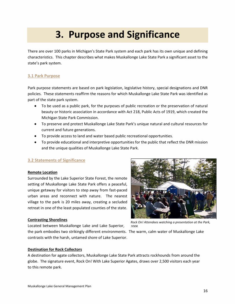
3. Purpose and SignificanceThere are over 100 parks in Michigan’s State Park system and each park has its own unique and defining characteristics. This chapter describes what makes Muskallonge Lake State Park a significant asset to the state’s park system.
3.1 Park Purpose
Park purpose statements are based on park legislation, legislative history, special designations and DNR policies. These statements reaffirm the reasons for which Muskallonge Lake State Park was identified as part of the state park system.
• To be used as a public park, for the purposes of public recreation or the preservation of naturalbeauty or historic association in accordance with Act 218, Public Acts of 1919, which created theMichigan State Park Commission.
• To preserve and protect Muskallonge Lake State Park’s unique natural and cultural resources forcurrent and future generations.
• To provide access to land and water based public recreational opportunities.• To provide educational and interpretive opportunities for the public that reflect the DNR mission
and the unique qualities of Muskallonge Lake State Park.
3.2 Statements of Significance
Remote Location Surrounded by the Lake Superior State Forest, the remote setting of Muskallonge Lake State Park offers a peaceful, unique getaway for visitors to step away from fast-paced urban areas and reconnect with nature. The nearest village to the park is 20 miles away, creating a secluded retreat in one of the least populated counties of the state.
Contrasting Shorelines Located between Muskallonge Lake and Lake Superior, the park embodies two strikingly different environments. The warm, calm water of Muskallonge Lake contrasts with the harsh, untamed shore of Lake Superior.
Destination for Rock Collectors A destination for agate collectors, Muskallonge Lake State Park attracts rockhounds from around the globe. The signature event, Rock On! With Lake Superior Agates, draws over 2,500 visitors each year to this remote park.
Rock On! Attendees watching a presentation at the Park, 2008.

Muskallonge Lake General Management Plan 17
Maritime History The park’s rich maritime history is evidenced by the remnants of one of the first Coast Guard Life Saving Stations on Lake Superior and the SS Cyprus shipwreck located off the shoreline. These reminders of Lake Superior’s “Shipwreck Coast”, along with oral and written histories, offer interesting interpretive and educational opportunities. Lumbering History Muskallonge Lake State Park includes the site of Deer Park, a lumbering town of the late 1800s situated between the lakes. Sawdust piles, dock pilings, partly submerged pine logs and narrow gauge rail beds are still visible today. Hub for Diverse Recreation Opportunities Muskallonge Lake State Park serves as a basecamp for regional recreation opportunities including Tahquamenon Falls State Park, Pictured Rocks National Lakeshore, and the Grand Marais log slide. The park also provides a stopping point along the North Country National Scenic Trail, the hiking route of the Iron Belle Trail, and the Lake Superior East Water Trail. The park offers the rare opportunity for ORV camping in the State Park system. In winter months, when visitors are few, the park comes alive again as the host of the Tahquamenon Country Sled Dog Race. Fishing Anglers find the fishery of Muskallonge Lake plentiful year round for catches of Northern Pike, Yellow Perch, Walleye, and Rock Bass. Muskallonge Lake State Park provides anglers a central point from which to explore other fishing opportunities in close proximity.
Sawdust piles from the area’s lumbering history over 100 years ago.

Muskallonge Lake General Management Plan 18
3.3 Public Affirmation of Significance Statements Stakeholder and public input assisted the Planning Team with identifying significant features and opportunities at Muskallonge Lake State Park. The feedback they provided via the online survey, the on-site workshops, and email affirmed the value of the park. Comments from stakeholders and the public further affirmed the unique characteristics of Muskallonge Lake and its significance within the State Park’s recreation system. Below are just a few comments from the online survey: What are people saying about Muskallonge Lake? “It is family tradition (we have been camping here for at least one week per summer since 1987). Great rock hunting. Lots to do when the weather is not so good.”
“Started as rock collection on Lake Superior, but now we enjoy all aspects of the state park. Beautifully kept up, clean, and great employees.”
“There is something for everyone to do.”
“Off the beaten path which allows us to better connect with each other and nature.”
“It is the most beautiful, remote, quiet campground. That has the benefit of an inland lake and Great Lake. And it is close to lots of things to do.”
“An Upper Peninsula adventure. Something way off the beaten path. Wanted to get away and unplug!
“It is our most favorite place on earth.’”

Muskallonge Lake General Management Plan 19
3.4 Relationship with the Local Community
Muskallonge Lake State Park draws over 47,000 visitors each year to this northern Luce County location, from across Michigan and from neighboring states and Canada. The Park is host of the Tahquamenon Country Sled Dog Race in the winter and the annual Rock On! With Lake Superior Agates in September, which draws local community members and international visitors to the park. Many are attracted to the park by its remote location, but it is recognized as a hub for recreational opportunities and the many attractions of the eastern Upper Peninsula. The online survey undertaken as part of this Management Plan indicated that the vast majority of visitors camping at the park include trips to Grand Marais, Tahquamenon Falls, Pictured Rocks National Lakeshore, Whitefish Point, and the Crisp Point Lighthouse during their visit. Grand Marais, the nearest community some 20 miles from the park, relies on the tourism and recreation industry. Several businesses in the vicinity of the park are also supported by park visitors, who are equally reliant on their services.

Muskallonge Lake General Management Plan 20
4. Management Zones The 20-Year Management Zone Plan was developed in keeping with the park’s significance, identity, and purpose. The primary goal in the development of the management zones is to protect the park’s resources while also preserving the opportunities and features that attract visitors to the park each year. From a palette of nine management zones, the Planning Team studied the park and applied zones that best fit, given the significant features of the park. Management zones describe a variety of activities that may be appropriate within the zone. The resource condition, visitor experience, and development level varies in each zone, as indicated in the figure below.
The Muskallonge Lake General Management Plan identifies management zone boundaries which reflects the resource protection goals and recreation development opportunities for different areas within the park. The following descriptions for each management zone describe the existing and future conditions in relation to each of the following:
• Natural Resources • Historic/Cultural Resources • Recreation Opportunities • Education Opportunities • Visitor Experience • Management Focus • Development
Management Zone Progression
Management Zone Resource Condition Visitor Experience Development Level
Ecologically Sensitive Pristine Restricted None
Primitive
Backcountry
Cultural Landscape
History Education
Scenic
Natural Resource Recreation
Developed Recreation Active Management Significant Use Extensive Development
Administrative

Muskallonge Lake General Management Plan 21
The 217-acre Muskallonge Lake State Park was divided into the following six Management Zones:
• Developed Recreation Zone • Administrative Zone • Natural Resource Recreation Zone • High Risk Erosion Zone • Cultural Landscape Zone • Scenic Zone
Any revisions to the zoning map will require public notification and the same review and approval process as the General Management Plan. Project Boundary Some parks may be approved by the Natural Resources Commission (NRC) to expand beyond their current boundaries. The 2004 NRC Project Boundary for Muskallonge Lake does not propose any changes in land ownership, which is supported by the planning team.

Muskallonge Lake General Management Plan 22
Intentionally left blank

Muskallonge Lake General Management Plan 23

Muskallonge Lake General Management Plan 24
Intentionally left blank

Muskallonge Lake General Management Plan 25

Muskallonge Lake General Management Plan 26
Intentionally left blank

Muskallonge Lake General Management Plan 27
4.1 Developed Recreation Zone
Approximately 29% of Muskallonge Lake State Park is designated Developed Recreation. This zone allows active recreation with high density of use conducted in areas not designated for natural resource significance. The Developed Recreation Zone includes most of the accessible shoreline of Muskallonge Lake and the designated campgrounds. ORV ingress and egress from the campgrounds is permitted in this zone.
Natural Resources Natural resources are actively managed and modified to support visitor activities. Vegetative management in this zone will address tree replacement, invasive species, pests and disease, and will also be allowed for purposes of facilitating development and recreational use while maintaining an aesthetically appealing landscape.
Historic / Cultural Resources There are no known historic resources within this zone. Cultural resources will generally be preserved and protected.
Recreational Opportunities High levels of recreation in a highly structured environment may be found in this zone. Visitors engage in recreation activities in diverse and modified land and water settings, which could include modern or semi-modern camping, boat launch, day-use areas, fishing areas, parking areas, and supporting amenities.
Campers utilizing campground amenities.

Muskallonge Lake General Management Plan 28
Education Opportunities Informational signage regarding invasive species control at the boat launch could be implemented. Active programming would be appropriate in areas where people congregate.
Visitor Experience A high level of visitor encounters can be accommodated. High noise tolerance and high interaction with DNR staff and other users can be expected.
Management Focus Management focuses on maintaining the use of the zone appropriate to the PRD’s mission, promoting and supporting a diversity of facilities and activities and providing a high level of accessibility.
Development A high level of development of facilities for support of visitor activities is permitted in this zone. Increased and improved camping opportunities, additional parking areas, improved access routes, and improvements for visitor accessibility are priorities in this zone.
4.2 Administrative Zone
This zone is 1% of total land and encompasses the developed areas required for program administration, operations, and the business of running the state park. While some of the park's administrative services are currently located outside of this zone, the long term goal is to relocate the park headquarters and support facilities to this location. While surrounded by the Cultural Landscape Zone, an archaeological evaluation determined that this area was suitable for development.

Muskallonge Lake General Management Plan 29
Natural Resources Natural resources are actively managed and modified to support administrative and support activities. Vegetative management is allowed (primarily tree removal for safety).
Historic / Cultural Resources There are no known historic or cultural resources within this zone, which was subject to a Phase 1 archaeological survey prior to being selected for the headquarters relocation. Cultural resources will generally be preserved and protected.
Recreational Opportunities There are no recreational activities provided in the Administrative Zone.
Education Opportunities Person to person contact at park office for general information; informational kiosk may be available.
Visitor Experience Visitors typically access the zone for business and information only. High noise tolerance and high interaction with others can be expected.
Management Focus Management focuses on the business of running the park, appropriate facilities for staff, employee safety and the like. The park will focus on fully implementing the relocation of the park headquarters from its lakeshore location.
Development Chosen as the area for relocation of the new park headquarters, a high level of development of facilities and high levels of accessibility are expected in this zone.
Construction of new park headquarters forced to relocate due to erosion, summer 2015.

Muskallonge Lake General Management Plan 30
4.3 Natural Resource Recreation Zone
Approximately 29% of Muskallonge Lake State Park is zoned Natural Resource Recreation. This zone provides for active recreation with medium to high density of use conducted in natural areas. The Natural Resource Recreation area is located west of the designated campgrounds, north and south of County Road 407. The area is heavily wooded and contains parts of the park’s trail system and a portion of the Muskallonge Lake shoreline. While the zone designation emphasizes resource protection, landscape modification is permitted to allow for moderate interaction and recreation, as well as more intensively used trail corridors. Natural Resources Natural resources support visitor activities with moderate impacts. This zone reflects natural processes, with vegetative management focused on restoring and maintaining natural ecological structure and processes (such as removing of invasive species), to address hazard trees, and to manage pests and disease. Vegetation may also be managed to facilitate recreational use and to maintain an aesthetically appealing landscape. Historic / Cultural Resources There are no known historic structures within this zone. Cultural resources will generally be preserved and protected.
Park trail.

Muskallonge Lake General Management Plan 31
Recreational Opportunities Moderate to high levels of recreation compatible with the natural character of the zone are to be expected. Visitors may be engaged in outdoor activities in diverse land and water natural settings, including hiking, rustic camping, canoeing, kayaking, nature observation.
Education Opportunities Interpretive signage may be used along trails and at specific points of interest.
Visitor Experience Visitors may be engaged in outdoor activities in diverse land and water natural settings for recreation and education. Variable time commitment, challenge and adventure; moderate noise tolerance and interaction with DNR staff and moderate to high visitor encounters can be accommodated.
Management Focus Management focuses on maintaining the use of the zone appropriate to the PRD’s mission. Public safety, protection of resources, and improved visitor accessibility are management priorities.
Development A moderate level of development of facilities for support of visitor activities is permitted in this zone. Examples of potential development at Muskallonge Lake includes camper cabins for year-round use. This zone allows site hardening as necessary to facilitate activities (such as ADA compliance) and to protect natural resources.

Muskallonge Lake General Management Plan 32
4.4 High Risk Erosion Zone
The High Risk Erosion Zone at Muskallonge Lake State Park has been applied to approximately 4,500 linear feet of Lake Superior shoreline, and a total of 12% of the park, running from the campground entrance drive and beach access walkway to the west boundary of the park. The zone varies in width from 220 to 360 feet and recognizes the high rate of active erosion that has been occurring long-term along the Lake Superior shoreline within the park. The primary focus of this zone is to manage the area in recognition of the continued rate of coastal recession. While some park infrastructure is currently located within this zone, the intent is to remove the infrastructure at risk over time and allow only limited and temporary recreational development in the future.
Natural Resources This zone will generally reflect natural processes, but will allow for active vegetative management techniques focused on protecting the shoreline from erosion. Vegetation may also be managed to maintain the viewscapes of the zone, but only if this will not exacerbate the rate of erosion (i.e. root systems should remain intact). Historic/Cultural Resources Cultural resources will be preserved as far as possible. Resources threatened by erosion should be recorded and monitored and may be removed with the appropriate approvals. There are no historic structures in this zone.
Erosion along the park’s Lake Superior shore.
Muskallonge Lake General Management Plan 33
Recreation Opportunities Low levels of recreation compatible with the purpose of viewing and beach access is permitted. Public access within the zone will be restricted for safety reasons and to reduce human induced erosion. This zone will transition over time to foot traffic only. Education Opportunities Education and interpretation of the shoreline processes should be explored. Interpretation will generally be outside the boundaries of the zone. Visitor Experience Due to the desire for park visitors to walk on the beach, swim, pick rocks, and take in scenic vistas, there may be a moderate level of visitor encounters in this zone. Management Focus Management focus within the High Risk Erosion Zone will be on public safety and the relocation of park infrastructure out of the zone. Management will take into account the 2014 Muskallonge Lake State Park Lake Superior Shoreline Erosion Study, and other studies of lakeshore recession in the park. Continued monitoring of the lakeshore will help to inform management decisions. Management will include the phased removal of infrastructure from the zone in response to the threat of bluff recession. Controlled access to reduce human induced erosion will be expected. Low-impact management techniques to reduce the rate of erosion may be employed. The quality of the coastal viewscapes will be maintained and upheld. Development Low level of development to support controlled beach access and sightseeing is permitted. Development will blend with the natural environment and may include foot trails and limited site hardening (i.e. beach access stairways, barriers and fencing).

Muskallonge Lake General Management Plan 34
4.5 Cultural Landscape Zone
Approximately 24% of Muskallonge Lake State Park is designated as Cultural Landscape Zone in recognition of the historic and cultural significance. This zone includes the remnants of Deer Park, as well as the former Coast Guard Life Saving Station. It is also likely an area of high sensitivity to the presence of prehistoric and historic Native American resources. The central focus of the Cultural Landscape Zone is managing the area to preserve its historical and cultural features. Natural Resources This zone will reflect natural processes, with vegetative management only allowed to restore and maintain natural ecological structure and processes (such as removing invasive species), to address hazard trees, and to manage pests and disease. Vegetation may also be managed to enhance education/interpretation uses which can include non-native species specific to the era and/or location, and maintaining an aesthetically appealing landscape that is sensitive to the historical resource and interpretation of the zone. Historic/Cultural Resources Historic remnants within the park are the focus of this zone and represent the area’s history. Sawdust piles, dock pilings, partly submerged pine logs, rail beds, and what remains of the Life Saving Station will be managed in compliance with the Secretary of the Interior’s Standards for Historic Preservation and in consultation with the State Historic Preservation Office. Informational placard on the local history.
Muskallonge Lake General Management Plan 35
Recreation Opportunities Visitors engage in sightseeing, recreational and educational activities compatible with and sensitive to the cultural setting. Education Opportunities Education and interpretation of the park’s history should be explored both on and off-site. This may include interpretive signage. Visitor Experience Visitors engage in sightseeing, and potential educational and interpretive activities. Moderate noise tolerance, and interaction with DNR staff, other visitors, and volunteers is characteristic of this zone. Management Focus Management focus is to maintain the cultural and historical character of the zone. Development Non-historic development and activities that do not conflict with the cultural landscape are tolerated. A moderate level of development compatible with the cultural landscape is permitted such as interpretive media, walks, and amenities to support visitor access and use.

Muskallonge Lake General Management Plan 36
4.6 Scenic Zone
Approximately 5% of Muskallonge Lake State Park is designated Scenic Zone. The zone protects and preserves the scenic viewscapes offered at the park. The Scenic Zone extends along the entire Lake Superior shoreline, as well as the viewing platform located at the eastern end of the park, and provides visitors with picturesque views of Lake Superior Natural Resources While natural resources and vegetation may be modified slightly to support visitor use and viewing, there is low tolerance for adverse impacts on the natural resources. The zone will reflect natural processes, with vegetative management allowed to restore and maintain ecological structure and processes, and to maintain or enhance the viewscapes. Historic/Cultural Resources There are no known historic resources within this zone. Cultural resources will generally be preserved and protected. Recreation Opportunities With the focus of this zone on the scenic viewscapes, only moderate levels of recreation compatible with the viewscapes will be permitted. Recreation activity will typically take place on the trails and at observation points along the shoreline Education Opportunities This zone presents an educational opportunity for visitors to learn about Lake Superior, as well as the erosion process at key locations such as trailheads and observation points.
Muskallonge Lake General Management Plan 37
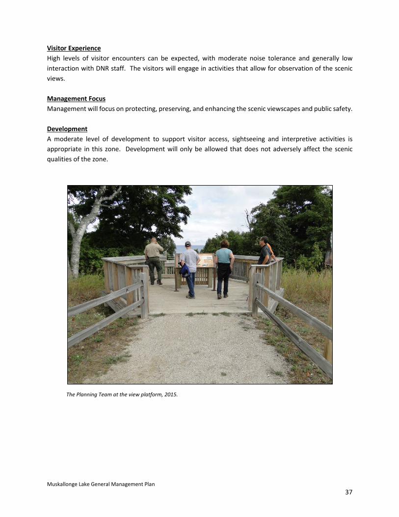
Visitor Experience High levels of visitor encounters can be expected, with moderate noise tolerance and generally low interaction with DNR staff. The visitors will engage in activities that allow for observation of the scenic views. Management Focus Management will focus on protecting, preserving, and enhancing the scenic viewscapes and public safety. Development A moderate level of development to support visitor access, sightseeing and interpretive activities is appropriate in this zone. Development will only be allowed that does not adversely affect the scenic qualities of the zone.
The Planning Team at the view platform, 2015.

Muskallonge Lake General Management Plan 38
5. 10-Year Action Goals The Action Goals proposed for Muskallonge Lake State Park were developed by the Planning Team in response to stakeholder and public input and in context with the core values and guiding resources discussed in Chapter 1 of this plan, including the Blue Ribbon Panel Report to Governor Snyder. The top reasons visitors come to Muskallonge Lake State Park, according to the online survey, are for its quiet, remote and scenic location on Lake Superior. The Action Goals proposed continue to recognize those features while making necessary improvements to existing infrastructure and amenities at the park. Providing greater education and interpretation opportunities, through the proposed addition of an interpretative trail and by expanding seasonal programming at the park, will add to the appreciation of the natural and cultural resources the park and the area has to offer. The region is known for its outdoor recreation and opportunities for exploration. Muskallonge Lake State Park is the perfect base for such activities with direct access to the NCNST, Iron Belle Trail, Lake Superior East Water Trail and nearby expansive state forest land, rivers and lakes. Continuing to work with the local community, event planners and regional partners will provide mutual benefits for the park, its visitors and the Eastern Upper Peninsula Planning Region. The Planning Team has developed 10-Year Action Goals that it believes are necessary to guide management and development within the park as a whole, and the six designated management zones, in order to achieve the desired user experience. For each management zone in the plan, action goals are recommended that address one or more of the following categories:
• Natural Resources • Historic/Cultural Resources • Recreation Opportunities • Education/Interpretation Opportunities • Management Focus • Development
Management Plans do not guarantee future PRD funding to implement them, but are based on funding realities and sound investment policies. PRD will seek internal funding, alternative funding sources, partnerships and other potential mechanisms for implementing the desired future conditions defined in this plan. The 10-Year Action Goals address the desired future condition at the park, and serve as a blueprint for management decisions.

Muskallonge Lake General Management Plan 39
General Action Goals Many of the 10-Year Action Goals for Muskallonge Lake State Park are general in nature and apply
within all of the management zones. These often deal with park-wide issues, such as invasive species control, universal access, trails that cross zone boundaries, or marketing the park's many recreational
opportunities to a wider audience of potential users. Many of the overall maintenance and operational issues of running a state park also result in the need for actions across all zone
boundaries, such as law enforcement.
Action Goals Target
Completion Date
Program Input From Responsible Program Position
Natural Resources
Implement land and water based invasive species control Ongoing
Park Manager Stewardship
Fisheries Wildlife
Stewardship Fisheries Wildlife
Develop a Stewardship Plan that identifies conservation targets and priorities for resource management and stewardship
5-10 years Stewardship Park Manager
Stewardship Ecologist
Historic/ Cultural Resources Fund through Stewardship Unit the completion of a Phase 1 archaeological survey for the balance of the park not already inventoried
1 Year Park Manager Stewardship
State Archaeologist Stewardship
Recreation Opportunities Continue to manage Muskallonge Lake in accordance with management prescriptions to establish/maintain it as a fishing destination
Ongoing Park Manager Fisheries Fisheries
Continue partnership with EUPRPDC to support the Lake Superior East Water Trail and provide base line water trail user amenities
Ongoing Park Manager
EUPRPDC Trails Specialist
Park Manager
Formalize the reroute of the North Country National Scenic Trail and Iron Belle Trail 1 Year
Park Manager Regional Planner Trails Specialist
Stewardship NCNST
Park Manager
Improve shore fishing angler access with pier and structures such as crib, tree drop, and other methods to be determined
5-10 Years Park Manager
Regional Planner Fisheries
Park Manager Fisheries
Education/Interpretive Opportunities
Bring a seasonal interpreter/explorer guide to the park 5-10 Years Park Manager
Marketing & Outreach Park Manager
Install/develop an interpretive trail focusing on the park’s heritage and natural resources.
5-10 Years
Park Manager Marketing & Outreach
Stewardship Regional Planner
State Archaeologist
Park Manager

Muskallonge Lake General Management Plan 40
General Action Goals
Action Goals Target
Completion Date
Program Input From Responsible Program Position
Management
Continue to relocate existing infrastructure in response to lakeshore erosion Ongoing Park Manager
Regional Planner Park Manager
Regional Planner
Evaluate park lighting for Dark Sky compliance * Ongoing Park Manager
Regional Planner Park Manager
Work with partners to promote park as Dark Sky destination* Ongoing
Park Manager Marketing & Outreach
Partners Park Manager
Establish partnerships with businesses to enhance visitor experience Ongoing Park Manager Park Manager
Continue to review and update capital outlay list as needed Annual
District Supervisor Park Manager
Regional Planner Park Manager
Continue to review and monitor infrastructure needs based on visitor use and trends
Annual Park Manager Regional Planner Park Manager
Evaluate options for overflow vehicle storage 5-10 Years Park Manager
Regional Planner Park Manager
Evaluate and expand park’s WiFi service to campground areas if financially sustainable 5-10 Years Park Manager
Regional Planner Park Manager
Continue to monitor and explore partnerships or commercial services that will provide the opportunity to enhance cell phone service at the park
5-10 Years Park Manager Regional Planner Park Manager
Development
Implement phased capital outlay projects as funds become available Ongoing
District Supervisor Park Manager
Regional Planner Park Manager
EUPRPDC = Eastern Upper Peninsula Regional Planning and Development Commission NCNST = North Country National Scenic Trail * State Legislation relating to dark sky preserve designation excludes establishment in the Upper Peninsula, however the park may still be managed and promoted for night sky viewing or for consideration as an International Dark Sky Preserve.
Muskallonge Lake General Management Plan 41
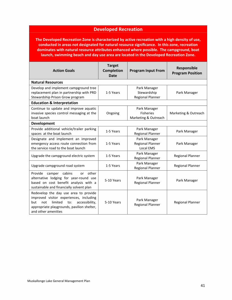
Developed Recreation
The Developed Recreation Zone is characterized by active recreation with a high density of use, conducted in areas not designated for natural resource significance. In this zone, recreation
dominates with natural resource attributes enhanced where possible. The campground, boat launch, swimming beach and day use area are located in the Developed Recreation Zone.
Action Goals Target
Completion Date
Program Input From Responsible Program Position
Natural Resources Develop and implement campground tree replacement plan in partnership with PRD Stewardship Prison Grow program
1-5 YearsPark Manager Stewardship
Regional Planner Park Manager
Education & Interpretation Continue to update and improve aquatic invasive species control messaging at the boat launch
Ongoing Park Manager
Fisheries Marketing & Outreach
Marketing & Outreach
Development Provide additional vehicle/trailer parking spaces at the boat launch 1-5 Years Park Manager
Regional Planner Park Manager
Designate and implement an improved emergency access route connection from the service road to the boat launch
1-5 YearsPark Manager
Regional Planner Local EMS
Park Manager
Upgrade the campground electric system 1-5 Years Park Manager Regional Planner Regional Planner
Upgrade campground road system 1-5 Years Park Manager Regional Planner Regional Planner
Provide camper cabins or other alternative lodging for year-round use based on cost benefit analysis with a sustainable and financially solvent plan
5-10 Years Park Manager Regional Planner Park Manager
Redevelop the day use area to provide improved visitor experiences, including but not limited to: accessibility, appropriate playgrounds, pavilion shelter, and other amenities
5-10 Years Park Manager Regional Planner Regional Planner
Muskallonge Lake General Management Plan 42
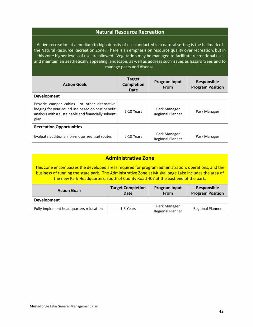
Natural Resource Recreation
Active recreation at a medium to high density of use conducted in a natural setting is the hallmark of the Natural Resource Recreation Zone. There is an emphasis on resource quality over recreation, but in
this zone higher levels of use are allowed. Vegetation may be managed to facilitate recreational use and maintain an aesthetically appealing landscape, as well as address such issues as hazard trees and to
manage pests and disease.
Action Goals Target
Completion Date
Program Input From
Responsible Program Position
Development
Provide camper cabins or other alternative lodging for year-round use based on cost benefit analysis with a sustainable and financially solvent plan
5-10 Years Park Manager Regional Planner Park Manager
Recreation Opportunities
Evaluate additional non-motorized trail routes 5-10 Years Park Manager Regional Planner Park Manager
Administrative Zone This zone encompasses the developed areas required for program administration, operations, and the business of running the state park. The Administrative Zone at Muskallonge Lake includes the area of
the new Park Headquarters, south of County Road 407 at the east end of the park.
Action Goals Target Completion Date
Program Input From
Responsible Program Position
Development
Fully implement headquarters relocation 1-5 Years Park Manager Regional Planner Regional Planner
Muskallonge Lake General Management Plan 43
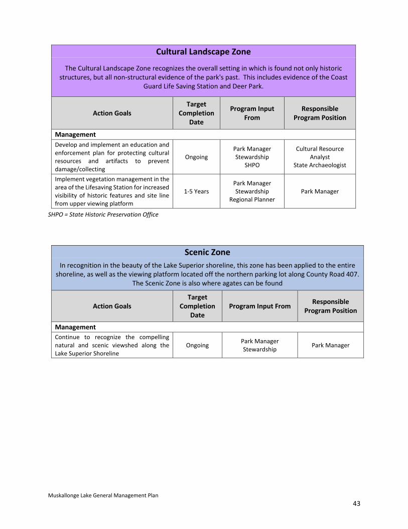
Cultural Landscape Zone
The Cultural Landscape Zone recognizes the overall setting in which is found not only historic structures, but all non-structural evidence of the park's past. This includes evidence of the Coast
Guard Life Saving Station and Deer Park.
Action Goals Target
Completion Date
Program Input From
Responsible Program Position
Management Develop and implement an education and enforcement plan for protecting cultural resources and artifacts to prevent damage/collecting
Ongoing Park Manager Stewardship
SHPO
Cultural Resource Analyst
State Archaeologist
Implement vegetation management in the area of the Lifesaving Station for increased visibility of historic features and site line from upper viewing platform
1-5 Years Park Manager Stewardship
Regional Planner Park Manager
SHPO = State Historic Preservation Office
Scenic Zone In recognition in the beauty of the Lake Superior shoreline, this zone has been applied to the entire
shoreline, as well as the viewing platform located off the northern parking lot along County Road 407. The Scenic Zone is also where agates can be found
Action Goals Target
Completion Date
Program Input From Responsible Program Position
Management Continue to recognize the compelling natural and scenic viewshed along the Lake Superior Shoreline
Ongoing Park Manager Stewardship Park Manager
Muskallonge Lake General Management Plan 44
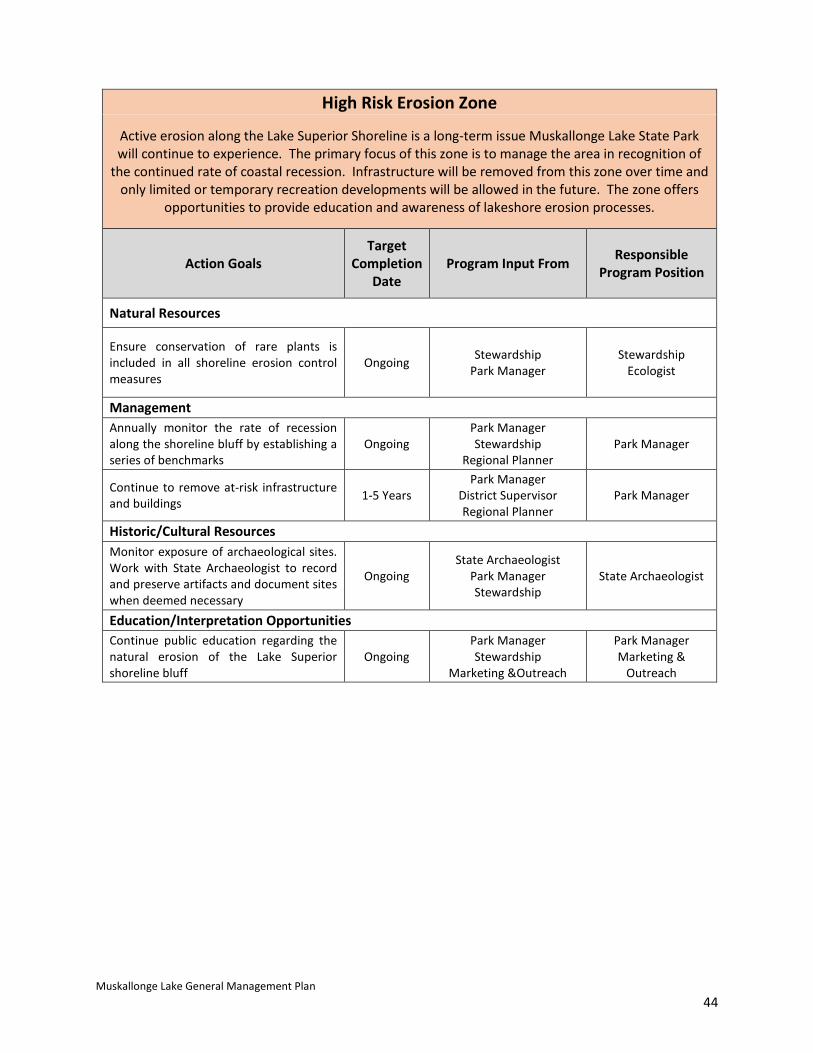
High Risk Erosion Zone
Active erosion along the Lake Superior Shoreline is a long-term issue Muskallonge Lake State Park will continue to experience. The primary focus of this zone is to manage the area in recognition of
the continued rate of coastal recession. Infrastructure will be removed from this zone over time and only limited or temporary recreation developments will be allowed in the future. The zone offers
opportunities to provide education and awareness of lakeshore erosion processes.
Action Goals Target
Completion Date
Program Input From Responsible Program Position
Natural Resources
Ensure conservation of rare plants is included in all shoreline erosion control measures
Ongoing Stewardship Park Manager
Stewardship Ecologist
Management Annually monitor the rate of recession along the shoreline bluff by establishing a series of benchmarks
Ongoing Park Manager Stewardship
Regional Planner Park Manager
Continue to remove at-risk infrastructure and buildings 1-5 Years
Park Manager District Supervisor Regional Planner
Park Manager
Historic/Cultural Resources Monitor exposure of archaeological sites. Work with State Archaeologist to record and preserve artifacts and document sites when deemed necessary
Ongoing State Archaeologist
Park Manager Stewardship
State Archaeologist
Education/Interpretation Opportunities Continue public education regarding the natural erosion of the Lake Superior shoreline bluff
Ongoing Park Manager Stewardship
Marketing &Outreach
Park Manager Marketing &
Outreach