draft environmental impact assessment and environmental
TRANSCRIPT

Draft Environmental Impact Assessment and
Environmental Management Programme
For The
Amendment of the Existing EMP and Inclusion of
Listed Activities Associated with Operations at
Driefontein Mining Right Area, Sibanye Gold Limited
DMR Reference Number: GP 30/5/1/2/2 (55) MR
January 2016
SUBMITTED FOR ENVIRONMENTAL AUTHORISATIONS IN TERMS OF THE NATIONAL
ENVIRONMENTAL MANAGEMENT ACT, 1998 (ACT NO. 107 OF 2008) (NEMA) AND THE
NATIONAL ENVIRONMENTAL MANAGEMENT: WASTE ACT, 2008 (ACT NO. 59 OF 2008)
(NEM:WA) IN RESPECT OF LISTED ACTIVITIES THAT HAVE BEEN TRIGGERED BY
APPLICATIONS IN TERMS OF THE MINERAL AND PETROLEUM RESOURCES
DEVELOPMENT ACT, 2002 (ACT NO. 28 of 2008) AS AMENDED (MPRDA).
NAME OF APPLICANT: Sibanye Gold Limited
TEL NO: +27 11 278 5061
FAX NO: +27 86 295 5752
POSTAL ADDRESS: Private Bag X5, Westonaria, South Africa, 1780
PHYSICAL ADDRESS: Libanon Business Park, 1 Hospital Street (off Cedar
Avenue), Libanon, Westonaria, 1780
FILE REFERENCE NUMBER SAMRAD:
Digby Wells Environmental i
This document has been prepared by Digby Wells Environmental.
Report Type: Draft Environmental Impact Assessment and Environmental
Management Programme
Project Name:
Amendment of the Existing EMP and Inclusion of Listed
Activities Associated with Operations at Driefontein Mining
Right Area, Sibanye Gold Limited
Project Code: GOL2376
Name Responsibility Signature Date
Duncan Pettit Report Writer
November 2015
Marcelle Radyn Project Manager
January 2016
This report is provided solely for the purposes set out in it and may not, in whole or in part, be used for any other purpose
without Digby Wells Environmental prior written consent.
Draft Environmental Impact Assessment and Environmental Management Programme
Amendment of the Existing EMP and Inclusion of Listed Activities Associated with Operations at Driefontein Mining Right Area, Sibanye Gold Limited
GOL2376
Digby Wells Environmental ii
IMPORTANT NOTICE
In terms of the Mineral and Petroleum Resources Development Act, 2002 (Act No. 28 of
2002) as amended (MPRDA), the Minister must grant a Prospecting or Mining Right if
among others the mining “will not result in unacceptable pollution, ecological degradation or
damage to the environment”.
Unless an Environmental Authorisation can be granted following the evaluation of an
Environmental Impact Assessment (EIA) and an Environmental Management Programme
(EMP) report in terms of the National Environmental Management Act, 1998 (Act No. 107 of
1998) (NEMA), it cannot be concluded that the said activities will not result in unacceptable
pollution, ecological degradation or damage to the environment.
In terms of section 16(3)(b) of the EIA Regulations, 2014, any report submitted as part of an
application must be prepared in a format that may be determined by the Competent
Authority and in terms of section 17 (1) (c) the Competent Authority must check whether the
application has taken into account any minimum requirements applicable or instructions or
guidance provided by the competent authority to the submission of applications.
It is therefore an instruction that the prescribed reports required in respect of applications for
an Environmental Authorisation for listed activities triggered by an application for a right or a
permit are submitted in the exact format of, and provide all the information required in terms
of this template. Furthermore please be advised that failure to submit the information
required in the format provided in this template will be regarded as a failure to meet the
requirements of the Regulation and will lead to the Environmental Authorisation being
refused.
It is furthermore an instruction that the Environmental Assessment Practitioner (EAP) must
process and interpret his/her research and analysis and use the findings thereof to compile
the information required herein. (Unprocessed supporting information may be attached as
appendices). The EAP must ensure that the information required is placed correctly in the
relevant sections of the Report, in the order, and under the provided headings as set out
below, and ensure that the report is not cluttered with un-interpreted information and that it
unambiguously represents the interpretation of the applicant.
Draft Environmental Impact Assessment and Environmental Management Programme
Amendment of the Existing EMP and Inclusion of Listed Activities Associated with Operations at Driefontein Mining Right Area, Sibanye Gold Limited
GOL2376
Digby Wells Environmental iii
OBJECTIVE OF THE ENVIRONMENTAL IMPACT
ASSESSMENT PROCESS
The objective of the EIA process is to, through a consultative process: -
■ determine the policy and legislative context within which the activity is located and
document how the proposed activity complies with and responds to the policy and
legislative context;
■ describe the need and desirability of the proposed activity, including the need and
desirability of the activity in the context of the preferred location;
■ identify the location of the development footprint within the preferred site based on an
impact and risk assessment process inclusive of cumulative impacts and a ranking
process of all the identified development footprint alternatives focusing on the
geographical, physical, biological, social, economic, heritage and cultural aspects of
the environment;
■ determine the: -
nature, significance, consequence, extent, duration and probability of the impacts
occurring to inform identified preferred alternatives; and
degree to which these impacts: -
can be reversed;
may cause irreplaceable loss of resources, and
can be avoided, managed or mitigated.
■ identify the most ideal location for the activity within the preferred site based on the
lowest level of environmental sensitivity identified during the assessment;
■ identify, assess, and rank the impacts the activity will impose on the preferred
location through the life of the activity;
■ identify suitable measures to manage, avoid or mitigate identified impacts; and
■ identify residual risks that need to be managed and monitored.
Draft Environmental Impact Assessment and Environmental Management Programme
Amendment of the Existing EMP and Inclusion of Listed Activities Associated with Operations at Driefontein Mining Right Area, Sibanye Gold Limited
GOL2376
Digby Wells Environmental iv
EXECUTIVE SUMMARY
Digby Wells Environmental (Digby Wells) was appointed by Sibanye Gold Limited (SGL) to
conduct the Environmental Impact Assessment (EIA) process for the West Rand Tailings
Retreatment Project (WRTRP) in Gauteng, South Africa.
The EIA is considered a tool with which to identify and manage potential impacts on the
environment as a result of a particular project. Environmental risks associated with such a
project or development are also identified and mitigation measures are proposed. The
completion of an EIA is a regulatory requirement in terms of the provisions of the National
Environmental Management Act, 1998, as amended (NEMA) and the EIA process which is
regulated in accordance with the Environmental Impact Assessment Regulations, 20141 (the
EIA 2014 Regulations). The overarching purpose of the EIA process is to determine, assess
and evaluate the consequences (positive and negative) of a proposed development, activity
or project. The objectives of this EIA and EMP report are to:
■ Detail policies and legislation relevant to the activity;
■ Motivate the need and desirability of the proposed activity;
■ Detail and confirm the preferred activity and alternative(s);
■ Determine and assess the significance of the potential impacts of the project
including the nature, consequence, extent, duration and probability of the impacts;
■ Determine the most ideal location for the activity;
■ Determine suitable measures to manage, avoid or mitigate identified impacts; and
■ Determine residual risks that need to be managed and monitored.
The Scoping Report for the project was compiled and submitted for public review from 15
September to 6 November 2015. Comments and issues raised by Interested and Affected
Parties (I&APs) were recorded and responded to before the Scoping Report was updated
and submitted to the Department of Mineral Resources (DMR) on 13 November 2015. In
parallel to the scoping phase specialist studies were undertaken to determine the baseline of
the receiving environment. Following the acceptance of the Scoping Report, specialist
studies were finalised and all additional requirements of the IAPs and competent authorities
taken into consideration. The studies assessed the significance of the potential impacts
associated with the project’s activities and proposed mitigation and management measures
to mitigate adverse impacts and enhance benefits.
1 GN R982 published in Government Gazette 38282 of 4 December 2014

Draft Environmental Impact Assessment and Environmental Management Programme
Amendment of the Existing EMP and Inclusion of Listed Activities Associated with Operations at Driefontein Mining Right Area, Sibanye Gold Limited
GOL2376
Digby Wells Environmental v
Project Overview
The broader West Rand, including Carletonville in the far west to Randfontein in the
northeast and including Westonaria centrally, contains an estimated 1.3 billion tonnes of
surface gold and uranium tailings with approximately 170 million pounds of recoverable
uranium and 11 million ounces of recoverable gold. SGL, as the current majority owner of
these resources, plans to exploit the tailings to develop a strong, long life and high yield
surface mining business. Key to the successful execution of this business growth and
development strategy is the WRTRP.
Project Applicant
GFI Mining South Africa (Pty) Limited, (Registration Number 2002/031431/07) was, prior to
February 2013, a subsidiary within the Gold Fields Group. In early 2013, Gold Fields
unbundled its Kloof Driefontein Complex (KDC) and Beatrix gold mines in the Free State to
create SGL (Registration Number 2002/031431/06), listed as a fully independent company
on both the JSE and the NYSE Stock Exchanges.
In parallel in 2012, Gold One International Limited (Gold One) acquired Rand Uranium
Limited (Rand Uranium) and in the same year acquired Ezulwini Mining Company (Pty) Ltd
(Ezulwini) in an agreement with First Uranium Corporation.
Subsequently, in October 2013, SGL acquired the interest held by Gold One in Rand
Uranium and Ezulwini. These Gold One assets are now part of Sibanye Gold, and comprise
the Cooke Operations (underground mining and reclamation operations), that currently
produce gold and uranium.
Table I: Contact details for SGL
Company name: Sibanye Gold Limited
Contact person: Mr Grant Stuart
Physical address: Libanon Business Park, 1 Hospital Street (off Cedar Avenue), Libanon,
Westonaria, 1780
Telephone: +27 11 278 5061
Cell phone: +27 82 602 5992
Email: [email protected]
Environmental Consultants
Digby Wells was appointed by SGL as the independent Environmental Assessment
Practitioner (EAP) to undertake the Scoping and EIA processes. The contact details for
Digby Wells are set out in Table II.
Draft Environmental Impact Assessment and Environmental Management Programme
Amendment of the Existing EMP and Inclusion of Listed Activities Associated with Operations at Driefontein Mining Right Area, Sibanye Gold Limited
GOL2376
Digby Wells Environmental vi
Table II: Contact Details for Digby Wells
Company name: Digby Wells Environmental
Contact person: Mr Marcelle Radyn
Physical address: Digby Wells House, Turnberry Office Park, 48 Grosvenor Road, Bryanston,
2191
Telephone: +27 11 789 9495
Cell phone: +27 82 442 1405
Email: [email protected]
Project History
Prior to the creation of SGL, Gold Fields had embarked on a project known as the West Wits
Project (WWP), aimed at retreating Tailings Storage Facilities (TSFs) on the West Rand. Its
intention was to recover residual gold, uranium and sulfur through a central processing plant,
where viable, and storing the residual tailings on a proposed Centralised TSF (CTSF) near
South Deep’s existing Doornpoort TSF.
Similarly Rand Uranium had embarked on the Cooke Uranium Project (CUP) which
endeavoured to treat the Cooke TSF for gold, uranium and sulfur and ultimately deposit the
residual tailings on to the proposed Geluksdal TSF. The CUP and WWP were essentially
two independent projects with similar broad objectives, processing infrastructure and
deposition sites and within a 25 km radius of each other.
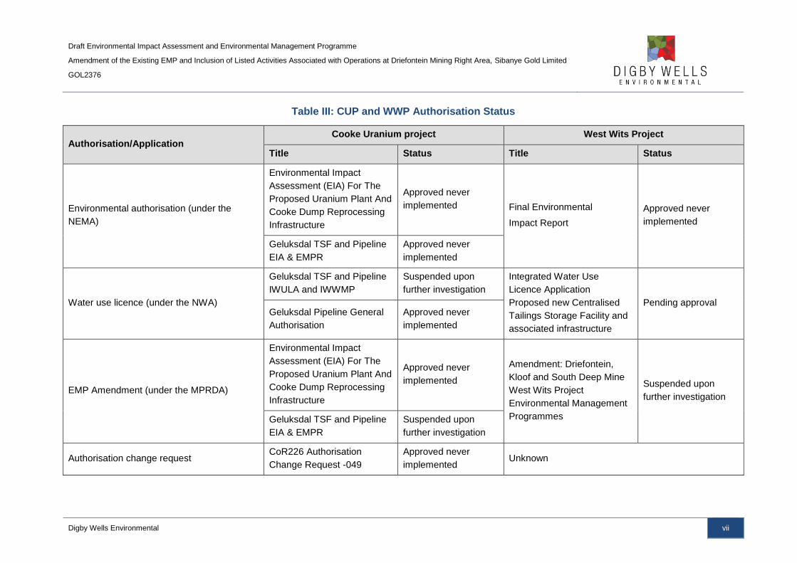
Elements of the CUP and WWP projects have been approved and authorised, as indicated
in Table III, although not in their entirety. Stakeholders and departments expressed concern
over the implementation of two similar projects in proximity to one another and the
accumulation of their impacts. It was proposed that these projects be combined to provide a
consolidated solution for the region.
The WRTRP therefore integrates the WWP and CUP into one project, where up to 13
current and historical TSFs and current arising tailings will be centrally processed through a
new proposed Central Processing Plant (CPP) and the residue deposited onto a new
proposed Regional TSF (RTSF). A Return Water Dam (RWD) will be constructed adjacent to
the RSTF to contain any potential water runoff, with the water to be treated at an Advanced
Water Treatment Facility (AWTF).
As stated, should one of the elements of the WRTRP not be authorised, the entire project
would be unable to proceed. In this case SGL will revert back to the CUP and WWP projects
and further pursue the approval of the outstanding applications.
Draft Environmental Impact Assessment and Environmental Management Programme
Amendment of the Existing EMP and Inclusion of Listed Activities Associated with Operations at Driefontein Mining Right Area, Sibanye Gold Limited
GOL2376
Digby Wells Environmental vii
Table III: CUP and WWP Authorisation Status
Authorisation/Application Cooke Uranium project West Wits Project
Title Status Title Status
Environmental authorisation (under the
NEMA)
Environmental Impact
Assessment (EIA) For The
Proposed Uranium Plant And
Cooke Dump Reprocessing
Infrastructure
Approved never
implemented Final Environmental
Impact Report
Approved never
implemented
Geluksdal TSF and Pipeline
EIA & EMPR
Approved never
implemented
Water use licence (under the NWA)
Geluksdal TSF and Pipeline
IWULA and IWWMP
Suspended upon
further investigation
Integrated Water Use
Licence Application
Proposed new Centralised
Tailings Storage Facility and
associated infrastructure
Pending approval Geluksdal Pipeline General
Authorisation
Approved never
implemented
EMP Amendment (under the MPRDA)
Environmental Impact
Assessment (EIA) For The
Proposed Uranium Plant And
Cooke Dump Reprocessing
Infrastructure
Approved never
implemented
Amendment: Driefontein,
Kloof and South Deep Mine
West Wits Project
Environmental Management
Programmes
Suspended upon
further investigation
Geluksdal TSF and Pipeline
EIA & EMPR
Suspended upon
further investigation
Authorisation change request CoR226 Authorisation
Change Request -049
Approved never
implemented Unknown
Draft Environmental Impact Assessment and Environmental Management Programme
Amendment of the Existing EMP and Inclusion of Listed Activities Associated with Operations at Driefontein Mining Right Area, Sibanye Gold Limited
GOL2376
Digby Wells Environmental viii
Project Description
There is a long history of gold and uranium mining in the broader West Rand area which has
resulted in tailings containing in excess of 170 million pounds of uranium and 11 million
ounces of gold. SGL, through the unbundling from Gold Fields and the acquisition of Gold
One and Ezulwini, currently owns the majority of the tailings in the area and its gold and
uranium resources.
The key to capitalising these resources successfully relies on the execution of the WRTRP.
The concept of the WRTRP is well understood with an 8 year history of extensive
metallurgical test work, environmental studies, feasibility studies and design by a number of
major mining houses. A pre-feasibility study (PFS) completed during 2013 for the WRTRP
has confirmed that there is a significant opportunity to extract value from the SGL surface
resources in a cost effective sequence.
The implementation of the WRTRP will be done in phases to achieve the objectives of the
ultimate project. The Ultimate Project and the Initial Implementation are detailed below.
Ultimate Project
SGL’s historical TSF holdings in the West Rand can be divided into four Mining Rights: the
Cooke, Ezulwini, Kloof and Driefontein Mining Rights. Each of these Mining Rights (other
than Ezulwini) contains a number of historical TSFs which will ultimately be reclaimed during
the life of the WRTRP:
■ Kloof Mining Right area: Kloof 1 TSF, Kloof 2 TSF, Leeudoorn TSF, Libanon TSF,
Venterspost North and Venterspost South TSFs. Venterspost North and South TSFs
will be processed with the concurrent construction of Module 2 floatation and gold
plants of the CPP. The remainder of the TSFs will be processed once Module 3 has
been constructed. It must be noted that although the reclamation of Venterspost
North and South TSFs are not part of this EIA, the inclusion of the TSFs into the
Kloof Mining Right area is part of this EIA and Section 102 amendment submitted to
the DMR;
■ Driefontein Mining Right area: Driefontein 1, 2, 3, 4 and 5 TSF. Once the Driefontein
3 and 5 TSFs have been reclaimed, the remainder of the Driefontein TSFs, namely
Driefontein 1, 2 and 4 TSFs, will be processed through the CPP. The Driefontein 4
TSF currently falls outside the Driefontein Mining Right area; the inclusion of
Driefontein 4 TSF into the Driefontein Mining Right area is part of this EIA and
Section 102 amendment submitted to the DMR;
■ Cooke Mining Right area: C4S TSF, Cooke TSF and the Millsite Complex (38, 39
and 40/41 and Valley) TSFs. Millsite Complex will be processed with the concurrent
construction of Module 2 floatation and gold plants; and
■ Ezulwini Mining Right area: No TSFs fall within the Ezulwini Mining Right. Uranium
will be processed at the Ezulwini Plant and new pipelines will be constructed.
Draft Environmental Impact Assessment and Environmental Management Programme
Amendment of the Existing EMP and Inclusion of Listed Activities Associated with Operations at Driefontein Mining Right Area, Sibanye Gold Limited
GOL2376
Digby Wells Environmental ix
Once commissioned the project will initially reclaim and treat the TSFs at a rate of 1.5 million
tonnes per month (Mt/m) (1 Mt/m from Driefontein 3 TSF, followed sequentially by
Driefontein 5 and C4S TSFs and 0.5 Mt/m from Cooke TSF). Reclamation and processing
capacity will ultimately ramp up to 4 Mt/m over an anticipated period of 8 years. At the 4
Mt/m tailings retreatment capacity, each of the Mining Right areas will be reclaimed and
processed simultaneously.
The ultimate WRTRP involves the construction of a large-scale CPP for the recovery of gold,
uranium and sulfur from the available resources. The CPP, centrally located to the West
Rand resources, will be developed in phases/modules to treat eventually up to 4 Mt/m of
tailings inclusive of current underground arisings. The resultant tailings will be deposited on
a TSF with a modern engineering design, called the RTSF.
The tailings material will be centrally treated in the CPP. In addition to gold and uranium
extraction, sulfur will be extracted to produce sulfuric acid, an important reagent required for
uranium leaching. The CPP footprint will ultimately occupy approximately 75 hectares when
fully constructed. The CPP will be developed in phases to treat eventually up to 4 Mt/m of
tailings and current underground arisings. The CPP will eventually comprise the following:
■ Gold Plants;
■ Floatation plants and associated infrastructure;
■ Uranium Processing Plants;
■ Multiple Roasters and associated infrastructure;
■ Acid Plant and associated infrastructure;
■ Uranium and sulfide concentrate storage facilities;
■ Loading facilities for uranium concentrate; and
■ Water storage facilities.
A new deposition site for the residue from the CPP will be located in an area that has been
extensively studied as part of the original WWP and CUP (the proposed Geluksdal TSF is
associated with the CUP). The “deposition area” on which the project is focussing, has been
termed the RTSF and is anticipated to accommodate the entire tonnage from the district.
The RTSF will be one large facility as opposed to the two independent deposition facilities
proposed by the WWP and CUP respectively.
Draft Environmental Impact Assessment and Environmental Management Programme
Amendment of the Existing EMP and Inclusion of Listed Activities Associated with Operations at Driefontein Mining Right Area, Sibanye Gold Limited
GOL2376
Digby Wells Environmental x
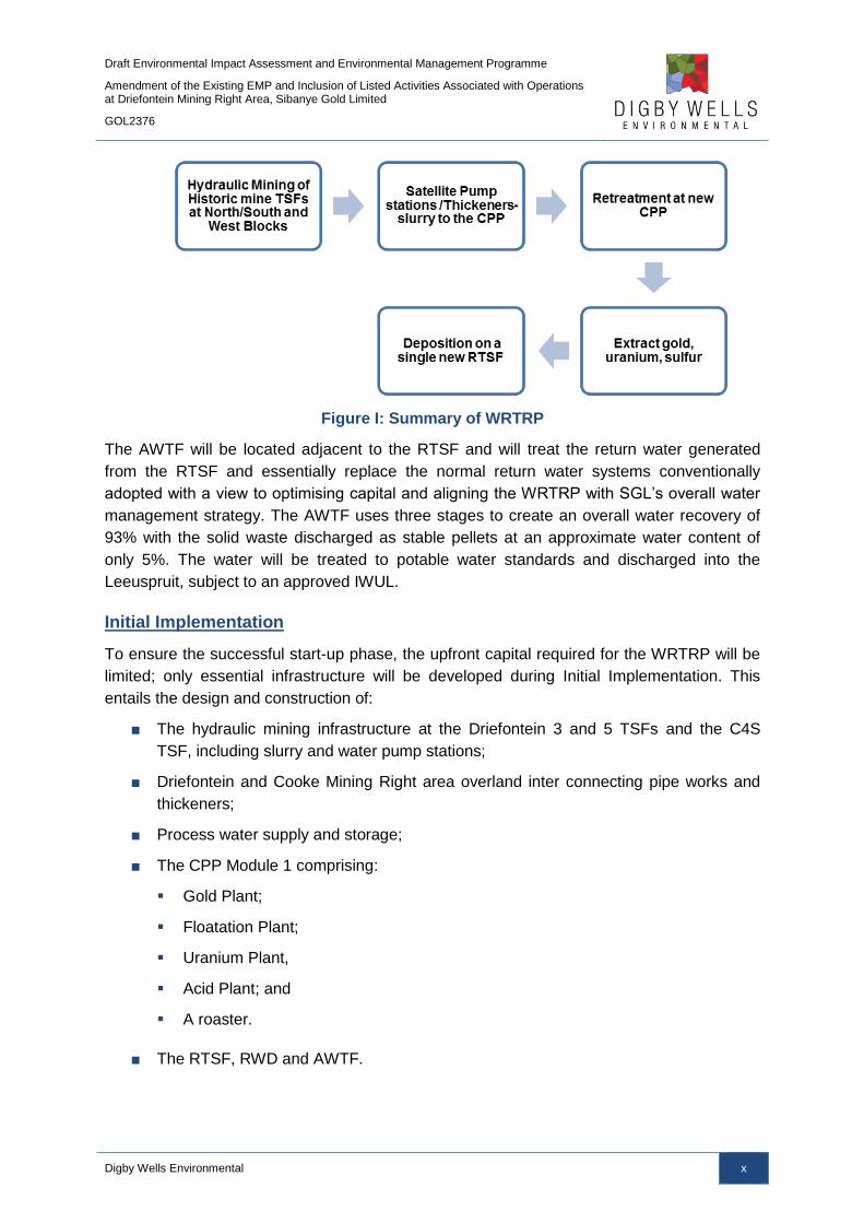
Figure I: Summary of WRTRP
The AWTF will be located adjacent to the RTSF and will treat the return water generated
from the RTSF and essentially replace the normal return water systems conventionally
adopted with a view to optimising capital and aligning the WRTRP with SGL’s overall water
management strategy. The AWTF uses three stages to create an overall water recovery of
93% with the solid waste discharged as stable pellets at an approximate water content of
only 5%. The water will be treated to potable water standards and discharged into the
Leeuspruit, subject to an approved IWUL.
Initial Implementation
To ensure the successful start-up phase, the upfront capital required for the WRTRP will be
limited; only essential infrastructure will be developed during Initial Implementation. This
entails the design and construction of:
■ The hydraulic mining infrastructure at the Driefontein 3 and 5 TSFs and the C4S
TSF, including slurry and water pump stations;
■ Driefontein and Cooke Mining Right area overland inter connecting pipe works and
thickeners;
■ Process water supply and storage;
■ The CPP Module 1 comprising:
Gold Plant;
Floatation Plant;
Uranium Plant,
Acid Plant; and
A roaster.
■ The RTSF, RWD and AWTF.

Draft Environmental Impact Assessment and Environmental Management Programme
Amendment of the Existing EMP and Inclusion of Listed Activities Associated with Operations at Driefontein Mining Right Area, Sibanye Gold Limited
GOL2376
Digby Wells Environmental xi
This first module of the CPP will receive two reclaimed slurry streams and will retreat up to
1.0 Mt/m from the Driefontein 3 and 5 TSFs and C4S TSF in sequence over 11 years. In
addition to and concurrently with the Driefontein 3 and 5 and C4S TSFs, up to 0.5 Mt/m of
the Cooke TSF will be mined for a period of 16 years. The resultant tailings from the CPP
will be deposited onto the first phase of the new RTSF.
A high grade uranium concentrate, produced at the CPP, will be transported to Ezulwini
(50 kilotonnes per month) for the extraction of uranium and gold. The tailings from this
process will be deposited on the existing operational Ezulwini North TSF.
The Initial Implementation of the project is outlined in the Figure II below.

Draft Environmental Impact Assessment and Environmental Management Programme
Amendment of the Existing EMP and Inclusion of Listed Activities Associated with Operations at Driefontein Mining Right Area, Sibanye Gold Limited
GOL2376
Digby Wells Environmental xii
Figure II: Initial Implementation Phase

Draft Environmental Impact Assessment and Environmental Management Programme
Amendment of the Existing EMP and Inclusion of Listed Activities Associated with Operations at Driefontein Mining Right Area, Sibanye Gold Limited
GOL2376
Digby Wells Environmental xiii
Driefontein Mining Right Area
The focus of this application is the authorisation of those activities associated with the Initial
Implementation of the WRTRP that occur within the Driefontein Mining Right or are to be
included in the Driefontein Mining Right. Authorisation for this component of the Initial
Implementation phase (Driefontein) will require the amendment of the Driefontein Mining
Right, Mining Work Programme (MWP) and EMP to cover the processing of reclaimed
slimes at the CPP and the deposition of the resultant tailings on the RTSF.
The Driefontein Mining Right will be amended to include:
■ The inclusion of Driefontein 4 TSF into the Driefontein Mining Right Area;
■ The reclamation of Driefontein 3 and 5 TSFs;
■ The construction and operation of the West Block Thickener (WBT) and Bulk Water
Storage Facility (BWSF); and
■ Roads, power lines, pipelines and pump stations associated with the above listed
infrastructure.
The intention of this EIA report is, therefore, to identify these activities within the
current and expanded Driefontein Mining Right area, to assess the potential impacts
that they may have on the receiving environment and to provide mitigation measures
and monitoring plans for the potential impacts.
Project Alternatives
Alternatives for the various aspects of the WRTRP have been assessed during the pre-
feasibility of the Project. The alternatives considered include location, technology and
processes of the CPP, RTSF and associated RWD and AWTF, the pipeline dimensions and
routes, the location and capacities of the BWSFs, thickeners and reclamation of the TSFs.
The alternatives for the above activities have been detailed in the EIAs for the respective
Mining Right areas. This EIA and EMP report, however, details the alternatives
considered specifically for the Driefontein Mining Right area.
WBT and BWSF Complex Site Alternatives
The alternatives associated with the WBT and BWSF are based around the location of the
facilities. The WBT and BWSF have been located adjacent to each other to minimise the
required footprints, as well as optimising and aiding in the operational and maintenance
efficiency during the operational phase. The footprint of the WBT and BWSF complex has
been optimised and the alteration of the footprint shape will reduce the operational
efficiency. As a result, the block footprint has been utilised to select suitable locations.
The WBT and BWSF complex has been located adjacent to the R501 regional road, where
the road alters direction and arcs to avoid depressions and sink holes in the landscape. The
presence of the depressions and sink holes limits the potential land use adjacent to the
Draft Environmental Impact Assessment and Environmental Management Programme
Amendment of the Existing EMP and Inclusion of Listed Activities Associated with Operations at Driefontein Mining Right Area, Sibanye Gold Limited
GOL2376
Digby Wells Environmental xiv
R501 regional road arc. The identified location is also situated approximately midway
between the K10 shaft water abstraction point and Driefontein 3 TSF, as well as where the
slurry pipeline heads southwards to the CPP, making the location the central point for the
pipeline routes. An alternative location was identified further to the west of the current
location but was excluded as the water pipeline and thickened slurry pipeline would share a
servitude resulting in additional pumping costs; the preferred location is central to the water
pipeline, slurry pipeline and thickened slurry pipeline, optimising the pumping requirements.
Furthermore, SGL has proposed to construct a solar farm to generate electricity to the south
of the R501 regional road arc, limiting the potential footprint locations to within the road arc.
The site specific location will be investigated and selected based on potential sensitivities, as
well as being based to avoid the depressions and sink holes.
Pipeline Alternatives
The pipeline routes and supporting infrastructure need to be located where the feed sources,
current infrastructure, services and proposed infrastructure including the WBT and BWSF
complex, CPP and RTSF are located. Alternative pipeline routes between the WBT and the
CPP have been identified.
Premised on the primary requirement of the pipe routes being selected being the shortest
distance between infrastructure, feed sources and the historical TSFs, alternative routes
were considered which capitalised on the following:
■ Following existing routes where possible;
■ Avoiding identified environmental sensitive areas, predominantly wetland areas;
■ Crossing existing impacted land;
■ Maximising mine owned land; and
■ Assessing the operating costs pertaining to topographical considerations on pumping
costs.
The preferred pipeline route was determined using the above criteria and overlaying
sensitive areas, such as wetlands, over the proposed routes. The preferred pipeline route
has been selected based on the location of current servitudes, and the locations and
frequency of wetlands.

Draft Environmental Impact Assessment and Environmental Management Programme
Amendment of the Existing EMP and Inclusion of Listed Activities Associated with Operations at Driefontein Mining Right Area, Sibanye Gold Limited
GOL2376
Digby Wells Environmental xv
No-Go Option
In terms of the “No-go” option, the primary land uses for the region are mining, agriculture,
and in some areas, residential. Should the project not be implemented, the Driefontein 3 and
5 TSFs will not be reclaimed; the TSFs will remain in situ and continue to impact on the
environmental and social landscapes, as per the status quo. None of the envisioned benefits
will come to fruition, such as. environmental clean-up, job opportunities, investment into the
local and regional economy, treatment of currently impacted water and a reduction in the
health impacts posed by the historical TSFs. The existing impacts include:
■ Potentially leaching contaminants e.g. uranium and sulfur, into the sensitive dolomitic
aquifers;
■ Risk to community health and an increased potential for AMD in the Western Basin;
■ Further weakening of the West Rand’s economy as mining declines; and
■ The AWTF will not be funded which will result in mine affected water not being
treated to potable standards (SANS 241:2011). This results in water quality
resources continuing to be impacted upon by contaminated water, impacting on the
receiving environment and downstream water users.
The infrastructure associated with the Driefontein Mining Right area, such as the WBT,
BWSF and associated pipelines, roads and transmission lines are required for the efficient
implementation of the WRTRP. If any component of it is not approved, the entire project will
be abandoned.
Public Participation Process
The Public Participation Process (PPP) was developed to ensure compliance with
environmental regulatory requirements and to provide Interested and Affected Parties
(I&APs) with an opportunity to evaluate the proposed project. During this process
stakeholders are able to provide inputs and to receive feedback from the environmental
specialists and/or proponent.
Taking cognisance of the project’s regional locality and complexity, the PPP ensured early
information availability and also enabled open dialogue with I&APs in an effort to understand
I&APs concerns. Prior to and during the Scoping Phase this was embodied by a combination
of focus group and open house meetings undertaken to facilitate the participation from
various sectors of society.
The Scoping Reports were made available at seven public libraries throughout the West
Rand, as well as on the Digby Wells website, for a period of 30 days from 15 September
2015 to 15 October 2015. In addition, focus group meetings and public meetings were held
from 6 October 2015 to 14 October 2015. Comments received from I&APs were recorded
and responses provided, as outlined in this EIA and EMP report.

Draft Environmental Impact Assessment and Environmental Management Programme
Amendment of the Existing EMP and Inclusion of Listed Activities Associated with Operations at Driefontein Mining Right Area, Sibanye Gold Limited
GOL2376
Digby Wells Environmental xvi
Summary of the Driefontein Mining Right Area Environment
The WRTRP is situated in the Upper Vaal WMA 8 and within the quaternary catchments
C23E, C23J, C23D, C22J and C22H, with the Driefontein Mining Right area falling within
quaternary catchments C23E, C23D and C23J. The WRTRP area is drained by the
Wonderfonteinspruit, Leeuspruit and the Loopspruit. The Wonderfonteinspruit flows
westwards, north of the Driefontein 3 and 5 TSFs, and eventually becomes the
Mooirivierloop before a confluence with the Mooi River downstream.
The overall surface water quality for the WRTRP area indicated elevated concentrations of
sulfates, nitrates, fluorides, manganese and ammonia exceeding the In-Stream Water
Quality Guidelines for the Vaal Barrage (Barrage WQO). This indicates that rivers within this
area are already impacted; the majority of river systems associated with the WRTRP area
are largely modified. The modification of these systems is largely attributed to the location of
the sources of the associated river systems, which are located within urban and industrial
areas and associated impacts to instream and riparian conditions have resulted in the large
modification of the systems.
Wetlands within the Driefontein Mining Right area are characterised by valley bottom
systems associated with the Wonderfonteinspruit, Loopspruit and other tributaries. In
addition, in the midslopes and valley heads of the catchments, there are pan and seep
systems associated with the landscapes. The identified wetlands are considered to be
impacted upon as a result of the surrounding land uses, including mining, agriculture and
road infrastructure. This has led to serious impacts to the quality of these systems and has
contributed to the direct loss of wetland habitat. The wetlands have been demarcated a
Present Ecological Status (PES) of D (largely modified) and an Ecological Importance and
Sensitivity (EIS) of low to moderate. The aquatic ecosystems associated with the project
area mirror the impacted nature of the surface water quality and wetlands functioning, with
the aquatic systems determined to have PES of Class D and E, which is moderately to
seriously modified.
The groundwater within the Driefontein Mining Right area is typical of contaminated water
emanating from historical TSFs and current mining operations, with elevated concentrations
of sulfate, TDS and nitrates, as well as manganese and chloride. The pH values range
between 4.1 and 8 and are indicative of AMD impacts associated with seepage from existing
TSFs. The historical TSFs are located on dolomite which is dewatered to allow for dry and
safe underground workings; the dewatering result in a low pressure within the dolomite and
encourages drainage of mine affected water from the TSFs into the groundwater system and
the seepage is expected to migrate downwards into the aquifers.
The regional vegetation of the WRTRP area consists of the Carletonville Dolomite
Grassland, Gauteng Shale Mountain Bushveld, Rand Highveld Grassland and Soweto
Highveld Grassland, with the two former vegetation types being classified as Vulnerable and
the Highveld Grassland vegetation types classified as Endangered.
Draft Environmental Impact Assessment and Environmental Management Programme
Amendment of the Existing EMP and Inclusion of Listed Activities Associated with Operations at Driefontein Mining Right Area, Sibanye Gold Limited
GOL2376
Digby Wells Environmental xvii
The infrastructure associated with the Driefontein Mining Right area is located within
grassland, wetland, ridges, agricultural (cultivation and grazing) and transformed areas. The
grassland is composed of dominant and well developed graminoid components, as well as a
healthy forb component. The dominant grassland sub community associated with the WBT
and BWSF complex and pipelines between the K10 shaft, WBT and BWSF complex and
Driefontein 3 TSF is the Eragrostis gummiflua – Themeda triandra grassland, with the
southern section of the pipeline towards the CPP being the Themeda triandra – Hyparhennia
hirta grassland and the central section of the pipeline from the WBT to the CPP being
delineated as Cymbopogon excavates – Helichrysum regulosum grasslands.
No Red Data mammal or bird SSC were identified during the field survey, although the
Grass Owl (Tyto capensis), has previously been identified within the project area (Golder,
2008) and is expected to occur within the wetland habitats identified within the project area.
This species has been allocated a status of Vulnerable. Reptile Red Data species that may
occur within the project area include the Giant Girdled Lizard (Cordylus giganteus)
(Vulnerable) and the Striped Harlequin Snake (Homoroselaps dorsalis) (Rare). Invertebrate
Red Data species expected to occur on site include the Marsh sylph (Metisella meninx),
Roodepoort Copper (Aloeides dentatis dentatis) and Highveld Blue (Lepidochrysops
praeterita), although no species were identified during the survey.
Geologically, the project area is largely underlain by dolomitic rock that has the potential for
karst topography which is characterised by underground drainage systems with sinkholes,
dolines and caves. The heritage resources identified within the Driefontein Mining Right area
were three structures older than 60 years old and are protected under Section 34 of the
NHRA. The identified structures do not occur within the proposed infrastructure footprints but
are located between 30 m and 100 m from the pipeline route. The identified resources are
considered to have a negligible cultural significance.
Potential Impacts
The predominant negative impacts associated with the Driefontein Mining Right area are due
to the site clearing for and construction of the WBT and BWSF complex. The construction of
the WBT and BWSF complex will potentially impact on soil and surface water resources due
to the clearance of vegetation and resultant soil erosion and compaction. Eroded soils may
report to surface water resources due to runoff from the site which can lead to sedimentation
of water and deterioration of water quality. In addition, the WBT and BWSF complex has
been partially located within a pan which has a high (negative) impact due to the loss of
wetland habitat; the partial location within the pan was unavoidable due to the presence of
sinkholes and depressions, the R501 road to the north and future construction to the south.
A wetland offset strategy will be implemented to compensate for the loss of wetlands,
subject to a WUL.
The positive impacts associated with the project are predominantly part of the Kloof Mining
Right area as significant capital expenditure will take place which will boost the local

Draft Environmental Impact Assessment and Environmental Management Programme
Amendment of the Existing EMP and Inclusion of Listed Activities Associated with Operations at Driefontein Mining Right Area, Sibanye Gold Limited
GOL2376
Digby Wells Environmental xviii
economy and have a multiplier effect. Job creation and skills development will also result
from the project.
The significant positive impacts associated with the Driefontein Mining Right area activities
will be realised following the complete reclamation of the historical TSFs and the
rehabilitation of the footprints. The removal of the historical TSFs will have a positive visual
impact on the landscape, as well as positive impacts on air quality, surrounding wetlands
and aquatic ecology and surface water and groundwater quality as the source of pollution
will be removed from the landscape. In addition, surface water yield to the catchment will
increase as runoff is not restricted or contaminated by the TSFs; fauna and flora biodiversity
will increase due to the removal of unfavourable habitats and the visual environment will
improve due to the removal of visual intrusions on the landscape.
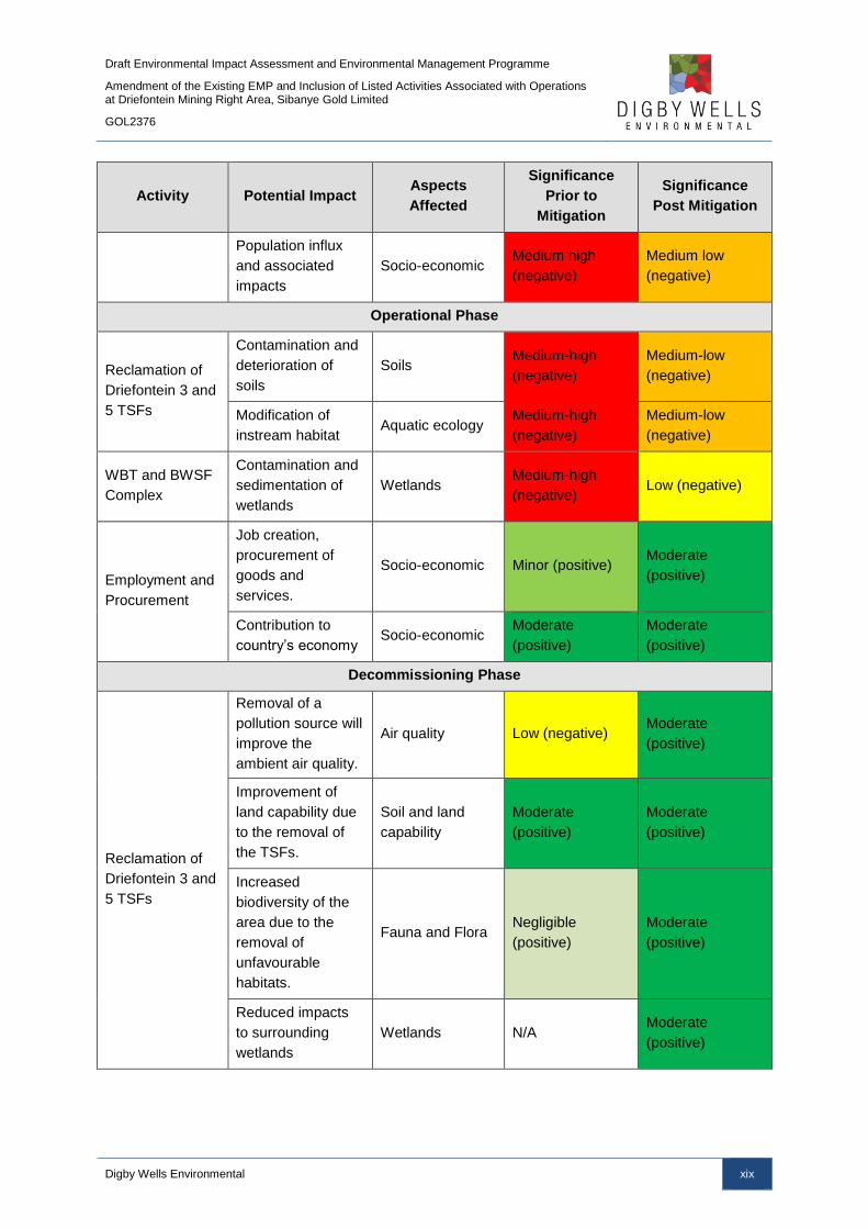
A summary of the most significant impacts prior to and post implementation of mitigation
measures is provided in the table below.
Table IV: Significant Impacts Associated with the Driefontein Mining Right Area of the
WRTRP
Activity Potential Impact Aspects
Affected
Significance
Prior to
Mitigation
Significance
Post Mitigation
Construction Phase
WBT and BWSF
Complex
Loss of topsoil as a
resource Soils
Medium-high
(negative) Low (negative)
Loss of land
capability
Soils and land
capability
Medium-high
(negative)
Medium-high
(negative)
Sedimentation and
deterioration of
surface water
quality
Surface water Medium-high
(negative) Low (negative)
Destruction of
habitats and loss of
ecosystem services
Wetlands High (negative) Medium-high
(negative)
Employment and
Procurement
Job creation,
procurement of
goods and services
and skills upliftment
Socio-economic Minor (positive) Moderate
(positive)
Direct investment
and multiplier
effect.
Socio-economic Minor (positive) Moderate
(positive)
Draft Environmental Impact Assessment and Environmental Management Programme
Amendment of the Existing EMP and Inclusion of Listed Activities Associated with Operations at Driefontein Mining Right Area, Sibanye Gold Limited
GOL2376
Digby Wells Environmental xix
Activity Potential Impact Aspects
Affected
Significance
Prior to
Mitigation
Significance
Post Mitigation
Population influx
and associated
impacts
Socio-economic Medium high
(negative)
Medium low
(negative)
Operational Phase
Reclamation of
Driefontein 3 and
5 TSFs
Contamination and
deterioration of
soils
Soils Medium-high
(negative)
Medium-low
(negative)
Modification of
instream habitat Aquatic ecology
Medium-high
(negative)
Medium-low
(negative)
WBT and BWSF
Complex
Contamination and
sedimentation of
wetlands
Wetlands Medium-high
(negative) Low (negative)
Employment and
Procurement
Job creation,
procurement of
goods and
services.
Socio-economic Minor (positive) Moderate
(positive)
Contribution to
country’s economy Socio-economic
Moderate
(positive)
Moderate
(positive)
Decommissioning Phase
Reclamation of
Driefontein 3 and
5 TSFs
Removal of a
pollution source will
improve the
ambient air quality.
Air quality Low (negative) Moderate
(positive)
Improvement of
land capability due
to the removal of
the TSFs.
Soil and land
capability
Moderate
(positive)
Moderate
(positive)
Increased
biodiversity of the
area due to the
removal of
unfavourable
habitats.
Fauna and Flora Negligible
(positive)
Moderate
(positive)
Reduced impacts
to surrounding
wetlands
Wetlands N/A Moderate
(positive)
Draft Environmental Impact Assessment and Environmental Management Programme
Amendment of the Existing EMP and Inclusion of Listed Activities Associated with Operations at Driefontein Mining Right Area, Sibanye Gold Limited
GOL2376
Digby Wells Environmental xx
Activity Potential Impact Aspects
Affected
Significance
Prior to
Mitigation
Significance
Post Mitigation
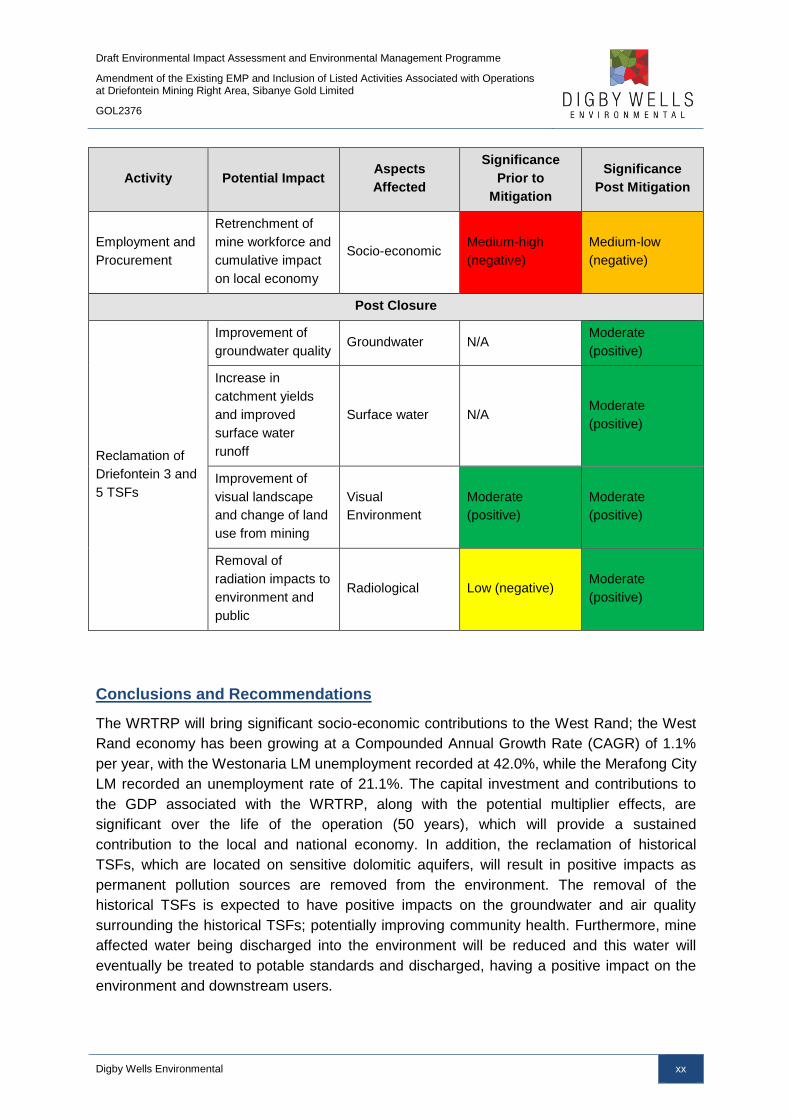
Employment and
Procurement
Retrenchment of
mine workforce and
cumulative impact
on local economy
Socio-economic Medium-high
(negative)
Medium-low
(negative)
Post Closure
Reclamation of
Driefontein 3 and
5 TSFs
Improvement of
groundwater quality Groundwater N/A
Moderate
(positive)
Increase in
catchment yields
and improved
surface water
runoff
Surface water N/A Moderate
(positive)
Improvement of
visual landscape
and change of land
use from mining
Visual
Environment
Moderate
(positive)
Moderate
(positive)
Removal of
radiation impacts to
environment and
public
Radiological Low (negative) Moderate
(positive)
Conclusions and Recommendations
The WRTRP will bring significant socio-economic contributions to the West Rand; the West
Rand economy has been growing at a Compounded Annual Growth Rate (CAGR) of 1.1%
per year, with the Westonaria LM unemployment recorded at 42.0%, while the Merafong City
LM recorded an unemployment rate of 21.1%. The capital investment and contributions to
the GDP associated with the WRTRP, along with the potential multiplier effects, are
significant over the life of the operation (50 years), which will provide a sustained
contribution to the local and national economy. In addition, the reclamation of historical
TSFs, which are located on sensitive dolomitic aquifers, will result in positive impacts as
permanent pollution sources are removed from the environment. The removal of the
historical TSFs is expected to have positive impacts on the groundwater and air quality
surrounding the historical TSFs; potentially improving community health. Furthermore, mine
affected water being discharged into the environment will be reduced and this water will
eventually be treated to potable standards and discharged, having a positive impact on the
environment and downstream users.
Draft Environmental Impact Assessment and Environmental Management Programme
Amendment of the Existing EMP and Inclusion of Listed Activities Associated with Operations at Driefontein Mining Right Area, Sibanye Gold Limited
GOL2376
Digby Wells Environmental xxi
TABLE OF CONTENTS
1 Introduction ..................................................................................................................... 2
1.1 Company Background ............................................................................................. 2
1.2 Project History ......................................................................................................... 2
1.3 Project Description .................................................................................................. 3
1.3.1 Ultimate Project ................................................................................................ 6
1.3.2 Initial Implementation ...................................................................................... 23
1.3.3 Amendment to the Driefontein Mining Right .................................................... 28
2 Item 3: Project applicant ............................................................................................... 28
2.1 Item 3(a)(i): Details of the EAP .............................................................................. 28
2.2 Item 3(a)(ii): Expertise of the EAP ......................................................................... 29
2.2.1 The qualifications of the EAP .......................................................................... 29
2.2.2 Summary of the EAP’s past experience .......................................................... 29
3 Item 3(b): Description of the property ......................................................................... 29
4 Item 3(c) of Appendix 3: Locality map ........................................................................ 36
5 Item 3(d) of Appendix 3: Description of the Scope of the Proposed Overall
Activity ........................................................................................................................... 36
5.1 Listed and Specified Activities ............................................................................... 37
5.1.1 Environmental Authorisation ........................................................................... 37
5.1.2 Waste Management ....................................................................................... 38
5.2 Item 3(d)(ii): Description of the activities to be undertaken .................................... 43
5.2.1 Water from K10 Shaft and Bulk Water Storage Facility ................................... 46
5.2.2 Reclamation of Driefontein Tailings Storage Facilities .................................... 46
5.2.3 Thickening of the Slurry at the West Block Thickener and Pumping to the
Central Processing Plant ................................................................................ 47
5.2.4 Pump Stations ................................................................................................ 48
5.2.5 Pipeline Routes (Driefontein Mining Right area only) ...................................... 48
6 Item 3(e): Policy and Legislative Context ................................................................... 50
7 Item 3(f): Need and Desirability of the Proposed Activities ...................................... 55

Draft Environmental Impact Assessment and Environmental Management Programme
Amendment of the Existing EMP and Inclusion of Listed Activities Associated with Operations at Driefontein Mining Right Area, Sibanye Gold Limited
GOL2376
Digby Wells Environmental xxii
7.1 Driefontein Specific Components .......................................................................... 56
7.1.1 Bulk Water Storage Facility and West Block Thickener................................... 56
7.1.2 Reclamation of Driefontein 3 and 5 TSFs ....................................................... 57
8 Item 3(g): Motivation for the Preferred Development Footprint within the
approved Site including a full Description of the Process followed to reach
the Proposed Development Footprint within the approved site ............................... 59
8.1 Item 3(g)(i): Details of the Development Footprint Alternatives Considered ........... 59
8.1.1 WBT and BWSF Complex .............................................................................. 60
8.1.2 Pipeline Routes .............................................................................................. 60
8.1.3 The Option of Not Implementing the Activity ................................................... 61
8.2 Item 3(g)(ii): Details of the Public Participation Process followed ........................... 63
8.2.1 Stakeholder Identification ............................................................................... 63
8.2.2 Land Claimants .............................................................................................. 67
8.2.3 Pre-Consultation with Interested and Affected Parties .................................... 67
8.2.4 Consultation during the Scoping Phase .......................................................... 71
8.2.5 Consultation during the Impact Assessment Phase ........................................ 77
8.3 Item 3(g)(iii): Summary of Issues Raised by I&APs ............................................... 77
9 Item 3(g)(iv): The Environmental Attributes Associated with the Development
Footprint Alternatives ................................................................................................... 96
9.1 Baseline Environment ........................................................................................... 96
9.1.1 Air Quality ....................................................................................................... 96
9.1.2 Geology ........................................................................................................ 100
9.1.3 Groundwater ................................................................................................. 103
9.1.4 Soils ............................................................................................................. 104
9.1.5 Surface Water .............................................................................................. 110
9.1.6 Fauna and Flora ........................................................................................... 124
9.1.7 Aquatics ....................................................................................................... 139
9.1.8 Wetlands ...................................................................................................... 148
9.1.9 Topography and Visual ................................................................................. 158
9.1.10 Noise ............................................................................................................ 159
9.1.11 Heritage ........................................................................................................ 169

Draft Environmental Impact Assessment and Environmental Management Programme
Amendment of the Existing EMP and Inclusion of Listed Activities Associated with Operations at Driefontein Mining Right Area, Sibanye Gold Limited
GOL2376
Digby Wells Environmental xxiii
9.1.12 Socio-Economic............................................................................................ 171
9.1.13 Radiation ...................................................................................................... 179
9.2 Description of the Current Land Uses .................................................................. 180
9.2.1 Land Claims ................................................................................................. 180
9.3 Description of Specific Environmental Features and Infrastructure on the Site .... 180
9.3.1 Water Resources .......................................................................................... 180
9.3.2 Terrestrial Landscape Habitat ....................................................................... 181
9.3.3 Cultural Heritage........................................................................................... 182
9.3.4 Infrastructure ................................................................................................ 182
9.4 Environmental and Current Land Use Map .......................................................... 182
10 Item 3(g)(v): Impacts and Risks Identified including the Nature, Significance,
Consequence, Extent, Duration and Probability ...................................................... 183
10.1 Construction Phase ............................................................................................. 184
10.1.1 Air Quality Impacts ....................................................................................... 184
10.1.2 Groundwater Impacts ................................................................................... 186
10.1.3 Soil Impacts .................................................................................................. 186
10.1.4 Surface Water Impacts ................................................................................. 192
10.1.5 Fauna and Flora Impacts .............................................................................. 195
10.1.6 Aquatics Impacts .......................................................................................... 199
10.1.7 Wetlands Impacts ......................................................................................... 202
10.1.8 Visual Impacts .............................................................................................. 206
10.1.9 Noise Impacts ............................................................................................... 208
10.1.10 Heritage Impacts .......................................................................................... 210
10.1.11 Socio-Economic Impacts .............................................................................. 210
10.2 Operational Phase ............................................................................................... 219
10.2.1 Air Quality Impacts ....................................................................................... 219
10.2.2 Groundwater Impacts ................................................................................... 225
10.2.3 Soil Impacts .................................................................................................. 228
10.2.4 Surface Water Impacts ................................................................................. 231
10.2.5 Fauna and Flora Impacts .............................................................................. 231
10.2.6 Aquatics Impacts .......................................................................................... 231
Draft Environmental Impact Assessment and Environmental Management Programme
Amendment of the Existing EMP and Inclusion of Listed Activities Associated with Operations at Driefontein Mining Right Area, Sibanye Gold Limited
GOL2376
Digby Wells Environmental xxiv
10.2.7 Wetlands Impacts ......................................................................................... 234
10.2.8 Visual Impacts .............................................................................................. 235
10.2.9 Noise Impacts ............................................................................................... 237
10.2.10 Socio-Economic Impacts .............................................................................. 239
10.2.11 Radiation Impacts ......................................................................................... 243
10.3 Decommissioning Phase ..................................................................................... 245
10.3.1 Air Quality Impacts ....................................................................................... 245
10.3.2 Soil Impacts .................................................................................................. 248
10.3.3 Surface Water Impacts ................................................................................. 251
10.3.4 Fauna and Flora Impacts .............................................................................. 251
10.3.5 Aquatics Impacts .......................................................................................... 253
10.3.6 Wetlands Impacts ......................................................................................... 258
10.3.7 Visual Impacts .............................................................................................. 261
10.3.8 Noise Impacts ............................................................................................... 264
10.3.9 Socio-Economic Impacts .............................................................................. 265
10.4 Post-Closure Phase ............................................................................................ 268
10.4.1 Groundwater Impacts ................................................................................... 268
10.4.2 Surface Water Impacts ................................................................................. 270
10.4.3 Visual Impacts .............................................................................................. 271
10.4.4 Radiation Impacts ......................................................................................... 273
10.5 Cumulative Impacts ............................................................................................. 274
10.6 Item 3(g)(vi): Methodology Used in Determining and Ranking the Nature,
Significance, Consequence, Extent, Duration and Probability of Potential
Environmental Impacts and Risks ....................................................................... 281
10.7 Item 3(g)(vii): The Positive and Negative Impacts that the Proposed Activity (in
terms of the Initial Site Layout) and Alternatives will have on the Environment and
the Community that may be Affected ................................................................... 287
10.8 Item 3(g)(viii): The Possible Mitigation Measures that could be applied and the
Level of Risk ........................................................................................................ 288
10.9 Item 3(g)(ix): Motivation where No Alternatives Sites were Considered ............... 289
10.10 Item 3(g)(x): Statement Motivating the Alternative Development Location within the
Overall Site .......................................................................................................... 289
10.10.1 WBT and BWSF Complex ............................................................................ 289

Draft Environmental Impact Assessment and Environmental Management Programme
Amendment of the Existing EMP and Inclusion of Listed Activities Associated with Operations at Driefontein Mining Right Area, Sibanye Gold Limited
GOL2376
Digby Wells Environmental xxv
10.10.2 Pipe routes ................................................................................................... 289
11 Item 3(h): Full Description of the Process undertaken to Identify, Assess and
Rank the Impacts and Risks the Activity will impose on the Preferred Site (In
respect of the final site layout plan) through the Life of the Activity ..................... 290
12 Item 3(i): Assessment of each Identified Potentially Significant Impact and
Risk ............................................................................................................................... 290
13 Item 3(j): Summary of Specialist Reports ................................................................. 298
14 Item 3(k): Environmental Impact Statement ............................................................. 302
14.1 Item 3(k)(i): Summary if the Key Findings of the Environmental Impact Assessment
302
14.2 Item 3(k)(ii): Final Site Map ................................................................................. 306
14.3 Item 3(k)(iii): Summary of the Positive and Negative Implications and Risks of the
Proposed Activity and Identified Alternatives ....................................................... 308
15 Item 3(l): Proposed Impact Management Objectives and the Impact
Management Outcomes for Inclusion in the EMPR ................................................. 308
16 Item 3(m): Final Proposed Alternatives .................................................................... 309
17 Item 3(n): Aspects for Inclusion as Conditions of Authorisation ........................... 309
18 Item 3(o): Description of any Assumptions, Uncertainties and Gaps in
Knowledge ................................................................................................................... 310
18.1 Air Quality Impact Assessment ............................................................................ 310
18.2 Soil Impact Assessment ...................................................................................... 310
18.3 Surface Water Impact Assessment...................................................................... 310
18.4 Fauna and Flora Impact Assessment .................................................................. 310
18.5 Wetlands Impact Assessment ............................................................................. 311
18.6 Visual Impact Assessment .................................................................................. 311
18.7 Noise Impact Assessment ................................................................................... 312
18.8 Social Impact Assessment .................................................................................. 312
19 Item 3(p): Reasoned Opinion as to whether the Proposed Activity should or
should not be authorised ........................................................................................... 312
19.1 Item 3(p)(i): Reasons why the Activity should be Authorised or not ..................... 313
19.2 Item 3(p)(ii): Conditions that must be Included in the Authorisation ..................... 313

Draft Environmental Impact Assessment and Environmental Management Programme
Amendment of the Existing EMP and Inclusion of Listed Activities Associated with Operations at Driefontein Mining Right Area, Sibanye Gold Limited
GOL2376
Digby Wells Environmental xxvi
19.2.1 Specific Conditions to be included into the Compilation and Approval of EMPR
..................................................................................................................... 313
19.2.2 Rehabilitation Requirements ......................................................................... 314
20 Item 3(q): Period for which the Environmental Authorisation is required ............. 315
21 Item 3(r): Undertaking ................................................................................................. 315
22 Item 3(s): Financial Provision .................................................................................... 315
22.1 Item 3(s)(i): Explain how the Aforesaid Amount was Derived............................... 316
22.2 Item 3(s)(ii): Confirm that this Amount can be Provided for from Operating
Expenditure ......................................................................................................... 316
23 Item 3(t): Deviations from the Approved Scoping Report and Plan of Study ....... 316
23.1 Item 3(t)(i): Deviations from the Methodology used in Determining the Significance
of Potential Environmental Impacts and Risks ..................................................... 316
23.2 Item 3(t)(ii): Motivation for the Deviation .............................................................. 316
24 Item 3(u): Other Information required by the Competent Authority ....................... 317
24.1 Item 3(u)(i)(1): Impact on the Socio-Economic Conditions of any Directly Affected
Person ................................................................................................................. 317
24.2 Item 3(u)(i)(2): Impact on any National Estate Referred to in Section 3(2) of the
National Heritage Resources Act. ........................................................................ 317
25 Item 3(v): Other Matters Required in Terms of Sections 24(4)(a) and (b) of the
Act ................................................................................................................................ 320
1 Item 1(a): Details of the EAP ...................................................................................... 322
2 Item 1(b): Description of the Aspects of the Activity ............................................... 322
3 Item 1(c): Composite Map .......................................................................................... 322
4 Item 1(d): Description of Impact Management Objectives including
Management Statements ............................................................................................ 322
4.1 Item 1(d)(i): Determination of Closure Objectives ................................................ 322
4.2 Item 1(d)(ii): The Process for Managing any Environmental Damage, Pollution,
Pumping and Treatment of Extraneous Water or Ecological Degradation as a Result
of undertaking a Listed Activity ............................................................................ 323
4.2.1 Ecological Degradation due to Listed Activities ............................................. 323
4.2.2 Process for Managing Ecological Degradation ............................................. 323
Draft Environmental Impact Assessment and Environmental Management Programme
Amendment of the Existing EMP and Inclusion of Listed Activities Associated with Operations at Driefontein Mining Right Area, Sibanye Gold Limited
GOL2376
Digby Wells Environmental xxvii
4.3 Item 1(d)(iii): Potential Risk of Acid Mine Drainage .............................................. 326
4.4 Item 1(d)(iv): Steps taken to Investigate, Assess, and Evaluate the Impact of Acid
Mine Drainage ..................................................................................................... 327
4.5 Item i(d)(v): Engineering or Mine Design Solutions to be Implemented to Avoid or
Remedy Acid Mine Drainage ............................................................................... 327
4.6 Item 1(d)(vi): Measures that will be put in place to Remedy any Residual or
Cumulative Impact that may Result from Acid Mine Drainage ............................. 328
4.7 Item 1(d)(vii): Volumes and Rate of Water Use Required for the Mining, Trenching
or Bulk Sampling Operation ................................................................................. 328
4.8 Item 1(d)(viii): Has a Water Use Licence has been Applied for ............................ 328
5 Item 1(d)(ix): Impacts to be Mitigated in their Respective Phases ......................... 328
6 Item 1(e): Impact Management Outcomes ................................................................ 340
7 Item 1(f): Impact Management Actions ..................................................................... 346
8 Financial provision ..................................................................................................... 352
8.1 Item (i)(1): Determination of the Amount of Financial Provision ........................... 352
8.1.1 Item (i)(1)(a): Describe the Closure Objectives and the Extent to which they
have been Aligned to the Baseline Environment described under Regulation 22
(2) (d) as described in 2.4 herein .................................................................. 352
8.1.2 Item (i)(1)(b): Confirm specifically that the Environmental Objectives in relation
to Closure have been consulted with Landowner and Interested and Affected
Parties .......................................................................................................... 352
8.1.3 Item (i)(1)(c): Provide a Rehabilitation Plan that describes and shows the Scale
and Aerial Extent of the Main Mining Activities, including the Anticipated Mining
Area at the time of Closure ........................................................................... 353
8.1.4 Item (i)(1)(d): Explain why it can be Confirmed that the Rehabilitation Plan is
compatible with the Closure Objectives ........................................................ 353
8.1.5 Item (i)(1)(e): Calculate and State the Quantum of the Financial Provision
required to Manage and Rehabilitate the Environment in accordance with the
Applicable Guideline ..................................................................................... 353
8.1.6 Item (i)(1)(f): Confirm that the financial provision will be provided as determined
..................................................................................................................... 354
9 Monitoring Compliance with and Performance Assessment ................................. 354
9.1 Item 1(g): Monitoring of Impact Management Actions .......................................... 354
9.1.1 Air Quality ..................................................................................................... 354

Draft Environmental Impact Assessment and Environmental Management Programme
Amendment of the Existing EMP and Inclusion of Listed Activities Associated with Operations at Driefontein Mining Right Area, Sibanye Gold Limited
GOL2376
Digby Wells Environmental xxviii
9.1.2 Fauna and Flora ........................................................................................... 355
9.1.3 Aquatics ....................................................................................................... 359
9.1.4 Wetlands ...................................................................................................... 360
9.1.5 Groundwater ................................................................................................. 360
9.1.6 Socio-economic Environment ....................................................................... 362
9.2 Item 1(h): Monitoring and Reporting Frequency .................................................. 362
9.3 Item 1(i): Responsible Persons ............................................................................ 362
9.4 Item 1(j): Time Period for Implementing Impact Management Actions ................. 363
9.5 Item 1(k): Mechanism for Monitoring Compliance ................................................ 363
10 Item 1(l): Indicate the Frequency of the Submission of the Performance
Assessment Report .................................................................................................... 365
11 Item 1(m): Environmental Awareness Plan .............................................................. 365
11.1 Item 1(m)(1): Manner in which the Applicant Intends to Inform his or her Employees
of any Environmental Risk which may Result from their Work ............................. 365
11.1.1 Internal Communication and Awareness Campaign ..................................... 365
11.1.2 External Communication and Awareness Campaign .................................... 366
11.2 Item 1(m)(2): Manner in which Risks will be dealt with to Avoid Pollution or the
Degradation of the Environment .......................................................................... 367
12 Item 1(n): Specific Information Required by the Competent Authority ................. 370
13 Item 2: Undertaking ..................................................................................................... 370
Draft Environmental Impact Assessment and Environmental Management Programme
Amendment of the Existing EMP and Inclusion of Listed Activities Associated with Operations at Driefontein Mining Right Area, Sibanye Gold Limited
GOL2376
Digby Wells Environmental xxix
LIST OF TABLES
Table 1-1: Scheduled Activities of the WRTRP – Ultimate Project....................................... 14
Table 1-2: Total Area Covered by the TSFs that will be reclaimed over the Life of the
Ultimate Project ................................................................................................................... 17
Table 1-3: Primary Activities of the WRTRP Initial Implementation ...................................... 25
Table 1-4: Pipeline Route Lengths ...................................................................................... 27
Table 1-5: Driefontein Activities ........................................................................................... 28
Table 2-1: Contact details of the EAP ................................................................................. 29
Table 3-1: Farms Associated with the Driefontein Mining Right Area .................................. 30
Table 3-2: Farms Associated with the Driefontein Mining Right Area Expansion ................. 30
Table 3-3: WBT and BWSF Complex Property Description ................................................. 30
Table 3-4: Driefontein 3 TSF Property Descriptions ............................................................ 31
Table 3-5: Driefontein 4 TSF Property Description .............................................................. 31
Table 3-6: Driefontein 5 TSF Property Descriptions ............................................................ 31
Table 3-7: Pipeline Routes Property Descriptions ............................................................... 32
Table 5-1: Project Activities ................................................................................................. 39
Table 5-2: Water Supply Pipelines ...................................................................................... 46
Table 5-3: Slurry Pipelines Summary .................................................................................. 47
Table 5-4: Summary of Pipeline Route Lengths .................................................................. 48
Table 6-1: Relevant National Legislation ............................................................................. 50
Table 6-2: Local By-Laws .................................................................................................... 54
Table 8-1: Landowners and Properties Directly Affected by Driefontein Mining Right Area
Activities.............................................................................................................................. 64
Table 8-2: Adjacent Property Details Associated with the Driefontein Mining Right Area
Activities.............................................................................................................................. 66
Table 8-3: Authorities Engaged ........................................................................................... 66
Table 8-4: Summary of PP Activities during the Pre-Application Phase .............................. 69
Table 8-5: Summary of PP Activities during the Scoping Phase .......................................... 72
Table 8-6: Interested and Affected Parties .......................................................................... 78
Table 8-7: Other Affected Parties ........................................................................................ 91
Table 8-8: Interested Parties ............................................................................................... 92
Table 9-1: Wind Class Frequency Distribution per Direction................................................ 98
Table 9-2: Monthly Average Relative Humidity Values ........................................................ 99

Draft Environmental Impact Assessment and Environmental Management Programme
Amendment of the Existing EMP and Inclusion of Listed Activities Associated with Operations at Driefontein Mining Right Area, Sibanye Gold Limited
GOL2376
Digby Wells Environmental xxx
Table 9-3: Total Monthly and Average Precipitation Values ................................................ 99
Table 9-4: Monthly Evaporation Rates for Westonaria ...................................................... 100
Table 9-5: Dominant Land Types and Slopes within the WRTRP Project Area ................. 105
Table 9-6: Summary of the Surface Water Attributes for Quaternary Catchments ............. 110
Table 9-7: Surface Water Users within the Driefontein Mining Right Area Affected
Catchments ....................................................................................................................... 111
Table 9-8: Surface Water Monitoring Locations................................................................. 114
Table 9-9: Water Quality Results benchmarked against the SANS 241-1:2011 Drinking
Water Quality Standards ................................................................................................... 116
Table 9-10: Water Quality Results benchmarked against the In-Stream Water Quality
Guidelines for the Vaal Barrage sub-catchment ................................................................ 118
Table 9-11: Water Quality Results benchmarked against the South African Water Quality
Guidelines for Agricultural Use: Irrigation (DWAF, 1996) ................................................... 120
Table 9-12: Average Surface Water Flows for the Project Area (DWS, 1990 to 2014) ...... 123
Table 9-13: Red Data Categories (SANBI, 2012) .............................................................. 128
Table 9-14: Plant SSC likely to occur on site ..................................................................... 129
Table 9-15: Grassland Sub-communities .......................................................................... 129
Table 9-16: Ecological Integrity of the Vegetation Communities within the Driefontein Mining
Right Area Infrastructure ................................................................................................... 132
Table 9-17: Expected list of plant SSC .............................................................................. 132
Table 9-18: Expected Mammals within the Driefontein Mining Right Area and WRTRP Area
......................................................................................................................................... 134
Table 9-19: Amphibian Species Identified ......................................................................... 135
Table 9-20: In Situ Water Quality Results .......................................................................... 140
Table 9-21: Intermediate Habitat Integrity Assessment Categories (Kleynhans, 1996) ...... 143
Table 9-22: IHIA for Instream Habitats .............................................................................. 143
Table 9-23: IHIA for Riparian Habitats ............................................................................... 144
Table 9-24: Description of IHAS scores with the respective percentage category (McMillan,
1998) ................................................................................................................................ 144
Table 9-25: IHAS Results for the WRTRP ......................................................................... 145
Table 9-26: Invertebrate Biotope Diversity ........................................................................ 145
Table 9-27: Highveld Low Biological Banding ................................................................... 146
Table 9-28: SASS5 Results for the Project Site ................................................................. 146
Table 9-29: MIRAI Scores for the WRTRP ........................................................................ 147
Draft Environmental Impact Assessment and Environmental Management Programme
Amendment of the Existing EMP and Inclusion of Listed Activities Associated with Operations at Driefontein Mining Right Area, Sibanye Gold Limited
GOL2376
Digby Wells Environmental xxxi
Table 9-30: Present Ecological Status .............................................................................. 147
Table 9-31: Wetlands Units occurring in the Driefontein Mining Right Area ....................... 150
Table 9-32: Wetland Findings ........................................................................................... 152
Table 9-33: Closest Towns and Settlements to the Driefontein Mining Right Area Activities
......................................................................................................................................... 158
Table 9-34: Acceptable Rating Levels for Noise in Districts (SANS 10103:2008) .............. 160
Table 9-35: Noise Measurement Locations ....................................................................... 161
Table 9-36: Results of the Baseline Noise Measurements ................................................ 163
Table 9-37: Farm Portions and Land Uses for the Driefontein Mining Right Area
Infrastructure ..................................................................................................................... 176
Table 9-38: Environmental and Land Use Features Plans ................................................ 183
Table 10-1: Interactions and Impacts on Air Quality during the Construction Phase .......... 184
Table 10-2: Potential Impacts on Air Quality due to the Construction Phase ..................... 185
Table 10-3: Interactions and Impacts on Soil during the Construction Phase .................... 187
Table 10-4: Potential Impacts on Soils due to the WBT and BWSF Complex .................... 189
Table 10-5: Potential Impacts on Soils due to Pipelines and Roads .................................. 191
Table 10-6: Interactions and Impacts on Surface Water during the Construction Phase ... 192
Table 10-7: Potential Impacts on Surface Water due to the WBT and BWSF Complex ..... 194
Table 10-8: Interactions and Impacts on Fauna and Flora during the Construction Phase 195
Table 10-9: Potential Impacts on Fauna and Flora during the Construction Phase ........... 197
Table 10-10: Interactions and Impacts on Aquatic Ecosystems during the Construction
Phase ............................................................................................................................... 200
Table 10-11: Potential Impacts on Aquatic Ecology during the Construction Phase .......... 201
Table 10-12: Interactions and Impacts on Wetlands during the Construction Phase ......... 202
Table 10-13: Potential Impacts on Wetlands due to the WBT and BWSF Complex ........... 204
Table 10-14: Potential Impacts on Wetlands due to Pipelines and Roads ......................... 205
Table 10-15: Interactions and Impacts associated with the Visual Environment during the
Construction Phase ........................................................................................................... 207
Table 10-16: Potential Impacts on the Visual Environment due to Construction Phase ..... 207
Table 10-17: Interactions and Impacts associated with Noise during the Construction Phase
......................................................................................................................................... 209
Table 10-18: Potential Impacts on Noise due to Construction Phase ................................ 209
Table 10-19: Summary of the Potential Socio-Economic Impacts Resulting from the
Construction Phase ........................................................................................................... 211

Draft Environmental Impact Assessment and Environmental Management Programme
Amendment of the Existing EMP and Inclusion of Listed Activities Associated with Operations at Driefontein Mining Right Area, Sibanye Gold Limited
GOL2376
Digby Wells Environmental xxxii
Table 10-20: Potential Impacts on the Socio-Economic Environment due to Employment and
Procurement ..................................................................................................................... 213
Table 10-21: Pre-Mitigation and Post-Mitigation Potential Impacts on the Socio-Economic
Environment ...................................................................................................................... 216
Table 10-22: Pre-Mitigation and Post-Mitigation Potential Impacts on the Socio-Economic
Environment ...................................................................................................................... 217
Table 10-23: Summary of Dispersion Modelling Results ................................................... 221
Table 10-24: Interactions and Impacts on Air Quality during the Operational Phase ......... 224
Table 10-25: Potential Impacts on Air Quality due to the WBT and BWSF Complex ......... 225
Table 10-26: Interactions and Impacts on Groundwater during the Operational Phase ..... 226
Table 10-27: Potential Impacts on Groundwater due to the Reclamation of the Driefontein 3
and 5 TSFs ....................................................................................................................... 227
Table 10-28: Interactions and Impacts on Soil during the Operational Phase .................... 228
Table 10-29: Potential Impacts on Soils due to Pipelines and Roads ................................ 229
Table 10-30: Potential Impacts on Soils due to the Reclamation of Driefontein 3 and 5 TSFs
......................................................................................................................................... 230
Table 10-31: Interactions and Impacts on Aquatic Ecosystems during the Operational Phase
......................................................................................................................................... 232
Table 10-32: Potential Impacts on Aquatic Habitats due to the Reclamation of Driefontein 3
and 5 TSFs ....................................................................................................................... 233
Table 10-33: Interactions and Impacts on Wetlands during the Operational Phase ........... 234
Table 10-34: Potential Impacts on Wetlands due to the WBT and BWSF Complex ........... 235
Table 10-35: Interactions and Impacts of the RTSF of the Visual Environment ................. 236
Table 10-36: Potential Impacts on the Visual Environment due to the WBT and BWSF
Complex............................................................................................................................ 236
Table 10-37: Interactions and Impacts associated with Noise during the Operational Phase
......................................................................................................................................... 238
Table 10-38: Potential Impacts on Noise during the Operational Phase ............................ 238
Table 10-39: Summary of the Potential Socio-Economic Impacts Resulting from the
Operational Phase ............................................................................................................ 240
Table 10-40: Potential Impacts on the Socio-Economic Environment due to Employment and
Procurement ..................................................................................................................... 241
Table 10-41: Interactions and Impacts due to Radionuclides during the Operational Phase
......................................................................................................................................... 243
Table 10-42: Potential Impacts due to Radiological Impacts ............................................. 244

Draft Environmental Impact Assessment and Environmental Management Programme
Amendment of the Existing EMP and Inclusion of Listed Activities Associated with Operations at Driefontein Mining Right Area, Sibanye Gold Limited
GOL2376
Digby Wells Environmental xxxiii
Table 10-43: Interactions and Impacts on Air Quality during the Decommissioning Phase 245
Table 10-44: Potential Impacts on Air Quality due to the Decommissioning Phase ........... 246
Table 10-45: Potential Impacts on Air Quality due to the Reclamation of the Driefontein 3
and 5 TSFs ....................................................................................................................... 247
Table 10-46 Interactions and Impacts on Soils and Land Capability during the
Decommissioning Phase ................................................................................................... 248
Table 10-47: Potential Impacts on Soils due to the Decommissioning Phase .................... 249
Table 10-48: Potential Impacts on Soils due to the Reclamation of the Driefontein 3 and 5
TSFs ................................................................................................................................. 251
Table 10-49: Interactions and Impacts on Fauna and Flora during the Decommissioning
Phase ............................................................................................................................... 252
Table 10-50: Potential Impacts on Fauna and Flora due to the Reclamation of the Driefontein
3 and 5 TSFs .................................................................................................................... 253
Table 10-51: Interactions and Impacts on Aquatic Ecosystems during the Decommissioning
Phase ............................................................................................................................... 254
Table 10-52: Potential Impacts on Aquatic Ecology during the Decommissioning Phase .. 255
Table 10-53: Potential Impacts on Aquatic Ecology due to Rehabilitation of Driefontein 3 and
5 TSFs .............................................................................................................................. 257
Table 10-54: Interactions and Impacts on Wetlands during the Decommissioning Phase . 258
Table 10-55: Potential Impacts on Wetlands due to the Decommissioning Phase ............. 259
Table 10-56: Potential Impacts on Wetlands due to the Reclamation of the Driefontein 3 and
5 TSFs .............................................................................................................................. 261
Table 10-57: Interactions and Impacts associated with the Visual Environmental during the
Decommissioning Phase ................................................................................................... 261
Table 10-58: Potential Impacts on the Visual Environment due to the WBT and BWSF
Complex and Pipelines and Roads ................................................................................... 262
Table 10-59: Interactions and Impacts associated with Noise during the Decommissioning
Phase ............................................................................................................................... 264
Table 10-60: Potential Impacts on Noise during Decommissioning ................................... 264
Table 10-61: Summary of the Potential Socio-Economic Impacts Resulting from the
Decommissioning Phase ................................................................................................... 265
Table 10-62: Potential Impacts on the Socio-Economic Environment due to Employment and
Procurement ..................................................................................................................... 267
Table 10-63: Interaction and Impacts on Groundwater Post-Closure ................................ 268
Table 10-64: Potential Impacts on Groundwater due to the Reclamation of the Driefontein 3
and 5 TSFs ....................................................................................................................... 269
Draft Environmental Impact Assessment and Environmental Management Programme
Amendment of the Existing EMP and Inclusion of Listed Activities Associated with Operations at Driefontein Mining Right Area, Sibanye Gold Limited
GOL2376
Digby Wells Environmental xxxiv
Table 10-65: Interaction and Impacts on Surface Water Post-Closure .............................. 270
Table 10-66: Potential Impacts on Surface Water due to the Reclamation of the Driefontein 3
and 5 TSFs ....................................................................................................................... 271
Table 10-67: Interactions and Impacts on the Visual Environment associated with the
Reclamation of Driefontein 3 and 5 TSFs .......................................................................... 272
Table 10-68: Potential Impacts on the Visual Environment due to the Reclamation of
Driefontein 3 and 5 TSFs .................................................................................................. 272
Table 10-69: Interactions and Impacts due to Radionuclides during Post Closure ............ 273
Table 10-70: Potential Impacts due to Radiological Impacts ............................................. 274
Table 10-71: Potential Cumulative Impacts ....................................................................... 276
Table 10-72: Impact Assessment Parameter Ratings........................................................ 282
Table 10-73: Probability/Consequence Matrix ................................................................... 285
Table 10-74: Significance Rating Description .................................................................... 286
Table 12-1: Assessment of Each Identified Impact ............................................................ 291
Table 13-1: Summary of Specialist Impact Assessments for the WRTRP ......................... 299
Table 14-1: Summary of the Potential Impacts on the Biophysical and Social Environment
......................................................................................................................................... 303
Table 22-1: Summary of the Closure Cost Liability for the Driefontein Mining Right Area .. 315
Table 24-1: Structures that may require a Section 34 Destruction Permit .......................... 318
Table 5-1: Impacts to be mitigated .................................................................................... 329
Table 6-1: Impact Management Outcomes ....................................................................... 341
Table 7-1: Impact Management Actions ............................................................................ 347
Table 8-1: Summary of the Closure Cost Liability for the Driefontein Mining Right Area .... 354
Table 9-1: Aquatic Ecology Monitoring Programme .......................................................... 359
Table 9-2: Monitoring and Management of Environmental Impacts ................................... 364
Table 11-1: Mitigation Measures for Environmental Risks ................................................. 368
Draft Environmental Impact Assessment and Environmental Management Programme
Amendment of the Existing EMP and Inclusion of Listed Activities Associated with Operations at Driefontein Mining Right Area, Sibanye Gold Limited
GOL2376
Digby Wells Environmental xxxv
LIST OF FIGURES
Figure 1-1: Geographical Extent of the WRTRP – Ultimate Project ..................................... 15
Figure 1-2: Initial Implementation Process Summary .......................................................... 24
Figure 5-1: Summary of Construction Activities - Driefontein ............................................... 44
Figure 5-2: Main Activities Associated with the Operational Phase of the Project –
Driefontein .......................................................................................................................... 45
Figure 9-1: Surface Wind Rose for Sibanye Project Area .................................................... 97
Figure 9-2: Wind Class Frequency Distribution ................................................................... 98
Figure 9-3: Noise Time History Graph for Monitoring Site N1 ............................................ 164
Figure 9-4: Noise History Graph for Monitoring Site N2 ..................................................... 165
Figure 9-5: Noise History Graph for Monitoring Site N3 ..................................................... 166
Figure 9-6: Noise History Graph for Monitoring Site N4 ..................................................... 167
LIST OF APPENDICES
Appendix A: Plans
Appendix B: CV and Proof of Qualification
Appendix C: Economic Impact Assessment
Appendix D: Public Participation Process
Appendix E: Air Quality Impact Assessment
Appendix F: Groundwater Impact Assessment
Appendix G: Soil Impact Assessment
Appendix H: Surface Water Impact Assessment
Appendix I: Fauna and Flora Impact Assessment
Appendix J: Aquatic Impact Assessment
Appendix K: Wetland Impact Assessment
Appendix L: Visual Impact Assessment
Appendix M: Noise Impact Assessment
Appendix N: Heritage Impact Assessment
Appendix O: Social Impact Assessment
Appendix P: Radiological Impact Assessment
Appendix Q: Rehabilitation Plan
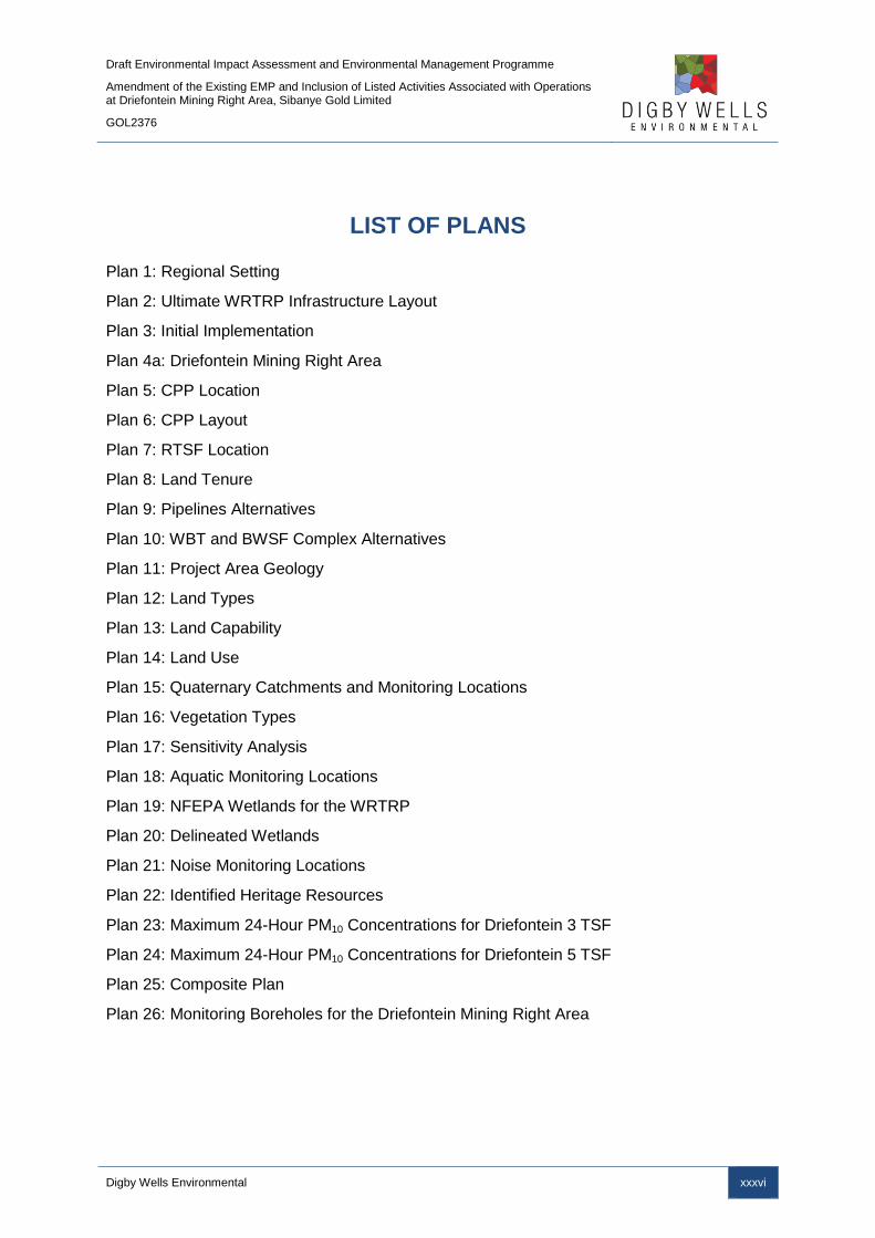
Draft Environmental Impact Assessment and Environmental Management Programme
Amendment of the Existing EMP and Inclusion of Listed Activities Associated with Operations at Driefontein Mining Right Area, Sibanye Gold Limited
GOL2376
Digby Wells Environmental xxxvi
LIST OF PLANS
Plan 1: Regional Setting
Plan 2: Ultimate WRTRP Infrastructure Layout
Plan 3: Initial Implementation
Plan 4a: Driefontein Mining Right Area
Plan 5: CPP Location
Plan 6: CPP Layout
Plan 7: RTSF Location
Plan 8: Land Tenure
Plan 9: Pipelines Alternatives
Plan 10: WBT and BWSF Complex Alternatives
Plan 11: Project Area Geology
Plan 12: Land Types
Plan 13: Land Capability
Plan 14: Land Use
Plan 15: Quaternary Catchments and Monitoring Locations
Plan 16: Vegetation Types
Plan 17: Sensitivity Analysis
Plan 18: Aquatic Monitoring Locations
Plan 19: NFEPA Wetlands for the WRTRP
Plan 20: Delineated Wetlands
Plan 21: Noise Monitoring Locations
Plan 22: Identified Heritage Resources
Plan 23: Maximum 24-Hour PM10 Concentrations for Driefontein 3 TSF
Plan 24: Maximum 24-Hour PM10 Concentrations for Driefontein 5 TSF
Plan 25: Composite Plan
Plan 26: Monitoring Boreholes for the Driefontein Mining Right Area

Draft Environmental Impact Assessment and Environmental Management Programme
Amendment of the Existing EMP and Inclusion of Listed Activities Associated with Operations at Driefontein Mining Right Area, Sibanye Gold Limited
GOL2376
Digby Wells Environmental xxxvii
List of Acronyms and Abbreviations
ASTP Average Score Per recorded Taxon
AWTF Advanced Water Treatment Facility
BWSF Bulk Water Storage Facility
C4S Cooke 4 South
CPP Central Processing Plant
CR Critically Endangered
COP Cooke Optimisation Project
CoR Certificate of Registration
CUP Cooke Uranium Project
CV Curriculum Vitae
CVB Channelled valley bottom
DEA Department of Environmental Affairs
DMR Department of Mineral Resources
EA Environmental Authorisation
EAP Environmental Assessment Practitioner
EIA Environmental Impact Assessment
EIS Ecological Importance and Sensitivity
EMP Environmental Management Programme
EN Endangered
FTE Full time equivalent
GAC Granular activated carbon
GDARD Gauteng Department of Agriculture and Rural Development
GDP-R Gross Domestic Product per Region
I&APs Interested and Affected Parties
IDP Integrated Development Plan
IHAS Integrated Habitat Assessment System
IHIA Intermediate Habitat Integrity Assessment
IUCN International Union for the Conservation of Nature
KDC Kloof Driefontein Complex
LC Least Concern
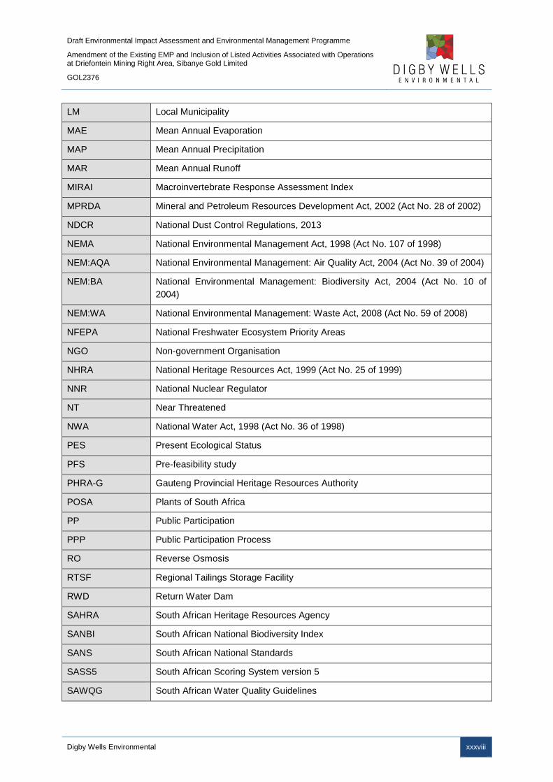
Draft Environmental Impact Assessment and Environmental Management Programme
Amendment of the Existing EMP and Inclusion of Listed Activities Associated with Operations at Driefontein Mining Right Area, Sibanye Gold Limited
GOL2376
Digby Wells Environmental xxxviii
LM Local Municipality
MAE Mean Annual Evaporation
MAP Mean Annual Precipitation
MAR Mean Annual Runoff
MIRAI Macroinvertebrate Response Assessment Index
MPRDA Mineral and Petroleum Resources Development Act, 2002 (Act No. 28 of 2002)
NDCR National Dust Control Regulations, 2013
NEMA National Environmental Management Act, 1998 (Act No. 107 of 1998)
NEM:AQA National Environmental Management: Air Quality Act, 2004 (Act No. 39 of 2004)
NEM:BA National Environmental Management: Biodiversity Act, 2004 (Act No. 10 of
2004)
NEM:WA National Environmental Management: Waste Act, 2008 (Act No. 59 of 2008)
NFEPA National Freshwater Ecosystem Priority Areas
NGO Non-government Organisation
NHRA National Heritage Resources Act, 1999 (Act No. 25 of 1999)
NNR National Nuclear Regulator
NT Near Threatened
NWA National Water Act, 1998 (Act No. 36 of 1998)
PES Present Ecological Status
PFS Pre-feasibility study
PHRA-G Gauteng Provincial Heritage Resources Authority
POSA Plants of South Africa
PP Public Participation
PPP Public Participation Process
RO Reverse Osmosis
RTSF Regional Tailings Storage Facility
RWD Return Water Dam
SAHRA South African Heritage Resources Agency
SANBI South African National Biodiversity Index
SANS South African National Standards
SASS5 South African Scoring System version 5
SAWQG South African Water Quality Guidelines
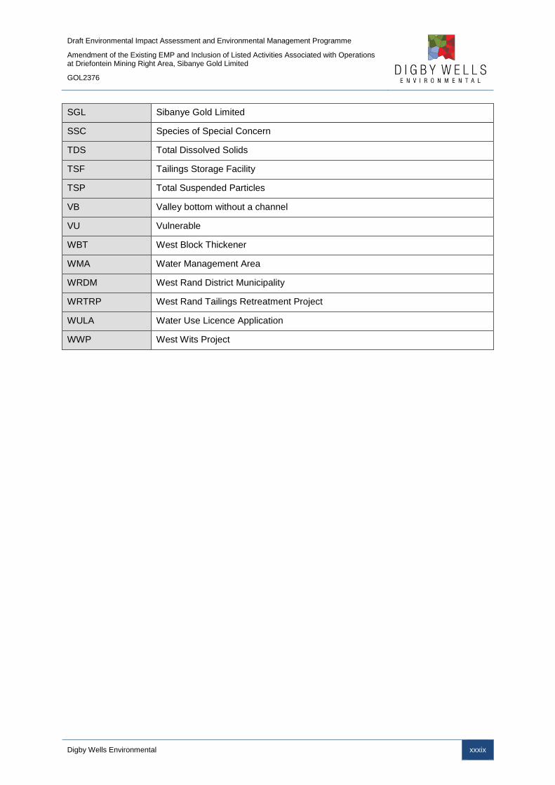
Draft Environmental Impact Assessment and Environmental Management Programme
Amendment of the Existing EMP and Inclusion of Listed Activities Associated with Operations at Driefontein Mining Right Area, Sibanye Gold Limited
GOL2376
Digby Wells Environmental xxxix
SGL Sibanye Gold Limited
SSC Species of Special Concern
TDS Total Dissolved Solids
TSF Tailings Storage Facility
TSP Total Suspended Particles
VB Valley bottom without a channel
VU Vulnerable
WBT West Block Thickener
WMA Water Management Area
WRDM West Rand District Municipality
WRTRP West Rand Tailings Retreatment Project
WULA Water Use Licence Application
WWP West Wits Project

Draft Environmental Impact Assessment and Environmental Management Programme
Amendment of the Existing EMP and Inclusion of Listed Activities Associated with Operations at Driefontein Mining Right Area, Sibanye Gold Limited
GOL2376
Digby Wells Environmental 1
Part A: Scope of Assessment and
Environmental Impact Assessment Report

Draft Environmental Impact Assessment and Environmental Management Programme
Amendment of the Existing EMP and Inclusion of Listed Activities Associated with Operations at Driefontein Mining Right Area, Sibanye Gold Limited
GOL2376
Digby Wells Environmental 2
1 Introduction
Digby Wells Environmental (Digby Wells) was appointed by Sibanye Gold Limited (SGL) to
conduct the Environmental Impact Assessment (EIA) process, which includes the
compilation of an EIA and Scoping Report, for the West Rand Tailing Retreatment Project
(WRTRP) in the Gauteng Province, South Africa, as shown in Plan 12.
1.1 Company Background
GFI Mining South Africa (Pty) Limited, (Registration Number 2002/031431/07) was, prior to
February 2013, a subsidiary within the Gold Fields Group. In early 2013 Gold Fields
unbundled its Kloof Driefontein Complex (KDC) and Beatrix gold mines in the Free State to
create a separate entity in SGL (Registration Number 2002/031431/06), listed as a fully
independent company on both the JSE and the NYSE Stock Exchanges.
Subsequently, in October 2013, SGL purchased the interest held by Gold One International
Limited (Gold One) in Rand Uranium Limited (Rand Uranium) and Ezulwini Mining Company
Limited (Ezulwini). These interests were held through a 74% shareholding in Newshelf 1114
(Pty) Limited (Newshelf), which owns 100% of Rand Uranium and Ezulwini. The purchase
consideration was 150 million SGL shares, amounting to a shareholding of about 17% being
held by Gold One. The transaction was subject to various conditions, including the approval
of the Competition Commission and the approval of the Minister of Mineral Resources.
These approvals have been granted and the merger is now unconditional. The Gold One
assets which have become part of Sibanye included the Cooke Operations (underground
mining and surface reclamation operations) for gold and uranium production, and after
completion of the transaction, SGL consolidated all of its and Gold One’s operations for the
reclamation of tailings to produce gold, uranium and sulphur on the West Rand.
1.2 Project History
The treatment of historical tailings in the West Rand area has a long history with Gold Fields,
Rand Uranium, Harmony Gold Mining Company Limited (Harmony), Gold One and SGL
completing a number of parallel, independent studies relating to the treatment of these
historical tailings.
In late 2009, Gold Fields and Rand Uranium met to evaluate the potential synergy of an
integrated flow sheet for the Cooke Uranium Project (Rand Uranium) and the West Wits
Tailings Treatment Project (Gold Fields), both of which were nearing feasibility completion. A
significant amount of re-engineering and confirmatory test work would have been required to
achieve this and, given the momentum of the respective projects, it was agreed that the
investment would not be justified at that point in time. After the completion of the respective
projects they were put on hold because of economic circumstances at the time.
2 All plans are also provided in Appendix A.
Draft Environmental Impact Assessment and Environmental Management Programme
Amendment of the Existing EMP and Inclusion of Listed Activities Associated with Operations at Driefontein Mining Right Area, Sibanye Gold Limited
GOL2376
Digby Wells Environmental 3
From 2010 through to 2012, Rand Uranium completed the Cooke Uranium Project (CUP)
and the Cooke Optimisation Project (COP) for which various applications were made to the
authorities with authorisation on certain aspects being received and others remain pending.
In 2012, Gold One acquired Rand Uranium and in the same year acquired the Ezulwini
Mining Company (Pty) Ltd (Ezulwini) in an agreement with First Uranium Corporation. The
company, during the same year, completed an application and relevant studies for the
Geluksdal TSF Project.
In early 2013 Gold Fields unbundled its KDC and Beatrix gold mines to create SGL.
1.3 Project Description
The broader West Rand area3 contains an estimated 1.3 billion tonnes of surface gold and
uranium tailings, with approximately 170 million pounds of recoverable uranium and 11
million ounces of recoverable gold. SGL, as the current majority owner of these resources,
plans to exploit the tailings to develop a strong, long life and high yield surface mining
business. Key to the successful execution of this development strategy is the WRTRP. The
concept of the WRTRP is well understood with an 8 year history of extensive metallurgical
test work, feasibility studies and design by a number of major mining houses. A pre-
feasibility study (PFS) completed during 2013 for the WRTRP has confirmed that there is a
significant opportunity to extract value from the SGL surface resources in a cost effective
sequence.
The ultimate WRTRP or “Ultimate Project” involves the construction of a large-scale Central
Processing Plant (CPP) for the recovery of gold, uranium and sulfur from the available
resources. The CPP, centrally located to the West Rand resources, will be developed in
phases to treat eventually up to 4 million tonnes per month (Mt/m) of tailings inclusive of
current underground arisings. The resultant tailings will be deposited on a Tailings Storage
Facility (TSF) with a modern engineering design called the Regional TSF (RTSF). The
regional and local project settings are indicated on Plan 1 and Plan 2.
The Ultimate Project will be implemented in a number phases. Of these phases, phase 1 or
the “Initial Implementation”, entails the reclamation of certain TSFs as well as the
construction and operation of the first phase section of the RTSF, Gold Module 1 of the CPP
and the first uranium roaster and acid plants. The Ultimate Project and Initial Implementation
are explained in more detail below (Plan 3).
3 The broader West Rand area includes Carletonville in the far west, Westonaria and Randfontein in the northeast.

Draft Environmental Impact Assessment and Environmental Management Programme
Amendment of the Existing EMP and Inclusion of Listed Activities Associated with Operations at Driefontein Mining Right Area, Sibanye Gold Limited
GOL2376
Digby Wells Environmental 4
Plan 1: Regional Setting

Draft Environmental Impact Assessment and Environmental Management Programme
Amendment of the Existing EMP and Inclusion of Listed Activities Associated with Operations at Driefontein Mining Right Area, Sibanye Gold Limited
GOL2376
Digby Wells Environmental 5
Plan 2: Ultimate WRTRP Infrastructure Layout

Draft Environmental Impact Assessment and Environmental Management Programme
Amendment of the Existing EMP and Inclusion of Listed Activities Associated with Operations at Driefontein Mining Right Area, Sibanye Gold Limited
GOL2376
Digby Wells Environmental 6
1.3.1 Ultimate Project
Simplistically, SGL’s historical TSF holdings in the West Rand can be divided into four
Mining Right areas; the Driefontein, Kloof, Cooke and Ezulwini Mining Right areas as shown
in Plan 4a – Plan 4d. Each of these Mining Right areas (other than Ezulwini) contains a
number of historical TSFs as detailed below:
■ Kloof Mining Right area: Kloof 1 TSF, Kloof 2 TSF, Leeudoorn TSF, Libanon TSF,
Venterspost North and Venterspost South TSFs. Venterspost North and South TSFs
will be processed with the concurrent construction of Module 2 floatation and gold
plants of the CPP. The remainder of the TSFs will be processed once Module 3 has
been constructed;
■ Driefontein Mining Right area: Driefontein 1, 2, 3 and 5 TSF. Once the Driefontein 3
and 5 TSFs have been depleted the remainder of the Driefontein TSFs, namely
Driefontein 1, 2 and 4 TSFs, will be processed through the CPP. The Driefontein 4
TSF currently falls outside the Driefontein Mining Right area; the inclusion of
Driefontein 4 TSF into the Driefontein Mining Right area is part of this EIA and
Section 102 amendment submitted to the DMR;
■ Cooke Mining Right area: C4S TSF, Cooke TSF and the Millsite Complex (38, 39
and 40/41 and Valley) TSFs. Millsite Complex will be processed with the concurrent
construction of Module 2 floatation and gold plants; and
■ Ezulwini Mining Right area: No TSFs fall within the Ezulwini Mining Right. Uranium
will be processed at the Ezulwini Plant and new pipelines will be constructed.
Each of the Mining Right areas will be reclaimed in a phased approach (Plan 3). The
Driefontein 3 TSF, concurrently with the Cooke TSF, will be reclaimed first. Following
reclamation of Driefontein 3 TSF, Driefontein 5 TSF and Cooke 4 Dam south (C4S) will be
reclaimed.
Once commissioned the project will initially reclaim and treat the TSFs at a rate of 1.5 Mt/m:
1 Mt/m from Driefontein 3 TSF, followed sequentially by Driefontein 5 and C4S TSFs and 0.5
Mt/m from Cooke TSF. Reclamation and processing capacity will ultimately ramp up to 4
Mt/m over an anticipated period of 8 years. At the 4 Mt/m tailings retreatment capacity, each
of the Mining Right area TSFs will be reclaimed and processed simultaneously as well as the
underground arisings being accommodated.
The tailings material will be centrally treated in a CPP. In addition to gold and uranium
extraction, sulfur will be extracted to produce sulphuric acid which in turn will be reused in
the uranium plant leach section.
To ensure the economic viability of the project the upfront capital required for the WRTRP
will be minimised, only essential infrastructure will be developed during initial
implementation. Use of existing and available infrastructure may be used to process gold
Draft Environmental Impact Assessment and Environmental Management Programme
Amendment of the Existing EMP and Inclusion of Listed Activities Associated with Operations at Driefontein Mining Right Area, Sibanye Gold Limited
GOL2376
Digby Wells Environmental 7
and uranium until the volumetric increase in tonnage necessitates the need to expand the
CPP.
The authorisation, construction and operation of a new deposition site for the residue from
the CPP will be located in an area that has been extensively studied as part of the original
Gold Fields’ West Wits Project (WWP) and the Rand Uranium’s Cooke Uranium Project
(CUP) and Geluksdal TSF. The “deposition area” on which the project is focussing, has been
termed the RTSF and is anticipated to accommodate the entire tonnage from the district.
The RTSF if proved viable will be one large facility as opposed to the two independent
deposition facilities proposed by the WWP and CUP respectively.
SGL has various authorisations and approvals for elements of the WWP and CUP projects,
with authorisations and approvals for certain aspects of the respective projects still
outstanding. The WRTRP aims to combine the WWP and CUP projects, as per stakeholder
concerns and suggestions based on the WWP and CUP projects. Should the WRTRP not
proceed, SGL will continue with the CUP and WWP projects for activities that have been
authorised, as well as proceeding with the application processes for the outstanding
authorisations.
Draft Environmental Impact Assessment and Environmental Management Programme
Amendment of the Existing EMP and Inclusion of Listed Activities Associated with Operations at Driefontein Mining Right Area, Sibanye Gold Limited
GOL2376
Digby Wells Environmental 8
Plan 3: Initial Implementation

Draft Environmental Impact Assessment and Environmental Management Programme
Amendment of the Existing EMP and Inclusion of Listed Activities Associated with Operations at Driefontein Mining Right Area, Sibanye Gold Limited
GOL2376
Digby Wells Environmental 9
Plan 4a: Driefontein Mining Right Area

Draft Environmental Impact Assessment and Environmental Management Programme
Amendment of the Existing EMP and Inclusion of Listed Activities Associated with Operations at Driefontein Mining Right Area, Sibanye Gold Limited
GOL2376
Digby Wells Environmental 10
Plan 4b: Kloof Mining Right Area

Draft Environmental Impact Assessment and Environmental Management Programme
Amendment of the Existing EMP and Inclusion of Listed Activities Associated with Operations at Driefontein Mining Right Area, Sibanye Gold Limited
GOL2376
Digby Wells Environmental 11
Plan 4c: Cooke Mining Right Area

Draft Environmental Impact Assessment and Environmental Management Programme
Amendment of the Existing EMP and Inclusion of Listed Activities Associated with Operations at Driefontein Mining Right Area, Sibanye Gold Limited
GOL2376
Digby Wells Environmental 12
Plan 4d: Ezulwini Mining Right Area

Draft Environmental Impact Assessment and Environmental Management Programme
Amendment of the Existing EMP and Inclusion of Listed Activities Associated with Operations at Driefontein Mining Right Area, Sibanye Gold Limited
GOL2376
Digby Wells Environmental 13
1.3.1.1 Mining Rights Concerned
1.3.1.1.1 Driefontein Mining Right Area
Driefontein holds mining right GP 51 MR. Currently the Driefontein No 4 TSF lies outside of
the MR area and needs to be incorporated through an amendment process in terms of
Section 102 of the MPRDA. This is the Driefontein Mining right Area.
Table 1-1 provides a summary of the ultimate project and Figure 1-1 shows the geographical
extent of the ultimate project.
1.3.1.1.2 Kloof Mining Right Area
Kloof holds in its own right, GP 66 MR within which the CPP and K10 water supply forms
part. Adjacent to the Kloof Mining Right area are the Venterspost TSFs (North and South),
as well as the proposed RTSF and AWTF; the Mining Right area will be amended to
incorporate these areas into the right as part of this application.
1.3.1.1.3 Cooke Mining Right Area
Rand Uranium holds 2 mining rights (GP 7 MR and GP 173 MR) and two prospecting rights
(GP 241 PR and GP 238 PR). These rights relate to the Cooke operations (1, 2 & 3) and Old
Randfontein. This, after the prospecting rights have been converted into mining rights, will be
referred to as the Cooke Mining Right Area.
1.3.1.1.4 Ezulwini Mining Right Area
Ezulwini holds Cooke 4 under GP 38 MR and a prospecting right (GP 307 PR). These will be
known as the Ezulwini Mining Right Area.

Draft Environmental Impact Assessment and Environmental Management Programme
Amendment of the Existing EMP and Inclusion of Listed Activities Associated with Operations at Driefontein Mining Right Area, Sibanye Gold Limited
GOL2376
Digby Wells Environmental 14
Table 1-1: Scheduled Activities of the WRTRP – Ultimate Project
Proposed Construction Start Date* 2016 2018 2020
Operation Date 2019 2021 2024
Activities
Treat Driefontein 3 and 5, C4S TSF (at 1Mt/m) and
Cooke TSFs at0.5Mt/m totalling 1.5 Mt/m through
Gold Module 1, uranium, roaster and acid plants of the
new CPP with deposition onto the RTSF.
High grade uranium concentrate (50 kt/m) transported
and treated at Ezulwini uranium plant.
Kloof 1 and 2 TSFs and current arisings
Reclaim Leeudoorn and associated Mine Dumps
Potentially South Deep Mine Dumps (future) and
current arisings tail will go through CPP (high
Uranium)
Reclaim Millsite TSF
Continue to reclaim Millsite TSF (39, 40, 41 and
Valley)
Reclaim Venterspost North and South Mine Dumps
Existing infrastructure to be leveraged Ezulwini Uranium Plant (50 kt/m) to treat concentrate
from the CPP
New infrastructure required
CPP Gold Module I (footprint of full capacity to be
authorised now):
Gold Plant I
Sulphide and oxide Floatation Plant
Uranium Plant 1
Acid Plant
Roaster 1
RTSF (footprint of full capacity to be authorised now)
West Block Thickener (WBT) and bulk water storage
Pipelines between Driefontein 3, Driefontein 5, C4S,
Cooke TSF, WBT, CPP and RTSF
CPP Gold Module II:
Gold Plant II
Pipelines, roads and pumps
CPP Gold Module III:
Gold Plant III
Uranium Plant II
Pipelines, roads and pumps
Thickener

Draft Environmental Impact Assessment and Environmental Management Programme
Amendment of the Existing EMP and Inclusion of Listed Activities Associated with Operations at Driefontein Mining Right Area, Sibanye Gold Limited
GOL2376
Digby Wells Environmental 15
Figure 1-1: Geographical Extent of the WRTRP – Ultimate Project
Draft Environmental Impact Assessment and Environmental Management Programme
Amendment of the Existing EMP and Inclusion of Listed Activities Associated with Operations at Driefontein Mining Right Area, Sibanye Gold Limited
GOL2376
Digby Wells Environmental 16
1.3.1.2 Water Sources
A number of mine impacted water sources have been identified from which water can be
supplied to the reclamation operations. SGL has recognised that water is a scarce and
strategic commodity and hence currently impacted mine water will be used preferentially
over Rand Water or other higher quality sources. Water will be supplied to the reclamation
areas from the identified sources, such as mine affected water at the Kloof K10 shaft, Cooke
1 and 2 Shafts and Cooke 4 South Shaft, via pipelines and bulk water storage facilities
(BWSF).
Once the impacted mine water, supplemented by recovered water from the various
thickeners, has been used in the hydraulic reclamation process, it will find its way to the
RTSF as carrier water for the retreated tailings. As process and rain water builds up on the
RTSF it will be drained to the Return Water Dam (RWD) and treated through the Advanced
Water Treatment Facility (AWTF).
1.3.1.3 Reclamation of Tailings
The tailings reclamation process is essentially a water hydraulic mining operation, where the
TSFs will be hydraulically reclaimed to the natural ground level in nominal 12 to 15 m
benches and the foot print rehabilitated to a suitable end land use.
Water will be supplied to the various reclamation sites, from existing impacted mine water
sources, and then pressurised through a high pressure pumping system before reporting to
the monitoring guns at the top of the historical TSFs. Monitoring guns will be used at the
reclamation site mining face to reclaim the tailings material.
The reclaimed material, in the form of slurry, will flow through open channels over screens to
remove oversized debris from the slurry before it enters a tank. A series of pumps will then
pump the slurry from the tanks via thickeners to the CPP for gold, uranium and sulfur
extraction. The historical TSFs proposed for reclamation cover a total of approximately
1 660 ha, as shown in Table 1-2. The RTSF footprint will be approximately 1 350 ha,
liberating a nett 310 ha of currently sterilised land.
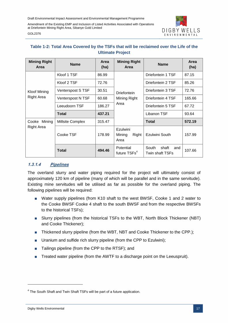
Draft Environmental Impact Assessment and Environmental Management Programme
Amendment of the Existing EMP and Inclusion of Listed Activities Associated with Operations at Driefontein Mining Right Area, Sibanye Gold Limited
GOL2376
Digby Wells Environmental 17
Table 1-2: Total Area Covered by the TSFs that will be reclaimed over the Life of the
Ultimate Project
Mining Right
Area Name
Area
(ha)
Mining Right
Area Name
Area
(ha)
Kloof Mining
Right Area
Kloof 1 TSF 86.99
Driefontein
Mining Right
Area
Driefontein 1 TSF 87.15
Kloof 2 TSF 72.76 Driefontein 2 TSF 85.26
Venterspost S TSF 30.51 Driefontein 3 TSF 72.76
Venterspost N TSF 60.68 Driefontein 4 TSF 165.66
Leeudoorn TSF 186.27 Driefontein 5 TSF 67.72
Total 437.21 Libanon TSF 93.64
Cooke Mining
Right Area
Millsite Complex 315.47 Total 572.19
Cooke TSF 178.99
Ezulwini
Mining Right
Area
Ezulwini South 157.99
Total 494.46 Potential
future TSFs4
South shaft and
Twin shaft TSFs 107.66
1.3.1.4 Pipelines
The overland slurry and water piping required for the project will ultimately consist of
approximately 120 km of pipeline (many of which will be parallel and in the same servitude).
Existing mine servitudes will be utilised as far as possible for the overland piping. The
following pipelines will be required:
■ Water supply pipelines (from K10 shaft to the west BWSF, Cooke 1 and 2 water to
the Cooke BWSF Cooke 4 shaft to the south BWSF and from the respective BWSFs
to the historical TSFs);
■ Slurry pipelines (from the historical TSFs to the WBT, North Block Thickener (NBT)
and Cooke Thickener);
■ Thickened slurry pipeline (from the WBT, NBT and Cooke Thickener to the CPP.);
■ Uranium and sulfide rich slurry pipeline (from the CPP to Ezulwini);
■ Tailings pipeline (from the CPP to the RTSF); and
■ Treated water pipeline (from the AWTF to a discharge point on the Leeuspruit).
4 The South Shaft and Twin Shaft TSFs will be part of a future application.
Draft Environmental Impact Assessment and Environmental Management Programme
Amendment of the Existing EMP and Inclusion of Listed Activities Associated with Operations at Driefontein Mining Right Area, Sibanye Gold Limited
GOL2376
Digby Wells Environmental 18
1.3.1.5 Thickeners
A WBT, NBT and Cooke Thickener will be constructed for the respective Mining Right areas.
The thickeners will be used to thicken reclaimed tailings from the TSFs before it is pumped
to the CPP for processing. The thickeners provide slurry of consistent density to the CPP
and are critical in the optimisation of the operating of the plant. The thickeners also aid in
minimising pumping costs by optimising the amount of water pumped around the circuit.
1.3.1.6 Central Processing Plant
The anticipated location for the CPP is mid-way between Kloof Main and Kloof 4 shaft
central to all the resources, water and power supply, as well as existing and planned
infrastructure (Plan 5). The Plant will be developed in phases to treat eventually up to 4 Mt/m
of historical tailings and current underground arisings. The CPP will eventually comprise
(Plan 6):
■ Gold Plant Modules (3);
■ Floatation plants and associated infrastructure (one associated with the uranium
plants);
■ Roasters and associated infrastructure;
■ Acid plants and associated infrastructure;
■ Uranium processing plants (2);
■ Bulk sulfuric acid storage facility;
■ Loading facilities for uranium concentrate, bulk sulfuric acid and reagents;
■ Bulk Water storage facilities; and
■ Pollution control dams.
1.3.1.7 Regional Tailings Storage Facility
This RTSF has been positioned and sized as a facility that can cater for both the tailings
generated by the WRTRP as well as other tailings located in the region approximating 1.3
billion tonnes.
During the pre-feasibility study (PFS) the Gold Fields CTSF authorised by
DEA/GDARD/NEMA and the Gold One Geluksdal TSF were considered for the WRTRP.
Following an optimisation exercise requiring an ultimate deposition rate of 4 Mt/m, it was
recognised that the CTSF and Geluksdal sites alone and collectively were insufficient to
accommodate the desired tonnage profile for the project, both in deposition rates and in
tonnage capacity for the proposed RTSF. The optimal location of the RTSF has been
positioned between these two facilities, an area that has been extensively studied by the
WWP and CUP but requires further investigation (Plan 7). It is likely that the construction of
the RTSF will be phased to suit the envisaged tonnage build up. The RTSF will be sized,
assessed and permitted on the basis of accommodating the long term requirements of the
Draft Environmental Impact Assessment and Environmental Management Programme
Amendment of the Existing EMP and Inclusion of Listed Activities Associated with Operations at Driefontein Mining Right Area, Sibanye Gold Limited
GOL2376
Digby Wells Environmental 19
region. The RTSF will consolidate and mitigate the potential impacts of the historical TSFs
currently scattered throughout the West Rand.
1.3.1.8 Return Water Dam
The design and management of the RTSF RWD will need to be undertaken in line with the
requirements of the GN 704 regulations. The RWD has therefore been sized to ensure that it
is unlikely to spill into any clean water system more than once in 50 years, given a certain
return water and/or water treatment rate.
The ultimate RWD arrangement, which will consist of a series of compartments due to the
phased development of the RTSF, will require a total storage capacity of at least 3.5 million
m3. To limit seepage of process water, the RWD will be lined with a geocomposite liner
consisting of a geomembrane underlain by a 300 mm thick layer of clayey material won from
site. A seepage collection system will also be provided to intercept and identify any leakage.
1.3.1.9 Advanced Water Treatment Facility
The design by Watercare Mining (WCM) consists of a multiple stage softening and
membrane separation process. The method of softening uses a Crystalactor® process for
softening which reduces the incoming water hardness by the precipitation of calcium pellets.
Through pH control and a feed crystal source of fine quartz sand, precipitation is controlled
and creates fine pellets which are highly stable and easy to handle. This effectively
combines the softening and clarifying stage in one process. This is followed by GAC
(granular activated carbon) and Nano-filtration to remove all solids as well as organic
compounds to protect the Reverse osmosis (RO) membranes from damage and fouling. The
filtrate from the first stage membranes is below the prescribed quality and the brine is sent to
a secondary Crystalactor® for softening again and follows the same processes as described
by Stage 1. Three stages are used to create an overall water recovery of 93% with the solid
waste discharged as stable pellets at an approximate water content of only 5%. Each stage
of RO membrane recovery ranges from 65% to 50%, with each consecutive stage being
lower recovery due to the saturation limit as well as the operating pressure being kept as low
as possible to conserve energy.
The options for disposal of the pellets is either by creating a slurry that is pumped to the
RTSF, or it needs to be collected on a drying bank and collected with a tipper and driven to
the RTSF for disposal. The footprint of the proposed plant is approximate area of 0.36 ha
and will cater for the scope of the Ultimate Project.

Draft Environmental Impact Assessment and Environmental Management Programme
Amendment of the Existing EMP and Inclusion of Listed Activities Associated with Operations at Driefontein Mining Right Area, Sibanye Gold Limited
GOL2376
Digby Wells Environmental 20
Plan 5: CPP Location

Draft Environmental Impact Assessment and Environmental Management Programme
Amendment of the Existing EMP and Inclusion of Listed Activities Associated with Operations at Driefontein Mining Right Area, Sibanye Gold Limited
GOL2376
Digby Wells Environmental 21
Plan 6: CPP Layout

Draft Environmental Impact Assessment and Environmental Management Programme
Amendment of the Existing EMP and Inclusion of Listed Activities Associated with Operations at Driefontein Mining Right Area, Sibanye Gold Limited
GOL2376
Digby Wells Environmental 22
Plan 7: RTSF Location
Draft Environmental Impact Assessment and Environmental Management Programme
Amendment of the Existing EMP and Inclusion of Listed Activities Associated with Operations at Driefontein Mining Right Area, Sibanye Gold Limited
GOL2376
Digby Wells Environmental 23
1.3.2 Initial Implementation
Due to commercial imperatives in developing a project of this magnitude, it needs to be
implemented over time. The initial investment and development will be focused on those
assets that will put the project in a position to partially fund the remaining development.
This entails the design and construction of the initial components of the CPP (gold module,
floatation plant, uranium plant, acid plant and a roaster), to retreat up to 1.5 Mt/m
concurrently from the Driefontein 3 and 5 TSFs, C4S TSF (1Mt/m) and the Cooke TSF
(0.5Mt/m). Driefontein 3, 5 and C4S TSFs will be mined sequentially over 11 years, whilst
the Cooke TSF will be mined concurrent to these for a period of 16 years. The resultant
tailings will be deposited onto the first stage of the new RTSF.
A high grade uranium concentrate, produced at the CPP, will be transported to Ezulwini (50
k tonnes per month) for the extraction of uranium. The tailings from this process will be
deposited on the existing operational Ezulwini North TSF.
Figure 1-2 provides a high-level overview of the process to be undertaken as part of the
Initial Implementation of the WRTRP, whilst Plan 3 provides a visual overview of the project
to be implemented in the various phased.

Draft Environmental Impact Assessment and Environmental Management Programme
Amendment of the Existing EMP and Inclusion of Listed Activities Associated with Operations at Driefontein Mining Right Area, Sibanye Gold Limited
GOL2376
Digby Wells Environmental 24
Figure 1-2: Initial Implementation Process Summary
Draft Environmental Impact Assessment and Environmental Management Programme
Amendment of the Existing EMP and Inclusion of Listed Activities Associated with Operations at Driefontein Mining Right Area, Sibanye Gold Limited
GOL2376
Digby Wells Environmental 25
The CPP and RTSF are likely to be the two components of the project with the most
significant potential environmental impacts and will be developed as the project progresses.
The CPP will be developed in 3 phases over a period of approximately eight years, however
this application is for the entire CPP site i.e. Modules I, II and III, uranium plants, roasters
and acid plant. Similarly the RTSF will be developed in two phases over the life of the
project, but this application is for the entire RTSF footprint and will be assessed as such. The
decision to take this approach, as opposed to authorising these components in stages as
they are developed, is to provide the regulators and the public with an impact assessment
that takes the whole project into consideration. This approach allows the authorities to make
a decision based on a complete impact assessment as opposed to incremental applications
for each new phase.
The primary activities to take place during the Initial Implementation of the WRTRP are listed
in Table 1-3, with the pipeline routes outlined in Table 1-4.
Table 1-3: Primary Activities of the WRTRP Initial Implementation
Category Activity
Driefontein Mining Right area
Infrastructure
Pipeline Routes (water, slurry and thickened tailings).
West block Thickener (WBT) and Bulk Water Storage Facility (BWSF) complex.
Collection sumps and pump stations at the Driefontein 3 and 5 TSFs
Processes Hydraulic reclamation of the Driefontein 3 and 5 TSFs.
Pumping
Pumping water from K10 to the BWSF located next to the WBT.
Pumping water from the BWSF to the Driefontein TSFs that will be reclaimed.(Dri3
& 5 TSFs)
Pumping slurry from the TSF sump to the WBT (for Driefontein 3 and 5 TSFs).
Pumping the thickened slurry from the WBT to the CPP.
Electricity
supply
Power supply from West Driefontein 6 substation to Driefontein 3 TSF.
Power supply from West Driefontein Gold substation to Driefontein 5 TSF.
Power supply from East Driefontein Shaft substation to WBT and BWSF complex.
Kloof Mining Right area
Infrastructure
Pipeline Routes (residual tailings).
Central processing Plant (CPP) incorporating Module 1 floatation and gold plants
and uranium, roaster and acid plants.
The Regional Tailings Storage Facility (RTSF), RTSF Return Water Dam (RWD)
and the Advanced Water Treatment Facility (AWTF). Collectively known as the
RTSF complex.
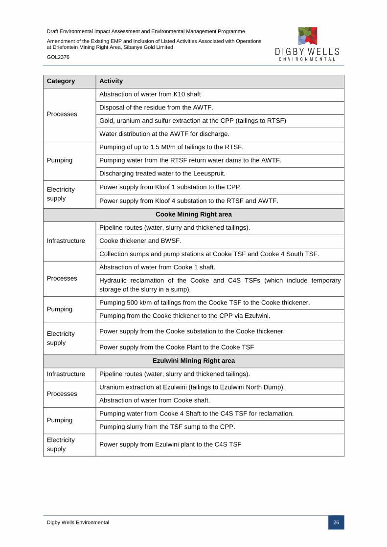
Draft Environmental Impact Assessment and Environmental Management Programme
Amendment of the Existing EMP and Inclusion of Listed Activities Associated with Operations at Driefontein Mining Right Area, Sibanye Gold Limited
GOL2376
Digby Wells Environmental 26
Category Activity
Processes
Abstraction of water from K10 shaft
Disposal of the residue from the AWTF.
Gold, uranium and sulfur extraction at the CPP (tailings to RTSF)
Water distribution at the AWTF for discharge.
Pumping
Pumping of up to 1.5 Mt/m of tailings to the RTSF.
Pumping water from the RTSF return water dams to the AWTF.
Discharging treated water to the Leeuspruit.
Electricity
supply
Power supply from Kloof 1 substation to the CPP.
Power supply from Kloof 4 substation to the RTSF and AWTF.
Cooke Mining Right area
Infrastructure
Pipeline routes (water, slurry and thickened tailings).
Cooke thickener and BWSF.
Collection sumps and pump stations at Cooke TSF and Cooke 4 South TSF.
Processes
Abstraction of water from Cooke 1 shaft.
Hydraulic reclamation of the Cooke and C4S TSFs (which include temporary
storage of the slurry in a sump).
Pumping Pumping 500 kt/m of tailings from the Cooke TSF to the Cooke thickener.
Pumping from the Cooke thickener to the CPP via Ezulwini.
Electricity
supply
Power supply from the Cooke substation to the Cooke thickener.
Power supply from the Cooke Plant to the Cooke TSF
Ezulwini Mining Right area
Infrastructure Pipeline routes (water, slurry and thickened tailings).
Processes Uranium extraction at Ezulwini (tailings to Ezulwini North Dump).
Abstraction of water from Cooke shaft.
Pumping Pumping water from Cooke 4 Shaft to the C4S TSF for reclamation.
Pumping slurry from the TSF sump to the CPP.
Electricity
supply Power supply from Ezulwini plant to the C4S TSF
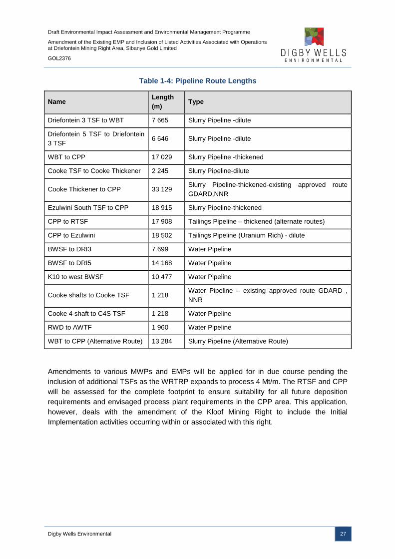
Draft Environmental Impact Assessment and Environmental Management Programme
Amendment of the Existing EMP and Inclusion of Listed Activities Associated with Operations at Driefontein Mining Right Area, Sibanye Gold Limited
GOL2376
Digby Wells Environmental 27
Table 1-4: Pipeline Route Lengths
Name Length
(m) Type
Driefontein 3 TSF to WBT 7 665 Slurry Pipeline -dilute
Driefontein 5 TSF to Driefontein
3 TSF 6 646 Slurry Pipeline -dilute
WBT to CPP 17 029 Slurry Pipeline -thickened
Cooke TSF to Cooke Thickener 2 245 Slurry Pipeline-dilute
Cooke Thickener to CPP 33 129 Slurry Pipeline-thickened-existing approved route
GDARD,NNR
Ezulwini South TSF to CPP 18 915 Slurry Pipeline-thickened
CPP to RTSF 17 908 Tailings Pipeline – thickened (alternate routes)
CPP to Ezulwini 18 502 Tailings Pipeline (Uranium Rich) - dilute
BWSF to DRI3 7 699 Water Pipeline
BWSF to DRI5 14 168 Water Pipeline
K10 to west BWSF 10 477 Water Pipeline
Cooke shafts to Cooke TSF 1 218 Water Pipeline – existing approved route GDARD ,
NNR
Cooke 4 shaft to C4S TSF 1 218 Water Pipeline
RWD to AWTF 1 960 Water Pipeline
WBT to CPP (Alternative Route) 13 284 Slurry Pipeline (Alternative Route)
Amendments to various MWPs and EMPs will be applied for in due course pending the
inclusion of additional TSFs as the WRTRP expands to process 4 Mt/m. The RTSF and CPP
will be assessed for the complete footprint to ensure suitability for all future deposition
requirements and envisaged process plant requirements in the CPP area. This application,
however, deals with the amendment of the Kloof Mining Right to include the Initial
Implementation activities occurring within or associated with this right.

Draft Environmental Impact Assessment and Environmental Management Programme
Amendment of the Existing EMP and Inclusion of Listed Activities Associated with Operations at Driefontein Mining Right Area, Sibanye Gold Limited
GOL2376
Digby Wells Environmental 28
1.3.3 Amendment to the Driefontein Mining Right
This application and EIA Report relates to the required environmental authorisations for
initial implementation relevant to the Driefontein Mining Right area which entails:
■ The inclusion of Driefontein No 4 TSF into the Driefontein Mining Right Area;
■ The reclamation of Driefontein 3 and 5 TSFs;
■ The construction and operation of the WBT and BWSF; and
■ Roads, power lines, pipelines and pump stations associated with the above listed
infrastructure.
The activities associated with the Driefontein application are listed in Table 1-5.
Table 1-5: Driefontein Activities
Category Activity
Infrastructure
Pipeline Routes (water, slurry and tailings).
West Block Thickeners (WBT)
West Block Bulk Water Storage (BWS) Facility
Processes Hydraulic reclamation of the TSFs (which include temporary storage of the slurry in
a sump).
Pumping –
Slurry, Tailings
and water
Pumping water from K10 shaft to the BWSF located next to the WBT.
Pumping water from the BWSF to the Driefontein TSFs that will be reclaimed.
Pumping slurry from the TSF sump to the WBT (for Driefontein 3 and 5 TSFs).
Pumping the thickened slurry from the WBT to the CPP (2 pipeline route options).
Electricity
supply
Power supply from West Driefontein 6 substation to Driefontein 3 TSF.
Power supply from West Driefontein Gold substation to Driefontein 5 TSF.
Power supply from East Driefontein Shaft substation to WBT and BWSF complex.
2 Item 3: Project applicant
SGL has appointed Digby Wells as the independent Environmental Assessment Practitioner
(EAP) to conduct the EIA and associated specialist studies for the WRTRP, as well as the
required Public Participation Process (PPP).
2.1 Item 3(a)(i): Details of the EAP
Table 2-1 below provides the details of the Environmental Assessment Practitioner (EAP)
working on the proposed Project.
Draft Environmental Impact Assessment and Environmental Management Programme
Amendment of the Existing EMP and Inclusion of Listed Activities Associated with Operations at Driefontein Mining Right Area, Sibanye Gold Limited
GOL2376
Digby Wells Environmental 29
Table 2-1: Contact details of the EAP
Name of
Practitioner: Mr Marcelle Radyn
Telephone: +27 11 789 9495
Fax: +27 11 789 9498
Email: [email protected]
2.2 Item 3(a)(ii): Expertise of the EAP
2.2.1 The qualifications of the EAP
Marcelle completed his BSc at the University of the Witwatersrand. He then completed a
BSc (Hons) through the University of South Africa. Refer to Appendix B for proof of these
qualifications.
2.2.2 Summary of the EAP’s past experience
Marcelle is a Senior Environmental Consultant at Digby Wells within the Environmental
Management Services Department. Marcelle has been with Digby Wells since 2012 and has
managed many projects within South Africa. During his employment at Digby Wells, Marcelle
has been extensively involved in the management of the Environmental Impact Assessment
(EIA) process as well as with the compilation of Environmental Management Programmes
(EMPr). This includes the completion of the EIA/EMPs for mining related projects in
accordance with the Mineral and Petroleum Resources Development Act, 2002 (Act No. 28
of 2002) (MPRDA). The projects involved managing the PPP, Project Meetings and resource
allocation and management. He has also compiled numerous Prospecting Right Applications
and Water Use License Applications (WULA). In addition he possesses experience in
conducting due diligence investigations and EMP compliance auditing.
Refer to Appendix B for Marcelle’s Curriculum Vitae (CV).
3 Item 3(b): Description of the property
SGL holds a Mining Right for Driefontein (which includes Driefontein 1, 2, 3 and 5 TSFs and
Libanon TSF), with reference GP 51 MR, in respect of the properties listed in Table 3-1. The
additional properties to be included into the Driefontein Mining Right area in respect of
Driefontein 4 TSF are provided in Table 3-2.

Draft Environmental Impact Assessment and Environmental Management Programme
Amendment of the Existing EMP and Inclusion of Listed Activities Associated with Operations at Driefontein Mining Right Area, Sibanye Gold Limited
GOL2376
Digby Wells Environmental 30
Table 3-1: Farms Associated with the Driefontein Mining Right Area
Farms
Oog Van Wonderfontein 110
IQ Rietfontein 519 IQ Zuurbult 240 IQ Leeuwpoort 356 IQ
Oog Van Elandsfontein 114 IQ Springbok Kraal 359
IQ Uitval 280 IQ Davonia 363 IQ
Libanon or Witkleigat 283 IQ Foch 150 IQ Planvlakte 291 IQ Driefontein 113 IQ
Blyvooruitzicht 116 IQ Waterval 174 IQ Doornkop 239 IQ Middelvlei 255 IQ
Hemsbokfontein 290 IQ Strydpan 243 IQ Witpoortje 245 IQ Vlakfontein 238 IQ
Weltevreden 357 IQ Gemspost 288 IQ Kraalkop 147 IQ Rietvalei 241 IQ
Wildebeestkuil 360 IQ Waterpan 292 IQ Venterspost 284 IQ Nelshoogte 286 IQ
Doornkloof 347 IQ Jachtfontein 344 IQ Bekkersdal 294 IQ
Table 3-2: Farms Associated with the Driefontein Mining Right Area Expansion
Farms
Portion 2 of Driefontein 113
IQ
Remaining Extent of Vlakplaats 112
IQ Portion 6 of Vlakplaats 112 IQ
Once the Driefontein 3 and 5 TSFs have been depleted the remainder of the Driefontein
TSFs, namely Driefontein 1, 2 and 4 and the Libanon TSF, will be processed through the
CPP. The amendment of the Driefontein Mining Right to include new activities and
infrastructure will entail development on a number of properties (Plan 8). The aspects of the
Initial Implementation of the WRTRP relevant to the Driefontein Mining Area and the
properties these will take place on are detailed in Table 3-3 to Table 3-7.
Table 3-3: WBT and BWSF Complex Property Description
Farm Name(s) and
21 digit Surveyor
General Code(s)
for each farm
portion:
Portion 10 of Driefontein 355 T0IQ00000000035500010
Portion 11 of Driefontein 355 T0IQ00000000035500011
Application Area
(Ha): 3 ha
Magisterial
District:
Merafong City Local Municipality
Oberholzer Magisterial District
Distance and
direction from
nearest town:
12 km east of Carletonville.
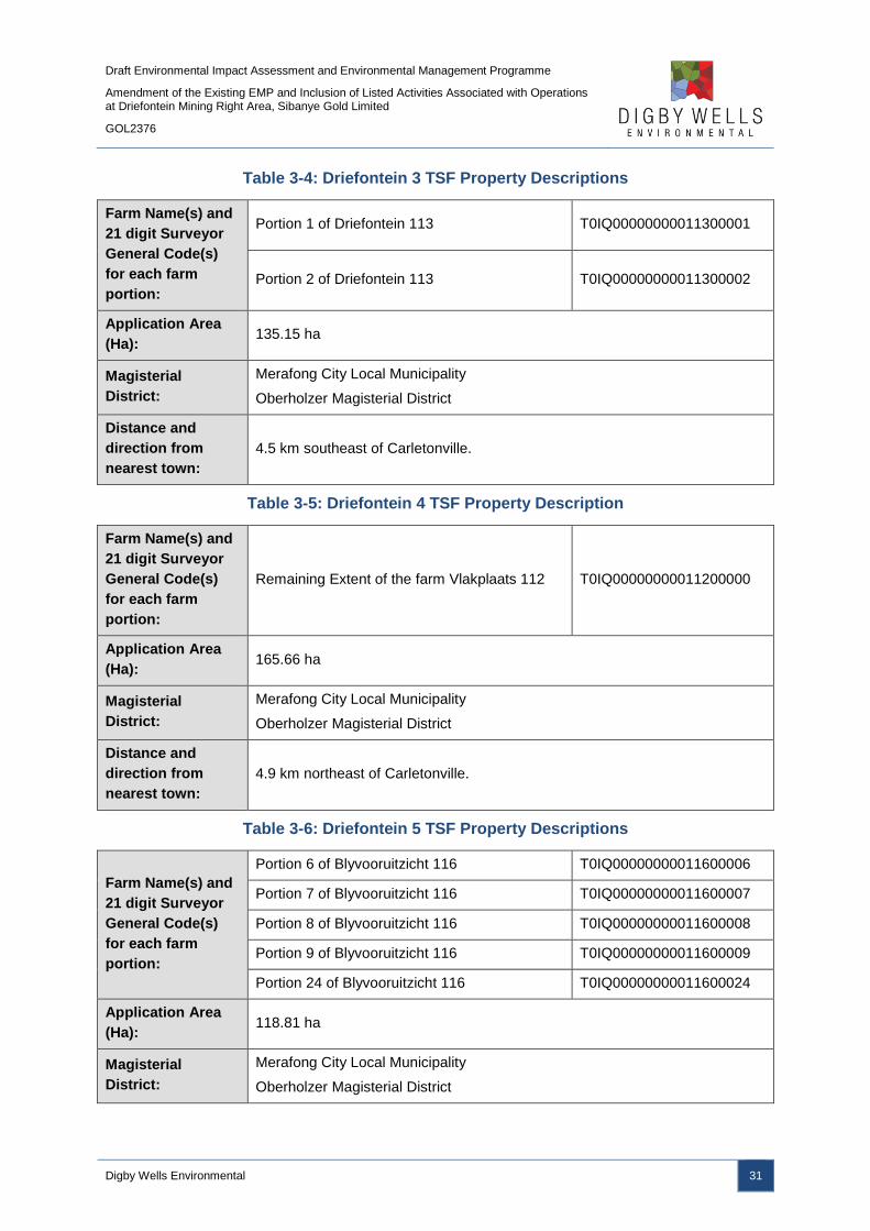
Draft Environmental Impact Assessment and Environmental Management Programme
Amendment of the Existing EMP and Inclusion of Listed Activities Associated with Operations at Driefontein Mining Right Area, Sibanye Gold Limited
GOL2376
Digby Wells Environmental 31
Table 3-4: Driefontein 3 TSF Property Descriptions
Farm Name(s) and
21 digit Surveyor
General Code(s)
for each farm
portion:
Portion 1 of Driefontein 113 T0IQ00000000011300001
Portion 2 of Driefontein 113 T0IQ00000000011300002
Application Area
(Ha): 135.15 ha
Magisterial
District:
Merafong City Local Municipality
Oberholzer Magisterial District
Distance and
direction from
nearest town:
4.5 km southeast of Carletonville.
Table 3-5: Driefontein 4 TSF Property Description
Farm Name(s) and
21 digit Surveyor
General Code(s)
for each farm
portion:
Remaining Extent of the farm Vlakplaats 112 T0IQ00000000011200000
Application Area
(Ha): 165.66 ha
Magisterial
District:
Merafong City Local Municipality
Oberholzer Magisterial District
Distance and
direction from
nearest town:
4.9 km northeast of Carletonville.
Table 3-6: Driefontein 5 TSF Property Descriptions
Farm Name(s) and
21 digit Surveyor
General Code(s)
for each farm
portion:
Portion 6 of Blyvooruitzicht 116 T0IQ00000000011600006
Portion 7 of Blyvooruitzicht 116 T0IQ00000000011600007
Portion 8 of Blyvooruitzicht 116 T0IQ00000000011600008
Portion 9 of Blyvooruitzicht 116 T0IQ00000000011600009
Portion 24 of Blyvooruitzicht 116 T0IQ00000000011600024
Application Area
(Ha): 118.81 ha
Magisterial
District:
Merafong City Local Municipality
Oberholzer Magisterial District

Draft Environmental Impact Assessment and Environmental Management Programme
Amendment of the Existing EMP and Inclusion of Listed Activities Associated with Operations at Driefontein Mining Right Area, Sibanye Gold Limited
GOL2376
Digby Wells Environmental 32
Distance and
direction from
nearest town:
3.7 km southeast of Carletonville.
Table 3-7: Pipeline Routes Property Descriptions
Farm Name(s) and
21 digit Surveyor
General Code(s)
for each farm
portion:
Portion 70 of the farm Leeuwpoort 356 T0IQ00000000035600070
Portion 71 of the farm Leeuwpoort 356 T0IQ00000000035600071
Portion 6 of the farm Blyvooruitzicht 116 T0IQ00000000011600006
Portion 7 of the farm Blyvooruitzicht 116 T0IQ00000000011600007
Portion 8 of the farm Blyvooruitzicht 116 T0IQ00000000011600008
Portion 24 of the farm Blyvooruitzicht 116 T0IQ00000000011600024
Remaining Extent of the farm Uitval 280 T0IQ00000000028000000
Portion 8 of the farm Uitval 280 T0IQ00000000028000008
Portion 9 of the farm Uitval 280 T0IQ00000000028000009
Remaining Extent of the farm Driefontein 355 T0IQ00000000035500000
Portion 1 of the farm Driefontein 355 T0IQ00000000011300001
Portion 4 of the farm Driefontein 355 T0IQ00000000035500004
Portion 5 of the farm Driefontein 355 T0IQ00000000035500005
Portion 8 of the farm Driefontein 355 T0IQ00000000035500008
Portion 10 of the farm Driefontein 355 T0IQ00000000035500010
Portion 11 of the farm Driefontein 355 T0IQ00000000035500011
Portion 15 of the farm Driefontein 355 T0IQ00000000035500015
Portion 21 of the farm Driefontein 355 T0IQ00000000035000021
Portion 22 of the farm Driefontein 355 T0IQ00000000035500022
Remaining Extent of the farm Doornkloof 348 T0IQ00000000034800000
Portion 1 of the farm Doornkloof 350 T0IQ00000000035000001
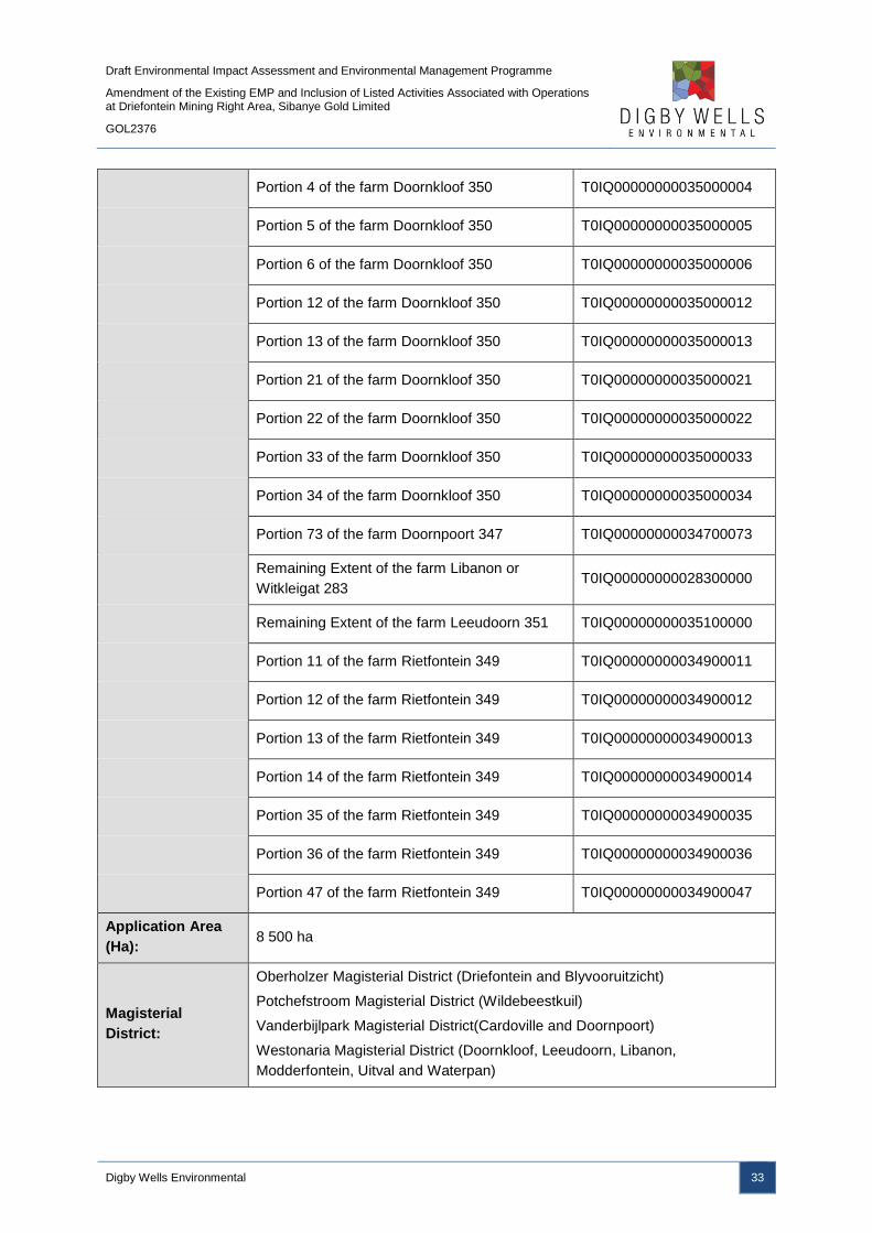
Draft Environmental Impact Assessment and Environmental Management Programme
Amendment of the Existing EMP and Inclusion of Listed Activities Associated with Operations at Driefontein Mining Right Area, Sibanye Gold Limited
GOL2376
Digby Wells Environmental 33
Portion 4 of the farm Doornkloof 350 T0IQ00000000035000004
Portion 5 of the farm Doornkloof 350 T0IQ00000000035000005
Portion 6 of the farm Doornkloof 350 T0IQ00000000035000006
Portion 12 of the farm Doornkloof 350 T0IQ00000000035000012
Portion 13 of the farm Doornkloof 350 T0IQ00000000035000013
Portion 21 of the farm Doornkloof 350 T0IQ00000000035000021
Portion 22 of the farm Doornkloof 350 T0IQ00000000035000022
Portion 33 of the farm Doornkloof 350 T0IQ00000000035000033
Portion 34 of the farm Doornkloof 350 T0IQ00000000035000034
Portion 73 of the farm Doornpoort 347 T0IQ00000000034700073
Remaining Extent of the farm Libanon or
Witkleigat 283 T0IQ00000000028300000
Remaining Extent of the farm Leeudoorn 351 T0IQ00000000035100000
Portion 11 of the farm Rietfontein 349 T0IQ00000000034900011
Portion 12 of the farm Rietfontein 349 T0IQ00000000034900012
Portion 13 of the farm Rietfontein 349 T0IQ00000000034900013
Portion 14 of the farm Rietfontein 349 T0IQ00000000034900014
Portion 35 of the farm Rietfontein 349 T0IQ00000000034900035
Portion 36 of the farm Rietfontein 349 T0IQ00000000034900036
Portion 47 of the farm Rietfontein 349 T0IQ00000000034900047
Application Area
(Ha): 8 500 ha
Magisterial
District:
Oberholzer Magisterial District (Driefontein and Blyvooruitzicht)
Potchefstroom Magisterial District (Wildebeestkuil)
Vanderbijlpark Magisterial District(Cardoville and Doornpoort)
Westonaria Magisterial District (Doornkloof, Leeudoorn, Libanon,
Modderfontein, Uitval and Waterpan)

Draft Environmental Impact Assessment and Environmental Management Programme
Amendment of the Existing EMP and Inclusion of Listed Activities Associated with Operations at Driefontein Mining Right Area, Sibanye Gold Limited
GOL2376
Digby Wells Environmental 34
Distance and
direction from
nearest town:
15 km SE of Westonaria

Draft Environmental Impact Assessment and Environmental Management Programme
Amendment of the Existing EMP and Inclusion of Listed Activities Associated with Operations at Driefontein Mining Right Area, Sibanye Gold Limited
GOL2376
Digby Wells Environmental 35
Plan 8: Land Tenure
Draft Environmental Impact Assessment and Environmental Management Programme
Amendment of the Existing EMP and Inclusion of Listed Activities Associated with Operations at Driefontein Mining Right Area, Sibanye Gold Limited
GOL2376
Digby Wells Environmental 36
4 Item 3(c) of Appendix 3: Locality map
The WRTRP ultimate scope is located across the West Rand District Municipality (WRDM)
in Gauteng Province. The WRDM includes four local municipalities (LMs): Mogale City,
Westonaria, Randfontein and Merafong City. Towns and larger settlements located in the
broader project area include Randfontein, Toekomsrus, Fochville, Carletonville, Westonaria,
Venterspost, Modderfontein, Rietvallei, Bekkersdal and Mohlakeng.
Sections of the water supply and slurry pipelines route, as well as the CPP and RTSF, are
located within the Westonaria City Local Municipality, with the Driefontein Mining Right area
falling within the Merafong City Local Municipality. Land uses in the Merafong City and
Westonaria LMs can be categorised in three main divisions, i.e. agriculture, mining and
residential. Agriculture is the dominant land use in both LMs, followed by mining and
residential land uses, with the latter accounting for less than 10% of the total land area of the
LMs. The area includes a large number of both historical and existing mining activities. The
municipalities’ human settlements are relatively scattered due to the mining activities taking
place. The LM’s residential development is generally dispersed with the dominant townships
including:
■ Westonaria;
■ Bekkersdal;
■ Hillshaven;
■ Glenharvie;
■ Venterspost;
■ Simunye; and
■ Mining towns such as Libanon and Waterpan.
As indicated in Plan 1, the Driefontein Mining Right area is situated north and west of the
N12 National Road regional road and east of Carletonville.
5 Item 3(d) of Appendix 3: Description of the Scope of the
Proposed Overall Activity
The Ultimate Project is detailed in Section 1.3.1, with the required environmental
authorisations for the Initial Implementation relevant to envisaged activities pertaining to the
Driefontein Mining Right Area including the following:
■ The inclusion of Driefontein 4 TSF into the Driefontein Mining Right Area;
■ The reclamation of Driefontein 3 and 5 TSFs;
■ The construction and operation of the WBT and The BWSF; and

Draft Environmental Impact Assessment and Environmental Management Programme
Amendment of the Existing EMP and Inclusion of Listed Activities Associated with Operations at Driefontein Mining Right Area, Sibanye Gold Limited
GOL2376
Digby Wells Environmental 37
■ Roads, power lines, pipelines and pump stations associated with the above listed
infrastructure.
The activities listed above are described in more detail in Section 5.2. The listed activities
specific to the construction and operation of the CPP and RTSF are included as part of the
Kloof Mining Right area applications.
5.1 Listed and Specified Activities
5.1.1 Environmental Authorisation
The primary authorisation to consider will be an Environmental Authorisation to be granted in
accordance with the Environmental Impact Assessment Regulations, 2014 (the EIA 2014
Regulations) promulgated in terms of the provisions of the National Environmental
Management Act, 1998, as amended (NEMA). NEMA identifies two classes of activities
requiring authorisation, those of a less significant nature requiring evaluation by what is
described as a Basic Assessment process (BA), and those with substantial impact which
require a more detailed scoping and environmental impact assessment (S&EIA) process. In
addition to the EIA 2014 Regulations, the Minister of Environmental Affairs (DEA) has
published two notices identifying activities that require a BA process (Listing Notice 1) and a
full Environmental Impact Assessment process (Listing Notice 2). The proposed activities
should be assessed against the activities listed in the two listing notices to determine what
which of the Listed Activities will be triggered. As this project triggers activities under both
Listing Notice 1 and 2, a full EIA process will be undertaken.
The listed and specified activities are set out in Table 5-1 below.
Part 3 of Chapter 4 of the EIA 2014 Regulations sets out the timeframe for applying for and
obtaining an Environmental Authorisation (EA). In brief, this requires:
■ Compilation of a Scoping Report: within 44 days from date of submission of the
application for the EA, a Scoping Report must be submitted to the competent
authority;
■ Consideration of the Scoping Report by the competent authority: the competent
authority must reach a decision on the Scoping Report within 43 days and either
accepts it and directs the applicant to proceed with the EIA, or refuse it under defined
circumstances. The Scoping Report was submitted to the DMR on 13 November
2015;;
■ Preparation of the EIA: the applicant must prepare a detailed EIA and an
Environmental Management Programme (EMPr) in accordance with the Scoping
Report and submit it to the competent authority within 106 days after being directed
to do so; and
■ Decision on the application: the competent authority must reach a decision on the
EIA and the EMPr and either grant authorisation or refuse it.
Draft Environmental Impact Assessment and Environmental Management Programme
Amendment of the Existing EMP and Inclusion of Listed Activities Associated with Operations at Driefontein Mining Right Area, Sibanye Gold Limited
GOL2376
Digby Wells Environmental 38
5.1.2 Waste Management
The Regulations regarding the Planning and Management of Residue Stockpiles and
Residue Deposits, 2015 were published on Friday 24 July 2015 in GN R632 in GG 39020.
These Regulations provide the framework for the management of TSFs in terms of the
National Environmental Management: Waste Act, 2008 (Act No. 59 of 2008) (NEM:WA), in
place of the Regulations previously in place in terms of the MPRDA. Although the DMR will
remain the competent authority, residue stockpiles and residue deposits will now be
governed by the new NEM:WA Regulations.
The implications in brief are as follows:
■ The identification and assessment of environmental impacts arising from residue
stockpiles and residue deposits must be done as part of the environmental impact
assessment;
■ The management of residue stockpiles and residue deposits must be in accordance
with any conditions and management measures in the EMP and waste management
licence;
■ A risk analysis based on the identified characteristics and the classification must be
used to determine the appropriate mitigation and management measures;
■ Residue stockpile and residue deposit must be characterised to identify any potential
risk to health, safety and environmental impacts that may be associated with the
residue when stockpiled or deposited, in terms of its physical characteristics,
chemical characteristics and mineral content; and
■ The required pollution control barrier system shall be defined by the National Norms
and Standards for the Assessment of Waste for Landfill Disposal and the National
Norms and Standards for Disposal of Waste to Landfill.
As far as the design of TSFs is concerned, the Regulations provide that the design must be
undertaken by a professional civil or mining engineer, an assessment of the typical soil
profile on the site is required for all residue stockpile and residue deposit must be made and
the design of a residue stockpile and residue deposit must take into account all phases of
the life cycle of the residue stockpile and residue deposit, from construction through to post
closure
The List of waste management activities that have, or are likely to have, a detrimental effect
on the environment published in GN 921 in GG 37083 of 29 November 2013 have been
amended in terms of GN R633 in GG 39020 of 24 July 2015 to include residue deposits and
residue stockpiles.
Further details pertinent to the policy and legislative context of this project are set out in
Section 6 of this report.
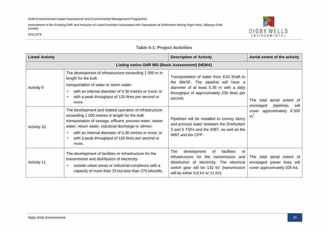
Draft Environmental Impact Assessment and Environmental Management Programme
Amendment of the Existing EMP and Inclusion of Listed Activities Associated with Operations at Driefontein Mining Right Area, Sibanye Gold Limited
GOL2376
Digby Wells Environmental 39
Table 5-1: Project Activities
Listed Activity Description of Activity Aerial extent of the activity
Listing notice GNR 983 (Basic Assessment) (NEMA)
Activity 9
The development of infrastructure exceeding 1 000 m in
length for the bulk
transportation of water or storm water-
with an internal diameter of 0.36 metres or more; or
with a peak throughput of 120 litres per second or
more.
Transportation of water from K10 Shaft to
the BWSF. The pipeline will have a
diameter of at least 0.36 m with a daily
throughput of approximately 230 litres per
second. The total aerial extent of
envisaged pipelines will
cover approximately 8 500
m2.
Activity 10
The development and related operation of infrastructure
exceeding 1 000 metres in length for the bulk
transportation of sewage, effluent, process water, waste
water, return water, industrial discharge or slimes-
with an internal diameter of 0,36 metres or more; or
with a peak throughput of 120 litres per second or
more.
Pipelines will be installed to convey slurry
and process water between the Driefontein
3 and 5 TSFs and the WBT, as well as the
WBT and the CPP.
Activity 11
The development of facilities or infrastructure for the
transmission and distribution of electricity-
outside urban areas or industrial complexes with a
capacity of more than 33 but less than 275 kilovolts.
The development of facilities or
infrastructure for the transmission and
distribution of electricity. The electrical
switch gear will be 132 kV (transmission
will be either 6.6 kV or 11 kV).
The total aerial extent of
envisaged power lines will
cover approximately 325 ha.

Draft Environmental Impact Assessment and Environmental Management Programme
Amendment of the Existing EMP and Inclusion of Listed Activities Associated with Operations at Driefontein Mining Right Area, Sibanye Gold Limited
GOL2376
Digby Wells Environmental 40
Listed Activity Description of Activity Aerial extent of the activity
Activity 12
The development of-
infrastructure or structures with a physical footprint of
100 square metres or more
where such development occurs-
within a watercourse;
in front of a development setback; or
if no development setback exists, within 32 metres of
a watercourse, measured from the edge of a
watercourse.
The pipeline routes traverse watercourses.
There are approximately 25 watercourse
crossings.
250 m2
Activity 19
The infilling or depositing of any material of more than 5
cubic metres into, or the dredging, excavation, removal or
moving of soil, sand, shells, shell grit, pebbles or rock of
more than 5 cubic metres from-
a watercourse.
Pipelines routes cross approximately 25
watercourses. 250 m
2
Activity 24
The development of a road with a reserve wider than
13.5 m, or where no reserve exists, the road is wider than
8 m.
Additional roads to be constructed to allow
for access to new infrastructure such as
the WBT and BWSF complex.
There will be approximately
19 km of roads.
Activity 27 The clearance of an area of 1 hectare or more, but less
than 20 hectares of indigenous vegetation.
Clearing of land for the construction of the
WBT and BWSF complex.
Approximately 3 ha will be
cleared for the WBT and
BWSF complex.
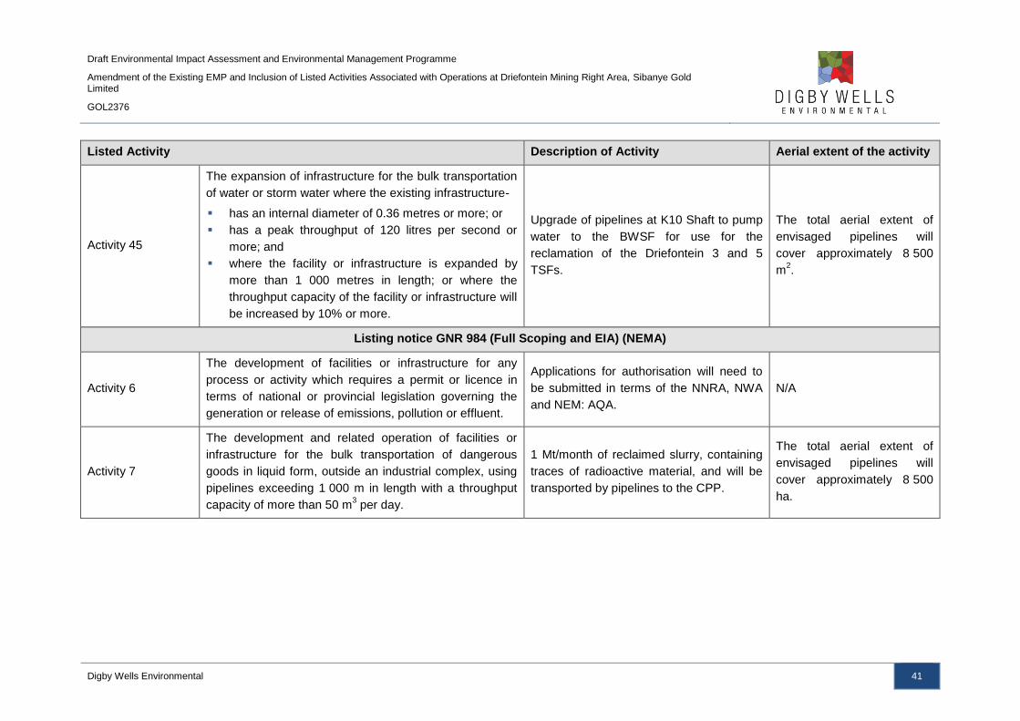
Draft Environmental Impact Assessment and Environmental Management Programme
Amendment of the Existing EMP and Inclusion of Listed Activities Associated with Operations at Driefontein Mining Right Area, Sibanye Gold Limited
GOL2376
Digby Wells Environmental 41
Listed Activity Description of Activity Aerial extent of the activity
Activity 45
The expansion of infrastructure for the bulk transportation
of water or storm water where the existing infrastructure-
has an internal diameter of 0.36 metres or more; or
has a peak throughput of 120 litres per second or
more; and
where the facility or infrastructure is expanded by
more than 1 000 metres in length; or where the
throughput capacity of the facility or infrastructure will
be increased by 10% or more.
Upgrade of pipelines at K10 Shaft to pump
water to the BWSF for use for the
reclamation of the Driefontein 3 and 5
TSFs.
The total aerial extent of
envisaged pipelines will
cover approximately 8 500
m2.
Listing notice GNR 984 (Full Scoping and EIA) (NEMA)
Activity 6
The development of facilities or infrastructure for any
process or activity which requires a permit or licence in
terms of national or provincial legislation governing the
generation or release of emissions, pollution or effluent.
Applications for authorisation will need to
be submitted in terms of the NNRA, NWA
and NEM: AQA.
N/A
Activity 7
The development and related operation of facilities or
infrastructure for the bulk transportation of dangerous
goods in liquid form, outside an industrial complex, using
pipelines exceeding 1 000 m in length with a throughput
capacity of more than 50 m3 per day.
1 Mt/month of reclaimed slurry, containing
traces of radioactive material, and will be
transported by pipelines to the CPP.
The total aerial extent of
envisaged pipelines will
cover approximately 8 500
ha.

Draft Environmental Impact Assessment and Environmental Management Programme
Amendment of the Existing EMP and Inclusion of Listed Activities Associated with Operations at Driefontein Mining Right Area, Sibanye Gold Limited
GOL2376
Digby Wells Environmental 42
Listed Activity Description of Activity Aerial extent of the activity
Activity 17
Any activity including the operation of that activity which
requires a mining right as contemplated in section 22 of
the Mineral and Petroleum Resources Development Act,
2002 (Act No. 28 of 2002), including associated
infrastructure, structures and earthworks, directly related
to the extraction of a mineral resource, including activities
for which an exemption has been issued in terms of
section 106 of the Mineral and Petroleum Resources
Development Act, 2002 (Act No. 28 of 2002).
The reclamation of TSFs, or residue
deposits, requires a Mining Right in
accordance with the MPRDA.
A Section 102 Amendment will be applied
for to include Driefontein 4 TSF into the
Driefontein Mining Right.
Driefontein 3 and 5 TSFs are
a combined 140.48 ha in
extent, with Driefontein 4
TSF being 165.66 ha in
extent.
Activity 25
The development and related operation of facilities or
infrastructure for the treatment of effluent, wastewater or
sewage with a daily throughput capacity of 15 000 cubic
metres or more.
Operation of the AWTF. 3 600 m2

Draft Environmental Impact Assessment and Environmental Management Programme
Amendment of the Existing EMP and Inclusion of Listed Activities Associated with Operations at Driefontein Mining Right Area, Sibanye Gold Limited
GOL2376
Digby Wells Environmental 43
5.2 Item 3(d)(ii): Description of the activities to be undertaken
This section describes in detail the envisaged activities to be undertaken and includes (Plan
9):
■ The inclusion of Driefontein 4 TSF into the Driefontein Mining Right Area;
■ The reclamation of Driefontein 3 and 5 TSFs;
■ The construction and operation of the WBT and BWSF; and
■ Roads, power lines, pipelines and pump stations associated with the above listed
infrastructure.
During the construction phase of the project the environmental aspects of land
transformation, job creation and spending may need to be investigated further. Land
transformation was seen to have an influence on the heritage landscape, land use and
biophysical (wetlands and fauna and flora) of the project areas. This applies to all the areas
of surface disturbance such as pipelines, WBT, BWSF and support infrastructure.
The creation of jobs was seen to link to the characterisation of the social environment of the
study area and this would need to be studied to identify possible impacts; positive and
negative. The capital expenditure and the operational costs for the project are linked to the
economic analysis of the project.
The activities associated with the construction phase are summarised in Figure 5-1.
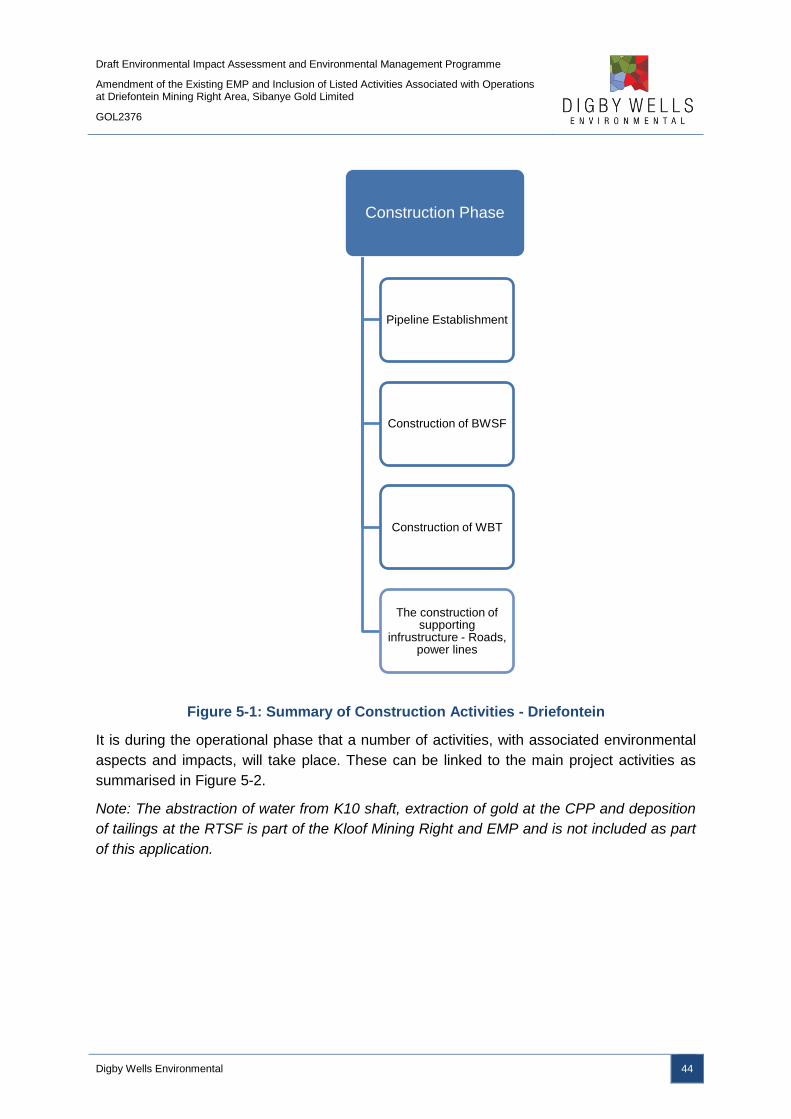
Draft Environmental Impact Assessment and Environmental Management Programme
Amendment of the Existing EMP and Inclusion of Listed Activities Associated with Operations at Driefontein Mining Right Area, Sibanye Gold Limited
GOL2376
Digby Wells Environmental 44
Figure 5-1: Summary of Construction Activities - Driefontein
It is during the operational phase that a number of activities, with associated environmental
aspects and impacts, will take place. These can be linked to the main project activities as
summarised in Figure 5-2.
Note: The abstraction of water from K10 shaft, extraction of gold at the CPP and deposition
of tailings at the RTSF is part of the Kloof Mining Right and EMP and is not included as part
of this application.
Construction Phase
Pipeline Establishment
Construction of BWSF
Construction of WBT
The construction of supporting
infrustructure - Roads, power lines

Draft Environmental Impact Assessment and Environmental Management Programme
Amendment of the Existing EMP and Inclusion of Listed Activities Associated with Operations at Driefontein Mining Right Area, Sibanye Gold Limited
GOL2376
Digby Wells Environmental 45
Figure 5-2: Main Activities Associated with the Operational Phase of the Project –
Driefontein
The project spans several Mining Right areas with pipelines often required to traverse areas
where no Mining Right is held. To ensure the liability of project infrastructure is attributed to
SGL’s Mining Right areas, the following principles were adopted:
■ The Mining Right area within which infrastructure is situated will be liable for said
infrastructure;
■ Where pipelines traverse non-mining areas, the Mining Right area whose activities
necessitate the pipeline, will accept liability; and
■ The Driefontein Mining Right area will be extended to include Driefontein 4 TSF.
Operational Phase
Abstraction and pumping of water from
the K10 Shaft to the BWSF
Reclamation of Driefontein 3 and 5
TSFs
Thickening of the slurry at the WBT
Pumping of the thickened slurry to the
CPP
Gold extraction at the CPP and deposition of
slurry at the RTSF

Draft Environmental Impact Assessment and Environmental Management Programme
Amendment of the Existing EMP and Inclusion of Listed Activities Associated with Operations at Driefontein Mining Right Area, Sibanye Gold Limited
GOL2376
Digby Wells Environmental 46
Plan 2 shows the infrastructure and the Mining Right area liable for it.
5.2.1 Water from K10 Shaft and Bulk Water Storage Facility
A number of water sources have been identified, from which water can be supplied to the
surface reclamation operations, one such source being the K10 Shaft5, located just west of
Westonaria. The WRTRP has recognised that water is a scarce and strategic commodity
and hence mine impacted water will be used preferentially over Rand Water or other higher
quality sources. Water will be abstracted and pumped to the BWSF for temporary storage in
two cylindrical flat bottom tanks, each with a volume of 2 000 m3, before being pumped for
use during the reclamation activities at Driefontein 3 and 5 TSFs. The BWSF is located
adjacent to the R501 regional road, approximately 12 km east of Carletonville and 8.6 km
west of K10 Shaft and within the WBT and BWSF complex.
Once the impacted mine water has been used in the hydraulic reclamation process, the
slurry will eventually find its way to the RTSF. As water builds up in the RTSF it will be
drained to the RWD and the option to treat it through an advanced water treatment facility
will be investigated. The water will then be treated to potable standards (SANS 241:2011),
depending on the final use.
The BWSF and water pipelines from K10 Shaft are illustrated in Plan 4b, with the water
pipelines summarised in Table 5-2. The alternative pipeline routes considered are provided
in Plan 9.
Table 5-2: Water Supply Pipelines
Name Length (m) Type
K10 Shaft to BWSF 10 477 Water Pipeline
BWSF to DRI3 7 699 Water Pipeline
BWSF to DRI5 14 168 Water Pipeline
5.2.2 Reclamation of Driefontein Tailings Storage Facilities
Driefontein 3 TSF will be reclaimed initially, followed by Driefontein 5 TSF, at a rate of
1Mt/month for a period of 11 years. The TSFs will be reclaimed using a water hydraulic
monitoring gun; the TSFs will be hydraulically reclaimed in nominal 12 to 15 m benches until
the entire TSF has been reclaimed to the natural ground level. The hydraulic monitoring gun
will direct pressurised water towards the face of the TSF benches, where the tailings
material will be broken from the TSF. The mixing of the tailings material and water used as
part of the hydraulic mining will result in the formation of a slurry, which will flow through
open channels and over screens to remove vegetation and unwanted oversized material,
and into a temporary sump.
5 The abstraction of water from K10 Shaft is part of the Kloof Mining Right area application.

Draft Environmental Impact Assessment and Environmental Management Programme
Amendment of the Existing EMP and Inclusion of Listed Activities Associated with Operations at Driefontein Mining Right Area, Sibanye Gold Limited
GOL2376
Digby Wells Environmental 47
The reclaimed slurry will be pumped via pipelines to the WBT where flocculants will be
added to thicken the slurry. The thickened slurry will then be transported by pipelines to the
CPP for gold, uranium and sulfur extraction, with the resultant tailings deposited on the
RTSF. The location of the Driefontein 3 and 5 TSFs and the slurry pipelines are provided in
Plan 4a.
The water that will be used for the hydraulic reclamation will be transported to the TSFs from
the K10 Shaft, via the BWSF. Once the Driefontein 3 and 5 TSFs have been reclaimed, the
TSF footprints will be rehabilitated to a suitable end land use and according to the Closure
Plan to be compiled for Driefontein Mining Right area. Driefontein 3 TSF is 72.76 ha in
extent, with Driefontein 5 TSF being 67.72 ha in extent.
SGL also intend to incorporate Driefontein 4 TSF into the Driefontein Mining Right. The
Driefontein 4 TSF is located 2 km north of the Driefontein 3 TSF, with the Mining Right
boundary located 0.5 km to the southeast of Driefontein 4 TSF. The reclamation of
Driefontein 4 TSF will be subject to a future application following the complete removal of
Driefontein 3 and 5 TSFs, although the inclusion of the TSF into the Driefontein Mining Right
will be included as part of the Section 102 Amendment.
5.2.3 Thickening of the Slurry at the West Block Thickener and Pumping to
the Central Processing Plant
The WBT is located adjacent to the BWSF along the R501 regional road and 11 km
northwest of the proposed CPP (Plan 4a). The slurry from the Driefontein 3 and 5 TSFs will
be pumped via pipelines to the WBT. The slurry pipelines will be located adjacent to and
within the same servitudes of the water supply pipelines from the BWSF, as illustrated in
Plan 4a. The WBT will add flocculants (polyacrylamide flocculants) to thicken the slurry
which ensure a consistent slurry density, optimising the efficiency of the CPP and volume of
water required, as well as minimising pumping costs. The thickened slurry pipeline will
transport the thickened slurry to the CPP for gold, uranium and sulfur extraction. The WBT
and BWSF complex will have a thickened tailings storage tanks with a storage capacity of
2 200 m3 which will provide a 1 hour residence time. Any overflow from the WBT will be
pumped to the BWSF and reused in the reclamation process.
A summary of the slurry and thickened slurry pipelines are listed in Table 5-3.
Table 5-3: Slurry Pipelines Summary
Name Length (m) Type
DRI3 to WBT 7 665 Slurry Pipeline -dilute
DRI5 to DRI3 6 646 Slurry Pipeline -dilute
WBT to CPP 17 473 Slurry Pipeline -thickened
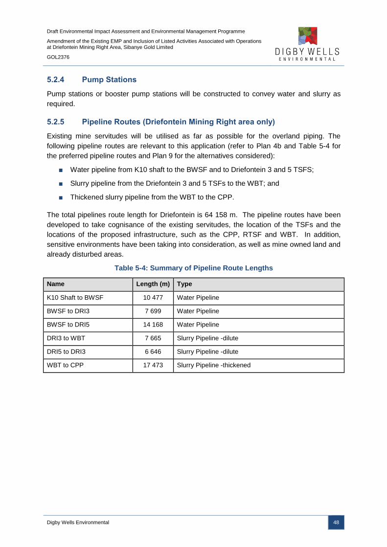
Draft Environmental Impact Assessment and Environmental Management Programme
Amendment of the Existing EMP and Inclusion of Listed Activities Associated with Operations at Driefontein Mining Right Area, Sibanye Gold Limited
GOL2376
Digby Wells Environmental 48
5.2.4 Pump Stations
Pump stations or booster pump stations will be constructed to convey water and slurry as
required.
5.2.5 Pipeline Routes (Driefontein Mining Right area only)
Existing mine servitudes will be utilised as far as possible for the overland piping. The
following pipeline routes are relevant to this application (refer to Plan 4b and Table 5-4 for
the preferred pipeline routes and Plan 9 for the alternatives considered):
■ Water pipeline from K10 shaft to the BWSF and to Driefontein 3 and 5 TSFS;
■ Slurry pipeline from the Driefontein 3 and 5 TSFs to the WBT; and
■ Thickened slurry pipeline from the WBT to the CPP.
The total pipelines route length for Driefontein is 64 158 m. The pipeline routes have been
developed to take cognisance of the existing servitudes, the location of the TSFs and the
locations of the proposed infrastructure, such as the CPP, RTSF and WBT. In addition,
sensitive environments have been taking into consideration, as well as mine owned land and
already disturbed areas.
Table 5-4: Summary of Pipeline Route Lengths
Name Length (m) Type
K10 Shaft to BWSF 10 477 Water Pipeline
BWSF to DRI3 7 699 Water Pipeline
BWSF to DRI5 14 168 Water Pipeline
DRI3 to WBT 7 665 Slurry Pipeline -dilute
DRI5 to DRI3 6 646 Slurry Pipeline -dilute
WBT to CPP 17 473 Slurry Pipeline -thickened

Draft Environmental Impact Assessment and Environmental Management Programme
Amendment of the Existing EMP and Inclusion of Listed Activities Associated with Operations at Driefontein Mining Right Area, Sibanye Gold Limited
GOL2376
Digby Wells Environmental 49
Plan 9: Pipelines Alternatives
Draft Environmental Impact Assessment and Environmental Management Programme
Amendment of the Existing EMP and Inclusion of Listed Activities Associated with Operations at Driefontein Mining Right Area, Sibanye Gold Limited
GOL2376
Digby Wells Environmental 50
6 Item 3(e): Policy and Legislative Context
This section (Table 6-1 and Table 6-2), although also applicable to the Ultimate WRTRP,
relates specifically to the Driefontein Mining Right in the context of this EIA Report. It aims to
provide a description of the policy and legislative context within which the project is being
proposed. This section has been divided into national, provincial and local legislation and
policies, plans, guidelines and development planning frameworks and tools.
Table 6-1: Relevant National Legislation
Applicable legislation and guidelines used to compile the
report Reference where applied
The Constitution of the Republic of South Africa, 1996
(Act No. 108 of 1996)
Under Section 24 of the Constitution of the Republic of South
Africa, it is clearly stated that:
Everyone has the right to (a) an environment that is not
harmful to their health or well-being; and (b) to have the
environment protected, for the benefit of present and future
generations, through reasonable legislative and other
measures that -
(i) Prevent pollution and ecological degradation;
(ii) Promote conservation; and
(iii) Secure ecologically sustainable development and use
of natural resources while promoting justifiable
economic and social development.
An EIA process is being undertaken
to determine the impacts associated
with the project. As part of the EIA
process, mitigation measures and
monitoring plans have been
recommended to ensure that any
potential impacts are managed to
acceptable levels to support the
rights as enshrined in the
Constitution.
National Environmental Management Act, 1998 (Act No
107 of 1998) (NEMA) and EIA Regulations (December
2014)
The National Environmental Management Act, 1998 (Act No
107 of 1998) (NEMA), as amended was set in place in
accordance with Section 24 of the Constitution of the Republic
of South Africa. Certain environmental principles under NEMA
have to be adhered to, to inform decision making for issues
affecting the environment. Section 24 (1)(a) and (b) of NEMA
state that:
The potential impact on the environment and socio-economic
conditions of activities that require authorisation or permission
by law and which may significantly affect the environment,
must be considered, investigated and assessed prior to their
implementation and reported to the organ of state charged by
law with authorizing, permitting, or otherwise allowing the
implementation of an activity.
The Environmental Impact Assessment (EIA) Regulations,
Government Notice Regulation (GN) R982 were published on
The EIA process has been
undertaken in accordance with the
principles of Section 2 of NEMA as
well as with the EIA 2014
Regulations, promulgated in terms
of NEMA.
These Listed Notices have been
reviewed against the project
activities to determine the likely
triggers. The listed activities which
are potentially triggered under the
Listing Notices are provided in Table
5-1.
Based on the activities listed, it has
been identified that a full EIA
process is required for the project.
An application for the listed activities
has been submitted to the DMR who
is the relevant Competent Authority

Draft Environmental Impact Assessment and Environmental Management Programme
Amendment of the Existing EMP and Inclusion of Listed Activities Associated with Operations at Driefontein Mining Right Area, Sibanye Gold Limited
GOL2376
Digby Wells Environmental 51
Applicable legislation and guidelines used to compile the
report Reference where applied
04 December 2014 and promulgated on 08 December 2014
(the EIA 2014 Regulations). Together with the EIA 2014
Regulations, the Minister also published GN R 983 (Listing
Notice No. 1), GN 984 (Listing Notice No. 2) and GN R 985
(Listing Notice No. 3) in terms of Sections 24(2) and 24D of
the NEMA, as amended.
in terms of this application for
Environmental Authorisation.
GN R. 982 National Environmental Management Act, 1998
(Act No. 107 of 1998): Environmental Impact Assessment
Regulations, 2014
These three listing notices set out a list of identified activities
which may not commence without an Environmental
Authorisation from the relevant Competent Authority through
one of the following processes:
Regulation GN R. 983 - Listing Notice 1: This listing
notice provides a list of various activities which require
environmental authorisation and which must follow a
basic assessment process.
Regulation GN R. 984 – Listing Notice 2: This listing
notice provides a list of various activities which require
environmental authorisation and which must follow an
environmental impact assessment process.
Regulation GN R. 985 – Listing Notice 3: This notice
provides a list of various environmental activities
which have been identified by provincial governmental
bodies which if undertaken within the stipulated
provincial boundaries will require environmental
authorisation. The basic assessment process will need
to be followed.
Refer to Table 5-1 above for the
listed activities which could
potentially be triggered by the
proposed project.
National Water Act, 1998 (Act No. 36 of 1998) (NWA)
The National Water Act, 1998 (Act No. 36 of 1998) (NWA)
provides for the sustainable and equitable use and protection
of water resources. It is founded on the principle that the
National Government has overall responsibility for and
authority over water resource management, including the
equitable allocation and beneficial use of water in the public
interest, and that a person can only be entitled to use water if
the use is permissible under the NWA.
GN R704 National Water Act, 1998 (Act No. 36 of 1998)
Regulations 4 and 5 of the regulation on use of water for
mining and related activities aimed at the protection of water
resources, Government Notice Regulation 704 (GN R No. 704)
published in June 1999, states the following:
An Integrated Water Use Licence
Application (IWULA) and Integrated
Water and Waste Management Plan
(IWWMP) has been compiled and
submitted to the Department of
Water and Sanitation (DWS) as the
decision making authority. The
water uses triggered under Section
21 of the NWA in relation to the
proposed project are listed below:
S21(c) – Impeding or
diverting the flow of water in
a watercourse;
S21 (g) – Disposing of
waste in a manner which

Draft Environmental Impact Assessment and Environmental Management Programme
Amendment of the Existing EMP and Inclusion of Listed Activities Associated with Operations at Driefontein Mining Right Area, Sibanye Gold Limited
GOL2376
Digby Wells Environmental 52
Applicable legislation and guidelines used to compile the
report Reference where applied
Regulation 4: No residue deposit, reservoir or dam
may be located within the 1:100 year flood line, or less
than a horizontal distance of 100 m from the nearest
watercourse. Furthermore, person(s) may not dispose
of any substance that may cause water pollution.
Regulation 5: No person(s) may use substances for
the construction of a dam or impoundment if that
substance will cause water pollution.
Regulation 6 is concerned with the capacity
requirements of clean and dirty water systems, while
Regulation 7 details the requirements necessary for
the protection of water resources.
may detrimentally impact on
a water resource;
S21 (i) – Altering the bed,
banks, course or
characteristics of a
watercourse;
S21 (j) - Removing,
discharging or disposing of
water found underground if
it is necessary for the
efficient continuation of an
activity or for the safety of
people.
Mineral and Petroleum Resource Development Act. 2002
(Act No. 28 of 2002) (MPRDA)
A Mining Right Application (MRA) submitted to the Department
of Mineral Resources (DMR) in terms of the Mineral and
Petroleum Resources Act, 2002 (Act No.28 of 2002) (MPRDA)
must be succeeded by various documents including a Scoping
Report, EIA Report and an EMP.
The MPRDA requires that mining companies assess the socio-
economic impacts of their activities from start to closure and
beyond. Companies must develop and implement a
comprehensive Social and Labour Plan (SLP) to promote
socio-economic development in their host communities and to
prevent or lessen negative social impacts.
This EIA Report, which relates
specifically to the Driefontein Mining
Right (although it is generally
applicable to the WRTRP as a
whole) has been compiled in
accordance with the MPRDA read
with the EIA 2014 Regulations.
National Environmental Management: Biodiversity Act,
2004 (Act No. 10 of 2004) (NEM:BA)
The National Environmental Management: Biodiversity Act,
2004 (Act No. 10 of 2004) (NEM:BA) regulates the
management and conservation of the biodiversity of South
Africa within the framework provided under NEMA. This Act
also regulates the protection of species and ecosystems that
require national protection and also takes into account the
management of alien and invasive species. This Act works in
accordance to the framework set under NEMA. The following
regulations which have been promulgated in terms of the
NEM:BA are also of relevance:
Alien and Invasive Species Lists, 2014 published (GN
R599 in GG 37886 of 1 August 2014) ;
National Environmental Management: Biodiversity Act,
2004: Threatened and Protected Species Regulations;
As part of this project, a flora, fauna,
wetlands and aquatic assessment
has been undertaken to determine
the current status of the
environment and to determine any
potential ecological sensitivities to
be avoided and/or mitigated.
There are currently no applications
submitted in terms of NEM:BA for
the project.

Draft Environmental Impact Assessment and Environmental Management Programme
Amendment of the Existing EMP and Inclusion of Listed Activities Associated with Operations at Driefontein Mining Right Area, Sibanye Gold Limited
GOL2376
Digby Wells Environmental 53
Applicable legislation and guidelines used to compile the
report Reference where applied
National list of Ecosystems Threatened and in need of
Protection under Section 52(1) (a) of the Biodiversity
Act (GG 34809, GN 1002, 9 December 2011).
National Environmental Management: Air Quality Act,
2004 (Act No. 39 of 2004) (NEM:AQA)
According to the National Environmental Management: Air
Quality Act, 2004 (Act No. 39 of 2004) (NEM: AQA) the
Department of Environmental Affairs (DEA), the provincial
environmental departments and local authorities (district and
local municipalities) are separately and jointly responsible for
the implementation and enforcement of various aspects of
NEM: AQA. A fundamental aspect of the new approach to the
air quality regulation, as reflected in the NEM: AQA is the
establishment of National Ambient Air Quality Standards
(NAAQS) (GN R 1210 of 2009). These standards provide the
goals for air quality management plans and also provide the
benchmark by which the effectiveness of these management
plans is measured.
An Air Quality Assessment has been
undertaken to determine the
baseline conditions of the air prior to
the implementation of the proposed
activities at the CPP and RTSF and
respective TSFs. The project
activities will be set out to abide by
the NEM: AQA and standards set
out in the National Ambient Air
Quality Standards. The required
measures have been included in the
EMPr.
An Atmospheric Emissions Licence
has been applied for in terms of
Section 21 of the NEM:AQA. The
following activities have been
applied for:
Category 4, sub-category
4.16: Production of acid;
Category 4, subcategory
4.17: Gold processing; and
Category 7, sub-category
7.2: Production of acids.
National Heritage Resources Act, 1999 (Act No. 25 of
1999) (NHRA)
The National Heritage Resources Act, 1999 (Act No. 25 of
1999) (NHRA) is the overarching legislation that protects and
regulates the management of heritage resources in South
Africa. The Act requires that Heritage Resources Agency’s in
this case the South African Heritage Resources Agency
(SAHRA) and Gauteng Provincial Heritage Resources
Authority (PHRA-G), be notified as early as possible of any
developments that may exceed certain minimum thresholds.
This act is enforced through the National Heritage Regulations
GN R 548 (2000).
A Notice of Intent to Develop (NID)
has been submitted, as part of this
report, to the Gauteng Provincial
Heritage Resources Authority
(PHRA-G) and the South African
Heritage Resources. Furthermore, a
Heritage Impact Assessment (HIA)
has also been undertaken.
The Provincial Heritage Resources Authority Gauteng
(PHRA-G)
The PHRA-G is responsible for the identification, conservation
and management of heritage resources throughout the
An HIA has been undertaken in
respect of these regulations to
determine whether a permit will be
required as a result of the proposed
Draft Environmental Impact Assessment and Environmental Management Programme
Amendment of the Existing EMP and Inclusion of Listed Activities Associated with Operations at Driefontein Mining Right Area, Sibanye Gold Limited
GOL2376
Digby Wells Environmental 54
Applicable legislation and guidelines used to compile the
report Reference where applied
province. The Agency was established in terms of the NHRA. activities.
Environmental Conservation Act, 1989 (ECA), (Act No. 73
of 1989) - National Noise Control Regulations, GN R.154
(10 January 1992)
These regulations make provision for guidelines pertaining to
noise control and measurements. The regulations make
reference to the use of the South African National Standards
10103:2008 (SANS) guidelines for the Measurement and
Rating of Environmental Noise with Respect to Land Use,
Health, and Annoyance and to Speech Communication.
The NEM:AQA also provides for noise control.
A Noise Impact Assessment has
been undertaken as part of the EIA
process to understand the potential
impacts as a result of the proposed
activities to be undertaken.
Table 6-2: Local By-Laws
Applicable legislation and guidelines used to
compile the report Reference where applied
Spatial Planning and Land Use Management Act,
2013 (Act No 16 of 2013) (SPLUMA)
SPLUMA is a framework act for all spatial planning and
land use management legislation in South Africa and
came into force on 1 July 2015. Municipalities will as a
result of the new legislation be solely responsible for
processing and dealing with land use applications and
the appeals relating thereto. Municipalities will have 5
years from commencement of the Act to adopt and
approve a single land use scheme for all of its municipal
area. The land use scheme must include appropriate
categories of land use zoning and regulations for the
entire municipal area, including areas not previously
subject to a land use scheme. Rezoning will be required
for land that was previously excluded from town planning
schemes and zoned as “undetermined”.
This Act will be relevant in terms of the
required re-zoning applications related to
this project. Mining companies will have
to rezone mine property to comply with
any new land use scheme of the
Municipality, which would have an
implication on rates and taxes after
rezoning.
Notwithstanding that land was previously
zoned as mining land (such as Kloof), it
may fall within a new land use scheme
once this is developed by the
municipality.
Draft Environmental Impact Assessment and Environmental Management Programme
Amendment of the Existing EMP and Inclusion of Listed Activities Associated with Operations at Driefontein Mining Right Area, Sibanye Gold Limited
GOL2376
Digby Wells Environmental 55
7 Item 3(f): Need and Desirability of the Proposed Activities
The objectives of the WRTRP is to reprocess historical TSFs to economically recover gold,
uranium and sulfur, while implementing concurrent rehabilitation of their footprints for long
term sustainability. By removing the existing historical TSF liabilities located on ecologically
sensitive dolomitic structures, sulfur and uranium constituents will reduce significantly and
will consequently reduce any future pollution potential and acid mine drainage, as well as
eliminate residual cyanide trapped in the historical TSFs. In addition, the reclamation of up to
13 historical and current TSFs throughout the project area and the deposition of the residual
tailings on the RTSF will reduce the footprint of mining on the landscape, feeing in excess of
300 ha of occupied land. The following benefits are envisioned as a result of the
implementation of the WRTRP:
■ During construction, capital investment into the WRTRP will generate a total of
R26.48 billion of new business sales that will translate into R9.89 billion in GDP-R
(Gross Domestic Product per Region), at 2015 prices, as well as creating a total of
54 049 full time equivalent (FTE) man-years. Of these, approximately three quarters
will be created through production and consumption induced impacts. Households
will earn R4.25 billion (2015 prices) in income over the Initial Implementation
construction period (Appendix C);
■ The operational phase will span the period between 2018 and 2034, during which the
historical TSFs will be reclaimed. This will generate sales to the value in excess of
R40 billion at 2015 prices. Through the direct and multiplier effects, the mine will
stimulate the creation of new business sales to the value of approximately R72 billion
that will translate into R36.8 billion of value added in 2015 prices. On average, R6.5
billion of production output, and associated R4.6 billion of GDP-R will be created on
an annual basis (Appendix C). This will in turn create and sustain 53 820
employment opportunities throughout the country, of which 7 683 jobs will be
sustained at the mine itself (Appendix C). The total income earned by all households
benefiting from the WRTRP operation, directly or through multiplier effects, will be
approximately R7 billion in 2015 prices. In addition, operations of the mine will
increase export earnings for South Africa and boost government revenue to the value
of R5 billion (2015 prices) (Appendix C);
■ Protection of sensitive dolomitic aquifers and water resources through:
The removal of the historical TSFs, currently located on the dolomites.
The deposition of the reclaimed and reprocessed tailings onto the RTSF, which is
to be constructed on impermeable bedrock, away from sensitive dolomitic areas.
■ Removal of impacts associated with existing historical gold tailings facilities by
reducing sulfur and uranium concentrations. The reduction in sulfur concentrations
will in turn lower the risk of Acid Mine Drainage (AMD);
Draft Environmental Impact Assessment and Environmental Management Programme
Amendment of the Existing EMP and Inclusion of Listed Activities Associated with Operations at Driefontein Mining Right Area, Sibanye Gold Limited
GOL2376
Digby Wells Environmental 56
■ Reduction of health risk to surrounding communities by addressing persistent dust
fallout from TSF’s spread over a vast area, into a single well-managed best practice
designed RTSF;
■ Release of valuable land under the historical TSFs for residential, commercial, and
agricultural needs. The final land uses of the TSF footprints will be determined
based on a Closure Plan for the respective Mining Right areas;
■ Treatment of currently impacted water with the proposed AWTF, which could
potentially provide potable water for domestic and agricultural users, mitigating
existing shortages.
The baseline environment for the project area indicates impacted and modified environments
due to the land uses within the landscape, namely mining, agriculture and residential. These
land uses have impacted and will continue to impact on the surrounding environment. The
respective specialist studies have assessed the continued impacts of the existing land uses
on the baseline environment, or the no-go option. The continued impacts on the aquatic
habitats and wetlands due to the current land uses are considered to be medium-high to
high. Although construction and operational impacts are likely to occur as a result of the
WRTRP, there will be long term positive impacts as pollution sources will be removed,
impacted wetlands from the CPP and RTSF will be offset, and treated water will be
discharged into the Leeuspruit, diluting the poor water quality. The discharge of 15 Mℓ/day of
treated water into the Leeuspruit has positive impacts for downstream water uses in terms of
both water quality and water quantity.
7.1 Driefontein Specific Components
The activities and infrastructure associated with the Driefontein Mining Right area, as well as
the activities associated with the remaining Mining Right areas, are critical for the success of
the WRTRP. The WRTRP requires the implementation of all of the proposed activities
associated with each Mining Right area; should one aspect of the proposed WRTRP not be
approved, the WRTRP would not go ahead. To realise the need and desirability of the
WRTRP, the activities associated with the Driefontein Mining Right area are required as
discussed below.
7.1.1 Bulk Water Storage Facility and West Block Thickener
A BWSF is required to store water for use in the reclamation activities. Mine affected water
from K10 Shaft will be abstracted, pumped via pipelines and stored in the BWSF. The
storage of water in the BWSF will ensure that there is adequate supply for use during the
reclamation activities. By utilising mine affected water, SGL eliminates the need to use Rand
Water or other high quality water sources.
The WBT is required to thicken the reclaimed slurry using flocculants, before pumping the
thickened slurry to the CPP for processing. The thickeners provide slurry of consistent
density to the CPP which is critical in the optimisation of the CPP and the amount of water

Draft Environmental Impact Assessment and Environmental Management Programme
Amendment of the Existing EMP and Inclusion of Listed Activities Associated with Operations at Driefontein Mining Right Area, Sibanye Gold Limited
GOL2376
Digby Wells Environmental 57
used throughout pipeline circuit. The consistent density of the thickened slurry will also
minimise pumping costs associated with the activity.
The need for the BWSF and WBT are a necessity for the efficiency of the reclamation,
pumping and processing of the reclaimed TSFs. The BWSF and WBT have been located
adjacent together to optimise the construction footprints, as well as optimising the
operational layout. The BWSF and WBT are located approximately midway between the K10
Shaft where water will be abstracted and the Driefontein 3 TSF, as well as being located at
the servitude where thickened slurry pipeline heads southwards towards the CPP. The
BWSF and WBT are located adjacent to the R501 regional road within open fields.
The R501 regional road extends from the N12 national highway in a westwards direction to
Driefontein 3 TSF, before curving slightly south-westwards to Carletonville. Approximately
7 km west of the N12 national highway and R501 regional road intersection, the R501 arcs
northwards before continuing its existing course westwards; the arc is to avoid depressions
and sink holes in the land scape. SGL intends to construct the BWSF and WBT within the
unoccupied open areas and adjacent to the depressions and sink holes. The presence of the
depressions and sink holes have limited the land use adjacent to the R501 regional road arc
and the construction and operation of the BWSF and WBT will make use of this impacted
land use potential. It is unlikely that significant development of infrastructure will take place
within and adjacent to the depressions and sink holes and the use of such an area for the
development is the best practicable environmental option for the location of the BWSF and
WBT.
The BWSF and WBT are essential for the reclamation of Driefontein 3 and 5 TSFs, as well
as future TSFs associated with the Driefontein Mining Right area. The needs and desirability
associated with the reclamation of the TSFs is discussed below.
7.1.2 Reclamation of Driefontein 3 and 5 TSFs
The reclamation of the TSFs is fundamental to the success of the Ultimate Project and Initial
Implementation. The reclamation of the TSFs will mobilise tailings material from the TSFs
which will be processed to extract gold, uranium and sulfur. The Ultimate Project contains in
excess of 170 million pounds of uranium and 11 million ounces of gold that is extractable
from the TSFs located throughout the Mining Right areas. The quantities of gold and
uranium contained in the TSFs ensure that the reclamation and processing of the TSFs is
economically viable.
Driefontein 3 and 5 TSFs are located approximately 4.75 km and 4.2 km to the southeast
and south of Carletonville, respectively, and occupy a combined 140.48 ha. The presence of
the TSFs is a pollution source to the receiving environment and surrounding receptors. The
generation of dust emissions from the TSFs impacts on the ambient air quality, affecting the
receptors in and surrounding Carletonville. In addition, the TSFs are located on sensitive
dolomitic aquifers where seepage and contamination plumes from the TSFs are impacting
on groundwater resources. Although impacts on the surrounding environment and receptors
may increase during the reclamation activities, the complete removal of the TSFs will have a
Draft Environmental Impact Assessment and Environmental Management Programme
Amendment of the Existing EMP and Inclusion of Listed Activities Associated with Operations at Driefontein Mining Right Area, Sibanye Gold Limited
GOL2376
Digby Wells Environmental 58
long term positive impact for the region. Once the TSFs have been reclaimed in their
entirety, the TSF footprints will be rehabilitated to a suitable end land use and according to
the Closure Plan for the sites. The complete reclamation and rehabilitation of the TSF
footprints will free 140.48 ha of occupied land within 5 km of Carletonville for an appropriate
land use. The reclamation of the TSFs will remove a permanent source of air pollution and
groundwater and surface water contamination due to the removal of uranium and sulfur,
reducing the risk of AMD; the RTSF is proposed to be located on impenetrable bedrock and
away from sensitive dolomitic aquifers.
Mining activities are the dominant sector in the Merafong City Local Municipality, as well as
Westonaria Local Municipality, however, the sector has been experiencing a steady decline
since 2005 (WRDM IDP, 2013/2014). Although the local municipalities are aiming to diversify
the economy with the development of business districts and industrial areas, the
predominant economic activity is still mining. The West Rand District still remains
significantly dependant on mining activities, both in terms of direct economic contribution and
through employment, with mining sector contributing 40.3% to the District GDP in 2010. The
WRDM identifies the importance of the mining sector in the Merafong City and Westonaria
Local Municipalities and aims to utilise the mining sector as a catalyst for developing other
economic activities by strengthening local backward and forward linkages (WRDM IDP,
2013/2014). The reclamation activities of Driefontein 3 and 5 TSFs will last for a period of 11
years, with future reclamation of the remaining TSFs (Driefontein 1, 2 and 4 TSFs) occurring
over a period of 23 years, aligning with the District Municipality’s strategy to align economic
activities based on mining.
In addition, the WRDM aims to improve the environment of the District, through key strategic
objectives to “become the Greenest District in South Africa” (WRDM IDP, 2013/2014). The
WRDM has identified the legacy of historic mining activities, acid mine drainage and mine
dumps (TSFs) as particular challenges that result in environmental and socio-economic
impacts, with the primary guiding elements to improve and rehabilitate mining areas (WRDM
IDP, 2013/2014). The reclamation of the TSFs within the Driefontein Mining Right area
aligns with the objectives of the IDP in that the pollution sources will be removed from their
current locations on sensitive dolomitic aquifers and in proximity to sensitive receptors, as
well as the footprints rehabilitated to a suitable end land use.
Draft Environmental Impact Assessment and Environmental Management Programme
Amendment of the Existing EMP and Inclusion of Listed Activities Associated with Operations at Driefontein Mining Right Area, Sibanye Gold Limited
GOL2376
Digby Wells Environmental 59
8 Item 3(g): Motivation for the Preferred Development Footprint
within the approved Site including a full Description of the
Process followed to reach the Proposed Development Footprint
within the approved site
8.1 Item 3(g)(i): Details of the Development Footprint Alternatives
Considered
Alternatives are different means of meeting the general purpose and need of a proposed
activity. Alternatives help identify the most appropriate method of developing a project,
taking into account location or site alternatives, activity alternatives, process or technology
alternatives, temporal alternatives or the no-go alternative. Alternatives also help identify the
activity with a reduced environmental and/or social impact.
With reference to the site plan provided in Plan 4 and the location of the individual activities
on site, this section provides details of the alternatives considered for the infrastructure
relevant to the Driefontein Mining Right area. The criteria used to assess the alternatives
include:
■ the property on which or location where it is proposed to undertake the activity;
■ the type of activity to be undertaken;
■ the design or layout of the activity;
■ the technology to be used in the activity;
■ the operational aspects of the activity; and
■ the option of not implementing the activity.
Alternatives in terms of the site location of key infrastructure were limited as SGL prioritised
placing infrastructure not only on properties that they owned and/or fell within their current
Mining Right areas, but also on properties and servitudes that made economic,
environmental and social sense. Furthermore, it was crucial that infrastructure was to be
placed within reasonable distances of the resources (i.e. historical TSFs) and the ultimate
deposition site at the RTSF.
In addition to the above, a site selection process was undertaken in terms of the placement
of the CPP as well as the RTSF. Essentially the site selection process considered not only
environmental and social aspects, but also sensible economics as mentioned. The site
selection process for the CPP and RTSF is detailed in the Kloof Mining Right area
applications.

Draft Environmental Impact Assessment and Environmental Management Programme
Amendment of the Existing EMP and Inclusion of Listed Activities Associated with Operations at Driefontein Mining Right Area, Sibanye Gold Limited
GOL2376
Digby Wells Environmental 60
8.1.1 WBT and BWSF Complex
The alternatives associated with the WBT and BWSF are based around the location of the
facilities. The WBT and BWSF have been located adjacent to each other to minimise the
required footprints, as well as optimising and aiding in the operational and maintenance
efficiency during the Operational Phase. The footprint of the WBT and BWSF complex has
been optimised and the alteration of the footprint shape will reduce the operational
efficiency. As a result, the block footprint has been utilised to select suitable locations. The
considered alternatives are illustrated in Plan 10.
The WBT and BWSF complex has been located adjacent to the R501 regional road, where
the road alters direction and arcs to avoid depressions and sink holes in the landscape. The
presence of the depressions and sink holes limits the potential land use adjacent to the
R501 regional road arc. The identified location is also situated approximately midway
between the K10 shaft abstraction point and Driefontein 3 TSF, as well as where the slurry
pipeline heads southwards to the CPP, making the location the central point for the pipeline
routes. An alternative location was identified further to the west of the current location but
was excluded as the water pipeline and thickened slurry pipeline would share a servitude
resulting in additional pumping costs; the preferred location is central to the water pipeline,
slurry pipeline and thickened slurry pipeline, optimising the pumping requirements.
Furthermore, SGL has proposed to construct a solar farm to generate electricity to the south
of the R501 regional road arc, limiting the potential footprint locations to within the road arc.
The site specific location will be investigated and selected based on potential sensitivities, as
well as being based to avoid the depressions and sink holes.
A polyacrylamide flocculant will be used at the WBT.
8.1.2 Pipeline Routes
The pipeline routes and supporting infrastructure need to be located where the feed sources,
current infrastructure, services and proposed infrastructure, including the WBT, CPP and
RTSF, are located. Alternative pipeline routes between the WBT and the CPP and between
the CPP and the RTSF have been identified. The pipeline routes have been designed to
make use of the shortest possible routes, while making use of existing road servitudes. The
use of the road servitudes will prevent additional impacts associated with the clearing and
construction of the pipelines, as well as ensuring that the pipeline routes are easily
accessible for maintenance requirements during the Operational Phase. The pipeline routes
alternatives investigated are included in Plan 9.
Premised on the primary requirement of the pipe routes being selected being the shortest
distance between the respective project activities, alternative routes were considered which
capitalised on the following:
■ Following existing routes where possible;
■ Avoiding identified environmental sensitive areas, predominantly wetland areas;
■ Crossing existing impacted land;
Draft Environmental Impact Assessment and Environmental Management Programme
Amendment of the Existing EMP and Inclusion of Listed Activities Associated with Operations at Driefontein Mining Right Area, Sibanye Gold Limited
GOL2376
Digby Wells Environmental 61
■ Maximising mine owned land; and
■ Assessing the operating costs pertaining to topographical considerations on pumping
costs.
The preferred pipeline route was determined using the above criteria and overlaying
sensitive areas, such as wetlands, over the proposed routes. The preferred pipeline route
has been selected based on the location of current servitudes, and the locations and
frequency of wetlands.
8.1.3 The Option of Not Implementing the Activity
In terms of the “No-go” option, the primary land uses for the region are mining, agriculture,
and in some areas, residential. Should the project not be implemented, the Driefontein 3 and
5 TSFs will not be reclaimed; the TSFs will remain in situ and continue to impact on the
environmental and social landscapes, as per the status quo. None of the envisioned benefits
(described in Section 0) will come to fruition, such as. environmental clean-up, job
opportunities, investment into the local and regional economy, treatment of currently
impacted water and a reduction in the health impacts posed by the historical TSFs. The
existing impacts include:
■ Leaching contaminants e.g. uranium and sulfur, into the sensitive dolomitic aquifers;
■ Risk to community health and an increased potential for AMD in the Western Basin;
■ Further weakening of the West Rand’s economy as mining declines; and
■ The AWTF will not be funded which will result in mine affected water not being
treated potable standards (SANS 241:2011). This results in water quality resources
continuing to be impacted upon by contaminated water, impacting on the receiving
environment and downstream water users.
The infrastructure associated with the Driefontein Mining Right area, such as the WBT,
BWSF and associated pipelines, roads and transmission lines are required for the efficient
implementation of the WRTRP. If any component of it is not approved, the entire project
would not proceed.

Draft Environmental Impact Assessment and Environmental Management Programme
Amendment of the Existing EMP and Inclusion of Listed Activities Associated with Operations at Driefontein Mining Right Area, Sibanye Gold Limited
GOL2376
Digby Wells Environmental 62
Plan 10: WBT and BWSF Complex Alternatives
Draft Environmental Impact Assessment and Environmental Management Programme
Amendment of the Existing EMP and Inclusion of Listed Activities Associated with Operations at Driefontein Mining Right Area, Sibanye Gold Limited
GOL2376
Digby Wells Environmental 63
8.2 Item 3(g)(ii): Details of the Public Participation Process followed
The PPP was developed to ensure compliance with environmental regulatory requirements
and to provide Interested and Affected Parties (I&APs) with an opportunity to evaluate the
proposed project. During this process stakeholders are able to provide inputs and to receive
feedback from the environmental specialists and/or proponent. This section provides an
overview of the PPP undertaken and full details thereof are included in the Public
Participation (PP) Report under Appendix D.
8.2.1 Stakeholder Identification
To ensure a proper representation of all stakeholders, the following identification methods
were utilised to develop a comprehensive stakeholder database:
■ Conduct Windeed searches for farm portions in and around the project site to verify
land ownership and obtain contact details;
■ Use of existing stakeholder databases available from SGL, Digby Wells and Gold
Fields;
■ Desktop and online research; and
■ Stakeholder networking and discussions to source additional stakeholder details.
Stakeholders identified who are effected by or interested in the proposed project were
grouped into the following broad categories:
■ Government: National, Provincial, District and Local Authorities;
■ Parastatals: Various semi-Government entities;
■ Landowners: Directly or indirectly affected and adjacent;
■ Land occupiers: Directly or indirectly affected and adjacent;
■ Communities: Directly affected and adjacent communities;
■ Agriculture and Water: Farmers associations and entities responsible for water
management and/or regulation;
■ Non-Governmental Organisations (NGOs): Environmental organisations,
community-based organisations; and
■ Business and industry: small to medium enterprises, mines, industrial and large
business organisations.
A detailed description of the various stakeholder categories are provided in further detail in
the Public Participation Report and a full list of stakeholders is categorised and included in
the stakeholder database.
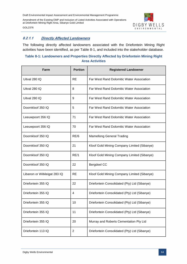
Draft Environmental Impact Assessment and Environmental Management Programme
Amendment of the Existing EMP and Inclusion of Listed Activities Associated with Operations at Driefontein Mining Right Area, Sibanye Gold Limited
GOL2376
Digby Wells Environmental 64
8.2.1.1 Directly Affected Landowners
The following directly affected landowners associated with the Driefontein Mining Right
activities have been identified, as per Table 8-1, and included into the stakeholder database.
Table 8-1: Landowners and Properties Directly Affected by Driefontein Mining Right
Area Activities
Farm Portion Registered Landowner
Uitval 280 IQ RE Far West Rand Dolomitic Water Association
Uitval 280 IQ 8 Far West Rand Dolomitic Water Association
Uitval 280 IQ 9 Far West Rand Dolomitic Water Association
Doornkloof 350 IQ 5 Far West Rand Dolomitic Water Association
Leeuwpoort 356 IQ 71 Far West Rand Dolomitic Water Association
Leeuwpoort 356 IQ 70 Far West Rand Dolomitic Water Association
Doornkloof 350 IQ RE/6 Mamellong General Trading
Doornkloof 350 IQ 21 Kloof Gold Mining Company Limited (Sibanye)
Doornkloof 350 IQ RE/1 Kloof Gold Mining Company Limited (Sibanye)
Doornkloof 350 IQ 22 Bergdeel CC
Libanon or Witkleigat 283 IQ RE Kloof Gold Mining Company Limited (Sibanye)
Driefontein 355 IQ 22 Driefontein Consolidated (Pty) Ltd (Sibanye)
Driefontein 355 IQ 4 Driefontein Consolidated (Pty) Ltd (Sibanye)
Driefontein 355 IQ 10 Driefontein Consolidated (Pty) Ltd (Sibanye)
Driefontein 355 IQ 11 Driefontein Consolidated (Pty) Ltd (Sibanye)
Driefontein 355 IQ 20 Murray and Roberts Cementation Pty Ltd
Driefontein 113 IQ 2 Driefontein Consolidated (Pty) Ltd (Sibanye)

Draft Environmental Impact Assessment and Environmental Management Programme
Amendment of the Existing EMP and Inclusion of Listed Activities Associated with Operations at Driefontein Mining Right Area, Sibanye Gold Limited
GOL2376
Digby Wells Environmental 65
Farm Portion Registered Landowner
Driefontein 355 IQ 15 Driefontein Consolidated (Pty) Ltd (Sibanye)
Driefontein 355 IQ 21 Golden Dries Developments CC
Driefontein 355 IQ 5 Driefontein Consolidated (Pty) Ltd (Sibanye)
Driefontein 355 IQ 8 Driefontein Consolidated (Pty) Ltd (Sibanye)
Driefontein 113 IQ RE\1 Driefontein Consolidated (Pty) Ltd (Sibanye)
Driefontein 355 IQ R Driefontein Consolidated (Pty) Ltd (Sibanye)
Blyvooruitzicht 116 IQ 6 Driefontein Consolidated (Pty) Ltd (Sibanye)
Blyvooruitzicht 116 IQ 7 Driefontein Consolidated (Pty) Ltd (Sibanye)
Blyvooruitzicht 116 IQ 24 Blywonder Trust Pty Ltd
Blyvooruitzicht 116 IQ 8 Nortjie Elizabeth Margaritha
Doornkloof 350 IQ 4 Kloof Gold Mining Company Limited (Sibanye)
Rietfontein 349 IQ 35 Kloof Gold Mining Company Limited (Sibanye)
Rietfontein 349 IQ 73 Kloof Gold Mining Company Limited (Sibanye)
Doornkloof 350 IQ R Kloof Gold Mining Company Limited (Sibanye)
Doornkloof 350 IQ 13 Kloof Gold Mining Company Limited (Sibanye)
Rietfontein 349 IQ 36 Kloof Gold Mining Company Limited (Sibanye)
Rietfontein 349 IQ 5 Kloof Gold Mining Company Limited (Sibanye)
Doornkloof 350 IQ 12 Kloof Gold Mining Company Limited (Sibanye)
Leeudoorn 351 IQ Kloof Gold Mining Company Limited (Sibanye)
Doornkloof 350 IQ 33 Kloof Gold Mining Company Limited (Sibanye)
Draft Environmental Impact Assessment and Environmental Management Programme
Amendment of the Existing EMP and Inclusion of Listed Activities Associated with Operations at Driefontein Mining Right Area, Sibanye Gold Limited
GOL2376
Digby Wells Environmental 66
Farm Portion Registered Landowner
Rietfontein 349 IQ 35 Kloof Gold Mining Company Limited (Sibanye)
Libanon or Witkleigat 283 IQ R Sibanye Gold Ltd
8.2.1.2 Adjacent Landowners
The various adjacent landowners associated with the Driefontein Mining Right area activities
are reflected in Table 8-2 below.
Table 8-2: Adjacent Property Details Associated with the Driefontein Mining Right
Area Activities
Farm Portion Registered Landowner
Uitval 280 IQ 6 Far West Rand Dolomitic Water Association
Uitval 280 IQ 5 Far West Rand Dolomitic Water Association
Uitval 280 IQ 4 Far West Rand Dolomitic Water Association
Driefontein 355 IQ 23 Corobrik Pty Ltd
Blyvooruitzicht 116 IQ 9 Blywonder Trust Pty Ltd
Driefontein 355 IQ 28 Eskom Holdings Ltd
8.2.1.3 Authorities
As indicated in Table 8-3, various authorities are listed who have been engaged during the
pre-application phase.
Table 8-3: Authorities Engaged
Authority Representative
Department of Water Affairs and
Sanitation (DWS)
Ms Petunia Ramunenyiwa
Acting Provincial Head
Bashan Govender
Water Quality Manager
Department of Mineral Resources (DMR)
Dimakatso Ledwaba
Acting Regional Manager
Jimmy Sekgale
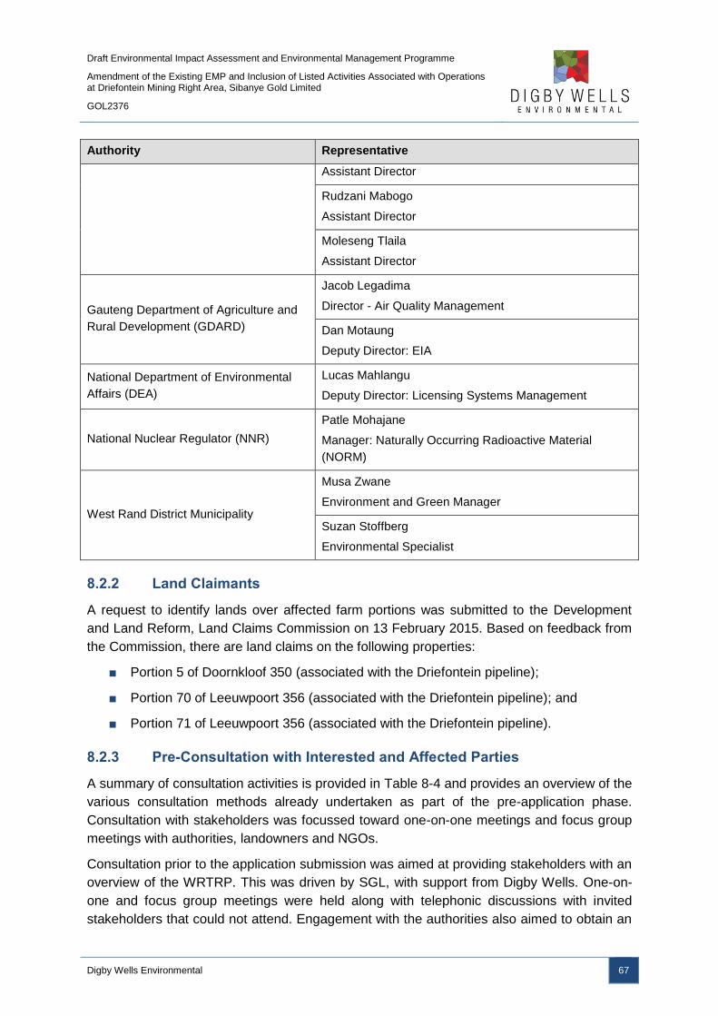
Draft Environmental Impact Assessment and Environmental Management Programme
Amendment of the Existing EMP and Inclusion of Listed Activities Associated with Operations at Driefontein Mining Right Area, Sibanye Gold Limited
GOL2376
Digby Wells Environmental 67
Authority Representative
Assistant Director
Rudzani Mabogo
Assistant Director
Moleseng Tlaila
Assistant Director
Gauteng Department of Agriculture and
Rural Development (GDARD)
Jacob Legadima
Director - Air Quality Management
Dan Motaung
Deputy Director: EIA
National Department of Environmental
Affairs (DEA)
Lucas Mahlangu
Deputy Director: Licensing Systems Management
National Nuclear Regulator (NNR)
Patle Mohajane
Manager: Naturally Occurring Radioactive Material
(NORM)
West Rand District Municipality
Musa Zwane
Environment and Green Manager
Suzan Stoffberg
Environmental Specialist
8.2.2 Land Claimants
A request to identify lands over affected farm portions was submitted to the Development
and Land Reform, Land Claims Commission on 13 February 2015. Based on feedback from
the Commission, there are land claims on the following properties:
■ Portion 5 of Doornkloof 350 (associated with the Driefontein pipeline);
■ Portion 70 of Leeuwpoort 356 (associated with the Driefontein pipeline); and
■ Portion 71 of Leeuwpoort 356 (associated with the Driefontein pipeline).
8.2.3 Pre-Consultation with Interested and Affected Parties
A summary of consultation activities is provided in Table 8-4 and provides an overview of the
various consultation methods already undertaken as part of the pre-application phase.
Consultation with stakeholders was focussed toward one-on-one meetings and focus group
meetings with authorities, landowners and NGOs.
Consultation prior to the application submission was aimed at providing stakeholders with an
overview of the WRTRP. This was driven by SGL, with support from Digby Wells. One-on-
one and focus group meetings were held along with telephonic discussions with invited
stakeholders that could not attend. Engagement with the authorities also aimed to obtain an
Draft Environmental Impact Assessment and Environmental Management Programme
Amendment of the Existing EMP and Inclusion of Listed Activities Associated with Operations at Driefontein Mining Right Area, Sibanye Gold Limited
GOL2376
Digby Wells Environmental 68
understanding of the regulatory requirements in lieu of the changes promulgated in
December 2014. Table 8-4 details activities that formed part of the pre-application phase.
Stakeholders were provided with project information as part of the engagement process
which were distributed via email, post and hand delivery or presented at stakeholder
meetings. An overview of each are detailed below.
■ Positioning document;
■ Various notification letters;
■ Information pack comprising of a project description document and Invitation letter
with registration and comment form and agenda;
■ Illustrative Maps;
■ Animation showing the reclamation process; and
■ Various PowerPoint presentations.

Draft Environmental Impact Assessment and Environmental Management Programme
Amendment of the Existing EMP and Inclusion of Listed Activities Associated with Operations at Driefontein Mining Right Area, Sibanye Gold Limited
GOL2376
Digby Wells Environmental 69
Table 8-4: Summary of PP Activities during the Pre-Application Phase
Activity Details Reference in PP Report
Pre-Application Phase
Identification of stakeholders
Stakeholders, with associated details, were identified by means of Windeed
searches, available existing information, stakeholder networking, site visits,
and research for the compilation of a database.
Appendix D
Stakeholder database.
Identification of land claims
A request to identify potential land claims over affected land portions was
submitted to the Development and Land Reform, Land Claims Commission
on 13 February 2015 and feedback indicated there are no existing land
claims thus far.
Further feedback was received by means of written correspondence on
Monday, 3 August 2015 which indicated there is land claims on Driefontein
355-IQ Portion 15 (Merafong Local Municipality); Doornpoort 347 Portion 30,
29, 2, 37 (Westonaria Local Municipality) which reside over the direct
affected and adjacent land portions.
Appendix D
Land claims letters.
Development of information materials Various material pieces were developed to be used as part of stakeholder
meetings and for ad-hoc requests to provide project details.
Appendix D
Pre-application information materials.
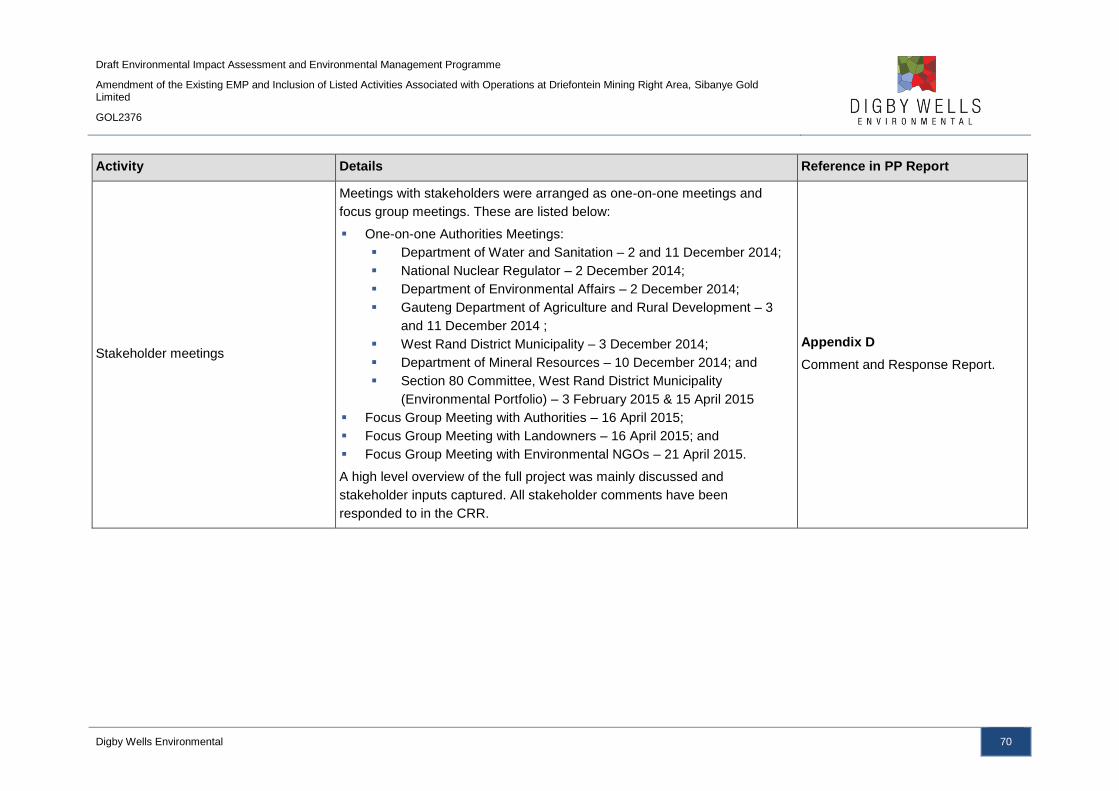
Draft Environmental Impact Assessment and Environmental Management Programme
Amendment of the Existing EMP and Inclusion of Listed Activities Associated with Operations at Driefontein Mining Right Area, Sibanye Gold Limited
GOL2376
Digby Wells Environmental 70
Activity Details Reference in PP Report
Stakeholder meetings
Meetings with stakeholders were arranged as one-on-one meetings and
focus group meetings. These are listed below:
One-on-one Authorities Meetings:
Department of Water and Sanitation – 2 and 11 December 2014;
National Nuclear Regulator – 2 December 2014;
Department of Environmental Affairs – 2 December 2014;
Gauteng Department of Agriculture and Rural Development – 3
and 11 December 2014 ;
West Rand District Municipality – 3 December 2014;
Department of Mineral Resources – 10 December 2014; and
Section 80 Committee, West Rand District Municipality
(Environmental Portfolio) – 3 February 2015 & 15 April 2015
Focus Group Meeting with Authorities – 16 April 2015;
Focus Group Meeting with Landowners – 16 April 2015; and
Focus Group Meeting with Environmental NGOs – 21 April 2015.
A high level overview of the full project was mainly discussed and
stakeholder inputs captured. All stakeholder comments have been
responded to in the CRR.
Appendix D
Comment and Response Report.
Draft Environmental Impact Assessment and Environmental Management Programme
Amendment of the Existing EMP and Inclusion of Listed Activities Associated with Operations at Driefontein Mining Right Area, Sibanye Gold Limited
GOL2376
Digby Wells Environmental 71
8.2.4 Consultation during the Scoping Phase
The aim of consultation during the Scoping Phase was centred on the formal EIA process,
proposed specialist impact studies and addressing stakeholder comments already
submitted. The Scoping Report was made available for review for a period of 30 days and a
combination of Focus Group and Open House meetings were prominent methods to
facilitate stakeholder dialogue between the project team and landowners, authorities, NGOs
and communities.
The updated Scoping Reports were made available to stakeholders on the Digby Wells
website and in public places for a 21 day comment period and notification was distributed to
inform stakeholders of its availability. Stakeholders had the opportunity to verify that their
comments were captured and also to review responses provided by the project team.
The various PP materials used during the Scoping phase have been included as
appendices.
■ Background Information Document;
■ Newspaper advertisements;
■ Site notices;
■ Letter with Registration and Comment Form; and
■ PowerPoint presentation and poster set.
Table 8-5 details PP activities that will be undertaken as part of the Scoping Phase have
been detailed.
Draft Environmental Impact Assessment and Environmental Management Programme
Amendment of the Existing EMP and Inclusion of Listed Activities Associated with Operations at Driefontein Mining Right Area, Sibanye Gold Limited
GOL2376
Digby Wells Environmental 72
Table 8-5: Summary of PP Activities during the Scoping Phase
Activity Details Reference in PP Report
Scoping Phase
Update of stakeholder information The stakeholder database has been updated with new I&APs who formally
register, attend stakeholder meetings or submit comments.
Appendix D
Stakeholder database.
Distribution announcement materials
A BID, announcement letter with registration and comment form was email
and posted to stakeholders on Tuesday, 1 September 2015.
An SMS to announce the project was sent to the full database on Tuesday, 1
September 2015.
The Background Information Document was also available on
(www.digbywells.com/en/public-documents/sibanye-gold-west-rand-tailings-
retreatment-project/) Tuesday, 1 September 2015.
The announcement letter also included information of the stakeholder
meetings that will be held, where the Scoping Reports will be available for
comment and the allowed public comment period.
Appendix D
BID, letter with registration and
comment form.
Placing of advertisements
Advertisements were placed in the following newspapers:
Randfontein Herald (Local Newspaper), Friday 11 September 2015;
Carletonville Herald (Local Newspaper), Thursday, 3 September 2015;
and
Roodepoort Record (Local Newspaper), Friday, 4 September 2015.
Appendix D
Advertisement.
Placing of site notices
Site notices were put up at various places within proposed project site, local
libraries and publically accessible venues within close proximity of the project
area on Tuesday, 1 September 2015 – Thursday, 3 September 2015. These
places are:
City of Johannesburg Metropolitan Library;
Appendix D
Site notice map and placement
report.

Draft Environmental Impact Assessment and Environmental Management Programme
Amendment of the Existing EMP and Inclusion of Listed Activities Associated with Operations at Driefontein Mining Right Area, Sibanye Gold Limited
GOL2376
Digby Wells Environmental 73
Activity Details Reference in PP Report
Scoping Phase
Randfontein Public Library;
Westonaria Public Library;
Toekomsrus Public Library;
Fochville Public Library;
Carletonville Public Library; and
Bekkersdal Public Library.
A site notice placement report and map has been developed, indicating the
exact locations where site notices were placed, with photos and GPS
coordinates.
Identification of land claims
A request to identify potential land claims over affected land portions was
submitted to the Development and Land Reform, Land Claims Commission
on 13 February 2015. Feedback indicated there are land claims on the
following properties Doornkloof 350 Ptn 5, Leeuwpoort 356 Ptn 71 and
Leeuwpoort 356 Ptn 70. A response on some of the properties is still
outstanding.
Appendix D
Land claims letters.
Announcement of the Scoping Reports
The announcement letter was emailed and posted to the full database on 1
September 2015 to:
Announce availability of the Scoping Reports;
Share information of the Open House meetings;
Where the Scoping Reports will be available for comment; and
Public comment period.
The public comment was extended and announcement was done by means
of a letter emailed and posted to stakeholders on 15 October 2015.
SMSs to notify stakeholders that the Scoping Reports are available for
Appendix D
Letter to announce availability of
Scoping Report
Draft Environmental Impact Assessment and Environmental Management Programme
Amendment of the Existing EMP and Inclusion of Listed Activities Associated with Operations at Driefontein Mining Right Area, Sibanye Gold Limited
GOL2376
Digby Wells Environmental 74
Activity Details Reference in PP Report
Scoping Phase
comment and about the public comment period extension was sent to the full
database.
The Scoping Reports was available on the Digby Wells website:
(www.digbywells.com/en/public-documents/sibanye-gold-west-rand-tailings-
retreatment-project/).
(Public comment period: 15 September to 15 October 2015, extended to 6
November 2015)
Placement of Scoping Reports
The Scoping Reports have been made available to stakeholders at the
following public places:
City of Johannesburg Metropolitan Library
Randfontein Public Library
Westonaria Public Library
Toekomsrus Public Library
Fochville Public Library
Carletonville Public Library
Bekkersdal Public Library
The Scoping Reports were available on the Digby Wells website
(www.digbywells.com/en/public-documents/sibanye-gold-west-rand-tailings-
retreatment-project/) and was available at the various stakeholder meetings.
(Public comment period: 15 September to 15 October 2015, extended to 6
November 2015)
Appendix D
Placement map.
Focus Group Meetings The following Focus Group meetings were held during October and
November 2015:
Authorities’ site visit to key areas of the project was held on Tuesday,
Appendix D
Comment and Response Report.

Draft Environmental Impact Assessment and Environmental Management Programme
Amendment of the Existing EMP and Inclusion of Listed Activities Associated with Operations at Driefontein Mining Right Area, Sibanye Gold Limited
GOL2376
Digby Wells Environmental 75
Activity Details Reference in PP Report
Scoping Phase
6 October 2015 from 09:00 – 11:00. All the officials met at Lido Sand
Works Conference venue and were accompanied from there by SGL and
Digby Wells. A route and infrastructure map was also provided. The
following authorities attended: DMR, DWS, NNR, WRDM and WLM);
The site visit was followed by the formal Focus Group Meeting from
12:00 – 14:00 at the same venue;
A Focus Group Meeting was held with landowners (occupiers and
private) on Tuesday, 6 October from 16:00 – 19:00 at Lido Sand Works
Conference venue;
A Focus Group Meeting was held with NGOs and some very technical
stakeholders on Tuesday, 13 October 2015 from 10:00 – 12:00 at
Oaklands Inn, Randburg; and
A smaller Focus Group with specific landowners (as per their request)
close to the Doornpoort farm on 4 November 2015. This meeting was
accompanied by SGL, Digby Wells and SLR (consulting engineers).
Appendix D
PowerPoint Presentation.
Open House Meetings Two Open House meetings were held with communities and all stakeholders
scheduled between 15:00 – 19:00 on the following dates and venues:
Wednesday, 7 October 2015: Westonaria Banquet Hall; and
Thursday, 8 October 2015: Carletonville Community Hall.
Appendix D
Comment and Response Report.
Announcement of the updated Scoping
Reports
Announcement letter of availability of the updated Scoping Reports was
emailed and posted to the full database on Tuesday 17 November 2015.
An SMS to notify stakeholders that the updated Scoping Reports are
available for comment was sent to the full database on Tuesday, 17
November 2015.
These reports were available on (www.digbywells.com/en/public-
Appendix D
Announcement Letter.
Draft Environmental Impact Assessment and Environmental Management Programme
Amendment of the Existing EMP and Inclusion of Listed Activities Associated with Operations at Driefontein Mining Right Area, Sibanye Gold Limited
GOL2376
Digby Wells Environmental 76
Activity Details Reference in PP Report
Scoping Phase
documents/sibanye-gold-west-rand-tailings-retreatment-project/).
(Public comment period: 17 November to 15 December 2015)
Placement of updated Scoping Reports
The updated Scoping Reports include the amended CRR, which contains
new stakeholder comments and responses, and the inclusion of new PP
activities undertaken as part of the Scoping phase.
The updated Scoping Reports were available on the Digby Wells website
(www.digbywells.com/en/public-documents/sibanye-gold-west-rand-tailings-
retreatment -project).
N/A
Focus Group Meetings
It is anticipated that various Focus Group Meetings will be held.
Stakeholders will be informed of the various meetings via email and
telephonic discussions. Additional methods of informing stakeholders of the
meetings will be considered and implemented.
Appendix D
Comment and Response Report
Open House Meetings
Two Open House Meetings will be held with all stakeholders, and
specifically so communities, scheduled between 15:00 – 18:00 as follow:
Wednesday, 17 February 2016: Westonaria Banquet Hall; and
Thursday, 18 February 2016: Carletonville Community Hall.
Appendix D
Comment and Response Report
Obtaining comments from stakeholders Comments, issues and suggestions received from stakeholders will be
captured into the Comment and Response Report.
Appendix D
Comment and Response Report

Draft Environmental Impact Assessment and Environmental Management Programme
Amendment of the Existing EMP and Inclusion of Listed Activities Associated with Operations at Driefontein Mining Right Area, Sibanye Gold Limited
GOL2376
Digby Wells Environmental 77
8.2.5 Consultation during the Impact Assessment Phase
It is anticipated that the PP process to be implemented for the Impact Assessment phase will
be similar to the process commenced for the Scoping phase. The premise of activities is to
ensure that the various legislative requirements for PP are met and that a single, integrated
process is followed. This will limit stakeholder fatigue and ensure that stakeholders are
presented with a single view of the full project and EIA information.
8.3 Item 3(g)(iii): Summary of Issues Raised by I&APs
This section provides a summary of the I&AP comments that have arisen from the PPP thus
far. The CRR summary is provided in Table 8-6 to Table 8-8.

Draft Environmental Impact Assessment and Environmental Management Programme
Amendment of the Existing EMP and Inclusion of Listed Activities Associated with Operations at Driefontein Mining Right Area, Sibanye Gold Limited
GOL2376
Digby Wells Environmental 78
Table 8-6: Interested and Affected Parties
Interested and Affected Parties Date of comments
received Issues raised
EAPs response to issues as mandated by the
applicant
Consultation Status
(consensus dispute,
not finalised, etc.) Name of Individual Consulted
Landowners, Lawful occupier/s of the land, Landowners or lawful occupiers on adjacent properties
Nicci Simpson
Landowner Yes
25 March 2015, 17
April 2015
It is requested that more effort be made to inform
landowners for the attendance of stakeholder
meetings, specifically previously disadvantaged
farmers. The Public Participation process must also be
managed in a more transparent manner.
A fair amount of landowners have already been
identified either interested in or affected by the
proposed project, and since the formal EIA process is
only aimed to start in September 2015, we are
continuing our efforts to identify more landowners by
means of various channels. Also, adverts will be placed
as part of the formal EIA process. Please feel free to
provide details of specific landowners you would want
us to include as part of the process.
Not yet finalised and
under investigation
Peet Bornman, Jaco Taute
Landowners Yes 16 April 2015
When the west wind blows the whole area is white with
dust and trucks do not always water for dust
suppression. Breathing in the dust causes health
issues.
With dedicated mitigation measure in place, dust
emission will be reduced drastically, hence lowering
exposure to repairable fractions that result in health
problems-this material is likely sourced from the
historical dams which are planned to be removed. The
newly planned RTSF will be concurrently rehabilitated.
Not yet finalised and
under investigation
Piet Rheeder, Armand de
Villiers
Landowners
Yes 16 April 2015
Pollution of groundwater and surface sources,
specifically the Leeuspruit, is a concern. This will also
disturb the water balance of our water.
Any water discharged into the Leeuspruit, will be
treated to SANS 241 drinking standards and will
enhance the quality therein. These guidelines are very
stringent, so therefore, any water discharged will be of
a benefit as it will serve to promote dilution, of the
current water quality of the Leeuspruit.
Not yet finalised and
under investigation
Peet Bornman, Piet Rheeder
Landowners Yes 16 April 2015
The Regional Tailings Storage Facility (RTSF) will have
a negative impact on surrounding area, specifically
from a visual point of view.
A Visual Impact Assessment was undertaken and
assesses the significance of the visual impacts to the
surrounding landscape. Mitigation measures have been
provided in the EMP to mitigate such visual impacts.
Please refer to the photomontages in Section 9.4 of the
Topography and Visual Impact Assessment Report for
an illustration of the potential future views of the RTSF
and other project infrastructure.
Not yet finalised and
under investigation
Dre Schalekamp, Nicci
Simpson
Landowners
Yes 16 April 2015
Why pollute new agricultural land? Other Tailings
Storage Facilities (TSFs) can be used. Sibanye need to
do what is good for the community.
This project is attempting to combine the proposed
Geluksdal and West Wits project TSFs into a single
deposition site based on request made by the
community and the DMR. The historic dumps are not
designed to today’s best practice standards. Their size
Not yet finalised and
under investigation
Draft Environmental Impact Assessment and Environmental Management Programme
Amendment of the Existing EMP and Inclusion of Listed Activities Associated with Operations at Driefontein Mining Right Area, Sibanye Gold Limited
GOL2376
Digby Wells Environmental 79
Interested and Affected Parties Date of comments
received Issues raised
EAPs response to issues as mandated by the
applicant
Consultation Status
(consensus dispute,
not finalised, etc.) Name of Individual Consulted
limits the deposition rates and tonnage storage
required to retreat these dumps economically. They do
not have adequate pollution prevention measures in
place and are a source of pollution to the groundwater
aquifers of the dolomites.
Armand de Villiers
Landowner Yes 16 April 2015
Will mined areas be rehabilitated and if so, what are
the timelines?
The intention is to rehabilitate back to a suitable land
use, as determined by the LED plans and from
community consultation. Some concurrent rehabilitation
is envisaged with final rehabilitation being completed
after removal of the final layer of tailings and will be
completed within 2/3 years. The final end-land use of
these re-mined areas will be dependent on several
factors and engagement with all stakeholders is
imperative to assist in determining the end-land use
and also site specific conditions. The timeframe
associated with the rehabilitation of these areas is
dependent on several factors, such as the rate of
reclamation and current market demands.
Not yet finalised and
under investigation
Coetsee Badenhorst, Alf
Rudman
Landowners
Yes 16 April 2015 How will compensation be managed for the project,
since no agreements have been put in place yet?
The specialist studies are not directly involved in
decisions around the actual buy-out of farms which
have to be considered at the appropriate timelines as
the project unfolds and meets social, commercial and
environmental imperatives.
Not yet finalised and
under investigation
Barry van Wyk, Peet Bornman
Landowners Yes 16 April 2015
Cattle’s meat will be contaminated as a result of the
project and people have been very ill as a result of
drinking contaminated water.
The impact assessment phase has evaluated the
current groundwater quality at various farm boreholes.
Representative boreholes were collected for water
quality evaluation and the laboratory result is available
for anyone interested. The potential impact during and
after the mine operation have also been predicted.
Please refer to the groundwater EIA report for details.
Not yet finalised and
under investigation
Sarel Cilliers, Barry van Wyk
Landowners Yes 16 April 2015
We are not in support of the proposed project and
object to it strongly. Promises are being made and
nothing is delivered. Our environment and lives are
destroyed because of the mines.
Thank you for the comment. The legislative process will
allow all stakeholders to raise their grievances.
Not yet finalised and
under investigation
Draft Environmental Impact Assessment and Environmental Management Programme
Amendment of the Existing EMP and Inclusion of Listed Activities Associated with Operations at Driefontein Mining Right Area, Sibanye Gold Limited
GOL2376
Digby Wells Environmental 80
Interested and Affected Parties Date of comments
received Issues raised
EAPs response to issues as mandated by the
applicant
Consultation Status
(consensus dispute,
not finalised, etc.) Name of Individual Consulted
Hermann Heunis
Landowner Yes 4 September 2015
The National Water Act stipulates that water pollution
should be avoided by all possible reasonable humane
methods. Assessments done in the past show that this
principle cannot be guaranteed.
All developments impact water to some degree
however the EIA regulations read with the National
Water Act provide for the assessment of those impacts
and necessary mitigations and then the regulator can
make a balanced and informed decision about the
project.
Dre Schalekamp
Landowner
Thabang Frans Ramogodi
Senwes LTD
Yes 15 October 2015,
6 November 2015
The affected land is being used to produce maize and
this land will be next to the TSF.
The SIA and Economic Impact Assessment (EIA)
addresses the impact on land uses from the
perspective of (a) increased access to land following
the retreatment of tailings, and (b) alternative end-land
uses post mine closure (see also Section 11.6 and
Section 11.10 of the SIA, as well as the EIA specialist
study
Jacobus van Wyk
Landowner
Mr & Mrs Rudman
Landowners
Yes 6 October 2015,
12 October 2015
My farm's water will be contaminated. There will also
be air pollution due to the dust and we will inhale the
dust. There will also be an visual impact and our
property prices will drop.
The Groundwater Impact Assessment has modelled
the potential contamination plume and draw down
impacts associated with the RTSF and blast curtain. In
addition, an Air Quality Impact Assessment modelled
potential dust fallout, PM2.5 and PM10 emissions.
Please refer to Sections 8.3 and 9.2 of the Topography
and Visual Impact Assessment Report. The viewshed
areas of the CPP and RTSF were split into categories
expected to experience different levels of visual
exposure. These categories are as follows. CPP: 0 -
1.5 km Potential High Visual Exposure, 1.5 - 3 km
Potential Moderate Visual Exposure and 3 - 4 km
Potential Low Visual Exposure. RTSF: 0 -5 km
Potentially High Visual Exposure, 5 - 9 km Potentially
Moderate Visual Exposure and 9 - 12 km Potentially
Low Visual Exposure. Plans 13, 15 and 16 of the
Topography and Visual Impact Assessment Report
indicate the practical viewshed models of the CPP,
RTSF and Kloof MRA.
The above impacts have also been detailed in the EIA
report, with the mitigation measures provided.

Draft Environmental Impact Assessment and Environmental Management Programme
Amendment of the Existing EMP and Inclusion of Listed Activities Associated with Operations at Driefontein Mining Right Area, Sibanye Gold Limited
GOL2376
Digby Wells Environmental 81
Interested and Affected Parties Date of comments
received Issues raised
EAPs response to issues as mandated by the
applicant
Consultation Status
(consensus dispute,
not finalised, etc.) Name of Individual Consulted
Kriszanne Lehman
Landowner
F.R.J de Bruyn
Landowner
Jean Coetzer & Maria Coetzer
Landowner
Yes 28 September 2015,
November 2015
The pollution will affect my and my family's health
negatively.
One of the key objectives of the ultimate project is to
re-mine and thus physically remove the historical
sources of dust i.e. TSFs. Predicted impacts on
ambient air quality resulting from the hydraulic re-
mining and construction processes are minimal (see
Section 8.1). It is worth mentioning that mitigation
measures in place will further reduce anticipated
impacts.
Alida Potgieter
Landowner
Sarel Cilliers
Landowner
Andre Burger
Landowner
Dorothy de Bruyn
Landowner
Yes
6 October 2015,
1 & 6 November
2015
As land value is impacted by surrounding mine dams,
land should be bought out entirely at a competitive rate
to ensure owner can replace farm somewhere else
without financial loss.
The purchasing of properties is dependent on various
aspects, one of which is SGL receiving a licence to
operate. Should the project proceed, the acquisition of
properties will take place on case-by-case basis if
applicable.
Paul da Cruz
Landowner Yes 13 October 2015
The proposed pipeline will also negatively affect the
current and future value of my property thereby having
a financial impact on the investment I have made in the
property and improving it.
The impact of the infrastructure proposed on individual
land value will have to be assessed once the
necessary environmental and company approvals for
the project are obtained.
Dr J.A Olivier
Landowner Yes 4 November 2015
There needs to be a balance between the economics
and impact an environment for this project; there needs
to be a compromise between the stakeholders
involved.
SGL concurs.
Nicci Simpson
Landowner
Dr J.A Olivier
Landowner
Alf Rudman
Landowner
Yes 6 October 2015,
4 November 2015
Why can’t the RTSF be built more north of the
Doornpoort TSF?
The West Wits project EIA provided a site selection
process and Gold Fields also submitted an application
for another TSF. DMR said what a single TSF must be
developed for the area. The proposed TSF will need to
accommodate 4 million tonnes of tailings per month.
The proposed Gold Fields TSF could only
accommodate 2,75 million tonnes of tailings per month
and West Wits 0,75 million tonnes of tailings per month
- this was established through the 2 EIA studies
undertaken. If was identified that the preferred area for
the RTSF falls between the West Wits area and Gold
Draft Environmental Impact Assessment and Environmental Management Programme
Amendment of the Existing EMP and Inclusion of Listed Activities Associated with Operations at Driefontein Mining Right Area, Sibanye Gold Limited
GOL2376
Digby Wells Environmental 82
Interested and Affected Parties Date of comments
received Issues raised
EAPs response to issues as mandated by the
applicant
Consultation Status
(consensus dispute,
not finalised, etc.) Name of Individual Consulted
Fields area, but unfortunately 2 separate sites can't be
used for the RTSF.
H.N Thorold, Adriaan and Lanet
and Susan and Jaco Taute,
Victor Siqongana, Pulane
Malebo, Shanique Marais,
Patricia August
Landowners / Occupiers
Yes 5 November 2015 Do not build the dump and the plant.
Under the constitution a developer has the right to put
forward any project proposal for regulatory approval
and which meet legislative requirements.
H.N Thorold, Adriaan and Lanet
and Susan and Jaco Taute,
Victor Siqongana, Pulane
Malebo, Shanique Marais,
Patricia August
Landowners / Occupiers
Yes 5 November 2015 The impacts can be managed by keeping existing plant
at Waterpan or Westonaria.
This is the most suitable area for the RTSF in terms of
greatest final capacity and the rate of deposition
required. Two independent site selection processes
looked at a 50 km radius of the district and both homed
into this area.
Kimberly Gietzmann
Landowner Yes 6 November 2015
Increase of theft because mines do not control access
to their properties and do not give advanced notice.
Your comment is noted. Safety and security concerns
are endemic to the region and the country, and needs a
collective and collaborative approach to root out.
Pierre Ludick on behalf of Dr
J.A Olivier
Landowner
Yes 15 December 2015
My communication refers: As I am in contention to the
proposed dump of Sibanye to be placed in
Kalbasfontein, I am therefore insisting on the services
of an independent specialist to be despatched to assist
the community, and where I am instructing that the
services of this specialist environmentalist to be paid
for by Sibanye, as it is Sibanye who is wanting to place
the dump in our area that we do not want. It is
unacceptable to me that the community should be
expected to be paying for such services and where it is
insisted upon that all studies be reinitiated, with nothing
being carried over from the Geluksdal project, but to
begin afresh. Your immediate and urgent response is
required.
With regard to your request that we consider the
appointment an independent consultant at our own
expense, we point out that if payment is made to such
a consultant, he could not be regarded as any more
independent than our existing consultants who are
currently lending us advice. Regrettably, therefore, we
are unable to accede to your request.
Municipal councillor

Draft Environmental Impact Assessment and Environmental Management Programme
Amendment of the Existing EMP and Inclusion of Listed Activities Associated with Operations at Driefontein Mining Right Area, Sibanye Gold Limited
GOL2376
Digby Wells Environmental 83
Interested and Affected Parties Date of comments
received Issues raised
EAPs response to issues as mandated by the
applicant
Consultation Status
(consensus dispute,
not finalised, etc.) Name of Individual Consulted
Clr Vincent Mfazi
West Rand District Municipality,
Section 80 Committee
Yes 3 February 2015
The reclamation process uses water, but Acid Mine
Drainage (AMD) is a concern and will be used as part
of the process.
Government funds with regard to AMD are largely
targeted at legacy or abandoned areas. The WRTRP
will use impacted water from current operations No
inter connected mine activities exist between the
western and far western basins.
Not yet finalised and
under investigation
Clr Roy Harris
West Rand District Municipality,
Section 80 Committee
Yes 3 February 2015
Is this similar to what is done by Mintails? Radioactivity
is a concern because it remains well after reclamation
and rehabilitation took place. The rehabilitated land
might not be suitable for agriculture because it remains
radioactive.
Similar to what is done at DRD Gold. Final
rehabilitation of the reclaimed TSF footprint has to
achieve standards set by the NNR for end land use
Working with specialists to cut into surface and take out
radioactive material to understand feasibility at this
stage.
Clr Vincent Mfazi
West Rand District Municipality,
Section 80 Committee
Yes 3 December 2014,
15 April 2015
The clay structure will collapse during the reclamation
process and new chemical structures will be formed
which can be harmful to people and the environment.
How will the particulates be prevented from floating into
the air once the clay structure is destroyed?
The reclamation is a waterborne process. The slurry
will be processed through a number of chemical
processes before going to the RTSF. The resultant
tailings will undergo a very specific geochemical
analysis as part of the specialist impact studies to
ensure that the chemical components of the process is
understood in detail once the elements in the tailings
are exposed to the various processes. The specialists
addressing the geochemical analysis and doing the
design of the RTSF are highly specialized. Collection of
samples from a composite and individual sample of the
TSFs to be treated and analysis thereof after
metallurgical test work has been done over the last six
months in order to understand all the elements
including the clay structures. Air quality modelling will
be used and integrated with the geochemical findings
in order to prescribe mitigation measures to be
included in the EMP.
Not yet finalised and
under investigation
Municipality
Susan Stoffberg
West Rand District Municipality, Yes 3 December 2014
What are the potential land uses that can be
considered? This will assist the West Rand District
Municipality for future development and associated
planning.
The post closure land uses of the TSFs that will be
mined will be based on inputs from various sectors of
local society - ongoing interaction with the relevant
Section 80 committees will assist in integrating
planning.
Not yet finalised and
under investigation
Olivia Calderia Yes 15 April 2015 There are a lot of health issues because of the amount Dust and PM10 monitoring is in place already to assess Not yet finalised and
Draft Environmental Impact Assessment and Environmental Management Programme
Amendment of the Existing EMP and Inclusion of Listed Activities Associated with Operations at Driefontein Mining Right Area, Sibanye Gold Limited
GOL2376
Digby Wells Environmental 84
Interested and Affected Parties Date of comments
received Issues raised
EAPs response to issues as mandated by the
applicant
Consultation Status
(consensus dispute,
not finalised, etc.) Name of Individual Consulted
West Rand District Municipality,
Section 80 Committee
of dust and this is an issue/concern. A lot of watering
will need to be done.
current scenario and future impacts associated with
those pollutants. A dispersion model will be run during
the EIA phase, after which mitigation measures will be
recommended to curtail potential impacts. Mitigation
measures will be put in place to curtail dust i.e.
concurrent covering and vegetation of tailings slopes,
application of dust suppressants on mine dirt road –
water, dust-a-side etc. Suitable quality water will be
available.
under investigation
Tokky Mosolo
Westonaria Local Municipality Yes 16 April 2015
Ad hoc projects for community development originating
from other mining houses in the area are underway and
a consolidated Social and Labour Plan (SLP) for the
area and the project should be developed
(incorporating other mining houses in the area).
The SLPs must be tied to a mining right issued by the
DMR.SGL is attempting to consolidate these as the
legislation requires them to be separate.
Not yet finalised and
under investigation
Joyce Kethwa
Westonaria Municipality Yes 2 October 2015
There will be a lot of dust and people will contract
diseases like cholera and TB. Also we will have a lot of
earth tremors where maybe houses will be affected e.g.
cracks and broken windows.
One of the key objectives of the ultimate project is to
re-mine and thus physically remove the historical
sources of dust i.e. TSFs. Predicted impacts on
ambient air quality resulting from the hydraulic re-
mining and construction processes are minimal (see
Section 8.1). It is worth mentioning that mitigation
measures in place will further reduce anticipated
impacts.
Charles Stevens
West Rand District Municipality Yes 6 October 2015
What are the closure objectives and what will be the
land use be used for? This must be determined at the
planning phase. Also, what is the future use of the
RTSF considering post-closure?
The intention is to rehabilitate back to a suitable land
use, as determined by the LED plans and from
community consultation. Some concurrent rehabilitation
is envisaged with final rehabilitation being completed
after removal of the final layer of tailings and will be
completed within 2/3 years.
Organisations of state (Responsible for Infrastructure that may be affected Roads Department, Eskom, Telkom, DWA etc.)
Will be consulted during the
Scoping and EIA phases.
Communities
Lucas Misapitso
Interested Community Member Yes 21 April 2015
Some of the communities are irresponsible and uses
AMD water to irrigate crops and are also using sludge
to manufacture bricks. It is a huge problem and a
The DMR Regional Strategy was considered during the
compilation of the rehabilitation report and the plan
compiled is aligned with these objectives. This will
Not yet finalised and
under investigation
Draft Environmental Impact Assessment and Environmental Management Programme
Amendment of the Existing EMP and Inclusion of Listed Activities Associated with Operations at Driefontein Mining Right Area, Sibanye Gold Limited
GOL2376
Digby Wells Environmental 85
Interested and Affected Parties Date of comments
received Issues raised
EAPs response to issues as mandated by the
applicant
Consultation Status
(consensus dispute,
not finalised, etc.) Name of Individual Consulted
health risk. Communities need to be educated and
mitigation measures put in place.
ensure that all the proposed mitigation measures are
implemented accurately to minimize any residual
impacts. The reclamation process will ensure controlled
exposure of the material to air and water and contained
within the existing foot print of the TSF.
Lucas Misapitso
Interested Community Member Yes 21 April 2015
Which mitigation strategies will Sibanye use to reduce
the radiation levels? The Westrand already has high
level of radiation.
The remaining footprint after reclamation is the biggest
challenge, but the needed closure and rehabilitation
plans will be developed in collaboration with the
relevant competent authorities. This will also include
end land use which will be considered as part of the
social studies to be undertaken. One of the reasons the
project is being undertaken is to remove the latent
radiation found in these tailings facilities. This will
reduce the risk and exposure for communities. NNR
approvals for the project require assessments to be
done for workers and public in and around the TSFs to
be reclaimed.
Not yet finalised and
under investigation
Ezekiel Khunou
Bekkersdal Care for the Aged
Tefo Hlasa
Batho Pele Community
Development Centre
Sylvia Maguma
Sizabantu HBC
Yes 25 September 2015,
7 October 2015
The project might impact me in terms of health. The
dust can have negative impact to the community
especially our elderly whom their immune system is
vulnerable to many for opportunistic diseases.
Thank you for your comment. One of the key objectives
of the ultimate project is to re-mine and thus physically
remove the tailings dams as sources of potential dust
pollution. Any potential impacts resulting from the
hydraulic re-mining and construction processes, will be
investigated during the EIA process, and if needed,
appropriate mitigation measures will be put in place to
mitigate these impacts.
Bongani Jonas
MACU Yes 28 September 2015
During such reclamation processes at dams near
informal dwellers, they are automatically affected or
infected from the acid mining drainage e.g. cattle drink
water from a polluted dam.
Surface and groundwater specialist studies have been
undertaken to determine environmental impacts and
the results thereof, together with mitigation measures,
are available to the public and stakeholders.
Siphiwe Radebe
SANCO Yes 7 October 2015
When demolishing the old TSFs, dust will be a concern
for nearby communities, because there will be
chemicals used. Are any mitigation measure put in
place for that?
The reclamation of TSFs uses only water and dust
doesn't get created as part of the process. No
chemicals are included.
Moatlhodi Molefe
Wira Coordinator Yes 7 October 2015
There is exclusion and not sufficient communication
which leads to the community not being informed
properly.
The Public Participation process provides opportunity
to communities to partake in the process in order to
gain a better understanding of the project and EIA

Draft Environmental Impact Assessment and Environmental Management Programme
Amendment of the Existing EMP and Inclusion of Listed Activities Associated with Operations at Driefontein Mining Right Area, Sibanye Gold Limited
GOL2376
Digby Wells Environmental 86
Interested and Affected Parties Date of comments
received Issues raised
EAPs response to issues as mandated by the
applicant
Consultation Status
(consensus dispute,
not finalised, etc.) Name of Individual Consulted
process. No stakeholders are excluded from the
process and can partake freely.
Thabsile Vilakazi
Batho Pele Community
Development Centre
Sibusiso Khumalo
SANCO
Makhotso Lekopa
Ward Committee secretary
ward 18
Yes 7 & 8 October 2015 What is the benefit for the community?
The Project will give preference to local employment for
both temporary and permanent employment of suitably
skilled people, as well as for local procurement. The
SLP of the Project will provide details of required skills
and associated local employment opportunities. These
results will provide an indication to candidate
employees opportunities in order to better equip
themselves. The SLP makes provision for skills
development and internships. The SIA recommends
that project training programmes are extended to
include members of the local communities. Local
economic development projects will be implemented as
part of the SLP. See also Section 11.1 to 11.4 and
11.13 of the SIA report.
Ebrahim Dithagiso
Hillshaven Homeowners
Association
Sibongile Doreen Kati
Twelve Star Co-operative
Siphiwe Radebe
SANCO
Yes 27 September 2015,
6 & 7 October-2015
First it will affect us because the project will change the
nature of this place the dust will affect the community
which will cause people to be ill and easily affected by
TB.
One of the key objectives of the ultimate project is to
re-mine and thus physically remove the historical
sources of dust i.e. TSFs. Predicted impacts on
ambient air quality resulting from the hydraulic re-
mining and construction processes are minimal (see
Section 8.1). It is worth mentioning that mitigation
measures in place will further reduce anticipated
impacts.
Tebogo Makolwane
SANCO
Londi Tembe
Poortjie Community
Yes 7 & 8 October 2015
It will impact me positive if I would be a beneficiary
from the project, even though it might also leave after
effects in terms on health and environmental due to air
pollution, which might affect my community.
Thank you for your comment. The SIA makes
recommendations to maximise project benefits for
affected communities. The SLP will also commit to
implement community projects based on the priorities
of the municipality. See also Section 11.5 and 11.8 of
the SIA.
Norman Ngqaqu
Merafong Disability Forum
Clement Mokoma
Ward 18 Ward Committee BEE
Yes 8 October 2015 Why are the Councilors not here?
The various Councilors were invited, but it is
understood that they are on recess and not able to
attend.
Clement Mokoma
Ward 18 Ward Committee BEE Yes 8 October 2015
How/what will the communities benefit out of this
proposed project in terms of jobs?
Approximately 2000 jobs opportunities will be available
during the construction phase and approximately 500

Draft Environmental Impact Assessment and Environmental Management Programme
Amendment of the Existing EMP and Inclusion of Listed Activities Associated with Operations at Driefontein Mining Right Area, Sibanye Gold Limited
GOL2376
Digby Wells Environmental 87
Interested and Affected Parties Date of comments
received Issues raised
EAPs response to issues as mandated by the
applicant
Consultation Status
(consensus dispute,
not finalised, etc.) Name of Individual Consulted
Annah Tshoagong
Aganang Centre
Tebogo Makolwane
SANCO
permanent positions thereafter.
Mosimanegape Mathiba
Matre-Faith Trading and
Projects
Yes 18 November 2015 The polluted air and water affects people, animals,
farmers and plants.
Model predictions show that impacts are minimal and
within compliance. Please refer to the relevant
specialist' studies and sections in the draft EIA Report.
Busisiwa Ronose
Westonaria Concerned
Residents
Yes 14 December 2015
The tailings dam must concentrate accordingly in order
to avoid the contaminants that have been disposed in
the tailings dam from affecting the environment.
Mitigation measures have been provided in the EIA
report for the operation of the RTSF to mitigate and
prevent potential impacts to the surrounding
environment. Water runoff, seepage and contamination
plumes and erosion of tailings material through wind
have all been identified as potential to result in
environmental impacts. The mitigation measures are
provided in the EIA report.
Traditional Leaders
No traditional leaders are
involved in the project.
Department of Land Affairs
Nomvuzo Mjadu
Department of Agriculture,
Forestry and Fisheries
Yes 15 December 2015
The pipeline routes traverse watercourses and there
will be 25 watercourses crossing:-
• Are there no any other routes away from the 25
rivers, to mitigate the chances of spillage or pipeline
bursts and leakages into the watercourses?
Department of Environmental Affairs
Lucas Mahlangu
Department of Environmental
Affairs
Yes 2 December 2014 For listed activities it needs to be ensured that the
correct department or level is consulted.
Noted - however we understand that at the present
these interactions will be channelled through the DMR.
Not yet finalised and
under investigation
Majalele Pholudi
Department of Environmental
Affairs
Yes 16 April 2015 Environmental liability is important; who will be held
responsible?
A closure costing estimate was undertaken as part of
the EIA process and will be approved by the DMR and
it will be Sibanye Gold’s responsibility to provide
sufficient funds to undertake rehabilitation prior to
approval of the project.
Not yet finalised and
under investigation
Draft Environmental Impact Assessment and Environmental Management Programme
Amendment of the Existing EMP and Inclusion of Listed Activities Associated with Operations at Driefontein Mining Right Area, Sibanye Gold Limited
GOL2376
Digby Wells Environmental 88
Interested and Affected Parties Date of comments
received Issues raised
EAPs response to issues as mandated by the
applicant
Consultation Status
(consensus dispute,
not finalised, etc.) Name of Individual Consulted
Other Competent Authorities Affected
Victor Nkuna, Portia Chawane,
Bashan Govender
Department of Water and
Sanitation
Yes 2, 11 December
2014, 4 June 2015
How will water use be managed or treated and where
will water be sourced from used for reclamation?
The removal of historic dumps on dolomite as part of
the tailings reclamation is expected to improve the
water quality by removing the sources of
contamination. The geochemistry of the proposed
RTSF has been conducted and the seepage rate has
been calculated. Appropriate monitoring and
management plans will be implemented at each site
that is being reclaimed.
Not yet finalised and
under investigation
Patle Mahonjane
National Nuclear Regulator Yes 2 December 2014
A radiation protection function needs to be integrated
as part of the EIA and associated processes.
The EIA process as well as a public and worker
assessment is required to be carried out for approval of
the NNR which will require monitoring and reporting.
Sibanye have a dedicated radiation protection team
that will work on the WRTRP.
Not yet finalised and
under investigation
Mwinsa Mpundu
National Nuclear Regulator
Rina Taviv, Christopher
Rakuambo
Gauteng Department of
Agriculture and Rural
Development
Yes 2, 3 December 2014
Are there other options for the project? For example
decentralised plants, rather expanding the existing
ones e.g. Geluksdal Central Tailings Storage Facility
(CTSF)?
The technical viability of the processes to be employed
for gold, uranium and sulphur are the result of
extensive metallurgical test work, based on this
outcome the position of all the components of the
necessary infrastructure are then subjected to
alternatives in terms of location and are presented for
scrutiny as part of the EIA process.
Not yet finalised and
under investigation
Moleseng Tlaka
Department of Mineral
Resources
Yes 10 December 2014
Will the RTSF be able to accommodate all the tailings
facilities in the area and will it be jointly owned by
Sibanye Gold and Gold Fields?
The RTSF will be able to accommodate SGL and other
TSFs in the area to a total of 1.3 billion tonnes.
Not yet finalised and
under investigation
Bashan Govender
Department of Water and
Sanitation
Yes 11 December 2014
The Department of Water and Sanitation look to
address issues coming from underground/surface
water AMD experienced currently.
The water management will be integrated with the
technology and recovery will be the focus for the area.
Water migrating to groundwater resources will be
reduced and it is aimed to close shafts and mines
where required. For the WRTRP the use of Rand
Water will be replaced with treatment of existing water
resources to be used as part of the reclamation
process. It is also envisaged that municipality(s) will be
assisted with the management of their water.
Not yet finalised and
under investigation
Dan Motaung
Gauteng Department of Yes
11 December 2014,
4 June 2015
Concern is that the new area is in a rural setting used
for farming and this will be removing agricultural land in
The historical TSF sites will be removed, making
previously unusable land available. The potential
Not yet finalised and
under investigation
Draft Environmental Impact Assessment and Environmental Management Programme
Amendment of the Existing EMP and Inclusion of Listed Activities Associated with Operations at Driefontein Mining Right Area, Sibanye Gold Limited
GOL2376
Digby Wells Environmental 89
Interested and Affected Parties Date of comments
received Issues raised
EAPs response to issues as mandated by the
applicant
Consultation Status
(consensus dispute,
not finalised, etc.) Name of Individual Consulted
Agriculture and Rural
Development
Marius Keet
Department of Water and
Sanitation
Gauteng. impact of the RTSF on the surface and groundwater
has been evaluated and mitigations methods have
been proposed. With the implementation of the
proposed mitigations techniques, the impact can be
reduced to minimum. Please refer to the Surface and
Groundwater reports for details.
Bashan Govender
Department of Water and
Sanitation
Rudzani Mabogo
Department of Mineral
Resources
Yes 11 December 2014,
16 April 2015
Close consideration must be given to the liner option or
rather how to go about securing that water does not
leak into the underground water resources e.g. High
Density Polyethylene (HDPE) liner
It is likely that lining a facility of this size will make the
project economically unfeasible however a number of
options are being explored.
Not yet finalised and
under investigation
Eric Mulibana,
Gauteng Department of
Agriculture and Rural
Development
Portia Chawane, Victor Nkuna
Department of Water and
Sanitation
Yes 2 December
2014,16 April 2015
Where will the water to be used for reclamation be
sourced from? It is proposed that existing mine water
for the reclamation process.
The water will be sourced from existing impacted water
from underground operations at the Kloof, and Cooke
shafts. Currently 35 Mℓ/day is discharged from the
Kloof 10 shaft, into the Wonderfonteinspruit, and 20
Ml/d from Cooke under licence. The first phase
(1.5Mt/m) of this project will take 30 Ml/d of that for
hydraulic reclamation and once it has gone through the
process, it will be treated through an advanced water
treatment facility (AWTF) at the toe of the RTSF. The
treated water will either be discharged to the
Leeuwspruit or can be supplied to nearby communities.
It is not likely that there will be a significant impact on
downstream users where water is being discharged
into the Wonderfonteinspruit.
Not yet finalised and
under investigation
Wilcot Speelman
National Nuclear Regulator Yes 16 April 2015
Clarity on the full project needs to be provided, not just
phase one. The WRTRP must be well thought through
considering that it will be a 25 year project sot that
potential negative impacts do not become a reality in
the future and is irreparable.
The project will be presented as a whole to
demonstrate long term viability with authorisation being
sought for initial implementation.
Not yet finalised and
under investigation
Dan Motaung
Gauteng Department of
Agriculture and Rural
Development
Yes 16 April 2015 How will rehabilitation for the project and RTSF be
managed?
Consideration of alternate are a requirement for all
sites proposed in the WRTRP. The specific
rehabilitation measures for the RTSF and historic
facilities will be addressed within the rehabilitation plan
that will compiled including appropriate re-vegetation
Not yet finalised and
under investigation

Draft Environmental Impact Assessment and Environmental Management Programme
Amendment of the Existing EMP and Inclusion of Listed Activities Associated with Operations at Driefontein Mining Right Area, Sibanye Gold Limited
GOL2376
Digby Wells Environmental 90
Interested and Affected Parties Date of comments
received Issues raised
EAPs response to issues as mandated by the
applicant
Consultation Status
(consensus dispute,
not finalised, etc.) Name of Individual Consulted
techniques and post rehabilitation monitoring.
Marius Keet
Department of Water and
Sanitation
Yes 4 June 2015 Sibanye can potentially assist in supplying water to
people in the broader region.
Sibanye is more than willing to engage with the
Department on these matters.
Not yet finalised and
under investigation
Rudzani Mabogo
Department of Mineral
Resources
Yes 6 October 2015
It is important to ensure that the RTSF will be
accessible to all companies in the area, large or small,
busy with reclamation to deposit tailings.
Other miming companies in the area will have access
for deposition and the necessary arrangements will
have to be negotiated and put into place.
Bashan Govender
Department of Water and
Sanitation
Yes 6 October 2015 Will the RTSF be lined? Various options are being investigated currently.
Bashan Govender
Department of Water and
Sanitation
Yes 6 October 2015
Does SGL have the needed allocated and dedicated
funds should a pipe burst? Also, are the required
emergency processes in place for such an event?
Yes, SGL does have the required funds allocated and
associated health & safety plans in place in order to
address pipeline emergencies.
Elmond Lekota
National Nuclear Regulator Yes 6 October 2015
The pipeline infrastructure results in a lot of stream and
wetland crossings; you must have alternatives and it
must be environmentally viable and cost effective.
Thank you for your comment, all the necessary pipe
routes have been assessed in relation to viable
alternatives and thus minimising potential risks to the
wetlands -these will be assessed during the EIA phase
and appropriate mitigation measures recommended.
Amukezani Shibambo
Department of Water and
Sanitation
Yes 6 October 2015
Has SGL done an analysis, and associated costs, of
treatment and discharge of water into the Leeuspruit? It
needs to be determined if the treated water can be
used for human consumption and not just to discharge
into the river.
Yes part of the proposal is to install a AWTF (advanced
water treatment facility) to treat the water to the SANS
241 potable water standard, prior to discharge.
Rudzani Mabogo
Department of Mineral
Resources
Yes 7 October 2015 What other social development benefits will this project
be brining to the area?
The Project will give preference to local employment for
both temporary and permanent employment of suitably
skilled people, as well as for local procurement. The
SLP of the Project will provide details of required skills
and associated local employment opportunities. These
results will provide an indication to candidate
employees opportunities in order to better equip
themselves. The SLP makes provision for skills
development and internships. The SIA recommends
that project training programmes are extended to
include members of the local communities. Local
economic development projects will be implemented as

Draft Environmental Impact Assessment and Environmental Management Programme
Amendment of the Existing EMP and Inclusion of Listed Activities Associated with Operations at Driefontein Mining Right Area, Sibanye Gold Limited
GOL2376
Digby Wells Environmental 91
Interested and Affected Parties Date of comments
received Issues raised
EAPs response to issues as mandated by the
applicant
Consultation Status
(consensus dispute,
not finalised, etc.) Name of Individual Consulted
part of the SLP. See also Section 11.1 to 11.4 and
11.13 of the SIA report.
Table 8-7: Other Affected Parties
Other Affected Parties
Date of
comments
received
Issues raised EAPs response to issues as mandated by the
applicant
Section and
paragraph reference
in this report where
the issues and/or
responses were
incorporated
Name of Individual Consulted
Xolani Hlanganyana
Empowering Emotionally Abused
Women and Children
Yes 28 September
2015
Safety precautions need be followed and the community
should be alerted in terms of safety.
Risk assessments are conducted for all sections of the
proposed plant and suitable mitigations provided
especially for safety issues.
William Mathe
Letsema Agriculture
Development Unit
Yes 28 September
2015
The heritage site is only Donaldson Dam, the stream that
supply Donaldson Dam is used by churches to baptise
people of various religions.
Please refer to the Water Quality Assessment for further
details on the risks associated with continued use of the
Donaldson Dam.
From a heritage perspective, the loss of ritualistic use of
the dam will manifest in the degradation of the intrinsic
intangible heritage value. Where continued use is
maintained, no impact to the intangible heritage value of
the resource is envisaged.
Thabang Wesi
Great Westonaria Concerned
Residents Association P.R.O
Yes 7 October 2015
Regulators are always backing up the mines. Diseases
will occur and people's lives could be in danger if the
DMR do not consider who they issue licences to.
All mines need to comply with regulations, which sets out
requirements pertaining to health impacts. Should this
project proceed, SGL will adhere to these legislative
requirements.
Philip Mofokeng
ANC Treasure Ward 15
Charles Marekwa
Remmogo
Johnson Mdlolo
SANCO
Yes 7 October 2015 There will be more revenue impact because of job
creation and economic upliftment. Thank you for the comment.
Heinrich von Wielligh
Corobrik Yes 8 October 2015 Will all the required funds be available for rehabilitation?
The intention is to rehabilitate back to a suitable land
use, as determined by the LED plans and from
community consultation. Some concurrent rehabilitation
Draft Environmental Impact Assessment and Environmental Management Programme
Amendment of the Existing EMP and Inclusion of Listed Activities Associated with Operations at Driefontein Mining Right Area, Sibanye Gold Limited
GOL2376
Digby Wells Environmental 92
Other Affected Parties
Date of
comments
received
Issues raised EAPs response to issues as mandated by the
applicant
Section and
paragraph reference
in this report where
the issues and/or
responses were
incorporated
Name of Individual Consulted
is envisaged with final rehabilitation being completed
after removal of the final layer of tailings and will be
completed within 2/3 years.
Table 8-8: Interested Parties
Interested Parties
Date of
comments
received
Issues raised EAPs response to issues as mandated by the
applicant
Section and
paragraph reference
in this report where
the issues and/or
responses were
incorporated
Name of Individual Consulted
Mariette Liefferink
Federation for a Sustainable
Environment
Yes 21 April 2015 What type of water treatment will be used and how
many megalitres will be treated a day?
Chrystalactic/Reverse osmosis process is proposed for
the water treatment. Between 10 and 15 megalitres will
be treated per day and options for the use thereof is
being investigated.
Not yet finalised and
under investigation
Emily Taylor
Endangered Wildlife Trust
(EWT)
Yes 21 April 2015
The EWT would like to be involved and assist with
information relating to the identification of species,
where possible.
Thank you for your comment, the wet and dry season
field work studies have been completed and the full
species list (both fauna and flora) is in the F&F report
heading no.7. EWT did not accompany the team during
the dry season site visit due to short time frames.
However the report will also be made available to EWT
for review.
Not yet finalised and
under investigation
Mariette Liefferink
Federation for a Sustainable
Environment
Yes 21 April 2015
The DMR’s regional mine closure strategies needs to
be closely considered and the required closure funds
needs to be available.
While the FSE is in support of the re-mining of historical
tailings storage facilities and reclamation, a
precautionary approach needs to be adopted and
consideration should be given to risks when
determining re-mining, rehabilitation, closure and
financial provisions for rehabilitation and closure.
The primary objective of regional TSFs and regional
mine closure must be to prevent or minimize adverse
The DMR’s closure guideline document and Dr Phil
Tanner’s Report and guideline will be considered in the
compilation of rehabilitation plan report. This will ensure
that all the proposed mitigation measures are
implemented accurately to minimize any residual
impacts. The reclamation process will ensure controlled
exposure of the material to air and water and contained
within the existing foot print of the TSF. The closure
provision fund will be put in place and managed
according to legal requirements which provides for
assessing these aspects.
Not yet finalised and
under investigation

Draft Environmental Impact Assessment and Environmental Management Programme
Amendment of the Existing EMP and Inclusion of Listed Activities Associated with Operations at Driefontein Mining Right Area, Sibanye Gold Limited
GOL2376
Digby Wells Environmental 93
Interested Parties
Date of
comments
received
Issues raised EAPs response to issues as mandated by the
applicant
Section and
paragraph reference
in this report where
the issues and/or
responses were
incorporated
Name of Individual Consulted
long term environmental and socio-economic impacts,
and to leave the environment in a state where
sustainable development can take place.
Mariette Liefferink
Federation for a Sustainable
Environment
Yes 21 April 2015
Radiometric surveys over previously reprocessed mine
residue deposit footprints have, in some cases, shown
elevated levels of residual radioactivity in soils.
This is a valuable comment and will definitely be taken
into account. It is understood that the land use can only
be determined once the historical TSFs are removed.
The radioactive material and impact on the underlying
soils will vary for each footprint; therefore the end land
use potentials will be different.
Not yet finalised and
under investigation
Mariette Liefferink
Federation for a Sustainable
Environment
Judith Taylor
Earthlife Africa
Bashan Govender
Department of Water and
Sanitation
Yes 21 April 2015, 4
June 2015
Social and economic benefits are very important and
communities need to benefit, and not just in terms of
jobs, but benefits must be applicable to communities
over the long term. They need to be involved to ensure
short to long term benefits that are sustainable.
The Project will give preference to local employment for
both temporary and permanent employment of suitably
skilled people, as well as for local procurement. The
SLP of the Project will provide details of required skills
and associated local employment opportunities. These
results will provide an indication to candidate employees
opportunities in order to better equip themselves. The
SLP makes provision for skills development and
internships. The SIA recommends that project training
programmes are extended to include members of the
local communities. Local economic development
projects will be implemented as part of the SLP. See
also Section 11.1 to 11.4 and 11.13 of the SIA report.
Not yet finalised and
under investigation
Elise Tempelhoff
Media24 Yes 6 October 2015
How will SGL ensure that dust won’t affect the area
negatively?
One of the key objectives of the ultimate project is to re-
mine and thus physically remove the historical sources
of dust i.e. TSFs. Predicted impacts on ambient air
quality resulting from the hydraulic re-mining and
construction processes are minimal (see Section 8.1). It
is worth mentioning that mitigation measures in place
will further reduce anticipated impacts.
Thabang Wesi
Great Westonaria Concerned
Residents Association P.R.O
Yes 7 October 2015 Have SGL worked with the communities in terms of
grooming them for potential employment opportunities?
SGL is in the process to identify the various
requirements for employment and will incorporate the
SIA specialist study findings and recommendations.
Mariette Liefferink
Federation for a Sustainable Yes 13 October 2015
The impact assessment ratings and associated
definitions utilised for the EIA studies needs to be
Sibanye Gold trusts that Digby Wells, as the
independent and competent EAP, will apply the latest
Draft Environmental Impact Assessment and Environmental Management Programme
Amendment of the Existing EMP and Inclusion of Listed Activities Associated with Operations at Driefontein Mining Right Area, Sibanye Gold Limited
GOL2376
Digby Wells Environmental 94
Interested Parties
Date of
comments
received
Issues raised EAPs response to issues as mandated by the
applicant
Section and
paragraph reference
in this report where
the issues and/or
responses were
incorporated
Name of Individual Consulted
Environment reconsidered, since this will influence the mitigation
measures to be developed and implemented.
definitions and ratings to the impact assessments.
Mariette Liefferink
Federation for a Sustainable
Environment
Yes 13 October 2015
As part of the Geluksdal project it was proposed that
alternative sites need to be identified. One of the very
strong suggestions was to deposit on Gold Fields' site
which is land already mined. May I ask why that was
not perused? My understanding is that Gold Fields are
comfortable to investigate this option whereby liabilities
and responsibilities can be co-owned.
The Gold Fields site has not been considered, due to
the total deposition tonnages required.
Judith Taylor
Earthlife Africa Yes 13 October 2015
Impacts from dust are significant and so does the effect
thereof on people - they are getting very sick in areas
such as Welkom and Riverlea.
The hydraulic mining is not a dust generating process.
However, the proposed hydraulic reclamation of the
historical TSFs will result in the permanent removal of
these sources, resulting in an environment that is within
compliance.
Mariette Liefferink
Federation for a Sustainable
Environment
Yes 22 October 2015
Demonstrate that the end or post-mining (sequential)
land use with associated use of other resources
connected with such sequential land use, for example
water use, is viable and will result in a self-sustaining
ecosystem and communities.
Sustainable closure plans with adequate funding are a
requirement of the EIA process with final closure to be
assessed and refined in conjunction with relevant
stakeholders at the time of closure.
Mariette Liefferink
Federation for a Sustainable
Environment
Yes 22 October 2015
Plough some of the value from the reprocessing
operations back into the rehabilitation of the entire
mining area. It must be accepted that the reprocessing
of some mining residues will never be economically
viable and that these will need to be transported to the
RTSF, if this is not too costly or rehabilitated in situ.
Adequate financial provision (which is reviewed
annually by the competent authority) is made for the
entire mining impacted area.
Mariette Liefferink
Federation for a Sustainable
Environment
Yes 4 November
2015
The FSE recommends that the risks pertaining to
radon, stay on or in close proximity to contaminated
land and/or unauthorised entry to mine sites be
investigated and mitigation measures proposed.
This is an important aspect to consider with respect to
land use. Appropriate mitigation measures will be
provided within the soils report and the rehabilitation
plan, as the level of contamination will determine the
potential land use and what remedial action is required.
Jaco Taute and Carl van
Heerden
Landowners, NFMD
Yes 14 December
2015
We as the NFMD (No for Mega Dump) Forum
representing the Community (farmers, business owners
and residential area). Attached find signed petition
forms (29 forms and 793 signatories_ and a letter from
Your petition is noted and will be submitted to the DMR
along with the final EIA.

Draft Environmental Impact Assessment and Environmental Management Programme
Amendment of the Existing EMP and Inclusion of Listed Activities Associated with Operations at Driefontein Mining Right Area, Sibanye Gold Limited
GOL2376
Digby Wells Environmental 95
Interested Parties
Date of
comments
received
Issues raised EAPs response to issues as mandated by the
applicant
Section and
paragraph reference
in this report where
the issues and/or
responses were
incorporated
Name of Individual Consulted
Tom McGhee our Consulting Geologist.
Tom McGhee
Independent Consultant Yes
14 December
2015
With this project having a lifespan of over 30 years, it is
apparent that both the area of the existing dumps and
the area of the proposed RTSF as well as a large area
on either side of the proposed pipelines will be under
threat during this period with no benefits to existing
communities. I seriously urge you to reconsider your
proposal.
The project will be undertaken in stages and the
benefits of removing the dumps from the landscape will
materialise as soon as the reclamation starts. Please
refer to our mitigation measures in the EIA and let us
know if there are any gaps that you can identify.

Draft Environmental Impact Assessment and Environmental Management Programme
Amendment of the Existing EMP and Inclusion of Listed Activities Associated with Operations at Driefontein Mining Right Area, Sibanye Gold Limited
GOL2376
Digby Wells Environmental 96
9 Item 3(g)(iv): The Environmental Attributes Associated with the
Development Footprint Alternatives
This section describes the baseline environmental conditions prior to the proposed project
commencing. Furthermore, this section also contains a description of the current land uses
and specific environmental features relevant to the project area.
9.1 Baseline Environment
9.1.1 Air Quality
The Air Quality Impact Assessment report is attached as Appendix E.
9.1.1.1 Climate
Ambient air quality in this region of South Africa is strongly influenced by regional
atmospheric movements, together with local climatic and meteorological conditions. The
most important of these atmospheric movement routes are the direct transport towards the
Indian Ocean and the recirculation over the sub-continents.
The country experiences distinct weather patterns in summer and winter that affect the
dispersal of pollutants in the atmosphere. In summer, unstable atmospheric conditions result
in mixing of the atmosphere and rapid dispersion of pollutants. Summer rainfall also aids in
removing pollutants through wet deposition. In contrast, winter is characterised by
atmospheric stability caused by a persistent high pressure system over South Africa. This
dominant high pressure system results in subsidence, causing clear skies and a pronounced
temperature inversion over the Highveld. This inversion layer traps the pollutants in the lower
atmosphere, which results in reduced dispersion and a poorer ambient air quality. Preston-
Whyte and Tyson (1988) describe the atmospheric conditions in the winter months as highly
unfavourable for the dispersion of atmospheric pollutants.
Site specific MM5 modelled meteorological data set for full three calendar years (2012 –
2014) was obtained from the Lakes Environmental Consultants in Canada to determine local
prevailing weather conditions. This dataset consists of surface data, as well as upper air
meteorological data that is required to run the dispersion model.
Modelled meteorological data for the period January 2012 to December 2014 was obtained
for a point in the proposed project area near Westonaria (26.317775°S, 27.650683° E).
9.1.1.2 Wind
Dispersion of atmospheric pollutants is a function of the prevailing wind characteristics at
any site. The vertical dispersion of pollution is largely a function of the wind field. The wind
speed determines both the distance of downward transport and the rate of dilution of
pollutants. The generation of mechanical turbulence is similarly a function of the wind speed,
in combination with the surface roughness.

Draft Environmental Impact Assessment and Environmental Management Programme
Amendment of the Existing EMP and Inclusion of Listed Activities Associated with Operations at Driefontein Mining Right Area, Sibanye Gold Limited
GOL2376
Digby Wells Environmental 97
The amount of particulate matter generated by wind is highly dependent upon the wind
speed. Below the wind speed threshold for a specific particle type, no particulate matter is
liberated, while above the threshold, particulate matter liberation tends to increase with the
wind speed. The amount of particulate matter generated by wind is also dependent on the
material’s surface properties. This includes whether the material is crusted, the amount of
non-erodible particles and the particle size distribution of the material.
The spatial and annual variability in the wind field for the West Rand area calculated from
the modelled data is clearly evident in Figure 9-1. The predominant winds are coming from
north northeast and north with an average wind speed of 3.86 m/s. Wind class frequency
distribution per sector (wind direction) is given in Figure 9-2 and Table 9-1.
Figure 9-1: Surface Wind Rose for Sibanye Project Area

Draft Environmental Impact Assessment and Environmental Management Programme
Amendment of the Existing EMP and Inclusion of Listed Activities Associated with Operations at Driefontein Mining Right Area, Sibanye Gold Limited
GOL2376
Digby Wells Environmental 98
Figure 9-2: Wind Class Frequency Distribution
Table 9-1: Wind Class Frequency Distribution per Direction
No. Directions 0.2 -2.1 2.1 -3.6 3.6 -5.4 5.4 -8.8 >= 8.8 Total (%)
1 N 1.6 3.4 8.4 3.1 0.4 16.8
2 NNE 1.5 2.0 8.4 6.6 0.4 18.9
3 NE 1.3 1.5 3.8 1.4 0.1 8.0
4 ENE 0.8 1.2 2.4 0.4 0.0 4.8
5 E 0.9 1.0 2.2 0.5 0.0 4.7
6 ESE 0.8 1.2 1.7 0.4 0.0 4.1
7 SE 1.1 1.2 1.6 0.3 0.0 4.2
8 SSE 1.0 1.2 1.2 0.3 0.0 3.8
9 S 0.9 1.0 1.1 0.5 0.1 3.6
10 SSW 0.7 0.8 1.2 0.5 0.0 3.2
11 SW 0.6 0.8 0.8 0.4 0.0 2.6
12 WSW 0.8 0.7 0.6 0.2 0.0 2.3
13 W 1.0 0.7 0.6 0.2 0.0 2.6
14 WNW 1.0 1.0 0.8 0.3 0.0 3.1
15 NW 1.3 1.6 1.8 0.7 0.1 5.6
16 NNW 1.5 2.5 4.4 1.5 0.2 10.0
Sub-Total 16.8 21.8 41.1 17.3 1.3 98.3
Calms
1.7
Missing/Incomplete
0
Total
100
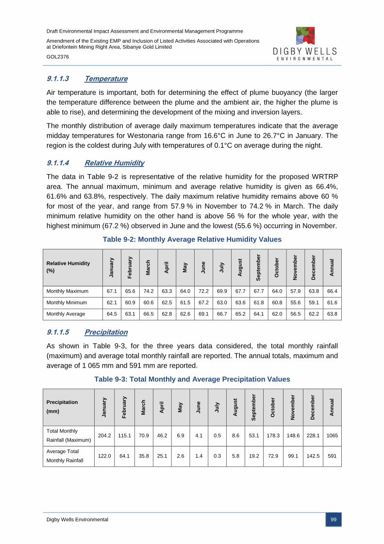
Draft Environmental Impact Assessment and Environmental Management Programme
Amendment of the Existing EMP and Inclusion of Listed Activities Associated with Operations at Driefontein Mining Right Area, Sibanye Gold Limited
GOL2376
Digby Wells Environmental 99
9.1.1.3 Temperature
Air temperature is important, both for determining the effect of plume buoyancy (the larger
the temperature difference between the plume and the ambient air, the higher the plume is
able to rise), and determining the development of the mixing and inversion layers.
The monthly distribution of average daily maximum temperatures indicate that the average
midday temperatures for Westonaria range from 16.6°C in June to 26.7°C in January. The
region is the coldest during July with temperatures of 0.1°C on average during the night.
9.1.1.4 Relative Humidity
The data in Table 9-2 is representative of the relative humidity for the proposed WRTRP
area. The annual maximum, minimum and average relative humidity is given as 66.4%,
61.6% and 63.8%, respectively. The daily maximum relative humidity remains above 60 %
for most of the year, and range from 57.9 % in November to 74.2 % in March. The daily
minimum relative humidity on the other hand is above 56 % for the whole year, with the
highest minimum (67.2 %) observed in June and the lowest (55.6 %) occurring in November.
Table 9-2: Monthly Average Relative Humidity Values
Relative Humidity
(%)
Jan
ua
ry
Fe
bru
ary
Ma
rch
Ap
ril
Ma
y
Ju
ne
Ju
ly
Au
gu
st
Sep
tem
be
r
Octo
be
r
No
vem
be
r
Decem
be
r
An
nu
al
Monthly Maximum 67.1 65.6 74.2 63.3 64.0 72.2 69.9 67.7 67.7 64.0 57.9 63.8 66.4
Monthly Minimum 62.1 60.9 60.6 62.5 61.5 67.2 63.0 63.6 61.8 60.8 55.6 59.1 61.6
Monthly Average 64.5 63.1 66.5 62.8 62.6 69.1 66.7 65.2 64.1 62.0 56.5 62.2 63.8
9.1.1.5 Precipitation
As shown in Table 9-3, for the three years data considered, the total monthly rainfall
(maximum) and average total monthly rainfall are reported. The annual totals, maximum and
average of 1 065 mm and 591 mm are reported.
Table 9-3: Total Monthly and Average Precipitation Values
Precipitation
(mm)
Jan
ua
ry
Fe
bru
ary
Ma
rch
Ap
ril
Ma
y
Ju
ne
Ju
ly
Au
gu
st
Sep
tem
be
r
Octo
be
r
No
vem
be
r
Decem
be
r
An
nu
al
Total Monthly
Rainfall (Maximum) 204.2 115.1 70.9 46.2 6.9 4.1 0.5 8.6 53.1 178.3 148.6 228.1 1065
Average Total
Monthly Rainfall 122.0 64.1 35.8 25.1 2.6 1.4 0.3 5.8 19.2 72.9 99.1 142.5 591
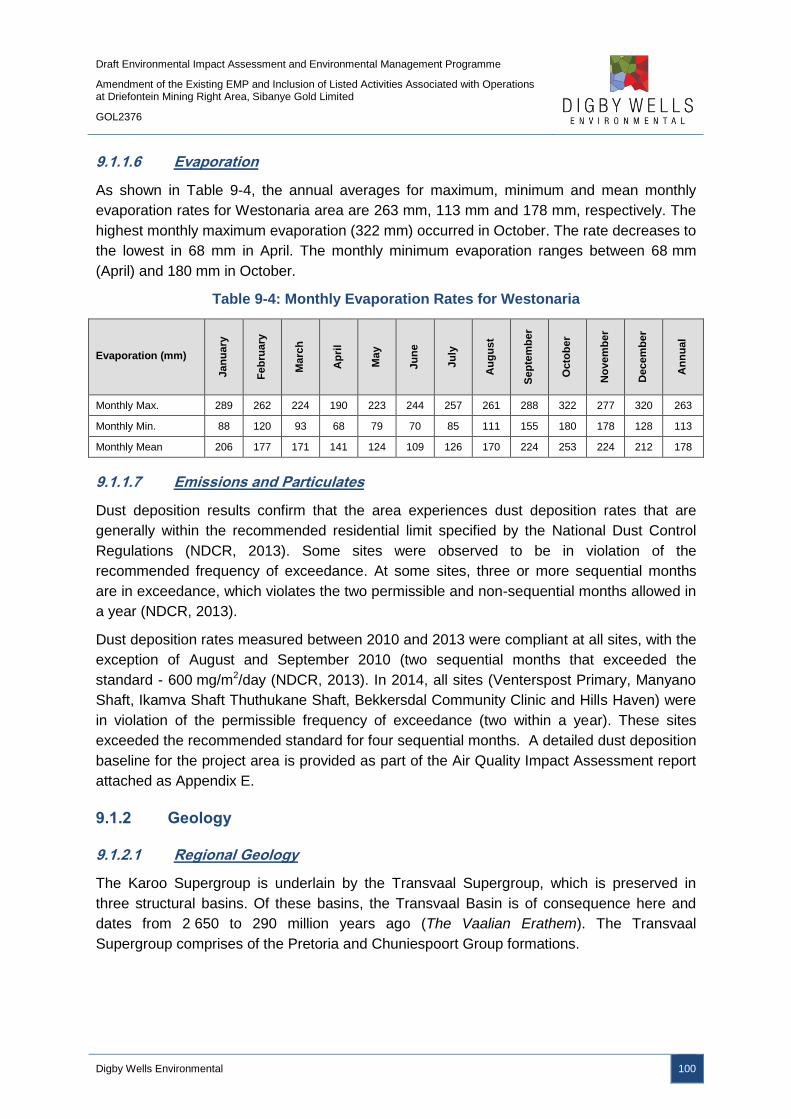
Draft Environmental Impact Assessment and Environmental Management Programme
Amendment of the Existing EMP and Inclusion of Listed Activities Associated with Operations at Driefontein Mining Right Area, Sibanye Gold Limited
GOL2376
Digby Wells Environmental 100
9.1.1.6 Evaporation
As shown in Table 9-4, the annual averages for maximum, minimum and mean monthly
evaporation rates for Westonaria area are 263 mm, 113 mm and 178 mm, respectively. The
highest monthly maximum evaporation (322 mm) occurred in October. The rate decreases to
the lowest in 68 mm in April. The monthly minimum evaporation ranges between 68 mm
(April) and 180 mm in October.
Table 9-4: Monthly Evaporation Rates for Westonaria
Evaporation (mm)
Jan
ua
ry
Fe
bru
ary
Ma
rch
Ap
ril
Ma
y
Ju
ne
Ju
ly
Au
gu
st
Sep
tem
be
r
Octo
be
r
No
vem
be
r
Decem
be
r
An
nu
al
Monthly Max. 289 262 224 190 223 244 257 261 288 322 277 320 263
Monthly Min. 88 120 93 68 79 70 85 111 155 180 178 128 113
Monthly Mean 206 177 171 141 124 109 126 170 224 253 224 212 178
9.1.1.7 Emissions and Particulates
Dust deposition results confirm that the area experiences dust deposition rates that are
generally within the recommended residential limit specified by the National Dust Control
Regulations (NDCR, 2013). Some sites were observed to be in violation of the
recommended frequency of exceedance. At some sites, three or more sequential months
are in exceedance, which violates the two permissible and non-sequential months allowed in
a year (NDCR, 2013).
Dust deposition rates measured between 2010 and 2013 were compliant at all sites, with the
exception of August and September 2010 (two sequential months that exceeded the
standard - 600 mg/m2/day (NDCR, 2013). In 2014, all sites (Venterspost Primary, Manyano
Shaft, Ikamva Shaft Thuthukane Shaft, Bekkersdal Community Clinic and Hills Haven) were
in violation of the permissible frequency of exceedance (two within a year). These sites
exceeded the recommended standard for four sequential months. A detailed dust deposition
baseline for the project area is provided as part of the Air Quality Impact Assessment report
attached as Appendix E.
9.1.2 Geology
9.1.2.1 Regional Geology
The Karoo Supergroup is underlain by the Transvaal Supergroup, which is preserved in
three structural basins. Of these basins, the Transvaal Basin is of consequence here and
dates from 2 650 to 290 million years ago (The Vaalian Erathem). The Transvaal
Supergroup comprises of the Pretoria and Chuniespoort Group formations.
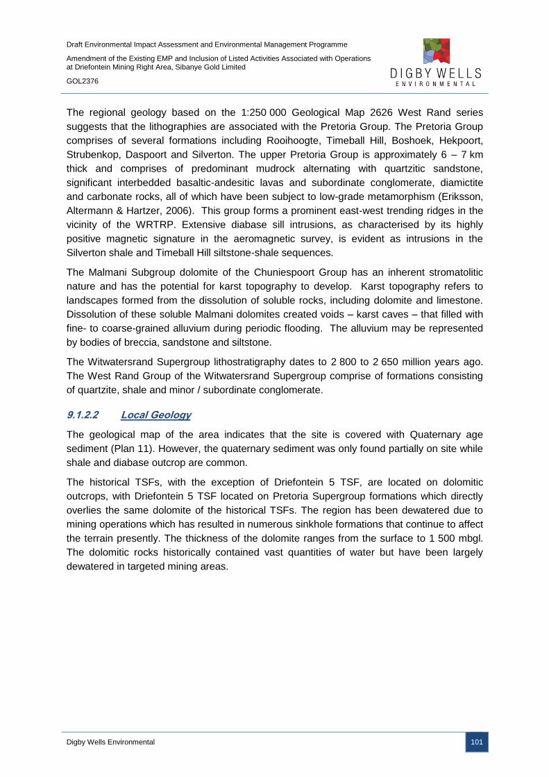
Draft Environmental Impact Assessment and Environmental Management Programme
Amendment of the Existing EMP and Inclusion of Listed Activities Associated with Operations at Driefontein Mining Right Area, Sibanye Gold Limited
GOL2376
Digby Wells Environmental 101
The regional geology based on the 1:250 000 Geological Map 2626 West Rand series
suggests that the lithographies are associated with the Pretoria Group. The Pretoria Group
comprises of several formations including Rooihoogte, Timeball Hill, Boshoek, Hekpoort,
Strubenkop, Daspoort and Silverton. The upper Pretoria Group is approximately 6 – 7 km
thick and comprises of predominant mudrock alternating with quartzitic sandstone,
significant interbedded basaltic-andesitic lavas and subordinate conglomerate, diamictite
and carbonate rocks, all of which have been subject to low-grade metamorphism (Eriksson,
Altermann & Hartzer, 2006). This group forms a prominent east-west trending ridges in the
vicinity of the WRTRP. Extensive diabase sill intrusions, as characterised by its highly
positive magnetic signature in the aeromagnetic survey, is evident as intrusions in the
Silverton shale and Timeball Hill siltstone-shale sequences.
The Malmani Subgroup dolomite of the Chuniespoort Group has an inherent stromatolitic
nature and has the potential for karst topography to develop. Karst topography refers to
landscapes formed from the dissolution of soluble rocks, including dolomite and limestone.
Dissolution of these soluble Malmani dolomites created voids – karst caves – that filled with
fine- to coarse-grained alluvium during periodic flooding. The alluvium may be represented
by bodies of breccia, sandstone and siltstone.
The Witwatersrand Supergroup lithostratigraphy dates to 2 800 to 2 650 million years ago.
The West Rand Group of the Witwatersrand Supergroup comprise of formations consisting
of quartzite, shale and minor / subordinate conglomerate.
9.1.2.2 Local Geology
The geological map of the area indicates that the site is covered with Quaternary age
sediment (Plan 11). However, the quaternary sediment was only found partially on site while
shale and diabase outcrop are common.
The historical TSFs, with the exception of Driefontein 5 TSF, are located on dolomitic
outcrops, with Driefontein 5 TSF located on Pretoria Supergroup formations which directly
overlies the same dolomite of the historical TSFs. The region has been dewatered due to
mining operations which has resulted in numerous sinkhole formations that continue to affect
the terrain presently. The thickness of the dolomite ranges from the surface to 1 500 mbgl.
The dolomitic rocks historically contained vast quantities of water but have been largely
dewatered in targeted mining areas.

Draft Environmental Impact Assessment and Environmental Management Programme
Amendment of the Existing EMP and Inclusion of Listed Activities Associated with Operations at Driefontein Mining Right Area, Sibanye Gold Limited
GOL2376
Digby Wells Environmental 102
Plan 11: Project Area Geology
Draft Environmental Impact Assessment and Environmental Management Programme
Amendment of the Existing EMP and Inclusion of Listed Activities Associated with Operations at Driefontein Mining Right Area, Sibanye Gold Limited
GOL2376
Digby Wells Environmental 103
9.1.3 Groundwater
The Groundwater Impact Assessment report has been included as Appendix F.
9.1.3.1 Groundwater Level and Flow Direction
Groundwater levels in the dolomite aquifers are controlled by topography, permeability, mine
compartmentalisation, recharge and dewatering. Groundwater levels in the shallow aquifer
zones tend to mimic the topography, while more complex groundwater flow paths exist in the
deep dolomitic and fractured aquifers. The groundwater table in the dolomitic aquifers is
relatively flat and is influenced largely by compartmentalisation. Highly variable water level
measurements were taken over short distances indicating the presence of groundwater
barriers.
Pre-mining water levels were shallow and ranged from 1 mbgl to 30 mbgl and averages
14.49 mbgl. Nengovhela (2008) reported that dolomitic springs feeding into streams were
common across the dolomitic area, but are now dry due to the dewatering activities
associated with mining operations. The underground operations are kept dry to allow for safe
mining conditions and the water levels are currently kept between 800 mbgl and 1 200 mbgl.
Local confined to semi-confined conditions exist where the dolomite is overlain by
impermeable strata such as the Ventersdorp lavas or Karoo sediments. The water level in
the shallow aquifers is different from that of the dolomite, if they are separated by an
impermeable layer. Borehole yields in the shallow aquifer have been recorded between 0.5
litres and 2 litres per second, with yields in the dolomitic aquifers exceeding 5 litres per
second.
The historical TSFs are not lined and drain directly into the dolomitic systems. The
dewatering activities of the underground operations result in a low pressure within the
dolomite which encourages drainage from the historical TSFs.
9.1.3.2 Groundwater Quality
The Driefontein Mining Right area consists of Driefontein 1, 2, 3, 4 and 5 TSFs, with
Driefontein 1, 2 and 5 TSFs still in operation, Driefontein 5 TSF partially operational and 3
TSF was decommissioned in 2003. The historical TSFs are located on dolomitic aquifers
and any seepage from the TSFs is expected to migrate downwards into the aquifers.
Monitoring data indicates elevated concentrations of sulfate, TDS and nitrate in the
groundwater which are all typical constituents associated with contamination emanating from
gold mining areas. The pH ranges from 4.1 to 8 and is indicative of AMD impacts associated
with seepage from existing tailings and surface mining facilities; only Driefontein 1 TSF
shows an overall neutralising capacity according to geochemical testing conducted by the
Institute for Groundwater Studies (IGS, 2008).

Draft Environmental Impact Assessment and Environmental Management Programme
Amendment of the Existing EMP and Inclusion of Listed Activities Associated with Operations at Driefontein Mining Right Area, Sibanye Gold Limited
GOL2376
Digby Wells Environmental 104
The groundwater in the vicinity of Driefontein 3 TSF is classified as Class I and Class II
according to the SANS 241:2011 drinking water standards, with boreholes to the north of the
TSF classified as Class II due to increased TDS values. Driefontein 5 TSF is contaminated
with sulfate, TDS, calcium, manganese and chloride, with pH values showing a more
alkaline signature than the groundwater for the remaining TSFs with a pH between 7 and 9.
9.1.4 Soils
A Soils Impact Assessment report has been included as Appendix G.
9.1.4.1 Land Type
The land type data for the Ultimate Project area includes the following dominant soils:
■ Red well-drained soils on foot slopes of Land Type Ab;
■ Shallow rocky soils on the steep escarpment of Land Type Fb;
■ Red soils and rocky soils on crests of Land Type Ba; and
■ Various hydromorphic and shallow soils on rock in midslopes and foot slopes of Land
Type Bb.
The soils associated with the respective land types are summarised in Table 9-5, with the
land type for the project area illustrated in Plan 12.
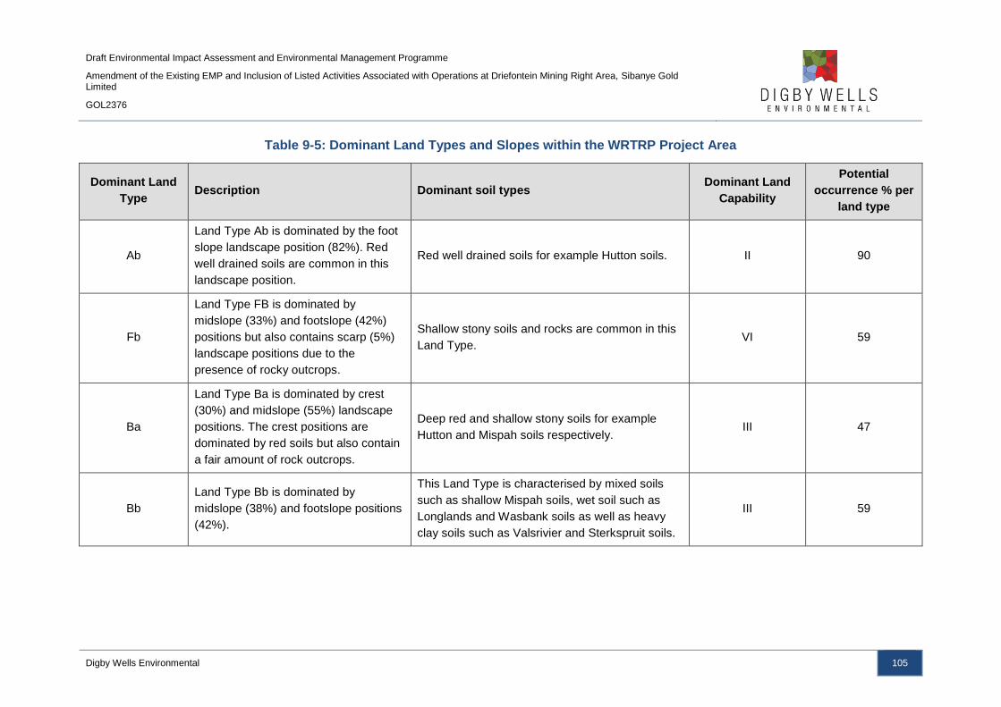
Draft Environmental Impact Assessment and Environmental Management Programme
Amendment of the Existing EMP and Inclusion of Listed Activities Associated with Operations at Driefontein Mining Right Area, Sibanye Gold Limited
GOL2376
Digby Wells Environmental 105
Table 9-5: Dominant Land Types and Slopes within the WRTRP Project Area
Dominant Land
Type Description Dominant soil types
Dominant Land
Capability
Potential
occurrence % per
land type
Ab
Land Type Ab is dominated by the foot
slope landscape position (82%). Red
well drained soils are common in this
landscape position.
Red well drained soils for example Hutton soils. II 90
Fb
Land Type FB is dominated by
midslope (33%) and footslope (42%)
positions but also contains scarp (5%)
landscape positions due to the
presence of rocky outcrops.
Shallow stony soils and rocks are common in this
Land Type. VI 59
Ba
Land Type Ba is dominated by crest
(30%) and midslope (55%) landscape
positions. The crest positions are
dominated by red soils but also contain
a fair amount of rock outcrops.
Deep red and shallow stony soils for example
Hutton and Mispah soils respectively. III 47
Bb
Land Type Bb is dominated by
midslope (38%) and footslope positions
(42%).
This Land Type is characterised by mixed soils
such as shallow Mispah soils, wet soil such as
Longlands and Wasbank soils as well as heavy
clay soils such as Valsrivier and Sterkspruit soils.
III 59

Draft Environmental Impact Assessment and Environmental Management Programme
Amendment of the Existing EMP and Inclusion of Listed Activities Associated with Operations at Driefontein Mining Right Area, Sibanye Gold Limited
GOL2376
Digby Wells Environmental 106
Plan 12: Land Types
Draft Environmental Impact Assessment and Environmental Management Programme
Amendment of the Existing EMP and Inclusion of Listed Activities Associated with Operations at Driefontein Mining Right Area, Sibanye Gold Limited
GOL2376
Digby Wells Environmental 107
9.1.4.1.1 Driefontein Mining Right Area Soil Forms
Land type data was used to determine the soil forms for the areas specific to the Driefontein
Mining Right area activities. The Driefontein 3 TSF is located within the Ab7 land type, with
the Driefontein 5 TSF located within land type Fb15. The Ab land type is dominated by feely
draining deep red soils of the Hutton soil form, with shallow rocky soils, such as Mispah soil
forms, dominating the Fb land type.
Similarly, the pipeline route between the Driefontein 5 TSF and Driefontein 3 TSF is
associated with land type Fb15 (shallow rocky soils such as Mispah) and crosses into Ab7
land type (deep, well drained red soils such as Hutton) in proximity to the Driefontein 3 TSF.
The proposed WBT and BWSF complex is located within the Ab7 land type. From the WBT,
the thickened slurry pipeline crosses back into FB15 land type, before traversing land type
Ba1, which is a mix of deep red Hutton soil forms in the midslopes and shallow rocky Mispah
soil forms on the crests, and land type Fb5 which also consist of shallow rock soils.
9.1.4.2 Land Capability and Land Use
Land capability is determined by a combination of soil, terrain and climate features. Land
capability classes reflect the most intensive long term use of land under rain-fed conditions.
The land capability and land use for the project area is provided in Plan 13 and Plan 14,
respectively. The current land use for the region is dominated by agricultural and mining
activities, with agriculture including both cultivation of crops and grazing.
The land capability for the Driefontein Mining Right area is dominated by Class II, Class III
and Class VI, which is intensive cultivation and moderate cultivation/intensive grazing and
moderate grazing respectively.

Draft Environmental Impact Assessment and Environmental Management Programme
Amendment of the Existing EMP and Inclusion of Listed Activities Associated with Operations at Driefontein Mining Right Area, Sibanye Gold Limited
GOL2376
Digby Wells Environmental 108
Plan 13: Land Capability

Draft Environmental Impact Assessment and Environmental Management Programme
Amendment of the Existing EMP and Inclusion of Listed Activities Associated with Operations at Driefontein Mining Right Area, Sibanye Gold Limited
GOL2376
Digby Wells Environmental 109
Plan 14: Land Use
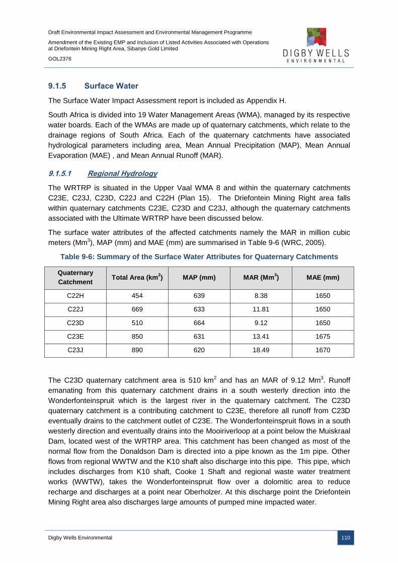
Draft Environmental Impact Assessment and Environmental Management Programme
Amendment of the Existing EMP and Inclusion of Listed Activities Associated with Operations at Driefontein Mining Right Area, Sibanye Gold Limited
GOL2376
Digby Wells Environmental 110
9.1.5 Surface Water
The Surface Water Impact Assessment report is included as Appendix H.
South Africa is divided into 19 Water Management Areas (WMA), managed by its respective
water boards. Each of the WMAs are made up of quaternary catchments, which relate to the
drainage regions of South Africa. Each of the quaternary catchments have associated
hydrological parameters including area, Mean Annual Precipitation (MAP), Mean Annual
Evaporation (MAE) , and Mean Annual Runoff (MAR).
9.1.5.1 Regional Hydrology
The WRTRP is situated in the Upper Vaal WMA 8 and within the quaternary catchments
C23E, C23J, C23D, C22J and C22H (Plan 15). The Driefontein Mining Right area falls
within quaternary catchments C23E, C23D and C23J, although the quaternary catchments
associated with the Ultimate WRTRP have been discussed below.
The surface water attributes of the affected catchments namely the MAR in million cubic
meters (Mm3), MAP (mm) and MAE (mm) are summarised in Table 9-6 (WRC, 2005).
Table 9-6: Summary of the Surface Water Attributes for Quaternary Catchments
Quaternary
Catchment Total Area (km
2) MAP (mm) MAR (Mm
3) MAE (mm)
C22H 454 639 8.38 1650
C22J 669 633 11.81 1650
C23D 510 664 9.12 1650
C23E 850 631 13.41 1675
C23J 890 620 18.49 1670
The C23D quaternary catchment area is 510 km2 and has an MAR of 9.12 Mm3. Runoff
emanating from this quaternary catchment drains in a south westerly direction into the
Wonderfonteinspruit which is the largest river in the quaternary catchment. The C23D
quaternary catchment is a contributing catchment to C23E, therefore all runoff from C23D
eventually drains to the catchment outlet of C23E. The Wonderfonteinspruit flows in a south
westerly direction and eventually drains into the Mooiriverloop at a point below the Muiskraal
Dam, located west of the WRTRP area. This catchment has been changed as most of the
normal flow from the Donaldson Dam is directed into a pipe known as the 1m pipe. Other
flows from regional WWTW and the K10 shaft also discharge into this pipe. This pipe, which
includes discharges from K10 shaft, Cooke 1 Shaft and regional waste water treatment
works (WWTW), takes the Wonderfonteinspruit flow over a dolomitic area to reduce
recharge and discharges at a point near Oberholzer. At this discharge point the Driefontein
Mining Right area also discharges large amounts of pumped mine impacted water.

Draft Environmental Impact Assessment and Environmental Management Programme
Amendment of the Existing EMP and Inclusion of Listed Activities Associated with Operations at Driefontein Mining Right Area, Sibanye Gold Limited
GOL2376
Digby Wells Environmental 111
The C23E quaternary catchment area is 850 km2 and has an MAR of 13.41 Mm3. Runoff
emanating from this quaternary catchment drains in a south westerly direction via the
Mooirivierloop. The C23E quaternary catchment includes urban areas which are greater than
5 km2.
The C23J quaternary catchment area is 890 km2 and has an MAR of 18.49 Mm3. Runoff
emanating from this quaternary catchment drains in a south westerly direction via the
Loopspruit. The Loopspruit is the largest river within the quaternary catchment. The
Loopspruit forms part of the Mooiriverloop catchment and flows into the Mooiriverloop at
Potchefstroom, located southwest of the WRTRP area. All runoff drained by the Loopspruit
eventually reaches the Vaal River.
The registered water users within the affected quaternary catchments include mining,
irrigation, livestock watering, industry and urban and non-urban users, based on the DWS
water use database (Table 9-7). The predominant use of surface water throughout the
WRTRP area is irrigation and livestock watering.
Table 9-7: Surface Water Users within the Driefontein Mining Right Area Affected
Catchments
Quaternary
Catchment Primary Drainage Potential Surface Water Users
C23D Wonderfonteinspruit Agriculture, Mining, Carletonville and surrounding towns and
Residential areas, Agricultural Holdings
C23E Mooirivierloop Towns and Residential areas in upper reaches, Mining in
upper reaches, Agriculture, Pivot Irrigation
C23J Loopspruit Mining in upper reaches, Agriculture, Potchefstroom in lower
reaches
Draft Environmental Impact Assessment and Environmental Management Programme
Amendment of the Existing EMP and Inclusion of Listed Activities Associated with Operations at Driefontein Mining Right Area, Sibanye Gold Limited
GOL2376
Digby Wells Environmental 112
Plan 15: Quaternary Catchments and Monitoring Locations

Draft Environmental Impact Assessment and Environmental Management Programme
Amendment of the Existing EMP and Inclusion of Listed Activities Associated with Operations at Driefontein Mining Right Area, Sibanye Gold Limited
GOL2376
Digby Wells Environmental 113
9.1.5.2 Surface Water Quality
Where data from SGL’s current monitoring networks were not sufficient to characterise the
baseline of the WRTRP, additional samples were taken. Surface water quality samples were
collected from the rivers and dams within and around the project area to determine the
baseline water quality for the project area. The sampled rivers include the Leeuspruit,
Loopspruit and other unnamed rivers around the project area.
Samples were submitted to Aquatico Laboratory (Pty) Ltd, a SANAS accredited laboratory in
Pretoria for analysis of their physical and chemical quality status, as well as additional water
quality data sets (January 2013 to March 2015) also provided to Digby Wells and used to
describe the current water quality status for those monitoring points.
Water quality results have been benchmarked against the SANS 241-1: 2011 drinking water
standards. This part of SANS 241 specifies the quality of acceptable drinking water, defined
in terms of microbiological, physical, aesthetic and chemical determinants, at the point of
delivery. Water that complies with this part of SANS 241 is deemed to present an acceptable
health risk for lifetime consumption (this implies an average consumption of 2 L of water per
day for 70 years by a person that weighs 60 kg).
The results were also benchmarked with the In-stream Water Quality Guidelines for the Vaal
Dam Catchment. This is due to the fact that the project area lies within the Vaal Dam
drainage region/catchment.
The Receiving Water Quality Objectives (RWQOs) are defined by the NWA as “clear goals
relating to the quality of the relevant water resources” (DWAF, 2006a). In South Africa, the
South African Water Quality Guidelines (SAWQG) has been developed as discrete values
that set out the change from one category of fitness for use to another (DWAF, 1996).
The water quality guidelines describe the “fitness for use” of a water resource, while the
Water Quality Objectives defines “what management action is required” for a water resource.
The fitness for use of water defines how suitable the quality of water is for its intended use.
The following fitness for use categories are linked to the SAWQGs:
■ Ideal – the use of water is not affected in any way; 100% fit for use by all users at all
times; desirable water quality;
■ Acceptable – slight to moderate problems encountered on a few occasions or for
short periods of time;
■ Tolerable – moderate to severe problems are encountered; usually for a limited
period only; and
■ Unacceptable – water cannot be used for its intended use under normal
circumstances at any time (DWAF, 2006c).
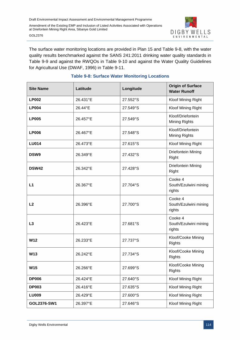
Draft Environmental Impact Assessment and Environmental Management Programme
Amendment of the Existing EMP and Inclusion of Listed Activities Associated with Operations at Driefontein Mining Right Area, Sibanye Gold Limited
GOL2376
Digby Wells Environmental 114
The surface water monitoring locations are provided in Plan 15 and Table 9-8, with the water
quality results benchmarked against the SANS 241:2011 drinking water quality standards in
Table 9-9 and against the RWQOs in Table 9-10 and against the Water Quality Guidelines
for Agricultural Use (DWAF, 1996) in Table 9-11.
Table 9-8: Surface Water Monitoring Locations
Site Name Latitude Longitude Origin of Surface
Water Runoff
LP002 26.431°E 27.552°S Kloof Mining Right
LP004 26.44°E 27.549°S Kloof Mining Right
LP005 26.457°E 27.549°S Kloof/Driefontein
Mining Rights
LP006 26.467°E 27.548°S Kloof/Driefontein
Mining Rights
LU014 26.473°E 27.615°S Kloof Mining Right
DSW9 26.349°E 27.432°S Driefontein Mining
Right
DSW42 26.342°E 27.428°S Driefontein Mining
Right
L1 26.367°E 27.704°S
Cooke 4
South/Ezulwini mining
rights
L2 26.396°E 27.700°S
Cooke 4
South/Ezulwini mining
rights
L3 26.423°E 27.681°S
Cooke 4
South/Ezulwini mining
rights
W12 26.233°E 27.737°S Kloof/Cooke Mining
Rights
W13 26.242°E 27.734°S Kloof/Cooke Mining
Rights
W15 26.266°E 27.699°S Kloof/Cooke Mining
Rights
DP006 26.424°E 27.640°S Kloof Mining Right
DP003 26.416°E 27.635°S Kloof Mining Right
LU009 26.429°E 27.600°S Kloof Mining Right
GOL2376-SW1 26.397°E 27.646°S Kloof Mining Right

Draft Environmental Impact Assessment and Environmental Management Programme
Amendment of the Existing EMP and Inclusion of Listed Activities Associated with Operations at Driefontein Mining Right Area, Sibanye Gold Limited
GOL2376
Digby Wells Environmental 115
Site Name Latitude Longitude Origin of Surface
Water Runoff
GOL2376-SW2 26.455°E 27.637°S Kloof Mining Right
GOL2376-SW3 26.526°E 27.676°S Kloof Mining Right
GOL2376-SW4 26.472°E 27.617°S Kloof Mining Right
GOL2376-SW5 26.428°E 27.601°S Kloof Mining Right
GOL2376-SW6 26.479°E 27.539°S Kloof/Driefontein
Mining Rights
GOL2376-SW7 26.422°E 27.553°S Kloof Mining Right
GOL2376-SW8 26.411°E 27.406°S Driefontein Mining
Right
GOL2376-SW9 26.398°E 27.403°S Driefontein Mining
Right
GOL2376-SW13 26.434°E 27.552°S Kloof Mining Right
GOL2376-SW21 26.375°E 27.592°S Kloof Mining Right
GOL2376-SW23 26.418°E 27.602°S Kloof Mining Right
GOL2376-SW26 26.453°E 27.604°S Kloof Mining Right
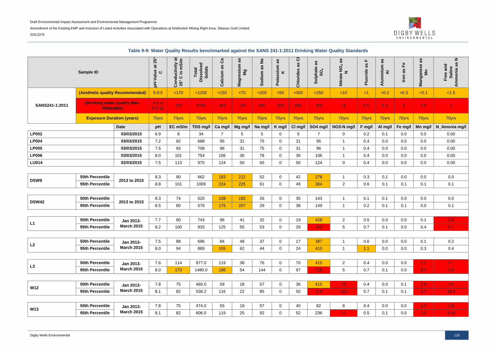
Draft Environmental Impact Assessment and Environmental Management Programme
Amendment of the Existing EMP and Inclusion of Listed Activities Associated with Operations at Driefontein Mining Right Area, Sibanye Gold Limited
GOL2376
Digby Wells Environmental 116
Table 9-9: Water Quality Results benchmarked against the SANS 241-1:2011 Drinking Water Quality Standards
Sample ID
pH
-Valu
e a
t 25
°
C
Co
nd
ucti
vit
y a
t
25°
C in
mS
/m
To
tal
Dis
so
lved
So
lid
s
Calc
ium
as C
a
Mag
nesiu
m a
s
Mg
So
diu
m a
s N
a
Po
tassiu
m a
s
K
Ch
lori
des
as C
l
Su
lph
ate
as
SO
4
Nit
rate
NO
3 a
s
N
Flu
ori
de a
s F
Alu
min
ium
as
Al
Iro
n a
s F
e
Man
gan
ese a
s
Mn
Fre
e a
nd
Salin
e
Am
mo
nia
as N
SANS241-1:2011
(Aesthetic quality Recommended) 5-9.5 <170 <1200 <150 <70 <200 <50 <300 <250 <10 <1 <0.3 <0.3 <0.1 <1.5
(Drinking water quality Max.
Allowable)
4-5 or
9.5-10 370 2400 300 100 400 100 600 500 11 1.5 0.5 2 0.5 2
Exposure Duration (years) 70yrs 70yrs 70yrs 70yrs 70yrs 70yrs 70yrs 70yrs 70yrs 70yrs 70yrs 70yrs 70yrs 70yrs 70yrs
Date pH EC mS/m TDS mg/l Ca mg/l Mg mg/l Na mg/l K mg/l Cl mg/l SO4 mg/l NO3-N mg/l F mg/l Al mg/l Fe mg/l Mn mg/l N_Amonia mg/l
LP002 03/03/2015 6.9 8 34 7 5 5 0 5 7 0 0.2 0.1 0.0 0.0 0.00
LP004 03/03/2015 7.2 92 688 95 31 75 0 31 95 1 0.4 0.0 0.0 0.0 0.00
LP005 03/03/2015 7.5 93 708 96 31 75 0 31 96 1 0.4 0.0 0.0 0.0 0.00
LP006 03/03/2015 8.0 101 754 106 36 78 0 36 106 1 0.4 0.0 0.0 0.0 0.00
LU014 02/03/2015 7.5 113 970 124 50 65 0 50 124 0 0.4 0.0 0.0 0.0 0.00
DSW9 50th Percentile
2013 to 2015 8.3 90 662 183 212 52 0 42 278 1 0.3 0.1 0.0 0.0 0.0
95th Percentile 8.8 101 1009 224 225 61 0 49 304 2 0.6 0.1 0.1 0.1 0.1
DSW42 50th Percentile
2013 to 2015 8.3 74 520 158 192 26 0 35 143 1 0.1 0.1 0.0 0.0 0.0
95th Percentile 8.5 80 579 175 207 29 0 38 149 1 0.2 0.1 0.1 0.0 0.1
L1 50th Percentile Jan 2013-
March 2015
7.7 90 743 96 41 32 0 19 428 2 0.5 0.0 0.0 0.1 2.9
95th Percentile 8.2 100 933 125 55 53 0 29 502 5 0.7 0.1 0.0 0.4 6.1
L2 50th Percentile Jan 2013-
March 2015
7.5 88 696 84 48 37 0 17 387 1 0.6 0.0 0.0 0.1 0.2
95th Percentile 8.0 94 889 155 62 44 0 24 410 1 1.1 0.0 0.0 0.3 0.4
L3 50th Percentile Jan 2013-
March 2015
7.6 114 877.0 119 38 76 0 70 415 2 0.4 0.0 0.0 1.2 2.1
95th Percentile 8.0 173 1480.0 186 54 144 0 97 719 5 0.7 0.1 0.0 9.7 4.6
W12 50th Percentile Jan 2013-
March 2015
7.8 75 460.0 59 18 57 0 36 415 75 0.4 0.0 0.1 1.4 4.0
95th Percentile 8.1 82 538.2 116 22 85 0 50 719 215 0.7 0.1 0.1 3.7 18.4
W13 50th Percentile Jan 2013-
March 2015
7.8 75 474.0 55 19 57 0 40 82 8 0.4 0.0 0.0 1.3 4.8
95th Percentile 8.1 82 606.0 119 25 92 0 52 236 14 0.5 0.1 0.0 3.0 19.8
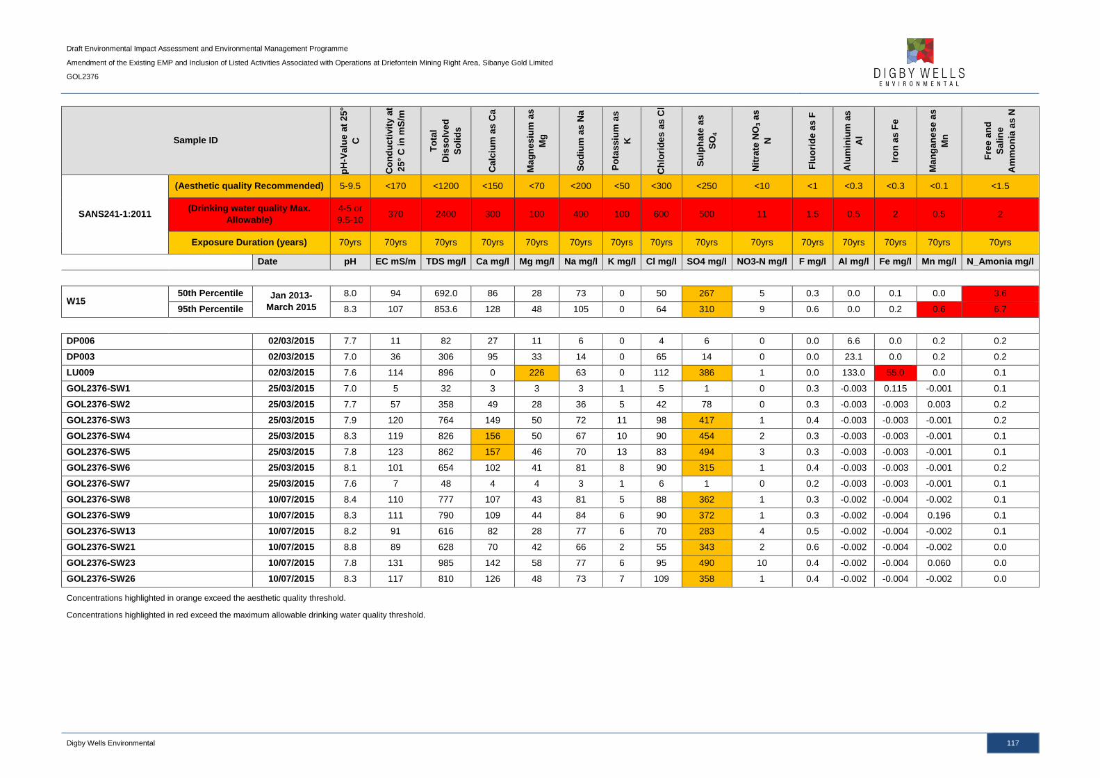
Draft Environmental Impact Assessment and Environmental Management Programme
Amendment of the Existing EMP and Inclusion of Listed Activities Associated with Operations at Driefontein Mining Right Area, Sibanye Gold Limited
GOL2376
Digby Wells Environmental 117
Sample ID
pH
-Valu
e a
t 25
°
C
Co
nd
ucti
vit
y a
t
25°
C in
mS
/m
To
tal
Dis
so
lved
So
lid
s
Calc
ium
as C
a
Mag
nesiu
m a
s
Mg
So
diu
m a
s N
a
Po
tassiu
m a
s
K
Ch
lori
des
as C
l
Su
lph
ate
as
SO
4
Nit
rate
NO
3 a
s
N
Flu
ori
de a
s F
Alu
min
ium
as
Al
Iro
n a
s F
e
Man
gan
ese a
s
Mn
Fre
e a
nd
Salin
e
Am
mo
nia
as N
SANS241-1:2011
(Aesthetic quality Recommended) 5-9.5 <170 <1200 <150 <70 <200 <50 <300 <250 <10 <1 <0.3 <0.3 <0.1 <1.5
(Drinking water quality Max.
Allowable)
4-5 or
9.5-10 370 2400 300 100 400 100 600 500 11 1.5 0.5 2 0.5 2
Exposure Duration (years) 70yrs 70yrs 70yrs 70yrs 70yrs 70yrs 70yrs 70yrs 70yrs 70yrs 70yrs 70yrs 70yrs 70yrs 70yrs
Date pH EC mS/m TDS mg/l Ca mg/l Mg mg/l Na mg/l K mg/l Cl mg/l SO4 mg/l NO3-N mg/l F mg/l Al mg/l Fe mg/l Mn mg/l N_Amonia mg/l
W15 50th Percentile Jan 2013-
March 2015
8.0 94 692.0 86 28 73 0 50 267 5 0.3 0.0 0.1 0.0 3.6
95th Percentile 8.3 107 853.6 128 48 105 0 64 310 9 0.6 0.0 0.2 0.6 6.7
DP006 02/03/2015 7.7 11 82 27 11 6 0 4 6 0 0.0 6.6 0.0 0.2 0.2
DP003 02/03/2015 7.0 36 306 95 33 14 0 65 14 0 0.0 23.1 0.0 0.2 0.2
LU009 02/03/2015 7.6 114 896 0 226 63 0 112 386 1 0.0 133.0 55.0 0.0 0.1
GOL2376-SW1 25/03/2015 7.0 5 32 3 3 3 1 5 1 0 0.3 -0.003 0.115 -0.001 0.1
GOL2376-SW2 25/03/2015 7.7 57 358 49 28 36 5 42 78 0 0.3 -0.003 -0.003 0.003 0.2
GOL2376-SW3 25/03/2015 7.9 120 764 149 50 72 11 98 417 1 0.4 -0.003 -0.003 -0.001 0.2
GOL2376-SW4 25/03/2015 8.3 119 826 156 50 67 10 90 454 2 0.3 -0.003 -0.003 -0.001 0.1
GOL2376-SW5 25/03/2015 7.8 123 862 157 46 70 13 83 494 3 0.3 -0.003 -0.003 -0.001 0.1
GOL2376-SW6 25/03/2015 8.1 101 654 102 41 81 8 90 315 1 0.4 -0.003 -0.003 -0.001 0.2
GOL2376-SW7 25/03/2015 7.6 7 48 4 4 3 1 6 1 0 0.2 -0.003 -0.003 -0.001 0.1
GOL2376-SW8 10/07/2015 8.4 110 777 107 43 81 5 88 362 1 0.3 -0.002 -0.004 -0.002 0.1
GOL2376-SW9 10/07/2015 8.3 111 790 109 44 84 6 90 372 1 0.3 -0.002 -0.004 0.196 0.1
GOL2376-SW13 10/07/2015 8.2 91 616 82 28 77 6 70 283 4 0.5 -0.002 -0.004 -0.002 0.1
GOL2376-SW21 10/07/2015 8.8 89 628 70 42 66 2 55 343 2 0.6 -0.002 -0.004 -0.002 0.0
GOL2376-SW23 10/07/2015 7.8 131 985 142 58 77 6 95 490 10 0.4 -0.002 -0.004 0.060 0.0
GOL2376-SW26 10/07/2015 8.3 117 810 126 48 73 7 109 358 1 0.4 -0.002 -0.004 -0.002 0.0
Concentrations highlighted in orange exceed the aesthetic quality threshold.
Concentrations highlighted in red exceed the maximum allowable drinking water quality threshold.

Draft Environmental Impact Assessment and Environmental Management Programme
Amendment of the Existing EMP and Inclusion of Listed Activities Associated with Operations at Driefontein Mining Right Area, Sibanye Gold Limited
GOL2376
Digby Wells Environmental 118
Table 9-10: Water Quality Results benchmarked against the In-Stream Water Quality Guidelines for the Vaal Barrage sub-catchment
Sample ID
Nit
rate
NO
3 a
s N
Ch
lori
de
s a
s C
l
To
tal
Alk
ali
nit
y
as
Ca
CO
3
Su
lfa
te a
s S
O4
Co
nd
uc
tiv
ity
at
25
° C
in
mS
/m
pH
-Va
lue
at
25
° C
Fre
e a
nd
Sa
lin
e
Am
mo
nia
as
N
Flu
ori
de
as
F
Ph
os
ph
ate
as
PO
4
Alu
min
ium
as
Al
Iro
n a
s F
e
Ma
ng
an
es
e a
s
Mn
Ma
gn
es
ium
as
Mg
In-stream Water Quality Guidelines for the Vaal
Barrage sub-catchment
Ideal <0.5 <5 <20 <18 6.5-8.5 <0.2 -- -- <8
Acceptable 0.3-3 5-50 20-100 18-30 - 0.2-0.5 <0.5 <0.03 <0.3 <0.5 <0.15 8-30
Tolerable 3-6 50-75 100-200 30-70 - 0.5-1.0 0.5-1 0.03-0.05 0.3-0.5 0.5-1.0 0.15-
0.20
30-70
Unacceptable >6 >75 >200 >70 <6.5;>8.5 >1 >1 >0.05 >0.5 >1.0 >0.2 >70
LP002 03/03/2015 18.0 4.9 0 7.2 8.3 6.9 0.0 20.0 0.2 0.1 0.0 0.0 5
LP004 03/03/2015 237.0 31.0 0 94.8 91.7 7.2 0.0 127.1 0.4 0.0 0.0 0.0 31
LP005 03/03/2015 240.0 30.8 0 96.0 93.3 7.5 0.0 126.3 0.4 0.0 0.0 0.0 31
LP006 03/03/2015 265.0 35.8 0 106.0 101.0 8.0 0.0 147.8 0.4 0.0 0.0 0.0 36
LU014 02/03/2015 310.0 49.8 0 124.0 113.0 7.5 0.0 204.2 0.4 0.0 0.0 0.0 50
DSW9
50th
percentile 2013 to 2015
1.5 42.5 0 278.0 89.8 8.3 0.0 0.3 0.1 0.1 0.0 0.0 212
95th
percentile 2.0 49.1 0 303.8 100.9 8.8 0.1 0.6 0.1 0.1 0.1 0.1 225
DSW42
50th
percentile 2013 to 2015
1.2 35.0 0 143.0 74.1 8.3 0.0 0.1 0.3 0.1 0.0 0.0 192
95th
percentile 1.3 38.3 0 148.8 80.2 8.5 0.1 0.2 0.3 0.1 0.1 0.0 207
L1
50th
percentile Jan 2013-March 2015
2.3 19
428 90 7.7 2.9 0.45
0.0 0.0 0.1 41
95th
percentile 5.3 29.2
502 99.8 8.24 6.1 0.74
0.1 0.0 0.4 55
L2
50th
percentile Jan 2013-March 2015
0.6 16.5
387 87.5 7.5 0.2 0.6
0.0 0.0 0.1 48
95th
percentile 0.775 24
410 93.75 7.975 0.37 1.05
0.0 0.0 0.3 62
L3
50th
percentile Jan 2013-March 2015
1.9 70
415 114 7.6 2.1 0.43
0.0 0.0 1.2 38
95th
percentile 5.45 97.4
718.8 172.8 8.04 4.6 0.745
0.1 0.0 9.7 54
W12 50th
percentile Jan 2013-March 2015 74.5 36
415 75 7.8 4 0.4
0.0 0.1 1.4 18

Draft Environmental Impact Assessment and Environmental Management Programme
Amendment of the Existing EMP and Inclusion of Listed Activities Associated with Operations at Driefontein Mining Right Area, Sibanye Gold Limited
GOL2376
Digby Wells Environmental 119
Sample ID
Nit
rate
NO
3 a
s N
Ch
lori
de
s a
s C
l
To
tal
Alk
ali
nit
y
as
Ca
CO
3
Su
lfa
te a
s S
O4
Co
nd
uc
tiv
ity
at
25
° C
in
mS
/m
pH
-Va
lue
at
25
° C
Fre
e a
nd
Sa
lin
e
Am
mo
nia
as
N
Flu
ori
de
as
F
Ph
os
ph
ate
as
PO
4
Alu
min
ium
as
Al
Iro
n a
s F
e
Ma
ng
an
es
e a
s
Mn
Ma
gn
es
ium
as
Mg
In-stream Water Quality Guidelines for the Vaal
Barrage sub-catchment
Ideal <0.5 <5 <20 <18 6.5-8.5 <0.2 -- -- <8
Acceptable 0.3-3 5-50 20-100 18-30 - 0.2-0.5 <0.5 <0.03 <0.3 <0.5 <0.15 8-30
Tolerable 3-6 50-75 100-200 30-70 - 0.5-1.0 0.5-1 0.03-0.05 0.3-0.5 0.5-1.0 0.15-
0.20
30-70
Unacceptable >6 >75 >200 >70 <6.5;>8.5 >1 >1 >0.05 >0.5 >1.0 >0.2 >70
95th
percentile 215.25 50.2
718.8 82.4 8.1 18.4 0.725
0.1 0.1 3.7 22
W13
50th
percentile Jan 2013-March 2015
7.8 40
82 75 7.8 4.8 0.4
0.0 0.0 1.3 19
95th
percentile 14.2 52.2
235.8 82.2 8.12 19.8 0.525
0.1 0.0 3.0 25
W15
50th
percentile Jan 2013-March 2015
5.2 50
267 94 8 3.6 0.3
0.0 0.1 0.0 28
95th
percentile 8.74 64
310 107 8.3 6.74 0.56
0.0 0.2 0.6 48
Klein Wes Rietspruit 0.9 19 379 85 7.7 2.4 0.4 0.2 0.0 0.0 0.0 41
C2H080 2.6 53 322 103 7.6 1.0 0.3 3.0 0.0 0.3 0.0 39
DP006 02/03/2015 0.3 3.56
5.72 10.8 7.67 0.15 0
0.004 0.0 0.2 6.6
DP003 02/03/2015 0.3 64.7
13.5 36 7.02 0.22 0
0.021 0.0 0.2 23.1
LU009 02/03/2015 1.4 112
386 114 7.63 0.08 0
0.001 0.019 0.0 55
GOL2376-SW1 25/03/2015 0.24 5.48 19.2 0.53 5.25 6.97 0.11 0.25 0.08 -0.003 0.115 -0.001 3
GOL2376-SW2 25/03/2015 0.21 41.5 205 78 56.5 7.72 0.22 0.34 0.06 -0.003 -0.003 0.003 28
GOL2376-SW3 25/03/2015 0.84 97.7 149 417 120 7.89 0.22 0.39 0.06 -0.003 -0.003 -0.001 50
GOL2376-SW4 25/03/2015 1.52 89.9 139 454 119 8.28 0.13 0.32 0.06 -0.003 -0.003 -0.001 50
GOL2376-SW5 25/03/2015 2.53 82.8 133 494 123 7.76 0.1 0.3 0.08 -0.003 -0.003 -0.001 46
GOL2376-SW6 25/03/2015 1.16 90.1 131 315 101 8.14 0.15 0.41 0.44 -0.003 -0.003 -0.001 41
GOL2376-SW7 25/03/2015 0.17 5.83 24.5 0.9 6.5 7.55 0.11 0.22 0.07 -0.003 -0.003 -0.001 4
GOL2376-SW8 10/07/2015 0.833 88.2
362 110 8.35 0.079 0.319 0.017 -0.002 -0.004 -0.002 43
GOL2376-SW9 10/07/2015 0.554 90.1
372 111 8.29 0.083 0.337 -0.002 -0.002 -0.004 0.196 44
GOL2376-SW13 10/07/2015 4 70
283 91 8.17 0.068 0.457 0.509 -0.002 -0.004 -0.002 28
GOL2376-SW21 10/07/2015 1.55 54.6
343 89.4 8.8 0.006 0.633 -0.002 -0.002 -0.004 -0.002 42
GOL2376-SW23 10/07/2015 9.86 95.1
490 131 7.82 0.009 0.353 -0.002 -0.002 -0.004 0.060 58
GOL2376-SW26 10/07/2015 1.19 109
358 117 8.34 0.031 0.372 -0.002 -0.002 -0.004 -0.002 48
Concentrations highlighted in green and orange indicate acceptable and tolerable limits respectively, with concentrations highlighted in red being deemed unacceptable.

Draft Environmental Impact Assessment and Environmental Management Programme
Amendment of the Existing EMP and Inclusion of Listed Activities Associated with Operations at Driefontein Mining Right Area, Sibanye Gold Limited
GOL2376
Digby Wells Environmental 120
Table 9-11: Water Quality Results benchmarked against the South African Water Quality Guidelines for Agricultural Use: Irrigation (DWAF, 1996)
Sample ID
pH
-Valu
e a
t 25
°
C
Co
nd
ucti
vit
y a
t
25°
C in
mS
/m
To
tal D
isso
lved
So
lid
s
Calc
ium
as C
a
Mag
nesiu
m a
s
Mg
So
diu
m a
s N
a
Po
tassiu
m a
s K
Ch
lori
des
as C
l
Su
lfate
as S
O4
Nit
rate
NO
3 a
s N
Flu
ori
de a
s F
Alu
min
ium
as
Al
Iro
n a
s F
e
Man
gan
ese a
s
Mn
Fre
e a
nd
Sa
lin
e
Am
mo
nia
as N
South Africa Water
Quality Guidelines:
Agriculture Irrigation
Ideal <6.5 -
>8.4 N/A <90 N/A N/A <115 N/A N/A N/A N/A <2 <5 <5 <0.02 N/A
Max. Allowable <6.5 -
>8.4 N/A >540 N/A N/A >460 N/A N/A N/A N/A >15.0 >20 >20 >10.0 N/A
Date pH EC mS/m TDS mg/l Ca mg/l Mg mg/l Na mg/l K mg/l Cl mg/l SO4 mg/l NO3-N mg/l F mg/l Al mg/l Fe mg/l Mn mg/l Ammonia mg/l
LP002 03/03/2015 6.9 8 34 7 5 5 0 5 7 0 0.2 0.1 0.0 0.0 0.00
LP004 03/03/2015 7.2 92 688 95 31 75 0 31 95 1 0.4 0.0 0.0 0.0 0.00
LP005 03/03/2015 7.5 93 708 96 31 75 0 31 96 1 0.4 0.0 0.0 0.0 0.00
LP006 03/03/2015 8.0 101 754 106 36 78 0 36 106 1 0.4 0.0 0.0 0.0 0.00
LU014 02/03/2015 7.5 113 970 124 50 65 0 50 124 0 0.4 0.0 0.0 0.0 0.00
DSW9 50th Percentile
2013 to 2015 8.3 90 662 183 212 52 0 42 278 1 0.3 0.1 0.0 0.0 0.0
95th Percentile 8.8 101 1009 224 225 61 0 49 304 2 0.6 0.1 0.1 0.1 0.1
DSW42 50th Percentile
2013 to 2015 8.3 74 520 158 192 26 0 35 143 1 0.1 0.1 0.0 0.0 0.0
95th Percentile 8.5 80 579 175 207 29 0 38 149 1 0.2 0.1 0.1 0.0 0.1
L1 50th Percentile Jan 2013-
March 2015
7.7 90 743 96 41 32 0 19 428 2 0.5 0.0 0.0 0.1 2.9
95th Percentile 8.2 100 933 125 55 53 0 29 502 5 0.7 0.1 0.0 0.4 6.1
L2 50th Percentile Jan 2013-
March 2015
7.5 88 696 84 48 37 0 17 387 1 0.6 0.0 0.0 0.1 0.2
95th Percentile 8.0 94 889 155 62 44 0 24 410 1 1.1 0.0 0.0 0.3 0.4
L3 50th Percentile Jan 2013-
March 2015
7.6 114 877.0 119 38 76 0 70 415 2 0.4 0.0 0.0 1.2 2.1
95th Percentile 8.0 173 1480.0 186 54 144 0 97 719 5 0.7 0.1 0.0 9.7 4.6
W12 50th Percentile Jan 2013-
March 2015
7.8 75 460.0 59 18 57 0 36 415 75 0.4 0.0 0.1 1.4 4.0
95th Percentile 8.1 82 538.2 116 22 85 0 50 719 215 0.7 0.1 0.1 3.7 18.4
W13 50th Percentile Jan 2013-
March 2015
7.8 75 474.0 55 19 57 0 40 82 8 0.4 0.0 0.0 1.3 4.8
95th Percentile 8.1 82 606.0 119 25 92 0 52 236 14 0.5 0.1 0.0 3.0 19.8
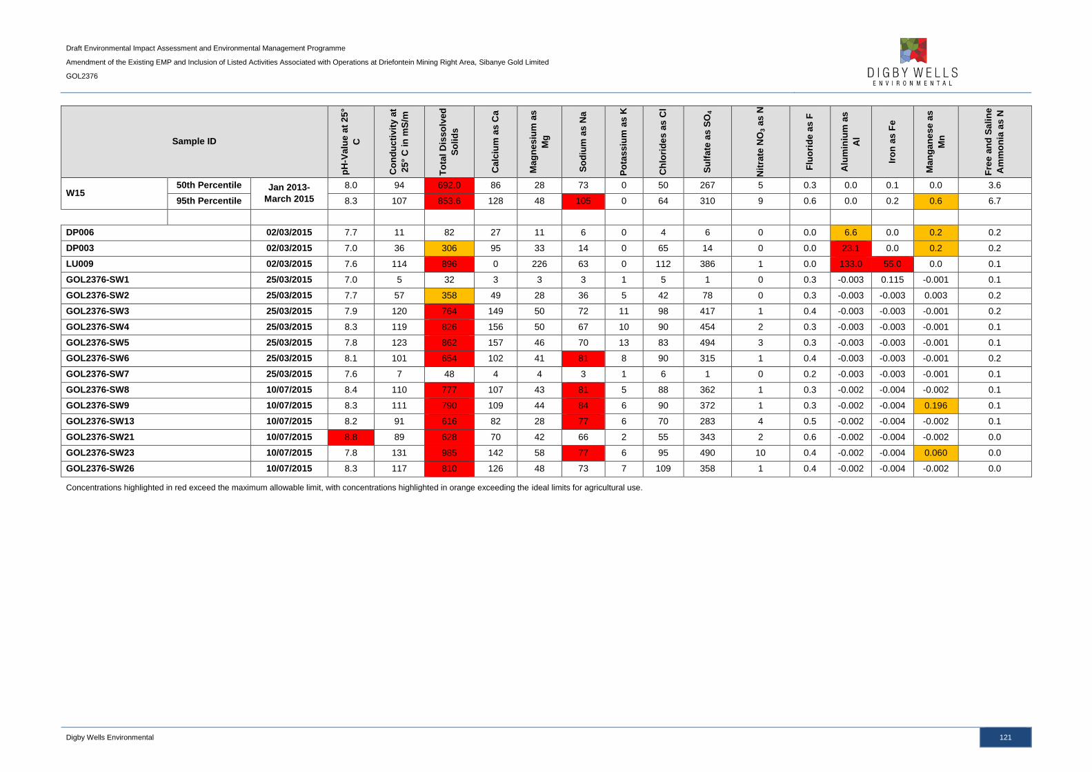
Draft Environmental Impact Assessment and Environmental Management Programme
Amendment of the Existing EMP and Inclusion of Listed Activities Associated with Operations at Driefontein Mining Right Area, Sibanye Gold Limited
GOL2376
Digby Wells Environmental 121
Sample ID
pH
-Valu
e a
t 25
°
C
Co
nd
ucti
vit
y a
t
25°
C in
mS
/m
To
tal D
isso
lved
So
lid
s
Calc
ium
as C
a
Mag
nesiu
m a
s
Mg
So
diu
m a
s N
a
Po
tassiu
m a
s K
Ch
lori
des
as C
l
Su
lfate
as S
O4
Nit
rate
NO
3 a
s N
Flu
ori
de a
s F
Alu
min
ium
as
Al
Iro
n a
s F
e
Man
gan
ese a
s
Mn
Fre
e a
nd
Sa
lin
e
Am
mo
nia
as N
W15 50th Percentile Jan 2013-
March 2015
8.0 94 692.0 86 28 73 0 50 267 5 0.3 0.0 0.1 0.0 3.6
95th Percentile 8.3 107 853.6 128 48 105 0 64 310 9 0.6 0.0 0.2 0.6 6.7
DP006 02/03/2015 7.7 11 82 27 11 6 0 4 6 0 0.0 6.6 0.0 0.2 0.2
DP003 02/03/2015 7.0 36 306 95 33 14 0 65 14 0 0.0 23.1 0.0 0.2 0.2
LU009 02/03/2015 7.6 114 896 0 226 63 0 112 386 1 0.0 133.0 55.0 0.0 0.1
GOL2376-SW1 25/03/2015 7.0 5 32 3 3 3 1 5 1 0 0.3 -0.003 0.115 -0.001 0.1
GOL2376-SW2 25/03/2015 7.7 57 358 49 28 36 5 42 78 0 0.3 -0.003 -0.003 0.003 0.2
GOL2376-SW3 25/03/2015 7.9 120 764 149 50 72 11 98 417 1 0.4 -0.003 -0.003 -0.001 0.2
GOL2376-SW4 25/03/2015 8.3 119 826 156 50 67 10 90 454 2 0.3 -0.003 -0.003 -0.001 0.1
GOL2376-SW5 25/03/2015 7.8 123 862 157 46 70 13 83 494 3 0.3 -0.003 -0.003 -0.001 0.1
GOL2376-SW6 25/03/2015 8.1 101 654 102 41 81 8 90 315 1 0.4 -0.003 -0.003 -0.001 0.2
GOL2376-SW7 25/03/2015 7.6 7 48 4 4 3 1 6 1 0 0.2 -0.003 -0.003 -0.001 0.1
GOL2376-SW8 10/07/2015 8.4 110 777 107 43 81 5 88 362 1 0.3 -0.002 -0.004 -0.002 0.1
GOL2376-SW9 10/07/2015 8.3 111 790 109 44 84 6 90 372 1 0.3 -0.002 -0.004 0.196 0.1
GOL2376-SW13 10/07/2015 8.2 91 616 82 28 77 6 70 283 4 0.5 -0.002 -0.004 -0.002 0.1
GOL2376-SW21 10/07/2015 8.8 89 628 70 42 66 2 55 343 2 0.6 -0.002 -0.004 -0.002 0.0
GOL2376-SW23 10/07/2015 7.8 131 985 142 58 77 6 95 490 10 0.4 -0.002 -0.004 0.060 0.0
GOL2376-SW26 10/07/2015 8.3 117 810 126 48 73 7 109 358 1 0.4 -0.002 -0.004 -0.002 0.0
Concentrations highlighted in red exceed the maximum allowable limit, with concentrations highlighted in orange exceeding the ideal limits for agricultural use.

Draft Environmental Impact Assessment and Environmental Management Programme
Amendment of the Existing EMP and Inclusion of Listed Activities Associated with Operations at Driefontein Mining Right Area, Sibanye Gold Limited
GOL2376
Digby Wells Environmental 122
At the Driefontein mining complex, most of the water quality monitoring points was dry,
however sampling sites SW08 and SW09, taken on the upstream and downstream tributary
of the Wonderfonteinspruit indicate sulfate concentrations of 362 mg per litre and 372 mg
per litre respectively. Water quality monitoring points LP004, LP005 and LP006 indicate high
concentrations of nitrate, with the latter two exceeding 230 mg per litre. Sampling points
LP004, LP005 and LP006 drain a portion of the Kloof and Driefontein Mining Right areas.
The overall water quality data indicated elevated concentrations of sulfates, nitrates,
fluorides, manganese and ammonia exceeding the In-Stream Water Quality Guidelines for
the Vaal Barrage (Barrage WQO). This indicates that rivers within this area are already
impacted. The project area is comprised of various land uses which includes mining,
historical TSFs, industrial areas, residential areas and agricultural activities. All these land
uses could possibly have contributed to the current water quality status.
Ammonia occurs naturally in water bodies arising from the breakdown of nitrogenous organic
and inorganic matter in soil and water, excretion by biota, reduction of the nitrogen gas in
water by micro-organisms and from gas exchange with the atmosphere. It is also discharged
into water bodies by some industrial processes and also as a component of municipal or
community waste. Higher concentrations could be an indication of organic pollution such as
from domestic sewage, industrial waste and fertiliser run-off. Ammonia is, therefore, a useful
indicator of organic pollution (Chapman, 1996). This will also contribute in high nitrate levels
as nitrates form when microorganisms break down organic residues such as decaying
plants, fertilisers and manures.
Manganese is a relatively abundant element, constituting approximately 0.1% of the earth's
crust. It is found in solution predominantly as the manganous Mn(II) ion, which can be
stabilised by complexation to humic acids. On oxidation to the manganic, ion, Mn(IV),
manganese tends to precipitate out of solution to form a black hydrated oxide, which is
responsible for the staining problems often associated with manganese bearing waters. Its
concentration in the soil solution is largely determined by soil pH and oxidation-reduction
reactions. This is further modified by sorption and desorption reactions with the soil
exchange complex. Manganese is reduced (and the solubility increased) under waterlogged
conditions in association with low pH (DWAF, 1996). The study area is also underlain by
dolomites, commonly associated with elevated manganese concentrations in local water
sources.
Possible sources of chloride could include wastewater runoff, agricultural runoff and
industrial effluent.
9.1.5.3 Surface Water Quantity
The Driefontein Mining Right area is drained by the Wonderfonteinspruit and the Loopspruit.
The Wonderfonteinspruit flows westwards and eventually becomes the Mooirivierloop before
a confluence with the Mooi River downstream. The Wonderfonteinspruit is divided into the
Upper and the Lower Wonderfonteinspruit; the Upper Wonderfonteinspruit ends at the
outflow of the Donaldson Dam, where a 1 m diameter pipeline signifies the beginning of the
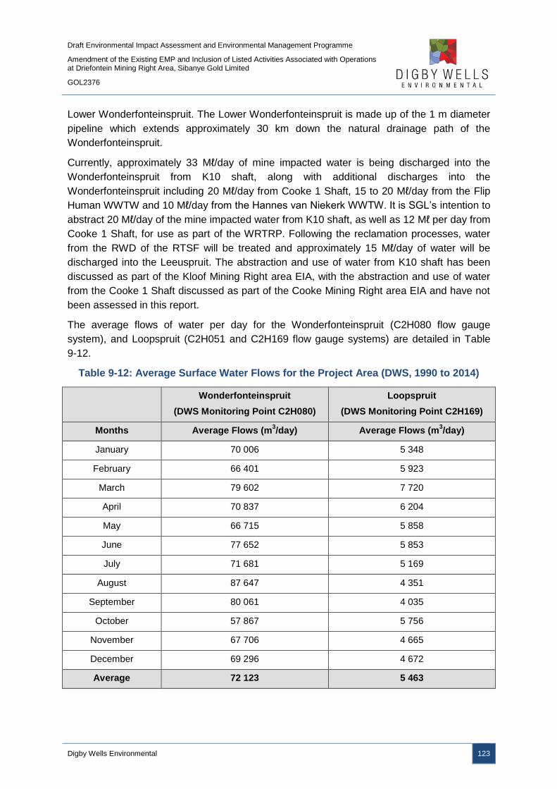
Draft Environmental Impact Assessment and Environmental Management Programme
Amendment of the Existing EMP and Inclusion of Listed Activities Associated with Operations at Driefontein Mining Right Area, Sibanye Gold Limited
GOL2376
Digby Wells Environmental 123
Lower Wonderfonteinspruit. The Lower Wonderfonteinspruit is made up of the 1 m diameter
pipeline which extends approximately 30 km down the natural drainage path of the
Wonderfonteinspruit.
Currently, approximately 33 Mℓ/day of mine impacted water is being discharged into the
Wonderfonteinspruit from K10 shaft, along with additional discharges into the
Wonderfonteinspruit including 20 Mℓ/day from Cooke 1 Shaft, 15 to 20 Mℓ/day from the Flip
Human WWTW and 10 Mℓ/day from the Hannes van Niekerk WWTW. It is SGL’s intention to
abstract 20 Mℓ/day of the mine impacted water from K10 shaft, as well as 12 Mℓ per day from
Cooke 1 Shaft, for use as part of the WRTRP. Following the reclamation processes, water
from the RWD of the RTSF will be treated and approximately 15 Mℓ/day of water will be
discharged into the Leeuspruit. The abstraction and use of water from K10 shaft has been
discussed as part of the Kloof Mining Right area EIA, with the abstraction and use of water
from the Cooke 1 Shaft discussed as part of the Cooke Mining Right area EIA and have not
been assessed in this report.
The average flows of water per day for the Wonderfonteinspruit (C2H080 flow gauge
system), and Loopspruit (C2H051 and C2H169 flow gauge systems) are detailed in Table
9-12.
Table 9-12: Average Surface Water Flows for the Project Area (DWS, 1990 to 2014)
Wonderfonteinspruit
(DWS Monitoring Point C2H080)
Loopspruit
(DWS Monitoring Point C2H169)
Months Average Flows (m3/day) Average Flows (m
3/day)
January 70 006 5 348
February 66 401 5 923
March 79 602 7 720
April 70 837 6 204
May 66 715 5 858
June 77 652 5 853
July 71 681 5 169
August 87 647 4 351
September 80 061 4 035
October 57 867 5 756
November 67 706 4 665
December 69 296 4 672
Average 72 123 5 463

Draft Environmental Impact Assessment and Environmental Management Programme
Amendment of the Existing EMP and Inclusion of Listed Activities Associated with Operations at Driefontein Mining Right Area, Sibanye Gold Limited
GOL2376
Digby Wells Environmental 124
9.1.6 Fauna and Flora
A Fauna and Flora Impact Assessment is included as Appendix I.
9.1.6.1 Regional Vegetation
The project area falls within four vegetation types according to Mucina and Rutherford
(2006) as described below and shown in Plan 16. The sections below also discuss the
fauna and flora of the region.
9.1.6.1.1 Carletonville Dolomite Grassland
This vegetation unit mainly occurs in the North-West Province but also in Gauteng and
marginally into the Free State Province. It is distributed in the region of Potchefstroom,
Ventersdorp and Carletonville, extending westwards to the vicinity of Ottoshoop, but also
occurring as far east as Centurion and Bapsfontein in Gauteng Province.
This vegetation occurs on slightly undulating plains dissected by prominent rocky chert
ridges. It forms a complex mosaic pattern dominated by many species. Grasses such as
Loudetia simplex (Common Russet Grass), Hyparrhenia hirta (Common Thatching Grass),
Brachiaria serrata (Velvet Signal Grass) and Heteropogon contortus (Spear Grass) are
prominent while shrubs such as Euclea undulata (Common Guarri), Searsia
magalismontana (Berg Taaibos), Zanthoxylon capense (Small Knobwood) and Diospyros
lycioides (Bluebush) are scattered in protected places (e.g. among rocks and boulders). The
geology of this vegetation unit consists of dolomites and cherts of the Malmani subgroup
from the Transvaal Super Group.
Conservation status is currently considered vulnerable, with only a small extent conserved in
statutory reserves (Sterkfontein Caves— part of the Cradle of Humankind World Heritage
Site, Oog Van Malmani, Abe Bailey, Boskop Dam, Schoonspruit, Krugersdorp, Olifantsvlei,
Groenkloof) and in at least six private conservation areas. Almost a quarter of the vegetation
type has already been transformed by cultivation, urban sprawl or by mining activity as well
as the building of the Boskop and Klerkskraal Dams.
9.1.6.1.2 Gauteng Shale Mountain Bushveld
This vegetation unit occurs in Gauteng and North-West Provinces, mainly on the ridge of the
Gatsrand south of Carletonville–Westonaria–Lenasia. It occurs on low broken ridges varying
in steepness and generally with a high surface rock cover. The vegetation is a short, semi-
open thicket, dominated by a variety of woody species such as Acacia caffra, Searsia
leptodictya, Cussonia spicata and Englerophytum magalismontanum. The understory is
dominated by grasses such as Cymbopogon pospischilii and Digitaria eriantha. Some of the
ridges form plateaus that carry scrubby grassland. The geology consists of shale and
andesite from the Pretoria group (Transvaal supergroup).

Draft Environmental Impact Assessment and Environmental Management Programme
Amendment of the Existing EMP and Inclusion of Listed Activities Associated with Operations at Driefontein Mining Right Area, Sibanye Gold Limited
GOL2376
Digby Wells Environmental 125
Conservation status is currently considered to be Vulnerable, statutorily conserved in
Skanskop and Hartebeesthoek Nature Reserves, Magaliesburg Nature Area and Groenkloof
National Park.
9.1.6.1.3 Rand Highveld Grassland
Rand Highveld Grassland is found in the highly variable landscape with extensive sloping
plains and ridges in the Gauteng, North-West, Free State and Mpumalanga Provinces. The
vegetation type is found in areas between rocky ridges from Pretoria to Witbank, extending
onto ridges in the Stoffberg and Roossenekal regions as well as in the vicinity of Derby and
Potchefstroom, extending southwards and north-eastwards from there. The vegetation is
characterised by species rich, sour grassland alternating with low shrubland on rocky
outcrops. The most common grasses on the plains belong to the genera Themeda,
Eragrostis, Heteropogon and Elionurus. High numbers of herbs belonging to the Asteraceae
family are also found. In rocky areas, shrubs and trees also prevail and are mostly Protea
caffra, Acacia caffra, Celtis africana and Searsia spp.
Due to the low conservation status, this vegetation type is classified as Endangered. Almost
half of the vegetation type has been transformed by cultivation, plantations, urbanisation or
dam-building. Scattered aliens (most prominently Acacia mearnsii) are present in the unit.
9.1.6.1.4 Soweto Highveld Grassland
This vegetation unit occurs in Mpumalanga, Gauteng (and to a very small extent also in
neighbouring Free State and North West) Provinces. It lies in a broad band roughly
delimited by the N17 road between Ermelo and Johannesburg in the north, Perdekop in the
southeast and the Vaal River (border with the Free State) in the south. It extends further
westwards along the southern edge of the Johannesburg Dome (including part of Soweto)
as far as the vicinity of Randfontein. In southern Gauteng it includes the surrounds of
Vanderbijlpark and Vereeniging as well as Sasolburg in the northern Free State.
The vegetation occurs on gently to moderately undulating landscape on the Highveld plateau
supporting short to medium high, dense, tufted grassland dominated almost entirely by
Themeda triandra (Rooi grass) and accompanied by a variety of other grasses such as
Elionurus muticus (Wire grass), Eragrostis racemosa (Small heart grass), Heteropogon
contortus (Spear grass) and Tristachya leucothrix (Trident grass).
Only small scattered wetlands, narrow streams and occasional ridges or rocky outcrops
interrupt the continuous grassland cover. The geology of the Soweto Integration consists
mainly of shale, sandstone or mudstone of the Madzarinwe formation (Karoo supergroup).
The conservation status is currently considered to be Endangered, only small areas are
statutorily conserved (Waldrift, Krugersdorp, Leeuwkuil, Suikerbosrand, and Rolfe’s Pan
Nature Reserves) or privately conserved (Johanna Jacobs, Tweefontein, Gert Jacobs,
Nikolaas and Avalon Nature Reserves, Heidelberg Natural Heritage Site). Almost half of the
area already transformed by cultivation, urban sprawl, mining and building of road

Draft Environmental Impact Assessment and Environmental Management Programme
Amendment of the Existing EMP and Inclusion of Listed Activities Associated with Operations at Driefontein Mining Right Area, Sibanye Gold Limited
GOL2376
Digby Wells Environmental 126
infrastructure. Some areas have been flooded by dams (Grootdraai, Leeukuil,
Trichardtsfontein, Vaal and Willem Brummer dams). Erosion is generally very low (93%).

Draft Environmental Impact Assessment and Environmental Management Programme
Amendment of the Existing EMP and Inclusion of Listed Activities Associated with Operations at Driefontein Mining Right Area, Sibanye Gold Limited
GOL2376
Digby Wells Environmental 127
Plan 16: Vegetation Types

Draft Environmental Impact Assessment and Environmental Management Programme
Amendment of the Existing EMP and Inclusion of Listed Activities Associated with Operations at Driefontein Mining Right Area, Sibanye Gold Limited
GOL2376
Digby Wells Environmental 128
9.1.6.2 Floral Species of Special Concern
The project area lies within three Quarter Degree Square (QDS) grids, namely 2627AD and
2627BC and 2627DA. According to the PRECIS (National Herbarium Pretoria Computerised
Information System), no Red Data species are expected to occur for the QDS for each of the
sites.
The Plants of South Africa (http://posa.sanbi.org) website list was obtained from the South
African National Biodiversity Institute (SANBI) website; it lists all the Red Data plant species
officially recorded by SANBI for Quarter degree square grids. For a plant species to be
included in this list, a specimen collected in this grid must be supplied to SANBI. This list is
therefore not a comprehensive list representing only those species that may occur in these
grids, but rather a guideline as to what is likely to occur. The sites sampled are also only a
very small portion of the whole grid and habitats suitable for certain species in these Plants
of South Africa (POSA) lists may not be present at the sites sampled. It is therefore not
unusual for species in the POSA list to be absent from the sampling sites.
Certain species included in the list below were confirmed by scrutinising previous specialist
studies that were undertaken in the past. The IUCN category descriptions for fauna and flora
are provided in Table 9-13, with the Species of Special Concern (SSC) likely to occur on site
are listed in Table 9-14.
Table 9-13: Red Data Categories (SANBI, 2012)
Category Description
Extinct (EX) No known individuals remaining.
Extinct in the Wild (EW) Known only to survive in captivity.
Critically Endangered (CR) Extremely high risk of extinction in the wild.
Endangered (EN) High risk of extinction in the wild
Vulnerable (VU) High risk of endangerment in the wild.
Near Threatened (NT) Likely to become endangered in the near future.
Least Concern (LC) Lowest risk. Does not qualify for a more at risk category.
Widespread and abundant taxa are included in this category. Data Deficient (DD) Not enough data to make an assessment of its risk of extinction.
Not Evaluated (NE) Has not yet been evaluated against the criteria.
Extinct Threatened species are species that are facing a high risk of
extinction. Any species classified in the IUCN categories CR, EN
or VU is a threatened species. Species of conservation concern
are species that have a high conservation importance in terms of
preserving South Africa’s high floristic diversity and include not
only threatened species, but also those classified in the
categories, NT, LC and DD
Threatened
Other categories of
conservation concern
Other categories
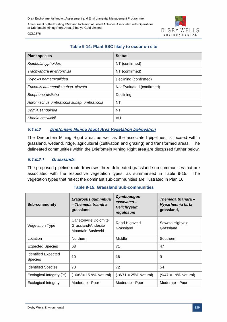
Draft Environmental Impact Assessment and Environmental Management Programme
Amendment of the Existing EMP and Inclusion of Listed Activities Associated with Operations at Driefontein Mining Right Area, Sibanye Gold Limited
GOL2376
Digby Wells Environmental 129
Table 9-14: Plant SSC likely to occur on site
Plant species Status
Kniphofia typhoides NT (confirmed)
Trachyandra erythrorrhiza NT (confirmed)
Hypoxis hemerocallidea Declining (confirmed)
Eucomis autumnalis subsp. clavata Not Evaluated (confirmed)
Boophone disticha Declining
Adromischus umbraticola subsp. umbraticola NT
Drimia sanguinea NT
Khadia beswickii VU
9.1.6.3 Driefontein Mining Right Area Vegetation Delineation
The Driefontein Mining Right area, as well as the associated pipelines, is located within
grassland, wetland, ridge, agricultural (cultivation and grazing) and transformed areas. The
delineated communities within the Driefontein Mining Right area are discussed further below.
9.1.6.3.1 Grasslands
The proposed pipeline route traverses three delineated grassland sub-communities that are
associated with the respective vegetation types, as summarised in Table 9-15. The
vegetation types that reflect the dominant sub-communities are illustrated in Plan 16.
Table 9-15: Grassland Sub-communities
Sub-community
Eragrostis gummiflua
– Themeda triandra
grassland
Cymbopogon
excavates –
Helichrysum
regulosum
Themeda triandra –
Hyparhennia hirta
grassland,
Vegetation Type
Carletonville Dolomite
Grassland/Andesite
Mountain Bushveld
Rand Highveld
Grassland
Soweto Highveld
Grassland
Location Northern Middle Southern
Expected Species 63 71 47
Identified Expected
Species 10 18 9
Identified Species 73 72 54
Ecological Integrity (%) (10/63= 15.9% Natural) (18/71 = 25% Natural) (9/47 = 19% Natural)
Ecological Integrity Moderate - Poor Moderate - Poor Moderate - Poor
Draft Environmental Impact Assessment and Environmental Management Programme
Amendment of the Existing EMP and Inclusion of Listed Activities Associated with Operations at Driefontein Mining Right Area, Sibanye Gold Limited
GOL2376
Digby Wells Environmental 130
The Eragrostis gummiflua – Themeda triandra grassland sub-community was found
predominantly in the northern part of the Driefontein Mining Right area, with the water
pipelines falling entirely in this sub-community, as well as the WBT and BWSF complex and
Driefontein 3 TSF, the slurry pipeline and a large portion of the thickened slurry pipeline.
This grassland community falls within the Carletonville Dolomite Grassland (Mucina and
Rutherford, 2006). A dominance of Common Thatching Grass (Hyparrhenia hirta) and a
large number of problem plants indicated poor ecological health. This was further confirmed
through comparison of expected species listed for Carletonville Dolomite Grassland.
The Cymbopogon excavatus – Helichrysum regulosum dominated grassland, with the
common occurring Acacia karroo (Sweet Thorn), falls within the Rand Highveld Grassland
(Mucina and Rutherford, 2006) and is associated with the central thickened slurry pipeline
route and Driefontein 5 TSF. Due to the favourable microclimate created by Acacia karroo,
there are a larger number of small shrubs and forbs in these areas. The ecological health is
estimated to moderate to poor due to the high number of alien invasive species, such as
Wild Verbena (Verbena bonariensis).
The southern section of the thickened slurry pipeline route to the CPP is predominantly
described as Themeda triandra – Hyparhennia hirta grassland, which falls within the Soweto
Highveld Vegetation type. Much of this vegetation type is assumed to have been
transformed for agricultural purposes and is regarded as being slightly to largely modified.
The extent of the degradation is illustrated through diminished species richness and the
presence of alien invasive vegetation. The result grasslands are vulnerable to destruction by
cultivation; once ploughed they are invaded by weed pioneer plants that are predominantly
alien (Ferrar and Lotter, 2006). A high number of species were identified within the various
grassland sub communities, however these species are not typical of the vegetation type
(many of the species are alien invasive), and therefore the grassland is largely modified from
the original state, with poor ecological integrity.
9.1.6.3.2 Ridge Areas
Similar vegetation species exist between ridge areas and the grassland sub-communities.
The increased rockiness and shallow soils in the ridge areas, however, has resulted in these
areas having largely escaped anthropogenic disturbances and transformation. Ridges
provide diverse habitat and refuge for a number of species and are generally regarded to be
sensitive habitats due to the high levels of biodiversity that they host. The ridges within the
project area are elevated above the grassland and host abundant woody species, which are
not present in the grassland community. Ridges are regarded as sensitive habitats as many
of these species are specifically adapted to this microclimate. The vegetation associated
with the ridge areas is listed in Appendix I.
Draft Environmental Impact Assessment and Environmental Management Programme
Amendment of the Existing EMP and Inclusion of Listed Activities Associated with Operations at Driefontein Mining Right Area, Sibanye Gold Limited
GOL2376
Digby Wells Environmental 131
9.1.6.3.3 Wetland
Wetland and riparian vegetation is associated predominantly with proposed pipeline
crossings, as well as adjacent and within the WBT and BWSF complex. The delineated
wetlands are discussed in further detail in Section 9.1.8.
9.1.6.3.4 Agricultural
Agricultural activities are undertaken in the project area. Agricultural crops which have
replaced natural vegetation include Maize (Zea mays) which is the primary crop in the area,
Soybean (Glycine max) and Sunflowers (Helianthus annulus). Small plots of commercial
vegetables, Lucerne and Peaches are also cultivated in the area. Livestock farming
(including sheep and cattle) is also popular, which has resulted in degradation of the natural
grassland biodiversity. This is evident through the presence of Bankrupt Bush (Seriphium
plumosum), which has overtaken numerous fields in the area, as well as a number of other
problem plants and general assumed diminished species richness.
9.1.6.3.5 Transformed
Transformed areas are associated with alien invasive and exotic vegetation and features
prominently in the grassland landscape, with areas where the natural grasslands have been
transformed in its entirety occurring. This is typically in the form of stands of exotic trees that
have been planted, usually for the uptake of water. Red River Gum ((Eucalyptus
camaldulensis) surrounds much of the mining areas, often planted for their robust nature and
ability to take up toxic leachates from the groundwater surrounding retention dams. Pampas
grass (Cortaderia selloana) is a similarly robust plant which has been planted in an effort to
rehabilitate areas which have been mined. Alien invasive vegetation recorded on site is
listed in Appendix I.
9.1.6.3.6 Ecological Importance
The ecological importance of the vegetation communities is described in Table 9-16. The
remnant natural vegetation communities illustrate high ecological importance due to their
ecosystem functioning. Despite their diminished ecological integrity they are seen to be
valuable for biodiversity maintenance and therefore these communities, namely; grasslands,
ridges and wetland vegetation should be conservation priorities. Transformed vegetation is
not regarded to have high ecological importance due to poor integrity, limited ecosystem
functioning and abundance of introduced alien vegetation species.
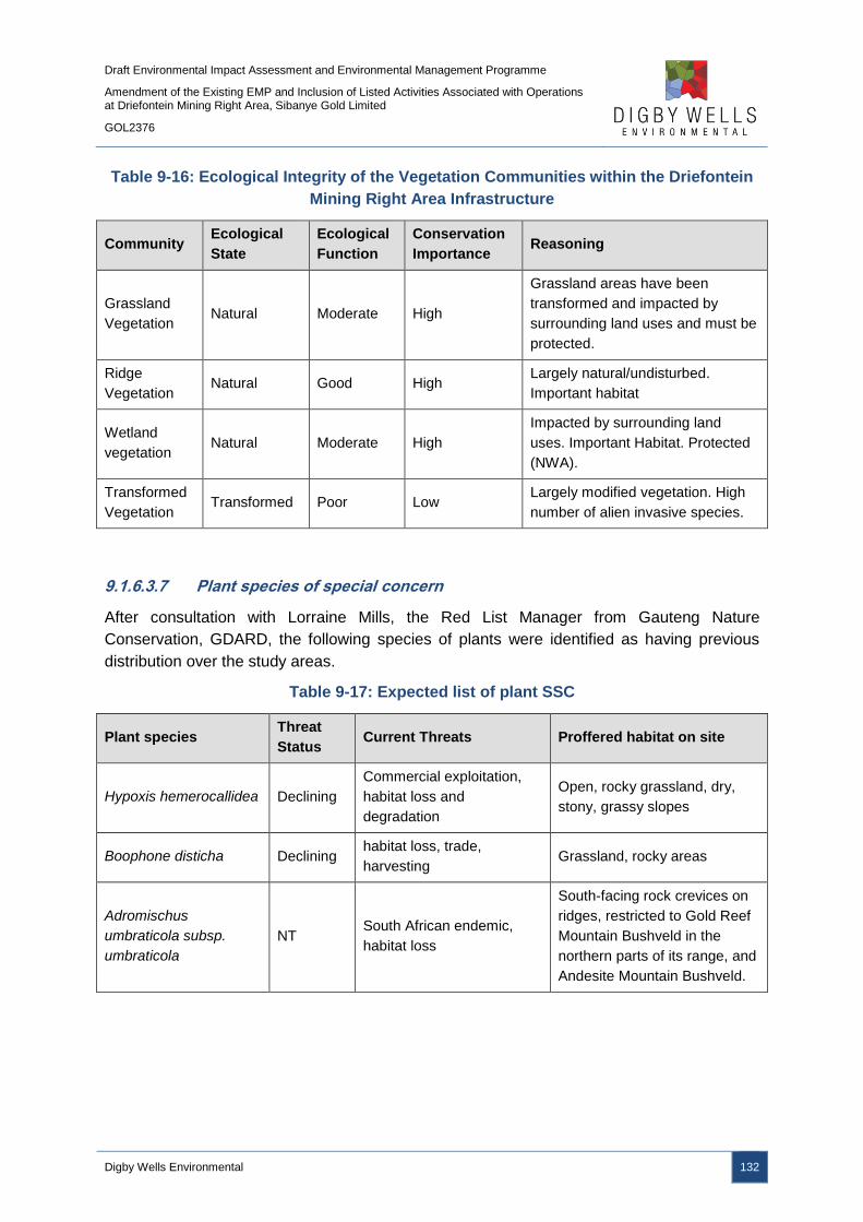
Draft Environmental Impact Assessment and Environmental Management Programme
Amendment of the Existing EMP and Inclusion of Listed Activities Associated with Operations at Driefontein Mining Right Area, Sibanye Gold Limited
GOL2376
Digby Wells Environmental 132
Table 9-16: Ecological Integrity of the Vegetation Communities within the Driefontein
Mining Right Area Infrastructure
Community Ecological
State
Ecological
Function
Conservation
Importance Reasoning
Grassland
Vegetation Natural Moderate High
Grassland areas have been
transformed and impacted by
surrounding land uses and must be
protected.
Ridge
Vegetation Natural Good High
Largely natural/undisturbed.
Important habitat
Wetland
vegetation Natural Moderate High
Impacted by surrounding land
uses. Important Habitat. Protected
(NWA).
Transformed
Vegetation Transformed Poor Low
Largely modified vegetation. High
number of alien invasive species.
9.1.6.3.7 Plant species of special concern
After consultation with Lorraine Mills, the Red List Manager from Gauteng Nature
Conservation, GDARD, the following species of plants were identified as having previous
distribution over the study areas.
Table 9-17: Expected list of plant SSC
Plant species Threat
Status Current Threats Proffered habitat on site
Hypoxis hemerocallidea Declining
Commercial exploitation,
habitat loss and
degradation
Open, rocky grassland, dry,
stony, grassy slopes
Boophone disticha Declining habitat loss, trade,
harvesting Grassland, rocky areas
Adromischus
umbraticola subsp.
umbraticola
NT South African endemic,
habitat loss
South-facing rock crevices on
ridges, restricted to Gold Reef
Mountain Bushveld in the
northern parts of its range, and
Andesite Mountain Bushveld.
Draft Environmental Impact Assessment and Environmental Management Programme
Amendment of the Existing EMP and Inclusion of Listed Activities Associated with Operations at Driefontein Mining Right Area, Sibanye Gold Limited
GOL2376
Digby Wells Environmental 133
Plant species Threat
Status Current Threats Proffered habitat on site
Drimia sanguinea NT
Highly poisonous bulb that
has caused mass livestock
mortality in the pass and
was subject to frequent
land clearance by farmers,
hence its status
Open veld and scrubby
woodland in a variety of soil
types.
Khadia beswickii VU
Habitat loss, invasive alien
species (direct effects),
harvesting
Yes, open shallow soil over
rocks in grassland.
Kniphofia typhoides NT Habitat loss, plant invasion
Wetlands and seasonally wet
areas in climax Themeda
triandra grasslands on heavy
black clay soils.
Gunnera perpensa Declining Traditional medicine Grassland areas.
Lithops lesliei
subsp.lesliei NT
Harvesting (gathering),
specifically for commercial
sale
Arid grasslands, usually in
rocky places, growing under
the protection of forbs and
grasses.
9.1.6.4 Fauna
Fauna expected to occur within the Driefontein Mining Right area and larger WRTRP area
include assemblages within terrestrial and wetland ecosystems: mammals, birds, reptiles,
amphibians and invertebrates. Each of these assemblages occurs within unique habitats and
the ecological state of these habitats directly relates to the number of species found within
them. The main habitats occurring in the project area are grassland plains and pans, with
little altitudinal variation.
Large areas of the terrestrial vegetation and habitat have been modified within the project
area. It is assumed that these impacts have had a subsequent effect on the fauna species
diversity and abundance. The findings of the fauna survey are used as a secondary
reflection of the ecosystem health. Low numbers of Mammalia, Avifauna, Reptiles,
Amphibians and Invertebrates were identified within the project area and many of these
species are associated with the sensitive habitats associated with the grassland and wetland
areas.

Draft Environmental Impact Assessment and Environmental Management Programme
Amendment of the Existing EMP and Inclusion of Listed Activities Associated with Operations at Driefontein Mining Right Area, Sibanye Gold Limited
GOL2376
Digby Wells Environmental 134
9.1.6.4.1 Mammals
A number of small mammals were identified within the project area, such as Steenbok
(Raphicerus campestris), Ground Squirrels (Xerus inauris), and Porcupine (Hystrix
africaeaustralis). Species were identified through actual sightings and visual evidence,
although none of the identified species are considered SSC. A list of expected mammals to
occur within the project area, as well as those species observed and recorded, is provided in
Table 9-18.
Table 9-18: Expected Mammals within the Driefontein Mining Right Area and WRTRP
Area
Family Species Common Name Recorded on
site Status
Bovidae Raphicerus
campestris Steenbok X LC
Bovidae Sylvicapra grimmia Common Duiker X LC
Bovidae Damaliscus
pygargus phillips Blesbuck X LC
Chrysochloridae Chrysospalax
pillosus
Rough Haired Golden
Mole VU
Chrysochloridae Amblysomus
septentrionalis Highveld Golden Mole NT
Herpestidae Cynictis penicillata Yellow Mongoose X LC
Herpestidae Galerella
sanguineus Slender Mongoose X LC
Hysticidae Hystrix
africaeaustralis Porcupine X LC
Muridae Rhabdomys
pumilio Striped Field Mouse X LC
Muridae Mus musculus House Mouse X LC
Muridae Rattus rattus House Rat X LC
Muridae Myosorex varius Forest Shrew LC
Muridae Dasmys incomtus African Marsh Rat
House rat LC
Muridae Hydrictis
maculicollis Spotted Necked Otter NT
Muridae Xerus inauris Ground Squirrel X LC
Mustelidae Mystromys
albicaudatus White-Tailed Mouse EN

Draft Environmental Impact Assessment and Environmental Management Programme
Amendment of the Existing EMP and Inclusion of Listed Activities Associated with Operations at Driefontein Mining Right Area, Sibanye Gold Limited
GOL2376
Digby Wells Environmental 135
9.1.6.4.2 Avifauna
A number of birds were identified within the area of the proposed RTSF and pipeline routes.
The birds are associated with a variety of habitats which correspond with the vegetation
communities namely, grassland, ridges, wetland and transformed habitats. Thirty Seven
(37) bird species were identified during the survey and are detailed in Appendix I. No Listed
Red Data bird species were identified during the field survey. The Grass Owl (Tyto
capensis), has previously been identified within the project area (Golder, 2008) and is
expected to occur within the wetland habitats identified within the project area. This species
has been allocated a status of Vulnerable.
9.1.6.4.3 Reptiles
One species of reptile, a Rinkhals (Hemachatus haemachatus) was identified during the field
survey. It should be noted that all land tortoises are protected in the Gauteng Province,
however the probability of occurrence of the species in the study area are seen as low. Red
Data species that may occur within the project area include the Giant Girdled Lizard
(Cordylus giganteus), listed as Vulnerable, and the Striped Harlequin Snake (Homoroselaps
dorsalis), identified as Rare; both species are allocated a low probability of occurrence.
9.1.6.4.4 Amphibians
Six amphibians were encountered during the field survey. The amphibian species identified
and expected for the area are listed in Table 9-19; the species identified were all
encountered within the wetlands habitat types.
Table 9-19: Amphibian Species Identified
Scientific Name Common Name Occurrence Habitat
Afrana angolensis Common River
Frog
Widespread;
confirmed
Grassland, savanna and forest
fringe, breeds in shallow water of
pools, dams, streams and slow-
flowing rivers
Afrana fuscigula Cape River Frog
Widespread;
high; SA
Endemic.
Streams and ponds. Prefers well-
vegetated waterways.
Amietophrynus
gutturalis Guttural Toad
Widespread;
confirmed
Habitat generalist; breeds in open
pools, dams, or streams
Amietophrynus rangeri Raucous Toad Marginal, low
Grassland, usually when
inundated, man-made
impoundments
Cacosternum boettgeri Common Caco Widespread;
confirmed
Varied including grassland;
breeds in vleis and inundated
grassland or shallow pans

Draft Environmental Impact Assessment and Environmental Management Programme
Amendment of the Existing EMP and Inclusion of Listed Activities Associated with Operations at Driefontein Mining Right Area, Sibanye Gold Limited
GOL2376
Digby Wells Environmental 136
Scientific Name Common Name Occurrence Habitat
Kassina senegalensis Bubbling Kassina Widespread;
confirmed
Grasslands; breeds in vleis, pans
and dams
Phrynobatrachus
natalensis
Snoring Puddle
Frog
Marginal;
medium
Breeds in pools or marshy areas
associated with pans, streams or
vleis
Pyxicephalus adspersus Giant Bullfrog Confirmed;
Mainly grassland and savanna;
breeds in temporary pans or
pans.
Schismaderma carens Red Toad Widespread;
high
Streams and rivers, and still
permanent bodies water
Strongylopus fasciatus Striped Stream
Frog
Widespread;
confirmed
Streams and rivers, and still
permanent bodies water
Tomopterna cryptotis Tremolo Sand Frog Widespread;
high
Varied habitats; breeds in water
bodies that have vegetation
Tomopterna natalensis Natal Sand frog Widespread;
high
Savanna; breeds in temporary
pans
Xenopus laevis Common Platanna Widespread;
confirmed
Breeds in shallow permanent
streams, of temporary water
bodies in grassland
9.1.6.4.5 Invertebrates
Butterflies are a good indication of the habitats available in a specific area (Woodhall 2005).
Although many species are eurytropes (able to use a wide range of habitats) and are
widespread and common, South Africa has many stenotrope (specific habitat requirements
with populations concentrated in a small area) species which may be very specialised
(Woodhall 2005). Red Data species expected to occur on site are the Marsh sylph (Metisella
meninx), Roodepoort Copper (Aloeides dentatis dentatis) and Highveld Blue
(Lepidochrysops praeterita), although no species were identified during the survey. This
may be due to the timing of the survey and it is expected that species will be encountered in
the area.
9.1.6.5 Sensitivity Analysis
The sensitivity assessment takes into account all of the desktop information (Gauteng C-
Plan, Threatened Ecosystems and the NPAES), as well as the field data gathered during the
site visits. This forms as assessment of the perceived biodiversity value and the result
assigns sensitivity to the vegetation delineated on site. The sensitivity analysis is provided in
Plan 17.
Draft Environmental Impact Assessment and Environmental Management Programme
Amendment of the Existing EMP and Inclusion of Listed Activities Associated with Operations at Driefontein Mining Right Area, Sibanye Gold Limited
GOL2376
Digby Wells Environmental 137
Ridges and wetlands constitute High Sensitivity areas due to their role as process areas
within the ecosystem. In addition, high sensitivity was given to areas occurring within a
Threatened Ecosystem, and those areas that were pristine or close to pristine with low or no
anthropogenic impacts. Areas occurring within Highly Significant C-Plan areas (unless
heavily degraded) were also given a High Sensitivity, as were areas on steep rocky slopes
and those that have high numbers of species of special concern.
Areas of Medium Sensitivity include those natural areas with some anthropogenic change or
degradation, with high numbers of species of special concern and moderate rocky slopes.
Low Sensitivity was assigned to areas completely transformed or heavily degraded, on
relatively flat ground.
Draft Environmental Impact Assessment and Environmental Management Programme
Amendment of the Existing EMP and Inclusion of Listed Activities Associated with Operations at Driefontein Mining Right Area, Sibanye Gold Limited
GOL2376
Digby Wells Environmental 138
Plan 17: Sensitivity Analysis
Draft Environmental Impact Assessment and Environmental Management Programme
Amendment of the Existing EMP and Inclusion of Listed Activities Associated with Operations at Driefontein Mining Right Area, Sibanye Gold Limited
GOL2376
Digby Wells Environmental 139
9.1.7 Aquatics
The Aquatics Impact Assessment is included as Appendix J.
Within the quaternary catchments (as identified in the surface water baseline section), a total
of nine river systems will be affected by the proposed project and a total of 13 Sub
Quaternary Reaches (SQRs). The SQR within the WRTRP area are associated with the
Wonderfonteinspruit, Mooirivierloop, Loopspruit and the Leeuspruit.
The majority of the rivers systems in the WRTRP area are largely modified with the Present
Ecological Status (PES) of these systems ranging from Class D to Class E and an ecological
importance and sensitivity ranging from Low to Moderate (DWA, 2013). The modification of
these systems is largely attributed to the location of the sources of the associated river
systems. The sources of the river systems are located within urban and industrial areas and
as such, associated impacts to instream and riparian conditions have resulted in the large
modification of the systems. Consequently, aquatic biota is considered to be of low
importance with low sensitivities within these systems.
High flow and low flow site surveys were undertaken for the project area to assess the
baseline aquatic environment. The following aspects were assessed and are detailed below
for the aquatic environments associated with the Driefontein Mining Right area activities:
■ Water quality;
■ Intermediate Habitat Integrity Assessment (IHIA); and
■ Macroinvertebrate Assessment including:
Integrated Habitat Assessment System (IHAS);
South African Scoring System version 5 (SASS5); and
Macroinvertebrate Response Assessment Index (MIRAI).
9.1.7.1 Water Quality
The location of the aquatic sampling locations is provided in Plan 18. The results of the
aquatic sampling has been provided for the locations associated with the
Wonderfonteinspruit, as the Wonderfonteinspruit runs westwards to the north of Driefontein
3 an 5 TSFS and water from K10 shaft is discharged into the water resource. It must be
noted that a section of the Wonderfonteinspruit has been piped and, as a result, is
significantly modified. Sampling locations WON1 and WON4 occur upstream and
downstream of the piped section respectively, with sampling site CAR1 located to the west
of Driefontein 5 TSF.
The water quality results from the aquatic sampling are listed in Table 9-20.

Draft Environmental Impact Assessment and Environmental Management Programme
Amendment of the Existing EMP and Inclusion of Listed Activities Associated with Operations at Driefontein Mining Right Area, Sibanye Gold Limited
GOL2376
Digby Wells Environmental 140
Table 9-20: In Situ Water Quality Results
High Flow Survey Low Flow Survey
Constituent Guideline WON1 WON4 CAR1 WON1 WON4 CAR1
Temperature (ºC) 5-25 16 13.8 17.6 9.5 13.8 7.5
pH 6-9 7.5 8.6 8.6 7.8 8.6 8.1
Conductivity
(µS/cm) <700 774 1 035 1 228 879 1 035 1164
Dissolved oxygen
(mg/l) >5 3.77 8.6 6.9 4.5 6.34 7.22
Dissolved oxygen
saturation (%) >50 38 81 61 40 61 63
*Red colour denotes constituent exceeding recommended DWAF (1996) Aquatic guideline

Draft Environmental Impact Assessment and Environmental Management Programme
Amendment of the Existing EMP and Inclusion of Listed Activities Associated with Operations at Driefontein Mining Right Area, Sibanye Gold Limited
GOL2376
Digby Wells Environmental 141
Plan 18: Aquatic Monitoring Locations

Draft Environmental Impact Assessment and Environmental Management Programme
Amendment of the Existing EMP and Inclusion of Listed Activities Associated with Operations at Driefontein Mining Right Area, Sibanye Gold Limited
GOL2376
Digby Wells Environmental 142
When considering the in situ results from the high flow survey, temperatures were observed
to range between 13.8ºC at WON4 to 17.6ºC at CAR1. The pH levels obtained during the
survey ranged between 7.5 at WON1 to 8.6 at WON4 and CAR1. The conductivity
recordings obtained during the survey ranged from 774 µS per cm to 1 035 µS per cm at
sampling sites WON1 and WON4 respectively and exceeded the DWAF aquatic guidelines
(1996). Concentrations of dissolved oxygen ranged were within the recommended DWAF
(1996) aquatic guidelines for sampling sites WON4 and CAR1, with WON1 exceeding the
recommended guidelines.
The low flow survey indicated similar results as the high flow survey, with all sites exceeding
the conductivity concentrations and sampling site WON1 exceeding the dissolved oxygen
concentrations for the aquatic guidelines (DWAF, 1996). All sampling sites were within the
DWAF (1996) aquatic guidelines for temperature and pH.
9.1.7.2 Intermediate Habitat Integrity Assessment
To define a general habitat the instream and riparian habitat was assessed and
characterised according to “Procedure for Rapid Determination of Resource Directed
Measures for River Ecosystems (Section D), 1999”. The IHIA model was used to assess the
integrity of the habitats from a riparian and instream perspective. The habitat integrity of a
river refers to the maintenance of a balanced composition of physico-chemical and habitat
characteristics on a temporal and spatial scale that are comparable to the characteristics of
natural habitats of the region (Kleynhans, 1996).
The criteria utilised as part of the IHIA is detailed in Appendix J, with the scores placed into
IHIA categories. The IHIA categories are detailed in Table 9-21, with the results of the
instream and riparian IHIA provided in Table 9-22 and Table 9-23 respectively.
Within the SQR of the Wonderfonteinspruit, the IHIA results of the instream habitats are
classified as class E or seriously modified, with the riparian habitat as class D or largely
modified.

Draft Environmental Impact Assessment and Environmental Management Programme
Amendment of the Existing EMP and Inclusion of Listed Activities Associated with Operations at Driefontein Mining Right Area, Sibanye Gold Limited
GOL2376
Digby Wells Environmental 143
Table 9-21: Intermediate Habitat Integrity Assessment Categories (Kleynhans, 1996)
Category Description Score
A Unmodified, natural. 90-100
B
Largely natural with few modifications. A small change in natural
habitats and biota may have taken place but the ecosystem
functions are essentially unchanged.
80-90
C
Moderately modified. A loss and change of natural habitat and
biota have occurred but the basic ecosystem functions are still
predominantly unchanged.
60-79
D Largely modified. A large loss of natural habitat, biota and basic
ecosystem functions has occurred. 40-59
E The loss of natural habitat, biota and basic ecosystem functions
is extensive. 20-39
F
Modifications have reached a critical level and the lotic system
has been modified completely with an almost complete loss of
natural habitat and biota. In the worst instances the basic
ecosystem functions have been destroyed and the changes are
irreversible.
0-19
Table 9-22: IHIA for Instream Habitats
Wonderfonteinspruit
Instream Average Score Score
Water abstraction 13.33 7.46
Flow modification 25 13
Bed modification 25 13
Channel modification 25 13
Water quality 11.66 6.53
Inundation 20.33 8.13
Exotic macrophytes 8 2.88
Exotic fauna 10 3.2
Solid waste disposal 11.66 2.8
Total Instream 29.98
Category Class E
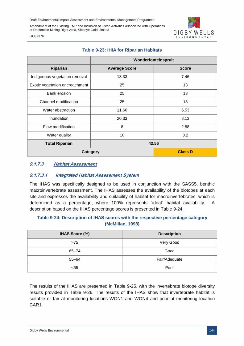
Draft Environmental Impact Assessment and Environmental Management Programme
Amendment of the Existing EMP and Inclusion of Listed Activities Associated with Operations at Driefontein Mining Right Area, Sibanye Gold Limited
GOL2376
Digby Wells Environmental 144
Table 9-23: IHIA for Riparian Habitats
Wonderfonteinspruit
Riparian Average Score Score
Indigenous vegetation removal 13.33 7.46
Exotic vegetation encroachment 25 13
Bank erosion 25 13
Channel modification 25 13
Water abstraction 11.66 6.53
Inundation 20.33 8.13
Flow modification 8 2.88
Water quality 10 3.2
Total Riparian 42.56
Category Class D
9.1.7.3 Habitat Assessment
9.1.7.3.1 Integrated Habitat Assessment System
The IHAS was specifically designed to be used in conjunction with the SASS5, benthic
macroinvertebrate assessment. The IHAS assesses the availability of the biotopes at each
site and expresses the availability and suitability of habitat for macroinvertebrates, which is
determined as a percentage, where 100% represents "ideal" habitat availability. A
description based on the IHAS percentage scores is presented in Table 9-24.
Table 9-24: Description of IHAS scores with the respective percentage category
(McMillan, 1998)
IHAS Score (%) Description
>75 Very Good
65–74 Good
55–64 Fair/Adequate
<55 Poor
The results of the IHAS are presented in Table 9-25, with the invertebrate biotope diversity
results provided in Table 9-26. The results of the IHAS show that invertebrate habitat is
suitable or fair at monitoring locations WON1 and WON4 and poor at monitoring location
CAR1.

Draft Environmental Impact Assessment and Environmental Management Programme
Amendment of the Existing EMP and Inclusion of Listed Activities Associated with Operations at Driefontein Mining Right Area, Sibanye Gold Limited
GOL2376
Digby Wells Environmental 145
Table 9-25: IHAS Results for the WRTRP
Site WON1 WON4 CAR1
Flow Moderate Fast Slow/Standing
Score 63 60 42
Suitability Fair Fair Poor
Table 9-26: Invertebrate Biotope Diversity
Biotope WON1 WON4 CAR1
Stones in current 4 4 2
Stones out of current 1 0 1
Bedrock 4 0 0
Aquatic Vegetation 1 3 0
Marginal Vegetation In Current 3 3 0
Marginal Vegetation Out Of Current 4 0 0
Gravel 3 0 0
Sand 3 2 3
Mud 2 3 3
Biotope Score 25 15 9
Biotope Score (%) 56 33 20
Biotope suitability Good Fair Poor
9.1.7.3.2 South African Scoring System Version 5
The SASS5 is the current biological index being used to assess the status of riverine
macroinvertebrates in South Africa. According to Dickens and Graham (2002), the index is
based on the presence of aquatic invertebrate families and the perceived sensitivity to water
quality changes of these families. Different families exhibit different sensitivities to pollution,
these sensitivities range from highly tolerant families (e.g. Muscidae and Psychodidae) to
highly sensitive families (e.g. Oligoneuridae). SASS5 results are expressed both as an index
score (SASS5 score) and the Average Score Per recorded Taxon (ASPT value).
All SASS5 and ASPT scores are compared with the SASS5 Data Interpretation Guidelines
(Dallas, 2007) for the Highveld lower ecoregion. This method seeks to develop biological
bands depicting the various ecological states and is derived from data contained within the
Rivers Database and supplemented with other data not yet in the database. Table 9-27
illustrates the biological banding and classification.

Draft Environmental Impact Assessment and Environmental Management Programme
Amendment of the Existing EMP and Inclusion of Listed Activities Associated with Operations at Driefontein Mining Right Area, Sibanye Gold Limited
GOL2376
Digby Wells Environmental 146
Table 9-27: Highveld Low Biological Banding
Class SASS5 Score ASPT Condition
A >123 >5.6 Natural/unmodified
B 83-122 5.5–5.8 Minimally modified
C 64–82 5.1–5.5 Moderately modified
D 51–63 4.6–5.1 Largely modified
E <50 <4.6 Seriously modified
The results of the SASS5 assessments for the project area are provided in Table 9-28 and
indicate that the sampling locations are largely to seriously modified.
Table 9-28: SASS5 Results for the Project Site
High Flow Survey Low Flow Survey
Site WON1 WON4 CAR1 WON1 WON4 CAR1
SASS5 35 62 47 36 56 39
Taxa 10 16 12 10 12 11
ASPT 3.5 3.8 3.9 3.6 4.6 3.5
Category E D E E D E
9.1.7.3.3 Macroinvertebrate Assessment Index
The MIRAI was used to provide a habitat-based cause-and-effect foundation to interpret the
deviation of the aquatic invertebrate community from the calculated reference conditions for
the Highveld Lower Ecoregion. This does not preclude the calculation of SASS5 scores if
required (Thirion, 2007). The four major components of a stream system that determine
productivity for aquatic macroinvertebrates are as follows:
■ Flow regime;
■ Physical habitat structure;
■ Water quality; and
■ Energy inputs from the watershed Riparian vegetation assessment.
The results of the MIRAI provide an indication of the current ecological category and
therefore assist in the determination of the PES. The MIRAI scores are provided in Table
9-29.

Draft Environmental Impact Assessment and Environmental Management Programme
Amendment of the Existing EMP and Inclusion of Listed Activities Associated with Operations at Driefontein Mining Right Area, Sibanye Gold Limited
GOL2376
Digby Wells Environmental 147
Table 9-29: MIRAI Scores for the WRTRP
Wonderfonteinspruit
Invertebrate Metric Group Score Calculated
Flow modification 45.7
Habitat 52.5
Water Quality 40.1
Connectivity and seasonality 24.6
Ecological Score 41
Invertebrate Category Class D
The results of the IHAS and SASS5 biotope assessment indicates that there is sufficient
habitat to support a diverse community of macroinvertebrates at the sites considered in the
Wonderfonteinspruit system.
Despite the available habitat, seriously and largely modified classes were derived for the
SASS5 assessments. These low scores are expected to be related to poor water quality in
the river systems and due to flow modification.
9.1.7.4 Present Ecological Status
The results of the ecological classification and PES for the considered water resources are
provided in Table 9-30. The systems are considered to be Class D/E or largely to seriously
modified.
Table 9-30: Present Ecological Status
Wonderfonteinspruit
Category Score Ecological category
Riparian Habitat Ecological
Category 42 Largely modified
Macroinvertebrate Ecological
Category 39 Largely modified
Ecostatus Largely/Seriously modified
Draft Environmental Impact Assessment and Environmental Management Programme
Amendment of the Existing EMP and Inclusion of Listed Activities Associated with Operations at Driefontein Mining Right Area, Sibanye Gold Limited
GOL2376
Digby Wells Environmental 148
9.1.8 Wetlands
The Wetland Impact Assessment for the WRTRP is provided in Appendix K.
The WRTRP area spans over several quaternary catchments and therefore is characterised
by several different watercourses as summarised in Section 9.1.5. The project area is found
to have many valley bottom systems which mostly correlate to the rivers and their tributaries.
These systems are both channelled and unchannelled. There are also multiple pan systems
that occur within the area.
The majority of river systems associated with the project area are largely modified. The
modification of these systems is largely attributed to the location of the sources of the
associated river systems, which are located within urban and industrial areas and associated
impacts to instream and riparian conditions have resulted in the large modification of the
systems. The project area is characterised by the valley bottom systems associated with the
Wonderfonteinspruit, Leeuspruit, Loopspruit and other tributaries. In addition, in the
midslopes and valley heads of the catchments, there are pan and seep systems associated
with the landscapes. The National Freshwater Ecosystem Priority Areas (NFEPA) wetlands
within the Ultimate Project area are shown in Plan 19.

Draft Environmental Impact Assessment and Environmental Management Programme
Amendment of the Existing EMP and Inclusion of Listed Activities Associated with Operations at Driefontein Mining Right Area, Sibanye Gold Limited
GOL2376
Digby Wells Environmental 149
Plan 19: NFEPA Wetlands for the WRTRP
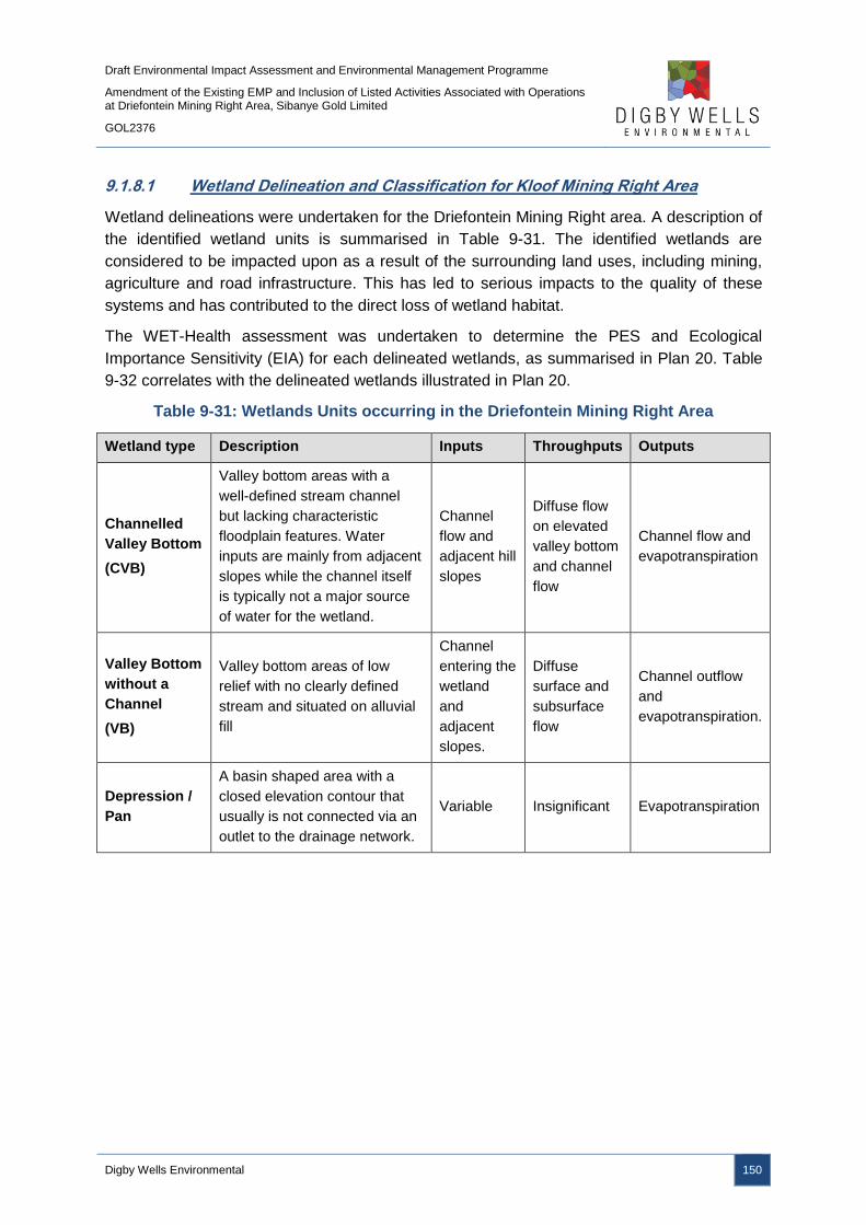
Draft Environmental Impact Assessment and Environmental Management Programme
Amendment of the Existing EMP and Inclusion of Listed Activities Associated with Operations at Driefontein Mining Right Area, Sibanye Gold Limited
GOL2376
Digby Wells Environmental 150
9.1.8.1 Wetland Delineation and Classification for Kloof Mining Right Area
Wetland delineations were undertaken for the Driefontein Mining Right area. A description of
the identified wetland units is summarised in Table 9-31. The identified wetlands are
considered to be impacted upon as a result of the surrounding land uses, including mining,
agriculture and road infrastructure. This has led to serious impacts to the quality of these
systems and has contributed to the direct loss of wetland habitat.
The WET-Health assessment was undertaken to determine the PES and Ecological
Importance Sensitivity (EIA) for each delineated wetlands, as summarised in Plan 20. Table
9-32 correlates with the delineated wetlands illustrated in Plan 20.
Table 9-31: Wetlands Units occurring in the Driefontein Mining Right Area
Wetland type Description Inputs Throughputs Outputs
Channelled
Valley Bottom
(CVB)
Valley bottom areas with a
well-defined stream channel
but lacking characteristic
floodplain features. Water
inputs are mainly from adjacent
slopes while the channel itself
is typically not a major source
of water for the wetland.
Channel
flow and
adjacent hill
slopes
Diffuse flow
on elevated
valley bottom
and channel
flow
Channel flow and
evapotranspiration
Valley Bottom
without a
Channel
(VB)
Valley bottom areas of low
relief with no clearly defined
stream and situated on alluvial
fill
Channel
entering the
wetland
and
adjacent
slopes.
Diffuse
surface and
subsurface
flow
Channel outflow
and
evapotranspiration.
Depression /
Pan
A basin shaped area with a
closed elevation contour that
usually is not connected via an
outlet to the drainage network.
Variable Insignificant Evapotranspiration

Draft Environmental Impact Assessment and Environmental Management Programme
Amendment of the Existing EMP and Inclusion of Listed Activities Associated with Operations at Driefontein Mining Right Area, Sibanye Gold Limited
GOL2376
Digby Wells Environmental 151
Plan 20: Delineated Wetlands

Draft Environmental Impact Assessment and Environmental Management Programme
Amendment of the Existing EMP and Inclusion of Listed Activities Associated with Operations at Driefontein Mining Right Area, Sibanye Gold Limited
GOL2376
Digby Wells Environmental 152
Table 9-32: Wetland Findings
Quaternary
Catchment
Wetland
and HGM
unit
Area
(ha) Description and Associated infrastructure PES EIS EcoServices Radial Plot
C23E
1 CVB 40.9
This is a small unnamed stream flowing northwards past the western side of the Driefontein 5 TSF.
This wetland has been significantly impacted upon by the mining activities immediately adjacent to the wetland.
Water quality has therefore been significantly compromised. The wetland hydrology has been altered due to the
establishment of numerous farm dams. Parts of the wetland have been significantly impacted by colonisation of
alien species, particularly Acacia mearnsii (Black Wattle).
With regard to ecological sensitivity, no Red Data species were recorded in this wetland area and there is no
suitable habitat to support such species. Further to this, due to the general transformation of habitat, significant
natural features were absent. This wetland still serves an important role in streamflow regulation.
E
6.2
Low
1.0
2 VB 17.1
This is a small unnamed stream flowing northwards past the western side of the Driefontein 3 TSF.
This wetland has been largely impacted on through drainage modifications, vegetation removal due to historical
mining activities and part of the upstream wetland has been completely destroyed through mining.
Given the severity of the impacts to this wetland, the services provided by the wetland are low and therefore the
importance and sensitivity is low. In addition, the EcoServices are not significant. This wetland would require
significant rehabilitation measures to restore functionality.
The pipeline from Driefontein 5 to Driefontein 3 TSF will cross this wetland. This pipeline then continues from
Driefontein 3 TSF towards the WBT and follows along the R501 road. Coming from the opposite direction are
two additional pipelines bringing water from the BWSF; these too will cross this wetland. These pipelines in
addition cross over two artificial drainage lines that have been put in place to manage water within these highly
impacted areas such as the two TSF’s. These are not delineated as wetlands. Similarly, the PCDs associated
with the TSFs are not delineated as wetlands.
E
6.8
Low
1.0
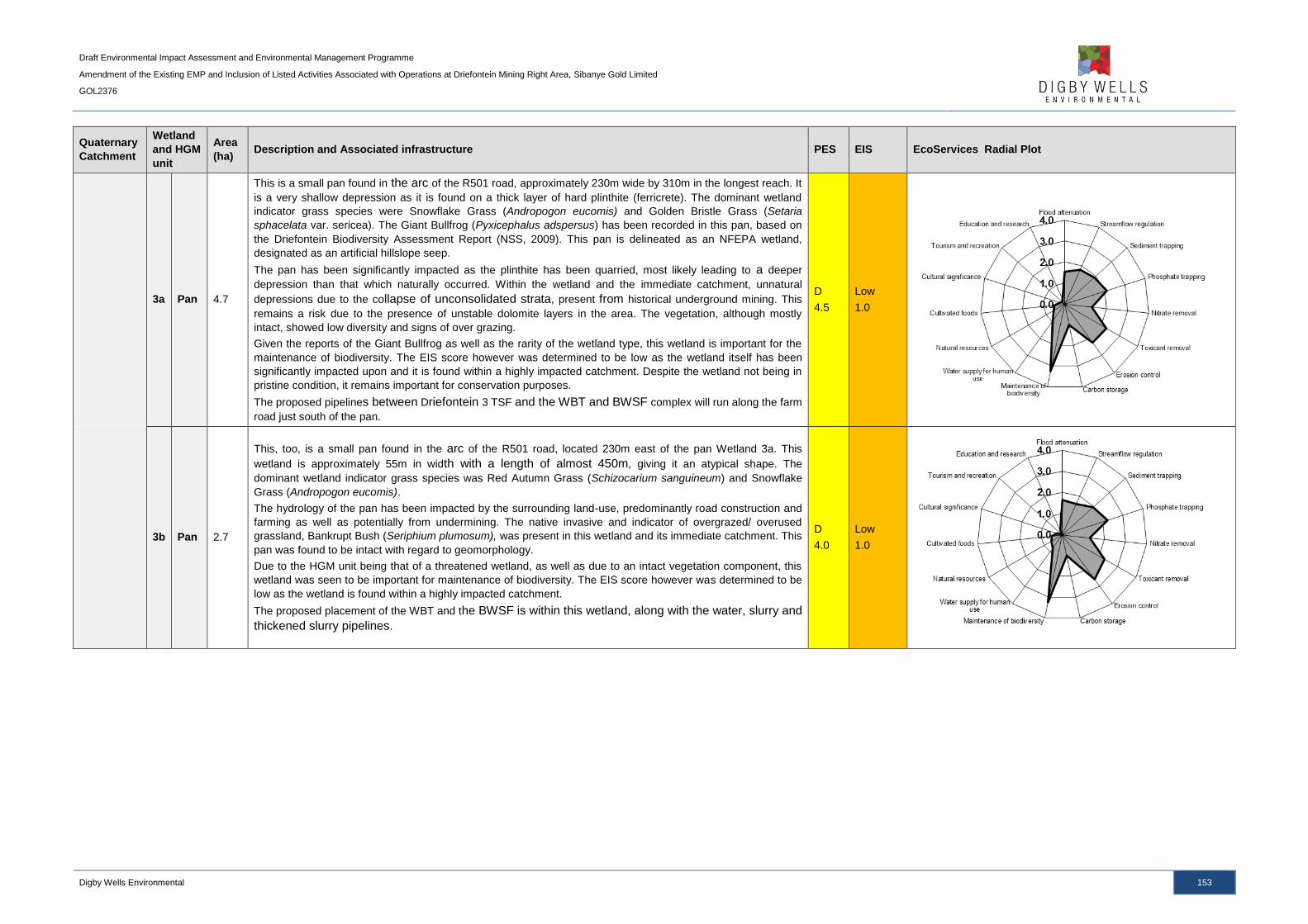
Draft Environmental Impact Assessment and Environmental Management Programme
Amendment of the Existing EMP and Inclusion of Listed Activities Associated with Operations at Driefontein Mining Right Area, Sibanye Gold Limited
GOL2376
Digby Wells Environmental 153
Quaternary
Catchment
Wetland
and HGM
unit
Area
(ha) Description and Associated infrastructure PES EIS EcoServices Radial Plot
3a Pan 4.7
This is a small pan found in the arc of the R501 road, approximately 230m wide by 310m in the longest reach. It
is a very shallow depression as it is found on a thick layer of hard plinthite (ferricrete). The dominant wetland
indicator grass species were Snowflake Grass (Andropogon eucomis) and Golden Bristle Grass (Setaria
sphacelata var. sericea). The Giant Bullfrog (Pyxicephalus adspersus) has been recorded in this pan, based on
the Driefontein Biodiversity Assessment Report (NSS, 2009). This pan is delineated as an NFEPA wetland,
designated as an artificial hillslope seep.
The pan has been significantly impacted as the plinthite has been quarried, most likely leading to a deeper
depression than that which naturally occurred. Within the wetland and the immediate catchment, unnatural
depressions due to the collapse of unconsolidated strata, present from historical underground mining. This
remains a risk due to the presence of unstable dolomite layers in the area. The vegetation, although mostly
intact, showed low diversity and signs of over grazing.
Given the reports of the Giant Bullfrog as well as the rarity of the wetland type, this wetland is important for the
maintenance of biodiversity. The EIS score however was determined to be low as the wetland itself has been
significantly impacted upon and it is found within a highly impacted catchment. Despite the wetland not being in
pristine condition, it remains important for conservation purposes.
The proposed pipelines between Driefontein 3 TSF and the WBT and BWSF complex will run along the farm
road just south of the pan.
D
4.5
Low
1.0
3b Pan 2.7
This, too, is a small pan found in the arc of the R501 road, located 230m east of the pan Wetland 3a. This
wetland is approximately 55m in width with a length of almost 450m, giving it an atypical shape. The
dominant wetland indicator grass species was Red Autumn Grass (Schizocarium sanguineum) and Snowflake
Grass (Andropogon eucomis).
The hydrology of the pan has been impacted by the surrounding land-use, predominantly road construction and
farming as well as potentially from undermining. The native invasive and indicator of overgrazed/ overused
grassland, Bankrupt Bush (Seriphium plumosum), was present in this wetland and its immediate catchment. This
pan was found to be intact with regard to geomorphology.
Due to the HGM unit being that of a threatened wetland, as well as due to an intact vegetation component, this
wetland was seen to be important for maintenance of biodiversity. The EIS score however was determined to be
low as the wetland is found within a highly impacted catchment.
The proposed placement of the WBT and the BWSF is within this wetland, along with the water, slurry and
thickened slurry pipelines.
D
4.0
Low
1.0

Draft Environmental Impact Assessment and Environmental Management Programme
Amendment of the Existing EMP and Inclusion of Listed Activities Associated with Operations at Driefontein Mining Right Area, Sibanye Gold Limited
GOL2376
Digby Wells Environmental 154
Quaternary
Catchment
Wetland
and HGM
unit
Area
(ha) Description and Associated infrastructure PES EIS EcoServices Radial Plot
C23D
4 VB 154.3
This is an unchannelled valley bottom system associated with the Bank Fault Spruit, which leads to the
Wonderfonteinspruit. The wetland indicator grass species present was Red Autumn Grass (Schizocarium
sanguineum) and Garden Bristle Grass (Setaria pumila). The natural vegetation wetland indicators, however,
were difficult to identify in many places due to the land-use impacts that have led to long-term vegetation
changes, which mainly included grazing and intense agriculture.
The wetland and its immediate catchment are dominated by farming activities that have significantly impacted on
the natural vegetation. The farming activities mainly include maize (Zea mays) crops and cattle farming. In
addition, this wetland has been affected by surrounding infrastructure (including a large sub-station) and
damming of the water flow. The common invasive species of impacted wetlands, Garden Cosmos (Cosmos
bipinnatus), is dominant in many parts of the wetland.
The most important service provided by this wetland is that of streamflow regulation as it is associated with the
Bank Fault Spruit. The wetland is highly transformed from its natural state with respect to hydrology and
vegetation and therefore plays little to no role in maintenance of biodiversity. The wetland has scored low on the
EIS rating.
This wetland will potentially interact with two pipelines of the project, being the tailings pipeline from the WBT to
the CPP and the water pipeline running along the R501 from K10 shaft to the BWSF. The tailings pipeline to the
CPP has two alternative routes; both routes are designated to cross this wetland.
D
5.6
Low
1.0
5 VB 25.1
This is a small unchannelled valley bottom wetland, which appears to be a leading towards the Wetland 4
associated with Bank Fault Spruit, which leads to the Wonderfonteinspruit. Wetland vegetation found in this
wetland includes Common Reed (Phragmites australis) and Yellow Nut Sedge (Cyperus esculentus). Part of this
wetland has been delineated as an NFEPA wetland and characterised as a natural hillslope seep.
This wetland has been significantly impacted upon by multiple surrounding land-uses, including pipeline routes,
roads and farming. A water pipeline is crossing this wetland, which runs through a maize farm, and was recorded
to be leaking. The pipe has been leaking for a long time through investigation of historical imagery and this has
led to the wetland being greater in extent down gradient of the leak. This has also led to permanently wet
conditions being created that may not be present naturally. Upstream of this wetland there are mining activities,
which appear to be discharging water into this wetland as well through a culvert under the N12 national road.
This too had led to unnatural permanently wet conditions and a potential decrease in water quality. The
hydrology therefore has been significantly impacted. The vegetation has also been altered significantly from the
natural state as much of the wetland is now under maize farming and other areas are dominated by Phragmites
australis.
The wetland is highly transformed from its natural state with respect to hydrology and vegetation and therefore
plays little to no role in maintenance of biodiversity. The wetland has therefore scored low on the EIS rating.
Streamflow regulation is the major service provided by this wetland.
This wetland will interact with the proposed route of the water pipeline that runs along the R501 road from the
K10 shaft to the BWSF. This same area of contact is had with the alternative route for the thickened slurry
pipeline from the WBT to the CPP.
E
6.1
Low
1.0
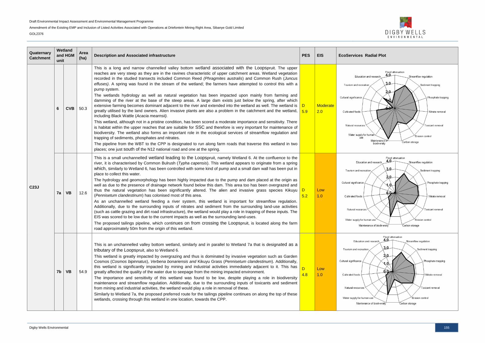
Draft Environmental Impact Assessment and Environmental Management Programme
Amendment of the Existing EMP and Inclusion of Listed Activities Associated with Operations at Driefontein Mining Right Area, Sibanye Gold Limited
GOL2376
Digby Wells Environmental 155
Quaternary
Catchment
Wetland
and HGM
unit
Area
(ha) Description and Associated infrastructure PES EIS EcoServices Radial Plot
C23J
6 CVB 50.3
This is a long and narrow channelled valley bottom wetland associated with the Loopspruit. The upper
reaches are very steep as they are in the ravines characteristic of upper catchment areas. Wetland vegetation
recorded in the studied transects included Common Reed (Phragmites australis) and Common Rush (Juncus
effuses). A spring was found in the stream of the wetland; the farmers have attempted to control this with a
pump system.
The wetlands hydrology as well as natural vegetation has been impacted upon mainly from farming and
damming of the river at the base of the steep areas. A large dam exists just below the spring, after which
extensive farming becomes dominant adjacent to the river and extended into the wetland as well. The wetland is
greatly utilised by the land owners. Alien invasive plants are also a problem in the catchment and the wetland,
including Black Wattle (Acacia mearnsii).
This wetland, although not in a pristine condition, has been scored a moderate importance and sensitivity. There
is habitat within the upper reaches that are suitable for SSC and therefore is very important for maintenance of
biodiversity. The wetland also forms an important role in the ecological services of streamflow regulation and
trapping of sediments, phosphates and nitrates.
The pipeline from the WBT to the CPP is designated to run along farm roads that traverse this wetland in two
places; one just south of the N12 national road and one at the spring.
D
5.9
Moderate
2.0
7a VB 12.6
This is a small unchannelled wetland leading to the Loopspruit, namely Wetland 6. At the confluence to the
river, it is characterised by Common Bulrush (Typha capensis). This wetland appears to originate from a spring
which, similarly to Wetland 6, has been controlled with some kind of pump and a small dam wall has been put in
place to collect this water.
The hydrology and geomorphology has been highly impacted due to the pump and dam placed at the origin as
well as due to the presence of drainage network found below this dam. This area too has been overgrazed and
thus the natural vegetation has been significantly altered. The alien and invasive grass species Kikuyu
(Pennisetum clandestinum) has colonised most of this area.
As an unchannelled wetland feeding a river system, this wetland is important for streamflow regulation.
Additionally, due to the surrounding inputs of nitrates and sediment from the surrounding land-use activities
(such as cattle grazing and dirt road infrastructure), the wetland would play a role in trapping of these inputs. The
EIS was scored to be low due to the current impacts as well as the surrounding land-uses.
The proposed tailings pipeline, which continues on from crossing the Loopspruit, is located along the farm
road approximately 50m from the origin of this wetland.
D
5.2
Low
1.0
7b VB 54.9
This is an unchannelled valley bottom wetland, similarly and in parallel to Wetland 7a that is designated as a
tributary of the Loopspruit, also to Wetland 6.
This wetland is greatly impacted by overgrazing and thus is dominated by invasive vegetation such as Garden
Cosmos (Cosmos bipinnatus), Verbena bonariensis and Kikuyu Grass (Pennisetum clandestinum). Additionally,
this wetland is significantly impacted by mining and industrial activities immediately adjacent to it. This has
greatly affected the quality of the water due to seepage from the mining impacted environment.
The importance and sensitivity of this wetland was found to be low, despite playing a role in biodiversity
maintenance and streamflow regulation. Additionally, due to the surrounding inputs of toxicants and sediment
from mining and industrial activities, the wetland would play a role in removal of these.
Similarly to Wetland 7a, the proposed preferred route for the tailings pipeline continues on along the top of these
wetlands, crossing through this wetland in one location, towards the CPP.
D
4.8
Low
1.0

Draft Environmental Impact Assessment and Environmental Management Programme
Amendment of the Existing EMP and Inclusion of Listed Activities Associated with Operations at Driefontein Mining Right Area, Sibanye Gold Limited
GOL2376
Digby Wells Environmental 156
Quaternary
Catchment
Wetland
and HGM
unit
Area
(ha) Description and Associated infrastructure PES EIS EcoServices Radial Plot
C22J
8 CVB 754.3
This is a channelled valley bottom system associated with the Leeuspruit. Wetland vegetation recorded in the
studied transects included Common Reed (Phragmites australis), Common Bulrush (Typha capensis) and
Common Rush (Juncus effuses).
This river and wetland are greatly impacted by the surrounding mining and industrial activities as well as farming
practices. This includes impacts to the hydrology due to the river being dammed multiple times in the upper
reaches, as well as significant impacts to the natural vegetation as dense stands of alien invasive trees are
present within the wetland and the catchment, mainly Black Wattle (Acacia mearnsii). The industrial and
agricultural land-uses in the catchment of the Leeuspruit have led to the water quality being significantly
compromised as well as over sedimentation occurring due to erosion. This leads to the characteristic
dominance of parts of the wetland and stream by the Common Reed (Phragmites australis) and Common
Bulrush (Typha capensis).
The EIS of this wetland was determined to be moderate as the Leeuspruit is an important tributary to the Vaal
River. The system plays an important role in water supply for human use. There is diversity within the system
that would support important species and thus the wetland plays a role in the maintenance of biodiversity. As a
main river system, the wetland is also playing an important service for streamflow regulation and trapping of
sediments. Although this wetland has received a low health state of D (largely modified), it is still a very
important wetland and river and all efforts to protect and rehabilitate it should be done.
D
5.3
Moderate
2.0
9a VB 22.1
This is an unchannelled valley bottom wetland leading eastwards towards Wetland 8, associated with the
Leeuspruit.
This wetland has been significantly impacted by the surrounding land-uses, which are dominated by mining and
related activities, industrial activities, farming and grazing as well as road infrastructure. Through analysis of
historical imagery, there is evidence of mining of this wetland. Upon investigation with a hand auger, it was found
that a layer of approximately 10cm of tailings material is found within the soil profile. Planted rows of grasses
indicate that this area has undergone rehabilitation. Further downstream, this wetland has been dammed many
times before it reaches the Leeuspruit main channel, Wetland 8. All aspects of this wetland, being hydrology,
geomorphology and the natural vegetation have been significantly impacted in parts of this wetland.
Given the above described impacts, the wetland was found to be of a low importance and sensitivity and a
health state of E (significantly modified). The ecological services provided by this wetland have been
compromised and thus it plays a small role in streamflow regulation and toxicant removal where vegetation is
intact.
E
6.5
Low
1.0

Draft Environmental Impact Assessment and Environmental Management Programme
Amendment of the Existing EMP and Inclusion of Listed Activities Associated with Operations at Driefontein Mining Right Area, Sibanye Gold Limited
GOL2376
Digby Wells Environmental 157
Quaternary
Catchment
Wetland
and HGM
unit
Area
(ha) Description and Associated infrastructure PES EIS EcoServices Radial Plot
9b VB 49.8
This wetland consists of two unchannelled valley bottom wetlands, leading westwards towards Wetland 8,
associated with the Leeuspruit.
The natural vegetation of the wetlands is impacted by the surrounding land uses which are predominantly cattle
grazing, infrastructure and mining related activities. An existing pipeline runs through both the wetlands and was
found to be leaking at a point in the one wetland (26°25'6.25"S; 27°36'46.69"E). The pipe appears to have been
leaking for a significant time period through investigation of historical imagery. This has also led to permanently
wet conditions being created that may not be present naturally, thus altering the natural hydrological conditions
of the wetland. Industrial activities and infrastructure is found upstream of and around these wetlands; which
include a TSF, substation and processing plant; this impacts on the water quality.
Due to the current impacts, the wetlands were found to be of low ecological importance and their main ecological
services provided are trapping and some removal of the toxicants and sediments that are unnatural fed to this
system due to the surround land-use impacts. The wetland, too, would play a role in maintenance of biodiversity
as it is a sensitive ecological system and is a tributary of the Leeuspruit.
D
5.2
Low
1.0
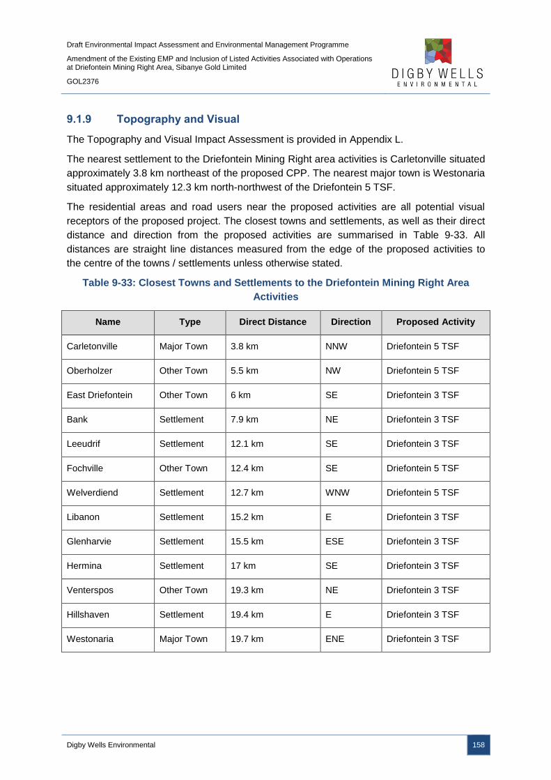
Draft Environmental Impact Assessment and Environmental Management Programme
Amendment of the Existing EMP and Inclusion of Listed Activities Associated with Operations at Driefontein Mining Right Area, Sibanye Gold Limited
GOL2376
Digby Wells Environmental 158
9.1.9 Topography and Visual
The Topography and Visual Impact Assessment is provided in Appendix L.
The nearest settlement to the Driefontein Mining Right area activities is Carletonville situated
approximately 3.8 km northeast of the proposed CPP. The nearest major town is Westonaria
situated approximately 12.3 km north-northwest of the Driefontein 5 TSF.
The residential areas and road users near the proposed activities are all potential visual
receptors of the proposed project. The closest towns and settlements, as well as their direct
distance and direction from the proposed activities are summarised in Table 9-33. All
distances are straight line distances measured from the edge of the proposed activities to
the centre of the towns / settlements unless otherwise stated.
Table 9-33: Closest Towns and Settlements to the Driefontein Mining Right Area
Activities
Name Type Direct Distance Direction Proposed Activity
Carletonville Major Town 3.8 km NNW Driefontein 5 TSF
Oberholzer Other Town 5.5 km NW Driefontein 5 TSF
East Driefontein Other Town 6 km SE Driefontein 3 TSF
Bank Settlement 7.9 km NE Driefontein 3 TSF
Leeudrif Settlement 12.1 km SE Driefontein 3 TSF
Fochville Other Town 12.4 km SE Driefontein 5 TSF
Welverdiend Settlement 12.7 km WNW Driefontein 5 TSF
Libanon Settlement 15.2 km E Driefontein 3 TSF
Glenharvie Settlement 15.5 km ESE Driefontein 3 TSF
Hermina Settlement 17 km SE Driefontein 3 TSF
Venterspos Other Town 19.3 km NE Driefontein 3 TSF
Hillshaven Settlement 19.4 km E Driefontein 3 TSF
Westonaria Major Town 19.7 km ENE Driefontein 3 TSF
Draft Environmental Impact Assessment and Environmental Management Programme
Amendment of the Existing EMP and Inclusion of Listed Activities Associated with Operations at Driefontein Mining Right Area, Sibanye Gold Limited
GOL2376
Digby Wells Environmental 159
The N12 national route is situated 5.7 km south and 7.8 km south of the Driefontein 5 TSF
and the Driefontein 3 TSF respectively. The R500 regional road runs east of the Driefontein
5 TSF and the R501 regional road runs adjacent to the north of the Driefontein 5 TSF. The
Driefontein 3 and 5 TSFs cover an area of 125.7 ha and 101.2 ha respectively.
The Driefontein 3 TSF is situated on a relatively flat area with a ridge to the south, with the
Driefontein 5 TSF situated almost entirely surrounded by ridges with the exception of a small
area on the north-western side.
The receiving environment of the Driefontein Mining Right area can be described as having
low scenic, cultural or historical significance and is characterised by a mixture of residential
areas, small holdings, agriculture and open land interspersed with large areas disturbed by
mining.
The topography of the Driefontein Mining Right area is undulating with ridges and valleys.
The elevation of the Driefontein Mining Right area increases from 1 529 m above mean sea
level (mamsl) on the upper slopes of the Mooirivierloop and Wonderfonteinspruit rivers in the
north to 1 765 mamsl along the east-west ridge located in the centre of the Mining Right
area. The elevation decreases again towards the southern sections of the Mining Right area
to approximately 1 549 mamsl in the Loopspruit valley.
The majority of the Driefontein Mining Right area has gentle slopes less than 5.6°, with
steeper slopes between 5.7° and 17.2° occurring in isolated areas along the ridges and
valleys.
9.1.10 Noise
A Noise Impact Assessment is included in Appendix M.
9.1.10.1 Current Ambient Noise
The current noise soundscape of the WRTRP area has been characterised by means of
baseline noise measurements near the major noise emitting components from the WRTRP.
The measurements were carried out in accordance with the Gauteng Noise Control
Regulations. The measured baseline will be compared to the guidelines of the SANS
10103:2008 which compares environmental noise with respect to annoyance and speech
communication. The SANS 10103:2008 noise level guidelines for districts is provided in
Table 9-34.

Draft Environmental Impact Assessment and Environmental Management Programme
Amendment of the Existing EMP and Inclusion of Listed Activities Associated with Operations at Driefontein Mining Right Area, Sibanye Gold Limited
GOL2376
Digby Wells Environmental 160
Table 9-34: Acceptable Rating Levels for Noise in Districts (SANS 10103:2008)
Type of District
Equivalent continuous rating level (LReg.T) for noise (dBA)
Outdoors Indoors, with open windows
Day-night Day-time Night-time Day-night Day-time Night-time
LR,dna LReq,d
b LReq,n
b LR,dn
a LReq,d
b LReq,n
b
RESIDENTIAL DISTRICTS
a) Rural districts 45 45 35 35 35 25
b) Suburban districts
with little road traffic 50 50 40 40 40 30
c) Urban districts 55 55 45 45 45 35
NON-RESIDENTIAL DISTRICTS
d) Urban districts with
some workshops, with
business premises,
and with main roads
60 60 50 50 50 40
e) Central business
districts 65 65 55 55 55 45
f) Industrial districts 70 70 60 60 60 50
NOTE 1 If the measurement or calculation time interval is considerably shorter than the reference
time intervals, significant deviations from the values given in the table might result.
NOTE 2 If the spectrum of the sound contains significant low frequency components, or when an
unbalanced spectrum towards the low frequencies is suspected, special precautions should be taken
and specialist advice should be obtained. In this case the indoor sound levels might significantly differ
from the values given in columns 5 to 7.
NOTE 3 In districts where outdoor LR,dn exceeds 55 dBA, residential buildings (e.g. dormitories, hotel
accommodation and residences) should preferably be treated acoustically to obtain indoor LReq,T
values in line with those given in table 1.
NOTE 4 For industrial districts, the LR,dn concept does not necessarily hold. For industries legitimately
operating in an industrial district during the entire 24 h day/night cycle, LReq,d = LReq,n =70 dBA can
be considered as typical and normal.
NOTE 5 The values given in columns 2 and 5 in this table are equivalent continuous rating levels and
include corrections for tonal character, impulsiveness of the noise and the time of day.
NOTE 6 The noise from individual noise sources produced, or caused to be produced, by humans
within natural quiet spaces such as national parks, wilderness areas and bird sanctuaries, should not
exceed a maximum Weighted sound pressure level of 50 dBA at a distance of 15 m from each
individual source.

Draft Environmental Impact Assessment and Environmental Management Programme
Amendment of the Existing EMP and Inclusion of Listed Activities Associated with Operations at Driefontein Mining Right Area, Sibanye Gold Limited
GOL2376
Digby Wells Environmental 161
Type of District
Equivalent continuous rating level (LReg.T) for noise (dBA)
Outdoors Indoors, with open windows
Day-night Day-time Night-time Day-night Day-time Night-time
LR,dna LReq,d
b LReq,n
b LR,dn
a LReq,d
b LReq,n
b
a The values given in columns 2 and 5 are equivalent continuous rating levels and include corrections
for tonal character and impulsiveness of the noise and the time of day.
b The values given in columns 3, 4, 6 and 7 are equivalent continuous rating levels and include
corrections for tonal character and impulsiveness.
The noise monitoring locations are provided in Plan 21 and Table 9-35. The criteria used to
site the measurement locations include:
■ The locations nearest noise sensitive receptors to the proposed CPP and RTSF, as
well as the Driefontein 3 and 5 TSFs; and
■ The locations served as suitable reference points for the measurement of ambient
sound levels surrounding the proposed project area. The noise measurement
locations cover rural as well as suburban and urban areas that represent a
comprehensive soundscape of the area.
Table 9-35: Noise Measurement Locations
Site ID Farm/location Category of
Receiver GPS Coordinates
N1 Leslie Williams Private Hospital Urban/industrial 26° 24.077'S & 27° 25.322'E
N2 Wildebeestkuil 360 IQ portion 6 Rural 26° 28.459'S & 27° 36.615'E
N3 Letsatsing Village Suburban 26°15'17.95"S &
28°29'22.04"E
N4 Rietfontein 349 IQ portion 42 Rural 26° 25.346'S & 27° 37.832'E

Draft Environmental Impact Assessment and Environmental Management Programme
Amendment of the Existing EMP and Inclusion of Listed Activities Associated with Operations at Driefontein Mining Right Area, Sibanye Gold Limited
GOL2376
Digby Wells Environmental 162
Plan 21: Noise Monitoring Locations

Draft Environmental Impact Assessment and Environmental Management Programme
Amendment of the Existing EMP and Inclusion of Listed Activities Associated with Operations at Driefontein Mining Right Area, Sibanye Gold Limited
GOL2376
Digby Wells Environmental 163
The results from the noise meter recordings for all the sampled points as well as the rating
limits according to the SANS 10103:2008 guidelines are presented in Table 9-36.
Table 9-36: Results of the Baseline Noise Measurements
Sample
ID
SANS 10103:2008 Rating Limit
Type of
district Period
Acceptable
rating level dBA
LAreq,T
dBA
Maximum/Minimum
dBA Date
N1 Urban
Daytime 60 52 80/ 39 23/02/2015
Night
time 50 52 68 / 41 23/02/2015
N2 Rural
Daytime 45 51 87 / 29 26/02/2015
Night
time 35 43 67 / 28 26/02/2015
N3 Suburban
Daytime 50 44 77 / 38 02/03/2015
Night
time 40 40 66 / 37 02/03/2015
N4 Rural
Daytime 45 45 72 / 29 05/03/2015
Night
time 35 48 70 / 37 05/03/2015
Indicates current LAeq,T levels above either the daytime rating limit or the night time rating
limit

Draft Environmental Impact Assessment and Environmental Management Programme
Amendment of the Existing EMP and Inclusion of Listed Activities Associated with Operations at Driefontein Mining Right Area, Sibanye Gold Limited
GOL2376
Digby Wells Environmental 164
Figure 9-3: Noise Time History Graph for Monitoring Site N1
-----------------------------------Daytime---------------------------------- ----------------------Night time-----------------------
-----------
-------Daytime-------
----------------------
----
Daytime limit (Urban)
Night time limit (Urban)
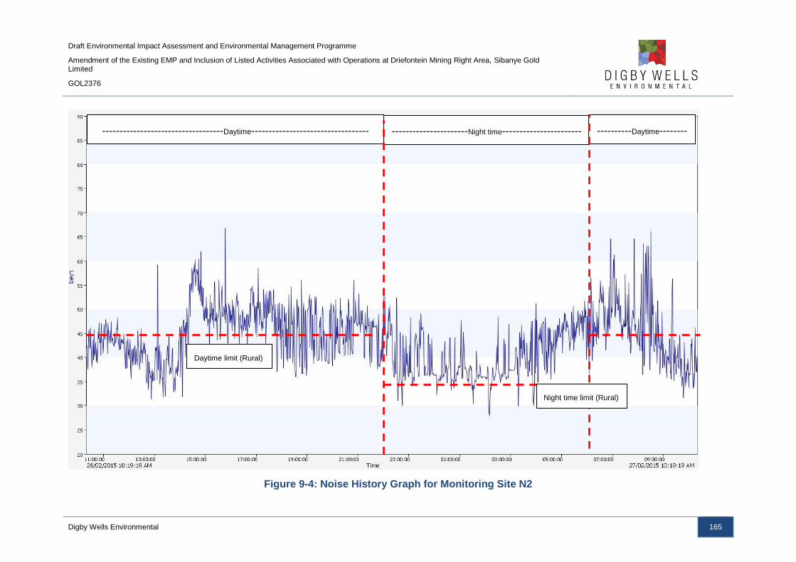
Draft Environmental Impact Assessment and Environmental Management Programme
Amendment of the Existing EMP and Inclusion of Listed Activities Associated with Operations at Driefontein Mining Right Area, Sibanye Gold Limited
GOL2376
Digby Wells Environmental 165
Figure 9-4: Noise History Graph for Monitoring Site N2
-----------------------------------Daytime---------------------------------- ----------------------Night time-----------------------
-----------
----------Daytime--------
-------------------------
Night time limit (Rural)
Daytime limit (Rural)

Draft Environmental Impact Assessment and Environmental Management Programme
Amendment of the Existing EMP and Inclusion of Listed Activities Associated with Operations at Driefontein Mining Right Area, Sibanye Gold Limited
GOL2376
Digby Wells Environmental 166
Figure 9-5: Noise History Graph for Monitoring Site N3
-----------------------------------Daytime---------------------------------- ----------------------Night time----------------------
------------
------------Daytime-----------
----------------------
Daytime limit (Suburban)
Night time limit (Suburban)
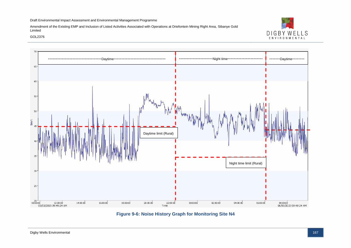
Draft Environmental Impact Assessment and Environmental Management Programme
Amendment of the Existing EMP and Inclusion of Listed Activities Associated with Operations at Driefontein Mining Right Area, Sibanye Gold Limited
GOL2376
Digby Wells Environmental 167
Figure 9-6: Noise History Graph for Monitoring Site N4
-----------------------------------Daytime---------------------------------- ----------------------Night time-----------------------
-----------
-------Daytime--------
-----------------------
--
Daytime limit (Rural)
Night time limit (Rural)
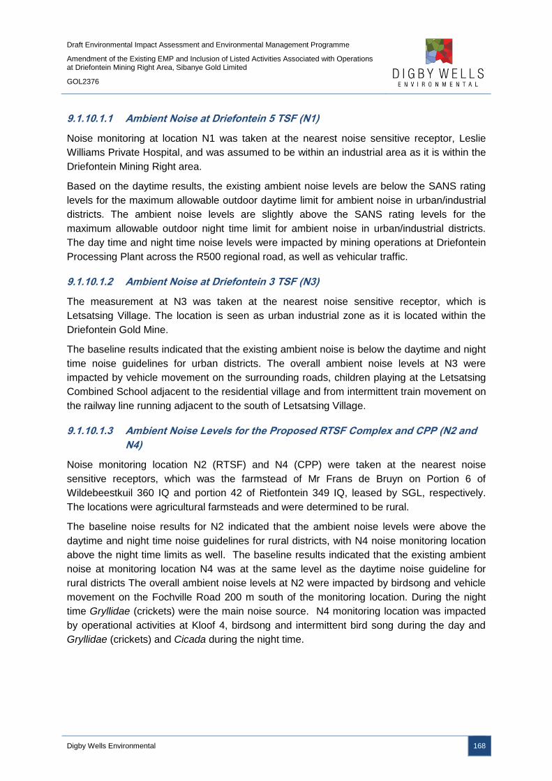
Draft Environmental Impact Assessment and Environmental Management Programme
Amendment of the Existing EMP and Inclusion of Listed Activities Associated with Operations at Driefontein Mining Right Area, Sibanye Gold Limited
GOL2376
Digby Wells Environmental 168
9.1.10.1.1 Ambient Noise at Driefontein 5 TSF (N1)
Noise monitoring at location N1 was taken at the nearest noise sensitive receptor, Leslie
Williams Private Hospital, and was assumed to be within an industrial area as it is within the
Driefontein Mining Right area.
Based on the daytime results, the existing ambient noise levels are below the SANS rating
levels for the maximum allowable outdoor daytime limit for ambient noise in urban/industrial
districts. The ambient noise levels are slightly above the SANS rating levels for the
maximum allowable outdoor night time limit for ambient noise in urban/industrial districts.
The day time and night time noise levels were impacted by mining operations at Driefontein
Processing Plant across the R500 regional road, as well as vehicular traffic.
9.1.10.1.2 Ambient Noise at Driefontein 3 TSF (N3)
The measurement at N3 was taken at the nearest noise sensitive receptor, which is
Letsatsing Village. The location is seen as urban industrial zone as it is located within the
Driefontein Gold Mine.
The baseline results indicated that the existing ambient noise is below the daytime and night
time noise guidelines for urban districts. The overall ambient noise levels at N3 were
impacted by vehicle movement on the surrounding roads, children playing at the Letsatsing
Combined School adjacent to the residential village and from intermittent train movement on
the railway line running adjacent to the south of Letsatsing Village.
9.1.10.1.3 Ambient Noise Levels for the Proposed RTSF Complex and CPP (N2 and
N4)
Noise monitoring location N2 (RTSF) and N4 (CPP) were taken at the nearest noise
sensitive receptors, which was the farmstead of Mr Frans de Bruyn on Portion 6 of
Wildebeestkuil 360 IQ and portion 42 of Rietfontein 349 IQ, leased by SGL, respectively.
The locations were agricultural farmsteads and were determined to be rural.
The baseline noise results for N2 indicated that the ambient noise levels were above the
daytime and night time noise guidelines for rural districts, with N4 noise monitoring location
above the night time limits as well. The baseline results indicated that the existing ambient
noise at monitoring location N4 was at the same level as the daytime noise guideline for
rural districts The overall ambient noise levels at N2 were impacted by birdsong and vehicle
movement on the Fochville Road 200 m south of the monitoring location. During the night
time Gryllidae (crickets) were the main noise source. N4 monitoring location was impacted
by operational activities at Kloof 4, birdsong and intermittent bird song during the day and
Gryllidae (crickets) and Cicada during the night time.

Draft Environmental Impact Assessment and Environmental Management Programme
Amendment of the Existing EMP and Inclusion of Listed Activities Associated with Operations at Driefontein Mining Right Area, Sibanye Gold Limited
GOL2376
Digby Wells Environmental 169
9.1.11 Heritage
The Heritage Impact Assessment is included as Appendix N.
Geologically, the project area is largely underlain by dolomitic rock that has the potential for
karst topography. Karst topography refers to landscapes formed from the dissolution of
soluble rocks, including dolomite and limestone. Karst topography is characterised by
underground drainage systems with sinkholes, dolines and caves. This geological
phenomenon creates karst caves that can be filled with fine to coarse-grained alluvium
during periodic flooding. The alluvium may be represented by bodies of breccia, sandstone
and siltstone which have an increased potential to contain archaeological material. This
geological feature is one of the motivating factors in implementing the proposed project.
Many of the historical TSFs are at risk as the potential for sinkholes is high in some areas.
Archaeologically, Stone Age and Late Farming Community sites have been recorded within
the larger area under consideration here. Stone Age lithics recorded have been found as
surface scatters outside of any discernible context thereby limiting the information potential
and overall significance of these resources. Late Farming Community sites within the region
have primarily been identified as stone walled settlements classified as Type N and
Klipriviersberg. Only one potential stonewalled site has been identified in the routing option
for the powerlines on the farm Doornpoort 347 IQ Portion 73. No other archaeological sites
have been identified within the development footprint of the proposed infrastructure
associated with the WRTRP.
Within regional, local and site specific contexts, the project is located in historically
significant mining-industrial and agricultural-rural cultural landscapes. In terms of the mining
landscape, there are several features and markers such as many of the historical TSFs
created by the original mines established during the first half of the 20th century. The
agricultural landscape is represented in turn by several structures and werwe that were
recorded during the scoping survey completed on 16 February 2015. The potential impacts
to these will be assessed during the Impact Assessment phase of the project.
9.1.11.1 Driefontein Mining Right Area Heritage Resources
The identified heritage resources associated with the Driefontein Mining Right area are
provided in Plan 22. Five heritage resources were found that may be impacted by the
Driefontein Mining Right area infrastructure and activities. The resources identified have
been deemed to have a negligible cultural significance (Appendix N) and no heritage
resources identified were determined to have cultural significance; no burial grounds or
graves are associated with the Driefontein Mining Right area.
The identified heritage resources, although deemed to have a negligible cultural significance,
are protected under Section 34 of the NHRA and require a destruction permit should the
resources be removed. It is not anticipated that the heritage resources will be required to be
demolished as they are adjacent to the proposed pipeline routes and not within the footprint
areas.

Draft Environmental Impact Assessment and Environmental Management Programme
Amendment of the Existing EMP and Inclusion of Listed Activities Associated with Operations at Driefontein Mining Right Area, Sibanye Gold Limited
GOL2376
Digby Wells Environmental 170
Plan 22: Identified Heritage Resources

Draft Environmental Impact Assessment and Environmental Management Programme
Amendment of the Existing EMP and Inclusion of Listed Activities Associated with Operations at Driefontein Mining Right Area, Sibanye Gold Limited
GOL2376
Digby Wells Environmental 171
9.1.12 Socio-Economic
The Social Impact Assessment for the WRTRP is provided in Appendix O.
The West Rand DM encompasses 2 442 km2 of the province’s land mass and is
predominantly rural. The main economic hubs in the DM are Krugersdorp, Randfontein, and
Westonaria; the dominant land uses in the region include mining, residential, and agriculture.
Developments of residential settlements are concentrated towards the east of the district,
and are reflective of current developmental dynamics and historical patterns and trends. As
a result of the mining activities, and due to the dolomitic nature of the land in the district, land
use patterns are often dispersed. This has meant that major economic centres in the district
take on a fragmented form. In addition to the significant impact mining has had on the
district, tourism and conservation opportunities exist to the north and north-east of the
district, while agricultural holdings in the western side of the district represent possibility for
development of the agricultural sector in the region.
The dispersed main economic centres are linked by various roads and rail routes, which also
provide links to areas beyond the DM. The N14 and N12 form a strong south-east and north-
west linkage, while the R500 provides road connection to the north via the linkage with the
N14. The R512 is the access road to Lanseria airport, and the R559 links Soweto and
Randfontein.
9.1.12.1 Towns, Resources and Land Capabilities
The Westonaria LM, where the CPP and RTSF will be situated, is bordered by the
Randfontein LM, Johannesburg Metropolitan Municipality, Merafong City LM, Sedibeng DM,
and Emfuleni LM. The Driefontein 3 and 5 TSFs, WBT and BWSF complex and associated
infrastructure will be located within the Merafong City LM. The LM’s residential development
is generally dispersed with the dominant townships including:
■ Westonaria;
■ Bekkersdal;
■ Hillshaven;
■ Glenharvie;
■ Venterspost;
■ Simunye; and
■ Mining towns such as Libanon and Waterpan.
The only significant business node occurs within Westonaria and Carletonville towns’ Central
Business District (CBD); the remainder of the LMs is characterised by scattered residential
areas, agriculture and various mining developments. The main reason for the perceived low
population density in the LM is due to the dolomitic conditions in the region. Westonaria and
Carletonville are linked to Johannesburg via the N12; the prominent entrance point into
Draft Environmental Impact Assessment and Environmental Management Programme
Amendment of the Existing EMP and Inclusion of Listed Activities Associated with Operations at Driefontein Mining Right Area, Sibanye Gold Limited
GOL2376
Digby Wells Environmental 172
Johannesburg from Gauteng, various developments are planned for along this route to take
advantage of its strategic positioning.
Land uses in the Merafong City LM can be categorised in three main divisions, i.e.
agriculture, mining, and residential. Agriculture is the dominant land use in the LM, followed
by mining and residential land uses, with the latter accounting for approximately 8% of the
total land area of the LM.
The only notable agricultural holdings areas in the LM are located to the north-eastern and
central parts of the district. The local government, based on the vision of a global city, or the
Unicity, supports future development to the west of the LM. Development on this side of the
LM would mean that the area’s development follows the natural market forces, ensuring that
commercial and industrial developments remain close to the current and future workforces.
The municipality’s human settlements are relatively scattered due to the mining activities
taking place, the prominent settlements are:
■ Fochville;
■ Carletonville;
■ Welverdiend;
■ Greenspark;
■ Wedela;
■ Blyblank;
■ Khutsong; and
■ Kokosi.
Carletonville is located centrally in the Merafong City LM. The Carletonville-Khutsong-
Welverdiend area is also the LM’s most populous region. The townships of Kokosi and
Graanspark and the relatively wealthier Fochville is located to the south of Carletonville, with
the central part of the LM being characterised by mining activities and the associated
scattered housing developments. As with the rest of the West Rand mining belt, the LM’s
infrastructure development is hindered by the high occurrence of dolomite.
The economy of Merafong is dominated by the mining activities, which has led to the
development of dispersed human settlements leading to a loss of purchasing power across
the region as central town functions are not well developed in the LM.
9.1.12.2 Demographic Profile and Income Levels
Based on a combined population of 333 444, the Westonaria and Merafong City LMs
comprise just about 40.1% of the West Rand DM’s total population, which was estimated at
831 241 individuals in 2013. The average household size in the DM is 2.8. Based on Census
2011 (Stats SA, 2015), approximately 65% of households in the district are living in formal
residential properties; the remaining 35% reside in informal or traditional dwellings. In South

Draft Environmental Impact Assessment and Environmental Management Programme
Amendment of the Existing EMP and Inclusion of Listed Activities Associated with Operations at Driefontein Mining Right Area, Sibanye Gold Limited
GOL2376
Digby Wells Environmental 173
Africa, approximately 71% of households reside in formal residences (Stats SA, 2015).
Traditionally, smaller household sizes are indicative of an increase in development, however,
based on the relatively high number of households living in informal dwellings and
considering the fact that the region is classed as a mining region it can be assumed that in
this case the smaller household size is rather a result of migrant workers working or
searching for opportunities, with the aim of sending money home to their families.
The male population of the West Rand DM exceeds the female population at 52% versus the
48% females residing in the region (Stats SA, 2015). The fact that 71% of the DM’s
population is of working age (Stats SA, 2015), i.e. between the ages of 15 and 65, could be
seen as an additional indicator of the fact that the area attracts migrant workers. Moreover,
in the two local municipalities within which Phase 2 of the project will be located an even
higher number of individuals are of working age with 73.3% in the Westonaria LM, and
72.6% in the Merafong City LM (Stats SA, 2015).
Within the Westonaria and Merafong City LM’s, the proportion of the population aged 20 and
older with no education is greater than in the district, with 6.2% and 6% versus the 5.0%
observed in the DM (Stats SA, 2015). Furthermore, the percentages of individuals who have
obtained a matric qualification in these local municipalities are also below that of the district,
province, and even South Africa.
The average income within the Westonaria and Merafong City LMs were significantly lower
than that of the other study areas at R5 597 and R6 625 per month (in 2011 in current
prices), respectively (based on Stats SA, 2015).
9.1.12.3 Economy and Sectoral Structure
In 2013, the economies of the Westonaria and Merafong City LM’s represented 35.8% of the
total GDP of the West Rand DM, which was valued at R61 466 million (2013 prices).
Between 2003 and 2013, the West Rand DM economy has been growing at a Compounded
Annual Growth Rate (CAGR) of 1.1% per year.
The West Rand economy is primarily based on the tertiary services with 66.7% of its GDP
being generated by industries in this sector. Finance and personal services, as well as
government services are the major contributors to the Western Rand economy. Its
dependency on mining though is also quite substantial as the mining sector contributed
11.2% of GDP in the district. It should be noted that manufacturing is also quite prominent in
the West Rand economy with 15.7% contribution to its GDP.
The Westonaria and Merafong City economies though are far more dependent on the mining
industry than the district in general.
9.1.12.4 Labour Force and Employment Structure
In South Africa, the unemployment rate is defined as comprising of those individuals aged
between 16 and 65 years old, actively looking for employment that are unable to find gainful
opportunities; it therefore does not take into consideration discouraged job seekers. Based
Draft Environmental Impact Assessment and Environmental Management Programme
Amendment of the Existing EMP and Inclusion of Listed Activities Associated with Operations at Driefontein Mining Right Area, Sibanye Gold Limited
GOL2376
Digby Wells Environmental 174
on Stats SA’s Census 2011 data, the West Rand DM had 590 206 individuals of working age
in 2011 with 3.3% of these individuals being discouraged job seekers. The situation was
slightly worse in the Westonaria and Merafong City LMs, where 4.1% and 3.6% respectively
of the working age population groups were discouraged job seekers; however, it was still
better than at the national level where the figure was 5.5% (Stats SA, 2015).
The labour force participation rate in the West Rand DM was estimated at 56.9% in 2013.
The unemployment rate in the West Rand DM was 24.4% in 2013. In the Westonaria LM,
unemployment was recorded at 42.0%, while the Merafong City LM recorded an
unemployment rate of 21.1%.
Between 2003 and 2013, the economy of Westonaria, due to the share decline in its mining
sector’s production output lost over 24 thousand employment opportunities. At the same
time, the Merafong City economy managed to increase its employment by over five
thousand people during the same period, despite experiencing negative economic growth
rate. This means that the losses in the mining sector’s employment due to the contraction of
that industry in the Merafong City LM were possible to offset by the increased employment in
other industries.
In the West Rand DM, 75.3% of jobs are formal employment opportunities, while in the LMs
formal employment opportunities comprise even a greater percentage, i.e. 81.5% and 80.5%
in the Westonaria and Merafong City LMs, respectively (Quantec Research, 2015). At the
same time, it is estimated that 2.4% of those employed in the West Rand DM are working in
private households.
It is estimated that just about two thirds of all employment opportunities within the DM are
created by the tertiary sector. Mining provides 15.0% of employment opportunities in the
West Rand DM.
Within the Westonaria LM the importance of the mining sector for job security is significantly
greater than in the district, as it provides 36.7% of opportunities in the LM’s economy. It
again shows the economy’s reliance on the mining sector. In 2003, though, the mining sector
contributes 74.2% of all jobs created in Westonaria; at the same time, though, the total
employment in the local area was 51 409.
In the Merafong City LM, the employment structure was largely skewed towards the tertiary
and mining industries. The mining sector created 42.7% of all employment opportunities in
this economy in 2013 with the tertiary industries accounting for 48.8%. Unlike the situation
observed in the Westonaria LM, employment in mining has increased between 2003 and
2013 despite the sector experiencing decline post 2008 period. Losses in employment in
agriculture, manufacturing and finance and business service, though offset some of the
employment gained during that period in mining and other industries.
9.1.12.5 Driefontein Mining Right Area
Major land uses within the Driefontein Mining Right area mirror the land uses for the region
and include agriculture, grazing, residential, mining and business uses. Residential land use

Draft Environmental Impact Assessment and Environmental Management Programme
Amendment of the Existing EMP and Inclusion of Listed Activities Associated with Operations at Driefontein Mining Right Area, Sibanye Gold Limited
GOL2376
Digby Wells Environmental 175
comprises both formal and informal uses. Formal structures are either occupied by land
users who rent properties from mining companies and farm owners, or landowning families
farming on privately owned property.
Agricultural activities within the area comprise commercial maize and soya farming, as well
as livestock grazing. Livestock, mostly cattle, also graze throughout the Mining Right area.
An overview of the land owners and land use within the affected properties associated with
the Driefontein Mining Right area infrastructure are provided in Table 9-37.
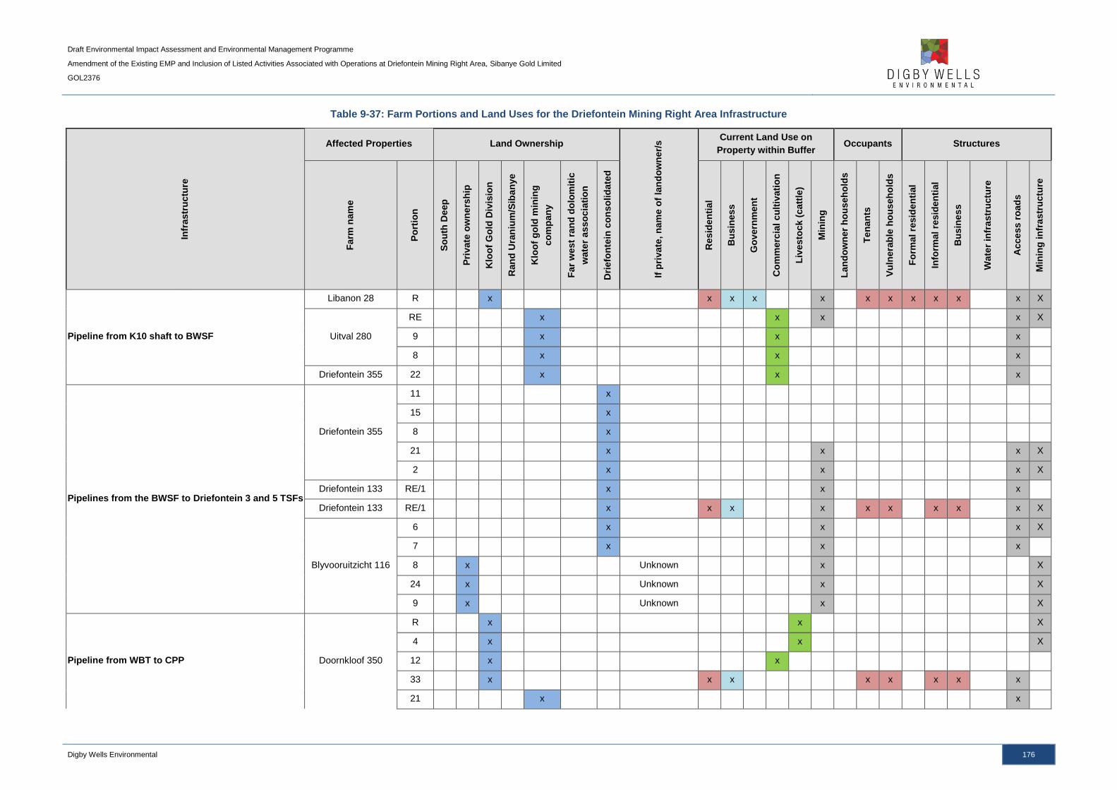
Draft Environmental Impact Assessment and Environmental Management Programme
Amendment of the Existing EMP and Inclusion of Listed Activities Associated with Operations at Driefontein Mining Right Area, Sibanye Gold Limited
GOL2376
Digby Wells Environmental 176
Table 9-37: Farm Portions and Land Uses for the Driefontein Mining Right Area Infrastructure
Infr
astr
uctu
re
Affected Properties Land Ownership
If p
rivate
, n
am
e o
f la
nd
ow
ner/
s Current Land Use on
Property within Buffer Occupants Structures
Farm
nam
e
Po
rtio
n
So
uth
Deep
Pri
vate
ow
ne
rsh
ip
Klo
of
Go
ld D
ivis
ion
Ran
d U
ran
ium
/Sib
an
ye
Klo
of
go
ld m
inin
g
co
mp
an
y
Far
west
ran
d d
olo
mit
ic
wate
r a
sso
cia
tio
n
Dri
efo
nte
in c
on
so
lid
ate
d
Resid
en
tia
l
Bu
sin
es
s
Go
vern
men
t
Co
mm
erc
ial
cu
ltiv
ati
on
Liv
esto
ck
(catt
le)
Min
ing
Lan
do
wn
er
ho
useh
old
s
Ten
an
ts
Vu
lnera
ble
ho
us
eh
old
s
Fo
rmal re
sid
en
tial
Info
rmal re
sid
en
tial
Bu
sin
es
s
Wate
r in
fra
str
uctu
re
Acce
ss r
oad
s
Min
ing
in
fra
str
uctu
re
Pipeline from K10 shaft to BWSF
Libanon 28 R x x x x x x x x x x x X
Uitval 280
RE x x x x X
9 x x x
8 x x x
Driefontein 355 22 x x x
Pipelines from the BWSF to Driefontein 3 and 5 TSFs
Driefontein 355
11 x
15 x
8 x
21 x x x X
2 x x x X
Driefontein 133 RE/1 x x x
Driefontein 133 RE/1 x x x x x x x x x X
Blyvooruitzicht 116
6 x x x X
7 x x x
8 x Unknown x X
24 x Unknown x X
9 x Unknown x X
Pipeline from WBT to CPP Doornkloof 350
R x x X
4 x x X
12 x x
33 x x x x x x x x
21 x x
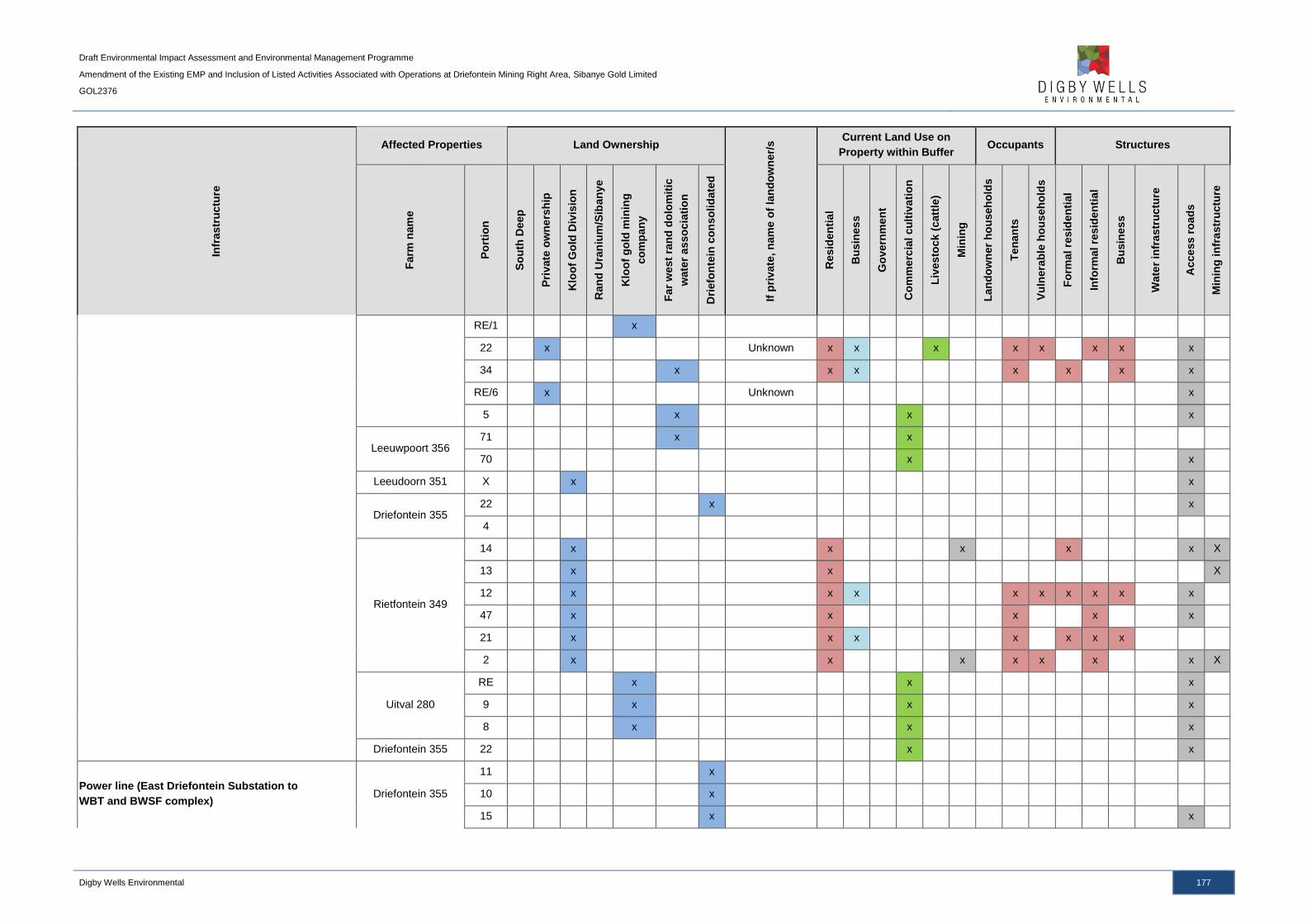
Draft Environmental Impact Assessment and Environmental Management Programme
Amendment of the Existing EMP and Inclusion of Listed Activities Associated with Operations at Driefontein Mining Right Area, Sibanye Gold Limited
GOL2376
Digby Wells Environmental 177
Infr
astr
uctu
re
Affected Properties Land Ownership
If p
rivate
, n
am
e o
f la
nd
ow
ner/
s Current Land Use on
Property within Buffer Occupants Structures
Farm
nam
e
Po
rtio
n
So
uth
Deep
Pri
vate
ow
ne
rsh
ip
Klo
of
Go
ld D
ivis
ion
Ran
d U
ran
ium
/Sib
an
ye
Klo
of
go
ld m
inin
g
co
mp
an
y
Far
west
ran
d d
olo
mit
ic
wate
r a
sso
cia
tio
n
Dri
efo
nte
in c
on
so
lid
ate
d
Resid
en
tia
l
Bu
sin
es
s
Go
vern
men
t
Co
mm
erc
ial
cu
ltiv
ati
on
Liv
esto
ck
(catt
le)
Min
ing
Lan
do
wn
er
ho
useh
old
s
Ten
an
ts
Vu
lnera
ble
ho
us
eh
old
s
Fo
rmal re
sid
en
tial
Info
rmal re
sid
en
tial
Bu
sin
es
s
Wate
r in
fra
str
uctu
re
Acce
ss r
oad
s
Min
ing
in
fra
str
uctu
re
RE/1 x
22 x Unknown x x x x x x x x
34 x x x x x x x
RE/6 x Unknown x
5 x x x
Leeuwpoort 356 71 x x
70 x x
Leeudoorn 351 X x x
Driefontein 355 22 x x
4
Rietfontein 349
14 x x x x x X
13 x x X
12 x x x x x x x x x
47 x x x x x
21 x x x x x x x
2 x x x x x x x X
Uitval 280
RE x x x
9 x x x
8 x x x
Driefontein 355 22 x x
Power line (East Driefontein Substation to
WBT and BWSF complex) Driefontein 355
11 x
10 x
15 x x
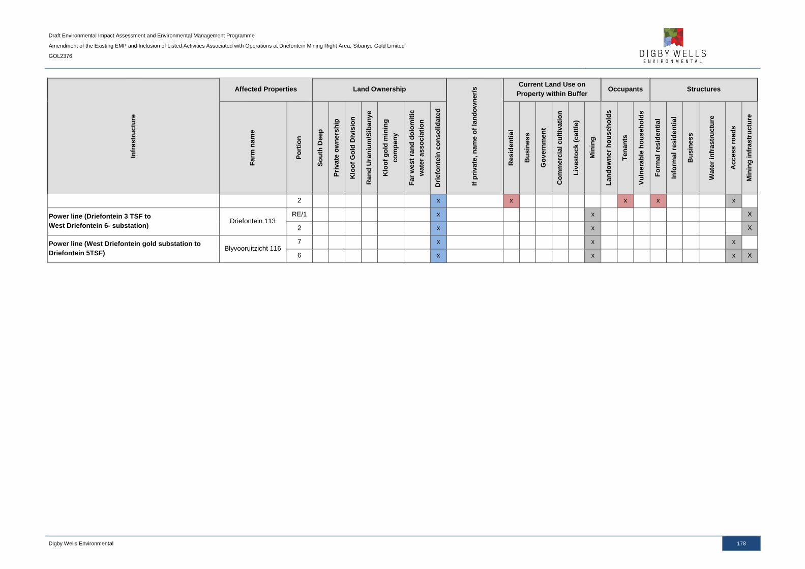
Draft Environmental Impact Assessment and Environmental Management Programme
Amendment of the Existing EMP and Inclusion of Listed Activities Associated with Operations at Driefontein Mining Right Area, Sibanye Gold Limited
GOL2376
Digby Wells Environmental 178
Infr
astr
uctu
re
Affected Properties Land Ownership
If p
rivate
, n
am
e o
f la
nd
ow
ner/
s Current Land Use on
Property within Buffer Occupants Structures
Farm
nam
e
Po
rtio
n
So
uth
Deep
Pri
vate
ow
ne
rsh
ip
Klo
of
Go
ld D
ivis
ion
Ran
d U
ran
ium
/Sib
an
ye
Klo
of
go
ld m
inin
g
co
mp
an
y
Far
west
ran
d d
olo
mit
ic
wate
r a
sso
cia
tio
n
Dri
efo
nte
in c
on
so
lid
ate
d
Resid
en
tia
l
Bu
sin
es
s
Go
vern
men
t
Co
mm
erc
ial
cu
ltiv
ati
on
Liv
esto
ck
(catt
le)
Min
ing
Lan
do
wn
er
ho
useh
old
s
Ten
an
ts
Vu
lnera
ble
ho
us
eh
old
s
Fo
rmal re
sid
en
tial
Info
rmal re
sid
en
tial
Bu
sin
es
s
Wate
r in
fra
str
uctu
re
Acce
ss r
oad
s
Min
ing
in
fra
str
uctu
re
2 x x x x x
Power line (Driefontein 3 TSF to
West Driefontein 6- substation) Driefontein 113
RE/1 x x X
2 x x X
Power line (West Driefontein gold substation to
Driefontein 5TSF) Blyvooruitzicht 116
7 x x x
6 x x x X
Draft Environmental Impact Assessment and Environmental Management Programme
Amendment of the Existing EMP and Inclusion of Listed Activities Associated with Operations at Driefontein Mining Right Area, Sibanye Gold Limited
GOL2376
Digby Wells Environmental 179
9.1.13 Radiation
A Radiological Impact Assessment was undertaken by Dr. JJ van Blerk, a Radiation
Protection Specialist, and is attached as Appendix P.
Many radioactive isotopes (or radionuclides) occur naturally throughout the Earth's crust and
are present in rocks, soils, river water, as well as in seawater. Most of these naturally
occurring radionuclides, which are also associated with the gold bearing reefs of the
Witwatersrand, are members of three radioactive series identified as the uranium (U-238),
actinium (U-235), and thorium (Th-232) series. In undisturbed environmental conditions,
these radionuclides form part of the natural background radiation, to which all humans are
exposed on a daily basis through the air, water, soil and food (Kathren, 1998).
As part of the regulatory process administrated by the NNR, SGL is required to characterise
the radiological baseline for the areas potentially affected by the WRTRP. This process,
which normally includes area gamma and dose rate surveys of the affected areas, full
spectrum radioanalysis of soil, water and sediment, as well as measurements of airborne
radon concentrations, was sub-contracted to the South African Nuclear Energy Corporation
(Necsa). The purpose of the survey was to characterise the baseline radiological conditions
of the potentially affected areas and to determine the levels of naturally occurring
radionuclides.
The following sections present a summary of the gamma survey and dose rate
measurement results.
9.1.13.1 Gamma Survey
Measurements were collected during July and August 2015 at all accessible areas within the
proposed infrastructure footprints and immediate surroundings, such as the WBT and BWSF
complex and pipeline routes. The readings included K-40, Ra-226 and Ra-228 nuclide
concentrations in surface soil. The gamma survey results are based on comparing the
measured activity concentration to the regulatory exclusion level for radioactive nuclides in
the soil which is defined as the maximum activity concentration of 0.5 Bq per gram for
uranium and thorium and 10 Bq per gram for K-40 (NNR, 1999). The average and median
results for all measurement locations associated with the Driefontein Mining Right area
infrastructure footprints were within the maximum concentrations, with 8 measurements
exceeding the 0.5 Bq per gram for nuclides of the U-238 decay chain. The measurements
exceeding the maximum concentrations were along the proposed pipeline route between the
Driefontein 3 and 5 TSFs.
9.1.13.2 Gamma Dose Rate Measurements
Gamma dose-rate measurements were collected using a calibrated dose-rate monitor
equipped with a Geiger Muller counter. Similarly with the gamma survey, majority of the
measurements associated with the Driefontein Mining Right area infrastructure footprints
Draft Environmental Impact Assessment and Environmental Management Programme
Amendment of the Existing EMP and Inclusion of Listed Activities Associated with Operations at Driefontein Mining Right Area, Sibanye Gold Limited
GOL2376
Digby Wells Environmental 180
were within natural background concentrations, with four measurements associated with
Driefontein 5 TSFs exceeding the maximum range.
9.2 Description of the Current Land Uses
The current land use for the region is dominated by agricultural and mining activities, with
agriculture including both cultivation of crops and grazing. The proposed pipeline routes
utilise existing servitudes, mine owned land and already disturbed areas which is associated
with agricultural and mining land uses, as well as residential. The land use for the project
area is illustrated in Plan 14, as discussed in Section 9.1.4.2.
9.2.1 Land Claims
A request to identify lands over affected farm portions was submitted to the Development
and Land Reform, Land Claims Commission on 13 February 2015. Based on feedback from
the Commission, there are land claims on the following properties associated with the
Driefontein Mining Right area:
■ Portion 5 of Doornkloof 350 (associated with the Driefontein pipeline);
■ Portion 70 of Leeuwpoort 356 (associated with the Driefontein pipeline); and
■ Portion 71 of Leeuwpoort 356 (associated with the Driefontein pipeline).
9.3 Description of Specific Environmental Features and Infrastructure
on the Site
The environmental features within the WRTRP and Driefontein Mining Right area are
discussed in detail in Section 9.1.
9.3.1 Water Resources
The WRTRP is situated in the Upper Vaal WMA 8 and within the quaternary catchments
C23E, C23J, C23D, C22J and C22H, with the Driefontein Mining Right area falling within
quaternary catchments C23E, C23D and C23J. The WRTRP area is drained by the
Wonderfonteinspruit, Leeuspruit and the Loopspruit. The Wonderfonteinspruit flows
westwards, north of the Driefontein 3 and 5 TSFs, and eventually becomes the
Mooirivierloop before a confluence with the Mooi River downstream.
The overall surface water quality for the WRTRP area indicated elevated concentrations of
sulfates, nitrates, fluorides, manganese and ammonia exceeding the Barrage WQO. This
indicates that rivers within this area are already impacted; the majority of river systems
associated with the project area are largely modified. The modification of these systems is
largely attributed to the location of the sources of the associated river systems, which are
located within urban and industrial areas and associated impacts to instream and riparian
conditions have resulted in the large modification of the systems.
Draft Environmental Impact Assessment and Environmental Management Programme
Amendment of the Existing EMP and Inclusion of Listed Activities Associated with Operations at Driefontein Mining Right Area, Sibanye Gold Limited
GOL2376
Digby Wells Environmental 181
Wetlands within the WRTRP area are characterised by valley bottom systems associated
with the Wonderfonteinspruit, Leeuspruit, Loopspruit and other tributaries. In addition, in the
midslopes and valley heads of the catchments, there are pan and seep systems associated
with the landscapes. The identified wetlands are considered to be impacted upon as a result
of the surrounding land uses, including mining, agriculture and road infrastructure. This has
led to serious impacts to the quality of these systems and has contributed to the direct loss
of wetland habitat. The wetlands have been demarcated a PES of D (largely modified) and
an EIS of low to moderate.
The aquatic ecosystems associated with the project area mirror the impacted nature of the
surface water quality and wetlands functioning, with the aquatic systems determined to have
PES of Class D and E, which is moderately to seriously modified. The conductivity
concentrations exceeded the DWAF (1996) aquatic guidelines for all monitoring sites
sampled, during the high and low flow surveys.
The groundwater within the Driefontein Mining Right area is typical of contaminated water
emanating from historical TSFs and current mining operations, with elevated concentrations
of sulfate, TDS and nitrates, as well as manganese and chloride. The pH values range
between 4.1 and 8 and are indicative of AMD impacts associated with seepage from existing
TSFs. The historical TSFs are located on dolomite which is dewatered to allow for dry and
safe underground workings; the dewatering result in a low pressure within the dolomite and
encourages drainage of mine affected water from the TSFs into the groundwater system and
the seepage is expected to migrate downwards into the aquifers.
9.3.2 Terrestrial Landscape Habitat
The project area is comprised of various land uses which includes mining, historical TSFs,
industrial areas, residential areas and agricultural activities. The regional vegetation of the
WRTRP area consists of the Carletonville Dolomite Grassland, Gauteng Shale Mountain
Bushveld, Rand Highveld Grassland and Soweto Highveld Grassland, with the two former
vegetation types being classified as Vulnerable and the Highveld Grassland vegetation types
classified as Endangered.
The infrastructure associated with the Driefontein Mining Right area is located within
grassland, wetland, ridges, agricultural (cultivation and grazing) and transformed areas. The
grassland is composed of dominant and well developed graminoid components, as well as a
healthy forb component. Within the grassland delineation, three sub communities were
identified. The dominant grassland sub community associated with the WBT and BWSF
complex and pipelines between the K10 shaft, WBT and BWSF complex and Driefontein 3
TSF is the Eragrostis gummiflua – Themeda triandra grassland, with the southern section of
the pipeline towards the CPP being the Themeda triandra – Hyparhennia hirta grassland and
the central section of the pipeline from the WBT to the CPP being delineated as
Cymbopogon excavates – Helichrysum regulosum grasslands.
No Red Data mammal or bird SSC were identified during the field survey, although the
Grass Owl (Tyto capensis), has previously been identified within the project area (Golder,

Draft Environmental Impact Assessment and Environmental Management Programme
Amendment of the Existing EMP and Inclusion of Listed Activities Associated with Operations at Driefontein Mining Right Area, Sibanye Gold Limited
GOL2376
Digby Wells Environmental 182
2008) and is expected to occur within the wetland habitats identified within the project area.
This species has been allocated a status of Vulnerable. Reptile Red Data species that may
occur within the project area include the Giant Girdled Lizard (Cordylus giganteus)
(Vulnerable) and the Striped Harlequin Snake (Homoroselaps dorsalis) (Rare). Invertebrate
Red Data species expected to occur on site include the Marsh sylph (Metisella meninx),
Roodepoort Copper (Aloeides dentatis dentatis) and Highveld Blue (Lepidochrysops
praeterita), although no species were identified during the survey.
9.3.3 Cultural Heritage
Geologically, the project area is largely underlain by dolomitic rock that has the potential for
karst topography which is characterised by underground drainage systems with sinkholes,
dolines and caves. Archaeologically, Stone Age and Late Farming Community sites have
been recorded within the larger, regional area. Stone Age lithics recorded have been found
as surface scatters outside of any discernible context, limiting the overall significance of
these resources. Late Farming Community sites within the region have primarily been
identified as stone walled settlements classified as Type N and Klipriviersberg.
The heritage resources identified within the Driefontein Mining Right area were three
structures older than 60 years old and are protected under Section 34 of the NHRA. The
identified structures do not occur within the proposed infrastructure footprints but are located
between 30 m and 100 m from the pipeline route. The identified resources are considered to
have a negligible cultural significance.
9.3.4 Infrastructure
The WRTRP area is located throughout the West Rand, with towns such as Carletonville,
Westonaria and Randfontein located adjacent and within the Mining Right areas. The
proposed pipelines between the K10 shaft and Driefontein 3 and 5 TSFs (via the WBT and
BWSF complex) are located adjacent to the R501 regional road. The pipeline from the WBT
to the CPP will cross the N12 national road and will utilise the servitudes of other farm and
provincial roads. With the exception of the R501 regional road, there is no further
infrastructure associated with the proposed WBT and BWSF complex location.
9.4 Environmental and Current Land Use Map
The environmental and land use features for the Driefontein Mining Right area are detailed
in the respective plans included above, as referenced in Table 9-38.
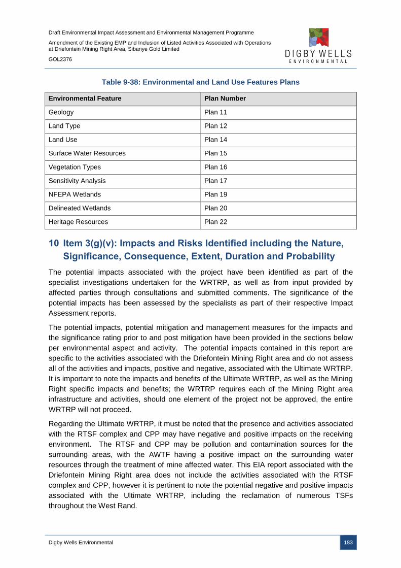
Draft Environmental Impact Assessment and Environmental Management Programme
Amendment of the Existing EMP and Inclusion of Listed Activities Associated with Operations at Driefontein Mining Right Area, Sibanye Gold Limited
GOL2376
Digby Wells Environmental 183
Table 9-38: Environmental and Land Use Features Plans
Environmental Feature Plan Number
Geology Plan 11
Land Type Plan 12
Land Use Plan 14
Surface Water Resources Plan 15
Vegetation Types Plan 16
Sensitivity Analysis Plan 17
NFEPA Wetlands Plan 19
Delineated Wetlands Plan 20
Heritage Resources Plan 22
10 Item 3(g)(v): Impacts and Risks Identified including the Nature,
Significance, Consequence, Extent, Duration and Probability
The potential impacts associated with the project have been identified as part of the
specialist investigations undertaken for the WRTRP, as well as from input provided by
affected parties through consultations and submitted comments. The significance of the
potential impacts has been assessed by the specialists as part of their respective Impact
Assessment reports.
The potential impacts, potential mitigation and management measures for the impacts and
the significance rating prior to and post mitigation have been provided in the sections below
per environmental aspect and activity. The potential impacts contained in this report are
specific to the activities associated with the Driefontein Mining Right area and do not assess
all of the activities and impacts, positive and negative, associated with the Ultimate WRTRP.
It is important to note the impacts and benefits of the Ultimate WRTRP, as well as the Mining
Right specific impacts and benefits; the WRTRP requires each of the Mining Right area
infrastructure and activities, should one element of the project not be approved, the entire
WRTRP will not proceed.
Regarding the Ultimate WRTRP, it must be noted that the presence and activities associated
with the RTSF complex and CPP may have negative and positive impacts on the receiving
environment. The RTSF and CPP may be pollution and contamination sources for the
surrounding areas, with the AWTF having a positive impact on the surrounding water
resources through the treatment of mine affected water. This EIA report associated with the
Driefontein Mining Right area does not include the activities associated with the RTSF
complex and CPP, however it is pertinent to note the potential negative and positive impacts
associated with the Ultimate WRTRP, including the reclamation of numerous TSFs
throughout the West Rand.

Draft Environmental Impact Assessment and Environmental Management Programme
Amendment of the Existing EMP and Inclusion of Listed Activities Associated with Operations at Driefontein Mining Right Area, Sibanye Gold Limited
GOL2376
Digby Wells Environmental 184
The activities associated with the Driefontein Mining Right area, which may result in potential
impacts, includes the following:
■ The reclamation of Driefontein 3 and 5 TSFs;
■ The construction and operation of the WBT and BWSF;
■ Roads, power lines, pipelines and pump stations associated with the above listed
infrastructure; and
■ Employment and Procurement.
The methodology used to determine the significance of the potential impacts is provided in
Section 10.6. The potential impacts have been discussed per phase of the project, per
environmental aspect and according to each activity.
The impacts ratings in the following sections do not constitute the entire array of impacts that
have been assessed by the various specialists. The impacts ratings highlighted here are
those considered significant; all low and medium-low negative and negligible and minor
positive impacts ratings have not been included. Please refer to the individual specialist
studies for a detailed impact assessment of all potential impacts identified.
Potential project risks, such as hydrocarbon spillages and pipeline leaks, have not been
assessed as part of the impact assessment as the probability of these events occurring are
not covered by the impact assessment methodology. Mitigation and management measures
to prevent project risks from occurring have been provided in the EMP section of this report,
however.
10.1 Construction Phase
The construction phase includes site clearing activities of all of the proposed infrastructure
footprints and includes vegetation removal and soil stripping, as well as the construction of
the infrastructure.
10.1.1 Air Quality Impacts
Table 10-1 details the project activities’ interactions and the resultant impacts as a result of
the proposed developments.
Table 10-1: Interactions and Impacts on Air Quality during the Construction Phase
Interaction Impact
Site clearing Generation of dust from vehicle wheels travelling on gravel roads
and the reduction in the quality of ambient air due to airborne dust
Exposure of loose soils due to
loss of vegetation cover
Increased particulate matter load in the atmosphere leading to
deteriorated air quality

Draft Environmental Impact Assessment and Environmental Management Programme
Amendment of the Existing EMP and Inclusion of Listed Activities Associated with Operations at Driefontein Mining Right Area, Sibanye Gold Limited
GOL2376
Digby Wells Environmental 185
10.1.1.1 WBT and BWSF Complex and Pipelines and Roads
10.1.1.1.1 Impact Description
The removal of vegetation, stripping of soil and grading of the landscape in preparation for
construction activities uses a range of construction equipment. These activities leads to the
generation of fugitive dust, which comprises Total Suspended Particles (TSPs), PM10 and
PM2.5, from the equipment and during material handling. The movement of vehicles and
equipment, contractors and permanent workforce and the levelling and compacting of the
landscape all contribute to dust emissions.
10.1.1.1.2 Management Objectives
The management objective is to ensure that nuisance and contaminated dust emissions,
associated with the construction of the WBT and BWSF complex and associated pipelines
and roads, comply with regulatory guidelines and standards for the protection of the
environment, human health and wellbeing; the management objective is to ensure that both
on-site and off-site airborne dust concentrations comply with the relevant health protection
criteria.
10.1.1.1.3 Management Actions and Targets
On-site monitoring must be undertaken daily to capture peak emissions. Monitoring will be
undertaken upwind and downwind of active operations, as well as at the site of active
operation. Fine particulate monitoring for public exposure will be undertaken at the closest
public area downwind. All monitoring results must be maintained on a logging sheet for
reference and proof of compliance to the air quality standards. All test results must be
assessed against the relevant standards (NDCR and NAAQS) for PM10 (75 µg /m3) and dust
fallout (600 mg/m2/day).
10.1.1.1.4 Impact Ratings
The impact significance ratings prior to and post mitigation measures, as well as the
mitigation measures, for the impacts on air quality are provided in Table 10-2.
Table 10-2: Potential Impacts on Air Quality due to the Construction Phase
Site Clearing for the WBT and BWSF complex and pipelines and roads
Dimension Rating Motivation Significance
Impact Description: Reduction in ambient air quality due to dust generation
Prior to mitigation/ management
Duration Short term (1) Dust generation will be limited to the
disturbed area and only for a few days Low (negative)
– 12 Extent Local (2)
Dust generated will be limited to the site
and the immediate surroundings
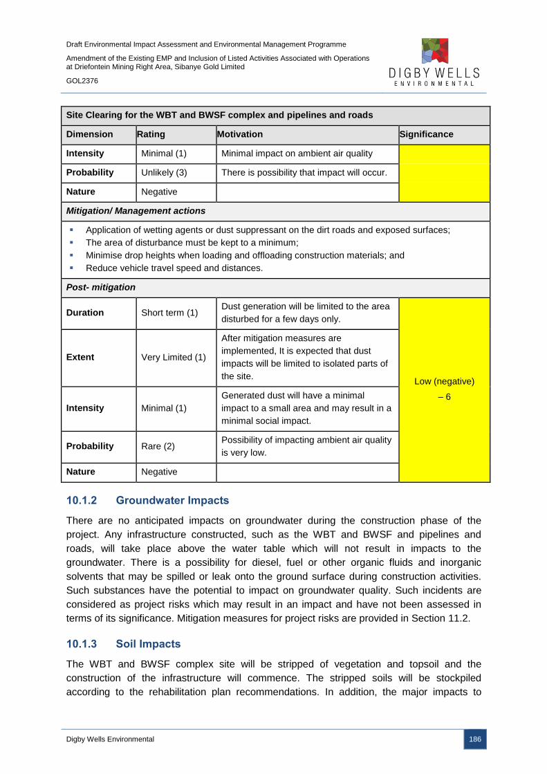
Draft Environmental Impact Assessment and Environmental Management Programme
Amendment of the Existing EMP and Inclusion of Listed Activities Associated with Operations at Driefontein Mining Right Area, Sibanye Gold Limited
GOL2376
Digby Wells Environmental 186
Site Clearing for the WBT and BWSF complex and pipelines and roads
Dimension Rating Motivation Significance
Intensity Minimal (1) Minimal impact on ambient air quality
Probability Unlikely (3) There is possibility that impact will occur.
Nature Negative
Mitigation/ Management actions
Application of wetting agents or dust suppressant on the dirt roads and exposed surfaces;
The area of disturbance must be kept to a minimum;
Minimise drop heights when loading and offloading construction materials; and
Reduce vehicle travel speed and distances.
Post- mitigation
Duration Short term (1) Dust generation will be limited to the area
disturbed for a few days only.
Low (negative)
– 6
Extent Very Limited (1)
After mitigation measures are
implemented, It is expected that dust
impacts will be limited to isolated parts of
the site.
Intensity Minimal (1)
Generated dust will have a minimal
impact to a small area and may result in a
minimal social impact.
Probability Rare (2) Possibility of impacting ambient air quality
is very low.
Nature Negative
10.1.2 Groundwater Impacts
There are no anticipated impacts on groundwater during the construction phase of the
project. Any infrastructure constructed, such as the WBT and BWSF and pipelines and
roads, will take place above the water table which will not result in impacts to the
groundwater. There is a possibility for diesel, fuel or other organic fluids and inorganic
solvents that may be spilled or leak onto the ground surface during construction activities.
Such substances have the potential to impact on groundwater quality. Such incidents are
considered as project risks which may result in an impact and have not been assessed in
terms of its significance. Mitigation measures for project risks are provided in Section 11.2.
10.1.3 Soil Impacts
The WBT and BWSF complex site will be stripped of vegetation and topsoil and the
construction of the infrastructure will commence. The stripped soils will be stockpiled
according to the rehabilitation plan recommendations. In addition, the major impacts to
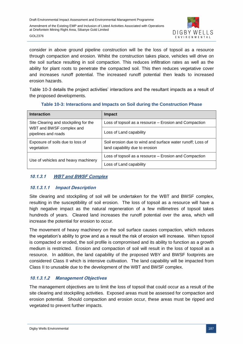
Draft Environmental Impact Assessment and Environmental Management Programme
Amendment of the Existing EMP and Inclusion of Listed Activities Associated with Operations at Driefontein Mining Right Area, Sibanye Gold Limited
GOL2376
Digby Wells Environmental 187
consider in above ground pipeline construction will be the loss of topsoil as a resource
through compaction and erosion. Whilst the construction takes place, vehicles will drive on
the soil surface resulting in soil compaction. This reduces infiltration rates as well as the
ability for plant roots to penetrate the compacted soil. This then reduces vegetative cover
and increases runoff potential. The increased runoff potential then leads to increased
erosion hazards.
Table 10-3 details the project activities’ interactions and the resultant impacts as a result of
the proposed developments.
Table 10-3: Interactions and Impacts on Soil during the Construction Phase
Interaction Impact
Site Clearing and stockpiling for the
WBT and BWSF complex and
pipelines and roads
Loss of topsoil as a resource – Erosion and Compaction
Loss of Land capability
Exposure of soils due to loss of
vegetation
Soil erosion due to wind and surface water runoff; Loss of
land capability due to erosion
Use of vehicles and heavy machinery Loss of topsoil as a resource – Erosion and Compaction
Loss of Land capability
10.1.3.1 WBT and BWSF Complex
10.1.3.1.1 Impact Description
Site clearing and stockpiling of soil will be undertaken for the WBT and BWSF complex,
resulting in the susceptibility of soil erosion. The loss of topsoil as a resource will have a
high negative impact as the natural regeneration of a few millimetres of topsoil takes
hundreds of years. Cleared land increases the runoff potential over the area, which will
increase the potential for erosion to occur.
The movement of heavy machinery on the soil surface causes compaction, which reduces
the vegetation’s ability to grow and as a result the risk of erosion will increase. When topsoil
is compacted or eroded, the soil profile is compromised and its ability to function as a growth
medium is restricted. Erosion and compaction of soil will result in the loss of topsoil as a
resource. In addition, the land capability of the proposed WBY and BWSF footprints are
considered Class II which is intensive cultivation. The land capability will be impacted from
Class II to unusable due to the development of the WBT and BWSF complex.
10.1.3.1.2 Management Objectives
The management objectives are to limit the loss of topsoil that could occur as a result of the
site clearing and stockpiling activities. Exposed areas must be assessed for compaction and
erosion potential. Should compaction and erosion occur, these areas must be ripped and
vegetated to prevent further impacts.

Draft Environmental Impact Assessment and Environmental Management Programme
Amendment of the Existing EMP and Inclusion of Listed Activities Associated with Operations at Driefontein Mining Right Area, Sibanye Gold Limited
GOL2376
Digby Wells Environmental 188
Stripped soils are to be placed in the correct stockpile allocations to reduce cross
contamination of soils. These soils must be monitored and maintained in a reasonably fertile
state; vegetation cover on all stockpiled soil is essential to eliminate erosion. Soils must be
stripped by truck and shovel methods only.
There are no management objectives for the loss of land capability as the land use will
change from agricultural to mining, impacting on the land capability.
10.1.3.1.3 Management Actions and Targets
There are no regulated targets and requirements for the management of soils. SGL will
rehabilitate the footprints of the WBT and BWSF complex to an adequate end land use to be
determined by a Closure Plan which will be updated in due course. To ensure that
rehabilitation and eventual closure is effective and successful, the management of the soil
resources is critical during the life of the project. The management of the soil throughout the
project will directly influence the success of the rehabilitation activities. The soil will, thus, be
stripped and stockpiled to prevent and minimise potential impacts with rehabilitation and long
term use in mind.
A Rehabilitation Plan (Appendix Q) has been compiled and will detail the following:
■ Following adequate stripping guidelines;
■ The topsoil must be stripped by mechanical means, such as an excavator bucket,
and loaded onto dump trucks;
■ Topsoil stockpiles are to be kept to a maximum height of 4m (the practical tipping
height of dump trucks);
■ Topsoil is to be stripped when the soil is dry, as to reduce compaction;
■ The topsoil (0.3 m of the soil profile) should be stripped first and stockpiled
separately;
■ The subsoil (approximately 0.3 – 0.8 m thick) will then be stripped and stockpiled
separately;
■ Soils to be stripped according to the soil stripping ratios and stockpiled accordingly;
■ Compaction of the removed topsoil must be avoided by prohibiting traffic on
stockpiles;
■ Stockpiles should only be used for their designated final purposes; and
■ The stockpiles must be vegetated to reduce the risk of erosion, prevent weed growth
and to reinstitute the ecological processes within the soil.
10.1.3.1.4 Impact Ratings
The impact significance ratings prior to and post mitigation measures, as well as the
mitigation measures, for the impacts on soils are provided in Table 10-4.
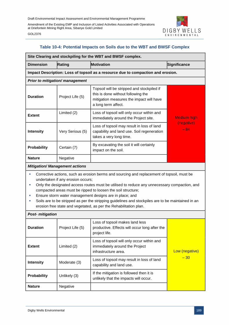
Draft Environmental Impact Assessment and Environmental Management Programme
Amendment of the Existing EMP and Inclusion of Listed Activities Associated with Operations at Driefontein Mining Right Area, Sibanye Gold Limited
GOL2376
Digby Wells Environmental 189
Table 10-4: Potential Impacts on Soils due to the WBT and BWSF Complex
Site Clearing and stockpiling for the WBT and BWSF complex.
Dimension Rating Motivation Significance
Impact Description: Loss of topsoil as a resource due to compaction and erosion.
Prior to mitigation/ management
Duration Project Life (5)
Topsoil will be stripped and stockpiled if
this is done without following the
mitigation measures the impact will have
a long term affect.
Medium-high
(negative)
– 84
Extent Limited (2) Loss of topsoil will only occur within and
immediately around the Project site.
Intensity Very Serious (5)
Loss of topsoil may result in loss of land
capability and land use. Soil regeneration
takes a very long time.
Probability Certain (7) By excavating the soil it will certainly
impact on the soil.
Nature Negative
Mitigation/ Management actions
Corrective actions, such as erosion berms and sourcing and replacement of topsoil, must be
undertaken if any erosion occurs;
Only the designated access routes must be utilised to reduce any unnecessary compaction, and
compacted areas must be ripped to loosen the soil structure;
Ensure storm water management designs are in place; and
Soils are to be stripped as per the stripping guidelines and stockpiles are to be maintained in an
erosion free state and vegetated, as per the Rehabilitation plan.
Post- mitigation
Duration Project Life (5)
Loss of topsoil makes land less
productive. Effects will occur long after the
project life.
Low (negative)
– 30
Extent Limited (2)
Loss of topsoil will only occur within and
immediately around the Project
infrastructure area.
Intensity Moderate (3) Loss of topsoil may result in loss of land
capability and land use.
Probability Unlikely (3) If the mitigation is followed then it is
unlikely that the impacts will occur.
Nature Negative

Draft Environmental Impact Assessment and Environmental Management Programme
Amendment of the Existing EMP and Inclusion of Listed Activities Associated with Operations at Driefontein Mining Right Area, Sibanye Gold Limited
GOL2376
Digby Wells Environmental 190
Loss of land capability due to site clearing and due to the WBT and BWSF Complex
Dimension Rating Motivation Significance
Impact Description: Removal of soil layers will impact on the land capability because
vegetation can no longer be supported.
Prior to mitigation/ management
Duration Project life (5)
The removal of soil from a profile reduces
the land capability from a rateable index
to non-existent; this impact will occur for
the project life.
Medium-High
(negative)
– 77
Extent Limited (2) The impact will only occur on the project
infrastructure area.
Intensity Serious (4) Loss of topsoil results in the loss of land
capability and use.
Probability Certain (7) By removing the topsoil the impact on
land capability is certain.
Nature Negative
Mitigation/ Management actions
No land capability mitigation is possible during the construction phase because the land capability will
be reduced to unusable. As a result, there are no post mitigation measure impact ratings.
10.1.3.2 Pipelines and Roads
10.1.3.2.1 Impact Description
The construction of the pipelines and roads may result in soil erosion due to exposed
surfaces, as well as compacting soil resources due to the presence of vehicles and
machinery. The loss of topsoil as a resource will have a high negative impact as the natural
regeneration of a few millimetres of topsoil takes hundreds of years, although the impact will
be limited to the linear footprints of the pipelines and roads.
10.1.3.2.2 Management Objectives
The management objectives are to limit the loss of topsoil that could occur as a result of the
site clearing and construction activities. Exposed areas must be assessed for compaction
and erosion potential. Should compaction and erosion occur, these areas must be ripped
and vegetated to prevent further impacts.
10.1.3.2.3 Management Actions and Targets
There are no regulated targets and requirements for the management of soils. SGL will
rehabilitate the disturbed areas associated with pipeline and road construction.
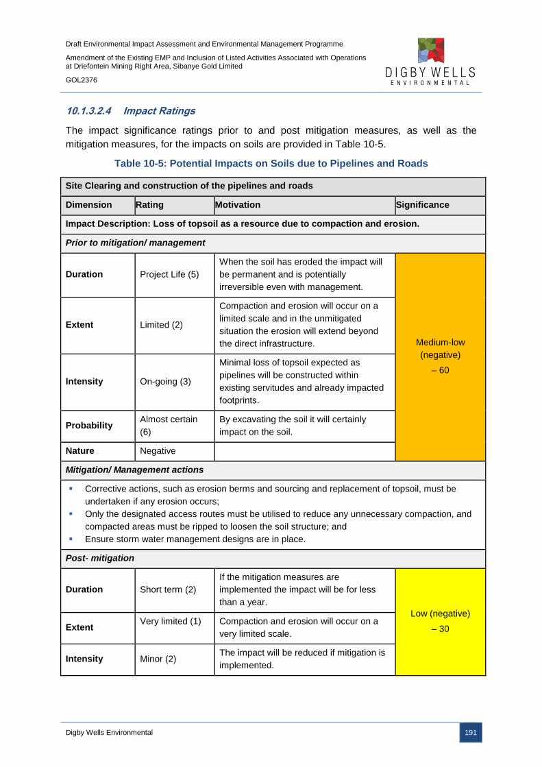
Draft Environmental Impact Assessment and Environmental Management Programme
Amendment of the Existing EMP and Inclusion of Listed Activities Associated with Operations at Driefontein Mining Right Area, Sibanye Gold Limited
GOL2376
Digby Wells Environmental 191
10.1.3.2.4 Impact Ratings
The impact significance ratings prior to and post mitigation measures, as well as the
mitigation measures, for the impacts on soils are provided in Table 10-5.
Table 10-5: Potential Impacts on Soils due to Pipelines and Roads
Site Clearing and construction of the pipelines and roads
Dimension Rating Motivation Significance
Impact Description: Loss of topsoil as a resource due to compaction and erosion.
Prior to mitigation/ management
Duration Project Life (5)
When the soil has eroded the impact will
be permanent and is potentially
irreversible even with management.
Medium-low
(negative)
– 60
Extent Limited (2)
Compaction and erosion will occur on a
limited scale and in the unmitigated
situation the erosion will extend beyond
the direct infrastructure.
Intensity On-going (3)
Minimal loss of topsoil expected as
pipelines will be constructed within
existing servitudes and already impacted
footprints.
Probability Almost certain
(6)
By excavating the soil it will certainly
impact on the soil.
Nature Negative
Mitigation/ Management actions
Corrective actions, such as erosion berms and sourcing and replacement of topsoil, must be
undertaken if any erosion occurs;
Only the designated access routes must be utilised to reduce any unnecessary compaction, and
compacted areas must be ripped to loosen the soil structure; and
Ensure storm water management designs are in place.
Post- mitigation
Duration Short term (2)
If the mitigation measures are
implemented the impact will be for less
than a year.
Low (negative)
– 30 Extent Very limited (1) Compaction and erosion will occur on a
very limited scale.
Intensity Minor (2) The impact will be reduced if mitigation is
implemented.
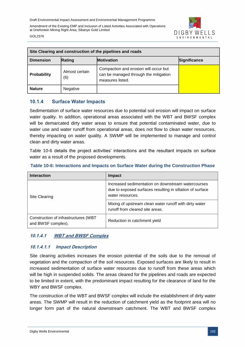
Draft Environmental Impact Assessment and Environmental Management Programme
Amendment of the Existing EMP and Inclusion of Listed Activities Associated with Operations at Driefontein Mining Right Area, Sibanye Gold Limited
GOL2376
Digby Wells Environmental 192
Site Clearing and construction of the pipelines and roads
Dimension Rating Motivation Significance
Probability Almost certain
(6)
Compaction and erosion will occur but
can be managed through the mitigation
measures listed.
Nature Negative
10.1.4 Surface Water Impacts
Sedimentation of surface water resources due to potential soil erosion will impact on surface
water quality. In addition, operational areas associated with the WBT and BWSF complex
will be demarcated dirty water areas to ensure that potential contaminated water, due to
water use and water runoff from operational areas, does not flow to clean water resources,
thereby impacting on water quality. A SWMP will be implemented to manage and control
clean and dirty water areas.
Table 10-6 details the project activities’ interactions and the resultant impacts on surface
water as a result of the proposed developments.
Table 10-6: Interactions and Impacts on Surface Water during the Construction Phase
Interaction Impact
Site Clearing
Increased sedimentation on downstream watercourses
due to exposed surfaces resulting in siltation of surface
water resources.
Mixing of upstream clean water runoff with dirty water
runoff from cleared site areas.
Construction of infrastructures (WBT
and BWSF complex). Reduction in catchment yield
10.1.4.1 WBT and BWSF Complex
10.1.4.1.1 Impact Description
Site clearing activities increases the erosion potential of the soils due to the removal of
vegetation and the compaction of the soil resources. Exposed surfaces are likely to result in
increased sedimentation of surface water resources due to runoff from these areas which
will be high in suspended solids. The areas cleared for the pipelines and roads are expected
to be limited in extent, with the predominant impact resulting for the clearance of land for the
WBY and BWSF complex.
The construction of the WBT and BWSF complex will include the establishment of dirty water
areas. The SWMP will result in the reduction of catchment yield as the footprint area will no
longer form part of the natural downstream catchment. The WBT and BWSF complex
Draft Environmental Impact Assessment and Environmental Management Programme
Amendment of the Existing EMP and Inclusion of Listed Activities Associated with Operations at Driefontein Mining Right Area, Sibanye Gold Limited
GOL2376
Digby Wells Environmental 193
occupies less than 1 % of the C23E quaternary catchment and this impact is considered to
be negligible and has not been rated as a result.
10.1.4.1.2 Management Objectives
The management objectives adopted during the construction phase relate specifically to GN
R704 of the NWA, which was established to provide regulations on the use of water for
mining and related activities aimed at the protection of water resources.
The three main conditions of GN 704 applicable to this project are:
■ Condition 4 which defines the area in which mine workings or associated structures
may be located, with reference to a watercourse and associated flooding. Any
residue deposit, dam or reservoir together with any associated structure or any other
facility should be situated outside the 1:100 year flood-line;
■ Condition 6 which describes the capacity requirements of clean and dirty water
systems. Clean and dirty water systems must be kept separate and must be
designed, constructed, maintained and operated to ensure conveyance of flows of a
1:50 year recurrence event. Any dirty water dams must have a minimum freeboard of
0.8 m above full supply level; and
■ Condition 7 which describes the measures that must be taken to protect water
resources. All dirty water or substances that may cause pollution must be prevented
from entering a water resource (by spillage, seepage, erosion etc.) and ensure that
water used in any process is recycled as far as practicable.
10.1.4.1.3 Management Actions and Targets
The runoff from the upstream clean water catchment is to be diverted away from the
proposed infrastructures. Temporary surface water ditches/berms are to be constructed on
the upstream boundary of cleared areas so as to meet GN 704 requirements regarding the
separation of clean and dirty water runoff. All clean water runoff will therefore be diverted
away from the cleared area. The temporary surface ditches are to be sized such that the
1:50 year peak discharge can be contained within it.
Within the cleared area along the downstream boundary, temporary ditches are to be
constructed along with a temporary excavated storage area. All dirty water runoff will then be
captured and contained within the temporary storage facility. The temporary storage facility
is to be sized based on the runoff volume generated from the cleared area for the 1:50 year
storm event. The water contained in the storage facility should be used during the
construction phase as much as possible, ensuring the mentioned storage facility is operated
empty. The temporary ditches are to be sized such that the 1:50 year peak discharge can be
contained within it.

Draft Environmental Impact Assessment and Environmental Management Programme
Amendment of the Existing EMP and Inclusion of Listed Activities Associated with Operations at Driefontein Mining Right Area, Sibanye Gold Limited
GOL2376
Digby Wells Environmental 194
10.1.4.1.4 Impact Ratings
The impact significance ratings prior to and post mitigation measures, as well as the
mitigation measures, for the impacts on surface water resources are provided in Table 10-7.
Table 10-7: Potential Impacts on Surface Water due to the WBT and BWSF Complex
Site clearing for the Construction of the WBT and BWSF complex.
Dimension Rating Motivation Significance
Mixing of upstream clean water runoff with dirty water runoff from cleared site areas, along
with surface water sedimentation.
Prior to mitigation/ management
Duration Beyond project
life (6)
May continue beyond the project life if
not managed correctly
Medium-high
(negative)
– 80
Extent Region (5) May affect water quality on a regional
basis
Intensity High (5)
May impact on highly sensitive
environments such as the downstream
Vaal Dam
Probability Likely (5) Is likely to occur if not managed correctly
Nature Negative
Mitigation/ Management actions
Temporary ditches must be constructed down-gradient of the cleared areas;
The temporary ditches must be sized according to the 1:50 year rainfall event;
Utilise water stored in the temporary ditches;
Clean water upstream of the cleared and construction areas must be diverted around the site to
nearby water courses. The diversion canals must be sized to accommodate a 1:50 year rainfall
event; and
All dirty water channels must be constructed and placed within the dirty water infrastructure
areas.
Post- mitigation
Duration Short term (2) Will only last for the duration of the
construction phase
Low (negative)
– 28
Extent Limited (2) Limited to the project site if mitigation is
applied correctly
Intensity Moderate (3) May impact already moderately impacted
surface water resources
Probability Probable (4) Probable, has occurred elsewhere and
may occur here
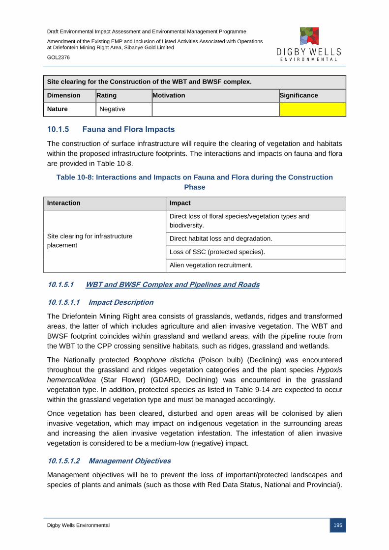
Draft Environmental Impact Assessment and Environmental Management Programme
Amendment of the Existing EMP and Inclusion of Listed Activities Associated with Operations at Driefontein Mining Right Area, Sibanye Gold Limited
GOL2376
Digby Wells Environmental 195
Site clearing for the Construction of the WBT and BWSF complex.
Dimension Rating Motivation Significance
Nature Negative
10.1.5 Fauna and Flora Impacts
The construction of surface infrastructure will require the clearing of vegetation and habitats
within the proposed infrastructure footprints. The interactions and impacts on fauna and flora
are provided in Table 10-8.
Table 10-8: Interactions and Impacts on Fauna and Flora during the Construction
Phase
Interaction Impact
Site clearing for infrastructure
placement
Direct loss of floral species/vegetation types and
biodiversity.
Direct habitat loss and degradation.
Loss of SSC (protected species).
Alien vegetation recruitment.
10.1.5.1 WBT and BWSF Complex and Pipelines and Roads
10.1.5.1.1 Impact Description
The Driefontein Mining Right area consists of grasslands, wetlands, ridges and transformed
areas, the latter of which includes agriculture and alien invasive vegetation. The WBT and
BWSF footprint coincides within grassland and wetland areas, with the pipeline route from
the WBT to the CPP crossing sensitive habitats, such as ridges, grassland and wetlands.
The Nationally protected Boophone disticha (Poison bulb) (Declining) was encountered
throughout the grassland and ridges vegetation categories and the plant species Hypoxis
hemerocallidea (Star Flower) (GDARD, Declining) was encountered in the grassland
vegetation type. In addition, protected species as listed in Table 9-14 are expected to occur
within the grassland vegetation type and must be managed accordingly.
Once vegetation has been cleared, disturbed and open areas will be colonised by alien
invasive vegetation, which may impact on indigenous vegetation in the surrounding areas
and increasing the alien invasive vegetation infestation. The infestation of alien invasive
vegetation is considered to be a medium-low (negative) impact.
10.1.5.1.2 Management Objectives
Management objectives will be to prevent the loss of important/protected landscapes and
species of plants and animals (such as those with Red Data Status, National and Provincial).
Draft Environmental Impact Assessment and Environmental Management Programme
Amendment of the Existing EMP and Inclusion of Listed Activities Associated with Operations at Driefontein Mining Right Area, Sibanye Gold Limited
GOL2376
Digby Wells Environmental 196
This is achieved by avoiding destruction of areas where these species are located. If this is
not possible in the case of plants, relocation permits will be required.
The destruction of the vegetative cover must be limited. This can be achieved by restricting
the removal and disturbance of vegetation to those areas absolutely essential for the
infrastructure placements and identifying species that can be removed, such as alien
invasive vegetation.
The ecosystem present must be preserved; this includes areas not directly affected by
project activities and can be achieved by limiting project activities to areas where they are
essential. The risk of habitat fragmentation must be reduced through preservation of natural
corridors. Rehabilitation plans must be initiated during construction to minimise disturbed
areas. Habitat/vegetation degradation must be prevented through the implementation of an
alien invasive plant management strategy.
10.1.5.1.3 Management Actions and Targets
Red Data plants located in areas of development (Boophone disticha (Poison bulb) and
Hypoxis hemerocallidea (Star Flower)) should be marked prior to construction of any
infrastructure and the necessary permits for relocations of these protected species must be
obtained from the relevant government department. The relocation strategy must be
approved by relevant authorities (GDARD) prior to relocation to a safe place to avoid
destruction and stipulations made by GDARD must be followed. A nursery should be
developed on site for this purpose. No protected plant species can be disturbed without
authorisation.
Three basic rules of conservation apply to populations of Red Data plant species according
to Red List Plant Guidelines (2012) and include:
■ All populations of Near Threatened and Threatened plant taxa must be conserved in
situ;
■ All populations of Near Threatened and Threatened plant taxa must be protected with
a buffer zone in accordance with guidelines; and
■ An Ecological Management Plan must be compiled in respect of all actions that affect
populations of Red Data plant species, and such Ecological Management Plans must
conform with the Guidelines set out for buffer zone widths.
An Alien Invasive Management Plan has been developed and implemented as part of the
Driefontein Mine. The Alien Invasive Management Plan must be extended to include
activities associated with the WRTRP and implemented to preserve natural habitat. An Alien
Invasive Management Plan must be implemented to preserve natural habitat and reduce
current infestations, such as the 85 ha of alien invasive vegetation identified within the
Driefontein Mining Right area. Such a strategy will entail the identification and extent of
areas where such infestation occurs. Thereafter, specific eradication measures can be
prescribed for species present. The Alien Invasive Management Plan must reduce the
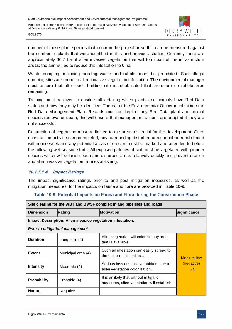
Draft Environmental Impact Assessment and Environmental Management Programme
Amendment of the Existing EMP and Inclusion of Listed Activities Associated with Operations at Driefontein Mining Right Area, Sibanye Gold Limited
GOL2376
Digby Wells Environmental 197
number of these plant species that occur in the project area; this can be measured against
the number of plants that were identified in this and previous studies. Currently there are
approximately 60.7 ha of alien invasive vegetation that will form part of the infrastructure
areas: the aim will be to reduce this infestation to 0 ha.
Waste dumping, including building waste and rubble, must be prohibited. Such illegal
dumping sites are prone to alien invasive vegetation infestation. The environmental manager
must ensure that after each building site is rehabilitated that there are no rubble piles
remaining.
Training must be given to onsite staff detailing which plants and animals have Red Data
status and how they may be identified. Thereafter the Environmental Officer must initiate the
Red Data Management Plan. Records must be kept of any Red Data plant and animal
species removal or death; this will ensure that management actions are adapted if they are
not successful.
Destruction of vegetation must be limited to the areas essential for the development. Once
construction activities are completed, any surrounding disturbed areas must be rehabilitated
within one week and any potential areas of erosion must be marked and attended to before
the following wet season starts. All exposed patches of soil must be vegetated with pioneer
species which will colonise open and disturbed areas relatively quickly and prevent erosion
and alien invasive vegetation from establishing.
10.1.5.1.4 Impact Ratings
The impact significance ratings prior to and post mitigation measures, as well as the
mitigation measures, for the impacts on fauna and flora are provided in Table 10-9.
Table 10-9: Potential Impacts on Fauna and Flora during the Construction Phase
Site clearing for the WBT and BWSF complex in and pipelines and roads
Dimension Rating Motivation Significance
Impact Description: Alien invasive vegetation infestation.
Prior to mitigation/ management
Duration Long term (4) Alien vegetation will colonise any area
that is available.
Medium-low
(negative)
- 48
Extent Municipal area (4) Such an infestation can easily spread to
the entire municipal area.
Intensity Moderate (4) Serious loss of sensitive habitats due to
alien vegetation colonisation.
Probability Probable (4) It is unlikely that without mitigation
measures, alien vegetation will establish.
Nature Negative

Draft Environmental Impact Assessment and Environmental Management Programme
Amendment of the Existing EMP and Inclusion of Listed Activities Associated with Operations at Driefontein Mining Right Area, Sibanye Gold Limited
GOL2376
Digby Wells Environmental 198
Site clearing for the WBT and BWSF complex in and pipelines and roads
Dimension Rating Motivation Significance
Mitigation/ Management actions
Manage vegetation clearing to areas required for construction to limit the extent of disturbed and
open areas; and
Implement an Alien Invasive Management Plan and eradicate alien invasive vegetation.
Post- mitigation
Duration Medium term (3)
Alien vegetation colonisation will be
eradicated in accordance with the alien
management plan.
Low (negative)
- 24
Extent Limited (2)
An infestation will not be allowed to
spread beyond the site and its
boundaries.
Intensity Minor (2) Only limited areas will experience this for
a short duration.
Probability Unlikely (3) It is unlikely that alien vegetation will
establish if mitigation is adhered to.
Nature Negative
Site clearing for the WBT and BWSF complex in and pipelines and roads
Dimension Rating Motivation Significance
Impact Description: Direct loss of floral species/vegetation types and the resultant loss of
habitats for fauna. This will result in the reduction of biodiversity.
Prior to mitigation/ management
Duration Long term (4) Loss floral species/vegetation will occur.
Medium-high
(negative)
- 72
Extent Local (4) Species/habitat loss will only occur within
and immediately around the Project site.
Intensity High (5)
Sensitive sites occur throughout the
pipeline and WBT, such as ridges and
grasslands, all which have a high
probability of containing SSC.
Probability High (6)
It is likely that destruction of vegetation
types will occur without management
measures.
Nature Negative
Mitigation/ Management actions
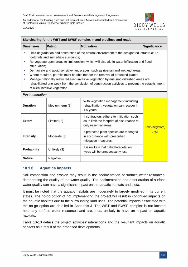
Draft Environmental Impact Assessment and Environmental Management Programme
Amendment of the Existing EMP and Inclusion of Listed Activities Associated with Operations at Driefontein Mining Right Area, Sibanye Gold Limited
GOL2376
Digby Wells Environmental 199
Site clearing for the WBT and BWSF complex in and pipelines and roads
Dimension Rating Motivation Significance
Limit degradation and destruction of the natural environment to the designated infrastructure
footprints and immediate surrounds;
Re-vegetate open areas to limit erosion, which will also aid in water infiltration and flood
attenuation;
Demarcate and avoid sensitive landscapes, such as riparian and wetland areas;
Where required, permits must be obtained for the removal of protected plants;
Manage nationally restricted alien invasive vegetation by ensuring disturbed areas are
rehabilitated one week from the conclusion of construction activities to prevent the establishment
of alien invasive vegetation
Post- mitigation
Duration Medium term (3)
With vegetation management including
rehabilitation, vegetation can recover in
1-5 years.
Low (negative)
- 24
Extent Limited (2)
If contractors adhere to mitigation such
as to limit the footprint of disturbance to
only essential areas.
Intensity Moderate (3)
If protected plant species are managed
in accordance with prescribed
mitigation measures.
Probability Unlikely (3) It is unlikely that habitat/vegetation
types will be unnecessarily lost.
Nature Negative
10.1.6 Aquatics Impacts
Soil compaction and erosion may result in the sedimentation of surface water resources,
deteriorating the quality of the water quality. The sedimentation and deterioration of surface
water quality can have a significant impact on the aquatic habitats and biota.
It must be noted that the aquatic habitats are moderately to largely modified in its current
states. The no-go option of not implementing the project will result in continued impacts on
the aquatic habitats due to the surrounding land uses. The potential impacts associated with
the no-go option are detailed in Appendix J. The WBT and BWSF complex is not located
near any surface water resources and are, thus, unlikely to have an impact on aquatic
habitats.
Table 10-10 details the project activities’ interactions and the resultant impacts on aquatic
habitats as a result of the proposed developments.

Draft Environmental Impact Assessment and Environmental Management Programme
Amendment of the Existing EMP and Inclusion of Listed Activities Associated with Operations at Driefontein Mining Right Area, Sibanye Gold Limited
GOL2376
Digby Wells Environmental 200
Table 10-10: Interactions and Impacts on Aquatic Ecosystems during the
Construction Phase
Interaction Impact
Site clearing for WBT and BWSF
complex and pipelines and roads.
Increased runoff as a result of cover loss could result in
instream and riparian habitat modification or destruction
through erosion, flow, bed, channel and water quality
modification. Water quality modification can be related to
an increase in the amount of suspended/dissolved solids
which can result in increased sedimentation and changes
to the physical chemistry of the water in downstream
regions. These physical impacts could lead to reduced
aquatic biodiversity.
10.1.6.1 WBT and BWSF Complex and Pipelines and Roads
10.1.6.1.1 Impact Description
Runoff high in dissolved/suspended solids from cleared areas could result in water quality
impacts. In addition, through contaminated runoff, general water chemistry modification may
occur as a result of increased metals and nutrients as well as modified pH balances.
Increased runoff and erosion caused through construction activities as well as movement of
suspended materials in runoff may produce habitat quality impacts which may include
sedimentation, bed, channel and flow modification. This impact may result from the site
clearing and construction activities for the pipelines and roads.
10.1.6.1.2 Management Objectives
The objective is to preserve the PES and prevent further degradation of local aquatic
environments. This objective can be achieved through the management of potential water
and habitat quality impacts.
10.1.6.1.3 Management Actions and Targets
Mitigation measures provided as part of the surface water and groundwater sections apply
for aquatic ecosystems as well. The removal of vegetative cover, as well as the construction
of infrastructure, has been recognised as being responsible for increased runoff,
sedimentation and subsequent water and habitat quality degradation in downstream portions
of river systems (WRC, 2014). As such the careful management of vegetation removal and
sedimentation control must be undertaken.
Along with the implementation of the mitigation measures, bi-annual aquatic biomonitoring
must take place, with the primary target to improve the PES of the Wonderfonteinspruit and
Carletonville Tributary. The monitoring for the presence of Hydropsychidae, Aeshnidae and
Baetidae species downstream must take place to determine potential habitat impacts as
these species were found in abundance. The SASS5 and ASPT index monitoring should not
reduce by more than 25% as a result of activities related to the proposed project.
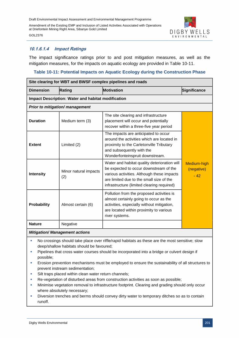
Draft Environmental Impact Assessment and Environmental Management Programme
Amendment of the Existing EMP and Inclusion of Listed Activities Associated with Operations at Driefontein Mining Right Area, Sibanye Gold Limited
GOL2376
Digby Wells Environmental 201
10.1.6.1.4 Impact Ratings
The impact significance ratings prior to and post mitigation measures, as well as the
mitigation measures, for the impacts on aquatic ecology are provided in Table 10-11.
Table 10-11: Potential Impacts on Aquatic Ecology during the Construction Phase
Site clearing for WBT and BWSF complex pipelines and roads
Dimension Rating Motivation Significance
Impact Description: Water and habitat modification
Prior to mitigation/ management
Duration Medium term (3)
The site clearing and infrastructure
placement will occur and potentially
recover within a three-five year period
Medium-high
(negative)
- 42
Extent Limited (2)
The impacts are anticipated to occur
around the activities which are located in
proximity to the Carletonville Tributary
and subsequently with the
Wonderfonteinspruit downstream.
Intensity Minor natural impacts
(2)
Water and habitat quality deterioration will
be expected to occur downstream of the
various activities. Although these impacts
are limited due to the small size of the
infrastructure (limited clearing required)
Probability Almost certain (6)
Pollution from the proposed activities is
almost certainly going to occur as the
activities, especially without mitigation,
are located within proximity to various
river systems.
Nature Negative
Mitigation/ Management actions
No crossings should take place over riffle/rapid habitats as these are the most sensitive; slow
deep/shallow habitats should be favoured;
Pipelines that cross water courses should be incorporated into a bridge or culvert design if
possible;
Erosion prevention mechanisms must be employed to ensure the sustainability of all structures to
prevent instream sedimentation;
Silt traps placed within clean water return channels;
Re-vegetation of disturbed areas from construction activities as soon as possible;
Minimise vegetation removal to infrastructure footprint. Clearing and grading should only occur
where absolutely necessary;
Diversion trenches and berms should convey dirty water to temporary ditches so as to contain
runoff.
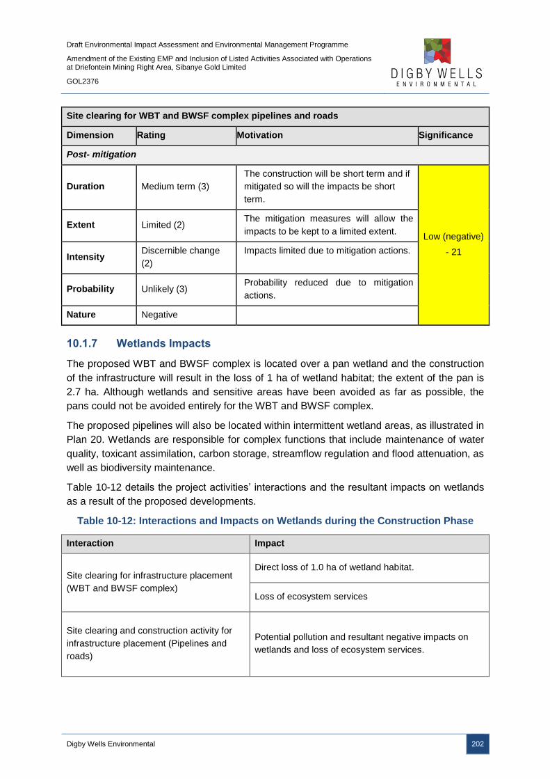
Draft Environmental Impact Assessment and Environmental Management Programme
Amendment of the Existing EMP and Inclusion of Listed Activities Associated with Operations at Driefontein Mining Right Area, Sibanye Gold Limited
GOL2376
Digby Wells Environmental 202
Site clearing for WBT and BWSF complex pipelines and roads
Dimension Rating Motivation Significance
Post- mitigation
Duration Medium term (3)
The construction will be short term and if
mitigated so will the impacts be short
term.
Low (negative)
- 21
Extent Limited (2) The mitigation measures will allow the
impacts to be kept to a limited extent.
Intensity Discernible change
(2)
Impacts limited due to mitigation actions.
Probability Unlikely (3) Probability reduced due to mitigation
actions.
Nature Negative
10.1.7 Wetlands Impacts
The proposed WBT and BWSF complex is located over a pan wetland and the construction
of the infrastructure will result in the loss of 1 ha of wetland habitat; the extent of the pan is
2.7 ha. Although wetlands and sensitive areas have been avoided as far as possible, the
pans could not be avoided entirely for the WBT and BWSF complex.
The proposed pipelines will also be located within intermittent wetland areas, as illustrated in
Plan 20. Wetlands are responsible for complex functions that include maintenance of water
quality, toxicant assimilation, carbon storage, streamflow regulation and flood attenuation, as
well as biodiversity maintenance.
Table 10-12 details the project activities’ interactions and the resultant impacts on wetlands
as a result of the proposed developments.
Table 10-12: Interactions and Impacts on Wetlands during the Construction Phase
Interaction Impact
Site clearing for infrastructure placement
(WBT and BWSF complex)
Direct loss of 1.0 ha of wetland habitat.
Loss of ecosystem services
Site clearing and construction activity for
infrastructure placement (Pipelines and
roads)
Potential pollution and resultant negative impacts on
wetlands and loss of ecosystem services.
Draft Environmental Impact Assessment and Environmental Management Programme
Amendment of the Existing EMP and Inclusion of Listed Activities Associated with Operations at Driefontein Mining Right Area, Sibanye Gold Limited
GOL2376
Digby Wells Environmental 203
10.1.7.1 WBT and BWSF Complex
10.1.7.1.1 Impact Description
The clearing of land for the WBT and BWSF complex will result in the destruction of 1 ha of
pan wetlands. The loss of wetlands will have potential downstream impacts as the wetland
functioning is lost. In addition to the direct impact on the wetlands due to site clearing, the
remaining adjacent wetlands will be indirectly impacted upon due to potential contaminated
runoff from the cleared areas.
10.1.7.1.2 Management Objectives
Management objectives are to inform SGL where there are wetland interactions with the
proposed activities during the construction of the WBT and BWSF complex. These
objectives are to prevent the loss of or further damage to wetland ecosystems and their
buffer areas. This is important as the wetlands play a major role in controlling the hydrology
of the West Rand, which has national importance as the Vaal and Crocodile River systems
are downstream, and support a range of ecological processes and biodiversity in the region
(WRDM EMF, 2013).
10.1.7.1.3 Management Actions and Targets
A Wetland Management Plan has been provided in Appendix K and must be used as a
guide to inform management actions. However, specific management actions are briefly
discussed below:
■ A Wetland Offset Strategy will need to be compiled for lost wetlands for the WBT and
BWSF complex, as detailed in Appendix K;
■ Minimise footprint area disturbed by construction activities; and
■ Rehabilitation Plan for disturbed wetland must be in place.
10.1.7.1.4 Impact Rating
The impact significance ratings prior to and post mitigation measures, as well as the
mitigation measures, for the impacts on wetlands are provided in Table 10-13.
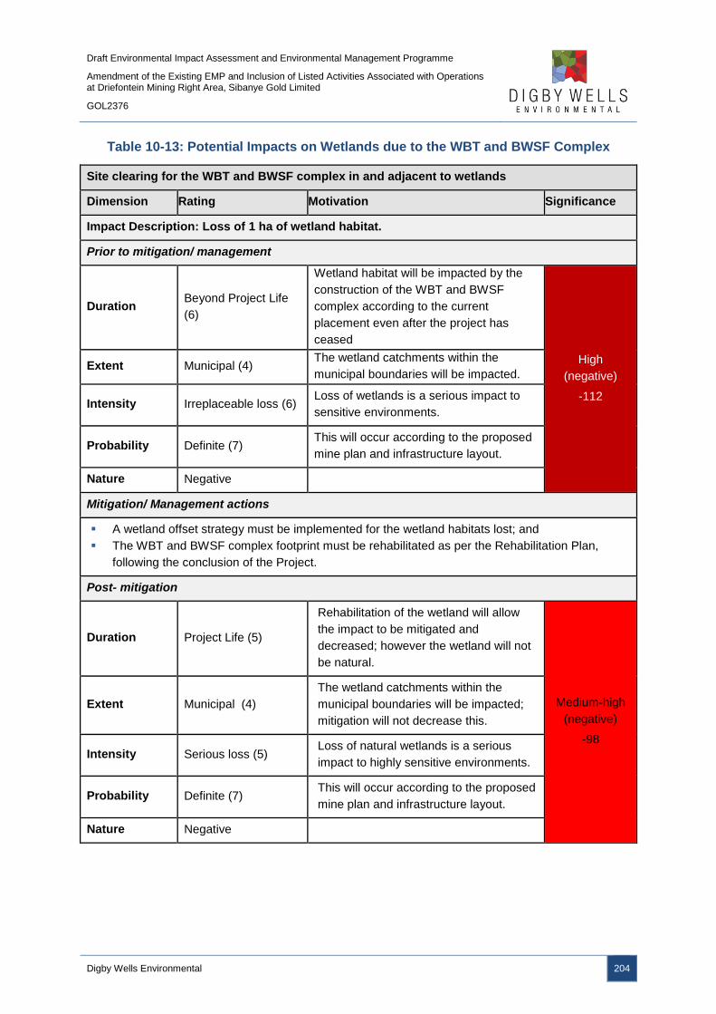
Draft Environmental Impact Assessment and Environmental Management Programme
Amendment of the Existing EMP and Inclusion of Listed Activities Associated with Operations at Driefontein Mining Right Area, Sibanye Gold Limited
GOL2376
Digby Wells Environmental 204
Table 10-13: Potential Impacts on Wetlands due to the WBT and BWSF Complex
Site clearing for the WBT and BWSF complex in and adjacent to wetlands
Dimension Rating Motivation Significance
Impact Description: Loss of 1 ha of wetland habitat.
Prior to mitigation/ management
Duration Beyond Project Life
(6)
Wetland habitat will be impacted by the
construction of the WBT and BWSF
complex according to the current
placement even after the project has
ceased
High
(negative)
-112
Extent Municipal (4) The wetland catchments within the
municipal boundaries will be impacted.
Intensity Irreplaceable loss (6) Loss of wetlands is a serious impact to
sensitive environments.
Probability Definite (7) This will occur according to the proposed
mine plan and infrastructure layout.
Nature Negative
Mitigation/ Management actions
A wetland offset strategy must be implemented for the wetland habitats lost; and
The WBT and BWSF complex footprint must be rehabilitated as per the Rehabilitation Plan,
following the conclusion of the Project.
Post- mitigation
Duration Project Life (5)
Rehabilitation of the wetland will allow
the impact to be mitigated and
decreased; however the wetland will not
be natural.
Medium-high
(negative)
-98
Extent Municipal (4)
The wetland catchments within the
municipal boundaries will be impacted;
mitigation will not decrease this.
Intensity Serious loss (5) Loss of natural wetlands is a serious
impact to highly sensitive environments.
Probability Definite (7) This will occur according to the proposed
mine plan and infrastructure layout.
Nature Negative

Draft Environmental Impact Assessment and Environmental Management Programme
Amendment of the Existing EMP and Inclusion of Listed Activities Associated with Operations at Driefontein Mining Right Area, Sibanye Gold Limited
GOL2376
Digby Wells Environmental 205
10.1.7.2 Pipelines and Roads
10.1.7.2.1 Impact Description
The potential impacts on wetlands associated with the decommissioning phase may include
runoff high in dissolved and suspended solids from exposed surfaces.
10.1.7.2.2 Management Objectives
Management objectives are to prevent further damage to wetland ecosystems and their
buffer areas. This is important as the wetlands play a major role in controlling the hydrology
of the West Rand, which has national importance as the Vaal and Crocodile River systems
are downstream, and support a range of ecological processes and biodiversity in the region
(WRDM EMF, 2013).
10.1.7.2.3 Management Actions and Targets
The management actions and targets associated with the aquatic habitats, fauna and flora,
surface water quality and groundwater quality will aid in the preservation and management
of wetland areas.
10.1.7.2.4 Impact Ratings
The impact significance ratings prior to and post mitigation measures, as well as the
mitigation measures, for the impacts on wetlands are provided in Table 10-14.
Table 10-14: Potential Impacts on Wetlands due to Pipelines and Roads
Site clearing for pipelines and roads
Dimension Rating Motivation Significance
Impact Description: Water and habitat modification
Prior to mitigation/ management
Duration Medium term (3)
The construction activities involving
heavy machinery will be active in and
around the wetlands. The construction
will be short-term but the impacts can
have a medium term impact.
Medium-high
(negative)
- 55
Extent Local (3) Local wetlands will be impacted
Intensity Serious long term (5) Water quality deterioration is a serious
impact to sensitive environments.
Probability Likely (5)
Pollution from the proposed activities is
likely to occur as the pipeline is crossing
wetlands, however the pipe is following
existing servitudes and therefore
probability is not certain.
Nature Negative

Draft Environmental Impact Assessment and Environmental Management Programme
Amendment of the Existing EMP and Inclusion of Listed Activities Associated with Operations at Driefontein Mining Right Area, Sibanye Gold Limited
GOL2376
Digby Wells Environmental 206
Site clearing for pipelines and roads
Dimension Rating Motivation Significance
Mitigation/ Management actions
Storm water management must be put in place to prevent run-off of any pollutants;
Pipelines are to be supported on reclaimed railway sleepers placed at 9m intervals as it
approaches the wetland;
The pipeline will be unsupported across the 15 m wetland/ river span and this will also contain a
continuous HDPE liner;
The pipeline will not contain any flanges for the full length of the wetland crossing;
50 m before and after the wetland crossing, the pipeline will be supported on plinths (an in-situ
cast concrete support) with foundations located at 9m intervals and also fitted with steel straps;
The pipeline will be fitted with inspection points;
All flanges within 100m of the wetland will be fitted with spray prevention plates;
The spillage paddock will be located outside on the wetland; and
Cleared areas must be minimised as far as possible.
Post- mitigation
Duration Short term (2)
The construction will be short term and if
mitigated so will the impacts be short
term.
Low (negative)
- 32
Extent Limited (2)
The mitigation measures will allow the
impacts to be kept to a limited impacted
extent.
Intensity Serious medium
term (4)
Water quality deterioration is a serious
impact to sensitive environments but can
be lessened with mitigation measures.
Probability Probable (4)
Mitigation measures will decrease the
probability; however given the high impact
of the proposed project the impact is
probably still likely to occur.
Nature Negative
10.1.8 Visual Impacts
The site clearing and construction of infrastructure will add visual intrusions onto the
landscape. The interactions and impacts associated with the construction phase are detailed
in Table 10-15.
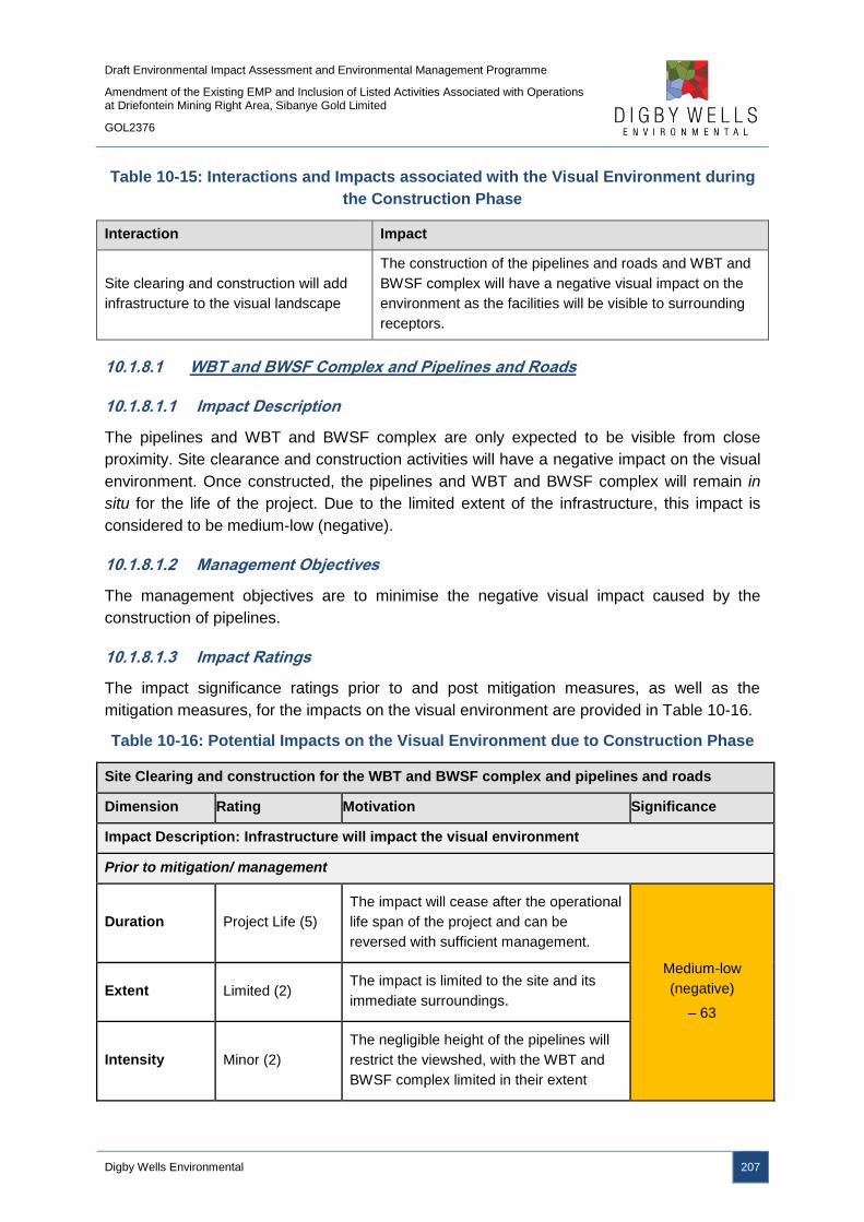
Draft Environmental Impact Assessment and Environmental Management Programme
Amendment of the Existing EMP and Inclusion of Listed Activities Associated with Operations at Driefontein Mining Right Area, Sibanye Gold Limited
GOL2376
Digby Wells Environmental 207
Table 10-15: Interactions and Impacts associated with the Visual Environment during
the Construction Phase
Interaction Impact
Site clearing and construction will add
infrastructure to the visual landscape
The construction of the pipelines and roads and WBT and
BWSF complex will have a negative visual impact on the
environment as the facilities will be visible to surrounding
receptors.
10.1.8.1 WBT and BWSF Complex and Pipelines and Roads
10.1.8.1.1 Impact Description
The pipelines and WBT and BWSF complex are only expected to be visible from close
proximity. Site clearance and construction activities will have a negative impact on the visual
environment. Once constructed, the pipelines and WBT and BWSF complex will remain in
situ for the life of the project. Due to the limited extent of the infrastructure, this impact is
considered to be medium-low (negative).
10.1.8.1.2 Management Objectives
The management objectives are to minimise the negative visual impact caused by the
construction of pipelines.
10.1.8.1.3 Impact Ratings
The impact significance ratings prior to and post mitigation measures, as well as the
mitigation measures, for the impacts on the visual environment are provided in Table 10-16.
Table 10-16: Potential Impacts on the Visual Environment due to Construction Phase
Site Clearing and construction for the WBT and BWSF complex and pipelines and roads
Dimension Rating Motivation Significance
Impact Description: Infrastructure will impact the visual environment
Prior to mitigation/ management
Duration Project Life (5)
The impact will cease after the operational
life span of the project and can be
reversed with sufficient management.
Medium-low
(negative)
– 63
Extent Limited (2) The impact is limited to the site and its
immediate surroundings.
Intensity Minor (2)
The negligible height of the pipelines will
restrict the viewshed, with the WBT and
BWSF complex limited in their extent
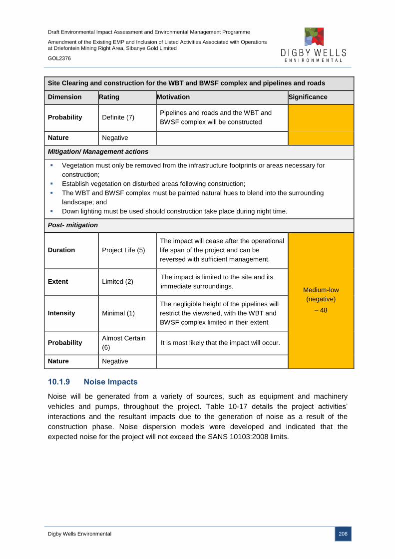
Draft Environmental Impact Assessment and Environmental Management Programme
Amendment of the Existing EMP and Inclusion of Listed Activities Associated with Operations at Driefontein Mining Right Area, Sibanye Gold Limited
GOL2376
Digby Wells Environmental 208
Site Clearing and construction for the WBT and BWSF complex and pipelines and roads
Dimension Rating Motivation Significance
Probability Definite (7) Pipelines and roads and the WBT and
BWSF complex will be constructed
Nature Negative
Mitigation/ Management actions
Vegetation must only be removed from the infrastructure footprints or areas necessary for
construction;
Establish vegetation on disturbed areas following construction;
The WBT and BWSF complex must be painted natural hues to blend into the surrounding
landscape; and
Down lighting must be used should construction take place during night time.
Post- mitigation
Duration Project Life (5)
The impact will cease after the operational
life span of the project and can be
reversed with sufficient management.
Medium-low
(negative)
– 48
Extent Limited (2) The impact is limited to the site and its
immediate surroundings.
Intensity Minimal (1)
The negligible height of the pipelines will
restrict the viewshed, with the WBT and
BWSF complex limited in their extent
Probability Almost Certain
(6) It is most likely that the impact will occur.
Nature Negative
10.1.9 Noise Impacts
Noise will be generated from a variety of sources, such as equipment and machinery
vehicles and pumps, throughout the project. Table 10-17 details the project activities’
interactions and the resultant impacts due to the generation of noise as a result of the
construction phase. Noise dispersion models were developed and indicated that the
expected noise for the project will not exceed the SANS 10103:2008 limits.

Draft Environmental Impact Assessment and Environmental Management Programme
Amendment of the Existing EMP and Inclusion of Listed Activities Associated with Operations at Driefontein Mining Right Area, Sibanye Gold Limited
GOL2376
Digby Wells Environmental 209
Table 10-17: Interactions and Impacts associated with Noise during the Construction
Phase
Interaction Impact
Site clearing and construction for WBT and
BWSF complex and pipelines and roads Generation of noise may increase ambient noise
10.1.9.1 WBT and BWSF Complex and Pipelines and Roads
10.1.9.1.1 Impact Description
Noise will emanate from machinery and vehicles operating during the site clearing and
construction activities. The noise levels will not exceed the SANS 10103:2008 limits and,
thus, the significance of the impacts are considered to be low (negative).
10.1.9.1.2 Management Objectives
The management objective is to minimise noise generation caused by machinery and
vehicles used during site clearance and construction.
10.1.9.1.3 Impact Ratings
The impact significance ratings prior to and post mitigation measures, as well as the
mitigation measures, for the impacts on noise are provided in Table 10-18.
Table 10-18: Potential Impacts on Noise due to Construction Phase
Site Clearing and construction for the WBT and BWSF complex and pipelines and roads
Dimension Rating Motivation Significance
Impact Description: Vehicle and machinery use will generate noise
Prior to mitigation/ management
Duration Immediate (1) Noise will be produced for the duration of
the construction phase.
Low (negative)
– 18
Extent Local (3)
It is expected that during construction
noise will extend as far as development
site area.
Intensity Minimal (1) It is expected that during construction
noise will have a minimal impact
Probability Unlikely (3) It is unlikely that noise will impact on the
surrounding receptors.
Nature Negative
Mitigation/ Management actions
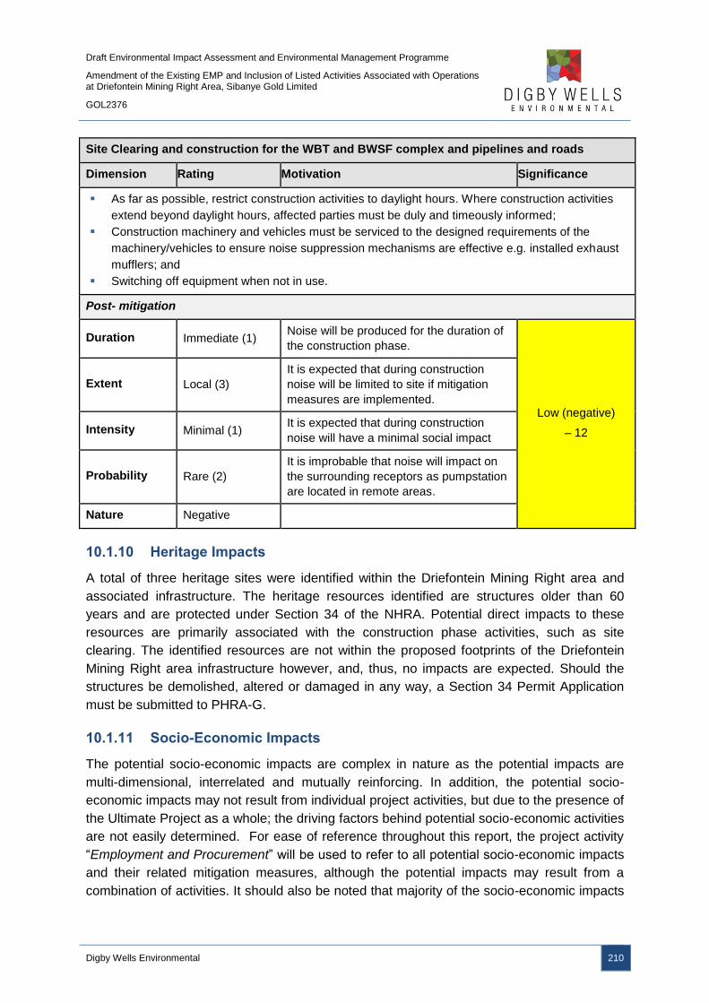
Draft Environmental Impact Assessment and Environmental Management Programme
Amendment of the Existing EMP and Inclusion of Listed Activities Associated with Operations at Driefontein Mining Right Area, Sibanye Gold Limited
GOL2376
Digby Wells Environmental 210
Site Clearing and construction for the WBT and BWSF complex and pipelines and roads
Dimension Rating Motivation Significance
As far as possible, restrict construction activities to daylight hours. Where construction activities
extend beyond daylight hours, affected parties must be duly and timeously informed;
Construction machinery and vehicles must be serviced to the designed requirements of the
machinery/vehicles to ensure noise suppression mechanisms are effective e.g. installed exhaust
mufflers; and
Switching off equipment when not in use.
Post- mitigation
Duration Immediate (1) Noise will be produced for the duration of
the construction phase.
Low (negative)
– 12
Extent Local (3)
It is expected that during construction
noise will be limited to site if mitigation
measures are implemented.
Intensity Minimal (1) It is expected that during construction
noise will have a minimal social impact
Probability Rare (2)
It is improbable that noise will impact on
the surrounding receptors as pumpstation
are located in remote areas.
Nature Negative
10.1.10 Heritage Impacts
A total of three heritage sites were identified within the Driefontein Mining Right area and
associated infrastructure. The heritage resources identified are structures older than 60
years and are protected under Section 34 of the NHRA. Potential direct impacts to these
resources are primarily associated with the construction phase activities, such as site
clearing. The identified resources are not within the proposed footprints of the Driefontein
Mining Right area infrastructure however, and, thus, no impacts are expected. Should the
structures be demolished, altered or damaged in any way, a Section 34 Permit Application
must be submitted to PHRA-G.
10.1.11 Socio-Economic Impacts
The potential socio-economic impacts are complex in nature as the potential impacts are
multi-dimensional, interrelated and mutually reinforcing. In addition, the potential socio-
economic impacts may not result from individual project activities, but due to the presence of
the Ultimate Project as a whole; the driving factors behind potential socio-economic activities
are not easily determined. For ease of reference throughout this report, the project activity
“Employment and Procurement” will be used to refer to all potential socio-economic impacts
and their related mitigation measures, although the potential impacts may result from a
combination of activities. It should also be noted that majority of the socio-economic impacts
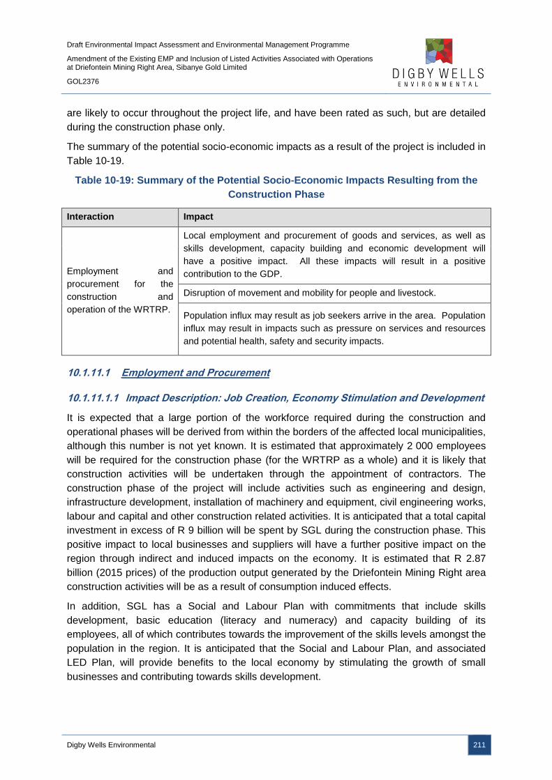
Draft Environmental Impact Assessment and Environmental Management Programme
Amendment of the Existing EMP and Inclusion of Listed Activities Associated with Operations at Driefontein Mining Right Area, Sibanye Gold Limited
GOL2376
Digby Wells Environmental 211
are likely to occur throughout the project life, and have been rated as such, but are detailed
during the construction phase only.
The summary of the potential socio-economic impacts as a result of the project is included in
Table 10-19.
Table 10-19: Summary of the Potential Socio-Economic Impacts Resulting from the
Construction Phase
Interaction Impact
Employment and
procurement for the
construction and
operation of the WRTRP.
Local employment and procurement of goods and services, as well as
skills development, capacity building and economic development will
have a positive impact. All these impacts will result in a positive
contribution to the GDP.
Disruption of movement and mobility for people and livestock.
Population influx may result as job seekers arrive in the area. Population
influx may result in impacts such as pressure on services and resources
and potential health, safety and security impacts.
10.1.11.1 Employment and Procurement
10.1.11.1.1 Impact Description: Job Creation, Economy Stimulation and Development
It is expected that a large portion of the workforce required during the construction and
operational phases will be derived from within the borders of the affected local municipalities,
although this number is not yet known. It is estimated that approximately 2 000 employees
will be required for the construction phase (for the WRTRP as a whole) and it is likely that
construction activities will be undertaken through the appointment of contractors. The
construction phase of the project will include activities such as engineering and design,
infrastructure development, installation of machinery and equipment, civil engineering works,
labour and capital and other construction related activities. It is anticipated that a total capital
investment in excess of R 9 billion will be spent by SGL during the construction phase. This
positive impact to local businesses and suppliers will have a further positive impact on the
region through indirect and induced impacts on the economy. It is estimated that R 2.87
billion (2015 prices) of the production output generated by the Driefontein Mining Right area
construction activities will be as a result of consumption induced effects.
In addition, SGL has a Social and Labour Plan with commitments that include skills
development, basic education (literacy and numeracy) and capacity building of its
employees, all of which contributes towards the improvement of the skills levels amongst the
population in the region. It is anticipated that the Social and Labour Plan, and associated
LED Plan, will provide benefits to the local economy by stimulating the growth of small
businesses and contributing towards skills development.

Draft Environmental Impact Assessment and Environmental Management Programme
Amendment of the Existing EMP and Inclusion of Listed Activities Associated with Operations at Driefontein Mining Right Area, Sibanye Gold Limited
GOL2376
Digby Wells Environmental 212
10.1.11.1.2 Management Objectives
The communities in the vicinity of the project are likely to be affected the most by the
project’s activities. It is consistent with national legislation and international best practice
standards that these host communities are given special consideration in terms of the
project’s benefits. To enhance the potential positive impacts associated with the project, the
following enhancement measures have been proposed:
■ Use labour-intensive construction methods, where feasible, to increase employment
opportunities;
■ Clearly define and publicise recruitment policies and the nature and number of
available jobs with specific focus on the local communities;
■ Local labour, local construction contractors and local and small businesses should be
prioritised;
■ Where feasible, reserve a percentage of, and promote employment opportunities for
woman and the youth;
■ Ensure that contractors comply with SGL’s employment policies and Social and
Labour Plan commitments;
■ Coordinate recruitment through the Department of Labour and/or bona fide
recruitment agencies;
■ Undertake a skills survey and establish a database to identify core skills required and
suitable candidates. Skills development and training programmes must be structured
around the findings of the skills survey. Training should aim to be National
Qualifications Framework (NQF) accredited;
■ Utilise existing SGL programmes and initiatives to identify students from local
schools to participate in company bursaries and internship programmes;
■ Include local procurement targets in the WRTRP procurement policy and contractor
agreements. Preferential procurement in accordance with Broad-Based Black
Economic Empowerment and the Mining Charter must be ensured;
■ Continued assessment of projected IDP and LED initiatives of the local municipalities
to ensure that the Social and Labour Plan commitments remain relevant and
appropriate;
■ Communicate corporate social investment to the local communities to manage
community expectations regarding infrastructure and services to be provided by SGL;
and
■ Support housing development through the promoting of house ownership for
employees.
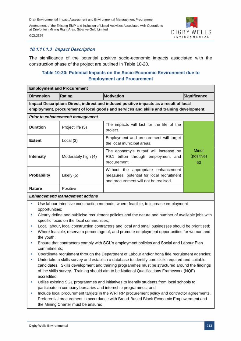
Draft Environmental Impact Assessment and Environmental Management Programme
Amendment of the Existing EMP and Inclusion of Listed Activities Associated with Operations at Driefontein Mining Right Area, Sibanye Gold Limited
GOL2376
Digby Wells Environmental 213
10.1.11.1.3 Impact Description
The significance of the potential positive socio-economic impacts associated with the
construction phase of the project are outlined in Table 10-20.
Table 10-20: Potential Impacts on the Socio-Economic Environment due to
Employment and Procurement
Employment and Procurement
Dimension Rating Motivation Significance
Impact Description: Direct, indirect and induced positive impacts as a result of local
employment, procurement of local goods and services and skills and training development.
Prior to enhancement/ management
Duration Project life (5) The impacts will last for the life of the
project.
Minor
(positive)
60
Extent Local (3) Employment and procurement will target
the local municipal areas.
Intensity Moderately high (4)
The economy’s output will increase by
R9.1 billion through employment and
procurement.
Probability Likely (5)
Without the appropriate enhancement
measures, potential for local recruitment
and procurement will not be realised.
Nature Positive
Enhancement/ Management actions
Use labour-intensive construction methods, where feasible, to increase employment
opportunities;
Clearly define and publicise recruitment policies and the nature and number of available jobs with
specific focus on the local communities;
Local labour, local construction contractors and local and small businesses should be prioritised;
Where feasible, reserve a percentage of, and promote employment opportunities for woman and
the youth;
Ensure that contractors comply with SGL’s employment policies and Social and Labour Plan
commitments;
Coordinate recruitment through the Department of Labour and/or bona fide recruitment agencies;
Undertake a skills survey and establish a database to identify core skills required and suitable
candidates. Skills development and training programmes must be structured around the findings
of the skills survey. Training should aim to be National Qualifications Framework (NQF)
accredited;
Utilise existing SGL programmes and initiatives to identify students from local schools to
participate in company bursaries and internship programmes; and
Include local procurement targets in the WRTRP procurement policy and contractor agreements.
Preferential procurement in accordance with Broad-Based Black Economic Empowerment and
the Mining Charter must be ensured.

Draft Environmental Impact Assessment and Environmental Management Programme
Amendment of the Existing EMP and Inclusion of Listed Activities Associated with Operations at Driefontein Mining Right Area, Sibanye Gold Limited
GOL2376
Digby Wells Environmental 214
Employment and Procurement
Dimension Rating Motivation Significance
Post- enhancement
Duration Project life (5) The impacts will last for the life of the
project.
Moderate
(positive)
96
Extent National (6) The resultant impacts will have a
significant impact on a national scale.
Intensity High (5)
Enhancement will maximise local job
creation and procurement which will
result in significant multiplier affects.
Probability Highly probable (6)
Enhancement measures will ensure the
local employment and procurement
potential is realised.
Nature Positive
Employment and Procurement
Dimension Rating Motivation Significance
Impact Description: Direct investment for goods and services will result in a multiplier effect
on the local economy as a portion of these funds will stimulate regional economic growth.
Prior to enhancement/ management
Duration Project life (5)
The LED will reach its peak during
operation, but will commence during
construction.
Minor
(positive)
70
Extent Municipal (4)
The local municipalities will benefit from
the project, with the district municipality
receiving benefits from taxes and
royalties.
Intensity High (5)
The multiplier effect is likely to have a
significant contribution to the region’s
economy.
Probability Likely (5)
Without the appropriate enhancement
measures, benefits may be ad hoc and
unsustainable
Nature Positive
Enhancement/ Management actions
Where feasible, utilise existing SLP, LED and related stakeholder engagement processes to
determine the need and viability for infrastructure and service-related projects;
Supporting housing development through promoting house ownership for employees;
Ensure that contractors comply with SGL’s employment policies and Social and Labour Plan
commitments;
Local labour, local construction contractors and local and small businesses should be prioritised;
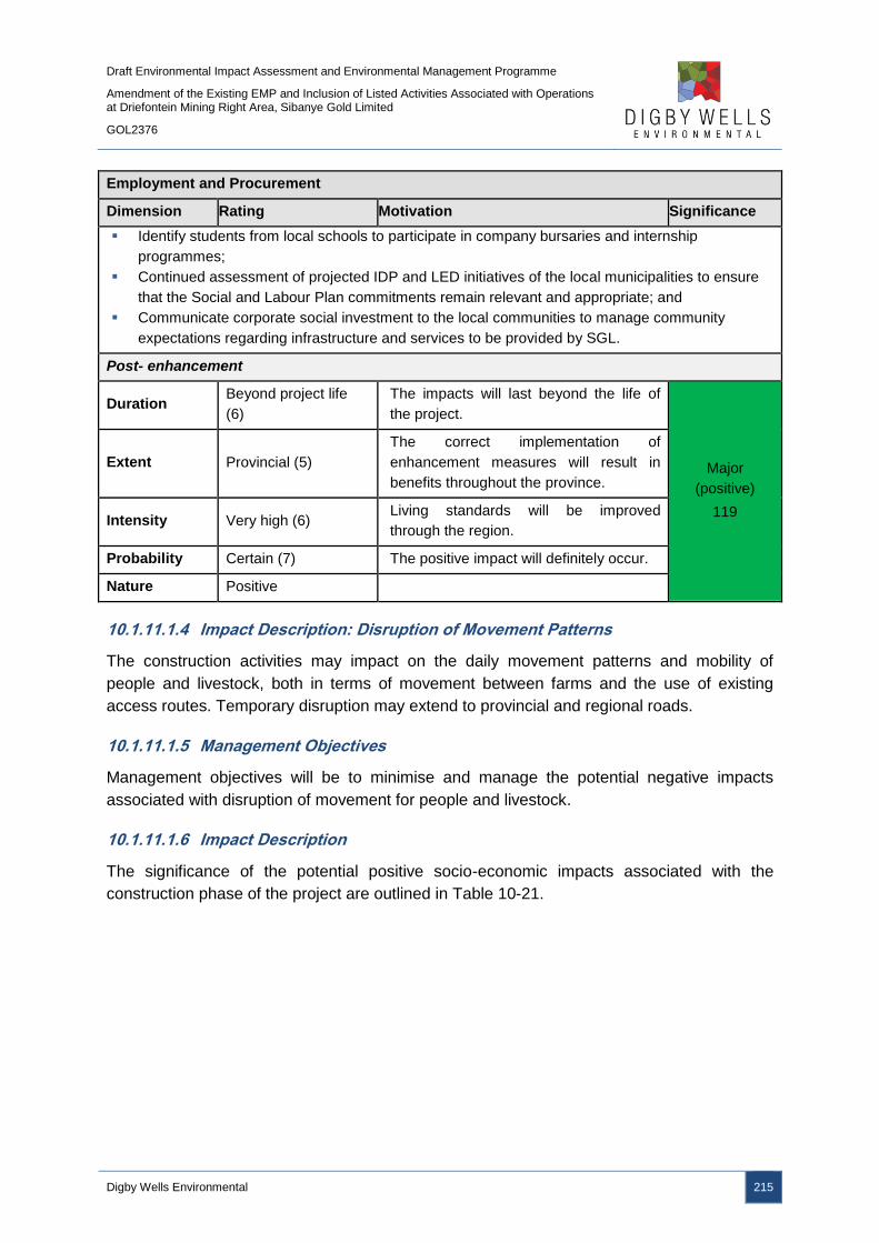
Draft Environmental Impact Assessment and Environmental Management Programme
Amendment of the Existing EMP and Inclusion of Listed Activities Associated with Operations at Driefontein Mining Right Area, Sibanye Gold Limited
GOL2376
Digby Wells Environmental 215
Employment and Procurement
Dimension Rating Motivation Significance
Identify students from local schools to participate in company bursaries and internship
programmes;
Continued assessment of projected IDP and LED initiatives of the local municipalities to ensure
that the Social and Labour Plan commitments remain relevant and appropriate; and
Communicate corporate social investment to the local communities to manage community
expectations regarding infrastructure and services to be provided by SGL.
Post- enhancement
Duration Beyond project life
(6)
The impacts will last beyond the life of
the project.
Major
(positive)
119
Extent Provincial (5)
The correct implementation of
enhancement measures will result in
benefits throughout the province.
Intensity Very high (6) Living standards will be improved
through the region.
Probability Certain (7) The positive impact will definitely occur.
Nature Positive
10.1.11.1.4 Impact Description: Disruption of Movement Patterns
The construction activities may impact on the daily movement patterns and mobility of
people and livestock, both in terms of movement between farms and the use of existing
access routes. Temporary disruption may extend to provincial and regional roads.
10.1.11.1.5 Management Objectives
Management objectives will be to minimise and manage the potential negative impacts
associated with disruption of movement for people and livestock.
10.1.11.1.6 Impact Description
The significance of the potential positive socio-economic impacts associated with the
construction phase of the project are outlined in Table 10-21.

Draft Environmental Impact Assessment and Environmental Management Programme
Amendment of the Existing EMP and Inclusion of Listed Activities Associated with Operations at Driefontein Mining Right Area, Sibanye Gold Limited
GOL2376
Digby Wells Environmental 216
Table 10-21: Pre-Mitigation and Post-Mitigation Potential Impacts on the Socio-
Economic Environment
Employment and Procurement
Dimension Rating Motivation Significance
Impact Description: Disruption of people and livestock daily movements
Prior to mitigation/ management
Duration Medium term (3) Mainly during construction phase with some disturbance during operation
Medium-low
(negative)
- 56
Extent Local (3) Project area and surrounding communities
Intensity Low (2) Disruption may be intense for local farmers
Probability Certain (7) Impact will definitely occur
Nature Negative
Mitigation/ Management actions
Inform and consult local communities regarding construction activities and potential road
closures;
Implement a grievance mechanism and procedures for surrounding communities to provide
comments and issues relating to activities associated with the WRTRP;
Erect suitable traffic and construction signage to raise awareness of construction and potential
hazards; and
Implement cattle corridors and access points during construction activities to ensure grazing
areas are uninterrupted.
Post- mitigation
Duration Medium term (3) Mainly during construction phase with some disturbance during operation
Medium-low
(negative)
- 42
Extent Limited (2) Project area and surrounding communities
Intensity Very low (1) Nuisance factor for road users. Disruption may affect productivity of farming businesses
Probability Certain (7) Mitigation will reduce disruption and provide alternative routes
Nature Negative
10.1.11.1.7 Impact Description: Population Influx
Expectations regarding possible employment opportunities may arise once activities
commence on site. Consequently, the area surrounding the CPP and RTSF complex may
experience an influx of job seekers as this has already occurred in these areas since mining
has expanded in the region. The magnitude of this impact may be influenced by the severity
of poverty and unemployment, as people will be more inclined to travel in search of better
livelihoods through employment.
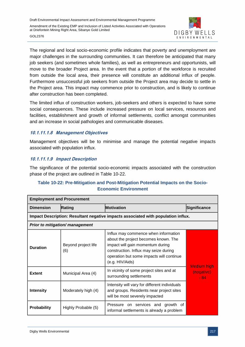
Draft Environmental Impact Assessment and Environmental Management Programme
Amendment of the Existing EMP and Inclusion of Listed Activities Associated with Operations at Driefontein Mining Right Area, Sibanye Gold Limited
GOL2376
Digby Wells Environmental 217
The regional and local socio-economic profile indicates that poverty and unemployment are
major challenges in the surrounding communities. It can therefore be anticipated that many
job seekers (and sometimes whole families), as well as entrepreneurs and opportunists, will
move to the broader Project area. In the event that a portion of the workforce is recruited
from outside the local area, their presence will constitute an additional influx of people.
Furthermore unsuccessful job seekers from outside the Project area may decide to settle in
the Project area. This impact may commence prior to construction, and is likely to continue
after construction has been completed.
The limited influx of construction workers, job-seekers and others is expected to have some
social consequences. These include increased pressure on local services, resources and
facilities, establishment and growth of informal settlements, conflict amongst communities
and an increase in social pathologies and communicable diseases.
10.1.11.1.8 Management Objectives
Management objectives will be to minimise and manage the potential negative impacts
associated with population influx.
10.1.11.1.9 Impact Description
The significance of the potential socio-economic impacts associated with the construction
phase of the project are outlined in Table 10-22.
Table 10-22: Pre-Mitigation and Post-Mitigation Potential Impacts on the Socio-
Economic Environment
Employment and Procurement
Dimension Rating Motivation Significance
Impact Description: Resultant negative impacts associated with population influx.
Prior to mitigation/ management
Duration Beyond project life
(6)
Influx may commence when information
about the project becomes known. The
impact will gain momentum during
construction. Influx may seize during
operation but some impacts will continue
(e.g. HIV/Aids) Medium high
(negative)
- 84 Extent Municipal Area (4)
In vicinity of some project sites and at
surrounding settlements
Intensity Moderately high (4)
Intensity will vary for different individuals
and groups. Residents near project sites
will be most severely impacted
Probability Highly Probable (5) Pressure on services and growth of
informal settlements is already a problem
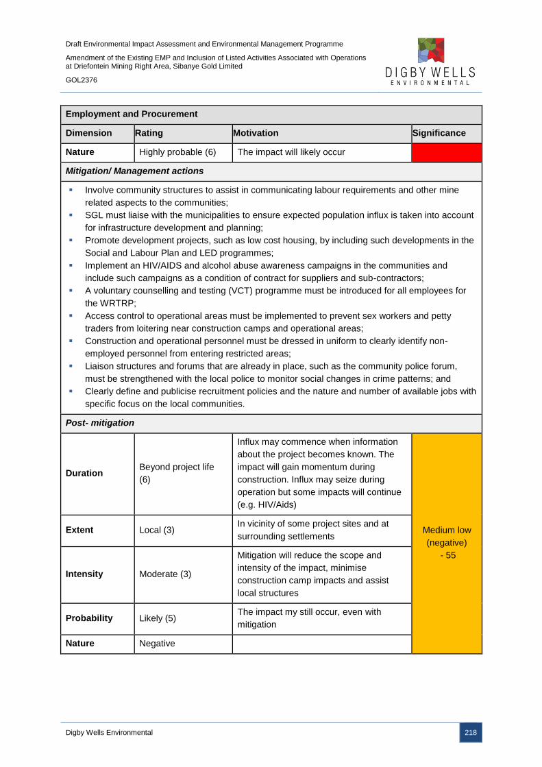
Draft Environmental Impact Assessment and Environmental Management Programme
Amendment of the Existing EMP and Inclusion of Listed Activities Associated with Operations at Driefontein Mining Right Area, Sibanye Gold Limited
GOL2376
Digby Wells Environmental 218
Employment and Procurement
Dimension Rating Motivation Significance
Nature Highly probable (6) The impact will likely occur
Mitigation/ Management actions
Involve community structures to assist in communicating labour requirements and other mine
related aspects to the communities;
SGL must liaise with the municipalities to ensure expected population influx is taken into account
for infrastructure development and planning;
Promote development projects, such as low cost housing, by including such developments in the
Social and Labour Plan and LED programmes;
Implement an HIV/AIDS and alcohol abuse awareness campaigns in the communities and
include such campaigns as a condition of contract for suppliers and sub-contractors;
A voluntary counselling and testing (VCT) programme must be introduced for all employees for
the WRTRP;
Access control to operational areas must be implemented to prevent sex workers and petty
traders from loitering near construction camps and operational areas;
Construction and operational personnel must be dressed in uniform to clearly identify non-
employed personnel from entering restricted areas;
Liaison structures and forums that are already in place, such as the community police forum,
must be strengthened with the local police to monitor social changes in crime patterns; and
Clearly define and publicise recruitment policies and the nature and number of available jobs with
specific focus on the local communities.
Post- mitigation
Duration Beyond project life
(6)
Influx may commence when information
about the project becomes known. The
impact will gain momentum during
construction. Influx may seize during
operation but some impacts will continue
(e.g. HIV/Aids)
Medium low
(negative)
- 55
Extent Local (3) In vicinity of some project sites and at
surrounding settlements
Intensity Moderate (3)
Mitigation will reduce the scope and
intensity of the impact, minimise
construction camp impacts and assist
local structures
Probability Likely (5) The impact my still occur, even with
mitigation
Nature Negative
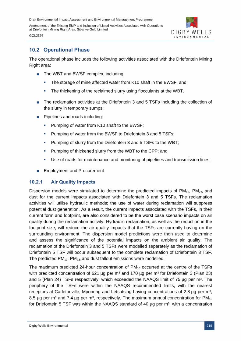
Draft Environmental Impact Assessment and Environmental Management Programme
Amendment of the Existing EMP and Inclusion of Listed Activities Associated with Operations at Driefontein Mining Right Area, Sibanye Gold Limited
GOL2376
Digby Wells Environmental 219
10.2 Operational Phase
The operational phase includes the following activities associated with the Driefontein Mining
Right area:
■ The WBT and BWSF complex, including:
The storage of mine affected water from K10 shaft in the BWSF; and
The thickening of the reclaimed slurry using flocculants at the WBT.
■ The reclamation activities at the Driefontein 3 and 5 TSFs including the collection of
the slurry in temporary sumps;
■ Pipelines and roads including:
Pumping of water from K10 shaft to the BWSF;
Pumping of water from the BWSF to Driefontein 3 and 5 TSFs;
Pumping of slurry from the Driefontein 3 and 5 TSFs to the WBT;
Pumping of thickened slurry from the WBT to the CPP; and
Use of roads for maintenance and monitoring of pipelines and transmission lines.
■ Employment and Procurement
10.2.1 Air Quality Impacts
Dispersion models were simulated to determine the predicted impacts of PM10, PM2.5 and
dust for the current impacts associated with Driefontein 3 and 5 TSFs. The reclamation
activities will utilise hydraulic methods; the use of water during reclamation will suppress
potential dust generation. As a result, the current impacts associated with the TSFs, in their
current form and footprint, are also considered to be the worst case scenario impacts on air
quality during the reclamation activity. Hydraulic reclamation, as well as the reduction in the
footprint size, will reduce the air quality impacts that the TSFs are currently having on the
surrounding environment. The dispersion model predictions were then used to determine
and assess the significance of the potential impacts on the ambient air quality. The
reclamation of the Driefontein 3 and 5 TSFs were modelled separately as the reclamation of
Driefontein 5 TSF will occur subsequent to the complete reclamation of Driefontein 3 TSF.
The predicted PM10, PM2.5 and dust fallout emissions were modelled.
The maximum predicted 24-hour concentration of PM10 occurred at the centre of the TSFs
with predicted concentration of 621 µg per m³ and 170 µg per m³ for Driefontein 3 (Plan 23)
and 5 (Plan 24) TSFs respectively, which exceeded the NAAQS limit of 75 µg per m³. The
periphery of the TSFs were within the NAAQS recommended limits, with the nearest
receptors at Carletonville, Mponeng and Letsatsing having concentrations of 2.8 µg per m³,
8.5 µg per m³ and 7.4 µg per m³, respectively. The maximum annual concentration for PM10
for Driefontein 5 TSF was within the NAAQS standard of 40 µg per m³, with a concentration

Draft Environmental Impact Assessment and Environmental Management Programme
Amendment of the Existing EMP and Inclusion of Listed Activities Associated with Operations at Driefontein Mining Right Area, Sibanye Gold Limited
GOL2376
Digby Wells Environmental 220
of 20 µg per m³. Driefontein 3 TSF exceeded this limit with an annual maximum
concentration of 69 µg per m³. PM10 concentrations from Driefontein 3 and 5 TSFs are likely
to be a burden on surrounding air quality, as opposed to cumulative air quality impacts form
surrounding land uses.
The daily and annual PM2.5 concentrations for Driefontein 3 TSF are within the NAAQS limits
with maximum concentrations of 52 µg per m³ and 5.7 µg per m³ respectively. Similarly, the
PM2.5 concentrations for Driefontein 5 TSF are also within the daily and annual NAAQS limits
with concentrations of 14 µg per m³ and 1.7 µg per m³ respectively.
Dust fallout emissions from Driefontein 5 TSF are not anticipated to exceed the NDCR
(2013) residential or non-residential rates as the maximum dust deposition of 692 mg per m2
per day reduces to 100 mg per m2 per day 600 m from the TSF. The maximum predicted
deposition rates for Driefontein 3 TSF are 92 mg per m2 per day and are well within the
NDCR (2013) limits.
A summary of the predicted dispersion model results are provided in Table 10-23.

Draft Environmental Impact Assessment and Environmental Management Programme
Amendment of the Existing EMP and Inclusion of Listed Activities Associated with Operations at Driefontein Mining Right Area, Sibanye Gold Limited
GOL2376
Digby Wells Environmental 221
Table 10-23: Summary of Dispersion Modelling Results
Air Contaminant Averaging
Period
Ambient Air
Quality Standard
(µg/m3)
Maximum Ground Level Concentration
(µg/m3)
Levels at receptors (µg/m3)
Carletonville Letsatsing Mponeng Driefontein 3 TSF Driefontein 5 TSF
Inhalable
Particulates (PM10)
24 hour 75 621 170 2.8 7.4 8.5
Annual 40 69 20 0.21 1.2 4.9
Fine Particulate
(PM2.5)
24 hour 65 52 14 0.01 0.29 0.18
Annual 25 5.7 1.7 0.02 0.12 0.41
Dust fall (mg/m2/day)
Dust Deposition Monthly 600 92 692 0.18 31 16.7

Draft Environmental Impact Assessment and Environmental Management Programme
Amendment of the Existing EMP and Inclusion of Listed Activities Associated with Operations at Driefontein Mining Right Area, Sibanye Gold Limited
GOL2376
Digby Wells Environmental 222
Plan 23: Maximum 24-Hour PM10 Concentrations for Driefontein 3 TSF
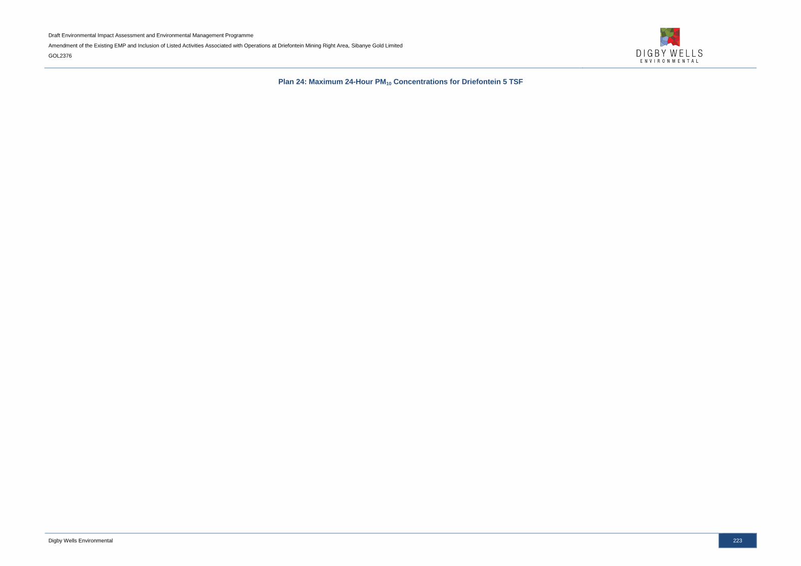
Draft Environmental Impact Assessment and Environmental Management Programme
Amendment of the Existing EMP and Inclusion of Listed Activities Associated with Operations at Driefontein Mining Right Area, Sibanye Gold Limited
GOL2376
Digby Wells Environmental 223
Plan 24: Maximum 24-Hour PM10 Concentrations for Driefontein 5 TSF

Draft Environmental Impact Assessment and Environmental Management Programme
Amendment of the Existing EMP and Inclusion of Listed Activities Associated with Operations at Driefontein Mining Right Area, Sibanye Gold Limited
GOL2376
Digby Wells Environmental 224
Table 10-24 details the activities’ interactions and the resultant impacts as a result of the
proposed developments.
Table 10-24: Interactions and Impacts on Air Quality during the Operational Phase
Interaction Impact
Reclamation activities Dust generation
Reduction in the quality of ambient air due to increased pollutants loading
Wind erosion of exposed
surfaces
Dust generation
Reduction in the quality of ambient air due to increased pollutants loading
10.2.1.1 Reclamation of Driefontein 3 and 5 TSFs
The Driefontein 3 and 5 TSFs will be hydraulically reclaimed during the operational phase.
The resultant slurry will flow to temporary sumps where it will be pumped, via pipelines and
the WBT, to the CPP.
10.2.1.1.1 Impact Description
The hydraulic reclamation of the TSFs are not expected to be dust generating activities as
the tailings material will form a slurry due to the use of water, suppressing any potential dust
emissions. The transportation of personnel on and off site is likely to have a greater impact
on air quality than the reclamation activities, although this impact is expected to be low
(negative).
10.2.1.1.2 Management Objectives
The management objective is to ensure that emissions on-site and off-site from the
reclamation activities comply with the NDCR standards for the protection of the environment,
human health and wellbeing.
10.2.1.1.3 Management Actions and Targets
An emissions management programme must be developed to assess performance and
compliance to the NDCR and NAAQS standards of 600 mg per m2 per day for dust fallout,
75 µg per m3 for PM10 and 65 µg per m3 for PM2.5. Monitoring of dust fallout levels must be
undertaken upwind and downwind of the reclamation activities.
10.2.1.1.4 Impact Ratings
The impact significance ratings prior to and post mitigation measures, as well as the
mitigation measures, for the impacts on air quality are provided in Table 10-25.

Draft Environmental Impact Assessment and Environmental Management Programme
Amendment of the Existing EMP and Inclusion of Listed Activities Associated with Operations at Driefontein Mining Right Area, Sibanye Gold Limited
GOL2376
Digby Wells Environmental 225
Table 10-25: Potential Impacts on Air Quality due to the WBT and BWSF Complex
Reclamation of the Driefontein 3 and 5 TSFs
Dimension Rating Motivation Significance
Impact Description: Reduction in ambient air quality
Prior to mitigation/ management
Duration Medium term (3) Dust will be produced in the medium term
Low (negative)
– 10
Extent Very Limited (1) Dust generated will be limited to the site
and it immediate surroundings
Intensity Limited (1) Limited impact on ambient air quality
during reclamation
Probability Rare (2) Possibility of dust generation is very low.
Nature Negative
Mitigation/ Management actions
Vehicle travel speeds and distances must be reduced when transporting personnel on site; and
Dust suppressants must be used on gravel roads.
Post- mitigation
Duration Medium term (3) Dust will be produced in the medium term
Low (negative)
– 10
Extent Very limited (1)
After mitigation measures are
implemented, It is expected that dust
impacts will be limited to isolated parts of
the site.
Intensity Limited (1) Limited impact on ambient air quality
during reclamation
Probability Rare (2) The possibility of dust generation is very
low
Nature Negative
10.2.2 Groundwater Impacts
The reclamation of the historical TSFs will remove a permanent pollution source from the
landscape which is expected to have a positive long term impact on the environment.
Impacts on groundwater quality may, however, occur during the reclamation activities. The
project activities’ interactions and impacts on groundwater during the operational phase are
provided in Table 10-26.
Draft Environmental Impact Assessment and Environmental Management Programme
Amendment of the Existing EMP and Inclusion of Listed Activities Associated with Operations at Driefontein Mining Right Area, Sibanye Gold Limited
GOL2376
Digby Wells Environmental 226
Table 10-26: Interactions and Impacts on Groundwater during the Operational Phase
Interaction Impact
Hydraulic reclamation of the
historical TSFs
The water used during hydraulic reclamation may seep through
the TSF footprint and deteriorate groundwater quality.
Tailings exposure to oxygen and
water
The potential for AMD generation increases during reclamation
as tailings material is exposed to water and oxygen.
10.2.2.1 Reclamation of Driefontein 3 and 5 TSFs
10.2.2.1.1 Impact Description
The groundwater impacts associated with the reclamation of the historical TSFs are
expected to be positive since the source of contamination will be removed. Although the site
specific hydrogeological conditions of the TSFs may differ, the identified impacts will
essentially be the same and a positive outcome for the groundwater systems associated with
all of the historical TSFs.
The historical TSFs are not lined and seepage is expected to drain into the underlying
groundwater system. The current hypothesis is that if there were no TSFs located directly
over the dolomite, it is likely that the dolomitic water (also called fissure water by the mines)
pumped from the underground chambers would be of better quality compared to the current
status. The positive long terms impacts, however, will only be realised once the historical
TSFs have been reclaimed in their entirety.
AMD could be generated in the short-term due to the exposure of the tailings to oxygen and
water during the reclamation phase. This is expected to be short lived (spanning the period
of reclamation) and buffered by the dolomitic carbonates underneath. Furthermore, the
impact to groundwater may occur during reclamation due to increased seepage of the mine
affected water. The impact of the AMD generation and seepage is considered to be medium-
low (negative) as the sites are already considered to be contaminated due to the presence of
the historical TSFs and the pollution plumes are local.
10.2.2.1.2 Management Objectives
To realise the positive impacts on the groundwater quality due to the reclamation of the
historical TSFs, the TSF must be reclaimed in its entirety and the footprint rehabilitated
according to the Closure and Rehabilitation Plans. Mine affected water must be managed
effectively to minimise the potential for seepage to occur.
10.2.2.1.3 Management Targets and Actions
All tailings material must be removed from the footprint of the historical TSFs to ensure that
no pollution or contaminant sources remain. Mine affected water must be diverted to the TSF
sumps and pooling of mine affected water must be avoided to ensure increased seepage
does not occur.
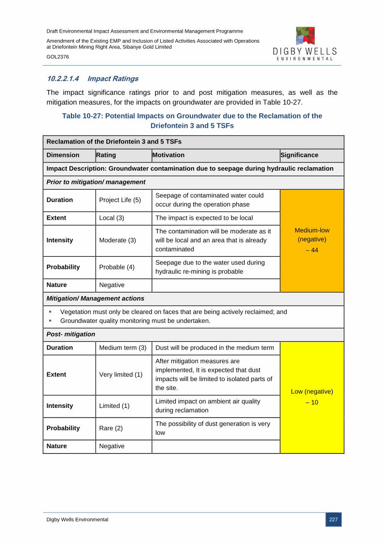
Draft Environmental Impact Assessment and Environmental Management Programme
Amendment of the Existing EMP and Inclusion of Listed Activities Associated with Operations at Driefontein Mining Right Area, Sibanye Gold Limited
GOL2376
Digby Wells Environmental 227
10.2.2.1.4 Impact Ratings
The impact significance ratings prior to and post mitigation measures, as well as the
mitigation measures, for the impacts on groundwater are provided in Table 10-27.
Table 10-27: Potential Impacts on Groundwater due to the Reclamation of the
Driefontein 3 and 5 TSFs
Reclamation of the Driefontein 3 and 5 TSFs
Dimension Rating Motivation Significance
Impact Description: Groundwater contamination due to seepage during hydraulic reclamation
Prior to mitigation/ management
Duration Project Life (5) Seepage of contaminated water could
occur during the operation phase
Medium-low
(negative)
– 44
Extent Local (3) The impact is expected to be local
Intensity Moderate (3)
The contamination will be moderate as it
will be local and an area that is already
contaminated
Probability Probable (4) Seepage due to the water used during
hydraulic re-mining is probable
Nature Negative
Mitigation/ Management actions
Vegetation must only be cleared on faces that are being actively reclaimed; and
Groundwater quality monitoring must be undertaken.
Post- mitigation
Duration Medium term (3) Dust will be produced in the medium term
Low (negative)
– 10
Extent Very limited (1)
After mitigation measures are
implemented, It is expected that dust
impacts will be limited to isolated parts of
the site.
Intensity Limited (1) Limited impact on ambient air quality
during reclamation
Probability Rare (2) The possibility of dust generation is very
low
Nature Negative

Draft Environmental Impact Assessment and Environmental Management Programme
Amendment of the Existing EMP and Inclusion of Listed Activities Associated with Operations at Driefontein Mining Right Area, Sibanye Gold Limited
GOL2376
Digby Wells Environmental 228
10.2.3 Soil Impacts
During the operational phase, the pipelines will be monitored and maintained, resulting in
site access along the pipeline route and use of the associated roads. The monitoring and
maintenance of the pipelines may result in soil compaction due to vehicle and personnel
movements.
Table 10-28 details the project activities’ interactions and the resultant impacts as a result of
the proposed developments.
Table 10-28: Interactions and Impacts on Soil during the Operational Phase
Interaction Impact
Use of vehicles and heavy
machinery Loss of topsoil as a resource – Erosion and Compaction
10.2.3.1 Pipelines and Roads
10.2.3.1.1 Impact Description
The movement of personnel, vehicles and machinery during the monitoring and
maintenance of the pipelines may result in soil compaction. Soil compaction prevents
vegetation from being established and increases the velocity of water runoff which may
result in soil erosion. The compaction and erosion of the soils leads to a loss of topsoil
resources.
10.2.3.1.2 Management Objectives
The management objectives are to limit the loss of topsoil that could occur as a result of the
monitoring and maintenance activities. Exposed areas must be assessed for compaction
and erosion potential. Should compaction and erosion occur, these areas must be ripped
and vegetated to prevent further impacts.
10.2.3.1.3 Management Actions and Targets
There are no regulated targets and requirements for the management of soils. SGL will
rehabilitate the disturbed areas associated with pipeline and road construction.
10.2.3.1.4 Impact Ratings
The impact significance ratings prior to and post mitigation measures, as well as the
mitigation measures, for the impacts on soils are provided in Table 10-29.
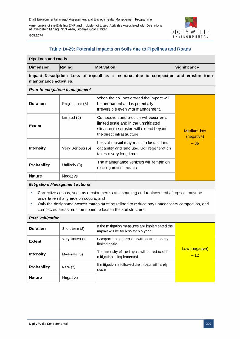
Draft Environmental Impact Assessment and Environmental Management Programme
Amendment of the Existing EMP and Inclusion of Listed Activities Associated with Operations at Driefontein Mining Right Area, Sibanye Gold Limited
GOL2376
Digby Wells Environmental 229
Table 10-29: Potential Impacts on Soils due to Pipelines and Roads
Pipelines and roads
Dimension Rating Motivation Significance
Impact Description: Loss of topsoil as a resource due to compaction and erosion from
maintenance activities.
Prior to mitigation/ management
Duration Project Life (5)
When the soil has eroded the impact will
be permanent and is potentially
irreversible even with management.
Medium-low
(negative)
– 36
Extent
Limited (2) Compaction and erosion will occur on a
limited scale and in the unmitigated
situation the erosion will extend beyond
the direct infrastructure.
Intensity Very Serious (5)
Loss of topsoil may result in loss of land
capability and land use. Soil regeneration
takes a very long time.
Probability Unlikely (3) The maintenance vehicles will remain on
existing access routes
Nature Negative
Mitigation/ Management actions
Corrective actions, such as erosion berms and sourcing and replacement of topsoil, must be
undertaken if any erosion occurs; and
Only the designated access routes must be utilised to reduce any unnecessary compaction, and
compacted areas must be ripped to loosen the soil structure.
Post- mitigation
Duration Short term (2) If the mitigation measures are implemented the
impact will be for less than a year.
Low (negative)
– 12
Extent Very limited (1) Compaction and erosion will occur on a very
limited scale.
Intensity Moderate (3) The intensity of the impact will be reduced if
mitigation is implemented.
Probability Rare (2) If mitigation is followed the impact will rarely
occur
Nature Negative

Draft Environmental Impact Assessment and Environmental Management Programme
Amendment of the Existing EMP and Inclusion of Listed Activities Associated with Operations at Driefontein Mining Right Area, Sibanye Gold Limited
GOL2376
Digby Wells Environmental 230
10.2.3.2 Reclamation of Driefontein 3 and 5 TSFs
10.2.3.2.1 Impact Description
The contamination of surrounding soil resources, as a result of the mobilisation of tailings
material by wind and water, may take place. However, as discussed in Section 10.2.1, the
current dust emissions are considered a worst case scenario; the hydraulic reclamation, as
well as reduction in footprint, of the TSFs will reduce the generation of dust from the TSFs
and its impacts. As a result, the potential to impact surrounding soil resources is likely to
reduce during the hydraulic reclamation of the TSFs and subsequent footprint reduction. The
no-go option will therefore likely to continue impacting surrounding soil resources.
10.2.3.2.2 Management Objectives
The management objectives are to limit the mobilisation and erosion of contaminants on the
RTSF that could impact on surrounding soil resources around the Driefontein 3 and 5 TSFs.
10.2.3.2.3 Management Actions and Targets
There are no regulated targets and requirements for the management of soils.
10.2.3.2.4 Impact Ratings
The impact significance ratings prior to and post mitigation measures, as well as the
mitigation measures, for the impacts on soils are provided in Table 10-30.
Table 10-30: Potential Impacts on Soils due to the Reclamation of Driefontein 3 and 5
TSFs
Reclamation of Driefontein 3 and 5 TSFs
Dimension Rating Motivation Significance
Impact Description: Loss of topsoil resources due to contamination from windblown tailings
material and runoff
Prior to mitigation/ management
Duration Project Life (5) Contamination if unmitigated could last for
many years.
Medium-low
(negative)
– 70
Extent Limited (2) The impact will occur within and
immediately around the Project site.
Intensity On-going (3)
Loss of topsoil may result in loss of land
capability and land use. Soil regeneration
takes a very long time.
Probability Certain (7) It is certain that this impact will occur
Nature Negative
Mitigation/ Management actions
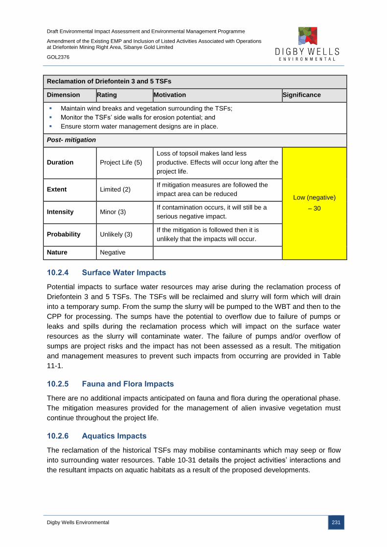
Draft Environmental Impact Assessment and Environmental Management Programme
Amendment of the Existing EMP and Inclusion of Listed Activities Associated with Operations at Driefontein Mining Right Area, Sibanye Gold Limited
GOL2376
Digby Wells Environmental 231
Reclamation of Driefontein 3 and 5 TSFs
Dimension Rating Motivation Significance
Maintain wind breaks and vegetation surrounding the TSFs;
Monitor the TSFs’ side walls for erosion potential; and
Ensure storm water management designs are in place.
Post- mitigation
Duration Project Life (5)
Loss of topsoil makes land less
productive. Effects will occur long after the
project life.
Low (negative)
– 30
Extent Limited (2) If mitigation measures are followed the
impact area can be reduced
Intensity Minor (3) If contamination occurs, it will still be a
serious negative impact.
Probability Unlikely (3) If the mitigation is followed then it is
unlikely that the impacts will occur.
Nature Negative
10.2.4 Surface Water Impacts
Potential impacts to surface water resources may arise during the reclamation process of
Driefontein 3 and 5 TSFs. The TSFs will be reclaimed and slurry will form which will drain
into a temporary sump. From the sump the slurry will be pumped to the WBT and then to the
CPP for processing. The sumps have the potential to overflow due to failure of pumps or
leaks and spills during the reclamation process which will impact on the surface water
resources as the slurry will contaminate water. The failure of pumps and/or overflow of
sumps are project risks and the impact has not been assessed as a result. The mitigation
and management measures to prevent such impacts from occurring are provided in Table
11-1.
10.2.5 Fauna and Flora Impacts
There are no additional impacts anticipated on fauna and flora during the operational phase.
The mitigation measures provided for the management of alien invasive vegetation must
continue throughout the project life.
10.2.6 Aquatics Impacts
The reclamation of the historical TSFs may mobilise contaminants which may seep or flow
into surrounding water resources. Table 10-31 details the project activities’ interactions and
the resultant impacts on aquatic habitats as a result of the proposed developments.
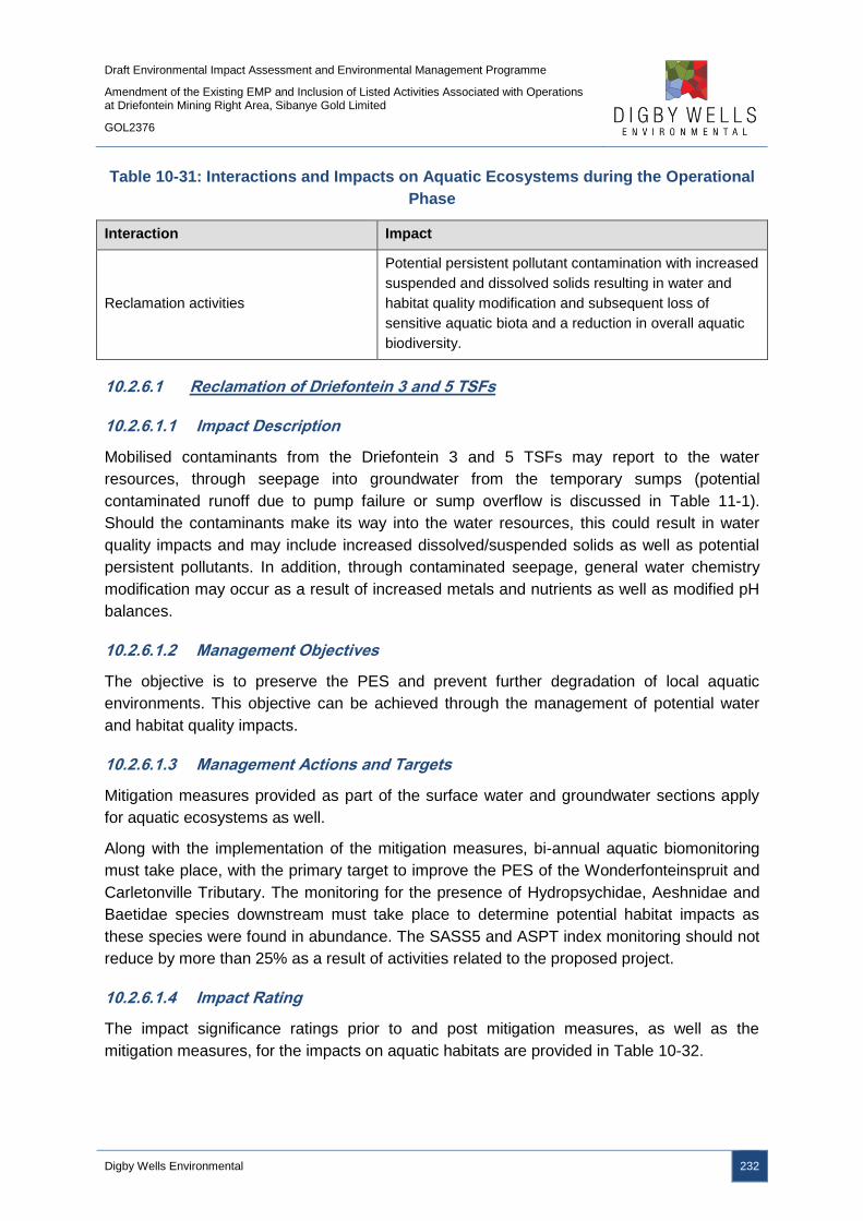
Draft Environmental Impact Assessment and Environmental Management Programme
Amendment of the Existing EMP and Inclusion of Listed Activities Associated with Operations at Driefontein Mining Right Area, Sibanye Gold Limited
GOL2376
Digby Wells Environmental 232
Table 10-31: Interactions and Impacts on Aquatic Ecosystems during the Operational
Phase
Interaction Impact
Reclamation activities
Potential persistent pollutant contamination with increased
suspended and dissolved solids resulting in water and
habitat quality modification and subsequent loss of
sensitive aquatic biota and a reduction in overall aquatic
biodiversity.
10.2.6.1 Reclamation of Driefontein 3 and 5 TSFs
10.2.6.1.1 Impact Description
Mobilised contaminants from the Driefontein 3 and 5 TSFs may report to the water
resources, through seepage into groundwater from the temporary sumps (potential
contaminated runoff due to pump failure or sump overflow is discussed in Table 11-1).
Should the contaminants make its way into the water resources, this could result in water
quality impacts and may include increased dissolved/suspended solids as well as potential
persistent pollutants. In addition, through contaminated seepage, general water chemistry
modification may occur as a result of increased metals and nutrients as well as modified pH
balances.
10.2.6.1.2 Management Objectives
The objective is to preserve the PES and prevent further degradation of local aquatic
environments. This objective can be achieved through the management of potential water
and habitat quality impacts.
10.2.6.1.3 Management Actions and Targets
Mitigation measures provided as part of the surface water and groundwater sections apply
for aquatic ecosystems as well.
Along with the implementation of the mitigation measures, bi-annual aquatic biomonitoring
must take place, with the primary target to improve the PES of the Wonderfonteinspruit and
Carletonville Tributary. The monitoring for the presence of Hydropsychidae, Aeshnidae and
Baetidae species downstream must take place to determine potential habitat impacts as
these species were found in abundance. The SASS5 and ASPT index monitoring should not
reduce by more than 25% as a result of activities related to the proposed project.
10.2.6.1.4 Impact Rating
The impact significance ratings prior to and post mitigation measures, as well as the
mitigation measures, for the impacts on aquatic habitats are provided in Table 10-32.

Draft Environmental Impact Assessment and Environmental Management Programme
Amendment of the Existing EMP and Inclusion of Listed Activities Associated with Operations at Driefontein Mining Right Area, Sibanye Gold Limited
GOL2376
Digby Wells Environmental 233
Table 10-32: Potential Impacts on Aquatic Habitats due to the Reclamation of
Driefontein 3 and 5 TSFs
Reclamation of Driefontein 3 and 5 TSFs
Dimension Rating Motivation Significance
Impact Description: Water and habitat quality modification
Prior to mitigation/ management
Duration Project life (5) The impact will occur for the duration of
the project.
Medium-high
(negative)
- 78
Extent Local (3)
The impacts will only occur within the
local area. Even water quality impacts
would only occur until dilution can occur
within short distance downstream
regions.
Intensity Very serious (5)
Runoff from the historical TSFs during the
reclamation would likely enter and
degrade local aquatic ecosystems.
Probability Almost certain (6)
The impact will almost certainly occur if
activities are to occur within proximity to
the river systems without mitigation
actions.
Nature Negative
Mitigation/ Management actions
Silt traps placed within clean water return channels; and
The planting of indigenous trees around the historical TSFs and temporary sumps.
Post- mitigation
Duration Project life (5) The impact will occur for the duration of
the project.
Medium-low
(negative)
- 39
Extent Local (3)
The impacts will only occur within the
local area. Even water quality impacts
would only occur until dilution can occur
within short distance downstream
regions.
Intensity Very serious (5)
Seepage and runoff from the RTSF will
contain pollutants and will potentially
negatively influence downstream water
quality.
Probability Unlikely (3) Probability reduced due to mitigation
actions.
Nature Negative
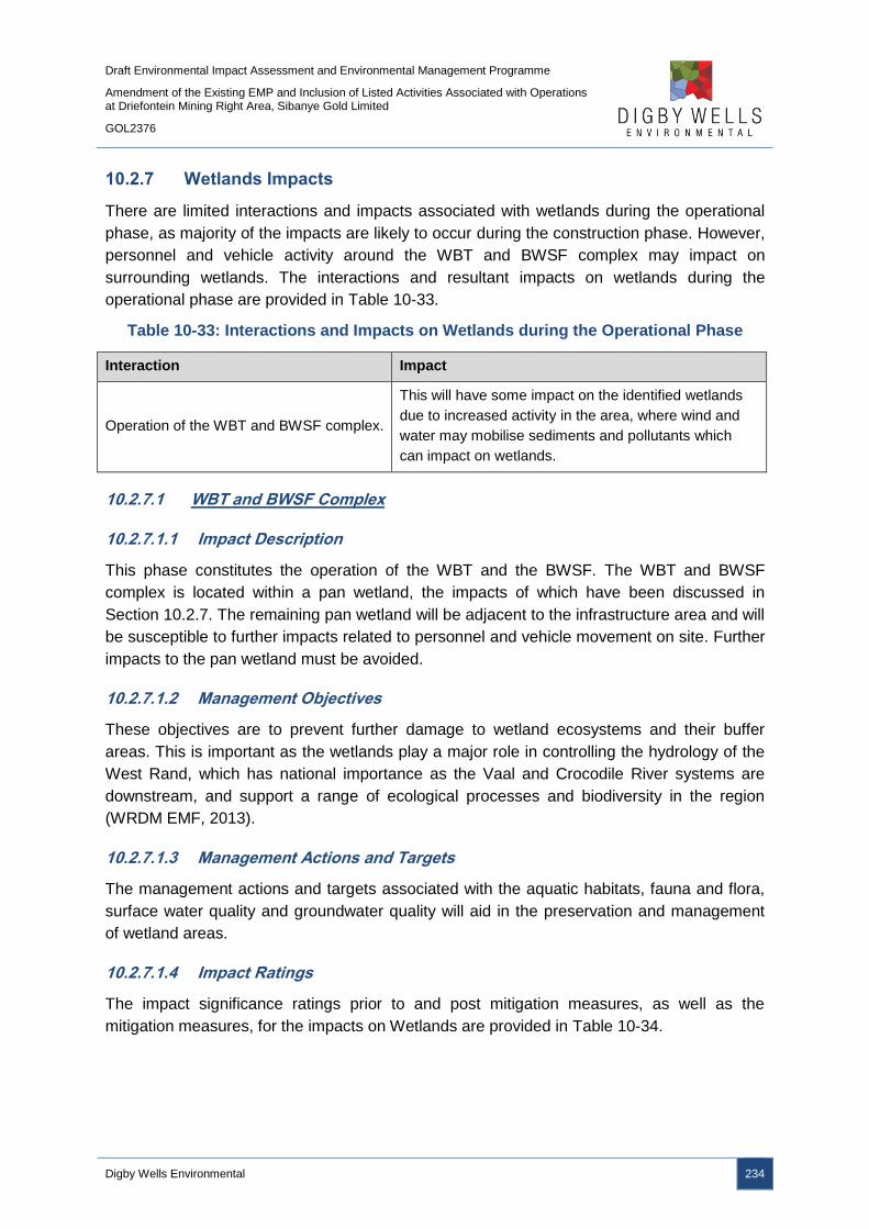
Draft Environmental Impact Assessment and Environmental Management Programme
Amendment of the Existing EMP and Inclusion of Listed Activities Associated with Operations at Driefontein Mining Right Area, Sibanye Gold Limited
GOL2376
Digby Wells Environmental 234
10.2.7 Wetlands Impacts
There are limited interactions and impacts associated with wetlands during the operational
phase, as majority of the impacts are likely to occur during the construction phase. However,
personnel and vehicle activity around the WBT and BWSF complex may impact on
surrounding wetlands. The interactions and resultant impacts on wetlands during the
operational phase are provided in Table 10-33.
Table 10-33: Interactions and Impacts on Wetlands during the Operational Phase
Interaction Impact
Operation of the WBT and BWSF complex.
This will have some impact on the identified wetlands
due to increased activity in the area, where wind and
water may mobilise sediments and pollutants which
can impact on wetlands.
10.2.7.1 WBT and BWSF Complex
10.2.7.1.1 Impact Description
This phase constitutes the operation of the WBT and the BWSF. The WBT and BWSF
complex is located within a pan wetland, the impacts of which have been discussed in
Section 10.2.7. The remaining pan wetland will be adjacent to the infrastructure area and will
be susceptible to further impacts related to personnel and vehicle movement on site. Further
impacts to the pan wetland must be avoided.
10.2.7.1.2 Management Objectives
These objectives are to prevent further damage to wetland ecosystems and their buffer
areas. This is important as the wetlands play a major role in controlling the hydrology of the
West Rand, which has national importance as the Vaal and Crocodile River systems are
downstream, and support a range of ecological processes and biodiversity in the region
(WRDM EMF, 2013).
10.2.7.1.3 Management Actions and Targets
The management actions and targets associated with the aquatic habitats, fauna and flora,
surface water quality and groundwater quality will aid in the preservation and management
of wetland areas.
10.2.7.1.4 Impact Ratings
The impact significance ratings prior to and post mitigation measures, as well as the
mitigation measures, for the impacts on Wetlands are provided in Table 10-34.

Draft Environmental Impact Assessment and Environmental Management Programme
Amendment of the Existing EMP and Inclusion of Listed Activities Associated with Operations at Driefontein Mining Right Area, Sibanye Gold Limited
GOL2376
Digby Wells Environmental 235
Table 10-34: Potential Impacts on Wetlands due to the WBT and BWSF Complex
Operation of the WBT and BWSF complex
Dimension Rating Motivation Significance
Impact Description: Sediment and pollution impacting the integrity of adjacent wetlands.
Prior to mitigation/ management
Duration Project Life (5)
Impact will only occur during the
operation of the WBT and BWSF
complex.
Medium-high
(negative)
-84
Extent Municipal (4) The wetland catchments within the
municipal boundaries will be impacted.
Intensity Serious (5) This represents serious damage to highly
sensitive environments.
Probability Highly probable (6) This is highly probable due to the nature
of the activity.
Nature Negative
Mitigation/ Management actions
Alien Invasive Management Plan for disturbed areas and the project site;
Dust suppressants must be used on gravel roads and exposed areas; and
The WBT and BWSF complex footprints must be fully contained and a Storm Water
Management Plan implemented.
Post- mitigation
Duration Project Life (5) Mitigation will not decrease the duration
of the operation of the CPP and RTSF.
Low (negative)
-30
Extent Local (3) The mitigation measures will allow the
impacts to be kept to a local extent.
Intensity Minor effects (2)
The wetlands will be subjected to minor
impacts with mitigation measure
employed.
Probability Unlikely (3) Mitigation will decrease the likelihood of
impacts significantly.
Nature Negative
10.2.8 Visual Impacts
The visual impacts associated with the infrastructure commenced during the construction
phase and will continue through the operational phase. The only new visual impact during
the operational phase is due to the hydraulic reclamation of the Driefontein 3 and 5 TSFs
should dust be generated. However, as detailed in the Air Quality Impact Assessment
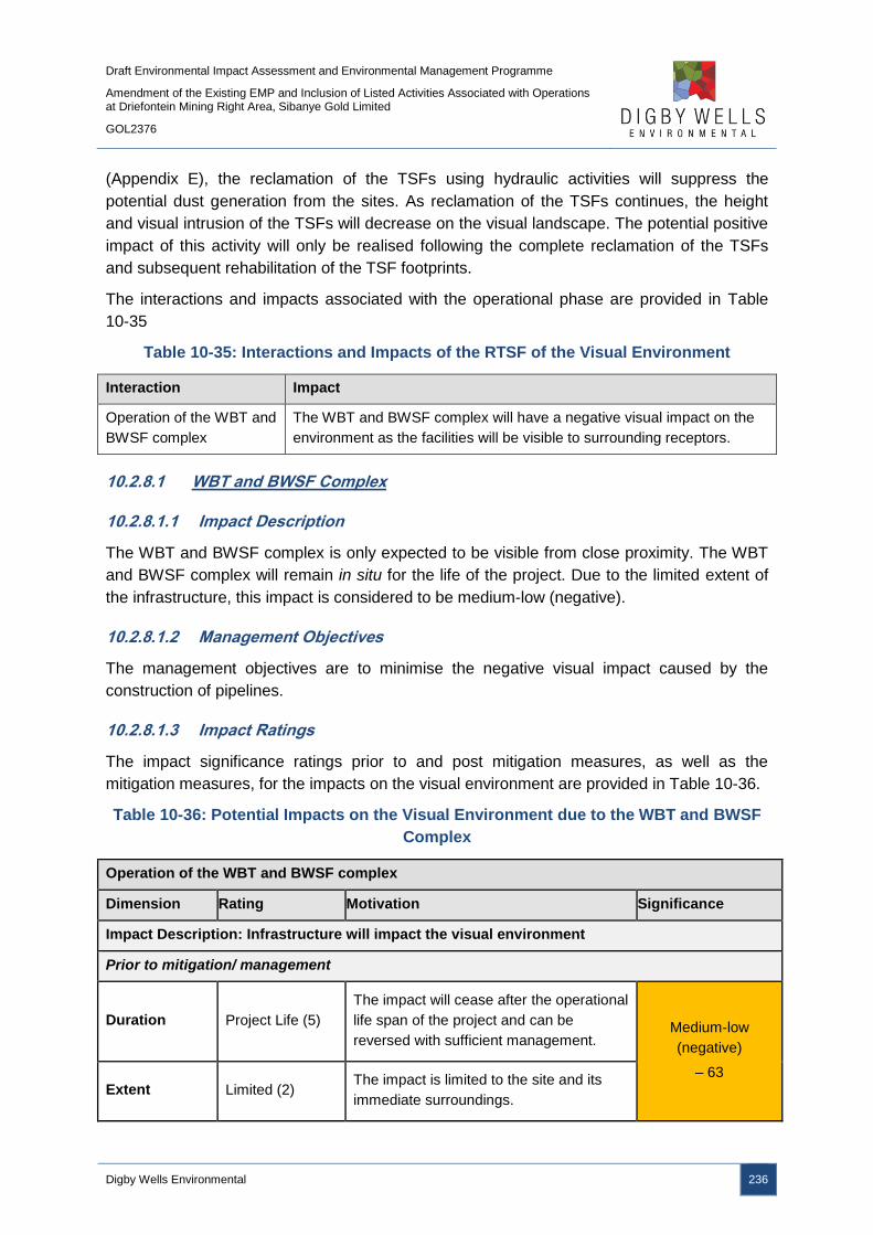
Draft Environmental Impact Assessment and Environmental Management Programme
Amendment of the Existing EMP and Inclusion of Listed Activities Associated with Operations at Driefontein Mining Right Area, Sibanye Gold Limited
GOL2376
Digby Wells Environmental 236
(Appendix E), the reclamation of the TSFs using hydraulic activities will suppress the
potential dust generation from the sites. As reclamation of the TSFs continues, the height
and visual intrusion of the TSFs will decrease on the visual landscape. The potential positive
impact of this activity will only be realised following the complete reclamation of the TSFs
and subsequent rehabilitation of the TSF footprints.
The interactions and impacts associated with the operational phase are provided in Table
10-35
Table 10-35: Interactions and Impacts of the RTSF of the Visual Environment
Interaction Impact
Operation of the WBT and
BWSF complex
The WBT and BWSF complex will have a negative visual impact on the
environment as the facilities will be visible to surrounding receptors.
10.2.8.1 WBT and BWSF Complex
10.2.8.1.1 Impact Description
The WBT and BWSF complex is only expected to be visible from close proximity. The WBT
and BWSF complex will remain in situ for the life of the project. Due to the limited extent of
the infrastructure, this impact is considered to be medium-low (negative).
10.2.8.1.2 Management Objectives
The management objectives are to minimise the negative visual impact caused by the
construction of pipelines.
10.2.8.1.3 Impact Ratings
The impact significance ratings prior to and post mitigation measures, as well as the
mitigation measures, for the impacts on the visual environment are provided in Table 10-36.
Table 10-36: Potential Impacts on the Visual Environment due to the WBT and BWSF
Complex
Operation of the WBT and BWSF complex
Dimension Rating Motivation Significance
Impact Description: Infrastructure will impact the visual environment
Prior to mitigation/ management
Duration Project Life (5)
The impact will cease after the operational
life span of the project and can be
reversed with sufficient management. Medium-low
(negative)
– 63
Extent Limited (2) The impact is limited to the site and its
immediate surroundings.

Draft Environmental Impact Assessment and Environmental Management Programme
Amendment of the Existing EMP and Inclusion of Listed Activities Associated with Operations at Driefontein Mining Right Area, Sibanye Gold Limited
GOL2376
Digby Wells Environmental 237
Operation of the WBT and BWSF complex
Dimension Rating Motivation Significance
Intensity Minor (2)
The negligible height of the pipelines will
restrict the viewshed, with the WBT and
BWSF complex limited in their extent
Probability Definite (7) Pipelines and roads and the WBT and
BWSF complex will be constructed
Nature Negative
Mitigation/ Management actions
Vegetation must only be removed from the infrastructure footprints or areas necessary for
construction;
Establish vegetation on disturbed areas following construction;
The WBT and BWSF complex must be painted natural hues to blend into the surrounding
landscape; and
Down lighting must be used should construction take place during night time.
Post- mitigation
Duration Project Life (5)
The impact will cease after the operational
life span of the project and can be
reversed with sufficient management.
Medium-low
(negative)
– 48
Extent Limited (2) The impact is limited to the site and its
immediate surroundings.
Intensity Minimal (1)
The negligible height of the pipelines will
restrict the viewshed, with the WBT and
BWSF complex limited in their extent
Probability Almost Certain
(6) It is most likely that the impact will occur.
Nature Negative
10.2.9 Noise Impacts
Table 10-37 details the project activities’ interactions and the resultant impacts due to noise
generation as a result of the proposed developments. Noise dispersion models were
developed and indicated that the expected noise for the project will not exceed the SANS
10103:2008 limits.
Draft Environmental Impact Assessment and Environmental Management Programme
Amendment of the Existing EMP and Inclusion of Listed Activities Associated with Operations at Driefontein Mining Right Area, Sibanye Gold Limited
GOL2376
Digby Wells Environmental 238
Table 10-37: Interactions and Impacts associated with Noise during the Operational
Phase
Interaction Impact
Operation of the WBT and BWSF and
associated pumps, as well as reclamation
of Driefontein 3 and TSFs.
Generation of noise may increase ambient noise
10.2.9.1 WBT and BWSF Complex and Reclamation of Driefontein 3 and 5 TSFs
10.2.9.1.1 Impact Description
Noise will emanate from machinery and equipment associated with the operation of the WBT
and BSWF, as well as the operation of the associated pump stations for the pipelines. Based
on the noise model (Appendix M), the noise levels will not exceed the SANS 10103:2008
limits and, thus, the significance of the impacts are considered to be low (negative).
10.2.9.1.2 Management Objectives
The management objective is to minimise noise generation caused by the reclamation
activities and pump stations.
10.2.9.1.3 Impact Ratings
The impact significance ratings prior to and post mitigation measures, as well as the
mitigation measures, for the impacts on noise are provided in Table 10-38.
Table 10-38: Potential Impacts on Noise during the Operational Phase
Operation of the WBT and BWSF complex and reclamation of the Driefontein 3 and 5 TSFs
Dimension Rating Motivation Significance
Impact Description: Noise will emanate from the reclamation activities and pump stations
during the operational phase
Prior to mitigation/ management
Duration Long term (4)
Noise will be produced for the duration of
the reclamation activities of between 5 to
6 years for each TSF.
Low (negative)
– 24 Extent Local (3)
It is expected that during operation noise
will be limited to site.
Intensity Minor (1)
It is expected that during operational
phase noise will have a minor social
impact
Draft Environmental Impact Assessment and Environmental Management Programme
Amendment of the Existing EMP and Inclusion of Listed Activities Associated with Operations at Driefontein Mining Right Area, Sibanye Gold Limited
GOL2376
Digby Wells Environmental 239
Operation of the WBT and BWSF complex and reclamation of the Driefontein 3 and 5 TSFs
Dimension Rating Motivation Significance
Probability Unlikely (3)
It is unlikely that noise will impact on the
surrounding communities as the pump
stations and WBT and BWSF complex are
remotely located.
Nature Negative
Mitigation/ Management actions
Pump stations to be housed in noise attenuating enclosures;
Regular service maintenance on the pipelines to mitigate water hammer noise as well as
maintaining a constant flow rate during pumping of water and slurry;
Equipment and machinery must be serviced to the designed requirements to ensure noise
suppression mechanisms are effective e.g. installed exhaust mufflers; and
Switching off equipment when not in use.
Post- mitigation
Duration Long term (4)
Noise will be produced for the duration of
the reclamation activities of between 5 to
6 years.
Low (negative)
– 16
Extent Local (3)
Noise will be produced for the duration of
the reclamation activities of between 5 to
6 years for each TSF.
Intensity Minor (1)
It is expected that during operational
phase noise will have a minor social
impact
Probability Unlikely (2)
It is unlikely that noise will impact on the
surrounding communities as the pump
stations and WBT and BWSF complex are
remotely located.
Nature Negative
10.2.10 Socio-Economic Impacts
As detailed in Section 10.1.11, socio-economic impacts may arise from the construction
phase and continue throughout the life of the project. As a result, although these impacts
may continue to occur during the operational phase, these impacts have not been
reassessed for the operational phase below. For ease of reference, all potential socio-
economic impacts fall under the activity Employment and Procurement.
The summary of the potential socio-economic impacts as a result of the project is included in
Table 10-39.
Draft Environmental Impact Assessment and Environmental Management Programme
Amendment of the Existing EMP and Inclusion of Listed Activities Associated with Operations at Driefontein Mining Right Area, Sibanye Gold Limited
GOL2376
Digby Wells Environmental 240
Table 10-39: Summary of the Potential Socio-Economic Impacts Resulting from the
Operational Phase
Interaction Impact
Employment and procurement
during the operational phase
of the WRTRP.
Local employment and procurement of goods specific to the
operational phase of the WRTRP.
10.2.10.1 Employment and Procurement
10.2.10.1.1 Impact Description: Job Creation and Economy Stimulation
The Overall WRTRP will provide an estimated 500 permanent job positions over the life of
the operation. The project will also result in indirect employment opportunities in the formal
and informal sectors following project expenditure in the local areas and through the creation
and expansion of local businesses that may serve the project’s workforce.
In 2013, the export of gold contributed almost R 50 billion to South African exports,
accounting for 19.5% of the country’s total exports (DMR, 2015). The WRTRP will contribute
an estimated R 4.1 billion per annum should the gold and uranium product be exported.
Such exports will bring stability to the country through the earning of foreign exchange which
in turns allows a greater purchasing capacity in the international market that can be used to
acquire goods and services necessary for the development of other industries within the
nation. The business sales generated by the project over its lifespan through direct and spin-
off effects will translate into R 36 billion (2015 prices) of GDP per region.
10.2.10.1.2 Management Objectives
It is consistent with national legislation and international best practice standards that host
communities are given special consideration in terms of the project’s benefits. To enhance
the potential positive impacts associated with the project, the following enhancement
measures have been proposed:
■ Clearly define and publicise recruitment policies and the nature and number of
available jobs with specific focus on the local communities;
■ Local labour and local and small businesses should be prioritised;
■ Where feasible, reserve a percentage of, and promote employment opportunities for
woman and the youth;
■ Ensure that contractors comply with SGL’s employment policies and Social and
Labour Plan commitments;
■ Coordinate recruitment through the Department of Labour and/or bona fide
recruitment agencies;
■ Undertake a skills survey and establish a database to identify core skills required and
suitable candidates. Skills development and training programmes must be structured
Draft Environmental Impact Assessment and Environmental Management Programme
Amendment of the Existing EMP and Inclusion of Listed Activities Associated with Operations at Driefontein Mining Right Area, Sibanye Gold Limited
GOL2376
Digby Wells Environmental 241
around the findings of the skills survey. Training should aim to be National
Qualifications Framework (NQF) accredited;
■ Utilise existing SGL programmes and initiatives to identify students from local
schools to participate in company bursaries and internship programmes;
■ Include local procurement targets in the WRTRP procurement policy and contractor
agreements. Preferential procurement in accordance with Broad-Based Black
Economic Empowerment and the Mining Charter must be ensured;
■ Continued assessment of projected IDP and LED initiatives of the local municipalities
to ensure that the Social and Labour Plan commitments remain relevant and
appropriate;
■ Communicate corporate social investment to the local communities to manage
community expectations regarding infrastructure and services to be provided by SGL;
and
■ Support housing development through the promoting of house ownership for
employees.
10.2.10.1.3 Impact Description
The significance of the potential socio-economic impacts associated with the operational
phase of the project are outlined in Table 10-40.
Table 10-40: Potential Impacts on the Socio-Economic Environment due to
Employment and Procurement
Employment and Procurement
Dimension Rating Motivation Significance
Impact Description: Direct, indirect and induced positive impacts as a result of local
employment, procurement of local goods and services.
Prior to enhancement/ management
Duration Project life (5) The impacts will last for the life of the
project.
Minor
(positive)
60
Extent Local (3) Employment and procurement will target
the local municipal areas.
Intensity Moderately high (4)
Approximately 500 jobs will be created
during the operational phase, with
additional indirect jobs created as a
result.
Probability Likely (5)
Without the appropriate enhancement
measures, potential for local recruitment
and procurement will not be realised.

Draft Environmental Impact Assessment and Environmental Management Programme
Amendment of the Existing EMP and Inclusion of Listed Activities Associated with Operations at Driefontein Mining Right Area, Sibanye Gold Limited
GOL2376
Digby Wells Environmental 242
Employment and Procurement
Dimension Rating Motivation Significance
Nature Positive
Enhancement/ Management actions
Clearly define and publicise recruitment policies and the nature and number of available jobs with
specific focus on the local communities;
Local labour and local and small businesses should be prioritised;
Where feasible, reserve a percentage of, and promote employment opportunities for woman and
the youth;
Ensure that contractors comply with SGL’s employment policies and Social and Labour Plan
commitments;
Coordinate recruitment through the Department of Labour and/or bona fide recruitment agencies;
Undertake a skills survey and establish a database to identify core skills required and suitable
candidates. Skills development and training programmes must be structured around the findings
of the skills survey. Training should aim to be National Qualifications Framework (NQF)
accredited;
Utilise existing SGL programmes and initiatives to identify students from local schools to
participate in company bursaries and internship programmes ;and
Include local procurement targets in the WRTRP procurement policy and contractor agreements.
Preferential procurement in accordance with Broad-Based Black Economic Empowerment and
the Mining Charter must be ensured.
Post- enhancement
Duration Project life (5) The impacts will last for the life of the
project.
Moderate
(positive)
96
Extent National (6) The resultant impacts will have a
significant impact on a national scale.
Intensity High (5)
Enhancement will maximise local job
creation and procurement which will
result in significant multiplier affects.
Probability Highly probable (6)
Enhancement measures will ensure the
local employment and procurement
potential is realised.
Nature Positive
Dimension Rating Motivation Significance
Impact Description: Exportation of uranium and gold product will contribute directly to the
country’s economy.
Prior to enhancement/ management
Duration Project life (5) The impacts will last for the life of the
project.
Moderate
(positive)
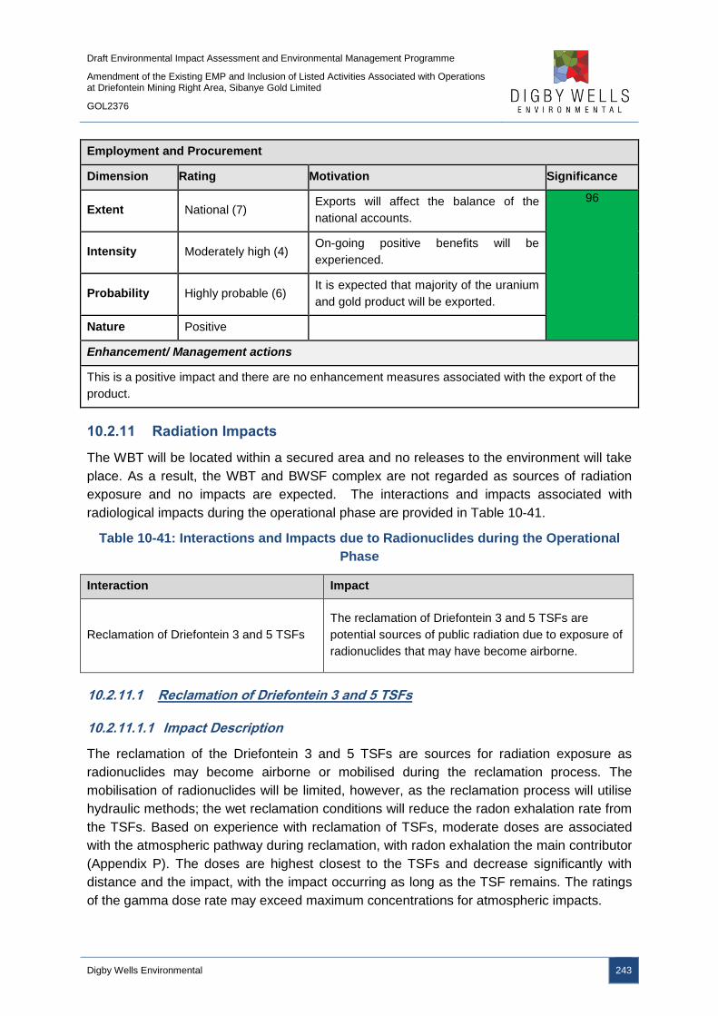
Draft Environmental Impact Assessment and Environmental Management Programme
Amendment of the Existing EMP and Inclusion of Listed Activities Associated with Operations at Driefontein Mining Right Area, Sibanye Gold Limited
GOL2376
Digby Wells Environmental 243
Employment and Procurement
Dimension Rating Motivation Significance
Extent National (7) Exports will affect the balance of the
national accounts.
96
Intensity Moderately high (4) On-going positive benefits will be
experienced.
Probability Highly probable (6) It is expected that majority of the uranium
and gold product will be exported.
Nature Positive
Enhancement/ Management actions
This is a positive impact and there are no enhancement measures associated with the export of the
product.
10.2.11 Radiation Impacts
The WBT will be located within a secured area and no releases to the environment will take
place. As a result, the WBT and BWSF complex are not regarded as sources of radiation
exposure and no impacts are expected. The interactions and impacts associated with
radiological impacts during the operational phase are provided in Table 10-41.
Table 10-41: Interactions and Impacts due to Radionuclides during the Operational
Phase
Interaction Impact
Reclamation of Driefontein 3 and 5 TSFs
The reclamation of Driefontein 3 and 5 TSFs are
potential sources of public radiation due to exposure of
radionuclides that may have become airborne.
10.2.11.1 Reclamation of Driefontein 3 and 5 TSFs
10.2.11.1.1 Impact Description
The reclamation of the Driefontein 3 and 5 TSFs are sources for radiation exposure as
radionuclides may become airborne or mobilised during the reclamation process. The
mobilisation of radionuclides will be limited, however, as the reclamation process will utilise
hydraulic methods; the wet reclamation conditions will reduce the radon exhalation rate from
the TSFs. Based on experience with reclamation of TSFs, moderate doses are associated
with the atmospheric pathway during reclamation, with radon exhalation the main contributor
(Appendix P). The doses are highest closest to the TSFs and decrease significantly with
distance and the impact, with the impact occurring as long as the TSF remains. The ratings
of the gamma dose rate may exceed maximum concentrations for atmospheric impacts.
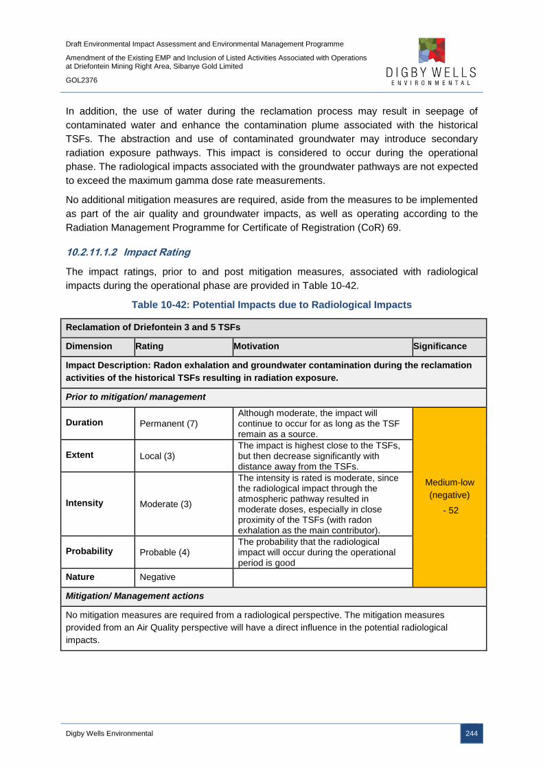
Draft Environmental Impact Assessment and Environmental Management Programme
Amendment of the Existing EMP and Inclusion of Listed Activities Associated with Operations at Driefontein Mining Right Area, Sibanye Gold Limited
GOL2376
Digby Wells Environmental 244
In addition, the use of water during the reclamation process may result in seepage of
contaminated water and enhance the contamination plume associated with the historical
TSFs. The abstraction and use of contaminated groundwater may introduce secondary
radiation exposure pathways. This impact is considered to occur during the operational
phase. The radiological impacts associated with the groundwater pathways are not expected
to exceed the maximum gamma dose rate measurements.
No additional mitigation measures are required, aside from the measures to be implemented
as part of the air quality and groundwater impacts, as well as operating according to the
Radiation Management Programme for Certificate of Registration (CoR) 69.
10.2.11.1.2 Impact Rating
The impact ratings, prior to and post mitigation measures, associated with radiological
impacts during the operational phase are provided in Table 10-42.
Table 10-42: Potential Impacts due to Radiological Impacts
Reclamation of Driefontein 3 and 5 TSFs
Dimension Rating Motivation Significance
Impact Description: Radon exhalation and groundwater contamination during the reclamation
activities of the historical TSFs resulting in radiation exposure.
Prior to mitigation/ management
Duration Permanent (7) Although moderate, the impact will continue to occur for as long as the TSF remain as a source.
Medium-low
(negative)
- 52
Extent Local (3) The impact is highest close to the TSFs, but then decrease significantly with distance away from the TSFs.
Intensity Moderate (3)
The intensity is rated is moderate, since the radiological impact through the atmospheric pathway resulted in moderate doses, especially in close proximity of the TSFs (with radon exhalation as the main contributor).
Probability Probable (4) The probability that the radiological impact will occur during the operational period is good
Nature Negative
Mitigation/ Management actions
No mitigation measures are required from a radiological perspective. The mitigation measures
provided from an Air Quality perspective will have a direct influence in the potential radiological
impacts.

Draft Environmental Impact Assessment and Environmental Management Programme
Amendment of the Existing EMP and Inclusion of Listed Activities Associated with Operations at Driefontein Mining Right Area, Sibanye Gold Limited
GOL2376
Digby Wells Environmental 245
10.3 Decommissioning Phase
The decommissioning phase will entail the demolition and removal of infrastructure,
including the WBT and BWSF complex and pipelines and roads, as well as the rehabilitation
of all infrastructure and TSF footprints. The footprints will be rehabilitated to a final land use.
10.3.1 Air Quality Impacts
Table 10-43 details the activities’ interactions and the resultant impacts as a result of the
proposed developments.
Table 10-43: Interactions and Impacts on Air Quality during the Decommissioning
Phase
Interaction Impact
Wind
erosion
Reduction in the quality of ambient air due to increased dust loading from vehicle
wheels and wind erosion
Improved air quality; availability of land for alternative uses
10.3.1.1 WBT and BWSF Complex and Pipelines and Roads
10.3.1.2 Impact description
The dismantling of old infrastructure, including the WBT and BWSF complex and pipelines
and roads involve the use of heavy machinery and vehicles similar to the construction
phase. Wind erosion of soils may occur until the rehabilitation is complete and vegetation
has been fully established, binding the soil particles. The impacts on the atmospheric
environment during this phase will result in the release of fugitive dust emissions containing
TSP, PM10 and PM2.5.
10.3.1.3 Management Objectives
The management objective is to ensure that emissions on-site and off-site from the
demolition activities and subsequent rehabilitation are not in exceedance of the NAAQS and
NDCR standards for the protection of the environment, human health and wellbeing.
10.3.1.4 Management Actions and Targets
An emissions management programme must be developed to assess performance and
compliance to the NDCR standards. Ambient pollutant monitoring should include particulate
emissions at upwind and downwind locations and monitors must be place discretely at the
nearest receptor area to assess public exposure. Ambient levels of dust will be assessed
against the relevant standards.
10.3.1.4.1 Impact Ratings
The impact significance ratings prior to and post mitigation measures, as well as the
mitigation measures, for the impacts on air quality are provided in Table 10-44.

Draft Environmental Impact Assessment and Environmental Management Programme
Amendment of the Existing EMP and Inclusion of Listed Activities Associated with Operations at Driefontein Mining Right Area, Sibanye Gold Limited
GOL2376
Digby Wells Environmental 246
Table 10-44: Potential Impacts on Air Quality due to the Decommissioning Phase
Decommissioning and rehabilitation of the WBT and BWSF complex and pipelines and roads
Dimension Rating Motivation Significance
Impact Description: Reduction in ambient air quality due dust generation from
decommissioning and rehabilitation activities.
Prior to mitigation/ management
Duration Short term (2) Dust will be generated for the duration
demolition
Low (negative)
– 18
Extent Limited (2) Dust generated will be limited to the site
and it immediate surroundings
Intensity Minor (2) The impact will be minor
Probability Unlikely (3) Possibility that the dust generated will
impact on ambient air quality.
Nature Negative
Mitigation/ Management actions
The area of disturbance must be kept to a minimum;
Drop heights when loading rubble should be minimised; and
Dust suppressants or wetting agents must be used on gravel roads and exposed areas.
Post- mitigation
Duration Short term (2) Dust will be generated for the duration of
the demolition
Low (negative)
– 10
Extent Limited (2) Dust generated will be limited to the site
and it immediate surroundings
Intensity Minimal (1) Minimal impact on ambient air quality
during demolition
Probability Rare (2) The possibility of dust generation is very
low
Nature Negative
10.3.1.5 Reclamation of Driefontein 3 and 5 TSFs
10.3.1.6 Impact description
The rehabilitation of Driefontein 3 and 5 TSFs will involve the use of heavy machinery and
vehicles similar to those used during the construction phase. Wind erosion of the exposed
soils may occur until the rehabilitation is complete and vegetation has been fully established,
binding the soil particles. The impacts on the atmospheric environment during this phase
will result in the release of fugitive dust emissions containing TSP, PM10 and PM2.5.
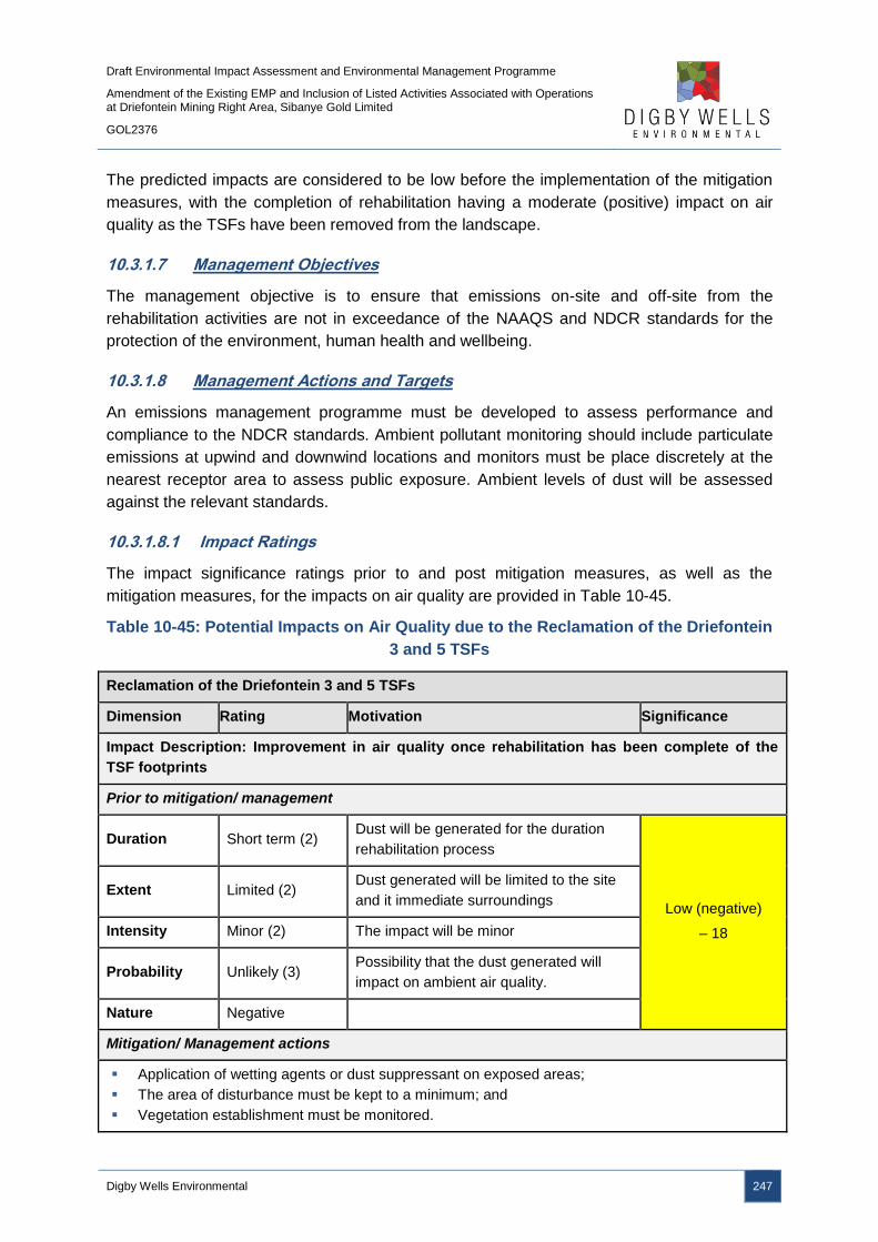
Draft Environmental Impact Assessment and Environmental Management Programme
Amendment of the Existing EMP and Inclusion of Listed Activities Associated with Operations at Driefontein Mining Right Area, Sibanye Gold Limited
GOL2376
Digby Wells Environmental 247
The predicted impacts are considered to be low before the implementation of the mitigation
measures, with the completion of rehabilitation having a moderate (positive) impact on air
quality as the TSFs have been removed from the landscape.
10.3.1.7 Management Objectives
The management objective is to ensure that emissions on-site and off-site from the
rehabilitation activities are not in exceedance of the NAAQS and NDCR standards for the
protection of the environment, human health and wellbeing.
10.3.1.8 Management Actions and Targets
An emissions management programme must be developed to assess performance and
compliance to the NDCR standards. Ambient pollutant monitoring should include particulate
emissions at upwind and downwind locations and monitors must be place discretely at the
nearest receptor area to assess public exposure. Ambient levels of dust will be assessed
against the relevant standards.
10.3.1.8.1 Impact Ratings
The impact significance ratings prior to and post mitigation measures, as well as the
mitigation measures, for the impacts on air quality are provided in Table 10-45.
Table 10-45: Potential Impacts on Air Quality due to the Reclamation of the Driefontein
3 and 5 TSFs
Reclamation of the Driefontein 3 and 5 TSFs
Dimension Rating Motivation Significance
Impact Description: Improvement in air quality once rehabilitation has been complete of the
TSF footprints
Prior to mitigation/ management
Duration Short term (2) Dust will be generated for the duration
rehabilitation process
Low (negative)
– 18
Extent Limited (2) Dust generated will be limited to the site
and it immediate surroundings
Intensity Minor (2) The impact will be minor
Probability Unlikely (3) Possibility that the dust generated will
impact on ambient air quality.
Nature Negative
Mitigation/ Management actions
Application of wetting agents or dust suppressant on exposed areas;
The area of disturbance must be kept to a minimum; and
Vegetation establishment must be monitored.
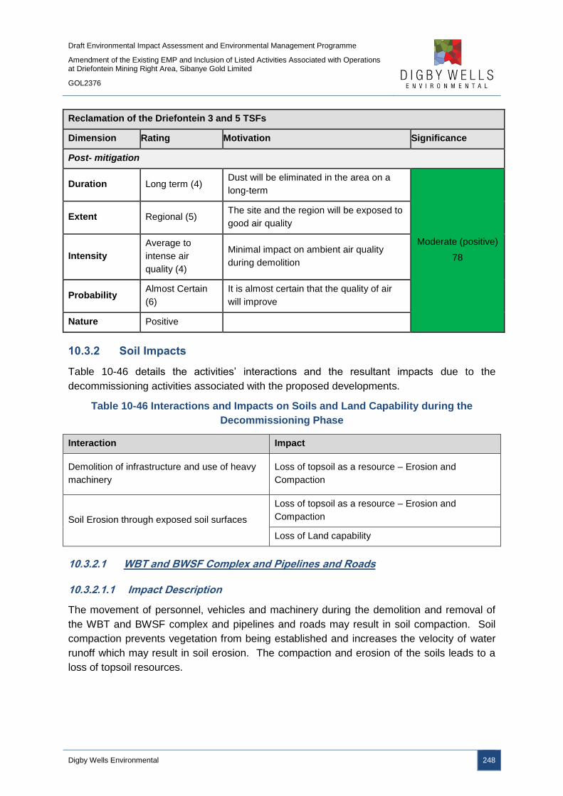
Draft Environmental Impact Assessment and Environmental Management Programme
Amendment of the Existing EMP and Inclusion of Listed Activities Associated with Operations at Driefontein Mining Right Area, Sibanye Gold Limited
GOL2376
Digby Wells Environmental 248
Reclamation of the Driefontein 3 and 5 TSFs
Dimension Rating Motivation Significance
Post- mitigation
Duration Long term (4) Dust will be eliminated in the area on a
long-term
Moderate (positive)
78
Extent Regional (5) The site and the region will be exposed to
good air quality
Intensity
Average to
intense air
quality (4)
Minimal impact on ambient air quality
during demolition
Probability Almost Certain
(6)
It is almost certain that the quality of air
will improve
Nature Positive
10.3.2 Soil Impacts
Table 10-46 details the activities’ interactions and the resultant impacts due to the
decommissioning activities associated with the proposed developments.
Table 10-46 Interactions and Impacts on Soils and Land Capability during the
Decommissioning Phase
Interaction Impact
Demolition of infrastructure and use of heavy
machinery
Loss of topsoil as a resource – Erosion and
Compaction
Soil Erosion through exposed soil surfaces
Loss of topsoil as a resource – Erosion and
Compaction
Loss of Land capability
10.3.2.1 WBT and BWSF Complex and Pipelines and Roads
10.3.2.1.1 Impact Description
The movement of personnel, vehicles and machinery during the demolition and removal of
the WBT and BWSF complex and pipelines and roads may result in soil compaction. Soil
compaction prevents vegetation from being established and increases the velocity of water
runoff which may result in soil erosion. The compaction and erosion of the soils leads to a
loss of topsoil resources.
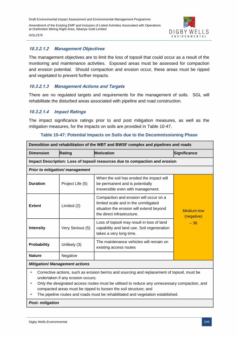
Draft Environmental Impact Assessment and Environmental Management Programme
Amendment of the Existing EMP and Inclusion of Listed Activities Associated with Operations at Driefontein Mining Right Area, Sibanye Gold Limited
GOL2376
Digby Wells Environmental 249
10.3.2.1.2 Management Objectives
The management objectives are to limit the loss of topsoil that could occur as a result of the
monitoring and maintenance activities. Exposed areas must be assessed for compaction
and erosion potential. Should compaction and erosion occur, these areas must be ripped
and vegetated to prevent further impacts.
10.3.2.1.3 Management Actions and Targets
There are no regulated targets and requirements for the management of soils. SGL will
rehabilitate the disturbed areas associated with pipeline and road construction.
10.3.2.1.4 Impact Ratings
The impact significance ratings prior to and post mitigation measures, as well as the
mitigation measures, for the impacts on soils are provided in Table 10-47.
Table 10-47: Potential Impacts on Soils due to the Decommissioning Phase
Demolition and rehabilitation of the WBT and BWSF complex and pipelines and roads
Dimension Rating Motivation Significance
Impact Description: Loss of topsoil resources due to compaction and erosion
Prior to mitigation/ management
Duration Project Life (5)
When the soil has eroded the impact will
be permanent and is potentially
irreversible even with management.
Medium-low
(negative)
– 36
Extent Limited (2)
Compaction and erosion will occur on a
limited scale and in the unmitigated
situation the erosion will extend beyond
the direct infrastructure.
Intensity Very Serious (5)
Loss of topsoil may result in loss of land
capability and land use. Soil regeneration
takes a very long time.
Probability Unlikely (3) The maintenance vehicles will remain on
existing access routes
Nature Negative
Mitigation/ Management actions
Corrective actions, such as erosion berms and sourcing and replacement of topsoil, must be
undertaken if any erosion occurs;
Only the designated access routes must be utilised to reduce any unnecessary compaction, and
compacted areas must be ripped to loosen the soil structure; and
The pipeline routes and roads must be rehabilitated and vegetation established.
Post- mitigation
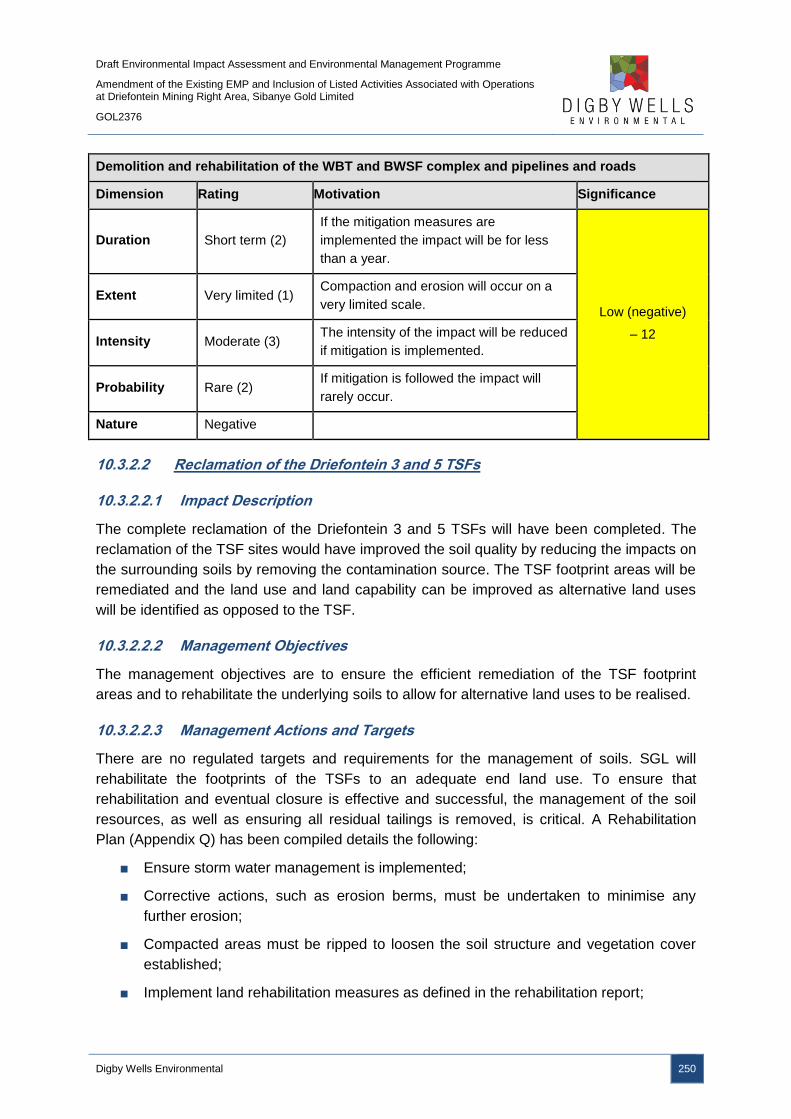
Draft Environmental Impact Assessment and Environmental Management Programme
Amendment of the Existing EMP and Inclusion of Listed Activities Associated with Operations at Driefontein Mining Right Area, Sibanye Gold Limited
GOL2376
Digby Wells Environmental 250
Demolition and rehabilitation of the WBT and BWSF complex and pipelines and roads
Dimension Rating Motivation Significance
Duration Short term (2)
If the mitigation measures are
implemented the impact will be for less
than a year.
Low (negative)
– 12
Extent Very limited (1) Compaction and erosion will occur on a
very limited scale.
Intensity Moderate (3) The intensity of the impact will be reduced
if mitigation is implemented.
Probability Rare (2) If mitigation is followed the impact will
rarely occur.
Nature Negative
10.3.2.2 Reclamation of the Driefontein 3 and 5 TSFs
10.3.2.2.1 Impact Description
The complete reclamation of the Driefontein 3 and 5 TSFs will have been completed. The
reclamation of the TSF sites would have improved the soil quality by reducing the impacts on
the surrounding soils by removing the contamination source. The TSF footprint areas will be
remediated and the land use and land capability can be improved as alternative land uses
will be identified as opposed to the TSF.
10.3.2.2.2 Management Objectives
The management objectives are to ensure the efficient remediation of the TSF footprint
areas and to rehabilitate the underlying soils to allow for alternative land uses to be realised.
10.3.2.2.3 Management Actions and Targets
There are no regulated targets and requirements for the management of soils. SGL will
rehabilitate the footprints of the TSFs to an adequate end land use. To ensure that
rehabilitation and eventual closure is effective and successful, the management of the soil
resources, as well as ensuring all residual tailings is removed, is critical. A Rehabilitation
Plan (Appendix Q) has been compiled details the following:
■ Ensure storm water management is implemented;
■ Corrective actions, such as erosion berms, must be undertaken to minimise any
further erosion;
■ Compacted areas must be ripped to loosen the soil structure and vegetation cover
established;
■ Implement land rehabilitation measures as defined in the rehabilitation report;
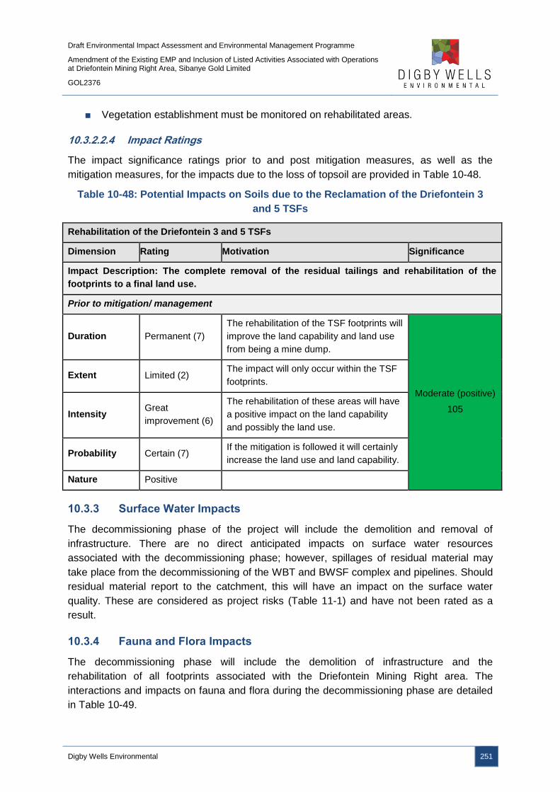
Draft Environmental Impact Assessment and Environmental Management Programme
Amendment of the Existing EMP and Inclusion of Listed Activities Associated with Operations at Driefontein Mining Right Area, Sibanye Gold Limited
GOL2376
Digby Wells Environmental 251
■ Vegetation establishment must be monitored on rehabilitated areas.
10.3.2.2.4 Impact Ratings
The impact significance ratings prior to and post mitigation measures, as well as the
mitigation measures, for the impacts due to the loss of topsoil are provided in Table 10-48.
Table 10-48: Potential Impacts on Soils due to the Reclamation of the Driefontein 3
and 5 TSFs
Rehabilitation of the Driefontein 3 and 5 TSFs
Dimension Rating Motivation Significance
Impact Description: The complete removal of the residual tailings and rehabilitation of the
footprints to a final land use.
Prior to mitigation/ management
Duration Permanent (7)
The rehabilitation of the TSF footprints will
improve the land capability and land use
from being a mine dump.
Moderate (positive)
105
Extent Limited (2) The impact will only occur within the TSF
footprints.
Intensity Great
improvement (6)
The rehabilitation of these areas will have
a positive impact on the land capability
and possibly the land use.
Probability Certain (7) If the mitigation is followed it will certainly
increase the land use and land capability.
Nature Positive
10.3.3 Surface Water Impacts
The decommissioning phase of the project will include the demolition and removal of
infrastructure. There are no direct anticipated impacts on surface water resources
associated with the decommissioning phase; however, spillages of residual material may
take place from the decommissioning of the WBT and BWSF complex and pipelines. Should
residual material report to the catchment, this will have an impact on the surface water
quality. These are considered as project risks (Table 11-1) and have not been rated as a
result.
10.3.4 Fauna and Flora Impacts
The decommissioning phase will include the demolition of infrastructure and the
rehabilitation of all footprints associated with the Driefontein Mining Right area. The
interactions and impacts on fauna and flora during the decommissioning phase are detailed
in Table 10-49.
Draft Environmental Impact Assessment and Environmental Management Programme
Amendment of the Existing EMP and Inclusion of Listed Activities Associated with Operations at Driefontein Mining Right Area, Sibanye Gold Limited
GOL2376
Digby Wells Environmental 252
Table 10-49: Interactions and Impacts on Fauna and Flora during the
Decommissioning Phase
Interaction Impact
Rehabilitation of the infrastructure:
including the WBT and BWSF footprints, as
well as the series of pipelines.
This will potentially have a positive impact on the
vegetation and habitat types that could be restored over
time.
Decommissioning of the reclaimed
Driefontein 3 and 5 TSF footprints.
With rehabilitation of the footprints, this will have a
positive impact to vegetation and habitat types present.
10.3.4.1 Reclamation of Driefontein 3 and 5 TSFs
10.3.4.1.1 Impact Description
Although all infrastructure footprints will be rehabilitated, these cannot be seen as positive
impacts due to the direct site clearing undertaken during the construction phase. The
rehabilitation of the infrastructure footprints will aim to emulate the environment prior to any
developments being undertaken. This is considered a neutral impact.
The rehabilitation of the Driefontein 3 and 5 TSFs will have a positive impact on the fauna
and flora of the region as previously inhospitable areas will be suitable for indigenous
vegetation establishment, which will provide suitable habitats for fauna. This will increase the
biodiversity of the region.
10.3.4.1.2 Management Objectives
The objective for this phase will be to maximise the success of the rehabilitation that will
occur once infrastructure is removed and to furthermore reduce any impacts that may occur
during this phase.
10.3.4.1.3 Management Actions and Targets
Rehabilitation activities must be conducted in such a manner to achieve aims for the
process. These aims will be to ensure the footprint areas are vegetated and that erosion
through runoff and wind does not occur. Efforts will be maximised if rehabilitation is
completed before the first rains fall so as to make use of the rainfall to assist in plant
recruitment and establishment.
10.3.4.1.4 Impact Ratings
The impact significance ratings prior to and post mitigation measures, as well as the
mitigation measures, for the impacts on fauna and flora are provided in Table 10-50.

Draft Environmental Impact Assessment and Environmental Management Programme
Amendment of the Existing EMP and Inclusion of Listed Activities Associated with Operations at Driefontein Mining Right Area, Sibanye Gold Limited
GOL2376
Digby Wells Environmental 253
Table 10-50: Potential Impacts on Fauna and Flora due to the Reclamation of the
Driefontein 3 and 5 TSFs
Rehabilitation of the Driefontein 3 and 5 TSFs
Dimension Rating Motivation Significance
Impact Description: The complete removal of the residual tailings and rehabilitation of the
footprints to a final land use.
Prior to mitigation/ management
Duration Short term (2) If rehabilitation is not completed
effectively it will not last.
Negligible (positive)
18
Extent Very Limited (1) Only certain parts of the site will have
revegetated cover.
Intensity Moderate (3) The effectiveness of the rehab will
determine the intensity
Probability Unlikely (3) It’s unlikely that the rehabilitation will be
effective
Nature Positive
Mitigation/ Management actions
Rehabilitation must be undertaken as outlined in the Rehabilitation Plan;
Rehabilitation to be completed prior to the rainy season (October to March); and
Vegetation establishment must be monitored and areas where rehabilitation has not been
successful must be ripped, vegetated and, if necessary, a fertiliser applied.
Post- mitigation
Duration Permanent (7) If rehabilitation is completed successfully
this impact will be permanent
Moderate (positive)
84
Extent Local (3) The general area beyond the project site
will be positively impacted on.
Intensity Positive (4) Vegetation will be restored.
Probability Almost certain
(6)
With correct implementation this impact
has a high probability of occurring
Nature Positive
10.3.5 Aquatics Impacts
The pipelines and roads will be demolished, depending on the final land use, and the
footprints rehabilitated. The WBT and BWSF complex will also be demolished and the
footprints rehabilitated, although this is not expected to impact on aquatic ecosystems due to
the WBT and BWSF complex not being located within close proximity to surface water
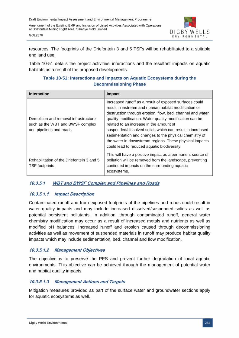
Draft Environmental Impact Assessment and Environmental Management Programme
Amendment of the Existing EMP and Inclusion of Listed Activities Associated with Operations at Driefontein Mining Right Area, Sibanye Gold Limited
GOL2376
Digby Wells Environmental 254
resources. The footprints of the Driefontein 3 and 5 TSFs will be rehabilitated to a suitable
end land use.
Table 10-51 details the project activities’ interactions and the resultant impacts on aquatic
habitats as a result of the proposed developments.
Table 10-51: Interactions and Impacts on Aquatic Ecosystems during the
Decommissioning Phase
Interaction Impact
Demolition and removal infrastructure
such as the WBT and BWSF complex
and pipelines and roads
Increased runoff as a result of exposed surfaces could
result in instream and riparian habitat modification or
destruction through erosion, flow, bed, channel and water
quality modification. Water quality modification can be
related to an increase in the amount of
suspended/dissolved solids which can result in increased
sedimentation and changes to the physical chemistry of
the water in downstream regions. These physical impacts
could lead to reduced aquatic biodiversity.
Rehabilitation of the Driefontein 3 and 5
TSF footprints
This will have a positive impact as a permanent source of
pollution will be removed from the landscape, preventing
continued impacts on the surrounding aquatic
ecosystems.
10.3.5.1 WBT and BWSF Complex and Pipelines and Roads
10.3.5.1.1 Impact Description
Contaminated runoff and from exposed footprints of the pipelines and roads could result in
water quality impacts and may include increased dissolved/suspended solids as well as
potential persistent pollutants. In addition, through contaminated runoff, general water
chemistry modification may occur as a result of increased metals and nutrients as well as
modified pH balances. Increased runoff and erosion caused through decommissioning
activities as well as movement of suspended materials in runoff may produce habitat quality
impacts which may include sedimentation, bed, channel and flow modification.
10.3.5.1.2 Management Objectives
The objective is to preserve the PES and prevent further degradation of local aquatic
environments. This objective can be achieved through the management of potential water
and habitat quality impacts.
10.3.5.1.3 Management Actions and Targets
Mitigation measures provided as part of the surface water and groundwater sections apply
for aquatic ecosystems as well.
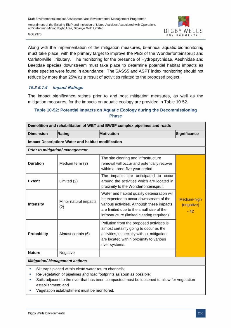
Draft Environmental Impact Assessment and Environmental Management Programme
Amendment of the Existing EMP and Inclusion of Listed Activities Associated with Operations at Driefontein Mining Right Area, Sibanye Gold Limited
GOL2376
Digby Wells Environmental 255
Along with the implementation of the mitigation measures, bi-annual aquatic biomonitoring
must take place, with the primary target to improve the PES of the Wonderfonteinspruit and
Carletonville Tributary. The monitoring for the presence of Hydropsychidae, Aeshnidae and
Baetidae species downstream must take place to determine potential habitat impacts as
these species were found in abundance. The SASS5 and ASPT index monitoring should not
reduce by more than 25% as a result of activities related to the proposed project.
10.3.5.1.4 Impact Ratings
The impact significance ratings prior to and post mitigation measures, as well as the
mitigation measures, for the impacts on aquatic ecology are provided in Table 10-52.
Table 10-52: Potential Impacts on Aquatic Ecology during the Decommissioning
Phase
Demolition and rehabilitation of WBT and BWSF complex pipelines and roads
Dimension Rating Motivation Significance
Impact Description: Water and habitat modification
Prior to mitigation/ management
Duration Medium term (3)
The site clearing and infrastructure
removal will occur and potentially recover
within a three-five year period
Medium-high
(negative)
- 42
Extent Limited (2)
The impacts are anticipated to occur
around the activities which are located in
proximity to the Wonderfonteinspruit
Intensity Minor natural impacts
(2)
Water and habitat quality deterioration will
be expected to occur downstream of the
various activities. Although these impacts
are limited due to the small size of the
infrastructure (limited clearing required)
Probability Almost certain (6)
Pollution from the proposed activities is
almost certainly going to occur as the
activities, especially without mitigation,
are located within proximity to various
river systems.
Nature Negative
Mitigation/ Management actions
Silt traps placed within clean water return channels;
Re-vegetation of pipelines and road footprints as soon as possible;
Soils adjacent to the river that has been compacted must be loosened to allow for vegetation
establishment; and
Vegetation establishment must be monitored.

Draft Environmental Impact Assessment and Environmental Management Programme
Amendment of the Existing EMP and Inclusion of Listed Activities Associated with Operations at Driefontein Mining Right Area, Sibanye Gold Limited
GOL2376
Digby Wells Environmental 256
Demolition and rehabilitation of WBT and BWSF complex pipelines and roads
Dimension Rating Motivation Significance
Post- mitigation
Duration Short term (2)
The impact will only occur during the
construction and decommissioning
phase.
Low (negative)
- 30
Extent Local (3)
The impacts will only occur within the
local area. Even water quality impacts
would only occur until dilution can occur
within short distance downstream
regions.
Intensity Very serious (5)
The habitat and water quality within the
local extent can be a very serious
impact. Especially to aquatic habitat
which is difficult to rehabilitate.
Probability Unlikely (3) Probability reduced due to mitigation
actions.
Nature Negative
10.3.5.2 Reclamation of Driefontein 3 and 5 TSFs
10.3.5.2.1 Impact Description
The rehabilitation of the Driefontein 3 and 5 TSF footprints will have a positive impact as a
permanent source of pollution will be removed from the landscape, preventing continued
impacts on the surrounding aquatic ecosystems. This will be a positive impact on aquatic
ecosystems associated with the Driefontein Mining Right area in comparison to the current
baseline environment. The failure to reclaim the TSFs, or rehabilitate the footprints, will
continue to have negative impacts on aquatics. The complete removal of tailings material
and the rehabilitation of the footprints will have a minor (positive) impact following the
implementation of enhancement measures.
10.3.5.2.2 Management Objectives
The objective is to preserve the PES and prevent further degradation of local aquatic
environments. This objective can be achieved through the management of potential water
and habitat quality impacts.
10.3.5.2.3 Management Actions and Targets
Mitigation measures provided as part of the surface water and groundwater sections apply
for aquatic ecosystems as well. Along with the implementation of the mitigation measures,
bi-annual aquatic biomonitoring must take place, with the primary target to improve the PES
of the Wonderfonteinspruit and Carletonville Tributary. The monitoring for the presence of

Draft Environmental Impact Assessment and Environmental Management Programme
Amendment of the Existing EMP and Inclusion of Listed Activities Associated with Operations at Driefontein Mining Right Area, Sibanye Gold Limited
GOL2376
Digby Wells Environmental 257
Hydropsychidae, Aeshnidae and Baetidae species downstream must take place to
determine potential habitat impacts as these species were found in abundance. The SASS5
and ASPT index monitoring should not reduce by more than 25% as a result of activities
related to the proposed project.
10.3.5.2.4 Impact Ratings
The impact significance ratings prior to and post mitigation measures, as well as the
mitigation measures, for the impacts on aquatic ecology are provided in Table 10-53.
Table 10-53: Potential Impacts on Aquatic Ecology due to Rehabilitation of Driefontein
3 and 5 TSFs
Rehabilitation of Driefontein 3 and 5 TSFs
Dimension Rating Motivation Significance
Impact Description: Water and habitat modification
Prior to mitigation/ management
Duration Beyond Project Life
(6)
The impact will remain for some time after
the project has been completed.
Medium-high
(negative)
- 60
Extent Local (3)
The impacts, especially habitat impacts,
will only occur within the local area. Water
quality impacts will also most likely only
impact a local area.
Intensity Discernible changes
(3)
Water quality will likely improve and thus
more sensitive aquatic biota will return.
Probability Likely (5) The impact will likely occur after the
completion of the project.
Nature Negative
Mitigation/ Management actions
Silt traps placed within clean water return channels;
Re-vegetation of footprints as soon as possible;
Erosion prevention mechanisms must be employed to prevent instream sedimentation; and
Rehabilitation according to the Rehabilitation Plan.
Post- mitigation
Duration Short term (2)
The impact will only occur during the
construction and decommissioning
phase.
Low (negative)
- 30
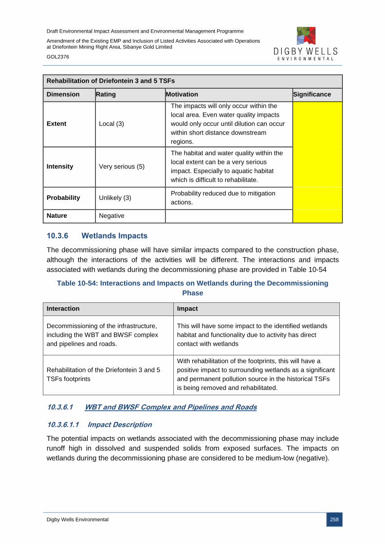
Draft Environmental Impact Assessment and Environmental Management Programme
Amendment of the Existing EMP and Inclusion of Listed Activities Associated with Operations at Driefontein Mining Right Area, Sibanye Gold Limited
GOL2376
Digby Wells Environmental 258
Rehabilitation of Driefontein 3 and 5 TSFs
Dimension Rating Motivation Significance
Extent Local (3)
The impacts will only occur within the
local area. Even water quality impacts
would only occur until dilution can occur
within short distance downstream
regions.
Intensity Very serious (5)
The habitat and water quality within the
local extent can be a very serious
impact. Especially to aquatic habitat
which is difficult to rehabilitate.
Probability Unlikely (3) Probability reduced due to mitigation
actions.
Nature Negative
10.3.6 Wetlands Impacts
The decommissioning phase will have similar impacts compared to the construction phase,
although the interactions of the activities will be different. The interactions and impacts
associated with wetlands during the decommissioning phase are provided in Table 10-54
Table 10-54: Interactions and Impacts on Wetlands during the Decommissioning
Phase
Interaction Impact
Decommissioning of the infrastructure,
including the WBT and BWSF complex
and pipelines and roads.
This will have some impact to the identified wetlands
habitat and functionality due to activity has direct
contact with wetlands
Rehabilitation of the Driefontein 3 and 5
TSFs footprints
With rehabilitation of the footprints, this will have a
positive impact to surrounding wetlands as a significant
and permanent pollution source in the historical TSFs
is being removed and rehabilitated.
10.3.6.1 WBT and BWSF Complex and Pipelines and Roads
10.3.6.1.1 Impact Description
The potential impacts on wetlands associated with the decommissioning phase may include
runoff high in dissolved and suspended solids from exposed surfaces. The impacts on
wetlands during the decommissioning phase are considered to be medium-low (negative).
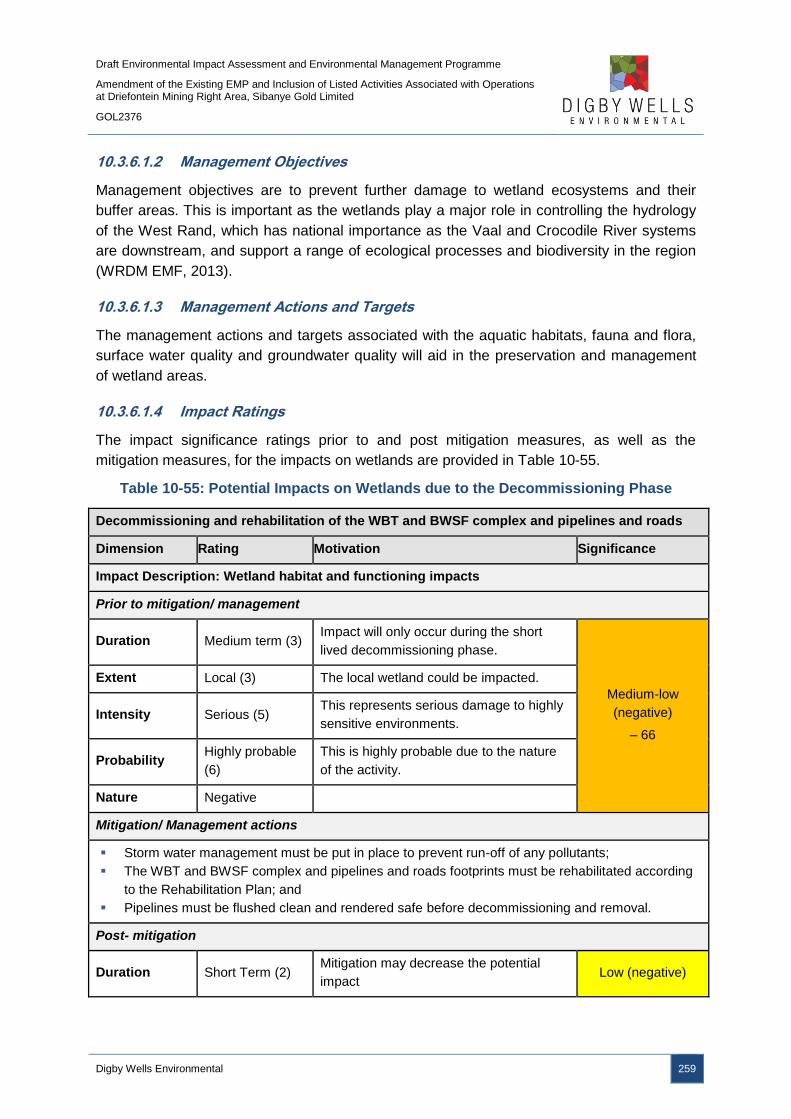
Draft Environmental Impact Assessment and Environmental Management Programme
Amendment of the Existing EMP and Inclusion of Listed Activities Associated with Operations at Driefontein Mining Right Area, Sibanye Gold Limited
GOL2376
Digby Wells Environmental 259
10.3.6.1.2 Management Objectives
Management objectives are to prevent further damage to wetland ecosystems and their
buffer areas. This is important as the wetlands play a major role in controlling the hydrology
of the West Rand, which has national importance as the Vaal and Crocodile River systems
are downstream, and support a range of ecological processes and biodiversity in the region
(WRDM EMF, 2013).
10.3.6.1.3 Management Actions and Targets
The management actions and targets associated with the aquatic habitats, fauna and flora,
surface water quality and groundwater quality will aid in the preservation and management
of wetland areas.
10.3.6.1.4 Impact Ratings
The impact significance ratings prior to and post mitigation measures, as well as the
mitigation measures, for the impacts on wetlands are provided in Table 10-55.
Table 10-55: Potential Impacts on Wetlands due to the Decommissioning Phase
Decommissioning and rehabilitation of the WBT and BWSF complex and pipelines and roads
Dimension Rating Motivation Significance
Impact Description: Wetland habitat and functioning impacts
Prior to mitigation/ management
Duration Medium term (3) Impact will only occur during the short
lived decommissioning phase.
Medium-low
(negative)
– 66
Extent Local (3) The local wetland could be impacted.
Intensity Serious (5) This represents serious damage to highly
sensitive environments.
Probability Highly probable
(6)
This is highly probable due to the nature
of the activity.
Nature Negative
Mitigation/ Management actions
Storm water management must be put in place to prevent run-off of any pollutants;
The WBT and BWSF complex and pipelines and roads footprints must be rehabilitated according
to the Rehabilitation Plan; and
Pipelines must be flushed clean and rendered safe before decommissioning and removal.
Post- mitigation
Duration Short Term (2) Mitigation may decrease the potential
impact Low (negative)

Draft Environmental Impact Assessment and Environmental Management Programme
Amendment of the Existing EMP and Inclusion of Listed Activities Associated with Operations at Driefontein Mining Right Area, Sibanye Gold Limited
GOL2376
Digby Wells Environmental 260
Decommissioning and rehabilitation of the WBT and BWSF complex and pipelines and roads
Dimension Rating Motivation Significance
Extent Limited (2) The mitigation measures will allow the
impacts to be kept to a limited extent.
– 18
Intensity Minor effects (2)
The wetlands will be subjected to minor
impacts with mitigation measure
employed.
Probability Unlikely (3) Mitigation will decrease the likelihood of
impacts significantly.
Nature Negative
10.3.6.2 Reclamation of Driefontein 3 and 5 TSFs
10.3.6.2.1 Impact Description
Following the reclamation of Driefontein 3 and 5 TSFs, the footprints will be rehabilitated.
Should the footprints not be rehabilitated, the wetlands will continue to be impacted upon as
is status quo. The footprints will be rehabilitated to a suitable end land use, to be identified in
the SGL updated Closure Plans and as per the Rehabilitation Plan. The complete removal of
tailings material and rehabilitation of the footprints will have a positive impact on surrounding
wetlands as the permanent pollution source will be removed from the landscape.
10.3.6.2.2 Management Objectives
Management objectives are to completely remove tailings material associated with the
Driefontein 3 and 5 TSFs and to rehabilitate the land to a suitable end land use, removing
the pollution source from the landscape. This is important as the wetlands play a major role
in controlling the hydrology of the West Rand, which has national importance as the Vaal
and Crocodile River systems are downstream, and support a range of ecological processes
and biodiversity in the region (WRDM EMF, 2013).
10.3.6.2.3 Management Actions and Targets
The management actions and targets associated with the aquatic habitats, fauna and flora,
surface water quality and groundwater quality will aid in the preservation and management
of wetland areas.
10.3.6.2.4 Impact Ratings
The impact significance ratings prior to and post mitigation measures, as well as the
mitigation measures, for the impacts on wetlands are provided in Table 10-56.
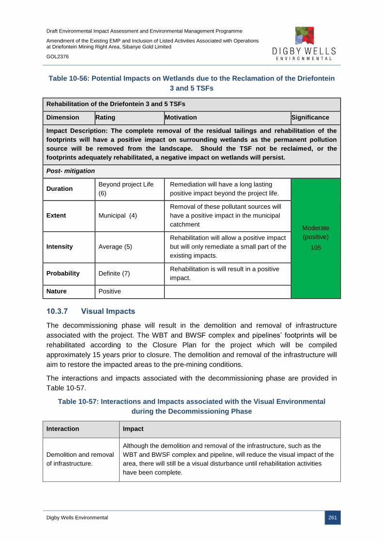
Draft Environmental Impact Assessment and Environmental Management Programme
Amendment of the Existing EMP and Inclusion of Listed Activities Associated with Operations at Driefontein Mining Right Area, Sibanye Gold Limited
GOL2376
Digby Wells Environmental 261
Table 10-56: Potential Impacts on Wetlands due to the Reclamation of the Driefontein
3 and 5 TSFs
Rehabilitation of the Driefontein 3 and 5 TSFs
Dimension Rating Motivation Significance
Impact Description: The complete removal of the residual tailings and rehabilitation of the
footprints will have a positive impact on surrounding wetlands as the permanent pollution
source will be removed from the landscape. Should the TSF not be reclaimed, or the
footprints adequately rehabilitated, a negative impact on wetlands will persist.
Post- mitigation
Duration Beyond project Life
(6)
Remediation will have a long lasting
positive impact beyond the project life.
Moderate
(positive)
105
Extent Municipal (4)
Removal of these pollutant sources will
have a positive impact in the municipal
catchment
Intensity Average (5)
Rehabilitation will allow a positive impact
but will only remediate a small part of the
existing impacts.
Probability Definite (7) Rehabilitation is will result in a positive
impact.
Nature Positive
10.3.7 Visual Impacts
The decommissioning phase will result in the demolition and removal of infrastructure
associated with the project. The WBT and BWSF complex and pipelines’ footprints will be
rehabilitated according to the Closure Plan for the project which will be compiled
approximately 15 years prior to closure. The demolition and removal of the infrastructure will
aim to restore the impacted areas to the pre-mining conditions.
The interactions and impacts associated with the decommissioning phase are provided in
Table 10-57.
Table 10-57: Interactions and Impacts associated with the Visual Environmental
during the Decommissioning Phase
Interaction Impact
Demolition and removal
of infrastructure.
Although the demolition and removal of the infrastructure, such as the
WBT and BWSF complex and pipeline, will reduce the visual impact of the
area, there will still be a visual disturbance until rehabilitation activities
have been complete.

Draft Environmental Impact Assessment and Environmental Management Programme
Amendment of the Existing EMP and Inclusion of Listed Activities Associated with Operations at Driefontein Mining Right Area, Sibanye Gold Limited
GOL2376
Digby Wells Environmental 262
10.3.7.1 WBT and BWSF Complex and Pipelines and Roads
10.3.7.1.1 Impact Description
The demolition and removal of the WBT and BWSF complex infrastructure and pipelines will
improve the visual environment in comparison to the operational phase of the project as the
visual disturbances will be removed from the landscape. However, the demolition and
rehabilitation activities will continue to impact on the visual environment until rehabilitation
activities have concluded, although the significance of the visual impact will be greatly
reduced.
10.3.7.1.2 Management Objectives
The management objectives are to reduce the visual impact of infrastructure by demolishing
and removing infrastructure from site, as well as to minimise the short term visual impact of
the decommissioning activities.
10.3.7.1.3 Management Actions and Targets
The rehabilitation of the footprints must ensure that the surfaces are free draining and no
surface water pools on the surface.
10.3.7.1.4 Impact Ratings
The impact significance ratings prior to and post mitigation measures, as well as the
mitigation measures, for the impacts on the visual environment are provided in Table 10-58.
Table 10-58: Potential Impacts on the Visual Environment due to the WBT and BWSF
Complex and Pipelines and Roads
Demolition and rehabilitation of the WBT and BWSF complex and pipelines and roads
Dimension Rating Motivation Significance
Impact Description: Demolition and rehabilitation activities will have a visual impact on the
environment.
Prior to mitigation/ management
Duration Medium Term
(3)
The impact will occur for 1-5 years and
the impact can be reversed with minimal
management. Medium-low
(negative)
– 42
Extent Limited (2) The impact is limited to the site and its
immediate surroundings.

Draft Environmental Impact Assessment and Environmental Management Programme
Amendment of the Existing EMP and Inclusion of Listed Activities Associated with Operations at Driefontein Mining Right Area, Sibanye Gold Limited
GOL2376
Digby Wells Environmental 263
Demolition and rehabilitation of the WBT and BWSF complex and pipelines and roads
Dimension Rating Motivation Significance
Intensity Minimal (1)
Minimal to no loss and / or effect to
biological or physical resources, not
affecting ecosystem functioning.
Minimal social impacts, low-level
repairable damage to commonplace
structures.
Probability Definite (7) Demolition and rehabilitation activities will
occur.
Nature Negative
Mitigation/ Management actions
The WBT and BWSF complex and pipelines and roads footprints must be rehabilitated according
to the Rehabilitation and Closure Plans;
Ensure that the footprints are contoured and profiled to ensure a free-draining topography; and
Remove all infrastructure and rubble from site.
Post- mitigation
Duration Medium Term
(3)
The impact will occur for 1-5 years and
the impact can be reversed with minimal
management.
Low (negative)
– 30
Extent Very Limited (1) The impact is limited to specific isolated
parts of the site.
Intensity Minimal (1)
Minimal to no loss and / or effect to
biological or physical resources, not
affecting ecosystem functioning.
Minimal social impacts, low-level
repairable damage to commonplace
structures.
Probability
Almost Certain
(6) It is likely that the demolition and
rehabilitation activities will result in visual
impacts.
Nature Negative
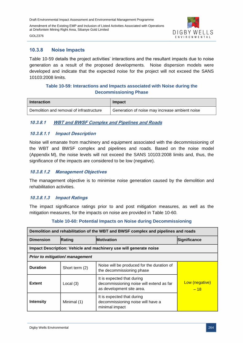
Draft Environmental Impact Assessment and Environmental Management Programme
Amendment of the Existing EMP and Inclusion of Listed Activities Associated with Operations at Driefontein Mining Right Area, Sibanye Gold Limited
GOL2376
Digby Wells Environmental 264
10.3.8 Noise Impacts
Table 10-59 details the project activities’ interactions and the resultant impacts due to noise
generation as a result of the proposed developments. Noise dispersion models were
developed and indicate that the expected noise for the project will not exceed the SANS
10103:2008 limits.
Table 10-59: Interactions and Impacts associated with Noise during the
Decommissioning Phase
Interaction Impact
Demolition and removal of infrastructure Generation of noise may increase ambient noise
10.3.8.1 WBT and BWSF Complex and Pipelines and Roads
10.3.8.1.1 Impact Description
Noise will emanate from machinery and equipment associated with the decommissioning of
the WBT and BWSF complex and pipelines and roads. Based on the noise model
(Appendix M), the noise levels will not exceed the SANS 10103:2008 limits and, thus, the
significance of the impacts are considered to be low (negative).
10.3.8.1.2 Management Objectives
The management objective is to minimise noise generation caused by the demolition and
rehabilitation activities.
10.3.8.1.3 Impact Ratings
The impact significance ratings prior to and post mitigation measures, as well as the
mitigation measures, for the impacts on noise are provided in Table 10-60.
Table 10-60: Potential Impacts on Noise during Decommissioning
Demolition and rehabilitation of the WBT and BWSF complex and pipelines and roads
Dimension Rating Motivation Significance
Impact Description: Vehicle and machinery use will generate noise
Prior to mitigation/ management
Duration Short term (2) Noise will be produced for the duration of
the decommissioning phase
Low (negative)
– 18
Extent Local (3)
It is expected that during
decommissioning noise will extend as far
as development site area.
Intensity Minimal (1)
It is expected that during
decommissioning noise will have a
minimal impact
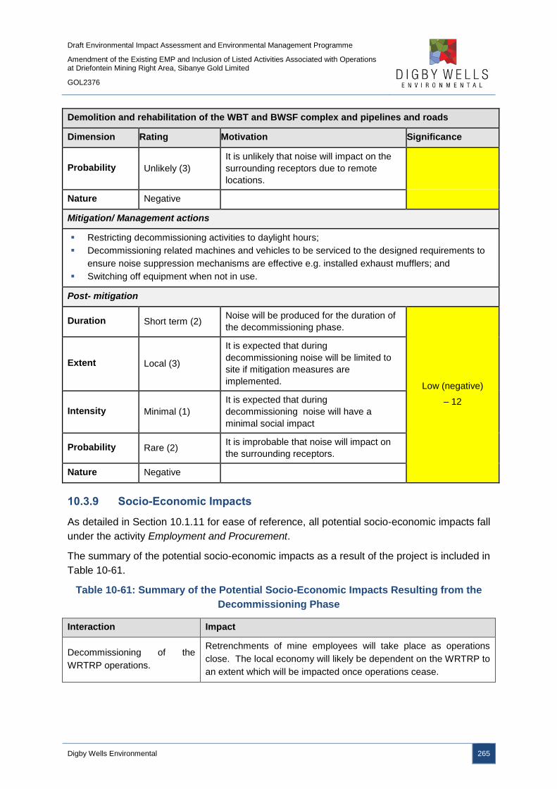
Draft Environmental Impact Assessment and Environmental Management Programme
Amendment of the Existing EMP and Inclusion of Listed Activities Associated with Operations at Driefontein Mining Right Area, Sibanye Gold Limited
GOL2376
Digby Wells Environmental 265
Demolition and rehabilitation of the WBT and BWSF complex and pipelines and roads
Dimension Rating Motivation Significance
Probability Unlikely (3)
It is unlikely that noise will impact on the
surrounding receptors due to remote
locations.
Nature Negative
Mitigation/ Management actions
Restricting decommissioning activities to daylight hours;
Decommissioning related machines and vehicles to be serviced to the designed requirements to
ensure noise suppression mechanisms are effective e.g. installed exhaust mufflers; and
Switching off equipment when not in use.
Post- mitigation
Duration Short term (2) Noise will be produced for the duration of
the decommissioning phase.
Low (negative)
– 12
Extent Local (3)
It is expected that during
decommissioning noise will be limited to
site if mitigation measures are
implemented.
Intensity Minimal (1)
It is expected that during
decommissioning noise will have a
minimal social impact
Probability Rare (2) It is improbable that noise will impact on
the surrounding receptors.
Nature Negative
10.3.9 Socio-Economic Impacts
As detailed in Section 10.1.11 for ease of reference, all potential socio-economic impacts fall
under the activity Employment and Procurement.
The summary of the potential socio-economic impacts as a result of the project is included in
Table 10-61.
Table 10-61: Summary of the Potential Socio-Economic Impacts Resulting from the
Decommissioning Phase
Interaction Impact
Decommissioning of the
WRTRP operations.
Retrenchments of mine employees will take place as operations
close. The local economy will likely be dependent on the WRTRP to
an extent which will be impacted once operations cease.

Draft Environmental Impact Assessment and Environmental Management Programme
Amendment of the Existing EMP and Inclusion of Listed Activities Associated with Operations at Driefontein Mining Right Area, Sibanye Gold Limited
GOL2376
Digby Wells Environmental 266
10.3.9.1 Employment and Procurement
10.3.9.1.1 Impact Description
Any impact predictions concerning the characteristics of the socio-economic environment at
the time of eventual project decommissioning are subject to a large margin of error which will
significantly reduce the accuracy of the impact assessment. Several socio-economic impacts
may arise when the operation is decommissioned and should be investigated prior to
decommissioning. The issues that may arise include psychological impacts on the workforce
due to personal and family income issues, dependency from the local economy on the
project through multiplier effects, tax and royalties and Social and Labour initiatives and
impacts on land uses following closure.
The closure of the project will result in the reduction in the economic stimulus to maintain the
current state of the local economy and for further growth. This impact will be cumulative with
regard to job losses, the closing down of businesses and the decrease on local investment
and spending, all resulting in an overall economic slow-down.
10.3.9.1.2 Management Objectives
An important approach to mitigating economic dependency on the Project is to develop
alternative and sustainable livelihoods so that local communities and businesses are able to
support themselves through other economic sectors at the time of project closure. SGL must
collaborate with the local municipalities and relevant government agencies to support the
diversification of the local economy to reduce the economies dependency on the project and
mining in general.
The MPRDA requires that the Social and Labour Plan provides strategies and measures that
could prevent job loss; these include the establishment of Future Forums to manage
downscaling and retrenchments. The alternatives to save jobs must be investigated before
decommissioning.
In addition, a Closure Plan will be developed and must include socio-economic impacts and
a stakeholder consultation process for the operations. The Closure Plan must be compiled
15 years prior to the expected closure, and reviewed every 5 years.
10.3.9.1.3 Impact Description
The significance of the potential socio-economic impacts associated with the
decommissioning of the project are outlined in Table 10-62.

Draft Environmental Impact Assessment and Environmental Management Programme
Amendment of the Existing EMP and Inclusion of Listed Activities Associated with Operations at Driefontein Mining Right Area, Sibanye Gold Limited
GOL2376
Digby Wells Environmental 267
Table 10-62: Potential Impacts on the Socio-Economic Environment due to
Employment and Procurement
Employment and Procurement
Dimension Rating Motivation Significance
Impact Description: Decommissioning of the project will have a direct negative impact through
the retrenchment of the mine workforce, as well as a cumulative impact on the local economy
due to its dependency on mining.
Prior to mitigation/ management
Duration Beyond project life
(6)
Some impacts (e.g. retrenchments) may
occur during operation. However, most
impacts will be felt after closure
Medium-high
(negative)
- 84
Extent Municipal Area (4) Impact will affect workers as well as local
municipalities and communities
Intensity Moderately high (4)
Without appropriate mitigation, impact will
undermine many of benefits achieved
under LED. Retrenched workers and their
families will be severely impacted
Probability Highly probable (6) The impact will most likely occur
Nature Negative
Mitigation/ Management actions
Develop a Closure Plan 15 years prior to planned closure and review the Closure Plan every 5
years;
Establish a Future Forum, should it not already be established, to promote on-going discussions
between SGL and the mine’s workforce;
Liaise with the Department of Labour for the utilisation of its resources and support services once
retrenchments take place;
Provide financial life skills to employees and ensure employees are trained in alternative skills;
and
Inform affected areas, such as the local municipality and labour sending areas, of planned
retrenchments.
Post- mitigation
Duration Beyond project life
(6)
Some impacts (e.g. retrenchments) may
occur during operation. However, most
impacts will be felt after closure
Medium-low
(negative)
- 60 Extent Municipal Area (4)
Impact will affect workers as well as local
municipalities and communities
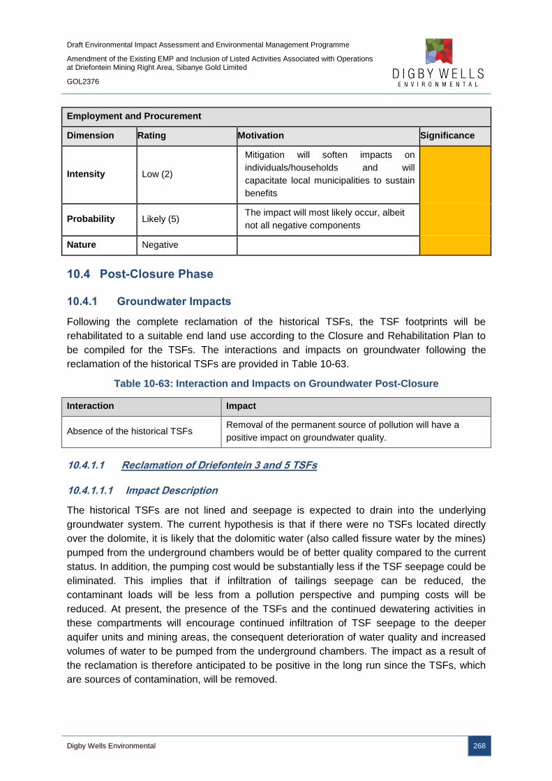
Draft Environmental Impact Assessment and Environmental Management Programme
Amendment of the Existing EMP and Inclusion of Listed Activities Associated with Operations at Driefontein Mining Right Area, Sibanye Gold Limited
GOL2376
Digby Wells Environmental 268
Employment and Procurement
Dimension Rating Motivation Significance
Intensity Low (2)
Mitigation will soften impacts on
individuals/households and will
capacitate local municipalities to sustain
benefits
Probability Likely (5) The impact will most likely occur, albeit
not all negative components
Nature Negative
10.4 Post-Closure Phase
10.4.1 Groundwater Impacts
Following the complete reclamation of the historical TSFs, the TSF footprints will be
rehabilitated to a suitable end land use according to the Closure and Rehabilitation Plan to
be compiled for the TSFs. The interactions and impacts on groundwater following the
reclamation of the historical TSFs are provided in Table 10-63.
Table 10-63: Interaction and Impacts on Groundwater Post-Closure
Interaction Impact
Absence of the historical TSFs Removal of the permanent source of pollution will have a
positive impact on groundwater quality.
10.4.1.1 Reclamation of Driefontein 3 and 5 TSFs
10.4.1.1.1 Impact Description
The historical TSFs are not lined and seepage is expected to drain into the underlying
groundwater system. The current hypothesis is that if there were no TSFs located directly
over the dolomite, it is likely that the dolomitic water (also called fissure water by the mines)
pumped from the underground chambers would be of better quality compared to the current
status. In addition, the pumping cost would be substantially less if the TSF seepage could be
eliminated. This implies that if infiltration of tailings seepage can be reduced, the
contaminant loads will be less from a pollution perspective and pumping costs will be
reduced. At present, the presence of the TSFs and the continued dewatering activities in
these compartments will encourage continued infiltration of TSF seepage to the deeper
aquifer units and mining areas, the consequent deterioration of water quality and increased
volumes of water to be pumped from the underground chambers. The impact as a result of
the reclamation is therefore anticipated to be positive in the long run since the TSFs, which
are sources of contamination, will be removed.

Draft Environmental Impact Assessment and Environmental Management Programme
Amendment of the Existing EMP and Inclusion of Listed Activities Associated with Operations at Driefontein Mining Right Area, Sibanye Gold Limited
GOL2376
Digby Wells Environmental 269
10.4.1.1.2 Management Objectives
The management objectives are to remove the historical TSFs in their entirety and to
rehabilitate the footprints to ensure that all tailings material has been removed which will
improve the groundwater quality.
10.4.1.1.3 Management Actions and Targets
The historical TSF footprints must be rehabilitated according to the Closure and
Rehabilitation Plan that will be developed prior to the conclusion of the reclamation activities
for the historical TSFs. The complete removal of tailings material and contaminants from the
TSF footprints will ensure that the pollution sources will be removed and the groundwater
quality is expected to improve. Groundwater monitoring must continue to take place.
10.4.1.1.4 Impact Rating
The impact significance ratings prior to and post mitigation measures, as well as the
mitigation measures, for the impacts on groundwater are provided in Table 10-64.
Table 10-64: Potential Impacts on Groundwater due to the Reclamation of the
Driefontein 3 and 5 TSFs
Rehabilitation of the Driefontein 3 and 5 TSFs
Dimension Rating Motivation Significance
Impact Description: The complete removal of the residual tailings and rehabilitation of the
footprints will have a positive impact on the groundwater quality as the permanent pollution
source will be removed from the landscape.
Prior to mitigation/ management
Duration Permanent (7) Seepage of contaminated water will
permanently be removed
Moderate
(positive)
105
Extent Local (3) The impact is expected to be local as the
sites are already contaminated
Intensity Serious (5) Serious environmental advantages once
the unlined TSFs are removed
Probability Definite (7)
There are sound scientific reasons to
expect that the positive impact will
definitely occur
Nature Positive
Mitigation/ Management actions
Remediation and rehabilitation of the TSF footprints according to the Rehabilitation Plan.

Draft Environmental Impact Assessment and Environmental Management Programme
Amendment of the Existing EMP and Inclusion of Listed Activities Associated with Operations at Driefontein Mining Right Area, Sibanye Gold Limited
GOL2376
Digby Wells Environmental 270
10.4.2 Surface Water Impacts
The TSF footprints will be rehabilitated to a suitable end land use. The interactions and
impacts are provided in Table 10-65.
Table 10-65: Interaction and Impacts on Surface Water Post-Closure
Interaction Impact
Absence of the historical TSFs
Removal of the permanent source of pollution will have a
positive impact on surface water quality, as well as increase
catchment yields.
10.4.2.1 Reclamation of Driefontein 3 and 5 TSFs
10.4.2.1.1 Impact Description
There will be no major impacts that will directly impact the surface water resources as
rehabilitation is carried out during the decommissioning phase. Rehabilitation is critical to
ensure that there are no residual surface water impacts associated with the reclaimed
footprints. The reclamation of the Driefontein 3 and 5 TSFs and subsequent rehabilitation will
ultimately have a positive impact on the surrounding surface water resources as the source
of pollution will be removed from the landscape.
In addition, restoration of the natural drainage patterns will result in an increase of the runoff
that reports to the natural water bodies thereby increasing the catchment yield. This will be a
positive impact on the on the water resources.
10.4.2.1.2 Management Objectives
The management objectives are to remove the historical TSFs in their entirety and to
rehabilitate the footprints to ensure that all tailings material has been removed and the
natural drainage patterns are restored.
10.4.2.1.3 Management Actions and Targets
The historical TSF footprints must be rehabilitated according to the Closure and
Rehabilitation Plan that will be developed prior to the conclusion of the reclamation activities
for the historical TSFs. The complete removal of tailings material and contaminants from the
TSF footprints will ensure that the pollution sources will be removed and the groundwater
quality is expected to improve. The following actions and targets must be implemented:
■ Ensure that the surface inspection is continuously undertaken to allow runoff to drain
onto the natural water bodies;
■ Ensure that monitoring is in place as per WUL requirements and the Rehabilitation
and Closure Plan; and
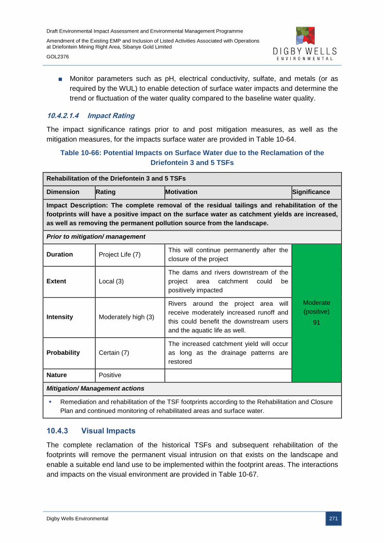
Draft Environmental Impact Assessment and Environmental Management Programme
Amendment of the Existing EMP and Inclusion of Listed Activities Associated with Operations at Driefontein Mining Right Area, Sibanye Gold Limited
GOL2376
Digby Wells Environmental 271
■ Monitor parameters such as pH, electrical conductivity, sulfate, and metals (or as
required by the WUL) to enable detection of surface water impacts and determine the
trend or fluctuation of the water quality compared to the baseline water quality.
10.4.2.1.4 Impact Rating
The impact significance ratings prior to and post mitigation measures, as well as the
mitigation measures, for the impacts surface water are provided in Table 10-64.
Table 10-66: Potential Impacts on Surface Water due to the Reclamation of the
Driefontein 3 and 5 TSFs
Rehabilitation of the Driefontein 3 and 5 TSFs
Dimension Rating Motivation Significance
Impact Description: The complete removal of the residual tailings and rehabilitation of the
footprints will have a positive impact on the surface water as catchment yields are increased,
as well as removing the permanent pollution source from the landscape.
Prior to mitigation/ management
Duration Project Life (7) This will continue permanently after the
closure of the project
Moderate
(positive)
91
Extent Local (3)
The dams and rivers downstream of the
project area catchment could be
positively impacted
Intensity Moderately high (3)
Rivers around the project area will
receive moderately increased runoff and
this could benefit the downstream users
and the aquatic life as well.
Probability Certain (7)
The increased catchment yield will occur
as long as the drainage patterns are
restored
Nature Positive
Mitigation/ Management actions
Remediation and rehabilitation of the TSF footprints according to the Rehabilitation and Closure
Plan and continued monitoring of rehabilitated areas and surface water.
10.4.3 Visual Impacts
The complete reclamation of the historical TSFs and subsequent rehabilitation of the
footprints will remove the permanent visual intrusion on that exists on the landscape and
enable a suitable end land use to be implemented within the footprint areas. The interactions
and impacts on the visual environment are provided in Table 10-67.

Draft Environmental Impact Assessment and Environmental Management Programme
Amendment of the Existing EMP and Inclusion of Listed Activities Associated with Operations at Driefontein Mining Right Area, Sibanye Gold Limited
GOL2376
Digby Wells Environmental 272
Table 10-67: Interactions and Impacts on the Visual Environment associated with the
Reclamation of Driefontein 3 and 5 TSFs
Interaction Impact
Change of land use
from mining to a
suitable end land
use
Change of land use from mining to a suitable end land use will have a positive
visual impact on the receiving environment. This change in land-use will
change the sense of place of the project area and surrounds from an industrial
/ mining sense of place resulting in increased scenic character and decreased
visual disturbance.
10.4.3.1 Reclamation of Driefontein 3 and 5 TSFs
10.4.3.1.1 Impact Description
This is a positive impact as the TSFs will have been reclaimed and the footprints
rehabilitated to a suitable end land use identified as per the Closure Plan to be developed for
the sites which will take into consideration the surrounding land uses. The removal of the
TSFs is a positive visual impact.
10.4.3.1.2 Impact Rating
The impact significance ratings prior to and post mitigation measures, as well as the
mitigation measures, for the impacts on the visual environment are provided in Table 10-68.
Table 10-68: Potential Impacts on the Visual Environment due to the Reclamation of
Driefontein 3 and 5 TSFs
Rehabilitation of the Driefontein 3 and 5 TSFs
Dimension Rating Motivation Significance
Impact Description: The change of land use from mining to a suitable end land use will have a
positive visual impact on the receiving environment. This change in land-use will change the
sense of place of the project area and surrounds from an industrial / mining sense of place
resulting in increased scenic character and decreased visual disturbance.
Prior to mitigation/ management
Duration Permanent (7) The positive impact is permanent as the
TSF will be removed.
Moderate
(positive)
105
Extent Local (3) The positive impact will extend only as far
as the development site area.
Intensity Very Serious (5)
On-going and widespread benefits to
local communities and natural features of
the landscape.
Probability Definite (7) Should the project proceed, the TSFs will
be reclaimed.
Draft Environmental Impact Assessment and Environmental Management Programme
Amendment of the Existing EMP and Inclusion of Listed Activities Associated with Operations at Driefontein Mining Right Area, Sibanye Gold Limited
GOL2376
Digby Wells Environmental 273
Rehabilitation of the Driefontein 3 and 5 TSFs
Dimension Rating Motivation Significance
Nature Positive
10.4.4 Radiation Impacts
The interactions and impacts associated with radiological impacts during post closure are
provided in Table 10-69.
Table 10-69: Interactions and Impacts due to Radionuclides during Post Closure
Interaction Impact
Reclamation of Driefontein 3 and 5 TSFs
The soils underneath the historical TSFs are possible
secondary sources of radiation exposure. The
complete removal of the TSFs will have a positive
impact however.
10.4.4.1 Reclamation of Driefontein 3 and 5 TSFs
10.4.4.1.1 Impact Description
The reclamation and removal of the historical TSFs will have a positive impact on public
radiation exposure conditions within proximity of the Driefontein 3 and 5 TSFs, provided that
the footprints are rehabilitated and that no residual tailings material remains. The
rehabilitation of the TSF footprints will immediately eliminate any contribution to the
atmospheric pathways over the area of impact, with a permanent benefit to the surrounding
public.
The complete removal of tailings material is essential to realise the positive impact of the
reclamation of the historical TSFs as contaminants are likely to have seeped into the
underlying soils, as well as possibly the aquifer system. This results in the formation of
secondary sources of contamination beneath the footprint areas.
10.4.4.1.2 Impact Rating
The impact ratings, prior to and post mitigation measures, associated with radiological
impacts during post closure are provided in Table 10-70.
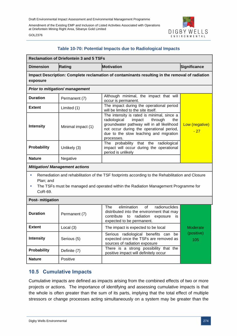
Draft Environmental Impact Assessment and Environmental Management Programme
Amendment of the Existing EMP and Inclusion of Listed Activities Associated with Operations at Driefontein Mining Right Area, Sibanye Gold Limited
GOL2376
Digby Wells Environmental 274
Table 10-70: Potential Impacts due to Radiological Impacts
Reclamation of Driefontein 3 and 5 TSFs
Dimension Rating Motivation Significance
Impact Description: Complete reclamation of contaminants resulting in the removal of radiation
exposure
Prior to mitigation/ management
Duration Permanent (7) Although minimal, the impact that will occur is permanent.
Low (negative)
- 27
Extent Limited (1) The impact during the operational period will be limited to the site itself.
Intensity Minimal impact (1)
The intensity is rated is minimal, since a radiological impact through the groundwater pathway will in all likelihood not occur during the operational period, due to the slow leaching and migration processes.
Probability Unlikely (3) The probability that the radiological impact will occur during the operational period is unlikely
Nature Negative
Mitigation/ Management actions
Remediation and rehabilitation of the TSF footprints according to the Rehabilitation and Closure
Plan; and
The TSFs must be managed and operated within the Radiation Management Programme for
CoR-69.
Post- mitigation
Duration Permanent (7)
The elimination of radionuclides distributed into the environment that may contribute to radiation exposure is expected to be permanent.
Moderate
(positive)
105
Extent Local (3) The impact is expected to be local
Intensity Serious (5) Serious radiological benefits can be expected once the TSFs are removed as sources of radiation exposure
Probability Definite (7) There is a strong possibility that the positive impact will definitely occur
Nature Positive
10.5 Cumulative Impacts
Cumulative impacts are defined as impacts arising from the combined effects of two or more
projects or actions. The importance of identifying and assessing cumulative impacts is that
the whole is often greater than the sum of its parts, implying that the total effect of multiple
stressors or change processes acting simultaneously on a system may be greater than the

Draft Environmental Impact Assessment and Environmental Management Programme
Amendment of the Existing EMP and Inclusion of Listed Activities Associated with Operations at Driefontein Mining Right Area, Sibanye Gold Limited
GOL2376
Digby Wells Environmental 275
sum of their effects when acting in isolation. Cumulative impacts usually relate to large-
scale rather than site-specific impacts and have a tendency to increase the intensity of
impacts already predicted for the proposed project.
The potential cumulative impacts as a result of the WRTRP are discussed in Table 10-71.

Draft Environmental Impact Assessment and Environmental Management Programme
Amendment of the Existing EMP and Inclusion of Listed Activities Associated with Operations at Driefontein Mining Right Area, Sibanye Gold Limited
GOL2376
Digby Wells Environmental 276
Table 10-71: Potential Cumulative Impacts
Environmental Aspect Cumulative Impacts
Air Quality
Air quality data from the existing dust monitoring network (Kloof, Driefontein, Cooke and Ezulwini) indicates deposition rates that
are within the recommended residential limit (600 mg/m2/day), with the Driefontein PM10 monitoring data for 2013 and 2014 being
within the regulatory 75 µg/m3 with occasional exceedances of these limits taking place. The Driefontein monitoring network
recorded much higher deposition rates than the remaining Mining Right monitoring networks.
The operational phase of the Project at the different Mining Right areas will exacerbate localised impacts in the immediate
vicinities of the activities. However, due to the existing mining operations currently taking place, as well as the limited distances
between the respective Mining Right areas, the cumulative regional air quality impact might be diluted to within regulatory
requirements. It is not envisaged that the proposed project will exacerbate the current ambient air quality scenario in the area.
Groundwater
The groundwater within the Driefontein Mining Right area is typical of contaminated water emanating from historical TSFs and
current mining operations, with elevated concentrations of sulfate, TDS and nitrates, as well as manganese and chloride. The pH
values range between 4.1 and 8 and are indicative of AMD impacts associated with seepage from existing TSFs.
The reclamation of the historical TSFs may result in short term AMD generation and seepage of the contaminated water as the
tailings material is exposed to oxygen and water. However, following the complete reclamation of the historical TSFs and
subsequent rehabilitation of the TSF footprints, it is expected that there will be a positive cumulative impact on the groundwater in
the region as the pollution sources are removed from the landscape.
Soils
The major impacts associated with mining are the disturbance of natural occurring soil profiles consisting of layers or soil
horizons. Rehabilitation of disturbed areas aims to restore land capability but the South African experience is that post mining
land capability usually decreases compared to pre-mining land capability. Soil formation is determined by a combination of five
interacting main soil formation factors. These factors are time, climate, slope, organisms and parent material. Soil formation is an
extremely slow process and soil can therefore be considered as a non-renewable resource.
Soil quality deteriorates during stockpiling and replacement of these soil materials into soil profiles during rehabilitation cannot
imitate pre-mining soil quality properties. Depth however can be imitated but the combined soil quality deterioration and resultant
compaction by the machines used in rehabilitation, leads to a net loss of land capability. A change in land capability then forces a
change in land use.

Draft Environmental Impact Assessment and Environmental Management Programme
Amendment of the Existing EMP and Inclusion of Listed Activities Associated with Operations at Driefontein Mining Right Area, Sibanye Gold Limited
GOL2376
Digby Wells Environmental 277
Environmental Aspect Cumulative Impacts
The impact on soil is high because natural soil layers are stripped and stockpiled for later use in rehabilitation. In addition, soil
fertility is impacted because stripped soil layers are usually thicker than the defined topsoil layer. The topsoil layer is the layer
where most plant roots are found and is generally 0.30 m thick.
Although a significant portion of arable land will be lost at the RTSF site. The reclaimed sites will have an increase in land use
and land capability. This will not be at the same level of the land capability and land use of the RTSF site.
Surface Water
The baseline water quality data indicated elevated concentrations of sulfate, nitrate, fluoride, manganese and ammonia in a
number of streams in the project area. This indicates that rivers within this area are already impacted. The area comprises of
various land uses which includes mining, industrial areas, residential areas, and agricultural activities. All these land uses could
possibly have contributed to this water quality status.
The reclamation of the historical TSFs may mobilise and expose sulfide minerals such a pyrite (FeS2) that, when exposed to air
and water, will oxidise and release large quantities of iron and sulfate into solution, and generate AMD. Therefore, without
adequate and effective mitigation measures, the proposed project may further deteriorate the quality of water in the natural water
courses.
In the long run it is anticipated that post closure, with the implementation of mitigation and management measures, the surface
water environment will benefit by eliminating a long term source of contaminants presented by the present position and contents
of the dumps. Monitoring should be implemented post closure to check for residual impacts. The reclamation of historical TSFs,
processing of the tailings material, removal of sulfides and deposition on a proposed RTSF will have an overall positive impact on
the environment .This project would therefore contribute to a regional closure strategy that talks to a sustainable solution for both
water issues and management of a multitude of poorly sited historical TSFs.
Fauna and Flora
The pipeline to the CPP, as well as the construction of the WBT and BWSF complex, are the only activities that will remove
vegetation and habitat types.
A positive impact to the vegetation and habitat types present will occur following the rehabilitation and remediation of the
Driefontein 3 and 5 TSF’s. It is expected that 65.3 ha of natural grassland, 6.7 ha of wetlands and 7.4 ha of ridge vegetation will
be removed to facilitate construction. Total cumulative impact will be 79.4 ha.
Aquatics Positive impacts within the Wonderfonteinspruit can be expected due to the project. The positive impacts would be expressed
Draft Environmental Impact Assessment and Environmental Management Programme
Amendment of the Existing EMP and Inclusion of Listed Activities Associated with Operations at Driefontein Mining Right Area, Sibanye Gold Limited
GOL2376
Digby Wells Environmental 278
Environmental Aspect Cumulative Impacts
through the removal of large sources of contaminated seepage and runoff, resulting in potential water quality improvement within
the river system. Short term cumulative impacts, specifically on aquatic ecology would involve impacts arising from potential
increased concentrations of dissolved and suspended solids. Specifically, contaminated runoff or seepage from reclamation
activities may temporarily increase the conductivity of the Wonderfonteinspruit, especially during rainfall periods. However, due to
the currently largely modified status of the ecology within the river system, the presence of largely tolerant species exist and
therefore this increase in dissolved solids may have a potentially lower effect than would be expected in an aquatic ecosystem
with largely sensitive species.
Wetlands
The activities associated with the Driefontein Mining Right area will result in the direct loss of 1 ha of pan wetlands due to the
WBT and BWSF complex footprint. SGL will need to investigate an offset strategy for the loss of these wetlands, as well as the
wetlands associated with the Ultimate WRTRP. This will directly contribute to the cumulative loss of wetlands in the local area,
municipality and province. This may result in reduced wetland functionality which is responsible for maintenance of water quality,
toxicant assimilation, carbon storage, streamflow regulation and flood attenuation, as well as biodiversity maintenance
Visual
The proposed CPP is situated near the existing Kloof mining infrastructure. This existing infrastructure has impacts on the visual
aesthetics / character of the receiving environment and the development of the proposed CPP will add to these existing visual
impacts.
The receiving environment of the proposed RTSF consists mainly of small holdings, agriculture and open land with some small
residential areas. Only a small percentage of the receiving environment has been disturbed by mining and prior to the
construction of the new Gold Fields Doornpoort TSF there was no mining activity within 3.5 km of the proposed RTSF site. The
construction of the new Gold Fields Doornpoort TSF and the proposed RTSF will have significant negative visual impacts on the
visual aesthetics / character of the receiving environment. The visibility of these large developments will alter the sense of place
of the receiving environment from rural to industrial / mining and result in a loss of scenic character and increased visual
disturbance.
The proposed activities of the Driefontein, Cooke and Ezulwini MRAs will have a neutral visual impact on the receiving
environment. The reclamation of the Driefontein 3, Driefontein 5, Cooke and Cooke 4 South TSFs will have a negative visual
impact during the reclamation phase but ultimately after the rehabilitation phase there will be a neutral visual impact because the
negative visual impact of mining created by the TSFs will be removed. This neutral visual impact will be increased as the number
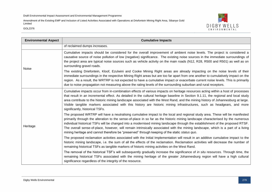
Draft Environmental Impact Assessment and Environmental Management Programme
Amendment of the Existing EMP and Inclusion of Listed Activities Associated with Operations at Driefontein Mining Right Area, Sibanye Gold Limited
GOL2376
Digby Wells Environmental 279
Environmental Aspect Cumulative Impacts
of reclaimed dumps increases.
Noise
Cumulative impacts should be considered for the overall improvement of ambient noise levels. The project is considered a
causative source of noise pollution of low (negative) significance. The existing noise sources in the immediate surroundings of
the project area are typical noise sources such as vehicle activity on the main roads (N12, R28, R500 and R501) as well as on
surrounding gravel roads.
The existing Driefontein, Kloof, Ezulwini and Cooke Mining Right areas are already impacting on the noise levels of their
immediate surroundings in the respective Mining Right areas but are too far apart from one another to cumulatively impact on the
region. As a result, the WRTRP is not expected to have a cumulative impact or exacerbate current noise levels. This is primarily
due to noise propagation not measuring above the rating levels of the surrounding suburban and rural receptors.
Heritage
Cumulative impacts occur from in-combination effects of various impacts on heritage resources acting within a host of processes
that result in an incremental effect. As detailed in the cultural heritage baseline in Section 9.1.11, the regional and local study
area contribute to the historic mining landscape associated with the West Rand, and the mining history of Johannesburg at large.
Visible tangible markers associated with this history are historic mining infrastructures, such as headgears, and more
significantly, historical TSFs.
The proposed WRTRP will have a neutralising cumulative impact to the local and regional study area. These will be manifested
primarily through the alteration to the sense-of-place in so far as the historic mining landscape characterised by the numerous
individual historical TSFs will be changed into a modernised mining landscape through the establishment of the proposed RTSF.
The overall sense-of-place, however, will remain intrinsically associated with the mining landscape, which is a part of a living
mining heritage and cannot therefore be “preserved” through keeping of the static status quo.
The proposed reclamation activities associated with the Initial Implementation will result in an additive cumulative impact to the
historic mining landscape, i.e. the sum of all the effects of the reclamation. Reclamation activities will decrease the number of
remaining historical TSFs as tangible markers of historic mining activities on the West Rand.
The removal of the historical TSF’s will subsequently gradually increase the significance of in situ resources. Through time, the
remaining historical TSFs associated with the mining heritage of the greater Johannesburg region will have a high cultural
significance regardless of the integrity of the resource.

Draft Environmental Impact Assessment and Environmental Management Programme
Amendment of the Existing EMP and Inclusion of Listed Activities Associated with Operations at Driefontein Mining Right Area, Sibanye Gold Limited
GOL2376
Digby Wells Environmental 280
Environmental Aspect Cumulative Impacts
Socio-Economic
It is expected that the project will contribute towards improving environmental conditions in the project area and its surroundings
due to the reclamation of historical TSFs. The cumulative contribution of this impact is, however, dependent on the impacts of
other existing and future developments in the area, as well as the success of government programmes aimed at the protection of
the environment, and the socio-economic development of historically disadvantaged local communities. Cooperating and
partnering with government, mining companies and industries is therefore imperative.
It is also expected that the project will contribute to employment, local procurement and the production of high value products;
this will facilitate income growth, capacity development and national level economic benefits. The project may also contribute to
infrastructure and service improvements in the affected districts, which will in themselves impact positively on the local and
district socio-economic status. These positive impacts, in combination with those of other developments, could boost the overall
development in the surrounding municipal districts.
A highly significant cumulative impact relates to the fact that existing and new developments in the West Rand may accelerate
population influx to the area with the associated increased pressure on land, resources and services, as well as the potential for
informal settlement, encroachment and urban sprawl. The development of the project could exacerbate conditions such as the
spread of HIV/AIDS and other communicable diseases following population influx, settlement densification and related factors
(e.g. decreases in the quality and quantity of water). Health impacts must be addressed in the project’s Community Health and
Safety Management Plan. Moreover, the Project should collaborate with national, provincial and local government, as well as
leading health-based NGOs to promote an integrated approach to combating HIV/AIDS.
Radiological
Due to the nature of most mining and mineral processing operations, a cumulative radiological impact may be expected between
different facilities within the same CoR, especially where facilities are closely (spatially) associated with each other. Viewed from
a radiation protection perspective, each CoR is licensed separately, which means that the cumulative effect between all potential
sources included in the scope of that CoR should be within the compliance criteria set for public exposure.
Within the Driefontein Mining Right area, the cumulative effect as far as the WRTRP is concerned is anticipated to result in the
reduction in the total effective dose, since the Driefontein 3 and 5 TSFs are major pollution sources that will be removed from the
system, with a significant reduction in the radiological impact near these facilities.
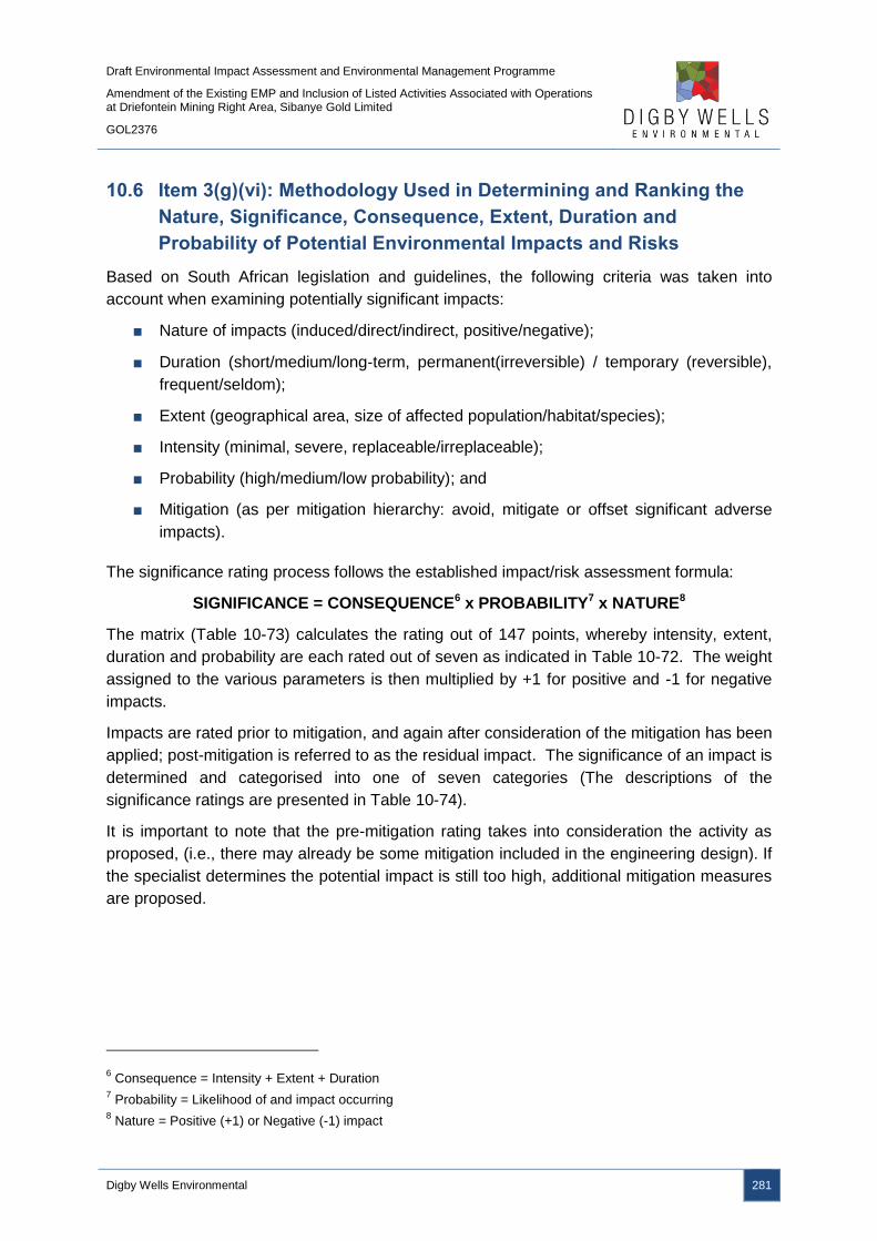
Draft Environmental Impact Assessment and Environmental Management Programme
Amendment of the Existing EMP and Inclusion of Listed Activities Associated with Operations at Driefontein Mining Right Area, Sibanye Gold Limited
GOL2376
Digby Wells Environmental 281
10.6 Item 3(g)(vi): Methodology Used in Determining and Ranking the
Nature, Significance, Consequence, Extent, Duration and
Probability of Potential Environmental Impacts and Risks
Based on South African legislation and guidelines, the following criteria was taken into
account when examining potentially significant impacts:
■ Nature of impacts (induced/direct/indirect, positive/negative);
■ Duration (short/medium/long‐term, permanent(irreversible) / temporary (reversible),
frequent/seldom);
■ Extent (geographical area, size of affected population/habitat/species);
■ Intensity (minimal, severe, replaceable/irreplaceable);
■ Probability (high/medium/low probability); and
■ Mitigation (as per mitigation hierarchy: avoid, mitigate or offset significant adverse
impacts).
The significance rating process follows the established impact/risk assessment formula:
SIGNIFICANCE = CONSEQUENCE6 x PROBABILITY7 x NATURE8
The matrix (Table 10-73) calculates the rating out of 147 points, whereby intensity, extent,
duration and probability are each rated out of seven as indicated in Table 10-72. The weight
assigned to the various parameters is then multiplied by +1 for positive and -1 for negative
impacts.
Impacts are rated prior to mitigation, and again after consideration of the mitigation has been
applied; post-mitigation is referred to as the residual impact. The significance of an impact is
determined and categorised into one of seven categories (The descriptions of the
significance ratings are presented in Table 10-74).
It is important to note that the pre-mitigation rating takes into consideration the activity as
proposed, (i.e., there may already be some mitigation included in the engineering design). If
the specialist determines the potential impact is still too high, additional mitigation measures
are proposed.
6 Consequence = Intensity + Extent + Duration
7 Probability = Likelihood of and impact occurring
8 Nature = Positive (+1) or Negative (-1) impact

Draft Environmental Impact Assessment and Environmental Management Programme
Amendment of the Existing EMP and Inclusion of Listed Activities Associated with Operations at Driefontein Mining Right Area, Sibanye Gold Limited
GOL2376
Digby Wells Environmental 282
Table 10-72: Impact Assessment Parameter Ratings
RATING INTENSITY/REPLACABILITY
EXTENT DURATION/REVERSIBILITY PROBABILITY Negative impacts Positive impacts
7
Irreplaceable loss or
damage to biological or
physical resources or
highly sensitive
environments.
Irreplaceable damage to highly sensitive cultural/social resources.
Noticeable, on-going natural and / or social benefits which have improved the overall conditions of the baseline.
International
The effect will occur across international borders.
Permanent: The impact is irreversible, even with management, and will remain after the life of the project.
Definite: There are sound scientific reasons to expect that the impact will definitely occur. >80% probability.
6
Irreplaceable loss or
damage to biological or
physical resources or
moderate to highly
sensitive
environments.
Irreplaceable damage to cultural/social resources of moderate to highly sensitivity.
Great improvement to the overall conditions of a large percentage of the baseline.
National
Will affect the entire country.
Beyond project life: The impact will remain for some time after the life of the project and is potentially irreversible even with management.
Almost certain / Highly probable: It is most likely that the impact will occur. <80% probability.

Draft Environmental Impact Assessment and Environmental Management Programme
Amendment of the Existing EMP and Inclusion of Listed Activities Associated with Operations at Driefontein Mining Right Area, Sibanye Gold Limited
GOL2376
Digby Wells Environmental 283
RATING INTENSITY/REPLACABILITY
EXTENT DURATION/REVERSIBILITY PROBABILITY Negative impacts Positive impacts
5
Serious loss and/or
damage to physical or
biological resources or
highly sensitive
environments, limiting
ecosystem function.
Very serious widespread social impacts. Irreparable damage to highly valued items.
On-going and widespread benefits to local communities and natural features of the landscape.
Province/ Region
Will affect the entire province or region.
Project Life (>15 years): The impact will cease after the operational life span of the project and can be reversed with sufficient management.
Likely: The impact may occur. <65% probability.
4
Serious loss and/or
damage to physical or
biological resources or
moderately sensitive
environments, limiting
ecosystem function.
On-going serious social issues. Significant damage to structures / items of cultural significance.
Average to intense natural and / or social benefits to some elements of the baseline.
Municipal Area
Will affect the whole municipal area.
Long term: 6-15 years and impact can be reversed with management.
Probable: Has occurred here or elsewhere and could therefore occur. <50% probability.
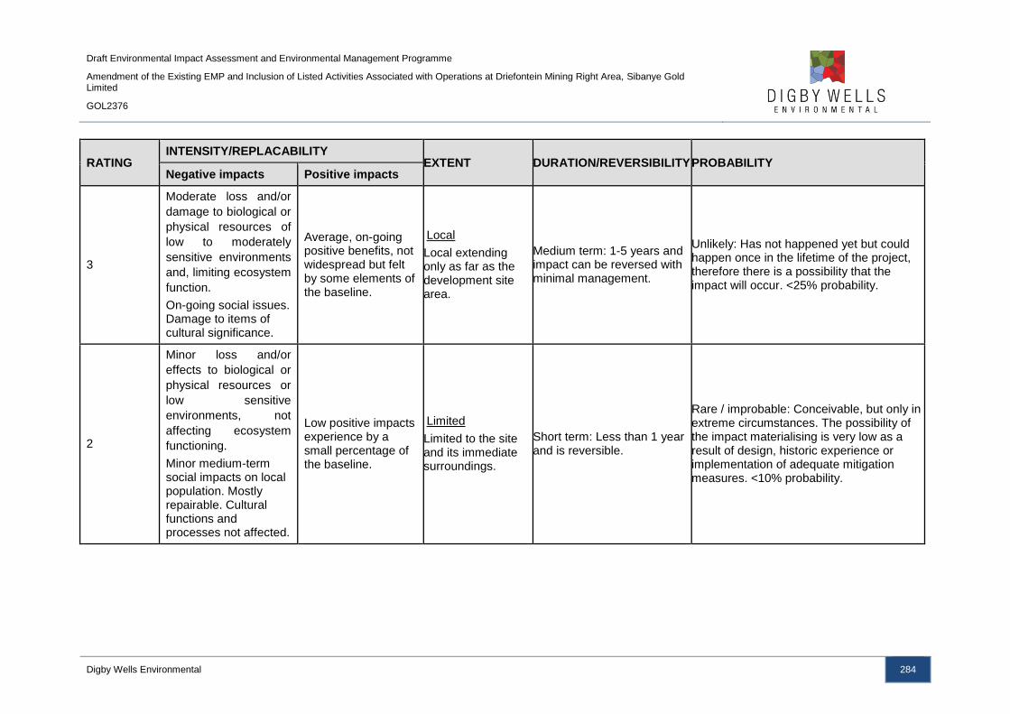
Draft Environmental Impact Assessment and Environmental Management Programme
Amendment of the Existing EMP and Inclusion of Listed Activities Associated with Operations at Driefontein Mining Right Area, Sibanye Gold Limited
GOL2376
Digby Wells Environmental 284
RATING INTENSITY/REPLACABILITY
EXTENT DURATION/REVERSIBILITY PROBABILITY Negative impacts Positive impacts
3
Moderate loss and/or
damage to biological or
physical resources of
low to moderately
sensitive environments
and, limiting ecosystem
function.
On-going social issues. Damage to items of cultural significance.
Average, on-going positive benefits, not widespread but felt by some elements of the baseline.
Local
Local extending only as far as the development site area.
Medium term: 1-5 years and impact can be reversed with minimal management.
Unlikely: Has not happened yet but could happen once in the lifetime of the project, therefore there is a possibility that the impact will occur. <25% probability.
2
Minor loss and/or
effects to biological or
physical resources or
low sensitive
environments, not
affecting ecosystem
functioning.
Minor medium-term social impacts on local population. Mostly repairable. Cultural functions and processes not affected.
Low positive impacts experience by a small percentage of the baseline.
Limited
Limited to the site and its immediate surroundings.
Short term: Less than 1 year and is reversible.
Rare / improbable: Conceivable, but only in extreme circumstances. The possibility of the impact materialising is very low as a result of design, historic experience or implementation of adequate mitigation measures. <10% probability.
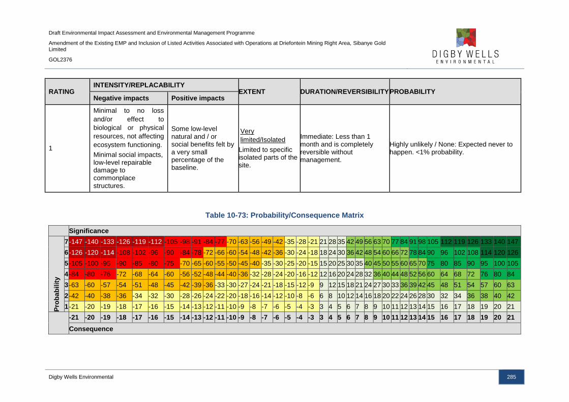
Draft Environmental Impact Assessment and Environmental Management Programme
Amendment of the Existing EMP and Inclusion of Listed Activities Associated with Operations at Driefontein Mining Right Area, Sibanye Gold Limited
GOL2376
Digby Wells Environmental 285
RATING INTENSITY/REPLACABILITY
EXTENT DURATION/REVERSIBILITY PROBABILITY Negative impacts Positive impacts
1
Minimal to no loss
and/or effect to
biological or physical
resources, not affecting
ecosystem functioning.
Minimal social impacts, low-level repairable damage to commonplace structures.
Some low-level natural and / or social benefits felt by a very small percentage of the baseline.
Very
limited/Isolated
Limited to specific isolated parts of the site.
Immediate: Less than 1 month and is completely reversible without management.
Highly unlikely / None: Expected never to happen. <1% probability.
Table 10-73: Probability/Consequence Matrix
Significance
Pro
bab
ilit
y
7 -147 -140 -133 -126 -119 -112 -105 -98 -91 -84 -77 -70 -63 -56 -49 -42 -35 -28 -21 21 28 35 42 49 56 63 70 77 84 91 98 105 112 119 126 133 140 147
6 -126 -120 -114 -108 -102 -96 -90 -84 -78 -72 -66 -60 -54 -48 -42 -36 -30 -24 -18 18 24 30 36 42 48 54 60 66 72 78 84 90 96 102 108 114 120 126
5 -105 -100 -95 -90 -85 -80 -75 -70 -65 -60 -55 -50 -45 -40 -35 -30 -25 -20 -15 15 20 25 30 35 40 45 50 55 60 65 70 75 80 85 90 95 100 105
4 -84 -80 -76 -72 -68 -64 -60 -56 -52 -48 -44 -40 -36 -32 -28 -24 -20 -16 -12 12 16 20 24 28 32 36 40 44 48 52 56 60 64 68 72 76 80 84
3 -63 -60 -57 -54 -51 -48 -45 -42 -39 -36 -33 -30 -27 -24 -21 -18 -15 -12 -9 9 12 15 18 21 24 27 30 33 36 39 42 45 48 51 54 57 60 63
2 -42 -40 -38 -36 -34 -32 -30 -28 -26 -24 -22 -20 -18 -16 -14 -12 -10 -8 -6 6 8 10 12 14 16 18 20 22 24 26 28 30 32 34 36 38 40 42
1 -21 -20 -19 -18 -17 -16 -15 -14 -13 -12 -11 -10 -9 -8 -7 -6 -5 -4 -3 3 4 5 6 7 8 9 10 11 12 13 14 15 16 17 18 19 20 21
-21 -20 -19 -18 -17 -16 -15 -14 -13 -12 -11 -10 -9 -8 -7 -6 -5 -4 -3 3 4 5 6 7 8 9 10 11 12 13 14 15 16 17 18 19 20 21
Consequence
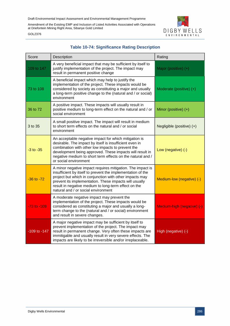
Draft Environmental Impact Assessment and Environmental Management Programme
Amendment of the Existing EMP and Inclusion of Listed Activities Associated with Operations at Driefontein Mining Right Area, Sibanye Gold Limited
GOL2376
Digby Wells Environmental 286
Table 10-74: Significance Rating Description
Score Description Rating
109 to 147 A very beneficial impact that may be sufficient by itself to justify implementation of the project. The impact may result in permanent positive change
Major (positive) (+)
73 to 108
A beneficial impact which may help to justify the implementation of the project. These impacts would be considered by society as constituting a major and usually a long-term positive change to the (natural and / or social) environment
Moderate (positive) (+)
36 to 72 A positive impact. These impacts will usually result in positive medium to long-term effect on the natural and / or social environment
Minor (positive) (+)
3 to 35 A small positive impact. The impact will result in medium to short term effects on the natural and / or social environment
Negligible (positive) (+)
-3 to -35
An acceptable negative impact for which mitigation is desirable. The impact by itself is insufficient even in combination with other low impacts to prevent the development being approved. These impacts will result in negative medium to short term effects on the natural and / or social environment
Low (negative) (-)
-36 to -72
A minor negative impact requires mitigation. The impact is insufficient by itself to prevent the implementation of the project but which in conjunction with other impacts may prevent its implementation. These impacts will usually result in negative medium to long-term effect on the natural and / or social environment
Medium-low (negative) (-)
-73 to -108
A moderate negative impact may prevent the implementation of the project. These impacts would be considered as constituting a major and usually a long-term change to the (natural and / or social) environment and result in severe changes.
Medium-high (negative) (-)
-109 to -147
A major negative impact may be sufficient by itself to prevent implementation of the project. The impact may result in permanent change. Very often these impacts are immitigable and usually result in very severe effects. The impacts are likely to be irreversible and/or irreplaceable.
High (negative) (-)

Draft Environmental Impact Assessment and Environmental Management Programme
Amendment of the Existing EMP and Inclusion of Listed Activities Associated with Operations at Driefontein Mining Right Area, Sibanye Gold Limited
GOL2376
Digby Wells Environmental 287
10.7 Item 3(g)(vii): The Positive and Negative Impacts that the Proposed
Activity (in terms of the Initial Site Layout) and Alternatives will
have on the Environment and the Community that may be Affected
The layout of the project has been designed to mitigate and prevent potential impacts as far
as possible. The project activities associated with the Kloof Mining Right area are likely to
result in negative impacts to the biophysical environment, while the reclamation activities
associated with the remaining Mining Right areas, namely Driefontein, Ezulwini and Cooke,
are likely to result in positive impacts to the biophysical environment as a result of the
removal of historical TSFs that are sources of pollution and contamination.
The predominant layout concerns raised by I&APs is the location and resultant impacts of
the proposed RTSF site. The RTSF has been discussed as part of the Kloof Mining Right
area EIA and is not included in this report. The location of the WBT and BWSF complex has
been determined based on the central location from the K10 shaft, Driefontein 3 TSF and
CPP. The WBT and BWSF complex has also been located within the R501 arc where the
regional road avoids depressions and sinkholes in the landscape. The WBT and BWSF
complex is located adjacent to these depressions and sinkholes which has limited the
potential land uses for the area.
I&APs have expressed concern over the location of the pipeline routes and the potential
impacts associated with person and animal movement restrictions and possible visual
impacts, as well as impacts to the environment in the event of a pipeline leak or spill. The
pipeline routes have been determined premised on the primary requirement of the shortest
distance between the respective project activities, as well as capitalising on the following:
■ Following existing routes where possible;
■ Avoiding identified environmental sensitive areas, predominantly wetland areas;
■ Crossing existing impacted land;
■ Maximising mine owned land; and
■ Assessing the operating costs pertaining to topographical considerations on pumping
costs.
Utilising existing mine owned land, servitudes and impacted land ensures that potential
impacts to landowners, land occupiers and the environment are prevented or reduced. The
pipelines are critical for the reclamation of the historical TSFs; without the pipelines the
historical TSFs cannot be reclaimed and the positive impacts associated with the project will
not be realised.

Draft Environmental Impact Assessment and Environmental Management Programme
Amendment of the Existing EMP and Inclusion of Listed Activities Associated with Operations at Driefontein Mining Right Area, Sibanye Gold Limited
GOL2376
Digby Wells Environmental 288
10.8 Item 3(g)(viii): The Possible Mitigation Measures that could be
applied and the Level of Risk
This section discusses the potential mitigation measures that have been recommended to
accommodate or address issues and concerns raised by I&APs. One of the predominant
concerns raised by I&APs is the generation of dust and the resultant deterioration on
ambient air quality. Dispersion models were developed as part of the Air Quality Impact
Assessment (Appendix E) and modelled the reclamation process associated with Driefontein
3 and 5 TSFs. The historical TSFs are currently a source of air pollution and the TSFs will be
hydraulically reclaimed. The dispersion models indicated that the dust generated from the
historical TSFs will reduce as the TSFs are reclaimed due to the decreasing size of the
TSFs. In addition, the hydraulic reclamation will act as a natural dust suppressant during the
reclamation activities. It is also vital that vegetation removal on the TSFs only takes place on
the areas being directly reclaimed, preventing dust generation from exposed surfaces not
directly being reclaimed. The source of dust emissions will be completely removed, provided
the historical TSFs are reclaimed in their entirety and rehabilitated according to the
Rehabilitation and Closure Plan. The complete removal of the historical TSFs and
subsequent rehabilitation of the footprints has been included as a condition of authorisation
in this EMP.
I&APs have also raised the concerns over the pipeline routes in terms of the location and
impact to directly affected persons, as well as the potential restriction of movement for
people and animals, as well as the potential for environmental impacts should a pipeline leak
or spill. Based on the location determinants above, by optimising existing servitudes and
mine owned land, the potential impacts to directly affected persons and the movement of
animals and people will be significantly reduced. The use of existing impacted land and the
avoidance of sensitive areas, predominantly wetlands, ensures that potential visual impacts
are reduced, as well as limiting potential impacts to the environment in the event of a
pipeline leak or spill. In addition, mitigation measures are provided in Section 11.2 to prevent
and manage pipeline leaks and spills. Such precautionary measures include the electronic
monitoring of pipeline pressure to identify potential leaks or bursts, emergency valves to
immediately shut down pumping of slurry or mine impacted water, no flanges will be utilised
in floodline areas and all pipelines will be constructed outside of the 1:100 year floodline. In
addition, SGL has established an Emergency Response Plan to contain and clean up any
spills and leaks to prevent environmental degradation.
During the PPP, the predominant impacts raised were regarding the RTSF and its potential
impacts on the environment and directly and indirectly affected landowners and land
occupiers. The RTSF has been assessed and discussed as part of the Kloof Mining Right
area EIA and is not included in this report.
Draft Environmental Impact Assessment and Environmental Management Programme
Amendment of the Existing EMP and Inclusion of Listed Activities Associated with Operations at Driefontein Mining Right Area, Sibanye Gold Limited
GOL2376
Digby Wells Environmental 289
10.9 Item 3(g)(ix): Motivation where No Alternatives Sites were
Considered
Alternatives sites were considered for the WBT and BWSF complex, as well as the pipeline
routes. A comprehensive site selection process was undertaken for the CPP and RTSF
complex, as detailed in Section 8.1.1. The pipeline route alternatives were determined based
on existing routes and servitudes, avoiding wetland and sensitive areas, crossing impacted
and mine owned land and assessing operating costs pertaining to topographical
considerations on pumping costs. The pipeline routes alternatives haven been detailed in
Section 8.1.2.
10.10 Item 3(g)(x): Statement Motivating the Alternative Development
Location within the Overall Site
10.10.1 WBT and BWSF Complex
The WBT and BWSF have been located adjacent to each other to minimise the required
footprints, as well as optimising and aiding in the operational and maintenance efficiency
during the Operational Phase. The footprint of the WBT and BWSF complex has been
optimised and the alteration of the footprint shape will reduce the operational efficiency. As a
result, the block footprint has been utilised to select suitable locations.
The WBT and BWSF complex has been located adjacent to the R501 regional road, where
the road alters direction and arcs to avoid depressions and sink holes in the landscape. The
presence of the depressions and sink holes limits the potential land use adjacent to the
R501 regional road arc. The identified location is also situated approximately midway
between the K10 shaft abstraction point and Driefontein 3 TSF, as well as where the slurry
pipeline heads southwards to the CPP, making the location the central point for the pipeline
routes.
10.10.2 Pipe routes
As outlined in section 8.1.2, the interconnecting pipeline routes shown in Plan 9 have been
well considered and are the preferred pipeline routes for the project.

Draft Environmental Impact Assessment and Environmental Management Programme
Amendment of the Existing EMP and Inclusion of Listed Activities Associated with Operations at Driefontein Mining Right Area, Sibanye Gold Limited
GOL2376
Digby Wells Environmental 290
11 Item 3(h): Full Description of the Process undertaken to Identify,
Assess and Rank the Impacts and Risks the Activity will impose
on the Preferred Site (In respect of the final site layout plan)
through the Life of the Activity
The proposed infrastructure layout for the Driefontein Mining Right area was informed by
various environmental, technical and engineering studies, as well as the location of existing
infrastructure and historical TSFs. The location of the proposed CPP and RTSF has been
detailed in the Kloof Mining Right area EIA and has undergone comprehensive site selection
and feasibility studies. The Driefontein Mining Right area infrastructure has been selected
based on the locations of the CPP and RTSF, as well as taking cognisance of the historical
TSFs for reclamation and existing servitudes and infrastructure. The Scoping phase of the
project identified potential impacts that may arise as a result of the proposed project and
detailed the plan of study for specialist studies to determine the sensitives and baseline
environment of the project area.
Following the identification of potential impacts and detailed baseline environment, the
impacts were assessed utilising the Digby Wells’ methodology which assesses the nature of
the impact, duration and extent, intensity including the aspects irreplaceability, and the
probability of the impact occurring. The EIA methodology is detailed in Section 10.6.
Following the assessment of the potential impacts, mitigation measures were provided and
the potential impacts were assessed post-mitigation. The significance of the pre-mitigation
impacts, the proposed mitigation measures and the post-mitigation significance ratings are
detailed per environmental aspect per phase of the project in Section 10. The potential
impacts assessed are based on the preferred site layout (Plan 4).
12 Item 3(i): Assessment of each Identified Potentially Significant
Impact and Risk
The potential impacts per activity are detailed in Table 12-1. The discussion of the impacts
are provided in Section 10, along with the impact ratings prior to and post the
implementation of mitigation and management measures, as well as providing a list of the
mitigation measures.
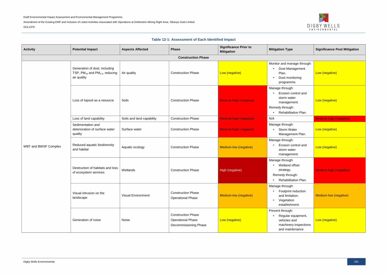
Draft Environmental Impact Assessment and Environmental Management Programme
Amendment of the Existing EMP and Inclusion of Listed Activities Associated with Operations at Driefontein Mining Right Area, Sibanye Gold Limited
GOL2376
Digby Wells Environmental 291
Table 12-1: Assessment of Each Identified Impact
Activity Potential Impact Aspects Affected Phase Significance Prior to
Mitigation Mitigation Type Significance Post Mitigation
Construction Phase
WBT and BWSF Complex
Generation of dust, including
TSP, PM10 and PM2.5, reducing
air quality
Air quality Construction Phase Low (negative)
Monitor and manage through:
Dust Management
Plan.
Dust monitoring
programme.
Low (negative)
Loss of topsoil as a resource Soils Construction Phase Medium-high (negative)
Manage through:
Erosion control and
storm water
management.
Remedy through:
Rehabilitation Plan.
Low (negative)
Loss of land capability Soils and land capability Construction Phase Medium-high (negative) N/A Medium-high (negative)
Sedimentation and
deterioration of surface water
quality
Surface water Construction Phase Medium-high (negative)
Manage through:
Storm Water
Management Plan.
Low (negative)
Reduced aquatic biodiversity
and habitat Aquatic ecology Construction Phase Medium-low (negative)
Manage through:
Erosion control and
storm water
management.
Low (negative)
Destruction of habitats and loss
of ecosystem services Wetlands Construction Phase High (negative)
Manage through:
Wetland offset
strategy.
Remedy through:
Rehabilitation Plan.
Medium-high (negative)
Visual intrusion on the
landscape Visual Environment
Construction Phase
Operational Phase Medium-low (negative)
Manage through:
Footprint reduction
and limitation.
Vegetation
establishment.
Medium-low (negative)
Generation of noise Noise
Construction Phase
Operational Phase
Decommissioning Phase
Low (negative)
Prevent through:
Regular equipment,
vehicles and
machinery inspections
and maintenance
Low (negative)
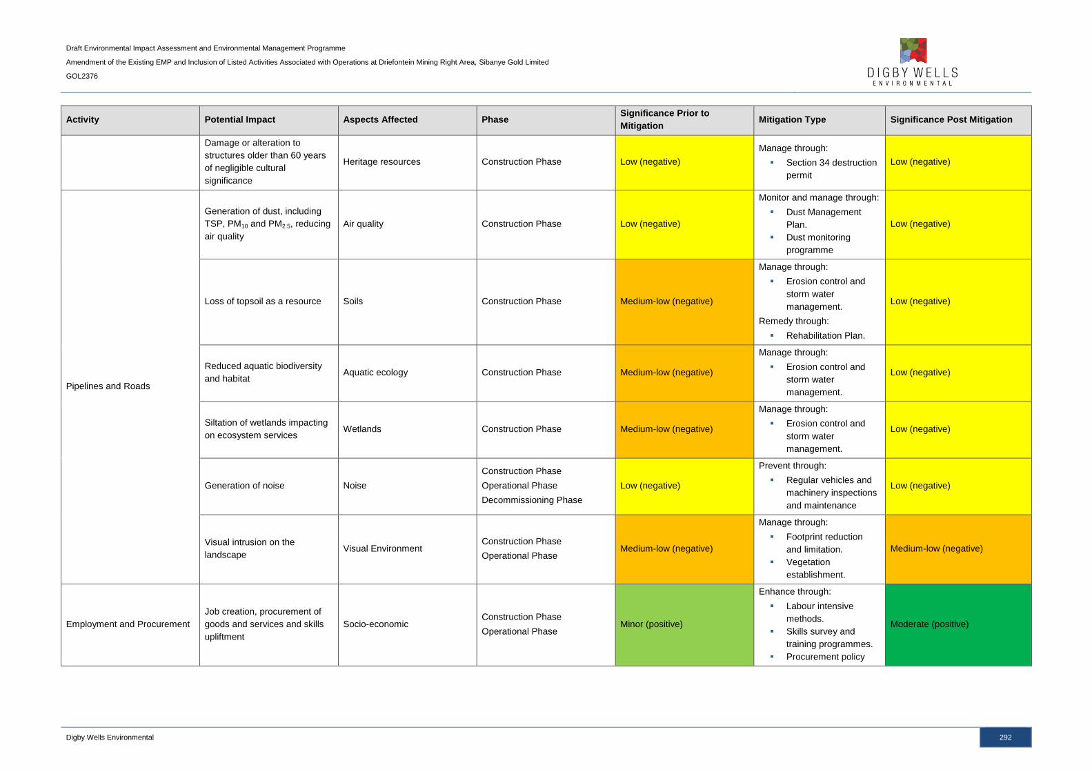
Draft Environmental Impact Assessment and Environmental Management Programme
Amendment of the Existing EMP and Inclusion of Listed Activities Associated with Operations at Driefontein Mining Right Area, Sibanye Gold Limited
GOL2376
Digby Wells Environmental 292
Activity Potential Impact Aspects Affected Phase Significance Prior to
Mitigation Mitigation Type Significance Post Mitigation
Damage or alteration to
structures older than 60 years
of negligible cultural
significance
Heritage resources Construction Phase Low (negative)
Manage through:
Section 34 destruction
permit
Low (negative)
Pipelines and Roads
Generation of dust, including
TSP, PM10 and PM2.5, reducing
air quality
Air quality Construction Phase Low (negative)
Monitor and manage through:
Dust Management
Plan.
Dust monitoring
programme
Low (negative)
Loss of topsoil as a resource Soils Construction Phase Medium-low (negative)
Manage through:
Erosion control and
storm water
management.
Remedy through:
Rehabilitation Plan.
Low (negative)
Reduced aquatic biodiversity
and habitat Aquatic ecology Construction Phase Medium-low (negative)
Manage through:
Erosion control and
storm water
management.
Low (negative)
Siltation of wetlands impacting
on ecosystem services Wetlands Construction Phase Medium-low (negative)
Manage through:
Erosion control and
storm water
management.
Low (negative)
Generation of noise Noise
Construction Phase
Operational Phase
Decommissioning Phase
Low (negative)
Prevent through:
Regular vehicles and
machinery inspections
and maintenance
Low (negative)
Visual intrusion on the
landscape Visual Environment
Construction Phase
Operational Phase Medium-low (negative)
Manage through:
Footprint reduction
and limitation.
Vegetation
establishment.
Medium-low (negative)
Employment and Procurement
Job creation, procurement of
goods and services and skills
upliftment
Socio-economic Construction Phase
Operational Phase Minor (positive)
Enhance through:
Labour intensive
methods.
Skills survey and
training programmes.
Procurement policy
Moderate (positive)
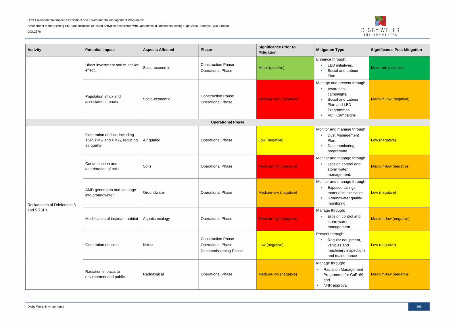
Draft Environmental Impact Assessment and Environmental Management Programme
Amendment of the Existing EMP and Inclusion of Listed Activities Associated with Operations at Driefontein Mining Right Area, Sibanye Gold Limited
GOL2376
Digby Wells Environmental 293
Activity Potential Impact Aspects Affected Phase Significance Prior to
Mitigation Mitigation Type Significance Post Mitigation
Direct investment and multiplier
effect. Socio-economic
Construction Phase
Operational Phase Minor (positive)
Enhance through:
LED initiatives.
Social and Labour
Plan.
Moderate (positive)
Population influx and
associated impacts Socio-economic
Construction Phase
Operational Phase Medium high (negative)
Manage and prevent through:
Awareness
campaigns.
Social and Labour
Plan and LED
Programmes.
VCT Campaigns.
Medium low (negative)
Operational Phase
Reclamation of Driefontein 3
and 5 TSFs
Generation of dust, including
TSP, PM10 and PM2.5, reducing
air quality
Air quality Operational Phase Low (negative)
Monitor and manage through:
Dust Management
Plan.
Dust monitoring
programme.
Low (negative)
Contamination and
deterioration of soils Soils Operational Phase Medium-high (negative)
Monitor and manage through:
Erosion control and
storm water
management.
Medium-low (negative)
AMD generation and seepage
into groundwater Groundwater Operational Phase Medium-low (negative)
Monitor and manage through:
Exposed tailings
material minimisation.
Groundwater quality
monitoring.
Low (negative)
Modification of instream habitat Aquatic ecology Operational Phase Medium-high (negative)
Manage through:
Erosion control and
storm water
management.
Medium-low (negative)
Generation of noise Noise
Construction Phase
Operational Phase
Decommissioning Phase
Low (negative)
Prevent through:
Regular equipment,
vehicles and
machinery inspections
and maintenance
Low (negative)
Radiation impacts to
environment and public Radiological Operational Phase Medium-low (negative)
Manage through:
Radiation Management
Programme for CoR-69;
and
NNR approval.
Medium-low (negative)
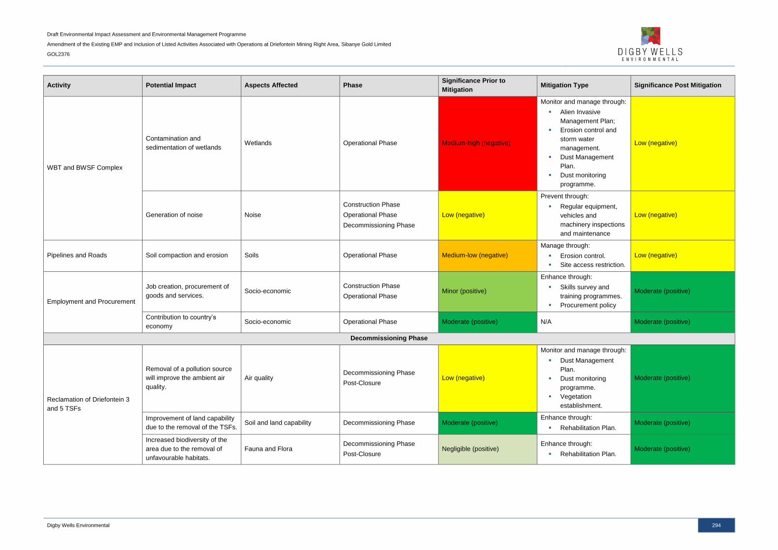
Draft Environmental Impact Assessment and Environmental Management Programme
Amendment of the Existing EMP and Inclusion of Listed Activities Associated with Operations at Driefontein Mining Right Area, Sibanye Gold Limited
GOL2376
Digby Wells Environmental 294
Activity Potential Impact Aspects Affected Phase Significance Prior to
Mitigation Mitigation Type Significance Post Mitigation
WBT and BWSF Complex
Contamination and
sedimentation of wetlands Wetlands Operational Phase Medium-high (negative)
Monitor and manage through:
Alien Invasive
Management Plan;
Erosion control and
storm water
management.
Dust Management
Plan.
Dust monitoring
programme.
Low (negative)
Generation of noise Noise
Construction Phase
Operational Phase
Decommissioning Phase
Low (negative)
Prevent through:
Regular equipment,
vehicles and
machinery inspections
and maintenance
Low (negative)
Pipelines and Roads Soil compaction and erosion Soils Operational Phase Medium-low (negative)
Manage through:
Erosion control.
Site access restriction.
Low (negative)
Employment and Procurement
Job creation, procurement of
goods and services. Socio-economic
Construction Phase
Operational Phase Minor (positive)
Enhance through:
Skills survey and
training programmes.
Procurement policy
Moderate (positive)
Contribution to country’s
economy Socio-economic Operational Phase Moderate (positive) N/A Moderate (positive)
Decommissioning Phase
Reclamation of Driefontein 3
and 5 TSFs
Removal of a pollution source
will improve the ambient air
quality.
Air quality Decommissioning Phase
Post-Closure Low (negative)
Monitor and manage through:
Dust Management
Plan.
Dust monitoring
programme.
Vegetation
establishment.
Moderate (positive)
Improvement of land capability
due to the removal of the TSFs. Soil and land capability Decommissioning Phase Moderate (positive)
Enhance through:
Rehabilitation Plan. Moderate (positive)
Increased biodiversity of the
area due to the removal of
unfavourable habitats.
Fauna and Flora Decommissioning Phase
Post-Closure Negligible (positive)
Enhance through:
Rehabilitation Plan. Moderate (positive)
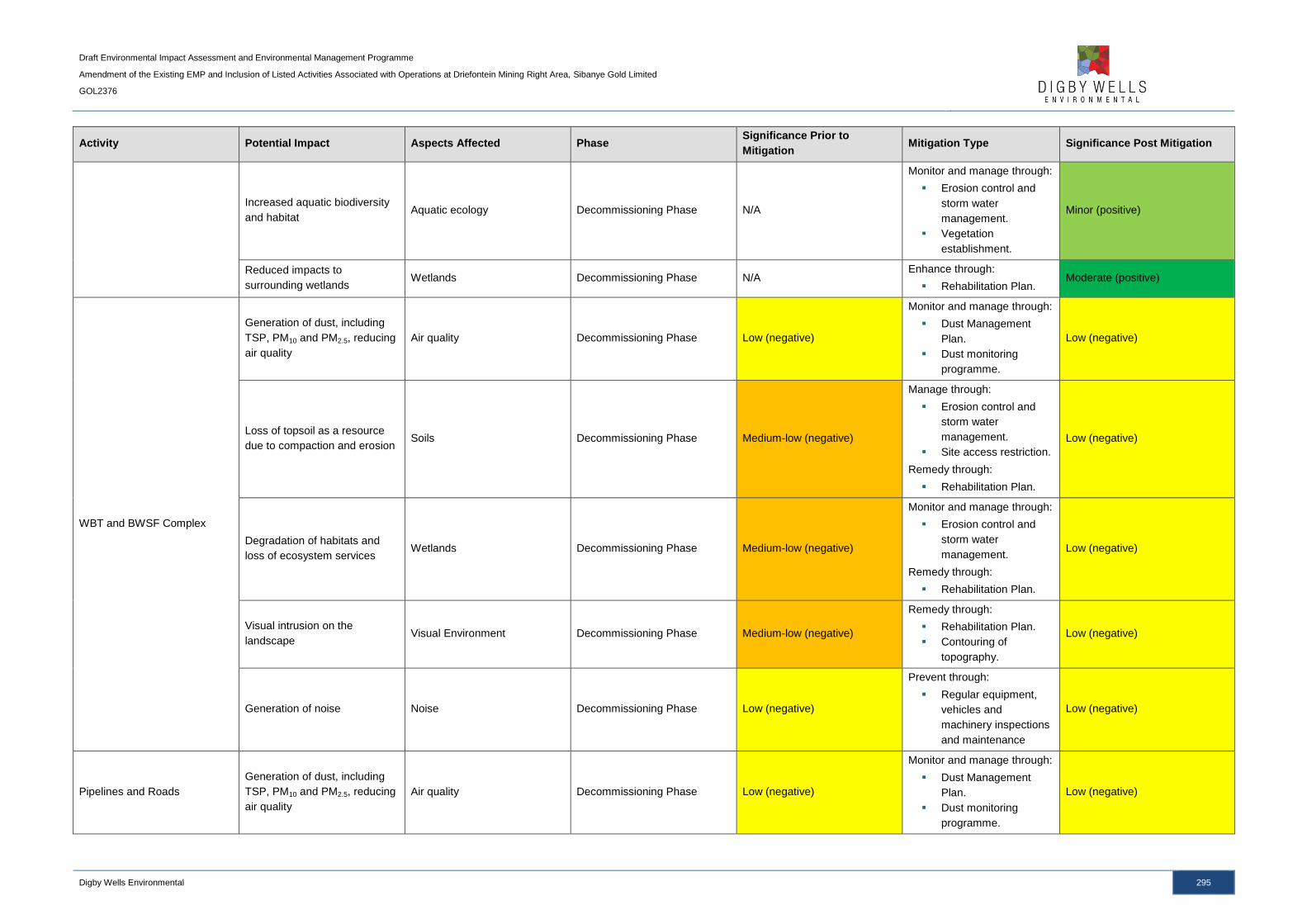
Draft Environmental Impact Assessment and Environmental Management Programme
Amendment of the Existing EMP and Inclusion of Listed Activities Associated with Operations at Driefontein Mining Right Area, Sibanye Gold Limited
GOL2376
Digby Wells Environmental 295
Activity Potential Impact Aspects Affected Phase Significance Prior to
Mitigation Mitigation Type Significance Post Mitigation
Increased aquatic biodiversity
and habitat Aquatic ecology Decommissioning Phase N/A
Monitor and manage through:
Erosion control and
storm water
management.
Vegetation
establishment.
Minor (positive)
Reduced impacts to
surrounding wetlands Wetlands Decommissioning Phase N/A
Enhance through:
Rehabilitation Plan. Moderate (positive)
WBT and BWSF Complex
Generation of dust, including
TSP, PM10 and PM2.5, reducing
air quality
Air quality Decommissioning Phase Low (negative)
Monitor and manage through:
Dust Management
Plan.
Dust monitoring
programme.
Low (negative)
Loss of topsoil as a resource
due to compaction and erosion Soils Decommissioning Phase Medium-low (negative)
Manage through:
Erosion control and
storm water
management.
Site access restriction.
Remedy through:
Rehabilitation Plan.
Low (negative)
Degradation of habitats and
loss of ecosystem services Wetlands Decommissioning Phase Medium-low (negative)
Monitor and manage through:
Erosion control and
storm water
management.
Remedy through:
Rehabilitation Plan.
Low (negative)
Visual intrusion on the
landscape Visual Environment Decommissioning Phase Medium-low (negative)
Remedy through:
Rehabilitation Plan.
Contouring of
topography.
Low (negative)
Generation of noise Noise Decommissioning Phase Low (negative)
Prevent through:
Regular equipment,
vehicles and
machinery inspections
and maintenance
Low (negative)
Pipelines and Roads
Generation of dust, including
TSP, PM10 and PM2.5, reducing
air quality
Air quality Decommissioning Phase Low (negative)
Monitor and manage through:
Dust Management
Plan.
Dust monitoring
programme.
Low (negative)

Draft Environmental Impact Assessment and Environmental Management Programme
Amendment of the Existing EMP and Inclusion of Listed Activities Associated with Operations at Driefontein Mining Right Area, Sibanye Gold Limited
GOL2376
Digby Wells Environmental 296
Activity Potential Impact Aspects Affected Phase Significance Prior to
Mitigation Mitigation Type Significance Post Mitigation
Loss of topsoil as a resource
due to compaction and erosion Soils Decommissioning Phase Medium-low (negative)
Manage through:
Erosion control and
storm water
management.
Site access restriction.
Remedy through:
Rehabilitation Plan.
Low (negative)
Reduced aquatic biodiversity
and habitat Aquatic ecology Decommissioning Phase Medium-low (negative)
Monitor and manage through:
Erosion control and
storm water
management.
Vegetation
establishment.
Low (negative)
Degradation of habitats and
loss of ecosystem services Wetlands Decommissioning Phase Medium-low (negative)
Monitor and manage through:
Erosion control and
storm water
management.
Remedy through:
Rehabilitation Plan.
Low (negative)
Visual intrusion on the
landscape Visual Environment Decommissioning Phase Medium-low (negative)
Remedy through:
Rehabilitation Plan.
Contouring of
topography.
Low (negative)
Generation of noise Noise Operational Phase
Decommissioning Phase Low (negative)
Prevent through:
Regular equipment,
vehicles and
machinery inspections
and maintenance
Low (negative)
Employment and Procurement
Retrenchment of mine
workforce and cumulative
impact on local economy
Socio-economic Decommissioning Phase Medium-high (negative)
Manage through:
Closure Plan.
Future Forum.
Medium-low (negative)
Post-Closure
Reclamation of Driefontein 3
and 5 TSFs
Improvement of groundwater
quality Groundwater Post Closure N/A
Enhance through:
Rehabilitation Plan. Moderate (positive)
Increase in catchment yields
and improved surface water
runoff
Surface water Post Closure N/A Enhance through:
Rehabilitation Plan. Moderate (positive)
Improvement of visual
landscape and change of land
use from mining
Visual Environment Post Closure Moderate (positive) N/A Moderate (positive)
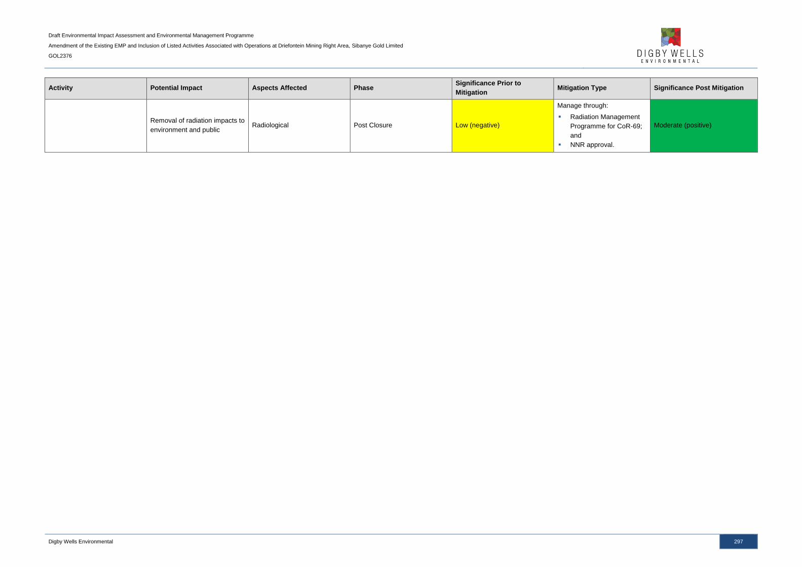
Draft Environmental Impact Assessment and Environmental Management Programme
Amendment of the Existing EMP and Inclusion of Listed Activities Associated with Operations at Driefontein Mining Right Area, Sibanye Gold Limited
GOL2376
Digby Wells Environmental 297
Activity Potential Impact Aspects Affected Phase Significance Prior to
Mitigation Mitigation Type Significance Post Mitigation
Removal of radiation impacts to
environment and public Radiological Post Closure Low (negative)
Manage through:
Radiation Management
Programme for CoR-69;
and
NNR approval.
Moderate (positive)
Draft Environmental Impact Assessment and Environmental Management Programme
Amendment of the Existing EMP and Inclusion of Listed Activities Associated with Operations at Driefontein Mining Right Area, Sibanye Gold Limited
GOL2376
Digby Wells Environmental 298
13 Item 3(j): Summary of Specialist Reports
The summary of the specialist impact assessment reports undertaken for the WRTRP is
detailed in Table 13-1.
Draft Environmental Impact Assessment and Environmental Management Programme
Amendment of the Existing EMP and Inclusion of Listed Activities Associated with Operations at Driefontein Mining Right Area, Sibanye Gold Limited
GOL2376
Digby Wells Environmental 299
Table 13-1: Summary of Specialist Impact Assessments for the WRTRP
List of studies undertaken Recommendations of specialist reports
Specialist
Recommendations that
have been included in
the EIA report
Reference to applicable section of report where specialist
recommendations have been included
Air Quality Impact Assessment
Although the reclamation of the historical TSFs will result in dust
generation, the use of the hydraulic monitoring gun will suppress dust
emissions. The impact on air quality due to the historical TSFs will reduce
over time as the TSFs are reclaimed and the footprints reduced. It is
imperative that the TSFs are reclaimed in their entirety. Dust monitoring
must continue on a monthly basis.
All recommendations
have been considered
and included.
The Air Quality Impact Assessment has been included in Appendix E.
All mitigation and management measures included in this report were
recommended by the Air Quality Specialist, as well as the monitoring
programmes. This includes the impact assessment and mitigation
measures as discussed in Section 10, as well as the recommendations
provided in Part B Sections 5, 6 and 7 and the monitoring provided in
Section 9.
Groundwater Impact Assessment
The reclamation of the historical TSFs will improve the groundwater
quality in the region of the TSFs. During the reclamation activities,
however, there is the potential for AMD generation due to increased
exposure of tailings material to oxygen and water. The water used during
reclamation, which may be acidic, may seep through the TSF footprint
into the groundwater. Capped and vegetated surfaces must not be
disturbed until such walls will be mined. Groundwater monitoring must be
undertaken.
All recommendations
have been considered
and included.
The Groundwater Impact Assessment has been included in Appendix
F.
All mitigation and management measures included in this report were
recommended by the Groundwater Specialist, as well as the monitoring
programmes. This includes the impact assessment and mitigation
measures as discussed in Section 10, as well as the recommendations
provided in Part B, Sections 5, 6 and 7 and the monitoring provided in
Section 9.
Soil Impact Assessment
The removal of the historical TSFs will improve on the land capability of
the TSF footprints, as well as alter the land use to a suitable end land use
other than a mine dump. The Rehabilitation and Closure Plan will be
paramount to ensure the complete rehabilitation of the historical TSF
footprints.
All recommendations
have been considered
and included.
The Soil Impact Assessment has been included in Appendix G.
All mitigation and management measures included in this report were
recommended by the Soil Specialist, as well as the monitoring
programmes. This includes the impact assessment and mitigation
measures as discussed in Section 10, as well as the recommendations
provided in Part B, Sections 5, 6 and 7.
Surface Water Impact Assessment
The Nationally protected Boophone disticha (Poison bulb) (Declining)
was encountered throughout the grassland and ridges vegetation
categories and the plant species Hypoxis hemerocallidea (Star Flower)
(GDARD, Declining)
All recommendations
have been considered
and included.
The Surface Water Impact Assessment has been included in Appendix
H.
All mitigation and management measures included in this report were
recommended by the Surface Water Specialist, as well as the
monitoring programmes. This includes the impact assessment and
mitigation measures as discussed in Section 10, as well as the
recommendations provided in Part B, Sections 5, 6 and 7 and the
monitoring provided in Section 9.
Fauna and Flora Impact Assessment
The WBT and BWSF complex and pipeline routes are located in sensitive
areas, such as grasslands, ridges and wetlands. Nationally protected
species occur throughout the region and must not be destroyed. Plant
species such as Boophone disticha (Poison bulb) and Hypoxis
hemerocallidea (Star Flower) must be identified. Relocation permits must
be applied for all protected plants species that fall within the infrastructure
footprints.
All recommendations
have been considered
and included.
The Fauna and Flora Impact Assessment has been included in
Appendix I.
All mitigation and management measures included in this report were
recommended by the Fauna and Flora Specialist, as well as the
monitoring programmes. This includes the impact assessment and
mitigation measures as discussed in Section 10, as well as the
recommendations provided in Part B, Sections 5, 6 and 7 and the
monitoring provided in Section 9.

Draft Environmental Impact Assessment and Environmental Management Programme
Amendment of the Existing EMP and Inclusion of Listed Activities Associated with Operations at Driefontein Mining Right Area, Sibanye Gold Limited
GOL2376
Digby Wells Environmental 300
List of studies undertaken Recommendations of specialist reports
Specialist
Recommendations that
have been included in
the EIA report
Reference to applicable section of report where specialist
recommendations have been included
Aquatics Impact Assessment
The sedimentation of water resources is a significant threat to the quality
of aquatic ecosystems. Sediment must be collected through silt traps and
buffers implemented from all water resources where possible.
All recommendations
have been considered
and included.
The Aquatics Impact Assessment has been included in Appendix J.
All mitigation and management measures included in this report were
recommended by the Aquatics Specialist, as well as the monitoring
programmes. This includes the impact assessment and mitigation
measures as discussed in Section 10, as well as the recommendations
provided in Part B, Sections 5, 6 and 7 and the monitoring provided in
Section 9.
Wetlands Impact Assessment
The sedimentation of wetlands will inhibit their ecological functioning.
Impacts to wetlands must be mitigated through the implementation of
storm water management, management of alien invasive vegetation and
the offset of destroyed wetlands due to the construction of the WBT and
BWSF complex.
All recommendations
have been considered
and included.
The Wetlands Impact Assessment has been included in Appendix K.
All mitigation and management measures included in this report were
recommended by the Wetland Specialist, as well as the monitoring
programmes. This includes the impact assessment and mitigation
measures as discussed in Section 10, as well as the recommendations
provided in Part B, Sections 5, 6 and 7.
Visual and Topography Impact Assessment
The construction of infrastructure will result in visual intrusions on the
landscape which are unavoidable should the project proceed. The
complete reclamation of the Driefontein e and 5 TSFs, however, will have
a positive impact on the visual environment; it is imperative that the TSFs
are reclaimed in their entirety to ensure the positive impacts are
achieved.
All recommendations
have been considered
and included.
The Visual and Topography Impact Assessment has been included in
Appendix L.
All mitigation and management measures included in this report were
recommended by the Visual Specialist, as well as the monitoring
programmes. This includes the impact assessment and mitigation
measures as discussed in Section 10, as well as the recommendations
provided in Part B, Sections 5, 6 and 7.
Noise Impact Assessment
Noise impacts are considered to be low (negative) due to the baseline
noise levels for the region. The impacts can be further mitigated through
the maintenance of machinery and operating equipment and limiting
activities to daylight hours.
All recommendations
have been considered
and included.
The Noise Impact Assessment has been included in Appendix M.
All mitigation and management measures included in this report were
recommended by the Noise Specialist, as well as the monitoring
programmes. This includes the impact assessment and mitigation
measures as discussed in Section 10, as well as the recommendations
provided in Part B, Sections 5, 6 and 7.
Heritage Impact Assessment
There are heritage resources located within close proximity to the
pipeline routes associated with the Driefontein Mining Right area. The
heritage resources are not expected to be impacted upon, however,
should the resources be impacted, a Section 34 permit must be applied
for in accordance with the NHRA.
All recommendations
have been considered
and included.
The Heritage Impact Assessment has been included in Appendix N.
The mitigation and management measures included in this report were
recommended by the Heritage Specialist, although no impacts to
heritage resources are expected.
Social Impact Assessment
There are positive and negative socio-economic impacts associated with
the project. The positive impacts can be enhanced and the negative
impacts mitigated through the recommendations provided by the
specialists and all positive impacts should be focused on the local
municipalities and receiving communities.
All recommendations
have been considered
and included.
The Social Impact Assessment has been included in Appendix O.
All mitigation and management measures included in this report were
recommended by the Social Specialist, as well as the monitoring
programmes. This includes the impact assessment and mitigation
measures as discussed in Section 10, as well as the recommendations
provided in Part B, Sections 5, 6 and 7.
Draft Environmental Impact Assessment and Environmental Management Programme
Amendment of the Existing EMP and Inclusion of Listed Activities Associated with Operations at Driefontein Mining Right Area, Sibanye Gold Limited
GOL2376
Digby Wells Environmental 301
List of studies undertaken Recommendations of specialist reports
Specialist
Recommendations that
have been included in
the EIA report
Reference to applicable section of report where specialist
recommendations have been included
Economic Impact Assessment
All recommendations
have been considered
and included.
The Economic Impact Assessment has been included in Appendix C.
All mitigation and management measures included in this report were
recommended by the Economic Specialist, as well as the monitoring
programmes. This includes the impact assessment as discussed in
Section 10.
Radiation Impact Assessment
The radiological impacts are anticipated to be medium-low and the
reclamation thereof will have long term positive impacts. The operations
must operate within the Radiation Management Programme of CoR-69
and mitigation measures associated with air quality and groundwater
must be implemented.
All recommendations
have been considered
and included.
The Radiation Impact Assessment has been included in Appendix P.
All mitigation and management measures included in this report were
recommended by the Radiation Specialist, as well as the monitoring
programmes. This includes the impact assessment and mitigation
measures as discussed in Section 10, as well as the recommendations
provided in Part B, Sections 5, 6 and 7.
Draft Environmental Impact Assessment and Environmental Management Programme
Amendment of the Existing EMP and Inclusion of Listed Activities Associated with Operations at Driefontein Mining Right Area, Sibanye Gold Limited
GOL2376
Digby Wells Environmental 302
14 Item 3(k): Environmental Impact Statement
14.1 Item 3(k)(i): Summary if the Key Findings of the Environmental
Impact Assessment
The Environmental Impact Statement is utilised to summarise all of the potential significant
environmental and social impacts identified during each phase of the proposed project. The
significance of the impacts associated with the biophysical and social environment, pre-
mitigation and post-mitigation, is summarised in Table 14-1.
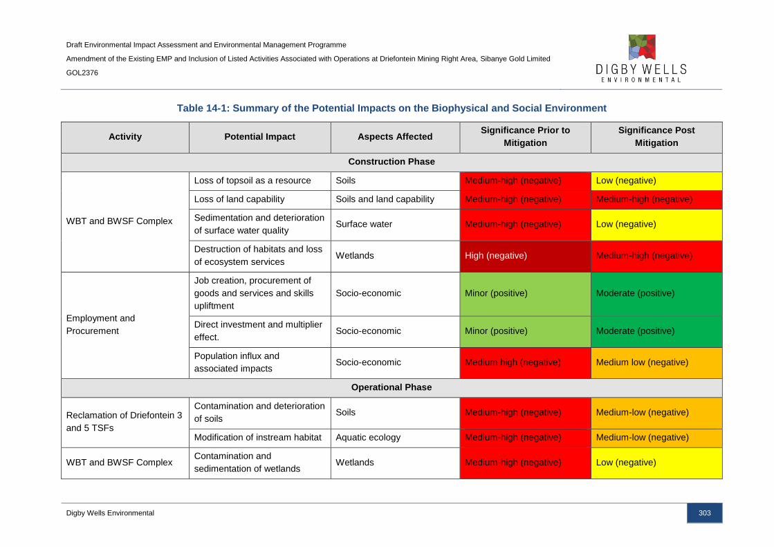
Draft Environmental Impact Assessment and Environmental Management Programme
Amendment of the Existing EMP and Inclusion of Listed Activities Associated with Operations at Driefontein Mining Right Area, Sibanye Gold Limited
GOL2376
Digby Wells Environmental 303
Table 14-1: Summary of the Potential Impacts on the Biophysical and Social Environment
Activity Potential Impact Aspects Affected Significance Prior to
Mitigation
Significance Post
Mitigation
Construction Phase
WBT and BWSF Complex
Loss of topsoil as a resource Soils Medium-high (negative) Low (negative)
Loss of land capability Soils and land capability Medium-high (negative) Medium-high (negative)
Sedimentation and deterioration
of surface water quality Surface water Medium-high (negative) Low (negative)
Destruction of habitats and loss
of ecosystem services Wetlands High (negative) Medium-high (negative)
Employment and
Procurement
Job creation, procurement of
goods and services and skills
upliftment
Socio-economic Minor (positive) Moderate (positive)
Direct investment and multiplier
effect. Socio-economic Minor (positive) Moderate (positive)
Population influx and
associated impacts Socio-economic Medium high (negative) Medium low (negative)
Operational Phase
Reclamation of Driefontein 3
and 5 TSFs
Contamination and deterioration
of soils Soils Medium-high (negative) Medium-low (negative)
Modification of instream habitat Aquatic ecology Medium-high (negative) Medium-low (negative)
WBT and BWSF Complex Contamination and
sedimentation of wetlands Wetlands Medium-high (negative) Low (negative)

Draft Environmental Impact Assessment and Environmental Management Programme
Amendment of the Existing EMP and Inclusion of Listed Activities Associated with Operations at Driefontein Mining Right Area, Sibanye Gold Limited
GOL2376
Digby Wells Environmental 304
Activity Potential Impact Aspects Affected Significance Prior to
Mitigation
Significance Post
Mitigation
Employment and
Procurement
Job creation, procurement of
goods and services. Socio-economic Minor (positive) Moderate (positive)
Contribution to country’s
economy Socio-economic Moderate (positive) Moderate (positive)
Decommissioning Phase
Reclamation of Driefontein 3
and 5 TSFs
Removal of a pollution source
will improve the ambient air
quality.
Air quality Low (negative) Moderate (positive)
Improvement of land capability
due to the removal of the TSFs. Soil and land capability Moderate (positive) Moderate (positive)
Increased biodiversity of the
area due to the removal of
unfavourable habitats.
Fauna and Flora Negligible (positive) Moderate (positive)
Reduced impacts to
surrounding wetlands Wetlands N/A Moderate (positive)
Employment and
Procurement
Retrenchment of mine
workforce and cumulative
impact on local economy
Socio-economic Medium-high (negative) Medium-low (negative)
Post Closure
Reclamation of Driefontein 3
and 5 TSFs
Improvement of groundwater
quality Groundwater N/A Moderate (positive)
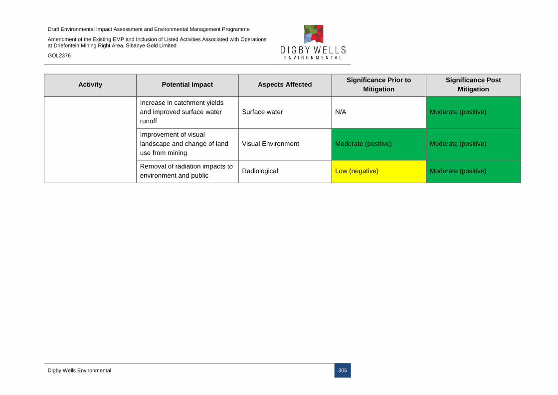
Draft Environmental Impact Assessment and Environmental Management Programme
Amendment of the Existing EMP and Inclusion of Listed Activities Associated with Operations at Driefontein Mining Right Area, Sibanye Gold Limited
GOL2376
Digby Wells Environmental 305
Activity Potential Impact Aspects Affected Significance Prior to
Mitigation
Significance Post
Mitigation
Increase in catchment yields
and improved surface water
runoff
Surface water N/A Moderate (positive)
Improvement of visual
landscape and change of land
use from mining
Visual Environment Moderate (positive) Moderate (positive)
Removal of radiation impacts to
environment and public Radiological Low (negative) Moderate (positive)
Draft Environmental Impact Assessment and Environmental Management Programme
Amendment of the Existing EMP and Inclusion of Listed Activities Associated with Operations at Driefontein Mining Right Area, Sibanye Gold Limited
GOL2376
Digby Wells Environmental 306
14.2 Item 3(k)(ii): Final Site Map
The infrastructure layout plan for the Driefontein Mining Right area is illustrated Plan 4b of
this Report and in Appendix A. A composite plan is provided in Plan 25 below and in
Appendix A.

Draft Environmental Impact Assessment and Environmental Management Programme
Amendment of the Existing EMP and Inclusion of Listed Activities Associated with Operations at Driefontein Mining Right Area, Sibanye Gold Limited
GOL2376
Digby Wells Environmental 307
Plan 25: Composite Plan
Draft Environmental Impact Assessment and Environmental Management Programme
Amendment of the Existing EMP and Inclusion of Listed Activities Associated with Operations at Driefontein Mining Right Area, Sibanye Gold Limited
GOL2376
Digby Wells Environmental 308
14.3 Item 3(k)(iii): Summary of the Positive and Negative Implications
and Risks of the Proposed Activity and Identified Alternatives
The predominant negative impacts associated with the Driefontein Mining Right area are due
to the site clearing for and construction of the WBT and BWSF complex. The construction of
the WBT and BWSF complex will potentially impact on soil and surface water resources due
to the clearance of vegetation and resultant soil erosion and compaction. Eroded soils may
report to surface water resources due to runoff from the site which can lead to sedimentation
of water and deterioration of water quality. In addition, the WBT and BWSF complex has
been partially located within a pan which has a high (negative) impact due to the loss of
wetland habitat; the partial location within the pan was unavoidable due to the presence of
sinkholes and depressions, the R501 road to the north and future construction to the south.
A wetland offset strategy will be implemented to compensate for the loss of wetlands,
subject to a WUL.
The positive impacts associated with the project are predominantly part of the Kloof Mining
Right area as significant capital expenditure will take place which will boost the local
economy and have a multiplier effect. Job creation and skills development will also result
from the project.
The significant positive impacts associated with the Driefontein Mining Right area activities
will be realised following the complete reclamation of the historical TSFs and the
rehabilitation of the footprints. The removal of the historical TSFs will have a positive visual
impact on the landscape, as well as positive impacts on air quality, surrounding wetlands
and aquatic ecology and surface water and groundwater quality as the permanent source of
pollution will be removed from the landscape. In addition, surface water yield to the
catchment will increase as runoff is not restricted by the TSFs, fauna and flora biodiversity
will increase due to the removal of unfavourable habitats and the visual environment will
improve due to the removal of the visual intrusion on the landscape.
15 Item 3(l): Proposed Impact Management Objectives and the
Impact Management Outcomes for Inclusion in the EMPR
The EMP seeks to achieve a required end state and describes how activities that have, or
could have, an adverse impact on the environment will be mitigated, controlled and
monitored.
The EMP will address the environmental impacts during the construction, operational,
decommissioning and post-closure phases of the project. Due regard must be given to
environmental protection during the entire project; a number of environmental
recommendations are made to achieve environmental protection.

Draft Environmental Impact Assessment and Environmental Management Programme
Amendment of the Existing EMP and Inclusion of Listed Activities Associated with Operations at Driefontein Mining Right Area, Sibanye Gold Limited
GOL2376
Digby Wells Environmental 309
These recommendations are aimed at ensuring that the contractor maintains adequate
control over the project to:
■ Minimise the extent of an impact during the life of the project;
■ Ensure appropriate restoration of areas affected by the project; and
■ Prevent long term environmental degradation.
The specific impact management objectives and outcomes for the WRTRP include the
following:
■ Maintain and minimise impacts to the ecosystems within the WRTRP area;
■ Provide suitable end land capability and land use following the reclamation of the
historical TSFs;
■ Provide suitable vegetation establishment on the RTSF to prevent long term impacts;
■ Implement concurrent rehabilitation measures where possible;
■ Reduce dust contamination and generation of dust from historical TSFs;
■ Prevent soil, surface water and groundwater contamination;
■ Comply with local and national regulatory requirements; and
■ Maintain and monitor operational and rehabilitated areas for impact identification.
16 Item 3(m): Final Proposed Alternatives
The layout for the WRTRP and Driefontein Mining Right area infrastructure was informed by
environmental and technical studies, as discussed in detail in Section 8.1 and Section 10.10.
Where impacts cannot be avoided, mitigation and management measures have been
provided. Although sensitive areas have been avoided as far as possible, sections of the
WBT and BWSF complex and pipelines are located in wetland areas; the wetlands cannot
be avoided. A wetland offset strategy has been proposed and developed to offset the loss of
wetland areas for the WBT and BWSF complex, along with the CPP and RTSF area as part
of the Kloof Mining Right area.
17 Item 3(n): Aspects for Inclusion as Conditions of Authorisation
The following aspects must be included as part of the conditions for authorisation:
■ A wetland offset strategy must be implemented for the loss of wetland habitat
associated with the WRTRP, particularly the RTSF complex. The wetland offset
strategy must be implemented within 1 year of a wetland being impacted upon;
■ All mitigation measures provided in this report must be implemented. Should the
mitigation measures be deemed impractical, ineffective or cost prohibitive, SGL may
apply to the DMR to alter such mitigation measures accordingly. Any change in
mitigation measures must be approved by the competent authority;

Draft Environmental Impact Assessment and Environmental Management Programme
Amendment of the Existing EMP and Inclusion of Listed Activities Associated with Operations at Driefontein Mining Right Area, Sibanye Gold Limited
GOL2376
Digby Wells Environmental 310
■ All historical TSFs as part of the WRTRP must be completely reclaimed and their
footprints rehabilitated according to closure plans to be compiled;
■ The treatment of mine affected water at the AWTF must continue beyond the
operational phase. Liability of the AWTF may be transferred to a third party upon
agreement;
■ Environmental monitoring must take place as recommended;
■ “Chance Find” Procedures must be developed for the construction phase in the event
of accidental exposure of unidentified heritage resources;
■ A performance assessment will be undertaken every two years by a suitably qualified
person; and
■ The closure cost assessment must be updated and submitted to the DMR as per the
legislative requirements (annually).
18 Item 3(o): Description of any Assumptions, Uncertainties and
Gaps in Knowledge
This section highlights the assumptions, uncertainties, limitations and knowledge gaps
relevant to the various specialist studies undertaken.
18.1 Air Quality Impact Assessment
It must be noted that modelled data was utilised for site-specific meteorological data in the
Air Quality Impact Assessment.
18.2 Soil Impact Assessment
The assumptions and limitations associated with the Soil Impact Assessment include:
■ A field survey was undertaken for the RTSF complex only, with land type data used
for the remaining WRTRP area.
18.3 Surface Water Impact Assessment
Additional water quality data provided by the client was used in the baseline water quality
description. The assumption and limitation applicable to the Surface Water Impact
Assessment includes:
■ No flow measuring equipment was installed on site. All flow data was obtained from
existing DWS flow gauging stations.
18.4 Fauna and Flora Impact Assessment
A conservative assumption was made that all new pipelines will be above ground and within
new servitudes. Furthermore, it was assumed that the pipeline servitudes will be 20m wide.

Draft Environmental Impact Assessment and Environmental Management Programme
Amendment of the Existing EMP and Inclusion of Listed Activities Associated with Operations at Driefontein Mining Right Area, Sibanye Gold Limited
GOL2376
Digby Wells Environmental 311
The vegetation or habitat types that will be disturbed due to the pipelines, and calculations
on areas of disturbance, were based on these assumptions.
Avifaunal activity is reduced due to the lack of the summer migrants that generally start
arriving in South Africa in October and early November. This also coincides with the
breeding of most of the Southern African species.
The faunal sampling assessment was intended to document any faunal activity or evidence
thereof on site. It is likely that some cryptic, nocturnal or migrant species may not have been
recorded during the faunal survey.
Whilst every effort to document all plant species was made, it is possible that the emerging
period (including flowering or seed-bearing phases of plant life-cycles) of some plants may
not have coincided with the time of sampling. In this case, the absence of these plants from
the species list does not imply that they do not occur on site at all.
18.5 Wetlands Impact Assessment
The assumptions and limitations associated with the Wetlands Impact Assessment include:
■ Only areas that coincide directly with infrastructure and development were assessed.
Given the linear nature of this project, as well as the large extent of the area, only
wetlands within a 500 m study area from the infrastructure areas (250 m either side)
were studied in detail; this included the pipelines, powerlines, historical TSFs and the
footprints of the WBT and BWSF complex;
■ It is important to note that not all wetland floral indicators or important species may
have been identified as the sampling methodology aims to be representative of the
project site and does not cover the entire surface area; and
■ Whilst every effort was made to record all plant species, it is possible that the
flowering period or seed-bearing phases of plant life-cycles of some plants may not
have coincided with the time of sampling.
18.6 Visual Impact Assessment
A Visual Impact Assessment is open to subjectivity. This subjectivity is due to the different
opinions receptors have of a proposed project. A receptor may be partial to the fact that the
proposed project is occurring in an area, which becomes a source of economic upliftment for
a community, whereas another receptor may view a proposed project as a negative factor
which could hamper tourism or recreational activities.
Many factors can enhance or reduce the visual impact of the proposed project. It is,
therefore, difficult to determine the visual impact of the proposed project from the viewpoint
of each individual receptor. Consequently, this report focuses on the size of the viewshed
area. Some infrastructure heights were not available for this study and assumptions were
made. These assumptions were based on the heights of infrastructure from similar projects.
Draft Environmental Impact Assessment and Environmental Management Programme
Amendment of the Existing EMP and Inclusion of Listed Activities Associated with Operations at Driefontein Mining Right Area, Sibanye Gold Limited
GOL2376
Digby Wells Environmental 312
The 5 metre contour relief data from CD: NGI did not include contours for any of the mining
activities (TSFs) for the project area and surrounds. These TSFs could potentially provide
some screening of the proposed project. Lidar data (0.5 metre contours) from SGL was used
where available to add the TSFs. For other areas, the contour data was edited and contours
were added for these mining activities to produce a more representative topographical
model.
18.7 Noise Impact Assessment
The assumptions and limitations associated with the Noise Impact Assessment include:
■ Only daytime scenarios were modelled for the construction phase as it is assumed
that construction activities will only be undertaken during daytime hours (06:00-
22:00); and
■ The resulting noise contours represent worst case (unmitigated), LAeq at any receiver
located 360 degrees in the horizontal plane around the noise sources. The noise
modelling software is limited to calculating the predominant wind direction (or
downwind conditions of propagation) per single receptor only. Calm wind conditions
have therefore been included in the model due to the number of surrounding
receptors. Thus, the noise dispersion plots do not represent a typical seasonal
scenario in the predominant wind direction but rather a yearly average of the area’s
meteorological conditions in all directions.
18.8 Social Impact Assessment
The assessment of potential socio-economic impacts expected to arise as a result of a
proposed project is challenging for a number of reasons. Potential social impacts and the
elements that combine to determine the socio-economic status of affected populations are
generally multi-dimensional and interrelated.
For example, insufficient access to services such as water, sanitation and healthcare is both
a cause and an effect of poverty. Hence, if a project increases the availability of services in
an area, the ability of surrounding communities to take advantage of these services may, to
some extent, depend on their current socio-economic status. In addition, the linkages
between various potential project impacts are complex and can be mutually reinforcing and,
lastly, many social impacts cascade. Although it is necessary to keep the complexity of
social impacts in mind, it is also necessary to produce a Social Impact Assessment that will
be accessible to a non-specialist audience and meet the requirements of the project.
19 Item 3(p): Reasoned Opinion as to whether the Proposed
Activity should or should not be authorised
It must be noted that the Driefontein Mining Right activities in isolation require authorisation
in conjunction with the activities associated with the remaining Mining Right areas to
incorporate the Ultimate WRTRP. Should one application or activity not be authorised, the

Draft Environmental Impact Assessment and Environmental Management Programme
Amendment of the Existing EMP and Inclusion of Listed Activities Associated with Operations at Driefontein Mining Right Area, Sibanye Gold Limited
GOL2376
Digby Wells Environmental 313
entire WRTRP will not proceed and the significant positive impacts associated with the
project will not be realised. As a result, the following section has been discussed taking into
account the Ultimate WRTRP as well as the Driefontein Mining Right area.
19.1 Item 3(p)(i): Reasons why the Activity should be Authorised or not
The WRTRP will bring significant socio-economic contributions to the West Rand; the West
Rand economy has been growing at a Compounded Annual Growth Rate (CAGR) of 1.1%
per year, with the Westonaria LM unemployment was recorded at 42.0%, while the Merafong
City LM recorded an unemployment rate of 21.1%. The capital investment and contributions
to the GDP associated with the WRTRP, along with the potential multiplier effects, are
significant over the life of the operation (50 years), which will provide a sustained
contribution to the local and national economy. In addition, the reclamation of historical
TSFs, which are located on sensitive dolomitic aquifers, will result in positive impacts as
permanent pollution sources are removed from the environment, improving the ambient air
quality, groundwater quality and having positive impacts on the surrounding surface water
resources, wetlands and aquatic ecology. Furthermore, mine affected water being
discharged into the environment, as part of the Kloof and Cooke Mining Right areas, will be
reduced and this water will eventually be treated to potable standards and discharged,
having a positive impact on the environment and downstream users.
The WRTRP will also result in negative impacts on the environment, most notably the
construction of the proposed RTSF. The development and presence of the RTSF will result
in a contamination plume that will impact on groundwater quality. The RTSF will be
approximately 1 300 ha in size and, should no mitigation be implemented, the resultant
contamination plume will impact an area of approximately 3 600 ha 100 years after closure.
SGL proposes to implement a blast curtain which will restrict the contamination plume to an
area of approximately 1 600 ha which is 1 900 ha greater than the RTSF footprint. Although
the liner is preferred from a groundwater perspective, the implementation of a blast curtain
will ensure the project is feasible and the larger positive impacts associated with the WRTRP
are realised. Based on the potential positive impacts associated with the project, the
implementation of a blast curtain is considered to be an acceptable mitigation measure
should the requirement of a liner result in the project becoming financially unfeasible; the
implementation of a blast curtain is more suitable than the project not being undertaken at
all.
19.2 Item 3(p)(ii): Conditions that must be Included in the Authorisation
19.2.1 Specific Conditions to be included into the Compilation and Approval
of EMPR
The following aspects must be included as part of the conditions for authorisation:
■ A wetland offset strategy must be implemented for the loss of wetland habitat
associated with the WRTRP, particularly the RTSF complex. The wetland offset
strategy must be implemented within 1 year of a wetland being impacted upon;
Draft Environmental Impact Assessment and Environmental Management Programme
Amendment of the Existing EMP and Inclusion of Listed Activities Associated with Operations at Driefontein Mining Right Area, Sibanye Gold Limited
GOL2376
Digby Wells Environmental 314
■ All mitigation measures provided in this report must be implemented. Should the
mitigation measures be deemed impractical, ineffective or cost prohibitive, SGL may
apply to the DMR to alter such mitigation measures accordingly. Any change in
mitigation measures must be approved by the competent authority;
■ All historical TSFs as part of the WRTRP must be completely reclaimed and their
footprints rehabilitated according to closure plans to be compiled;
■ The treatment of mine affected water at the AWTF must continue beyond the
operational phase. Liability of the AWTF may be transferred to a third party upon
agreement;
■ Environmental monitoring must take place as recommended;
■ “Chance Find” Procedures must be developed for the construction phase in the event
of accidental exposure of unidentified heritage resources;
■ A performance assessment will be undertaken every two years by a suitably qualified
person; and
■ The closure cost assessment must be updated and submitted to the DMR as per the
legislative requirements (annually).
19.2.2 Rehabilitation Requirements
A Rehabilitation Plan (Appendix Q) has been compiled for the WRTRP, as required and
detailed in the MPRDA. A Rehabilitation Plan is an important planning tool designed to assist
in preventing, minimising or mitigating adverse long-term environmental and social impacts
caused by the proposed project, as well as to create a self-sustaining ecosystem and to
ensure the optimal management of rehabilitation issues that may arise. The overall
rehabilitation objectives, and requirements, for the WRTRP are as follows:
■ Maintain and minimise impacts to the ecosystem within the study area;
■ Provide practical rehabilitation measures for the rehabilitation of the Driefontein 3 and
5 TSFs, the Cooke TSF, Ezulwini South and the RTSF;
■ Identification of suitable end post reclamation land capability and land use and
potential identification of what the future land use could be for these areas;
■ Provide suitable vegetation establishment techniques that can be adopted for the two
dumps that will be reclaimed and for the RTSF;
■ Implement progressive rehabilitation measures where possible;
■ Reduction in dust contamination and generation of dust from historical TSFs through
rehabilitation efforts and concurrent rehabilitation;
■ Prevent soil, surface water and groundwater contamination by removing old tailings
off dolomites and reducing the risk of sinkhole formation;
■ Comply with the relevant local and national regulatory requirements; and
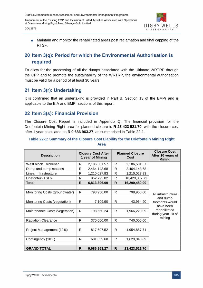
Draft Environmental Impact Assessment and Environmental Management Programme
Amendment of the Existing EMP and Inclusion of Listed Activities Associated with Operations at Driefontein Mining Right Area, Sibanye Gold Limited
GOL2376
Digby Wells Environmental 315
■ Maintain and monitor the rehabilitated areas post reclamation and final capping of the
RTSF.
20 Item 3(q): Period for which the Environmental Authorisation is
required
To allow for the processing of all the dumps associated with the Ultimate WRTRP through
the CPP and to promote the sustainability of the WRTRP, the environmental authorisation
must be valid for a period of at least 30 years.
21 Item 3(r): Undertaking
It is confirmed that an undertaking is provided in Part B, Section 13 of the EMPr and is
applicable to the EIA and EMPr sections of this report.
22 Item 3(s): Financial Provision
The Closure Cost Report is included in Appendix Q. The financial provision for the
Driefontein Mining Right area for planned closure is R 23 423 521.70, with the closure cost
after 1 year calculated as R 9 686 963.27, as summarised in Table 22-1.
Table 22-1: Summary of the Closure Cost Liability for the Driefontein Mining Right
Area
Description Closure Cost After
1 year of Mining Planned Closure
Cost
Closure Cost After 10 years of
Mining
West block Thickener R 2,186,501.57 R 2,186,501.57
All infrastructure and dump
footprints would have been
rehabilitated during year 10 of
mining
Dams and pump stations R 2,464,143.68 R 2,464,143.68
Linear Infrastructure R 1,210,027.93 R 1,210,027.93
Driefontein TSFs R 952,722.82 R 10,429,807.72
Total R 6,813,396.00 R 16,290,480.90
Monitoring Costs (groundwater) R 798,950.00 R 798,950.00
Monitoring Costs (vegetation) R 7,109.90 R 43,964.90
Maintenance Costs (vegetation) R 198,560.24 R 1,966,220.09
Radiation Clearance R 370,000.00 R 740,000.00
Project Management (12%) R 817,607.52 R 1,954,857.71
Contingency (10%) R 681,339.60 R 1,629,048.09
GRAND TOTAL R 9,686,963.27 R 23,423,521.70

Draft Environmental Impact Assessment and Environmental Management Programme
Amendment of the Existing EMP and Inclusion of Listed Activities Associated with Operations at Driefontein Mining Right Area, Sibanye Gold Limited
GOL2376
Digby Wells Environmental 316
22.1 Item 3(s)(i): Explain how the Aforesaid Amount was Derived
The “Guideline Document for the Evaluation of the Quantum of Closure-Related Financial
Provision Provided by a Mine” was used to assess SGL’s environmental liability. The DMR
Guideline Document format makes use of a set template for which defined rates and
multiplication factors are used.
The infrastructure areas and other areas affected by the mining activities were measured
from plans provided by SGL. Measurements that were taken have been standardised to
ensure that the costs calculated are easily updatable. The concrete and steel estimates
associated with the plants are based on previous experience and assumptions.
The rates used were updated by quotes from demolition and civil contractors and
professionals wherever possible. Rate formulation takes into consideration the total labour
costs, plant costs, fuel costs and construction costs and provides an accurate, defendable
rate.
The closure cost model was compiled in Microsoft Excel. The model consists of an input
sheet, containing all measurements of each area of the infrastructure and activities, a
standard rate sheet and a summary sheet which summarises the costs for closure. Each
sheet is linked to the rate sheet, thereby, allowing the costs calculations to be updated easily
from year to year.
22.2 Item 3(s)(ii): Confirm that this Amount can be Provided for from
Operating Expenditure
SGL confirms that the amount detailed in Table 22-1 can be provided for from the operating
expenditure of the WRTRP.
23 Item 3(t): Deviations from the Approved Scoping Report and
Plan of Study
23.1 Item 3(t)(i): Deviations from the Methodology used in Determining
the Significance of Potential Environmental Impacts and Risks
There were no deviations from the methodology proposed in the Scoping Report and plan of
study.
23.2 Item 3(t)(ii): Motivation for the Deviation
No deviations were undertaken from the submitted Scoping Report to the DMR.

Draft Environmental Impact Assessment and Environmental Management Programme
Amendment of the Existing EMP and Inclusion of Listed Activities Associated with Operations at Driefontein Mining Right Area, Sibanye Gold Limited
GOL2376
Digby Wells Environmental 317
24 Item 3(u): Other Information required by the Competent
Authority
To ensure compliance with the provisions of Sections 24(4)(a) and (b) read with Section 24
(3) (a) and (7) of the NEMA, the EIA report must include the information provided in the
following chapters.
24.1 Item 3(u)(i)(1): Impact on the Socio-Economic Conditions of any
Directly Affected Person
The potential socio-economic impacts were discussed in Sections 10.1.11 and 10.2.10. The
WBT and BWSF complex is located on portions 10 and 11 of the farm Driefontein 355 which
is owned by Driefontein Consolidated which is, in turn, held by SGL. There are no land
occupiers, potential beneficiaries or directly affected persons associated with the WBT and
BWSF complex.
The proposed pipeline routes have been determined taking into account mine owned land,
existing impacted land, environmental sensitivities, existing routes and servitudes and
operating costs. The pipeline routes may impact on landowners or land occupiers where the
pipeline does not make use of mine owned land or existing servitudes. Where the pipelines
cross private ownership, namely portions 8, 9 and 24 of the farm Blyvooruitzicht 116 and
portion 22 and the remaining extent of portion 6 of the farm Doornkloof 350, agreements with
the landowners will be concluded to establish servitudes, wayleaves or right of access.
The Social Impact Assessment is included in Appendix O and it is hereby confirmed that the
mitigation measures are provided in Table 5-1 and Table 6-1, Part B of this report.
24.2 Item 3(u)(i)(2): Impact on any National Estate Referred to in Section
3(2) of the National Heritage Resources Act.
The potential impacts on heritage resources have been investigated and assessed in detail.
The Heritage Impact Assessment is included in Appendix N to this report. In summary,
structures older than 60 years were identified throughout the project area, although these
structures were not located within the WBT and BWSF complex and pipeline footprints.
Structures older than 60 years require a destruction permit in accordance with Section 34 of
the NHRA should these structures be altered, damaged or require destruction even though
the structures are deemed to have negligible cultural significance. The structures older than
60 years that may be impacted upon due to the Driefontein Mining Right area activities, and
may require a Section 34 destruction permit, are listed in Table 24-1 and displayed in Plan
22.
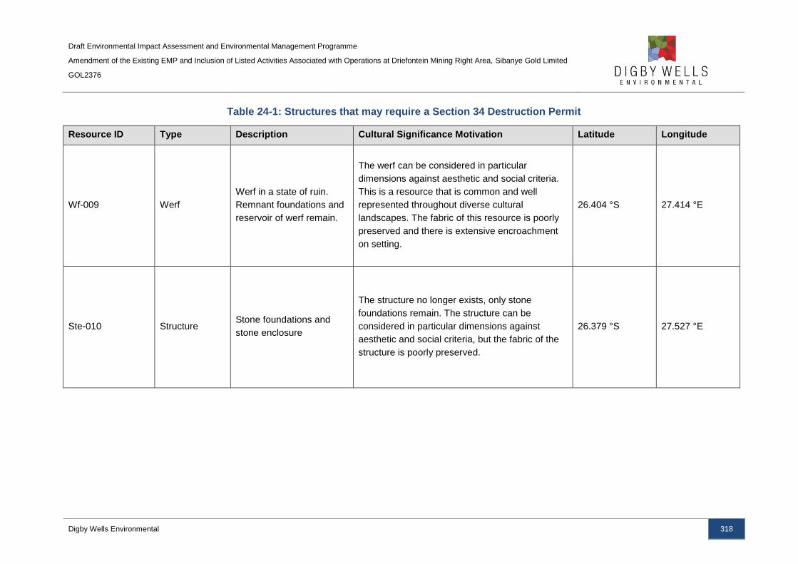
Draft Environmental Impact Assessment and Environmental Management Programme
Amendment of the Existing EMP and Inclusion of Listed Activities Associated with Operations at Driefontein Mining Right Area, Sibanye Gold Limited
GOL2376
Digby Wells Environmental 318
Table 24-1: Structures that may require a Section 34 Destruction Permit
Resource ID Type Description Cultural Significance Motivation Latitude Longitude
Wf-009 Werf
Werf in a state of ruin.
Remnant foundations and
reservoir of werf remain.
The werf can be considered in particular
dimensions against aesthetic and social criteria.
This is a resource that is common and well
represented throughout diverse cultural
landscapes. The fabric of this resource is poorly
preserved and there is extensive encroachment
on setting.
26.404 °S 27.414 °E
Ste-010 Structure Stone foundations and
stone enclosure
The structure no longer exists, only stone
foundations remain. The structure can be
considered in particular dimensions against
aesthetic and social criteria, but the fabric of the
structure is poorly preserved.
26.379 °S 27.527 °E
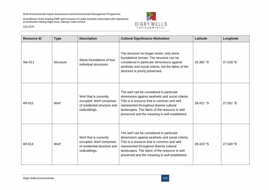
Draft Environmental Impact Assessment and Environmental Management Programme
Amendment of the Existing EMP and Inclusion of Listed Activities Associated with Operations at Driefontein Mining Right Area, Sibanye Gold Limited
GOL2376
Digby Wells Environmental 319
Resource ID Type Description Cultural Significance Motivation Latitude Longitude
Ste-011 Structure Stone foundations of four
individual structures.
The structure no longer exists, only stone
foundations remain. The structure can be
considered in particular dimensions against
aesthetic and social criteria, but the fabric of the
structure is poorly preserved.
26.381 °S 27.528 °E
Wf-012 Werf
Werf that is currently
occupied. Werf comprises
of residential structure and
outbuildings.
The werf can be considered in particular
dimensions against aesthetic and social criteria.
This is a resource that is common and well
represented throughout diverse cultural
landscapes. The fabric of the resource is well
preserved and the meaning is well established.
26.421 °S 27.551 °E
Wf-013 Werf
Werf that is currently
occupied. Werf comprises
of residential structure and
outbuildings.
The werf can be considered in particular
dimensions against aesthetic and social criteria.
This is a resource that is common and well
represented throughout diverse cultural
landscapes. The fabric of the resource is well
preserved and the meaning is well established.
26.423 °S 27.549 °E
Draft Environmental Impact Assessment and Environmental Management Programme
Amendment of the Existing EMP and Inclusion of Listed Activities Associated with Operations at Driefontein Mining Right Area, Sibanye Gold Limited
GOL2376
Digby Wells Environmental 320
25 Item 3(v): Other Matters Required in Terms of Sections 24(4)(a)
and (b) of the Act
This EIA report provides the competent authority with a detailed investigation of the activities
to be undertaken a part of the project and their potential impacts. In addition, alternatives for
the project have been discussed and assessed and no other matters are required in terms of
Sections 24(4)(a) and (b) of the NEMA.
Draft Environmental Impact Assessment and Environmental Management Programme
Amendment of the Existing EMP and Inclusion of Listed Activities Associated with Operations at Driefontein Mining Right Area, Sibanye Gold Limited
GOL2376
Digby Wells Environmental 321
Part B: Environmental Management
Programme Report

Draft Environmental Impact Assessment and Environmental Management Programme
Amendment of the Existing EMP and Inclusion of Listed Activities Associated with Operations at Driefontein Mining Right Area, Sibanye Gold Limited
GOL2376
Digby Wells Environmental 322
1 Item 1(a): Details of the EAP
It is confirmed that the details of the EAP have been provided in Part A, Section 2.1 of this
report.
2 Item 1(b): Description of the Aspects of the Activity
It is confirmed that the baseline environment that may be impacted by the activities is
detailed and discussed in Part A, Section 9.1 of this report.
3 Item 1(c): Composite Map
A composite plan for the Driefontein Mining Right area is illustrated in Plan 25, as well as in
Appendix A.
4 Item 1(d): Description of Impact Management Objectives
including Management Statements
4.1 Item 1(d)(i): Determination of Closure Objectives
Mine closure aims to achieve long-term site stability and the establishment of a self-
sustaining ecosystem which supports the final end land use. The overall rehabilitation and
closure objective for the WRTRP is to:
■ Remove mining infrastructure that cannot be used by a subsequent land owner or a
third party. Where buildings can be used by a third party, arrangements must be
made to ensure their long term sustainable use;
■ Any proposed post closure developments on old mining land will need to undergo
extensive environmental and stability assessments before they can be permitted;
■ Implement progressive rehabilitation measures, beginning during the construction
phase wherever possible;
■ Conducting a radiological field survey to control or stop any action of radon emitting
material;
■ Leave a safe and stable environment for both humans and animals and make their
condition sustainable;
■ Follow a process of closure that is progressive and integrated into the mine plans
and that will assess the closure impacts proactively at regular intervals throughout
project life;
■ To prevent any soil and surface/groundwater contamination by managing all water on
site;
■ Comply with local and national regulatory requirements; and

Draft Environmental Impact Assessment and Environmental Management Programme
Amendment of the Existing EMP and Inclusion of Listed Activities Associated with Operations at Driefontein Mining Right Area, Sibanye Gold Limited
GOL2376
Digby Wells Environmental 323
■ To maintain and monitor all rehabilitated areas following re-vegetation and, if
monitoring shows that the objectives have been met, making an application for
closure.
4.2 Item 1(d)(ii): The Process for Managing any Environmental
Damage, Pollution, Pumping and Treatment of Extraneous Water
or Ecological Degradation as a Result of undertaking a Listed
Activity
4.2.1 Ecological Degradation due to Listed Activities
Listed and specified activities associated with the Driefontein Mining Right area will result in
ecological degradation and environmental damage and pollution. The potential impacts
associated with such activities have been identified and assessed for each environmental
aspect in Sections 10.1 to 10.4. Mitigation measures have been provided to mitigate the
potential impacts associated with the project’s activities to reduce the significance of such
impacts. In addition, monitoring programmes have been provided in Section 9.5 to
monitoring potential impacts which will allow alternative mitigation measures to be
implemented if necessary.
The predominant impacts that may result in ecological degradation are due to the loss of
topsoil resources and destruction of wetland associated with the construction of the WBT
and BWSF complex, which in turn may impact on surface water resources through
sedimentation and deterioration of water quality. The potential ecological degradation will be
managed by implementing storm water management designs to separate clean and dirty
water from the WBT and BWSF complex footprint area, as well as implementing corrective
actions, such as berms, should topsoil erosion occur. In addition, a wetland offset strategy
will be implemented to compensate for the loss of wetland habitat due to the construction of
the WBT and BWSF complex within a delineated pan area.
4.2.2 Process for Managing Ecological Degradation
SGL has established environmental preparedness procedures for any emergencies that may
result in ecological degradation. These procedures applicable to the activities associated
with the Driefontein Mining Right area of the WRTRP have been categorised into the
following:
■ Water spillages;
■ Tailings spillages;
■ Oil spillages; and
■ Chemical spillages.
Draft Environmental Impact Assessment and Environmental Management Programme
Amendment of the Existing EMP and Inclusion of Listed Activities Associated with Operations at Driefontein Mining Right Area, Sibanye Gold Limited
GOL2376
Digby Wells Environmental 324
4.2.2.1 Water Spillages
Water spillages include spillages from all water bearing pipelines and include potable and
non-potable water sources. Water spillages have been included as an emergency procedure
to ensure that valuable resources are not wasted, as aligned to the companies’ policy
statement. In the event of a water spillage occurring, the following actions will apply:
■ The spillage of water from any pipeline, reservoir, dam or other water conveyance or
storage medium into the environment must be immediately reported to the control
room;
■ The control room official must establish and record the following information before
contacting the relevant persons to repair the leak:
Name of person reporting the emergency and their contact details;
Location of the emergency; and
Brief description of the emergency.
■ The control room official will instruct the official that is to repair the leak as to the
following:
To ascertain the source of the water;
To immediately shut off the water supply to the leak;
To check to see whether any water could enter the storm water system or report
to the environment; and
Should water be reporting to the environment, the estimated volume of water.
■ Should non-potable water be reporting to the environment, the control room official
will notify the environmental department who will report any major incident to the
relevant authorities; and
■ An investigation into the incident and an applicable non-conformance and corrective
action report will be completed by the environmental department and submitted to the
relevant head of department.
4.2.2.2 Tailings Spillage
As a result of the nature of the tailings material, pipelines transporting the material have the
potential to fail. SGL will implement operational control procedures to inspect, maintain and
replace pipelines to prevent spillages from occurring. However, should a spillage occur, the
tailings material has the potential to cause significant environmental impacts. In the event of
a spillage being detected, the following actions will apply:
■ The spillage of tailings material must be immediately reported to the control room;
■ The control room official must establish and record the following information:

Draft Environmental Impact Assessment and Environmental Management Programme
Amendment of the Existing EMP and Inclusion of Listed Activities Associated with Operations at Driefontein Mining Right Area, Sibanye Gold Limited
GOL2376
Digby Wells Environmental 325
Name of person reporting the emergency and their contact details;
Location of the emergency; and
Brief description of the emergency.
■ The control room official will contact the relevant persons to repair the leak;
■ The control room official will instruct the official that is to repair the leak as to the
following:
To ascertain the source of the tailings material;
To immediately shut off the supply to the leak;
To check to see whether any tailings material could enter the storm water system
or report to the environment or if the tailings material is confined to a paddock,
berm or other structure designed to contain accidental spillages. All reasonable
precautions must be taken to prevent the tailings material from entering the storm
water or clean water systems; and
The estimate quantity that has been spilled.
■ The control room official will notify the environmental department who will report any
major incident to the relevant authorities;
■ An investigation into the incident and an applicable non-conformance and corrective
action report will be completed by the environmental department and submitted to the
relevant head of department;
■ The security personnel must be notified where a need occurs for the diversion of
traffic or guarding of livestock or wildlife from drinking from or near the spill; and
■ Necessary sampling must be conducted by the Assistant Supervisor in the
contaminated media.
4.2.2.3 Hydrocarbon or Chemical Spill
The spillage of hydrocarbons or chemicals can have significant impacts on various
components of the environment. Operational control procedures have been developed for
the correct handling and storage of hydrocarbons and chemicals at the various management
units. These procedures include actions to be taken in the event of a spill or leak. The below
procedure, however, details the actions to be undertaken for spills larger than 20 litres which
are anticipated to potentially occur during transportation:
■ The spillage of hydrocarbon or chemical must be immediately reported to the control
room;
■ The control room official must establish and record the following information:
Name of person reporting the emergency and their contact details;
Draft Environmental Impact Assessment and Environmental Management Programme
Amendment of the Existing EMP and Inclusion of Listed Activities Associated with Operations at Driefontein Mining Right Area, Sibanye Gold Limited
GOL2376
Digby Wells Environmental 326
Location of the emergency; and
Brief description of the emergency.
■ In the case of a spill on a road, the control room official must instruct the person
reporting the spill to take actions to divert traffic around the spill and to take
preventative action to contain and stop the spill and to prevent it from reporting to any
water systems;
■ The control room official must immediately contact the contracted environmental
pollution clean-up consultants to clean up the spill;
■ The control room official will notify the environmental department who will report any
major incident to the relevant authorities; and
■ An investigation into the incident and an applicable non-conformance and corrective
action report will be completed by the environmental department and submitted to the
relevant head of department.
4.3 Item 1(d)(iii): Potential Risk of Acid Mine Drainage
To determine the potential for AMD associated with the project, a comprehensive sampling
and testing campaign was undertaken by SLR Consulting (2015) to characterise the physical
and geochemical properties of the tailings from the historical TSFs. Three typical composite
samples were made up on which detailed and specialised geotechnical laboratory test work
was undertaken. The composite samples included:
■ Typical fine tailings: it is estimated that 95% of all tailings within historical TSFs will
be coarser than this grading;
■ Typical mean tailings: it is estimated to be a representative average tailings grading;
and
■ Typical coarse tailings: it is estimated that 80% to 90% of all tailings will be finer than
this grading.
The historical tailings samples underwent small scale SPLP leach tests and showed that
there were nine contaminants likely to be of concern, namely, arsenic, iron, manganese,
molybdenum, nickel, nitrate, sodium, sulfate and uranium.
AMD could be generated in the short-term due to the exposure of the tailings material at
Driefontein 3 and 5 TSFs to oxygen and water during the reclamation phase. This is
expected to be short lived (spanning the period of reclamation) and buffered by the dolomitic
carbonates underneath. The impact of the AMD generation and seepage is considered to be
medium-low (negative) as the sites are already considered to be contaminated due to the
presence of the historical TSFs and the pollution plumes are local
Draft Environmental Impact Assessment and Environmental Management Programme
Amendment of the Existing EMP and Inclusion of Listed Activities Associated with Operations at Driefontein Mining Right Area, Sibanye Gold Limited
GOL2376
Digby Wells Environmental 327
4.4 Item 1(d)(iv): Steps taken to Investigate, Assess, and Evaluate the
Impact of Acid Mine Drainage
SLR Consulting (2015) undertook and geochemical and geotechnical analysis of tailings
samples from the historical TSFs associated with the WRTRP; the mineralogy and element
content of the tailings composite samples were found to be similar. A small scale laboratory
leach test was used to evaluate the effect of different metallurgical processes on the tailings
leachability.
4.5 Item i(d)(v): Engineering or Mine Design Solutions to be
Implemented to Avoid or Remedy Acid Mine Drainage
The Driefontein 3 and 5 TSFs will be hydraulically reclaimed. As the TSF is reclaimed, the
tailings material is exposed to air and water which may result in the formation of AMD. The
resultant slurry will flow to collection sumps where it will be pumped to the WBT and then to
the CPP for processing.
The processing of the reclaimed tailings to a sulfide mass concentration of less than 0.3%
will significantly reduce the AMD potential of the residual tailings, as well as playing a
positive role in reducing contaminant concentrations of other elements. Soregaroli and
Lawrence (1998) showed that a sulfide-sulfur concentration of at least 0.3% is required for
long term acid generation. In addition to the sulfide removal, a correlation to the
concentration of other potential contaminants and the potential pH values were identified,
such as concentrations of iron, uranium, manganese, aluminium, zinc lead and nickel among
others. By controlling the pH of the residual tailings, the concentrations of potential
contaminants can be reduced, as well as the potential of AMD generation. The following pH
controls will be implemented and are expected to maintain the pH of the residual tailings
between 6 and 9 in the long term (SLR Consulting, 2015):
■ Sulfide removal and segregation through flotation to achieve a consistent mass
concentration of 0.3%;
■ Addition of lime to raise the pH of the process water going to the RTSF to around
10.5 initially;
■ Construction of a concurrent cover to the RTSF side slopes to limit oxygen ingress
and oxidation of any residual sulfide; and
■ Control the rate of rise which maintains relatively low air permeability throughout the
bulk of the volume of the RTSF.
Thus, the AMD potential of the historical TSFs will be remedied through the processing of
the tailings material.

Draft Environmental Impact Assessment and Environmental Management Programme
Amendment of the Existing EMP and Inclusion of Listed Activities Associated with Operations at Driefontein Mining Right Area, Sibanye Gold Limited
GOL2376
Digby Wells Environmental 328
4.6 Item 1(d)(vi): Measures that will be put in place to Remedy any
Residual or Cumulative Impact that may Result from Acid Mine
Drainage
The reclaimed tailings material, in slurry form, will be diverted and flow towards the
temporary sumps before being pumped to the CPP, via the WBT, for processing. There is a
potential that AMD may seep through the historical TSF or sumps and impact on
groundwater resources. A groundwater monitoring programme has been developed for the
Driefontein Mining complex and the monitoring programme will continue. Should it become
evident that the groundwater resources are impacted due to the reclamation activities, SGL
will implement measures to ensure that impacts are mitigated.
4.7 Item 1(d)(vii): Volumes and Rate of Water Use Required for the
Mining, Trenching or Bulk Sampling Operation
Approximately 20 Mℓ of mine affected water will be abstracted from K10 shaft, with an
additional 12 Mℓ of mine affected water abstracted from Cooke 1 shaft per day required for
the reclamation activities. This will result in the requirement for 32 Mℓ of water required per
day which is currently being discharged into the Wonderfonteinspruit and is considered to be
significantly impacted upon. Following the reclamation activities, processing of the tailings
and deposition of the residual tailings on the RTSF, the AWTF will treat runoff and seepage
from the RTSF to potable standards prior to discharge, IWUL permitting, into the Leeuspruit.
It is anticipated that approximately 15 Mℓ of potable treated water will be discharged per day.
4.8 Item 1(d)(viii): Has a Water Use Licence has been Applied for
An IWULA and IWWMP has been compiled and submitted to the DWS as the decision
making authority. The water uses triggered under Section 21 of the NWA in relation to the
proposed project are listed below:
■ S21(c) – Impeding or diverting the flow of water in a watercourse;
■ S21 (g) – Disposing of waste in a manner which may detrimentally impact on a water
resource;
■ S21 (i) – Altering the bed, banks, course or characteristics of a watercourse; and
■ S21 (j) - Removing, discharging or disposing of water found underground if it is
necessary for the efficient continuation of an activity or for the safety of people.
5 Item 1(d)(ix): Impacts to be Mitigated in their Respective Phases
The proposed mitigation measures and its compliance with the relevant standards are
presented in Table 5-1.
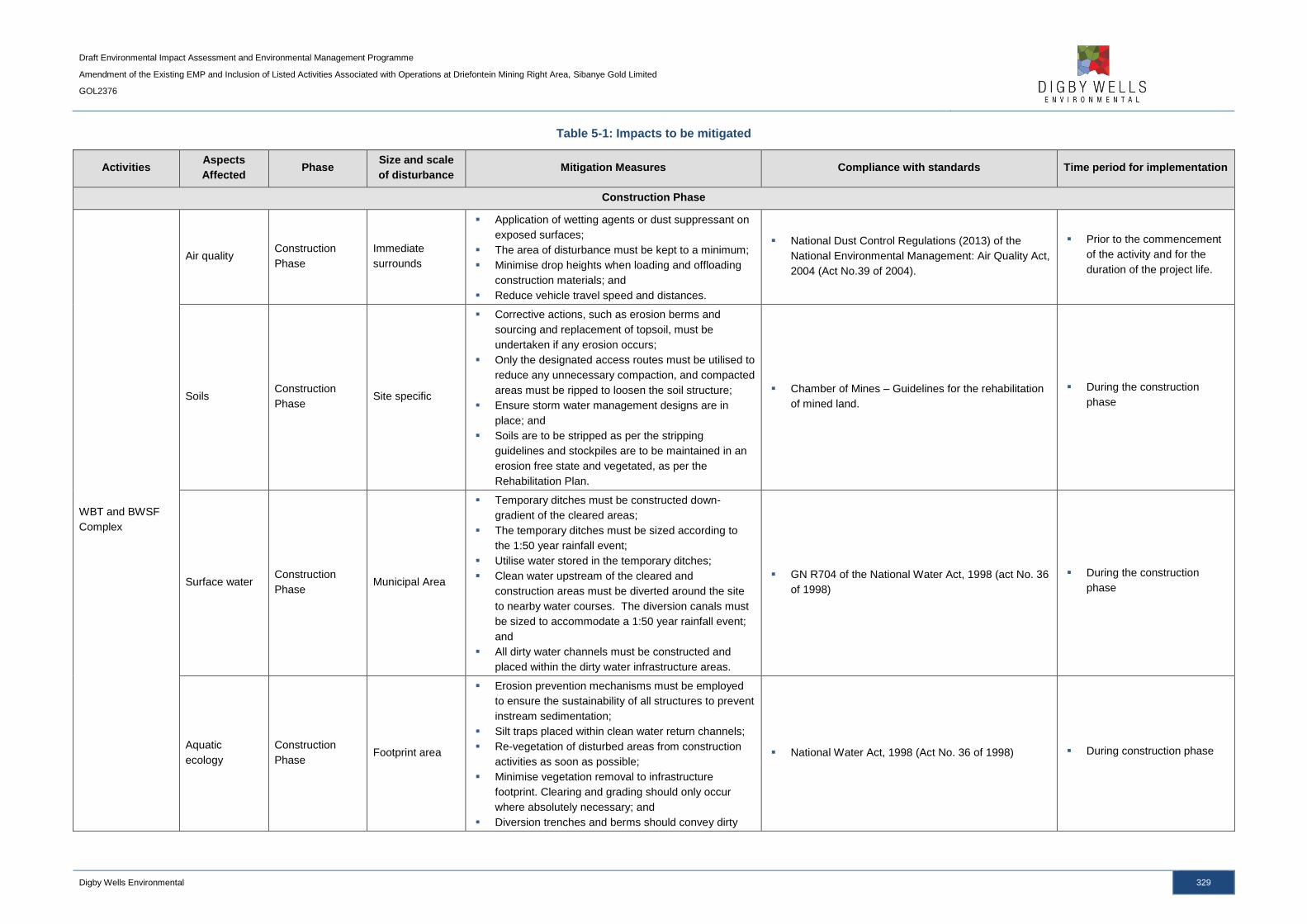
Draft Environmental Impact Assessment and Environmental Management Programme
Amendment of the Existing EMP and Inclusion of Listed Activities Associated with Operations at Driefontein Mining Right Area, Sibanye Gold Limited
GOL2376
Digby Wells Environmental 329
Table 5-1: Impacts to be mitigated
Activities Aspects
Affected Phase
Size and scale
of disturbance Mitigation Measures Compliance with standards Time period for implementation
Construction Phase
WBT and BWSF
Complex
Air quality Construction
Phase
Immediate
surrounds
Application of wetting agents or dust suppressant on
exposed surfaces;
The area of disturbance must be kept to a minimum;
Minimise drop heights when loading and offloading
construction materials; and
Reduce vehicle travel speed and distances.
National Dust Control Regulations (2013) of the
National Environmental Management: Air Quality Act,
2004 (Act No.39 of 2004).
Prior to the commencement
of the activity and for the
duration of the project life.
Soils Construction
Phase Site specific
Corrective actions, such as erosion berms and
sourcing and replacement of topsoil, must be
undertaken if any erosion occurs;
Only the designated access routes must be utilised to
reduce any unnecessary compaction, and compacted
areas must be ripped to loosen the soil structure;
Ensure storm water management designs are in
place; and
Soils are to be stripped as per the stripping
guidelines and stockpiles are to be maintained in an
erosion free state and vegetated, as per the
Rehabilitation Plan.
Chamber of Mines – Guidelines for the rehabilitation
of mined land.
During the construction
phase
Surface water Construction
Phase Municipal Area
Temporary ditches must be constructed down-
gradient of the cleared areas;
The temporary ditches must be sized according to
the 1:50 year rainfall event;
Utilise water stored in the temporary ditches;
Clean water upstream of the cleared and
construction areas must be diverted around the site
to nearby water courses. The diversion canals must
be sized to accommodate a 1:50 year rainfall event;
and
All dirty water channels must be constructed and
placed within the dirty water infrastructure areas.
GN R704 of the National Water Act, 1998 (act No. 36
of 1998)
During the construction
phase
Aquatic
ecology
Construction
Phase Footprint area
Erosion prevention mechanisms must be employed
to ensure the sustainability of all structures to prevent
instream sedimentation;
Silt traps placed within clean water return channels;
Re-vegetation of disturbed areas from construction
activities as soon as possible;
Minimise vegetation removal to infrastructure
footprint. Clearing and grading should only occur
where absolutely necessary; and
Diversion trenches and berms should convey dirty
National Water Act, 1998 (Act No. 36 of 1998) During construction phase
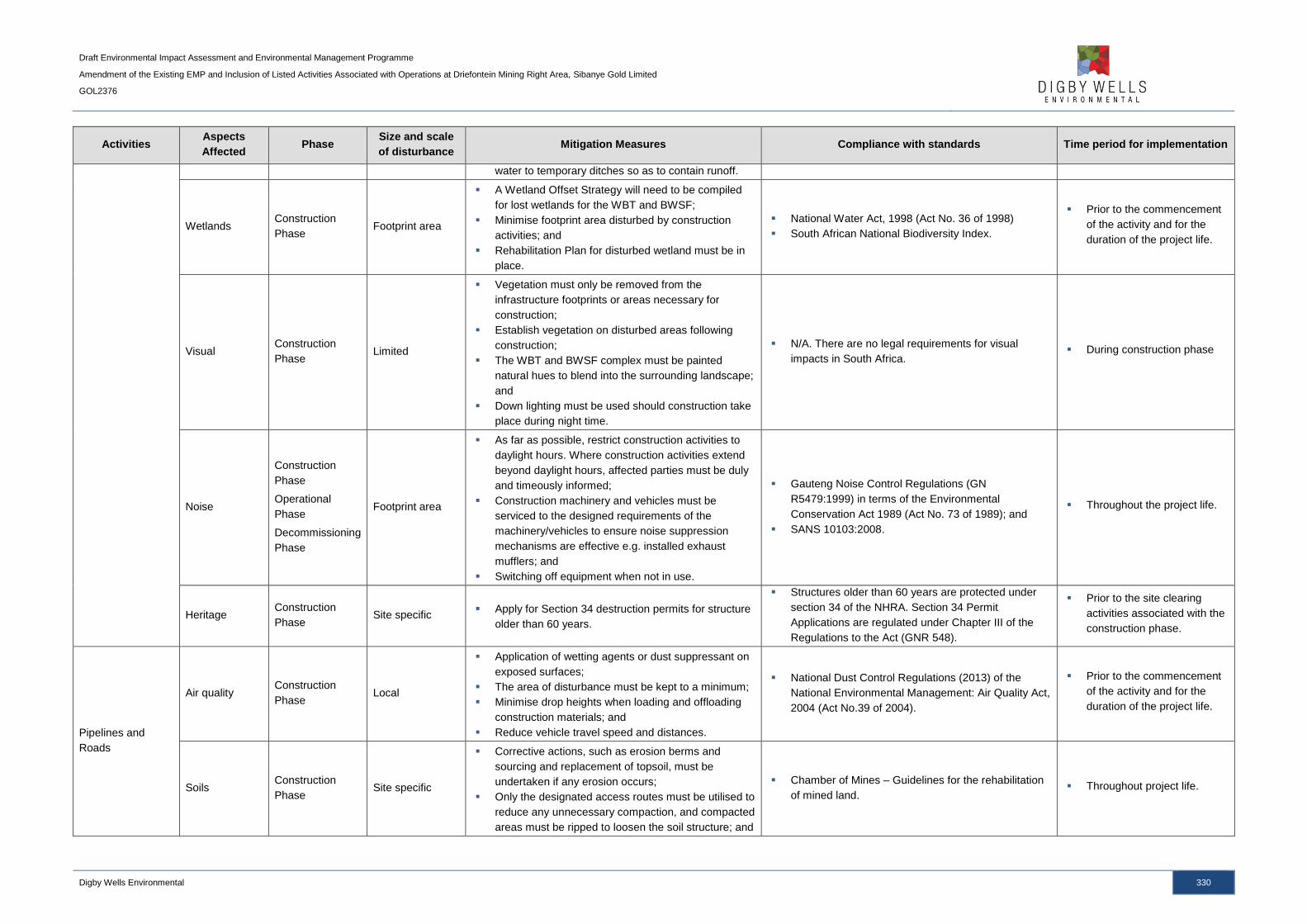
Draft Environmental Impact Assessment and Environmental Management Programme
Amendment of the Existing EMP and Inclusion of Listed Activities Associated with Operations at Driefontein Mining Right Area, Sibanye Gold Limited
GOL2376
Digby Wells Environmental 330
Activities Aspects
Affected Phase
Size and scale
of disturbance Mitigation Measures Compliance with standards Time period for implementation
water to temporary ditches so as to contain runoff.
Wetlands Construction
Phase Footprint area
A Wetland Offset Strategy will need to be compiled
for lost wetlands for the WBT and BWSF;
Minimise footprint area disturbed by construction
activities; and
Rehabilitation Plan for disturbed wetland must be in
place.
National Water Act, 1998 (Act No. 36 of 1998)
South African National Biodiversity Index.
Prior to the commencement
of the activity and for the
duration of the project life.
Visual Construction
Phase Limited
Vegetation must only be removed from the
infrastructure footprints or areas necessary for
construction;
Establish vegetation on disturbed areas following
construction;
The WBT and BWSF complex must be painted
natural hues to blend into the surrounding landscape;
and
Down lighting must be used should construction take
place during night time.
N/A. There are no legal requirements for visual
impacts in South Africa. During construction phase
Noise
Construction
Phase
Operational
Phase
Decommissioning
Phase
Footprint area
As far as possible, restrict construction activities to
daylight hours. Where construction activities extend
beyond daylight hours, affected parties must be duly
and timeously informed;
Construction machinery and vehicles must be
serviced to the designed requirements of the
machinery/vehicles to ensure noise suppression
mechanisms are effective e.g. installed exhaust
mufflers; and
Switching off equipment when not in use.
Gauteng Noise Control Regulations (GN
R5479:1999) in terms of the Environmental
Conservation Act 1989 (Act No. 73 of 1989); and
SANS 10103:2008.
Throughout the project life.
Heritage Construction
Phase Site specific
Apply for Section 34 destruction permits for structure
older than 60 years.
Structures older than 60 years are protected under
section 34 of the NHRA. Section 34 Permit
Applications are regulated under Chapter III of the
Regulations to the Act (GNR 548).
Prior to the site clearing
activities associated with the
construction phase.
Pipelines and
Roads
Air quality Construction
Phase Local
Application of wetting agents or dust suppressant on
exposed surfaces;
The area of disturbance must be kept to a minimum;
Minimise drop heights when loading and offloading
construction materials; and
Reduce vehicle travel speed and distances.
National Dust Control Regulations (2013) of the
National Environmental Management: Air Quality Act,
2004 (Act No.39 of 2004).
Prior to the commencement
of the activity and for the
duration of the project life.
Soils Construction
Phase Site specific
Corrective actions, such as erosion berms and
sourcing and replacement of topsoil, must be
undertaken if any erosion occurs;
Only the designated access routes must be utilised to
reduce any unnecessary compaction, and compacted
areas must be ripped to loosen the soil structure; and
Chamber of Mines – Guidelines for the rehabilitation
of mined land. Throughout project life.

Draft Environmental Impact Assessment and Environmental Management Programme
Amendment of the Existing EMP and Inclusion of Listed Activities Associated with Operations at Driefontein Mining Right Area, Sibanye Gold Limited
GOL2376
Digby Wells Environmental 331
Activities Aspects
Affected Phase
Size and scale
of disturbance Mitigation Measures Compliance with standards Time period for implementation
Ensure storm water management designs are in
place.
Surface water Construction
Phase N/A
Pipeline routes will be located above the 1:100 year
modelled floodline elevation.
GN R704 of the National Water Act, 1998 (Act No. 36
of 1998) During construction phase
Aquatic
ecology
Construction
Phase Footprint area
No crossings should take place over riffle/rapid
habitats as these are the most sensitive; slow
deep/shallow habitats should be favoured;
Pipelines that cross water courses should be
incorporated into a bridge or culvert design if
possible;
Erosion prevention mechanisms must be employed
to ensure the sustainability of all structures to prevent
instream sedimentation;
Silt traps placed within clean water return channels;
Re-vegetation of disturbed areas from construction
activities as soon as possible;
Minimise vegetation removal to infrastructure
footprint. Clearing and grading should only occur
where absolutely necessary; and
Diversion trenches and berms should convey dirty
water to temporary ditches so as to contain runoff.
National Water Act, 1998 (Act No. 36 of 1998) During construction phase
Wetlands Construction
Phase Footprint area
Storm water management must be put in place to
prevent run-off of any pollutants;
Pipelines are to be supported on reclaimed railway
sleepers placed at 9m intervals as it approaches the
wetland;
The pipeline will be unsupported across the 15 m
wetland/ river span and this will also contain a
continuous HDPE liner;
The pipeline will not contain any flanges for the full
length of the wetland crossing;
50 m before and after the wetland crossing, the
pipeline will be supported on plinths (an in-situ cast
concrete support) with foundations located at 9m
intervals and also fitted with steel straps;
The pipeline will be fitted with inspection points;
All flanges within 100m of the wetland will be fitted
with spray prevention plates;
The spillage paddock will be located outside on the
wetland; and
Cleared areas must be minimised as far as possible.
National Water Act, 1998 (Act No. 36 of 1998)
South African National Biodiversity Index. Throughout the project life.
Visual Construction
Phase
Immediate
surrounds
Vegetation must only be removed from the pipeline
routes or areas necessary for the construction of the
N/A. There are no legal requirements for visual
impacts in South Africa. During construction phase

Draft Environmental Impact Assessment and Environmental Management Programme
Amendment of the Existing EMP and Inclusion of Listed Activities Associated with Operations at Driefontein Mining Right Area, Sibanye Gold Limited
GOL2376
Digby Wells Environmental 332
Activities Aspects
Affected Phase
Size and scale
of disturbance Mitigation Measures Compliance with standards Time period for implementation
pipeline;
Establish vegetation on disturbed areas following
construction; and
Down lighting must be used should construction take
place during night time.
Noise
Construction
Phase
Operational
Phase
Decommissioning
Phase
Footprint Area
As far as possible, restrict construction activities to
daylight hours. Where construction activities extend
beyond daylight hours, affected parties must be duly
and timeously informed;
Construction machinery and vehicles must be
serviced to the designed requirements of the
machinery/vehicles to ensure noise suppression
mechanisms are effective e.g. installed exhaust
mufflers; and
Switching off equipment when not in use.
Gauteng Noise Control Regulations (GN
R5479:1999) in terms of the Environmental
Conservation Act 1989 (Act No. 73 of 1989); and
SANS 10103:2008.
Throughout the construction
phase.
Heritage
resources
Construction
Phase Site specific
Apply for Section 34 destruction permits for structure
older than 60 years that may be impacted.
Structures older than 60 years are protected under
section 34 of the NHRA. Section 34 Permit
Applications are regulated under Chapter III of the
Regulations to the Act (GNR 548).
Prior to the site clearing
activities associated with the
construction phase.
Employment and
Procurement
Socio-
economic
Construction
Phase
Operational
Phase
Municipal
Use labour-intensive construction methods, where
feasible, to increase employment opportunities;
Clearly define and publicise recruitment policies and
the nature and number of available jobs with specific
focus on the local communities;
Local labour, local construction contractors and local
and small businesses should be prioritised;
Where feasible, reserve a percentage of, and
promote employment opportunities for woman and
the youth;
Ensure that contractors comply with SGL’s
employment policies and Social and Labour Plan
commitments;
Coordinate recruitment through the Department of
Labour and/or bona fide recruitment agencies;
Undertake a skills survey and establish a database to
identify core skills required and suitable candidates.
Skills development and training programmes must be
structured around the findings of the skills survey.
Training should aim to be National Qualifications
Framework (NQF) accredited;
Utilise existing SGL programmes and initiatives to
identify students from local schools to participate in
company bursaries and internship programmes; and
Include local procurement targets in the WRTRP
Mineral and Petroleum Resources Development Act,
2002 (Act No. 2002);
Employment Equity Act, 1997 (Act No. 75 of 1997);
Labour Relations Act 1995 (Act No. 66 of 1995); and
Skills Development Act, 1998 (Act No. 97 of 1998).
Prior to construction and
through operation.

Draft Environmental Impact Assessment and Environmental Management Programme
Amendment of the Existing EMP and Inclusion of Listed Activities Associated with Operations at Driefontein Mining Right Area, Sibanye Gold Limited
GOL2376
Digby Wells Environmental 333
Activities Aspects
Affected Phase
Size and scale
of disturbance Mitigation Measures Compliance with standards Time period for implementation
procurement policy and contractor agreements.
Preferential procurement in accordance with Broad-
Based Black Economic Empowerment and the
Mining Charter must be ensured.
Socio-
economic
Construction
Phase
Operational
Phase
Municipal
Where feasible, utilise existing SLP, LED and related
stakeholder engagement processes to determine the
need and viability for infrastructure and service-
related projects;
Supporting housing development through promoting
house ownership for employees;
Ensure that contractors comply with SGL’s
employment policies and Social and Labour Plan
commitments;
Local labour, local construction contractors and local
and small businesses should be prioritised;
Identify students from local schools to participate in
company bursaries and internship programmes;
Continued assessment of projected IDP and LED
initiatives of the local municipalities to ensure that the
Social and Labour Plan commitments remain
relevant and appropriate; and
Communicate corporate social investment to the
local communities to manage community
expectations regarding infrastructure and services to
be provided by SGL.
Mineral and Petroleum Resources Development Act,
2002 (Act No. 2002); and
Skills Development Act, 1998 (Act No. 97 of 1998).
Prior to construction and
through operation.
Socio-
economic
Construction
Phase
Operational
Phase
Municipal
Involve community structures to assist in
communicating labour requirements and other mine
related aspects to the communities;
SGL must liaise with the municipalities to ensure
expected population influx is taken into account for
infrastructure development and planning;
Promote development projects, such as low cost
housing, by including such developments in the
Social and Labour Plan and LED programmes;
Implement an HIV/AIDS and alcohol abuse
awareness campaigns in the communities and
include such campaigns as a condition of contract for
suppliers and sub-contractors;
A VCT programme must be introduced for all
employees for the WRTRP;
Access control to operational areas must be
implemented to prevent sex workers and petty
traders from loitering near construction camps and
operational areas;
Mineral and Petroleum Resources Development Act,
2002 (Act No. 2002);
SPLUMA, 2013 (Act No. 16 of 2013).
Prior to construction and
through operation.
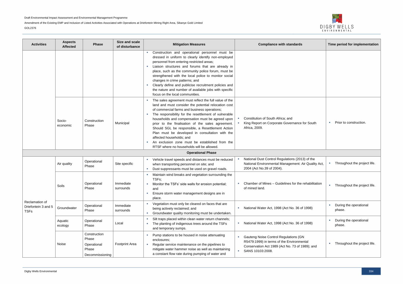
Draft Environmental Impact Assessment and Environmental Management Programme
Amendment of the Existing EMP and Inclusion of Listed Activities Associated with Operations at Driefontein Mining Right Area, Sibanye Gold Limited
GOL2376
Digby Wells Environmental 334
Activities Aspects
Affected Phase
Size and scale
of disturbance Mitigation Measures Compliance with standards Time period for implementation
Construction and operational personnel must be
dressed in uniform to clearly identify non-employed
personnel from entering restricted areas;
Liaison structures and forums that are already in
place, such as the community police forum, must be
strengthened with the local police to monitor social
changes in crime patterns; and
Clearly define and publicise recruitment policies and
the nature and number of available jobs with specific
focus on the local communities.
Socio-
economic
Construction
Phase Municipal
The sales agreement must reflect the full value of the
land and must consider the potential relocation cost
of commercial farms and business operations;
The responsibility for the resettlement of vulnerable
households and compensation must be agreed upon
prior to the finalisation of the sales agreement.
Should SGL be responsible, a Resettlement Action
Plan must be developed in consultation with the
affected households; and
An exclusion zone must be established from the
RTSF where no households will be allowed.
Constitution of South Africa; and
King Report on Corporate Governance for South
Africa, 2009.
Prior to construction.
Operational Phase
Reclamation of
Driefontein 3 and 5
TSFs
Air quality Operational
Phase Site specific
Vehicle travel speeds and distances must be reduced
when transporting personnel on site; and
Dust suppressants must be used on gravel roads.
National Dust Control Regulations (2013) of the
National Environmental Management: Air Quality Act,
2004 (Act No.39 of 2004).
Throughout the project life.
Soils Operational
Phase
Immediate
surrounds
Maintain wind breaks and vegetation surrounding the
TSFs;
Monitor the TSFs’ side walls for erosion potential;
and
Ensure storm water management designs are in
place.
Chamber of Mines – Guidelines for the rehabilitation
of mined land. Throughout the project life.
Groundwater Operational
Phase
Immediate
surrounds
Vegetation must only be cleared on faces that are
being actively reclaimed; and
Groundwater quality monitoring must be undertaken.
National Water Act, 1998 (Act No. 36 of 1998) During the operational
phase.
Aquatic
ecology
Operational
Phase Local
Silt traps placed within clean water return channels;
The planting of indigenous trees around the TSFs
and temporary sumps.
National Water Act, 1998 (Act No. 36 of 1998) During the operational
phase.
Noise
Construction
Phase
Operational
Phase
Decommissioning
Footprint Area
Pump stations to be housed in noise attenuating
enclosures;
Regular service maintenance on the pipelines to
mitigate water hammer noise as well as maintaining
a constant flow rate during pumping of water and
Gauteng Noise Control Regulations (GN
R5479:1999) in terms of the Environmental
Conservation Act 1989 (Act No. 73 of 1989); and
SANS 10103:2008.
Throughout the project life.
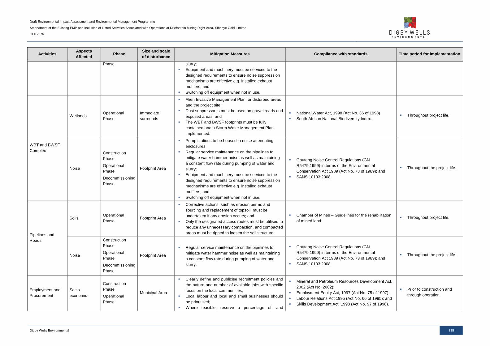
Draft Environmental Impact Assessment and Environmental Management Programme
Amendment of the Existing EMP and Inclusion of Listed Activities Associated with Operations at Driefontein Mining Right Area, Sibanye Gold Limited
GOL2376
Digby Wells Environmental 335
Activities Aspects
Affected Phase
Size and scale
of disturbance Mitigation Measures Compliance with standards Time period for implementation
Phase slurry;
Equipment and machinery must be serviced to the
designed requirements to ensure noise suppression
mechanisms are effective e.g. installed exhaust
mufflers; and
Switching off equipment when not in use.
WBT and BWSF
Complex
Wetlands Operational
Phase
Immediate
surrounds
Alien Invasive Management Plan for disturbed areas
and the project site;
Dust suppressants must be used on gravel roads and
exposed areas; and
The WBT and BWSF footprints must be fully
contained and a Storm Water Management Plan
implemented.
National Water Act, 1998 (Act No. 36 of 1998)
South African National Biodiversity Index. Throughout project life.
Noise
Construction
Phase
Operational
Phase
Decommissioning
Phase
Footprint Area
Pump stations to be housed in noise attenuating
enclosures;
Regular service maintenance on the pipelines to
mitigate water hammer noise as well as maintaining
a constant flow rate during pumping of water and
slurry;
Equipment and machinery must be serviced to the
designed requirements to ensure noise suppression
mechanisms are effective e.g. installed exhaust
mufflers; and
Switching off equipment when not in use.
Gauteng Noise Control Regulations (GN
R5479:1999) in terms of the Environmental
Conservation Act 1989 (Act No. 73 of 1989); and
SANS 10103:2008.
Throughout the project life.
Pipelines and
Roads
Soils Operational
Phase Footprint Area
Corrective actions, such as erosion berms and
sourcing and replacement of topsoil, must be
undertaken if any erosion occurs; and
Only the designated access routes must be utilised to
reduce any unnecessary compaction, and compacted
areas must be ripped to loosen the soil structure.
Chamber of Mines – Guidelines for the rehabilitation
of mined land. Throughout project life.
Noise
Construction
Phase
Operational
Phase
Decommissioning
Phase
Footprint Area
Regular service maintenance on the pipelines to
mitigate water hammer noise as well as maintaining
a constant flow rate during pumping of water and
slurry.
Gauteng Noise Control Regulations (GN
R5479:1999) in terms of the Environmental
Conservation Act 1989 (Act No. 73 of 1989); and
SANS 10103:2008.
Throughout the project life.
Employment and
Procurement
Socio-
economic
Construction
Phase
Operational
Phase
Municipal Area
Clearly define and publicise recruitment policies and
the nature and number of available jobs with specific
focus on the local communities;
Local labour and local and small businesses should
be prioritised;
Where feasible, reserve a percentage of, and
Mineral and Petroleum Resources Development Act,
2002 (Act No. 2002);
Employment Equity Act, 1997 (Act No. 75 of 1997);
Labour Relations Act 1995 (Act No. 66 of 1995); and
Skills Development Act, 1998 (Act No. 97 of 1998).
Prior to construction and
through operation.

Draft Environmental Impact Assessment and Environmental Management Programme
Amendment of the Existing EMP and Inclusion of Listed Activities Associated with Operations at Driefontein Mining Right Area, Sibanye Gold Limited
GOL2376
Digby Wells Environmental 336
Activities Aspects
Affected Phase
Size and scale
of disturbance Mitigation Measures Compliance with standards Time period for implementation
promote employment opportunities for woman and
the youth;
Ensure that contractors comply with SGL’s
employment policies and Social and Labour Plan
commitments;
Coordinate recruitment through the Department of
Labour and/or bona fide recruitment agencies;
Undertake a skills survey and establish a database to
identify core skills required and suitable candidates.
Skills development and training programmes must be
structured around the findings of the skills survey.
Training should aim to be NQF accredited;
Utilise existing SGL programmes and initiatives to
identify students from local schools to participate in
company bursaries and internship programmes ;and
Include local procurement targets in the WRTRP
procurement policy and contractor agreements.
Preferential procurement in accordance with Broad-
Based Black Economic Empowerment and the
Mining Charter must be ensured.
Decommissioning Phase
Reclamation of
Driefontein 3 and 5
TSFs
Air quality Decommissioning
Phase Limited
Application of wetting agents or dust suppressant on
exposed surfaces;
The area of disturbance must be kept to a minimum;
and
Reduce vehicle travel speed and distances.
National Dust Control Regulations (2013) of the
National Environmental Management: Air Quality Act,
2004 (Act No.39 of 2004).
During the decommissioning
phase.
Soil and land
capability
Decommissioning
Phase Footprint area
Soil handling, amelioration and rehabilitation must be
undertaken as outlined in the Rehabilitation Plan.
Chamber of Mines – Guidelines for the rehabilitation
of mined land.
During the decommissioning
phase.
Fauna and
Flora
Decommissioning
Phase Local
Remediation and rehabilitation of the TSF footprints
according to the Rehabilitation Plan. South African National Biodiversity Index.
During the decommissioning
phase.
Aquatic
ecology
Decommissioning
Phase Local
Silt traps placed within clean water return channels;
Re-vegetation of pipelines and road footprints as
soon as possible;
Soils that have been compacted must be ripped to
allow for vegetation establishment; and
Vegetation establishment must be monitored.
National Water Act, 1998 (Act No. 36 of 1998) During decommissioning
phase
Wetlands Decommissioning
Phase Local
Remediation and rehabilitation of the TSF footprints
according to the Rehabilitation Plan.
National Water Act, 1998 (Act No. 36 of 1998)
South African National Biodiversity Index.
During the decommissioning
phase.
WBT and BWSF
Complex Air quality
Decommissioning
Phase Limited
Application of wetting agents or dust suppressant on
exposed surfaces and gravel roads;
The area of disturbance must be kept to a minimum;
and
National Dust Control Regulations (2013) of the
National Environmental Management: Air Quality Act,
2004 (Act No.39 of 2004).
During the decommissioning
phase.
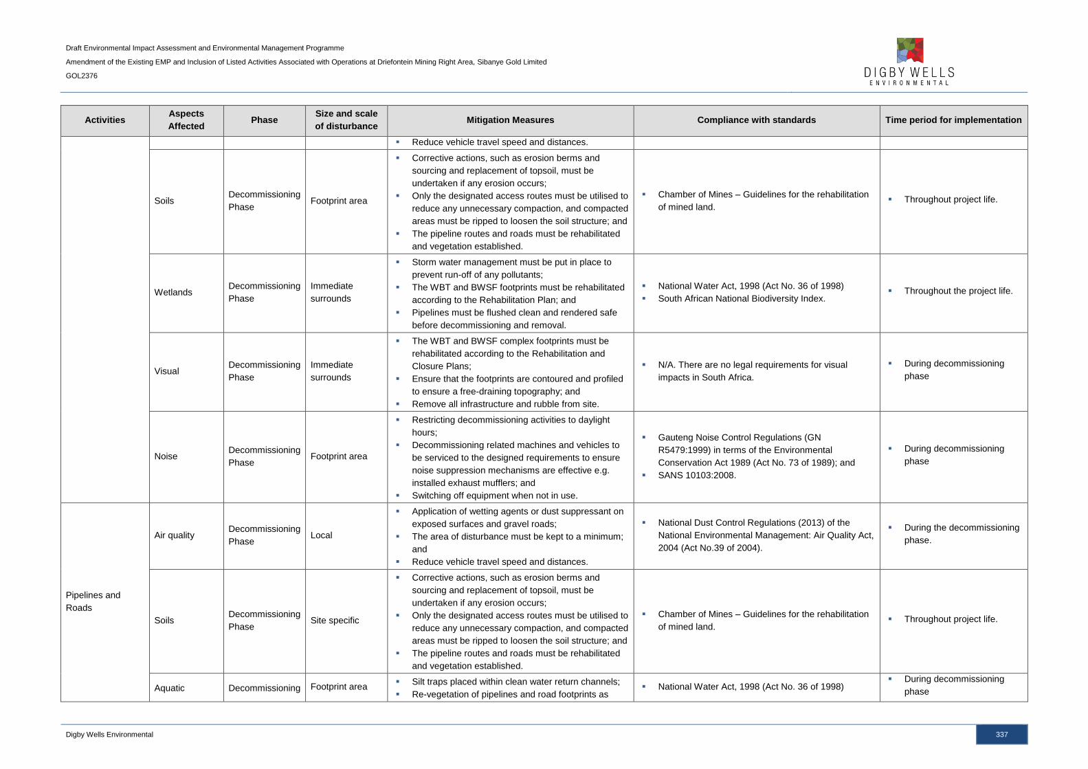
Draft Environmental Impact Assessment and Environmental Management Programme
Amendment of the Existing EMP and Inclusion of Listed Activities Associated with Operations at Driefontein Mining Right Area, Sibanye Gold Limited
GOL2376
Digby Wells Environmental 337
Activities Aspects
Affected Phase
Size and scale
of disturbance Mitigation Measures Compliance with standards Time period for implementation
Reduce vehicle travel speed and distances.
Soils Decommissioning
Phase Footprint area
Corrective actions, such as erosion berms and
sourcing and replacement of topsoil, must be
undertaken if any erosion occurs;
Only the designated access routes must be utilised to
reduce any unnecessary compaction, and compacted
areas must be ripped to loosen the soil structure; and
The pipeline routes and roads must be rehabilitated
and vegetation established.
Chamber of Mines – Guidelines for the rehabilitation
of mined land. Throughout project life.
Wetlands Decommissioning
Phase
Immediate
surrounds
Storm water management must be put in place to
prevent run-off of any pollutants;
The WBT and BWSF footprints must be rehabilitated
according to the Rehabilitation Plan; and
Pipelines must be flushed clean and rendered safe
before decommissioning and removal.
National Water Act, 1998 (Act No. 36 of 1998)
South African National Biodiversity Index. Throughout the project life.
Visual Decommissioning
Phase
Immediate
surrounds
The WBT and BWSF complex footprints must be
rehabilitated according to the Rehabilitation and
Closure Plans;
Ensure that the footprints are contoured and profiled
to ensure a free-draining topography; and
Remove all infrastructure and rubble from site.
N/A. There are no legal requirements for visual
impacts in South Africa.
During decommissioning
phase
Noise Decommissioning
Phase Footprint area
Restricting decommissioning activities to daylight
hours;
Decommissioning related machines and vehicles to
be serviced to the designed requirements to ensure
noise suppression mechanisms are effective e.g.
installed exhaust mufflers; and
Switching off equipment when not in use.
Gauteng Noise Control Regulations (GN
R5479:1999) in terms of the Environmental
Conservation Act 1989 (Act No. 73 of 1989); and
SANS 10103:2008.
During decommissioning
phase
Pipelines and
Roads
Air quality Decommissioning
Phase Local
Application of wetting agents or dust suppressant on
exposed surfaces and gravel roads;
The area of disturbance must be kept to a minimum;
and
Reduce vehicle travel speed and distances.
National Dust Control Regulations (2013) of the
National Environmental Management: Air Quality Act,
2004 (Act No.39 of 2004).
During the decommissioning
phase.
Soils Decommissioning
Phase Site specific
Corrective actions, such as erosion berms and
sourcing and replacement of topsoil, must be
undertaken if any erosion occurs;
Only the designated access routes must be utilised to
reduce any unnecessary compaction, and compacted
areas must be ripped to loosen the soil structure; and
The pipeline routes and roads must be rehabilitated
and vegetation established.
Chamber of Mines – Guidelines for the rehabilitation
of mined land. Throughout project life.
Aquatic Decommissioning Footprint area Silt traps placed within clean water return channels;
Re-vegetation of pipelines and road footprints as National Water Act, 1998 (Act No. 36 of 1998)
During decommissioning
phase

Draft Environmental Impact Assessment and Environmental Management Programme
Amendment of the Existing EMP and Inclusion of Listed Activities Associated with Operations at Driefontein Mining Right Area, Sibanye Gold Limited
GOL2376
Digby Wells Environmental 338
Activities Aspects
Affected Phase
Size and scale
of disturbance Mitigation Measures Compliance with standards Time period for implementation
ecology Phase soon as possible;
Soils adjacent the river that has been compacted
must be ripped to allow for vegetation establishment;
and
Vegetation establishment must be monitored.
Wetlands Decommissioning
Phase
Surrounding and
downstream
wetlands
Storm water management must be put in place to
prevent run-off of any pollutants;
The pipelines and roads footprints must be
rehabilitated according to the Rehabilitation Plan; and
Pipelines must be flushed clean and rendered safe
before decommissioning and removal.
National Water Act, 1998 (Act No. 36 of 1998)
South African National Biodiversity Index. Throughout the project life.
Visual Decommissioning
Phase
Immediate
surrounds
The pipelines and roads footprints must be
rehabilitated according to the Rehabilitation and
Closure Plans;
Ensure that the footprints are contoured and profiled
to ensure a free-draining topography; and
Remove all infrastructure and rubble from site.
N/A. There are no legal requirements for visual
impacts in South Africa.
During decommissioning
phase
Noise
Construction
Phase
Operational
Phase
Decommissioning
Phase
Footprint area
Restricting decommissioning activities to daylight
hours;
Decommissioning related machines and vehicles to
be serviced to the designed requirements to ensure
noise suppression mechanisms are effective e.g.
installed exhaust mufflers; and
Switching off equipment when not in use.
Gauteng Noise Control Regulations (GN
R5479:1999) in terms of the Environmental
Conservation Act 1989 (Act No. 73 of 1989); and
SANS 10103:2008.
During decommissioning
phase
Employment and
Procurement
Socio-
economic
Decommissioning
Phase Municipal area
Develop a Closure Plan 15 years prior to planned
closure and review the Closure Plan every 5 years;
Establish a Future Forum, should it not already be
established, to promote on-going discussions
between SGL and the mine’s workforce;
Liaise with the Department of Labour for the
utilisation of its resources and support services once
retrenchments take place;
Provide financial life skills to employees and ensure
employees are trained in alternative skills; and
Inform affected areas, such as the local municipality
and labour sending areas, of planned retrenchments.
Mineral and Petroleum Resources Development Act,
2002 (Act No. 2002).
15 years prior to
decommissioning.
Post Closure
Reclamation of
Driefontein 3 and 5
TSFs
Groundwater Post Closure Local
Complete removal, remediation and rehabilitation of
the TSF footprints according to the Rehabilitation
Plan.
National Water Act, 1998 (Act No. 36 of 1998) During decommissioning
phase
Surface water Post Closure Local Complete removal, remediation and rehabilitation of
the TSF footprints according to the Rehabilitation National Water Act, 1998 (Act No. 36 of 1998)
During decommissioning
phase
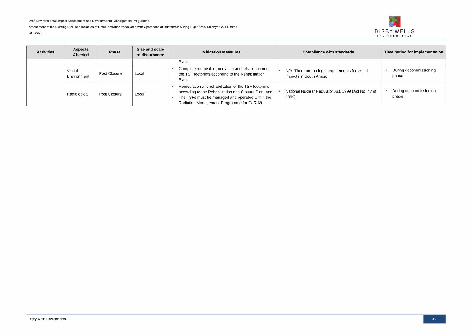
Draft Environmental Impact Assessment and Environmental Management Programme
Amendment of the Existing EMP and Inclusion of Listed Activities Associated with Operations at Driefontein Mining Right Area, Sibanye Gold Limited
GOL2376
Digby Wells Environmental 339
Activities Aspects
Affected Phase
Size and scale
of disturbance Mitigation Measures Compliance with standards Time period for implementation
Plan.
Visual
Environment Post Closure Local
Complete removal, remediation and rehabilitation of
the TSF footprints according to the Rehabilitation
Plan.
N/A. There are no legal requirements for visual
impacts in South Africa.
During decommissioning
phase
Radiological Post Closure Local
Remediation and rehabilitation of the TSF footprints
according to the Rehabilitation and Closure Plan; and
The TSFs must be managed and operated within the
Radiation Management Programme for CoR-69.
National Nuclear Regulator Act, 1999 (Act No. 47 of
1999).
During decommissioning
phase
Draft Environmental Impact Assessment and Environmental Management Programme
Amendment of the Existing EMP and Inclusion of Listed Activities Associated with Operations at Driefontein Mining Right Area, Sibanye Gold Limited
GOL2376
Digby Wells Environmental 340
6 Item 1(e): Impact Management Outcomes
A description of the objectives and outcomes of the EMP is outlined in Table 6-1, taking into
account the impact and mitigation type.
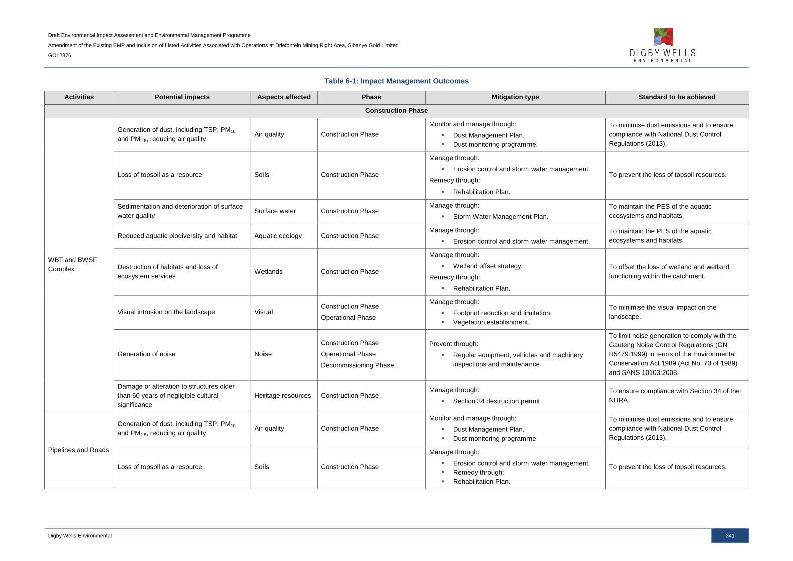
Draft Environmental Impact Assessment and Environmental Management Programme
Amendment of the Existing EMP and Inclusion of Listed Activities Associated with Operations at Driefontein Mining Right Area, Sibanye Gold Limited
GOL2376
Digby Wells Environmental 341
Table 6-1: Impact Management Outcomes
Activities Potential impacts Aspects affected Phase Mitigation type Standard to be achieved
Construction Phase
WBT and BWSF
Complex
Generation of dust, including TSP, PM10
and PM2.5, reducing air quality Air quality Construction Phase
Monitor and manage through:
Dust Management Plan.
Dust monitoring programme.
To minimise dust emissions and to ensure
compliance with National Dust Control
Regulations (2013).
Loss of topsoil as a resource Soils Construction Phase
Manage through:
Erosion control and storm water management.
Remedy through:
Rehabilitation Plan.
To prevent the loss of topsoil resources.
Sedimentation and deterioration of surface
water quality Surface water Construction Phase
Manage through:
Storm Water Management Plan.
To maintain the PES of the aquatic
ecosystems and habitats.
Reduced aquatic biodiversity and habitat Aquatic ecology Construction Phase Manage through:
Erosion control and storm water management.
To maintain the PES of the aquatic
ecosystems and habitats.
Destruction of habitats and loss of
ecosystem services Wetlands Construction Phase
Manage through:
Wetland offset strategy.
Remedy through:
Rehabilitation Plan.
To offset the loss of wetland and wetland
functioning within the catchment.
Visual intrusion on the landscape Visual Construction Phase
Operational Phase
Manage through:
Footprint reduction and limitation.
Vegetation establishment.
To minimise the visual impact on the
landscape.
Generation of noise Noise
Construction Phase
Operational Phase
Decommissioning Phase
Prevent through:
Regular equipment, vehicles and machinery
inspections and maintenance
To limit noise generation to comply with the
Gauteng Noise Control Regulations (GN
R5479:1999) in terms of the Environmental
Conservation Act 1989 (Act No. 73 of 1989)
and SANS 10103:2008.
Damage or alteration to structures older
than 60 years of negligible cultural
significance
Heritage resources Construction Phase Manage through:
Section 34 destruction permit
To ensure compliance with Section 34 of the
NHRA.
Pipelines and Roads
Generation of dust, including TSP, PM10
and PM2.5, reducing air quality Air quality Construction Phase
Monitor and manage through:
Dust Management Plan.
Dust monitoring programme
To minimise dust emissions and to ensure
compliance with National Dust Control
Regulations (2013).
Loss of topsoil as a resource Soils Construction Phase
Manage through:
Erosion control and storm water management.
Remedy through:
Rehabilitation Plan.
To prevent the loss of topsoil resources.

Draft Environmental Impact Assessment and Environmental Management Programme
Amendment of the Existing EMP and Inclusion of Listed Activities Associated with Operations at Driefontein Mining Right Area, Sibanye Gold Limited
GOL2376
Digby Wells Environmental 342
Activities Potential impacts Aspects affected Phase Mitigation type Standard to be achieved
Reduced aquatic biodiversity and habitat Aquatic ecology Construction Phase Manage through:
Erosion control and storm water management.
To maintain the PES of the aquatic
ecosystems and habitats.
Siltation of wetlands impacting on
ecosystem services Wetlands Construction Phase
Manage through:
Erosion control and storm water management.
To maintain the PES and EIS of the
surrounding wetlands.
Visual intrusion on the landscape Visual Construction Phase
Operational Phase
Manage through:
Footprint reduction and limitation.
Vegetation establishment.
To minimise the visual impact on the
landscape.
Generation of noise Noise
Construction Phase
Operational Phase
Decommissioning Phase
Prevent through:
Regular vehicles and machinery inspections and
maintenance
To limit noise generation to comply with the
Gauteng Noise Control Regulations (GN
R5479:1999) in terms of the Environmental
Conservation Act 1989 (Act No. 73 of 1989)
and SANS 10103:2008.
Employment and
Procurement
Job creation, procurement of goods and
services and skills upliftment Socio-economic
Construction Phase
Operational Phase
Enhance through:
Labour intensive methods.
Skills survey and training programmes.
Procurement policy
To enhance the positive impacts associated
with the project to benefit the local
communities and economy.
Direct investment and multiplier effect. Socio-economic Construction Phase
Operational Phase
Enhance through:
LED initiatives.
Social and Labour Plan.
To enhance the positive impacts associated
with the project to benefit the local
communities and economy.
Population influx and associated impacts Socio-economic Construction Phase
Operational Phase
Manage and prevent through:
Awareness campaigns.
Social and Labour Plan and LED Programmes.
VCT Campaigns.
To manage potential impacts associated with
population influx.
Physical and economic displacement Socio-economic Construction Phase
Manage and remedy through:
Sales agreement.
Exclusion zones.
To ensure that compensation is received for
physical and economic displacement impacts.
Operational Phase
Reclamation of
Driefontein 3 and 5
TSFs
Generation of dust, including TSP, PM10
and PM2.5, reducing air quality Air quality Operational Phase
Monitor and manage through:
Dust Management Plan.
Dust monitoring programme.
To minimise dust emissions and to ensure
compliance with National Dust Control
Regulations (2013).
Contamination and deterioration of soils Soils Operational Phase Monitor and manage through:
Erosion control and storm water management.
To prevent the loss and contamination of
topsoil resources.
AMD generation and seepage into
groundwater Groundwater Operational Phase
Monitor and manage through:
Exposed tailings material minimisation.
Groundwater quality monitoring.
To ensure no further deterioration of
groundwater quality and prevent AMD
formation.
Modification of instream habitat Aquatic ecology Operational Phase Manage through:
Erosion control and storm water management.
To maintain the PES of the aquatic
ecosystems and habitats.
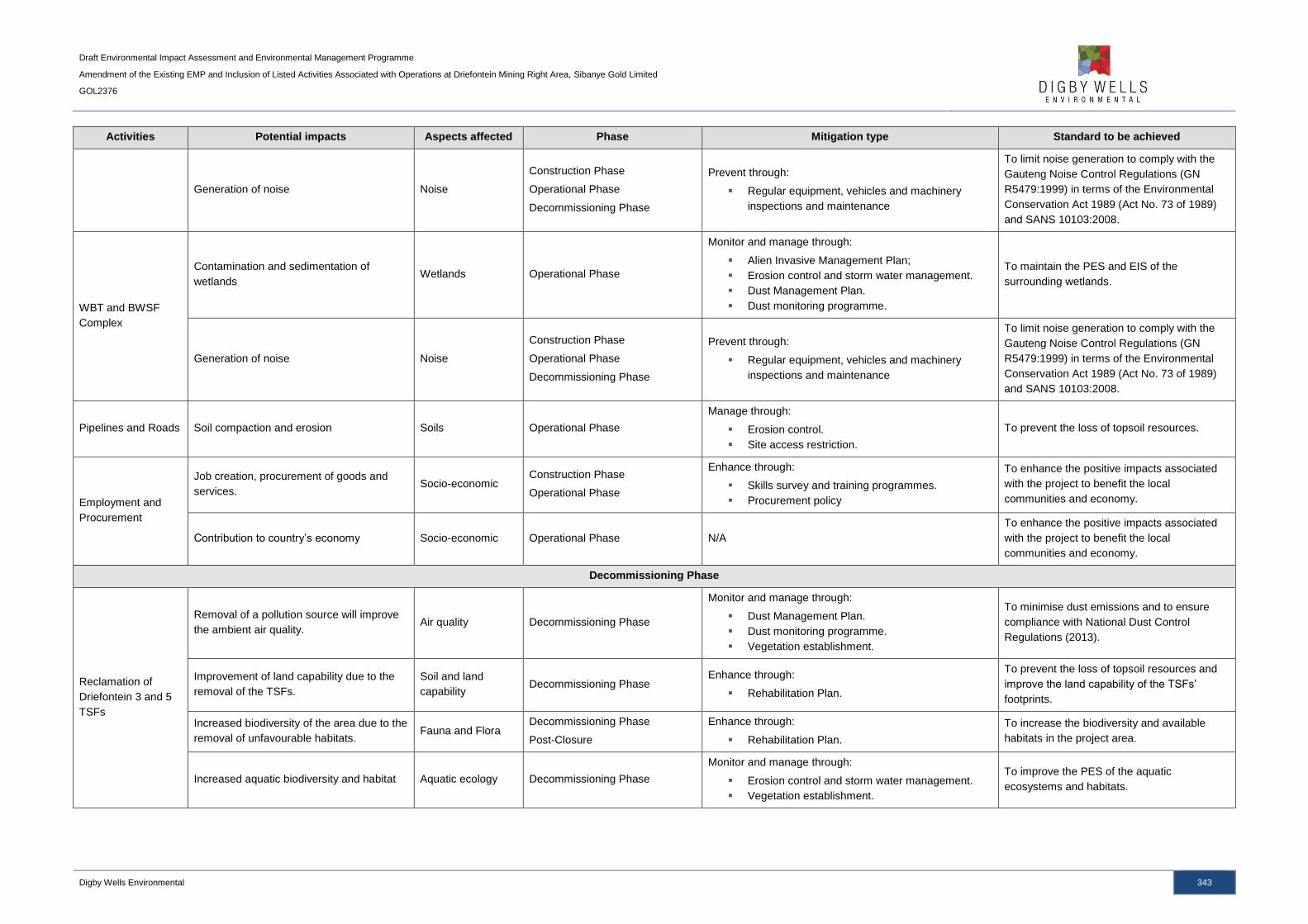
Draft Environmental Impact Assessment and Environmental Management Programme
Amendment of the Existing EMP and Inclusion of Listed Activities Associated with Operations at Driefontein Mining Right Area, Sibanye Gold Limited
GOL2376
Digby Wells Environmental 343
Activities Potential impacts Aspects affected Phase Mitigation type Standard to be achieved
Generation of noise Noise
Construction Phase
Operational Phase
Decommissioning Phase
Prevent through:
Regular equipment, vehicles and machinery
inspections and maintenance
To limit noise generation to comply with the
Gauteng Noise Control Regulations (GN
R5479:1999) in terms of the Environmental
Conservation Act 1989 (Act No. 73 of 1989)
and SANS 10103:2008.
WBT and BWSF
Complex
Contamination and sedimentation of
wetlands Wetlands Operational Phase
Monitor and manage through:
Alien Invasive Management Plan;
Erosion control and storm water management.
Dust Management Plan.
Dust monitoring programme.
To maintain the PES and EIS of the
surrounding wetlands.
Generation of noise Noise
Construction Phase
Operational Phase
Decommissioning Phase
Prevent through:
Regular equipment, vehicles and machinery
inspections and maintenance
To limit noise generation to comply with the
Gauteng Noise Control Regulations (GN
R5479:1999) in terms of the Environmental
Conservation Act 1989 (Act No. 73 of 1989)
and SANS 10103:2008.
Pipelines and Roads Soil compaction and erosion Soils Operational Phase
Manage through:
Erosion control.
Site access restriction.
To prevent the loss of topsoil resources.
Employment and
Procurement
Job creation, procurement of goods and
services. Socio-economic
Construction Phase
Operational Phase
Enhance through:
Skills survey and training programmes.
Procurement policy
To enhance the positive impacts associated
with the project to benefit the local
communities and economy.
Contribution to country’s economy Socio-economic Operational Phase N/A
To enhance the positive impacts associated
with the project to benefit the local
communities and economy.
Decommissioning Phase
Reclamation of
Driefontein 3 and 5
TSFs
Removal of a pollution source will improve
the ambient air quality. Air quality Decommissioning Phase
Monitor and manage through:
Dust Management Plan.
Dust monitoring programme.
Vegetation establishment.
To minimise dust emissions and to ensure
compliance with National Dust Control
Regulations (2013).
Improvement of land capability due to the
removal of the TSFs.
Soil and land
capability Decommissioning Phase
Enhance through:
Rehabilitation Plan.
To prevent the loss of topsoil resources and
improve the land capability of the TSFs’
footprints.
Increased biodiversity of the area due to the
removal of unfavourable habitats. Fauna and Flora
Decommissioning Phase
Post-Closure
Enhance through:
Rehabilitation Plan.
To increase the biodiversity and available
habitats in the project area.
Increased aquatic biodiversity and habitat Aquatic ecology Decommissioning Phase
Monitor and manage through:
Erosion control and storm water management.
Vegetation establishment.
To improve the PES of the aquatic
ecosystems and habitats.

Draft Environmental Impact Assessment and Environmental Management Programme
Amendment of the Existing EMP and Inclusion of Listed Activities Associated with Operations at Driefontein Mining Right Area, Sibanye Gold Limited
GOL2376
Digby Wells Environmental 344
Activities Potential impacts Aspects affected Phase Mitigation type Standard to be achieved
Reduced impacts to surrounding wetlands Wetlands Decommissioning Phase Enhance through:
Rehabilitation Plan.
To improve the PES and EIS of the
surrounding wetlands.
WBT and BWSF
Complex
Generation of dust, including TSP, PM10
and PM2.5, reducing air quality Air quality Decommissioning Phase
Monitor and manage through:
Dust Management Plan.
Dust monitoring programme.
To minimise dust emissions and to ensure
compliance with National Dust Control
Regulations (2013).
Loss of topsoil as a resource due to
compaction and erosion Soils Decommissioning Phase
Manage through:
Erosion control and storm water management.
Site access restriction.
Remedy through:
Rehabilitation Plan.
To prevent the loss of topsoil resources.
Degradation of habitats and loss of
ecosystem services Wetlands Decommissioning Phase
Monitor and manage through:
Erosion control and storm water management.
Remedy through:
Rehabilitation Plan.
To maintain the PES and EIS of the
surrounding wetlands.
Generation of noise Noise Decommissioning Phase
Prevent through:
Regular equipment, vehicles and machinery
inspections and maintenance
To limit noise generation to comply with the
Gauteng Noise Control Regulations (GN
R5479:1999) in terms of the Environmental
Conservation Act 1989 (Act No. 73 of 1989)
and SANS 10103:2008.
Pipelines and Roads
Generation of dust, including TSP, PM10
and PM2.5, reducing air quality Air quality Decommissioning Phase
Monitor and manage through:
Dust Management Plan.
Dust monitoring programme.
To minimise dust emissions and to ensure
compliance with National Dust Control
Regulations (2013).
Loss of topsoil as a resource due to
compaction and erosion Soils Decommissioning Phase
Manage through:
Erosion control and storm water management.
Site access restriction.
Remedy through:
Rehabilitation Plan.
To prevent the loss of topsoil resources.
Reduced aquatic biodiversity and habitat Aquatic ecology Decommissioning Phase
Monitor and manage through:
Erosion control and storm water management.
Vegetation establishment.
To maintain the PES of the aquatic
ecosystems and habitats.
Degradation of habitats and loss of
ecosystem services Wetlands Decommissioning Phase
Monitor and manage through:
Erosion control and storm water management.
Remedy through:
Rehabilitation Plan.
To maintain the PES and EIS of the
surrounding wetlands.
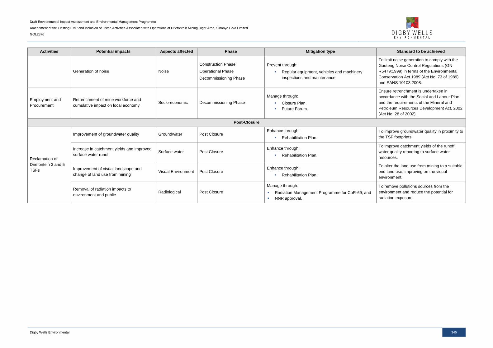
Draft Environmental Impact Assessment and Environmental Management Programme
Amendment of the Existing EMP and Inclusion of Listed Activities Associated with Operations at Driefontein Mining Right Area, Sibanye Gold Limited
GOL2376
Digby Wells Environmental 345
Activities Potential impacts Aspects affected Phase Mitigation type Standard to be achieved
Generation of noise Noise
Construction Phase
Operational Phase
Decommissioning Phase
Prevent through:
Regular equipment, vehicles and machinery
inspections and maintenance
To limit noise generation to comply with the
Gauteng Noise Control Regulations (GN
R5479:1999) in terms of the Environmental
Conservation Act 1989 (Act No. 73 of 1989)
and SANS 10103:2008.
Employment and
Procurement
Retrenchment of mine workforce and
cumulative impact on local economy Socio-economic Decommissioning Phase
Manage through:
Closure Plan.
Future Forum.
Ensure retrenchment is undertaken in
accordance with the Social and Labour Plan
and the requirements of the Mineral and
Petroleum Resources Development Act, 2002
(Act No. 28 of 2002).
Post-Closure
Reclamation of
Driefontein 3 and 5
TSFs
Improvement of groundwater quality Groundwater Post Closure Enhance through:
Rehabilitation Plan.
To improve groundwater quality in proximity to
the TSF footprints.
Increase in catchment yields and improved
surface water runoff Surface water Post Closure
Enhance through:
Rehabilitation Plan.
To improve catchment yields of the runoff
water quality reporting to surface water
resources.
Improvement of visual landscape and
change of land use from mining Visual Environment Post Closure
Enhance through:
Rehabilitation Plan.
To alter the land use from mining to a suitable
end land use, improving on the visual
environment.
Removal of radiation impacts to
environment and public Radiological Post Closure
Manage through:
Radiation Management Programme for CoR-69; and
NNR approval.
To remove pollutions sources from the
environment and reduce the potential for
radiation exposure.
Draft Environmental Impact Assessment and Environmental Management Programme
Amendment of the Existing EMP and Inclusion of Listed Activities Associated with Operations at Driefontein Mining Right Area, Sibanye Gold Limited
GOL2376
Digby Wells Environmental 346
7 Item 1(f): Impact Management Actions
A description of impact management actions, identifying the manner in which the impact
management objectives and outcomes referenced in Sections 5 and 6 will be achieved, is
provided in Table 7-1.

Draft Environmental Impact Assessment and Environmental Management Programme
Amendment of the Existing EMP and Inclusion of Listed Activities Associated with Operations at Driefontein Mining Right Area, Sibanye Gold Limited
GOL2376
Digby Wells Environmental 347
Table 7-1: Impact Management Actions
Activities Potential impacts Aspects affected Mitigation type Time period for implementation Compliance with standards
Construction Phase
WBT and BWSF
Complex
Generation of dust,
including TSP, PM10 and
PM2.5, reducing air quality
Air quality
Monitor and manage through:
Dust Management Plan.
Dust monitoring programme.
Prior to the commencement of
the activity and for the duration
of the project life.
National Dust Control Regulations (2013) of
the National Environmental Management:
Air Quality Act, 2004 (Act No.39 of 2004).
Loss of topsoil as a
resource Soils
Manage through:
Erosion control and storm water management.
Remedy through:
Rehabilitation Plan.
During the construction phase Chamber of Mines – Guidelines for the
rehabilitation of mined land.
Sedimentation and
deterioration of surface
water quality
Surface water Manage through:
Storm Water Management Plan. During the construction phase
GN R704 of the National Water Act, 1998
(act No. 36 of 1998)
Reduced aquatic
biodiversity and habitat Aquatic ecology
Manage through:
Erosion control and storm water management. During construction phase
National Water Act, 1998 (Act No. 36 of
1998)
Destruction of habitats
and loss of ecosystem
services
Wetlands
Manage through:
Wetland offset strategy.
Remedy through:
Rehabilitation Plan.
Prior to the commencement of
the activity and for the duration
of the project life.
National Water Act, 1998 (Act No. 36 of
1998)
South African National Biodiversity Index.
Visual intrusion on the
landscape Visual
Manage through:
Footprint reduction and limitation.
Vegetation establishment.
During construction phase N/A. There are no legal requirements for
visual impacts in South Africa.
Generation of noise Noise
Prevent through:
Regular equipment, vehicles and machinery
inspections and maintenance
Throughout the project life.
Gauteng Noise Control Regulations (GN
R5479:1999) in terms of the Environmental
Conservation Act 1989 (Act No. 73 of 1989);
and
SANS 10103:2008.
Damage or alteration to
structures older than 60
years of negligible cultural
significance
Heritage resources Manage through:
Section 34 destruction permit
Prior to the site clearing
activities associated with the
construction phase.
Structures older than 60 years are protected
under section 34 of the NHRA. Section 34
Permit Applications are regulated under
Chapter III of the Regulations to the Act
(GNR 548).
Pipelines and Roads
Generation of dust,
including TSP, PM10 and
PM2.5, reducing air quality
Air quality
Monitor and manage through:
Dust Management Plan.
Dust monitoring programme
Prior to the commencement of
the activity and for the duration
of the project life.
National Dust Control Regulations (2013) of
the National Environmental Management:
Air Quality Act, 2004 (Act No.39 of 2004).
Loss of topsoil as a
resource Soils
Manage through:
Erosion control and storm water management.
Remedy through:
Rehabilitation Plan.
Throughout project life. Chamber of Mines – Guidelines for the
rehabilitation of mined land.
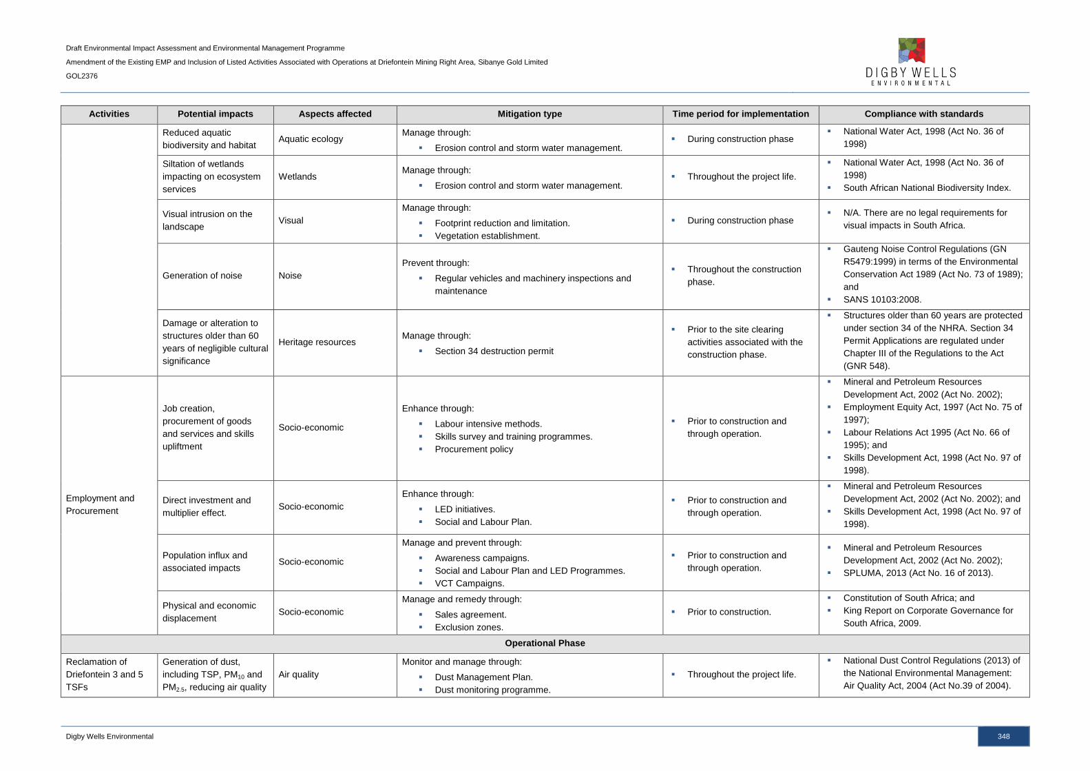
Draft Environmental Impact Assessment and Environmental Management Programme
Amendment of the Existing EMP and Inclusion of Listed Activities Associated with Operations at Driefontein Mining Right Area, Sibanye Gold Limited
GOL2376
Digby Wells Environmental 348
Activities Potential impacts Aspects affected Mitigation type Time period for implementation Compliance with standards
Reduced aquatic
biodiversity and habitat Aquatic ecology
Manage through:
Erosion control and storm water management. During construction phase
National Water Act, 1998 (Act No. 36 of
1998)
Siltation of wetlands
impacting on ecosystem
services
Wetlands Manage through:
Erosion control and storm water management. Throughout the project life.
National Water Act, 1998 (Act No. 36 of
1998)
South African National Biodiversity Index.
Visual intrusion on the
landscape Visual
Manage through:
Footprint reduction and limitation.
Vegetation establishment.
During construction phase N/A. There are no legal requirements for
visual impacts in South Africa.
Generation of noise Noise
Prevent through:
Regular vehicles and machinery inspections and
maintenance
Throughout the construction
phase.
Gauteng Noise Control Regulations (GN
R5479:1999) in terms of the Environmental
Conservation Act 1989 (Act No. 73 of 1989);
and
SANS 10103:2008.
Damage or alteration to
structures older than 60
years of negligible cultural
significance
Heritage resources Manage through:
Section 34 destruction permit
Prior to the site clearing
activities associated with the
construction phase.
Structures older than 60 years are protected
under section 34 of the NHRA. Section 34
Permit Applications are regulated under
Chapter III of the Regulations to the Act
(GNR 548).
Employment and
Procurement
Job creation,
procurement of goods
and services and skills
upliftment
Socio-economic
Enhance through:
Labour intensive methods.
Skills survey and training programmes.
Procurement policy
Prior to construction and
through operation.
Mineral and Petroleum Resources
Development Act, 2002 (Act No. 2002);
Employment Equity Act, 1997 (Act No. 75 of
1997);
Labour Relations Act 1995 (Act No. 66 of
1995); and
Skills Development Act, 1998 (Act No. 97 of
1998).
Direct investment and
multiplier effect. Socio-economic
Enhance through:
LED initiatives.
Social and Labour Plan.
Prior to construction and
through operation.
Mineral and Petroleum Resources
Development Act, 2002 (Act No. 2002); and
Skills Development Act, 1998 (Act No. 97 of
1998).
Population influx and
associated impacts Socio-economic
Manage and prevent through:
Awareness campaigns.
Social and Labour Plan and LED Programmes.
VCT Campaigns.
Prior to construction and
through operation.
Mineral and Petroleum Resources
Development Act, 2002 (Act No. 2002);
SPLUMA, 2013 (Act No. 16 of 2013).
Physical and economic
displacement Socio-economic
Manage and remedy through:
Sales agreement.
Exclusion zones.
Prior to construction.
Constitution of South Africa; and
King Report on Corporate Governance for
South Africa, 2009.
Operational Phase
Reclamation of
Driefontein 3 and 5
TSFs
Generation of dust,
including TSP, PM10 and
PM2.5, reducing air quality
Air quality
Monitor and manage through:
Dust Management Plan.
Dust monitoring programme.
Throughout the project life.
National Dust Control Regulations (2013) of
the National Environmental Management:
Air Quality Act, 2004 (Act No.39 of 2004).
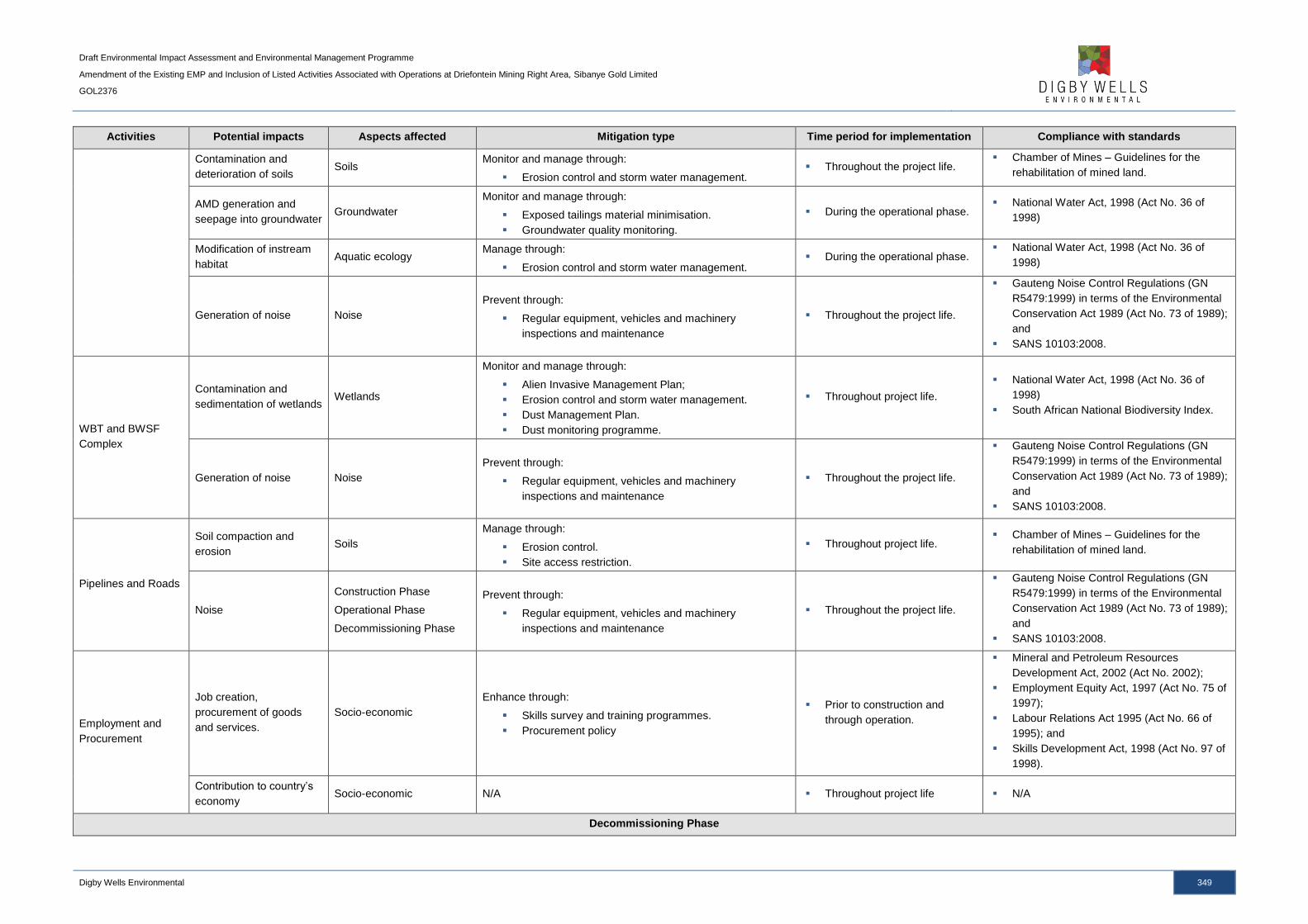
Draft Environmental Impact Assessment and Environmental Management Programme
Amendment of the Existing EMP and Inclusion of Listed Activities Associated with Operations at Driefontein Mining Right Area, Sibanye Gold Limited
GOL2376
Digby Wells Environmental 349
Activities Potential impacts Aspects affected Mitigation type Time period for implementation Compliance with standards
Contamination and
deterioration of soils Soils
Monitor and manage through:
Erosion control and storm water management. Throughout the project life.
Chamber of Mines – Guidelines for the
rehabilitation of mined land.
AMD generation and
seepage into groundwater Groundwater
Monitor and manage through:
Exposed tailings material minimisation.
Groundwater quality monitoring.
During the operational phase. National Water Act, 1998 (Act No. 36 of
1998)
Modification of instream
habitat Aquatic ecology
Manage through:
Erosion control and storm water management. During the operational phase.
National Water Act, 1998 (Act No. 36 of
1998)
Generation of noise Noise
Prevent through:
Regular equipment, vehicles and machinery
inspections and maintenance
Throughout the project life.
Gauteng Noise Control Regulations (GN
R5479:1999) in terms of the Environmental
Conservation Act 1989 (Act No. 73 of 1989);
and
SANS 10103:2008.
WBT and BWSF
Complex
Contamination and
sedimentation of wetlands Wetlands
Monitor and manage through:
Alien Invasive Management Plan;
Erosion control and storm water management.
Dust Management Plan.
Dust monitoring programme.
Throughout project life.
National Water Act, 1998 (Act No. 36 of
1998)
South African National Biodiversity Index.
Generation of noise Noise
Prevent through:
Regular equipment, vehicles and machinery
inspections and maintenance
Throughout the project life.
Gauteng Noise Control Regulations (GN
R5479:1999) in terms of the Environmental
Conservation Act 1989 (Act No. 73 of 1989);
and
SANS 10103:2008.
Pipelines and Roads
Soil compaction and
erosion Soils
Manage through:
Erosion control.
Site access restriction.
Throughout project life. Chamber of Mines – Guidelines for the
rehabilitation of mined land.
Noise
Construction Phase
Operational Phase
Decommissioning Phase
Prevent through:
Regular equipment, vehicles and machinery
inspections and maintenance
Throughout the project life.
Gauteng Noise Control Regulations (GN
R5479:1999) in terms of the Environmental
Conservation Act 1989 (Act No. 73 of 1989);
and
SANS 10103:2008.
Employment and
Procurement
Job creation,
procurement of goods
and services.
Socio-economic
Enhance through:
Skills survey and training programmes.
Procurement policy
Prior to construction and
through operation.
Mineral and Petroleum Resources
Development Act, 2002 (Act No. 2002);
Employment Equity Act, 1997 (Act No. 75 of
1997);
Labour Relations Act 1995 (Act No. 66 of
1995); and
Skills Development Act, 1998 (Act No. 97 of
1998).
Contribution to country’s
economy Socio-economic N/A Throughout project life N/A
Decommissioning Phase

Draft Environmental Impact Assessment and Environmental Management Programme
Amendment of the Existing EMP and Inclusion of Listed Activities Associated with Operations at Driefontein Mining Right Area, Sibanye Gold Limited
GOL2376
Digby Wells Environmental 350
Activities Potential impacts Aspects affected Mitigation type Time period for implementation Compliance with standards
Reclamation of
Driefontein 3 and 5
TSFs
Removal of a pollution
source will improve the
ambient air quality.
Air quality
Monitor and manage through:
Dust Management Plan.
Dust monitoring programme.
Vegetation establishment.
During the decommissioning
phase.
National Dust Control Regulations (2013) of
the National Environmental Management:
Air Quality Act, 2004 (Act No.39 of 2004).
Improvement of land
capability due to the
removal of the TSFs.
Soil and land capability Enhance through:
Rehabilitation Plan.
During the decommissioning
phase.
Chamber of Mines – Guidelines for the
rehabilitation of mined land.
Increased biodiversity of
the area due to the
removal of unfavourable
habitats.
Fauna and Flora Enhance through:
Rehabilitation Plan.
During the decommissioning
phase. South African National Biodiversity Index.
Increased aquatic
biodiversity and habitat Aquatic ecology
Monitor and manage through:
Erosion control and storm water management.
Vegetation establishment.
During decommissioning
phase
National Water Act, 1998 (Act No. 36 of
1998)
Reduced impacts to
surrounding wetlands Wetlands
Enhance through:
Rehabilitation Plan.
During the decommissioning
phase.
National Water Act, 1998 (Act No. 36 of
1998)
South African National Biodiversity Index.
WBT and BWSF
Complex
Generation of dust,
including TSP, PM10 and
PM2.5, reducing air quality
Air quality
Monitor and manage through:
Dust Management Plan.
Dust monitoring programme.
During the decommissioning
phase.
National Dust Control Regulations (2013) of
the National Environmental Management:
Air Quality Act, 2004 (Act No.39 of 2004).
Loss of topsoil as a
resource due to
compaction and erosion
Soils
Manage through:
Erosion control and storm water management.
Site access restriction.
Remedy through:
Rehabilitation Plan.
Throughout project life. Chamber of Mines – Guidelines for the
rehabilitation of mined land.
Degradation of habitats
and loss of ecosystem
services
Wetlands
Monitor and manage through:
Erosion control and storm water management.
Remedy through:
Rehabilitation Plan.
Throughout the project life.
National Water Act, 1998 (Act No. 36 of
1998)
South African National Biodiversity Index.
Visual intrusion on the
landscape Visual
Remedy through:
Rehabilitation Plan.
Contouring of topography.
During decommissioning
phase
N/A. There are no legal requirements for
visual impacts in South Africa.
Generation of noise Noise
Prevent through:
Regular equipment, vehicles and machinery
inspections and maintenance
During decommissioning
phase
Gauteng Noise Control Regulations (GN
R5479:1999) in terms of the Environmental
Conservation Act 1989 (Act No. 73 of 1989);
and
SANS 10103:2008.
Pipelines and Roads
Generation of dust,
including TSP, PM10 and
PM2.5, reducing air quality
Air quality
Monitor and manage through:
Dust Management Plan.
Dust monitoring programme.
During the decommissioning
phase.
National Dust Control Regulations (2013) of
the National Environmental Management:
Air Quality Act, 2004 (Act No.39 of 2004).
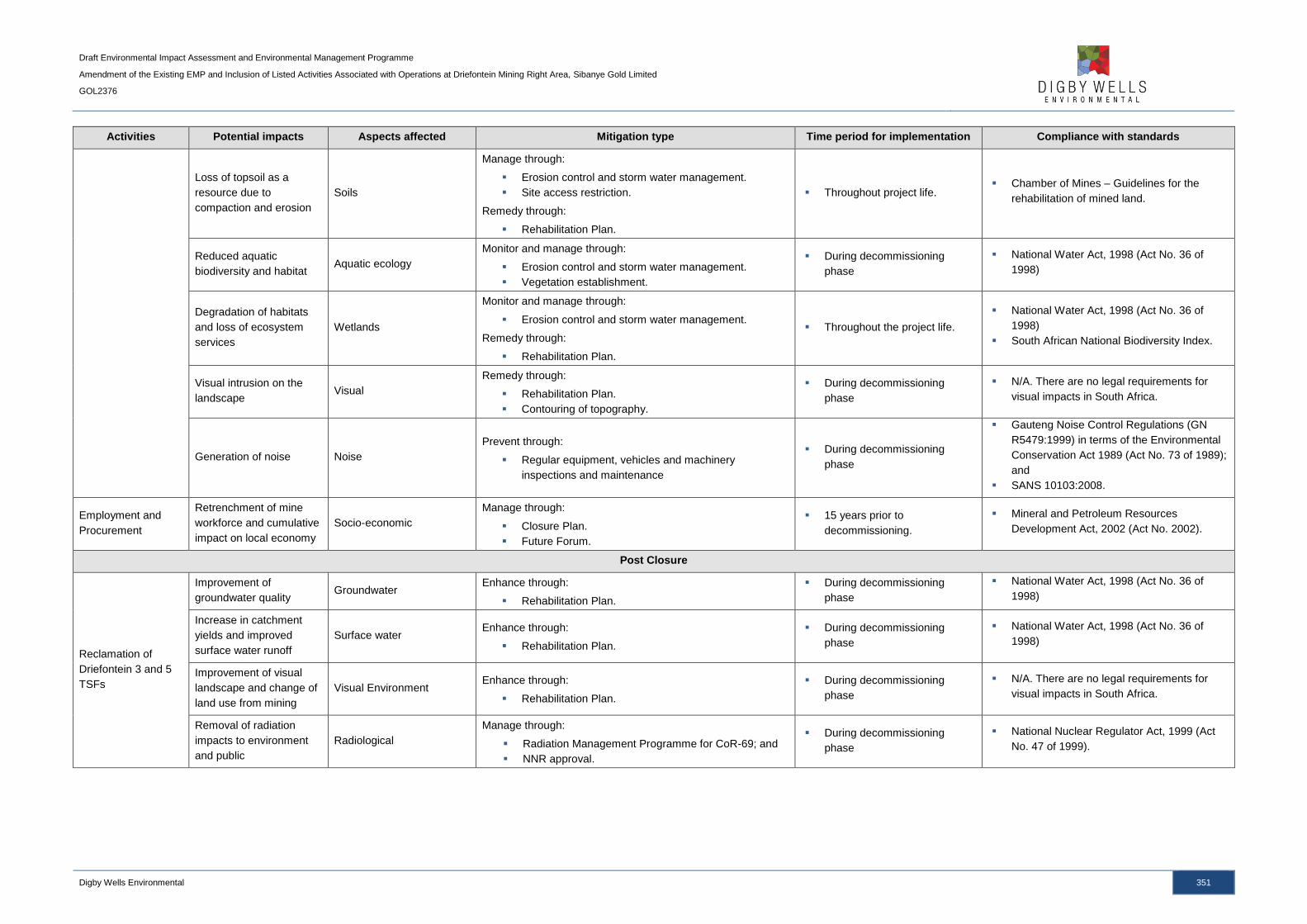
Draft Environmental Impact Assessment and Environmental Management Programme
Amendment of the Existing EMP and Inclusion of Listed Activities Associated with Operations at Driefontein Mining Right Area, Sibanye Gold Limited
GOL2376
Digby Wells Environmental 351
Activities Potential impacts Aspects affected Mitigation type Time period for implementation Compliance with standards
Loss of topsoil as a
resource due to
compaction and erosion
Soils
Manage through:
Erosion control and storm water management.
Site access restriction.
Remedy through:
Rehabilitation Plan.
Throughout project life. Chamber of Mines – Guidelines for the
rehabilitation of mined land.
Reduced aquatic
biodiversity and habitat Aquatic ecology
Monitor and manage through:
Erosion control and storm water management.
Vegetation establishment.
During decommissioning
phase
National Water Act, 1998 (Act No. 36 of
1998)
Degradation of habitats
and loss of ecosystem
services
Wetlands
Monitor and manage through:
Erosion control and storm water management.
Remedy through:
Rehabilitation Plan.
Throughout the project life.
National Water Act, 1998 (Act No. 36 of
1998)
South African National Biodiversity Index.
Visual intrusion on the
landscape Visual
Remedy through:
Rehabilitation Plan.
Contouring of topography.
During decommissioning
phase
N/A. There are no legal requirements for
visual impacts in South Africa.
Generation of noise Noise
Prevent through:
Regular equipment, vehicles and machinery
inspections and maintenance
During decommissioning
phase
Gauteng Noise Control Regulations (GN
R5479:1999) in terms of the Environmental
Conservation Act 1989 (Act No. 73 of 1989);
and
SANS 10103:2008.
Employment and
Procurement
Retrenchment of mine
workforce and cumulative
impact on local economy
Socio-economic
Manage through:
Closure Plan.
Future Forum.
15 years prior to
decommissioning.
Mineral and Petroleum Resources
Development Act, 2002 (Act No. 2002).
Post Closure
Reclamation of
Driefontein 3 and 5
TSFs
Improvement of
groundwater quality Groundwater
Enhance through:
Rehabilitation Plan.
During decommissioning
phase
National Water Act, 1998 (Act No. 36 of
1998)
Increase in catchment
yields and improved
surface water runoff
Surface water Enhance through:
Rehabilitation Plan.
During decommissioning
phase
National Water Act, 1998 (Act No. 36 of
1998)
Improvement of visual
landscape and change of
land use from mining
Visual Environment Enhance through:
Rehabilitation Plan.
During decommissioning
phase
N/A. There are no legal requirements for
visual impacts in South Africa.
Removal of radiation
impacts to environment
and public
Radiological
Manage through:
Radiation Management Programme for CoR-69; and
NNR approval.
During decommissioning
phase
National Nuclear Regulator Act, 1999 (Act
No. 47 of 1999).

Draft Environmental Impact Assessment and Environmental Management Programme
Amendment of the Existing EMP and Inclusion of Listed Activities Associated with Operations at Driefontein Mining Right Area, Sibanye Gold Limited
GOL2376
Digby Wells Environmental 352
8 Financial provision
8.1 Item (i)(1): Determination of the Amount of Financial Provision
8.1.1 Item (i)(1)(a): Describe the Closure Objectives and the Extent to
which they have been Aligned to the Baseline Environment described
under Regulation 22 (2) (d) as described in 2.4 herein
Mine closure aims to achieve long-term site stability and the establishment of a self-
sustaining ecosystem which supports the final end land use. The overall rehabilitation and
closure objective for the WRTRP is to:
■ Remove mining infrastructure that cannot be used by a subsequent land owner or a
third party. Where buildings can be used by a third party, arrangements must be
made to ensure their long term sustainable use;
■ Any proposed post closure developments on old mining land will need to undergo
extensive environmental and stability assessments before they can be permitted;
■ Implement progressive rehabilitation measures, beginning during the construction
phase wherever possible;
■ Conducting a radiological field survey to control or stop any action of radon emitting
material;
■ Leave a safe and stable environment for both humans and animals and make their
condition sustainable;
■ Follow a process of closure that is progressive and integrated into the mine plans
and that will assess the closure impacts proactively at regular intervals throughout
project life;
■ To prevent any soil and surface/groundwater contamination by managing all water on
site;
■ Comply with local and national regulatory requirements; and
■ To maintain and monitor all rehabilitated areas following re-vegetation and, if
monitoring shows that the objectives have been met, making an application for
closure.
8.1.2 Item (i)(1)(b): Confirm specifically that the Environmental Objectives
in relation to Closure have been consulted with Landowner and
Interested and Affected Parties
As part of the PPP, the closure objectives and Rehabilitation Plan have been made available
for public review. In addition, consultation with landowners and I&APs was undertaken as
part of the Social Impact Assessment and input was requested regarding the environmental
objectives in relation to closure.
Draft Environmental Impact Assessment and Environmental Management Programme
Amendment of the Existing EMP and Inclusion of Listed Activities Associated with Operations at Driefontein Mining Right Area, Sibanye Gold Limited
GOL2376
Digby Wells Environmental 353
8.1.3 Item (i)(1)(c): Provide a Rehabilitation Plan that describes and shows
the Scale and Aerial Extent of the Main Mining Activities, including
the Anticipated Mining Area at the time of Closure
A Rehabilitation Plan has been compiled for the WRTRP, including the Driefontein Mining
Right area, and is provided in Appendix Q.
8.1.4 Item (i)(1)(d): Explain why it can be Confirmed that the Rehabilitation
Plan is compatible with the Closure Objectives
The Rehabilitation Plan has been compiled in support of the primary closure objectives
which are to remove unwanted infrastructure and rehabilitate the land to a suitable post-
mining land use which provides a safe and stable environment for surrounding receptors and
faunal species.
8.1.5 Item (i)(1)(e): Calculate and State the Quantum of the Financial
Provision required to Manage and Rehabilitate the Environment in
accordance with the Applicable Guideline
The “Guideline Document for the Evaluation of the Quantum of Closure-Related Financial
Provision Provided by a Mine” was used to assess SGL’s environmental liability. The DMR
Guideline Document format makes use of a set template for which defined rates and
multiplication factors are used.
The infrastructure areas and other areas affected by the mining activities were measured
from plans provided by SGL. Measurements that were taken have been standardised to
ensure that the costs calculated are easily updatable. The concrete and steel estimates
associated with the plants are based on previous experience and assumptions.
The rates used were updated by quotes from demolition and civil contractors and
professionals wherever possible. Rate formulation takes into consideration the total labour
costs, plant costs, fuel costs and construction costs and provides an accurate, defendable
rate.
The closure cost model was compiled in Microsoft Excel. The model consists of an input
sheet, containing all measurements of each area of the infrastructure and activities, a
standard rate sheet and a summary sheet which summarises the costs for closure. Each
sheet is linked to the rate sheet, thereby, allowing the costs calculations to be updated easily
from year to year.
The financial provision for the Driefontein Mining Right area for planned closure is
R 23 423 521.70, with the 1 year financial provision calculated as R 9 686 963.27, as
summarised in Table 8-1.

Draft Environmental Impact Assessment and Environmental Management Programme
Amendment of the Existing EMP and Inclusion of Listed Activities Associated with Operations at Driefontein Mining Right Area, Sibanye Gold Limited
GOL2376
Digby Wells Environmental 354
Table 8-1: Summary of the Closure Cost Liability for the Driefontein Mining Right Area
Description Closure Cost After
1 year of Mining Planned Closure
Cost
Closure Cost After 10 years of
Mining
West block Thickener R 2,186,501.57 R 2,186,501.57
All infrastructure and dump
footprints would have been
rehabilitated during year 10 of
mining
Dams and pump stations R 2,464,143.68 R 2,464,143.68
Linear Infrastructure R 1,210,027.93 R 1,210,027.93
Driefontein TSFs R 952,722.82 R 10,429,807.72
Total R 6,813,396.00 R 16,290,480.90
Monitoring Costs (groundwater) R 798,950.00 R 798,950.00
Monitoring Costs (vegetation) R 7,109.90 R 43,964.90
Maintenance Costs (vegetation) R 198,560.24 R 1,966,220.09
Radiation Clearance R 370,000.00 R 740,000.00
Project Management (12%) R 817,607.52 R 1,954,857.71
Contingency (10%) R 681,339.60 R 1,629,048.09
GRAND TOTAL R 9,686,963.27 R 23,423,521.70
8.1.6 Item (i)(1)(f): Confirm that the financial provision will be provided as
determined
The applicant, SGL, confirms that the financial provision will be provided for as determined in
Section 8.
9 Monitoring Compliance with and Performance Assessment
SGL will be responsible for the implementation of all of the monitoring of mitigation and
management measures, as well as compliance with the EMP. The recommended
monitoring for the identified impacts is detailed below. SGL will keep a record of all
environmental monitoring undertaken as part of the WRTRP. A summary of the
environmental monitoring to be undertaken is included in Table 9-2.
9.1 Item 1(g): Monitoring of Impact Management Actions
9.1.1 Air Quality
9.1.1.1 Dust Monitoring Programme
There are existing dust monitoring networks for the respective Mining Right areas
(Driefontein, Ezulwini, Kloof and Cooke) and it is considered that the number of monitoring
Draft Environmental Impact Assessment and Environmental Management Programme
Amendment of the Existing EMP and Inclusion of Listed Activities Associated with Operations at Driefontein Mining Right Area, Sibanye Gold Limited
GOL2376
Digby Wells Environmental 355
locations is sufficient for the WRTRP. The current monitoring network for the Driefontein
Mining Right area is considered to be adequate. In terms of the Ultimate WRTRP, however,
the dust monitoring network does not include the proposed RTSF site. It is recommended
that some of the existing monitoring locations are decommissioned, particularly where
monitoring locations are in close proximity to each other, and replaced with monitoring
locations around the proposed RTSF complex.
There must be a monitoring programme in place to ensure regular review and update of the
network and to assess the data collected against regulatory standards. If such data are
assessed properly, tailored mitigation measures can be applied to sources that will contain
fugitive dust, resulting in reduced risk of damage to property, improved visibility, and reduced
impacts on flora and fauna habitats.
9.1.1.2 PM10 Monitoring Programme
A PM10 monitoring network has been established as part of the Kloof Mine. It is
recommended that the PM10 monitoring network is expanded, with a minimum of one PM10
monitoring site commissioned for each Mining Right area. The monitoring network should be
established prior to the commencement of the project to establish ambient PM10 levels. The
monitoring sites should be located downwind of the activities and at the closest receptors.
The monitors must be calibrated on an annual basis to ensure the integrity of the measured
data.
9.1.2 Fauna and Flora
The fauna and flora monitoring programme should be initiated prior to construction and
continue throughout the construction phase and must be conducted annually during the
growing season (December to March). Annual monitoring must be undertaken during the
same months each year. Should the monitoring results indicate the additional presence of
Red Data species, or threatened species, this may necessitate the need to undergo
monitoring for that particular species more frequently, especially during the breeding and
birthing seasons for that species.
Monitoring will include sites in the undisturbed vegetation which will act as control plots, plots
within the disturbed infrastructure areas which will have baseline data and then be monitored
during rehabilitation. The same plots will be monitored with each survey so as to ensure
collected data is comparable and trends are identified.
Where rehabilitation is conducted, additional plots will be included to monitor vegetation
establishment. Aspects that will be monitored in the annual surveys will include species
richness, vegetation composition i.e. proportion grasses, forbs and woody species, canopy
height, cover percentage, presence of Red Data or protected species, and presence of alien
invasive species.

Draft Environmental Impact Assessment and Environmental Management Programme
Amendment of the Existing EMP and Inclusion of Listed Activities Associated with Operations at Driefontein Mining Right Area, Sibanye Gold Limited
GOL2376
Digby Wells Environmental 356
9.1.2.1 Flora
9.1.2.1.1 Vegetation Cover Monitoring
The vegetation cover established on the disturbed areas needs to be monitored annually for
the first five years after rehabilitation has been carried out to ensure that the rehabilitation
has been successful in terms of stabilising the newly formed surfaces (preventing air and
water erosion from affecting those surfaces). In addition, monitoring must ensure that the
newly established vegetation cover is trending towards convergence with the original
vegetation cover found on the areas prior to disturbance (and on adjacent undisturbed
areas) (Dawson, 2007). SGL is currently undertaking biodiversity assessments and has a
Biodiversity Management Action Plan in place; these must be extended to include the
WRTRP.
Various parameters need to be measured, both on the rehabilitation sites and in the adjacent
undisturbed areas, to determine the success or otherwise of the establishment of the
rehabilitation vegetation cover and how this compares with the undisturbed vegetation in the
area.
These parameters include (Dawson, 2007):
■ Presence or absence of plant species;
■ Presence or absence of weed species in rehabilitated areas;
■ The number of individuals of a species in a given area (density);
■ The number of times a species is recorded in a given number of sample points
(frequency);
■ The area covered by vegetation at ground level (basal cover);
■ The biomass of representative sample plots, giving an indication of the mass of living
material present above the surface;
■ An assessment of the vitality or vigour of the various species present. This can be
assessed by measuring factors such as the amount of inflorescences (flowering
heads) or seed produced, and the proportion of senescent (dead) material present
within the vegetation cover;
■ Photographic recording of vegetation appearance, at fixed points, to provide a visual
record of appearance and changes over time; and
■ Potential climatic influences on local biodiversity, which will be apparent with
inclusion of control plots.
This assessment needs to be undertaken by a botanist / environmental scientist trained and
experienced in vegetation assessments of this nature (Dawson, 2007).
Vegetation cover of rehabilitated areas should be assessed during the summer growing
season, at least a month after rain has fallen (so that there has been an opportunity for fresh
Draft Environmental Impact Assessment and Environmental Management Programme
Amendment of the Existing EMP and Inclusion of Listed Activities Associated with Operations at Driefontein Mining Right Area, Sibanye Gold Limited
GOL2376
Digby Wells Environmental 357
plant growth to have occurred). It is recommended that this should be done annually for the
first five years. Thereafter, visual spot-checking with photographic recording by an
experienced field botanist / rehabilitation practitioner every three years will suffice,
depending on results found. Remote sensing information and aerial photos will also be used
to determine impacts and management plans. A detailed botanical study should again be
undertaken, comparing plots on the rehabilitated areas with plots in the undisturbed adjacent
vegetation 20 years post rehabilitation (Dawson, 2007)
The environmental indicators which will demonstrate whether the rehabilitation has been
successful or not include:
■ Increasing similarity between rehabilitated and undisturbed areas in terms of species
composition and vegetation structure;
■ Increasing species diversity of desired (local) species in rehabilitation cover over
time;
■ Reduction in presence of alien invasive vegetation species over time;
■ Increase in woody plant growth, and achievement of reproductive status and
production of reproductive propagules (seed);
■ Ability of the rehabilitation species populations to reproduce, indicated by the
presence of seedlings of the rehabilitation species once the original generation has
reached sexual maturity (population recruitment);
■ Increase in vegetation basal cover and biomass; and
■ Increase in soil organic matter.
In the event that the vegetation cover remains static or should deteriorate, additional
seeding, with locally harvested species, and possibly fertilisation would be required as a
mitigation measure.
9.1.2.1.2 Alien Invasive Vegetation monitoring
During vegetation monitoring, the presence of alien invasive vegetation species should also
be detected. An active programme of weed management must be implemented to control
the presence and spread of invasive weeds. Species likely to be problematic include those
identified during the fauna and flora study of the site, namely Datura stramonium and D.
ferox and Opuntia ficus-indica.
The environmental indicator assessed in this instance is the reduction in presence of alien
invasive vegetation species over time, to the point where no alien invasive vegetation
species are present and no further population recruitment occurs. The WRTRP must aim to
reduce the alien invasive vegetation infestation to 0 ha for all areas considered as part of the
operations.
Draft Environmental Impact Assessment and Environmental Management Programme
Amendment of the Existing EMP and Inclusion of Listed Activities Associated with Operations at Driefontein Mining Right Area, Sibanye Gold Limited
GOL2376
Digby Wells Environmental 358
9.1.2.2 Fauna
The fauna monitoring will be closely linked to the flora monitoring to enable solid scientific
conclusions and comparisons; in addition, the strong ecological link between vegetation and
animals can only be measured if monitoring is similar (e.g. in terms of monitoring points) for
both disciplines.
To successfully monitor faunal and floral biodiversity, a solid baseline (pre-construction) will
be established through the first round of monitoring. This needs to be supplemented with
regular repeats to compile a reasonable comparison between the pre-construction faunal
communities present and faunal communities found in the same areas during various stages
of construction and operation of the proposed project.
9.1.2.2.1 Mammals
Small mammals will be surveyed by using small mammal live traps and line transects to
gather repeatable quantitative data with regards to species richness and population
dynamics. Tracks and ecological indicators will be used to assess the presence of larger
free-roaming mammals; frequencies of such observations will be used for quantitative
comparisons. The nesting sites, burrows and possible home ranges of these species will be
recorded, marked, monitored and actively avoided.
All wetland and riverine habitats must be continuously surveyed for the following mammal
species:
■ Rough-haired golden moles (Chrysospalax villosus);
■ Spotted-necked otter (Lutra maculicollis); and
■ African marsh rat (Dasymys incomtus).
This must also include any other SSC that has been identified on or near the project area.
9.1.2.2.2 Birds
Line transects will be used to compile quantitative lists of birds present in the areas
surveyed; both sounds and visual observations will be used. Nesting sites of threatened
birds will be marked and the area preserved with an adequate buffer zone. It is
recommended that the more detailed avifaunal monitoring is conducted in the breeding
season between October and January.
Surveys for terrestrial birds must be conducted in summer, but only once the vegetation
layer has recovered sufficiently from winter fires to allow for assessment of available habitat.
Surveys for aquatic birds must also be conducted in summer. For species associated with
rivers, the assessment must coincide with average flow conditions (i.e. not dry and not in
flood) and preferably within the breeding season. For species associated with wetlands, the
assessment must follow good summer rains i.e. standing water must be present and the
vegetation must have recovered sufficiently from winter fires to allow for assessment of
available habitat.
Draft Environmental Impact Assessment and Environmental Management Programme
Amendment of the Existing EMP and Inclusion of Listed Activities Associated with Operations at Driefontein Mining Right Area, Sibanye Gold Limited
GOL2376
Digby Wells Environmental 359
9.1.2.2.3 Reptiles and Amphibians
Active searches for both reptiles and amphibians will be used to assess species richness of
these groups in the area; due to the difficulty in recording occurrence of these groups data
gathering will be limited to species counts.
9.1.2.2.4 Invertebrates
Invertebrate biodiversity will be measured by using pitfall trap lines. This method
concentrates on ground-living invertebrates; the groups found in pitfall traps are good
indicator groups for general biodiversity. Pitfall traps can be repeated exactly and works well
in areas where vegetation cover at ground level is low (open habitat) as is found in the study
area. In addition sweep net sampling will be conducted to provide an indication of airborne
and canopy dwelling species.
9.1.3 Aquatics
An aquatic biomonitoring programme is an essential management tool. The monitoring
programme should be designed to enable the detection of potential negative impacts
brought about by the proposed project. SGL has an existing biomonitoring programme in
place and this will be expanded to take into account the WRTRP.
Aquatic biotas have been proven to be excellent indicators of water quality and ecosystem
health. In addition, aquatic biota can detect slight changes in the aquatic environment, which
have been shown to be a fluctuating system. Table 9-1 highlights some important aspects to
monitor in reference to aquatic biota for the duration of the proposal. Key performance
indicators for the aquatic biomonitoring study would be an improvement of SASS5 scores,
ASPT values and the increased presence of fish (when compared to this study).
Table 9-1: Aquatic Ecology Monitoring Programme
Location Monitoring objectives Frequency of
monitoring
Parameters to be
monitored
Current sites used in
this study will suffice.
Determine if habitat
deterioration is
occurring.
Bi-annual
Water clarity should not
vary between surveys
by more than 40%.
Current sites used in
this study will suffice.
Determine if water
quality deterioration is
occurring.
Bi-annual
SASS5 scores should
not decrease as a
result of the WRTRP
(currently impacts are
related to
sewage/urban runoff).
Site used in this study
and the surface water
assessment.
Determine if water
quality deterioration is
occurring.
Monthly
Standard water quality
monitoring, as per the
surface water specialist
report.

Draft Environmental Impact Assessment and Environmental Management Programme
Amendment of the Existing EMP and Inclusion of Listed Activities Associated with Operations at Driefontein Mining Right Area, Sibanye Gold Limited
GOL2376
Digby Wells Environmental 360
Location Monitoring objectives Frequency of
monitoring
Parameters to be
monitored
Current sites used in
this study will suffice.
Determine if
water/habitat quality
deterioration is
occurring.
Bi-annual Monitor for presence of
fish.
9.1.4 Wetlands
Monitoring of the wetlands and the above discussed mitigation measures is important as the
impacts from the activities need to be identified and rectified as far as possible. This will be
mostly relevant during the construction phase. Monitoring should be done by a qualified
wetland specialist on a monthly basis for the duration of the construction phase. The wetland
monitoring should be undertaken concurrently with the faunal monitoring.
9.1.5 Groundwater
Groundwater monitoring must be undertaken at all phases of the mine operation to identify
potential impacts on the groundwater and to ensure effective measures can be undertaken
at an early stage before serious damage to the environment takes place.
An extensive monitoring programme has been developed as part of the Kloof Mining Right
area with specific reference to the RTSF site; a total of 45 boreholes have been identified for
monitoring. SGL is currently undertaking monitoring as part of the Driefontein Mining Right
area. It is recommended that this monitoring programme continues in frequency and for
constituents. The monitoring boreholes are provided in Plan 26.

Draft Environmental Impact Assessment and Environmental Management Programme
Amendment of the Existing EMP and Inclusion of Listed Activities Associated with Operations at Driefontein Mining Right Area, Sibanye Gold Limited
GOL2376
Digby Wells Environmental 361
Plan 26: Monitoring Boreholes for the Driefontein Mining Right Area
Draft Environmental Impact Assessment and Environmental Management Programme
Amendment of the Existing EMP and Inclusion of Listed Activities Associated with Operations at Driefontein Mining Right Area, Sibanye Gold Limited
GOL2376
Digby Wells Environmental 362
9.1.6 Socio-economic Environment
It is proposed that a monitoring programme be developed and implemented to monitor the
implementation of social management actions. Furthermore, it is recommended that this is
conducted by a competent monitoring and evaluation officer as the implementation of
monitoring tools (surveys, databases, etc.) will require specialised skills.
The monitoring and evaluation approach recommended is based on the “inputs-outputs-
outcomes-impacts” model, which assesses performance of each level of the "results chain".
As such, the following four categories of monitoring and evaluation indicators have been
defined:
■ Input indicators: These indicators measure the quantity, quality, and timeliness of
resources – human, financial and material, technological and information – provided
for an activity/ project/ programme;
■ Output indicators: These indicators measure the quantity, quality, and timeliness of
the products – goods or services – that are the short-term results of an activity/
project/ programme;
■ Outcome indicators: These indicators measure the intermediate results generated
by programme outputs. They often correspond to any change in people’s behaviour
as a result of programme; and
■ Impact indicators: These indicators measure the quality and quantity of long-term
results generated by programme outputs (e.g. measurable change in quality of life,
reduced incidence of diseases, increased income, reduced mortality, etc.).
The framework for monitoring the implementation and performance of social management
actions will need to be compiled and developed once all social programmes and structures
are in place for the project. A detailed example is provided in Appendix O which will require
updating once the project has been approved to commence.
9.2 Item 1(h): Monitoring and Reporting Frequency
The monitoring and reporting frequency for the monitoring programmes per environmental
aspect are supplied in Table 9-2.
9.3 Item 1(i): Responsible Persons
The responsible persons for the respective monitoring programmes are detailed in Table
9-2. The environmental manager for SGL will be responsible for ensuring that all monitoring
programmes are undertaken.
Draft Environmental Impact Assessment and Environmental Management Programme
Amendment of the Existing EMP and Inclusion of Listed Activities Associated with Operations at Driefontein Mining Right Area, Sibanye Gold Limited
GOL2376
Digby Wells Environmental 363
9.4 Item 1(j): Time Period for Implementing Impact Management
Actions
The time period for implementing impact management actions has been provided for in
Table 9-2.
9.5 Item 1(k): Mechanism for Monitoring Compliance
Table 9-2 sets out the method of monitoring the implementation of the impact management
actions, the frequency of monitoring the implementation of the impact management actions,
an indication of the persons who will be responsible for the implementation of the impact
management actions, the time periods within which the impact management actions must be
implemented and the mechanism for monitoring compliance with the identified impact
management actions.
Draft Environmental Impact Assessment and Environmental Management Programme
Amendment of the Existing EMP and Inclusion of Listed Activities Associated with Operations at Driefontein Mining Right Area, Sibanye Gold Limited
GOL2376
Digby Wells Environmental 364
Table 9-2: Monitoring and Management of Environmental Impacts
Activities
Impacts requiring
monitoring
programmes
Functional requirements for monitoring Roles and responsibilities
(For the execution of the monitoring programmes)
Monitoring and reporting frequency
and time periods for implementing
impact management actions
All activities associated
with the Driefontein
Mining Right Area
Deterioration to the
ambient air quality
The following aspects should be monitored on a continuous basis,
with analysis taking place monthly:
Dust deposition; and
PM10.
An Air Quality Specialist must undertake the monitoring of the air
quality and must be responsible for the changing of the dust
buckets on a monthly basis. An independent or suitably qualified
internal specialist is sufficient.
The dust buckets must be analysed on a
monthly basis, with a report compiled
every quarter. The Environmental
Manager will be responsible for
implementing impact management
actions based on the findings and results
of the quarterly reports.
Loss of biodiversity
The fauna and flora monitoring must be undertaken on a yearly
basis by an independent ecologist, starting prior to construction
and commencing until post closure. The fauna and flora monitoring
must be undertaken during the growing season (December to
March) and must monitor the following:
Vegetation cover;
Alien invasive vegetation establishment;
Mammals;
Birds;
Reptiles and amphibians; and
Invertebrates.
An independent or internal ecologist must undertake the fauna and
flora monitoring and compile a yearly report. It is the responsibility
of the Environmental Manager to appoint the ecologist on an
annual basis.
Annual monitoring and reporting must
take place. The reporting must detail the
changes in the biodiversity based on
previous monitoring findings.
Impact to water quality
and aquatic ecosystems.
Bi-annual aquatic monitoring must take place and must include
monitoring of the water clarity, SASS5 scores and the presence of
fish. The bi-annual monitoring must be undertaken during the high-
flow and low-flow seasons. The aquatic monitoring locations
utilised in the Aquatic Impact Assessment must be used.
In addition, monthly water quality monitoring must be undertaken.
A groundwater specialist, either independent or an internal
specialist, must undertake the monthly water level monitoring and
quarterly groundwater quality monitoring.
Bi-annual monitoring and reporting must
be undertaken by the independent aquatic
ecologist.
Deterioration of
groundwater quality and
reduction in water levels.
Groundwater quality monitoring must be undertaken as per the
current monitoring programme implemented for the Driefontein
Mining Right area. The monitoring borehole locations are provided
in Plan 26.
A groundwater specialist must undertake the monthly water level
monitoring and quarterly groundwater quality monitoring.
Groundwater quality must be monitored
as per the current Driefontein Mining
Right area monitoring programme. A
database must be managed and must
keep records of all monitoring results. A
report must be compiled on a quarterly
basis detailing the results of the water
levels and groundwater quality.
Draft Environmental Impact Assessment and Environmental Management Programme
Amendment of the Existing EMP and Inclusion of Listed Activities Associated with Operations at Driefontein Mining Right Area, Sibanye Gold Limited
GOL2376
Digby Wells Environmental 365
10 Item 1(l): Indicate the Frequency of the Submission of the
Performance Assessment Report
A performance assessment will be undertaken every two years by a suitably qualified
person. Following the performance assessment, a report will be compiled and submitted to
the DMR for review.
11 Item 1(m): Environmental Awareness Plan
11.1 Item 1(m)(1): Manner in which the Applicant Intends to Inform his
or her Employees of any Environmental Risk which may Result
from their Work
Driefontein Gold Mine has a management procedure and internal communication strategy
for identifying environmental training needs and providing awareness and competence
training that was developed and successfully implemented as part of the Environmental
Management System (EMS) of the mine. The EMS has been based on ISO 14001:2004
principles.
The communication strategy is reviewed on an annual basis and revised as necessarily.
This strategy will be revised to include the internal and external stakeholders of the new
mining development prior to the commencement of mining.
11.1.1 Internal Communication and Awareness Campaign
Internal communication is conducted every second month through the EMS committee.
Applicable employees, which include the management team, have been identified by
Driefontein Gold Mine to form the EMS and the committee discusses all relevant
environmental issues on a quarterly basis at least. Action plans are drafted and followed up
during meetings. Weekly Health, Safety, Environment and Community (HSEC) meetings are
held on a weekly basis and will include the following:
■ Mine specific HSEC management where all heads of departments discuss with the
relevant operations’ manager and HSEC issues;
■ Review meetings to provide feedback to the Operations Director on a monthly basis
and includes all HSEC issues; and
■ Group Environmental Meeting Committee which includes the environmental
coordinators attending a meeting where all relevant environmental issues are
discussed. Monthly environmental reports are compiled which are distributed to
management for discussion and review.

Draft Environmental Impact Assessment and Environmental Management Programme
Amendment of the Existing EMP and Inclusion of Listed Activities Associated with Operations at Driefontein Mining Right Area, Sibanye Gold Limited
GOL2376
Digby Wells Environmental 366
11.1.2 External Communication and Awareness Campaign
11.1.2.1 Stakeholder Register
A stakeholder register will be developed that will include any person or group of people who
are interested and or affected by the HSEC or operational performances of the operations,
excluding employees. The register contains a list of all stakeholders and includes the name
of the stakeholder organisation, contact name, address, e-mail address and telephone
numbers. The register is maintained by the environmental department and will be updated
on a continual basis.
11.1.2.2 Stakeholder Reports
The environmental performance and issues report is compiled on a quarterly basis; the
reports are collated at the end of each year and published in the stakeholders’ website for all
stakeholders to access.
11.1.2.3 Community Forums and Interested and Affected Parties Meeting
Driefontein Gold Mine is a member of the Westrand Mining Interest Group which deals with
all environmental issues in the region and addresses them collectively. In addition,
Driefontein Gold Mine is a member of the Wonderfontein Spruit Forum which includes
environmental groups, communities and land owners. The forum offers a platform for raising
environmental issues that need to be addressed.
11.1.2.4 External Complaints Register
An HSEC external complaints register is stationed at Driefontein Gold Mine. Should a
complaint or concern be raised, a formal Incident Investigation is opened as part of the EMS
and managed and investigated in accordance with a fixed operating procedures. Records
are kept of the external complaints, as well as the follow-up investigations and actions
undertaken. Regular contact is kept with the complainant until the complaint has been
satisfactorily addressed.

Draft Environmental Impact Assessment and Environmental Management Programme
Amendment of the Existing EMP and Inclusion of Listed Activities Associated with Operations at Driefontein Mining Right Area, Sibanye Gold Limited
GOL2376
Digby Wells Environmental 367
11.2 Item 1(m)(2): Manner in which Risks will be dealt with to Avoid
Pollution or the Degradation of the Environment
An environmental emergency and remediation plan has been developed for the Driefontein
Mining Right area as part of Driefontein Gold Mine. Emergency response will be conducted
in accordance with the Driefontein ISO 14001 EMS procedure. The procedure describes
how emergencies and incidents will be dealt with and recorded. The objective is to ensure
that all employees are trained and capable of reacting effectively to emergencies to mitigate
the impacts on the environment.
The emergency preparedness and response procedure describes:
■ The identification of incidents;
■ Emergency responses to emergencies;
■ Incident and emergency training; and
■ Emergency drills.
In addition, the mitigation and management measures associated with environmental risks
that may arise during the operation of the project are provided in Table 11-1.

Draft Environmental Impact Assessment and Environmental Management Programme
Amendment of the Existing EMP and Inclusion of Listed Activities Associated with Operations at Driefontein Mining Right Area, Sibanye Gold Limited
GOL2376
Digby Wells Environmental 368
Table 11-1: Mitigation Measures for Environmental Risks
Unplanned Event Environmental Aspects Potential Impact Mitigation and Management Measures
Hydrocarbon spillages Aquatics, surface water and
wetlands
Degradation of surface water quality,
impacting downstream users,
wetlands functioning and aquatic
habitats.
Bunded storage of hydrocarbons outside 1:100 floodline
or 500m buffer, whichever is greater.
Hydrocarbon spill kits and employee training in their use;
Regular inspection for leakages and subsequent repair
(maintenance);
Emergency Response Plan; and
The refuelling and replacement of oil for vehicles must
be undertaken in contained areas (bunded areas) built to
the capacity of the facility provided with sumps.
Pipeline leaks, spills,
bursts and failure Wetlands
Deterioration of surrounding
wetlands’ health and functioning.
Pipelines are to be supported on reclaimed railway
sleepers placed at 9m intervals as it approaches the
wetland;
The pipeline will be unsupported across the 15 m
wetland/ river span and this will also contain a
continuous HDPE liner;
The pipeline will not contain any flanges for the full
length of the wetland crossing;
50 m before and after the wetland crossing, the pipeline
will be supported on plinths (an in-situ cast concrete
support) with foundations located at 9m intervals and
also fitted with steel straps;
The pipeline will be fitted with inspection points;
All flanges within 100m of the wetland will be fitted with
spray prevention plates;
The spillage paddock will be located outside on the
Draft Environmental Impact Assessment and Environmental Management Programme
Amendment of the Existing EMP and Inclusion of Listed Activities Associated with Operations at Driefontein Mining Right Area, Sibanye Gold Limited
GOL2376
Digby Wells Environmental 369
Unplanned Event Environmental Aspects Potential Impact Mitigation and Management Measures
wetland;
Electronic monitoring of pipeline pressure to identify
potential leaks or bursts and soon as possible;
Emergency valves must be shut down immediately
should a burst pipeline be identified;
No flanges to be utilised in the floodline demarcated
areas;
Implement the Emergency Response Plan;
Known heritage resources in proximity to burst pipelines
must be assessed for potential damage. Any change to
the status quo of the heritage resource must be reported
to the responsible HRA immediately
Pump failure and
sump overflow Surface water
Degradation of surface water quality,
impacting downstream users,
wetlands functioning and aquatic
habitats.
Construct, monitor and maintain overflow compartments
downstream of the sumps;
Sumps to be constructed to handle a 1:50 year extreme
rainfall event; and
Ensure emergency procedures are compiled and
implemented in the event of a power failure, such as the
operational modifications and the use of stand-by
generators to operate the pump station should the
sumps begin reaching capacity.
Accidental exposure
of unidentified
heritage resources
Heritage
Damage or destruction to heritage
resources generally protected under
Section 35 and 36 of the NHRA.
Chance Find Procedures must be developed prior to the
construction phase.

Draft Environmental Impact Assessment and Environmental Management Programme
Amendment of the Existing EMP and Inclusion of Listed Activities Associated with Operations at Driefontein Mining Right Area, Sibanye Gold Limited
GOL2376
Digby Wells Environmental 370
12 Item 1(n): Specific Information Required by the Competent
Authority
The financial provision for the environmental rehabilitation and closure requirements of
mining operations is governed by the NEMA which provides, in Section 24P, that the holder
of a Mining Right must make financial provision for rehabilitation of negative environmental
impacts. The financial revision will be reviewed on an annual basis.
13 Item 2: Undertaking
The EAP herewith confirms:-
2(a) the correctness of the information provided in the reports
2(b) the inclusion of comments and inputs from stakeholders and I&APs ;
2(c) the inclusion of inputs and recommendations from the specialist reports where
relevant; and
2(d) the acceptability of the project in relation to the finding of the assessment and
level of mitigation proposed.
Draft Environmental Impact Assessment and Environmental Management Programme
Amendment of the Existing EMP and Inclusion of Listed Activities Associated with Operations at Driefontein Mining Right Area, Sibanye Gold Limited
GOL2376
Appendix A: Plans
Draft Environmental Impact Assessment and Environmental Management Programme
Amendment of the Existing EMP and Inclusion of Listed Activities Associated with Operations at Driefontein Mining Right Area, Sibanye Gold Limited
GOL2376
Appendix B: CV and Proof of Qualification
Draft Environmental Impact Assessment and Environmental Management Programme
Amendment of the Existing EMP and Inclusion of Listed Activities Associated with Operations at Driefontein Mining Right Area, Sibanye Gold Limited
GOL2376
Appendix C: Economic Impact Assessment

Draft Environmental Impact Assessment and Environmental Management Programme
Amendment of the Existing EMP and Inclusion of Listed Activities Associated with Operations at Driefontein Mining Right Area, Sibanye Gold Limited
GOL2376
Appendix D: Public Participation Process

Draft Environmental Impact Assessment and Environmental Management Programme
Amendment of the Existing EMP and Inclusion of Listed Activities Associated with Operations at Driefontein Mining Right Area, Sibanye Gold Limited
GOL2376
Appendix E: Air Quality Impact Assessment
Draft Environmental Impact Assessment and Environmental Management Programme
Amendment of the Existing EMP and Inclusion of Listed Activities Associated with Operations at Driefontein Mining Right Area, Sibanye Gold Limited
GOL2376
Appendix F: Groundwater Impact Assessment
Draft Environmental Impact Assessment and Environmental Management Programme
Amendment of the Existing EMP and Inclusion of Listed Activities Associated with Operations at Driefontein Mining Right Area, Sibanye Gold Limited
GOL2376
Appendix G: Soil Impact Assessment

Draft Environmental Impact Assessment and Environmental Management Programme
Amendment of the Existing EMP and Inclusion of Listed Activities Associated with Operations at Driefontein Mining Right Area, Sibanye Gold Limited
GOL2376
Appendix H: Surface Water Impact Assessment
Draft Environmental Impact Assessment and Environmental Management Programme
Amendment of the Existing EMP and Inclusion of Listed Activities Associated with Operations at Driefontein Mining Right Area, Sibanye Gold Limited
GOL2376
Appendix I: Fauna and Flora Impact
Assessment

Draft Environmental Impact Assessment and Environmental Management Programme
Amendment of the Existing EMP and Inclusion of Listed Activities Associated with Operations at Driefontein Mining Right Area, Sibanye Gold Limited
GOL2376
Appendix J: Aquatic Impact Assessment

Draft Environmental Impact Assessment and Environmental Management Programme
Amendment of the Existing EMP and Inclusion of Listed Activities Associated with Operations at Driefontein Mining Right Area, Sibanye Gold Limited
GOL2376
Appendix K: Wetland Impact Assessment
Draft Environmental Impact Assessment and Environmental Management Programme
Amendment of the Existing EMP and Inclusion of Listed Activities Associated with Operations at Driefontein Mining Right Area, Sibanye Gold Limited
GOL2376
Appendix L: Visual Impact Assessment

Draft Environmental Impact Assessment and Environmental Management Programme
Amendment of the Existing EMP and Inclusion of Listed Activities Associated with Operations at Driefontein Mining Right Area, Sibanye Gold Limited
GOL2376
Appendix M: Noise Impact Assessment

Draft Environmental Impact Assessment and Environmental Management Programme
Amendment of the Existing EMP and Inclusion of Listed Activities Associated with Operations at Driefontein Mining Right Area, Sibanye Gold Limited
GOL2376
Appendix N: Heritage Impact Assessment

Draft Environmental Impact Assessment and Environmental Management Programme
Amendment of the Existing EMP and Inclusion of Listed Activities Associated with Operations at Driefontein Mining Right Area, Sibanye Gold Limited
GOL2376
Appendix O: Social Impact Assessment

Draft Environmental Impact Assessment and Environmental Management Programme
Amendment of the Existing EMP and Inclusion of Listed Activities Associated with Operations at Driefontein Mining Right Area, Sibanye Gold Limited
GOL2376
Appendix P: Radiological Impact Assessment
Draft Environmental Impact Assessment and Environmental Management Programme
Amendment of the Existing EMP and Inclusion of Listed Activities Associated with Operations at Driefontein Mining Right Area, Sibanye Gold Limited
GOL2376
Appendix Q: Rehabilitation Plan