draft environmental impact report for the 2030 galt ... · draft environmental impact report for...
TRANSCRIPT

live.com 2007
Draft Environmental Impact Reportfor the 2030 Galt General Plan SCH No. 2007082092Final
July 2008
Prepared by:-----------------------------------------------Mintier HarnishEnvironmental Science AssociatesApplied Development EconomicsOmni-Means
Please visit the City’s website for more information on the General Plan Update: www.ci.galt.ca.us

Galt General Plan Update: 2030 i ESA / 203100 Draft Environmental Impact Report July 2008
TABLE OF CONTENTS City of Galt General Plan Update: 2030 Draft Environmental Impact Report
Page Executive Summary ES-1 1. Introduction and Project Description 1-1 1.1 Purpose and Use of the EIR 1-1 1.2 Type of EIR 1-2 1.3 EIR Process 1-4 1.4 Reader’s Guide to the Draft EIR 1-10 1.5 EIR Preparation 1-16 1.6 Project Setting 1-16 1.7 Project Description 1-16 1.8 General Plan Land Use Classifications 1-22
2. Economic Conditions 2-1 2.1 Introduction 2-1
3. Community Character 3-1 3.1 Introduction 3-1 3.2 Community Image (Aesthetics) 3-1
4. Land Use and Demographics 4-1 4.1 Introduction 4-1 4.2 Land Use 4-1
5. Circulation and Transportation 5-1 5.1 Introduction 5-1 5.2 Circulation and Transportation 5-2
6. Public Facilities and Services 6-1 6.1 Introduction 6-1 6.2 Water Supply 6-1 6.3 Wastewater Systems 6-11 6.4 Storm Drainage 6-19 6.5 Solid Waste 6-31 6.6 Gas and Electric 6-34 6.7 Communication Systems 6-36 6.8 Law Enforcement 6-36 6.9 Fire Protection 6-38 6.10 Community Facilities 6-42 6.11 Public Schools 6-44 6.12 Parks 6-45
Table of Contents
Page
Galt General Plan Update: 2030 ii ESA / 203100 Draft Environmental Impact Report July 2008
7. Housing 7-1 7.1 Introduction 7-1
8. Natural Resources 8-1 8.1 Introduction 8-1 8.2 Hydrology 8-1 8.3 Biological Resources 8-10 8.4 Soils and Agricultural Resources 8-22
9. Historic Resources 9-1 9.1 Introduction 9-1 9.2 Historic and Cultural Resources 9-1
10. Public Health and Safety 10-1 10.1 Introduction 10-1 10.2 Noise 10-1 10.3 Geology and Seismic Hazards 10-12 10.4 Flooding 10-17 10.5 Wildland Fires 10-18 10.6 Human-Made Hazards 10-21 10.7 Air Quality and Global Climate Change 10-38
11. Alternatives to the Proposed Project 11-1 11.1 Overview 11-1 11.2 Factors Considered In Selection of Alternatives 11-2 11.3 Alternatives Selected For Further Consideration 11-4
12. Other CEQA Considerations 12-1 12.1 Growth Inducing Effects of the Proposed Project 12-1
12.2 Cumulative Impactd 12-3 12.3 Unavoidable Significant Environmental Impacts 12-13 12.4 Significant Irreversible Environmental Changes 12-17
13. Report Preparation 13-1 14. Acronyms 14-1 15. Bibliography 15-1
Appendices A. Notice of Preparation A-1 B. Existing Conditions Report (Document Bound Separately) B-1 C. Policy Document (Document Bound Separately) C-1 D. Circulation and Travel Demand Model Update D-1 E. Air Quality Emissions Calculator E-1
List of Figures ES-1 City of Galt Regional Location ES-4 1-1 An Integrated Approach 1-3 1-2 City of Galt Regional Location 1-17 1-3 City Council Preferred Land Use and Circulation Diagram 1-21 5-1 City Council Preferred Land Use and Circulation Diagram 5-9 8-1 Consumnes Groundwater Sub-basic and the City of Galt 8-5 10-1 Community Noise Environments 10-3

Table of Contents
Page
Galt General Plan Update: 2030 iii ESA / 203100 Draft Environmental Impact Report July 2008
List of Tables ES-1 Summary of the Seven Mandated Elements of the General Plan ES-3 ES-2 Summary of the General Plan Objectives ES-5 ES-3 Designated Land Uses Proposed under the Preferred Land Use
Alternatives for the Planning Area ES-6 ES-4 Summary of Impacts and Mitigation Measures ES-10 1-1 City of Galt General Plan Update 2030 Status 1-4 1-2 Summary of Key Issues from Comments Received During the August 15 to September 13, 2007 Public Review Period 1-5 1-3 Required Environmental impact Report Contents and Organization 1-12 1-4 Summary of the Seven Mandated Elements of the General Plan 1-18 1-5 Summary of the General Plan Objectives 1-19 1-6 Designated Land Uses Proposed Under the Preferred Land Use Alternatives for the Planning Area 1-24 5-1 Roadway Segments Level-Of-Service (LOS) Criteria 5-4 5-2 Roadway Classification Description 5-4 5-3 Existing Roadway Segment Level of Service 5-5 5-4 Existing Intersection Level of Service 5-7 5-5 Forecasted Future General Plan Build-Out Roadway Segment Level of Service under the Proposed Project 5-11 5-6 Forecasted General Plan Build-out Future Roadway Segments
That will Exceed adopted Level of Service Standards 5-14 5-7 Forecasted At-Capacity of Overcapacity Intersections 5-15 5-8 Proposed Class II Bikeways for the General Plan Area 5-16 6-1 2005 UWMP Water Demand Comparison 6-7 6-2 Estimated WWTP Flows at Build-Out of the Proposed Project 6-15 8-1 Habitat Acreage Impacted by the Proposed Project 8-12 8-2 Farmland Mapping Categories Affected by the Proposed Project 8-25 10-1 Noise Levels Generated by Typical Construction Equipment 10-5 10-2 Existing and Projected PM Peak-Hour Traffic Noise Levels Along Roadways in the Project Vicinity 10-7 10-3 Air Quality Monitoring Data (2004-2006) Number of Days Above the State and National Standard 10-39 10-4 Sacramento County Attainment Status 10-40 10-5 Recommended AB32 Greenhouse Gas Measures to be Initiated by CARB Between 2001 and 2012 10-42 10-6 City of Galt GHG Emissions by Source for 2005 10-44 10-7 Operational Emissions (Tons Per Year) 10-47 11-1 Summary of the Conceptual Land Use Alternatives 11-2 11-2 Summary of Community outreach Conducted to Develop General Plan Land Use Alternatives 11-3 11-3 Summary of Alternatives 11-4 12-1 Population Projections in Galt and Sacramento County 12-2


Executive Summary


EXECUTIVE SUMMARY
Introduction This draft environmental impact report (EIR) is designed to assess the environmental impacts of the proposed Galt 2030 General Plan Update (General Plan or Proposed Project), which includes a Preferred land Use Alternative and the 2030 Circulation Diagram. The City of Galt (City) will act as the CEQA lead agency. The information contained in this EIR will be used to inform local decision makers and the general public of any significant environmental impacts associated with the project and assist City officials in reviewing and adopting the Proposed Project. As described below, this EIR will be used as a first-tier environmental document for the subsequent review of a variety of City projects including future specific plans, infrastructure improvements, general plan amendments, and other local development projects.
This chapter presents a summary of the draft EIR. As part of this summary, the chapter provides an overview of the Proposed Project, identifies the impacts and mitigation measures associated with the analysis of the Proposed Project, and identifies other impact conclusions required by the California Environmental Quality Act (CEQA).
Intended Use and Purpose of this EIR CEQA requires that all state and local governmental agencies consider the environmental consequences of programs and projects over which they have discretionary authority before taking action on them. CEQA also requires each public agency to mitigate or avoid significant environmental effects resulting from proposed programs/projects and to identify alternatives to the proposed program/project that could reduce or avoid those environmental effects.
The CEQA Guidelines provide information on the types of environmental analysis that can be used to analyze a project, and one of these is a Program EIR. According to the CEQA Guidelines (Section 15168[a]), a local agency may prepare a program-level EIR to address a series of actions that can be characterized as one large project or series of actions that are linked geographically; logical parts of a chain of contemplated events; rules, regulations, or plans that govern the conduct of a continuing program; or individual activities carried out under the same authorizing statutory or regulatory authority and having generally similar environmental effects that can be mitigated in similar ways.
Under CEQA, a Program EIR can function as a first-tier environmental document that assesses and documents the broad environmental impacts of a program with the understanding that a more
Galt General Plan Update: 2030 ES-1 ESA / 203100 Draft Environmental Impact Report July 2008

City of Galt General Plan Update: 2030
detailed site-specific review may be required to assess future projects implemented under the program. As described above, the analysis contained in this EIR may also be used as a reference for subsequent environmental review of specific plans, infrastructure improvements, zoning amendments, impact fees, and other development proposals within Galt.
With respect to the processing of such later, more site-specific projects, the City, in making optimal use of this EIR once it is certified, intends to avail itself of two separate, but complementary processes authorized by CEQA that are intended to streamline the review of projects consistent with approved general plans. These two processes are described below to put the public on notice of how, specifically, the City intends to use this EIR in the future.
This EIR has two primary purposes:
• The EIR will assist the City in complying with CEQA requirements for the analysis of environmental impacts by including a complete and comprehensive evaluation of the physical impacts of the project and its alternatives.
• The EIR will inform interested stakeholders (including local residents) and members of the City Council and Planning Commission of the environmental impacts prior to the City Planning Commission making its recommendations and City Council taking action on the project.
Additionally, the EIR is intended to identify ways to minimize significant effects of the project and describes reasonable alternatives to the project that would avoid or reduce the project’s significant effects (State CEQA Guidelines Section 15121[a]).
The proposed General Plan includes a Policy Document (see Appendix C of this Draft EIR) which consists of policies and implementation programs to guide the future growth of the City within its defined planning area. As readers will see in reviewing this document, various chapters refer readers not only to the Policy Document, which contains numerous policies that function like mitigating measures governing future actions consistent with the General Plan, but also to another General Plan document: the “General Plan Existing Conditions Report”. This document, included as a separately bound volume in Appendix B of this draft EIR, includes a great deal of information relevant to the environmental settings for various impact topics, in addition to providing relevant information to the EIR impact discussions. In order to avoid undue repetition and to avoid creating an overwhelming amount of paper for members of the public and decision-makers to sort through, this document frequently incorporates by reference or briefly summarizes information from both the Existing Conditions Report and Policy Document. Because of the interrelatedness of the EIR and these two General Plan documents, readers should consider all three documents as contributing to the City’s CEQA compliance for the proposed General Plan.
Galt General Plan Update: 2030 ES-2 ESA / 203100 Draft Environmental Impact Report July 2008

Executive Summary
Project Description
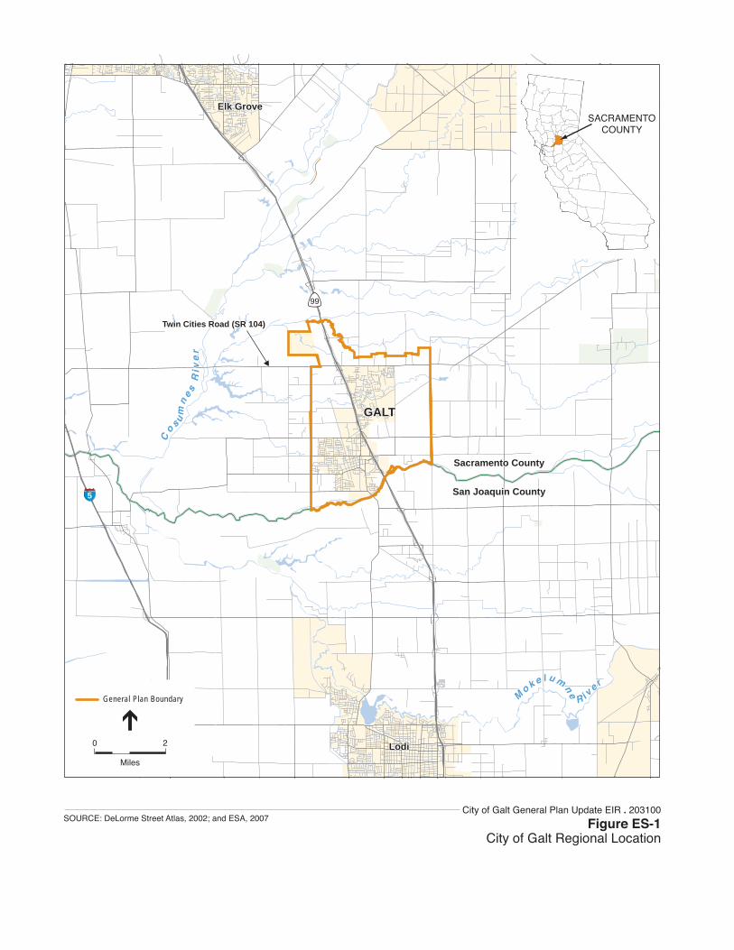
Project Location The City of Galt is located on State Route 99 in southern Sacramento County between the cities of Elk Grove and Lodi. The City is located 26 miles south of the Sacramento metro area and 24 miles north of the Stockton metro area. Twin Cities Road connects Galt west to I-5 and State Route 104 provides access to the Sierra Nevada Mountains and various foothill communities. Galt is also located approximately 100 miles east of the San Francisco Bay Area. The City is surrounded by agricultural lands and the Cosumnes River Preserve. Figure ES-1 identifies the regional location of the Proposed Project.
Project Description The Proposed Project is intended to address several changes in the City since preparation of the existing 1989 General Plan, which was originally adopted in May of 1990. Consequently, the Proposed Project, which establishes a planning framework and policies for a 22-year planning period, will replace the existing General Plan.
State law requires each county and city to prepare and adopt a comprehensive and long-range general plan for its physical development (Government Code Section 65300). Each general plan must address the seven topics (referred to as “elements”) of land use, circulation, housing, open-space, conservation, safety, and noise as identified in State law (Government Code Section 65302), to the extent that the topics are locally relevant. It may also include other topics of local interest, as chosen by the City (Government Code Section 65303). These seven elements, along with a summary of the primary objectives addressed within the elements, are identified in Table ES-1.
TABLE ES-1 SUMMARY OF THE SEVEN MANDATED ELEMENTS OF THE GENERAL PLAN
General Plan Element Primary Objectives
Land Use Element Provides the general distribution and intensity of land uses within the planning area.
Circulation Element Identifies the general location and extent of existing and proposed transportation facilities and utilities.
Housing Element Includes a comprehensive assessment of current and future housing needs for all segments of the City population, as well as a program for meeting those needs.
Open Space Element Provides measures for the preservation of open space, for the protection of natural resources, the managed production of resources, and for public health and safety.
Conservation Element Addresses the conservation, development, and use of natural resources.
Safety Element Establishes policies to protect the community from risks associated with natural and human-made hazards such as seismic, geologic, flooding, wildlife hazards, and air quality.
Noise Element Identifies major noise sources and contains policies intended to protect the community from exposure to excessive noise levels.
Galt General Plan Update: 2030 ES-3 ESA / 203100 Draft Environmental Impact Report July 2008
99
5
Lodi
Elk Grove
GALT
Sacramento County
San Joaquin County
M
o k e l u m
ne
R i ve r
Lodi
Elk Grove
GALT
Sacramento County
San Joaquin County
M
o k e l u m
ne
R i ve r
Co s u
mn
es
Riv
er
Co s u
mn
es
Riv
er
Twin Cities Road (SR 104)Twin Cities Road (SR 104)
SACRAMENTOCOUNTY
0 2
Miles
General Plan Boundary
City of Galt General Plan Update EIR . 203100
Figure ES-1City of Galt Regional Location
SOURCE: DeLorme Street Atlas, 2002; and ESA, 2007
Executive Summary
The City may adopt a general plan in the format that best fits it unique circumstances (Government Code Section 65300.5). In doing so, the City must ensure that the general plan and its component parts comprise an integrated, internally consistent and compatible statement of development policies. The City has chosen to adopt a general plan that includes all of the mandatory elements (identified above in Table ES-1) and includes four optional elements (Historic, Community Character, Public Facilities and Services, and an Economic Development element).
The City began its General Plan update process in June of 2002, after undertaking a review of the existing General Plan. The need for a new general plan is a result of the City determining that the current plan no longer meets several of the City’s key needs, including addressing planning concerns within the current SOI boundary and addressing recent and projected population growth within the City. The primary purpose of the City’s General Plan is to create a plan that meets the requirements of State law while reflecting the key policy needs of the City.
Project Objectives The General Plan was designed to meet several key objectives that were identified and considered by the General Plan Focus Group, Planning Commission, and City Council, based on input by key stakeholders and City staff. These objectives (Urban Form/Growth, Circulation, Infrastructure and Utilities Expansion, Economic Development, Agricultural Land and Wildlife Habitat Protection, Community Image and Identity) set the foundation for the goals, policies, and implementation measures that comprise the various elements of the proposed General Plan. A summary of these key objectives is provided below (see Table ES-2).
TABLE ES-2 SUMMARY OF THE GENERAL PLAN OBJECTIVES
Urban Form/Growth − New growth should provide a balanced mix of land uses while preserving rural communities and revitalizing the existing
downtown area. Circulation − Existing traffic and parking facilities improvements must be made to meet the needs of visitors, businesses and
residents in addition to planning for future expansion of transit options. Infrastructure & Utilities Expansion − Adequate provision of infrastructure and utility services is necessary to keep pace with the City’s future growth. Economic Development − Development of new business, retail, commercial services and expansion of the City’s economic base is necessary to
provide new jobs and shopping opportunities within the City. Agricultural Land & Wildlife Habitat Protection − Protection of agricultural residential areas and preserving the rural setting of the community is essential in preserving
productive agricultural land and protecting valuable wildlife habitat in the vicinity of the community. Community Image & Identity − The community’s image as a small town is integral to sustaining and developing a distinct identity for the City of Galt.
Planning Boundaries The Planning Area refers to the geographic area that will be directly addressed by the general plan, and typically encompasses the city limits and potentially annexable land within its sphere of influence. The Planning Area for the Proposed Project extends from the Sacramento-San Joaquin county line in the south (e.g., Dry Creek), Laguna and Skunk Creeks in the north, Cherokee Road in the east, and Sargent/Midway Road in the west.
Galt General Plan Update: 2030 ES-5 ESA / 203100 Draft Environmental Impact Report July 2008

City of Galt General Plan Update: 2030
Build-out Under the Preferred Land Use Alternative Full development under the project is referred to as “build out”. This section describes the implications of General Plan build-out in terms of future land uses proposed for the City. Under the Preferred Land Use Alternative, adequate land is provided by this General Plan to accommodate anticipated housing and employment needs through 2030.
Table ES-3 provides a list of the designated land uses proposed for the Preferred Land Use Alternative along with an estimate of acreage attributed to each land use category. As shown in the table, low density residential land use accounts for the majority of acreage, with approximately 2,470 acres. Commercial land uses account for 690 acres and Light Industrial land uses account for 650 acres. The Preferred Land Use Alternative would also include an estimated 550 acres of open space.
TABLE ES-3 DESIGNATED LAND USES PROPOSED UNDER THE PREFERRED LAND USE
ALTERNATIVES FOR THE PLANNING AREA
Designated Land Use Planning Area Acreage (percent of total)a
Rural Residential 1,450 acres (18%) Residential Estates 190 acres (2%)
Low Density Residential 2,470 acres (31%) Medium Density Residential 370 acres (5%)
Medium-High Density Residential 80 acres (1%) High Density Residential 200 acres (3%)
Mixed Use 20 acres (less than 1%) Commercial 690 acres (9%)
Office Professional 200 acres (3%) Light Industrial 650 acres (8%)
Public/Quasi-Public 830 acres (11%) Parks 160 acres (2%)
Open Space 550 acres (7%) Total: 7,860 acres
a Does not include waterways, rights-of-ways, or other non designated areas that can’t be developed
Summary of the Alternatives to the Proposed Project In accordance with State CEQA Guidelines, Section 15126(d), a draft EIR must describe a range of reasonable alternatives to the proposed program/project or to its location that could feasibly attain the program/project’s basic objectives and reduce the impacts of the proposed program/project.
The following three alternatives to the Proposed Project are considered and described in greater detail in Chapter 11.0 “Alternatives to the Proposed Project” of the draft EIR:
• Alternative 1: No Project (Build-out of Existing General Plan).
• Alternative 2: Compact Growth Alternative.
• Alternative 3: Focused Growth Alternative.
Galt General Plan Update: 2030 ES-6 ESA / 203100 Draft Environmental Impact Report July 2008
Executive Summary
Reader’s Guide to the Draft EIR To assist the reader in understanding both the organization and content of this EIR, a “Reader’s Guide to the EIR” has been prepared to introduce the reader of this document to the basic concepts of the project, assist the reader understand the organization of the document, and understand the key assumptions that went into preparation of the EIR analysis. This section provides a brief introduction with additional detail provided in Chapter 1 “Introduction and Project Description” of the EIR.
Glossary of Key Terms The following key terms are used throughout the EIR:
• Sphere of Influence: The City’s Sphere of Influence represents the City’s future physical boundaries and service area as defined by Local Agency Formation Commission (LAFCO).
• Planning or Study Area: For this EIR, the study area includes all lands that comprise the City’s proposed Sphere of Influence. The resources associated with this land are the focus of the EIR analysis. The study area also includes any surrounding unincorporated land outside the Sphere of Influence that may indirectly affect land use within the City through various activities.
For each impact identified in this EIR, a statement of the level of significance of the impact is provided. Impacts are categorized in one of the following categories:
• A project impact is considered beneficial if it will result in the improvement of a physical condition in the environment (no mitigation required).
• A project impact is considered less than significant when it does not reach the standard of significance and, therefore, would cause no substantial change in the environment. No mitigation is required for less-than-significant impacts.
• A significant impact is a substantial, or potentially substantial, adverse change in the environment. Physical conditions in the area will be directly or indirectly affected by the proposed project. Impacts may be direct or indirect and short-term or long-term. A project impact is considered significant if it reaches or exceeds the threshold of significance identified in the EIR. Mitigation measures may reduce a potentially significant impact to a less-than-significant impact.
• A significant unavoidable impact occurs when; even with the adoption of all proposed mitigation measures a significant impact cannot be avoided or mitigated to a less-than-significant level should the project be implemented.
The impact assessment provided in this EIR is divided into a number of individual impact statements that deal with specific topics. For example:
Galt General Plan Update: 2030 ES-7 ESA / 203100 Draft Environmental Impact Report July 2008

City of Galt General Plan Update: 2030
Impact 10.7-1: The Proposed Project would result in a cumulatively considerable net increase of criteria pollutants. Future growth in accordance with the Proposed Project would exceed the daily SMAQMD thresholds for NOx and ROG.
Following each impact statement is a discussion of the potential impact and the General Plan policies and implementation measures that would help to mitigate this impact. Following each impact statement, a summary table identifying each impact’s level of significance and the key policies that were added or modified to mitigate the impact is also provided (see example below).
Level of Significance Before Mitigation: Potentially Significant
Required Mitigation: Mitigation Measure 10.7-1a: Adopt General Plan Policy COS-5.11 “Construction Mitigation Measures” to Address Air Quality Impacts, Mitigation Measure 10.7-1b: Adopt General Plan Policy COS-5.12 “Construction Mitigation Fees” to Address Air Quality Impacts, Mitigation Measure 10.7-1c: Adopt General Plan Policy COS-5.13 “Air Pollution Control Technology” to Address Air Quality Impacts.
Level of Significance After Mitigation: Significant and Unavoidable
Overall EIR Approach and Assumptions This EIR is a complete EIR with updated information on the Study Area’s environmental setting from the General Plan Existing Conditions Report (November 2005), impact analysis, mitigation measures, and evaluation of a range of land use alternatives. The General Plan Existing Conditions Report is provided as Appendix B of this EIR.
As more fully described above under Section 1.2, this EIR has been prepared as a Program EIR. As a Program EIR, this document focuses on the overall effects of the project. However, the analysis does not examine in detail the localized effects of potential site-specific projects that may occur under the overall umbrella of this program in future years. In fact, this EIR assumes that specific development projects and infrastructure improvement proposals submitted to the City may necessitate an independent environmental analysis in accordance with the requirements of CEQA. (For possible means of streamlining such review, see Section 1.2.) The nature of general plans is such that many proposed policies are intended to be general, with details to be later determined during the implementation phases of the general plan. Consequently, many of the impacts and mitigation measures can only be described in general or qualitative terms.
The proposed General Plan is intended to be self-mitigating, in that the policies and implementation measures are designed to mitigate environmental impacts. This EIR clearly identifies how the impacts of future development in Galt will be mitigated through the implementation of the policies and measures of the Proposed Project. A significance criterion is an identifiable quantitative, qualitative, or performance level of a particular environmental effect that, if exceeded, indicates that the impact is considered to be significant.
The analysis provided in the EIR is based on the following key assumptions:
• Full Implementation. This EIR assumes that all policies in the proposed General Plan will be fully implemented and all development will be consistent with the Preferred Land Use Diagram.
Galt General Plan Update: 2030 ES-8 ESA / 203100 Draft Environmental Impact Report July 2008
Executive Summary
• Buildout in 2030. The EIR assumes that overall buildout of the Proposed Project will occur by 2030. Development under the Proposed Project will be incremental and timed in response to market conditions. The proposed General Plan will include policies intended to control the amount and location of new growth.
• Consistency with Jurisdictional Boundary Requirements. This EIR assumes that development proposed outside the current City limits but inside the Sphere of Influence area will be annexed to the City, after review and approval by the Sacramento County Local Agency Formation Commission. Urban development and services will not be extended outside the City’s proposed Sphere of Influence boundary.
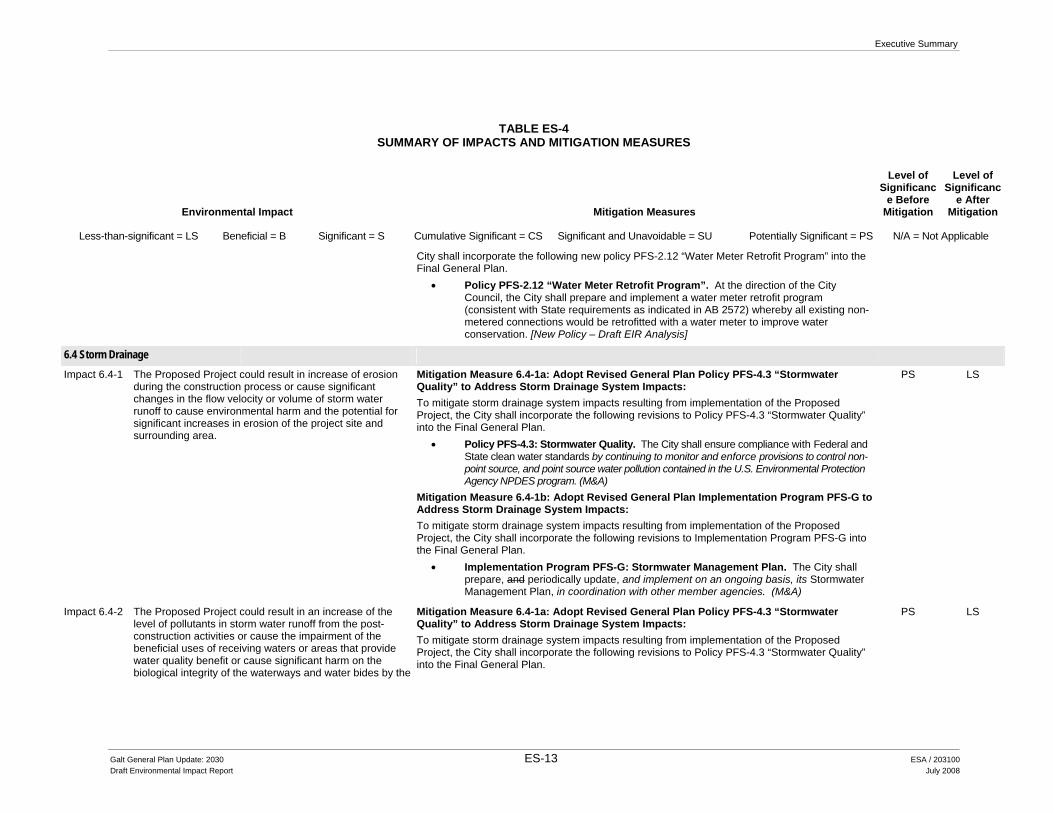
Summary of Environmental Impacts and Mitigation Measures Table ES-4 presents a summary of impacts and mitigation measures identified in this EIR. It is organized to correspond with the environmental issues discussed throughout the EIR. The table is arranged in four columns: 1) environmental impacts; 2) mitigation measure; 3) significance before mitigation; and 4) significance after mitigation.
Galt General Plan Update: 2030 ES-9 ESA / 203100 Draft Environmental Impact Report July 2008
Executive Summary
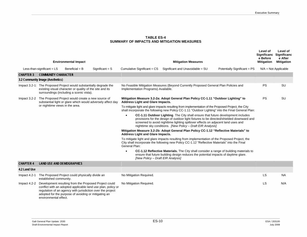
TABLE ES-4 SUMMARY OF IMPACTS AND MITIGATION MEASURES
Environmental Impact Mitigation Measures
Level of Significanc
e Before Mitigation
Level of Significanc
e After Mitigation
Less-than-significant = LS Beneficial = B Significant = S Cumulative Significant = CS Significant and Unavoidable = SU Potentially Significant = PS N/A = Not Applicable
CHAPTER 3 COMMUNITY CHARACTER 3.2 Community Image (Aesthetics)
Impact 3.2-1: The Proposed Project would substantially degrade the existing visual character or quality of the site and its surroundings (including a scenic vista).
No Feasible Mitigation Measures (Beyond Currently Proposed General Plan Policies and Implementation Programs) Available.
PS SU
Impact 3.2-2 The Proposed Project would create a new source of substantial light or glare which would adversely affect day or nighttime views in the area.
Mitigation Measure 3.2-2a: Adopt General Plan Policy CC-1.11 “Outdoor Lighting” to Address Light and Glare Impacts. To mitigate light and glare impacts resulting from implementation of the Proposed Project, the City shall incorporate the following new Policy CC-1.11 “Outdoor Lighting” into the Final General Plan:
• CC-1.11 Outdoor Lighting. The City shall ensure that future development includes provisions for the design of outdoor light fixtures to be directed/shielded downward and screened to avoid nighttime lighting spillover effects on adjacent land uses and nighttime sky conditions. [New Policy – Draft EIR Analysis]
Mitigation Measure 3.2-2b: Adopt General Plan Policy CC-1.12 “Reflective Materials” to Address Light and Glare Impacts. To mitigate light and glare impacts resulting from implementation of the Proposed Project, the City shall incorporate the following new Policy CC-1.12 “Reflective Materials” into the Final General Plan:
• CC-1.12 Reflective Materials. The City shall consider a range of building materials to ensure that future building design reduces the potential impacts of daytime glare. [New Policy – Draft EIR Analysis]
PS SU
CHAPTER 4 LAND USE AND DEMOGRAPHICS
4.2 Land Use
Impact 4.2-1 The Proposed Project could physically divide an established community.
No Mitigation Required. LS NA
Impact 4.2-2 Development resulting from the Proposed Project could conflict with an adopted applicable land use plan, policy or regulation of an agency with jurisdiction over the project adopted for the purpose of avoiding or mitigating an environmental effect.
No Mitigation Required. LS N/A
Galt General Plan Update: 2030 ES-10 ESA / 203100 Draft Environmental Impact Report July 2008

Executive Summary
TABLE ES-4 SUMMARY OF IMPACTS AND MITIGATION MEASURES
Environmental Impact Mitigation Measures
Level of Significanc
e Before Mitigation
Level of Significanc
e After Mitigation
Less-than-significant = LS Beneficial = B Significant = S Cumulative Significant = CS Significant and Unavoidable = SU Potentially Significant = PS N/A = Not Applicable
Impact 4.2-3 Development resulting from the Proposed Project could conflict with an adopted applicable airport land use compatibility plan.
Mitigation Measure 4.2-3: Adopt General Plan Policy LU-1.15 “Caltrans Handbook Reference” to Address Airport Land Use Compatibility Impacts. To mitigate airport land use compatibility impacts resulting from implementation of the Proposed Project, the City shall incorporate the following new Policy LU-1.15 “Caltrans Handbook Reference” into the Final General Plan.
• LU-1.15 Caltrans Handbook Reference: When reviewing proposed projects within a one mile radius of an airport (Mustang Airport, if approved for public use), the City shall refer to the Caltrans Airport Land Use Planning Handbook (2002) in order to identify any potential safety compatibility concerns between the airport and the proposed land use. [New Policy – Draft EIR Analysis]
PS LS
Impact 4.2-4 Development resulting from the Proposed Project could conflict with an adopted Habitat Conservation Plan (HCP) or Natural Community Conservation Plan (NCCP).
No Mitigation Required. LS N/A
CHAPTER 5 CIRCULATION AND TRANSPORTATION
5.2 Circulation and Transportation Impact 5.2-1 The Proposed Project would cause an increase in traffic
which is substantial in relation to the existing traffic load and capacity of the street system (e.g., result in a substantial increase in either the number of vehicle trips, the volume to capacity ratio on roads, or congestion at intersections).
No Feasible Mitigation Measures (Beyond Currently Proposed General Plan Policies and Implementation Programs) Available.
PS SU
Impact 5.2-2 The Proposed Project would exceed, either individually or cumulatively, a level of service standard established by the City on facilities that do not connect with regional facilities.
No Mitigation Required. LS N/A
Impact 5.2-3 The Proposed Project would exceed, either individually or cumulatively, the level of service standard established by the City on facilities that connect with regional facilities.
No Feasible Mitigation Measures (Beyond Currently Proposed General Plan Policies and Implementation Programs) Available.
PS SU
Impact 5.2-4 The Proposed Project would result in inadequate parking capacity.
No Mitigation Required. LS N/A
Galt General Plan Update: 2030 ES-11 ESA / 203100 Draft Environmental Impact Report July 2008
City of Galt General Plan Update: 2030
TABLE ES-4 SUMMARY OF IMPACTS AND MITIGATION MEASURES
Environmental Impact Mitigation Measures
Level of Significanc
e Before Mitigation
Level of Significanc
e After Mitigation
Less-than-significant = LS Beneficial = B Significant = S Cumulative Significant = CS Significant and Unavoidable = SU Potentially Significant = PS N/A = Not Applicable
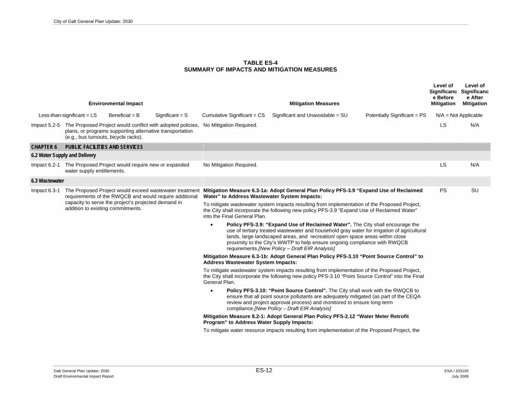
Impact 5.2-5 The Proposed Project would conflict with adopted policies, plans, or programs supporting alternative transportation (e.g., bus turnouts, bicycle racks).
No Mitigation Required. LS N/A
CHAPTER 6 PUBLIC FACILITIES AND SERVICES 6.2 Water Supply and Delivery
Impact 6.2-1 The Proposed Project would require new or expanded water supply entitlements.
No Mitigation Required. LS N/A
6.3 Wastewater
Impact 6.3-1 The Proposed Project would exceed wastewater treatment requirements of the RWQCB and would require additional capacity to serve the project’s projected demand in addition to existing commitments.
Mitigation Measure 6.3-1a: Adopt General Plan Policy PFS-3.9 “Expand Use of Reclaimed Water” to Address Wastewater System Impacts: To mitigate wastewater system impacts resulting from implementation of the Proposed Project, the City shall incorporate the following new policy PFS-3.9 “Expand Use of Reclaimed Water” into the Final General Plan.
• Policy PFS-3.9: “Expand Use of Reclaimed Water”. The City shall encourage the use of tertiary treated wastewater and household gray water for irrigation of agricultural lands, large landscaped areas, and recreation/ open space areas within close proximity to the City’s WWTP to help ensure ongoing compliance with RWQCB requirements.[New Policy – Draft EIR Analysis]
Mitigation Measure 6.3-1b: Adopt General Plan Policy PFS-3.10 “Point Source Control” to Address Wastewater System Impacts: To mitigate wastewater system impacts resulting from implementation of the Proposed Project, the City shall incorporate the following new policy PFS-3.10 “Point Source Control” into the Final General Plan.
• Policy PFS-3.10: “Point Source Control”. The City shall work with the RWQCB to ensure that all point source pollutants are adequately mitigated (as part of the CEQA review and project approval process) and monitored to ensure long-term compliance.[New Policy – Draft EIR Analysis]
Mitigation Measure 8.2-1: Adopt General Plan Policy PFS-2.12 “Water Meter Retrofit Program” to Address Water Supply Impacts: To mitigate water resource impacts resulting from implementation of the Proposed Project, the
PS SU
Galt General Plan Update: 2030 ES-12 ESA / 203100 Draft Environmental Impact Report July 2008
Executive Summary
TABLE ES-4 SUMMARY OF IMPACTS AND MITIGATION MEASURES
Environmental Impact Mitigation Measures
Level of Significanc
e Before Mitigation
Level of Significanc
e After Mitigation
Less-than-significant = LS Beneficial = B Significant = S Cumulative Significant = CS Significant and Unavoidable = SU Potentially Significant = PS N/A = Not Applicable
City shall incorporate the following new policy PFS-2.12 “Water Meter Retrofit Program” into the Final General Plan.
• Policy PFS-2.12 “Water Meter Retrofit Program”. At the direction of the City Council, the City shall prepare and implement a water meter retrofit program (consistent with State requirements as indicated in AB 2572) whereby all existing non-metered connections would be retrofitted with a water meter to improve water conservation. [New Policy – Draft EIR Analysis]
6.4 Storm Drainage
Impact 6.4-1 The Proposed Project could result in increase of erosion during the construction process or cause significant changes in the flow velocity or volume of storm water runoff to cause environmental harm and the potential for significant increases in erosion of the project site and surrounding area.
Mitigation Measure 6.4-1a: Adopt Revised General Plan Policy PFS-4.3 “Stormwater Quality” to Address Storm Drainage System Impacts: To mitigate storm drainage system impacts resulting from implementation of the Proposed Project, the City shall incorporate the following revisions to Policy PFS-4.3 “Stormwater Quality” into the Final General Plan.
• Policy PFS-4.3: Stormwater Quality. The City shall ensure compliance with Federal and State clean water standards by continuing to monitor and enforce provisions to control non-point source, and point source water pollution contained in the U.S. Environmental Protection Agency NPDES program. (M&A)
Mitigation Measure 6.4-1b: Adopt Revised General Plan Implementation Program PFS-G to Address Storm Drainage System Impacts: To mitigate storm drainage system impacts resulting from implementation of the Proposed Project, the City shall incorporate the following revisions to Implementation Program PFS-G into the Final General Plan.
• Implementation Program PFS-G: Stormwater Management Plan. The City shall prepare, and periodically update, and implement on an ongoing basis, its Stormwater Management Plan, in coordination with other member agencies. (M&A)
PS LS
Impact 6.4-2 The Proposed Project could result in an increase of the level of pollutants in storm water runoff from the post-construction activities or cause the impairment of the beneficial uses of receiving waters or areas that provide water quality benefit or cause significant harm on the biological integrity of the waterways and water bides by the
Mitigation Measure 6.4-1a: Adopt Revised General Plan Policy PFS-4.3 “Stormwater Quality” to Address Storm Drainage System Impacts: To mitigate storm drainage system impacts resulting from implementation of the Proposed Project, the City shall incorporate the following revisions to Policy PFS-4.3 “Stormwater Quality” into the Final General Plan.
PS LS
Galt General Plan Update: 2030 ES-13 ESA / 203100 Draft Environmental Impact Report July 2008

City of Galt General Plan Update: 2030
TABLE ES-4 SUMMARY OF IMPACTS AND MITIGATION MEASURES
Environmental Impact Mitigation Measures
Level of Significanc
e Before Mitigation
Level of Significanc
e After Mitigation
Less-than-significant = LS Beneficial = B Significant = S Cumulative Significant = CS Significant and Unavoidable = SU Potentially Significant = PS N/A = Not Applicable
discharge of stormwater. • Policy PFS-4.3: Stormwater Quality. The City shall ensure compliance with Federal and State clean water standards by continuing to monitor and enforce provisions to control non-point source, and point source water pollution contained in the U.S. Environmental Protection Agency NPDES program. (M&A)
Mitigation Measure 6.4-1b: Adopt Revised General Plan Implementation Program PFS-G to Address Storm Drainage System Impacts: To mitigate storm drainage system impacts resulting from implementation of the Proposed Project, the City shall incorporate the following revisions to Implementation Program PFS-G into the Final General Plan. Implementation Program PFS-G: Stormwater Management Plan. The City shall prepare, and periodically update, and implement on an ongoing basis, its Stormwater Management Plan, in coordination with other member agencies. (M&A)
Impact 6.4-3 The Proposed Project could place housing within a 100-year flood hazard area, as mapped on a federal Flood Hazard Boundary or Flood Insurance Rate Map or other flood hazard delineation map or place within a 100-year flood hazard area structures which could impede or redirect flood flows.
No Mitigation Required. LS N/A
Impact 6.4-4 The Proposed Project could expose people or structures to a significant risk of loss, injury, or death involving flooding, including flooding as a result of the failure of a levee or dam.
No Mitigation Required. LS N/A
Impact 6.4-5 Impact 6.4-5: The Proposed Project could result in an increase of the discharge of storm water from material storage areas, vehicle or equipment fueling, vehicle or equipment maintenance (including washing), waste handling, hazardous materials handling or storage, delivery areas or loading docks, or other outdoor work areas.
Mitigation Measure 6.4-1a: Adopt Revised General Plan Policy PFS-4.3 “Stormwater Quality” to Address Storm Drainage System Impacts: To mitigate storm drainage system impacts resulting from implementation of the Proposed Project, the City shall incorporate the following revisions to Policy PFS-4.3 “Stormwater Quality” into the Final General Plan.
• Policy PFS-4.3: Stormwater Quality. The City shall ensure compliance with Federal and State clean water standards by continuing to monitor and enforce provisions to control non-point source, and point source water pollution contained in the U.S. Environmental Protection Agency NPDES program. (M&A)
•
PS LS
Galt General Plan Update: 2030 ES-14 ESA / 203100 Draft Environmental Impact Report July 2008

Executive Summary
TABLE ES-4 SUMMARY OF IMPACTS AND MITIGATION MEASURES
Environmental Impact Mitigation Measures
Level of Significanc
e Before Mitigation
Level of Significanc
e After Mitigation
Less-than-significant = LS Beneficial = B Significant = S Cumulative Significant = CS Significant and Unavoidable = SU Potentially Significant = PS N/A = Not Applicable
Mitigation Measure 6.4-1b: Adopt Revised General Plan Implementation Program PFS-G to Address Storm Drainage System Impacts: To mitigate storm drainage system impacts resulting from implementation of the Proposed Project, the City shall incorporate the following revisions to Implementation Program PFS-G into the Final General Plan. Implementation Program PFS-G: Stormwater Management Plan. The City shall prepare, and periodically update, and implement on an ongoing basis, its Stormwater Management Plan, in coordination with other member agencies. (M&A)
6.5 Solid Waste
Impact 6.5-1 The Proposed Project would produce substantial solid waste that would exceed the permitted capacity of a landfill serving the Study Area.
No Feasible Mitigation Measures (Beyond Currently Proposed General Plan Policies and Implementation Programs) Available.
PS SU
Impact 6.5-2 The Proposed Project could conflict with federal, State, and Local Statutes and Regulations related to solid waste.
No Mitigation Required. LS N/A
6.6 Gas and Electric
Impact 6.6-1 The Proposed Project would not result in wasteful, inefficient, or unnecessary consumption of energy by residential, commercial, industrial, or public uses.
LS N/A
6.8 Law Enforcement
Impact 6.8-1 The Proposed Project would increase the need or use of existing law enforcement facilities such that substantial physical deterioration of the facility would occur or be accelerated in order to maintain acceptable service ratios and/or response times.
No Mitigation Required. LS N/A
6.9 Fire Protection
Impact 6.9-1 The Proposed Project would increase the need or use of existing fire protection facilities such that substantial physical deterioration of the facility would occur or be accelerated in order to maintain acceptable service ratios
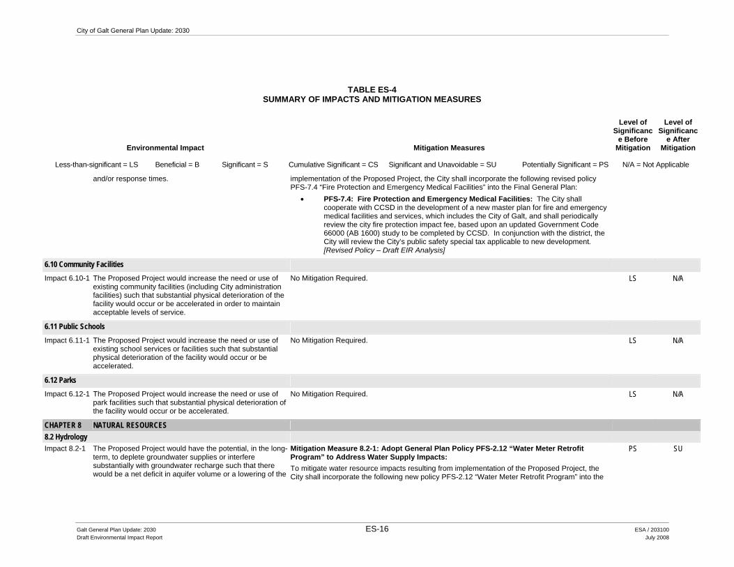
Mitigation Measure 6.9-1: Adopt Revised General Plan Policy PFS-7.4 “Fire Protection and Emergency Medical Facilities” to address fire protection and emergency medical facility impacts: To mitigate potential fire protection and emergency medical response impacts resulting from
PS SU
Galt General Plan Update: 2030 ES-15 ESA / 203100 Draft Environmental Impact Report July 2008
City of Galt General Plan Update: 2030
TABLE ES-4 SUMMARY OF IMPACTS AND MITIGATION MEASURES
Environmental Impact Mitigation Measures
Level of Significanc
e Before Mitigation
Level of Significanc
e After Mitigation
Less-than-significant = LS Beneficial = B Significant = S Cumulative Significant = CS Significant and Unavoidable = SU Potentially Significant = PS N/A = Not Applicable
and/or response times. implementation of the Proposed Project, the City shall incorporate the following revised policy PFS-7.4 “Fire Protection and Emergency Medical Facilities” into the Final General Plan:
• PFS-7.4: Fire Protection and Emergency Medical Facilities: The City shall cooperate with CCSD in the development of a new master plan for fire and emergency medical facilities and services, which includes the City of Galt, and shall periodically review the city fire protection impact fee, based upon an updated Government Code 66000 (AB 1600) study to be completed by CCSD. In conjunction with the district, the City will review the City’s public safety special tax applicable to new development. [Revised Policy – Draft EIR Analysis]
6.10 Community Facilities Impact 6.10-1 The Proposed Project would increase the need or use of
existing community facilities (including City administration facilities) such that substantial physical deterioration of the facility would occur or be accelerated in order to maintain acceptable levels of service.
No Mitigation Required. LS N/A
6.11 Public Schools Impact 6.11-1 The Proposed Project would increase the need or use of
existing school services or facilities such that substantial physical deterioration of the facility would occur or be accelerated.
No Mitigation Required. LS N/A
6.12 Parks Impact 6.12-1 The Proposed Project would increase the need or use of
park facilities such that substantial physical deterioration of the facility would occur or be accelerated.
No Mitigation Required. LS N/A
CHAPTER 8 NATURAL RESOURCES 8.2 Hydrology Impact 8.2-1 The Proposed Project would have the potential, in the long-
term, to deplete groundwater supplies or interfere substantially with groundwater recharge such that there would be a net deficit in aquifer volume or a lowering of the
Mitigation Measure 8.2-1: Adopt General Plan Policy PFS-2.12 “Water Meter Retrofit Program” to Address Water Supply Impacts: To mitigate water resource impacts resulting from implementation of the Proposed Project, the City shall incorporate the following new policy PFS-2.12 “Water Meter Retrofit Program” into the
PS SU
Galt General Plan Update: 2030 ES-16 ESA / 203100 Draft Environmental Impact Report July 2008

Executive Summary
TABLE ES-4 SUMMARY OF IMPACTS AND MITIGATION MEASURES
Environmental Impact Mitigation Measures
Level of Significanc
e Before Mitigation
Level of Significanc
e After Mitigation
Less-than-significant = LS Beneficial = B Significant = S Cumulative Significant = CS Significant and Unavoidable = SU Potentially Significant = PS N/A = Not Applicable
local groundwater table. Final General Plan: • Policy PFS-2.12 “Water Meter Retrofit Program”. At the direction of the City
Council, the City shall prepare and implement a water meter retrofit program (consistent with State requirements as indicated in AB 2572) whereby all existing non-metered connections would be retrofitted with a water meter to improve water conservation. [New Policy – Draft EIR Analysis]
Impact 8.2-2 The Proposed Project could violate water quality standards or waste discharge requirements, or otherwise degrade water quality.
No Mitigation Required. LS N/A
8.3 Biological Resources Impact 8.3-1 The Proposed Project would have a substantial adverse
effect, either directly or through habitat modifications, on any fish or wildlife species including those officially designated species identified as endangered, threatened, candidate, sensitive, or special status species in local or regional plans, policies, or regulations, or by the California Department of Fish and Game or U.S. Fish and Wildlife Service.
Mitigation Measure 8.3-1a: Adopt General Plan Policy COS-2.8 “Habitat Conservation Easement Coordination” to Address Biological Resource Impacts: To mitigate biological resource impacts resulting from implementation of the Proposed Project, the City shall incorporate the following new policy COS-2.8 “Habitat Conservation Easement Coordination” into the Final General Plan:
• COS-2.8 Habitat Conservation Easement Coordination. The City will initiate contact with private conservation trusts and work to identity trust lands within the SOI and to the extent feasible will inventory known trust lands to address potential conflicts with development in the City’s planning area. [New Policy – Draft EIR Analysis]
Mitigation Measure 8.3-1b: Adopt General Plan Policy COS-2.9 “Minimize Lighting Impact” to Address Biological Resource Impacts: To mitigate biological resource impacts resulting from implementation of the Proposed Project, the City shall incorporate the following new policy COS-2.9 “Minimize Lighting Impacts” into the Final General Plan:
• COS-2.9 Minimize Lighting Impacts. The City should ensure that lighting associated with new development or facilities (including street lighting, recreational facilities, and parking) shall be designed to prevent artificial lighting from illuminating adjacent natural areas at a level greater than one foot candle above ambient conditions. [New Policy – Draft EIR Analysis]
•
PS SU
Galt General Plan Update: 2030 ES-17 ESA / 203100 Draft Environmental Impact Report July 2008

City of Galt General Plan Update: 2030
TABLE ES-4 SUMMARY OF IMPACTS AND MITIGATION MEASURES
Environmental Impact Mitigation Measures
Level of Significanc
e Before Mitigation
Level of Significanc
e After Mitigation
Less-than-significant = LS Beneficial = B Significant = S Cumulative Significant = CS Significant and Unavoidable = SU Potentially Significant = PS N/A = Not Applicable
Impact 8.3-2 The Proposed Project would have a substantial adverse effect on any riparian habitat or other sensitive natural community identified in local or regional plans, policies, regulations or by the California Department of Fish and Game or U.S. Fish and Wildlife Service.
Mitigation Measure 8.3-1a: Adopt General Plan Policy COS-2.8 “Habitat Conservation Easement Coordination” to Address Biological Resource Impacts: To mitigate biological resource impacts resulting from implementation of the Proposed Project, the City shall incorporate the following new policy COS-2.8 “Habitat Conservation Easement Coordination” into the Final General Plan:
• COS-2.8 Habitat Conservation Easement Coordination. The City will initiate contact with private conservation trusts and work to identity trust lands within the SOI and to the extent feasible will inventory known trust lands to address potential conflicts with development in the City’s planning area. [New Policy – Draft EIR Analysis]
Mitigation Measure 8.3-1b: Adopt General Plan Policy COS-2.9 “Minimize Lighting Impact” to Address Biological Resource Impacts: To mitigate biological resource impacts resulting from implementation of the Proposed Project, the City shall incorporate the following new policy COS-2.9 “Minimize Lighting Impacts” into the Final General Plan: COS-2.9 Minimize Lighting Impacts. The City should ensure that lighting associated with new development or facilities (including street lighting, recreational facilities, and parking) shall be designed to prevent artificial lighting from illuminating adjacent natural areas at a level greater than one foot candle above ambient conditions. [New Policy – Draft EIR Analysis]
PS SU
Impact 8.3-3 The Proposed Project would have a substantial adverse effect on “federally protected” wetlands as defined by Section 404 of the Clean Water Act (including, but not limited to marsh, vernal pool, etc.) through direct removal, filling, hydrological interruption, or other means.
Mitigation Measure 8.3-1a: Adopt General Plan Policy COS-2.8 “Habitat Conservation Easement Coordination” to Address Biological Resource Impacts: To mitigate biological resource impacts resulting from implementation of the Proposed Project, the City shall incorporate the following new policy COS-2.8 “Habitat Conservation Easement Coordination” into the Final General Plan:
• COS-2.8 Habitat Conservation Easement Coordination. The City will initiate contact with private conservation trusts and work to identity trust lands within the SOI and to the extent feasible will inventory known trust lands to address potential conflicts with development in the City’s planning area. [New Policy – Draft EIR Analysis]
Mitigation Measure 8.3-1b: Adopt General Plan Policy COS-2.9 “Minimize Lighting Impact” to Address Biological Resource Impacts: To mitigate biological resource impacts resulting from implementation of the Proposed Project, the City shall incorporate the following new policy COS-2.9 “Minimize Lighting Impacts” into the Final General Plan:
PS SU
Galt General Plan Update: 2030 ES-18 ESA / 203100 Draft Environmental Impact Report July 2008

Executive Summary
TABLE ES-4 SUMMARY OF IMPACTS AND MITIGATION MEASURES
Environmental Impact Mitigation Measures
Level of Significanc
e Before Mitigation
Level of Significanc
e After Mitigation
Less-than-significant = LS Beneficial = B Significant = S Cumulative Significant = CS Significant and Unavoidable = SU Potentially Significant = PS N/A = Not Applicable
COS-2.9 Minimize Lighting Impacts. The City should ensure that lighting associated with new development or facilities (including street lighting, recreational facilities, and parking) shall be designed to prevent artificial lighting from illuminating adjacent natural areas at a level greater than one foot candle above ambient conditions. [New Policy – Draft EIR Analysis]
Impact 8.3-4 The Proposed Project would interfere substantially with the movement of any native resident or migratory fish or wildlife species or with established native resident or migratory wildlife corridors, or impede the use of native wildlife nursery sites.
Mitigation Measure 8.3-1a: Adopt General Plan Policy COS-2.8 “Habitat Conservation Easement Coordination” to Address Biological Resource Impacts: To mitigate biological resource impacts resulting from implementation of the Proposed Project, the City shall incorporate the following new policy COS-2.8 “Habitat Conservation Easement Coordination” into the Final General Plan:
• COS-2.8 Habitat Conservation Easement Coordination. The City will initiate contact with private conservation trusts and work to identity trust lands within the SOI and to the extent feasible will inventory known trust lands to address potential conflicts with development in the City’s planning area. [New Policy – Draft EIR Analysis]
Mitigation Measure 8.3-1b: Adopt General Plan Policy COS-2.9 “Minimize Lighting Impact” to Address Biological Resource Impacts: To mitigate biological resource impacts resulting from implementation of the Proposed Project, the City shall incorporate the following new policy COS-2.9 “Minimize Lighting Impacts” into the Final General Plan: COS-2.9 Minimize Lighting Impacts. The City should ensure that lighting associated with new development or facilities (including street lighting, recreational facilities, and parking) shall be designed to prevent artificial lighting from illuminating adjacent natural areas at a level greater than one foot candle above ambient conditions. [New Policy – Draft EIR Analysis]
PS SU
8.4 Soils and Agricultural Resources Impact 8.4-1 The Proposed Project would result in substantial soil
erosion or the loss of topsoil. No Mitigation Required. LS N/A
Impact 8.4-2 The Proposed Project would result in the conversion of important farmland to non-agricultural uses.
No Feasible Mitigation Measures (Beyond Currently Proposed General Plan Policies and Implementation Programs) Available.
PS SU
Impact 8.4-3 The Proposed Project could conflict with existing zoning for agricultural use, or conflict with existing Williamson Act contracts.
No Mitigation Required. LS N/A
Galt General Plan Update: 2030 ES-19 ESA / 203100 Draft Environmental Impact Report July 2008

City of Galt General Plan Update: 2030
TABLE ES-4 SUMMARY OF IMPACTS AND MITIGATION MEASURES
Environmental Impact Mitigation Measures
Level of Significanc
e Before Mitigation
Level of Significanc
e After Mitigation
Less-than-significant = LS Beneficial = B Significant = S Cumulative Significant = CS Significant and Unavoidable = SU Potentially Significant = PS N/A = Not Applicable
Impact 8.4-4 The Proposed Project would involve other changes in the existing environment that, due to their location or nature, could result in the conversion of Important Farmlands, to non-agricultural uses.
No Mitigation Required. LS N/A
CHAPTER 9 HISTORIC RESOURCES
9.2 Historic and Cultural Resources
Impact 9.2-1 The Proposed Project could cause a substantial adverse change in the significance of a historical resource as defined in CEQA Guidelines Section 15064.5.
Mitigation Measure 9.2-1a: Adopt Revised General Plan Policy HRE-1.2 “Preservation of Architectural Styles” to Address Historic Resource Impacts. To mitigate historic resource impacts resulting from implementation of the Proposed Project, the City shall incorporate the following revisions to Policy HRE-1.2 “Preservation of Architectural Styles” into the Final General Plan:
• Policy HRE-1.2: Preservation of Architectural Styles. The City should encourage the preservation of varied architectural styles that reflect Galt’s cultural, social, economic, political, and architectural past. For structures listed on the City’s cultural resources list or on the NRHP or CRHR, preservation efforts shall conform to the current Secretary of the Interior’s Standards for the Treatment of Historic Properties and Guidelines for Preserving, Rehabilitating, Restoring, and Reconstructing Historic Building. [Galt Area Historical Society – Draft EIR Analysis]
Mitigation Measure 9.2-1b: Adopt Revised General Plan Policy HRE-1.4 “Renovations” to Address Historic Resource Impacts. To mitigate historic resource impacts resulting from implementation of the Proposed Project, the City shall incorporate the following revisions to Policy HRE-1.4 “Renovations” into the Final General Plan:
• Policy HRE-1.4: Renovations. The City should continue to assist in financing and accomplishing renovation efforts in the Downtown area, including façade enhancements, as funding allows. For designated historic structures, renovation efforts shall conform to the current Secretary of the Interior’s Standards for the Treatment of Historic Properties and Guidelines for Preserving, Rehabilitating, Restoring, and Reconstructing Historic Building. [City: D-2– Draft EIR Analysis]
PS SU
Galt General Plan Update: 2030 ES-20 ESA / 203100 Draft Environmental Impact Report July 2008
Executive Summary
TABLE ES-4 SUMMARY OF IMPACTS AND MITIGATION MEASURES
Environmental Impact Mitigation Measures
Level of Significanc
e Before Mitigation
Level of Significanc
e After Mitigation
Less-than-significant = LS Beneficial = B Significant = S Cumulative Significant = CS Significant and Unavoidable = SU Potentially Significant = PS N/A = Not Applicable
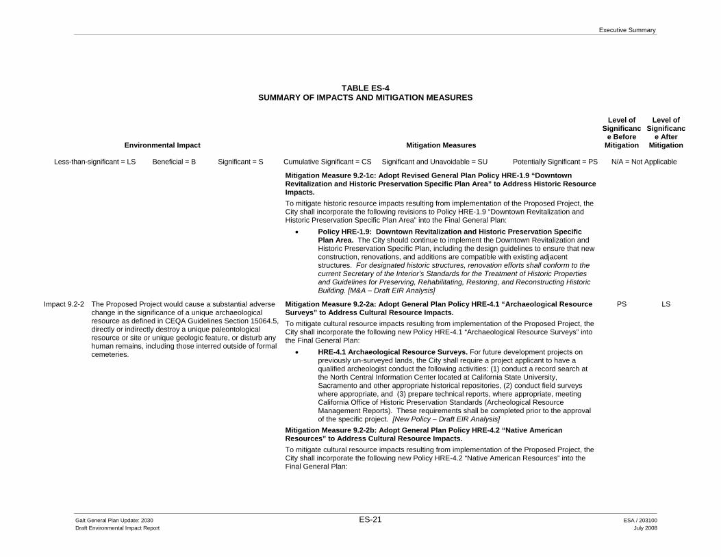
Mitigation Measure 9.2-1c: Adopt Revised General Plan Policy HRE-1.9 “Downtown Revitalization and Historic Preservation Specific Plan Area” to Address Historic Resource Impacts. To mitigate historic resource impacts resulting from implementation of the Proposed Project, the City shall incorporate the following revisions to Policy HRE-1.9 “Downtown Revitalization and Historic Preservation Specific Plan Area” into the Final General Plan:
• Policy HRE-1.9: Downtown Revitalization and Historic Preservation Specific Plan Area. The City should continue to implement the Downtown Revitalization and Historic Preservation Specific Plan, including the design guidelines to ensure that new construction, renovations, and additions are compatible with existing adjacent structures. For designated historic structures, renovation efforts shall conform to the current Secretary of the Interior’s Standards for the Treatment of Historic Properties and Guidelines for Preserving, Rehabilitating, Restoring, and Reconstructing Historic Building. [M&A – Draft EIR Analysis]
Impact 9.2-2 The Proposed Project would cause a substantial adverse change in the significance of a unique archaeological resource as defined in CEQA Guidelines Section 15064.5, directly or indirectly destroy a unique paleontological resource or site or unique geologic feature, or disturb any human remains, including those interred outside of formal cemeteries.
Mitigation Measure 9.2-2a: Adopt General Plan Policy HRE-4.1 “Archaeological Resource Surveys” to Address Cultural Resource Impacts. To mitigate cultural resource impacts resulting from implementation of the Proposed Project, the City shall incorporate the following new Policy HRE-4.1 “Archaeological Resource Surveys” into the Final General Plan:
• HRE-4.1 Archaeological Resource Surveys. For future development projects on previously un-surveyed lands, the City shall require a project applicant to have a qualified archeologist conduct the following activities: (1) conduct a record search at the North Central Information Center located at California State University, Sacramento and other appropriate historical repositories, (2) conduct field surveys where appropriate, and (3) prepare technical reports, where appropriate, meeting California Office of Historic Preservation Standards (Archeological Resource Management Reports). These requirements shall be completed prior to the approval of the specific project. [New Policy – Draft EIR Analysis]
Mitigation Measure 9.2-2b: Adopt General Plan Policy HRE-4.2 “Native American Resources” to Address Cultural Resource Impacts. To mitigate cultural resource impacts resulting from implementation of the Proposed Project, the City shall incorporate the following new Policy HRE-4.2 “Native American Resources” into the Final General Plan:
PS LS
Galt General Plan Update: 2030 ES-21 ESA / 203100 Draft Environmental Impact Report July 2008
City of Galt General Plan Update: 2030
TABLE ES-4 SUMMARY OF IMPACTS AND MITIGATION MEASURES
Environmental Impact Mitigation Measures
Level of Significanc
e Before Mitigation
Level of Significanc
e After Mitigation
Less-than-significant = LS Beneficial = B Significant = S Cumulative Significant = CS Significant and Unavoidable = SU Potentially Significant = PS N/A = Not Applicable
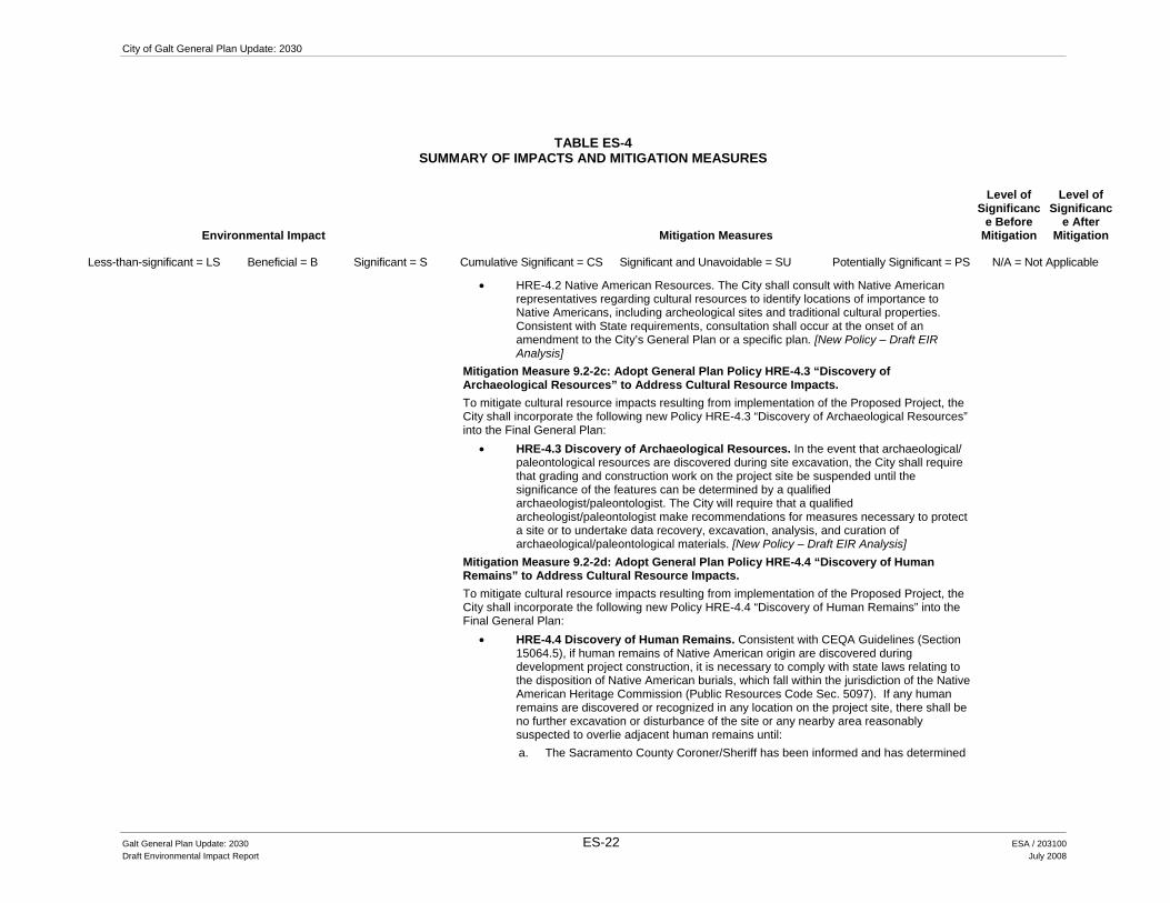
• HRE-4.2 Native American Resources. The City shall consult with Native American representatives regarding cultural resources to identify locations of importance to Native Americans, including archeological sites and traditional cultural properties. Consistent with State requirements, consultation shall occur at the onset of an amendment to the City’s General Plan or a specific plan. [New Policy – Draft EIR Analysis]
Mitigation Measure 9.2-2c: Adopt General Plan Policy HRE-4.3 “Discovery of Archaeological Resources” to Address Cultural Resource Impacts. To mitigate cultural resource impacts resulting from implementation of the Proposed Project, the City shall incorporate the following new Policy HRE-4.3 “Discovery of Archaeological Resources” into the Final General Plan:
• HRE-4.3 Discovery of Archaeological Resources. In the event that archaeological/ paleontological resources are discovered during site excavation, the City shall require that grading and construction work on the project site be suspended until the significance of the features can be determined by a qualified archaeologist/paleontologist. The City will require that a qualified archeologist/paleontologist make recommendations for measures necessary to protect a site or to undertake data recovery, excavation, analysis, and curation of archaeological/paleontological materials. [New Policy – Draft EIR Analysis]
Mitigation Measure 9.2-2d: Adopt General Plan Policy HRE-4.4 “Discovery of Human Remains” to Address Cultural Resource Impacts. To mitigate cultural resource impacts resulting from implementation of the Proposed Project, the City shall incorporate the following new Policy HRE-4.4 “Discovery of Human Remains” into the Final General Plan:
• HRE-4.4 Discovery of Human Remains. Consistent with CEQA Guidelines (Section 15064.5), if human remains of Native American origin are discovered during development project construction, it is necessary to comply with state laws relating to the disposition of Native American burials, which fall within the jurisdiction of the Native American Heritage Commission (Public Resources Code Sec. 5097). If any human remains are discovered or recognized in any location on the project site, there shall be no further excavation or disturbance of the site or any nearby area reasonably suspected to overlie adjacent human remains until: a. The Sacramento County Coroner/Sheriff has been informed and has determined
Galt General Plan Update: 2030 ES-22 ESA / 203100 Draft Environmental Impact Report July 2008
Executive Summary
TABLE ES-4 SUMMARY OF IMPACTS AND MITIGATION MEASURES
Environmental Impact Mitigation Measures
Level of Significanc
e Before Mitigation
Level of Significanc
e After Mitigation
Less-than-significant = LS Beneficial = B Significant = S Cumulative Significant = CS Significant and Unavoidable = SU Potentially Significant = PS N/A = Not Applicable
that no investigation of the cause of death is required; and b. if the remains are of Native American origin,
1. The descendants of the deceased Native Americans have made a timely recommendation to the landowner or the person responsible for the excavation work, for means of treating or disposing of, with appropriate dignity, the human remains and any associated grave goods as provided in Public Resources Code Section 5097.98, or
2. The Native American Heritage Commission was unable to identify a descendant or the descendant failed to make a recommendation within 24 hours after being notified by the commission. [New Policy – Draft EIR Analysis]
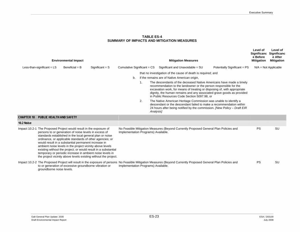
CHAPTER 10 PUBLIC HEALTH AND SAFETY
10.2 Noise
Impact 10.2-1 The Proposed Project would result in the exposure of persons to or generation of noise levels in excess of standards established in the local general plan or noise ordinance, or applicable standards of other agencies; or would result in a substantial permanent increase in ambient noise levels in the project vicinity above levels existing without the project; or would result in a substantial temporary or periodic increase in ambient noise levels in the project vicinity above levels existing without the project.
No Feasible Mitigation Measures (Beyond Currently Proposed General Plan Policies and Implementation Programs) Available.
PS SU
Impact 10.2-2 The Proposed Project will result in the exposure of persons to or generation of excessive groundborne vibration or groundborne noise levels.
No Feasible Mitigation Measures (Beyond Currently Proposed General Plan Policies and Implementation Programs) Available.
PS SU
Galt General Plan Update: 2030 ES-23 ESA / 203100 Draft Environmental Impact Report July 2008
City of Galt General Plan Update: 2030
TABLE ES-4 SUMMARY OF IMPACTS AND MITIGATION MEASURES
Environmental Impact Mitigation Measures
Level of Significanc
e Before Mitigation
Level of Significanc
e After Mitigation
Less-than-significant = LS Beneficial = B Significant = S Cumulative Significant = CS Significant and Unavoidable = SU Potentially Significant = PS N/A = Not Applicable
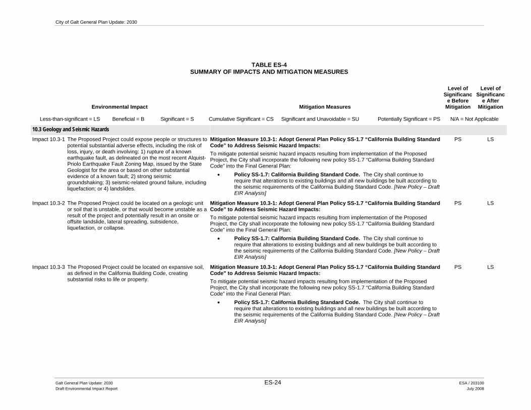
10.3 Geology and Seismic Hazards
Impact 10.3-1 The Proposed Project could expose people or structures to potential substantial adverse effects, including the risk of loss, injury, or death involving: 1) rupture of a known earthquake fault, as delineated on the most recent Alquist-Priolo Earthquake Fault Zoning Map, issued by the State Geologist for the area or based on other substantial evidence of a known fault; 2) strong seismic groundshaking; 3) seismic-related ground failure, including liquefaction; or 4) landslides.
Mitigation Measure 10.3-1: Adopt General Plan Policy SS-1.7 “California Building Standard Code” to Address Seismic Hazard Impacts: To mitigate potential seismic hazard impacts resulting from implementation of the Proposed Project, the City shall incorporate the following new policy SS-1.7 “California Building Standard Code” into the Final General Plan:
• Policy SS-1.7: California Building Standard Code. The City shall continue to require that alterations to existing buildings and all new buildings be built according to the seismic requirements of the California Building Standard Code. [New Policy – Draft EIR Analysis]
PS LS
Impact 10.3-2 The Proposed Project could be located on a geologic unit or soil that is unstable, or that would become unstable as a result of the project and potentially result in an onsite or offsite landslide, lateral spreading, subsidence, liquefaction, or collapse.
Mitigation Measure 10.3-1: Adopt General Plan Policy SS-1.7 “California Building Standard Code” to Address Seismic Hazard Impacts: To mitigate potential seismic hazard impacts resulting from implementation of the Proposed Project, the City shall incorporate the following new policy SS-1.7 “California Building Standard Code” into the Final General Plan:
• Policy SS-1.7: California Building Standard Code. The City shall continue to require that alterations to existing buildings and all new buildings be built according to the seismic requirements of the California Building Standard Code. [New Policy – Draft EIR Analysis]
PS LS
Impact 10.3-3 The Proposed Project could be located on expansive soil, as defined in the California Building Code, creating substantial risks to life or property.
Mitigation Measure 10.3-1: Adopt General Plan Policy SS-1.7 “California Building Standard Code” to Address Seismic Hazard Impacts: To mitigate potential seismic hazard impacts resulting from implementation of the Proposed Project, the City shall incorporate the following new policy SS-1.7 “California Building Standard Code” into the Final General Plan:
• Policy SS-1.7: California Building Standard Code. The City shall continue to require that alterations to existing buildings and all new buildings be built according to the seismic requirements of the California Building Standard Code. [New Policy – Draft EIR Analysis]
PS LS
Galt General Plan Update: 2030 ES-24 ESA / 203100 Draft Environmental Impact Report July 2008

Executive Summary
TABLE ES-4 SUMMARY OF IMPACTS AND MITIGATION MEASURES
Environmental Impact Mitigation Measures
Level of Significanc
e Before Mitigation
Level of Significanc
e After Mitigation
Less-than-significant = LS Beneficial = B Significant = S Cumulative Significant = CS Significant and Unavoidable = SU Potentially Significant = PS N/A = Not Applicable
10.5 Wildland Fires
Impact 10.5-1 The Proposed Project could expose people or structures to a significant risk of loss, injury, or death involving wildland fires, including where wildlands are adjacent to urbanized areas or where residences are intermixed with wildlands.
Mitigation Measure 6.9-1: Adopt Revised General Plan Policy PFS-7.4 “Fire Protection and Emergency Medical Facilities” to address fire protection and emergency medical facility impacts: To mitigate potential fire protection and emergency medical response impacts resulting from implementation of the Proposed Project, the City shall incorporate the following revised policy PFS-7.4 “Fire Protection and Emergency Medical Facilities” into the Final General Plan:
• PFS-7.4: Fire Protection and Emergency Medical Facilities: The City shall cooperate with CCSD in the development of a new master plan for fire and emergency medical facilities and services, which includes the City of Galt, and shall periodically review the city fire protection impact fee, based upon an updated Government Code 66000 (AB 1600) study to be completed by CCSD. In conjunction with the district, the City will review the City’s public safety special tax applicable to new development. [Revised Policy – Draft EIR Analysis]
PS SU
10.6 Human-Made Hazards
Impact 10.6-1 The Proposed Project could create a significant hazard to the public or the environment through the routine transport, use, or disposal of hazardous materials or create a significant hazard to the public or the environment through reasonable foreseeable upset and accident conditions involving the release of hazardous materials to the environment.
Mitigation Measure 10.6-1a: Adopt Revised General Plan Policy SS-1.2 “Inter-Agency Coordination” to Address Public Safety Impacts: To mitigate potential public safety impacts resulting from implementation of the Proposed Project, the City shall incorporate the following revised policy SS-1.2 “Inter-Agency Coordination” into the Final General Plan:
• Policy SS-1.2: Inter-Agency Coordination. The City shall cooperate with the Cosumnes Community Services District Fire Department, the Red Cross, the County and State Offices of Emergency Services, Sacramento County Environmental Management Department, and the Federal Office of Emergency Preparedness in their efforts to do emergency planning, evacuation planning, and public disaster education. [Revised Policy – Draft EIR Analysis]
Mitigation Measure 10.6-1b: Adopt Revised General Plan Policy SS-5.4 “Rancho Seco Nuclear Generating Station” to Address Public Safety Impacts: To mitigate potential public safety impacts resulting from implementation of the Proposed Project, the City shall incorporate the following revised policy SS-5.4 “Rancho Seco Nuclear Generating Station” into the Final General Plan:
PS LS
Galt General Plan Update: 2030 ES-25 ESA / 203100 Draft Environmental Impact Report July 2008

City of Galt General Plan Update: 2030
TABLE ES-4 SUMMARY OF IMPACTS AND MITIGATION MEASURES
Environmental Impact Mitigation Measures
Level of Significanc
e Before Mitigation
Level of Significanc
e After Mitigation
Less-than-significant = LS Beneficial = B Significant = S Cumulative Significant = CS Significant and Unavoidable = SU Potentially Significant = PS N/A = Not Applicable
• Policy SS-5.4: Rancho Seco Nuclear Generating Station. The City should coordinate efforts with Sacramento County to plan emergency evacuation routes in the event that the Rancho Seco Nuclear Generation Station becomes an active nuclear facility in the future and to be prepared for accidental release of radioactive wastes that are currently stored at the facility. [Revised Policy – Draft EIR Analysis]
Mitigation Measure 10.6-1c: Adopt General Plan Policy SS-5.5 “Hazardous Materials Management” to Address Public Safety Impacts: To mitigate potential public safety impacts resulting from implementation of the Proposed Project, the City shall incorporate the following new policy SS-5.5 “Hazardous Materials Management” into the Final General Plan:
• Policy SS-5.5: Hazardous Materials Management. The City shall continue to cooperate with the County and the CCSD Fire Department in the identification of hazardous material users (both large and small scale) and in the development of an inspection process and hazardous materials management plan. [New Policy – Draft EIR Analysis]
Mitigation Measure 10.6-1d: Adopt General Plan Policy SS-5.6 “Hazardous Materials Inventory” to Address Public Safety Impacts: To mitigate potential public safety impacts resulting from implementation of the Proposed Project, the City shall incorporate the following new policy SS-5.6 “Hazardous Materials Inventory” into the Final General Plan:
• Policy SS-5.6: Hazardous Materials Inventory. The City shall require, as appropriate and as a component of the environmental review process or business license review/building permit review a hazardous materials inventory for project sites, including an assessment of materials and operations for any development applications. [New Policy – Draft EIR Analysis]
Mitigation Measure 10.6-1e: Adopt General Plan Policy SS-5.7 “Household Hazardous Waste Collection” to Address Public Safety Impacts: To mitigate potential public safety impacts resulting from implementation of the Proposed Project, the City shall incorporate the following new policy SS-5.7 “Household Hazardous Waste Collection” into the Final General Plan:
• Policy SS-5.7: Household Hazardous Waste Collection. The City should continue to provide opportunities for residents to conveniently dispose of household hazardous
Galt General Plan Update: 2030 ES-26 ESA / 203100 Draft Environmental Impact Report July 2008

Executive Summary
TABLE ES-4 SUMMARY OF IMPACTS AND MITIGATION MEASURES
Environmental Impact Mitigation Measures
Level of Significanc
e Before Mitigation
Level of Significanc
e After Mitigation
Less-than-significant = LS Beneficial = B Significant = S Cumulative Significant = CS Significant and Unavoidable = SU Potentially Significant = PS N/A = Not Applicable
waste. [New Policy – Draft EIR Analysis] Mitigation Measure 10.6-1f: Adopt General Plan Policy SS-5.8 “Increase Public Awareness” to Address Public Safety Impacts: To mitigate potential public safety impacts resulting from implementation of the Proposed Project, the City shall incorporate the following new policy SS-5.8 “Increase Public Awareness” into the Final General Plan:
• Policy SS-5.8: Increase Public Awareness. The City shall continue to work with the appropriate waste disposal service provider to educate the public as to the types of household hazardous wastes and the proper methods of disposal. [New Policy – Draft EIR Analysis]
Mitigation Measure 10.6-1g: Adopt General Plan Policy SS-5.9 “Hazardous Materials Studies” to Address Public Safety Impacts: To mitigate potential public safety impacts resulting from implementation of the Proposed Project, the City shall incorporate the following new policy SS-5.9 “Hazardous Materials Studies” into the Final General Plan:
• Policy SS-5.9: Hazardous Materials Studies. The City shall ensure that the proponents of applicable new development projects address hazardous materials concerns through the preparation of Phase I or Phase II hazardous materials studies for each identified site as part of the design phase for each project. Recommendations required to satisfy federal or State cleanup standards outlined in the studies will be implemented as part of the construction phase for each project. [New Policy – Draft EIR Analysis]
Mitigation Measure 10.6-1h: Adopt General Plan Implementation Program SS-D to Address Public Safety Impacts: To mitigate potential public safety impacts resulting from implementation of the Proposed Project, the City shall incorporate the following new implementation program into the Final General Plan:
• Implementation Program: SS-D: Use, Production, or Transport of Hazardous Materials and Wastes. The City should develop siting and enforcement criteria for businesses that use, produce, or transport hazardous materials and wastes. [New Policy – Draft EIR Analysis]
•
Galt General Plan Update: 2030 ES-27 ESA / 203100 Draft Environmental Impact Report July 2008

City of Galt General Plan Update: 2030
TABLE ES-4 SUMMARY OF IMPACTS AND MITIGATION MEASURES
Environmental Impact Mitigation Measures
Level of Significanc
e Before Mitigation
Level of Significanc
e After Mitigation
Less-than-significant = LS Beneficial = B Significant = S Cumulative Significant = CS Significant and Unavoidable = SU Potentially Significant = PS N/A = Not Applicable
Impact 10.6-2 The Proposed Project could emit hazardous emissions or handle hazardous or acutely hazardous materials, substances, or waste within one-quarter mile of an existing or proposed school.
Mitigation Measure 10.6-1a: Adopt Revised General Plan Policy SS-1.2 “Inter-Agency Coordination” to Address Public Safety Impacts: To mitigate potential public safety impacts resulting from implementation of the Proposed Project, the City shall incorporate the following revised policy SS-1.2 “Inter-Agency Coordination” into the Final General Plan:
• Policy SS-1.2: Inter-Agency Coordination. The City shall cooperate with the Cosumnes Community Services District Fire Department, the Red Cross, the County and State Offices of Emergency Services, Sacramento County Environmental Management Department, and the Federal Office of Emergency Preparedness in their efforts to do emergency planning, evacuation planning, and public disaster education. [Revised Policy – Draft EIR Analysis]
Mitigation Measure 10.6-1b: Adopt Revised General Plan Policy SS-5.4 “Rancho Seco Nuclear Generating Station” to Address Public Safety Impacts: To mitigate potential public safety impacts resulting from implementation of the Proposed Project, the City shall incorporate the following revised policy SS-5.4 “Rancho Seco Nuclear Generating Station” into the Final General Plan:
• Policy SS-5.4: Rancho Seco Nuclear Generating Station. The City should coordinate efforts with Sacramento County to plan emergency evacuation routes in the event that the Rancho Seco Nuclear Generation Station becomes an active nuclear facility in the future and to be prepared for accidental release of radioactive wastes that are currently stored at the facility. [Revised Policy – Draft EIR Analysis]
Mitigation Measure 10.6-1c: Adopt General Plan Policy SS-5.5 “Hazardous Materials Management” to Address Public Safety Impacts: To mitigate potential public safety impacts resulting from implementation of the Proposed Project, the City shall incorporate the following new policy SS-5.5 “Hazardous Materials Management” into the Final General Plan:
• Policy SS-5.5: Hazardous Materials Management. The City shall continue to cooperate with the County and the CCSD Fire Department in the identification of hazardous material users (both large and small scale) and in the development of an inspection process and hazardous materials management plan. [New Policy – Draft EIR Analysis]
Mitigation Measure 10.6-1d: Adopt General Plan Policy SS-5.6 “Hazardous Materials
PS LS
Galt General Plan Update: 2030 ES-28 ESA / 203100 Draft Environmental Impact Report July 2008

Executive Summary
TABLE ES-4 SUMMARY OF IMPACTS AND MITIGATION MEASURES
Environmental Impact Mitigation Measures
Level of Significanc
e Before Mitigation
Level of Significanc
e After Mitigation
Less-than-significant = LS Beneficial = B Significant = S Cumulative Significant = CS Significant and Unavoidable = SU Potentially Significant = PS N/A = Not Applicable
Inventory” to Address Public Safety Impacts: To mitigate potential public safety impacts resulting from implementation of the Proposed Project, the City shall incorporate the following new policy SS-5.6 “Hazardous Materials Inventory” into the Final General Plan:
• Policy SS-5.6: Hazardous Materials Inventory. The City shall require, as appropriate and as a component of the environmental review process or business license review/building permit review a hazardous materials inventory for project sites, including an assessment of materials and operations for any development applications. [New Policy – Draft EIR Analysis]
Mitigation Measure 10.6-1e: Adopt General Plan Policy SS-5.7 “Household Hazardous Waste Collection” to Address Public Safety Impacts: To mitigate potential public safety impacts resulting from implementation of the Proposed Project, the City shall incorporate the following new policy SS-5.7 “Household Hazardous Waste Collection” into the Final General Plan:
• Policy SS-5.7: Household Hazardous Waste Collection. The City should continue to provide opportunities for residents to conveniently dispose of household hazardous waste. [New Policy – Draft EIR Analysis]
Mitigation Measure 10.6-1f: Adopt General Plan Policy SS-5.8 “Increase Public Awareness” to Address Public Safety Impacts: To mitigate potential public safety impacts resulting from implementation of the Proposed Project, the City shall incorporate the following new policy SS-5.8 “Increase Public Awareness” into the Final General Plan:
• Policy SS-5.8: Increase Public Awareness. The City shall continue to work with the appropriate waste disposal service provider to educate the public as to the types of household hazardous wastes and the proper methods of disposal. [New Policy – Draft EIR Analysis]
Mitigation Measure 10.6-1g: Adopt General Plan Policy SS-5.9 “Hazardous Materials Studies” to Address Public Safety Impacts: To mitigate potential public safety impacts resulting from implementation of the Proposed Project, the City shall incorporate the following new policy SS-5.9 “Hazardous Materials Studies” into the Final General Plan:
Galt General Plan Update: 2030 ES-29 ESA / 203100 Draft Environmental Impact Report July 2008

City of Galt General Plan Update: 2030
TABLE ES-4 SUMMARY OF IMPACTS AND MITIGATION MEASURES
Environmental Impact Mitigation Measures
Level of Significanc
e Before Mitigation
Level of Significanc
e After Mitigation
Less-than-significant = LS Beneficial = B Significant = S Cumulative Significant = CS Significant and Unavoidable = SU Potentially Significant = PS N/A = Not Applicable
• Policy SS-5.9: Hazardous Materials Studies. The City shall ensure that the proponents of applicable new development projects address hazardous materials concerns through the preparation of Phase I or Phase II hazardous materials studies for each identified site as part of the design phase for each project. Recommendations required to satisfy federal or State cleanup standards outlined in the studies will be implemented as part of the construction phase for each project. [New Policy – Draft EIR Analysis]
Mitigation Measure 10.6-1h: Adopt General Plan Implementation Program SS-D to Address Public Safety Impacts: To mitigate potential public safety impacts resulting from implementation of the Proposed Project, the City shall incorporate the following new implementation program into the Final General Plan:
• Implementation Program: SS-D: Use, Production, or Transport of Hazardous Materials and Wastes. The City should develop siting and enforcement criteria for businesses that use, produce, or transport hazardous materials and wastes. [New Policy – Draft EIR Analysis]
Impact 10.6-3 Development under the Proposed Project could be located on a site which is included on a list of hazardous materials sites compiled pursuant to government code section 65962.5 and, as a result, could create a significant hazard to the public or the environment.
Mitigation Measure 10.6-1a: Adopt Revised General Plan Policy SS-1.2 “Inter-Agency Coordination” to Address Public Safety Impacts: To mitigate potential public safety impacts resulting from implementation of the Proposed Project, the City shall incorporate the following revised policy SS-1.2 “Inter-Agency Coordination” into the Final General Plan:
• Policy SS-1.2: Inter-Agency Coordination. The City shall cooperate with the Cosumnes Community Services District Fire Department, the Red Cross, the County and State Offices of Emergency Services, Sacramento County Environmental Management Department, and the Federal Office of Emergency Preparedness in their efforts to do emergency planning, evacuation planning, and public disaster education. [Revised Policy – Draft EIR Analysis]
Mitigation Measure 10.6-1b: Adopt Revised General Plan Policy SS-5.4 “Rancho Seco Nuclear Generating Station” to Address Public Safety Impacts: To mitigate potential public safety impacts resulting from implementation of the Proposed Project, the City shall incorporate the following revised policy SS-5.4 “Rancho Seco Nuclear Generating Station” into the Final General Plan:
• Policy SS-5.4: Rancho Seco Nuclear Generating Station. The City should
PS LS
Galt General Plan Update: 2030 ES-30 ESA / 203100 Draft Environmental Impact Report July 2008

Executive Summary
TABLE ES-4 SUMMARY OF IMPACTS AND MITIGATION MEASURES
Environmental Impact Mitigation Measures
Level of Significanc
e Before Mitigation
Level of Significanc
e After Mitigation
Less-than-significant = LS Beneficial = B Significant = S Cumulative Significant = CS Significant and Unavoidable = SU Potentially Significant = PS N/A = Not Applicable
coordinate efforts with Sacramento County to plan emergency evacuation routes in the event that the Rancho Seco Nuclear Generation Station becomes an active nuclear facility in the future and to be prepared for accidental release of radioactive wastes that are currently stored at the facility. [Revised Policy – Draft EIR Analysis]
Mitigation Measure 10.6-1c: Adopt General Plan Policy SS-5.5 “Hazardous Materials Management” to Address Public Safety Impacts: To mitigate potential public safety impacts resulting from implementation of the Proposed Project, the City shall incorporate the following new policy SS-5.5 “Hazardous Materials Management” into the Final General Plan:
• Policy SS-5.5: Hazardous Materials Management. The City shall continue to cooperate with the County and the CCSD Fire Department in the identification of hazardous material users (both large and small scale) and in the development of an inspection process and hazardous materials management plan. [New Policy – Draft EIR Analysis]
Mitigation Measure 10.6-1d: Adopt General Plan Policy SS-5.6 “Hazardous Materials Inventory” to Address Public Safety Impacts: To mitigate potential public safety impacts resulting from implementation of the Proposed Project, the City shall incorporate the following new policy SS-5.6 “Hazardous Materials Inventory” into the Final General Plan:
• Policy SS-5.6: Hazardous Materials Inventory. The City shall require, as appropriate and as a component of the environmental review process or business license review/building permit review a hazardous materials inventory for project sites, including an assessment of materials and operations for any development applications. [New Policy – Draft EIR Analysis]
Mitigation Measure 10.6-1e: Adopt General Plan Policy SS-5.7 “Household Hazardous Waste Collection” to Address Public Safety Impacts: To mitigate potential public safety impacts resulting from implementation of the Proposed Project, the City shall incorporate the following new policy SS-5.7 “Household Hazardous Waste Collection” into the Final General Plan:
• Policy SS-5.7: Household Hazardous Waste Collection. The City should continue to provide opportunities for residents to conveniently dispose of household hazardous waste. [New Policy – Draft EIR Analysis]
Galt General Plan Update: 2030 ES-31 ESA / 203100 Draft Environmental Impact Report July 2008
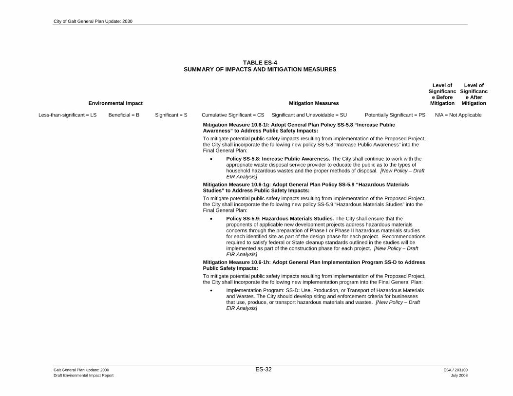
City of Galt General Plan Update: 2030
TABLE ES-4 SUMMARY OF IMPACTS AND MITIGATION MEASURES
Environmental Impact Mitigation Measures
Level of Significanc
e Before Mitigation
Level of Significanc
e After Mitigation
Less-than-significant = LS Beneficial = B Significant = S Cumulative Significant = CS Significant and Unavoidable = SU Potentially Significant = PS N/A = Not Applicable
Mitigation Measure 10.6-1f: Adopt General Plan Policy SS-5.8 “Increase Public Awareness” to Address Public Safety Impacts: To mitigate potential public safety impacts resulting from implementation of the Proposed Project, the City shall incorporate the following new policy SS-5.8 “Increase Public Awareness” into the Final General Plan:
• Policy SS-5.8: Increase Public Awareness. The City shall continue to work with the appropriate waste disposal service provider to educate the public as to the types of household hazardous wastes and the proper methods of disposal. [New Policy – Draft EIR Analysis]
Mitigation Measure 10.6-1g: Adopt General Plan Policy SS-5.9 “Hazardous Materials Studies” to Address Public Safety Impacts: To mitigate potential public safety impacts resulting from implementation of the Proposed Project, the City shall incorporate the following new policy SS-5.9 “Hazardous Materials Studies” into the Final General Plan:
• Policy SS-5.9: Hazardous Materials Studies. The City shall ensure that the proponents of applicable new development projects address hazardous materials concerns through the preparation of Phase I or Phase II hazardous materials studies for each identified site as part of the design phase for each project. Recommendations required to satisfy federal or State cleanup standards outlined in the studies will be implemented as part of the construction phase for each project. [New Policy – Draft EIR Analysis]
Mitigation Measure 10.6-1h: Adopt General Plan Implementation Program SS-D to Address Public Safety Impacts: To mitigate potential public safety impacts resulting from implementation of the Proposed Project, the City shall incorporate the following new implementation program into the Final General Plan:
• Implementation Program: SS-D: Use, Production, or Transport of Hazardous Materials and Wastes. The City should develop siting and enforcement criteria for businesses that use, produce, or transport hazardous materials and wastes. [New Policy – Draft EIR Analysis]
Galt General Plan Update: 2030 ES-32 ESA / 203100 Draft Environmental Impact Report July 2008

Executive Summary
TABLE ES-4 SUMMARY OF IMPACTS AND MITIGATION MEASURES
Environmental Impact Mitigation Measures
Level of Significanc
e Before Mitigation
Level of Significanc
e After Mitigation
Less-than-significant = LS Beneficial = B Significant = S Cumulative Significant = CS Significant and Unavoidable = SU Potentially Significant = PS N/A = Not Applicable
Impact 10.6-4 The Proposed Project could result in development located within an airport land use plan area or/and could result in a safety hazard for people residing or working in the Study Area.
Mitigation Measure 4.2-3: Adopt General Plan Policy LU-1.15 “Caltrans Handbook Reference” to Address Airport Land Use Compatibility Impacts. To mitigate airport land use compatibility impacts resulting from implementation of the Proposed Project, the City shall incorporate the following new Policy LU-1.15 “Caltrans Handbook Reference” into the Final General Plan.
• LU-1.15 Caltrans Handbook Reference: When reviewing proposed projects within a one mile radius of an airport (Mustang Airport, if approved for public use), the City shall refer to the Caltrans Airport Land Use Planning Handbook (2002) in order to identify any potential safety compatibility concerns between the airport and the proposed land use. [New Policy – Draft EIR Analysis]
PS LS
Impact 10.6-5 The Proposed Project could impair implementation of or physically interfere with an adopted emergency response plan or emergency evacuation plan.
No Feasible Mitigation Measures (Beyond Currently Proposed General Plan Policies and Implementation Programs) Available.
PS SU
10.7 Air Quality and Global Climate Change
Impact 10.7-1 The Proposed Project would result in a cumulatively considerable net increase of criteria pollutants. Future growth in accordance with the Proposed Project would exceed the daily SMAQMD thresholds for NOx and ROG.
Mitigation Measure 10.7-1a: Adopt General Plan Policy COS-5.11 “Construction Mitigation Measures” to Address Air Quality Impacts. To mitigate air quality impacts resulting from implementation of the Proposed Project, the City shall incorporate the following new Policy COS-5.11 “Construction Mitigation Measures”, into the Final General Plan:
• Policy COS-5.11: Construction Mitigation Measures. The City shall require developers to implement dust suppression measures as well as the applicable standard construction mitigation measures associated with exhaust NOx and PM-10 reduction in accordance with the current SMAQMD CEQA Guide to Air Quality Assessment. [New Policy – Draft EIR Analysis]
Mitigation Measure 10.7-1b: Adopt General Plan Policy COS-5.12 “Construction Mitigation Fees” to Address Air Quality Impacts. To mitigate air quality impacts resulting from implementation of the Proposed Project, the City shall incorporate the following new Policy COS-5.12 “Construction Mitigation Fees” into the Final General Plan:
• Policy COS-5.12: Construction Mitigation Fees. The City shall require developers to comply with the current SMAQMD construction mitigation fee offset program. [New Policy – Draft EIR Analysis]
PS SU
Galt General Plan Update: 2030 ES-33 ESA / 203100 Draft Environmental Impact Report July 2008

City of Galt General Plan Update: 2030
TABLE ES-4 SUMMARY OF IMPACTS AND MITIGATION MEASURES
Environmental Impact Mitigation Measures
Level of Significanc
e Before Mitigation
Level of Significanc
e After Mitigation
Less-than-significant = LS Beneficial = B Significant = S Cumulative Significant = CS Significant and Unavoidable = SU Potentially Significant = PS N/A = Not Applicable
Mitigation Measure 10.7-1c: Adopt General Plan Policy COS-5.13 “Air Pollution Control Technology” to Address Air Quality Impacts. To mitigate air quality impacts resulting from implementation of the Proposed Project, the City shall incorporate the following new Policy COS-5.13 “Air Pollution Control Technology” into the Final General Plan:
• Policy COS-5.13: Air Pollution Control Technology. The City shall follow the rules and regulations as adopted by the SMAQMD to maintain healthful air quality and high visibility standards. These measures shall be applied to new development approvals and permit modifications as appropriate. [New Policy – Draft EIR Analysis]
Impact 10.7-2 The Proposed Project could conflict with or obstruct implementation of an applicable air quality plan.
Mitigation Measure 10.7-1a: Adopt General Plan Policy COS-5.11 “Construction Mitigation Measures” to Address Air Quality Impacts. To mitigate air quality impacts resulting from implementation of the Proposed Project, the City shall incorporate the following new Policy COS-5.11 “Construction Mitigation Measures”, into the Final General Plan:
• Policy COS-5.11: Construction Mitigation Measures. The City shall require developers to implement dust suppression measures as well as the applicable standard construction mitigation measures associated with exhaust NOx and PM-10 reduction in accordance with the current SMAQMD CEQA Guide to Air Quality Assessment. [New Policy – Draft EIR Analysis]
Mitigation Measure 10.7-1b: Adopt General Plan Policy COS-5.12 “Construction Mitigation Fees” to Address Air Quality Impacts. To mitigate air quality impacts resulting from implementation of the Proposed Project, the City shall incorporate the following new Policy COS-5.12 “Construction Mitigation Fees” into the Final General Plan:
• Policy COS-5.12: Construction Mitigation Fees. The City shall require developers to comply with the current SMAQMD construction mitigation fee offset program. [New Policy – Draft EIR Analysis]
Mitigation Measure 10.7-1c: Adopt General Plan Policy COS-5.13 “Air Pollution Control Technology” to Address Air Quality Impacts. To mitigate air quality impacts resulting from implementation of the Proposed Project, the City shall incorporate the following new Policy COS-5.13 “Air Pollution Control Technology” into the Final General Plan:
PS LS
Galt General Plan Update: 2030 ES-34 ESA / 203100 Draft Environmental Impact Report July 2008

Executive Summary
TABLE ES-4 SUMMARY OF IMPACTS AND MITIGATION MEASURES
Environmental Impact Mitigation Measures
Level of Significanc
e Before Mitigation
Level of Significanc
e After Mitigation
Less-than-significant = LS Beneficial = B Significant = S Cumulative Significant = CS Significant and Unavoidable = SU Potentially Significant = PS N/A = Not Applicable
• Policy COS-5.13: Air Pollution Control Technology. The City shall follow the rules and regulations as adopted by the SMAQMD to maintain healthful air quality and high visibility standards. These measures shall be applied to new development approvals and permit modifications as appropriate. [New Policy – Draft EIR Analysis]
Impact 10.7-3 Buildout of the Proposed Project would generate emissions above the daily SMAQMD significance thresholds for NOx and ROG, primarily due to traffic and area source emissions.
Mitigation Measure 10.7-1c: Adopt General Plan Policy COS-5.13 “Air Pollution Control Technology” to Address Air Quality Impacts. To mitigate air quality impacts resulting from implementation of the Proposed Project, the City shall incorporate the following new Policy COS-5.13 “Air Pollution Control Technology” into the Final General Plan:
• Policy COS-5.13: Air Pollution Control Technology. The City shall follow the rules and regulations as adopted by the SMAQMD to maintain healthful air quality and high visibility standards. These measures shall be applied to new development approvals and permit modifications as appropriate. [New Policy – Draft EIR Analysis]
PS SU
Impact 10.7-4 The Proposed Project would expose sensitive receptors to substantial pollutant concentrations.
Mitigation Measure 10.7-1a: Adopt General Plan Policy COS-5.11 “Construction Mitigation Measures” to Address Air Quality Impacts. To mitigate air quality impacts resulting from implementation of the Proposed Project, the City shall incorporate the following new Policy COS-5.11 “Construction Mitigation Measures”, into the Final General Plan:
• Policy COS-5.11: Construction Mitigation Measures. The City shall require developers to implement dust suppression measures as well as the applicable standard construction mitigation measures associated with exhaust NOx and PM-10 reduction in accordance with the current SMAQMD CEQA Guide to Air Quality Assessment. [New Policy – Draft EIR Analysis]
Mitigation Measure 10.7-1b: Adopt General Plan Policy COS-5.12 “Construction Mitigation Fees” to Address Air Quality Impacts. To mitigate air quality impacts resulting from implementation of the Proposed Project, the City shall incorporate the following new Policy COS-5.12 “Construction Mitigation Fees” into the Final General Plan:
• Policy COS-5.12: Construction Mitigation Fees. The City shall require developers to comply with the current SMAQMD construction mitigation fee offset program. [New Policy – Draft EIR Analysis]
Mitigation Measure 10.7-1c: Adopt General Plan Policy COS-5.13 “Air Pollution Control
PS SU
Galt General Plan Update: 2030 ES-35 ESA / 203100 Draft Environmental Impact Report July 2008

City of Galt General Plan Update: 2030
TABLE ES-4 SUMMARY OF IMPACTS AND MITIGATION MEASURES
Environmental Impact Mitigation Measures
Level of Significanc
e Before Mitigation
Level of Significanc
e After Mitigation
Less-than-significant = LS Beneficial = B Significant = S Cumulative Significant = CS Significant and Unavoidable = SU Potentially Significant = PS N/A = Not Applicable
Technology” to Address Air Quality Impacts. To mitigate air quality impacts resulting from implementation of the Proposed Project, the City shall incorporate the following new Policy COS-5.13 “Air Pollution Control Technology” into the Final General Plan:
• Policy COS-5.13: Air Pollution Control Technology. The City shall follow the rules and regulations as adopted by the SMAQMD to maintain healthful air quality and high visibility standards. These measures shall be applied to new development approvals and permit modifications as appropriate. [New Policy – Draft EIR Analysis]
Impact 10.7-5 The Proposed Project could create objectionable odors affecting a substantial number of people.
No Mitigation Required. LS N/A
Impact 10.7-6 The Proposed Project would potentially conflict with implementation of state goals for reducing greenhouse gas emissions and thereby have a negative effect on Global Climate Change.
Mitigation Measure 10.7-6: Adopt Revised General Plan Policy COS-7.1 “Greenhouse Gas Emission Reduction” to Address Climate Change Impacts: To mitigate potential climate change impacts resulting from implementation of the Proposed Project, the City shall incorporate the following revised policy COS-7.1 “Greenhouse Gas Emission Reduction” into the Final General Plan:
• Policy COS-7.1: Greenhouse Gas Emission Reduction. The City should reduce greenhouse gas emissions from City operations as well as from private development in compliance with the California Global Warming Act of 2006 and any applicable State regulations. To accomplish this, the City will coordinate with the SMAQMD and the California Air Resources Board in developing a Greenhouse Gas Emissions Reduction Plan (Plan) that identifies greenhouse gas emissions within the City as well as ways to reduce those emissions. The plan will parallel the requirements adopted by the California Air Resources Board specific to this issue. Specifically, the City will work with the SMAQMD to include the following key items in the Plan:
Inventory all known, or reasonably discoverable, sources of greenhouse gases in the City,
Inventory the greenhouse gas emissions level in 1990, the current level, and that projected for the year 2030, and
Set a target for the reduction of emissions attributable to the City’s discretionary land use decisions and its own internal government operations. [Revised Policy – Draft EIR Analysis]
PS SU
Galt General Plan Update: 2030 ES-36 ESA / 203100 Draft Environmental Impact Report July 2008

Chapter 1 Introduction and Project Description


CHAPTER 1.0 ,QWURGXFWLRQ�DQG�3URMHFW�'HVFULSWLRQ�
1.1 Purpose and Use of the EIR The California Environmental Quality Act (CEQA) requires that all state and local government agencies consider the environmental consequences of programs and projects over which they have discretionary authority before taking action on them. This chapter outlines the overall approach to preparation of the environmental impact report (EIR) on the proposed Galt 2030 General Plan Update (General Plan), which includes the Preferred Land Use Alternative and the 2030 Circulation Diagram. The City of Galt (City) is the CEQA lead agency for the Proposed Project and the Galt City Council, as the lead agency’s decision-making body, will consider the information presented in this EIR before taking discretionary action on the Proposed Project.
This EIR has two primary purposes:
• The EIR will assist the City in complying with CEQA requirements for the analysis of environmental impacts by including a complete and comprehensive evaluation of the physical impacts of the project and its alternatives.
• The EIR will inform interested stakeholders (including local residents) and members of the City Council and Planning Commission of the environmental impacts prior to the City Planning Commission making its recommendations and City Council taking action on the project.
Additionally, the EIR is intended to identify ways to minimize significant effects of the project and describes reasonable alternatives to the project that would avoid or reduce the project’s significant effects (State CEQA Guidelines Section 15121[a]).
The proposed General Plan includes a Policy Document (see Appendix C of this Draft EIR) which consists of policies and implementation programs to guide the future growth of the City within its defined planning area. This Draft EIR evaluates the potential impacts resulting from adoption and implementation of the Proposed Project. The information contained in this EIR will be used to inform local decision makers and the general public of the potentially significant environmental impacts associated with the project and to assist City officials in reviewing and considering adoption of the project or one of the alternatives. This EIR will also be used as a first-tier (or “program”) environmental document for subsequent environmental review of specific plans, infrastructure improvements, general plan and zoning amendments, impact fees, and other local development proposals.
Galt General Plan Update: 2030 1-1 ESA / 203100 Draft Environmental Impact Report July 2008

City of Galt General Plan Update: 2030
As readers will see in reviewing this document, various chapters refer readers not only to the above-described Policy Document, which contains numerous policies that function like mitigating measures governing future actions consistent with the General Plan, but also to another General Plan document: the “General Plan Existing Conditions Report”. This document, included as a separately bound volume in Appendix B of this Draft EIR, includes a great deal of information relevant to the environmental settings for various impact topics, in addition to providing relevant information to the EIR impact discussions. In order to avoid undue repetition and to avoid creating an overwhelming amount of paper for members of the public and decision-makers to sort through, this document frequently incorporates by reference or briefly summarizes information from both the Existing Conditions and Goals and Policies Reports. Because of the interrelatedness of the EIR and these two General Plan documents, readers should consider all three documents as contributing to the City’s CEQA compliance for the proposed General Plan. See Figure 1-1 for a graphical representation of the relationship of these three documents.
1.2 Type of EIR The CEQA Guidelines provide information on the types of environmental analysis that can be used to analyze a project, and one of these is a Program EIR. According to the CEQA Guidelines (Section 15168[a]), a local agency may prepare a program-level EIR to address a series of actions that can be characterized as one large project or series of actions that are linked geographically; logical parts of a chain of contemplated events; rules, regulations, or plans that govern the conduct of a continuing program; or individual activities carried out under the same authorizing statutory or regulatory authority and having generally similar environmental effects that can be mitigated in similar ways.
Under CEQA, a Program EIR can function as a first-tier environmental document that assesses and documents the broad environmental impacts of a program with the understanding that a more detailed site-specific review may be required to assess future projects implemented under the program. As described above, the analysis contained in this EIR may also be used as a reference for subsequent environmental review of specific plans, infrastructure improvements, zoning amendments, impact fees, and other development proposals within Galt.
With respect to the processing of such later, more site-specific projects, the City, in making optimal use of this EIR once it is certified, intends to avail itself of two separate, but complementary processes authorized by CEQA that are intended to streamline the review of projects consistent with approved general plans. These two processes are described below to put the public on notice of how, specifically, the City intends to use this EIR in the future.
Galt General Plan Update: 2030 1-2 ESA / 203100 Draft Environmental Impact Report July 2008

ES
TAB
LIS
H C
EQ
A B
AS
EL
INE
GO
AL
S,
PO
LIC
IES
, A
ND
IMP
LE
ME
NTA
TIO
N P
RO
GR
AM
S
IDE
NT
IFIC
AT
ION
OF
IM
PA
CT
S A
ND
MIT
IGA
TIO
N M
EA
SU
RE
S
City
of G
alt G
ener
al P
lan
Upd
ate
EIR
. 20
3100
Figu
re 1
-1A
n In
tegr
ated
App
roac
h
SO
UR
CE
: ES
A, 2
008

City of Galt General Plan Update: 2030
First of all, as noted above, this Program EIR also functions as a first-tier EIR. Thus, the scope of future site-specific approvals may be narrowed, pursuant to the rules for tiering set forth in CEQA Guidelines Section 15152. That section provides, for example, that, where a first-tier EIR has “adequately addressed” the subject of cumulative impacts, such impacts need not be revisited in second- and/or third-tier documents. According to subdivision (f)(3) of Section 15152, significant effects identified in a first-tier EIR are adequately addressed, for purposes of later approvals, if the lead agency determines that such effects either (a) “have been mitigated or avoided as a result of the prior [EIR] and findings adopted in connection with that prior [EIR]” or (b) “have been examined at a sufficient level of detail in the prior [EIR] to enable those effects to be mitigated or avoided by site-specific revisions, the imposition of conditions, or by other means in connection with the approval of the later project.”
Second, future environmental review can also be streamlined pursuant to Public Resources Code Section 21083.3 and CEQA Guidelines Section 15183. These provisions generally limit the scope of necessary environmental review for site-specific approvals following the preparation of an EIR for a general plan. For such site-specific approvals, CEQA generally applies only to impacts that are “peculiar to the parcel or to the project” and that have not been disclosed in the general plan EIR, except where “substantial new information” shows that previously identified impacts will be more significant than previously assumed. Notably, impacts are considered not to be “peculiar to the parcel or to the project” if they can be substantially mitigated pursuant to previously adopted “uniformly applied development policies or standards.”
1.3 EIR Process In preparing this EIR and considering approval of the project, the City has completed, or will complete, the activities identified in Table 1-1. Each of these activities is further described below.
TABLE 1-1 CITY OF GALT GENERAL PLAN UPDATE 2030 STATUS
Activity Status Notice of Preparation - Preparation and Circulation Completed: August to September 2007 Public Scoping Meeting Completed: September 12, 2007 Draft EIR – Preparation Completed: July 2008 Draft EIR – Circulation (45 Day Public Review/Comment) To be completed Final EIR – Preparation To be completed Final EIR – Circulation To be completed
1RWLFH�RI�3UHSDUDWLRQ��In accordance with Section 15082(a) of the CEQA Guidelines, the City prepared and circulated a Notice of Preparation (NOP) of a Draft EIR for the Proposed Project. An NOP is a brief notice sent by a Lead Agency (City of Galt) to notify interested agencies (including state and federal agencies as appropriate) that the Lead Agency plans to prepare an EIR for the project. The purpose of the NOP is to solicit guidance from those agencies as to the scope and content of the environmental information to be included in the EIR. The NOP for the Proposed Project was circulated for a 30-
Galt General Plan Update: 2030 1-4 ESA / 203100 Draft Environmental Impact Report July 2008
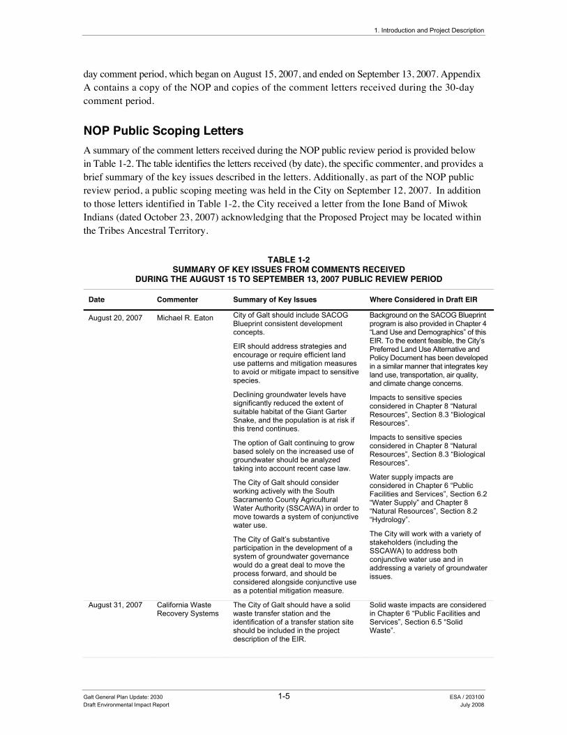
1. Introduction and Project Description
day comment period, which began on August 15, 2007, and ended on September 13, 2007. Appendix A contains a copy of the NOP and copies of the comment letters received during the 30-day comment period.
NOP Public Scoping Letters A summary of the comment letters received during the NOP public review period is provided below in Table 1-2. The table identifies the letters received (by date), the specific commenter, and provides a brief summary of the key issues described in the letters. Additionally, as part of the NOP public review period, a public scoping meeting was held in the City on September 12, 2007. In addition to those letters identified in Table 1-2, the City received a letter from the Ione Band of Miwok Indians (dated October 23, 2007) acknowledging that the Proposed Project may be located within the Tribes Ancestral Territory.
TABLE 1-2 SUMMARY OF KEY ISSUES FROM COMMENTS RECEIVED
DURING THE AUGUST 15 TO SEPTEMBER 13, 2007 PUBLIC REVIEW PERIOD
Date Commenter Summary of Key Issues Where Considered in Draft EIR
August 20, 2007 Michael R. Eaton City of Galt should include SACOG Blueprint consistent development concepts.
EIR should address strategies and encourage or require efficient land use patterns and mitigation measures to avoid or mitigate impact to sensitive species.
Declining groundwater levels have significantly reduced the extent of suitable habitat of the Giant Garter Snake, and the population is at risk if this trend continues.
The option of Galt continuing to grow based solely on the increased use of groundwater should be analyzed taking into account recent case law.
The City of Galt should consider working actively with the South Sacramento County Agricultural Water Authority (SSCAWA) in order to move towards a system of conjunctive water use.
The City of Galt’s substantive participation in the development of a system of groundwater governance would do a great deal to move the process forward, and should be considered alongside conjunctive use as a potential mitigation measure.
Background on the SACOG Blueprint program is also provided in Chapter 4 “Land Use and Demographics” of this EIR. To the extent feasible, the City’s Preferred Land Use Alternative and Policy Document has been developed in a similar manner that integrates key land use, transportation, air quality, and climate change concerns.
Impacts to sensitive species considered in Chapter 8 “Natural Resources”, Section 8.3 “Biological Resources”.
Impacts to sensitive species considered in Chapter 8 “Natural Resources”, Section 8.3 “Biological Resources”.
Water supply impacts are considered in Chapter 6 “Public Facilities and Services”, Section 6.2 “Water Supply” and Chapter 8 “Natural Resources”, Section 8.2 “Hydrology”.
The City will work with a variety of stakeholders (including the SSCAWA) to address both conjunctive water use and in addressing a variety of groundwater issues.
August 31, 2007 California Waste Recovery Systems
The City of Galt should have a solid waste transfer station and the identification of a transfer station site should be included in the project description of the EIR.
Solid waste impacts are considered in Chapter 6 “Public Facilities and Services”, Section 6.5 “Solid Waste”.
Galt General Plan Update: 2030 1-5 ESA / 203100 Draft Environmental Impact Report July 2008

City of Galt General Plan Update: 2030
TABLE 1-2 SUMMARY OF KEY ISSUES FROM COMMENTS RECEIVED
DURING THE AUGUST 15 TO SEPTEMBER 13, 2007 PUBLIC REVIEW PERIOD
Date Commenter Summary of Key Issues Where Considered in Draft EIR
September 6, 2007
Sacramento Metropolitan Air Quality Management District
Since current emissions are already significantly effecting global warming, it is critical that new projects be analyzed to determine whether they will worsen the warming process and whether there are mitigation measures available to reduce any impacts identified.
The fact that there are no developed thresholds of significance does not negate the CEQA mandate to analyze all potentially significant impacts, including emissions of greenhouse gases.
It is recommended that the EIR include a discussion of anticipated greenhouse gas emissions during both the construction and operation phases of the project.
The benefits of greenhouse gas mitigation measures should be noted in the EIR.
Global climate change and greenhouse gas emissions are considered in Chapter 10 “Public Health and Safety”, Section 10.7 “Air Quality and Global Climate Change”.
As appropriate, an analysis of greenhouse gas emissions (including an estimate of these gases) is provided in Chapter 10 “Public Health and Safety”, Section 10.7 “Air Quality and Global Climate Change”.
September 7, 2007
Sacramento Metropolitan Air Quality Management District
The EIR should include transportation related performance factors that measure consistency between the General Plan Land Use Alternative and the SACOG Blueprint Preferred Scenario.
The EIR should include a discussion of climate change as well as an inventory of greenhouse gas emissions associated with the General Plan growth projections.
Sustainable development and environmental justice policies from the 2003 General Plan Guidelines published by the Office of Planning and Research should be included in the General Plan.
Background on the SACOG Blueprint program is also provided in Chapter 4 “Land Use and Demographics” of this EIR. To the extent feasible, the City’s Preferred Land Use Alternative and Policy Document has been developed in a similar manner that integrates key land use, transportation, air quality, and climate change concerns.
Global climate change and greenhouse gas emissions are considered in Chapter 10 “Public Health and Safety”, Section 10.7 “Air Quality and Global Climate Change”.
General Plan policies addressing sustainable development and environmental justice issues are provided in both the Land Use and Conservation/Open Space Elements.
September 12, 2007
Cosumnes Community Services District Fire Department
Significant population growth in the City of Galt will require new and expanded fire stations, along with an increase in emergency personnel. The EIR should analyze the ability of the City, through implementation of the proposed General Plan and the recent redevelopment plan action to meet the response times and service levels currently established by the Cosumnes CSD. Policies and mitigation measures should be developed and adopted to ensure that the Galt community has adequate fire, medical and other
Impacts to a variety of service providers (including law enforcement, fire protection, and emergency response services) are identified in Chapter 6 “Public Facilities and Services”, Sections 6.8 “Law Enforcement” and 6.9 “Fire Protection”. .
Galt General Plan Update: 2030 1-6 ESA / 203100 Draft Environmental Impact Report July 2008
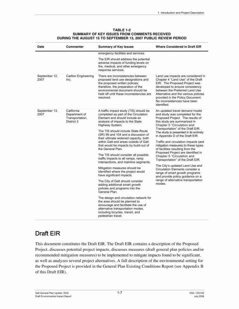
1. Introduction and Project Description
TABLE 1-2 SUMMARY OF KEY ISSUES FROM COMMENTS RECEIVED
DURING THE AUGUST 15 TO SEPTEMBER 13, 2007 PUBLIC REVIEW PERIOD
Date Commenter Summary of Key Issues Where Considered in Draft EIR
emergency facilities and services.
The EIR should address the potential adverse impacts of funding levels on fire, medical, and other emergency response services.
September 12, 2007
Carlton Engineering Inc.
There are inconsistencies between proposed land use designations and the proposed written policies; therefore, the preparation of the environmental document should be held off until these inconsistencies are resolved.
Land use impacts are considered in Chapter 4 “Land Use” of the Draft EIR. The Proposed Project was developed to ensure consistency between the Preferred Land Use Alternative and the various policies provided in the Policy Document. No inconsistencies have been identified.
September 13, 2007
California Department of Transportation, District 3
A traffic impact study (TIS) should be completed as part of the Circulation Element and should include an analysis of impacts to the State Highway System.
The TIS should include State Route (SR) 99 and 104 and a discussion of their ultimate widened capacity, both within Galt and areas outside of Galt that would be impacts by build-out of the General Plan.
The TIS should consider all possible traffic impacts to all ramps, ramp intersections, and mainline segments.
Mitigation measures should be identified where the project would have significant impacts.
The City of Galt should consider adding additional smart growth policies and programs into the General Plan.
The design and circulation network for the area should be planned to encourage and facilitate the use of alternative transportation modes, including bicycles, transit, and pedestrian travel.
An updated travel demand model and study was completed for the Proposed Project. The results of this study are summarized in Chapter 5 “Circulation and Transportation” of the Draft EIR. The study is presented in its entirety in Appendix D of the Draft EIR.
Traffic and circulation impacts (and mitigation measures) to these types of facilities resulting from the Proposed Project are identified in Chapter 5 “Circulation and Transportation” of the Draft EIR.
The City’s updated Land Use and Circulation Elements consider a range of smart growth programs and provide policy guidance on a range of alternative transportation modes.
'UDIW�(,5��This document constitutes the Draft EIR. The Draft EIR contains a description of the Proposed Project, discusses potential project impacts, discusses measures (draft general plan policies and/or recommended mitigation measures) to be implemented to mitigate impacts found to be significant, as well as analyzes several project alternatives. A full description of the environmental setting for the Proposed Project is provided in the General Plan Existing Conditions Report (see Appendix B of this Draft EIR).
Galt General Plan Update: 2030 1-7 ESA / 203100 Draft Environmental Impact Report July 2008

City of Galt General Plan Update: 2030
As required by CEQA, this Draft EIR focuses on significant or potentially significant environmental effects (CEQA Guidelines Section 15143). As discussed above, the NOP was prepared for the Proposed Project to identify the specific issues to be evaluated in the Draft EIR (see Appendix A). Comments received on the NOP were considered and helped to further refine the list of environmental issues to be evaluated in this EIR. Please see Section 1.4, Reader’s Guide to the EIR for additional information related to the scope and organization of the Draft EIR.
The impacts analyzed in this EIR, including those considered to be less than significant, are summarized in Table ES-3 of the Executive Summary.
3XEOLF�5HYLHZ�RI�WKH�'UDIW�(,5��This document will be circulated to numerous agencies, organizations, and interested groups and persons for comment during the 45-day public review period for the Draft EIR. A public notice will be posted on the General Plan website (<http://www.ci.galt.ca.us> click on the General Plan 2030 icon) and published in the Galt Herald. Additionally, a notice will be mailed (or emailed) to all persons who previously requested such notice and are listed on the Galt General Plan Update notification list. The Draft EIR and General Plan Update are also available for public review on the City’s General Plan website and at the following locations during the review period:
City of Galt City Clerk’s Office
380 Civic Drive Galt, CA 95632 (209) 366-7130
Marian O Lawrence Public Library 1000 Caroline Avenue
Galt, CA 95632
The Draft EIR and Galt General Plan Update, along with copies of documents referenced therein, are available at the Galt Planning Department located at 495 Industrial Drive, Galt, CA 95632.
Questions regarding the EIR can be directed to Sandra Kiriu at (209) 366-7230 or by email at [email protected]. Also, please note that written comments on the Draft EIR must be submitted to the Galt Planning Department (495 Industrial Drive, Galt, CA 95632), or by fax (209-744-1642), or email ([email protected]) within the 45-day public review period.
A public workshop with the Planning Commission to receive comments on the Draft EIR will also be held during the public review period. Public comment is encouraged during the 45-day public review period and at the public workshop on the Draft EIR. Additionally, the City will receive public input on the Final EIR at a public hearing by the City Council before the City Council makes a final decision on the Proposed Project. The public hearing(s) will be held on various dates to be separately noticed.
Galt General Plan Update: 2030 1-8 ESA / 203100 Draft Environmental Impact Report July 2008

1. Introduction and Project Description
)LQDO�(,5�DQG�(,5�&HUWLILFDWLRQ�Written and oral comments received in response to the Draft EIR will be addressed in a response to comments document, which, together with the Draft EIR, will constitute the Final EIR. The City of Galt staff will make a recommendation to the City Council. The City Council will review the Final EIR for adequacy and consider it for certification, pursuant to the requirements of Section 15090 of the CEQA Guidelines. Certification consists of three separate but related findings:
• The Final EIR has been completed in compliance with CEQA.
• The Final EIR was presented to the decision-making body of the lead agency, and the decision-making body reviewed and considered the information contained in the Final EIR prior to approving the project.
• The Final EIR reflects the lead agency’s independent judgment and analysis.
If the City Council certifies the Final EIR and chooses to approve the project, the Council will then be required to adopt findings on the feasibility of reducing or avoiding significant environmental effects (CEQA Guidelines, Section 15091, subd. (a)) and may be required to adopt a statement of overriding considerations that identifies the project benefits that outweigh the project’s significant unavoidable effects (CEQA Guidelines, Section 15093).
The findings required by Section 15091, subdivision (a), will require the City Council to make one or more of the following three findings with respect to each significant effect identified in this EIR:
• Changes or alterations have been required in, or incorporated into, the project that avoid or substantially lessen the significant environmental effect as identified in the Final EIR.
• Such changes or alterations are within the responsibility and jurisdiction of another public agency and not the agency making the finding. Such changes have been adopted by such other agency or can and should be adopted by such other agency.
• Specific economic, legal, social, technological, or other considerations, including provision of employment opportunities for highly trained workers, make infeasible the mitigation measures or project alternatives identified in the Final EIR.
According to CEQA Guidelines Section 15093, which sets forth the requirements for the preparation of a statement of overriding considerations:
• CEQA requires the decision-making agency to balance, as applicable, the economic, legal, social, technological, or other benefits of a proposed project against its unavoidable environmental risks when determining whether to approve the project. If the specific economic, legal, social, technological, or other benefits of a proposed project outweigh the unavoidable adverse environmental effects, the adverse environmental effects may be considered “acceptable.”
Galt General Plan Update: 2030 1-9 ESA / 203100 Draft Environmental Impact Report July 2008

City of Galt General Plan Update: 2030
• When the lead agency approves a project that will result in significant effects identified in the Final EIR that are not avoided or substantially lessened, the agency shall state in writing the specific reasons to support its action, based on the Final EIR and/or other information in the record. The statement of overriding considerations shall be supported by substantial evidence in the record.
Public Resources Code Section 21081.6(a)(1), requires lead agencies to “adopt a reporting or monitoring program for the changes made to the project or conditions of project approval, adopted in order to mitigate or avoid significant effects on the environment.” This mitigation monitoring and reporting program (MMRP) should be adopted when the Council adopts the findings described above. Throughout this Draft EIR, mitigation measures have been clearly identified and presented in language that will facilitate the establishment of an MMRP. Any mitigation measures adopted by the City may take the form of policies integrated into the General Plan itself. This approach is encouraged by the same statute, which, in subdivision (b), states that “conditions of project approval may be set forth in referenced documents which address required mitigation measures or, in the case of the adoption of a plan, policy, regulation, or other public project, by incorporating the mitigation measures into the plan, policy, regulation, or project design.” Case law gives the City the option of integrating its MMRP directly into the General Plan as well. (See Rio Vista Farm Bureau Center v. County of Solano (1992) 5 Cal.App.4th 351, 380-381.)
1.4 Reader’s Guide to the Draft EIR This section of the Draft EIR is intended to provide a brief introduction to the structure and format of the impact analysis contained in this program EIR for the Proposed Project. The section begins with a description of the primary documents that comprise the Proposed Project and follows with descriptive information related to the organization of the Draft EIR.
*HQHUDO�3ODQ�'RFXPHQWV�As previously described above in Section 1.1, the Proposed Project includes the preparation of several key or primary documents. These documents can be divided into two categories: general plan documents that are intended for adoption and supporting documents that are used to assist the decision-making process but are not part of the adopted General Plan itself. General Plan documents include:
• Existing Conditions Report. This report provides a detailed description of the environmental, economic, land use, public facility, and service conditions that exist within the City’s Planning Area. Although the document was originally prepared in 2004, the overall baseline of information has been updated to reflect 2005/2006 conditions, with some sections (including fire protection, wastewater treatment, and historic resources) reflecting more current information (2007/2008) (see Appendix B of this Draft EIR).
• Policy Document. This report is the essence of the General Plan. It contains the goals and policies that will guide future decisions within the City. It also identifies a full set of
Galt General Plan Update: 2030 1-10 ESA / 203100 Draft Environmental Impact Report July 2008
1. Introduction and Project Description
implementation measures that will ensure the goals and policies in the General Plan are carried out. The Policy Document is included as Appendix C of this EIR.
General Plan supporting documents include the following:
• Expanded Study Area Report. This report provides a discussion of several land use alternatives considered during the General Plan Update process.
• Environmental Impact Report. The EIR prepared for the General Plan is designed to meet the requirements of CEQA. The Planning Commission, the City Council, the community, and interested public agencies will use the EIR during their review of the draft General Plan to understand the potential environmental implications associated with implementation of the General Plan. As noted above in Section 1.1, the EIR relies in part on both the Existing Conditions Report and Policy Document for certain information of relevance under CEQA (see Figure 1-1). In this sense, this EIR should be understood to include both of these ostensibly separate documents.
One objective in updating the City’s General Plan, related to this last point about the EIR, is to make the plan user-friendly. To do this, the Galt 2030 General Plan has been divided into several documents so that its goals and policies can be easily referenced, while detailed background and environmental information is also easily available when needed.
(,5�2UJDQL]DWLRQ��Table 1-3 highlights the organization of the EIR, which is intended to coincide with the organization of the other primary documents described above and identified in Figure 1-1). This draft EIR includes all of the sections required by CEQA as identified in Table 1-3.
As shown in Table 1-3, the EIR is organized into the following chapters so that the reader can easily obtain information about the project and its specific issues:
• Chapter 1.0, Introduction and Project Description, provides an overview of the purpose and use of an EIR and the EIR process and a detailed description of the project objectives and the components of the project.
• Chapters 2.0 through 10.0 provide an analysis and discussion of the project’s impacts on each resource topic as well as topics covered in the elements of the General Plan. Mitigation measures (General Plan policies) that would eliminate or reduce significant impacts are also included.
• Chapter 11.0, Alternatives, evaluates the environmental effects of the alternatives to the project, including the No Project Alternative and the environmentally superior alternative.
• Chapter 12.0, Other CEQA Considerations, provides a discussion of issues required by CEQA that are not covered in other chapters. This includes unavoidable adverse impacts, irreversible environmental changes, growth inducement, and cumulative impacts.
Galt General Plan Update: 2030 1-11 ESA / 203100 Draft Environmental Impact Report July 2008

City of Galt General Plan Update: 2030
• Chapter 13.0, Report Preparation, lists the individuals involved in preparing this EIR.
• Chapter 14.0, Acronyms, provides a list of all the abbreviations and acronyms used in the EIR.
• Chapter 15.0, Bibliography, identifies the documents (printed references) and individuals (personal communications) consulted in preparing this EIR.
TABLE 1-3 REQUIRED ENVIRONMENTAL IMPACT REPORT CONTENTS AND ORGANIZATION
Location in the Environmental Impact Report Requirement (CEQA Section)
Table of Contents Table of Contents (Section 15122)
Executive Summary Summary (Section 15123)
Chapter 1.0 Introduction and Project Description Project Description (Section 15124)
Chapter 2.0 Economic Conditions Chapter 3.0 Community Character Chapter 4.0 Land Use and Demographics Chapter 5.0 Circulation and Transportation Chapter 6.0 Public Facilities and Services
6.1 Introduction 6.2 Water Supply 6.3 Wastewater Systems 6.4 Storm Drainage 6.5 Solid Waste 6.6 Gas and Electric 6.7 Communication Systems 6.8 Law Enforcement 6.9 Fire Protection 6.10 Community Facilities 6.11 Public Schools 6.12 Parks
Chapter 7.0 Housing Chapter 8.0 Natural Resources Chapter 9.0 Historic Resources Chapter 10.0 Public Health and Safety
10.1 Introduction 10.2 Noise 10.3 Geology and Seismic Hazards 10.4 Flooding 10.5 Wildland Fires 10.6 Human-Made Hazards 10.7 Air Quality
Significant Environmental Effects of the Project (Section 15126[a]) Unavoidable Significant Environmental Effects (Section 15126[b]) Mitigation Measures (Section 15126[e])
Chapter 11.0 Alternatives Alternatives to the Project (Section 15126[f]) Chapter 12.0 Other CEQA Considerations
Cumulative Impacts (Section 15130) Growth-Inducing Impacts (Section 15126[d]) Effects Found Not To Be Significant (Section 15128)
Chapter 13.0 Report Preparation List of Preparers (Section 15129) Chapter 14.0 Acronyms Chapter 15.0 Bibliography Organization and Persons Consulted (Section 15129)
,VVXHV�$GGUHVVHG�LQ�WKH�(,5�As part of the CEQA process for the Proposed Project, an NOP was prepared and circulated for public comment. On the basis of the analysis provided in the NOP and public input, the scope of environmental resources and issues to be addressed in this EIR was established. The NOP prepared
Galt General Plan Update: 2030 1-12 ESA / 203100 Draft Environmental Impact Report July 2008

1. Introduction and Project Description
for this EIR reported the potential impacts related to implementation of the Proposed Project, based on information known at the time of its preparation. To help ensure that this EIR evaluates all topics that may be significantly affected by the project, the topics included in the NOP were again reviewed during preparation of the EIR. A copy of the NOP is included in Appendix A of this Draft EIR.
7HUPLQRORJ\�8VHG�,Q�WKH�(,5�For each impact identified in this EIR, a statement of the level of significance of the impact is provided. Impacts are categorized in one of the following categories:
• A project impact is considered beneficial if it will result in the improvement of a physical condition in the environment (no mitigation required).
• A project impact is considered less than significant when it does not reach the standard of significance and, therefore, would cause no substantial change in the environment. No mitigation is required for less-than-significant impacts.
• A significant impact is a substantial, or potentially substantial, adverse change in the environment. Physical conditions in the area will be directly or indirectly affected by the proposed project. Impacts may be direct or indirect and short-term or long-term. A project impact is considered significant if it reaches or exceeds the threshold of significance identified in the EIR. Mitigation measures may reduce a potentially significant impact to a less-than-significant impact.
• A significant unavoidable impact occurs when even with the adoption of all proposed mitigation measures, a significant impact cannot be avoided or mitigated to a less-than-significant level should the project be implemented.
The impact assessment provided in this EIR is divided into a number of individual impact statements that deal with specific topics. For example:
Impact 10.7-1: The Proposed Project would result in a cumulatively considerable net increase of criteria pollutants. Future growth in accordance with the Proposed Project would exceed the daily SMAQMD thresholds for NOx and ROG.
Following each impact statement is a discussion of the potential impact and the General Plan policies and implementation measures that would help to mitigate this impact. Following each impact statement, a summary table identifying each impact’s level of significance and the key policies that were added or modified to mitigate the impact is also provided (see example below).
Level of Significance Before Mitigation: Potentially Significant
Required Mitigation: Mitigation Measure 10.7-1a: Adopt General Plan Policy COS-5.11 “Construction Mitigation Measures” to Address Air Quality Impacts, Mitigation Measure 10.7-1b: Adopt General Plan Policy COS-5.12 “Construction Mitigation Fees” to Address Air Quality Impacts, Mitigation Measure 10.7-1c: Adopt General Plan Policy COS-5.13 “Air Pollution Control Technology” to Address Air Quality Impacts.
Level of Significance After Mitigation: Significant and Unavoidable
Galt General Plan Update: 2030 1-13 ESA / 203100 Draft Environmental Impact Report July 2008

City of Galt General Plan Update: 2030
The CEQA Guidelines (Section 15370) define mitigation as:
• Avoiding the impact altogether by not taking a certain action or parts of an action.
• Minimizing impacts by limiting the degree or magnitude of the action and its implementation.
• Rectifying the impact by repairing, rehabilitating, or restoring the impacted environment.
• Reducing or eliminating the impact over time by preservation and maintenance operations during the life of the action.
• Compensating for the impact by replacing or providing substitute resources or environments.
As identified in the example above for Impact 10.7-1 of this Draft EIR, the mitigation measures take the form of additional new policies that were identified during the Draft EIR analysis phase to reduce the severity of a particular impact. In some cases, the mitigation measures also take the form of revisions to existing policies.
2YHUDOO�(,5�$SSURDFK�DQG�$VVXPSWLRQV�This EIR is a complete EIR with updated information on the Study Area’s environmental setting from the General Plan Existing Conditions Report, impact analysis, mitigation measures, and evaluation of a range of land use alternatives. The General Plan Existing Conditions Report is provided as Appendix B of this EIR.
As more fully described above under Section 1.2, this EIR has been prepared as a Program EIR. As a Program EIR, this document focuses on the overall effects of the project. However, the analysis does not examine in detail the localized effects of potential site-specific projects that may occur under the overall umbrella of this program in future years. In fact, this EIR assumes that specific development projects and infrastructure improvement proposals submitted to the City may necessitate an independent environmental analysis in accordance with the requirements of CEQA. (For possible means of streamlining such review, see Section 1.2.) The nature of general plans is such that many proposed policies are intended to be general, with details to be later determined during the implementation phases of the general plan. Consequently, many of the impacts and mitigation measures can only be described in general or qualitative terms.
CEQA mandates that lead agencies adopt MMRPs for projects identified as having significant impacts where mitigation measures have been identified to reduce the impacts to a less-than-significant level. MMRPs are intended to ensure compliance during project implementation. These programs provide the additional advantages of providing staff and decision-makers with feedback as to the effectiveness of mitigation measures, as well as the experience and information to shape future mitigation measures.
The proposed General Plan is intended to be self-mitigating, in that the policies and implementation programs are designed to mitigate environmental impacts to the extent feasible. This EIR
Galt General Plan Update: 2030 1-14 ESA / 203100 Draft Environmental Impact Report July 2008
1. Introduction and Project Description
clearly identifies how the impacts of future development in Galt will be mitigated through the implementation of the policies and measures of the Proposed Project. A significance criterion is an identifiable quantitative, qualitative, or performance level of a particular environmental effect that, if exceeded, indicates that the impact is considered to be significant.
The analysis provided in the EIR is based on the following key assumptions:
• Full Implementation. This EIR assumes that all policies in the proposed General Plan will be fully implemented and all development will be consistent with the Preferred Land Use Diagram.
• Buildout in 2030. The EIR assumes that overall buildout of the Proposed Project will occur by 2030. Development under the Proposed Project will be incremental and timed in response to market conditions. The proposed General Plan will include policies intended to control the amount and location of new growth.
• Consistency with Jurisdictional Boundary Requirements. This EIR assumes that development proposed outside the current City limits but inside the Sphere of Influence area will be annexed to the City, after review and approval by the Sacramento County Local Agency Formation Commission. Urban development and services will not be extended outside the City’s proposed Sphere of Influence boundary.
'RFXPHQWV�,QFRUSRUDWHG�E\�5HIHUHQFH��Section 15150 of the CEQA Guidelines permits documents of lengthy technical detail to be incorporated by reference in an EIR. Specifically, Section 15150 states that an EIR may “incorporate by reference all or portions of another document which is a matter of public record or is generally available to the public ....” Incorporated documents are to be briefly summarized in the EIR and made available to the public for inspection or reference. The City of Galt 2030 General Plan Draft EIR incorporates by reference the documents noted below, several of which are provided as appendices to this EIR or are available at the City of Galt, Planning Department. Summaries of important parts of these documents will be provided throughout this EIR in appropriate places.
• City of Galt General Plan Policy Document. This report contains the goals and policies that will guide future development within the City and its Planning Area. This document also identifies implementation measures and includes land use and circulation diagrams.
• Expanded Study Area Report. This report provides a discussion of several land use alternatives considered during the General Plan Update process.
• Existing Conditions Report. This report provides a detailed description of the environmental, economic, land use, public facility, and service conditions that existed within the City’s Planning Area (generally as of 2005/2006, with some minor updates as deemed necessary).
Galt General Plan Update: 2030 1-15 ESA / 203100 Draft Environmental Impact Report July 2008

City of Galt General Plan Update: 2030
1.5 EIR Preparation This EIR has been prepared by a consulting team led by staff from Environmental Science Associates, under contract to the City of Galt. The Draft EIR has been prepared for the City of Galt in accordance with CEQA (Public Resources Code Section 21000 et seq.) and the State CEQA Guidelines (14 CCR 15000 et. seq.). Staff members from the City of Galt and the consulting team who helped prepare this EIR are identified in Chapter 13, Report Preparation.
1.6 Project Setting
5HJLRQDO�/RFDWLRQ�The City of Galt is located on State Route 99 in southern Sacramento County between the cities of Elk Grove and Lodi. The City is located 26 miles south of Sacramento metro area and 24 miles north of Stockton metro area. Twin Cities Road connects Galt west to I-5 and State Route 104 provides access to the Sierra Nevada Mountains and various foothill communities. Galt is also located approximately 100 miles east of the San Francisco Bay Area. The City is surrounded by agricultural lands and the Cosumnes River Preserve. Figure 1-2 identifies the regional location of the Proposed Project.
3ODQQLQJ�%RXQGDULHV��The Planning Area refers to the geographic area that will be directly addressed by the general plan, and typically encompasses the city limits and potentially annexable land within its proposed sphere of influence. The Planning Area for the Galt General Plan extends from the Sacramento-San Joaquin county line in the south (e.g., Dry Creek), Laguna and Skunk Creeks in the north, Cherokee Road in the east, and Sargent/Midway Road in the west.
1.7 Project Description
*HQHUDO�3ODQV�LQ�&DOLIRUQLD��State law requires each county and city to prepare and adopt a comprehensive and long-range general plan for its physical development (Government Code Section 65300). Each general plan must address the seven topics (referred to as “elements”) of land use, circulation, housing, open-space, conservation, safety, and noise as identified in State law (Government Code Section 65302), to the extent that the topics are locally relevant. It may also include other topics of local interest, as chosen by the City (Government Code Section 65303).
Together, the seven mandated elements of a general plan form a comprehensive set of planning policies. These seven elements, along with a summary of the primary objectives addressed within the elements, are identified in Table 1-4.
Galt General Plan Update: 2030 1-16 ESA / 203100 Draft Environmental Impact Report July 2008
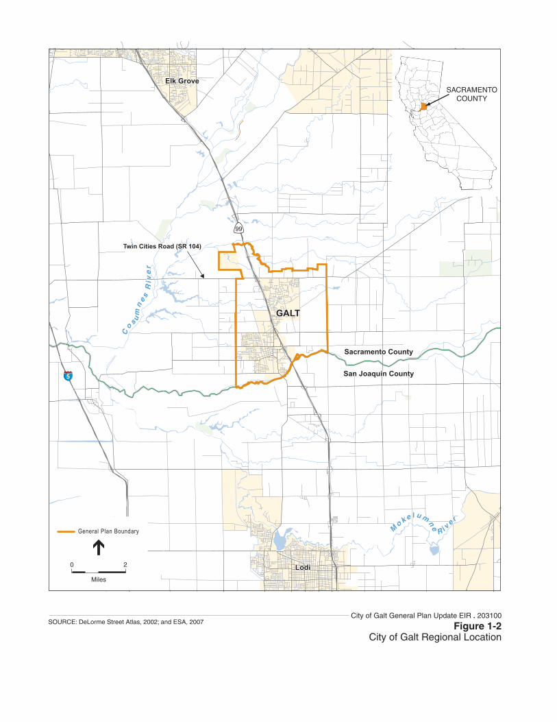
99
5
Lodi
Elk Grove
GALT
Sacramento County
San Joaquin County
M
o k e l u mne R i v
e r
Lodi
Elk Grove
GALT
Sacramento County
San Joaquin County
M
o k e l u mne R i v
e r
Co s u
mn
e s R
ive
r
Co s u
mn
e s R
ive
r
Twin Cities Road (SR 104)Twin Cities Road (SR 104)
SACRAMENTOCOUNTY
0 2
Miles
General Plan Boundary
City of Galt General Plan Update EIR . 203100
Figure 1-2City of Galt Regional Location
SOURCE: DeLorme Street Atlas, 2002; and ESA, 2007
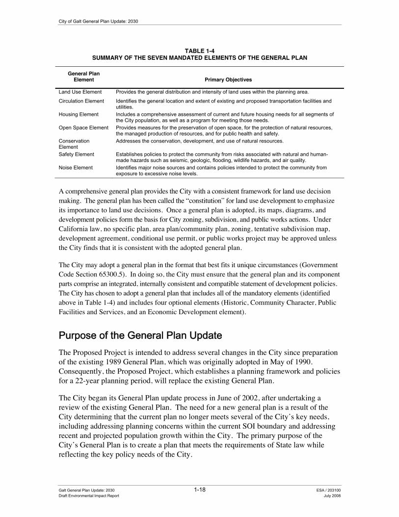
City of Galt General Plan Update: 2030
TABLE 1-4 SUMMARY OF THE SEVEN MANDATED ELEMENTS OF THE GENERAL PLAN
General Plan Element Primary Objectives
Land Use Element Provides the general distribution and intensity of land uses within the planning area.
Circulation Element Identifies the general location and extent of existing and proposed transportation facilities and utilities.
Housing Element Includes a comprehensive assessment of current and future housing needs for all segments of the City population, as well as a program for meeting those needs.
Open Space Element Provides measures for the preservation of open space, for the protection of natural resources, the managed production of resources, and for public health and safety.
Conservation Element
Addresses the conservation, development, and use of natural resources.
Safety Element Establishes policies to protect the community from risks associated with natural and human-made hazards such as seismic, geologic, flooding, wildlife hazards, and air quality.
Noise Element Identifies major noise sources and contains policies intended to protect the community from exposure to excessive noise levels.
A comprehensive general plan provides the City with a consistent framework for land use decision making. The general plan has been called the “constitution” for land use development to emphasize its importance to land use decisions. Once a general plan is adopted, its maps, diagrams, and development policies form the basis for City zoning, subdivision, and public works actions. Under California law, no specific plan, area plan/community plan, zoning, tentative subdivision map, development agreement, conditional use permit, or public works project may be approved unless the City finds that it is consistent with the adopted general plan.
The City may adopt a general plan in the format that best fits it unique circumstances (Government Code Section 65300.5). In doing so, the City must ensure that the general plan and its component parts comprise an integrated, internally consistent and compatible statement of development policies. The City has chosen to adopt a general plan that includes all of the mandatory elements (identified above in Table 1-4) and includes four optional elements (Historic, Community Character, Public Facilities and Services, and an Economic Development element).
3XUSRVH�RI�WKH�*HQHUDO�3ODQ�8SGDWH��The Proposed Project is intended to address several changes in the City since preparation of the existing 1989 General Plan, which was originally adopted in May of 1990. Consequently, the Proposed Project, which establishes a planning framework and policies for a 22-year planning period, will replace the existing General Plan.
The City began its General Plan update process in June of 2002, after undertaking a review of the existing General Plan. The need for a new general plan is a result of the City determining that the current plan no longer meets several of the City’s key needs, including addressing planning concerns within the current SOI boundary and addressing recent and projected population growth within the City. The primary purpose of the City’s General Plan is to create a plan that meets the requirements of State law while reflecting the key policy needs of the City.
Galt General Plan Update: 2030 1-18 ESA / 203100 Draft Environmental Impact Report July 2008

1. Introduction and Project Description
2EMHFWLYHV�RI�WKH�*HQHUDO�3ODQ��The General Plan was designed to meet several key objectives that were identified and considered by the General Plan Focus Group, Planning Commission, and City Council, based on input by key stakeholders and City staff. These objectives (Urban Form/Growth, Circulation, Infrastructure and Utilities Expansion, Economic Development, Agricultural Land and Wildlife Habitat Protection, Community Image and Identity) set the foundation for the goals, policies, and implementation measures that comprise the various elements of the proposed General Plan. A summary of these key objectives is provided below (see Table 1-5); with additional detail regarding these objectives or guiding principles provided under the section entitled “The Galt 2030 General Plan Update” of this chapter.
TABLE 1-5 SUMMARY OF THE GENERAL PLAN OBJECTIVES
Urban Form/Growth ! New growth should provide a balanced mix of land uses while preserving rural communities and revitalizing the existing
downtown area. Circulation ! Existing traffic and parking facilities improvements must be made to meet the needs of visitors, businesses and
residents in addition to planning for future expansion of transit options.
Infrastructure & Utilities Expansion ! Adequate provision of infrastructure and utility services is necessary to keep pace with the City’s future growth. Economic Development ! Development of new business, retail, commercial services and expansion of the City’s economic base is necessary to
provide new jobs and shopping opportunities within the City. Agricultural Land & Wildlife Habitat Protection ! Protection of agricultural residential areas and preserving the rural setting of the community is essential in preserving
productive agricultural land and protecting valuable wildlife habitat in the vicinity of the community. Community Image & Identity ! The community’s image as a small town is integral to sustaining and developing a distinct identity for the City of Galt.
7KH�*DOW������*HQHUDO�3ODQ�8SGDWH��As previously described, the Proposed Project includes the seven elements required by State law (see Table 1-4) and four other elements that address local concerns (Historic, Community Character, Public Facilities and Services, and Economic Development). This section provides additional details regarding the project, including a description of the guiding principles behind development of the general plan, the general plan land use diagram, and general plan land use classifications.
Guiding Principles and Planning Concepts The General Plan sets the framework for future growth and development within which Galt can expand while still maintaining the small-town feeling and quality of life that are so important to Galt residents. The major theme of the General Plan is to retain and build upon Galt’s small-town and neighborhood qualities while achieving an economically-healthy and self-sufficient community.
Galt General Plan Update: 2030 1-19 ESA / 203100 Draft Environmental Impact Report July 2008
City of Galt General Plan Update: 2030
With this theme in mind, the following guiding principles provide the foundation for the General Plan. The following principles were developed through the public workshops, City Council and Planning Commission meetings and stakeholder meetings:
1) Provide a mix of residential density choices while preserving the traditional character of Galt.
2) Population projections based on the 2030 General Plan is approximately 51,500 people.
3) Preserve agriculture and open space land north of Laguna and Skunk Creeks.
4) Promote economic and job growth along Highway 99 and the Twin Cities Road corridor.
5) Preserve land surrounding the wastewater treatment plant.
6) Distribute school and public/quasi-public uses throughout the General Plan area.
General Plan Land Use and Circulation Diagram The land use diagram for the Proposed Project is provided as Figure 1-3. The diagram also includes potential school site locations and several potential transportation improvements and designates the proposed general location, distribution, and extent of land uses through build out (2030) of the General Plan. As required by State law, land use classifications, shown in specific color patterns, letter designations, or labels on the land use diagram, specify a range of housing density and building intensity for each land use type. These standards also allow for various circulation and utility infrastructure needs to be determined. The Land Use Diagram is a graphical representation of the various planning concepts and guiding principles described above.
Galt General Plan Update: 2030 1-20 ESA / 203100 Draft Environmental Impact Report July 2008

HighSchool
ES
ES
ES
ES
ES
ES
MS
HighSchool
Wastewater Treatment Plant (City of Galt)
Twin Cities RoadTwin Cities Road (SR 104)
Walnut Avenue
Stre
et 2
Street 1
Street 3
Street 4
Stre
et 5
Stre
et 7
Street 6
Simmerhorn Road
Boessow Road
Mar
eng
o R
oad
Carillion Blvd.
G Street
Elm Street
A Street
New Hope Road
Kost Road
Lincoln Way
West Stockton Blvd.
East Stockton Blvd.
Ind
ustr
ial D
rive
Street 8
Street 9
Cry
stal
Way
HighSchool
ES
ES
ES
ES
ES
ES
MS
HighSchool
er Treatment Plant City of Galt)
Twin Cities RoadTwin Cities Road (SR 104)
WalnutWWWaalnnuuutttWWWWWaaalnnuuutt Avenuennu AAAvvveeenuu Avenueeee
Stre
etttSt
reet
reeretrSt22222
Streettrererrr 1
StreetStreetStreeteeteettStreetttt
reetreetttreeteetreettteetettttetetetetteeeeeeeeeeeeeeeeeeeeeeeeeeetreerrrrrtrrttttttSSS
333 3333333333333333333333333333333
StreetStreetStreStreStreeetStreeeeeetttSSStrrrreeeeeeStreeStreereettSS rreet 4444 4
Stre
etSt
reett
reet
Stre
etSt
reet et
tree
treee
Stre
eeSt
ree
Stre
eeSt
ree
Stre
eeeeeeeSt
reeSt
rerrrrrrSt
rtrrtrrt St SSSSSS55 555555
Stre
et 7
Street 6
SimmermeSimmeSimmeSimmeimmerrSSimmmmmmmmeeSimmeerSimmerSSimi horn Rhorn Rrn Rnnnhorn RRRRRhhhooooorrrnnhornhorn Rhorn Roadoadddooaaaaddooaaaaaddoadd
BBoessoessoBoooeeessssooooBBoooeeessssoBoesso R dR ddRRRRoooooaadddwwww RoaRw Road
Mar
eng
Mar
eng
Mar
eng
Mar
eng
Mar
eng
Mar
eng
eng
ng
aren
gM
aren
gar
eng
Mar
eng
aren
gM
aren
gM
aren
gggggen
gar
eng
enM
aren
Mar
enM
aren
aren
aren
aren
aren
Mar
eneeM
are
are
Mo
Roa
do
Roa
do
Roa
dR
oad
o R
oad
o R
oad
o R
oad
o R
oaoaaao
Roaaa
o R
oaao
Roaoao
o R
oo
Ro
oR
ooo
Ro
Ro
Ro
Rooo
Carillion Bl
ion vd.
GG StrG StreSStrG StreG StreSt eeStreG StreeeG StreGGGGG S reetetetett
l SEEl SStSStttElm St ttreet
SA Street
N HHHHHNNNN HHNew Ho RRRRRRRRRpe Rpe Rpe Rope Roape Roappp ddddddddddddddd
KKost Rostt doad
West Stockton Blvd.
East SEast SEasEast SE
Stocktotocktotockto
kkton Bn Blvdn Blvdn
..
Ind
ust
rial
Dri
ve
StreetStreetStreet
eetStreetStreetStreetS
e 8888
Streetreet
StreetStreStreetSStreetStrStreSStStStreetStreetSStrStreetSSStreSStreetSSStrStrSSSStStStStStreetStreetStreetStStStreetStreetStSttttrtrtrtrtrtrtrtre
trtrtrrrreetrrrreeeeetetetettttttttttttttttttt 9 999999999999999999999999999999
Cry
sta
Cry
stC
ryst
Cry
sC
rys
Cryy
Cr
Cl W
ay
LinLinccoLincolLincolLincoLincolLincolLincLincLincoLinLincLincoLincLincoLinc
incoiincolincolncnconcolnnncol
cnn n W
ayn W
ayn W
ayn
Way
nW
ayn
Way
n y
n Way
nnn Way
nW
ayn W
an W
ayn W
an W
ayn
Wa
n Wnn W
yn W
ayn W
ayWW
City Limits (2008)
General Plan Boundary
School
100-Year FEMA Floodplain
500-Year FEMA Floodplain
Boundary and Symbol Legend
ES
Future 6 Lane Expressway
Future 4 Lane ArterialExisting 4 Lane Arterial
Future 2 Lane ArterialExisting 2 Lane Arterial
Future 2 Lane CollectorExisting 2 Lane Collector
Street to be Removed
Circulation Legend
Residential Estates
Low Density Residential
Rural Residential
Medium Density Residential
Medium-High Density Res.
Color
Office Professional
Light Industrial
Commercial
0.5
1
4
6
11
-
-
-
0
0
1,404
216
0
0
0
5,616
1,296
0
270
11
284
-
-
-
1,451
188
1,061
150
83
412
186
367
Designation
0**
188
4,244
900
913
-
-
-
Assumed Avg. Density
Acres Inside City Limits
Acres Outside City Limits
Units Inside City Limits
Units Outside City Limits
High Density Residential 18 140 2,520 58 1,044
Land Use Legend
0 - 0.5
0 - 1
0 - 6
8 - 14
-
-
-
DensityRange
14 - 24
5 - 8
00
564564
29,58029,580
6,5886,588
2,7392,739
-
-
-
TotalPopulation
51,291
10,69210,692
Mixed-Use 18 5 88 16 2885 - 60 1,1281,128
0 0 25 0 5 0 75 1 Mile
General Plan Land UseRural Residential
Residential Estate
Low-Density Residential
Medium-Density Residential
Medium-High Density Residential
High-Density Residential
Commercial
Light Industrial
Office Professional
P Mixed Useark
Open Space
Public Quasi-Public
Planning Area Boundary
City Limit
County Boundary
0 0.5
Mile
City of Galt General Plan Update EIR . 203100Figure 1-3
City Council Preferred Land Use and Circulation Diagram
SOURCE: Sacramento County, 2007; City of Galt, 2008; Mintier & Associates, 2008; and ESA, 2008
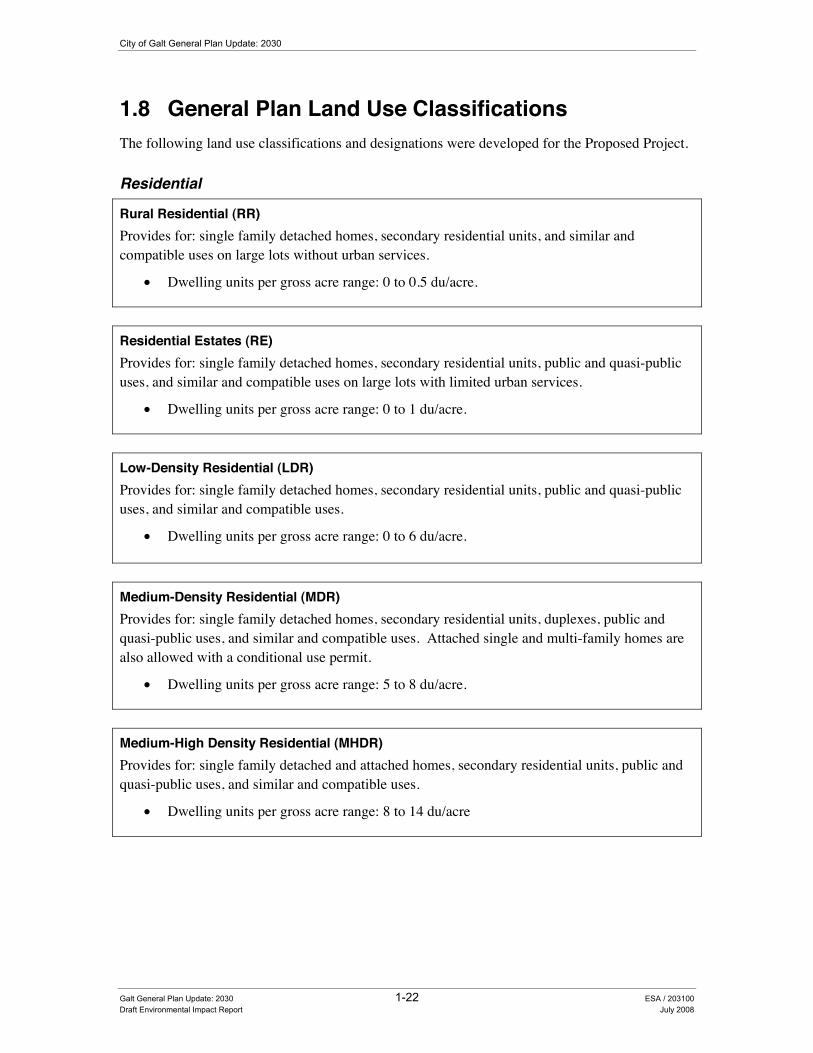
City of Galt General Plan Update: 2030
1.8 General Plan Land Use Classifications The following land use classifications and designations were developed for the Proposed Project.
Residential
Rural Residential (RR) Provides for: single family detached homes, secondary residential units, and similar and compatible uses on large lots without urban services.
• Dwelling units per gross acre range: 0 to 0.5 du/acre.
Residential Estates (RE) Provides for: single family detached homes, secondary residential units, public and quasi-public uses, and similar and compatible uses on large lots with limited urban services.
• Dwelling units per gross acre range: 0 to 1 du/acre.
Low-Density Residential (LDR) Provides for: single family detached homes, secondary residential units, public and quasi-public uses, and similar and compatible uses.
• Dwelling units per gross acre range: 0 to 6 du/acre.
Medium-Density Residential (MDR) Provides for: single family detached homes, secondary residential units, duplexes, public and quasi-public uses, and similar and compatible uses. Attached single and multi-family homes are also allowed with a conditional use permit.
• Dwelling units per gross acre range: 5 to 8 du/acre.
Medium-High Density Residential (MHDR) Provides for: single family detached and attached homes, secondary residential units, public and quasi-public uses, and similar and compatible uses.
• Dwelling units per gross acre range: 8 to 14 du/acre
Galt General Plan Update: 2030 1-22 ESA / 203100 Draft Environmental Impact Report July 2008
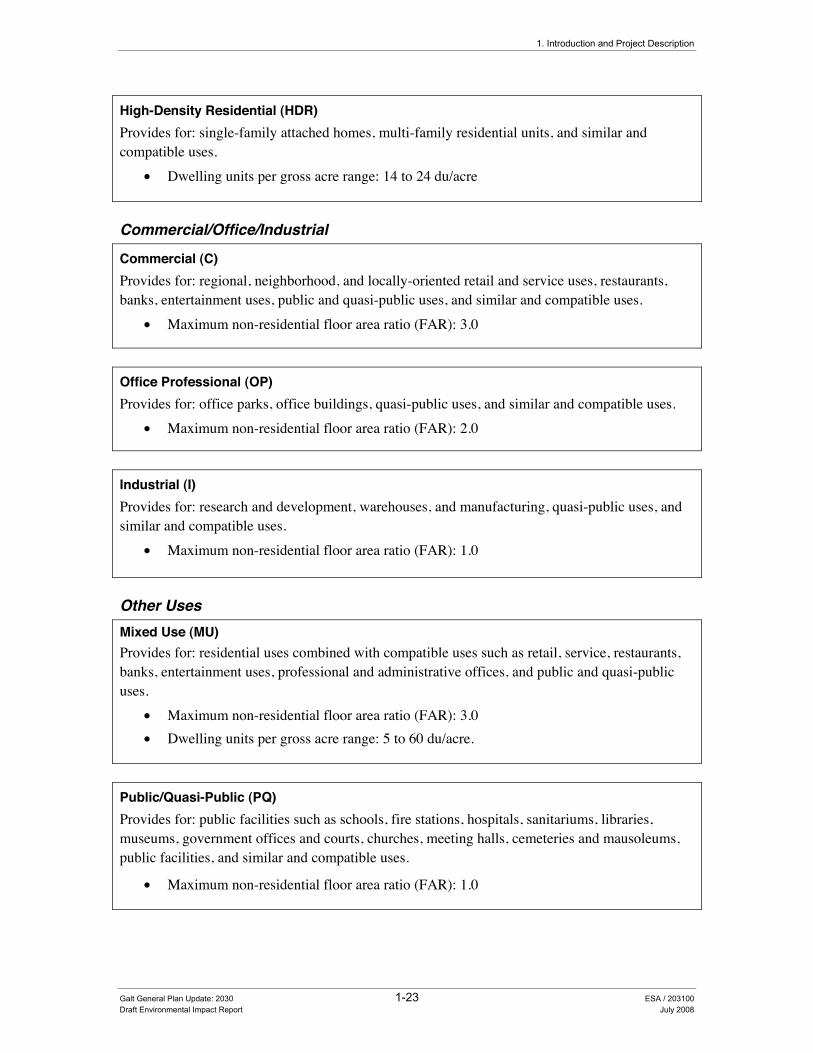
1. Introduction and Project Description
High-Density Residential (HDR) Provides for: single-family attached homes, multi-family residential units, and similar and compatible uses.
• Dwelling units per gross acre range: 14 to 24 du/acre
Commercial/Office/Industrial
Commercial (C) Provides for: regional, neighborhood, and locally-oriented retail and service uses, restaurants, banks, entertainment uses, public and quasi-public uses, and similar and compatible uses.
• Maximum non-residential floor area ratio (FAR): 3.0
Office Professional (OP) Provides for: office parks, office buildings, quasi-public uses, and similar and compatible uses.
• Maximum non-residential floor area ratio (FAR): 2.0
Industrial (I) Provides for: research and development, warehouses, and manufacturing, quasi-public uses, and similar and compatible uses.
• Maximum non-residential floor area ratio (FAR): 1.0
Other Uses Mixed Use (MU) Provides for: residential uses combined with compatible uses such as retail, service, restaurants, banks, entertainment uses, professional and administrative offices, and public and quasi-public uses.
• Maximum non-residential floor area ratio (FAR): 3.0 • Dwelling units per gross acre range: 5 to 60 du/acre.
Public/Quasi-Public (PQ) Provides for: public facilities such as schools, fire stations, hospitals, sanitariums, libraries, museums, government offices and courts, churches, meeting halls, cemeteries and mausoleums, public facilities, and similar and compatible uses.
• Maximum non-residential floor area ratio (FAR): 1.0
Galt General Plan Update: 2030 1-23 ESA / 203100 Draft Environmental Impact Report July 2008

City of Galt General Plan Update: 2030
Open Space (OS) Provides for: passive outdoor recreational uses, habitat protection, watershed management, public/quasi-public uses, areas that contain public health and safety hazards such as floodways, and areas containing environmentally-sensitive features.
• Maximum non-residential floor area ratio (FAR): 0.10
Parks (P) Provides for: passive and active outdoor recreational uses, habitat protection, and public and quasi-public uses.
• Maximum non-residential floor area ratio (FAR): 0.10
Build out under the Proposed General Plan Full development under the project is referred to as “build out”. This section describes the implications of General Plan build out in terms of future population and housing units proposed for the City. Under the Preferred Land Use Alternative, adequate land is provided by this General Plan to accommodate anticipated housing and employment needs through 2030.
Table 1-6 provides a list of the designated land uses proposed for the Preferred Land Use Alternative along with an estimate of acreage attributed to each land use category. As shown in the table, low density residential land use accounts for the majority of acreage, with approximately 2,470 acres. Commercial land uses account for 690 acres and Light Industrial land uses account for 650 acres. The Preferred Land Use Alternative would also include an estimated 550 acres of open space.
TABLE 1-6 DESIGNATED LAND USES PROPOSED UNDER THE PREFERRED LAND USE
ALTERNATIVES FOR THE PLANNING AREA
Designated Land Use Planning Area Acreage (percent of total)a
Rural Residential 1,450 acres (18%) Residential Estates 190 acres (2%) Low Density Residential 2,470 acres (31%) Medium Density Residential 370 acres (5%) Medium-High Density Residential 80 acres (1%) High Density Residential 200 acres (3%) Mixed Use 20 acres (less than 1%) Commercial 690 acres (9%) Office Professional 200 acres (3%) Light Industrial 650 acres (8%) Public/Quasi-Public 830 acres (11%) Parks 160 acres (2%) Open Space 550 acres (7%)
Total: 7,860 acres
a Does not include waterways, rights-of-ways, or other non designated areas that can’t be developed
Galt General Plan Update: 2030 1-24 ESA / 203100 Draft Environmental Impact Report July 2008

1. Introduction and Project Description
5HTXLUHG�$SSURYDOV���As the lead agency under CEQA, the City Planning Commission will consider the Final EIR and recommend that the City Council certify the final Program EIR for the proposed general plan and adopt the proposed Galt 2030 General Plan Update (including the Preferred Land Use Alternative). As previously described, this EIR will also be used as a first-tier environmental document for the subsequent environmental review of a variety of City projects including future specific plans, infrastructure improvements, general plan amendments, and other local development projects. As these specific projects are defined, additional city review and approval will be required prior to their implementation. Additional approvals may also be required by a variety of local, state, and federal agencies for the purposes of specific permitting reviews and approvals. For instance, the Regional Water Quality Control Board may be required to approve applications for waste discharge requirements associated with future development projects.
The Sacramento County Local Agency Formation Commission will have to approve various boundary changes necessitated by development contemplated beyond the City’s current (2007) municipal boundaries. To help accommodate future population growth anticipated under the project, the City is considering an expansion to its existing SOI concurrent with its Planning Area boundary. The Cortese/Knox/Hertzberg Local Government Act of 2000 defines a sphere of influence as “a plan for the probable ultimate physical boundaries and service area of a local agency”. The Local Agency Formation Commission (LAFCO) is responsible for adopting a “sphere of influence” for each agency subject to LAFCO regulations
As with all LAFCOs, the Sacramento County Local Agency Formation Commission (SCLAFCO) decision-making process is guided by several policies outlined in the Cortese/Knox/Hertzberg Local Government Act of 2000. These policies include the following:
• To encourage orderly growth and development which are essential to the social, fiscal, and economic well being of the state;
• To promote orderly development by encouraging the logical formation and determination of boundaries and working to provide housing for families of all incomes;
• To discourage urban sprawl;
• To preserve open-space and prime agricultural lands by guiding development in a manner that minimizes resource loss;
• To exercise its authority to ensure that affected populations receive efficient governmental services; to promote logical formation and boundary modifications that direct the burdens and benefits of additional growth to those local agencies that are best suited to provide necessary services and housing;
• To make studies and obtain and furnish information which will contribute to the local and reasonable development of local agencies and to shape their development so as to advantageously provide for the present and future needs of each county and its communities;
Galt General Plan Update: 2030 1-25 ESA / 203100 Draft Environmental Impact Report July 2008

City of Galt General Plan Update: 2030
• To establish priorities by assessing and balancing total community services needs with financial resources available to secure and provide community services and to encourage government structures that reflect local circumstances, conditions and financial resources; and
• To determine whether new or existing agencies can feasibly provide needed services in a more efficient or accountable manner and, where deemed necessary, consider reorganization with other single purpose agencies that provide related services.
• In order to conduct these legislative policies, the SCLAFCO has the power to conduct studies, approve or disapprove applications, modify boundaries of a proposal and impose reasonable terms and conditions on approval. Consequently the SCLAFCO will need to consider and adopt the City’s amendment to its existing SOI. The SCLAFCO will also need to conduct a municipal services review to ensure the adequate availability of public services to the City’s new SOI.
• Future annexations to the updated SOI would also require additional environmental review and approval by the City of Galt and SCLAFCO.
Galt General Plan Update: 2030 1-26 ESA / 203100 Draft Environmental Impact Report July 2008
Chapter 2 Economic Conditions


CHAPTER 2.0 (FRQRPLF�&RQGLWLRQV�
2.1 Introduction In preparing the Proposed Project, a common chapter numbering system was used in preparing key general plan documents to allow readers the ability to easily find related information throughout the various documents. In the Existing Conditions Report, Chapter 2.0 is the “Economic Conditions” section, which provides a variety of background economic data, including population and employment trends. The section also provides an in-depth market analysis of the Galt area, identifying key industries and retail sales leakages. The Policy Document provides a variety of policies designed to assist the City address these key topics and attain their economic development goals.
As described in the State CEQA Guidelines (Section 15382), this EIR does not evaluate economic impacts. Section 15382 of the State CEQA Guidelines states the following:
“Significant effect on the environment” means a substantial, or potential substantial, adverse change in any of the physical conditions within the area affected by the project, including land, air, water, minerals, flora, fauna, ambient noise, and objects of historic or aesthetic significance. An economic or social change by itself shall not be considered a significant effect on the environment. A social or economic change related to a physical change may be considered in determining whether the physical change is significant.
All physical changes to the environment that may result from economic or social change created by the Proposed Project are discussed within the appropriate resource sections of this EIR.
Galt General Plan Update: 2030 2-1 ESA / 203100 Draft Environmental Impact Report July 2008


Chapter 3 Community Character


CHAPTER 3.0 &RPPXQLW\�&KDUDFWHU�
3.1 Introduction In preparing the Proposed Project, a common chapter numbering system was used in preparing key general plan documents to allow readers the ability to easily find related information throughout the various documents. In the Existing Conditions Report, Chapter 3.0 is the “Community Character” section, which provides background on the City’s historic development and its design character. The Policy Document provides a variety of policies that have been developed to assist the City address these key topics and maintain their desired community character.
This chapter of the draft EIR analyzes the impacts associated with implementation of the Proposed Project on the aesthetic resources or the community character of the Study Area.
3.2 Community Image (Aesthetics)
(QYLURQPHQWDO�DQG�5HJXODWRU\�6HWWLQJ�As previously described in the “Readers Guide” (see Chapter 1 of this draft EIR), Section 15150 of the CEQA Guidelines permits documents of lengthy technical detail to be incorporated by reference in an EIR. Specifically, Section 15150 states that an EIR may “incorporate by reference all or portions of another document which is a matter of public record or is generally available to the public ....”. Consistent with the CEQA Guidelines and as a way to avoid creating an overwhelming amount of paper for members of the public and decision-makers to sort through, this draft EIR incorporates by reference information from both the Existing Conditions and Policy Document. Environmental setting and regulatory information for aesthetic resources in the City of Galt can be found in Chapter 3.0 of the Existing Conditions Report (see Appendix B).
,PSDFW�0HWKRGRORJ\��The assessment of visual resources is a qualitative review of the existing resources located within the Study Area and a determination of whether the Proposed Project includes adequate provisions to ensure continued protection of these resources. As part of the analysis, a reconnaissance-level survey of the various aesthetic resources (including views of local waterways, parks, open space areas, and neighborhoods) of the Study Area was conducted.
Galt General Plan Update: 2030 3-1 ESA / 203100 Draft Environmental Impact Report July 2008

City of Galt General Plan Update: 2030
6WDQGDUGV�RI�6LJQLILFDQFH�The Proposed Project will establish development guidelines against which future projects will be judged for consistency. The significance criteria for this analysis were developed from criteria presented in Section 15065 and Appendix G “Environmental Checklist Form” of the CEQA Guidelines and based on the professional judgment of the City of Galt and its consultants. The project (or the project alternatives) would result in a significant impact if it would:
• Substantially degrade the existing visual character or quality of the site and its surroundings;
• Have a substantial adverse effect on a scenic vista;
• Substantially damage scenic resources, including, but not limited to, trees, rock outcroppings, and historic buildings within a state scenic highway; or
• Create a new source of substantial light or glare which would adversely affect day or nighttime views in the area.
A review of the current Caltrans Map of Designated Scenic Routes indicates that there are no officially state-designated or eligible scenic routes within the Study Area. Furthermore, SR 104 and SR 99, the two most significant highways within the Study Area, are not identified as a scenic roadway by any county or city planning document. Therefore, the Proposed Project would have no impact on scenic resources associated with a scenic highway or roadway and this impact is not discussed further below.
,PSDFWV�DQG�0LWLJDWLRQ�0HDVXUHV�
Impact 3.2-1: The Proposed Project would substantially degrade the existing visual character or quality of the site and its surroundings (including a scenic vista).
Impact Summary
Level of Significance Before Mitigation: Potentially Significant
Required Mitigation Measures: No Feasible Mitigation Available
Level of Significance After Mitigation: Significant and Unavoidable
Impact Analysis
The visual character of the City’s Study Area is influenced by the quality of its roadways, boulevards, waterways, view corridors, and the land use adjoining them (i.e., open space, neighborhoods, etc.). Visual quality is often affected by a variety of factors including General Plan land use designations and policies, specific plan requirements, zoning regulations and enforcement, and private property maintenance. Buildout of the Preferred Land Use Alternative and the Circulation Diagram would
Galt General Plan Update: 2030 3-2 ESA / 203100 Draft Environmental Impact Report July 2008

3. Community Character
result in temporary changes in local visual conditions during construction of specific development or infrastructure projects in the Study Area. However given the relatively short-term nature of these construction-related activities, construction-related visual impacts are considered less-than-significant.
A major focus of the Proposed Project is the enhancement of the visual quality of the City and its surroundings, with the inclusion of several policies identified below that are designed to protect the aesthetic qualities of the City’s view corridors, downtown, and open space areas. However, buildout of the Preferred Land Use Alternative and the Circulation Diagram would result in several permanent changes to existing views associated with new development predominately within the northern and eastern portions of the Study Area. Although development anticipated under the Proposed Project would represent the continuation of existing city-wide land use patterns, new development within the northern and eastern portions of the Study Area is proposed on land currently used for a variety of rural residential, agricultural, and open space uses. This new development would alter the existing open space views of surrounding visible areas and contrast with the surrounding open space/agricultural environment (in particular those views of the Cosumnes River and Sierra Foothills) at the edge of these new development areas. Consequently, even with implementation of the below mentioned policies and implementation programs, this impact to the existing visual character of the City is still considered potentially significant.
Community Character Element
Policies and implementation programs designed to improve the overall visual quality of the urban environment and reduce visual impacts include the following:
CC-1.1 City Image CC-1.2 Neighborhood Integrity CC-1.3 Existing Neighborhood Design CC-1.4 New Neighborhood Design CC-1.5 Rail Corridors CC-1.6 Open Space Features CC-1.7 Viewsheds
CC-1.8 Building Elevations CC-1.9 Signage CC-1.10 Art in Public Spaces Implementation Program CC-A Implementation Program CC-B Implementation Program CC-C
Policies designed to maintain and enhance the visual quality of Galt’s major corridors and city entrances through landscape and streetscape improvements and help to reduce visual impacts include the following:
CC-2.1 Gateway Entrances CC-2.2 New Development in Corridors CC-2.3 Building Setbacks and Landscape Areas CC-2.4 Architectural Enhancements in Major Corridors
CC-2.5 Landscape Maintenance CC-2.6 Positive Travel Experience CC-2.7 State Route 99 and State Route 104 Beautification
Policies and implementation programs designed to protect the historical and authentic qualities of Galt’s Downtown and help to reduce visual impacts include the following:
CC-3.1Restore Downtown CC-3.2 Historical and Cultural Resources CC-3.3 Incorporating Historical Features in New Development Implementation Program CC-D
Policies and implementation programs designed to maintain and enhance the quality of Galt’s trees and help to reduce visual impacts include the following:
CC-4.1 Tree Canopy CC-4.2 Trees in New Development CC-4.3 Tree and Landscape Maintenance Requirements for Large Development Projects Implementation Program CC-E
Galt General Plan Update: 2030 3-3 ESA / 203100 Draft Environmental Impact Report July 2008

City of Galt General Plan Update: 2030
Required Mitigation Measures
As stated above, buildout of the Preferred Land Use Alternative/Circulation Diagram would result in temporary changes in local visual conditions during construction of specific projects in the Study Area that may affect a scenic vista or other scenic resources. However given the relatively short-term nature of these construction-related activities, construction-related visual impacts are considered less-than-significant. However, even with implementation of the policies and implementation programs listed above, new development along the periphery of the existing City boundary would substantially degrade the existing visual character or quality of the site and its surroundings through the introduction of developed uses within areas currently used for open space/agricultural activities. As a result, the impact remains significant. No additional feasible mitigation is currently available.
Significance after Implementation of Mitigation for Impact 3.2-1
As stated above, no additional feasible mitigation measures are currently available to reduce this impact to a less than significant level. Consequently, this impact is considered significant and unavoidable.
Impact 3.2-2: The Proposed Project would create a new source of substantial light or glare which would adversely affect day or nighttime views in the area.
Impact Summary
Level of Significance Before Mitigation: Potentially Significant
Required Mitigation: Mitigation Measure 3.2-2a: Adopt General Plan Policy CC-1.11 “Outdoor Lighting” to Address Light and Glare Impacts and Mitigation Measure 3.2-2b: Adopt General Plan Policy CC-1.12 “Reflective Materials” to Address Light and Glare Impacts.
Level of Significance After Mitigation: Significant and Unavoidable
Impact Analysis
As planned growth under the Preferred Land Use Alternative/Circulation Diagram occurs, additional lighting will be required to provide street and building illumination, security lighting, nighttime traffic lights, and light associated with new recreation facilities. Potential development on the periphery of the City’s existing boundary could result in the addition of several new sources of illumination within the Study Area.
Buildout of the Preferred Land Use Alternative/Circulation Diagram would increase the amount of light and glare associated with the development of urban uses, such as additional parking lots, building lights, and streetlights within areas that currently have no light or minimal amounts of light and glare. While the types of lighting and their specific locations are not specified at this point, development proposed under the Proposed Project would increase the amount of spill light and glare onto adjacent areas.
Galt General Plan Update: 2030 3-4 ESA / 203100 Draft Environmental Impact Report July 2008

3. Community Character
As previously described, a major focus of the Proposed Project is the enhancement of the visual quality of the City and its surroundings , with the inclusion of several policies identified below that are designed to protect the aesthetic qualities of the City’s view corridors, downtown, and open space areas. However, even with implementation of the below mentioned policies and implementation programs, this impact resulting from new sources of light and glare is still considered potentially significant.
Community Character Element
Policies and implementation programs designed to improve the overall visual quality of the urban environment and reduce visual impacts include the following: CC-1.1 City Image CC-1.2 Neighborhood Integrity CC-1.3 Existing Neighborhood Design CC-1.4 New Neighborhood Design CC-1.5 Rail Corridors CC-1.6 Open Space Features CC-1.7 Viewsheds
CC-1.8 Building Elevations CC-1.9 Signage CC-1.10 Art in Public Spaces Implementation Program CC-A Implementation Program CC-B Implementation Program CC-C
Policies designed to maintain and enhance the visual quality of Galt’s major corridors and city entrances through landscape and streetscape improvements and help to reduce visual impacts include the following: CC-2.1 Gateway Entrances CC-2.2 New Development in Corridors CC-2.3 Building Setbacks and Landscape Areas CC-2.4 Architectural Enhancements in Major Corridors
CC-2.5 Landscape Maintenance CC-2.6 Positive Travel Experience CC-2.7 State Route 99 and State Route 104 Beautification
Policies and implementation programs designed to protect the historical and authentic qualities of Galt’s Downtown and help to reduce visual impacts include the following: CC-3.1Restore Downtown CC-3.2 Historical and Cultural Resources CC-3.3 Incorporating Historical Features in New Development Implementation Program CC-D Policies and implementation programs designed to maintain and enhance the quality of Galt’s trees and help to reduce visual impacts include the following: CC-4.1 Tree Canopy CC-4.2 Trees in New Development CC-4.3 Tree and Landscape Maintenance Requirements for Large Development Projects Implementation Program CC-E
Required Mitigation Measures
To address this impact, the City shall implement the following mitigation measures:
Mitigation Measure 3.2-2a: Adopt General Plan Policy CC-1.11 “Outdoor Lighting” to Address Light and Glare Impacts.
To mitigate light and glare impacts resulting from implementation of the Proposed Project, the City shall incorporate the following new Policy CC-1.11 “Outdoor Lighting” into the Final General Plan:
• CC-1.11 Outdoor Lighting. The City shall ensure that future development includes provisions for the design of outdoor light fixtures to be directed/shielded downward and screened to avoid nighttime lighting spillover effects on adjacent land uses and nighttime sky conditions. [New Policy – Draft EIR Analysis]
Galt General Plan Update: 2030 3-5 ESA / 203100 Draft Environmental Impact Report July 2008

City of Galt General Plan Update: 2030
Mitigation Measure 3.2-2b: Adopt General Plan Policy CC-1.12 “Reflective Materials” to Address Light and Glare Impacts.
To mitigate light and glare impacts resulting from implementation of the Proposed Project, the City shall incorporate the following new Policy CC-1.12 “Reflective Materials” into the Final General Plan:
• CC-1.12 Reflective Materials. The City shall consider a range of building materials to ensure that future building design reduces the potential impacts of daytime glare. [New Policy – Draft EIR Analysis]
Significance after Implementation of Mitigation for Impact 3.2-2
As stated above, the City will continue to enforce a variety of measures designed to minimize impacts resulting from a new source of substantial light or glare which would adversely affect day or nighttime views in the area. However, even with implementation of the policies and implementation programs listed above (including the new Policies “CC-1.11 “Outdoor Lighting” and CC-1.12 “Reflective Materials”), new development along the periphery of the existing City boundary would result in substantial new sources of light and glare within areas currently used for a variety of open space/agricultural activities. As a result, the impact remains significant. No additional feasible mitigation is currently available. Consequently, this impact is considered significant and unavoidable.
Galt General Plan Update: 2030 3-6 ESA / 203100 Draft Environmental Impact Report July 2008
Chapter 4 Land Use and Demographics

CHAPTER 4.0 /DQG�8VH�DQG�'HPRJUDSKLFV�
4.1 Introduction In preparing the Proposed Project, a common chapter numbering system was used in preparing the key general plan documents to allow readers the ability to easily find related information throughout the various documents. In the Existing Conditions Report, Chapter 4.0 is the “Land Use and Demographics” section. This section provides background information on the existing land use and socioeconomic conditions of the Study Area, with the draft Policy Document providing the policy framework for the various land uses identified under the Proposed Project.
This chapter of the EIR addresses the impacts associated with two key land use issues: land use compatibility and general plan consistency. This chapter also examines whether the Proposed Project has the potential to physically divide the arrangement of any established community areas within the Study Area. To find related information specific to the potential land use conflicts that may occur between agricultural activities and other land uses included under the Proposed Project, please see Chapter 8.0, Section 8.4, “Soils and Agricultural Resources” of this EIR. Section 8.4 focuses on impacts associated with a variety of agricultural resource issues (including potential impacts to important farmlands and conflicts with Williamson Act lands).
4.2 Land Use
(QYLURQPHQWDO�DQG�5HJXODWRU\�6HWWLQJ�As previously described in the “Readers Guide” (see Chapter 1 of this draft EIR), Section 15150 of the CEQA Guidelines permits documents of lengthy technical detail to be incorporated by reference in an EIR. Specifically, Section 15150 states that an EIR may “incorporate by reference all or portions of another document which is a matter of public record or is generally available to the public…” Consistent with the CEQA Guidelines and as a way to avoid creating an overwhelming amount of paper for members of the public and decision-makers to sort through, this draft EIR incorporates by reference information from both the Existing Conditions and Policy Document. Consistent with this approach, the reader is directed to Chapter 4 of the Existing Conditions Report for environmental and regulatory setting information specific to land use topics (see Appendix B of this draft EIR).
Galt General Plan Update: 2030 4-1 ESA / 203100 Draft Environmental Impact Report July 2008

City of Galt General Plan Update: 2030
,PSDFW�0HWKRGRORJ\��Land use impacts are described qualitatively. Land use changes enabled by the Proposed Project were compared to the existing level of development on lands within the Study Area. The analysis also considered the compatibility of land uses proposed next to each other within the Study Area.
As a result of comments (see Table 1-1 of Chapter 1.0 “Introduction”) received during the NOP public scoping phase of the Proposed Project, specific planning and land use issues have been considered as part of the impact analysis. For example, one commenter recommended that the City should include SACOG Blueprint consistent development concepts and that the EIR should address strategies that encourage efficient land use patterns.
The Sacramento Area Council of Governments (SACOG) has been in the process of developing a regional growth alternatives plan known as the Blueprint project. This project is a comprehensive regional process integrating land use and transportation, air quality and other regional concerns. It is an in-depth modeling and research process, conducted by SACOG in cooperation with all jurisdictions in the region that will look at how future growth is likely to occur. To the extent feasible, the City’s Preferred Land Use Alternative and Policy Document has been developed in a similar manner that integrates key land use, transportation, air quality, and climate change concerns.
6WDQGDUGV�RI�6LJQLILFDQFH��The Proposed Project will establish development guidelines against which future projects will be judged for consistency. The significance criteria for this analysis were developed from criteria presented in Appendix G, “Environmental Checklist Form”, of the CEQA Guidelines and based on the professional judgment of the City of Galt and its consultants. The project (or the project alternatives) would result in a significant impact if it would:
• Physically divide an established community;
• Conflict with any applicable land use plan, policy or regulation of an agency with jurisdiction over the project adopted for the purpose of avoiding or mitigating a significant environmental effect;
• Result in land uses that are not compatible with any applicable airport land use compatibility plan; or
• Conflict with any applicable habitat conservation plan or natural community conservation plan.
Galt General Plan Update: 2030 4-2 ESA / 203100 Draft Environmental Impact Report July 2008

4. Land Use
,PSDFWV�DQG�0LWLJDWLRQ�0HDVXUHV��
Impact 4.2-1: The Proposed Project could physically divide an established community.
Impact Summary
Level of Significance Before Mitigation: Less Than Significant
Required Mitigation Measures: No Mitigation Required
Level of Significance After Mitigation: Less Than Significant
Impact Analysis
Implementation of the Proposed Project (build out of the Preferred Land Use Alternative and the Circulation Diagram) includes a number of proposed new roadway features that could result in the physical division of an established community area within the City. Although the Study Area currently includes two large linear features that physically divide the City (e.g., State Route 99 and a rail road corridor) and the project proposes several new roadway features, the Proposed Project has been developed with the primary goal of insuring that future growth will occur in an orderly manner that establishes and maintains links to the regional transportation system. As this growth occurs, future infrastructure and development projects will be evaluated on their conformance with the Proposed Project. Policies and implementation measures included as part of the Proposed Project that would minimize this impact are summarized below by general plan element, with a complete description of these policies and implementation measures provided in Appendix C “Policy Document” of this draft EIR. For example, policies included in the Circulation Element address a variety of connectivity issues. Policy C-1.1 establishes the base for citywide land use and circulation compatibility and consistency. Policy C-1.4 assures that new development effectively links east and west sides of the City across State Route 99 and the railroad tracks. Other policies (including Policy C-3.1 “Through Traffic”) strive to control traffic through out the City including the minimization of traffic through residential areas.
Land Use Element Community Character Element Policies designed to minimize any potential impact of dividing the physical arrangement of an established community by ensuring that growth occurs in an organized manner including the following:
LU-1.1 Phased Development LU-1.2 Proposed Development Consistency LU-1.6 Orderly Growth LU-1.8 Infrastructure LU-1.12 Zoning Consistency LU-1.13 Smart Growth Principles LU-1.15 Innovative Design for Planned Unit Development and Specific Plans
CC-1.2 Neighborhood Integrity
Land Use Element Circulation Element Policies designed to integrate needed infrastructure with future proposed land uses to help minimize land use impacts include the following:
LU-1.3 Annexation Areas LU-1.4 Annexation Requirements LU-1.5 Sphere of Influence (SOI) Boundaries LU-1.9 Growth in Hazard-Prone Areas
C-1.1Consistency with Land Use Element C-1.4 Connectivity C-1.6 Specific Gateway Enhancements C-3.1Through Traffic
Galt General Plan Update: 2030 4-3 ESA /203100 Draft Environmental Impact Report July 2008
City of Galt General Plan Update: 2030
The Land Use Element also includes a number of policies designed to ensure orderly development including LU-1.2 “Proposed Development Consistency”, LU-1.6 “Orderly Growth”, and LU-1.8 “Infrastructure”. Other policies in both the Community Character and Circulation Elements (policies CC-1.2 and C-1.6) strive to improve and maintain the integrity of existing neighborhoods. Specifically, Policy C-1.6 works to maintain specific entry points into various areas of the City. Overall, new development associated with the Proposed Project would represent a continuation of the existing urban area of the City and would not result in the physical division of an existing community area. With implementation of the above mentioned policies, this impact is considered less-than-significant.
Required Mitigation Measures
This impact is considered less-than-significant. No mitigation measures are required.
Impact 4.2-2: Development resulting from the Proposed Project could conflict with an adopted applicable land use plan, policy or regulation of an agency with jurisdiction over the project adopted for the purpose of avoiding or mitigating an environmental effect.
Impact Summary
Level of Significance Before Mitigation: Less Than Significant
Required Mitigation Measures: No Mitigation Required
Level of Significance After Mitigation: Less Than Significant
Impact Analysis
The Proposed Project provides a citywide growth strategy and guidance for future development (as identified in the Preferred Land Use Alternative and the Circulation Diagram) in the City of Galt. An inconsistency with an adopted plan is not by itself considered a significant impact. The inconsistency must relate to a physical environmental impact to be considered significant under CEQA. Although no specific projects or actions have been identified with the Proposed Project that would result in any direct or indirect physical change in the environment, future actions and/or developments are anticipated that could result in conflicts with other adopted plans. To address these potential conflicts, the Proposed Project has been developed with the following concerns in mind:
• Environmental Policies. The Proposed Project has been developed to address a variety of environmental issues specific to the City’s natural setting and resources, the legislative framework that was in place during preparation of the General Plan, and the need to address specific community issues. Specific topics addressed under the Proposed Project include open space, agricultural resources, biological resources, water resources, air quality, energy consumption, and global warming issues. As provided in the Policy Document (see Appendix C of this draft EIR), the Proposed Project contains the most comprehensive and up-to-date environmental policies of the City of Galt and in most cases is considered consistent with regional environmental goals including those established by the Sacramento
Galt General Plan Update: 2030 4-4 ESA / 203100 Draft Environmental Impact Report July 2008
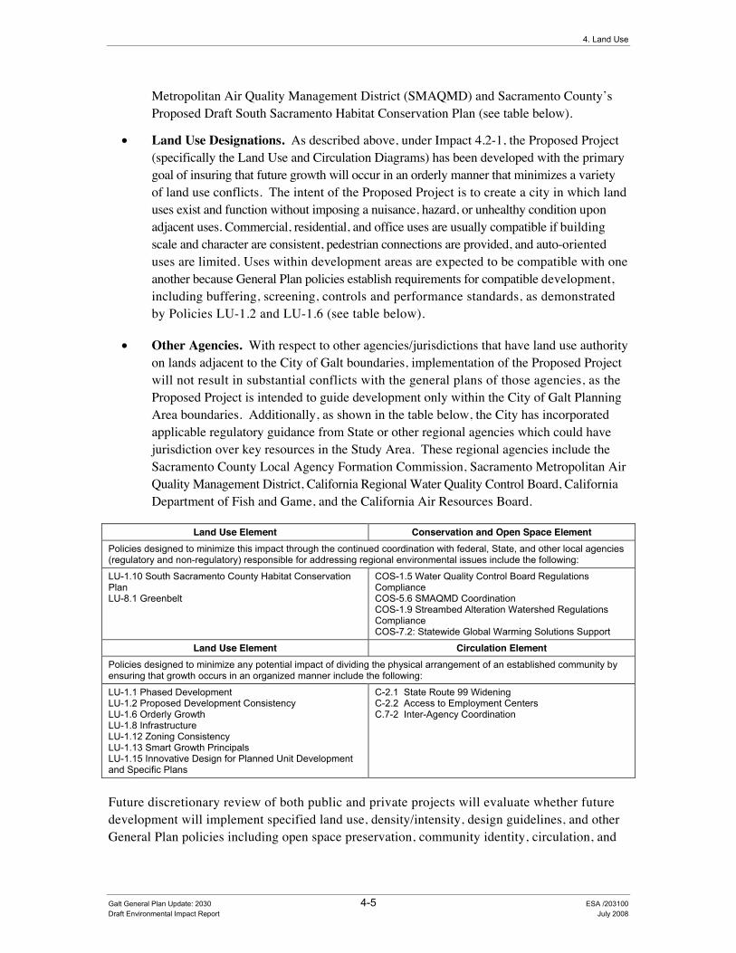
4. Land Use
Metropolitan Air Quality Management District (SMAQMD) and Sacramento County’s Proposed Draft South Sacramento Habitat Conservation Plan (see table below).
• Land Use Designations. As described above, under Impact 4.2-1, the Proposed Project (specifically the Land Use and Circulation Diagrams) has been developed with the primary goal of insuring that future growth will occur in an orderly manner that minimizes a variety of land use conflicts. The intent of the Proposed Project is to create a city in which land uses exist and function without imposing a nuisance, hazard, or unhealthy condition upon adjacent uses. Commercial, residential, and office uses are usually compatible if building scale and character are consistent, pedestrian connections are provided, and auto-oriented uses are limited. Uses within development areas are expected to be compatible with one another because General Plan policies establish requirements for compatible development, including buffering, screening, controls and performance standards, as demonstrated by Policies LU-1.2 and LU-1.6 (see table below).
• Other Agencies. With respect to other agencies/jurisdictions that have land use authority on lands adjacent to the City of Galt boundaries, implementation of the Proposed Project will not result in substantial conflicts with the general plans of those agencies, as the Proposed Project is intended to guide development only within the City of Galt Planning Area boundaries. Additionally, as shown in the table below, the City has incorporated applicable regulatory guidance from State or other regional agencies which could have jurisdiction over key resources in the Study Area. These regional agencies include the Sacramento County Local Agency Formation Commission, Sacramento Metropolitan Air Quality Management District, California Regional Water Quality Control Board, California Department of Fish and Game, and the California Air Resources Board.
Land Use Element Conservation and Open Space Element Policies designed to minimize this impact through the continued coordination with federal, State, and other local agencies (regulatory and non-regulatory) responsible for addressing regional environmental issues include the following:
LU-1.10 South Sacramento County Habitat Conservation Plan LU-8.1 Greenbelt
COS-1.5 Water Quality Control Board Regulations Compliance COS-5.6 SMAQMD Coordination COS-1.9 Streambed Alteration Watershed Regulations Compliance COS-7.2: Statewide Global Warming Solutions Support
Land Use Element Circulation Element Policies designed to minimize any potential impact of dividing the physical arrangement of an established community by ensuring that growth occurs in an organized manner include the following:
LU-1.1 Phased Development LU-1.2 Proposed Development Consistency LU-1.6 Orderly Growth LU-1.8 Infrastructure LU-1.12 Zoning Consistency LU-1.13 Smart Growth Principals LU-1.15 Innovative Design for Planned Unit Development and Specific Plans
C-2.1 State Route 99 Widening C-2.2 Access to Employment Centers C.7-2 Inter-Agency Coordination
Future discretionary review of both public and private projects will evaluate whether future development will implement specified land use, density/intensity, design guidelines, and other General Plan policies including open space preservation, community identity, circulation, and
Galt General Plan Update: 2030 4-5 ESA /203100 Draft Environmental Impact Report July 2008
City of Galt General Plan Update: 2030
the timing or provision of public facilities that do not adversely affect the Proposed Project. The Proposed Project provides the framework to guide future general plan amendments, updates, and projects under discretionary review. According to the State of California 2003 General Plan Guidelines, a general rule for determining whether “an action, program, or project is consistent with the general plan (is) if, considering all its aspects, it will further the objectives and policies of the general plan and not obstruct their attainment.” As previously described, the Proposed Project has been developed to minimize conflicts with other planning documents by ensuring environmental goals, orderly development, and coordination with regional planning efforts serve as the basis for the General Plan. With implementation of the above mentioned policies, this impact is considered less-than-significant.
Required Mitigation Measures
This impact is considered less-than-significant. No mitigation measures are required.
Impact 4.2-3: Development resulting from the Proposed Project could conflict with an adopted applicable airport land use compatibility plan.
Impact Summary
Level of Significance Before Mitigation: Potentially Significant
Required Mitigation: Mitigation Measure 4.2-3: Adopt General Plan Policy LU-1.15 “Caltrans Handbook Reference” to Address Airport Land Use Compatibility Impacts
Level of Significance After Mitigation: Less Than Significant
Impact Analysis
The nearest public airport to the City of Galt is Franklin Field, which is located six miles west of the Study Area. Mustang Airport, a small private use airport, is located one and a half miles north of the Study Area. The Study Area for the Proposed Project is located outside of the Comprehensive Land Use Plan boundary for Franklin Field.
There is no adopted airport land use plan for Mustang Airport. Furthermore, Mustang Airport does not have a Federal Aviation Administration (FAA) approved airport layout plan (ALP). However, it is worth noting that the owner of Mustang Airport has applied for public airport status. The Sacramento County Planning Commission has approved the owner’s application contingent upon completion of a Final EIR and other mitigation measures including the development of an airport land use compatibility plan (ALUCP). Should the Final EIR be approved, the Sacramento County Board of Supervisors (Board) will review the proposal and decide whether or not to allow Mustang Airport to operate as a public-use airport. Should the Board agree on the status change, it is anticipated that the number of operations at the airport will increase and that planning documents required by the County, such as an ALP and ALUCP, will be prepared.
Galt General Plan Update: 2030 4-6 ESA / 203100 Draft Environmental Impact Report July 2008
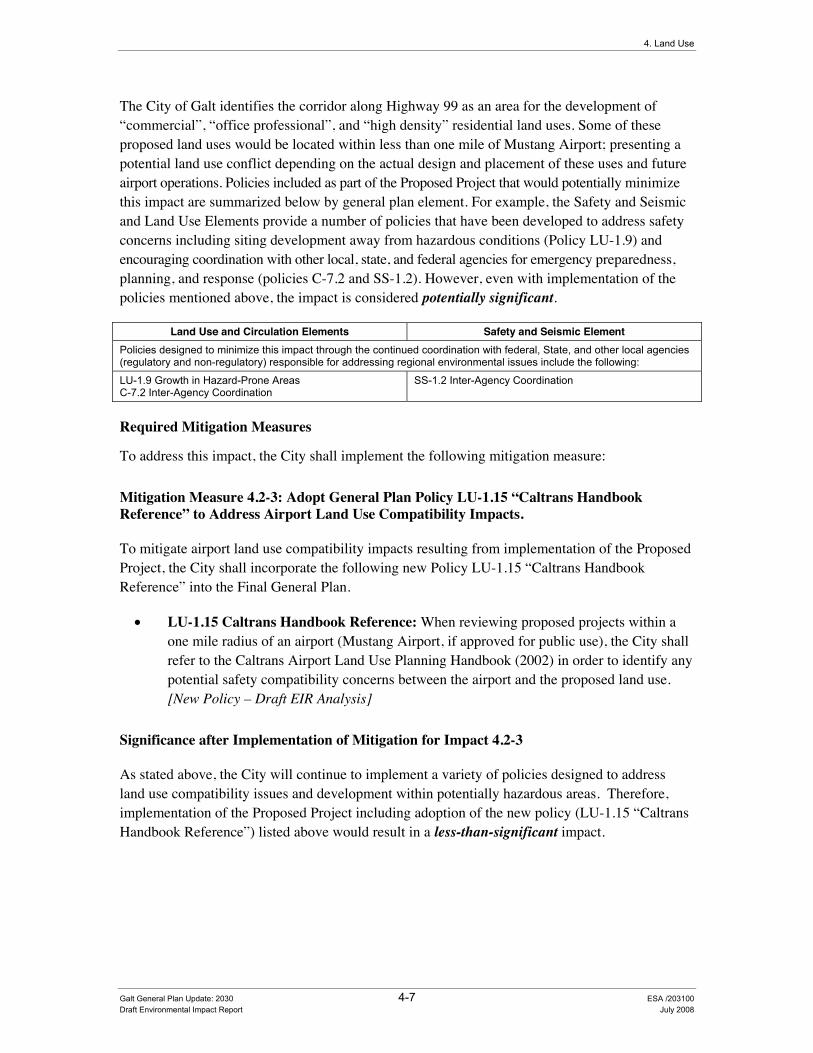
4. Land Use
The City of Galt identifies the corridor along Highway 99 as an area for the development of “commercial”, “office professional”, and “high density” residential land uses. Some of these proposed land uses would be located within less than one mile of Mustang Airport; presenting a potential land use conflict depending on the actual design and placement of these uses and future airport operations. Policies included as part of the Proposed Project that would potentially minimize this impact are summarized below by general plan element. For example, the Safety and Seismic and Land Use Elements provide a number of policies that have been developed to address safety concerns including siting development away from hazardous conditions (Policy LU-1.9) and encouraging coordination with other local, state, and federal agencies for emergency preparedness, planning, and response (policies C-7.2 and SS-1.2). However, even with implementation of the policies mentioned above, the impact is considered potentially significant.
Land Use and Circulation Elements Safety and Seismic Element Policies designed to minimize this impact through the continued coordination with federal, State, and other local agencies (regulatory and non-regulatory) responsible for addressing regional environmental issues include the following:
LU-1.9 Growth in Hazard-Prone Areas C-7.2 Inter-Agency Coordination
SS-1.2 Inter-Agency Coordination
Required Mitigation Measures
To address this impact, the City shall implement the following mitigation measure:
Mitigation Measure 4.2-3: Adopt General Plan Policy LU-1.15 “Caltrans Handbook Reference” to Address Airport Land Use Compatibility Impacts.
To mitigate airport land use compatibility impacts resulting from implementation of the Proposed Project, the City shall incorporate the following new Policy LU-1.15 “Caltrans Handbook Reference” into the Final General Plan.
• LU-1.15 Caltrans Handbook Reference: When reviewing proposed projects within a one mile radius of an airport (Mustang Airport, if approved for public use), the City shall refer to the Caltrans Airport Land Use Planning Handbook (2002) in order to identify any potential safety compatibility concerns between the airport and the proposed land use. [New Policy – Draft EIR Analysis]
Significance after Implementation of Mitigation for Impact 4.2-3
As stated above, the City will continue to implement a variety of policies designed to address land use compatibility issues and development within potentially hazardous areas. Therefore, implementation of the Proposed Project including adoption of the new policy (LU-1.15 “Caltrans Handbook Reference”) listed above would result in a less-than-significant impact.
Galt General Plan Update: 2030 4-7 ESA /203100 Draft Environmental Impact Report July 2008
City of Galt General Plan Update: 2030
Impact 4.2-4: Development resulting from the Proposed Project could conflict with an adopted Habitat Conservation Plan (HCP) or Natural Community Conservation Plan (NCCP).
Impact Summary
Level of Significance Before Mitigation: Less Than Significant
Required Mitigation Measures: No Mitigation Required
Level of Significance After Mitigation: Less Than Significant
Impact Analysis
As described above under Impact 4.2-2, policies included as part of the Proposed Project have been designed to promote consistency with the appropriate planning documents of other key neighboring land use agencies including the proposed South Sacramento Habitat Conservation Plan (SSHCP). Sacramento County is in the process of developing the SSHCP, which would provide a regional approach to addressing issues related to urban development, habitat conservation and agricultural protection. The goal of the SSHCP will be to consolidate environmental efforts that protect and enhance wetlands (primarily vernal pools) and upland habitats to provide ecologically viable conservation areas. The SSHCP will cover 46 different species of plants and wildlife including 11 that are State or federally listed as threatened or endangered.
The SSHCP will represent an agreement between State/Federal regulators and SSHCP participants to allow land owners to engage in the "incidental take" of listed species (i.e., to destroy or degrade habitat in connection with economic activity) in return for conservation commitments from the County. These commitments will be identified prior to adoption of the plan and will be fulfilled using funds from a per-acre fee paid by developers to mitigate habitat impacts from new development. Fees collected will be directed to both public and private mitigation sites that provide large-scale habitat preservation and limited habitat restoration opportunities. The geographic scope of the SSHCP includes the unincorporated County area bounded by Highway 50 to the north, the County line to the east and south; excluding the Delta, and Interstate 5 to the west. The County hopes to partner with the incorporated cities of Elk Grove, Rancho Cordova, and Galt to further advance the regional planning goals of the SSHCP (King, personal communication). A draft of the SSHCP has been recently prepared, with an environmental review of the SSHCP anticipated to begin in 2008.
Policies included as part of the Proposed Project that would minimize this potential impact are summarized below by general plan element, with a complete description of these policies and implementation measures provided in Appendix C of this draft EIR. Specifically, Policy COS-2.7, which requires that the City continue to coordinate efforts with Sacramento County in order to develop the South Sacramento County Habitat Conservation Plan. The City will continue to support the natural resource objectives administered by the County and the South Sacramento County Habitat Conservation Plan. Therefore, implementation of the Proposed Project including the adoption of the policies and implementation measures identified below would result in a less-than-significant impact.
Galt General Plan Update: 2030 4-8 ESA / 203100 Draft Environmental Impact Report July 2008

4. Land Use
Conservation and Open Space Element Policies designed to minimize this impact through the continued coordination with federal, State, and other local agencies (regulatory and non-regulatory) responsible for addressing regional environmental issues include the following:
COS-2.4 Federal, State, and Local Statutes Compliance COS-2.5 Mitigation Measures Imposition COS-2.7 Regional Habitat Conservation Efforts Coordination
Required Mitigation Measures
This impact is considered less-than-significant. No mitigation measures are required.
Galt General Plan Update: 2030 4-9 ESA /203100 Draft Environmental Impact Report July 2008


Chapter 5 Circulation and Transportation


Galt General Plan Update: 2030 5-1 ESA / 203100 Draft Environmental Impact Report July 2008
CHAPTER 5.0 &LUFXODWLRQ�DQG�7UDQVSRUWDWLRQ���
5.1 Introduction The City of Galt is predominantly a �“bedroom community,�” with the majority of workers commuting outside the City to work in the metropolitan areas of Sacramento to the north and Stockton to the south. The City population has grown from 13,000 to over 23,470 in the past ten years. Much of this growth has occurred in both the northeast and southwest portions of the City. Residential development in the City has been particularly active with the adoption of the Northeast Area Specific Plan in the late 1980s. Within the existing City Limits, the Land Use Plan of the current General Plan is largely built out for most residential land uses. With the adoption of the Preferred Land Use Plan within this General Plan Update, future growth is likely to occur both north of Twin Cities Road (State Route 104), and to the east as far as Cherokee Lane.
Retail commercial and highway commercial opportunities are located mainly in downtown Galt and along the State Route (SR) 99 corridor. Light manufacturing uses are primarily located in the west and northwestern quadrant of the City, between SR 99 and the Union Pacific Railroad tracks. Little employment growth has occurred within the City due to the proximity of Sacramento and Stockton as metropolitan employment hubs. Many commercial, office, and industrial lands remain vacant or underutilized within the City. The Galt Market remains a major regional shopping attraction each week on Tuesday and Wednesday, making Tuesday/Wednesday traffic conditions in the City significantly worse than all other days.
In developing the Proposed Project, a common chapter numbering system was used in preparing key general plan documents to allow readers the ability to find related information easily throughout the various documents. In the Existing Conditions Report, Chapter 5.0 is the �“Circulation�” section, which provides background on the transportation and roadway (circulation) network of the City. The Policy Document provides a variety of policies that have been developed to assist the City address key transportation issues and maintain efficient patterns of circulation.
This chapter of the draft EIR analyzes the impacts associated with implementation of the Proposed Project (including the circulation diagram) on transportation and circulation conditions of the Study Area.

City of Galt General Plan Update: 2030
Galt General Plan Update: 2030 5-2 ESA / 203100 Draft Environmental Impact Report July 2008
5.2 Circulation and Transportation (QYLURQPHQWDO�DQG�5HJXODWRU\�6HWWLQJ��As previously described in the �“Reader�’s Guide�” (see Chapter 1 of this draft EIR), Section 15150 of the CEQA Guidelines permits documents of lengthy technical detail to be incorporated by reference in an EIR. Specifically, Section 15150 states that an EIR may �“incorporate by reference all or portions of another document which is a matter of public record or is generally available to the public�…�” Consistent with the CEQA Guidelines and as a way to avoid creating an overwhelming amount of paper for members of the public and decision-makers to sort through, this draft EIR incorporates by reference information from both the Existing Conditions and Policy Documents. Consistent with this approach, the reader is directed to Chapter 5 of the Existing Conditions Report for environmental and regulatory setting information specific to circulation topics (see Appendix B of this draft EIR).
,PSDFW�0HWKRGRORJ\��This section provides a discussion of the techniques and methods used to analyze the transportation effects of the Proposed Project. This section provides a summary of the complete travel demand model results conducted for the Proposed Project (see Appendix D of this Draft EIR). The section begins with the identification of major circulation issues affecting the Study Area and a general description of the City�’s traffic service standards.
Circulation Issues Specific to the Study Area Observations by City staff and residents indicate several circulation issues within the Study Area beyond roadway Level-of-Service (see next section for a definition), including existing deficiencies at SR-99 freeway interchanges and the lack of an adequate intra-city circulation network. The observations were confirmed with traffic studies; the results are summarized below:
• The City lacks a �“backbone�” hierarchy of arterials, collectors, and local streets to provide a cohesive circulation system. In particular, the City lacks an arterial system that provides adequate connectivity across SR-99 and as a result, City residents tend to use the freeway for intra-city travel.
• The Central Galt/SR 99 interchange is a non-standard �“tight-diamond�” interchange design that congests regularly, particularly on Galt Market days. Improvements to this interchange are imperative for the future growth of the City.
• The Twin Cities Road/SR 99 interchange is nearing capacity and improvements are required for it to continue facilitating City and regional traffic circulation. The interchange may need realignment to the north to satisfy Caltrans requirements for one-mile spacing between adjacent intersections.
• The California Department of Transportation (Caltrans) Transportation Concept Report (TCR) for SR-99 (Caltrans District 3, May 2004) shows that the facility is being considered for a concept facility configuration as a six-lane freeway with High-Occupancy Vehicle (HOV) lane (Segment 1, PM 0.0 to 12.761). The ultimate

5. Circulation and Transportation
Galt General Plan Update: 2030 5-3 ESA / 203100 Draft Environmental Impact Report July 2008
concept is an eight-lane freeway with HOV lanes. Initial review indicates that the six-lane widening can generally occur within the center median. Widening SR-99 to eight lanes within the City will require the existing �“hook-ramps�” at Twin Cities Road, Walnut Avenue, Pringle Road, Ayers Lane, Elm Avenue, Simmerhorn Road, Fairway Drive, and Crystal Way to be removed or redesigned. The right-of-way required for the freeway widening to eight lanes is expected to require the removal of City frontage roads on at least one side of the SR-99.
• Rail traffic has increased in frequency and length of trains. The lack of separated grade crossings at railroad tracks creates circulation and safety issues and exacerbates poor cross-town circulation.
Traffic Service Standards (including Level of Service) Existing roadway operations were theoretically qualified based on the ratio between observed daily traffic volume and the roadway�’s theoretical daily traffic capacity (V/C). Qualitative Levels of Service (LOS) are calculated for various V/C thresholds, with acceptable congestion and delay represented by letter grades starting at LOS �“A�” and degrading to LOS �“F�”. The daily traffic counts are considered representative of average conditions; the counts are henceforth referred to as Average Daily Traffic (ADT). Table 5-1 presents the roadway segment LOS V/C thresholds and estimated daily volumes based on those thresholds for a set of roadway types.
Overall, the City of Galt adopted LOS D as the minimum acceptable LOS for all traffic facilities within the City limits. However, the City has also adopted a few exceptions to this policy. Specifically, the City has also adopted LOS E for roadway segments within ¼ of a mile of a state highway (Policy C-1.3), along A Street and C Street between SR 99 to the railroad tracks, and Lincoln Way between Pringle Avenue to Meladee Lane.
TABLE 5-1 ROADWAY SEGMENTS LEVEL-OF-SERVICE (LOS) CRITERIA
LOS �“A�” LOS �“B�” LOS �“C�” LOS �“D�” LOS �“E�”
All Facilities (Volume-to-Capacity Ratio (V/C)) <0.6 0.6-0.7 0.7-0.8 0.8-0.9 0.9-1.0
Two-way Average Daily Traffic (ADT) Threshold
Roadway Segment Type LOS �“A�” LOS �“B�” LOS �“C�” LOS �“D�” LOS �“E�”
6-Lane Freeway < 72,000 < 84,000 < 96,000 < 108,000 < 120,000 4-Lane Freeway < 48,000 < 56,000 < 64,000 < 72,000 < 80,000
6-lane Expressway < 36,000 < 42,000 < 48,000 < 54,000 < 60,000 4-Lane Expressway < 24,000 < 28,000 < 32,000 < 36,000 < 40,000
6-Lane Major Arterial < 29,000 < 33,500 < 38,500 < 43,000 < 48,000 4-Lane Major Arterial < 19,000 < 22,500 < 25,500 < 29,000 < 32,000 4-Lane Minor Arterial < 17,000 < 19,500 < 22,500 < 25,000 < 28,000 2-Lane Minor Arterial < 8,500 < 10,000 < 11,000 < 12,500 < 14,000
4-Lane Collector < 14,500 < 17,000 < 19,000 < 21,500 < 24,000 2-Lane Collector < 7,000 < 8,500 < 9,500 < 11,000 < 12,000

City of Galt General Plan Update: 2030
Galt General Plan Update: 2030 5-4 ESA / 203100 Draft Environmental Impact Report July 2008
TABLE 5-1 ROADWAY SEGMENTS LEVEL-OF-SERVICE (LOS) CRITERIA
Notes: 1. Based on "Highway Capacity Manual", Transportation Research Board, 2000 peak hour capacities. Daily capacities in the study area are assumed as ten times the peak hour capacity. 2. All volumes are approximate and assume ideal roadway characteristics. Actual threshold volumes for each Level of Service listed above may vary depending on a variety of factors including (but not limited to) roadway curvature and grade, intersection or interchange spacing, driveway spacing, percentage of trucks and other heavy vehicles, travel lane widths, signal timing characteristics, on-street parking, volume of cross traffic and pedestrians, etc.
Table 5-2 presents roadway descriptions that correspond with the roadway classifications presented in Table 5-1. The descriptions were derived from the Highway Capacity Manual 2000 (Transportation Research Board, 2000). These descriptions are used to describe the existing and future classifications in Table 5-3.
TABLE 5-2 ROADWAY CLASSIFICATION DESCRIPTION
Classification Access Lanes Parking
Separate Left-Turn
Lane Signals /
mile
Speed Limit (mph)
Roadside Development
Freeway Grade-separated (interchange)
4-8 No No No 65-70 No
Expressway (HCM Class I)
Grade-separated or at-grade
2-6 No Yes 0.5-2 45-55 Low density
Major Arterial (HCM Class II)
At-grade 4-8 No Yes 1-5 40-45 Low to medium density
Minor Arterial (HCM Class III)
At-grade 2-6 Some Usually 4-10 30-40 Medium to moderate density
Collector (HCM Class
IV)
At-grade 2-4 Significant Some 6-12 25-35 High Density / Residential Frontage
Source: Highway Capacity Manual 2000 (Transportation Research Board), Exhibit 10-4.
Existing Traffic Conditions This section provides a qualitative estimate of roadway operations based on a LOS, derived from the relationship between observed daily traffic volume and theoretical capacity of the roadway. The LOS was calculated based on the observed configurations, corresponding roadway classification (Table 5-2), and daily traffic thresholds (Table 5-1). This section also provides a quantitative estimate of intersection delay, as calculated by methodology contained in the Highway Capacity Manual (Transportation Research Board, 2000). The LOS is a proxy for driver delay and congestion, and indicates the amount of remaining capacity. Roadway traffic counts were performed in 2005. Intersection traffic counts were collected from 2005 through January 2008.
As shown in Table 5-3, SR-99 is estimated to operate at the cusp of Caltrans acceptable LOS �“C-D�”. Several other roadway segments including those of SR 104/Twin Cities Road, C Street, and Lincoln Way are estimated to operate near or at capacity (LOS E) under existing conditions. As previously stated, LOS E is an acceptable standard of operations for the A Street, C Street, and Lincoln Way corridors per City policy C-1.3. Note that Table 5-3 differentiates between the constructed roadway configuration, specifying between major and minor arterial characteristics, and the current General Plan (1989-2005) designation.
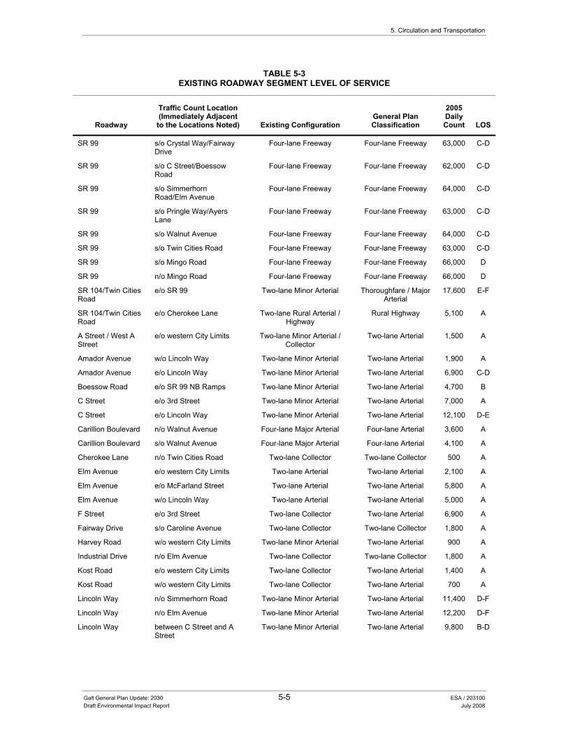
5. Circulation and Transportation
Galt General Plan Update: 2030 5-5 ESA / 203100 Draft Environmental Impact Report July 2008
TABLE 5-3 EXISTING ROADWAY SEGMENT LEVEL OF SERVICE
Roadway
Traffic Count Location (Immediately Adjacent
to the Locations Noted) Existing Configuration General Plan Classification
2005 Daily Count LOS
SR 99 s/o Crystal Way/Fairway Drive
Four-lane Freeway Four-lane Freeway 63,000 C-D
SR 99 s/o C Street/Boessow Road
Four-lane Freeway Four-lane Freeway 62,000 C-D
SR 99 s/o Simmerhorn Road/Elm Avenue
Four-lane Freeway Four-lane Freeway 64,000 C-D
SR 99 s/o Pringle Way/Ayers Lane
Four-lane Freeway Four-lane Freeway 63,000 C-D
SR 99 s/o Walnut Avenue Four-lane Freeway Four-lane Freeway 64,000 C-D
SR 99 s/o Twin Cities Road Four-lane Freeway Four-lane Freeway 63,000 C-D
SR 99 s/o Mingo Road Four-lane Freeway Four-lane Freeway 66,000 D
SR 99 n/o Mingo Road Four-lane Freeway Four-lane Freeway 66,000 D
SR 104/Twin Cities Road
e/o SR 99 Two-lane Minor Arterial Thoroughfare / Major Arterial
17,600 E-F
SR 104/Twin Cities Road
e/o Cherokee Lane Two-lane Rural Arterial / Highway
Rural Highway 5,100 A
A Street / West A Street
e/o western City Limits Two-lane Minor Arterial / Collector
Two-lane Arterial 1,500 A
Amador Avenue w/o Lincoln Way Two-lane Minor Arterial Two-lane Arterial 1,900 A
Amador Avenue e/o Lincoln Way Two-lane Minor Arterial Two-lane Arterial 6,900 C-D
Boessow Road e/o SR 99 NB Ramps Two-lane Minor Arterial Two-lane Arterial 4,700 B
C Street e/o 3rd Street Two-lane Minor Arterial Two-lane Arterial 7,000 A
C Street e/o Lincoln Way Two-lane Minor Arterial Two-lane Arterial 12,100 D-E
Carillion Boulevard n/o Walnut Avenue Four-lane Major Arterial Four-lane Arterial 3,600 A
Carillion Boulevard s/o Walnut Avenue Four-lane Major Arterial Four-lane Arterial 4,100 A
Cherokee Lane n/o Twin Cities Road Two-lane Collector Two-lane Collector 500 A
Elm Avenue e/o western City Limits Two-lane Arterial Two-lane Arterial 2,100 A
Elm Avenue e/o McFarland Street Two-lane Arterial Two-lane Arterial 5,800 A
Elm Avenue w/o Lincoln Way Two-lane Arterial Two-lane Arterial 5,000 A
F Street e/o 3rd Street Two-lane Collector Two-lane Arterial 6,900 A
Fairway Drive s/o Caroline Avenue Two-lane Collector Two-lane Collector 1,800 A
Harvey Road w/o western City Limits Two-lane Minor Arterial Two-lane Arterial 900 A
Industrial Drive n/o Elm Avenue Two-lane Collector Two-lane Collector 1,800 A
Kost Road e/o western City Limits Two-lane Collector Two-lane Arterial 1,400 A
Kost Road w/o western City Limits Two-lane Collector Two-lane Arterial 700 A
Lincoln Way n/o Simmerhorn Road Two-lane Minor Arterial Two-lane Arterial 11,400 D-F
Lincoln Way n/o Elm Avenue Two-lane Minor Arterial Two-lane Arterial 12,200 D-F
Lincoln Way between C Street and A Street
Two-lane Minor Arterial Two-lane Arterial 9,800 B-D
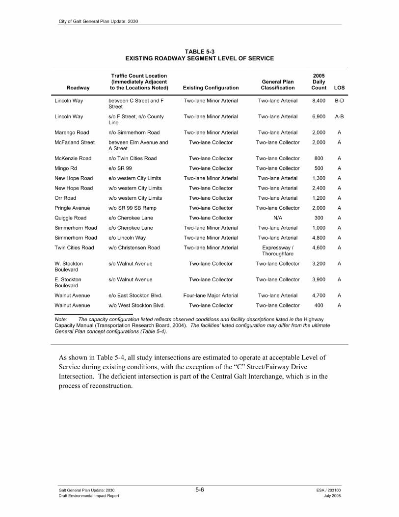
City of Galt General Plan Update: 2030
Galt General Plan Update: 2030 5-6 ESA / 203100 Draft Environmental Impact Report July 2008
TABLE 5-3 EXISTING ROADWAY SEGMENT LEVEL OF SERVICE
Roadway
Traffic Count Location (Immediately Adjacent
to the Locations Noted) Existing Configuration General Plan Classification
2005 Daily Count LOS
Lincoln Way between C Street and F Street
Two-lane Minor Arterial Two-lane Arterial 8,400 B-D
Lincoln Way s/o F Street, n/o County Line
Two-lane Minor Arterial Two-lane Arterial 6,900 A-B
Marengo Road n/o Simmerhorn Road Two-lane Minor Arterial Two-lane Arterial 2,000 A
McFarland Street between Elm Avenue and A Street
Two-lane Collector Two-lane Collector 2,000 A
McKenzie Road n/o Twin Cities Road Two-lane Collector Two-lane Collector 800 A
Mingo Rd e/o SR 99 Two-lane Collector Two-lane Collector 500 A
New Hope Road e/o western City Limits Two-lane Minor Arterial Two-lane Arterial 1,300 A
New Hope Road w/o western City Limits Two-lane Collector Two-lane Arterial 2,400 A
Orr Road w/o western City Limits Two-lane Collector Two-lane Arterial 1,200 A
Pringle Avenue w/o SR 99 SB Ramp Two-lane Collector Two-lane Collector 2,000 A
Quiggle Road e/o Cherokee Lane Two-lane Collector N/A 300 A
Simmerhorn Road e/o Cherokee Lane Two-lane Minor Arterial Two-lane Arterial 1,000 A
Simmerhorn Road e/o Lincoln Way Two-lane Minor Arterial Two-lane Arterial 4,800 A
Twin Cities Road w/o Christensen Road Two-lane Minor Arterial Expressway / Thoroughfare
4,600 A
W. Stockton Boulevard
s/o Walnut Avenue Two-lane Collector Two-lane Collector 3,200 A
E. Stockton Boulevard
s/o Walnut Avenue Two-lane Collector Two-lane Collector 3,900 A
Walnut Avenue e/o East Stockton Blvd. Four-lane Major Arterial Two-lane Arterial 4,700 A
Walnut Avenue w/o West Stockton Blvd. Two-lane Collector Two-lane Collector 400 A
Note: The capacity configuration listed reflects observed conditions and facility descriptions listed in the Highway Capacity Manual (Transportation Research Board, 2004). The facilities�’ listed configuration may differ from the ultimate General Plan concept configurations (Table 5-4).
As shown in Table 5-4, all study intersections are estimated to operate at acceptable Level of Service during existing conditions, with the exception of the �“C�” Street/Fairway Drive Intersection. The deficient intersection is part of the Central Galt Interchange, which is in the process of reconstruction.

5. Circulation and Transportation
Galt General Plan Update: 2030 5-7 ESA / 203100 Draft Environmental Impact Report July 2008
TABLE 5-4 EXISTING INTERSECTION LEVEL OF SERVICE
AM Peak Hour PM Peak Hour
# Intersection Control Type1
Target LOS Delay LOS2
Warrant Met?3 Delay LOS2
Warrant Met?3
1 Twin Cities Road/West Stockton Boulevard Signal D 31.4 C N/A 41.4 D N/A
2 Twin Cities Road/East Stockton Boulevard Signal D 29.2 C N/A 33.3 C N/A
3 Twin Cities Road/Carillion Boulevard TWSC D 28.7 D Yes 16.2 C Yes 4 Twin Cities Road/Marengo Road TWSC D 11.8 B No 11.0 B No 5 Walnut Avenue/Carillion Boulevard AWSC D 9.6 A No 8.6 A No
6 Walnut Avenue/E Stockton Blvd./SR 99 NB Ramps AWSC D 10.1 B No 9.2 A No
7 SR-99 SB Ramps-Pringle Avenue / N. Lincoln Way AWSC D 8.3 A No 14.7 B No
8 SR-99 NB Ramps-Ayers Lane / E. Stockton Boulevard-Carol Lane AWSC D 10.6 B No 10.7 B No
9 Amador Avenue / Lincoln Way Signal D 35.5 D N/A 31.7 C N/A 10 Amador Avenue / Carol Drive TWSC D 11.3 B No 11.2 B No 11 Lincoln Way / Simmerhorn Road TWSC D 28.6 D No 17.9 C No
12 SR-99 SB Ramps-Elm Avenue / Lincoln Way AWSC D 24.3 C Yes 16.7 C Yes
13 Simmerhorn Road/SR 99 NB Ramps TWSC D 10.6 B No 11.7 B No 14 Simmerhorn Road/Carillion Blvd. AWSC D 9.7 A No 8.2 A No 15 �‘A�’ Street/SR 99 SB Ramps TWSC E 10.7 B No 9.4 A No 16 Lincoln Way/C Street Signal E 31.9 C N/A 35.2 D N/A 17 �‘C�’ Street/Fairway Drive AWSC D 84.3 F Yes 44.5 E Yes 18 Boessow Road/SR 99 NB Ramps AWSC D 17.0 C No 16.6 C No 19 Lower Sacramento Road / Liberty Road TWSC D 14.5 B No 13.3 B No
Notes: 1. TWSC = Two Way (Minor Approach) Stop/Yield Control; AWSC = All Way Stop Control 2. LOS = Delay based on worst minor street approach for TWSC intersections, average delay for AWSC and signalized intersections 3. Warrant = Criteria for installing signal control based on California MUTCD Warrant 3 (peak hour traffic)
Proposed Roadway Facility Improvements The City�’s 2006 update to the Citywide Traffic Capital Improvements Program (TCIP) anticipates a number of roadway network improvements including, but not limited to, the following:
• Central Galt Interchange is planned for modification by the year 2011. The facility is congested during the morning and afternoon hours, with most of the congestion occurring at the C Street/Fairway Drive/SR 99 southbound off-ramp intersection and the Boessow Road/SR 99 northbound on- and off-ramp. The improvements involve extending and expanding the interchange bridge structure into two bridges (A Street and C Street) and on- and off-ramps to improve circulation and driver safety. The City�’s selected interchange alignment, Alternative 13A (OMNI-MEANS, 2004), was utilized for future travel forecasting within the travel demand model.

City of Galt General Plan Update: 2030
Galt General Plan Update: 2030 5-8 ESA / 203100 Draft Environmental Impact Report July 2008
• Amador-Simmerhorn Interchange near Amador Avenue and Simmerhorn Road consists of hook ramps at Simmerhorn Road, Elm Avenue, Pringle Avenue, and Ayers Lane; and overpasses at Amador Avenue and Simmerhorn Road. Study of improvements at this location is ongoing, with concepts emphasizing the widening and realigning of the overpasses, and removing some ramps. The preliminary concept analyzed in this study is a �“spread diamond�” interchange configuration, which keeps the northbound off-ramp at Simmerhorn Road, the southbound on-ramp at Elm Avenue, the northbound on-ramp at Ayers Lane, and the southbound off-ramp at Pringle Avenue. The Simmerhorn Road extension to Carol Drive would be constructed as a part of this concept.
• Walnut Avenue Interchange currently has northbound and southbound hook ramps, but lacks an overpass. The need for additional cross-freeway access is anticipated with further development in the northern and eastern portion of the City. Improvements at Walnut Avenue include constructing either an overpass or a full-access interchange.
• Twin Cities Road Interchange consists of hook ramps at East and West Stockton, and a two-lane overpass, which is anticipated for reconstruction in the TCIP. The City General Plan has the adjacent area designated for Highway Commercial and the interchange is at capacity. Further capacity is required to accommodate the build-out of the area consistent with the General Plan. The interchange may need realignment to the north to satisfy Caltrans requirements for one-mile spacing between adjacent intersections.
Other roadway improvement projects noted in the TCIP include improvements at Kost Road, F Street, A Street, Elm Avenue/Amador Drive, Twin Cities Road, Marengo Road, and sections of Walnut Avenue and C Street adjacent to their respective interchanges. The TCIP projects have been incorporated into the General Plan Update circulation system.
Roadway projects identified in the Draft Circulation Diagram (see Figure 5-1), but not identified in the TCIP, include the Walnut Avenue Extension (from Marengo to Cherokee), Carillion Road Extensions (north to Mingo and south from Boessow Road to Crystal Way), Industrial Drive Extension to Twin Cities Road, and W. Stockton Boulevard Realignment Project to Mingo Road. Marengo Road is noted in the General Plan Circulation Element as a future extension to �“A�” Street at the Central Galt Interchange. The Carillion Boulevard Extension is noted in the General Plan Circulation Element as a future extension from Simmerhorn Road to the Crystal Way/SR 99 Ramps. Interchange improvements outside the current TCIP include improvements to the Amador Avenue / Simmerhorn Road Interchange and Walnut Avenue Interchange. These improvements will be added to a revised TCIP following adoption of the General Plan.
One additional improvement not included in the TCIP, but anticipated based on other regional planning, is the widening of SR-99 to six and eventually eight lanes. The improvement to six and eight lanes is listed in the SR-99 Caltrans Transportation Concept Report (Caltrans District 3, May 2004) as the concept facility configuration and ultimate facility configuration, respectively. The section through the City of Galt is a small piece of the overall corridor improvement strategy. Deficiencies will be mitigated with widening SR 99 to eight lanes. The right-of-way required for the ultimate expansion would result in the closure of some frontage road segments and ramps.

HighSchool
ES
ES
ES
ES
ES
ES
MS
HighSchool
Wastewater Treatment Plant (City of Galt)
Twin Cities RoadTwin Cities Road (SR 104)
Walnut Avenue
Stre
et 2
Street 1
Street 3
Street 4
Stre
et 5
Stre
et 7
Street 6
Simmerhorn Road
Boessow Road
Mar
eng
o R
oad
Carillion Blvd.
G Street
Elm Street
A Street
New Hope Road
Kost Road
Lincoln Way
West Stockton Blvd.
East Stockton Blvd.
Ind
ustr
ial D
rive
Street 8
Street 9
Cry
stal
Way
HighSchool
ES
ES
ES
ES
ES
ES
MS
HighSchool
er Treatment Plant City of Galt)
Twin Cities RoadTwin Cities Road (SR 104)
WalnutWWWaalnnuuutttWWWWWaaalnnuuutt Avenuennu AAAvvveeenuu Avenueeee
Stre
etttSt
reet
reeretrSt22222
Streettrererrr 1
StreetStreetStreeteeteettStreetttt
reetreetttreeteetreettteetettttetetetetteeeeeeeeeeeeeeeeeeeeeeeeeeetreerrrrrtrrttttttSSS
333 3333333333333333333333333333333
StreetStreetStreStreStreeetStreeeeeetttSSStrrrreeeeeeStreeStreereettSS rreet 4444 4
Stre
etSt
reett
reet
Stre
etSt
reet et
tree
treee
Stre
eeSt
ree
Stre
eeSt
ree
Stre
eeeeeeeSt
reeSt
rerrrrrrSt
rtrrtrrt St SSSSSS55 555555
Stre
et 7
Street 6
SimmermeSimmeSimmeSimmeimmerrSSimmmmmmmmeeSimmeerSimmerSSimi horn Rhorn Rrn Rnnnhorn RRRRRhhhooooorrrnnhornhorn Rhorn Roadoadddooaaaaddooaaaaaddoadd
BBoessoessoBoooeeessssooooBBoooeeessssoBoesso R dR ddRRRRoooooaadddwwww RoaRw Road
Mar
eng
Mar
eng
Mar
eng
Mar
eng
Mar
eng
Mar
eng
eng
ng
aren
gM
aren
gar
eng
Mar
eng
aren
gM
aren
gM
aren
gggggen
gar
eng
enM
aren
Mar
enM
aren
aren
aren
aren
aren
Mar
eneeM
are
are
Mo
Roa
do
Roa
do
Roa
dR
oad
o R
oad
o R
oad
o R
oad
o R
oaoaaao
Roaaa
o R
oaao
Roaoao
o R
oo
Ro
oR
ooo
Ro
Ro
Ro
Rooo
Carillion Bl
ion vd.
GG StrG StreSStrG StreG StreSt eeStreG StreeeG StreGGGGG S reetetetett
l SEEl SStSStttElm St ttreet
SA Street
N HHHHHNNNN HHNew Ho RRRRRRRRRpe Rpe Rpe Rope Roape Roappp ddddddddddddddd
KKost Rostt doad
West Stockton Blvd.
East SEast SEasEast SE
Stocktotocktotockto
kkton Bn Blvdn Blvdn
..
Ind
ust
rial
Dri
ve
StreetStreetStreet
eetStreetStreetStreetS
e 8888
Streetreet
StreetStreStreetSStreetStrStreSStStStreetStreetSStrStreetSSStreSStreetSSStrStrSSSStStStStStreetStreetStreetStStStreetStreetStSttttrtrtrtrtrtrtrtre
trtrtrrrreetrrrreeeeetetetettttttttttttttttttt 9 999999999999999999999999999999
Cry
sta
Cry
stC
ryst
Cry
sC
rys
Cryy
Cr
Cl W
ay
LinLinccoLincolLincolLincoLincolLincolLincLincLincoLinLincLincoLincLincoLinc
incoiincolincolncnconcolnnncol
cnn n W
ayn W
ayn W
ayn
Way
nW
ayn
Way
n y
n Way
nnn Way
nW
ayn W
an W
ayn W
an W
ayn
Wa
n Wnn W
yn W
ayn W
ayWW
City Limits (2008)
General Plan Boundary
School
100-Year FEMA Floodplain
500-Year FEMA Floodplain
Boundary and Symbol Legend
ES
Future 6 Lane Expressway
Future 4 Lane ArterialExisting 4 Lane Arterial
Future 2 Lane ArterialExisting 2 Lane Arterial
Future 2 Lane CollectorExisting 2 Lane Collector
Street to be Removed
Circulation Legend
Residential Estates
Low Density Residential
Rural Residential
Medium Density Residential
Medium-High Density Res.
Color
Office Professional
Light Industrial
Commercial
0.5
1
4
6
11
-
-
-
0
0
1,404
216
0
0
0
5,616
1,296
0
270
11
284
-
-
-
1,451
188
1,061
150
83
412
186
367
Designation
0**
188
4,244
900
913
-
-
-
Assumed Avg. Density
Acres Inside City Limits
Acres Outside City Limits
Units Inside City Limits
Units Outside City Limits
High Density Residential 18 140 2,520 58 1,044
Land Use Legend
0 - 0.5
0 - 1
0 - 6
8 - 14
-
-
-
DensityRange
14 - 24
5 - 8
00
564564
29,58029,580
6,5886,588
2,7392,739
-
-
-
TotalPopulation
51,291
10,69210,692
Mixed-Use 18 5 88 16 2885 - 60 1,1281,128
0 0 25 0 5 0 75 1 Mile
General Plan Land UseRural Residential
Residential Estate
Low-Density Residential
Medium-Density Residential
Medium-High Density Residential
High-Density Residential
Commercial
Light Industrial
Office Professional
P Mixed Useark
Open Space
Public Quasi-Public
Planning Area Boundary
City Limit
County Boundary
0 0.5
Mile
City of Galt General Plan Update EIR . 203100Figure 5-1
City Council Preferred Land Use and Circulation Diagram
SOURCE: Sacramento County, 2007; City of Galt, 2008; Mintier & Associates, 2008; and ESA, 2008

City of Galt General Plan Update: 2030
Galt General Plan Update: 2030 5-10 ESA / 203100 Draft Environmental Impact Report July 2008
Analysis Results Future roadway operations were quantified using future traffic forecasts and the same LOS methodology as that described above to analyze for existing conditions. The future traffic forecasts were generated using the City of Galt Travel Demand Model (Omni-Means, 2007). The travel demand model forecasts the amount of trips generated by various land uses and the purpose of those trips. Complimentary trip purposes are matched between land uses as origin-destination pairs (e.g. home-to-work, home-to-shop). The trips are assigned through the traffic network based on the travel time between the zones containing the complimentary land uses. Table 5-5 compares the traffic volumes between existing conditions, conditions with build-out of the Proposed Project loaded onto the existing roadway network, and conditions with build-out of the Proposed Project loaded onto the Circulation Diagram roadway network.
Several roadway segments show large differences in projected traffic when loaded onto the existing roadway network and Circulation Diagram network. The differences are attributed to new facilities in the Circulation Diagram that redirect traffic flow. Examples of these new facilities include freeway widening to six lanes; new freeway crossings at the Central Galt Interchange and Walnut Interchange; and new east-west connections to Carillion Boulevard, Marengo Road, and Industrial Drive.
There are constraints to full implementation of the Circulation Diagram improvements, including physical constraints, environmental constraints, funding deficits, and changes to land use. Deficiencies will occur if the improvements are not constructed and alternative mitigation is not provided. All Circulation Diagram improvements, apart from improvements to State Facilities (i.e. SR 99 and SR 104 and interchange ramps) are solely City-funded and can be implemented absent funding from any other entity. Based upon prior funding levels, the necessary funds from other governmental sources will probably be available, but cannot be guaranteed. The City has adopted policies to coordinate Capital Improvements Programs (CIP) with future development (Policy PFS-1.3) and to update the CIP regularly (Policy PFS-1.6). Therefore, the Circulation Diagram and forthcoming TCIP update (following General Plan adoption) are considered adequate plans for implementation and as such, the projected impacts are not considered significant under CEQA requirements.

City
of G
alt G
ener
al P
lan
Upd
ate:
203
0
Gal
t Gen
eral
Pla
n U
pdat
e: 2
030
5-11
ES
A /
2031
00
Dra
ft E
nviro
nmen
tal I
mpa
ct R
epor
t Ju
ly 2
008
TAB
LE 5
-5
FOR
ECA
STED
FU
TUR
E G
ENER
AL
PLA
N B
UIL
D-O
UT
RO
AD
WA
Y SE
GM
ENT
LEVE
L O
F SE
RVI
CE
UN
DER
TH
E PR
OPO
SED
PR
OJE
CT
Exis
ting
Net
wor
k G
ener
al P
lan
Circ
ulat
ion
Dia
gram
Impr
oved
Net
wor
k
Roa
dway
Traf
fic C
ount
Loc
atio
n (Im
med
iate
ly A
djac
ent t
o th
e Lo
catio
ns N
oted
) Ex
istin
g C
onfig
urat
ion
2005
D
aily
C
ount
GP
Bui
ld-
Out
Dai
ly
Proj
ectio
n R
oadw
ay
LOS
Gen
eral
Pla
n Fa
cilit
y Ty
pe
GP
Bui
ld-
Out
Dai
ly
Proj
ectio
n R
oadw
ay
LOS
SR
99
s/o
Cry
stal
Way
/Fai
rway
D
rive
Four
-lane
Fre
eway
63
,000
87
,800
F
Six
-lane
Fre
eway
1 87
,800
C
SR
99
s/o
C S
treet
/Boe
ssow
Roa
d Fo
ur-la
ne F
reew
ay
62,0
00
94,6
00
F S
ix-la
ne F
reew
ay1
91,9
00
C
SR
99
s/o
Sim
mer
horn
Roa
d/E
lm
Ave
nue
Four
-lane
Fre
eway
64
,000
10
6,10
0 F
Six
-lane
Fre
eway
1 12
0,00
0 F
SR
99
s/o
Prin
gle
Way
/Aye
rs L
ane
Four
-lane
Fre
eway
63
,000
11
6,60
0 F
Six
-lane
Fre
eway
1 13
7,40
0 F
SR
99
s/o
Wal
nut A
venu
e Fo
ur-la
ne F
reew
ay
64,0
00
126,
900
F S
ix-la
ne F
reew
ay1
145,
100
F S
R 9
9 s/
o Tw
in C
ities
Roa
d Fo
ur-la
ne F
reew
ay
63,0
00
125,
000
F S
ix-la
ne F
reew
ay1
150,
100
F S
R 9
9 s/
o M
ingo
Roa
d Fo
ur-la
ne F
reew
ay
66,0
00
117,
000
F S
ix-la
ne F
reew
ay1
122,
100
F S
R 9
9 n/
o M
ingo
Roa
d Fo
ur-la
ne F
reew
ay
66,0
00
92,2
00
F S
ix-la
ne F
reew
ay1
92,2
00
C
SR
104
/Tw
in C
ities
Roa
d w
/o S
R 9
9 Tw
o-la
ne M
inor
Arte
rial
No
Cou
nt
25,9
00
F S
ix-la
ne
Exp
ress
way
/Tho
roug
hfar
e 47
,300
C
SR
104
/Tw
in C
ities
Roa
d S
R 9
9 O
verc
ross
ing
Two-
lane
Min
or A
rteria
l N
o C
ount
52
,200
F
Six
-lane
E
xpre
ssw
ay/T
horo
ughf
are
50,1
00
D
SR
104
/Tw
in C
ities
Roa
d e/
o S
R 9
9 Tw
o-la
ne M
inor
Arte
rial
17,6
00
34,7
00
F S
ix-la
ne
Exp
ress
way
/Tho
roug
hfar
e 59
,700
E
SR
104
/Tw
in C
ities
Roa
d w
/o C
arill
ion
Roa
d Tw
o-la
ne M
inor
Arte
rial
No
Cou
nt
27,3
00
F S
ix-la
ne
Exp
ress
way
/Tho
roug
hfar
e 34
,600
A
SR
104
/Tw
in C
ities
Roa
d e/
o C
arill
ion
Roa
d Tw
o-la
ne M
inor
Arte
rial
No
Cou
nt
15,0
00
F Fo
ur-la
ne M
ajor
Arte
rial
19,9
00
B
SR
104
/Tw
in C
ities
Roa
d e/
o C
hero
kee
Lane
Tw
o-la
ne M
inor
Arte
rial
5,10
0 12
,600
E
Fo
ur-la
ne M
ajor
Arte
rial
12,6
00
A
A S
treet
/ W
est A
Stre
et
e/o
wes
tern
City
Lim
its
Two-
lane
Min
or A
rteria
l /
Col
lect
or
1,50
0 7,
700
B
Two-
lane
Min
or A
rteria
l 2,
700
A
A S
treet
w
/o S
R 9
9 Tw
o-la
ne M
inor
Arte
rial
No
Cou
nt
13,1
00
E
Four
-lane
Maj
or A
rteria
l 25
,500
D
A
Stre
et
SR
99
Ove
rcro
ssin
g Fu
ture
Fac
ility
Fu
ture
Fac
ility
Fo
ur-la
ne M
ajor
Arte
rial
32,7
00
E
A S
treet
(M
aren
go R
oad
Ext
ensi
on to
In
terc
hang
e)
e/o
SR
99
Futu
re F
acili
ty
Futu
re F
acili
ty
Four
-lane
Min
or A
rteria
l 30
,600
E
Am
ador
Ave
nue
w/o
Lin
coln
Way
Tw
o-la
ne M
inor
Arte
rial
1,90
0 16
,900
F
Four
lane
Min
or A
rteria
l 7,
000
A
Am
ador
Ave
nue
SR
99
Ove
rcro
ssin
g Tw
o-la
ne M
inor
Arte
rial
6,90
0 33
,100
F
Four
lane
Min
or A
rteria
l 10
,700
A
B
oess
ow R
oad
e/o
SR
99
NB
Ram
ps
Two-
lane
Min
or A
rteria
l 4,
700
24,7
00
F Fo
ur-la
ne M
ajor
Arte
rial
15,9
00
A
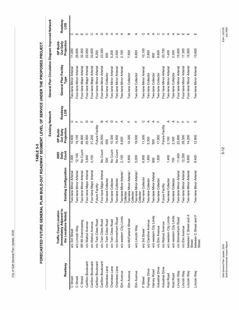
City
of G
alt G
ener
al P
lan
Upd
ate:
203
0 G
alt G
ener
al P
lan
Upd
ate:
203
0 5-
12
ES
A /
2031
00
Dra
ft E
nviro
nmen
tal I
mpa
ct R
epor
t Ju
ly 2
008
TAB
LE 5
-5
FOR
ECA
STED
FU
TUR
E G
ENER
AL
PLA
N B
UIL
D-O
UT
RO
AD
WA
Y SE
GM
ENT
LEVE
L O
F SE
RVI
CE
UN
DER
TH
E PR
OPO
SED
PR
OJE
CT
Exis
ting
Net
wor
k G
ener
al P
lan
Circ
ulat
ion
Dia
gram
Impr
oved
Net
wor
k
Roa
dway
Traf
fic C
ount
Loc
atio
n (Im
med
iate
ly A
djac
ent t
o th
e Lo
catio
ns N
oted
) Ex
istin
g C
onfig
urat
ion
2005
D
aily
C
ount
GP
Bui
ld-
Out
Dai
ly
Proj
ectio
n R
oadw
ay
LOS
Gen
eral
Pla
n Fa
cilit
y Ty
pe
GP
Bui
ld-
Out
Dai
ly
Proj
ectio
n R
oadw
ay
LOS
C S
treet
e/
o 3r
d S
treet
Tw
o-la
ne M
inor
Arte
rial
7,00
0 10
,600
C
Tw
o-la
ne M
inor
Arte
rial
11,0
00
C
C S
treet
e/
o Li
ncol
n W
ay
Two-
lane
Min
or A
rteria
l 12
,100
19
,100
F
Four
-lane
Min
or A
rteria
l 26
,600
E
C
Stre
et
SR
99
Ove
rcro
ssin
g Tw
o-la
ne M
inor
Arte
rial
No
Cou
nt
48,9
00
F Fo
ur-la
ne M
ajor
Arte
rial
32,3
00
E
Car
illio
n B
oule
vard
n/
o W
alnu
t Ave
nue
Four
-lane
Maj
or A
rteria
l 3,
600
25,0
00
D
Four
-lane
Maj
or A
rteria
l 22
,600
C
C
arill
ion
Bou
leva
rd
s/o
Wal
nut A
venu
e Fo
ur-la
ne M
ajor
Arte
rial
4,10
0 31
,200
E
Fo
ur-la
ne M
ajor
Arte
rial
22,6
00
C
Car
illio
n B
oule
vard
n/
o Tw
in C
ities
Roa
d Fu
ture
Fac
ility
Fu
ture
Fac
ility
Fo
ur-la
ne M
inor
Arte
rial
8,20
0 A
C
arill
ion
Bou
leva
rd
s/o
Twin
Citi
es R
oad
Four
-lane
Maj
or A
rteria
l N
o C
ount
20
,500
- B
Fo
ur-la
ne M
inor
Arte
rial
23,3
00
D
Che
roke
e La
ne
n/o
Twin
Citi
es R
oad
Two-
lane
Col
lect
or
500
500
A
Two-
lane
Col
lect
or
500
A
Che
roke
e La
ne
s/o
Twin
Citi
es R
oad
Two-
lane
Col
lect
or
No
Cou
nt
10,3
00
D
Two-
lane
Min
or A
rteria
l 5,
200
A
Che
roke
e La
ne
n/o
Sim
mer
horn
Roa
d Tw
o-la
ne C
olle
ctor
N
o C
ount
15
,400
F
Two-
lane
Min
or A
rteria
l 2,
000
A
Elm
Ave
nue
e/o
wes
tern
City
Lim
its
Two-
lane
Min
or A
rteria
l /
Col
lect
or
2,10
0 6,
600
A
Two-
lane
Min
or A
rteria
l 2,
100
A
Elm
Ave
nue
e/o
McF
arla
nd S
treet
Tw
o-la
ne M
inor
Arte
rial /
C
olle
ctor
5,
800
14,3
00
F Tw
o-la
ne C
olle
ctor
7,
500
B
Elm
Ave
nue
w/o
Lin
coln
Way
Tw
o-la
ne M
inor
Arte
rial /
C
olle
ctor
5,
000
18,0
00
F Tw
o-la
ne C
olle
ctor
6,
800
A
F S
treet
e/
o 3r
d S
treet
Tw
o-la
ne C
olle
ctor
6,
900
11,0
00
C
Two-
lane
Min
or A
rteria
l 10
,100
C
Fa
irway
Driv
e s/
o C
arol
ine
Ave
nue
Two-
lane
Col
lect
or
1,80
0 5,
300
A
Two-
lane
Col
lect
or
2,80
0 A
H
arve
y R
oad
w/o
wes
tern
City
Lim
its
Two-
lane
Min
or A
rteria
l 90
0 90
0 A
Tw
o-la
ne C
olle
ctor
90
0 A
In
dust
rial D
rive
n/o
Elm
Ave
nue
Two-
lane
Col
lect
or
1,80
0 17
,900
F
Two-
lane
Col
lect
or
8,60
0 C
In
dust
rial D
rive
s/o
Wal
nut A
venu
e Fu
ture
Fac
ility
Fu
ture
Fac
ility
Fo
ur la
ne M
inor
Arte
rial
20,7
00
C
Kos
t Roa
d e/
o w
este
rn C
ity L
imits
Tw
o-la
ne C
olle
ctor
1,
400
2,10
0 A
Tw
o-la
ne M
inor
Arte
rial
1,40
0 A
K
ost R
oad
w/o
wes
tern
City
Lim
its
Two-
lane
Col
lect
or
700
2,30
0 A
Tw
o-la
ne C
olle
ctor
2,
300
A
Linc
oln
Way
n/
o S
imm
erho
rn R
oad
Two-
lane
Min
or A
rteria
l 11
,400
23
,800
F
Four
lane
Min
or A
rteria
l 15
,600
E
Li
ncol
n W
ay
n/o
Elm
Ave
nue
Two-
lane
Min
or A
rteria
l 12
,200
29
,300
F
Four
-lane
Min
or A
rteria
l 17
,300
E
Li
ncol
n W
ay
betw
een
C S
treet
and
A
Stre
et
Two-
lane
Min
or A
rteria
l 9,
800
14,2
00
F Fo
ur-la
ne M
inor
Arte
rial
15,9
00
E
Linc
oln
Way
be
twee
n C
Stre
et a
nd F
S
treet
Tw
o-la
ne M
inor
Arte
rial
8,40
0 12
,800
E
Tw
o-la
ne M
inor
Arte
rial
13,6
00
E

5. C
ircul
atio
n an
d Tr
ansp
orta
tion
Gal
t Gen
eral
Pla
n U
pdat
e: 2
030
5-13
ES
A /
2031
00
Dra
ft E
nviro
nmen
tal I
mpa
ct R
epor
t Ju
ly 2
008
TAB
LE 5
-5
FOR
ECA
STED
FU
TUR
E G
ENER
AL
PLA
N B
UIL
D-O
UT
RO
AD
WA
Y SE
GM
ENT
LEVE
L O
F SE
RVI
CE
UN
DER
TH
E PR
OPO
SED
PR
OJE
CT
Exis
ting
Net
wor
k G
ener
al P
lan
Circ
ulat
ion
Dia
gram
Impr
oved
Net
wor
k
Roa
dway
Traf
fic C
ount
Loc
atio
n (Im
med
iate
ly A
djac
ent t
o th
e Lo
catio
ns N
oted
) Ex
istin
g C
onfig
urat
ion
2005
D
aily
C
ount
GP
Bui
ld-
Out
Dai
ly
Proj
ectio
n R
oadw
ay
LOS
Gen
eral
Pla
n Fa
cilit
y Ty
pe
GP
Bui
ld-
Out
Dai
ly
Proj
ectio
n R
oadw
ay
LOS
Linc
oln
Way
s/
o F
Stre
et
Two-
lane
Min
or A
rteria
l 6,
900
10,3
00
C
Two-
lane
Min
or A
rteria
l 9,
000
B
Mar
engo
Roa
d n/
o S
imm
erho
rn R
oad
Two-
lane
Min
or A
rteria
l 2,
000
5,10
0 A
Fo
ur-la
ne M
inor
Arte
rial
9,00
0 A
M
cFar
land
Stre
et
betw
een
Elm
Ave
nue
and
A
Stre
et
Two-
lane
Col
lect
or
2,00
0 7,
600
B
Two-
lane
Col
lect
or
2,00
0 A
Min
go R
d e/
o S
R 9
9 Tw
o-la
ne C
olle
ctor
50
0 16
,200
F
Six
lane
Maj
or A
rteria
l 39
,900
C
M
ingo
Rd
SR
99
Ove
rcro
ssin
g Fu
ture
Fac
ility
Fu
ture
Fac
ility
S
ix-la
ne M
ajor
Arte
rial
39,4
00
C
Min
go R
d w
/o S
R 9
9 Fu
ture
Fac
ility
Fu
ture
Fac
ility
S
ix la
ne M
ajor
Arte
rial
39,9
00
C
New
Hop
e R
oad
e/o
wes
tern
City
Lim
its
Two-
lane
Min
or A
rteria
l 1,
300
3,90
0 A
Tw
o-la
ne M
inor
Arte
rial
2,50
0 A
N
ew H
ope
Roa
d w
/o w
este
rn C
ity L
imits
Tw
o-la
ne C
olle
ctor
2,
400
3,80
0 A
Tw
o-la
ne C
olle
ctor
3,
800
A
Orr
Roa
d w
/o w
este
rn C
ity L
imits
Tw
o-la
ne C
olle
ctor
1,
200
1,50
0 A
Tw
o-la
ne C
olle
ctor
1,
500
A
Prin
gle
Ave
nue
w/o
SR
99
SB
Ram
p Tw
o-la
ne C
olle
ctor
2,
000
8,40
0 B
Tw
o-la
ne C
olle
ctor
7,
100
B
Qui
ggle
Roa
d e/
o C
hero
kee
Lane
Tw
o-la
ne C
olle
ctor
30
0 30
0 A
Tw
o-la
ne C
olle
ctor
30
0 A
S
imm
erho
rn R
oad
e/o
Che
roke
e La
ne
Two-
lane
Min
or A
rteria
l 1,
000
4,90
0 A
Tw
o-la
ne M
inor
Arte
rial
4,90
0 A
S
imm
erho
rn R
oad
SR
99
Ove
rcro
ssin
g Tw
o-la
ne M
inor
Arte
rial
4,80
0 36
,600
F
Four
-lane
Min
or A
rteria
l 23
,700
D
Tw
in C
ities
Roa
d w
/o C
hris
tens
en R
oad
Two-
lane
Min
or A
rteria
l 4,
600
8,80
0 B
Tw
o-la
ne M
inor
Arte
rial
8,80
0 B
W
. Sto
ckto
n B
oule
vard
s/
o W
alnu
t Ave
nue
Two-
lane
Col
lect
or
3,20
0 15
,000
F
Two-
lane
Col
lect
or
7,80
0 A
W
. Sto
ckto
n B
oule
vard
n/
o W
alnu
t Ave
nue
Two-
lane
Col
lect
or
No
Cou
nt
19,7
00
F Tw
o-la
ne M
inor
Arte
rial
6,40
0 A
W
. Sto
ckto
n B
oule
vard
s/
o Tw
in C
ities
Roa
d Tw
o-la
ne C
olle
ctor
N
o C
ount
16
,700
F
Two-
lane
Min
or A
rteria
l 6,
000
A
E. S
tock
ton
Bou
leva
rd
s/o
Wal
nut A
venu
e Tw
o-la
ne C
olle
ctor
3,
900
20,9
00
F R
oadw
ay R
emov
ed fo
r SR
99
Wid
enin
g E
. Sto
ckto
n B
oule
vard
n/
o W
alnu
t Ave
nue
Two-
lane
Col
lect
or
No
Cou
nt
11,0
00
E
Roa
dway
Rem
oved
for S
R 9
9 W
iden
ing
E. S
tock
ton
Bou
leva
rd
n/o
Twin
Citi
es R
oad
Two-
lane
Col
lect
or
No
Cou
nt
10,6
00
D
Four
-lane
Min
or A
rteria
l 24
,200
C
W
alnu
t Ave
nue
e/o
Eas
t Sto
ckto
n B
lvd.
Fo
ur-la
ne M
ajor
Arte
rial
4,70
0 28
,400
D
S
ix la
ne M
ajor
Arte
rial
32,8
00
C
Wal
nut A
venu
e w
/o W
est S
tock
ton
Blv
d.
Two-
lane
Col
lect
or
400
8,40
0 B
S
ix la
ne M
ajor
Arte
rial
36,5
00
C
Wal
nut A
venu
e S
R 9
9 O
verc
ross
ing
Futu
re F
acili
ty
Futu
re F
acili
ty
Six
-lane
Maj
or A
rteria
l 40
,500
E
N
ote:
1.
Ulti
mat
e co
ncep
t is
eigh
t-lan
e fre
eway
. S
ix la
nes
wer
e an
alyz
ed b
ased
on
an e
stim
ate
of fe
asib
le im
prov
emen
ts w
ithin
the
timef
ram
e fo
r pro
ject
bui
ld-o
ut.
Ave
rage
Dai
ly T
raffi
c (A
DT)
is th
e to
tal v
olum
e of
veh
icle
traf
fic in
bot
h di
rect
ions
of a
hig
hway
or r
oad
for w
hat i
s co
nsid
ered
�“ave
rage
�”, i.e
. typ
ical
, con
ditio
ns.

City
of G
alt G
ener
al P
lan
Upd
ate:
203
0 G
alt G
ener
al P
lan
Upd
ate:
203
0 5-
14
ES
A /
2031
00
Dra
ft E
nviro
nmen
tal I
mpa
ct R
epor
t Ju
ly 2
008
TAB
LE 5
-6
FOR
ECA
STED
GEN
ERA
L PL
AN
BU
ILD
-OU
T FU
TUR
E R
OA
DW
AY
SEG
MEN
TS T
HA
T W
ILL
EXC
EED
AD
OPT
ED L
EVEL
OF
SER
VIC
E ST
AN
DA
RD
S
Exis
ting
Net
wor
k G
ener
al P
lan
Circ
ulat
ion
Dia
gram
Impr
oved
Net
wor
k
Roa
dway
Traf
fic C
ount
Loc
atio
n (Im
med
iate
ly A
djac
ent t
o th
e Lo
catio
ns N
oted
) Fa
cilit
y Ty
pe
2005
Dai
ly
Cou
nt
GP
Bui
ld-
Out
Dai
ly
Proj
ectio
n R
oadw
ay
LOS
GP
Bui
ld-O
ut D
aily
Pr
ojec
tion
Roa
dway
LO
S
GP
Bui
ld-
Out
Dai
ly
Proj
ectio
n
SR
99
s/o
Sim
mer
horn
Roa
d/E
lm
Ave
nue
Four
-lane
Fre
eway
64
,000
10
6,10
0 F
Six
-lane
Fre
eway
1 12
0,00
0 F
S
R 9
9 s/
o P
ringl
e A
venu
e/A
yers
Lan
e Fo
ur-la
ne F
reew
ay
63,0
00
116,
600
F S
ix-la
ne F
reew
ay1
137,
400
F
SR
99
s/o
Wal
nut A
venu
e Fo
ur-la
ne F
reew
ay
64,0
00
126,
900
F S
ix-la
ne F
reew
ay1
145,
100
F
SR
99
s/o
Twin
Citi
es R
oad
Four
-lane
Fre
eway
63
,000
12
5,00
0 F
Six
-lane
Fre
eway
1 15
0,10
0 F
S
R 9
9 s/
o M
ingo
Roa
d Fo
ur-la
ne F
reew
ay
66,0
00
117,
000
F S
ix-la
ne F
reew
ay1
122,
100
F
SR
104
/Tw
in C
ities
Roa
d S
R 9
9 O
verc
ross
ing
Two-
lane
Min
or
Arte
rial
No
Cou
nt
52,2
00
F
Six
-lane
E
xpre
ssw
ay/T
horo
ughf
are
50,1
00
E
SR
104
/Tw
in C
ities
Roa
d e/
o S
R 9
9
Two-
lane
Min
or
Arte
rial
17,6
00
34,7
00
F
Six
-lane
E
xpre
ssw
ay/T
horo
ughf
are
59,7
00
E
N
ote:
1.
Ulti
mat
e co
ncep
t is
eigh
t-lan
e fre
eway
. Six
lane
s w
ere
anal
yzed
bas
ed o
n th
e fe
asib
le ti
mef
ram
e fo
r pro
ject
bui
ld-o
ut.

5. Circulation and Transportation
Galt General Plan Update: 2030 5-15 ESA / 203100 Draft Environmental Impact Report July 2008
The majority of City intersections in the improved roadway circulation system are projected to operate at acceptable LOS. Future intersections will be configured based on the capacity of the adjacent roadway segments. Table 5-7 presents intersections forecasted to operate at or over their capacity upon General Plan build-out. Some intersections are planned for improvements consistent with roadway improvements (e.g. widening, interchange reconstruction, etc). Several existing intersections have limited right-of-way for further expansion; the constraints to mitigation are identified in the table below.
TABLE 5-7 FORECASTED AT-CAPACITY OR OVERCAPACITY INTERSECTIONS
Deficient Intersection Existing Control Feasible Mitigation
Twin Cities Road / SR 104 / SR 99 Interchange
Signal Control, Two-Lane Overcrossing
Reconstruct Interchange, Six to Eight Lane Overcrossing
Walnut Avenue/SR 99 NB Ramps Stop Sign Control, No Overcrossing
Reconstruct Interchange, Four to Six Lane Overcrossing
Walnut Avenue/Carillion Blvd. Stop Sign Control Install signal control. Further turning movement lane channelization, limited right-of-way available
Lincoln Way/Pringle Avenue Stop Sign Control
Lincoln Way/Amador Avenue Signal Control
Lincoln Way/Simmerhorn Road
Lincoln Way/Elm Avenue
Ayers Lane/Carol Drive/SR 99 NB Ramps
Simmerhorn Road/SR 99 NB Ramps
Stop Sign Control
Signal control and/or ramp/interchange reconstruction with Ayers Lane, Amador Avenue, and Simmerhorn Road. Lincoln Way has limited right-of-way for further widening. Deficiency is mitigated with City adoption of LOS �“E�” exception for the A Street, C Street, and Lincoln Way corridors (Policy C-1.3).
Lincoln Way/A Street
Lincoln Way/C Street
Signal Control Lincoln Way has limited right-of-way for further widening. Deficiency is mitigated with City adoption of LOS �“E�” exception for the Lincoln Way corridor (Policy C-1.3).
A Street / C Street /. SR 99 (Central Galt) Interchange
Stop Sign Control, Two-Lane Overcrossing
Interchange currently in reconstruction process
Glendale Avenue/Fairway Drive/SR 99 SB Ramps
Stop Sign Control LOS improves when Central Galt Interchange is improved. Traffic is diverted from this facility.
Proposed Bicycle Facility Improvements The Galt Bicycle Transportation Plan (May 2002) proposes a number of new Class II bikeways to create a citywide trail system. The citywide network aims to connect major activity centers and thereby promote non-motorized travel modes for short trips within the City. The Class II bikeway system includes the facilities listed in Table 5-8. The Proposed Project also includes policies that require the development of bicycle facilities on all new collector streets and minor arterials with 60 feet of available right-of-way (as determined feasible).
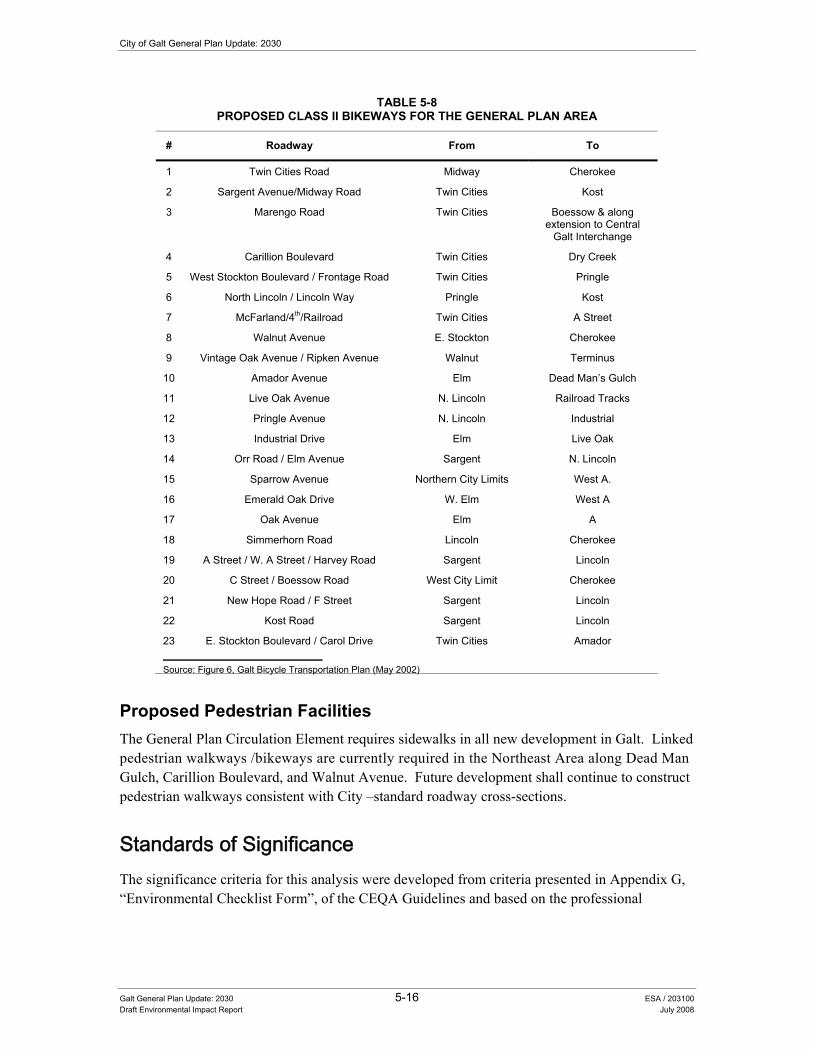
City of Galt General Plan Update: 2030
Galt General Plan Update: 2030 5-16 ESA / 203100 Draft Environmental Impact Report July 2008
TABLE 5-8 PROPOSED CLASS II BIKEWAYS FOR THE GENERAL PLAN AREA
# Roadway From To
1 Twin Cities Road Midway Cherokee
2 Sargent Avenue/Midway Road Twin Cities Kost
3 Marengo Road Twin Cities Boessow & along extension to Central
Galt Interchange
4 Carillion Boulevard Twin Cities Dry Creek
5 West Stockton Boulevard / Frontage Road Twin Cities Pringle
6 North Lincoln / Lincoln Way Pringle Kost
7 McFarland/4th/Railroad Twin Cities A Street
8 Walnut Avenue E. Stockton Cherokee
9 Vintage Oak Avenue / Ripken Avenue Walnut Terminus
10 Amador Avenue Elm Dead Man�’s Gulch
11 Live Oak Avenue N. Lincoln Railroad Tracks
12 Pringle Avenue N. Lincoln Industrial
13 Industrial Drive Elm Live Oak
14 Orr Road / Elm Avenue Sargent N. Lincoln
15 Sparrow Avenue Northern City Limits West A.
16 Emerald Oak Drive W. Elm West A
17 Oak Avenue Elm A
18 Simmerhorn Road Lincoln Cherokee
19 A Street / W. A Street / Harvey Road Sargent Lincoln
20 C Street / Boessow Road West City Limit Cherokee
21 New Hope Road / F Street Sargent Lincoln
22 Kost Road Sargent Lincoln
23 E. Stockton Boulevard / Carol Drive Twin Cities Amador
Source: Figure 6, Galt Bicycle Transportation Plan (May 2002)
Proposed Pedestrian Facilities The General Plan Circulation Element requires sidewalks in all new development in Galt. Linked pedestrian walkways /bikeways are currently required in the Northeast Area along Dead Man Gulch, Carillion Boulevard, and Walnut Avenue. Future development shall continue to construct pedestrian walkways consistent with City �–standard roadway cross-sections.
6WDQGDUGV�RI�6LJQLILFDQFH�The significance criteria for this analysis were developed from criteria presented in Appendix G, �“Environmental Checklist Form�”, of the CEQA Guidelines and based on the professional

5. Circulation and Transportation
Galt General Plan Update: 2030 5-17 ESA /203100 Draft Environmental Impact Report July 2008
judgment of the City of Galt and its consultants. The project (or the project alternatives) would result in a significant impact if it would:
• Cause an increase in traffic which is substantial in relation to the existing traffic load and capacity of the street system (e.g., result in a substantial increase in either the number of vehicle trips, the volume to capacity ratio on roads, or congestion at intersections);
• Exceed, either individually or cumulatively, a level of service standard established by the City for designated roads;
• Result in inadequate parking capacity; or
• Conflict with adopted policies, plans, or programs supporting alternative transportation (e.g., bus turnouts, bicycle racks).
,PSDFWV�DQG�0LWLJDWLRQ�0HDVXUHV�
Impact 5.2-1: The Proposed Project would cause an increase in traffic which is substantial in relation to the existing traffic load and capacity of the street system (e.g., result in a substantial increase in either the number of vehicle trips, the volume to capacity ratio on roads, or congestion at intersections).
Impact Summary
Level of Significance Before Mitigation: Potentially Significant
Required Mitigation Measures: No Feasible Mitigation is Available
Level of Significance After Mitigation: Significant and Unavoidable
Impact Analysis
Implementation of the Proposed Project (including the Preferred Land Use Alternative and the Circulation Diagram) includes substantial amounts of new development in the Study Area. The analysis methodology (provided above) describes in detail the traffic implications to several local and regional intersections and roadways resulting from the Proposed Project. As described in detail in the section on �“Impact Methodology�”, there are some intersections and roadway facilities where it is not possible to achieve the City�’s desired level of service (LOS D) given the presence of local physical and/or environmental constraints. Table 5-6 and Table 5-7 identify intersection and roadway facilities where operations beyond LOS D are projected, even with implementation of the Proposed Project and several of its associated circulation improvements. LOS F occurs only along SR 99, which is a regional facility that carries both City and regional traffic.
Policies included as part of the Proposed Project that would minimize this impact are summarized below by General Plan Element, with a complete description of these policies provided in Appendix C �“Policy Document�” of this draft EIR. As shown below, policies included in the Circulation Element have been designed to minimize circulation and transportation impacts
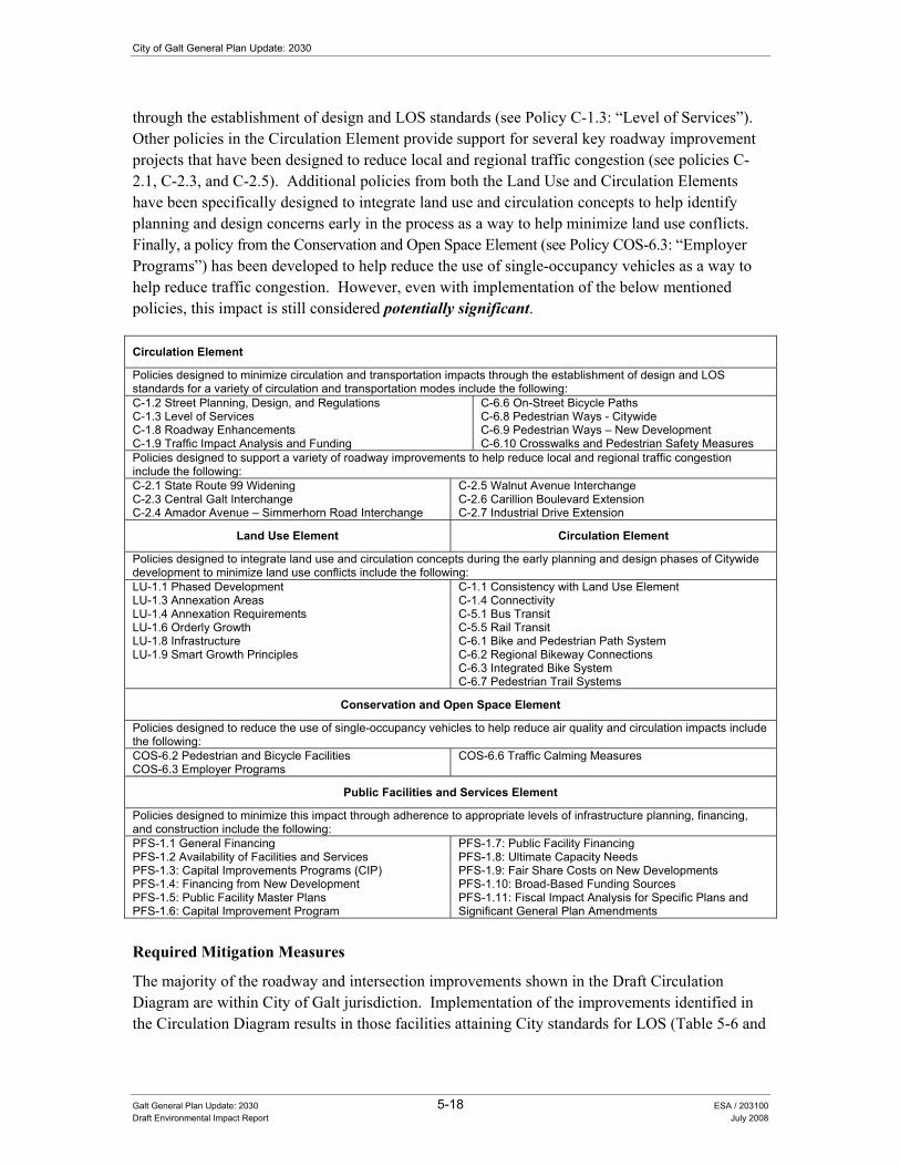
City of Galt General Plan Update: 2030
Galt General Plan Update: 2030 5-18 ESA / 203100 Draft Environmental Impact Report July 2008
through the establishment of design and LOS standards (see Policy C-1.3: �“Level of Services�”). Other policies in the Circulation Element provide support for several key roadway improvement projects that have been designed to reduce local and regional traffic congestion (see policies C-2.1, C-2.3, and C-2.5). Additional policies from both the Land Use and Circulation Elements have been specifically designed to integrate land use and circulation concepts to help identify planning and design concerns early in the process as a way to help minimize land use conflicts. Finally, a policy from the Conservation and Open Space Element (see Policy COS-6.3: �“Employer Programs�”) has been developed to help reduce the use of single-occupancy vehicles as a way to help reduce traffic congestion. However, even with implementation of the below mentioned policies, this impact is still considered potentially significant.
Circulation Element
Policies designed to minimize circulation and transportation impacts through the establishment of design and LOS standards for a variety of circulation and transportation modes include the following: C-1.2 Street Planning, Design, and Regulations C-1.3 Level of Services C-1.8 Roadway Enhancements C-1.9 Traffic Impact Analysis and Funding
C-6.6 On-Street Bicycle Paths C-6.8 Pedestrian Ways - Citywide C-6.9 Pedestrian Ways �– New Development C-6.10 Crosswalks and Pedestrian Safety Measures
Policies designed to support a variety of roadway improvements to help reduce local and regional traffic congestion include the following: C-2.1 State Route 99 Widening C-2.3 Central Galt Interchange C-2.4 Amador Avenue �– Simmerhorn Road Interchange
C-2.5 Walnut Avenue Interchange C-2.6 Carillion Boulevard Extension C-2.7 Industrial Drive Extension
Land Use Element Circulation Element
Policies designed to integrate land use and circulation concepts during the early planning and design phases of Citywide development to minimize land use conflicts include the following: LU-1.1 Phased Development LU-1.3 Annexation Areas LU-1.4 Annexation Requirements LU-1.6 Orderly Growth LU-1.8 Infrastructure LU-1.9 Smart Growth Principles
C-1.1 Consistency with Land Use Element C-1.4 Connectivity C-5.1 Bus Transit C-5.5 Rail Transit C-6.1 Bike and Pedestrian Path System C-6.2 Regional Bikeway Connections C-6.3 Integrated Bike System C-6.7 Pedestrian Trail Systems
Conservation and Open Space Element
Policies designed to reduce the use of single-occupancy vehicles to help reduce air quality and circulation impacts include the following: COS-6.2 Pedestrian and Bicycle Facilities COS-6.3 Employer Programs
COS-6.6 Traffic Calming Measures
Public Facilities and Services Element
Policies designed to minimize this impact through adherence to appropriate levels of infrastructure planning, financing, and construction include the following: PFS-1.1 General Financing PFS-1.2 Availability of Facilities and Services PFS-1.3: Capital Improvements Programs (CIP) PFS-1.4: Financing from New Development PFS-1.5: Public Facility Master Plans PFS-1.6: Capital Improvement Program
PFS-1.7: Public Facility Financing PFS-1.8: Ultimate Capacity Needs PFS-1.9: Fair Share Costs on New Developments PFS-1.10: Broad-Based Funding Sources PFS-1.11: Fiscal Impact Analysis for Specific Plans and Significant General Plan Amendments
Required Mitigation Measures
The majority of the roadway and intersection improvements shown in the Draft Circulation Diagram are within City of Galt jurisdiction. Implementation of the improvements identified in the Circulation Diagram results in those facilities attaining City standards for LOS (Table 5-6 and
5. Circulation and Transportation
Galt General Plan Update: 2030 5-19 ESA /203100 Draft Environmental Impact Report July 2008
Table 5-7). Improvements noted in Circulation Diagram, but that are not in the current Traffic Capital Improvement Program (TCIP), will be added in a TCIP update (Policy PFS-1.3 and PFS-1.6). Improvements are listed in the previous Proposed Roadway Facility Improvements (p. 5-9 and 5-10). Overall, the Public Facilities and Services Element includes a number of policies that will continue to recognize the City�’s commitment to early planning for future roadway infrastructure needs including the financing of needed improvements identified in the TCIP (see policies PFS-1.1 �“General Financing�”, PFS-1.3 �“Capital Improvements Programs�”, PFS-1.6 �“Capital Improvement Program�” and PFS-1.4 �“Financing from New Development�”).
Some of the roadway and intersection improvements shown in the Draft Circulation Diagram are on facilities under the jurisdiction of entities outside of the City of Galt, such as Caltrans and Sacramento and San Joaquin County. Implementation of the proposed improvements would be subject to approval by other agencies, as well as to funding programs that are not fully developed at this time. The City shall mitigate its impact by collecting fees that represent its fair share contribution to the regional improvements. The City has committed to adopting the Measure A Sacramento Countywide Transportation Mitigation Fee Program (SCTMFP, City Resolution 2006-99, June 7, 2006). Full funding of the regional improvements and their timely construction would require substantial coordination and cooperation between the City and other agencies.
For example, the design and construction of any improvements involving a state route or highway (i.e., SR 99 or SR 104) would be subject to oversight and approval of Caltrans, and funding would likely come from a combination of sources, including State funds, regional funds, and (potentially) local funds such as developer fees. If these improvements are delayed such that implementation does not coincide with the development envisioned under the Proposed Project, the likely result would be greater levels of traffic congestion than identified in this draft EIR along both the existing freeway system and the major parallel streets in the City.
In summary, the Proposed Project addresses its traffic effects through a combination of policies and the physical improvements identified in the Circulation Diagram. Some physical improvements to facilities outside City jurisdiction would require cooperation and funding from a variety of entities outside of the City, so implementation of these improvements cannot be guaranteed solely through the City�’s actions. Therefore, implementation of the Proposed Project including the adoption of the policies identified above would result in a significant impact. No additional feasible mitigation is currently available.
Significance after Implementation of Mitigation for Impact 5.2-1
Even with an update to the TCIP and collection of fees for future improvements for new facilities, there may be a delay between the need and full funding for improvements. The timing for State and regional funding for regional facilities is uncertain. Therefore, no additional feasible mitigation measures are currently available to reduce this impact to a less than significant level. Consequently, this impact is considered significant and unavoidable.
City of Galt General Plan Update: 2030
Galt General Plan Update: 2030 5-20 ESA / 203100 Draft Environmental Impact Report July 2008
Impact 5.2-2: The Proposed Project would exceed, either individually or cumulatively, a level of service standard established by the City on facilities that do not connect with regional facilities.
Impact Summary
Level of Significance Before Mitigation: Less Than Significant
Required Mitigation Measures: No Mitigation Required
Level of Significance After Mitigation: Less Than Significant
Impact Analysis
As identified above under Impact 5.2-1, implementation of the Proposed Project (including the Preferred Land Use Alternative and the Circulation Diagram) includes substantial amounts of new development in the Study Area. Future development consistent with the Proposed Project would require additional traffic capacity at existing facilities in developed areas and new facilities in undeveloped areas to maintain the LOS standard established by the City for designated roads. Table 5-6 and Table 5-7 (above) identifies those facilities where operations at LOS E or F are projected, even with implementation of the Proposed Project and several of its associated circulation improvements.
Policies included as part of the Proposed Project that would minimize this impact are summarized below by General Plan Element, with a complete description of these policies provided in Appendix C �“Policy Document�” of this draft EIR. As shown below, policies included in the Circulation Element have been designed to minimize circulation and transportation impacts through the establishment of design and LOS standards (see Policy C-1.3: �“Level of Services�”). Other policies in the Circulation Element provide support for several key roadway improvement projects that have been designed to reduce local and regional traffic congestion (see policies C-2.1, C-2.3, and C-2.5). Additional policies from both the Land Use and Circulation Elements have been specifically designed to integrate land use and circulation concepts to help identify planning and design concerns early in the process as a way to help minimize land use conflicts. Finally, policies from the Conservation and Open Space Element (see Policy COS-6.3: �“Employer Programs�”) have been developed to help reduce the use of single-occupancy vehicles as a way to help reduce traffic congestion.
In summary, the Proposed Project addresses its traffic effects through a combination of policies and the physical improvements identified in the Circulation Diagram. All City facilities that do not connect to regional facilities fall within City standards for LOS with implementation of the improvements identified in the Circulation Diagram. Consequently, with implementation of the City-funded improvements identified in the Circulation Diagram and the below mentioned policies, this impact is considered less-than-significant.

5. Circulation and Transportation
Galt General Plan Update: 2030 5-21 ESA /203100 Draft Environmental Impact Report July 2008
Circulation Element
Policies designed to minimize circulation and transportation impacts through the establishment of design and LOS standards for a variety of circulation and transportation modes include the following: C-1.2 Street Planning, Design, and Regulations C-1.3 Level of Services C-1.8 Roadway Enhancements C-1.9 Traffic Impact Analysis and Funding
C-6.6 On-Street Bicycle Paths C-6.8 Pedestrian Ways - Citywide C-6.9 Pedestrian Ways �– New Development C-6.10 Crosswalks and Pedestrian Safety Measures
Policies designed to support a variety of roadway improvements to help reduce local and regional traffic congestion include the following: C-2.1 State Route 99 Widening C-2.3 Central Galt Interchange C-2.4 Amador Avenue �– Simmerhorn Road Interchange
C-2.5 Walnut Avenue Interchange C-2.6 Carillion Boulevard Extension C-2.7 Industrial Drive Extension
Land Use Element Circulation Element
Policies designed to integrate land use and circulation concepts during the early planning and design phases of Citywide development to minimize land use conflicts include the following: LU-1.1 Phased Development LU-1.3 Annexation Areas LU-1.4 Annexation Requirements LU-1.6 Orderly Growth LU-1.8 Infrastructure LU-1.9 Smart Growth Principles
C-1.1 Consistency with Land Use Element C-1.4 Connectivity C-5.1 Bus Transit C-5.5 Rail Transit C-6.1 Bike and Pedestrian Path System C-6.2 Regional Bikeway Connections C-6.3 Integrated Bike System C-6.7 Pedestrian Trail Systems
Conservation and Open Space Element
Policies designed to reduce the use of single-occupancy vehicles to help reduce air quality and circulation impacts include the following: COS-6.2 Pedestrian and Bicycle Facilities COS-6.3 Employer Programs
COS-6.6 Traffic Calming Measures
Required Mitigation Measures
This impact is considered less-than-significant. No mitigation measures are required.
Impact 5.2-3: The Proposed Project would exceed, either individually or cumulatively, the level of service standard established by the City on facilities that connect with regional facilities.
Impact Summary
Level of Significance Before Mitigation: Potentially Significant
Required Mitigation Measures: No Feasible Mitigation Available
Level of Significance After Mitigation: Significant and Unavoidable
Impact Analysis
Similar to Impact 5.2-2, future development consistent with the Proposed Project would require additional traffic capacity at facilities serving regional traffic and at facilities that connect to regional facilities. The primary regional facilities requiring improvements not fully funded by the City include SR-99 and its interchanges with Twin Cities Road, Elm Avenue, Simmerhorn Road / Ayers Lane / Amador Avenue, Mingo Road, and Walnut Avenue.

City of Galt General Plan Update: 2030
Galt General Plan Update: 2030 5-22 ESA / 203100 Draft Environmental Impact Report July 2008
Policies that would minimize this impact are summarized below by General Plan Element, with a complete description of these policies provided in Appendix C �“Policy Document�” of this draft EIR. These policies were designed to minimize circulation and transportation impacts through the establishment of design and LOS standards (see Policy C-1.3: �“Level of Service�”). Other policies in the Circulation Element provide support for several key roadway improvement projects designed to reduce local and regional traffic congestion (see policies C-2.1, C-2.3, and C-2.5). Additionally, the Public Facilities and Services Element includes a number of policies that will continue to recognize the City�’s commitment to early planning for future roadway infrastructure needs including the financing of needed improvements identified in the TCIP (see policies PFS-1.1 �“General Financing�”, PFS-1.3 �“Capital Improvements Programs�”, PFS-1.6 �“Capital Improvement Program�” and PFS-1.4 �“Financing from New Development�”).
Policies from the Land Use and Circulation Elements have been designed to integrate land use and circulation concepts to help identify planning and design concerns early in the process as a way to help minimize land use conflicts. Finally, policies from the Conservation and Open Space Element (see Policy COS-6.3: �“Employer Programs�”) have been developed to help reduce the use of single-occupancy vehicles to alleviate traffic congestion. However, even with implementation of the below mentioned policies, this impact is still considered potentially significant.
Circulation Element
Policies designed to minimize circulation and transportation impacts through the establishment of design and LOS standards for a variety of circulation and transportation modes include the following: C-1.2 Street Planning, Design, and Regulations C-1.3 Level of Services C-1.8 Roadway Enhancements C-1.9 Traffic Impact Analysis and Funding
C-6.6 On-Street Bicycle Paths C-6.8 Pedestrian Ways - Citywide C-6.9 Pedestrian Ways �– New Development C-6.10 Crosswalks and Pedestrian Safety Measures
Policies designed to support a variety of roadway improvements to help reduce local and regional traffic congestion include the following: C-2.1 State Route 99 Widening C-2.3 Central Galt Interchange C-2.4 Amador Avenue �– Simmerhorn Road Interchange
C-2.5 Walnut Avenue Interchange C-2.6 Carillion Boulevard Extension C-2.7 Industrial Drive Extension
Land Use Element Circulation Element
Policies designed to integrate land use and circulation concepts during the early planning and design phases of Citywide development to minimize land use conflicts include the following: LU-1.1 Phased Development LU-1.3 Annexation Areas LU-1.4 Annexation Requirements LU-1.6 Orderly Growth LU-1.8 Infrastructure LU-1.9 Smart Growth Principles
C-1.1 Consistency with Land Use Element C-1.4 Connectivity C-5.1 Bus Transit C-5.5 Rail Transit C-6.1 Bike and Pedestrian Path System C-6.2 Regional Bikeway Connections C-6.3 Integrated Bike System C-6.7 Pedestrian Trail Systems
Conservation and Open Space Element
Policies designed to reduce the use of single-occupancy vehicles to help reduce air quality and circulation impacts include the following: COS-6.2 Pedestrian and Bicycle Facilities COS-6.3 Employer Programs
COS-6.6 Traffic Calming Measures
Public Facilities and Services Element
Policies designed to minimize this impact through adherence to appropriate levels of infrastructure planning, financing, and construction include the following: PFS-1.1 General Financing PFS-1.2 Availability of Facilities and Services PFS-1.3: Capital Improvements Programs (CIP)
PFS-1.7: Public Facility Financing PFS-1.8: Ultimate Capacity Needs PFS-1.9: Fair Share Costs on New Developments
5. Circulation and Transportation
Galt General Plan Update: 2030 5-23 ESA /203100 Draft Environmental Impact Report July 2008
PFS-1.4: Financing from New Development PFS-1.5: Public Facility Master Plans PFS-1.6: Capital Improvement Program
PFS-1.10: Broad-Based Funding Sources PFS-1.11: Fiscal Impact Analysis for Specific Plans and Significant General Plan Amendments
Required Mitigation Measures
The regional facilities subject to improvements shown on the Circulation Diagram (i.e. SR 99 and its interchanges with Twin Cities Road, Elm Avenue, Simmerhorn Road, and Walnut Avenue-see Figure 5-1) are under the jurisdiction of outside entities such as Caltrans and/or Sacramento/San Joaquin County. Implementation of the proposed roadway improvements would be subject to approval by other agencies, as well as to funding programs that are not fully developed at this time. Timely construction of these proposed improvements would require substantial coordination and cooperation between the City and other agencies.
In summary, the Proposed Project addresses its traffic impacts through the implementation of a combination of Circulation Element policies and the physical improvements identified in the Circulation Diagram. The physical improvements would require cooperation and funding from a variety of entities outside of the City, so implementation of these improvements cannot be guaranteed solely through the City�’s actions. Therefore, implementation of the Proposed Project including the adoption of the policies identified above would still result in a significant impact. No additional feasible mitigation is currently available.
Significance after Implementation of Mitigation for Impact 5.2-3
As stated above, no additional feasible mitigation measures are currently available to reduce this impact to a less than significant level. Consequently, this impact is considered significant and unavoidable.
Impact 5.2-4: The Proposed Project would result in inadequate parking capacity.
Impact Summary
Level of Significance Before Mitigation: Less Than Significant
Required Mitigation Measures: No Mitigation Required
Level of Significance After Mitigation: Less Than Significant
Impact Analysis
Implementation of the Proposed Project (including the Preferred Land Use Alternative and the Circulation Diagram) includes substantial amounts of new development in the Study Area that will require parking areas based upon the specific parking requirements generated by a particular land use.
The City�’s Zoning Code (C.18.36) contains a variety of parking standards to ensure adequate levels of parking area are provided under all future development in the City. Additionally,

City of Galt General Plan Update: 2030
Galt General Plan Update: 2030 5-24 ESA / 203100 Draft Environmental Impact Report July 2008
policies included as part of the Proposed Project that would minimize this impact are summarized below by general plan element, with a complete description of these policies provided in Appendix C �“Policy Document�” of this draft EIR. As shown below, policies included in the Circulation Element have been designed to ensure adequate levels of both on- and off-street parking is provided as part of all future development proposals and that excessive amounts of parking is also avoided (see Policy C-4.1 �“Adequate Parking�”). Other policies have been included (see policies C-4.3: �“Parking Standards �– Downtown�” and C-4.5: �“Visual Impacts�”) to help address potential design or visual impacts associated with the development of new parking facilities in the City. With implementation of the below mentioned policies, this impact is considered less-than-significant.
Circulation Element
Policies designed to minimize parking impacts through the implementation of adequate parking standards include the following: C-4.1 Adequate Parking C-4.2 Parking Standards �– General C-4.3 Pedestrian Safety
C-4.5 Visual Impacts C-4.6 Shared Parking C-4.7 Over-Sized Parking Lots
Required Mitigation Measures
This impact is considered less-than-significant. No mitigation measures are required.
Impact 5.2-5: The Proposed Project would conflict with adopted policies, plans, or programs supporting alternative transportation (e.g., bus turnouts, bicycle racks).
Impact Summary
Level of Significance Before Mitigation: Less Than Significant
Required Mitigation Measures: No Mitigation Required
Level of Significance After Mitigation: Less Than Significant
Impact Analysis
As identified above under Impact 5.2-2, implementation of the Proposed Project (including the Preferred Land Use Alternative and the Circulation Diagram) includes substantial amounts of new development in the Study Area. As indicated in the below mentioned policies, the City�’s support of a variety of alternative transportation modes and programs is one of the primary features of several policies contained in the Land Use, Circulation, and Conservation and Open Space Elements of the Proposed Project. For example, policies C-6.6, C-6.10, C-6.1, C-6.3, and COS-6.2 call for the integration of bicycle/pedestrian facilities into future City-wide development. Additionally, Policy LU-1.9 requires the City to implement smart growth land use and circulation principles as part of all future planning efforts in the City. With implementation of the below mentioned policies, this impact is considered less-than-significant.

5. Circulation and Transportation
Galt General Plan Update: 2030 5-25 ESA /203100 Draft Environmental Impact Report July 2008
Circulation Element
Policies designed to minimize circulation and transportation impacts through the establishment of design and LOS standards for a variety of circulation and transportation modes include the following: C-1.2 Street Planning, Design, and Regulations C-1.3 Level of Services C-1.8 Roadway Enhancements C-1.9 Traffic Impact Analysis and Funding
C-6.6 On-Street Bicycle Paths C-6.8 Pedestrian Ways - Citywide C-6.9 Pedestrian Ways �– New Development C-6.10 Crosswalks and Pedestrian Safety Measures
Land Use Element Circulation Element
Policies designed to integrate land use and circulation concepts during the early planning and design phases of Citywide development to minimize land use conflicts include the following: LU-1.1 Phased Development LU-1.3 Annexation Areas LU-1.4 Annexation Requirements LU-1.6 Orderly Growth LU-1.8 Infrastructure LU-1.9 Smart Growth Principles
C-1.1 Consistency with Land Use Element C-1.4 Connectivity C-4.3 Pedestrian Safety C-5.1 Bus Transit C-5.2 Bus Turnouts, Stops, and Shelter C-5.3 ADA Compliance C-5.4 Family Transit Needs C-5.5 Rail Transit C-5.6 Park-n-Ride Facilities C-5.7 Transit Plan C-6.1 Bike and Pedestrian Path System C-6.2 Regional Bikeway Connections C-6.3 Integrated Bike System C-6.4 Bikeway Linkages to Attractions Outside of Galt C-6.5 Bicycle Parking C-6.7 Pedestrian Trail Systems C-6.11 Bike and Pedestrian Railroad Crossings C-8.1 Attractive Streets C-8.2 Bikeways along Major Streets C-8.3 Street, Pedestrian, and Bicycle Facilities C-8.4 Pedestrian and Bike Convenience at Intersections C-8.5 Intersection Speed Reduction C-8.6 Bikeway and Pedestrian Trail Funding Mechanisms C-8.7 Bike Safety Outreach Program C-8.8 Transit Access in New Developments
Conservation and Open Space Elements
Policies designed to reduce the use of single-occupancy vehicles to help reduce air quality and circulation impacts include the following: COS-6.2 Pedestrian and Bicycle Facilities COS-6.3 Employer Programs
COS-6.6 Traffic Calming Measures
Required Mitigation Measures
This impact is considered less-than-significant. No mitigation measures are required.


Chapter 6 Public Facilities and Services


CHAPTER 6.0 3XEOLF�)DFLOLWLHV�DQG�6HUYLFHV�
6.1 Introduction In preparing the Proposed Project, a common chapter numbering system was used in preparing the key general plan documents that allow readers the ability to easily find related information throughout the various documents. In the Existing Conditions Report, Chapter 6.0 is the “Public Facilities and Services” section. This section provides background information on the current state of the various public facilities and services provided to residents and workers within the City of Galt, with the draft Policy Document providing the policy framework for the continued adequate provision of these services.
This chapter discusses the potential impacts of the Proposed Project on a variety of public facilities and services including:
• Water Supply (Section 6.2),
• Wastewater Systems (Section 6.3),
• Storm Drainage (Section 6.4),
• Solid Waste (Section 6.5),
• Gas and Electric (Section 6.6),
• Communication Systems (Section 6.7),
• Law Enforcement (Section 6.8),
• Fire Protection (Section 6.9),
• Community Facilities (including libraries) (Section 6.10),
• Public Schools (Section 6.11), and
• Parks (Section 6.12).
6.2 Water Supply Adequate domestic water infrastructure is essential if the City of Galt is to sustain economic growth and serve projected increases in employment and population. The main purpose of this section is to address domestic water infrastructure availability. Hydrologic impacts related to groundwater supply and recharge are addressed in Chapter 8.0 “Natural Resources” (see Section 8.2 “Hydrology”).
Galt General Plan Update: 2030 6-1 ESA / 203100 Draft Environmental Impact Report July 2008
City of Galt General Plan Update: 2030
Section 8.2 also addresses water quality impacts that may result from implementation of the Proposed Project.
(QYLURQPHQWDO�DQG�5HJXODWRU\�6HWWLQJ��Section 15150 of the CEQA Guidelines permits documents of lengthy technical detail to be incorporated by reference in an EIR. Specifically, Section 15150 states that an EIR may “incorporate by reference all or portions of another document which is a matter of public record or is generally available to the public ....” Consistent with the CEQA Guidelines and as a way to avoid creating an overwhelming amount of paper for members of the public and decision-makers to sort through, this draft EIR incorporates by reference information from both the Existing Conditions and Policy Document. Consistent with this approach, the reader is directed to Chapter 4 of the Existing Conditions Report for environmental and regulatory setting information specific to public facilities and services topics (see Appendix B of this draft EIR).
In addition, the City’s adopted “2005 Urban Water Management Plan Update” is also incorporated by reference and information from the document may be specifically noted in this EIR, as appropriate. Although the Urban Water Management Plan (UWMP) provides for a 20-year planning (to year 2030) horizon, the document is required to be updated every five years. For this reason, the most recent UWMP (formally adopted by the City Council) shall supersede previous versions with regard to the reference in this EIR.
Beneficial uses and water quality objectives for surface water and groundwater resources are protected by a number of federal, State, and local governments. The Government Code, Section 65302 (Land Use), requires a City or County General Plan to address water supply as a topical issue using an Urban Water Management Plan as a primary source document.
Senate Bill (SB) 610 Compliance SB 610 amended the Water Code (Section 10910) to improve the link between information on water supply availability and land use decisions made by local agencies. The statute requires detailed information regarding water availability that will be provided to decision-makers before approval of certain large development projects. Under SB 610, water supply assessments must be prepared for inclusion in any environmental documents for these projects and must be considered as part of the environmental review process of CEQA. These projects must include a water supply assessment containing specified information from the local public water supplier likely to provide water in the project area. In this case, the water supplier is the City of Galt.
According to the “Guidebook for Implementation of Senate Bill 610 and Senate Bill 221 of 2001”, a foundational document for compliance with both SB 610 and SB 221 is the Urban Water Management Plan (UWMP). Both of these statutes repeatedly identify the UWMP as a planning document that, if properly prepared, can be used by a water supplier to meet the standards set forth in both statutes. Thorough and complete UWMPs will allow water suppliers to use UWMPs as a foundation to fulfill the specific requirements of these two statutes. Cities, counties, water districts, property owners, and developers will be able to utilize this document when planning for new projects.
Galt General Plan Update: 2030 6-2 ESA / 203100 Draft Environmental Impact Report July 2008
6. Public Facilities and Services
SB 610 states that “if the projected water demand associated with the proposed project was accounted for in the most recently adopted urban water management plan, the public water system may incorporate the requested information from the urban water management plan in preparing the elements of the assessment required” by the statute. (Water Code, Section 10910[c][2].) The City’s 2005 UWMP identified groundwater supplies as being adequate to serve the projected population of 49,150, which will be exceeded with implementation of the Proposed Project, which projects a build-out population of approximately 51,300. Subsequent updates to the City’s UWMP (to occur on a five year cycle, with the new update required in 2010) need to address this increase in build-out population projections.
UWMPs serve as important documents for cities and counties as they update their general plans. Conversely, general plans are source documents as water supplies update their UWMPs. These planning documents are linked and their accuracy and usefulness are interdependent. It is crucial that cities/counties and water suppliers work closely when developing and updating these documents.
Under SB 610, a water supply assessment is required to include an identification of any existing water supply entitlements, water rights, or water service contracts relevant to the identified water supply for the specific project and a description of the quantities of water received in prior years by the public water system. If no water has been received in prior years by the public water system, then the water supply assessment must describe the other public water systems that receive water from the same source. (Water Code, Section 10910[d-e])
Section 2 of the City’s UWMP identifies the City’s current and projected water supplies for the planning period through the year 2030. The UWMP also details the quantities of water received in prior years by the public water system and other users that receive water from the same source.
An additional provision of SB 610 requires that if the source for the project includes groundwater, factors and specifications related to groundwater source must be included. If a water supply for a proposed project includes groundwater, the following additional information shall be included in the water assessment (in this case, the City’s 2005 UWMP Update, Boyle Engineering, January 2006). (Water Code, Section 10910[f]) Since groundwater would be a source of water for development anticipated under the Proposed Project, the following list identifies the additional information to be included in the water assessment, and the applicable sections of the UWMP which specifically address each item.
1) A review of information contained in urban water management plan relevant to the identified water supply for proposed project.
• Section 2 of the City’s UWMP identifies the current and projected water supplies for the City for a planning period through year 2030. Future water supplies are identified as the development of new groundwater wells as warranted by demand.
2) A description of any groundwater basin or basins from which the proposed project will be supplied. For basins that have not been adjudicated (as is the case for the basin underlying the City of Galt), information as to whether DWR has identified the basin or basins as over-drafted or has projected the basin or basins will become over-drafted if
Galt General Plan Update: 2030 6-3 ESA /203100 Draft Environmental Impact Report July 2008

City of Galt General Plan Update: 2030
present management conditions continue. The most current bulletin of DWR that characterizes the condition of the groundwater basin, and details a description of the efforts being undertaken by the public water supplier to eliminate the long-term overdraft condition.
• Section 2.1.1 of the City’s UWMP provides a detailed description of the Consumnes Subbasin (DWR Groundwater Basin Number 5-22.16) of the San Joaquin Valley Groundwater Basin, and also provides information from the latest Bulletin 118 Publication on that basin with regard to over-draft conditions. Section 3.2.2 of the City’s UWMP describes current efforts the City is undertaking to respond to potential basin overdraft. Section 6 of the UWMP provides a comprehensive description of the City’s Demand Management Measures, which the City continues to implement.
3) A detailed description and analysis of the amount and location of groundwater pumped by the public water supplier for the past five years from any groundwater basin from which the proposed project will be supplied. The description and analysis shall be based on information that is reasonably available, including, but not limited to, historic use records.
• Section 4.2, Table 4-2 of the City’s UWMP provides quantities of groundwater pumped annually for the period between 2000 and 2004. Table 2-2 of the City’s UWMP provides the number of general location (name) of the City’s groundwater wells, and the corresponding gallon per minute pumping capacity of each well.
4) A detailed description and analysis of the amount and location of groundwater that is projected to be pumped by the public water supplier from any basin from which the proposed project will be supplied. The description and analysis shall be based on information that is reasonably available, including, but not limited to, historic use records.
• Section 5.1, Table 5-1 of the City’s UWMP provides a supply and demand comparison for normal year, single dry year, and multiple dry year, in five year increments from 2005 through 2030. The location of additional groundwater pumping facilities will be strategically located as determined by master planning that is currently underway by the City.
5) An analysis of the sufficiency of the groundwater from the basin or basins from which the proposed project will be supplied to meet the projected water demand associated with the proposed project.
• According to the City’s UWMP, “… the City should have sufficient planned water production capabilities to support the planned growth in the community…”
Based upon the above criteria, and the associated contents of the City’s UWMP, it is determined that the City’s UWMP provides the necessary compliance with SB 610, as it pertains to the implementation of the Proposed Project.
,PSDFW�0HWKRGRORJ\��Build-out of the Proposed Project (including the Preferred Land Use Alternative and the Circulation Diagram) could have a significant impact on the City which provides domestic water service to
Galt General Plan Update: 2030 6-4 ESA / 203100 Draft Environmental Impact Report July 2008

6. Public Facilities and Services
its community. The first step in the impact analysis is to establish significance criteria consistent with CEQA and the City of Galt Guidelines that will be used as a basis for identifying impacts. After establishing the significance criteria, an overview of the City’s domestic water service is provided. A qualitative assessment of the existing domestic water infrastructure for the City is then provided which outlines whether the existing water system is capable of serving growth associated with the build-out of the Proposed Project. A brief description of the City’s water system is then provided which outlines available information including existing capacity, planned improvements, and potential constraints.
Following an overview of the City’s water system, an overall impact analysis is performed, which identifies potentially significant environmental impacts associated with the build-out of the Proposed Project, along with policies that would reduce these impacts. Impacts that are found to be significant and unavoidable are identified.
6WDQGDUGV�RI�6LJQLILFDQFH��The significance criteria for this analysis were developed from criteria presented in Appendix G, “Environmental Checklist Form”, of the CEQA Guidelines and based on the professional judgment of the City of Galt and its consultants. The project (or the project alternatives) would result in a significant impact if it would:
• Need new or expanded water supply entitlements.
:DWHU�6HUYLFH�6\VWHP�2YHUYLHZ�The City of Galt Public Works Department, Water Division, operates the City’s water system which provides water throughout the community. The City prepared a “2005 Urban Water Management Plant Update” (Boyle Engineering, 2005), which was adopted by the Galt City Council on January 17, 2006. The City’s UWMP, available on the City’s website, was obtained and used in this evaluation.
The City’s existing water system supports approximately 7,200 connections, and a total population of about 23,605. Four alternatives have been considered for the Proposed Project, with population projections ranging between 44,000 and 51,291.
The City of Galt relies upon groundwater from the Cosumnes Subbasin (DWR Groundwater Basin Number 5-22.16) of the San Joaquin Valley Groundwater Basin as its sole source of domestic potable water. The Cosumnes Sub basin is an un-adjudicated basin that supports both municipal and agricultural users. The quality of the ground water is good with the City only needing to treat for iron, manganese, and arsenic to meet maximum contaminant levels established by the California Department of Public Health. In addition the water is disinfected by adding low levels of chlorine.
The City has ten (10) well sites of which eight (8) wells are active, one (1) is a backup well, and one (1) well is currently under construction. The City’s active wells have a total maximum production efficiency of approximately 8,900 gallons per minute. The City’s backup well has a
Galt General Plan Update: 2030 6-5 ESA /203100 Draft Environmental Impact Report July 2008

City of Galt General Plan Update: 2030
production rate of approximately 800 gallons per minute. The depth to ground water is approximately 80’ to 100’ with the wells drawing water from depths ranging from 350’ to 900’.
The water system includes two, 3-million gallon storage tanks and two 1.5-million gallon storage tanks for a total storage capability of 9-million gallons. Two more 1.5-million gallon storage tanks are presently being planned.
In calendar year 2007, the total water consumption was approximately 6,202 acre-ft per year pumped from eight (8) wells. The 2007 average annual daily consumption was 5.5 million gallons per day (MGD). Historical usage data indicates that the average consumption per service connection equates to approximately 725 gallons per day per account.
The average daily consumption varies from month to month depending on the weather. Based on 2007 production figures, the average daily consumption ranges from a low of 2.9 MGD in February to a high of 9.6 MGD in July. This equates to approximately 400 gallons per account per day in the winter months to 1,360 gallons per account per day in the summer months.
An analysis of future water supply requirements, based upon the ultimate build-out of the Proposed Project, has been performed in accordance with “Standard Practice for Determination of Water Supply Requirements of Water Systems – Standard Practice U-22” (California Public Utilities Commission Water Division, October 2000). The total water supply requirement is that flow which is required to meet the immediate demands of all customers during the time of maximum system usage. This requirement, usually expressed as gallons per minute (gpm) and related demand during the maximum hour, can be met from any one or more of the following sources:
• Gravity flow from springs and stream diversions • Directly from wells delivering at operating pressures • Gravity flow from elevated storage tanks and reservoirs • Booster pumped surface storage, stream flow or spring supplies
The term “total water supply requirement” should not be confused with the actual water supply available for any particular water system. A water system having storage facilities which can store in excess of 10% of the maximum day’s demand can normally meet its customers’ demands with an available water supply which will be appreciably less than the total water supply requirement.
Where only the month of maximum system use is known, the maximum hourly requirement can usually be estimated more accurately by using the empirical formula Q=N(c) (f), where Q= flow in gpm, N = number of customers, c = a constant ranging from 2 to 5 for metered systems and from 5 to 9 for flat-rate systems and f = a constant to reflect diversity, taken as 0.3 for systems similar in size to Galt’s water system. Based upon current water consumption and production rates, it is determined that an appropriate “c” factor for Galt’s water system is 6.0.
In order to determine the future water supply requirement based upon build out of the Proposed Project, the number of water system connections needs to be estimated. The future number of connections can be estimated by utilizing a ratio of the existing population to the existing number
Galt General Plan Update: 2030 6-6 ESA / 203100 Draft Environmental Impact Report July 2008

6. Public Facilities and Services
of water connections, and deriving the future number of water connections from the projected build-out population of 51,291. Utilizing an existing population of 23,605 (January 2008), and 7,200 existing (January 2008) water connections, the number of water connections at build-out is projected to be 15,650.
Peak Hour Maximum Demand at Build-Out of the Proposed Project
Q = N(c) (f) = 15,650(6.0) (0.3)
Q = 28,170 gallons per minute
Peak hour maximum demands and fire flow demands are typically met through available storage capacity, which is assumed to be the case for the City of Galt. The supply source (groundwater wells in the City’s case) should be capable of meeting the maximum day demand at 100% pumping capacity for 12 hours per day. Maximum day demand typically ranges between 2.0 and 2.5 times the Average Annual Daily Demand, and the Peak Hour Maximum Demand typically ranges between 3.0 and 3.5 times the Average Annual Daily Demand. Assuming that the Peak Hour Maximum Demand is 3.3 times the Average Annual Daily Demand and the Maximum Day Demand is 2.1 times the Average Annual Daily Demand, based upon typical water system characteristics in the region, the City, at build-out of the Proposed Project, can expect the following:
Average Annual Daily Demand: 8,540 gallons per minute
Maximum Day Demand: 17,934 gallons per minute
Based upon the above analysis, the City’s available groundwater pumping capacity is projected to be approximately 17,934 gallons per minute at build-out. The analysis assumes that no other supply sources, other than groundwater, would be available within the General Plan horizon. It can be expected that should the City implement water conservation measures through the installation of water meters and/or use of reclaimed water for non-consumptive uses, the total water demand would be less than indicated above. The City’s existing (active) wells have a combined production rate of 10,400 gallons per minute, indicating that at build-out, an additional capacity of approximately 7,534 gallons per minute would need to be brought online. Assuming an average production rate of 1,000 gallons per minute, the City would need to bring between 7 and 8 additional groundwater wells online in order to accommodate build-out water demands. For comparative purposes, the estimates contained in this EIR analysis have been compared to water demand projections contained within the City’s “2005 Urban Water Management Plan Update” (Boyle Engineering Corporation, January 2006). The results are summarized in Table 6-1 below.
TABLE 6-1 2005 UWMP WATER DEMAND COMPARISON
Comparison Criteria 2030 Projection (2005 UWMP) 2030 Projection (EIR Analysis)
2030 Population 49,150 51,291 2030 Water Connections 16,484 15,650 2030 Water Demand 13,380 AFY 13,780 AFY 2030 Groundwater Pumping Capacity 13,640 AFY 14,470 AFY 2030 Excess Supply Capacity 260 AFY 690 AFY
Galt General Plan Update: 2030 6-7 ESA /203100 Draft Environmental Impact Report July 2008

City of Galt General Plan Update: 2030
Notes: 1) Groundwater Pumping Capacity assumes 12-hour pumping period per day at 100% Capacity 2) AFY = Acre-Feet per Year
3) The difference in future connections between the EIR Analysis and the City’s UWMP is due to the differences in methodologies applied. As indicated, although projected water connections assumed in the draft EIR analysis are less than those assumed in the 2005 UWMP, a proportional increase in water demand has been projected. Both alternative methodologies are recognized and acceptable.
As indicated in the above table, the water demand estimates developed for this analysis are comparable to the projections contained within the City’s 2005 UWMP.
The water distribution system consists of pipelines ranging in size from 4” to 12” in diameter. The water transmission system consists of pipelines ranging in size from 16” to 24” in diameter.
The City’s UWMP has a two part program for implementing demand management measures. The first part includes the metering of all new connections and meter retrofitting of existing connections. The second part includes the development of commodity water rates, which amounts to billing by volume of water usage and not decreasing the water price for increased use. The full implementation of a volume based rate structure must await the installation of residential meters. To date, the City has completed the installation of water meters for all industrial and commercial customers. Residential meters have been installed at all new homes constructed after January 2004. Those customers who have an operational meter are billed for water service based upon metered consumption. The City of Galt Public Works Department has retained the services of an engineering consulting firm to look at the issue of water meter implementation for the City. The State of California recently passed AB 2572 which will require the City of Galt to have all water connections metered no later than January 1, 2025.
The operation and maintenance of the water system is funded by a monthly utility fee. A development impact fee is assessed to new development to fund the development of wells and the distribution system including transmission mains, water storage tanks, and treatment/pumping facilities. New development is required to construct the distribution system associated with their projects.
,PSDFWV�DQG�0LWLJDWLRQ�0HDVXUHV��
Impact 6.2-1: The Proposed Project would require new or expanded water supply entitlements.
Impact Summary
Level of Significance Before Mitigation: Less than Significant
Required Mitigation Measures: No Mitigation Required
Level of Significance After Mitigation: Less than Significant
Galt General Plan Update: 2030 6-8 ESA / 203100 Draft Environmental Impact Report July 2008
6. Public Facilities and Services
Impact Analysis
Implementation of the Proposed Project (including build-out of the Preferred Land Use Alternative) would result in the need for increased water supply facilities, either through the construction of new facilities or through the expansion or retrofitting of existing facilities. Beyond the existing eight (8) active wells and one backup well, and based upon future water demand analysis, seven (7) to eight (8) more wells would need to be added to the water service system for a total of fifteen (15) to sixteen (16) active wells and one backup well. Although significant planning (via the City’s CIP) has continued for upgrade of this existing water service system, no current Water Service Master Plan exists. Such a Water Service Master Plan, however, is planned for preparation to formally guide continued expansion of the water service system. With the addition of these wells, it is anticipated that there will be adequate potable water for the Proposed Project with a planned population of 51,291.
Several new capital water supply facilities are required to meet the City’s build-out water service demands of the Study Area. Proposed groundwater production and capacity facilities include wells, on-site treatment facilities or centralized water treatment, additional storage and pumping infrastructure, and conveyance to the distribution system.
As water use increases, facilities that use reclaimed water may also be required depending upon the various needs of the City. For this impact analysis, no reclaimed water is assumed in the projection of water supply to support the Proposed Project, even though the City’s 2005 UWMP makes such as assumption. The site specific impacts of these facilities cannot be determined until such time that the specific types of facilities and their locations are identified and undergo their own specific environmental review. The following excerpt from the City’s 2005 UWMP addresses reclaimed water as a potential future supply source.
“Accordingly, utilization of reclaimed water as a source of supply remains cost prohibitive for the City. However, as the demand for potable water within the City service area increases, the incentive for promoting the utilization of reclaimed water in lieu of potable water for non-consumptive uses becomes more attractive. From a water supply planning standpoint, the City is advised to assume that future potable water demand will be accommodated with additional groundwater pumping. If reclaimed water becomes a viable future source of supply to offset demand for potable water, then groundwater pumping will be reduced accordingly. For this Plan it will be assumed that, beginning in year 2015, 500 acre-feet per year of reclaimed water will be available to offset potable water use for non-consumptive proposes.”
The recycled water facilities component may consist of pipelines, storage, and pumping capacity to deliver recycled water to customers within a reasonable distance from the City’s WWTP. A recycled water system would require a distribution system separate from the City’s potable water system.
The following excerpt from the City’s 2005 UWMP explains the potential of obtaining surface water entitlements that may be available for conjunctive use in the City:
Galt General Plan Update: 2030 6-9 ESA /203100 Draft Environmental Impact Report July 2008
City of Galt General Plan Update: 2030
“Treated surface water is only viable as a future water supply if the City is successful in negotiating the purchase of an imported water supply. The City has researched the availability of surface water rights for the Cosumnes River as well as from the intermittent creeks in the vicinity of the City. From this research endeavor, the City has determined that the only reliable source of surface water, that may be available for conjunctive use in the City, would be from the Folsom South Canal. The Water Resources Division of the County of Sacramento has attempted to negotiate a water supply contract with the United States Bureau of Reclamation (USBR) on behalf of the City, whereby the City would acquire surface water from USBR, or from an exchange partner, that would be conveyed to the City through the Folsom South Canal. These negotiations are currently on hold.
The current City policy is to accommodate new potable water demands through additional groundwater pumping. This pumping capacity is to be provided via new wells equipped with onsite treatment facilities for disinfection, as well as for the removal of iron, manganese or other constituents as required by State Department of Health Services standards.”
As defined by current City Policy, new potable water demands are to be met through additional groundwater pumping. For this reason, build-out of the Proposed Project (including the Preferred Land Use Alternative) would not, in itself, trigger the need for new or expanded water supply entitlements. Based upon the above, the City has expressed interest in obtaining new water supply entitlements that would be conveyed to the City through the Folsom South Canal, in order to offset the need for additional groundwater pumping.
The City of Galt will be participating in a comprehensive study with other Galt area groundwater basin users as part of the South Area Water Council to further define the sustainable yield of the basin and to set basin management objectives to ensure the future viability of the basin as a reliable water supply. The need to obtain new water supply entitlements will depend largely upon the outcome of the study.
The City’s 2005 UWMP, as previously stated, identified groundwater supplies as being adequate to serve a projected population of 49,150, which will be exceeded with implementation of the General Plan, which projects a build-out population of 51,291. Subsequent updates to the City’s UWMP, (to occur on a five year cycle) need to address this increase in build-out population projections. With the implementation of water conservation programs, build-out of the Proposed Project would not in itself trigger the need for new or expanded surface water supply entitlements since future demands would be met through additional groundwater pumping. Consequently, this impact is considered less-than-significant.
Required Mitigation Measures
This impact is considered less-than-significant. No additional mitigation measures are required.
Galt General Plan Update: 2030 6-10 ESA / 203100 Draft Environmental Impact Report July 2008

6. Public Facilities and Services
6.3 Wastewater Systems Adequate sanitary sewer infrastructure is essential if the City of Galt is to sustain economic growth and serve projected increases in employment and population. The main purpose of this section is to address wastewater infrastructure availability. Hydrologic impacts related to water quality are addressed in Chapter 8.0 “Natural Resources” (see Section 8.2 “Hydrology”).
(QYLURQPHQWDO�DQG�5HJXODWRU\�6HWWLQJ��Section 15150 of the CEQA Guidelines permits documents of lengthy technical detail to be incorporated by reference in an EIR. Specifically, Section 15150 states that an EIR may “incorporate by reference all or portions of another document which is a matter of public record or is generally available to the public ....” Consistent with the CEQA Guidelines and as a way to avoid creating an overwhelming amount of paper for members of the public and decision-makers to sort through, this draft EIR incorporates by reference information from both the Existing Conditions and Policy Document. Consistent with this approach, the reader is directed to Chapter 4 of the Existing Conditions Report for environmental and regulatory setting information specific to public facilities and services topics (see Appendix B of this draft EIR).
,PSDFW�0HWKRGRORJ\��Build-out of the Proposed Project (including the Preferred Land Use Alternative and the Circulation Diagram) could have a significant impact on the City which provides wastewater service to its community. The first step in the impact analysis is to establish significance criteria consistent with CEQA and the City of Galt Guidelines that will be used as a basis for identifying impacts. After establishing the significance criteria, an overview of the City’s wastewater service is provided. A qualitative assessment of the existing sanitary sewer infrastructure for the City is then provided which outlines whether the existing sewer system is capable of serving growth associated with the build-out of the Proposed Project. A brief description of the City’s sewer system is then provided which outlines available information including existing capacity, planned improvements, and potential constraints.
Following an overview of the City’s sewer system, an overall impact analysis is performed, which identifies potentially significant environmental impacts associated with the build-out of the Proposed Project, along with policies that would reduce these impacts. Impacts that are found to be significant and unavoidable are identified.
6WDQGDUGV�RI�6LJQLILFDQFH��The significance criteria for this analysis were developed from criteria presented in Appendix G, “Environmental Checklist Form”, of the CEQA Guidelines (as amended by the City of Galt to address stormwater quality issues) and based on the professional judgment of the City of Galt and
Galt General Plan Update: 2030 6-11 ESA /203100 Draft Environmental Impact Report July 2008

City of Galt General Plan Update: 2030
its consultants. The project (or the project alternatives) would result in a significant impact if it would:
• Exceed wastewater treatment requirements of the Central Valley Regional Water Quality Control Board (RWQCB); or
• Require additional capacity to serve the project’s projected demand in addition to existing commitments.
6DQLWDU\�6HZHU�6\VWHP�2YHUYLHZ�The City of Galt Public Works Department operates the City’s sanitary sewer collection system and the wastewater treatment plant (treatment and disposal components). The collection system consists of collection lines and trunk lines ranging in size from 4” to 24” in diameter. Due to the relatively flat topography of the City, the sewage must be lifted by sanitary sewer lift stations. There are a total of three (3) pump stations and eight (8) sewer lift stations in the City. Ultimately, the sewage is lifted and placed in a two (2) mile long 16” force main where it is transported to the City’s wastewater treatment plant (WWTP) located north of the City. This major force main runs along the west side of the Union Pacific Railroad mainline track. Presently, there is no level of redundancy in this force main. Similarly, the Live Oak pump station also has no redundancy. If the force main or the pump stations fail for any reason it will have an impact on the ability to convey sewage to the treatment plant and could cause sewage backups in the community. The City recently awarded an engineering design contract to replace the pump station & force main and recommend ways to achieve operational redundancies. Construction is expected to occur in 2009/2010.
The WWTP is located north of the community, approximately ½ mile north of Twin Cities Road and west of the Union Pacific Railroad tracks. The WWTP operates under the following orders that have been issued by the RWQCB.
• Order No. R5-2004-0001 (NPDES No. CA0081434) “Waste Discharge Requirements for City of Galt and Roman Catholic Bishop of Sacramento Wastewater Treatment Plant and Reclamation Facility Sacramento County”
• “Monitoring and Reporting Program No. R5-2004-0001 (NPDES No. CA0081434) for City of Galt and Roman Catholic Bishop of Sacramento Wastewater Treatment Plant and Reclamation Facility Sacramento County”
• Order No. R5-2004-0002 “Requiring the City of Galt Wastewater Treatment Plant and Reclamation Facility Sacramento County to Cease and Desist From Discharging Contrary to Requirements”
Treated municipal wastewater from the City’s WWTP is seasonally discharged to Laguna Creek, a tributary to the Cosumnes River, a water of the United States, and into ponds which are used for irrigation of land surrounding the facility. During the winter months (November 1 through April 30), the WWTP is allowed to discharge treated effluent to Laguna Creek. During the summer months
Galt General Plan Update: 2030 6-12 ESA / 203100 Draft Environmental Impact Report July 2008
6. Public Facilities and Services
(May 1 through October 31), the treated effluent must be reclaimed for the irrigation of fodder crops. Due to the amount of land that is available, under City ownership or lease, for reclamation, the City is currently limited to a maximum discharge of 2.6 MGD during the summer months.
The City of Galt owns approximately 170 acres of land surrounding the WWTP. In March 2003, the City entered into a lease with the Roman Catholic Bishop of Sacramento for an additional 180 acres (160 acres of which are irrigable) adjacent to the WWTP for reclamation purposes. This brings the total land available for the application of effluent during the summer months to 330 acres.
The wastewater treatment plant is rated at three (3) million gallons per day (MGD). The plant is currently operating at approximately 2.3 MGD and provides secondary treatment. Maximum daily flows reach about 3.00 mgd and 2.71 mgd during summer and winter months, respectively.
Currently the City provides service to approximately 7,000 sanitary sewer accounts. The City has a very limited discharge from industrial-type users. Therefore, the majority of the sewage is domestic in nature coming from residential and commercial users. The average discharge is approximately 330 gallons per day per account.
As noted above, the WWTP has a design capacity of 3.0 MGD. However, the plant is designed and laid out in a manner that would allow it to be expanded to six (6) MGD. In addition to capacity improvements, the City is currently implementing several treatment process related improvements in order achieve compliance with the requirements of the RWQCB.
The operation and maintenance of the sanitary sewer collection system and the WWTP is funded by a monthly utility. A development impact fee is assessed to new development to fund the construction of the trunk line system and the WWTP. New development is required to construct the sanitary sewer collection system associated with their projects. In addition, the WWTP upgrade improvements, in order to achieve compliance with the requirements of the RWQCB, is funded by a supplemental monthly utility fee on existing accounts as well as new development impact fees.
,PSDFWV�DQG�0LWLJDWLRQ�0HDVXUHV��
Impact 6.3-1: The Proposed Project would exceed wastewater treatment requirements of the RWQCB and would require additional capacity to serve the project’s projected demand in addition to existing commitments.
Impact Summary
Level of Significance Before Mitigation: Potentially Significant
Required Mitigation: Mitigation Measure 6.3-1a: Adopt General Plan Policy PFS-3.9 “Expand Use of Reclaimed Water” to Address Wastewater System Impacts, Mitigation Measure 6.3-1b: Adopt General Plan Policy PFS-3.10 “Point Source Control” to Address Wastewater System Impacts, and Mitigation Measure 8.2-1: Adopt General Plan Policy PFS-2.12 “Water Meter Retrofit Program” to Address Water Supply Impacts.
Level of Significance After Mitigation: Significant and Unavoidable
Galt General Plan Update: 2030 6-13 ESA /203100 Draft Environmental Impact Report July 2008
City of Galt General Plan Update: 2030
Impact Analysis
Implementation of the Proposed Project (including build-out of the Preferred Land Use Alternative) would require additional wastewater treatment capacity to serve projected growth, and has the potential of exceeding wastewater treatment requirements of the RWQCB. It should be noted that the City’s WWTP is currently operating under a Cease and Desist Order issued by the RWQCB. The Cease and Desist Order establishes a full compliance date of November 1, 2008. While it is not known at this time if the City will meet the compliance date, the City is making significant progress towards achieving compliance with the requirements of the RWQCB. In its comprehensive effort to work with the RWQCB to achieve compliance, the City has prepared the following reports/studies with regard to upgrading its WWTP:
• City of Galt WWTP Land Needs Staff Report (Ted Anderson, City Manager, April 2004, Subject: Wastewater Treatment Plant Disposal Options).
• Biological Resources Review at the Potential Wastewater Treatment Plant Expansion Site, Sacramento County, California (Moore Biological Consultants, November 2003).
• City of Galt Wastewater Treatment Plant Phase I Feasibility Study (West Yost & Associates, January 2005).
• NPDES Permit Compliance Action Plan, City of Galt Wastewater Treatment Plant (West Yost & Associates, December 2005).
While the City is making significant strides towards achieving compliance with the RWQCB, the scope, schedule, and cost of necessary improvements to its WWTP are considerable, and will require continuing efforts by City staff and the City Council to ensure that WWTP improvements are constructed in a timely manner in order to meet the needs of anticipated growth associated with the Proposed Project, as well as meeting the requirements of the RWQCB.
The existing wastewater treatment system, including the existing 3.0 MGD wastewater treatment plant, was planned to have capacity to support the existing planned population of 30,000 residents. However, recent estimates of projected sewerage generation for the available vacant land inventory within the current City limits indicates that may not be an accurate assumption. Estimates indicate that full build-out within the current City limits may produce sewer flows around 3.5 MGD. At this time, it is estimated that additional wastewater treatment capacity will need to be added to support full build-out within the current City limits as well as development anticipated under the Proposed Project. Therefore, the City is currently studying options to expand their current WWTP from 3.0 MGD to around 6.0 MGD.
The ultimate demand at the City’s WWTP can be estimated by utilizing the net increase in various land uses identified for the Proposed Project. Table 6-2 identifies the estimated net increase in equivalent dwelling units (EDU) based upon build-out of the Proposed Project (the quantities are segregated by land within existing City Limits, and land outside existing City Limits). The table also identifies the estimated WWTP flows based upon gallon per day (GPD) flows per EDU based upon land use in accordance with City of Galt standards (per correspondence between Omni Means and City of Galt staff dated January 23, 2008).
Galt General Plan Update: 2030 6-14 ESA / 203100 Draft Environmental Impact Report July 2008
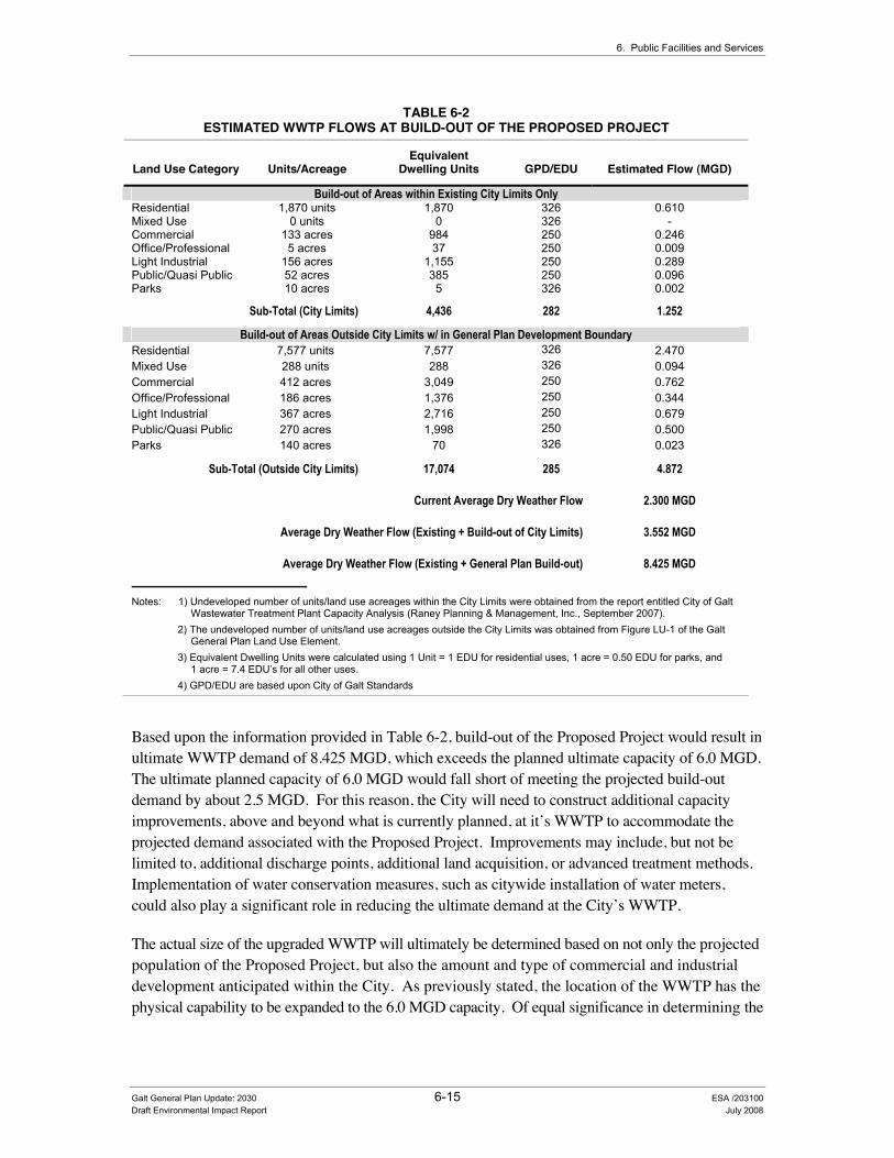
6. Public Facilities and Services
TABLE 6-2 ESTIMATED WWTP FLOWS AT BUILD-OUT OF THE PROPOSED PROJECT
Land Use Category Units/Acreage Equivalent
Dwelling Units GPD/EDU Estimated Flow (MGD)
Build-out of Areas within Existing City Limits Only Residential 1,870 units 1,870 326 0.610 Mixed Use 0 units 0 326 - Commercial 133 acres 984 250 0.246 Office/Professional 5 acres 37 250 0.009 Light Industrial 156 acres 1,155 250 0.289 Public/Quasi Public 52 acres 385 250 0.096 Parks 10 acres 5 326 0.002
Sub-Total (City Limits) 4,436 282 1.252
Build-out of Areas Outside City Limits w/ in General Plan Development Boundary Residential 7,577 units 7,577 326 2.470 Mixed Use 288 units 288 326 0.094 Commercial 412 acres 3,049 250 0.762 Office/Professional 186 acres 1,376 250 0.344 Light Industrial 367 acres 2,716 250 0.679 Public/Quasi Public 270 acres 1,998 250 0.500 Parks 140 acres 70 326 0.023
Sub-Total (Outside City Limits) 17,074 285 4.872
Current Average Dry Weather Flow 2.300 MGD
Average Dry Weather Flow (Existing + Build-out of City Limits) 3.552 MGD
Average Dry Weather Flow (Existing + General Plan Build-out) 8.425 MGD
Notes: 1) Undeveloped number of units/land use acreages within the City Limits were obtained from the report entitled City of Galt
Wastewater Treatment Plant Capacity Analysis (Raney Planning & Management, Inc., September 2007). 2) The undeveloped number of units/land use acreages outside the City Limits was obtained from Figure LU-1 of the Galt
General Plan Land Use Element. 3) Equivalent Dwelling Units were calculated using 1 Unit = 1 EDU for residential uses, 1 acre = 0.50 EDU for parks, and
1 acre = 7.4 EDU’s for all other uses. 4) GPD/EDU are based upon City of Galt Standards
Based upon the information provided in Table 6-2, build-out of the Proposed Project would result in ultimate WWTP demand of 8.425 MGD, which exceeds the planned ultimate capacity of 6.0 MGD. The ultimate planned capacity of 6.0 MGD would fall short of meeting the projected build-out demand by about 2.5 MGD. For this reason, the City will need to construct additional capacity improvements, above and beyond what is currently planned, at it’s WWTP to accommodate the projected demand associated with the Proposed Project. Improvements may include, but not be limited to, additional discharge points, additional land acquisition, or advanced treatment methods. Implementation of water conservation measures, such as citywide installation of water meters, could also play a significant role in reducing the ultimate demand at the City’s WWTP.
The actual size of the upgraded WWTP will ultimately be determined based on not only the projected population of the Proposed Project, but also the amount and type of commercial and industrial development anticipated within the City. As previously stated, the location of the WWTP has the physical capability to be expanded to the 6.0 MGD capacity. Of equal significance in determining the
Galt General Plan Update: 2030 6-15 ESA /203100 Draft Environmental Impact Report July 2008

City of Galt General Plan Update: 2030
sanitary sewer expansion requirements, is addressing the seasonal discharge quantity and quality issue and selecting a preferred option that is NPDES permit compliant for treatment capacity expansion.
The two (2) NPDES permit compliance options under consideration are as follows:
A. Upgrade the existing treatment plant to comply with new discharge limitations and continue wet seasonal discharge to Laguna Creek with dry season reclamation and off-site biosolids disposal.
B. Discharge to Laguna Creek on a year-round basis with discontinued dry season irrigation.
With selection of one of the above options, development anticipated under the Proposed Project could be supported with a compatible sewer collection system. Because of the flat topography, the requirement for additional sewer lift stations will likely be required.
Policies and implementation programs included as part of the Proposed Project that would minimize this impact (specifically with regard to the provision of needed additional wastewater infrastructure) are summarized below by General Plan Element, with a complete description of these policies and programs provided in Appendix C “Policy Document” of this draft EIR.
Public Facilities and Services Element
Policies and implementation programs designed to minimize this impact through ensuring that adequate infrastructure financing mechanisms are in place to provide needed capital wastewater system improvements to accommodate planned growth include the following: PFS-1.2 Availability of Facilities and Services PFS-1.4 Financing from New Development PFS-1.6 Capital Improvement Program PFS-1.7 Public Facility Financing PFS-1.9 Fair Share Costs on New Developments PFS-1.10 Broad-Based Funding Sources PFS-1.11 Fiscal Impact Analysis for Specific Plans and Significant General Plan Amendments PFS-B Capitol Improvement Program PFS-C Development Fee Schedule Policies and implementation programs designed to minimize this impact through the early identification of required infrastructure and the orderly construction and rehabilitation of the facilities needed to serve existing and planned urban areas include the following: PFS-1.2 Availability of Facilities and Services PFS-1.5 Public Facility Master Plans PFS-1.6 Capital Improvement Program PFS-1.8 Ultimate Capacity Needs PFS-A Infrastructure Master Plans Policies and implementation programs designed to minimize this impact through achieving compliance with the Central Valley RWQCB requirements include the following: PFS-2.7 Water Quality Monitoring PFS-3.1 Treatment Facilities Safety PFS-3.5 Sewer Enhancements PFS-3.6 Sewage Sludge PFS-3.7 Compliance with the Clean Water Act Additional policies designed to minimize this impact through the provision and conservation of water resources and service include the following: PFS-2.3 Ground Water Protection Response Plan PFS-2.8 Water Conservation PFS-2.9 Inter-Agency Water Conservation
Galt General Plan Update: 2030 6-16 ESA / 203100 Draft Environmental Impact Report July 2008
6. Public Facilities and Services
Implementation Program PFS-A requires the City to prepare, annually review, and update every five years a Wastewater Master Plan. The preparation and implementation of a Wastewater Master Plan would implement Policy PFS-1.5 by ensuring compatibility with current land use policy, and identifying necessary improvements consistent with State and Federal Laws. PFS-A would also implement Policy PFS-1.2 by establishing areas suitable for development consistent with the location of master planned infrastructure. PFS-A would also implement Policies PFS-1.6 and PFS-1.8 through the identification of needed capital improvements and associated schedule for inclusion in the City’s CIP, and by sizing infrastructure facilities to meet ultimate demands.
Implementation Program PFS-B requires the City to annually review and update its CIP. Annual reviews and updates of the City’s CIP would implement Policies PFS-1.3 and PFS-1.7 by establishing the required financing for needed capital wastewater system improvements, and tying the needed funds to development impact fees. Annual reviews and updates of the City’s CIP also assures that adequate wastewater will continue to be provided through annual funding allocations, and assuring the adequate infrastructure is in place to allow for new development to occur (implements policies PFS-3.2, and PFS-3.5).
Implementation Program PFS-C requires the City to prepare development fee schedules based on the City’s CIP. The preparation of development fee schedules implements Policies PFS-1.4 and PFS-1.9 by assuring that financing mechanisms are in place in order to construct capital infrastructure improvements that are required as a result of new development.
In addition, Policies PFS-3.4 and PFS-3.8 direct the City to oppose urban development within areas of the City’s Sphere of Influence without service, and areas outside of the City Limits prior to annexation unless the City amends the Utility Services Area with LAFCO.
Policies PFS-2.7, PFS-3.1, PFS-3.5, PFS-3.6, and PFS-3.7 would help bring the City into compliance with the requirements of the RWQCB, in addition to continuing to operate within provisions set forth by the RWQCB. The implementation of the NPDES Permit Compliance Action Plan, City of Galt Wastewater Treatment Plant (West Yost & Associates, December 2005) would result in the implementation of the above referenced policies.
Policies PFS-2.3, PFS-2.8, and PFS-2.9 would help to reduce increased demands on the City’s WWTP through the implementation of water conservation programs. The City could also look for opportunities to reclaim treated effluent in an effort to reduce groundwater pumping and surface water discharges to Laguna Creek. However, even with implementation of the above mentioned policies and implementation programs, this impact is considered potentially significant.
Required Mitigation Measures
To address this impact, the City shall implement the following mitigation measures:
Mitigation Measure 6.3-1a: Adopt General Plan Policy PFS-3.9 “Expand Use of Reclaimed Water” to Address Wastewater System Impacts:
Galt General Plan Update: 2030 6-17 ESA /203100 Draft Environmental Impact Report July 2008

City of Galt General Plan Update: 2030
To mitigate wastewater system impacts resulting from implementation of the Proposed Project, the City shall incorporate the following new policy PFS-3.9 “Expand Use of Reclaimed Water” into the Final General Plan.
• Policy PFS-3.9: “Expand Use of Reclaimed Water”. The City shall encourage the use of tertiary treated wastewater and household gray water for irrigation of agricultural lands, large landscaped areas, and recreation/ open space areas within close proximity to the City’s WWTP to help ensure ongoing compliance with RWQCB requirements.[New Policy – Draft EIR Analysis]
Mitigation Measure 6.3-1b: Adopt General Plan Policy PFS-3.10 “Point Source Control” to Address Wastewater System Impacts:
To mitigate wastewater system impacts resulting from implementation of the Proposed Project, the City shall incorporate the following new policy PFS-3.10 “Point Source Control” into the Final General Plan.
• Policy PFS-3.10: “Point Source Control”. The City shall work with the RWQCB to ensure that all point source pollutants are adequately mitigated (as part of the CEQA review and project approval process) and monitored to ensure long-term compliance.[New Policy – Draft EIR Analysis]
Mitigation Measure 8.2-1: Adopt General Plan Policy PFS-2.12 “Water Meter Retrofit Program” to Address Water Supply Impacts:
To mitigate water resource impacts resulting from implementation of the Proposed Project, the City shall incorporate the following new policy PFS-2.12 “Water Meter Retrofit Program” into the Final General Plan.
• Policy PFS-2.12 “Water Meter Retrofit Program”. At the direction of the City Council, the City shall prepare and implement a water meter retrofit program (consistent with State requirements as indicated in AB 2572) whereby all existing non-metered connections would be retrofitted with a water meter to improve water conservation. [New Policy – Draft EIR Analysis]
Research has indicated that the installation of water meters, and the billing of customers based upon volumetric usage has resulted in a 15% to 30% decrease in water usage as compared to a flat rate structure. This is an indication that the installation of water meters could also realize benefits in terms of decreased wastewater flows.
Significance after Implementation of Mitigation for Impact 6.3-1
As stated above, the City is continuing efforts to achieve compliance with RWQCB requirements through the implementation of an NPDES Permit Compliance Action Plan. The NPDES Permit Compliance Action Plan is currently being implemented through the City’s CIP.
Galt General Plan Update: 2030 6-18 ESA / 203100 Draft Environmental Impact Report July 2008

6. Public Facilities and Services
Since a definitive time frame to achieve compliance with the requirements of the RWQCB and to increase the capacity of the City’s WWTP to 8.425 MGD (see Table 6-2 above) cannot be assumed at this time, the impact would remain significant after mitigation. Therefore, implementation of the Proposed Project including the adoption of the policies provided in Mitigation Measures 6.3-1a, 6.3-1b, and 8.2-1 (listed above) would still result in a significant impact. No additional feasible mitigation is currently available. This impact is considered significant and unavoidable until such time that the City:
1) Is able to achieve and maintain, through the build-out of the Proposed Project, full compliance with the requirements of the RWQCB and;
2) Has constructed sufficient capacity improvements at its WWTP that would allow for enough capacity (ultimate WWTP demand of 8.425 MGD) to accommodate the build-out population of the Proposed Project.
6.4 Storm Drainage Adequate storm drainage infrastructure is essential if the City of Galt is to sustain economic growth and serve projected increases in employment and population. This section addresses storm water drainage and flooding concerns. Overall water quality impacts that could result from build-out of the Proposed Project are addressed in Chapter 8.0 “Natural Resources” (Section 8.2 “Hydrology”).
(QYLURQPHQWDO�DQG�5HJXODWRU\�6HWWLQJ��Section 15150 of the CEQA Guidelines permits documents of lengthy technical detail to be incorporated by reference in an EIR. Specifically, Section 15150 states that an EIR may “incorporate by reference all or portions of another document which is a matter of public record or is generally available to the public ....” Consistent with the CEQA Guidelines and as a way to avoid creating an overwhelming amount of paper for members of the public and decision-makers to sort through, this draft EIR incorporates by reference information from both the Existing Conditions and Policy Document. Consistent with this approach, the reader is directed to Chapter 4 of the Existing Conditions Report for environmental and regulatory setting information specific to public facilities and services topics (see Appendix B of this draft EIR).
,PSDFW�0HWKRGRORJ\��The provision of ongoing storm water management is currently being accomplished through requirements set forth in the City of Galt Municipal Code. The City of Galt also submitted their Storm Water Management Plan/Program (SWMP) (as a joint effort with other member agencies of the Sacramento Stormwater Quality Partnership) in November 2000 and a subsequent update in December 2003. The SWMP includes program elements that each permittee will implement to reduce the discharge of pollutants in storm water to the maximum extent practicable (MEP), and to effectively prohibit non-storm water discharges into MS4s within each permittee’s jurisdiction. Each Stormwater Quality Improvement Program (SQIP) is a site-specific modification of the existing
Galt General Plan Update: 2030 6-19 ESA /203100 Draft Environmental Impact Report July 2008

City of Galt General Plan Update: 2030
comprehensive SWMP required under the previous MS4 permit, Order No. 96-105. The County and the Cities of Citrus Heights, Elk Grove, Folsom, and Galt jointly submitted a SQIP (County SQIP). The City of Sacramento submitted a separate SQIP (City SQIP). On 10 April 2001, Regional Board staff sent a letter to all permittees to express agreement with the SQIP subject to the condition that the SQIP be revised in accordance with Order No. R5-2002-0206 NPDES No. CAS082597.
Build-out of the Proposed Project (including the Preferred Land Use Alternative and the Circulation Diagram) could have a significant impact on the City which provides stormwater service to its community. The first step in the impact analysis is to establish significance criteria consistent with CEQA and the City of Galt Guidelines that will be used as a basis for identifying impacts. After establishing the significance criteria, an overview of the current storm drainage infrastructure and planning efforts of the City is provided followed by the impacts and mitigation measures resulting from the implementation of the Proposed Project.
6WDQGDUGV�RI�6LJQLILFDQFH��The significance criteria for this analysis were developed from criteria presented in Appendix G, “Environmental Checklist Form”, of the CEQA Guidelines (as amended by the City of Galt to address stormwater quality issues) and based on the professional judgment of the City of Galt and its consultants. The project (or the project alternatives) would result in a significant impact if it would:
• Result in increase of erosion during the construction process or cause significant changes in the flow velocity or volume of storm water runoff to cause environmental harm and the potential for significant increases in erosion of the project site and surrounding areas;
• Result in an increase of the discharge of storm water from material storage areas, vehicle or equipment fueling, vehicle or equipment maintenance (including washing), waste handling, hazardous materials handling or storage, delivery areas or loading docks, or other outdoor work areas;
• Result in an increase of the level of pollutants in storm water runoff from the post-construction activities or cause the impairment of the beneficial uses of receiving waters or areas that provide water quality benefit or cause significant harm on the biological integrity of the waterways and water bodies by the discharge of stormwater;
• Place housing within a 100-year flood hazard area, as mapped on a federal Flood Hazard Boundary or Flood Insurance Rate Map or other flood hazard delineation map;
• Place within a 100-year flood hazard area structures that would impede or redirect flood flows; or
• Expose people or structures to a significant risk of loss, injury, or death involving flooding, including flooding as a result of the failure of a levee or dam.
Galt General Plan Update: 2030 6-20 ESA / 203100 Draft Environmental Impact Report July 2008

6. Public Facilities and Services
6WRUP�'UDLQDJH�6\VWHP�2YHUYLHZ�The City of Galt Public Works Department operates the City’s storm drain collection and disposal system. The storm drain system consists of curbs and gutters which collect the storm waters and direct them into catch basins where it enters an underground system of pipes. The underground piping system then directs the storm runoff to one of three drainage channels: Dry Creek, Hen Creek and Deadman’s Gulch.
Dry Creek is a natural channel which forms the southern boundary of the City and the boundary between Sacramento and San Joaquin County to the south. Dry Creek, flowing in a westerly direction, flows into the Mokelumne River which then flows to the Delta.
Deadman’s Gulch flows in the westerly direction generally through the northern sector of the City. East of SR99, Deadman’s Gulch has been designed and reconstructed to serve as a storm water detention facility in addition to a storm water conveyance facility. This occurs as a result of the culvert structure under SR 99 which meters the flow into Deadman’s Gulch west of the highway. This allows the storm water flows from the development occurring east of the highway to better match the channel capacity west of the highway.
The City has one other detention basin which serves as a joint use facility/city park. It is located on the west side of town adjacent to the Greer Middle School. After being detained in the detention basin the storm flows are pumped to Hen Creek for ultimate disposal. The lift station at Greer Detention Basin is one of only two stormwater lift stations in the City of Galt. The other is the Wagon Way lift station.
The storm drainage system is comprised of pipelines ranging in size from 8” to 84” in diameter. The larger pipe sizes serve as the outfall structures conveying the storm runoff from the southwest portion of the community to Dry Creek.
The City of Galt has a Phase 1 NPDES stormwater permit. The City joined with Sacramento County and other cities in the County to obtain the permit during the first round of permitting in the early 1990s.
The City funds the operation and maintenance of the storm drainage system through a storm drainage monthly utility rate. For the most part, the monthly utility rate is insufficient to fully fund the operation and maintenance of the system and is augmented with gas tax funding. A storm drainage impact fee is assessed to new development to fund the construction of the major components of the storm drain system. New development is required to construct the storm drainage system associated with their projects.
Sacramento area public agencies, including the County of Sacramento and the Cities of Sacramento, Citrus Heights, Elk Grove, Folsom, Galt, and Rancho Cordova have joined together to form the Sacramento Stormwater Quality Partnership (SSQP). These agencies are regulated by Order No. R5-2002-0206 NPDES No. CAS082597 “Waste Discharge Requirements for County of Sacramento and Cities of Citrus Heights, Elk Grove, Folsom, Galt and Sacramento Storm Water Discharges
Galt General Plan Update: 2030 6-21 ESA /203100 Draft Environmental Impact Report July 2008

City of Galt General Plan Update: 2030
From Municipal Separate Storm Sewer Systems Sacramento County” issued by the Central Valley RWQCB. Galt is unlike the other permittees in that its MS4 is non-contiguous with the other MS4s; it is also surrounded by rural and agricultural areas that are not subject to the NPDES regulations. An MS4 (or municipal separate storm sewer system) is a conveyance or system of conveyances owned by a State, City, Town, or other public entity that discharges to waters of U.S. and is: designed or used for collecting or conveying stormwater; not a combined sewer; and not part of a Publicly Owned Treatment Works (POTW). Galt became part of the Phase I Sacramento Storm Water Management Program voluntarily in 1990.
The General MS4 permit requires the discharger to develop and implement a Storm Water Management Plan/Program (SWMP) with the goal of reducing the discharge of pollutants to the maximum extent practicable (MEP). MEP is the performance standard specified in Section 402(p) of the Clean Water Act. The general permit requires regulated Small MS4s to develop and implement a SWMP that describes Best Management Practices (BMPs), measurable goals, and timetables for implementation in the following six program areas.
• Public Education – Educate the public in its permitted jurisdiction about the importance of the storm water program and the public’s role in the program;
• Public Participation – Comply with all State and local notice requirements when implementing a public involvement/participation program;
• Illicit Discharge Detection and Elimination – Adopt and enforce ordinances or take equivalent measures that prohibit illicit discharges, and implement a program to detect illicit discharges;
• Construction Site Storm Water Runoff Control – Develop a program to control the discharge of pollutants from construction sites greater than or equal to one acre in size within its permitted jurisdiction. The program must include inspections of construction sites and enforcement actions against violators;
• Post Construction Storm Water Management – Require long term post-construction BMPs that protect water quality and control runoff flow, to be incorporated into development and significant redevelopment projects. Post construction programs are most efficient when they stress (1) low impact design; (2) source controls; and (3) treatment controls.
,PSDFWV�DQG�0LWLJDWLRQ�0HDVXUHV��
Impact 6.4-1: The Proposed Project could result in increase of erosion during the construction process or cause significant changes in the flow velocity or volume of storm water runoff to cause environmental harm and the potential for significant increases in erosion of the project site and surrounding areas.
Galt General Plan Update: 2030 6-22 ESA / 203100 Draft Environmental Impact Report July 2008

6. Public Facilities and Services
Impact Summary
Level of Significance Before Mitigation: Potentially Significant
Required Mitigation: Mitigation Measure 6.4-1a: Adopt Revised General Plan Policy PFS-4.3 “Stormwater Quality” to Address Storm Drainage System Impacts and Mitigation Measure 6.4-1b: Adopt Revised General Plan Implementation Program PFS-G to Address Storm Drainage System Impacts.
Level of Significance After Mitigation: Less than Significant
Impact Analysis
Drainage runoff from developing areas or parcels is dependent on the percent of impervious surface created on individual parcels or projects. Development resulting from the Proposed Project (particularly within currently undeveloped areas) will increase the amount of impervious surfaces, thereby increasing the amounts and speed of runoff. Increased runoff volumes and speeds may increase erosion or siltation and result in localized nuisance flooding in areas without adequate drainage facilities.
The existing drainage channels of Dry Creek, Hen Creek and Deadman’s Gulch all serve the drainage sheds of the Study Area south of Twin Cities Road. With continued urbanization under the Proposed Project (including both the Preferred Land Use Alternative and the Circulation Diagram), these existing drainage sheds will continue to increase in runoff requiring additional detention storage to meter downstream flows and prevent flooding. Therefore, future detention sites should be identified early in the process as individual development projects are proposed to provide adequate storm water detention over time.
Under the Proposed Project, urban development is planned north of Twin Cities Road both west and east of SR 99. The drainage shed north of Twin Cities Road is oriented north toward the Cosumnes River. With such an orientation, additional processing and permits would be required to identify locations for drainage outfalls and detention requirements to help meter increased runoff due to the urbanization of land.
Policies and implementation programs included as part of the Proposed Project that would minimize this impact are summarized below by General Plan Element, with a complete description of these policies and programs provided in Appendix C “Policy Document” of this draft EIR.
Public Facilities and Services Element
Policies designed to minimize this water quality impact through adherence to appropriate best management practices designed to address soil erosion include the following: PFS-4.3 Stormwater Quality PFS-4.4 Project Design PFS-4.5 Grading During the Rainy Season PFS-4.6 Erosion Control Plan PFS-4.7 Mitigating Stormwater Runoff Policies and implementation programs designed to minimize this impact through management of downstream channel capacities, and allow for development of the City’s storm drainage system to prevent flooding include the following: PFS-1.5 Public Facilities Master Plans PFS-1.6 Capital Improvement Program
Galt General Plan Update: 2030 6-23 ESA /203100 Draft Environmental Impact Report July 2008
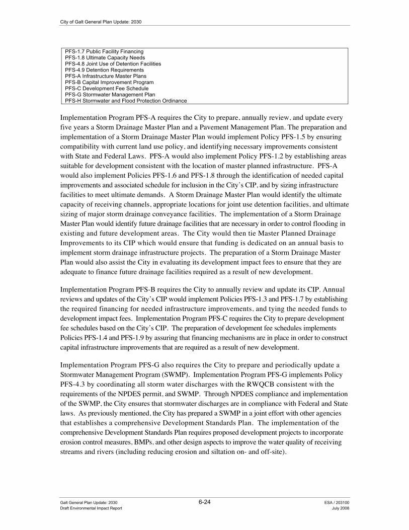
City of Galt General Plan Update: 2030
PFS-1.7 Public Facility Financing PFS-1.8 Ultimate Capacity Needs PFS-4.8 Joint Use of Detention Facilities PFS-4.9 Detention Requirements PFS-A Infrastructure Master Plans PFS-B Capital Improvement Program PFS-C Development Fee Schedule PFS-G Stormwater Management Plan PFS-H Stormwater and Flood Protection Ordinance
Implementation Program PFS-A requires the City to prepare, annually review, and update every five years a Storm Drainage Master Plan and a Pavement Management Plan. The preparation and implementation of a Storm Drainage Master Plan would implement Policy PFS-1.5 by ensuring compatibility with current land use policy, and identifying necessary improvements consistent with State and Federal Laws. PFS-A would also implement Policy PFS-1.2 by establishing areas suitable for development consistent with the location of master planned infrastructure. PFS-A would also implement Policies PFS-1.6 and PFS-1.8 through the identification of needed capital improvements and associated schedule for inclusion in the City’s CIP, and by sizing infrastructure facilities to meet ultimate demands. A Storm Drainage Master Plan would identify the ultimate capacity of receiving channels, appropriate locations for joint use detention facilities, and ultimate sizing of major storm drainage conveyance facilities. The implementation of a Storm Drainage Master Plan would identify future drainage facilities that are necessary in order to control flooding in existing and future development areas. The City would then tie Master Planned Drainage Improvements to its CIP which would ensure that funding is dedicated on an annual basis to implement storm drainage infrastructure projects. The preparation of a Storm Drainage Master Plan would also assist the City in evaluating its development impact fees to ensure that they are adequate to finance future drainage facilities required as a result of new development.
Implementation Program PFS-B requires the City to annually review and update its CIP. Annual reviews and updates of the City’s CIP would implement Policies PFS-1.3 and PFS-1.7 by establishing the required financing for needed infrastructure improvements, and tying the needed funds to development impact fees. Implementation Program PFS-C requires the City to prepare development fee schedules based on the City’s CIP. The preparation of development fee schedules implements Policies PFS-1.4 and PFS-1.9 by assuring that financing mechanisms are in place in order to construct capital infrastructure improvements that are required as a result of new development.
Implementation Program PFS-G also requires the City to prepare and periodically update a Stormwater Management Program (SWMP). Implementation Program PFS-G implements Policy PFS-4.3 by coordinating all storm water discharges with the RWQCB consistent with the requirements of the NPDES permit, and SWMP. Through NPDES compliance and implementation of the SWMP, the City ensures that stormwater discharges are in compliance with Federal and State laws. As previously mentioned, the City has prepared a SWMP in a joint effort with other agencies that establishes a comprehensive Development Standards Plan. The implementation of the comprehensive Development Standards Plan requires proposed development projects to incorporate erosion control measures, BMPs, and other design aspects to improve the water quality of receiving streams and rivers (including reducing erosion and siltation on- and off-site).
Galt General Plan Update: 2030 6-24 ESA / 203100 Draft Environmental Impact Report July 2008

6. Public Facilities and Services
Implementation Program PFS-H requires the City to prepare and adopt a Stormwater and Flood Protection Ordinance to implement the updated Storm Drainage and Flood Protection Master Plan to address stormwater runoff and flood protection.
Even with implementation of the above mentioned policies and implementation programs, this impact is considered potentially significant.
Required Mitigation Measures
To address this impact, the City shall implement the following mitigation measures:
Mitigation Measure 6.4-1a: Adopt Revised General Plan Policy PFS-4.3 “Stormwater Quality” to Address Storm Drainage System Impacts:
To mitigate storm drainage system impacts resulting from implementation of the Proposed Project, the City shall incorporate the following revisions to Policy PFS-4.3 “Stormwater Quality” into the Final General Plan.
• Policy PFS-4.3: Stormwater Quality. The City shall ensure compliance with Federal and State clean water standards by continuing to monitor and enforce provisions to control non-point source, and point source water pollution contained in the U.S. Environmental Protection Agency NPDES program. (M&A)
Mitigation Measure 6.4-1b: Adopt Revised General Plan Implementation Program PFS-G to Address Storm Drainage System Impacts:
To mitigate storm drainage system impacts resulting from implementation of the Proposed Project, the City shall incorporate the following revisions to Implementation Program PFS-G into the Final General Plan.
• Implementation Program PFS-G: Stormwater Management Plan. The City shall prepare, and periodically update, and implement on an ongoing basis, its Stormwater Management Plan, in coordination with other member agencies. (M&A)
Significance after Implementation of Mitigation for Impact 6.4-1
The City’s implementation of the Sacramento SWMP, and associated Development Standards Plan would address a variety of erosion generating or water quality impacts associated with the alteration of an existing drainage pattern. As stated above, the City will continue to implement a variety of policies and programs designed to address the provision of needed storm drainage infrastructure and stormwater quality issues. Therefore, implementation of the Proposed Project including the adoption of the revised policy and implementation program described under Mitigation Measure 6.4-1a and Mitigation Measure 6.4-1b (revisions to Policy PFS-4.3 “Stormwater Quality” and Implementation Program PFS-G: “Stormwater Management Plan” ) would result in a less-than-significant impact.
Galt General Plan Update: 2030 6-25 ESA /203100 Draft Environmental Impact Report July 2008

City of Galt General Plan Update: 2030
Impact 6.4-2: The Proposed Project could result in an increase of the level of pollutants in storm water runoff from the post-construction activities or cause the impairment of the beneficial uses of receiving waters or areas that provide water quality benefit or cause significant harm on the biological integrity of the waterways and water bides by the discharge of stormwater;
Impact Summary
Level of Significance Before Mitigation: Potentially Significant
Required Mitigation: Mitigation Measure 6.4-1a: Adopt Revised General Plan Policy PFS-4.3 “Stormwater Quality” to Address Storm Drainage System Impacts and Mitigation Measure 6.4-1b: Adopt Revised General Plan Implementation Program PFS-G to Address Storm Drainage System Impacts.
Level of Significance After Mitigation: Less than Significant
Impact Analysis
Flood control detention is considered the most viable option for mitigating the increase in runoff from new development areas, with the specific types and locations of these drainage facilities to be determined at the time development applications are submitted. Pollution associated with increased stormwater and urban runoff would affect local and regional surface and groundwater quality conditions. Unlike sewage, which is transported to a treatment plant, urban runoff may flow untreated through the storm drainage system. Anything thrown, swept, or poured into the street, gutter, or a catch basin (the curbside openings that lead into the storm drainage system) flows directly into ponding basins or local channels and creeks. Pollutant loads can be particularly acute at the beginning of the rainy season, but can be a problem at any time due to the improper disposal of products associated with home, garden, or automotive use.
Policies and implementation programs included as part of the Proposed Project that would minimize this impact are the same as those described above under Impact 6.4-1. However, even with implementation of the above mentioned policies and implementation programs, this impact is considered potentially significant.
Required Mitigation Measures
To address this impact, the City shall implement “Mitigation Measure 6.4-1a: Adopt Revised General Plan Policy PFS-4.3 “Stormwater Quality” to Address Storm Drainage System Impacts and Mitigation Measure 6.4-1b: Adopt Revised General Plan Implementation Program PFS-G to Address Storm Drainage System Impacts”, which are more fully described above under the description for Impact 6.4-1.
Significance after Implementation of Mitigation for Impact 6.4-2
The City’s implementation of the Sacramento SWMP, and associated Development Standards Plan would address a variety of erosion generating or water quality impacts associated with runoff water that exceeds the capacity of existing storm drainage infrastructure
Galt General Plan Update: 2030 6-26 ESA / 203100 Draft Environmental Impact Report July 2008

6. Public Facilities and Services
As stated above, the City will continue to implement a variety of policies and programs designed to address the provision of needed storm drainage infrastructure and stormwater quality issues. Therefore, implementation of the Proposed Project including the adoption of the revised policy and implementation program described above under Mitigation Measure 6.4-1a and Mitigation Measure 6.4-1b would result in a less-than-significant impact.
Impact 6.4-3: The Proposed Project could place housing within a 100-year flood hazard area, as mapped on a federal Flood Hazard Boundary or Flood Insurance Rate Map or other flood hazard delineation map or place within a 100-year flood hazard area structures which could impede or redirect flood flows.
Impact Summary
Level of Significance Before Mitigation: Less than Significant
Required Mitigation Measures: No Mitigation Required
Level of Significance After Mitigation: Less than Significant
Impact Analysis A review of applicable FEMA flood maps indicates that there are several areas within the City’s Planning Area that are within a 100-year floodplain area. Floodplain lands are found (but not limited to) areas along Dry Creek, Laguna Creek, Skunk Creek, and Deadman Gulch. Additionally, there are small patches of 100-year floodplain areas along Hen Creek in the southwest portion of the Study Area. The Proposed Project (Preferred Land Use Diagram) has identified the floodplain areas around Dry Creek as remaining as open space. Implementation of the Proposed Project (including build-out of the Preferred Land Use Alternative) could expose more people and habitable structures to potential flooding if development occurs within or adjacent to these floodplain areas. The City of Galt has channelized Deadman Gulch and a Letter of Map Revision (LOMR) has been issued from FEMA. The City anticipates that there will be no structures in the floodplains located within the current City limits.
Policies and implementation programs included as part of the Proposed Project that would minimize this impact are summarized below by General Plan Element, with a complete description of these policies and programs provided in Appendix C “Policy Document” of this draft EIR. Specific policies direct the City to preserve floodplain areas (see policies SS-3.1, SS-3.3, COS-1.14, COS-4.2, and Implementation Program COS-A) and limit development in hazardous areas (see policies SS-3.1 and SS-3.2). Additional policies require the City to continue to cooperate with local, state, and federal agencies to address local and regional flood issues (see policy COS-1.3) and continue to enforce the City’s Emergency Response Plan (policy SS-1.1) in the event of a flood emergency. Other policies from the Public Facilities and Services Element require the City to prepare, annually review, and update every five years a Storm Drainage Master Plan and a Pavement Management Plan to ensure that adequate levels of storm drainage infrastructure are planned and provisions are made for their development (see policies PFS-1.5, PFS-4.1, and Implementation Programs PFS-A, PFS-G, and PFS-H). With implementation of these policies and implementation programs, this impact is considered less-than-significant.
Galt General Plan Update: 2030 6-27 ESA /203100 Draft Environmental Impact Report July 2008

City of Galt General Plan Update: 2030
Safety and Seismic & Land Use Elements Conservation and Open Space Element
Policies and implementation programs designed to minimize this impact through the preservation of floodplain areas and the management of new development in hazardous areas include the following: SS-3.1 Floodplain Mapping SS-3.2 Development in the 100-Year Floodplain SS-3.3 Natural Drainageways Enhancements LU-1.9 Growth in Hazard-Prone Areas
COS-1.1 Flood Control COS-1.2 Flood Protection Ordinance COS-1.4 Storm Flow Impacts COS-1.14 Floodplain Dedication COS-1.17 Floodplain Visual Accessibility COS-4.2 Natural Floodway Protection COS-4.4 Open Space Protection COS-A Flood Protection Ordinance
Policies designed to minimize this impact through the continued coordination with emergency response plans and service providers include the following: SS-1.1 City Emergency Operations Plan (EOP) SS-1.2 Inter-Agency Coordination
COS-1.3 Inter-Agency Coordination
Public Facilities and Services Element Policies and implementation programs designed to minimize this impact through adherence to appropriate levels of stormwater infrastructure planning, financing and construction include the following: PFS-1.4 Financing from New Development PFS-1.5 Public Facility Master Plans PFS-1.6 Capital Improvement Program PFS-1.7 Public Facility Financing PFS-1.8 Ultimate Capacity Needs PFS-1.9 Fair Share Costs on New Developments PFS-1.10 Broad-Based Funding Sources PFS-1.11 Fiscal Impact Analysis for Specific Plans and Significant General Plan Amendments
PFS-4.1 Storm Drain Enhancements PFS-4.2 Conservation/Stormwater PFS-4.4 Project Design PFS-4.7 Mitigating Stormwater Runoff PFS-4.8 Joint Use of Detention Facilities PFS-4.9 Detention Requirements PFS-A Infrastructure Master Plans PFS-G Stormwater Management Plan PFS-H Stormwater and Flood Protection Ordinance
Required Mitigation Measures
This impact is considered less-than-significant. No additional mitigation measures are required.
Impact 6.4-4: The Proposed Project could expose people or structures to a significant risk of loss, injury, or death involving flooding, including flooding as a result of the failure of a levee or dam.
Impact Summary
Level of Significance Before Mitigation: Less than Significant
Required Mitigation Measures: No Mitigation Required
Level of Significance After Mitigation: Less than Significant
Impact Analysis
Flood hazards associated with inundation resulting from levee or dam failure are considered a low threat in the City of Galt. A system of levees and dikes for the streams and creeks draining to the Cosumnes River are generally found in the northwestern portion of the Study Area outside of the General Plan boundary and to the north of the Study Area. Additionally, Laguna Creek may be subject to dam failure inundation in the event of a major dam failure at Rancho Seco Dam, which is located almost 10 miles northeast of the City of Galt. However, the dam inundation area along Laguna Creek and near the City of Galt is located along the northern boundary of the Study Area.
Galt General Plan Update: 2030 6-28 ESA / 203100 Draft Environmental Impact Report July 2008
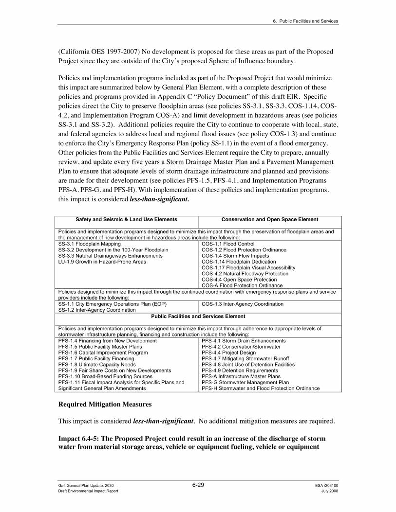
6. Public Facilities and Services
(California OES 1997-2007) No development is proposed for these areas as part of the Proposed Project since they are outside of the City’s proposed Sphere of Influence boundary.
Policies and implementation programs included as part of the Proposed Project that would minimize this impact are summarized below by General Plan Element, with a complete description of these policies and programs provided in Appendix C “Policy Document” of this draft EIR. Specific policies direct the City to preserve floodplain areas (see policies SS-3.1, SS-3.3, COS-1.14, COS-4.2, and Implementation Program COS-A) and limit development in hazardous areas (see policies SS-3.1 and SS-3.2). Additional policies require the City to continue to cooperate with local, state, and federal agencies to address local and regional flood issues (see policy COS-1.3) and continue to enforce the City’s Emergency Response Plan (policy SS-1.1) in the event of a flood emergency. Other policies from the Public Facilities and Services Element require the City to prepare, annually review, and update every five years a Storm Drainage Master Plan and a Pavement Management Plan to ensure that adequate levels of storm drainage infrastructure and planned and provisions are made for their development (see policies PFS-1.5, PFS-4.1, and Implementation Programs PFS-A, PFS-G, and PFS-H). With implementation of these policies and implementation programs, this impact is considered less-than-significant.
Safety and Seismic & Land Use Elements Conservation and Open Space Element
Policies and implementation programs designed to minimize this impact through the preservation of floodplain areas and the management of new development in hazardous areas include the following: SS-3.1 Floodplain Mapping SS-3.2 Development in the 100-Year Floodplain SS-3.3 Natural Drainageways Enhancements LU-1.9 Growth in Hazard-Prone Areas
COS-1.1 Flood Control COS-1.2 Flood Protection Ordinance COS-1.4 Storm Flow Impacts COS-1.14 Floodplain Dedication COS-1.17 Floodplain Visual Accessibility COS-4.2 Natural Floodway Protection COS-4.4 Open Space Protection COS-A Flood Protection Ordinance
Policies designed to minimize this impact through the continued coordination with emergency response plans and service providers include the following: SS-1.1 City Emergency Operations Plan (EOP) SS-1.2 Inter-Agency Coordination
COS-1.3 Inter-Agency Coordination
Public Facilities and Services Element Policies and implementation programs designed to minimize this impact through adherence to appropriate levels of stormwater infrastructure planning, financing and construction include the following: PFS-1.4 Financing from New Development PFS-1.5 Public Facility Master Plans PFS-1.6 Capital Improvement Program PFS-1.7 Public Facility Financing PFS-1.8 Ultimate Capacity Needs PFS-1.9 Fair Share Costs on New Developments PFS-1.10 Broad-Based Funding Sources PFS-1.11 Fiscal Impact Analysis for Specific Plans and Significant General Plan Amendments
PFS-4.1 Storm Drain Enhancements PFS-4.2 Conservation/Stormwater PFS-4.4 Project Design PFS-4.7 Mitigating Stormwater Runoff PFS-4.8 Joint Use of Detention Facilities PFS-4.9 Detention Requirements PFS-A Infrastructure Master Plans PFS-G Stormwater Management Plan PFS-H Stormwater and Flood Protection Ordinance
Required Mitigation Measures
This impact is considered less-than-significant. No additional mitigation measures are required.
Impact 6.4-5: The Proposed Project could result in an increase of the discharge of storm water from material storage areas, vehicle or equipment fueling, vehicle or equipment
Galt General Plan Update: 2030 6-29 ESA /203100 Draft Environmental Impact Report July 2008
City of Galt General Plan Update: 2030
maintenance (including washing), waste handling, hazardous materials handling or storage, delivery areas or loading docks, or other outdoor work areas;
Impact Summary
Level of Significance Before Mitigation: Potentially Significant
Required Mitigation: Mitigation Measure 6.4-1a: Adopt Revised General Plan Policy PFS-4.3 “Stormwater Quality” to Address Storm Drainage System Impacts and Mitigation Measure 6.4-1b: Adopt Revised General Plan Implementation Program PFS-G to Address Storm Drainage System Impacts.
Level of Significance After Mitigation: Less than Significant
Impact Analysis
Development consistent with the build-out of the General Plan could result in stormwater discharges from material storage areas, vehicle or equipment fueling/maintenance areas, loading docks, or other outdoor work areas. Several policies and implementation measures contained in the General Plan are designed to minimize discharge of polluted runoff.
Detention and implementation of other best management practices (BMPs) are considered the most viable option for minimizing the discharge of pollutants to receiving waters. Pollution associated with increased stormwater and urban runoff would affect local and regional surface and groundwater quality conditions. Unlike sewage, which is transported to a treatment plant, urban runoff may flow untreated through the storm drainage system. Anything thrown, swept, or poured into the street, gutter, or a catch basin (the curbside openings that lead into the storm drainage system) flows directly into ponding basins or local channels and creeks. Pollutant loads can be particularly acute at the beginning of the rainy season, but can be a problem at any time due to the improper disposal of products associated with home, garden, or automotive use. The implementation of BMPs on every project helps to reduce the discharge of pollutants to receiving waters.
Policies and implementation programs included as part of the Proposed Project that would minimize this impact are the same as those described under Impact 6.4-1. However, even with implementation of the above mentioned policies and implementation programs, this impact is considered potentially significant.
Required Mitigation Measures
To address this impact, the City shall implement “Mitigation Measure 6.4-1a: Adopt Revised General Plan Policy PFS-4.3 “Stormwater Quality” to Address Storm Drainage System Impacts and Mitigation Measure 6.4-1b: Adopt Revised General Plan Implementation Program PFS-G to Address Storm Drainage System Impacts”, which are more fully described above under the description for Impact 6.4-1.
Significance after Implementation of Mitigation for Impact 6.4-5
Galt General Plan Update: 2030 6-30 ESA / 203100 Draft Environmental Impact Report July 2008

6. Public Facilities and Services
The City’s implementation of the Sacramento SWMP, and associated Development Standards Plan would address a variety of erosion generating and water quality impacts associated with runoff water that exceeds the capacity of existing storm drainage infrastructure.
As stated above, the City will continue to implement a variety of policies and programs designed to address stormwater quality issues. Therefore, implementation of the Proposed Project including the adoption of the revised policy and implementation program described above under Mitigation Measure 6.4-1a and Mitigation Measure 6.4-1b would result in a less-than-significant impact.
6.5 Solid Waste This section focuses on impacts resulting from the generation, handling, and storage of solid waste materials associated with implementation of the Proposed Project.
(QYLURQPHQWDO�DQG�5HJXODWRU\�6HWWLQJ��Section 15150 of the CEQA Guidelines permits documents of lengthy technical detail to be incorporated by reference in an EIR. Specifically, Section 15150 states that an EIR may “incorporate by reference all or portions of another document which is a matter of public record or is generally available to the public ....” Consistent with the CEQA Guidelines and as a way to avoid creating an overwhelming amount of paper for members of the public and decision-makers to sort through, this draft EIR incorporates by reference information from both the Existing Conditions and Policy Document. Consistent with this approach, the reader is directed to Chapter 4 of the Existing Conditions Report for environmental and regulatory setting information specific to public facilities and services topics (see Appendix B of this draft EIR).
,PSDFW�0HWKRGRORJ\��Solid waste impacts were evaluated by comparing the expected solid waste generated by the Proposed Project to existing and any planned capacity of the landfills expected to serve the Study Area. Estimates of City-wide average daily solid waste production were calculated using average daily production rates provided by the EPA (4.6 pounds per day) and the estimate of current solid waste production (20,406 tons per year in 2003) provided for the City.
As a result of comments (see Table 1-1 of Chapter 1.0 “Introduction”) received during the NOP public scoping phase of the Proposed Project, specific effects from the project relating to solid waste have been considered as part of the impact analysis. For example, the California Waste Recovery Systems suggested that the City should have a solid waste transfer station and that the identification of a transfer station site should be included in the project description of the EIR. To address this concern, the Policy Document includes Policy LU-8.5 “Refuse Transfer Station”. This policy requires the City to coordinate efforts with the refuse service provider to locate a new refuse transfer station along the railroad tracks, north of Twin Cities Road.
Galt General Plan Update: 2030 6-31 ESA /203100 Draft Environmental Impact Report July 2008

City of Galt General Plan Update: 2030
6WDQGDUGV�RI�6LJQLILFDQFH��The significance criteria for this analysis were developed from criteria presented in Appendix G, “Environmental Checklist Form”, of the CEQA Guidelines and based on the professional judgment of the City of Galt and its consultants. The project (or the project alternatives) would result in a significant impact if it would:
• Produce substantive solid waste that would exceed the permitted capacity of a landfill serving the Study Area; or
• Conflict with federal, state, and local statutes and regulations related to solid waste.
,PSDFWV�DQG�0LWLJDWLRQ�0HDVXUHV��
Impact 6.5-1: The Proposed Project would produce substantive solid waste that would exceed the permitted capacity of a landfill serving the Study Area.
Impact Summary
Level of Significance Before Mitigation: Potentially Significant
Required Mitigation Measures: No Feasible Mitigation
Level of Significance After Mitigation: Significant and Unavoidable
Impact Analysis
Implementation of the Proposed Project is estimated to add an additional 30,000 people to the Study Area. Currently, the average American produces 4.6 pounds of solid waste per day (EPA, 2005). Based on this average rate, population growth associated with the Proposed Project would result in an additional 25,000 tons per year of solid waste, with industrial and commercial land uses producing additional amounts of solid waste per year. Added to current estimates of solid waste disposal, total annual production of solid waste by 2030 is expected to amount to an estimated 45,560 tons per year or 125 tons per day. Application of a 50% diversion rate would result in the diversion of some waste per year; however, growth associated with the Proposed Project would result in the additional transfer of waste to nearby landfill facilities which may reach or be caused to exceed their permitted capacity. Alternative disposal locations may be required to safely ensure that adequate waste disposal capacity is met for development resulting from implementation of the Proposed Project.
Policies included as part of the Proposed Project that would address the continued provision of solid waste handling services are summarized below by General Plan Element. For example, policies PFS-5.1 requires the City to ensure the continued provision of solid waste collection services for new development. Policies PFS-5.4, PFS-5.5, and PFS-5.7 require the City to promote a variety of solid waste reduction measures including solid waste recycling, the use of
Galt General Plan Update: 2030 6-32 ESA / 203100 Draft Environmental Impact Report July 2008
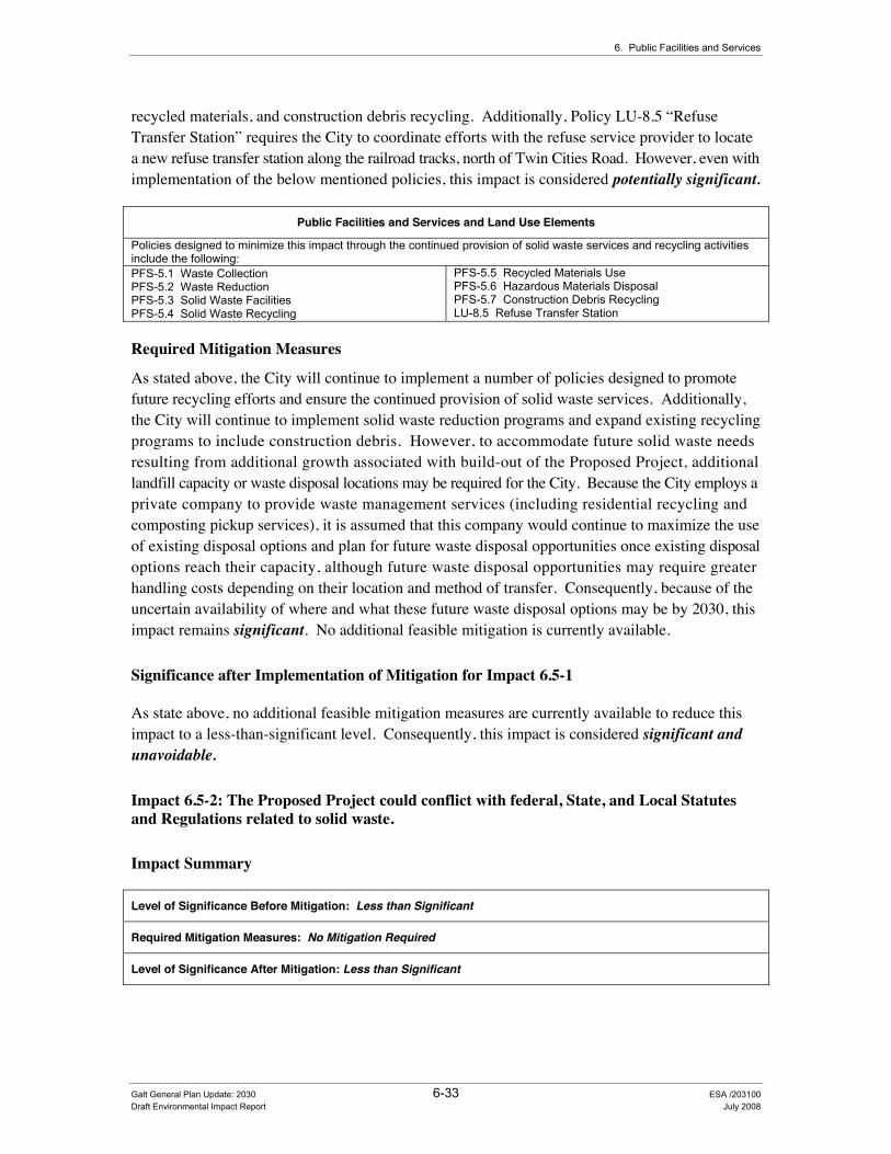
6. Public Facilities and Services
recycled materials, and construction debris recycling. Additionally, Policy LU-8.5 “Refuse Transfer Station” requires the City to coordinate efforts with the refuse service provider to locate a new refuse transfer station along the railroad tracks, north of Twin Cities Road. However, even with implementation of the below mentioned policies, this impact is considered potentially significant.
Public Facilities and Services and Land Use Elements
Policies designed to minimize this impact through the continued provision of solid waste services and recycling activities include the following: PFS-5.1 Waste Collection PFS-5.2 Waste Reduction PFS-5.3 Solid Waste Facilities PFS-5.4 Solid Waste Recycling
PFS-5.5 Recycled Materials Use PFS-5.6 Hazardous Materials Disposal PFS-5.7 Construction Debris Recycling LU-8.5 Refuse Transfer Station
Required Mitigation Measures
As stated above, the City will continue to implement a number of policies designed to promote future recycling efforts and ensure the continued provision of solid waste services. Additionally, the City will continue to implement solid waste reduction programs and expand existing recycling programs to include construction debris. However, to accommodate future solid waste needs resulting from additional growth associated with build-out of the Proposed Project, additional landfill capacity or waste disposal locations may be required for the City. Because the City employs a private company to provide waste management services (including residential recycling and composting pickup services), it is assumed that this company would continue to maximize the use of existing disposal options and plan for future waste disposal opportunities once existing disposal options reach their capacity, although future waste disposal opportunities may require greater handling costs depending on their location and method of transfer. Consequently, because of the uncertain availability of where and what these future waste disposal options may be by 2030, this impact remains significant. No additional feasible mitigation is currently available.
Significance after Implementation of Mitigation for Impact 6.5-1
As state above, no additional feasible mitigation measures are currently available to reduce this impact to a less-than-significant level. Consequently, this impact is considered significant and unavoidable.
Impact 6.5-2: The Proposed Project could conflict with federal, State, and Local Statutes and Regulations related to solid waste.
Impact Summary
Level of Significance Before Mitigation: Less than Significant
Required Mitigation Measures: No Mitigation Required
Level of Significance After Mitigation: Less than Significant
Galt General Plan Update: 2030 6-33 ESA /203100 Draft Environmental Impact Report July 2008
City of Galt General Plan Update: 2030
Impact Analysis
As previously described above in Impact 6.5-1, the City is in the process of complying with statutory requirements to divert at least 50 percent of its solid waste from landfills through source reduction, recycling, or composting (also see Appendix B of this draft EIR, Chapter 6.0 “Public Facilities and Services”). The City continues to divert solid waste from local landfills through various conservation, recycling, and composting measures, including curbside recycling programs. Policies included as part of the Proposed Project that would address the continued need to promote local and State solid waste and recycling programs are summarized below by General Plan Element. For example, policies PFS-5.1 requires the City to ensure the continued provision of solid waste collection services for new development. Policies PFS-5.4, PFS-5.5, and PFS-5.7 require the City to promote a variety of solid waste reduction measures including solid waste recycling, the use of recycled materials, and construction debris recycling. With implementation of the below mentioned policies, this impact is considered less-than-significant.
Public Facilities and Services Element
Policies designed to minimize this impact through the continued provision of solid waste services and recycling activities include the following: PFS-5.1 Waste Collection PFS-5.2 Waste Reduction PFS-5.3 Solid Waste Facilities PFS-5.4 Solid Waste Recycling
PFS-5.5 Recycled Materials Use PFS-5.6 Hazardous Materials Disposal PFS-5.7 Construction Debris Recycling
Required Mitigation Measures
This impact is considered less-than-significant. No additional mitigation measures are required.
6.6 Gas and Electric This section discusses energy consumption and addresses the potential for wasteful, inefficient, or unnecessary use of energy from implementation of the Proposed Project.
(QYLURQPHQWDO�DQG�5HJXODWRU\�6HWWLQJ��Section 15150 of the CEQA Guidelines permits documents of lengthy technical detail to be incorporated by reference in an EIR. Specifically, Section 15150 states that an EIR may “incorporate by reference all or portions of another document which is a matter of public record or is generally available to the public ....” Consistent with the CEQA Guidelines and as a way to avoid creating an overwhelming amount of paper for members of the public and decision-makers to sort through, this draft EIR incorporates by reference information from both the Existing Conditions and Policy Document. Consistent with this approach, the reader is directed to Chapter 4 of the Existing Conditions Report for environmental and regulatory setting information specific to public facilities and services topics (see Appendix B of this draft EIR).
Galt General Plan Update: 2030 6-34 ESA / 203100 Draft Environmental Impact Report July 2008

6. Public Facilities and Services
,PSDFW�0HWKRGRORJ\��The assessment of energy and public utility impacts is a qualitative analysis of the existing services available to the Study Area and a determination of whether the Proposed Project includes adequate provisions to ensure continued service that meets acceptable standards.
6WDQGDUGV�RI�6LJQLILFDQFH��The significance criteria for this analysis were based on the professional judgment of the City of Galt and its consultants. The project (or the project alternatives) would result in a significant impact if it would:
• Result in wasteful, inefficient, or unnecessary consumption of energy by residential, commercial, industrial, or public uses.
,PSDFWV�DQG�0LWLJDWLRQ�0HDVXUHV��
Impact 6.6-1: The Proposed Project could result in wasteful, inefficient, or unnecessary consumption of energy by residential, commercial, industrial, or public uses.
Impact Summary
Level of Significance Before Mitigation: Less than Significant
Required Mitigation Measures: No Mitigation Required
Level of Significance After Mitigation: Less than Significant
Impact Analysis
Implementation of the Proposed Project is projected to increase the City’s population by approximately 30,000 new residents by 2030, which will increase the demand for additional energy. The development of new residential, commercial, and industrial uses will also contribute to the need for additional energy supplies and utility infrastructure. However, future development would occur in an area currently served with both adequate supplies of electricity and gas service.
Policies included as part of the Proposed Project that would address the need for additional public utilities are summarized below by General Plan Element. For example, policy COS-7.4 through COS-7.8 promote energy conservation measures within new development including the planting of shade trees and cool roofs for “cool communities” and encouraging energy efficient new developments. Policy COS-7.18 encourages coordination between the City and local utility providers to promote education programs designed to increase awareness related to energy conservation measures. With implementation of the below mentioned policies, this impact is considered less-than-significant.
Galt General Plan Update: 2030 6-35 ESA /203100 Draft Environmental Impact Report July 2008
City of Galt General Plan Update: 2030
Conservation and Open Space Element
Policies designed to minimize this impact through the continued provision of solid waste services and recycling activities include the following: COS-7.4 Energy Efficient Development COS-7.5 Building Design and Components COS-7.6 Sustainable Design COS-7.7 Energy Efficient Design Techniques in Specific Plans COS-7.8 Energy Efficient Manufactured Homes COS-7.9 City Facilities COS-7.10 Renewable Energy Incentive Programs COS-7.11 Solar Photovoltaic System Incentive Programs COS-7.12 Residential Rehabilitations and Improvements
COS-7.13 Renewable Technology Industries Recruitment COS-7.14 Energy Planner Coordination COS-7.15 New Tree Selection and Location COS-7.16 EPA Energy Star Certified Appliances COS-7.17 Developer and Builder Energy Provider Coordination COS-7-18 Energy Workshops COS-7.19 Expedited Review for Installing Photovoltaic Systems COS-7.20 Incentives
Required Mitigation Measures
This impact is considered less-than-significant. No additional mitigation measures are required.
6.7 Communication Systems No environmental issues were identified relating to the provision of local and regional communications systems. Typical aesthetic and land use conflict issues related to the future placement of both above and below ground utility corridors in the Study Area are described in Chapter 3 “Community Character” and Chapter 4 “Land Use and Demographics”. Except for the kinds of impacts addressed in those chapters, the provision of communications infrastructure typically does not cause other kinds of environmental impacts. The wiring needed for various communications systems is typically laid in streets at the time they are constructed (adding no additional impacts beyond those associated with road construction), and new homes and other structures are typically wired as they are developed.
6.8 Law Enforcement This section evaluates potential impacts to the provision of law enforcement services to the Study Area associated with implementation of the Proposed Project.
(QYLURQPHQWDO�DQG�5HJXODWRU\�6HWWLQJ��Section 15150 of the CEQA Guidelines permits documents of lengthy technical detail to be incorporated by reference in an EIR. Specifically, Section 15150 states that an EIR may “incorporate by reference all or portions of another document which is a matter of public record or is generally available to the public ....” Consistent with the CEQA Guidelines and as a way to avoid creating an overwhelming amount of paper for members of the public and decision-makers to sort through, this draft EIR incorporates by reference information from both the Existing Conditions and Policy Document. Consistent with this approach, the reader is directed to Chapter 4 of the Existing Conditions Report for environmental and regulatory setting information specific to public facilities and services topics (see Appendix B of this draft EIR).
Galt General Plan Update: 2030 6-36 ESA / 203100 Draft Environmental Impact Report July 2008

6. Public Facilities and Services
,PSDFW�0HWKRGRORJ\��The assessment of law enforcement services is a qualitative review of the existing services available to the Study Area and a determination of whether the Proposed Project includes adequate provisions to ensure continued service that meets acceptable standards.
6WDQGDUGV�RI�6LJQLILFDQFH��The significance criteria for this analysis were developed from criteria presented in Appendix G, “Environmental Checklist Form”, of the CEQA Guidelines and based on the professional judgment of the City of Galt and its consultants. The project (or the project alternatives) would result in a significant impact if it would:
• Increase the need or use of existing law enforcement facilities such that substantial physical deterioration of the facility would occur or be accelerated in order to maintain acceptable service ratios or response times.
,PSDFWV�DQG�0LWLJDWLRQ�0HDVXUHV��
Impact 6.8-1: The Proposed Project would increase the need or use of existing law enforcement facilities such that substantial physical deterioration of the facility would occur or be accelerated in order to maintain acceptable service ratios and/or response times.
Impact Summary
Level of Significance Before Mitigation: Less than Significant
Required Mitigation: No Mitigation Required
Level of Significance After Mitigation: Less than Significant
Impact Analysis
Implementation of the Proposed Project would increase the overall demand on law enforcement services to the City. Future growth in accordance with build-out of the Preferred Land Use Alternative is expected to generate the typical range of service calls. New police facilities, vehicles, equipment, and personnel will be required in order to provide adequate response times to serve future growth, particularly in the faster growing northeast, southeast, and southwestern areas. Therefore, the City’s costs to maintain equipment and facilities and to train and equip personnel would also increase. Additionally, growth in existing rural areas of the City’s Planning Area would also increase the demand for law enforcement services in those areas. However, the additional personnel and materials costs would be offset through the increased revenue, and fees, generated by future development. In addition, future projects will be reviewed by the City on an individual
Galt General Plan Update: 2030 6-37 ESA /203100 Draft Environmental Impact Report July 2008
City of Galt General Plan Update: 2030
basis and will be required to comply with requirements (i.e., impact fees, public safety CFD participation, etc.) in effect at the time.
Policies and implementation programs included as part of the Proposed Project that address the need for additional law enforcement services are summarized below by draft General Plan Element. For example, Policies PFS-1.1, PFS-1.4, PFS-1.5, PFS-1.8, and PFS-1.9 require the City to plan for and expand a variety of public services (including law enforcement facilities) consistent with community needs. Also, Policies PFS-6.3, PFS-6.4, and PFS-6.5 require the City to maintain law enforcement standards, require developers to incorporate best available practices in residential and nonresidential site plan design and construction using principles of Crime Prevention through environmental design, and require new projects to develop or fund police facilities, equipment, and personnel. Additionally, Implementation Program PFS-I requires that the City update the Public Safety Services Master Plan for police services based on future development trends. With implementation of the below mentioned policies, this impact is considered less-than-significant.
Public Facilities and Services Element
Policies and implementation programs designed to minimize this impact through the continued provision of police services include the following: PFS-1.1 General Financing PFS-1.2 Availability of Facilities and Services PFS-1.3 Capital Improvements Programs (CIP) PFS-1.4 Financing from New Development PFS-1.5 Public Facility Master Plans PFS-1.6 Capital Improvement Program PFS-1.7 Public Facility Financing PFS-1.8 Ultimate Capacity Needs PFS-1.9 Fair Share Costs on New Developments PFS-1.10 Broad-Based Funding Sources PFS-1.11 Fiscal Impact Analysis for Specific Plans and Significant General Plan Amendments
PFS-6.1 Neighborhood Security PFS-6.2 Police Protection PFS-6.3 Maintaining Service Standards PFS-6.4 Reducing Crime through Site Design PFS-6.5 Police Facility Funding PFS-7.1 Fire Protection PFS-7.1 Local Access to Fire Services PFS-7.3 Fire Code PFS-7.4 Fire Protection and Emergency Medical Facilities PFS-I Public Safety Services Master Plan
Required Mitigation Measures
This impact is considered less-than-significant. No additional mitigation measures are required.
6.9 Fire Protection This section evaluates potential impacts to the provision of fire protection services (including emergency medical response) to the Study Area associated with implementation of the Proposed Project.
(QYLURQPHQWDO�DQG�5HJXODWRU\�6HWWLQJ��Section 15150 of the CEQA Guidelines permits documents of lengthy technical detail to be incorporated by reference in an EIR. Specifically, Section 15150 states that an EIR may “incorporate by reference all or portions of another document which is a matter of public record or is generally available to the public ....” Consistent with the CEQA Guidelines and as a way to avoid creating an overwhelming amount of paper for members of the public and decision-makers to sort through, this draft EIR incorporates by reference information from both the Existing Conditions and Policy
Galt General Plan Update: 2030 6-38 ESA / 203100 Draft Environmental Impact Report July 2008
6. Public Facilities and Services
Document. Consistent with this approach, the reader is directed to Chapter 4 of the Existing Conditions Report for environmental and regulatory setting information specific to public facilities and services topics (see Appendix B of this draft EIR).
,PSDFW�0HWKRGRORJ\��The assessment of fire protection and emergency medical response services is a qualitative review of the existing services available to the Study Area and a determination of whether the Proposed Project includes adequate provisions to ensure continued service that meets acceptable standards.
As a result of comments (see Table 1-2 of Chapter 1.0 “Introduction”) received during the NOP public scoping phase of the Proposed Project, specific effects from the project relating to fire protection have been considered as part of the impact analysis. For example, Cosumnes Community Services District Fire Department suggested that the EIR should analyze the ability of the City, through implementation of the Proposed Project and the recent redevelopment plan action to meet the response times and service levels currently established by the Cosumnes CSD. Cosumnes Community Services District Fire Department also suggested that the EIR should address the potential adverse impacts of funding levels on fire, medical, and other emergency response services.
6WDQGDUGV�RI�6LJQLILFDQFH��The significance criteria for this analysis were developed from criteria presented in Appendix G, “Environmental Checklist Form”, of the CEQA Guidelines and based on the professional judgment of the City of Galt and its consultants. The project (or the project alternatives) would result in a significant impact if it would:
• Increase the need or use of existing fire protection facilities such that substantial physical deterioration of the facility would occur or be accelerated in order to maintain acceptable service ratios or response times.
,PSDFWV�DQG�0LWLJDWLRQ�0HDVXUHV��Impact 6.9-1: The Proposed Project would increase the need or use of existing fire protection facilities such that substantial physical deterioration of the facility would occur or be accelerated in order to maintain acceptable service ratios and/or response times.
Impact Summary
Level of Significance Before Mitigation: Potentially Significant
Required Mitigation: Mitigation Measure 6.9-1: Adopt Revised General Plan Policy PFS-7.4 “Fire Protection and Emergency Medical Facilities” to Address Fire Protection and Emergency Medical Facilities Impacts
Level of Significance After Mitigation: Significant and Unavoidable
Galt General Plan Update: 2030 6-39 ESA /203100 Draft Environmental Impact Report July 2008
City of Galt General Plan Update: 2030
Impact Analysis
Implementation of the Proposed Project would increase the overall demand on fire protection services (including emergency medical response services) to the City. Future growth in accordance with build-out of the Preferred Land Use Alternative is expected to generate the typical range of service calls, including structure fires, car fires, and electrical fires. New fire facilities, vehicles, equipment, and personnel will be required in order to provide adequate response times to serve future growth. Therefore, the Cosumnes Community Services District Fire Department (CCSDFD) costs to maintain equipment and facilities and to train and equip personnel would also increase. Additionally, growth in existing rural areas of the City’s Planning Area would also increase the demand for fire protection services in those areas. However, the additional personnel and materials costs would be offset through the increased revenue, and fees, generated by future development. In addition, future projects will be reviewed by the City on an individual basis and will be required to comply with requirements (i.e., impact fees, public safety CFD, etc.) in effect at the time.
The CCSDFD does not have a current master plan, as the existing master plan was adopted in 1998, which was before the CCSDFD took over fire protection and emergency medical response in the City of Galt. According to CCSDFD staff, a new master plan is underway, and expected to be adopted in the near term, although there is no firm adoption date.
The City currently collects a public safety fire fee. The City is negotiating with the Cosumnes Community Services District (CCSD) to transfer the fees to CCSD for the acquisition of equipment to serve Galt residents. CCSD has advised the City that the current fee collected by the City is inadequate, but until such time as the CCSDFD adopts a new master plan, and a new fee is calculated which reflects the fair share acquisition of equipment and allocation of costs between Elk Grove, Galt and unincorporated portions of Sacramento County served by CCSD, the amount of a new City fee which would mitigate the impacts is unknown. Adoption of a new fee by the City with transfer of the proceeds to CCSD will require a new agreement.
The City also collects a special tax (Public Safety Community Facilities District) for police, fire and emergency medical services from new growth areas in the City. This revenue is collected for ongoing delivery of services, and not for capital facilities such as equipment.
Policies and implementation programs included as part of the Proposed Project that address the need for additional fire prevention services are summarized below by draft General Plan Element. For example, Policies PFS-7.1 and PFS-7.4 require the City to continue to support the CCSDFD for fire protection service capable of meeting the needs of the community based on the benefit received to the city. Additionally, Implementation Program PFS-J: New Fire Substations requires the City to work with the CCSDFD to plan and site new fire stations through out the City. However, even with implementation of the below mentioned policies and implementation programs, this impact is still considered potentially significant.
Galt General Plan Update: 2030 6-40 ESA / 203100 Draft Environmental Impact Report July 2008

6. Public Facilities and Services
Public Facilities and Services Element
Policies and implementation programs designed to minimize this impact through the continued provision of fire protection services and emergency response planning include the following: PFS-7.1 Fire Protection PFS-7.2 Local Access to Fire Services PFS-7.3 Fire Code PFS-7.4 Fire Protection and Emergency Medical Facilities PFS-7.5 Traffic Control and Calming Measures PFS-J New Fire Substations
Required Mitigation Measures
To address this impact, the City shall implement the following mitigation measure:
Mitigation Measure 6.9-1: Adopt Revised General Plan Policy PFS-7.4 “Fire Protection and Emergency Medical Facilities” to Address Fire Protection and Emergency Medical Facilities Impacts:
To mitigate potential fire protection and emergency medical response impacts resulting from implementation of the Proposed Project, the City shall incorporate the following revised policy PFS-7.4 “Fire Protection and Emergency Medical Facilities” into the Final General Plan:
• PFS-7.4: Fire Protection and Emergency Medical Facilities: The City shall cooperate with CCSD in the development of a new master plan for fire and emergency medical facilities and services, which includes the City of Galt, and shall periodically review the city fire protection impact fee, based upon an updated Government Code 66000 (AB 1600) study to be completed by CCSD. In conjunction with the district, the City will review the City’s public safety special tax applicable to new development. [Revised Policy – Draft EIR Analysis]
Significance after Implementation of Mitigation for Impact 6.9-1
As previously described, the City will continue to implement a variety of policies and programs designed to support the provision of fire protection and emergency medical response services provided by the CCSDFD. However, as more fully described in the Existing Conditions Report (see Appendix B of this draft EIR), the CCSDFD has identified a variety of staffing, facility improvements (including new stations), and equipment needs that will be required to address the provision of adequate levels of service based on anticipated growth resulting from implementation of the Proposed Project. The City will continue to support the overall purpose and goals of the CCSDFD; however, staffing and facility needs identified by the CCSDFD also require cooperation and funding from a variety of entities outside of the City (including the City of Elk Grove, County of Sacramento, CCSD), so implementation of these improvements cannot be guaranteed solely through the City’s actions. Therefore, implementation of the Proposed Project including the adoption of the revised policy provided in Mitigation Measure 6.9-1 (listed above) would still result in a significant and unavoidable impact.
Galt General Plan Update: 2030 6-41 ESA /203100 Draft Environmental Impact Report July 2008
City of Galt General Plan Update: 2030
6.10 Community Facilities This section evaluates potential impacts to the provision of community facilities, such as City administration buildings, to the Study Area associated with implementation of the Proposed Project.
(QYLURQPHQWDO�DQG�5HJXODWRU\�6HWWLQJ��Section 15150 of the CEQA Guidelines permits documents of lengthy technical detail to be incorporated by reference in an EIR. Specifically, Section 15150 states that an EIR may “incorporate by reference all or portions of another document which is a matter of public record or is generally available to the public ....” Consistent with the CEQA Guidelines and as a way to avoid creating an overwhelming amount of paper for members of the public and decision-makers to sort through, this draft EIR incorporates by reference information from both the Existing Conditions and Policy Document. Consistent with this approach, the reader is directed to Chapter 4 of the Existing Conditions Report for environmental and regulatory setting information specific to public facilities and services topics (see Appendix B of this draft EIR).
,PSDFW�0HWKRGRORJ\��The assessment of community facilities is a qualitative review of the existing services available to the Study Area and a determination of whether the Proposed Project includes adequate provisions to ensure continued service that meets acceptable standards.
6WDQGDUGV�RI�6LJQLILFDQFH��The significance criteria for this analysis were developed from criteria presented in Appendix G, “Environmental Checklist Form”, of the CEQA Guidelines and based on the professional judgment of the City of Galt and its consultants. The project (or the project alternatives) would result in a significant impact if it would:
• Increase the need or use of existing community facilities such that substantial physical deterioration of the facility would occur or be accelerated in order to maintain acceptable levels of service.
,PSDFWV�DQG�0LWLJDWLRQ�0HDVXUHV��
Impact 6.10-1: The Proposed Project would increase the need or use of existing community facilities (such as City administration facilities) such that substantial physical deterioration of the facility would occur or be accelerated in order to maintain acceptable levels of service.
Galt General Plan Update: 2030 6-42 ESA / 203100 Draft Environmental Impact Report July 2008
6. Public Facilities and Services
Impact Summary
Level of Significance Before Mitigation: Less than Significant
Required Mitigation: No Mitigation Required
Level of Significance After Mitigation: Less than Significant
Impact Analysis
Implementation of the Proposed Project would increase the overall demand on City provided community services. Future growth in accordance with build-out of the Preferred Land Use Alternative is expected to generate the typical range of demands for community facilities. New community facilities, equipment, and personnel will be required in order to serve future growth. Therefore, the City’s costs to maintain equipment and facilities would also increase. Additionally, assuming annexation of future growth areas, growth in existing rural areas would also increase the demand for community facilities in those areas. Future projects will be reviewed by the City on an individual basis and will be required to comply with requirements in effect at the time building permits are issued.
Policies included as part of the Proposed Project that address the need for additional community services are summarized below by draft General Plan Element. For example, Policies PFS-1.1, PFS-1.3, PFS-1.4, PFS-1.5, PFS-1.6, PFS-1.7, PFS-1.8, and PFS-1.9, PFS-1.10, PFS-1.11 and Implementation Programs PFS-B and PFS-C require the City to plan for and expand a variety of public services (including community facilities) consistent with community needs. Policy PFS-8.13 encourages the development of a performing arts center and related facilities in the community. With implementation of the below mentioned policies and implementation programs, this impact is considered less-than-significant.
Public Facilities and Services Element
Policies and Implementation Programs designed to minimize this impact through the continued provision of community facilities include the following: PFS-1.1 General Financing PFS-1.2 Availability of Facilities and Services PFS-1.3 Capital Improvements Programs (CIP) PFS-1.4 Financing from New Development PFS-1.5 Public Facility Master Plans PFS-1.6 Capital Improvement Program PFS-1.7 Public Facility Financing
PFS-1.8 Ultimate Capacity Needs PFS-1.9 Fair Share Costs on New Developments PFS-1.10 Broad-Based Funding Sources PFS-1.11 Fiscal Impact Analysis for Specific Plans and Significant General Plan Amendments Policy PFS-8.13 Performing Arts Center Implementation Program PFS-B: Capital Improvement Program Implementation Program PFS-C: Development Fee Schedule
Required Mitigation Measures
This impact is considered less-than-significant. No additional mitigation measures are required.
Galt General Plan Update: 2030 6-43 ESA /203100 Draft Environmental Impact Report July 2008

City of Galt General Plan Update: 2030
6.11 Public Schools This section evaluates potential impacts to the provision of public school services to the Study Area associated with implementation of the Proposed Project.
(QYLURQPHQWDO�DQG�5HJXODWRU\�6HWWLQJ��Section 15150 of the CEQA Guidelines permits documents of lengthy technical detail to be incorporated by reference in an EIR. Specifically, Section 15150 states that an EIR may “incorporate by reference all or portions of another document which is a matter of public record or is generally available to the public ....” Consistent with the CEQA Guidelines and as a way to avoid creating an overwhelming amount of paper for members of the public and decision-makers to sort through, this draft EIR incorporates by reference information from both the Existing Conditions and Policy Document. Consistent with this approach, the reader is directed to Chapter 4 of the Existing Conditions Report for environmental and regulatory setting information specific to public facilities and services topics (see Appendix B of this draft EIR).
,PSDFW�0HWKRGRORJ\��The assessment of school services is a qualitative review of the existing services available to the Study Area and a determination of whether the Proposed Project includes adequate provisions to help local school districts meet acceptable levels of service.
6WDQGDUGV�RI�6LJQLILFDQFH��The significance criteria for this analysis were developed from criteria presented in Appendix G, “Environmental Checklist Form”, of the CEQA Guidelines and based on the professional judgment of the City of Galt and its consultants. The project (or the project alternatives) would result in a significant impact if it would:
• Increase the need or use of existing school services or facilities such that substantial physical deterioration of the facility would occur or be accelerated.
,PSDFWV�DQG�0LWLJDWLRQ�0HDVXUHV��
Impact 6.11-1: The Proposed Project would increase the need or use of existing school services or facilities such that substantial physical deterioration of the facility would occur or be accelerated.
Galt General Plan Update: 2030 6-44 ESA / 203100 Draft Environmental Impact Report July 2008

6. Public Facilities and Services
Impact Summary
Level of Significance Before Mitigation: Less than Significant
Required Mitigation Measures: No Mitigation Required
Level of Significance After Mitigation: Less than Significant
Impact Analysis
Implementation of the Proposed Project would allow for the construction of approximately 17,000 total housing units and an additional 27,300 residents through build-out of the Preferred Land Use Alternative. This increased population will result in increased student generation. The majority of these students would be generated in Galt Joint Union Elementary School District and Galt Joint Union High School District. Consequently, new facilities and personnel will be required in order to provide adequate service for future growth. Although these school districts have plans for the construction of new facilities, the continued provision of adequate funding sources (i.e., developer fees, etc.) and the dedication or purchase of future school sites will be necessary to ensure continued development of future school facilities. The California legislature has provided that developer payment of school impact fees constitutes full mitigation of new development on school facilities per Government Code Section 65996(b).
Policies included as part of the Proposed Project that address the need for additional school services are summarized below by draft General Plan Element. For example, the Proposed Project includes Policies PFS-9.1, PFS-9.2, and PFS-9.3 which require the City to coordinate the future planning, siting, and construction of new school facilities with the appropriate school district to help them ensure that adequate levels of service are maintained. With implementation of the below mentioned policies, this impact is considered less-than-significant.
Public Facilities and Services Element
Policies designed to minimize this impact through the continued provision of school services include the following: PFS-9.1 Development Coordination PFS-9.2 School Locations PFS-9.3 Accessibility to Residential Uses PFS-9.4 Coordination with Land Use Planning PFS-9.5 Pedestrian and Bicycle Safety and Access PFS-9.6 School Off-Street Parking and Pick-Up/Drop-Off Areas
Required Mitigation Measures
This impact is considered less-than-significant. No additional mitigation measures are required.
6.12 Parks This section evaluates potential impacts to the provision of park and recreation services to the Study Area associated with implementation of the Proposed Project.
Galt General Plan Update: 2030 6-45 ESA /203100 Draft Environmental Impact Report July 2008

City of Galt General Plan Update: 2030
(QYLURQPHQWDO�DQG�5HJXODWRU\�6HWWLQJ��Section 15150 of the CEQA Guidelines permits documents of lengthy technical detail to be incorporated by reference in an EIR. Specifically, Section 15150 states that an EIR may “incorporate by reference all or portions of another document which is a matter of public record or is generally available to the public ....” Consistent with the CEQA Guidelines and as a way to avoid creating an overwhelming amount of paper for members of the public and decision-makers to sort through, this draft EIR incorporates by reference information from both the Existing Conditions and Policy Document. Consistent with this approach, the reader is directed to Chapter 4 of the Existing Conditions Report for environmental and regulatory setting information specific to public facilities and services topics (see Appendix B of this draft EIR).
,PSDFW�0HWKRGRORJ\��The assessment of park services is a qualitative review of the existing services available to the Study Area and a determination of whether the Proposed Project includes adequate provisions to ensure continued service that meets acceptable standards.
6WDQGDUGV�RI�6LJQLILFDQFH��The significance criteria for this analysis were developed from criteria presented in Appendix G, “Environmental Checklist Form”, of the CEQA Guidelines and based on the professional judgment of the City of Galt and its consultants. The project (or the project alternatives) would result in a significant impact if it would:
• Increase the need or use of existing park facilities such that substantial physical deterioration of the facility would occur or be accelerated in order to maintain acceptable service ratios or response times.
,PSDFWV�DQG�0LWLJDWLRQ�0HDVXUHV��Impact 6.12-1: The Proposed Project would increase the need or use of park facilities such that substantial physical deterioration of the facility would occur or be accelerated.
Impact Summary
Level of Significance Before Mitigation: Less than Significant
Required Mitigation Measures: No Mitigation Required
Level of Significance After Mitigation: Less than Significant
Impact Analysis Implementation of the Proposed Project would increase the overall demand on park services to the City. Future growth in accordance with build-out of the Preferred Land Use Alternative is
Galt General Plan Update: 2030 6-46 ESA / 203100 Draft Environmental Impact Report July 2008

6. Public Facilities and Services
expected to generate the typical range of demands for facilities. New park facilities, equipment, and personnel will be required to serve future growth, particularly in the faster growing northeast, southeast, and southwestern areas. Therefore, the City’s costs to maintain equipment and facilities would also increase. Additionally, growth in existing rural areas would also increase the demand for park services in those areas. Future projects will be reviewed by the City on an individual basis and will be required to comply with requirements in effect at the time building permits are issued.
Policies included as part of the Proposed Project that address the need for additional park services are summarized below by draft General Plan Element. For example, Policies PFS-1.1, PFS-1.4, PFS-1.5, PFS-1.8, and PFS-1.9 require the City to plan for and expand a variety of public services (including park and recreation facilities) consistent with community needs. Also, Policies PFS-8.1, PFS-8.3, and PFS-8.9 require the City to maintain park service standards, require developers to provide for park acreages at a minimum of 5 acres/1,000 residents and make land acquisition for parks and open space a recreation priority, require the City to ensure that recreation facilities are sited to minimize negative impacts (i.e., parking, night lighting, and excessive noise) on surrounding neighborhoods, and strive to maintain a standard of one park within a ½-mile of all new homes. Implementation Program PFS-K will also require the City to update its park and recreation master plan as necessary to outline facility needs and funding mechanisms for future parks. With implementation of the below mentioned policies and implementation programs, this impact is considered less-than-significant.
Public Facilities and Services Element
Policies and Implementation Programs designed to minimize this impact through the continued provision of park services include the following: PFS-1.1 General Financing PFS-1.2 Availability of Facilities and Services PFS-1.3 Capital Improvements Programs (CIP) PFS-1.4 Financing from New Development PFS-1.5 Public Facility Master Plans PFS-1.6 Capital Improvement Program PFS-1.7 Public Facility Financing PFS-1.8 Ultimate Capacity Needs PFS-1.9 Fair Share Costs on New Developments PFS-1.10 Broad-Based Funding Sources PFS-1.11 Fiscal Impact Analysis for Specific Plans and Significant General Plan Amendments Policy PFS-8.1 Parks/Resident Ratio
PFS-8.2 Dry Creek and Deadman Gulch Recreation Areas PFS-8.3 Park/Recreation Master Plan PFS-8.4 Joint Use of Parks PFS-8.5 Parks/Recreation Funding PFS-8.6 Galt Market Revenue PFS-8.7 Park Design Factors PFS-8.8 Service Clubs PFS-8.9 Park Siting PFS-8.10 Crime Prevention PFS-8.11 Park Linkages PFS-8.13 Performing Arts Center Implementation Program PFS-K
Required Mitigation Measures
This impact is considered less-than-significant. No additional mitigation measures are required.
Galt General Plan Update: 2030 6-47 ESA /203100 Draft Environmental Impact Report July 2008


Chapter 7 Housing


CHAPTER 7.0 +RXVLQJ�
7.1 Introduction In preparing the Proposed Project, a common chapter numbering system was used in preparing key general plan documents to allow readers the ability to easily find related information throughout the various documents. In the Existing Conditions Report, Chapter 7.0 is the “Housing” section, which provides background information specific to housing issues within the City’s Study Area.
Consistent with State requirements, the City’s Housing Element is also in the process of being updated with an anticipated completion date of 2009. Given the specific timing requirements for preparation of housing elements in California, the City’s Housing Element will undergo its own CEQA compliance phase upon completion of the element.
Regarding housing issues, the assessment of environmental impacts associated with this topic area falls into two categories: impacts that are covered elsewhere in this draft EIR and issues that are not subject to CEQA analysis. For example, construction-related impacts associated with the development of new suburban residential areas and the conversion of existing open space areas addressed in Chapter 8.0 “Natural Resources”, land use compatibility impacts are addressed in Chapter 4.0 “Land Use and Demographics”, and impacts related to the provision of governmental services to proposed development (including residential land uses) are addressed in Chapter 6.0 “Public Facilities and Services”. Other topics were not considered to contribute to physical changes in the environment, and as specified in CEQA, the State CEQA Guidelines and case law, are not considered to be significant effects on the environment. (See Pub. Resources Code, § 21080, subd. (e) (“evidence of social or economic impacts that do not contribute to or are not caused by, physical impacts on the environment” is not “substantial evidence” for purposes of requiring preparation of EIR analysis); CEQA Guidelines, § 15131, subd. (a) (“economic or social effects of a project shall not be treated as significant effects on the environment”); San Franciscans for Reasonable Growth v. City and County of San Francisco (1989) 209 Cal.App.3d 1502, 1521-1522, fn. 13 (“demands for additional . . . housing implicate social and economic, not environmental, concerns and, thus, are outside the CEQA purview”).
Galt General Plan Update: 2030 7-1 ESA / 203100 Draft Environmental Impact Report July 2008


Chapter 8 Natural Resources

CHAPTER 8.0 1DWXUDO�5HVRXUFHV�
8.1 Introduction In preparing the Proposed Project, a common chapter numbering system was used in preparing the key general plan documents to allow readers the ability to easily find related information throughout the various documents. In the Existing Conditions Report, Chapter 8.0 is the “Natural Resources” section. This section provides background information on the existing open space and natural resource conditions of the Study Area, with the draft Policy Document providing the policy framework for the various resources identified under the Proposed Project.
This chapter discusses the potential impacts of the Proposed Project on a variety of natural resources including:
• Hydrology (8.2),
• Biological Resources (8.3), and
• Soils and Agricultural Resources (8.4).
8.2 Hydrology Hydrology issues include the distribution and circulation of water, both aboveground (surface water) and belowground (groundwater). Water quality deals with the quality of both surface and groundwater resources. Surface water includes all water resources on the surface of the land and includes rivers, lakes, canals, and of course the Sacramento-San Joaquin River Delta (Delta). Hydrologic impacts related to the provision of water supply, wastewater, and storm water drainage services are addressed in Chapter 6.0 “Public Facilities & Services” (see Sections 6.2 “Water Supply”, Section 6.3 “Wastewater Systems”, and Section 6.4 “Storm Drainage”). Hydrologic impacts related to flooding issues are addressed in Chapter 10.0 “Public Health and Safety” (see Section 10.4 “Flooding”).
(QYLURQPHQWDO�DQG�5HJXODWRU\�6HWWLQJ��As previously described in the “Readers Guide” (see Chapter 1 of this draft EIR), Section 15150 of the CEQA Guidelines permits documents of lengthy technical detail to be incorporated by reference in an EIR. Specifically, Section 15150 states that an EIR may “incorporate by reference all or portions of another document which is a matter of public record or is generally available to the
Galt General Plan Update: 2030 8-1 ESA / 203100 Draft Environmental Impact Report July 2008

City of Galt General Plan Update: 2030
public…” Consistent with the CEQA Guidelines and as a way to avoid creating an overwhelming amount of paper for members of the public and decision-makers to sort through, this draft EIR incorporates by reference information from both the Existing Conditions Report and Policy Document. Consistent with this approach, the reader is directed to Chapter 8.0 of the Existing Conditions Report for environmental and regulatory setting information specific to hydrology and water quality topics (see Appendix B of this draft EIR).
,PSDFW�0HWKRGRORJ\��The provision of ongoing storm water management is currently being accomplished through requirements set forth in the City of Galt Municipal Code. The City of Galt also submitted its Storm Water Management Plan/Program (SWMP) (as a joint effort with other member agencies of the Sacramento Stormwater Quality Partnership) in November 2000 and a subsequent update in December 2003. The SWMP includes program elements that each permittee will implement to reduce the discharge of pollutants in storm water to the maximum extent practicable (MEP), and to effectively prohibit non-storm water discharges into municipal separate storm sewer systems (MS4s) within each permittee’s jurisdiction. Each Stormwater Quality Improvement Program (SQIP) is a site-specific modification of the existing comprehensive SWMP required under the previous MS4 permit, Order No. 96-105. The County and the Cities of Citrus Heights, Elk Grove, Folsom, and Galt jointly submitted a SQIP (County SQIP). The City of Sacramento submitted a separate SQIP (City SQIP). The City is required to maintain compliance with National Pollutant Discharge Elimination System (NPDES) requirements that evolve over time.
Impacts associated with hydrologic resources were evaluated using information provided in the General Plan Existing Conditions Report (see Appendix B of this draft EIR). This assessment of impacts to hydrologic resources is a qualitative review of the existing hydrologic conditions within the Study Area and a determination of whether the Proposed Project includes adequate provisions to ensure continued protection of these resources.
As a result of comments (see Table 1-1 of Chapter 1.0 “Introduction”) received during the NOP public scoping phase of the Proposed Project, specific effects on groundwater resources have been considered as part of the impact analysis. For example, Michael Eaton recommended that the EIR analysis consider specific impacts to groundwater resources and that the City consider working actively with the South Sacramento County Agricultural Water Authority (SSCAWA) in order to move towards a system of conjunctive water use.
6WDQGDUGV�RI�6LJQLILFDQFH��The Proposed Project will establish development guidelines against which future projects will be judged for consistency. The significance criteria for this analysis were developed from criteria presented in Appendix G, “Environmental Checklist Form”, of the CEQA Guidelines (as amended by the City of Galt to address a variety of water quality issues). The project (or the project alternatives) would result in a significant impact if it would:
Galt General Plan Update: 2030 8-2 ESA / 203100 Draft Environmental Impact Report July 2008

8. Natural Resources
• Substantially deplete groundwater supplies or interfere substantially with groundwater recharge such that there would be a net deficit in aquifer volume or a lowering of the local groundwater table level (i.e., the production rate of pre-existing nearby wells would drop to a level which would not support existing land uses or planned uses for which permits have been granted); or
• Violate any water quality standards, waste discharge requirements, or otherwise substantially degrade water quality.
,PSDFWV�DQG�0LWLJDWLRQ�0HDVXUHV��
Impact 8.2-1: The Proposed Project would have the potential, in the long-term, to deplete groundwater supplies or interfere substantially with groundwater recharge such that there would be a net deficit in aquifer volume or a lowering of the local groundwater table.
Impact Summary
Level of Significance Before Mitigation: Potentially Significant
Required Mitigation: Mitigation Measure 8.2-1: Adopt General Plan Policy PFS-2.12 “Water Meter Retrofit Program” to Address Water Supply Impacts
Level of Significance After Mitigation: Significant and Unavoidable
Impact Analysis
Implementation of the Proposed Project (including build out of the Preferred Land Use Alternative and the Circulation Diagram) would result in an increased demand on groundwater supplies for urban and rural uses within the City. Effective implementation of groundwater management practices are necessary to meet future water demands via groundwater extraction, without creating declining groundwater levels, and adversely affecting existing wells. Concerns of declining groundwater levels are heightened by the fact that the City is presently dependent upon groundwater supplies.
The City of Galt relies upon groundwater from the Cosumnes Sub-basin (DWR Groundwater Basin Number 5-22.16) of the San Joaquin Valley Groundwater Basin as its sole source of domestic potable water. The Cosumnes Sub-basin is an un-adjudicated basin that supports both municipal and agricultural users.
The publication, “California’s Groundwater – Bulletin 118, Update 2003”, published by the California Department of Water Resources contains a wide range of information pertaining to groundwater basins and sub-basins throughout California. The information summarized below was derived from the referenced publication.
Cosumnes Sub-Basin: "Montgomery Watson Consultants (Montgomery Watson 1993) developed a groundwater model for Sacramento County. A subsequent model was developed for San Joaquin County by Montgomery Watson as part of
Galt General Plan Update: 2030 8-3 ESA /203100 Draft Environmental Impact Report July 2008

City of Galt General Plan Update: 2030
the American River Water Resources Investigation (USBR 1996). Based on running these models together and with data updates, Bookman-Edmonston/Navigant Consulting provided estimates of several groundwater budget components for an area generally corresponding to the Cosumnes Sub-Basin. The data represents an average budget for the period from 1970 to 1995. Basin inflows include natural and applied water recharge, which total 269,518 acre-feet (af). Sub-surface inflow and outflow are not known specifically, but the model indicates that there is a net sub-surface outflow of 144,551 af. Other groundwater outflows include annual urban extraction of 35,063 af, and agricultural extraction calculated by the model of 94,198 af."
The following excerpts from the City’s 2005 UWMP further describe the state of the Cosumnes Sub Basin:
“Based upon the water balance provided in Bulletin 118-Update 2003, groundwater outflows exceed groundwater inflows by approximately 4,300 acre-feet per year (AFY), suggesting a basin overdraft situation may exist. However, assuming a + 5% error, the water balance deficit of 4,300 AFY is potentially inconclusive with regard to the overall health of the basin.
Furthermore, the California Department of Water Resources has continuously monitored the groundwater level at the City of Galt’s Gateway Well since 1963. Over the period of record, there are two distinctive periods of declining ground water levels. The first period of declining groundwater levels is from 1963 to 1980, and the second is from 1984 to 1992. In each instance, over time, the groundwater levels have recovered such that the depth to groundwater either met or exceeded the groundwater level at the beginning of the period of decline.”
“Since the only source of water for the City is groundwater, a prolonged drought has historically had little extended effect upon the availability of supply. From experience, periods of drought have resulted in short-term increases in the depth to groundwater due to the slower-than normal aquifer recharge. To date the temporary increase in depth to groundwater has not impacted the City’s ability to supply water nor has there been any significant impact upon the well water quality.”
The location of the Cosumnes groundwater sub-basin is illustrated on Figure 8-1. The Cosumnes sub-basin stretches across three Counties (Sacramento, San Joaquin, and Amador) with the majority of the basin located within the southeastern portion of Sacramento County. Within Sacramento County, Galt is the only major City to extract water from this basin for domestic purposes. Additional extractions may include, but may not be limited to, those by irrigation districts, special service districts and private well users. The southern limit of the Cosumnes Basin generally follows the Mokelumne River through San Joaquin County, indicating that no major Cities within San Joaquin County extract water from the basin for domestic use.
Galt General Plan Update: 2030 8-4 ESA / 203100 Draft Environmental Impact Report July 2008

8. Natural Resources
Figure 8-1. Cosumnes Groundwater Sub-basin and the City of Galt
Source: Groundwater Basins: GIS Shapefiles obtained from California Department of Water Resources Website (http://www.groundwater.water.ca.gov/bulletin118/basin_maps/index.cfm). SACOG County/City Boundaries GIS Shapefiles obtained from SACOG website (http://www.sacog.org/mapping/clearinghouse/). Amador County/City Boundaries GIS Shapefiles obtained from Amador County’s website (http://www.co.amador.ca.us/ACGIS/index.cfm?id=2).
Galt General Plan Update: 2030 8-5 ESA /203100 Draft Environmental Impact Report July 2008

City of Galt General Plan Update: 2030
All Cities south of the Mokelumne River extract water from the Eastern San Joaquin Sub-basin, if groundwater is used as their source of supply. The only major City overlying the Cosumnes sub-basin in Amador County is the City of Ione. The Amador Water Agency provides domestic water throughout Amador County. The City of Ione domestic water sources are derived from the Tanner Reservoir. The La Mel Heights and Lake Camanche urban areas receive water from a total of four groundwater wells within the sub-basin.
It is likely that the City will continue to be dependent upon groundwater to meet their water needs. Until comprehensive assessments of groundwater and groundwater management efforts occur, it is not possible to conclude that the City’s continued reliance on groundwater to meet future supply needs would not result in a net deficit in aquifer volume or a lowering of the local groundwater table.
Interpreting the success of groundwater management efforts throughout the State cannot be achieved at present time. While there are many examples of local agency successes, there are neither mandates to prepare groundwater management plans nor reporting requirements when plans are implemented, so a comprehensive assessment of local planning efforts is not possible. Additionally, many plans have been adopted only recently, during a period of several consecutive wet years, so many of the plan components are either untested or not implemented. At a minimum, successful groundwater management should be defined as maintaining and maximizing long term reliability of the groundwater resource, focused on preventing significant depletion of groundwater in storage over the long term and preventing significant degradation of groundwater quality.
With more than 200 agencies participating in plans and more than 120 of those involved in coordinated plans with other agencies, Assembly Bill 3030 (also termed the Groundwater Management Act of 1992) has resulted in a heightened awareness of groundwater management. California Water Code Sections 10750 through 10756 refer to AB 3030. Additionally, annual reports published by a few water agencies indicate that they are indeed moving toward better coordination throughout the basin and more effective management of all water supplies. Given the history of groundwater management in California, these seemingly small steps toward better management may actually represent significant steps forward.
More recently, financial incentives have played a large role in driving groundwater management activities. For example, under grant and loan programs resulting from Proposition 13 passed in 2000, local agencies submitted applications proposing a total increase in annual water yield of more than 300,000 acre feet through groundwater storage projects. Additional projects and programs would be developed with sufficient funding for feasibility and pilot studies. Unfortunately, not enough funding exists for all of the proposed projects, and many other legal and institutional barriers remain. It is clear that further incentives would help agencies move ahead more aggressively in their groundwater management planning efforts. Refer to Chapter 6 “Public Facilities and Services” of this Draft EIR for the Proposed Project’s water demand analysis, and further information relating to the City’s Urban Water Management Plan.
A Memorandum of Agreement for the Management for Water and Environmental Resources Associated with the Lower Cosumnes River was executed in February 2005 between the Sacramento Water Authority, The Nature Conservancy (TNC), and the SSCAWA. The
Galt General Plan Update: 2030 8-6 ESA / 203100 Draft Environmental Impact Report July 2008

8. Natural Resources
SSCAWA includes as its members the Omochumne-Hartnell Water District, Galt Irrigation District and Clay Water District. The SSCAWA, in partnership with TNC, is taking a leading role in developing and evaluating conjunctive use of surface water and groundwater in the southern area of Sacramento County.
The SSCAWA has and continues to take the lead role in developing a groundwater management plan for south Sacramento County. The activities to be undertaken by the SSCAWA include, but are not limited to: financing, developing and adopting a groundwater management plan for the lands within the boundaries of the member districts; initiating the evaluation of potential groundwater recharge projects and identifying potential local and regional partners for those projects; and evaluating the possibility of expanding the existing Joint Powers Authority to include the City of Galt, Rancho Murieta Community Service District, Sloughhouse Resource Conservation District, and the TNC to form a regional partnership for the management of groundwater, surface water, and environmental resources in the southern area of Sacramento County.
There are several program elements through which the goals of the Memorandum of Agreement will be accomplished including, but not limited to, the following: Cosumnes River Flow Augmentation Project, Conjunctive Use, Reclaimed Water Reuse, Comprehensive Science and Monitoring Program, and an Integrated Regional Water Management Plan (IRWMP). The City of Galt’s participation and ongoing implementation of an IRWMP would increase the City’s ability to more effectively manage its groundwater resources and ensure long term supply availability.
The following General Plan Policies and associated Implementation Programs are included in the Public Facilities and Services Element and would provide partial mitigation of this impact specifically with regard to the protection of groundwater resources. A complete description of all the policies and implementation programs is provided in Appendix C “Policy Document” of this draft EIR. For example, implementation programs PFS-E and F would require the City to study and develop a response plan to address groundwater imbalances including an appropriate mix of water conservation measures, reuse, surface water supplements, and other water management techniques. A response plan shall be prepared in such case when any applicable studies indicate that an imbalance between safe groundwater yield and project water requirements will occur. PFS-F would implement policies PFS-2.2 and PFS-2.3 by requiring the City to study, in cooperation with other public and private entities, the safe yield of the groundwater basin. The outcome of these studies would be used to determine the most appropriate long-term water supply to serve Galt. Because of this uncertainty, even with implementation of the below mentioned policies and implementation programs, this impact is considered potentially significant.
Public Facilities and Services Element
Policies and implementation programs designed to minimize groundwater impacts through the early identification of required infrastructure and the orderly construction and rehabilitation of the facilities needed to serve existing and planned urban areas include the following: PFS-2.2 Groundwater Protection PFS-2.3 Ground Water Protection Response Plan Implementation Program PFS-D Water Supply Alternatives Implementation Program PFS-F Ground Water Protection Response Plan
Galt General Plan Update: 2030 8-7 ESA /203100 Draft Environmental Impact Report July 2008
City of Galt General Plan Update: 2030
Policies and implementation programs designed to minimize this impact through the provision and conservation of water resources and service include the following: PFS-2.8 Water Conservation PFS-2.9 Inter-Agency Water Conservation Implementation Program PFS-E Water Management Plan
Required Mitigation Measures
To address this impact, the City shall implement the following mitigation measure:
Mitigation Measure 8.2-1: Adopt General Plan Policy PFS-2.12 “Water Meter Retrofit Program” to Address Water Supply Impacts:
To mitigate water resource impacts resulting from implementation of the Proposed Project, the City shall incorporate the following new policy PFS-2.12 “Water Meter Retrofit Program” into the Final General Plan:
• Policy PFS-2.12 “Water Meter Retrofit Program”. At the direction of the City Council, the City shall prepare and implement a water meter retrofit program (consistent with State requirements as indicated in AB 2572) whereby all existing non-metered connections would be retrofitted with a water meter to improve water conservation. [New Policy – Draft EIR Analysis]
Significance after Implementation of Mitigation for Impact 8.2-1
As stated above, the City will continue to study, in cooperation with other public and private entities, the safe yield of the groundwater, and consider efforts designed to improve groundwater management efforts throughout the region. Research has indicated that the installation of water meters, and the billing of customers based upon volumetric usage has resulted in a 15% to 30% decrease in water usage as compared to a flat rate structure. This is an indication that the installation of water meters could reduce existing and future demands on groundwater resources. Implementation of Mitigation Measure 8.2-1 calling for a water meter retrofit program would help to ensure long term availability of groundwater resources through water conservation. However, until definitive conclusions can be drawn regarding the effectiveness of groundwater management efforts, and whether or not these efforts will effectively prevent overdraft conditions, this impact remains significant. No additional feasible mitigation is currently available. Consequently, this impact is considered significant and unavoidable.
Impact 8.2-2: The Proposed Project could violate water quality standards or waste discharge requirements, or otherwise degrade water quality.
Impact Summary
Level of Significance Before Mitigation: Less than Significant
Required Mitigation Measures: No Mitigation Required
Level of Significance After Mitigation: Less than Significant
Galt General Plan Update: 2030 8-8 ESA / 203100 Draft Environmental Impact Report July 2008

8. Natural Resources
Impact Analysis
Both point sources, such as direct drainage sources, and non-point sources of water pollution, such as urban runoff, are usually discharged via separate storm drains to “Waters of the United States” and are therefore regulated under the Federal Clean Water Act (CWA). Consequently, the City must comply with provisions of the CWA, including Federal water quality, waste discharge, and total maximum daily load standards. Development resulting from implementation of the Proposed Project would potentially impact the quality of runoff and other pollutant loadings to receiving waters. Water quality impacts may also be significantly greater during the rainy season.
The existing drainage channels of Dry Creek, Hen Creek and Deadman’s Gulch all serve the drainage sheds of the Study Area south of Twin Cities Road. Under the Proposed Project, urban development is planned north of Twin Cities Road both west and east of SR 99. At minimum, a new NPDES storm water permit would be required along with other environmental documentation. At this program level, the Proposed Project does not, in itself, violate water quality standards or waste discharge requirements, or otherwise degrade water quality. As specific development proposal applications are processed, water quality impacts would be evaluated on an individual project specific basis.
Policies included as part of the Proposed Project that would minimize this impact are summarized below by General Plan element, with a complete description of these policies and implementation programs provided in Appendix C “Policy Document” of this draft EIR. For example, policies PFS-3.1, PFS-3.5, and PFS-4.4 would ensure the planning and development of adequate levels of wastewater and drainage capacity and infrastructure to help address water quality concerns. Policy PFS-3.7: “Compliance with Clean Water Act” and PFS-4.3: “Stormwater Quality” support the City’s continued compliance with the requirements of the Clean Water Act to help minimize the discharge of pollutants to local and regional surface waters. Policy PFS-4.5: “Grading During the Rainy Season” and Policy PFS-4.6: “Erosion Control Plan” requires the preparation of an erosion control plan or place limitations on construction-related activities to help address sedimentation impacts that could affect water quality. Policy PFS-4.7: “Mitigating Stormwater Runoff” would require future projects to incorporate mitigation measures necessary to address urban runoff and surface water quality impacts. Several complementary policies designed to address water quality issues are also included in the Conservation and Open Space Element as described below. With implementation of these policies, continued implementation of the Sacramento SWMP, and associated Development Standards Plan, this impact is considered less-than-significant.
Public Facilities and Services Element Conservation and Open Space Element
Policies designed to minimize water quality impacts associated with stormwater, water, and wastewater utility infrastructure needed to serve existing and planned urban areas include the following: PFS-3.1 Treatment Facilities Safety PFS-3.5 Sewer Enhancements PFS-3.6 Sewage Sludge PFS-3.7 Compliance with Clean Water Act PFS-4.2 Conservation/Stormwater PFS-4.3 Stormwater Quality PFS-4.4 Project Design PFS-4.5 Grading During the Rainy Season PFS-4.6 Erosion Control Plan PFS-4.7 Mitigating Stormwater Runoff
COS-1.5 Water Quality Control Board Regulations Compliance COS-1.6 Underground Storage Tank Law Compliance COS-1.7 Stormwater Quality Protection COS-1.12 Best Management Practices
Galt General Plan Update: 2030 8-9 ESA /203100 Draft Environmental Impact Report July 2008

City of Galt General Plan Update: 2030
Required Mitigation Measures
This impact is considered less-than-significant. No additional mitigation measures are required.
8.3 Biological Resources Biological resource impacts include impacts to common species, special-status species, and the habitats in which they are typically found.
(QYLURQPHQWDO�DQG�5HJXODWRU\�6HWWLQJ��As previously described in the “Readers Guide” (see Chapter 1 of this draft EIR), Section 15150 of the CEQA Guidelines permits documents of lengthy technical detail to be incorporated by reference in an EIR. Specifically, Section 15150 states that an EIR may “incorporate by reference all or portions of another document which is a matter of public record or is generally available to the public…” Consistent with the CEQA Guidelines and as a way to avoid creating an overwhelming amount of paper for members of the public and decision-makers to sort through, this draft EIR incorporates by reference information from both the Existing Conditions Report and Policy Document. Consistent with this approach, the reader is directed to Chapter 8.0 of the Existing Conditions Report for environmental and regulatory setting information specific to biological resource topics (see Appendix B of this draft EIR).
,PSDFW�0HWKRGRORJ\��Impacts associated with biological resources were evaluated using information provided in the General Plan Existing Conditions Report (see Appendix B of this draft EIR). Using GIS data provided by the Sacramento County Planning and Community Development Department, an estimate of the area affected (number of acres of converted habitat land) was calculated for development anticipated under the Preferred Land Use Alternative. Following this estimate of the area affected by the Proposed Project, a determination of whether the Proposed Project includes adequate provisions to ensure continued protection of these resources was conducted.
The CEQA Guidelines (Section 15168(a)) allow a local agency to prepare a Program level EIR to address a series of actions that can be characterized as one large project or series of actions, that are linked geographically, are logical parts of a chain of contemplated events, rules, regulations, or plans that govern the conduct of a continuing program, or individual activities carried out under the same authorizing statutory or regulatory authority and having generally similar environmental effects that can be mitigated in similar ways. This Draft EIR has been prepared as a Program EIR. It serves as a first-tier document that assesses and documents the broader environmental impacts of a program with the understanding that a more detailed site-specific environmental review may be required to assess future projects implemented under the program. As individual projects with specific site plans and facilities are planned, the City will evaluate each project to determine the extent to which this EIR covers the impacts of the project (including those to wildlife and habitats) and to what extent additional environmental analysis may be
Galt General Plan Update: 2030 8-10 ESA / 203100 Draft Environmental Impact Report July 2008

8. Natural Resources
required for each specific future project. If further analysis indicates that sensitive habitats or species would be affected by a specific project, the additional project-specific analysis would quantify these impacts and identify project-specific mitigation that would be developed to reduce the severity (to the extent feasible) of the impact. The development of these site or project specific standards is more appropriate at the individual project or specific plan level of analysis and is not intended to be part of the broader policy framework characteristic of a general plan.
As a result of comments (see Table 1-1 of Chapter 1.0 “Introduction”) received during the NOP public scoping phase of the Proposed Project, specific effects on biological resources have been considered as part of the impact analysis. For example, one commenter recommended that the EIR consider a combination of strategies that would encourage or require more efficient land use patterns and require appropriate mitigation to minimize or avoid impacts to Swainson’s hawk and other avian species.
6WDQGDUGV�RI�6LJQLILFDQFH��The Proposed Project will establish development guidelines against which future projects will be judged for consistency. The significance criteria for this analysis were developed from criteria presented in Appendix G, “Environmental Checklist Form”, of the CEQA Guidelines and based on the professional judgment of the City of Galt and its consultants. The project (or the project alternatives) would result in a significant impact if it would:
• Substantially reduce the habitat of a fish or wildlife species;
• Cause a fish or wildlife population to drop below self-sustaining levels;
• Threaten to eliminate a plant or animal community;
• Substantially reduce the number or restrict the range of an endangered, rare or threatened species;
• Have a substantial adverse effect, either directly or through habitat modifications, on any species identified as a candidate, sensitive, or special-status species in local or regional plans, policies, or regulations, or by the California Department of Fish and Game or U.S. Fish and Wildlife Service;
• Have a substantial adverse effect on any riparian habitat or other sensitive natural community identified in local or regional plans, policies, or regulations by the California Department of Fish and Game or U.S. Fish and Wildlife Service;
• Have a substantial adverse effect on federally protected wetlands as defined by Section 404 of the Clean Water Act (including, but not limited to, marshes, vernal pools, coastal wetlands, etc.) through direct removal, filling, hydrological interruption, or other means;
• Interfere substantially with the movement of any native resident or migratory fish or wildlife species or with established native resident or migratory wildlife corridors, or impede the use of native wildlife nursery sites; or
Galt General Plan Update: 2030 8-11 ESA /203100 Draft Environmental Impact Report July 2008
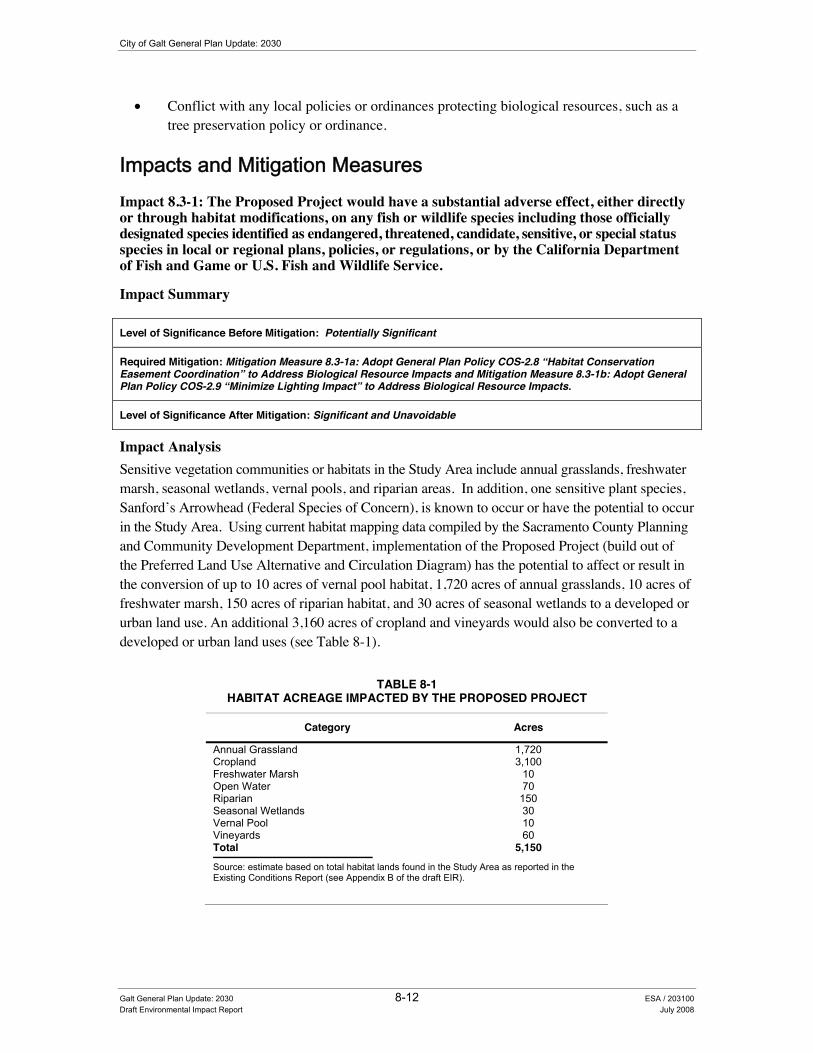
City of Galt General Plan Update: 2030
• Conflict with any local policies or ordinances protecting biological resources, such as a tree preservation policy or ordinance.
,PSDFWV�DQG�0LWLJDWLRQ�0HDVXUHV��Impact 8.3-1: The Proposed Project would have a substantial adverse effect, either directly or through habitat modifications, on any fish or wildlife species including those officially designated species identified as endangered, threatened, candidate, sensitive, or special status species in local or regional plans, policies, or regulations, or by the California Department of Fish and Game or U.S. Fish and Wildlife Service.
Impact Summary
Level of Significance Before Mitigation: Potentially Significant
Required Mitigation: Mitigation Measure 8.3-1a: Adopt General Plan Policy COS-2.8 “Habitat Conservation Easement Coordination” to Address Biological Resource Impacts and Mitigation Measure 8.3-1b: Adopt General Plan Policy COS-2.9 “Minimize Lighting Impact” to Address Biological Resource Impacts.
Level of Significance After Mitigation: Significant and Unavoidable
Impact Analysis Sensitive vegetation communities or habitats in the Study Area include annual grasslands, freshwater marsh, seasonal wetlands, vernal pools, and riparian areas. In addition, one sensitive plant species, Sanford’s Arrowhead (Federal Species of Concern), is known to occur or have the potential to occur in the Study Area. Using current habitat mapping data compiled by the Sacramento County Planning and Community Development Department, implementation of the Proposed Project (build out of the Preferred Land Use Alternative and Circulation Diagram) has the potential to affect or result in the conversion of up to 10 acres of vernal pool habitat, 1,720 acres of annual grasslands, 10 acres of freshwater marsh, 150 acres of riparian habitat, and 30 acres of seasonal wetlands to a developed or urban land use. An additional 3,160 acres of cropland and vineyards would also be converted to a developed or urban land uses (see Table 8-1).
TABLE 8-1 HABITAT ACREAGE IMPACTED BY THE PROPOSED PROJECT
Category Acres
Annual Grassland 1,720 Cropland 3,100 Freshwater Marsh 10 Open Water 70 Riparian 150 Seasonal Wetlands 30 Vernal Pool 10 Vineyards 60 Total 5,150 Source: estimate based on total habitat lands found in the Study Area as reported in the Existing Conditions Report (see Appendix B of the draft EIR).
Galt General Plan Update: 2030 8-12 ESA / 203100 Draft Environmental Impact Report July 2008
8. Natural Resources
A number of sensitive animal species are also known to occur or have the potential to occur within the Study Area. These sensitive species include, but are not limited to, Swainson’s hawk (State Threatened), tricolored blackbird (California Special Concern Species), and giant garter snake (Federal and State Threatened). Appendix B of this Draft EIR provides a complete list of these special status species and identifies the potential habitat areas where these species may be located. Additionally, the Cosumnes and Dry Creek watersheds that surround the Study Area have a high potential for greater wildlife diversity and an abundant wildlife population. These areas also provide important foraging, dispersal, and migratory corridors for many sensitive wildlife species.
Buildout of the Proposed Project (including the Preferred Land Use Alternative and Circulation Diagram) would allow for the introduction of development (predominately residential land uses) into largely undisturbed areas. Such construction has the potential to result in a significant impact on sensitive habitats, individual plants, and wildlife species. The primary impact would be the removal of sensitive habitats for building pad development and the construction of buildings, infrastructure and roadways. Additional impacts would result from increased erosion from roadways and the introduction of non-native weed and landscape plant species. The introduction of developed land uses would also result in the elimination of habitat and food resources for wildlife through the removal of vegetative communities (including some agricultural lands). The introduction of new sources of light and glare could affect nesting habitat and migratory corridors. These effects may be particularly pronounced for wildlife species with low tolerance for habitat modification or disturbance, especially some riparian bird and reptile species. Additionally, where future development under the Proposed Project would encroach upon undisturbed areas, there may be conflicts with the management of established conservation easements and preservation areas (e.g., the Cosumnes River Project) that are intended to protect sensitive habitats and special-status species. Some of these key effects are described in greater detail below.
• Indirect Impacts of the Proposed Project. Suitable habitat for listed species exists within the Planning Area and could be directly affected by both development under the Proposed Project, and roadway improvement and construction. Just as direct impacts would occur to habitats where listed species are found, indirect impacts would occur as well. Indirect impacts occur primarily through increased human/wildlife interactions, habitat fragmentation, encroachment by exotic plants and weeds, and area-wide changes in surface water flows due to development of previously undeveloped areas. Development of previously undeveloped land for residential uses can expose species to impacts from feral and unconfined pets. Additionally, the Proposed Project incorporates a network of roadways and other circulation features throughout the City, further exposing habitat and species to possible indirect impacts associated with pedestrian and bicycle use of areas that are currently inaccessible.
• Habitat Fragmentation. Much of the habitat within the Study Area used by listed species is currently interconnected with large areas of open space and sparse development that currently has a minor impact on species in the area. However, wide-scale development of the Study Area consistent with the Proposed Project could result in small pockets of
Galt General Plan Update: 2030 8-13 ESA /203100 Draft Environmental Impact Report July 2008

City of Galt General Plan Update: 2030
conserved habitat that are no longer connected by open space areas, resulting in indirect impacts to species diversity and movement within the Study Area. Habitat fragmentation reduces the species richness and increases the potential for the extinction or disappearance of sensitive species. Alterations to the hydrology, increased sedimentation, pollutants or garbage, increased human disturbance from off-road vehicles, and pedestrian traffic may result from the fragmentation of larger habitat areas (with minimal or no links to larger regional habitats) to smaller isolated preserves. For larger more mobile species such as the Swainson’s hawk, for example, the smaller preserves are generally not used as foraging habitat due to their close proximity to human disturbances at the preserve boundaries. This current analysis does not provide the level of detail to identify specific habitat needs at this time. However, it should be noted that most new development resulting from implementation of the Proposed Project would expand on the existing developed portions of the City and would not be unevenly spread through out the Study Area. Development of the Preferred Land Use Alternative and Circulation Diagram was intended to minimize encroachment on the more sensitive northern and western portions of the Study Area (e.g., Cosumnes River waterway).
• Encroachment by Exotic Weeds. Generally, landscaping installed as part of development in the region has relied heavily on exotic, non-native plant species for decoration. However, some of these species can spread to natural areas, causing native plant life to be replaced by exotic species. As native plants are replaced by exotic species, indirect impacts to the habitat of listed species would occur such as modification or degradation of habitat.
The majority of impacts to sensitive vegetation communities and wildlife species will occur as a result of project-specific activities developed subsequent to the Proposed Project. At the time individual development applications are submitted, the City will assess development proposals for potential impacts to significant biological resources pursuant to CEQA and associated State and federal regulations. The preservation of biological resources is a key goal of the Proposed Project, with the inclusion of several policies in the Conservation and Open Space, Land Use, and Community Character Elements. A complete description of these policies and implementation measures are provided in the Policy Document (see Appendix C of this draft EIR). Several policies address preservation, conservation, and avoidance of specific habitat types, including wetlands, riparian habitats, and sensitive species and vegetation communities (see policies COS-1.10, COS-1.11, COS-2.2, COS-2.3, COS-3.1, COS-3.2, COS-4.2, COS-4.3, COS-4.4, COS-4.5, COS-4.6, COS-4.8, and COS-4.9). The Conservation and Open Space and Community Character Elements also contain a number of policies that outline specific measures designed to address development impacts to these resources (see policies COS-1.13, COS-2.1, COS-2.4, COS-2.5, COS-2.6, and CC-1.6). The Proposed Project also encourages continued participation in the preparation of the South Sacramento County Habitat Conservation Plan, which is intended to help ensure the protection of sensitive biological resources in the area around the City of Galt (see policy COS-2.7). However, even with implementation of the below mentioned policies, this impact is still considered potentially significant.
Galt General Plan Update: 2030 8-14 ESA / 203100 Draft Environmental Impact Report July 2008

8. Natural Resources
Conservation and Open Space Element Land Use Element
Policies designed to protect and preserve sensitive habitats and address biological resource impacts include the following:
COS-1.10 Ecological Features Retention LU-1.10 South Sacramento Habitat Conservation Plan COS-1.11 Riparian Corridor Protection COS-1.14 Floodplain Dedication
LU-8.1 Greenbelt
COS-2.2 Wetland and Riparian Communities Management COS-2.3 Biologically Sensitive Area Development COS-2.7 Regional Habitat Conservation Efforts Coordination
COS-3.1 Riparian Protection COS-3.2 Mature Tree and Woodland Preservation COS-4.2 Natural Floodway Protection COS-4.3 Natural Land Forms COS-4.4 Open Space Protection COS-4.5 Development Design and Construction COS-4.6 Natural Open Space in Parks COS-4.8 Open Space and Natural Area Connectivity COS-4.9 Open Space Preservation
Conservation and Open Space Element Community Character Element
Policies designed to mitigate the impact of development on key biological resources include the following:
COS-1.13 No Net Loss of Wetlands CC-1.6 Open Space Features COS-2.1 Sensitive Species Protection COS-2.4 Federal, State, and Local Statutes Compliance COS-2.5 Mitigation Measures Imposition COS-2.6 Biological Surveys
Required Mitigation Measures
To address this impact, the City shall implement the following mitigation measures:
Mitigation Measure 8.3-1a: Adopt General Plan Policy COS-2.8 “Habitat Conservation Easement Coordination” to Address Biological Resource Impacts:
To mitigate biological resource impacts resulting from implementation of the Proposed Project, the City shall incorporate the following new policy COS-2.8 “Habitat Conservation Easement Coordination” into the Final General Plan:
• COS-2.8 Habitat Conservation Easement Coordination. The City will initiate contact with private conservation trusts and work to identity trust lands within the SOI and to the extent feasible will inventory known trust lands to address potential conflicts with development in the City’s planning area. [New Policy – Draft EIR Analysis]
Mitigation Measure 8.3-1b: Adopt General Plan Policy COS-2.9 “Minimize Lighting Impact” to Address Biological Resource Impacts:
Galt General Plan Update: 2030 8-15 ESA /203100 Draft Environmental Impact Report July 2008

City of Galt General Plan Update: 2030
To mitigate biological resource impacts resulting from implementation of the Proposed Project, the City shall incorporate the following new policy COS-2.9 “Minimize Lighting Impacts” into the Final General Plan:
• COS-2.9 Minimize Lighting Impacts. The City should ensure that lighting associated with new development or facilities (including street lighting, recreational facilities, and parking) shall be designed to prevent artificial lighting from illuminating adjacent natural areas at a level greater than one foot candle above ambient conditions. [New Policy – Draft EIR Analysis]
Significance after Implementation of Mitigation for Impact 8.3-1
As stated above, the City will adopt and implement a variety of policies designed to address impacts to biological resources (including officially designated endangered, threatened, candidate, sensitive, or special status species). Although these policies seek to protect a variety of open space and biological resources within the Study Area, implementation of the Proposed Project would still result in the conversion of some open space and habitat areas, which would result in the overall reduction of a plant or wildlife species habitat. Therefore, implementation of the Proposed Project including adoption of the new policies provided in mitigation measures 8.3-1a and 8.3-1b (listed above) would still result in a significant impact. No additional feasible mitigation is currently available. Consequently, this impact is considered significant and unavoidable.
Impact 8.3-2: The Proposed Project would have a substantial adverse effect on any riparian habitat or other sensitive natural community identified in local or regional plans, policies, regulations or by the California Department of Fish and Game or U.S. Fish and Wildlife Service.
Impact Summary
Level of Significance Before Mitigation: Potentially Significant
Required Mitigation: Mitigation Measure 8.3-1a: Adopt General Plan Policy COS-2.8 “Habitat Conservation Easement Coordination” to Address Biological Resource Impacts and Mitigation Measure 8.3-1b: Adopt General Plan Policy COS-2.9 “Minimize Lighting Impact” to Address Biological Resource Impacts.
Level of Significance After Mitigation: Significant and Unavoidable
Impact Analysis
Areas along the Cosumnes River, Laguna Creek, Dry Creek, and other local waterways contain riparian habitat. Riparian habitats support a variety of plant and wildlife species along watercourses or water bodies adaptable to seasonal flooding. Other sensitive habitats in the Study Area include annual grassland, wetlands, and vernal pool habitats. As more fully described above under Impact 8.3-1, buildout of the Proposed Project (including the Preferred Land Use Alternative and Circulation Diagram) would result in both direct and indirect significant adverse impacts to riparian and other sensitive natural communities occurring in the Study Area. Some impacts to riparian communities could include the alteration of hydrology, increased sedimentation, filling of roadside ditches,
Galt General Plan Update: 2030 8-16 ESA / 203100 Draft Environmental Impact Report July 2008

8. Natural Resources
wetland features, or other aquatic water bodies, removal of riparian vegetation, and the construction of bridges over floodways.
Similar to Impact 8.3-1, policies and implementation measures included as part of the Proposed Project would minimize this impact. Several policies address preservation, conservation, and avoidance of specific habitat types, including wetlands, riparian habitats, and sensitive species and vegetation communities (see policies COS-1.10, COS-1.11, COS-2.2, COS-2.3, COS-3.1, COS-3.2, COS-4.2, COS-4.3, COS-4.4, COS-4.5, COS-4.6, COS-4.8, and COS-4.9). Specifically, Policy COS-3.1 “Riparian Protection” calls for the protection of existing riparian vegetation along local stream courses and Policy COS-3.2 “Mature Tree and Woodland Preservation” encourages the retention of woodland areas. Several other policies outline specific measures designed to address development impacts to these resources (see policies COS-1.13, COS-2.1, COS-2.4, COS-2.5, COS-2.6, and CC-1.6). The Proposed Project also encourages continued participation in the preparation of the South Sacramento County Habitat Conservation Plan, which is intended to help ensure the protection of sensitive biological resources in the area around the City of Galt (see policy COS-2.7). However, even with implementation of the below mentioned policies, this impact is still considered potentially significant.
Conservation and Open Space Element Land Use Element
Policies designed to protect and preserve sensitive habitats and address biological resource impacts include the following:
COS-1.10 Ecological Features Retention LU-1.10 South Sacramento Habitat Conservation Plan COS-1.11 Riparian Corridor Protection COS-1.14 Floodplain Dedication
LU-8.1 Greenbelt
COS-2.2 Wetland and Riparian Communities Management COS-2.3 Biologically Sensitive Area Development COS-2.7 Regional Habitat Conservation Efforts Coordination
COS-3.1 Riparian Protection COS-3.2 Mature Tree and Woodland Preservation COS-4.2 Natural Floodway Protection COS-4.3 Natural Land Forms COS-4.4 Open Space Protection COS-4.5 Development Design and Construction COS-4.6 Natural Open Space in Parks COS-4.8 Open Space and Natural Area Connectivity COS-4.9 Open Space Preservation
Conservation and Open Space Element Community Character Element
Policies designed to mitigate the impact of development on key biological resources include the following:
COS-1.13 No Net Loss of Wetlands CC-1.6 Open Space Features COS-2.1 Sensitive Species Protection COS-2.4 Federal, State, and Local Statutes Compliance COS-2.5 Mitigation Measures Imposition COS-2.6 Biological Surveys
Galt General Plan Update: 2030 8-17 ESA /203100 Draft Environmental Impact Report July 2008

City of Galt General Plan Update: 2030
Required Mitigation Measures
To address this impact, the City shall implement the following mitigation measures:
Mitigation Measure 8.3-1a: Adopt General Plan Policy COS-2.8 “Habitat Conservation Easement Coordination” to Address Biological Resource Impacts:
To mitigate biological resource impacts resulting from implementation of the Proposed Project, the City shall incorporate the following new policy COS-2.8 “Habitat Conservation Easement Coordination” into the Final General Plan:
• COS-2.8 Habitat Conservation Easement Coordination. The City will initiate contact with private conservation trusts and work to identity trust lands within the SOI and to the extent feasible will inventory known trust lands to address potential conflicts with development in the City’s planning area. [New Policy – Draft EIR Analysis]
Mitigation Measure 8.3-1b: Adopt General Plan Policy COS-2.9 “Minimize Lighting Impact” to Address Biological Resource Impacts:
To mitigate biological resource impacts resulting from implementation of the Proposed Project, the City shall incorporate the following new policy COS-2.9 “Minimize Lighting Impacts” into the Final General Plan:
• COS-2.9 Minimize Lighting Impacts. The City should ensure that lighting associated with new development or facilities (including street lighting, recreational facilities, and parking) shall be designed to prevent artificial lighting from illuminating adjacent natural areas at a level greater than one foot candle above ambient conditions. [New Policy – Draft EIR Analysis]
Significance after Implementation of Mitigation for Impact 8.3-2
As stated above, the City would adopt and implement a variety of policies designed to address impacts to biological resources (including sensitive natural communities). Although these policies seek to protect a variety of open space and biological resources within the Study Area, implementation of the Proposed Project would still result in the conversion of some sensitive natural communities (including riparian habitat areas) to a developed use. Therefore, implementation of the Proposed Project including adoption of the new policies provided in mitigation measures 8.3-1a and 8.3-1b would still result in a significant impact. No additional feasible mitigation is currently available. Consequently, this impact is considered significant and unavoidable.
Impact 8.3-3: The Proposed Project would have a substantial adverse effect on “federally protected” wetlands as defined by Section 404 of the Clean Water Act (including, but not limited to marsh, vernal pool, etc.) through direct removal, filling, hydrological interruption, or other means.
Galt General Plan Update: 2030 8-18 ESA / 203100 Draft Environmental Impact Report July 2008

8. Natural Resources
Impact Summary
Level of Significance Before Mitigation: Potentially Significant
Required Mitigation: Mitigation Measure 8.3-1a: Adopt General Plan Policy COS-2.8 “Habitat Conservation Easement Coordination” to Address Biological Resource Impacts and Mitigation Measure 8.3-1b: Adopt General Plan Policy COS-2.9 “Minimize Lighting Impact” to Address Biological Resource Impacts.
Level of Significance After Mitigation: Significant and Unavoidable
Impact Analysis
Similar to Impact 8.3-1, implementation of the Proposed Project would result in both direct and indirect significant adverse impacts to wetlands and other sensitive natural communities occurring in the Study Area. Policies included as part of the Proposed Project that would minimize this impact are summarized below by general plan element. A complete description of these policies is provided in the Policy Document (see Appendix C of this Draft EIR). For example, Conservation and Open Space Element policies COS-1.10, COS-2.1, COS-2.5, COS-2.6, COS-4.4, and COS-4.5 call for the protection of a variety of natural resource areas, fish and wildlife habitat areas, and endangered vegetation habitats from encroachment and development. Policy COS-1.13 calls for the City to maintain a policy of no net loss of wetlands on a project-by project basis. Several policies also encourage the avoidance, protection, restoration, expansion, and management of wetland areas (policies COS-2.2 and COS-2.3) and coordination with federal regulations to address impacts to sensitive wetland resources (see policies COS-2.4 and COS-2.5). However, even with implementation of the above mentioned policies, this impact is still considered potentially significant.
Conservation and Open Space Element
Policies designed to protect and preserve sensitive habitats (including wetland and vernal pool habitats) include the following:
COS-1.10 Ecological Features Retention COS-2.4 Federal, State, and Local Statutes Compliance COS-1.13 No Net Loss of Wetlands COS-2.5 Mitigation Measures Imposition COS-2.1 Sensitive Species Protection COS-2.6 Biological Surveys COS-2.2 Wetland and Riparian Communities Management COS-4.4 Open Space Protection COS-2.3 Biologically Sensitive Area Development COS-4.5 Development Design and Construction
Required Mitigation Measures
To address this impact, the City shall implement the following mitigation measures:
Mitigation Measure 8.3-1a: Adopt General Plan Policy COS-2.8 “Habitat Conservation Easement Coordination” to Address Biological Resource Impacts:
To mitigate biological resource impacts resulting from implementation of the Proposed Project, the City shall incorporate the following new policy COS-2.8 “Habitat Conservation Easement Coordination” into the Final General Plan:
Galt General Plan Update: 2030 8-19 ESA /203100 Draft Environmental Impact Report July 2008
City of Galt General Plan Update: 2030
• COS-2.8 Habitat Conservation Easement Coordination. The City will initiate contact with private conservation trusts and work to identity trust lands within the SOI and to the extent feasible will inventory known trust lands to address potential conflicts with development in the City’s planning area. [New Policy – Draft EIR Analysis]
Mitigation Measure 8.3-1b: Adopt General Plan Policy COS-2.9 “Minimize Lighting Impact” to Address Biological Resource Impacts:
To mitigate biological resource impacts resulting from implementation of the Proposed Project, the City shall incorporate the following new policy COS-2.9 “Minimize Lighting Impacts” into the Final General Plan:
• COS-2.9 Minimize Lighting Impacts. The City should ensure that lighting associated with new development or facilities (including street lighting, recreational facilities, and parking) shall be designed to prevent artificial lighting from illuminating adjacent natural areas at a level greater than one foot candle above ambient conditions. [New Policy – Draft EIR Analysis]
Significance after Implementation of Mitigation for Impact 8.3-3
As stated above, the City would continue to implement a variety of policies designed to minimize the impact associated with a substantial adverse effect on federally protected wetlands as defined by Section 404 of the Clean Water Act (including, but not limited to, marsh, vernal pool, etc.) through direct removal, filling, hydrological interruption, or other means resulting from implementation of the Proposed Project. However, although these policies seek to protect a variety of open space resources within the Planning Area, implementation of the Proposed Project would still result in the conversion of sensitive natural communities (including wetlands). Therefore, implementation of the Proposed Project including adoption of the new policies provided in mitigation measures 8.3-1a and 8.3-1b would still result in a significant impact. No additional feasible mitigation is currently available. Consequently, this impact is considered significant and unavoidable.
Impact 8.3-4: The Proposed Project would interfere substantially with the movement of any native resident or migratory fish or wildlife species or with established native resident or migratory wildlife corridors, or impede the use of native wildlife nursery sites.
Impact Summary
Level of Significance Before Mitigation: Potentially Significant
Required Mitigation: Mitigation Measure 8.3-1a: Adopt General Plan Policy COS-2.8 “Habitat Conservation Easement Coordination” to Address Biological Resource Impacts and Mitigation Measure 8.3-1b: Adopt General Plan Policy COS-2.9 “Minimize Lighting Impact” to Address Biological Resource Impacts.
Level of Significance After Mitigation: Significant and Unavoidable
Galt General Plan Update: 2030 8-20 ESA / 203100 Draft Environmental Impact Report July 2008
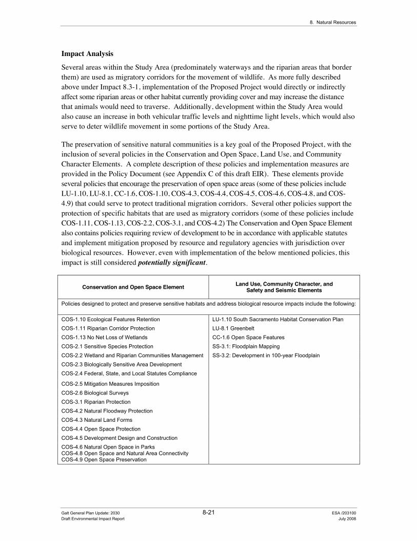
8. Natural Resources
Impact Analysis
Several areas within the Study Area (predominately waterways and the riparian areas that border them) are used as migratory corridors for the movement of wildlife. As more fully described above under Impact 8.3-1, implementation of the Proposed Project would directly or indirectly affect some riparian areas or other habitat currently providing cover and may increase the distance that animals would need to traverse. Additionally, development within the Study Area would also cause an increase in both vehicular traffic levels and nighttime light levels, which would also serve to deter wildlife movement in some portions of the Study Area.
The preservation of sensitive natural communities is a key goal of the Proposed Project, with the inclusion of several policies in the Conservation and Open Space, Land Use, and Community Character Elements. A complete description of these policies and implementation measures are provided in the Policy Document (see Appendix C of this draft EIR). These elements provide several policies that encourage the preservation of open space areas (some of these policies include LU-1.10, LU-8.1, CC-1.6, COS-1.10, COS-4.3, COS-4.4, COS-4.5, COS-4.6, COS-4.8, and COS-4.9) that could serve to protect traditional migration corridors. Several other policies support the protection of specific habitats that are used as migratory corridors (some of these policies include COS-1.11, COS-1.13, COS-2.2, COS-3.1, and COS-4.2) The Conservation and Open Space Element also contains policies requiring review of development to be in accordance with applicable statutes and implement mitigation proposed by resource and regulatory agencies with jurisdiction over biological resources. However, even with implementation of the below mentioned policies, this impact is still considered potentially significant.
Conservation and Open Space Element Land Use, Community Character, and Safety and Seismic Elements
Policies designed to protect and preserve sensitive habitats and address biological resource impacts include the following:
COS-1.10 Ecological Features Retention LU-1.10 South Sacramento Habitat Conservation Plan COS-1.11 Riparian Corridor Protection LU-8.1 Greenbelt COS-1.13 No Net Loss of Wetlands CC-1.6 Open Space Features COS-2.1 Sensitive Species Protection SS-3.1: Floodplain Mapping COS-2.2 Wetland and Riparian Communities Management SS-3.2: Development in 100-year Floodplain COS-2.3 Biologically Sensitive Area Development COS-2.4 Federal, State, and Local Statutes Compliance
COS-2.5 Mitigation Measures Imposition COS-2.6 Biological Surveys COS-3.1 Riparian Protection COS-4.2 Natural Floodway Protection COS-4.3 Natural Land Forms COS-4.4 Open Space Protection COS-4.5 Development Design and Construction COS-4.6 Natural Open Space in Parks COS-4.8 Open Space and Natural Area Connectivity COS-4.9 Open Space Preservation
Galt General Plan Update: 2030 8-21 ESA /203100 Draft Environmental Impact Report July 2008

City of Galt General Plan Update: 2030
Required Mitigation Measures
To address this impact, the City shall implement the following mitigation measures:
Mitigation Measure 8.3-1a: Adopt General Plan Policy COS-2.8 “Habitat Conservation Easement Coordination” to Address Biological Resource Impacts:
To mitigate biological resource impacts resulting from implementation of the Proposed Project, the City shall incorporate the following new policy COS-2.8 “Habitat Conservation Easement Coordination” into the Final General Plan:
• COS-2.8 Habitat Conservation Easement Coordination. The City will initiate contact with private conservation trusts and work to identity trust lands within the SOI and to the extent feasible will inventory known trust lands to address potential conflicts with development in the City’s planning area. [New Policy – Draft EIR Analysis]
Mitigation Measure 8.3-1b: Adopt General Plan Policy COS-2.9 “Minimize Lighting Impact” to Address Biological Resource Impacts:
To mitigate biological resource impacts resulting from implementation of the Proposed Project, the City shall incorporate the following new policy COS-2.9 “Minimize Lighting Impacts” into the Final General Plan:
• COS-2.9 Minimize Lighting Impacts. The City should ensure that lighting associated with new development or facilities (including street lighting, recreational facilities, and parking) shall be designed to prevent artificial lighting from illuminating adjacent natural areas at a level greater than one foot candle above ambient conditions. [New Policy – Draft EIR Analysis]
Significance after Implementation of Mitigation for Impact 8.3-4
As stated above, the City would adopt and implement a variety of policies designed to address impacts to biological resources, including the migratory corridors of local wildlife. Although these policies seek to protect a variety of open space resources and migratory corridors within the Study Area, implementation of the Proposed Project would still result in the conversion of some open space areas that could serve as migratory corridors. Therefore, implementation of the Proposed Project including adoption of the new policies provided in mitigation measures 8.3-1a and 8.3-1b would still result in a significant impact. No additional feasible mitigation is currently available. Consequently, this impact is considered significant and unavoidable.
8.4 Soils and Agricultural Resources Soils and agricultural resource impacts include those to existing agricultural uses, Important Farmlands (those classified and mapped by the Farmland Mapping and Monitoring Program of the California Department of Conservation), along with the potential for increased levels of soil erosion.
Galt General Plan Update: 2030 8-22 ESA / 203100 Draft Environmental Impact Report July 2008
8. Natural Resources
(QYLURQPHQWDO�DQG�5HJXODWRU\�6HWWLQJ��As previously described in the “Readers Guide” (see Chapter 1 of this draft EIR), Section 15150 of the CEQA Guidelines permits documents of lengthy technical detail to be incorporated by reference in an EIR. Specifically, Section 15150 states that an EIR may “incorporate by reference all or portions of another document which is a matter of public record or is generally available to the public…” Consistent with the CEQA Guidelines and as a way to avoid creating an overwhelming amount of paper for members of the public and decision-makers to sort through, this draft EIR incorporates by reference information from both the Existing Conditions Report and Policy Document. Consistent with this approach, the reader is directed to Chapter 8.0 of the Existing Conditions Report for environmental and regulatory setting information specific to soils and agricultural resources issues (see Appendix B of this draft EIR).
,PSDFW�0HWKRGRORJ\��Similar to biological resources, impacts to soils and agricultural resources were evaluated using information provided in the General Plan Existing Conditions Report (see Appendix B of this draft EIR). Using GIS data provided by the California Department of Conservation’s Farmland Mapping and Monitoring Program, an estimate of the area affected (number of acres of Important Farmland) was calculated for development anticipated under the Preferred Land Use Alternative/Circulation Diagram. Following this estimate of the area affected by the Proposed Project, a determination of whether the Proposed Project includes adequate provisions to ensure continued protection of these resources was conducted.
6WDQGDUGV�RI�6LJQLILFDQFH��The Proposed Project will establish development guidelines against which future projects will be judged for consistency. The significance criteria for this analysis were developed from criteria presented in Appendix G, “Environmental Checklist Form”, of the CEQA Guidelines and based on the professional judgment of the City of Galt and its consultants. The project (of the project alternatives) would result in a significant impact if it would:
• Result in substantial soil erosion or the loss of topsoil;
• Convert Prime Farmland, Unique Farmland, or Farmland of Statewide Importance (Farmland) as shown on the maps prepared pursuant to the Farmland Mapping and Monitoring Program of the California Resources Agency, to non-agricultural use;
• Conflict with existing zoning for agricultural use, or conflict with a Williamson Act contract; or
• Involve other changes in the existing environment that, due to their location or nature, could result in conversion of farmland, to non-agricultural uses.
Galt General Plan Update: 2030 8-23 ESA /203100 Draft Environmental Impact Report July 2008
City of Galt General Plan Update: 2030
,PSDFWV�DQG�0LWLJDWLRQ�0HDVXUHV��
Impact 8.4-1: The Proposed Project would result in substantial soil erosion or the loss of topsoil.
Impact Summary
Level of Significance Before Mitigation: Less than Significant
Required Mitigation Measures: No Mitigation Required
Level of Significance After Mitigation: Less than Significant
Impact Analysis
Erosion is a normal and inevitable geologic process whereby earth materials are loosened, worn away, decomposed or dissolved, and are removed from one place and transported to another location. Precipitation, running water, and wind are all factors that contribute to erosion. Ordinarily, erosion proceeds very slowly as to be imperceptible, but when the natural equilibrium of the environment is changed, the rate of erosion can be greatly accelerated. Accelerated erosion within an urban area can cause damage by undermining structures, blocking storm sewers and depositing silt, sand, or mud in roads and tunnels. Consequently, these erosion effects can result in a variety of aesthetic and engineering problems. Additionally, eroded materials are eventually deposited into local waterways where the carried silt remains suspended for some time, constituting a pollutant and altering the normal balance of a waterway ecosystem.
Overall, the Study Area is relatively flat with soil conditions that exhibit minimal potential for erosion impacts. However, development activities resulting from buildout of the Proposed Project would accelerate the Study Area’s erosion rate through both an increase in short-term construction-related activities and an overall increase in the amount of impervious surfaces. Development in the Study Area would be subject to local and State codes and requirements for erosion control and grading. In addition, project sites encompassing an area of one or more acres would require compliance with a National Pollutant Discharge Elimination System (NPDES) permit and consequently the development and implementation of a Storm Water Pollution Prevention Plan (SWPPP).
Policies included as part of the Proposed Project that would minimize this impact are summarized below by general plan element, with a complete description of these policies provided in Appendix C “Policy Document” of this draft EIR. For example, erosion-related effects can be minimized at the onset of a specific project through implementation of Conservation and Open Space Element policies requiring soils investigations and reports to be prepared (see policies SS-2.1 and SS-2.3). Policy PFS-4.5: “Grading During the Rainy Season” and Policy PFS-4.6: “Erosion Control Plan” requires the preparation of an erosion control plan or places limitations on construction-related activities to help address sedimentation impacts. Additionally, Policy COS-1.12 “Best Management Practices” requires new development to implement a variety of common best management practices
Galt General Plan Update: 2030 8-24 ESA / 203100 Draft Environmental Impact Report July 2008

8. Natural Resources
(BMPs) that will help to minimize soil erosion during a variety of construction and grading related activities. BMPs focus on, but are not limited to, a variety of construction techniques that utilize site preparation, grading, and silt fencing measures designed to minimize soil loss. With implementation of these policies, this impact is considered less-than-significant.
Public Facilities and Services Element Conservation and Open Space & Safety and Seismic Elements
Policies designed to minimize soils-related impacts associated with a variety of factors (including both human and naturally occurring effects) include the following:
PFS-4.4 Project Design PFS-4.5 Grading During the Rainy Season PFS-4.6 Erosion Control Plan
COS-1.12 Best Management Practices SS-2.1 Geologic and Soils Information SS-2.3 Grading/Erosion Control
Required Mitigation Measures
This impact is considered less-than-significant. No additional mitigation measures are required.
Impact 8.4-2: The Proposed Project would result in the conversion of important farmland to non-agricultural uses.
Impact Summary
Level of Significance Before Mitigation: Potentially Significant
Required Mitigation Measures: No Feasible Mitigation
Level of Significance After Mitigation: Significant and Unavoidable
Impact Analysis
As shown below in Table 8-2, buildout of the Proposed Project (including the Preferred Land Use Alternative and Circulation Diagram) would result in the conversion of up to 3,200 acres of important farmland.
TABLE 8-2 FARMLAND MAPPING CATEGORIES
AFFECTED BY THE PROPOSED PROJECT
Category Acres(a)
Grazing 100 Farmland of Local Importance 1,300 Prime Farmland 100 Farmland of Statewide Importance 3,000 Unique Farmland 100 Other Land 900 Total 5,880
Note (a) – estimate based on total FMMP lands found in the Study Area as reported in the Existing Conditions Report (see Appendix B of the draft EIR).
Galt General Plan Update: 2030 8-25 ESA /203100 Draft Environmental Impact Report July 2008

City of Galt General Plan Update: 2030
Policies included as part of the Proposed Project that would minimize this impact are summarized below by general plan element, with a complete description of these policies and implementation measures provided in the Policy Document (see Appendix C of this draft EIR). For example, the Conservation and Open Space and Land Use Elements provide a number of policies that have been developed to ensure a safe environment for the City’s residents, visitors, and businesses. Some of these policies are intended to support continued agricultural uses (see policies COS-4.1, LU-8.1, and LU-8.2). For example, Policy LU-8.1 “Greenbelt” requires the City to participate in regional efforts to establish a permanent greenbelt between the northern boundary of the Study Area and the City of Elk Grove. Additionally, policy COS-4.1 encourages the City to preserve prime agricultural lands surrounding the Study Area. These policies and Policy COS-4.4 also help to reduce conflicts between agricultural and urban uses. However, even with implementation of the policies mentioned below, this impact, the conversion of an estimated 3,490 acres of important farmland to urban and other uses, is still considered potentially significant.
Land Use Element Conservation and Open Space Element
Policies designed to conserve soils and agricultural resources within the Study Area include the following:
LU-9.1 Greenbelt LU-9.2 Agricultural-Residential Uses
COS-4.1 Prime Agricultural Land Preservation COS-4.4 Open Space Protection
Required Mitigation Measures
As stated above, the City will continue to support both local and regional agricultural preservation measures through the implementation of a variety of policies incorporated as part of the Proposed Project. While these policies would provide partial mitigation for agricultural conversion, it would not prevent the loss of important farmlands within the Study Area and would still result in a significant impact. No additional feasible mitigation is currently available.
Significance after Implementation of Mitigation for Impact 8.4-2
As stated above, no additional feasible mitigation measures are currently available to reduce this impact to a less-than-significant level. Consequently, this impact is considered significant and unavoidable.
Impact 8.4-3: The Proposed Project could conflict with existing zoning for agricultural use, or conflict with existing Williamson Act contracts.
Impact Summary
Level of Significance Before Mitigation: Less than Significant
Required Mitigation Measures: No Mitigation Required
Level of Significance After Mitigation: Less than Significant
Galt General Plan Update: 2030 8-26 ESA / 203100 Draft Environmental Impact Report July 2008
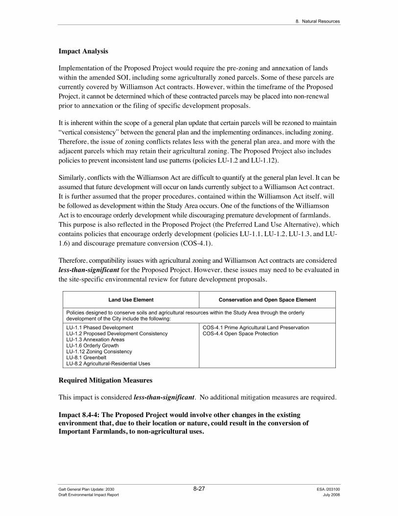
8. Natural Resources
Impact Analysis
Implementation of the Proposed Project would require the pre-zoning and annexation of lands within the amended SOI, including some agriculturally zoned parcels. Some of these parcels are currently covered by Williamson Act contracts. However, within the timeframe of the Proposed Project, it cannot be determined which of these contracted parcels may be placed into non-renewal prior to annexation or the filing of specific development proposals.
It is inherent within the scope of a general plan update that certain parcels will be rezoned to maintain “vertical consistency” between the general plan and the implementing ordinances, including zoning. Therefore, the issue of zoning conflicts relates less with the general plan area, and more with the adjacent parcels which may retain their agricultural zoning. The Proposed Project also includes policies to prevent inconsistent land use patterns (policies LU-1.2 and LU-1.12).
Similarly, conflicts with the Williamson Act are difficult to quantify at the general plan level. It can be assumed that future development will occur on lands currently subject to a Williamson Act contract. It is further assumed that the proper procedures, contained within the Williamson Act itself, will be followed as development within the Study Area occurs. One of the functions of the Williamson Act is to encourage orderly development while discouraging premature development of farmlands. This purpose is also reflected in the Proposed Project (the Preferred Land Use Alternative), which contains policies that encourage orderly development (policies LU-1.1, LU-1.2, LU-1.3, and LU-1.6) and discourage premature conversion (COS-4.1).
Therefore, compatibility issues with agricultural zoning and Williamson Act contracts are considered less-than-significant for the Proposed Project. However, these issues may need to be evaluated in the site-specific environmental review for future development proposals.
Land Use Element Conservation and Open Space Element
Policies designed to conserve soils and agricultural resources within the Study Area through the orderly development of the City include the following:
LU-1.1 Phased Development LU-1.2 Proposed Development Consistency LU-1.3 Annexation Areas LU-1.6 Orderly Growth LU-1.12 Zoning Consistency LU-8.1 Greenbelt LU-8.2 Agricultural-Residential Uses
COS-4.1 Prime Agricultural Land Preservation COS-4.4 Open Space Protection
Required Mitigation Measures
This impact is considered less-than-significant. No additional mitigation measures are required.
Impact 8.4-4: The Proposed Project would involve other changes in the existing environment that, due to their location or nature, could result in the conversion of Important Farmlands, to non-agricultural uses.
Galt General Plan Update: 2030 8-27 ESA /203100 Draft Environmental Impact Report July 2008

City of Galt General Plan Update: 2030
Impact Summary
Level of Significance Before Mitigation: Less than Significant
Required Mitigation Measures: No Mitigation Required
Level of Significance After Mitigation: Less than Significant
Impact Analysis
Direct impacts to agricultural resources include the conversion of farmland to non-agricultural uses, as discussed above. Indirect changes may include nuisance effects resulting from urban expansion into agricultural areas—also known as “edge effects.” These nuisance effects include noise (from farm equipment and crop dusting), dust, odors, and drift of agricultural chemicals. From the agricultural perspective, conflicts with urban development include restrictions on the use of agricultural chemicals, complaints regarding noise and dust, trespass, vandalism, and damage from domestic animals (such as dogs). These conflicts may increase costs to the agricultural operation, and combined with rising land values for residential development, encourage conversion of additional Important Farmland to urban uses. Several policies included in the Proposed Project address the protection of agricultural land uses and establishing a green belt (see policies COS-4.1, COS-4.4, LU-8.1, and LU-8.2) that could help minimize conflicts between agricultural and incompatible land uses. With implementation of these policies, this impact is considered less-than-significant.
Land Use Element Conservation and Open Space Element
Policies designed to conserve soils and agricultural resources within the Study Area include the following:
LU-8.1 Greenbelt LU-8.2 Agricultural-Residential Uses
COS-4.1 Prime Agricultural Land Preservation COS-4.4 Open Space Protection
Required Mitigation Measures
This impact is considered less-than-significant. No additional mitigation measures are required.
Galt General Plan Update: 2030 8-28 ESA / 203100 Draft Environmental Impact Report July 2008
Chapter 9 Historic Resources


CHAPTER 9.0 +LVWRULF�5HVRXUFHV��
9.1 Introduction In preparing the Proposed Project, a common chapter numbering system was used in preparing key general plan documents to allow readers the ability to easily find related information throughout the various documents. In the Existing Conditions Report, Chapter 9.0 is the “Historic Resources” section, which provides background on the unique cultural and historic resources of the City. The Policy Document provides a variety of policies that have been developed to assist the City address these key topics and maintain their desired community character.
This chapter of the draft EIR analyzes the impacts associated with implementation of the Proposed Project on the historic and cultural resources of the Study Area. Cultural resource impacts include those to existing historic resources (i.e., historic districts, landmarks, etc.) and archeological resources.
9.2 Historic and Cultural Resources
(QYLURQPHQWDO�DQG�5HJXODWRU\�6HWWLQJ��As previously described in the “Readers Guide” (see Chapter 1 of this draft EIR), Section 15150 of the CEQA Guidelines permits documents of lengthy technical detail to be incorporated by reference in an EIR. Specifically, Section 15150 states that an EIR may “incorporate by reference all or portions of another document which is a matter of public record or is generally available to the public ....”. Consistent with the CEQA Guidelines and as a way to avoid creating an overwhelming amount of paper for members of the public and decision-makers to sort through, this draft EIR incorporates by reference information from both the Existing Conditions Report and Policy Document. Environmental setting and regulatory information for a variety of cultural resources in the City of Galt can be found in Chapter 3.0 of the Existing Conditions Report (see Appendix B of this draft EIR).
,PSDFW�0HWKRGRORJ\��The assessment of impacts to cultural resources is a qualitative review of the existing cultural resource conditions within the Study Area and a determination of whether the Proposed Project includes adequate provisions to ensure continued protection of these resources.
Galt General Plan Update: 2030 9-1 ESA / 203100 Draft Environmental Impact Report July 2008

City of Galt General Plan Update: 2030
6WDQGDUGV�RI�6LJQLILFDQFH�The significance criteria for this analysis were developed from criteria presented in Section 15064.5 and Appendix G “Environmental Checklist Form” of the CEQA Guidelines and based on the professional judgment of the City of Galt and its consultants.
CEQA offers direction regarding impacts on historical resources and unique archaeological resources. CEQA states that if implementation of a project would result in significant environmental impacts, then public agencies should determine whether such impacts can be substantially lessened or avoided through feasible mitigation measures or feasible alternatives. However, only significant cultural resources (e.g., “historical resources” and “unique archaeological resources”) need to be addressed. The CEQA Guidelines define a historical resource as, among other things “a resource listed or eligible for listing on the California Register of Historical Resources” (CRHR) (State CEQA Guidelines §15064.5(a) (i); Public Resources Code §§5024.1, 21084.1). A historical resource may be eligible for inclusion on the CRHR, as determined by the State Historical Resources Commission or the lead agency, if the resource:
1. is associated with events that have made a significant contribution to the broad patterns of California’s history and cultural heritage; or
2. is associated with the lives of persons important in our past; or
3. embodies the distinctive characteristics of a type, period, region, or method of construction, or represents the work of an important creative individual, or possesses high artistic values; or
4. has yielded, or may be likely to yield, information important in prehistory or history.
(CEQA Guidelines, §15064.5, subds. (a)(1), (a)(3).) In addition, a resource is presumed to constitute an “historical resource” if it is included in a “local register of historical resources” unless “the preponderance of evidence demonstrates that it is not historically or culturally significant.” (CEQA Guidelines, §15064.5, subd. (a)(2)). In addition, the State CEQA Guidelines also require consideration of unique archaeological sites (§15064.5) (see also Public Resources Code §21083.2). A “unique archaeological resource” is defined as:
an archaeological artifact, object, or site about which it can be clearly demonstrated that, without merely adding to the current body of knowledge, there is a high probability that it meets any of the following criteria: (1) Contains information needed to answer important scientific research questions and that there is a demonstrable public interest in that information. (2) Has a special and particular quality such as being the oldest of its type or the best available example of its type. (3) Is directly associated with a scientifically recognized important prehistoric or historic event or person. [Public Resources Code, § 21083.2, subd. (h)].
If an archaeological site does not meet the criteria for inclusion on the CRHR but does meet the definition of a unique archeological resource as outlined in the Public Resource Code, it is entitled to special protection or attention under CEQA. Treatment options include activities that preserve such resources in place in an undisturbed state. Other acceptable methods of mitigation include excavation and curation or study in place without excavation and curation.
Galt General Plan Update: 2030 9-2 ESA / 203100 Draft Environmental Impact Report July 2008

9. Historic Resources
CEQA Guidelines section 15064.5, subdivision (e), requires that excavation activities be stopped whenever human remains are uncovered and that the county coroner be called in to assess the remains. If the county coroner determines that the remains are those of Native Americans, the Native American Heritage Commission must be contacted within 24 hours. At that time, the lead agency shall consult with the appropriate Native Americans as identified by the Native American Heritage Commission and directs the lead agency (or applicant), under certain circumstances, to develop an agreement with the Native Americans for the treatment and disposition of the remains.
For historical structures, CEQA Guidelines indicate that a project that follows the Secretary of the Interior’s Standards for the Treatment of Historic Properties with Guidelines for Preserving, Rehabilitating, Restoring, and Reconstructing Historic Buildings, or the Secretary of the Interior’s Standards for Rehabilitation and Guidelines for Rehabilitating Historic Buildings (1995), will mitigate potential impacts to a less than significant level. Potential eligibility also rests upon the integrity of the resource. Integrity is defined as the retention of the resource’s physical identity that existed during its period of significance. Integrity is determined through considering the setting, design, workmanship, materials, location, feeling, and association of the resource.
In light of this regulatory background, the Proposed Project (or the project alternatives) would result in a significant impact if it would:
• Cause a substantial adverse change in the significance of an historical resource as defined in CEQA Guidelines Section 15064.5;
• Cause a substantial adverse change in the significance of a unique archaeological resource pursuant to CEQA Guidelines Section 15064.5;
• Directly or indirectly destroy a unique paleontological resource or site or unique geologic feature; or
• Disturb any human remains, including those interred outside of formal cemeteries.
CEQA Guidelines section 15064.defines “substantial adverse change” as physical demolition, destruction, relocation, or alteration of the resource or its immediate surroundings.
,PSDFWV�DQG�0LWLJDWLRQ�0HDVXUHV�Impact 9.2-1: The Proposed Project could cause a substantial adverse change in the significance of a historical resource as defined in CEQA Guidelines Section 15064.5.
Impact Summary
Level of Significance Before Mitigation: Potentially Significant
Required Mitigation: Mitigation Measure 9.2-1a: Adopt Revised General Plan Policy HRE-1.2 “Preservation of Architectural Styles” to Address Historic Resource Impacts, Mitigation Measure 9.2-1b: Adopt Revised General Plan Policy HRE-1.4 “Renovations” to Address Historic Resource Impacts, and Mitigation Measure 9.2-1c: Adopt Revised General Plan Policy HRE-1.9 “Downtown Revitalization and Historic Preservation Specific Plan Area” to Address Historic Resource Impacts.
Level of Significance After Mitigation: Significant and Unavoidable
Galt General Plan Update: 2030 9-3 ESA /203100 Draft Environmental Impact Report July 2008
City of Galt General Plan Update: 2030
Impact Analysis
The City of Galt contains two NRHP listed buildings, one State Historic Landmark, two State Historical Points of Interest, and fifty City Historic Landmarks/Sites. Identified historic structures and sites that are eligible for National Register of Historic Resources listing, particularly in the City’s downtown area, may be vulnerable to development activities accompanying infill or redevelopment activities.
In developing the Proposed Project, the City has taken a key role in the preservation and enhancement of its historic resources with the development of several policies contained in the Historic Resources Element. Policies within the proposed Historic Resources Element establish specific measures that the City will implement to enhance and preserve its historic districts, neighborhoods, and buildings. These specific policies include those that intended to establish a framework for the preservation of Galt’s historic resources (such as Policies HRE-1.1: “Historic Preservation,” HRE-1.5: “Historic Resources Inventory,” and HRE-1.9: “Downtown Revitalization and Historic Preservation Specific Plan Area”) as well as policies intended to promote economic assistance for historic preservation and develop innovative community education programs to promote historic preservation (such as Policies HRE-2.2: “Federal and State Grants” and HRE-3.1: “Awareness Ceremonies”). However, even with implementation of the above mentioned policies, this impact to historic resources is still considered potentially significant.
Historic Resources Element
Policies designed to preserve and maintain City historic resources include the following:
HRE-1.1 Historic Preservation HRE-1.2 Preservation of Architectural Styles HRE-1.3 Downtown Design Coordination HRE-1.4 Renovations HRE-1.5 Historic Resources Inventory HRE-1.6 Property Owner Consultation HRE-1.7 Environmental Review of Historic Resources HRE-1.8 Railroad Property HRE-1.9 Downtown Revitalization and Historic Preservation Specific Plan Area HRE-1.10 Adaptive Reuse HRE-1.11 Historic Preservation Plan HRE-2.1 Economic Incentives HRE-2.2 Federal and State Grants HRE-3.1 Awareness Ceremonies HRE-3.2 Coordination with other Agencies and Organizations
Required Mitigation Measures
To address this impact, the City shall implement the following mitigation measures:
Mitigation Measure 9.2-1a: Adopt Revised General Plan Policy HRE-1.2 “Preservation of Architectural Styles” to Address Historic Resource Impacts.
To mitigate historic resource impacts resulting from implementation of the Proposed Project, the City shall incorporate the following revisions to Policy HRE-1.2 “Preservation of Architectural Styles” into the Final General Plan:
Galt General Plan Update: 2030 9-4 ESA / 203100 Draft Environmental Impact Report July 2008

9. Historic Resources
• Policy HRE-1.2: Preservation of Architectural Styles. The City should encourage the preservation of varied architectural styles that reflect Galt’s cultural, social, economic, political, and architectural past. For structures listed on the City’s cultural resources list or on the NRHP or CRHR, preservation efforts shall conform to the current Secretary of the Interior’s Standards for the Treatment of Historic Properties and Guidelines for Preserving, Rehabilitating, Restoring, and Reconstructing Historic Building. [Galt Area Historical Society – Draft EIR Analysis]
Mitigation Measure 9.2-1b: Adopt Revised General Plan Policy HRE-1.4 “Renovations” to Address Historic Resource Impacts.
To mitigate historic resource impacts resulting from implementation of the Proposed Project, the City shall incorporate the following revisions to Policy HRE-1.4 “Renovations” into the Final General Plan:
• Policy HRE-1.4: Renovations. The City should continue to assist in financing and accomplishing renovation efforts in the Downtown area, including façade enhancements, as funding allows. For designated historic structures, renovation efforts shall conform to the current Secretary of the Interior’s Standards for the Treatment of Historic Properties and Guidelines for Preserving, Rehabilitating, Restoring, and Reconstructing Historic Building. [City: D-2– Draft EIR Analysis]
Mitigation Measure 9.2-1c: Adopt Revised General Plan Policy HRE-1.9 “Downtown Revitalization and Historic Preservation Specific Plan Area” to Address Historic Resource Impacts.
To mitigate historic resource impacts resulting from implementation of the Proposed Project, the City shall incorporate the following revisions to Policy HRE-1.9 “Downtown Revitalization and Historic Preservation Specific Plan Area” into the Final General Plan:
• Policy HRE-1.9: Downtown Revitalization and Historic Preservation Specific Plan Area. The City should continue to implement the Downtown Revitalization and Historic Preservation Specific Plan, including the design guidelines to ensure that new construction, renovations, and additions are compatible with existing adjacent structures. For designated historic structures, renovation efforts shall conform to the current Secretary of the Interior’s Standards for the Treatment of Historic Properties and Guidelines for Preserving, Rehabilitating, Restoring, and Reconstructing Historic Building. [M&A – Draft EIR Analysis]
Significance after Implementation of Mitigation for Impact 9.2-1
As stated above, the City will continue to ensure that a variety of preservation efforts are implemented under all future development projects to minimize impacts to historic resources (as defined in Section 15064.5). However, implementation of the Proposed Project may ultimately result in a “substantial adverse change” (physical demolition, destruction, relocation, or alteration
Galt General Plan Update: 2030 9-5 ESA /203100 Draft Environmental Impact Report July 2008
City of Galt General Plan Update: 2030
of the resource or its immediate surroundings) through various development activities for which no possible mitigation may be available to maintain the historic integrity of the affected resource or its surroundings. Therefore, implementation of the Proposed Project including the adoption of the revised policies provided in mitigation measures 9.2-1a, 9.2-1b, and 9.2-1c (listed above) would still result in a significant impact. No additional feasible mitigation is currently available. Consequently, this impact is considered significant and unavoidable.
Impact 9.2-2: The Proposed Project would cause a substantial adverse change in the significance of a unique archaeological resource as defined in CEQA Guidelines Section 15064.5, directly or indirectly destroy a unique paleontological resource or site or unique geologic feature, or disturb any human remains, including those interred outside of formal cemeteries.
Impact Summary
Level of Significance Before Mitigation: Potentially Significant
Required Mitigation: Mitigation Measure 9.2-2a: Adopt General Plan Policy HRE-4.1 “Archaeological Resource Surveys” to Address Cultural Resource Impacts, Mitigation Measure 9.2-2b: Adopt General Plan Policy HRE-4.2 “Native American Resources” to Address Cultural Resource Impacts, Mitigation Measure 9.2-2c: Adopt General Plan Policy HRE-4.3 “Discovery of Archaeological Resources” to Address Cultural Resource Impacts, and Mitigation Measure 9.2-2d: Adopt General Plan Policy HRE-4.4 “Discovery of Human Remains” to Address Cultural Resource Impacts.
Level of Significance After Mitigation: Less than Significant
Impact Analysis
Archival research indicates that most prehistoric settlement in the area was focused along the major waterways, especially the Cosumnes River, and along the Dry Creek corridor. Evidence from previous survey activities and site investigations of the Study Area indicate that most prehistoric sites would consist of the following; mounded midden sites, grinding stones, manos, matates, mortars, lithic flakes and projectile points. Prehistoric site probabilities would likely be located along the waterways of the Study Area, although it is possible to encounter archaeological deposits in almost any location throughout the Study Area. Archaeological resources and/or human remains could be damaged or inadvertently unearthed during ground-disturbing activities such as grading, trenching, or use of staging areas.
In developing the Proposed Project, the City has also taken a key role in addressing archaeological and paleontological resources. Policies within the proposed Historic Resources Element establish protocols to address archaeological resources and promote their protection through the development of the City’s Historic Preservation Plan. However, even with implementation of the below mentioned policy, this impact is still considered potentially significant.
Historic Resources Element
Policies designed to preserve and maintain archaeological resources include the following:
HRE-1.11 Historic Preservation Plan
Galt General Plan Update: 2030 9-6 ESA / 203100 Draft Environmental Impact Report July 2008

9. Historic Resources
Required Mitigation Measures
To address this impact, the City shall implement the following mitigation measures:
Mitigation Measure 9.2-2a: Adopt General Plan Policy HRE-4.1 “Archaeological Resource Surveys” to Address Cultural Resource Impacts.
To mitigate cultural resource impacts resulting from implementation of the Proposed Project, the City shall incorporate the following new Policy HRE-4.1 “Archaeological Resource Surveys” into the Final General Plan:
• HRE-4.1 Archaeological Resource Surveys. For future development projects on previously un-surveyed lands, the City shall require a project applicant to have a qualified archeologist conduct the following activities: (1) conduct a record search at the North Central Information Center located at California State University, Sacramento and other appropriate historical repositories, (2) conduct field surveys where appropriate, and (3) prepare technical reports, where appropriate, meeting California Office of Historic Preservation Standards (Archeological Resource Management Reports). These requirements shall be completed prior to the approval of the specific project. [New Policy – Draft EIR Analysis]
Mitigation Measure 9.2-2b: Adopt General Plan Policy HRE-4.2 “Native American Resources” to Address Cultural Resource Impacts.
To mitigate cultural resource impacts resulting from implementation of the Proposed Project, the City shall incorporate the following new Policy HRE-4.2 “Native American Resources” into the Final General Plan:
• HRE-4.2 Native American Resources. The City shall consult with Native American representatives regarding cultural resources to identify locations of importance to Native Americans, including archeological sites and traditional cultural properties. Consistent with State requirements, consultation shall occur at the onset of an amendment to the City’s General Plan or a specific plan. [New Policy – Draft EIR Analysis]
Mitigation Measure 9.2-2c: Adopt General Plan Policy HRE-4.3 “Discovery of Archaeological Resources” to Address Cultural Resource Impacts.
To mitigate cultural resource impacts resulting from implementation of the Proposed Project, the City shall incorporate the following new Policy HRE-4.3 “Discovery of Archaeological Resources” into the Final General Plan:
• HRE-4.3 Discovery of Archaeological Resources. In the event that archaeological/ paleontological resources are discovered during site excavation, the City shall require that grading and construction work on the project site be suspended until the significance of the features can be determined by a qualified archaeologist/paleontologist. The City will require that a qualified archeologist/paleontologist make recommendations for measures necessary to
Galt General Plan Update: 2030 9-7 ESA /203100 Draft Environmental Impact Report July 2008

City of Galt General Plan Update: 2030
protect a site or to undertake data recovery, excavation, analysis, and curation of archaeological/paleontological materials. [New Policy – Draft EIR Analysis]
Mitigation Measure 9.2-2d: Adopt General Plan Policy HRE-4.4 “Discovery of Human Remains” to Address Cultural Resource Impacts.
To mitigate cultural resource impacts resulting from implementation of the Proposed Project, the City shall incorporate the following new Policy HRE-4.4 “Discovery of Human Remains” into the Final General Plan:
• HRE-4.4 Discovery of Human Remains. Consistent with CEQA Guidelines (Section 15064.5), if human remains of Native American origin are discovered during development project construction, it is necessary to comply with state laws relating to the disposition of Native American burials, which fall within the jurisdiction of the Native American Heritage Commission (Public Resources Code Sec. 5097). If any human remains are discovered or recognized in any location on the project site, there shall be no further excavation or disturbance of the site or any nearby area reasonably suspected to overlie adjacent human remains until:
a. The Sacramento County Coroner/Sheriff has been informed and has determined that no investigation of the cause of death is required; and
b. if the remains are of Native American origin,
1. The descendants of the deceased Native Americans have made a timely recommendation to the landowner or the person responsible for the excavation work, for means of treating or disposing of, with appropriate dignity, the human remains and any associated grave goods as provided in Public Resources Code Section 5097.98, or
2. The Native American Heritage Commission was unable to identify a descendant or the descendant failed to make a recommendation within 24 hours after being notified by the commission. [New Policy – Draft EIR Analysis]
Significance after Implementation of Mitigation for Impact 9.2-2
In accordance with State law, the City will continue to ensure that a variety of preservation efforts are implemented to minimize impacts to archaeological resources (as defined in Section 15064.5), paleontological resources, or human remains. Therefore, implementation of the Proposed Project including the adoption of the additional policies provided in mitigation measures 9.2-2a, 9.2-2b, 9.2-2c, and 9.2-2d (listed above) would result in a less-than-significant impact.
Galt General Plan Update: 2030 9-8 ESA / 203100 Draft Environmental Impact Report July 2008
Chapter 10 Public Health and Safety


Galt General Plan Update: 2030 10-1 ESA / 203100 Draft Environmental Impact Report July 2008
CHAPTER 10.0 3XEOLF�+HDOWK�DQG�6DIHW\�
10.1 Introduction In preparing the Proposed Project, a common chapter numbering system was used in preparing the key general plan documents to allow readers the ability to easily find related information throughout the various documents. In the Existing Conditions Report, Chapter 10.0 is the �“Public Health and Safety�” section. This section provides background information on a variety of natural and human health and safety conditions that may occur in the Study Area, with the draft Policy Document providing the policy framework to address these issues identified for the Proposed Project.
This chapter discusses the potential impacts of the Proposed Project on a variety of public health and safety issues including:
• Noise (10.2),
• Geology and Seismic Hazards (10.3),
• Flooding (10.4),
• Wildland Fires (10.5),
• Human-Made Hazards (10.6), and
• Air Quality and Global Climate Change (10.7).
10.2 Noise Primary noise sources within the City include traffic and railroad operations. Industrial and commercial activities also contribute to background noise. This section provides an analysis of potential impacts to noise that would result from implementation of the Proposed Project and identifies applicable policies that would mitigate these impacts.
Environmental and Regulatory Setting Section 15150 of the CEQA Guidelines permits documents of lengthy technical detail to be incorporated by reference in an EIR. Specifically, Section 15150 states that an EIR may �“incorporate by reference all or portions of another document which is a matter of public record or is generally available to the public ....�” Consistent with the CEQA Guidelines and as a way to avoid creating an overwhelming amount of paper for members of the public and decision-makers to sort
City of Galt General Plan Update: 2030
Galt General Plan Update: 2030 10-2 ESA / 203100 Draft Environmental Impact Report July 2008
through, this draft EIR incorporates by reference information from both the Existing Conditions Report and Policy Document. Consistent with this approach, the reader is directed to Chapter 10.0 of the Existing Conditions Report for environmental and regulatory setting information specific to health and safety topics (see Appendix B of this draft EIR).
,PSDFW�0HWKRGRORJ\��Noise impacts are assessed based on a comparative analysis of the noise levels resulting from the Proposed Project and the noise levels under baseline or existing conditions. The traffic-related noise analysis is based on the traffic volumes reported in the traffic analysis (see Chapter 5 �“Circulation and Transportation of this draft EIR) and using the FHWA Traffic Noise Prediction Model (FHWA RD-77-108) (Barry, T.M. and Regan, J.A., 1978). An increase of at least three decibels is considered to be a significant increase in traffic-related noise, and it requires a doubling of traffic volumes (a 100 percent increase) for noise levels to increase by three decibels.
6WDQGDUGV�RI�6LJQLILFDQFH�The significance criteria for this analysis were developed from criteria presented in Appendix G, �“Environmental Checklist Form�”, of the CEQA Guidelines and based on the professional judgment of the City of Galt and its consultants. The project (or the project alternatives) would result in a significant impact if it would:
• Expose persons to or generate noise levels in excess of standards established in a local general plan or noise ordinance or applicable standards of other agencies;
• Expose persons to or generate excessive groundborne vibration or groundborne noise levels;
• Result in a substantial permanent increase in ambient noise levels in the project vicinity above levels existing without the project;
• Result in a substantial temporary or periodic increase in ambient noise levels in the project vicinity above levels existing without the project;
• Be located within an airport land use plan area, or, where such a plan has not been adopted, within two miles of a public airport or public use airport and expose people residing or working in the project area to excessive noise levels; or
• Be located in the vicinity of a private airstrip and expose people residing or working in the project area to excessive noise levels.
As more fully described in Chapter 10.0 of the Existing Conditions Report (see Appendix B of this document), the following Figure 10-1 presents criteria used to assess the compatibility of proposed land uses with the surrounding noise environment.

Indu
stria
l, M
anuf
actu
ring,
Util
ities
, Agr
icul
ture
Offi
ce B
uild
ings
, Bus
ines
s,C
omm
erci
al a
nd P
rofe
ssio
nal
Gol
f Cou
rses
, Rid
ing
Stab
les,
Wat
er R
ecre
atio
n, C
emet
erie
s
Play
grou
nds,
Nei
ghbo
rhoo
d Pa
rks
Spor
ts A
rena
,O
utdo
or S
pect
ator
Spo
rts
Audi
toriu
m, C
once
rt H
all,
Amph
ithea
ters
Scho
ols,
Lib
rarie
s, C
hurc
hes,
Hos
pita
ls, N
ursi
ng H
omes
Tran
sien
t Lod
ging
�–M
otel
/ Hot
el
Res
iden
tial -
Mul
ti-Fa
mily
Res
iden
tial -
Low
Den
sity
Sing
le F
amily
, Dup
lex,
Mob
ile H
ome
LAN
D U
SE C
ATEG
OR
Y
CO
MM
UN
ITY
NO
ISE
EXPO
SUR
E Ld
n O
R C
NEL
, db
5055
6065
7075
80
NO
RM
ALLY
AC
CEP
TABL
ESp
ecifi
ed la
nd u
se is
sat
isfa
ctor
y, b
ased
up
on th
e as
sum
ptio
n th
at a
ny b
uild
ings
in
volv
ed a
re o
f nor
mal
con
vent
iona
l co
nstru
ctio
n, w
ithou
t any
spe
cial
noi
se
insu
latio
n re
quire
men
ts.
CO
ND
ITIO
NAL
LY A
CC
EPTA
BLE
New
con
stru
ctio
n or
dev
elop
men
t sho
uld
be u
nder
take
n on
ly a
fter a
det
aile
d an
alys
is o
f the
noi
se re
duct
ion
requ
irem
ents
is m
ade
and
need
ed n
oise
in
sula
tion
feat
ures
are
incl
uded
in th
e de
sign
. C
onve
ntio
nal c
onst
ruct
ion,
but
w
ith c
lose
d w
indo
ws
and
fresh
air
supp
ly
syst
ems
or a
ir co
nditi
onin
g w
ill n
orm
ally
su
ffice
.
NO
RM
ALLY
UN
ACC
EPTA
BLE
New
con
stru
ctio
n or
dev
elop
men
t sho
uld
be d
isco
urag
ed.
If ne
w c
onst
ruct
ion
or
deve
lopm
ent d
oes
proc
eed,
a d
etai
led
anal
ysis
of t
he n
oise
redu
ctio
n re
quire
men
t m
ust b
e m
ade
and
need
ed n
oise
insu
latio
n fe
atur
es in
clud
ed in
the
desi
gn.
CLE
ARLY
UN
ACC
EPTA
BLE
New
con
stru
ctio
n or
dev
elop
men
t sho
uld
gene
rally
not
be
unde
rtake
n.
INTE
RPR
ETAT
ION
City
of G
alt G
ener
al P
lan
Upda
te E
IR .
2031
00Fi
gure
10-
1Co
mm
unity
Noi
se E
nviro
nmen
tSO
URCE
: Sta
te o
f Cal
iforn
ia G
ener
al P
lan
Gui
delin
es, O
ffice
of P
lann
ing
and
Rese
arch
, 199
8; a
nd E
SA, 2
008

City of Galt General Plan Update: 2030
Galt General Plan Update: 2030 10-4 ESA / 203100 Draft Environmental Impact Report July 2008
This EIR considers changes in ambient noise levels from sources directly attributed to the Proposed Project. A sliding scale is commonly used for this purpose, allowing greater increases at lower absolute sound levels than at higher levels. A 3 dBA noise increase is barely perceptible to the average healthy ear and a 5 dBA increase is readily perceptible. Thus the significance criteria for changes in noise associated with the Proposed Project are as follows:
• If the noise level resulting from project operations (in the case of the Proposed Project this would occur through increased traffic generation along local roadways, etc.) would exceed the �“normally acceptable�” range for a given land use where the existing noise level exceeds the normally acceptable range, a 3 dBA or greater increase due to the project is considered significant.
• If the noise level resulting from project operations would exceed the �“normally acceptable�” range for a given land use where the existing noise level is within the normally acceptable range, a 5 dBA or greater increase due to the project is considered significant.
• If the noise level resulting from project operations would be within the �“normally acceptable�” range for a given land use, a 10 dBA or greater increase due to the project is considered significant.
The project Study Area is located six miles east of Franklin Field and one and a half miles south of Mustang Airport. Given the relative distances of the Study Area to these airports, airport related noise impacts are not considered further in this chapter.
,PSDFWV�DQG�0LWLJDWLRQ�0HDVXUH�
Impact 10.2-1: The Proposed Project would result in the exposure of persons to or generation of noise levels in excess of standards established in the local general plan or noise ordinance, or applicable standards of other agencies; or would result in a substantial permanent increase in ambient noise levels in the project vicinity above levels existing without the project; or would result in a substantial temporary or periodic increase in ambient noise levels in the project vicinity above levels existing without the project.
Impact Summary
Level of Significance Before Mitigation: Potentially Significant
Required Mitigation: No Feasible Mitigation Available
Level of Significance After Mitigation: Significant and Unavoidable

10. Public Health and Safety
Galt General Plan Update: 2030 10-5 ESA / 203100 Draft Environmental Impact Report July 2008
Impact Analysis
Construction Noise. Construction related noise is considered a short-term noise impact associated with demolition, site preparation, grading, and other construction-related activities. Two types of short-term noise impacts could occur during these construction-related activities. First, the transport of workers and the movement of materials to and from the construction site could incrementally increase noise levels along local access roads. The second source of noise would result from the physical activities (e.g., grading, etc.) associated with any construction-related activities. Construction is performed in various distinct steps, each with its own mix of equipment, workers, and activities. Consequently, each step has its own noise characteristics. However, despite the variety in the type and size of construction equipment, similarities in the dominant noise sources and patterns of operation allow construction-related noise ranges to be categorized by work phase. Table 10-1 provides a list of typical construction equipment noise levels recommended for noise impact assessments, based on a distance of 50 feet between a particular piece of equipment and a noise receptor. Implementation of the Proposed Project would result in additional City-wide residential and non-residential development that has the potential to result in all of these types of construction-related noises at varying times and intensities throughout the planning period.
TABLE 10-1 NOISE LEVELS GENERATED BY TYPICAL CONSTRUCTION EQUIPMENT
Type of Equipment Range of Sound Levels
Measured (dBA of 50 feet) Suggested Sound Levels for
Analysis (dBA of 50 feet)
Pile Drivers, 12,000 to 18,000 ft �–lb/blow 81 to 96 93 Rock Drills 83 to 99 96 Jack Hammers 75 to 85 82 Pneumatic Tools 78 to 88 85 Pumps 68 to 80 77 Dozers 85 to 90 88 Tractor 77 to 82 80 Front-End Loaders 86 to 90 88 Hydraulic Backhoe 81 to 90 86 Hydraulic Excavators 81 to 90 86 Graders 79 to 89 86 Air Compressors 76 to 86 86 Trucks 81 to 87 86 Source: Noise Control for Buildings and Manufacturing Plants (Bolt, Beranek and Newman, 1987).
Using the information provided in Table 10-1, an estimate of composite construction noise for commercial and industrial development can be characterized as 89 dBA Leq when measured at a distance of 50 feet from the construction area. Residential development is slightly lower with a composite noise level of 88 dBA Leq. These values represent an �“average�” and take into account the typical or expected number, pieces, and spacing of the types of equipment used for each type of activity. For example, it would not be assumed that a large number of pile driving noise sources would occur during most residential developments. Additionally, during the later phases of building construction, noise levels typically are reduced from these values and the physical structures themselves may further break-up line-of-sight noise propagation.

City of Galt General Plan Update: 2030
Galt General Plan Update: 2030 10-6 ESA / 203100 Draft Environmental Impact Report July 2008
As more fully described in the Existing Conditions Report, Community Noise Equivalent Level (CNEL), is used to characterize average sound levels over a 24-hour period, with weighting factors included for evening and nighttime sound levels. For a given set of sound measurements, the CNEL value will usually be about 1 dB higher than the Ldn value. In practice, CNEL and Ldn are often used interchangeably. Ldn represents an average sound exposure over a 24-hour period and the hour Leq represents the equivalent sound level measured over a 1-hour period.
Using the 89 dBA Leq value and assuming that construction would occur for approximately 8 hours per day, the CNEL is estimated at 84 dBA at 50 feet (83 dBA CNEL for residential construction). Consequently, construction-related noise associated with the Proposed Project could exceed the �“normally acceptable�” range for a given land use and result in a significant impact (as indicated on Figure 10-1). It is expected that subsequent CEQA documentation prepared for individual development projects would have project-specific data and will be required to address, and if possible, mitigate any potential construction-related noise impacts to a less-than-significant level. Examples of mitigation that may be proposed include shielding of construction equipment and limitations on construction hours. However, it should be noted, the ability to mitigate this potential impact is contingent on a variety of factors including the severity of the noise impact, existing land use conditions and the technical feasibility of being able to implement any proposed mitigation measures.
Operational Noise (On-Road Mobile Sources). Potential impacts on existing land uses are the result of additional on-road mobile sources (vehicles) traveling along local roadways. Table 10-2 identifies the various routes for which traffic data was prepared for the Proposed Project. The table compares noise levels on roadway segments for Baseline (year 2005) versus Buildout (year 2030) and identifies the potential for a significant increase in noise due to buildout of the Proposed Project. However, the actual level of impact would depend on the presence and location of any existing or proposed land uses or barriers in relation to the noise source. While an increase of 3 to 5 dBA is considered potentially significant, it is only significant if it affects sensitive land uses (i.e., residential, schools, etc.). It is expected that subsequent CEQA documentation prepared for individual projects would have project-specific data and will be required to address, and if possible, mitigate any potential operations-related noise impacts to a less-than-significant level. Examples of mitigation that may be proposed include various types of shielding (e.g., berms, vegetation, etc.) or sound walls. However, it should be noted, the ability to mitigate this potential impact is contingent on a variety of factors including the severity of the noise impact, existing land use conditions and the technical feasibility of being able to implement any proposed mitigation measures.
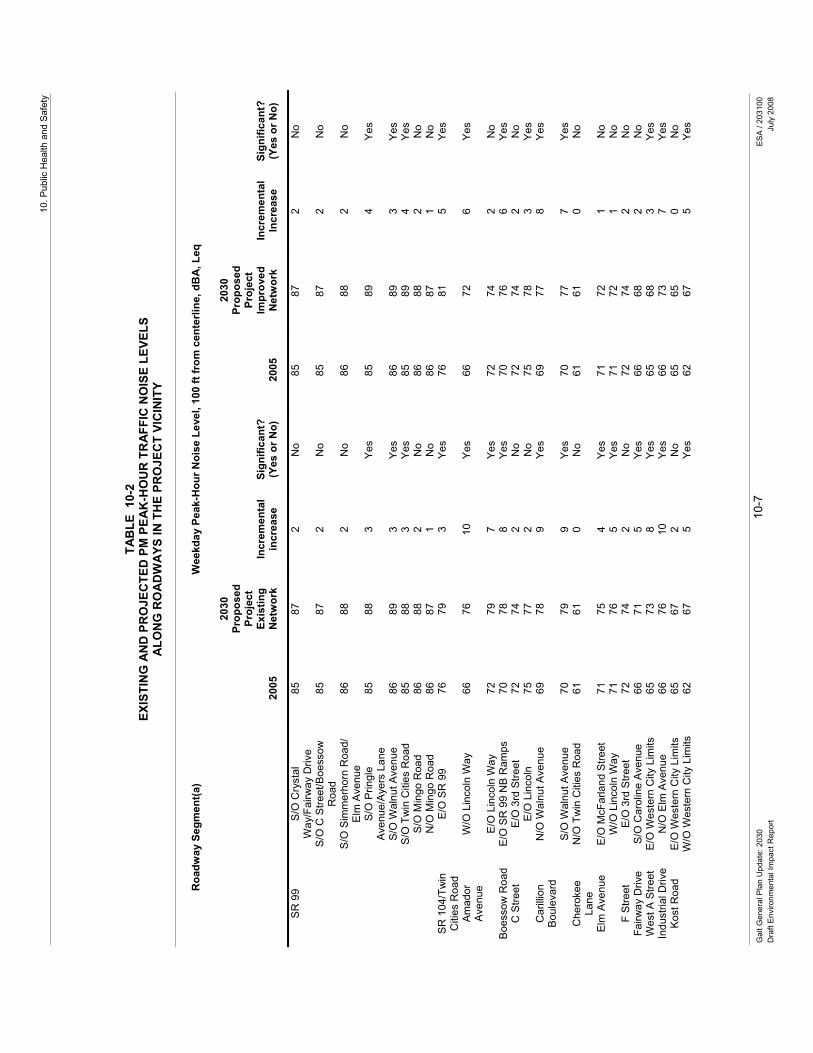
10. P
ublic
Hea
lth a
nd S
afet
y
Gal
t Gen
eral
Pla
n U
pdat
e: 2
030
10-7
ES
A /
2031
00
Dra
ft E
nviro
nmen
tal I
mpa
ct R
epor
t Ju
ly 2
008
TAB
LE 1
0-2
EXIS
TIN
G A
ND
PR
OJE
CTE
D P
M P
EAK
-HO
UR
TR
AFF
IC N
OIS
E LE
VELS
A
LON
G R
OA
DW
AYS
IN T
HE
PRO
JEC
T VI
CIN
ITY
Roa
dway
Seg
men
t(a)
Wee
kday
Pea
k-H
our N
oise
Lev
el, 1
00 ft
from
cen
terli
ne, d
BA
, Leq
20
05
2030
Pr
opos
ed
Proj
ect
Exis
ting
Net
wor
k In
crem
enta
l in
crea
se
Sign
ifica
nt?
(Yes
or N
o)
2005
2030
Pr
opos
ed
Proj
ect
Impr
oved
N
etw
ork
Incr
emen
tal
Incr
ease
Si
gnifi
cant
? (Y
es o
r No)
SR
99
S/O
Cry
stal
W
ay/F
airw
ay D
rive
85
87
2 N
o 85
87
2
No
S
/O C
Stre
et/B
oess
ow
Roa
d 85
87
2
No
85
87
2 N
o
S
/O S
imm
erho
rn R
oad/
E
lm A
venu
e 86
88
2
No
86
88
2 N
o
S
/O P
ringl
e A
venu
e/A
yers
Lan
e 85
88
3
Yes
85
89
4 Ye
s
S
/O W
alnu
t Ave
nue
86
89
3 Ye
s 86
89
3
Yes
S
/O T
win
Citi
es R
oad
85
88
3 Ye
s 85
89
4
Yes
S
/O M
ingo
Roa
d 86
88
2
No
86
88
2 N
o
N/O
Min
go R
oad
86
87
1 N
o 86
87
1
No
SR
104
/Tw
in
Citi
es R
oad
E/O
SR
99
76
79
3 Ye
s 76
81
5
Yes
Am
ador
A
venu
e W
/O L
inco
ln W
ay
66
76
10
Yes
66
72
6 Ye
s
E
/O L
inco
ln W
ay
72
79
7 Ye
s 72
74
2
No
Boe
ssow
Roa
d E
/O S
R 9
9 N
B R
amps
70
78
8
Yes
70
76
6 Ye
s C
Stre
et
E/O
3rd
Stre
et
72
74
2 N
o 72
74
2
No
E
/O L
inco
ln
75
77
2 N
o 75
78
3
Yes
Car
illio
n B
oule
vard
N
/O W
alnu
t Ave
nue
69
78
9 Ye
s 69
77
8
Yes
S
/O W
alnu
t Ave
nue
70
79
9 Ye
s 70
77
7
Yes
Che
roke
e La
ne
N/O
Tw
in C
ities
Roa
d 61
61
0
No
61
61
0 N
o
Elm
Ave
nue
E/O
McF
arla
nd S
treet
71
75
4
Yes
71
72
1 N
o
W/O
Lin
coln
Way
71
76
5
Yes
71
72
1 N
o F
Stre
et
E/O
3rd
Stre
et
72
74
2 N
o 72
74
2
No
Fairw
ay D
rive
S/O
Car
olin
e A
venu
e 66
71
5
Yes
66
68
2 N
o W
est A
Stre
et
E/O
Wes
tern
City
Lim
its
65
73
8 Ye
s 65
68
3
Yes
Indu
stria
l Driv
e N
/O E
lm A
venu
e 66
76
10
Ye
s 66
73
7
Yes
Kos
t Roa
d E
/O W
este
rn C
ity L
imits
65
67
2
No
65
65
0 N
o
W/O
Wes
tern
City
Lim
its
62
67
5 Ye
s 62
67
5
Yes

City
of G
alt G
ener
al P
lan
Upd
ate:
203
0 G
alt G
ener
al P
lan
Upd
ate:
203
0 10
-8
ES
A /
2031
00
Dra
ft E
nviro
nmen
tal I
mpa
ct R
epor
t Ju
ly 2
008
TAB
LE 1
0-2
EXIS
TIN
G A
ND
PR
OJE
CTE
D P
M P
EAK
-HO
UR
TR
AFF
IC N
OIS
E LE
VELS
A
LON
G R
OA
DW
AYS
IN T
HE
PRO
JEC
T VI
CIN
ITY
Roa
dway
Seg
men
t(a)
Wee
kday
Pea
k-H
our N
oise
Lev
el, 1
00 ft
from
cen
terli
ne, d
BA
, Leq
20
05
2030
Pr
opos
ed
Proj
ect
Exis
ting
Net
wor
k In
crem
enta
l in
crea
se
Sign
ifica
nt?
(Yes
or N
o)
2005
2030
Pr
opos
ed
Proj
ect
Impr
oved
N
etw
ork
Incr
emen
tal
Incr
ease
Si
gnifi
cant
? (Y
es o
r No)
Linc
oln
Way
N
/O S
imm
erho
rn R
oad
74
77
3 Ye
s 74
76
2
No
B
etw
een
C S
treet
and
A
Stre
et
74
75
1 N
o 74
76
2
No
B
etw
een
C S
treet
and
F
Stre
et
73
75
2 N
o 73
75
2
No
S
/O F
Stre
et
72
74
2 N
o 72
73
1
No
Mar
engo
Roa
d N
/O S
imm
erho
rn R
oad
67
71
4 Ye
s 67
73
6
Yes
McF
arla
nd
Stre
et
Bet
wee
n E
lm A
venu
e an
d A
Stre
et
67
73
6 Ye
s 67
67
0
No
New
Hop
e R
oad
E/O
Wes
tern
City
Lim
its
65
70
5 Ye
s 65
68
3
Yes
W
/O W
este
rn C
ity L
imits
68
70
2
No
68
69
1 N
o O
rr R
oad
W/O
Wes
tern
City
Lim
its
64
65
1 N
o 64
65
1
No
Prin
gle
Ave
nue
W/O
SR
99 S
B R
amp
67
73
6 Ye
s 67
74
7
Yes
Qui
ggle
Roa
d E
/O C
hero
kee
Lane
58
59
1
No
58
58
0 N
o S
imm
erho
rn
Roa
d E
/O C
hero
kee
Roa
d 64
71
7
Yes
64
71
7 Ye
s
E
/O L
inco
ln W
ay
71
79
8 Ye
s 71
77
6
Yes
W. S
tock
ton
Bou
leva
rd
S/O
Wal
nut A
venu
e 69
75
6
Yes
69
73
4 Ye
s
E. S
tock
ton
Bou
leva
rd
S/O
Wal
nut A
ve
70
77
7 Ye
s 70
N
A
NA
N
A
Wal
nut A
ve
E/O
Eas
t Sto
ckto
n B
oule
vard
70
78
8
Yes
70
79
9 Ye
s
W
/O W
est S
tock
ton
Bou
leva
rd
60
73
13
Yes
60
79
19
Yes
a
Noi
se le
vels
wer
e de
term
ined
usi
ng F
HW
A Tr
affic
Noi
se P
redi
ctio
n M
odel
(FH
WA
RD
-77-
108)
(Bar
ry, T
.M. a
nd R
egan
, J.A
., 19
78).
S
ourc
e: E
SA,
200
7

Galt General Plan Update: 2030 10-9 ESA / 203100 Draft Environmental Impact Report July 2008
Operational Noise (Railroad Sources). Railroad noise primarily occurs from existing operations along the Union Pacific Railroad (UPRR) main line (runs north-south through the City) and the Ione spur line, which runs north-east through the City. As more fully described in Appendix B of this draft EIR, railroad operations along the UPRR main line have averaged about 27 trains per day on an unscheduled basis within the Study Area. Train speeds in the Study Area are maximum 70 mph for freight trains, which average 6,000 feet in length, and 79 mph for passenger trains. Measurements of individual train passages in the Study Area indicated that maximum noise levels ranged from 83 dBA without use of the horn to 92 dBA with the horn at a distance of 100 feet (City of Galt, 1990). Buildout of the Proposed Project could locate residential land uses in the vicinity of the UPRR (or other railroad) corridor, which could result in the exposure of sensitive receptors to noise levels that exceed City standards. The actual level of impact would depend on the presence and location of any existing or proposed sensitive land uses in relation to the noise source. While an increase of 3 to 5 dBA is considered potentially significant, it is only significant if it affects sensitive land uses. It is expected that subsequent CEQA documentation prepared for individual projects would have project-specific data and will be required to address, and if possible, mitigate any potential operations-related noise impacts to a less-than-significant level. Examples of mitigation that may be proposed include various types of shielding (e.g., berms, vegetation, etc.), sound walls, or noise-reducing building treatments. The City may also consider the establishment of �“Quiet Zones�” or setback areas adjacent to railroad crossings in an effort to minimize noise impacts (e.g., train whistles, etc.) to a variety of sensitive land uses. However, it should be noted, the ability to mitigate this potential impact is contingent upon a variety of factors including the severity of the noise impact, existing land use conditions and the technical feasibility of being able to implement any proposed mitigation measures.
Stationary Noise. The siting of new industrial areas may increase noise levels in their proximity. This could occur due to the continual presence of heavy trucks used for the distribution of goods and supplies; increased rail traffic (if situated near a rail line); or from the use of equipment actually used in the manufacturing process or on the site to transport goods (primarily forklifts). Potential areas of land use-noise conflict could occur at the borders of these industrial areas with other sensitive land uses (i.e., residential, schools, etc.) or along roadways leading to these industrial areas. Other common sources of stationary noise include noise generated from school yards or park fields (including those recreational fields that use an amplified sound system).
It is expected that subsequent CEQA documentation prepared for individual projects would have project-specific data and will be required to address, and if possible, mitigate any potential operations-related noise impacts to a less-than-significant level. Examples of mitigation that may be proposed include various types of shielding (e.g., berms, vegetation, etc.), sound walls, or noise-reducing building treatments. However, it should be noted, the ability to mitigate this potential impact is contingent upon a variety of factors including the severity of the noise impact, existing land use conditions and the technical feasibility of being able to implement any proposed mitigation measures.
Policies included as part of the Proposed Project that would minimize this impact are summarized below. Policies have been developed to provide guidance on the analysis and mitigation of

City of Galt General Plan Update: 2030
Galt General Plan Update: 2030 10-10 ESA / 203100 Draft Environmental Impact Report July 2008
future project-related noise issues. Additional policies have been designed to promote compatible development that minimizes a variety of nuisance related impacts (i.e., visual, noise, etc.). However, even with implementation of the below mentioned policies, this impact is considered potentially significant.
Noise Element
Policies designed to provide guidance on the analysis, mitigation and monitoring of a variety of noise-related impacts that could occur within the Study Area include the following: N-1.1: Noise-Generating Uses N-1.2: Noise Mitigation N-1.3: Neighborhood Noise Protection N-1.4: Noise Level Performance Standards N-1.5: �“Noise-Impacted�” Designation N-1.6: Noise-Sensitive Land Separation
N-1.7: EIR Acoustical Analyses N-1.9: Sound Attenuation Features N-1.11: Land Use Compatibility N-1.12: City Equipment/Noise Element Compliance N-1.15: Noise Compatibility Guidelines N-1.17: Zoning Ordinance Consistency
Policies designed to minimize construction-related noise impacts in the Study Area include the following: N-13:Construction Noise N-14:Limiting Construction Activities Policies designed to minimize mobile or transportation-related noise impacts in the Study Area include the following: N-1.8: Coordination with Caltrans N-1.10: Noise Buffering N-1.16: Muffler Enforcement
Required Mitigation Measures
The City will implement a variety of policies designed to address noise issues. The City will also continue to discourage the siting of industrial uses near sensitive land uses. In addition, the City will ensure that future CEQA documentation be prepared for individual projects (with project-specific data) that will (if technically possible) mitigate any potential noise impacts to a less-than-significant level. However, it should be noted, the ability to mitigate this potential impact is contingent upon a variety of factors including the severity of the noise impact, existing land use conditions, existing sources of noise (i.e., highway or roadway noise), and the technical feasibility of being able to implement any proposed mitigation measures. Given the uncertainty as to whether future noise impacts could be adequately mitigated (i.e., establishment of setbacks near at-grade railroad crossings, etc.) for all the individual projects that will be implemented as part of the Proposed Project, this impact remains significant. No additional feasible mitigation is currently available.
Significance after Implementation of Mitigation for Impact 10.2-1
As stated above, no additional feasible mitigation measures are currently available to reduce this impact to a less-than-significant level. Consequently, this impact is considered significant and unavoidable.
Impact 10.2-2: The Proposed Project will result in the exposure of persons to or generation of excessive groundborne vibration or groundborne noise levels.

10. Public Health and Safety
Galt General Plan Update: 2030 10-11 ESA / 203100 Draft Environmental Impact Report July 2008
Impact Summary
Level of Significance Before Mitigation: Potentially Significant
Required Mitigation: No Feasible Mitigation Available
Level of Significance After Mitigation: Significant and Unavoidable
Impact Analysis
Similar to Impact 10.2-1, buildout of the Proposed Project could potentially expose more people to the impacts of excess groundborne vibration. Increased exposure to sources of groundborne vibration could occur through increased residential or employment densities on lands within proximity to noise generating activities (i.e., industrial, airport, etc.). Specifically, vibration created through construction and industrial activities or through the operation of motor vehicles and railways could result in potentially significant impacts on local residents. It is expected that subsequent CEQA documentation prepared for individual projects would have project-specific data and will be required to address, and if possible, mitigate any potential construction/operations-related vibration and noise impacts to a less-than-significant level. Examples of mitigation that may be proposed include setbacks of sensitive land uses from vibration sources. However, it should be noted, the ability to mitigate this potential impact is contingent upon a variety of factors including the severity of the vibration impact, existing land use conditions and the technical feasibility of being able to implement any proposed mitigation measures.
Policies included as part of the Proposed Project that would minimize this impact are summarized below. However, even with implementation of the below mentioned policies, this impact is considered potentially significant.
Noise Element
Policies designed to provide guidance on the analysis, mitigation and monitoring of a variety of noise-related impacts that could occur within the Study Area include the following: N-1.1: Noise-Generating Uses N-1.2: Noise Mitigation N-1.3: Neighborhood Noise Protection N-1.4: Noise Level Performance Standards N-1.5: �“Noise-Impacted�” Designation N-1.6: Noise-Sensitive Land Separation
N-1.7: EIR Acoustical Analyses N-1.9: Sound Attenuation Features N-1.11: Land Use Compatibility N-1.12: City Equipment/Noise Element Compliance N-1.15: Noise Compatibility Guidelines N-1.17: Zoning Ordinance Consistency
Policies designed to minimize construction-related noise impacts in the Study Area include the following: N-13: Construction Noise N-14:Limiting Construction Activities Policies designed to minimize mobile or transportation-related noise impacts in the Study Area include the following: N-1.8: Coordination with Caltrans N-1.10: Noise Buffering N-1.16: Muffler Enforcement
Required Mitigation Measures
The City will implement a variety of policies designed to address noise and vibration issues. The City will also continue to discourage the siting of industrial uses near sensitive land uses. In addition, the City will ensure that future CEQA documentation be prepared for individual projects (with project-specific data) that will (if technically possible) mitigate any potential vibration impacts to

City of Galt General Plan Update: 2030
Galt General Plan Update: 2030 10-12 ESA / 203100 Draft Environmental Impact Report July 2008
a less-than-significant level. However, it should be noted, the ability to mitigate this potential impact is contingent upon a variety of factors including the severity of the vibration impact, existing land use conditions and the technical feasibility of being able to implement any proposed mitigation measures, such as the ability to provide structural improvements designed to minimize noise or vibration impacts to a building with existing structural deficiencies. Given the uncertainty as to whether future vibration impacts could be adequately mitigated for all the individual projects that will be implemented as part of the Proposed Project, this impact remains significant. No additional feasible mitigation is currently available.
Significance after Implementation of Mitigation for Impact 10.2-2
As stated above, no additional feasible mitigation measures are currently available to reduce this impact to a less-than-significant level. Consequently, this impact is considered significant and unavoidable.
10.3 Geology and Seismic Hazards The potential for geologic and seismic hazards (including seismicity, landsliding, and liquefaction) is the focus of this section. Potential soil erosion impacts resulting from implementation of the Proposed Project are addressed in Chapter 8.0 �“Natural Resources�” (see Section 8.4 �“Soil and Agricultural Resources�”) of this draft EIR.
Environmental and Regulatory Setting Section 15150 of the CEQA Guidelines permits documents of lengthy technical detail to be incorporated by reference in an EIR. Specifically, Section 15150 states that an EIR may �“incorporate by reference all or portions of another document which is a matter of public record or is generally available to the public ....�” Consistent with the CEQA Guidelines and as a way to avoid creating an overwhelming amount of paper for members of the public and decision-makers to sort through, this draft EIR incorporates by reference information from both the Existing Conditions Report and Policy Document. Consistent with this approach, the reader is directed to Chapter 10.0 of the Existing Conditions Report for environmental and regulatory setting information specific to health and safety topics (see Appendix B of this draft EIR).
,PSDFW�0HWKRGRORJ\��The potential for geologic and seismic impacts as a result of implementation of the Proposed Project or its alternatives was reviewed and evaluated using readily available background information, such as pertinent geologic maps and seismic hazard maps. Key sources of information included the California Division of Mines and Geology and the United States Geologic Survey.
To reduce or mitigate potential hazards from earthquakes or other local geologic hazards, the City ensures that development will continue to be completed in compliance with local and State regulations. These regulations include the California Building Code, the Alquist-Priolo Earthquake Fault Zoning Act, and the Seismic Hazard Mapping Act. Policies and implementation programs

10. Public Health and Safety
Galt General Plan Update: 2030 10-13 ESA / 203100 Draft Environmental Impact Report July 2008
developed for the Proposed Project include continued conformance with applicable local and State building regulations.
6WDQGDUGV�RI�6LJQLILFDQFH�The significance criteria for this analysis were developed from criteria presented in Appendix G, �“Environmental Checklist Form�”, of the CEQA Guidelines and based on the professional judgment of the City of Galt and its consultants. The project (or the project alternatives) would result in a significant impact if it would:
• Expose people or structures to potential substantial adverse effects, including the risk of loss, injury, or death involving: 1) rupture of a known earthquake fault, as delineated on the most recent Alquist-Priolo Earthquake Fault Zoning Map issued by the State Geologist for the area or based on other substantial evidence of a known fault; 2) strong seismic groundshaking; 3) seismic-related ground failure, including liquefaction; or 4) landslides;
• Be located on a geologic unit or soil that is unstable or that would become unstable as a result of the project and potentially result in an onsite or offsite landslide, lateral spreading, subsidence, liquefaction, or collapse; or
• Be located on expansive soil, as defined in the California Uniform Building Code, creating substantial risks to life or property.
,PSDFWV�DQG�0LWLJDWLRQ�0HDVXUHV�Impact 10.3-1: The Proposed Project could expose people or structures to potential substantial adverse effects, including the risk of loss, injury, or death involving: 1) rupture of a known earthquake fault, as delineated on the most recent Alquist-Priolo Earthquake Fault Zoning Map issued by the State Geologist for the area or based on other substantial evidence of a known fault; 2) strong seismic groundshaking; 3) seismic-related ground failure, including liquefaction; or 4) landslides.
Impact Summary
Level of Significance Before Mitigation: Potentially Significant
Required Mitigation: Mitigation Measure 10.3-1: Adopt General Plan Policy SS-1.7 �“California Building Standard Code�” to Address Seismic Hazard Impacts
Level of Significance After Mitigation: Less than Significant
Impact Analysis
The Study Area�’s topography is relatively flat. The City is located in Seismic Risk Zone 3 (posing a lesser risk than those experienced in Zone 4 - San Francisco Bay Area) and is not located within an Alquist-Priolo Earthquake Fault Zone nor is it located in the immediate vicinity of an active fault. Ground shaking hazards are considered to be low. The probability of soil liquefaction actually

City of Galt General Plan Update: 2030
Galt General Plan Update: 2030 10-14 ESA / 203100 Draft Environmental Impact Report July 2008
taking place in the Study Area is considered to be a low to moderate hazard. The Study Area is considered a potential subsidence area due to the underlying groundwater basin and the rates of groundwater withdrawal that have occurred in the area over the past few years. The possibility of soil liquefaction or land subsidence within the Study Area should be considered when planning and designing levees, building foundations, and structures in areas of potential liquefaction and subsidence.
Policies included as part of the Proposed Project that would minimize this impact are summarized below by General Plan element, with a complete description of these policies and implementation programs provided in the Policy Document (see Appendix C of the draft EIR). For example, the Health & Safety Element provides a number of policies that have been developed to ensure a safe environment for the City�’s residents, visitors, and businesses. These policies and implementation program include seismic retrofitting of structures (see policy SS-1.3, SS-1.4, and SS-2.2) and requiring site-specific soils reports to be prepared for a project (policies SS-2.1 and SS-2.3). Additionally, Implementation Program SS-B requires the City to complete an inventory of non-single family unreinforced masonary structures. With adherence to these policies contained in the Safety and Seismic Element, geologic hazard impacts associated with on-or off-site landslide, lateral spreading, subsidence, liquefaction, or collapse would be minimized. However, even with implementation of the below mentioned policies and implementation program, this impact is considered potentially significant.
Safety and Seismic Element Land Use Element
Policies and implementation programs designed to minimize geologic hazard impacts to people and structures in the Study Area include the following: SS-1.1: City Emergency Operations Plan (EOP) SS-1.2: Inter-Agency Coordination SS-1.3: Rehabilitation Loans for Seismic Retrofitting SS-1.4: Structural Improvements Grants/Loans SS-2.1: Geologic and Soils Information SS-2.2: Seismically-Engineered Public Structures SS-2.3: Grading/Erosion Control SS-B Unreinforced Masonry Structures Inventory
LU-1.9: Growth in Hazard-Prone Areas
Required Mitigation Measures
To address this impact, the City shall implement the following mitigation measure:
Mitigation Measure 10.3-1: Adopt General Plan Policy SS-1.7 �“California Building Standard Code�” to Address Seismic Hazard Impacts:
To mitigate potential seismic hazard impacts resulting from implementation of the Proposed Project, the City shall incorporate the following new policy SS-1.7 �“California Building Standard Code�” into the Final General Plan:
• Policy SS-1.7: California Building Standard Code. The City shall continue to require that alterations to existing buildings and all new buildings be built according to the seismic requirements of the California Building Standard Code. [New Policy �– Draft EIR Analysis]

10. Public Health and Safety
Galt General Plan Update: 2030 10-15 ESA / 203100 Draft Environmental Impact Report July 2008
Significance after Implementation of Mitigation for Impact 10.3-1
As stated above, the City will continue to implement a variety of policies and implementation programs designed to address geologic hazard impacts. Therefore, implementation of the Proposed Project including the adoption of the new policy provided as part of Mitigation Measure 10.3-1 (listed above) would result in a less-than-significant impact.
Impact 10.3-2: The Proposed Project could be located on a geologic unit or soil that is unstable or that would become unstable as a result of the project and potentially result in an onsite or offsite landslide, lateral spreading, subsidence, liquefaction, or collapse.
Impact Summary
Level of Significance Before Mitigation: Potentially Significant
Required Mitigation: Mitigation Measure 10.3-1: Adopt General Plan Policy SS-1.7 �“California Building Standard Code�” to Address Seismic Hazard Impacts
Level of Significance After Mitigation: Less than Significant
Impact Analysis
As described above under Impact 10.3-1, the Study Area is not located within an Alquist-Priolo Earthquake Fault Zone and the probability of soil liquefaction or land subsidence actually taking place in the Study Area is considered a low to moderate hazard.
Policies included as part of the Proposed Project that would minimize this impact are summarized below by General Plan element, with a complete description of these policies and implementation programs provided in the Policy Document (see Appendix C of this draft EIR). The Proposed Project includes several policies and implementation programs that have been developed to ensure a safe environment for its residents, visitors, and businesses. For example, Policy SS-2.2 requires the preparation of engineering studies for all new development proposals within areas of potential soil instability. Grading control plans and soils reports required by proposed General Plan policies (see policies SS-2.1 and SS-2.3) are also intended to identify and avoid hazards associated with landslide, lateral spreading, subsidence, liquefaction, or collapse. Also, the City encourages development to avoid areas identified as having hazardous conditions, such as unstable soils (see policy LU-1.9). Even with adherence to all applicable State and local building codes and regulations and implementation of the policies and implementation programs contained in the draft Safety and Seismic Element, impacts associated with on- or off-site landslide, subsidence, liquefaction, or collapse would remain potentially significant.
Safety and Seismic Element Land Use Element
Policies designed to minimize geologic hazard impacts to people and structures in the Study Area include the following: SS-2.1: Geologic and Soils Information SS-2.2: Seismically-Engineered Public Structures SS-2.3: Grading/Erosion Control
LU-1.9: Growth in Hazard-Prone Areas
City of Galt General Plan Update: 2030
Galt General Plan Update: 2030 10-16 ESA / 203100 Draft Environmental Impact Report July 2008
Required Mitigation Measures
To address this impact, the City shall implement the following mitigation measure:
Mitigation Measure 10.3-1: Adopt General Plan Policy SS-1.7 �“California Building Standard Code�” to Address Seismic Hazard Impacts:
To mitigate potential seismic hazard impacts resulting from implementation of the Proposed Project, the City shall incorporate the following new policy SS-1.7 �“California Building Standard Code�” into the Final General Plan:
• Policy SS-1.7: California Building Standard Code. The City shall continue to require that alterations to existing buildings and all new buildings be built according to the seismic requirements of the California Building Standard Code. [New Policy �– Draft EIR Analysis]
Significance after Implementation of Mitigation for Impact 10.3-2
As stated above, the City will implement a variety of policies designed to minimize effects from seismic activity and ensure that adequate protection is provided as part of the Proposed Project. Therefore, implementation of the Proposed Project including the adoption of the new policy provided above as part of Mitigation Measure 10.3-1 (listed above) would result in a less-than-significant impact.
Impact 10.3-3: The Proposed Project could be located on expansive soil, as defined in the California Building Code, creating substantial risks to life or property.
Impact Summary
Level of Significance Before Mitigation: Potentially Significant
Required Mitigation: Mitigation Measure 10.3-1: Adopt General Plan Policy SS-1.7 �“California Building Standard Code�” to Address Seismic Hazard Impacts
Level of Significance After Mitigation: Less than Significant
Impact Analysis
Expansive soils are those possessing clay particles that react to moisture changes by shrinking (when they dry) or swelling (when they become wet). Expansive soils can also consist of silty to sandy clay. The extent of shrinking and swelling is influenced by the environment, including the extent of wet or dry cycles, and by the amount of clay in the soil. This physical change in the soils can react unfavorably with building foundations, concrete walkways, swimming pools, roadways, and masonry walls. Expansive soils are found within the Study Area. However, expansive soils (i.e., clay) located within developed areas have been mixed with more granular soils during site excavation or buried beneath more granular soils during excavation operations to reduce the soil�’s overall expansiveness.

10. Public Health and Safety
Galt General Plan Update: 2030 10-17 ESA / 203100 Draft Environmental Impact Report July 2008
Policies included as part of the Proposed Project that would minimize this impact are summarized below by General Plan element, a complete description of these policies is found in the Policy Document (see Appendix C of this draft EIR). Specific policies have been developed to address a variety of public health and safety concerns including siting development within areas that minimize exposure to a variety of hazardous conditions. Policy SS-2.1 requires soils reports to be prepared for new projects to identify hazardous soil conditions. Policy SS-2.3 requires grading and erosion control plans to be prepared by qualified engineers or land surveyors. Application of the existing regulations identified in the Uniform Building Code and implementation of these policies contained in the Seismic and Safety Element would minimize the risk associated with any development proposed within areas containing expansive soils. Even after implementation of the below mentioned policies, this impact is potentially significant.
Safety and Seismic Element Land Use Element
Policies designed to minimize geologic hazard impacts to people and structures in the Study Area include the following: SS-2.1: Geologic and Soils Information SS-2.3: Grading/Erosion Control
LU-1.9 Growth in Hazard-Prone Areas
Required Mitigation Measures
To address this impact, the City shall implement the following mitigation measure:
Mitigation Measure 10.3-1: Adopt General Plan Policy SS-1.7 �“California Building Standard Code�” to Address Seismic Hazard Impacts:
To mitigate potential seismic hazard impacts resulting from implementation of the Proposed Project, the City shall incorporate the following new policy SS-1.7 �“California Building Standard Code�” into the Final General Plan:
• Policy SS-1.7: California Building Standard Code. The City shall continue to require that alterations to existing buildings and all new buildings be built according to the seismic requirements of the California Building Standard Code. [New Policy �– Draft EIR Analysis]
Significance after Implementation of Mitigation for Impact 10.3-3
As stated above, the City will implement a variety of policies designed to minimize effects from seismic activity and ensure that adequate protection is provided as part of the Proposed Project. Therefore, implementation of the Proposed Project including the adoption of the new policy provided above as part of Mitigation Measure 10.3-1 (listed above) would result in a less-than-significant impact.
10.4 Flooding As previously described, a common chapter numbering system was used in preparation of the Proposed Project to allow readers to easily find related information in all of the documents that comprise the General Plan. Within this EIR, Section 10.4 is the �“Flooding�” section of the Health
City of Galt General Plan Update: 2030
Galt General Plan Update: 2030 10-18 ESA / 203100 Draft Environmental Impact Report July 2008
and Safety Chapter. However, in this EIR, flood impacts are addressed as part of the stormwater discussion due to their relationship to local drainage patterns and stormwater infrastructure capacity issues. Consequently, please see Chapter 6.0 �“Public Facilities and Services�”; Section 6.4 �“Storm Drainage�” for a discussion of flood hazard impacts.
10.5 Wildland Fires This section discusses the potential for the Proposed Project to expose people or structures to wildland fires. Also, please see Chapter 6.0 �“Public Facilities and Services�”; Section 6.9, �“Fire Protection�” for additional information specific to the overall provision of fire protection services as it relates to the Proposed Project.
(QYLURQPHQWDO�DQG�5HJXODWRU\�6HWWLQJ�Section 15150 of the CEQA Guidelines permits documents of lengthy technical detail to be incorporated by reference in an EIR. Specifically, Section 15150 states that an EIR may �“incorporate by reference all or portions of another document which is a matter of public record or is generally available to the public ....�” Consistent with the CEQA Guidelines and as a way to avoid creating an overwhelming amount of paper for members of the public and decision-makers to sort through, this draft EIR incorporates by reference information from both the Existing Conditions Report and Policy Document. Consistent with this approach, the reader is directed to Chapter 10.0 of the Existing Conditions Report for environmental and regulatory setting information specific to health and safety topics (see Appendix B of this draft EIR).
,PSDFW�0HWKRGRORJ\��The assessment of wildland fire hazard impacts is a qualitative review of the existing conditions applicable to the Study Area and a determination of whether the Proposed Project includes adequate provisions to address the potential impacts associated with local wildland fire conditions.
6WDQGDUGV�RI�6LJQLILFDQFH�The significance criteria for this analysis were developed from criteria presented in Appendix G, �“Environmental Checklist Form�”, of the CEQA Guidelines and based on the professional judgment of the City of Galt and its consultants. The project (or the project alternatives) would result in a significant impact if it would:
• Expose people or structures to a significant risk of loss, injury or death involving wildland fires, including where wildlands are adjacent to urbanized areas or where residences are intermixed with wildlands.

10. Public Health and Safety
Galt General Plan Update: 2030 10-19 ESA / 203100 Draft Environmental Impact Report July 2008
,PSDFWV�DQG�0LWLJDWLRQ�0HDVXUHV�Impact 10.5-1: The Proposed Project would expose people or structures to a significant risk of loss, injury or death involving wildland fires, including where wildlands are adjacent to urbanized areas or where residences are intermixed with wildlands.
Impact Summary
Level of Significance Before Mitigation: Potentially Significant
Required Mitigation: Mitigation Measure 6.9-1: Adopt Revised General Plan Policy PFS-7.4 �“Fire Protection and Emergency Medical Facilities�” to Address Fire Protection and Emergency Medical Facilities Impacts
Level of Significance After Mitigation: Significant and Unavoidable
Impact Analysis
Wildland fires are considered to be a low threat to the people and structures of the Study Area. A large portion of the Study Area is urbanized or used for irrigated agricultural practices. Consequently, much of the undeveloped portions of the Study Area do not pose a high risk due to the existing urban uses and agricultural practices on the land. However, grass fires can occur on uncultivated lands, particularly where there is native vegetation, such as the northwestern portion of the Study Area containing annual grassland. Although this area is outside of the proposed Sphere of Influence boundary and has not been identified for development as part of the Proposed Project, wildland fires within these areas can spread to adjacent areas, some within the City. Annual grassland is also found along the eastern portion of the Study Area. Development under the Proposed Project identified for the eastern portion of the Study Area includes residential, open space, and public land uses. One of the primary factors contributing to the effective control of a vegetation fire is the rapid response by local fire units. This is especially true during fire season, when fire units may be committed to other fires and are unavailable to respond quickly.
As previously described in Chapter 6 �“Public Facilities and Services (see Impact 6.9-1), the CCSDFD does not have a current master plan, as the existing master plan was adopted in 1998, which was before the CCSDFD took over fire protection and emergency medical response in the City of Galt. According to CCSDFD staff, a new master plan is underway, and expected to be adopted in the near term, although there is no firm adoption date.
The City currently collects a public safety fire fee. The City is negotiating with the CCSD to transfer the fees to CCSD for the acquisition of equipment to serve Galt residents. CCSD has advised the City that the current fee collected by the City is inadequate, but until such time as the CCSDFD adopts a new master plan, and a new fee is calculated which reflects the fair share acquisition of equipment and allocation of costs between Elk Grove, Galt and unincorporated portions of Sacramento County served by CCSD, the amount of a new City fee which would mitigate the impacts is unknown. Adoption of a new fee by the City with transfer of the proceeds to CCSD will require a new agreement.
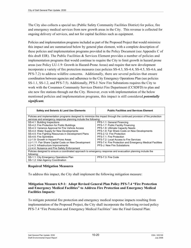
City of Galt General Plan Update: 2030
Galt General Plan Update: 2030 10-20 ESA / 203100 Draft Environmental Impact Report July 2008
The City also collects a special tax (Public Safety Community Facilities District) for police, fire and emergency medical services from new growth areas in the City. This revenue is collected for ongoing delivery of services, and not for capital facilities such as equipment.
Policies and implementation programs included as part of the Proposed Project that would minimize this impact and are summarized below by general plan element, with a complete description of these policies and implementation programs provided in the Policy Document (see Appendix C of this draft EIR). The Public Facilities & Services Element provides a number of policies and implementation programs that would continue to require the City to limit growth in hazard prone areas (see Policy LU-1.9: Growth in Hazard-Prone Areas) and require that new development incorporate a variety of fire protection measures (see policies SS-4.3, SS-4.4, SS-4.5, SS-4.6, and PFS-7.2) to address wildfire concerns. Additionally, there are several policies that ensure coordination between agencies and adherence to the City Emergency Operations Plan (see policies SS-1.1, SS-1.2, and PFS-7.5). Additionally, PFS-J: New Fire Substations requires the City to work with the Cosumnes Community Services District Fire Department (CCSDFD) to plan and site new fire stations through out the City. However, even with implementation of the below mentioned policies and implementation programs, this impact is still considered potentially significant.
Safety and Seismic & Land Use Elements Public Facilities and Services Element
Policies and implementation programs designed to minimize this impact through the continued provision of fire protection services and emergency response planning include the following: SS-4.1: Building Inspections SS-4.2: Fire Protection for Public Buildings SS-4.3: Variance Approval for Fire Vehicle Access SS-4.4: Water Supply for New Developments SS-4.5: Fire Fighting Resources in Development Plans SS-4.6: Fire Sprinklers LU-1.9: Growth in Hazard-Prone Areas LU-1.11: Fair Share Capital Costs on New Development LU-4.3: Infrastructure Improvements LU-4.4: Nuisance and Fire Safety Enforcement
PFS-1.1: General Financing PFS-1.7: Public Facility Financing PFS-1.8: Ultimate Capacity Needs PFS-1.9: Fair Share Costs on New Developments PFS-2.12: Fire Protection PFS-7.1: Fire Protection PFS-7.2: Local Access to Fire Services PFS-7.4: Fire Protection and Emergency Medical Facilities PFS-J: New Fire Substations
Policies designed to ensure a coordinated approach to emergency response and evacuation planning include the following: SS-1.1: City Emergency Operations Plan SS-1.2: Inter-Agency Coordination
PFS-7.3: Fire Code
Required Mitigation Measures
To address this impact, the City shall implement the following mitigation measure:
Mitigation Measure 6.9-1: Adopt Revised General Plan Policy PFS-7.4 �“Fire Protection and Emergency Medical Facilities�” to Address Fire Protection and Emergency Medical Facilities Impacts:
To mitigate potential fire protection and emergency medical response impacts resulting from implementation of the Proposed Project, the City shall incorporate the following revised policy PFS-7.4 �“Fire Protection and Emergency Medical Facilities�” into the Final General Plan:

10. Public Health and Safety
Galt General Plan Update: 2030 10-21 ESA / 203100 Draft Environmental Impact Report July 2008
• PFS-7.4: Fire Protection and Emergency Medical Facilities: The City shall cooperate with CCSD in the development of a new master plan for fire and emergency medical facilities and services, which includes the City of Galt, and shall periodically review the city fire protection impact fee, based upon an updated Government Code 66000 (AB 1600) study to be completed by CCSD. In conjunction with the district, the City will review the City�’s public safety special tax applicable to new development. [Revised Policy �– Draft EIR Analysis]
Significance after Implementation of Mitigation for Impact 6.9-1
As previously described, the City will continue to implement a variety of policies and programs designed to support the provision of fire protection and emergency medical response services provided by the CCSDFD. However, as more fully described in the Existing Conditions Report (see Appendix B of this draft EIR), the CCSDFD has identified a variety of staffing, facility improvements (including new stations), and equipment needs that will be required to address the provision of adequate levels of service based on anticipated growth resulting from implementation of the Proposed Project. The City will continue to support the overall purpose and goals of the CCSDFD.
Staffing and facility needs identified by the CCSDFD also require cooperation and funding from a variety of entities outside of the City (including the City of Elk Grove, County of Sacramento, CCSD), so implementation of these improvements cannot be guaranteed solely through the City�’s actions. Therefore, implementation of the Proposed Project including the adoption of the revised policy provided in Mitigation Measure 6.9-1 (listed above) would still result in a significant and unavoidable impact.
10.6 Human-Made Hazards This section provides information on a variety of safety hazards with the potential to occur within the Study Area, including human-made hazards associated with emergency preparedness and hazardous waste disposal.
(QYLURQPHQWDO�DQG�5HJXODWRU\�6HWWLQJ�Section 15150 of the CEQA Guidelines permits documents of lengthy technical detail to be incorporated by reference in an EIR. Specifically, Section 15150 states that an EIR may �“incorporate by reference all or portions of another document which is a matter of public record or is generally available to the public ....�” Consistent with the CEQA Guidelines and as a way to avoid creating an overwhelming amount of paper for members of the public and decision-makers to sort through, this draft EIR incorporates by reference information from both the Existing Conditions Report and Policy Document. Consistent with this approach, the reader is directed to Chapter 10.0 of the Existing Conditions Report for environmental and regulatory setting information specific to health and safety topics (see Appendix B of this draft EIR).

City of Galt General Plan Update: 2030
Galt General Plan Update: 2030 10-22 ESA / 203100 Draft Environmental Impact Report July 2008
,PSDFW�0HWKRGRORJ\��The assessment of human-hazard impacts is a qualitative review of the existing conditions applicable to the Study Area and a determination of whether the Proposed Project includes adequate provisions to address the potential impacts associated with local human-hazard conditions.
6WDQGDUGV�RI�6LJQLILFDQFH�The significance criteria for this analysis were developed from criteria presented in Appendix G, �“Environmental Checklist Form�”, of the CEQA Guidelines and based on the professional judgment of the City of Galt and its consultants. The project (or the project alternatives) would result in a significant impact if it would:
• Create a significant hazard to the public or the environment through the routine transport, use, or disposal of hazardous materials;
• Create a significant hazard to the public or the environment through reasonable foreseeable upset and accident conditions involving the release of hazardous materials into the environment;
• Emit hazardous emissions or involve handling hazardous or acutely hazardous substances, or waste within one-quarter mile of an existing or proposed school;
• Be located on a site that is included on a list of hazardous materials sites compiled pursuant to Government Code Section 65962.5 and, as a result, would it create a significant hazard to the public or environment;
• Be located within an airport land use plan area or, where such a plan has not been adopted, be within two miles of a public airport or public use airport, and result in a safety hazard for people residing or working in the project area;
• Be located within the vicinity of a private airstrip and result in a safety hazard for people residing or working in the project area; or
• Impair implementation of or physically interfere with an adopted emergency response plan or emergency evacuation plan.
,PSDFWV�DQG�0LWLJDWLRQ�0HDVXUHV�
Impact 10.6-1: The Proposed Project could create a significant hazard to the public or the environment through the routine transport, use, or disposal of hazardous materials or create a significant hazard to the public or the environment through reasonable foreseeable upset and accident conditions involving the release of hazardous materials to the environment.
10. Public Health and Safety
Galt General Plan Update: 2030 10-23 ESA / 203100 Draft Environmental Impact Report July 2008
Impact Summary
Level of Significance Before Mitigation: Potentially Significant
Required Mitigation: Mitigation Measure 10.6-1a: Adopt Revised General Plan Policy SS-1.2 �“Inter-Agency Coordination�” to Address Public Safety Impacts, Mitigation Measure 10.6-1b: Adopt Revised General Plan Policy SS-5.4 �“Rancho Seco Nuclear Generating Station�” to Address Public Safety Impacts, Mitigation Measure 10.6-1c: Adopt General Plan Policy SS-5.5 �“Hazardous Materials Management�” to Address Public Safety Impacts, Mitigation Measure 10.6-1d: Adopt General Plan Policy SS-5.6 �“Hazardous Materials Inventory�” to Address Public Safety Impacts, Mitigation Measure 10.6-1e: Adopt General Plan Policy SS-5.7 �“Household Hazardous Waste Collection�” to Address Public Safety Impacts, Mitigation Measure 10.6-1f: Adopt General Plan Policy SS-5.8 �“Increase Public Awareness�” to Address Public Safety Impacts, Mitigation Measure 10.6-1g: Adopt General Plan Policy SS-5.9 �“Hazardous Materials Studies�” to Address Public Safety Impacts, and Mitigation Measure 10.6-1h: Adopt General Plan Implementation Program SS-D to Address Public Safety Impacts.
Level of Significance After Mitigation: Less than Significant
Impact Analysis
Lists of contaminated sites within the Study Area are available through the Sacramento County Environmental Management Department, the Regional Water Quality Control Board, and the Department of Toxic Substance Control. Most of the identified contaminated sites are located within the central part of the City. One site is located in the northern portion of the City and another site is located at the eastern edge of the City. Several sites have been identified as still under investigation while a couple of the sites have already begun remediation activities (see Table 10.8 in the Existing Conditions Report in Appendix B of this EIR). In addition, businesses such as dry cleaners and gas stations could also be contaminated. Railroad rights-of-way typically have surface contamination due to the lubricating oil used on the wheels and the use of herbicides to help minimize weeds within these areas. Although a number of businesses within the Study Area routinely store, handle and transport hazardous substances, the use of these hazardous materials is controlled and permitted by the County and CCSDFD, which conducts Uniform Fire Code inspections of these facilities, regulates these facilities, and otherwise ensures that risks associated with the use of hazardous materials in the community are minimized.
The Rancho Seco Nuclear Generating Station (Rancho Seco) is located over 9 miles northeast of the City of Galt. Rancho Seco ended its operations in 1989. Since then, Sacramento Municipal Utility District (SMUD) has been in the process of decommissioning and dismantling Rancho Seco. Until a suitable waste disposal option is identified, Class B and C radioactive waste will be stored on site. Decommissioning and dismantling activities as well as radioactive waste storage are governed by a variety of regulations intended to protect the general environment from offsite releases of radioactive materials. (USNRC 2007) In addition to ensuring the continued provision of emergency services during disasters (see policy SS-1.1), the Proposed Project states that the City shall coordinate with Sacramento County to provide evacuation routes in the event that Rancho Seco becomes an active nuclear facility in the future (see policy SS-5.4).
Policies included as part of the Proposed Project that would minimize this impact are summarized below by General Plan element, with a complete description of these policies and implementation programs provided in the Policy Document (see Appendix C of this draft EIR). For example, the General Plan provides a number of policies and implementation programs that have been developed
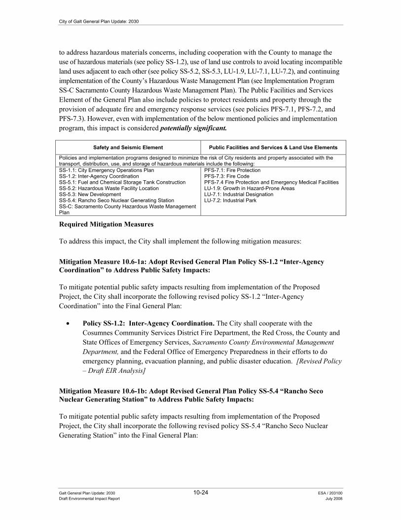
City of Galt General Plan Update: 2030
Galt General Plan Update: 2030 10-24 ESA / 203100 Draft Environmental Impact Report July 2008
to address hazardous materials concerns, including cooperation with the County to manage the use of hazardous materials (see policy SS-1.2), use of land use controls to avoid locating incompatible land uses adjacent to each other (see policy SS-5.2, SS-5.3, LU-1.9, LU-7.1, LU-7.2), and continuing implementation of the County�’s Hazardous Waste Management Plan (see Implementation Program SS-C Sacramento County Hazardous Waste Management Plan). The Public Facilities and Services Element of the General Plan also include policies to protect residents and property through the provision of adequate fire and emergency response services (see policies PFS-7.1, PFS-7.2, and PFS-7.3). However, even with implementation of the below mentioned policies and implementation program, this impact is considered potentially significant.
Safety and Seismic Element Public Facilities and Services & Land Use Elements
Policies and implementation programs designed to minimize the risk of City residents and property associated with the transport, distribution, use, and storage of hazardous materials include the following: SS-1.1: City Emergency Operations Plan SS-1.2: Inter-Agency Coordination SS-5.1: Fuel and Chemical Storage Tank Construction SS-5.2: Hazardous Waste Facility Location SS-5.3: New Development SS-5.4: Rancho Seco Nuclear Generating Station SS-C: Sacramento County Hazardous Waste Management Plan
PFS-7.1: Fire Protection PFS-7.3: Fire Code PFS-7.4 Fire Protection and Emergency Medical Facilities LU-1.9: Growth in Hazard-Prone Areas LU-7.1: Industrial Designation LU-7.2: Industrial Park
Required Mitigation Measures
To address this impact, the City shall implement the following mitigation measures:
Mitigation Measure 10.6-1a: Adopt Revised General Plan Policy SS-1.2 �“Inter-Agency Coordination�” to Address Public Safety Impacts:
To mitigate potential public safety impacts resulting from implementation of the Proposed Project, the City shall incorporate the following revised policy SS-1.2 �“Inter-Agency Coordination�” into the Final General Plan:
• Policy SS-1.2: Inter-Agency Coordination. The City shall cooperate with the Cosumnes Community Services District Fire Department, the Red Cross, the County and State Offices of Emergency Services, Sacramento County Environmental Management Department, and the Federal Office of Emergency Preparedness in their efforts to do emergency planning, evacuation planning, and public disaster education. [Revised Policy �– Draft EIR Analysis]
Mitigation Measure 10.6-1b: Adopt Revised General Plan Policy SS-5.4 �“Rancho Seco Nuclear Generating Station�” to Address Public Safety Impacts:
To mitigate potential public safety impacts resulting from implementation of the Proposed Project, the City shall incorporate the following revised policy SS-5.4 �“Rancho Seco Nuclear Generating Station�” into the Final General Plan:
10. Public Health and Safety
Galt General Plan Update: 2030 10-25 ESA / 203100 Draft Environmental Impact Report July 2008
• Policy SS-5.4: Rancho Seco Nuclear Generating Station. The City should coordinate efforts with Sacramento County to plan emergency evacuation routes in the event that the Rancho Seco Nuclear Generation Station becomes an active nuclear facility in the future and to be prepared for accidental release of radioactive wastes that are currently stored at the facility. [Revised Policy �– Draft EIR Analysis]
Mitigation Measure 10.6-1c: Adopt General Plan Policy SS-5.5 �“Hazardous Materials Management�” to Address Public Safety Impacts:
To mitigate potential public safety impacts resulting from implementation of the Proposed Project, the City shall incorporate the following new policy SS-5.5 �“Hazardous Materials Management�” into the Final General Plan:
• Policy SS-5.5: Hazardous Materials Management. The City shall continue to cooperate with the County and the CCSD Fire Department in the identification of hazardous material users (both large and small scale) and in the development of an inspection process and hazardous materials management plan. [New Policy �– Draft EIR Analysis]
Mitigation Measure 10.6-1d: Adopt General Plan Policy SS-5.6 �“Hazardous Materials Inventory�” to Address Public Safety Impacts:
To mitigate potential public safety impacts resulting from implementation of the Proposed Project, the City shall incorporate the following new policy SS-5.6 �“Hazardous Materials Inventory�” into the Final General Plan:
• Policy SS-5.6: Hazardous Materials Inventory. The City shall require, as appropriate and as a component of the environmental review process or business license review/building permit review a hazardous materials inventory for project sites, including an assessment of materials and operations for any development applications. [New Policy �– Draft EIR Analysis]
Mitigation Measure 10.6-1e: Adopt General Plan Policy SS-5.7 �“Household Hazardous Waste Collection�” to Address Public Safety Impacts:
To mitigate potential public safety impacts resulting from implementation of the Proposed Project, the City shall incorporate the following new policy SS-5.7 �“Household Hazardous Waste Collection�” into the Final General Plan:
• Policy SS-5.7: Household Hazardous Waste Collection. The City should continue to provide opportunities for residents to conveniently dispose of household hazardous waste. [New Policy �– Draft EIR Analysis]
Mitigation Measure 10.6-1f: Adopt General Plan Policy SS-5.8 �“Increase Public Awareness�” to Address Public Safety Impacts:

City of Galt General Plan Update: 2030
Galt General Plan Update: 2030 10-26 ESA / 203100 Draft Environmental Impact Report July 2008
To mitigate potential public safety impacts resulting from implementation of the Proposed Project, the City shall incorporate the following new policy SS-5.8 �“Increase Public Awareness�” into the Final General Plan:
• Policy SS-5.8: Increase Public Awareness. The City shall continue to work with the appropriate waste disposal service provider to educate the public as to the types of household hazardous wastes and the proper methods of disposal. [New Policy �– Draft EIR Analysis]
Mitigation Measure 10.6-1g: Adopt General Plan Policy SS-5.9 �“Hazardous Materials Studies�” to Address Public Safety Impacts:
To mitigate potential public safety impacts resulting from implementation of the Proposed Project, the City shall incorporate the following new policy SS-5.9 �“Hazardous Materials Studies�” into the Final General Plan:
• Policy SS-5.9: Hazardous Materials Studies. The City shall ensure that the proponents of applicable new development projects address hazardous materials concerns through the preparation of Phase I or Phase II hazardous materials studies for each identified site as part of the design phase for each project. Recommendations required to satisfy federal or State cleanup standards outlined in the studies will be implemented as part of the construction phase for each project. [New Policy �– Draft EIR Analysis]
Mitigation Measure 10.6-1h: Adopt General Plan Implementation Program SS-D to Address Public Safety Impacts:
To mitigate potential public safety impacts resulting from implementation of the Proposed Project, the City shall incorporate the following new implementation program into the Final General Plan:
• Implementation Program: SS-D: Use, Production, or Transport of Hazardous Materials and Wastes. The City should develop siting and enforcement criteria for businesses that use, produce, or transport hazardous materials and wastes. [New Policy �– Draft EIR Analysis]
Significance after Implementation of Mitigation for Impact 10.6-1
As stated above, the City will continue to manage the use of hazardous materials, avoid locating incompatible land uses adjacent to each other, and continue to implement the County�’s Hazardous Waste Management Plan. Additionally, the City will implement a variety of policies designed to address hazardous materials concerns including the designation of routes for the transport of hazardous materials, continued compliance with all applicable local, state, and federal safety standards, and ensuring the continuation of an adequate level of emergency services during emergencies among other policies and implementation programs designed to minimize exposure to hazardous materials and waste in the City of Galt. Therefore, implementation of the Proposed Project including the adoption of the policies and implementation program provided in mitigation

10. Public Health and Safety
Galt General Plan Update: 2030 10-27 ESA / 203100 Draft Environmental Impact Report July 2008
measures 10.6-1a, 10.6-1b, 10.6-1c, 10.6-1d, 10.6-1e, 10.6-1f, 10.6-1g, and 10.6-1h (listed above) would result in a less-than-significant impact.
Impact 10.6-2: The Proposed Project could emit hazardous emissions or handle hazardous or acutely hazardous materials, substances, or waste within one-quarter mile of an existing or proposed school.
Impact Summary
Level of Significance Before Mitigation: Potentially Significant
Required Mitigation: Mitigation Measure 10.6-1a: Adopt Revised General Plan Policy SS-1.2 �“Inter-Agency Coordination�” to Address Public Safety Impacts, Mitigation Measure 10.6-1b: Adopt Revised General Plan Policy SS-5.4 �“Rancho Seco Nuclear Generating Station�” to Address Public Safety Impacts, Mitigation Measure 10.6-1c: Adopt General Plan Policy SS-5.5 �“Hazardous Materials Management�” to Address Public Safety Impacts, Mitigation Measure 10.6-1d: Adopt General Plan Policy SS-5.6 �“Hazardous Materials Inventory�” to Address Public Safety Impacts, Mitigation Measure 10.6-1e: Adopt General Plan Policy SS-5.7 �“Household Hazardous Waste Collection�” to Address Public Safety Impacts, Mitigation Measure 10.6-1f: Adopt General Plan Policy SS-5.8 �“Increase Public Awareness�” to Address Public Safety Impacts, Mitigation Measure 10.6-1g: Adopt General Plan Policy SS-5.9 �“Hazardous Materials Studies�” to Address Public Safety Impacts, and Mitigation Measure 10.6-1h: Adopt General Plan Implementation Program SS-D to Address Public Safety Impacts.
Level of Significance After Mitigation: Less than Significant
Impact Analysis
Schools are one of several sensitive receptors that must be taken into consideration when the City is approving new land uses or transportation routes that may accommodate the production, storage, use, or transportation of hazardous materials and/or waste. Implementation of the Proposed Project (including buildout of the Preferred Land Use Alternative) would result in increased population levels throughout the Study Area and would increase the number of school-age children as well. A potential increase in levels of residential development throughout the City and within the outlying school districts would generate an increase in the number of students (dependent upon future household sizes and make-ups), and would necessitate the need to construct additional school facilities. New school sites should be evaluated for their proximity and potential exposure to hazardous materials as they are proposed for development. Potential school sites should be selected to minimize their exposure to a variety of hazardous conditions. In addition to general CEQA requirements, school acquisition/development projects to be funded under the State School Facilities Program must also satisfy several specific requirements established under the California Education Code and California Code of Regulations. These regulations require that potential school hazards relating to soils, seismicity, hazards and hazardous materials, and flooding be addressed during the school site selection process. Compliance with these requirements by the school districts will address significant impacts associated with the siting of new public schools within the Study Area.
Policies included as part of the Proposed Project that would minimize this impact are summarized below by general plan element, with a complete description of these policies and implementation programs provided in the Policy Document (see Appendix C of the draft EIR). For example, the Safety and Seismic and Land Use Elements provide a number of policies and implementation programs that have been developed to address hazardous materials concerns including siting
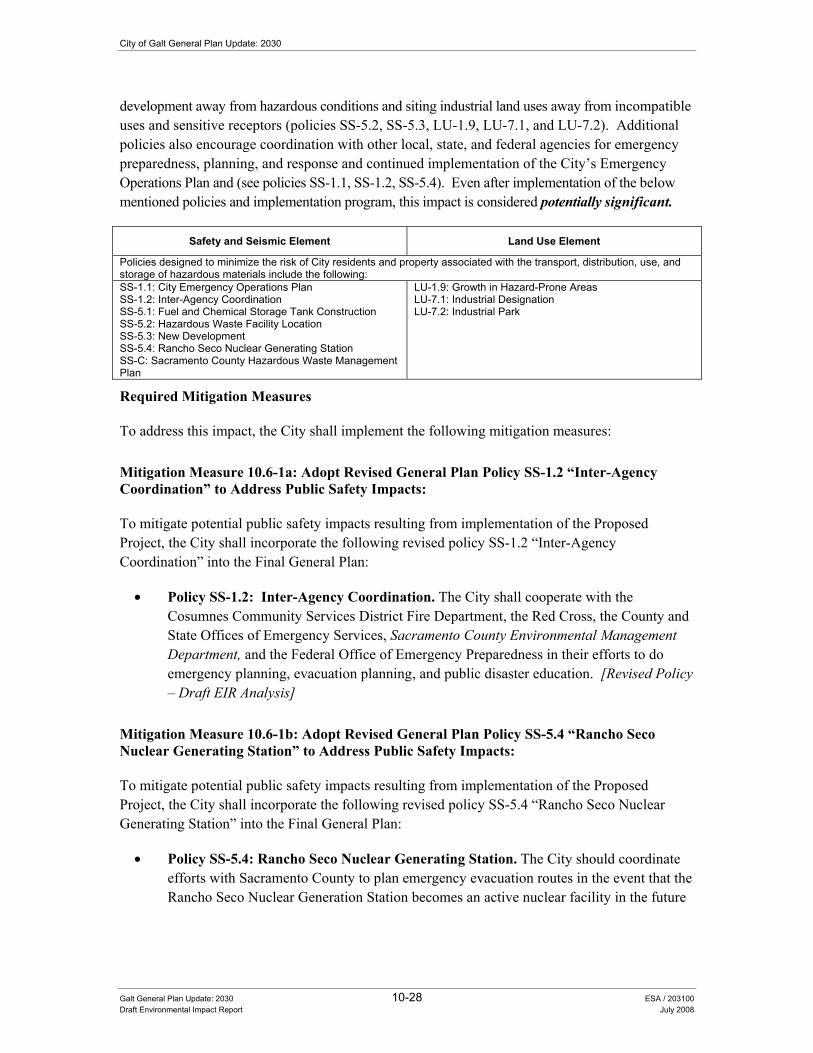
City of Galt General Plan Update: 2030
Galt General Plan Update: 2030 10-28 ESA / 203100 Draft Environmental Impact Report July 2008
development away from hazardous conditions and siting industrial land uses away from incompatible uses and sensitive receptors (policies SS-5.2, SS-5.3, LU-1.9, LU-7.1, and LU-7.2). Additional policies also encourage coordination with other local, state, and federal agencies for emergency preparedness, planning, and response and continued implementation of the City�’s Emergency Operations Plan and (see policies SS-1.1, SS-1.2, SS-5.4). Even after implementation of the below mentioned policies and implementation program, this impact is considered potentially significant.
Safety and Seismic Element Land Use Element
Policies designed to minimize the risk of City residents and property associated with the transport, distribution, use, and storage of hazardous materials include the following: SS-1.1: City Emergency Operations Plan SS-1.2: Inter-Agency Coordination SS-5.1: Fuel and Chemical Storage Tank Construction SS-5.2: Hazardous Waste Facility Location SS-5.3: New Development SS-5.4: Rancho Seco Nuclear Generating Station SS-C: Sacramento County Hazardous Waste Management Plan
LU-1.9: Growth in Hazard-Prone Areas LU-7.1: Industrial Designation LU-7.2: Industrial Park
Required Mitigation Measures
To address this impact, the City shall implement the following mitigation measures:
Mitigation Measure 10.6-1a: Adopt Revised General Plan Policy SS-1.2 �“Inter-Agency Coordination�” to Address Public Safety Impacts:
To mitigate potential public safety impacts resulting from implementation of the Proposed Project, the City shall incorporate the following revised policy SS-1.2 �“Inter-Agency Coordination�” into the Final General Plan:
• Policy SS-1.2: Inter-Agency Coordination. The City shall cooperate with the Cosumnes Community Services District Fire Department, the Red Cross, the County and State Offices of Emergency Services, Sacramento County Environmental Management Department, and the Federal Office of Emergency Preparedness in their efforts to do emergency planning, evacuation planning, and public disaster education. [Revised Policy �– Draft EIR Analysis]
Mitigation Measure 10.6-1b: Adopt Revised General Plan Policy SS-5.4 �“Rancho Seco Nuclear Generating Station�” to Address Public Safety Impacts:
To mitigate potential public safety impacts resulting from implementation of the Proposed Project, the City shall incorporate the following revised policy SS-5.4 �“Rancho Seco Nuclear Generating Station�” into the Final General Plan:
• Policy SS-5.4: Rancho Seco Nuclear Generating Station. The City should coordinate efforts with Sacramento County to plan emergency evacuation routes in the event that the Rancho Seco Nuclear Generation Station becomes an active nuclear facility in the future

10. Public Health and Safety
Galt General Plan Update: 2030 10-29 ESA / 203100 Draft Environmental Impact Report July 2008
and to be prepared for accidental release of radioactive wastes that are currently stored at the facility. [Revised Policy �– Draft EIR Analysis]
Mitigation Measure 10.6-1c: Adopt General Plan Policy SS-5.5 �“Hazardous Materials Management�” to Address Public Safety Impacts:
To mitigate potential public safety impacts resulting from implementation of the Proposed Project, the City shall incorporate the following new policy SS-5.5 �“Hazardous Materials Management�” into the Final General Plan:
• Policy SS-5.5: Hazardous Materials Management. The City shall continue to cooperate with the County and the CCSD Fire Department in the identification of hazardous material users (both large and small scale) and in the development of an inspection process and hazardous materials management plan. [New Policy �– Draft EIR Analysis]
Mitigation Measure 10.6-1d: Adopt General Plan Policy SS-5.6 �“Hazardous Materials Inventory�” to Address Public Safety Impacts:
To mitigate potential public safety impacts resulting from implementation of the Proposed Project, the City shall incorporate the following new policy SS-5.6 �“Hazardous Materials Inventory�” into the Final General Plan:
• Policy SS-5.6: Hazardous Materials Inventory. The City shall require, as appropriate and as a component of the environmental review process or business license review/building permit review a hazardous materials inventory for project sites, including an assessment of materials and operations for any development applications. [New Policy �– Draft EIR Analysis]
Mitigation Measure 10.6-1e: Adopt General Plan Policy SS-5.7 �“Household Hazardous Waste Collection�” to Address Public Safety Impacts:
To mitigate potential public safety impacts resulting from implementation of the Proposed Project, the City shall incorporate the following new policy SS-5.7 �“Household Hazardous Waste Collection�” into the Final General Plan:
• Policy SS-5.7: Household Hazardous Waste Collection. The City should continue to provide opportunities for residents to conveniently dispose of household hazardous waste. [New Policy �– Draft EIR Analysis]
Mitigation Measure 10.6-1f: Adopt General Plan Policy SS-5.8 �“Increase Public Awareness�” to Address Public Safety Impacts:
To mitigate potential public safety impacts resulting from implementation of the Proposed Project, the City shall incorporate the following new policy SS-5.8 �“Increase Public Awareness�” into the Final General Plan:

City of Galt General Plan Update: 2030
Galt General Plan Update: 2030 10-30 ESA / 203100 Draft Environmental Impact Report July 2008
• Policy SS-5.8: Increase Public Awareness. The City shall continue to work with the appropriate waste disposal service provider to educate the public as to the types of household hazardous wastes and the proper methods of disposal. [New Policy �– Draft EIR Analysis]
Mitigation Measure 10.6-1g: Adopt General Plan Policy SS-5.9 �“Hazardous Materials Studies�” to Address Public Safety Impacts:
To mitigate potential public safety impacts resulting from implementation of the Proposed Project, the City shall incorporate the following new policy SS-5.9 �“Hazardous Materials Studies�” into the Final General Plan:
• Policy SS-5.9: Hazardous Materials Studies. The City shall ensure that the proponents of applicable new development projects address hazardous materials concerns through the preparation of Phase I or Phase II hazardous materials studies for each identified site as part of the design phase for each project. Recommendations required to satisfy federal or State cleanup standards outlined in the studies will be implemented as part of the construction phase for each project. [New Policy �– Draft EIR Analysis]
Mitigation Measure 10.6-1h: Adopt General Plan Implementation Program SS-D to Address Public Safety Impacts:
To mitigate potential public safety impacts resulting from implementation of the Proposed Project, the City shall incorporate the following new implementation program into the Final General Plan:
• Implementation Program: SS-D: Use, Production, or Transport of Hazardous Materials and Wastes. The City should develop siting and enforcement criteria for businesses that use, produce, or transport hazardous materials and wastes. [New Policy �– Draft EIR Analysis]
Significance after Implementation of Mitigation for Impact 10.6-2
As stated above, the City will continue to manage the use of hazardous materials, avoid locating incompatible land uses adjacent to each other, and continue to implement the County�’s Hazardous Waste Management Plan. Additionally, the City will implement a variety of policies designed to address hazardous materials concerns including the designation of routes for the transport of hazardous materials, continued compliance with all applicable local, state, and federal safety standards, and ensuring the continuation of an adequate level of emergency services during emergencies among other policies and implementation programs designed to minimize exposure to hazardous materials and waste in the City of Galt. Therefore, implementation of the Proposed Project including the adoption of the policies and implementation program provided in mitigation measures 10.6-1a, 10.6-1b, 10.6-1c, 10.6-1d, 10.6-1e, 10.6-1f, 10.6-1g, and 10.6-1h (listed above) would result in a less-than-significant impact.
10. Public Health and Safety
Galt General Plan Update: 2030 10-31 ESA / 203100 Draft Environmental Impact Report July 2008
Impact 10.6-3: Development under the Proposed Project could be located on a site which is included on a list of hazardous materials sites compiled pursuant to government code section 65962.5 and, as a result, could create a significant hazard to the public or the environment.
Impact Summary
Level of Significance Before Mitigation: Potentially Significant
Required Mitigation: Mitigation Measure 10.6-1a: Adopt Revised General Plan Policy SS-1.2 �“Inter-Agency Coordination�” to Address Public Safety Impacts, Mitigation Measure 10.6-1b: Adopt Revised General Plan Policy SS-5.4 �“Rancho Seco Nuclear Generating Station�” to Address Public Safety Impacts, Mitigation Measure 10.6-1c: Adopt General Plan Policy SS-5.5 �“Hazardous Materials Management�” to Address Public Safety Impacts, Mitigation Measure 10.6-1d: Adopt General Plan Policy SS-5.6 �“Hazardous Materials Inventory�” to Address Public Safety Impacts, Mitigation Measure 10.6-1e: Adopt General Plan Policy SS-5.7 �“Household Hazardous Waste Collection�” to Address Public Safety Impacts, Mitigation Measure 10.6-1f: Adopt General Plan Policy SS-5.8 �“Increase Public Awareness�” to Address Public Safety Impacts, Mitigation Measure 10.6-1g: Adopt General Plan Policy SS-5.9 �“Hazardous Materials Studies�” to Address Public Safety Impacts, and Mitigation Measure 10.6-1h: Adopt General Plan Implementation Program SS-D to Address Public Safety Impacts.
Level of Significance After Mitigation: Less than Significant
Impact Analysis
As more fully described above under Impact 10.6-1, lists of contaminated sites within the Study Area are available through the Sacramento County Environmental Management Department, the Regional Water Quality Control Board, and the Department of Toxic Substance Control (i.e., Cortese List, etc.). Most of the identified contaminated sites are located within the central part of Galt. One site is located at the northern edge of the City and another site is located at the eastern edge of the City. Several sites have been identified as still under investigation while a couple of the sites have already begun remediation activities (see Table 10.8 in the Existing Conditions Report in Appendix B of this EIR). In addition, businesses such as dry cleaners and gas stations could also be contaminated.
Policies included as part of the Proposed Project have been designed to minimize this impact and are summarized below by general plan element, with a complete description of these policies and implementation programs are described in the Policy Document (see Appendix C of this draft EIR). For example, the Seismic and Safety and Land Use Elements provide a number of policies and implementation programs that have been developed to address hazardous materials concerns including siting development within areas that minimize exposure to a variety of hazardous conditions (policies SS-5.2, SS-5.3, LU-1.9, LU-7.1, and LU-7.2), cooperating with the County to manage the use of hazardous materials (see policy SS-1.2), and continuing implementation of the County�’s Hazardous Waste Management Plan (see Implementation Program SS-C Sacramento County Hazardous Waste Management Plan. However, even with implementation of the below mentioned policies and implementation program, this impact is considered potentially significant.
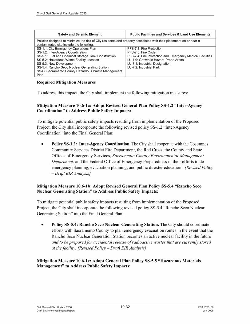
City of Galt General Plan Update: 2030
Galt General Plan Update: 2030 10-32 ESA / 203100 Draft Environmental Impact Report July 2008
Safety and Seismic Element Public Facilities and Services & Land Use Elements
Policies designed to minimize the risk of City residents and property associated with their placement on or near a contaminated site include the following: SS-1.1: City Emergency Operations Plan SS-1.2: Inter-Agency Coordination SS-5.1: Fuel and Chemical Storage Tank Construction SS-5.2: Hazardous Waste Facility Location SS-5.3: New Development SS-5.4: Rancho Seco Nuclear Generating Station SS-C: Sacramento County Hazardous Waste Management Plan
PFS-7.1: Fire Protection PFS-7.3: Fire Code PFS-7.4: Fire Protection and Emergency Medical Facilities LU-1.9: Growth in Hazard-Prone Areas LU-7.1: Industrial Designation LU-7.2: Industrial Park
Required Mitigation Measures
To address this impact, the City shall implement the following mitigation measures:
Mitigation Measure 10.6-1a: Adopt Revised General Plan Policy SS-1.2 �“Inter-Agency Coordination�” to Address Public Safety Impacts:
To mitigate potential public safety impacts resulting from implementation of the Proposed Project, the City shall incorporate the following revised policy SS-1.2 �“Inter-Agency Coordination�” into the Final General Plan:
• Policy SS-1.2: Inter-Agency Coordination. The City shall cooperate with the Cosumnes Community Services District Fire Department, the Red Cross, the County and State Offices of Emergency Services, Sacramento County Environmental Management Department, and the Federal Office of Emergency Preparedness in their efforts to do emergency planning, evacuation planning, and public disaster education. [Revised Policy �– Draft EIR Analysis]
Mitigation Measure 10.6-1b: Adopt Revised General Plan Policy SS-5.4 �“Rancho Seco Nuclear Generating Station�” to Address Public Safety Impacts:
To mitigate potential public safety impacts resulting from implementation of the Proposed Project, the City shall incorporate the following revised policy SS-5.4 �“Rancho Seco Nuclear Generating Station�” into the Final General Plan:
• Policy SS-5.4: Rancho Seco Nuclear Generating Station. The City should coordinate efforts with Sacramento County to plan emergency evacuation routes in the event that the Rancho Seco Nuclear Generation Station becomes an active nuclear facility in the future and to be prepared for accidental release of radioactive wastes that are currently stored at the facility. [Revised Policy �– Draft EIR Analysis]
Mitigation Measure 10.6-1c: Adopt General Plan Policy SS-5.5 �“Hazardous Materials Management�” to Address Public Safety Impacts:

10. Public Health and Safety
Galt General Plan Update: 2030 10-33 ESA / 203100 Draft Environmental Impact Report July 2008
To mitigate potential public safety impacts resulting from implementation of the Proposed Project, the City shall incorporate the following new policy SS-5.5 �“Hazardous Materials Management�” into the Final General Plan:
• Policy SS-5.5: Hazardous Materials Management. The City shall continue to cooperate with the County and the CCSD Fire Department in the identification of hazardous material users (both large and small scale) and in the development of an inspection process and hazardous materials management plan. [New Policy �– Draft EIR Analysis]
Mitigation Measure 10.6-1d: Adopt General Plan Policy SS-5.6 �“Hazardous Materials Inventory�” to Address Public Safety Impacts:
To mitigate potential public safety impacts resulting from implementation of the Proposed Project, the City shall incorporate the following new policy SS-5.6 �“Hazardous Materials Inventory�” into the Final General Plan:
• Policy SS-5.6: Hazardous Materials Inventory. The City shall require, as appropriate and as a component of the environmental review process or business license review/building permit review a hazardous materials inventory for project sites, including an assessment of materials and operations for any development applications. [New Policy �– Draft EIR Analysis]
Mitigation Measure 10.6-1e: Adopt General Plan Policy SS-5.7 �“Household Hazardous Waste Collection�” to Address Public Safety Impacts:
To mitigate potential public safety impacts resulting from implementation of the Proposed Project, the City shall incorporate the following new policy SS-5.7 �“Household Hazardous Waste Collection�” into the Final General Plan:
• Policy SS-5.7: Household Hazardous Waste Collection. The City should continue to provide opportunities for residents to conveniently dispose of household hazardous waste. [New Policy �– Draft EIR Analysis]
Mitigation Measure 10.6-1f: Adopt General Plan Policy SS-5.8 �“Increase Public Awareness�” to Address Public Safety Impacts:
To mitigate potential public safety impacts resulting from implementation of the Proposed Project, the City shall incorporate the following new policy SS-5.8 �“Increase Public Awareness�” into the Final General Plan:
• Policy SS-5.8: Increase Public Awareness. The City shall continue to work with the appropriate waste disposal service provider to educate the public as to the types of household hazardous wastes and the proper methods of disposal. [New Policy �– Draft EIR Analysis]

City of Galt General Plan Update: 2030
Galt General Plan Update: 2030 10-34 ESA / 203100 Draft Environmental Impact Report July 2008
Mitigation Measure 10.6-1g: Adopt General Plan Policy SS-5.9 �“Hazardous Materials Studies�” to Address Public Safety Impacts:
To mitigate potential public safety impacts resulting from implementation of the Proposed Project, the City shall incorporate the following new policy SS-5.9 �“Hazardous Materials Studies�” into the Final General Plan:
• Policy SS-5.9: Hazardous Materials Studies. The City shall ensure that the proponents of applicable new development projects address hazardous materials concerns through the preparation of Phase I or Phase II hazardous materials studies for each identified site as part of the design phase for each project. Recommendations required to satisfy federal or State cleanup standards outlined in the studies will be implemented as part of the construction phase for each project. [New Policy �– Draft EIR Analysis]
Mitigation Measure 10.6-1h: Adopt General Plan Implementation Program SS-D to Address Public Safety Impacts:
To mitigate potential public safety impacts resulting from implementation of the Proposed Project, the City shall incorporate the following new implementation program into the Final General Plan:
• Implementation Program: SS-D: Use, Production, or Transport of Hazardous Materials and Wastes. The City should develop siting and enforcement criteria for businesses that use, produce, or transport hazardous materials and wastes. [New Policy �– Draft EIR Analysis]
Significance after Implementation of Mitigation for Impact 10.6-3
As stated above, the City will continue to regulate hazardous materials concerns as part of the development process for future projects in the Study Area. Therefore, implementation of the Proposed Project including the adoption of the policies and implementation program provided in mitigation measures 10.6-1a, 10.6-1b, 10.6-1c, 10.6-1d, 10.6-1e, 10.6-1f, 10.6-1g, and 10.6-1h (listed above) would result in a less-than-significant impact.
Impact 10.6-4: The Proposed Project could result in development located within an airport land use plan area or and could result in a safety hazard for people residing or working in the Study Area.
Impact Summary
Level of Significance Before Mitigation: Potentially Significant
Required Mitigation: Mitigation Measure 4.2-3: Adopt General Plan Policy LU-1.15 �“Caltrans Handbook Reference�” to Address Airport Land Use Compatibility Impacts
Level of Significance After Mitigation: Less Than Significant

10. Public Health and Safety
Galt General Plan Update: 2030 10-35 ESA / 203100 Draft Environmental Impact Report July 2008
Impact Analysis
The nearest public airport to the City of Galt is Franklin Field, which is located six miles west of the Study Area. Mustang Airport, a small private use airport, is located one and a half miles north of the Study Area. The Study Area for the proposed Project is located outside of the Comprehensive Land Use Plan boundary for Franklin Field. There is no adopted airport land use plan for Mustang Airport. Furthermore, Mustang Airport does not have a Federal Aviation Administration (FAA) approved airport layout plan (ALP).
Due to the �“private�” status of Mustang Airport, neither Federal nor State regulations (e.g., FAR Part 771, PUC 21001 et seq.2, etc.) apply in regards to the guidance of operations at the airport, or the compatibility of land uses surrounding it. However, this does not affect the issue of safety with respect to how aircraft operations have the potential to impact people residing or working in the vicinity of an airport. Protecting people and property on the ground from the potentially severe consequences of aircraft accidents should be a fundamental concern for any planning agency. While it is impossible to apply State airport land use regulations to a private airfield such as Mustang Airport, or predict the exact time and location of an aircraft accident, the City can take proactive measures to reduce the risk of harm to people on the ground through reasonable restrictions on the types of land uses that are near an airport. Mustang Airport typically has up to three take offs and landings per day. (DERA 2005)
The potential severity of an off-airport accident is largely dependent upon the nature of the land use at the accident site. The California Department of Transportation (Caltrans) identifies criteria in the California Airport Land Use Planning Handbook (2002), which is designed to promote safety for those on the ground and in aircraft, through smart land use planning decisions. Generally, the Handbook recommends that residential land uses be kept to low intensities (dwelling units per acre) near an airport, and ideally should remain outside an airport�’s approach paths entirely. Nonresidential uses are considered more �“acceptable�” near an airport, provided that they do not penetrate the protected airspace of an airport, generate safety hazards through the presence of smoke, steam, glare, thermal plumes, etc., and maintain reasonably acceptable concentrations of people on any given site. Other types of safety measures can also be applied to land uses in order to reduce the risk of harm to people and property on the ground. These would include the use of clustering and maintaining open space for an aircraft to land in the event of an emergency.
The City of Galt identifies the corridor along Highway 99 as an area for the development of �“commercial�”, �“office professional�”, and �“high density�” residential land uses. Some of these proposed land uses would be located within less than one mile of Mustang Airport; presenting a potential safety hazard for those working and living in the Study Area. Policies included as part of the Proposed Project that would potentially minimize this impact are summarized below by general plan element. For example, the Safety and Seismic and Land Use Elements provide a number of policies that have been developed to address safety concerns including siting development away from hazardous conditions (see policy LU-1.9). Additional policies also encourage coordination with other local, state, and federal agencies for emergency preparedness, planning, and response 1 Federal Aviation Regulation Part 77: Objects Affecting Navigable Airspace. 2 California Public Utilities Code, Sections 21001 et seq., relating to the State Aeronautics Act.

City of Galt General Plan Update: 2030
Galt General Plan Update: 2030 10-36 ESA / 203100 Draft Environmental Impact Report July 2008
(policy SS-1.2). Even after implementation of the policies mentioned below, however, the impact is considered potentially significant.
Additionally, it is worth noting that the owner of Mustang Airport has applied for public airport status. The Sacramento County Planning Commission has approved the owner�’s application contingent upon completion of a Final EIR and other mitigation measures including the development of an airport land use compatibility plan (ALUCP). Should the FEIR be approved, the Sacramento County Board of Supervisors will review the proposal and decide whether or not to allow Mustang Airport to operate as a public-use airport. Should the Board agree on the status change, it is anticipated that the number of operations at the airport will increase and that planning documents required by the Sacramento County Planning Commission, such as an ALP and ALUCP, will be prepared.
Safety and Seismic Element Land Use Element
Policies designed to minimize the risk of airport related hazards to City residents and property include the following: SS-1.2 Interagency Coordination LU-1.9 Growth in Hazard-Prone Areas
Circulation Element Noise Element
C-7.1 Airport Improvements C-7.2 Inter-Agency Coordination
N-1.2 Noise Mitigation N-1.6 Noise-Sensitive Land Separation N-1.11 Land Use Compatibility
Required Mitigation Measures
To address this impact, the City shall implement the following mitigation measure:
Mitigation Measure 4.2-3: Adopt General Plan Policy LU-1.15 �“Caltrans Handbook Reference�” to Address Airport Land Use Compatibility Impacts.
To mitigate airport land use compatibility impacts resulting from implementation of the Proposed Project, the City shall incorporate the following new Policy LU-1.15 �“Caltrans Handbook Reference�” into the Final General Plan:
• LU-1.15 Caltrans Handbook Reference: When reviewing proposed projects within a one mile radius of an airport (such as Mustang Airport, if approved for public use), the City shall refer to the Caltrans Airport Land Use Planning Handbook (2002) in order to identify any potential safety compatibility concerns between the airport and the proposed land use. [New Policy �– Draft EIR Analysis]
Significance after Implementation of Mitigation for Impact 10.6-4
As stated above, the City will coordinate planning efforts with the County to ensure compatible land uses within airport overflight zones and minimize siting incompatible land uses adjacent to each other as part of the development process for future projects in the Study Area. The City will also implement a variety of policies designed to address airports hazards concerns including the siting of future development within areas that minimize exposure to airport-related hazards. Therefore, implementation of the Proposed Project including the adoption of the new policy provided in Mitigation Measure 4.2-3 would result in a less-than-significant impact.
10. Public Health and Safety
Galt General Plan Update: 2030 10-37 ESA / 203100 Draft Environmental Impact Report July 2008
Impact 10.6-5: The Proposed Project could impair implementation of or physically interfere with an adopted emergency response plan or emergency evacuation plan.
Impact Summary
Level of Significance Before Mitigation: Potentially Significant
Required Mitigation: No Feasible Mitigation Available
Level of Significance After Mitigation: Significant and Unavoidable
Impact Analysis
As more fully described in Chapter 5.0 �“Circulation�” of this EIR, implementation of the Proposed Project would more than double the current number of vehicle trips and miles of vehicular travel within the Study Area. Consequently, several local roadway facilities would experience deterioration in their level of service to an unacceptable level. The Proposed Project addresses these traffic impacts through a combination of policies and several physical roadway improvements identified in the Circulation Diagram (see Chapter 5.0 �“Circulation�” of this EIR for additional information). However, the traffic impact is still considered �“significant and unavoidable�” because the proposed policies allow for the deterioration of their level of service beyond what is allowed under the current General Plan and because implementation of several proposed roadway improvements is contingent on a variety of factors outside the City�’s control. Roadways operating at unacceptable levels of service could contribute to the physical interference of an adopted emergency response plan or evacuation plan.
Policies included as part of the Proposed Project that would minimize this impact are summarized below by General Plan element, with a complete description of these polices found in the Policy Document (see Appendix C of this draft EIR). The Safety and Seismic Element provides a number of these policies that address conformance with local emergency response programs and continued cooperation with emergency response service providers. For example, policies have been developed to ensure that all applicable disaster plans are updated regularly (see policy SS-1.1) and a coordinated emergency response system is maintained with other agencies (see policy SS-1.2). The Public Facilities and Services Element provides policies that ensure the maintenance and support of adequate levels of emergency response capabilities (see policies PFS-6.2, PFS-6.3, PFS-7.1, and PFS-7.4). Policy PFS-7.5 requires the City to coordinate the design and installation of traffic control and calming measures that can minimize impacts on emergency vehicle response. The Circulation Element provides a number of policies to improve traffic circulation and mitigate impacts to the City�’s roadways (see policies C-1.3, C-1.9, C-1.10, C-3.2, and implementation program C-A). However, even with implementation of the below mentioned policies and implementation program, this impact is considered potentially significant.

City of Galt General Plan Update: 2030
Galt General Plan Update: 2030 10-38 ESA / 203100 Draft Environmental Impact Report July 2008
Safety and Seismic & Circulation Elements Public Facilities and Services Element
Policies and implementation programs designed to minimize the risk of airport related hazards to City residents and property include the following: SS-1.1 City Emergency Response Plan SS-1.2 Inter-Agency Coordination SS-5.4 Rancho Seco Nuclear Generating Station C-1.3 Level of Service C-1.9 Traffic Impact Analysis and Funding C-1.10 Traffic Fees C-3.2 New Developments C-A Capital Improvements Financing Plan and Development Fees
PFS-6.2 Police Protection PFS-6.3 Maintaining Service Standards PFS-7.1 Fire Protection PFS-7.3 Fire Code PFS-7.4 Fire Protection and Emergency Medical Facilities PFS-7.5 Traffic Control and Calming Measures
Required Mitigation Measures
As stated above, the City will implement a variety of policies and implementation programs designed to address conformance with local emergency response programs and continued cooperation with emergency response service providers. However, roadways operating at unacceptable levels of service (through increased vehicle traffic associated with the Proposed Project) could physically impede the response times of emergency response vehicles or delay implementation of an evacuation plan. Consequently, this impact remains significant. No additional feasible mitigation is currently available.
Significance after Implementation of Mitigation for Impact 10.6-5
As stated above, no additional feasible mitigation measures are currently available to reduce this impact to a less-than-significant level. Consequently, this impact is considered significant and unavoidable.
10.7 Air Quality and Global Climate Change This section provides an overview of the existing air quality within the City of Galt and surrounding region, the regulatory framework, an analysis of potential impacts to air quality that would result from implementation of the Proposed Project, and identification of mitigation measures.
(QYLURQPHQWDO�DQG�5HJXODWRU\�6HWWLQJ�Section 15150 of the CEQA Guidelines permits documents of lengthy technical detail to be incorporated by reference in an EIR. Specifically, Section 15150 states that an EIR may �“incorporate by reference all or portions of another document which is a matter of public record or is generally available to the public ....�” Consistent with the CEQA Guidelines and as a way to avoid creating an overwhelming amount of paper for members of the public and decision-makers to sort through, this draft EIR incorporates by reference information from both the Existing Conditions Report and Policy Document. Consistent with this approach, the reader is directed to Chapter 10.0 of the Existing Conditions Report for environmental and regulatory setting information specific to health and safety topics (see Appendix B of this draft EIR).

10. Public Health and Safety
Galt General Plan Update: 2030 10-39 ESA / 203100 Draft Environmental Impact Report July 2008
Additional information provided below includes updated air quality monitoring and designation information (Tables 10-3 and 10-4) as well as regulatory and background information on greenhouse gases and global climate change.
Air Quality Monitoring and Existing Emission Levels Measurements of ambient air pollutant concentrations determine the attainment status within an area. Although there is no ambient air monitoring station within the City of Galt, several are located in the general vicinity in Sacramento County. Table 10-3 shows updated ambient air quality data from that originally presented in the General Plan Existing Conditions Report (including data for the years 2004 through 2006 and monitoring information for PM-10 and PM-2.5) for the maximum concentrations of the non-attainment pollutants at the nearest monitoring stations, which are in Elk Grove (Bruceville Road) and Sacramento (Health Department on Stockton Boulevard). Geographic areas and air basins are classified for each pollutant as either attainment or non-attainment, which are described below in Table 10-4.
TABLE 10-3 AIR QUALITY MONITORING DATA (2004 - 2006)
NUMBER OF DAYS ABOVE THE STATE AND NATIONAL STANDARD
Monitoring Data by Year Pollutant
Standarda 2004 2005 2006
Ozone �– Elk Grove �– Bruceville Road
Highest 1 Hour Average (ppm)b 0.09 0.096 0.113 0.143
Days over State Standard 1 7 10
Highest 8 Hour Average (ppm)b 0.08 0.086 0.095 0.112
Days over National Standard 1 2 7
Particulate Matter (PM-10) Sacramento �– Health Department on Stockton Boulevard
Highest 24 Hour Average (µg/m3)b 46.0 68.0 57.0
Est. Days over State Standardc 50 0 NA NA
Est. Days over National Standardc 150 0 0 0
State Annual Average (µg/m3) b 20 21.4 NA NA
Particulate Matter (PM-2.5) �– Sacramento �– Health Department on Stockton Boulevard
Highest 24 Hour Average (µg/m3)b 35 47.0 59.0 45.0
Days over National Standardd 0 0 0
State Annual Average (µg/m3)b 12 10.5 NA NA

City of Galt General Plan Update: 2030
Galt General Plan Update: 2030 10-40 ESA / 203100 Draft Environmental Impact Report July 2008
TABLE 10-3 AIR QUALITY MONITORING DATA (2004 - 2006)
NUMBER OF DAYS ABOVE THE STATE AND NATIONAL STANDARD
Monitoring Data by Year Pollutant
Standarda 2004 2005 2006
a Generally, state standards and national standards are not to be exceeded more than once per year. b ppm = parts per million; µg/m3 = micrograms per cubic meter. c PM-10 is not measured every day of the year. Number of estimated days over the standard is based on 365 days per year. d Days over National Standard for PM-2.5 are based on the previous standard of 65 µg/m3 rather than the current standard of 35 µg/m3
NOTES: Values in bold are in excess of at least one applicable standard. NA = Not Available. SOURCE: California Air Resources Board, 2007a. Summaries of Air Quality Data, 2004, 2005, 2006; http://www.arb.ca.gov/adam/cgi-bin/db2www/polltrendsb.d2w/start, site accessed December 5, 2007.
TABLE 10-4
SACRAMENTO COUNTY ATTAINMENT STATUS
Designation/Classification Pollutant
Federal Standards State StandardsOzone �– one hour No Federal Standard1 Nonattainment Ozone �– eight hour Serious Nonattainment Unclassified PM-10 Moderate Nonattainment Nonattainment PM-2.5 Unclassified/Attainment Nonattainment CO Attainment Attainment Nitrogen Dioxide Unclassified/Attainment Attainment Sulfur Dioxide Attainment Attainment Lead No Designation Attainment Hydrogen Sulfide No Federal Standard Unclassified Sulfates No Federal Standard Attainment Visibility-Reducing Particles No Federal Standard Unclassified
Notes: 1 Federal One Hour Ozone National Ambient Air Quality Standard was revoked on June 15, 2005 Unclassified: a pollutant is designated unclassified if the data are incomplete and do not support a designation of attainment or nonattainment.
SOURCE: California Air Resources Board, 2007b. Area Designation Maps, http://www.arb.ca.gov/desig/adm/adm.htm, page updated September 11, 2007.
Greenhouse Gases and Global Climate Change Gases that trap heat in the atmosphere are called greenhouse gases (GHG). The major concern is that increases in greenhouse gases are causing global climate change. Global climate change is a change in the average weather on earth that can be measured by wind patterns, storms, precipitation and temperature. Although there is tremendous disagreement as to the speed of global warming and the extent of the impacts attributable to human activities, most scientists agree that there is a direct link between increased emission of GHG and long term global temperature rise. What GHG have in common is that they allow sunlight to enter the atmosphere, but trap a portion of the outward-bound infrared radiation and warm up the air. The process is similar to the effect greenhouses have in raising the internal temperature, hence the name GHG. Both natural processes and human activities emit GHG. The accumulation of GHG in the atmosphere regulates the earth�’s temperature. Emissions from human activities such as electricity production and motor vehicles have contributed to the elevation of GHG in the atmosphere. This accumulation of GHG

10. Public Health and Safety
Galt General Plan Update: 2030 10-41 ESA / 203100 Draft Environmental Impact Report July 2008
has resulted in an increase in the temperature of the earth�’s atmosphere and contributed to global climate change. The principal GHG are carbon dioxide (CO2), methane (CH4), nitrous oxide (N2O), sulfur hexafluoride (SF6), perfluorocarbons (PFCs), hydrofluorocarbons (HFCs), and water vapor (H2O). Carbon dioxide is the reference gas for climate change because it gets the most attention and is considered the most important GHG. To account for the warming potential of GHG, GHG emissions are often quantified and reported as CO2 equivalents (CO2E). Large emission sources are reported in million metric tons of CO2E (MMTCO2E). HFCs are used in refrigeration systems as substitutes for CFCs, which were banned for destroying the ozone layer.
State Standards for Greenhouse Gases In 2005, in recognition of California�’s vulnerability to the effects of climate change, Governor Schwarzenegger established Executive Order S-3-05, which sets forth a series of target dates by which statewide emission of GHG would be progressively reduced, as follows:
• By 2010, reduce GHG emissions to 2000 levels;
• By 2020, reduce GHG emissions to 1990 levels; and
• By 2050, reduce GHG emissions to 80 percent below 1990 levels.
In 2006, California passed the California Global Warming Solutions Act of 2006 (Assembly Bill No. 32; California Health and Safety Code Division 25.5, Sections 38500, et seq., or AB 32), which requires the California Air Resources Board (CARB) to design and implement emission limits, regulations, and other measures, such that feasible and cost-effective statewide GHG emissions are reduced to 1990 levels by 2020 (representing an approximate 25 percent reduction in emissions).
In June 2007 CARB directed staff to pursue 37 early actions for reducing GHG emissions under the California Global Warming Solutions Act of 2006 (AB 32). The broad spectrum of strategies to be developed �– including a Low Carbon Fuel Standard, regulations for refrigerants with high global warming potentials, guidance and protocols for local governments to facilitate GHG reductions, and green ports �– reflects that the serious threat of climate change requires action as soon as possible (CARB, 2007c).
In addition to approving the 37 greenhouse gas reduction strategies, CARB directed staff to further evaluate early action recommendations made at the June 2007 meeting, and to report back to CARB within six months. The general sentiment of CARB suggested a desire to try to pursue greater GHG emissions reductions in California in the near-term. Since the June 2007 CARB hearing, CARB staff has evaluated all 48 recommendations submitted by several stakeholder and several internally-generated staff ideas and published the Draft List of Early Action Measures To Reduce Greenhouse Gas Emissions In California Recommended For Board Consideration in September 2007 (CARB, 2007c). Based on its additional analysis, CARB staff is recommending the expansion of the early action list to a total of 44 measures, which are listed below in Table 10-

City of Galt General Plan Update: 2030
Galt General Plan Update: 2030 10-42 ESA / 203100 Draft Environmental Impact Report July 2008
5. Three of these early action items were approved by the Board at its June 2007 hearing, listed as ID# 15, 16 and 17 in Table 10-5.
The 2020 target reductions are currently estimated to be 174 MMTCO2E. In total, the 44 recommended early actions have the potential to reduce GHG emissions by at least 42 million metric tons of carbon dioxide (CO2) equivalent (MMTCO2E) emissions by 2020, representing about 25% of the estimated reductions needed by 2020. CARB staff is working on 1990 and 2020 GHG emission inventories in order to refine the projected reductions needed by 2020 and expects to present its recommendations to the CARB by the end of 2007. The 44 measures are in the sectors of fuels, transportation, forestry, agriculture, education, energy efficiency, commercial, solid waste, cement, oil and gas, electricity, and fire suppression.
In addition to identifying early actions to reduce GHG, the CARB is also developing the GHG mandatory reporting regulation that is required by January 1, 2008 pursuant to requirements of AB32. The regulations are expected to require reporting for certain types of facilities that make up the bulk of the stationary source emissions in California. Currently, the draft regulation language identifies major facilities as those that generate more than 25,000 metric tons of CO2 per year (CO2/yr). This reporting limit is consistent with European Union reporting. Cement plants, oil refineries, electric generating facilities/providers, co-generation facilities, and hydrogen plants and other stationary combustion sources that emit more than 25,000 MT CO2/yr, make up 94 percent of the point source CO2 emissions in California (CARB, 2007d).
TABLE 10-5RECOMMENDED AB32 GREENHOUSE GAS MEASURES TO BE
INITIATED BY CARB BETWEEN 2007 AND 2012
ID # Sector Strategy Name
1 Fuels Above Ground Storage Tanks2 Transportation Diesel �– Offroad equipment (non-agricultural)3 Forestry Forestry protocol endorsement4 Transportation Diesel �– Port trucks5 Transportation Diesel �– Vessel main engine fuel specifications6 Transportation Diesel �– Commercial harbor craft7 Transportation Green ports8 Agriculture Manure management (methane digester protocol)9 Education Local gov. Greenhouse Gas (GHG) reduction guidance / protocols
10 Education Business GHG reduction guidance / protocols11 Energy Efficiency Cool communities program12 Commercial Reduce high Global Warming Potential (GWP) GHGs in products 13 Commercial Reduction of PFCs from semiconductor industry14 Transportation SmartWay truck efficiency15 Transportation Low Carbon Fuel Standard (LCFS)16 Transportation Reduction of HFC-134a from DIY Motor Vehicle AC servicing 17 Waste Improved landfill gas capture18 Fuels Gasoline disperser hose replacement19 Fuels Portable outboard marine tanks20 Transportation Standards for off-cycle driving conditions21 Transportation Diesel �– Privately owned on-road trucks

10. Public Health and Safety
Galt General Plan Update: 2030 10-43 ESA / 203100 Draft Environmental Impact Report July 2008
TABLE 10-5RECOMMENDED AB32 GREENHOUSE GAS MEASURES TO BE
INITIATED BY CARB BETWEEN 2007 AND 2012
ID # Sector Strategy Name
22 Transportation Anti-idling enforcement23 Commercial SF6 reductions from the non-electric sector24 Transportation Tire inflation program25 Transportation Cool automobile paints26 Cement Cement (A): Blended cements27 Cement Cement (B): Energy efficiency of California cement facilities 28 Transportation Ban on HFC release from Motor Vehicle AC service / dismantling 29 Transportation Diesel �– offroad equipment (agricultural)30 Transportation Add AC leak tightness test and repair to Smog Check31 Agriculture Research on GHG reductions from nitrogen land applications 32 Commercial Specifications for commercial refrigeration33 Oil and Gas Reduction in venting / leaks from oil and gas systems34 Transportation Requirement of low-GWP GHGs for new Motor Vehicle ACs 35 Transportation Hybridization of medium and heavy-duty diesel vehicles 36 Electricity Reduction of SF6 in electricity generation37 Commercial High GWP refrigerant tracking, reporting and recovery program 38 Commercial Foam recovery / destruction program39 Fire Suppression Alternative suppressants in fire protection systems40 Transportation Strengthen light-duty vehicle standards41 Transportation Truck stop electrification with incentives for truckers42 Transportation Diesel �– Vessel speed reductions43 Transportation Transportation refrigeration �– electric standby44 Agriculture Electrification of stationary agricultural engines
Source: CARB, 2007c
City of Galt 80% Greenhouse Gas Inventory As part of the Proposed Project, a preliminary inventory of large sources (transportation, electricity use, and natural gas combustion) of known GHG emissions in the city of Galt for the year 2005 was performed. The goal of this initial inventory was to capture 80% of all known GHG emissions in the City of Galt, with the intent to tier from this effort and perform a full detailed 2005 greenhouse gas inventory for the City in cooperation with the Sacramento Municipal Utility District, County of Sacramento, and the cities within Sacramento County.
The City of Galt is a member the International Council for Local Environmental Initiatives Local Governments for Sustainability (ICLEI). Comprising over 815 cities, towns, countries and their associations worldwide, ICLEI is an international association of local governments, as well as national and regional local government organizations, that have made a commitment to sustainable development. The Clean Air and Climate Protection (CACP) Software, developed by ICLEI, was used to estimate GHG emissions within the City of Galt. The CACP software inventories community GHG emissions for all operations within the selected boundary of the local government.
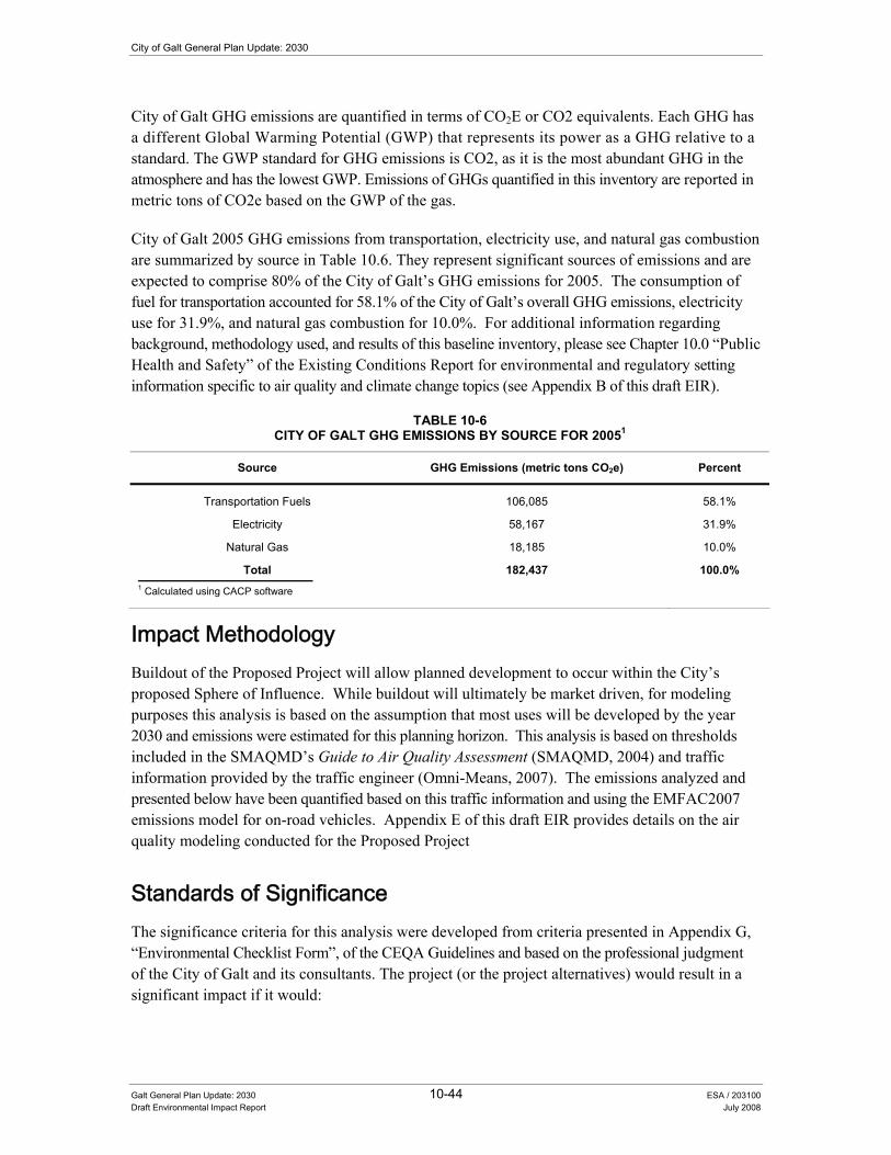
City of Galt General Plan Update: 2030
Galt General Plan Update: 2030 10-44 ESA / 203100 Draft Environmental Impact Report July 2008
City of Galt GHG emissions are quantified in terms of CO2E or CO2 equivalents. Each GHG has a different Global Warming Potential (GWP) that represents its power as a GHG relative to a standard. The GWP standard for GHG emissions is CO2, as it is the most abundant GHG in the atmosphere and has the lowest GWP. Emissions of GHGs quantified in this inventory are reported in metric tons of CO2e based on the GWP of the gas.
City of Galt 2005 GHG emissions from transportation, electricity use, and natural gas combustion are summarized by source in Table 10.6. They represent significant sources of emissions and are expected to comprise 80% of the City of Galt�’s GHG emissions for 2005. The consumption of fuel for transportation accounted for 58.1% of the City of Galt�’s overall GHG emissions, electricity use for 31.9%, and natural gas combustion for 10.0%. For additional information regarding background, methodology used, and results of this baseline inventory, please see Chapter 10.0 �“Public Health and Safety�” of the Existing Conditions Report for environmental and regulatory setting information specific to air quality and climate change topics (see Appendix B of this draft EIR).
TABLE 10-6 CITY OF GALT GHG EMISSIONS BY SOURCE FOR 20051
Source GHG Emissions (metric tons CO2e) Percent
Transportation Fuels 106,085 58.1%
Electricity 58,167 31.9%
Natural Gas 18,185 10.0%
Total 182,437 100.0%
1 Calculated using CACP software
,PSDFW�0HWKRGRORJ\��Buildout of the Proposed Project will allow planned development to occur within the City�’s proposed Sphere of Influence. While buildout will ultimately be market driven, for modeling purposes this analysis is based on the assumption that most uses will be developed by the year 2030 and emissions were estimated for this planning horizon. This analysis is based on thresholds included in the SMAQMD�’s Guide to Air Quality Assessment (SMAQMD, 2004) and traffic information provided by the traffic engineer (Omni-Means, 2007). The emissions analyzed and presented below have been quantified based on this traffic information and using the EMFAC2007 emissions model for on-road vehicles. Appendix E of this draft EIR provides details on the air quality modeling conducted for the Proposed Project
6WDQGDUGV�RI�6LJQLILFDQFH�The significance criteria for this analysis were developed from criteria presented in Appendix G, �“Environmental Checklist Form�”, of the CEQA Guidelines and based on the professional judgment of the City of Galt and its consultants. The project (or the project alternatives) would result in a significant impact if it would:

10. Public Health and Safety
Galt General Plan Update: 2030 10-45 ESA / 203100 Draft Environmental Impact Report July 2008
• Result in a cumulatively considerable net increase of any criteria pollutant for which the project region is a nonattainment area for an applicable federal or state ambient air quality standard (including releasing emissions that exceed quantitative thresholds for ozone precursors);
• Conflict with or obstruct implementation of the applicable air quality plan;
• Violate any air quality standard or contribute substantially to an existing or projected air quality violation;
• Expose sensitive receptors to substantial pollutant concentrations;
• Create objectionable odors affecting a substantial number of people; or
• Conflict with the state goal of reducing greenhouse gas emissions in California to 1990 levels by 2020, as set forth by the timetable established in AB 32, California Global Warming Solutions Act of 2006.
SMAQMD has published recommendations that provide specific guidance on evaluating projects under CEQA relative to the above general criteria (SMAQMD, 2004). For evaluating long-term emission increases during the operation of the project, SMAQMD recommends that lead agencies use criteria of 65 pounds per day for ROG or NOx generated by project operations to identify significant increases in emissions. For other criteria pollutants, including carbon monoxide and PM-10, a project that may cause an exceedance of the respective state standards or may make a substantial3 contribution to a current exceedance of a state standard would have a significant adverse air quality impact.
For the cumulative analysis, the impact of a proposed project is considered cumulatively significant if:
• The project would require a change in the current land use designation (i.e., general plan amendment, rezone), and the projected emissions (ROG or NOx) of the project would be greater than the emissions anticipated for the site if it were developed under the current land use designation.
In addition, the operation of any project with the potential to expose sensitive receptors to substantial levels of toxic air contaminants (TACs) would be deemed to have a potentially significant air quality impact as well. More specifically, proposed development projects that have the potential to expose the public to project-related TACs in excess of the following thresholds would be considered to have a significant air quality impact:
• Probability of contracting cancer for the Maximally Exposed Individual exceeds 10 in one million.
• Ground-level concentrations of non-carcinogenic TACs would result in a Hazard Index greater than 1.
3 Substantial is defined by SMAQMD as making measurably worse, which is 5 percent or more of a current
exceedance of a state standards.

City of Galt General Plan Update: 2030
Galt General Plan Update: 2030 10-46 ESA / 203100 Draft Environmental Impact Report July 2008
Application of these standards would typically apply to the preparation of a more detailed project-specific health risk assessment (based on a detailed air dispersion modeling effort) that would occur as individual development projects are considered as part of the Proposed Project. For the Proposed Project, the assessment of TACs is conducted at a qualitative level with specific policies and implementation programs provided to address the potential impacts associated with this issue.
,PSDFWV�DQG�0LWLJDWLRQ�0HDVXUHV�
Impact 10.7-1: The Proposed Project would result in a cumulatively considerable net increase of criteria pollutants. Future growth in accordance with the Proposed Project would exceed the daily SMAQMD thresholds for NOx and ROG.
Impact Summary
Level of Significance Before Mitigation: Potentially Significant
Required Mitigation: Mitigation Measure 10.7-1a: Adopt General Plan Policy COS-5.11 �“Construction Mitigation Measures�” to Address Air Quality Impacts, Mitigation Measure 10.7-1b: Adopt General Plan Policy COS-5.12 �“Construction Mitigation Fees�” to Address Air Quality Impacts, Mitigation Measure 10.7-1c: Adopt General Plan Policy COS-5.13 �“Air Pollution Control Technology�” to Address Air Quality Impacts.
Level of Significance After Mitigation: Significant and Unavoidable
Impact Analysis
Construction-Related. Construction activity that would occur in accordance with the Proposed Project would cause temporary, short-term emissions of various air pollutants. Reactive organic gases (ROG) and nitrogen oxides (NOx), which are ozone precursors, as well as particulate matter (PM-10 and PM-2.5) and CO2 (a greenhouse gas) would be emitted by construction equipment during various activities, such as grading and excavation, infrastructure construction, building demolition, and a variety of construction activities. Information regarding specific development projects, soil conditions, and the location of sensitive receptors in relation to the various projects would be needed in order to quantify the level of impact associated with construction activity. However, given the amount of development associated with implementation of the Proposed Project, it is reasonable to assume that some large-scale construction activity would exceed SMAQMD adopted thresholds over the duration of the Proposed Project development. Actual significance would be determined on a project-by-project basis as future development applications are submitted. Additionally, a variety of policies are designed to address construction-related air quality impacts including requiring contractors to implement appropriate dust suppression measures and potential mitigation fees to offset construction emissions (see �“Required Mitigation Measures�” below).
Operation-Related. Operational impacts would primarily result from local and regional vehicle emissions generated by future population growth associated with buildout of the Proposed Project. The annual emissions of ROG, NOx, CO, CO2, PM-10, and PM-2.5 associated with Proposed Project traffic for the analysis years 2005 (baseline) and 2030 (buildout) were estimated

10. Public Health and Safety
Galt General Plan Update: 2030 10-47 ESA / 203100 Draft Environmental Impact Report July 2008
using the EMFAC2007 model and traffic information provided by Omni-Means, Ltd (2007). Area source emissions were estimated based on land uses to be developed as part of the Proposed Project buildout. These operational emissions are provided below in Table 10-7. As shown in the table, future growth in accordance with the Proposed Project would exceed the SMAQMD thresholds for ROG and NOx. Also, given the amount of development associated with implementation of the Proposed Project, it is reasonable to assume that traffic and area source emissions associated with operations of the Proposed Project would substantially contribute to the current exceedance of the State standards for PM-10 and PM-2.5. Sacramento County is in attainment of the CO State standard, and the Proposed Project is not expected to conflict with continuing attainment. Actual significance of PM-10, PM-2.5, and CO would be determined on a project-by-project basis as future development applications are submitted and localized pollutant concentrations can be determined. CO2 (greenhouse gas) emissions are discussed further in Impact 10.7-6.
TABLE 10-7 OPERATIONAL EMISSIONS (TONS PER YEAR)
Unmitigated Operational Emissions (Pounds/Day)
Emissions Source ROG NOx CO CO2 PM-10 PM-2.5b
City of Galt Onroad Vehicle Emissionsa Baseline (Year 2005) 381 1,270 7,937 631,788 888 879
Buildout (Year 2030) 336 571 4,745 1,451,159 1,989 1969
Incremental Increase c (45) (699) (3,192) 819,371 1,101 1,090
Proposed Project Area Source Emissionsa 3,754 909 20,370 1,201,656 3,283 3,160
Total Incremental Onroad and Area Source Emissions (lbs/day) 3,709 210 17,178 2,021,027 4,384 4,250
SMAQMD Significance Criteria (lbs/day) 65 65 NA NA NA NA
a Onroad vehicle emissions were estimated with the EMFAC2007 model using traffic information provided by Omni-Means, Ltd (2007). Area source emissions were estimated using URBEMIS2007 for the land uses included as part of the Proposed Project. Please see Appendix E for additional information.
b The PM-2.5 fraction of PM-10 is assumed to be 99 percent of the PM-10 emissions for operational sources (SCAQMD, 2006). c Values in (parentheses) represent calculated reductions in future year emissions versus the baseline scenario. ROG, NOx, and CO were estimated to decrease in the future scenario due to decreased emission factors in the future year. These emission factors generated by EMFAC2007 assume a cleaner mix of vehicles as older, more polluting vehicles are retired. d Bold values are in excess of the applicable standard. The SMAQMD established thresholds for ROG and NOx are 65 pounds per day. PM-10 and CO emissions are considered significant if the emissions exceed the State AAQS. The estimated mass emissions (lbs/day) of PM-10 and CO are presented in this Table, however, due to the programmatic nature of this analysis, are discussed only qualitatively below. PM-2.5, and CO2 do not have an established emissions threshold of significance.
SOURCES: ESA, 2007; Omni-Means, 2007; SCAQMD, 2006
A variety of industrial and commercial processes (e.g., dry cleaning, etc.) allowed under the Proposed Project would also be expected to release emissions; some of which could be of a hazardous nature. These emissions are controlled at the local and regional level through permitting and would be subject to further study and a health risk assessment prior to the issuance of any necessary air quality permits.
Policies included as part of the Proposed Project that would minimize this impact are summarized below. However, even with implementation of the below mentioned policies, this impact is considered potentially significant.
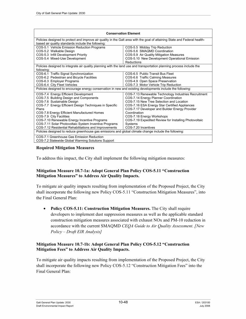
City of Galt General Plan Update: 2030
Galt General Plan Update: 2030 10-48 ESA / 203100 Draft Environmental Impact Report July 2008
Conservation Element
Policies designed to protect and improve air quality in the Galt area with the goal of attaining State and Federal health-based air quality standards include the following: COS-5.1 Vehicle Emission Reduction Programs COS-5.2 Walkable Design COS-5.3 Infill Development Priority COS-5.4 Mixed-Use Development
COS-5.5 Midday Trip Reduction COS-5.6 SMAQMD Coordination COS-5.9 Air Quality Mitigation Measures COS-5.10 New Development Operational Emission Reductions
Policies designed to integrate air quality planning with the land use and transportation planning process include the following: COS-6.1 Traffic Signal Synchronization COS-6.2 Pedestrian and Bicycle Facilities COS-6.3 Employer Programs COS-6.4 City Fleet Vehicles
COS-6.5 Public Transit Bus Fleet COS-6.6 Traffic Calming Measures COS-4.9 Open Space Preservation COS-7.3 Motor Vehicle Trip Reduction
Policies designed to encourage energy conservation in new and existing developments include the following:
COS-7.4 Energy Efficient Development COS-7.5 Building Design and Components COS-7.6 Sustainable Design COS-7.7 Energy Efficient Design Techniques in Specific Plans COS-7.8 Energy Efficient Manufactured Homes COS-7.9 City Facilities COS-7.10 Renewable Energy Incentive Programs COS-7.11 Solar Photovoltaic System Inventive Programs COS-7.12 Residential Rehabilitations and Improvements
COS-7.13 Renewable Technology Industries Recruitment COS-7.14 Energy Planner Coordination COS-7.15 New Tree Selection and Location COS-7.16 ESA Energy Star Certified Appliances COS-7.17 Developer and Builder Energy Provider Coordination COS-7.18 Energy Workshops COS-7.19 Expedited Review for Installing Photovoltaic Systems COS-7.20 Incentives
Policies designed to reduce greenhouse gas emissions and global climate change include the following:
COS-7.1 Greenhouse Gas Emission Reduction COS-7.2 Statewide Global Warming Solutions Support
Required Mitigation Measures
To address this impact, the City shall implement the following mitigation measures:
Mitigation Measure 10.7-1a: Adopt General Plan Policy COS-5.11 �“Construction Mitigation Measures�” to Address Air Quality Impacts.
To mitigate air quality impacts resulting from implementation of the Proposed Project, the City shall incorporate the following new Policy COS-5.11 �“Construction Mitigation Measures�”, into the Final General Plan:
• Policy COS-5.11: Construction Mitigation Measures. The City shall require developers to implement dust suppression measures as well as the applicable standard construction mitigation measures associated with exhaust NOx and PM-10 reduction in accordance with the current SMAQMD CEQA Guide to Air Quality Assessment. [New Policy �– Draft EIR Analysis]
Mitigation Measure 10.7-1b: Adopt General Plan Policy COS-5.12 �“Construction Mitigation Fees�” to Address Air Quality Impacts.
To mitigate air quality impacts resulting from implementation of the Proposed Project, the City shall incorporate the following new Policy COS-5.12 �“Construction Mitigation Fees�” into the Final General Plan:

10. Public Health and Safety
Galt General Plan Update: 2030 10-49 ESA / 203100 Draft Environmental Impact Report July 2008
• Policy COS-5.12: Construction Mitigation Fees. The City shall require developers to comply with the current SMAQMD construction mitigation fee offset program. [New Policy �– Draft EIR Analysis]
Mitigation Measure 10.7-1c: Adopt General Plan Policy COS-5.13 �“Air Pollution Control Technology�” to Address Air Quality Impacts.
To mitigate air quality impacts resulting from implementation of the Proposed Project, the City shall incorporate the following new Policy COS-5.13 �“Air Pollution Control Technology�” into the Final General Plan:
• Policy COS-5.13: Air Pollution Control Technology. The City shall follow the rules and regulations as adopted by the SMAQMD to maintain healthful air quality and high visibility standards. These measures shall be applied to new development approvals and permit modifications as appropriate. [New Policy �– Draft EIR Analysis]
Significance after Implementation of Mitigation for Impact 10.7-1
As stated above, the City will implement a variety of existing and new policies designed to address air quality issues. Depending on the feasibility and level of implementation as applied to individual development projects consistent with the General Plan, the inclusion of construction emission reduction policies, trip reduction measures, and energy conservation practices would help to further reduce emissions from individual project development. Future project-specific compliance with SMAQMD permitting would also help to reduce air quality emissions associated with individual projects. However, total air quality emissions associated with buildout of the Proposed Project would still exceed SMAQMD thresholds for ROG and NOx. Therefore, implementation of the Proposed Project including adoption of the additional policies provided in mitigation measures 10.7-1a, 10.7-1b, and 10.7-1c (listed above) would still result in a significant impact. No additional feasible mitigation measures are currently available. Consequently, the impact remains significant and unavoidable.
Impact 10.7-2: The Proposed Project could conflict with or obstruct implementation of an applicable air quality plan.
Impact Summary
Level of Significance Before Mitigation: Potentially Significant
Required Mitigation: Mitigation Measure 10.7-1a: Adopt General Plan Policy COS-5.11 �“Construction Mitigation Measures�” to Address Air Quality Impacts, Mitigation Measure 10.7-1b: Adopt General Plan Policy COS-5.12 �“Construction Mitigation Fees�” to Address Air Quality Impacts, Mitigation Measure 10.7-1c: Adopt General Plan Policy COS-5.13 �“Air Pollution Control Technology�” to Address Air Quality Impacts.
Level of Significance After Mitigation: Less than Significant

City of Galt General Plan Update: 2030
Galt General Plan Update: 2030 10-50 ESA / 203100 Draft Environmental Impact Report July 2008
Impact Analysis
The Proposed Project was designed specifically to achieve and promote consistency with the planning documents of other key neighboring land use agencies or other agencies that have jurisdiction over the project. Specific policies direct the City to protect and improve air quality (see policies COS-5.1 through COS-5.9), integrate the air quality, land use, and transportation planning process (see policies COS-6.1 through COS-6.7), and reduce greenhouse gas emissions and global climate change (see Policy COS-9.1). Additionally, the Conservation and Open Space Element was also updated to include several policies (see policies COS-7.4 through COS-7.20) designed to promote a variety of energy conservation measures include: solar photovoltaic system programs, tree planting, energy efficient development and building design, and renewable energy incentive programs. However, even with implementation of the below mentioned policies, this impact is considered potentially significant.
Conservation Element
Policies designed to protect and improve air quality in the Galt area with the goal of attaining State and Federal health-based air quality standards include the following: COS-5.1 Vehicle Emission Reduction Programs COS-5.2 Walkable Design COS-5.3 Infill Development Priority COS-5.4 Mixed-Use Development
COS-5.5 Midday Trip Reduction COS-5.6 SMAQMD Coordination COS-5.9 Air Quality Mitigation Measures COS-5.10 New Development Operational Emission Reductions
Policies designed to integrate air quality planning with the land use and transportation planning process include the following: COS-6.1 Traffic Signal Synchronization COS-6.2 Pedestrian and Bicycle Facilities COS-6.3 Employer Programs COS-6.4 City Fleet Vehicles
COS-6.5 Public Transit Bus Fleet COS-6.6 Traffic Calming Measures COS-4.9 Open Space Preservation COS-7.3 Motor Vehicle Trip Reduction
Policies designed to encourage energy conservation in new and existing developments include the following:
COS-7.4 Energy Efficient Development COS-7.5 Building Design and Components COS-7.6 Sustainable Design COS-7.7 Energy Efficient Design Techniques in Specific Plans COS-7.8 Energy Efficient Manufactured Homes COS-7.9 City Facilities COS-7.10 Renewable Energy Incentive Programs COS-7.11 Solar Photovoltaic System Inventive Programs COS-7.12 Residential Rehabilitations and Improvements
COS-7.13 Renewable Technology Industries Recruitment COS-7.14 Energy Planner Coordination COS-7.15 New Tree Selection and Location COS-7.16 ESA Energy Star Certified Appliances COS-7.17 Developer and Builder Energy Provider Coordination COS-7.18 Energy Workshops COS-7.19 Expedited Review for Installing Photovoltaic Systems COS-7.20 Incentives
Policies designed to reduce greenhouse gas emissions and global climate change include the following:
COS-7.1 Greenhouse Gas Emission Reduction COS-7.2 Statewide Global Warming Solutions Support
Required Mitigation Measures
To address this impact, the City shall implement the following mitigation measures:
Mitigation Measure 10.7-1a: Adopt General Plan Policy COS-5.11 �“Construction Mitigation Measures�” to Address Air Quality Impacts.
To mitigate air quality impacts resulting from implementation of the Proposed Project, the City shall incorporate the following new Policy COS-5.11 �“Construction Mitigation Measures�”, into the Final General Plan:
10. Public Health and Safety
Galt General Plan Update: 2030 10-51 ESA / 203100 Draft Environmental Impact Report July 2008
• Policy COS-5.11: Construction Mitigation Measures. The City shall require developers to implement dust suppression measures as well as the applicable standard construction mitigation measures associated with exhaust NOx and PM-10 reduction in accordance with the current SMAQMD CEQA Guide to Air Quality Assessment. [New Policy �– Draft EIR Analysis]
Mitigation Measure 10.7-1b: Adopt General Plan Policy COS-5.12 �“Construction Mitigation Fees�” to Address Air Quality Impacts.
To mitigate air quality impacts resulting from implementation of the Proposed Project, the City shall incorporate the following new Policy COS-5.12 �“Construction Mitigation Fees�” into the Final General Plan:
• Policy COS-5.12: Construction Mitigation Fees. The City shall require developers to comply with the current SMAQMD construction mitigation fee offset program. [New Policy �– Draft EIR Analysis]
Mitigation Measure 10.7-1c: Adopt General Plan Policy COS-5.13 �“Air Pollution Control Technology�” to Address Air Quality Impacts.
To mitigate air quality impacts resulting from implementation of the Proposed Project, the City shall incorporate the following new Policy COS-5.13 �“Air Pollution Control Technology�” into the Final General Plan:
• Policy COS-5.13: Air Pollution Control Technology. The City shall follow the rules and regulations as adopted by the SMAQMD to maintain healthful air quality and high visibility standards. These measures shall be applied to new development approvals and permit modifications as appropriate. [New Policy �– Draft EIR Analysis]
Significance after Implementation of Mitigation for Impact 10.7-2
Therefore, implementation of the Proposed Project including adoption of the additional policies provided in mitigation measures 10.7-1a, 10.7-1b, and 10.7-1c (listed above) would result in a less-than-significant impact.
Impact 10.7-3: Buildout of the Proposed Project would generate emissions above the daily SMAQMD significance thresholds for NOx and ROG, primarily due to traffic and area source emissions.
Impact Summary
Level of Significance Before Mitigation: Potentially Significant
Required Mitigation: Mitigation Measure 10.7-1c: Adopt General Plan Policy COS-5.13 �“Air Pollution Control Technology�” to Address Air Quality Impacts.
Level of Significance After Mitigation: Significant and Unavoidable
City of Galt General Plan Update: 2030
Galt General Plan Update: 2030 10-52 ESA / 203100 Draft Environmental Impact Report July 2008
Impact Analysis
As more fully described above under Impact 10.7-1, development resulting from buildout of the Proposed Project would result in an increase in emissions primarily due to additional motor vehicle trips and area sources. Stationary sources and area sources associated with future development, including residential wood stoves, are a significant source of CO and PM-10 emissions during wintertime conditions. Operational emissions of ROG, NOx, CO, CO2, PM-10, and PM-2.5 from project related motor vehicle trips and area sources are summarized in Table 10-7. The results indicate that buildout of the Proposed Project would generate emissions above the significance thresholds for NOx and ROG.
Policies included as part of the Proposed Project that would minimize this impact are summarized below. However, even with implementation of the below mentioned policies, this impact is considered potentially significant.
Conservation Element
Policies designed to protect and improve air quality in the Galt area with the goal of attaining State and Federal health-based air quality standards include the following: COS-5.1 Vehicle Emission Reduction Programs COS-5.2 Walkable Design COS-5.3 Infill Development Priority COS-5.4 Mixed-Use Development
COS-5.5 Midday Trip Reduction COS-5.6 SMAQMD Coordination COS-5.9 Air Quality Mitigation Measures COS-5.10 New Development Operational Emission Reductions
Policies designed to integrate air quality planning with the land use and transportation planning process include the following: COS-6.1 Traffic Signal Synchronization COS-6.2 Pedestrian and Bicycle Facilities COS-6.3 Employer Programs COS-6.4 City Fleet Vehicles
COS-6.5 Public Transit Bus Fleet COS-6.6 Traffic Calming Measures COS-4.9 Open Space Preservation COS-7.3 Motor Vehicle Trip Reduction
Policies designed to encourage energy conservation in new and existing developments include the following:
COS-7.4 Energy Efficient Development COS-7.5 Building Design and Components COS-7.6 Sustainable Design COS-7.7 Energy Efficient Design Techniques in Specific Plans COS-7.8 Energy Efficient Manufactured Homes COS-7.9 City Facilities COS-7.10 Renewable Energy Incentive Programs COS-7.11 Solar Photovoltaic System Inventive Programs COS-7.12 Residential Rehabilitations and Improvements
COS-7.13 Renewable Technology Industries Recruitment COS-7.14 Energy Planner Coordination COS-7.15 New Tree Selection and Location COS-7.16 ESA Energy Star Certified Appliances COS-7.17 Developer and Builder Energy Provider Coordination COS-7.18 Energy Workshops COS-7.19 Expedited Review for Installing Photovoltaic Systems COS-7.20 Incentives
Policies designed to reduce greenhouse gas emissions and global climate change include the following:
COS-7.1 Greenhouse Gas Emission Reduction COS-7.2 Statewide Global Warming Solutions Support
Required Mitigation Measures
To address this impact, the City shall implement the following mitigation measure:
Mitigation Measure 10.7-1c: Adopt General Plan Policy COS-5.13 �“Air Pollution Control Technology�” to Address Air Quality Impacts.
To mitigate air quality impacts resulting from implementation of the Proposed Project, the City shall incorporate the following new Policy COS-5.13 �“Air Pollution Control Technology�” into the Final General Plan:

10. Public Health and Safety
Galt General Plan Update: 2030 10-53 ESA / 203100 Draft Environmental Impact Report July 2008
• Policy COS-5.13: Air Pollution Control Technology. The City shall follow the rules and regulations as adopted by the SMAQMD to maintain healthful air quality and high visibility standards. These measures shall be applied to new development approvals and permit modifications as appropriate. [New Policy �– Draft EIR Analysis]
Significance after Implementation of Mitigation for Impact 10.7-3
As stated above, the City will implement a variety of existing and new policies designed to address air quality issues. Depending on the feasibility and level of implementation as applied to individual development projects consistent with the General Plan, the inclusion of construction emission reduction policies, trip reduction measures, and energy conservation practices would help to further reduce emissions from individual project development. Future project-specific compliance with SMAQMD permitting would also help to reduce air quality emissions associated with individual projects. However, total air quality emissions associated with buildout of the Proposed Project would still exceed SMAQMD thresholds for ROG and NOx. Therefore, implementation of the Proposed Project including adoption of the additional policies provided in Mitigation Measure 10.7-1c (listed above) would still result in a significant impact. No additional feasible mitigation measures are currently available. Consequently, the impact remains significant and unavoidable.
Impact 10.7-4: The Proposed Project would expose sensitive receptors to substantial pollutant concentrations.
Impact Summary
Level of Significance Before Mitigation: Potentially Significant
Required Mitigation: Mitigation Measure 10.7-1a: Adopt General Plan Policy COS-5.11 �“Construction Mitigation Measures�” to Address Air Quality Impacts and Mitigation Measure 10.7-1c: Adopt General Plan Policy COS-5.13 �“Air Pollution Control Technology�” to Address Air Quality Impacts.
Level of Significance After Mitigation: Significant and Unavoidable
Impact Analysis
Development resulting from buildout of the Proposed Project could place sensitive land uses near local intersections or roadways associated with air pollutant emissions that exceed State or federal ambient air quality standards. Similarly, existing sensitive land uses near local roadways that experience increased levels of traffic resulting from buildout of the Proposed Project could be exposed to air pollutant emissions that exceed State and/or federal ambient air quality standards. In addition to these air pollutant emissions, a variety of TAC emissions could also be released from various construction and operations (i.e., industrial processes, diesel equipment and vehicles) associated with the Proposed Project. The California Air Resources Board has declared that diesel particulate matter from diesel engine exhaust is a TAC. Additionally, the California Office of Environmental Health Hazard Assessment (OEHHA) has determined that chronic exposure to DPM can cause carcinogenic and non-carcinogenic health effects.

City of Galt General Plan Update: 2030
Galt General Plan Update: 2030 10-54 ESA / 203100 Draft Environmental Impact Report July 2008
Subsequent CEQA documentation prepared for individual projects would have project-specific data and will be required to address, and to the extent feasible, mitigate any significant or potentially significant air quality impacts to a less-than-significant level. Examples of mitigation that may be proposed include intersection/roadway capacity improvements or additional land use siting and required setbacks. However, it should be noted, the ability to mitigate these potential impacts is contingent on a variety of factors including the severity of the air quality impact, existing land use conditions and the technical feasibility of being able to implement any proposed mitigation measures (e.g., relocations, road widening, etc.).
Policies included as part of the Proposed Project that would potentially reduce this impact are summarized below. However, even with implementation of these policies, this impact is still considered potentially significant.
Conservation Element
Policies designed to protect and improve air quality in the Galt area with the goal of attaining State and Federal health-based air quality standards include the following: COS-5.1 Vehicle Emission Reduction Programs COS-5.2 Walkable Design COS-5.3 Infill Development Priority COS-5.4 Mixed-Use Development
COS-5.5 Midday Trip Reduction COS-5.6 SMAQMD Coordination COS-5.9 Air Quality Mitigation Measures COS-5.10 New Development Operational Emission Reductions
Policies designed to integrate air quality planning with the land use and transportation planning process include the following: COS-6.1 Traffic Signal Synchronization COS-6.2 Pedestrian and Bicycle Facilities COS-6.3 Employer Programs COS-6.4 City Fleet Vehicles
COS-6.5 Public Transit Bus Fleet COS-6.6 Traffic Calming Measures COS-4.9 Open Space Preservation COS-7.3 Motor Vehicle Trip Reduction
Policies designed to encourage energy conservation in new and existing developments include the following:
COS-7.4 Energy Efficient Development COS-7.5 Building Design and Components COS-7.6 Sustainable Design COS-7.7 Energy Efficient Design Techniques in Specific Plans COS-7.8 Energy Efficient Manufactured Homes COS-7.9 City Facilities COS-7.10 Renewable Energy Incentive Programs COS-7.11 Solar Photovoltaic System Inventive Programs COS-7.12 Residential Rehabilitations and Improvements
COS-7.13 Renewable Technology Industries Recruitment COS-7.14 Energy Planner Coordination COS-7.15 New Tree Selection and Location COS-7.16 ESA Energy Star Certified Appliances COS-7.17 Developer and Builder Energy Provider Coordination COS-7.18 Energy Workshops COS-7.19 Expedited Review for Installing Photovoltaic Systems COS-7.20 Incentives
Policies designed to reduce greenhouse gas emissions and global climate change include the following:
COS-7.1 Greenhouse Gas Emission Reduction COS-7.2 Statewide Global Warming Solutions Support
Required Mitigation Measures
To address this impact, the City shall implement the following mitigation measures:
Mitigation Measure 10.7-1a: Adopt General Plan Policy COS-5.11 �“Construction Mitigation Measures�” to Address Air Quality Impacts.
To mitigate air quality impacts resulting from implementation of the Proposed Project, the City shall incorporate the following new Policy COS-5.11 �“Construction Mitigation Measures�”, into the Final General Plan:

10. Public Health and Safety
Galt General Plan Update: 2030 10-55 ESA / 203100 Draft Environmental Impact Report July 2008
• Policy COS-5.11: Construction Mitigation Measures. The City shall require developers to implement dust suppression measures as well as the applicable standard construction mitigation measures associated with exhaust NOx and PM-10 reduction in accordance with the current SMAQMD CEQA Guide to Air Quality Assessment. [New Policy �– Draft EIR Analysis]
Mitigation Measure 10.7-1c: Adopt General Plan Policy COS-5.13 �“Air Pollution Control Technology�” to Address Air Quality Impacts.
To mitigate air quality impacts resulting from implementation of the Proposed Project, the City shall incorporate the following new Policy COS-5.13 �“Air Pollution Control Technology�” into the Final General Plan:
• Policy COS-5.13: Air Pollution Control Technology. The City shall follow the rules and regulations as adopted by the SMAQMD to maintain healthful air quality and high visibility standards. These measures shall be applied to new development approvals and permit modifications as appropriate. [New Policy �– Draft EIR Analysis]
Significance after Implementation of Mitigation for Impact 10.7-4
Implementation of the Proposed Project including adoption of the additional policies provided in Mitigation Measure 10.7-1c (listed above) would still result in a significant impact. No additional feasible mitigation measures are currently available. Consequently, the impact remains significant and unavoidable.
Impact 10.7-5: The Proposed Project could create objectionable odors affecting a substantial number of people.
Impact Summary
Level of Significance Before Mitigation: Less Than Significant
Required Mitigation: No Mitigation Required
Level of Significance After Mitigation: Less Than Significant
Impact Analysis
Construction activity will require the operation of equipment which may generate exhaust from either gasoline or diesel fuel. Construction of new buildings will also require the application of architectural coatings and the paving of roads which would generate odors from materials such as paints and asphalt. However, these odors are of a temporary or short-term nature and quickly disperse into the surrounding atmosphere.
Future residential and commercial development would also involve minor, odor-generating activities, such as backyard barbeque smoke, garden equipment exhaust, and the application of exterior paint for

City of Galt General Plan Update: 2030
Galt General Plan Update: 2030 10-56 ESA / 203100 Draft Environmental Impact Report July 2008
home improvement activities. These types of odors are typical of most residential communities and are not considered significant generators of odor impacts. Additionally, subsequent CEQA documentation prepared for individual projects would have project-specific data and will be required to address, and if necessary, mitigate any significant or potentially significant air quality odor impacts to a less-than-significant level. Additionally, as shown below, the City will continue to implement a variety of policies that will help address a variety of nuisance issues (including odor concerns) associated with the inappropriate siting of sensitive land uses near other incompatible uses. Consequently, this impact is considered less-than-significant.
Conservation Element
Policies designed to protect and improve air quality in the Galt area with the goal of attaining State and Federal health-based air quality standards include the following: COS-5.1 Vehicle Emission Reduction Programs COS-5.2 Walkable Design COS-5.3 Infill Development Priority COS-5.4 Mixed-Use Development
COS-5.5 Midday Trip Reduction COS-5.6 SMAQMD Coordination COS-5.9 Air Quality Mitigation Measures COS-5.10 New Development Operational Emission Reductions
Policies designed to integrate air quality planning with the land use and transportation planning process include the following:
COS-6.1 Traffic Signal Synchronization COS-6.2 Pedestrian and Bicycle Facilities COS-6.3 Employer Programs COS-6.4 City Fleet Vehicles
COS-6.5 Public Transit Bus Fleet COS-6.6 Traffic Calming Measures COS-4.9 Open Space Preservation COS-7.3 Motor Vehicle Trip Reduction
Required Mitigation Measures
This impact is considered less-than-significant. No mitigation measures are required.
Impact 10.7-6: The Proposed Project would potentially conflict with implementation of state goals for reducing greenhouse gas emissions and thereby have a negative effect on Global Climate Change.
Impact Summary
Level of Significance Before Mitigation: Potentially Significant
Required Mitigation: Mitigation Measure 10.7-6: Adopt Revised General Plan Policy COS-7.1 �“Greenhouse Gas Emission Reduction�” to Address Climate Change Impacts
Level of Significance After Mitigation: Significant and Unavoidable
Impact Analysis
Traffic emissions anticipated with buildout of the Proposed Project would be the primary contributors to operational greenhouse gas emissions. Emissions will be generated from a variety of stationary sources including the use of natural gas, the use of landscape maintenance equipment, and the use of woodburning stoves. In addition, CO2 would be generated by indirect sources associated with electricity generation. Information regarding specific development projects would be needed in order to quantify indirect source emissions.

10. Public Health and Safety
Galt General Plan Update: 2030 10-57 ESA / 203100 Draft Environmental Impact Report July 2008
The incremental increase in on-road vehicle CO2 emissions for the Proposed Project buildout (year 2030) versus baseline scenario (year 2005) and emissions from area sources are estimated at 255,388 metric tons per year. When compared to the overall state reduction goal of approximately 174 million metric tons CO2E/year, the incremental increase in greenhouse gas emissions for the Proposed Project would be about 0.15 percent of the State goal for reducing greenhouse gas emissions by the year 2020. The efforts the State is currently undertaking related to AB32 are substantial with regard to measures that could reduce greenhouse gas emissions by similar levels (0.15 percent of the total). Thus, the Proposed Project would conflict with the state AB32 goals related to greenhouse gas emissions and would be a significant impact prior to mitigation.
Policies included as part of the Proposed Project that would potentially reduce this impact are summarized below. Specific policies direct the City to integrate the air quality, land use, and transportation planning process (see policies COS-6.1 through COS-6.7) and reduce greenhouse gas emissions and global climate change (see Policy COS-7.1). Additional policies from the Conservation and Open Space Element (see policies COS-7.4 through COS-7.20) are designed to promote a variety of energy conservation measures include: solar photovoltaic system programs, tree planting, energy efficient development and building design, and renewable energy incentive programs. However, even with implementation of these policies, this impact is still considered potentially significant.
Conservation Element
Policies designed to protect and improve air quality in the Galt area with the goal of attaining State and Federal health-based air quality standards include the following: COS-5.1 Vehicle Emission Reduction Programs COS-5.2 Walkable Design COS-5.3 Infill Development Priority COS-5.4 Mixed-Use Development
COS-5.5 Midday Trip Reduction COS-5.6 SMAQMD Coordination COS-5.9 Air Quality Mitigation Measures COS-5.10 New Development Operational Emission Reductions
Policies designed to integrate air quality planning with the land use and transportation planning process include the following: COS-6.1 Traffic Signal Synchronization COS-6.2 Pedestrian and Bicycle Facilities COS-6.3 Employer Programs COS-6.4 City Fleet Vehicles
COS-6.5 Public Transit Bus Fleet COS-6.6 Traffic Calming Measures COS-4.9 Open Space Preservation COS-7.3 Motor Vehicle Trip Reduction
Policies designed to encourage energy conservation in new and existing developments include the following:
COS-7.4 Energy Efficient Development COS-7.5 Building Design and Components COS-7.6 Sustainable Design COS-7.7 Energy Efficient Design Techniques in Specific Plans COS-7.8 Energy Efficient Manufactured Homes COS-7.9 City Facilities COS-7.10 Renewable Energy Incentive Programs COS-7.11 Solar Photovoltaic System Inventive Programs COS-7.12 Residential Rehabilitations and Improvements
COS-7.13 Renewable Technology Industries Recruitment COS-7.14 Energy Planner Coordination COS-7.15 New Tree Selection and Location COS-7.16 ESA Energy Star Certified Appliances COS-7.17 Developer and Builder Energy Provider Coordination COS-7.18 Energy Workshops COS-7.19 Expedited Review for Installing Photovoltaic Systems COS-7.20 Incentives
Policies designed to reduce greenhouse gas emissions and global climate change include the following:
COS-7.1 Greenhouse Gas Emission Reduction COS-7.2 Statewide Global Warming Solutions Support
Required Mitigation Measures
Mitigation Measure 10.7-6: Adopt Revised General Plan Policy COS-7.1 �“Greenhouse Gas Emission Reduction�” to Address Climate Change Impacts:

City of Galt General Plan Update: 2030
Galt General Plan Update: 2030 10-58 ESA / 203100 Draft Environmental Impact Report July 2008
To mitigate potential climate change impacts resulting from implementation of the Proposed Project, the City shall incorporate the following revised policy COS-7.1 �“Greenhouse Gas Emission Reduction�” into the Final General Plan:
• Policy COS-7.1: Greenhouse Gas Emission Reduction. The City should reduce greenhouse gas emissions from City operations as well as from private development in compliance with the California Global Warming Act of 2006 and any applicable State regulations. To accomplish this, the City will coordinate with the SMAQMD and the California Air Resources Board in developing a Greenhouse Gas Emissions Reduction Plan (Plan) that identifies greenhouse gas emissions within the City as well as ways to reduce those emissions. The plan will parallel the requirements adopted by the California Air Resources Board specific to this issue. Specifically, the City will work with the SMAQMD to include the following key items in the Plan:
• Inventory all known, or reasonably discoverable, sources of greenhouse gases in the City,
• Inventory the greenhouse gas emissions level in 1990, the current level, and that projected for the year 2030, and
• Set a target for the reduction of emissions attributable to the City�’s discretionary land use decisions and its own internal government operations. [Revised Policy �– Draft EIR Analysis]
Significance after Implementation of Mitigation for Impact 10.7-6
Depending on the feasibility and level of implementation as applied to individual development projects consistent with the General Plan, the inclusion of additional trip reduction measures would help to further reduce vehicle-related CO2 emissions. Also, energy conservation policies would reduce indirect source emissions of CO2 and other greenhouse gases. Future project-specific compliance with SMAQMD permitting would also help to reduce air quality emissions associated with individual projects. However, the emission level at which project generated CO2 would result in or contribute to a significant impact has not been defined. Consequently, the increase in greenhouse gases by the Proposed Project (255,388 metric tons per year) potentially places it in conflict with the goal of AB32 to reduce up to 174 million metric tons CO2E/yr. Therefore, as a conservative determination, implementation of the Proposed Project including the adoption of the policies provided in Mitigation Measure 10.7-6 (listed above) would still result in a significant and unavoidable impact.

Chapter 11 Alternatives


C+APTER 11.0 $OWHUQDWLYHV�WR�WKH�3URSRVHG�3URMHFW���
11.1 Overview CEQA requires the consideration of alternative development scenarios and the analysis of impacts associated with the alternatives. Through comparison of these alternatives to the proposed project, the advantages of each can be weighed and analyzed. Section 15126.6 of the CEQA Guidelines requires that an EIR, "describe a range of reasonable alternatives to the project, or to the location of the project, which would feasibly attain most of the basic objectives of the project, but would avoid or substantially lessen any of the significant effects of the project, and evaluate the comparative merits of the alternatives." The emphasis is added to stress that the alternatives analysis should look for ways to further mitigate the effects of the project.
Additionally, the CEQA Guidelines state:
• The specific alternative of "no project" shall also be evaluated along with its impact. If the environmentally superior alternative is the "no project" alternative, the EIR shall also identify an environmentally superior alternative among the other alternatives. [Section15126.6(e)(1)(2)]
• An EIR need not consider every conceivable alternative to a project. Rather, it must consider a reasonable range of potentially feasible alternatives that will foster informed decision making and public participation. An EIR is not required to consider alternatives which are infeasible. The range of potential alternatives to the proposed project shall include those that could feasibly accomplish most of the basic objectives of the project and could avoid or substantially lessen one or more of the significant effects. The EIR should briefly discuss the rationale for selecting the alternatives to be discussed. The EIR should also identify any alternatives that were considered by the lead agency but were rejected as infeasible during the scoping process and briefly explain the reasons underlying the lead agency’s determination. Among the factors that may be used to eliminate alternatives from detailed consideration in an EIR are: (i) failure to meet most of the basic project objectives, (ii), infeasibility, or (iii) inability to avoid significant environmental impacts. (Section 15126.6[a][c])
Galt General Plan Update: 2030 11-1 ESA / 203100 Draft Environmental Impact Report July 2008

City of Galt General Plan Update: 2030
11.2 Factors Considered In Selection of Alternatives Several of the key significant environmental impacts that the City, in identifying alternatives, seeks to eliminate or reduce are:
• Transportation and circulation impacts resulting from substantial increases in vehicular traffic for roadways outside of the City’s jurisdiction.
• Air quality and greenhouse gas emission impacts resulting from increased development and vehicular traffic.
• Noise and nuisance effects on adjacent sensitive receptor locations.
• Loss of agricultural land.
• Biological resources impacts resulting from a loss of habitat.
$OWHUQDWLYHV�6HOHFWLRQ�3URFHVV��The Proposed Project (including the Draft Land Use Diagram) and the alternatives addressed in this chapter of the EIR are based on several ideas and concepts developed with City decision-makers and the public over the course of an almost two year period (from September 2003 to November 2005). As a result of this work, the City prepared a report entitled “Expanded Study Area Report” that provided comparative land use, circulation, infrastructure, economic, and environmental analysis describing four land use alternatives and an Expanded Study Area. The overall purpose of the report was to inform and assist the Galt City Council and the Planning Commission in their selection of a “preferred” or Draft Land Use Diagram for the Proposed Project and analysis in the draft EIR.
Key features of these conceptual land use alternatives are summarized below in Table 11-1. As shown in the table, each alternative represents distinct choices related to the extent of development occurring outside the existing City limits and the potential environmental impacts that could result from the implementation of each alternative.
TABLE 11-1 SUMMARY OF THE CONCEPTUAL LAND USE ALTERNATIVES
Land Use Characteristics Alternative 1 Alternative 2 Alternative 3 Alternative 4 Expanded Study Area
Total Population (including existing City)
44,150 44,150 44,150 49,150 105,100
Total New Dwelling Units 7,070 7,070 7,070 11,200 26,550 Total Development Outside Existing (2005) City Limits
660 acres 1,740 acres 1,040 acres 3,530 acres 6,680 acres
Environmental Characteristics Loss of Important Farmland 930 acres 1,620 acres 1,240 acres 3,030 acres 5,650 acres Loss of Special Status Species Lands
940 acres 1,590 acres 1,030 acres 2,350 acres 5,780 acres
Galt General Plan Update: 2030 11-2 ESA / 203100 Draft Environmental Impact Report July 2008

11. Alternatives to the Proposed Project
Although some changes to land use classifications within the City limits were originally assumed in the “Expanded Study Area Report”, most of the those infill parcels have since been granted entitlements or have been developed under the existing General Plan (1989 – 2005). Consequently, City staff directed the consulting team to maintain all current land uses in the City limits and to create slightly modified new land use alternatives for the environmental analysis required under CEQA that are still based on similar guiding principles to those used in the “Expanded Study Area Report”, but that will differ by assumed densities or land area in order to accommodate the same assumed population growth.
Public outreach conducted exclusively for development of the “preferred” land use alternative was extensive and is summarized in Table 11-2. As identified in the table, the process was conducted to incorporate stakeholder input (in the form of community surveys and community workshops) at several key points through the Proposed Project. These key points are identified under each community workshop title (for example: Community Workshop #1: Planning Issues Workshop). From this stakeholder input, as well as input from City staff the General Plan consulting team, three land use alternatives were developed for analysis in this draft EIR.
TABLE 11-2 SUMMARY OF COMMUNITY OUTREACH CONDUCTED TO DEVELOP GENERAL PLAN LAND USE
ALTERNATIVES
Date Outreach Method and Purpose
September 3, 2003 Community Workshop #1: Planning Issues Workshop October, 2003 Community Survey #1 (City Newsletter) October 8, 2003 City Council and Planning Commission Joint Study Session November 19, 2003 Community Workshop #2: Objectives for the Future January 28, 2004 Community Workshop #3: Alternatives Futures Workshop February 9, 2004 City Council and Planning Commission Joint Study Session February 25, 2004 Community Workshop #4: Economic Development Workshop April 7, 2004 Community Workshop #5: Community Design Workshop April 19, 2004 City Council and Planning Commission Joint Study Session May 18, 2004 City Council and Planning Commission Joint Study Session July 21, 2004 Community Workshop #6: Revised Alternatives Workshop October 2004 Community Survey #2 February 22, 2005 City Council and Planning Commission Joint Study Session March 15, 2005 City Council Meeting April 5, 2005 City Council Meeting April 19, 2005 City Council Meeting April 26, 2005 City Council Meeting on LAFCO Policies September 26, 2005 City Council Meeting Del Webb Workshop December 12, 2005 City Council and Planning Commission Joint Study Session March 1, 2006 Sacramento LAFCO Meeting May 1, 2006 GPU Meeting with Sacramento County Property Owners August 15, 2006 City Council Meeting to Discuss General Plan Update September 26, 2006 City Council and Planning Commission Joint Study Session October 10, 2006 Calling for Property Owner Land Use Requests January 15, 2007 City Council and Planning Commission Joint Study Session February 21, 2007 City Council and Planning Commission Joint Study Session March 14, 2007 City Council and Planning Commission Joint Study Session
Galt General Plan Update: 2030 11-3 ESA / 203100 Draft Environmental Impact Report July 2008

City of Galt General Plan Update: 2030
$OWHUQDWLYHV�(OLPLQDWHG�)URP�)XUWKHU�&RQVLGHUDWLRQ��
Alternative Project Location None of the above alternatives includes consideration of an alternate location. The CEQA Guidelines recommend considering an alternative location to reduce potential impacts of a proposed project. However, the goals and policies of the General Plan are specific to the geographic context of the City’s proposed Sphere of Influence. Build-out consistent with the goals and policies of the Proposed Project at another location does not make sense for a general plan that applies to all properties within the City’s jurisdiction and within its proposed sphere of influence. Thus, this EIR does not evaluate an Alternate Location alternative.
11.3 Alternatives Selected for Further Consideration The following section provides a general description of the three alternatives considered in this analysis, which include the following:
• Alternative 1: No Project (Build-out of Existing General Plan).
• Alternative 2: Compact Growth Alternative.
• Alternative 3: Focused Growth Alternative.
These three alternatives were developed and have been determined to represent a reasonable range of alternatives which (with the exception of “No Project”) have the potential to feasibly attain most of the basic project objectives. This section begins with a matrix (Table 11-3) comparing the significance of the identified impacts for each alternative to the impacts identified for the Proposed Project. The section then provides a description of each alternative. Following the description of each alternative, a description of the environmental impacts associated with each alternative is also provided below. As indicated in Section 15126.6(d) of the CEQA Guidelines, the significant effects of each alternative are identified in less detail than those of the Proposed Project.
TABLE 11-3 SUMMARY OF ALTERNATIVES
(COMPARISON OF IMPACTS WITH PROPOSED PROJECT LEVEL OF SIGNIFICANCE)
Impact Proposed
Project
Alternative 1 (No
Project)
Alternative 2 (Compact Growth)
Alternative 3 (Focused Growth)
Aesthetics (Community Character) Impact 3.1-1: The Proposed Project would substantially degrade the existing visual character or quality of the site and its surroundings (including a scenic vista).
SU SU - SU + SU -
Impact 3.1-2: The Proposed Project would create a new source of substantial light or glare which would adversely affect day or nighttime views in the area.
SU SU - SU + SU -
Agricultural and Soil Resources Impact 8.4-1: The Proposed Project would result in substantial soil erosion or the loss of topsoil.
LTS LTS LTS LTS
Galt General Plan Update: 2030 11-4 ESA / 203100 Draft Environmental Impact Report July 2008

11. Alternatives to the Proposed Project
TABLE 11-3 SUMMARY OF ALTERNATIVES
(COMPARISON OF IMPACTS WITH PROPOSED PROJECT LEVEL OF SIGNIFICANCE)
Impact Proposed
Project
Alternative 1 (No
Project)
Alternative 2 (Compact Growth)
Alternative 3 (Focused Growth)
Impact 8.4-2: The Proposed Project would result in the conversion of important farmland to non-agricultural uses.
SU SU - SU - SU -
Impact 8.4-3: The Proposed Project could conflict with existing zoning for agricultural use, or conflict with existing Williamson Act contracts.
LTS LTS LTS LTS
Impact 8.4-4: The Proposed Project would involve other changes in the existing environment that, due to their location or nature, could result in the conversion of Important Farmlands, to non-agricultural uses.
LTS LTS LTS LTS
Air Quality and Global Climate Change Impact 10.7-1: The Proposed Project would result in a cumulatively considerable net increase of criteria pollutants. Future growth in accordance with the Proposed Project would exceed the daily SMAQMD thresholds for NOx and ROG.
SU SU - SU + SU -
Impact 10.7-2: The Proposed Project could conflict with or obstruct implementation of an applicable air quality plan.
LTS LTS LTS LTS
Impact 10.7-3: Buildout of the Proposed Project would generate emissions above the daily SMAQMD significance thresholds for NOx and ROG, primarily due to traffic and area source emissions.
SU SU - SU + SU -
Impact 10.7-4: The Proposed Project would expose sensitive receptors to substantial pollutant concentrations.
SU SU - SU + SU-
Impact 10.7-5: The Proposed Project could create objectionable odors affecting a substantial number of people.
LTS LTS LTS LTS
Impact 10.7-6: The Proposed Project would potentially conflict with implementation of state goals for reducing greenhouse gas emissions and thereby have a negative effect on Global Climate Change.
SU SU - SU - SU -
Biological Resources Impact 8.3-1: The Proposed Project would have a substantial adverse effect, either directly or through habitat modifications, on any fish or wildlife species including those officially designated species identified as endangered, threatened, candidate, sensitive, or special status species in local or regional plans, policies, or regulations, or by the California Department of Fish and Game or U.S. Fish and Wildlife Service.
SU SU - SU - SU -
Impact 8.3-2: The Proposed Project would have a substantial adverse effect on any riparian habitat or other sensitive natural community identified in local or regional plans, policies, regulations or by the California Department of Fish and Game or U.S. Fish and Wildlife Service.
SU SU - SU - SU -
Impact 8.3-3: The Proposed Project would have a substantial adverse effect on “federally protected” wetlands as defined by Section 404 of the Clean Water Act (including, but not limited to marsh, vernal pool, etc.) through direct removal, filling, hydrological interruption, or other means.
SU SU - SU - SU -
Impact 8.3-4: The Proposed Project would interfere substantially with the movement of any native resident or migratory fish or wildlife species or with established native resident or migratory wildlife corridors, or impede the use of native wildlife nursery sites.
SU SU - SU - SU -
Cultural Resources Impact 9.2-1: The Proposed Project could cause a substantial adverse change in the significance of a historical resource as defined in CEQA Guidelines Section 15064.5.
SU SU + SU SU -
Galt General Plan Update: 2030 11-5 ESA / 203100 Draft Environmental Impact Report July 2008

City of Galt General Plan Update: 2030
TABLE 11-3 SUMMARY OF ALTERNATIVES
(COMPARISON OF IMPACTS WITH PROPOSED PROJECT LEVEL OF SIGNIFICANCE)
Impact Proposed
Project
Alternative 1 (No
Project)
Alternative 2 (Compact Growth)
Alternative 3 (Focused Growth)
Impact 9.2-2: The Proposed Project would cause a substantial adverse change in the significance of a unique archaeological resources as defined in CEQA Guidelines Section 15064.5, directly or indirectly destroy a unique paleontological resource or site or unique geologic feature, or disturb any human remains, including those interred outside of formal cemeteries.
LTS LTS LTS LTS
Geology and Soils Impact 10.3-1: The Proposed Project could expose people or structures to potential substantial adverse effects, including the risk of loss, injury, or death involving: 1) rupture of a known earthquake fault, as delineated on the most recent Alquist-Priolo Earthquake Fault Zoning Map issued by the State Geologist for the area or based on other substantial evidence of a known fault; 2) strong seismic groundshaking; 3) seismic-related ground failure, including liquefaction; or 4) landslides.
LTS LTS LTS LTS
Impact 10.3-2: The Proposed Project could be located on a geologic unit or soil that is unstable or that would become unstable as a result of the project and potentially result in an onsite or offsite landslide, lateral spreading, subsidence, liquefaction, or collapse.
LTS LTS LTS LTS
Impact 10.3-3: The Proposed Project could be located on expansive soil, as defined in Table 18-1-B of the Uniform Building Code (1994), creating substantial risks to life or property.
LTS LTS LTS LTS
Hazards and Hazardous Materials Impact 10.6-1: The Proposed Project could create a significant hazard to the public or the environment through the routine transport, use, or disposal of hazardous materials or create a significant hazard to the public or the environment through reasonable foreseeable upset and accident conditions involving the release of hazardous materials to the environment.
LTS LTS LTS LTS
Impact 10.6-2: The Proposed Project could emit hazardous emissions or handle hazardous or acutely hazardous materials, substances, or waste within one-quarter mile of an existing or proposed school.
LTS LTS LTS LTS
Impact 10.6-3: Development under the Proposed Project could be located on a site which is included on a list of hazardous materials sites compiled pursuant to government code section 65962.5 and, as a result, could create a significant hazard to the public or the environment.
LTS LTS LTS LTS
Impact 10.6-4: The Proposed Project could result in development located within an airport land use plan area or and could result in a safety hazard for people residing or working in the Study Area.
LTS LTS LTS LTS
Impact 10.6-5: The Proposed Project could impair implementation of or physically interfere with an adopted emergency response plan or emergency evacuation plan.
SU SU - SU + SU -
Impact 10.5-1: The Proposed Project would expose people or structures to a significant risk of loss, injury or death involving wildland fires, including where wildlands are adjacent to urbanized areas or where residences are intermixed with wildlands.
SU SU- SU- SU-
Hydrology and Water Quality Impact 8.2-1: The Proposed Project would have the potential, in the long-term, to deplete groundwater supplies or interfere substantially with groundwater recharge such that there would be a net deficit in aquifer volume or a lowering of the local groundwater table.
SU SU - SU - SU -
Galt General Plan Update: 2030 11-6 ESA / 203100 Draft Environmental Impact Report July 2008
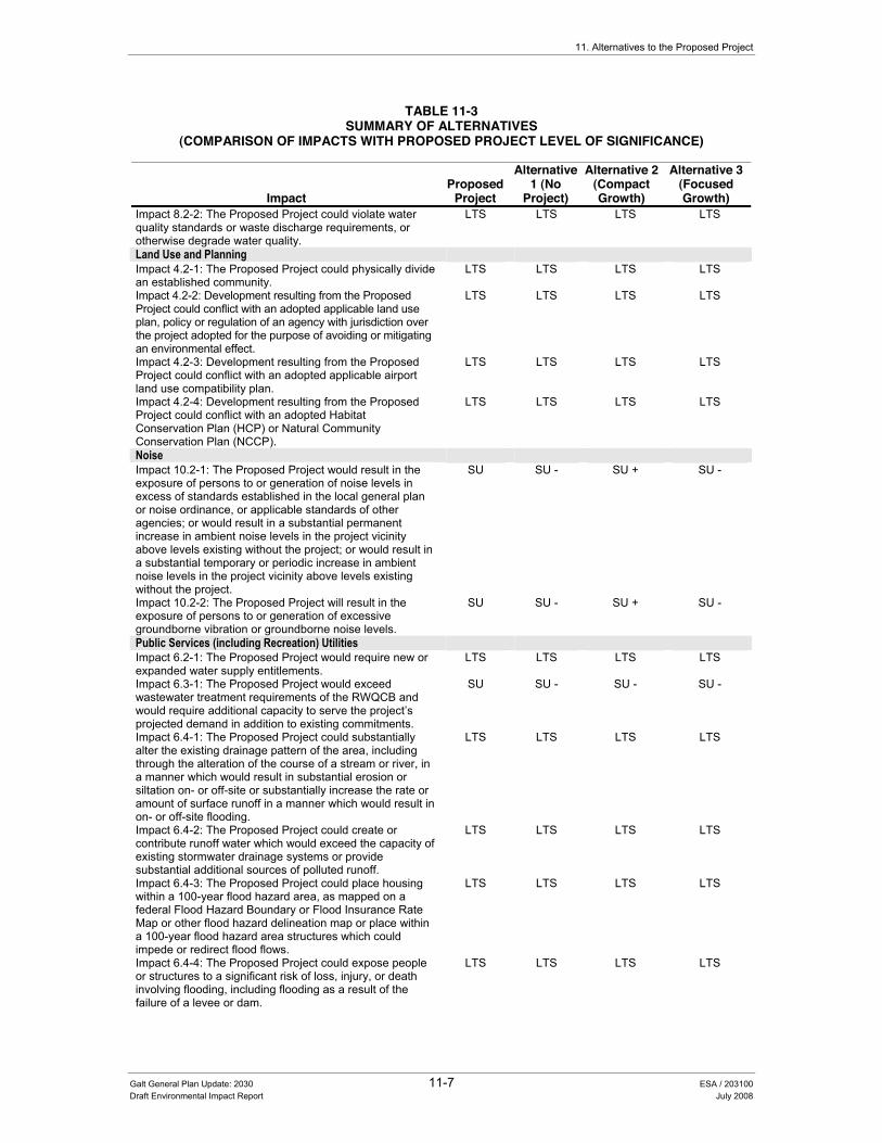
11. Alternatives to the Proposed Project
TABLE 11-3 SUMMARY OF ALTERNATIVES
(COMPARISON OF IMPACTS WITH PROPOSED PROJECT LEVEL OF SIGNIFICANCE)
Impact Proposed
Project
Alternative 1 (No
Project)
Alternative 2 (Compact Growth)
Alternative 3 (Focused Growth)
Impact 8.2-2: The Proposed Project could violate water quality standards or waste discharge requirements, or otherwise degrade water quality.
LTS LTS LTS LTS
Land Use and Planning Impact 4.2-1: The Proposed Project could physically divide an established community.
LTS LTS LTS LTS
Impact 4.2-2: Development resulting from the Proposed Project could conflict with an adopted applicable land use plan, policy or regulation of an agency with jurisdiction over the project adopted for the purpose of avoiding or mitigating an environmental effect.
LTS LTS LTS LTS
Impact 4.2-3: Development resulting from the Proposed Project could conflict with an adopted applicable airport land use compatibility plan.
LTS LTS LTS LTS
Impact 4.2-4: Development resulting from the Proposed Project could conflict with an adopted Habitat Conservation Plan (HCP) or Natural Community Conservation Plan (NCCP).
LTS LTS LTS LTS
Noise Impact 10.2-1: The Proposed Project would result in the exposure of persons to or generation of noise levels in excess of standards established in the local general plan or noise ordinance, or applicable standards of other agencies; or would result in a substantial permanent increase in ambient noise levels in the project vicinity above levels existing without the project; or would result in a substantial temporary or periodic increase in ambient noise levels in the project vicinity above levels existing without the project.
SU SU - SU + SU -
Impact 10.2-2: The Proposed Project will result in the exposure of persons to or generation of excessive groundborne vibration or groundborne noise levels.
SU SU - SU + SU -
Public Services (including Recreation) Utilities Impact 6.2-1: The Proposed Project would require new or expanded water supply entitlements.
LTS LTS LTS LTS
Impact 6.3-1: The Proposed Project would exceed wastewater treatment requirements of the RWQCB and would require additional capacity to serve the project’s projected demand in addition to existing commitments.
SU SU - SU - SU -
Impact 6.4-1: The Proposed Project could substantially alter the existing drainage pattern of the area, including through the alteration of the course of a stream or river, in a manner which would result in substantial erosion or siltation on- or off-site or substantially increase the rate or amount of surface runoff in a manner which would result in on- or off-site flooding.
LTS LTS LTS LTS
Impact 6.4-2: The Proposed Project could create or contribute runoff water which would exceed the capacity of existing stormwater drainage systems or provide substantial additional sources of polluted runoff.
LTS LTS LTS LTS
Impact 6.4-3: The Proposed Project could place housing within a 100-year flood hazard area, as mapped on a federal Flood Hazard Boundary or Flood Insurance Rate Map or other flood hazard delineation map or place within a 100-year flood hazard area structures which could impede or redirect flood flows.
LTS LTS LTS LTS
Impact 6.4-4: The Proposed Project could expose people or structures to a significant risk of loss, injury, or death involving flooding, including flooding as a result of the failure of a levee or dam.
LTS LTS LTS LTS
Galt General Plan Update: 2030 11-7 ESA / 203100 Draft Environmental Impact Report July 2008

City of Galt General Plan Update: 2030
TABLE 11-3 SUMMARY OF ALTERNATIVES
(COMPARISON OF IMPACTS WITH PROPOSED PROJECT LEVEL OF SIGNIFICANCE)
Impact Proposed
Project
Alternative 1 (No
Project)
Alternative 2 (Compact Growth)
Alternative 3 (Focused Growth)
Impact 6.5-1: The Proposed Project would produce substantive solid waste that would exceed the permitted capacity of a landfill serving the Study Area.
SU SU - SU - SU -
Impact 6.5-2: The Proposed Project could conflict with federal, State, and Local Statutes and Regulations related to solid waste.
LTS LTS LTS LTS
Impact 6.6-1: The Proposed Project could result in wasteful, inefficient, or unnecessary consumption of energy by residential, commercial, industrial, or public uses.
LTS LTS LTS LTS
Impact 6.8-1: The Proposed Project would increase the need or use of existing law enforcement facilities such that substantial physical deterioration of the facility would occur or be accelerated in order to maintain acceptable service ratios and/or response times.
LTS LTS LTS LTS
Impact 6.9-1: The Proposed Project would increase the need or use of existing fire protection facilities such that substantial physical deterioration of the facility would occur or be accelerated in order to maintain acceptable service ratios and/or response times.
SU SU- SU- SU-
Impact 6.10-1: The Proposed Project would increase the need or use of existing community facilities (including libraries and City administration facilities) such that substantial physical deterioration of the facility would occur or be accelerated in order to maintain acceptable service ratios and/or response times.
LTS LTS LTS LTS
Impact 6.11-1: The Proposed Project would increase the need or use of existing school services or facilities such that substantial physical deterioration of the facility would occur or be accelerated.
LTS LTS LTS LTS
Impact 6.12-1: The Proposed Project would increase the need or use of park facilities such that substantial physical deterioration of the facility would occur or be accelerated.
LTS LTS LTS LTS
Transportation Impact 5.2-1: The Proposed Project would cause an increase in traffic which is substantial in relation to the existing traffic load and capacity of the street system (e.g., result in a substantial increase in either the number of vehicle trips, the volume to capacity ratio on roads, or congestion at intersections).
SU SU - SU + SU -
Impact 5.2-2: The Proposed Project would exceed, either individually or cumulatively, a level of service standard established by the City on facilities that do not connect with regional facilities.
LTS LTS LTS LTS
Impact 5.2-3: The Proposed Project would exceed, either individually or cumulatively, the level of service standard established by the City on facilities that connect with regional facilities.
SU SU - SU + SU -
Impact 5.2-4: The Proposed Project would result in inadequate parking capacity.
LTS LTS LTS LTS
Impact 5.2-5: The Proposed Project would conflict with adopted policies, plans, or programs supporting alternative transportation (e.g., bus turnouts, bicycle racks).
LTS LTS LTS LTS
NOTES: LTS = Less than Significant Impact SU = Significant and Unavoidable Impact SU - = Lesser impact than the Proposed Project SU + = Greater impact than the Proposed Project
Galt General Plan Update: 2030 11-8 ESA / 203100 Draft Environmental Impact Report July 2008

11. Alternatives to the Proposed Project
$OWHUQDWLYH���1R�3URMHFW��%XLOG�RXW�RI�([LVWLQJ�*HQHUDO�3ODQ��Section 15126.6(e) of the CEQA Guidelines requires that an EIR evaluate and analyze the environmental impacts of the “No-Project” Alternative. When the project is the revision of an existing land use or regulatory plan or policy, the no-project alternative will be the continuation of the existing plan or policy into the future. Therefore, Alternative 1 (No-Project or Existing General Plan) analyzes the effects of continued implementation of the City’s existing 1989 General Plan, which would remain as the adopted long-range planning policy document for the City. Consequently, current development patterns would continue to occur in accordance with the existing General Plan, Zoning Code, and Specific Plans. Development outside the existing SOI would require LAFCO review and approval on a case-by-case basis. Additionally, the existing General Plan does not encourage orderly growth patterns using a variety of current planning concepts (see Policy LU-2.3 “Smart Growth Principles and Sustainable Land Use Practices”) provided as part of the Proposed Project. Continued implementation of the No-Project Alternative would also not likely result in as large a build out population as that provided under the Proposed Project and would not include any of the new policies and implementation measures designed to address the environmental impacts of future City development.
Environmental Impacts of the Alternative The environmental impacts of the No-Project Alternative (Alternative 1) are summarized in Table 11-3 and described in greater detail below.
Aesthetics Under the No-Project Alternative, the City would continue to function under the direction of the existing General Plan. Although, this alternative may result in the eventual annexation (with LAFCO approval) and urbanization of the existing SOI (due to regional growth pressures), build out under the existing General Plan would result in fewer jobs, dwelling units and residents than the Proposed Project. However, the City would continue to review and approve individual development projects on a case-by-case basis, with development outside the existing SOI requiring individual LAFCO review and approval.
The proposed goals and policies provided as part of the Community Character, Land Use, and Historic Resources Elements of the Proposed Project are considered considerably more comprehensive and detailed than those provided in the existing General Plan. However, it is assumed that the City would continue to evaluate the environmental impacts of these projects on a case-by-case basis and would identify all applicable feasible mitigation measures for any identified significant impacts.
As with the Proposed Project, the No Project Alternative would result in a significant and unavoidable impact because growth would occur over several acres of currently undeveloped land. This growth would affect the existing visual character of the City and would also result in increased sources of nighttime light and glare. However, this alternative would likely result in
Galt General Plan Update: 2030 11-9 ESA / 203100 Draft Environmental Impact Report July 2008
City of Galt General Plan Update: 2030
less growth than the Proposed Project and the significant and unavoidable impacts would be somewhat lessened.
Agricultural Resources Implementation of the No-Project Alternative would result in less of an impact to agricultural resources compared to the Proposed Project. This is because a smaller amount of land designated as Prime, Unique or Farmland of Statewide Importance would likely be converted to urban uses under the No Project Alternative compared to the amount of farmland that would be converted to urban uses under the Proposed Project. However, since there would be some conversion of important farmland to urbanized uses under this alternative, there would still be a significant and unavoidable impact (although to a lesser degree).
Air Quality Under the No-Project Alternative, the City would continue to function under the direction of the existing General Plan. Consequently, build out under the existing General Plan would result in fewer jobs, dwelling units, and residents than the Proposed Project. These reductions in dwelling units and other types of development would result in reduced levels of both mobile and stationary sources of air quality emissions (including greenhouse gas emissions and toxic air contaminants). However, implementation of the No Project Alternative would still result in a significant and unavoidable impact because growth would still contribute to air pollutant emissions that could exceed the daily SMAQMD thresholds for NOx and ROG.
Biological Resources As stated in Chapter 4.0 “Land Use and Demographics”, Sacramento County is in the process of developing the South Sacramento Habitat Conservation Plan (SSHCP), which would provide a regional approach to addressing issues related to urban development, habitat conservation and agricultural protection. The County hopes to partner with the incorporated cities of Elk Grove, Rancho Cordova, and Galt to further advance the regional planning goals of the SSHCP, with a draft of the SSHCP recently prepared and ready to undergo environmental review. Both the No-Project Alternative and the Proposed Project would be subject to the SSHCP upon its approval. However, as with the Proposed Project, the No Project Alternative would result in a significant and unavoidable impact because growth would occur over several acres of currently undeveloped land and would result in the overall reduction of a plant or wildlife species habitat.
Cultural Resources Land that has been used for various types of agricultural or open space uses that do not require extensive excavation and/or grading activities may be more likely to contain previously undiscovered cultural resources, particularly near local waterways. Urbanized areas may also contain a variety of historic resources (i.e., buildings, bridges, etc.).
The existing General Plan does not have the full range of policies designed to address cultural resources. The existing General Plan includes some policy guidance with respect to cultural resources; however, the proposed goals and polices provided as part of the Proposed Project
Galt General Plan Update: 2030 11-10 ESA / 203100 Draft Environmental Impact Report July 2008
11. Alternatives to the Proposed Project
(including the Historic Resources Element) are considerably more comprehensive and detailed, including, in particular, those related to historic resources.
Similar to the Proposed Project, urbanization associated with future growth could damage or destroy a variety of cultural resources during various construction-related activities.
Geology and Soils Current State and federal regulations require specific engineering and design criteria to avoid impacts related to geologic, soils, and seismic hazards, which would apply to both the No-Project Alternative and the Proposed Project. For this reason, geologic and soils impacts under the No-Project Alternative are considered to be similar to those of the Proposed Project.
Hazards and Hazardous Materials The No-Project Alternative proposes development that is similar in nature to that anticipated under the Proposed Project. The No Project Alternative would not include the additional hazardous materials and public safety policies and implementation measure contained as part of the Proposed Project. However, hazardous materials generation, storage and clean-up are heavily regulated by federal, State and local regulations that would apply to both the No-Project Alternative and the Proposed Project. For this reason, hazards and hazardous materials impacts under the No-Project Alternative are considered to be similar to those of the Proposed Project.
Hydrology and Water Quality Under the No-Project Alternative, development would convert less densely population or open space land to urban uses than the Proposed Project. As with the Proposed Project, the creation of impervious surfaces associated with urbanization would increase the amount of runoff, which could affect water quality. An increase in impervious surfaces could also reduce groundwater recharge potential. However, because land conversion would be less than the Proposed Project, fewer impervious surfaces would be developed. For this reason, hydrologic and water quality impacts under the No-Project Alternative are considered to be similar to those of the Proposed Project (although to a lesser degree).
Land Use and Planning Neither the No-Project Alternative nor the Proposed Project would result in the division or alteration of an existing community. Similar to the Proposed Project, development proposed under the No-Project Alternative would need to be consistent with existing plans and policies. However, under the existing General Plan, the City would have less policy guidance to direct specific development changes to ensure that new development is well-connected and compatible with surrounding uses. The proposed General Plan includes increased policy direction for the City overall with a variety of updated policies providing guidance on the character of the community, development of future specific plans, sustainability, energy conservation, and public safety. Although existing General Plan policies would generally ensure that new development is compatible with surrounding land
Galt General Plan Update: 2030 11-11 ESA / 203100 Draft Environmental Impact Report July 2008

City of Galt General Plan Update: 2030
uses, the existing General Plan lacks the more updated and comprehensive land use guidance provided under the Proposed Project.
Noise Under the No-Project Alternative, the City would continue to function under the direction of the existing General Plan. Consequently, build-out under the existing General Plan would result in fewer jobs, dwelling units, and residents than the Proposed Project. These reductions in dwelling units and other types of development would result in reduced levels of both mobile and stationary noise sources. However, implementation of the No Project Alternative would still result in a significant and unavoidable impact because growth could still contribute additional sources of noise that exceed local standards.
Public Services (Including Recreation) and Utilities Build-out under the existing General Plan would result in fewer jobs, dwelling units, and residents than the Proposed Project. This lower level of population growth and development would result in similar although slightly lesser impacts to the provision of public services and utilities in the City that would be required to adequately serve the levels of development projected under the No-Project Alternative.
Transportation/Traffic Build-out of the City’s existing 1989 General Plan would result in substantially fewer jobs, dwelling units and residents than the Proposed Project. Total daily vehicle trips generated under this alternative over most roadway segments would be lower under the No Project Alternative than the Proposed Project. However, the roadway network under the No Project Alternative does not include any roadway improvements that are proposed as part of the Proposed Project. Therefore, the No Project Alternative may result in similar localized level of service impacts on some roadway segments within the City as those anticipated under the Proposed Project even with overall lower roadway traffic volumes.
$OWHUQDWLYH���&RPSDFW�*URZWK��Under Alternative 2, land uses within the existing City limits would be similar to those anticipated under the Proposed Project. However, land uses adjacent to the existing City limits would intensify to some degree that the anticipated population at build-out of Alternative 2 would be similar to that of the Proposed Project but would ultimately occur within a smaller SOI compared to that of the Proposed Project. It is anticipated that this new growth would be integrated into distinct neighborhoods with a mix of uses. Similar to the Proposed Project, The total buildout population for this alternative would be approximately 51,500 people.
Overall, the intensification of land uses would result in a decreased need to convert existing open space space/agricultural lands to a developed use. Such an approach may result in increased levels of traffic congestion within these areas of intensified development or may result in the increased need to
Galt General Plan Update: 2030 11-12 ESA / 203100 Draft Environmental Impact Report July 2008

11. Alternatives to the Proposed Project
provide additional levels of public services (e.g., law enforcement, fire, etc.) or infrastructure. However, the intensification of land uses may also increase the feasibility of inter-city or city-wide transit service that would help to reduce air quality and traffic impacts within these new areas of development.
Environmental Impacts of the Alternative
Aesthetics Alternative 2 would result in similar types of development with a similar build-out population to that anticipated under the Proposed Project. However, implementation of this alternative would intensify development within a smaller SOI area (focused on new development areas surrounding the existing City limits) and would likely convert less open space areas within the sphere of influence to developed uses. Although this alternative would convert less land to developed uses, intensified development within the City could result in slightly higher building densities and may allow an increase in the size and heights of structures within the new SOI. Consequently, build-out of this alternative may result in slightly greater impacts to aesthetic resources because growth would likely be intensified within a smaller development area.
Light and glare impacts would also be slightly greater under this alternative due to the intensification of land uses that would increase the number of currently undeveloped acres to an urban use, such as additional parking lots, building lights, and streetlights.
Agricultural Resources Development proposed under Alternative 2 would result in a reduced impact to agricultural resources compared to the Proposed Project. This is because a fewer number of acres of land designated as Prime, Unique or Farmland of Statewide Importance would be converted to urban uses under this alternative compared to the amount of important farmland that would be converted to urban uses under the Proposed Project. However, similar to the Proposed Project, Alternative 2 would also result in a significant and unavoidable impact, since there would be some conversion of important farmland to urbanized uses under this alternative.
Air Quality Under Alternative 2, The City would intensify development within the proposed sphere of influence through the 2030 planning horizon. Although this alternative has the potential to reduce the overall number of vehicle miles traveled by local residents, it has the potential to result in an increase in overall travel delay and the time motorists would spend on the road due to increased levels of traffic congestion. Compact development would also result in slightly higher emission levels of both mobile and stationary sources of air quality emissions, toxic air contaminants, and the potential for odor emissions. Consequently, development proposed under Alternative 2 would still result in a significant and unavoidable impact because growth would still contribute to air pollutant emissions that could exceed the daily SMAQMD thresholds for a variety of air pollutants.
Galt General Plan Update: 2030 11-13 ESA / 203100 Draft Environmental Impact Report July 2008
City of Galt General Plan Update: 2030
Biological Resources Alternative 2 would result in similar impacts to biological resources (compared to the Proposed Project) through the conversion of open space lands to developed uses. However, under this alternative, more compact growth patterns would result in a fewer number of acres of land designated as habitat to be converted to urban uses compared to the same types of land uses that would be converted under the Proposed Project. As with the Proposed Project, this impact is still considered to be significant and unavoidable due to the proposed development on several acres of currently undeveloped land, which would result in the overall reduction of a plant or wildlife species habitat.
Cultural Resources Development proposed under this alternative would focus new growth within existing open space areas to the north and east of the existing City limits, which could result in similar impacts to cultural resources. Similar to the Proposed Project, urbanization associated with future growth could damage or destroy a variety of cultural resources during various construction-related activities. However, these potential impacts would occur within a slightly smaller SOI.
Geology and Soils Alternative 2 proposes development that is similar in nature to that anticipated under the Proposed Project. Current State and federal regulations require specific engineering and design criteria to minimize impacts related to geologic, soils, and seismic hazards, which would apply to local geologic/soil conditions under each of the alternatives and the Proposed Project. Policies and implementation measures included as part of the Proposed Project incorporate all applicable regulations to minimize these impacts. For this reason, geologic and soils impacts under Alternative 2 are considered similar to those of the Proposed Project.
Hazards and Hazardous Materials Alternative 2 proposes development that is similar in nature to that anticipated under the Proposed Project. Development proposed under this alternative would affect a variety of agricultural lands (predominately to the north and east) outside the existing City limits. Similar to the Proposed Project, implementation of this alternative would involve a decrease in the use of pesticides, herbicides, and other hazardous materials used for agricultural practices. Although hazards related to agricultural uses would be reduced, potential new commercial and industrial uses may introduce new sources of hazardous materials. However, hazardous materials generation, storage and clean-up are heavily regulated by federal, State and local regulations that would apply to both Alternative 2 and the Proposed Project. For this reason, hazardous materials impacts under Alternative 2 are considered to be similar to those of the Proposed Project.
Hydrology and Water Quality Under Alternative 2, development would convert slightly less open space land to urban uses (within the proposed SOI) than the Proposed Project. As with the Proposed Project, the creation of impervious surfaces associated with urbanization would increase the amount of runoff, which could affect water quality. An increase in impervious surfaces could also reduce groundwater
Galt General Plan Update: 2030 11-14 ESA / 203100 Draft Environmental Impact Report July 2008

11. Alternatives to the Proposed Project
recharge potential. However, because land conversion would be less than the Proposed Project, fewer impervious surfaces would be developed. Overall, hydrologic and water quality impacts under Alternative 2 are considered to be similar to those of the Proposed Project.
Land Use and Planning Alternative 2 would result in similar types of development with a similar build-out population to that anticipated under the Proposed Project. However, implementation of this alternative would intensify development within the new proposed growth areas surrounding the existing City limits and result in a smaller SOI compared to the Proposed Project. Moreover, by definition, this alternative would include increased policy direction for the City to ensure a more compact development pattern than with the Proposed Project. A compact development pattern has the potential (through intensified land uses) for some nuisance impacts associated with noise, odors, air quality emissions, glare, and visual compatibility. However, neither the Proposed Project nor Alternative 2 would divide existing communities. Additionally, both the Proposed Project and Alternative 2 would be subject to the same policy direction with regards to ensuring land use compatibility with surrounding uses.
Noise Although Alternative 2 includes a slightly reduced development footprint, development anticipated under this alternative would be similar to that anticipated under the Proposed Project. Similar to the Proposed Project, significant noise level increases (3 dBA Ldn or greater) associated with increased traffic and railroad operations would occur adjacent to existing noise sensitive land uses during the 30-year planning horizon. However, because land uses are intensified within certain areas of the sphere of influence, noise impacts may actually be greater in some cases, in particular along major transportation corridors. Overall, implementation of Alternative 2 would still result in a significant and unavoidable impact because growth could still contribute additional sources of noise and vibration that would exceed local standards.
Public Services (including Recreation) and Utilities Alternative 2 would be expected to result in substantial new development within the northern and eastern portions of the City’s expanded sphere of influence. This development would require the expansion of a variety of local city services (including police, fire, water supply, parks, etc.) in addition to those provided by both local school districts. Because development proposed under this alternative would be similar to that anticipated under the Proposed Project, public service and utility impacts are also anticipated to be similar.
Transportation/Traffic Alternative 2 would result in the intensification of similar types of development over a smaller development footprint as that anticipated under the Proposed Project. Consequently, Alternative 2 would cause slightly higher levels of delay and congestion than the Proposed Project within new growth areas surrounding the existing City limits. This is because Alternative 2 would tend to cluster development and its associated traffic within a smaller area, whereas the Proposed
Galt General Plan Update: 2030 11-15 ESA / 203100 Draft Environmental Impact Report July 2008

City of Galt General Plan Update: 2030
Project would place development in areas where transportation improvements are generally easier to implement. Overall, implementation of Alternative 2 would still result in significant and unavoidable traffic impacts. However, the increased density associated with development proposed under Alternative 2 may encourage and support the use of a variety of alternative forms of transportation including buses, and bicycles through out the entire SOI.
$OWHUQDWLYH���)RFXVHG�*URZWK�$OWHUQDWLYH��Alternative 3 would focus future growth primarily around three activity nodes (identified as the notch, new high school, and Twin Cities Road) that have services within easy driving or walking distance. The “notch” neighborhood (east of downtown) would include a regional commercial and entertainment center oriented towards the highway, and office and neighborhood commercial uses near residential. The “new high school” neighborhood would be a predominately single family residential neighborhood with parks, a continuation of the City’s trail system, and an emphasis on joint-use facilities with the school district. The “Twin Cities Road” neighborhood would be focused primarily on shopping and employment opportunities. This alternative would require urbanization of approximately 1,040 acres outside of the current City limits. The total buildout population for this alternative would be approximately 44,150 people.
Environmental Impacts of the Alternative
Aesthetics Alternative 3 would result in similar types of development with a lower build-out population to that anticipated under the Proposed Project. As expected build-out of a smaller development footprint/population will result in similar (but to a lesser degree) types of visual impacts. Light and glare impacts would also be lower under this alternative and would be focused within the new developing areas, such as additional parking lots, building lights, and streetlights.
Agricultural Resources Development proposed under Alternative 3 would result in a lesser impact to agricultural resources compared to the Proposed Project. This is because a fewer number of acres of land designated as Prime, Unique or Farmland of Statewide Importance would be converted to urban uses under this alternative compared to the amount of important farmland that would be converted to urban uses under the Proposed Project. However, similar to the Proposed Project, Alternative 3 would also result in a significant and unavoidable impact, since there would be some conversion of important farmland to urbanized uses under this alternative.
Air Quality Because this alternative would result in fewer new units and new nonresidential development, fewer vehicle trips would result, and air pollutant emissions and associated impacts would be reduced. Construction-related emissions are one of the major contributors to PM10 emissions.
Galt General Plan Update: 2030 11-16 ESA / 203100 Draft Environmental Impact Report July 2008
11. Alternatives to the Proposed Project
Therefore, regional emissions of PM10 would likely be less under this alternative. Overall, local and regional air pollutant emissions, toxic air contaminants, and greenhouse gas emissions would be reduced by this alternative. However, development proposed under Alternative 3 would still result in a significant and unavoidable impact because growth would still contribute to air pollutant emissions that could exceed the daily SMAQMD thresholds for a variety of air pollutants.
Biological Resources Alternative 3 would result in similar impacts to biological resources (compared to the Proposed Project) through the conversion of open space lands to developed uses. However, under this alternative, a smaller development footprint would result in a lesser number of acres of land designated as habitat to be converted to urban uses compared to the same types of land uses that would be converted under the Proposed Project. As with the Proposed Project, this impact is still considered to be significant and unavoidable due to the proposed development on several acres of currently undeveloped land, which would result in the overall reduction of a plant or wildlife species habitat.
Cultural Resources Similar to the Proposed Project, urbanization associated with future growth could damage or destroy a variety of cultural resources during various construction-related activities. However, decreased levels of development may result in fewer impacts to previously undiscovered cultural resources in currently undeveloped areas and to the design qualities of the City’s traditional neighborhoods and historic districts.
Geology and Soils Alternative 3 proposes development that is similar in nature to that anticipated under the Proposed Project. Current State and federal regulations require specific engineering and design criteria to minimize impacts related to geologic, soils, and seismic hazards, which would apply to local geologic/soil conditions under each of the alternatives and the Proposed Project. Policies and implementation measures included as part of the Proposed Project incorporate all applicable regulations to minimize these impacts. For this reason, geologic and soils impacts under Alternative 3 are considered similar to those of the Proposed Project.
Hazards and Hazardous Materials Alternative 3 proposes development that is similar in nature to that anticipated under the Proposed Project. Development proposed under this alternative would affect a variety of agricultural lands outside the existing City limits. Similar to the Proposed Project, implementation of this alternative would involve a decrease in the use of pesticides, herbicides, and other hazardous materials used for agricultural practices. Although hazards related to agricultural uses would be reduced, potential new commercial and industrial uses may introduce new sources of hazardous materials. However, hazardous materials generation, storage and clean-up are heavily regulated by federal, State and local regulations that would apply to both Alternative 3 and the Proposed Project. For this reason,
Galt General Plan Update: 2030 11-17 ESA / 203100 Draft Environmental Impact Report July 2008

City of Galt General Plan Update: 2030
hazardous materials impacts under Alternative 3 are considered to be similar to those of the Proposed Project.
Hydrology and Water Quality Under Alternative 3, development would convert a fewer number of less densely populated/open space lands to urban uses than that anticipated under the Proposed Project. As with the Proposed Project, the creation of impervious surfaces associated with urbanization would increase the amount of runoff, which could affect water quality. An increase in impervious surfaces could also reduce groundwater recharge potential. Because less lands would be converted to an urbanized use, hydrologic and water quality impacts under Alternative 3 are considered to be lower to those of the Proposed Project.
Land Use and Planning Alternative 3 would result in similar types of development with a lower build-out population to that anticipated under the Proposed Project. Implementation of this alternative would reduce development through out the study area. However, neither the Proposed Project nor Alternative 3 would be designed to divide existing communities and they would both be subject to the same policy direction with regards to ensuring land use compatibility with surrounding uses. Consequently, land use impacts under this alternative are considered to be similar to those identified for the Proposed Project.
Noise A reduced level of development would translate to fewer local vehicle trips contributing to local traffic noise. Similar to the Proposed Project, significant noise level increases (3 dBA Ldn or greater) associated with increased traffic and railroad operations would occur adjacent to existing noise sensitive land uses during the 30-year planning horizon. However, because development would be lower through out the study area, noise impacts may actually be less in some cases, in particular along major transportation corridors. Overall, implementation of Alternative 3 would still result in a significant and unavoidable impact because growth could still contribute additional sources of noise and vibration that would exceed local standards.
Public Services (including Recreation) and Utilities Development anticipated under alternative 3 would require some expansion of a variety of local city services (including police, fire, water supply, parks, etc.) in addition to those provided by both local school districts. However, development under this alternative would place a lower future demand on public services and utilities providers, including water, sewer, schools, fire, and police.
Transportation/Traffic Alternative 3 would result in a lesser degree of development over a smaller development footprint as that anticipated under the Proposed Project. Consequently, Alternative 3 may cause lower levels of delay and congestion than the Proposed Project. However, implementation of Alternative 3 would still result in significant and unavoidable traffic impacts. Similar to Alternative 2, increased
Galt General Plan Update: 2030 11-18 ESA / 203100 Draft Environmental Impact Report July 2008

11. Alternatives to the Proposed Project
levels of development proposed under Alternative 3 may encourage and support the use of a variety of alternative forms of transportation including buses, and bicycles.
Environmentally Superior Alternative As previously described, Table 11-3 provides a summary of the anticipated impacts resulting from implementation of the alternatives compared to those identified for the Proposed Project. As summarized in the table, the environmentally superior alternative for this project would be Alternative 3 (Focused Growth Alternative). Other than the No Project Alternative, this is the only alternative that would reduce the severity of most environmental impacts of the Proposed Project.
Galt General Plan Update: 2030 11-19 ESA / 203100 Draft Environmental Impact Report July 2008


Chapter 12 Other CEQA Considerations


Galt General Plan Update: 2030 12-1 ESA / 203100 Draft Environmental Impact Report July 2008
CHAPTER 12.0 2WKHU�&(4$�&RQVLGHUDWLRQV�
12.1 Growth Inducing Effects of the Proposed Project
,QWURGXFWLRQ�The CEQA Guidelines require that an EIR evaluate the growth-inducing impacts of a proposed action (Section 15126.2[d]). A growth-inducing impact is defined by the CEQA Guidelines as:
[T]he ways in which the proposed project could foster economic or population growth, or the construction of additional housing, either directly or indirectly, in the surrounding environment. Included in this are projects which would remove obstacles to population growth.... It must not be assumed that growth in any area is necessarily beneficial, detrimental, or of little significance to the environment.
A project can have direct and/or indirect growth-inducement potential. Direct growth inducement would result if a project involved construction of new housing. A project can have indirect growth-inducement potential if it would establish substantial new permanent employment opportunities (e.g., commercial, industrial or governmental enterprises) or if it would involve a substantial construction effort with substantial short-term employment opportunities and indirectly stimulate the need for additional housing and services to support the new employment demand. Similarly, under CEQA, a project would indirectly induce growth if it would remove an obstacle to additional growth and development, such as removing a constraint on a required public service. An example of this indirect effect would be the expansion of a wastewater treatment plant, which might allow for more development within a service area.
3RWHQWLDO�IRU�*URZWK�,QGXFHPHQW�The purpose of a general plan is to guide the growth and development of a community. Accordingly, the City�’s proposed General Plan Update is premised on a certain amount of growth taking place. Once situated within the largely rural Sacramento Valley, the City of Galt finds itself surrounded by growth and population expansion. According to the US Bureau of the Census, Galt had a population of 19,470 in 2000. The city added 10,700 people from 1990 to 2000. This resulted in a 122 percent change, compared to the 19 percent increase in Sacramento County as a whole. This

City of Galt General Plan Update: 2030
Galt General Plan Update: 2030 12-2 ESA / 203100 Draft Environmental Impact Report July 2008
110 percent increase was greater than the other Sacramento County cities of Elk Grove or Sacramento, and is also greater than the City of Lodi in San Joaquin County.
As of January 1, 2007, the City�’s current population is estimated at 23, 470. The City is expected to continue to grow at a similar rate through 2030. According to SACOG estimates for population growth in Sacramento County, Galt can expect to have a population of over 29,000 in 2015 and over 33,800 in 2025. Table 12-1 shows the projected population growth for Galt and Sacramento County. Population estimates for year 2002 in Table 12-1 is based on population estimates calculated by the US Bureau of the Census, while subsequent population figures 2015 through 2025 are official projections used by SACOG for the purposes of regional land-use planning and analysis. According to SACOG, Galt will grow by two percent annually between 2002 and 2025. However, local officials in Galt believe that, based on recent trends, Galt will grow by 3.4 percent annually between 2002 and 2025. Population projections based on the 3.4 percent annual growth are included in Table 12-1.
TABLE 12.1 POPULATION PROJECTIONS IN GALT AND SACRAMENTO COUNTY
2002 2015 2020 2025 Annual
Growth Rate 1990 �– 2000
Annual Growth Rate 2002 �– 2025
Galt (local) 22,321 32,779 38,000 44,150 8.3% 3.4% Galt (SACOG) 22,321 29,210 31,620 33,790 8.3% 1.8% Sacramento County 1,305,082 1,574,420 1,646,045 1,695,498 1.8% 1.1%
Sources: Applied Development Economics, SACOG 1990 and 2000, 2002 US Census Population Estimates for Counties and sub-areas, City of Galt, and SACOG Sacramento County Population Projections
Additionally, surrounding jurisdictions are also growing to accommodate regional population growth. The City of Elk Grove, to the north of Galt, has recently updated its General Plan (2003) and the City of Lodi, to the south of Galt, is currently in the process of updating its existing 1991 General Plan.
'LUHFW�,PSDFWV�The Proposed Project is specifically intended to plan for the orderly growth of Galt and its sphere of influence, define the limits of that growth, and act as a mechanism to accommodate future managed growth. Projects permitted pursuant to land use policy will provide for additional housing for all income levels, create a better balance of residential and non-residential uses in the community, promote a more pedestrian-friendly environment, and protect natural resources. Implementation of the Proposed Project will result in a more inclusive community, bring new employment opportunities to the City, and foster a stable economic base.
While the Proposed Project would result in an increase of growth locally, the policies included as part of the Proposed Project would reduce the potential for negative impacts associated with directly induced growth. Overall, implementation of the Proposed Project would potentially encourage

12. Other CEQA Considerations
Galt General Plan Update: 2030 12-3 ESA / 203100 Draft Environmental Impact Report July 2008
growth, given the regional pressures for housing and Galt�’s desire to increase its tax base with new commercial uses.
,QGLUHFW�,PSDFWV�While the Proposed Project does allow additional growth, it also includes specific policies that manage and direct growth within the Planning Area. Consistent with several of the Proposed Project�’s Guiding Principles designed to promote job growth (in particular along key transportation corridors), the Draft Land Use and Circulation Diagram also provides a mixture of housing, shopping, and employment opportunities so that as the number of residents increase they do not pressure adjacent communities to provide new commercial and employment opportunities.
Also as previously stated in Chapter 5.0, �“Public Facilities and Utilities�”, commitments to provide utility infrastructure would be limited to areas within the City�’s proposed Planning Area (see Public Facilities and Services Element including Policy PFS-1.2 �“Availability of Facilities and Services�”). As a result, the Proposed Project�’s policies would strive to contain growth within the proposed City boundaries. However, the City�’s proposed policies would not preclude or conflict with other surrounding jurisdictions from developing areas adjacent to the City�’s proposed Planning Area.
Proposed policies (including Policy LU-11.2 �“Maintaining Planning Consistency�”) encourage a uniform land use policy and strive for regional cooperation to address land use planning issues; however, the City has limited ability to constrain future development (driven by market forces) adjacent to the proposed Planning Area by neighboring jurisdictions. Consequently, the Proposed Project may also encourage indirect inducing growth effects.
12.2 Cumulative Impacts
,QWURGXFWLRQ�CEQA Guidelines Section 15130(a) requires that an EIR discuss the cumulative impacts of a project when the project�’s incremental effect is �“cumulatively considerable,�” meaning that the project�’s incremental effects are considerable when viewed in connection with the effects of past, current, and probable future projects. A consideration of actions included as part of a cumulative impact scenario can vary by geographic extent, time frame, and scale. They are defined according to environmental resource issue and the specific significance level associated with potential impacts. CEQA Guidelines 15130(b) requires that discussions of cumulative impacts reflect the severity of the impacts and their likelihood of occurrence. The CEQA Guidelines note that the cumulative impacts discussion does not need to provide as much detail as is provided in the analysis of project-only impacts and should be guided by the standards of practicality and reasonableness and focus on the cumulative impact to which the identified other projects contribute rather than the attributes of other projects which do not contribute to the cumulative impacts. The CEQA Guidelines allow for the use of two alternative methods to determine the scope of projects for the cumulative impact analysis:
City of Galt General Plan Update: 2030
Galt General Plan Update: 2030 12-4 ESA / 203100 Draft Environmental Impact Report July 2008
• List Method - A list of past, present, and probable future projects producing related or cumulative impacts, including, if necessary, those projects outside the control of the agency.
• Regional Growth Projections Method - A summary of projects contained in an adopted general plan or related planning document or in a prior environmental document which has been adopted or certified, which described or evaluated regional or area wide conditions contributing to the cumulative impact (Section 15130).
The Proposed Project establishes policy to guide future development within the City, and implementation is long-term in nature. The Regional Growth Projections Method is considered an appropriate methodology for evaluating cumulative impacts because it provides overall growth projections for the region over the long-term.
&XPXODWLYH�6HWWLQJ�For the purposes of this EIR, the cumulative setting is based on a two-fold approach. For some impact issue areas (i.e., air quality, traffic, and water supply), the cumulative setting is defined by specific regional boundaries (air basin, regional roadway network, etc.) or projected regional or area-wide conditions, contributing to cumulative impacts. For the remaining impact issue areas, the cumulative setting is based on development anticipated within the vicinity of the City (surrounding cities within Sacramento and San Joaquin County).
This analysis is based primarily on a summary of projections contained in the existing general plan documents for these jurisdictions surrounding the City (including the County of Sacramento). These impacts were also evaluated in their respective environmental documents.
The various general plans and EIRs considered as part of the cumulative analysis are identified below:
• City of Elk Grove General Plan and EIR (adopted in 2003);
• City of Rancho Cordova General Plan and EIR (adopted in 2006);
• City of Sacramento 1988 General Plan (revised by City Council in 2000 and 2003) and EIR (Note to Reader: current update to 2030 in progress);
• City of Lodi 1991General Plan and EIR (Note to Reader: update in progress);
• County of Sacramento 1993 General Plan and EIR (Note to Reader: update in progress);
• County of San Joaquin 2010 General Plan and EIR (Note to Reader: update in progress); and
• Sacramento Area Council of Governments Metropolitan Transportation Plan for 2025 and EIR (Note to Reader: update in progress).

12. Other CEQA Considerations
Galt General Plan Update: 2030 12-5 ESA / 203100 Draft Environmental Impact Report July 2008
&XPXODWLYH�,PSDFWV�The following discusses the cumulative impacts associated with adopting and implementing the Proposed Project, when considered with growth in the surrounding communities of Elk Grove, Rancho Cordova, and Lodi, as well as Sacramento and San Joaquin Counties as a whole as such growth affects Galt.
Cumulative Impacts Related to Aesthetics Implementation of the Proposed Project would result in changes to the visual character of the City�’s proposed Sphere of Influence from a more agricultural/rural setting to one that is more characterized by suburban or urban uses (i.e., streets, homes, and community commercial shopping centers), with increased light and glare sources. As more fully described in Chapter 3.0 �“Community Character�” despite the proposed General Plan�’s policies and implementation programs (see selected policies below), in conjunction with adopted State, County and City regulations to enhance the City�’s current community character and preserve open space (see additional policies from the Conservation/Open Space and Land Use Elements below under the discussion of cumulative impacts to biological resources), development permitted under the Proposed Project would result in a significant impact to the existing visual identity and character of the City due to the amount of growth allowed over the proposed timeframe of the updated General Plan (2030).
Community Character Element
Policies and implementation programs designed to improve the overall visual quality of the urban environment and reduce visual impacts include the following: CC-1.1 City Image CC-1.2 Neighborhood Integrity CC-1.3 Existing Neighborhood Design CC-1.4 New Neighborhood Design CC-1.5 Rail Corridors CC-1.6 Open Space Features CC-1.7 Viewsheds
CC-1.8 Building Elevations CC-1.9 Signage CC-1.10 Art in Public Places Implementation Program CC-A Implementation Program CC-B Implementation Program CC-C
Policies designed to maintain and enhance the visual quality of Galt�’s major corridors and city entrances through landscape and streetscape improvements and help to reduce visual impacts include the following: CC-2.1 Gateway Entrances CC-2.2 New Development in Corridors CC-2.3 Building Setbacks and Landscape Areas CC-2.4 Architectural Enhancements in Major Corridors
CC-2.5 Landscape Maintenance CC-2.6 Positive Travel Experience CC-2.7 State Route 99 and State Route 104 Beautification
Policies and implementation programs designed to protect the historical and authentic qualities of Galt�’s Downtown and help to reduce visual impacts include the following: CC-3.1Restore Downtown CC-3.2 Historical and Cultural Resources CC-3.3 Incorporating Historical Features in New Development Implementation Program CC-D Policies and implementation programs designed to maintain and enhance the quality of Galt�’s trees and help to reduce visual impacts include the following: CC-4.1 Tree Canopy CC-4.2 Trees in New Development CC-4.3 Tree and Landscape Maintenance Requirements for Large Development Projects Implementation Program CC-E
Similarly, development associated with the anticipated regional growth would result in a substantial change to the visual character of the surrounding areas of Sacramento and San Joaquin counties. Continual urbanization of existing agriculture and open space land has the potential to permanently alter the character of the area. Although the Proposed Project does include a variety of policies that

City of Galt General Plan Update: 2030
Galt General Plan Update: 2030 12-6 ESA / 203100 Draft Environmental Impact Report July 2008
promote the preservation of open space areas and the development of parks, the overall conversion of existing open space areas to suburban land uses would permanently alter the City�’s existing character. State and local regulations, such as the State Scenic Highway guidelines may mitigate some potential impacts along scenic corridors by preserving views and open space land. However, the Proposed Project combined with the overall growth trends in San Joaquin and Sacramento Counties would contribute considerably to cumulative aesthetic impacts (including additional sources of light and glare) which would transform the region from an agricultural/rural character to a more suburban setting and thus, would result in a cumulative significant and unavoidable aesthetic impact. Consequently, even with implementation of the policies and implementation programs identified in the Policy Document, the Proposed Project may contribute to a cumulatively significant environmental impact.
Cumulative Impacts Related to Agricultural Resources With the implementation of the Proposed Project there would be a loss of the existing agricultural lands within the City�’s proposed Sphere of Influence. While the Proposed Project includes policies (shown below) to minimize this impact, there would still be a project level significant and unavoidable impact. The loss of agricultural land (in particular lands defined as �“Prime Farmlands�”) within the City�’s proposed Sphere of Influence as a result of urban development is part of an overall trend within Sacramento and San Joaquin Counties and the Counties will continue to face development pressure in the foreseeable future. As more fully described in Chapter 8.0 �“Natural Resources�”, the Proposed Project does include several policies (see below) stating that the City will work at a regional level to control the conversion of agricultural uses. However, since the surrounding counties are projected to continue to urbanize at a significant rate, the loss of agricultural lands as a result of the Proposed Project would contribute considerably to a significant and unavoidable cumulative impact to agricultural resources. Consequently, even with implementation of the policies and implementation programs identified in the Policy Document, the Proposed Project may contribute to a cumulatively significant environmental impact.
Land Use Element Conservation and Open Space Element
Policies designed to conserve soils and agricultural resources within the Study Area through the orderly development of the City include the following: LU-1.1 Phased Development LU-1.2 Proposed Development Consistency LU-1.3 Annexation Areas LU-1.6 Orderly Growth LU-1.12 Zoning Consistency LU-9.1 Greenbelt LU-9.2 Agricultural-Residential Uses
COS-4.1 Prime Agricultural Land Preservation COS-4.4 Open Space Protection
Cumulative Impacts Related to Air Quality and Climate Change Cumulative air quality impacts were considered in terms of the various land uses proposed under the Proposed Project and the traffic projections generated by a cumulative traffic model. The traffic model considered growth under the Proposed Project in conjunction with projected regional growth for Sacramento County. As more fully described in Section 10.7 of Chapter 10.0 �“Public Health and Safety�”, there are various policies included in the Proposed Project (see selected policies below) available to address air quality, climate change, and energy conservation impacts. However, due to the existing and projected air quality issues in the Sacramento Valley Air Basin; the

12. Other CEQA Considerations
Galt General Plan Update: 2030 12-7 ESA / 203100 Draft Environmental Impact Report July 2008
Proposed Project would still contribute considerably to a significant and unavoidable cumulative air quality and climate change impact. Consequently, even with implementation of the policies and implementation programs identified in the Policy Document, the Proposed Project may contribute to a cumulatively significant environmental impact.
Conservation Element
Policies designed to protect and improve air quality in the Galt area with the goal of attaining State and Federal health-based air quality standards include the following: COS-5.1 Vehicle Emission Reduction Programs COS-5.2 Walkable Design COS-5.3 Infill Development Priority COS-5.4 Mixed-Use Development
COS-5.5 Midday Trip Reduction COS-5.6 SMAQMD Coordination COS-5.9 Air Quality Mitigation Measures COS-5.10 New Development Operational Emission Reductions
Policies designed to integrate air quality planning with the land use and transportation planning process include the following: COS-6.1 Traffic Signal Synchronization COS-6.2 Pedestrian and Bicycle Facilities COS-6.3 Employer Programs COS-6.4 City Fleet Vehicles
COS-6.5 Public Transit Bus Fleet COS-6.6 Traffic Calming Measures COS-4.9 Open Space Preservation COS-7.3 Motor Vehicle Trip Reduction
Policies designed to encourage energy conservation in new and existing developments include the following:
COS-7.4 Energy Efficient Development COS-7.5 Building Design and Components COS-7.6 Sustainable Design COS-7.7 Energy Efficient Design Techniques in Specific Plans COS-7.8 Energy Efficient Manufactured Homes COS-7.9 City Facilities COS-7.10 Renewable Energy Incentive Programs COS-7.11 Solar Photovoltaic System Inventive Programs COS-7.12 Residential Rehabilitations and Improvements
COS-7.13 Renewable Technology Industries Recruitment COS-7.14 Energy Planner Coordination COS-7.15 New Tree Selection and Location COS-7.16 ESA Energy Star Certified Appliances COS-7.17 Developer and Builder Energy Provider Coordination COS-7.18 Energy Workshops COS-7.19 Expedited Review for Installing Photovoltaic Systems COS-7.20 Incentives
Policies designed to reduce greenhouse gas emissions and global climate change include the following:
COS-7.1 Greenhouse Gas Emission Reduction COS-7.2 Statewide Global Warming Solutions Support
Cumulative Impacts Related to Biological Resources Development associated with implementation of the Proposed Project would contribute to the ongoing loss of natural and agricultural lands in Sacramento and San Joaquin Counties, which currently provide habitat for a variety of federal and State listed special status species, as well as other wildlife and plant resources. Development under the Proposed Project would result in the conversion of existing habitats to urban uses. As more fully described in Section 8.3 of Chapter 8.0 �“Natural Resources�”, there are various policies in the Proposed Project (see selected policies below) available to mitigate impacts to biological resources at a project specific level. The City is also subject to State and federal regulations related to the preservation of sensitive habitats and listed special status species. Development outside of the City�’s Sphere of Influence in surrounding Sacramento and San Joaquin Counties would also be subject to the same State and federal regulations addressing sensitive species. However, since the surrounding cities and county (to a lesser extent) are projected to continue to urbanize at a steady rate, the loss of open space areas and habitats as a result of the Proposed Project would contribute considerably to a significant and unavoidable cumulative impact to biological resources. Consequently, even with implementation of the policies and implementation programs identified in the Policy Document, the Proposed Project may contribute to a cumulatively significant environmental impact.

City of Galt General Plan Update: 2030
Galt General Plan Update: 2030 12-8 ESA / 203100 Draft Environmental Impact Report July 2008
Conservation and Open Space Element Land Use Element
Policies designed to protect and preserve sensitive habitats and address biological resource impacts include the following:
COS-1.10 Ecological Features Retention LU-1.10 South Sacramento Habitat Conservation Plan COS-1.11 Riparian Corridor Protection COS-1.14 Floodplain Dedication
LU-8.1 Greenbelt
COS-2.2 Wetland and Riparian Communities Management COS-2.3 Biologically Sensitive Area Development COS-2.7 Regional Habitat Conservation Efforts Coordination
COS-3.1 Riparian Protection COS-3.2 Mature Tree and Woodland Preservation COS-4.2 Natural Floodway Protection COS-4.3 Natural Land Forms COS-4.4 Open Space Protection COS-4.5 Development Design and Construction COS-4.6 Natural Open Space in Parks COS-4.8 Open Space and Natural Area Connectivity COS-4.9 Open Space Preservation
Conservation and Open Space Element Community Character Element
Policies designed to mitigate the impact of development on key biological resources include the following:
COS-1.13 No Net Loss of Wetlands CC-1.6 Open Space Features COS-2.1 Sensitive Species Protection COS-2.4 Federal, State, and Local Statutes Compliance COS-2.5 Mitigation Measures Imposition COS-2.6 Biological Surveys
Cumulative Impacts Related to Cultural Resources While grading and other construction activities have the potential to impact cultural resources in the City�’s proposed Sphere of Influence, draft General Plan policies identified in the EIR (see below) and compliance with federal and State regulations reduce the project-specific impact to a less-than-significant level. Cultural resources such as historical, archaeological and paleontological resources, in surrounding areas could be cumulatively impacted by future development and related construction activities in the region.
Historic Resources Element
Policies designed to preserve and maintain City historic resources include the following: HRE-1.1 Historic Preservation HRE-1.2 Preservation of Architectural Styles HRE-1.3 Downtown Design Coordination HRE-1.4 Renovations HRE-1.5 Historic Resources Inventory HRE-1.6 Property Owner Consultation HRE-1.7 Environmental Review of Historic Resources HRE-1.8 Railroad Property HRE-1.9 Downtown Revitalization and Historic Preservation Specific Plan Area HRE-1.10 Adaptive Reuse HRE-1.11 Historic Preservation Plan HRE-2.1 Economic Incentives HRE-2.2 Federal and State Grants HRE-3.1 Awareness Ceremonies HRE-3.2 Coordination with other Agencies and Organizations
12. Other CEQA Considerations
Galt General Plan Update: 2030 12-9 ESA / 203100 Draft Environmental Impact Report July 2008
As stated in Chapter 9.0, the City will continue to ensure that a variety of preservation efforts are implemented (including the new policies HR-4.1 �“Archaeological Resource Surveys,�” HR-4.2 �“Native American Resources,�” HR-4.3 �“Discovery of Archaeological Resources,�” and HR-4.4 �“Discovery of Human Remains�”) under all future development projects to minimize impacts to archaeological resources (as defined in Section 15064.5), paleontological resources, or human remains. Under CEQA, however, any "substantial adverse change in the significance of an historical resource" (e.g., the destruction of such a resource) is considered a significant environmental effect as a matter of law. Because it is possible that, after City decision-makers have approved a development project, grading activities in an area identified for development reveal an archaeological resource meeting the definition of an historical resource, and that such a previously unknown historical resource cannot be preserved or avoided without substantial redesign at significant cost, the City cannot be sure that impacts on all such historical resources can be mitigated to less than significant levels. Consequently, the Proposed Project has the potential to contribute considerably to a significant and unavoidable cumulative impact to these historic resources. However, similar considerations do not apply to unique archaeological resources or paleontological resources, which therefore can be fully mitigated through data recovery where avoidance or preservation is infeasible or unnecessary. Therefore, implementation of the Proposed Project including the adoption of the policies listed above would reduce the potential cumulative impact to a less-than-significant level with respect to human remains and archaeological resources that do not qualify as historical resources.
A variety of historic resources (including above ground buildings, etc.) are also present within the City�’s Sphere of Influence and surround area. Because the Proposed Project and surrounding development could significantly affect these resources, for which no mitigation may be available to replace the resource, the Proposed Project has the potential to contribute considerably to a significant and unavoidable cumulative impact to historic resources.
Cumulative Impacts Related to Geology and Soils Regional development would increase the number of people and structures subject to geologic- and soils-related risks. The policies contained in the Draft General Plan, along with compliance with federal, State and local regulations addressing building construction, run-off and erosion, reduce the potential project-level impact associated with geology and soils to a less-than-significant level. Development in other communities in Sacramento and San Joaquin Counties would also be required to comply with federal, State and local regulations that are designed to protect people and structures from hazards related to such issues as earthquakes, landslides and soil erosion. As a result, conformance with adopted California building codes, and other measures to protect people and structures from geologic hazards, would reduce this impact to a less-than-significant level. The project�’s incremental contribution to these impacts will be less than cumulatively considerable.
Cumulative Impacts to Hazards and Hazardous Materials As discussed in Section 10.6 of Chapter 10.0 �“Public Health and Safety�”, the increase in local population and employment under the Proposed Project would result in the increased use of hazardous household, commercial and industrial materials. In addition, there would be an increase in population that would be exposed to potential wildland fires. Potential project-level impacts

City of Galt General Plan Update: 2030
Galt General Plan Update: 2030 12-10 ESA / 203100 Draft Environmental Impact Report July 2008
associated with hazards and hazardous materials would be reduced to a less-than-significant level due to local, regional, State and federal regulations, such as those that control the production, use and transportation of hazardous materials and waste and control the location of incompatible land uses in airport hazard areas. Similarly, as growth occurs throughout Sacramento and San Joaquin Counties, additional people would be exposed to risks associated with hazardous materials, wastes, and wildland fires. However, City, regional, State and federal regulations would apply to development countywide, thereby reducing the potential for cumulative impacts associated with hazards and hazardous materials to a less-than-significant level. The project�’s incremental contribution to these impacts will be less than cumulatively considerable.
Cumulative Impacts to Hydrology and Water Quality As development proceeds within the affected watersheds, the amount of pollutants in runoff will increase, potentially impacting surface and groundwater quality. The amount of impervious surfaces will increase as development proceeds and groundwater recharge rates will consequently decrease. Erosion and sedimentation impacts on surface water will occur during grading and construction activity. However, cumulative impact on surface water will be reduced by compliance with the National Pollutant Discharge Elimination System (NPDES) requirements, as well as implementation of the other General Plan policies and implementation programs identified in Section 8.2 �“Hydrology�” of Chapter 8.0 �“Natural Resources�” of the draft EIR and shown below.
Public Facilities and Services Element Conservation and Open Space Element
Policies designed to minimize water quality impacts associated with stormwater, water, and wastewater utility infrastructure needed to serve existing and planned urban areas include the following: PFS-2.3 Surface Water Protection PFS-2.8 Water Quality Monitoring PFS-3.1 Treatment Facilities Safety PFS-3.4 Sewage Treatment PFS-3.5 Sewer Enhancements PFS-3.6 Sewage Sludge PFS-3.7 Compliance with Clean Water Act PFS-4.2 Conservation/Stormwater PFS-4.3 Stormwater Quality PFS-4.4 Project Design PFS-4.5 Grading During the Rainy Season PFS-4.6 Erosion Control Plan PFS-4.7 Mitigating Stormwater Runoff
COS-1.1 Flood Control COS-1.4 Storm Flow Impacts COS-1.5 Water Quality Control Board Regulations Compliance COS-1.6 Underground Storage Tank Law Compliance COS-1.7 Stormwater Quality Protection COS-1.12 Best Management Practices
As a result, implementation of the Proposed Project will not result in a significant cumulative impact associated with a variety of water quality issues.
Long-term water use within the City�’s proposed Sphere of Influence, combined with consumption by users in other cities that rely upon regional groundwater basins and imported supplies, will result in a cumulative increase in water use. As discussed in Section 8.2 �“Hydrology�” and Section 6.2 �“Water Supply�” of the draft EIR, the City will implement many programs to reduce water use associated with existing and new development to protect the groundwater basin. Several General Plan policies and implementation programs from the draft EIR are shown below.

12. Other CEQA Considerations
Galt General Plan Update: 2030 12-11 ESA / 203100 Draft Environmental Impact Report July 2008
Public Facilities and Services Element
Policies and implementation programs designed to minimize groundwater impacts through the early identification of required infrastructure and the orderly construction and rehabilitation of the facilities needed to serve existing and planned urban areas include the following: PFS-2.2 Groundwater Protection PFS-2.3 Ground Water Protection Response Plan Implementation Program PFS-D Water Supply Alternatives Implementation Program PFS-F Ground Water Protection Response Plan Policies and implementation programs designed to minimize this impact through the provision and conservation of water resources and service include the following: PFS-2.8 Water Conservation PFS-2.9 Inter-Agency Water Conservation Implementation Program PFS-E Water Management Plan
Water service providers are required to complete Urban Water Management plans on a five-year cycle to assess long-term demand and to identify supplies to meet demand. Pursuant to the Public Resources Code Section 21151.9 (CEQA Statute) and Part 2.10 Section 10910 et seq. of the Water Code, as part of CEQA review for development projects that exceed the density or intensity thresholds set forth in Section 10912 of the Water Code, Claremont and other jurisdictions will requirement the completion of water supply assessments. Although existing regulations will work to assess and anticipate long-term, cumulative water supply needs and address them appropriately, it is currently uncertain whether water demands resulting from implementation of the Proposed Project (combined with other regional demands) would adverse affect the safe yield of the groundwater basin. Until definitive conclusions can be drawn regarding the effectiveness of groundwater management efforts, and whether or not these efforts will eventually reverse overdraft conditions, this impact is considered to contribute considerably to a significant and unavoidable cumulative impact to groundwater resources.
Cumulative Impacts to Land Use and Planning New development will occur pursuant to the land use distribution and intensity identified as part of the draft Land Use Diagram and the Land Use and Community Character Elements. The land use plan has been developed to provide for compatibility among uses. Future development will comply with adopted land use standards, policies, and ordinances. The Proposed Project will not result in any land uses or circulation routes that would physically divide established communities either within the City or surrounding areas. In addition, the analysis in Chapter 4.0 �“Land Use and Demographics�” indicates that General Plan policies and implementation programs are consistent with regional plans. Therefore implementation of the Proposed Project will not add considerably to a significant cumulative land use impact.
Cumulative Impacts to Noise Traffic-related cumulative noise impacts are considered as part of the noise analysis provided in Section 10.2 �“Noise�” of Chapter 10.0 �“Public Health and Safety�”. The future traffic projections used for the noise analysis were generated by a traffic model that considered growth under the Proposed Project in conjunction with the projected regional growth for Sacramento County. As discussed in detail in Section 10.2 �“Noise�”, future noise level increases related to increases in traffic associated with new roadways facilitated by the Proposed Project would result in an overall

City of Galt General Plan Update: 2030
Galt General Plan Update: 2030 12-12 ESA / 203100 Draft Environmental Impact Report July 2008
significant and unavoidable noise impact at the project-level and cumulative level. Consequently, even with implementation of the policies and implementation programs identified in the Policy Document, the Proposed Project may contribute to a cumulatively significant environmental impact.
Cumulative Impacts to Public Services and Utilities The analysis in Chapter 6.0 �“Public Facilities and Services�” assesses the cumulative, long-term impact of growth within the City�’s proposed Sphere of Influence on schools, water service, sewer service, gas and electrical services, solid waste services, police protection, fire protection and emergency services, parks and recreation, and community facilities (including City administrative facilities, etc). As concluded for most issue areas (with the exception of fire protection), most impacts are considered less than significant. Service providers will continue to evaluate the levels of service desired and the funding sources available to meet increases in demand. Although the ability of local service providers to provide specific levels of services varies throughout the region, sound local planning to accommodate future growth, along with implementation of the various policies identified in the draft EIR, will reduce cumulative impacts associated with the provision of services and utilities to a less than significant level. However, as more fully described in Chapter 6 �“Public Facilities and Services�”, the CCSDFD has identified a variety of staffing, facility improvements (including new stations), and equipment needs that will be required to address the provision of adequate levels of service based on anticipated growth resulting from implementation of the Proposed Project. The City will continue to support the overall purpose and goals of the CCSDFD. However, staffing and facility needs identified by the CCSDFD also require cooperation and funding from a variety of entities outside of the City (including the City of Elk Grove, County of Sacramento, CCSD), so implementation of these improvements cannot be guaranteed solely through the City�’s actions. Consequently, the Proposed Project would also contribute considerably to a significant and unavoidable cumulative impact to the provision of fire protection services.
Cumulative Impacts to Traffic and Circulation Cumulative traffic and circulation impacts of the Proposed Project are more fully described in Chapter 5.0 �“Circulation and Transportation�” of this draft EIR. The following section provides a summary of the information provided in this chapter of the EIR.
The traffic model used considered growth under the draft General Plan in conjunction with the projected regional growth for Sacramento County. Therefore, the transportation analysis of development anticipated under the updated Draft General Plan is inherently cumulative in nature, because the implementation of the Proposed Project would take place over many years and would occur in conjunction with other growth and development throughout the region.
As identified in Chapter 5.0 the Proposed Project would result in substantial increase in vehicular traffic on roadways in the Planning Area resulting in a significant and unavoidable impact. Because this analysis was based on a cumulative model, the project�’s incremental contribution to traffic impacts would be cumulatively considerable.

12. Other CEQA Considerations
Galt General Plan Update: 2030 12-13 ESA / 203100 Draft Environmental Impact Report July 2008
As with the impacts identified in Chapter 5.0, some physical improvements identified in the Proposed Project would require cooperation and funding from a variety of entities outside the City of Galt, so implementation of the improvements cannot be guaranteed solely through the City�’s actions. Thus, for the same reasons as presented in Impact 5.2-1 and Impact 5.2-3, these cumulative effects are considered significant and unavoidable. The project�’s incremental contribution to these impacts will be cumulatively considerable.
12.3 Unavoidable Significant Environmental Impacts CEQA Guidelines 21100(b) (2) and 15126.2(b) require that any significant and unavoidable effect on the environment must be identified. In addition, CEQA Guidelines 15093(a) allows the decision-making agency to determine if the benefits of a proposed project outweigh the unavoidable adverse environmental impacts of implementing the project. The City can approve a project with unavoidable adverse impacts if it prepares and adopts a �“Statement of Overriding Considerations�” setting forth the specific reasons for making such a judgment. A list of unavoidable adverse impacts identified in this EIR is provided below. For each of the unavoidable adverse impacts, the City must prepare and adopt a Statement of Overriding Considerations if the City approves the project.
8QDYRLGDEOH�$GYHUVH�,PSDFWV�The Executive Summary (see Table ES-4) and Chapter 11.0 �“Alternatives to the Proposed Project�” provide a detailed summary table that identifies the Proposed Project�’s environmental impacts, proposed mitigation measures, and the level of impact significance after mitigation. This section lists the impacts (by environmental resource topic) which are considered significant after all mitigation is applied. These impacts include the following:
Aesthetics (Community Character) Implementation of the Proposed Project would result in changes to the visual character of the City�’s proposed Sphere of Influence from a more agricultural/rural setting to one that is more characterized by suburban or urban uses (i.e., streets, homes, and commercial/industrial development), with increased light and glare sources. As a result, the following aesthetic impacts are considered significant and unavoidable:
• Impact 3.1-1: The Proposed Project would substantially degrade the existing visual character or quality of the site and its surroundings.
• Impact 3.1-2: The Proposed Project would create a new source of substantial light or glare which would adversely affect day or nighttime views in the area.
• Contribute to a cumulative significant and unavoidable aesthetic impact.

City of Galt General Plan Update: 2030
Galt General Plan Update: 2030 12-14 ESA / 203100 Draft Environmental Impact Report July 2008
Agricultural and Soil Resources With the implementation of the Proposed Project there would be a loss of the existing agricultural lands (including soils classified as Prime Farmlands) within the City�’s proposed Sphere of Influence. While the Proposed Project includes policies to minimize this impact, the following agricultural resource impacts are considered significant and unavoidable:
• Impact 8.4-2: The Proposed Project would result in the conversion of important farmland to non-agricultural uses.
• Contribute to a cumulative significant and unavoidable agricultural resource impact.
Air Quality and Global Climate Change Construction activities associated with individual development projects in accordance with the Proposed Project would exceed local air quality district significance thresholds. While the Proposed Project includes policies to minimize this impact, the following air quality impacts are considered significant and unavoidable:
• Impact 10.7-1: The Proposed Project would result in a cumulatively considerable net increase of criteria pollutants. Future growth in accordance with the Proposed Project would exceed the daily SMAQMD thresholds for NOx and ROG.
• Impact 10.7-3: Buildout of the Proposed Project would generate emissions above the daily SMAQMD significance thresholds for NOx and ROG, primarily due to traffic and area source emissions.
• Impact 10.7-4: The Proposed Project would expose sensitive receptors to substantial pollutant concentrations.
• Impact 10.7-6: The Proposed Project would potentially conflict with implementation of state goals for reducing greenhouse gas emissions and thereby have a negative effect on Global Climate Change.
• Contribute to a cumulative significant and unavoidable air quality impact.
Biological Resources Development associated with implementation of the Proposed Project would contribute to the ongoing loss of natural and agricultural lands in Sacramento and San Joaquin Counties, which currently provide habitat for a variety of federally and State list special status species. While the Proposed Project includes several policies to minimize this impact, the following biological resource impacts are considered significant and unavoidable:
• Impact 8.3-1: The Proposed Project would have a substantial adverse effect, either directly or through habitat modifications, on any fish or wildlife species including those
12. Other CEQA Considerations
Galt General Plan Update: 2030 12-15 ESA / 203100 Draft Environmental Impact Report July 2008
officially designated species identified as endangered, threatened, candidate, sensitive, or special status species in local or regional plans, policies, or regulations, or by the California Department of Fish and Game or U.S. Fish and Wildlife Service.
• Impact 8.3-2: The Proposed Project would have a substantial adverse effect on any riparian habitat or other sensitive natural community identified in local or regional plans, policies, and regulations or by the California Department of Fish and Game or U.S. Fish and Wildlife Service.
• Impact 8.3-3: The Proposed Project would have a substantial adverse effect on �“federally protected�” wetlands as defined by Section 404 of the Clean Water Act (including, but not limited to marsh, vernal pool, etc.) through direct removal, filling, hydrological interruption, or other means.
• Impact 8.3-4: The Proposed Project would interfere substantially with the movement of any native resident or migratory fish or wildlife species or with established native resident or migratory wildlife corridors, or impede the use of native wildlife nursery sites.
• Contribute to a cumulative significant and unavoidable biological resource impact.
Cultural Resources Development associated with implementation of the Proposed Project could cause a substantial adverse change to a historic resource for which no mitigation may be available. While the Proposed Project includes several policies to minimize this impact, the following cultural resource impact is considered significant and unavoidable:
• Impact 9.2-1: The Proposed Project could cause a substantial adverse change in the significance of a historical resource as defined in CEQA Guidelines Section 15064.5.
• Contribute to a cumulative significant and unavoidable impact to historic resources.
Hazards and Hazardous Materials Overall, most impacts associated with hazards and hazardous materials would be reduced to a less-than-significant level due to local, regional, State and federal regulations, such as those that control the production, use and transportation of hazardous materials and waste and control the location of incompatible land uses within an airport hazard area. While the Proposed Project includes policies to minimize a majority of these impacts, the following impact is considered significant and unavoidable:
• Impact 10.6-5: The Proposed Project could impair implementation of or physically interfere with an adopted emergency response plan or emergency evacuation plan.
City of Galt General Plan Update: 2030
Galt General Plan Update: 2030 12-16 ESA / 203100 Draft Environmental Impact Report July 2008
Hydrology and Water Quality Overall, most impacts associated with hydrology and/or water quality would be reduced to a less-than-significant level. However, while the Proposed Project includes policies to minimize a majority of these impacts, the following impact to groundwater resources is considered significant and unavoidable:
• Impact 8.2-1: The Proposed Project would have the potential, in the long-term, to deplete groundwater supplies or interfere substantially with groundwater recharge such that there would be a net deficit in aquifer volume or a lowering of the local groundwater table.
• Contribute to a cumulative significant and unavoidable groundwater resource impact.
Noise Future noise level increases related to the additional traffic resulting from the Proposed Project would result in significant noise impacts. While the Proposed Project includes several policies developed to minimize this impact, the following noise impacts are considered significant and unavoidable:
• Impact 10.2-1: The Proposed Project would result in the exposure of persons to or generation of noise levels in excess of standards established in the local general plan or noise ordinance, or applicable standards of other agencies; or would result in a substantial permanent increase in ambient noise levels in the project vicinity above levels existing without the project; or would result in a substantial temporary or periodic increase in ambient noise levels in the project vicinity above levels existing without the project.
• Impact 10.2-2: The Proposed Project will result in the exposure of persons to or generation of excessive groundborne vibration or groundborne noise levels.
• Contribute to a cumulative significant and unavoidable noise impact.
Public Services (including Recreation) and Utilities While the Proposed Project includes several policies to ensure the provision of adequate levels of service, the following wastewater and solid waste impacts are considered significant and unavoidable:
• Impact 6.3-1: The Proposed Project would exceed wastewater treatment requirements of the RWQCB and would require additional capacity to serve the project�’s projected demand in addition to existing commitments.
• Impact 6.5-1: The Proposed Project would produce substantive solid waste that would exceed the permitted capacity of a landfill serving the Study Area.

12. Other CEQA Considerations
Galt General Plan Update: 2030 12-17 ESA / 203100 Draft Environmental Impact Report July 2008
• Impact 6.9-1: The Proposed Project would increase the need or use of existing fire protection facilities such that substantial physical deterioration of the facility would occur or be accelerated in order to maintain acceptable service ratios and/or response times.
• Contribute to a cumulative significant and unavoidable fire protection impact.
Traffic and Circulation The Proposed Project would result in significant and unavoidable impacts to several local and regional roadways. While the Proposed Project includes several policies developed to minimize these traffic and transportation impacts, the following impacts are considered significant and unavoidable:
• Impact 5.2-1: The Proposed Project would cause an increase in traffic which is substantial in relation to the existing traffic load and capacity of the street system (e.g., result in a substantial increase in either the number of vehicle trips, the volume to capacity ratio on roads, or congestion at intersections).
• Impact 5.2-3: The Proposed Project would exceed, either individually or cumulatively, the level of service standard established by the City on facilities that connect with regional facilities.
• Contribute to a cumulative significant and unavoidable transportation impact.
12.4 Significant Irreversible Environmental Changes CEQA Guidelines 21100(b) (2) and 15126.2(b) require that any significant effect on the environment that would be irreversible if the project is implemented must be identified. A project would generally result in a significant irreversible impact if:
• Primary and secondary impacts (i.e., such as roadway improvements which provide access to previously inaccessible areas, etc.) would commit future generations to similar uses;
• The project would involve a large commitment of nonrenewable resources; and/or
• The project would involve uses in which irreversible damage could result from any potential environmental accidents associated with the project.
The General Plan will result in development of urban uses in areas that are currently vacant. These urban uses would include both residential and non residential development along with the infrastructure improvements (i.e., roadways, interchanges, pipelines, etc.) necessary to serve new development. Once developed, reversion to a less urban use or open space is highly unlikely.
The irreversible commitment of limited resources is inherent in any development project, or in the case of the General Plan, cumulative development projects. Resources anticipated to be irreversibly
City of Galt General Plan Update: 2030
Galt General Plan Update: 2030 12-18 ESA / 203100 Draft Environmental Impact Report July 2008
committed over the approximate 20-year life of the General Plan include, but are not limited to, lumber and other related forest products; sand, gravel, and concrete; petrochemicals; construction materials; steel, copper, lead and other metals; and water. Build-out of the General Plan represents a long-term commitment to the consumption of fossil fuel oil and natural gas.
Over the long term, development projects pursued consistent with General Plan land use policy will result in the consumption of non-renewable resources such as construction materials and, once projects are operational, the use of energy resources for heating, cooling, cooking, transportation, etc. Although, as part of the Proposed Project, the City is considering several policies designed to reduce energy consumption (including policies COS-7.7 �“Energy Efficient Design Techniques in Specific Plans�”, COS-7.10 �“Renewable Energy Incentive Programs�”, COS-7.11 �“Solar Photovoltaic System Inventive Programs�”, COS-7.13 �“Renewable Technology Industries Recruitment�”, COS-7.15 �“New Tree Selection and Location�”, COS-7.18 �“Energy Workshops�”, COS-7.19 �“Expedited Review for Installing Photovoltaic Systems�”, and COS-7.20 �“Incentives�” identified in Chapter 10 of the draft EIR), this use will have an irreversible effect on such energy resources.

Chapter 13 Report Preparation


CHAPTER 13.0 5HSRUW�3UHSDUDWLRQ�
/HDG�$JHQF\��&LW\�RI�*DOW���Community Development Director: Curt Campion
City Project Manager: Sandra Kiriu, AICP The City of Galt Planning Department 495 Industrial Drive Galt, CA 95632
*HQHUDO�3ODQ�(,5�&RQVXOWLQJ�7HDP��Key staff from the consulting team that contributed to preparation of the draft EIR includes the following:
Environmental Science Associates 8950 Cal Center Drive, Suite 300 Sacramento, CA 95826 Phone: 916-564-4500 Fax: 916-564-4501 Project Manager: Ray Weiss
Project Coordinator: Jessica Mitchell
Technical Staff: Kathy Anderson Jessica Mitchell Paul Miller, REA Matthew Morales
GIS Support: Brad Allen
Production Support: Tom Wyatt – Graphics Logan Sakai – Word Processing and Production
Galt General Plan Update: 2030 13-1 ESA / 203100 Draft Environmental Impact Report July 2008
City of Galt General Plan Update: 2030
OMNI-MEANS, LTD Marty Inouye – Traffic and Circulation
Andrew Lee, T.E. – Traffic and Circulation
Mike Winton, P.E. – Water Supply, Wastewater, and Stormwater Drainage
Mintier & Associates Jim Harnish, JD – Land Use Issues
Dan Amsden, AICP – Land Use Issues
Galt General Plan Update: 2030 13-2 ESA / 203100 Draft Environmental Impact Report July 2008
Chapter 14 Acronyms


CHAPTER 14.0 $FURQ\PV�
ADT Average Daily Traffic AF/YR Acre Feet/Year ALUCP Airport Land Use Compatibility Plan ALP Airport Layout Plan AWSC All Way Stop Control BMPs Best Management Practices BP Business and Professional C Commercial CACP Clean Air and Climate Protection CARB California Air Resources Board CCSDFD Cosumnes Community Services District Fire Department CALTRANS California Department of Transportation CEQA California Environmental Quality Act CIP Capital Improvement Plan CNEL Community Noise Equivalent Level CO Carbon Monoxide CRHR California Register of Historical Resources CVRWQCB Central Valley Regional Water Quality Control Board CWA Clean Water Act dB Decibels dBA A-weighted decibels DNL Day / Night Sound Levels DU Dwelling Unit DU/AC Dwelling Unit per Acre DWR Department of Water Resources EIR Environmental Impact Report ESA Environmental Science Associates FAA Federal Aviation Administration FAR Floor Area Ratio FEMA Federal Emergency Management Agency
Galt General Plan Update: 2030 14-1 ESA / 203100 Draft Environmental Impact Report July 2008

City of Galt General Plan Update: 2030
FHWA Federal Highway Administration FMMP Farmlands Mapping and Monitoring Program GHG Greenhouse Gas GPU General Plan Update GWP Global Warming Potential HCD Housing and Community Development HCM Highway Capacity Manual HCP Habitat Conservation Plan HDR High Density Residential HOV High Occupancy Vehicle I Industrial ICLEI International Council for Local Environmental Initiatives Local
Governments for sustainability IRWMP Integrated Regional Water Management Plan ISO Insurance Services Office LAFCO Local Agency Formation Commission LDR Low Density Residential LI Light Industrial LOS Level of Service MDR Medium Density Residential MEP Maximum Extent Practicable MG Million Gallons MGD Million Gallons per Day MHDR Medium-High Density Residential MMRP Mitigation Monitoring and Reporting Program MPH Miles Per Hour MTP Metropolitan Transportation Plan MU Mixed Use NAHC Native American Heritage Commission NC Neighborhood Commercial NCCP Natural Community Conservation Plan NDDB Natural Diversity Data Base NOP Notice of Preparation NOx Nitrogen Oxides NPDES National Pollutant Discharge Elimination System OP Office Professional OS Open Space
Galt General Plan Update: 2030 14-2 ESA / 203100 Draft Environmental Impact Report July 2008

14. Acronyms
PM Particulate Matter PM10 Particulate Matter less than 10 Microns in Diameter PG&E Pacific Gas and Electricity PQ Public/Quasi-Public P Parks RE Residential Estates ROG Reactive Organic Gases RR Rural Residential SACOG Sacramento Area Council of Governments SCLAFCO Sacramento County Local Agency Formation Commission SCTMFP Sacramento Countywide Transportation Mitigation Fee Program SMAQMD Sacramento Metropolitan Air Quality Management District SMUD Sacramento Municipal Utility District SOI Sphere of Influence SO2 Sulfur Dioxide SQIP Stormwater Quality Improvement Program SR State Route SSCAWA South Sacramento County Agricultural Water Authority SSHCP South Sacramento Habitat Conservation Plan SWPPP Storm Water Pollution Prevention Plan SVAB Sacramento Valley Air Basin SWMP Storm Water Management Plan/Program TCR Caltrans’ Transportation Concept Report TCIP Traffic Capital Improvements Program TIS Traffic Impact Study TDA Transportation Development Act TNC The Nature Conservancy TWSC Two Way (Minor Approach) Stop/Yield Control UPRR Union Pacific Railroad USBR United States Bureau of Reclamation UV Ultravoilet V/C Volume-to-Capacity WTP Water Treatment Plant
Galt General Plan Update: 2030 14-3 ESA / 203100 Draft Environmental Impact Report July 2008


Chapter 15 Bibliography


CHAPTER 15.0 %LEOLRJUDSK\��
Introduction This chapter provides a list of all the printed references used in preparation of the draft EIR for the Proposed Project.
5HIHUHQFHV�Barry, T.M. and Regan, J.A., 1978. FHWA Highway Traffic Noise Prediction Model. Report No.
FHWA-RD-77-108. Washington, DC: Federal Highway Administration, December 1978.
California Air Resources Board, 2007a. Summaries of Air Quality Data, 2004, 2005, 2006; http://www.arb.ca.gov/adam/cgi-bin/db2www/polltrendsb.d2w/start
California Air Resources Board, 2007b. Area Designation Maps, http://www.arb.ca.gov/desig/adm/adm.htm, page updated September 11, 2007.
California Air Resources Board, August 29, 2007d. Mandatory Reporting of California greenhouse gas Emissions, Presentation at Cal/EPA Headquarters.
California Air Resources Board, September 2007c. Draft List of Early Action Measures To Reduce Greenhouse Gas Emissions In California Recommended For Board Consideration.
California Department of Transportation (Caltrans), 2007. California Scenic Highway Program. Available at: http://www.dot.ca.gov/hq/LandArch/scenic/scpr.htm\
City of Galt, 1990. General Plan 1989-2005. March 15, 1990. Available at: http://www.ci.galt.ca.us/site/Depts/Planning/
City of Galt, General Plan Circulation Element Update and Travel Demand Model Update, 2007.
Sacramento County, 1993. Circulation Element of the County of Sacramento General Plan. December 15, 1993. Available at: http://www.planning.saccounty.net/general-plan/docs/pdf/GP-Elements/Circulation-Element.pdf
Sacramento County Department of Environmental Review and Assessment. DERA 2005. Draft Environmental Impact Report, Mustang Airport Use Permit. May 2005.
Sacramento Metropolitan Air Quality Management District (SMAQMD). 2004. Guide to Air Quality Assessment for Sacramento County, July 2004.
Galt General Plan Update: 2030 15-1 ESA / 203100 Draft Environmental Impact Report July 2008
City of Galt General Plan Update: 2030
South Coast Air Quality Management District (SCAQMD), 2006. Final Methodology to Calculate Particulate Matter (PM) 2.5 and PM 2.5 Significance Thresholds. October 2006.
U.S. Nuclear Regulatory Commission. USNRC 2007. Rancho Seco. http://www.nrc.gov/info-finder/decommissioning/power-reactor/rancho-seco-nuclear-generating-station.html Accessed October 29, 2007.
USDA Natural Resources Conservation Service. NRCS 1993. Soil Survey of Sacramento County, California. April 1993.
3HUVRQDO�&RPPXQLFDWLRQV��Lee, Andrew. Transportation Engineer, Omni-Means, Ltd. Personal communication via email
dated November 27, 2007.
Thompson, Debbie. Deputy Agricultural Commissioner, Sacramento County Agricultural Commissioner. Personal communication via telephone. October 25, 2007.
Galt General Plan Update: 2030 15-2 ESA / 203100 Draft Environmental Impact Report July 2008