draft development control plan...draft development control plan waterloo metro quarter 5 the metro...
TRANSCRIPT

Draft Development Control Plan Waterloo Metro Quarter
UrbanGrowth NSW Development Corporation 02 October 2018

Draft Development Control Plan Waterloo Metro Quarter 2
Draft Development Control Plan
Waterloo Metro Quarter
Contents
5.9.1 Locality statement 5.9-1
5.9.2 Waterloo Metro Quarter urban strategy 5.9-2
5.9.3 Local infrastructure and public domain 5.9-3
5.9.3.1 Street, pedestrian and cycle network 5.9.3-1
5.9.3.2 Carparking, access and circulation 5.9.3-3
5.9.3.3 Publicly accessible open space 5.9.3-12
5.9.3.4 Stormwater management 5.9.3-13
5.9.3.5 Public art 5.9.3-16
5.9.3.6 Urban forest 5.9.3-18
5.9.3.7 Lighting 5.9.3-19
5.9.4 Building layout, form and design 5.9.4
5.9.4.1 Height of buildings 5.9.4-4
5.9.4.2 Building setbacks 5.9.4-7
5.9.4.3 Building form and design 5.9.4-8
5.9.4.4 Building typologies and use 5.9.4-12
5.9.4.5 Active frontages 5.9.4-24
5.9.4.6 Acoustic and visual privacy 5.9.4-25
5.9.4.7 Development levels 5.9.4-26
5.9.4.8 Staging and implementation 5.9.4-34
5.9.4.9 Utilities 5.9.4-36
5.9.4.10 Solar access 5.9.4-40
5.9.4.11 Wind 5.9.4-42
5.9.5 Sustainability infrastructure 5.9.5
5.9.6 Community facilities 5.9.6
5.9.7 Housing 5.9.7
5.9.8 Heritage 5.9.8
5.9.8.1 Setbacks 5.9.8-2
5.9.8.2 Bulk, scale and height 5.9.8-2
5.9.8.3 Layout and design 5.9.8-2
5.9.8.4 Materiality 5.9.8-2
5.9.8.5 Public domain 5.9.8-2

Draft Development Control Plan Waterloo Metro Quarter 3
5.9.8.6 Excavation in the vicinity of heritage items 5.9.8-3
5.9.8.7 Heritage assessments 5.9.8-3
5.9.8.8 Archaeological assessments 5.9.8-3

Draft Development Control Plan Waterloo Metro Quarter 4
5.9
Waterloo Metro Quarter
5.9.1: Locality statement
The Waterloo Metro Quarter (the Metro Quarter) is bounded by Botany Road, Raglan Street,
Cope Street and Wellington Street, Waterloo as shown in Figure 1: Waterloo Metro Quarter.
The Metro Quarter is an integral part of one of Sydney’s most distinct and diverse
communities: Central to Eveleigh. Despite experiencing significant changes, Central to Eveleigh
is resilient, forming a proud and inclusive community. In particular, the community has strong
connections to opportunity, equity and social progressiveness.
Traditionally home of the Gadigal people of the Eora nation, the Metro Quarter was originally
part of a broader wetland complex that encompassed lower lying land around Sheas Creek.
With the arrival of Europeans, this natural landscape was heavily modified to support
industrial uses. While the adjoining Waterloo Estate evolved to become a mainly residential
area, firstly in the form of workers housing and then in the form of social housing, the Metro
Quarter retained its industrial character.
Development of the Waterloo Metro Station provides opportunity for renewal of the Metro
Quarter to enhance the adjoining Waterloo Estate and Botany Road Corridor, as well as
Central to Eveleigh.
Drawing from the Central to Eveleigh heritage and its’ co-location with a Metro Station, the
Metro Quarter will be renewed as a local centre that forms the transport heart of the
Waterloo Precinct. In this role, it will be a sustainable, mixed use and transit-oriented place for
living, working and recreation, with a particular focus on catering for the day to day needs of
local residents, workers and users of the Metro Station. The Metro Quarter will complement
surrounding established and future neighbourhoods, in particular the Waterloo Estate, and
will form the foundation for the desired future character of a renewed Botany Road Corridor.
The Metro Quarter will prioritise public and active transport. The Metro Station will be the
focal point for the Metro Quarter, which will integrate with a bus interchange on Botany Road
and proposed cycleways on Cope and Wellington Street through a high quality, attractive and
safe public domain.
Publicly accessible open space in the form of plazas will provide access to the station entries
and a shared way and through block link will connect the metro quarter with surrounding
streets, and function as spaces for passive recreation and social interaction.
The public domain, including streets and publicly accessible open spaces, will reduce the
amount and improve the quality of stormwater released into waterways such as Sheas Creek.
In addition to performing a stormwater function, other sustainable infrastructure will reduce
the Metro Quarter’s use of energy generated from non-renewable sources.
Existing heritage will be respected. In particular, the Waterloo Congregational Church will be
retained and its setting enhanced to enable greater appreciation from the public domain.

Draft Development Control Plan Waterloo Metro Quarter 5
The Metro Quarter will support a range of spaces that will cater for the special social and
economic needs of the current and future Waterloo Precinct, including community facilities.
While of a scale that optimises public transport and land use integration, built form will
respond to the attributes of existing important buildings and surrounding neighbourhoods.
Built form will be vertically mixed, with retail uses at the ground floor, community and
employment uses at lower levels and residential uses at upper levels. Residential parts of
buildings will provide high quality living environments and will integrate a diversity of housing.
Buildings will demonstrate design excellence.
Sustainability will be embraced in the precinct, including through lower levels of on-site
carparking, stormwater re-use and water-sensitive design, and measures intended to improve
the environmental performance of buildings.

Draft Development Control Plan Waterloo Metro Quarter 6
Figure 1: Waterloo Metro Quarter

Draft Development Control Plan Waterloo Metro Quarter 7
5.9.2: Waterloo Metro Quarter urban strategy
Objectives
(a) Development creates a vibrant, mixed use local centre that is the gateway to
the Waterloo Precinct and caters to the needs of the Metro Quarter, Waterloo
Estate and users of the Metro Station
(b) Development creates a distinct and memorable urban quarter that reflects its
role as a transport hub while responding to local character
(c) Development establishes the Metro Station and adjoining Cope Street Plaza as
the focus of the Metro Quarter, providing an integrated public asset that
draws together commuters and the local community
(d) Development creates a vibrant, safe, high amenity and walkable public
domain that caters for the different needs of a variety of users
(e) Development promotes the use of the Metro Station as a key public transport
hub and prioritises sustainable movement choices
(f) Development provides for a seamless interchange between transport modes,
in particular rail, bus, walking and cycling
(g) Development promotes the growth of the Central to Eveleigh economy as a
technical innovation and creative corridor linked with nearby metropolitan
scale education and health facilities
(h) Development contributes to meeting the economic and social needs of the
Metro Quarter and Waterloo Estate
(i) Development incorporates infrastructure that promotes economic growth,
community cohesion and sustainability
(j) Development creates an inclusive community that is welcoming to all
(k) Development provides a greater amount and choice of housing
(l) Development respects and celebrates the significant Aboriginal and other
heritage values of the Central to Eveleigh community, including the Waterloo
Congregational Church
(m) Development exhibits high quality architecture within a cohesive variety of
building forms and heights
Provisions
(1) Development occurs generally in accordance with Figure 2: Waterloo Metro
Quarter Urban Strategy

Draft Development Control Plan Waterloo Metro Quarter 8
Figure 2: Waterloo Metro Quarter Urban Strategy
Draft Development Control Plan Waterloo Metro Quarter 9
5.9.3: Local infrastructure and public domain
Objectives
(a) Development creates a high quality, integrated, permeable and
multifunctional public domain that caters for movement, recreation and social
interaction
(b) Development promotes public and active transport and low car ownership
(c) The public domain and adjoining built form provides for a high quality
pedestrian experience
Provisions
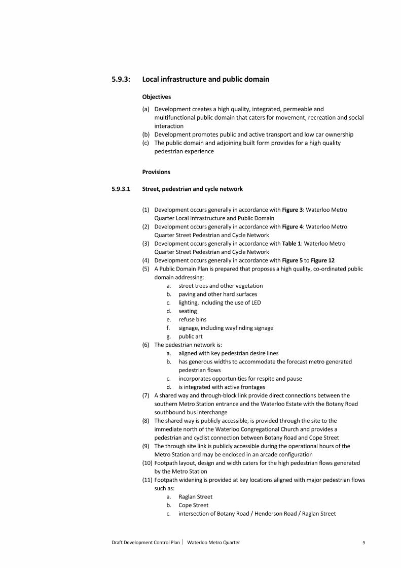
5.9.3.1 Street, pedestrian and cycle network
(1) Development occurs generally in accordance with Figure 3: Waterloo Metro
Quarter Local Infrastructure and Public Domain
(2) Development occurs generally in accordance with Figure 4: Waterloo Metro
Quarter Street Pedestrian and Cycle Network
(3) Development occurs generally in accordance with Table 1: Waterloo Metro
Quarter Street Pedestrian and Cycle Network
(4) Development occurs generally in accordance with Figure 5 to Figure 12
(5) A Public Domain Plan is prepared that proposes a high quality, co-ordinated public
domain addressing:
a. street trees and other vegetation
b. paving and other hard surfaces
c. lighting, including the use of LED
d. seating
e. refuse bins
f. signage, including wayfinding signage
g. public art
(6) The pedestrian network is:
a. aligned with key pedestrian desire lines
b. has generous widths to accommodate the forecast metro generated
pedestrian flows
c. incorporates opportunities for respite and pause
d. is integrated with active frontages
(7) A shared way and through-block link provide direct connections between the
southern Metro Station entrance and the Waterloo Estate with the Botany Road
southbound bus interchange
(8) The shared way is publicly accessible, is provided through the site to the
immediate north of the Waterloo Congregational Church and provides a
pedestrian and cyclist connection between Botany Road and Cope Street
(9) The through site link is publicly accessible during the operational hours of the
Metro Station and may be enclosed in an arcade configuration
(10) Footpath layout, design and width caters for the high pedestrian flows generated
by the Metro Station
(11) Footpath widening is provided at key locations aligned with major pedestrian flows
such as:
a. Raglan Street
b. Cope Street
c. intersection of Botany Road / Henderson Road / Raglan Street

Draft Development Control Plan Waterloo Metro Quarter 10
(12) Development contributes to the provision of improved pedestrian crossing points
at adjoining intersections
(13) Marked pedestrian crossings are established:
a. across the western side of the Raglan Street and Cope Street intersection
connecting the northern station entrance with the northern side of
Raglan Street
b. across the southern side of the Raglan Street and Cope Street
intersection connecting the northern station entrance with the Waterloo
Estate
c. across Cope Street connecting Cope Street Plaza and the Waterloo Estate
(14) On site pedestrian paths have a maximum gradient of 1:20
(15) A cycleway is provided adjoining the site in Wellington Street
(16) On-site bicycle parking is provided for residents in accordance with the City of
Sydney DCP 2012 rates of 1 space per dwelling and 1 visitor space per 10 dwellings
(17) 400 on site-bicycle parking spaces are provided for non-residents such as
customers of the metro station
(18) 120 on-site bicycle parking spaces are provided in the public domain for share
bikes and casual visitors
(19) Non-resident bicycle parking and visitor spaces are provided together in a bike hub
that is accessible to both residents of the Metro Quarter and the public domain
and also included end of trip facilities such as showers
(20) A bus stop is provided for southbound movements on Botany Road adjoining the
site
(21) Development prepares a Construction Management Plan
(22) Development prepares a Travel Management Plan

Draft Development Control Plan Waterloo Metro Quarter 11
Figure 3: Waterloo Metro Quarter Local Infrastructure and Public Domain
Draft Development Control Plan Waterloo Metro Quarter 12
Figure 4: Waterloo Metro Quarter Street, Pedestrian and Cycle Network

Draft Development Control Plan Waterloo Metro Quarter 13
Table 1: Waterloo Metro Quarter Street, Pedestrian and Cycle Network
Type Reservation Width Lane width On road cycle lane Footpath width
Main Street
Botany Road
17.5m 2 travel lanes:
2 x 3.25m
2 parking lanes:
2 x 2.3m
2 x 3.5m variable
Local Street
Cope Street
19.8m 2 travel lanes
2 x 3.25m
2 x 5.5m to 7.8m variable
Local Street
Wellington Street
20.1m 2 travel lanes
2 x 3.75m
Bi-directional cycle lanes
2 x 2.5m wide with separator
2 x 3.6m to 4.0m variable
Local Street
Raglan Street
20.5m 3 travel lanes
3 x 3.25m
1 x parking lane
1 x 2.75m
2 x 4.0m variable
Share way 13.5m 1 x travel lane
1 x 6.0m
2 x 3.5m – 4.0m variable

Draft Development Control Plan Waterloo Metro Quarter 14
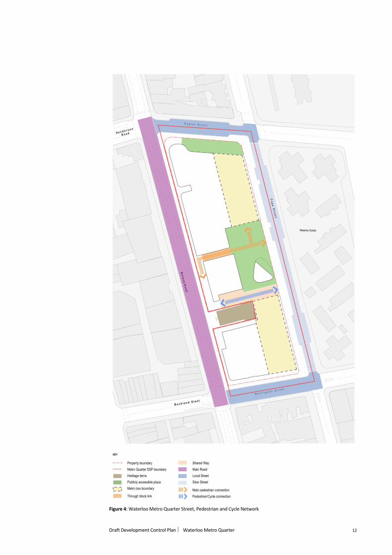
Figure 5: Waterloo Metro Quarter Street, Pedestrian and Cycle Network Section Locations
Draft Development Control Plan Waterloo Metro Quarter 15
Figure 6: Section A - A– Local Street Typical Section – Raglan Street
Figure 7: Section B - B – Main Street Typical Section – Botany Road (Bus southbound interchange)

Draft Development Control Plan Waterloo Metro Quarter 16
Figure 8: Section C - C – Main Street Typical Section – Botany Road (General)
Figure 9: Section D - D – Local Street Typical Section – Cope Street (Cope Street Plaza)

Draft Development Control Plan Waterloo Metro Quarter 17
Figure 10: Section E - E – Local Street Typical Section – Wellington Street

Draft Development Control Plan Waterloo Metro Quarter 18
Figure 11: Section F - F – Share way Typical Section
Provisions
5.9.3.2 Carparking, access and circulation
(1) Development occurs generally in accordance with Figure 12: Waterloo Metro
Quarter Carparking, Access and Circulation
(2) Two separate pedestrian access points, being a northern and southern access
point, are provided to the Metro Station
(3) Cope Street is reconfigured as a slow street (maximum 20k/h) that includes:
a. 2 opposite direction vehicle travel lanes
b. taxi waiting spaces
c. kiss and ride drop off spaces
d. short term drop off and pick up spaces
e. a widened footpath along the site’s entire eastern boundary and a
corresponding reduction in the width of the carriageway
(4) Existing intersections are reconfigured to establish give-way intersections at:
a. Raglan Street and Cope Street, with right of way to Raglan Street
b. Cope Street and Wellington Street, with right of way to Wellington Street
(5) Site access is provided as follows:
a. Botany Road site access: service vehicle access (left in / left out)

Draft Development Control Plan Waterloo Metro Quarter 19
b. Cope Street site access: residential access
c. Wellington Street site access: residential access & service vehicle access
(left in / left out)
(6) The maximum number of on-site residential carparking spaces is in accordance
with that specified for Category A for residential flat buildings under the City of
Sydney LEP 2012 as follows:
a. for each studio dwelling: 0.1 spaces
b. for each 1 bedroom dwelling: 0.3 spaces
c. for each 2 bedroom dwelling: 0.7 spaces
d. for each 3 or more bedroom dwelling: 1 space
(7) The maximum number of on-site retail carparking spaces is in accordance with the
following formula under the City of Sydney LEP 2012 as follows:
a. M = (G x A) / (50 x T) where M is the maximum number of carparking
spaces, G is the gross floor area of all retail premises in the building in
square metres, A is the site area in square metres and T is the total gross
floor area of all buildings on the site in square metres
(8) Development is encouraged to provide dedicated on-site carparking for:
a. car share spaces
b. accessible spaces
c. retail tenancy spaces
(9) On-site car parking is provided underground in basement levels
(10) Car parking basement level/s are shared across the residential taller buildings

Draft Development Control Plan Waterloo Metro Quarter 20
Figure 12: Waterloo Metro Quarter Carparking, Access and Circulation

Draft Development Control Plan Waterloo Metro Quarter 21
5.9.3.3 Publicly accessible open space
(1) Development occurs generally in accordance with Figure 3: Waterloo Metro
Quarter Local Infrastructure and Public Domain
(2) Development occurs generally in accordance with Table 2: Waterloo Metro
Quarter Open Space Network
Table 2: Waterloo Metro Quarter Open Space Network
Type Requirement Guideline
Publicly accessible
plaza
Cope Street Plaza
Has a minimum area of
1400sqm to be publicly
accessible at all hours and
provides a link between the
southern entrance to the
Metro Station, Cope Street
and the Waterloo Estate
and accommodates a range
of informal passive
recreation activities
• Located adjoining the southern Metro Station entrance
• Has an extensive open boundary with Cope Street
• Is an open, largely hard paved urban space that caters
for the needs of commuters and the Metro Quarter
community
• Responds to site flooding constraints through
demarcation into three distinct but integrated
components:
− a lower plaza at the same level as the
adjoining Cope Street public domain that
features a raised lawn area (including a
landmark tree) that provides for informal
leisure, gathering and breakout space for the
Metro Station and the community facility
− a bleacher terrace providing for seamless
movement between the lower area and
upper area as well as providing for seating
and mediation of the change in level required
to achieve entry datum to the Metro Station
− an upper plaza at the same height as
southern Metro Station entrance that
provides for a range of informal, passive
recreation activities such as seating,
gathering and social interaction, and is
bordered on its western edge by active
frontages that include seating within the
plaza
Publicly accessible
plaza
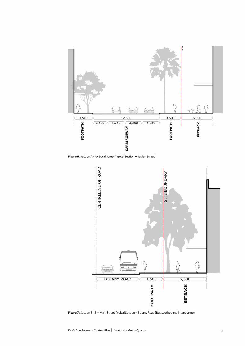
Raglan Street Plaza
Has a minimum area of
580sqm to be publicly
accessible at all hours and
provides a link between the
northern entrance to the
Metro Station, Raglan
Street and locations to the
west such as the Australian
Technology Park and
accommodates a range of
social interaction
• Located adjoining the northern Metro Station entrance
• Has an extensive open boundary with Raglan Street
• Is an open, largely hard paved urban space that caters
for the needs of commuters and the Metro Quarter
community
• Integrates with an extension of the public domain at the
intersection of Raglan Street and Cope Street
• Trees and associated vegetation in the western part of
the Raglan Street Plaza create two parallel rows of
coordinated deciduous plantings to:
− delineate areas of primary pedestrian
through movement and pause and linger
space

Draft Development Control Plan Waterloo Metro Quarter 22
Type Requirement Guideline
− provides shade in summer and solar access in
winter to social interaction spaces and active
frontages along the plaza’s southern edge
Figure 13: Indicative concept – Cope Street Plaza
Draft Development Control Plan Waterloo Metro Quarter 23
Figure 14: Indicative concept – Raglan Street Plaza
5.9.3.4 Stormwater management
(1) Development occurs generally in accordance with Figure 15: Waterloo Metro
Quarter Stormwater Management
(2) Development complies with Flood Planning Level requirements as stipulated
by the Consent Authority
(3) Development protects the Metro Station from flooding
(4) Building surfaces are to be designed to accommodate possible flood flows
without damage or potential for erosion
(5) Building entry points are oriented away from locations on Botany Road and
Cope Street where there is a greater risk of flooding
(6) A Flood Management Plan is prepared as part of the first stage of
development
(7) Carpark entrances are ramped up to respond to Probable Maximum Flood
(PMF) levels

Draft Development Control Plan Waterloo Metro Quarter 24
(8) Development incorporates suitable shelter in place facilities
(9) Water Sensitive Urban Design (WSUD) measures are incorporated into the
Metro Quarter and the surrounding street network to improve stormwater
quality flowing into waterways such as Sheas Creek, and potentially include:
a. gross pollutant traps
b. passive irrigation
c. bio-retention areas
d. rainwater harvesting
Figure 15: Waterloo Metro Quarter Stormwater Management

Draft Development Control Plan Waterloo Metro Quarter 25
5.9.3.5 Public art
(1) Development incorporates public art that creates an authentic sense of place
drawing from and reflecting Central to Eveleigh’s strong Aboriginal and other
heritage values
(2) Public art that provides for heritage interpretation is contemporary,
innovative and creative, and is created by local artists
(3) Development occurs generally in accordance with the Public Art Plan
prepared by Milne & Stonehouse and dated June 2018, and in particular
reflects the concepts of:
a. Aboriginal Heart
b. H20
c. Nourish, Thrive and Grow
d. Compass and Calendar
e. Making Waves/Watershed
5.9.3.6 Urban forest
(1) Trees within the public domain, and in particular within streets, contribute to
the achievement of the City of Sydney’s urban forest outcomes as outlined in
its Urban Forest Strategy, including by:
a. ensuring tree canopy covers a minimum of 20% of streets adjoining
the Metro Quarter
b. incorporating street trees as an integral part of any public street
reconfiguration, including the provision of conditions conductive to
establishment and growth
c. being endemic to Sydney and creating diversity within plant families,
genera and species
d. considering species that currently prosper in slightly warmer climates
to cater for climate change
e. incorporating deciduous trees to provide better solar access during
cooler months, particularly to north facing spaces
f. provide a visually prominent tree to demarcate Cope Street Plaza
g. where appropriate, incorporating trees at upper levels of built form,
including podiums and on roof tops
5.9.3.7 Lighting
(1) Lighting in or of the public domain complies with AS4282‐1997
Note: Given station operating, the Metro Quarter public domain will need to
facilitate convenient and safe access to and from the station. This will require
extensive and longer than typical operation night-time illumination, in
particular to Cope Street Plaza
5.9.4 Building layout, form and design
Objectives
(a) Building layout, form and design balances its regional significance with
responsiveness to local character

Draft Development Control Plan Waterloo Metro Quarter 26
(b) Development incorporates a cohesive mix of different building typologies to
provide visual interest and break up the apparent scale of built form, in
particular when viewed from locations to the west
(c) Building have high quality façade design and finishes, in particular where they
are located in prominent or otherwise highly visible locations
Provisions
(1) Development is generally in accordance with Figure 16: Waterloo Metro
Quarter Built Form

Draft Development Control Plan Waterloo Metro Quarter 27
Figure 16: Waterloo Metro Quarter Built Form
Draft Development Control Plan Waterloo Metro Quarter 28
5.9.4.1 Height of buildings
(1) Height of buildings is generally in accordance with Figure 16: Waterloo Metro
Quarter Built Form
(2) Development generally tapers down in height form north to south
5.9.4.2 Building setbacks
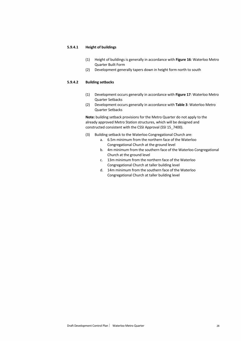
(1) Development occurs generally in accordance with Figure 17: Waterloo Metro
Quarter Setbacks
(2) Development occurs generally in accordance with Table 3: Waterloo Metro
Quarter Setbacks
Note: building setback provisions for the Metro Quarter do not apply to the
already approved Metro Station structures, which will be designed and
constructed consistent with the CSSI Approval (SSI 15_7400).
(3) Building setback to the Waterloo Congregational Church are:
a. 6.5m minimum from the northern face of the Waterloo
Congregational Church at the ground level
b. 4m minimum from the southern face of the Waterloo Congregational
Church at the ground level
c. 13m minimum from the northern face of the Waterloo
Congregational Church at taller building level
d. 14m minimum from the southern face of the Waterloo
Congregational Church at taller building level
Draft Development Control Plan Waterloo Metro Quarter 29
Figure 17: Waterloo Metro Quarter Setbacks

Draft Development Control Plan Waterloo Metro Quarter 30
Table 3: Waterloo Metro Quarter Setbacks
Botany Road
Primary 6.5m where shown in Figure 18: Waterloo Metro Quarter Setbacks to respond to the
Waterloo Congregational Church
Primary 2.5m for all other parts of Botany Road
Secondary 2 for a mid-rise building
Secondary 0m for a taller building
Note: while a 0m setback is permitted, the intent is to achieve and appropriate balance
between a 0m setback and a greater setback to mitigate the visual appearance of building
bulk and scale when viewed from the adjoining Botany Road public domain
Cope Street
Primary 0m from property boundary
Secondary 0m from property boundary
Note: while a 0m setback is permitted for a building within Cope Street Plaza, the intent is
to achieve and appropriate balance between a 0m setback and a greater setback to
mitigate the visual appearance of building bulk and scale when viewed from the adjoining
Botany Road public domain
Wellington Street
Primary 3m minimum from property boundary
Secondary Where on the metro station part of the site, 4m minimum from the property boundary
Secondary Where not on the metro station part of the site, 2.5m minimum from the property
boundary
Raglan Street
Primary Where adjoining Raglan Street Plaza, 10m minimum from the property boundary
Primary Where not adjoining Raglan Street Plaza, 5m minimum from the property boundary
or
Where the layout and design of the building demarcates the Botany Road and Raglan
Street landmark site, 4m minimum from Raglan Street
Secondary Where for a taller building overhang, 5m minimum from the property boundary
Secondary Where to demarcate the Botany Road and Raglan Street landmark site, 4m minimum from
Raglan Street
Draft Development Control Plan Waterloo Metro Quarter 31
5.9.4.3 Building form and design
(1) Development comprises three distinct building typologies:
a. podium
b. mid-rise
c. taller building
(2) The podium:
a. is divided into separate parts
b. has a height aligned with that of the uppermost part of the Waterloo
Congregational Church (the bellcotes)
c. engage with the adjoining public domain, providing opportunities for
passive casual surveillance through design measures such as
extensive, transparent windows, balconies and other devices
(3) Taller buildings:
a. have floor plates less than 800sqm gross floor area
b. have a visually slender form
c. have a shaped or curved profile
d. are well separated
e. reinforce the visual prominence of the Botany Road and Raglan
Street and Botany Road and Wellington Street corners
(4) Development ensures the safety of the metro and the Metro Quarter
community, with consideration given to metro box loading and the required
clearances zones to openings such as mechanical grilles for exhaust and fire
discharge or fire rated construction on adjoining buildings
(5) Permanent (eg buildings) or temporary structures (eg cranes) do not have an
adverse impact on the operation of Sydney (Kingsford Smith) Airport,
including through lighting or reflection
5.9.4.4 Building typologies and use
(1) Development occurs generally in accordance with Figure 18: Waterloo Metro
Quarter Building Typologies and Use
(2) Development includes residential, retail, community and where appropriate,
entertainment uses
(3) Development includes a diverse mix of non-residential uses that support and
complement the operation of a Metro Station
(4) Development improves the wellbeing of the Metro Quarter and Waterloo
Estate community, including through the provision of a diverse range of
services
(5) Development provides a mix of social and business enterprise that can
provide appropriate employment opportunities for local residents, including
flexible workspace for creative industries and ‘start up’ business
(6) Development provides a vibrant and comprehensive convenience and food
based retail offer
(7) Development is encouraged to provide the following land uses:
a. supermarket
b. small, convenience based retail and services premises
c. food and beverage
d. cafés
e. medical centre
f. gym
g. bank

Draft Development Control Plan Waterloo Metro Quarter 32
h. community services
i. social services
j. health services
k. recreational premises
l. late night / live music venues (where appropriately located and
designed to minimise adverse amenity impacts)
m. co-working space
(8) Development does not include non-food anchors like department stores or
discount department stores
(9) The location of uses, in particular at the ground plane, is responsive to the
movement patterns generated by the Metro Station
(10) Only non-residential uses are located at the ground and podium levels
(11) Development has a layout and design that is consistent with Crime
Prevention Through Environmental Design (CPTED) principles

Draft Development Control Plan Waterloo Metro Quarter 33
Figure 18: Waterloo Metro Quarter Building Typologies and Use
Draft Development Control Plan Waterloo Metro Quarter 34
5.9.4.5 Active frontages
(1) Development at the ground plane has a layout and design that activates the
adjoining public domain, including through measures such as:
a. locating high activity areas such as seating overlooking the public
domain
b. incorporating large doors or windows
c. not locating activities that are sensitive to public view, such as offices,
overlooking the public domain
d. not including grilles or other security measures
(2) Fine grain retail tenancies are located surrounding Cope Street Plaza and
along key pedestrian movement corridors, in particular between the Metro
Station and the south-bound bus interchange on Botany Road
(3) Larger format retail is located on the Botany Road frontage of the site
(4) Larger format retail or showrooms have an internal layout and present large
expanses of transparent glass frontages that enable ready perception of
indoor activity from the adjoining public domain
(5) Vehicular access to the site is located and designed to minimise disruption to
active frontages
(6) Visually coherent, high quality cantilevered awnings at the ceiling height of
the ground level that achieve adequate protection for pedestrians from rain,
wind and sun are provided along the full length of active frontages
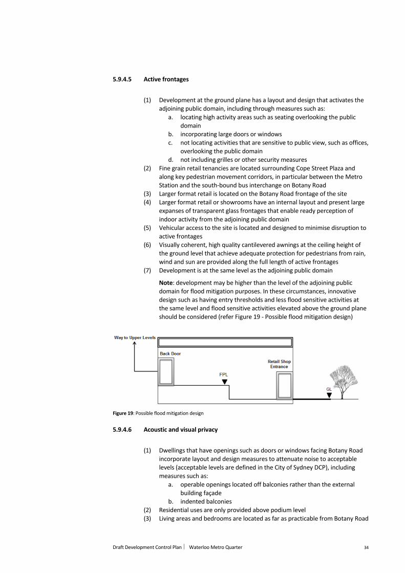
(7) Development is at the same level as the adjoining public domain
Note: development may be higher than the level of the adjoining public
domain for flood mitigation purposes. In these circumstances, innovative
design such as having entry thresholds and less flood sensitive activities at
the same level and flood sensitive activities elevated above the ground plane
should be considered (refer Figure 19 - Possible flood mitigation design)
Figure 19: Possible flood mitigation design
5.9.4.6 Acoustic and visual privacy
(1) Dwellings that have openings such as doors or windows facing Botany Road
incorporate layout and design measures to attenuate noise to acceptable
levels (acceptable levels are defined in the City of Sydney DCP), including
measures such as:
a. operable openings located off balconies rather than the external
building façade
b. indented balconies
(2) Residential uses are only provided above podium level
(3) Living areas and bedrooms are located as far as practicable from Botany Road
Draft Development Control Plan Waterloo Metro Quarter 35
Note: this measure should be balanced with the desire to create an urban
character streetscape to Botany Road and providing opportunities for passive
casual surveillance of the adjoining Botany Road public domain
(4) Bedroom openings face north, south or east
(5) Mechanical plant and other sources of industrial noise are located and
designed to minimise noise impacts on sensitive uses such as dwellings
5.9.4.7 Development levels
(1) Development achieves flood protection outcomes while activating the
adjoining public domain, in particular at the corner of Cope Street and
Wellington Street
5.9.4.8 Staging and implementation
(1) Development is integrated with delivery of the Metro Station and enables
activation of the surrounding public domain from the day of the Metro
Station opening
5.9.4.9 Utilities
(1) Development is provided with fibre to the premises NBN connection
5.9.4.10 Solar access
(1) Development enables sunlight to at least 50% of the total area of Cope Plaza
or Raglan Street Plaza for at least 3 hours between 9am and 3pm on 21 June
(2) Development maintains sunlight to at least 50% of the total area of
Alexandria Park for at least 4 hours between 9am to 3pm on 21 June
(3) Development does not result in any additional overshadowing of the
Alexandria Park Heritage Conservation Area after 11am on 21 June
5.9.4.11 Wind
(1) The layout and design of the public domain and the built form, including
placement, orientation, shape and external design of buildings, ensures the
suitability of areas for their intended use in terms of the impact of wind on
comfort and safety
Note: suitability of areas for their intended use can be guided by proposed
City of Sydney requirements that specify an hourly mean wind speed, or gust
equivalent mean wind speed (GEM) (whichever is greater for each wind
direction) must not exceed 8m/s for comfortable walking, 6m/s for standing
and 4m/s for sitting based on 5% probability of exceedance
(2) Cope Street Plaza is located in the eastern part of the quarter screened from
direct southerly and westerly winds by built form
(3) The western entrance to the shared way is narrowed by built form to provide
greater protection from direct westerly winds
(4) Taller buildings incorporate rounded corners to enable a smooth flow of wind

Draft Development Control Plan Waterloo Metro Quarter 36
(5) Where there is potential for significant downwash of wind from buildings,
development incorporates impermeable canopies, awnings, pergolas or
other appropriate wind mitigation devices over or within the affected public
domain
(6) Balconies are recessed into the elevation of buildings
(7) Balconies with exposure to wind from more than one aspect incorporate
wind deflective elements such as full height screens to one aspect
(8) Wind deflective elements are incorporated within podium level private
communal open space
(9) Impermeable awnings are included:
a. along the four corners of the quarter
b. along the western elevation of the central building podiums
c. over the shared way between Taller Building E and the Waterloo
Congregational Church
(10) Subject to CPTED considerations, planting of densely foliating evergreen trees
and shrubs within and around the quarter boundary is encouraged to further
enhance levels of pedestrian comfort
5.9.5 Sustainability infrastructure
Objectives
(a) Development creates an integrated sustainable infrastructure network
incorporating transport facilities, public domain, water systems and vegetation
to:
a. reduce energy consumption
b. reduce carbon emissions
c. minimise greenhouse emissions
d. reduce the urban heat island effect
e. improved air quality
f. improve absorption of carbon
Provisions
(1) Measures intended to reduce energy consumption and carbon emissions are
consistent with the following principles:
a. are affordable for all in the community
b. achieve low or zero carbon
c. are efficient in consumption
d. are resilient in supply and network security
e. are flexible and adaptable
(2) Development achieves:
a. a 6 star Green Star communities rating
b. a 5 star Green Star buildings rating
(3) Development is encouraged to exceed BASIX targets
(4) Communal open space provided on podium roofs incorporates substantial
areas that enable rainwater infiltration
(5) Tree canopy covers a minimum of 20% of streets adjoining the Metro
Quarter
(6) The size and spatial configuration of rooftop elements such as building plants
and lift overruns maximise opportunities for the installation of solar
photovoltaic systems to generate renewable energy
Draft Development Control Plan Waterloo Metro Quarter 37
(7) Buildings are rounded and oriented away from the west and Botany Road to
minimise undesirable solar gain and noise from the road
(8) Buildings incorporate shading on western façades to minimise undesirable
summer afternoon solar gain
(9) Building massing and spatial configuration is designed to encourage desirable
cross ventilation through the Metro Quarter
(10) Rainwater and / or stormwater harvesting tanks are incorporated to meet
BASIX water requirements
(11) Rainwater and / or stormwater captured on site is used to irrigate publicly
accessible open spaces
(12) Development is to incorporate appropriate waste reduction and recycling
measures
(13) For residential uses, residual waste and recycling chutes are provided in
separated but co-located arrangements
(14) Residential and commercial/retail waste disposal rooms are separate
(15) Development is encouraged to provide centrally plumbed hot water systems
within building to provide more efficient delivery of hot water
(16) Development is encouraged to incorporate green roofs and or green walls, in
particular where fronting Botany Road, to:
a. provide amenity and improve microclimate conditions
b. create comfortable spaces for recreation
5.9.6 Community facilities
Objectives
(a) Development provides community facilities that cater for the needs of the
Metro Quarter and Waterloo Estate community
Provisions
(1) Development includes floorspace that is suitable for community facilities
that:
a. is multi-purpose and flexible
b. is located at podium levels
c. provides opportunity for social and human services providers to
establish operations
d. is encouraged to include alternative community-focussed uses such
as a social enterprise café and community support services, such as
NSW Land and Housing Corporation services, bulk billing health
services, government service centre
(2) Private communal open space is encouraged to incorporate facilities such as
community gardens that encourage local food production and community
interaction
5.9.7 Housing
Objectives
(a) Development facilitates the creation of a diverse, inclusive, healthy and
socially connected community through the provision of a mix of dwelling
types, tenures, sizes and price-points that consider the needs of renters,
investors and owner occupiers

Draft Development Control Plan Waterloo Metro Quarter 38
(b) Development increases the amount of affordable housing
(c) Development provides for a mix of traditional and innovative dwelling types
and sizes, including those that specifically cater for demand for small
households
Provisions
(1) Development is to provide between five and ten percent of dwellings as
“affordable housing”
Note: ‘affordable housing’ means housing for very low income households,
low income households or moderate income households.
Note: A household is taken to be a very low income household, low income
household or moderate income household if the household:
(a) has a gross income that is less than 120 per cent of the median
household income for the time being for the Greater Sydney (Greater Capital
City Statistical Area) (according to the Australian Bureau of Statistics) and
pays no more than 30 per cent of that gross income in rent, or
(b) is eligible to occupy rental accommodation under the National Rental
Affordability Scheme and pays no more rent than that which would be
charged if the household were to occupy rental accommodation under that
scheme
(2) “Affordable housing” is to be managed by a registered community housing
provider for 10 years from the date of the issue of the occupation certificate
Note: A condition of consent is to be imposed requiring a restriction to be
registered, before the date of the issue of the occupation certificate, against
the title of the property on which development is to be carried out, in
accordance with section 88E of the Conveyancing Act 1919, to ensure the
above
(3) Affordable housing:
a. has a high level of amenity, including having regard to orientation,
outlook and views
b. has equal access to shared facilities to private dwellings such as
communal private open space
c. has an external appearance that is not distinguishable from private
dwellings
5.9.8 Heritage
Objectives
(a) Development retains significant heritage items within the Waterloo Metro
Quarter
(b) Development respects the heritage values of the Waterloo Metro Quarter and
its setting
(c) Development enhances the heritage values of the Waterloo Metro Quarter
and its setting by removing unsympathetic surrounding development
(d) Development exposes and celebrates significant elements within the
Waterloo Metro Quarter and its setting
(e) Development provides appropriate setbacks from heritage items
(f) Development provides appropriate building form and scale with consideration
for heritage items in the vicinity of the Waterloo Metro Quarter

Draft Development Control Plan Waterloo Metro Quarter 39
(g) Development enhances and complements existing character in its design but
does not replicate heritage buildings
(h) Development responds appropriately to heritage items and conservation
areas in the vicinity of the Waterloo Metro Quarter
(i) Development responds to significant corner typologies in the vicinity of the
Waterloo Metro Quarter
Provisions
5.9.8.1 Setbacks
(1) Development is setback from the Waterloo Congregational Church generally
in accordance with Figure 18 – Waterloo Metro Quarter Setbacks
5.9.8.2 Bulk, scale and height
(1) The height and façade articulation of the Botany Road ground level
development and any awnings considers the proportion, scale and
architectural features of the Congregational Church
(2) The height, proportion, scale and architectural articulation of the Botany
Road podium for new development considers the proportion scale and
architectural features of the Congregational Church
(3) The height, proportion, scale and architectural articulation of any adjacent
new development to the Congregational Church considers the proportion
scale and architectural features of the Church
5.9.8.3 Layout and design
(1) Development incorporates articulated corner forms which define each corner
in its context, having specific regard to heritage items in the vicinity,
including;
a. The Cauliflower Hotel at 123 Botany Road, Waterloo
b. The Former CBC Bank at 60 Botany Road, Alexandria
c. The Cricketers Arms Hotel at 56-58 Botany Road, Alexandria
5.9.8.4 Materiality
(1) Development incorporates materiality that appropriately responds to
heritage items in the vicinity, and also reflects the industrial heritage and
character of Waterloo
5.9.8.5 Public domain
(1) Development incorporates a publicly accessible shared way to the immediate
north of the Waterloo Congregational Church to significantly enhance
visibility of the church as a distinct built form item
(2) Subject to landowner’s consent, the existing later fence and vegetation at the
front of the Waterloo Congregational Church site is removed to enable
greater visibility from the Botany Road public domain

Draft Development Control Plan Waterloo Metro Quarter 40
(3) Subject to landowner’s consent, the setting of the Waterloo Congregational
Church is integrated into the public domain design for the Metro Quarter, in
particular through selection of consistent paving materials
(4) Development incorporates the Waterloo Congregational Church through the
provision of visual and physical connections between the Church, the Metro
Station, and the public domain
(5) Public domain and built form incorporates materials that reference the
industrial heritage of the Metro Quarter, including brickwork
(6) The public domain incorporates public art that celebrates the heritage values
of the Metro Quarter
5.9.8.6 Excavation in the vicinity of heritage items
(1) Excavation beneath or adjacent to heritage items and/or buildings in heritage
conservation areas will only be permitted if it is supported by both a
Geotechnical Engineering report and a Structural Engineering report.
5.9.8.7 Heritage assessments
(1) A Heritage Impact Statement is to be submitted for development
applications which have the potential to impact heritage items or buildings
within heritage conservation areas.
(2) The consent authority may not grant consent to a development application
that proposes substantial demolition or major alterations to a building older
than 50 years, until it has considered a heritage impact statement, so as to
enable it to fully consider the heritage significance of a building and the
impact that the proposed development has on the building and its setting.
(3) The Heritage Impact Statement is to be prepared by a suitably qualified
person, such as a heritage consultant. Guidelines for the preparation of
Statements of Heritage Impact are available on the website of the Heritage
Branch, NSW Department of Planning at www.heritage.nsw.gov.au.
(4) The Heritage Impact Statement is to address:
a. the heritage significance of the building or its contribution to a
heritage conservation area;
b. the options that were considered when arriving at a preferred
development and the reasons for choosing the preferred option;
c. the impact of the proposed development on the heritage significance
of the heritage items or buildings within heritage conservation areas;
and
d. the compatibility of the development with conservation policies
contained within a Heritage Conservation Management Plan or
Conservation Management Strategy, or conservation policies within
the Sydney Heritage Inventory Report, as applicable.
5.9.8.8 Archaeological assessments
(1) An archaeological assessment is to be prepared by a suitably qualified
archaeologist in accordance with the guidelines prepared by the NSW Office
and Environment and Heritage.
(2) An archaeological assessment is to be submitted as part of the Statement of
Environmental Effects for development applications affecting an

Draft Development Control Plan Waterloo Metro Quarter 41
archaeological site or a place of Aboriginal heritage significance, or potential
archaeological site that is likely to have heritage significance.
(3) An archaeological assessment is to include:
a. an assessment of the archaeological potential of the archaeological
site or place of Aboriginal heritage significance;
b. the heritage significance of the archaeological site or place of
Aboriginal heritage significance;
c. the probable impact of the proposed development on the heritage
significance of the archaeological site or place of Aboriginal heritage
significance;
d. the compatibility of the development with conservation policies
contained within an applicable conservation management plan or
conservation management strategy; and
e. a management strategy to conserve the heritage significance of the
archaeological site or place of Aboriginal heritage significance.
(4) If there is any likelihood that the development will have an impact on
significant archaeological relics, development is to ensure that the impact is
managed according to the assessed level of significance of those relics.