
West Berkshire Council
Level 2 SFRA Detailed Site Summary Tables
1
Table of Contents ALD5 .................................................................................................................................................... 3
BEEN1 .................................................................................................................................................. 8
BH1 .................................................................................................................................................... 13
BUR3.................................................................................................................................................. 18
BUR14................................................................................................................................................ 23
CA10 .................................................................................................................................................. 29
CA15 .................................................................................................................................................. 34
COM2 ................................................................................................................................................ 38
COM3 ................................................................................................................................................ 42
E12 .................................................................................................................................................... 47
ENG1 ................................................................................................................................................. 51
HUN6 ................................................................................................................................................. 55
HUN10 ............................................................................................................................................... 60
LAM1 ................................................................................................................................................. 66
LAM5 ................................................................................................................................................. 70
MID5 .................................................................................................................................................. 74
NEW1 ................................................................................................................................................ 79
NEW3 ................................................................................................................................................ 84
PAD1 .................................................................................................................................................. 89
PAD3 .................................................................................................................................................. 93
PAD4 .................................................................................................................................................. 98
PAN5 ............................................................................................................................................... 102
SCD4 ................................................................................................................................................ 107
THA5 ................................................................................................................................................ 112
THA9 ................................................................................................................................................ 116
THA15 .............................................................................................................................................. 121
THE1 ................................................................................................................................................ 125
THE2 ................................................................................................................................................ 130
THE3 ................................................................................................................................................ 134
THE4 ................................................................................................................................................ 139
THE7 ................................................................................................................................................ 144
THE8 ................................................................................................................................................ 149
WOK2 .............................................................................................................................................. 154

West Berkshire Council
Level 2 SFRA Detailed Site Summary Tables
2
WOK4 .............................................................................................................................................. 160

West Berkshire Council
Level 2 SFRA Detailed Site Summary Tables
3
Site code ALD5
Site name Basingstoke Road/Fallows Road, Aldermaston Wharf
Site details OS Grid reference
SU 60091 66771
Area 2.9 Ha
Current land use Greenfield - Agricultural
Proposed site use
Residential
NPPF Flood risk vulnerability
More vulnerable
Sources of flood risk
Existing watercourses/biodiversity
There are no watercourses within the site boundary. The River Kennet (Main River) is located 140m south of the site, and a large lake is located 65m north west of the site.
Flood history
The site is within the EA Recorded Flood Outline. The site has been affected by fluvial flooding on two previous incidents: June 1971 and January 2003. This was as a result of channel exceedance along the River Kennet, which is south of the site.
The Thames Water DG5 record shows that there have been six sewer flooding incidents within the postcode area (RG7 4), of which two have resulted in internal flooding of property.
Fluvial
Proportion of site at risk in Flood Zones
Proportion of the site
at risk (%)
Flood Zone 3b
5% AEP
Flood Zone 3a
1% AEP
Flood Zone 2
0.1% AEP
Flood Zone 1
0% 55% 3% 42%
Range of depths (m)
0.01m – 0.27m
0.01m – 0.57m
0.01m – 0.59m N/A
Available modelled data:
The site is covered by the 2007 River Kennet (Newbury to Tyle Mill) 1D model. Depth grid outputs were provided for use in the SFRA.
Flood characteristics:
The south of the site is at a high risk of fluvial flooding. The site is within Flood Zone 3a where flooding is expected during the 1% AEP event. A slightly larger area is within Flood Zone 2 (0.1% AEP event). The remainder of the site is within
Flood Zone 1, where the risk of fluvial flooding is negligible.
Surface Water
Proportion of site at risk (RoFSW)
1 in 30 (3.33% AEP) 1 in 100 (1% AEP) 1 in 1000 (0.1% AEP)
0% 0% 1%
Description of surface water flow paths:
The site is at a low risk of surface water flooding.
Groundwater
Proportion of the site at risk in JBA Groundwater Map 1% AEP risk categories
Depth below surface
0-0.025m
Depth below surface
0.025-0.5m
Total in highest risk categories
0% 0% 0%
The site is predicted to be at negligible risk of groundwater flooding.
This Jacobs Groundwater Flood Risk modelling does not show the site to be at risk of groundwater emergence.

West Berkshire Council
Level 2 SFRA Detailed Site Summary Tables
4
Site code ALD5
Site name Basingstoke Road/Fallows Road, Aldermaston Wharf
Reservoir The site is not at risk of flooding, in the rare event of a reservoir breach.
Canal There are no canals within the vicinity of the site.
Flood risk management infrastructure
Defences Defence Type
Standard of
Protection Condition
There are no defences present within the site.
Residual risk
Culvert / structure blockage?
N/A
Impounded water body failure?
N/A
Defence breach / overtopping?
Breach Zone
N/A
Emergency planning
Flood warning The site is within the following EA Flood Alert Area: River Kennet from Thatcham down to Reading.
Access and egress
The site is likley to be accessed via the A340 Basingstoke Road, with current access at the northern border of the site. This route is at risk of fluvial flooding during the 0.1% AEP event (Flood Zone 2). The risk of surface water flooding to the road is low.
Climate Change
Climate change allowances for ‘2080s’
River Basin District Central Higher Central Upper End
Thames 25% 35% 70%
Implications for the site
Modelling shows that climate change leads to a small increase in flood extent at the site. However, the extent of Flood Zone 3a + 70% CC does not extend beyond that of Flood Zone 2, and therefore climate change is unilkely to significantly impact the proposed site.

West Berkshire Council
Level 2 SFRA Detailed Site Summary Tables
5
Site code ALD5
Site name Basingstoke Road/Fallows Road, Aldermaston Wharf
Requirement for drainage control and
impact mitigation
Bedrock Geology
London Clay Formation - Clay, Silt And Sand.
Superficial Geology
Alluvium - Clay, Silt, Sand And Gravel.
Soils Freely draining slightly acid loamy soils
SuDS
• SuDS design must follow the West Berkshire Council SuDS SPD, meet the Defra National Non-Statutory Technical Standards, and follow current best design practice (CIRIA Manual 2015).
• Opportunities should be taken on a greenfield site such as this to deliver SuDS with multiple benefits, such as biodiversity, recreation and water resource education, through integration with areas of greenspace.
• ‘Natural’, vegetated SuDS (such as green roofs, swales and ponds) will be preferred by West Berkshire Council as LLFA over ‘hard engineered’ and below-ground drainage.
• All development should adopt source control SuDS techniques. Conveyance features should be designed above ground and following natural flow paths where possible.
• Storage for runoff from the development in extreme events should be located out of fluvial flood risk areas.
• The impermeable bedrock geology suggests that deep infiltration may not be a suitable option. However, the underlying permeable soil and superficial deposits may provide opportunity to infiltrate to a shallow depth but over a wider area. Site investigation and infiltration testing will be required to test suitability.
• Additionally, the site is located within Groundwater Source Protection Zone 2. As such infiltration techniques should only be used where there are suitable levels of treatment and following the granting of any required environmental permits from the Environment Agency.
Groundwater Source Protection Zone
The site is within Groundwater Source Protection Zone 2.
Historic Landfill Site
There are no historic landfill sites within the site boundary.
Opportunities for flood risk betterment
Opportunities for using source control SuDS to manage runoff rates and volumes, contributing to the reduction of flood peaks downstream on the River Kennnet and existing surface water flow paths leaving the site.
Cumulative impacts of development
Water Framework Directive Catchment
Sensitivity to
cumulative impacts
Implications
Kennet and Holy Brook High
The FRA should examine the cumulative impacts of potential peak runoff rates and volumes from the site (and other developments in the WFD catchment) on flood risk in the receiving watercourses.
Sequential Test and Exception Test requirements

West Berkshire Council
Level 2 SFRA Detailed Site Summary Tables
6
Site code ALD5
Site name Basingstoke Road/Fallows Road, Aldermaston Wharf
Recommend-ations for Local Plan
policy
The Sequential Test must be satisfied. If the Sequential Test has been passed, then Table 3 of the NPPG gives details of appropriate flood risk vulnerability for each Flood Zone. For this site, if More Vulnerable (residential) development is proposed within Flood Zone 3, or Highly Vulnerable development is proposed within Flood Zone 2, the Exception Test must be satisfied. A large proportion of the site is at high fluvial flood risk (>50% in Flood Zone 3), but flood depths are relatively shallow, therefore it could be possible to pass the Exception Test by making future development safe through design.
However, the site is currently considered unviable for large scale residential development.
Recommendations for requirements of site-specific Flood Risk Assessment, including guidance for developers
Flood risk assessment:
• At the planning application stage, a site-specific flood risk assessment and surface water drainage strategy will be required.
• Consultation with the Local Authority and the Environment Agency should be undertaken at an early stage.
• A site-specific flood risk assessment will be required because the site is within Flood Zone 2 and 3 and at risk from sources of flooding other than rivers and the sea. Government guidance on flood risk assessments must be followed (https://www.gov.uk/guidance/floodrisk-assessment-for-planning-applications).
• Detailed modelling will be required to confirm Flood Zone and climate change extents (see ‘Available modelled data’). The Environment Agency and LLFA should be consulted to obtain the latest hydraulic modelling information for the site at the time of the flood risk assessment. They will advise as to whether existing detailed models are available, and if so, whether they need to be updated.
• Climate change should be assessed using recommended climate change allowances at the time of the assessment (https://www.gov.uk/guidance/flood-risk-assessments-climatechange-allowances) for the type of development and level of risk. The current allowances were published in February 2016 but may be subject to change in the future.
• Other sources of flooding should also be considered as part of a site-specific flood risk assessment, including surface water and groundwater.
• The site is located within a catchment identified as highly sensitive to the cumulative impacts of development on flood risk. The site-specific FRA and surface water drainage strategy should consider the recommendations outlined for high sensitivity catchments in the West Berkshire Level 1 SFRA Cumulative Impacts Assessment Addendum.
Guidance for site design and making development safe:
• Development must seek opportunities to reduce overall level of flood risk both on and offsite, for example by reducing volume and rate of runoff and creating space for flooding.
• Safe access and egress should be demonstrated in the 1 in 100 plus climate change event.
• A site-specific surface water drainage strategy will be required.
• Infiltration techniques may be ineffective and may pose a pollution risk. SuDS may need to be shallow and take up larger areas. Above ground conveyance and attenuation can be used.
• Storage for runoff from the development in extreme events should be located out of flood risk
areas.
• The design must ensure that flows resulting from rainfall in excess of a 1 in 100-year event are managed via exceedance routes that minimise the risks to people and property.
• The level of detail and method of assessment of surface water runoff rates and volumes should be appropriate to the scale and risk of the development and should include recommended allowance for climate change and urban creep at the time of the assessment (currently +40% allowance for climate change and a 10% increase in impermeable area for urban creep).
• SuDS design must follow West Berkshire Council SuDS Supplementary Planning Document (SPD) standards, meet the Defra National Non-Statutory Technical Standards, and follow current best design practice (CIRIA Manual 2015).The design must ensure that flows resulting from rainfall in excess of a 1 in 100-year event are managed via exceedance routes that minimise the risks to people and property.

West Berkshire Council
Level 2 SFRA Detailed Site Summary Tables
7

West Berkshire Council
Level 2 SFRA Detailed Site Summary Tables
8
Site code BEEN1
Site name Land fronting Bath Road, Aldermaston Wharf, Reading (Site B)
Site details OS Grid reference
SU 59990 67366
Area 4.5 Ha
Current land use Greenfield - Grassland
Proposed site use
Residential
Flood risk vulnerability
More vulnerable
Sources of flood risk
Existing watercourses/biodiversity
The River Kennet (here also classified as the River and Avon Canal) is located 30m south of the site. There are no watercourses within the site boundary. A lake is located 40m to the south of the site.
Flood history
The site is not within the EA Recorded Flood Outlines dataset.
The Thames Water DG5 register shows that there have been six sewer flooding incidents within the postcode area (RG7 4), of which two have resulted in internal
property flooding.
Fluvial
Fluvial
Proportion of the site at risk (%)
Flood Zone 3b
5% AEP
Flood Zone 3a
1% AEP
Flood Zone 2
0.1% AEP
Flood Zone 1
0% 0% 0% 100%
Available modelled data:
The site is covered by the 2007 River Kennet (Newbury to Tyle Mill) 1D model.
Flood characteristics:
The site is located entirely within Flood Zone 1, and is therefore at very low risk of fluvial flooding.
Surface Water
Proportion of site at risk (RoFSW)
1 in 30 (3.33% AEP) 1 in 100 (1% AEP) 1 in 1,000 (0.1% AEP)
10% 17% 35%
Description of surface water flow paths:
The site is shown to be at risk of surface water flooding, as the topography is lower
than the surrounding roads and railway line, allowing water to pond.
The eastern area of the site is at high risk of surface water flooding, where flooding is predicted to occur during a 3.33% AEP (1 in 30) rainfall event. The extent of flooding significantly increases during the 0.1% AEP (1 in 1,000) event, with the eastern half of the site expected to flood during this event. The central and western areas of the site remain at very low surface water flood risk.
Groundwater
Proportion of the site at risk in JBA Groundwater Map 1% AEP risk categories
Depth below surface 0-0.025m
Depth below surface 0.025-0.5m
Total in highest risk categories
100% 0% 100%
The site is at high groundwater flood risk, with groundwater levels expected to lie within 0.025m of the ground surface during a 1% AEP (1 in 100) event.
The Jacobs Groundwater Flood Risk modelling does not show the site to be at risk
of groundwater emergence.

West Berkshire Council
Level 2 SFRA Detailed Site Summary Tables
9
Site code BEEN1
Site name Land fronting Bath Road, Aldermaston Wharf, Reading (Site B)
Reservoir The site is not at risk of flooding, in the rare event of a reservoir breach.
Canal
The Kennet and Avon Canal is located within 40m of the southern boundary of the site, although the railway line forms a topographic barrier between the site and canal. The residual risk of flooding to the site, in the event of a breach or overtopping on the canal should be assessed in further detail within a site-specific Flood Risk Assessment.
Flood risk management infrastructure
Defences Defence Type Standard of Protection Condition
There are no flood defences present.
Residual risk
Culvert / structure blockage?
N/A
Impounded water body failure?
N/A
Defence breach / overtopping?
Breach Zone
N/A
Emergency planning
Flood warning The site is not within an EA Flood Alert or Flood Warning Area.
Access and egress
The site is likely to be accessed via A4 Bath Road along the northern boundary of the site, or Station Road, which lies to the east. Bath Road is at very low fluvial flood risk, and is located within Flood Zone 1. The majority of Station Road is at very low risk of fluvial flooding, with a small area of flooding predicted to occur at
the junction with A340 Basingstoke Road during a 0.1% AEP (1 in 1,000) event.
Surface water flooding is predicted to affect westbound access on Bath Road during the 3.3% AEP (1 in 30) rainfall event, and inreases during the 1% (1 in 100) and 0.1% AEP events. However eastbound access is at low surface water flood risk. Adjacent to the site, Station Road is at very low risk of surface water flooding.
Climate Change
Climate change allowances for ‘2080s’
River Basin District Central Higher Central
Upper End
Thames 25% 35% 70%
Implications for the site
The site remains in Flood Zone 1 when considering the impact of climate change.

West Berkshire Council
Level 2 SFRA Detailed Site Summary Tables
10
Site code BEEN1
Site name Land fronting Bath Road, Aldermaston Wharf, Reading (Site B)
Requirement for drainage control and
impact mitigation
Bedrock Geology
London Clay Formation - Clay, Silt and Sand.
Superficial Geology
Beenham Grange Gravel Member - Sand and Gravel.
Soils Freely draining slightly acid loamy soils.
SuDS
• SuDS design must follow the West Berkshire Council SuDS SPD, meet the Defra National Non-Statutory Technical Standards, and follow current best design practice (CIRIA Manual 2015).
• All development should adopt source control SuDS techniques. Conveyance features should be designed above ground and following natural flow paths where possible.
• ‘Natural’, vegetated SuDS (such as green roofs, swales and ponds) will be preferred by West Berkshire Council as LLFA over ‘hard engineered’ and below-ground SuDS.
• SuDS features should be designed outside of fluvial flood risk areas and conveyance features should remain above surface and follow natural pathways.
• The impermeable bedrock geology and high groundwater flood risk suggests that infiltration techniques may not be suitable on this site. However, the presence of superficial deposits and freely draining soils suggests that infiltration to a shallow depth may be possible, subject to infiltration testing. If infiltration is proposed, it is recommended that further site investigation should be carried out to assess potential for drainage by infiltration, including at least 12 months of groundwater level monitoring on site.
• The site is located within Groundwater Source Protection Zone 2. As such infiltration techniques should only be used where there are suitable levels of treatment and following the granting of any required environmental permits from the Environment Agency.
• Where below ground storage is proposed, the base of the feature must be located at least 1m above the highest groundwater level, to reduce the risk of groundwater ingress or flotation.
Groundwater Source Protection Zone
The site is within Groundwater Source Protection Zone 2.
Historic Landfill Site
There are no historic landfill sites within the site boundary.
Opportunities for flood risk betterment
Opportunities for using source control SuDS to manage runoff rates and volumes, contributing to the reduction of flood peaks downstream on the River Kennet and existing surface water flow paths leaving the site.
Water Framework Directive
Catchment
Sensitivity to cumulative
impacts Implications

West Berkshire Council
Level 2 SFRA Detailed Site Summary Tables
11
Site code BEEN1
Site name Land fronting Bath Road, Aldermaston Wharf, Reading (Site B)
Cumulative impacts of development
Kennet and Holy Brook
High
The FRA should examine the cumulative impacts of potential peak runoff rates and volumes from the site (and other developments in the WFD catchment) on flood risk in the receiving watercourses.
Recommend-ations for Local Plan
policy
Sequential Test and Exception Test requirements
The site is within Flood Zone 1 but at risk from other sources of flooding. The Sequential Test must be passed. The Exception Test is not required under the NPPF, but it must be shown that the development will be safe for its lifetime and the risk can be managed through a sequential approach to design.
Recommendations for requirements of site-specific Flood Risk Assessment, including guidance for developers
Flood risk assessment:
• At the planning application stage, a site-specific flood risk assessment and surface water drainage strategy will be required.
• Consultation with the Local Authority and the Environment Agency should be undertaken at an early stage.
• A site-specific flood risk assessment will be required because the site is over 1ha in area within Flood Zone 1 and at risk from sources of flooding other than rivers and the sea. Government guidance on flood risk assessments must be followed (https://www.gov.uk/guidance/flood-risk-assessment-for-planning-applications).
• Other sources of flooding should also be considered as part of a site-specific flood risk assessment, including surface water and groundwater.
• Climate change should be assessed using recommended climate change allowances at the time of the assessment (https://www.gov.uk/guidance/flood-risk-assessments-climate-change-allowances) for the type of development and level of risk. The current allowances were published in February 2016 but may be subject to change in the future.
• The site is located within a catchment identified as highly sensitive to the cumulative impacts of development on flood risk. The site-specific FRA and surface water drainage strategy should consider the recommendations outlined for high sensitivity catchments in the West Berkshire Level 1 SFRA Cumulative Impacts Assessment Addendum.

West Berkshire Council
Level 2 SFRA Detailed Site Summary Tables
12
Site code BEEN1
Site name Land fronting Bath Road, Aldermaston Wharf, Reading (Site B)
Guidance for site design and making development safe:
• Development must seek opportunities to reduce overall level of flood risk at the site.
• Safe access and egress should be demonstrated in the 1 in 100 plus climate change event and raising of access routes must not impact on floodplain storage capacity.
• Mitigation for seasonal high groundwater levels must be considered (for example by raising finished floor levels to an appropriate height above ground level).
• Due to the high groundwater flood risk, basements are not permitted.
• The design of SuDS schemes must consider the seasonally high groundwater table. Infiltration techniques may be ineffective and may pose a pollution risk. SuDS may need to be shallow and take up larger areas. Above ground conveyance and attenuation can be used but care must be taken that groundwater does not enter the SuDS feature and reduce the storage capacity and structural integrity of the design.
• The level of detail and method of assessment of surface water runoff rates and volumes should be appropriate to the scale and risk of the development and should include recommended allowance for climate change and urban creep at the time of the assessment (currently +40% allowance for climate change and a 10% increase in impermeable area for urban creep).
• Storage for runoff from the development in extreme events should be located out of flood risk areas.
• The design must ensure that flows resulting from rainfall in excess of a 1 in 100-year event are managed via exceedance routes that minimise the risks to people and property.
• SuDS design must follow West Berkshire Council SuDS Supplementary Planning Document (SPD) standards, meet the Defra National Non-Statutory Technical Standards, and follow current best design practice (CIRIA Manual 2015).The design must ensure that flows resulting from rainfall in excess of a 1 in 100-year event are managed via exceedance routes that minimise the risks to people and property.

West Berkshire Council
Level 2 SFRA Detailed Site Summary Tables
13
Site code BH1
Site name Clappers Farm, Cross Lane, Beech Hill, Grazeley
Site details OS Grid reference
SU 69253 65831
Area 75.1 Ha
Current land use Greenfield - Agricultural
Proposed site use
Residential
NPPF Flood risk vulnerability
More vulnerable
Sources of flood risk
Existing watercourses/biodiversity
The site is formed of two land parcels separated by Bloomfield Hatch Lane. Foudry Brook (Main River) forms the southern boundary of the eastern land parcel, and flows in a north-easterly direction through the south of the site. An unnamed ordinary watercourse flows north westwards along the northern
boundary of the western land parcel.
Within the site is an area of purple moor-grass and rush pastures, a protected habitat listed in S41 od the Natural Environment and Rural Communities Act, 2006. The habitat is dependant on wet or waterlogged soils and is sensitive to changes in the water table or flooding.
Flood history
The site is within the EA Recorded Flood Outline. Fluvial flooding has occurred within the site on two separate occasions: September 1992 and October 1993. These occurred as a result of channel exceedance along the Foudry Brook. The Thames Water DG5 register shows that there have been two external sewer flooding incidents to properties within the postcode area (RG7 2).
Fluvial
Proportion of site at risk in Flood Zones
Proportion of the site at risk (%)
Flood Zone 3b
5% AEP
Flood Zone 3a
1% AEP
Flood Zone 2
0.1% AEP
Flood Zone 1
14% 0% 1% 85%
Available modelled data:
The site is covered by the 2004 Foudry Brook 1D model.
Flood characteristics:
The fluvial flood risk is located in the south of the eastern land parcel and closely follows the course of the Foudry Brook. A small increase in flood extent is shown between Flood Zone 3b (5% AEP) and Flood Zone 2 (0.1% AEP). The remainder of the site is within Flood Zone 1, where fluvial flood risk is negligible.
Surface Water
Proportion of site at risk (RoFSW)
1 in 30 (3.33% AEP) 1 in 100 (1% AEP) 1 in 1000 (0.1% AEP)
5% 9% 19%
Description of surface water flow paths:
Surface water flood risk to the site follows the route of the Foudry Brook, and consequently overlaps with the Flood Zones. A flow path is shown to develop here during the 0.1% AEP (1 in 1,000) rainfall event, with areas of ponding occurring during the 3.33% (1 in 30) and 1% AEP (1 in 100) events. An area of ponding forms in the north west corner of the western land parcel, adjacent to
the railway line, during the 3.3% AEP and greater rainfall events.
During the 0.1% AEP event, multiple flow paths form in the north and east of the eastern land parcel, and flow either southwards towards the Foudry Brook, or
eastwards into an unnamed ordinary watercourse.

West Berkshire Council
Level 2 SFRA Detailed Site Summary Tables
14
Site code BH1
Site name Clappers Farm, Cross Lane, Beech Hill, Grazeley
Groundwater
Proportion of the site at risk in JBA Groundwater Map 1% AEP risk categories
Depth below surface
0-0.025m
Depth below surface
0.025-0.5m
Total in highest risk categories
14% 5% 19%
Groundwater flood risk varies across the site. The highest risk is in the south of the site, adjacent to the Foudry Brook, where groundwater levels are expected to lie within 0.025m of the ground surface during a 1% AEP (1 in 100) event. In the eastern land parcel (north of Bloomfieldhatch Lane) the risk is also high, with groundwater levels expected to lie between 0.025 – 0.5m of the ground surface. In the west of the site, there is a large area (26%) of lower risk, where groundwater levels are expected to be 0.5 – 5m below the ground surface. The remainder of the site is at negligible flood risk.
This Jacobs Groundwater Flood Risk modelling does not show the site to be at
risk of groundwater emergence.
Reservoir The site is not at risk of flooding, in the rare event of a reservoir breach.
Canal There are no canals witin the vicinity of the site.
Flood risk management infrastructure
Defences Defence Type Standard of Protection Condition
There are no defences present on the site.
Residual risk
Culvert / structure blockage?
There are several structures that require consideration within this site. The first is where the Foudry Brook passes below Cross Lane through a bridge. Blockage of the bridge may result in flooding to the south of the site. The second blockage may occur where the Foudry Brook passes below Grazeley Road, at the east of the site. A blockage to this structure may result in flooding to the east of the site. The unnamed ordinary watercourse at the northern border of the western land parcel also appears to be culverted beneath the railway line. Using the RoFSW mapping as a proxy, blockage of this structure is predicted to cause flooding to the north west corner of the site.
Impounded water body
failure? N/A
Breach Zone
Defence breach / overtopping?
N/A
Emergency planning
Flood warning
The site is within the following EA Flood Alert and Flood Warning Areas:
• Flood Alert Area: River Enborne and Foudry Brook
Flood Warning Area: Foudry Brook from Stratfield Mortimer to Green Park
Access and egress
The following roads could be used to access to the site:
• Cross Lane, south of the site.
• Grazeley Road, east of the site.
• Bloomfieldhatch Lane, through the west of the site.
Cross Lane and Grazeley Lane are affected by fluvial floding during the 1% AEP event (Flood Zone 3). Bloomfieldhatch Lane is within Flood Zone 1, where fluvial flood risk is low. Cross Lane and Grazeley Lane are also shown to be at risk of surface water flooding. However this largely coincides with fluvial flood risk from the Foudry Brook. Bloomfieldhatch Lane is at low risk of surface water flooding.
River Basin District Central Higher Central
Upper End

West Berkshire Council
Level 2 SFRA Detailed Site Summary Tables
15
Site code BH1
Site name Clappers Farm, Cross Lane, Beech Hill, Grazeley
Climate Change
Climate change allowances for ‘2080s’
Thames 25% 35% 70%
Implications for the site
Modelling shows that climate change leads to a small increase in flood extent at the site. However, the extent of Flood Zone 3a + 70% CC does not extend beyond that of Flood Zone 2, and therefore climate change is unilkely to significantly impact the proposed site.
Requirement for drainage control and
impact mitigation
Bedrock Geology
London Clay Formation - Clay, Silt And Sand.
Superficial Geology
River Terrace Deposits (sand and gravel) are found in the western land parcel, and in the south western corner of the site, alongside the Foudry Brook.
Soils Slowly permeable seasonally wet slightly acid but base-rich loamy and clayey soils
SuDS
• SuDS design must follow the West Berkshire Council SuDS SPD, meet the Defra National Non-Statutory Technical Standards, and follow current best design practice (CIRIA Manual 2015).
• Opportunities should be taken on a greenfield site such as this to deliver SuDS with multiple benefits, such as biodiversity, recreation and water resource education, through integration with areas of greenspace.
• ‘Natural’, vegetated SuDS (such as green roofs, swales and ponds) will be preferred by West Berkshire Council as LLFA over ‘hard engineered’ and below-ground SuDS.
• All development should adopt source control SuDS techniques. Conveyance features should be designed above ground and following natural flow paths where possible.
• Storage for runoff from the development in extreme events should be located out of fluvial flood risk areas.
• The impermeable bedrock geology and groundwater flood risk suggests that deep infiltration may not be a suitable option. However, the underlying permeable soil and superficial deposits may provide opportunity to infiltrate to a shallow depth but over a wider area. Site investigations and infiltration testing would be required to test suitability.
Groundwater Source Protection Zone
The site is not within a designated Groundwater Source Protection Zone.
Historic Landfill Site
There are no historic landfill sites within the site boundary.

West Berkshire Council
Level 2 SFRA Detailed Site Summary Tables
16
Site code BH1
Site name Clappers Farm, Cross Lane, Beech Hill, Grazeley
Requirement for drainage control and impact mitigation
Opportunities for flood risk betterment
Opportunities for using source control SuDS to manage runoff rates and volumes, contributing to the reduction of flood peaks downstream on the Foudry Brook and existing surface water flow paths leaving the site.
Cumulative impacts of development
Water Framework Directive
Catchment
Sensitivity to cumulative
impacts Implications
Foudry Brook (West End Brook to M4)
High
The FRA should examine the cumulative impacts of potential peak runoff rates and volumes from the site (and other developments in the WFD catchment) on flood risk in the receiving watercourses
Burghfield Brook Medium
Recommend-ations for Local Plan
policy
Sequential Test and Exception Test requirements
The Sequential Test must be satisfied. Only once the Sequential Test is satisfied should the Exception Test be applied. It is anticipated that proposed development will be sequentially located within Flood Zone 1. For this site, the Exception Test must be satisfied:
• If More Vulnerable and Essential Infrastructure is located in FZ3a or FZ3a plus climate change.
• If Highly Vulnerable development is located in FZ2.
If Essential Infrastructure is located in Flood Zone 3b then it must be demonstrated that the exception test is satisfied. Development will not be permitted in the following scenarios:
• Highly Vulnerable development within FZ3a or FZ3a plus climate change and FZ3b.
• More Vulnerable and Less Vulnerable development within FZ3b.
Recommendations for requirements of site-specific Flood Risk Assessment, including guidance for developers
Flood risk assessment:
• At the planning application stage, a site-specific flood risk assessment and surface water drainage strategy will be required.
• Consultation with the Local Authority and the Environment Agency should be undertaken at an early stage.
• A site-specific flood risk assessment will be required because the site is within Flood Zone 2 and 3 and at risk from sources of flooding other than rivers and the sea. Government guidance on flood risk assessments must be followed (https://www.gov.uk/guidance/floodrisk-assessment-for-planning-applications).
• Detailed modelling will be required to confirm Flood Zone and climate change extents (see ‘Available modelled data’). The Environment Agency and LLFA should be consulted to obtain the latest hydraulic modelling information for the site at the time of the flood risk assessment. They will advise as to whether existing detailed models are available, and if so, whether they need to be updated.
• Climate change should be assessed using recommended climate change allowances at the time of the assessment (https://www.gov.uk/guidance/flood-risk-assessments-climatechange-allowances) for the type of development and level of risk. The current allowances were published in February 2016 but may be subject to change in the future.
• Other sources of flooding should also be considered as part of a site-specific flood risk assessment, including surface water and groundwater.

West Berkshire Council
Level 2 SFRA Detailed Site Summary Tables
17
Site code BH1
Site name Clappers Farm, Cross Lane, Beech Hill, Grazeley
• Blockage modelling should be conducted to assess the residual risk associated with potential blockage of the bridge structures over the Foudry Brook along Cross Lane and Grazeley Road.
• The site is located within a catchment identified as highly sensitive to the cumulative impacts of development on flood risk. The site-specific FRA and surface water drainage strategy should consider the recommendations outlined for catchments of high sensitivity in the West Berkshire Level 1 SFRA Cumulative Impacts Assessment Addendum.
Guidance for site design and making development safe:
• Development must seek opportunities to reduce overall level of flood risk both on and offsite, for example by reducing volume and rate of runoff and creating space for flooding.
• Safe access and egress should be demonstrated in the 1 in 100 plus climate change event.
• Mitigation for seasonal high groundwater levels must be considered (for example by raising finished floor levels to an appropriate height above ground level).
• Due to the high groundwater flood risk, basements are not permitted.
• A site-specific surface water drainage strategy will be required.
• The design of SuDS schemes must consider the seasonally high groundwater table. Infiltration techniques may be ineffective and may pose a pollution risk. SuDS may need to be shallow and take up larger areas. Above ground conveyance and attenuation can be used but care must be taken that groundwater does not enter the SuDS feature and reduce the storage capacity and structural integrity of the design.
• Storage for runoff from the development in extreme events should be located out of flood risk areas.
• The design must ensure that flows resulting from rainfall in excess of a 1 in 100-year event are managed via exceedance routes that minimise the risks to people and property.
• The level of detail and method of assessment of surface water runoff rates and volumes should be appropriate to the scale and risk of the development and should include recommended allowance for climate change and urban creep at the time of the assessment (currently +40% allowance for climate change and a 10% increase in impermeable area for
urban creep).
• SuDS design must follow West Berkshire Council SuDS Supplementary Planning Document (SPD) standards, meet the Defra National Non-Statutory Technical Standards, and follow current best design practice (CIRIA Manual 2015).The design must ensure that flows resulting from rainfall in excess of a 1 in 100-year event are managed via exceedance routes that minimise the risks to people and property.
• The Foudry Brook, which flows through the site, is a Main River. An 8m wide buffer should
be maintained between the riverbank and any built structures, to enable the riparian owners
and/or the Environment Agency to access and maintain the channel.
West Berkshire Council
Level 2 SFRA Detailed Site Summary Tables
18
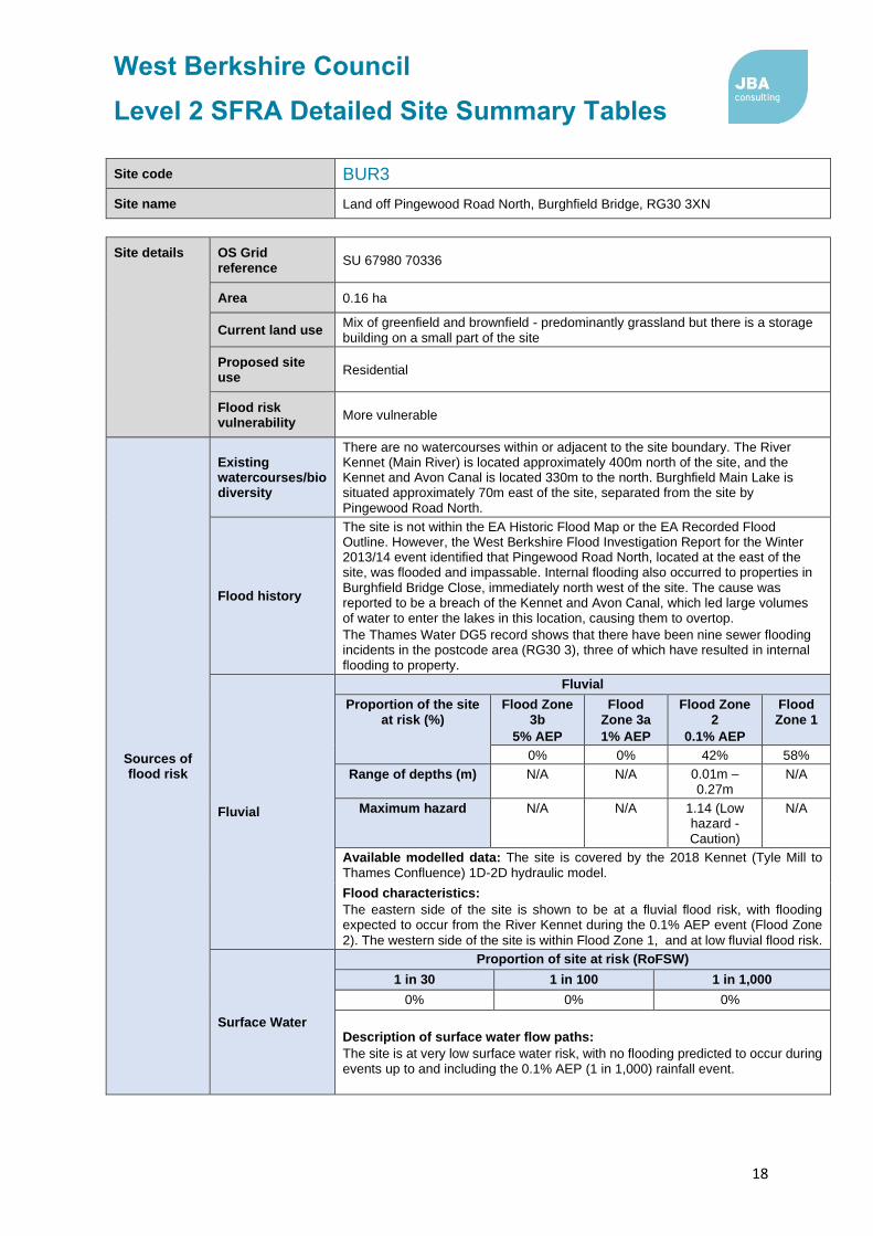
Site code BUR3
Site name Land off Pingewood Road North, Burghfield Bridge, RG30 3XN
Site details OS Grid reference
SU 67980 70336
Area 0.16 ha
Current land use Mix of greenfield and brownfield - predominantly grassland but there is a storage building on a small part of the site
Proposed site use
Residential
Flood risk vulnerability
More vulnerable
Sources of flood risk
Existing watercourses/biodiversity
There are no watercourses within or adjacent to the site boundary. The River Kennet (Main River) is located approximately 400m north of the site, and the Kennet and Avon Canal is located 330m to the north. Burghfield Main Lake is situated approximately 70m east of the site, separated from the site by Pingewood Road North.
Flood history
The site is not within the EA Historic Flood Map or the EA Recorded Flood Outline. However, the West Berkshire Flood Investigation Report for the Winter 2013/14 event identified that Pingewood Road North, located at the east of the site, was flooded and impassable. Internal flooding also occurred to properties in Burghfield Bridge Close, immediately north west of the site. The cause was reported to be a breach of the Kennet and Avon Canal, which led large volumes of water to enter the lakes in this location, causing them to overtop.
The Thames Water DG5 record shows that there have been nine sewer flooding incidents in the postcode area (RG30 3), three of which have resulted in internal flooding to property.
Fluvial
Fluvial
Proportion of the site at risk (%)
Flood Zone 3b
5% AEP
Flood Zone 3a
1% AEP
Flood Zone 2
0.1% AEP
Flood Zone 1
0% 0% 42% 58%
Range of depths (m) N/A N/A 0.01m – 0.27m
N/A
Maximum hazard N/A N/A 1.14 (Low hazard - Caution)
N/A
Available modelled data: The site is covered by the 2018 Kennet (Tyle Mill to Thames Confluence) 1D-2D hydraulic model.
Flood characteristics:
The eastern side of the site is shown to be at a fluvial flood risk, with flooding expected to occur from the River Kennet during the 0.1% AEP event (Flood Zone
2). The western side of the site is within Flood Zone 1, and at low fluvial flood risk.
Surface Water
Proportion of site at risk (RoFSW)
1 in 30 1 in 100 1 in 1,000
0% 0% 0%
Description of surface water flow paths:
The site is at very low surface water risk, with no flooding predicted to occur during events up to and including the 0.1% AEP (1 in 1,000) rainfall event.

West Berkshire Council
Level 2 SFRA Detailed Site Summary Tables
19
Site code BUR3
Site name Land off Pingewood Road North, Burghfield Bridge, RG30 3XN
Groundwater
Areas Susceptible to Groundwater Flooding Map class (risk of groundwater emergence)
Depth below surface 0-0.025m
Depth below surface 0.025-0.5m
Total in highest risk categories
100% 0% 100%
The site is at high risk of groundwater flooding, with groundwater levels across the whole site predicted to lie within 0.025m of the ground surface during a 1% AEP (1
in 100) event.
Reservoir The site is not at risk of flooding, in the rare event of a reservoir breach.
Canal There are no canals witin the site. However, areas adjacent to the site were flooded due to breach f the Kennet and Avon Canal during the Winter 2013/14.
Flood risk management infrastructure
Defences
Defence Type Standard of Protection Condition
There are no defences present within the site boundary. The site is not benefitting from any other defences.
Residual risk
Culvert / structure blockage?
N/A
Impounded water body failure?
Due to flooding of areas adjacent to the site in Winter 2013/14, due to a breach on the Kennet and Avon Canal, the risk of canal flooding to the site should be assessed in detail within a site-
specific Flood Risk Assessment.
Defence breach / overtopping?
Breach Zone
N/A
Emergency planning
Flood warning
The site is within the following EA Flood Alert Areas and Flood Warning Area:
• Flood Alert Area: River Kennet from Thatcham down to Reading
• Flood Warning Area: River Kennet from Theale down to Reading
Access and egress
The site is likely to be accessed via Pingewood Road North, located to the east of the site.
The access route is within Flood Zone 2 and therefore is at risk during a 0.1% AEP fluvial flood event. Pingewood Road North is also at risk of surface water flooding during the 0.1% AEP event (1 in 1,000).
Climate Change
Climate change allowances for ‘2080s’
River Basin District Central Higher Central
Upper End
Thames 25% 35% 70%
Implications for the site
Climate change is predicted to significantly increase the risk of flooding to the site. The 1 in 100 + 35% and +70% climate change events extend to cover the eastern half of the site, with the 1 in 100 + 70% event extending beyond the 0.1% AEP (1 in 1,000) event, or Flood Zone 2, coverage within the site.

West Berkshire Council
Level 2 SFRA Detailed Site Summary Tables
20
Site code BUR3
Site name Land off Pingewood Road North, Burghfield Bridge, RG30 3XN
Requirement for drainage control and
impact mitigation
Bedrock Geology
Woolwich and Reading Beds Formation – Clay, Gravel, Sand and Silt
Superficial Geology
Alluvium – Clay, Silt and Sand
Soils Freely draining, slightly acid loamy soils
SuDS
• SuDS design must follow the West Berkshire Council SuDS SPD, meet the Defra National Non-Statutory Technical Standards, and follow current best design practice (CIRIA Manual 2015).
• Opportunities should be taken on a greenfield site such as this to deliver SuDS with multiple benefits, such as biodiversity, recreation and water resource education, through integration with areas of greenspace.
• ‘Natural’, vegetated SuDS (such as green roofs, swales and ponds) will be preferred by West Berkshire Council as LLFA over ‘hard engineered’ and below-ground SuDS.
• All development should adopt source control SuDS techniques. Conveyance features should be designed above ground and following natural flow paths where possible.
• Storage for runoff from the development in extreme events should be located out of fluvial flood risk areas.
• The bedrock geology suggests variable infiltration potential, and mapping indicates that the site is at high risk of groundwater flooding. Therefore, infiltration techniques may not be suitable at the site. If infiltration is proposed, it is recommended that further site investigation should be carried out to assess potential for drainage by infiltration, including at least 12 months of groundwater level monitoring on site. Infiltration techniques should only be used where there are suitable levels of surface water runoff treatment.
• SuDS features in the south of the site, in the vicinity of the historic landfill site, may need to be designed with an impermeable liner, to prevent the
leaching of pollutants.
Groundwater Source Protection Zone
A small area (75m2) in the south west corner of the site is located within Flood Zone 3. The vast majority of the site is not within a Groundwater Source Protection Zone, however
Historic Landfill Site
There are historic landfill sites within the site boundary. However, Knights Farm North historic landfill site lies adjacent to the southern boundary of the site. Two further historic landfill sites are also located in close proximity, with Pingewood Road and Pleasant View Cottage located 75m and 15m away, respectively.
Opportunities for flood risk betterment
Opportunities for using source control SuDS to manage runoff rates and volumes, contributing to the reduction of flood peaks on the River Kennet downstream and
existing surface water flow paths leaving the site.
Cumulative impacts of development
Water Framework Directive
Catchment
Sensitivity to cumulative
impacts Implications
Kennet and Holy
Brook High
The FRA should examine the cumulative impacts of potential peak runoff rates and volumes from the site (and other developments in the WFD catchment) on flood risk in the receiving watercourses.
Sequential Test and Exception Test requirements

West Berkshire Council
Level 2 SFRA Detailed Site Summary Tables
21
Site code BUR3
Site name Land off Pingewood Road North, Burghfield Bridge, RG30 3XN
Recommend-ations for Local Plan
policy
The Sequential Test must be satisfied. Only once the Sequential Test is satisfied should the Exception Test be applied. It is anticipated that proposed development will be sequentially located within Flood Zone 1. For this site, the Exception Test must be satisfied:
• If More Vulnerable and Essential Infrastructure is located in FZ3a or FZ3a plus climate change.
• If Highly Vulnerable development is located in FZ2.
• If Essential Infrastructure is located in Flood Zone 3b.
Development will not be permitted in the following scenarios:
• Highly Vulnerable development within FZ3a or FZ3a plus climate change and FZ3b.
• More Vulnerable and Less Vulnerable development within FZ3b.
Recommendations for requirements of site-specific Flood Risk Assessment, including guidance for developers
Flood risk assessment:
• At the planning application stage, a site-specific flood risk assessment and surface water drainage strategy will be required.
• Consultation with the Local Authority and the Environment Agency should be undertaken at an early stage.
• A site-specific flood risk assessment will be required because the site is within Flood Zone 2 and 3 and at risk from sources of flooding other than rivers and the sea. Government guidance on flood risk assessments must be followed (https://www.gov.uk/guidance/floodrisk-assessment-for-planning-applications).
• Other sources of flooding should also be considered as part of a site-specific flood risk assessment, including groundwater.
• Climate change should be assessed using recommended climate change allowances at the time of the assessment (https://www.gov.uk/guidance/flood-risk-assessments-climate-change-allowances) for the type of development and level of risk. The current allowances were published in February 2016 but may be subject to change in the future.
• The site is located within a catchment identified as highly sensitive to the cumulative impacts of development on flood risk. The site-specific FRA and surface water drainage strategy should consider the recommendations outlined for high sensitivity catchments in the West Berkshire Level 1 SFRA Cumulative Impacts Assessment Addendum.
Guidance for site design and making development safe:
• Development must seek opportunities to reduce overall level of flood risk both on and offsite, for example by reducing volume and rate of runoff and creating space for flooding.
• Safe access and egress should be demonstrated in the 1 in 100 plus climate change event.
• Mitigation for seasonal high groundwater levels must be considered (for example by raising finished floor levels to an appropriate height above ground level).
• Due to the high groundwater flood risk, basements are not permitted.
• A site-specific surface water drainage strategy will be required.
• The design of SuDS schemes must consider the seasonally high groundwater table. Infiltration techniques may be ineffective and may pose a pollution risk. SuDS may need to be shallow and take up larger areas. Above ground conveyance and attenuation can be used but care must be taken that groundwater does not enter the SuDS feature and reduce the storage capacity and structural integrity of the design.
• The surface water drainage design must ensure that flows resulting from rainfall in excess of a 1 in 100-year rainfall event are managed via exceedance routes that minimise the risks to people and property.
• The level of detail and method of assessment of surface water runoff rates and volumes should be appropriate to the scale and risk of the development and should include recommended allowance for climate change and urban creep at the time of the assessment (currently +40% allowance for climate change and a 10% increase in impermeable area for urban creep).
• SuDS design must follow West Berkshire Council SuDS Supplementary Planning Document (SPD) standards, meet the Defra National Non-Statutory Technical Standards, and follow current best design practice (CIRIA Manual 2015).The design must ensure that flows resulting

West Berkshire Council
Level 2 SFRA Detailed Site Summary Tables
22
Site code BUR3
Site name Land off Pingewood Road North, Burghfield Bridge, RG30 3XN
from rainfall in excess of a 1 in 100-year event are managed via exceedance routes that
minimise the risks to people and property

West Berkshire Council
Level 2 SFRA Detailed Site Summary Tables
23
Site code BUR14
Site name Herons Nest, Station Road, Theale
Site details OS Grid reference
SU 66413 70041
Area 31.3 ha
Current land use Greenfield - former quarry with land being reinstated
Proposed site use
Employment, renewable energy
Flood risk vulnerability
Less vulnerable
Sources of flood risk
Existing watercourses/biodiversity
Clayhill Brook, an ordinary watercourse, flows in a north easterly direction along the south eastern boundary of the site. Two large lakes are located close to the site boundary, with a lake is situated adjacent to the north west boundary of the site, and a second lake is situated 100m to the north east, separated from the site
by the M4.
Part of the site includes part of the Theale Gravel Pits Local Wildlife Site (LWS) which is an area of terrestrial habitats adjacent to the large lake. There s also a strip of deciduous woodland, adjacent to the M4, which is a protected habitat listed in S41 of the NERC Act.
Flood history
The north west corner of the site is within the EA Historic Flood Map outline, where the adjacent lake flooded into the site boundary during the January 2003 flood event. The DG5 record shows that there has been a total of six sewer flooding incidents within the postcode area (RG7 4), two of which have resulted in internal flooding of property.
Fluvial
Fluvial
Proportion of the site at risk (%)
Flood Zone 3b
5% AEP
Flood Zone 3a
1% AEP
Flood Zone 2
0.1% AEP
Flood Zone 1
1% 10% 16% 73%
Range of depths (m) 0.38m 0.01m – 0.49m
0.02m – 1.96m
N/A
Maximum hazard Significant (Dangerous
for most)
Significant (Dangerou
s for most)
Extreme (Dangerous
for all)
N/A
Available modelled data: The site is covered by the River Kennet (Tyle Mill to Thames Confluence) 1D-2D hydraulic model, which was built in 2018. However, the Clayhill Brook is not within this model.
Flood characteristics:
The north eastern boundary of the site, adjacent to the M4, and the centre of the site, are located within Flood Zone 3a, and are at risk of fluvial flooding during the 1% AEP (1 in 100) flood event. The extent of flooding increase during the 0.1% AEP (1 in 1,000) event, to cover the northern and eastern boundaries of the site. A very small proportion of the north western boundary of the site is also within Flood Zone 3b (5% AEP), and is associated with the large lake. The remainder of the site is within Flood Zone 1, where fluvial flood risk is low.
Surface Water
Proportion of site at risk (RoFSW)
1 in 30 1 in 100 1 in 1,000
14% 19% 32%

West Berkshire Council
Level 2 SFRA Detailed Site Summary Tables
24
Site code BUR14
Site name Herons Nest, Station Road, Theale
Description of surface water flow paths:
Surface water flood risk in the site is concentrated in the north and east of the site, following the route of the Clayhill Brook, as well as ponding against the higher topography of the M4 motorway. This flow path is present in the 3.33% (1 in 30), 1% (1 in 100) and 0.1% AEP (1 in 1,000) events. A flow path also forms in the centre of the site during the 3.33% AEP and greater rainfall events, and flows towards the north eastern corner of the site, to pond against the M4 motorway embankment. During the 0.1% AEP (1 in 1,000) rainfall event, isolated areas of surface water ponding form, extending to cover the western portion of the site.
Groundwater
Areas Susceptible to Groundwater Flooding Map class (risk of groundwater emergence)
Depth below surface 0-0.025m
Depth below surface 0.025-0.5m
Total in highest risk categories
55% 43% 98%
The site is at moderate-high to high risk of groundwater flooding. Over half of the site is located within the highest risk category, where groundwater levels are likely to lie within 0.025m of the ground surface during a 1% AEP event. In the central and western portions of the site, groundwater levels are expected to lie between
0.025 – 0.5m of the ground surface during a flood event.
Reservoir The site is not at risk of flooding, in the rare event of a reservoir breach.
Canal There are no canals witin the site.

West Berkshire Council
Level 2 SFRA Detailed Site Summary Tables
25
Site code BUR14
Site name Herons Nest, Station Road, Theale
Flood risk management infrastructure
Defences
Defence Type Standard of Protection Condition
There are no defences present within the site boundary. The site is not benefitting from any other defences.
Residual risk
Culvert / structure blockage?
The Clayhill Brook appears to be culverted beneath the M4 motorway at the north eastern corner of the site. Using RoFSW mapping as a proxy (as it does not represent the culvert), blockage of the culvert is predicted to cause flooding to the north eastern portion of the site. However, the impact of this blockage on the residual risk to the site should be assessed in detail within a site-specific Flood Risk Assessment.
Impounded water body failure?
N/A
Defence breach / overtopping?
Breach Zone
N/A
Emergency planning
Flood warning
The eastern side of the site is within both an EA Flood Alert and Flood Warning Area:
• Flood Alert Area: River Kennet from Thatcham down to Reading
• Flood Warning Area: River Kennet from Theale to Reading
Access and egress
The site can be accessed from Deans Copse Road, to the south of the site, and Bennett’s Hill to the south of the site. The western end of Deans Copse Road is located within Flood Zone 3a and is predicted to flood during a 1% AEP (1 in 100) flood event. Bennett’s Hill and the eastern end of Deans Copse Road and located within Flood Zone 1, where fluvial flood risk is low. Both access routes are shown to be at risk of suface water flooding during the 3.33% AEP (1 in 30) and greater rainfall events.
Climate Change
Climate change allowances for ‘2080s’
River Basin District Central Higher Central
Upper End
Thames 25% 35% 70%
Implications for the site
Climate change is predicted to increase the risk of flooding to the site. The 1 in 100 + 35% and +70% climate change events extend to cover a greater area of the north and east of the site, with the 1 in 100 + 70% event extending beyond the 0.1% AEP (1 in 1,000) event, or Flood Zone 2, coverage within the site.

West Berkshire Council
Level 2 SFRA Detailed Site Summary Tables
26
Site code BUR14
Site name Herons Nest, Station Road, Theale
Requirement for drainage control and
impact mitigation
Bedrock Geology
Most of the site is underlain by London Clay Group – Clay, Silt, Sand and Gravel. A small area (1.5ha) in the northern of the site is underlain by Woolwich and Reading Bedrock – Clay, Silt, Sand and Gravel.
Superficial Geology
Most of the site is overlain by River Terrace Deposits (Undifferentiated) – Sand and Gravel. A small area (1.5ha) in the northern point of the site contains Alluvium deposits – Clay, Silt and Sand.
Soils Most of the site contains freely draining, slightly acid loamy soils. The south of the site contains loamy soils with naturally high groundwater.
SuDS
• SuDS design must follow the West Berkshire Council SuDS SPD, meet the Defra National Non-Statutory Technical Standards, and follow current best design practice (CIRIA Manual 2015).
• SuDS are possible on all sites, including previously developed sites such as this one. All development should adopt source control SuDS techniques. Conveyance features should be designed above ground and following natural flow paths where possible.
• ‘Natural’, vegetated SuDS (such as green roofs, swales and ponds) will be preferred by West Berkshire Council as LLFA over ‘hard engineered’ and below-ground SuDS.
• Storage for runoff from the development in extreme events should be located out of fluvial flood risk areas.
• The impermeable bedrock geology and groundwater flood risk indicate the infiltration techniques may not be suitable at the site. However, the underlying permeable soil and superficial deposits may provide opportunity for shallower infiltration depths. If infiltration is proposed, it is recommended that further site investigation should be carried out to assess potential for drainage by infiltration, including at least 12 months of groundwater level monitoring on site.
• The site is located within Groundwater Source Protection Zone 3. Therefore, infiltration techniques should only be used where there are suitable levels of treatment and following the granting of any required environmental permits from the Environment Agency.
• Where below ground storage is proposed, the base of the feature must be located at least 1m above the highest groundwater level, to reduce
the risk of groundwater ingress or flotation.
Groundwater Source Protection Zone
The site is in Groundwater Source Protection Zone 3.
Historic Landfill Site
There are no historic landfill sites within the site boundary. There is a historic landfill site (Field Farm No.1) located 70m from the most easterly point of the site, and is separated by the M4 motorway.
Opportunities for flood risk betterment
Opportunities for using source control SuDS to manage runoff rates and volumes, contributing to the reduction of flood peaks downstream on the River Kennet and existing surface water flow paths leaving the site.
Cumulative impacts of development
Water Framework Directive Catchment
Sensitivity to cumulative impacts
Implications
Clayhill Brook Low
The FRA and surface water drainage strategy for the site must meet national and local standards. Management of flood risk beyond the site boundary should be considered.
Sequential Test and Exception Test requirements

West Berkshire Council
Level 2 SFRA Detailed Site Summary Tables
27
Site code BUR14
Site name Herons Nest, Station Road, Theale
Recommend-ations for Local Plan
policy
The Sequential Test must be satisfied. Only once the Sequential Test is satisfied should the Exception Test be applied. It is anticipated that proposed development will be sequentially located within Flood Zone 1. For this site, the Exception Test must be satisfied:
• If More Vulnerable and Essential Infrastructure is located in FZ3a or FZ3a plus climate change.
• If Highly Vulnerable development is located in FZ2.
• If Essential Infrastructure is located in Flood Zone 3b
Development will not be permitted in the following scenarios:
• Highly Vulnerable development within FZ3a or FZ3a plus climate change and FZ3b.
• More Vulnerable and Less Vulnerable development within FZ3b.
Recommendations for requirements of site-specific Flood Risk Assessment, including guidance for developers
Flood risk assessment:
• At the planning application stage, a site-specific flood risk assessment and surface water drainage strategy will be required.
• Consultation with the Local Authority and the Environment Agency should be undertaken at an early stage.
• A site-specific flood risk assessment will be required because the site is within Flood Zone 2 and 3 and at risk from sources of flooding other than rivers and the sea. Government guidance on flood risk assessments must be followed (https://www.gov.uk/guidance/floodrisk-assessment-for-planning-applications).
• Other sources of flooding should also be considered as part of a site-specific flood risk assessment, including surface water and groundwater.
• It is recommended that the Clayhill Brook is modelled to better understand the fluvial flood risk to the site. Detailed modelling will be required to confirm Flood Zone and climate change extents (see ‘Available modelled data’). The Environment Agency and LLFA should be consulted to obtain the latest hydraulic modelling information for the site at the time of the flood risk
assessment. They will advise as to whether existing detailed models need to be updated.
• Climate change should be assessed using recommended climate change allowances at the time of the assessment (https://www.gov.uk/guidance/flood-risk-assessments-climate-change-allowances) for the type of development and level of risk. The current allowances were published in February 2016 but may be subject to change in the future.
• Modelling should be conducted to assess the residual risk associated with potential blockage of the culvert within the site.
• The site is located within a catchment identified as at low sensitivity to the cumulative impacts of development on flood risk. The site-specific FRA and surface water drainage strategy should consider the recommendations outlined in the West Berkshire Level 1 SFRA Cumulative Impacts Assessment Addendum.
Guidance for site design and making development safe:
• Development must seek opportunities to reduce overall level of flood risk at the site and should seek to reduce the levels of flood risk downstream.
• Safe access and egress should be demonstrated in the 1 in 100 plus climate change event.
• Mitigation for seasonal high groundwater levels must be considered (for example by raising finished floor levels to an appropriate height above ground level).
• Due to the high groundwater flood risk, basements are not permitted.
• A site-specific surface water drainage strategy will be required.
• The design of SuDS schemes must consider the seasonally high groundwater table. Infiltration techniques may be ineffective and may pose a pollution risk. SuDS may need to be shallow and take up larger areas. Above ground conveyance and attenuation can be used but care must be taken that groundwater does not enter the SuDS feature and reduce the storage capacity and structural integrity of the design.
• The surface water drainage design must ensure that flows resulting from rainfall in excess of a 1 in 100-year event are managed via exceedance routes that minimise the risks to people and property.

West Berkshire Council
Level 2 SFRA Detailed Site Summary Tables
28
Site code BUR14
Site name Herons Nest, Station Road, Theale
• The level of detail and method of assessment of surface water runoff rates and volumes should be appropriate to the scale and risk of the development and should include recommended allowance for climate change and urban creep at the time of the assessment (currently +40% allowance for climate change and a 10% increase in impermeable area for urban creep).
• SuDS design must follow West Berkshire Council SuDS Supplementary Planning Document (SPD) standards, meet the Defra National Non-Statutory Technical Standards, and follow current best design practice (CIRIA Manual 2015).
• The unnamed watercourse which forms the south eastern boundary of the site is an ordinary watercourse. A sufficient width of buffer, to be agreed in consultation with West Berkshire Council, should be maintained between the riverbank and any built structures, to enable riparian owners to access and maintain the channel.

West Berkshire Council
Level 2 SFRA Detailed Site Summary Tables
29
Site code CA10
Site name Sims Metal Management & J. Passey and Son Butchers, Turnpike Road, Newbury
Site details OS Grid reference
SU 48981 68254
Area 1.5 ha
Current land use Brownfield - Scrap yard
Proposed site use
Residential
Flood risk vulnerability
More vulnerable
Sources of flood risk
Existing watercourses/biodiversity
An unnamed ordinary watercourse passes through the site . It enters a culvert beneath Waller Drive, approximately 20m north of the site, and is understood to remain culverted through the site. The River Lambourn (Main River) forms a confluence with the River Kennet (Main River) approximately 850m south of the site.
Flood history
The site is not within the EA Recorded Flood Outline or the EA Historic Flood Map. West Berkshire Council Parish Flood Report for the July 2007 event reported that 42 properties (32 residential and 10 commercial) in the Waller Drive area reported flooding during the event. Flood water was reported to have ponded against the scrap yard wall, up to a depth of 1.5m, which caused the wall to collapse. Flood waters then flowed into Turnpike Industrial Estate, flooding all six industrial units. A number of residential properties in Fleetwood Close, located immediately north west of the site, were also internally flooded during the event. The source of flooding is understood to be runoff from fields to the north of Newbury, which overwhelmed the drainage system. The trash screen on the culvert beneath Waller Drive was also reported to be blocked with silt during the event. Flood alleviation options have been considered to provide protection to the Waller Drive area, and Property Flood Resilience measures were fitted to
properties at high risk between 2015 - 2017.
The DG5 record shows that there has been a total of 16 sewer flooding incidents within the postcode area (RG14 2), four of which have resulted in internal flooding of property.
Fluvial
Fluvial
Proportion of the site at risk (%)
Flood Zone 3b
5% AEP
Flood Zone 3a
1% AEP
Flood Zone 2
0.1% AEP
Flood Zone 1
0% 0% 0% 100%
Available modelled data:
The site is located just outside the extent of the River Kennet and Lambourn (Newbury) 1D-2D model.
Flood characteristics:
The site is located within Flood Zone 1, and is therefore at low fluvial flood risk.
Surface Water
Proportion of site at risk (RoFSW)
1 in 30 1 in 100 1 in 1,000
11% 21% 41%

West Berkshire Council
Level 2 SFRA Detailed Site Summary Tables
30
Site code CA10
Site name Sims Metal Management & J. Passey and Son Butchers, Turnpike Road, Newbury
Description of surface water flow paths:
The surface water flood risk at the site follows a flow path, which follows the route of the ordinary watercourse through the centre of the site, from north to south. The flow path is present in the 3.33% (1 in 30), 1% (1 in 100) and 0.1% AEP (1 in 1,000) rainfall events. During a 0.1% AEP event, the extent of flooding increases to cover the north west corner of the site, where surface water ponds against an area of
higher topography.
Groundwater
Areas Susceptible to Groundwater Flooding Map class (risk of groundwater emergence)
Depth below surface 0-0.025m
Depth below surface 0.025-0.5m
Total in highest risk categories
0% 0% 0%
There is a negligible risk of groundwater flooding at the site.
Reservoir The site is not at risk of flooding, in the rare event of a reservoir breach.
Canal There are no canals witin the vicinity of the site.
Flood risk management infrastructure
Defences
Defence Type Standard of Protection Condition
There are no defences present in this site, nor does the site benefit from any defences.
Residual risk
Culvert / structure blockage?
The unnamed ordinary watercourse which passes through the site enters a culvert to the north of the site, at Waller Drive. Due to the topography of the site, blockage of this culvert may cause flows to back up and flood onto Waller Drive, and may overtop into the site. The impact of this blockage on the residual risk to the site should be assessed in detail within a site-specific Flood Risk Assessment.
Impounded water body failure?
N/A
Defence breach / overtopping?
Breach Zone
N/A
Emergency planning
Flood warning The site is not located within an EA Flood Alert Area or Flood Warning Area.
Access and egress
The site can be accessed via Waller Drive or via Turnpike Industrial Estate, located off Turnpike Road. The access routes are located within Flood Zone 1, and is therefrore at low risk of fluvial flooding. However, both access routes are shown to be at risk of suface water flooding during the 3.33% AEP (1 in 30) and greater rainfall events.
Climate Change
Climate change allowances for ‘2080s’
River Basin District Central Higher Central
Upper End
Thames 25% 35% 70%
Implications for the site
The site remains within Flood Zone 1, accounting for the impact of climate change.

West Berkshire Council
Level 2 SFRA Detailed Site Summary Tables
31
Site code CA10
Site name Sims Metal Management & J. Passey and Son Butchers, Turnpike Road, Newbury
Requirement for drainage control and
impact mitigation
Bedrock Geology
Woolwich and Reading Beds Formation – Clay, Silt, Sand and Gravel
Superficial Geology
Sand and gravel of uncertain age and origin
Soils Slowly permeable, seasoanlly wet, slightly acid but base-rich loamy and clayey soils
SuDS
• SuDS design must follow the West Berkshire Council SuDS SPD, meet the Defra National Non-Statutory Technical Standards, and follow current best design practice (CIRIA Manual 2015).
• All development should adopt source control SuDS techniques. Conveyance features should be designed above ground and following natural flow paths where possible.
• ‘Natural’, vegetated SuDS (such as green roofs, swales and ponds) will be preferred by West Berkshire Council as LLFA over ‘hard engineered’ and below-ground SuDS.
• Storage for runoff from the development in extreme events should be located outside areas of fluvial flood risk.
• The bedrock geology suggests variable infiltration potential; therefore it is recommended that further site investigation should be carried out to assess potential for drainage by infiltration. Infiltration techniques should only be used where there are suitable levels of surface water runoff treatment, and following the granting of any required environmental permits from the Environment Agency.
Groundwater Source Protection Zone
The site is in Groundwater Source Protection Zone 3.
Historic Landfill Site
There are no historical landfill sites on the site or in the nearby vicinity.
Opportunities for flood risk betterment
Opportunities for using source control SuDS to manage runoff rates and volumes, contributing to the reduction of flood peaks on the River Kennet downstream and existing surface water flow paths leaving the site.
Opportunities should be taken to open (or ’daylight’) the culverted ordinary watercourse which passes through the site, to enhance biodiversity and reduce the risk of blockage to the structure.
Cumulative impacts of development
Water Framework Directive Catchment
Sensitivity to cumulative
impacts Implications
Lambourn (Source to Newbury)
Medium
The FRA and surface water drainage strategy should demonstrate wider betterment by demonstrating measures which can be put in place to contribute
to a reduction in flood risk downstream.
Sequential Test and Exception Test requirements

West Berkshire Council
Level 2 SFRA Detailed Site Summary Tables
32
Site code CA10
Site name Sims Metal Management & J. Passey and Son Butchers, Turnpike Road, Newbury
Recommend-ations for Local Plan
policy
The site is within Flood Zone 1 but at risk from other sources of flooding. The Sequential Test must be passed. The Exception Test is not required under the NPPF, but it must be shown that the development will be safe for its lifetime and the risk can be managed through a sequential approach to design.
Recommendations for requirements of site-specific Flood Risk Assessment, including guidance for developers
Flood risk assessment:
• At the planning application stage, a site-specific flood risk assessment and surface water drainage strategy will be required.
• Consultation with the Local Authority and the Environment Agency should be undertaken at an early stage.
• A site-specific flood risk assessment will be required because the site is greater than 1Ha in area, and at risk from sources of flooding other than rivers and the sea. Government guidance on flood risk assessments must be followed (https://www.gov.uk/guidance/floodrisk-assessment-for-planning-applications).
• Other sources of flooding should also be considered as part of a site-specific flood risk assessment, including surface water.
• Detailed modelling will be required to confirm Flood Zone and climate change extents (see ‘Available modelled data’). The Environment Agency and LLFA should be consulted to obtain the latest hydraulic modelling information for the site at the time of the flood risk assessment. They will advise as to whether existing detailed models are available, and if so, whether they need to be updated.
• Climate change should be assessed using recommended climate change allowances at the time of the assessment (https://www.gov.uk/guidance/flood-risk-assessments-climate-change-allowances) for the type of development and level of risk. The current allowances were published in February 2016 but may be subject to change in the future.
• Modelling should be conducted to assess the residual risk associated with potential blockage of the culvert within the site.
• The site is located within a catchment identified as moderately sensitive to the cumulative impacts of development on flood risk. The site-specific FRA and surface water drainage strategy should consider the recommendations outlined for catchments of medium sensitivity in the West Berkshire Level 1 SFRA Cumulative Impacts Assessment Addendum.
Guidance for site design and making development safe:
• Development must seek opportunities to reduce overall level of flood risk both on and offsite, for example by reducing volume and rate of runoff and creating space for flooding.
• Safe access and egress should be demonstrated in the 1 in 100 plus climate change event.
• Resilience measures will be required to ensure that development is safe if buildings are situated within surface water risk areas.
• Flow routes would need to be preserved if carrying out land-raising within the surface water risk area, including to provide a safe access route.
• Opportunities should be taken to open (or ’daylight’) the culverted ordinary watercourse which passes through the site, to enhance biodiversity and reduce the risk of blockage to the structure.
• A site-specific surface water drainage strategy will be required.
• The surface water drainage design must ensure that flows resulting from rainfall in excess of a 1 in 100-year event are managed via exceedance routes that minimise the risks to people and property.
• The level of detail and method of assessment of surface water runoff rates and volumes should be appropriate to the scale and risk of the development and should include recommended allowance for climate change and urban creep at the time of the assessment (currently +40% allowance for climate change and a 10% increase in impermeable area for urban creep).
• SuDS design must follow West Berkshire Council SuDS Supplementary Planning Document (SPD) standards, meet the Defra National Non-Statutory Technical Standards, and follow current best design practice (CIRIA Manual 2015).The design must ensure that flows resulting from rainfall in excess of a 1 in 100-year event are managed via exceedance routes that minimise the risks to people and property.

West Berkshire Council
Level 2 SFRA Detailed Site Summary Tables
33
Site code CA10
Site name Sims Metal Management & J. Passey and Son Butchers, Turnpike Road, Newbury
• An unnamed ordinary watercourse passes through the site. A sufficient width of buffer, to be agreed in consultation with West Berkshire Council, should be maintained between the riverbank and any built structures, to enable riparian owners to access and maintain the channel.

West Berkshire Council
Level 2 SFRA Detailed Site Summary Tables
34
Site code CA15
Site name Land at Long Lane, Newbury
Site details OS Grid reference
SU 48226 68861
Area 16.75 ha
Current land use Greenfield - Agriculture
Proposed site use
Residential
Flood risk vulnerability
More vulnerable
Sources of flood risk
Existing watercourses/biodiversity
The site is formed of two land parcels, separated by B4009 Long Lane. There are no watercourses located within the site boundary. The River Lambourn (Main River) is located 530m south of the site.
Flood history
The site is not covered by the EA Recorded Flood Outline. The West Berkshire Parish Flood Report for the July 2007 event indicates that the River Lambourn backed up and caused flooding to Shaw Hill, to the south of the site.
The Thames Water DG5 record shows that there has been a total of 16 sewer flooding incidents within the postcode area (RG14 2), four of which have resulted in internal flooding of property.
Fluvial
Fluvial
Proportion of the site at risk (%)
Flood Zone 3b
5% AEP
Flood Zone 3a
1% AEP
Flood Zone 2
0.1% AEP
Flood Zone 1
0% 0% 0% 100%
Available modelled data:
The site is not covered by a detailed hydraulic model.
Flood characteristics:
The site is located in Flood Zone 1, and is therefore the risk of fluvial flooding is low.
Surface Water
Proportion of site at risk (RoFSW)
1 in 30 1 in 100 1 in 1,000
21% 24% 37%
Description of surface water flow paths:
The surface water flood risk at the site follows the route of the lowest topography, which acts to channel surface water runoff through the centre of the site, from the north to the south. The flow path forms in the 3.33% (1 in 30) rainfall event, and extends to cover a greater area of the site during the 1% (1 in 100) and 0.1% AEP (1 in 1,000) rainfall events. During the 0.1% AEP (1 in 1,000) rainfall event, further surface water flow paths enter the west, north west, north east and south east of the site, and join the main flow path.
Groundwater
Areas Susceptible to Groundwater Flooding Map class (risk of groundwater emergence)
Depth below surface 0-0.025m
Depth below surface 0.025-0.5m
Total in highest risk categories
95% 3% 98%

West Berkshire Council
Level 2 SFRA Detailed Site Summary Tables
35
Site code CA15
Site name Land at Long Lane, Newbury
Most of the site is at high risk of groundwater flooding, with groundwater levels predicted to lie within 0.025m of ground surface during a 1% AEP (1 in 100) event. The south east corner of the western land parcel is at moderate-high risk of groundwater flooding, with levels predicted to reach between 0.025 and 5m below the ground surface during a 1% AEP (1 in 100) event.
Reservoir The site is not at risk of flooding, in the rare event of a reservoir breach.
Canal There are no canals witin the site.
Flood risk management infrastructure
Defences
Defence Type Standard of Protection Condition
There are no defences present in this site, nor does the site benefit from any defences.
Residual risk
Culvert / structure blockage?
N/A
Impounded water body failure?
N/A
Defence breach / overtopping?
Breach Zone
N/A
Emergency planning
Flood warning The site is not located within an EA Flood Alert Area or an EA Flood Warning Area.
Access and egress
The B4009 (Long Lane) runs through the middle of site and therefore is the access route for both land parcels of the site. The northern end of the road is located in Flood Zone 1, and therefore is at low fluvial flood risk. However, the southern end of the road is at risk of flooding during the 0.1% AEP (1 in 1,000) flood event. Long Lane is also at risk of surface water flooding during a 3.33% AEP (1 in 30) and greater rainfall events.
Climate Change
Climate change allowances for ‘2080s’
River Basin District Central Higher Central
Upper End
Thames 25% 35% 70%
Implications for the site
The site remains within Flood Zone 1, when accounting for the impact of climate change.

West Berkshire Council
Level 2 SFRA Detailed Site Summary Tables
36
Site code CA15
Site name Land at Long Lane, Newbury
Requirement for drainage control and
impact mitigation
Bedrock Geology
They majority of the site is underlain with Sussex White Chalk Formation. The eastern boundary of the eastern land parcel located is underlain by Lambeth Group Clay, Silt, Sand and Gravel.
Superficial Geology
No superficial geology has been recorded at the site.
Soils Freely draining, slighly acid but base-rich soils
SuDS
• SuDS design must follow the West Berkshire Council SuDS SPD, meet the Defra National Non-Statutory Technical Standards, and follow current best design practice (CIRIA Manual 2015).
• A greenfield site such as this should seek to implement an exemplar scheme, using natural, vegetated SuDS to deliver multiple benefits, including water quality, biodiversity, amenity, green infrastructure etc.
• ‘Natural’, vegetated SuDS (such as green roofs, swales and ponds) will be preferred by West Berkshire Council as LLFA over ‘hard engineered’ and below-ground SuDS.
• All development should adopt source control SuDS techniques. Conveyance features should be designed above ground and following natural flow paths where possible.
• The bedrock geology suggests variable infiltration potential, and mapping indicates that the site is at high risk of groundwater flooding. Therefore, infiltration techniques may not be suitable at the site. If infiltration is proposed, it is recommended that further site investigation should be carried out to assess potential for drainage by infiltration, including at least 12 months of groundwater level monitoring on site.
• The site is located within Groundwater Protection Zone 3. Therefore, infiltration techniques should only be used where there are suitable levels of treatment and following the granting of any required environmental permits from the Environment Agency.
Groundwater Source Protection Zone
The site is located within Groundwater Source Protection Zone 3.
Historic Landfill Site
There are no historic landfill sites at the site. The Shaw Farm historic landfill site is located 250m west of the site.
Opportunities for flood risk betterment
Opportunities for using source control SuDS to manage runoff rates and volumes, contributing to the reduction of flood peaks downstream on the River Lambourn and existing surface water flow paths leaving the site.
Cumulative impacts of development
Water Framework Directive Catchment
Sensitivity to cumulative impacts
Implications
Lambourn (Source to
Newbury) Medium
The FRA and surface water
drainage strategy should
demonstrate wider betterment
by demonstrating measures
which can be put in place to
contribute to a reduction in flood
risk downstream.
Sequential Test and Exception Test requirements

West Berkshire Council
Level 2 SFRA Detailed Site Summary Tables
37
Site code CA15
Site name Land at Long Lane, Newbury
Recommend-ations for Local Plan
policy
The site is within Flood Zone 1 but at risk from other sources of flooding. The Sequential Test must be passed. The Exception Test is not required under the NPPF, but it must be shown that the development will be safe for its lifetime and the risk can be managed through a sequential approach to design.
Recommendations for requirements of site-specific Flood Risk Assessment, including guidance for developers
Flood risk assessment:
• At the planning application stage, a site-specific flood risk assessment and surface water drainage strategy will be required.
• Consultation with the Local Authority and the Environment Agency should be undertaken at an early stage.
• A site-specific flood risk assessment will be required because the site is greater than 1 Ha in area, and is at risk from sources of flooding other than rivers and the sea. Government guidance on flood risk assessments must be followed (https://www.gov.uk/guidance/floodrisk-assessment-for-planning-applications).
• Other sources of flooding should also be considered as part of a site-specific flood risk
assessment, including surface water and groundwater.
• Climate change should be assessed using recommended climate change allowances at the time of the assessment (https://www.gov.uk/guidance/flood-risk-assessments-climate-change-allowances) for the type of development and level of risk. The current allowances were published in February 2016 but may be subject to change in the future.
• The site is located within a catchment identified as moderately sensitive to the cumulative impacts of development on flood risk. The site-specific FRA and surface water drainage strategy should consider the recommendations outlined for catchments of medium sensitivity in the West Berkshire Level 1 SFRA Cumulative Impacts Assessment Addendum.
Guidance for site design and making development safe:
• Development must seek opportunities to reduce overall level of flood risk at the site and should seek to reduce the levels of flood risk downstream.
• Safe access and egress should be demonstrated in the 1 in 100 plus climate change event.
• Mitigation for seasonal high groundwater levels must be considered (for example by raising finished floor levels to an appropriate height above ground level).
• Due to the high groundwater flood risk, basements are not permitted.
• A site-specific surface water drainage strategy will be required.
• The design of SuDS schemes must consider the seasonally high groundwater table. Infiltration techniques may be ineffective and may pose a pollution risk. SuDS may need to be shallow and take up larger areas. Above ground conveyance and attenuation can be used but care must be taken that groundwater does not enter the SuDS feature and reduce the storage capacity and structural integrity of the design.
• The surface water drainage design must ensure that flows resulting from rainfall in excess of a 1 in 100-year event are managed via exceedance routes that minimise the risks to people and property.
• The level of detail and method of assessment of surface water runoff rates and volumes should be appropriate to the scale and risk of the development and should include recommended allowance for climate change and urban creep at the time of the assessment (currently +40% allowance for climate change and a 10% increase in impermeable area for urban creep).
• SuDS design must follow West Berkshire Council SuDS Supplementary Planning Document (SPD) standards, meet the Defra National Non-Statutory Technical Standards, and follow current best design practice (CIRIA Manual 2015).

West Berkshire Council
Level 2 SFRA Detailed Site Summary Tables
38
Site code COM2
Site name Land north of Hill Top House, Churn Road, Compton
Site details OS Grid reference
SU 51588 80150
Area 0.8 ha
Current land use Greenfield - Agriculture
Proposed site use
Residential
Flood risk vulnerability
More vulnerable
Sources of flood risk
Existing watercourses/biodiversity
There are no watercourses within the site boundary. The River Pang is located approximately 200m south of the site.
Flood history
The site is not located within the EA Recorded Flood Outlines dataset. It is also not recorded as having been affected by flooding during the Winter 2013/14 event, although significant flooding occurred to the south, within Compton village.
The Thames Water DG5 register shows that there have been seven recorded sewer flooding incidents within the postcode area (RG20 7), of which two led to internal property flooding.
Fluvial
Fluvial
Proportion of the site at risk (%)
Flood Zone 3b
5% AEP
Flood Zone 3a
1% AEP
Flood Zone 2
0.1% AEP
Flood Zone 1
0% 0% 0% 100%
Available modelled data: There is no detailed hydraulic fluvial model covering the site.
Flood characteristics: The site is located within Flood Zone 1, and is therefore at negligible risk of fluvial flooding.
Surface Water
Proportion of site at risk (RoFSW)
3.3% AEP
(1 in 30)
1% AEP
(1 in 100)
0.1% AEP
(1 in 1,000)
0% 0% 0%
Description of surface water flow paths: The site is at very low risk of surface water flooding.
Groundwater
Proportion of the site at risk in JBA Groundwater Map 1% AEP (1 in 100-year) risk categories
Depth below surface 0-0.025m
Depth below surface 0.025-0.5m
Total in highest risk categories
0% 0% 0%

West Berkshire Council
Level 2 SFRA Detailed Site Summary Tables
39
Site code COM2
Site name Land north of Hill Top House, Churn Road, Compton
JBA Groundwater Mapping shows the site to be at moderate risk of groundwater flooding, with groundwater levels predicted to lie between 0.5m and 5m below the ground surface during a 1% AEP event.
However, groundwater emergence modelling carried out by Jacobs following the Winter 2013/14 flood event, indicates that groundwater emergence is predicted to impact the south of the site during a 3.3% AEP flood event, and extend to cover the
south of the site during a 1% AEP event.
Reservoir The site is not at risk of flooding, in the rare event of a reservoir breach.
Canal There are no canals witin the site boundary.
Flood risk management infrastructure
Defences
Defence Type Standard of Protection Condition
There are no defences within site boundary.
Residual risk
Culvert / structure blockage?
N/A
Impounded water body failure?
N/A
Defence breach / overtopping?
Breach Zone
N/A
Emergency planning
Flood warning The site is not covered by an Environment Agency Flood Alert or Flood Warning Area.
Access and egress
The site is likely to be accessed via Churn Road to the east, which is at very low fluvial and surface water flood risk. However, groundwater emergence modelling indicates that Churn Road is at risk of groundwater flooding, during a 3.3% AEP (1 in 30) and 1% AEP (1 in 100) events. Therefore, access to the site via Churn Road may be restricted at times of groundwater flooding.
Climate Change
Climate change allowances for ‘2080s’
River Basin District Central Higher Central
Upper End
Thames 25% 35% 70%
Implications for the site
The site remains within Flood Zone 1, accounting for the impact of climate change on fluvial flood risk.
Requirement for drainage control and
impact mitigation
Bedrock Geology
The site is underlain by Sussex White Chalk Formation
Superficial Geology
There are no superficial geology deposits recorded on the site.
Soils Shallow lime-rich soils over chalk
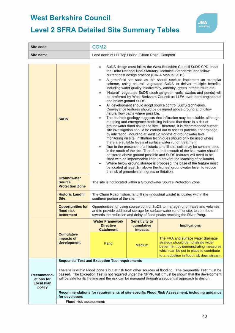
West Berkshire Council
Level 2 SFRA Detailed Site Summary Tables
40
Site code COM2
Site name Land north of Hill Top House, Churn Road, Compton
SuDS
• SuDS design must follow the West Berkshire Council SuDS SPD, meet the Defra National Non-Statutory Technical Standards, and follow current best design practice (CIRIA Manual 2015).
• A greenfield site such as this should seek to implement an exemplar scheme, using natural, vegetated SuDS to deliver multiple benefits, including water quality, biodiversity, amenity, green infrastructure etc.
• ‘Natural’, vegetated SuDS (such as green roofs, swales and ponds) will be preferred by West Berkshire Council as LLFA over ‘hard engineered’ and below-ground SuDS.
• All development should adopt source control SuDS techniques. Conveyance features should be designed above ground and follow natural flow paths where possible.
• The bedrock geology suggests that infiltration may be suitable, although mapping and emergence modelling indicate that there is a risk of groundwater flood risk to the site. Therefore, it is recommended further site investigation should be carried out to assess potential for drainage by infiltration, including at least 12 months of groundwater level monitoring on site. Infiltration techniques should only be used where there are suitable levels of surface water runoff treatment.
• Due to the presence of a historic landfill site, soils may be contaminated in the south of the site. Therefore, in the south of the site, water should be stored above ground possible and SuDS features will need to be fitted with an impermeable liner, to prevent the leaching of pollutants.
• Where below ground storage is proposed, the base of the feature must be located at least 1m above the highest groundwater level, to reduce the risk of groundwater ingress or flotation.
Groundwater Source Protection Zone
The site is not located within a Groundwater Source Protection Zone.
Historic Landfill Site
The Churn Road historic landfill site (industrial waste) is located within the southern portion of the site.
Opportunities for flood risk betterment
Opportunities for using source control SuDS to manage runoff rates and volumes, and to provide additional storage for surface water runoff onsite, to contribute
towards the reduction and delay of flood peaks reaching the River Pang.
Cumulative impacts of development
Water Framework Directive
Catchment
Sensitivity to cumulative
impacts Implications
Pang Medium
The FRA and surface water drainage strategy should demonstrate wider betterment by demonstrating measures which can be put in place to contribute
to a reduction in flood risk downstream.
Recommend-ations for Local Plan
policy
Sequential Test and Exception Test requirements
The site is within Flood Zone 1 but at risk from other sources of flooding. The Sequential Test must be passed. The Exception Test is not required under the NPPF, but it must be shown that the development will be safe for its lifetime and the risk can be managed through a sequential approach to design.
Recommendations for requirements of site-specific Flood Risk Assessment, including guidance for developers
Flood risk assessment:

West Berkshire Council
Level 2 SFRA Detailed Site Summary Tables
41
Site code COM2
Site name Land north of Hill Top House, Churn Road, Compton
• At the planning application stage, a site-specific flood risk assessment and surface water drainage strategy will be required.
• Consultation with the Local Authority and the Environment Agency should be undertaken at an early stage.
• A site-specific flood risk assessment will be required because the site is greater than 1Ha in area and at risk from sources of flooding other than rivers and the sea. Government guidance on flood risk assessments must be followed (https://www.gov.uk/guidance/floodrisk-assessment-for-planning-applications).
• Other sources of flooding should also be considered as part of a site-specific flood risk assessment, including surface water and groundwater.
• Climate change should be assessed using recommended climate change allowances at the time of the assessment (https://www.gov.uk/guidance/flood-risk-assessments-climate-change-allowances) for the type of development and level of risk. The current allowances were published in February 2016 but may be subject to change in the future.
• The site is located within a catchment identified as moderately sensitive to the cumulative impacts of development on flood risk. The site-specific FRA and surface water drainage strategy should consider the recommendations outlined for catchments of medium sensitivity in the West Berkshire Level 1 SFRA Cumulative Impacts Assessment Addendum.
Guidance for site design and making development safe:
• Development must seek opportunities to reduce overall level of flood risk at the site and should seek to reduce the levels of flood risk downstream.
• Safe access and egress should be demonstrated in the 1 in 100 plus climate change event.
• Mitigation for seasonal high groundwater levels must be considered (for example by raising finished floor levels to an appropriate height above ground level).
• Due to the high groundwater flood risk, basements are not permitted.
• A site-specific surface water drainage strategy will be required.
• The surface water drainage design must ensure that flows resulting from rainfall in excess of a 1 in 100-year event are managed via exceedance routes that minimise the risks to people and property.
• The level of detail and method of assessment of surface water runoff rates and volumes should be appropriate to the scale and risk of the development and should include recommended allowance for climate change and urban creep at the time of the assessment (currently +40% allowance for climate change and a 10% increase in impermeable area for urban creep).
• SuDS design must follow West Berkshire Council SuDS Supplementary Planning Document (SPD) standards, meet the Defra National Non-Statutory Technical Standards, and follow current best design practice (CIRIA Manual 2015).

West Berkshire Council
Level 2 SFRA Detailed Site Summary Tables
42
Site code COM3
Site name Land east of Mayfield Cottages, Cheseridge Road, Compton, RG20 7PL
Site details OS Grid reference
SU 51424 79787
Area 1.8 ha
Current land use Agriculture (Greenfield)
Proposed site use
Residential
Flood risk vulnerability
More vulnerable
Sources of flood risk
Existing watercourses/biodiversity
There are no watercourses within the site boundary. However, the River Pang (Main River) flows in an easterly direction 80m north of the site.
Flood history
The site is not located within the EA Recorded Flood Outline dataset. The Thames Water DG5 register shows that there has been a total of 7 sewer flooding incidents within the postcode area (RG20 7), two of which resulted in internal flooding to property.
Fluvial
Fluvial
Proportion of the site at risk (%)
Flood Zone 3b
5% AEP
Flood Zone 3a
1% AEP
Flood Zone 2
0.1% AEP
Flood Zone 1
19% 0% 1% 80%
Available modelled data:
The site is covered by broadscale, generalised modelling, with the model files not available for use in the Level 2 SFRA. Therefore, Flood Zone 3b has been used as a proxy for Flood Zone 3a.
Flood characteristics:
The northern part of the site is at risk of fluvial flooding from the River Pang during the 1% AEP (1 in 100) event. There is a small increase in flood extent during the 0.1% AEP (1 in 100) event. The remainder of the site is located within Flood Zone
1, and is at low fluvial flood risk.
Surface Water
Proportion of site at risk (RoFSW)
1 in 30 1 in 100 1 in 1,000
0% 0% 22%
Description of surface water flow paths:
There is no risk of surface water flooding predicted to occur at the site during the 3.3% AEP (1 in 30) and 1% AEP (1 in 100) rainfall events. During the 1% AEP (1 in 1,000) event, the northern portion of the site is at risk of surface water flooding, where runoff ponds against the higher topography in the south of the site.
Groundwater
Areas Susceptible to Groundwater Flooding Map class (risk of groundwater emergence)
Depth below surface 0-0.025m
Depth below surface 0.025-0.5m
Total in highest risk categories
0% 0% 0%
The site is at a moderate risk of groundwater flooding, with groundwater levels predicted to reach 0.5 – 5m below the ground surface during a 1% AEP (1 in 100) event.

West Berkshire Council
Level 2 SFRA Detailed Site Summary Tables
43
Site code COM3
Site name Land east of Mayfield Cottages, Cheseridge Road, Compton, RG20 7PL
Reservoir The site is not at risk of flooding, in the rare event of a reservoir breach.
Canal There are no canals witin the site.
Flood risk management infrastructure
Defences
Defence Type Standard of Protection Condition
There are no defences present within the site boundary. The site is not benefitting from any other defences.
Residual risk
Culvert / structure blockage?
The River Pang appears to be culverted below the unnamed road at the east of the site, at the junction with Ilsley Road. Based on the topography of the site, blockage of this culvert may cause the River Pang to back up and flood the north east of the site. However, the residual flood risk to the site, in the event of blockage to the culvert, should be assessed in detail within a site-specific Flood Risk Assessment.
Impounded water body failure?
N/A
Defence breach / overtopping?
Breach Zone
N/A
Emergency planning
Flood warning
The northern part of the site is located within the following EA Flood Alert Area:
• River Pang from East Ilsley to Pangbourne and Sulham Brook
The site is not located within an EA Flood Warning Area.
Access and egress
The site can be accessed via Cheseridge Road located to the west of the site, or via Newbury Road at the east of the site.
To the north, both access roads are at risk of fluvial flooding during the 1% AEP (1 in 100) and 0.1% AEP (1 in 1,000) flood events. However to the south, the access roads are located within Flood Zone 1, and are at very low risk of fluvial flooding. To the north, both access routes are at risk of surface water flooding during a 0.1% AEP (1 in 1,000) rainfall event.
Climate Change
Climate change allowances for ‘2080s’
River Basin District Central Higher Central
Upper End
Thames 25% 35% 70%
Implications for the site
Fluvial flood risk to the site is predicted to increase when accounting for the impact of climate change. However, in this location, Flood Zone 2 (0.1% AEP) has been used to represent the extent of Flood Zone 3a + climate change.

West Berkshire Council
Level 2 SFRA Detailed Site Summary Tables
44
Site code COM3
Site name Land east of Mayfield Cottages, Cheseridge Road, Compton, RG20 7PL
Requirement for drainage control and
impact mitigation
Bedrock Geology
Sussex White Chalk Formation
Superficial Geology
There are no superficial geology deposits mapped at this site.
Soils Freely draining lime-rich loamy soils
SuDS
• SuDS design must follow the West Berkshire Council SuDS SPD, meet the Defra National Non-Statutory Technical Standards, and follow current best design practice (CIRIA Manual 2015).
• Opportunities should be taken on a greenfield site such as this to deliver SuDS with multiple benefits, such as biodiversity, recreation and water resource education, through integration with areas of greenspace.
• ‘Natural’, vegetated SuDS (such as green roofs, swales and ponds) will be preferred by West Berkshire Council as LLFA over ‘hard engineered’ and below-ground SuDS.
• All development should adopt source control SuDS techniques. Conveyance features should be designed above ground and following natural flow paths where possible.
• Storage for runoff from the development in extreme events should be located out of fluvial flood risk areas.
• The permeable underlying geology and low groundwater flood risk suggest that discharge of the site via infiltration may be feasible, subject to a site investigation and site-specific soakage testing, to assess the potential for drainage by infiltration. Infiltration techniques should only be used where there are suitable levels of surface water runoff treatment.
Groundwater Source Protection Zone
The site is not within a Groundwater Source Protection Zone.
Historic Landfill Site
There are no historic landfill sites within the site boundary. The Hill Barn Road historic landfill site is located 250m south west of the site. Churn Road historic landfill site is located 250m north of the site.
Opportunities for flood risk betterment
Opportunities for using source control SuDS to manage runoff rates and volumes, contributing to the reduction of flood peaks downstream on the River Pang and existing surface water flow paths leaving the site.
Cumulative impacts of development
Water Framework Directive Catchment
Sensitivity to cumulative
impacts Implications
Pang Medium
The FRA and surface water drainage strategy should demonstrate wider betterment by demonstrating measures which can be put in place to contribute
to a reduction in flood risk downstream. Sequential Test and Exception Test requirements

West Berkshire Council
Level 2 SFRA Detailed Site Summary Tables
45
Site code COM3
Site name Land east of Mayfield Cottages, Cheseridge Road, Compton, RG20 7PL
Recommend-ations for Local Plan
policy
The Sequential Test must be satisfied. Only once the Sequential Test is satisfied should the Exception Test be applied. It is anticipated that proposed development will be sequentially located within Flood Zone 1. For this site, the Exception Test must be satisfied:
• If More Vulnerable and Essential Infrastructure is located in FZ3a or FZ3a plus climate change.
• If Highly Vulnerable development is located in FZ2.
• If Essential Infrastructure is located in Flood Zone 3b
Development will not be permitted in the following scenarios:
• Highly Vulnerable development within FZ3a or FZ3a plus climate change and FZ3b.
• More Vulnerable and Less Vulnerable development within FZ3b.
Recommendations for requirements of site-specific Flood Risk Assessment, including guidance for developers
Flood risk assessment:
• At the planning application stage, a site-specific flood risk assessment and surface water drainage strategy will be required.
• Consultation with the Local Authority and the Environment Agency should be undertaken at an early stage.
• A site-specific flood risk assessment will be required because the site is within Flood Zone 2 and 3 and at risk from sources of flooding other than rivers and the sea. Government guidance on flood risk assessments must be followed (https://www.gov.uk/guidance/floodrisk-assessment-for-planning-applications).
• Other sources of flooding should also be considered as part of a site-specific flood risk
assessment, including surface water and groundwater.
• Climate change should be assessed using recommended climate change allowances at the time of the assessment (https://www.gov.uk/guidance/flood-risk-assessments-climate-change-allowances) for the type of development and level of risk. The current allowances were published in February 2016 but may be subject to change in the future.
• Modelling should be conducted to assess the residual risk associated with potential blockage of the culvert within the site.
• The site is located within a catchment identified as moderately sensitive to the cumulative impacts of development on flood risk. The site-specific FRA and surface water drainage strategy should consider the recommendations outlined for catchments of medium sensitivity in the West Berkshire Level 1 SFRA Cumulative Impacts Assessment Addendum.
Guidance for site design and making development safe:
• Development must seek opportunities to reduce overall level of flood risk at the site and should seek to reduce the levels of flood risk downstream.
• Safe access and egress should be demonstrated in the 1 in 100 plus climate change event.
• A site-specific surface water drainage strategy will be required.
• The surface water drainage design must ensure that flows resulting from rainfall in excess of a 1 in 100-year event are managed via exceedance routes that minimise the risks to people and property.
• The level of detail and method of assessment of surface water runoff rates and volumes should be appropriate to the scale and risk of the development and should include recommended allowance for climate change and urban creep at the time of the assessment (currently +40% allowance for climate change and a 10% increase in impermeable area for urban creep).
• SuDS design must follow West Berkshire Council SuDS Supplementary Planning Document (SPD) standards, meet the Defra National Non-Statutory Technical Standards, and follow current best design practice (CIRIA Manual 2015). The design must ensure that flows resulting from rainfall in excess of a 1 in 100-year event are managed via exceedance routes that minimise the risks to people and property.
• The level of detail and method of assessment of surface water runoff rates and volumes should be appropriate to the scale and risk of the development and should include recommended allowance for climate change and urban creep at the time of the assessment (currently +40%
allowance for climate change and a 10% increase in impermeable area for urban creep).

West Berkshire Council
Level 2 SFRA Detailed Site Summary Tables
46
Site code COM3
Site name Land east of Mayfield Cottages, Cheseridge Road, Compton, RG20 7PL

West Berkshire Council
Level 2 SFRA Detailed Site Summary Tables
47
Site code E12
Site name Land south of Fidler's Lane, East Ilsley
Site details OS Grid reference
SU 49124 81148
Area 2.1 ha
Current land use Greenfield - Agriculture
Proposed site use
Residential
Flood risk vulnerability
More vulnerable
Sources of flood risk
Existing watercourses/biodiversity
An unnamed ordinary watercourse (which forms a tributary of the River Pang) flows southwards along the western boundary of the site.
Flood history
The site is not located within the EA Recorded Flood Outlines dataset. The site itself is not recorded as having been affected by flooding during the Winter 2013/14 event. However, the West Berkshire Council Winter 2013/14 Parish Flood Report for East Ilsley identifies that groundwater emergence occurred on Fidler’s Lane, through cracks in the road surface. During the event, sewer flooding was also reported within East Ilsley, as groundwater infiltrated into the sewer network, causing surcharging and manhole flooding.
The Thames Water DG5 register shows that there have been seven recorded sewer flooding incidents within the postcode area (RG20 7), of which two led to internal property flooding.
Fluvial
Fluvial
Proportion of the site at risk (%)
Flood Zone 3b
5% AEP
Flood Zone 3a
1% AEP
Flood Zone 2
0.1% AEP
Flood Zone 1
0% 0% 0% 100%
Available modelled data: There is no detailed hydraulic fluvial model covering the site.
Flood characteristics: The site is located within Flood Zone 1, and is therefore at negligible risk of fluvial flooding.
Surface Water
Proportion of site at risk (RoFSW)
3.3% AEP
(1 in 30)
1% AEP
(1 in 100)
0.1% AEP
(1 in 1,000)
0% 0% 1%
Description of surface water flow paths: The majority of the site is at very low surface water flood risk, with no flooding predicted to occur in events up to and including the 0.1% AEP (1 in 1,000-year) rainfall event. A small flow path is predicted to form in the east of the site during the 0.1% AEP, and flow eastwards onto the High Street.
Groundwater
Proportion of the site at risk in JBA Groundwater Map 1% AEP (1 in 100-year) risk categories
Depth below surface 0-0.025m
Depth below surface 0.025-0.5m
Total in highest risk categories
0% 0% 0%

West Berkshire Council
Level 2 SFRA Detailed Site Summary Tables
48
Site code E12
Site name Land south of Fidler's Lane, East Ilsley
JBA Groundwater Mapping shows the site to be at moderate risk of groundwater flooding, with groundwater levels predicted to lie between 0.5m and 5m below the ground surface during a 1% AEP event.
However, groundwater emergence modelling carried out by Jacobs following the Winter 2013/14 flood event, indicates that groundwater emergence is predicted to impact the north and east of the site during the 3.3% AEP event, and extend to
cover the majority of the site during a 1% AEP flood event.
Reservoir The site is not at risk of flooding, in the rare event of a reservoir breach.
Canal There are no canals witin the site boundary.
Flood risk management infrastructure
Defences
Defence Type Standard of Protection Condition
There are no defences within site boundary.
Residual risk
Culvert / structure blockage?
The unnamed ordinary watercourse at the western boundary of the site appears to be culverted below Fidler’s Lane, at the north west corner of the site. The structure has the potential to cause flooding to the northern portion of the site, in the event of a blockage. However, the impact of this blockage should be assessed in detail within a site-specific Flood Risk Assessment.
Impounded water body failure?
N/A
Defence breach / overtopping?
Breach Zone
N/A
Emergency planning
Flood warning The site is not covered by an Environment Agency Flood Alert or Flood Warning Area.
Access and egress
The site is likely to be accessed via Fidler’s Lane to the north, or High Street to the east. Both roads are at very low fluvial flood risk, although are at surface water flood risk. Surface water flooding is predicted to affect Fidler’s Lane during the 1% AEP (1 in 100) and 0.1% AEP (1 in 1,000) rainfall events, and is expected to form on High Street during a 0.1% AEP (1 in 1,000) rainfall event. The junction between the two roads is at high surface water flood risk, with a flow path causing flooding
during the 3.3% AEP (1 in 30) rainfall event.
Groundwater emergence modelling indicates that both roads are also at risk of groundwater flooding, during a 3.3% AEP (1 in 30) and 1% AEP (1 in 100) events. Therefore, access to the site via Fidler’s Lane and the High Street may be restricted at times of surface water and groundwater flooding.
Climate Change
Climate change allowances for ‘2080s’
River Basin District Central Higher Central
Upper End
Thames 25% 35% 70%
Implications for the site
The site remains within Flood Zone 1, accounting for the impact of climate change on fluvial flood risk.

West Berkshire Council
Level 2 SFRA Detailed Site Summary Tables
49
Site code E12
Site name Land south of Fidler's Lane, East Ilsley
Requirement for drainage control and
impact mitigation
Bedrock Geology
The site is underlain by Sussex White Chalk Formation
Superficial Geology
There are no superficial deposits on the site.
Soils Freely draining lime-rich loamy soils.
SuDS
• SuDS design must follow the West Berkshire Council SuDS SPD, meet the Defra National Non-Statutory Technical Standards, and follow current best design practice (CIRIA Manual 2015).
• A greenfield site such as this should seek to implement an exemplar scheme, using natural, vegetated SuDS to deliver multiple benefits, including water quality, biodiversity, amenity, green infrastructure etc.
• ‘Natural’, vegetated SuDS (such as green roofs, swales and ponds) will be preferred by West Berkshire Council as LLFA over ‘hard engineered’ and below-ground SuDS.
• All development should adopt source control SuDS techniques. Conveyance features should be designed above ground and follow natural flow paths where possible.
• The bedrock geology suggests that infiltration may be suitable, although mapping and emergence modelling indicate that the site is at risk of groundwater flooding. Therefore, it is recommended further site investigation should be carried out to assess potential for drainage by infiltration, including at least 12 months of groundwater level monitoring on site. Infiltration techniques should only be used where there are suitable levels of surface water runoff treatment.
• Where below ground storage is proposed, the base of the feature must be located at least 1m above the highest groundwater level, to reduce
the risk of groundwater ingress or flotation.
Groundwater Source Protection Zone
The site is not located within a Groundwater Source Protection Zone.
Historic Landfill Site
There are no historic landfill sites within the site boundary or within close proximity.
Opportunities for flood risk betterment
Opportunities for using source control SuDS to manage runoff rates and volumes, and to provide additional storage for surface water runoff onsite, to contribute towards the reduction and delay of flood peaks reaching the River Pang and the existing surface water flow path leaving the site.
Cumulative impacts of development
Water Framework Directive Catchment
Sensitivity to cumulative
impacts Implications
Pang Medium
The FRA and surface water drainage strategy should demonstrate wider betterment by demonstrating measures which can be put in place to contribute to a reduction in
flood risk downstream. Sequential Test and Exception Test requirements

West Berkshire Council
Level 2 SFRA Detailed Site Summary Tables
50
Site code E12
Site name Land south of Fidler's Lane, East Ilsley
Recommend-ations for Local Plan
policy
The site is within Flood Zone 1 but at risk from other sources of flooding. The Sequential Test must be passed. The Exception Test is not required under the NPPF, but it must be shown that the development will be safe for its lifetime and the risk can be managed through a sequential approach to design.
Recommendations for requirements of site-specific Flood Risk Assessment, including guidance for developers
Flood risk assessment:
• At the planning application stage, a site-specific flood risk assessment and surface water drainage strategy will be required.
• Consultation with the Local Authority and the Environment Agency should be undertaken at an early stage.
• A site-specific flood risk assessment will be required because the site is greater than 1Ha in area and at risk from sources of flooding other than rivers and the sea. Government guidance on flood risk assessments must be followed (https://www.gov.uk/guidance/floodrisk-assessment-for-planning-applications).
• Other sources of flooding should also be considered as part of a site-specific flood risk assessment, including surface water and groundwater.
• Detailed modelling will be required to confirm Flood Zone and climate change extents for the ordinary watercourse within the site (see ‘Available modelled data’). The Environment Agency and LLFA should be consulted to obtain the latest hydraulic modelling information for the site at the time of the flood risk assessment. They will advise as to whether existing detailed models are available, and if so, whether they need to be updated.
• Climate change should be assessed using recommended climate change allowances at the time of the assessment (https://www.gov.uk/guidance/flood-risk-assessments-climate-change-allowances) for the type of development and level of risk. The current allowances were published in February 2016 but may be subject to change in the future.
• Modelling should be conducted to assess the residual risk associated with potential blockage of the culvert within the site.
• The site is located within a catchment identified as moderately sensitive to the cumulative impacts of development on flood risk. The site-specific FRA and surface water drainage strategy should consider the recommendations outlined for catchments of medium sensitivity in the West Berkshire Level 1 SFRA Cumulative Impacts Assessment Addendum.
Guidance for site design and making development safe:
• Development must seek opportunities to reduce overall level of flood risk at the site and should seek to reduce the levels of flood risk downstream.
• Safe access and egress should be demonstrated in the 1 in 100 plus climate change event.
• A site-specific surface water drainage strategy will be required.
• The surface water drainage design must ensure that flows resulting from rainfall in excess of a 1 in 100-year event are managed via exceedance routes that minimise the risks to people and
property.
• The level of detail and method of assessment of surface water runoff rates and volumes should be appropriate to the scale and risk of the development and should include recommended allowance for climate change and urban creep at the time of the assessment (currently +40% allowance for climate change and a 10% increase in impermeable area for urban creep).
• SuDS design must follow West Berkshire Council SuDS Supplementary Planning Document (SPD) standards, meet the Defra National Non-Statutory Technical Standards, and follow current best design practice (CIRIA Manual 2015).
• The unnamed watercourse which forms the western boundary of the site is an ordinary watercourse. A sufficient width of buffer, to be agreed in consultation with West Berkshire Council, should be maintained between the riverbank and any built structures, to enable riparian
owners to access and maintain the channel.

West Berkshire Council
Level 2 SFRA Detailed Site Summary Tables
51
Site code ENG1
Site name Englefield Estate Yard, The Street, Englefield, RG7 5ES
Site details OS Grid reference
SU 62825 72284
Area 1.1 Ha
Current land use Brownfield - Estate yard
Proposed site use
Commercial and community facilities
Flood risk vulnerability
Less vulnerable
Sources of flood risk
Existing watercourses/biodiversity
There are no watercourses in the site boundary.
Flood history
The site is not located within the EA Recorded Flood Outline dataset.
The Thames Water DG5 register shows that 14 sewer flooding incidents have been recorded within the postcode area (RG7 5), of which one has resulted in
internal property flooding.
Fluvial
Fluvial
Proportion of the site at risk (%)
Flood Zone 3b
5% AEP
Flood Zone 3a
1% AEP
Flood Zone 2
0.1% AEP
Flood Zone 1
0% 0% 0% 100%
Available modelled data:
The site is not covered by a hydraulic model.
Flood characteristics:
The site is located within Flood Zone 1, where fluvial flood risk is negligible.
Surface Water
Proportion of site at risk (RoFSW)
1 in 30 (3.33% AEP) 1 in 100 (1% AEP) 1 in 1,000 (0.1% AEP)
0% 0% 1%
Description of surface water flow paths:
The site is at very low surface water flood risk, with a small area of ponding predicted to form against an existing building in the centre of the site during a 0.1% AEP (1 in 1,000) rainfall event.
Groundwater
Proportion of the site at risk in JBA Groundwater Map 1% AEP risk categories
Depth below surface 0-0.025m
Depth below surface 0.025-0.5m
Total in highest risk categories
74% 26% 100%
The site is at high risk of groundwater flooding, with groundwater levels across the majority of the site predicted to lie within 0.025m of the ground surface during a 1% AEP (1 in 100) event. In the north of the site, groundwater levels are predicted to
lie between 0.025 – 0.5m of the ground surface during a flood event.
Reservoir The site is not at risk of flooding, in the rare event of a reservoir breach.
Canal There are no canals within the vicinity of the site.

West Berkshire Council
Level 2 SFRA Detailed Site Summary Tables
52
Site code ENG1
Site name Englefield Estate Yard, The Street, Englefield, RG7 5ES
Flood risk management infrastructure
Defences Defence Type Standard of Protection Condition
There are no flood defences within the site boundary.
Residual risk
Culvert / structure blockage?
N/A
Impounded water body failure?
N/A
Defence breach / overtopping?
Breach Zone
N/A
Emergency planning
Flood warning The site is not within an EA Flood Alert or Flood Warning Area.
Access and egress
The site is likely to be accessed via The Street with current access to the south of the site. The route is in Flood Zone 1 with neglgibile risk of fluvial flooding. Adjacent to the site, there is a small area of surface water ponding within the highway which is likley to occur duirng the 3.33% AEP event.
Climate Change
Climate change allowances for ‘2080s’
River Basin District Central Higher Central
Upper End
Thames 25% 35% 70%
Implications for the site
The site remains in Flood Zone 1 when accounting for the impact of climate change.

West Berkshire Council
Level 2 SFRA Detailed Site Summary Tables
53
Site code ENG1
Site name Englefield Estate Yard, The Street, Englefield, RG7 5ES
Requirement for drainage control and
impact mitigation
Bedrock Geology
Seaford Chalk Formation.
Superficial Geology
Thatcham Gravel - Sand And Gravel.
Soils Freely draining slightly acid loamy soils.
SuDS
• SuDS design must follow the West Berkshire Council SuDS SPD, meet the Defra National Non-Statutory Technical Standards, and follow current best design practice (CIRIA Manual 2015).
• SuDS are possible on all sites, including previously developed sites such as this one. All development should adopt source control SuDS techniques. Conveyance features should be designed above ground and following natural flow paths where possible.
• ‘Natural’, vegetated SuDS (such as green roofs, swales and ponds) will be preferred by West Berkshire Council as LLFA over ‘hard engineered’ and below-ground SuDS.
• The bedrock geology appears to be permeable, although mapping indicates that the site is at high risk of groundwater flooding, therefore infiltration techniques may not be suitable. It is recommended that further site investigation should be carried out to assess and confirm the potential for infiltration.
• The site is located within Groundwater Source Protection Zone 3. As such infiltration techniques should only be used where there are suitable levels of treatment and following the granting of any required environmental permits from the Environment Agency.
• Where below ground storage is proposed, the base of the feature must be located at least 1m above the highest groundwater level, to reduce the risk of groundwater ingress or flotation.
Groundwater Source Protection Zone
The site is within Groundwater Source Protection Zone 3.
Historic Landfill Site
There are no historic landfill sites within the site boundary.
Opportunities for flood risk betterment
Opportunities for using source control SuDS to manage runoff rates and volumes, contributing to the reduction of flood peaks downstream and existing surface
water flow paths leaving the site.
Cumulative impacts of development
Water Framework Directive Catchment
Sensitivity to cumulative impacts
Implications
Sulham Brook Medium
The FRA and surface water
drainage strategy should
demonstrate wider betterment
by demonstrating measures
which can be put in place to
contribute to a reduction in
flood risk downstream.
Sequential Test and Exception Test requirements

West Berkshire Council
Level 2 SFRA Detailed Site Summary Tables
54
Site code ENG1
Site name Englefield Estate Yard, The Street, Englefield, RG7 5ES
Recommend-ations for Local Plan
policy
The site is within Flood Zone 1 but at risk from other sources of flooding. The Sequential Test must be passed. The Exception Test is not required under the NPPF, but it must be shown that the development will be safe for its lifetime and the risk can be managed through a sequential approach to design.
Recommendations for requirements of site-specific Flood Risk Assessment, including guidance for developers
Flood risk assessment:
• At the planning application stage, a site-specific flood risk assessment and surface water drainage strategy will be required.
• Consultation with the Local Authority and the Environment Agency should be undertaken at an early stage.
• A site-specific flood risk assessment will be required because the site is over 1 ha in area and located within Flood Zone 1, as well as at risk from sources of flooding other than rivers and the sea. Government guidance on flood risk assessments must be followed (https://www.gov.uk/guidance/flood-risk-assessment-for-planning-applications).
• Other sources of flooding should also be considered as part of a site-specific flood risk assessment, including surface water and groundwater.
• Climate change should be assessed using recommended climate change allowances at the time of the assessment (https://www.gov.uk/guidance/flood-risk-assessments-climate-change-allowances) for the type of development and level of risk. The current allowances were published in February 2016 but may be subject to change in the future.
• The site is located within a catchment identified as moderately sensitive to the cumulative impacts of development on flood risk. The site-specific FRA and surface water drainage strategy should consider the recommendations outlined for catchments of medium sensitivity in the West Berkshire Level 1 SFRA Cumulative Impacts Assessment Addendum.
Guidance for site design and making development safe:
• Development must seek opportunities to reduce overall level of flood risk at the site.
• Mitigation for seasonal high groundwater levels must be considered (for example by raising finished floor levels to an appropriate height above ground level).
• Due to the high groundwater flood risk, basements are not permitted.
• The design of SuDS schemes must consider the seasonally high groundwater table. Infiltration techniques may be ineffective and may pose a pollution risk. SuDS may need to be shallow and take up larger areas. Above ground conveyance and attenuation can be used but care must be taken that groundwater does not enter the SuDS feature and reduce the storage capacity and structural integrity of the design.
• The level of detail and method of assessment of surface water runoff rates and volumes should be appropriate to the scale and risk of the development and should include recommended allowance for climate change and urban creep at the time of the assessment (currently +40% allowance for climate change and a 10% increase in impermeable area for urban creep).
• SuDS design must follow West Berkshire Council SuDS Supplementary Planning Document (SPD) standards, meet the Defra National Non-Statutory Technical Standards, and follow current best design practice (CIRIA Manual 2015).The design must ensure that flows resulting from rainfall in excess of a 1 in 100-year event are managed via exceedance routes that minimise the risks to people and property.

West Berkshire Council
Level 2 SFRA Detailed Site Summary Tables
55
Site code HUN6
Site name Hungerford Trading Estate, Smitham Bridge Road, Hungerford, RG17 0QU
Site details OS Grid reference
SU 33065 68223
Area 0.7 ha
Current land use Brownfield - Employment (light industrial)
Proposed site use
Residential
Flood risk vulnerability
More vulnerable
Sources of flood risk
Existing watercourses/biodiversity
The Shalbourne Brook (Main River), a tributary of the River Dun, flows north eastwards along the western boundary of the site. The Kennet and Avon Canal is located 250m north of the site.
The Shalbourne Brook is a chalk river, which is a protected habitat listed in S41 of the NERC Act.
Flood history
The site is not located within either an EA Historic Flood Map.
The Thames Water DG5 record shows that there have been eight sewer flooding incidents within the postcode area (RG17 0), three of which have resulted in internal flooding of the property.
Fluvial
Fluvial
Proportion of the site at risk (%)
Flood Zone 3b
5% AEP
Flood Zone 3a
1% AEP
Flood Zone 2
0.1% AEP
Flood Zone 1
24% 0% 3% 73%
Available modelled data:
The site is covered by broadscale, generalised modelling, with the model files not available for use in the Level 2 SFRA. Therefore, Flood Zone 3b has been used as a proxy for Flood Zone 3a.
Flood characteristics:
The western boundary of the site is at risk of fluvial flooding from the Shalbourne Brook during the 1% AEP (1 in 100) flood event, with a small increase in flood extent during the 0.1% AEP (1 in 1,000) event. The remainder of the site is within Flood Zone 1, and is therefore at low fluvial flood risk.
Surface Water
Proportion of site at risk (RoFSW)
1 in 30 1 in 100 1 in 1,000
22% 39% 91%
Description of surface water flow paths:
Surface water flood risk at the site follows the route of the Shalbourne Brook, with a flow path draining in a north easterly direction along the western boundary of the site during the 3.33% (1 in 30) and greater rainfall events. During the 3.33% and 1% AEP events, the flow paths follow the western boundary of the site and do not reach the outline of the existing building on the site. However, during the 0.1% AEP event, surface water flood risk extends to cover the majority of the site, with the existing building is at risk of surface water flooding. During the 3.33% and 1% AEP events, an area of surface water ponding also forms in the south east of the site, where runoff ponds against surrounding higher topography.
Groundwater
Areas Susceptible to Groundwater Flooding Map class (risk of groundwater emergence)
Depth below surface 0-0.025m
Depth below surface 0.025-0.5m
Total in highest risk categories

West Berkshire Council
Level 2 SFRA Detailed Site Summary Tables
56
Site code HUN6
Site name Hungerford Trading Estate, Smitham Bridge Road, Hungerford, RG17 0QU
98% 2% 100%
The site is at a high of groundwater flooding, with groundwater levels across the majority of the site likely to lie within 0.025m of the ground surface during a 1% AEP event (1 in 100). Along the eastern boundary, groundwater levels are predicted to lie between 0.025 – 0.5m of the ground surface.
Reservoir The site is not at risk of flooding, in the rare event of a reservoir breach.
Canal The site is seperated from the Kennet and Avon Canal by a railway embankment, and therefore the site is conidered to be at low risk of flooding from canals.
Flood risk management infrastructure
Defences
Defence Type Standard of Protection Condition
There are no formal defences within site boundary, and the site is not identified as benefitting from defence.
Residual risk
Culvert / structure blockage?
The Shalbourne Brook is culverted beneath Smitham Bridge Road, to the north east corner of the site. Blockage of this culvert is likely to cause flooding to the north of the site. However, the impact of this blockage on residual risk to the site should be assessed in detail within a site-specific Flood Risk Assessment.
Impounded water body failure?
The site is not at risk of flooding due to reservoir breach.
Defence breach / overtopping?
Breach Zone
N/A
Emergency planning
Flood warning
The western side of the site is within the following EA Flood Alert and Flood Warning Areas:
• Flood Alert Area: River Kennet and its tributaries from Berwick Basset down to Newbury
• Flood Warning Area: River Kennet and its tributaries at Hungerford
Access and egress
The site is likely to be accessed via Smitham Bridge Road at the north of the site, or Chilton Way to the east. The section of Smitham Bridge Road immediately north of the site is at risk of fluvial flooding during 1% AEP (1 in 100) and 0.1% AEP (1 in 1,000) events. Chilton Way at the east of the site is located in Flood Zone 1, and is therefore at low fluvial flood risk. Smitham Bridge Road is at high surface water flood risk, with flooding predicted to occur during the 3.3% AEP (1 in 30) rainfall event and greater rainfall events. Chilton Way is at very low surface water flood risk.
Climate Change
Climate change allowances for ‘2080s’
River Basin District Central Higher Central
Upper End
Thames 25% 35% 70%
Implications for the site
Fluvial flood risk to the site is predicted to increase when accounting for the impact of climate change. However, in this location, Flood Zone 2 (0.1% AEP) has been used to represent the extent of Flood Zone 3a + climate change.

West Berkshire Council
Level 2 SFRA Detailed Site Summary Tables
57
Site code HUN6
Site name Hungerford Trading Estate, Smitham Bridge Road, Hungerford, RG17 0QU
Requirement for drainage control and
impact mitigation
Bedrock Geology
Sussex White Chalk Formation
Superficial Geology
Alluvium – Clay, Silt and Sand
Soils Freely draining, slightly acid but base-rich, loamy soils
SuDS
• SuDS design must follow the West Berkshire Council SuDS SPD, meet the Defra National Non-Statutory Technical Standards, and follow current best design practice (CIRIA Manual 2015).
• All development should adopt source control SuDS techniques. Conveyance features should be designed above ground and following natural flow paths where possible.
• ‘Natural’, vegetated SuDS (such as green roofs, swales and ponds) will be preferred by West Berkshire Council as LLFA over ‘hard engineered’ and below-ground SuDS.
• Storage for runoff from the development in extreme events should be located out of fluvial flood risk areas.
• The bedrock geology suggests good infiltration potential, although mapping indicates that the site is at high risk of groundwater flooding. Therefore, infiltration techniques may not be suitable at the site. If infiltration is proposed, it is recommended that further site investigation should be carried out to assess potential for drainage by infiltration, including at least 12 months of groundwater level monitoring on site. Infiltration techniques should only be used where there are suitable levels of surface water runoff treatment.
• Where below ground storage is proposed, the base of the feature must be located at least 1m above the highest groundwater level, to reduce the risk of groundwater ingress or flotation.
Groundwater Source Protection Zone
The site is not within a Groundwater Source Protection Zone.
Historic Landfill Site
There are no historic landfill sites within the site boundary or in the near vicinity.
Opportunities for flood risk betterment
Opportunities for using source control SuDS to manage runoff rates and volumes, contributing to the reduction of flood peaks downstream on the River Dun and existing surface water flow paths leaving the site.
Cumulative impacts of development
Water Framework Directive Catchment
Sensitivity to cumulative impacts
Implications
Shalbourne (source to Kennet at Hungerford)
Medium
The FRA and surface water drainage strategy should demonstrate wider betterment by demonstrating measures which can be put in place to contribute to a reduction in
flood risk downstream. Sequential Test and Exception Test requirements

West Berkshire Council
Level 2 SFRA Detailed Site Summary Tables
58
Site code HUN6
Site name Hungerford Trading Estate, Smitham Bridge Road, Hungerford, RG17 0QU
Recommend-ations for Local Plan
policy
The Sequential Test must be satisfied. Only once the Sequential Test is satisfied should the Exception Test be applied. It is anticipated that proposed development will be sequentially located within Flood Zone 1. For this site, the Exception Test must be satisfied:
• If More Vulnerable and Essential Infrastructure is located in FZ3a or FZ3a plus climate change.
• If Highly Vulnerable development is located in FZ2.
• If Essential Infrastructure is located in Flood Zone 3b
Development will not be permitted in the following scenarios:
• Highly Vulnerable development within FZ3a or FZ3a plus climate change and FZ3b.
• More Vulnerable and Less Vulnerable development within FZ3b.
Recommendations for requirements of site-specific Flood Risk Assessment, including guidance for developers
Flood risk assessment:
• At the planning application stage, a site-specific flood risk assessment and surface water drainage strategy will be required.
• Consultation with the Local Authority and the Environment Agency should be undertaken at an early stage.
• A site-specific flood risk assessment will be required because the site is within Flood Zone 2 and 3 and at risk from sources of flooding other than rivers and the sea. Government guidance on flood risk assessments must be followed (https://www.gov.uk/guidance/floodrisk-assessment-for-planning-applications).
• Other sources of flooding should also be considered as part of a site-specific flood risk assessment, including surface water and groundwater.
• Detailed modelling will be required to confirm Flood Zone and climate change extents for the ordinary watercourse within the site (see ‘Available modelled data’). The Environment Agency and LLFA should be consulted to obtain the latest hydraulic modelling information for the site at the time of the flood risk assessment. They will advise as to whether existing detailed models
are available, and if so, whether they need to be updated.
• Climate change should be assessed using recommended climate change allowances at the time of the assessment (https://www.gov.uk/guidance/flood-risk-assessments-climate-change-allowances) for the type of development and level of risk. The current allowances were published in February 2016 but may be subject to change in the future.
• Modelling should be conducted to assess the residual risk associated with potential blockage of the culvert within the site.
• The site is located within a catchment identified as moderately sensitive to the cumulative impacts of development on flood risk. The site-specific FRA and surface water drainage strategy should consider the recommendations outlined for catchments of medium sensitivity in the West Berkshire Level 1 SFRA Cumulative Impacts Assessment Addendum.
Guidance for site design and making development safe:
• Development must seek opportunities to reduce overall level of flood risk at the site and should seek to reduce the levels of flood risk downstream.
• Safe access and egress should be demonstrated in the 1 in 100 plus climate change event.
• Mitigation for seasonal high groundwater levels must be considered (for example by raising finished floor levels to an appropriate height above ground level).
• Due to the high groundwater flood risk, basements are not permitted.
• A site-specific surface water drainage strategy will be required.
• The design of SuDS schemes must take into account the seasonally high groundwater table. Infiltration techniques may be ineffective and may pose a pollution risk. SuDS may need to be shallow and take up larger areas. Above ground conveyance and attenuation can be used but care must be taken that groundwater does not enter the SuDS feature and reduce the storage capacity and structural integrity of the design.
• The surface water drainage design must ensure that flows resulting from rainfall in excess of a 1 in 100-year event are managed via exceedance routes that minimise the risks to people and property.

West Berkshire Council
Level 2 SFRA Detailed Site Summary Tables
59
Site code HUN6
Site name Hungerford Trading Estate, Smitham Bridge Road, Hungerford, RG17 0QU
• The level of detail and method of assessment of surface water runoff rates and volumes should be appropriate to the scale and risk of the development and should include recommended allowance for climate change and urban creep at the time of the assessment (currently +40% allowance for climate change and a 10% increase in impermeable area for urban creep).
• SuDS design must follow West Berkshire Council SuDS Supplementary Planning Document (SPD) standards, meet the Defra National Non-Statutory Technical Standards, and follow current best design practice (CIRIA Manual 2015).
• The Shalbourne Brook, a Main River, is located at the western boundary of the site. An 8m wide buffer should be maintained between the riverbank and any built structures, to enable the riparian owners and/or the Environment Agency to access and maintain the channel.

West Berkshire Council
Level 2 SFRA Detailed Site Summary Tables
60
Site code HUN10
Site name Land off Smitham Bridge Road and Marsh Lane, Hungerford
Site details OS Grid reference
SU 33220 68558
Area 3 Ha
Current land use Greenfield – grassland
Proposed site use
Public open space and/or marina
Flood risk vulnerability
Less vulnerable
Sources of flood risk
Existing watercourses/biodiversity
The Kennet and Avon Canal forms the northern boundary of the site. The Shalbourne Brook (Main River), a tributary of the River Dun, flows in a northerly direction along the western boundary of the site. The watercourse branches within the site boundary, with one watercourse continuing northwards along the western boundary, and a second watercourse flowing north eastwards across the site and crossing the Kennet and Avon Canal at the northern boundary of the site. A 100m long linear water body is also located in the north east corner of the site.
The Kennet and Avon Canal forms the southern boundary of the Freeman’s Marsh Site of Special Scientific Interest (SSSI) which supports a number of wetland habitats that are reliant upon season flooding. Development must not alter the flooding regime of the SSSI.
The Shalbourne Brook is a chalk river which is a protected habitat listed in S41 of the NERC Act.
Flood history
The site is not located within the EA Recorded Flood Outline dataset. The Thames Water DG5 register shows that there have been eight sewer flooding incidents within the postcode area (RG17 0), three of which have resulted in internal flooding of the property.
Fluvial
Fluvial
Proportion of the site at risk (%)
Flood Zone 3b
5% AEP
Flood Zone 3a
1% AEP
Flood Zone 2
0.1% AEP
Flood Zone 1
32% 0% 3% 65%
Available modelled data:
The site is situated adjacent to the extent of the 2007 1D River Kennet (Marlborough to Newbury) model. The Flood Zones within the site are informed by broadscale, generalised modelling, with the model files not available for use in the Level 2 SFRA. Therefore, Flood Zone 3a (1% AEP) has been used as a proxy for Flood Zone 3b.
Flood characteristics:
The western boundary and north west of the site are at risk of fluvial flooding from the Shalbourne Brook during a 1% AEP (1 in 100) event, with a small increase in flood extent predicted during the 0.1% AEP (1 in 1,000) event. The remainder of the site is located within Flood Zone 1, and is at low fluvial flood risk.
Surface Water
Proportion of site at risk (RoFSW)
1 in 30 1 in 100 1 in 1,000
51% 60% 68%
Description of surface water flow paths:
Surface water flood risk at the site largely follows the two branches of the Shalbourne Brook, northwards along the western border of the site, and north eastwards across the north of the site. The railway line at the south of the site forms a topographic barrier, causing flooding to extend across the south west, centre and north of the site, during the 3.3% AEP (1 in 30) and greater rainfall events.

West Berkshire Council
Level 2 SFRA Detailed Site Summary Tables
61
Site code HUN10
Site name Land off Smitham Bridge Road and Marsh Lane, Hungerford
Groundwater
Areas Susceptible to Groundwater Flooding Map class (risk of groundwater emergence)
Depth below surface 0-0.025m
Depth below surface 0.025-0.5m
Total in highest risk categories
86% 8% 94%
The site is at high risk of groundwater flooding. Across the majority of the site, groundwater levels are predicted to lie within 0.025m of the ground surface during a 1% AEP (1 in 100) event. The south east corner of the site is at a moderate to moderate-high risk of flooding, with groundwater levels expected to lie between 0.025 – 0.5m, and 0.5 – 5m of the ground surface.
Reservoir The site is not at risk of flooding, in the rare event of a reservoir breach.
Canal The Kennet and Avon Canal forms the northern boundary of the site. Therefore, the site may be at risk of flooding, in the unlikely event of breach or overtopping of the canal bank.

West Berkshire Council
Level 2 SFRA Detailed Site Summary Tables
62
Site code HUN10
Site name Land off Smitham Bridge Road and Marsh Lane, Hungerford
Flood risk management infrastructure
Defences
Defence Type Standard of Protection Condition
There are no defences present in this site, nor does the site benefit from any defences.
Residual risk
Culvert / structure blockage?
The Shalbourne Brook passes below the Kennet and Avon Canal at two locations in the north west and northern boundaries of the site. Blockage of these structures is likely to cause backing up and flooding to the north and west of the site. However, the impact of these blockages on the residual risk to the site should be assessed in detail within a site-specific Flood Risk
Assessment.
Impounded water body failure?
N/A
Defence breach / overtopping?
Breach Zone
N/A
Emergency planning
Flood warning
The western side of the site is within the following EA Flood Alert and Flood Warning Areas:
• Flood Alert Area: River Kennet and its tributaries from Berwick Basset down to Newbury
• Flood Warning Area: River Kennet and its tributaries at Hungerford
Access and egress
The site would be accessed from Smitham Bridge Road to the south, via a private access road at the south eastern tip of the site (not shown on available OS Mapping). Other potential access routes would be via Parsonage Lane to the east of the site or Marsh Lane to the west.
Smitham Bridge Road is predominantely at low fluvial flood risk, although a small area to the south east of the site is at risk of fluoding during a 1% AEP (1 in 100) fluvial flood event, where an ordinary watercourse is culverted below the road. Parsonage Lane and Marsh Lane are both located in Flood Zone 1, and therefore at low fuvial flood risk.
To the south of the site, Smitham Bridge Road is at high surface water flood risk, with flooding of the road predicted to occur during the 3.3% AEP (1 in 30) and greater rainfall events.
Parsonage Lane is at risk of surface water flooding during a 1% AEP ( 1 in 100) and 0.1% AEP (1 in 1,000) rainfall event, and Marsh Lane is at risk of surface water flooding during 3.3% AEP (1 in 30) and greater rainfall events, particularly where the road passes below the railway line.
Climate Change
Climate change allowances for ‘2080s’
River Basin District Central Higher Central
Upper End
Thames 25% 35% 70%
Implications for the site
Fluvial flood risk to the site is predicted to increase when accounting for the impact of climate change. However, in this location, Flood Zone 2 (0.1% AEP) has been used to represent the extent of Flood Zone 3a + climate change.

West Berkshire Council
Level 2 SFRA Detailed Site Summary Tables
63
Site code HUN10
Site name Land off Smitham Bridge Road and Marsh Lane, Hungerford
Requirement for drainage control and
impact mitigation
Bedrock Geology
Sussex White Chalk Formation
Superficial Geology
Superficial geology has been mapped at the eastern side the site: Alluvium - Clay, Silt and Sand.
Soils Loamy and clayey floodplain soils with naturally high groundwater
SuDS
• Due to the high groundwater flood risk, basements are not permitted.
• Opportunities should be taken on a greenfield site such as this to deliver SuDS with multiple benefits, such as biodiversity, recreation and water resource education, through integration with areas of greenspace.
• ‘Natural’, vegetated SuDS (such as green roofs, swales and ponds) will be preferred by West Berkshire Council as LLFA over ‘hard engineered’ and below-ground SuDS.
• All development should adopt source control SuDS techniques. Conveyance features should be designed above ground and following natural flow paths where possible.
• Storage for runoff from the development in extreme events should be located out of fluvial flood risk areas.
• The bedrock geology suggests good infiltration potential, although mapping indicates that the site is at high risk of groundwater flooding. Therefore, infiltration techniques may not be suitable at the site. If infiltration is proposed, it is recommended that further site investigation should be carried out to assess potential for drainage by infiltration, including at least 12 months of groundwater level monitoring on site. Infiltration techniques should only be used where there are suitable levels of surface water runoff treatment.
• Where below ground storage is proposed, the base of the feature must be located at least 1m above the highest groundwater level, to reduce the risk of groundwater ingress or flotation.
Groundwater Source Protection Zone
The site is not within a Groundwater Source Protection Zone.
Historic Landfill Site
There are no historic landfill sites within the site boundary or in the near vicinity.
Opportunities for flood risk betterment
Opportunities for using source control SuDS to manage runoff rates and volumes, contributing to the reduction of flood peaks downstream on the River Kennet and
existing surface water flow paths leaving the site.
Cumulative impacts of development
Water Framework Directive Catchment
Sensitivity to cumulative impacts
Implications
Kennet and Avon Canal ad Dun above Hungerford
High The FRA should examine the cumulative impacts of potential peak runoff rates and volumes from the site (and other developments in the WFD catchment) on flood risk in the receiving watercourses.
Shalbourne (source to Kennet at Hungerford)
Medium
Sequential Test and Exception Test requirements

West Berkshire Council
Level 2 SFRA Detailed Site Summary Tables
64
Site code HUN10
Site name Land off Smitham Bridge Road and Marsh Lane, Hungerford
Recommend-ations for Local Plan
policy
The Sequential Test must be satisfied. Only once the Sequential Test is satisfied should the Exception Test be applied. It is anticipated that proposed development will be sequentially located within Flood Zone 1. For this site, the Exception Test must be satisfied:
• If More Vulnerable and Essential Infrastructure is located in FZ3a or FZ3a plus climate change.
• If Highly Vulnerable development is located in FZ2.
• If Essential Infrastructure is located in Flood Zone 3b
Development will not be permitted in the following scenarios:
• Highly Vulnerable development within FZ3a or FZ3a plus climate change and FZ3b.
• More Vulnerable and Less Vulnerable development within FZ3b.
Recommendations for requirements of site-specific Flood Risk Assessment, including guidance for developers
Flood risk assessment:
• At the planning application stage, a site-specific flood risk assessment and surface water drainage strategy will be required.
• Consultation with the Local Authority and the Environment Agency should be undertaken at an early stage.
• A site-specific flood risk assessment will be required because the site is within Flood Zone 2 and 3 and at risk from sources of flooding other than rivers and the sea. Government guidance on flood risk assessments must be followed (https://www.gov.uk/guidance/floodrisk-assessment-for-planning-applications).
• Other sources of flooding should also be considered as part of a site-specific flood risk assessment, including surface water and groundwater.
• Detailed modelling will be required to confirm Flood Zone and climate change extents for the ordinary watercourse within the site (see ‘Available modelled data’). The Environment Agency and LLFA should be consulted to obtain the latest hydraulic modelling information for the site at the time of the flood risk assessment. They will advise as to whether existing detailed models
are available, and if so, whether they need to be updated.
• Climate change should be assessed using recommended climate change allowances at the time of the assessment (https://www.gov.uk/guidance/flood-risk-assessments-climate-change-allowances) for the type of development and level of risk. The current allowances were published in February 2016 but may be subject to change in the future.
• Modelling should be conducted to assess the residual risk associated with potential blockage of the culvert within the site.
• The site is located within a catchment identified as highly sensitive to the cumulative impacts of development on flood risk. The site-specific FRA and surface water drainage strategy should consider the recommendations outlined for catchments of high sensitivity in the West Berkshire Level 1 SFRA Cumulative Impacts Assessment Addendum.
Guidance for site design and making development safe:
• Development must seek opportunities to reduce overall level of flood risk at the site and should seek to reduce the levels of flood risk downstream.
• Safe access and egress should be demonstrated in the 1 in 100 plus climate change event.
• Mitigation for seasonal high groundwater levels must be considered (for example by raising finished floor levels to an appropriate height above ground level).
• Due to the high groundwater flood risk, basements are not permitted.
• A site-specific surface water drainage strategy will be required.
• The design of SuDS schemes must take into account the seasonally high groundwater table. Infiltration techniques may be ineffective and may pose a pollution risk. SuDS may need to be shallow and take up larger areas. Above ground conveyance and attenuation can be used but care must be taken that groundwater does not enter the SuDS feature and reduce the storage capacity and structural integrity of the design.
• The surface water drainage design must ensure that flows resulting from rainfall in excess of a 1 in 100-year event are managed via exceedance routes that minimise the risks to people and property.

West Berkshire Council
Level 2 SFRA Detailed Site Summary Tables
65
Site code HUN10
Site name Land off Smitham Bridge Road and Marsh Lane, Hungerford
• The level of detail and method of assessment of surface water runoff rates and volumes should be appropriate to the scale and risk of the development and should include recommended allowance for climate change and urban creep at the time of the assessment (currently +40% allowance for climate change and a 10% increase in impermeable area for urban creep).
• SuDS design must follow West Berkshire Council SuDS Supplementary Planning Document (SPD) standards, meet the Defra National Non-Statutory Technical Standards, and follow current best design practice (CIRIA Manual 2015).
• The Kennet and Avon Canal is located at the north of the site. A buffer, the distance to be determined in consultation with the Canal and River Trust, should be maintained between the canal and any built structures, to enable access and maintenance.
• The Shalbourne Brook, a Main River, is located at the western boundary of the site. An 8m wide buffer should be maintained between the riverbank and any built structures, to enable the riparian owners and/or the Environment Agency to access and maintain the channel.

West Berkshire Council
Level 2 SFRA Detailed Site Summary Tables
66
Site code LAM1
Site name Land between Folly Road, Rockfel Road/Bridleways, Stork House Drive, Lambourn
Site details OS Grid reference
SU 32167 78915
Area 3.05 ha
Current land use Greenfield - Grassland
Proposed site use
Residential
Flood risk vulnerability
More vulnerable
Sources of flood risk
Existing watercourses/biodiversity
There are no watercourses within the site boundary. The River Lambourn (classified as a Main River downstream of Goose Green) is located approximately 560m east of the site.
The Lambourn is a designated SSSI and a Special Area of Conservation (SAC), as well as a chalk river which is a protected habitat listed in S41 of the NERC Act. Here, it is a winterbourne stream and is therefore sensitive to changed in groundwater levels and changes to the flooding regime.
Flood history
The site is not located within the EA Recorded Flood Outlines dataset, and was not reported to be affected by the Winter 2013/14 groundwater flooding events in Lambourn. However, Groundwater emergence modelling calibrated to the Winter 2013/14 event predicted that the southern portion of the site was affected by flooding during the event. As the site is grassland, rather than habited property,
this flooding may not have been reported during the event.
Thames Water data indicates that a total of 20 sewer flooding incidents have been reported to properties in postcode area RG17 8, in which one property
reported internal flooding.
Fluvial
Fluvial
Proportion of the site at risk (%)
Flood Zone 3b
5% AEP
Flood Zone 3a
1% AEP
Flood Zone 2
0.1% AEP
Flood Zone 1
0% 0% 0% 100%
Available modelled data: There is no detailed hydraulic fluvial model covering the site.
Flood characteristics: The site is located within Flood Zone 1, and is therefore at negligible risk of fluvial flooding.
Surface Water
Proportion of site at risk (RoFSW)
3.3% AEP
(1 in 30)
1% AEP
(1 in 100)
0.1% AEP
(1 in 1,000)
0% 0% 0%
Description of surface water flow paths: The site is at very low risk of surface water flooding, with no flooding predicted to occur in events up to and including the 0.1% AEP (1 in 1,000-year) rainfall event.
Groundwater
Areas Susceptible to Groundwater Flooding Map class (risk of groundwater emergence)
Depth below surface 0-0.025m
Depth below surface 0.025-0.5m
Total in highest risk categories
0% 0% 0%

West Berkshire Council
Level 2 SFRA Detailed Site Summary Tables
67
Site code LAM1
Site name Land between Folly Road, Rockfel Road/Bridleways, Stork House Drive, Lambourn
JBA Groundwater Mapping shows the site to be at a low to moderate risk of groundwater flooding, with groundwater levels at the southern boundary predicted to lie between 0.5m and 5m below the ground surface during a 1% AEP event. Across remaining areas of the site, groundwater levels are predicted to lie at least
0.5m below the ground surface.
However, groundwater emergence modelling carried out by Jacobs following the Winter 2013/14 flood event, indicates that groundwater emergence is predicted to impact the south east of the site during a 3.3% AEP flood event, and extend to cover the south of the site during a 1% AEP event.
Reservoir The site is not at risk of flooding, in the rare event of a reservoir breach.
Canal There are no canals witin the site boundary.
Flood risk management infrastructure
Defences
Defence Type Standard of Protection Condition
There are no defences within the site boundary.
Residual risk
Culvert / structure blockage?
N/A
Impounded water body failure?
N/A
Defence breach / overtopping?
Breach Zone
N/A
Emergency planning
Flood warning The site is not covered by an Environment Agency Flood Alert or Flood Warning Area.
Access and egress
The site is likely to be accessed via Folly Road to the north west, Rockfel Road to the south east, or using the exisiting access track within the site.
Folly Road is at very low fluvial flood risk, and at low surface water flood risk, with localised ponding predicted to form at the junction with Upper Lambourn Road during 1% AEP (1 in 100) and 0.1% AEP (1 in 1,000) rainfall events. Rockfel Road is at very low risk of fluvial or surface water flooding. However, Groundwater Emergence Modelling indicates that both Folly Road and Rockfel Road are at risk of groundwater flooding during the 3.3% AEP (1 in 30) and 1% AEP (1 in 100) events.
Climate Change
Climate change allowances for ‘2080s’
River Basin District Central Higher Central
Upper End
Thames 25% 35% 70%
Implications for the site
The site remains within Flood Zone 1, accounting for the impact of climate change on fluvial flood risk.
Requirement for drainage control and
impact mitigation
Bedrock Geology
The site is underlain by Sussex White Chalk Formation
Superficial Geology
The eastern border of the site is overlain by superficial deposits of alluvium (clay, silt and sand)
Soils Freely draining lime-rich loamy soils.

West Berkshire Council
Level 2 SFRA Detailed Site Summary Tables
68
Site code LAM1
Site name Land between Folly Road, Rockfel Road/Bridleways, Stork House Drive, Lambourn
SuDS
• SuDS design must follow the West Berkshire Council SuDS SPD, meet the Defra National Non-Statutory Technical Standards, and follow current best design practice (CIRIA Manual 2015).
• A greenfield site such as this should seek to implement an exemplar scheme, using natural, vegetated SuDS to deliver multiple benefits, including water quality, biodiversity, amenity, green infrastructure etc.
• ‘Natural’, vegetated SuDS (such as green roofs, swales and ponds) will be preferred by West Berkshire Council as LLFA over ‘hard engineered’ and below-ground SuDS.
• All development should adopt source control SuDS techniques. Conveyance features should be designed above ground and follow natural flow paths where possible.
• The bedrock geology suggests that infiltration may be suitable, although mapping indicates that groundwater flood risk is variable across the site. Therefore, it is recommended further site investigation should be carried out to assess potential for drainage by infiltration, including at least 12 months of groundwater level monitoring on site. Infiltration techniques should only be used where there are suitable levels of surface water runoff treatment.
• Where below ground storage is proposed, the base of the feature must be located at least 1m above the highest groundwater level, to reduce the risk of groundwater ingress or flotation.
Groundwater Source Protection Zone
The site is not located within a Groundwater Source Protection Zone.
Historic Landfill Site
There are no historic landfill sites within the site boundary or within close proximity.
Opportunities for flood risk betterment
Opportunities for using source control SuDS to manage runoff rates and volumes, and to provide additional storage for surface water runoff onsite, to contribute towards the reduction and delay of flood peaks reaching the River Lambourn and
existing surface water flow paths leaving the site.
Cumulative impacts of development
Water Framework Directive Catchment
Sensitivity to cumulative
impacts Implications
Lambourn (Source to Newbury)
Medium
The FRA and surface water drainage strategy should demonstrate wider betterment by demonstrating measures which can be put in place to contribute to a
reduction in flood risk downstream.
Recommend-ations for Local Plan
policy
Sequential Test and Exception Test requirements
The site is within Flood Zone 1 but at risk from other sources of flooding. The Sequential Test must be passed. The Exception Test is not required under the NPPF, but it must be shown that the development will be safe for its lifetime and the risk can be managed through a sequential approach to design.
Recommendations for requirements of site-specific Flood Risk Assessment, including guidance for developers
Flood risk assessment:
• At the planning application stage, a site-specific flood risk assessment and surface water drainage strategy will be required.
• Consultation with the Local Authority and the Environment Agency should be undertaken at an early stage.
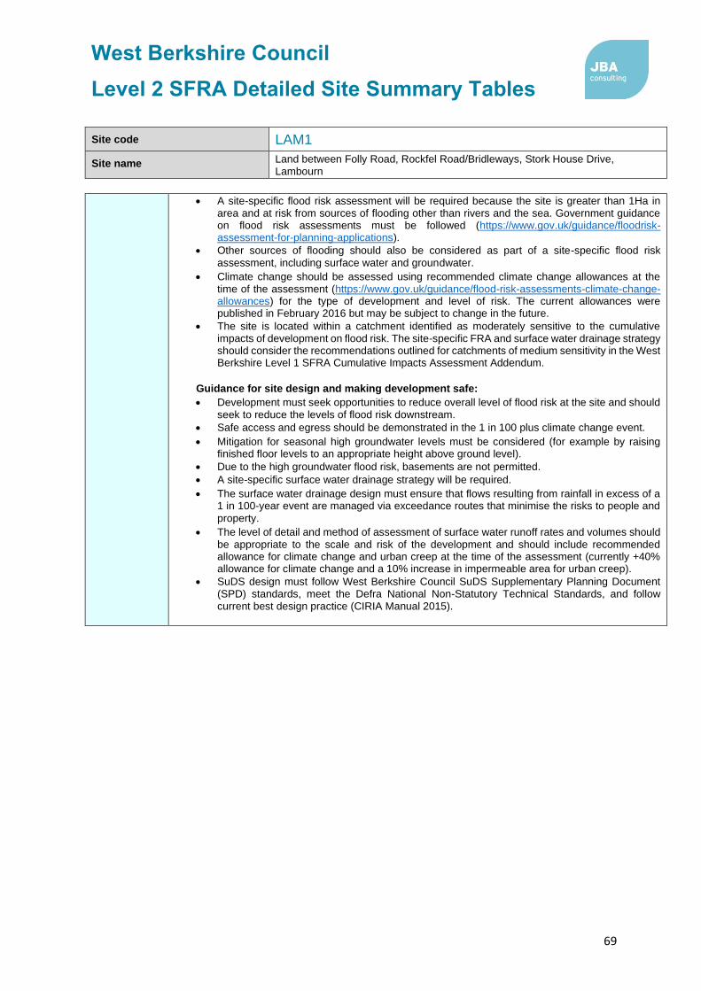
West Berkshire Council
Level 2 SFRA Detailed Site Summary Tables
69
Site code LAM1
Site name Land between Folly Road, Rockfel Road/Bridleways, Stork House Drive, Lambourn
• A site-specific flood risk assessment will be required because the site is greater than 1Ha in area and at risk from sources of flooding other than rivers and the sea. Government guidance on flood risk assessments must be followed (https://www.gov.uk/guidance/floodrisk-assessment-for-planning-applications).
• Other sources of flooding should also be considered as part of a site-specific flood risk
assessment, including surface water and groundwater.
• Climate change should be assessed using recommended climate change allowances at the time of the assessment (https://www.gov.uk/guidance/flood-risk-assessments-climate-change-allowances) for the type of development and level of risk. The current allowances were published in February 2016 but may be subject to change in the future.
• The site is located within a catchment identified as moderately sensitive to the cumulative impacts of development on flood risk. The site-specific FRA and surface water drainage strategy should consider the recommendations outlined for catchments of medium sensitivity in the West Berkshire Level 1 SFRA Cumulative Impacts Assessment Addendum.
Guidance for site design and making development safe:
• Development must seek opportunities to reduce overall level of flood risk at the site and should seek to reduce the levels of flood risk downstream.
• Safe access and egress should be demonstrated in the 1 in 100 plus climate change event.
• Mitigation for seasonal high groundwater levels must be considered (for example by raising finished floor levels to an appropriate height above ground level).
• Due to the high groundwater flood risk, basements are not permitted.
• A site-specific surface water drainage strategy will be required.
• The surface water drainage design must ensure that flows resulting from rainfall in excess of a 1 in 100-year event are managed via exceedance routes that minimise the risks to people and
property.
• The level of detail and method of assessment of surface water runoff rates and volumes should be appropriate to the scale and risk of the development and should include recommended allowance for climate change and urban creep at the time of the assessment (currently +40% allowance for climate change and a 10% increase in impermeable area for urban creep).
• SuDS design must follow West Berkshire Council SuDS Supplementary Planning Document (SPD) standards, meet the Defra National Non-Statutory Technical Standards, and follow current best design practice (CIRIA Manual 2015).

West Berkshire Council
Level 2 SFRA Detailed Site Summary Tables
70
Site code LAM5
Site name Windsor House Large Paddocks, Crowle Road, Lambourn
Site details OS Grid reference
SU 32350 78668
Area 3.07 ha
Current land use Greenfield - Paddock (and temporary overflow car park for local events)
Proposed site use
Residential and a LEAP (Local Equipped Play Area) / LAP (Local Area for Play)
Flood risk vulnerability
More vulnerable
Sources of flood risk
Existing watercourses/biodiversity
There are no watercourses within the site boundary. The River Lambourn (classified as a Main River downstream of Goose Green) is located approximately 415m north east of the site.
The Lambourn is a designated SSSI and a SAC, as well as a chalk river which is a protected habitat listed in S41 of the NERC Act. Here, it is a winterbourne stream and is therefore sensitive to changes in groundwater levels and changes to the flooding regime.
Flood history
The site is not located within the EA Recorded Flood Outlines dataset. However, the site flooded during the Winter 2013/14 flood event. The West Berkshire Council 2013/14 Parish Flood Report for Lambourn states on 14th and 15th February 2014 a ‘significant volume of water collected in the paddock as a result of the high groundwater levels’, with water entering the site through the paddock access gates. Water levels on the site remained high for eight weeks, before subsiding, and draining down completely after a further two weeks.
Thames Water data indicates that a total of 20 sewer flooding incidents have been reported to properties in the postcode area (RG17 8), in which one property reported internal flooding.
Fluvial
Fluvial
Proportion of the site at risk (%)
Flood Zone 3b
5% AEP
Flood Zone 3a
1% AEP
Flood Zone 2
0.1% AEP
Flood Zone 1
0% 0% 0% 100%
Available modelled data: There is no detailed hydraulic fluvial model covering the site.
Flood characteristics: The site is located within Flood Zone 1, and is therefore at negligible risk of fluvial flooding.
Surface Water
Proportion of site at risk (RoFSW)
3.3% AEP
(1 in 30)
1% AEP
(1 in 100)
0.1% AEP
(1 in 1,000)
0% 40% 50%
Description of surface water flow paths: Flood risk to the site is associated with an extensive surface water flow path, which originates north of Baydon, and flows into the south west of the site, ponding in the low-lying ground. The centre of the site is at risk of surface water flooding during the 1% and 0,1% AEP rainfall events, with flood extents covering up to half of the site.
Groundwater
Proportion of the site at risk in JBA Groundwater Map 1% AEP (1 in 100-year) risk categories
Depth below surface 0-0.025m
Depth below surface 0.025-0.5m
Total in highest risk categories
0% 0% 0%

West Berkshire Council
Level 2 SFRA Detailed Site Summary Tables
71
Site code LAM5
Site name Windsor House Large Paddocks, Crowle Road, Lambourn
JBA Groundwater Mapping shows the site to be at moderate risk of groundwater flooding, with groundwater levels in the south of the site predicted to lie between 0.5m and 5m below the ground surface during a 1% AEP event. In the north of the
site, groundwater levels are predicted to lie at least 5m below the ground surface.
However, groundwater emergence modelling carried out by Jacobs following the Winter 2013/14 flood event, indicates that groundwater emergence is predicted to impact the entire site during the 3.3% AEP and 1% AEP flood events. Maximum flood depths in the centre of the site are predicted to reach 0.9m during a 3.3% AEP (1 in 30) event, and 1.0m during a 1% AEP (1in 100) event.
Reservoir The site is not at risk of flooding, in the rare event of a reservoir breach.
Canal There are no canals witin the site boundary.
Flood risk management infrastructure
Defences
Defence Type Standard of Protection Condition
There are no defences within site boundary.
Residual risk
Culvert / structure blockage?
N/A
Impounded water body failure?
N/A
Defence breach / overtopping?
Breach Zone
N/A
Emergency planning
Flood warning The site is not covered by an Environment Agency Flood Alert or Flood Warning Area.
Access and egress
The site is likely to be accessed via Crowle Road to the north, or Baydon Road to the west. Both roads are at very low fluvial flood risk. Baydon Road is also at low surface water flood risk.
However, Crowle Rod is at low to moderate surface water flood risk, with flooding predicted to occur during the 1% AEP (1 in 100) and 0.1% AEP (1 in 1,000) rainfall events. Groundwater emergence modelling indicates that Crowle Road is also at risk of groundwater flooding, during a 3.3% AEP (1 in 30) and 1% AEP (1 in 100) events. Therefore, access to the site via Crowle Road may be restricted at times of surface water and groundwater flooding.
Climate Change
Climate change allowances for ‘2080s’
River Basin District Central Higher Central
Upper End
Thames 25% 35% 70%
Implications for the site
The site remains within Flood Zone 1, accounting for the impact of climate change on fluvial flood risk.
Requirement for drainage control and
impact mitigation
Bedrock Geology
The site is underlain by Sussex White Chalk Formation
Superficial Geology
There are no superficial geology deposits recorded on the site.
Soils Shallow lime-rich soils over chalk.

West Berkshire Council
Level 2 SFRA Detailed Site Summary Tables
72
Site code LAM5
Site name Windsor House Large Paddocks, Crowle Road, Lambourn
SuDS
• SuDS design must follow the West Berkshire Council SuDS SPD, meet the Defra National Non-Statutory Technical Standards, and follow current best design practice (CIRIA Manual 2015).
• A greenfield site such as this should seek to implement an exemplar scheme, using natural, vegetated SuDS to deliver multiple benefits, including water quality, biodiversity, amenity, green infrastructure etc.
• ‘Natural’, vegetated SuDS (such as green roofs, swales and ponds) will be preferred by West Berkshire Council as LLFA over ‘hard engineered’ and below-ground SuDS.
• All development should adopt source control SuDS techniques. Conveyance features should be designed above ground and follow natural flow paths where possible.
• The bedrock geology suggests that infiltration may be suitable, although mapping and emergence modelling indicate that groundwater flood risk to the site is high. Therefore, it is recommended further site investigation should be carried out to assess potential for drainage by infiltration, including at least 12 months of groundwater level monitoring on site. Infiltration techniques should only be used where there are suitable levels of surface water runoff treatment.
• Where below ground storage is proposed, the base of the feature must be located at least 1m above the highest groundwater level, to reduce the risk of groundwater ingress or flotation.
Groundwater Source Protection Zone
The site is not located within a Groundwater Source Protection Zone.
Historic Landfill Site
There are no historic landfill sites within the site boundary or within close proximity.
Opportunities for flood risk betterment
Opportunities for using source control SuDS to manage runoff rates and volumes, and to provide additional storage for surface water runoff onsite, to contribute towards the reduction and delay of flood peaks reaching the River Lambourn and the existing surface water flow path leaving the site.
Cumulative impacts of development
Water Framework Directive Catchment
Sensitivity to cumulative
impacts Implications
Lambourn (Source to Newbury)
Medium
The FRA and surface water drainage strategy should demonstrate wider betterment by demonstrating measures which can be put in place to contribute to a reduction in flood risk
downstream.
Recommend-ations for Local Plan
policy
Sequential Test and Exception Test requirements
The site is within Flood Zone 1 but at risk from other sources of flooding. The Sequential Test must be passed. The Exception Test is not required under the NPPF, but it must be shown that the development will be safe for its lifetime and the risk can be managed through a sequential approach to design.
Recommendations for requirements of site-specific Flood Risk Assessment, including guidance for developers
Flood risk assessment:
• At the planning application stage, a site-specific flood risk assessment and surface water drainage strategy will be required.

West Berkshire Council
Level 2 SFRA Detailed Site Summary Tables
73
Site code LAM5
Site name Windsor House Large Paddocks, Crowle Road, Lambourn
• Consultation with the Local Authority and the Environment Agency should be undertaken at an early stage.
• A site-specific flood risk assessment will be required because the site is greater than 1Ha in
area and at risk from sources of flooding other than rivers and the sea. Government guidance
on flood risk assessments must be followed (https://www.gov.uk/guidance/floodrisk-
assessment-for-planning-applications).
• Other sources of flooding should be considered as part of a site-specific flood risk assessment, including groundwater.
• Climate change should be assessed using recommended climate change allowances at the time of the assessment (https://www.gov.uk/guidance/flood-risk-assessments-climate-change-allowances) for the type of development and level of risk. The current allowances were published in February 2016 but may be subject to change in the future.
• The site is located within a catchment identified as moderately sensitive to the cumulative impacts of development on flood risk. The site-specific FRA and surface water drainage strategy should consider the recommendations outlined for catchments of medium sensitivity in the West Berkshire Level 1 SFRA Cumulative Impacts Assessment Addendum.
Guidance for site design and making development safe:
• Development must seek opportunities to reduce overall level of flood risk at the site and should seek to reduce the levels of flood risk downstream.
• Safe access and egress should be demonstrated in the 1 in 100 plus climate change event.
• Mitigation for seasonal high groundwater levels must be considered (for example by raising finished floor levels to an appropriate height above ground level).
• Due to the high groundwater flood risk, basements are not permitted.
• A site-specific surface water drainage strategy will be required.
• The surface water drainage design must ensure that flows resulting from rainfall in excess of a 1 in 100-year event are managed via exceedance routes that minimise the risks to people and property.
• The level of detail and method of assessment of surface water runoff rates and volumes should be appropriate to the scale and risk of the development and should include recommended allowance for climate change and urban creep at the time of the assessment (currently +40% allowance for climate change and a 10% increase in impermeable area for urban creep).
• SuDS design must follow West Berkshire Council SuDS Supplementary Planning Document (SPD) standards, meet the Defra National Non-Statutory Technical Standards, and follow current best design practice (CIRIA Manual 2015).

West Berkshire Council
Level 2 SFRA Detailed Site Summary Tables
74
Site code MID5
Site name Land east of Colthrop Industrial Estate, Thatcham
Site details OS Grid reference
SU 54374 66651
Area 5.1 Ha
Current land use Greenfield - Agriculture
Proposed site use
Employment (general industrial / storage or distribution)
Flood risk vulnerability
Less vulnerable
Sources of flood risk
Existing watercourses/biodiversity
An unnamed watercourse flows southwards along the western boundary of the site, before flowing westwards along the southern border. A balancing pond is located beyond the south western boundary of the site, and the Kennet and Avon Canal lies 150m to the south.
Flood history
The site is not within the EA Recorded Flood Outlines dataset. The site is not reported to have flooded during the July 2007 surface water flood event in Thatcham. However, West Berkshire Council Parish Flood Reports for the event report that runoff from the A4 Bath Road, and the surrounding fields, caused the balancing pond on Gables Way (to the south west of the site) to overtop and
cause flooding of Midgham Marsh.
The Thames Water DG5 register shows that seven sewer flooding incidents have been recorded within the postcode area (RG19 4), of which three have resulted in
internal property flooding.
Fluvial
Fluvial
Proportion of the site at risk (%)
Flood Zone 3b
5% AEP
Flood Zone 3a
1% AEP
Flood Zone 2
0.1% AEP
Flood Zone 1
0% 0% 0% 100%
Available modelled data:
The site is not covered by a hydraulic model.
Flood characteristics:
The site is entirely within Flood Zone 1, where fluvial flood risk is negligible.
Surface Water
Proportion of site at risk (RoFSW)
1 in 30 (3.33% AEP) 1 in 100 (1% AEP) 1 in 1,000 (0.1% AEP)
0% 2% 26%
Description of surface water flow paths:
A small area of ponding is predicted to form in a low point in the north east of the site during the 3.3% AEP (1 in 30) and greater rainfall events.
During the 0.1% AEP (1 in 1,000) a large surface flow path enters the north of the site from A4 Bath Road, and flows south eastwards through the site, before ponding against the railway line at the south of the site. Remaining areas of the site are at
very low risk of flooding.
Groundwater
Proportion of the site at risk in JBA Groundwater Map 1% AEP risk categories
Depth below surface 0-0.025m
Depth below surface 0.025-0.5m
Total in highest risk categories
46% 0% 46%
The north of the site is at high risk of groundwater flooding, with groundwater levels predicted to lie within 0.025m of the ground surface during a 1% AEP event.

West Berkshire Council
Level 2 SFRA Detailed Site Summary Tables
75
Site code MID5
Site name Land east of Colthrop Industrial Estate, Thatcham
Reservoir The site is not at risk of flooding, in the rare event of a reservoir breach.
Canal The Kennet and Avon Canal is located 150m south of the site. However, as the railway line at the south of the site forms a topographic barrier, breach or
overtopping of the canal would be unlikely to diretly affect the site.
Flood risk management infrastructure
Defences Defence Type Standard of Protection Condition
There are no defences within the site boundary.
Residual risk
Culvert / structure blockage?
N/A
Impounded water body failure?
N/A
Defence breach / overtopping?
Breach Zone
N/A
Emergency planning
Flood warning The site is not within an EA Flood Alert or Flood Warning Area.
Access and egress
The site may be accessed via Bath Road at the northern border of the site, although preferred access is from Gables Way to the west. Within the vicinity of the site, both routes are located within Flood Zone 1, and therfore at very low risk of fluvial flooding. Localised areas of surface water ponding are predicted to form on both Bath Road and Gables Way during a 3.33% AEP (1 in 30) and greater rainfall events.
Climate Change
Climate change allowances for ‘2080s’
River Basin District Central Higher Central
Upper End
Thames 25% 35% 70%
Implications for the site
The site remains in Flood Zone 1 when accounting for the impact of climate change.
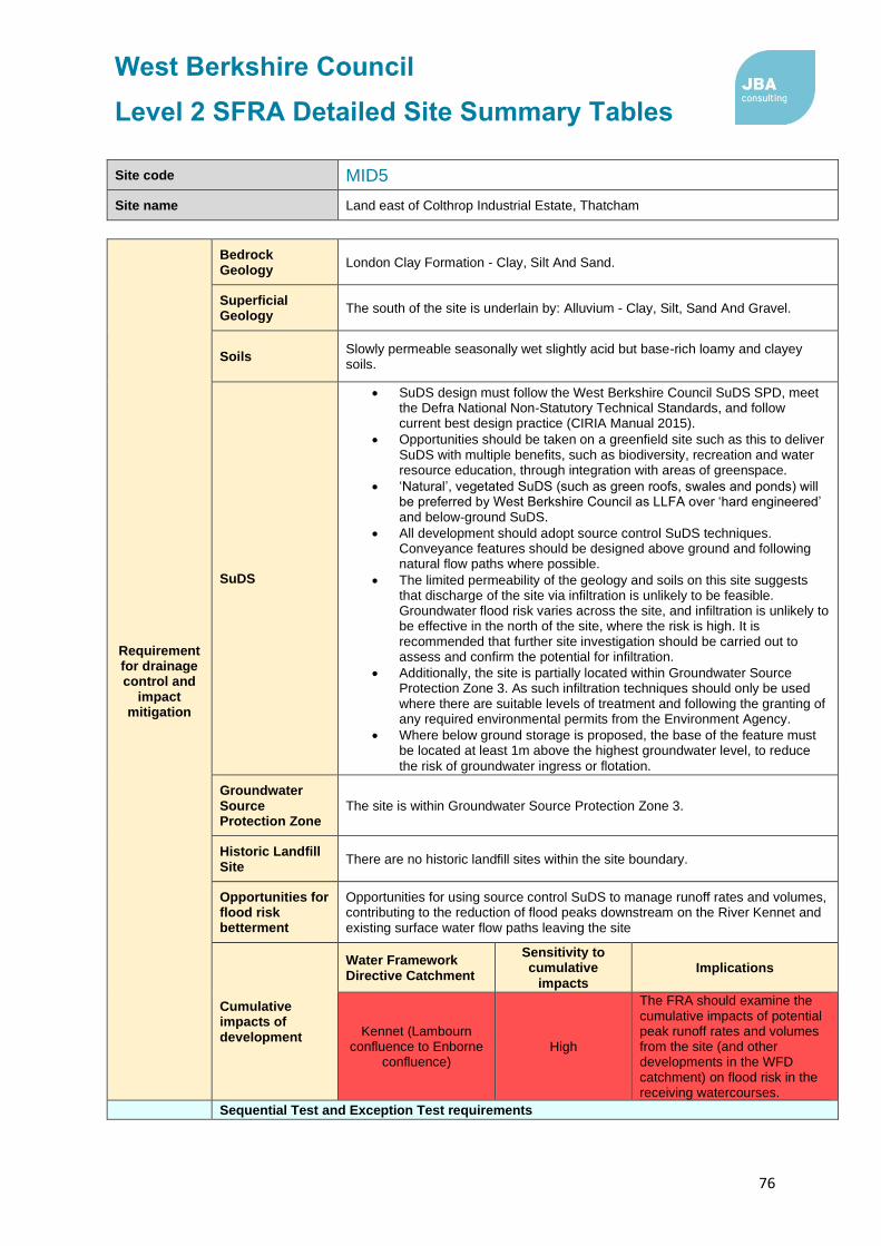
West Berkshire Council
Level 2 SFRA Detailed Site Summary Tables
76
Site code MID5
Site name Land east of Colthrop Industrial Estate, Thatcham
Requirement for drainage control and
impact mitigation
Bedrock Geology
London Clay Formation - Clay, Silt And Sand.
Superficial Geology
The south of the site is underlain by: Alluvium - Clay, Silt, Sand And Gravel.
Soils Slowly permeable seasonally wet slightly acid but base-rich loamy and clayey soils.
SuDS
• SuDS design must follow the West Berkshire Council SuDS SPD, meet the Defra National Non-Statutory Technical Standards, and follow current best design practice (CIRIA Manual 2015).
• Opportunities should be taken on a greenfield site such as this to deliver SuDS with multiple benefits, such as biodiversity, recreation and water resource education, through integration with areas of greenspace.
• ‘Natural’, vegetated SuDS (such as green roofs, swales and ponds) will be preferred by West Berkshire Council as LLFA over ‘hard engineered’ and below-ground SuDS.
• All development should adopt source control SuDS techniques. Conveyance features should be designed above ground and following natural flow paths where possible.
• The limited permeability of the geology and soils on this site suggests that discharge of the site via infiltration is unlikely to be feasible. Groundwater flood risk varies across the site, and infiltration is unlikely to be effective in the north of the site, where the risk is high. It is recommended that further site investigation should be carried out to assess and confirm the potential for infiltration.
• Additionally, the site is partially located within Groundwater Source Protection Zone 3. As such infiltration techniques should only be used where there are suitable levels of treatment and following the granting of any required environmental permits from the Environment Agency.
• Where below ground storage is proposed, the base of the feature must be located at least 1m above the highest groundwater level, to reduce
the risk of groundwater ingress or flotation.
Groundwater Source Protection Zone
The site is within Groundwater Source Protection Zone 3.
Historic Landfill Site
There are no historic landfill sites within the site boundary.
Opportunities for flood risk betterment
Opportunities for using source control SuDS to manage runoff rates and volumes, contributing to the reduction of flood peaks downstream on the River Kennet and existing surface water flow paths leaving the site
Cumulative impacts of development
Water Framework Directive Catchment
Sensitivity to cumulative
impacts Implications
Kennet (Lambourn confluence to Enborne
confluence) High
The FRA should examine the cumulative impacts of potential peak runoff rates and volumes from the site (and other developments in the WFD catchment) on flood risk in the receiving watercourses.
Sequential Test and Exception Test requirements

West Berkshire Council
Level 2 SFRA Detailed Site Summary Tables
77
Site code MID5
Site name Land east of Colthrop Industrial Estate, Thatcham
Recommend-ations for Local Plan
policy
The site is within Flood Zone 1 but at risk from other sources of flooding. The Sequential Test must be passed. The Exception Test is not required under the NPPF, but it must be shown that the development will be safe for its lifetime and the risk can be managed through a sequential approach to design.
Recommendations for requirements of site-specific Flood Risk Assessment, including guidance for developers
Flood risk assessment:
• At the planning application stage, a site-specific flood risk assessment and surface water drainage strategy will be required.
• Consultation with the Local Authority and the Environment Agency should be undertaken at an early stage.
• A site-specific flood risk assessment will be required because the site is over 1ha in area within Flood Zone 1 and at risk from sources of flooding other than rivers and the sea. Government guidance on flood risk assessments must be followed (https://www.gov.uk/guidance/flood-risk-assessment-for-planning-applications).
• Other sources of flooding should also be considered as part of a site-specific flood risk assessment, including surface water and groundwater.
• Detailed modelling will be required to confirm Flood Zone and climate change extents for the ordinary watercourse within the site (see ‘Available modelled data’). The Environment Agency and LLFA should be consulted to obtain the latest hydraulic modelling information for the site at the time of the flood risk assessment. They will advise as to whether existing detailed models are available, and if so, whether they need to be updated.
• Climate change should be assessed using recommended climate change allowances at the time of the assessment (https://www.gov.uk/guidance/flood-risk-assessments-climate-change-allowances) for the type of development and level of risk. The current allowances were published in February 2016 but may be subject to change in the future.
• The site is located within a catchment identified as highly sensitive to the cumulative impacts of development on flood risk. The site-specific FRA and surface water drainage strategy should consider the recommendations outlined for high sensitivity catchments in the West Berkshire Level 1 SFRA Cumulative Impacts Assessment Addendum.
Guidance for site design and making development safe:
• Development must seek opportunities to reduce overall level of flood risk at the site.
• Safe access and egress should be demonstrated in the 1 in 100 plus climate change event and raising of access routes must not impact on floodplain storage capacity.
• Mitigation for seasonal high groundwater levels must be considered (for example by raising finished floor levels to an appropriate height above ground level).
• Due to the high groundwater flood risk, basements are not permitted.
• The design of SuDS schemes must take into account the seasonally high groundwater table. Infiltration techniques may be ineffective and may pose a pollution risk. SuDS may need to be shallow and take up larger areas. Above ground conveyance and attenuation can be used but care must be taken that groundwater does not enter the SuDS feature and reduce the storage capacity and structural integrity of the design.
• The level of detail and method of assessment of surface water runoff rates and volumes should be appropriate to the scale and risk of the development and should include recommended allowance for climate change and urban creep at the time of the assessment (currently +40% allowance for climate change and a 10% increase in impermeable area for urban creep).
• Storage for runoff from the development in extreme events should be located out of flood risk areas.
• The design must ensure that flows resulting from rainfall in excess of a 1 in 100-year event are managed via exceedance routes that minimise the risks to people and property.
• SuDS design must follow West Berkshire Council SuDS Supplementary Planning Document (SPD) standards, meet the Defra National Non-Statutory Technical Standards, and follow current best design practice (CIRIA Manual 2015).The design must ensure that flows resulting from rainfall in excess of a 1 in 100-year event are managed via exceedance routes that minimise the risks to people and property.

West Berkshire Council
Level 2 SFRA Detailed Site Summary Tables
78
Site code MID5
Site name Land east of Colthrop Industrial Estate, Thatcham
• The unnamed watercourse which forms the western and southern boundaries of the site is an ordinary watercourse. A sufficient width of buffer, to be agreed in consultation with West Berkshire Council, should be maintained between the riverbank and any built structures, to enable riparian owners to access and maintain the channel.

West Berkshire Council
Level 2 SFRA Detailed Site Summary Tables
79
Site code NEW1
Site name London Road Industrial Estate, Newbury
Site details OS Grid reference SU 47654 67397
Area 9.5 Ha
Current land use Brownfield - Employment
Proposed site use Residential, employment, and retail
NPPF Flood risk vulnerability
More vulnerable
Sources of flood risk
Existing watercourses/biodiversity
The River Kennet (Main River) flows in an easterly direction along the southern boundary of the site. The Kennet and Avon Canal is located
approximately 20m south of the site.
Both the River Kenner and Kennet and Avon Canal are designated as the River Kennet SSSI and are chalk rivers, a protected habitat listed in S41 od
the NERC Act.
Flood history
The site is within the EA Recorded Flood Outline. Flooding occurred within the site during the June 1971 and March 1979 flood events as a result of channel exceedance.
The Thames Water DG5 register identifies 16 sewer flooding incidents in total across the post code area RG14 2, of which seven reported internal flooding.
Fluvial
Proportion of site at risk in Flood Zones
Proportion of the site at risk (%)
Flood Zone 3b
5% AEP
Flood Zone 3a
1% AEP
Flood Zone 2
0.1% AEP
Flood Zone 1
1% 65% 20% 14%
Range of depths (m) N/A 0.02 - 0.57m
0.04m – 1.36m
N/A
Maximum Hazard N/A Significant - Danger to
most
Extreme - Danger to all
N/A
Available modelled data:
The site is covered by the 2016 River Kennet and Lambourn (Newbury) 1D-2D model.
The site is shown to be in an area benefiting from defence from the Newbury Flood Alleviation Scheme (FAS). .
Flood characteristics:
The site is at high fluvial flood risk, with flooding from the River Kennet predicted to affect the majority of the site during a 1% AEP (1 in 100) event. The area of the site at risk increases during the 0.1% AEP (1 in 1,000) event. Small areas in both the north and south of the site are topographically higher than the remaining areas of the site, and are located within Flood Zone 1.
Surface Water
Proportion of site at risk (RoFSW)
1 in 30 (3.33% AEP) 1 in 100 (1% AEP) 1 in 1000 (0.1% AEP)
0% 4% 22%
Description of surface water flow paths:
The site is generally at a low risk of surface water flooding. Isolated areas of ponding are expected to form on Faraday Road and south of Marconi Road flood during the 3.3% AEP (1 in 30) and greater rainfall events. Surface water flood risk extends during the 0.1% AEP (1 in 1,000) rainfall event, to cover the remaining road network, and form ponding between existing buildings at
Marconi Road, Ampere Road and Fleming Road.

West Berkshire Council
Level 2 SFRA Detailed Site Summary Tables
80
Site code NEW1
Site name London Road Industrial Estate, Newbury
Groundwater
Proportion of the site at risk in JBA Groundwater Map 1% AEP risk categories
Depth below surface
0-0.025m
Depth below surface
0.025-0.5m
Total in highest risk categories
83% 17% 100%
The site is at high risk of groundwater flooding. The majority of the site is within the highest risk category, where groundwater levels are likely to be within 0.025m of the ground surface during a 1% AEP event. In the south of the site, levels are expected to be between 0.025 – 0.5m of the ground surface, which is also considered as high risk.
The Jacobs Groundwater Emergence modelling does not show the site to be at risk of groundwater emergence.
Reservoir The site is not at risk of flooding, in the rare event of a reservoir breach.
Canal
The Kennet and Avon Canal flows along the southern border of the site. There is a residual risk to the site, in the event of breach or overtoppng of the canal, which should be assessed in detail within a site-specific Flood Risk Assessment.
Flood risk management infrastructure
Defences
Defence Type Standard of Protection Condition
Earth bank with steel sheet pilling at channel side
Not available 2
Earth flood embankment with gravel facing & capping (part
of Newbury FAS) 100 2
Newbury FAS is expected to provide protection to the site during a flood events with a 1% (1 in 100) chance of occurring in any given year.
Residual risk
Culvert / structure blockage?
N/A
Impounded water body failure?
N/A
Defence breach / overtopping?
Breach Zone
The impact on flood risk to the site, in the event of a breach event on the nearby River Kennet defences, should be assessed within a site-specific Flood Risk Assessment.
Emergency planning
Flood warning
The site is within the following EA Flood Alert and Flood Warning Areas.
• Flood Alert Area: River Kennet and its tributaries from Berwick Bassett down to Newbury
• Flood Warning Area: River Kennet at Newbury
Access and egress
The site is likely to be accessed via the A339 to the west of the site or the A4 to the north. The A339 is located within Flood Zone 3a, and is predicted to flood during the 1% AEP (1 in 100) event. The A4 is also at risk of flooding during the 1% AEP (1 in 100) event, affecting access to the site from the north-east. Both routes have a moderate surface water food risk, with small areas of ponding forming in the in the 1% AEP (1 in 100) and 0.1% AEP (1 in 1,000) rainfall events.
Climate Change
Climate change allowances for ‘2080s’
River Basin District Central Higher Central
Upper End
Thames 25% 35% 70%
Implications for the site
Modelling indicates that the extent of Flood Zone 3a + 70% CC does not extend beyond that of Flood Zone 2, and therefore climate change is not predicted to siginficantly impact the proposed site.

West Berkshire Council
Level 2 SFRA Detailed Site Summary Tables
81
Site code NEW1
Site name London Road Industrial Estate, Newbury
Requirement for drainage control and
impact mitigation
Bedrock Geology Seaford Chalk Formation.
Superficial Geology
The north of the site is overlain by deposits of alluvium, including clay, silt and sand.
Soils
The majority of the site is underlain by loamy and clayey floodplain soils with
naturally high groundwater. The north of the site is underlain by freely
draining slightly acid loamy soils.
Site-based investigations would be required to fully understand the variety in soils across the site.
SuDS
• SuDS design must follow the West Berkshire Council SuDS SPD, meet the Defra National Non-Statutory Technical Standards, and follow current best design practice (CIRIA Manual 2015).
• SuDS are possible on all sites, including previously developed sites such as this one. All development should adopt source control SuDS techniques.
• ‘Natural’, vegetated SuDS (such as green roofs, swales and ponds) will be preferred by West Berkshire Council as LLFA over ‘hard engineered’ and below-ground SuDS.
• Conveyance features should be designed above ground and following natural flow paths where possible.
• Storage for runoff from the development in extreme events should be located out of fluvial flood risk areas.
• The bedrock geology suggests high infiltration potential, although mapping indicates a high risk of groundwater flooding. Therefore, infiltration techniques may not be suitable at the site. If infiltration is proposed, it is recommended that further site investigation should be carried out to assess potential for drainage by infiltration, including at least 12 months of groundwater level monitoring on site. Infiltration techniques should only be used where there are suitable levels of surface water runoff treatment, and following the granting of any required environmental permits from the Environment Agency.
• Where below ground storage is proposed, the base of the feature must be located at least 1m above the highest groundwater level, to reduce the risk of groundwater ingress or flotation.
• SuDS features located near the historic landfill site in the centre of the site, may need to be designed with an impermeable liner, to prevent the leaching of pollutants.
Groundwater Source Protection Zone
The site is in Groundwater Source Protection Zone 3.
Historic Landfill Site
The Faraday Road Estate landfill site is located within the centre of the site. The landfill site has contained industrial, commercial and residential waste, as well as liquid sludge.
Opportunities for flood risk betterment
The site forms a significant proportion of the Northbrook Stream catchment. Therefore, redevelopment of the site using source control SuDS to manage runoff rates and volumes, offers sigificant opportunities to reduce surface water flood risk downstream.
Cumulative impacts of development
Water Framework Directive Catchment
Sensitivity to cumulative impacts
Implications
Lambourn (Source to Newbury)
Medium The FRA and surface water

West Berkshire Council
Level 2 SFRA Detailed Site Summary Tables
82
Site code NEW1
Site name London Road Industrial Estate, Newbury
Middle Kennet (Hungerford to
Newbury) Medium
drainage strategy should demonstrate wider betterment by demonstrating measures which can be put in place to contribute to a reduction in flood risk
downstream.
Recommend-ations for Local Plan
policy
Sequential Test and Exception Test requirements
The Sequential Test must be satisfied. If the Sequential Test has been passed, then Table 3 of the NPPG gives details of appropriate flood risk vulnerability for each Flood Zone. For this site, if More Vulnerable (residential) development is proposed within Flood Zone 3, or Highly Vulnerable development is proposed within Flood Zone 2, the Exception Test must be satisfied. A large proportion of the site is at high fluvial flood risk (>50% in Flood Zone 3) and flood depths are relatively deep, with a high flood hazard to people, therefore the site is unlikely to pass the Exception Test. As a result, the site is currently considered unviable for large scale residential development.
Recommendations for requirements of site-specific Flood Risk Assessment, including guidance for developers
Flood risk assessment:
• At the planning application stage, a site-specific flood risk assessment and surface water drainage strategy will be required.
• Consultation with the Local Authority and the Environment Agency should be undertaken at an early stage.
• A site-specific flood risk assessment will be required because the site is within Flood Zone 2 and 3 and at risk from sources of flooding other than rivers and the sea. Government guidance on flood risk assessments must be followed (https://www.gov.uk/guidance/floodrisk-assessment-for-planning-applications).
• Detailed modelling will be required to confirm Flood Zone and climate change extents (see ‘Available modelled data’). The Environment Agency and LLFA should be consulted to obtain the latest hydraulic modelling information for the site at the time of the flood risk assessment. They will advise as to whether existing detailed models are available, and if so, whether they need to be updated.
• Modelling should be conducted to assess the residual risk associated with breach or overtopping of the Kennet and Avon Canal, as well as a breach occurring on the nearby River Kennet defences.
• Climate change should be assessed using recommended climate change allowances at the time of the assessment (https://www.gov.uk/guidance/flood-risk-assessments-climatechange-allowances) for the type of development and level of risk. The current allowances were published in February 2016 but may be subject to change in the future.
• Other sources of flooding should also be considered as part of a site-specific flood risk
assessment, including surface water and groundwater.
• The site is located within a catchment identified as moderately sensitive to the cumulative impacts of development on flood risk. The site-specific FRA and surface water drainage strategy should consider the recommendations outlined for catchments of medium sensitivity in the West Berkshire Level 1 SFRA Cumulative Impacts Assessment Addendum.
Guidance for site design and making development safe:
• Development must seek opportunities to reduce overall level of flood risk at the site and should seek to reduce the levels of flood risk downstream.
• Safe access and egress should be demonstrated in the 1 in 100 plus climate change event.
• Mitigation for seasonal high groundwater levels must be considered (for example by raising finished floor levels to an appropriate height above ground level).
• Due to the high groundwater flood risk, basements are not permitted.

West Berkshire Council
Level 2 SFRA Detailed Site Summary Tables
83
Site code NEW1
Site name London Road Industrial Estate, Newbury
• A site-specific surface water drainage strategy will be required.
• The design of SuDS schemes must take into account the seasonally high groundwater table. Infiltration techniques may be ineffective and may pose a pollution risk. SuDS may need to be shallow and take up larger areas. Above ground conveyance and attenuation can be used but care must be taken that groundwater does not enter the SuDS feature and reduce the
storage capacity and structural integrity of the design.
• The surface water drainage design must ensure that flows resulting from rainfall in excess of a 1 in 100-year event are managed via exceedance routes that minimise the risks to people and property.
• The level of detail and method of assessment of surface water runoff rates and volumes should be appropriate to the scale and risk of the development and should include recommended allowance for climate change and urban creep at the time of the assessment (currently +40% allowance for climate change and a 10% increase in impermeable area for urban creep).
• SuDS design must follow West Berkshire Council SuDS Supplementary Planning Document (SPD) standards, meet the Defra National Non-Statutory Technical Standards, and follow current best design practice (CIRIA Manual 2015).

West Berkshire Council
Level 2 SFRA Detailed Site Summary Tables
84
Site code NEW3
Site name Kennet Shopping Centre, Newbury, RG14 5EN
Site details OS Grid reference
SU 47127 66969
Area 2.2 Ha
Current land use Retail, cafés, restaurants, cinema, and car parking
Proposed site use
Residential and possibly also a hotel to complement the existing uses
NPPF Flood risk vulnerability
More vulnerable
Sources of flood risk
Existing watercourses/biodiversity
There are no watercourses within the site boundary. The River Kennet (here also classified as the Kennet and Avon Canal) flows in an easterly direction within 100m of the northern boundary of the site.
Both the River Kenner and Kennet and Avon Canal are designated as the River Kennet SSSI and are chalk rivers, a protected habitat listed in S41 of the NERC Act.
Flood history
The site is not within the EA Recorded Flood Outlines dataset. However, the DG5 record shows that there have been several sewer flooding incidents within the postcode area (RG14 5), with 10 incidents in total, of which four have resulted in internal flooding of property.
Fluvial
Proportion of site at risk in Flood Zones
Proportion of site at risk (%)
Flood Zone 3b
5% AEP
Flood Zone 3a
1% AEP
Flood Zone 2
0.1% AEP
Flood Zone 1
0% 0% 60% 40%
Range of depths (m)
N/A N/A 0.01m – 0.28m N/A
Maximum hazard
N/A N/A Moderate – Dangerous for
some
N/A
Available modelled data:
The site is covered by the 2016 River Kennet and Lambourn (Newbury) 1D-2D model.
Flood characteristics:
A large area of the north and centre of the site is shown to be at fluvial flood risk, with flooding expected to occur during the 0.1% AEP event (Flood Zone 2). The southern area of the site is located within Flood Zone 1, where fluvial flood risk is low.
Surface Water
Proportion of site at risk (RoFSW)
1 in 30 (3.33% AEP) 1 in 100 (1% AEP) 1 in 1000 (0.1% AEP)
0% 0% 3%
The site is at a low risk of surface water flooding, with a small area of ponding predicted to form at the western boundary of the site during the 0.1% AEP (1 in 1,000) rainfall event.
Groundwater
Proportion of the site at risk in JBA Groundwater Map 1% AEP risk categories
Depth below surface
0-0.025m
Depth below surface
0.025-0.5m
Total in highest risk categories
18% 82% 100%

West Berkshire Council
Level 2 SFRA Detailed Site Summary Tables
85
Site code NEW3
Site name Kennet Shopping Centre, Newbury, RG14 5EN
The site is within a high groundwater risk area. The highest risk is along the western and northern borders of the site, where groundwater levels are expected to lie within 0.025m of the ground surface during a 1% AEP event. The remaining areas of the site are at moderate to high risk, with groundwater levels expected to lie between 0.025 – 0.5m of the ground surface.
This Jacobs Groundwater Emergence modelling does not show the site to be at
risk of groundwater emergence.
Reservoir The site is not at risk of flooding, in the rare event of a reservoir breach.
Canal The Kennet and Avon Canal flows along the southern border of the site. There is a residual risk to the site, in the event of breach or overtoppng of the canal,
which should be assessed in detail within a site-specific Flood Risk Assessment.
Flood risk management infrastructure
Defences Defence Type Standard of Protection Condition
There are no defences within site boundary.
Residual risk
Culvert / structure blockage?
N/A
Impounded water body failure?
N/A
Defence breach / overtopping?
Breach Zone
N/A
Emergency planning
Flood warning
The site is within the following EA Flood Alert and Flood Warning Areas:
• Flood Alert Area: River Kennet and its tributaries from Berwick Bassett down to Newbury
• Flood Warning Area: River Kennet at Newbury
Access and egress
The site may be accessed from several acces routes, inlcuding West Mills to the north, Bartholemew Street to the west, Market Street to the south, and Market Place to the east. Market Street is located in Flood Zone 1 and is at low fluvial flood risk. The remaining access routes are within Flood Zone 2, and predicted to be affected during the 1 in 1,000 (0.1% AEP) flood event. West Mills to the north is at low surface water flood risk, whereas flooding is predicted to form on Bartholemew Street and Market Place during the 3.3% AEP (1 in 30) and greater rainfall events. Market Street to the south is at risk during the 1% AEP (1 in 100) and 0.1% AEP (1 in 1,000) rainfall events.
Climate Change
Climate change allowances for ‘2080s’
River Basin District
Central Higher Central
Upper End
Thames 25% 35% 70%
Implications for the site
Modelling indicates that the extent of Flood Zone 3a + 70% CC does not extend beyond that of Flood Zone 2, and therefore climate change is not predicted to
siginficantly impact the proposed site.

West Berkshire Council
Level 2 SFRA Detailed Site Summary Tables
86
Site code NEW3
Site name Kennet Shopping Centre, Newbury, RG14 5EN
Requirement for drainage control and
impact mitigation
Bedrock Geology
Seaford Chalk Formation.
Superficial Geology
Beenham Grange Gravel Member - Sand And Gravel.
Soils Freely draining slightly acid loamy soils.
SuDS
• SuDS design must follow the West Berkshire Council SuDS SPD, meet the Defra National Non-Statutory Technical Standards, and follow current best design practice (CIRIA Manual 2015).
• SuDS are possible on all sites, including previously developed sites such as this one. All development should adopt source control SuDS techniques. Conveyance features should be designed above ground and following natural flow paths where possible.
• ‘Natural’, vegetated SuDS (such as green roofs, swales and ponds) will be preferred by West Berkshire Council as LLFA over ‘hard engineered’ and below-ground SuDS.
• Storage for runoff from the development in extreme events should be located out of fluvial flood risk areas.
• The bedrock geology suggests high infiltration potential, although mapping indicates a high risk of groundwater flooding. Therefore, infiltration techniques may not be suitable at the site. If infiltration is proposed, it is recommended that further site investigation should be carried out to assess potential for drainage by infiltration, including at least 12 months of groundwater level monitoring on site.
• The site is located within Groundwater Source Protection Zone 3. As such infiltration techniques should only be used where there are suitable levels of treatment and following the granting of any required environmental permits from the Environment Agency.
• Where below ground storage is proposed, the base of the feature must be located at least 1m above the highest groundwater level, to reduce the risk of groundwater ingress or flotation.
Groundwater Source Protection Zone
The site is within Groundwater Source Protection Zone 3.
Historic Landfill Site
There are no historic landfill sites within the site boundary.
Opportunities for flood risk betterment
Opportunities for using source control SuDS to manage runoff rates and volumes, contributing to the reduction of flood peaks downstream on the River Kennet and existing surface water flow paths leaving the site.
Cumulative impacts of development
Water Framework Directive
Catchment
Sensitivity to cumulative
impacts Implications
Middle Kennet (Hungerford to
Newbury) Medium
The FRA and surface water drainage strategy should demonstrate wider betterment by demonstrating measures which can be put in place to contribute to a reduction in flood
risk downstream. Sequential Test and Exception Test requirements

West Berkshire Council
Level 2 SFRA Detailed Site Summary Tables
87
Site code NEW3
Site name Kennet Shopping Centre, Newbury, RG14 5EN
Recommend-ations for Local Plan
policy
The Sequential Test must be satisfied. Only once the Sequential Test is satisfied should the Exception Test be applied. It is anticipated that proposed development will be sequentially located within Flood Zone 1. For this site, the Exception Test must be satisfied:
• If More Vulnerable and Essential Infrastructure is located in FZ3a.
• If Highly Vulnerable development is located in FZ2 or Flood Zone 3a plus climate change.
• If Essential Infrastructure is located in Flood Zone 3b
If Essential Infrastructure is located in Flood Zone 3b then it must be demonstrated that the exception
test is satisfied. Development will not be permitted in the following scenarios:
• Highly Vulnerable development within FZ3a or Flood Zone 3a plus climate change and FZ3b.
• More Vulnerable and Less Vulnerable development within FZ3b.
Recommendations for requirements of site-specific Flood Risk Assessment, including guidance for developers
Flood risk assessment:
• At the planning application stage, a site-specific flood risk assessment and surface water drainage strategy will be required.
• Consultation with the Local Authority and the Environment Agency should be undertaken at an early stage.
• A site-specific flood risk assessment will be required because the site is within Flood Zone 2 and 3 and at risk from sources of flooding other than rivers and the sea. Government guidance on flood risk assessments must be followed (https://www.gov.uk/guidance/floodrisk-assessment-for-planning-applications).
• Detailed modelling will be required to confirm Flood Zone and climate change extents (see ‘Available modelled data’). The Environment Agency and LLFA should be consulted to obtain the latest hydraulic modelling information for the site at the time of the flood risk assessment. They will advise as to whether existing detailed models are available, and if so, whether they need to be updated.
• Climate change should be assessed using recommended climate change allowances at the time of the assessment (https://www.gov.uk/guidance/flood-risk-assessments-climatechange-allowances) for the type of development and level of risk. The current allowances were published in February 2016 but may be subject to change in the future.
• Other sources of flooding should also be considered as part of a site-specific flood risk
assessment, including surface water and groundwater.
• The site is located within a catchment identified as moderately sensitive to the cumulative impacts of development on flood risk. The site-specific FRA and surface water drainage strategy should consider the recommendations outlined for catchments of medium sensitivity in the West Berkshire Level 1 SFRA Cumulative Impacts Assessment Addendum.
Guidance for site design and making development safe:
• Development must seek opportunities to reduce overall level of flood risk at the site and should seek to reduce the levels of flood risk downstream.
• Safe access and egress should be demonstrated in the 1 in 100 plus climate change event.
• Mitigation for seasonal high groundwater levels must be considered (for example by raising finished floor levels to an appropriate height above ground level).
• Due to the high groundwater flood risk, basements are not permitted.
• A site-specific surface water drainage strategy will be required.
• The design of SuDS schemes must take into account the seasonally high groundwater table. Infiltration techniques may be ineffective and may pose a pollution risk. SuDS may need to be shallow and take up larger areas. Above ground conveyance and attenuation can be used but care must be taken that groundwater does not enter the SuDS feature and reduce the storage capacity and structural integrity of the design.
• The surface water drainage design must ensure that flows resulting from rainfall in excess of a 1 in 100-year event are managed via exceedance routes that minimise the risks to people and property.
• The level of detail and method of assessment of surface water runoff rates and volumes should be appropriate to the scale and risk of the development and should include
West Berkshire Council
Level 2 SFRA Detailed Site Summary Tables
88
Site code NEW3
Site name Kennet Shopping Centre, Newbury, RG14 5EN
recommended allowance for climate change and urban creep at the time of the assessment (currently +40% allowance for climate change and a 10% increase in impermeable area for urban creep).
• SuDS design must follow West Berkshire Council SuDS Supplementary Planning Document (SPD) standards, meet the Defra National Non-Statutory Technical Standards, and follow current best design practice (CIRIA Manual 2015).

West Berkshire Council
Level 2 SFRA Detailed Site Summary Tables
89
Site code PAD1
Site name Land fronting Bath Road, Aldermaston Wharf, Reading (Site A)
Site details OS Grid reference
SU 59990 67366
Area 2.8 Ha
Current land use Greenfield - Scrubland
Proposed site use
Residential
Flood risk vulnerability
More vulnerable
Sources of flood risk
Existing watercourses/biodiversity
The River Kennet (here also classified as the River and Avon Canal) is located 250m south of the site. There are no watercourses within the site boundary. Small lakes are located 30m north west of the site, and 20m south of the site.
Flood history
The site is not within the EA Recorded Flood Outlines dataset.
The Thames Water DG5 register shows that there have been six sewer flooding incidents within the postcode area (RG7 4), of which two have resulted in internal
property flooding.
Fluvial
Fluvial
Proportion of the site at risk (%)
Flood Zone 3b
5% AEP
Flood Zone 3a
1% AEP
Flood Zone 2
0.1% AEP
Flood Zone 1
0% 0% 0% 100%
Available modelled data:
The site is covered by the 2007 River Kennet (Newbury to Tyle Mill) 1D model.
Flood characteristics:
The site is located entirely within Flood Zone 1, and is therefore at very low risk of fluvial flooding.
Surface Water
Proportion of site at risk (RoFSW)
1 in 30 (3.33% AEP) 1 in 100 (1% AEP) 1 in 1,000 (0.1% AEP)
43% 52% 74%
Description of surface water flow paths:
The site is shown to be at significant surface water flood risk, as the topography is
lower than the surrounding roads and railway line, allowing water to pond.
The eastern half of the site is at high risk of surface water flooding, where flooding is predicted to occur during a 3.33% AEP (1 in 30) rainfall event. The extent of flooding significantly increases during the 0.1% AEP (1 in 1,000) event, with the majority of the site expected to flood during this event.
Groundwater
Proportion of the site at risk in JBA Groundwater Map 1% AEP risk categories
Depth below surface 0-0.025m
Depth below surface 0.025-0.5m
Total in highest risk categories
100% 0% 100%
The site is at high groundwater flood risk, with groundwater levels expected to lie within 0.025m of the ground surface during a 1% AEP (1 in 100) event.
The Jacobs Groundwater Flood Risk modelling does not show the site to be at risk of groundwater emergence.
Reservoir The site is not at risk of flooding, in the rare event of a reservoir breach.

West Berkshire Council
Level 2 SFRA Detailed Site Summary Tables
90
Site code PAD1
Site name Land fronting Bath Road, Aldermaston Wharf, Reading (Site A)
Canal The Kennet and Avon Canal is located 250m south of the site, and therefore the site is considered to be at low risk of canal flooding.
Flood risk management infrastructure
Defences Defence Type Standard of Protection Condition
There are no flood defences present.
Residual risk
Culvert / structure blockage?
N/A
Impounded water body failure?
N/A
Defence breach / overtopping?
Breach Zone
N/A
Emergency planning
Flood warning The site is not within an EA Flood Alert or Flood Warning Area.
Access and egress
The site is likely to be accessed via A4 Bath Road along the northern boundary of the sites, Station Road to the west, or A340 Basingstoke Road to the south (preferred route). Bath Road is at very low fluvial flood risk, and is located within Flood Zone 1. The majority of Station Road is at very low risk of fluvial flooding, with a small area of flooding predicted to occur at the junction with A340 Basingstoke Road during a 0.1% AEP (1 in 1,000) event. Basingstoke Road is at very low risk of fluvial flooding.
Surface water flooding is predicted to affect westbound access on Bath Road during the 3.3% AEP (1 in 30) rainfall event, and inreases during the 1% (1 in 100) and 0.1% AEP events. However eastbound access, north of the site, is at low surface water flood risk. Adjacent to the site, Station Road is at very low risk of surface water flooding, and isolated areas of ponding are prodcted to form on Basingstoke Road during the 0.1% AEP (1 in 1,000) rainfall event.
Climate Change
Climate change allowances for ‘2080s’
River Basin District Central Higher Central
Upper End
Thames 25% 35% 70%
Implications for the site
The site remains in Flood Zone 1 when considering the impact of climate change.

West Berkshire Council
Level 2 SFRA Detailed Site Summary Tables
91
Site code PAD1
Site name Land fronting Bath Road, Aldermaston Wharf, Reading (Site A)
Requirement for drainage control and
impact mitigation
Bedrock Geology
London Clay Formation - Clay, Silt and Sand.
Superficial Geology
Beenham Grange Gravel Member - Sand and Gravel.
Soils Freely draining slightly acid loamy soils.
SuDS
• SuDS design must follow the West Berkshire Council SuDS SPD, meet the Defra National Non-Statutory Technical Standards, and follow current best design practice (CIRIA Manual 2015).
• All development should adopt source control SuDS techniques. Conveyance features should be designed above ground and following natural flow paths where possible.
• ‘Natural’, vegetated SuDS (such as green roofs, swales and ponds) will be preferred by West Berkshire Council as LLFA over ‘hard engineered’ and below-ground SuDS.
• SuDS features should be designed outside of fluvial flood risk areas and conveyance features should remain above surface and follow natural pathways.
• The impermeable bedrock geology and high groundwater flood risk suggests that infiltration techniques may not be suitable on this site. However, the presence of superficial deposits and freely draining soils suggests that infiltration to a shallow depth may be possible, subject to infiltration testing. If infiltration is proposed, it is recommended that further site investigation should be carried out to assess potential for drainage by infiltration, including at least 12 months of groundwater level monitoring on site.
• The site is located within Groundwater Source Protection Zone 2. As such infiltration techniques should only be used where there are suitable levels of treatment and following the granting of any required environmental permits from the Environment Agency.
• Where below ground storage is proposed, the base of the feature must be located at least 1m above the highest groundwater level, to reduce the risk of groundwater ingress or flotation.
Groundwater Source Protection Zone
The site is within Groundwater Source Protection Zone 2.
Historic Landfill Site
There are no historic landfill sites within the site boundary.
Opportunities for flood risk betterment
Opportunities for using source control SuDS to manage runoff rates and volumes, contributing to the reduction of flood peaks downstream on the River Kennet and existing surface water flow paths leaving the site.
Cumulative impacts of development
Water Framework Directive
Catchment
Sensitivity to cumulative
impacts Implications
Kennet and Holy Brook
High
The FRA should examine the cumulative impacts of potential peak runoff rates and volumes from the site (and other developments in the WFD catchment) on flood risk in the receiving watercourses.
Sequential Test and Exception Test requirements

West Berkshire Council
Level 2 SFRA Detailed Site Summary Tables
92
Site code PAD1
Site name Land fronting Bath Road, Aldermaston Wharf, Reading (Site A)
Recommend-ations for Local Plan
policy
The site is within Flood Zone 1 but at risk from other sources of flooding. The Sequential Test must be passed. The Exception Test is not required under the NPPF, but it must be shown that the development will be safe for its lifetime and the risk can be managed through a sequential approach to design.
Recommendations for requirements of site-specific Flood Risk Assessment, including guidance for developers
Flood risk assessment:
• At the planning application stage, a site-specific flood risk assessment and surface water drainage strategy will be required.
• Consultation with the Local Authority and the Environment Agency should be undertaken at an early stage.
• A site-specific flood risk assessment will be required because the site is over 1ha in area within Flood Zone 1 and at risk from sources of flooding other than rivers and the sea. Government guidance on flood risk assessments must be followed (https://www.gov.uk/guidance/flood-risk-assessment-for-planning-applications).
• Other sources of flooding should also be considered as part of a site-specific flood risk assessment, including surface water and groundwater.
• Climate change should be assessed using recommended climate change allowances at the time of the assessment (https://www.gov.uk/guidance/flood-risk-assessments-climate-change-allowances) for the type of development and level of risk. The current allowances were published in February 2016 but may be subject to change in the future.
• The site is located within a catchment identified as highly sensitive to the cumulative impacts of development on flood risk. The site-specific FRA and surface water drainage strategy should consider the recommendations outlined for high sensitivity catchments in the West Berkshire Level 1 SFRA Cumulative Impacts Assessment Addendum.
Guidance for site design and making development safe:
• Development must seek opportunities to reduce overall level of flood risk at the site.
• Safe access and egress should be demonstrated in the 1 in 100 plus climate change event and raising of access routes must not impact on floodplain storage capacity.
• Mitigation for seasonal high groundwater levels must be considered (for example by raising finished floor levels to an appropriate height above ground level).
• Due to the high groundwater flood risk, basements are not permitted.
• The design of SuDS schemes must consider the seasonally high groundwater table. Infiltration techniques may be ineffective and may pose a pollution risk. SuDS may need to be shallow and take up larger areas. Above ground conveyance and attenuation can be used but care must be taken that groundwater does not enter the SuDS feature and reduce the storage capacity and structural integrity of the design.
• The level of detail and method of assessment of surface water runoff rates and volumes should be appropriate to the scale and risk of the development and should include recommended allowance for climate change and urban creep at the time of the assessment (currently +40% allowance for climate change and a 10% increase in impermeable area for urban creep).
• Storage for runoff from the development in extreme events should be located out of flood risk areas.
• The design must ensure that flows resulting from rainfall in excess of a 1 in 100-year event are managed via exceedance routes that minimise the risks to people and property.
• SuDS design must follow West Berkshire Council SuDS Supplementary Planning Document (SPD) standards, meet the Defra National Non-Statutory Technical Standards, and follow current best design practice (CIRIA Manual 2015).The design must ensure that flows resulting from rainfall in excess of a 1 in 100-year event are managed via exceedance routes that minimise the risks to people and property.

West Berkshire Council
Level 2 SFRA Detailed Site Summary Tables
93
Site code PAD3
Site name Land at Padworth Lane, Padworth
Site details OS Grid reference
SU 60860 67826
Area 11.5 Ha
Current land use Greenfield - Field
Proposed site use
Residential
NPPF Flood risk vulnerability
More vulnerable
Sources of flood risk
Existing watercourses/biodiversity
The Kennet and Avon Canal forms the eastern boundary of the site. The River Kennet flows in a north easterly direction 50m east of the site.
The River Kennet forms the western boundary of floodplain grazing marsh which is a protected habitat listed in S41 of the NERC Act. The site is also north of Padworth Lane Gravel Pits LWS.
Flood history
The EA Recorded Flood Outlines dataset shows the east of the site to have flooded as a result of channel exceedance along the River Kennet in June 1971. The flood extent from the January 2003 flood event (also caused by
exceedance of the River Kennet) reached the eastern boundary of the site.
The Thames Water DG5 register shows that there have been 14 sewer flooding incidents within the postcode area (RG7 5), with one incident of internal property flooding.
Fluvial
Proportion of site at risk in Flood Zones
Proportion of site at risk (%)
Flood Zone 3b
5% AEP
Flood Zone 3a
1% AEP
Flood Zone 2
0.1% AEP
Flood Zone 1
8% 1% 9% 82%
Available modelled data:
The site is covered by the River Kennet (Newbury to Tyle Mill) 2007 1D model.
Flood characteristics:
The south east of the site is within Flood Zone 3b, with flooding is likely to occur during the 5% AEP (1 in 20) event. The same area is located within Flood Zone 3a, where flooding is predicted during the 1% AEP event. Flood Zone 2 extends further into the site, with flooding predicted to affect the eastern border of the site during the 0.1% AEP (1 in 1,000) event. The remainder of the site is within Flood Zone 1, where fluvial flood risk is negligible.
Surface Water
Proportion of site at risk (RoFSW)
1 in 30 (3.33% AEP) 1 in 100 (1% AEP) 1 in 1000 (0.1% AEP)
0% 0% 3%
Description of surface water flow paths:
The site is at low risk of surface water flooding, with a small area in the south east corner of the site is predicted to flood during the 0.1% AEP (1 in 1,000) rainfall.
Groundwater
Proportion of the site at risk in JBA Groundwater Map 1% AEP risk categories
Depth below surface
0-0.025m
Depth below surface
0.025-0.5m
Total in highest risk categories
94% 0% 94%

West Berkshire Council
Level 2 SFRA Detailed Site Summary Tables
94
Site code PAD3
Site name Land at Padworth Lane, Padworth
The majority of the site is at high risk of groundwater flooding, with groundwater levels expected to lie within 0.025m of the ground surface during a 1% AEP event. The remaining areas of the site, along the eastern border, are shown to be at negligible risk of groundwater flooding.
This Jacobs Groundwater Flood Risk modelling does not show the site to be at risk of groundwater emergence.
Reservoir The site is not at risk of flooding, in the rare event of a reservoir breach.
Canal
The Kennet and Avon Canal runs along the eastern border of the site. There is a residual risk of flooding to the site, in the event of a breach or overtopping on the canal. This risk should be assessed in further detail within a site-specific
Flood Risk Assessment.
Flood risk management infrastructure
Defences Defence Type Standard of Protection Condition
There are no defences present within the site.
Residual risk
Culvert / structure blockage?
N/A
Impounded water body failure?
N/A
Defence breach / overtopping?
Breach Zone
N/A
Emergency planning
Flood warning The east of the site is within an EA Flood Alert Area: River Kennet from Thatcham down to Reading.
Access and egress
The site is likley to be accessed via Padwoth Lane, with current access to the south of the site. Adjacent to the site, this route is at low fluvial and surface water flood risk. However, to the east, Padworth Lane is at risk of flooding during the 5% AEP (1 in 20) and greater events. Therefore, eastbound access and egress to the site is likely to be restricted at times of fluvial flooding.
Climate Change
Climate change allowances for ‘2080s’
River Basin District Central Higher Central
Upper End
Thames 25% 35% 70%
Implications for the site
Modelling shows that climate change leads to a small increase in flood extent at the site. However, the extent of Flood Zone 3a + 70% CC does not extend beyond that of Flood Zone 2, and therefore climate change is unilkely to significantly impact the proposed site.

West Berkshire Council
Level 2 SFRA Detailed Site Summary Tables
95
Site code PAD3
Site name Land at Padworth Lane, Padworth
Requirement for drainage control and
impact mitigation
Bedrock Geology
London Clay Formation - Clay, Silt and Sand.
Superficial Geology
Beenham Grange Gravel Member - Sand and Gravel.
Soils Freely draining slightly acid loamy soils.
SuDS
• SuDS design must follow the West Berkshire Council SuDS SPD, meet the Defra National Non-Statutory Technical Standards, and follow current best design practice (CIRIA Manual 2015).
• Opportunities should be taken on a greenfield site such as this to deliver SuDS with multiple benefits, such as biodiversity, recreation and water resource education, through integration with areas of greenspace.
• ‘Natural’, vegetated SuDS (such as green roofs, swales and ponds) will be preferred by West Berkshire Council as LLFA over ‘hard engineered’ and below-ground SuDS.
• All development should adopt source control SuDS techniques. Conveyance features should be designed above ground and following natural flow paths where possible.
• Storage for runoff from the development in extreme events should be located out of fluvial flood risk areas.
• The impermeable bedrock geology, location within Groundwater Source Protection Zone 2 and high groundwater flood risk suggest that deep infiltration may not be a suitable option. However, the underlying permeable soil and superficial deposits may provide opportunity to infiltrate to a shallow depth but over a wider area. If infiltration is proposed, it is recommended that further site investigation should be carried out to assess potential for drainage by infiltration, including at least 12 months of groundwater level monitoring on site. Infiltration techniques should only be used where there are suitable levels of surface water runoff treatment, and following the granting of any required environmental permits from the Environment Agency.
• Where below ground storage is proposed, the base of the feature must be located at least 1m above the highest groundwater level, to reduce the risk of groundwater ingress or flotation.
Groundwater Source Protection Zone
The site is within Groundwater Source Protection Zone 2.
Historic Landfill Site
There are no historic landfill sites within the site boundary.
Opportunities for flood risk betterment
Opportunities for using source control SuDS to manage runoff rates and volumes, contributing to the reduction of flood peaks downstream and existing surface water flow paths leaving the site.
Water Framework Directive Catchment
Sensitivity to cumulative
impacts Implications

West Berkshire Council
Level 2 SFRA Detailed Site Summary Tables
96
Site code PAD3
Site name Land at Padworth Lane, Padworth
Cumulative impacts of development
Kennet and Holy Brook
High
The FRA should examine the cumulative impacts of potential peak runoff rates and volumes from the site (and other developments in the WFD catchment) on flood risk in the receiving watercourses.
Recommend-ations for Local Plan
policy
Sequential Test and Exception Test requirements
The Sequential Test must be satisfied. Only once the Sequential Test is satisfied should the Exception Test be applied. It is anticipated that proposed development will be sequentially located within Flood Zone 1. For this site, the Exception Test must be satisfied:
• If More Vulnerable and Essential Infrastructure is located in FZ3a or FZ3a plus climate change.
• If Highly Vulnerable development is located in FZ2.
If Essential Infrastructure is located in Flood Zone 3b then it must be demonstrated that the exception test is satisfied. Development will not be permitted in the following scenarios:
• Highly Vulnerable development within FZ3a or FZ3a plus climate change and FZ3b.
• More Vulnerable and Less Vulnerable development within FZ3b.
Recommendations for requirements of site-specific Flood Risk Assessment, including guidance for developers
Flood risk assessment:
• At the planning application stage, a site-specific flood risk assessment and surface water drainage strategy will be required.
• Consultation with the Local Authority and the Environment Agency should be undertaken at an early stage.
• A site-specific flood risk assessment will be required because the site is within Flood Zone 2 and 3 and at risk from sources of flooding other than rivers and the sea. Government guidance on flood risk assessments must be followed (https://www.gov.uk/guidance/floodrisk-assessment-for-planning-applications).
• Detailed modelling will be required to confirm Flood Zone and climate change extents (see ‘Available modelled data’). The Environment Agency and LLFA should be consulted to obtain the latest hydraulic modelling information for the site at the time of the flood risk assessment. They will advise as to whether existing detailed models are available, and if so, whether they need to be updated.
• Modelling should be conducted to assess the residual risk associated with breach or overtopping of the Kennet and Avon Canal.
• Climate change should be assessed using recommended climate change allowances at the time of the assessment (https://www.gov.uk/guidance/flood-risk-assessments-climatechange-allowances) for the type of development and level of risk. The current allowances were published in February 2016 but may be subject to change in the future.
• Other sources of flooding should also be considered as part of a site-specific flood risk assessment, including surface water and groundwater.
• The site is located within a catchment identified as highly sensitive to the cumulative impacts of development on flood risk. The site-specific FRA and surface water drainage strategy should consider the recommendations outlined for high sensitivity catchments in the West Berkshire Level 1 SFRA Cumulative Impacts Assessment Addendum.
Guidance for site design and making development safe:
• Development must seek opportunities to reduce overall level of flood risk both on and offsite, for example by reducing volume and rate of runoff and creating space for flooding.
• Safe access and egress should be demonstrated in the 1 in 100 plus climate change event.
• Mitigation for seasonal high groundwater levels must be considered (for example by raising finished floor levels to an appropriate height above ground level).
• Due to the high groundwater flood risk, basements are not permitted.
• A site-specific surface water drainage strategy will be required.

West Berkshire Council
Level 2 SFRA Detailed Site Summary Tables
97
Site code PAD3
Site name Land at Padworth Lane, Padworth
• The design of SuDS schemes must take into account the seasonally high groundwater table. Infiltration techniques may be ineffective and may pose a pollution risk. SuDS may need to be shallow and take up larger areas. Above ground conveyance and attenuation can be used but care must be taken that groundwater does not enter the SuDS feature and reduce the storage capacity and structural integrity of the design.
• The level of detail and method of assessment of surface water runoff rates and volumes should be appropriate to the scale and risk of the development and should include recommended allowance for climate change and urban creep at the time of the assessment (currently +40% allowance for climate change and a 10% increase in impermeable area for urban creep).
• Storage for runoff from the development in extreme events should be located out of flood risk areas.
• The design must ensure that flows resulting from rainfall in excess of a 1 in 100-year event
are managed via exceedance routes that minimise the risks to people and property.
• SuDS design must follow West Berkshire Council SuDS Supplementary Planning Document (SPD) standards, meet the Defra National Non-Statutory Technical Standards, and follow current best design practice (CIRIA Manual 2015).The design must ensure that flows resulting from rainfall in excess of a 1 in 100-year event are managed via exceedance routes that minimise the risks to people and property.
• The Grand Union Canal is located at the eastern boundary of the site. A buffer, the distance to be determined in consultation with the Canal and River Trust, should be maintained between the canal and any built structures, to enable access and maintenance.

West Berkshire Council
Level 2 SFRA Detailed Site Summary Tables
98
Site code PAD4
Site name Land adjacent Padworth IWMF, Padworth Lane, Lower Padworth
Site details OS Grid reference
SU 60680 67510
Area 3.1 Ha
Current land use Brownfield - Oil terminal
Proposed site use
Employment
Flood risk vulnerability
More vulnerable
Sources of flood risk
Existing watercourses/biodiversity
There are no watercourses within the site boundary. The Kennet and Avon Canal is located 40m east of the site. The River Kennet (Main River) is located 100m north east of the site.
The site is north of the Padworth Lane Gravel Pits LWS.
Flood history
The site is not within the EA Recorded Flood Outlines dataset. West Berkshire Council Parish Flood Reports identified that Padworth Lane flooded on 4/5 February 2014, due to surface water runoff from nearby fields, exacerbated by high groundwater levels in the area. The road was also reported as flooding up to
a depth of 300mm during the July 2007 flood event.
The Thames Water DG5 register identifies that six previous sewer flooding incidents have occurred within the RG7 4 postcode, of which two resulted in external flooding.
Fluvial
Fluvial
Proportion of the site at risk (%)
Flood Zone 3b
5% AEP
Flood Zone 3a
1% AEP
Flood Zone 2
0.1% AEP
Flood Zone 1
0% 0% 0% 100%
Available modelled data:
The site is covered by the 2007 River Kennet (Newbury to Tyle Mill) 1D model.
Flood characteristics:
The site is within Flood Zone 1, and is therefore at very low risk of fluvial flood risk.
Surface Water
Proportion of site at risk (RoFSW)
1 in 30 (3.33% AEP) 1 in 100 (1% AEP) 1 in 1,000 (0.1% AEP)
0% 1% 3%
Description of surface water flow paths:
The site is at low risk of surface water flooding. Isolated areas of ponding are predicted to form in the south east corner of the site during the 1% AEP (1 in 100), and along the southern boundary of the site during a 0.1% AEP (1 in 1,000) rainfall event.
Groundwater
Proportion of the site at risk in JBA Groundwater Map 1% AEP risk categories
Depth below surface 0-0.025m
Depth below surface 0.025-0.5m
Total in highest risk categories
100% 0% 100%
The entire site is at high groundwater flood risk, with groundwater levels predicted to lie within 0.025m of the ground surface during a 1% AEP event.
The Jacobs Groundwater Flood Risk modelling does not show the site to be at risk of groundwater emergence.

West Berkshire Council
Level 2 SFRA Detailed Site Summary Tables
99
Site code PAD4
Site name Land adjacent Padworth IWMF, Padworth Lane, Lower Padworth
Reservoir The site is not at risk of flooding, in the rare event of a reservoir breach.
Canal
The Kennet and Avon Canal is located within 50m of the southern border of the site. There is a residual risk to the site, in the event of breach or overtopping of the canal, which should be assessed in detail within a site-specific Flood Risk Assessment.
Flood risk management infrastructure
Defences Defence Type Standard of Protection Condition
There are no defences within the site boundary.
Residual risk
Culvert / structure blockage?
N/A
Impounded water body failure?
N/A
Defence breach / overtopping?
Breach Zone
N/A
Emergency planning
Flood warning The site is not within an EA Flood Alert or Flood Warning Area.
Access and egress
The site is likely to be accessed via Padworth Lane, with current access to the north of the of the site. To the east of the site, the route is located in Flood Zone 3, and is at risk of flooding during a 5% AEP (1 in 20) event, which may affect access from the site in this direction. To the west, fluvial flood risk to Padworth Lane is very low. The access route is at low surface water flood risk, with isolated areas of ponding
predicted to form during the 0.1% AEP (1 in 1,000) rainfall event.
Climate Change
Climate change allowances for ‘2080s’
River Basin District Central Higher Central
Upper End
Thames 25% 35% 70%
Implications for the site
The site remains within Flood Zone 1, accounting for the impact of climate change on fluvial flood risk.

West Berkshire Council
Level 2 SFRA Detailed Site Summary Tables
100
Site code PAD4
Site name Land adjacent Padworth IWMF, Padworth Lane, Lower Padworth
Requirement for drainage control and
impact mitigation
Bedrock Geology
London Clay Formation - Clay, Silt And Sand.
Superficial Geology
Beenham Grange Gravel Member - Sand And Gravel.
Soils Freely draining slightly acid loamy soils.
SuDS
• SuDS design must follow the West Berkshire Council SuDS SPD, meet
the Defra National Non-Statutory Technical Standards, and follow
current best design practice (CIRIA Manual 2015).
• SuDS are possible on all sites, including previously developed sites such as this one. All development should adopt source control SuDS techniques. Conveyance features should be designed above ground and following natural flow paths where possible.
• ‘Natural’, vegetated SuDS (such as green roofs, swales and ponds) will be preferred by West Berkshire Council as LLFA over ‘hard engineered’ and below-ground SuDS.
• Mapping suggests that the bedrock geology is impermeable, and the site is at high risk of groundwater flooding, therefore infiltration techniques may not be suitable. It is recommended that further site investigation should be carried out to assess and confirm the potential for infiltration.
• The site is located within Groundwater Source Protection Zone 2. As such infiltration techniques should only be used where there are suitable levels of treatment and following the granting of any required environmental permits from the Environment Agency.
• Where below ground storage is proposed, the base of the feature must be located at least 1m above the highest groundwater level, to reduce the risk of groundwater ingress or flotation.
• Due to the former use of the site as an oil terminal, soils may be contaminated. Therefore, surface water runoff should be stored above ground where possible, and SuDS features will need to be fitted with an impermeable liner, to prevent the leaching of pollutants.
Groundwater Source Protection Zone
The site is within Groundwater Source Protection Zone 2.
Historic Landfill Site
There are no historic landfill sites within the site boundary.
Opportunities for flood risk betterment
Opportunities for using source control SuDS to manage runoff rates and volumes, contributing to the reduction of flood peaks downstream on the River Kennet and existing surface water flow paths leaving the site.
Cumulative impacts of development
Water Framework
Directive Catchment
Sensitivity to cumulative
impacts Implications
Kennet and Holy Brook
High
The FRA should examine the cumulative impacts of potential peak runoff rates and volumes from the site (and other developments in the WFD catchment) on flood risk in the receiving watercourses.
Sequential Test and Exception Test requirements

West Berkshire Council
Level 2 SFRA Detailed Site Summary Tables
101
Site code PAD4
Site name Land adjacent Padworth IWMF, Padworth Lane, Lower Padworth
Recommend-ations for Local Plan
policy
The site is within Flood Zone 1 but at risk from other sources of flooding. The Sequential Test must be passed. The Exception Test is not required under the NPPF, but it must be shown that the development will be safe for its lifetime and the risk can be managed through a sequential approach to design.
Recommendations for requirements of site-specific Flood Risk Assessment, including guidance for developers
Flood risk assessment:
• At the planning application stage, a site-specific flood risk assessment and surface water drainage strategy will be required.
• Consultation with the Local Authority and the Environment Agency should be undertaken at an early stage.
• A site-specific flood risk assessment will be required because the site is over 1ha in area within Flood Zone 1 and at risk from sources of flooding other than rivers and the sea. Government guidance on flood risk assessments must be followed (https://www.gov.uk/guidance/flood-risk-assessment-for-planning-applications).
• Other sources of flooding should also be considered as part of a site-specific flood risk assessment, including surface water and groundwater.
• Climate change should be assessed using recommended climate change allowances at the time of the assessment (https://www.gov.uk/guidance/flood-risk-assessments-climate-change-allowances) for the type of development and level of risk. The current allowances were published in February 2016 but may be subject to change in the future.
• Modelling should be conducted to assess the residual risk associated with breach or overtopping of the Kennet and Avon Canal.
• The site is located within a catchment identified as highly sensitive to the cumulative impacts of development on flood risk. The site-specific FRA and surface water drainage strategy should consider the recommendations outlined for high sensitivity catchments in the West Berkshire Level 1 SFRA Cumulative Impacts Assessment Addendum.
Guidance for site design and making development safe:
• Development must seek opportunities to reduce overall level of flood risk at the site.
• Mitigation for seasonal high groundwater levels must be considered (for example by raising finished floor levels to an appropriate height above ground level).
• Due to the high groundwater flood risk, basements are not permitted.
• The design of SuDS schemes must take into account the seasonally high groundwater table. Infiltration techniques may be ineffective and may pose a pollution risk. SuDS may need to be shallow and take up larger areas. Above ground conveyance and attenuation can be used but care must be taken that groundwater does not enter the SuDS feature and reduce the storage capacity and structural integrity of the design.
• The level of detail and method of assessment of surface water runoff rates and volumes should be appropriate to the scale and risk of the development and should include recommended allowance for climate change and urban creep at the time of the assessment (currently +40% allowance for climate change and a 10% increase in impermeable area for urban creep).
• SuDS design must follow West Berkshire Council SuDS Supplementary Planning Document (SPD) standards, meet the Defra National Non-Statutory Technical Standards, and follow current best design practice (CIRIA Manual 2015).The design must ensure that flows resulting from rainfall in excess of a 1 in 100-year event are managed via exceedance routes that minimise the risks to people and property.

West Berkshire Council
Level 2 SFRA Detailed Site Summary Tables
102
Site code PAN5
Site name Pangbourne College Boat House, 16 Shooters Hill, Pangbourne, RG8 7DX
Site details OS Grid reference
SU 63093 76823
Area 0.24 Ha
Current land use Brownfield - Residential dwelling and boat club
Proposed site use
Residential and Boat House
NPPF Flood risk vulnerability
More vulnerable
Sources of flood risk
Existing watercourses/biodiversity
The River Thames (Main River) flows in an easterly direction along the northern boundary of the site.
Flood history
The EA Recorded Flood Outlines shows that the site has previously been affected by one reported flood event. The flooding occurred during the Winter 2013-14 flood event, and as a result of surface water/local drainage.
The Thames Water DG5 register shows that there have been 2 external sewer flooding incidents to property within the postcode area (RG8 7).
Fluvial
Proportion of site at risk in Flood Zones
Proportion of the site at risk (%)
Flood Zone 3b
5% AEP
Flood Zone 3a
1% AEP
Flood Zone 2
0.1% AEP
Flood Zone 1
36% 7% 58% 35%
Range of depths (m) N/A 0.05 – 0.24m
0.01 – 0.71m N/A
Maximum Hazard N/A 0.6 – Low:
Caution
1.37 – Significant: Dangerous
for most
N/A
Available modelled data: The site is covered by the 2018 River Thames (Sandford to Mapledurham) 1D-2D model.
Flood characteristics:
The site is at high risk of fluvial flooding. The majority of the site is within Flood Zone 2 where flooding is predicted to occur during a 0.1% AEP event. The risk increases along the northern border where the site is within Flood Zone 3b, and at risk of flooding during the 5% AEP (1 in 20) event.
Surface Water
Proportion of site at risk (RoFSW)
1 in 30 (3.33% AEP) 1 in 100 (1% AEP) 1 in 1,000 (0.1% AEP)
0% 1% 7%
Description of surface water flow paths:
The site is at low risk of surface water flooding. A small area along the northern border is at risk of flooding during a 0.1% AEP (1 in 1,000) rainfall event. However, this area of risk overlaps with the extent of fluvial flood risk.
Groundwater
Proportion of the site at risk in JBA Groundwater Map 1% AEP risk categories
Depth below surface
0-0.025m
Depth below surface
0.025-0.5m
Total in highest risk categories
28% 16% 44%

West Berkshire Council
Level 2 SFRA Detailed Site Summary Tables
103
Site code PAN5
Site name Pangbourne College Boat House, 16 Shooters Hill, Pangbourne, RG8 7DX
The northern boundary of the site is at high risk of groundwater flooding, where groundwater levels are expected to be within 0.025m during a 1% AEP (1 in 100) event. The risk reduces towards the southern border of the site, with a band of risk where groundwater levels lie between 0.025 – 0.5m below the ground surface, and then 0.5 – 5m below the ground surface.
This Jacobs Groundwater Flood Risk modelling does not show the site to be at
risk of groundwater emergence.
Reservoir The site is not at risk of flooding, in the rare event of a reservoir breach.
Canal There are no canals within the vicinity of the site.
Flood risk management infrastructure
Defences Defence Type
Standard of Protection
Condition
There are no defences present within site boundary.
Residual risk
Culvert / structure blockage? N/A
Impounded water body failure?
N/A
Defence breach / overtopping?
Breach Zone
N/A
Emergency planning
Flood warning The site is within the following EA Flood Alert Area: River Thames from Pangbourne to Purley.
Access and egress
The site is likely to be accessed via the A329 (Shooter’s Hill) with current access to the southern border of the site. This route is within Flood Zone 2, and predicted to be affected by flooding during the 0.1% AEP (1 in 1,000) event. The route is at low risk of surface water flooding, with flooding predicted to occur during the 0.1% AEP (1 in 1,000) rainfall event.
Climate Change
Climate change allowances for ‘2080s’
River Basin District Central Higher Central
Upper End
Thames 25% 35% 70%
Implications for the site
Modelling shows that climate change leads to an increase in flood extent at the site. The extent of Flood Zone 3a + 70% CC extends marginally beyond that of Flood Zone 2, and therefore climate change is likely to significantly impact the proposed site.

West Berkshire Council
Level 2 SFRA Detailed Site Summary Tables
104
Site code PAN5
Site name Pangbourne College Boat House, 16 Shooters Hill, Pangbourne, RG8 7DX
Requirement for drainage control and
impact mitigation
Bedrock Geology
Lewes Nodular Chalk Formation.
Superficial Geology
Alluvium - Clay, Silt, Sand And Gravel.
Soils Loamy and clayey floodplain soils with naturally high groundwater.
SuDS
• SuDS design must follow the West Berkshire Council SuDS SPD,
meet the Defra National Non-Statutory Technical Standards, and
follow current best design practice (CIRIA Manual 2015).
• SuDS are possible on all sites, including previously developed sites such as this one.
• ‘Natural’, vegetated SuDS (such as green roofs, swales and ponds) will be preferred by West Berkshire Council as LLFA over ‘hard engineered’ and below-ground SuDS.
• All development should adopt source control SuDS techniques. Conveyance features should be designed above ground and following natural flow paths where possible.
• The bedrock geology suggests that infiltration may be suitable, although mapping indicates that groundwater flood risk is variable across the site. Therefore, it is recommended further site investigation should be carried out to assess potential for drainage by infiltration, including at least 12 months of groundwater level monitoring on site.
• Additionally, the site is located within Groundwater Source Protection Zone 1. As such infiltration techniques should only be used where there are suitable levels of treatment and following the granting of any required environmental permits from the Environment Agency.
• Where below ground storage is proposed, the base of the feature must be located at least 1m above the highest groundwater level, to reduce the risk of groundwater ingress or flotation.
Groundwater Source Protection Zone
The site is within Groudnwater Source Protection Zone 1.
Historic Landfill Site
There are no historic landfill sites within the site boundary.
Opportunities for flood risk betterment
Opportunities for using source control SuDS to manage runoff rates and volumes, contributing to the reduction of flood peaks downstream on the River
Thames and existing surface water flow paths leaving the site.
Cumulative impacts of development
Water Framework
Directive Catchment
Sensitivity to
cumulative impacts
Implications
Thames Wallingford to Caversham
High
The FRA should examine the cumulative impacts of potential peak runoff rates and volumes from the site (and other developments in the WFD catchment) on flood risk in the receiving watercourses.
Sequential Test and Exception Test requirements

West Berkshire Council
Level 2 SFRA Detailed Site Summary Tables
105
Site code PAN5
Site name Pangbourne College Boat House, 16 Shooters Hill, Pangbourne, RG8 7DX
Recommend-ations for Local Plan
policy
The Sequential Test must be passed. For this site, More Vulnerable development is proposed within FZ3a, and therefore, the Exception Test must be applied. The site is at high risk of flooding from multiple sources, and therefore it may not be safe to develop the site for residential purposes. Strong evidence that both parts of the Exception Test can be fulfilled will be required to justify development of the site.
Recommendations for requirements of site-specific Flood Risk Assessment, including guidance for developers
Flood risk assessment:
• At the planning application stage, a site-specific flood risk assessment and surface water drainage strategy will be required.
• Consultation with the Local Authority and the Environment Agency should be undertaken at an early stage.
• A site-specific flood risk assessment will be required because the site is within Flood Zone 2 and 3 and at risk from sources of flooding other than rivers and the sea. Government guidance on flood risk assessments must be followed (https://www.gov.uk/guidance/floodrisk-assessment-for-planning-applications).
• Detailed modelling will be required to confirm Flood Zone and climate change extents (see ‘Available modelled data’). The Environment Agency and LLFA should be consulted to obtain the latest hydraulic modelling information for the site at the time of the flood risk assessment. They will advise as to whether existing detailed models are available, and if so, whether they need to be updated.
• Climate change should be assessed using recommended climate change allowances at the time of the assessment (https://www.gov.uk/guidance/flood-risk-assessments-climatechange-allowances) for the type of development and level of risk. The current allowances were published in February 2016 but may be subject to change in the future.
• Other sources of flooding should also be considered as part of a site-specific flood risk assessment, including surface water and groundwater.
• The site is located within a catchment identified as highly sensitive to the cumulative impacts of development on flood risk. The site-specific FRA and surface water drainage strategy should consider the recommendations outlined for high sensitivity catchments in the West Berkshire Level 1 SFRA Cumulative Impacts Assessment Addendum.
Guidance for site design and making development safe:
• Development must seek opportunities to reduce overall level of flood risk both on and offsite, for example by reducing volume and rate of runoff and creating space for flooding.
• Safe access and egress should be demonstrated in the 1 in 100 plus climate change event.
• Mitigation for seasonal high groundwater levels must be considered (for example by raising finished floor levels to an appropriate height above ground level).
• Due to the high groundwater flood risk, basements are not permitted.
• A site-specific surface water drainage strategy will be required.
• The design of SuDS schemes must take into account the seasonally high groundwater table. Infiltration techniques may be ineffective and may pose a pollution risk. SuDS may need to be shallow and take up larger areas. Above ground conveyance and attenuation can be used but care must be taken that groundwater does not enter the SuDS feature and reduce the storage capacity and structural integrity of the design.
• The level of detail and method of assessment of surface water runoff rates and volumes should be appropriate to the scale and risk of the development and should include recommended allowance for climate change and urban creep at the time of the assessment (currently +40% allowance for climate change and a 10% increase in impermeable area for urban creep).
• Storage for runoff from the development in extreme events should be located out of flood risk areas.
• The design must ensure that flows resulting from rainfall in excess of a 1 in 100-year event are managed via exceedance routes that minimise the risks to people and property.
• SuDS design must follow West Berkshire Council SuDS Supplementary Planning Document (SPD) standards, meet the Defra National Non-Statutory Technical Standards, and follow

West Berkshire Council
Level 2 SFRA Detailed Site Summary Tables
106
Site code PAN5
Site name Pangbourne College Boat House, 16 Shooters Hill, Pangbourne, RG8 7DX
current best design practice (CIRIA Manual 2015).The design must ensure that flows resulting from rainfall in excess of a 1 in 100-year event are managed via exceedance routes that minimise the risks to people and property.
• The River Thames, a Main River, is located at the northern boundary of the site. An 8m wide
buffer should be maintained between the riverbank and any built structures, to enable the
riparian owners and/or the Environment Agency to access and maintain the channel.

West Berkshire Council
Level 2 SFRA Detailed Site Summary Tables
107
Site code SCD4
Site name Land to the north of Newbury
Site details OS Grid reference
SU 46973 69560
Area 36 Ha
Current land use Brownfield - Agriculture
Proposed site use
Residential-led mixed use development (retail, leisure/recreation, community facility)
Flood risk vulnerability
More vulnerable
Sources of flood risk
Existing watercourses/biodiversity
The site is formed of two land parcels, separated by the A339 a large parcel to the east, and a smaller parcel to the west.
In the eastern land parcel, an ordinary watercourse (designated as a chalk river) flows through the north west border of the site, and south westwards through the site. The River Lambourn (Main River) is located 600m - 1km south of the site.
The ordinary watercourse is a chalk river and is therefore a protected habitat in S41 of the NERC Act. The River Lambourn is also a chalk river, as well as being designated as a SSSI SAC. The western parcel of land is partly within both the High Wood LWS and Brick Kiln Wood LWS which provide habitat to deciduous woodland, which is protected in S41 of the NERC Act.
Flood history
The site is not within the EA Recorded Flood Outlines dataset. Large volumes of floodwater were reported to flows through the valley in the eastern land parcel (around Shaw Farm), during the July 2007 event. Flood water affected the barn and houses on the property, and led to the overtopping of the lakes downstream of the site, causing flooding of Trinity School and the Vodaphone headquarters.
Fluvial
Fluvial
Proportion of the site at risk (%)
Flood Zone 3b
5% AEP
Flood Zone 3a
1% AEP
Flood Zone 2
0.1% AEP
Flood Zone 1
0% 0% 0% 100%
Available modelled data:
The site is not covered by a hydraulic model.
Flood characteristics:
The site is entirely within Flood Zone 1, where fluvial flood risk is negligible. However, the Flood Zones do not represent the fluvial flood risk from the ordinary watercourse within the site boundary, which is better represented by the RoFSW mapping.
Surface Water
Proportion of site at risk (RoFSW)
1 in 30 (3.33% AEP) 1 in 100 (1% AEP) 1 in 1,000 (0.1% AEP)
3% 3% 7%
Description of surface water flow paths:
Large surface water flow paths pass though both land parcels on the site. On the western land parcel, a surface water flow path passes south eastwards through the site during a 3.3% AEP (1 in 30) rainfall event. During the 0.1% AEP (1 in 1,000) rainfall event, the surface water flood risk extends, and smaller flow paths enter the west of the site, from Oxford Road.
In the eastern land parcel, a surface water flow path forms during the 3.3% AEP (1 in 30) rainfall event, and follows the route of the unnamed chalk stream. The flow path increases in extent during the 0.1% AEP rainfall event, increasing the area of the site at risk. Additional flow paths form in the north and north east of the site during the 0.1% AEP (1 in 1,000) rainfall event.

West Berkshire Council
Level 2 SFRA Detailed Site Summary Tables
108
Site code SCD4
Site name Land to the north of Newbury
Groundwater
Proportion of the site at risk in JBA Groundwater Map 1% AEP risk categories
Depth below surface 0-0.025m
Depth below surface 0.025-0.5m
Total in highest risk categories
12% 28% 40%
Areas of both land parcels are at high risk of groundwater flooding during a 1% AEP event. The central band of the western land parcel, as well as the north and west of the eastern land parcel, are at high risk, where groundwater is likely to lie within 0.025m of the ground surface during a 1% AEP (1 in 100) event. A large area of the eastern land parcel is also shown to be at high risk, with groundwater levels expected to lie within 0.025 – 0.5m of the ground surface. In remaining areas of the western land parcel, groundwater levels are expected to lie within 0.5 – 5m below the surface.
The Jacobs Groundwater Flood Risk modelling does not show the site to be at risk
of groundwater emergence.
Reservoir The site is not at risk of flooding, in the rare event of a reservoir breach.
Canal There are no canals within the vicinity of the site.
Flood risk management infrastructure
Defences Defence Type Standard of Protection Condition
There are no flood defences present within the site.
Residual risk
Culvert / structure blockage?
N/A
Impounded water body failure?
N/A
Defence breach / overtopping?
Breach Zone
N/A
Emergency planning
Flood warning The site is not within an EA Flood Alert or Flood Warning Area.
Access and egress
The site is likely to be accessed either via the A339, which separates the two land parcels of the site. The western land parcel may also be accessed by Oxford Road, and the eastern land parcel may be aceessed by Shaw Farm Road to the south,and by The Connection to the west.
All of the access routes are located within Flood Zone 1, and are therefore at very low fluvial risk. The A339 is shown to be at high surface water flood risk, with highway flooding occurring during the 3.3% AEP (1 in 30) and greater rainfall events.
Oxford Road and The Connection are also at high surface water flood risk, where a flow path is predicted to cross both roads during the 3.3% AEP rainfall event. Shaw Farm Road is at very low risk of both fluvial and surface water flooding.
Climate Change
Climate change allowances for ‘2080s’
River Basin District Central Higher Central
Upper End
Thames 25% 35% 70%
Implications for the site
The site remains in Flood Zone 1 when considering the impact of climate change.

West Berkshire Council
Level 2 SFRA Detailed Site Summary Tables
109
Site code SCD4
Site name Land to the north of Newbury
Requirement for drainage control and
impact mitigation
Bedrock Geology
The site has a varying geology. The majority of the western and eastern land parcels are underlain by Seaford Chalk Formation. The south west corner of the western land parcel, and the northern boundary of the eastern land parcel, are
underlain by Lambeth Group (Clay, Silt and Sand).
Site investigations will be required to fully understand the transition of geology across the site.
Superficial Geology
There are no superficial deposits recorded at the western land parcel. Sand and gravel deposits are located in the northern and eastern areas of the eastern land parcel.
Soils
Two soil types cover the site. The east of the western land parcel, as well as the south west and east of the eastern land parcel, contain freely draining slightly acid but base-rich soils. Remaining areas of the site are underlain by slowly permeable seasonally wet slightly acid but base-rich loamy and clayey soils. Site specific testing will be required to understand the transition in soil type across the site.
SuDS
• SuDS design must follow the West Berkshire Council SuDS SPD, meet
the Defra National Non-Statutory Technical Standards, and follow
current best design practice (CIRIA Manual 2015).
• Opportunities should be taken on a greenfield site such as this to deliver SuDS with multiple benefits, such as biodiversity, recreation and water resource education, through integration with areas of greenspace.
• ‘Natural’, vegetated SuDS (such as green roofs, swales and ponds) will be preferred by West Berkshire Council as LLFA over ‘hard engineered’ and below-ground SuDS.
• All development should adopt source control SuDS techniques. Conveyance features should be designed above ground and following natural flow paths where possible.
• Bedrock geology and soils on the site have varying permeability, and there is a high risk of groundwater flooding to the site. Where the site is underlain by chalk and freely draining soils, infiltration may be suitable. However, it is recommended that further site investigation should be carried out to assess potential for drainage by infiltration, including at least 12 months of groundwater level monitoring on site. Infiltration techniques should only be used where there are suitable levels of surface water runoff treatment.
• Where below ground storage is proposed, the base of the feature must be located at least 1m above the highest groundwater level, to reduce the risk of groundwater ingress or flotation.
• Due to the presence of a historic landfill site, soils may be contaminated in the south of the eastern land parcel. Therefore, surface water runoff in this location should be stored above ground, where possible and SuDS features will need to be fitted with an impermeable liner, to prevent the leaching of pollutants.
Groundwater Source Protection Zone
The site is within Groundwater Source Protection Zone 3.
Historic Landfill Site
Shaw Farm Landfill site is 0.7 Ha in area, and is located in the south of the eastern land parcel.
Opportunities for flood risk betterment
Opportunities for using source control SuDS to manage runoff rates and volumes, contributing to the reduction of flood peaks downstream on the River Lambourn and existing surface water flow paths leaving the site.

West Berkshire Council
Level 2 SFRA Detailed Site Summary Tables
110
Site code SCD4
Site name Land to the north of Newbury
Cumulative impacts of development
Water Framework
Directive
Catchment
Sensitivity to cumulative impacts
Implications
Lambourn (Source to Newbury)
Medium
The FRA and surface water drainage strategy should demonstrate wider betterment by demonstrating measures which can be put in place to contribute to a reduction in flood
risk downstream.
Recommend-ations for Local Plan
policy
Sequential Test and Exception Test requirements
The site is within Flood Zone 1 but at risk from other sources of flooding. The Sequential Test must be passed. The Exception Test is not required under the NPPF, but it must be shown that the development will be safe for its lifetime and the risk can be managed through a sequential approach to design.
Recommendations for requirements of site-specific Flood Risk Assessment, including guidance for developers
Flood risk assessment:
• At the planning application stage, a site-specific flood risk assessment and surface water drainage strategy will be required.
• Consultation with the Local Authority and the Environment Agency should be undertaken at an early stage.
• A site-specific flood risk assessment will be required because the site is over 1ha in area within Flood Zone 1 and at risk from sources of flooding other than rivers and the sea. Government guidance on flood risk assessments must be followed (https://www.gov.uk/guidance/flood-risk-assessment-for-planning-applications).
• Other sources of flooding should also be considered as part of a site-specific flood risk assessment, including surface water and groundwater.
• Detailed modelling will be required to confirm Flood Zone and climate change extents for the ordinary watercourse within the site (see ‘Available modelled data’). The Environment Agency and LLFA should be consulted to obtain the latest hydraulic modelling information for the site at the time of the flood risk assessment. They will advise as to whether existing detailed models are available, and if so, whether they need to be updated.
• Climate change should be assessed using recommended climate change allowances at the time of the assessment (https://www.gov.uk/guidance/flood-risk-assessments-climate-change-allowances) for the type of development and level of risk. The current allowances were published in February 2016 but may be subject to change in the future.
• The site is located within a catchment identified as moderately sensitive to the cumulative impacts of development on flood risk. The site-specific FRA and surface water drainage strategy should consider the recommendations outlined for catchments of medium sensitivity in the West Berkshire Level 1 SFRA Cumulative Impacts Assessment Addendum.
Guidance for site design and making development safe:
• Development must seek opportunities to reduce overall level of flood risk at the site.
• Mitigation for seasonal high groundwater levels must be considered (for example by raising finished floor levels to an appropriate height above ground level).
• Due to the high groundwater flood risk, basements are not permitted.
• The design of SuDS schemes must take into account the seasonally high groundwater table. Infiltration techniques may be ineffective and may pose a pollution risk. SuDS may need to be shallow and take up larger areas. Above ground conveyance and attenuation can be used but care must be taken that groundwater does not enter the SuDS feature and reduce the storage capacity and structural integrity of the design.
• The level of detail and method of assessment of surface water runoff rates and volumes should be appropriate to the scale and risk of the development and should include recommended allowance for climate change and urban creep at the time of the assessment

West Berkshire Council
Level 2 SFRA Detailed Site Summary Tables
111
Site code SCD4
Site name Land to the north of Newbury
(currently +40% allowance for climate change and a 10% increase in impermeable area for
urban creep).
• SuDS design must follow West Berkshire Council SuDS Supplementary Planning Document (SPD) standards, meet the Defra National Non-Statutory Technical Standards, and follow current best design practice (CIRIA Manual 2015).The design must ensure that flows resulting from rainfall in excess of a 1 in 100-year event are managed via exceedance routes that minimise the risks to people and property.
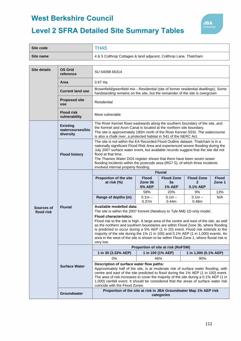
West Berkshire Council
Level 2 SFRA Detailed Site Summary Tables
112
Site code THA5
Site name 4 & 5 Colthrop Cottages & land adjacent, Colthrop Lane, Thatcham
Site details OS Grid reference
SU 54098 66314
Area 0.67 Ha
Current land use Brownfield/greenfield mix - Residential (site of former residential dwellings). Some hardstanding remains on the site, but the remainder of the site is overgrown
Proposed site use
Residential
Flood risk vulnerability
More vulnerable
Sources of flood risk
Existing watercourses/biodiversity
The River Kennet flows eastwards along the southern boundary of the site, and the Kennet and Avon Canal is located at the northern site boundary.
The site is approximately 180m north of the River Kennet SSSI. The watercourse
is also a chalk river, a protected habitat in S41 of the NERC Act.
Flood history
The site is not within the EA Recorded Flood Outline dataset. Thatcham is in a nationally significant Flood Risk Area and experienced severe flooding during the July 2007 surface water event, but available records suggest that the site did not flood at that time.
The Thames Water DG5 register shows that there have been seven sewer flooding incidents within the postcode area (RG7 5), of which three incidents involved internal property flooding.
Fluvial
Fluvial
Proportion of the site at risk (%)
Flood Zone 3b
5% AEP
Flood Zone 3a
1% AEP
Flood Zone 2
0.1% AEP
Flood Zone 1
58% 20% 9% 13%
Range of depths (m) 0.1m – 0.37m
0.1m – 0.44m
0.1m – 0.48m
N/A
Available modelled data:
The site is within the 2007 Kennet (Newbury to Tyle Mill) 1D-only model.
Flood characteristics:
Flood risk to the site is high. A large area of the centre and east of the site, as well as the northern and southern boundaries are within Flood Zone 3b, where flooding is predicted to occur during a 5% AEP (1 in 20) event. Flood risk extends to the majority of the site during the 1% (1 in 100) and 0.1% AEP (1 in 1,000) events. An area in the west of the site is shown to be within Flood Zone 1, where fluvial risk is very low.
Surface Water
Proportion of site at risk (RoFSW)
1 in 30 (3.33% AEP) 1 in 100 (1% AEP) 1 in 1,000 (0.1% AEP)
0% 46% 90%
Description of surface water flow paths:
Approximately half of the site, is at moderate risk of surface water flooding, with centre and east of the site predicted to flood during the 1% AEP (1 in 100) event. The area of risk increases to cover the majority of the site during a 0.1% AEP (1 in 1,000) rainfall event. It should be considered that the areas of surface water risk
coincide with the Flood Zones.
Groundwater Proportion of the site at risk in JBA Groundwater Map 1% AEP risk
categories

West Berkshire Council
Level 2 SFRA Detailed Site Summary Tables
113
Site code THA5
Site name 4 & 5 Colthrop Cottages & land adjacent, Colthrop Lane, Thatcham
Depth below surface 0-0.025m
Depth below surface 0.025-0.5m
Total in highest risk categories
0% 0% 0%
The site is at a negligible risk of groundwater flooding.
This Jacobs Groundwater Flood Risk modelling does not show the site to be at risk
of groundwater emergence.
Reservoir The site is not at risk of flooding, in the rare event of a reservoir breach.
Canal The Kennet and Avon Canal is located at the northern border of the site. There is a residual risk to the site, in the event of breach or overtoppng of the canal, which
should be assessed in detail within a site-specific Flood Risk Assessment.
Flood risk management infrastructure
Defences Defence Type Standard of Protection Condition
There are no defences present.
Residual risk
Culvert / structure blockage?
N/A
Impounded water body failure?
N/A
Defence breach / overtopping?
Breach Zone
N/A
Emergency planning
Flood warning The site is within the following EA Flood Alert Area: River Kennet from Thatcham down to Reading.
Access and egress
The site is likely to be accessed via Colthrop Lane, west of the site. To the north and south of the site, the access route is at risk of fluvial flooding during a 5% AEP (1 in 20) event. Therefore, fluvial flooding is likely to affect access, as this is currently the only access point for the site.
The surface water flood risk is low near to the site, with flooding predicted to occur duirng a 0.1% AEP (1 in 1,000) rainfall event, but increases north of the site boundary, where flooding is predicted to occur during a 3.33% AEP (1 in 30) and greater rainfall events.
Climate Change
Climate change allowances for ‘2080s’
River Basin District Central Higher Central
Upper End
Thames 25% 35% 70%
Implications for the site
Modelling shows that climate change leads to an increase in flood extent at the site. The extent of Flood Zone 3a + 70% CC does not extend beyond that of Flood Zone 2, and therefore climate change is unlikely to significantly impact the proposed site.

West Berkshire Council
Level 2 SFRA Detailed Site Summary Tables
114
Site code THA5
Site name 4 & 5 Colthrop Cottages & land adjacent, Colthrop Lane, Thatcham
Requirement for drainage control and
impact mitigation
Bedrock Geology
Lambeth Group - Clay, Silt and Sand.
Superficial Geology
Alluvium - Clay, Silt, Sand and Gravel.
Soils Slowly permeable seasonally wet slightly acid but base-rich loamy and clayey soils.
SuDS
• SuDS design must follow the West Berkshire Council SuDS SPD, meet
the Defra National Non-Statutory Technical Standards, and follow
current best design practice (CIRIA Manual 2015).
• All development should adopt source control SuDS techniques. Conveyance features should be designed above ground and following natural flow paths where possible.
• ‘Natural’, vegetated SuDS (such as green roofs, swales and ponds) will be preferred by West Berkshire Council as LLFA over ‘hard engineered’ and below-ground SuDS.
• Opportunities should be taken on a greenfield site such as this to deliver SuDS with multiple benefits, such as biodiversity, recreation and water resource education, through integration with areas of greenspace.
• The limited permeability of the underlying geology suggests that discharge of the site via infiltration may not be feasible, however shallow infiltration techniques may still be appropriate, subject to site-specific infiltration testing. Infiltration techniques should only be used where there are suitable levels of surface water runoff treatment.
Groundwater Source Protection Zone
The site is within Groundwater Source Protection Zone 3.
Historic Landfill Site
There are no historic landfill sites within the site boundary.
Opportunities for flood risk betterment
Opportunities for using source control SuDS to manage runoff rates and volumes, contributing to the reduction of flood peaks downstream on the River Kennet and existing surface water flow paths leaving the site.
Cumulative impacts of development
Water Framework Directive Catchment
Sensitivity to cumulative
impacts Implications
Kennet (Lambourn confluence to Enborne
confluence) High
The FRA should examine the cumulative impacts of potential peak runoff rates and volumes from the site (and other developments in the WFD catchment) on flood risk in the receiving watercourses.
Recommend-ations for Local Plan
policy
Sequential Test and Exception Test requirements
The Sequential Test must be passed. For this site, More Vulnerable development is proposed within FZ3a, and therefore, the Exception Test must be applied. The site is at high risk of flooding from multiple sources, and therefore it may not be safe to develop the site for residential purposes. Strong evidence that both parts of the Exception Test can be fulfilled will be required to justify development of the site.
Recommendations for requirements of site-specific Flood Risk Assessment, including guidance for developers

West Berkshire Council
Level 2 SFRA Detailed Site Summary Tables
115
Site code THA5
Site name 4 & 5 Colthrop Cottages & land adjacent, Colthrop Lane, Thatcham
Flood risk assessment:
• At the planning application stage, a site-specific flood risk assessment and surface water drainage strategy will be required.
• Consultation with the Local Authority and the Environment Agency should be undertaken at an early stage.
• A site-specific flood risk assessment will be required because the site is within Flood Zone 2 and 3 and at risk from sources of flooding other than rivers and the sea. Government guidance on flood risk assessments must be followed (https://www.gov.uk/guidance/floodrisk-assessment-for-planning-applications).
• Other sources of flooding should also be considered as part of a site-specific flood risk
assessment, including surface water and groundwater.
• Climate change should be assessed using recommended climate change allowances at the time of the assessment (https://www.gov.uk/guidance/flood-risk-assessments-climate-change-allowances) for the type of development and level of risk. The current allowances were published in February 2016 but may be subject to change in the future.
• Modelling should be conducted to assess the residual risk associated with breach or overtopping of the Kennet and Avon Canal.
• The site is located within a catchment identified as highly sensitive to the cumulative impacts of development on flood risk. The site-specific FRA and surface water drainage strategy should consider the recommendations outlined for high sensitivity catchments in the West Berkshire Level 1 SFRA Cumulative Impacts Assessment Addendum.
Guidance for site design and making development safe:
• Development must seek opportunities to reduce overall level of flood risk both on and offsite, for example by reducing volume and rate of runoff and creating space for flooding.
• Safe access and egress should be demonstrated in the 1 in 100 plus climate change event.
• A site-specific surface water drainage strategy will be required.
• Infiltration techniques may be ineffective and may pose a pollution risk. SuDS may need to be shallow and take up larger areas. Above ground conveyance and attenuation can be used.
• The level of detail and method of assessment of surface water runoff rates and volumes should be appropriate to the scale and risk of the development and should include recommended allowance for climate change and urban creep at the time of the assessment (currently +40% allowance for climate change and a 10% increase in impermeable area for urban creep).
• Storage for runoff from the development in extreme events should be located out of flood
risk areas.
• The design must ensure that flows resulting from rainfall in excess of a 1 in 100-year event are managed via exceedance routes that minimise the risks to people and property.
• SuDS design must follow West Berkshire Council SuDS Supplementary Planning Document (SPD) standards, meet the Defra National Non-Statutory Technical Standards, and follow current best design practice (CIRIA Manual 2015).The design must ensure that flows resulting from rainfall in excess of a 1 in 100-year event are managed via exceedance routes that minimise the risks to people and property.
• The River Kennet, which flows along the southern boundary of the site, is a Main River. An
8m wide buffer should be maintained between the riverbank and any built structures, to
enable the riparian owners and/or the Environment Agency to access and maintain the
channel.
• The Kennet and Avon Canal is located at the north of the site. A buffer, the distance to be determined in consultation with the Canal and River Trust, should be maintained between the canal and any built structures, to enable access and maintenance.

West Berkshire Council
Level 2 SFRA Detailed Site Summary Tables
116
Site code THA9
Site name Land at Lower Way Farm, Thatcham, RG19 3TL
Site details OS Grid reference
SU 49904 67234
Area 2.87 Ha
Current land use Residential dwelling and garden, and former farmstead
Proposed site use
Residential and 1 Ha public open space
Flood risk vulnerability
More vulnerable
Sources of flood risk
Existing watercourses/biodiversity
There are no watercourses within the site boundary. However, Moor Ditch, an ordinary watercourse which forms a tributary of the River Kennet, is located 40m south of the site. A series of large lakes are also located immediately south of the site.
The site is approximately 50m north of the Thatcham Reed Beds SSSI that is part of the Kennet and Lambourne Floodplain SAC. It is also within the same distance of the Moor Ditch, an ordinary watercourse that is a chalk river, a protected
habitat in S41 of the NERC Act.
Flood history
The site is not within the EA Recorded Flood Outlines dataset. Thatcham is in a nationally significant Flood Risk Area and experienced severe flooding during the July 2007 surface water event, but the site is not recorded as having flooded at that time.
The Thames Water DG5 register shows that there have been two sewer flooding incidents within the postcode area (RG19 3), both of which resulted in external property flooding.
Fluvial
Fluvial
Proportion of the site at risk (%)
Flood Zone 3b
5% AEP
Flood Zone 3a
1% AEP
Flood Zone 2
0.1% AEP
Flood Zone 1
0% 0% 15% 85%
Available modelled data:
The site is covered by the 2007 River Kennet (Newbury to Tyle Mill) 1D-only model.
Flood characteristics:
The site is at relatively low risk of fluvial flooding. The south of the site is within Flood Zone 2, where flooding is likely to occur during a 0.1% AEP (1 in 1,000) event. The extent of Flood Zone 3a, the 1% AEP (1 in 100) flood event, reaches the southern boundary of the site, although does not enter the site. Remaining areas
of the site are located within Flood Zone 1, where fluvial flood risk is negligible.
Surface Water
Proportion of site at risk (RoFSW)
1 in 30 1 in 100 1 in 1,000
0% 0% 1%
Description of surface water flow paths:
The site is at low risk of surface water flooding.
Groundwater
Proportion of the site at risk in JBA Groundwater Map 1% AEP risk categories
Depth below surface 0-0.025m
Depth below surface 0.025-0.5m
Total in highest risk categories
95% 5% 100%

West Berkshire Council
Level 2 SFRA Detailed Site Summary Tables
117
Site code THA9
Site name Land at Lower Way Farm, Thatcham, RG19 3TL
The site is at high risk of groundwater flooding, with groundwater levels across the majority of the site predicted to lie within 0.025m of the surface during a 1% AEP (1 in 100) event. A small area at the northern boundary of the site is also at high risk, with groundwater levels predicted to lie between 0.025 – 0.5m of the ground surface.
The Jacobs Groundwater Flood Risk modelling does not show the site to be at risk
of groundwater emergence.
Reservoir The site is not at risk of flooding, in the rare event of a reservoir breach.
Canal There are no canals within the vicinity of the site.
Flood risk management infrastructure
Defences Defence Type Standard of Protection Condition
There are no flood defences present in the site.
Residual risk
Culvert / structure blockage?
N/A
Impounded water body failure?
N/A
Defence breach / overtopping?
Breach Zone
N/A
Emergency planning
Flood warning
The site is within the following EA Flood Alert and Flood Warning Areas:
• Flood Alert Area: River Kennet and its tributaries from Berwick Bassett down to Newbury
• Flood Warning Area: River Kennet at Newbury
Access and egress
The site is likely to be accessed via Lower Way, to the north of the site, or Prince Hold Road to the east. Both routes are located within Flood Zone 1, and are therefore at low fluvial flood risk. Surface water flood risk adjacent to the site is high, with ponding expected during a 3.3% AEP (1 in 30), extending to form surface water flow paths during the 0.1% AEP (1 in 1,000) rainfall event.
Climate Change
Climate change allowances for ‘2080s’
River Basin District Central Higher Central
Upper End
Thames 25% 35% 70%
Implications for the site
Modelling shows that climate change leads to an increase in flood extent at the site. The extent of Flood Zone 3a + 70% CC does not extend beyond that of Flood Zone 2, and therefore climate change is unlikely to significantly impact the
proposed site.

West Berkshire Council
Level 2 SFRA Detailed Site Summary Tables
118
Site code THA9
Site name Land at Lower Way Farm, Thatcham, RG19 3TL
Requirement for drainage control and
impact mitigation
Bedrock Geology
Lambeth Group - Clay, Silt And Sand.
Superficial Geology
Beenham Grange Gravel Member - Sand And Gravel.
Soils Freely draining slightly acid loamy soils.
SuDS
• SuDS design must follow the West Berkshire Council SuDS SPD, meet
the Defra National Non-Statutory Technical Standards, and follow
current best design practice (CIRIA Manual 2015).
• All development should adopt source control SuDS techniques. Conveyance features should be designed above ground and following natural flow paths where possible.
• ‘Natural’, vegetated SuDS (such as green roofs, swales and ponds) will be preferred by West Berkshire Council as LLFA over ‘hard engineered’ and below-ground SuDS.
• SuDS features should be designed outside of fluvial flood risk areas and conveyance features should remain above surface and follow natural pathways.
• The impermeable bedrock geology suggests that infiltration techniques may not be suitable on this site. Furthermore, the mapping suggests that there is high risk of groundwater flooding at this location, therefore infiltration techniques may not be suitable. This should be confirmed via site investigations and site-specific infiltration testing, to assess the potential for infiltration.
• The site is located within Groundwater Source Protection Zone 3. As such infiltration techniques should only be used where there are suitable levels of treatment and following the granting of any required environmental permits from the Environment Agency.
Groundwater Source Protection Zone
The site is within Groundwater Source Protection Zone 3.
Historic Landfill Site
There are no historic landfill sites within the site boundary.
Opportunities for flood risk betterment
Opportunities for using source control SuDS to manage runoff rates and volumes, contributing to the reduction of flood peaks downstream on the River Kennet and existing surface water flow paths leaving the site.
Cumulative impacts of development
Water Framework Directive Catchment
Sensitivity to cumulative impacts
Implications
Lambourn (Source to Newbury)
Medium
The FRA and surface
water drainage strategy
should demonstrate
wider betterment by
demonstrating measures
which can be put in
place to contribute to a
reduction in flood risk
downstream.
Sequential Test and Exception Test requirements

West Berkshire Council
Level 2 SFRA Detailed Site Summary Tables
119
Site code THA9
Site name Land at Lower Way Farm, Thatcham, RG19 3TL
Recommend-ations for Local Plan
policy
The Sequential Test must be satisfied. Only once the Sequential Test is satisfied should the Exception Test be applied. It is anticipated that proposed development will be sequentially located within Flood Zone 1. For this site, the Exception Test must be satisfied:
• If More Vulnerable and Essential Infrastructure is located in FZ3a or FZ3a plus climate change.
• If Highly Vulnerable development is located in FZ2.
If Essential Infrastructure is located in Flood Zone 3b then it must be demonstrated that the exception test is satisfied. Development will not be permitted in the following scenarios:
• Highly Vulnerable development within FZ3a or FZ3a plus climate change and FZ3b.
• More Vulnerable and Less Vulnerable development within FZ3b.
Recommendations for requirements of site-specific Flood Risk Assessment, including guidance for developers
Flood risk assessment:
• At the planning application stage, a site-specific flood risk assessment and surface water drainage strategy will be required.
• Consultation with the Local Authority and the Environment Agency should be undertaken at an early stage.
• A site-specific flood risk assessment will be required because the site is within Flood Zone 2 and 3 and at risk from sources of flooding other than rivers and the sea. Government guidance on flood risk assessments must be followed (https://www.gov.uk/guidance/floodrisk-assessment-for-planning-applications).
• Other sources of flooding should also be considered as part of a site-specific flood risk assessment, including surface water and groundwater.
• Climate change should be assessed using recommended climate change allowances at the time of the assessment (https://www.gov.uk/guidance/flood-risk-assessments-climate-change-allowances) for the type of development and level of risk. The current allowances were published in February 2016 but may be subject to change in the future.
• The site is located within a catchment identified as moderately sensitive to the cumulative impacts of development on flood risk. The site-specific FRA and surface water drainage strategy should consider the recommendations outlined for catchments of medium sensitivity in the West Berkshire Level 1 SFRA Cumulative Impacts Assessment Addendum.
Guidance for site design and making development safe:
• Development must seek opportunities to reduce overall level of flood risk at the site.
• Safe access and egress should be demonstrated in the 1 in 100 plus climate change event and raising of access routes must not impact on floodplain storage capacity.
• Mitigation for seasonal high groundwater levels must be considered (for example by raising finished floor levels to an appropriate height above ground level).
• Due to the high groundwater flood risk, basements are not permitted.
• The design of SuDS schemes must take into account the seasonally high groundwater table. Infiltration techniques may be ineffective and may pose a pollution risk. SuDS may need to be shallow and take up larger areas. Above ground conveyance and attenuation can be used but care must be taken that groundwater does not enter the SuDS feature and reduce the storage capacity and structural integrity of the design.
• The level of detail and method of assessment of surface water runoff rates and volumes should be appropriate to the scale and risk of the development and should include recommended allowance for climate change and urban creep at the time of the assessment (currently +40% allowance for climate change and a 10% increase in impermeable area for urban creep).
• Storage for runoff from the development in extreme events should be located out of flood risk areas.
• The design must ensure that flows resulting from rainfall in excess of a 1 in 100-year event are managed via exceedance routes that minimise the risks to people and property.
• SuDS design must follow West Berkshire Council SuDS Supplementary Planning Document (SPD) standards, meet the Defra National Non-Statutory Technical Standards, and follow current best design practice (CIRIA Manual 2015).The design must ensure that

West Berkshire Council
Level 2 SFRA Detailed Site Summary Tables
120
Site code THA9
Site name Land at Lower Way Farm, Thatcham, RG19 3TL
flows resulting from rainfall in excess of a 1 in 100-year event are managed via exceedance
routes that minimise the risks to people and property.

West Berkshire Council
Level 2 SFRA Detailed Site Summary Tables
121
Site code THA15
Site name Hollington Place, Thatcham
Site details OS Grid reference
SU 51360 67320
Area 0.2 Ha
Current land use Brownfield and greenfield mix - Residential dwellings and residential gardens
Proposed site use
Residential, specialist residential, employment, and a community facility
Flood risk vulnerability
More vulnerable
Sources of flood risk
Existing watercourses/biodiversity
There are no watercourses within the site boundary.
Flood history
The site is not located within the EA Recorded Flood Outlines dataset. The site is not identified as having flooding during the July 2007 surface water flood event, which severely affected Thatcham.
The Thames Water DG5 register identifies that two previous sewer flooding incidents have occurred within the RG19 3 postcode, both resulting in external flooding.
Fluvial
Fluvial
Proportion of the site at risk (%)
Flood Zone 3b
5% AEP
Flood Zone 3a
1% AEP
Flood Zone 2
0.1% AEP
Flood Zone 1
0% 0% 0% 100%
Available modelled data:
The site is not covered by within a hydraulic model.
Flood characteristics:
The site is entirely within Flood Zone 1, where fluvial flood risk is negligible.
Surface Water
Proportion of site at risk (RoFSW)
1 in 30 (3.33% AEP) 1 in 100 (1% AEP) 1 in 1,000 (0.1% AEP)
0% 0% 1%
Description of surface water flow paths:
The site is at very low risk of surface water flooding.
Groundwater
Proportion of the site at risk in JBA Groundwater Map 1% AEP risk categories
Depth below surface 0-0.025m
Depth below surface 0.025-0.5m
Total in highest risk categories
80% 20% 100%
The majority of the site is at high risk of groundwater flooding, with groundwater levels are predicted to lie within 0.025m of the ground surface during a 1% AEP (1 in 100) event. Groundwater levels along the southern boundary are predicted to lie between 0.025 – 0.5m of the ground surface during a 1% AEP event.
The Jacobs Groundwater Flood Risk modelling does not show the site to be at risk of groundwater emergence.

West Berkshire Council
Level 2 SFRA Detailed Site Summary Tables
122
Site code THA15
Site name Hollington Place, Thatcham
Reservoir The site is not at risk of flooding, in the rare event of a reservoir breach.
Canal There are no canals witin the vicinity of the site.
Flood risk management infrastructure
Defences Defence Type Standard of Protection Condition
There are no defences within the site boundary.
Residual risk
Culvert / structure blockage?
N/A
Impounded water body failure?
N/A
Defence breach / overtopping?
Breach Zone
N/A
Emergency planning
Flood warning The site is not within an EA Flood Alert or Flood Warning Area.
Access and egress
The site is likely to be accessed via Green Lane, with current access at the east of the site. This route is within Flood Zone 1, and is therefore at very low fluvial flood risk. The road is at risk of surface water flooding, with a flow path predicted to form during the 3.3% AEP (1 in 30) and greater rainfall events.
Climate Change
Climate change allowances for ‘2080s’
River Basin District Central Higher Central
Upper End
Thames 25% 35% 70%
Implications for the site
The site remains in Flood Zone 1 when accounting for the impact of climate change.

West Berkshire Council
Level 2 SFRA Detailed Site Summary Tables
123
Site code THA15
Site name Hollington Place, Thatcham
Requirement for drainage control and
impact mitigation
Bedrock Geology
Lambeth Group - Clay, Silt And Sand.
Superficial Geology
Thatcham Gravel - Sand And Gravel.
Soils Freely draining slightly acid loamy soils.
SuDS
• SuDS design must follow the West Berkshire Council SuDS SPD, meet
the Defra National Non-Statutory Technical Standards, and follow
current best design practice (CIRIA Manual 2015).
• SuDS are possible on all sites, including previously developed sites such as this one. All development should adopt source control SuDS techniques. Conveyance features should be designed above ground and following natural flow paths where possible.
• ‘Natural’, vegetated SuDS (such as green roofs, swales and ponds) will be preferred by West Berkshire Council as LLFA over ‘hard engineered’ and below-ground SuDS.
• Mapping suggests that the bedrock geology is impermeable, and the site is at high risk of groundwater flooding, therefore infiltration techniques may not be suitable. It is recommended that further site investigation should be carried out to assess and confirm the potential for infiltration.
• The site is located within Groundwater Source Protection Zone 3. As such infiltration techniques should only be used where there are suitable levels of treatment and following the granting of any required environmental permits from the Environment Agency.
• Where below ground storage is proposed, the base of the feature must be located at least 1m above the highest groundwater level, to reduce the risk of groundwater ingress or flotation.
Groundwater Source Protection Zone
The site is within Groundwater Source Protection Zone 3.
Historic Landfill Site
There are no historic landfill sites within the site.
Opportunities for flood risk betterment
Opportunities for using source control SuDS to manage runoff rates and volumes, contributing to the reduction of flood peaks downstream on the River Kennet and existing surface water flow paths leaving the site.
Cumulative impacts of development
Water Framework Directive Catchment
Sensitivity to cumulative impacts
Implications
Kennet (Lambourn confluence to
Enborne confluence) High
The FRA should examine the cumulative impacts of potential peak runoff rates and volumes from the site (and other developments in the WFD catchment) on flood risk in the receiving watercourses.
Recommend-ations for Local Plan
policy
Sequential Test and Exception Test requirements
The site is within Flood Zone 1 but at risk from other sources of flooding. The Sequential Test must be passed. The Exception Test is not required under the NPPF, but it must be shown that the development will be safe for its lifetime and the risk can be managed through a sequential approach to design.
Recommendations for requirements of site-specific Flood Risk Assessment, including guidance for developers

West Berkshire Council
Level 2 SFRA Detailed Site Summary Tables
124
Site code THA15
Site name Hollington Place, Thatcham
Flood risk assessment:
• At the planning application stage, a site-specific flood risk assessment and surface water drainage strategy will be required.
• Consultation with the Local Authority and the Environment Agency should be undertaken at an early stage.
• Government guidance specifies that a site-specific flood risk assessment will be required where a site is within Flood Zone 2 and 3 or is greater than 1 Ha and at risk from sources of flooding other than rivers and the sea. This does not apply to the site. However, due to the extent of groundwater risk, it is advised that further investigations are undertaken to understand and manage risk. Government guidance on flood risk assessments must be followed (https://www.gov.uk/guidance/floodrisk-assessment-for-planning-applications).
• Other sources of flooding should also be considered as part of a site-specific flood risk assessment, including surface water and groundwater.
• Climate change should be assessed using recommended climate change allowances at the time of the assessment (https://www.gov.uk/guidance/flood-risk-assessments-climate-change-allowances) for the type of development and level of risk. The current allowances were published in February 2016 but may be subject to change in the future.
• The site is located within a catchment identified as highly sensitive to the cumulative impacts of development on flood risk. The site-specific FRA and surface water drainage strategy should consider the recommendations outlined for high sensitivity catchments in the West Berkshire Level 1 SFRA Cumulative Impacts Assessment Addendum.
Guidance for site design and making development safe:
• Development must seek opportunities to reduce overall level of flood risk at the site.
• Mitigation for seasonal high groundwater levels must be considered (for example by raising finished floor levels to an appropriate height above ground level).
• Due to the high groundwater flood risk, basements are not permitted.
• The design of SuDS schemes must take into account the seasonally high groundwater table. Infiltration techniques may be ineffective and may pose a pollution risk. SuDS may need to be shallow and take up larger areas. Above ground conveyance and attenuation can be used but care must be taken that groundwater does not enter the SuDS feature and reduce the storage capacity and structural integrity of the design.
• The level of detail and method of assessment of surface water runoff rates and volumes should be appropriate to the scale and risk of the development and should include recommended allowance for climate change and urban creep at the time of the assessment (currently +40% allowance for climate change and a 10% increase in impermeable area for urban creep).
• SuDS design must follow West Berkshire Council SuDS Supplementary Planning Document (SPD) standards, meet the Defra National Non-Statutory Technical Standards, and follow current best design practice (CIRIA Manual 2015).The design must ensure that flows resulting from rainfall in excess of a 1 in 100-year event are managed via exceedance routes that minimise the risks to people and property.

West Berkshire Council
Level 2 SFRA Detailed Site Summary Tables
125
Site code THE1
Site name Whitehart Meadow, High Street, Theale
Site details OS Grid reference
SU 64656 71711
Area 8 Ha
Current land use Greenfield - Agriculture
Proposed site use
Employment or residential
NPPF Flood risk vulnerability
Less / More vulnerable
Sources of flood risk
Existing watercourses/biodiversity
The Sulham Brook (Main River) flows north eastwards through the site, and then northwards along the eastern site boundary. Unnamed ordinary watercourses, which form tributaries to the Sulham Brook, flow along the eastern and northern boundaries of the site.
Flood history
The majority of the site is within the EA Recorded Flood Outline dataset. The site is recorded as having flooded on 6 June 1971 and 6 January 2003, as a result of channel exceedance along the Sulham Brook.
The Thames Water DG5 register shows that there have been 14 sewer flooding incidents within the postcode area (RG7 5), of which one incident involved internal property flooding.
Fluvial
Proportion of site at risk in Flood Zones
Proportion of the site at risk (%)
Flood Zone 3b
5% AEP
Flood Zone 3a
1% AEP
Flood Zone 2
0.1% AEP
Flood Zone 1
0% 0% 31% 69%
Available modelled data:
The site is not covered by a detailed hydraulic model. The extent of Flood Zone
2 in this location is based on the January 2003 recorded flood outline.
Flood characteristics:
The site is shown to be at risk of fluvial flooding, with the north and centre of the site located in Flood Zone 2, and expected to flood during the 0.1% AEP (1 in 1,000) event. The remainder of the site is in Flood Zone 1, and is therefore at negligible fluvial risk.
Surface Water
Proportion of site at risk (RoFSW)
1 in 30 (3.33% AEP) 1 in 100 (1% AEP) 1 in 1000 (0.1% AEP)
0% 1% 8%
Description of surface water flow paths:
The site is at low risk of surface water flooding, with small areas of ponding in the south and west of the site expected to occur in the 0.1% AEP (1 in 1,000) rainfall event.
Groundwater
Proportion of the site at risk in JBA Groundwater Map 1 in 100-year (1% AEP) risk categories
Depth below surface
0-0.025m
Depth below surface
0.025-0.5m
Total in highest risk categories
82% 0% 82%

West Berkshire Council
Level 2 SFRA Detailed Site Summary Tables
126
Site code THE1
Site name Whitehart Meadow, High Street, Theale
The majority of the site is at high risk of groundwater flooding where groundwater levels are predicted to lie within 0.025m of the ground surface during a 1% AEP event. The remainder of the site, in the north, is shown to be at a negligible risk
of groundwater emergence.
This Jacobs Groundwater Flood Risk modelling does not show the site to be at risk of groundwater emergence.
Reservoir The site is not at risk of flooding, in the rare event of a reservoir breach.
Canal There are no canals within the vicinity of the site.
Flood risk management infrastructure
Defences Defence Type
Standard of Protection
Condition
There are no defences present within site boundary.
Residual risk
Culvert / structure blockage?
There is a culvert exit at the western border of the site, which is the limit of the Main River. However, the culvert entrance is located a significant distance upstream of the site, and therefore blockage of this culvert is not
expected to affect flood risk to the site.
Impounded water body failure?
N/A
Defence breach / overtopping?
Breach Zone
N/A
Emergency planning
Flood warning
The site is covered by two EA Flood Alert Areas:
• River Pang from East Ilsley to Pangbourne and Sulham Brook
• River Kennet from Thatcham down to Reading
Access and egress
The site is likley to be accessed via High Street, with current access to the south of the site. The route is located within Flood Zone 1 and therefore is at low fluvial flood risk. The risk of surface water flooding is also shown to low, with isolated areas of ponding predicted during the 1% AEP (1 in 100) and 0.1% AEP (1 in 1,000) rainfall events.
Climate Change
Climate change allowances for ‘2080s’
River Basin District Central Higher Central
Upper End
Thames 25% 35% 70%
Implications for the site
As no detailed modelling covers the site, Flood Zone 2 has been used as a proxy for the impact of climate change on the 1% AEP (1 in 100) fluvial flood event. This provides a conservative extent of the proportion of the site identified as at risk from a 1 in 100 + CC flood event.

West Berkshire Council
Level 2 SFRA Detailed Site Summary Tables
127
Site code THE1
Site name Whitehart Meadow, High Street, Theale
Requirement for drainage control and
impact mitigation
Bedrock Geology
Seaford Chalk Formation.
Superficial Geology
Alluvium - Clay, Silt, Sand and Gravel.
Soils Loamy soils with naturally high groundwater.
SuDS
• SuDS design must follow the West Berkshire Council SuDS SPD,
meet the Defra National Non-Statutory Technical Standards, and
follow current best design practice (CIRIA Manual 2015).
• SuDS are possible on all sites, including previously developed sites such as this one. All development should adopt source control SuDS techniques. Conveyance features should be designed above ground and following natural flow paths where possible.
• ‘Natural’, vegetated SuDS (such as green roofs, swales and ponds) will be preferred by West Berkshire Council as LLFA over ‘hard engineered’ and below-ground SuDS.
• Storage for runoff from the development in extreme events should be located out of fluvial flood risk areas.
• The bedrock geology suggests that infiltration may be suitable, although mapping indicates that groundwater flood risk is high across the site. Therefore, it is recommended further site investigation should be carried out to assess potential for drainage by infiltration, including at least 12 months of groundwater level monitoring on site. Infiltration techniques should only be used where there are suitable levels of surface water runoff treatment.
• Where below ground storage is proposed, the base of the feature must be located at least 1m above the highest groundwater level, to reduce the risk of groundwater ingress or flotation.
Groundwater Source Protection Zone
The site is not within a designated Groundwater Source Protection Zone.
Historic Landfill Site
There are no historic site boundaries within the site boundary.
Opportunities for flood risk betterment
Opportunities for using source control SuDS to manage runoff rates and volumes, contributing to the reduction of flood peaks downstream on the Sulham Brook and existing surface water flow paths leaving the site.
Cumulative impacts of development
Water Framework Directive Catchment
Sensitivity to cumulative
impacts Implications
Sulham Brook Medium
The FRA and surface water drainage strategy should demonstrate wider betterment by demonstrating measures which can be put in place to contribute to a reduction
in flood risk downstream. Sequential Test and Exception Test requirements

West Berkshire Council
Level 2 SFRA Detailed Site Summary Tables
128
Site code THE1
Site name Whitehart Meadow, High Street, Theale
Recommend-ations for Local Plan
policy
The Sequential Test must be satisfied. Only once the Sequential Test is satisfied should the Exception Test be applied. It is anticipated that proposed development will be sequentially located within Flood Zone 1. For this site, the Exception Test must be satisfied:
• If More Vulnerable and Essential Infrastructure is located in FZ3a or FZ3a plus climate change.
• If Highly Vulnerable development is located in FZ2.
If Essential Infrastructure is located in Flood Zone 3b then it must be demonstrated that the exception test is satisfied. Development will not be permitted in the following scenarios:
• Highly Vulnerable development within FZ3a or FZ3a plus climate change and FZ3b. More Vulnerable and Less Vulnerable development within FZ3b.
Recommendations for requirements of site-specific Flood Risk Assessment, including guidance for developers
Flood risk assessment:
• At the planning application stage, a site-specific flood risk assessment and surface water drainage strategy will be required.
• Consultation with the Local Authority and the Environment Agency should be undertaken at an early stage.
• A site-specific flood risk assessment will be required because the site is within Flood Zone 2 and 3 and at risk from sources of flooding other than rivers and the sea. Government guidance on flood risk assessments must be followed (https://www.gov.uk/guidance/floodrisk-assessment-for-planning-applications).
• Other sources of flooding should also be considered as part of a site-specific flood risk assessment, including surface water and groundwater.
• Detailed modelling will be required to confirm Flood Zone and climate change extents (see ‘Available modelled data’). The Environment Agency and LLFA should be consulted to obtain the latest hydraulic modelling information for the site at the time of the flood risk assessment. They will advise as to whether existing detailed models are available, and if so, whether they need to be updated.
• Modelling should be conducted to assess the residual risk associated with potential blockage of the culvert within the site.
• Climate change should be assessed using recommended climate change allowances at the time of the assessment (https://www.gov.uk/guidance/flood-risk-assessments-climatechange-allowances) for the type of development and level of risk. The current allowances were published in February 2016 but may be subject to change in the future.
• The site is located within a catchment identified as moderately sensitive to the cumulative impacts of development on flood risk. The site-specific FRA and surface water drainage strategy should consider the recommendations outlined for catchments of medium sensitivity in the West Berkshire Level 1 SFRA Cumulative Impacts Assessment Addendum.
Guidance for site design and making development safe:
• Development must seek opportunities to reduce overall level of flood risk at the site.
• Safe access and egress should be demonstrated in the 1 in 100 plus climate change event and raising of access routes must not impact on floodplain storage capacity.
• Mitigation for seasonal high groundwater levels must be considered (for example by raising finished floor levels to an appropriate height above ground level).
• Due to the high groundwater flood risk, basements are not permitted.
• The design of SuDS schemes must take into account the seasonally high groundwater table. Infiltration techniques may be ineffective and may pose a pollution risk. SuDS may need to be shallow and take up larger areas. Above ground conveyance and attenuation can be used but care must be taken that groundwater does not enter the SuDS feature and reduce the storage capacity and structural integrity of the design.
• The level of detail and method of assessment of surface water runoff rates and volumes should be appropriate to the scale and risk of the development and should include recommended allowance for climate change and urban creep at the time of the assessment (currently +40% allowance for climate change and a 10% increase in impermeable area for urban creep).

West Berkshire Council
Level 2 SFRA Detailed Site Summary Tables
129
Site code THE1
Site name Whitehart Meadow, High Street, Theale
• Storage for runoff from the development in extreme events should be located out of flood risk areas.
• The design must ensure that flows resulting from rainfall in excess of a 1 in 100-year event are managed via exceedance routes that minimise the risks to people and property.
• SuDS design must follow West Berkshire Council SuDS Supplementary Planning Document (SPD) standards, meet the Defra National Non-Statutory Technical Standards, and follow current best design practice (CIRIA Manual 2015).The design must ensure that flows resulting from rainfall in excess of a 1 in 100-year event are managed via exceedance routes that minimise the risks to people and property.
• The Sulham Brook, which flows through the site, is a Main River. An 8m wide buffer should be maintained between the riverbank and any built structures, to enable the riparian owners and/or the Environment Agency to access and maintain the channel.

West Berkshire Council
Level 2 SFRA Detailed Site Summary Tables
130
Site code THE2
Site name Theale Primary School, Church Street, Theale
Site details OS Grid reference
SU 63907 71267
Area 0.6 Ha
Current land use Brownfield - Primary School
Proposed site use
Residential
Flood risk vulnerability
More vulnerable
Sources of flood risk
Existing watercourses/biodiversity
There are no watercourses within the site boundary.
Flood history
The site is not within the EA Recorded Flood Outlines dataset.
The Thames Water DG5 register shows that there have been 14 sewer flooding incidents within the postcode area (RG7 5), of which one has resulted in internal
property flooding.
Fluvial
Fluvial
Proportion of the site at risk (%)
Flood Zone 3b
5% AEP
Flood Zone 3a
1% AEP
Flood Zone 2
0.1% AEP
Flood Zone 1
0% 0% 0% 100%
Available modelled data:
The site is not covered by a hydraulic model.
Flood characteristics:
The site is entirely within Flood Zone 1 where flood risk is negligible.
Surface Water
Proportion of site at risk (RoFSW)
1 in 30 (3.33% AEP) 1 in 100 (1% AEP) 1 in 1,000 (0.1% AEP)
0% 0% 5%
Description of surface water flow paths:
The majority of the site is at negligible risk of surface water flooding. A small area of ponding is predicted to form in the west of the site during a 0.1% AEP (1 in 1,000) rainfall event.
Groundwater
Proportion of the site at risk in JBA Groundwater Map 1% AEP risk categories
Depth below surface 0-0.025m
Depth below surface 0.025-0.5m
Total in highest risk categories
100% 0% 100%
The entirety of the site is within the highest groundwater flood risk category, where groundwater levels are likely to lie within 0.025m of the ground surface during a 1%
AEP (1 in 100) event.
The Jacobs Groundwater Flood Risk modelling does not show the site to be at risk of groundwater emergence.
Reservoir The site is not at risk of flooding, in the rare event of a reservoir breach.
Canal There are no canals within the vicinity of the area.

West Berkshire Council
Level 2 SFRA Detailed Site Summary Tables
131
Site code THE2
Site name Theale Primary School, Church Street, Theale
Flood risk management infrastructure
Defences Defence Type Standard of Protection Condition
There are no defences within site boundary.
Residual risk
Culvert / structure blockage?
N/A
Impounded water body failure?
N/A
Defence breach / overtopping?
Breach Zone
N/A
Emergency planning
Flood warning The site is not within an EA Flood Alert or Flood Warning Area.
Access and egress
The site is likely to be accessed via Church Street, with current access at the southern border of the site. The route is located within Flood Zone 1, and is at low risk of surface water flooding.
Climate Change
Climate change allowances for ‘2080s’
River Basin District Central Higher Central
Upper End
Thames 25% 35% 70%
Implications for the site
The site remains in Flood Zone 1 when considering the impact of climate change.

West Berkshire Council
Level 2 SFRA Detailed Site Summary Tables
132
Site code THE2
Site name Theale Primary School, Church Street, Theale
Requirement for drainage control and
impact mitigation
Bedrock Geology
Seaford Chalk Formation.
Superficial Geology
Beenham Grange Gravel Member - Sand and Gravel.
Soils Loamy soils with naturally high groundwater.
SuDS
• SuDS design must follow the West Berkshire Council SuDS SPD, meet
the Defra National Non-Statutory Technical Standards, and follow
current best design practice (CIRIA Manual 2015).
• SuDS are possible on all sites, including previously developed sites such as this one. All development should adopt source control SuDS techniques. Conveyance features should be designed above ground and following natural flow paths where possible.
• ‘Natural’, vegetated SuDS (such as green roofs, swales and ponds) will be preferred by West Berkshire Council as LLFA over ‘hard engineered’ and below-ground SuDS.
• Mapping suggests that there is high risk of groundwater flooding at this location, therefore infiltration techniques may not be suitable. This should be confirmed via site investigations to assess the potential for infiltration.
• The site is located within Groundwater Source Protection Zone 3. As such infiltration techniques should only be used where there are suitable levels of treatment and following the granting of any required environmental permits from the Environment Agency.
• Where below ground storage is proposed, the base of the feature must be located at least 1m above the highest groundwater level, to reduce the risk of groundwater ingress or flotation.
Groundwater Source Protection Zone
The site is within Groundwater Source Protection Zone 3.
Historic Landfill Site
There are no historic landfill sites within the site boundary.
Opportunities for flood risk betterment
Opportunities for using source control SuDS to manage runoff rates and volumes, contributing to the reduction of flood peaks downstream and existing surface
water flow paths leaving the site.
Cumulative impacts of development
Water Framework Directive Catchment
Sensitivity to cumulative
impacts Implications
Sulham Brook Medium The FRA should examine the cumulative impacts of potential peak runoff rates and volumes from the site (and other developments in the WFD catchment) on flood risk in the receiving watercourses.
Holy Brook High
Recommend-ations for Local Plan
policy
Sequential Test and Exception Test requirements
The site is within Flood Zone 1 but at risk from other sources of flooding. The Sequential Test must be passed. The Exception Test is not required under the NPPF, but it must be shown that the development will be safe for its lifetime and the risk can be managed through a sequential approach to design.
Recommendations for requirements of site-specific Flood Risk Assessment, including guidance for developers

West Berkshire Council
Level 2 SFRA Detailed Site Summary Tables
133
Site code THE2
Site name Theale Primary School, Church Street, Theale
Flood risk assessment:
• At the planning application stage, a site-specific flood risk assessment and surface water drainage strategy will be required.
• Consultation with the Local Authority and the Environment Agency should be undertaken at an early stage.
• Government guidance specifies that a site-specific flood risk assessment will be required where a site is greater than 1 Ha in area and at risk from sources of flooding other than rivers and the sea. The site is less than 1Ha in area, although due to the extent of groundwater risk, it is advised that further investigations are undertaken to understand and manage risk. Government guidance on flood risk assessments must be followed (https://www.gov.uk/guidance/floodrisk-assessment-for-planning-applications).
• Other sources of flooding should also be considered as part of a site-specific flood risk assessment, including surface water and groundwater.
• Climate change should be assessed using recommended climate change allowances at the time of the assessment (https://www.gov.uk/guidance/flood-risk-assessments-climate-change-allowances) for the type of development and level of risk. The current allowances were published in February 2016 but may be subject to change in the future.
• The site is located within catchments identified as moderately and highly sensitive to the cumulative impacts of development on flood risk. The site-specific FRA and surface water drainage strategy should consider the recommendations outlined for high sensitivity catchments in the West Berkshire Level 1 SFRA Cumulative Impacts Assessment Addendum
Guidance for site design and making development safe:
• Development must seek opportunities to reduce overall level of flood risk at the site.
• Mitigation for seasonal high groundwater levels must be considered (for example by raising finished floor levels to an appropriate height above ground level).
• Due to the high groundwater flood risk, basements are not permitted.
• The design of SuDS schemes must take into account the seasonally high groundwater table. Infiltration techniques may be ineffective and may pose a pollution risk. SuDS may need to be shallow and take up larger areas. Above ground conveyance and attenuation can be used but care must be taken that groundwater does not enter the SuDS feature and reduce the storage capacity and structural integrity of the design.
• The level of detail and method of assessment of surface water runoff rates and volumes should be appropriate to the scale and risk of the development and should include recommended allowance for climate change and urban creep at the time of the assessment (currently +40% allowance for climate change and a 10% increase in impermeable area for
urban creep).
• SuDS design must follow West Berkshire Council SuDS Supplementary Planning Document (SPD) standards, meet the Defra National Non-Statutory Technical Standards, and follow current best design practice (CIRIA Manual 2015).The design must ensure that flows resulting from rainfall in excess of a 1 in 100-year event are managed via exceedance routes that minimise the risks to people and property.

West Berkshire Council
Level 2 SFRA Detailed Site Summary Tables
134
Site code THE3
Site name Station Plaza, Station Road, Theale, RG7 4AQ
Site details OS Grid reference
SU 64372 71043
Area 1.04 Ha
Current land use Brownfield – Employment (Offices)
Proposed site use
Residential, employment, retail, tourism, leisure/recreation
Flood risk vulnerability
More vulnerable
Sources of flood risk
Existing watercourses/biodiversity
There are no watercourses within the site boundary. The River Kennet (Main River) flows in a north easterly direction, 300m south of the site.
Flood history
The site is within the EA Recorded Flood Outline dataset. There has been one previous flood incident, occurring on 6 June 1971, as a result of channel exceedance along the River Kennet. The West Berkshire Council Parish Flood Report for the Winter 2013/14 event identified that Station Road was closed on 5 February 2014, due to the depth of flooding, caused by backing up of the River
Kennet at the road crossing.
The Thames Water DG5 register shows that there have been six sewer flooding incidents within the postcode area (RG19 3), both of which two resulted in internal property flooding.
Fluvial
Fluvial
Proportion of the site at risk (%)
Flood Zone 3b
5% AEP
Flood Zone 3a
1% AEP
Flood Zone 2
0.1% AEP
Flood Zone 1
0% 70% 30% 0%
Range of Depths (m)
N/A 0.01m – 0.72m
0.03m – 0.87m
N/A
Maximum Hazard N/A Significant: Danger to
most
Significant: Danger to
most
N/A
Available modelled data:
The site is covered by the 2018 River Kennet (Tyle Mill to Thames Confluence) 1D-2D model.
Flood characteristics:
The majority of the site is located within Flood Zone 3a, where fluvial flooding is expected during the 1% AEP (1 in 100) event. Remaining areas of the site are within Flood Zone 2, where flooding is expected during a 0.1% AEP (1 in 1,000) event.
Surface Water
Proportion of site at risk (RoFSW)
1 in 30 (3.33% AEP) 1 in 100 (1% AEP) 1 in 1,000 (0.1% AEP)
3% 9% 24%
Description of surface water flow paths:
A small area of ponding forms on the access road in the east of the site, during the 3.3% AEP (1 in 30) and 1% AEP (1 in 100) rainfall events. The risk extends during the 0.1% AEP (1 in 1,000) rainfall event, with a flow path entering the site from Brunel Road to the south.
Groundwater Proportion of the site at risk in JBA Groundwater Map 1% AEP risk
categories

West Berkshire Council
Level 2 SFRA Detailed Site Summary Tables
135
Site code THE3
Site name Station Plaza, Station Road, Theale, RG7 4AQ
Depth below surface 0-0.025m
Depth below surface 0.025-0.5m
Total in highest risk categories
23% 0% 23%
The east and south of the site is at high groundwater flood risk, where groundwater levels lie within 0.025m of the ground surface during a 1% AEP (1 in 100) flood event. The remaining areas of the site are at negligible risk of groundwater flooding.
The Jacobs Groundwater Flood Risk modelling does not show the site to be at risk of groundwater emergence.
Reservoir The site is not at risk of flooding, in the rare event of a reservoir breach.
Canal There are no canals within the vicinity of the site.
Flood risk management infrastructure
Defences Defence Type Standard of Protection Condition
There are no flood defences present within the site.
Residual risk
Culvert / structure blockage?
N/A
Impounded water body failure?
N/A
Defence breach / overtopping?
Breach Zone
N/A
Emergency planning
Flood warning
The site is within the following EA Flood Alert and Flood Warning Areas:
• Flood Alert Area: River Kennet from Thatcham down to Reading
• Flood Warning Area: River Kennet from Theale down to Reading
Access and egress
The site is likely to be accessed via Brunel Road (with current access to the south) or Station Road (with current access to the west). Both of these routes are within Flood Zone 3a, where flooding is likley to occur during the 1% AEP event. The routes are at relatively low surface water flood risk, with flow paths forming during the 0.1% AEP (1 in 1,000) rainfall event.
Climate Change
Climate change allowances for ‘2080s’
River Basin District Central Higher Central
Upper End
Thames 25% 35% 70%
Implications for the site
Modelling shows that climate change leads to an increase in flood extent at the site. The extent of Flood Zone 3a + 70% CC does not extend beyond that of Flood Zone 2, and therefore climate change is unlikely to significantly impact the proposed site.

West Berkshire Council
Level 2 SFRA Detailed Site Summary Tables
136
Site code THE3
Site name Station Plaza, Station Road, Theale, RG7 4AQ
Requirement for drainage control and
impact mitigation
Bedrock Geology
Seaford Chalk Formation.
Superficial Geology
Alluvium - Clay, Silt, Sand And Gravel.
Soils Loamy and clayey floodplain soils with naturally high groundwater.
SuDS
• SuDS design must follow the West Berkshire Council SuDS SPD, meet
the Defra National Non-Statutory Technical Standards, and follow
current best design practice (CIRIA Manual 2015).
• SuDS are possible on all sites, including previously developed sites such as this one. All development should adopt source control SuDS techniques. Conveyance features should be designed above ground and following natural flow paths where possible.
• ‘Natural’, vegetated SuDS (such as green roofs, swales and ponds) will be preferred by West Berkshire Council as LLFA over ‘hard engineered’ and below-ground SuDS.
• As the entire site is at risk of fluvial flooding, it is not possible to locate attenuation features outside areas of flood risk. Therefore, source control measures will be required to manage rainfall rates and volumes where rain lands.
• The bedrock geology and surface deposits are permeable, although the east of the site is at high risk of groundwater flooding. Additionally, the soil has a high-water content, and therefore discharge of the site via infiltration may not be suitable. Therefore site investigation and soakage testing would be required to understand infiltration potential at the site.
• The site is located within Groundwater Source Protection Zone 3. As such infiltration techniques should only be used where there are suitable levels of treatment and following the granting of any required
environmental permits from the Environment Agency.
Groundwater Source Protection Zone
The site is within Groundwater Source Protection Zone 3.
Historic Landfill Site
There are no historic landfill sites within the site boundary.
Opportunities for flood risk betterment
Opportunities for using source control SuDS to manage runoff rates and volumes, contributing to the reduction of flood peaks downstream on the River Kennet and existing surface water flow paths leaving the site.
Cumulative impacts of development
Water Framework Directive
Catchment
Sensitivity to cumulative
impacts Implications
Holy Brook High
The FRA should examine the cumulative impacts of potential peak runoff rates and volumes from the site (and other developments in the WFD catchment) on flood risk in the receiving watercourses.
Sequential Test and Exception Test requirements

West Berkshire Council
Level 2 SFRA Detailed Site Summary Tables
137
Site code THE3
Site name Station Plaza, Station Road, Theale, RG7 4AQ
Recommend-ations for Local Plan
policy
The Sequential Test must be satisfied. If the Sequential Test has been passed, then Table 3 of the NPPG gives details of appropriate flood risk vulnerability for each Flood Zone. For this site, if More Vulnerable (residential) development is proposed within Flood Zone 3, or Highly Vulnerable development is proposed within Flood Zone 2, the Exception Test must be satisfied. A large proportion of the site is at high fluvial flood risk (>50% in Flood Zone 3) and flood depths are relatively deep, with a high flood hazard to people, therefore the site is unlikely to pass the Exception Test. As a result, the site is currently considered unviable for large scale residential development.
Recommendations for requirements of site-specific Flood Risk Assessment, including guidance for developers
Flood risk assessment:
• At the planning application stage, a site-specific flood risk assessment and surface water drainage strategy will be required.
• Consultation with the Local Authority and the Environment Agency should be undertaken at an early stage.
• A site-specific flood risk assessment will be required because the site is within Flood Zone 2 and 3 and at risk from sources of flooding other than rivers and the sea. Government guidance on flood risk assessments must be followed (https://www.gov.uk/guidance/floodrisk-assessment-for-planning-applications).
• Other sources of flooding should also be considered as part of a site-specific flood risk assessment, including surface water and groundwater.
• Climate change should be assessed using recommended climate change allowances at the time of the assessment (https://www.gov.uk/guidance/flood-risk-assessments-climate-change-allowances) for the type of development and level of risk. The current allowances were published in February 2016 but may be subject to change in the future.
• The site is located within a catchment identified as highly sensitive to the cumulative impacts of development on flood risk. The site-specific FRA and surface water drainage strategy should consider the recommendations outlined for high sensitivity catchments in the West Berkshire Level 1 SFRA Cumulative Impacts Assessment Addendum.
Guidance for site design and making development safe:
• Development must seek opportunities to reduce overall level of flood risk at the site.
• Safe access and egress should be demonstrated in the 1 in 100 plus climate change event and raising of access routes must not impact on floodplain storage capacity.
• Mitigation for seasonal high groundwater levels must be considered (for example by raising finished floor levels to an appropriate height above ground level).
• Due to the high groundwater flood risk, basements are not permitted.
• Flow routes would need to be preserved if carrying out land-raising within an area of surface water flood risk area, and a safe access route provided.
• The design of SuDS schemes must take into account the seasonally high groundwater table. Infiltration techniques may be ineffective and may pose a pollution risk. SuDS may need to be shallow and take up larger areas. Above ground conveyance and attenuation can be used but care must be taken that groundwater does not enter the SuDS feature and reduce the storage capacity and structural integrity of the design.
• The level of detail and method of assessment of surface water runoff rates and volumes should be appropriate to the scale and risk of the development and should include recommended allowance for climate change and urban creep at the time of the assessment (currently +40% allowance for climate change and a 10% increase in impermeable area for urban creep).
• Storage for runoff from the development in extreme events should be located out of flood risk areas.
• The design must ensure that flows resulting from rainfall in excess of a 1 in 100-year event are managed via exceedance routes that minimise the risks to people and property.
• SuDS design must follow West Berkshire Council SuDS Supplementary Planning Document (SPD) standards, meet the Defra National Non-Statutory Technical Standards,

West Berkshire Council
Level 2 SFRA Detailed Site Summary Tables
138
Site code THE3
Site name Station Plaza, Station Road, Theale, RG7 4AQ
and follow current best design practice (CIRIA Manual 2015).The design must ensure that flows resulting from rainfall in excess of a 1 in 100-year event are managed via exceedance routes that minimise the risks to people and property.

West Berkshire Council
Level 2 SFRA Detailed Site Summary Tables
139
Site code THE4
Site name Kuehne & Nagel Distribution Centre, Brunel Road, Theale, RG7 4XE
Site details OS Grid reference
SU 64847 71096
Area 2.6 Ha
Current land use Brownfield - Employment (Storage and distribution)
Proposed site use
Employment, retail convenience store, private medical facilities (D1 use)
Flood risk vulnerability
More vulnerable
Sources of flood risk
Existing watercourses/biodiversity
An unnamed ordinary watercourse flows in an easterly direction along the northern border of the site. The River Kennet (Main River) is located 190m south of the south.
Flood history
The site is within the EA Recorded Flood Outline dataset. The site previously flooded on 6 June 1971 as a result of channel exceedance along the River Kennet.
The Thames Water DG5 register shows that there have been six sewer flooding incidents within the postcode area (RG7 4), of which two have resulted in internal property flooding.
Fluvial
Fluvial
Proportion of the site at risk (%)
Flood Zone 3b
5% AEP
Flood Zone 3a
1% AEP
Flood Zone 2
0.1% AEP
Flood Zone 1
0% 88% 12% 0%
Range of Depths (m) N/A 0.03m – 0.67m
0.08m – 1.27m
N/A
Maximum Hazard N/A Significant: Danger to
most
Significant: Danger to
most
N/A
Available modelled data:
The site is covered by the 2018 River Kennet (Tyle Mill to Thames Confluence) 1D-
2D model.
Flood characteristics:
The majority of the site (excluding the north east of the site) is within Flood Zone 3a, where flooding is likely to occur during a 1% AEP (1 in 100) event. The remaining areas of the site are within Flood Zone 2, where flooding is likely to occur during the 0.1% AEP (1 in 1,000) event.
Surface Water
Proportion of site at risk (RoFSW)
1 in 30 (3.33% AEP) 1 in 100 (1% AEP) 1 in 1,000 (0.1% AEP)
0% 0% 35%
Description of surface water flow paths:
The site is at low risk of surface water flooding, with flooding predicted to form across the east of the site during the 0.1% AEP event, where the topography is relatively low. The area of surface water flood risk is also located within the fluvial
Flood Zones.
Groundwater Proportion of the site at risk in JBA Groundwater Map 1% AEP risk
categories

West Berkshire Council
Level 2 SFRA Detailed Site Summary Tables
140
Site code THE4
Site name Kuehne & Nagel Distribution Centre, Brunel Road, Theale, RG7 4XE
Depth below surface 0-0.025m
Depth below surface 0.025-0.5m
Total in highest risk categories
0% 0% 0%
The site is at negligible risk of groundwater flooding.
The Jacobs Groundwater Flood Risk modelling does not show the site to be at risk
of groundwater emergence.
Reservoir The site is not at risk of flooding, in the rare event of a reservoir breach.
Canal There are no canals within the vicinity of the site.
Flood risk management infrastructure
Defences Defence Type Standard of Protection Condition
There are no flood defences present in the site.
Residual risk
Culvert / structure blockage?
The unnamed ordinary watercourse, flowing along the northern boundary of the site, is culverted below Waterside Drive. Blockage of this culvert may result in backing up of the watercourse, and subsequent flooding of the site. The impact of this blockage on the residual risk to the site should be assessed in detail within a site-specific Flood Risk Assessment.
Impounded water body failure?
N/A
Defence breach / overtopping?
Breach Zone
N/A
Emergency planning
Flood warning
The site is within the following EA Flood Alert and Flood Warning Areas:
• Flood Alert Area: River Kennet from Thatcham down to Reading
• Flood Warning Area: River Kennet from Theale down to Reading
Access and egress
The site is likely to be accessed via Brunel Road, to the south of the site. This route is within Flood Zone 3a, where flooding is predicted to occur in a 1% AEP event. The route is also at high surface water flood risk, with extensive ponding expected to occur on the road during the 3.3% AEP and greater rainfall events. Therefore, acces to the site may be restricted during periods of fluvial and surfae water flooding.
Climate Change
Climate change allowances for ‘2080s’
River Basin District Central Higher Central
Upper End
Thames 25% 35% 70%
Implications for the site
Modelling shows that climate change leads to an increase in flood extent at the site. The extent of Flood Zone 3a + 70% CC does not extend beyond that of Flood Zone 2, and therefore climate change is unlikely to significantly impact the proposed site.

West Berkshire Council
Level 2 SFRA Detailed Site Summary Tables
141
Site code THE4
Site name Kuehne & Nagel Distribution Centre, Brunel Road, Theale, RG7 4XE
Requirement for drainage control and
impact mitigation
Bedrock Geology
Seaford Chalk Formation.
Superficial Geology
Alluvium - Clay, Silt, Sand And Gravel.
Soils Loamy and clayey floodplain soils with naturally high groundwater
SuDS
• SuDS design must follow the West Berkshire Council SuDS SPD, meet
the Defra National Non-Statutory Technical Standards, and follow
current best design practice (CIRIA Manual 2015).
• SuDS are possible on all sites, including previously developed sites such as this one. All development should adopt source control SuDS techniques. Conveyance features should be designed above ground and following natural flow paths where possible.
• ‘Natural’, vegetated SuDS (such as green roofs, swales and ponds) will be preferred by West Berkshire Council as LLFA over ‘hard engineered’ and below-ground SuDS.
• As the entire site is at risk of fluvial flooding, it is not possible to locate attenuation features outside areas of flood risk. Therefore, source control measures will be required to manage rainfall rates and volumes where the rain lands.
• The bedrock geology and surface deposits are permeable, although the east of the site is at high risk of groundwater flooding. Additionally, the soil has a high-water content, and therefore discharge of the site via infiltration may not be suitable. Therefore site investigation and soakage testing would be required to understand infiltration potential at the site.
• The site is located within Groundwater Source Protection Zone 3. As such infiltration techniques should only be used where there are suitable levels of treatment and following the granting of any required
environmental permits from the Environment Agency.
Groundwater Source Protection Zone
The site is within Groundwater Source Protection Zone 3.
Historic Landfill Site
There are no historic landfill sites within the site boundary.
Opportunities for flood risk betterment
Opportunities for using source control SuDS to manage runoff rates and volumes, contributing to the reduction of flood peaks downstream on the River Kennet and existing surface water flow paths leaving the site.

West Berkshire Council
Level 2 SFRA Detailed Site Summary Tables
142
Cumulative impacts of development
Water Framework Directive
Catchment
Sensitivity to cumulative
impacts Implications
Holy Brook High
The FRA should examine the cumulative impacts of potential peak runoff rates and volumes from the site (and other developments in the WFD catchment) on flood risk in the receiving watercourses.
Recommend-ations for Local Plan
policy
Sequential Test and Exception Test requirements
The Sequential Test must be satisfied. If the Sequential Test has been passed, then Table 3 of the NPPG gives details of appropriate flood risk vulnerability for each Flood Zone. For this site, if More Vulnerable (residential) development is proposed within Flood Zone 3, or Highly Vulnerable development is proposed within Flood Zone 2, the Exception Test must be satisfied. A large proportion of the site is at high fluvial flood risk (>50% in Flood Zone 3) and flood depths are relatively deep, with a high flood hazard to people, therefore the site is unlikely to pass the Exception Test. As a result, the site is currently considered unviable for large scale residential development.
Recommendations for requirements of site-specific Flood Risk Assessment, including guidance for developers
Flood risk assessment:
• At the planning application stage, a site-specific flood risk assessment and surface water drainage strategy will be required.
• Consultation with the Local Authority and the Environment Agency should be undertaken at an early stage.
• A site-specific flood risk assessment will be required because the site is within Flood Zone 2 and 3 and at risk from sources of flooding other than rivers and the sea. Government guidance on flood risk assessments must be followed (https://www.gov.uk/guidance/floodrisk-assessment-for-planning-applications).
• Other sources of flooding should also be considered as part of a site-specific flood risk assessment, including surface water and groundwater.
• Detailed modelling will be required to confirm Flood Zone and climate change extents for the ordinary watercourse within the site (see ‘Available modelled data’). The Environment Agency and LLFA should be consulted to obtain the latest hydraulic modelling information for the site at the time of the flood risk assessment. They will advise as to whether existing detailed models are available, and if so, whether they need to be updated.
• Modelling should be conducted to assess the residual risk associated with potential
blockage of the culvert within the site.
• Climate change should be assessed using recommended climate change allowances at the time of the assessment (https://www.gov.uk/guidance/flood-risk-assessments-climate-change-allowances) for the type of development and level of risk. The current allowances were published in February 2016 but may be subject to change in the future.
• The site is located within a catchment identified as highly sensitive to the cumulative impacts of development on flood risk. The site-specific FRA and surface water drainage strategy should consider the recommendations outlined for high sensitivity catchments in the West Berkshire Level 1 SFRA Cumulative Impacts Assessment Addendum.
Guidance for site design and making development safe:
• Development must seek opportunities to reduce overall level of flood risk both on and offsite, for example by reducing volume and rate of runoff and creating space for flooding.
• Safe access and egress should be demonstrated in the 1 in 100 plus climate change event.
• A site-specific surface water drainage strategy will be required.
• Infiltration techniques may be ineffective and may pose a pollution risk. SuDS may need to be shallow and take up larger areas. Above ground conveyance and attenuation can be used.
• The level of detail and method of assessment of surface water runoff rates and volumes should be appropriate to the scale and risk of the development and should include recommended allowance for climate change and urban creep at the time of the assessment (currently +40% allowance for climate change and a 10% increase in impermeable area for urban creep).

West Berkshire Council
Level 2 SFRA Detailed Site Summary Tables
143
• Storage for runoff from the development in extreme events should be located out of flood risk areas.
• The design must ensure that flows resulting from rainfall in excess of a 1 in 100-year event are managed via exceedance routes that minimise the risks to people and property.
• SuDS design must follow West Berkshire Council SuDS Supplementary Planning Document (SPD) standards, meet the Defra National Non-Statutory Technical Standards, and follow current best design practice (CIRIA Manual 2015).The design must ensure that flows resulting from rainfall in excess of a 1 in 100-year event are managed via exceedance routes that minimise the risks to people and property.
• The unnamed watercourse which forms the north west boundary of the site is an ordinary watercourse. A sufficient width of buffer, to be agreed in consultation with West Berkshire Council, should be maintained between the riverbank and any built structures, to enable riparian owners to access and maintain the channel.

West Berkshire Council
Level 2 SFRA Detailed Site Summary Tables
144
Site code THE7
Site name Former Theale Sewage Treatment Works, Blossom Lane, Theale, RG7 5SB
Site details OS Grid reference
SU 64453 71907
Area 4.93 Ha
Current land use Greenfield - Former sewage treatment works
Proposed site use
Residential
Flood risk vulnerability
More vulnerable
Sources of flood risk
Existing watercourses/biodiversity
The Sulham Brook (Main River) flows north westwards along the eastern boundary of the site. OS Mapping also indicate that a small unnamed watercourse flows northwards through the site, which may have been associated with the previous treatment works.
Flood history
The east of the site is within the EA Recorded Flood Outline dataset. Flooding to the east of the site occurred on 6 January 2003 and 6 June 1971, as a result of channel exceedance along the Sulham Brook.
The Thames Water DG5 register shows that there have been 14 sewer flooding incidents within the postcode area (RG7 5), of which one has resulted in internal property flooding.
Fluvial
Fluvial
Proportion of the site at risk (%)
Flood Zone 3b
5% AEP
Flood Zone 3a
1% AEP
Flood Zone 2
0.1% AEP
Flood Zone 1
0% 0% 27% 73%
Available modelled data:
There is no hydraulic modelling coverage (detailed or generalised) at the site. Flood Zone 2 is based on the January 2003 historic flood outline. There is also no Flood Zone 3a, and therefore Flood Zone 3 has been used as a proxy for Flood Zone 3b.
Flood characteristics:
The east of the site is within Flood Zone 2, where flooding is likely to occur during a 0.1% AEP event (1 in 1,000). Remaining areas of the site are within Flood Zone 1, where flood risk is negligible.
Surface Water
Proportion of site at risk (RoFSW)
1 in 30 (3.33% AEP) 1 in 100 (1% AEP) 1 in 1,000 (0.1% AEP)
0% 0% 5%
Description of surface water flow paths:
The risk of surface water flooding is negligible across the majority of the site. A small area of the site is shown to be at risk of surface water flooding during the 0.1% AEP (1 in 1,000) rainfall event, which is associated with small areas of
ponding across the north and south west of the site.
Groundwater
Proportion of the site at risk in JBA Groundwater Map 1% AEP risk categories
Depth below surface 0-0.025m
Depth below surface 0.025-0.5m
Total in highest risk categories
72% 0% 72%

West Berkshire Council
Level 2 SFRA Detailed Site Summary Tables
145
Site code THE7
Site name Former Theale Sewage Treatment Works, Blossom Lane, Theale, RG7 5SB
A large proportion of the site, including western and central areas, is at high risk of groundwater flooding, with groundwater likely to lie within 0.025m of the ground surface during a 1% AEP event. The eastern portion of the site is at negligible risk
of flooding.
The Jacobs Groundwater Flood Risk modelling does not show the site to be at risk of groundwater emergence.
Reservoir The site is not at risk of flooding, in the rare event of a reservoir breach.
Canal There are no canals within the vicinity of the site.
Flood risk management infrastructure
Defences Defence Type Standard of Protection Condition
There are no flood defences present within the site.
Residual risk
Culvert / structure blockage?
N/A
Impounded water body failure?
N/A
Defence breach / overtopping?
Breach Zone
N/A
Emergency planning
Flood warning
The east of the site is within the following EA Flood Alert Areas and a Flood Warning Areas:
• Flood Alert Area: o River Pang from East Ilsley to Pangbourne and Sulham Brook o River Kennet from Thatcham down to Reading
• Flood Warning Area: o Sulham Brook for Theale
Access and egress
At present, the existing access routes ot the site include the small track (leading on to Blossom Lane) to the west and the M4 to the east. Both of these routes are within Flood Zone 1, and are therefore at very low fluvial flood risk. The M4 and the western access track are at very low surface water flood risk. However, Blossom Lane is at risk of flooding during a 3.3% AEP (1 in 30) and greater rainfall events.
Climate Change
Climate change allowances for ‘2080s’
River Basin District Central Higher Central
Upper End
Thames 25% 35% 70%
Implications for the site
As no detailed modelling covers the site, Flood Zone 2 has been used as a proxy for the impact of climate change on the 1% AEP (1 in 100) fluvial flood event. This provides a conservative extent of the proportion of the site identified as at risk from a 1 in 100 + CC flood event.
West Berkshire Council
Level 2 SFRA Detailed Site Summary Tables
146
Site code THE7
Site name Former Theale Sewage Treatment Works, Blossom Lane, Theale, RG7 5SB
Requirement for drainage control and
impact mitigation
Bedrock Geology
Seaford Chalk Formation.
Superficial Geology
Alluvium - Clay, Silt, Sand And Gravel.
Soils Loamy soils with naturally high groundwater.
SuDS
• SuDS design must follow the West Berkshire Council SuDS SPD, meet
the Defra National Non-Statutory Technical Standards, and follow
current best design practice (CIRIA Manual 2015).
• All development should adopt source control SuDS techniques. Conveyance features should be designed above ground and following natural flow paths where possible.
• ‘Natural’, vegetated SuDS (such as green roofs, swales and ponds) will be preferred by West Berkshire Council as LLFA over ‘hard engineered’ and below-ground SuDS.
• SuDS features should be designed outside of fluvial flood risk areas and conveyance features should remain above surface and follow natural pathways.
• The bedrock geology and surface deposits are permeable, although the east of the site is at high risk of groundwater flooding. Additionally, the soil has a high-water content, and therefore discharge of the site via infiltration may not be suitable. Therefore site investigation and soakage testing would be required to understand infiltration potential at the site. Infiltration techniques should only be used where there are suitable levels of treatment.
• Where below ground storage is proposed, the base of the feature must be located at least 1m above the highest groundwater level, to reduce the risk of groundwater ingress or flotation.
Groundwater Source Protection Zone
The site is not within a Groundwater Source Protection Zone.
Historic Landfill Site
There are no historic landfill sites within the site boundary.
Opportunities for flood risk betterment
Opportunities for using source control SuDS to manage runoff rates and volumes, contributing to the reduction of flood peaks downstream on the Sulham Brook and existing surface water flow paths leaving the site.
West Berkshire Council
Level 2 SFRA Detailed Site Summary Tables
147
Cumulative impacts of development
Water Framework Directive Catchment
Sensitivity to cumulative
impacts Implications
Sulham Brook Medium
The FRA and surface water drainage
strategy should demonstrate wider
betterment by demonstrating
measures which can be put in place
to contribute to a reduction in flood
risk downstream.
Recommend-ations for Local Plan
policy
Sequential Test and Exception Test requirements
The Sequential Test must be satisfied. Only once the Sequential Test is satisfied should the Exception Test be applied. It is anticipated that proposed development will be sequentially located within Flood Zone 1. For this site, the Exception Test must be satisfied:
• If More Vulnerable and Essential Infrastructure is located in FZ3a or FZ3a plus climate change.
• If Highly Vulnerable development is located in FZ2.
If Essential Infrastructure is located in Flood Zone 3b then it must be demonstrated that the exception
test is satisfied. Development will not be permitted in the following scenarios:
• Highly Vulnerable development within FZ3a or FZ3a plus climate change and FZ3b. More Vulnerable and Less Vulnerable development within FZ3b.
Recommendations for requirements of site-specific Flood Risk Assessment, including guidance for developers
Flood risk assessment:
• At the planning application stage, a site-specific flood risk assessment and surface water drainage strategy will be required.
• Consultation with the Local Authority and the Environment Agency should be undertaken at an early stage.
• A site-specific flood risk assessment will be required because the site is within Flood Zone 2 and 3 and at risk from sources of flooding other than rivers and the sea. Government guidance on flood risk assessments must be followed (https://www.gov.uk/guidance/floodrisk-assessment-for-planning-applications).
• Other sources of flooding should also be considered as part of a site-specific flood risk assessment, including surface water and groundwater.
• Detailed modelling will be required to confirm Flood Zone and climate change extents for the Sulham Brook (currently not modelled within the site) and ordinary watercourse within the site (see ‘Available modelled data’). The Environment Agency and LLFA should be consulted to obtain the latest hydraulic modelling information for the site at the time of the flood risk assessment. They will advise as to whether existing detailed models are available, and if so, whether they need to be updated.
• Climate change should be assessed using recommended climate change allowances at the time of the assessment (https://www.gov.uk/guidance/flood-risk-assessments-climate-change-allowances) for the type of development and level of risk. The current allowances were published in February 2016 but may be subject to change in the future.
• The site is located within a catchment identified as moderately sensitive to the cumulative impacts of development on flood risk. The site-specific FRA and surface water drainage strategy should consider the recommendations outlined for catchments of medium sensitivity in the West Berkshire Level 1 SFRA Cumulative Impacts Assessment Addendum.
Guidance for site design and making development safe:
• Development must seek opportunities to reduce overall level of flood risk at the site.
• Safe access and egress should be demonstrated in the 1 in 100 plus climate change event and raising of access routes must not impact on floodplain storage capacity.
• Mitigation for seasonal high groundwater levels must be considered (for example by raising finished floor levels to an appropriate height above ground level).
• Due to the high groundwater flood risk, basements are not permitted.
• The design of SuDS schemes must take into account the seasonally high groundwater table. Infiltration techniques may be ineffective and may pose a pollution risk. SuDS may need to be shallow and take up larger areas. Above ground conveyance and attenuation

West Berkshire Council
Level 2 SFRA Detailed Site Summary Tables
148
can be used but care must be taken that groundwater does not enter the SuDS feature and reduce the storage capacity and structural integrity of the design.
• The level of detail and method of assessment of surface water runoff rates and volumes should be appropriate to the scale and risk of the development and should include recommended allowance for climate change and urban creep at the time of the assessment (currently +40% allowance for climate change and a 10% increase in impermeable area for urban creep).
• Storage for runoff from the development in extreme events should be located out of flood risk areas.
• The design must ensure that flows resulting from rainfall in excess of a 1 in 100-year event are managed via exceedance routes that minimise the risks to people and property.
• SuDS design must follow West Berkshire Council SuDS Supplementary Planning Document (SPD) standards, meet the Defra National Non-Statutory Technical Standards, and follow current best design practice (CIRIA Manual 2015).The design must ensure that flows resulting from rainfall in excess of a 1 in 100-year event are managed via exceedance routes that minimise the risks to people and property.
• The Sulham Brook, which flows along the eastern boundary of the site, is a Main River. An
8m wide buffer should be maintained between the riverbank and any built structures, to
enable the riparian owners and/or the Environment Agency to access and maintain the
channel.
• The unnamed watercourse which passes through the site is an ordinary watercourse. A sufficient width of buffer, to be agreed in consultation with West Berkshire Council, should be maintained between the riverbank and any built structures, to enable riparian owners to access and maintain the channel.

West Berkshire Council
Level 2 SFRA Detailed Site Summary Tables
149
Site code THE8
Site name Land adjacent J12 of M4, Theale
Site details OS Grid reference
SU 64760 71467
Area 5.5 Ha
Current land use Field
Proposed site use
Residential and employment
Flood risk vulnerability
More vulnerable
Sources of flood risk
Existing watercourses/biodiversity
An unnamed ordinary watercourse, which appears to form a tributary of the Sulham Brook (Main River) is located at the eastern boundary of the site. A further ordinary watercourse, which appears to be a tributary of the River Kennet, is located 70m south of the site.
Flood history
The site is within the EA Recorded Flood Outlines dataset and has previously flooded on two occasions:
• June 1971
• January 2003
Both of these events occurred as a result of channel exceedance along the River Kennet (south of the site).
The Thames Water DG5 register shows that there have been six sewer flooding incidents within the postcode area (RG7 5), of which two have resulted in internal property flooding.
Fluvial
Fluvial
Proportion of the site at risk (%)
Flood Zone 3b
5% AEP
Flood Zone 3a
1% AEP
Flood Zone 2
0.1% AEP
Flood Zone 1
0% 0% 90% 10%
Available modelled data:
The site is covered by the 2018 River Kennet (Tyle Mill to Thames Confluence) 1D-2D model.
Flood characteristics:
The majority of the site is located within Flood Zone 2, where flooding is predicted to occur during the 0.1% AEP (1 in 1,000) event. A small area at the north east corner of the site is within Flood Zone 1, and is at very low fluvial flood risk.
It should be noted that Flood Zone 2 in this location is based on historic flood extents, and the River Kennet (Tyle Mill to Thames Confluence) model results do not show flood waters to reach the site during the 0.1% AEP event.
Surface Water
Proportion of site at risk (RoFSW)
1 in 30 (3.33% AEP) 1 in 100 (1% AEP) 1 in 1,000 (0.1% AEP)
2% 5% 19%
Description of surface water flow paths:
Surface water flood risk varies across the site, with areas of ponding forming in the south west, north and south east of the site during the 3.33% AEP (1 in 30) and greater rainfall events. The areas of ponding extend significantly during the 0.1%
AEP (1 in 1,000) rainfall event, particularly along the southern boundary of the site.
Groundwater Proportion of the site at risk in JBA Groundwater Map 1% AEP risk
categories

West Berkshire Council
Level 2 SFRA Detailed Site Summary Tables
150
Site code THE8
Site name Land adjacent J12 of M4, Theale
Depth below surface 0-0.025m
Depth below surface 0.025-0.5m
Total in highest risk categories
100% 0% 100%
The entirety of the site is at high groundwater flood risk, where groundwater levels are predicted to lie within 0.025m of the ground surface during a 1% AEP (1 in 100) event.
The Jacobs Groundwater Flood Risk modelling does not show the site to be at risk of groundwater emergence.
Reservoir The site is not at risk of flooding, in the rare event of a reservoir breach.
Canal There are no canals within the vicinity of the site.
Flood risk management infrastructure
Defences Defence Type Standard of Protection Condition
There are no defences within the site boundary.
Residual risk
Culvert / structure blockage?
N/A
Impounded water body failure?
N/A
Defence breach / overtopping?
Breach Zone
N/A
Emergency planning
Flood warning
The site is within both an EA Flood Alert and Flood Warning Area:
• Flood Alert Area: River Kennet from Thatcham down to Reading
• Flood Warning Area: River Kennet from Theale down to Reading
Access and egress
There are several routes which currently provide access to the proposed site.
The site could be accessed to the south via the A4 Bath Road, with current access to the south of the site. This route is within Flood Zone 2, where flooding is predicted to occcur during a 0.1% AEP (1 in 1,000) event. However, the route is at very low risk of surface water flooding.
Alternatively, the site could be accessed via Hoad Way, wth current access to the west of the site. This route is also located within Flood Zone 2 and at risk of surface water flooding during the 0.1% AEP rainfall event.
The site could also be accesssed from the north, with current access from High Street. This route is at very low fluvial and surface water flood risk.
Climate Change
Climate change allowances for ‘2080s’
River Basin District Central Higher Central
Upper End
Thames 25% 35% 70%
Implications for the site
Modelling shows that the extent of Flood Zone 3a + 70% CC does not extend into the site, or beyond that of Flood Zone 2. Therefore, climate change is unilkely to significantly impact flood risk at the proposed site.

West Berkshire Council
Level 2 SFRA Detailed Site Summary Tables
151
Site code THE8
Site name Land adjacent J12 of M4, Theale
Requirement for drainage control and
impact mitigation
Bedrock Geology
Seaford Chalk Formation.
Superficial Geology
Alluvium - Clay, Silt, Sand And Gravel.
Soils Loamy and clayey floodplain soils with naturally high groundwater.
SuDS
• SuDS design must follow the West Berkshire Council SuDS SPD, meet
the Defra National Non-Statutory Technical Standards, and follow
current best design practice (CIRIA Manual 2015).
• A greenfield site such as this should seek to implement an exemplar scheme, using natural, vegetated SuDS to deliver multiple benefits, including water quality, biodiversity, amenity, green infrastructure etc.
• ‘Natural’, vegetated SuDS (such as green roofs, swales and ponds) will be preferred by West Berkshire Council as LLFA over ‘hard engineered’ and below-ground SuDS.
• All development should adopt source control SuDS techniques. Conveyance features should be designed above ground and following natural flow paths where possible.
• Storage for runoff from the development in extreme events should be located out of fluvial flood risk areas.
• The bedrock geology suggests that infiltration may be suitable, although mapping and indicates that there is a high groundwater flood risk to the site. Therefore, it is recommended further site investigation should be carried out to assess potential for drainage by infiltration, including at least 12 months of groundwater level monitoring on site. Infiltration techniques should only be used where there are suitable levels of surface water runoff treatment.
• Where below ground storage is proposed, the base of the feature must be located at least 1m above the highest groundwater level, to reduce the risk of groundwater ingress or flotation.
Groundwater Source Protection Zone
The site is not within a Groundwater Source Protection Zone.
Historic Landfill Site
There are no historic landfill sites within the site boundary.
Opportunities for flood risk betterment
Opportunities for using source control SuDS to manage runoff rates and volumes, contributing to the reduction of flood peaks downstream and existing surface water flow paths leaving the site.
Cumulative impacts of development
Water Framework Directive Catchment
Sensitivity to cumulative impacts
Implications
Sulham Brook Medium The FRA should examine the cumulative impacts of potential peak runoff rates and volumes from the site (and other developments in the WFD catchment) on flood risk in the receiving watercourses.
Holy Brook High
Sequential Test and Exception Test requirements

West Berkshire Council
Level 2 SFRA Detailed Site Summary Tables
152
Site code THE8
Site name Land adjacent J12 of M4, Theale
Recommend-ations for Local Plan
policy
The Sequential Test must be satisfied. Only once the Sequential Test is satisfied should the Exception Test be applied. For this site, the Exception Test must be satisfied:
• If More Vulnerable and Essential Infrastructure is located in FZ3a or FZ3a plus climate change.
• If Highly Vulnerable development is located in FZ2.
If Essential Infrastructure is located in Flood Zone 3b then it must be demonstrated that the exception test is satisfied. Development will not be permitted in the following scenarios:
• Highly Vulnerable development within FZ3a or FZ3a plus climate change and FZ3b.
• More Vulnerable and Less Vulnerable development within FZ3b.
Recommendations for requirements of site-specific Flood Risk Assessment, including guidance for developers
Flood risk assessment:
• At the planning application stage, a site-specific flood risk assessment and surface water drainage strategy will be required.
• Consultation with the Local Authority and the Environment Agency should be undertaken at an early stage.
• A site-specific flood risk assessment will be required because the site is within Flood Zone 2 and 3 and at risk from sources of flooding other than rivers and the sea. Government guidance on flood risk assessments must be followed (https://www.gov.uk/guidance/floodrisk-assessment-for-planning-applications).
• Other sources of flooding should also be considered as part of a site-specific flood risk assessment, including surface water and groundwater.
• Detailed modelling will be required to confirm Flood Zone and climate change extents for the ordinary watercourse within the site (see ‘Available modelled data’). The Environment Agency and LLFA should be consulted to obtain the latest hydraulic modelling information for the site at the time of the flood risk assessment. They will advise as to whether existing detailed models are available, and if so, whether they need to be updated.
• Climate change should be assessed using recommended climate change allowances at the time of the assessment (https://www.gov.uk/guidance/flood-risk-assessments-climate-change-allowances) for the type of development and level of risk. The current allowances were published in February 2016 but may be subject to change in the future.
• The site is located within a catchment identified as highly sensitive to the cumulative impacts of development on flood risk. The site-specific FRA and surface water drainage strategy should consider the recommendations outlined for high sensitivity catchments in the West Berkshire Level 1 SFRA Cumulative Impacts Assessment Addendum.
Guidance for site design and making development safe:
• Development must seek opportunities to reduce overall level of flood risk at the site.
• Safe access and egress should be demonstrated in the 1 in 100 plus climate change event and raising of access routes must not impact on floodplain storage capacity.
• Mitigation for seasonal high groundwater levels must be considered (for example by raising finished floor levels to an appropriate height above ground level).
• Due to the high groundwater flood risk, basements are not permitted.
• The design of SuDS schemes must take into account the seasonally high groundwater table. Infiltration techniques may be ineffective and may pose a pollution risk. SuDS may need to be shallow and take up larger areas. Above ground conveyance and attenuation can be used but care must be taken that groundwater does not enter the SuDS feature and reduce the storage capacity and structural integrity of the design.
• The level of detail and method of assessment of surface water runoff rates and volumes should be appropriate to the scale and risk of the development and should include recommended allowance for climate change and urban creep at the time of the assessment (currently +40% allowance for climate change and a 10% increase in impermeable area for urban creep).
• Storage for runoff from the development in extreme events should be located out of flood risk areas.
• The design must ensure that flows resulting from rainfall in excess of a 1 in 100-year event are managed via exceedance routes that minimise the risks to people and property.

West Berkshire Council
Level 2 SFRA Detailed Site Summary Tables
153
Site code THE8
Site name Land adjacent J12 of M4, Theale
• SuDS design must follow West Berkshire Council SuDS Supplementary Planning Document (SPD) standards, meet the Defra National Non-Statutory Technical Standards, and follow current best design practice (CIRIA Manual 2015).The design must ensure that flows resulting from rainfall in excess of a 1 in 100-year event are managed via exceedance routes that minimise the risks to people and property.
• The unnamed watercourse which forms the eastern boundary of the site is an ordinary watercourse. A sufficient width of buffer, to be agreed in consultation with West Berkshire Council, should be maintained between the riverbank and any built structures, to enable riparian owners to access and maintain the channel.

West Berkshire Council
Level 2 SFRA Detailed Site Summary Tables
154
Site code WOK2
Site name Pierces Farm, Goodboy’s Lane, Mortimer, RG7 3AH
Site details OS Grid reference
SU 68123 66496
Area 76.5 Ha
Current land use Greenfield - Agriculture
Proposed site use
Residential-led mixed use development
Flood risk vulnerability
More vulnerable
Sources of flood risk
Existing watercourses/biodiversity
The site is formed of three land parcels, with a small parcel located north of Goring Lane, and two large parcels, separated by Goodboy’s Lane.
An unnamed ordinary watercourse flows north eastwards through the large western land parcel, continues below Sheepcot Lane and Goodboy’s Lane and flows through the eastern land parcel. A second unnamed ordinary watercourse flows along the southern boundary of the western land parcel, before passing below Goodboy’s Lane. A pond is also located at the southern boundary of the
western land parcel.
There are no watercourses within the northern land parcel. However, Burghfield Brook (ordinary watercourse) is located 100m north of the parcel.
Flood history The site is not located within the EA Recorded Flood Outlines dataset.
Fluvial
Fluvial
Proportion of the site at risk (%)
Flood Zone 3b
5% AEP
Flood Zone 3a
1% AEP
Flood Zone 2
0.1% AEP
Flood Zone 1
0% 0% 0% 100%
Available modelled data:
The site is not covered by a hydraulic model.
Flood characteristics:
The site is located entirely within Flood Zone 1, and is therefore classified as at low fluvial flood risk. However, the Flood Zones do not represent the risk of flooding associated with the ordinary watercourses within the site boundary. RoFSW mapping has been used as a proxy to represent the risk of flooding from these
watercourses.
Surface Water
Proportion of site at risk (RoFSW)
1 in 30 (3.33% AEP) 1 in 100 (1% AEP) 1 in 1,000 (0.1% AEP)
1% 3% 12%

West Berkshire Council
Level 2 SFRA Detailed Site Summary Tables
155
Site code WOK2
Site name Pierces Farm, Goodboy’s Lane, Mortimer, RG7 3AH
Description of surface water flow paths:
Surface water flood risk follows the routes of the ordinary watercourses within the
site.
A flow path forms in the north of the large western land parcel during the 3.3% AEP (1 in 30) rainfall event, and during the 0.1% AEP (1 in 1,000) event, flowing north eastwards across Sheepcot Lane and Goodboy’s Lane, before entering the eastern land parcel. Within the eastern land parcel, areas of ponding form along the route of the watercourse during the 3.3% AEP (1 in 30) rainfall event, an extend to form a north easterly flow path during the 1% AEP (1 in 100) rainfall event.
Additional flow paths form in the south east and eastern borders of the eastern land parcel during the 1% AEP and 0.1% AEP rainfall events.
A large area of ponding forms at the south of the western land parcel during the 3.3% AEP rainfall event, in the location of the existing pond, and increases in extent during the 1% AEP rainfall event, to flow north eastwards, along the route of the existing watercourse. Additional flow paths form along the eastern boundary of the land parcel during the 0.1% AEP rainfall event.
The small northern land parcel is at very low risk of surface water flooding.
Groundwater
Proportion of the site at risk in JBA Groundwater Map 1% AEP risk categories
Depth below surface 0-0.025m
Depth below surface 0.025-0.5m
Total in highest risk categories
9% 0% 9%
The entirety of the northern land parcel, as well as a small area along the northern border of the eastern land parcel, are at high risk of groundwater flooding. Here, groundwater levels are predicted to lie within 0.025m of the ground surface during a 1% AEP event. The remainder of the site is at negligible risk of groundwater flooding.
Reservoir The site is not at risk of flooding, in the rare event of a reservoir breach.
Canal There are no canals within the vicinity of the site.

West Berkshire Council
Level 2 SFRA Detailed Site Summary Tables
156
Site code WOK2
Site name Pierces Farm, Goodboy’s Lane, Mortimer, RG7 3AH
Flood risk management infrastructure
Defences Defence Type Standard of Protection Condition
There are no defences within the site boundary.
Residual risk
Culvert / structure blockage?
The two unnamed ordinary watercourses which flow through the western land parcel appear to be culverted beneath Goodboy’s Lane. Blockage of these structures is expected to increase flood risk to the north east and south east of the land parcel. However, the impact of these blockages on the residual risk to the site should be assessed in detail within a site-specific Flood Risk Assessment.
Impounded water body failure?
N/A
Defence breach / overtopping?
Breach Zone
N/A
Emergency planning
Flood warning The site is not within an EA Flood Alert or Flood Warning Area.
Access and egress
The eastern and western land parcels are likely to be accessed via Goodboy’s Lane, whereas the northern land parcel may be accessed by Goodboy’s Lane or Goring Lane.
To the west of the northern land parcel, Goring Lane is located within Flood Zone 3b (where flooding is expected duirng the 5% AEP event), and is at risk of flooding during a 3.3% AEP and greater rainfall events. Therefore access to the site from
the west may be affected during times of flood.
Goodboy’s Lane is located within Flood Zone 1, and is therefore at low fluvial flow risk. Surface water flooding is predicted to form at the north of Goodboy’s Lane
during the 1% AEP and 0.1% AEP rainfall events.
Climate Change
Climate change allowances for ‘2080s’
River Basin District Central Higher Central
Upper End
Thames 25% 35% 70%
Implications for the site
The site remains in Flood Zone 1 when accounting for the impact of climate change.

West Berkshire Council
Level 2 SFRA Detailed Site Summary Tables
157
Site code WOK2
Site name Pierces Farm, Goodboy’s Lane, Mortimer, RG7 3AH
Requirement for drainage control and
impact mitigation
Bedrock Geology
London Clay Formation - Clay, Silt And Sand.
Superficial Geology
The northern parcel of land is underlain by River Terrace Deposits - Sand and Gravel.
Soils Slowly permeable seasonally wet slightly acid but base-rich loamy and clayey soils.
SuDS
• SuDS design must follow the West Berkshire Council SuDS SPD, meet
the Defra National Non-Statutory Technical Standards, and follow
current best design practice (CIRIA Manual 2015).
• Opportunities should be taken on a greenfield site such as this to deliver SuDS with multiple benefits, such as biodiversity, recreation and water resource education, through integration with areas of greenspace.
• ‘Natural’, vegetated SuDS (such as green roofs, swales and ponds) will be preferred by West Berkshire Council as LLFA over ‘hard engineered’ and below-ground SuDS.
• All development should adopt source control SuDS techniques. Conveyance features should be designed above ground and following natural flow paths where possible.
• The limited permeability of the geology and soils on this site suggests that discharge of the site via infiltration is unlikely to be feasible. Groundwater flood risk varies across the site, and infiltration is unlikely to be effective in the north of the site, where the risk is high. It is recommended that further site investigation should be carried out to assess and confirm the potential for infiltration.
• Additionally, the site is partially located within Groundwater Source Protection Zone 2 and 3. As such, infiltration techniques should only be used where there are suitable levels of treatment and following the granting of any required environmental permits from the Environment
Agency.
Groundwater Source Protection Zone
The northern parcel of land is within Groundwater Source Protection Zone 2. The southern parcel of land is split between Groundwater Source Protection Zone 2 and 3.
Historic Landfill Site
There are no historic landfill sites within the site boundary.
Opportunities for flood risk betterment
Opportunities for using source control SuDS to manage runoff rates and volumes, contributing to the reduction of flood peaks downstream on the Foudry Brook and existing surface water flow paths leaving the site
Cumulative impacts of development
Water Framework Directive
Catchment
Sensitivity to cumulative
impacts Implications
Burghfield Brook Medium
The FRA and surface water drainage strategy should demonstrate wider betterment by demonstrating measures which can be put in place to contribute to a
reduction in flood risk downstream.
Recommend-ations for
Sequential Test and Exception Test requirements
The site is within Flood Zone 1 but at risk from other sources of flooding. The Sequential Test must be passed. The Exception Test is not required under the NPPF, but it must be shown that the development will be safe for its lifetime and the risk can be managed through a sequential approach to design.

West Berkshire Council
Level 2 SFRA Detailed Site Summary Tables
158
Site code WOK2
Site name Pierces Farm, Goodboy’s Lane, Mortimer, RG7 3AH
Local Plan policy
Recommendations for requirements of site-specific Flood Risk Assessment, including guidance for developers
Flood risk assessment:
• At the planning application stage, a site-specific flood risk assessment and surface water drainage strategy will be required.
• Consultation with the Local Authority and the Environment Agency should be undertaken at an early stage.
• A site-specific flood risk assessment will be required because the site is over 1 Ha in area within Flood Zone 1 and at risk from sources of flooding other than rivers and the sea. Government guidance on flood risk assessments must be followed (https://www.gov.uk/guidance/flood-risk-assessment-for-planning-applications).
• Other sources of flooding should also be considered as part of a site-specific flood risk assessment, including surface water and groundwater.
• Detailed modelling will be required to confirm Flood Zone and climate change extents for the ordinary watercourses within the site (see ‘Available modelled data’). The Environment Agency and LLFA should be consulted to obtain the latest hydraulic modelling information for the site at the time of the flood risk assessment. They will advise as to whether existing detailed models are available, and if so, whether they need to be updated.
• Modelling should be conducted to assess the residual risk associated with potential blockage of the culverts within the site.
• Climate change should be assessed using recommended climate change allowances at the time of the assessment (https://www.gov.uk/guidance/flood-risk-assessments-climate-change-allowances) for the type of development and level of risk. The current allowances were published in February 2016 but may be subject to change in the future.
• The site is located within a catchment identified as moderately sensitive to the cumulative impacts of development on flood risk. The site-specific FRA and surface water drainage strategy should consider the recommendations outlined for catchments of medium sensitivity in the West Berkshire Level 1 SFRA Cumulative Impacts Assessment Addendum.
Guidance for site design and making development safe:
• Development must seek opportunities to reduce overall level of flood risk at the site.
• Safe access and egress should be demonstrated in the 1 in 100 plus climate change event and raising of access routes must not impact on floodplain storage capacity.
• Mitigation for seasonal high groundwater levels must be considered (for example by raising finished floor levels to an appropriate height above ground level).
• Due to the high groundwater flood risk, basements are not permitted.
• The design of SuDS schemes must take into account the seasonally high groundwater table. Infiltration techniques may be ineffective and may pose a pollution risk. SuDS may need to be shallow and take up larger areas. Above ground conveyance and attenuation can be used but care must be taken that groundwater does not enter the SuDS feature and reduce the storage capacity and structural integrity of the design.
• The level of detail and method of assessment of surface water runoff rates and volumes should be appropriate to the scale and risk of the development and should include recommended allowance for climate change and urban creep at the time of the assessment (currently +40% allowance for climate change and a 10% increase in impermeable area for urban creep).
• Storage for runoff from the development in extreme events should be located out of flood risk areas.
• The design must ensure that flows resulting from rainfall in excess of a 1 in 100-year event are managed via exceedance routes that minimise the risks to people and property.
• SuDS design must follow West Berkshire Council SuDS Supplementary Planning Document (SPD) standards, meet the Defra National Non-Statutory Technical Standards, and follow current best design practice (CIRIA Manual 2015).The design must ensure that flows resulting from rainfall in excess of a 1 in 100-year event are managed via exceedance routes that minimise the risks to people and property.

West Berkshire Council
Level 2 SFRA Detailed Site Summary Tables
159
Site code WOK2
Site name Pierces Farm, Goodboy’s Lane, Mortimer, RG7 3AH
• Several ordinary watercourses pass through the site. A sufficient width of buffer, to be agreed in consultation with West Berkshire Council, should be maintained between the riverbank and any built structures, to enable riparian owners to access and maintain the channel.

West Berkshire Council
Level 2 SFRA Detailed Site Summary Tables
160
Site code WOK4
Site name Land at Grazeley
Site details OS Grid reference
SZ 69302 16800
Area 262 Ha
Current land use Greenfield - Agriculture
Proposed site use
Residential
Flood risk vulnerability
More vulnerable
Sources of flood risk
Existing watercourses/biodiversity
The site is formed of six land parcels: two small parcels in the north (immediately south of the M4), two large land parcels (covering Burnt House Farm, and divided by the railway line) and two medium-sized land parcels to the south (to the west of the railway line, covering Poundgreen).
The Foudry Brook, a main river, is located 300m east of the small land parcels. Several tributary watercourses of the Foudry Brook pass through the site:
• Eastern boundary watercourse (ordinary watercourse): flows northwards along the eastern borders of the site, before joining the Foudry Brook via a culvert at the junction of Kybers Lane/Pingewood Road South.
• Western watercourse (ordinary watercourse): an unnamed ordinary watercourse passes north eastwards through the central land parcels, passing below the railway line, before meeting the eastern boundary watercourse.
• Burghfield Brook (ordinary watercourse): flows north eastwards along the western boundary of the southern land parcels, flows eastwards through the site, and passes beneath the railway line before entering the eastern boundary watercourse.
• Lockram Brook (ordinary watercourse): flows north eastwards through the southern and central land parcels. At the railway line it flows northwards and joins Burghfield Brook.
There are also a number of existing waterbodies within the site. Notably the two northern land parcels are covered by large lakes. A cluster of smaller lakes is located around Pinge Woods, in the north west corner of the central land parcel. Individual, smaller lakes are located alongside the railway line in the west of the site, and in the south of the site.
The site includes the Pinge Wood LWS.
Flood history
The central land parcels are identified within the EA Recorded Flood Outlines dataset as having flooded on 6 January 2003, due to channel exceedance from the surrounding watercourses. Flooding is recorded as having occurred around the existing lakes around Pinge Wood in the north west of the site.
The site itself is not recorded as having been affected by flooding during the Winter 2013/14 event.
Fluvial
Fluvial
Proportion of the site at risk (%)
Flood Zone 3b
5% AEP
Flood Zone 3a
1% AEP
Flood Zone 2
0.1% AEP
Flood Zone 1
20% 3% 19% 58%
Maximum Flood Depth (m)
0.04 - 0.89 0.05 -1.88 0.05 - 2.34 N/A
Maximum Flood Hazard
1.34 (Danger to most)
1.83 (Danger to
most)
2.06 (Danger to all)
N/A

West Berkshire Council
Level 2 SFRA Detailed Site Summary Tables
161
Site code WOK4
Site name Land at Grazeley
Available modelled data: The north of the site is covered by the River Kennet 2018 (Tyle Mill to Thames Confluence) 1D-2D hydraulic model. The portion of the east of the railway line is covered by the Foudry Brook (Grazeley to upstream of M4) 2017 1D-2D hydraulic model. Where the River Kennet and Foudry Brook models overlap, the Environment Agency has recommended use of the River Kennet 2018 model, which is the most recent model data.
The southern western section of the site appears to be covered by broadscale, generalised modelling, with the model files not available for use in the Level 2 SFRA. In this location, Flood Zone 3b has been used as a proxy for Flood Zone 3a. Flood characteristics: The site is at high risk of fluvial flooding. The railway line forms a topographic barrier, causing water to pond in the east of the site, with flooding predicted to occur during a 5% AEP (1 in 20) event. The west of the site is at risk of flooding during the 1% AEP (1 in 100) event, and areas of flooding coincide with the existing lakes and ordinary watercourses. The highest maximum flood depths and hazards within the site are associated with the existing lakes.
In the north and north west of the site, Flood Zone 2 is compiled from both hydraulic modelling results and the extent of historic flooding during the January 2003 flood event.
Surface Water
Proportion of site at risk (RoFSW)
3.3% AEP
(1 in 30)
1% AEP
(1 in 100)
0.1% AEP
(1 in 1,000)
11% 24% 47%
Description of surface water flow paths: The eastern and central areas of the site are at high surface water flood risk, with flooding predicted to occur in the 3.3% AEP (1 in 30) and greater rainfall events. The extent of flooding increases during the 1% AEP ( 1 in 100) rainfall event, to cover the existing lakes in the north and north west of the site. Flooding is predicted to extend significantly during the 0.1% AEP (1 in 1,000) rainfall event, particularly in the centre of the site, where runoff backs up against the topographic barrier of the railway.
Surface water flood risk in these locations coincides with areas of fluvial flood risk and existing lakes within the site. Elsewhere, surface water flood risk at the site is
low.
Groundwater
Proportion of the site at risk in JBA Groundwater Map 1% AEP (1 in 100-year) risk categories
Depth below surface 0-0.025m
Depth below surface 0.025-0.5m
Total in highest risk categories
33% 2% 35%
JBA Groundwater Mapping shows the site to be at high risk of groundwater flooding, with groundwater levels in the northern portion and south west corner of the site predicted to lie within 0.025m of the ground surface during a 1% AEP event. In the north of the site, alongside the railway line, groundwater levels are predicted
to lie between 0.025 and 0.5m of the ground surface.
The areas of predicted high groundwater levels coincide with deposits of fluvial sands and gravels, which can allow connectivity of water close to the ground surface.
Reservoir The site is not at risk of flooding, in the rare event of a reservoir breach.
Canal There are no canals witin the site boundary.

West Berkshire Council
Level 2 SFRA Detailed Site Summary Tables
162
Site code WOK4
Site name Land at Grazeley
Flood risk management infrastructure
Defences
Defence Type Standard of Protection Condition
There are no formal defences within site boundary. However, the railway line in the centre of the site forms a topographic barrier, which provides an informal defence to the west of the site from the Foudry Brook during a 5% AEP (1 in 20) flood event.
Residual risk
Culvert / structure blockage?
Burghfield Brook and the unnamed ordinary watercourse which flow eastwards through the central parcels of the site are culverted below railway line. Blockage of this structure is likely to cause flooding to the west of the site.
The eastern boundary watercourse is culverted below Kybes Lane, at the junction with Pingewood Road South. There is potential for the watercourse to back up and cause flooding to the north eastern corner of the site, in the event of a blockage. However, the impact of these blockages on the residual risk to the site should be assessed in detail within a site-specific Flood
Risk Assessment.
Impounded water body failure?
N/A
Defence breach / overtopping?
Breach Zone
N/A
Emergency planning
Flood warning
The site is covered by the following Environment Agency Flood Alert and Flood Warning Areas:
Flood Alert Areas: River Kennet from Thatcham down to Reading, River Enborne and Foudry Brook,
Flood Warning Areas: River Kennet from Theale down to Reading, Properties Closest to the River Kennet, Foudry Brook from Stratfield Mortimer to Green Park
Access and egress
The site is may be accessed from Goring Lane to the south west, Burnthouse Lane/Rider’s Lane to the west, Fuller’s Lane in the centre, and Pingewood Road South in the north. All roads are at risk of fluvial flooding, during the 5% AEP (1 in 20) and greater flood events. Surface water flooding is also predicted to affect access routes to the site during a 3.3% AEP (1 in 30) and greater rainfall events. Therefore, access from the site is predicted to be affected during fluvial and surfce
water flood events.
Climate Change
Climate change allowances for ‘2080s’
River Basin District Central Higher Central
Upper End
Thames 25% 35% 70%
Implications for the site
Fluvial flood risk to the site is predicted to increase when accounting for the impact of climate change, particularly in the north west of the site. In this location, the extent of Flood Zone 3a + 70%CC is predicted to extend beyond Flood Zone 2
(0.1% AEP).
Requirement for drainage control and
impact mitigation
Bedrock Geology
The site is underlain by bedrock composed of clay, silt, sand and gravel, with Thames Group covering the majority of the site, and Lambeth Group covering the
north.
Superficial Geology
The northern and central areas of the site are overlain by superficial river terrace deposits of sand and gravel.
Soils The north of the site contains loamy soils with naturally high groundwater. The south contains slowly permeable, seasonally wet, slightly acid but base-rich loamy and clayey soils.

West Berkshire Council
Level 2 SFRA Detailed Site Summary Tables
163
Site code WOK4
Site name Land at Grazeley
SuDS
• SuDS design must follow the West Berkshire Council SuDS SPD, meet
the Defra National Non-Statutory Technical Standards, and follow
current best design practice (CIRIA Manual 2015).
• A greenfield site such as this should seek to implement an exemplar scheme, using natural, vegetated SuDS to deliver multiple benefits, including water quality, biodiversity, amenity, green infrastructure etc.
• ‘Natural’, vegetated SuDS (such as green roofs, swales and ponds) will be preferred by West Berkshire Council as LLFA over ‘hard engineered’ and below-ground SuDS.
• All development should adopt source control SuDS techniques. Conveyance features should be designed above ground and follow natural flow paths where possible.
• Storage for runoff from the development in extreme events should be located outside areas of fluvial flood risk.
• The bedrock geology suggests variable infiltration potential, and mapping indicates that the site is located within Groundwater Source Protection Zone 1, and is at high risk of groundwater flooding. Therefore, infiltration techniques may not be suitable at the site. If infiltration is proposed, it is recommended that further site investigation should be carried out to assess potential for drainage by infiltration, including at least 12 months of groundwater level monitoring on site. Infiltration techniques should only be used where there are suitable levels of surface water runoff treatment, and following the granting of any required environmental permits from the Environment Agency.
• Where below ground storage is proposed, the base of the feature must be located at least 1m above the highest groundwater level, to reduce the risk of groundwater ingress or flotation.
• SuDS features in the north west of the site, in the vicinity of the historic landfill site, may need to be designed with an impermeable liner, to prevent the leaching of pollutants.
Groundwater Source Protection Zone
The centre and east of the site is located within Groundwater Source Protection Zone (GSPZ) 1, with adjacent areas located within GSPZs 2 and 3.
Historic Landfill Site
The Moores Farm historic landfill site is located in the north of the site (central land parcel), and is recorded to have contained industrial, commercial and household waste, as well as liquid sludge.
Opportunities for flood risk betterment
Opportunities for using source control SuDS to manage runoff rates and volumes, and to provide additional storage for surface water runoff onsite, to contribute towards the reduction and delay of flood peaks reaching the Foudry Brook and the existing surface water flow path leaving the site.
Cumulative impacts of development
Water Framework Directive Catchment
Sensitivity to cumulative impacts
Implications
Burghfield Brook Medium
The FRA and surface water drainage strategy should demonstrate wider betterment by demonstrating measures which can be put in place to contribute to a reduction in flood
risk downstream. Sequential Test and Exception Test requirements

West Berkshire Council
Level 2 SFRA Detailed Site Summary Tables
164
Site code WOK4
Site name Land at Grazeley
Recommend-ations for Local Plan
policy
The Sequential Test must be satisfied. Only once the Sequential Test is satisfied should the Exception Test be applied. It is anticipated that proposed development will be sequentially located within Flood Zone 1. For this site, the Exception Test must be satisfied:
• If More Vulnerable and Essential Infrastructure is located in FZ3a or FZ3a plus climate change.
• If Highly Vulnerable development is located in FZ2.
If Essential Infrastructure is located in Flood Zone 3b then it must be demonstrated that the exception test is satisfied. Development will not be permitted in the following scenarios:
• Highly Vulnerable development within FZ3a or FZ3a plus climate change and FZ3b.
• More Vulnerable and Less Vulnerable development within FZ3b.
Recommendations for requirements of site-specific Flood Risk Assessment, including guidance for developers
Flood risk assessment:
• At the planning application stage, a site-specific flood risk assessment and surface water drainage strategy will be required.
• Consultation with the Local Authority and the Environment Agency should be undertaken at an early stage.
• A site-specific flood risk assessment will be required because the site is within Flood Zone 2 and 3 and at risk from sources of flooding other than rivers and the sea. Government guidance on flood risk assessments must be followed (https://www.gov.uk/guidance/floodrisk-assessment-for-planning-applications).
• Other sources of flooding should also be considered as part of a site-specific flood risk assessment, including surface water and groundwater.
• Detailed modelling will be required to confirm Flood Zone and climate change extents for the ordinary watercourses within the site (see ‘Available modelled data’). The Environment Agency and LLFA should be consulted to obtain the latest hydraulic modelling information for the site at the time of the flood risk assessment. They will advise as to whether existing detailed models are available, and if so, whether they need to be updated.
• Modelling should be conducted to assess the residual risk associated with potential blockage of the culverts within the site.
• Climate change should be assessed using recommended climate change allowances at the time of the assessment (https://www.gov.uk/guidance/flood-risk-assessments-climate-change-allowances) for the type of development and level of risk. The current allowances were published in February 2016 but may be subject to change in the future.
• The site is located within a catchment identified as moderately sensitive to the cumulative impacts of development on flood risk. The site-specific FRA and surface water drainage strategy should consider the recommendations outlined for catchments of medium sensitivity in the West Berkshire Level 1 SFRA Cumulative Impacts Assessment Addendum.
Guidance for site design and making development safe:
• Development must seek opportunities to reduce overall level of flood risk at the site and should seek to reduce the levels of flood risk downstream.
• Safe access and egress should be demonstrated in the 1 in 100 plus climate change event.
• Mitigation for seasonal high groundwater levels must be considered (for example by raising finished floor levels to an appropriate height above ground level).
• Due to the high groundwater flood risk, basements are not permitted.
• A site-specific surface water drainage strategy will be required.
• The design of SuDS schemes must take into account the seasonally high groundwater table. Infiltration techniques may be ineffective and may pose a pollution risk. SuDS may need to be shallow and take up larger areas. Above ground conveyance and attenuation can be used but care must be taken that groundwater does not enter the SuDS feature and reduce the storage capacity and structural integrity of the design.

West Berkshire Council
Level 2 SFRA Detailed Site Summary Tables
165
Site code WOK4
Site name Land at Grazeley
• The surface water drainage design must ensure that flows resulting from rainfall in excess of a 1 in 100-year event are managed via exceedance routes that minimise the risks to people and property.
• The level of detail and method of assessment of surface water runoff rates and volumes should be appropriate to the scale and risk of the development and should include recommended allowance for climate change and urban creep at the time of the assessment (currently +40% allowance for climate change and a 10% increase in impermeable area for urban creep).
• SuDS design must follow West Berkshire Council SuDS Supplementary Planning Document (SPD) standards, meet the Defra National Non-Statutory Technical Standards, and follow current best design practice (CIRIA Manual 2015).
• Several ordinary watercourses pass through the site. A sufficient width of buffer, to be agreed in consultation with West Berkshire Council, should be maintained between the riverbank and any built structures, to enable riparian owners to access and maintain the channel.


