berkshire geoconservation group the berkshire
TRANSCRIPT

West Berkshire Countryside Society West Berkshire Countryside Society was formed in January 2012 by merging
four long-established environmental groups. These were The Friends of the Pang, Kennet & Lambourn Valleys, The Bucklebury Heathland Conservation Group, The Pang Valley Conservation Volunteers and The Pang Valley Barn Owl Group. Our remit is to continue their work of promoting and improving the landscape of West Berkshire by practical conservation work and by introducing people to the countryside, its work, history and wildlife, through the medium of talks and conducted walks.The Society is run entirely by volunteers.
Members of West Berkshire Countryside Society currently pay a £15 annual subscription for individual and family membership to provide a financial resource. Those members who wish to, make up volunteer working parties to undertake practical conservation tasks. Non-members are very welcome to join our conducted walks for which we make no charge. Non-members are also welcome at our talks for which we make a small charge.
If you would like more information about our activities or would like to join us and help with our work, please visit our website:
www.westberkscountryside.org.uk
The Berkshire Geoconservation Group The Berkshire Geoconservation Group are a volunteer group which aims to work with local authorities, landowners and the general public to safeguard our special landscape for future generations and to promote understanding of this its geology and geodiversity. We designate sites of significance within the county so that these can be conserved and enhanced where appropriate. Over the year we have a regular programme of walks to areas of interest and anyone is most welcome along on these. We are always happy to give talks to local groups about the area.
For more information about the group and how you can become involved in conservation of sites or simply join our walks please
contact Lesley Dunlop on 01993 814147 www.berkshirerigs.org.uk
References: Victoria County History – Berkshire The Concise Dictionary of English Placenames. OUP. The Soils Survey of England & Wales. Sheet 268 Reading British Geological Survey sheet 268 Reading Williamson T Shaping Medieval Landscapes Bowen M. A Short History of Kintbury 1932
Morrish T & Yates M 1000 years of Kintbury 1995 Rocque, John. A Survey of the County of Berkshire 1761. Re-printed by Headley Bros. Ashford Ordnance Survey First Edition 1878 BBOWT Inkpen Common Nature Reserve Pevsner N The Buildings ofEngland – Berkshire 1966 Wordie R. Ed. Enclosure in Berkshire 1485-1885 Berks Record Society 2000 Fox N Berkshire to Botany Bay
&
BERKSHIRE GEOCONSERVATION GROUP
‘ABOVE & BELOW KINTBURY’
A walk in the Kintbury and Inkpen Common area to
look at the interaction between geology, wildlife and
human history.
Starting and finishing at the Kintbury Wharf
About 5 miles or 8km.
Ordnance Survey Explorer Map 158 – ‘Newbury & Hungerford’ will be useful
There are steep hills on this walk and surfaces can be uneven
and muddy. There are a number of stiles and several short lengths of road walking.
© Lesley Dunlop and Dick Greenaway 2009

The water meadows in 1878
General Geology The underlying geology of the Kintbury area is varied. The village is on a bedrock of Chalk. This is a marine deposit of the Upper Cretaceous and dates from about 85-75 million years ago. Chalk is comprised of tiny organisms called coccoliths, each one measuring only about 2 microns in diameter. This rock was deposited in shallow tropical seas. Further to the south the sands and clays of the Lambeth Group over lie the Cretaceous deposits. These beds were deposited in estuary type conditions about 55 million years ago. There is an unconformity between the chalk and sands of at least 20 million years. Further to the south again London Clay deposits are present. This is a marine deposit dated 50 million years ago. Following a period of uplift and erosion deposits formed during the last 2 million years, known as Head, are present. These were formed in freeze thaw episodes during the Ice Age. The presence of so many different strata has led to a wide range of economic uses from brick making to the digging of chalk for whiting.
How the geology has affected the human history. The wide range
of geological and soil types has allowed a wide range of activities. Early in its history the rivers and marshes of the Kennet Valley would have provided a rich source of fish and wildfowl. Later the marshes were drained and converted to the skilfully engineered water meadows that can be seen on the excerpt of the 1878 map. The chalk hill rising above the alluvium on which Kintbury church and village stand provided a dry and defensible site while the well watered calcareous soils further south supplied fertile arable and grazing land. The acid heath at Inkpen Common would not have been neglected. It would have provided rough grazing in summer to allow the meadows to be shut up for hay and would also have provided furze and wood for fuel and bracken for animal bedding.
A short history of Kintbury. There was a Mesolithic (c.10,000-4,500BC)
flint quarry and settlement at Wawcott just north across the river from Kintbury and a Roman bath house close to the east on the site of the modern sewage works. ‘Kintbury’ means Burgh on the River Kennet. King Alfred the Great used a network of burghs – defended settlements – as part of his successful campaigns against the invading Danes in the 9
th century. Kintbury was almost
certainly part of the network. It is first documented in 931 in the will of Wulfgar who lived at Inkpen. He left a large estate to go to ‘the holy place at Kintbury’ after his wife’s death. It seems probable that the ‘holy place’ was a minster church from which itinerant preachers went out to minister to the surrounding area. Saxon skeletons have been found in the village. In 1086 Domesday Book records two manors, one belonging to the king and one to the Abbess of Amesbury. Between them they had about 600 acres of arable, 100 acres of meadow, 3 mills but very little woodland. There were 64 households. About 40% of the land had been enclosed by 1600 and most of the rest by the end of the 1700’s. The Kennet and Avon Canal arrived in 1810. Kintbury was one of the focal points for the Swing Riots in 1830. These were machine breaking riots which resulted in a Kintbury man being hanged and 13 others transported to New South Wales.
Kintbury Lock Kintbury Church
Kintbury Church Norman doorway A mass dial on the south side of the tower
Hole for a shadow pin
Timing marks
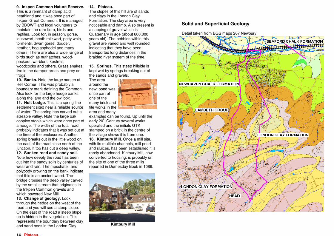
9. Inkpen Common Nature Reserve. This is a remnant of damp acid heathland and it was once part of Inkpen Great Common. It is managed by BBOWT and local volunteers to maintain the rare flora, birds and reptiles. Look for, in season, gorse, lousewort, heath milkwort, petty whin, tormentil, dwarf gorse, dodder, heather, bog asphodel and many others. There are also a wide range of birds such as nuthatches, wood-peckers, warblers, kestrels, woodcocks and others. Grass snakes live in the damper areas and prey on frogs. 10. Banks. Note the large sarsen at Hell Corner. This was probably a boundary mark defining the Common. Also look for the large hedge banks along the lane and the owl box. 11. Holt Lodge. This is a spring line settlement sited near a reliable source of water. The spring has carved out a sizeable valley. Note the large oak coppice stools which were once part of a hedge. The width of the total road probably indicates that it was set out at the time of the enclosures. Another spring breaks out in the little wood on the east of the road close north of the junction. It too has cut a deep valley. 12. Sunken road and sandy soil. Note how deeply the road has been cut into the sandy soils by centuries of wear and rain. The moschatel and polypody growing on the bank indicate that this is an ancient wood. The bridge crosses the deep valley carved by the small stream that originates in the Inkpen Common gravels and which powered New Mill. 13. Change of geology. Look through the hedge on the west of the road and you will see a steep slope. On the east of the road a steep slope up is hidden in the vegetation. This represents the boundary between clay and sand beds in the London Clay. 14. Plateau.
14. Plateau. The slopes of this hill are of sands and clays in the London Clay Formation. The clay area is very noticeable and damp. Also present is a capping of gravel which is Quaternary in age (about 600,000 years old). The pebbles within this gravel are varied and well rounded indicating that they have been transported long distances in the braided river system of the time. 15. Springs. This steep hillside is kept wet by springs breaking out of the sands and gravels. The area around the newt pond was once part of one of the many brick and tile works in the area and many examples can be found. Up until the early 20
th Century several works
operated and the initials GTK stamped on a brick in the centre of the village shows it is from one. 16. Kintbury Mill. Once a mill site, with its multiple channels, mill pond and sluices, has been established it is rarely abandoned. Kintbury Mill, now converted to housing, is probably on the site of one of the three mills reported in Domesday Book in 1086.
Kintbury Mill
Solid and Superficial Geology Detail taken from BGS maps 267 Newbury
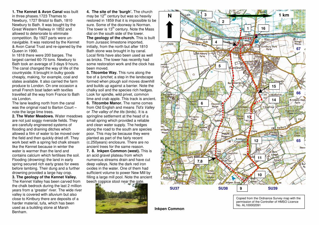
1. The Kennet & Avon Canal was built in three phases.1723 Thames to Newbury, 1727 Bristol to Bath, 1810 Newbury to Bath. It was bought by the Great Western Railway in 1852 and allowed to deteriorate to eliminate competition. By 1927 parts were un-navigable. It was restored by the Kennet & Avon Canal Trust and re-opened by the Queen in 1990. In 1818 there were 200 barges. The largest carried 60-70 tons. Newbury to Bath took an average of 3 days 9 hours. The canal changed the way of life of the countryside. It brought in bulky goods cheaply, making, for example, coal and slates available. It also carried the farm produce to London. On one occasion a small French boat laden with textiles travelled all the way from France to Bath via London. The lane leading north from the canal was the original road to Barton Court – note the large lime trees. 2. The Water Meadows. Water meadows are not just soggy riverside fields. They are carefully engineered systems of flooding and draining ditches which allowed a film of water to be moved over the field and then quickly dried off. They work best with a spring fed chalk stream like the Kennet because in winter the water is warmer than the land and contains calcium which fertilises the soil. Flooding (drowning) the land in early spring secured rich early grass for ewes before lambing. Their dung and a further drowning provided a large hay crop. 3. The geology of the Kennet Valley. The Kennet Valley has been carved from the chalk bedrock during the last 2 million years from a ‘greater’ river. The wide river valley is covered with alluvium but also close to Kintbury there are deposits of a harder material, tufa, which has been used as a building stone at Marsh Benham.
4. The site of the ‘burgh’. The church may be 12
th century but was so heavily
restored in 1859 that it is impossible to be sure. Some of the doorway is Norman. The tower is 13
th century. Note the Mass
dial on the south side of the tower. The geology of the church. This is built from Jurassic limestone imported, initially, from the north but after 1810 Bath stone was brought in by canal. Local flints have also been used as well as bricks. The tower has recently had some restoration work and the clock has been moved. 5. Titcombe Way. This runs along the toe of a lynchet, a step in the landscape formed when plough soil moves downhill and builds up against a barrier. Note the chalky soil and the species rich hedges. Look for spindle, wild privet, common lime and crab apple. This track is ancient. 6. Titcombe Manor. The name comes from Old English and means Tid’s Valley or The valley of the tits (birds). It is a springline settlement at the head of a small spring which provided a reliable and clean water supply. The hedges along the road to the south are species poor. This may be because they were planted as part of the fairly recent (c.250years) enclosure. There are no ancient trees for the same reason. 7. 8. Inkpen Common (west). This is an acid gravel plateau from which numerous streams drain and have cut deep valleys. Note the dark red iron oxides in the water. One of them had sufficient volume to power New Mill by filling a large mill pool. Note the ancient beech coppice stool near the gate.
1
2
3
4
5
6
7,8
9
10
11
12
13
15
14
16
Copied from the Ordnance Survey map with the permission of the Controller of HMSO Licence No. AL100002091
65
SU37 SU38
66
67
1 km N
SU39
Inkpen Common