
26 Feb 09 URPL 590 – Week 1
Web Services, Mashups & KML
Exploring and Using the GeoWeb & Web 2.0
Technologies
AJ Wortley – UW State Cartographer’s Office

26 Feb 09 URPL 590 – Week 1
–
Overview –•
Introduction to Web 2.0
•
Web services & web service clients•
KML -> 3D client publishing
•
KML Clients & Tools •
Mashups
explained -> web services applied
•
Mashup
Tools•
Mashup
Frameworks
•
Local & other examples

26 Feb 09 URPL 590 – Week 1
The Context
•
Globalization•
Shrinking resources
•
Information society•
Moving from Maps as art and output …
to geospatial as an organizing principle in support of efficiency, economy, knowledge communication and measuring well-being
26 Feb 09 URPL 590 – Week 1
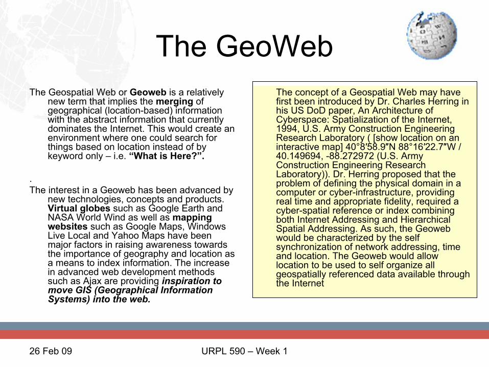
The GeoWebThe Geospatial Web or Geoweb is a relatively
new term that implies the merging of geographical (location-based) information with the abstract information that currently dominates the Internet. This would create an environment where one could search for things based on location instead of by keyword only – i.e. “What is Here?”.
.The interest in a Geoweb has been advanced by
new technologies, concepts and products. Virtual globes such as Google Earth and NASA World Wind as well as mappingwebsites such as Google Maps, Windows Live Local and Yahoo Maps have been major factors in raising awareness towards the importance of geography and location as a means to index information. The increase in advanced web development methods such as Ajax are providing inspiration to move GIS (Geographical Information Systems) into the web.
The concept of a Geospatial Web may have first been introduced by Dr. Charles Herring in his US DoD paper, An Architecture of Cyberspace: Spatialization of the Internet, 1994, U.S. Army Construction Engineering Research Laboratory ( [show location on an interactive map] 40°8′58.9″N 88°16′22.7″W / 40.149694, -88.272972 (U.S. Army Construction Engineering Research Laboratory)). Dr. Herring proposed that the problem of defining the physical domain in a computer or cyber-infrastructure, providing real time and appropriate fidelity, required a cyber-spatial reference or index combining both Internet Addressing and Hierarchical Spatial Addressing. As such, the Geowebwould be characterized by the self synchronization of network addressing, time and location. The Geoweb would allow location to be used to self organize all geospatially referenced data available through the Internet

26 Feb 09 URPL 590 – Week 1
Author: Ludwig Gatke
URL: http://www.railsonwave.it/2007/1/2/web-2-0-map/
What is Web 2.0
Author: Tim O’Reilly
URL: http://www.oreillynet.com/oreilly/tim/news
/2005/09/30/graphics/figure1.jpg

26 Feb 09 URPL 590 – Week 1
Author: Markus Angermeier
What is Web 2.0

26 Feb 09 URPL 590 – Week 1
Author: Luca Cremonini
Source: http://www.railsonwave.it/railsonwave/2007/1/2/web-2-0-map
URL: http://www.railsonwave.com/assets/2006/12/25/Web_2.0_Map.svg
What is Web 2.0

26 Feb 09 URPL 590 – Week 1
Web 2.0According to Tim O'Reilly:
"Web 2.0 is the business revolution in the computer industry caused by the move to the Internet as platform, and an attempt to understand the rules for success on that new platform."
An IBM social-networking analyst, Dario de Judicibus, has proposed a different definition which focuses more on social interactions and on architectural implementation:"Web 2.0 is a knowledge-oriented environment where human interactions generate content that is published, managed and used through network applications in a service-oriented architecture."
Web 2.0 can be defined as "the philosophy of mutually maximizing collective intelligence and added value for each participant by formalized and dynamic information sharing and creation."
Wikipedia, the free encyclopedia

26 Feb 09 URPL 590 – Week 1
Web 2.0
… and whether the technologies came first or the words to describe them, they often adhere to said principles like reusability, interactivity, user-generated content ….
Which fits very well in the world of GIS and web publishing of Geographic Information –
as if it’s where we were headed all along.

26 Feb 09 URPL 590 – Week 1
Web 2.0 –
in other words
•
Internet = platform –> connected devices•
Government and corporate data combined with user-created data (UGC,VGI, crowd- sourced)
•
2-way interaction encouraging interactive participation and collaboration
•
Authoring of data as (re)usable web services
•
Data as a service | s/w
as a service (SAAS)

26 Feb 09 URPL 590 – Week 1
Web 2.0 Content Services
•
Blog content•
Web surveys, polls, feedback
•
Photo sharing, Video sharing•
Searching, shopping
•
Social networking sites•
Location, maps and mappable
things
… Enter Web services & Mashups

26 Feb 09 URPL 590 – Week 1

26 Feb 09 URPL 590 – Week 1
Web services
A Web service (also Web Service) is defined by the W3C as "a software system designed to support interoperable Machine to Machine interaction over a network." Web services are frequently just Web APIs that can be accessed over a network, such as the Internet, and executed on a remote system hosting the requested services.
{Note: API = Application Programming Interface }

26 Feb 09 URPL 590 – Week 1
“Open”
Web services
•
Differentiate …
(all location examples)–
Proprietary services (e.g. ArcWeb
Services)
–
Commercial APIs (e.g. Yahoo/Google Maps)–
Standards-based web services (OGC)
•
Open Geospatial Consortium•
+ ISO, XML …
•
KML, WMS, WFS, WCS–
Defining Open … not always 100% clear

26 Feb 09 URPL 590 – Week 1
OGC Web service standards
Of primary interest…•
Web Map Service
(WMS)
Image
•
Web Feature Service (WFS)
Feature•
GeoRSS
Event
•
KML (not really a service, but we’ll come back.)Of secondary interest …•
Web Coverage Service (WCS)
Grid
•
Catalog Service for Web (CSW) Catalog
26 Feb 09 URPL 590 – Week 1
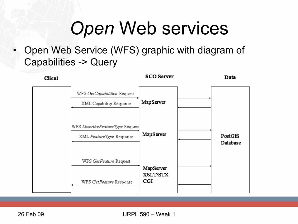
Open Web services• Open Web Service (WFS) graphic with diagram of
Capabilities -> Query

26 Feb 09 URPL 590 – Week 1
On-line Mapping Applications and Open Geospatial Web ServicesInteractive ApplicationsWeb Browser Requirements for Interactive Maps:
Soil Landscapes of Canada
Version 3.0 Interactive Map
Version 2.2 Interactive Map
Soil Landscapes of Canada (SLCs) describe the major characteristics of soil and land for the whole country. SLCs were compiled at a scale of 1:1 million, and information is organized according to a uniform national set of soil and landscape criteria based on permanent natural attributes. More Info
Ecosystem FrameworkInteractive Map
Open Web Services: WMS GetCapabilitiesWFS GetCapabilitiesEcozones Context Document
The National Ecological Framework provides a consistent, national spatial context within which ecosystems at various levels of generalization can be described, monitored, and reported on. The use of such a framework of standard ecological units provides for common communication and reporting between different jurisdictions and disciplines, and provides a common ground to report on the state of the environment and the sustainability of ecos
http://sis.agr.gc.ca/cansis/systems/online_maps.html

26 Feb 09 URPL 590 – Week 1
Map Web Service Authoring Tools
•
MapServer•
simpleWMS
•
GeoServer•
Featureserver
•
Autodesk MapGuide
& MapGuide
Enterprise
•
ArcGIS
Server (ArcIMS, ArcObjects)

26 Feb 09 URPL 590 – Week 1
Web Service Clients•
Web clients (Site, application, mashup)–
E.g. Targeted ads, Coastal Circle Tour, weather)
–
Microsoft Virtual Earth = fuzzy line …•
Thin clients (software-lite, service-heavy)–
E.g. 2D: QGIS, gvSIG, UDig, Gaia
–
E.g. 3D: Worldwind, Google Earth,ArcGIS Explorer
•
Thick clients (often traditional software)–
E.g. ArcGIS, AutoDesk
Map, Intergraph
26 Feb 09 URPL 590 – Week 1
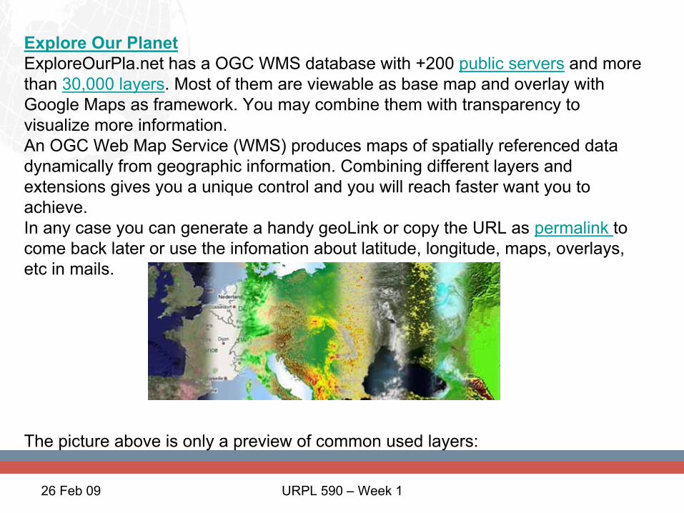
Explore Our Planet ExploreOurPla.net
has a OGC WMS database with +200 public servers
and more than 30,000 layers. Most of them are viewable as base map and overlay with Google Maps as framework. You may combine them with transparency
to visualize more information.An OGC Web Map Service (WMS) produces maps of spatially referenced data dynamically from geographic information. Combining different layers and extensions gives you a unique control and you will reach faster want you to achieve. In any case you can generate a handy geoLink
or copy the URL as permalink to come back later or use the infomation
about latitude, longitude, maps, overlays, etc in mails.
The picture above is only a preview of common used layers:

26 Feb 09 URPL 590 – Week 1

26 Feb 09 URPL 590 – Week 1
Exchange
•
First there was XML …
•
Then there was GML …
•
Now there is KML …

26 Feb 09 URPL 590 – Week 1
KML Tools
•
MapExcel2KML ….•
KML2SHP, SHP2KML
•
Gdal2tiles, GeoServer, •
ESRI-related: –
Export to KML 2.4.4 http://arcscripts.esri.com/details.asp?dbid=14273
–
Arc2Earth•
KML Clients (Google Earth, ArcGIS
Explorer, NASA Worldwind)

26 Feb 09 URPL 590 – Week 1
“How Google Earth Ate Our Town”
- Nanaimo, BC http://earth.nanaimo.ca/

26 Feb 09 URPL 590 – Week 1
Mashup
Concepts
•
Mashups
–
The merging of services and content from multiple web sites in an integrated, coherent way is called a mashup.
•
Most mashups
do more than simply integrate services and content. Sites that do mashups
typically add value. They benefit users in a way that's different and better than the individual services they leverage.
Source: http://java.sun.com/developer/technicalArticles/J2EE/mashup_1/

26 Feb 09 URPL 590 – Week 1

26 Feb 09 URPL 590 – Week 1
(Location) Map Mashups
Mashups
are appearing on the web at an extremely fast rate. Three new mashups
typically appear on the web each day. You can see some of the newest ones on the ProgrammableWeb
site. The bulk of the
mashups
on the web involve the use of maps. Many of these sites use mapping services such as those provided by Yahoo Maps
and Google
Maps. Source: http://java.sun.com/developer/technicalArticles/J2EE/mashup_1/

26 Feb 09 URPL 590 – Week 1
GeoWeb
Relationships
(Geo)Web services = content/process
Mashups = web service app’s
KML = sharing, publishing, exchange

26 Feb 09 URPL 590 – Week 1
26 Feb 09 URPL 590 – Week 1
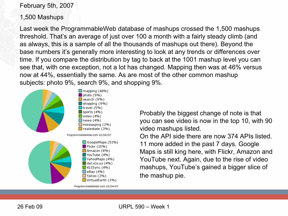
Probably the biggest change of note is that you can see video is now in the top 10, with 90 video mashups
listed.On the API side there are now 374 APIs listed. 11 more added in the past 7 days. Google Maps is still king here, with Flickr, Amazon and YouTube next. Again, due to the rise of video mashups, YouTube’s gained a bigger slice of the mashup
pie.
February 5th, 2007
1,500 Mashups
Last week the ProgrammableWeb
database of mashups
crossed the 1,500 mashups
threshold. That’s an average of just over 100 a month with a fairly steady climb
(and as always, this is a sample of all the thousands of mashups
out there). Beyond the base numbers it’s generally more interesting to look at any trends or differences over time. If you compare the distribution by tag to back at the 1001
mashup
level you can see that, with one exception, not a lot has changed. Mapping then was at 46% versus now at 44%, essentially the same. As are most of the other common mashup
subjects: photo 9%, search 9%, and shopping 9%.

26 Feb 09 URPL 590 – Week 1

26 Feb 09 URPL 590 – Week 1
Map-based Web Services
•
Map image•
3D image, photo image
•
Geocoding, reverse geo-coding•
Gazetteer, place name search
•
Analytical processing services•
Geo-tagged content services
•
Geosocial
networks

26 Feb 09 URPL 590 – Week 1

26 Feb 09 URPL 590 – Week 1
Wisconsin County Web Mapping Sites
http://coastal.lic.wisc.edu/
26 Feb 09 URPL 590 – Week 1
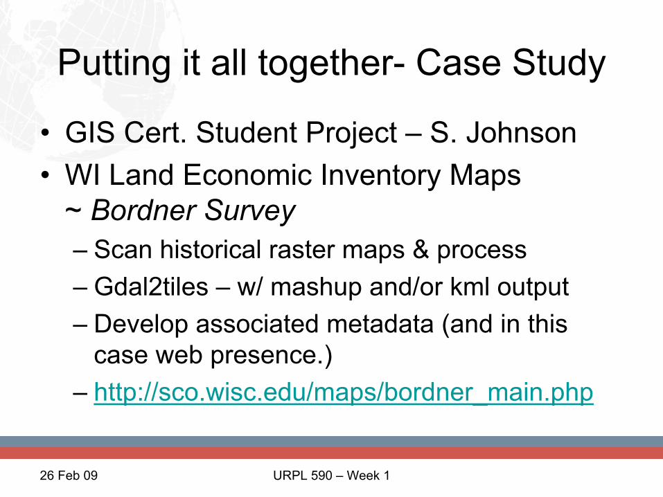
Putting it all together-
Case Study
•
GIS Cert. Student Project –
S. Johnson•
WI Land Economic Inventory Maps ~ Bordner Survey–
Scan historical raster maps & process
–
Gdal2tiles –
w/ mashup
and/or kml
output–
Develop associated metadata (and in this case web presence.)
–
http://sco.wisc.edu/maps/bordner_main.php

26 Feb 09 URPL 590 – Week 1
26 Feb 09 URPL 590 – Week 1
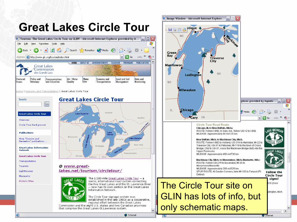
Great Lakes Circle Tour
The Circle Tour site on GLIN has lots of info, but only schematic maps.
26 Feb 09 URPL 590 – Week 1
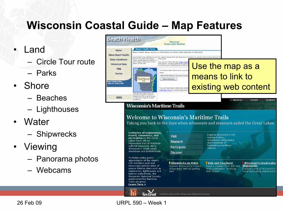
Wisconsin Coastal Guide – Map Features
•
Land–
Circle Tour route–
Parks
•
Shore–
Beaches–
Lighthouses
•
Water–
Shipwrecks
•
Viewing–
Panorama photos–
Webcams
Use the map as a means to link to existing web content

26 Feb 09 URPL 590 – Week 1
Map Viewer Interfaces
Web Mapping Interface
• OpenLayers
• MapServer/Chameleon
• GeoServer
• ESRI ArcIMS
Virtual Globe
• Google Earth
• NASA World Wind
Map Search/Directions
• Google Map API
• Yahoo Maps/Pipes

26 Feb 09 URPL 590 – Week 1
Wisconsin Coastal Guide

26 Feb 09 URPL 590 – Week 1
Wisconsin Coastal Guide
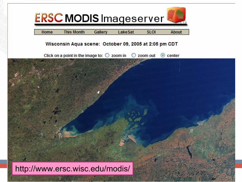
26 Feb 09 URPL 590 – Week 1http://www.ersc.wisc.edu/modis/

26 Feb 09 URPL 590 – Week 1

26 Feb 09 URPL 590 – Week 1
http://www.burbankca.org/planning/projectsmap.html
Mashups
in Planning• Project communication
• Relevant regulations
• Participatory mapping
•
Combining multiple map services for visual interpretation

26 Feb 09 URPL 590 – Week 1

26 Feb 09 URPL 590 – Week 1

26 Feb 09 URPL 590 – Week 1
Enterprise Support
for Mashups

26 Feb 09 URPL 590 – Week 1

26 Feb 09 URPL 590 – Week 1
What it all means …
•
Lower skills threshold and lower cost of ownership
•
Faster development and rollout often soliciting iterative feedback
•
Useful mid-project as well as for communication of results
•
Map mashups
are a good entry point

26 Feb 09 URPL 590 – Week 1
Mashup
Tools•
Yahoo! Pipes, Yahoo! GeoPlanet
•
Google Maps, StreetView, GE APIs•
Google & Yahoo! Geocoding
services
•
.NET/Microsoft Virtual Earth•
Custom coding
•
Mashup
code “framework”
(e.g. OpenLayers, MapFish)
•
Online mashup
frameworks (ExploreOurPla.net, GeoCommons
Maker/Finder)
… and the list is growing.
26 Feb 09 URPL 590 – Week 1
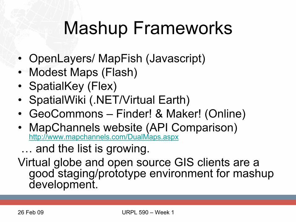
Mashup
Frameworks•
OpenLayers/ MapFish
(Javascript)
•
Modest Maps (Flash)•
SpatialKey
(Flex)
•
SpatialWiki
(.NET/Virtual Earth)•
GeoCommons
–
Finder! & Maker! (Online)
•
MapChannels
website (API Comparison) http://www.mapchannels.com/DualMaps.aspx
… and the list is growing.Virtual globe and open source GIS clients are a
good staging/prototype environment for mashup development.

26 Feb 09 URPL 590 – Week 1
Beyond tools -
considerations
•
Audience/ Use Case Scenario
•
Data access
•
Resources and skills to get it done.

26 Feb 09 URPL 590 – Week 1
Who’s Your Audience ?

26 Feb 09 URPL 590 – Week 1
Data Access
•
Geospatial One Stop www.geodata.gov
•
Regional and Local Clearinghouses
•
Agency-specific Outlets
•
Ad-hoc collections

26 Feb 09 URPL 590 – Week 1
Sources of Google Earth Files•
“How Google Earth Ate Our Town”
-
Nanaimo, BC
–
http://earth.nanaimo.ca/
•
Space Science and Engineering, UW-Madison•
Wisconsin Coastal Guide
•
Great Lakes Environmental Research Lab•
Great Lakes GIS
•
NOAA (NWS, NOHRSC), NASA, USGS•
Google gallery, ad-hoc compilations

26 Feb 09 URPL 590 – Week 1
Learning more:
•
Blogs•
Books
•
On-line Training•
Trial and error
•
The Planning Report: ‘Mash-Ups’ Will Revolutionize How Planners and Citizens View City Planning
http://www.planningreport.com/tpr/?module=displaystory&story_id=1190&format=html

3 March 09 URPL 590 – Week 2
Re-cap• Web services as pipe feeds …• Open web services and web service
standards• Plethora of web service clients• KML as exchange and web service output• Mashup concepts & examples• Message/Audience, Data access &
resources

3 March 09 URPL 590 – Week 2
What it all means …• Lower skills threshold and lower cost of
ownership• Faster development and rollout often
soliciting iterative feedback• Useful mid-project as well as for
communication of results• Focus on user and value-added content• Networked for connectivity to other tools

3 March 09 URPL 590 – Week 2
Case Study example

3 March 09 URPL 590 – Week 2
– ControlFinder Overview –• Audience – Wisconsin+ surveying community• Data access – NGS, SCO/USGS, Counties • Tools – Mapserver, PostGIS, PHP, Javascript• Resources – Grants + office/student talent• Mashup potential – Favorable • Potential benefits – Reduced maintenance, focus
on content, future enhancements• Next step – Functional application analysis

3 March 09 URPL 590 – Week 2
Author: Luca Cremonini Source: http://www.railsonwave.it/railsonwave/2007/1/2/web-2-0-map
URL: http://www.railsonwave.com/assets/2006/12/25/Web_2.0_Map.svg
What is Web 2.0

3 March 09 URPL 590 – Week 2
Goals of ControlFinder Mashup
• Usability• Remixability• Standardization• Convergence• Flexible output• Participation/
feedback from users

3 March 09 URPL 590 – Week 2
Use Case Scenario

3 March 09 URPL 590 – Week 2
Use Case Scenario & KML Opportunity
Know your audience

3 March 09 URPL 590 – Week 2
Sometimes, knowing your audience is not by accident

3 March 09 URPL 590 – Week 2
Data Access
NGS – Bulk download, granuar query… aiming for web services and change alert.
The rest (via SCO)= Web Map Service (WMS)

3 March 09 URPL 590 – Week 2
Data Delivery - Clients

3 March 09 URPL 590 – Week 2
Potential Tools & choices• PostGIS & flat files : data storage• Mapserver - > GeoServer : web service
authoring• OpenLayers/MapFish : mapping framework• GoogleMaps API ? : basemap• Upgraded scripts : specific functions
– E.g. Saved results• New scripts : enhanced feedback reporting

3 March 09 URPL 590 – Week 2
KML Exchange
• KML is a transport format • Can be discreetly published or…• Can be output by a web service

3 March 09 URPL 590 – Week 2
KML Tools
• MapExcel2KML ….• KML2SHP, SHP2KML• Gdal2tiles, GeoServer, • ESRI-related:
– Export to KML 2.4.4 http://arcscripts.esri.com/details.asp?dbid=14273
– Arc2Earth• KML Clients (Google Earth, ArcGIS
Explorer, NASA Worldwind)

3 March 09 URPL 590 – Week 2
KML Tool Compilations
http://freegeographytools.com/ 2007/kml-editors
http://www.zonums.com/

3 March 09 URPL 590 – Week 2
KML Generators

3 March 09 URPL 590 – Week 2
KML Generators
3 March 09 URPL 590 – Week 2
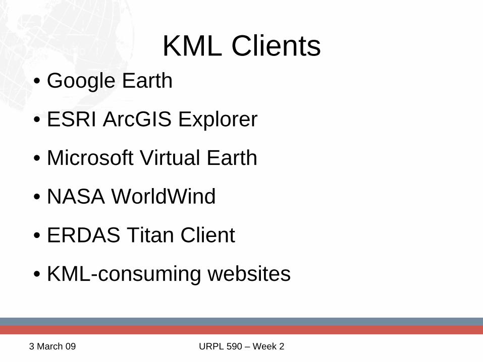
KML Clients• Google Earth
• ESRI ArcGIS Explorer
• Microsoft Virtual Earth
• NASA WorldWind
• ERDAS Titan Client
• KML-consuming websites

3 March 09 URPL 590 – Week 2
Mashup Tools• Google Maps, StreetView, GE APIs• Yahoo! Pipes, Yahoo! GeoPlanet• Google & Yahoo! Geocoding services• .NET/Microsoft Virtual Earth, GeoLife• Custom coding• Mashup code “framework” (e.g. OpenLayers,
MapFish)• Online mashup frameworks (ExploreOurPla.net,
GeoCommons Maker/Finder)

3 March 09 URPL 590 – Week 2
Mashup Frameworks• OpenLayers/ MapFish (Javascript)• Modest Maps (Flash)• SpatialKey (Flex)• SpatialWiki (.NET/Virtual Earth)• GeoCommons – Finder! & Maker! (Online)• MapChannels website (API Comparison)
http://www.mapchannels.com/DualMaps.aspx
… and the list is growing.Virtual globe and open source GIS clients are a
good staging/prototype environment for mashup development.


