This w
Unit 7B Vern
ImpaAdju
E
IMAResource
Provin
work was carriDevelop
IMAPE Projenida I Condom
Telephon
IMAPEPhili
acts of Mustment Environm
APE Reseaes Analysis
ncial Planning Provinc
Octoed out with th
pment Researc
ect. Policy andminium, 120 A
Metro Mane: (632) 813-6
Email: mima
E Projecippines
MacroecPolicies
ment Pro
arch Papers, Provinc
and Developm
ce of Palawanober 2001 he aid of a grach Centre, Ott
d DevelopmenAmorsolo Streanila Philippin6178/79 Fax: [email protected]
ct
conomics on theoject
r No. 08 e of Palaw
ment Office
ant from the Intawa, Canada.
nt Foundationeet, Legaspi Vies (632) 813-617et.ph
c
wan
nternational
n, Inc. Village, Makati
79
City,
IMAPE Research Paper No. 08
Resources Analysis, Province of Palawan
Provincial Planning and Development Office Province of Palawan
October 2001
This work was carried out with the aid of a grant from the International Development Research Centre, Ottawa, Canada.
IMAPE Project. Policy and Development Foundation, Inc.
Unit 7B Vernida I Condominium, 120 Amorsolo Street, Legaspi Village, Makati City, Metro Manila Philippines
Telephone: (632) 813-6178/79 Fax: (632) 813-6179
Email: [email protected]
IMAPE Project Philippines
Impacts of Macroeconomic Adjustment Policies on the Environment Project
Project concept Resources Analysis
Province of Palawan 1
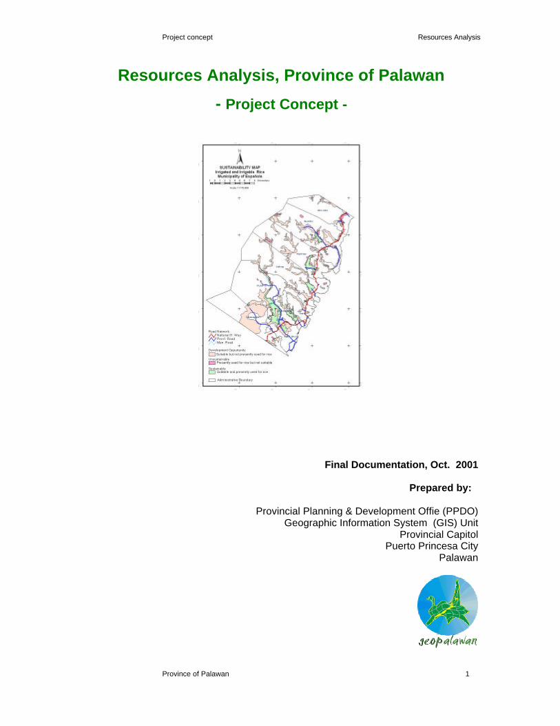
Resources Analysis, Province of Palawan
- Project Concept -
Final Documentation, Oct. 2001
Prepared by:
Provincial Planning & Development Offie (PPDO) Geographic Information System (GIS) Unit
Provincial Capitol Puerto Princesa City
Palawan
Project concept Resources Analysis
Province of Palawan 2
Resources Analysis, Province of Palawan
List of Contents Introduction 3 Objectives and Principles of the Resources Analysis 5 Data Sources 7 Implementation and Project Activities 17 Project Partners and Cooperation 18 Limitations of the study 19 List of Tables Table 1: Environmentally Critical Area Network (ECAN) 9 Table 2: Existing land uses by type and definition 13
List of Maps Map 1: Environmentally critical Area Network (ECAN) 10 Map 3: Palawan Land Management Units 12 Map 3: Palawan Existing Land Uses (1988, based on LMU) 14 Map 4: Existing Infrastructre 16

Project concept Resources Analysis
Province of Palawan 3
Resources Analysis, Province of Palawan
- Project Concept -
Introduction
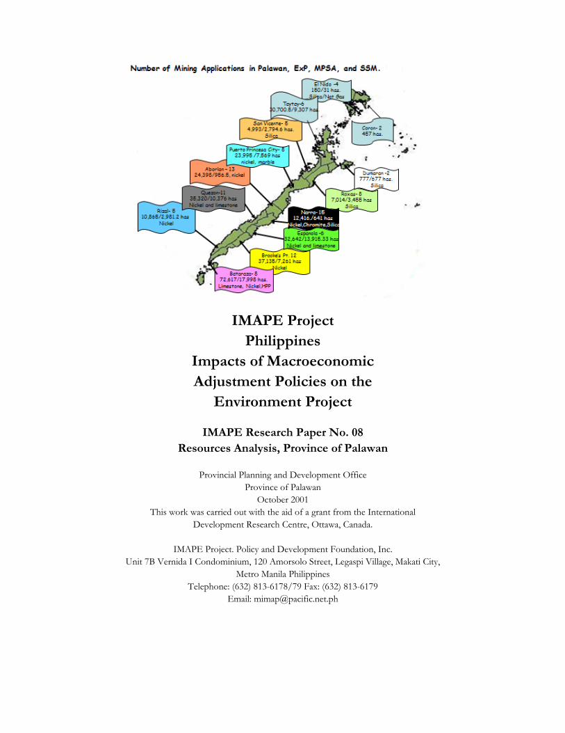
The Province of Palawan is reportedly rich in land and marine
resources. About 25% of the total land area or roughly 375,000 has
are potentially suitable for agricultural and livestock production,
ranging from irrigated rice land to upland farming and agroforestry1.
The remaining or potential forest areas (together about 1,100,000 has)
are a valuable source for minor forest products and, where it is
permitted by the Environmentally Critical Area Network (ECAN),
controlled logging and forestation2. The estimated provincial water
bodies of around 49,408 sq. km provide a wealth of marine resources3.
Fishing and exploitation of marine products has become of increasing
importance for household livelihood. The value of fish production
doubled between 1993 and 19984. In the year 2000, around 21.38% of
all employed persons (a total number of around 42,131) reported
fishing as their major livelihood activity. With an average family size of
4.98 persons, this amounts to 210,655 out of the total 755,412 people
depending on fishing as main source of income5.
However, socio-economic data on the development situation of
households and communities in Palawan indicates that resource
availability and utilization so far did not translate into a significantly
increasing economic welfare of the population6. In the year 2000, only
about 30,73% of the 150,983 households in Palawan had an income
higher than the poverty line defined by the National Economic
Development Authority (NEDA). This means that a total number of
104,586 households in the Province did not have sufficient financial
1 Based on the Protected Areas for Agriculture (NPAA/NAAD) map, BSWD, 1988 2 The ECAN permits the latter activities in the controlled buffer zone and the traditional use zone 3 figure taken from the Provincial Development Plan 2001 - 2005 4 Bureau of Agricultural Statistics (BAS), figure taken from the Provincial Development Plan 2001 - 2005, Value in 1993 = 1,636,054, Value in 1998 = 3,058,878 (in 1,000 pesos) 5 Demographic data based on NSO Census 2000
Palawan: a province rich
in land and marine
resources
Poverty incidence
and economic
performance
Project concept Resources Analysis
Province of Palawan 4
resources to satisfy all their basic needs. The high poverty incidence
can be explained by looking at employment figures. With 80.43% of all
persons aged 15 - 64 in gainful work, the employment rate in the year
2000 was below the national average of 86.10%. But even more
significant is the fact that 64.19% of the employed persons reported to
be underemployed, which means that their work did not give them
sufficient income to support their families.
About 62.60% of the labor force population is employed in the primary
sectors agriculture, fishery and forestry while it is only 8.85% in the
industry sector and 28.03% in the trade sector. It is noted that those
Municipalities with the highest proportion of employment in the primary
sector are also among those with the highest poverty incidence.
Examples are Linapacan, Cagayancillo and Rizal. On the opposite, the
Municipalities with higher proportion of employed persons in industry
and trade sectors (like Aborlan, Magsaysay and Cuyo) do better in
terms of household income (refer to annex 1 for comparison by
municipality).
The summary above points out that the utilization of resource is
characterized by low productivity with only marginal benefits to farmers
and fishermen. This situation is commonly associated with a lack of
infrastructure, poor market linkages, low technology and skills levels
and absence of investment capital.
The Provincial Government of Palawan has given attention to this
problem. On the assumption that employment in the primary sector will
continue to be the main source of livelihood, the Governor has
prioritized poverty alleviation through increased productivity and the
promotion of income generating industries as the major converns of
the current administration7. The creation of Special Development
areas (SDA) is expected to bring employment opportunities in
6 information below is taken from the draft Human Development Report for Palawan, PPDO 2001 7 ‘State-of-the-Province Address’ delivered by Hon. Joel T. Reyes on July 1, 2001
Increase in productivity and income generation
Employment distribution
by sectors and Municipalities
Low productivity in
the primary sectors

Project concept Resources Analysis
Province of Palawan 5
resource-based industries8. Part of this effort will be the identification
of growth clusters for five major development sectors (Fisheries,
Livestock, Crops, Agroforestry and Tourism) and the designation and
promotion of resource based industrial developments. This strategy
gives attention to enhance production and at the same time to develop
the viable schemes for the processing of resources.
Objectives and Principles of the Resources Analysis
The project on resources analysis is designed to assist in the
generation of data for potential locations, areas and production levels
for those resources, that will justify investments for the establishment
of resource based industries. The study is also conceptualized to
assist in the decision making for the selection of growth clusters.
It is intended to provide documentation on the promotion and
marketing of resource-based industrial development.
The analysis is also an instrument to control and direct land uses and
to plan management intervention. If conducted on a regular basis, it
can be vital source to monitor land use changes.
In summary, the study consists of three main steps:
• Delineation of potential suitable locations for the development of
different resources (land and marine uses)
• Identification of development opportunity areas, where different
resource / land uses can be developed and intensified in a
sustainable manner
• Comparison of different locations for development in terms of the
existing frame conditions based on a set criteria pertaining to
socio-economic parameters, infrastructure and utilities, farm
technologies and others
8 The following information is taken from the Terms of Reference on the Preliminary Study on Growth Area Master Planning, PPDO, undated
Identification of locations for
resource-based development
Framework for environmental
monitoring
Analytical steps
Marketing of resources
Project concept Resources Analysis
Province of Palawan 6
The suitability analysis is done by cartographic overlay of potential and
existing land uses, aided by Geographic Information (GIS) technology.
The land resources or land uses that will be examined are rice,
cultivated annual crops, trees and vines, pasture and grazing,
agroforestry/ forest plantation and extraction of minor forest products.
Information will be provided on following aspects:
• The suitable geographic location for resource developed
• The size of the land area
• The potential volume and value, based on current production
levels
The following criteria have been selected for suitability analysis9
1. Slope
2. Ersoion hazard
3. Hydrological properties
4. Soil: Alluvium
5. Elevation
6. Presence of protected, endangered ecosystems and species
The analysis of the different land uses further compares the potential
land suitability with the existing land uses. The guiding principle in this
analytical step is that of sustainability. Any particular resource or land
use is only recommended in those locations, where its requirements
will satisfy the geo-physical characteristics of the land, without causing
deterioration. The analysis will provide information on:
• The area and location, where a current land use is in conflict with
the suitability criteria and where land is being overused
(unsustainable). This information is useful in preparation of
management interventions (such as measures to prevent soil
erosion)
9 Based on a joint assessment with GIS section of PCSDS/PTFPP on July 16, 2001
Step 1: Suitability
analysis
Step 2: Sustainability
analysis
Project concept Resources Analysis
Province of Palawan 7
• The area and location, where the intensity of current land use is
below the suitability level. This land is a potential development
opportunity
• The area and location where the current land use are meeting
the suitability criteria (sustainable use of land)
The identified sustainable areas for the different land uses / resources
are clustered and then linked to additional information such as the
presence of infrastructure (road density, power and water availability),
socio-economic indicators (employment patterns, educational levels
etc), the presence of technology ( post harvest facilities, farm and
fishing technologies, agricultural extension) and accessibility of
markets. This will allow a comparison of different clusters in terms of
the frame conditions for their development and the required
intervention levels, such as the provision of addition infrastructure,
skills development etc.)
Data Sources
The study uses a set of spatial data, each of them imposing conditions
or restriction on the potential and existing land use. They are:
• Environmentally Critical Area Network, PCSDS
• Land Management Units, BSWD/LREP, 1988
• Existing Land Use (Municipal and Provincial Governments)
• Climatic maps
• Biodiversity data
• Infrastructure and utilities
• Socio-economic parameters
Step 3: Comparison of identified
locations

Project concept Resources Analysis
Province of Palawan 8
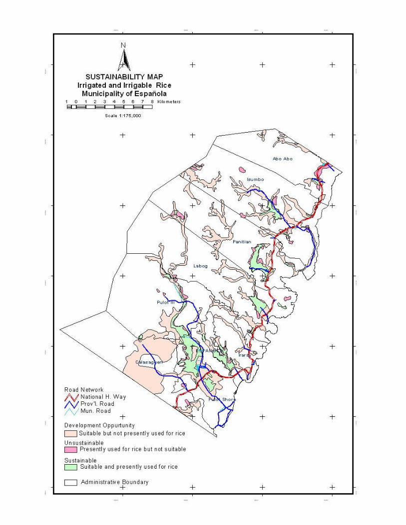
Example: Identification of areas for irrigated rice cultivation
Step 1: Suitability analysis Data sources: • LMU, ECAN, Biodiversity data Criteria: 1. Slope: Nearly level to gently sloping, 0-3%, up to 8% if terraced 2. Ersoion hazard: no to slight erosion 3. Hydrological properties: poorly to moderately drained 4. Soil: Alluvium, collu-alluvium (clay, loam) 5. Elevation: below 100 m 6. Absence of protected, endangered ecosystems and species
Output: • Map showing the locations which are suitable for the cultivation of irrigated rice Step 2: Sustainability analysis Data sources: • Suitability map by resource (land use), Existing land use map Criteria: • If current use is irrigated rice and suitable use is of lower intensity (i.e. forest), then the
area is overused (unsustainable use) • If current use is rice and suitable use is rice, then the use is sustainable • If current use is of lower intensity then rice and suitable use is rice, then the area is a
development opportunity area for irrigated rice Output: • Sustainability map for the land use type ´irrigated rice` • Cluster of development opportunity areas for land use type ´irrigated rice` Step 3: Examination of existing facilities / socio-economic conditions by location Data sources: • Sustainability map for the land use type ´irrigated rice` • Infrastructure map • Facilities map (post harvest, market places, extension services) • Socio-economic parameters by barangay breakdown Criteria (examples): • Road density per area of development opportunity land • Capacity of post harvest facilities • Distance (travel time) to markets • Farm technology levels used • Access to sources of energy (% rates) Output: • Comparative analysis of different locations by the selected indicators

Project concept Resources Analysis
Province of Palawan 9
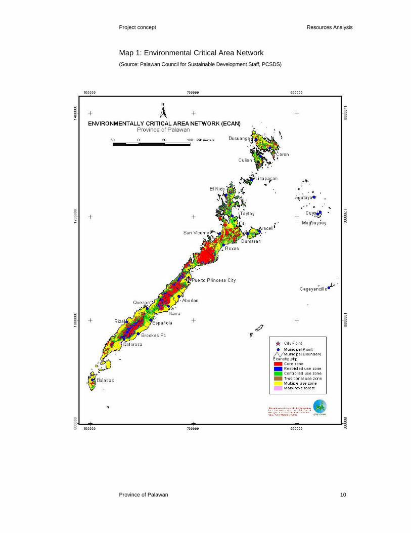
The ECAN establishes a graded system of protection and
development control over the whole province, to ensure forest
protection and conservation, watershed protection, preservation of
biological diversity, maintenance of maximum sustainable yield and
others10.
Table 1: Environmentally Critical Area Network (ECAN)
ECAN Zone Definition Criteria Suitable land uses Core Zone Fully and strictly protected and above 1,000m; Forest,
maintained free of human virging forest or first growth; gathering of forest intervention steep gradient, > 50% slope; species for medicinal peaks of mountains with purposes elevation > 500m;
Buffer Zone, Generally surrounds the core elevation > 500m < 1,000 m; Forest, restricted use area zopne and provides a slope 36 - 50%; limited and non
protective barrier critical watershed; consumptive elevation < 500m >300m to activities protect the remaining
forested
peaks of watersheds; adjacent to critical ecosystems
elevation <500m, 10km belt
surrounding core zone; Buffer Zone, Encircles and provides the elevation 100 - 500m; Forest, controlled use outer buffer to the core slope 18 - 35%; controlled forest
and restricted zones extraction (minor forest products, strictly controlled logging and mining
Traditional use Edges of intact forest where slope > 18% but elevation upland farming thraditional land use is below 100m; systems, social already stabilized or being open brushland or grassland, forestry stabilized still classified Timberland; industrial tree Timberland/Public Land
<100m; plantation
Multiple/manipulativ The area where the landscape areas classified as A&D; no restrictions Use zone has been modified for areas with slope < 18%; different forms od land uses Mangrove Forest (1) Mangrove forest Buffer strips along 20m along rivers Forest, vegetative rivers and cover escarpments (1)
10 Republic Act 7611, Adopting the Strategic Environmental Plan for Palawan, 1992
Environmentally Critical Area Network
(ECAN)
Project concept Resources Analysis
Province of Palawan 10
Map 1: Environmental Critical Area Network
(Source: Palawan Council for Sustainable Development Staff, PCSDS)
Project concept Resources Analysis
Province of Palawan 11
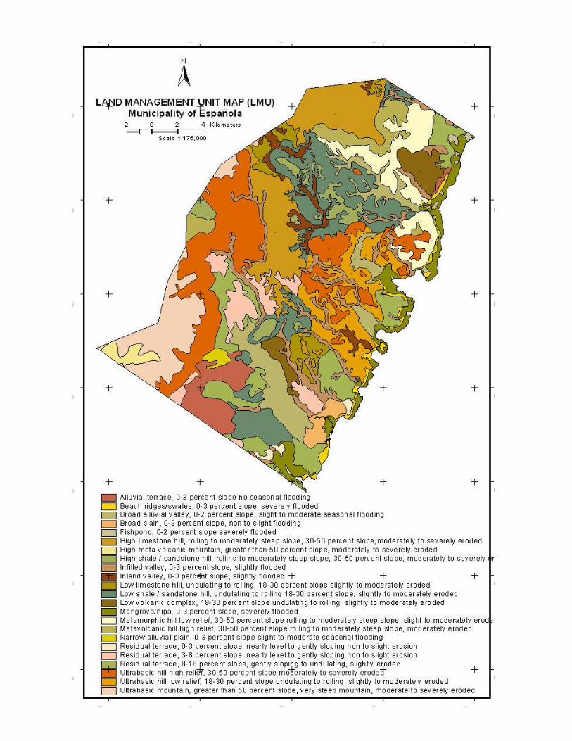
The LMU were established by the Bureau of Soils and Water
Management (BSWM) in 1988 to define land suitability. Land suitability
is a classification of land into categories based on the degree to which
the characteristics of the land can satisfy the environmental
requirements of specific crops, without deterioration. A particular area
of land may have a high suitability for irrigated rice but low suitability
for growing fruit trees because of the poor soil drainage11:
11 AUSAID/NEDA, PPFP Training Program, 1996, p. 76
Land Management Units (LMU)

Project concept Resources Analysis
Province of Palawan 12
Map 2: Palawan Land Management Units
Project concept Resources Analysis
Province of Palawan 13
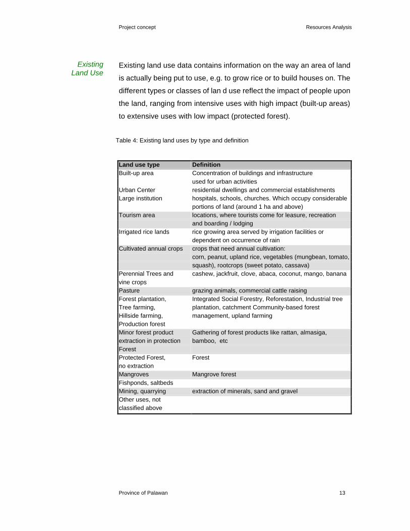
Existing land use data contains information on the way an area of land
is actually being put to use, e.g. to grow rice or to build houses on. The
different types or classes of lan d use reflect the impact of people upon
the land, ranging from intensive uses with high impact (built-up areas)
to extensive uses with low impact (protected forest).
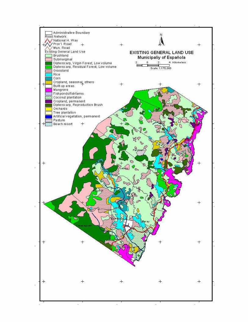
Table 4: Existing land uses by type and definition
Land use type Definition Built-up area Concentration of buildings and infrastructure
used for urban activities Urban Center residential dwellings and commercial establishments Large institution hospitals, schools, churches. Which occupy considerable
portions of land (around 1 ha and above) Tourism area locations, where tourists come for leasure, recreation
and boarding / lodging Irrigated rice lands rice growing area served by irrigation facilities or
dependent on occurrence of rain Cultivated annual crops crops that need annual cultivation:
corn, peanut, upland rice, vegetables (mungbean, tomato, squash), rootcrops (sweet potato, cassava)
Perennial Trees and cashew, jackfruit, clove, abaca, coconut, mango, banana vine crops Pasture grazing animals, commercial cattle raising Forest plantation, Integrated Social Forestry, Reforestation, Industrial tree Tree farming, plantation, catchment Community-based forest Hillside farming, management, upland farming Production forest Minor forest product Gathering of forest products like rattan, almasiga, extraction in protection bamboo, etc Forest Protected Forest, Forest no extraction Mangroves Mangrove forest Fishponds, saltbeds Mining, quarrying extraction of minerals, sand and gravel Other uses, not classified above
Existing Land Use
Project concept Resources Analysis
Province of Palawan 14
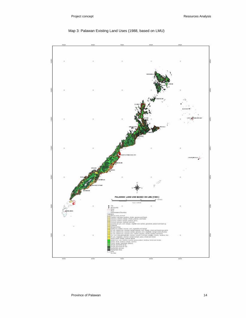
Map 3: Palawan Existing Land Uses (1988, based on LMU)
Project concept Resources Analysis
Province of Palawan 15
A series of spatial data is used with information on the road network in
potential areas for resource development initiatives as well as the
location and type of available facilities (post harvest, extension
services) and utilities (power, water). The sources are maps, which are
available at the Provincial Government Offices, particularly the PPDO.
Socio-economic information for Palawan is made available through the
Community-based Monitoring System (CBMS), a household survey
conducted in the year 2000. A set of indicators is used to document
the human development situation and conditions in the area. These
indicators pertain to educational levels and attainment, employment by
sector, health conditions, peace and order, economic activities et.
Infrastructure and utilities
Socio-economic parameters

Project concept Resources Analysis
Province of Palawan 16
Map 4: Existing Infrastructure facilities

Project concept Resources Analysis
Province of Palawan 17
Implementation and Project Activities
It is proposed to pilot the land resources analysis in two locations. One
is Brooke's Point (with Espanola), the other is Taytay (with El Nido).
The selection is based on the criteria that Taytay and Brooke’ Point
have been identified as alternative growth centers to Puerto Princesa
City 12.
The first activity to implement the resource analysis will be the
generation of digital data needed for the suitability analysis. While the
Land Management Units are being digitized by the GIS Unit of PPDO,
the ECAN and biodiversity needs to be obtained from the PCSDS and
other sources.
Once, all data sets are available, the suitability classes per resource
(land use) need to be identified (using the criteria mentioned above)
and suitability profiles for each resource generated.
Crucial to the sustainability analysis is the availability of recent and
valid information on existing land uses. While digital data is available
for parts of El Nido and Taytay (through the NIPAP) and Espanola,
where the Municipal Government was assisted by the Palawan
Tropical Forestry Protection Programme (PTFPP) in generating land
use maps, the Brooke’s Point data is both not yet digitized and does
not have the required accuracy/validity. For areas in EL Nido and
Taytay that are not covered by the NIPAP survey, the existing land use
map needs to be procured from the Municipal Governments, validated
and converted into digital format.
Once the data is available, sustainability profiles for each resource
can be performed by overlaying land suitability and existing land use
for each respective resource. Based on this analysis, priority
opportunity areas for resource development can be identified.
Pilot sites: Brooke’s Point
and Taytay
Activities for step 1 of project
implementation
Activities for step 2 of project
implementation

Project concept Resources Analysis
Province of Palawan 18
For the comparison of identified development opportunity areas, most
of the required data is available at the PPDO. In terms of economic
data (like production cost, markets, farm-gate prices), some field
validation will be necessary. The first activity is to cluster the
development opportunity areas (output of step 2). In a second activity,
the set of criteria to be used in the analysis needs to be finalized and
applied to find preferred development clusters. Finally, the results of
the analysis will have to documented and presented for decision
making.
Project Partners and Cooperation
It is proposed to undertake the project as a collaborative effort of the
Provincial Planning and Development Office, concerned provincial
departments, the municipal government agencies and PTFPP/PCSDS.
The analysis and documentation itself can be performed by staff from
the GIS Unit of the Provincial Planning and Development Office. As
the output is expected to assist the Plans and Programs Division of the
Office in preparing feasibility studies on the Special Development
Areas, each step needs to be closely coordinated with staff from the
Division. A number of provincial offices, in particular agriculture,
environment and economic enterprise development, should also be
involved. Their expertise is needed in validation and refinement of
criteria for suitability analysis. As main users of the results, they should
also contribute to project implementation
It is further advised to involve the municipal governments to an extent
that goes beyond the role of providing land use data in map format.
The project can deliver results that may be of great value to the
municipal planners. For this purpose, the project should be presented
and discussed to representatives of the Local Government Units.
12 Provincial Physical Framework Plan 200 - 2010, Province of Palawan
Activities for step 3 of project
implementation
Plans and Programs
Division (PPDO)
Municipal Governments
Provincial Line agencies:
Agriculture, Environment,
Economic Enterprise
development
Project concept Resources Analysis
Province of Palawan 19
The Provincial Government of Palawan has established a cooperation
for data exchange on land use with the Palawan Council for
Sustainable Development Staff (PCSDS) and the Palawan Tropical
Forestry Protection Program (PTFPP). The cooperation is specified in
a Memorandum of Agreement (MOA) among the parties, that includes
the resources analysis. Therefore, the PCSDS and PTFPP should be
consulted.
Limitations of the study
The main limitation of the analysis is its dependency on the quality of
existing land use data. Field validation is too costly and in the absence
of other sources (like recent satellite images), the existing land use
maps from the Municipalities have to be used, which are not all of
satisfactory quality.
The selected resources / land uses comprise of general categories
only. It is noted that more detailed information is also required for
particular crops (for example Cashew under the tree crop land use
type). It is suggested that the results from the analysis will be
examined and detailed further as the need arises. This will require
additional agricultural knowledge and interpretation of the conditions
for specific crops.
In terms of the development areas to be studied, there are limitations
on the fisheries sector. While information is available for the general
location of fishing grounds, more detailed data (area, extent, resources
etc.) is not existing. Given this situation, the assessment of possible
development clusters will be rather general. The question of
sustainability levels cannot be addressed. This would need further
scientific research. The tourism sector is not part of the analysis,
simply because an extensive research has been conducted by the
Government of the Philippines in cooperation with JICA.
Quality of land use data
Fisheries and Tourism sectors
Degree of detail for resources /
land uses
PCSDS and PTFPP

Project concept Resources Analysis
Province of Palawan 20
Analysis also excludes mineral resources. Like for the aquatic
resources, this would need a separate study.
PPDO GIS Unit
October 15, 2001

Project concept Resources Analysis
Province of Palawan 21
Annex 1: Employment data for Palawan ( based on CBMS
survey year 2000)
Location Employment Income above Underemployed Employment by Sector (%) rate (%) poverty line (%) persons (%) Agric./Fish./For. Industry Services Philippines 86,10 68,20 25,10 37,30 16,10 46,60 Palawan 80,43 30,73 64,19 62,60 8,85 28,03 Aborlan 75,68 38,44 81,85 56,38 8,40 35,22 Agutaya 69,43 19,97 48,93 80,28 5,23 14,49 Araceli 90,38 24,16 96,36 74,66 10,46 14,88 Balabac 88,79 82,78 57,15 76,83 4,85 18,31 Bataraza 82,71 23,15 65,44 70,01 9,41 20,50 Brooke's Point 82,07 69,85 76,70 71,70 3,98 24,32 Busuanga 85,61 20,49 82,52 56,20 10,48 18,42 Cagayancillo 81,64 11,75 29,70 68,79 3,67 26,93 Coron 74,89 13,93 52,08 56,96 11,02 32,02 Culion no data no data no data no data no data no data Cuyo 73,34 29,65 70,89 42,73 14,42 42,86 Dumaran 85,96 15,19 99,34 72,59 8,51 18,86 El Nido 84,60 28,66 65,35 78,08 9,99 13,44 Española 52,84 27,09 74,10 58,49 11,36 30,15 Kalayaan no data no data no data no data no data no data Linapacan 62,85 9,76 94,85 83,33 1,71 14,94 Magsaysay 79,87 36,02 50,87 48,61 11,40 39,99 Narra 82,75 21,67 57,59 42,31 12,64 45,04 Quezon 93,81 19,52 61,88 61,82 5,85 32,32 Rizal 95,30 0,31 73,98 80,57 7,43 12,00 Roxas 77,78 25,19 72,92 52,10 11,82 36,08 San Vicente 78,67 30,52 50,04 63,32 6,09 30,78 Taytay 80,97 20,40 64,39 72,52 8,08 19,39 PPCity no data no data no data no data no data no data


Project concept Resources Analysis
Province of Palawan 23
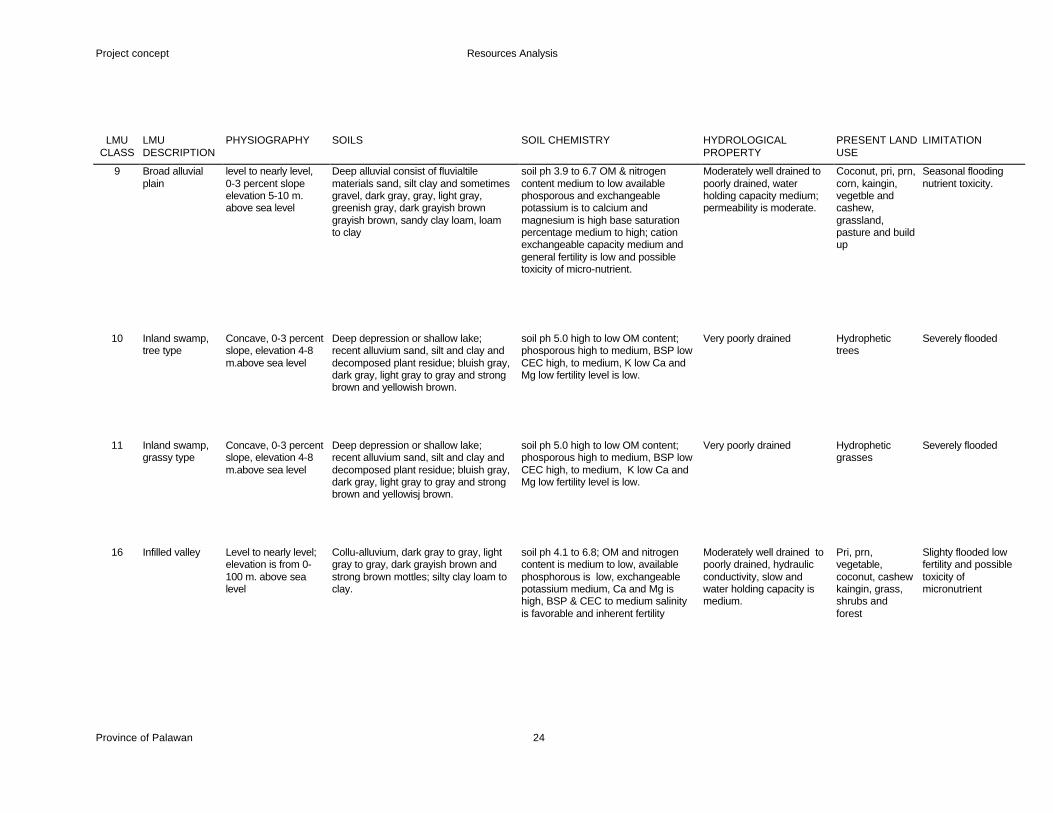
Annex 2: Land Management Units (BSWD, LREP 1988)
LMU CLASS
LMU DESCRIPTION
PHYSIOGRAPHY
SOILS
SOIL CHEMISTRY
HYDROLOGICAL PROPERTY
PRESENT LAND USE
LIMITATION
1 Fishpond level, 0-1 percent slope, elevation 0-1 m.
moderately deep to very deep, fluvio marine deposit,dark gray dark brown, dark grayish brown, grayish brown, yellowish brown, nudulain by partly decomposed or decomposed plant residues
soil ph 3.4 extremely acid, high OM content medium phosphorus; trace potassium; high base saturation percentages and CEC; high Ca and Mg, low fertility
Under water, very poorly drained
Fishpond Tidal flooding, salinity
2 Mangrove/ nipa level to nearly level, 0-3 percent slope elevation 0-2 meter above sea level
moderately deep to very deep, fluvio marine deposit,dark gray dark brown, dark grayish brown, grayish brown, yellowish brown, nudulain by partly decomposed or decomposed plant residues
soil ph 3.4 extremely acid, high OM content medium phosphorus; trace potassium; high base saturation percentages and CEC; high Ca and Mg, low fertility
Under water, very poorly drained
Mangrove/ Nipa Tidal flooding, salinity
3 Beach ridges/swales
level to nearly level, 0-3 percent slope elevation 0-2 meter above sea level.
poorly develop profile moderately deep to deep coarse texture with AC horizon, gray dark brown grayish brown, dark grayish brown
soil ph 3.4 extremely acid, high OM content medium phosphorus; trace potassium; high base saturation percentages and CEC; high Ca and Mg, low fertility
Well drained Built up area, coconut
Tidal flooding
6 River level level to nearly level 0-3 percent slope elevation 3-6 meter above sea level
deep, alluvial deposit, dark brown, brown to dark brown, light brownish gray, yellowish brown, silt loam to silty clay loam
soil ph 4.0 to 4.6 low Dm content and available phosporous, medium to low exchangeable potassium; high calcium and manganese; low inherent fertility.
Moderately well drained to somewhat poorly drained, moderately slow, permeability water holding capacity is medium.
Coconut, corn, vegetable, peanut and bamboo
Seasonal flush flood
7 River terrace level to nearly level, 0-3 percent slope elevation 5-8 m. above sea level
deep alluvial deposit dark brown, brown, light brownish gray, yellowish brown and strong brown silty clay loam silty clay loam to clay loam.
soil ph is high, OM, nitrogen and available phosporous is exchangeable potassium is medium to low, base saturation percentages and cation exchange capacity is high, electrical conductivity is favorable; inherent fertility is high to moderate
Moderately well drained to somewhat poorly drained, hydraulic conductivity is moderate and water holding capacity is medium
Paddy rice rainfed, coconut, corn, vegetable and kaingin
Slight seasonal flooding flush flood
Project concept Resources Analysis
Province of Palawan 24
LMU
CLASS LMU DESCRIPTION
PHYSIOGRAPHY SOILS SOIL CHEMISTRY HYDROLOGICAL PROPERTY
PRESENT LAND USE
LIMITATION
9 Broad alluvial plain
level to nearly level, 0-3 percent slope elevation 5-10 m. above sea level
Deep alluvial consist of fluvialtile materials sand, silt clay and sometimes gravel, dark gray, gray, light gray, greenish gray, dark grayish brown grayish brown, sandy clay loam, loam to clay
soil ph 3.9 to 6.7 OM & nitrogen content medium to low available phosporous and exchangeable potassium is to calcium and magnesium is high base saturation percentage medium to high; cation exchangeable capacity medium and general fertility is low and possible toxicity of micro-nutrient.
Moderately well drained to poorly drained, water holding capacity medium; permeability is moderate.
Coconut, pri, prn, corn, kaingin, vegetble and cashew, grassland, pasture and build up
Seasonal flooding nutrient toxicity.
10 Inland swamp, tree type
Concave, 0-3 percent slope, elevation 4-8 m.above sea level
Deep depression or shallow lake; recent alluvium sand, silt and clay and decomposed plant residue; bluish gray, dark gray, light gray to gray and strong brown and yellowish brown.
soil ph 5.0 high to low OM content; phosporous high to medium, BSP low CEC high, to medium, K low Ca and Mg low fertility level is low.
Very poorly drained Hydrophetic trees
Severely flooded
11 Inland swamp, grassy type
Concave, 0-3 percent slope, elevation 4-8 m.above sea level
Deep depression or shallow lake; recent alluvium sand, silt and clay and decomposed plant residue; bluish gray, dark gray, light gray to gray and strong brown and yellowisj brown.
soil ph 5.0 high to low OM content; phosporous high to medium, BSP low CEC high, to medium, K low Ca and Mg low fertility level is low.
Very poorly drained Hydrophetic grasses
Severely flooded
16 Infilled valley Level to nearly level; elevation is from 0-100 m. above sea level
Collu-alluvium, dark gray to gray, light gray to gray, dark grayish brown and strong brown mottles; silty clay loam to clay.
soil ph 4.1 to 6.8; OM and nitrogen content is medium to low, available phosphorous is low, exchangeable potassium medium, Ca and Mg is high, BSP & CEC to medium salinity is favorable and inherent fertility
Moderately well drained to poorly drained, hydraulic conductivity, slow and water holding capacity is medium.
Pri, prn, vegetable, coconut, cashew kaingin, grass, shrubs and forest
Slighty flooded low fertility and possible toxicity of micronutrient
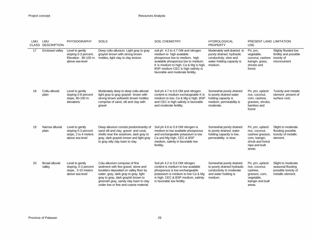
Project concept Resources Analysis
Province of Palawan 25
LMU
CLASS LMU DESCRIPTION
PHYSIOGRAPHY SOILS SOIL CHEMISTRY HYDROLOGICAL PROPERTY
PRESENT LAND USE
LIMITATION
17 Enclosed valley Level to gently sloping 0-3 percent. Elevation 80-100 m. above sea level
Deep collu-alluvium. Light gray to gray grayish brown with strong brown mottles, light clay to clay texture.
soil ph 4.2 to 4.7 OM and nitrogen medium to high available phosporous low to medium, high available phosporous low to medium, K is medium to high; Ca & Mg is high, BSP medium CEC is high salinity is favorable and moderate fertility.
Moderately well drained to poorly drained, hydraulic conductivity, slow and water holding capacity is medium.
Pri, prn, vegetable, coconut, cashew kaingin, grass, shrubs and forest
Slighty flooded low fertility and possible toxicity of micronutrient
18 Collu-alluvial plain
Level to gently sloping 0-8 percent slope, 90-100 m. elevationv
Moderately deep to deep collu-alluvial light gray to gray grayish brown with strong brown yellowish brown mottles comprise of sand, silt and clay with gravel
Soil ph 4.7 to 6.6 OM and nitrogen content is medium exchangeable K is medium to low, Ca & Mg is high, BSP and CEC is high salinity is favorable and moderate fertility.
Somewhat poorly drained to poorly drained water holding capacity is medium, permeability is moderate.
Pri, prn, upland rice, coconut, corn, cashew, grasses, shrubs, bamboo and forest
Toxicity and metalic element present of surface rock.
19 Narrow alluvial plain
Level to gently sloping 0-3 percent slope, 2 to 4 meters above sea level
Deep alluvium consist predominantly of sand silt and clay, gravel and coral, shells near the seashore, dark gray to gray, dark grayish brown and light gray to gray silty clay loam to clay.
Soil ph 4.6 to 5.9 OM nitrogen is medium to low available phosporous and exchangeable potassium is low Ca and Mg high, CEC & BSP medium, salinity in favorable low fertility.
Somewhat poorly drained to poorly drained; water holding capacity is low, permeability is slow.
Pri, prn, upland rice, coconut, cashew grasses, corn, kaingin, shrub and forest nipa and built areas.
Slight to moderate flooding possible toxicity of metallic element.
20 Broad alluvial valley
Level to gently sloping, 0-3 percent slope, 3-10 meters above sea level
Colu-alluvium compose of fine sediment with few gravel, stone and boulders deposited on valley floor by water, gray, dark gray to gray, light gray to gray, dark grayish brown to greenish gray, sandy clay loam to clay under low or fine and coarse material.
Soil ph 4.2 to 5.6 OM nitrogen content is medium to low available phosporous is low exchangeable potassium is medium to low Ca & Mg is high, CEC & BSP medium, salinity is favorable low fertility.
Somewhat poorly drained to poorly drained hydraulic conductivity to moderate and water holding is medium.
Pri, prn, upland rice, coconut, cashew, grasses, corn, vegetable, kaingin and built areas.
Slight to moderate seasonal flooding possible toxicity of metallic element.

Project concept Resources Analysis
Province of Palawan 26
LMU
CLASS LMU DESCRIPTION
PHYSIOGRAPHY SOILS SOIL CHEMISTRY HYDROLOGICAL PROPERTY
PRESENT LAND USE
LIMITATION
21 Alluvial terrace Nearly level to gently sloping 0-8 percent slope 50 to 10 m. above sea level
Collu alluvium compose of fine sediment sandy clay with occasional gravel, stone and boulders deposited through the current of water and gravity.
Soil ph 5.0 to 5.4 OM and nitrogen content, available is high exchangeable potassium is medium to low, Ca & Mg is high, BSP, CEC is medium , salinity is favorable, low fertility level.
Somewhat poorly drained to poorly drained, hydraulic conductivity is moderately slow and water holding capacity is medium.
Pri, prn, upland rice, coconut, cashew, grasses, corn, vegetable, kaingin and built areas.
None to slight erosion, present of stone and possible toxicity of metallic element.
22 Residual terrace Level to gently sloping 0-3 percent slope 5 to 10 m. elevation
Derived from sedimentary, volcanic, metamorphic and ultrabasic rock or from the weathering of unconsolidated complex rock, sandy clay loam to clay, dark brown with strong brown and yellowish brown mottlers undrlain by fine and coarse material.
Soil ph 5.0 to 5.4; OM and nitrogen content is medium, available phosporous is high exchangeable potassium is low Ca and Mg is high CEC is medium and BSP is high salinity is favorable, general fertility is low.
Moderately well drained to somewhat poorly drained, hydraulic conductivity is moderately slow and water holding capacity is medium.
Prn, corn, peanut, vegetable, cashew, coconut, fruit trees, grasses, shrubs, bamboo, forest and kaingin.
Slight erosion.
23 Residual terrace Gently sloping to undulating slope 3 to 8 percent, elevation is to 40m.
Derived from sedimentary, volcanic, metamorphic and ultrabasic rock or from the weathering of unconsolidated complex rock, sandy clay loam to clay, dark brown with strong brown and yellowish brown mottlers undrlain by fine and coarse material.
Soil 4.0 to 5.9, OM and nitrogen content is medium, available phodporous is low exchangeably potassium is medium, Ca & Mg is high, CEC to BSP percentage is medium; salinity is favorable natural fertility is low.
Moderately well drained to somewhat to poorly drained, water holding capacity is medium hydraulic conductivity is moderate low.
Prn, corn, peanut, vegetable, cashew, coconut, fruit trees, grasses, shrubs, bamboo, forest and kaingin.
None to slight erosion
24 Residual terrace Undulating rolling 8 to 18 percent slope; elevation 20 to 60 m.
Shallow to moderately deep sandy clay loam to clay derived from unconsolidated complex rock, grayish brown to dark grayish brown, brown to dark brown, strong brown, yellowish brown and yellowish red.
Soil ph 4.2 to 6.9, OM and nitrogen content is medium available phosporous is low exchangeable K, Ca, Mg, CEC and BSP are high salinity is favorable general fertility is moderate.
Well drained to moderately well drained, hydraulic conductivity moderate and slow water holding capacity is medium.
Cassava, cashew, kaingin, shrubs, grasses, and forest.
Slight to moderate erosion
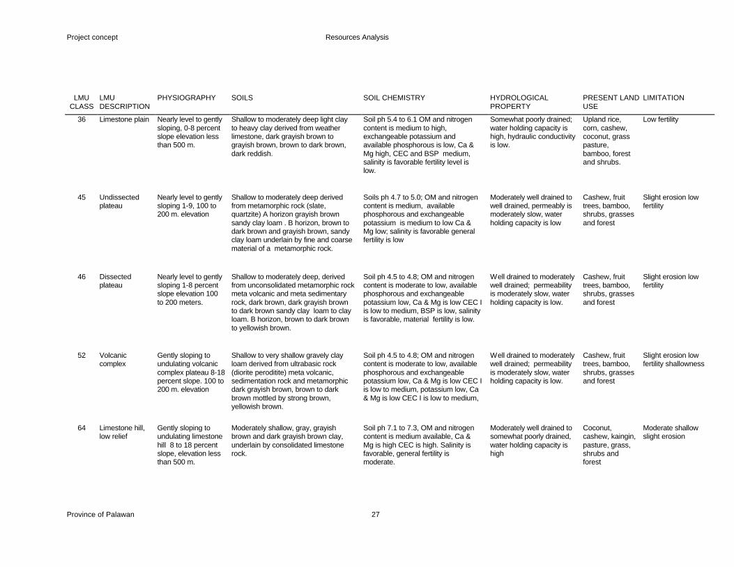
Project concept Resources Analysis
Province of Palawan 27
LMU
CLASS LMU DESCRIPTION
PHYSIOGRAPHY SOILS SOIL CHEMISTRY HYDROLOGICAL PROPERTY
PRESENT LAND USE
LIMITATION
36 Limestone plain Nearly level to gently sloping, 0-8 percent slope elevation less than 500 m.
Shallow to moderately deep light clay to heavy clay derived from weather limestone, dark grayish brown to grayish brown, brown to dark brown, dark reddish.
Soil ph 5.4 to 6.1 OM and nitrogen content is medium to high, exchangeable potassium and available phosphorous is low, Ca & Mg high, CEC and BSP medium, salinity is favorable fertility level is low.
Somewhat poorly drained; water holding capacity is high, hydraulic conductivity is low.
Upland rice, corn, cashew, coconut, grass pasture, bamboo, forest and shrubs.
Low fertility
45 Undissected plateau
Nearly level to gently sloping 1-9, 100 to 200 m. elevation
Shallow to moderately deep derived from metamorphic rock (slate, quartzite) A horizon grayish brown sandy clay loam . B horizon, brown to dark brown and grayish brown, sandy clay loam underlain by fine and coarse material of a metamorphic rock.
Soils ph 4.7 to 5.0; OM and nitrogen content is medium, available phosphorous and exchangeable potassium is medium to low Ca & Mg low; salinity is favorable general fertility is low
Moderately well drained to well drained, permeably is moderately slow, water holding capacity is low
Cashew, fruit trees, bamboo, shrubs, grasses and forest
Slight erosion low fertility
46 Dissected plateau
Nearly level to gently sloping 1-8 percent slope elevation 100 to 200 meters.
Shallow to moderately deep, derived from unconsolidated metamorphic rock meta volcanic and meta sedimentary rock, dark brown, dark grayish brown to dark brown sandy clay loam to clay loam. B horizon, brown to dark brown to yellowish brown.
Soil ph 4.5 to 4.8; OM and nitrogen content is moderate to low, available phosphorous and exchangeable potassium low, Ca & Mg is low CEC I is low to medium, BSP is low, salinity is favorable, material fertility is low.
Well drained to moderately well drained; permeability is moderately slow, water holding capacity is low.
Cashew, fruit trees, bamboo, shrubs, grasses and forest
Slight erosion low fertility
52 Volcanic complex
Gently sloping to undulating volcanic complex plateau 8-18 percent slope. 100 to 200 m. elevation
Shallow to very shallow gravely clay loam derived from ultrabasic rock (diorite peroditite) meta volcanic, sedimentation rock and metamorphic dark grayish brown, brown to dark brown mottled by strong brown, yellowish brown.
Soil ph 4.5 to 4.8; OM and nitrogen content is moderate to low, available phosphorous and exchangeable potassium low, Ca & Mg is low CEC I is low to medium, potassium low, Ca & Mg is low CEC I is low to medium,
Well drained to moderately well drained; permeability is moderately slow, water holding capacity is low.
Cashew, fruit trees, bamboo, shrubs, grasses and forest
Slight erosion low fertility shallowness
64 Limestone hill, low relief
Gently sloping to undulating limestone hill 8 to 18 percent slope, elevation less than 500 m.
Moderately shallow, gray, grayish brown and dark grayish brown clay, underlain by consolidated limestone rock.
Soil ph 7.1 to 7.3, OM and nitrogen content is medium available, Ca & Mg is high CEC is high. Salinity is favorable, general fertility is moderate.
Moderately well drained to somewhat poorly drained, water holding capacity is high
Coconut, cashew, kaingin, pasture, grass, shrubs and forest
Moderate shallow slight erosion
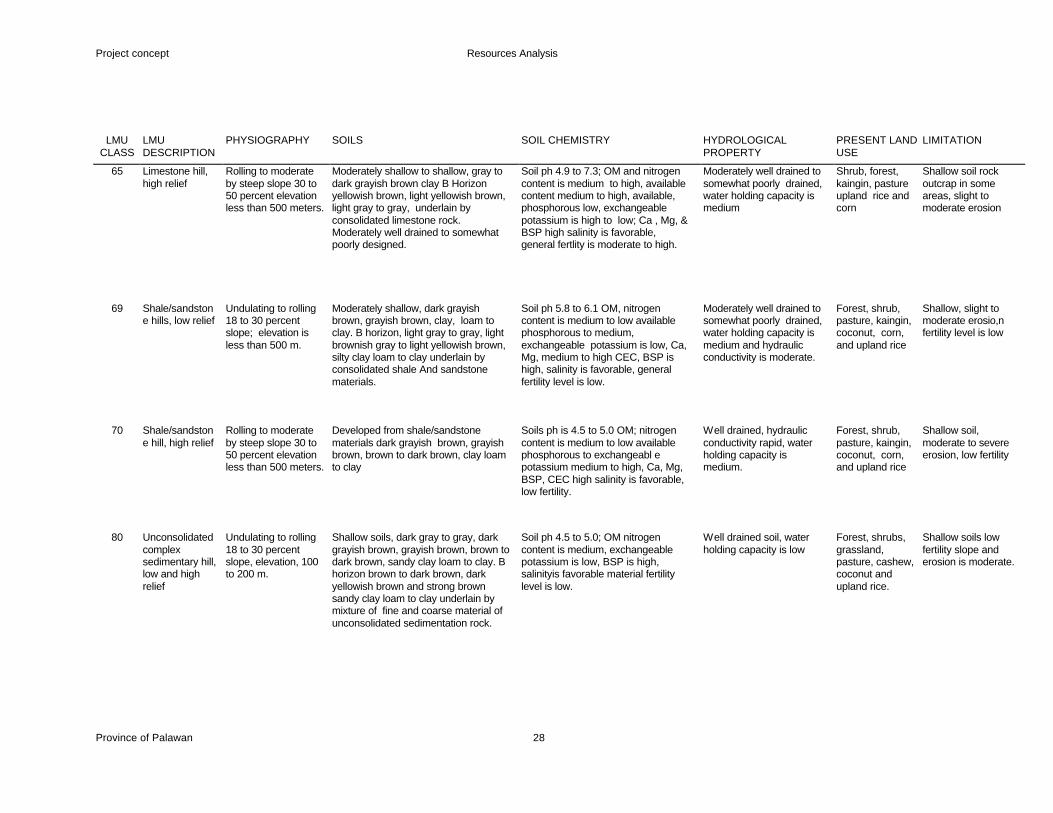
Project concept Resources Analysis
Province of Palawan 28
LMU
CLASS LMU DESCRIPTION
PHYSIOGRAPHY SOILS SOIL CHEMISTRY HYDROLOGICAL PROPERTY
PRESENT LAND USE
LIMITATION
65 Limestone hill, high relief
Rolling to moderate by steep slope 30 to 50 percent elevation less than 500 meters.
Moderately shallow to shallow, gray to dark grayish brown clay B Horizon yellowish brown, light yellowish brown, light gray to gray, underlain by consolidated limestone rock. Moderately well drained to somewhat poorly designed.
Soil ph 4.9 to 7.3; OM and nitrogen content is medium to high, available content medium to high, available, phosphorous low, exchangeable potassium is high to low; Ca , Mg, & BSP high salinity is favorable, general fertlity is moderate to high.
Moderately well drained to somewhat poorly drained, water holding capacity is medium
Shrub, forest, kaingin, pasture upland rice and corn
Shallow soil rock outcrap in some areas, slight to moderate erosion
69 Shale/sandstone hills, low relief
Undulating to rolling 18 to 30 percent slope; elevation is less than 500 m.
Moderately shallow, dark grayish brown, grayish brown, clay, loam to clay. B horizon, light gray to gray, light brownish gray to light yellowish brown, silty clay loam to clay underlain by consolidated shale And sandstone materials.
Soil ph 5.8 to 6.1 OM, nitrogen content is medium to low available phosphorous to medium, exchangeable potassium is low, Ca, Mg, medium to high CEC, BSP is high, salinity is favorable, general fertility level is low.
Moderately well drained to somewhat poorly drained, water holding capacity is medium and hydraulic conductivity is moderate.
Forest, shrub, pasture, kaingin, coconut, corn, and upland rice
Shallow, slight to moderate erosio,n fertility level is low
70 Shale/sandstone hill, high relief
Rolling to moderate by steep slope 30 to 50 percent elevation less than 500 meters.
Developed from shale/sandstone materials dark grayish brown, grayish brown, brown to dark brown, clay loam to clay
Soils ph is 4.5 to 5.0 OM; nitrogen content is medium to low available phosphorous to exchangeabl e potassium medium to high, Ca, Mg, BSP, CEC high salinity is favorable, low fertility.
Well drained, hydraulic conductivity rapid, water holding capacity is medium.
Forest, shrub, pasture, kaingin, coconut, corn, and upland rice
Shallow soil, moderate to severe erosion, low fertility
80 Unconsolidated complex sedimentary hill, low and high relief
Undulating to rolling 18 to 30 percent slope, elevation, 100 to 200 m.
Shallow soils, dark gray to gray, dark grayish brown, grayish brown, brown to dark brown, sandy clay loam to clay. B horizon brown to dark brown, dark yellowish brown and strong brown sandy clay loam to clay underlain by mixture of fine and coarse material of unconsolidated sedimentation rock.
Soil ph 4.5 to 5.0; OM nitrogen content is medium, exchangeable potassium is low, BSP is high, salinityis favorable material fertility level is low.
Well drained soil, water holding capacity is low
Forest, shrubs, grassland, pasture, cashew, coconut and upland rice.
Shallow soils low fertility slope and erosion is moderate.
Project concept Resources Analysis
Province of Palawan 29
LMU
CLASS LMU DESCRIPTION
PHYSIOGRAPHY SOILS SOIL CHEMISTRY HYDROLOGICAL PROPERTY
PRESENT LAND USE
LIMITATION
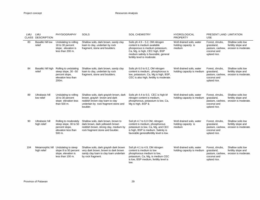
83 Basaltic hill low relief
Undulating to rolling 18 to 30 percent slope; elevation is less than 200 m.
Shallow soils, dark brown, sandy clay loam to clay, underlain by rock fragment, stone and boulders.
Soils ph 4.9 – 5.2, OM nitrogen content is medium available phosporous is medium potassium, Ca, Mg, is high, CEC high, BSP medium salinity is favorable, general fertility level is moderate.
Well drained soils, water holding capacity is medium
Forest, shrubs, grassland, pasture, cashew, coconut and upland rice.
Shallow soils low fertility slope and erosion is moderate.
84 Basaltic hill high relief
Rolling to undulating steep slope, 30 –50 percent slope, elevation less than 200m.
Shallow soils, dark brown, sandy clay loam to clay, underlain by rock fragment, stone and boulders.
Soils ph 6.0 to 6.2, OM nitrogen content is medium, phosphorous is low, potassium, Ca, Mg is high, BSP, CEC is also high, fertility is moderate.
Well drained soils, water holding capacity is medium
Forest, shrubs, grassland, pasture, cashew, coconut and upland rice.
Shallow soils low fertility slope and erosion is moderate.
89 Ultrabasic hill low relief
Undulating to rolling 18 to 30 percent slope elevation less than 500 m.
Shallow soils, dark grayish brown, dark brown, grayish brown and dark reddish brown clay loam to clay underlain by rock fragment stone and boulder.
Soils ph 4.4 to 6.0, CEC is high.M nitrogen content is medium, phosphorous, potassium is low, Ca, Mg is high, BSP &
Well drained soils, water holding capacity is medium
Forest, shrubs, grassland, pasture, cashew, coconut and upland rice.
Shallow soils low fertility slope and erosion is moderate.
90 Ultrabasic hill high relief
Rolling to moderately steep slope, 30 to 50 percent slope, elevation less than 500 m.
Shallow soils, dark brown, brown to dark brown, dark yellowish brown reddish brown, strong clay, medium by rock fragment stone and boulder.
Soil ph 4.7 to 6.0 OM, nitrogen content is medium, phosphorous potassium is low, Ca, Mg, and CEC is high, BSP is medium. Salinity is favorable generalfertility level is low.
Well drained soils, water holding capacity is medium
Forest, shrubs, grassland, pasture, cashew, coconut and upland rice.
Shallow soils low fertility slope and erosion is moderate.
104 Metamorphic hill high relief
Undulating to steep slope 8 to 50 percent slope, elevation is less than 100 m.
Shallow soils, dark grayish dark brown very dark brown, brown to dark brown sandy clay loam to clay loam underlain by rock fragment.
Soil ph 4.1 to 4.9, OM nitrogen content is medium to low phosphorous medium to low, potassium, Ca, Mg, is medium CEC is low, BSP medium, fertility level is low.
Well drained soils, water holding capacity is medium
Forest, shrubs, grassland, pasture, cashew, coconut and upland rice.
Shallow soils low fertility slope and erosion is moderate.
Project concept Resources Analysis
Province of Palawan 30
LMU
CLASS LMU DESCRIPTION
PHYSIOGRAPHY SOILS SOIL CHEMISTRY HYDROLOGICAL PROPERTY
PRESENT LAND USE
LIMITATION
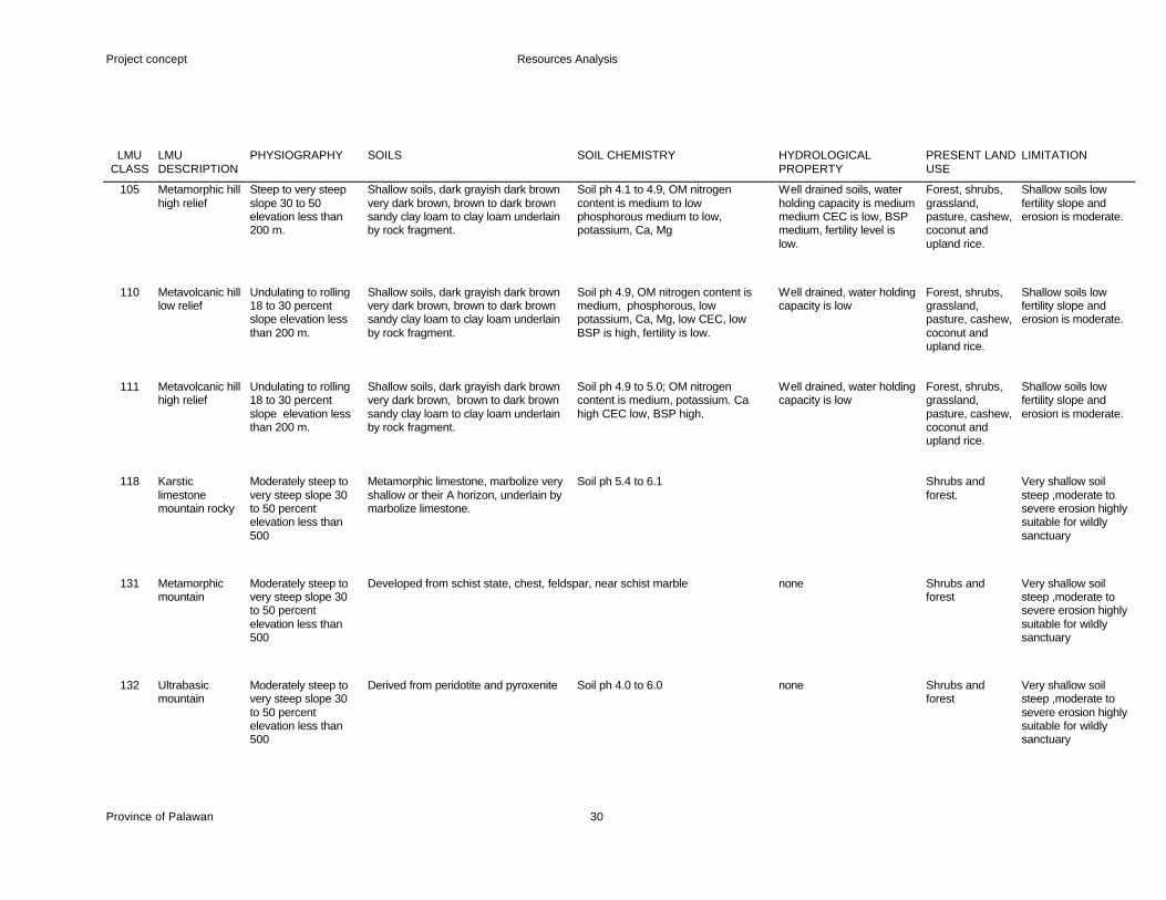
105 Metamorphic hill high relief
Steep to very steep slope 30 to 50 elevation less than 200 m.
Shallow soils, dark grayish dark brown very dark brown, brown to dark brown sandy clay loam to clay loam underlain by rock fragment.
Soil ph 4.1 to 4.9, OM nitrogen content is medium to low phosphorous medium to low, potassium, Ca, Mg
Well drained soils, water holding capacity is medium medium CEC is low, BSP medium, fertility level is low.
Forest, shrubs, grassland, pasture, cashew, coconut and upland rice.
Shallow soils low fertility slope and erosion is moderate.
110 Metavolcanic hill low relief
Undulating to rolling 18 to 30 percent slope elevation less than 200 m.
Shallow soils, dark grayish dark brown very dark brown, brown to dark brown sandy clay loam to clay loam underlain by rock fragment.
Soil ph 4.9, OM nitrogen content is medium, phosphorous, low potassium, Ca, Mg, low CEC, low BSP is high, fertility is low.
Well drained, water holding capacity is low
Forest, shrubs, grassland, pasture, cashew, coconut and upland rice.
Shallow soils low fertility slope and erosion is moderate.
111 Metavolcanic hill high relief
Undulating to rolling 18 to 30 percent slope elevation less than 200 m.
Shallow soils, dark grayish dark brown very dark brown, brown to dark brown sandy clay loam to clay loam underlain by rock fragment.
Soil ph 4.9 to 5.0; OM nitrogen content is medium, potassium. Ca high CEC low, BSP high.
Well drained, water holding capacity is low
Forest, shrubs, grassland, pasture, cashew, coconut and upland rice.
Shallow soils low fertility slope and erosion is moderate.
118 Karstic limestone mountain rocky
Moderately steep to very steep slope 30 to 50 percent elevation less than 500
Metamorphic limestone, marbolize very shallow or their A horizon, underlain by marbolize limestone.
Soil ph 5.4 to 6.1 Shrubs and forest.
Very shallow soil steep ,moderate to severe erosion highly suitable for wildly sanctuary
131 Metamorphic mountain
Moderately steep to very steep slope 30 to 50 percent elevation less than 500
Developed from schist state, chest, feldspar, near schist marble none Shrubs and forest
Very shallow soil steep ,moderate to severe erosion highly suitable for wildly sanctuary
132 Ultrabasic mountain
Moderately steep to very steep slope 30 to 50 percent elevation less than 500
Derived from peridotite and pyroxenite Soil ph 4.0 to 6.0 none Shrubs and forest
Very shallow soil steep ,moderate to severe erosion highly suitable for wildly sanctuary
Project concept Resources Analysis
Province of Palawan 31
LMU
CLASS LMU DESCRIPTION
PHYSIOGRAPHY SOILS SOIL CHEMISTRY HYDROLOGICAL PROPERTY
PRESENT LAND USE
LIMITATION
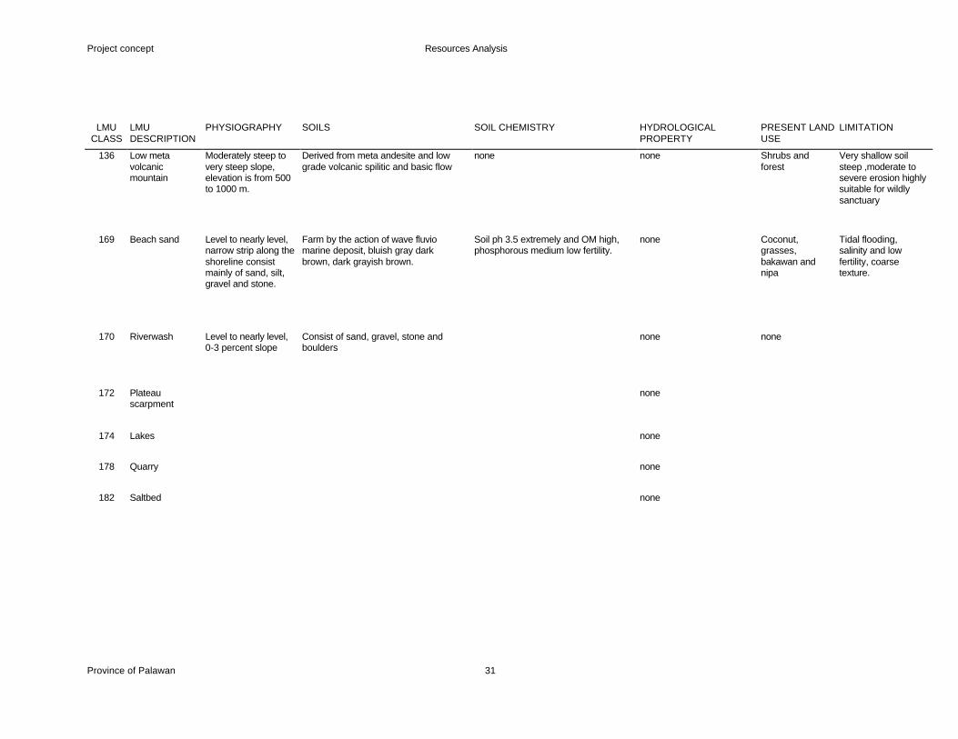
136 Low meta volcanic mountain
Moderately steep to very steep slope, elevation is from 500 to 1000 m.
Derived from meta andesite and low grade volcanic spilitic and basic flow
none none Shrubs and forest
Very shallow soil steep ,moderate to severe erosion highly suitable for wildly sanctuary
169 Beach sand Level to nearly level, narrow strip along the shoreline consist mainly of sand, silt, gravel and stone.
Farm by the action of wave fluvio marine deposit, bluish gray dark brown, dark grayish brown.
Soil ph 3.5 extremely and OM high, phosphorous medium low fertility.
none Coconut, grasses, bakawan and nipa
Tidal flooding, salinity and low fertility, coarse texture.
170 Riverwash Level to nearly level, 0-3 percent slope
Consist of sand, gravel, stone and boulders
none none
172 Plateau scarpment
none
174 Lakes none
178 Quarry none
182 Saltbed none

Project concept Resources Analysis
Province of Palawan 32
Annex 3: Sustainability Anaysis, using the Municipality of Espanola as Sample
Map 1: Existing general land use
Map 2: Existing Land Use Irrigated Rice
Map 3: Land Management Units
Map 4: Suitability for Irrigated and Irrigable Rice
Map 5: Sustainability for Irrigated and Irrigable Rice


Project concept Resources Analysis
Province of Palawan 33


