Download - GIS HELPDESK - uni-goettingen.de

1GIS Campus Day 19/20. April 2018 | Dr. Daniel Wyss [email protected] | GIS Helpdesk
GIS HELPDESK
https://www.uni-goettingen.de/en/187111.html

2GIS Campus Day 19/20. April 2018 | Dr. Daniel Wyss [email protected] | GIS Helpdesk
GIS HELPDESK o Offered through the Cartography, GIS and RS section;
o Since 2008, funded by the state of Lower Saxony.Aim: To improve quality of Teaching and Learning (Studienqualitätsmittel / SQM);
o Multidisciplinary; Cross departmental;
o For students engaging in: o Acquisition; o Management;o Analysis;o Presentation
of geospatial information.

3GIS Campus Day 19/20. April 2018 | Dr. Daniel Wyss [email protected] | GIS Helpdesk
GIS HELPDESK
Supports:
o GIS Capacity Development (Delivery of Basic and Advanced GIS courses);
o Spatial Data Acquisition (OpenData);
o GIS Tools and Methods;
o GIS Software (Proprietary and FOSS GIS);
o Use of GPS;
o ArcGIS Desktop Licenses for students.CORINE Land Cover, Source: BKG

4GIS Campus Day 19/20. April 2018 | Dr. Daniel Wyss [email protected] | GIS Helpdesk
Interpolation of Survey Data (Lake Tana, Ethiopia) Source: ITC, 2009, ESRI BaseMaps
o Cross-faculty key competency courses;
o Integral Part of B.Sc. and M.Sc. Degree curricula.
GIS Courses for the summer term 2018Interdisciplinary and cross-departmental
‘Introduction to GIS’ (B.Geg.751)Weekly Wednesdays, 10:00 to 12:00
‘Advanced GIS’ (B.Geg.752)Delivered in block mode (13. to 17. August 2018)
GIS COURSES

5GIS Campus Day 19/20. April 2018 | Dr. Daniel Wyss [email protected] | GIS Helpdesk
Introduction to GIS :
Course Outcomes:
o Methodological skills to handle spatial data using GIS-Software;
o Create, edit, manage, analyse and present spatial data for basic applications and small projects.
Proximity Analysis / John Snow 1854
GIS COURSES

6GIS Campus Day 19/20. April 2018 | Dr. Daniel Wyss [email protected] | GIS Helpdesk
Introduction to GIS :
Course Contents:
o Introduction to GIS – Concepts, Applications and Trends;
o Exploring Spatial Data;
o Working with Descriptive Information (attributes);
o Coordinate Systems and Projections;
o Georeferencing of images;
o Topological Editing;
o Geoprocessing / Vector Analysis;
o Open Data Acquisition & Processing;
o Map compilation and Cartographic Symbolization.
Topographic Map 1: 100.000 in combination with Analytical Hillshading (Selenge, Mongolia)

7GIS Campus Day 19/20. April 2018 | Dr. Daniel Wyss [email protected] | GIS Helpdesk
OutputsIntroduction to GIS:
Agroecology – Mapping of Calcareous Grasslands
8GIS Campus Day 19/20. April 2018 | Dr. Daniel Wyss [email protected] | GIS Helpdesk
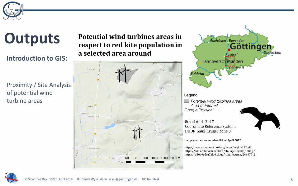
OutputsIntroduction to GIS:
Proximity / Site Analysisof potential wind turbine areas
9GIS Campus Day 19/20. April 2018 | Dr. Daniel Wyss [email protected] | GIS Helpdesk
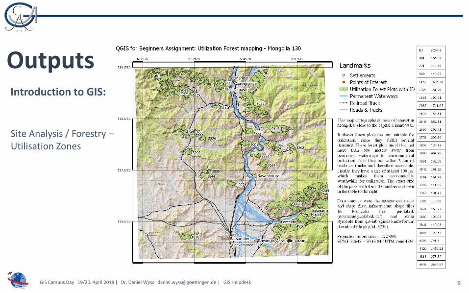
OutputsIntroduction to GIS:
Site Analysis / Forestry –Utilisation Zones

10GIS Campus Day 19/20. April 2018 | Dr. Daniel Wyss [email protected] | GIS Helpdesk
OutputsIntroduction to GIS:
Choropleth Mapping based on socio-economic survey data

11GIS Campus Day 19/20. April 2018 | Dr. Daniel Wyss [email protected] | GIS Helpdesk
OutputsIntroduction to GIS:
Heatmap of human activity & Black Bear events in Canada

12GIS Campus Day 19/20. April 2018 | Dr. Daniel Wyss [email protected] | GIS Helpdesk
OutputsIntroduction to GIS:
International Conflict Research(QGIS Flowmapper Plugin)

13GIS Campus Day 19/20. April 2018 | Dr. Daniel Wyss [email protected] | GIS Helpdesk
OutputsIntroduction to GIS:
Species Distribution based on Survey and Climate Data (WorldClim)

14
GIS Campus Day 19/20. April 2018 | Dr. Daniel Wyss [email protected] | GIS Helpdesk
Advanced GIS :
Course Outcomes:
o Advanced methodological skills in the spatial analysis and modelling of space-related data;
o Application of advanced tools within real-world and problem-driven projects.
GIS COURSES
Sentinel 2 – GöttingenSource: USGS

15
GIS Campus Day 19/20. April 2018 | Dr. Daniel Wyss [email protected] | GIS Helpdesk
MODIS NDVI / Active FiresSource: LDOPE Facility, Dr. David Roy
Advanced GIS :
Course Contents:
o Data Management – Working with ESRI Geodatabases;
o Methods of Terrain Analysis;
o 3D Visualisation and Animations;
o Satellite Image Processing and Interpretation;
o Methods of Image Classification;
o Time Series Analysis;
o Methods of Data Interpolation;
o Spatial Analysis using ArcGIS ModelBuilder.

16GIS Campus Day 19/20. April 2018 | Dr. Daniel Wyss [email protected] | GIS Helpdesk
OutputsAdvanced GIS:
Suitability Analysis /NDVI Applications

17GIS Campus Day 19/20. April 2018 | Dr. Daniel Wyss [email protected] | GIS Helpdesk
OutputsAdvanced GIS:
Application of Interpolation Methods

18GIS Campus Day 19/20. April 2018 | Dr. Daniel Wyss [email protected] | GIS Helpdesk
OutputsAdvanced GIS:
Application of Indices for Vegetation Mapping
19GIS Campus Day 19/20. April 2018 | Dr. Daniel Wyss [email protected] | GIS Helpdesk
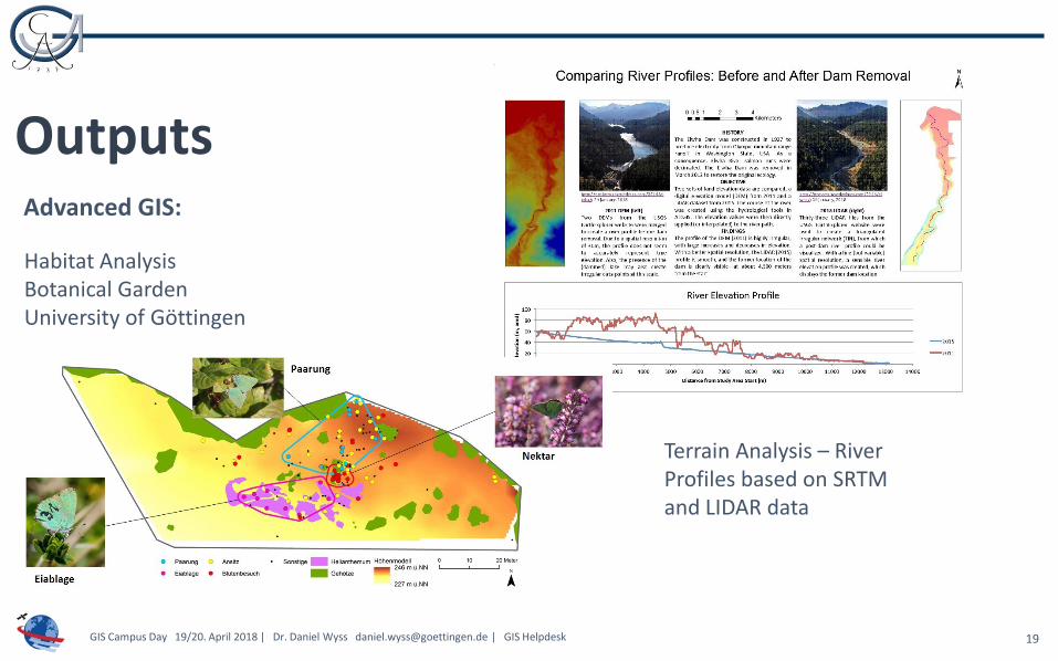
OutputsAdvanced GIS:
Habitat Analysis Botanical Garden University of Göttingen
Terrain Analysis – River Profiles based on SRTM and LIDAR data

20GIS Campus Day 19/20. April 2018 | Dr. Daniel Wyss [email protected] | GIS Helpdesk
OutputsAdvanced GIS:
Fire / Terrain Analysis
NDVI Analysis to map Algae Blooms

21GIS Campus Day 19/20. April 2018 | Dr. Daniel Wyss [email protected] | GIS Helpdesk
OutputsAdvanced GIS:
Multitemporal Change Detection
Kernel Density Mapping
22GIS Campus Day 19/20. April 2018 | Dr. Daniel Wyss [email protected] | GIS Helpdesk
Some Statistics

23GIS Campus Day 19/20. April 2018 | Dr. Daniel Wyss [email protected] | GIS Helpdesk
Some Statistics
0
2
4
6
8
10
12
14
Introduction to GIS- Distribution According to Study Course
WS2016/2017 SS2017 WS2017/2018

24GIS Campus Day 19/20. April 2018 | Dr. Daniel Wyss [email protected] | GIS Helpdesk
Some Statistics
0
2
4
6
8
10
12
14
Advanced GIS - Distribution According to Study Course
SS2017 WS2017/2018 (A) WS2017/2018 (B)

25GIS Campus Day 19/20. April 2018 | Dr. Daniel Wyss [email protected] | GIS Helpdesk
Some Statistics
14
21
18
17
8
17
4
Introduction to GIS - Distribution According to Main Study Area in Percent of Total
Agriculture Biology / Biodiversity
Economics Forestry
Geosciences Mathematics / Statistics
Other
8
21
10
13
38
8 2
Advanced GIS– Distribution According to mainStudy Area in Percent of Total
Agriculture Biology / Biodiversity
Economics Forestry
Geosciences Mathematics / Statistics
Other

26GIS Campus Day 19/20. April 2018 | Dr. Daniel Wyss [email protected] | GIS Helpdesk
Some Statistics
20
66
15
Advanced GIS - Distribution According to Degree in Percent of Total
Bachelor Master Promotion
14
68
17
1
Introduction to GIS - Distribution According to Degree in Percent of total
Bachelor Master Promotion Other
27GIS Campus Day 19/20. April 2018 | Dr. Daniel Wyss [email protected] | GIS Helpdesk
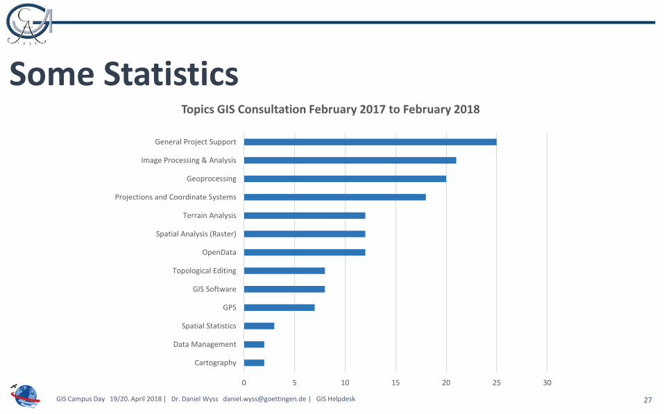
Some Statistics
0 5 10 15 20 25 30
Cartography
Data Management
Spatial Statistics
GPS
GIS Software
Topological Editing
OpenData
Spatial Analysis (Raster)
Terrain Analysis
Projections and Coordinate Systems
Geoprocessing
Image Processing & Analysis
General Project Support
Topics GIS Consultation February 2017 to February 2018

THANK YOU


