Institute for Economic Geography and GIScience, Vienna University of Economics and Business Administration
Dr. Petra Staufer-Steinnocher
GeomarketingLocation Intelligence and Spatial Decision Support Systems in Business
P. Staufer-Steinnocher (2002-2007); Institute for Economic Geography and GIScience, WU Wien 2
AgendaWhy Location Intelligence in Business?Basic Concepts of Business-GIS & GeomarketingBusiness-GIS Applications Overview – What Location Intelligence can do for you?A Basic Range of Queries and Concepts of Reasoning with a GIS Business Location Intelligence
Site SelectionDemographic IndexingCannibalization Studies
Address-related Applications GeomarketingLocation Based ServicesRouting and Fleet Management
Related Materials
P. Staufer-Steinnocher (2002-2007); Institute for Economic Geography and GIScience, WU Wien 3
The 5th P in the Marketing Mix: ProcessingProduct, Price, Promotion, and Place
Communications-Policy
Product-Policy
Price -Policy
Distribution-Policy
TheMarkets
Quality
Quantity
Sales Mix
CustomerServices
PhysicalDistribution
DistributionChannel
SalesOrganization
PublicRelationsPersonal
Selling
SalesPromotion
Advertising
PriceSales Discount Cash
Discount
MarketingMix

P. Staufer-Steinnocher (2002-2007); Institute for Economic Geography and GIScience, WU Wien 4
... Geographic Space, Neighborhoods, and Market Development
Customer-/Marketing-Information
ExploratorySpatial Data
Analysis
Micro-Markets & Micro-
Geographies
GIS-TechnologyI&C-Technologies
Business GIS & GeomarketingLocation Intelligence
for Business Companies
P. Staufer-Steinnocher (2002-2007); Institute for Economic Geography and GIScience, WU Wien 5
Business-GIS
Business-GIS: An Information System between MIS and GIS
Business-GIS: Geographic Information System [GIS] to support management decisions in business companies
Geomarketing - in a wider sense: Use of Business-GIS Tools in companies in order to physically analyze questions relevant to marketing, sales and service issues
M I S G I SBusiness Data Geo- and Market Data
Database Management System Spatial DatabaseManagement System
Exploratory Data Analysis Exploratory SpatialData Analysis
Business-Graphics Mapsand Graphics
P. Staufer-Steinnocher (2002-2007); Institute for Economic Geography and GIScience, WU Wien 6
Why Geomarketing?These and many more business-related questions can be answered efficiently and graphically by means of Geomarketing tools:
How is the distribution of my A, B and C type customers? In which areas does my turnover grow? Which sales representatives are in charge of which customers? What is the size of my branches’ catchment areas? How can I guarantee optimal services to my customers?
Company-owned data as well as population, economic and potential data are analyzed by means of digital maps. Geo marketing thus offers a goal-oriented knowledge and information analysis and the processing of business specific and market specific data.

P. Staufer-Steinnocher (2002-2007); Institute for Economic Geography and GIScience, WU Wien 7
Information Processing Concept in Business-GIS
A Business-GIS stores information about the company’s business activities and its environment as a collection of thematic layers, which are connected to each other via the geographic location of their objects (e.g., addresses, geographic coordinates)
Graphics: ESRI
Simple, but extremely powerful and flexible concept for entrepreneurial decision support, e.g.
customer analysis, market analysis, location and territory analysis
are typical areas where geomarketing is used
P. Staufer-Steinnocher (2002-2007); Institute for Economic Geography and GIScience, WU Wien 8
Typical Questions for Business-GIS & Geomarketing
Where is a (geographic) object or event located?
e.g., customer addresses, competitors, micro-markets
What is the characteristics of a specific geographic object/event?
e.g., demographic profile and socio-economic characteristics of the population in a neighborhood / sales area
Which geographic objects/events are located in a specific distance to a center?
e.g., potential customers, who live in max. 5 minutes driving distance from a service center
P. Staufer-Steinnocher (2002-2007); Institute for Economic Geography and GIScience, WU Wien 9
How Business-GIS Tools work …
Market Data[internal/external]
Geographic Data
Problem SpecificData Processing
Link via SpatialKey Variables
Link via SpatialKey Variables
Spatially Differentiated Market View

P. Staufer-Steinnocher (2002-2007); Institute for Economic Geography and GIScience, WU Wien 10
Micro-Geographic Market Segmentation ... is a data analysis concept in the market segmentation arenaprotecting the privacy of individuals/consumersAnalysis of segmentation criteria not based on the individual customer but – for the reason of protecting data privacy – based on small-scale geographic neighborhoods
Behavioral and lifestyle criteriaSocio-demographic and socio-economic criteriaGeographic criteria
ExamplesLifestyle SegmentationDevonshire Economic Data – providing a full picture of consumer spending and actual sales activity in any market: supply and demand.Bank Summary and Location DataConsumer Expenditures – average annual dollars spent and aggregate dollars spent on retail and services
P. Staufer-Steinnocher (2002-2007); Institute for Economic Geography and GIScience, WU Wien 11
The MOSAIC Lifestyle Segmentation
Objectives of the Classification (Spatial Insights, Inc., 1997-2007)
To create a series of neighborhood types that provide the most powerful discrimination of consumer behavior, lifestyles, and attitudes.To build types that are as recognizable and meaningful as possible to marketers.To ensure that each of the types contain sufficient numbers of households to be statistically reliable for most analyses.To ensure that each cluster is homogeneous in terms of demographics and consumer behavior.To avoid an excessive concentration of individual U.S. MOSAIC types within particular geographic regions, except where appropriate.For more information about how MOSAIC was developed, please click here.
P. Staufer-Steinnocher (2002-2007); Institute for Economic Geography and GIScience, WU Wien 12
Range of Business-GIS Applications
MicroMarkets
Market Datae.g., demography,
competitors, potentials
Business Datae.g., locations,
customers,suppliers
Geomarketinge.g., customer care,
turnover and sales analysis
Location Intelligence
e.g., site selection,proximity studies,
routing & tracking
Geographic Data
Analysis Building Blocksmarket structure , customer structure,
probability of purchase, etc.
Geo-Coding
Geo
-C
odin
g Geo-
Coding
P. Staufer-Steinnocher (2002-2007); Institute for Economic Geography and GIScience, WU Wien 13
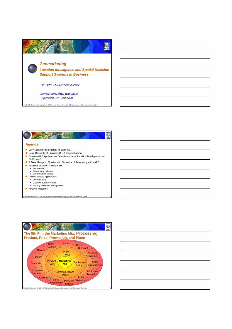
Building Blocks for Business-GIS Applications (I)
Market Analysischaracterize the market itself characterize geographic market segments use internal and external data get first insights about the market
… for example
Customer AnalysisDistribution of customers in geographic market segmentsdisaggregated by products, sales areas, etc. provides a basis for cross-selling activities, media planning, mailings, location analysis, selection of test markets, risk management, sales controlling, etc.… for example
P. Staufer-Steinnocher (2002-2007); Institute for Economic Geography and GIScience, WU Wien 14
Geo
prof
il of
a M
arke
t Are
a
P. Staufer-Steinnocher (2002-2007); Institute for Economic Geography and GIScience, WU Wien 15
Bus
ines
es50
0m a
roun
d…
P. Staufer-Steinnocher (2002-2007); Institute for Economic Geography and GIScience, WU Wien 16
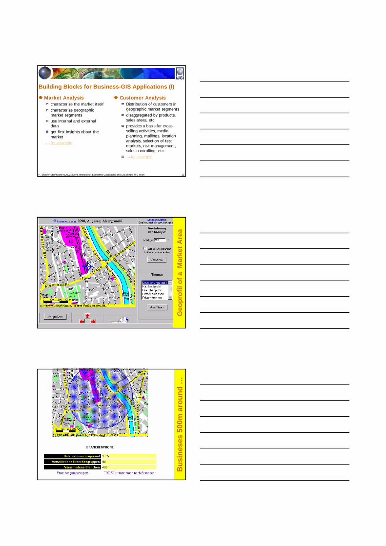
Top 50 Businesses Disaggregated by Industry Sector in theMarket Area (500m around Franz-Josefs-Bhf.)
Count Level 1 Industry Sector Level 2 Industry Sector
39 Associations, Societies, Organizations
Organizations, Public Admin. Offices/Sevices
34 Medical Practitioners (Doctors Health Care Services
34 Psychologists, Psychotherapists Health Care Services
27 Coffee Houses and Bars Tourism, Gastronomy
25 Hairdressers and Beauty Salons Chemical, Pharmaceutical, Cosmetics Sector Services
19 Grocery/Retailing Food and Beverages/Retail
18 Child’s Ware Textile and Leather/Retail
P. Staufer-Steinnocher (2002-2007); Institute for Economic Geography and GIScience, WU Wien 17
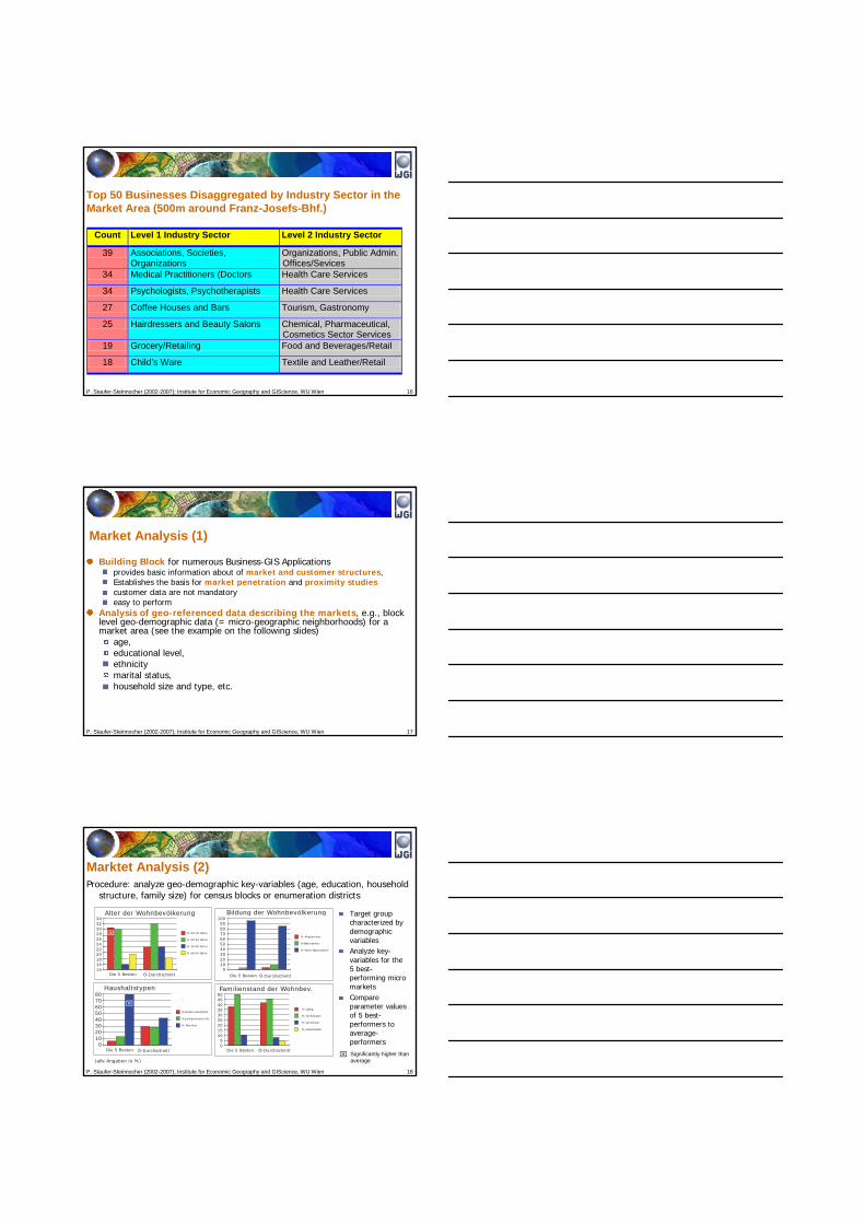
Market Analysis (1)
Building Block for numerous Business-GIS Applications provides basic information about of market and customer structures, Establishes the basis for market penetration and proximity studiescustomer data are not mandatoryeasy to perform
Analysis of geo-referenced data describing the markets, e.g., block level geo-demographic data (= micro-geographic neighborhoods) for a market area (see the example on the following slides)
age,educational level,ethnicitymarital status,household size and type, etc.
P. Staufer-Steinnocher (2002-2007); Institute for Economic Geography and GIScience, WU Wien 18
Procedure: analyze geo-demographic key-variables (age, education, household structure, family size) for census blocks or enumeration districts
Bildung der Wohnbevölkerung
Die 5 Besten Ö-Durchschnitt
% Akademiker
%Maturanten
% Nicht Maturanten
1009080706050403020100
Haushaltstypen
Die 5 Besten Ö-Durchschnitt
%Single Haushalte
%Zweipersonen HH
% Familien
80706050403020100
Alter der Wohnbevölkerung
Die 5 Besten Ö-Durchschnitt
% bis 19 Jahre
% 20-39 Jahre
% 40-59 Jahre
% ab 60 Jahre
3432302826242220181614
Familienstand der Wohnbev.
Die 5 Besten Ö-Durchschnitt
% Ledig
% Verheiratet
% Verwitwet
% Geschieden
50454035302520151050
(alle Angaben in %)
⌧
⌧
⌧
signifikant
Target group characterized by demographic variablesAnalyze key-variables for the 5 best-performing micro marketsCompare parameter values of 5 best-performers to average-performersSignificantly higher than average
Marktet Analysis (2)

P. Staufer-Steinnocher (2002-2007); Institute for Economic Geography and GIScience, WU Wien 19
Analysis of Market PerformanceRelates geo-demographic structures with customer data
Provides Answers to questions like … What does the regional distribution of my customers look like?Which micro-markets are performing well/badly?Where is a concentration of "important" or "less important" customers? Which customers are visited by which location or by which sales representative?
e.g., Territorial Analysis
Proximity AnalysisDetermines catchment areasNecessary for analyzing market potentialsMight consider the locations of competitorsSupports analysis of
Existing points-of-sales Potential points-of-salesMergers- and acquisition decisions
e.g., Site Analysis
Building Blocks for Business-GIS Applications (II)
P. Staufer-Steinnocher (2002-2007); Institute for Economic Geography and GIScience, WU Wien 20
Analyzing Market Performance (1)Technique
Classify key data of your business – calculating business ratios• internal data only• jointly with external market information
Key figures for market performanceCustomer penetration ratios
• Level-1 penetration = # customers / household (alternatively, per resident)• Level-2 penetration = # customers / target group household• Level-3 penetration = # customer / product owners household
Sales volume ratios• sales volume per household, or resident, or target group member, or
customer, etc.• gross profit, average spending per household or customer, etc.
P. Staufer-Steinnocher (2002-2007); Institute for Economic Geography and GIScience, WU Wien 21
Analyzing Market Performance (2): Using GIS-Tools
Analysis based on vector data resulting in thematic maps
Cell-based analysis (density- and neighborhood analysis)
x
x
x
x
A1A2
C1
B1
C2
DEMO
GRAP
HIE
KUND
EN
GEBIETA1A2B1C1
%KUNDEN3.2%4.2%0.8%3.4%
UMSATZ/ EW232,-228,-
16,-144,-GR
ENZE
NZE
LLEN
POTE
NTIA
LE GEBIETP1P2P3P4
UMSATZ_P20.00025.00010.000
5.000
KUNDEN_P10%5%
15%20%
x
x
x
x
P1
P2P3
P4
P5
P. Staufer-Steinnocher (2002-2007); Institute for Economic Geography and GIScience, WU Wien 22
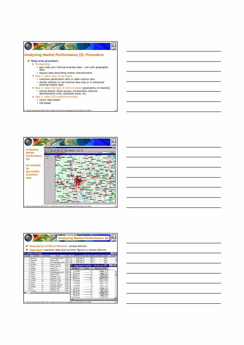
Analyzing Market Performance (3): ProcedureStep-wise procedure
Prerequisites• geo-code your internal business data – join with geographic
data• acquire data describing market characteristics
Step 1: select type of key figure• customer penetration ratio or sales volume ratio• decide whether to use internal data only or to enhanced
external market dataStep 2: select the type of micro-markets [granularity of markets]
• census blocks, block groups, enumeration districts, administrative units, postcode areas, etc.
Step 3: select GIS analysis technique• vector-data based• cell-based
P. Staufer-Steinnocher (2002-2007); Institute for Economic Geography and GIScience, WU Wien 23
AnalyzingMarketPerformance (4):
An example forgeo-codedcustomerdata
P. Staufer-Steinnocher (2002-2007); Institute for Economic Geography and GIScience, WU Wien 24
Analyzing Market Performance (5)
Granularity of Micro-Markets: census districtsAggregate customer data and turnover figures to census districts
P. Staufer-Steinnocher (2002-2007); Institute for Economic Geography and GIScience, WU Wien 25
Penetrationsanalyse (7)
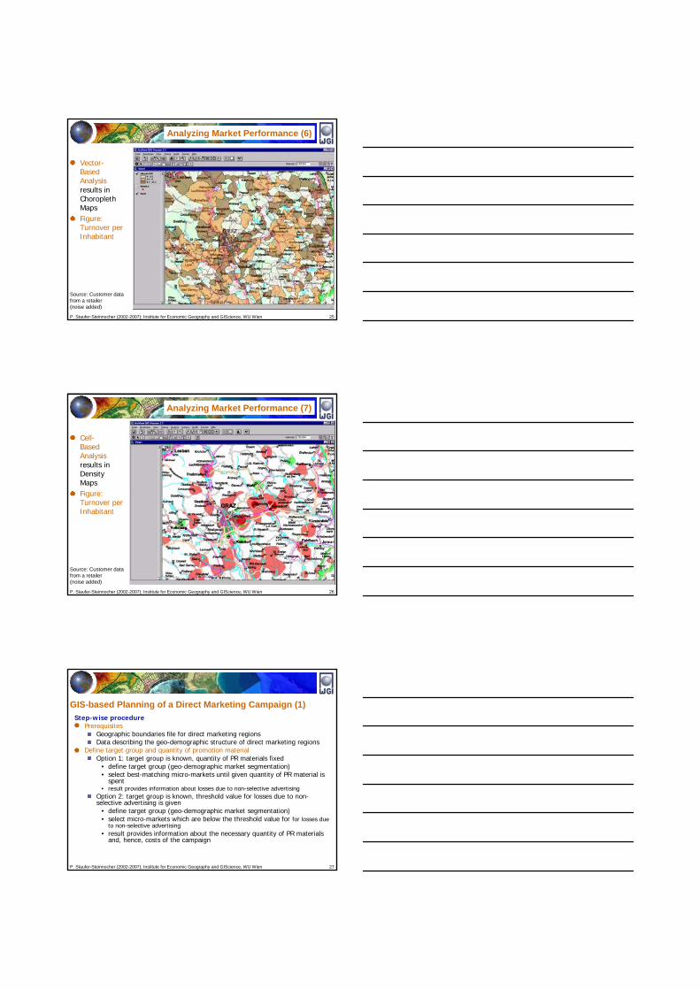
Vector-BasedAnalysisresults inChoroplethMapsFigure:Turnover perInhabitant
Source: Customer datafrom a retailer (noise added)
Analyzing Market Performance (6)
P. Staufer-Steinnocher (2002-2007); Institute for Economic Geography and GIScience, WU Wien 26
Cell-BasedAnalysisresults inDensityMapsFigure:Turnover perInhabitant
Analyzing Market Performance (7)
Source: Customer datafrom a retailer (noise added)
P. Staufer-Steinnocher (2002-2007); Institute for Economic Geography and GIScience, WU Wien 27
GIS-based Planning of a Direct Marketing Campaign (1)Step-wise procedure
PrerequisitesGeographic boundaries file for direct marketing regionsData describing the geo-demographic structure of direct marketing regions
Define target group and quantity of promotion materialOption 1: target group is known, quantity of PR materials fixed
• define target group (geo-demographic market segmentation)• select best-matching micro-markets until given quantity of PR material is
spent• result provides information about losses due to non-selective advertising
Option 2: target group is known, threshold value for losses due to non-selective advertising is given
• define target group (geo-demographic market segmentation)• select micro-markets which are below the threshold value for for losses due
to non-selective advertising• result provides information about the necessary quantity of PR materials
and, hence, costs of the campaign
P. Staufer-Steinnocher (2002-2007); Institute for Economic Geography and GIScience, WU Wien 28
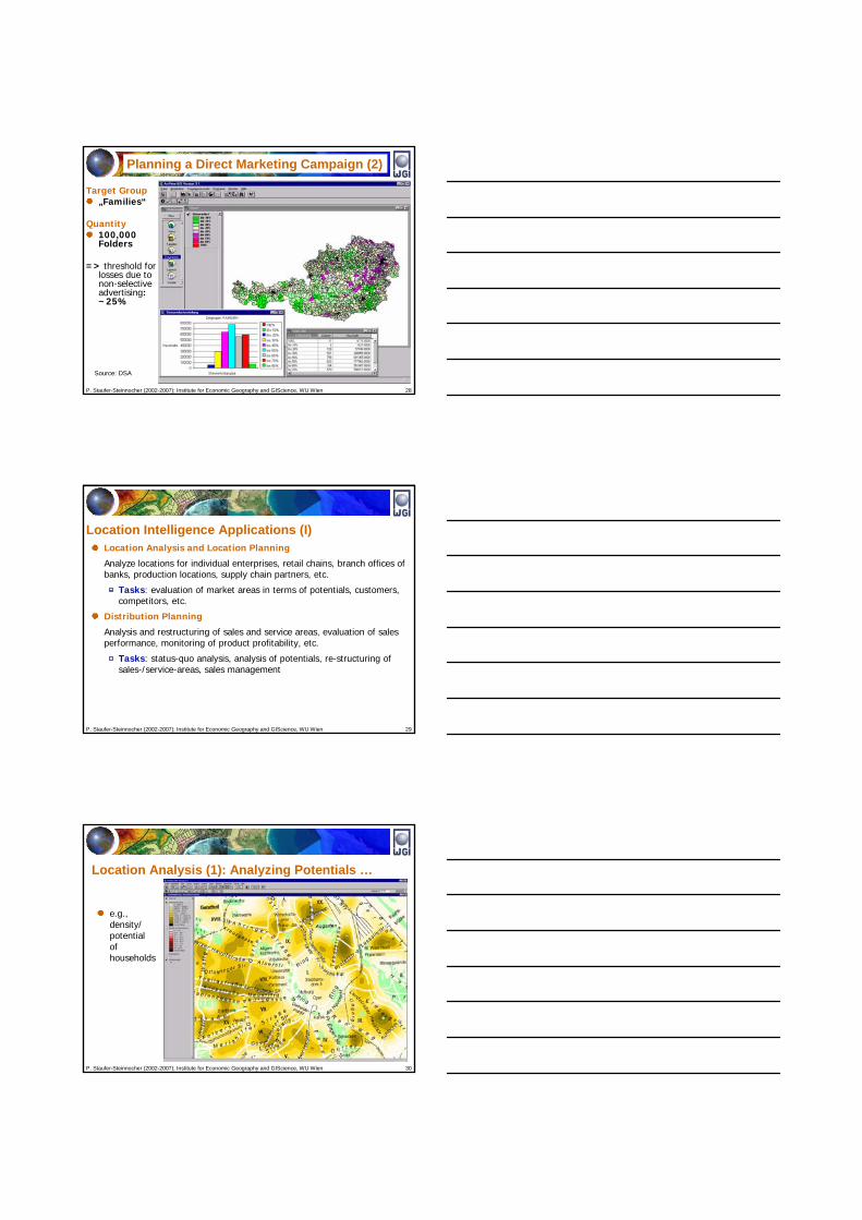
Source: DSA
Target Group„Families“
Quantity100,000 Folders
=> threshold for losses due to non-selective advertising: ~25%
Planning a Direct Marketing Campaign (2)
P. Staufer-Steinnocher (2002-2007); Institute for Economic Geography and GIScience, WU Wien 29
Location Intelligence Applications (I)Location Analysis and Location Planning
Analyze locations for individual enterprises, retail chains, branch offices of banks, production locations, supply chain partners, etc.
Tasks: evaluation of market areas in terms of potentials, customers, competitors, etc.
Distribution Planning
Analysis and restructuring of sales and service areas, evaluation of sales performance, monitoring of product profitability, etc.
Tasks: status-quo analysis, analysis of potentials, re-structuring of sales-/service-areas, sales management
P. Staufer-Steinnocher (2002-2007); Institute for Economic Geography and GIScience, WU Wien 30
Location Analysis (1): Analyzing Potentials …
e.g.,density/potential of households

P. Staufer-Steinnocher (2002-2007); Institute for Economic Geography and GIScience, WU Wien 31
Location Analysis (2): Analyzing Potentials …
e.g.,density/potential of travel agencies
P. Staufer-Steinnocher (2002-2007); Institute for Economic Geography and GIScience, WU Wien 32
Regions with high householddensities
and
lowdenstiy oftravelagencies
are marked in blue!
Location Analysis (3): Overlaying Potentials …
P. Staufer-Steinnocher (2002-2007); Institute for Economic Geography and GIScience, WU Wien 33
A Gallery of Industry Applications …. provided by ESRI.com
„The application of GIS is limited only by the imagination of those who use it”(Copyright © 1995-2007 ESRI )
Clink to www.esri.com

P. Staufer-Steinnocher (2002-2007); Institute for Economic Geography and GIScience, WU Wien 34
Business Applications
Financial ServicesInsuranceReal EstateRetail and Commercial Business
(Copyright © 1995-2007 ESRI )
P. Staufer-Steinnocher (2002-2007); Institute for Economic Geography and GIScience, WU Wien 35
Communications
Location-Based ServicesMediaTelecommunications
(Copyright © 1995-2007 ESRI )
P. Staufer-Steinnocher (2002-2007); Institute for Economic Geography and GIScience, WU Wien 36
Government Economic DevelopmentElectionsFederalHomeland SecurityLand Records and Cadastral SolutionsLaw EnforcementPublic SafetyState and LocalSustainable DevelopmentUrban and Regional Planning
(Copyright © 1995-2007 ESRI )

P. Staufer-Steinnocher (2002-2007); Institute for Economic Geography and GIScience, WU Wien 37
Health and Human Services
Hospitals and Health SystemsPublic Health and Human Services
(Copyright © 1995-2007 ESRI )
P. Staufer-Steinnocher (2002-2007); Institute for Economic Geography and GIScience, WU Wien 38
Transportation and Utilities
TransportationLogisticsTransportation Systems and Networks
UtilitiesElectric and GasWater/Wastewater
(Copyright © 1995-2007 ESRI )


