
Steeds Lane, KINGSNORTH, Kingsnorth, Ashford, TN26 1NQ
LOCATION Contents

LOCATION Introduction
An invaluable insight into your new home
This Location Information brochure offers an informed overview of Steeds Lane as a potential new home, along withessential material about its surrounding area and its local community. It provides a valuable insight for any prospectiveowner or tenant.
We wanted to provide you with information that you can absorb quickly, so we have presented it as visually as possible,making use of maps, icons, tables, graphs and charts. Overall, the brochure contains information about:
The Property - including property details, floor plans, room details, photographs and Energy Performance
Certificate.
Transport - including locations of bus and coach stops, railway stations and ferry ports.
Health - including locations, contact details and organisational information on the nearest GPs, pharmacies,
hospitals and dentists.
Local Policing - including locations, contact details and information about local community policing and the nearest
police station, as well as police officers assigned to the area.
Education - including locations of infant, primary and secondary schools and Key Performance Indicators (KPIs) for
each key stage.
Local Amenities - including locations of local services and facilities - everything from convenience stores to leisure
centres, golf courses, theatres and DIY centres.
Gould Harrison 1 Middle Row, High Street, Ashford, TN24 8SQ 01233 646411

LOCATION The Property
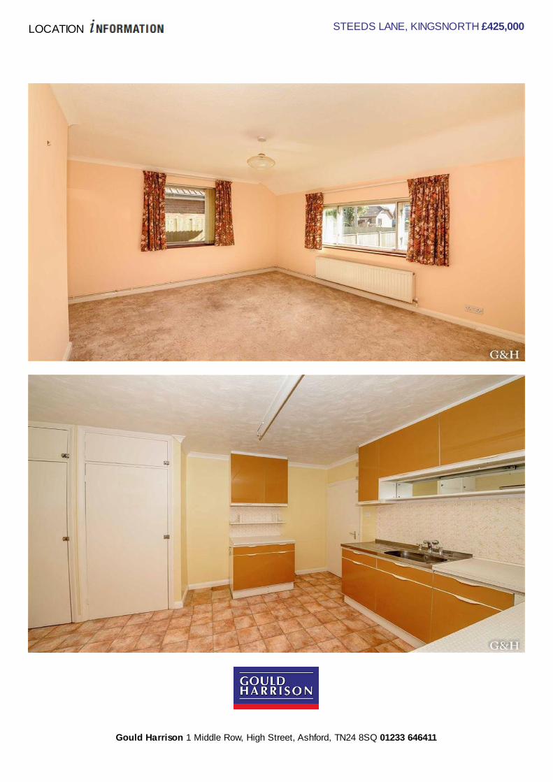
STEEDS LANE, KINGSNORTH £425,000
x3 x1 x1Bedrooms Living Rooms Bathrooms
Where you are

LOCATION STEEDS LANE, KINGSNORTH £425,000
Gould Harrison 1 Middle Row, High Street, Ashford, TN24 8SQ 01233 646411
LOCATION STEEDS LANE, KINGSNORTH £425,000
Gould Harrison 1 Middle Row, High Street, Ashford, TN24 8SQ 01233 646411

LOCATION Features
Spacious detached three bedroom bungalow with about a quarter of an acre, in a delightful semi rural location. Traditionallyconstructed in about 1955 and subsequently extended the existing accommodation comprises entrance porch, hallway,lounge, kitchen/diner, dining room, utility room, loft room, three bedrooms, bathroom, garage with rear store and outsidetoilet.Planning permission has been obtained to extend the ground floor and add a first floor with two additional bedrooms andbathrooms.
Double glazed Front Door to: - -
Entrance Porch - With half glazed door to: -
Hallway - Radiator, picture rail, access via a pull down ladder to: -
Loft Room - Radiator, window to rear, two eaves storage cupboards.
3.35m x 3.35m (11'0 x 11'0)
Lounge - Double aspect, double radiator, TV point, telephone point.
4.55m x 3.76m (14'11 x 12'4)
Kitchen/Diner - Stainless steel sink unit, range of worktops with drawers and cupboards, fridge/freezer, washing machine
and dishwasher, airing cupboard, Worcester gas boiler for central heating and domestic hot water.
4.09m x 3.20m (13'5 x 10'6)
Rear Lobby/Utility Room - With UPVC double glazed doors to both sides.
3.20m x 1.91m (10'6 x 6'3)
Dining Room - Double radiator.
4.29m x 2.31m (14'1 x 7'7)
Bedroom One - Radiator, window to front, picture rail, coved ceiling.
3.81m x 3.33m (12'6 x 10'11)
Bedroom Two - Radiator, window to front.
4.39m x 2.57m (14'5 x 8'5)
Bedroom Three - Radiator, range of built in wardrobe cupboards to one wall.
3.05m x 2.29m (10'0 x 7'6)
Bathroom - With white suite and fully tiled walls, panelled bath with electric shower over and glass splashback, pedestal
wash hand basin, low level WC, radiator.
Outside - The gardens extend to three side with lawn, borders and shrubs, small natural pond and extend to just under a
quarter of an acre, large new garden shed.
Attached Garage - With rear store and leading to: -
5.72m x 2.31m (18'9 x 7'7)
Cloakroom - Low level WC, wash hand basin and radiator.
Services - All main services are connected.

Tenure - Freehold.
Council Tax - Ashford Borough Council Band: E.
- You may download, store and use the material for your own personal use and research. You may not republish,
retransmit, redistribute or otherwise make the material available to any party or make the same available on any website,
online service or bulletin board of your own or of any other party or make the same available in hard copy or in any other
media without the website owner's express prior written consent. The website owner's copyright must remain on all
reproductions of material taken from this website.
Gould Harrison 1 Middle Row, High Street, Ashford, TN24 8SQ 01233 646411

LOCATION Floor Plans
Gould Harrison 1 Middle Row, High Street, Ashford, TN24 8SQ 01233 646411

LOCATION
EnergyPerformance
Certificate
Below is the Energy Performance Certificate (EPC) for Steeds LaneEnergy Performance Certificates illustrate the energy efficiency of homes on a scale from A to G. Those in Band A are themost efficient, and will usually have the lowest fuel bills.The same scale is used to define the impact of a property on the environment. Higher rated homes will usually have lessimpact through carbon dioxide (CO2) emissions.To put this in perspective, the average property in the UK is in band D or E for both ratings.The Certificate also makes energy saving recommendations that may help reduce future energy bills. In some cases, thesecan be financed under the Government's Green Deal. In effect, Green Deal offers UK home-owners a loan, which is repaidthrough regular electricity bills. The main loan condition (the "Golden Rule") is that the amount saved each year on energybills should be more than the cost of annual loan repayments. Note that the loan stays with the house when owners moveon.
Gould Harrison 1 Middle Row, High Street, Ashford, TN24 8SQ 01233 646411


LOCATION Prices
How does Steeds Lane compare to the county and national average?
Whether you are selling, buying, letting or renting it is always useful to know the prices that local properties have recentlysold for. The table below contains local, average and national sold prices for the period 1/7/2016 to 31/1/2017 for all types ofproperty allowing you to get a sense of the current market conditions.
Post code / National Detached Semi-detached Terraced Flats/Maisonettes
TN26 £523696 £287126 £246750 £$ppap.averagePostcodePricePaid.get("F")
National £388720 £242324 £232459 £275086
Data produced by Land Registry © Crown copyright 2014.
This data covers the transactions received at Land Registry in the period 1/1/2010 to 31/1/2017. © Crown copyright 2014.
Gould Harrison 1 Middle Row, High Street, Ashford, TN24 8SQ 01233 646411


LOCATION Authorities
Get to know your local authorities
Local government directly affects quality of life, particularly when it comes to council tax, planning, waste disposal and theimpact of local policies. You may want to investigate how this is likely to affect you if you decide to move.There are nearly 400 local authorities in England, with five different types of local government structure. These can bebroadly divided into single-tier and two-tier authorities.Single-tier authorities are Metropolitan Authorities, London Boroughs and Unitary or Shire Authorities.Two-tier authorities have both a County Council , and a District Council or City Council .There are also around 10,000 parish and town councils, effectively creating an additional tier in some areas - mostly, but notexclusively, in rural areas. The National Association of Local Councils (NALC) represents and works on behalf of thesecommunity councils and is a useful contact point.
The local authority locations and contact details for Steeds Lane are:
Shire / County /District Website Address Contact details
Ashford Borough Council(Shire District)
http://www.ashford.gov.uk Tannery Lane, Ashford, Kent, TN231PL
t: 01233 637311f: 01233 645654e:[email protected]
Kent County Council(Shire County)
http://www.kent.gov.uk Maidstone, Kent, ME14 1XQ
t: 0845 8247247f: 01622 759905e:[email protected]
Disclaimer: The information displayed above has been obtained using the property's postcode in proximity to its local authority. Itis recommended that this information is independently verified.


LOCATION Transport Links
Become familiar with public transport linksBeing able to choose to travel by public transport is important for many reasons. It helps to reduce congestion, providesaccess to work and education, and facilitates use of health and leisure facilities. If you or your family members travelabroad, access to the nearest ferry terminals is also likely to be a significant factor in choosing a new property.Using the maps below, you can pinpoint the precise locations of transport links for Steeds Lane. Tables for each type oftransport indicate the property's distance from the nearest bus stops, railway stations, coach stops and ferry terminals(providing that these facilities are within the scale proximity of the maps.)
Transport Links

LOCATION Transport Links
Airports Approx Distance
Lydd London Ashford Airport 11.07 miles
London Southend Airport 32.48 miles
Biggin Hill Airport 39.14 miles
London City Airport 44.54 miles
London Gatwick Airport 44.65 miles
Ferry ports Approx Distance
Folkestone Eurotunnel Terminal 11.02 miles
Dover Western Docks Ferry Terminal 19.53 miles
Dover Eastern Docks Ferry Terminal 20.07 miles
Ramsgate Ferry Terminal 28.14 miles
Gravesend Pier 31.64 miles
Tilbury Ferry Terminal 31.96 miles
Wallasea Island Ferry Landing 35.64 miles
Burnham on Crouch Ferry Landing 35.66 miles
Disclaimer: The information represented in this section has been sourced from the Department of Transport's Open Data and isbased on the property's postcode. It is recommended that this information is independently verified.
Gould Harrison 1 Middle Row, High Street, Ashford, TN24 8SQ 01233 646411

LOCATION Transport Links
Train Stations Approx Distance
Ashford International Rail Station 2.46 miles
Ham Street Rail Station 2.82 miles
Appledore (Kent) Rail Station 5.62 miles
Wye Rail Station 5.96 miles
Pluckley Rail Station 6.06 miles
Westenhanger Rail Station 7.57 miles
Charing (Kent) Rail Station 7.58 miles
Sandling Rail Station 8.82 miles
Bus Stops Approx Distance
Smithfields Crossroads 0.48 miles
Smithfields Crossroads 0.49 miles
Cricket Pavilion 0.61 miles
Bryony Drive 0.64 miles
Bishopswood 0.64 miles
Queens Head 0.72 miles
Wood Lane 0.74 miles
Total Garage 0.77 miles
Coach Stops Approx Distance
Ashford (Kent): Town Centre Coach Stops 2.87 miles
Willesborough (Ashford Kt): Hythe Rd. Coach Stop 2.93 miles
Sellindge (Kent): Ashford Rd Coach Stop 6.19 miles
Newingreen (Kent): Ashford Rd Coach Stop 7.55 miles
Hythe (Kent) Coach Stop 9.67 miles
Seabrook (Kent): Seabrook Rd Coach Stop 11.34 miles
Sandgate: High Street Coach Stop 12.36 miles
Folkestone: Bouverie Square Bus Station 13.67 miles
Disclaimer: The information represented in this section has been sourced from the Department of Transport's Open Data and isbased on the property's postcode. It is recommended that this information is independently verified.
Gould Harrison 1 Middle Row, High Street, Ashford, TN24 8SQ 01233 646411


LOCATION Education
How are local schools performing?
If schools are important to you, then this section sets out the published Key Performance Indicators for schools near toyour prospective new home. Key Performance Indicators look primarily at how well pupils perform in their tests andexaminations, as well as some other measures like attendance.If you want to know more about a particular school or college, you can also visit the Ofsted websitehttp://www.ofsted.gov.uk/inspection-reports/find-inspection-report
Local Schools

LOCATION Key Stage 0
The next page shows tables and charts divided into Key Stages and a list of respective schools local to Steeds Lane.There are four main age-related Key Stages defined as:
Special schools are marked with this icon
Key Stage Definition
Key Stage 0 Marker / indicator - no legal definition
Key Stage 1 Fits broadly with the first stage of education, i.e. ages 5-7.
Key Stage 2Fits the later stage of primary education, often known as junior schools, i.e. ages 8-11. This takes pupils upto the standardised break at age 11 after which pupils generally change schools and transfer to secondaryeducation.
Key Stage 3 Secondary education split between key stages 3 and 4, with key stage 3 covering ages 11-13.
Key Stage 4 Key Stage 4 (ages 14-16) covers the two year period of study for GCSE level examinations.
Key Stage 5 Beyond key stage 4 is 16+ or Sixth Form provision, sometimes unofficially referred to as Key Stage 5.
Key Stage 0 - Name and Address Approx Distance
Name: Yellow Elephant Play Nursery
Address: Kingsnorth, ASHFORD, Kent, TN23 3EF0.69 miles
Name: Little Acorns Pre-school
Address: Kings North Recreation Centre, ASHFORD, Kent, TN23 3NZ0.83 miles
Name: Jellybeans Pre School Day Nursery
Address: Field View, ASHFORD, Kent, TN23 3NZ0.83 miles
Name: Canterbury House Nursery
Address: 59-61 Canterbury Road, ASHFORD, Kent, TN24 0BH1.92 miles
Disclaimer: The information represented in this section has been sourced from Experian and is based on the property'spostcode.
Gould Harrison 1 Middle Row, High Street, Ashford, TN24 8SQ 01233 646411
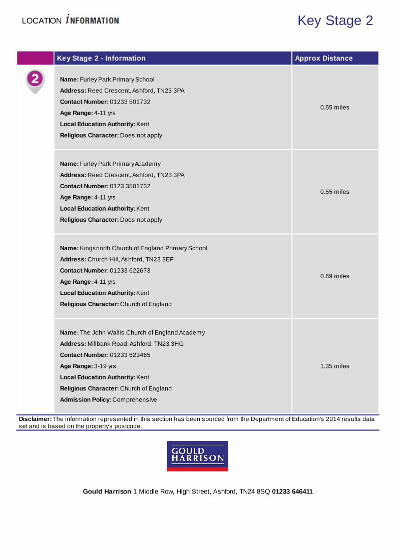
LOCATION Key Stage 2
Key Stage 2 - Information Approx Distance
Name: Furley Park Primary School
Address: Reed Crescent, Ashford, TN23 3PA
Contact Number: 01233 501732
Age Range: 4-11 yrs
Local Education Authority: Kent
Religious Character: Does not apply
0.55 miles
Name: Furley Park Primary Academy
Address: Reed Crescent, Ashford, TN23 3PA
Contact Number: 0123 3501732
Age Range: 4-11 yrs
Local Education Authority: Kent
Religious Character: Does not apply
0.55 miles
Name: Kingsnorth Church of England Primary School
Address: Church Hill, Ashford, TN23 3EF
Contact Number: 01233 622673
Age Range: 4-11 yrs
Local Education Authority: Kent
Religious Character: Church of England
0.69 miles
Name: The John Wallis Church of England Academy
Address: Millbank Road, Ashford, TN23 3HG
Contact Number: 01233 623465
Age Range: 3-19 yrs
Local Education Authority: Kent
Religious Character: Church of England
Admission Policy: Comprehensive
1.35 miles
Disclaimer: The information represented in this section has been sourced from the Department of Education's 2014 results dataset and is based on the property's postcode.
Gould Harrison 1 Middle Row, High Street, Ashford, TN24 8SQ 01233 646411
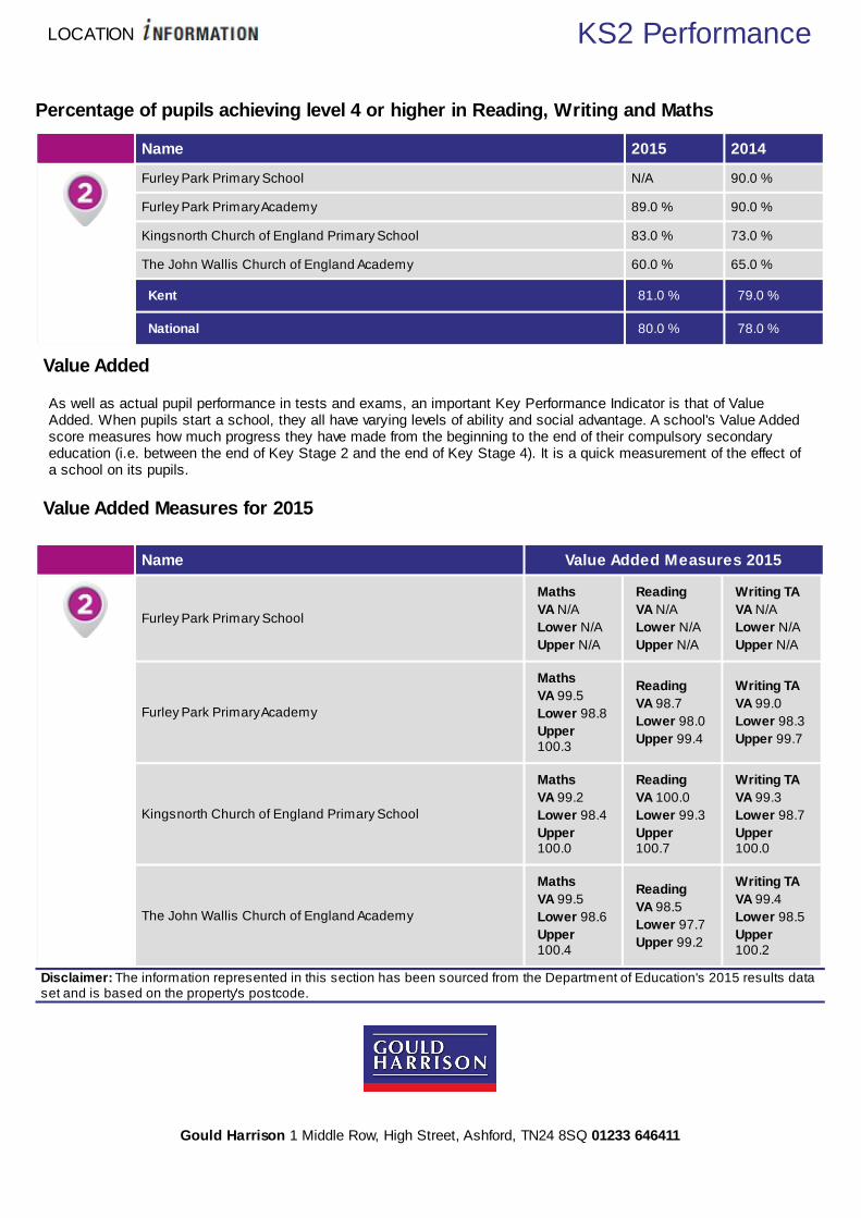
LOCATION KS2 Performance
Percentage of pupils achieving level 4 or higher in Reading, Writing and Maths
Name 2015 2014
Furley Park Primary School N/A 90.0 %
Furley Park Primary Academy 89.0 % 90.0 %
Kingsnorth Church of England Primary School 83.0 % 73.0 %
The John Wallis Church of England Academy 60.0 % 65.0 %
Kent 81.0 % 79.0 %
National 80.0 % 78.0 %
Value Added
As well as actual pupil performance in tests and exams, an important Key Performance Indicator is that of ValueAdded. When pupils start a school, they all have varying levels of ability and social advantage. A school's Value Addedscore measures how much progress they have made from the beginning to the end of their compulsory secondaryeducation (i.e. between the end of Key Stage 2 and the end of Key Stage 4). It is a quick measurement of the effect ofa school on its pupils.
Value Added Measures for 2015
Name Value Added Measures 2015
Furley Park Primary School
MathsVA N/ALower N/AUpper N/A
ReadingVA N/ALower N/AUpper N/A
Writing TAVA N/ALower N/AUpper N/A
Furley Park Primary Academy
MathsVA 99.5Lower 98.8Upper100.3
ReadingVA 98.7Lower 98.0Upper 99.4
Writing TAVA 99.0Lower 98.3Upper 99.7
Kingsnorth Church of England Primary School
MathsVA 99.2Lower 98.4Upper100.0
ReadingVA 100.0Lower 99.3Upper100.7
Writing TAVA 99.3Lower 98.7Upper100.0
The John Wallis Church of England Academy
MathsVA 99.5Lower 98.6Upper100.4
ReadingVA 98.5Lower 97.7Upper 99.2
Writing TAVA 99.4Lower 98.5Upper100.2
Disclaimer: The information represented in this section has been sourced from the Department of Education's 2015 results dataset and is based on the property's postcode.
Gould Harrison 1 Middle Row, High Street, Ashford, TN24 8SQ 01233 646411

LOCATION Key Stage 4
Key Stage 4 - Information Approx Distance
Name: The John Wallis Church of England Academy
Address: Millbank Road, Ashford, TN23 3HG
Contact Number: 01233 623465
Age Range: 3-19 yrs
Local Education Authority: Kent
Religious Character: Church of England
Admission Policy: Comprehensive
1.35 miles
Name: The North School
Address: Essella Road, Ashford, TN24 8AL
Contact Number: 01233 614600
Age Range: 11-19 yrs
Local Education Authority: Kent
Religious Character: Does not apply
Admission Policy: Modern
2.57 miles
Name: The Wyvern School (Buxford)
Address: Great Chart Bypass, Ashford, TN23 4ER
Contact Number: 01233 621302
Age Range: 3-19 yrs
Local Education Authority: Kent
Religious Character: Does not apply
2.72 miles
Name: The Norton Knatchbull School
Address: Hythe Road, Ashford, TN24 0QJ
Contact Number: 01233 620045
Age Range: 11-18 yrs
Local Education Authority: Kent
Religious Character: None
Admission Policy: Selective
2.85 miles
Disclaimer: The information represented in this section has been sourced from the Department of Education's 2015 results dataset and is based on the property's postcode.
Gould Harrison 1 Middle Row, High Street, Ashford, TN24 8SQ 01233 646411

LOCATION KS4 Performance
Percentage of pupils achieving 5+ A*-C or equivalents including A*-C in both English andMathematics GCSEs Name 2015 2014 2013 2012
The John Wallis Church of England Academy 41.0 % 48.0 % 45.0 % 44.0 %
The North School 24.0 % 36.0 % 42.0 % 34.0 %
The Wyvern School (Buxford) N/A 0.0 % 0.0 % 0.0 %
The Norton Knatchbull School 95.0 % 93.0 % 94.0 % 94.0 %
Kent 57.4 % 58.1 % 63.1 % 61.3 %
National 53.8 % 53.4 % 59.2 % 59.4 %
Disclaimer: The information represented in this section has been sourced from the Department of Education's 2015 results dataset and is based on the property's postcode.
Percentage of pupils achieving the English Baccalaureate for English, Maths, Science,Humanities and Language subject area at grade A*-G Name English Maths Science Humanities Languages
The John Wallis Church of EnglandAcademy 55.0 % 62.0 % 87.0 % 73.0 % 42.0 %
The North School 39.0 % 38.0 % 52.0 % 26.0 % 59.0 %
The Wyvern School (Buxford) N/A N/A N/A N/A N/A
The Norton Knatchbull School 99.0 % 98.0 % 93.0 % 89.0 % 78.0 %
Kent 70.4 % 66.6 % 71.5 % 65.7 % 70.8 %
National 65.8 % 65.5 % 69.9 % 69.2 % 72.7 %
Disclaimer: The information represented in this section has been sourced from the Department of Education's 2015 results dataset and is based on the property's postcode.
Gould Harrison 1 Middle Row, High Street, Ashford, TN24 8SQ 01233 646411
LOCATION KS4 Performance
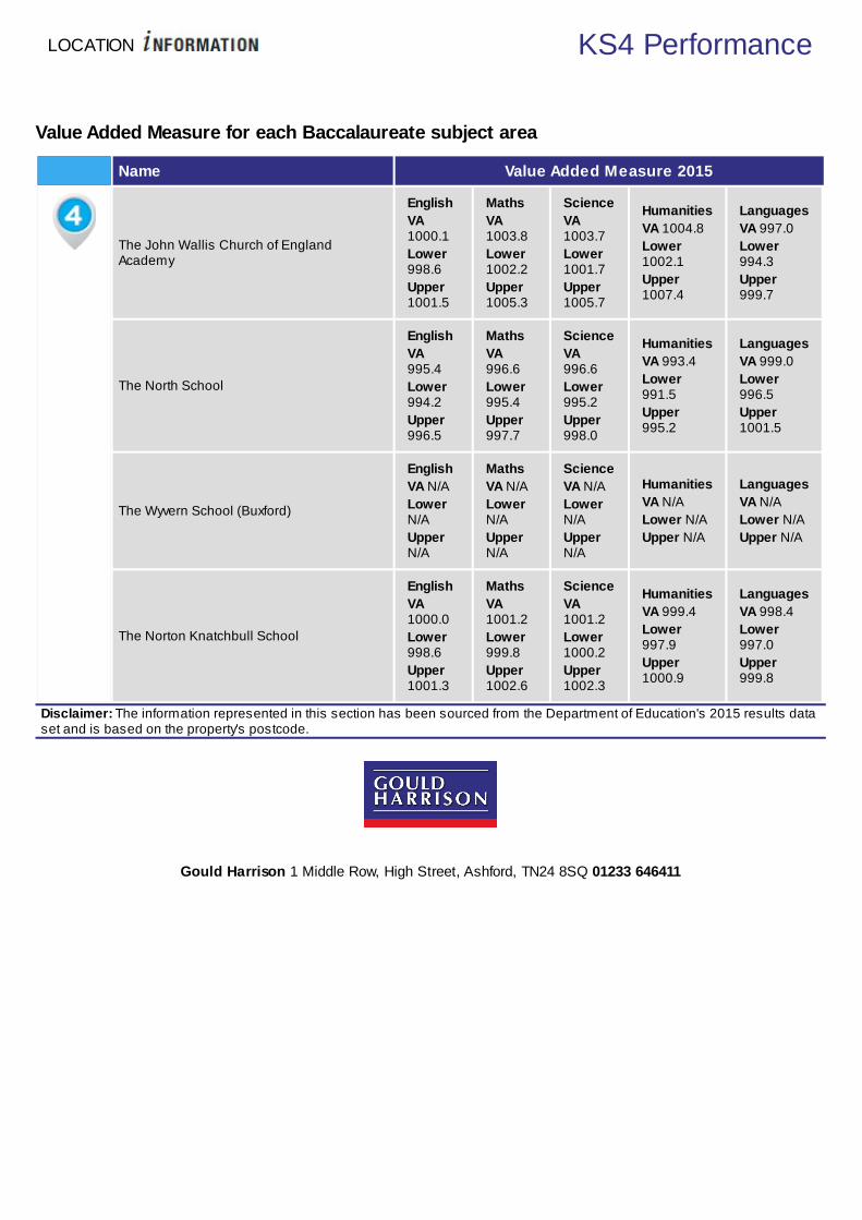
Value Added Measure for each Baccalaureate subject area
Name Value Added Measure 2015
The John Wallis Church of EnglandAcademy
EnglishVA1000.1Lower998.6Upper1001.5
MathsVA1003.8Lower1002.2Upper1005.3
ScienceVA1003.7Lower1001.7Upper1005.7
HumanitiesVA 1004.8Lower1002.1Upper1007.4
LanguagesVA 997.0Lower994.3Upper999.7
The North School
EnglishVA995.4Lower994.2Upper996.5
MathsVA996.6Lower995.4Upper997.7
ScienceVA996.6Lower995.2Upper998.0
HumanitiesVA 993.4Lower991.5Upper995.2
LanguagesVA 999.0Lower996.5Upper1001.5
The Wyvern School (Buxford)
EnglishVA N/ALowerN/AUpperN/A
MathsVA N/ALowerN/AUpperN/A
ScienceVA N/ALowerN/AUpperN/A
HumanitiesVA N/ALower N/AUpper N/A
LanguagesVA N/ALower N/AUpper N/A
The Norton Knatchbull School
EnglishVA1000.0Lower998.6Upper1001.3
MathsVA1001.2Lower999.8Upper1002.6
ScienceVA1001.2Lower1000.2Upper1002.3
HumanitiesVA 999.4Lower997.9Upper1000.9
LanguagesVA 998.4Lower997.0Upper999.8
Disclaimer: The information represented in this section has been sourced from the Department of Education's 2015 results dataset and is based on the property's postcode.
Gould Harrison 1 Middle Row, High Street, Ashford, TN24 8SQ 01233 646411

LOCATION Key Stage 5
Key Stage 5 - Information Approx Distance
Name: The John Wallis Church of England Academy
Address: Millbank Road, Ashford, TN23 3HG
Contact Number: 01233 623465
Age Range: 3-19 yrs
Local Education Authority: Kent
Religious Character: Church of England
Admission Policy: Comprehensive
1.35 miles
Name: The North School
Address: Essella Road, Ashford, TN24 8AL
Contact Number: 01233 614600
Age Range: 11-19 yrs
Local Education Authority: Kent
Religious Character: Does not apply
Admission Policy: Modern
2.57 miles
Name: The Norton Knatchbull School
Address: Hythe Road, Ashford, TN24 0QJ
Contact Number: 01233 620045
Age Range: 11-18 yrs
Local Education Authority: Kent
Religious Character: None
Admission Policy: Selective
2.85 miles
Name: Ashford School
Address: East Hill, Ashford, TN24 8PB
Contact Number: 01233 625171
Age Range: 3-18 yrs
Local Education Authority: Kent
Religious Character: Christian
2.89 miles
Disclaimer: The information represented in this section has been sourced from the Department of Education's 2015 results dataset and is based on the property's postcode.
Gould Harrison 1 Middle Row, High Street, Ashford, TN24 8SQ 01233 646411
LOCATION KS5 Performance
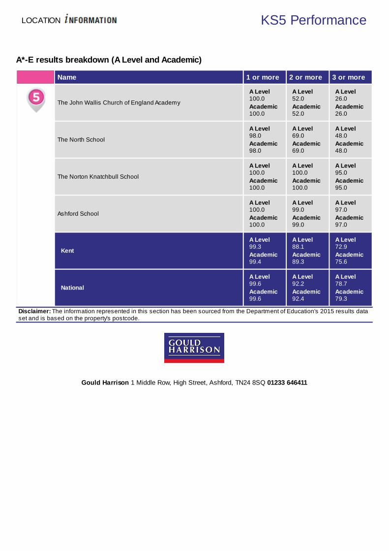
A*-E results breakdown (A Level and Academic)
Name 1 or more 2 or more 3 or more
The John Wallis Church of England Academy
A Level100.0Academic100.0
A Level52.0Academic52.0
A Level26.0Academic26.0
The North School
A Level98.0Academic98.0
A Level69.0Academic69.0
A Level48.0Academic48.0
The Norton Knatchbull School
A Level100.0Academic100.0
A Level100.0Academic100.0
A Level95.0Academic95.0
Ashford School
A Level100.0Academic100.0
A Level99.0Academic99.0
A Level97.0Academic97.0
Kent
A Level99.3Academic99.4
A Level88.1Academic89.3
A Level72.9Academic75.6
National
A Level99.6Academic99.6
A Level92.2Academic92.4
A Level78.7Academic79.3
Disclaimer: The information represented in this section has been sourced from the Department of Education's 2015 results dataset and is based on the property's postcode.
Gould Harrison 1 Middle Row, High Street, Ashford, TN24 8SQ 01233 646411


LOCATION Health
How local are the health services?
We all want good access to local health facilities, wherever we live. To see how well Steeds Lane is served, we have setout below the exact locations of hospitals, Accident & Emergency centres, GPs, pharmacies, dentists, out-of-hoursmedical care and walk-in clinics. Where it's available, you will find more detailed information, including the names ofpractitioners and their contact details.
Hospitals Approx Distance
William Harvey Hospital (ashford), Kennington Road, Ashford, Kent, TN24 0LZ 3.17 miles
A&E Approx Distance
William Harvey Hospital (ashford), Kennington Road, Ashford, Kent, TN24 0LZ 3.17 miles
Walk-in Clinics Approx Distance
Kingsnorth Medical Practice, Ashford Road, Kingsnorth, Ashford Kent, TN23 3ED 0.85 miles
Disclaimer: The information represented in this section has been sourced from the Department of Health's Open Data and isbased on the property's postcode.

LOCATION Health
GPs Approx Distance
KINGSNORTH MEDICAL PRACTICE, KINGSNORTH MEDICAL PRACT., KENT,TN23 3ED 0.85 miles
SINGLETON SURGERY, THE SURGERY, KENT, TN23 5SU 1.74 miles
ST STEPHENS HEALTH CENTRE, ST STEPHENS HEALTH CENTRE, KENT, TN235AQ 1.75 miles
MUSGROVE PARK MEDICAL CENTRE, MUSGROVE PARK MEDICAL CTR, KENT,TN23 7SP 1.93 miles
Disclaimer: The information represented in this section has been sourced from the Department of Health's Open Data and isbased on the property's postcode.
Dental Surgeons Approx Distance
Beaconsfield Dental Practice, St Stephens Health Centre, ASHFORD, Kent, TN235AQ 1.75 miles
Oradent, 169 Beaver Road, ASHFORD, Kent, TN23 7SG 2.03 miles
Singleton Dental Practice, 10 The Singleton Centre, ASHFORD, Kent, TN23 5GR 2.42 miles
Sunnyside Dental Practice, Elwick Road, ASHFORD, Kent, TN23 1NN 2.58 miles
Leafield Dental Surgery, Church Road, ASHFORD, Kent, TN23 1RD 2.61 miles
Disclaimer: The information represented in this section has been sourced from Experian and is based on the property'spostcode.
Gould Harrison 1 Middle Row, High Street, Ashford, TN24 8SQ 01233 646411


LOCATION Amenities
What about local amenities?
There are a number of local amenities on offer in the area around Steeds Lane. The tables below give the addresses oflocal shops, restaurants, pubs, gyms and even golf clubs.
Local Grocers and Convenience Stores Approx Distance
Stanhope Minimarket, 192 Speldhurst Close, ASHFORD, Kent, TN23 5TS 1.53 miles
One Stop Community Stores Ltd, 39-41 Court Wurtin Beaver Lane, ASHFORD, Kent, TN23 5NH 1.87 miles
Costcutter, 101-103 Beaver Lane, ASHFORD, Kent, TN23 5NU 1.98 miles
Costcutter, Brookfield Road, ASHFORD, Kent, TN23 4ES 2.11 miles
M & S Latestop, 90 Hunter Avenue, ASHFORD, Kent, TN24 0HG 2.48 miles
Supermarkets Approx Distance
Tesco Superstore, Moatf ield Meadow, ASHFORD, Kent, TN23 3LU 1.0 miles
The Co-operative Food, 83 Hunter Avenue, ASHFORD, Kent, TN24 0HG 2.48 miles
Tesco Stores, Mace Lane, ASHFORD, Kent, TN24 8DN 2.68 miles
Tesco Extra, Hythe Road, ASHFORD, Kent, TN24 0YE 2.88 miles
Waitrose, Repton Park, ASHFORD, Kent, TN23 3RT 3.25 miles
Disclaimer: The information represented in this section has been sourced from Experian and is based on the property'spostcode.

LOCATION Amenities
Nightclubs Approx Distance
Club Horizon, 48 Ferry Road, RYE, East Sussex, TN31 7DN 12.38 miles
Club Chemistry, 15 Station Road East, CANTERBURY, Kent, CT1 2RB 14.64 miles
Steinbeck and Shaw, St George's Place, CANTERBURY, Kent, CT1 2JT 15.01 miles
Coffee Romba, Gabriels Hill, MAIDSTONE, Kent, ME15 6JJ 18.6 miles
Lockmeadow Entertainment Centre, Barker Road, MAIDSTONE, Kent, ME16 8SF 18.68 miles
Pubs / Bars / Inns Approx Distance
The Queens Head, Ashford Road, ASHFORD, Kent, TN23 3ED 0.85 miles
The French Connection, Hall Avenue, ASHFORD, Kent, TN24 0GA 1.89 miles
The Albion, 2 Albion Place, ASHFORD, Kent, TN24 0BU 2.11 miles
The Locomotive, 65-67 Beaver Road, ASHFORD, Kent, TN23 7SF 2.12 miles
The Kings Head - Shepherd Neame Pubs, Woodchurch Road, ASHFORD, Kent, TN26 1LQ 2.13 miles
Wine Bars Approx Distance
Ampersand Design Cafe, 46 Tontine Street, FOLKESTONE, Kent, CT20 1JU 13.99 miles
Lime's Lounge, 13 Rosemary Lane, CANTERBURY, Kent, CT1 2PN 14.74 miles
Alberry's Wine Bar, 38 St Margarets Street, CANTERBURY, Kent, CT1 2TY 14.88 miles
Bramley's, 15 Orange Street, CANTERBURY, Kent, CT1 2JA 15.08 miles
Deco 5, 15-17 Oxford Street, WHITSTABLE, Kent, CT5 1DB 18.42 miles
Restaurants Approx Distance
Mcdonald's Restaurants Ltd, The Parade, ASHFORD, Kent, TN24 0HT 1.83 miles
Table Table, French Connection Hall Avenue, ASHFORD, Kent, TN24 0GN 1.96 miles
Wagamama, Ashford Designer Outlet, ASHFORD, Kent, TN24 0SD 2.05 miles
Mcdonald's Restaurants, Kimberley Way, ASHFORD, Kent, TN24 0SD 2.05 miles
Pizza Express, Unit 85-86, ASHFORD, Kent, TN24 0SD 2.05 miles
Golf Club / Courses / Professionals Approx Distance
Great Chart Golf & Leisure, Bridge Farm, ASHFORD, Kent, TN23 3BW 3.88 miles
Ashford Golf Club, Sandyhurst Lane, Ashford, Kent, TN25 4NT 4.37 miles
Tenterden Golf Club, Woodchurch Road, TENTERDEN, Kent, TN30 7DR 7.2 miles
Chart Hills Golf Club, Biddenden, ASHFORD, Kent, TN27 8JX 9.52 miles
Little Stone Warren Golf Club, St Andrew s Road, NEW ROMNEY, Kent, TN28 8RB 9.58 miles
Disclaimer: The information represented in this section has been sourced from Experian and is based on the property'spostcode.
Gould Harrison 1 Middle Row, High Street, Ashford, TN24 8SQ 01233 646411

LOCATION Amenities
Places of Worship Approx Distance
The Kingdom Hall Of Jehovah's Witnesses, Hamstreet Road, ASHFORD, Kent, TN26 1NL 1.01 miles
Highfield Community Church, 272 Kingsnorth Road, ASHFORD, Kent, TN23 6LU 1.38 miles
The King Of Glory Christian Assembly, Kingsnorth Industrial Estate, ASHFORD, Kent, TN23 6LN 1.58 miles
St Simon Stock, Brookfield Road, ASHFORD, Kent, TN23 4EU 2.05 miles
Christ Church C Of E Church, Beaver Road, ASHFORD, Kent, TN23 7SR 2.11 miles
Banks / Financial Institutions Approx Distance
The Co-operative Bank, 21 Bank Street, ASHFORD, Kent, TN23 1DG 2.73 miles
Tsb, 17 Bank Street, ASHFORD, Kent, TN23 1DF 2.75 miles
Hsbc Bank Plc, 39 High Street, ASHFORD, Kent, TN24 8TG 2.79 miles
Lloyds Bank, 81 High Street, ASHFORD, Kent, TN24 8SS 2.8 miles
Natw est, 20 High Street, ASHFORD, Kent, TN24 8SH 2.83 miles
DIY Stores Approx Distance
Dad, Unit 12-15, ASHFORD, Kent, TN23 6LL 1.63 miles
B & Q Plc, Norman Road, ASHFORD, Kent, TN23 7DG 1.96 miles
Hinges & Brackets, 107 Beaver Road, ASHFORD, Kent, TN23 7SG 2.03 miles
The Flat Pack Man, 28 Low er Denmark Road, ASHFORD, Kent, TN23 7SY 2.18 miles
Homebase Ltd, Unit 2, ASHFORD, Kent, TN24 0SG 2.25 miles
Hotels Approx Distance
Ashford International Hotel, Simone Weil Avenue, ASHFORD, Kent, TN24 8UX 3.39 miles
Holiday Inn, Canterbury Road, ASHFORD, Kent, TN24 8QQ 3.43 miles
Travelodge, Eureka Leisure Park, ASHFORD, Kent, TN25 4BN 3.65 miles
The Conningbrook Hotel - Shepherd Neame Pubs, Canterbury Road, ASHFORD, Kent, TN249QR
4.21 miles
The Railw ay Hotel, Station Road, ASHFORD, Kent, TN26 2DF 5.62 miles
Theatres / Concert Halls Approx Distance
Fhods, The Tow er Theatre, FOLKESTONE, Kent, CT20 3HL 11.87 miles
Arden Theatre, Leslie Smith Drive, FAVERSHAM, Kent, ME13 8PW 14.29 miles
The Marlow e Theatre, The Friars, Canterbury, Kent, CT1 2AS 15.07 miles
Playhouse Theatre, 104 High Street, WHITSTABLE, Kent, CT5 1AZ 18.54 miles
Haslet Theatre, Earl Street, MAIDSTONE, Kent, ME14 1PL 18.75 miles
Disclaimer: The information represented in this section has been sourced from Experian and is based on the property'spostcode.
Gould Harrison 1 Middle Row, High Street, Ashford, TN24 8SQ 01233 646411

LOCATION Amenities
Cinemas Approx Distance
Cinew orld, Eureka Leisure Park, ASHFORD, Kent, TN25 4BN 3.65 miles
Kino Digital, Lion Street, RYE, East Sussex, TN31 7LB 12.31 miles
The Silver Screen Cinema, The Tow n Hall, FOLKESTONE, Kent, CT20 1DY 13.85 miles
The Royal Cinema, 9 Market Place, FAVERSHAM, Kent, ME13 7AG 14.35 miles
Odeon Cinemas Ltd, 45 St Georges Place, CANTERBURY, Kent, CT1 1UP 14.98 miles
Leisure Centres Approx Distance
Kingsnorth Recreation Centre, Field View, ASHFORD, Kent, TN23 3NZ 0.83 miles
Ashford International Sports & Social Club Ltd, 181 Beaver Road, ASHFORD, Kent, TN23 7SG 2.03 miles
The Stour Centre, Station Approach, ASHFORD, Kent, TN23 1ET 2.6 miles
Tenterden Leisure Centre Trust, Recreation Ground Road, TENTERDEN, Kent, TN30 6RA 8.1 miles
Freedom Leisure, The Grove, RYE, East Sussex, TN31 7ND 12.1 miles
Newsagents Approx Distance
Mccolls, 2 Stanhope Court, ASHFORD, Kent, TN23 5EW 1.58 miles
Dog World, Williamson House, ASHFORD, Kent, TN23 6LW 1.66 miles
South Willesborough New sagents, 63 Gladstone Road, ASHFORD, Kent, TN24 0BZ 2.02 miles
Martins, Brookfield Post Off ice, ASHFORD, Kent, TN23 5ER 2.19 miles
County Square, 28A County Square, ASHFORD, Kent, TN23 1AE 2.7 miles
Post Offices Approx Distance
Stubbs Cross Post Off ice, 3 Tally House Road, ASHFORD, Kent, TN26 1HJ 1.42 miles
Post Off ice Ltd, 2 Stanhope Court, ASHFORD, Kent, TN23 5EW 1.58 miles
Kingsnorth Road Sub Post Off ice, Kingsnorth Road, ASHFORD, Kent, TN23 6HZ 1.69 miles
New tow n Stores & Post Off ice, 20 New tow n Green, ASHFORD, Kent, TN24 0PE 2.11 miles
Brookfield Post Off ice, 7 Brookfield Court, ASHFORD, Kent, TN23 5ER 2.19 miles
Disclaimer: The information represented in this section has been sourced from Experian and is based on the property'spostcode.
Gould Harrison 1 Middle Row, High Street, Ashford, TN24 8SQ 01233 646411


LOCATION Policing
Understanding who polices your neighbourhood
When you move to a new area, you want to know the arrangements for local community policing. See below for essentialinformation about police services near to Steeds Lane. We have included location and contact details for the police stationand wherever possible, details of police officers assigned to the area.
Your policing neighbourhood
The name of your policing neighbourhood is Ashford - Weald East and it has a population of 1996.
Weald East ward covers Kingsnorth, Mersham and Broad Oak and has more than 800 households.
Your Local Policing Team
Name Rank Tel No. E-mail
Jasmine Bloomfield Sergeant 101
Kim Cameron Sergeant 101
Gavin Hart Sergeant 101
Bradley Hobbs PCSO 101
Aarron Newell PCSO 101
Lee Sinden PCSO 101
Disclaimer: The information represented in this section has been sourced from data.police.uk.
Locations of Interest
Ashford Police Station stationTufton Street, Ashford
9am - 5pm Monday to Saturday (excluding bank holidays)Disclaimer: The information represented in this section has been sourced from data.police.uk.

Gould Harrison 1 Middle Row, High Street, Ashford, TN24 8SQ 01233 646411


