douglas creek allotment management plan revision and …€¦ · · 2015-01-15douglas creek...
TRANSCRIPT
DOI-BLM-OR-134-2014-0008 Page 1
Douglas Creek Allotment Management Plan (AMP) Revision and Douglas Creek Canyon Restoration Environmental Assessment
DOI-BLM-OR-134-2014-0008-EA
Grazing Authorization Number 3600778
January 2015
Bureau of Land Management Wenatchee Field Office
915 N. Walla Walla Avenue Wenatchee, WA 98801

DOI-BLM-OR-134-2014-0008 Page 2
Table of Contents 1. Introduction and Background ............................................................................................................... 4
1.1 Conformance Review and Applicable Laws, Regulations, and Policies ............................................. 4
1.2 Purpose and Need for Action and Decision to be Made ................................................................... 7
1.3 Scoping, Tribal Consultation, and Public Involvement ...................................................................... 7
1.4 Issues Identified ................................................................................................................................. 8
1.5 Resources Eliminated from Further Analysis .................................................................................. 10
2. Proposed Actions and Alternatives ......................................................................................................... 11
2.1 Description of Alternative 1 – The Proposed Action ......................................................................... 11
2.1.1 Douglas Creek Allotment Management Plan .............................................................................. 11
2.1.2 Douglas Creek Canyon Proposed Action ..................................................................................... 16
2.1.3 Weed Treatment: Douglas Creek Allotment and Douglas Creek Canyon .................................. 20
2.1.4 Design Features for all Action Alternatives: Cultural Resources ................................................ 22
2.1.5 Monitoring and Adaptive Management ..................................................................................... 22
2.2 Description of Alternatives to the Proposed Action ......................................................................... 24
2.2.1 Alternative 2 - No Action (Continuation of Current Management) ............................................ 24
2.2.2 Alternative 3 - No Grazing........................................................................................................... 24
2.2.3 Alternative 4 - Lessee’s Application to Graze ............................................................................. 24
3. Affected Environment and Environmental Effects ................................................................................. 25
3.1 Issue 1: Upland Watershed Function .............................................................................................. 30
3.1.1 Affected Environment ................................................................................................................. 30
3.1.2 Direct and Indirect Effects from the Proposed Action (Alternative 1) ....................................... 31
3.1.3 Direct and Indirect Effects from No Action (Alternative 2) ........................................................ 33
3.1.4 Direct and Indirect Effects from No Grazing (Alternative 3) ....................................................... 34
3.1.5 Direct and Indirect Effects from Lessee’s Application (Alternative 4) ........................................ 35
3.2 Issue 2: Riparian-Wetland Watershed Function ............................................................................ 36
3.2.1 Affected Environment ................................................................................................................. 36
3.2.2 Direct and Indirect Effects from the Proposed Action (Alternative 1) ....................................... 37
3.2.3 Direct and Indirect Effects from No Action (Alternative 2) ........................................................ 38
3.2.4 Direct and Indirect Effects from No Grazing (Alternative 3) ...................................................... 39
3.2.5 Direct and Indirect Effects from Lessee’s Application (Alternative 4) ....................................... 39
3.3 Issue 3: Sensitive Wildlife Species ................................................................................................... 40

DOI-BLM-OR-134-2014-0008 Page 3
3.3.1 Affected Environment ................................................................................................................. 40
3.3.2 Direct and Indirect Effects from the Proposed Action (Alternative 1) ....................................... 41
3.3.3 Direct and Indirect Effects from No Action (Alternative 2) ........................................................ 44
3.3.4 Direct and Indirect Effects from No Grazing (Alternative 3)....................................................... 45
3.3.5 Direct and Indirect Effects from Lessee’s Application (Alternative 4) ........................................ 46
3.4 Issue 4: Sensitive Plant Species ....................................................................................................... 47
3.4.1 Affected Environment ................................................................................................................. 47
3.4.2 Direct and Indirect Effects from the Proposed Action (Alternative 1) ....................................... 47
3.4.3 Direct and Indirect Effects from No Action (Alternative 2) ........................................................ 48
3.4.4 Direct and Indirect Effects from No Grazing (Alternative 3)....................................................... 49
3.4.5 Direct and Indirect Effects from Lessee’s Application (Alternative 4) ........................................ 49
3.5 Issue 5: Socioeconomics ................................................................................................................. 49
3.5.1 Affected Environment ................................................................................................................. 49
3.5.2 Direct and Indirect Effects from the Proposed Action (Alternative 1) ....................................... 49
3.5.3 Direct and Indirect Effects from No Action (Alternative 2) ........................................................ 50
3.5.4 Direct and Indirect Effects from No Grazing (Alternative 3)....................................................... 50
3.5.5 Direct and Indirect Effects from Lessee’s Application (Alternative 4) ........................................ 50
3.6 Issue 6: Cultural ............................................................................................................................... 50
3.6.1 Affected Environment ................................................................................................................. 50
3.6.2 Direct and Indirect Effects from the Proposed Action (Alternative 1) ....................................... 51
3.6.3 Direct and Indirect Effects from No Action (Alternative 2) ........................................................ 51
3.6.4 Direct and Indirect Effects from No Grazing (Alternative 3)....................................................... 52
3.6.5 Direct and Indirect Effects from Lessee’s Application (Alternative 4) ........................................ 52
3.7 Cumulative Effects ............................................................................................................................ 52
4. Tribes, Individuals, Organizations, or Agencies Consulted ..................................................................... 54
5. List of Preparers ...................................................................................................................................... 54
6. References .............................................................................................................................................. 56
7. Glossary .................................................................................................................................................. 60
Appendix A: Maps ....................................................................................................................................... 62
Appendix B: The Douglas Creek Allotment Management Plan (AMP) Revision ......................................... 66
Appendix C. Invasive and Noxious Weeds ................................................................................................. 72

DOI-BLM-OR-134-2014-0008 Page 4
1. Introduction and Background The Bureau of Land Management Wenatchee Field Office (BLM) is considering requests to graze livestock in the Douglas Creek grazing allotment and unleased adjacent areas, and is simultaneously considering measures to improve land health and watershed conditions in the area and in the Douglas Creek canyon. The Douglas Creek allotment, adjacent unleased areas, and Douglas Creek canyon comprise the action area for this environmental assessment (EA) (Map A-1). The action area is located approximately 18 miles east-northeast of Wenatchee, Washington in south-central Douglas County. The legal description of the action area includes portions of T.23 N. R.23 E., sections 8-11, 13-16, and 21-24. Additional BLM-administered portions of Douglas Creek canyon in T.23 N. R.23 E., section 5 and T.24 N. R.23 E., sections 19, 29, 30, and 32 are also analyzed in this EA. The action area is part of the Douglas Creek watershed (analysis area). The analysis area is approximately 132,056 acres in size and includes approximately 14,530 acres of BLM-administered lands (11% of the watershed). Douglas Creek allotment includes six pastures encompassing 4,092 acres1. A currently unleased area (termed the “New Acquisition” in USDI BLM 2014) of 440 acres is included in the action area and described in this EA as pastures Six and Seven (Map A-2). The Douglas Creek canyon has not been included in a grazing lease since 1974 (USDI BLM 2014, p.14). Therefore, the canyon (approximately 1,613 acres) is treated as an independent unit in this EA. The BLM authorizes livestock grazing as a component of its multiple-use program under the Federal Lands Policy and Management Act of 1976 (FLPMA), and following Spokane District Resource Management Plan (RMP) direction and Federal Grazing Administration regulations (43 CFR 4100) (as described in Section 1.1). The BLM manages land health and watershed function as directed by the RMP and Federal Grazing Administration regulations (see Section 1.1). In May 2014, a BLM Interdisciplinary Team (IDT) conducted a land health evaluation (LHE) and determination of land health standards for the analysis area. The LHE concluded that BLM-administered lands in the analysis area were meeting or making significant progress towards meeting most standards, and identified portions of the action area where land health improvements could be made. Standards for rangeland health and LHE results are described in Section 3. The LHE is incorporated by reference into this EA and available at http://www.blm.gov/or/districts/spokane/plans/inventas.php.
1.1 Conformance Review and Applicable Laws, Regulations, and Policies This document is tiered to the Spokane District RMP, approved in 1987, and the management alternatives analyzed are in conformance with the RMP. Applicable guidance is provided in the RMP Record of Decision (RMP ROD), the Spokane District Resource Management Plan EIS, and the Spokane Resource Management Plan Amendment EIS. The RMP ROD identified objectives and management actions for each resource on public lands managed by the BLM Wenatchee Field Office. Action alternatives in this EA propose treatments in support of RMP 1 Acreages described in the majority of this document are based on GIS analysis, and should be considered estimates. Acreages described in the AMP (Appendix B) are based on legal descriptions of grazing leases.

DOI-BLM-OR-134-2014-0008 Page 5
resource objectives for livestock grazing, land health, sensitive species, and invasive species. RMP and regulatory support for these treatments is provided below. The BLM manages livestock grazing based on the following, laws, regulations, land use plan, and guidance:
• The FLPMA (43 U.S.C. § 1701 et seq.), which directs multiple uses on BLM-administered lands to meet present and future needs of the American people, with consideration given to the relative values of the resources and not necessarily to the combination of uses that will give the greatest economic return or the greatest unit output;
• The Taylor Grazing Act of 1934 (43 U.S.C. 315) which directs the BLM to issue grazing leases with appropriate terms and conditions to provide for rangeland use and prevent overgrazing and soil deterioration;
• The Department of Interior Grazing Administration Federal Regulations (43 CFR 4100),
which direct BLM to provide for the sustainability of the western livestock industry and communities dependent upon productive, healthy, public rangelands (43 CFR 4100.0-2); and
• The RMP ROD, which directs the BLM to develop or revise management systems on “I”
(improve) category allotments, such as the Douglas Creek allotment, to benefit range and riparian habitat conditions (USDI BLM 1987, p. 24-25); and
• BLM Instruction Memorandum No. 2013-094, which provides guidance on modification of uses authorized or managed by the BLM (including livestock grazing) during drought conditions (USDI BLM 2013).
The BLM manages land health and watershed function under the following direction:
• The Fundamentals of Rangeland Health (43 CFR 4180.1), which require BLM to support proper watershed function, ecological processes, water quality, and habitat for sensitive species;
• The RMP ROD, which directs the BLM to: a) implement habitat improvement projects, as well as vegetation manipulation projects to improve habitat (p.19-20); b) protect or enhance water quality (p.7), minimize the degradation of stream banks and the loss of riparian vegetation (p.19); and c) improve wildlife habitat in the Douglas Creek riparian area by planting shrubs and grasses, controlling noxious weeds (see Glossary), and excluding cattle from specific areas (p.20) (USDI BLM 1987); and
• The Standards for Rangeland Health and Guidelines for Livestock Grazing Management
for Public Lands Administered by the Bureau of Land Management in the States of Oregon and Washington (Standards for Rangeland Health, USDI BLM 1997), which define rangeland health standards in watersheds (see Section 3).

DOI-BLM-OR-134-2014-0008 Page 6
The BLM manages sensitive species habitat under the following land use plan, policies, and regulation:
• The RMP ROD states that management activities in sensitive species habitat would be designed specifically to benefit sensitive species whenever possible, through habitat improvement or protection (USDI BLM 1987, p. 21);
• The BLM’s 6840 Manual for Special Status Species (USDI BLM 2001), which directs the BLM to manage sensitive species (see Glossary) to promote their conservation and to minimize the likelihood and need for listing under the Endangered Species Act (ESA);
• The Endangered Species Act, which requires Federal agencies to protect and recover imperiled species (listed as “Threatened” or “Endangered”) and the ecosystems on which they depend; and
• The BLM’s National Sage Grouse Strategy (USDI BLM 2004), which directs BLM to
manage public lands to maintain, enhance, and restore sage-grouse and sagebrush habitats while continuing to provide for multiple uses of BLM lands. The BLM used the State of Washington Greater Sage-Grouse Recovery Plan (Stinson et al. 2004) as a technical reference when developing management consistent with the National Sage Grouse Strategy.
The BLM manages invasive species and noxious weeds under the following policies and regulation:
• Treatments of invasive species proposed in the action alternatives conform to all applicable guidance and standards set forth in the Vegetation Treatments Using Herbicides on BLM Lands in 17 Western States Programmatic EIS (USDI BLM 2007, Vegetation Treatments PEIS, hereafter), to which this EA is tiered;
• The Agricultural Risk Protection Act of 2000 (Public Law 106-224) authorizes the BLM to manage noxious weeds and to coordinate with other federal and state agencies in activities to eradicate, suppress, control, prevent, or retard the spread of any noxious weeds on federal lands;
• The Federal Insecticide, Fungicide, and Rodenticide Act (FIFRA, 7 U.S.C. 136r-1)
directs agencies to follow an integrated pest management approach to managing invasive species; and
• The Federal Noxious Weed Act of 1974 directs federal agencies to control or contain
undesirable plant species using methods including biological agents and the BLM Manual 9014 (Use of Biological Control Agents of Pests on Public Land) provides guidance for the use of biological control agents for integrated pest management (IPM) programs on BLM-administered lands. Release of biological control agents is regulated by the Animal and Plant Health Inspection Service (APHIS) and requires a permit (APHIS 2014).

DOI-BLM-OR-134-2014-0008 Page 7
1.2 Purpose and Need for Action and Decision to be Made The purpose of the action is to address applications to: a) renew the current Douglas Creek allotment grazing lease and b) authorize grazing in unleased BLM lands adjacent to the Douglas Creek allotment. Another purpose of the action is to maintain or improve both riparian and upland health in Douglas Creek allotment, Douglas Creek canyon and adjacent unleased BLM lands (action area), including habitat for sensitive species. The need for the action arises from the BLM’s requirement to respond to external requests for renewal of grazing leases and grazing of unleased BLM lands as described in the FLMPA of 1976 (43 U.S.C. § 1701 et seq.), grazing regulations at 43 CFR 4100, and the Taylor Grazing Act (43 U.S.C 315, 1934). Additionally, the Spokane District RMP ROD directs BLM to continue to authorize grazing leases and to maintain or revise management systems on Improve category allotments (USDI BLM 1987, p. ii). The need for maintaining or improving riparian and upland health in the action area is to meet federal grazing objectives for promoting healthy sustainable rangeland ecosystems (43 CFR 4100.0-2), as outlined in the Fundamentals of Rangeland Health (43 CFR 4180.1) and the Standards for Rangeland Health (BLM 1997). The RMP ROD directs BLM to: a) preserve, protect, and restore natural functions in riparian and wetland areas (USDI BLM 1987, p. 19); and b) design vegetation management projects to improve wildlife habitat and to plant shrubs and control noxious weeds in the Douglas Creek Management Area (USDI BLM 1987, p. 20).
Decisions to be Made
The BLM will decide whether or not to:
• Renew Douglas Creek allotment grazing authorization No. 3600778, and if so under what terms and conditions;
• Authorize grazing on lands adjacent to the Douglas Creek allotment, and incorporate these newly available lands into the Douglas Creek allotment;
• Adopt and implement the proposed allotment management plan (AMP) revision; • Implement restoration projects to improve shrub-steppe habitat and riparian-wetland
conditions in the action area; and
• Manage noxious and invasive weed species in the action area.
1.3 Scoping, Tribal Consultation, and Public Involvement On May 30, 2014 the BLM posted a scoping letter on its public NEPA website describing the proposed action and purpose and need for action in the action area, as well as notified the

DOI-BLM-OR-134-2014-0008 Page 8
Colville Confederated Tribes and the Yakama Indian Nation and adjacent landowners including, The Nature Conservancy, United States Fish and Wildlife Service, and Washington State Department of Fish and Wildlife. No comments were received in response to this posting. In addition, scoping and information meetings were held with the current Douglas Creek allotment grazing lessee. Additionally, a copy of the public scoping notice and cover letters were individually addressed and sent to the tribal Chairs, as well as the Cultural Resources Program managers and Tribal Historic Preservation Officers (THPOs) of the Colville Confederated Tribes and the Yakama Indian Nation.
Formal National Historic Preservation Act (NHPA) Section 106 consultations for projects discussed in this EA were initiated on August 15, 2014 with the Washington State Department of Archaeology & Historic Preservation (DAHP), the Colville Confederated Tribes and the Yakama Indian Nation. Parties were given a 30-day response period. The DAHP concurred with the Area of Potential Effect (APE) on August 19, 2014. The BLM received concurrence with a determination of no adverse effect to cultural resources, from DAHP on September 30th, 2014, provided that site protection and archaeological monitoring takes place, as recommended. No response was received from tribes contacted.
1.4 Issues Identified Identification of relevant issues helped the BLM to consider alternate ways to achieve the purpose and need. Relevant issues facilitate a reasoned choice between alternatives, and are potentially associated with significant effects (USDI BLM 2008). Issues identified during internal and external scoping are detailed below. Indicators provided were used to describe the affected environment for each issue, measure change in the issue for different alternatives, and assess the impacts of alternatives on the issues. Issue 1: Watershed Function: Uplands
• How will BLM-administered grazing operations affect upland function in the action area?
• How will BLM upland shrub-steppe restoration projects affect upland function in the action area?
Indicators: Rangeland health attributes (soil stability, hydrologic function, biotic integrity), invasive species cover, fuels conditions
Issue 2: Watershed Function: Riparian-Wetland Areas and Water Quality
• How will modifications in Douglas Creek canyon dispersed recreation sites affect the function of riparian-wetland areas in the action area?
• How will riparian restoration activities in Douglas Creek canyon affect the function of riparian-wetland areas in the action area, including stream shading and riparian species composition?

DOI-BLM-OR-134-2014-0008 Page 9
• How will application of herbicide for restoration activities in Douglas Creek canyon
affect water quality in the action area?
Indicators: Douglas Creek riparian-wetland Properly Functioning Condition classification (PFC, see Glossary) indicators (hydrology, geomorphology, and vegetation), site-scale riparian cover, riparian species diversity, riparian structural diversity, riparian invasive species presence/density, water quality indicators (water temperature, dissolved oxygen, turbidity), presence of unstable banks and sediment delivery areas.
Issue 3: Sensitive Wildlife Species
• How will BLM-administered grazing operations affect habitat for greater sage-grouse (GSG) and sagebrush obligate/shrub-steppe associated species in the analysis area?
• How will restoration, range improvement, and herbicide use activities affect habitat for GSG and other sagebrush obligate/shrub-steppe associated species in the action area?
Indicators: Site-scale GSG habitat suitability as defined by Stiver et al. (2010) based on sagebrush cover and height, bunchgrass cover and height, forb cover and forb diversity.
• How will grazing, recreation, and restoration activities disturb native upland shrub-steppe associated species?
Indicators: noise disturbance (decibels, number of days, number of acres)
• How will restoration activities affect wildlife species associated with riparian habitat in the action area?
Indicators: Riparian overstory canopy cover, PFC classification.
Issue 4: Sensitive Plant Species
• How will restoration activities for longsepal globemallow affect habitat and/or population for this species?
Indicators: Presence, density, reproduction of longsepal globemallow in Douglas Creek canyon
Issue 5: Socio-Economics
• How will grazing authorization and terms and conditions affect ranchers and the local economy?
• How will upland restoration activities affect ranchers and the local economy?
Indicators: Animal Unit Months (AUMs; see Glossary), money provided to state and federal governments, financial contribution to local economy, cost of alternate feed.
Issue 6: Cultural

• How will BLM-administered grazing operations affect cultural resources in the action area?
• How will restoration and range improvement activities affect cultural resources in the action area?
Indicators: Disturbance to known archaeological sites, presence of healthy populations of culturally valued botanical resources.
1.5 Resources Eliminated from Further Analysis Resources that were considered but are not further analyzed in this EA are listed in Table 1 below. Table 1. Resources Eliminated from Further Analysis
Resource Not Present Rationale Present Not
Affected Action alternatives would not change existing access in the Access X action area.
Action alternatives would not change existing air quality. Air Quality X Areas of Critical Environmental X No ACECs in action area. Concern (ACEC’s)
No minority populations or low-income populations are Environmental present in the action area. Alternatives would have X Justice negligible or not disproportionately high and adverse
indirect human health or environmental effects. Action alternatives would result in less than 50 tons of
Greenhouse gas carbon emission, based on action scope and AUMs offered. X emissions This level is lower than that typically analyzed by federal agencies (USDI BLM 2008b). Although there are several locatable minerals (basalt, sand,
Mineral gravel) and leasable minerals (natural gas) found in the X Resources action area, development would not be profitable and is unlikely. Although approximately 200 acres of prime farmland (aggregated to include irrigated and/or drained farmland), Prime and and 570 acres of Farmland of Statewide Importance exist in Unique X the action area, action alternatives would not preclude Farmlands future agricultural uses (NRCS, 2013). Therefore, no impacts to Prime and Unique Farmlands are expected. Action alternatives would not substantially change Recreational Use X recreational use.
Visual Resources X Alternatives would not change existing visual corridors.
DOI-BLM-OR-134-2014-0008 Page 10
Resource Not Present Rationale Present Not
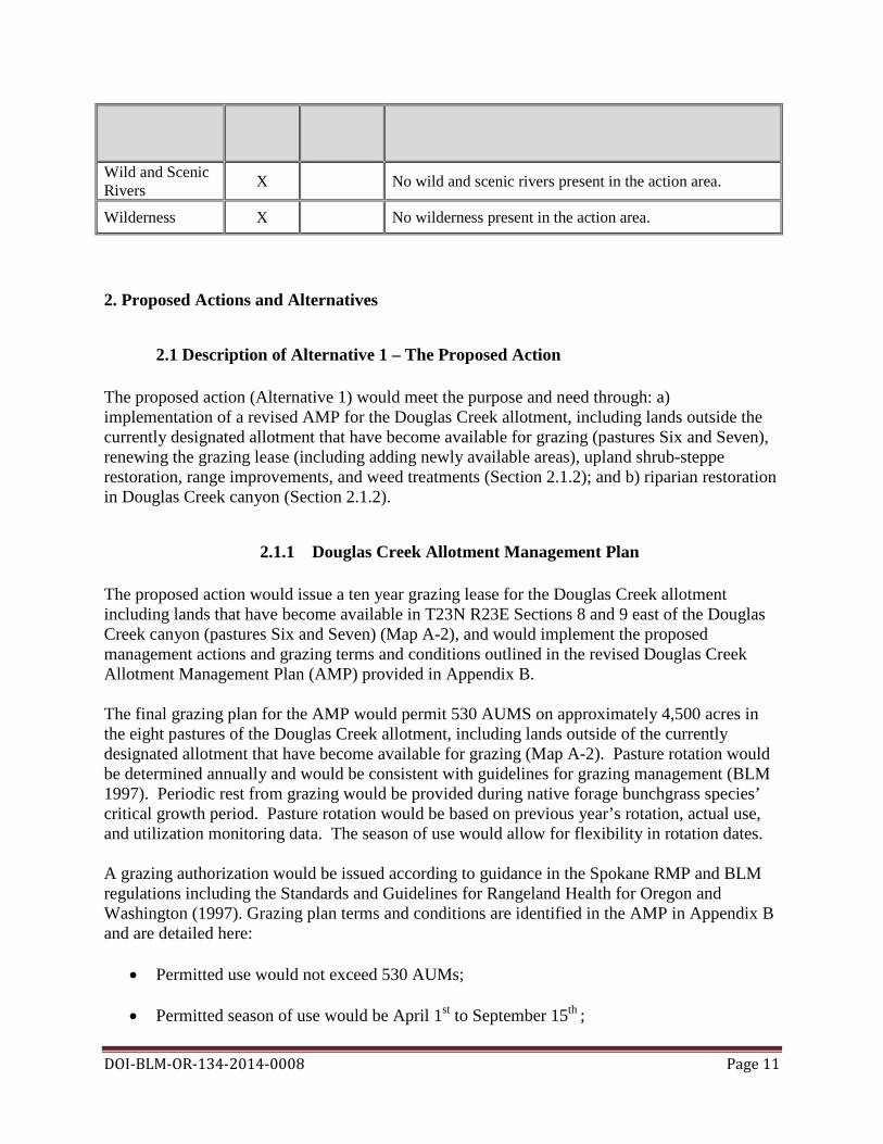
Affected Wild and Scenic X No wild and scenic rivers present in the action area. Rivers
Wilderness X No wilderness present in the action area.
DOI-BLM-OR-134-2014-0008 Page 11
2. Proposed Actions and Alternatives
2.1 Description of Alternative 1 – The Proposed Action The proposed action (Alternative 1) would meet the purpose and need through: a) implementation of a revised AMP for the Douglas Creek allotment, including lands outside the currently designated allotment that have become available for grazing (pastures Six and Seven), renewing the grazing lease (including adding newly available areas), upland shrub-steppe restoration, range improvements, and weed treatments (Section 2.1.2); and b) riparian restoration in Douglas Creek canyon (Section 2.1.2).
2.1.1 Douglas Creek Allotment Management Plan The proposed action would issue a ten year grazing lease for the Douglas Creek allotment including lands that have become available in T23N R23E Sections 8 and 9 east of the Douglas Creek canyon (pastures Six and Seven) (Map A-2), and would implement the proposed management actions and grazing terms and conditions outlined in the revised Douglas Creek Allotment Management Plan (AMP) provided in Appendix B. The final grazing plan for the AMP would permit 530 AUMS on approximately 4,500 acres in the eight pastures of the Douglas Creek allotment, including lands outside of the currently designated allotment that have become available for grazing (Map A-2). Pasture rotation would be determined annually and would be consistent with guidelines for grazing management (BLM 1997). Periodic rest from grazing would be provided during native forage bunchgrass species’ critical growth period. Pasture rotation would be based on previous year’s rotation, actual use, and utilization monitoring data. The season of use would allow for flexibility in rotation dates. A grazing authorization would be issued according to guidance in the Spokane RMP and BLM regulations including the Standards and Guidelines for Rangeland Health for Oregon and Washington (1997). Grazing plan terms and conditions are identified in the AMP in Appendix B and are detailed here:
• Permitted use would not exceed 530 AUMs;
• Permitted season of use would be April 1st to September 15th ;

DOI-BLM-OR-134-2014-0008 Page 12
• Cattle would be the only authorized livestock kind;
• Livestock would not exceed 200 head (cow or cow/calf pair). Schedule would be adjusted
to not exceed permitted AUMs dependent on livestock number;
• Livestock supplements would be placed at least 0.5 miles from water at a location determined by BLM and agreed upon by lessee; and
• Average utilization of key upland bunchgrasses not to exceed a moderate level (30 to 40%) of the current year’s growth by weight (Holecheck et al. 2011).
An interim grazing plan would be in effect until BLM and the lessee completed all range improvement and restoration projects (described below). The interim grazing plan would temporarily suspend some AUMs in pastures One, One A, and Five during restoration activities (Appendix B). During restoration in Pasture Six, additional forage (up to 60 AUMs) with no additional preference would be made available to achieve an average of 60% utilization on non-native, seeded grasses. Once restoration objectives (described below) were met, utilization in Pasture Six would be reduced to not exceed moderate levels. The BLM and authorized grazing lessee would implement four range improvement projects to improve rangeland health and livestock distribution in this allotment (Map A-2). Range improvements would include reinforcing a drift fence, rebuilding springs in Pastures Two and Four, and improving a well in Pasture Six. Range improvements are identified in the AMP in Appendix B. Douglas Creek Allotment Proposed Restoration Projects Shrub-steppe restoration would be implemented to maintain or improve land health (Pyke 2011) and to enhance habitat for sagebrush obligates in the allotment. BLM or its designee would implement shrub-steppe restoration in pastures One, One A, Five, and Six (Map A-3). Restoration is scheduled to be implemented beginning in 2016, but implementation schedules could vary depending on funding and logistics. Pasture One This shrub-steppe restoration project would take place on 125 acres in the southeastern portion of Pasture One in a historic Conservation Reserve Program (CRP) area (see Glossary). Proposed treatments would be designed to increase cover by native bunchgrasses and forbs and to reduce hazardous fuels (continuous annual grass cover), while protecting intact sagebrush. Restoration activities would begin in Pasture One in 2017. The BLM would exclude grazing in this restoration area beginning in the spring of 2018. Grazing exclusion from this restoration area would last until 66% of surviving grass plugs or seeded species produced seed, or no more than three growing seasons. Pasture One restoration project specifics

DOI-BLM-OR-134-2014-0008 Page 13
• The BLM would apply herbicide to reduce cover of non-native planted grasses, primarily crested wheatgrass. Spot-spray of herbicide would be applied in locations dominated by crested wheatgrass. Chemicals used would include glyphosate (trade names such as Roundup™) or a comparable non-residual herbicide.
• Native plugs would consist of native perennial bunchgrasses including: Great Basin
wildrye, Idaho fescue and bluebunch wheatgrass (90% of planted plugs). Native forb plugs would also be planted based on availability (10% of planted plugs). The BLM would hand-scalp small (less than ten square feet) areas for plug installation. Plugs would be installed at depths of two to six inches. Planted plug densities would be approximately 175 plugs per acre.
• Additionally, the BLM would hand seed native bunchgrass seed and imprint by raking or
harrow drawn by a small vehicle (such as an ATV), to ensure that native species successfully achieve dominance of the site. Seeding would occur in areas with bare ground.
• Herbicide application would occur several times during planted native species
establishment, to reduce weed competition. This herbicide application would use a non-residual herbicide (e.g. glyphosate). Plug installation, seeding, and maintenance weed spraying would occur at least twice, depending on seed/plug variability in survival.
• The BLM would install approximately 1.25 miles of fencing to exclude grazing from this
restoration area (Map A-4), following seeding and plugging. Pasture One A This shrub-steppe restoration project proposes to increase cover by native bunchgrasses on 100 acres in a historic CRP area in the pasture. Activities would begin in Pasture One A in 2021. The BLM would exclude grazing in this restoration area beginning in the spring of 2022, and would exclude grazing in this area for two growing seasons, resuming grazing in spring of 2025. Pasture One A restoration project specifics
• The BLM would replace non-native grasses with native shrubs, grasses, and forbs using intensive agricultural techniques (Benson et al. 2011). Activities would include site preparation including disking, harrowing, and one full year of chemical fallow using herbicide application to remove non-native species currently dominating this area. Herbicides could include chemicals with residual activity, such as Imazapic (first year of treatment), or non-residual herbicides, such as glyphosate.
• The BLM would seed native grasses using a small rangeland drill or similar mechanical seeder, if access to this site is feasible with this type of equipment. The BLM would harrow, mow, and/or use herbicide to decrease cheatgrass invasion in the site.
Pasture Five This shrub-steppe restoration and fuels reduction project proposes treatments that are designed to increase cover by native bunchgrasses, big sagebrush, and forbs, and to reduce hazardous fuels in

DOI-BLM-OR-134-2014-0008 Page 14
portions of Pasture Five where plant functional/structural groups are departed from reference state (300 acres). Restoration activities would be completed separately in two adjacent 150 acre patches, beginning in the fall of 2016 in Pasture Five’s southwestern portion. Cattle would be excluded in this western area for two growing seasons beginning in 2017; grazing would resume in the western portion of Pasture Five in the spring of 2019. Restoration activities would begin in the southeastern half of Pasture Five in fall of 2018. The BLM would exclude grazing in the eastern restoration area (150 acres) beginning in spring of 2019. Grazing exclusion from this restoration area would last until 66% of surviving grass plugs or seeded species produced seed, or no more than three growing seasons. Pasture Five restoration project specifics
• The BLM would harrow and apply herbicide to reduce cover of invasive species. Herbicide could include non-selective chemicals with residual action such as Imazapic, and non-residual non-specific chemicals like glyphosate applied at levels designed to eliminate annual grasses and retain perennial grasses. Spot spraying with glyphosate would be used following plug and seed establishment to control smooth brome and other annual grasses during stand establishment (Benson et al. 2011).
• The BLM would plant native plugs in loamy soil areas with few existing natives. Plugs would include bunchgrasses (80%) and Wyoming big sagebrush (20%).
• Additionally, the BLM would apply native grass seed in areas with few existing natives.
Seeding would supplement plug installation. Seed techniques would include hand broadcast or rangeland drill use, depending on access feasibility.
• Herbicide application would occur several times during native species establishment.
Plug installation and seeding would occur at least twice, depending on seedling survival.
• The BLM would install approximately 1.75 miles of fencing to exclude grazing from this restoration area.
Pasture Six This shrub-steppe restoration project proposes to increase the cover by big sagebrush and increase the cover by native bunchgrasses and forbs in a former agricultural area: identified as Douglas Pasture Six in this EA and as the New Acquisition Area in the LHE (250 acres). The BLM would achieve the objective to increase sagebrush cover, native forbs, and native bunchgrasses in several phases. Initially, the BLM would reduce the cover of non-native seeded grasses and increase the gap space between these grasses using grazing pressure. Once gaps developed, the BLM would seed these gaps directly and set up future native seed sources in islands, described below.
Pasture Six restoration project specifics

DOI-BLM-OR-134-2014-0008 Page 15
• Initial phase (gap development). The BLM would grant additional forage (up to 60 AUMs) in Pasture Six on an annual basis, with no additional preference assigned, in order to decrease cover by non-native seeded grasses including Sherman big bluegrass (Poa secunda juncifolia), thin wheatgrass (Thinopyron ponticum), and crested wheatgrass (Agropyron cristatum). Average utilization on current year’s growth on these non-native seeded grasses would not exceed 60%. The objective for this phase of restoration would be to reduce cover of non-native seeded species to less than 40%. Once this initial objective was met, AUMS offered would be reduced and average utilization target would be reduced to moderate levels (30 to 40% of the current year’s growth by weight). This cover objective could be modified depending on monitoring for other factors such as soil compaction. The BLM would apply herbicide such as glyphosate or Imazapic to control invasion by non-native (weed) species, as gaps developed in the treated stand.
• Second phase (gap seeding). Following reduction in cover of non-native seeded species and
development of gaps in their canopies, the BLM would seed the area with native species including bluebunch wheatgrass and Great Basin wildrye. Hoof pressure would be used to imprint native seed, as described in Brummer (2009). Due to grass competition and variability in hoof imprint, low seed survival (approximately 5%) is expected from this method.
• Third phase (native islands). The BLM would plant native plugs in small “islands” throughout the pasture. Establishment islands would have approximately 25 foot radii, installed at a density of one island per five acres. The BLM would plant plugs in small scalped areas (10 ft.2) within establishment islands, six to eight inches deep, spaced approximately six feet on center. Plug species would include Wyoming big sagebrush (80%), bunchgrasses (15%), and forbs (5%). Each scalped area would include one shrub plug, one grass plug and one forb plug. Planted areas would be protected with fencing (electric, hog wire, or barbed wire as described in Design Features) during establishment. Establishment would be defined as plugs being resistant to tugging and with 66% of surviving individuals reproductive. Establishment island exclosures would be installed over time, beginning in fall of 2017 and extending through fall of 2022. Less than 1% of this pasture would be in exclosures at any given time. Individual fenced areas would be removed following plug establishment, and materials would be used in other establishment islands within the pasture.
Design Features Common to Restoration and Range Improvements The following guidelines would be applied to rangeland improvement project implementation and maintenance:
• Fences would be constructed using approved standards in the BLM Fencing Handbook H 1741-1 (USDI BLM 1989). Fencing would utilize driven fence posts and four-strand barbed wire, or similar materials;
• Fences would be equipped with anti-strike markers to improve the visibility of wire and reduce the potential for wildlife collision with wires;
DOI-BLM-OR-134-2014-0008 Page 16
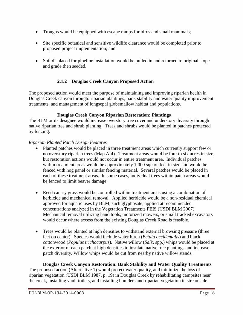
• Troughs would be equipped with escape ramps for birds and small mammals;
• Site specific botanical and sensitive wildlife clearance would be completed prior to proposed project implementation; and
• Soil displaced for pipeline installation would be pulled in and returned to original slope and grade then seeded.
2.1.2 Douglas Creek Canyon Proposed Action The proposed action would meet the purpose of maintaining and improving riparian health in Douglas Creek canyon through: riparian plantings, bank stability and water quality improvement treatments, and management of longsepal globemallow habitat and populations.
Douglas Creek Canyon Riparian Restoration: Plantings The BLM or its designee would increase overstory tree cover and understory diversity through native riparian tree and shrub planting. Trees and shrubs would be planted in patches protected by fencing. Riparian Planted Patch Design Features
• Planted patches would be placed in three treatment areas which currently support few or no overstory riparian trees (Map A-4). Treatment areas would be four to six acres in size, but restoration actions would not occur in entire treatment area. Individual patches within treatment areas would be approximately 1,000 square feet in size and would be fenced with hog panel or similar fencing material. Several patches would be placed in each of these treatment areas. In some cases, individual trees within patch areas would be fenced to limit beaver damage.
• Reed canary grass would be controlled within treatment areas using a combination of herbicide and mechanical removal. Applied herbicide would be a non-residual chemical approved for aquatic uses by BLM, such glyphosate, applied at recommended concentrations analyzed in the Vegetation Treatments PEIS (USDI BLM 2007). Mechanical removal utilizing hand tools, motorized mowers, or small tracked excavators would occur where access from the existing Douglas Creek Road is feasible.
• Trees would be planted at high densities to withstand external browsing pressure (three
feet on center). Species would include water birch (Betula occidentalis) and black cottonwood (Populus trichocarpus). Native willow (Salix spp.) whips would be placed at the exterior of each patch at high densities to insulate native tree plantings and increase patch diversity. Willow whips would be cut from nearby native willow stands.
Douglas Creek Canyon Restoration: Bank Stability and Water Quality Treatments
The proposed action (Alternative 1) would protect water quality, and minimize the loss of riparian vegetation (USDI BLM 1987, p. 19) in Douglas Creek by rehabilitating campsites near the creek, installing vault toilets, and installing boulders and riparian vegetation in streamside

DOI-BLM-OR-134-2014-0008 Page 17
areas disturbed by recreation activity. The BLM or its designee would complete these projects as funding and implementation priorities allowed.
• Rehabilitating dispersed campsites: The BLM would make modifications to three popular dispersed camping areas adjacent to Douglas Creek (Map A-4) to reduce sediment and pollution sources and restore riparian vegetation. The BLM would construct and designate four campsites at each of these three locations. Each campsite would include a picnic table, metal fire grill, and a graveled parking area. Campsites and roads to camp areas would be set a minimum of 50 feet from Douglas Creek’s wetted perimeter, above the five year floodplain, to protect riparian resources and to minimize impacts to existing trees and vegetation. The BLM would install fences and place boulders to limit recreational disturbance in the riparian area. Fencing at each site would be a maximum of 200 feet in length and would be installed above the creek’s five year floodplain. Less than 50 boulders would be placed at each site. Fencing materials and methods would be similar to fencing operations described above (without use of barbed wire), or would be constructed of wood. Boulder placement, materials, and methods would have similar characteristics to actions described above. Improved campsites would be established in currently disturbed areas. Total area covered by improved camping areas would be less than six acres. Areas outside the improved campsites and within currently disturbed dispersed camping areas would be restored and reseeded with a mix of native grasses. Riparian vegetation would be planted to provide wildlife cover, shade, and screening between campsites. Rehabilitation objectives would be to reduce the total area of disturbance in each camping areas. Revegetation would include a riparian terrace that has been impacted by invasive species and disturbance from campers (Map A-4) (USDI BLM 2014). In this area, herbicide would be applied to eliminate weeds including Russian knapweed (Acroptilon repens) (herbicide treatment described below). The BLM would install native Great Basin wildrye (Leymus cinereus) plugs and shrub plugs, including golden currant (Ribes aureum), to increase native species cover. Plugs would be established at high densities (two feet on center) to exclude weeds.
• Installation of vault toilets: The BLM would install permanent concrete vault toilets at
three heavily used locations in Douglas Creek canyon (Map A-4) as funding permitted. These locations attract visitors for camping, hiking, swimming and picnicking. The BLM would construct toilets in currently disturbed areas in Douglas Creek canyon, a minimum of 100 feet from the creek’s two year floodplain. The BLM would remove less than 500 square feet of riparian shrubs and no riparian trees during construction. Installed toilets would have footprints of less than 200 square feet. The BLM would arrange to have the toilets pumped at a frequency sufficient for sanitation and proper toilet function.
Installing boulders and riparian plantings: The BLM would place large boulders at eight locations in Douglas Creek canyon where recreational activity is impacting water quality (Map A-4) (USDI BLM 2014). Five or more large boulders (over three foot diameter) would be placed at each site using a tracked excavator. Boulders would be sourced from nearby commercial sources or from existing historic railroad ballast piles which have been previously approved for such uses by the BLM archaeologist and by the DAHP; any ballast piles supporting sensitive species would not be used for this project. The excavator would use existing roads and

DOI-BLM-OR-134-2014-0008 Page 18
the vehicle track would not enter the two year floodplain of Douglas Creek. Less than 500 square feet of riparian shrub vegetation would be temporarily disturbed during construction, and no riparian trees would be removed. Boulder placement would not lead to road closure or exclude lessee access to the Douglas Creek allotment. Native willow whips cut from adjacent areas would be planted adjacent to rock structures to improve riparian coverage.
Douglas Creek Canyon Restoration: Longsepal Globemallow
The BLM or its designee would perform several actions to maintain populations and restore habitat for longsepal globemallow in Douglas Creek canyon (Map A-4). BLM restoration actions would include: seed collection and propagation, longsepal globemallow plug planting or seeding, invasive exotic plant species control, and mechanical or fire disturbance methods to restore habitat and activate seed banks for this species. BLM actions supporting longsepal globemallow habitat restoration would be dependent upon information about the specific plant in the site, as well as collaboration with other organizations who manage longsepal globemallow populations. The BLM would complete actions to increase longsepal globemallow population densities and restore or enhance its habitat as funding and implementation priorities allowed. Longsepal Globemallow Enhancement Design Features
• Seed collection and propagation: The BLM would collect longsepal globemallow seed from plants in the analysis area. A portion of this seed would be propagated in a nursery to produce plugs for subsequent planting in historic longsepal globemallow habitat. Additional seed would be stored in a seed bank using long-term preservation techniques.
• Plug and seed plantings: The BLM would install plugs and seed within the historic longsepal globemallow population area in suitable areas currently lacking longsepal globemallow individuals. Plantings would occur in conjunction with invasive exotic species control and site disturbance designed to stimulate reproduction in this species. Seed would be scarified mechanically to increase the likelihood of germination (Fuentes 2000).
• Control of invasive exotics using herbicide, manual, biological, and mechanical
treatment: The BLM would use herbicide, biological control, and mechanical treatment (described below) as appropriate to actively minimize invasive exotic competition with existing and planted longsepal globemallow plants in the historic population area within Douglas Creek canyon (Map A-4). The BLM would use herbicides and adjuvants suitable for the site, while observing recommended buffers for such species. Approximately four acres would be treated.
• Mechanical and fire disturbance methods to reduce competition and enhance production:
Applied fire would be used to reduce cover and density of existing competing vegetation, as well as to stimulate longsepal globemallow germination. Depending on feasibility, mechanical treatments could be used in conjunction with or in place of fire to remove competing vegetation from around planted/seeded longsepal globemallow. Mechanical treatment could include mowing and harrowing with small power units (e.g. ATVs). Treatment areas would be within the historic longsepal globemallow population area

DOI-BLM-OR-134-2014-0008 Page 19
(Map A-4). Fire or mechanical disturbance would occur on less than five acres in the canyon.
Design Features for all work within Douglas Creek Canyon
• Staging areas (used for construction equipment storage, vehicle storage, fueling,
servicing, hazardous material storage, etc.) would be established over 100 feet from Douglas Creek, in a location and manner that would preclude erosion and stream or floodplain contamination;
• Upon project completion, project-related waste would be removed and properly disposed of;
• Sediment barriers would be installed prior to construction around sites where large
amounts of erosion could enter the stream directly or through road ditches. Barriers would be maintained throughout construction and site restoration;
• All areas of ground disturbance within 75 feet of a stream channel would have short-term
and permanent erosion control applied. Short-term stabilization measures may include the use of native seed, weed-free certified straw, jute matting, and other similar techniques. Stabilization measures would be instigated no later than three days following completion of construction. Short-term stabilization measures would be maintained until permanent erosion control measures are effective;
• Seeding and mulching would be implemented prior to construction completion as
necessary to stabilize soils;
• Where necessary, compacted areas such as access points, staging areas, and stockpile areas would be loosened (ripped) using construction equipment;
• Contractors would be required to have a written modified Spill Prevention Control and
Countermeasure Plan (SPCC) which describes measures to prevent or reduce impacts from potential spills (fuel, hydraulic fluid, etc.). The modified SPCC shall contain a description of the hazardous materials that would be used, including inventory, storage, handling procedures, spill response actions, and a description of quick response containment supplies that would be available on the site (e.g. a silt fence, straw bales, and an oil-absorbing, floating boom whenever surface water is present). Included in the SPCC would be the requirement for an Oil Spill Kit to be onsite during operations;
• To diminish the introduction or spread of noxious and invasive plants, all heavy
equipment and machinery would be washed prior to entering BLM-managed lands. Additionally, to minimize introduction or spread of noxious and invasive plants, all heavy equipment and machinery would be washed prior to exiting the job site; and
• Construction materials, including mulch, gravel, or fill used during implementation
would be clean of weed seeds.

2.1.3 Weed Treatment: Douglas Creek Allotment and Douglas Creek Canyon The BLM would meet the purpose of improving riparian and upland health by preventing the spread of noxious weeds in the action area. To treat weeds in the action area (Section 3, Map A-3), the BLM would follow direction in the Vegetation Treatments PEIS (USDI BLM 2007). Treatment methods would include herbicide, mechanical, manual, and biological. Herbicide Use The BLM would use herbicides approved for use on public lands by the ROD for the 2007 Vegetation Treatments PEIS to meet objectives in the action area. Herbicides would be used to control and eliminate areas of noxious weed and invasive plant spread and to contain existing infestations. The active ingredients in the herbicides proposed for use in the action area, and maximum application rates per acre are listed below in Table 2. Table 2. Herbicides considered for use in action alternatives.
Active Ingredient Maximum Application Rate in action area (lbs/ac.)
2,4-D 1.9 Dicamba 2.0
Glyphosate 7.0 Imazapic 0.19 Picloram 1.0 Triclopyr 10.0 Imazapyr 1.5
A list of these approved BLM herbicides, available formulations, registered trade names, and general effects can be found in Appendix C, Table C-1. Additional information concerning the herbicides available for use under the proposed action is included in the Vegetation Treatments PEIS. Concentrations analyzed in this EA assume the maximum concentrations analyzed in the Vegetation Treatments PEIS, however actual concentrations applied would often be lower. Application methods for herbicides would include spraying from all-terrain vehicle (ATV), utility-terrain vehicle (UTV), truck, or backpack. All application rates, procedures, and restrictions would be within label specifications. The BLM would develop a pesticide use permit (PUP) prior to spraying which would detail Standard Operating Procedures to minimize herbicide effects on non-target species and eliminate impacts to riparian areas (Appendix C). Douglas Creek Allotment Weeds Treatments: Roadside and Within-Unit Spot-Spraying The BLM would aggressively treat areas of knapweed and other noxious weed invasion near roads within the Douglas Creek allotment (Table 3, Map A-3). The BLM would also treat knapweed and other noxious weed invasion areas as encountered, focusing on eradicating new aggressive infestations of noxious weeds, controlling noxious weeds in high traffic areas, and containing the spread of weeds where feasible. No more than 200 acres (in addition to restoration activities) would be treated for weeds during the first ten years of implementation. Treatment would consist of herbicide spot-spray of new and existing noxious weeds infestations where immediate and on-going actions are required, with forb-specific herbicides.
DOI-BLM-OR-134-2014-0008 Page 20
DOI-BLM-OR-134-2014-0008 Page 21
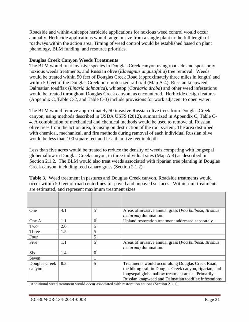
Roadside and within-unit spot herbicide applications for noxious weed control would occur annually. Herbicide applications would range in size from a single plant to the full length of roadways within the action area. Timing of weed control would be established based on plant phenology, BLM funding, and resource priorities. Douglas Creek Canyon Weeds Treatments The BLM would treat invasive species in Douglas Creek canyon using roadside and spot-spray noxious weeds treatments, and Russian olive (Elaeagnus angustifolia) tree removal. Weeds would be treated within 50 feet of Douglas Creek Road (approximately three miles in length) and within 50 feet of the Douglas Creek non-motorized rail trail (Map A-4). Russian knapweed, Dalmatian toadflax (Linaria dalmatica), whitetop (Cardaria draba) and other weed infestations would be treated throughout Douglas Creek canyon, as encountered. Herbicide design features (Appendix C, Table C-2, and Table C-3) include provisions for work adjacent to open water. The BLM would remove approximately 50 invasive Russian olive trees from Douglas Creek canyon, using methods described in USDA USFS (2012), summarized in Appendix C, Table C-4. A combination of mechanical and chemical methods would be used to remove all Russian olive trees from the action area, focusing on destruction of the root system. The area disturbed with chemical, mechanical, and fire methods during removal of each individual Russian olive would be less than 100 square feet and less than five feet in depth. Less than five acres would be treated to reduce the density of weeds competing with longsepal globemallow in Douglas Creek canyon, in three individual sites (Map A-4) as described in Section 2.1.2. The BLM would also treat weeds associated with riparian tree planting in Douglas Creek canyon, including reed canary grass (Section 2.1.2). Table 3. Weed treatment in pastures and Douglas Creek canyon. Roadside treatments would occur within 50 feet of road centerlines for paved and unpaved surfaces. Within-unit treatments are estimated, and represent maximum treatment sizes. Pasture/Area Roadside Within-unit Notes
treatment treatment (mi.) (ac.)
One 4.1 51 Areas of invasive annual grass (Poa bulbosa, Bromus tectorum) domination.
One A 1.1 01 Upland restoration treatment addressed separately. Two 2.6 5 Three 1.5 5 Four 5 Five 1.1 51 Areas of invasive annual grass (Poa bulbosa, Bromus
tectorum) domination. Six 1.4 01 Seven 1 Douglas Creek 8.5 5 Treatments would occur along Douglas Creek Road, canyon the hiking trail in Douglas Creek canyon, riparian, and
longsepal globemallow treatment areas. Primarily Russian knapweed and Dalmatian toadflax infestations.
1Additional weed treatment would occur associated with restoration actions (Section 2.1.1).
DOI-BLM-OR-134-2014-0008 Page 22
Biological Control of Weeds in Douglas Creek Allotment and Douglas Creek Canyon The BLM would use biological control to provide long term control of key noxious weed species in the action area including spotted knapweed (Centaurea stoebe), leafy spurge (Euphorbia esula), Canada thistle (Cirsium arvense), Dalmatian toadflax, and musk thistle (Carduus nutans), in conjunction with herbicide use. Biological control would employ species shown to have met USDA requirements for experimental release (Section 1.1). Release of biological control agents would occur in the same locations identified for herbicide control of noxious weeds (Map A-3) and would affect the same portions of the action area. Biological control would be instituted on a case-by-case basis, depending on funding priorities and availability of biological control agents.
2.1.4 Design Features for all Action Alternatives: Cultural Resources
• NHPA, Section 106 compliances have been completed for this project and concurrences on determinations of effect were received from the DAHP. Proposed treatments have been modified to avoid adverse impacts to known cultural resources. Recommended site-specific protection measures (fencing exclosures) identified in the cultural resources survey report would be completed prior to project implementation;
• During implementation, impacts to known sites would be avoided. Onsite monitoring during project implementation would be conducted where advised and recommended by a BLM archaeologist; and
• In the event that previously unknown cultural materials are identified during the course of
project implementation, work in the vicinity of the find would cease and the find would be protected from disturbance until a BLM archaeologist ascertained its historical significance. Additional NHPA Section 106 clearances and consultations would be completed if necessary, prior to resuming work in the area of the find.
2.1.5 Monitoring and Adaptive Management Monitoring and Evaluation Grazing utilization monitoring would be done in accordance with the Spokane District Monitoring Plan (USDI BLM 1988). Utilization studies measure the amount of the current years’ growth on key grass species consumed or destroyed. Utilization data would be collected by BLM at the end of the growing season for identified key bunchgrass species at currently identified key areas on a one to two year cycle. Additional key areas could be established as determined by a BLM rangeland management specialist. Upland ecological trend plots have been established by BLM in the action area following the BLM Assessment, Inventory, and Monitoring (AIM) Strategy as outlined in Technical Note 445 (Taylor et al. 2014). The AIM strategy includes a robust sampling design and set of core
DOI-BLM-OR-134-2014-0008 Page 23
measurements to characterize vegetation and soil conditions. AIM plots would be used to quantify the suitability of portions of the action area for GSG nesting, wintering, or early brood rearing habitat, as described in the GSG Habitat Assessment Framework (Stiver et al. 2010). AIM plots would also be used to assess the success of BLM restoration and weeds treatments in the action area, and would provide some information used to assess drought effects (USDI BLM 2013). AIM monitoring frequency and plot density would depend on sampling design, BLM budget, and BLM resource priorities. Change in riparian-wetland conditions would be monitored by the BLM using PFC methodology (Prichard 1998), multiple indicator monitoring (Burton et al. 2011), and site-scale documentation of change. Adaptive Management Adaptive management is a system of management practices based on clearly identified outcomes and monitoring to determine if management actions are meeting desired outcomes; and, if not, facilitates management changes that would best ensure outcomes are met. Knowing uncertainties exist in managing for sustainable ecosystems, changes in grazing management could be authorized which include, but are not limited to, adjusting the timing, season of use of grazing, and stocking rates: • Based on the previous year's monitoring and current year's climatic conditions; • Due to drought, causing a lack of available water in areas originally scheduled to be used; • To balance utilization levels; and • To protect the riparian and water resources.
Adaptive management would be employed during the implementation of range improvements, and upland and riparian-wetland restoration projects in the action area. Minor changes in location, timing, and construction of these improvements could occur as long as they continued to meet resource objectives, met the purpose and need of this action, and did not impact cultural, botanical, wildlife, or other sensitive natural resources.
Flexibility in grazing management would be authorized and changes in rotations would only be allowed as long as they continue to meet resource objectives and do not exceed the permitted use. Flexibility would be dependent upon the demonstrated stewardship and cooperation of the lessee. Rangeland and other ecological monitoring data would be a key component of adaptive management. As monitoring indicated changes in grazing management were needed to meet resource objectives, changes would be implemented annually, working with the lessee. Changes to on or off dates may be adjusted annually based on vegetative response to seasonal conditions, and would allow for a two week period of flexibility around the permitted season of use. Schedule would be adjusted to not exceed permitted AUMs dependent on livestock number.
DOI-BLM-OR-134-2014-0008 Page 24
2.2 Description of Alternatives to the Proposed Action
2.2.1 Alternative 2 - No Action (Continuation of Current Management) The term “no action” means no change from present management. The no action alternative (Alternative 2) would renew the existing livestock grazing lease for a period of ten years on the Douglas Creek allotment with terms and conditions listed under the expiring lease. The lease issued would continue to authorize livestock grazing not to exceed 200 cattle during the permitted season of use of April 1st to July 15th. The allotment would continue to be managed with a permitted use of 480 AUMs. These 480 AUMs would be distributed across the 4,092 acres in pastures One through Five without a set rotation. The stocking rate would average eight acres per AUM.
Under the no action alternative, grazing authorization would be issued in accordance with the RMP ROD (USDI BLM 1987), and BLM regulations including the Standards and Guidelines for Rangeland Health for Oregon and Washington (USDI BLM 1997). The no action alternative would allow average use of key forage species to achieve up to 50% average utilization. Under the no action alternative, the BLM would not take action on an application to graze 440 acres in BLM-administered lands treated as pastures Six and Seven in this EA. Succession and natural disturbance would produce the only changes in this area over time. The BLM would not restore upland habitats in Douglas Creek allotment, and would not complete riparian restoration activities in Douglas Creek canyon. In addition, the BLM would not treat weeds in any portion of the action area.
2.2.2 Alternative 3 - No Grazing An alternative analyzing elimination of grazing in the action area was included in the EA for comparison. Under the no grazing alternative (Alternative 3), the BLM would not renew the existing grazing lease for Douglas Creek allotment. No livestock grazing would be authorized on the BLM-managed lands in this allotment. Under this alternative, grazing exclusion fences would be retained in Douglas Creek canyon.
Under the no grazing alternative, the BLM would pursue the same restoration activities in Douglas Creek allotment and Douglas Creek canyon that are described for the proposed action (Alternative 1). Restoration in Pasture Six would occur without use of grazing as a disturbance or hoof imprint as a seeding technique.
2.2.3 Alternative 4- Lessee’s Application to Graze The BLM received application for renewal of a grazing lease and an application to graze newly acquired BLM lands from the current lessee authorized to graze livestock within the action area. Alternative 4 includes grazing leases offered with terms and conditions comparable to those identified in the applications received, and described below. Alternative 4 is included in this EA for comparison.
DOI-BLM-OR-134-2014-0008 Page 25
Under Alternative 4, BLM would issue a ten year grazing lease on the Douglas Creek allotment with terms and conditions similar to those for the expiring lease. In addition, Alternative 4 would authorize grazing on lands that have become available for grazing in T23N R23E Sections 8 and 9 east of the Douglas Creek canyon (pastures Six and Seven), consistent with multiple use objectives of the BLM. The additional acreage in these newly acquired lands would be attached to the Douglas Creek allotment. The new lease would change the total AUMs for the allotment to 675: 480 AUMs in pastures One through Five, 120 AUMs in Pasture Six, and 75 AUMs in Pasture Seven. Pastures One through Five would have a stocking rate of eight acres per AUM. Pastures Six and Seven would have a stocking rate of two acres per AUM. Alternative 4 would include all proposed range improvements and weed treatments described for the proposed action (Alternative 1). Grazing plan terms and conditions of the lease offered under Alternative 4 would be similar to the Alternative 1, with the following differences:
• Permitted use would not exceed 675 AUMs for pastures One through Seven; and • Average utilization of key forage species would not exceed 50%.
Alternative 4 would not include upland or riparian restoration: restoration would not occur in the Douglas Creek allotment or in the Douglas Creek canyon.
3. Affected Environment and Environmental Effects The existing environmental conditions in the action area have been described in detail in the LHE (USDI BLM 2014), incorporated by reference and summarized below. The affected environment described in this EA is defined and limited by the identified resource issues (Sections 3.1-3.6). Additional information is provided below for context including the physical setting, current livestock use, and land health conditions in the action area.
Physical setting. The action area receives 9 to 15 inches of average annual precipitation and falls into the Xeric soil moisture regime (USDA NRCS 2014). Soils in the action area are mostly wind transported Mollisols. Soil textures are predominately loamy with varying depths and amounts of coarse rock fragments. Soil depths vary from shallow (less than three inches) to moderately deep (greater than 20 inches). Elevations in the action area range from about 1,200 to 3,000 feet. Major landforms include hills and escarpments, with riparian flood plains and stream terraces in Douglas Creek canyon. Plant communities. Ecological sites in the action area are predominantly loamy (8XY102WA) or very shallow (8XY301WA). On loamy sites, shrub overstories are usually dominated by Wyoming big sagebrush (Artemisia tridentata ssp. wyomingensis) and three-tip sagebrush (A. tripartita). Typical associations include Artemisia tridentata-Agropyron spicatum and Artemisia tridentata-Festuca idahoensis (Daubenmire 1970). Very shallow sites include rigid sagebrush associations (Artemisia rigida-Poa secunda). The critical growth period for the action area is May 1st – June 25th (Rouse and Guinn 2009). Livestock grazing and actual use. The Douglas Creek allotment is designated as an “I” (improve) allotment; meaning the allotment has the potential for resource improvement and is manageable

since the BLM is the largest landowner within the allotment. The historic Douglas Creek allotment management plan (AMP), signed in 1987, implemented a rotational grazing system on this allotment, authorizing 480 AUMs of grazing distributed across 4,092 acres in pastures One through Five. Due to variable water availability, actual use by pasture varies and several pastures are often grazed together (Table 4). Since 2006, measured average utilization (proportion of current years’ forage consumed) has also been less than permitted utilization, averaging 14% and ranging from 0 to 40% in identified Key Areas (see Glossary). Table 4. Actual Use in AUMs, as reported by the lessee.
Pasture 2013 2012 2011 2010 2009 2008 2007 2006 One & One A 91 140
Two 1181 After 214 189 Three 182 301 301 65 July 1st 393 Four 209 79 70 Five 106 132 173 248
Total Days 106 113 78 78 87 76 75 81 Livestock # 111 89 116 116 140 153 160 164
Total AUMs2 379 327 301 301 416 387 393 437 1Merged cell indicate pastures that were grazed jointly due to water shortage. 2 AUMs calculated using BLM Range Administration System (RAS). Douglas Creek Land Health. The LHE evaluated the following five standards; Watershed Function-Uplands (Standard 1); Watershed Function-Riparian/Wetland Areas (Standard 2); Ecological Processes (Standard 3); Water Quality (Standard 4); and Native, Threatened and Endangered (T&E), and Locally Important Species (Standard 5). Within the analysis area, the Douglas Creek allotment and Douglas Creek canyon were found to be achieving most standards by the IDT (Table 5). Two areas (Douglas Creek canyon and the New Acquisition area (pastures Six and Seven in this EA)) were identified as not achieving but making significant progress towards achieving Standard 5 for Native, Threatened and Endangered and Locally Important Species. Livestock grazing was not identified as a causal factor in not meeting standards for the watershed. Although allotment-scale rangeland health was found to be achieving upland and riparian standards in the action area during the LHE, the BLM identified within-allotment opportunities to maintain or improve site-scale upland and riparian-wetland health in the action area. Table 5. Douglas Creek Watershed LHE: Allotment-Scale Land Health Findings
Douglas Creek Allotment Standard Finding Notes Watershed Function: Achieving Allotment supports stable soil, hydrologic, and biotic Uplands attributes. Portions of pastures One, Five, and Six departed from reference conditions. Invasive annual weeds and non-
native seeding led to changed plant groups. Watershed Function: Achieving The only riparian-wetland resources in this allotment are Riparian/Wetland Areas springs, used in grazing support. No departure noted in these
systems.
DOI-BLM-OR-134-2014-0008 Page 26

DOI-BLM-OR-134-2014-0008 Page 27
Ecological Processes Achieving Indicators of photosynthetic effectiveness and nutrient cycling appeared consistent with the capability of lands in the allotment.
Water Quality Achieving No flowing water in this allotment other than springs (addressed under riparian/wetland areas).
Native, Threatened and Making The majority of potential GSG habitat in this allotment was Endangered, Locally significant classified as marginal, primarily due to limited shrub cover. Important Species progress Passive restoration (shrub development) is occurring.
Douglas Creek Canyon
Standard Finding Notes Watershed Function: Achieving Douglas Creek canyon has stable land health attributes. Uplands Occasional site-scale dominance of weeds adjacent to road and access points. Watershed Function: Achieving Douglas Creek properly functioning (PFC). Lack of Riparian/Wetland Areas overstory trees and presence of reed canary grass limit the
desired condition. Localized impacts to stream banks and riparian vegetation.
Ecological Processes Achieving Indicators of photosynthetic effectiveness and nutrient cycling appeared consistent with the capability of lands in the canyon. Departed areas cover less than 100 acres.
Water Quality Achieving Measures of water quality in Douglas Creek (turbidity, dissolved oxygen, fecal coliform) suggested moderately high water quality. Stream temperature average was adequate to support fisheries. Point source impacts to water quality included undeveloped camp sites and recreation use.
Native, Threatened and Mixed Longsepal globemallow: Not Achieving. Limited Endangered, Locally distribution of habitat. Population stability threatened by lack Important Species of fire, population size, weed competition.
GSG: Making significant progress. Little (147 acres) potential GSG habitat; the majority of this habitat is marginal in quality due to lack of shrub cover; passive restoration occurring.
Summary of the Effects of Alternatives
Table 6 below summarizes the effects of Alternatives 1-4 on the affected environment, for the six issues identified in Section 1.4. The effects are described in detail for each issue in Sections 3.1-3.8 below. Cumulative effects of the alternatives are described in Section 3.7.
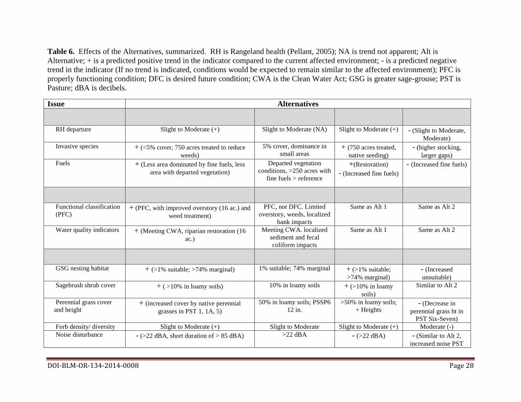
Table 6. Effects of the Alternatives, summarized. RH is Rangeland health (Pellant, 2005); NA is trend not apparent; Alt is Alternative; + is a predicted positive trend in the indicator compared to the current affected environment; - is a predicted negative trend in the indicator (If no trend is indicated, conditions would be expected to remain similar to the affected environment); PFC is properly functioning condition; DFC is desired future condition; CWA is the Clean Water Act; GSG is greater sage-grouse; PST is Pasture; dBA is decibels.
Issue Alternatives Proposed Action No Action No Grazing Lessee’s Application
Upland Function (Alternative 1) (Alternative 2) (Alternative 3) (Alternative 4) RH departure Slight to Moderate (+) Slight to Moderate (NA) Slight to Moderate (+) - (Slight to Moderate,
Moderate) Invasive species + (<5% cover, 750 acres treated to reduce 5% cover, dominance in + (750 acres treated, - (higher stocking,
weeds) small areas native seeding) larger gaps) Fuels + (Less area dominated by fine fuels, less Departed vegetation +(Restoration) - (Increased fine fuels)
area with departed vegetation) conditions, >250 acres with - (Increased fine fuels) fine fuels > reference
Proposed Action No Action No Grazing Lessee’s Application Riparian Function (Alternative 1) (Alternative 2) (Alternative 3) (Alternative 4)
Functional classification + (PFC, with improved overstory (16 ac.) and PFC, not DFC. Limited Same as Alt 1 Same as Alt 2 (PFC) weed treatment) overstory, weeds, localized
bank impacts Water quality indicators + (Meeting CWA, riparian restoration (16 Meeting CWA. localized Same as Alt 1 Same as Alt 2
ac.) sediment and fecal coliform impacts
Proposed Action No Action No Grazing Lessee’s Application Sensitive Wildlife Species (Alternative 1) (Alternative 2) (Alternative 3) (Alternative 4) GSG nesting habitat + (>1% suitable; >74% marginal) 1% suitable; 74% marginal + (>1% suitable; - (Increased
>74% marginal) unsuitable) Sagebrush shrub cover + ( >10% in loamy soils) 10% in loamy soils + (>10% in loamy Similar to Alt 2
soils) Perennial grass cover + (increased cover by native perennial 50% in loamy soils; PSSP6 >50% in loamy soils; - (Decrease in and height grasses in PST 1, 1A, 5) 12 in. + Heights perennial grass ht in
PST Six-Seven) Forb density/ diversity Slight to Moderate (+) Slight to Moderate Slight to Moderate (+) Moderate (-) Noise disturbance - (>22 dBA, short duration of > 85 dBA) >22 dBA - (>22 dBA) - (Similar to Alt 2,
increased noise PST
DOI-BLM-OR-134-2014-0008 Page 28
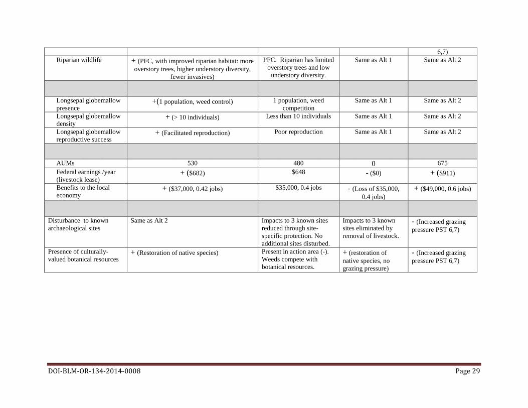
6,7) Riparian wildlife + (PFC, with improved riparian habitat: more PFC. Riparian has limited Same as Alt 1 Same as Alt 2
overstory trees, higher understory diversity, overstory trees and low fewer invasives) understory diversity.
Proposed Action No Action No Grazing Lessee’s Application Sensitive Plant Species (Alternative 1) (Alternative 2) (Alternative 3) (Alternative 4) Longsepal globemallow +(1 population, weed control) 1 population, weed Same as Alt 1 Same as Alt 2 presence competition Longsepal globemallow + (> 10 individuals) Less than 10 individuals Same as Alt 1 Same as Alt 2 density Longsepal globemallow + (Facilitated reproduction) Poor reproduction Same as Alt 1 Same as Alt 2 reproductive success
Proposed Action No Action No Grazing Lessee’s Application Socio-econ: grazing (Alternative 1) (Alternative 2) (Alternative 3) (Alternative 4) AUMs 530 480 0 675 Federal earnings /year + ($682) $648 - ($0) + ($911) (livestock lease) Benefits to the local + ($37,000, 0.42 jobs) $35,000, 0.4 jobs - (Loss of $35,000, + ($49,000, 0.6 jobs) economy 0.4 jobs)
Cultural Proposed Action No Action No Grazing Lessee’s Application (Alternative 1) (Alternative 2) (Alternative 3) (Alternative 4)
Disturbance to known Same as Alt 2 Impacts to 3 known sites Impacts to 3 known - (Increased grazing archaeological sites reduced through site- sites eliminated by pressure PST 6,7)
specific protection. No removal of livestock. additional sites disturbed.
Presence of culturally- + (Restoration of native species) Present in action area (-). + (restoration of - (Increased grazing valued botanical resources Weeds compete with native species, no pressure PST 6,7) botanical resources. grazing pressure)
DOI-BLM-OR-134-2014-0008 Page 29

DOI-BLM-OR-134-2014-0008 Page 30
3.1 Issue 1: Upland Watershed Function
3.1.1 Affected Environment Rangeland health attributes: Attributes of rangeland health include soil stability, hydrologic function, and biotic integrity, as defined in the technical reference Interpreting Indicators of Rangeland Health (Pellent et al. 2005). Rangeland health attributes for the action area were described in the LHE, supported by the collection of 17 quantitative indicators of rangeland health (IRH) and other supporting data (USDI BLM 2014). In the Douglas Creek allotment, soil stability and hydrologic function were found to have a Slight to Moderate departure from reference conditions. Areas of erosion and large water flow paths are limited, and soil stability is high. Douglas Pasture One includes a south-facing hill slope (150 acres) that has low soil resistance. Additionally, portions of loamy ecological sites in Pasture Five include large water flow paths, and extensive bare ground. This is not the dominant condition in this pasture. The LHE found that biotic integrity in the Douglas Creek allotment also had a Slight to Moderate departure from reference conditions, primarily due to changes in plant functional/structural groups. Reduced plant functional/structural group diversity was primarily associated with cover by invasive annual grasses and introduced (seeded) grass species. More than 300 acres (8%) of the allotment have been tilled and seeded with non-native grasses, changing functional/structural groups. Seeded non-native grasses occur in portions of pastures One, One A, and Two. As stated on page 23 of the LHE, “the IDT determined that Douglas Creek canyon as a whole is achieving Standard 1 (Watershed Function-Uplands) with near reference conditions for soil and hydrological attributes, and slight-to-moderate departure from ecological site reference conditions for its biotic attribute” (USDI BLM 2014).
Invasive species cover: The LHE identified noxious weeds in the action area including several species of knapweeds (Centaurea diffusa, C. stoebe, Acroptilon repens), Dalmatian toadflax, Canada thistle, and bull thistle (Cirsium vulgare) (USDI 2014). Subsequent field review has identified knapweeds and other invasive species along unpaved access roads and near holding areas in the action area. Douglas Creek allotment invasive cover was measured as 5% in loamy soils, based on limited plot data. Stony soils averaged much higher invasives cover, based on only two sample plots. The LHE identified invasive species dominance in portions of Pasture One and Pasture Five (areas described above). Douglas Creek canyon has “small-scale, localized dominance of weeds adjacent to roads and access points (less than 100 acres)” (USDI BLM 2014, p 23). The IDT identified concern that invasive plants could expand from the well-used Douglas Creek Road into lower slope positions in this area, given disturbance.
Fuels conditions: The action area is mapped as part of the Inter-Mountain Basins Big Sagebrush Steppe biophysical setting. Historic fire regime for this setting includes return intervals of 35 to 200 years with mixed severity (NatureServe 2009; USDA NRCS 2013). The Spokane District

DOI-BLM-OR-134-2014-0008 Page 31
BLM has documented less than 200 acres burned in the action area in the last 20 years; this is probably an underestimate. The LHE classified over 30% of the Douglas Creek watershed (including all ownerships) as departed from historic vegetation conditions, at risk from a changed fire regime (USDI BLM 2014). This classification was based on remotely-sensed data meant for large spatial scales (LANDFIRE 2013). Field verification suggested that several locations in the action area (described above) have continuous fine fuels layers produced by invasive annual grasses. Other portions of the action area support areas with gaps in native bunchgrass cover that are at risk for invasion by annual grasses and developing continuous fuel loading (Riesner 2010).
3.1.2 Direct and Indirect Effects from the Proposed Action (Alternative 1) Rangeland health attributes: Under the proposed action, the BLM would institute the following changes from current management (see Section 2.1) that would influence rangeland health:
• Development of new and improvement to existing water developments to aid in implementing a cattle grazing rotation;
• A longer season of use to allow for greater flexibility in rotation dates;
• Moderate grazing utilization;
• Heavy grazing introduced in Pasture Six, followed by native seeding, protected native shrub-steppe islands, and moderate grazing;
• Restoration of 300 acres in Pasture Five. Areas of invasive annual grasses would be decreased and areas of native bunchgrass and shrub cover would be increased; and
• Restoration of 225 acres in pastures One and One A to restore native species. Areas of agricultural seeded grasses would be decreased and native bunchgrass and shrub cover would be maintained or increased.
Improved and new water developments and flexibility in season of use would allow implementation of a grazing rotation, leading to more uniform grazing patterns in pastures One through Five. Moderate grazing pressure (30 to 40% average utilization of key forage species) would be less than the current grazing pressure (up to 50% average utilization). Moderate grazing pressure would be predicted to maintain herbaceous cover and the composition and diversity of native vegetation, limit the spread of noxious weeds, and produce moderate resilience to drought conditions. BLM management changes in grazing distribution and utilization would result in more native grass leaf area remaining after grazing, increased root storage, and more native seeding. This would be predicted to increase the reproductive capability of perennial plants, an indicator of rangeland health (Pellant et al. 2005). Stand development would be predicted to produce plant structural/functional groups more closely resembling reference conditions in these pastures in response to this management. Native bunchgrass root and basal area development would increase soil stability and decrease gap areas
DOI-BLM-OR-134-2014-0008 Page 32
and water flow path characteristics, producing soil and hydrologic functions more closely resembling reference conditions. BLM restoration activities in pastures One, One A, and Five would decrease cover by invasive annual grasses and non-native seeded grasses, and increase or maintain cover by native bunchgrasses, Wyoming big sagebrush, and forbs on 525 acres (8% of the allotment). The IDT identified these areas as the most departed portions of the allotment (USDI BLM 2014). Proposed management changes would produce plant functional/structural groups that more closely resemble reference communities. Establishment of native bunchgrasses and shrubs would increase soil stability, decrease gap areas and water flow paths, and increase hydrological lifting by tap rooted shrubs, improving soil and hydrologic functions in these pastures.
The BLM would apply heavy grazing pressure (up to 60% average utilization) and install native plant islands in Pasture Six. Native shrubs and grasses would be expected to increase in cover in this pasture in response to this management. Non-native seeded species (wheatgrasses and Sherman’s bluegrass) would be predicted to decrease in response to treatment. Range health improvements in Pasture Six would be predicted to be similar to treated areas in pastures One A and Five.
BLM management in upland portions of Douglas Creek canyon would be the same under the proposed action as in the no action, other than treating invasive and noxious weed species (described below).
Based on identical stocking rates and decreased forage utilization in pastures One through Five, moderate utilization introduced in pastures Six and Seven, planned range improvements, potential improved rotations, and shrub-steppe restoration, Alternative 1 would be predicted to maintain rangeland health at a Slight to Moderate departure from reference conditions at the allotment level, with a positive trend. Changes in range health would require up to ten years to develop, considering the timeline for restoration treatments and biotic response.
Invasive species cover: BLM management of invasive species under the proposed action would include:
• Roadside and within-pasture treatment of invasive and noxious weeds in Douglas Creek allotment (200 acres);
• Restoration activities in pastures One and One A (260 acres total), and Five (300 acres); and
• Weed treatment in upland portions of Douglas Creek canyon.
Invasive annuals were estimated at approximately 5% cover in the analysis area (USDI BLM 2014). Restoration activities would reduce cover by these species in less than 200 acres of the action area. Additional roadside and within-pasture treatments of less than 200 acres would decrease total cover by invasive and noxious species in the action area and greatly decrease the spread of these species into functioning shrub-steppe communities.

DOI-BLM-OR-134-2014-0008 Page 33
Fuels conditions: Restoration of native shrub-steppe communities would occur in 525 acres with vegetation departed from historic vegetation condition, based on field observation. These areas have invasive annual grass cover (a fine fuel) elevated above reference conditions, and support areas of seeded grasses. Weeds treatments (described above) would further decrease areas with departed vegetation conditions. Additionally, changes in livestock distribution in pastures One through Five would maintain or increase the amount of the action area supporting vegetation condition near reference conditions.
3.1.3 Direct and Indirect Effects from No Action (Alternative 2) Rangeland health attributes: Under the no action alternative (Alternative 2), grazing in the Douglas Creek allotment would continue under the current grazing regime and would be predicted to maintain upland health conditions similar to the current affected environment. Soil stability and hydrologic function would retain a Slight to Moderate departure from reference conditions. Areas of erosion or large water flow paths would be rare, and soil stability would generally be high. Portions of pastures One and Five with low soil resistance, large water flow paths, and extensive bare ground would retain departed soil stability and hydrologic function, barring large disturbance such as fire or extended drought. Biotic integrity in the Douglas Creek allotment would retain a Slight to Moderate departure from reference conditions, with continued livestock grazing during the authorized season of use at stocking rates and utilization levels detailed in terms and conditions of the current lease. Invasive annual grasses would continue to reduce plant functional/structural group diversity in portions of pastures Five and One. Continued grazing in spring during bunchgrass boot stage (when grasses are producing seed) without a rest rotation could lead to reduced root mass and reduced bunchgrass basal area in these pastures (Rouse and Guinn 2009). Portions of pastures One and One A seeded with non-native grasses (300 acres) would maintain reduced plant structural group diversity and modified group function.
Rangeland health in unleased pastures Six and Seven would be influenced solely by succession and natural disturbance under Alternative 2. Pasture Six is dominated by seeded non-native grasses, and would maintain reduced plant functional/structural group diversity and a Slight to Moderate departure from soil and hydrologic reference conditions. This pasture supports dense grass with little gap space, making invasion by weeds unlikely barring disturbance. Pasture Seven is native shrub-steppe dominated by lithosols, and would continue to support near reference condition soil and hydrologic conditions, and Slight to Moderate departure in biotic conditions due to presence of invasive annual grasses.
Alternative 2 would include continued grazing exclusion and no weeds treatments in the upland portions of Douglas Creek canyon. Range health indicators would include a slight departure from soil and hydrologic reference conditions, barring large disturbance. Biotic integrity in Douglas Creek canyon would retain a Slight to Moderate departure from reference conditions due to continued introduction of invasive and noxious weed species from Douglas Creek Road.
Invasive species cover: Under Alternative 2, gaps between native species and invasive species introductions would be similar to the environmental baseline (Section 3.1.1), barring large disturbances such as fire. Cover by invasive species (primarily annual grasses) in Douglas Creek
DOI-BLM-OR-134-2014-0008 Page 34
allotment would be predicted to remain near 5% in loamy soils, with continued dominance by invasive species in some stony soils as well as portions of Pasture One and Pasture Five (less than 200 acres).
Invasive species cover in currently unleased portions of the action area, Douglas Creek canyon and Douglas Creek pastures Six and Seven, would retain a Slight to Moderate departure from reference conditions under the no action, barring fire disturbance. Invasive and noxious species, including knapweeds and Dalmatian toadflax, would be predicted to maintain or increase densities and cover in these areas, particularly around existing roads. Disturbance associated with Alternative 2 (e.g. recreational activity in primitive dispersed campsites) or fire would be predicted to increase cover and density of invasive species.
Fuels conditions: The LHE classified over 30% of the analysis area (Douglas Creek watershed including all ownerships) as departed from historic vegetation conditions (USDI BLM 2014), at risk from a changed fire regime. Data is not accurate enough to classify fuels conditions in the action area. Alternative 2 would retain areas of BLM-administered lands departed from historic fire regimes due to presence of invasive annual grasses or seeded non-native grasses. Fire disturbance in these departed areas would be expected to exacerbate fire regime departure.
3.1.4 Direct and Indirect Effects from No Grazing (Alternative 3) Rangeland health attributes: Under the no grazing alternative (Alternative 3), livestock would be excluded from the action area, including all portions of the Douglas Creek allotment. Livestock grazing would remain excluded from Douglas Creek canyon and areas defined as pastures Six and Seven in this EA. Upland shrub-steppe restoration would occur in pastures One, One A, Five, and Six. Succession and upland shrub-steppe restoration would be the key processes directly affecting biotic integrity, soil and hydrologic stability.
In the absence of continued spring livestock grazing in pastures One through Five, existing bunchgrasses would develop larger root systems, dense decadent leaf material, and would seed into gap spaces. Native grass seedlings would compete with invasive annuals currently in gap space, leading to a mixed stand.
Shrub-steppe restoration on over 500 acres in pastures One, One A, and Five would improve biotic integrity in the action area by increasing shrubs, grasses and forbs associated with reference conditions, and decreasing cover by invasive annual species. No-till restoration techniques in pastures One and Five would retain or improve soil and hydrologic stability in these sites. Intensive agricultural approaches in Pasture One A would mix soil and could exacerbate a weak plow pan in this area; however, this site has been cultivated historically and would not increase soil stability departure from reference conditions. Shrub-steppe restoration on over 200 acres in Pasture Six would not include disturbance by grazing. It is possible that this restoration would be less successful without disturbance. However, shrub and forb cover would still be increased in this pasture.
Range health conditions and processes in Douglas Creek canyon and Pasture Seven under Alternative 3 would be the same as Alternative 2.

DOI-BLM-OR-134-2014-0008 Page 35
Due to increased natural seeding, decreased grazing pressure on native bunchgrasses during seed production periods, and shrub-steppe restoration on over 800 acres, pastures One through Six would be predicted to develop plant functional/structural group diversity more closely resembling reference conditions than under the no action, leading to increased soil and hydrologic stability. Pasture Seven and the Douglas Creek canyon would be predicted to maintain a Slight to Moderate departure from reference conditions.
Invasive species cover: Removal of livestock grazing would remove growing season disturbance in pastures One through Five. Shrub-steppe restoration would treat weeds on over 800 acres in the action area. Invasive species cover in pastures One through Six would be predicted to decrease as existing native bunchgrasses seeded successfully and invasive species were treated. Invasive species cover in Douglas Creek canyon and pastures Six and Seven under Alternative 3 would be similar to or less than Alternative 2.
Fuels conditions. Removal of livestock grazing can cause an accumulation of fine fuels that increase fire risk and severity and, subsequently, the probability of sagebrush steppe rangelands converting to exotic annual grasslands (Davies et al. 2014). Wildland fire disturbance is not modeled in this EA, and is not included as an indicator for upland watershed function.
Under Alternative 3, native bunchgrass fine fuel would be predicted to increase in cover in pastures One through Five. Fine fuels associated with invasive annuals in pastures One, One A, Five, and Six would decrease in areas with applied shrub-steppe restoration. Fine fuels associated with invasive annuals in the remainder of the action area could increase, depending on outcomes of competition with native species.
3.1.5 Direct and Indirect Effects from Lessee’s Application (Alternative 4)
Rangeland health attributes: Alternative 4 would influence rangeland health through grazing, improved and new water developments, and weed management (see Section 2.1).
In pastures One through Five, a similar stocking rate and water improvements would be predicted to produce rangeland health conditions similar to Alternative 1 in approximately 3,500 acres of the allotment. Alternative 4 would allow average utilization of up to 50% of key forage species. This higher utilization rate, in combination with continued yearly grazing during the critical growth period (Rouse and Guinn 2009) could lead to lower bunchgrass basal area and vigor than Alternative 1 in portions of pastures One through Five used each growing season. Upland restoration would not occur on 525 acres under Alternative 4. These areas would support rangeland health attributes comparable to Alternative 2, including invasive annual cover and limited shrub cover. It is predicted that pastures One through Five would continue to maintain a Slight to Moderate departure from reference condition under Alternative 4. Under Alternative 4, stocking rate would be two acres per AUM on 440 acres of BLM land in pastures Six and Seven. This use is far heavier than the eight acres per AUM proposed for Alternative 1, and would likely lead to a higher utilization of key forage species. This heavy stocking during the critical growth period for jointed grass species (native bunchgrasses and wheatgrasses) would be predicted to have a negative impact on rangeland health (Rouse and Guinn 2009). Grazing would be suspended once utilization reached 50% of key forage species.

DOI-BLM-OR-134-2014-0008 Page 36
Over time, this level of grazing during the critical growth period could cause the rangeland health of pastures Six and Seven to move from a Slight to Moderate departure from reference conditions toward a Moderate departure (Pyke 2011). Invasive species cover: BLM management of invasive species under Alternative 4 would be the same as Alternative 1, including roadside treatments and weed treatments in Douglas Creek canyon. Much heavier grazing in pastures Six and Seven would be predicted to lead to larger gaps between bunchgrasses, which could lead to invasion by cheatgrass in these pastures (Riesner et al. 2013).
Fuels conditions: Alternative 4 would produce fuels conditions similar to Alternative 2 in pastures One through Five, including some areas of departure and fine fuel loads due to presence of invasive annuals. Increased utilization and stocking in pastures Six and Seven would initially reduce fine fuels (seeded and native grasses) to levels lower than in Alternative 1, but could lead to invasion by annual grasses as gap space increased, increasing fine fuels. Weeds treatments under Alternative 4 would reduce some fine fuels, but would not be applied across entire pastures.
3.2 Issue 2: Riparian-Wetland Watershed Function
3.2.1 Affected Environment Douglas Creek is the only perennial stream in the action area (Map A-4). Douglas Creek is moderately entrenched, with low width/depth ratio, and banks stabilized by large materials (cobble and boulders) or riparian vegetation. Douglas Creek’s stream flow averages 12.7 cubic feet per second (cfs). An abandoned railroad corridor fill slope constrains channel morphology.
Riparian vegetation along Douglas Creek supports streamside wetlands dominated by invasive populations of reed canary grass (Phalaris arundinaceae). Riparian overstory, consisting of water birch (Betula occidentalis), aspen (Populus tremuloides), and cottonwood (P. trichocarpa) provides limited cover. Douglas Creek riparian corridor and adjacent terraces are affected by invasive species including reed canary grass (Phalaris arundinaceae), Russian knapweed and Dalmatian toadflax (Linaria genistifolia). Douglas Creek has a healthy introduced rainbow trout (Oncorhynchus mykiss) population, as well as speckled dace (Rhinichthys osculus) and crayfish (Pacifastacus lenisculus) populations.
BLM-administered portions of Douglas Creek canyon have been excluded from grazing since 1976 (USDI BLM 2014). No riparian areas were identified in the action area outside of Douglas Creek canyon. Springs used for watering livestock in Douglas Creek allotment pastures Two and Five do not support riparian-wetland vegetation or function.
Douglas Creek riparian-wetland functional classification (PFC): All Douglas Creek reaches in the analysis area were determined to be properly functioning in the LHE (USDI BLM 2014), supporting adequate vegetation and landform to dissipate stream energy, filter sediment, and maintain stream channel characteristics (Prichard 1998). Current activities influencing components of riparian-wetland function include: land use in the contributing watershed,

DOI-BLM-OR-134-2014-0008 Page 37
including grazing, and invasive plant species in the Douglas Creek riparian area. Current grazing in the action area does not appear to be affecting the function of Douglas Creek.
Douglas Creek hydrology, geomorphology, and vegetation indicators supported this PFC classification (USDI BLM 2014). Douglas Creek’s floodplain, although constrained by a historic railway fill slope and a road fill slope, is inundated in relatively frequent flow events. Outside of these fill slope constraints, geomorphology seems in balance with the landscape setting: the creek is vertically stable, and formed bars are generally vegetated. Douglas Creek appears to be in balance with the water and sediment being supplied by the watershed: excessive erosion and deposition are not occurring.
Douglas Creek supports a diverse age-class distribution of riparian-wetland vegetation. This vegetation is an indicator for riparian-wetland conditions, has high vigor, and has strong root masses capable of withstanding stream flows. However, Douglas Creek does not support a diverse riparian-wetland plant species composition. The riparian overstory has few trees. The riparian understory is dominated by reed canary grass, an introduced species. Thus, although Douglas Creek is classified as properly functioning, it does not support desired vegetation conditions.
Douglas Creek water quality indicators (water temperature, dissolved oxygen, turbidity): The LHE found that indicators of Douglas Creek water quality, including water temperature, dissolved oxygen, and turbidity were meeting state and federal Clean Water Act standards and supporting land health in the analysis area. Douglas Creek water temperature peaks were slightly above Department of Ecology (DOE) standards for support of non-anadromous interior redband trout. However, this creek is fed by warm springs and water temperature is probably only minimally affected by surrounding land use. Macroinvertebrate production and diversity suggest moderately high water quality.
Point sources of water quality and bank stability impact were identified in the action area. Several low water crossings exist on County-maintained road in the action area. Additionally, public users have developed several creek crossings. These crossing points have unstable banks and appear to be contributing sediment to Douglas Creek.
3.2.2 Direct and Indirect Effects from the Proposed Action (Alternative 1) Douglas Creek riparian-wetland functional classification (PFC): Under the proposed action (Alternative 1), the BLM would modify management in Douglas Creek canyon to improve localized riparian-wetland function and achieve desired vegetation conditions. The BLM would enhance riparian-wetland function by planting in Douglas Creek riparian and terrace areas, rehabilitating camping areas, restoration of disturbed areas, and controlling noxious and invasive plant species in the Douglas Creek riparian area (Section 2.1.2).
Under Alternative 1, the BLM would restore three riparian areas (16 acres), by installing fences and planting native trees and shrubs (Map A-4). This restoration would improve riparian-wetland function in 16 acres directly; increasing riparian diversity, providing species with root masses capable of withstanding high stream flow events and providing sources of woody

DOI-BLM-OR-134-2014-0008 Page 38
material. Restoration on a terrace above Douglas Creek’s ten year floodplain would increase the extent of riparian vegetation on four acres.
The BLM would restore riparian habitat in three dispersed camping sites adjacent to Douglas Creek and at six areas disturbed by recreation (See Map A-4). 11 acres of riparian and adjacent terrace habitat would be improved. Movement of campsites further from Douglas Creek would allow the riparian area to expand, improving riparian vegetation within 50 feet of Douglas Creek and improving stream bank stability in treated areas.
Proposed weed treatments would decrease cover by Russian knapweed (Acroptilon repens) and Dalmatian toadflax (Linaria genistifolia) in the Douglas Creek riparian corridor and adjacent terraces. Less than 30 acres would be treated over a ten year period. Removal of these noxious weeds from Douglas Creek canyon terraces would have little effect on riparian vegetation, but would permanently improve upland function on these 30 acres.
BLM-administered grazing operations would not affect riparian-wetland function in the action area under any action alternative, since grazing does not occur in proximity to riparian resources (Section 3.2.1).
Douglas Creek water quality indicators: Under the proposed action, the BLM would modify management in Douglas Creek canyon to improve Douglas Creek water quality. Specific modifications include:
• Rehabilitating dispersed camping areas and moving sites further from Douglas Creek;
• Installing vault toilets;
• Rehabilitating unstable banks and riparian areas (boulder installation); and
• Controlling noxious and invasive plant species in the Douglas Creek riparian area.
Moving dispersed campsites away from Douglas Creek and rehabilitating unstable banks and riparian areas with boulders (Section 2.1.2) would decrease turbidity introduced directly to Douglas Creek by failing banks. Stabilizing and planting these areas would have a negligible positive effect on stream temperature. Moving campsites further from Douglas Creek and restoring riparian vegetation would also decrease local turbidity effects and have a negligible positive effect on stream temperature. Installation of vault toilets would decrease fecal coliform levels and could increase dissolved oxygen in the creek by removing human waste from streamside areas.
Herbicides used to control noxious and invasive plants would follow Vegetation Treatment PEIS direction and design features in this EA (Section 2) to eliminate impacts on water quality. Only herbicides safe for aquatic use would be used near flowing streams or riparian-wetland areas.
3.2.3 Direct and Indirect Effects from No Action (Alternative 2)
DOI-BLM-OR-134-2014-0008 Page 39
Douglas Creek riparian-wetland functional classification (PFC): Under the no action (Alternative 2), Douglas Creek canyon would remain excluded from livestock grazing and vulnerable to current disruptive recreational activities, including dispersed camping within the riparian corridor. Activities including grazing outside exclosures and riparian disturbance processes, including floods, would continue to shape the Douglas Creek riparian area.
Under Alternative 2, the processes that produce properly functioning conditions (PFC) in Douglas Creek would remain in place. Douglas Creek would continue to support adequate vegetation and landform to dissipate stream energy, filter sediment, and maintain stream channel characteristics (Section 3.2.1) in the action area. Under Alternative 2, reed canary grass would remain dominant in the Douglas Creek riparian understory, providing stabilizing vegetation with high vigor but providing low diversity, shading, or woody material. Noxious weeds including Russian knapweed and dalmation toadflax (Linaria genistifolia) would maintain or increase in presence and cover in the Douglas Creek canyon, invading areas disturbed by natural flood or fire disturbance or disturbed by human activities. Site-scale recreation disturbances would decrease bank stability in localized areas but would not meaningfully limit Douglas Creek’s ability to filter sediment or maintain channel characteristics in the action area.
Douglas Creek water quality indicators: Under Alternative 2, recreation activities would continue to influence Douglas Creek water quality.
Camping adjacent to Douglas Creek at three dispersed camping sites (Map A-4) would continue under Alternative 2. These sites would continue to limit full extent of riparian development, remove riparian vegetation, destabilize banks, and contribute sediment and human waste to Douglas Creek. Effects would be localized, influencing riparian-wetland function in less than 0.5 miles of the creek. Water temperature, dissolved oxygen, and turbidity in Douglas Creek would continue to meet state water quality standards.
3.2.4 Direct and Indirect Effects from No Grazing (Alternative 3) The no grazing alternative (Alternative 3) would eliminate grazing in the Douglas Creek allotment, maintain grazing exclusion from Douglas Creek canyon, and would include riparian restoration activities described for Alternative 1 (Section 3.2.2). Current BLM-administered grazing in the Douglas Creek allotment is associated with properly functioning condition in Douglas Creek and water quality conditions meeting Clean Water Act requirements (USDI BLM 2014). Removal of livestock grazing in the Douglas Creek allotment would maintain PFC conditions and water quality in the portions of Douglas Creek in the action area, similar to Alternative 1.
3.2.5 Direct and Indirect Effects from Lessee’s Application (Alternative 4)
Douglas Creek riparian-wetland functional classification (PFC): The effects of Alternative 4 on riparian-wetland functional classification would be the similar to the effects of Alternative 2.
Douglas Creek water quality indicators: The effects of Alternative 4 on water quality indicators would be the similar to those in Alternative 2.

DOI-BLM-OR-134-2014-0008 Page 40
3.3 Issue 3: Sensitive Wildlife Species
3.3.1 Affected Environment Upland and riparian wildlife species use of the analysis area is described in the LHE (USDI BLM 2014). While many sensitive species occur in the analysis area (see USDI BLM 2014, Table C-9), habitat for the greater sage-grouse (Centrocercus urophasianus) was identified as an indicator of the effects of actions on sensitive wildlife species in this EA. This is appropriate considering this species’ population dynamics in Douglas Creek watershed and larger spatial scales (Stinson et al. 2004), its sensitivity to land health conditions (Stiver et al. 2010), and because management alternatives aimed at addressing issues identified for this species have broad scale applicability for addressing concerns for other species in similar habitats. Riparian associated species (described below) were included as indicators for rangeland health due to their presence in the action area and the differential effects of action alternatives on riparian species.
Habitat for sagebrush obligates and shrub-steppe associated species: Greater sage-grouse (GSG) are used as an indicator species for sagebrush obligate and shrub-steppe associated species in this EA because the diversity of habitats used by GSG makes it an appropriate focal species for managing sagebrush ecosystems (Stiver et al. 2010; Rowlanda 2006.). The distribution of GSG and GSG habitat in the analysis area is detailed in the LHE (USDI BLM 2014). Impact indicators for GSG habitat in this EA include: a) site-scale habitat suitability, as defined by Stiver et al. (2010), and the habitat indicators that inform suitability: sagebrush cover and height, perennial bunchgrass cover and height, and perennial forb cover and diversity; and b) noise disturbance indicators including decibels (dBA), total days, continuous days, and number of acres impacted.
• The LHE classified GSG habitat quality within seasonal ranges necessary to meet the bird’s life requisite needs: breeding, late brood rearing, and winter habitats (USDI BLM 2014). Approximately 1% (26 acres) of areas classified as potentially suitable GSG habitat were classified as currently suitable nesting habitat for this species in the action area, following the Habitat Assessment Framework (HAF) (Stiver et al. 2010); 74% (1,473 acres) of potentially suitable habitat was classified as marginal; and the remaining areas were unsuitable. The action area supported higher coverage of marginal and suitable late brood rearing and winter habitat. Habitat suitability classes are defined in Stiver et al. (2010) and summarized in the Glossary.
• Most areas classified as marginal or unsuitable GSG habitat met HAF bunchgrass criteria, but did not meet shrub cover criteria. Sagebrush shrub cover averaged less than 10% on loamy soils in the action area, based on limited sampling. Bunchgrass cover averaged over 50% in Douglas Creek allotment and was generally healthy. Bluebunch wheatgrass averaged over 12 inches in height. Portions of Pasture One and Pasture Five, described above, did not support dense bunchgrasses, due to cover by seeded species or invasive annual grasses. Pasture Six provided marginal GSG habitat based on the presence of very dense, tall bunchgrass acting as hiding cover.

DOI-BLM-OR-134-2014-0008 Page 41
• Forb covers in the action area range from 0 to 4% cover based on collected data; however, data collected during LHE probably under-represents forb diversity, since it was collected late in the flowering period. Forb species richness from other plots in the Douglas Creek allotment is over 70 species. Invasive annual grasses and past agriculture have probably decreased forb diversity in this area compared to reference sites.
• Habitat for ground-dwelling, sagebrush obligate animals is present in the action area. Sensitive ground-dwelling species, including pygmy rabbit (Brachylagus idahoensis) and Washington ground-squirrel (Urocitellus washingtoni), have not been identified in any portions of the action area (USDI BLM 2014). The nearest observations of pygmy rabbit are over eight miles from the action area; the nearest observations of Washington ground-squirrel are over three miles from the action area.
• Ongoing wildlife noise disturbance in the affected environment is attributable to continuing grazing operations, recreation, and use of an existing road in Douglas Creek canyon. GSG do not habituate to noise disturbance over time; ambient values at or below 22 dBA are suggested to minimize disturbance to this species (Patricelli et al. 2014). Currently, grazing operations and recreation occur during part of the GSG nesting season, and probably produce noise levels above this ambient level within the action area, based on comparison to noise produced by common activities (as quantified by Earthlink 2014). This noise attenuates within one mile to ambient levels (Sengio 2014).
Riparian Wildlife. Riparian wildlife in the analysis area, including in Douglas Creek, are described in detail in the LHE (USDI BLM 2014). No Threatened, Endangered, or Bureau sensitive fish or aquatic species occur or have been collected in Douglas Creek or its tributaries. Riparian and wetland species other than fishes utilizing analysis area riparian areas include North American beaver (Castor canadensis) and a wide variety of neotropical migrant birds. Vadas and Beecher (2011) suggest that riparian aquatic native species present in the analysis area occur at densities suitable to ensure reproductive capability and sustainability. The Douglas Creek riparian area is in PFC (USDI BLM 2014), suggesting that riparian habitats in the action area should support native riparian wildlife.
3.3.2 Direct and Indirect Effects from the Proposed Action (Alternative 1)
Habitat for sagebrush obligates and shrub-steppe associated species: Under the proposed action (Alternative 1), the BLM would take the following management actions (Section 2):
Pastures One through Five
• Improve existing and develop new water developments to aid in implementing a grazing rotation;
• Restore native shrub-steppe species on 525 acres in pastures One, One A, and Five; and
• Apply herbicide in restoration sites in pastures One, One A, and Five.

DOI-BLM-OR-134-2014-0008 Page 42
Pastures Six and Seven
• Authorize grazing, including temporary high utilization in Pasture Six; • Seed native plants and install native plugs in protected shrub-steppe islands; and
• Apply herbicide in Pasture Six.
The State of Washington Greater Sage-Grouse Recovery Plan suggests maintaining light (less than 35%) utilization of key forage species where protection of GSG is an objective (Stinson et al. 2004). Light grazing pressure can support breeding and wintering habitat by increasing herbaceous cover, improving the composition and diversity of native vegetation, and limiting the spread of noxious weeds. Alternative 1 would allow moderate average grazing utilization (30 to 40%) in the action area; still a reduction from current utilization levels (up to 50%). This reduction in livestock use, in combination with improved livestock distribution in pastures One through Five could slightly improve forb densities and diversity, and would increase perennial grass cover and height in high utilization areas near water (portions of pastures Two and Five). Perennial grass cover and height are not currently limiting GSG habitat suitability at the pasture scale, so would not change the amount of suitable habitat in the action area. Shrub-steppe restoration and succession in pastures One, One A, and Five (525 acres) would increase or maintain big sagebrush cover and increase cover by native grasses in these pastures. Sagebrush shrub cover in Pasture Five and Pasture One A restoration sites (400 acres) would be predicted to increase to over 10% by 2024 based on comparison to similar sites, and sagebrush cover in the Pasture One restoration area (125 acres) would be maintained. Forb seeding and control of competing invasive and noxious weed species would increase forb diversity and cover. The BLM predicts that of the over 500 acres currently classified as marginal and unsuitable habitat in these restoration areas, approximately 100 acres would become suitable and the remainder would be classified as marginal GSG breeding habitat by 2024.
Grazing authorization in Pasture Six would result in a short-term decrease in two GSG habitat indicators (perennial grass cover and height), and a long-term increase in overall GSG habitat suitability. It is possible that average grass height could be reduced to less than seven inches in portions of Pasture Six during high utilization, making these areas unsuitable as GSG habitat. This modification from marginal to unsuitable GSG habitat would affect less than 25 acres for less than three years. Once initial treatment objectives were met, native shrubs and grasses would be established and grazing use would be reduced. Restoration seeding and plug installation (Section 2.1) would increase shrub cover, native perennial grass cover, and forb cover. Final grazing authorization would set average utilization at moderate levels. This utilization would maintain native perennial species established during restoration efforts. Shrub-steppe restoration in Pasture Six would increase big sagebrush shrub cover directly in planted islands (1% of pasture), and indirectly throughout the pasture through passive shrub seeding. Big sagebrush shrub cover in Pasture Six would be predicted to increase from less than 1% to over 5% by 2024 (based on IDT observation of similar situations). Conversion of this entire site (250 acres) from marginal (current conditions) to suitable GSG habitat could take over 20 years (Pyke 2011).

DOI-BLM-OR-134-2014-0008 Page 43
Herbicide effects on upland sensitive species or their habitats would be minimal and less than two growing seasons. Glyphosate and Imazapic are no more than slightly toxic to terrestrial animals and it is expected that most terrestrial organisms would not be affected by the registered uses of these chemicals (EPA 1993, USDI BLM 2007). Herbicide treatment would have some effect on vegetation components of habitat, but this context and intensity is not expected to affect habitat suitability. Areas proposed for chemical fallow would coincide with mechanical fallow, and these effects are considered under the overall effects of restoration activities (Section 3.1).
Ground disturbance associated with plowing, harrowing, or seeding operations could cause mortality to shrub-steppe associated ground-dwelling species. Washington ground-squirrel and pygmy rabbit were not identified in the action area during LHE (USDI BLM 2014). Nearest known occurrences of these species is over three miles and over eight miles from the action area, respectively. Restoration in pastures One, One A and Five would disturb the ground in 525 acres (Section 2.1). Surveys would be conducted for Washington ground squirrel and pygmy rabbit or their dens in the spring prior to any ground disturbance. If pygmy rabbits were detected, consultation with USFWS would be initiated. Any occupied areas identified would be avoided.
Noise disturbance: Under Alternative 1, the BLM would influence wildlife species through noise disturbance associated with the following management actions (Section 2):
• Management of livestock grazing in pastures One through Five similar to the affected environment;
• Water developments and restoration in pastures One through Five; and • Changes in authorized grazing and minor fence work for restoration in pastures Six and
Seven.
Alternative 1 would include an increase in noise disturbance over conditions described for the affected environment due to increased human activity, vehicle traffic, and power unit operation (Table 7). This disturbance could cause temporary displacement of shrub-steppe species, including GSG, if it occurs when these species are present within the action area. Noise disturbance would attenuate to ambient levels within one mile of the action area (Sengpiel Audio 2014). No GSG leks would be disturbed by Alternative 1.
Table 7. Alternative 1 change in disturbance compared to affected environment conditions.
Proposed action Affected Days of Estimated noise acres disturbance range2 (dBA)
Authorized grazing: Pasture 6 250 30/yr 20-45 Authorized grazing: Pasture 7 <180 14/yr 20-45 Pasture One, One A, Five 150 45 20-95 restoration Douglas Creek Exclosure 0.25 mi. 3 20-45 Drift Fence George Wells Spring Rebuild <1 3 20-45 Hawthorn Spring Rebuild <1 3 20-45

DOI-BLM-OR-134-2014-0008 Page 44
Old Homestead Well <1 3 20-45 1Disturbance for final authorizations 2 Estimated dBA levels, based on Patricelli et al. (2014) and comparison of equipment used to noise levels described for construction and farm equipment (EASHWD 2014). Riparian wildlife: Under Alternative 1, the BLM would take the following management actions (Section 2) that would influence riparian wildlife habitat:
• Riparian planted patches and Douglas Creek terrace restoration;
• Rehabilitating riparian and camping areas, including moving camping areas further from Douglas Creek; and
• Controlling noxious and invasive plant species in the Douglas Creek riparian area.
These management actions would directly improve riparian habitat on approximately 60 acres in the Douglas Creek riparian zone and adjacent terraces of the action area (see Section 3.2.2). Riparian overstory, canopy cover, and bank stability would be improved and invasive weed cover would be decreased. Increased habitat diversity would permanently improve habitat for riparian wildlife, including Neotropical migrant birds, in the action area.
3.3.3 Direct and Indirect Effects from No Action (Alternative 2)
Under the no action (Alternative 2), livestock grazing in the Douglas Creek allotment would continue under the same terms and conditions of the current authorization, and would be expected to maintain upland health conditions and GSG and other sagebrush obligate habitat conditions similar to current conditions (described in USDI 2014), but with some shrub succession. Biotic integrity in the Douglas Creek allotment would retain a Slight to Moderate departure from reference conditions. Range health in pastures Six and Seven would be influenced solely by succession and natural disturbance. Pasture Six would maintain reduced plant functional/structural group diversity, but would provide dense cover due to densities of tall wheatgrass. Alternative 2 would continue to exclude grazing with no weeds treatments in the upland portions of Douglas Creek canyon. Biotic integrity in Douglas Creek canyon would retain a Slight to Moderate departure from reference conditions due to continued introduction of invasive and noxious weed species from Douglas Creek Road. Habitat for sagebrush obligates and other shrub-steppe associated species. Alternative 2 would affect indicators for GSG habitat including site-scale suitability (Stiver et al. 2010) based on sagebrush cover, perennial bunchgrass cover and height, forb cover and diversity, as well as noise disturbance based on decibels, total days, continuous days, and affected acres.
• Under Alternative 2, assuming some sagebrush succession (NRCS 2014) and no fire disturbance, areas classified as suitable nesting habitat for GSG could increase slightly in the next ten years, to greater than 1% of potentially suitable habitat. Some areas

DOI-BLM-OR-134-2014-0008 Page 45
currently unsuitable due to lack of sagebrush could become marginal habitat, increasing marginal habitat cover to over 74%.
• Assuming continued succession, sagebrush shrub cover would increase to over 10% on many loamy soils in the action area.
• Bunchgrass cover would remain healthy and over 50% in most of the Douglas Creek allotment. Portions of Pasture Five would not support bunchgrass cover suitable for GSG nesting and brood-rearing cover. Pasture One would retain cover of non-native seeded species.
• Forb density and diversity in the Douglas Creek allotment would remain relatively low compared to reference sites, due to competition with invasive annual grass cover and seeded grasses.
• Ground-dwelling species would be minimally affected by continuance of current livestock grazing practices under this alternative.
Noise disturbance: Wildlife noise disturbance under Alternative 2 would be comparable to that currently occurring in the affected environment, and less than that of Alternative 1 or Alternative 3. Grazing operations would be predicted to occasionally produce short-term noise in excess of ambient recommendations in Patricelli et al. (2014).
Riparian wildlife: Alternative 2 would maintain current riparian habitat including overstory cover and properly functioning condition (PFC) for riparian-associated species in the action area. Riparian fauna richness and diversity under Alternative 2 would be predicted to be similar to the affected environment and slightly less than that of Alternative 1.
3.3.4 Direct and Indirect Effects from No Grazing (Alternative 3)
Habitat for sagebrush obligate and other shrub-steppe associated species. Under the no grazing alternative (Alternative 3), succession and upland shrub-steppe restoration would be the key processes directly affecting wildlife habitat. BLM management would include the following components:
• Shrub-steppe succession in the action area;
• Restoring 525 acres in pastures One, One A, and Five. Shrub-steppe restoration would increase or maintain the cover of big sagebrush shrub, forbs, and bunchgrass, and decrease cover of non-native species; and
• Direct native seeding and native shrub-steppe island planting in 1% of Pasture Six, followed by passive succession (seeding by planted shrub and forb plugs) on 250 acres.
Alternative 3 would include increased natural seeding and decreased grazing pressure on native bunchgrasses during seed production periods compared to Alternatives 1, 2, and 4, as well as

DOI-BLM-OR-134-2014-0008 Page 46
shrub-steppe restoration on over 800 acres. Assuming succession in loamy soil plant associations in the action area, including Artemisia tridentata-Agropyron spicatum and Artemisia tridentata-Festuca idahoensis (Daubenmire 1970), and no wildland fire disturbance, pastures One through Six would be predicted to develop more suitable habitat for GSG and other sagebrush obligates under this alternative than any other alternative. Assuming succession, big sagebrush cover would increase to over 10% on many loamy soils in the action area by 2024. Perennial bunchgrass cover would be over 50% in most of the Douglas Creek allotment and average native bunchgrass height would increase. Forb density and diversity in the Douglas Creek allotment would remain lower than reference sites, but would be higher than Alternative 1 or 2 by 2024 due to reduced competition with invasive annual grasses (due to restoration activities), decreased grazing pressure, and direct seeding and planting. Initial herbicide treatments in pastures One A and Five could temporarily reduce forb diversity. Through shrub development and increased bunchgrass height and forb diversity, areas classified as suitable nesting habitat for GSG would increase in the next decade to greater than 1% of potentially suitable habitat. Some areas currently unsuitable due to lack of sagebrush would become marginal habitat, increasing marginal habitat cover to over 74%.
Short-term disturbance of ground-dwelling shrub-steppe associates due to restoration treatments would be similar to Alternative 1. Wildlife noise disturbance associated with Alternative 3 would be greater than Alternative 2 (the no action), but less than Alternative 1 (the proposed action). Restoration of 800 acres would require mechanized equipment, which would produce noise in excess of 22 dBA for approximately 45 days spread over a period of ten years, including during breeding season.
3.3.5 Direct and Indirect Effects from Lessee’s Application (Alternative 4)
Habitat for sagebrush obligate and other shrub-steppe associated species: Alternative 4 management in pastures One through Five would produce higher perennial grass cover and height than Alternative 2 (due to water developments), but less than Alternative 1 (due to higher utilization and no restoration). Perennial grass cover and height are not currently limiting GSG habitat suitability at the pasture scale. Alternative 4 would not include restoration, and would thus maintain current big sagebrush cover and forb cover in pastures One through Five, similar to Alternative 2.
Alternative 4 grazing authorization in Pasture Six would result in a short-term decrease in two GSG habitat indicators (perennial grass cover and screening cover) in this pasture. Pastures Six and Seven would have much higher utilization and higher stocking rates than other action alternatives. This level of grazing could increase departure of this area from reference conditions (Section 3.1.5), with low sagebrush cover and low forb diversity. Alternative 4 would not include planting shrubs or forbs in these pastures. Alternative 4 would be predicted to maintain the small amount of suitable habitat (primarily in pastures One through Five) in the action area, and change some currently marginal habitat in pasture Six to unsuitable habitat for GSG within ten years.
Noise disturbance: Noise and ground-disturbance associated with Alternative 4 would be comparable to Alternative 2.

DOI-BLM-OR-134-2014-0008 Page 47
Riparian wildlife: Alternative 4 would maintain existing Douglas Creek canyon exclosures comparable to Alternative 2, and would support riparian wildlife and habitat at levels comparable to Alternative 2.
3.4 Issue 4: Sensitive Plant Species
3.4.1 Affected Environment Sensitive plant species utilizing the analysis and action area are detailed in the LHE (USDI BLM 2014). Longsepal globemallow was the only sensitive plant species of management concern identified as an issue in the action area. A single population of this species was identified in Douglas Creek canyon, made up of several individuals distributed through the canyon. Reproduction has not been documented in these individuals. The LHE identified competition with invasive species and change in fire regime as potential threats to this population. Fuentes (2000) suggests that longsepal globemallow in Douglas County is also shade intolerant.
3.4.2 Direct and Indirect Effects from the Proposed Action (Alternative 1) Presence, density, reproduction of longsepal globemallow. Under the proposed action (Alternative 1), BLM would institute several restoration and enhancement actions designed to increase the presence, density and reproductive success of longsepal globemallow in Douglas Creek canyon including:
• Controlling invasive exotics adjacent to longsepal globemallow individuals and along Douglas Creek Road using herbicide, manual, biological, and mechanical treatments;
• Reducing competition and enhancing production of longsepal globemallow through
mechanical and fire disturbance methods;
• Collecting and propagating globemallow seed; and
• Planting globemallow seeds and installing globemallow plugs. BLM-administered portions of Douglas Creek canyon have been excluded from grazing since 1976 (USDI BLM 2014). Extant, identified longsepal globemallow populations occur only in the Douglas Creek canyon. Thus, changes in livestock grazing associated with Alternatives 1, 3, and 4 would have no effect on longsepal globemallow presence, density, or reproductive success. Treatments to reduce the cover of invasive exotic plants would have a long-term positive effect on longsepal globemallow presence and reproductive success by reducing competition for water, lights, and soil resources in three planting areas in the action area (Map A-4). Areas where invasive exotic plants are decreased or removed would be open for longsepal globemallow colonization. There is a risk that longsepal globemallow plants would be killed or damaged by herbicide treatments. However, treatment design would ensure that the globemallow plants were

DOI-BLM-OR-134-2014-0008 Page 48
shielded from direct herbicide application. Herbicide drift would be avoided by not applying in windy conditions. Weed spraying along Douglas Creek Road would avoid known populations of longsepal globemallow. It is possible that elimination of weeds in these areas would open growing space for this species, further increasing presence and density of longsepal globemallow in the action area. Similar to controlling invasives using herbicides, reducing competition through mechanical and fire means would free up resources such as water, light, and soil nutrients. This would increase density and improve long-term reproductive success of longsepal globemallow. Longsepal globemallow is not shade tolerant, therefore careful removal of overstory around the plants would allow for full exposure to sunlight (Fuentes 2000). Removal of other vegetation around the globemallow plants would also free up soil moisture and nutrients for use, and provide sites for germination.
The effect of fire used around but not directly on longsepal globemallow plants could have a positive effect on plant vigor and reproductive success. If fire is selected to reduce competition and encourage seed germination there is a risk that longsepal globemallow plants would be killed or damaged. This risk would be minimized by establishing buffers around individual plants during treatment and by placing fire resistant materials around the bases of plants.
Changes to management made under Alternative 1 (Section 2.1.2) designed to constrain recreational disturbance to set locations and limit refuse and waste deposition in Douglas Creek riparian areas would decrease impact to the longsepal globemallow population and habitat in riparian areas in the action area. Modifications in recreation in Douglas Creek canyon would be predicted to maintain or increase the presence and density of longsepal globemallow in the action area. Seed collection would be designed to retain the existing longsepal globemallow seed bank while minimally affecting reproduction in existing plants. Plug and seed planting and competition controls would occur on less than five acres through 2024. Densities would be greatly increased through higher germination and outplanting, and presence of this species would be established in treatment areas. Control of competition and scarification (mechanical development of a seedbed) would be expected to improve reproductive success (germination and establishment) by longsepal globemallow in treatment areas in the action area for the life of the plant. Installation of longsepal globemallow plugs and seeding in the action area would increase individual longsepal globemallow plants in the Douglas Creek canyon and in adjacent areas.
3.4.3 Direct and Indirect Effects from No Action (Alternative 2) If no actions designed to favor the longsepal globemallow populations were taken, the number of plants in the Douglas Creek drainage would remain the same or eventually decrease. The presence of invasive exotic plants would continue to provide competitive pressure to prevent seedling recruitment. Therefore, recruitment would continue to be non-existent. This is the only BLM-managed population on federal lands east of the Columbia River and represents the easternmost known population of this species. Loss of this BLM population would reduce the overall range of the species.
DOI-BLM-OR-134-2014-0008 Page 49
3.4.4 Direct and Indirect Effects from No Grazing (Alternative 3) In the action area, longsepal globemallow only occurs in Douglas Creek canyon. Actions performed under the no grazing alternative (Alternative 3) in Douglas Creek canyon would be the same as the actions for Alternative 1. Therefore, the direct and indirect effects of Alternative 3 on longsepal globemallow would be the same as the effects of Alternative 1.
3.4.5 Direct and Indirect Effects from Lessee’s Application (Alternative 4) In the action area, longsepal globemallow only occurs in Douglas Creek canyon. Management actions under Alternative 4 in Douglas Creek canyon would be the same as the actions for Alternative 2, and would include no restoration management for this species. Therefore, the direct and indirect effects of Alternative 4 on longsepal globemallow would be the same as the effects of Alternative 2.
3.5 Issue 5: Socioeconomics
3.5.1 Affected Environment Livestock grazing is a primary activity affecting socioeconomics in the action area, and an important economic driver in the analysis area. A single lessee leases the only BLM-administered grazing opportunity in the action area; the Douglas Creek allotment. Under the terms of the current lease, the lessee is authorized 480 AUMs with a season of use of April 1st to July 15th, on a total of 3,840 acres, with a maximum cattle density of 200 head (cow or cow/calf pair). The current lessee has also applied for an additional 440 acres of BLM-admin lands (pastures 6 and 7) to be added to the allotment boundary. Reported actual use in AUMs has ranged from 301 to 437 AUMs. BLM-measured actual utilization of key upland bunchgrasses has averaged 14% (range in measured plots: 0 to 40%). The Douglas Creek canyon would be excluded from grazing under all alternatives, and is not further discussed in Section 3.5. Many ranches that hold BLM grazing leases have developed operations dependent on a combination of public land grazing preferences and private land resources. Currently, the BLM charges $1.35 per AUM, returning approximately $648 to the federal and state government per year from this allotment. Based on modeling in a roughly comparable community (Taylor et al. 2005), provision of these AUMs to this rancher is estimated to provide $35,000 and 0.4 jobs directly to the local economy. Indirect stimulation of local communities from this support would add to this effect.
3.5.2 Direct and Indirect Effects from the Proposed Action (Alternative 1)
Under the proposed action (Alternative 1), a new lease would be issued authorizing 530 AUMs on 4,532 acres in the action area. This increase in AUMs would lead to a very small increase in monies returned to the government, and a slight increase in support to local economies (See Table 6 top of Section 3).

DOI-BLM-OR-134-2014-0008 Page 50
Issuing a new lease for this allotment would include: a) reduction in average utilization (from up to 50% reduced to 30 to 40%); b) increase in allotted area by 440 acres; c) range improvements that would facilitate livestock distribution and nutrition; d) pasture restoration that would initially reduce grazing acres but would eventually increase bunchgrass densities. These changes could produce higher quality livestock, but would not substantially change socio-economic indicators (AUMs, federal returns) over the length of the lease (ten years).
3.5.3 Direct and Indirect Effects from No Action (Alternative 2) The no action alternative (Alternative 2) would renew the existing livestock grazing lease for a period of ten years on the Douglas Creek allotment with terms and conditions listed under the expiring lease. The allotment would continue to be managed with a permitted use of 480 AUMs. Under Alternative 2, the BLM would not take action on an application to graze 440 acres in BLM-administered lands treated as pasture Six and Seven in this EA.
Provision of these AUMs to this rancher would provide approximately the same profit and indirect stimulation as described in the affected environment (Section 3.5.1 above).
3.5.4 Direct and Indirect Effects from No Grazing (Alternative 3) Under the no grazing alternative (Alternative 3), no livestock grazing would occur on BLM-administered lands in the action area. Livestock lease proceeds and support of local economies would be lost. The lessee would suffer income loss, attributable to finding alternate feed or grazing lands. The costs of providing alternate feed or grazing areas could be ten times more than grazing on federal lands (USDI BLM 2014b). Note that these expenses (paid by current BLM lessee) would also contribute to local economies.
3.5.5 Direct and Indirect Effects from Lessee’s Application (Alternative 4) Alternative 4 would provide more AUMs than other action alternatives. Thus, Alternative 4 would provide slightly more economic return to the government, the lessee involved, and to the community than other Alternatives (Table 6, see Section 3 above).
3.6 Issue 6: Cultural
3.6.1 Affected Environment A general overview of the historical context of the action area was provided in the LHE (USDI BLM 2014). Several cultural resources inventories of the area (or portions of it) were completed between 1978 and 2009; an intensive inventory was most recently completed for this project (BLM report #130140201) and submitted to the Washington State Department of Archaeology and Historic Preservation (DAHP). This survey documented 34 known archaeological sites and a

DOI-BLM-OR-134-2014-0008 Page 51
handful of isolated artifacts, both pre-contact and historic in nature. Some of the sites are potentially eligible for listing in the National Register of Historic Places (NRHP) under criterion D. Sites in the action area include lithic (chipped stone) scatters, seasonal resource procurement camp sites, rock cairns, early 20th century homesteads, stone foundations, historic household refuse scatters, agricultural equipment and remains of the Great Northern Railroad/Mansfield-Alstown spur rail line. The action area has historic cultural significance to members of the Colville Confederated Tribes whose traditional territories included lands in the action area. The Yakama Nation (a confederacy of 14 Plateau tribes) signed the Treaty of 1855 which ceded nearly 12 million acres on the Columbia Plateau, including lands in the Douglas Creek watershed to the federal government; however, the tribes retained the right to acquire resources (gather, hunt, and fish) on their ceded lands, as well as the right to conduct religious and cultural practices on those lands.
3.6.2 Direct and Indirect Effects from the Proposed Action (Alternative 1) Livestock disturbance to known sites: Under the proposed action (Alternative 1), grazing would be authorized in pastures One through Seven and range improvements would be implemented at selected locations. The results of cultural resources inventories indicate that livestock disturbance to recorded archaeological sites in the action area are in general low and not adverse, though three known sites have been directly impacted by grazing activities. Site protection measures (Section 2), would be completed prior to implementing Alternative 1, curtailing any additional direct effects to known sites.
Restoration disturbance to known sites: With the anticipated return of native shrub-steppe communities in the upland pastures following restoration, it may be more difficult to visually discern known sites; however, this would provide a measure of protection from looting or scavenging by occasional visitors and other public lands enthusiasts.
Presence of culturally valued botanical resources: Based upon the results of the LHE (USDI BLM 2014), Alternative 1 would directly enhance native populations of culturally valued grass, forb and shrub species. Herbicide treatments could potentially adversely affect some plants, but application protocols and treatment design have been developed to minimize the likelihood of such an occurrence. Indirect effects of enhancing culturally valued plants’ production and survival may include sustainable and better yields from traditional Tribal gathering efforts, should these take place within the action area.
3.6.3 Direct and Indirect Effects from No Action (Alternative 2)
Livestock disturbance to known sites: The effects of this alternative upon archaeological sites would be similar to those in Alternative 1 and site-specific protection measures would be completed prior to re-authorizing grazing, thus curtailing additional impacts to sites where disturbance has been documented.
Presence of culturally valued botanical resources: Under Alternative 2, the distribution of culturally valued native grass, forb and shrub populations in the action area would be less than under Alternative 1. Herbicide treatments would not be completed under this alternative; over

DOI-BLM-OR-134-2014-0008 Page 52
time, this could indirectly result in expanding populations of invasive non-native species while the diversity, abundance and distribution of culturally valued native plants would decrease. Any traditional tribal gathering efforts would be less productive over time.
3.6.4 Direct and Indirect Effects from No Grazing (Alternative 3)
Livestock disturbance to known sites: Under the no grazing alternative (Alternative 3), grazing would not be re-authorized nor would any of the range improvements be implemented. Livestock would not affect any known archaeological sites in the action area.
Restoration disturbance to known sites: Under Alternative 3, restoration actions would be identical to those discussed in Alternative 1, including design features developed to avoid known archaeological sites. Effects to cultural resources would be similar to those noted for Alternative 1.
Presence of culturally valued botanical resources: Under Alternative 3, culturally valued native plants would experience less grazing pressure. Restoration actions would directly enhance native populations of culturally valued grass, forb and shrub species. Herbicide treatments could potentially adversely affect some plants, but application protocols and treatment design have been developed to minimize the likelihood of such an occurrence. Indirect effects of enhancing culturally valued plants’ production and survival may include sustainable and better yields from traditional Tribal gathering efforts, should these take place within the action area.
3.6.5 Direct and Indirect Effects from Lessee’s Application (Alternative 4) Livestock disturbance to known sites: Under Alternative 4, authorized grazing pressure in the allotment would increase; the assumption is that more livestock have the potential to adversely affect sites which are currently not being impacted. Site protection measures (Section 2) would be completed prior to re-authorizing grazing thereby curtailing any additional direct effects to sites where impacts have been identified. Regular monitoring would ascertain whether additional sites were being impacted; if so, additional protection measures would need to be developed and implemented following consultations with the DAHP and Tribes.
Presence of culturally valued botanical resources: Alternative 4 would produce heavier grazing pressure in pastures Six and Seven, which could result in a loss of native forb diversity over time. Any traditional tribal gathering efforts could consequently be less productive over time.
3.7 Cumulative Effects Cumulative effects are those that result from adding the anticipated direct and indirect effects of the proposed action, to impacts from other past, present and reasonably foreseeable future actions. These additional impacts are considered regardless of what agency or person undertakes such actions (40 CFR 1508.7). The cumulative effects analysis area for this EA is defined as all land, regardless of ownership, in the Douglas Creek watershed (analysis area) influencing indicators selected for analysis in this EA. The temporal boundary when analyzing cumulative impacts is ten years. In this EA, the impacts of past and present actions occurring in the analysis

DOI-BLM-OR-134-2014-0008 Page 53
area have been analyzed as part of the environmental baseline, to the extent that they affect indicators in the analysis area. Past and present cumulative actions include agriculture occurring outside of BLM-administered areas (privately-owned lands), historic construction and abandonment of a railroad in Douglas Creek canyon, and private livestock grazing on adjacent shrub-steppe areas. Surrounding land uses are the primary reasonably foreseeable future actions acting cumulatively on effect indicators (Section 1.4) in the action area. Land use in the watershed, including all ownerships, and its effects on vegetation condition class, are described in the LHE (USDI BLM 2014).
The Nature Conservancy (TNC) manages lands directly adjacent to the action area (Map A-1). TNC has not announced plans to change management in these adjacent lands, which currently support grazing. Private land holdings in watershed adjacent to the action area include grazing, CRP, and agriculture. There are no known changes in these land uses.
The main access road through Douglas Creek canyon is owned by Douglas County. The northernmost portion of this road (north of the first locust grove) is maintained annually by the county. The remainder of the road is not maintained. Douglas County has considered the possibility of closing this road to motorized use, but has not announced plans to change their management of this road at this time.
Cumulative effects relevant to individual issues are described below.
Issue 1 Cumulative Effects: There are no known reasonably foreseeable future actions that would affect range health, invasive species, or fuels conditions in the action area or analysis area.
Issue 2 Cumulative Effects: Past actions influencing Douglas Creek riparian-wetland function and water quality include the maintenance and operation of Douglas Creek Road by Douglas County and historic construction and abandonment of a railroad in Douglas Creek canyon. Douglas Creek Road has modified Douglas Creek’s morphology. Constraint by Douglas Creek Road and by the historic railroad grade is considered part of the affected environment for this creek.
Reasonably foreseeable future actions acting cumulatively on Douglas creek riparian-wetland function or water quality include surrounding land use. TNC has not announced plans to change management in these adjacent lands, which currently support grazing. Adjacent private holdings management includes grazing and agriculture. Agriculture comprises over 60% of the analysis area. There are no known changes in land uses in the analysis area.
Issue 3 Cumulative Effects: Land use and existing GSG habitat in the Moses Coulee Priority Area for Conservation (PAC) affects the fitness of GSG using the analysis area. These conditions have been quantified in the LHE for this watershed (USDI BLM 2014), and are considered in the environmental baseline described in Section 3.3.1.
Reasonably foreseeable future actions acting cumulatively on upland sensitive species in the analysis area include surrounding land use. Private landowners in Douglas County have been converting lands managed as CRP back into agricultural production as the program reduced enrollment (Stubbs 2014), although a complementary program has been developed to replace

DOI-BLM-OR-134-2014-0008 Page 54
these lost acres (Richie 2014). This change would not affect GSG and sagebrush obligate habitat in the action area. Its effect on GSG using the action area by moving to seasonal habitats outside the action area to meet life requirements including breeding and wintering is included in the affected environment (Section 3.3.1). The neutral or positive effects of the alternatives on GSG habitat would not cumulatively increase negative effects for this species in the analysis area.
Issue 4 Cumulative Effects: Longsepal globemallow is a regional endemic to Chelan and Douglas counties, and federal land managers are active proponents of the conservation of this species. The US Forest Service Okanogan-Wenatchee National Forest maintains several populations of this species in Chelan County. Foreseeable actions which could affect the region-wide existence of this species could include prescribed fire and weed treatments to increase populations.
Issue 5 Cumulative Effects: Availability of motorized road access into Douglas Creek would affect the amount and type of recreation in the Douglas Creek canyon. However, Douglas County has not announced any changes in maintenance of Douglas Creek Road. No reasonably foreseeable actions affecting recreation are known.
Issue 6 Cumulative Effects: There are no known reasonably foreseeable future actions that would affect the condition or integrity of cultural resources within the action area.
4. Tribes, Individuals, Organizations, or Agencies Consulted Colville Tribes: Mr. Francis Somday, Executive Director Mr. Jim Boyd, Chair Business Council
Mr. Michael Finley, Chair Business Council Mr. Guy Moura, Tribal Historic Preservation Officer Yakama Tribes:
Mr. JoDe L. Goudy, Chair Mr. Johnson Meninick, Cultural Program Manager Ms. Kate Valdez, Tribal Historic Preservation Officer Individuals, Organizations, and Agencies:
Gary Daling, Grazing Lessee Chuck Warner, The Nature Conservancy Michael Schroeder, Washington Department of Fish and Wildlife Jessica Gonzales, US Department of Fish and Wildlife
5. List of Preparers Molly Boyter, Botanist

DOI-BLM-OR-134-2014-0008 Page 55
Erik Ellis, Wildlife Biologist Angela Link, Rangeland Management Specialist Anjolene Price, Environmental Planning Intern (Technical Editor) Chris Sheridan, Restoration Program Coordinator (IDT Lead) Francoise Sweeney, Cultural Specialist Greg Thorhaug, GIS Specialist Mark Williams, Weeds Program Specialist

DOI-BLM-OR-134-2014-0008 Page 56
6. References APHIS 2014. Animal and Plant Health Inspection Service Application for PPQ 525 permit. Retrieved from http://www.aphis.usda.gov/wps/portal/aphis/ourfocus/planthealth /sa_domestic_ pests_and_diseases/sa_bio_control/!ut/p/a0/04_Sj9CPykssy0xPLMnMz0vMAfGjzOK9_D2MDJ0MjDzd3V2dDDz93HwCzL29jAx8TfULsh0VAY_1WkE!/?1dmy&urile=wcm%3apath%3a%2Faphis_content_library%2Fsa_our_focus%2Fsa_plant_health%2Fsa_import%2Fsa_permits%2Fsa_plant_pests%2Fsa_apply%2Fct_plantpest_howtoapply Benson, J.E., R.T. Teveten, M.G. Asher, and P.W. Dunwiddie. 2011. Shrub-steppe and Grassland Restoration Manual for the Columbia River Basin. Retrieved from http://wdfw.wa.gov/publications/01330/. Brummer, J.E. 2009. Presentation. Idaho Alfalfa and Forage Conference. February 3, 2009. Burton, T.A., S.J. Smith, and E.R. Cowley. 2011. Riparian area management: Multiple indicator monitoring (MIM) of stream channels and streamside vegetation. Technical Reference 1737-23. U.S. Department of the Interior, Bureau of Land Management, National Operations Center, Denver, CO. 155 pp. Davies, K.W., M. Vavra, B. Schultz, and N. Rimbey. 2014. Implications of Longer Term Rest from Grazing in the Sagebrush Steppe. Journal of Rangeland Applications, 1(2014), 14-34. Daubenmire, R. 1970. Steppe Vegetation of Washington. Pullman: Washington Agricultural Experiment Station.131 pp.
Earthlink 2014. Decibel Levels of Common Sounds. Retrieved from http://home.earthlink.net/~dnitzer/4HaasEaton/Decibel.html
EPA. 1993. R.E.D. Facts. EPA-738-F-93-011. September 1993.
EASHWD (European Agency for Safety and Health at Work Data). 2014. Noise in agriculture and forestry. Retrieved from https://osha.europa.eu/en/sector/agriculture/noise. Fuentes, T.L. 2000. Effects of Fire and Disease on Iliamna longsepala (torr.) wiggins (Malvaceae). Arizona State University Thesis. December 2000. Holecheck, J.L., Pieper, R.D., and C.H. Herbel, 2011. Range Management: Principles and Practices (6th ed). Prentice Hall, NJ. LANDFIRE. 2013. Scale and Use of LANDFIRE Products. Retrieved from http://www.landfire.gov/documents/Scale_and_Use_of_LF_Data.pdf NatureServe. 2009. International Ecological Classification Standard: Terrestrial Ecological Systems of the United States. Natural Heritage Central Databases. NatureServe, Arlington, VA.
DOI-BLM-OR-134-2014-0008 Page 57
Patricelli, G.L., J.L. Blickeley, and S.L. Hooper. 2014. The impacts of noise on greater sage-grouse: A discussion of current management strategies in Wyoming with recommendations for further research and interim protections. Prepared for The Bureau of Land Management, Lander Field Office and Wyoming State Office, Cheyenne and Wyoming Game and Fish Department. Retrieved from https://www.blm.gov/epl-front-office/projects/lup/ 36511/45862/49563/ WildEarth%20Guardians/Attachment%2013%20Patricelli,%20et%20al.,__%20Revised%20noise%20recommendations,%202012.pdf
Pellant, M., P. Shaver, D.A. Pyke, and J.E. Herrick, 2005. Interpreting Indicators of Rangeland Health: Technical Reference 1734-6. U.S. Department of the Interior, Bureau of Land Management, National Science and Technology Center, Denver, CO. 122 pp. Retrieved from https://www.blm.gov/nstc/library/library.html
Prichard, D. 1998. Riparian Area Management: User Guide to Assessing Proper Functioning Condition and the Supporting Science for Lotic Areas: Technical Reference 1737-15. U.S. Department of the Interior, Bureau of Land Management, National Applied Resource Sciences Center. Denver, CO. Prichard, D. 2003. Riparian Area Management: A User Guide for Assessing Proper Functioning Condition and the Supporting Science for Lentic Areas: Technical Reference 1737-16. U.S. Department of the Interior, Bureau of Land Management, National Applied Resource Sciences Center. Denver, CO. Pyke, D.A. 2011. Restoring and rehabilitating sagebrush habitats. Pp. 531-548 In S.T. Knick and J.W. Connelly (editors). Greater Sage-Grouse: ecology and conservation of a landscape species and its habitats. Studies in Avian Biology (38), University of California Press, Berkeley, CA. Retrieved from http://www.sagestep.org/pubs/pubs/026Pyke.pdf Reisner, M. 2010. Drivers of community dynamics in sagebrush steppe ecosystems: cattle grazing, heat, and water stress. Ph.D. Dissertation, Oregon State University, Corvallis, OR. Retrieved from http://www.sagestep.org/pubs/pubs/055Reisner_2010.pdf Reisner, M.D., Grace, j.B., Pyke, D.A., and Doescher, P. 2013. Conditions favouring Bromus tectorum dominance of endangered sagebrush steppe ecosystems. Journal of Applied Ecology 50(4): 1039-1049. Richie, D. 2014. The Sage Grouse Initiative. Working Ranch June/July (2014): 96-100. Retrieved from http://www.sagegrouseinitiative.com/wp-content/uploads/2014/06/WorkingRanchMagazine-SGI-June2014.pdf. Rowlanda, M.M., M.J. Wisdoma, L.H. Suring, and C.W. Meinke. 2006. Greater sage-grouse as an umbrella species for sagebrush-associated vertebrates. Biological Conservation 129 (2006): 323-335.

DOI-BLM-OR-134-2014-0008 Page 58
Rouse, G., and K. Guinn. 2009. NRCS-WA Range Technical Note 34. USDA-Natural Resources Conservation Service, Spokane, WA. Sengpiel Audio. 2014. Damping of sound level (decibel dB) vs. distance: noise attenuation calculator. Website. Retrieved from http://www.sengpielaudio.com/calculator-distance.htm.
Stinson, D. W., D. W. Hays, and M. A. Schroeder. 2004. Washington State Recovery Plan for the Greater Sage-Grouse. Washington Department of Fish and Wildlife, Olympia, Washington. 109 pages. Stiver, S.J., Rinkes, E.T., and Naugle, D.E. (eds). 2010. Sage-grouse Habitat Assessment Framework. Unpublished Report. USDI Bureau of Land Management: Idaho State Office, Boise. Stubbs, M. 2014. Conservation Reserve Program (CRP): Status and Issues. Congressional Research Service Report 7-5700. Retrieved from http://nationalaglawcenter.org/wp-content/uploads/assets/crs/R42783.pdf. Taylor, J.J., E.J. Kachergis, G.R. Toevs, J.W. Karl, M.R. Bobo, M. Karl, S. Miller, and C.S. Spurrier. 2014. AIM-Monitoring: A Component of the BLM Assessment, Inventory, and Monitoring Strategy. Technical Note 445. U.S. Department of the Interior, Bureau of Land Management, National Operations Center, Denver, CO. Taylor, D.T., R.H. Coupal, and T. Foulke. 2005. The Economic Impact of Federal Grazing on the Economy of Park County, Wyoming. Final report for University of Wyoming Department of Agricultural and Applied Economics, August 2005. USDA NRCS. 2013. Ecological Sites: Understanding the Landscape. NRCS Fact Sheet. Retrieved from http://www.nrcs.usda.gov/Internet/FSE_DOCUMENTS/stelprdb1043492.pdf.
USDA NRCS 2014. Natural Resource Conservation Service Ecological Site Descriptions. Retrieved from http://www.nrcs.usda.gov/wps/portal/nrcs/main/ national/technical/ ecoscience/desc/ USDA USFS 2012. A Field Guide for Managing Russian Olive in the Southwest. TP-R3-16-24. December 2012.
USDI BLM. 1990. Use of Biological Control Agents of Pests on Public Lands. BLM Manual 9014. Released October, 1990.
USDI BLM. 2008. Manual 6840, the Special Status Species Management Manual for the Bureau of Land Management.
USDI BLM. 1988. Spokane District Monitoring Plan. Available at Wenatchee Field Office, Spokane District BLM.
USDI BLM 1989. BLM Fencing Handbook H 1741-1 (USDI 1989).

DOI-BLM-OR-134-2014-0008 Page 59
USDI BLM. 1997. Standards for Rangeland Health and Guidelines for Livestock Grazing Management for Public Lands Administered by the Bureau of Land Management in the States of Oregon and Washington. August 12, 1997. USDI BLM. 2001. BLM Handbook 4180-1 Rangeland Health Standards (H-4180-1). January 19, 2001.
USDI BLM 2004. Bureau of Land Management National Sage-Grouse Habitat Conservation Strategy. November, 2004. USDI BLM 2004. Bureau of Land Management National Sage-Grouse Habitat Conservation Strategy. U.S. Department of the Interior. November 2004. Retrieved from http://www.blm.gov/wo/st/en/prog/more/fish__wildlife_and/wildlife/national_sage-grouse.html.
USDI BLM. 2007. Vegetation Treatments Using Herbicides on BLM Lands in 17 Western States (Vegetation Treatments PEIS). Programmatic EIS approved on September 29, 2007.
USDI BLM 2008. BLM National Environmental Policy Act Handbook, H-1790-1. USDI BLM 2008b. Attachment 1: Detailed Instructions on Addressing Climate Change in NEPA documents. OR/WA BLM State direction to Districts. November 6, 2013. USDI BLM 2013. Instruction Memorandum No. 2013-094. Resource Management During Drought. March 13, 2013. Retrieved from http://www.blm.gov/wo/st/en/info/regulations/ Instruction_Memos_and_Bulletins/national_instruction/2013/im_2013-094_resource.html. USDI BLM 2014. Land Health Evaluation Report, Douglas Creek Watershed. Wenatchee Field Office. May 2014. Retrieved from http://www.blm.gov/or/districts/spokane/plans/files/doug-creek2.pdf. USDI BLM 2014b. Instruction Memorandum No. 2014-061: 2014 Grazing Fee, Surcharge Rates, and Penalty for Unauthorized Grazing Use. February 28, 2014. Vadas, R.L., and Beecher, H.A. 2011. Washington Department of Fish and Wildlife biological summary for the Foster and Douglas Creek watersheds, including other independent streams in Water Resource Areas 50 and 44. Unpublished Report. WDFW Habitat program. Olympia, WA. 28 pp.

DOI-BLM-OR-134-2014-0008 Page 60
7. Glossary
Allotment: An area of land designated and managed for grazing of livestock.
Allotment management plan (AMP): A documented program developed as an activity plan, consistent with the definition at 43 U.S.C. 1702(k), that focuses on, and contains the necessary instructions for, the management of livestock grazing on specified public lands to meet resource condition, sustained yield, multiple use, economic and other objectives.
Animal unit month (AUM): The amount of forage necessary for the sustenance of one cow or its equivalent for a period of one month.
Biotic integrity: The capacity of the biotic community to support ecological processes within the normal range of variability expected for the site, to resist a loss in the capacity to support these processes, and to recover this capacity when losses do occur. Conservation Reserve Program (CRP): A land conservation program administered by the Farm Service Agency (FSA). In exchange for a yearly rental payment, farmers enrolled in the program agree to remove environmentally sensitive land from agricultural production and plant species that will improve environmental health and quality. Functional-At Risk (FAR): Riparian-wetland areas that are in functional condition, but an existing landform, water, or vegetation attribute makes them susceptible to impairment. GSG Habitat Suitability (site-scale): suitable GSG habitat supports sagebrush cover types with sufficient shrub and herbaceous cover to protect sage-grouse from predators and weather and successfully raise young; marginal seasonal habitat has sparse cover that does not fully provide shelter needs, and food resources below expected levels; unsuitable habitat has cover types that do not provide sufficient cover or food resources to meet the life requisite needs (Stiver et al. 2010, p. II-15).
Herbicide: A chemical applied at certain plant growth stages to kill noxious weeds and invasive plants.
Hydrologic function: The capacity of an area to capture, store, and safely release water from rainfall, run-on, and snowmelt (where relevant), to resist a reduction in this capacity, and to recover this capacity when a reduction does occur.
Invasive plants: Non-native plants whose introductions do or are likely to cause economic or environmental harm or harm to human health (Executive Order 113112).
Key species: (1) Forage species whose use serves as an indicator to the degree of use of associated species. (2) Those, species which must, because of their importance, be considered in a management program (Interagency Tech Ref “Utilization Studies and Residual Measurements” 1996).

DOI-BLM-OR-134-2014-0008 Page 61
Key Areas: Indicator areas that are able to reflect what is happening on a larger area as a result of on-the-ground management actions. A key area should be a representative sample of a large stratum, such as a pasture or grazing allotment. Nonfunctional (NF): Riparian-wetland areas that clearly are not providing adequate vegetation, landform, or large woody material to dissipate stream energy associated with high flows, and thus are not reducing erosion, improving water quality, etc.
Noxious weed: A plant species designated by federal or state law as possessing one or more of the following characteristics: a) aggressive and difficult to manage; b) parasitic; c) a carrier or host of serious insects or disease; or d) non-native, new, or not common to the United States.
Properly Functioning Condition (PFC): A riparian-wetland area is considered to be in PFC, or “functioning properly” when adequate vegetation, landform, or large woody material is present to: a) dissipate stream energy associated with high waterflow, thereby reducing erosion and improving water quality; b) filter sediment, capture bedload, and aid floodplain development; c) improve flood-water retention and ground-water recharge; d) develop root masses that stabilize streambanks against erosion; and e) maintain channel characteristics. Soil stability: The capacity of an area to limit redistribution and loss of soil resources (including nutrients and organic matter) by wind and water.
Sensitive species: Species that require special management consideration to avoid potential future listing under the endangered species act (ESA) and that have been identified in accordance with procedures set forth in BLM manual 6840 (BLM 2008).
Utilization: The proportion or degree of current year’s forage production that is consumed or destroyed by animals (including insects).

DOI-BLM-OR-134-2014-0008 Page 62
Appendix A: Maps
Map A-1. Douglas Creek allotment, available adjacent lands, and Douglas Creek canyon.

DOI-BLM-OR-134-2014-0008 Page 63
Map A-2. Douglas Creek allotment pastures and range improvements.
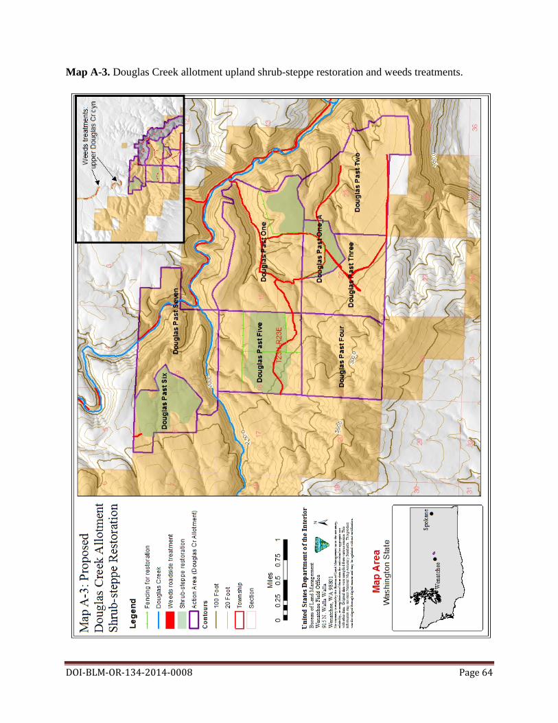
DOI-BLM-OR-134-2014-0008 Page 64
Map A-3. Douglas Creek allotment upland shrub-steppe restoration and weeds treatments.

DOI-BLM-OR-134-2014-0008 Page 65
Map A-4. Douglas Creek canyon riparian restoration. Boulder placements would not affect existing road use.

DOI-BLM-OR-134-2014-0008 Page 66
Appendix B: The Douglas Creek Allotment Management Plan (AMP) Revision Introduction The Douglas Creek allotment lies approximately four miles north of Palisades, Washington. The allotment ranges in elevation from 1,680 to 3,460 feet. Topography varies from gentle to steep. Average total annual precipitation is approximately ten inches. In 1987, an allotment management plan was developed for the allotment. Since that time, an additional 640 acres (School Pasture) was added to the BLM lands within the allotment boundary through an acquisition from the Department of Natural Resources (DNR). And an additional acquisition of 440 acres of private lands outside the allotment boundary that has been applied for by the lessee to be added to the allotment boundary and grazing plan. Management concerns raised by the current grazing lessee include the need for water in the Kelly-Davis pasture and reduced spring production of current water developments in the 4-Corners, and Hawthorn Spring pastures, as well as the need for knapweed treatment along roads within the allotment. Proposed weed treatments are addressed in Section 2.1 of the environmental assessment and therefore will not be addressed in this AMP. As a result of the acreage additions and issues described above, a revised AMP is needed. This revised Douglas Creek AMP includes restoration projects, new or improved water developments, and a revised grazing plan. In addition, consistent with multiple use goals of the BLM, the newly acquired lands in T23N R23E Section 8 and 9 east of the Douglas Creek canyon (Kelly-Davis and Trailing pastures) will be added to the current allotment. This AMP includes the current allotment and the additional acreage in the new acquisition for a total of 4,840 BLM administrative acres within the new allotment boundary (See Map B-1 below). The new allotment boundary will consist of the following eight pastures: Pasture Pasture Name Acres1 Number One Blue Gate 1,200 One A CRP 160 Two Hawthorn 1,280
Spring Three 4- Corners 480 Four George Well 640 Five School 640 Six Kelly-Davis 260 Seven Trailing 180 1Acreages are based on legal descriptions of grazing leases. Management Goals and Objectives Goal: Provide livestock grazing opportunities while maintaining and enhancing wildlife habitat to support native species including the Greater sage-grouse.
Objective: Maintain or improve rangeland health while allowing for grazing use by increasing livestock distribution.

Objective: Enhance greater sage-grouse habitat through restoration. Objective: Provide greater sage-grouse nesting cover through a moderate utilization level during the nesting/early brood-rearing period (April-June 15).
Objective: Implement a deferred grazing rotation.
Management Actions to Achieve Objectives
Action: Implement new water development in the Kelly-Davis pasture and improve water developments in School and Hawthorn Spring pastures.
Action: Implement restoration projects in School, Blue Gate, and CRP pastures as described in the restoration Section 2.1.1.
Action: Implement a moderate utilization level of key upland bunchgrasses not to exceed 30 to 40% average utilization of the current year’s growth by weight.
Action: Lengthen season of use by two months to allow for greater flexibility in rotation dates.
Terms and Conditions The ten year grazing lease will be issued with the following terms and conditions.
• Permitted use will not exceed 530 AUMs;
• Permitted season of use is April 1st to September 15th;
• Cattle will be the only authorized livestock kind;
• Livestock will not exceed 200 head (cow or cow/calf pair). Schedule will be adjusted to not exceed permitted AUMs dependent on livestock number;
• Livestock supplements will be placed at least 0.5 miles from water at a location
predetermined by the BLM and agreed upon by the lessee to facilitate livestock distribution; and
• Average utilization of key upland bunchgrasses not to exceed a moderate level (30 to 40%) of the current year’s growth by weight (Holecheck et al. 2011).
This AMP will take ten years to fully implement. Pasture rotation will be determined annually and consistent with the guidelines for grazing management (BLM 1997). Periodic rest from grazing during the native forage bunchgrass species critical growth period (May 1 to June 25) will occur in pastures to promote plant vigor, reproduction and productivity based on previous year’s rotation, actual use, and utilization monitoring data.
DOI-BLM-OR-134-2014-0008 Page 67

Once new or improved water developments are implemented and restoration projects are completed, the final grazing rotation will be implemented. Grazing use will be rotated between pastures; pastures grazed early in the grazing period one year will be grazed late in the season the following year. Billing The Douglas Creek allotment will be billed using Actual Use. As provided in 43 Code of Regulations (CFR) 4130.3-2(d), the lessee is required to submit an actual use report within 15 days after completion of annual grazing use. A grazing bill will be generated based on this report. Range Improvements The following range improvement projects will be implemented to improve rangeland health and livestock distribution in this allotment. All range improvements described below will have a new or updated cooperative agreement assigning responsibility for maintenance and repair to the BLM or lessee. • Douglas Creek Exclosure Drift Fence
o T23N R23E Sec 10: SW¼SW¼. Roughly .25 miles of drift fence will be constructed at the confluence of Duffy Creek and Douglas Creek to keep cattle from drifting into the Douglas Creek exclosure.
• George Well Spring Rebuild
o T23N R23E Sec 21: NE¼NE¼. The well will be cleaned out and restored to increase water flow. Concrete troughs will be replaced with aluminum troughs with wildlife escape ramps. Pipelines will be replaced where needed. The 4-Corners water provides water for Blue Gate, George Well, 4-Corners, and School pastures. Spring and trough improvement will occur in the same disturbed area as the current spring and trough. The possibility of installing a storage tank at this location to store water will be explored to increase availability of water.
• Hawthorn Spring Rebuild
o T23N R23E Sec 23: SW¼NE¼. Spring and pipeline will be cleaned out to increase flow and replace trough with wildlife ramp. Spring exclosure will be maintained. This water development provides water for Hawthorn Springs, CRP, and 4-Corners pastures.
• Kelly-Davis Well
o T23N R23E Sec 8: NE¼. The well site, old homestead, and outbuilding will be protected with a 100 by 200 foot enclosure using steel T-posts and wire. A solar pump will be installed into the historic well with an aboveground pipeline (approximately 150 feet) to a trough system downhill to a flat area (approximately 100 feet from enclosure fence). This water development will provide water for the Kelly-Davis Pasture.
Restoration Projects
DOI-BLM-OR-134-2014-0008 Page 68

During the scheduled restoration projects described in detail in the EA, the following changes in grazing management will be implemented: • Blue Gate Pasture
o Restoration in Blue gate pasture will occur on 125 acres. Restoration will occur first in the southeastern portion of the pasture. Temporary fencing will be used to exclude livestock from a portion of the pasture as restoration is done. Once specific restoration is complete, the temporary fence will be removed opening the entire pasture up for livestock use.
• CRP Pasture
o Restoration in CRP pasture will affect 100 acres. Temporary fencing will be used to exclude livestock from areas south of the access road as restoration is done. Once specific restoration is complete, the temporary fence will be removed opening the entire pasture up for livestock use.
• School Pasture
o Restoration in the School pasture will be done in two steps, working on the southwest side of the pasture first (150 acres); the southeastern portion (150 acres) of this pasture will be restored later. Temporary fencing will be used to exclude livestock from the areas as restoration is done. Cattle access to water will be maintained during restoration. Once specific restoration is complete, the temporary fence will be removed opening the entire pasture up for livestock use.
• Kelly-Davis Pasture o During the restoration, additional forage (up to 60 AUMs) with no additional
preference assigned will be granted on an annual basis if grazing monitoring indicates additional forage is available. Average utilization on current year’s growth on the non-native seeded species (Sherman’s bluegrass, tall wheatgrass, and crested wheatgrass) will not exceed 60%. Once restoration targets are met, average utilization of native key upland bunchgrasses will be reduced to not exceed 30 to 40% average utilization of the current year’s growth by weight. Less than 45 small (500 foot diameter) fenced areas within the pasture will be planted with shrubs, forbs, and grasses. Fenced areas will not affect terms and conditions for this pasture.
The following AUMs will be suspended during the grazing year in these pastures as outlined in the table below.
Grazing Acres in Suspended Pasture Year restoration AUMs Number 2017 150 18 Southwest School 2018 275 32 Southwest School and Blue Gate 2019 125 15 Blue Gate 2020 275 32 Blue Gate, East School 2021 150 18 Southeast School 2022 250 32 Southeast School, CRP
DOI-BLM-OR-134-2014-0008 Page 69

2023- 100 15 CRP 2024 Design Features for Range Improvements The following guidelines will be applied to rangeland improvement projects.
• Fences will be constructed using approved standards in the BLM Fencing Handbook 1741-1;
• Fences constructed in identified greater sage-grouse habitat will include plastic safety
clips where necessary to improve the visibility of wire and reduce the potential for wildlife collisions with fence wires;
• Troughs will be equipped with escape ramps for birds and small mammals; and
• Soil displaced for pipeline installation will be pulled in and returned to original slope and
grade then seeded. Monitoring and Evaluation Monitoring and evaluation will be done in accordance with the Spokane District Monitoring Resource Plan (1988) and any subsequent revisions or BLM guidance. Specifically, utilization data would be collected at the end of the growing season for identified key bunchgrass communities on a one to two year cycle. Utilization data will be collected at key areas and averaged by stratum and/or pasture. Long term trend data will be established and measured on a five year cycle as identified by the BLM interdisciplinary team. In addition, the following monitoring techniques may be implemented within the allotment. The BLM Assessment, Inventory, and Monitoring (AIM) Strategy plots (see BLM technical Note 445 (Taylor et al. 2014)) will be used to quantify the suitability of portions of the allotment for greater sage-grouse habitat and to assess the success of the restoration and weed treatments. Adaptive Management and Flexibility Adaptive management will be used to adjust season, timing of use and stocking rates based on rangeland monitoring. Once all improvements are implemented, management will have more opportunity to respond to short term resource needs through the increased ability to control and move livestock on the allotment. Flexibility in grazing management will be authorized and changes in rotations will only be allowed as long as they continue to meet resource objectives and do not exceed the permitted use. Changes to on or off dates may be adjusted annually based on vegetative response to seasonal conditions, and would allow for a two week period of flexibility around the permitted season of use. Schedule will be adjusted to not exceed permitted AUMs dependent on livestock number.
DOI-BLM-OR-134-2014-0008 Page 70

DOI-BLM-OR-134-2014-0008 Page 71
Map B-1. Douglas Creek Allotment Pastures and Improvements

Appendix C. Invasive and Noxious Weeds The Table C-1 below lists some of the approved herbicides that may be used on BLM lands at this time and their general affects to vegetation. The BLM would also be able to use new active ingredients that are developed in the future if: 1) they are registered by the EPA for use on one or more land types (e.g., rangeland, aquatic, etc.) managed by the BLM; 2) the BLM determines that the benefits of use on public lands outweigh the risks to human health and the environment; and 3) they meet evaluation criteria to ensure that the decision to use the active ingredient is supported by scientific evaluation and NEPA documentation. These evaluation criteria are discussed in more detail in the Vegetation PEIS (Appendix E of BLM 2007a).
Table C-1. Herbicides Approved for Use on BLM-administered lands.
Active Registered Trade Names General Effects to Vegetation Ingredient Agrisolution 2,4-D LV6; Agrisolution 2,4-D Amine 4; Agrisolution 2,4-D LV4; 2,4-D Amine 4; 2,4-D LV 4; Solve 2,4-D; 2,4-D LV 6; Five Star; D-638; Alliagre 2,4-D Amine; 2,4-D LV6; 2,4-D Amine; 2,4-D Amine 4; Opti-Amine; Barrage HF; HardBall; Unison; Clean Amine; Low Vol 4 Ester Weed Killer; Low Vol 6 Ester Weed Killer; Saber; Salvo; Savage DS; Aqua-Kleen; Esteron 2,4-D is a plant growth regulator 99C; Weedar 64; Weedone LV-4; Weedone LV-4 and acts as a synthetic auxin Solventless; Weedone LV-6; Formula 40; 2,4-D LV 6 hormone. Broad-leaved plants 2,4-D Ester; Platoon; WEEDstroy; AM-40; Hi-Dep; 2,4-D are more susceptible than Amine; Barrage; LV Ester; 2,4-D LV4; 2,4-D LV6; Clean narrow-leaved plants like Crop Amine 4; Clean Crop Low Vol 6 Ester; Salvo LV grasses. Ester; 2,4-D 4# Amine Weed Killer; Clean Crop LV-4 ES; Savage DS; Cornbelt 4 lb. Amine; Cornbelt 4#; LoVol Ester; Cornbelt 6# LoVol Ester; Amine 4; Base Camp Amine 4; Broadrange 55; Lo Vol-4; Lo Vol-6 Ester; Agrisolution 2,4-D LV6; Agrisolution 2,4-D Amine 4; Agrisolution 2,4-D LV4
A growth-regulating herbicide readily absorbed and Dicamba DMA; Vision; Cruise Control; Banvel; Clarity; translocated from either roots or Dicamba Vision; Rifle; Diablo; ; Vanquish Herbicide; Vanquish; foliage. This herbicide produces Sterling Blue effects similar to those found with 2,4-D.
Dicamba + 2,4- Range Star; Weedmaster; Brush-Rhap; Latigo; Outlaw; See Dicamba and 2,4-D for D Rifle-D; KambaMaster; Weedmaster; Veteran 720; Brash effects of these chemicals.
Aqua Star; Forest Star; GlyStar Gold; Gly Star; Original; Gly Star Plus; Gly Star Pro; Glyphosate 4 PLUS; Glyphosate 5.4; Glyfos Glyfos PRO; Glyfos Aquatic; ClearOut 41 Plus; Accord Concentrate; Accord SP; Accord XRT Accord XRT II; Glypro; Glypro Plus; Rodeo A nonselective systemic Showdown; Mirage; Mirage Plus; Aquamaster Roundup herbicide that can damage all Glyphosate Original; Roundup Original II; Roundup Original II CA; groups or families of non-target Honcho; Honcho Plus; Roundup PRO; Roundup PRO plants to varying degrees. Concentrate; Roundup PRO Dry; Roundup PROMAX; Aqua; Neat ; Credit Xtreme; Foresters; Razor; Razor Pro; GlyphoMate 41; AquaPro Aquatic Herbicide; Rattler; Buccaneer; Buccaneer Plus Mirage Herbicide; Mirage Plus Herbicide; Gly-4 Plus; Gly4; Glyphosate 4;
DOI-BLM-OR-134-2014-0008 Page 72

Agrisolutions Cornerstone; Agrisolutions Cornerstone Plus; Agrisolutions Rascal; Agrisolutions Rascal Plus
Glyphosate + See 2,4-D and glyphosate for Landmaster BW; Campaign 2,4-D effects of these chemicals. This is a selective, systemic herbicide that can be applied both pre-emergence and post-emergence for the management Imazapic Plateau; Panoramic 2SL of selective broadleaf and grassy plant species. Its mode of action is associated with the synthesis of branch-chained amino acids.
Imazapic + See imazapic and glyphosate for Journey Glyphosate effects of these chemicals. Imazapyr 2SL; Imazapyr 4SL; Ecomazapyr 2SL; Arsenal This broad-spectrum herbicide Railroad Herbicide; Chopper; Arsenal Applicators Conc.; can be applied pre or Arsenal; Arsenal PowerLine; Stalker; Habitat; Polaris; postemergence to weeds. Stable Polaris AC; Polaris AC; Polaris AQ; Polaris RR; Polaris for at least 18 months. Kills Imazapyr SP; Polaris SP; Polaris Herbicide; Habitat Herbicide; SSI plants within two to four weeks Maxim; Arsenal 0.5G; Ecomazapyr 2 SL; with residual activity. It is Imazapyr 2 SL; Imazapyr 4 SL currently registered for use in non-crop areas su Triumph K; Triumph 22K; Picloram K; Picloram 22K; Picloram is more toxic to
Picloram Grazon PC; OutPost 22K; Tordon K; Tordon 22K; broadleaf and woody plants than Trooper 22K grains or grasses. GunSlinger; Picloram + D; Tordon 101 Mixture; Tordon Picloram + 2,4- See Picloram, and 2,4-D for 101 R Forestry; Tordon RTU; Grazon P+D; HiredHand D effects of these chemicals. P+D; Pathway; Trooper 101; Trooper P + D
See Picloram, 2,4-D and Picloram + 2,4- Trooper Extra dicamba for effects of these D + Dicamba chemicals. Triclopyr 4EC; Triclopyr 3; Triclopry 4; Element 3A; Element 4; Forestry Garlon XRT; Garlon 3A; Garlon 4; A growth-regulating herbicide Garlon 4 Ultra; Remedy; Remedy Ultra: Pathfinder II; for control of woody and
Triclopyr Trycera; Relegate; Relegate RTU; Tahoe 3A; Tahoe 4E; broadleaf perennial weeds in Tahoe 4E Herbicide; Renovate 3; Renovate OTF; non-cropland, forest lands, and Ecotriclopyr 3 SL; Triclopyr 3 SL lawns.
Triclopyr + 2,4- See triclopyr and 2,4-D for Everett; Crossbow; Aquasweep; Candor D effects of these chemicals.
DOI-BLM-OR-134-2014-0008 Page 73

Table C-2. Streamside, Wetland, and Riparian Habitat Restrictions for Herbicide Use.
Riparian Area of Influence Aquatic Level of Max. Herbicide Application Concern Category* Wind Method for Authorized Speed Herbicides >100 feet from live waters but within
All ground/broadcast spraying upland areas where ground-based 8 mph Low and Moderate methods. herbicide applications may influence riparian habitat
Wicking, dipping, painting, >100 feet from live waters but within and injecting. upland areas where ground-based N/A Low and Moderate herbicide applications may influence
riparian habitat Ground/spot spraying, wicking, wiping, dipping, painting, injecting. Selective >15 feet from live waters or shallow 8 mph Low spraying of target species only water tables, or within riparian areas (e.g. spot treatment of individual plants). Backpack sprayer, hand sprayer, wicking, wiping, Aquatic approved dipping, painting, and >10 feet from live water or shallow water herbicides only. No use 5 mph injecting. Selective spraying of tables of surfactants will be target species only (e.g. spot authorized. treatment of individual plants).
DOI-BLM-OR-134-2014-0008 Page 74
Table C-3. Standard Operating Procedures for Applying Herbicides
Resource Element Standard Operating Procedure Guidance Documents BLM Handbook H-9011-1 (Chemical Pest Control); and manuals 1112 (Safety), 9011 (Chemical Pest Control), 9012
(Expenditure of Rangeland Insect Pest Control Funds), 9015 (Integrated Weed Management), and 9220 (Integrated Pest Management). Prepare operational and spill contingency plan in advance of treatment. Conduct a pretreatment survey before applying herbicides. Select herbicide that is least damaging to the environment while providing the desired results. Select herbicide products carefully to minimize additional impacts from degradates, adjuvants, inert ingredients, and tank mixtures. Apply the least amount of herbicide needed to achieve the desired result. Follow herbicide product label for use and storage. Have licensed applicators apply herbicides. Use only USEPA-approved herbicides and follow product label directions and “advisory” statements. Review, understand, and conform to the “Environmental Hazards” section on the herbicide product label. This section warns of known pesticide risks to the environment and provides practical ways to avoid harm to organisms or to the environment. Consider surrounding land use before assigning aerial spraying as a treatment method and avoid aerial spraying near agricultural or densely populated areas. Minimize the size of application area, when feasible. Comply with herbicide-free buffer zones to ensure that drift will not affect crops or nearby residents/landowners. Post treated areas and specify reentry or rest times, if appropriate. Notify adjacent landowners prior to treatment. Keep a copy of Material Safety Data Sheets (MSDSs) at work sites. MSDSs are available for review at http://www.cdms.net/. Keep records of each General application, including the active ingredient, formulation, application rate, date, time, and location. Avoid accidental direct spray and spill conditions to minimize risks to resources. Consider surrounding land uses before aerial spraying. Avoid aerial spraying during periods of adverse weather conditions (snow or rain imminent, fog, or air turbulence). Make helicopter applications at a target airspeed of 40 to 50 miles per hour (mph), and at about 30 to 45 feet above ground. Take precautions to minimize drift by not applying herbicides when winds exceed >10 mph (>6 mph for aerial applications), or a serious rainfall event is imminent. Use drift control agents and low volatile formulations. Conduct pre-treatment surveys for sensitive habitat and special status species within or adjacent to proposed treatment areas. Consider site characteristics, environmental conditions, and application equipment in order to minimize damage to non-target vegetation. Use drift reduction agents, as appropriate, to reduce the drift hazard to non-target species. Turn off applied treatments at the completion of spray runs and during turns to start another spray run. Refer to the herbicide product label when planning re-vegetation to ensure that subsequent vegetation would not be injured following application of the herbicide. Clean OHVs to remove seeds.
Soil, Minimize treatments in areas where herbicide runoff is likely, such as steep slopes when heavy rainfall is expected. See Manual 7000 (Soil, Minimize use of herbicides that have high soil mobility, particularly in areas where soil properties increase the potential for Water, and Air mobility. Do not apply granular herbicides on slopes of more than 15% where there is the possibility of runoff carrying the Management) granules into non-target areas.
DOI-BLM-OR-134-2014-0008 Page 75

Consider climate, soil type, slope, and vegetation type when developing herbicide treatment programs. Select herbicide products to minimize impacts to water. This is especially important for application scenarios that involve risk from active ingredients in a particular herbicide, as predicted by risk assessments. Use local historical weather data to choose the month of treatment. Considering the phenology of the target species, schedule treatments based on the condition of the water body and existing water quality conditions. Plan to treat between weather fronts (calms) and at appropriate time of day to avoid Water Resources, high winds that increase water movements, and to avoid potential stormwater runoff and water turbidity. Review See Manual 7000 (Soil, hydrogeologic maps of proposed treatment areas. Note depths to groundwater and areas of shallow groundwater and areas of Water, and Air surface water and groundwater interaction. Minimize treating areas with high risk for groundwater contamination. Conduct Management) mixing and loading operations in an area where an accidental spill would not contaminate an aquatic body. Do not rinse spray tanks in or near water bodies. Do not broadcast pellets where there is danger of contaminating water supplies. Maintain buffers between treatment areas and water bodies. Buffer widths should be developed based on herbicide-and site-specific criteria to minimize impacts to water bodies. Minimize the potential effects to surface water quality and quantity by stabilizing terrestrial areas as quickly as possible following treatment. Use a selective herbicide and a wick or backpack sprayer. Use appropriate herbicide-free buffer zones for herbicides not Wetlands and Riparian labeled for aquatic use based on risk assessment guidance, with minimum widths of 100 feet for aerial, 25 feet for vehicle, Areas and 10 feet for hand spray applications.
Fish and Other Aquatic Use appropriate buffer zones based on label and risk assessment guidance. Minimize treatments near fish-bearing water Organisms, bodies during periods when fish are in life stages most sensitive to the herbicide(s) used, and use spot rather than broadcast See manuals 6500 (Wildlife or aerial treatments. Use appropriate application equipment/method near water bodies if the potential for off-site drift exists. and Fisheries For treatment of aquatic vegetation, 1) treat only that portion of the aquatic system necessary to achieve acceptable Management) and 6780 vegetation management, 2) use the appropriate application method to minimize the potential for injury to desirable (Habitat Management vegetation and aquatic organisms, and 3) follow water use restrictions presented on the herbicide label. Plans) Threatened, Endangered, Survey for special status species before treating an area. Consider effects to special status species when designing herbicide and Sensitive Species, treatment programs. Use a selective herbicide and a wick or backpack sprayer to minimize risks to special status plants. See Manual 6840 (Special Avoid treating vegetation during time-sensitive periods (e.g., nesting and migration, sensitive life stages) for special status Status Species) species in area to be treated.
Whenever possible and whenever needed, schedule treatments when livestock are not present in the treatment area. Design treatments to take advantage of normal livestock grazing rest periods, when possible. As directed by the herbicide product label, remove livestock from treatment sites prior to herbicide application, where applicable. Use herbicides of low toxicity Livestock, to livestock, where feasible. Take into account the different types of application equipment and methods, where possible, to See Handbook H-4120-1 reduce the probability of contamination of non-target food and water sources. Avoid use of diquat in riparian pasture while (Grazing Management) pasture is being used by livestock. Notify permittees of the herbicide treatment project to improve coordination and avoid potential conflicts and safety concerns during implementation of the treatment. Notify permittees of livestock grazing, feeding, or slaughter restrictions, if necessary. Provide alternative forage sites for livestock, if possible.
DOI-BLM-OR-134-2014-0008 Page 76
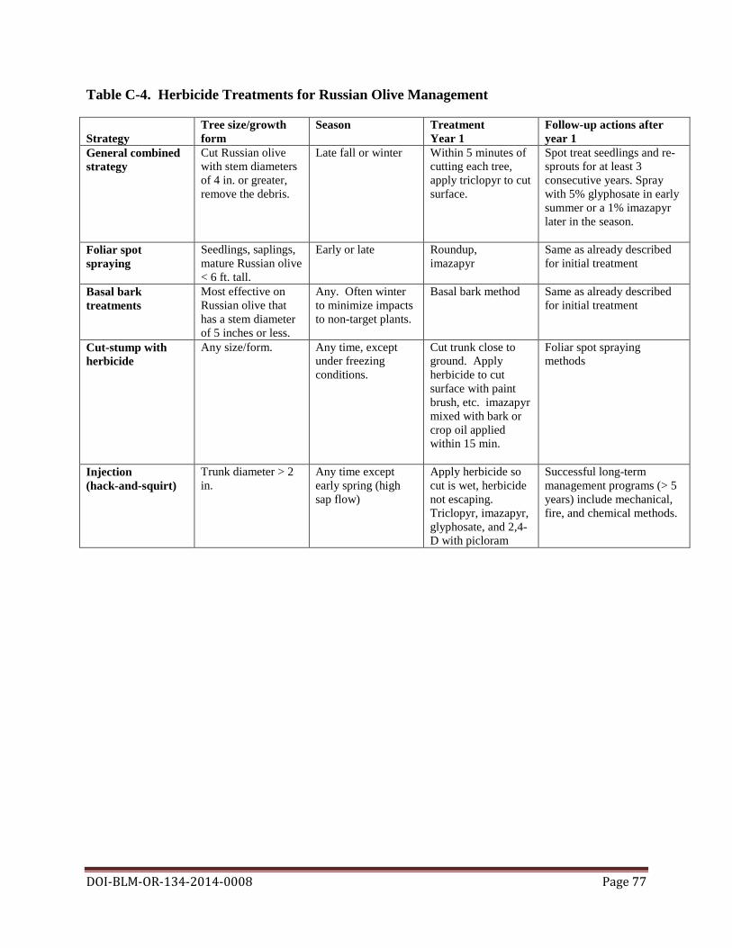
Table C-4. Herbicide Treatments for Russian Olive Management
Tree size/growth Season Treatment Follow-up actions after Strategy form Year 1 year 1 General combined Cut Russian olive Late fall or winter Within 5 minutes of Spot treat seedlings and re-strategy with stem diameters cutting each tree, sprouts for at least 3
of 4 in. or greater, apply triclopyr to cut consecutive years. Spray remove the debris. surface. with 5% glyphosate in early
summer or a 1% imazapyr later in the season.
Foliar spot Seedlings, saplings, Early or late Roundup, Same as already described spraying mature Russian olive imazapyr for initial treatment
< 6 ft. tall. Basal bark Most effective on Any. Often winter Basal bark method Same as already described treatments Russian olive that to minimize impacts for initial treatment
has a stem diameter to non-target plants. of 5 inches or less.
Cut-stump with Any size/form. Any time, except Cut trunk close to Foliar spot spraying herbicide under freezing ground. Apply methods conditions. herbicide to cut
surface with paint brush, etc. imazapyr mixed with bark or crop oil applied within 15 min.
Injection Trunk diameter > 2 Any time except Apply herbicide so Successful long-term (hack-and-squirt) in. early spring (high cut is wet, herbicide management programs (> 5
sap flow) not escaping. years) include mechanical, Triclopyr, imazapyr, fire, and chemical methods. glyphosate, and 2,4- D with picloram
DOI-BLM-OR-134-2014-0008 Page 77