reese creek allotment · the reese creek allotment lies entirely within the south fork reese creek...
TRANSCRIPT
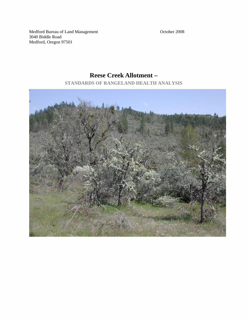
Medford Bureau of Land Management October 2008 3040 Biddle Road Medford, Oregon 97501
Reese Creek Allotment – STANDARDS OF RANGELAND HEALTH ANALYSIS
Table of Contents
Introduction Overview of the Evaluation Area and Principle Findings
Assessment The Existing Environment and an Overview of Rangeland Health Assessment Process
Maps Map 1- Reese Creek Allotment
Tables Table 1 - Special Status Species (Terrestrial Wildlife) Table 2 - Bird Species of Conservation Concern Table 3 - Special Status Species (Aquatic Wildlife) Table 4 - Special Status Species (Vascular Plants) Table 5 - RHA Location 1 indicator summary 5a-Species Composition 5b-Cover
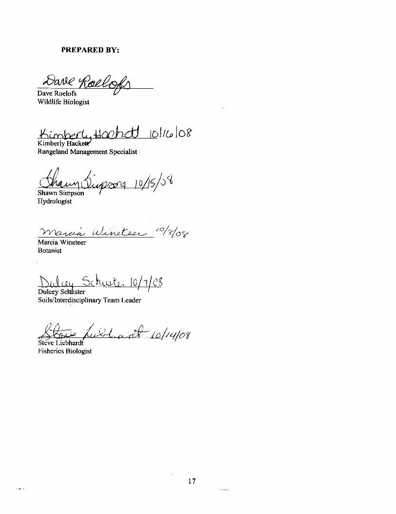
Assessment Participants (Name and Discipline):
Kimberly Hackett - Rangeland Management Dave Roelofs - Terrestrial Wildlife Steve Liebhardt - Aquatic/Fisheries Shawn Simpson - Hydrology Marcia Wineteer - Botany Dulcey Schuster - Soils/Interdisciplinary Team Leader
2
INTRODUCTION This is an Oregon/Washington Bureau of Land Management (BLM) Standards of Rangeland Health Evaluation that addresses the Reese Creek Allotment (10027). The Reese Creek Allotment is located east and west of the Butte Falls Highway in T. 35 S., R. 1 E., Section 5 Willamette Meridian (Map 1). The allotment is 40 acres with three cows permitted from May 1-May 31 in the western half of the allotment and four cows permitted from June 1-June 30 in the eastern half of the allotment totaling seven Animal Unit Months (AUMs).
Vegetation The vegetation in this allotment is a mosaic of chaparral (Ceanothus cuneatus), prairie, and Oregon white oak (Quercus garryana) woodland. The component of coniferous forest includes Ponderosa pine (Pinus ponderosa) and incense cedar (Calocedrus decurrens). Native grasses, including needlegrass (Achnatherum), and Roemer’s fescue (Festuca roemerii) grow across the allotment, depending on local conditions of soil, topography, and shade. Annual and short-lived perennial weedy grasses, including medusahead (Taeniatherum caput-medusae) annual bromes (Bromus sp.) and bulbous bluegrass (Poa bulbosa), grow throughout the allotment. On the portion of the allotment west of the Butte Falls Highway, there are small patches of yellow starthistle (Centeurea solstitalis) and Himalayan blackberry (Rubus armeniacus), and Fuller’s teasel (Dispacus fullonum) grow in extensive patches.
Soils The main soil limitations affecting livestock grazing are erosion, compaction, the depth to bedrock, and the steepness of slope. This season of use and number of cattle using the allotment does not significantly diminish the health and function of the watershed by minimizing use, maintaining adequate vegetative cover, and healthy root systems. These factors aid in maintaining existing infiltration, percolation, runoff and erosion rates. Areas dominated by invasive annual grasses have shallow root zones, and thus are less able than native grassland communities to retain and slowly release moisture, capture leaching nutrients, and stabilize the soil (D’Antonio and Vitousek 1992).
Soils in the area are primarily classified as McMullin-Rock outcrop / Medco clay / Medco McMullin series. McMullin-Rock outcrop soils are generally shallow and well drained, and typically composed of dark reddish-brown gravelly loams. Both Medco clay and Medco McMullin are moderately deep and moderately well drained. Permeability is moderately slow to moderate, with a water capacity of about 2 inches, and a corresponding rooting depth of about 12 to 20 inches. These soils have slight to moderate erosion factors by water. Rock outcrop consists of areas of exposed bedrock. Runoff is very rapid in these areas. These soils can be easily compacted if wet or saturated. These soil types are suitable for livestock grazing and wildlife habitat.
Hydrology The Reese Creek Allotment lies entirely within the South Fork Reese Creek Level 7 drainage in the Reese Creek – Rogue River Level 6 subwatershed which in turn is located in the Big Butte Creek Level 5 watershed. The South Fork of Reese Creek runs through the allotment along the Butte Falls Highway. The South Fork of Reese Creek flows into Reese Creek approximately three miles downstream of the allotment boundary which flows into the Rogue River approximately three additional miles downstream. There are 0.43 miles of perennial streams within the allotment boundary.
3
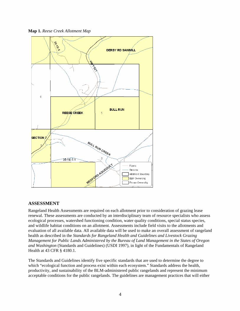
Map 1. Reese Creek Allotment Map
ASSESSMENT Rangeland Health Assessments are required on each allotment prior to consideration of grazing lease renewal. These assessments are conducted by an interdisciplinary team of resource specialists who assess ecological processes, watershed functioning condition, water quality conditions, special status species, and wildlife habitat conditions on an allotment. Assessments include field visits to the allotments and evaluation of all available data. All available data will be used to make an overall assessment of rangeland health as described in the Standards for Rangeland Health and Guidelines and Livestock Grazing Management for Public Lands Administered by the Bureau of Land Management in the States of Oregon and Washington (Standards and Guidelines) (USDI 1997), in light of the Fundamentals of Rangeland Health at 43 CFR § 4180.1.
The Standards and Guidelines identify five specific standards that are used to determine the degree to which “ecological function and process exist within each ecosystem.” Standards address the health, productivity, and sustainability of the BLM-administered public rangelands and represent the minimum acceptable conditions for the public rangelands. The guidelines are management practices that will either
4
maintain existing desirable conditions or move rangelands toward statewide standards within reasonable timeframes.
The Standards and Guidelines also specify a set of potential indicators for use when determining whether or not standards are being met. This assessment summarizes existing resource conditions on the Reese Creek Allotment using information derived from the rangeland health field assessments; BLM monitoring data; and all other available data in relation to the five specific standards described in the Standards and Guidelines (USDI 1997).
Primary Supporting Data: Data used by the BLM to support this assessment includes, but is not limited to, the following studies and monitoring projects.
Rangeland Health Field Assessments: Field assessments using the protocol described in Technical Reference 1734-6: Interpreting the Indicators of Rangeland Health (USDI and USDA 2005) were conducted July 17, 2008 at a Clayey Hills ecological site.
Hydrologic/Riparian Surveys: Surveys of all streams within the allotment were conducted in 2008 using the Butte Falls Resource Area Stream Survey Protocol. Location, periodicity, connectivity, channel classification/morphology data for streams, wetlands, and other hydrologic features; instream large wood; impact descriptions and restoration opportunities, especially related to livestock, transportation, timber harvest and vegetation throughout the allotment is collected. Properly functioning condition (PFC) is also assessed during the surveys.
Baseline Stream Temperature Monitoring: Seasonal 30-minute interval stream temperature data has been collected by the Medford Water Commission at two monitoring sites on Reese Creeks downstream of this allotment using USGS and Oregon DEQ-established methodologies. Temperature monitoring data assists in assessment of Aquatic Conservation Strategy (ACS) Objectives 1-4 and 6-9 (USDA/USDI 1994b); for assessment of compliance with state water quality standards; and assists in development of State of Oregon/EPA-required Water Quality Management Plans for the area.
Gaging Station and Staff Gages: Flow and Water Quality Assessment: Calculation and assessment of peak, high and low flows are extremely difficult without actual field measurement and reference over time. Flow data is also required for the meaningful analysis of water quality parameters. Because of rapid fluctuation in stream levels, continuous records are required at a key location to interpret data collected in non-continuous sampling from other locations. Grab samples of turbidity, air temperature, water temperature, pH, and flow, are collected in one location in the Reese Creek – Rogue River Level 6 subwatershed; the site, established in 2008, is within the grazing allotment and is located on the South Fork Reese Creek. Streamflow is also measured at this site. The general lack of multiple collection sites and subsequent data stems primarily from the scarcity of BLM managed land within this area. There are no stream gages established at any site within the Reese Creek – Rogue River Level 6 subwatershed.
Stream Channel Cross Sections: Stream cross-section measurements are collected at one site within the Reese Creek – Rogue River Level 6 subwatershed; the site is within the allotment and is located on the South Fork Reese Creek. Measurement methodologies include standard cadastral survey techniques and those outlined in Rosgen (1996). Sites are measured annually and/or after major flood events. Cross-sections provide a reference point from which to document changes in channel morphology, conduct flow measurements, and estimate flood flows. Documentation of changes in channel morphology provides an indication of stability and functioning of the upstream surface hydrologic system.
5
Rain Gages: Assessment of hydrologic response and water quality parameters, as well as many other aspects of ecosystem function, can only be analyzed accurately in the context of recent precipitation. Rainfall data is not collected within the Reese Creek – Rogue River Level 6 subwatershed. Similarly, daily snowfall and snow-on-the-ground is not collected. Data from non-BLM sources however, indicates that annual precipitation is between 24 and 34 inches. Year-to-year trends in precipitation tend to be uniform over an area the size of the Reese Creek Allotment, but there is substantial variability in precipitation across the Reese Creek – Rogue River Level 6 subwatershed based on terrain, elevation, aspect, etc. Precipitation data from a number of sites at varying elevations and locations in and around the subwatershed is needed for accurate interpretation of related data including hydrologic and vegetation conditions. The nearest BLM-monitored rain gage is in the community of Butte Falls, Oregon – approximately six miles east and in the Big Butte Creek Level 5 watershed.
Botany Surveys: Botany Surveys were conducted in the Reese Creek Allotment in 2002, 2006, and 2007 using the Intuitive Controlled Survey. In this method the surveyor traverses the project area enough to see a representative cross section of all the major habitats and topographic features, looking for Special Status plant species while en route between different areas. When the surveyor arrives at an area of high potential habitat, he conducts a more intensive survey for the target species.
Standard 1 Watershed Function - Uplands To meet this standard, upland soils exhibit infiltration and permeability rates, moisture storage, and stability that are appropriate to soil, climate, and landform.
This standard focuses on the basic physical functions of upland soils that support plant growth, the maintenance or development of plant populations and communities, and promote dependable flows of quality water from the watershed.
To achieve and sustain rangeland health, watersheds must function properly. Watersheds consist of three principle components: the uplands, riparian/wetland areas and the aquatic zone. This standard addresses the upland component of the watershed. When functioning properly, within its potential, a watershed captures, stores and safely releases the moisture associated with normal precipitation events (equal to or less than the 25-year, 5-hour event) that falls within its boundaries. Uplands make up the largest part of the watershed and are where most of the moisture received during precipitation events is captured and stored.
While all watersheds consist of similar components and processes, each is unique in its individual makeup. Each watershed displays its own pattern of landform and soil, its unique climate and weather patterns, and its own history of use and current condition. In directing management toward achieving this standard, it is essential to treat each unit of the landscape (soil, ecological site, and watershed) according to its own capability and how it fits with both smaller and larger units of the landscape.
A Rangeland Health Assessment was conducted on the allotment at a loamy shrub scabland ecological site in July of 2008. The indicators pertaining to Soil/Site Stability revealed that seven indicators (70%) were rated none-to-slight and three indicators (30%) was rated slight-to-moderate departures from the ecological sites reference condition.
The Reese Creek Allotment lies entirely within the South Fork Reese Creek Level 7 drainage in the Reese Creek – Rogue River Level 6 subwatershed. The road density in the South Fork Reese Creek Drainage is 4.92 mi./mi.
2. Within the Reese Creek – Rogue River Level 6 subwatershed the road density is 5.09 mi./mi. 2.
High road densities are generally associated with impaired hydrologic function; loss of connectivity; introduction and spread of exotic species and noxious weeds; reductions in site productivity; and
6
increased sediment production.
Standard 2 Watershed Function - Riparian/Wetland Areas To meet this standard, riparian-wetland areas are in properly functioning physical condition appropriate to soil, climate, and landform.
Riparian-wetland areas include standing water systems such as lakes, ponds, seeps, bogs, and meadows; and moving water systems such as rivers, streams, and springs. Wetlands are areas that are inundated or saturated by surface or ground water at a frequency and duration to support, and which under normal circumstances do support, a prevalence of vegetation typically adapted to life in saturated soil conditions. Riparian areas commonly occupy the transition zone between the uplands and surface water bodies (the aquatic zone) or permanently saturated wetlands.
Properly functioning condition of riparian and wetland areas describes the degree of physical function of these components of the watershed. Their functionality is important to water quality in the capture and retention of sediment and debris, the detention and detoxification of pollutants, and in moderating seasonal extremes of water temperature. Properly functioning riparian areas and wetlands enhance the timing and duration of stream flow through dissipation of flood energy, improved bank storage, and ground water recharge. Properly functioning condition should not be confused with the Desired Plant Community (DPC) or the Desired Future Condition (DFC) since, in most cases, it is the precursor to these levels of resource condition and is required for their attainment.
Functioning Condition Assessments were conducted in the riparian areas of the allotment in 2008 (BLM Stream Surveys). These assessments refer to a consistent approach for considering hydrology, vegetation, and erosion/deposition (soils) attributes and processes to assess the condition of riparian areas. The South Fork Reese Creek runs through the Reese Creek Allotment. The South Fork Reese Creek is a tributary to Reese Creek, a tributary to the Rogue River.
Upstream of the allotment, a diversion diverts roughly half of South Fork Reese Creek. However, due to groundwater, agricultural runoff and the influx of water from ditch and canal failures, South Fork Reese Creek and many of its tributaries are perennial.
The South Fork Reese Creek flows parallel to the Butte Falls Highway (County Road 821). Due to the close proximity of the road, the right bank of South Fork Reese Creek has been altered in terms of hydrology and riparian vegetation. The right streambank is located in armor-rock and is host to dense, non-native vegetation. Much of the left streambank is constrained by bedrock geology. Stemming from the armored right streambank and the bedrock left bank, stream energy is high. Where geology permits, the floodplain is wide. Energy is only attenuated by beaver dams – of which there are several.
Due to stream diversions and proximity to the Butte Falls Highway, the section of South Fork Reese Creek within the allotment is Functioning-at-Risk with an Upward Trend. Grazing does not appear to negatively influence hydrology. BLM surveys (2008) indicated no active erosion within the allotment. However, active erosion was observed on approximately 30% of streambanks along an unnamed, perennial tributary to the South Fork Reese Creek, immediately upstream from the allotment. Such erosion is likely to contribute sediment and increase turbidity within the allotment. Additionally, an unnamed, perennial tributary of South Fork Reese Creek immediately upstream of the allotment has been rated nonfunctional due to the stream’s high velocity and lack of structure flowing from a failure in an irrigation ditch. While obligate wetland vegetation exists, the stream consists largely of unstable, overland flow. Significant sediment inputs are possible. Due to the wide, shallow and unshaded nature
7
of this stream it is also susceptible to elevated water temperature which flows directly into South Fork Reese Creek.
The road density in the Reese Creek – Rogue River subwatershed is 5.09 mi./mi. 2. Roads within riparian
areas can greatly influence aquatic and riparian conditions. Roads contribute to the disruption of aquatic connectivity, large wood and nutrient storage regimes, peak flow routing, aquatic habitat complexity, temperature regimes, channel morphology, and direct sediment inputs from road failures. The Matrix of Pathways and Indicators for the Klamath Province/Siskiyou Mountains considers road densities of less than 2.0 mi./mi.2 as properly functioning condition and greater than 3.0 mi./mi.2 as not properly functioning (ODFW 2002, 2003).
Standard 3 Ecological Processes To meet this standard, healthy, productive, and diverse plant and animal populations and communities appropriate to soil, climate, and landform are supported by ecological processes of nutrient cycling, energy flow and the hydrologic cycle.
This standard addresses the ecological processes of energy flow and nutrient cycling as influenced by existing plant and animal communities. While emphasis may be on native species, an ecological site may be capable of supporting a number of different native and introduced plant and animal populations and communities while meeting this standard. This standard also addresses the hydrologic cycle which is essential for plant growth and appropriate levels of energy flow and nutrient cycling.
The ability of plants to capture sunlight energy, to grow and develop, plays a role in soil development and watershed function. Nutrients necessary for plant growth are made available to plants through the decomposition and metabolization of organic matter by insects, bacteria and fungi, the weathering of rocks and extraction from the atmosphere. Nutrients are transported through the soil by plant uptake, leaching and by rodent, insect and microbial activity. They follow cyclical patterns as they are used and reused by living organisms.
The ability of rangelands to provide habitat for wildlife and satisfy social and economic needs depends on the buildup and cycling of nutrients over time. Interrupting or slowing nutrient cycle can lead to site degradation, as these lands become increasingly deficient in the nutrients plants require.
Some plant communities, because of past livestock use, fire frequency, or other past extreme or continued disturbances, are incapable of meeting this standard. For example, shallow-rooted winter-annual grasses that completely dominate some sites do not fully occupy the potential rooting depth of some soils, thereby reducing nutrient cycling well below optimum levels. In addition, these plants have a relatively short growth period and thus capture less sunlight than more diverse plant communities. Plant communities like those cited in this example are considered to have crossed the threshold of recovery and often require great expense to be recovered. The cost of recovery must be weighed against the site’s potential ecological/economic value in establishing treatment priorities.
There is a healthy mix of live and dead/decaying matter on the rangeland. The dry meadows and oak woodland plant communities support a diverse mix of plant species. However, invasive plant species are scattered in patches through out the majority of the non-conifer areas, particularly annual grasses. In addition to reducing habitat quality for wildlife, annual grasses have shallower root systems and shorter life cycles than native perennial grasses, and thus have reduced capacity to hold the soil and retain water and nutrients. Medusahead where it is well established interrupts the nutrient cycle as it forms litter mats on the soil surface which decay slowly due to high silica content and retain nutrients. It also grows early
8
in the season thus outcompeting perennial grass seedlings for early soil moisture and nutrients. In areas where these annual grass species are already well established the plant community has likely crossed over a threshold into a less desirable stable state. Introduction and establishment of exotic annual grasses occurred in past decades, and current livestock grazing is not intense enough to contribute to additional conversion of native plant communities to exotic annual grasslands. The western portion of the allotment is in worse ecological condition than the eastern potion of the allotment, there are large patches of Himalayan blackberry (Rubus armeniacus), teasel (Dispacus fullonum), and non-native rose (Rosa sp).
Standard 4 Water Quality To meet this standard, surface water and groundwater quality, influenced by agency actions, complies with State water quality standards.
The quality of the water yielded by a watershed is determined by the physical and chemical properties of the geology and soils unique to the watershed, the prevailing climate and weather patterns, current resource conditions, the uses to which the land is put and the quality of the management of those uses. Standards 1, 2 and 3 contribute to attaining this standard.
States are legally required to establish water quality standards and federal land management agencies are to comply with those standards. In mixed ownership watersheds, agencies, like any other land owners, have limited influence on the quality of the water yielded by the watershed. The actions taken by the agency will contribute to meeting State water quality standards during the period that water crosses agency administered holdings.
The Oregon Department of Environmental Quality (DEQ) is required by the federal Clean Water Act (CWA) to maintain a list of stream segments that do not meet water quality standards for one or more beneficial uses. This list is called the 303(d) list because of the section of the CWA that makes the requirement. DEQs 2004/2006 303(d) list is the most recent listing of these streams (ODEQ 2006a). Within the Reese Creek Allotment, there are no known listed streams on DEQs 2004/2006 303 (d) list. However, the lower reaches of Reese Creek (stream mile 0-3) are listed for summer dissolved oxygen limitation and E. coli contamination.
Roads may alter the groundwater and surface flow patterns locally and may create an imbalance in hydrologic systems. Natural and graveled road surfaces, road cuts, fill slopes, and ditch lines are subject to erosion. Ditch lines that are not effectively drained by relief culverts (cross drains) act as extensions of stream networks that deliver fine sediment, as well as intercepted ground and surface water directly into stream channels. Research (Jones and Grant 1994; Wemple 1994; Wemple, et al. 1996) suggests that roads that contribute to the extension of the stream channel network are related to changes in the timing and magnitude of peak flows. Road cuts intercept subsurface flow, effectively increasing the amount of surface flow, and the ditch lines allow the water to move through the stream systems quicker. The road density in the Reese Creek – Rogue River subwatershed is 5.09 mi./mi.
2.
Standard 5 Native, T&E, and Locally Important Species To meet this standard, habitats support healthy, productive, and diverse populations and communities of native plants and animals (including special status species and species of local importance) appropriate to soil, climate, and landform.
Federal agencies are mandated to protect threatened and endangered species and will take appropriate action to avoid the listing of any species. This standard focuses on retaining and restoring native plant and
9
animal (including fish) species, populations and communities (including threatened, endangered and other special status species and species of local importance). In meeting the standard, native plant communities and animal habitats would be spatially distributed across the landscape with a density and frequency of species suitable to ensure reproductive capability and sustainability. Plant populations and communities would exhibit a range of age classes necessary to sustain recruitment and mortality fluctuations. The plant communities on this allotment are floristically diverse, healthy, and support a wide variety of animal species consistent with the surrounding soil, landscape and climate.
Species are recognized as "special status" if they are federally or state listed as threatened or endangered, are proposed or are a candidate for listing as threatened or endangered, or are Bureau sensitive. BLM policy is to manage for the conservation and recovery of listed and proposed species and their habitats; ensure that all actions authorized, funded, or carried out by the BLM are in compliance with the Endangered Species Act; evaluate all proposed actions to determine if individuals or populations of listed species or their habitat, including designated habitat, may be affected; and ensure that decisions, standards and guidelines, and best management practices are consistent with meeting recovery plan objectives and terms and conditions of applicable biological opinions. BLM policy for candidate, state listed and sensitive species is to ensure that actions authorized, funded, or carried out by the BLM do not contribute to the need for these species to become listed.
There are no designated Critical Habitat Units (CHU) or Late Successional Reserves (LSR) for the threatened northern spotted owl within this allotment.
Bureau Special Status terrestrial wildlife: Special Status species known or likely to be present on the allotment are displayed in Table 1.
Table 1. Special Status Species (Terrestrial Wildlife)
Species Species Status
Streaked Horned Lark (Eremophila alpestris strigata) BS
Lewis’ Woodpecker (Melanerpes lewis) BS Foothill Yellow-legged Frog (Rana boylii) BS Northwestern Pond Turtle (Actinemys marmorata marmorata) BS Pallid Bat (Antrozous pallidus) BS Townsend’s Big-eared Bat (Corynorhinus townsendii) BS Oregon Shoulderband Snail (Helminthoglypta hertleini) BS Chace Sideband Snail (Monadenia chaceana) BS Traveling Sideband Snail (Monadenia fidelis celeuthia) BS Siskiyou Hesperian Snail (Vespericola sierranus) BS Coronis Fritillary Butterfly (Coronis fritillary) BS
BS - Bureau Sensitive
The BLM recently issued interim guidance for meeting it’s responsibilities under the Migratory Bird Treaty Act and Executive Order (EO) 13186. Both the Act and the EO promote the conservation of migratory bird populations. The interim guidance was transmitted through Instruction Memorandum (IM) No. 2008-050. The IM relies on two lists prepared by the U.S. Fish and Wildlife Service in determining which species are to receive special attention in land management activities; the lists are Bird Species of Conservation Concern (BCC) found in various Bird Conservation Regions and Game Birds Below Desired Condition (GBBDC). Table 2 displays those species that are known or likely to present on the
10

allotment in this type of habitat.
Table 2. Bird Species of Conservation Concern Species Species Status Band-tailed Pigeon (Columba fasciata) GBBDC Grasshopper Sparrow (Ammodramus savannarum) BCC Lewis’ Woodpecker (Melanerpes lewis) BCC Mallard (Anas platyrhynchos) GBBDC Mourning Dove (Zenaida macroura) GBBDC Olive-sided Flycatcher (Contopus cooperi) BCC Red-naped Sapsucker (Sphyrapicus nuchalis) BCC Rufous Hummingbird (Selasphorus rufus) BCC White-headed Woodpecker (Picoides albolarvatus) BCC BCC - Bird of Conservation Concern GBBDC - Game Birds Below Desired Condition
Table 1 lists the Bureau Sensitive terrestrial wildlife species and Table 2 lists additional bird species of concern, that have a possibility of being found in the Reese Creek Allotment based on the type of habitat at that location. Livestock grazing primarily affects wildlife by changing vegetation composition, structure, and function. Grazing can result in a reduction of forage available to native herbivores, as well as reductions in vegetative ground cover for ground-nesting birds, rodents, and other wildlife species dependent on ground cover for protection, food, and breeding sites. Grazing may reduce water quality in seeps, springs, and streams used by native wildlife. The presence of livestock can also change local distribution and habitat use by native species due to site-specific behavioral traits. Generally, the extent of impacts to individual T&E species and their habitats are unknown.
Streaked horned larks likely will not be disturbed by grazing in this allotment because they are not known to nest in southwestern Oregon. Horned larks migrate through the Rogue Valley in the spring and fall and have been sighted near Lost Creek Lake during these times (Barrett, personal communication). Horned larks are commonly found in open fields with short (<1 ft), herb-dominated ground cover, and areas of significant sparse vegetation and patches of bare ground (Marshall 2003). Sightings of horned larks on Table Rock were reported in 2007 (Schnoes personal communication). It is unknown if this is the sub-species strigata. Lewis’s woodpeckers are associated with open woodlands near streams and rivers. They breed sparingly along Bear Creek and areas of the Upper Rogue Valley in Jackson County. Habitat preference is hardwood oak stands with scattered ponderosa pine near grassland shrub communities. Threats not related to grazing include the decline of lowland oak habitat, competition with European starlings, prospects for nest and food storage trees, competition for nest holes, and effects of pesticides. Because grazing does not remove nest and forage trees from the Lewis’ woodpecker, there will be no negative impact to the bird within this allotment. Band-tailed pigeons may forage in the Reese Creek allotment, but primarily nest in Douglas-fir trees within closed-canopy mixed conifer stands, a condition not present here. The short duration and small number of cows in Reese Creek will not negatively impact the band-tailed pigeon.
In the Rogue Valley, one small colony of grasshopper sparrows has been located outside of land administered by the BLM. They prefer to nest and forage in open grasslands, generally free of woody shrubs. The Reese Creek Allotment is not ideal habitat for the grasshopper sparrow. Heavy grazing poses a threat to this species, but it is expected that the short duration of use within this allotment will not experience areas of heavy grazing levels, even if the sparrows do occur here. Olive-sided flycatchers are often encountered on the Butte Falls Resource Area (BFRA) and occur in coniferous forests where they use tall trees and snags for nesting and foraging. The white-headed woodpecker likely does not use this
11
area for nesting as it prefers mature forest with large-diameter ponderosa pines. Cattle grazing will not remove habitat for the olive-sided flycatcher or the white-headed woodpecker, which forage on insects, and nest, in trees. Red-naped sapsuckers have not been found to nest west of the crest of the Cascades, but they may be present during the spring and fall migrations. They forage on sap, cambium, and soft parts beneath the bark, of ash, cottonwood, big-leaf maple, and Douglas fir, on the west side of the Cascades. Grazing will not remove the trees they depend upon for food. Mallards may be occasional visitors to the stream running through the allotment, most likely in the beaver pond next to the highway in the southeast corner. We saw no evidence of livestock visiting this beaver pond, and therefore the mallards would not be negatively impacted by grazing here.
One frog species and one reptile are listed on the Bureau Sensitive list that may be present in the Reese Creek Allotment. The foothill yellow-legged frog depends on aquatic environments for their entire life cycle. Foothill yellow-legged frogs are associated with low gradient streams and about one third of a mile of stream is within the boundaries of this allotment. We did not see evidence of heavy use by cows on this stream, likely because it is next to a highway and there is a fence splitting the allotment in half. The northwestern pond turtle may occur within the Reese Creek Allotment. Northwestern pond turtles spend the majority of their life cycle in aquatic environs, but must leave the water to dig terrestrial nests and lay their eggs. These turtles often over-winter in upland settings as well. Both of these activities may be impacted by heavy grazing and post-holing by livestock. We have not observed evidence of heavy grazing or post-holing by cows in Reese Creek, and do not expect that grazing poses a threat to the pond turtle or the yellow-legged frog in this allotment.
Pallid bats roost during the day in rocky outcroppings, buildings, caves, mines, rock piles, and tree cavities, especially near water. They forage on most types of insects on the ground and on vegetation. The short duration of grazing in Reese Creek is not expected to interfere with their food supply, nor will it remove any of their roost sites. Townsend’s big-eared bats hibernate and give birth to their young in caves or mines and feed mainly on moths. There are no caves or mines in this allotment and it is not expected that grazing here will disrupt any of their colonies.
Species that may be affected by forage removal include rufous hummingbirds, mourning doves, and coronis fritillary. Coronis fritillary may be present, but there is no record of any being observed on the Medford District of the BLM. One of their favorite plants to obtain nectar from is the bull thistle, which livestock will not forage on. They lay their eggs on litter near violets and the hatched caterpillars will feed on violet leaves. Violets used by coronis fritillary for ovipositing may be removed or trampled, and heavy grazing facilitates the invasion of non-native species (Hosten 2007a). Because grazing is light and the duration is short within this allotment, violets adapted to this habitat, like Viola purpurea, will not be completely removed. While the mourning dove may also be affected by the removal of seed-producing plants like some grasses, it will also forage on seeds of many other herbaceous plants and trees. Mourning doves are well-distributed throughout the resource area and grazing in Reese Creek will not negatively disrupt their ability to survive. The rufous hummingbird may use this allotment for foraging, but it prefers wooded areas with a well-developed understory and high canopy cover for nesting. While it feeds on nectar from flowering plants, it will also forage on insects and take advantage of hummingbird feeders near houses. Because of the short duration of grazing here and nesting habitat will not be removed, it is not expected that grazing will have a negative impact on the persistence of the species.
Each of the mollusk species listed in Table 1 have been found on the Butte Falls Resource Area. No mollusk surveys have been performed in the Reese Creek Allotment, but they may be present. The terrestrial mollusk species in Table 1 seek refuge in moist areas under rocks and large woody debris during the summer and late winter seasons, and are generally associated with mixed conifer forests with a high percentage of canopy cover. Oregon shoulderband, Chace sideband, and Siskiyou hesperian snails
12
have been found to be well-distributed across the BFRA, while the traveling sideband has been observed in four different locations, based on protocol mollusk surveys. No impact to the large woody debris or talus areas is expected from grazing and it is not anticipated that grazing in Reese Creek with impact the persistence of these species.
Table 3. Special Status Species (Aquatic) Species Status SONC coho salmon (Oncorhynchus kisutch) FT
FT- Federally Threatened
Special Status Species (Aquatic): Reese Creek supports populations of Southern Oregon/Northern California (SONC) coho salmon (Oncorhynchus kisutch), a “threatened” species under the Endangered Species Act (ESA). The allotment does not show any sign of livestock grazing near Reese Creek.
Threatened and Endangered (T&E) Plants The Reese Creek grazing allotment is within the range of and contains suitable habitat for one federally endangered plant, Fritillaria gentneri (Gentner’s fritillary). This species is endemic to Jackson and Josephine Counties. It grows in the rural foothills of the Rogue River and Illinois River Valleys in grassland and chaparral habitats within, or on the edge of dry, open woodlands. Consultation with the U.S. Fish and Wildlife Service was completed for T&E plants for planned activities in the Fiscal Year 2004-2008 Rogue River/South Coast Biological Assessment (USDA and USDI, 2003) and Biological Opinion (FWS) 1-14-03-F-511 (USFWS 2003). The Project Design Criteria (PDC) requirements for livestock grazing are to survey suitable habitat in the allotments at the appropriate time of year prior to the ten-year allotment renewals, identify sites, and implement protection measures. Surveys are good for five years. Surveys for Fritillaria gentneri were conducted in the Reese Creek allotment in April 2002 and April 2007. No Fritillaria gentneri sites have been documented in the allotment.
Special Status Vascular and Nonvascular Plants Surveys for special status vascular plants were conducted in the allotment in 2002 and 2007. Surveys for special status nonvascular plants were conducted in 2006. One sensitive plant site was documented and no special status nonvascular plants were found in the allotment.
Table 4. Special Status Plant Species Austin’s popcornflower (Plagiobothrys austiniae) BS
BS- Bureau Sensitive
A population of approximately 30 plants of Plagiobothrys austiniae (Austin’s popcornflower) was documented in a small rocky, grass opening west of the Butte Falls Highway. The vernally wet meadow is surrounded by thickets of wedgeleaf ceanothus and Oregon white oak woodland. Plagiobothrys austiniae is a small, spring-blooming annual that grows in vernally wet meadows and generally blooms and sets seed in April and May. Although the plants are not large enough to provide significant forage to livestock, they can be browsed with other grasses and forbs that grow in the same habitat. They can also be trampled and the habitat altered when livestock walk in the wet meadows and their hooves create small depressions in the soil. However, the site in the Reese Creek allotment contains shallow, rocky soils which support predominantly annual grasses and forbs. These areas are not very appealing to livestock because they do not provide much forage. Because this plant blooms in April or May and the season of use in the allotment is May 1-31, the plants could be impacted by cattle. However, the site did not show impacts from livestock when it was discovered in 2007 or during a site visit on July 17, 2008 when cows were actually present in the allotment outside the season of use.
13

Another way Plagiobothrys austiniae could be impacted as a result of livestock grazing is if noxious weeds increase due to overgrazing in the meadow. The 2007 site report indicated yellow star-thistle was present at the site and plants were in bloom there during the site visit in 2008. However, because the site does not contain much forage and did not show heavy use in 2008 (even though unauthorized livestock were found in the allotment), heavy grazing at the site is unlikely. It is more likely that yellow star-thistle seeds from the Plagiobothrys autsiniae site and other sites in the allotment will be spread by cows on their hooves or hair while passing through the grassy opening. The site should be periodically monitored to make sure cows do not impact the plants and to treat the yellow star-thistle population. Protection measures should be implemented if cows begin negatively impacting the plants.
The allotment is split in two by the Butte Falls Highway and South Fork Reese Creek, running southwest through the allotment. Vegetation on the west side is slightly different than on the east side. Both sides contain a mosaic of plant communities, including mixed hardwood-conifer woodlands, Oregon white oak woodlands; wedgeleaf ceanothus and manzanita chaparral; grassy, rocky openings; and riparian vegetation. Elevation ranges from 1,720 along South Reese Creek to 1,840 feet and aspects are east, northwest, and west-facing. The sites on both sides of the allotment are generally dry. Riparian zones are narrow, limited to an average width of one tree adjacent to the streams. South Fork Reese Creek is a perennial stream, bordered by an overstory of alder, cottonwood, bigleaf maple, Oregon ash, and willow trees and a thick understory hedge of blackberries along most of its length in the allotment. Himalayan blackberry is a noxious weed that overtakes native vegetation, particularly in riparian areas. It creates a monoculture, resulting in reduced plant diversity. A small intermittent stream bisects the northeastern corner of the allotment on the west side of the Butte Falls Highway. Water was not flowing there in July, but the ground was moist and teasel, Oregon ash, and poison oak were growing in and beside the shallow watercourse.
Plant communities in the eastern portion (21 acres or 53 percent) of the allotment are composed of mostly native plants, with the exception of rocky, shallow soil openings which contain annual, non-native grasses and forbs, including medusahead (Taeniatherum caput-medusae), hedgehog dogtail (Cynosurus echinatus), bulbous bluegrass (Poa bulbosa) and non-native annual bromes. The conversion from native to non-native species in these meadows or grassy openings occurred as a result of historical uses and the invasiveness and dominance of non-native grasses and forbs. The chaparral and woodland communities have not had recent fire and are generally decadent with dense poison oak and brush. Some conifers are dead or dying.
The portion of the allotment west of the Butte Falls Highway (19 acres or 48 percent), also contains oak woodlands and patches of dense wedgeleaf ceanothus and manzanita. During our site visit on July 17, 2008, we observed unauthorized livestock in the allotment. Grasses had been grazed at a moderate (41-60%) level in the riparian areas, trampling of vegetation and a slight to moderate increase in bare ground was also noted in these areas. Approximately one-fourth to one-third of the allotment was covered by blackberry shrubs. Several yellow star-thistle populations were observed and there was little native grass component. The conversion from native to non-native species in these meadows occurred as a result of historical uses, the invasiveness and dominance of non-native grasses and forbs, and their adaptability to harsh site conditions. Heavy use of the site will lead to further spread of noxious weeds, because removing vegetation leaves areas open to invasion by noxious weeds and undesirable nonnative plant species, especially where a continual and abundant seed source is present on site. Because the yellow star-thistle populations are currently small and manageable, they should be treated. The upland Himalayan blackberry shrubs should also be treated as resources are available. The Himalayan blackberry along South Reese Creek on the east side of the Butte Falls Highway provides a protective barrier to prevent livestock from accessing the stream and their treatment is a lower priority. Upland areas where
14
blackberries are treated should also be seeded with native grass seed appropriate to the site to prevent nonnative grasses and forbs and noxious weeds from occupying the recently cleared sites.
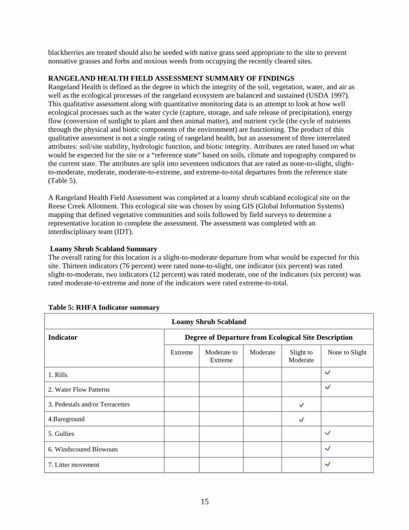
RANGELAND HEALTH FIELD ASSESSMENT SUMMARY OF FINDINGS Rangeland Health is defined as the degree in which the integrity of the soil, vegetation, water, and air as well as the ecological processes of the rangeland ecosystem are balanced and sustained (USDA 1997). This qualitative assessment along with quantitative monitoring data is an attempt to look at how well ecological processes such as the water cycle (capture, storage, and safe release of precipitation), energy flow (conversion of sunlight to plant and then animal matter), and nutrient cycle (the cycle of nutrients through the physical and biotic components of the environment) are functioning. The product of this qualitative assessment is not a single rating of rangeland health, but an assessment of three interrelated attributes: soil/site stability, hydrologic function, and biotic integrity. Attributes are rated based on what would be expected for the site or a “reference state” based on soils, climate and topography compared to the current state. The attributes are split into seventeen indicators that are rated as none-to-slight, slight-to-moderate, moderate, moderate-to-extreme, and extreme-to-total departures from the reference state (Table 5).
A Rangeland Health Field Assessment was completed at a loamy shrub scabland ecological site on the Reese Creek Allotment. This ecological site was chosen by using GIS (Global Information Systems) mapping that defined vegetative communities and soils followed by field surveys to determine a representative location to complete the assessment. The assessment was completed with an interdisciplinary team (IDT).
Loamy Shrub Scabland Summary The overall rating for this location is a slight-to-moderate departure from what would be expected for this site. Thirteen indicators (76 percent) were rated none-to-slight, one indicator (six percent) was rated slight-to-moderate, two indicators (12 percent) was rated moderate, one of the indicators (six percent) was rated moderate-to-extreme and none of the indicators were rated extreme-to-total.
Table 5: RHFA Indicator summary
Loamy Shrub Scabland
Indicator Degree of Departure from Ecological Site Description
Extreme Moderate to Extreme
Moderate Slight to Moderate
None to Slight
1. Rills
2. Water Flow Patterns
3. Pedestals and/or Terracettes
4.Bareground
5. Gullies
6. Windscoured Blowouts
7. Litter movement
15
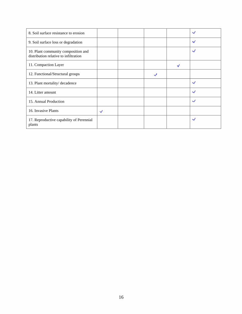
8. Soil surface resistance to erosion
9. Soil surface loss or degradation
10. Plant community composition and distribution relative to infiltration
11. Compaction Layer
12. Functional/Structural groups
13. Plant mortality/ decadence
14. Litter amount
15. Annual Production
16. Invasive Plants
17. Reproductive capability of Perennial plants
16
REFERENCES
Cooperrider, A.Y., R.J. Boyd, and H.R. Stuart, eds. (1986). Inventory and Monitoring of Wildlife Habitat.
U.S. Dept. Inter., Bur. Land Manage. Service Center. Denver, CO.
Corkran, C.C., Thoms, C., (2006). Amphibians of Oregon, Washington, and British Columbia. Auburn, WA: Lone Pine Publishing.
D’Antonio, C. M. and Vitousek, P. M. 1992. Biological invasions by exotic grasses, the grass/fire cycle, and global change. Annual Review of Ecology and Systematics 23:63-87.
Ehrlich, P.R., Dobkin, D.S., and Wheye, D., (1988). The Birder’s Handbook. New York, NY: Simon and
Schuster/Fireside Books.
Harvey, M.J., Altenbach, J.S., Best, T.L., (1999). Bats of the United States. Asheville, AR: Arkansas Game and Fish Commission.
Johnson, C.G. (1998). Common Plants of the Inland Pacific Northwest. USDA Forest Service, Baker City, OR.
Marshall, D.B., Hunter, M.G., Contreras, A.L., (2003). Birds of Oregon: A General Reference. Corvallis, OR: Oregon State University Press.
USDA Forest Service and USDI Bureau of Land Management. 2003. Rogue River/South Coast Biological Assessment FY04-08 for Activities that may affect listed species in the Rogue River/South Coast Province for Medford District, Bureau of Land Management, Rogue River and Sisikiyou National Forests.
USDA Soil Conservation Service. (1993). Soil Survey of Jackson County Area, Oregon.
USDI Bureau of Land Management. 2008a. Oregon and Washington Bureau of Land Management special status species list. Portland, Oregon.
USDI Bureau of Land Management. 2007. Reese Creek Allotment rangeland health field assessment summary of field evaluation. Medford, Oregon.
USDI Bureau of Land Management. 2008. Stream and riparian survey data. Medford, Oregon.
USDI Bureau of Land Management. 1997. Standards for rangeland health and guidelines for livestock grazing management for public lands administered by the Bureau of Land Management in the states of Oregon and Washington. Portland, Oregon.
USDI Bureau of Land Management. 1996. Utilization studies and residual measurements (Technical Reference 4400-3). BLM Service Center. Denver Colorado.
USDI Bureau of Land Management. 1995a. Medford district record of decision and resource management plan. Medford, Oregon.
18
USDI Bureau of Land Management. 1994a. Medford district proposed resource management plan and final environmental impact statement. Medford, Oregon.
USDI Bureau of Land Management. 1994b. Riparian area management: process for assessing properly functioning condition for lentic riparian-wetland areas (Technical Reference 1737-11). BLM Service Center. Denver, Colorado.
USDI Bureau of Land Management. 1984. Medford grazing management program environmental impact statement. Medford, Oregon.
USDI Bureau of Land Management, USDA Forest Service. 2000. Interpreting indicators of rangeland health. v. 3 (Technical Reference 1734-6). National Science and Technology Center. Denver, Colorado.
USDI Fish and Wildlife Service. 2003. Biological Opinion 1-14-03-F-511. Formal and informal consultation on activities that may affect listed species in the Rogue River Basin for fiscal year 2004 through fiscal year 2008 (log #1-14-03-F-511).
19