domino sugar plan - new york building congress · domino sugar plan april 2014. ... improvements to...
TRANSCRIPT

DOMINO SUGAR PLANAPRIL 2014

2APRIL 2014
When our planning process concluded in January, we toured the neighborhood and presented our finished plan to dozens of neighborhood groups and more than a thousand residents.
We hosted several leadership-level meetings with all the relevant community organizations, including:
• CB1 leadership• Los Sures• NAG• El Puente• GWAPP• Churches United• Open Space Alliance• St. Nick’s Alliance• North Brooklyn Creative Economic Zone• North Brooklyn Development Corp• EWIDCO• GMDC• Parents and administrators from local schools• Local artists organized by CreativeTime
OUTREACH SUMMARY
We concluded this process by hosting four large, public community forums with more than 1,000 attendees.

3APRIL 2014
CRITIQUE OF APPROVED PLAN
- OPEN SPACE- MIX OF USES- AFFORDABLE HOUSING- QUALITY OF ARCHITECTURE

4APRIL 2014
OPEN SPACE
INCREASE- QUANTITY- QUALITY- ACCESSIBILTY
5 MIN WALKING RADIUS

5APRIL 2014
INSTEAD OF CUL-DE-SACS & PRIVATE BACKYARDS
KENT AVE
WYTHE AVE
WILLIAMSBURGBRIDGE PARK
GRAND FERRY PARK
WIL
LIA
MS
BU
RG
BR
IDG
E
RIVER STREET

6APRIL 2014
CONNECT TO THE STREET GRID& CREATE A NEW WATERFRONT PARK
KENT AVE
WYTHE AVE
WILLIAMSBURGBRIDGE PARK
GRAND FERRY PARK
WIL
LIA
MS
BU
RG
BR
IDG
E

7APRIL 2014
REDISTRIBUTE DENSITY FROM THE WATERFRONT...
KENT AVE
WYTHE AVE
WILLIAMSBURGBRIDGE PARK
WIL
LIA
MS
BU
RG
BR
IDG
E
GRAND FERRY PARK

8APRIL 2014
TO CREATE A UNIQUE PUBLIC SQUARE
KENT AVE
WILLIAMSBURGBRIDGE PARK
GRAND FERRY PARK
WYTHE AVE
WIL
LIA
MS
BU
RG
BR
IDG
E
9APRIL 2014
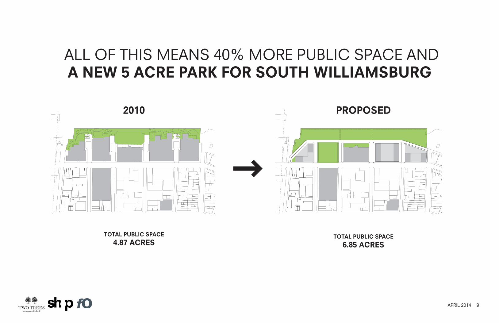
ALL OF THIS MEANS 40% MORE PUBLIC SPACE ANDA NEW 5 ACRE PARK FOR SOUTH WILLIAMSBURG
TOTAL PUBLIC SPACE
4.87 ACRESTOTAL PUBLIC SPACE
6.85 ACRES
2010 PROPOSED

10APRIL 2014
Quantity - the increase is not all in the streets as has been suggested:
PUBLIC SPACE
~4.9 acres ~6.9 acres
2010 PROPOSED
~3.5 acres ~4.5 acres
without Sidewalks + Streets
with Sidewalks + Streets
~40%increase
~30%increase

11APRIL 2014
WATERFRONT PARK

12APRIL 2014
WATERFRONT PARK

13APRIL 2014
24/7 - MIXED USE

14APRIL 2014
APPROVED PLAN PROPOSED PLAN
2,442,305 SF2,400
127,537 SF98,738 SF
0 SF146,451 SF
1,694143,353 SF
3,142,521 SF2,749,303 SF
340’
RESIDENTIAL RESIDENTIAL UNITSRETAILSMALL BUSINESS HEALTH CLUBCOMMUNITYPARKING SPACESPUBLIC OPEN SPACETOTAL GSFTOTAL ZFA
MAX BUILDING HEIGHT
RESIDENTIAL RESIDENTIAL UNITSRETAILSMALL BUSINESSHEALTH CLUBCOMMUNITYPARKING SPACESPUBLIC OPEN SPACETOTAL GSFTOTAL ZFA
MAX BUILDING HEIGHT
2,281,666 SF2,282
72,407 SF504,308 SF42,231 SF
150,935 SF1,050
227,919 SF3,314,741 SF2,948,429 SF
535’
VS.
DIFFERENCE
RESIDENTIAL RESIDENTIAL UNITSRETAILSMALL BUSINESSHEALTH CLUBCOMMUNITYPARKING SPACESPUBLIC OPEN SPACETOTAL GSFTOTAL ZFA
MAX BUILDING HEIGHT
(160,639)(118)
(55,130)405,570
42,2314,484 (644)
84,566172,220199,126
195’
SF COMPARISON

15APRIL 2014
504,300 SF OF COMMERCIAL OFFICE, MORE THAN 5X THE APPROVED PLAN - BRINGING OVER 2,700
NEW JOBS TO THE NEIGHBORHOOD

16APRIL 2014
EXTENDING THE SMALL-SCALE INDEPENDENT RETAILOF WILLIAMSBURG (NO BIG BOX)

17APRIL 2014
KENT AVENUE

18APRIL 2014
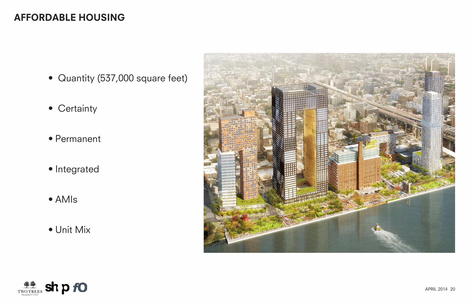
AFFORDABLE HOUSING

19APRIL 2014
AFFORDABLE HOUSING
BAM South Mercedes House
ProjectTotal
Afford.Units
Court House 64
Mercedes House 140
25 Washington 21
Dock Street 58
BAM South 76
Total 359
Court House Dock Street25 Washington
20APRIL 2014
AFFORDABLE HOUSING
• Quantity (537,000 square feet)
• Certainty
• Permanent
• Integrated
• AMIs
• Unit Mix

21APRIL 2014
CREATIVE AND THOUGHTFUL ARCHITECTURE
22APRIL 2014
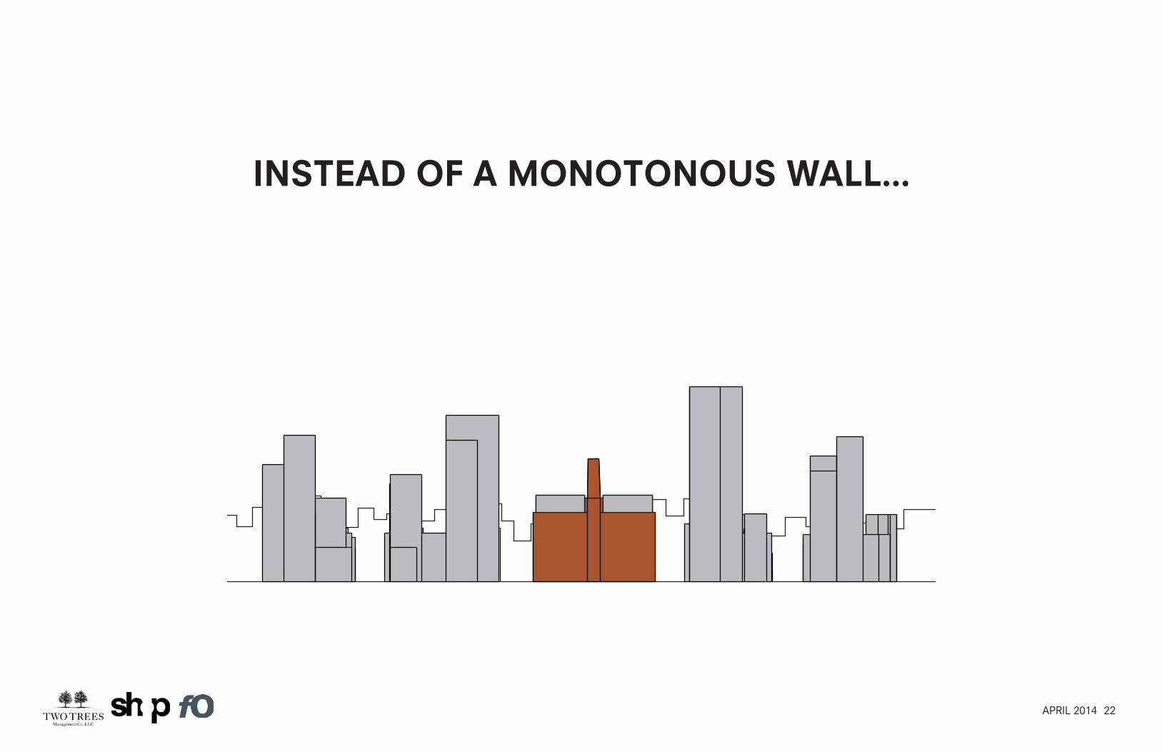
INSTEAD OF A MONOTONOUS WALL...
23APRIL 2014
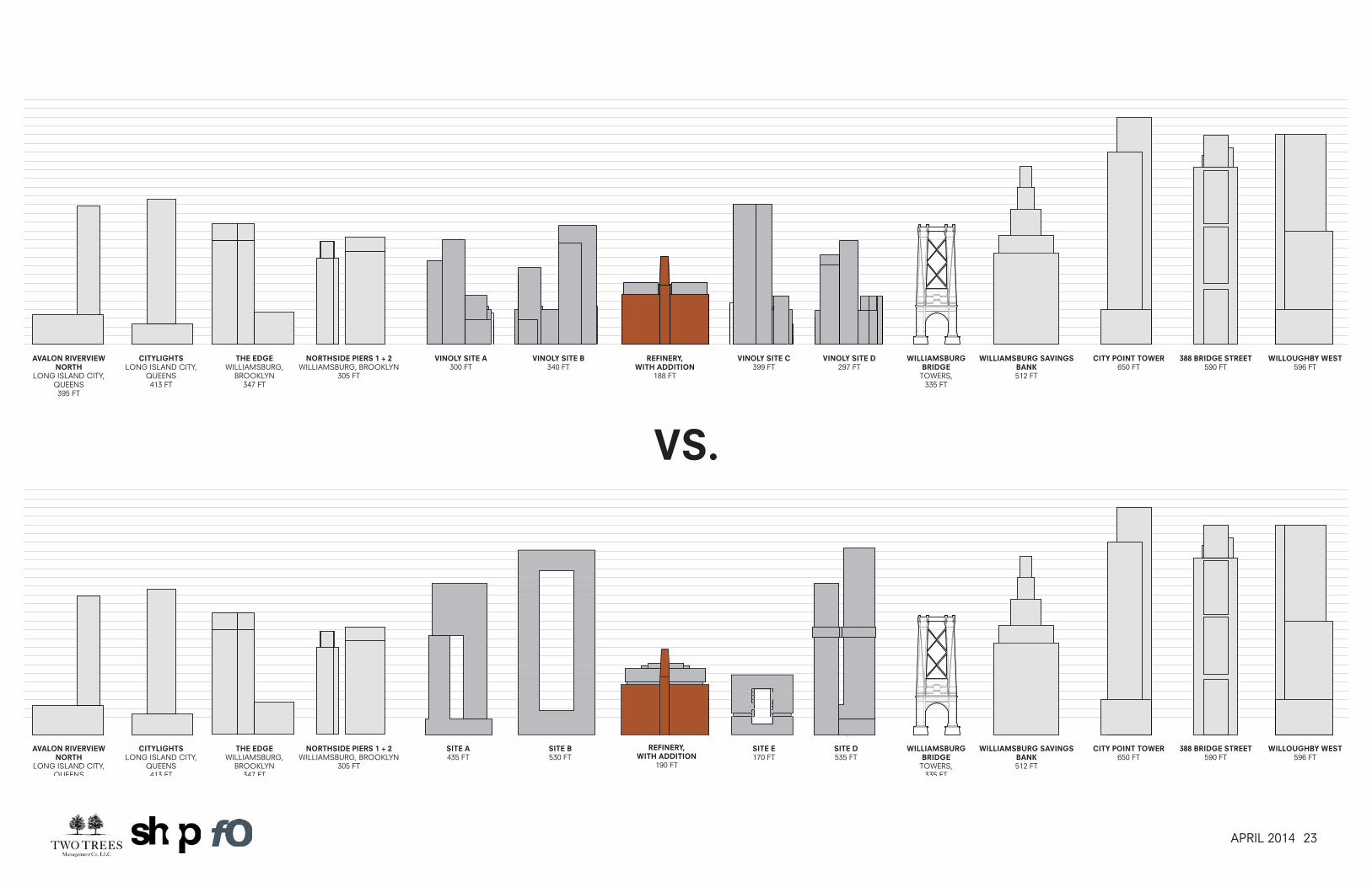
VINOLY SITE A300 FT
VINOLY SITE B340 FT
VINOLY SITE D297 FT
VINOLY SITE C399 FT
REFINERY, WITH ADDITION
188 FT
WILLIAMSBURG BRIDGE
TOWERS, 335 FT
WILLIAMSBURG SAVINGS BANK512 FT
CITY POINT TOWER650 FT
388 BRIDGE STREET590 FT
WILLOUGHBY WEST596 FT
THE EDGEWILLIAMSBURG,
BROOKLYN347 FT
NORTHSIDE PIERS 1 + 2WILLIAMSBURG, BROOKLYN
305 FT
AVALON RIVERVIEW NORTH
LONG ISLAND CITY, QUEENS395 FT
CITYLIGHTSLONG ISLAND CITY,
QUEENS413 FT
THE EDGEWILLIAMSBURG,
BROOKLYN347 FT
SITE A435 FT
SITE B530 FT
WILLIAMSBURG BRIDGE
TOWERS, 335 FT
WILLIAMSBURG SAVINGS BANK512 FT
CITY POINT TOWER650 FT
388 BRIDGE STREET590 FT
WILLOUGHBY WEST596 FT
SITE D535 FT
SITE E170 FT
REFINERY, WITH ADDITION
190 FT
NORTHSIDE PIERS 1 + 2WILLIAMSBURG, BROOKLYN
305 FT
AVALON RIVERVIEW NORTH
LONG ISLAND CITY, QUEENS
CITYLIGHTSLONG ISLAND CITY,
QUEENS413 FT
VS.

24APRIL 2014
BIRDS EYE VIEW

25APRIL 2014
REFINERY BUILDING
26APRIL 2014
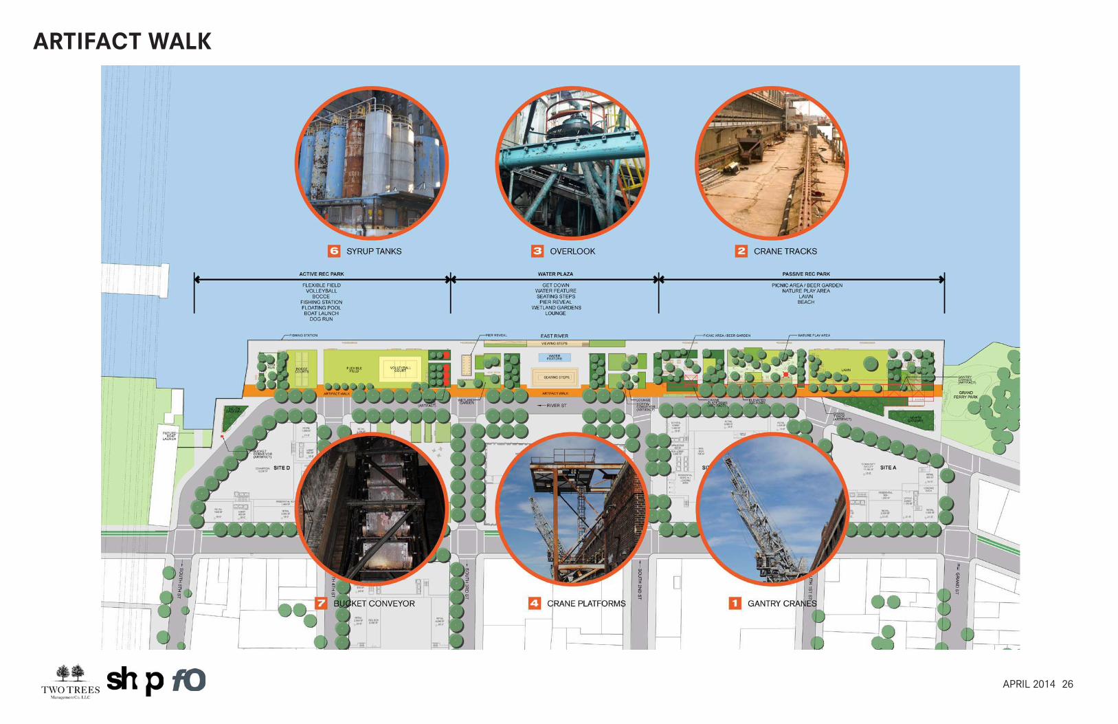
ARTIFACT WALK

27APRIL 2014
FLOOD PROTECTION MEASURES
• Buildings pulled away from the water
• Permeable surfaces (road + park)
• Critical systems above flood plain
• Sloping streets follow the natural grade of site to the water
FEMA 100 Year flood plain - 2010 Approved Plan
FEMA 100 Year flood plain - 2013 Proposal
100 year flood elevation (10.55’)
FEMA 100 Year flood plain - 2013 Proposal

28APRIL 2014
TECHNICAL CHANGES SOUGHT BY ULURP APPLICATION
ULURP Application includes the following actions that make this project possible:
• Zoning district to remain the same (R6, R8 and C6-2).
• Special permits to lock in massings and location of uses.
• Special permit to transfer floor area to Building E.
• Elimination of loading dock requirement in Building E.
• Authorizations, certifications and special permit to lock in open space design.
• Text Amendment to expand Inclusionary Zoning to include all uses in the
General Large Scale, including commericial and community facility space
(except for the school).
29APRIL 2014
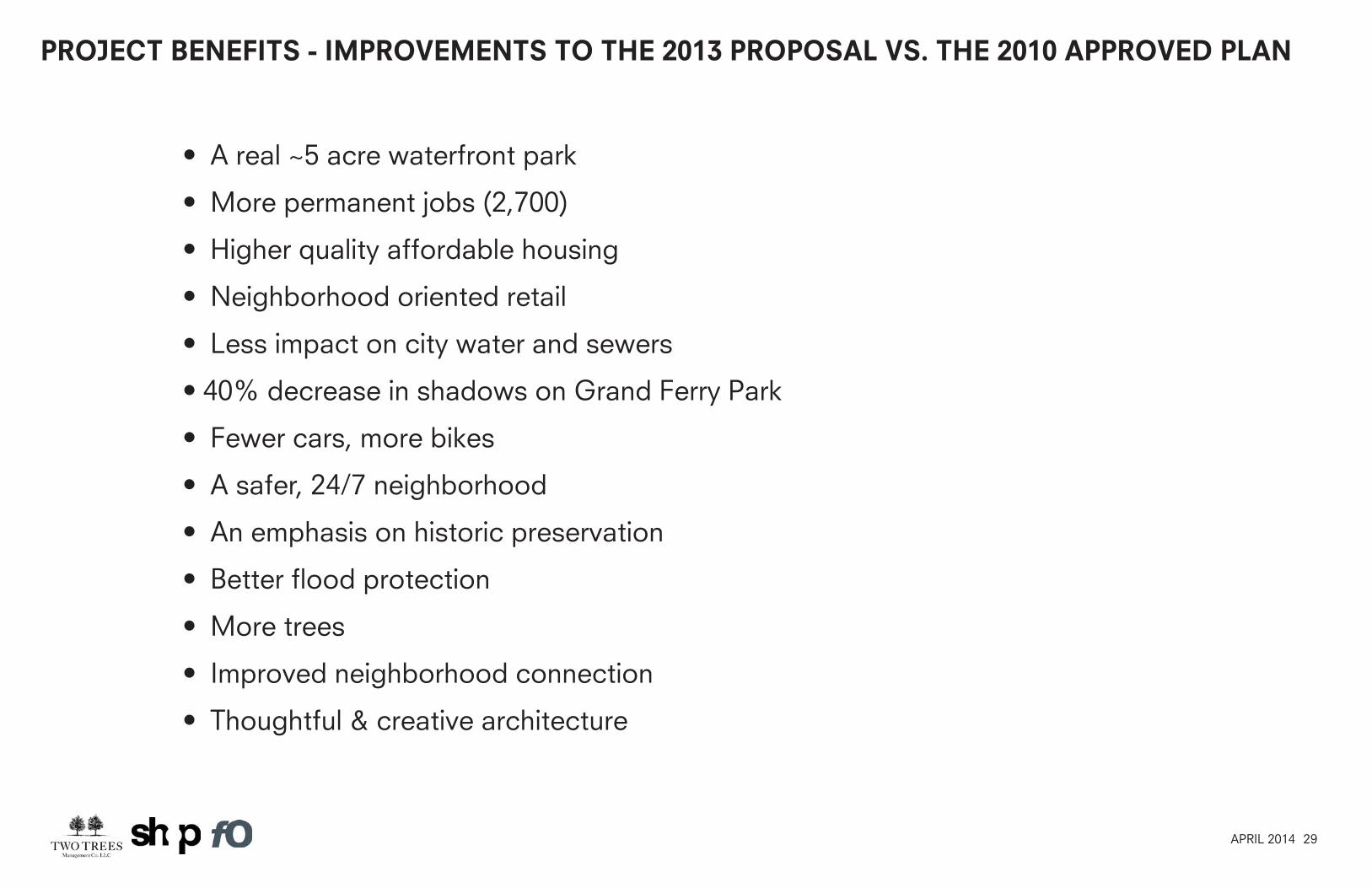
PROJECT BENEFITS - IMPROVEMENTS TO THE 2013 PROPOSAL VS. THE 2010 APPROVED PLAN
• A real ~5 acre waterfront park
• More permanent jobs (2,700)
• Higher quality affordable housing
• Neighborhood oriented retail
• Less impact on city water and sewers
• 40% decrease in shadows on Grand Ferry Park
• Fewer cars, more bikes
• A safer, 24/7 neighborhood
• An emphasis on historic preservation
• Better flood protection
• More trees
• Improved neighborhood connection
• Thoughtful & creative architecture
30APRIL 2014
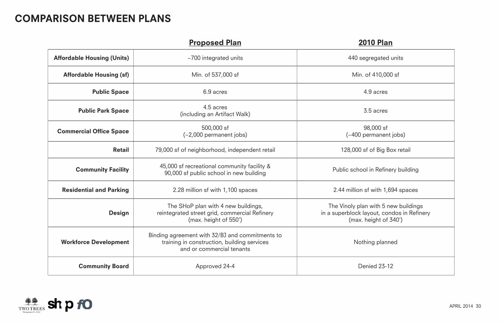
Proposed Plan 2010 Plan
Affordable Housing (Units) ~700 integrated units 440 segregated units
Affordable Housing (sf) Min. of 537,000 sf Min. of 410,000 sf
Public Space 6.9 acres 4.9 acres
Public Park Space 4.5 acres (including an Artifact Walk) 3.5 acres
Commercial Office Space 500,000 sf (~2,000 permanent jobs)
98,000 sf (~400 permanent jobs)
Retail 79,000 sf of neighborhood, independent retail 128,000 sf of Big Box retail
Community Facility 45,000 sf recreational community facility & 90,000 sf public school in new building Public school in Refinery building
Residential and Parking 2.28 million sf with 1,100 spaces 2.44 million sf with 1,694 spaces
DesignThe SHoP plan with 4 new buildings,
reintegrated street grid, commercial Refinery (max. height of 550’)
The Vinoly plan with 5 new buildings in a superblock layout, condos in Refinery
(max. height of 340’)
Workforce DevelopmentBinding agreement with 32/BJ and commitments to
training in construction, building services and or commercial tenants
Nothing planned
Community Board Approved 24-4 Denied 23-12
COMPARISON BETWEEN PLANS