district plan - western cape government · summarised in technical report: ... 1.6 review of the...
TRANSCRIPT

FINAL DRAFT
TABLE BAY
DISTRICT PLAN
SPATIAL DEVELOPMENT PLAN & ENVIRONMENTAL MANAGEMENT FRAMEWORK
TECHNICAL REPORT
OCTOBER 2012

Approved as a Structure Plan in terms of section 4(10) of the Land Use Planning Ordinance, Ordinance 15 of 1985 31 October 2012

REFERENCE GUIDE TO CONTENTS OF THE DISTRICT PLAN: Section Purpose and focus 1. INTRODUCTION • Outline of background and legislative status of SDP and EMF 2. DEVELOPMENT AND POLICY
CONTEXT • Planning directives and policy that inform the SDP
3. KEY STRATEGIES: THE CONTEXT AND CENTRAL SPATIAL IDEAS
• Key spatial strategies of the CTSDF and how they are applied to the district • Contextualises strategies in terms of the “district now” and “what action is needed” to
address issues • Identifies what spatial concepts should be applied to achieve strategy and address
issues • Highlights the central spatial ideas, specific to the district, that are key to reinforcing a
positive long term metropolitan and district spatial structure 3.1. Plan for employment and
improve access to economic opportunities
• Identifies the key challenges in respect of economic activity and employment in the district, giving consideration to the form and functioning of economic activity, the relationship between transport systems and land use
• Spatial concepts and structuring elements include: multi-directional accessibility grid, areas for intensification
3.2. Manage urban growth and create a balance between urban development and environmental protection
• Identifies the key challenges in terms of the natural environment and managing urban growth within the district
• Spatial concepts and structuring elements include: natural assets, development edges, future urban growth areas
3.3. Build inclusive, integrated and vibrant city
• Identifies opportunities for integration and improving public environments including opportunities for civic precincts, destination places
• Spatial concepts and structuring elements include: civic precincts, destination places, structuring open space and critical public links, integrated settlement patterns
4. SPATIAL DEVELOPMENT PLAN: DISTRICT DEVELOPMENT GUIDELINES
• Application of the spatial concepts and structuring elements identified in section 3 to the district
• Forms the “broad level” guide to the desired future spatial form of the district and is supplemented by more detailed “sub-district land use guidelines” in section 6.2. Guidelines are grouped into 5 sections
4.1. Spatial planning categories • This includes development guidelines at a broad district scale for the major land areas in the district (e.g. natural, agricultural and urban areas). The categories are aligned to those adopted by the PSDF and CTSDF.
4.2. Transport infrastructure and route designation
• Provides direction to the desired positive functioning of land use / transport network to support the public transport network and the accessibility of social and economic opportunities in the district
4.3. Conceptual designations • Provides broad guidance in relation to spatial concepts that are not precisely spatially defined at the district scale. (e.g. urban nodes, civic precincts, destination places). Land use and form implications may be detailed through local area plans.
4.4. Development edges • Provides direction to urban growth in relation to the definition of development edges in the district
4.5. Precautionary areas and utility service infrastructure installations and networks
• Provides development guidance in relation to areas which may present a risk or limits land use or activities in the district (e.g. flood prone areas, buffers associated with noxious uses)
5. ENVIRONMENTAL MANAGEMENT FRAMEWORK (EMF)
• Provides support mechanism (inclusive of spatial development plan: district development guidelines) in review of development applications
5.1. Environmental Impact Management Zones (EIMZs)
• Provides a summary of status, environmental management priorities for environmental attributes
• Based on environmental attributes, describes EIMZs, which provide an indication of possible impacts of activities on environmental attributes
6. IMPLEMENTATION • Provides guidance in terms of actions required to implement the proposals contained in the spatial development plan
6.1. Urban restructuring and upgrading: framework for capital investment
• Provides an informant to aligning spatial planning (including new development areas and areas for land use intensification) with service and infrastructure planning
• Identifies sector specific proposals (capital investment framework) in support of the spatial development plan (including for example new transport links, areas for public space investment, publicly assisted housing, new district scale open space proposals)

6.2. Sub-district development guidelines
• Supplements the spatial development plan: district development guidelines with more detailed “sub-district development guidelines” that provide further direction in terms of achieving desired spatial form at a local level
• Reference is made to where more detailed local area plans exist and will continue to provide guidance to decision making
6.3. Local area planning priorities • Identifies key local area planning priorities for the district where further work is required along with lead actions and role players
REFERENCE GUIDE TO ENVIRONMENTAL MANAGEMENT FRAMEWORK (EMF)*: Content elements Guide to location of content in the district plan • Identification of the area to which EMF applies • An indication of the conservation status of the area
• Baseline information and analysis report: Section 2.1
• A description of how information was captured; • Baseline information and analysis report: Section 1 • Identification of information gaps • Baseline information and analysis report: Section 1 • Specification of the environmental attributes in the area
as well as parts of the area to which attributes relate • Interrelationship and significance of the attributes;
• Baseline information and analysis report: Section 2.1 – 2.3 • Summarised in Technical report: Section 5.2
• Development pressures and trends; opportunities and constraints
• Baseline information and analysis report: Section 2.4. (see also section 3) •
• Description of the environmental (management) priorities in the area
• Baseline information and analysis report: Section 2.4 • Summarised in Technical report: Section 5.2
• Information on activities that would have a significant impact on those attributes and those that would not
• Information on activities that would be undesirable in the area or specific parts of the area
• Technical report: Section 5.2
• Management proposals and guidelines • Technical report: Section 5.2 (see also section 4 and section 6.2) • The desired state of the environment • Technical report: Section 4 (see also section 3) • Revision schedule for the environmental management
framework • Technical report: Section 1.6
• A description of the public participation process including issues raised by I&APs
• Technical report: Section 1.5 • Baseline information and analysis report (annexure)
*The EMF is an integrated though distinguishable component of the district plan. For ease of reference the table indicates how the EMF is structured across the district plan product.

Table of Contents 1. INTRODUCTION ............................................................................................................ 10
1.1 Purpose ............................................................................................................... 10
1.2 Towards a rationalised policy-driven land use management system .................... 11
1.3 Legal status of the district plan and consistency principle .................................... 12
1.3.1 Determining consistency with structure plans.................................................... 13
1.3.2 Relationship between the SDP and EMF .......................................................... 14
1.4 Alignment with Cape Town Zoning Scheme ........................................................ 15
1.5 Overview of the district plan drafting process ....................................................... 15
1.6 Review of the district plan .................................................................................... 16
1.7 Study Area ........................................................................................................... 16
2. DEVELOPMENT AND POLICY CONTEXT .............................................................. 18
2.1 Legislative context ............................................................................................... 18
2.2 Strategy and policy planning informants .............................................................. 18
2.2.1 National and Regional Planning Informants ...................................................... 18
2.2.2 Metropolitan and district planning Informants .................................................... 18
2.2.3 Local Area Plan Informants ............................................................................... 22
3. KEY SPATIAL STRATEGIES ....................................................................................... 23
3.1. Strategy 1: ........................................................................................................... 23
3.1.1. Table Bay District now ...................................................................................... 23
3.1.2 What action is needed? .................................................................................... 25
3.1.3 Spatial concepts and structuring elements ........................................................ 25
3.2 Strategy 2: ........................................................................................................... 32
3.2.1 Table Bay district now ....................................................................................... 32
3.2.2 What action is needed ...................................................................................... 32
3.2.3 Spatial concepts and structuring elements ........................................................ 32
3.3 Strategy 3: ........................................................................................................... 36
3.3.1 Table Bay district now ....................................................................................... 37
3.3.2 What action is needed ...................................................................................... 37
3.3.3 Spatial concepts and structuring elements ........................................................ 38
3.4 Synthesis: the Table Bay District spatial concept and vision ................................ 40
4. SPATIAL DEVELOPMENT PLAN: District development guidelines ................................ 42
EMF: DESIRED STATE OF THE ENVIRONMENT ............................................................. 42
4.1 Spatial planning categories .................................................................................. 43
4.2 Transport infrastructure and route designation..................................................... 47
4.3 Conceptual designations ..................................................................................... 52
4.4 Development edges ............................................................................................. 54
4.5 Precautionary areas and utility service infrastructure installations and networks .. 55

5. ENVIRONMENTAL MANAGEMENT FRAMEWORK ....................................................... 59
5.1 Introduction .......................................................................................................... 59
5.2 Environmental impact management zones and land use development informants 59
5.2.1 Hydrological Zone .............................................................................................. 62
5.2.2. Coastal and Dune Zone .................................................................................... 68
5.2.3. Conservation and Biodiversity Priority Zone ....................................................... 72
5.2.4. Cultural and Recreational Resources Zone ........................................................ 79
5.2.5. Natural Economic Resources Zone .................................................................... 84
5.2.6 Urban Uses and Utilities Zone ............................................................................ 87
5.3. Areas of potential impact on selected natural environmental attributes ................... 91
6. IMPLEMENTATION ..................................................................................................... 93
6.1. Urban restructuring and upgrading: framework for public investment ................... 93
6.1.1. Transport infrastructure ..................................................................................... 95
6.1.2. Open space system .......................................................................................... 99
6.1.3 Publicly assisted housing ................................................................................ 102
6.1.4 Infrastructure upgrading .................................................................................. 107
6.1.5. Public facilities and public space ..................................................................... 110
6.2. Sub-district development guidelines .................................................................. 116
6.2.1 Sub-district 1: Atlantic Seaboard and Table Mountain ..................................... 117
6.2.2 Sub-district 2: Central city ............................................................................... 121
6.2.3 Sub-district 3: TRUP/ Salt River/ Observatory/ Paarden Eiland ....................... 133
6.2.4. Sub-district 4: Greater Eastern Area ............................................................... 138
6.3. Local area planning priorities ............................................................................. 145
7. ANNEXURES ............................................................................................................ 147
7.1 Annexure A: List of withdrawn planning policy documents ....................................... 147
7.2. Annexure B: ............................................................................................................ 148
Principles for assessing development proposals in “areas of potential impact” on selected natural environmental attributes..................................................................................... 148
7.3 Annexure C: Relevant legislation and policies per Environmental Impact Management (EIM) Zone ............................................................................................... 150
7.4. Annexure D: ...................................................................................................... 152
Relationship between CTSDF and District Plan Spatial Planning Categories and the Biodiversity Network classification ................................................................................. 152
7.5. Annexure E: ....................................................................................................... 153
Relationship between CTSDF and district plan route designation, the National Department of Transport road classification system, the PSDF (2009), and City’s hierarchical road network classification system ........................................................................................ 153

ACRONYMS AND ABBREVIATIONS Acronym Abbreviation CBA Critical biodiversity area CBD Central business district CESA Critical ecological support area CMA Cape Metropolitan Area CoCT City of Cape Town CPPNE Cape Peninsula Protected Natural Environment CTIA Cape Town International Airport CTSDF Cape Town Spatial Development Framework CTZS Cape Town Zoning Scheme DFA Development Facilitation Act (No 108 of 1996) DSDP District Spatial Development Plan du/ha dwelling units per hectare EIA Environmental Impact Assessment EIMZ Environmental Impact Management Zone EIP Environmental Implementation Plan EMP Environmental Management Plan (in terms of Section 11 of NEMA) EMF Environmental Management Framework GIS Geographic Information System ICT Information communication technology IDP Integrated Development Plan (in terms of the MSA) IDZ Industrial development zone IEM Integrated environmental management IRT Integrated rapid transit ITP Integrated Transport Plan LGTA Local Government Transition Act LUMS Land use management system LUPO Land Use Planning Ordinance (No. 15 of 1985) MOSS Metropolitan open space system MSA Municipal Systems Act (No 32 of 2000) MSDF Metropolitan Spatial Development Framework NDAs New Development Areas NEMA National Environmental Management Act (No 107 of 1998) NEM: PAA National Environmental Protected Areas Act (No 57 of 2003) NLTA National Land Transport Act (No 5 of 2009) NHRA National Heritage Resources Act (No 25 of 1999) NMT Non-Motorised Transport OESA Other ecological support area PGDS Provincial Growth and Development Strategy PIIF Public Infrastructure Investment Framework POS Public open space PSDF Provincial Spatial Development Framework PTP Public Transport Plan SANParks South African National Parks SANRAL South African National Roads Agency Ltd SAHRA South African Heritage Resources Agency SDF Spatial Development Framework SDP Spatial Development Plan SMME Small, medium and micro enterprises TMNP Table Mountain National Park TMNP CDF TMNP Conservation Development Framework TMNP PMP TMNP Park Management Plan TPC Town-planning compliant UDZ Urban development zone VPADD Voluntary proactive deal driven VPUU Violence Prevention through Urban Upgrade WHS World Heritage Site WSUD Water-sensitive urban design

TERMS AND DEFINITIONS Term Definition Accessibility grid The grid of structuring routes (development and activity routes and activity streets)
that facilitates convenient public transport access and multidirectional movement between the district and other parts of the city and within the district. See also section 3.1.3
Activities In the context of the development guidelines (section 4), refers to the use of land or pursuits in particular locations that may be related to projects or programmes
Activity route See section 3.1.3 Activity street See section 3.1.3 Aquifer Area identified as reflecting physical extent of a water-bearing layer of soil, sand,
gravel, or rock that will yield significant usable quantities of water Biodiversity Biological wealth of a specified geographical region: including the different marine,
aquatic and terrestrial ecosystems, communities of organisms within these, and their component species, number and genetic variation.
Biodiversity network The map of protected and critical biodiversity areas (including natural vegetation and wetlands) for the city based on the fine scale systematic conservation plan, in accordance with legal requirements.
Buffer 1 and 2 areas See section 3.2.3 Cemetery A place for the burial of human remains, and may include ancillary buildings such as
an office and chapel, but does not include a crematorium. Civic precinct Concentration of public facilities (e.g. schools, clinics, library) located in close
proximity. See also section 3.3.3 Coastal edge Demarcated area around the coast, primarily to protect coastal resources, and to
avoid hazards and financial risks pertaining to areas at risk of flooding Coastal node Concentrated development at a specific coastal location. Commercial/ business area
General business activity and mixed-use development of a medium to high intensity. Whilst the focus of development of these areas is commercial (office and retail development) a mix of uses including high and medium density residential development could be appropriate in these areas. Industrial development is generally not suitable in these areas.
Connector route See section 3.1.3 Core 1 and 2 areas See section 3.2.3 Critical biodiversity areas
Critical biodiversity areas are terrestrial and aquatic features in the landscape that are critical for conserving biodiversity and maintaining ecosystem functioning.
Critical ecological support area
Natural and rural areas with biodiversity importance which are essential for management, consolidation, connectivity and viability of biodiversity in CBAs and protected areas.
Critical public link Route link/ public access that does or should serve to provide access to destination places and/or is associated with an existing or potential positive experiential quality relating to the surrounding environment along its length.
Cultural landscape Sites and landscapes of historical significance, areas of scenic beauty and places of spiritual and/or cultural importance.
Densification Increased use of space, both horizontally and vertically, within existing residential areas/ properties and new developments, accompanied by an increased number of units.
Destination place A place that forms a significant landmark or area of attraction and is part of the unique identity of Cape Town. Due to these qualities, these places hold potential for exploiting economic opportunities particularly in relation to their role as destinations for locals and tourists.
Development corridor See section 3.1.3. Development edge A demarcated edge line defining the outer limits of urban development for a
determined period of time; there are two types of edge lines, namely urban edge lines and coastal edge lines, the former being a medium- to long-term edge line, where the line has been demarcated in a position to phase urban growth appropriately, or to protect natural resources.
Development route See section 3.1.3 District park Park of landscaped/ maintained open space with recreational facilities which serves
the needs of several surrounding local communities or suburbs. Generally multifunctional, can include formal & informal recreational facilities, sports facilities including kick-about areas, playing fields & playgrounds (perhaps with play equipment). The diversity of activities caters for different age groups & may include a special interest component and/or a natural feature (e.g. river, water body or nature conservation area).

District plan Document which includes integrated District Spatial Development Plan (DSDP) and Environmental Management Framework (EMF)
District spatial development plan
Document of which sections 4 and 6.2 feature as statutory components in terms of section 4(10) of LUPO
Ecological buffer Strip of land adjacent to a watercourse, wetland or vlei required for the protection and enhancement of aquatic and riparian ecosystems.
Flood prone areas Areas that are susceptible to inundation by a specific recurrence interval flood (e.g. a 1:100 year flood) which must be managed in terms of catchment management policies and by-law.
50yr flood line Line to which flooding is likely to occur on average once every 50 years. 100yr flood line: Line to which flooding is likely to occur on average once every 100 years. Gap housing Housing for households with a monthly income that fall outside the government
housing subsidy income limit and find it difficult or are unable to access finance for housing in the private market (as their income is below the minimum typical income which would allow them to qualify for a conventional mortgage loan).
Incremental densification
Small-scale densification that is almost invisible, e.g. subdivisions and second dwellings.
Inclusionary housing Used to describe the inclusion (preferably on site) of residential units targeted at the gap and/or rental (social housing) market as part of the development of new areas. Where contextually appropriate and feasible, a subsidy housing component may be targeted.
Industrial development
Allows for all forms of industrial uses, except noxious industries. Allowance is made for limited forms if non-industrial activity such as a factory shop, service station, motor repair garage, but these activities should not compromise the general use of the industrial area.
Informal settlement Settlement area consisting of informal structures, the occupants of which may or may not have rights to the property or land upon which they reside.
Land use intensification
Refers to achieving a greater spectrum of mixed uses (commercial, industrial and residential) through the increased use of space, both horizontally and vertically, within existing areas or properties and new developments, accompanied by an increased number of units and/ or population thresholds, in accessible, high-opportunity locations.
Metropolitan park Park of landscaped/ maintained open space with recreational facilities or an aspect of special interest which serves the needs of the metropolitan community. Generally significant in size and tend towards being large-scale multi-functional parks. Likely to be integrated with other large scale public facilities such as formal sports fields or with natural areas or including natural features such as a river or water body.
Mixed land use Area of existing or proposed horizontal and/ or vertical integration of suitable and compatible residential and non-residential land uses within the same area or on the same parcel of land; implies contextually-appropriate intensity of land use that should facilitate efficient public transport and a vibrant local urban environment.
Metropolitan open space system
Inter-connected and managed open space network that supports interactions between social, economic and ecological activities, sustaining and enhancing both ecological processes and human settlements; includes natural areas, and active and passive recreation areas such as sports fields and parks, but also cemeteries, detention ponds servitudes, river corridors and road reserves to promote interconnection and multi-use.
Mobility The ease with which people can travel with minimal delay on route Multi-functional The combination of different yet compatible functions within one physical framework to
serve a variety of social and community groups; allow for a wider range of facilities that reinforce one another in close proximity, offering greater access to potential users. Differentiation in activity may be physical (different activities on different floors or premises of the same building) or in time (using the same facility for different activities, but at different times).
New development area
An area earmarked for future development
Nodal development Significant and concentrated development in terms of scale, location, impact, diversity and agglomeration of function (facilities, services and economic activities)
Non-motorised transport
Transport modes which are not motorised (e.g. walking and cycling)
Risk activity/ noxious industry
Comprises hazardous and noxious land uses in terms of smell, product, waste or other objectionable consequences of operation, or that carry a high risk in the event of fire or accident
Other ecological support area
Transformed (e.g. extensive agriculture) sites with conservation importance

Other structuring open space
Open space which is not part of the biodiversity network or significant agricultural areas, but has been identified to promote access to open space for active and passive recreation. Whilst the focus is on areas that are usable and accessible for most of the year, the identification has included cemeteries, detention ponds, servitudes, river corridors and road reserves in order to promote the notion of a linked open space system.
Overlay zone A category of zoning applicable to a particular area or land unit which: (i) stipulates development rules in addition to the underlying zone or base zone requirements, which may be more or less restrictive; (ii) may include provisions and development rules relating to primary uses, additional uses or consent uses, limitations in addition to the underlying base zone, subdivision and subdivisional areas, special planning areas, development incentives, urban form, urban renewal, heritage and environmental protection, etc.
Potential high density development
Area proposed for new higher density development where the gross density should average 40+ du/ha. The achievement of this target could occur via a range of housing typologies and varying net densities across the area. The development of required community facilities and open space should be addressed as part of the development of this area. Controlled opportunities for home employment and low intensity mixed use development could be considered in these areas.
Potential medium density development:
Area proposed for new medium density development where the gross density should average 25-40 du/ha du/ha. The achievement of this target could occur via a range of housing typologies and varying net densities across the area. The development of required community facilities and open space should be addressed as part of the development of this area. Controlled opportunities for home employment and low intensity mixed use development could be considered in these areas.
Potential low density development
Area proposed for new lower density development where the gross density could average 10-25 du/ha. The achievement of this target could occur via a range of housing typologies and varying net densities across the area. The development of required community facilities and open space should be addressed as part of the development of this area. Controlled opportunities for home employment, additional dwellings and low intensity mixed use development on could be considered within these areas.
Public transport interchange
Public transport interchange which supports the transfer of public transport users between modes (rail/bus/taxi), but also functions to support economic activity
Publicly assisted housing
The realisation of a range of housing opportunities, formal or informal, that the public sector plays a role in providing or supporting through its housing programmes
Railway station upgrade
Upgrading of the physical station buildings and/ or station environment. This could include the development of station forecourts, public access and landscaping intervention.
Rural living estates Extensive land units (ranging in size) located inside the urban edge Scenic routes (SR1 and SR 2)
Public roads that traverse areas of outstanding scenic quality or that provide a view of scenic areas. Scenic routes facilitate appreciation of Cape Town’s natural, built and cultural heritage, and in themselves have become attractions. Two types of scenic routes exist – SR1 routes, which are limited access routes that traverse areas of high scenic quality and SR2 routes which traverse areas of high scenic quality and are frequently accessed.
Smallholdings Extensive land units (ranging in size) located outside the urban edge Spatial concept A concept used to describe a particular set of spatial features (e.g. urban node, civic
precinct) Strategic site A land parcel or group of land parcels which due to its/their location or other unique
attributes holds the potential to impact significantly on planning policy objectives such as densification and integration and in so doing make a significant contribution to restructuring the city
Structuring element Spatial aspect that provides structure or form to urban development (e.g. a main road provides structure to which land uses respond)
Subsidised housing Housing supplied in terms of the National Department of Housing’s housing subsidy scheme.
Transit station area Refers to the areas that support transit (public transport) stations (including rail stations and trunk road based IRT stations). These supportive areas are conceptually defined in the district plan, but are generally within comfortable walking distance of these stations (i.e. +/- 800m). Transit stations are categorised in the district plan (e.g. neighbourhood station/ urban station), which provides an informant to potential development opportunities/ desired land use mix in the supportive areas and which should be further defined and detailed at the local area level.
Urban civic upgrade An area where public investment and/ or improved urban management is required as

a precondition for an improvement in the local social and economic conditions. These areas are generally strategically located to ensure that public investment has the greatest impact on the most number of people.
Urban development Buildings and infrastructure with a residential purpose as well as offices, shops, community facilities and other associated buildings, infrastructure and public open space necessary to provide for proper functioning of urban areas and amenity and recreation. The term ‘urban development’ includes golf estates, vineyard estates with a residential component, equestrian estates with a residential component, rural living estates, eco-estates, gated communities and regional shopping centres. Urban development excludes noxious industry and generally excludes land for industrial purposes. However, service trades that generate a low impact on surrounding urban uses may be permissible if the nature and type of service trade use deemed to form an integral part of of an area demarcated for urban development purposes.
Urban edge See development edge. Urban edge management zone
Zone or buffer area on either side of the urban edge, where land uses are to be managed to protect the integrity of the urban edge line.
Urban node Area characterised by the intensity, mix and clustering of activities/ land uses (including commercial/business development and associated employment opportunities, higher-order services and higher residential densities). See also section 3.1.3.
Zoning A category of directions setting out the purpose for which land may be used and the land use restrictions (e.g. height limits, building lines, bulk, coverage) applicable in respect of the said category of directions by the scheme regulations.
Zoning scheme A scheme consisting of scheme regulations and a register with (or without) a zoning map.
ANNEXURE Annexure A Schedule of existing spatial plans/ policies Annexure B Principles for dealing with development proposals in “areas of potential
impact” as well as areas where there are significant natural resources Annexure C EMF – relevant legislation and policies per impact management zone Annexure D Relationship between CTSDF and district plan spatial planning categories
and the biodiversity network classification Annexure E Relationship between the CTSDF and district plan route designation, PSDF
and City Road Network Hierarchical Classification System

10 Table Bay District Plan - Technical Report 2012
1. INTRODUCTION This district plan forms one of 8 plans developed for each of the planning districts of the City of Cape Town (CoCT), all of them informed by the city-wide Cape Town Spatial Development Framework (CTSDF). Whilst this plan is grounded in a sense of the current realities in the district, its focus is influencing the future today. In doing so it needs to have relevance to a wide range of stakeholders including communities and interest groups, the drivers of development and regulatory decision makers who all play a role in shaping urban development. As such the plan comprises a number of elements which include a discussion of the context and informants to the plan, the objectives of the plan (and spatial concepts and structuring elements), the plan itself and related to this, a set of implementation tools that are targeted at taking the broad proposals of the plan to a greater level of detail and action. To assist users of the plan, the diagram below summarises its contents.
1.1 Purpose The district plan is a medium term plan (developed on a +/- 10 year planning frame) that will guide spatial development processes within the district. It will pursue several strategic actions including: • Aligning with and facilitating the implementation of the Provincial Spatial Development
Framework (PSDF), Cape Town’s Integrated Development Plan (IDP) and Cape Town Spatial Development Framework within the district;
• Performing part of a package of decision support tools to assist in land use and environmental decision making processes;
• Delineating fixes and sensitivities which will provide an informant to such statutory decision making processes;
Note: • This district plan has been informed by a Baseline Information and Analysis Report prepared
separately. It is used as an information source and it is not intended that this separate report be consulted for statutory decision making processes.
• The “district plan” is the term given to the integrated “structure plan” or spatial development plan (SDP) and environmental management framework (EMF) as contained in this document.

11 Table Bay District Plan - Technical Report 2012
• Clearly giving direction to the form and desired structure of areas for new urban development as well as areas for land use change in the district in a manner that is in line with the principles and policies of higher level planning frameworks;
• Providing a strategic informant to public and private investment initiatives which will assist in achieving the principles and policies of higher level planning frameworks;
• Informing the development of priorities for more detailed local area planning exercises and frameworks that should provide detailed guidance to land use management and public and private investment.
1.2 Towards a rationalised policy-driven land use management system The City’s current planning framework comprises outdated plans with inconsistent status and conflicting development objectives. The City is updating and rationalising all aspects of the current planning framework guided by the relevant legislative and policy development environment. These initiatives promote a more responsive, flexible and policy-driven approach to land use management, in which a broader range of instruments and policies set the guidelines against which all land use decision-making takes place. The district plan is one of the tools for evaluating applications for new or enhanced land use rights. The hierarchy and role of plans, policies and guidelines that form the cornerstone of the rationalised, policy-driven LUMS are outlined in Table 1.1. Table 1.1 Hierarchy of spatial plans and policies
Spatial plan/ policy
Purpose What it is replacing/ adding to
Who approves
Legislation/ policy guiding approval
CTSDF Long-term (20+ years) citywide spatial structuring elements and plans, and overarching policy framework
Guide Plans (citywide), Metropolitan Spatial Development Frameworks and sub-regional plans approved in terms of Section 4(6) of LUPO
Province Council
MSA LUPO (Section 4(6)
District SDP Medium-term (+10 years) District-level spatial development plans which indicate land uses in new development areas, and upgrade interventions
Selected district and local structure plans approved in terms of LUPO and policy plans of district and sub-district significance.
Council LUPO (Section 4(10)) – provision on the lapsing of structure plans after a specified time frame City’s system of delegations
Environmental Management Frameworks
Environmental Impact Assessment and review of development applications.
First EMF for the district
DEA&DP with the concurrence of DWEA
GN 547 of 18 June 2010 under the NEMA and draft EMF guidelines
Local Development Plans
Detailed SDF related to, for example, the management of land uses and detailed local-level planning such as density plans.
Selected local structure plans approved in terms of LUPO and policy plans of local significance.
Council LUPO (Section 4(10)) City’s system of delegations
Strategy/policy documents
Detailed issue/ land use-specific policy parameters that should determine land use decisions, such as densification, urban edge, and guest houses and bead and breakfast (B&B) policy policy
Will replace or complement existing policies
Council
City’s system of delegations

12 Table Bay District Plan - Technical Report 2012
Spatial plan/ policy
Purpose What it is replacing/ adding to
Who approves
Legislation/ policy guiding approval
Development guidelines
Detailed guidelines that should inform land use decisions, such as fire protection guidelines and urban design guidelines (for example tall buildings guidelines)
Will replace or complement pre-existing guidelines
Council
City’s system of delegations
The CTSDF has initiated the process of rationalisation of spatial plans and policies by replacing the Guide Plans (Urban Structure Plans), where relevant, and previous metropolitan level planning frameworks. The district plan will further contribute to the rationalisation of spatial plans through replacing selected s4(10) and City approved spatial plans of relevance to district planning. The list of plans to be withdrawn as it pertains to this district is reflected in Annexure A. Central to policy rationalisation efforts will be the retention of a number of local development plans and policies that continue to provide direction to development in parts of the metropolitan area. These will be reviewed over time and supplemented by new local plans in areas that are selected as priorities for local area planning initiatives. Selected local development plans and policies that will continue to provide direction are listed, where relevant, in relation to the sub-district development guidelines of the district plan (see section 6.2). 1.3 Legal status of the district plan and consistency principle The district plan consists of two components, a Spatial Development Plan (SDP) and Environmental Management Framework (EMF) developed in terms of separate pieces of legislation: • The “Spatial Development Plan” (SDP) term has been used to differentiate it from the Cape
Town Spatial Development Framework. It is however regarded as a structure plan as provided for in terms of section 4(10) of the Land Use Planning Ordinance (LUPO) of 1985 and/or the equivalent as provided for in terms of any subsequent legislation that may replace LUPO.
• The Environmental Management Framework has been developed in compliance with the requirements of the National Environmental Management Act (NEMA) Action 107 of 1998 and regulations pertaining to environmental management frameworks promulgated under sections 24(5) and 44 of the said Act.
The statutory components of the District Spatial Development Plan in terms of section 4(10) of LUPO include: • Section 4: Spatial Development Plan: District Development Guidelines and the accompanying
Spatial Development Plan • Section 6.2: Sub-district Development Guidelines and accompanying sub-district plans The request for deviation from the spatial development plan will therefore only relate to cases in which the City of Cape Town deems there is a conflict between a development proposal and the statutory components of the SDP. The other maps, figures and text in the district plan are included for illustrative purposes and are intended to broaden the general understanding of the SDP and act as informants to the interpretation of the statutory components of the SDP. The preparation of local development plans and the assessment of development applications should therefore be guided by due consideration of these informants when interpreting the statutory components of the plan. As specified in terms of section 5(3) of LUPO, neither the CTSDF, nor the District Spatial Development Plan will confer or take away rights in terms of land. No guidelines or policies or any

13 Table Bay District Plan - Technical Report 2012
other provisions in respect of land designation that result from the CTSDF or district plan shall create any rights or exempt anyone from their obligations in terms of any other legislation. With regard to the EMF, no provision in law is made for its amendment or for deviation processes. It must, however, be taken into account in the consideration of applications for environmental authorisation in or affecting the geographical area to which the framework applies. (See regulations pertaining to environmental management frameworks under sections 24(5) and 44 of the National Environmental Management Act, 1998, (Act No. 107 of 1998). 1.3.1 Determining consistency with structure plans Determining policy compliance and measuring consistency between plans: In line with the consistency principle and hierarchical system of plans, a development proposal (or proposal contained in a lower-order framework plan) must be measured for consistency against the statutory components of the PSDF the CTSDF. The findings of such an assessment must be weighed as follows:
1. The statutory designation and/or text of the CTSDF provides for the proposal (and is generally in line with land development proposals);
2. The statutory designation and/or text of the CTSDF does not explicitly provide for the proposal; but on the other hand, the proposal is not necessarily clearly in conflict with the intent and purpose of the designation and/or text concerned;
3. The proposal is in conflict with the statutory designation and/or text of the PSDF or CTSDF. 4. The proposal is in conflict with the statutory designation and/or text of the District SDP and /
or any other structure plan in terms of s4(10) of LUPO or City of Cape Town approved local development plans/ land use policies.
These four initial findings lead to different planning and procedural outcomes, respectively: • In the case of (1), the proposal is considered to be policy compliant and evaluated further,
without any further action in terms of the framework or plan against which the proposal was measured;
• In the case of (2), a consistency ruling must be made. If it is positive, the development proposal can be further evaluated or considered;
• In the case of (3), consideration may be given to amending the framework or plan against which the proposal was measured as provided for in terms of Section 34(b) of MSA and Section 4(7) of LUPO (or subsequent provisions in legislation, which may replace it). The amendment of the impacted framework or plan should occur prior to or simultaneous with any other applications in terms of LUPO. Should this amendment not be approved, the proposal is not supported and may not go ahead.
In the case of (4), the City of Cape Town can consider condoning a deviation from the approved policy. This deviation should be fully motivated as part of any LUPO or building plan applications that may be required. A guide is provided to inform the approach to considering these deviations. (see second note below).
Note: The hierarchy of plans and the consistency principle • In terms of the consistency principle lower order spatial plans and policies must be consistent
with higher order spatial plans and policies. • The CTSDF is deemed to be consistent with the PSDF. Should the provisions of plans of a
lower order in the hierarchy (including local scale structure plans) be deemed to be inconsistent with the CTSDF, the CTSDF will take precedence.
• The District Spatial Development Plan, as a structure plan in terms of s4(10) of LUPO is deemed to be consistent with the CTSDF. Should the provisions of plans of a lower order in the hierarchy be deemed to be inconsistent with the district plan, the district plan will take precedence.
• In cases where an amendment of the CTSDF is approved, a simultaneous amendment to the District Spatial Development Plan will be deemed to have been affected.

14 Table Bay District Plan - Technical Report 2012
1.3.2 Relationship between the SDP and EMF The EIA regulations promulgated in terms of NEMA provide for the development of EMFs, which are intended to inform planning and environmental management. The various components of the EMF (as required in terms of the NEMA regulations) are spelt out in the reference guide in the front of the district plan. The CoCT has integrated an EMF into each of the SDPs in order to ensure that the EMF effectively informs and responds to the planning context. The broad objectives of the EMF are: • To inform and guide spatial planning in the district; • To assist in facilitating investment; • To function as a support mechanism in the environmental impact assessment process in the
evaluation and review of development applications, as well as making strategic informed decisions regarding land use planning applications (as an integral part of the district plan);
• To guide sustainable development in the area and determine the environmental management priorities; and
• To provide support to the process of delineating geographical areas within which specified activities are to be identified (or excluded from those listed) in terms of NEMA based on sensitivity of the environment to the potential impacts.
The EMF is developed as an input to the Spatial Development Plan, whilst also having some overlapping components. This should not create confusion or a basis for misalignment as:
Note: Guide to considering deviations from the district plan If no amendment to the CTSDF is required, but the findings of the assessment of an application trigger (4) (see above), a deviation from the District Spatial Development Plan (relating specifically to the statutory components of the DSDP) could be considered. Should a deviation from policy be determined to be necessary, this should be advertised as part of the land use application. The assessment of a deviation from the district plan should be integral to the LUPO process (i.e. consideration of LUPO applications such as rezoning). In relation to considering deviation from the district plan, reflection on the desirability of the proposed development (as specified in LUPO or replacement legislation), along with any possible negative impacts should be considered in the context of, but not limited to: • The provisions of relevant legislation and higher order planning policy principles; • Whether the proposal supports broader city planning imperatives including the CTSDF spatial
development principles and strategies and city wide planning policies (e.g. policies relating to densification);
• Whether the proposal, in terms of proposed use and development form, supports the overall goals for the local area in which it is proposed, as reflected by City of Cape Town policy (e.g. local area spatial development frameworks);
• Whether the proposed land use reflects general compatibility or appropriateness within the surrounding land use context;
• The extent of any negative impacts on safety, health and well-being of the local community that may be affected and the degree to which these can be mitigated against;
• The extent of opportunity costs in terms of considerations of the highest and best use of the site(s) in question;
• Whether there are likely to be unacceptable impacts on the environment; • Any changes in underlying context (e.g. environmental features) or new information which
potentially support a different view of development suitability (as may be reflected in the district plan) at the location in question;
• Whether the land use is appropriate to occur in the proposed location at this point in time (i.e. a timing consideration related to growth informants, for instance the availability of bulk services).

15 Table Bay District Plan - Technical Report 2012
• the proposals of the SDP (specifically the Spatial Development Plan: District Development Guidelines, section 4) are also regarded as the “desired state of environment” (fulfilling the requirement for such a component of an EMF in terms of NEMA);
• the area/ activity suitability matrix reflected as EIMZs should be read as an informant to section 4 (the Spatial Development Plan: District Development Guidelines / EMF desired state of the environment) rather than a stand-alone component of the district plan.
In a limited number of cases, there are instances where significant environmental attributes are potentially impacted by the development proposals in the spatial development plan. These areas of impact are identified as part of the EMF in section 5. Development proposals in these areas would be evaluated as reflected in section 1.3.1 and would be subject to normal statutory processes where required in terms of LUPO, NEMA or other relevant legislation. Furthermore, a set of principles are proposed to guide the manner in which these “areas of potential impact” are addressed. These are included as Annexure B.
1.4 Alignment with Cape Town Zoning Scheme The district plan offers a broad level of guidance to decision-making at the district scale with supplementary guidelines at a sub-district level. In many cases, there will be a need to develop policies and plans at a greater level of local detail that provide further direction to land use management decision making. As part of these local area planning initiatives, a number of potential products may be developed (e.g. local area structure plans or spatial development frameworks or plans, densification plans, urban design frameworks). In addition to these policy and guideline tools, the concept of overlay zones is introduced with the approval of the Cape Town Zoning Scheme. A number of these overlay zones will be put in place with the promulgation of the CTZS. An overlay zone may be imposed if it complies with the rules set out in the CTZS, and, as the City aims to establish a policy-driven LUM system, it must as far as possible be preceded by local planning policies. The development or updating of such local planning policies may be motivated and prioritised through the district plan process. Overlay zones are thus not developed as part of the district plan itself. The introduction of overlay zones is not an inevitable consequence of local area planning initiatives, but needs to be considered carefully, based on the strength of individual motivation around the need for (more or less restrictive) development rules in addition to the underlying zone or base zone requirements. Overlay zones are a tool that would be employed on an exceptional basis, when it is critical and strategic that actual land use rights are managed to achieve the vision for Cape Town.
1.5 Overview of the district plan drafting process The drafting of the district plan has been undertaken in line with the legislative requirements of LUPO as well as NEMA. The district plan has also been the subject of a process of internal engagement within the City of Cape Town. A rigorous and inclusive public engagement process is critical for the successful preparation of the district plan(s) and as such has included three phases: • Phase 1: In February 2008, the City initiated the first phase of the public engagement process in
its 23 Subcouncil areas. The purpose was to launch the process; create a sense of public/ stakeholder ownership of and involvement in the process; to elicit stakeholder views on the development issues facing Cape Town and also to identify the principles and strategic goals that should guide the preparation of the district plan (and CTSDF).
• Phase 2: The aforementioned engagement informed the preparation of the draft district plan(s) circulated for public comment between August 2009 and November 2009. The purpose of this round of engagement was to table and discuss the proposals contained in the draft district plan(s) including the integrated EMF and SDP.

16 Table Bay District Plan - Technical Report 2012
• Phase 3: A final draft for public engagement was undertaken in 2011. This round of engagement was aimed at allowing for comments on the amended draft district plan(s), following which the final draft district plan has been submitted to Council structures for approval. The EMF (as a component of the district plan) is submitted to the PGWC, (who have been granted concurrence of National government) for approval.
1.6 Review of the district plan It is envisaged that the district plan will be reviewed on a 10 year basis and to some extent should fulfil the need for a sense of continuity and predictability. However, within that period there are likely to be components of the district plan that will require amendment or review as summarised below. Table 1.2 Schedule for review of the district plan Component of district plan Scope of review Period District plan (SDP and EMF) Comprehensive 10 years Spatial development plan: district development guidelines
Limited, focussed on urban edge line.
5 year basis to coincide with review period for urban edge line.
EMF (EIMZ) Limited to components that are potentially dynamic (e.g. biodiversity network)
5 year basis (may be updated more frequently)
Urban upgrading plan / framework for capital investment
Comprehensive 5 year (if required)
Local area planning priorities Comprehensive 5 year (may be updated more frequently as progress made with local area planning initiatives)
The district plan could also be the subject of amendment as contemplated under section 4(7) of LUPO should this be necessary on a basis other than specified above.
1.7 Study Area
The Table Bay district boundary extends from Paarden Eiland at the mouth of the Black River along the coastline to just before Llandudno, thereby including the CBD and the Atlantic Seaboard. At Llandudno the boundary cuts across the Table Mountain National Park to the M3 at Groote Schuur Estate. The eastern boundary runs along Settler’s Way (N2) to Vanguard Drive and up to the N1 freeway at Wingfield. The district also includes Robben Island. Nearly half of the Table Bay District falls within the Table Mountain National Park (TMNP).This is managed by South African National Parks (SANParks) in terms of the National Environmental Management Protected Areas Act 57 of 2003. It therefore does not fall under the jurisdiction of the City of Cape Town, although spatial and environmental planning conducted by the Park and the City need to take cognisance of each other. A significant portion of the Cape Floral Region Protected Areas World Heritage Site is located in this district. The district is bordered by Blaauwberg District to the north, Tygerberg to the east, Cape Flats to the south-east and Southern District to the south.

17 Table Bay District Plan - Technical Report 2012
Figure 1.1 Study area

18 Table Bay District Plan - Technical Report 2012
2. DEVELOPMENT AND POLICY CONTEXT 2.1 Legislative context The district plan, which forms a structure plan in terms of LUPO and an EMF in terms of NEMA, has also aligned with the requirements of legislation including: • Municipal Systems Act (No 31 of 2000) and municipal planning and performance management
regulations (2001). The district plans complement and support the Cape Town SDF which is a central component of the IDP in terms of the Act. They provide guidelines for land use management and inform a capital investment framework.
• Development Facilitation Act (no 108 of 1996): its principles apply in the Western Cape and have informed the preparation of the CTSDF and district plan.
• National Environmental Management Act (107 of 1998): it has informed the preparation of the district plan and specifically the EMF component.
• National Environmental Biodiversity Management Act (Act 10 of 2004) • National Heritage Resources Act (Act 25 of 1999) • National Land Transport Act (Act 5 of 2009) • Land Use Planning Ordinance (No 15 of 1985): Section 4(10) makes provision for the
preparation and submission of structure plans to council for its approval. The purpose is to lay down guidelines for the future spatial development of the area to which it relates in such a way as will most effectively promote the order of the area as well as the general welfare of the community concerned.
2.2 Strategy and policy planning informants 2.2.1 National and Regional Planning Informants The district plan is developed and aligned to the CTSDF and as such is aligned to a range of national and provincial planning informants including: • The policy directives of the National Spatial Development Perspective • Provincial Growth and Development Strategy (2008) • Provincial Spatial Development Framework (2009) 2.2.2 Metropolitan and district planning Informants The district plan is developed in a manner that is aligned to the CTSDF, seeking to detail its strategies and proposals at the district scale. Proposals regarding land development and public investment in space have thus been informed by: • The three spatial strategies of the CTSDF which have been detailed through the district plan,
reflected in Table 2.1; • The spatial principles reflected in the CTSDF which should be used to guide decisions regarding
the future development of Cape Town, reflected in Figure 2.1; • The spatial development policies and guidelines for land use management as detailed in the
CTSDF.

19 Table Bay District Plan - Technical Report 2012
Table 2.1: Key CTSDF strategies to achieve sustainable, equitable and managed growth Strategy Sub strategy PLAN FOR EMPLOYMENT AND IMPROVE ACCESS TO ECONOMIC OPPORTUNITIES: To improve the access of people to urban opportunities, the City must adopt an integrated approach to land use planning, economic development and transport operations. Spatial planning will have a limited impact on economic growth and development unless the key drivers of growth are recognised and land and infrastructure are made available to guide and support economic investment and facilitate specialisation in desirable city locations. To this end, the City must ensure that it remains competitive and capitalises on existing and future sectoral comparative advantages to promote economic integration and efficiency. A clear spatial logic is necessary to inform economic investment and accommodate freight and logistics demands and to improve access to economic opportunities.
• Promote inclusive shared economic growth and development
• Address spatial economic imbalances • Establish an integrated city-wide public
transport system that supports the accessibility grid
• Integrate land use, economic and transport planning.
• Support the rationalisation, upgrade and/or development of economic gateways, and manage land uses around them appropriately.
MANAGE URBAN GROWTH AND CREATE A BALANCE BETWEEN URBAN DEVELOPMENT AND ENVIRONMENTAL PROTECTION: To put Cape Town on a more sustainable growth path the City needs to protect and enhance its exceptional natural and rural environments. New urban development should be directed towards locations where its impact on critical biodiversity areas, wetlands and agricultural areas will be minimised. The City needs to promote a compact and efficient form of urban development. Densification must be promoted in appropriate locations in order to improve economies of scale and increase thresholds required for public transport. Urban expansion should be managed and ensure effective and efficient use of the city’s resources. Planning decisions must be balanced, weighing the competing and conflicting demands of different interests in order to arrive at an optimum level of consensus to ensure short, medium and long term social equity, economic efficiency and environmental sustainability.
• Facilitate urban development • Support incremental development processes • Encourage a more compact form of
development • Appropriately protect the citizens of Cape
Town from hazardous areas/ activities • Appropriately manage urban development
impacts on natural resources and critical biodiversity networks
• Make efficient use of non-renewable resources
• Protect and enhance the city’s rural environment
BUILD AN INCLUSIVE, INTEGRATED, VIBRANT CITY: The City must promote integrated settlement patterns in existing and new residential areas to accommodate Cape Town’s growing population and redress social and land use fragmentation. An inclusive, integrated and vibrant city requires that basic services, social facilities and public open spaces are available and accessible to everyone. The City needs to promote equal opportunities, improve the quality of living environments, and reduce the levels of crime. Cape Town’s heritage must be respected, protected and enhanced and a network of great destinations and public spaces should be established.
• Transform the apartheid city • Proactively support publicly-led land reform
and new housing delivery • Encourage integrated settlement patterns • Enhance the unique sense of place and
quality of built form of Cape Town • Enhance the value of heritage resources and
scenic routes • Promote accessible, city wide destination
places
Figure 2.1: PSDF and City spatial development principles

20 Table Bay District Plan - Technical Report 2012
As part of the preparation of the Table Bay district plan, several key metropolitan and district level plans have been reviewed and served as informants. Table 2.2: Key metropolitan and district level plans Plan & Status Key features Overview and
Directives Guide plan: Approved by PGWC, 1988
• Approved LUPO 4(6) plan; • Guidelines for location of major
land uses
While the metropolitan and district level plans vary in terms of the detail of certain proposals, several themes are consistent including: • Improving conditions for
local economic development and recognising that job creation is critical;
• Protecting the natural assets of the city and allowing appropriate access to natural resources;
• Improving environmental quality and rationalising the undeveloped open space;
• Improving access to public facilities and clustering them within nodes close to public transport interchanges;
• Establishing and maintaining a system of movement routes that ensure equitable access across the city.
MSDF redraft: Adopted by Council, 2001
• Protect natural resources (Urban Edge)
• Open space system (MOSS) • Densification at points of high
accessibility (Nodes) • Densification on key public
transport routes (Corridors)
Cape Town Spatial Development Framework (SDF), 2011
• Plan for employment, and improve access to economic opportunities
• Manage urban growth and create a balance between urban development and environmental protection
• Build an inclusive, integrated vibrant city
Municipal Spatial Development Framework, 2000
The Framework proposed various interventions: • Green space (ecological
conservation areas, created green precincts, an interlinked green web, open spaces)
• Movement (activity corridors, key pedestrian links)
• Public space (a city-wide system of public spaces)
• Social facilities (developed according to a kit of parts)
Scenic Drives network • Various scenic drives have been identified and through specific guidelines and regulations, provide a means of preserving and experiencing prime portions of Cape Town’s natural and cultural landscapes.
Peninsula Urban Edge Study, Urban Edge Report 2001
• This study formed part of the
series of urban edge studies, which set out to demarcate a metropolitan-wide urban edge for Cape Town with the aim of

21 Table Bay District Plan - Technical Report 2012
containing urban sprawl and protecting valuable surrounding landscapes and resources.
City of Cape Town Coastal Protection Zone Policy (in preparation 2010)
• Respect coastal processes • Protect natural resources &
landscapes • Nodal rather than strip
development • Existing urban areas as danger
zones • Public good over private good
Floodplain and River Corridor Management Policy, 2009
The Policy aims to: • protect watercourses and
wetlands • limit / manage development in
floodprone areas • protect life and property in high
risk areas. Biodiversity Network: Draft, 2010
• Addresses uniqueness & irreplaceability of natural environment
• Sets minimum national protect ion area targets
• Maintenance of system through identification of alternative sites or biodiversity offsets if network sites developed
TMNP Park Management Plan and Conservation Development Framework; approved in 2008 in terms of NEM:PAA.
• Protect natural resources • Visitor use zones identified:
‘remote wilderness’, ‘remote’, ‘quiet’, ‘low intensity leisure’, ‘high intensity leisure’.
• Visitor sites identified: ‘tourism destination’, ‘mixed use’, ‘picnic-braai’, ‘park entry point’, ‘park accommodation’.
Densification Policy, 2012
• Encourage an average city density of 25du/ha in medium term.
• Guidelines to assist planners with development applications.
• Incentives to encourage higher densities, & disincentives to prevent low-density sprawl.
• Prioritise densification in certain targeted areas.
MOSS Strategy, draft 2007
• All open space types of value form a single open space system.
• Linkage & system important • Multi-use & place-making
important • Systems needs to be
ecologically, socially, & economically sustainable.

22 Table Bay District Plan - Technical Report 2012
2.2.3 Local Area Plan Informants Apart from the 1988 Cape Metropolitan Guide Plan (now the Cape Metropolitan Area: Peninsula Urban Structure Plan) and the Metropolitan Spatial Development Framework (approved as an interim policy in 2001), no structure plans pertaining to Table Bay District have been approved in terms of section 4(6) of the Land Use Planning Ordinance. The above-mentioned plans, together with the Municipal Spatial Development Framework (2000) and other local spatial plans have been reviewed for the purposes of this district plan. There are a large number of local spatial planning policies and frameworks dealing with this district. None of these have section 4(6) approval, while a number has been approved by Council (although none of them as section 4(10) approval) with one document approved through environmental legislation and processes - the Table Mountain National Park Conservation Development Framework 2006-2011, approved through NEM:PAA (No 57 of 2003). Many of the plans are outdated or no longer relevant. The district plan will supersede these, although its contents have drawn on and are aligned with previous planning intentions that remain relevant. Scale appropriate policies have been considered as part of the district planning exercise, to ensure that relevant proposals contained in these policies are included in the district plans.
As explained in Section 1.2, these local development plans and policies will continue to provide direction to development in parts of the metropolitan area. These will be reviewed over time and supplemented by new local plans in areas that are selected as priorities for local area planning initiatives.

23 Table Bay District Plan - Technical Report 2012
3. KEY SPATIAL STRATEGIES The district plan gives effect to the key spatial strategies proposed by the CTSDF at a district scale. These strategies are used as a basis for organising this chapter in relation to four key questions: 1. What are the key spatial planning challenges facing the Table Bay District now? Key
issues are drawn from the Table Bay District Spatial Development Plan: Baseline Document, which provides detailed information on the state of the district.
2. What action is needed is needed to address these challenges? This includes an articulation of a number of spatial objectives (both in terms of the role of the Table Bay District at city and intra-district level) which aim to address the key issues identified.
3. What are the general structuring elements and spatial concepts proposed by the CTSDF and district plan to contribute to addressing those challenges?
4. Associated with these spatial building blocks, what are the central spatial ideas around which proposals for the future spatial development of the Table Bay District will be built?
The chapter concludes by bringing together the ideas into a spatial vision and a composite spatial concept for the Table Bay District. 3.1. Strategy 1:
Plan for employment and improve access to economic opportunities This strategy focuses on encouraging economic development, both formal and informal, in accessible locations in order to ensure that the opportunities they offer can be accessed by a broader range of people. 3.1.1. Table Bay District now This section identifies the key challenges in respect of the economic activity and employment in the district, giving consideration to the form and functioning of economic activity, the relationship between transport systems and (economic) land use, and reflecting on accessibility of economic opportunities in the district. The character and urban form of Table Bay District has largely been determined by the historical development pattern as well as the natural constraints of the mountain and sea. Apart from pockets of finer-grained built environments, often with heritage value, the district is characterised by the legacies of modernist planning and Apartheid in the form of under-utilised land and a reliance on freeways and other barriers to separate the various land uses and racial groups. Much of this is still in evidence, although there is also a strong move towards more mixed use precincts with an emphasis on public transport and integrated environments. A number of issues require consideration in respect of the Table Bay District in relation to the Cape Town as a whole. These include the following: Population: • The district has an approximate population of 170 700. Of these, approximately 30 000 live in
the City Bowl and surrounds, 17680 in the Atlantic Seaboard region, 21223 in the Woodstock/ Salt River area and the remainder in other residential areas.

24 Table Bay District Plan - Technical Report 2012
Socio-economic issues: • The district has some of the highest income areas in the city, including parts of the Atlantic
Seaboard and City Bowl. Some of these areas have a high Socio-Economic Status (SES) Index, a general measurement based on average per capita qualifications, employment, occupation skills, and household income. This is in strong contrast with areas like Langa, which is far less affluent and the area worst off in socio-economic indicator terms.
• Most of the economically active people in the district are employed (52.9%), while 15.5% are unemployed.
• Employment: The district incorporates the main area of economic opportunity in the city with the largest concentration of economic activities - including most of the higher order services. It has the greatest value of all economic property (34%) and nearly 40% of all commercial properties.
Economy and development • Table Bay District comprises the main commercial and tourist areas of the city. It includes the
CBD, the City Bowl and the Atlantic Seaboard - all of which are prominent and globally recognised features of Cape Town - as well as the significant economic infrastructure of the port, the Cape Town International Convention Centre and the V&A Waterfront.
• The district is characterised by the intense concentration of business and commercial activities in the central city (stretching from Green Point to Woodstock and incorporating the city bowl) with subsequent movement patterns focused on the central business district and peak hour flows in and out of the area. The development pattern of the district clearly illustrates the unequal distribution of economic opportunities in Cape Town and the growing mismatch between population and employment.
• The employment opportunities related to the district’s economic activity are located away from the majority of residential areas and the rising population of the metro south-east. Overall, residential density in the district is relatively low. This disconnect results in an inefficient space economy where many workers are subject to high transport costs and inconvenience.
• The lack of affordable housing opportunities further limits access to the economic opportunities and civic amenities that the district has to offer.
Movement • The central city is the focal point of the existing radial transportation network. The road and rail
pattern has resulted in limited north-south linkages within and across the district and does not adequately allow for multi-directional movement within the metropolitan area.
• The existing movement pattern in the district and surrounds is characterised by increasing congestion of private vehicles as well as competition from a large amount of road-based freight movement. A strong commuter traffic flow towards the Cape Town CBD occurs during the morning peak period while routes operate far below capacity in the reverse direction during this time. The afternoon peak period is the reverse of this.
• There is a significant reliance on public transport for work-related travel towards the district from other areas. The need to improve these services is well-known and programmes of investment are underway for various integrated rapid transport initiatives.
• Within the central city area, there is a well-established pedestrian network and related amenities; this should be improved through sustained investment in non-motorised transport infrastructure.

25 Table Bay District Plan - Technical Report 2012
3.1.2 What action is needed? The following spatial objectives are aimed at addressing key spatial challenges in the district in relation to the economy and movement networks of the city as a whole. These include: • Maximise corridor opportunities: reinforce concentrations of economic activity along key
movement/ public transport routes to allow for greater cross-district access to opportunities; • Continue to attract investment into the central city while supporting investment and
infrastructural upgrade in emerging economic areas, as well as in areas with latent economic potential;
• Facilitate better access to the economic and other opportunities of the district by facilitating efficient movement (particularly public transport) patterns across the city.
• Intensify development around nodes by promoting mixed use development in nodal locations where clustered social and economic activities are easily accessible in order to facilitate thresholds to support them and to minimise work-related travel.
• Encourage creation of new economic opportunities at locations with economic viability within the district by carefully considering the location and the form of such activity, as well as encouraging the requisite thresholds/ residential development to support them.
• Facilitate integration of economic activity by creating the space for greater interaction between formal business, small business and the informal economy in locations to which it is suited.
• Actively promote the Urban Development Zone (UDZ) in the CBD, Lower Main Road and Voortrekker Road area to encourage development and revitalisation.
• Allow for mixed use development in proximity to accessible economic centres to facilitate thresholds to support them and to minimise work-related travel.
3.1.3 Spatial concepts and structuring elements Spatially, there is a need to ensure that the movement system provides convenient access to jobs and other opportunities. Furthermore, there is a need to further concentrate employment in areas that are convenient and easy for people to access. In this regard, several spatial structuring elements and concepts are significant in thinking about the spatial organisation of the city and district: a) The multi-directional accessibility grid The aim is to set up a grid of accessibility that facilitates convenient access and multidirectional movement between the district and other parts of the city (“primary accessibility grid”) and within the district (“secondary accessibility grid”) which will feed the primary grid. This grid will comprise a hierarchy of routes which provide varied, but complementary roles in terms of accommodating a continuum of mobility and accessibility functions. Figure 3.1: Diagram explaining accessibility grid concept

26 Table Bay District Plan - Technical Report 2012
The primary accessibility grid incorporates: • Activity routes:
Activity routes are characterised by strip and/or nodal urban development along sections of the route. Activity routes are generally supported by a mix of land uses and higher density urban development. Activity routes are characterised by direct access and interrupted movement flows, especially at bus and taxi stops and traffic lights.
• Development routes:
Development routes have a greater mobility function than activity routes. Mixed land use and higher-density development tend to be nodal, with access provided at intersections and generally linked to parallel and connecting side routes. Development routes may include short stretches of activity route-type development.
The primary accessibility grid is supported by a system of mobility links, which play a key role in reinforcing urban structure and include: • Urban freeways:Urban freeways fulfil a mobility function, and do not permit direct accessibility
to abutting land uses. The high connectivity provided by direct freeway/expressway connections tends to attract manufacturing, warehousing, major retail and industrial land uses. These opportunities tend to be realised around key intersections / off ramps and roads running parallel or linked to urban freeways.
• The rail network: The rail network provides for mobility over longer trip distances. The stations supporting the rail service are primary points of accessibility, particularly when associated with areas of high road based accessibility and can generally support intense concentrations of activity and medium to high land use densities.
The secondary accessibility grid incorporates: • Activity Streets:
Activity streets are characterised by strip and/or nodal urban development along sections of the route, although generally of lower intensity than typically found on activity routes. Activity streets are generally supported by a mix of land uses and medium-higher density residential development. Activity streets are characterised by direct access and interrupted movement flows, especially at bus and taxi stops and traffic lights.
• Other structuring routes: These routes provide structure (ordering land use configuration and intensities) to local areas and may accommodate a mixed activity/ mobility function, but their role in accommodating activity is less intense than activity routes/streets.

27 Table Bay District Plan - Technical Report 2012
The secondary accessibility grid is supported by a system of lower order mobility links which may include: • Connector route: Connector routes connect different areas of the city and are typically
characterised by high volumes of fast-moving traffic. In some instances, direct access to abutting land uses and residential properties is provided along connector routes.
The hierarchical, multi-directional accessibility grid envisaged for Cape Town lays the foundation for the routing and service design of an Integrated Public Transport Network (IPTN) intended to place over 85% of the city’s population within 1 km of a high-quality public transport system. The IPTN will inform a hierarchy of public transport services relating to the accessibility grid, including: • A rail service that provides a high-performance, high-volume and safe public transport service,
which will be the preferred mode of choice of long-distance commuters. Conceptually, this service should be provided at 8-16km intervals on a city-wide to district level - forming part of the Primary tier of the accessibility grid.
• A road based trunk service, provided by articulated and standard buses on dedicated and semi-dedicated right-of-way infrastructure, which offers an 18-hour frequent and rapid service along major metropolitan and district level roads, and along development and activity routes – forming part of the Primary tier of the accessibility grid.
• A community (feeder and distribution) service, at 4-8km intervals, provided by standard buses and smaller vehicles, that feeds into the trunk bus and rail services. The community service will operate at a district to inter-suburb scale, along district-level activity routes and streets – forming the Secondary tier of the accessibility grid.
• Pedestrian and cycle lanes should be provided along public transport routes and around public transport stops, stations and interchanges to facilitate safe and convenient access to public transport services – forming the Tertiary and Quaternary tier of the accessibility grid.
Note: The route designation reflected above does not replace the City’s Hierarchical Road Network Classification system, nor is it intended to run in parallel as a duplicate classification system. Annexure E describes the relationship between the CTSDF/ district plan route designations and DoT, the PSDF and the City’s hierarchical road classification network.

28 Table Bay District Plan - Technical Report 2012
b) Areas of land use intensification The City’s intention is to encourage land use intensification along the accessibility grid to ensure that the opportunities they offer can be accessed by a broader range of people (see Table 3.1). The process of land use intensification refers to achieving a greater spectrum of mixed uses (commercial, industrial and residential) through the increased use of space, both horizontally and vertically, in accessible, high-opportunity locations. Employment-generating activities, retail development, social facilities, public institutions and intensive mixed-use and residential development should be encouraged on and adjacent to the accessibility grid, particularly the primary accessibility grid. The spatial organisation of development in the areas of land use intensification can take a variety of forms, including development corridors, strip development and urban nodes. • Development corridors: Development corridors are broad areas of high intensity urban
development centred around activity and development routes. They are characterised by a dynamic, mutually supporting relationship between land use and the supporting movement system. Development corridors are generally supported by a hierarchy of transport services which function as an integrated system to facilitate ease of movement for private and public transport users. Corridor development is focused predominantly on activity/ development routes serviced by mass rapid public transport services (i.e. rail or BRT), however, the system of routes may serve different functions, with some routes combining route functionality in terms of accessibility and mobility. Figure 3.2 shows the basic elements of development corridors, including activity routes, passenger rail, stations, modal interchanges and freeways/ expressways. The combined operational capacity of the public and private transportation system
STRATEGY 1 - THE CENTRAL SPATIAL IDEAS a) Accessibility Grid In the Table Bay District, increased intensity and greater mix of land use activity is proposed along activity routes and at specific points along development routes (which will form the backbone of the trunk or line haul road-based public transport network), in relation to accessible modal interchanges and along local activity streets and other structuring routes in support of feeder road based public transport services. In this context, several spatial structuring elements in relation to the accessibility grid are highlighted in the district spatial concept and include: • The reinforcement of the primary accessibility grid informed at the city scale by:
o An east-west linkage along Voortrekker Road continuing from Sea Point through the city centre as part of an urban core corridor
o The north-south axis of Koeberg Road and Victoria Road leading to the southern suburbs
• In addition to the above, the reinforcement of a secondary and tertiary accessibility
grid, in some cases by means of new road linkages, include:
o A system of north-south linkages within and across the district in order to move away from the existing radial movement system focused on the CBD;
o Lower order structuring and connector routes that enable efficient local movement.

29 Table Bay District Plan - Technical Report 2012
supports a mix of land uses, and enables the development of medium and high levels of land use intensity.
Figure 3.2: Development corridor
• Urban nodes: Urban nodes are characterised by the intensity, mix and clustering of activities or
land uses (including commercial/ business development and associated employment opportunities, higher-order services and higher residential densities) at points of maximum accessibility, exposure, convenience and urban opportunity. The generative capacity of an urban node is generally a function of the mix of land uses that it supports and its position in the accessibility grid (see Table 3.1). The role and function of urban nodes is differentiated in terms of scale (metropolitan, sub-metropolitan, district, local) based upon its structural position within the accessibility grid, and the intensity and mix of land uses it supports. Urban nodes are identified as areas for further land use intensification, clustering and reinforcing economic land uses, public services and high-density residential development.
Table 3.1: Alignment and hierarchy of the accessibility grid and areas of intensification Accessibility grid
Span Associated nodal development
Scale of operation
Areas of land use intensification
Primary 8–16 km Metropolitan node Citywide Corridor/strip development/urban nodes
Primary 4–8 km Sub-metropolitan node Sub-metropolitan
Corridor/strip development/urban nodes
Secondary 2–4 km District node Inter-district significance
Strip development/urban nodes
Tertiary 1–2 km Local nodes Inter suburb Usually urban

30 Table Bay District Plan - Technical Report 2012
nodes Quaternary 0,5–1 km Neighbourhood centre Suburb Usually nodal
• Strip type development: Strip development is characterised by intense and mixed use
development often located along portions of activity routes/ streets and development routes. Depending on the intensity of development, the width of the strip could range from half a street block to two or more blocks. The mix of activity along these strips may vary, with some areas having a stronger commercial/retail focus, while other may be characterised by dense residential development.
Other forms of intensification of development, on the accessibility grid (development routes, activity routes and streets) could be encouraged in a locally appropriate manner including: • industrial areas where the changing of their nature is supported by the district plan; • particular business complexes that are on the accessibility grid (development and activity
routes / streets); • areas associated with transit stations (system of rail stations and the IRT trunk stations)
especially those which are a component of identified urban nodes. With regard to these areas, a typology of opportunities is proposed which considers the transport and land use role of the transit stations (rail and IRT trunk stations) and associated areas (comfortable walking distance from the station) in the broader urban system (see table below). Transit station areas that are associated with urban nodes as well as associated significant foot movement (based on their role in the transit system) are generally more likely to support more intense mixed use environments.
Table 3.2: Transit (Rail and IRT trunk) station precinct typology Transit station area typology
Land use character / role Intermodal connectivity
Structural urban position
Example station
Metropolitan station
High intensity land use mix (office, residential, commercial, civic and government)
Major intermodal connectivity and destinations
Generally associated with metropolitan urban node
Cape Town Station
Major urban station
Mix of office, retail, residential, commercial and public uses
Major intermodal connectivity
Generally associated with sub-metropolitan / district urban node
Salt River Station
Employment station
Specific industrial / commercial uses and destination
Limited intermodal connectivity
Generally associated with industrial area.
Mutual Station
Urban neighbourhood station
Local centre of activity, live, work, shop
Transit feeder station with parking
Generally associated with local urban node
Langa station
Neighbourhood station
Primarily residential function.
Local transit feeder station with limited parking
Likely to reflect embedded position in urban fabric.
Pinelands Station
Coastal station Coastal amenity with surrounding residential / tourism / restaurant orientation.
Limited intermodal connectivity
Generally outlying areas with minor urban catchments.
None in this district

31 Table Bay District Plan - Technical Report 2012
Figure 3.3: Accessibility grid and intensification
STRATEGY 1 - THE CENTRAL SPATIAL IDEAS b) Areas of Land Use Intensification Spatial structuring elements in relation to land use intensification are highlighted in the district spatial concept and include: • Significant areas for intensification/ economic opportunity areas associated with the primary
accessibility grid:
o In this district proposed intensification is largely concentrated along the primary accessibility grid comprising Voortrekker Road and Victoria Road/ Main Road. The Voortrekker Road corridor in particular lends itself to a renewed emphasis on economic activity that is supported by higher residential density.
o It is suggested that this band of economic and mixed use opportunity is extended to the central city by incorporating Paarden Eiland, Culemborg, the northern Foreshore and East City precinct.
o A less linear approach towards intensification is suggested for the Victoria/ Main Road corridor. The focus should vary along the route, with areas of greater intensity related to intersections of major routes and public transport interchanges.
• A hierarchy of nodes focused on the following areas:
o Central city (metropolitan node)
o Salt River/ Woodstock (district) o Wingfield/ Voortrekker Road (district)
o Pinelands (local) o Observatory (local) o Langa station precinct (local) o Camps Bay (local)

32 Table Bay District Plan - Technical Report 2012
3.2 Strategy 2: Manage a sustainable form of urban growth and create a balance between urban development and environmental protection
3.2.1 Table Bay district now A number of challenges present themselves when considering the Table Bay District in relation to the city as a whole, and include: • Development pressure on environmentally sensitive areas along the Atlantic Seaboard and
privatisation of open space. • Development pressure on open space and environmentally sensitive areas, as well as
alongside watercourses and wetlands and within their floodplains and ecological buffers. • Inappropriate built form that visually impacts on the surrounding natural areas. • The threat of climate change to biodiversity, urban infrastructure and livelihoods. • The environmental degradation and pollution of small wetland areas and riverine habitats as
a result of urban development, particularly evident in the Salt River system (Black, Liesbeeck and Elsieskraal rivers).
• The impact of pollution from urban stormwater run-off, treated effluent from waste water treatment works, overflows from malfunctioning pump stations and gravity sewer systems on the marine environment.
• Apart from the areas conserved as part of TMNP, very little natural vegetation remains in the district.
3.2.2 What action is needed The following spatial objectives are aimed at addressing key spatial challenges relevant at a city scale in relation to proactively managing the natural and rural environment and urban growth. They include: • Protect the key resources of environmental and economic value by effectively managing and
guiding urban development towards appropriate areas. • Consolidate open space. • Protect floodprone areas from inappropriate development. • Capitalise on areas where latent potential exists and support and enhance the natural
environment and open spaces in these areas. • Facilitate the development of vacant public land and infill sites within the urban edge. • Rationalise the open space system by encouraging development of specific portions of the open
space to allow greater utilisation and activity as well as passive surveillance. • Focus efforts in shaping the open space system on the quality of open space developed and the
functionality of that space, rather than the quantity. • Integrate biodiversity remnants within the urban edge into the urban fabric, ensuring sustainable
conservation and access to natural resources. 3.2.3 Spatial concepts and structuring elements a) Natural assets Cape Town’s natural assets and biological diversity are part of what makes Cape Town a unique and desirable place in which to live, work and play. Because people derive benefits from the natural environment in a number of direct and indirect ways, natural resources play an important role in shaping where and how the city develops. The recreational functionality and functional integrity and

33 Table Bay District Plan - Technical Report 2012
connectivity of ecosystems must be improved, and an interlinking network of linear parks with foot and cycle paths should be established to facilitate easy movement of fauna and flora. Urban development must respect the presence, role and function of natural assets, and should make the most of the possible benefits residents and visitors can derive from them. The CTSDF and district plan identifies the natural assets that are of value to the city and merit protection in the longer term, and/or where the impacts of development need to be carefully managed. Informed by their underlying environmental significance, the natural assets are categorised, each demanding different management approaches: • Core 1: Statutory conservation areas (biodiversity areas that are formally protected and
managed); critical biodiversity areas; conservation priority zones; critical, irreplaceable and restorable biodiversity sites; public conservation areas and private conservation areas.
• Core 2: Ecological corridors; critical ecological support areas; significant coastal and dune protection zones, major river corridors and waterbodies excluding waste water treatment works.
• Buffer 1: Rural areas, game and livestock farming areas and other natural vegetation areas that do not form part of the core areas, but are recognised as areas that could provide opportunities to establish biodiversity offsets. Essential utility service infrastructure may be located in Buffer 1 areas.
• Buffer 2: Other ecological support areas, transformed game and livestock farming areas, and rural areas that do not form part of Core 1 and Core 2 areas. Essential utility service infrastructure, cemeteries outside the urban edge, and areas zoned public open space may be accommodated in Buffer 2 areas.
• Intensive agriculture (high potential and unique agricultural land): high potential and unique agricultural land worthy of long term protection, given unique production, cultural and heritage attributes.
• Intensive agriculture (agricultural areas of significant value): agricultural areas of significant value given (1) existing use, (2) potential and emerging agricultural use due to new cultivation technology, availability of irrigation water, new varieties and crop types and the realisation of terroir qualities, and (3) food security.
This categorisation is consistent with the categorisation contained in the Provincial Spatial Development Framework (PSDF) and also the CTSDF. The network of natural assets is further integrated and linked into the urban areas via a system of structuring open space (including parks, sports fields). (See section 3.3.3)

34 Table Bay District Plan - Technical Report 2012
b) Development edges The spatial growth of the district will be managed through the use of development edges and the identification of future urban growth areas. Two types of development edges will be used to manage urban development: the urban edge and coastal edge. • The urban edge line: a medium to long-term edge line that has been demarcated to phase
urban growth appropriately, or to protect natural resources. Spatial growth in the medium term (10–15 years) should be prioritised within the urban edge. In the longer term (15–50 years), the City will need to provide more undeveloped land for urban development, and the edge line will have to be adjusted on the basis of the city’s growth direction.
• The coastal edge line: established to protect coastal resources, and to avoid hazards and
financial risks pertaining to areas at risk of flooding.
STRATEGY 2 - THE CENTRAL SPATIAL IDEAS a) Natural Assets In the Table Bay district, the plan identifies the following as key structuring elements in respect of natural assets within the district and supports: • At the city scale:
- Managing urban development impacts on natural resources appropriately, including the interface with biodiversity and development along the coastline and river systems.
- Improving access to a quality metropolitan open space system that includes a range of facilities and resources with appropriate development where relevant.
- Protecting and enhancing the rural environment by ensuring that conventional urban land uses are limited to urban areas.
• At the district scale:
- Protecting the Table Mountain National Park and managing the interface with urban development;
- Protecting and enhancing access to other biodiversity assets; - Ensuring the adequate provision of smaller, multi-functional open spaces; - Retaining and developing continuous open space corridors associated with the storm
water system; - Developing and reinforcing accessible district level sport and recreation facilities as
part of the open space network – Green Point Urban Park and Two Rivers Urban Park; - The strengthening of green linkages from the mountain to sea – De Waal Park link and
Trafalgar Park link; - Ensuring the public accessibility of the coastline and re-establishing the central city’s
connection with the water’s edge; - Protection of all river systems and their associated floodplains and environmental
buffers/ setbacks. - Promoting the formalisation of the Two Rivers Urban Park as a component of a coast-
to- coast green system.

35 Table Bay District Plan - Technical Report 2012
Figure 3.4: Diagrams explaining urban and coastal edge respectively
c) Future urban growth areas: Urban development should be directed away from significant natural asset resource areas (e.g. nature and agricultural areas, aquifer and hazards. It should occur as a priority within the existing footprint (such as development of underutilised infill sites or other forms of densification), and where it expands beyond this into areas of settlement/ developmental opportunity that are appropriate for urban development. Future urban development should be part of a phased, co-ordinated growth process associated with infrastructure provision (e.g. roads, stormwater, water, waste water, solid waste, and electricity services) as well as the planning for the required range of social and community facility provision (e.g. health facilities, schools, libraries, parks and cemeteries).
STRATEGY 2 - THE CENTRAL SPATIAL IDEAS b) Urban and coastal edges Urban edge and coastal urban edge lines are delineated in order to protect the key environmental and economic resources identified as part of the MOSS in the district. In this regard, the urban and coastal edge directs growth of the settlement footprint in the district away from key environmental resources, including: • Sensitive coastal areas along the Atlantic Seaboard; • Biodiversity areas (Table Mountain National Park); • Flood prone areas (e.g. Paarden Eiland).

36 Table Bay District Plan - Technical Report 2012
Figure 3.5: Natural assets, development edges & urban development
3.3 Strategy 3:
Build an inclusive, integrated and vibrant city This strategy focuses on transforming the apartheid city and encouraging more integrated settlement patterns. Furthermore, the intent is to enhance the qualitative aspects of the urban fabric and the unique aspects of the city and district for its people as well as those that visit the area.
STRATEGY 2 - THE CENTRAL SPATIAL IDEAS c) Future urban growth areas The plan identifies areas for urban development, which aim to complement and reinforce primary structuring elements by: • Creating more integrated urban areas and creating thresholds to support non-residential
land uses in specific locations, including; o Identifying targeted areas for significant new urban development (e.g. Wingfield;
District Six) o Identifying smaller-scale infill opportunities to address localised housing demand
through public assisted means. • Ensuring efficient use and effective management of utilities infrastructure which supports
urban areas and facilitates new development.

37 Table Bay District Plan - Technical Report 2012
Public investment
Private response
Road hierarchy
Interchange
3.3.1 Table Bay district now A number of challenges present themselves when considering the Table Bay District in relation to the city as a whole, and include: • The central city is the most important commercial and business area of Cape Town and acts as
a major drawcard for local and international visitors. • Continuing pressure for re-development exist in this area primarily due to the locational
qualities and character of the CBD and the proximity to employment opportunities within this district. Despite the economic downturn, it is expected that the exceptional amenity value and tourism potential of the district will remain the focus of a high level of redevelopment that is not experienced elsewhere in the metropolitan area.
• There are very few remaining land parcels available for new development to occur. • Land values, particularly in the central city are prohibitive to the development of affordable
housing. • The district has a large number of destination places
and offers unparalleled access to natural amenities, heritage and cultural features to those who are able to afford it.
• The district is generally well provided for in terms of services, facilities and amenities and living environments are of a relatively high standard.
• Continued spending in the central city area, particularly the investments related to the 2010 Soccer World Cup, is resulting in a skewed pattern of development that favours areas with sufficient existing infrastructure.
• The district reflects a range of residential neighbourhoods of varying character and residential densities and there are marked differences in the resultant service levels index. Although the district is mostly affluent, particularly the City Bowl and along the Atlantic Seaboard, it also includes lower-income areas including informal settlements with poor access to amenities and other services.
• Some parts of the district are at risk of losing its traditional character due to gentrification, for example Salt River, Woodstock and the Bo-Kaap.
• There is generally sufficient access to open space within the district although quality and maintenance of these vary widely.
• The potential exist for significant greenfield development in the district (District Six and Wingfield) which will provide public and economic facilities. However the drawn-out development processes and institutional complexity of these severely limit urban growth and renewal.
3.3.2 What action is needed The following spatial objectives are aimed at addressing key spatial challenges in relation to building inclusive, integrated and vibrant living environments. They include:

38 Table Bay District Plan - Technical Report 2012
• Facilitating access to public facilities and economic opportunities by improving the efficiency of
the public transport system through the implementation of the IRT system. • Clustering higher order public facilities at points of high accessibility in relation to the
accessibility grid and public transport routes. • Locating lower order local civic precincts in relation to local structuring routes and feeder public
transport routes in proximity to areas of highest need. • Developing integrated settlements where housing is mixed with public facilities, functional open
space and economic opportunities must be seen as a guiding principle throughout the district. • Upgrading and rationalisation of open spaces to improve the functioning of the overall open
space network and unlock development opportunities. • Maintaining a system of public places throughout the district that provide access to areas of
significant amenity, thereby creating spaces for communities to interact. 3.3.3 Spatial concepts and structuring elements The key spatial building blocks in respect to this strategy, along with the accessibility grid include: a) Civic precincts Social facilities and public institutions should be clustered in civic precincts, at the points of highest accessibility (the intersections of the grid). The hierarchy of the civic precincts will be determined by the hierarchy of the accessibility grid (see Table 3.1). The civic precincts that are of citywide significance will by and large be located at the intersection of the primary grid, such as Bellville and Wynberg. The civic precinct will be the focus of public investment, and will create opportunity for private-sector investment in commercial, mixed-use and higher-density residential development. They will therefore be closely associated with urban nodes.
b) Destination places Destination places are nodes, landmarks or precincts that form significant points or areas of attraction and are part of the identity of Cape Town. These comprise existing and proposed
STRATEGY 3 - THE CENTRAL SPATIAL IDEAS a) Civic precincts The plan calls for the reinforcement of a hierarchy of civic precincts to be distributed equitably across the district. These are associated with intense urban environments, located close to public transport where commercial and high density residential activity is encouraged.
o Cape Town CBD - metropolitan precinct Local precincts:
o Woodstock o Observatory o Wingfield o Langa o Maitland o Pinelands o Sea Point

39 Table Bay District Plan - Technical Report 2012
destinations and public spaces that would require various levels of investment to ensure optimal use. In addition, the identification of areas for new urban development is proposed to create greater integration of the urban and built environment, create thresholds to support development of enterprises, clusters of facilities and destination places, as well as promoting the efficient and effective use of valuable land and infrastructure.
c) The structuring open space system and critical public links The structuring open space system reflects an interlinking network of parks, sports fields and green links for walking and cycling. This system provides structure to urban areas and provides for escape from the more intense urban environment. Critical public links are identified as a component of the broader non-motorised transport network linking through these open spaces to significant destinations. d) Integrated human settlement patterns The promotion of integrated human settlement patterns is based on the qualitative aspects of the built environment as it pertains to the new growth areas of the city as well as upgrading of existing areas. In principle these areas should support the creation of a wider mix of residential options and income groups, as well as make provision for an appropriate provision of social (including civic precincts) and economic opportunities. Figure 3.6: Civic precincts & destination places
STRATEGY 3 - THE CENTRAL SPATIAL IDEAS b) Destination places The plan identifies the following as concepts in respect of the destination places:
o Coastal destination places (Atlantic seaboard; V&A) o Natural destination places (Table Mountain; Signal Hill; TRUP, Company’s Garden) o Urban special places (Public space network; Athlone Power Station)

40 Table Bay District Plan - Technical Report 2012
Fig. 3.7: Spatial model of socio-economic gradient principle
(Ref: Western Cape PSDF, 2009)
3.4 Synthesis: the Table Bay District spatial concept and vision The draft spatial development vision developed for the district reflects the desired spatial outcome for the area. It has been informed by the specific locational attributes and spatial opportunities in the district within the context of a spatial vision for the greater metropolitan area. It has further been influenced by the results of a public consultation process as well as processes related to formulation of the CTSDF.
It is to be a district in which locals and visitors can enjoy the remarkable natural and coastal environment and scenic beauty while having the opportunity to benefit from continued economic growth and extensive social and cultural amenities. It is a district where people can work, live and relax in a world- renowned setting where intense urban environments and natural areas complement each other. Its broad range of employment and recreation opportunities is accessible by means of efficient public transport linkages, while well-located affordable residential opportunities are available. The district is characterised by quality open spaces and pedestrian linkages that tie its diverse precincts together to create a liveable and vibrant part of the city.
Acknowledging the role of this district in the metropolitan context and how it needs to contribute to broader, city-wide planning objectives is vital. The strategic role of the district in this regard should focus on the following: • The role and function of the central city as a node of metropolitan significance;

41 Table Bay District Plan - Technical Report 2012
• The increased intensification of the urban core corridor between Cape Town CBD and Bellville; • Enabling access to the district’s economic, social and residential opportunities; • Continued enhancement of and access to the district’s outstanding urban and natural
environment.
Fig. 3.8: Table Bay District concept diagram
Fig 3.9: Composite spatial ideas

42 Table Bay District Plan - Technical Report 2012
The composite plan is the application of the conceptual framework and structuring elements to the Table Bay District at a greater level of detail.
4. SPATIAL DEVELOPMENT PLAN: District development guidelines EMF: DESIRED STATE OF THE ENVIRONMENT The spatial development plan essentially comprises the application of the spatial concepts and structuring elements discussed in Chapter 3 to the context of the Table Bay district. The identification and active promotion of the structuring elements are fundamental to responding to the 3 spatial strategies and realising the appropriate medium to long term spatial structure for the district. The district plan comprises 5 broad types of categories: • Spatial planning categories • Transport infrastructure and route designation • Conceptual designations • Development edges • Precautionary areas and utility service infrastructure installations
Each of these sections includes a description of the spatial concepts and structuring elements applied to the Table Bay District. This section also serves to synthesise the proposed broad spatial structure for the district and desired “end state” that will guide investment and land use decision-making. It should be read in conjunction with the CTSDF policies and sub-district development guidelines (contained in section 6.2 of this document). The district spatial development plan has been generated on a geographic information system (GIS), which improves the accuracy and legibility of mapping. This is particularly useful to the mapping of development edges and the precautionary areas, which are generally cadastrally defined. However, the spatial planning categories, although appropriate at a district and sub-district scale, are generally broad classifications, which may require a greater level of detail, through sectorally specific plans or local area planning frameworks, to further guide decision-making at a local and site level.

43 Table Bay District Plan - Technical Report 2012
4.1 Spatial planning categories
The land use classification system adopted by the Table Bay district plan is consistent with the bio-regional planning framework and broad provincial spatial planning categories (SPCs) adopted by the PSDF (2009), and utilised by the CTSDF. Additional categories, commensurate with the greater level of planning detail, are included (e.g. other structuring open space, mixed use intensification, and cemeteries).The SPCs specify the inherent land use suitability of the city’s environmental, cultural, and urban landscapes. Table 4.1: Spatial planning categories (SPCs) Spatial planning category
District elements District development guidelines Relevant CTSDF policies*
a. Core 1 Core 1 areas are areas of high conservation importance and include statutory conservation areas and other critical irreplaceable and connectivity biodiversity sites. In the Table Bay District the Core 1 areas mostly relate to the mountainous areas: • Table Mountain
National Park (TMNP)
Other areas include: • Pockets of land
around the Black river
• Portions of land around Wingfield as well as the wetlands to the north and north west.
1. Activities in these areas should focus on conservation use with conservation management activities (e.g. alien clearing, research) encouraged.
2. In general, low impact activities such as passive recreation (e.g. walkways and trails), environmental education and tourism may be appropriate, but should be subject to stringent controls. (e.g. limits to development footprint, management plans).
3. Where possible, all new utility infrastructure, services and structures should be located outside of these areas.
4. Formalised reserves and sites should be regarded as ‘no-go’ areas and no further development of any kind should be allowed in these areas without a detailed assessment of the impacts.
5. Development within TMNP (e.g. for conservation and tourism related facilities) should be undertaken in terms of the approved CDF visitor sites and use zones and regulated by environmental and heritage legislation.
6. Further subdivision of these areas should generally be discouraged and consolidation encouraged.
7. Reference should be made to the EMF’s conservation and biodiversity priority zone and specific environmental attribute detail for further guidance around the potential desirability of specific activities.
8. New development inside of the urban edge potentially impacts on areas of high biodiversity importance should only be considered under exceptional circumstances or where social and economic imperatives merit consideration of development in parts. Such development should then be sensitive to biodiversity considerations affecting these areas.
9. Where biodiversity corridors are located within proposed urban areas the extent of the biodiversity corridor is indicative and precise configuration should be determined through relevant land use and statutory processes including, but not limited to a local development framework as part of future land use applications
P1, P25-27
b. Core 2 Core 2 areas identified within the Table Bay District include (but are not limited to):
1. Activities in these areas should focus on conservation use with conservation management activities (e.g. alien clearing, research) encouraged.
2. In general, low impact activities such as passive recreation (eg walkways and trails), environmental education and tourism may be appropriate, but should be subject to stringent controls (e.g. limits to
P1

44 Table Bay District Plan - Technical Report 2012
• The portion of Oudekraal land adjacent to Camps Bay
• Green ‘fingers’ stretching between the mountain and the sea in Clifton area
• River corridors in TMNP
• River corridors related to the Black and Liesbeeck Rivers
• Ecological corridor related to Elsieskraal canal system
development footprint, management plans). 3. Where possible, all new utility infrastructure,
services and structures should be located outside of these areas.
4. Sites indicated as Core 2, but which also fall within identified precautionary areas (i.e. floodprone areas) should take into account district development guidelines identified for these areas.
5. Maintain and enhance mountain to sea linkages, especially along river courses. This should include efforts to improve amenity value of these areas and encouraging positive interfaces (e.g. through building orientation, permeable fencing) between abutting development and open space systems.
6. Further extension of agricultural activity, beyond existing uses and rights within these areas should generally be discouraged.
7. Reference should be made to the EMF’s conservation and biodiversity priority zone and specific environmental attribute detail for further guidance around the desirability of specific activities in these areas.
8. Where biodiversity corridors are located within proposed urban areas the extent of the biodiversity corridor is indicative and precise configuration should be determined through relevant land use and statutory processes including, but not limited to a local development framework as part of future land use applications
c. Buffer 1 The only Buffer 1 areas identified within the Table Bay District are: • Some of the
mountain stream corridors in Camps Bay
• Small pockets in Clifton
• Small portion of land around the confluence of the Black and Liesbeeck Rivers
1. Low impact activities (as per Core 1/2) may be appropriate.
2. Development (e.g. structures) in support of both tourism and biodiversity conservation in Core Areas should preferably be located in Buffer 1 and 2 areas if logistically feasible.
3. Extensive agricultural activities occurring in these areas, and which may impact on remnant natural vegetation should adopt low impact practices. (e.g. rotational grazing / resting cycles).
4. Reference should be made to the EMF’s conservation and biodiversity priority zone and specific environmental attribute detail for further guidance around the desirability of specific activities in these areas.
P24-27, P32, P33
d. Buffer 2 The BPSPC Buffer 2 areas identified within Table Bay District are: • Open space in the
Glen area, Camps Bay
• Existing or proposed urban development outside of the urban edge
• Pockets of open space on the sea-side of the coastal
1. Low impact activities (as per Core 1/2) may be appropriate.
2. Development (e.g. structures) in support of both tourism and biodiversity conservation in Core Areas should preferably be located in Buffer 1 and 2 areas if logistically feasible.
3. Furthermore, agricultural use could be considered appropriate in these areas as well as uses or activities directly relating to the agricultural enterprise. This could include farm buildings and farm worker accommodation.
4. Further uses and activities could be considered where contextually appropriate such as small scale holiday accommodation, restaurants, farm stall/ shop and tourist facilities.
5. Non agricultural uses (e.g. those specified above) should be managed through spot rezoning or
P25-27

45 Table Bay District Plan - Technical Report 2012
edge
consent uses and fragmentation of farm units should be discouraged.
6. Reference should be made to the EMF’s conservation and biodiversity priority zone and specific environmental attribute detail for further guidance around the desirability of specific activities in these areas.
e. Other structuring open space
• Green Point Common/ Urban Park
• Deer Park/ De Waal Park/ Company’s Gardens
• Trafalgar Park • Two Rivers Urban
Park • Open space
associated with Elsieskraal canal system
• Open space/ sports fields in Kensington
• Open space along Viking Way
• Proposed public open space corridor in Wingfield
• River corridors/ open space system in Camps Bay
1. In general, avoid development of these areas in a manner that would compromise open space linkage.
2. Encourage development to respond to and promote opportunities for linkage between identified structuring open space in developed areas. (e.g. the Trafalgar Park link in District Six area; re-development of Oude Molen and Valkenburg precincts)
3. In general, development adjacent to open spaces or which rationalises these spaces, should be orientated towards the open space to encourage the use and passive surveillance of these areas. Design which compromises this condition (e.g. excessive blank walls and backing of development onto these spaces) should be discouraged.
4. Subject to contextual informants, appropriate high or medium density development (e.g. 2/3 storey development) along open space interfaces could be considered to improve passive surveillance.
5. Safety and security should be considered in the upgrading, landscaping or development of public open spaces.
6. Where contextually appropriate, consider commercial activities such as small cafes, kiosks and restaurants that will enhance the open space.
7. Where feasible, opportunities for low impact sustainable use of open spaces, by local communities, should be considered (e.g. small scale urban agriculture) but this should take into account the wider access / linkage needs and public open space provision requirements.
P32, P52
f. Urban development
General (all areas) 1. These areas should be considered for a wide variety of urban uses such as housing development, public open spaces, community facilities, mixed use / business development (where appropriate), but should not include noxious industrial uses.
2. Sites indicated for urban development, but which also fall within identified precautionary areas should take into account associated district development guidelines.
3. Sites indicated for urban development, but where potential impact may occur on natural ecosystems (e.g. critical biodiversity areas) should be subject to EIA processes which take into account principles for dealing with development proposals in the areas of potential impact (see section 5.3 and Annexure B). In the Table Bay District the main example of such a case is Wingfield.
P1-50
Existing developed urban areas
4. Support the incremental intensification over time of urban areas where appropriate, for example along the Voortrekker Road corridor. This should be guided by available infrastructure capacity, neighbourhood density and character, proximity to
P1-50

46 Table Bay District Plan - Technical Report 2012
job opportunities and social facilities, and access to public transport.
5. Consider the existing character and heritage value of areas of significance (as may be reflected in detailed policies) as an informant to development and redevelopment proposals.
New development areas/ new urban infill: Only two identifiable areas of significant size for new development are located in this district- District Six and Wingfield. Beyond these major sites, new urban infill should be encouraged on underutilised land within the urban fabric, which is indicated as areas for mixed use intensification/residential. Given this district’s potential in terms of employment opportunities and other amenities, vacant land and infill sites can potentially address the need for affordable residential fabric by means of medium and high density mixed use development with inclusionary housing components.
6. Acknowledge and respect the surrounding urban environment and develop accordingly. This includes considerations relating to neighbourhood density and character, and access to public transport, job opportunities and social facilities.
7. In general, support the development of new development areas at higher densities than exist in these locations, but with due regard for appropriate transition to surrounding areas.
8. Develop utilising the principle of socio-economic gradient.
9. Particular design attention should be given in applications to interface areas between existing development and new development areas, especially where urban character may be impacted or where socio-economic gradient is steep.
10. Support the appropriate development of identified new development areas subject to infrastructure availability and in line with requirements for provision of associated social facilities and recreational spaces.
P39-42
Informal Settlements: • Joe Slovo • Joe Slovo North
(Little Kosovo) • Langa Sportsfield • Maitland Cemetery • Die Kraal , Bo-Kaap • Pickwick Rd, Salt
River • Railway Rd,
Woodstock • Koekoe Town/
Woltemade stn • Royal
plakkerskamp • Wingfield Camp • 6th Avenue
Kensington • Wingfield Camp • Pine Road,
11. Support incremental upgrading and formalisation of existing formal settlements that are identified as appropriate to remain as urban areas according to the criteria for categorisation of informal settlements (see section 6.1).
12. Support for incremental upgrading and formalisation should also apply to areas where backyard shacks are widely prevalent, primarily within the areas of Langa and Factreton.
13. Limit expansion of informal settlements into identified precautionary areas (e.g. flood prone and veldfire risk areas), or sensitive environmental areas such as high visual impact areas or biodiversity network areas.
P36

47 Table Bay District Plan - Technical Report 2012
Woodstock • Vermeulen Rd, Bo-
Kaap g. Mixed use
intensification • All business areas
associated with identified urban nodes, in particular the central city – Foreshore and East City areas
• Business strip areas, including Voortrekker Road, Albert Road and Victoria Road.
• Portion of Paarden Eiland
• Langa • Infill development
on strategic sites
1. Generally, support mixed use intensification as indicated, subject to any local guidelines and bulk service and transport infrastructure availability.
2. Promote an appropriate interface between these mixed use areas and adjacent residential areas through the use of sensitive design and informed by local level guidance and plans where applicable.
P11-P16, P20, P22P39-42
h. Industrial development
• Portions of Paarden Eiland
• Portions of Culemborg
• Ndabeni • Epping • Pockets in
Woodstock and Salt River
1. General industrial uses should generally be supported in these areas.
2. Due to particular requirements for road and waste infrastructure associated with industrial zoned land, these areas should generally be reserved to optimise this infrastructure and mitigate potential impacts
3. Allowance could be made for limited forms of non-industrial activity, but these activities should not compromise the general use of the areas zoned for industry.
4. Focus on the development of specialised high value small and medium-scale light industrial activities within the existing industrial areas.
5. Where industrial areas are surrounded by proposed mixed use development (e.g. at Ndabeni, Salt river and Paarden Eiland) consideration has to be given to the social, health and safety impacts of proposed industries.
P4, P5, P7, P8, P16,
i. Cemeteries • Maitland • Observatory • Langa
1. Support continued use of cemeteries for this purpose.
2. Support the utilisation of parts of older cemeteries (such as Maitland) for other social and recreational activities (e.g. memorial gardens, public parks) subject to further exploration.
3. Explore the provision of additional cemetery space as an extension to Langa cemetery to the north, depending on land suitability and ownership negotiations.
P41, P47
* list is not exhaustive 4.2 Transport infrastructure and route designation Transport infrastructure is reflected indicating selected elements of the district-wide movement system. In alignment with the CTSDF, the Table Bay district plan utilises a route designation indicating land use functionality that will encourage an appropriate level of development and more intense land uses to locate on or adjacent to the accessibility grid. This will contribute towards establishing the thresholds required for sustainable and cost effective public transport. It is important to note that opportunities along routes can also be linked to parallel streets and side roads. Furthermore, routes exhibit different characters and do not exhibit a uniform mix and density

48 Table Bay District Plan - Technical Report 2012
of land uses along their length. The district development guidelines should thus be read along with sub-district guidelines and local plans and policies where applicable and not necessarily be interpreted in a blanket manner for the length of the route. The route designation reflected does not replace the City’s Hierarchical Road Network Classification system, nor is it intended to run in parallel as a duplicate classification system. Annexure E describes the relationship between the CTSDF/ district plan route designations and DoT, the PSDF and the City’s hierarchical road classification network. Table 4.2:Transport infrastructure and route designations Transport infrastructure and route designations
District elements District development guidelines Relevant CTSDF policies*
a. Activity routes • A portion of Victoria Drive in Camps Bay.
• Somerset Road into Main Road Sea Point/ Kloof Street up to its end in Queen Street.
• Adderley Street up to the Wale Street intersection.
• Darling Street along Sir Lowry and into Victoria Road (Main Road) as it continues southward.
• From Victoria Road, the Salt River ‘triangle’ (Salt River Road and Durham Rd) connects into Voortrekker Road, which is an important activity route continuing eastwards across districts.
1. Support the functioning of Voortrekker Road as an activity route through encouraging its public transport role.
2. In general, intensification of land use along most sections of Voortrekker and Victoria Roads are appropriate in close proximity to the route and subject to sub-district and local area policy guidelines where relevant.
3. Greater intensification of land use, including mixed use development, is proposed along highly accessible sections of these routes (such as along the future Wingfield node, in the vicinity of Salt River circle and in the Observatory area.)
4. The process of land use intensification along these routes must consider the nature of access roads, additional traffic impacts, and parking requirements.
5. In general, development should front onto the activity route, active street interfaces should be encouraged and large extents of blank wall should be avoided.
6. Civic upgrades, landscaping and NMT provision should be made as and where appropriate to ensure quality streetscapes.
7. A wide range of facilities and services that are supported and shared by communities should be encouraged.
8. Where open spaces intersect with the corridor, consideration should be given to their retention and enhancement in order to develop the ‘green’ network, and also contribute to a variety of uses along the corridor.
P3-4, P10-11, P13-16, P35, P39
b. Activity streets
• Regent Street in Sea Point as a continuation of the Main Road activity route
• Long Street continuing into Kloof Street up to Bellevue Road
• Buitenkant Street between Darling and Vredehoek street
• Keisersgracht • Lower Main Rd in
1. Support the functioning of these routes as activity streets through encouraging their role as community service public transport routes,
2. Whilst these routes are not likely to reflect the same level of intensity of land use as activity routes, higher intensity land uses, including mixed use development should be supported at high accessibility areas.
3. The process of land use intensification along these streets must consider the nature of access roads, additional traffic impacts, and parking requirements.
4. In general, development should front onto the activity street, active street interfaces should be encouraged and large extents of blank wall should be avoided.
P3-4, P10-11, P13-16, P35, P39

49 Table Bay District Plan - Technical Report 2012
Observatory • Prestige Drive
continuing into Avonduur Drive in Pinelands
• 6th Avenue in Kensington
• Washington Drive in Langa (linking into the Athlone Power Station precinct)
• Roeland Street • Roodebloem Road
5. Direct access onto these streets from abutting properties is generally supported, but should be consolidated where possible.
6. Civic upgrades, landscaping and NMT provision should be made as and where appropriate to ensure quality streetscapes.
7. A wide range of facilities and services that are supported and shared by communities should be encouraged.
8. Where open spaces intersect with the street, it should be retained and enhanced in order to develop the ‘green’ network, and also contribute to a variety of uses along the street.
c. Development routes
• Jan Smuts Drive from Athlone northwards through Pinelands and into Berkley Road with a proposed extension that connects with Malta Road/ Albert Road (Lower Main) and continues up to Christiaan Barnard. This proposed development route would result in an important linkage that stretches from the CBD into other districts.
• Strand Street • Buitengracht
Road from the Coen Steytler intersection up to Burnside Road.
• Frans Conradie Road, continuing from Goodwood in the east, with a proposed extension along the upper end of Wingfield along an extension of Sable Road that would link into Koeberg Road in the Rugby area.
1. These routes should continue to perform primarily a mobility function. Their role as structuring routes providing improved access and movement continuity between districts and between distant work and living areas should be reinforced.
2. In general, intensification of development should be promoted to support line haul public transport, but this should be concentrated at identified nodal points.
3. The process of land use intensification along these routes must consider the nature of access roads, additional traffic impacts, and parking requirements.
4. Direct access onto these routes from abutting properties is not supported. Instead, limited access, with a focus on high access nodal points, should be permitted, and where necessary service roads should be developed.
5. Mitigation of the impact of the road’s dominant mobility function (including design efforts to slow traffic) may be appropriate at high intensity nodal areas. The route between these nodes should remain primarily mobility orientated through residential areas, with appropriate landscaping and adherence to the boundary walls policy.
6. Civic upgrades, landscaping and NMT provision should be made as and where appropriate to ensure quality streetscapes.
P3-4, P10-11, P13-16, P35, P39
d. Urban freeways
• N1/ Table Bay Boulevard
• N2/ Settler’s Way • Vanguard Drive • M5 • Nelson Mandela
Boulevard • Helen Suzman
Boulevard
1. In general, the mobility role of these routes should not be compromised.
2. Intensification of development, which is in part a response to freeway access, and is associated with the accessibility grid (development routes and activity routes /streets) should be supported. (e.g. Foreshore, Athlone Power Station)
3. Access from the freeway system onto the primary accessibility grid should be promoted where appropriate, to encourage proposed mixed use
P6, P10, P14-16

50 Table Bay District Plan - Technical Report 2012
intensification. e. Connector
routes • Victoria Road,
along the coast from Bantry Bay, through Clifton and continuing southwards (within which the Camps Bay portion function as an activity route).
• The upper portion of Strand Street and along High Level Road
• Kloof Nek – from Bellevue Road along Camps Bay Drive up to Victoria Road.
• Orange Street (including Buiten) along Annandale and Mill Streets and into De Waal Drive.
• Liesbeeck Parkway
• Viking Way • Nigeria Way
(proposed) • Marine Drive
continuing northwards into the R27 (West Coast Road)
• Mountain Road • Browning Road
1. In general, support the dominant mobility role of these routes.
2. Development along connector routes which are also indicated as scenic routes should take related guidelines into account (see below).
P10, P14-16
f. Other structuring routes
• Proposed Aerodrome Road in the Wingfield area with an extension towards Thornton.
• The portion of Helen suzman Boulevard along the Green Point common, Granger Bay Boulevard and Beach Rd up to Queens Rd
• Wale Street • ChristiaanBarnard
- Tennant-De Villiers
• Koeberg Rd into Cannon in Maitland
• 6th Avenue Kensington up to Sunderland Rd as well as 13th Avenue all the way up to proposed
1. The characteristic mix of predominantly residential function and character but interspersed with small mixed use areas, as well as mix of mobility and activity functions should remain and generally be contained in their current forms.
2. The role of these routes as (in many cases future) significant community service public transport routes should be reinforced.
3. Support, where appropriate, limited commercial or mixed use activity at points on or along specified portions of these routes, subject to sub-district development guidelines and / or local area plans. Expansion of these uses should be strongly controlled.
4. Civic upgrades, landscaping and NMT provision should be made as and where appropriate to ensure quality streetscapes.
P10, P13

51 Table Bay District Plan - Technical Report 2012
Frans Conradie extension
• Forest Drive through Pinelands (with activity in portions) into proposed continuation along top of Thornton.
• Searle Street • Station Road,
Observatory
g. Railway infrastructure
• Southern Suburbs line, as part of the Main Road corridor, extends from Simonstown to Cape Town CBD.
• Cape Flats line, running north-eastwards from Heathfield station through Southfield station and northwards to Pinelands and Cape Town CBD.
• Central line, which serves areas in the Cape Flats
• Northern line, connecting outlying areas and the northern suburbs to the Cape Town CBD.
• 19 rail stations within the district, including higher order stations at Cape Town, Woodstock/ Esplanade, Salt River, Observatory, Century City, Mutual and Langa.
• Railway sidings in Epping (currently disused)
1. Retain existing passenger rail lines for public transport right of way.
2. Adopt a precautionary approach to alienation of land associated with freight rail.
3. Investigate potential for greater land use integration at a number of stations in the district in order to facilitate increased park-and-ride options and transit-oriented development. This would include increased residential and commercial uses located around a station or corridor with high quality service, good walkability, parking management and other design features that improve transit use and maximise overall accessibility.
P9-18
h. IRT (trunk routes)
Two trunk routes are proposed to service the district as part of the first phase: • Doornbach/ Du
Noon – Cape Town CBD
• Airport - Cape Town CBD
1. Support the general alignment of proposed IRT trunk routes in the district with the accessibility grid (designated Activity Routes, Development Routes, and Activity Streets), subject to the spatial planning principles for public transport route alignment (see CTSDF).
2. Ensure public transport infrastructure is complementary to the identified land use and development role of the route.
3. Any future redevelopment of identified roads, associated pavement areas, and land uses fronting these, should take place with the potential
P9-18

52 Table Bay District Plan - Technical Report 2012
IRT infrastructure improvements in mind (e.g. potential stations). This focus should also include NMT considerations.
i. Scenic routes Numerous routes in the district are identified as scenic routes. S1 refers to routes which fulfil the definition of both “scenic” and “drive”: limited access routes which traverse areas of high scenic quality. S2 refers to routes which fulfil the definition of “scenic” but not of “drive”: roads which traverse areas of high scenic quality but which are frequently accessed. These include: S1 routes: • Victoria Road • Camps Bay Drive • Nelson Mandela
Boulevard • De Waal Drive • Tafelberg Road • Signal Hill Road • Kloof Road
S2 routes: • Beach Road • Camps Bay Drive • Orange/Mill Street • Kloof Road • Kloof Nek Road • Buitengracht Street.
1. In general, development along scenic drives and routes should seek to retain significant views from the route and avoid negatively affecting the character of the landscape through which it passes.
2. Any redevelopment along scenic drives and routes should focus on landscaping improvements to the (public and private) areas abutting the road.
3.Land use management decisions should be guided by the Scenic Drive Network Management Plan (Vol 3, 2003) or subsequently approved management plans.
P48
* list is not exhaustive 4.3 Conceptual designations These are designated areas in the district plan having significance in guiding urban development, but which are not precisely geographically defined (or exclusive) areas, but rather conceptually indicated. Land use and form implications may be detailed through local area plans. Table 4.3: Conceptual designations Conceptual designations
District elements District development guidelines Relevant CTSDF policies*
a. Urban nodes Metropolitan node: • Cape Town CBD
1. This area remains the most significant urban node and should be supported as an area for inclusive and sustainable economic growth that positions Cape Town as a globally competitive city.
2. A range of land use guidelines have been developed to address built form issues and to ensure appropriate bulk, density and heights within the node.
P3-4, P10, P16, P22

53 Table Bay District Plan - Technical Report 2012
District urban nodes: • Salt River and
Woodstock • Wingfield/
Voortrekker Road
3. In general, support high intensity mixed use development (e.g. office, retail, residential), the extent of which should be guided by relevant city/district and local area policy guidelines.
4. In general, support residential densification in line with the provision of the City’s Densification Policy (2012) and sub-district/ relevant local area development guidelines.
5. Support a more flexible position to parking provision and related departures in these nodes, where well served by public transport.
P3-4, P10, P16, P22
Local urban nodes: • Observatory • Pinelands • Langa • Camps Bay
6. In general, support locally appropriate mixed use development.
7. In general, support locally appropriate residential densification in line with the provision of the City’s Densification Policy and sub-district/ relevant local area development guidelines.
8. Support a more flexible position to parking provision and related departures in these nodes, where well served by public transport.
P10, P16, P22
b. Transit station areas
Metropolitan station: • Cape Town Station
1. Promote intense mixed use development. P10, P16, P22
Major urban station: • Woodstock/
Esplanade • Salt River
2. Promote intense mixed use development (e.g. including local retail development) and densification in line with guidelines for the associated urban nodes and areas for mixed use intensification.
Employment station: • Mutual • Maitland
3. Promote intense development focussing on employment (e.g. industrial uses) and where contextually appropriate local mixed use development.
Urban neighbourhood station: • Langa • Ndabeni • Century City
4. Promote appropriate mixed use development (e.g. including local retail development) and densification in line with guidelines for the associated urban nodes and areas for mixed use intensification.
5. Retain opportunities for park and ride (including shared parking opportunities), subject to local assessments and transport planning.
Neighbourhood station:
• Pinelands • Akasia Park • Woltemade • Thornton • Observatory
6. Allow for moderately scaled densification where appropriate in a manner that is sensitive to existing preservation worthy character and subject to infrastructure availability.
7. Retain opportunities for park and ride, subject to local assessments and transport planning.
c. Civic precincts
Higher order civic precincts, generally associated with metropolitan and sub-metropolitan urban nodes: • Cape Town CBD, in
particular the Foreshore, Civic Centre precinct and areas associated with critical public links, public transport facilities and NMT routes.
1. Support the development and improvement/ upgrade of higher order public facilities/ facility clusters and public spaces at the identified higher order civic precincts.
2. In the Table Bay District, on-going focus should be on the improvement of the Cape Town CBD while also supporting emerging civic precincts.
3. Where feasible, link the development of civic precincts to the redevelopment of business districts through public-private partnerships.
P41, P47, P50

54 Table Bay District Plan - Technical Report 2012
Local civic precincts, generally associated with district and local nodes: • Woodstock • Observatory • Wingfield • Langa • Maitland • Pinelands • Sea Point
1. Support the development and improvement/ upgrade of local public facilities/ facility clusters and public spaces at the identified local civic precincts.
d. Destination places
Coastal-based: • The beaches and
promenade areas of the Atlantic Seaboard
• City/sea interface (V&A Waterfront)
Nature-based: • Signal Hill • Table Mountain • Two Rivers
Urban Park • Company’s
Garden Urban-based: • central city’s
historic core - network of public spaces
• Athlone Power Station
1. Promote greater recreational and tourism opportunities at these key high visitor number destination places, and particularly where potential exists for significant improvement.
2. Appropriate development opportunities in the adjacent urban areas could be associated with these improvements.
3. Support the retention and improvement of public access and recreational opportunities associated with further development of destination places.
4. Support the maintenance and enhancement of the character of natural, recreational, and/ or heritage aspects of smaller (i.e. those that shouldn’t or can’t expand) but hugely valuable recreational and tourism nodes.
5. Support the many existing small natural special places, which are not appropriate for large numbers of people and attendant support facilities, but which nevertheless are valuable natural assets that contribute to quality of life, recreation and the tourism economy.
P1, P50
j. Critical public links
• Coastal Link • Inner City NMT
routes • Mountain-sea
linkages • Cape Point to City
Bowl
1. Any development should ensure that critical public links are maintained including:
• uninterrupted public access along the coastline through appropriate walkways
• ease of public access, with continuous / linked pathways and cycle tracks that form part of a city-wide network.
P13
* list is not exhaustive 4.4 Development edges Development edges are lines defining the outer limits of urban development for a determined period of time. In the Table Bay District these are generally either resource or hazard protection lines that should be maintained in the long term. Table 4.4: Development Edges Development edges
District elements District Development Guidelines Relevant CTSDF policies*
a. Urban edge
• Peninsula urban edge 1. Land beyond the urban edge line should not be used for urban development.
P22, P23, P25, P26, P28, P33

55 Table Bay District Plan - Technical Report 2012
2. Promote development form which supports positive urban edge conditions with due regard for local considerations (e.g. fire risk, visual impact).
3. Make provision for firebreaks and implementation of fire (and associated soil erosion) mitigation measures to prevent the spread of fire to and from properties.
4. In general, the urban edge in Table Bay District is considered a long-term edge line, where the line has been delineated in a position to protect natural resource areas, as a hazard protection (veldfires, and also steep slopes, geo-technical constraints and slumping and rock falls), and for visual impact and economic reasons (tourism and environmental quality).
5. Possible amendments to the urban edge can be considered in the case of the Magazine site and the Strand Street quarry where potential development (in line with approved guidelines) should consider the significance and character of these sites and provide a design solution that addresses the City’s biodiversity, tourism, heritage and land reform objectives and access linkages to TMNP.
b. Coastal edge
• Peninsula coastal edge
6. Land on the seaward side of the coastal edge line should not be used for urban development.
7. At identified destination places amenity opportunities on the seaward side of the coastal edge line could be considered to enhance its tourism and recreation role, for example to improve the CBD interface with the sea. This should not negatively affect the coastal environment and processes.
8. Outside of destination places, only low impact activities are appropriate within the coastal protection zone (i.e. seaward side of the coastal edge line), for example conservation and restoration activities, passive recreation and tourism, essential coastal environmental management activities, as well as sustainable harvesting of natural resources.
9. Encourage development form which reflects a positive urban interface with the coastal protection zone.
10. Reference should be made to the EMF’s coastal and dune zone for further guidance around the desirability of specific activities.
P22, P23, P25-27 .
* list is not exhaustive 4.5 Precautionary areas and utility service infrastructure installations and networks These areas are generally defined at a cadastral level and are likely to present a form of risk to development or activities. Although this may not exclude any underlying use as depicted (e.g. urban development) the risks related to the identified precautionary areas may place certain restrictions on development (e.g. in terms of use, density, form). Table 4.5: Precautionary areas and utility service infrastructure installations and networks Precautionary areas and utility service infrastructure installations
District elements District development guidelines Relevant CTSDF policies*

56 Table Bay District Plan - Technical Report 2012
a. Floodprone areas
• Paarden Eiland • Liesbeeck/ Black River
area • Elsieskraal canal area
Pinelands
1. Reference should be made to the EMF’s hydrological zone, and specific environmental attribute detail for further guidance around the desirability of specific activities within specified flood risk areas.
2. Undesirable activities in terms of the EIM Zone should only be authorised under exceptional circumstances, subject to compelling motivation (e.g. where there is an existing right).
3. Apply more restrictive building setback lines and maximise on-site water infiltration and permeability in relation to redevelopment initiatives in flood prone areas.
4. Although some agricultural activities may be permitted within the flood risk and flood fringe areas, the nature of the impacts and appropriate mitigation must be determined in the EIA process, and must be shown to be acceptable prior to approval (i.e. they must not pollute water resources or increase flood risk).
5. No agricultural activities should be approved within the 1:2 year flood line.
6. New development within the 1:100 year flood line should be subject to formal acknowledgement by the owner of flood risk, and is only permissible where there are existing rights.
7. Where facilities associated with sports fields, golf courses or picnic areas have been conditionally permitted in the 1:50 year zone, floor levels must be above the 1:50 year flood line.
8. In general, new buildings and developments abutting rivers should be orientated towards the river, where possible, and the principles of water sensitive urban design should be applied.
9. Aquifer re-charge areas and sole-source aquifers should be protected from potential sources of pollution.
P24
b. Coastal flood risk areas
As identified in the Coastal and Dune EIM Zone:
• V&A Waterfront • Cape Town port &
Foreshore • Culemborg, Paarden
Eiland • Liesbeeck/ Black River
area
1. Where possible, avoid major new urban development infrastructure and bulk services investment in coastal areas that are vulnerable to coastal storm events and inundation.
2. Redevelopment (intensification) and new urban development proposed in these areas should reflect consideration of potential flood risks and include mitigatory measures where necessary;
3. Where development proposed in these areas requires new or amended land use rights, the desirability of which is guided by this district plan and relevant policy, such development should reflect consideration of potential flood risks and include mitigation measures as may be deemed necessary by the relevant decision maker
P27
c. Veld fire risk areas
• Urban areas abutting the urban edge around the Peninsula mountain chain (especially steep land where the south easter blows from the veld towards the urban area)
1. In general, avoid supporting land uses that are fire prone (e.g. informal settlement) or present challenges to evacuation (e.g. old age homes) and access to emergency services (e.g. gated security estates) along high veld fire risk urban edge areas.
P26
d. Utility service infrastructure installations
• WWTW • Electricity transmission
/ powerline and utlity /
1. Where possible, all new infrastructure, services and structures should be located outside of patches of vegetation that have been identified as Core 1 and 2 areas.
P24

57 Table Bay District Plan - Technical Report 2012
and networks bulk services servitudes
• Other bulk infrastructure
2. In general, and in addition to the upgrade of existing installations, land within the structure plan designated as Buffer 1 or Buffer 2 may be used for the establishment of space extensive essential engineering infrastructure services and installations such as municipal engineering services, power substations, landfill sites, wind turbine infrastructure and for telecommunications purposes, subject to any necessary environmental authorisations.
3. Linear infrastructure which forms part of a services network such as power lines, bulk service pipes and ICT cabling may be suitable in any of the identified planning categories subject to relevant statutory authorisations and applicable policies and taking visual impact into account.
4. Where feasible, new electrical power lines should be located or planned for underground location through existing urban areas or new development areas. This infrastructure should avoid or at worst be sensitively located in relation to areas of scenic or visual significance (e.g. associated with scenic drives / routes).
5. In general, support the use of bulk services servitudes for uses such as public open space, and urban agriculture.
* list is not exhaustive

58 Table Bay District Plan - Technical Report 2012
Figure 4.1: Spatial Development Plan

59 Table Bay District Plan - Technical Report 2012
5. ENVIRONMENTAL MANAGEMENT FRAMEWORK 5.1 Introduction The following section describes the Environmental Impact Management Zones (EIMZ), which must be considered in planning, development and environmental and land management decisions. The information provided in this section has been informed by the attributes (characteristics and sensitivity) of the various environments described in the baseline information and analysis document. This chapter included management guidelines for each management zone. Further to these impact management zones, areas of potential impact have been identified that reflect areas prioritised for development purposes, but where underlying environmental attributes may be impacted. 5.2 Environmental impact management zones and land use development informants Environmental Impact Management (EIM) zones have been identified using the best available information at the time of report compilation. They comprise areas with homogenous or similar environmental attributes. These EIM zones are intended to guide and inform planning and decisions regarding activities that require environmental authorisation and / or planning approval within these areas. They should be regarded as a basis for the possible future exclusion of certain activities listed in the NEMA EIA Regulations (2010) from the requirement for environmental authorisation. The following tables should be read together with the accompanying EIM Zone maps1. Each attribute which is mapped as an environmentally sensitive zone, has an accompanying table indicating the following: • Kinds of developments, land uses or activities that would be undesirable: These are types
of activities which may be contrary to the desired state of the environment in a particular zone and should be discouraged, unless there is compelling motivation to the contrary.
• Kinds of developments, land uses or activities that may have a significant impact: These are types of activities that could be considered in a particular zone, provided potential impacts resulting from the activity are adequately assessed, prior to approval, and adequate mitigation measures to limit and reduce the negative impacts are identified and implemented.
• Kinds of developments, land uses or activities that may not have a significant impact: These are types of activities that are generally desirable and unlikely to cause significant impacts in a particular zone. However these activities are still subject to legislative requirements in terms of NEMA and other relevant legislation, as well as impact management norms and standards such as implementation of an Environmental Management Programme (EMP).
Additionally, each table indicates relevant policy and guideline documents which should be consulted (see also Annexure C). Important note: The kinds of developments, land uses or activities described in the EIM tables below are not the listed activities as contained in the National Environmental Management Act (NEMA) EIA Regulations (2010). In order to determine which activities will trigger the requirements for an Environmental Assessment process, reference must always be made to the NEMA EIA Regulations as well as the National Environmental Management (NEM): Waste Act, the NEM: Integrated Coastal Management Act and the NEM: Air Quality Management Act. Reference should also be made to section 38 of the National Heritage Resources Act. 1 The District Planning Office needs to be contacted for finer scale maps that enable the placement of individual properties relative to the EIM zones.

60 Table Bay District Plan - Technical Report 2012
The need to undertake an EIA in any of the environmental impact management zones listed below should be determined by whether the proposed project includes one or more listed activities as identified in the EIA Regulations (2010, as amended). Furthermore, should an EIA not be required, the local authority may still require an assessment of possible impacts on environmental attributes or specific environmental information in order to have sufficient information to evaluate an application made in terms of the Land Use Planning Ordinance (15 of 1985) or replacement legislation. Such requests for assessment or information may also apply in cases when there is likely to be any significant damage to or degradation of the environment, in which case an environmental assessment (or other precautionary steps as listed in section 28(3)) should be undertaken in terms of the Duty of Care Principle of NEMA (see below), sections 28(1), (2) and (3).
The environmental attributes are grouped on a number of EIM Zone maps as shown in Table 5.1 below. Each zone is preceded by a summary of its status (summarised from the detailed description in the baseline report) and a description of the environmental management priorities.
Note: Duty of Care Principle Any person undertaking any activity that may cause damage or degradation to the environment is subject to the Duty of Care Principle in terms of NEMA, section 28.
NEMA (S 28(1)) requires that: Every person who may cause significant … degradation of the environment must take reasonable measures to prevent such degradation from occurring …or, in so far as such harm to the environment is authorized by law or cannot reasonably be avoided … to minimize or rectify such … degradation of the environment.
The Duty of Care Principle therefore may apply to any activity or land use, irrespective of whether it is included in the listed activities in the EIA Regulations (2010).
The measures required in terms of subsection (1) may include measures to - (a) investigate, assess and evaluate the impact on the environment; (b) inform and educate employees about the environmental risks of their work and the
manner in which their tasks must be performed in order to avoid causing significant pollution or degradation of the environment;
(c) cease, modify or control any act, activity or process causing the pollution or degradation; (d) contain or prevent the movement of pollutants or the cause of degradation; (e) eliminate any source of the pollution or degradation; or (f) remedy the effects of the pollution or degradation.

61 Table Bay District Plan - Technical Report 2012
Table 5.1 Table Bay District: Overview of EIM Zone Maps
ZONE MAP NUMBER
Figure 5.1 Figure 5.2 Figure 5.3 Figure 5.4 Figure 5.5 Figure 5.6
ZONE MAP NAME Hydrological Zone Coastal and Dune Zone
Conservation and Biodiversity Priority Zone
Cultural and Recreational Resources Zone
Natural Economic Resources Zone
Urban Uses and Utilities Zone
ENVIRONMENTAL ATTRIBUTES
Flood Risk Areas • Flood Risk
Area 1 (1:50 flood line)
• Flood Risk Area 2 (1:100 flood line)
• Flood Risk Area 3
Rivers, Estuaries and Wetlands • Rivers and
associated buffers
• Wetlands and associated buffers
Aquifers • Moderately
productive aquifers
Coastal Protection Zone • Coastal
Protection Zone
• Coastal Risk Area
Dune Areas • Sensitive dune
fields
Conservation and Biodiversity Areas • Protected
areas • Critical
Biodiversity Areas 1
• Critical Biodiversity Areas 2
• Critical Ecological Support Areas
• Other Ecological Support Areas
• Other Natural Vegetation
Cultural and Heritage Areas • Cultural
landscapes • Potential
archaeological sites
• Other significant heritage resource areas
• Grade 3 heritage sites
• Scenic Routes Public Open Spaces • Structuring
Open Spaces
Mineral Extraction Areas
• Priority mineral resources
Industrial and Commercial Areas • Industrial areas • Commercial
areas Infrastructure and Utilities Areas • Infrastructure
servitudes

62 Table Bay District Plan - Technical Report 2012
5.2.1 Hydrological Zone SUMMARY OF STATUS Most of the rivers and small wetland areas in the Table Bay District, with the exception of those on Table Mountain (and within the TMNP) have been severely impacted on by urban development. The Salt River system (including its tributaries the Black, Liesbeek and Elsieskraal Rivers) flows through densely urbanised, industrial and agricultural areas and has mostly been canalised. As a result, these rivers have lost much of their natural riparian habitat and their environmental functioning has been seriously compromised. Pollution from urban stormwater run-off, treated effluent from WWTW, overflows from malfunctioning pump stations and gravity sewer systems and new industrial areas as well as infestation by alien invasive vegetation are very evident in the Salt River system, which is considered one of the worst systems in the CoCT. Remnants of threatened natural vegetation occur along the Black River in the vicinity of its confluence with the Liesbeek River. Some areas along the banks of the Black, Liesbeek and Salt Rivers are also particularly prone to flooding. ENVIRONMENTAL MANAGEMENT PRIORITIES
Management Priority
Priority area of focus
1. Enhance and restore
• Orientate new developments towards the rivers to improve oversight and amenity
• Improve water quality, especially in the Salt River system • Improve river systems by providing further detention ponds, de-canalising rivers
and introducing or restoring natural vegetation for filtration and cleaning purposes as well as overall ecological functioning.
• Maximise the amenity value of watercourses and wetlands. 2. Retain and protect
• River and wetland corridors and buffers – with appropriate low impact usage
where possible – e.g. Two Rivers Urban Park. • Aquifer recharge areas and sole source aquifers should be protected from
potential sources of pollution 3. EIA requirements • Issues to be considered in this zone: stormwater quality and quantity
management, catchment management, health & safety issues, biodiversity & rehabilitation, visual & heritage issues, infill & illegal dumping, visual & heritage issues, groundwater contamination, sustainable water abstraction.
• A detailed Environmental Management Programme (EMP) must be drawn up and implemented for all activities approved in these zones, in accordance with the City of Cape Town’s specifications for EMPs.
• A stormwater analysis is required to determine the extent and scale of activities that are or are not permitted.
• Activities abstracting large volumes of water from major aquifers must demonstrate that such abstraction is sustainable and may require authorization from the Department of Water Affairs.
• Obtain input from CCT Catchment Management Department where development is proposed on or near wetlands and rivers
• Although some agricultural activities may be permitted in flood risk areas, the nature of the impacts and appropriate mitigation must be determined in the EIA process and shown to be acceptable prior to approval (i.e. they must not pollute water resources or cause an increase in flood risk)
• No agricultural activities should be approved in the 1:2 year flood line 4. Monitor and • Identify and implement measures to prevent E.coli contamination of rivers and

63 Table Bay District Plan - Technical Report 2012
manage impacts wetlands (particularly Salt River) – including provision of services to informal settlements (e.g. at Langa)
• Manage reed growth and remove invasive alien vegetation (e.g along Black River and within the green corridors along the water courses that flow from Table Mountain through Camps Bay).
• Control stormwater quantity and quality to limit degradation of downstream channels.
• Require future developments to treat water quality and quantity at source according to criteria of CCT Management of Stormwater Impacts Policy.
• Discourage and monitor unfavourable practices leading to the contamination of stormwater (e.g. washing of surfaces containing oils and other chemicals).
5. Research & Educate
• Complete mapping of flood prone areas and investigate means to reduce flooding along the Salt River system.

64 Table Bay District Plan - Technical Report 2012
ENVIRONMENTAL IMPACT MANAGEMENT TABLE: HYDROLOGICAL ZONE. Refer to Map 5.1 Note: All activities contemplated within the hydrological zone must be supplemented with the activities as contained in the Floodplain and River Corridor Management Policy (2009) Table 5.1a)Hydrological Areas (Flood Risk Areas, Rivers, Wetlands, Estuaries, and Aquifers)
Environmental attributes
Kinds of developments, land uses or activities that would be undesirable.
Kinds of developments, land uses or activities that may have a significant impact
Kinds of developments, land uses or activities that may not have a significant impact
Relevant policy and guideline documents for environmental management
Flood Risk Area 1
These constitute areas within the 1:50 flood line, i.e. where floods of this magnitude are equalled or exceeded on average once in 50 years.
NOTE: ALL ACTIVITIES LISTED AS UNDESIRABLE ARE PROHIBITED IN TERMS OF THE FLOODPLAIN AND RIVER CORRIDOR MANAGEMENT POLICY (2009).
• Any activity which impedes the hydrological functioning and flooding of a river.
• Bulk infrastructure, including Waste Water Treatment Works, pump stations and power generation, electrical substations.
• Solid and liquid waste disposal.
• Telecommunication exchanges and transmitters.
• Manufacturing, storage, treatment, transportation or handling of hazardous substances.
• Any permanent building with foundations such as residential, business, educational, community and public facilities and institutions e.g. prisons, military bases, police stations, fire stations, hospitals, old age homes.
• Informal residential area.
• Railway stations, modal interchanges or bus depots.
• Any structure that would pollute the river if it was flooded.
• The infilling or depositing of any material into a watercourse, in stream dam or wetland.
• Establishment of cemeteries.
• Abattoirs.
• Industrial activities.
• Service stations.
• Conservation related facilities or infrastructure.
• All excavation and mining related activities.
• Essential engineering and utility services relating to outfall sewers, stormwater systems and underground services.
• Transmission towers
• On-site sewage treatment (conservancy tanks).
• Road, rail, pipeline and cable crossings and bridges.
• Bank protection, flow diversion structures and earthworks (e.g. dams weirs, walls, levees).
• Parking areas.
• Pedestrian walkways.
• Agricultural and Agri-industrial activities.
• Resorts and camping/caravan sites.
• Sustainable harvesting of natural resources.
• Sports fields and picnic areas.
• Conservation activities.
• Public open space areas with appropriate low-impact recreation activities.
• City of Cape Town’s Floodplain and River Corridor Management Policy (2009)
• City of Cape Town’s Management of Urban Stormwater Impacts Policy.
Flood Risk Area2
These constitute areas within the 1:100 flood line, i.e. floods of this magnitude are equalled or exceeded on average once in 100 years..
• Bulk infrastructure, including WWTWs, pump stations and power generation, electrical substations.
• Solid waste disposal sites.
• Telecommunication exchangers and transmitters.
• Manufacturing, storage,
• Conservation related facilities or infrastructure.
• All excavation and mining related activities.
• Roads and railways.
• Transmission towers and rooftop base stations
• Conservation activities.
• Public open space areas with appropriate low-impact recreation activities.
• Resorts and camping/caravan sites.
• Essential engineering

65 Table Bay District Plan - Technical Report 2012
Environmental attributes
Kinds of developments, land uses or activities that would be undesirable.
Kinds of developments, land uses or activities that may have a significant impact
Kinds of developments, land uses or activities that may not have a significant impact
Relevant policy and guideline documents for environmental management
NOTE: ALL ACTIVITIES LISTED AS UNDESIRABLE ARE PROHIBITED IN TERMS OF THE FLOODPLAIN AND RIVER CORRIDOR MANAGEMENT POLICY (2009).
treatment, transportation or handling of hazardous substances.
• Community and public facilities (including hospitals, old age homes, fire stations, educational facilities etc.)
• Informal residential areas
• Railway stations or bus depots.
• Any structure that would pollute the river if it was flooded.
• Establishment of cemeteries.
• Abattoirs.
• Industrial activities.
• Service stations
• Filling or reclamation activities
• Formal Residential development (which complies with specific conditions for development within this zone*).
• Bank protection, flow diversion structures and earthworks (e.g. dams weirs, walls, levees, infilling)
• Tourism facilities (which comply with specific conditions for development within this zone*).
• Commercial development (which complies with specific conditions for development within this zone*).
• Renewable power generation.
• Agri-industrial activities.
• Resorts
• Parking areas
and utility services relating to outfall sewers, stormwater systems and underground services.
• On-site sewage treatment (conservancy tanks).
• Agricultural activities.
• Sustainable harvesting of natural resources.
Flood Risk Area 3
These are areas prone to flooding. They are not necessarily associated with river or vlei systems, as flooding may originate from groundwater, collection of stormwater or runoff in low lying areas.
#Activities can be considered in conjunction with the implementation of appropriate engineering solutions to localised potential flooding.
#Activities can be considered in conjunction with the implementation of appropriate engineering solutions to localised potential flooding.
#Activities can be considered in conjunction with the implementation of appropriate engineering solutions to localised potential flooding.
Rivers and wetlands and their associated buffer areas
These are the buffer areas that have been determined via a series of standardised methodologies for the calculation of buffers (refer to the Floodplain and River Corridor Management Policy, 2009).River buffer widths range from 10 – 40m from the top of the river bank. Wetland buffer widths vary in width and may extend up to 75 m from the outer delineated edge of the wetland.
• Any land use or activity that will have an impact on the vegetation cover or hydrological functioning of the buffer area, including: − Industrial development; − Mining activities; − Commercial
development; − Residential
development; − Community and public
facilities; − Utilities and
infrastructure; − Agricultural activities;
Transport systems and − Infilling/reclamation − Abstraction of water for
domestic/ private use directly from rivers
• Conservation related facilities or infrastructure.
• Essential engineering and utility services relating to outfall sewers and storm water systems.
• Essential road, rail, pipeline and cable crossings and bridges.
• Sports fields and picnic areas. • Resorts and camping/caravan
sites. • Sustainable harvesting of
natural resources. • Existing utility areas e.g. dams
• Conservation activities. • Public open space
areas with appropriate low-impact recreation activities
• Where applicable, appropriate boating activities
• City of Cape Town’s Floodplain and River Corridor Management Policy (2009)
• City of Cape Town’s Policy on Minimising the Impact of Stormwater from Urban Development on Receiving Waters (2008)
• City of Cape Town: Prioritization of City Wetlands (2009)
• City of Cape Town Biodiversity Strategy

66 Table Bay District Plan - Technical Report 2012
Moderately productive aquifers
This zone includes moderately productive intergranular, fractured and fractured-and-intergranular aquifers.
• N/A • All activities can be considered in this zone, however the following activities may have a significant impact: − Manufacturing, storage,
treatment, transportation or handling of hazardous substances.
− Solid and liquid waste disposal.
− WWTWs. − Mining activities. − Establishment of
cemeteries. − Water abstraction. − Industrial activities. − Agricultural activities − Stormwater
management by means of infiltration
• Conservation activities. • Conservation related
facilities or infrastructure.
• Engineering and utility services (excluding waste disposal and WWTW).
• Public open space areas with appropriate recreation activities.
• Residential development.
• Commercial development.
• Tourism facilities. • Light industrial
activities. • Roads, rail, pipelines
and cables. • Transmission towers
and rooftop base stations.
• Sustainable harvesting of natural resources.
• Department of Water and Environmental Affairs Guideline for the Assessment, Planning and Management of Groundwater Resources in South Africa (2008)
• DWAF’s Groundwater Resource Directed Measures (2006)
• DEAD&DP’s Guideline for Involving Hydrogeologist Specialists in EIA Processes (2005)
• City of Cape Town’s Management of Urban Stormwater Impacts Policy (2009)

67 Table Bay District Plan - Technical Report 2012
Map 5.1 Hydrological Zone
68 Table Bay District Plan - Technical Report 2012
5.2.2. Coastal and Dune Zone
SUMMARY OF STATUS The Atlantic coastline of the Table Bay District is dominated by rocky shores, backed by steep mountain slopes that drop off into the sea. The rocky shoreline is interspersed with occasional sandy beaches, notably at Clifton and Camps Bay. South of Camps Bay, there is an undisturbed natural area with some recreational activities, mainly at the small sandy beaches. From Camps Bay northwards to Mouille Point is a mixed-use area (commercial, residential and recreation use activities) and the remainder of the District’s coastline comprises the Port of Cape Town (and V&A Waterfront) and consists of artificial shore protection and breakwaters. There are no dune systems left in this District, with only isolated embryo dunes in three locations. In light of future climate change and sea level rise predictions, floodprone areas (e.g. lower Woodstock) will have increased occurrence of storm events due to higher sea levels and increased storm energy. These factors combine to create significant safety issues for development in close proximity to the coast. A Coastal Protection Zone, in which coastal processes such as erosion, accretion and aeolian activity can take place, has been delineated to act as a ‘buffer’ between dynamic coastal processes and the built environment. The coastal protection zone is the area between the coastal urban edge and the high water mark. As the coastal urban edge skirts along the outside of the Port of Cape Town and quays (which is also effectively the position of the high water mark) the line/zone in this region is effectively zero width. If any activity i.e. reclamation does take place seaward of the port, it becomes national competency as the City has no jurisdiction seaward of the high water mark.
ENVIRONMENTAL MANAGEMENT PRIORITIES
Management Priority
Priority area of focus
1. Enhance and restore • Maximise amenity opportunities with minimum disturbance to the coastal environment and processes. Identified areas include the beaches along the Atlantic coastline (Camps Bay, Clifton) and the Sea Point promenade (potential to link with Milnerton).
2. Retain and protect • The coastal protection zone and all remnants of natural systems, particularly those that play a role in coastal protection
3. EIA requirements • Issues to be considered: sea level rise, storm events & coastal erosion, vegetation, health & safety issues, access to the coastal zone, pollution, dunes and sand movement, risk & liability issues.
• Development of coastal nodes must consider the functioning of the coastal ecological corridor in the EIA and implement measures to retain this functioning.
• An EMP must be drawn up and implemented for all activities approved in this zone, in accordance with the City of Cape Town’s specifications for EMPs.
• The coastal edge line should guide the determination of the seaward boundary of urban development
4. Monitor and manage impacts
• Remove alien vegetation wherever possible (e.g. Acacias on embryo dunes at Koeelbaai)
5. Research and Educate • Resolve issues of liability relating to development within the Coastal Protection Zone
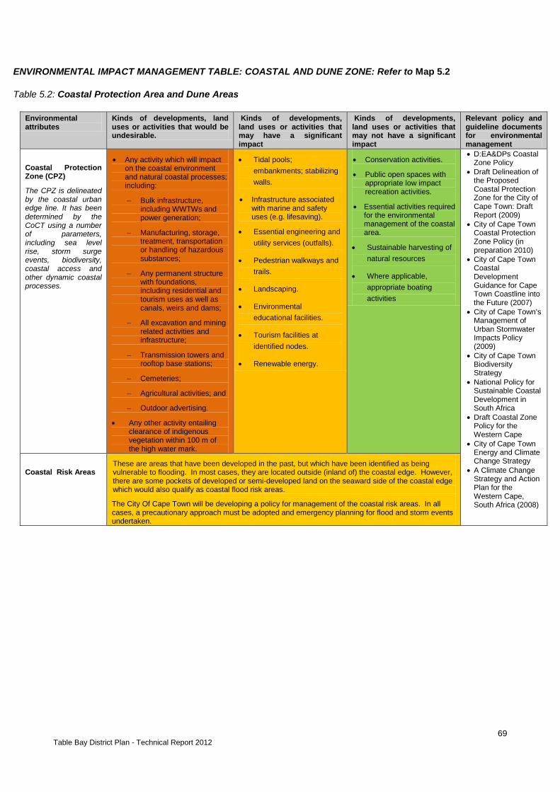
69 Table Bay District Plan - Technical Report 2012
ENVIRONMENTAL IMPACT MANAGEMENT TABLE: COASTAL AND DUNE ZONE: Refer to Map 5.2
Table 5.2: Coastal Protection Area and Dune Areas
Environmental attributes
Kinds of developments, land uses or activities that would be undesirable.
Kinds of developments, land uses or activities that may have a significant impact
Kinds of developments, land uses or activities that may not have a significant impact
Relevant policy and guideline documents for environmental management
Coastal Protection Zone (CPZ)
The CPZ is delineated by the coastal urban edge line. It has been determined by the CoCT using a number of parameters, including sea level rise, storm surge events, biodiversity, coastal access and other dynamic coastal processes.
• Any activity which will impact on the coastal environment and natural coastal processes; including:
− Bulk infrastructure, including WWTWs and power generation;
− Manufacturing, storage, treatment, transportation or handling of hazardous substances;
− Any permanent structure with foundations, including residential and tourism uses as well as canals, weirs and dams;
− All excavation and mining related activities and infrastructure;
− Transmission towers and rooftop base stations;
− Cemeteries;
− Agricultural activities; and
− Outdoor advertising.
• Any other activity entailing clearance of indigenous vegetation within 100 m of the high water mark.
• Tidal pools; embankments; stabilizing walls.
• Infrastructure associated with marine and safety uses (e.g. lifesaving).
• Essential engineering and utility services (outfalls).
• Pedestrian walkways and trails.
• Landscaping.
• Environmental educational facilities.
• Tourism facilities at identified nodes.
• Renewable energy.
• Conservation activities.
• Public open spaces with appropriate low impact recreation activities.
• Essential activities required for the environmental management of the coastal area.
• Sustainable harvesting of natural resources
• Where applicable, appropriate boating activities
• D:EA&DPs Coastal Zone Policy
• Draft Delineation of the Proposed Coastal Protection Zone for the City of Cape Town: Draft Report (2009)
• City of Cape Town Coastal Protection Zone Policy (in preparation 2010)
• City of Cape Town Coastal Development Guidance for Cape Town Coastline into the Future (2007)
• City of Cape Town’s Management of Urban Stormwater Impacts Policy (2009)
• City of Cape Town Biodiversity Strategy
• National Policy for Sustainable Coastal Development in South Africa
• Draft Coastal Zone Policy for the Western Cape
• City of Cape Town Energy and Climate Change Strategy
• A Climate Change Strategy and Action Plan for the Western Cape, South Africa (2008)
Coastal Risk Areas
These are areas that have been developed in the past, but which have been identified as being vulnerable to flooding. In most cases, they are located outside (inland of) the coastal edge. However, there are some pockets of developed or semi-developed land on the seaward side of the coastal edge which would also qualify as coastal flood risk areas.
The City Of Cape Town will be developing a policy for management of the coastal risk areas. In all cases, a precautionary approach must be adopted and emergency planning for flood and storm events undertaken.
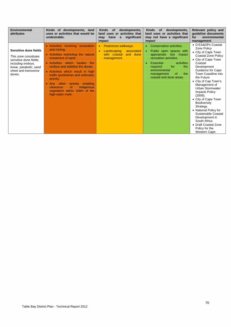
70 Table Bay District Plan - Technical Report 2012
Environmental attributes
Kinds of developments, land uses or activities that would be undesirable.
Kinds of developments, land uses or activities that may have a significant impact
Kinds of developments, land uses or activities that may not have a significant impact
Relevant policy and guideline documents for environmental management
Sensitive dune fields
This zone constitutes sensitive dune fields, including embryo, linear, parabolic, sand sheet and transverse dunes.
• Activities involving excavation and mining.
• Activities restricting the natural movement of sand.
• Activities which harden the surface and stabilise the dunes.
• Activities which result in high traffic (pedestrian and vehicular) activity.
• Any other activity entailing clearance of indigenous vegetation within 100m of the high water mark.
• Pedestrian walkways. • Landscaping associated
with coastal and dune management.
• Conservation activities. • Public open spaces with
appropriate low impact recreation activities.
• Essential activities required for the environmental management of the coastal and dune areas.
• D:EA&DPs Coastal Zone Policy
• City of Cape Town Coastal Zone Policy
• City of Cape Town Coastal Development Guidance for Cape Town Coastline into the Future
• City of Cap Town’s Management of Urban Stormwater Impacts Policy (2009).
• City of Cape Town Biodiversity Strategy.
• National Policy for Sustainable Coastal Development in South Africa
• Draft Coastal Zone Policy for the Western Cape.

71 Table Bay District Plan - Technical Report 2012
Map 5.2: Coastal Protection Zone and Dunes
72 Table Bay District Plan - Technical Report 2012
5.2.3. Conservation and Biodiversity Priority Zone SUMMARY OF STATUS With the exception of those areas falling within the TMNP, most of the Table Bay District is highly developed and transformed, and very little natural vegetation remains. However, the district does contain some of the remaining tracts of two of South Africa's rarest vegetation types, namely Sand Fynbos (very small and isolated patches) and Renosterveld (within the TMNP on Signal Hill). Both these types are exceptionally high in species diversity, and have a high incidence of vulnerable and endangered Red Data plant species and many endemic faunal species. Biodiversity in this District is under threat from rapid development, frequent veldfires, infestation by invasive alien species and overexploitation of water and marine resources. ENVIRONMENTAL MANAGEMENT PRIORITIES
Management Priority
Priority area of focus
1. Enhance and restore
• Rehabilitate and maintain areas of sensitive natural vegetation and high biodiversity value. Where biodiversity remnants conflict with areas earmarked for development, ensure adequate botanical and faunal impact assessments are undertaken timeously. Areas for rehabilitation include the sensitive and critical vegetation at Oudekraal, the northern part of Maitland and along the Black River at the Valkenberg hospital.
• Maintain and enhance mountain to sea linkages e.g. at Oudekraal and between Bantry bay and Clifton & especially along water courses e.g. streams through Camps Bay
2. EIA requirements • New development inside the urban edge that potentially impacts on areas of high biodiversity importance should only be considered under exceptional circumstances, subject to compelling motivation and in consultation with the City of Cape Town’s Biodiversity Branch
• Specialist botanicaland/or freshwater ecological input must be obtained for proposed new development inside the urban edge that potentially impacts on areas of high biodiversity importance
• Issues to be considered: vegetation, connectivity & access, fire control and land management issues, pollution, invasive alien vegetation and faunal species.
• Areas of high biodiversity importance outside the urban edge should be regarded as “no-go” areas for development.
• An EMP must be drawn up and implemented for all activities approved in this zone, in accordance with the City of Cape Town’s specifications for EMPs.
• Formalised reserves and sites should be regarded as “no-go” areas and no further development of any kind in these areas should be allowed without a detailed assessment of the impacts and reference to the Reserve Zonation Plan (2010)
• A variety of different types of critical vegetation are included within the CBA 1 zone. For planning purposes, reference must be made to a detailed biodiversity map and consultation with the Biodiversity Branch must take place.
• Identify opportunities to permit low impact sustainable development which contributes to a net increase in the protection of biodiversity and the establishment of functional biodiversity nodes and corridors.
• Opportunities for sustainable, low impact community utilisation of biodiversity resources should be identified.

73 Table Bay District Plan - Technical Report 2012
• Note that unless the Biodiversity Network is secured elsewhere, other natural vegetation areas may become important if required as biodiversity offsets.
3. Monitor and manage impacts
• Ensure effective implementation of the Two Rivers Urban Park management plans
• Control and remove invasive alien vegetation, particularly close to biodiversity areas e.g. areas around Acacia Park and Wingfield, the Two Rivers Urban Park and the stream corridors through Camps Bay
• Control and prevent illegal dumping and the illegal removal of terrestrial and marine species
• Implement effective veldfire management strategies in line with the City’s Veldfire Management Guidelines
4. Research and Educate
• Maximise opportunities for environmental education and appropriate types of recreation in biodiversity areas e.g. within the TMNP but also on or at the foot of Signal Hill, the V&A Waterfront and other coastal and beach areas – with a focus on marine biodiversity.

74 Table Bay District Plan - Technical Report 2012
ENVIRONMENTAL IMPACT MANAGEMENT TABLE: BIODIVERSITY: Refer to Map 5.3 Table 5.3a): Conservation and Critical Biodiversity Areas
Environmental attributes
Kinds of developments, land uses or activities that would be undesirable.
Kinds of developments, land uses or activities that may have a significant impact
Kinds of developments, land uses or activities that may not have a significant impact
Relevant policy and guideline documents for environmental management
Protected Areas
This zone includes protected and managed biodiversity areas
• Any land use or activity that will have an impact on the vegetation cover or ecological functioning of the area, including: − Manufacturing, storage,
treatment, transportation or handling of hazardous substances.
− Solid and liquid waste disposal.
− Industrial activities. − Residential and
commercial development. − All excavation and mining
related activities. − Establishment of
cemeteries. − Abattoirs. − Agricultural and agri-
industrial activities. − Outdoor advertising.
• Tourism and hospitality facilities.
• Environmental education facilities.
• Essential engineering and utility services.
• Institutional activities (museums etc.)
• Parking areas and offices (related to conservation activities).
• Transmission towers and rooftop base stations.
• Any other activity entailing clearance of 3 hectares or more of critically endangered indigenous vegetation.
• Conservation activities. • Activities necessary for
the management of the conservation area/ reserve.
• Hiking trails and walks.
• View points for e.g. bird watching.
• The Identification and Prioritisation of a Biodiversity Network for the City of Cape Town
• City of Cape Town Biodiversity Strategy
• Reserve Sensitivity and Zonation Plans (June 2010)
• City of Cape Town’s Natural Interface Study: Veldfire Planning Guidelines (2004)
• DEAD&DP’s Guideline for Involving Biodiversity Specialists in EIA Processes (2005)
• The Fynbos Forum’s Guidelines for Environmental Assessment in the Western Cape (2005)
• City of Cape Town Biodiversity Network: C-plan and Marxan analysis: 2009 Methods and Results-A Climate Change Strategy and Action Plan for the Western Cape, South Africa (2008)
• Western Cape Provincial Spatial Development Framework: Statutory

75 Table Bay District Plan - Technical Report 2012
Environmental attributes
Kinds of developments, land uses or activities that would be undesirable.
Kinds of developments, land uses or activities that may have a significant impact
Kinds of developments, land uses or activities that may not have a significant impact
Relevant policy and guideline documents for environmental management
Critical Biodiversity Areas 1
This zone encompasses critical irreplaceable minimum selection, consolidation and connectivity biodiversity sites i.e. Bionet categories CBA1 a-e.
• Any land use or activity that will have an impact on the vegetation cover or ecological functioning of the area, including: − Manufacturing, storage,
treatment, transportation or handling of hazardous substances.
− Solid and liquid waste disposal.
− Bulk infrastructure including WWTWs and power generation.
− Industrial and agric-industrial activities.
− Residential and commercial development.
− All excavation and mining related activities.
− Establishment of cemeteries.
− Abattoirs. − Outdoor advertising.
• Conservation related facilities or infrastructure.
• Essential roads, rail, pipelines and cables.
• Essential engineering and utility services.
• Tourism facilities. • Hiking trails and walks. • Environmental education
facilities. • Sustainable harvesting of
natural resources. • Any other activity entailing
clearance of critically endangered indigenous vegetation.
• Agricultural activities (outside the urban edge).
• Conservation activities • Urban open space areas
with appropriate low-impact recreation activities.
Critical Biodiversity Areas 2
(Restorable Irreplaceable Sites)
This zone encompasses the irreplaceable restorable biodiversity sites i.e. Bionet category CBA 2
• Any land use or activity that will have an impact on the vegetation cover or ecological functioning of the area, including: − Manufacturing, storage,
treatment, transportation or handling of hazardous substances.
− Solid and liquid waste disposal.
− Bulk infrastructure including WWTW and power generation.
− Industrial and agric-industrial activities.
− Residential and commercial development.
− All excavation and mining related activities.
− Establishment of Cemeteries.
− Abattoirs. − Outdoor advertising.
• Conservation related facilities or infrastructure.
• Essential roads, rail, pipelines and cables.
• Essential engineering and utility services.
• Tourism facilities. • Hiking trails and walks. • Environmental education
facilities. • Sustainable harvesting of
natural resources. • Any other activity entailing
clearance of critically endangered indigenous vegetation.
• Agricultural activities (outside the urban edge).
• Conservation activities • Urban open space areas
with appropriate low-impact recreation activities.
Critical Ecological Support Areas (CESAs)
These sites may comprise any habitat quality from very low condition to pristine. They provide essential ecosystem
• Any land use or activity that will change the existing land use and /or harden the surface of the site, including:
− Manufacturing, storage, treatment, transportation or handling of hazardous substances.
• Agricultural activities (outside the urban edge).
• Conservation related facilities or infrastructure.
• Essential road, rail, pipelines and cables.
• Essential engineering
• Conservation and restoration activities.
• Urban open space areas with appropriate low-impact recreation activities.
• Pedestrian walkways and

76 Table Bay District Plan - Technical Report 2012
Environmental attributes
Kinds of developments, land uses or activities that would be undesirable.
Kinds of developments, land uses or activities that may have a significant impact
Kinds of developments, land uses or activities that may not have a significant impact
Relevant policy and guideline documents for environmental management
services. They are required for additional consolidation and ecological support and are essential for management consolidation, connectivity and viability of biodiversity elements in protected areas and CBAs.
Other Ecological Support Areas (OESAs)
These sites are essential for management consolidation, connectivity and viability of biodiversity elements in CBA1, CBA2 and Protected sites.
− Solid and liquid waste disposal.
− Bulk infrastructure including WWTW and power generation.
− Higher-density residential development.
− Industrial activities.
− Mining related activities.
− Establishment of Cemeteries.
− Abattoirs.
services relating to tourism facilities.
• Tourism facilities.
• Transmission towers and rooftop base stations.
• Sustainable harvesting of natural resources.
• Any other activity that is in keeping with the existing land use.
trails.
Other Natural Vegetation
This zone encompasses other natural vegetation sites that do not fall into the categories discussed above.
• Manufacturing, storage, treatment, transportation or handling of hazardous substances.
• Industrial activities. • Mining related activities.
• Conservation related facilities or infrastructure.
• Essential road, rail, pipelines and cables.
• Essential engineering services relating to tourism facilities.
• Pedestrian walkways and trails
• Tourism facilities. • Institutional activities. • Residential and
commercial development. • Agricultural activities. • Transmission towers and
rooftop base stations. • Establishment of
cemeteries. • Sustainable harvesting of
natural resources. • Any other activity entailing
clearance of critically endangered indigenous vegetation.
• Conservation activities. • Urban open space areas
with appropriate low-impact recreation activities.

77
Map 5.3: Conservation and Biodiversity Zone

78

79
5.2.4. Cultural and Recreational Resources Zone SUMMARY OF STATUS Archaeological evidence testifies to many thousands of years of human occupation in the Table Valley, with the Khoekoen seasonally occupying the area at the time of early European settlement as a refreshment station for the Dutch East India Company in 1652. The District includes the oldest settlement areas in Cape Town, focussed around the Company’s Garden, the area between Buitengracht and Buitenkant streets and the various early farms of the Upper Table Valley. Many older buildings in this part of the City contain very early fabric. The French Lines to the east of the Castle was the de facto extent of the city. By the 1830s, discrete settlements were already developing on the outskirts of the City – such as Bo-kaap – often where freed slaves and less affluent people moved. The discovery of diamonds and gold in Kimberley and Witwatersrand led to a boom in the development of Cape Town and an influx of immigrants to the Cape. During this period, Tamboerskloof, Oranjezicht and Green Point developed a suburban character. An outbreak of bubonic plague in 1901 lead to the first forced removals in Cape Town under the name of slum clearance and sanitation. Black migrant dock workers were removed to the Uitvlugt camp, which later developed into the Ndabeni Native Location (Bickford-Smith, 1999). Heavy industrialization took place during the periods surrounding the two World Wars, and the high demand for housing post war provided the impetus for apartheid planning with separated residential areas for the different race groups - well before the Group Areas act was passed. Langa was already laid out in 1927 to accommodate the residents from Ndabeni who were to be removed to make place for the planned ‘Garden City of Pinelands’. Residential areas such as Windermere and Crawford were planned as coloured residential areas, and Maitland Garden Village was built for the coloured municipal employees (Bickford-Smith et al, 1999). The Group Areas were delineated from 1957. Virtually all of the residential areas of the City Bowl were declared White Group Areas, with the exception of the Bo-Kaap (Malay Quarter). The most well-known of the forced removals sites is District Six, which was demolished in the 1970s as a slum area and remained undeveloped until the present. Tramway/Ilford Roads, Sea Point as well as areas in Salt River and Observatory were affected and people were moved to the Cape Flats. Table Bay District enjoys a very high density of historical neighbourhoods, sites and routes which testify to its rich history and together with its spectacular scenic vistas contribute to the living environment of its people and the tourism potential of the District.
ENVIRONMENTAL MANAGEMENT PRIORITIES
Management Priority
Priority area of focus
1. Enhance and restore
• Encourage the enhancement of sites, features and areas of heritage value to maximise their quality and sense of history and the value they add to the City as a place to live and to visit.
2. Retain and protect
• Ensure conservation-worthy sites and places are protected and conserved, and that any alterations or changes are appropriate to the historical nature of

80 Table Bay District Plan - Technical Report 2012
the site or place. • Extend and declare Urban Conservation Areas/Heritage Areas where
applicable (e.g. within the City Bowl, Green Point, Sea Point, District Six, Woodstock, Salt River and Observatory etc.).
• Preserve the qualities of the various areas of the City, which exhibits a range of diverse character zones such as the City Bowl, Bo-Kaap, Main Road, and suburbs.
• Ensure that any historical buildings and sites associated with District Six and its surrounds are conserved, upgraded and integrated into the redevelopment of the area.
• Identify and manage sites of memory. 3. Manage land
use and form • Protect the historical built fabric, scale and texture of the historical areas of the
City. • Maintain green corridors extending from the mountain into the City (e.g. parks
and public spaces located in the upper reaches of the City Bowl) including remnants of historic plantations.
• Maintain the interface between the City and Table Mountain, retaining view corridors and scenic vistas and avoiding monolithic structures that block views.
• Existing and proposed Urban Conservation Areas will take on the status of Heritage Areas in terms of the National Heritage Resources Act, 25 of 1999, but continue to be protected and managed in terms of the planning legislation.
• All development adjacent to open spaces should be orientated towards the open space to encourage the use and passive surveillance of these areas.
• Safety and security should be considered in the upgrading, landscaping or development of public open spaces.
4. Monitor and manage impacts
• Ensure that proposed development is in keeping and appropriate to the historical nature of the City.
• Ensure the retention and protection of historical areas, sites and features- both above and underground.
• Ensure that construction activities within the district and, specifically within heritage and conservation areas do not negatively impact on the historical character of the area or fabric.
5. Assessment Requirements
• Important heritage issues in these zones include: archaeological, built environment, landscape and visual issues.
• Authorisation of the activities must be in compliance with the requirements in the National Heritage Resources Act 25 of 1999 including impact assessment and for heritage resources. (Heritage Protections: S27 - provincial and national heritage sites, S28 – protected areas, S29 – provisionally protected areas, S30 – heritage register, S31 – heritage areas, S34 – structures over 60 years old, S35 archaeology, palaeontology and meteorite sites, S36 – burial grounds and graves, S37 – public monuments and memorials, S38 – development triggers for impact assessment)
• A Heritage Overlay is being developed and will become part of the new Cape Town Zoning Scheme. Compliance to the CTZS will be required when it is in place
6. Research & Educate
• Confirm and refine mapping of cultural landscapes and heritage resources for protection.
• Develop interpretation and promote awareness • Develop heritage management tools and guidelines. • Undertake research.

81 Table Bay District Plan - Technical Report 2012
ENVIRONMENTAL IMPACT MANAGEMENT TABLE: HERITAGE: Refer to Figure 5.4 Table 5.4a) Cultural and Heritage Areas
Environmental attributes2 Kinds of developments, land uses or activities that would be undesirable.
Kinds of developments, land uses or activities that may have a significant impact
Kinds of developments, land uses or activities that may not have a significant impact
Relevant policy and guideline documents for environmental management
Table Mountain National Park
The park contains natural, heritage and archaeological sites (declared UNESCO World Heritage Site)
• Comply with the SANParks’ TMNP Park Management Plan (PMP), Conservation Development Framework (CDF), Heritage Resources Management Plan (HRMP) and City policy.
• D:EA&DP’s Guideline for Involving Heritage Specialists in EIA Processes (2005)
• D:EAD&DP’s Guideline for Involving Visual Specialists in EIA Processes (2005)
• D:EA&DP’s EIA Guideline Series: Guideline for the Management of Development on Mountains, Hills and Ridges of the Western Cape (2002)
• City Of Cape Town Scenic Routes Management Plan
• City Of Cape Town Heritage Resources Strategy
• National Heritage Resources Act (1999)
Robben Island
Robben Island is a declared UNESCO world heritage site
• Comply with the Robben Island Integrated Conservation Management Plan.
Urban Conservation Areas / Heritage Areas & Special Areas
This zone includes existing and proposed urban conservation areas / heritage areas. Urban conservation areas generally contain a concentration of Grade 2 and Grade 3 Heritage Resources.
• Any alterations, additions or new structures unsympathetic to protected buildings or the general character of area.
• Mining related activities and infrastructure.
• Industrial activities. • Inappropriate signage
and advertising. • Inappropriate
landscaping • Transmission towers
and base stations.
• Dependent on specific area. Suitable activities should be congruent and sympathetic to landscape / townscape.
• Institutional facilities • Tourism and
hospitality facilities. • Inappropriate
engineering and utility services.
• Inappropriate roadworks, rail, and cables.
• Sub-division and densification that may not be sensitive to the character of the area.
• Appropriate residential and commercial activities that are in keeping with the character of the area.
• Appropriate restoration and conservation of historical buildings and infrastructure.
• Public open space.
Forced Removal Sites
This includes areas that became vacant after communities were forcibly removed in terms of the Group Areas Act. This zone includes District Six and other areas not indicated on the map.
• Any development prior to consultation with groups that were affected by the forced removals.
• Inappropriate development.
• Creation of spaces or structures serving as memorials of the forced removals at the sites.
• Public open space • Residential
redevelopment involving removed communities
2Please note that cultural landscapes, potential archeological areas and other heritage areas have been mapped based on the best available data
and have not been refined, peer-reviewed or ground-truthed.

82 Table Bay District Plan - Technical Report 2012
Environmental attributes2 Kinds of developments, land uses or activities that would be undesirable.
Kinds of developments, land uses or activities that may have a significant impact
Kinds of developments, land uses or activities that may not have a significant impact
Relevant policy and guideline documents for environmental management
Potential archaeological sites / palaeontological sites/ burial areas
There is a likelihood of archaeological / palaeontological sites existing throughout the entire metropolitan area.
This zone includes areas of archaeological value or potential and areas of high probability of finding burials.
• Any development outside the urban edge.
• Any inappropriate development in historical areas of the City
• Any development involving burial grounds or cemeteries; especially for example the Green Point Burials Area.
• All excavation related activities and infrastructure.
• Essential engineering services and infrastructure.
• Tourism and hospitality facilities.
• Institutional and educational facilities.
• Special coastal node development.
• Sustainable harvesting of natural resources.
• Bulk infrastructure and energy generation (including renewable energy).
• Conservation activities.
• Public open space. • Viewing sites.
Scenic Routes
• Victoria Road • Beach Road • Kloof Road • Tafelberg Road • Signal Hill Road • Buitengracht and Kloof
Nek • De Waal Drive • Nelson Mandela
Boulevard • Camps Bay Drive • Ocean View Drive
• Activities which compromise or restrict views.
• Activities inconsistent with the landscape / townscape.
• Outdoor advertising. • Inappropriate
roadworks and landscaping
• Cables, pylons, street poles
• Dependent on section of road. Suitable activities should be congruent and sympathetic to landscape / townscape.
• N/A
Table 5.4b): Public Open Spaces
Environmental attributes Kinds of developments, land uses or activities that would be undesirable.
Kinds of developments, land uses or activities that may have a significant impact
Kinds of developments, land uses or activities that may not have a significant impact
Relevant policy and guideline documents for environmental management
Structuring Open Spaces
This zone includes structuring public open spaces (which are significant at a district scale and play a role in structuring the area)
• Waste disposal activities (including WWTW).
• Mining activities. • Industrial activities. • Residential
development.
• * Limited commercial activities.
• Institutional activities (museums, churches etc.).
• Tourism facilities. • Establishment of
cemeteries. • Sustainable harvesting
of natural resources. • Transmission towers
and rooftop base stations.
• Outdoor advertising. • Small-scale urban
agricultural activities.
• Conservation related facilities or infrastructure.
• Public open space areas with appropriate recreation activities.
• Essential engineering services relating to outfall sewers and storm water systems.
• Road, rail, pipeline and cable crossings and bridges.
• Landscaping.
• City of Cape Town’s CMOSS Strategy
• City of Cape Town’s Management of Urban Stormwater Impacts Policy (2009)
• City of Cape Town’s Floodplain and River Corridor Management Policy

83
Figure 5.4: Cultural and Recreational Resources Zone
84 Table Bay District Plan - Technical Report 2012
5.2.5. Natural Economic Resources Zone SUMMARY OF STATUS Cape Town’s CBD, located at the heart of the Table Bay District, is the most important commercial and business area of Cape Town. This district acts as a major draw card for national and international tourists. It has the second-highest number of industrial properties of all the districts in the CoCT and it incorporates the Port of Cape Town. It is therefore an important area for economic opportunities in the CoCT in terms of commercial, industrial and tourism activities. However, the Table Bay District has virtually no natural economic resources. Sand used for building material is considered a limited economic resource and there are concerns regarding the limited availability of unexploited sand and gravel resources. This creates conflict between demands to exploit remaining resources and maintaining the integrity of the receiving environment in which these resources occur. The main issue with regards to mineral extraction in this District is the existing sterilization of economic mineral resources by urban development (the sand resources in the Table Bay District are underneath established urban areas, e.g. in the Pinelands area).
ENVIRONMENTAL MANAGEMENT PRIORITIES
Management Priority
Priority area of focus
1. Manage land use and form
• There are few to no natural resources accessible for exploitation, but if large sites are redeveloped and there is potential to utilise underlying sand resources, these should be fully exploited.
2. EIA Requirements • Issues to be considered: water pollution, biodiversity, economy, health
& safety, access, noise, odour and visual issues. • Extraction of mineral resources should be considered prior to the
authorisation of urban or other development on mineral resources. • Mining activities should not be authorised without the required EMPs
and rehabilitation plans. • Mining companies must commit sufficient financial resources to
rehabilitation, prior to approval. • Where high priority mineral resources conflict with areas of biodiversity
importance, specialist input from the Biodiversity Management Branch is to be obtained, prior to the authorisation of mining activities.
• Where high priority mineral resources conflict with areas of archaeological and heritage importance, an assessment of these impacts must be undertaken and appropriate mitigation measures approved by Heritage Western Cape, prior to authorisation.
• Sand mining of dunes can only be considered outside of the Coastal Protection Zone, and subject to specialist input and the implementation of appropriate mitigation measures.
• Mineral resources close to visually sensitive areas, scenic routes and residential areas must consider the visual, health and safety impacts and adequate mitigation measures must be determined, prior to approval.
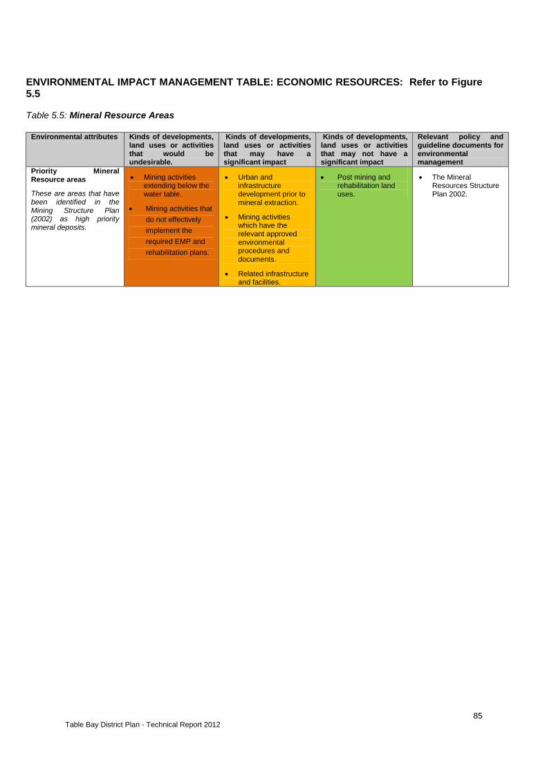
85 Table Bay District Plan - Technical Report 2012
ENVIRONMENTAL IMPACT MANAGEMENT TABLE: ECONOMIC RESOURCES: Refer to Figure 5.5 Table 5.5: Mineral Resource Areas
Environmental attributes Kinds of developments,
land uses or activities that would be undesirable.
Kinds of developments, land uses or activities that may have a significant impact
Kinds of developments, land uses or activities that may not have a significant impact
Relevant policy and guideline documents for environmental management
Priority Mineral Resource areas
These are areas that have been identified in the Mining Structure Plan (2002) as high priority mineral deposits.
• Mining activities extending below the water table.
• Mining activities that do not effectively implement the required EMP and rehabilitation plans.
• Urban and infrastructure development prior to mineral extraction.
• Mining activities which have the relevant approved environmental procedures and documents.
• Related infrastructure and facilities.
• Post mining and rehabilitation land uses.
• The Mineral Resources Structure Plan 2002.

86 Table Bay District Plan - Technical Report 2012
Figure 5.5: Natural Economic Resources Zone

87 Table Bay District Plan - Technical Report 2012
5.2.6 Urban Uses and Utilities Zone SUMMARY OF STATUS The Table Bay District contains the main commercial and tourist area of the CoCT (CBD, City Bowl, Atlantic Seaboard, Port of Cape Town and V&A Waterfront) and some important industrial land parcels like Epping, Paarden Eiland and Ndabeni. The District includes some of the most affluent residential areas in the city (Atlantic Seaboard and areas within the City Bowl), as well as middle and lower income residential areas (parts of Woodstock, Salt River and Langa). Despite its proximity to employment opportunities, the District has relatively few informal settlements. The District has a scarcity of housing due to the topography and important environmental and tourism assets. Development pressure within this District is focused in the CBD where a number of high-rise residential and mix-use developments have been developed over recent years. Movement patterns within the district are characterised by increasing traffic congestion with high commuter traffic volumes into the CBD in the morning and the reverse during the afternoon peak period. Commuters also rely on public transport into and out of the CBD and pedestrian volumes within the CBD are significant. The Table Bay District is experiencing increasing urban infrastructure pressure, with capacity constraints in bulk water provision and reticulation as well as the wastewater reticulation systems. Increasing waste generation leads to cumulative contamination and pollution in the long term, as the receiving environment has limited capacity to assimilate and breakdown waste. Two landfills at Vissershok are permitted to receive hazardous and general waste, and a substantial extension to one of these sites managed by the CoCT has been authorised. The City is rapidly running out of space for solid waste disposal and a new regional landfill site is urgently required. Even with the proposed new site, without interventions to minimise and recycle waste, the City will face an environmental and public health crisis. Pollution and degradation, particularly of rivers and wetland systems within this District is a critical issue. The rivers in the eastern part of the Table Bay District have lost much of their natural riparian habitat and their environmental functioning has been seriously compromised. Air pollution is also a problem in the district, especially in the CBD – identified air pollution ‘hot spot’ as per the City’s Air Quality Management Plan.
ENVIRONMENTAL MANAGEMENT PRIORITIES The SDP sets out a wide variety of strategies to address the socio-economic and infrastructural needs of the district relating to settlements, transport, open space and upgrading of urban areas. They are not repeated here. The priorities noted below are largely related to the management of waste and pollution. Management Priority
Priority area of focus
1. EIA Requirements
• Issues to be addressed: noise, air and stormwater pollution, health & safety issues, odour, visual issues
• Undesirable activities in the airport noise buffer may be considered by the local authority if acoustic screening measures are provided to limit sound levels. Sound levels inside buildings must be below 40dBA.
• Freshwater and/or groundwater specialist input must be obtained, and appropriate mitigation measures implemented, for industrial activities proposed on highly productive aquifers or close to river and wetland buffers.
• An EMP must be drawn up and implemented for all activities approved in

88 Table Bay District Plan - Technical Report 2012
these zones, in accordance with the City of Cape Town’s specifications for EMPs.
2. Monitor and manage impacts
• Monitor and enforce industry’s compliance with air pollution standards • Control illegal dumping and monitor and enforce landfill sites’ compliance
with environmental requirements • Reduce the frequency of overflows in the sewage conveyance system • Provide adequate services to backyarders
ENVIRONMENTAL IMPACT MANAGEMENT TABLE: URBAN USES AND UTILITIES: Refer to Figure 5.6 Table 5.6a):Airport Noise Buffer Area
Environmental attributes
Kinds of developments, land uses or activities that would be undesirable.
Kinds of developments, land uses or activities that may have a significant impact
Kinds of developments, land uses or activities that may not have a significant impact
Relevant policy and guideline documents for environmental management
Airport noise buffer zones This includes the noise cone around the Ysterplaat military airport
Within the 65 decibel zone (controlled area)*:
• Educational facilities.
• Institutional and community facilities, including hospitals and churches.
• Commercial - offices.
• Residential development.
• Commercial activities (excluding offices).
• Light industrial activities.
• Heavy (scheduled) industrial.
• Major roads.
• Air fields.
• Incinerators.
• Engineering and utility services and infrastructure.
• Sub-stations and electrical infrastructure.
• Conservation activities. • Public open space.
• Landscaping.
• Roads and rail.
• Transmission towers and rooftop base stations.
Table5.6b): Industrial and Commercial Areas
Environmental attributes
Kinds of developments, land uses or activities that would be undesirable.
Kinds of developments, land uses or activities that may have a significant impact
Kinds of developments, land uses or activities that may not have a significant impact
Relevant policy and guideline documents for environmental management
Industrial areas
This includes areas currently zoned for industrial use.
• Any upgrades or additional industrial activities which exceed air emission standards or will contribute to ambient pollution exceedences.
• Heavy (scheduled) industrial activities.
• Incinerators. • Major roads. • Air fields.
• Light industrial. • Commercial. • Infill development. • Engineering and utility
services and infrastructure.
• Sub-stations and electrical infrastructure.
• A Guide to Reporting and Estimating Emissions for the Integrated Pollutant and Waste Information System (IPWIS) 2005.
• City of Cape Town’s Air Pollution Control By-Law (2001).
• Air Quality Management Plan for the City of Cape Town (Sept, 2005).
• City of Cape Town’s Management of Urban Stormwater Impacts Policy (2009)
Commercial areas
This includes areas currently zoned for commercial use.
• Heavy (scheduled) industrial activity.
• Light industrial • Incinerators. • Major roads. • Air fields.
• Commercial. • Infill development. • Engineering and utility
services and infrastructure.
• Sub-stations and electrical infrastructure.

89 Table Bay District Plan - Technical Report 2012
Table 5.6c): Infrastructure and Utilities Servitudes
Environmental attributes
Kinds of developments, land uses or activities that would be undesirable.
Kinds of developments, land uses or activities that may have a significant impact
Kinds of developments, land uses or activities that may not have a significant impact
Relevant policy and guideline documents for environmental management
Infrastructure Servitudes
This includes power cables and underground pipelines and infrastructure
• Permanent structures and buildings other than those related to service provision.
• Roads and rail. • Transmission towers
and rooftop base stations.
• Agricultural activities (including urban agriculture).
• Conservation activities. • Public open space. • Landscaping. • Stormwater
management. • Pipelines and cables. • Engineering and utility
services and infrastructure.
• Power generation activities and power lines.
• Pedestrian walkways. • Sub-stations.
City of Cape Town’s Management of Urban Stormwater Impacts (2009) City of Cape Town’s Floodplain and River Corridor Management Policy (2009)

90 Table Bay District Plan - Technical Report 2012
Figure 5.6: Urban Uses and Utilities Zone

91 Table Bay District Plan - Technical Report 2012
5.3. Areas of potential impact on selected natural environmental attributes In the context of the Environmental Impact Management (EIM) zones, areas of potential impact are identified where new development is proposed on areas which have natural environmental attributes that are sensitive or have ecological value. These potential impact areas are shown in figure 5.7. The purpose of identifying these areas is to ‘flag’ the potential impacts that will need to be assessed in detail as part of an application for Environmental Authorisation, should this not already have occurred. There are several important considerations in terms of the assessment of these potential impacts as part of the application for environmental authorisation: • The development proposals in the SDP reflect the desired future spatial development
pattern in area, provide a strategic context and act as an informant to the project level assessment of impacts.
• The assessment of the potential impacts related to areas identified in figure 5.7 should occur within a broader assessment of the sustainability of any particular development proposal. This would include consideration of social justice / equity and economic development / prosperity in addition to ecological integrity factors.
• No relative significance has been assigned in the SDP/EMF to the potential impacts
relating to the selected environmental attributes – this will need to be assessed as part of the EIA process.
• Figure 5.7 identifies areas of potential impact on wetlands and conservation and
biodiversity areas only. The assessment of other environmental factors including the features identified within other EIM zones is required as part of the project specific EIA process.
Annexure B provides principles for assessing development proposals in the identified areas of potential impact.
92 Table Bay District Plan - Technical Report 2012

93
6. IMPLEMENTATION 6.1. Urban restructuring and upgrading: framework for public investment Urban restructuring and major upgrading deals with: • changes that need to occur within the existing urban footprint to reinforce the SDP, which
require sector specific capital investment. • informing planning around the capital investment requirements (public and in some cases
private) associated with new development areas and areas where major intensification is proposed (introduced in the box below).
ALIGNING SERVICE AND INFRASTRUCTURE PLANNING WITH THE SPATIAL DEVELOPMENT PLAN
Two considerations are important in terms of planning for services (public facilities, parks) and infrastructure (transport, bulk infrastructure/ utility services). Firstly, there is a need to address backlogs based on the existing demands and secondly a need to plan for new demand. In terms of the latter the SDP attempts to inform by: • indicating new development areas (focussed on significant greenfield development)
(See Map 6.1); • locating areas for intensification of urban use (areas where redevelopment is being
promoted) (See Map 6.1); • providing some indication, where possible, of the quantum of development and likely
phasing of development. This planning approach will be supplemented by more detailed modeling exercises conducted on a sectoral basis. New development area Likely land uses Possible yield (approx. dwelling
units) 1. District Six Mixed use,
residential (medium & high)
4500-5500 units
2. Wingfield
Mixed use, residential
Opportunity for medium to high density development, depending on site constraints (40+ du/ha)
3. Various smaller infill sites (<5ha)
Residential (Possibly inclusionary housing)
Limited opportunities; density dependent on context
Major intensification areas: • Central city/ Foreshore/ Culemborg • East City precinct • Voortrekker Road corridor • Paarden Eiland • Athlone Power Station/ Langa

94
Map 6.1. New Development Areas Plan

95
6.1.1. Transport infrastructure The prioritisation of interventions in relation to transport infrastructure requires a fundamental shift from the historical approach to movement infrastructure development in this district. Key principles informing intervention around transport infrastructure include: • Prioritisation of interventions to support non-motorised transport above mobility; • Prioritisation of public transport over private mobility; • Prioritising interventions that will release economic development associated with the
accessibility and opportunity grid. a) New Road links
Several route connections are proposed to promote integration in the area and to strengthen connectivity and general mobility: • Berkley Road extension: a proposed extension that connects Berkley Road with Malta Road/
Albert Road (Lower Main) as part of an inter-district development route. • Frans Conradie extension: The proposal is for an extension of Frans Conradie Road
(connecting Goodwood and Wingfield and linking up with an extension of Sable Road) that would ultimately link into Koeberg Road in the Rugby area. Current planning calls for a grade-separated interchange at the N7/ Vanguard and Frans Conradie intersection.
• Aerodrome Road: This proposed road is planned from the Conradie Hospital site over Voortrekker Road and into Wingfield. It is envisaged that it will connect with Frans Conradie Drive. Some planning has been carried out but alignments are still to be confirmed. There are three proposed alignments with the one indictated on Map 6.2 as the preferred option as it does not run through the Jewish cemetery.
• Wingfield: the westward expansion of Milton Road might be required in future but further planning work is required in this regard. Similarly the local level circulation network for the site is dependent on a number of development scenarios.
• Tennant/ De Villiers Road upgrade to replace Canterbury road scheme. b) Public transport infrastructure
Integrated Rapid Transport (IRT) The City of Cape Town's Integrated Rapid Transit (IRT) project, referred to as MyCiTi, is planned to transform the city's current road based public transport system. This is to be accomplished through inter alia the provision of Bus Rapid Transit services in dedicated right-of-ways, feeder bus services, automated fare systems, operating service contracts, institutional reform and the transformation of the existing public transport industry. Significant investment in public transport infrastructure is proposed for the district as part of the City’s IRT programme. The revised Phase 1A includes the Inner City, Woodstock rail station, Paarden Eiland, Montague Gardens and extends to Hout Bay and Atlantis. The following facilities are included in the current phase (of which implementation has partially been completed): Trunk routes Two trunk routes are proposed to service the district as part of the current phase: • Doornbach / Du Noon – Cape Town CBD • Airport - Cape Town CBD

96 Table Bay District Plan - Technical Report 2012
Trunk stations Phase 1A includes 17 trunk stations. These stations are closed and located in the median, with raised platforms to facilitate level boarding onto high-floor vehicles. In this district stations include: Civic Centre, Thibault Square, Stadium, Granger Bay, Section, Neptune, Paarden Eiland and Woodstock. Feeder routes and stations Feeder areas of the current phase are predominantly located in the inner city (including Hout Bay). These feeder routes will be supported by the Inner City depot and 590 feeder stations/ stops, including five closed feeder-to-feeder stations. See diagram below for a graphic representation of current proposals impacting on the central city (as at March 2012):

97 Table Bay District Plan - Technical Report 2012
Rail network improvements The Regional Rail Plan (RRP) was undertaken by the South African Rail Commuter Corporation (SARCC) to prioritise the existing rail corridors for investment in infrastructure and rolling stock. Three corridors for short term improvemen have been identified, all of which include portions in this district. These are the Cape Town - Khayelitsha/ Kapteinsklip line; the Cape Town - Simonstown line (including the Cape Flats line) and the Cape Town - Strand/ Bellville line (including the Monte Vista line). The bulk of infrastructure spending will be directed towards upgrading the Cape Town, Athlone, Heideveld and Langa railway stations, refurbishing and purchasing new rolling stock, improving security, upgrading communication and signalling systems, and constructing park and ride facilities. Continued co-operation between rail network and station improvement initiatives and spatial planning is necessary to ensure correlation between urban development and mobility. Station upgrades A major upgrade process has largely been completed for the Cape Town Station precinct. In addition to this, various options for significant further development, including the concept of sinking the railway lines underground, are being explored. Should this be a viable option, it would result in the considerable development potential of a number of new city blocks stretching out towards Woodstock. The impact of this is still to be assessed and further engagement with various roleplayers is to continue. Apart from the revitalisation process for Cape Town Station, Langa station is the only other station in this district that has been upgraded as a result of the 2010 Soccer World Cup transport infrastructure improvements. The upgrade of the station itself has been completed, but significant potential exist for the further development of the precinct and surrounding areas (through both public and private investment) that will contribute to a high quality environment with mixed land uses.
A number of other projects have been identified in this district as part of Intersite’s development programme. Although details and timeframes have not been established for all of these, preliminary upgrade proposals include the following:
• Langa Station – Shopping Centre • Maitland Station – Land Sale (residential area) • Mutual Station (Mupine residential development) • Thornton Station (commercial) • Thornton residential • Cape Town Station – mixed use development • Woodstock Industrial – industrial development • Kensington Station – residential development • Maitland Station – heavy industry operator • Maitland Station – residential development • Ndabeni – light industrial development • Observatory Rail Sidings – office space development Development frameworks have also been drawn up for the following stations in this district as part of the National Station Precinct Planning Project: • Woodstock/ Esplanade Station • Salt River Station

98 Table Bay District Plan - Technical Report 2012
• Maitland Station All of these fall within areas identified as suitable for mixed use/ intensification. Transport-oriented Development Transit-oriented development (TOD) refers to residential and commercial districts located around a transit station or corridor with high quality service, good walkability, parking management and other design features that facilitate transit use and maximise overall accessibility. Although most of the stations in Table Bay District are destinations rather than origin stations, the principle of high intensity residential and commercial uses in close proximity to stations are supported. Park-and-ride options are also to be investigated and implemented.
c) Non-Motorised Transport (NMT)
Continued investment in NMT infrastructure is a priority in this district. Intervention is currently taking place predominantly in the inner city as part of a programme to develop a broader NMT network. In extending this network, interventions should focus on: • Main movement generators (including public transport interchange/ station areas); • The system of structuring routes proposed as part of this SDP – the dominant mobility function
of most higher order routes can no longer prevail and the prioritisation of NMT within the cross section of existing routes is critical;
• Critical public links which connect destination places and movement generators; • The linked internal open space system. Critical public links The following have been identified as important pedestrian links that will benefit from further investment: • Coastal Link: It is proposed that a pedestrian walkway/ NMT route is established along the
entire coastline from Camps Bay northwards to Milnerton. Although it already functions in part, e.g. the Sea Point promenade, further effort should be made to link it continuously. Detailed urban design proposals around the Port and Foreshore area would have to be investigated in order to allow linkages.
• Inner City NMT routes: Certain routes in the inner city are to be emphasised as dedicated pedestrian links: − Waterkant Street linking into Somerset Road towards Green Point. − Adderley Street continuing from Government Avenue and Company’s Gardens/ De Waal
Park as mountain-coast linkage. − Longmarket Street as a major pedestrian link between the Bo-Kaap and District Six.
• Mountain-sea linkages: Green links between the sea, through Culemborg, along Searle Street/ Trafalgar Park, District Six to the mountain; Platteklip Washhouses and Deer Park as well as from Signal Hill.
• Cecil Road towards Salt River Station • Langa – Bonteheuwel: the continuation of a pedestrian link originating in Bonteheuwel is to be
explored in the vicinity of the Joe Slovo area redevelopment. Phase 1A of the IRT also includes infrastructure for non-motorised transport, catering both for pedestrians and bicycles.

99 Table Bay District Plan - Technical Report 2012
6.1.2. Open space system Open space upgrading, enhancement and development (associated with the natural environment and higher order sports and recreation facilities) are critical to achieving the vision for this district. In particular, the latent potential of the existing natural systems should be optimised. In this regard, several interventions relating to the open space system are proposed.
a) Implement the Cape Metropolitan Open Space System (CMOSS)
The open space system reflected in this framework promotes integration between various green components as part of a linked system. The upgrading and enhancement of the natural environment and the development of sports and recreational facilities are important elements in this regard and the following are to be considered in particular: • Table Mountain is a major environmental feature that requires appropriate protection.
Development within the TMNP is managed in terms of the approved PMP and CDF. The Core and Buffer areas of the Cape Floral Region Protected Areas World Heritage Site have been proclaimed in terms of South African legislation and the World Heritage Convention Act (49/ 1999). The Core areas are already protected as part of the TMNP, whilst special provision needs to be made for the protection of the Buffer areas. Consideration needs to be given to the areas where there are conflict between development interests, particularly around access points, while conserving the natural environment.
• Instances where possible urban edge amendments could be considered include the Magazine site and the Strand Street quarry. Guidelines have been drawn up to ensure that certain criteria are met and that any development (primarily for the purpose of enhancing access to the mountain and possibly inclusionary housing) is handled sensitively.
• Mountain-sea linkages: The natural topography of the Table Mountain chain is to be integrated into the urban fabric by means of a series of “green fingers” that extend towards the coast. These areas are intended to contain recreational green spaces that form part of a continuous open space system.
• Critical ecological links and water courses are to be protected (and enhanced) from source to sea.
• Metro-scale urban parks are to provide sport and recreational opportunities to a large number of people. Suitable development associated with these should facilitate active interfaces.
• Creative design can enable new green amenities in areas of residential density, for example the upgrade of Maitland cemetery to act as a multi-functional open space.
• At a district scale, the open space system reflected in the framework seeks to promote, where possible, continuity. Appropriate district scale sport and recreation and school facilities should seek to tie into this system of multi-functional open space.
• Scenic routes are to be protected and guidelines for any development impacting on these should be followed.
• More active recreational areas are to be associated with residential developments, for example incorporating the Langa sports complex as part of a linear park along the Jakkalsvlei canal.
• Parks and open spaces in the district should, where possible, be associated with social facilities and adjacent land uses with compatible activities. Intensively developed edges should define open spaces, with development fronting onto open spaces to enable passive surveillance.
b) Protect and promote the biodiversity network
The biodiversity network in this district has been identified and ground-truthed. These areas should be incorporated into the open space network and be protected as valuable natural assets. The

100 Table Bay District Plan - Technical Report 2012
following objectives should be prioritised in terms of protecting and enhancing biodiversity sustainability: • Support the on-going consolidation of the Table Mountain National Park by investigating the
inclusion of Irreplaceable High and Medium Condition biodiversity land along the western edge of the City Bowl and adjacent to Camps Bay (Oudekraal).
• Support the entrenchment of the natural environment, biodiversity and conservation related land uses in areas that are not within the National Park.
• Protect the ‘coast to crest’ landscapes of the Peninsula from inappropriate development, e.g. Oudekraal where private ownership of biodiversity land represents a development threat.
• Secure CBA remnants identified in the Biodiversity Network, particularly land adjacent to the Black River, and enhance the associated riverine system.
• Investigate biodiversity offsets and strategic placement of open spaces in the development of areas where conflict exists between identified biodiversity assets and urban development proposals such as Wingfield.
c) Improve riverine systems and waterbodies
Key water features within this district include the Liesbeeck River and Black River as part of the Salt River system and several smaller mountain streams e.g. Kasteelpoort, Camps Bay, Diep and Lekkerwater streams. These form important ‘green corridors’ between the mountains and coastline as well as providing habitats for a rich diversity of terrestrial and aquatic life. However many rivers have been canalised, altering runoff patterns and ecological functionality. This approach is also associated with a decline in water quality as well as compromising community interaction with rivers and wetlands. An approach should be followed whereby rivers are considered as important natural elements that not only has a recreational purpose but also serves an ecological function. Specific issues include: • The Liesbeek River has been canalised and cut off from its original course. In effect the
canalised section functions merely as a conduit for stormwater while the old water course remains largely stagnant. Although it might not be possible to redress this completely, further investigations should establish how this can become part of a well-maintained open space system that is ecologically sustainable while offering recreational opportunities.
• Pollution levels of rivers such as the Black River need to be addressed. • Many of the wetlands and rivers in the district are not at present functioning as passive
recreational amenities and are often inaccessible to the general public. • Ensure the application of Water Sensitive Urban Design principles in development proposals. • Investigate options of re-instating and developing the CBD’s underground canal system and
natural springs. d) Cemeteries
Table Bay District has traditionally accommodated its burials in the Maitland, Pinelands (Jewish) and Langa cemeteries, with Muslim burials in the Mowbray cemetery. This district, targeted for urban renewal including infill and densification, will require additional burial space in the short-medium term (i.e. 5-15 years). Burial space at Langa cemetery is restricted to limited infill, with Maitland cemetery fast approaching capacity. Similarly, Mowbray cemetery is subject to high burial demand given that the district is home to a large percentage of the City’s Muslim community. A shortage of suitable land for new cemetery development in this district restricts short-medium term grave supply for in-ground burial to burial infill areas at Maitland cemetery; the continued use of Mowbray cemetery (including grave re-use given Muslim re-burial practices); possible re-opening of Tana Baru cemetery for Muslim re-burial and continued use of Pinelands 2 cemetery.

101 Table Bay District Plan - Technical Report 2012
Additional opportunities for the extension of Langa cemetery to the north are to be investigated. New, more space efficient and environmentally sustainable burial technologies must be explored where space limitations are occurring. Further demand, including burial demand emanating from future Wingfield residential infill, will need to be accommodated in the new cemetery development in Blaauwberg District. The Maitland cemetery located along Voortrekker Road has been identified for upgrade. A long term strategy for this strategically located cemetery should include a re-conceptualisation of the landscape. By investigating opportunities for appropriate, sensitively-designed development along the Voortrekker Road edge and the general enhancement of the site as a memorial park, a greater level of integration into the area can be achieved as well as the provision of a multi-purpose green space with enhanced safety.
e) Metropolitan/ District Parks
i. Green Point Urban Park This metropolitan facility, developed as a result of the new Green Point stadium, should form the focus of sport, recreation and recreational open space in the area while providing for limited related commercial opportunities. Further initiatives to upgrade the Mouille Point/ Sea Point promenade must be explored. ii. Two Rivers Urban Park The area defined as the Two Rivers Urban Park, located at the confluence of the Black and Liesbeeck Rivers, provides an ideal location for the creation of a metropolitan scale park as it comprises extensive open spaces, sensitive ecological systems and habitats, significant institutions, historic buildings and cultural landscapes. The area is situated on the edge of the inner city adjacent to dense residential and other land uses. From a district spatial perspective, the proposed park is significant as it forms part of a conceptual coast to coast greenway which links open spaces to Table Bay. The existing state of the natural environment means that considerable investment is necessary to enable the establishment of a quality park. Environmental degradation and the continued demand for land together with institutional and procedural challenges makes this a challenging project. However, the benefit that it would afford the wider community is of such significance that continued efforts should be made to realise its full potential. The park can provide recreational facilities that are of particular advantage to areas like Salt River, Woodstock, District Six and the CBD where there is an under-supply of open space. As part of the park development, the rationalisation and upgrade of existing institutions on the site should be addressed.
f) Other public open space/ sports fields • It is proposed that open space upgrading in the form of local parks seek opportunities within the
local linear open space system.

102 Table Bay District Plan - Technical Report 2012
• Upgrading of sport and recreation facilities should be focused within existing sports complexes. Efforts should be made to broaden the diversity of activity available within these areas to include activities beyond formal sport to passive recreational activity.
• Rationalising a number of these open spaces through allowing new development should be encouraged to improve the quality of place and define the space.
6.1.3 Publicly assisted housing Publicly assisted housing, in the context of the district plan, relates to the realisation of a range of housing opportunities, formal or informal, that the public sector plays a role in providing or supporting through its housing programmes. The spatial plan supports housing sector planning by: • giving direction to where these opportunities could occur by identifying land suitable for urban
development (refer to Section 4 and Map 4.1: Table Bay Spatial Development Plan); • giving further spatial direction through identifying “new opportunities” for publicly assisted
housing development (section 6.1.3a); • providing a framework for “informal settlement development and upgrading” processes in the
district (section 6.1.3b). In the context of the housing backlog, urbanisation trends and land availability patterns at a city and district level, publicly assisted housing in this district will generally focus on: • Small to medium scale residential infill development building on opportunities around pockets of
well-located underutilised land that exists; • The large scale greenfield development opportunities of District Six and Wingfield; • Some incremental upgrading in relation to informal settlements and existing housing estates.
a) New opportunities
Identification of new opportunities for publicly assisted housing is guided by the CTSDF policies and associated criteria (see Table 6.1). In this district, while there are limited undeveloped tracts of land suited to urban development, a number of opportunities are identified. These include sites which may be part of new subsided housing projects on the 5 year housing plan, as well as sites that should be further investigated for publicly assisted housing projects. Table 6.1: Criteria to be used to guide the identification of land for subsidised and gap housing
Principle Subcomponents Contain urban sprawl and protect the urban edge
The land identified should: • contribute to the development of a more compact city; • maximise the use of existing infrastructure and service capacity; • and not be located adjacent to the urban edge (where possible)
Facilitate urban integration, and promote the establishment of viable communities
The land identified should: • be in close proximity to existing economic, social and public
transport opportunities; and • support a mutually beneficial mix of social, residential,
recreational, commercial and employment opportunities.

103 Table Bay District Plan - Technical Report 2012
i) New subsidised housing projects A number of projects are the subject of subsidised housing infill/ upgrade projects in the short to medium term. These are reflected on Map 6.2. These new subsidised housing projects identified for the Table Bay District include:
Site Anticipated yield (dwelling units) • Langa Community Residential Unit
programme (CRU) Potentially 1300 units spread over a number of sites, depending on outcome of Heritage Impact Assessment.
• Kensington CRU 180 The CRU programme facilitates the building of new rental stock (including hostels) and the upgrade of existing higher-density stock. This programme also includes the former Hostels Redevelopment Programme. ii) Further land identification for publicly assisted housing projects Further land has been identified specifically for investigation for publicly assisted housing projects (see Map 6.2). This is limited to publicly owned land and will be updated over time, based on new information. It includes various portions of undeveloped or underutilised land, with the most significant sites including small pockets in Woodstock and a number of strategic sites that require further investigation. In addition to these sites other smaller infill opportunities should be explored. These could include: • the development of new buildings as part of existing housing estates, especially where these
can contribute to a safer well defined public environment and improved safety; • development of over-scaled road reserves and buffer strips; • rationalising underutilised open space.
Facilitate a range of housing options and delivery approaches
The land identified should: • be suited to the development of new settlements, the upgrade
and de-densification of existing informal settlements, high-density housing, rental accommodation, and the release of land to the homeless; and
• note that the size of the housing project and type of delivery agent influence its economic viability.
Be suited to housing development
The identified land should: • encourage environmentally sustainable land development
practices and processes; • not lead to the loss/have a damaging impact on natural and built
assets that merit longer-term protection; and • ensure healthy, safe living conditions.
Take the beneficiaries’ economic and social well-being into account
• When identifying land, and providing infrastructure and shelter for the unhoused and poorly housed, it is important to take their livelihood strategies and social support networks into account.

104 Table Bay District Plan - Technical Report 2012
The intention is that those sites that are found developable should be pursued as new public housing projects or if not feasible for development by the public sector alone, should be the subject of partnership efforts where the provision of inclusionary housing should be a priority. In this district the following sites have been identified for further investigation: • Erven 1955, 1559 (Somerset Hospital 10.5ha) • Erf 2967, Bo-Kaap • Vacant sites in Upper Woodstock/ Trafalgar Park area • Erven 12997, 12998, 12999 (Dillon Lane, Woodstock) • Erven 16163, 16172, 16173 (Shelley Road, Woodstock) • Erven 13126,6 & 13136, 7 (Melbourne Road, Woodstock) • Erf 13814 (Pickwick Road, Woodstock) • Erf 30420 (Observatory) • Erf 103659 (Maitland Abattoir) • Portion of Erf 26439 (Oude Molen 18.8ha) • Athlone Power Station precinct • Erf 169125 & 169123 (Conradie Hospital) (22.15ha) • Wingfield • Depot site Langa • Langa TRA/ school site • Magazine site • Strand Street Quarry
iii) Partnerships and inclusionary housing The provision of new affordable housing opportunities in the district cannot be addressed through the development of public land alone nor should all publicly owned land be developed solely for public housing purposes. In this regard, the role of partnerships in line with the inclusionary housing provisions of the PSDF should be pursued. Areas which should be a particular focus of these efforts are those where their location can contribute to restructuring through the provision of affordable housing close to socio-economic opportunities. This includes: • Public land developed for a mix of uses where there would be an opportunity to provide
inclusionary housing (potentially through cross subsidisation initiatives), for example District Six, Athlone Power Station and other smaller well-located infill sites.
• Parastatal or private land where inclusionary housing should be targeted as part of development efforts. Examples of these sites include Wingfield, Oude Molen, Conradie hospital site; Somerset hospital etc.
b) Informal settlement development and upgrading Informal settlement upgrading is a priority in terms of the City’s obligation to provide basic services in terms of its constitutional mandate, as well as more broadly, improving the quality of life of its citizens through the improvement of the urban environment. The City of Cape Town’s incremental approach to upgrading is illustrated in Figure 6.1. below: Figure 6.1: Incremental upgrade approach

105 Table Bay District Plan - Technical Report 2012
City of Cape Town, Informal Settlements Master Plan, 2007
The district reflects a few areas of informal settlement ranging from backyard shacks, informal dwellings on their own stand, and broader areas of informal settlement, with varying levels of access to basic services. In terms of accommodating the demand for housing in relation to informal settlements, the focus in the Table Bay district will be on in-situ upgrading due mainly to constraints around land availability as well as the general desire to ensure minimal social disruption to communities. There is, however, also a need to plan for new housing opportunities, which may, at least initially, accommodate residents on an incremental basis. • In-situ upgrading One of the key issues facing informal settlement upgrade is the issue of which settlements should be regarded as permanent and thus becoming the focus of upgrading beyond access to basic services (e.g. in situ upgrading) and which settlements or areas within settlements should be considered temporary and suited to relocation. In this regard the City of Cape Town’s Informal Settlements Department has proposed that informal settlements be categorised into three types according to their location and circumstances, which will inform the nature of appropriate interventions. More than one category could be applied within an informal settlement to account for the existence of multiple circumstances. The proposed categories are as follows: • A – occupation is permitted. • B – occupation is only temporarily allowed because it is either demonstrably to the
disadvantage of existing rights holders or it is very difficult or costly for services to be supplied. • C – occupation is prohibited because it is hazardous to the residents or the wider
community. The following table indicates in more detail how the categories would be defined and suggests the kind of intervention that could be appropriate. The extent to which such interventions are possible will

106 Table Bay District Plan - Technical Report 2012
depend upon the availability of resources and the strength of the required partnerships between the City and resident communities. Table 6.2: Criteria for categorisation of informal settlements Category Circumstances Intervention
C
1 Occupation poses a direct threat to the safety of the wider urban community (e.g. under power lines)
Registration of addresses and their occupants, Essential Services to the periphery only, no electricity connections and an arrangement between the City and residents (and any other party that is involved with the community) which will organise the vacating of the area and securing it from re-occupation
2 Occupation poses a real danger to the resident community because of hazardous soil conditions (e.g. flooding, methane)
B
3 Occupation prevents a higher use for which the land is intended to be used within 5 years
Registration of addresses and their occupants, Essential Services, individual electricity connections and the potential for a partnership-based programme that will create physical and socio-economic improvements for the residents to the extent possible.
4 Occupation reduces the value of neighbouring property
5 Occupation contravenes the rights of servitude holders, but is not necessarily dangerous
6 The settlement cannot be serviced without great difficulty or inordinate expense
A None of the above Registration of addresses and their occupants, at least full Essential Services (communal water standpipes and toilets to prescribed ratios, solid waste removal and area lighting), individual electricity connections and the potential for a comprehensive partnership-based improvement programme that could include access to greater security of tenure.
In the light of these criteria, some informal settlements within the district are regarded as permanent settlement areas. In this regard, it is critical that apart from addressing requirements for basic services as is constitutionally mandated, these areas are upgraded into dignified neighbourhoods with associated social and economic opportunities as informed by a clear plan and programme for these settlements. A number of informal settlements exist in Table Bay District. Various options for the upgrading and/or relocation of these are being explored depending on specific site conditions. The settlements include:
• Joe Slovo, Langa • Joe Slovo North (Little Kosovo) • Langa Sportsfield • Maitland Cemetery Gate 1 • Die Kraal , Bo-Kaap • Pickwick Rd, Salt River • Railway Rd, Woodstock • Koekoe Town/ Woltemade station

107 Table Bay District Plan - Technical Report 2012
• Royal plakkerskamp • Wingfield Camp • 6th Avenue Kensington • Pine Road, Woodstock • Vermeulen Rd, Bo-Kaap
• Emergency housing and new incremental development areas The identification process for land for new incremental development areas should reflect on the land for investigation for publicly assisted housing (see section 6.1.3a). It is critical that land identified and planned in this regard is developed in a manner that supports the future development of integrated human settlements i.e. the development of these areas requires comprehensive planning taking into account needs for public facilities, engineering services, open space and principles of good urban form. 6.1.4 Infrastructure upgrading This district, similar to other older parts of Cape Town, is facing increasing urban infrastructure constraints. Although the extent of this is not easily quantifiable in respect of all services, large portions of the district might be affected within the next 5-10 years. The need for increased infrastructure spending should be considered during development processes. Bulk water provision and reticulation issues in this district would have to be addressed within the next 5 years. Capacity constraints also exist in the waste water reticulation system. For the majority of urban areas in this district this might have an effect within the next 5 years, while the remaining areas might be affected within 5-10 years. The waste water treatment works (WWTW) serving this area is functioning at capacity and would have to be upgraded to enable further urban development. Electricity capacity would also have to be addressed within certain areas of this district over the next 5 years. In terms of storm water management, a portion in the south-east of this district faces serious capacity constraints within the next 10 years and areas adjacent to some rivers (e.g. Black and Liesbeeck) are subject to the flooding and cannot be developed. Within the central city area a more detailed infrastructure capacity assessment was done. The findings of this study (CoCT 2008) are summarised below. Further work is currently underway and will result in a more accurate picture of infrastructure constraints within this area.
a) Bulk Water
The bulk water supply system for the purpose of this investigation refers to the part of the water supply system that supplies treated potable water from the Tygerberg Reservoir to the Molteno Reservoir via the Paarden Eiland booster pump station. The water distribution system is defined as the pipe system that distributes potable water from the bulk water system to each consumer in a metered connection. In the case of the central city area, the bulk water and distribution system are interconnected and therefore the distribution system forms an integral part of the bulk supply system to the Molteno Reservoir. Currently there are no immediate problems with the bulk supply system in terms of both the infrastructure and water as a source. The mechanical, electrical and civil infrastructure requires ongoing maintenance to ensure that the system can continue to operate effectively. The biggest future challenge will be to increase the potable water treatment, conveyance and reservoir storage capacity of the system to be able to supply future water demand. Augmentation of the bulk system will increase capacity over broad areas of the city; the central city area however will benefit from increased overall capacity i.e. increased assurance of supply across the network. The expansion in the Atlantic Seaboard area should be looked into from a bulk supply perspective. The ability to

108 Table Bay District Plan - Technical Report 2012
continue to provide an adequate bulk supply to the Molteno/Oranjezicht/ Kloofnek/Campsbay/Sea Point tank bulk supply system should be investigated. There are a few pipe reinforcements required on the bulk pipelines supplying the city centre.
b) Water Distribution
Currently the water distribution system is performing adequately but ageing. Performance is measured on the ability of the water infrastructure in the ground to deliver water to consumers in the designated area. Pressure recordings, taken hourly every day at fixed pressure monitoring points do not indicate any cause for concern. A key determinant in the effectiveness of the performance of this reticulation is the strictly controlled valve operation in this area. This performance is also monitored via pressure recordings. Soundness of the local water reticulation is measured by the number of burst water mains. While the infrastructure is ageing, burst main records do not indicate cause for alarm. An increased incidence of burst water mains is noted on occasions when the main booster station serving the area, Paarden Eiland pump station is operated. Sections of water mains are re-laid as and when required as part of the metro's mains replacement programme. The current trend of re-developing retail and office blocks into a combination of retail, office and residential uses (for example in the central city and along Voortrekker Road) may lead to future water supply and distribution demands. These re-development trends significantly alter water demand volumes, patterns and peak flows. The impact of this is that it may affect the water distribution system in terms of meter sizing, as these developments are using existing meters. It may cause localised problems due to the pipe diameters of the existing distribution system being too small to convey water demands.
c) Stormwater
The stormwater drainage system serving the central city area consists of an underground pipe network discharging into Table Bay at 16 separate outfalls. The underground pipe network is supplemented by the roads acting as outfall flow channels during larger and less frequent storm rainfall events. A number of storm gulleys/ watercourses that drain the upper steep slopes of Table Mountain discharge directly onto the drainage system serving the central city. Problems are mostly experienced in the central CBD and Sea Point areas. Capacity of systems is satisfactory but litter and debris clogs up gullies and connections. The proposed Culemborg development site is likely to give rise to stormwater drainage problems due to the flat topography of the area and the lack of stormwater conveyances in the vicinity of the site. In general the stormwater drainage system is able to manage runoff generated by storm rainfall events. The protection of entrances to basements and the ground floor levels of structures during 1 in 50 year and 1 in 100 year storm events need to be investigated. The discharge of litter and debris with stormwater into the harbour is the cause of regular complaints by the National Ports Authority. Projected flooding along some river systems will limit development potential (e.g. lower Elsieskraal, lower Liesbeeck and Black River) and densification in these catchments must be accompanied by measures to reduce peak runoff such as a reduction in impervious area, additional facilities etc.
d) Sewerage System
The sewerage system in the central city area is a conventional waterborne sanitation system. The bulk of the area gravitates via the reticulation system to the major Green Point trunk sewer and is

109 Table Bay District Plan - Technical Report 2012
pumped to sea. Waste from District Six and the eastern parts of the district gravitates via the reticulation system to the Woodstock pump station which discharges towards the Athlone Waste Water Treatment Works. The sewerage system in the central city area experiences few problems, largely as a result of the reasonably steep gradients, and nature of the wastewater from predominantly commercial and residential property. There are some sewers which do suffer from deposits of fat discharged from some hotels and restaurants and resultant blockages. The very old brick outfall sewer which runs from Woodstock via the Golden Acre and Adderley Street to Green Point is in need of regular cleaning (silt deposits).The connector 225mm earthenware sewer in upper Adderley Street is likewise in need of regular cleaning and maintenance. The upper City Bowl sewerage system suffers from water ingress during storms, with surcharge and overflows occurring regularly. Part of the central city catchment area drains towards the Woodstock Sewage pump station. This area suffers from increased solids content and also storm water ingress. Water ingress from incorrectly designed storm water drainage from individual erven, particularly in the Woodstock and Oranjezicht areas, is discharged into the sewer system, particularly via sewer inspection chamber covers that are lifted during storms. The pipes are generally old throughout this catchment. While earthenware pipes are extremely durable, they do suffer from failure of the cement caulking or rubber ring joints allowing ingress of groundwater, particularly during the rainy winter months. This weakness also allows roots to grow into the sewers, resulting in blockages. Further bulk sewer capacity in the eastern parts of the district, including Wingfield, will not be available until the Northern Areas Bulk Sewer upgrade is complete. The Woodstock sewage pump station is currently running at capacity, and will require upgrading. The sewerage system has several other smaller pump stations. Most of these are lift stations, delivering into the nearby trunk outfall sewer. No systemic problems with these sewage pump stations have been reported, other than the lack of flow meters. There are some separate sewerage systems which discharge into the municipal system – these include Portnet, V&A Waterfront, and the Roggebaai Canal precinct. Proposed intensification in the CBD and surrounds will impact significantly on the Green Point sewage outfall pump station. Although it still has hydraulic capacity, the permit conditions limit the total amount of flow that can be pumped to the sea. The Green Point outfall was designed for 40 Ml/day and the current permit is for 30 Ml/day. The average flow in 2007 was in the order of 27.6Ml/day, a figure that will increase substantially with additional development and residential conversions. The constraint on the Green Point outfall is the 1.7km x 700 mm pipeline which is embedded with concrete on the sea floor. The pipeline was designed for 1400l/s and 6bar pressure and therefore cannot transport more wastewater to discharge. Under current dry weather conditions the peak flows are already 1400l/s and the rainy season will only exacerbate possible flooding in the area. Possible options for addressing this concern include the construction of an additional sea pipeline outfall; additional sewers and pumpstations to discharge some of the sewerage of this catchment to the Athlone WWTW; a new WWTW in the area or increased efforts to facilitate on-site solutions whereby developments discharge treated effluent into the stormwater system. These options require further investigation, costing and action to enable spatial development to continue in the district.

110 Table Bay District Plan - Technical Report 2012
e) Electricity The electricity network in the CBD is owned and operated by the City of CapeTown. Bulk electricity is purchased at Eskom’s Acacia substation at 132kV and is then transferred to the City’s Montague Gardens main substation via 2 x 132kV overhead lines. From Montague Gardens main substation it is transferred to various main substations within the CBD via 132kV underground cables. At the main substations within the CBD the electricity is stepped down from 132kV to 11kV and then transferred via the 11kV medium voltage underground network. Many of the main substations are close to capacity as a result of the on-going high growth in demand and there is a recognised need to upgrade the high voltage capacity in the central city supply area to cope with this rapid development. Observatory, Tamboerskloof and Green Point main substations are close to firm capacity. Roggebaai main substation is over firm capacity. A number of main substation transformers and switchgear has reached the end of its operating life and needs to be replaced. The existing Eskom intake point at Montague Gardens main substation is at firm capacity. Capacity available on Eskom’s network (Acacia Substation) is constrained. There is a recognised need to replace ageing infrastructure on the 132kV high voltage and 11kV medium voltage networks.Well-defined plans and budgets are in place for the high voltage network and no additional work is required. There is also a recognised need to upgrade the medium voltage network to cope with the growth in demand. At this stage there is no integrated long-term master plan to address the load growth on the 11kV network and capacity is installed as and when required. Plans and budgets to address network constraints and capacity problems on the medium voltage network are not well defined and additional work is required in this regard. The high-voltage bulk supply to the Cape Town central business district (CBD) has been upgraded, partly in preparation for the 2010 FIFA Word Cup tournament but mainly to cater for actual and potential development in the CBD and the Atlantic Seaboard, as well as to replace ageing transformers and switchgear. Investment in the medium voltage distribution network is also required, and because of the increasing load density, the introduction of a new voltage level is being considered to improve efficiencies. 6.1.5. Public facilities and public space
a) Urban/Civic Upgrade
Areas identified for urban upgrade and improvement in the public realm include: • Woodstock along Victoria Road roughly between Station Road in the west and Salt River
Road in the east, focussed on Woodstock Town Hall precinct • Further along Victoria Road eastwards up to Observatory around Station Road • In future the interface between the Wingfield site and Voortrekker Road is to be
addressed.(Proposed commercial edge, together with intensification along the road in general and upgraded Maitland cemetery area)
• Parts of Langa, in particular Bhunga Drive and Washington Drive to contribute to the emerging cultural precinct
• The civic precincts of Maitland, Pinelands and Sea Point associated with existing community centres and/or town halls and opens spaces
b) Public facilities
The district plan provides an input to guiding the provision and distribution of public facilities, which should be supplemented by local development plans and the community services directorate’s

111 Table Bay District Plan - Technical Report 2012
master plans. The distribution of public facilities (such as clinics, libraries and community halls) is informed by the location of the proposed hierarchy of civic precincts (see section 4) proposed as clusters of social facilities and public institutions and proximity to the accessibility grid. Furthermore, the development of higher order (e.g. district and metropolitan) parks and sports facilities is informed by the identification of the structuring open space system that these facilities should seek to reinforce. Table Bay District reflects a relatively high level of investment in a range of community and public facilities. At a district scale, there are tertiary educational institutions, a number of major public and private hospitals as well as district level sports facilities and open spaces. Most of the residential areas are reasonably well-serviced in terms of schools, libraries, community halls and sports facilities. In general these are easily accessible and located along major transport routes. Facilities are generally well-maintained although there is a concern around the maintenance and utilisation of the more local parks and public open spaces. Often open spaces have poor connections and interfaces with the surrounding context, resulting in under usage and inadequate passive surveillance. A rationalisation of the open space system in this district is necessary to identify areas where spatial reconfiguration can improve its functioning and amenity value. Another concern relates to the management and functioning of prominent amenities such as the City Hall and Grand Parade, which have the potential to be further improved and better utilised. A clustering of community facilities is evident in a number of locations. This spatial configuration is to be reinforced where possible by locating additional facilities in close proximity to support improved access to public facilities and to promote a sense of civic identity. The CSIR public facilities accessibility analysis project has indicated the need for several new public facilities within the district. The areas of shortfall have been identified in the study to include the followings areas: Public facilities Areas of shortfall Community Centres The City of Cape Town has graded its community centres depending on their size and the facilities they offer as A, B, C, D or E-grade community centres. E-grade community centres are the smallest type and besides hall space does not offer any additional facilities such as toilets, kitchen, while A-grade community centres are the largest, offering many facilities and form part of a civic centre.
• Table Bay District is provided with 13 community centres and there is currently no unserved demand for facilities graded A, B, C, D and E. This will remain the case in the 2016 scenario based on projected population growth.
• In addition, a catchment area analysis of civic centres was undertaken separately from the community centres. Based on this, the accessibility of residents in the Table Bay District ranges between 1 and 10 minutes to the closest civic centre.
Public Libraries Local libraries are expected to serve areas within a 3km radius and have a service capacity derived from their floor space (ranging from 17 500 to 100 000 people. Regional Libraries are deemed to serve people within a 6km range and to have a set capacity of 100 000 people. It should be noted that these two sets are not mutually exclusive. Some libraries operate as both local and regional facilities – thus having different roles and resultant capacity.
Local Libraries • Table Bay district has a total of 10 public libraries. • This district is best provided for in terms of local
libraries with less than 16% of its population being unserved. The areas with least access are Langa and Thornton, although general access across the district is favourable, at a maximum of 2,5 km travelling distance to a library. This figure remains roughly the same in the 2016 scenario.
Regional Libraries • For the catchment area analysis (service audit), an

112 Table Bay District Plan - Technical Report 2012
access travel distance of 6km was used for regional libraries and the potential service capacity of each regional library was set at 100 000 people.
• 44.25% of the population of Table Bay District is unserved by a regional library.
• The only regional library in the district is the Pinelands Public Library. This means that parts of the district – the Atlantic Seaboard and central city – has a travelling distance of up to 35km.
• There is significant spare capacity for this facility. Schools Primary schools offer education in grades R to 7. Secondary schools offer education in grades 8 to 12. (Only public government funded schools were included in the analyses.)
Primary schools • There are 35 primary schools in the Table Bay
District. The district is relatively well served, with only 4.14% of the population unserved currently. This figure might rise to 6.28 % in the 2016 scenario.
• Most learners in the city, except for a few in the rural areas, can reach a primary school within 5km. Thus, the primary schools in the city are spatially located correctly.
• Some of the schools in the district have potential spare capacity.
Secondary schools • There are 22 secondary schools in the Table Bay
District. • The majority of the population of the district is served
by secondary schools, with only 1.15% unserved. • In terms of travelling distance, the majority of the
population is within 2,5 km of a secondary school. • Capacity surplus to local demand is available in some
schools in the district, primarily in the central city and Woodstock areas.
District and Community Parks District park: Landscaped open space with recreational facilities which serves the needs of several surrounding local communities or suburbs. Generally multifunctional, can include formal & informal recreational facilities, sports facilities including kick-about areas, playing fields & playgrounds (perhaps with play equipment). The diversity of activities caters for different age groups & may include a special interest component and/or a natural feature (e.g. river, water body or nature conservation area. Community park: Landscaped open space with recreational facilities which serves the needs of the immediate local community or neighbourhood. Can include passive & active recreation areas, small-scale informal sports facilities, kick-about areas, multi-purpose hard courts &playgrounds (perhaps with play equipment). Variety of uses depends on size of park but usually caters for two or more age groups.
District Parks • Based on the current scenario, 67% of the city’s
population are unable to reach a district park within the given standard of a maximum travel time of 20 minutes when the capacities of the district parks are taken into consideration.
• The majority of Table Bay District has adequate access to district parks, with the exception of the eastern end of the district, particularly areas like Kensington and Thornton (26.9% of the population)
• However the entire district is within 10-15 minutes travelling distance of a district park.
Community Parks • Based on the current scenarios as many as 54% of
the City’s population are unable to reach a community park within the given standard of a travel distance of 1km when the capacities of the community parks are taken into consideration.
• In the Table Bay District there is generally convenient access to community parks for about half the population, spread geographically across the district.
• Currently 48.63ha of community park space is provided in the district, but an additional 38.28ha is needed in order to meet the shortfall and make up for

113 Table Bay District Plan - Technical Report 2012
poorly located parks. • It must be kept in mind that the district provides
exceptional access to alternative recreational space which serves a similar purpose to parks, including the beach front, nature reserves and Table Mountain.
Sports facilities Sports fields: Formally provided and maintained municipal playing surfaces for the majority of mainstream sports including cricket, rugby, soccer, netball, tennis, bowls, etc. Sports stadiums: All operational municipal sports stadia (6 in total) – excluding privately-owned and managed stadia. Swimming Pools: All operational swimming pools 25 metres or larger (35 in total).Suitable for galas, etc. (tidal pools excluded)
Sports fields: • The standard for land provision for sports facilities is
0.56 ha/ 1 000 population (+ additional 0.3/ 0.4ha per 1000 in metropolitan areas for higher order facilities).
• The analyses include the entire city population, but only consider access to municipally provided fields. School, university and fully private facilities are excluded.
• 15 municipal sportsfields are provided in the Table Bay District.
• This means that only 44.9% of the population is served and that an additional 56.68 ha is required.
• The inclusion of school sportsfields has a significant impact on the number of people who can reach a sportsfield with capacity. Sports Stadiums:
• Table Bay District is well served in terms of sport stadia and only 0.23% of the district population is unprovided for.
Swimming pools • The analysis indicates that 63% of the current
population of the City of Cape Town can reach a swimming pool with capacity within 20 minutes vehicular travel during off-peak conditions.
• 6 Public swimming pools are available in Table Bay District.
• This means that the majority of the district is within 5-10 minutes travelling time of a pool.
• This is the only district with no unserved population. Indoor Sports Centres • Separate analysis was undertaken to test the
sufficiency and distribution of indoor sports centres with respect to demand – even though the land provision for these forms part of the sportsfields provision (0.3ha/ 1 000).
• Almost 98% of the entire population of the City of Cape Town can reach an indoor sports centre with capacity within 30 minutes vehicular travel during off-peak conditions.
• Only 2% of the total population are not provided for based on the provision standards.
• In Table Bay District, the entire population has adequate access.
These areas of shortfall should be addressed through detailed facility planning and review in order to either identify appropriate sites for new facilities that may be required or upgrade existing facilities to a higher order to address service delivery requirements.

114 Table Bay District Plan - Technical Report 2012
c) Destination Places
Special/ destination places are sites of existing or potential attraction facilitating celebration, recreation, amenity, memorial and cultural interest that are highly accessible by the public and positively reinforce the vision, structure and resource base of the city. Special places serve as a strategic mechanism for authority intervention (infrastructure investment, maintenance and management) towards benefiting the city as a whole - social, economic and environmental. The Table Bay District, and particularly the central city area, is home to many prominent and world-renowned destination places largely as a result of its unique environmental setting. The following have been identified as destination places. Although some of these already function as major city-wide attractions, all of them have the potential to become significant precincts through varying levels of investment, development and maintenance. Coastal destination places • The beaches and promenade areas of the Atlantic Seaboard • City/sea interface - V&A Waterfront and harbour precinct, including future improvements
like a cruiseliner terminal Natural destination places • Table Mountain: The character of the district is greatly influenced by its prominent natural
features. Table Mountain, a National Park, and part of the Cape Floral Kingdom, is foremost in this regard, both in terms of its natural resource value and its iconic status as an outstanding symbol of Cape Town.
• Signal Hill, as part of the mountain, is a popular destination for many people. • Two Rivers Urban Park: The potential consolidation of the site into a metropolitan urban park
will result in an accessible amenity offering a range of recreational activities. • Company’s Garden: this unique site has scenic, heritage and recreational value and is an
important green space in the urban context of the CBD. Urban special places • Grand Parade/public space network: As a public space with a strong civic identity and
strategic location, the emphasis is on the upgrading of the Grand Parade precinct to function as a multi-functional space that can be used for events, ceremonies and daily recreational activities. It must also be recognised that the space forms part of a system of public spaces (Greenmarket Square, Church Square, Pier Place, St Andrews Square etc.) and that the gradual upgrading and improved management of these are vital to ensure a quality urban environment that provides space for relaxation while contributing to the character of Cape Town.
• Athlone Power Station: The re-development of the site could potentially address a number of urban needs while functioning as a destination for local neighbourhoods and the greater Cape Town area.

115
Map 6.2: Urban restructuring

116
6.2. Sub-district development guidelines As indicated in Section 1.1, the purpose of the district plan is to provide broad guidance for land use and environmental decision making across the district. This is reflected in a spatial plan of the desired future development vision across the district (Chapter 4). However, districts are essentially large areas identified for management purposes, determined primarily by population number and bounded by clear management boundaries such as freeways. The future spatial development vision for one part of the district, for example Camps Bay or Sea Point, is quite different to that in a different part of the district, such as Paarden Eiland or Maitland. Thus land use guidance in support of achieving this variable vision needs to be reflective of local area character as well as development capacity and desirability. The purpose of this section is to provide more localised sub-district guidance for land use and environmental decision making. In the Table Bay District, four geographical sub-district areas have been identified within which distinct future spatial development visions apply. These are: Atlantic Seaboard and Table Mountain This sub-district includes residential areas along the Atlantic Seaboard up to the district boundary and a portion of Table Mountain National Park. Central city The central city sub-district stretches from Green Point to Salt River and includes the City Bowl and surrounds. The guidelines for this sub-district incorporate information that has been developed as part of an on-going initiative entitled the Central City Development Strategy. This study formulated land use guidelines for a number of typical development conditions in the central city area and made proposals for future development scenarios. TRUP/ Salt River/ Observatory/ Paarden Eiland This area to the east of the central city includes a mix of residential and industrial land and open space associated with the Liesbeeck, Black and Salt River system. Greater Eastern Area The remainder of the district contains a number of distinct residential areas separated by road and rail infrastructure and industrial pockets. This sub-district includes Kensington and Windermere, Wingfield, Acacia Park, Pinelands, Thornton, Langa and Epping. It is divided by the Voortrekker Road corridor into a northern and southern component. The sub-district guidance for land use and environmental decision making is essentially dealt with in two parts in each case. The first provides broad sub-district guidance towards achieving desirable medium to long term future development visions for these identified sub-districts. This includes guidance for existing urban, open space, natural and agricultural areas (see tables headed ‘Guidance for existing areas’). It should be noted, however, that this broad sub-district guidance does not replace detailed local area guidance (e.g. local area structure plans), which is usually at a significantly greater level of detail (including street and even erf scale). The second part of this section specifically includes guidance for undeveloped areas (only those exceeding 5ha) identified for future development (see tables headed ‘Guidance for New Development Areas’). Table Bay District has generally well defined areas considered to be either hazardous (for example flood prone areas, although these present conflict with potential development scenarios in some cases) or inappropriate for development according to environmental or heritage concerns. Of the remaining areas considered appropriate for development, very little opportunity exists for new

117 Table Bay District Plan - Technical Report 2012
development. There are limited urban infill opportunities, and in particular very few opportunities for large greenfield developments. This has implications for development options, the development process, and the integration of various land use typologies in the district. More detailed site by site guidance is provided in the sub-district sections below. Map 6.3: Sub-district areas

118 Table Bay District Plan - Technical Report 2012
6.2.1 Sub-district 1: Atlantic Seaboard and Table Mountain
SUB-DISTRICT 1: Guidance for existing areas
Spatial development objectives Supporting Development Guidelines SDF ref (Policy
statement no)
Applicable existing local policies
Camps Bay/ Clifton • Table Mountain National Park Conservation Development Framework
• Signal Hill & Lion's Head Development and management Guidelines Report
• Victoria / Houghton Road & Camps Bay Drive: Camps Bay Guidelines
• Development Edges Policy
• Peninsula Urban Edge Study
• City of Cape Town’s Natural Interface Study: Veldfire Planning Guidelines
• Greenpoint Development Framework
• Green and Sea Point Local Area Policy Plan
• Policy Plan for Clifton, Glen Beach and Bakoven Bungalow Areas
• Clifton Bungalow Guidelines
• Scenic Drive Management Policy
• Management of Urban Stormwater Impacts Policy
Land
use
/ inte
nsifi
catio
n/ ch
arac
ter
a) Ensure appropriate built form and land use to achieve a quality environment
1. Maintain the unique built character and vegetated setting of Clifton Bungalow area with reference to the Bungalow Guidelines.
2. Discourage inappropriate large visually intrusive buildings on upper slopes (e.g. tall unbroken facades or multi-level buildings with visually dominant massing).
3. Retain 10m height limit in Camps Bay. 4. Low-rise mixed use development supported along
eastern edge of Victoria road, Camps Bay. 5. Ensure active edges and positive interfaces on
building facades and improvement of streetscape to improve pedestrian environment.
6. Refer to Development Edges Policy for guidance on the management of land use within the coastal protection zone.
P39, P40, P41, P42, P43
Move
men
t
a) Prevent inappropriate development along scenic routes
1. Discourage activities which compromise or restrict views along Victoria Road, Camps Bay Drive and Kloof Road (consult Scenic Drive Management Policy).
P10, P11, P13, P48
b) Reinforce Victoria Road in Camps Bay as an activity route
1. Encourage intensification of commercial activity with active public/ pedestrian interface along eastern edge of Victoria Road along beachfront area.
c) Protect the network of pedestrian routes and facilitate increased accessibility
1. Prevent the closure of pedestrian lanes and staircases and encourage passive surveillance by adjacent buildings over these.
Open
spac
e/ Ur
ban
edge
a) Prevent deterioration of the natural environment as a result of over-development
1. Limit extensive run-off as a result of excessive impermeable surfacing.
2. Protect natural vegetation and prevent privatisation of open space.
3. Urban Edge to be retained as at present.
P23, P25, P26, P27
b) Ensure positive interface with parks and open spaces
1. Ensure positive interface between development and green links along mountain streams in Camps Bay area.
2. Prevent encroachment by development on the Camps Bay stream, Diep, Kasteelpoort, Platpoort and Lekkerwater Rivers that drain the western portion of Table Mountain.
3. Protect public pedestrian routes and public access to the beachfront.
c) Protect environmentally sensitive areas, including areas of biodiversity value
1. Protect Oudekraal as a component of the Cape Floral Region World Heritage Site and allow sensitive visitor access and activities.

119 Table Bay District Plan - Technical Report 2012
Civic
pre
cinct
s/ De
stin
atio
n pl
aces
a) Protect the visual and amenity value of the area as a destination place
1. Maintain the aesthetic character of Bantry Bay, Clifton, Camps Bay and Bakoven.
2. Encourage preservation and restoration in order to maintain the fine-grained built form and character of bungalow area, only permitting sensitive change and additions. (Refer to Clifton Bungalow Guidelines)
3. Prevent the privatisation of public open space and retain public accessibility.
P42, P43, P48, P50
Sea Point, Bantry Bay and Table Mountain
Land
use
/ inte
nsifi
catio
n/ ch
arac
ter
a) Ensure appropriate built form and land use to achieve a quality environment
1. Facilitate the taking up of existing rights in a way that allow sensitive interfaces between different building scales, forms and land uses.
2. Retain variety in built form and residential densities and protect the diversity of housing types in the area.
3. Support mixed use intensification along Main Road.
4. Encourage positive interfaces between developments and the public realm along Main Road and Beach Road.
5. Encourage medium density, lower rise built fabric on higher slopes and retain green character closer to the mountain interface.
6. Encourage mixed use activities at ground level along Beach Road to create a vibrant pedestrian interface and activity.
7. Support increased residential densities along public transport routes and in the vicinity of public transport stops.
8. Prevent blank facades and solid, high boundary walls along prominent routes, for example High Level Road.
9. Provide suitable interface conditions between non-residential land use and historic fabric of Urban Conservation Areas.
P39, P40, P41, P42, P43
Move
men
t
a) Prevent inappropriate development along scenic routes
1. Prevent activities which compromise or restrict views along Beach Road and Signal Hill Road (consult Scenic Drive Management Policy)
2. Investigate the opportunity to include Ocean View Drive as a Scenic Drive.
P10, P11, P13, P14, P15, P48, P49
b) Focus mixed use (commercial, retail and residential) development along activity routes
1. Encourage intensification of mixed use activity with active public/ pedestrian interfaces along Main Road and Regent Road.
c) Protect the network of
pedestrian routes and facilitate increased accessibility
1. Prevent the closure of pedestrian lanes and staircases and encourage passive surveillance by adjacent buildings.
2. Promote the development of a pedestrian route (incorporating the Sea Point promenade) along the entire Atlantic Seaboard area towards Milnerton.
3. Encourage improved non-motorised transport facilities (bicycle lanes and additional pedestrian space) as part of proposed public transport upgrades along Beach Road.

120 Table Bay District Plan - Technical Report 2012
Open
spac
e/ Ur
ban
edge
a) Prevent deterioration of the natural environment as a result of over-development
1. Limit extensive run-off as a result of excessive impermeable surfacing.
2. Protect natural vegetation and prevent privatisation of open space.
3. Urban Edge to be retained as at present.
P23, P25, P27
b) Ensure positive interface with parks and open spaces
1. Ensure positive interfaces between development and public open spaces and encourage passive surveillance.
2. Protect the promenade and Sea Point beach front as an accessible public amenity and quality open space.
c) Protect environmentally sensitive areas, including areas of biodiversity value
1. Protect the biodiversity value of Table Mountain. 2. Protect the marine environment and prevent
inappropriate development along the coastal edge.
Civic
pre
cinct
s/ De
stin
atio
n pl
aces
a) Protect the visual and amenity value of the area as a destination place
1. Encourage the establishment of a continuous pedestrian link from the Sea Point promenade towards and through the V&A Waterfront.
2. Retain and enhance the scenic qualities of Beach Road and the Sea Point promenade.
3. Optimise open space value of the promenade by making provision for active and passive recreational opportunities and improved landscaping.
4. Prevent the privatisation of public open space and prevent any further permanent development on the Sea Point promenade.
P45, P46, P48, P50
b) Upgrade and enhance special places of metropolitan significance
1. Maintain the aesthetic character and destination value of the Atlantic Seaboard.
2. Protect and enhance Table Mountain as a significant destination place.
3. Protect and enhance Signal Hill as a major natural destination.
4. Facilitate appropriate, sensitive access options to Lion Battery, Signal Hill and Table Mountain.

121 Table Bay District Plan - Technical Report 2012
Map 6.4. Sub-district area 1

122 Table Bay District Plan - Technical Report 2012
6.2.2 Sub-district 2: Central city
SUB-DISTRICT 2: Guidance for existing areas
Spatial development objectives Supporting Development Guidelines SDF ref (Policy
statement no)
Applicable existing local policies
De Waterkant/ Green Point/ Mouille Point • Bo-Kaap Revitalisation Framework
• Woodstock-Salt River Revitalisation Framework
• Upper Table Valley Policy Plan
• Urban design Framework for the Cape Town Foreshore
• St George's Street: Development Controls and Design Guidelines for St George's Street Special Area
• Greenpoint Development Framework
• Contextual Framework for Cape Town Central Waterfront
• Central City Development Strategy: Development Guidelines for Land Use Management (Draft policy)
• Draft Tall Buildings Policy • Management of Urban
Stormwater Impacts Policy
Land
use
/ inte
nsifi
catio
n/ ch
arac
ter
a) Ensure appropriate built form and land use to achieve a quality environment
1. Facilitate the taking up of existing rights in a way that allow sensitive interfaces between different building scales, forms and land uses, particularly in the context of existing fine-grain, human-scaled environments like De Waterkant.
2. Retain variety in built form, housing types and land uses.
3. Encourage active street frontages along Somerset Rd/ Main Rd; prevent blank facades and solid, high boundary walls.
4. Allow increased residential densities along Somerset Rd/ Main Rd to support the viability of public transport routes.
5. Facilitate suitable interface conditions between non-residential land use and historic fabric of Urban Conservation Areas in De Waterkant and Green Point.
6. Development adjacent to heritage areas needs to be sensitive to the architectural, heritage and cultural attributes.
7. Protect the fine-grained, mixed use character of the precinct as well as its residential integrity.
8. Discourage consolidation of blocks above Somerset Rd/ Main Rd.
9. Consider low impact business uses along Jarvis Street that is in keeping with the architectural style and character of the area.
10. Facilitate a pedestrian-prioritised street environment along Dixon and Jarvis Street with suitable surfacing and landscaping and active interfaces.
11. Encourage mixed use activities at ground level along Beach Road to create a vibrant pedestrian interface and activity, particularly in the vicinity of pedestrian crossings.
P, P39, P40, P41, P42
Move
men
t
a) Prevent inappropriate development along scenic routes
1. Retain and enhance the scenic qualities of Beach Road (consult Scenic Drive Management Policy).
P10, P11, P13, P14, P15, P48
b) Concentrate mixed use development (commercial, retail and residential) along activity routes
1. Encourage intensification of mixed use activity with active public/ pedestrian interfaces along Somerset Rd/ Main Rd
c) Protect the network of pedestrian routes and facilitate increased accessibility
1. Prevent the closure of pedestrian lanes and staircases and encourage passive surveillance by adjacent buildings.
2. Encourage development of a strong east-west mixed use activity and pedestrian link between the Cape Town Stadium and the CBD

123 Table Bay District Plan - Technical Report 2012
(Fanwalk) with positive ground level interfaces.
Open
spac
e/ Ur
ban
edge
a) Prevent deterioration of the natural environment as a result of over-development
1. Urban Edge to be retained as at present. 2. Ensure positive interfaces between
development and mountain edge and facilitate sensitively-scaled buildings.
P23, P25, P27, P47
b) Protect visual connection to natural features.
1. Retain access and visual linkages to the sea and mountain.
c) Ensure active use of parks and open spaces
1. Optimise open space value of the promenade by making provision for active and passive recreational opportunities and improved landscaping.
2. Protect the Green Point Urban Park and sports precinct as a public and open space amenity of metropolitan significance.
3. Protect, enhance and improve access to the natural beach in the Granger Bay area.
4. Enhance the utilisation of and access to Fort Wynyard as a cultural precinct with limited, sensitive development.
Civic
pre
cinct
s/ De
stin
atio
n pl
aces
d) Protect the visual and amenity value of the area as a destination place
1. Encourage the establishment of a continuous pedestrian link from the Sea Point promenade towards and through the V&A Waterfront.
2. Protect and reinforce the recreational and visual aspects of sea edge, promenade and public open space.
P45, P46, P48, P50
Foreshore and City Bowl
Land
use
/ inte
nsifi
catio
n/ ch
arac
ter
a) Ensure appropriate built form and land use to achieve a distinctive urban environment
1. Reinforce the central city as a vibrant business district with a diverse range of economic activity and land uses.
2. Promote mixed use intensification particularly in the Foreshore and East City areas to facilitate regeneration and improve the public realm.
3. Allow increased residential densities along existing and proposed public transport routes to support the viability of the routes.
4. Investigate infill development on smaller pockets of publicly-owned land and investigate the deproclamation of outdated road widening schemes to provide additional developable land.
P18, P22, P39, P40, P41, P42
b) Facilitate further development in the northern Foreshore area
1. Encourage a graduated skyline by concentrating buildings with greater heights according to the natural topography and wind conditions.
2. Facilitate developments of greater height and bulk in the Foreshore area (Refer to Tall Buildings Policy with regard to building and interface design).
3. Explore the re-use of the space under foreshore freeways while retaining linkages, view corridors and potential north-south connections in order to prevent a “solid wall” of development.
4. Any development in this area should have

124 Table Bay District Plan - Technical Report 2012
positive, active frontages and landscaping to improve the harsh and pedestrian un-friendly environment.
5. Encourage the development along Heerengracht/ Adderley Street to establish a significant spine from Company’s Gardens towards the sea edge.
6. Establish and emphasise east west pedestrian connections along the Foreshore to connect the it with potential development on Culemborg
7. Encourage appropriate densification around Artscape Gardens to promote more active use of the space.
8. Facilitate an appropriate "gateway" mixed use development as part of the proposed CTICC extension, with pedestrian friendly conditions and positive ground level interface.
9. Facilitate the redevelopment of the Roggebaai Canal precinct (allowing for active interfaces along the canal edge) in order to create a vibrant precinct and provide a well-defined pedestrian link between the Foreshore and the V&A Waterfront.
c) Encourage residential densification where possible and appropriate
1. Identify new residential opportunities e.g. Magazine site and Bo-Kaap quarries where inclusionary housing can be explored.
2. Encourage small scale densification of the Upper Table Valley residential areas to achieve an average gross density of 25 du/ha while preserving the character of the area and restricting heights to 2-3 storeys.
3. Protect the fine-grained character of the central city Urban Conservation Area and provide suitable interfaces with the historical built fabric.
d) Encourage intensification of development to support urban regeneration
1. Facilitate the development of the East City (the Fringe) as an intensive mixed-use area with an emphasis on creative industries and related land uses.
2. Optimise the use of significant state resources such as the Castle, the Granary, City Hall and Good Hope Centre.
3. Improve the quality of the urban environment and public space - upgrade Harrington square as an open space hub, surrounded by intensified land use.
4. Improve the connection to the CBD, District Six and Woodstock by enhancing movement linkages and aligning built form and character.
Move
men
t
a) Encourage integration and mixed use development along activity and development routes
1. Focus mixed use (commercial, retail and residential) development along the activity route system of Strand Street, Adderley Street and Somerset Road.
2. Facilitate the intensification of Buitengracht as a development route and resolve the deproclamation of the road widening scheme.
3. Encourage the development of a strong east-west mixed use activity and pedestrian/public
P10, P11, P13, P14, P15, P16

125 Table Bay District Plan - Technical Report 2012
transport link between the Stadium and the CBD (fan-walk).
b) Encourage land use intensification along public transport routes, along IRT routes and around stations.
1. Encourage intensification of land uses aligned with current and proposed public transport services.
2. Encourage redevelopment of the Cape Town station precinct with the aim of providing a quality public realm that is spatially integrated with the city.
c) Protect the network of NMT
routes and facilitate increased accessibility and use
1. Encourage active uses along important pedestrian linkages like Longmarket Street, St Georges Mall and Waterkant Street (Fanwalk).
2. Extend the planned network of NMT routes and upgrade the pedestrian environment particularly where it is associated with public transport stops and high order facilities.
3. Implement a class 3 metropolitan cycle route along Bree Street linking with a local class 3 route in the Foreshore.
4. Implement a class 2 cycle route along Beach Road, continuing as a class 3 facility towards Camps Bay.
5. Provide a class 2 cycle connection between Adderley Street and the upper Table Valley (Molteno Road).
6. Upgrade a local system of class 4 cycle routes in Oranjezicht and Vredehoek.
d) Decrease the amount of floor space utilised for parking purposes
1. Undertake a parking study and develop a policy to identify limits to parking provision in the central city and to identify alternative solutions such as remote parking garages and park-and-ride opportunities.
e) Prevent inappropriate development along scenic routes
1. Prevent activities which compromise or restrict views along Orange/ Mill Street, Buitengracht Street, Kloofnek Road, Signal Hill Road and Tafelberg Road (consult Scenic Drive Management Policy).
Open
spac
e/ Ur
ban
edge
a) Protect green links and open space system
1. Intensify urban development around public open spaces to activate the spaces.
2. Implement a landscape system that links existing parks and reinforces movement routes
3. Facilitate the strengthening of a continuous green link between the mountain and the sea incorporating Deer Park, Molteno reservoir, De Waal Park, Company Gardens and Adderley Street.
4. Explore development opportunities associated with the “Reclaim Camissa” proposal of re-establishing the Table Valley’s original water sources as part of the urban fabric.
P23, P27, P30, P47
b) Provide sensitive gateways to Table Mountain
1. Facilitate the appropriate development of Strand Street quarry and the Magazine site as additional gateways to the natural environment.
c) Prevent deterioration of the natural environment as a result of over-development
1. Prevent deterioration of the natural environment as a result of over-development

126 Table Bay District Plan - Technical Report 2012
d) Consider the sensitive development of Strand Street Quarry & Magazine site
1. Urban Edge to be retained as at present but can be re-evaluated in the case of the Magazine Site and Strand Street quarry.
Civic
pre
cinct
s/ De
stin
atio
n pl
aces
a) Encourage a vibrant and pedestrian-friendly central city
1. Improve the public realm by defining and enclosing public space with active facades and human-scaled building edges
2. Develop stronger linkages between the various central city precincts by concentrating active land uses along pedestrian routes.
3. Encourage mixed use (with residential component) overlooking public spaces and pedestrian routes to facilitate passive surveillance.
P45, P46, P47 P50
b) Improve and enhance Cape Town’s CBD as a civic precinct
1. Continue upgrading of the public environment associated with the Grand Parade precinct and its community facilities.
V&A Waterfront/ Port/ Culemborg
Land
use
/ inte
nsifi
catio
n/ ch
arac
ter
a) Investigate options of improving the city’s visual and physical connection to the water’s edge
1. Integrate development in central city and Foreshore with the port precinct to allow views and access to the water’s edge.
2. The end of Heerengracht should facilitate a visual connection to the harbour.
3. Maintain the concept of a physical connection to the harbour, though these linkages might initially be in the form of view corridors – particularly along Buitengracht, Loop, Long, Heerengracht, DF Malan, Jan Smuts and Christiaan Barnard.
4. Although the economic importance and operational requirements of the port are recognised, from a land-use and civic identity perspective, possible linkages (both physical and visual) should be explored to re-connect the city to the sea.
P18, P39, P46, P50
b) Facilitate continued development in the V&A Waterfront and improve connectivity.
1. Support higher densities and intensification in the Gateway precinct of the V&A to complement proposed Foreshore development.
2. Enhance pedestrian linkages (supported by active land uses) between the city bowl and V&A precinct.
3. Retain aspects of working harbour and fishing industry to protect this particular character as an integral part of V&A development.
Move
men
t
a) Protect the network of pedestrian routes and facilitate increased accessibility
1. Encourage pedestrian movement along implemented routes between the CBD and Waterfront.
2. Encourage the establishment of a continuous pedestrian link from the Sea Point promenade towards Milnerton.
P10, P11, P13, P14, P15, P16
b) Encourage land use intensification along public transport routes, along IRT routes and around stations.
1. Support development in close proximity to proposed Phase 1A services.
2. Align potential future public transport route planning and identification of intensification areas.

127 Table Bay District Plan - Technical Report 2012
Open
spac
e/ Ur
ban
edge
a) Protect and enhance the amenity value of open spaces
1. Promote a vibrant and attractive public realm by organising new developments around public open spaces and squares.
2. Promote greening and landscaping to mitigate the visual impact of the barren harbour/ elevated freeway environment.
P23, P27, P30, P47
Civic
pre
cinct
s/ De
stin
atio
n pl
aces
a) Enhance the central city’s role as a destination place
1. Improve the city’s interface with the water’s edge to capitalise on its character as a harbour city.
2. Address the present barrier effect of the port and freeway system.
3. Continue the improvement of visitor’s facilities and public environment in this area.
P45, P46, P47, P50
Woodstock/ Salt River
Land
use
/ inte
nsifi
catio
n/ ch
arac
ter
a) Encourage integration and mixed use development along activity routes
1. Support mixed use intensification along Main Road to reinforce its function as an activity route.
P35, P37, P39, P40, P41, P42, P43
b) Ensure appropriate built form and land use
1. Improve the visual and physical connection of Salt River market to lower Voortrekker Road and investigate upgrade opportunities in order to integrate the site with activities along Albert Road.
2. Ensure active edges and positive interfaces on building facades and the improvement of streetscape.
3. Consider alternative uses for the strategic site currently used as a bus holding area (Selwyn Street) should it become available for development in future.
4. Encourage more active interfaces and supportive pedestrian facilities for buildings along Searle Street overlooking Trafalgar Park
5. Encourage mixed use intensification of Salt River triangle as an area of high accessibility and link between Victoria Road, Albert Road and Culemborg.
c) Retain and enhance existing character areas
1. Protect and enhance buildings and streetscapes with historic/cultural value.
Move
men
t
a) Encourage integration and mixed use development along activity routes and activity streets
1. Facilitate a mix of land uses and support residential densification along the Victoria (Main) Road activity route
2. Support infill development and mixed use intensification along Albert (Lower Main) Road) as a development route.
P10, P11, P13, P14, P15, P16
b) Encourage land use intensification along public transport routes, along IRT routes and around stations
1. Support development in close proximity to proposed Phase 1A feeder services.
2. Align potential future public transport route planning and identification of intensification areas.
c) Implement a network of
NMT routes and improve pedestrian connections
1. Extend the planned network of NMT routes and upgrade the pedestrian environment particularly where it is associated with public transport stops and high order facilities.
2. Implement a class 3 metropolitan cycle route along Albert Road into Strand Street.

128 Table Bay District Plan - Technical Report 2012
3. Upgrade a local system of class 4 cycle routes in Woodstock and Salt River.
4. Improve pedestrian connections along Searle Street and Mountain Road.
5. Improve the pedestrian connection between Salt River market and the railway station
6. Promote a pedestrian link from Searle Street to Woodstock station
d) Allow more intense development around railway stations to facilitate increased ridership.
1. Support opportunities for investment and development on PRASA owned land to revitalise the Woodstock/ Esplanade station precinct and provide greater mixed use and residential density.
2. Support upgrade options and pedestrian improvements for Davidson and Grey Streets.
3. Improve pedestrian facilities and ramps between station platforms and new IRT facilities
e) Prevent inappropriate development along scenic routes
1. Prevent activities which compromise or restrict views along de Waal Drive or Nelson Mandela Boulevard (consult Scenic Drive Management Policy).
Open
spac
e/ Ur
ban
edge
a) Rationalise the open space system where appropriate
1. Investigate opportunities for the rationalisation of the open space with an emphasis on quality rather than quantity.
2. Retain and upgrade a sufficient variety of open space in the area.
P30, P47, P50
b) Prevent deterioration of the natural environment as a result of over-development
1. Extend a green/ pedestrian link northwards along Searle Street to Albert road as a visual continuation of Trafalgar Park and to attain a continuous green link from mountain to sea.
c) Ensure positive edges to parks and open spaces
1. Encourage more active interfaces and supportive pedestrian facilities for buildings along Searle Street overlooking Trafalgar Park
Civic
pre
cinct
s/ De
stin
atio
n pl
aces
a) Protect the character of the area as a vibrant mixed use neighbourhood
1. Support the revitalisation process underway in the area by allowing redevelopment that brings about activity along major routes.
2. Facilitate sensitive integration of new developments into existing built fabric by addressing scale and interface.
3. Complement the revitalisation of private buildings by public sector investment in the public realm.
P45, P46, P47, P50
b) Improve and upgrade the Woodstock civic precinct
1. Integrate Woodstock Town Hall with the park in front by means of a landscaped courtyard in order to strengthen the character of the civic node and encourage more active use of the park.
2. Improve visual and functional linkages between Woodstock station, other civic amenities, Town Hall square and a pedestrian link down Mountain Road.
Strategic sites
a) Facilitate the redevelopment of the Somerset Hospital site (Erven 1955, 1559)
1. The redevelopment of this site should be prioritised given its strategic location close to the Victoria and Alfred Waterfront and the Green Point Urban Park precinct.
2. Make provision for intensified mixed land uses including a new hospital, residential, commercial and office uses.
3. Promote active edges along Portswood Road and Granger

129 Table Bay District Plan - Technical Report 2012
Bay Boulevard 4. Improve pedestrian links to the stadium, V&A and across the
precinct. 5. Integrate the proposed development into existing context –
visually and by means of extensive pedestrian linkages. 6. Protect buildings with heritage value and ensure sensitive
integration into new context. 7. Protect visual corridors/ vistas, particularly with regard to the
sea and the mountain. 8. Consider additional densification in support of the IRT and
urban park. b) Facilitate the
redevelopment of Culemborg in a manner that will contribute to the broader development goals of the city
1. The use of the site should be optimised to make the most of its advantageous location close to the port and the central city and short to medium term development should not preclude changes in land use over time which may open up opportunities for spatial restructuring.
2. Depending on the longer term port expansion option pursued and operational land requirements, future redevelopment options for this precinct should consider mixed use intensification.
3. It is recognised that the growth and development of the port function have a significant impact on the economy of Cape Town and the Western Cape. However a spatial balance should be sought between the provision for port-related activities and the need to address other developmental and urban restructuring needs. The Cape Town Port is a strategic asset to Cape Town’s economy, its growth and development shold therefore be encouraged in a manner that balances the needs of the port over time with broader city needs to ensure sustainable movement systems, efficient use of well located land and high quality urban design.
4. The development of the site should be carefully approached in terms of urban design as it has a significant gateway function.
5. Intensify activities around points of access to public transport. 6. Integrate the site with the surrounding urban context and
investigate opportunities for extending the adjacent fine-grained street patterns onto the site.
7. Encourage an appropriate interface between the site and adjacent land uses.
SUB-DISTRICT 2: Guidance for New Development Areas
Spatial development objectives Supporting Development Guidelines SDF ref (Policy
statement no)
Applicable existing local policies
District Six • Draft Contextual Framework, 2003
• District Six Development Framework (Draft: November 2011)
Land
use
/ inte
nsifi
catio
n/
char
acte
r
a) Ensure an appropriate mix of land uses to achieve a vibrant urban environment
1. Support a mix of land uses (including a variety of commercial, institutional and public uses as well as light industrial activities) in close proximity to residential fabric.
2. Concentrate higher density mixed use along major streets and other points of high accessibility,
3. Reinforce New Hanover Street as a linear ‘spine’ of commercial/ retail activity.
4. Locate residential uses above commercial uses on the ground and first floors.
P35, P37, P39, P40, P41, P42, P43, P44

130 Table Bay District Plan - Technical Report 2012
b) Facilitate the development of a high density low to medium rise built form
1. Facilitate high residential densities to increase the opportunities for people of different income levels to live in the area while also providing the thresholds to support increased commercial and institutional uses.
2. Make provision for variety of housing types ranging from row houses to three/four storey apartment blocks.
3. Support increased building heights to at least 4 - 5 storeys, or more, along identified public transport routes.
4. Locate higher densities and taller buildings with commercial uses in the East City area.
c) Integrate the area into the existing urban context
1. Integrate District Six and the CBD by means of intense mixed land use activity in the East City.
2. Establish New Hanover Street/ Keizersgracht as an important linkage.
3. Reinforce gateways into District Six.
Move
men
t
a) Encourage integration and mixed use development along activity routes and activity streets
1. Allow higher density development along New Hanover Street as an activity street
2. Facilitate a mix of land uses and support residential densification along the Main Road activity route
P10, P11, P13, P14, P16, P48
b) Use a permeable network of routes to create an appropriate human-scaled urban structure
1. Reinstate the historic street grid to determine a fine grain block character.
2. Recognise the original street grid, pathways and communal spaces as layout informants
c) Improve linkages with the surrounding urban fabric
1. Investigate a potential underpass linking District Six to Vredehoek.
2. Enhance the historical link between District Six and Signal Hill/ Bo-Kaap along Longmarket Street
3. Improve the connection along Keizersgracht (Old Hanover Street) and Darling Street to the Grand Parade precinct.
4. Improve connectivity to the surrounding urban areas of Chapel Street, Woodstock and Vredehoek.
d) Prevent inappropriate development along scenic routes
1. Retain and enhance the scenic qualities of De Waal Drive (consult Scenic Drive Management Policy).
e) Implement a network of NMT routes and facilitate increased accessibility
1. Establish a pedestrian link along New Hanover Street that connects the area to the East City as part of a general focus on a network of pedestrian friendly streets.
2. Implement a class 3 cycle facility along New Hanover Street and into Darling Street.
f) Implement new road linkages to improve network functionality
1. Improve the mobility function of Tennant Street (related to the deproclamation of the Canterbury Road scheme).
Open
sp
ace
a) Protect natural green linkages through the site
1. Enhance the open space system by reinforcing a link from the mountain along Trafalgar Park potentially towards the yacht basin.
P30, P47, P50
131 Table Bay District Plan - Technical Report 2012
b) Support a legible open space network linked to a system of routes
1. Organise the development of District Six around a system of pedestrian routes and open spaces.
2. Create strong visual and physical links by emphasising the public environment of streets, squares and parks.
3. Facilitate active land uses around open spaces to activate them and provide enclosure.
Civic
pre
cinct
s/ De
stin
atio
n pl
aces
a) Provide community facilities to ensure the development of a sustainable and functional community
1. Provide sufficient open space and a wide range of social amenities particularly in areas of higher residential density.
2. Cluster new facilities at accessible locations and provide multipurpose facilities where possible.
3. Retain and enhance existing public facilities and optimise its use.
P45, P46, P47, P50
b) Facilitate a quality built environment with a strong focus on the public realm and civic identity
1. Enhance existing historic buildings through sensitive surrounding development.
2. Acknowledge the built heritage of the site and historic remnants where possible.

132
Map 6.5: Sub-district area 2

133
6.2.3 Sub-district 3: TRUP/ Salt River/ Observatory/ Paarden Eiland
SUB-DISTRICT 3: Guidance for existing areas
Spatial development objectives
Supporting Development Guidelines
SDF ref (Policy
statement no)
Applicable existing local policies
TRUP/ Salt River/ Observatory/ Paarden Eiland • Two Rivers Urban Park
Contextual Framework and Phase 1 Environmental Management Plan (2003)
• Black River Urban Park Spatial Development Framework (1999)
• Maitland Local Area Plan
• Observatory Policy Plan
• Cape Town Sea Level Rise Risk Assessment project (2009/2010)
• City of Cape Town, Coastal Zone Management Strategy (2003)
• Draft Cape Town Densification Policy (2010)
• Citywide NMT planning, infrastructure audit and implementation: Central Region (Draft report 2010)
• Floodplain and River Corridor Management Policy
• Management of Urban Stormwater Impacts Policy
Land
use
/ inte
nsifi
catio
n/ ch
arac
ter
a) Ensure appropriate built form and land use to give effect to proposed spatial restructuring
1. Improve the interface between the built environment and Voortrekker Road – discourage blank facades and walls and limit container stacking to a height of three containers.
2. Support infill development and intensification along Voortrekker Road and Albert Road in the vicinity of Salt River station.
3. Facilitate mixed use intensification of portions of Salt River and improve the public environment in support of the Main Road corridor.
4. Support positive built edge interfaces along Alexandra Road and Berkley Road.
P35, P37, P39, P40, P41, P42, P43
b) Improve the public realm in support of a quality built environment
1. Upgrade the Salt River market and improve the pedestrian environment in the precinct.
2. Address the visual quality of the Voortrekker Road corridor by upgrading the landscaping.
3. Retain and enhance the positive interface of buildings along Lower Main Road in Observatory.
c) Retain and protect existing built fabric that provide well-located residential opportunities
1. Maintain Maitland Garden Village as an important residential component while enhancing its role and contribution to the urban park and improving its edge interfaces.
2. Protect the historic fabric and residential character of Observatory.
d) Support a shift towards mixed use intensification of portions of Paarden Eiland
1. Encourage a mix of uses in Paarden Eiland including retail, offices and residential.
2. Support medium rise developments and medium to high residential densities in support of the IRT route.
3. Improve the interface between buildings and the Salt River canal and upgrade the public environment.
Move
men
t
a) Encourage integration and mixed use development along activity routes
1. Reinforce Voortrekker Road as a public transport route and activity route in support of the urban core intensification.
2. Support residential densification and mixed use in the urban core corridor (broad band extending from CT CBD to Bellville CBD).
3. Facilitate a mix of land uses and support residential densification along the Main Road activity route.
P10, P11, P13, P14, P16, P48

134 Table Bay District Plan - Technical Report 2012
b) Encourage land use intensification along public transport routes, along IRT routes and around stations
1. Support development in close proximity to Phase 1A trunk service in Paarden Eiland.
2. Align potential future public transport route planning and identification of intensification areas.
c) Implement a network of NMT routes and facilitate increased accessibility
1. Extend the planned network of NMT routes and upgrade the pedestrian environment particularly where it is associated with public transport stops and high order facilities.
2. Extend the existing class 2 cycle lane along Liesbeeck Parkway.
3. Plan for a class 2 cycle facility along the future Berkley Road extension.
4. Implement a class 3 metropolitan cycle route along Malta Road and Voortrekker Road.
5. Implement a class 3 local cycle route along Alexandra Road.
6. Enhance the local system of class 4 cycle routes in Observatory.
d) Allow more intense development around railway stations to facilitate increased ridership.
1. Support mixed use development around the Salt River station precinct.
2. Support opportunities for investment and development to revitalise station precincts and provide greater mixed use and residential density.
e) Implement new road linkages to improve network functionality
1. Investigate the potential of Berkley Road to be extended as part of a continuous development route.

135 Table Bay District Plan - Technical Report 2012
Open
spac
e/ Ur
ban
edge
a) Facilitate the establishment of a multipurpose metropolitan urban park (Two Rivers Urban Park)
1. Conserve and enhance ecologically sensitive areas and historically significant sites.
2. Upgrade and rehabilitate degraded open space and ecological systems.
3. Create a high-quality, multifunctional recreational area that forms part of an ecological system stretching from Table Bay to False Bay.
4. Allow for varied activities including conservation, active and passive recreation as well as more public uses along the edges of the site where appropriate.
5. Integrate the park into the fabric of the city by improving edge conditions and facilitating a positive interface with existing adjacent communities and institutions.
6. Support limited residential and institutional (with some supporting commercial use) development within the edges of the park to provide passive surveillance.
7. Formalise a system of pedestrian links across the site: east-west linkages from Alexandra Road as entry points into the park as well as north-south linkages between the Alexandra Institute, Maitland Garden Village and Oude Molen precinct.
P30, P47, P50
b) Prevent deterioration of the natural environment as a result of over-development
1. Prevent the loss of significant public open space through private development.
Civic
pre
cinct
s/ De
stin
atio
n pl
aces
a) Improve access to public facilities and upgrade the public environment in civic precincts.
1. Enhance the identity of Observatory as a local civic precinct.
P45, P46, P47, P50
b) Develop a continuous green system from Table Bay to False Bay as a natural destination place for a number of communities.
1. Investigate opportunities for implementing pedestrian linkages and landscaping as part of a continuous system.
2. Rehabilitate the Salt River system and de-canalise where possible to improve its ecological functioning and recreational opportunities.
3. Establish the Two Rivers Urban Park as a major recreational and multi-purpose facility.
Strategic sites a) Facilitate the development of a mixed-
use precinct at the Oude Molen site (portion of erf 26439, Valkenberg East)
1. Allow for increased density, height and bulk in order to develop a mixed use precinct that enhances the quality of the proposed urban park and provides identity.
2. Encourage a mix of land uses (commercial, institutional and residential) that will ensure an environment of high amenity to both inhabitants and visitors.
3. Residential land use along the western edge of the precinct should front onto the park and enable passive surveillance.
4. The precinct should allow for active interfaces along its edges, not only on the park side, but also towards Alexandra Road and Pinelands station.
5. Encourage commercial use along Alexandra road; residential and urban agriculture activities should be located towards the

136 Table Bay District Plan - Technical Report 2012
western edge of the site as a transitional zone adjacent to the urban park.
6. Encourage an urban form based on existing character: buildings should define a system of courtyards that are linked by a legible pattern of pedestrian routes.
7. Improve the connection between the site and Maitland Garden Village to the north. Investigate the use of Perseverance Road as a combined access road to the precinct.
8. Encourage a development approach that is based on social and land use integration with a focus on sustainable design.

137 Table Bay District Plan - Technical Report 2012
Map 6.6. Sub-district area 3

138 Table Bay District Plan - Technical Report 2012
6.2.4. Sub-district 4: Greater Eastern Area
SUB-DISTRICT 4: Guidance for existing areas
Spatial development objectives
Supporting Development
Guidelines
SDF ref (Policy
statement no)
Applicable existing local
policies Areas north of railway line: Maitland, Kensington, Windermere, Acacia Park
• Maitland local Area Plan (1992)
• Langa Local Area
Spatial Development Framework
• Citywide NMT
planning, infrastructure audit and implementation: Central Region (Draft report 2010)
Land
use
/ inte
nsifi
catio
n/ ch
arac
ter
a) Give spatial effect to the urban core concept by encouraging mixed use intensification
1. Facilitate mixed use intensification along Voortrekker Road and improve the public environment.
2. Promote a positive interface between residential and high intensity mixed use areas and the public environment along Voortrekker Road.
P35, P37, P39, P40, P41, P42, P43
b) Encourage residential development and higher densities
3. Support residential densification in the urban core corridor Depending on specific local context, densities between 50-375 du/ha (nett) could be considered.
4. Facilitate business developments with a residential component in areas identified for intensification.
c) Improve the public realm in support of a quality built environment
1. Address the edge conditions along Voortrekker Road, particularly the sterile periphery of Maitland cemetery.
d) Retain and protect existing built fabric that provide well-located residential opportunities
1. Protect buildings of heritage value and improve the character and identity of the Maitland area.
e) Investigate additional development opportunities
1. Determine the possibility of allowing development on the land northwest of Wingfield (west of Acacia Park) and the service infrastructure required to make this a viable option.
f) Investigate infill opportunities for residential densification
1. Consider pockets of vacant publicly-owned land in Windermere for medium-density residential infill.
Move
men
t
a) Increase intensity of land use along key activity and development routes and activity streets
1. Reinforce Voortrekker Road as a public transport route and activity route in support of the urban core intensification.
2. Enhance the character of 6th Avenue in Kensington as an activity street.
P13, P14, P16
b) Encourage land use intensification along public transport routes, along IRT routes and around stations.
1. Align potential future public transport route planning and identification of intensification areas.
c) Implement a network of NMT routes
1. Establish a class 3 metropolitan cycle route along Voortrekker Road.
2. Establish a class 2 metropolitan cycle facility in the N1 reserve.
3. Plan for a class 2 cycle facility along the Frans Conradie Road extension.
4. Enhance the local system of class 4 cycle routes in residential areas of Maitland and Windermere.

139 Table Bay District Plan - Technical Report 2012
d) Allow more intense development around railway stations to facilitate increased ridership
1. Support opportunities for investment and development on PRASA owned land to revitalise the Maitland station precinct and provide greater mixed use and residential density.
2. Support opportunities for development around Century City station (depending on biodiversity assessment).
e) Implement new road linkages to improve network functionality
1. Extend Frans Conradie Drive towards Ysterplaat.
Open
spac
e/ Ur
ban
Edge
a) Rationalise the open space system where appropriate
1. Investigate opportunities for the rationalisation of the open space with an emphasis on quality rather than quantity.
2. Retain and upgrade a sufficient variety of open space in the area.
P19, P24, P45
b) Establish green links between existing pockets of open space
1. Upgrade the open space along 13th Avenue in Windermere.
2. Consolidate and enhance the green strip between Dapper and Nyman Roads as linear public opens space system.
Civic
pre
cinct
s/ De
stin
atio
n pl
aces
a) Improve access to public facilities and upgrade the public environment in civic precincts.
1. Enhance the identity of Maitland as a local civic precinct.
2. Investigate upgrade options for the Maitland community hall area by improving the interface with Voortrekker Road as well as integration with the station precinct.
P45, P46, P47, P50
b) Establish new civic precincts through clustering of community facilities
1. Encourage the clustering of facilities along Voortrekker Road to establish a vibrant multifunctional environment as part of the future Wingfield development.
Areas south of railway line: Ndabeni, Pinelands, Thornton, Epping, Langa
Land
use
/ inte
nsifi
catio
n/ ch
arac
ter
a) Ensure appropriate built form and land use to achieve an efficient urban form
1. Support infill development and mixed use intensification along Jan Smuts Road where appropriate.
2. Support sensitive infill development to activate Avonduur/ Morningside Road.
3. Improve the interface with Forest Drive, particularly addressing the local node around the Howard Centre.
P35, P37, P39, P40, P41, P42, P43
b) Facilitate mixed use intensification in Langa to improve urban structure and legibility
1. Support development positive pedestrian interfaces along Washington Road.
2. Encourage mixed use intensification in the station precinct.
3. Investigate development opportunities for Nigeria Way in support of the proposed public transport corridor.
c) Retain and enhance existing built fabric that provide well-located residential opportunities
1. Investigate sensitive densification opportunities in the residential areas of Pinelands and Thornton except for floodprone areas along the downstream component of the Elsieskraal River.
2. Facilitate intensification and an improved built interface along Viking Way.

140 Table Bay District Plan - Technical Report 2012
d) Improve the public realm in support of a quality built environment
1. Facilitate a more positive land use response to the Elsieskraal canal and prevent blank edges overlooking open space.
Move
men
t
a) Increase intensity of land use along key activity and development routes and activity streets
1. Support Jan Smuts/ Berkley Road as a development route by allowing increased densification at points of direct access, transport interchanges, places of intense mixed use and in proximity to commercial complexes.
2. Support increased densification and a mix of activities along Washington Road as an activity street.
P13, P14, P16
b) Encourage land use intensification along public transport routes, along IRT routes and around stations
1. Align potential future public transport route planning and identification of intensification areas.
2. Co-ordinate the spatial impact of the Langa station upgrade, informal trading, the proposed IRT route and potential commercial development and supplement this with associated development.
c) Protect the network of pedestrian routes and facilitate increased accessibility
1. Extend the planned network of NMT routes and upgrade the pedestrian environment particularly where it is associated with public transport stops and high order facilities.
2. Establish a class 3 metropolitan cycle route along the northern section of Jan Smuts and Prestige Drive linking up with Voortrekker Road.
3. Establish class 2 metropolitan cycle routes in Langa along Bhunga Drive and Washington Road towards the station; along Jan Smuts Drive southwards; along Forest Drive and Avonduur in Pinelands and along Nigeria Way and Viking Way.
4. Enhance the local system of class 4 cycle routes in residential areas of Pinelands, Thornton and Langa.
d) Allow more intense development around railway stations to facilitate increased ridership.
1. Support mixed use infill development on vacant land around Langa station.
e) Implement new road linkages to
improve network functionality
5. Confirm the alignment and feasibility of a road connection between Viking Way and Voortrekker Road.
Open
spac
e/ Ur
ban
Edge
a) Prevent deterioration of the natural environment as a result of over-development
1. Limit extensive run-off as a result of excessive impermeable surfacing.
2. Protect natural vegetation and prevent privatisation of open space.
P19, P24, P45
b) Ensure positive interface with parks and open spaces
1. Ensure active edges adjacent to public open spaces.
2. Improve the interface between built edges and water systems, e.g. Elsieskraal and Jakkalsvlei canals.

141 Table Bay District Plan - Technical Report 2012
c) Rationalise the open space system where appropriate
1. Investigate opportunities for the rationalisation of the open space system based on more detailed studies and guidelines.
Civic
pre
cinct
s/ De
stin
atio
n pl
aces
a) Improve access to public facilities and upgrade the public environment in civic precincts.
1. Enhance the identity of Pinelands as a local civic precinct.
2. Upgrade and enhance the cluster of community facilities in Washinton Drive, Langa.
P45, P46, P47, P50
b) Revitalise the Athlone Power Station precinct as a significant multipurpose destination place.
See strategic sites
Strategic sites a) Facilitate the development of a mixed use
precinct on the old Maitland Abattoir site (Erf 103659)
1. Investigate the feasibility of developing a mixed use precinct with light industrial, commercial and higher density residential components.
2. Alternatively consider the site as part of a municipal hub of services that rationalised and efficiently developed, given the existing ownership and facilities on site.
3. Ensure that portions facing Berkley Road are optimally developed in line with its importance as a development route.
4. Determine the viability of various development options depending on the re-use of existing built structures and the associated costs.
5. Develop a spatial framework (based on the feasibility study) that addresses concerns around integration of the site; linkages with the urban park and the interface along Berkley road amongst others.
6. Capitalise on the site’s strategic location and size by optimising density and bulk.
b) Facilitate the development of a mixed use precinct on the Conradie Hospital site (Erven 169125 & 169123)
1. Support the development of a medium to high density mixed use neighbourhood with a significant housing component and employment opportunities (commercial, light industrial and retail land uses).
2. Link open space provision in the precinct to the revitalisation of the Elsieskraal canal.
3. Provide social facilities that can be of benefit to the precinct as well as the adjacent residential areas.
4. Improve road connections to the site by providing new linkages to Voortrekker Road and across the canal to Viking Way.

142 Table Bay District Plan - Technical Report 2012
c) Redevelop the Athlone Power Station site as a mixed use precinct that contributes to the spatial and social integration of the area.
1. Develop Athlone Power Station as a mixed use urban district with a focus on public and cultural uses.
2. Capitalise on the strategic location of the site by developing it as a destination place of regional significance.
3. Provide high density, active urban areas with a mix of public facilities, housing and commercial uses.
4. Explore the provision of shared public facilities and improved connections to the site in order to contribute to the social and spatial integration of the surrounding communities.
5. Promote a pedestrian-friendly environment and high quality public realm.
6. Rationalise the western edge of the Langa sports facility and consider housing opportunities as a positive interface.
7. Provide a sensitive interface with the Langa initiation site. 8. Explore the opportunity for a rail station on the existing line
in addition to proposed IRT services along Jan Smuts Drive. 9. Consider NMT linkages to Pinelands as part of a combined
rail/IRT station. 10. Take cognisance of the flood regime adjacent to the river
and develop the site in line with the principles of the Floodplain & River Corridor Management Policy.
SUB-DISTRICT 4: Guidance for New Development Areas
Spatial development objectives
Supporting Development
Guidelines City SDF ref Applicable
existing local policies
Wingfield
Land
use
/ inte
nsifi
catio
n/ ch
arac
ter
a) Facilitate a co-ordinated approach in developing this strategic land parcel to capitalise on its size and location.
1. Support the development of the site as a high density residential area with intense mixed uses along the Voortrekker Road edge.
2. The housing mix should be focused on social and gap housing but should not preclude market related housing.
3. Integrate the site visually and physically with existing surrounding residential areas.
b) Give spatial effect to the urban core concept.
1. Support intensification along Voortrekker Road and encourage a positive built interface.
Move
men
t
c) Integrate the site with the surrounding context and provide sufficient access
1. Upgrade the interchange at the N7 (Vanguard Drive) and Frans Conradie to allow for the extension of Frans Conradie across the site to the Sable Road interchange.
2. Confirm the alignment of the proposed Aerodrome Road that is planned from the Conradie Hospital site over Voortrekker Road to potentially intersect with Frans Conradie.
3. Investigate the feasibility of the westward expansion of Milton Road and possible grade separation at Vanguard drive.

143 Table Bay District Plan - Technical Report 2012
d) Increase intensity of land use along key activity and development routes
1. Reinforce Voortrekker Road as a public transport route and activity route in support of the urban core intensification.
2. Support increased densification, where contextually appropriate, along Frans Conradie as a development route.
e) Obtain clarity on the proposal for a rail
corridor that would cross the site in a north-south direction
1. Minimise the potential barrier effect of a raised railway corridor across the site by investigating alternative alignments.
Open
spac
e/ Ur
ban
Edge
f) Retain areas of natural value as part of the urban structure
1. As vegetation on site is Critically Endangered, but mainly of low habitat condition, development should consider a biodiversity offset and strategic placement of open spaces (to include natural vegetation patches and/ or wetlands).
2. Establish a green corridor on the eastern portion of the site to encompass areas of natural value and biodiversity pockets.
g) Integrate proposed green links with the
existing urban environment
1. Establish landscaped linkages along Sunderland Road and Dapper Road into Windermere to create a pedestrian oriented green recreation system.
h) Establish a network of open spaces
across the site
1. Ensure passive surveillance and active usage of the open space by facing development onto it.
i) Link the provision of required infrastructure with biodiversity requirements where appropriate.
1. Provide resources for substantial stormwater infrastructure improvements to permit the envisaged development.
Civic
pre
cinct
s/ De
stin
atio
n pl
aces
j) Establish a new civic precinct with a range of facilities
1. Encourage the clustering of facilities along Voortrekker Road to establish a vibrant multifunctional environment.
2. Facilities should provide in the needs of the local community but also serve as a focal point for the wider community and improve civic identity.
3. Convenience and access should be prioritised and facilities should be easily accessible by means of public transport.

144 Table Bay District Plan - Technical Report 2012
Map 6.7: Sub-district area 4

145 Table Bay District Plan - Technical Report 2012
6.3. Local area planning priorities Plan / Project and motivation
Description Lead actions: what needs to happen?
Responsibility Timeframe (S: 1-2yr, M: 2-5yr, M/L: 5+yr)
Local area planning initiative
Zoarvlei – Paarden Eiland
Investigate potential changes in land use (from industrial to mixed use). Also impact of sea level rise.
Spatial Development Framework and urban design guidelines – to guide development link into Ysterplaat (joint project with Blaauwberg)
SPUD/ PBDM M
Factreton / Windermere Framework
Rationalise open space system & identify development opportunities
Develop local area framework
SPUD/ PBDM M
Voortrekker Road, Maitland
Determine development opportunities and urban form scenarios related to urban core intensification.
Identify opportunities for intensification & investigate related issues: UDZ, bulk infrastructure; upgrade of Maitland cemetery etc.
SPUD/ PBDM/ Transport/ Utility depts
S
Main Road / Woodstock Salt River Land Use Guidelines
Review of the existing Woodstock / Salt River Revitalisation framework
Incorporate CCDS: DGLUM guidelines
SPUD/ PBDM M
Langa Development Framework
Prepare local area framework outlining development and urban upgrade opportunities
SPUD/ PBDM M/L
Nigeria way corridor concept development framework
Develop concept framework indicating potential development options and investment requirements.
Co-ordinate spatial impact of initiatives currently underway/ planned: Langa Station upgrade; informal trading layout; private commercial development; IRT routes.
SPUD S
Foreshore DF Develop concept framework indicating impact of potential developments and public realm response.
Rapid plan concept investigation; detail CCDS: DGLUM proposals.
SPUD/ PBDM/ Transport/ Utility depts
S
Buitenkant, Maynard Street, Kloof Road
Develop urban design guidelines to deal with
Review provisions of
SPUD/ PBDM/ Transport
M

146 Table Bay District Plan - Technical Report 2012
Gardens, Roodeblom Road Land use and parking policy.
spatial impact of redevelopment and parking provision.
Upper Table Valley Policy plan.
Victoria Road urban design Guidelines
Develop guidelines to manage intensification.
Detail CCDS: DGLUM guidelines
SPUD/ PBDM S
East City Development Strategy (The Fringe)
Develop spatial framework in support of broader redevelopment strategy.
Co-ordination of public and private initiatives; investigate deproclamation of Canterbury Road scheme.
SPUD/ Economic Development/ Roads
S
Project / development facilitation
TRUP Facilitate the on-going consolidation and upgrade of open space to establish an urban park.
Establish PMT to drive project.
ERM/ Parks M
Trafalgar Park Develop management plan & guidelines for adjacent land uses.
SPUD/PBDM M
Maitland Abattoir Complete detailed site assessment & develop spatial framework to guide redevelopment.
Establish City priority w.r.t. redevelopment/ land disposal option.
SPUD/ Property M
Sea point promenade project
Upgrade and enhance promenade as recreational public open space.
SPUD M
Strand Street Quarry Investigate development scenarios.
Establish housing options related to Die Kraal settlement; finalise development options.
Inter-departmental team
M
Salt River Market Develop local area framework to guide upgrade of the precinct.
Urban design framework for market area.
SPUD S
Wingfield Facilitate development in partnership with other stakeholders.
Complete feasibility study & process plan.
SPUD/ Housing M
Reclaim Camissa project
Investigate capital investment opportunities and potential supporting projects.
Identify City projects that can incorporate aspects of this initiative.
Inter-departmental team
M
Other local area planning initiatives that the City of Cape Town (Economic, Environment & Spatial Planning directorate) will not drive but should support in the form of involvement in project team, facilitation of land use applications and commenting where required: • District 6 (Land Claims Commission) • Culemborg DF (Transnet) • Wingfield redevelopment (DPW) • Provincial property regeneration programme (including Founders’ Garden, Somerset Hospital, Tafelberg
School, Woodstock Hospital, Dorp Street precinct , Government Garage, Oude Molen and other provincially-owned sites) (PGWC)

147 Table Bay District Plan - Technical Report 2012
7. ANNEXURES 7.1 Annexure A: List of withdrawn planning policy documents
Council approved policy plans Plans promulgated in terms of section 4(10) of the Land Use Planning Ordinance, and that impact on the Table Bay District, which are withdrawn include: • Muni-SDF (2000)

148 Table Bay District Plan - Technical Report 2012
7.2. Annexure B:
Principles for assessing development proposals in “areas of potential impact” on selected natural environmental attributes
1. Areas of potential impact should be addressed as soon as possible in the planning process and before significant resources have been allocated to a project. This requires a cooperative and transparent approach to these areas. Consultation with key role players should be initiated and include the City’s Environment & Heritage Management Branch, Biodiversity Management Branch, Spatial Planning, Catchment Stormwater and River Management Branch, and other key stakeholders such as Cape Nature.
2. Proactively and timeously search for the best practicable alternative: The application of this
principle is dependent on the significance of the potential impact when viewed in the context of the broader strategic intent of the district plan. In many instances, trade-offs are required and the SDP has sought to inform where these might be appropriate. However, development in highly sensitive or significant natural environments is generally undesirable, and has, where possible, been avoided in the district plan. In the limited instances where this has not occurred, balance has been sought by, for instance, the planning of biodiversity corridors where highly sensitive natural environments are likely to be impacted. More detailed planning of these areas should consider alternatives and detailed design intervention to prevent or minimise potential impact (as per 3 and 4 below). The Biodiversity Management Branch in the Environmental Resource Management Department and/or the Catchment Stormwater and River Management Branch of the Roads and Stormwater Department, where relevant, should be consulted to provide advice.
3. If an environmentally sensitive area has to be developed or transformed, investigate means
to:
• Maximise the retention of intact natural habitat and ecosystem connectivity
• Avoid fragmentation of natural habitat and aim to maintain spatial components of ecological processes (e.g. ecological corridors and vegetation boundaries)
• Minimise unavoidable impacts by reducing the project footprint and determining the
least damaging layouts of the proposed development and its accompanying infrastructure (e.g. by concentrating disturbance in degraded areas)
• Remedy habitat degradation and fragmentation through rehabilitation. 3
4. In key areas (particularly where on site mitigation is limited or not possible) investigate the use of biodiversity offsets4 as a mitigation measure. This may involve making resources available to secure and manage an alternative piece of land of the same ecosystem type or conservation of a proportion of the property in situ. The Biodiversity Management Branch may provide advice in this regard, but DEA&DP are the decision-making authority.
3More information on the above may be obtained from the Fynbos Forum Ecosystem Guidelines for Environmental Assessment in the Western Cape – from which the above points were extracted. Other useful sources of information include the principles included in the National Environmental Management Act and the National Environmental Management: Biodiversity Act, the Provincial Spatial Development Framework (promoting densification), the Coastal Edge Policy, the Catchment Management policies on river buffers and developments in flood prone areas and the Department of Environmental Affairs and Development Planning’s (DEADP) offset guideline. The DEADP guideline for involving biodiversity specialists in EA processes also provides useful information.
4 Provincial Guideline on Biodiversity Offsets (revised draft, March 2007). Department of Environmental Affairs and Development Planning, Provincial Government of the Western Cape

149 Table Bay District Plan - Technical Report 2012
5. Areas of potential impact may be identified in the district plan which already have environmental authorisation in terms of applicable legislation. The identification of these areas is not intended to form grounds for review of such approvals.
Although most areas of potential impact on natural resources occur due to the presence of critical biodiversity areas and listed ecosystems which require conservation measures in terms of national legislation, consideration also has to be given to the potential loss or sterilisation of natural resources which currently – or in future – will have value as economic resources (e.g. strategic mineral resources or aquifer water to supplement the City’s supply), or which provide an ecosystem service (e.g. water filtration and flood attenuation). The principle to apply is that where there are potential impacts of development/land use proposals on key resources – efficiency, equity and sustainability criteria must be used to determine the best use for the greater good of the City’s people and the environment. The assessment of impacts in terms of these criteria should include assessment of cumulative impacts at local, regional and national scales.
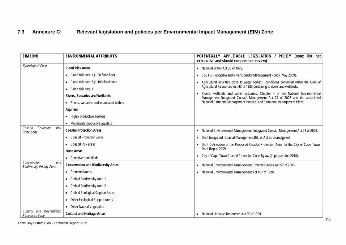
150 Table Bay District Plan - Technical Report 2012
7.3 Annexure C: Relevant legislation and policies per Environmental Impact Management (EIM) Zone
EIM ZONE ENVIRONMENTAL ATTRIBUTES POTENTIALLY APPLICABLE LEGISLATION / POLICY (note: list not exhaustive and should not preclude review)
Hydrological Zone Flood Risk Areas
• Flood risk area 1 (1:50 flood line)
• Flood risk area 2 (1:100 flood line)
• Flood risk area 3
Rivers, Estuaries and Wetlands
• Rivers, wetlands and associated buffers
Aquifers
• Highly productive aquifers
• Moderately productive aquifers
• National Water Act 36 of 1998.
• CoCT’s Floodplain and River Corridor Management Policy (May 2009).
• Agricultural activities close to water bodies: conditions contained within the Care of Agricultural Resources Act 43 of 1983 pertaining to rivers and wetlands.
• Rivers, wetlands and within estuaries: Chapter 4 of the National Environmental Management Integrated Coastal Management Act 24 of 2008 and the associated National Estuarine Management Protocol and Estuarine Management Plans.
Coastal Protection and Dune Zone Coastal Protection Areas
• Coastal Protection Zone
• Coastal risk areas
Dune Areas
• Sensitive dune fields
• National Environmental Management: Integrated Coastal Management Act 24 of 2008.
• Draft Integrated Coastal Management Bill, or Act as promulgated
• Draft Delineation of the Proposed Coastal Protection Zone for the City of Cape Town: Draft Report 2009
• City of Cape Town Coastal Protection Zone Bylaw (in preparation 2010).
Conservation and Biodiversity Priority Zone Conservation and Biodiversity Areas
• Protected areas
• Critical Biodiversity Area 1
• Critical Biodiversity Area 2
• Critical Ecological Support Areas
• Other Ecological Support Areas
• Other Natural Vegetation
• National Environmental Management Protected Areas Act 57 of 2003.
• National Environmental Management Act 107 of 1998.
Cultural and Recreational Resources Zone Cultural and Heritage Areas • National Heritage Resources Act 25 of 1999.

151 Table Bay District Plan - Technical Report 2012
• Cultural landscapes
• Potential archaeological sites
• Other significant heritage resource areas
• Grade 3 heritage sites
• Scenic Routes
Public Open Spaces
• Structuring Open Spaces
• A Heritage Overlay is being developed and will become part of the Integrated Zoning Scheme. Reference to the zoning schemes / CTZS is required.
Public open spaces:
• Outdoor Advertising and Signage By-Law, 2001.
• Authorisation of the activities in these zones must be in compliance with the City of Cape Town By-Law Related to Streets, Public Places and the Prevention of Nuisances, 2004
Natural Economic Resources Zone High Potential Agricultural Areas
• High potential and unique agricultural land worthy of statutory and long-term protection
• Agricultural area of significant value given existing, potential and emerging use
• Other Agricultural areas
• Smallholdings and agricultural areas
Mineral Extraction Areas
• Priority mineral resources
High Potential Agricultural Areas
• Care of Agricultural Resources Act 43 of 1983.
• Subdivision of Agricultural Land Act 70 of 1970.
• Draft Sustainable Utilisation of Agricultural Resources Bill, 2003.
Mineral extraction areas
• Mineral and Petroleum Resources Development Act 28 of 2002.
• Land Use Planning Ordinance (LUPO). Urban Uses and Utilities Zone Nuclear and Landfill Exclusion Areas
• Nuclear Exclusion zones
• Landfill sites and buffer zones
Industrial and Commercial Areas
• Industrial areas
• Commercial areas
Infrastructure and Utilities Areas
• Infrastructure servitudes, including WWTWs
• Relevant air pollution guidelines, including the City of Cape Town’s Air Pollution Control By-Law (2001).
• National Environmental Management Air Quality Act 39 of 2004.
• CCT Zoning Scheme Regulations
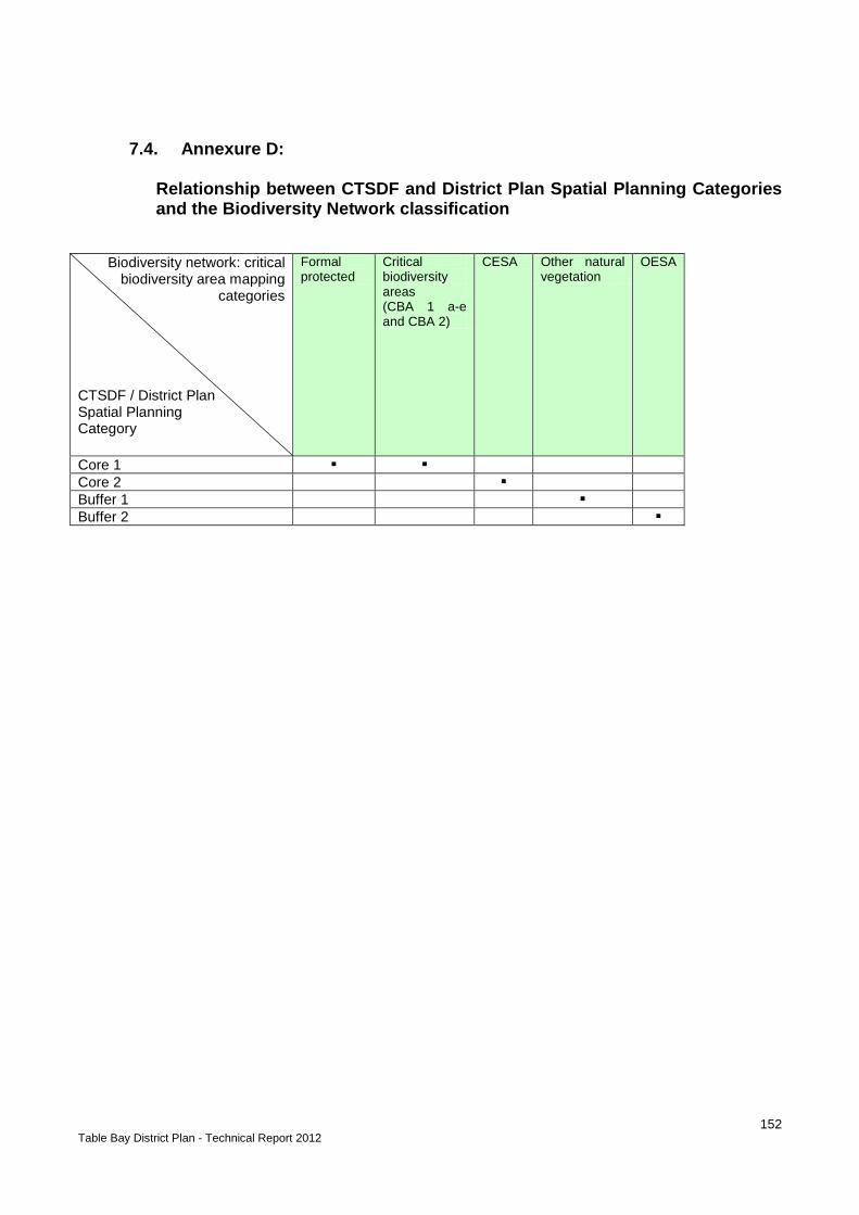
152 Table Bay District Plan - Technical Report 2012
7.4. Annexure D: Relationship between CTSDF and District Plan Spatial Planning Categories and the Biodiversity Network classification
Biodiversity network: critical biodiversity area mapping
categories
CTSDF / District Plan Spatial Planning Category
Formal protected
Critical biodiversity areas (CBA 1 a-e and CBA 2)
CESA Other natural vegetation
OESA
Core 1 Core 2 Buffer 1 Buffer 2

153 Table Bay District Plan - Technical Report 2012
7.5. Annexure E:
Relationship between CTSDF and district plan route designation, the National Department of Transport road classification system, the PSDF (2009), and City’s hierarchical road network classification system The relationship between the CTSDF (and district plan) route designation and the National Department of Transport (DoT) road classification system, the PSDF (2009) and the City’s hierarchical road network classification system is described in Table C.1, providing a general indication of the relationship between different road classification systems and their land use functionality. The route designation does not replace the City’s hierarchical road network classification system, nor is it intended to run in parallel as a duplicate classification system. The City’s hierarchical road network classification system will continue to determine road network planning, classification and the mobility and accessibility functions. The City’s hierarchical road network classification system, together with the Road Access Guidelines (PGWC, 2001), will continue to manage competing demands between mobility and accessibility in the evaluation of development applications to change or enhance land use rights. Table E.1: CTSDF route (and district plan) designation relationship with the National Department of Transport road classification system, the PSDF (2009), and the City’s hierarchical road network classification system.
ROUTE DESIGNATION ROAD CLASSIFICATION
Cape Town Spatial Development Framework / District Plan
Department of Transport (DoT)
Provincial Spatial Development
City of Cape Town Road Network Hierarchical
ACTIVITY ROUTE Predominantly
Class 2 to 4 roads Predominantly main roads
Predominantly secondary arterials
ACTIVITY STREET Predominantly Class 2 to 4 roads
Predominantly main roads
Predominantly secondary arterials
DEVELOPMENT ROUTE Predominantly Class 2 or 3 roads
Predominantly trunk roads
Predominantly primary arterials
CONNECTOR ROUTE Predominantly Class 2 to 4 transport routes
Predominantly national roads, divisional roads
Predominantly expressways, primary and secondary arterials
URBAN FREEWAY Class 1 National roads Freeway It is anticipated that the CTSDF route designation indicating land use functionality will encourage an appropriate level of development and more intense mixed land uses to locate on, or adjacent to, the accessibility grid. Opportunities along designated routes can also be linked to parallel streets and side roads in line with applicable policies, the relevant zoning scheme, District SDPs, and applicable local plans. This will contribute towards establishing the thresholds required for sustainable and cost effective public transport. Routes exhibit different characters and do not represent a uniform mix and density of land uses along their length. It is for these reasons that the route designations are indicated as a conceptual designation on the Cape Town Spatial Development Framework (Map 6.1). The process of land use intensification along designated routes must be evaluated at a more detailed local level of planning to inform land use management decision-making and the processing of development applications – to consider, for example, the nature of access roads, additional traffic
154 Table Bay District Plan - Technical Report 2012
impacts, parking requirements and the level of service (LOS) provided by public transport services. This is necessary to protect the mobility and operational integrity of road networks, and to ensure that land use intensification is informed by the operational capacity of particular routes and the public transport services by which they are supported.
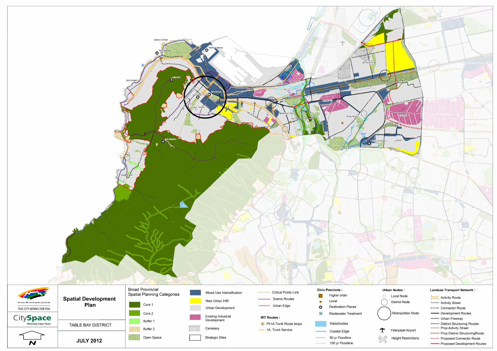
155 Table Bay District Plan - Technical Report 2012