district: astoria date: april 20, 2015 - state of oregon ... astoria date: april 20, 2015 timber...
TRANSCRIPT

District: Astoria Date: April 20, 2015
Timber Sale AppraisalKnob Point Combination
Sale AT-341-2015-54-
Cost Summary
Conifer Hardwood Total
Gross TimberSale Value $1,321,653.69 $34,121.84 $1,355,775.53
Project Work: ($37,826.00)
Advertised Value: $1,317,949.53
4/20/15 1

District: Astoria Date: April 20, 2015
Timber Sale AppraisalKnob Point Combination
Sale AT-341-2015-54-
Timber Description
Location: Portions of Sections 8, 18, and 19, T7N, R6W, and portions of Section 13, T7N, R7W, W.M., Clatsop County, Oregon.
Stand Stocking: 60%
Specie Name AvgDBH Amortization (%) Recovery (%)
Douglas - Fir 17 0 97
Western Hemlock / Fir 20 0 95
Sitka Spruce 15 0 95
Alder (Red) 13 0 95
Volume by Grade 2S 3S 4S Camprun Total
Douglas - Fir 1,880 837 189 0 2,906
Western Hemlock / Fir 711 218 30 0 959
Sitka Spruce 0 31 16 0 47
Alder (Red) 0 0 0 101 101
Total 2,591 1,086 235 101 4,013
4/20/15 2
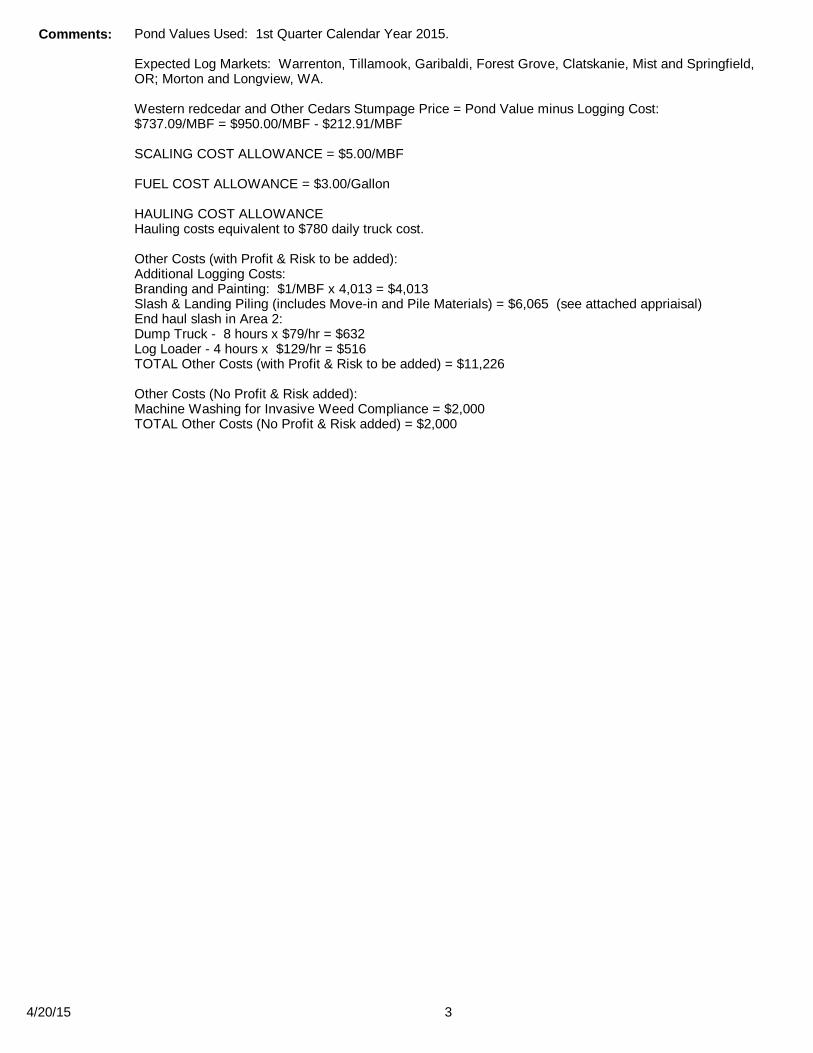
Comments: Pond Values Used: 1st Quarter Calendar Year 2015.
Expected Log Markets: Warrenton, Tillamook, Garibaldi, Forest Grove, Clatskanie, Mist and Springfield, OR; Morton and Longview, WA.
Western redcedar and Other Cedars Stumpage Price = Pond Value minus Logging Cost:$737.09/MBF = $950.00/MBF - $212.91/MBF
SCALING COST ALLOWANCE = $5.00/MBF
FUEL COST ALLOWANCE = $3.00/Gallon
HAULING COST ALLOWANCEHauling costs equivalent to $780 daily truck cost.
Other Costs (with Profit & Risk to be added):Additional Logging Costs:Branding and Painting: $1/MBF x 4,013 = $4,013Slash & Landing Piling (includes Move-in and Pile Materials) = $6,065 (see attached appriaisal)End haul slash in Area 2: Dump Truck - 8 hours x $79/hr = $632Log Loader - 4 hours x $129/hr = $516 TOTAL Other Costs (with Profit & Risk to be added) = $11,226
Other Costs (No Profit & Risk added):Machine Washing for Invasive Weed Compliance = $2,000TOTAL Other Costs (No Profit & Risk added) = $2,000
4/20/15 3

District: Astoria Date: April 20, 2015
Timber Sale AppraisalKnob Point Combination
Sale AT-341-2015-54-
Logging Conditions
Combination#: 1 Douglas - Fir 40.00%Western Hemlock / Fir 40.00%Sitka Spruce 40.00%Alder (Red) 40.00%
Logging System: Cable: Small Tower <=40 Process: Stroke Delimber
yarding distance: Medium (800 ft) downhill yarding: Notree size: Mature / Regen Cut (900 Bft/tree), 3-5 logs/MBF
loads / day: 10 bd. ft / load: 4200
cost / mbf: $133.33
machines: Log Loader (A)Stroke Delimber (A)Tower Yarder (Small)
Combination#: 2 Douglas - Fir 34.00%Western Hemlock / Fir 34.00%Sitka Spruce 34.00%Alder (Red) 34.00%
Logging System: Shovel Process: Feller Buncher
yarding distance: Medium (800 ft) downhill yarding: Notree size: Mature / Regen Cut (900 Bft/tree), 3-5 logs/MBF
loads / day: 9 bd. ft / load: 4200
cost / mbf: $93.60
machines: Feller Buncher w/ Delimber
Combination#: 3 Douglas - Fir 26.00%Western Hemlock / Fir 26.00%Sitka Spruce 26.00%Alder (Red) 26.00%
Logging System: Track Skidder Process: Manual Falling/Delimbing
yarding distance: Medium (800 ft) downhill yarding: Notree size: Small / Thinning 12in (130 Bft/tree), 12-17 logs/MBF
loads / day: 8 bd. ft / load: 4300
cost / mbf: $129.51
machines: Log Loader (B)Track Skidder
4/20/15 4
District: Astoria Date: April 20, 2015
Timber Sale AppraisalKnob Point Combination
Sale AT-341-2015-54-
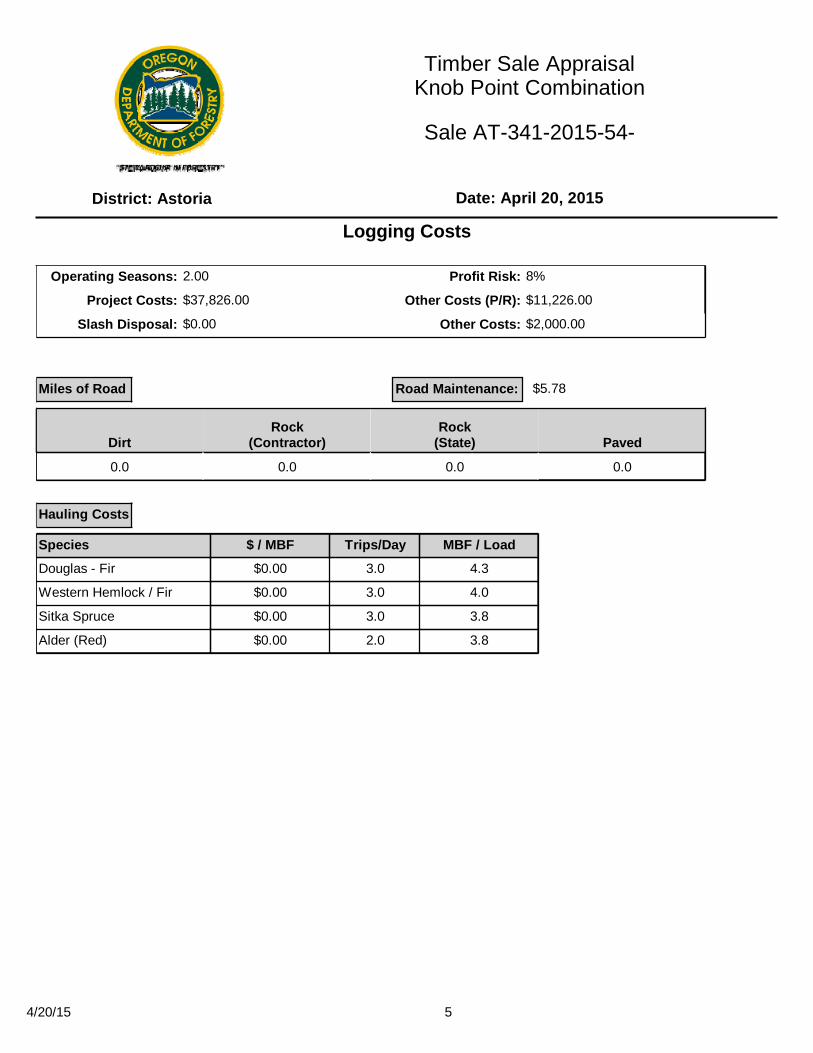
Logging Costs
Operating Seasons: 2.00 Profit Risk: 8%
Project Costs: $37,826.00 Other Costs (P/R): $11,226.00
Slash Disposal: $0.00 Other Costs: $2,000.00
Miles of Road
DirtRock
(Contractor)Rock
(State) Paved
0.0 0.0 0.0 0.0
Road Maintenance:
Hauling Costs
Species $ / MBF Trips/Day MBF / Load
Douglas - Fir $0.00 3.0 4.3
Western Hemlock / Fir $0.00 3.0 4.0
Sitka Spruce $0.00 3.0 3.8
Alder (Red) $0.00 2.0 3.8
$5.78
4/20/15 5

District: Astoria Date: April 20, 2015
Timber Sale AppraisalKnob Point Combination
Sale AT-341-2015-54-
Logging Costs Breakdown
LoggingRoadMaint
FireProtect
HaulingOther
P/R applProfit &
RiskSlash
DisposalScaling Other Total
Douglas - Fir
$118.83 $5.95 $2.19 $62.28 $2.80 $15.36 $0.00 $5.00 $0.50 $212.91
Western Hemlock / Fir
$118.83 $6.07 $2.19 $68.25 $2.80 $15.85 $0.00 $5.00 $0.50 $219.49
Sitka Spruce
$118.83 $6.07 $2.19 $71.84 $2.80 $16.14 $0.00 $5.00 $0.50 $223.37
Alder (Red)
$118.83 $6.07 $2.19 $107.76 $2.80 $19.01 $0.00 $5.00 $0.50 $262.16
Specie Amortization Pond Value Stumpage Amortized
Douglas - Fir $0.00 $577.49 $364.58 $0.00
Western Hemlock / Fir $0.00 $481.62 $262.13 $0.00
Sitka Spruce $0.00 $453.19 $229.82 $0.00
Alder (Red) $0.00 $600.00 $337.84 $0.00
4/20/15 6

District: Astoria Date: April 20, 2015
Timber Sale AppraisalKnob Point Combination
Sale AT-341-2015-54-
Summary
Specie MBF Value Total
Douglas - Fir 0 $0.00 $0.00
Western Hemlock / Fir 0 $0.00 $0.00
Sitka Spruce 0 $0.00 $0.00
Alder (Red) 0 $0.00 $0.00
Specie MBF Value Total
Douglas - Fir 2,906 $364.58 $1,059,469.48
Western Hemlock / Fir 959 $262.13 $251,382.67
Sitka Spruce 47 $229.82 $10,801.54
Alder (Red) 101 $337.84 $34,121.84
Amortized
Unamortized
Gross Timber Sale Value
Recovery: $1,355,775.53
Prepared By: Bryce Rodgers Phone: 503-325-5451
4/20/15 7


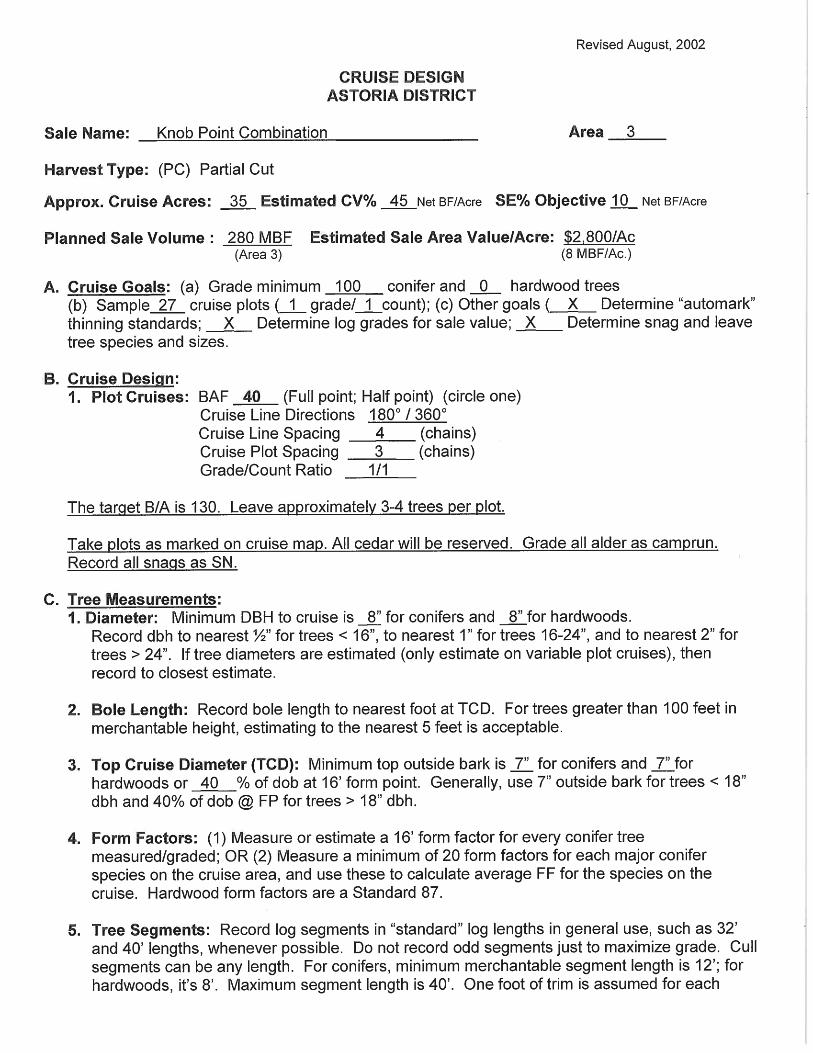
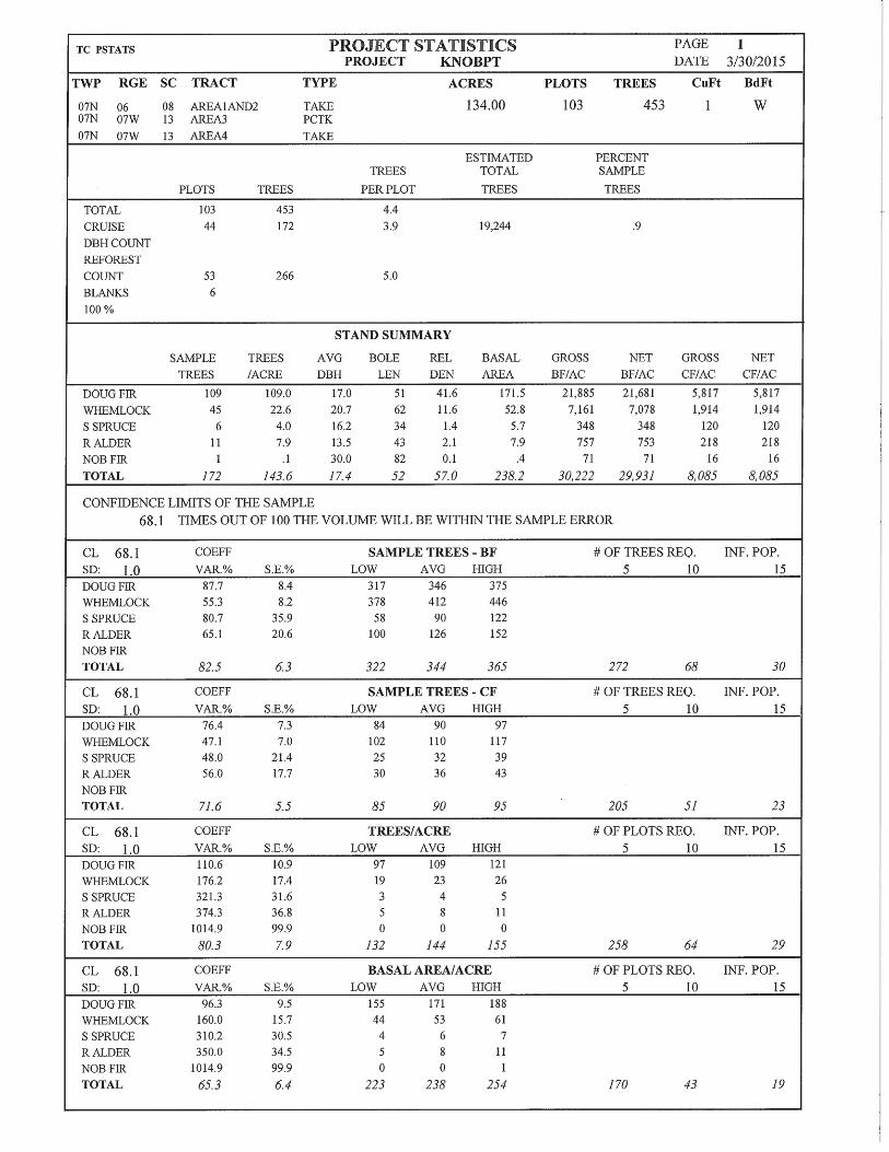
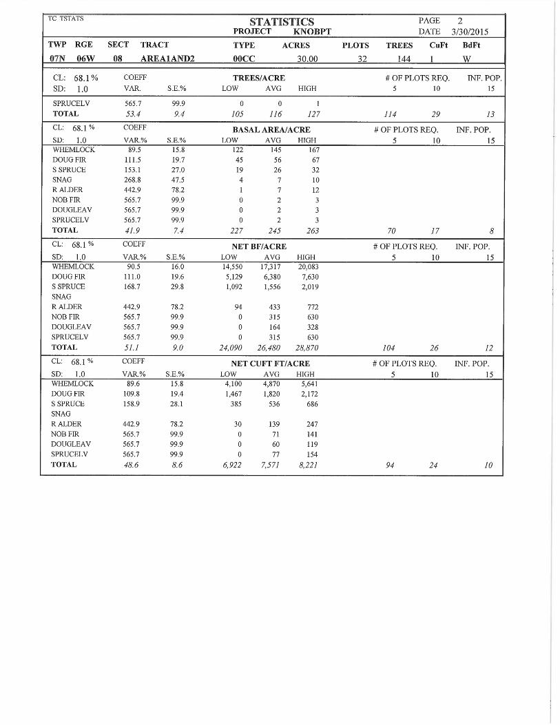
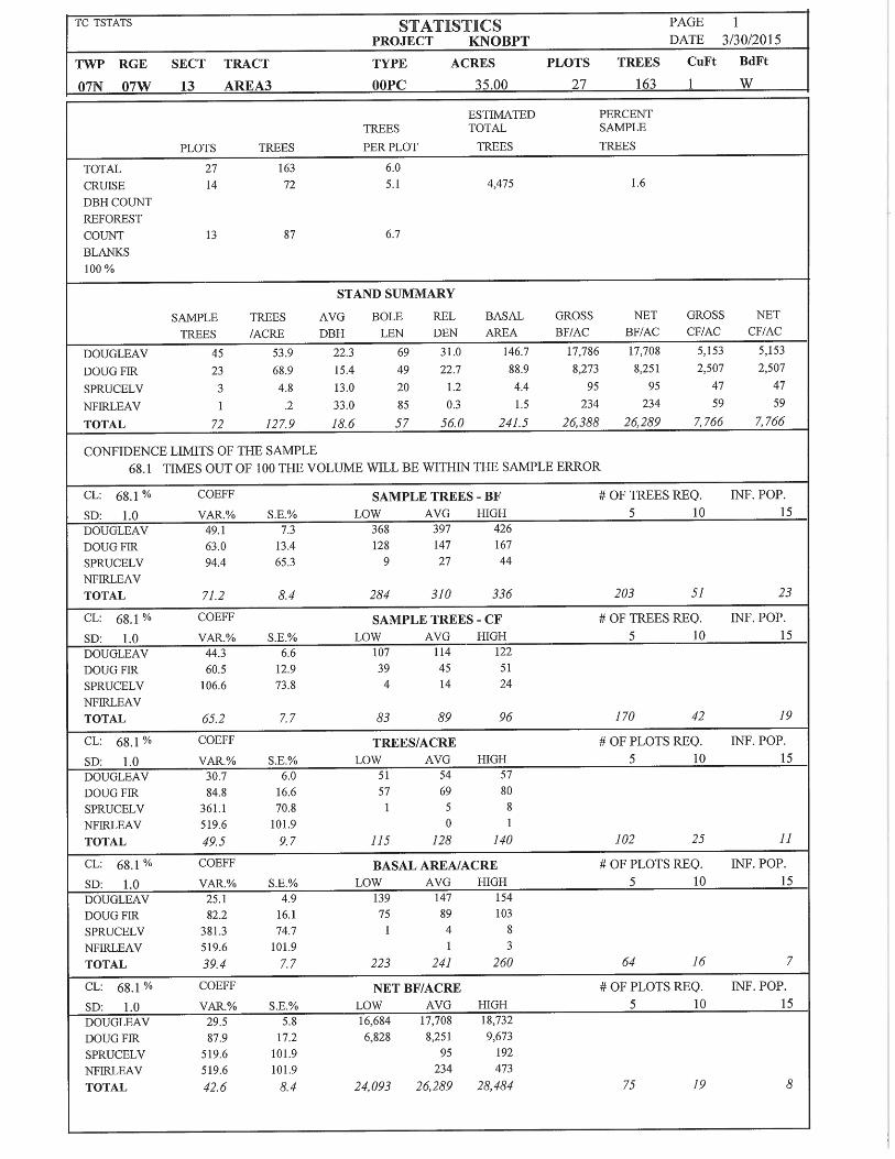
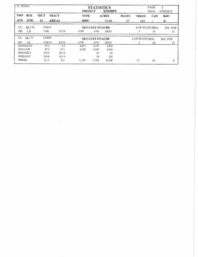
Knob Point Combination TIMBER CRUISE REPORT
FY 2015 1. Sale Area Location: Areas 1, 2, 3, and 4 are located in portions of Sections 8, 18, and 19, T7N,
R6W, and Section 13, T7N, R7W, W.M., Clatsop County, Oregon. 2. Fund Distribution: BOF 92% CSL 8%
Tax Code: 30-05 (73%) 01-02 (19%) CSL (8%)
3. Sale Acreage by Area:
Area Treatment Gross Acres
Posted Buffers
Existing R/W
Net Acres
Survey Method
1 Modified Clearcut 15 1 1 13 GIS
2 Modified Clearcut 18 0 1 17 GIS
3 Partial Cut 35 0 <1 35 GIS
4 Modified Clearcut 78 4 5 69 GIS
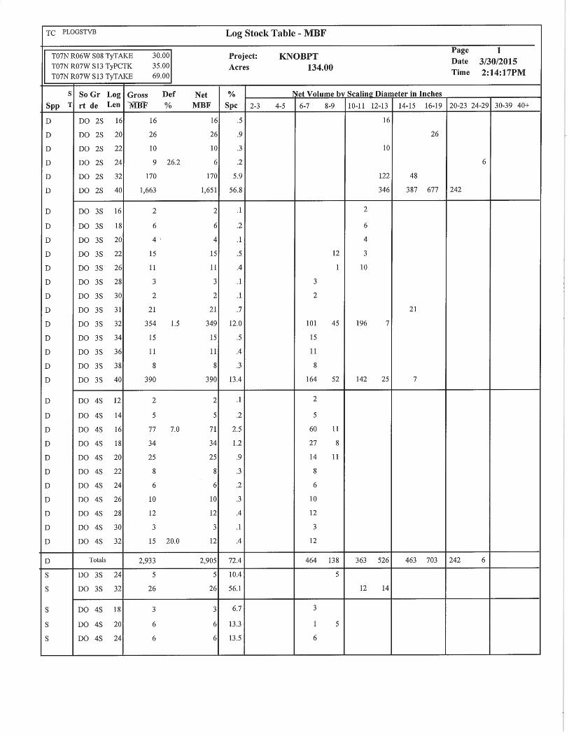
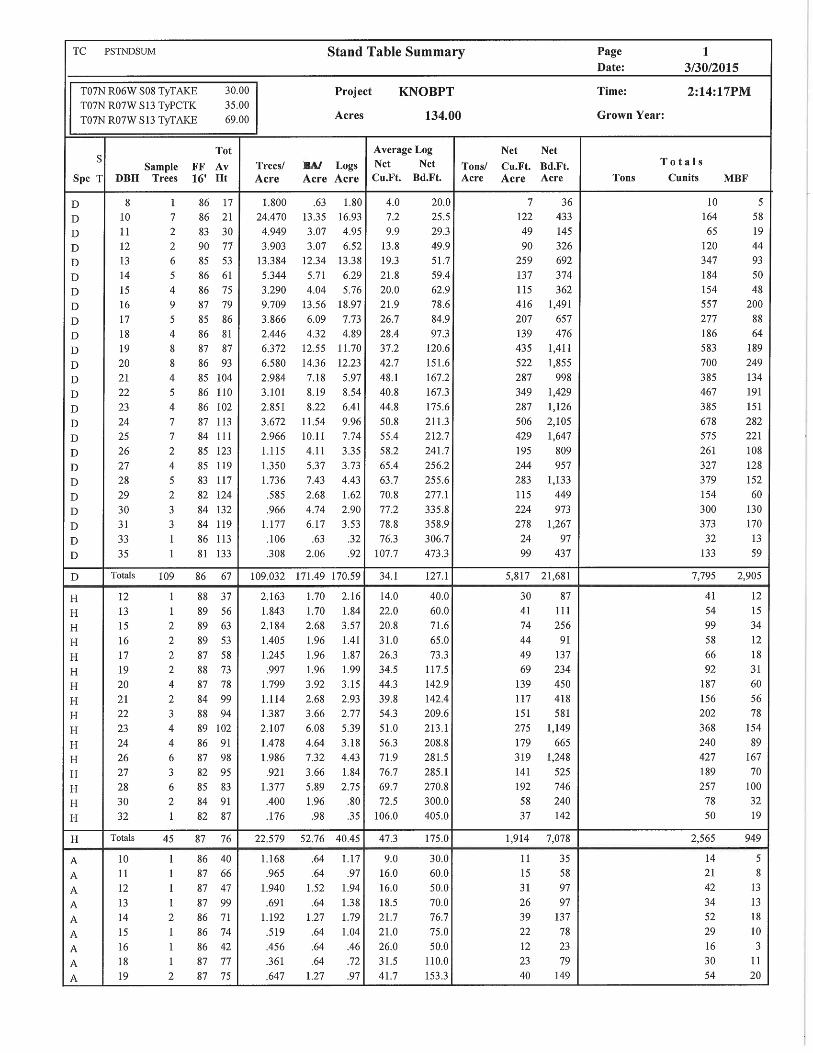
TOTALS 146 5 7 134
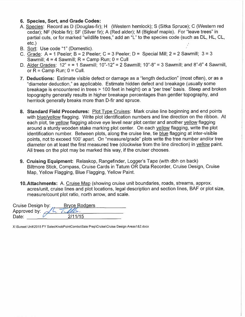
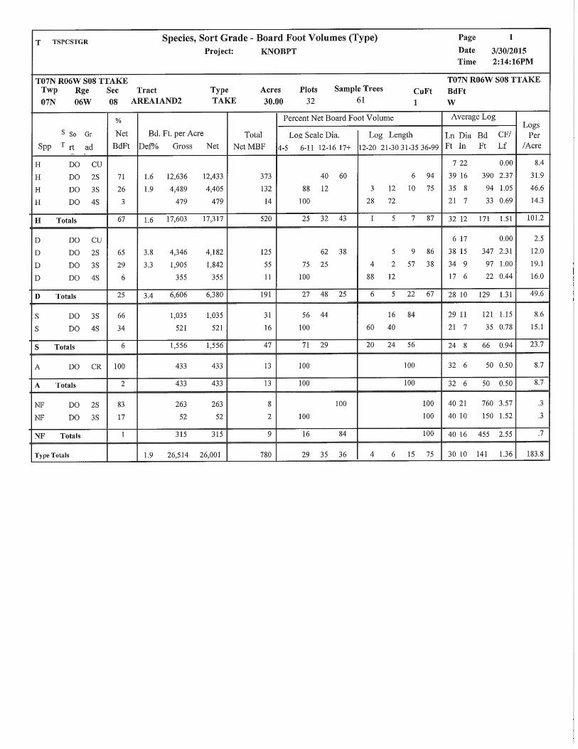
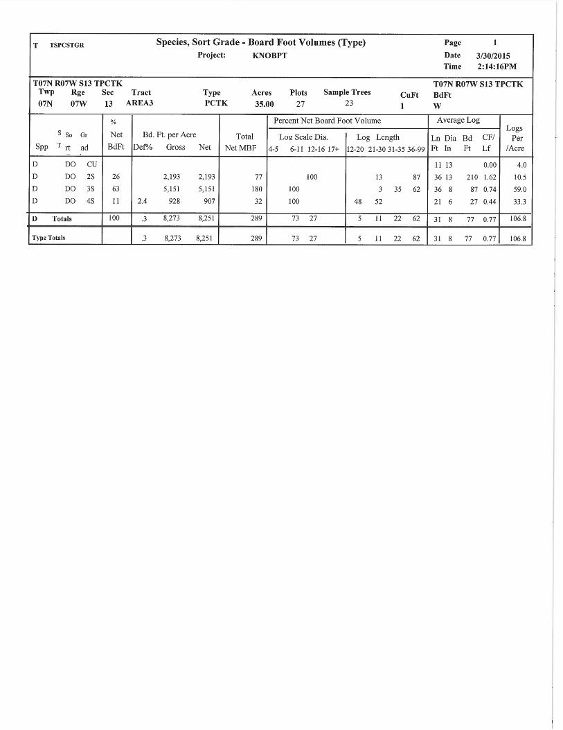
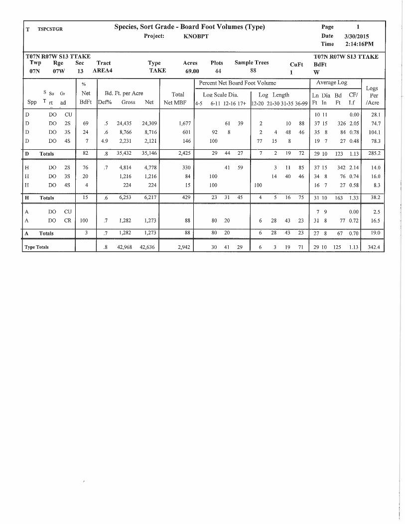
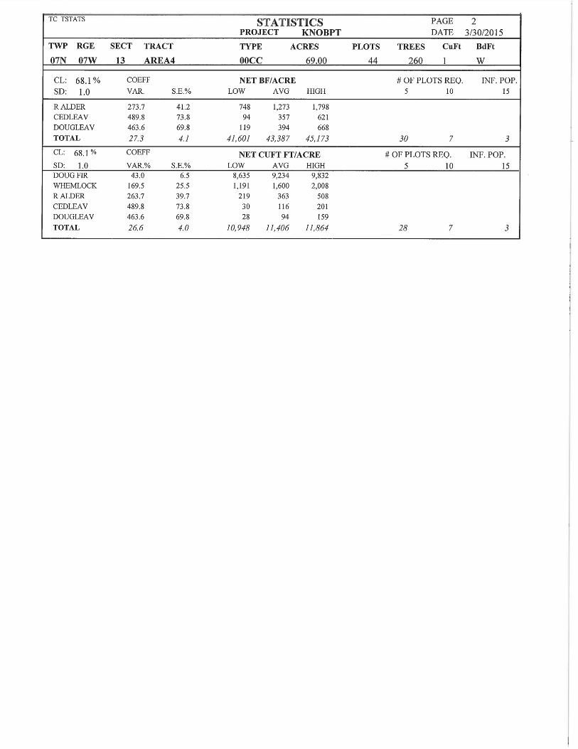
4. Cruisers and Cruise Dates: All areas were cruised by Bryce Rodgers, John Choate, Ed Holloran, Andrew Arvin, and Jon Long in February 2015. 5. Cruise Method and Computation: All cruisers used Corvallis Micro Technology (CMT) data collectors, and were downloaded to the Atterbury Super A.C.E. program at the Astoria District for computing. See the attached Cruise Design for more details on the cruise method. The cruise calculations were processed in the Astoria District office. Areas 1 and 2 are modified clearcut units and were variable plot cruised using a 54.44 BAF for all species. These plots are located on a 3 chain by 3 chain grid, with every other plot measured and graded. A total of 32 plots were sampled, with 15 measured and graded plots, and 17 count plots. Area 3 is a partial cut unit and was variable plot cruised using a 40 BAF for all species. These plots are located on a 4 chain by 3 chain grid, with every other plot measured and graded. A total of 27 plots were sampled, with 14 measured and graded plots, and 13 count plots. Area 4 is a modified clearcut unit and was variable plot cruised using a 54.44 BAF for all species. These plots are located on a 4 chain by 4 chain grid, with every other plot measured and graded. A total of 44 plots were sampled, with 17 measured and graded plots, and 27 count plots.
AREA CRUISE TRACT TYPE ACRES 1 and 2 T07N R06W 08 AREA1AND2 TAKE 30 3 T07N R07W 13 AREA3 TAKE 35 4 T07N R07W 13 AREA4 TAKE 69
6. Timber Description: Areas 1 and 2 are modified clearcut units, approximately 45 to 75 years old, consisting of Douglas-fir, Western hemlock, Sitka spruce, and red alder, with a minor cohort of Noble fir. The average Douglas-fir tree size to be harvested is approximately 19 inches DBH, with an average height of 50 feet to a merchantable top (6 inch d.i.b./40% fp). The average Western hemlock tree size to be harvested is approximately 22 inches DBH, with an average height of 61 feet to a merchantable top (6 inch d.i.b./40% fp). The average red alder tree size to


)))
))))
))
))))))
))))
))))
))))
))))))
ÑÜ
âÑ
âÑâÑ
âÑ
âÑ
âÑ
âÑ
âÑ
âÑ
âÑ
âÑ
âÑ
âÑâÑ
âÑâÑ
âÑâÑ
âÑ
âÑâÑ
âÑâÑ
âÑâÑâÑâÑ
âÑâÑ
âÑâÑâÑâÑâÑâÑâÑ
âÑâÑ
â Ñâ Ñ
â Ñ
âÑâÑâÑâÑâÑâ Ñâ Ñ
âÑâÑ
âÑâÑ
âÑ
âÑâÑ
âÑ
âÑâÑ
âÑâÑ
âÑ
âÑ
âÑâÑ
âÑâÑ
âÑâÑ
âÑ
âÑâÑ
âÑâÑ
âÑâÑ
âÑâÑ
âÑâÑ
âÑ
âÑ
âÑ
âÑâÑ
âÑâÑâÑâÑ
âÑ
âÑ
âÑâÑ
âÑâÑ
âÑâÑ
â ÑâÑ
âÑâ Ñ
â Ñâ Ñ
âÑ
âÑâÑ
âÑ
âÑ
âÑâÑ
âÑâÑ
âÑ
;
;
;!R
!R
!(
Area 1
Area 2
Big Nic Road
Shingle Mill Road
Knob PointStockpile SiteBO
F
Shingle Mill Road
1787
1818
1819 20
17
T7N
R6W
Knob Point Road
Shingle Mill Road
Big Nic Road
LOGGING PLAN MAPOF TIMBER SALE CONTRACT NO. 341-15-54
KNOB POINT COMBINATIONPORTIONS OF SECTIONS 8, 18 & 19, T7N, R6W,
AND SECTION 13, T7N, R7WW.M., CLATSOP COUNTY, OREGON
³ Approximate Net Acreage AcresArea 1 (MC) - 13 Area 2 (MC) - 17 Area 3 (PC) - 35 Area 4 (MC) - 69 Total Sale Acreage = 134
Legend
â Ñâ Ñ
â Ñ
âÑ âÑ âÑ âÑ âÑ
âÑâÑ
âÑâÑâÑâÑâÑ
Timber Sale Boundary
))))
))))))))
))))
)))))))) Posted Stream BufferStream BufferTyper N StreamType F StreamOwnership Boundary
!( Existing Landing
!R New Landing Construction; Ground Yarding Area
Cable Yarding AreaSurfaced RoadPaved Road
ÑÜ Stockpile Site
Logging Breakdown Tractor CableArea 1 (MC) - 30% 70%Area 2 (MC) - 0% 100%Area 3 (PC) - 100% 0%Area 4 (MC) - 59% 41%Total= 60% 40%
0 1,000 2,000500FeetApproximate Scale 1" = 1000'

)
)))))))))
)
)))))))))
))))))))))))
)
)))))))))
)
))))))))))
))
)))))))))))
)))
))))))))
)))))))))))))))))))
))))))))))))))))))
))))))))))))))))))))))))
)
))))))))))))
)
))))))))))
)
)))))))))))))))))))
)
)))))))))))))))))
B
ÑÜ
"J
"J
"J
âÑâÑ
â ÑâÑ
âÑâÑ âÑ
âÑ âÑ âÑ âÑ âÑ âÑ âÑ âÑ
âÑ
âÑâÑ
âÑ âÑ âÑ
âÑâ Ñ
â Ñ âÑâÑ
âÑ
âÑ
âÑ
âÑ
âÑ
âÑ
âÑ
âÑ
âÑâÑ
âÑ
âÑâÑâÑ
âÑâÑ
âÑâÑ
âÑâÑ
âÑâÑ
âÑâÑ
âÑâÑ
âÑ
âÑâÑ
âÑ
âÑ
âÑâÑ
âÑâÑ
âÑ
âÑ
âÑ
âÑ
âÑ
âÑ
âÑâ Ñ
â Ñâ Ñ
â Ñâ Ñ
âÑ
âÑâÑ
âÑâÑ
âÑâÑ
âÑâÑâÑâÑâÑâÑâÑâÑâÑâÑâÑâÑâÑ
âÑâÑ
âÑâÑ
âÑâÑ
âÑ
â Ñâ Ñ
â Ñâ Ñ
â Ñâ Ñ
â Ñâ Ñ
â Ñâ Ñ
â Ñâ Ñ
â Ñâ Ñ
â Ñâ Ñ
â Ñâ Ñ
â Ñâ Ñ
â Ñ
âÑ âÑ âÑ âÑ âÑ âÑ âÑ âÑ âÑâÑ
âÑâÑ
âÑ âÑâÑ
âÑ âÑâÑ
âÑâÑ
âÑ
âÑ
âÑ
âÑâÑâÑ
âÑâÑâÑâÑ
â Ñâ Ñ
â Ñâ Ñ
â ÑâÑ
âÑâÑ
âÑâÑ
âÑâÑâ Ñâ Ñ
â Ñâ Ñ
â Ñâ Ñ
â Ñâ Ñ
â Ñâ Ñ
â Ñâ Ñ
âÑâÑ âÑ âÑ âÑ âÑ âÑ âÑ âÑ âÑ âÑ âÑ âÑ âÑ âÑ âÑ âÑ âÑ
âÑâÑ
âÑâÑ
âÑâÑ
âÑ âÑ âÑ âÑ âÑâÑ
âÑâÑ
âÑâÑâÑ
âÑâÑ
âÑâÑâÑâÑâÑâÑâÑ
âÑâÑ
âÑâÑ
âÑâÑ
âÑâÑ
âÑâÑâÑâÑâÑâÑâÑâÑ
;
; ;
;
;;
;
; ;;
;;
;;
; ;
;
; ;
;
;
;; ;
;;
Area 3
Area 4
Big Nic Road
Shingle Mill Road
Knob Point Qaurryand Stockpile SitePR
IVAT
EST
ATE CSL
BOF
PRIV
ATE
STAT
E
18131924
1787
1818712
13
1819 20
17
T7N
R7W
T7N
R6W
Knob Point Road
³ Approximate Net Acreage AcresArea 1 (MC) - 13 Area 2 (MC) - 17 Area 3 (PC) - 35 Area 4 (MC) - 69 Total Sale Acreage = 134
Legend
â Ñâ Ñ
â Ñ
âÑ âÑ âÑ âÑ âÑ
âÑâÑ
âÑâÑâÑâÑâÑ
Timber Sale Boundary
))))
))))))))
))))
)))))))) Posted Stream BufferStream BufferReforestation AreaDirectional FellingOwnership BoundaryTyper N StreamType F Stream
!R New Landing ConstructionSurfaced RoadPaved Road
B QuarryÑÜ Stockpile Site; Ground Yarding Area
Cable Yarding Area
Logging Breakdown Tractor CableArea 1 (MC) - 30% 70%Area 2 (MC) - 0% 100%Area 3 (PC) - 100% 0%Area 4 (MC) - 59% 41%Total= 60% 40%
0 1,000 2,000500Feet
Approximate Scale 1" = 1000'
LOGGING PLAN MAPOF TIMBER SALE CONTRACT NO. 341-15-54
KNOB POINT COMBINATIONPORTIONS OF SECTIONS 8, 18 & 19, T7N, R6W,
AND SECTION 13, T7N, R7WW.M., CLATSOP COUNTY, OREGON