distributed simulation of snowcover mass- and...
TRANSCRIPT
Distributed simulation of snowcover mass- andenergy-balance in the boreal forest
Timothy Link1 and Danny Marks2*1Oregon State University, Environmental Sciences Graduate Program, at: USEPA-NHEERL, 200 SW 35th Street, Corvallis, OR 97333
2USDA Agricultural Research Service, NW Watershed Research Center, 800 Park Blvd., Suite 105, Boise, ID 83712
Abstract:The accurate distributed simulation of snowpack deposition and ablation beneath forest canopies iscomplicated by the fact that vegetation canopies strongly a�ect the snow surface energy balance. The canopy
alters the radiation balance of the snowcover and reduces the wind speed at the snow surface. Simple canopyadjustment algorithms for solar and thermal radiation and wind speed are used in conjunction with commonlyavailable land cover classi®cations to spatially distribute sub-canopy solar and thermal radiation, air and soil
temperature, humidity, wind speed, and precipitation. The distributed climate surfaces are used to drive a two-layer coupled energy- and mass-balance snowmelt model over two areas within the BOREAS study region forthe 1994±1995 snow season. Model results are validated using both automatic and manually collected snow
depth data. The simulated timing and rate of snowpack development and ablation at both study areas are wellrepresented beneath the canopy types where validation data are present. Rigorous evaluation of modelperformance beneath the full range of canopy types requires information regarding the spatial distribution ofsnow covered area during the ablation period. This study demonstrates that given basic landcover parameters,
relatively simple canopy adjustments coupled with an energy balance model can be used to estimate climateconditions and snowcover processes across a range of boreal forest covers. Copyright # 1999 John Wiley &Sons, Ltd.
KEY WORDS snowmelt; forest canopy e�ects; boreal forest
INTRODUCTION
Spatially distributed snowcover simulations can contribute to hydrologic investigations by providing esti-mates of the timing and rate of snowmelt delivery over heterogeneous regions. Spatial variation in thetransfer of energy to the snowcover principally results from topographic and vegetation canopy e�ects whichalter the radiation climatology and rates of turbulent energy transfer to the snow surface. Accuratesimulation of regional snowcover dynamics therefore requires the preparation of climate surfaces which arecorrected for both topographic and vegetation e�ects.
Topography principally in¯uences the intensity of incoming solar radiation (0.3±2.8 mm) due to simplegeometric e�ects. The presence of a forest canopy overlying a seasonal snowcover alters the processes of massand energy transfer and snowpack properties relative to open sites. Canopies strongly in¯uence the radiationbalance of a snowcover by absorbing and re¯ecting incoming solar radiation, and by altering the emission ofthermal radiation (2.8±100 mm) (Male and Granger, 1981; La¯eur and Adams, 1986). A forest canopy also
CCC 0885±6087/99/142439±14$17�50 Received 30 April 1998Copyright # 1999 John Wiley & Sons, Ltd. Revised 20 January 1999
Accepted 18 March 1999
HYDROLOGICAL PROCESSESHydrol. Process. 13, 2439±2452 (1999)
*Correspondence to: Dr D. Marks, USDA Agricultural Research Service, NW Watershed Research Center, 800 Park Blvd, Suite 105,Boise, ID 83712, USA. Email: [email protected]
Contract grant sponsor: NASA.Contract grant number: NAG5-2301; ref. 2207-BOREAS-U107.
shelters the snow surface from wind, greatly decreasing the e�ciency of turbulent energy transfer (Berris andHarr, 1987; Ohta et al., 1993; Marks et al., 1998).
This investigation presents two distributed simulations of the development and ablation of a seasonalsnowcover in the boreal forest ecosystem of northern Saskatchewan and Manitoba. In this region, snowsurface energy ¯uxes are primarily controlled by canopy e�ects, with minor controls exerted by topography.Thus, this area can be used to develop and validate general techniques which can be used to simulatesnowpack dynamics beneath vegetation canopies.
OBJECTIVES
The primary objective of this investigation is to simulate the energy- and mass-balance of the seasonalsnowcover over northern and southern regions in the boreal forest. The speci®c objectives of this invest-igation are to: 1. Spatially distribute and adjust climate data for topography and canopy cover over bothareas to estimate the climate at the snow surface throughout the course of a winter season. 2. Simulatethe development and ablation of the seasonal snowcover at each study site using a distributed two-layermass- and energy-balance snowmelt model (ISNOBAL) (Marks, Domingo and Frew, 1999; Marks et al.,1999, this issue). 3. Evaluate the use of simple canopy corrections over heterogeneous areas, and identifymeasures which may be taken to improve distributed results.
BACKGROUND
Snowcover energy-balance simulations were successfully completed beneath conifer canopies for the 1994ablation period using physically-based radiation transfer and snowcover models (Hardy et al., 1997; Ni et al.,1997). Sensitivity studies on the e�ects of conifer canopy height and density on snowcover ablation in theboreal environment demonstrated the strong control canopies exert on the timing and rates of snowmelt(Davis et al., 1997). Simpli®ed algorithms were developed and applied to adjust climate data collected aboveboreal forest canopies for conditions beneath a range of deciduous, mixed and conifer canopies. Theresulting data were used to simulate the development and ablation of the seasonal snowcover at pointlocations for the 1994±1995 winter season (Link and Marks, in press). The transition from point todistributed simulations requires the development of techniques to distribute climate parameters based oncommonly available geographic information, such as elevation, species cover and canopy height.
Spatially distributed snowmelt models can be run over a regular grid representing a spatially continuousparameter, typically a digital elevation model (DEM). Grid-based distributed snowmelt modelling using aphysically based mass- and energy-balance approach was successfully completed in several mountainousbasins, where variations in energy transfer resulted from topographic e�ects (Garen andMarks, 1996; Markset al., 1999, this issue). The simulations presented herein build on radiation studies in mountainous areas(Garen and Marks, 1996; Dubayah, 1994), detailed analyses of canopy climate e�ects, and point snowcoversimulations (Link, 1998; Link and Marks, in press; Hardy et al., 1997), to produce distributed snowcoversimulations accounting for both canopy and topographic structure.
APPROACH
Data preparation and snowcover simulations were completed within the Image Processing Workbench(IPW) environment (Marks, Domingo and Frew, 1999; Frew, 1990). IPW is a suite of software tools whichare designed to process geospatial data and support hydrologic and bio-physical simulations. The snowcoverinvestigations were completed using the following procedure: 1. Reclassify existing landcover data intosimple canopy cover and height classes. 2. Adjust and spatially distribute meteorological data collected aspart of the BOREAS project (Sellers et al., 1995) based on the distribution of canopy cover types andheights. 3. Simulate the mass- and energy-balance of the seasonal snowcover from 1 October 1994 throughcomplete ablation in the spring of 1995, on a one-hour timestep using ISNOBAL.
Copyright # 1999 John Wiley & Sons, Ltd. HYDROLOGICAL PROCESSES, VOL. 13, 2439±2452 (1999)
2440 T. LINK AND D. MARKS

Site descriptions
The BOREAS study region covers most of Saskatchewan and Manitoba, and contains southern andnorthern study areas (SSA and NSA), which are 130 km� 90 km, and 100 km� 80 km, respectively(Figure 1). A snowcover modelling sub-area was selected within each study area to encompass experimentalwatersheds and automated meteorological stations (AMSs), and to contain a complete range of vegeta-tion species and heights. The snowcover modelling sub-areas are 15 km� 18.5 km in the SSA, and18 km� 12 km in the NSA, and are indicated within the SSA and NSA maps on Figure 1. Each model gridcell represents a 100 m� 100 m area.
Topographic relief is subtle at both locations, with elevation ranges under 100 m for both snowcovermodelling sub-areas. The landcover at both study areas is composed of a patchwork of lakes, open areas ( fenand muskeg), and forests of predominantly aspen (Populus tremuloides), jack pine (Pinus banksiana) andblack spruce (Picea mariana) with other minor species. Canopy heights tend to be higher in the SSA, with themaximum about 22 m, whereas the maximum canopy height is estimated to be 15 m in the NSA.
Description of data products
Two AMSs operated by the Saskatchewan Research Council are located within both the SSA and NSA(Shewchuk, 1997). In the SSA, AMSs are located within mature jack pine (OJP) and aspen (OA) stands. Inthe NSA, AMSs are located within mature jack pine (OJP), and mixed spruce/poplar (YTH) stands. TheAMSs provide 15-minute average values for incoming global and di�use solar radiation, thermal radiation,air temperature, relative humidity, and windspeed measured from 3 to 6 m above the top of the canopy.Below-canopy air (2 m), soil (ÿ0.5 m), and canopy temperatures, precipitation and snow depth are alsorecorded by the AMSs. In addition, manual snow depth measurements were taken on a bi-weekly basisbeneath a range of canopy types.
Spatial data products for the study areas consist of digital elevation models, land cover and canopy heightimages. Landcover and height class distributions in the SSAwere derived by the Saskatchewan Environmentand Resource Management Forestry Branch from infrared aerial photography. In the NSA, landcover andcutting class distributions were prepared by Manitoba Natural Resources. Landcover distributions werereclassi®ed into ®ve major cover classes: open, deciduous (e.g. aspen), mixed conifer/deciduous, mediumconifer (e.g. jack pine) and dense conifer (e.g. black spruce). The SSA height class image contained ®veheight classes: open, 2.5±7.5 m, 7.5±12.5 m, 12.5±17.5 m, and 17.5±22.5 m. In the NSA, the cutting classimage and class descriptions were used to derive an image composed of six height classes: open, 0±2 m,2±3 m, 3±5 m, 5±10 m, 10±13 m, 13±15 m.
Data preparation
Previous studies noted that net snowcover radiation is the dominant component of the snowcover energybalance in the boreal environment (Link and Marks, in press; Davis et al., 1997; Price and Petzold, 1984).Distribution and canopy correction techniques used in these investigations are most accurately speci®ed fornet solar radiation which is adjusted for both topographic and canopy e�ects. Distribution methods forthermal radiation and parameters a�ecting sensible, latent, and soil heat ¯uxes are based on canopy class.Solar radiation is therefore treated as a spatially continuous variable, whereas other meteorologicalparameters are treated as categorical variables.
Input climate surfaces for ISNOBAL were prepared by distributing meteorological data recorded atthe AMSs in each of the study areas, and adjusting the values for canopy cover using simple algo-rithms developed and validated at point locations (Link and Marks, in press). The snowcover modellingsub-areas are relatively small (5300 km2), therefore it is assumed that the above-canopy meteorologicalparameters recorded at the AMSs (SSA-OJP and NSA-OJP) are representative of conditions across theentire sub-area. In addition, we assume that climate conditions measured below-canopy at the SSA-OJP,
Copyright # 1999 John Wiley & Sons, Ltd. HYDROLOGICAL PROCESSES, VOL. 13, 2439±2452 (1999)
SNOW HYDROLOGY 49: SIMULATION OF SNOWCOVER MASS- AND ENERGY-BALANCE 2441

Figure 1. Locations of BOREAS study sites, snowcover modelling sub-areas, and ¯ux tower sites
Copyright # 1999 John Wiley & Sons, Ltd. HYDROLOGICAL PROCESSES, VOL. 13, 2439±2452 (1999)
2442 T. LINK AND D. MARKS

SSA-OA, NSA-OJP, and NSA-YTH sites are representative of conditions beneath all grid cells of thecorresponding canopy class.
Solar radiation. The distribution of solar radiation over the snowcover modelling sub-areas is simulatedaccording to the ¯ow diagram depicted in Figure 2. The snowcover albedo for the visible (0.28±0.7 mm) andnear infrared (0.7±2.8 mm) band varies as a function of sun angle, therefore the distribution of each radiationband is calculated separately and recombined to determine the net solar radiation. The theoretical clear skytopographically-corrected solar radiation is calculated using the model STOPORAD which uses exoatmo-spheric solar radiation, a two-stream atmospheric radiative transfer model, and DEM as described by Dozier
Figure 2. Schematic diagram describing the technique used to distribute net snowcover radiation over the modelling sub-areas
Copyright # 1999 John Wiley & Sons, Ltd. HYDROLOGICAL PROCESSES, VOL. 13, 2439±2452 (1999)
SNOW HYDROLOGY 49: SIMULATION OF SNOWCOVER MASS- AND ENERGY-BALANCE 2443
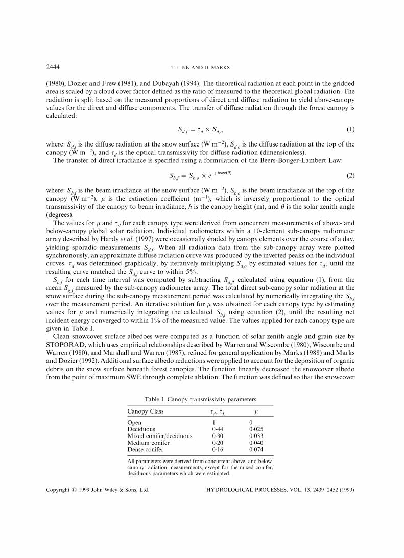
(1980), Dozier and Frew (1981), and Dubayah (1994). The theoretical radiation at each point in the griddedarea is scaled by a cloud cover factor de®ned as the ratio of measured to the theoretical global radiation. Theradiation is split based on the measured proportions of direct and di�use radiation to yield above-canopyvalues for the direct and di�use components. The transfer of di�use radiation through the forest canopy iscalculated:
Sd;f � td � Sd;o �1�
where: Sd,f is the di�use radiation at the snow surface (W mÿ2), Sd,o is the di�use radiation at the top of thecanopy (W mÿ2), and td is the optical transmissivity for di�use radiation (dimensionless).
The transfer of direct irradiance is speci®ed using a formulation of the Beers-Bouger-Lambert Law:
Sb;f � Sb;o � eÿmhsec�y� �2�
where: Sb,f is the beam irradiance at the snow surface (W mÿ2), Sb,o is the beam irradiance at the top of thecanopy (W mÿ2), m is the extinction coe�cient (mÿ1), which is inversely proportional to the opticaltransmissivity of the canopy to beam irradiance, h is the canopy height (m), and y is the solar zenith angle(degrees).
The values for m and td for each canopy type were derived from concurrent measurements of above- andbelow-canopy global solar radiation. Individual radiometers within a 10-element sub-canopy radiometerarray described by Hardy et al. (1997) were occasionally shaded by canopy elements over the course of a day,yielding sporadic measurements Sd,f. When all radiation data from the sub-canopy array were plottedsynchronously, an approximate di�use radiation curve was produced by the inverted peaks on the individualcurves. td was determined graphically, by iteratively multiplying Sd,o by estimated values for td , until theresulting curve matched the Sd,f curve to within 5%.
Sb,f for each time interval was computed by subtracting Sd,f, calculated using equation (1), from themean Sg,f measured by the sub-canopy radiometer array. The total direct sub-canopy solar radiation at thesnow surface during the sub-canopy measurement period was calculated by numerically integrating the Sb,f
over the measurement period. An iterative solution for m was obtained for each canopy type by estimatingvalues for m and numerically integrating the calculated Sb,f using equation (2), until the resulting netincident energy converged to within 1% of the measured value. The values applied for each canopy type aregiven in Table I.
Clean snowcover surface albedoes were computed as a function of solar zenith angle and grain size bySTOPORAD, which uses empirical relationships described byWarren andWiscombe (1980), Wiscombe andWarren (1980), andMarshall andWarren (1987), re®ned for general application byMarks (1988) andMarksandDozier (1992). Additional surface albedo reductions were applied to account for the deposition of organicdebris on the snow surface beneath forest canopies. The function linearly decreased the snowcover albedofrom the point of maximum SWE through complete ablation. The function was de®ned so that the snowcover
Table I. Canopy transmissivity parameters
Canopy Class td , tL m
Open 1 0Deciduous 0.44 0.025Mixed conifer/deciduous 0.30 0.033Medium conifer 0.20 0.040Dense conifer 0.16 0.074
All parameters were derived from concurrent above- and below-canopy radiation measurements, except for the mixed conifer/deciduous parameters which were estimated.
Copyright # 1999 John Wiley & Sons, Ltd. HYDROLOGICAL PROCESSES, VOL. 13, 2439±2452 (1999)
2444 T. LINK AND D. MARKS
albedo reached 0.55 just prior to complete ablation, as observed in the boreal forest (Pomeroy and Dion,1996). Adjusted albedo values were applied to the global sub-canopy radiation to yield net solar radiation.
Thermal radiation. Assuming negligible thermal re¯ection from the canopy, thermal radiation at the snowsurface (Lf) was estimated as:
Lf � tL � Lo � �1 ÿ tL�ecsT 4c �3�
where:tLis the transmissivity of the canopy to thermal radiation (dimensionless), Lo is the thermal radiationmeasured above the forest canopy (W mÿ2), ec is the emissivity of the canopy (0.96 dimensionless), s is theStefan-Boltzman constant (5.6697� 10ÿ8 W mÿ2 Kÿ1), and Tc is the mean surface temperature of thecanopy (K).
Lf radiation surfaces were created by applying the tL from Table I. In the SSA, Tc measurements from theOJP site were applied to the mixed and conifer classes, and measurements from the OA site were applied tothe deciduous classes. In the NSA, Tc measurements from the OJP site were applied to the conifer classes,and measurements from the YTH site were applied to the mixed and deciduous classes.
Other forcing data. Point snowcover investigations found that turbulent and soil energy ¯uxes comprise aminor portion of the snowcover energy balance (Link andMarks, in press), therefore simple distribution andadjustment techniques were used. Air temperatures (Ta) measured within the forest canopy were spatiallydistributed as categorical variables, as described for the Tc values in the Lf computations. In addition, Ta
values measured above the forest canopy were applied to all open locations. Relative humidity valuesmeasured above-canopy were assumed to be homogeneous both throughout the canopy, and over the DEMgrid. Vapor pressures (ea) at the snow surface were calculated using the distributed Ta surfaces in conjunctionwith the spatially constant humidity values. Wind speeds were adjusted only for the presence of a canopy. Inopen areas, above canopy windspeeds were applied, and in forested areas, above canopy values weredecreased by a factor of ®ve to account for sheltering of the snow surface. The wind speed reduction inforested areas was based on above- and below-canopy measurements at the SSA-OJP site (Hardy et al.,1997). Soil temperature (Tg) measurements were assumed to be spatially constant over the study areas.
Precipitation patterns may vary over the study regions due to localized phenomena or redistributionprocesses. Precipitation measurements were only available at the one AMS in each snowcover simulationarea, therefore it was assumed that precipitation did not vary over the DEM grid. Although snowfallinterception can be signi®cant in the boreal environment (Pomeroy and Schmidt, 1993), interception losseswere assumed to be negligible. This was because detailed interception data and process models for thisenvironment were not available when this investigation was undertaken.
Mass- and energy-balance snowmelt model
A detailed discussion of mass and energy transfer over a snow surface was presented by Marks (1988),Marks and Dozier (1992), and Marks et al. (1992). Development of the two-layer mass and energy transfersnowmelt model ISNOBAL was discussed by Marks et al. (1998), and Marks et al., 1999 (this issue).A complete description of the model, its input requirements, and output parameters is provided in Marks,Domingo and Frew, 1999. A brief overview of the model structure is presented to provide a basic descriptionof the snowcover simulation approach.
Seasonal snowcover dynamics are controlled by temperature and vapor gradients within the snowcover,which are caused by energy exchanges at the snow surface and at the snow-soil interface (Colbeck et al., 1979;Male and Granger, 1981). ISNOBAL is driven by net snowcover solar radiation, incoming thermal radia-tion, air temperature, vapor pressure, wind speed, soil temperature, and precipitation mass, temperature,density, and state (solid/liquid) fraction. The model determines the snowcover depth, density and thermalproperties from the meteorological conditions at each time step, throughout the duration of the simulation.
Copyright # 1999 John Wiley & Sons, Ltd. HYDROLOGICAL PROCESSES, VOL. 13, 2439±2452 (1999)
SNOW HYDROLOGY 49: SIMULATION OF SNOWCOVER MASS- AND ENERGY-BALANCE 2445

The model approximates the snowcover as being composed of two layers, a basal layer, and a ®xed-thicknesssurface layer. At each time-step, the model computes the energy balance of each layer, and adjusts thethickness, thermal properties, and measurement heights of the forcing data accordingly.
The model calculates the energy balance of a snowcover as:
DQ � Rn � H � LvE � G �M �4�
where: DQ is the change in snowcover energy (W mÿ2), Rn is the net radiative energy ¯ux (W mÿ2), H is thesensible energy ¯ux (W mÿ2), LvE is the latent energy ¯ux (W mÿ2), G is the soil energy ¯ux, and (W mÿ2),and M is the advected energy ¯ux (W mÿ2).
When the snowcover is in thermal equilibrium, there is no change in the net snowcover energy(i.e. DQ � 0). A positive change in snowcover energy will warm the snowpack, whereas a negative change inenergy will cool the snowcover. Signi®cant amounts of melt cannot occur until the entire snowcover reaches0 8C. When the entire snowpack is isothermal at 0 8C, a positive energy balance will result in melt, and anegative energy balance will result in refreezing of any water contained within the snowpack. The modelsimulates each component of the energy balance, calculates the addition or depletion of mass by deposition,melt, evaporation or runo�, and adjusts snowcover mass and thermal conditions at each time-step.
RESULTS
Comparison with 30-year records indicate that 1994 and 1995 were warmer and dryer than the long-termmeans (Shewchuk, 1997). The seasonal snowcover in both the SSA and NSA began to develop in earlyNovember 1994, and lasted until late April to mid-May, 1995, depending on site cover and local topography.The snowcover at both sites is characterized by low densities and shallow depths reaching approximately50 cm in the SSA and 60 cm in the NSA. Peak snow water equivalent was approximately 13 cm in the SSAand 12 cm in the NSA.
Extensive measurements of snow properties were not available when this investigation was initiated,therefore within-stand spatial variation of snow properties were not considered. Recent investigations com-pleted in the SSA indicate that snow depth variations in forested environments are related to the proximity totree stems (Davis et al., 1998). Little variation was noted in the deciduous stands, except for late in theseason. SWE under conifer crowns was found to be less than SWE measured along the snow courses, withpronounced tree wells early and late in the season. Density was found to be spatially conservative, thereforeSWE variations arose mainly from variations in snow depth. Measured and modelled depths are thereforemost likely to be overestimated within the conifer canopies.
Model validation
Measured and modelled snowcover depths for several landcover classes within the SSA and NSA arepresented in Figures 3 and 4. Modeled depths represent the mean of all grid cells in the cover type and heightclass corresponding to the locations where veri®cation depth measurements were recorded. As noted above,open site conditions were simulated using meterological data collected above the OJP canopy. Manualmeasurements are represented by points on the Figures, and automatic depth measurements are representedby the continuous line plots.
Model e�ciencies were found to range from 0.82 to 0.94, with root mean square di�erences ranging from3.5 to 6.0 cm of snow depth, at point locations. A detailed discussion of model ®tting statistics and modelsensitivity is provided in Link and Marks (in press).
Southern study area. In the SSA, continuous depth measurements were made only at the OJP site, withinthe snowcover modelling sub-area. Manual depth measurements in open, medium conifer, and dense conifercovers were made at locations approximately 15 km south of the modelling area. Manual depth measure-ments for the deciduous cover type were made approximately 80 km to the west of the modelling area, and
Copyright # 1999 John Wiley & Sons, Ltd. HYDROLOGICAL PROCESSES, VOL. 13, 2439±2452 (1999)
2446 T. LINK AND D. MARKS

are included to validate the general depth trends. The fact that many of the validation measurements weremade outside of the study area serves to validate the performance of the data preprocessing procedures as ageneral tool for simulating snowcover processes beneath large forested areas.
Mean simulated snow depths accurately reproduced measured depths within most land cover classes. Thesimulated meltout date for the medium conifer class was delayed by approximately ®ve days relative to theautomatic measurement; however, the meltout date appears to match closely the manually measuredlocation. The measured depths for the deciduous cover are similar to the modelled depths; however, themeasured depths are consistently higher. This result appears to be due to a larger quantity of snow waterequivalent deposited within this canopy cover.
Northern study area. In the NSA, continuous depth measurements were available only at the OJP site.Manual depth measurements within open, mixed and dense conifer covers were all made within the snow-cover modelling sub-area.
Modelled snowcover depths were similar to measured depths within the modelling area. Depthmeasurements are consistently higher than simulated values during portions of the season, particularly in the
Figure 3. Measured and simulated snow depths at the SSA modelling sub-area
Copyright # 1999 John Wiley & Sons, Ltd. HYDROLOGICAL PROCESSES, VOL. 13, 2439±2452 (1999)
SNOW HYDROLOGY 49: SIMULATION OF SNOWCOVER MASS- AND ENERGY-BALANCE 2447

open and dense conifer covers. These di�erences may be due to variations in precipitation deposition andredistribution patterns, or undercatch by the precipitation gauge at the OJP site. The simulated meltout dateat the medium conifer site closely matches the date observed with the automated depth sensor.
Distributed simulations
Results from distributed simulations are presented in Plate 1 and 2. The images cover the active ablationperiod from 21 April to 7 May at the SSA and from 21 April to 13 May at the NSA, to illustrate the relativetiming of snowcover depletion both between study areas, and between land cover classes. Simulated snowdepths are depicted by varying shades of gray, with darker values indicating deeper snow. When the snow iscompletely ablated from an individual pixel, the color corresponding to the land cover class is displayed.
Southern study area. The meltout date for the di�erent cover classes in the SSA varies by approximatelytwo weeks, as shown on Plate 1. Most of the open areas exhibit complete ablation by 21 April, followed bythe mixed and deciduous covers roughly two days later. Some areas of medium conifer also exhibit completeablation at this time. Areas of medium conifer cover which ablate at this early date correspond to relatively
Figure 4. Measured and simulated snow depths at the NSA modelling sub-area
Copyright # 1999 John Wiley & Sons, Ltd. HYDROLOGICAL PROCESSES, VOL. 13, 2439±2452 (1999)
2448 T. LINK AND D. MARKS

Plate 1. Distributed snowcover simulation results at the SSA modelling sub-area, 1995. Snow depths are indicated by the grayscale. When no snow is present, the canopyspecies class is indicated by the colour scale
Copyrig
ht#
1999JohnWiley
&Sons,Ltd.
HYDROLOGIC
ALPROCESSES,VOL.13,(1999)

Plate 2. Distributed snowcover simulation results at the NSA modelling sub-area, 1995. Snow depths are indicated by the grayscale. When no snow is present, the canopyspecies class is indicated by the colour scale
Copyrig
ht#
1999JohnWiley
&Sons,Ltd.
HYDROLOGIC
ALPROCESSES,VOL.13,(1999)

Plate 3. Mean snowcover energy balance for all grid cells in the given canopy classes (12.5 to 17.5 m height class) at the SSA. Theindividual energy balance components are indicated by the coloured bars and the net snowcover energy balance is shown by the
crosshatched bars
Copyright # 1999 John Wiley & Sons, Ltd. HYDROLOGICAL PROCESSES, VOL. 13, (1999)

short (2.5±7.5 m) canopies, which permit greater transmittance of direct radiation, as indicated by equation(2). A small depositional event occurs between 25 April and 27 April, but melts within 24 hours. Themajority of the grid cells in the medium conifer class melt out by 5May, followed by cells in the dense coniferclass on 7 May. Some small snow covered areas are still evident on 7 May, corresponding to dense coniferstands in the tallest (17.5±22.5 m) height class.
Northern study area. A smaller proportion of the snowcover in the northern modelling sub-area iscompletely ablated by 21 April, as a result of cooler temperatures and less radiation loading relative to thesouthern area. The ®rst canopy classes to exhibit complete meltout in this area are associated with therelatively short height classes (2±4 m), occurring on south facing slopes. These classes melt out before theopen areas, due to relatively low degrees of shading from the short canopies coupled with enhanced thermalemission from the overlying canopy, and slightly higher incident solar radiation resulting from topographice�ects. Depletion of snow covered area proceeds at a slower rate relative to the SSA, with the majority of theopen areas ablating by 23 April, followed by the remainder of the deciduous and mixed classes by 3 May,medium conifer by 5 May, and dense conifer from 7 May to 13 May. The snow covered portions of the13 May image correspond to dense conifer classes located on north-facing slopes. These results demonstratethat the canopy exerts the primary control on the snow surface energy balance in this region with minore�ects resulting from subtle topographic variations.
Energy balance. Plate 3 shows the mean daily snowcover energy balance components for all SSA grid cellswithin each landcover class for three days during the active ablation period to illustrate the contributions ofthe various components during snowmelt. For the forested classes, means for grid cells in the 12.5±17.5 mheight class are shown in order to eliminate energy transfer variations arising from di�erences in canopyheight. The net snowcover energy ¯uxes are also shown to illustrate di�erences between the canopy classes.
Variable e�ects of forest canopies on the net radiation and turbulent heat ¯uxes are clearly indicated bythis ®gure. 14 April is a relatively clear day where the dominant component of the snowcover energy balanceis net radiation. The open areas exhibit higher net turbulent (sensible � latent) heat ¯uxes, resulting fromwarmer air temperatures and higher wind speeds in the open areas. 16 April is a cloudy day with someprecipitation. The snowcover exhibits much smaller net energy ¯uxes associated with reduced solarradiation. Although net radiation dominates the energy balance within some cover classes, turbulent ¯uxescomprise a greater proportion of the energy balance with a minor contribution from the advected heat ¯uxassociated with rainfall on the snowpack. The net energy ¯ux in the open is much larger than the forestedlocations due to higher wind speeds and net radiation. 21 April represents a shift back to warm, sunnyconditions, where the energy balance is again dominated by radiative ¯uxes. Net turbulent ¯uxes are close tozero, due to negative latent ¯uxes which tend to balance positive sensible heat ¯uxes.
On the days shown in Plate 3, the snowcover in open areas is cooler than the snowcover in the forestedareas due to a larger degree of radiative cooling. This phenomenon causes larger soil heat ¯uxes in openareas, even though soil temperatures are assumed to be constant over the simulation domain.
On clear days, the net energy ¯uxes can be seen to decrease with increasing canopy optical density as aresult of variable canopy shading. On cloudy days, net ¯ux di�erences are greatest between forested and openareas due to reduced windspeeds beneath forest canopies, which greatly decrease the amount of turbulenttransfer relative to open areas.
DISCUSSION
Results of measured and simulated snow depths indicate that the canopy adjustments and snowmelt modelaccurately describe the development and ablation of the seasonal snowcover beneath a range of forestcanopies. The distributed climate data adjustments explicitly account for spatial variations in canopystructure and subtle topographic variations a�ecting snowcover dynamics in the modelling sub-areas.
Copyright # 1999 John Wiley & Sons, Ltd. HYDROLOGICAL PROCESSES, VOL. 13, 2439±2452 (1999)
SNOW HYDROLOGY 49: SIMULATION OF SNOWCOVER MASS- AND ENERGY-BALANCE 2449

Results from the distributed simulations indicate that canopy structure can delay seasonal snowmelt indensely forested areas for up to three weeks relative to more open areas. The individual energy balancecomponents suggest that net radiation is frequently the dominant source of energy contributing to snowmelt,illustrating the importance of accurate canopy shading adjustments.
The snow depth and radiation data used to derive the adjustment algorithms were both collected withinclosed-canopy mature forests. The canopy adjustments also assumed ®xed optical transmissivity values forall cover types, regardless of canopy density. We therefore expect the simulated snowcover results to be themost accurate beneath mature, closed canopy forests.
In the boreal forest, other researchers found canopy density to be as important as canopy height incontrolling transmissions of solar radiation (Davis et al., 1997). However, in the SSA and NSA less than12% and 2% of the area in the snowcover modelling sub-areas is covered by sparse (i.e. 555% closure)canopies. Errors in the calculated solar radiation beneath short and discontinuous canopies may be partiallyo�set by opposing errors in the thermal radiation, causing the e�ect on the net snowcover radiationcomputation to be reduced in these classes.
Snowcover simulations beneath forest canopies may be further improved by additional studies focusing onthe distribution of solar and thermal radiation beneath short and discontinuous canopies. In the absence ofdata beneath a full spectrum of canopy covers, the application of scaleable canopy shading models in whichspecies, height, and tree density are explicitly speci®ed (e.g. Ni et al., 1997; Price, 1997) will produce moreaccurate radiation surfaces for distributed snowcover simulations.
Studies have noted that the late winter snowcover beneath coniferous (spruce and pine) canopies are30±40% less than in deciduous canopies and open areas (Pomeroy and Schmidt, 1993). Simple adjustmentsfor interception losses, based on improved measurement techniques to estimate sub-canopy snowcoverdeposition (Davis et al., 1998) may improve simulated results. Integration of snow interception models(e.g. Hedstrom and Pomeroy, 1998) with snowcover mass- and energy-balance models can improvedistributed snowcover modelling by providing a physically-based representation of depositional processes.Model validation in heterogeneous environments will bene®t from the production of spatial data indicatingsnow covered area over time and measurements of snow depths beneath a wide range cover classes.
CONCLUSIONS
The results of the spatially distributed energy- and mass-balance snowcover simulations indicate that simplecanopy correction algorithms based on commonly available landcover data can be used to simulate sub-canopy snowcover dynamics e�ectively. The climate data preprocessing accounts for both forest canopy andtopographic e�ects, indicating that the techniques used in these investigations will also be applicable inmountainous basins. Canopy corrections for radiation at the snow surface can be applied with a good degreeof con®dence where the optical transmissivity of canopy classes are well characterized. Results of spatiallydistributed snowmelt simulations can be used to estimate the timing and rate of moisture delivery to the soilduring seasonal ablation, to parameterize hydrologic models, and to assess the potential e�ects of land coverchanges on regional hydrologic systems.
ACKNOWLEDGEMENTS
Funding for this research was provided by NASA, (grant no.NAG5-2301; reference no. 2207-BOREAS-U107). O�ce and computing facilities were provided by the US Environmental Protection Agency, WesternEcology Division. Meteorological data were provided by the diligent work of many people within theSaskatchewan Research Council. Special thanks go to the observers for their assistance with this project.Sub-canopy radiation, wind, and temperature measurements were collected by Janet P. Hardy and Robert E.Davis, of the Cold Regions Research and Engineering Laboratory (CRREL). The snow course data in theSSA were collected by the study area manager Mary Dalman, assisted by Vivian Heap. The NSA snow
Copyright # 1999 John Wiley & Sons, Ltd. HYDROLOGICAL PROCESSES, VOL. 13, 2439±2452 (1999)
2450 T. LINK AND D. MARKS

courses were carried out by AES Weather Specialist Bill Palmer, assisted by Martha Evaluardjuk. Sitelocation maps are provided courtesy of the BOREAS Information System (http://boreas.gsfc.nasa.gov).Mention of trade names or commercial products does not constitute endorsement or recommendationfor use.
REFERENCES
Berris SN, Harr RD. 1987. Comparative snow accumulation and melt during rainfall in forested and clear-cut plots in the westernCascades of Oregon. Water Resources Research 23: 135±142.
Colbeck SC, Anderson EA, Bissel VC, Crook AG, Male DH, Slaughter CW, Wiesnet DR. 1979. Snow accumulation, distribution,melt, and runo�. EOS, Transactions, American Geophysical Union 60: 465±474.
Davis RE, Hardy JP, Ni W, Woodcock C, McKenzie JC, Jordan R, Li X. 1997. Variation of snow cover ablation in the boreal forest: Asensitivity study on the e�ects of conifer canopy. Journal of Geophysical Research 102: 29389±29395.
Davis RE, Metcalfe JR, Hardy JP, Goodison B. 1998. Variations of snow accumulation in the southern boreal forest: Analyses of snowmeasurements 1993±1994 and 1994±1995. Proceedings of the Eastern Snow Conference 55: 153±164.
Dozier J. 1980. A clear-sky spectral solar radiation model for snow-covered mountainous terrain. Water Resources Research 16:709±718.
Dozier J, Frew JE. 1981. Atmospheric corrections to satellite radiometric data over rugged terrain. Remote Sensing of the Environment11: 191±205.
Dubayah R. 1994. Modeling a solar radiation topoclimatology for the Rio Grande River Basin. Journal of Vegetation Science 5:627±640.
Frew J. 1990. The Image Processing Workbench, PhD Thesis, Department of Geography, University of California, Santa Barbara:382 pp.
Garen DC, Marks D. 1996. Spatially distributed snow modeling in mountainous regions Ð Boise River application. In Proceedings ofthe International Conference on Application of GIS in Hydrology and Water Resources Management. IAHS-AIHS Publication 235:421±428.
Hardy JP, Davis RE, Jordan R, Li X, Woodcock C, Ni W, McKenzie JC. 1997. Snow ablation modeling at the stand scale in a borealjack pine forest. Journal of Geophysical Research 102: 29397±29405.
Hedstrom NR, Pomeroy JW. 1998. Measurements and modelling of snow interception in the boreal forest. Hydrological Processes 12:1611±1625.
La¯eur PM, Adams P. 1986. The e�ect of subarctic woodland vegetation on the radiation balance of a melting snow cover. Archives forMeteorology, Geophysics, and Bioclimatology, Serial A 34: 297±310.
Link TE. 1998. Seasonal snowcover dynamics beneath boreal forest canopies. MS Thesis, Department of Geosciences, Oregon StateUniversity, Corvallis: 63 pp.
Link TE, Marks D. in press. Point simulation of seasonal snowcover dynamics beneath boreal forest canopies. Journal of GeophysicalResearch.
Male DH, Granger RJ. 1981. Snow surface energy exchange. Water Resources Research 17: 609±627.Marks D. 1988. Climate, energy exchange, and snowmelt in Emerald Lake Watershed, Sierra Nevada. PhD Thesis, Department of
Geography and Mechanical Engineering, University of California at Santa Barbara, 158 pp.Marks D, Dozier J. 1992. Climate and energy exchange at the snow surface in the alpine region of the Sierra Nevada: 2. Snow cover
energy balance. Water Resources Research 28: 3043±3054.Marks D, Dozier J, Davis RE. 1992. Climate and energy exchange at the snow surface in the alpine region of the Sierra Nevada: 1.
Meteorological measurements and monitoring. Water Resources Research 28: 3029±3042.Marks D, Domingo J, Frew J. 1999. Software tools for hydro-climatic modeling and analysis: Image Processing Workbench, ARS-USGS
Version 2, [Online] ARS Technical Bulletin 99-1. Northwest Watershed Research Center, USDA Agricultural Research Service,Boise, Idaho: Available: http://www.nwrc.ars.usda.gov/ipw
Marks D, Kimball J, Tingey D, Link T. 1998. The sensitivity of snowmelt processes to climate conditions and forest cover during rain-on-snow: A case study of the 1996 Paci®c Northwest ¯ood. Hydrological Processes 12: 1569±1587.
Marks D, Domingo J, Susong D, Link T, Garen D. 1999. A spatially distributed energy-balance snowmelt model for application inmountain basins. Hydrological Processes, xxx±xxx, this issue.
Marshall SE, Warren SG. 1987. Parameterization of snow albedo for climate models. Large Scale E�ects of Seasonal Snow Cover,Goodison BE, Barry RG, Dozier J (eds); IAHS-AIHS Publication 166, International Association of Hydrologic Sciences:Wallingford: pp. 44±50.
Ni W, Li X, Woodcock CE, Roujean JL, Davis RE. 1997. Transmission of solar radiation in boreal conifer forests: Measurements andmodels. Journal of Geophysical Research 102: 29555±29566.
Ohta T, Hashimoto T, Ishibashi H. 1993. Energy budget comparison of snowmelt rates in a deciduous forest and an open site. Annals ofGlaciology 18: 53±59.
Pomeroy JW, Schmidt RA. 1993. The use of fractal geometry in modeling intercepted snow accumulation and sublimation. Proceedingsof the Eastern Snow Conference 50: 1±10.
Pomeroy JW, Dion K. 1996. Winter radiation extinction and re¯ection in a boreal pine canopy: Measurements and modelling.Hydrological Processes 10: 1591±1608.
Price AG, Petzold DE. 1984. Surface emissivities in a boreal forest during snowmelt. Arctic and Alpine Research 16: 45±51.
Copyright # 1999 John Wiley & Sons, Ltd. HYDROLOGICAL PROCESSES, VOL. 13, 2439±2452 (1999)
SNOW HYDROLOGY 49: SIMULATION OF SNOWCOVER MASS- AND ENERGY-BALANCE 2451

Price MA. 1997. A simplifed scaleable shading model for radiation at the forest ¯oor. MS Thesis, Department of Mathematics, OregonState University, Corvallis: 43 pp.
Sellers PJ et al. (eds). 1995. BOREAS Experiment Plan. In Boreal Ecosystem-Atmosphere Study Experiment Plan, version 3.1, NASA/Goddard Space Flight Center, Greenbelt, Maryland.
Shewchuk SR. 1997. Surface mesonet for BOREAS. Journal of Geophysical Research 102: 29077±29082.Warren SG, Wiscombe WJ. 1980. A model for the spectral albedo of snow. II. Snow containing atmospheric aerosols. Journal of
Atmospheric Science 37: 2734±2745.WiscombeWJ, Warren SG. 1980. A model for the spectral albedo of snow. I. Pure snow. Journal of Atmospheric Science 37: 2712±2733.
Copyright # 1999 John Wiley & Sons, Ltd. HYDROLOGICAL PROCESSES, VOL. 13, 2439±2452 (1999)
2452 T. LINK AND D. MARKS