directive 2010/40/eu progress report 2017 spain · 2018-06-01 · 1.1 document structure ... app...
TRANSCRIPT

Directive 2010/40/EU Progress Report 2017
Spain
August 2017

2
TABLE OF CONTENTS
1 Introduction ......................................................................................... 10
1.1 Document structure ............................................................................. 11
1.2 General overview of the national activities and projects .................... 11
1.3 General progress since 2014 ................................................................ 14
1.3.1 Traffic information ............................................................................... 16
1.3.2 Traffic and Mobility Management ....................................................... 21
1.3.3 Safety management, road safety and emergencies ............................ 26
1.3.4 Surveillance (Enforcement).................................................................. 27
1.3.5 Telematic payment and ETC ................................................................ 28
1.3.6 Freight and fleet ................................................................................... 29
1.3.7 Transport facilities ............................................................................... 31
2 Projects, activities and initiatives ........................................................ 36
2.1 Priority area I. Optimal use of road, traffic and travel data ................ 36
2.1.1 Description of the national activities and projects .............................. 37
2.1.2 Reporting under the Draft Delegated Regulation with regard to the
provision of EU-wide multimodal travel information services (priority action a) . 38
2.1.3 Reporting obligation under Delegated Regulation (EU) 2015/962 on
the provision of EU-wide real-time traffic information services (priority action b)45
2.1.4 Reporting obligation under Delegated Regulation (EU) No 886/2013 on
data and procedures for the provision, where possible, of road safety-related
minimum universal traffic information free of charge to users (priority action c) 67
2.1.5 Other: Environmental initiatives and projects ..................................... 70
2.2 Priority area II. Continuity of traffic and freight management ITS
services ............................................................................................................. 77
2.2.1 Description of the national activities and projects .............................. 77
2.2.2 Progress since 2014 ............................................................................. 79
2.3 Priority area III. ITS road safety and security applications ................... 81

3
2.3.1 Description of the national activities and projects .............................. 81
2.3.2 Progress since 2014 ............................................................................. 83
2.3.3 112 eCall (priority action d) ................................................................. 84
2.3.4 Reporting obligation under Delegated Regulation (EU) No 885/2013 on
the provision of information services for safe and secure parking places for trucks
and commercial vehicles (priority action e) ........................................................... 86
2.3.5 Registration of services for safe and secure parking places for trucks
and commercial vehicles (priority action f) ............................................................ 89
2.4 Priority area IV. Linking the vehicle with the transport infrastructure.92
2.5 Other initiatives / highlights ................................................................ 95
2.5.1 Description of other national initiatives / highlights and projects not
covered in priority areas 1-4: ................................................................................. 95
3 Key Performance Indicators (KPIs) ..................................................... 106
3.1 Deployment KPIs ................................................................................ 106
3.1.1 Information gathering infrastructures / equipment (road KPI) ......... 106
3.1.2 Incident detection (road KPI) ............................................................. 108
3.1.3 Traffic management and traffic control measures (road KPI) ........... 110
3.1.4 Cooperative-ITS services and applications (road KPI)........................ 112
3.1.5 Real-time traffic information (road KPI) ............................................ 113
3.1.6 Dynamic travel information (multimodal KPI) ................................... 114
3.1.7 Freight information (multimodal if possible or road KPI) .................. 117
3.1.8 112 eCalls (road KPI) .......................................................................... 118
3.2 Benefits KPIs....................................................................................... 119
3.2.1 Change in travel time (road KPI) ........................................................ 119
3.2.2 Change in road accident resulting in death or injuries numbers (road
KPI) ........................................................................................................... 119
3.2.3 Change in traffic-CO2 emissions (road KPI) ....................................... 123
3.3 Financial KPIs ..................................................................................... 124
4 References ......................................................................................... 125

4
LIST OF FIGURES
Figure 1 Document structure ................................................................................. 11
Figure 2 Main projects according to priority areas ................................................ 13
Figure 3 Projects, activities and initiatives ............................................................. 36
Figure 4 Priority Area I ............................................................................................ 37
Figure 5. Fuentes de Oñoro Spain - Portugal Border Crossing ............................... 38
Figure 6 Le Perthus. Spain - France Border Crossing .............................................. 38
Figure 7 Central Corridor and Mediterranean Corridor ......................................... 41
Figure 8 Multimodal information on VMS ............................................................. 42
Figure 9 Location of LPR and CCTV used during the OPE ....................................... 43
Figure 10. Example of DGT website “OPE” advice ................................................. 43
Figure 11 Example of front page of the triptych .................................................... 44
Figure 12 Example of the backside of the triptych ................................................. 44
Figure 13 NAP - Homepage .................................................................................... 46
Figure 14. LINCE Homepage ................................................................................... 47
Figure 15 VEOS – Homepage .................................................................................. 47
Figure 16. WRD - Access icon ................................................................................. 48
Figure 17 Kilometres of affected roads .................................................................. 49
Figure 18 Number of events ................................................................................... 49
Figure 19 Occupancy rate of emergency parking areas ......................................... 50
Figure 20 IGLU - Main menu ................................................................................... 51
Figure 21 Mobility map – National Roads .............................................................. 53
Figure 22 Restriction search on Mobility Map ....................................................... 54
Figure 23 Weather conditions on Mobility Map .................................................... 54
Figure 24. Infocar - Homepage and My queries page ............................................ 55
Figure 25 MeteoRuta - Homepage ......................................................................... 56
Figure 26 MeteoRuta - Map Viewer ....................................................................... 56
Figure 27 Municipal division for pollution management ....................................... 72
Figure 28 Priority Area II ......................................................................................... 77
Figure 29 Priority Area III ........................................................................................ 81
Figure 30 Comobity - Application Logotype ........................................................... 82
Figure 31 Comobity - Functionalities ...................................................................... 82
Figure 32 DGT APP - Main interface ....................................................................... 83
Figure 33 eCall Logotype ........................................................................................ 85
Figure 34 Safe and secure parking locations .......................................................... 87
Figure 35 New parking sites for heavy and commercial vehicles in Spain ............. 90
Figure 36 Reservation web (source: REPSOL) ........................................................ 90

5
Figure 37 Information of free places (source: autopistas) ..................................... 90
Figure 38 Priority Area IV ....................................................................................... 92
Figure 39 DGT 3.0 ecosystem ................................................................................. 93
Figure 40 DGT 3.0 - Structure of the pilot .............................................................. 94
Figure 41 Other Initiatives ...................................................................................... 95
Figure 42 European ITS Platform - Logotype .......................................................... 96
Figure 43 SCOOP@F - Logotype. ............................................................................ 97
Figure 44 SISCOGA - Logotype ................................................................................ 98
Figure 45 Auto C-ITS - Logotype ............................................................................. 99
Figure 46 C-Roads - Logotype ............................................................................... 101
Figure 47 Datex II - Logotype ................................................................................ 102
Figure 48 MedTIS Logotype .................................................................................. 103
Figure 49 Arc Atlantique Logotype ....................................................................... 104
Figure 50 Equipment for Information gathering infrastructures - KPI. TEN-T Core
and Comprehensive .............................................................................................. 106
Figure 51 Equipment for Incident detection - KPI. TEN-T Core and Comprehensive
.............................................................................................................................. 108
Figure 52 Equipment for Traffic management and traffic control measures - KPI.
TEN-T Core and Comprehensive........................................................................... 110
Figure 53 Equipment for Dynamic travel information - KPI. TEN-T Core and
Comprehensive ..................................................................................................... 114
LIST OF TABLES
Table 1 ITS progress ................................................................................................ 15
Table 2 ITS level of deployment colour scale ......................................................... 15
Table 3 Events and traffic incidents ....................................................................... 16
Table 4 Travel times ............................................................................................... 17
Table 5 Information of speed limits ....................................................................... 18
Table 6 Driving restrictions ..................................................................................... 19
Table 7 Image or video distribution ....................................................................... 19
Table 8 Weather related information .................................................................... 20
Table 9 Itinerary planning ...................................................................................... 20
Table 10 Information exchange .............................................................................. 20
Table 11 Dynamic speed management .................................................................. 21
Table 12 Prohibition of truck take over .................................................................. 21
Table 13 Implementation of reversible lanes ......................................................... 21
Table 14 Hard shoulder use .................................................................................... 21

6
Table 15 Management of high occupancy lanes .................................................... 22
Table 16 Ramp metering ........................................................................................ 22
Table 17 Dynamic management of driving restrictions in mass movements and
adverse weather conditions ................................................................................... 23
Table 18 Tunnel management ................................................................................ 23
Table 19 Traffic management plans ....................................................................... 24
Table 20 Dynamic management of urban traffic plans .......................................... 24
Table 21 Traffic light riority system for the public transport ................................. 25
Table 22 On request public transport .................................................................... 25
Table 23 Public bicycles services management ...................................................... 25
Table 24 Car pooling and car sharing ..................................................................... 26
Table 25 Safety management, road safety and emergencies ................................ 26
Table 26 Speeding control ...................................................................................... 27
Table 27 Red Light control ...................................................................................... 27
Table 28 Access control due to weather related reasons ...................................... 27
Table 29 Video surveillance in the public transportation system .......................... 28
Table 30 ETC offense .............................................................................................. 28
Table 31 ETC enforcement ..................................................................................... 28
Table 32 Mobile phone payment and card verification on public transport ......... 29
Table 33 Information and reservation services on safe and secure parking places
for lorries ................................................................................................................ 29
Table 34 Dangerous goods traffic management .................................................... 30
Table 35 Dangerous goods monitoring .................................................................. 30
Table 36 Special transport management ............................................................... 30
Table 37 Urban and interurban logistics ................................................................ 31
Table 38 lean and green logistics ........................................................................... 31
Table 39 Explotation Support Systems (ESS) .......................................................... 31
Table 40 Trip Planning (including door to door planner) ....................................... 32
Table 41 Intermodal transport management ......................................................... 33
Table 42 E-ticketing ................................................................................................ 34
Table 43 Exchange .................................................................................................. 34
Table 44 Traveller information ............................................................................... 35
Table 45 Operative number of rest areas and information points “Operación Paso
del Estrecho” .......................................................................................................... 41
Table 46 Important Roads not included in Trans – European Networks ............... 66
Table 47 List of safe and secure parking places in the National Road Network of
Spain ....................................................................................................................... 87

7
ACRONYMS
AEMET Agencia Estatal de
Meteorología - Spanish
Meteorological Agency
ANFAC National Association of
Manufacturers of Automobiles and
Trucks
APP Application
ATM Autoridades de Transporte
Metropolitano - Metropolitan
Transport Authorities
CAM Content Aggregation Model
CCTV Closed Circuit Television
CEDR Conference of European
Directors of Road
C-ITS Cooperative Intelligent
Transport Systems
CONCORDA Connected
Corridors Driving Automation
CTAG Centro Tecnológico de
Automoción de Galicia -
Technological Automotive Centre of
Galicia
DGC Dirección General de
Carreteras - General Directorate of
Roads
DGT Dirección General de Tráfico
- General Directorate of Traffic
DGTT Dirección General de
Transporte Terrestre - General
Directorate of Land Transport
DSRC Dedicated Short Range
Communications
DT Departamento de Tráfico y
Seguridad del País Vasco - Traffic and
Securtity Department of the Basque
Country
DVIT Digital Vision Touch
EATA European Automotive
Telecom Alliance
EC European Commission
ESP Programa Electrónico de
Estabilidad - Elektronisches
Stabilitäts-Programm
ESS Exploitation Support
Systems
ETC Electronic Toll Collection
EU European Union
EU EIP EU European ITS Platform
GPS Global Positioning System
HGV Heavy Goods Vehicles
HMI Human Machine Interface
IOS iPhone Operative System
IoT Internet of Things
IP Information Point
ITS Ingelligent Transport
Systems
LDM Local Dynamic Map

8
LEZ Low Emission Zone
LINCE Localizador de Incidencias
en las Carreteras de España - Events
Locator on Spanish Roads
LOPD Ley Orgánica de Protección
de Datos - Spanish Law on Personal
Data Protection
LOS Levels Of Service
LPR License Plate Recognition
LTE Long Term Evolution
MAC Código de Autenticación de
Mensaje - Message Authentication
Code
MMTIS Multi Modal Travel
Information Services
MNO Mobile Network Operators
NAP National Access Point
NFC Near Field Communication
NNTT Nuevas Tecnologías - New
Technologies
OPE Operación Paso del
Estrecho - Paso del Estrecho Special
Operation
PITVI Plan de Infraestructuras,
Transporte y Vivienda 2012 - 2024 -
Infrastructure, Transport and
dwelling national plan 2012 - 2024
PNE Propuesta de Norma
Española
PSAPs Public Safety Answering
Points
RA Rest Area
RACC Royal Automobile Club of
Catalonia
RDS Radio Data System
RIMP Red de Itinerarios para
Mercancías Peligrosas - Itineraries
Network for Dangerous Goods
RNE Radio Nacional de España
RSTI Road Safety Traffic
Information
RTTIS Real Time Traffic
Information Services
SAE Sistema de Ayuda a la
Explotación
SCT Servei Català de Tránsit
SIF Sistema de Información de
Frontera - Borderline Information
System
SIM Subscriber Identity Module
SIRDE Sistema de Información
para Registro de Datos de
Expediciones - Management
Information System for Recording
Data of Dispatches
SISCOGA Sistemas Cooperativos
Galicia - Cooperative Systems Galicia
SMS Short Message Service

9
TCA Tramos de Concentración
de Accidentes - Accident
Concentration Sections
TEN-T Trans-European Transport
Network
TES Tarjeta Española sin
Contacto - Spanish Contactless Card
TESC Comité de la Tarjeta
Española sin Contacto - Spanish
Contactless Card Comitee
TMC Traffic Management Centre
TRAZA Tramitación de
Autorizaciones - Processed
Authorizations
UC Use Cases
V2C Voice to Control
V2V Vehicle to Vehicle
VAO Vehículo de Alta Ocupación
- High Occupancy Vehicle
VEOS Visualizador Geolocalizado
de Sucesos - Events Geolocated
Display
VMS Variable Message Signs
WRD Winter Road Dashboard

10
1 Introduction This document covers the National
Progress Report of the Intelligent
Transport Systems (ITS) Deployment
in Spain according to the European
Directive 2010/40/EU1
.
Having regard to the Directive
2010/40/UE, and in particular article
17(3), each Member State has to
report every three (3) years and
following the initial report structure,
the progress made in the deployment
of the actions referred to in Article
17(1) (priority actions).
According to Royal Decree 662/20122
,
and in compliance with ITS Directive,
it is established that the General
Directorate of Traffic (DGT) will
inform the European Commission
about the undergone progress in ITS
activities and projects related to the
Priority Actions.
In August 2011, Spain reported on
the state of progress made on
implementing technological
applications for traffic and transport.
In August 2012 also Spain reported to
1 DIRECTIVE 2010/40/EU OF THE EUROPEAN PARLIAMENT AND OF THE COUNCIL of 7 July 2010 on the framework for the deployment of Intelligent Transport Systems in the field of road transport and for interfaces with other modes of transport
2
Royal Decree 662/2012 of April 13th,
establishing the framework for deployment of Intelligent Transport Systems in the field of road transport and for interfaces with other modes of transportation
the Commission on the national
ambitions, plans and projects for ITS
over the coming five years. Following
to these reports in 2014, Spain issued
its first every three year report. Now,
in August 2017 this second report
shows the progress made during the
last 3 years.
This document has the aim to gather
and organize the existent information
regarding the progress in Spain ITS
context in a comprehensive and
extensive way.
11
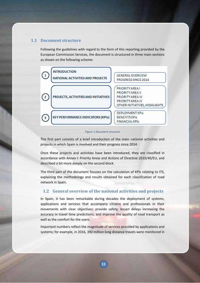
1.1 Document structure
Following the guidelines with regard to the form of this reporting provided by the
European Commission Services, the document is structured in three main sections
as shown on the following scheme:
Figure 1 Document structure
The first part consists of a brief introduction of the main national activities and
projects in which Spain is involved and their progress since 2014.
Once these projects and activities have been introduced, they are classified in
accordance with Annex I: Priority Areas and Actions of Directive 2010/40/EU, and
described a bit more deeply on the second block.
The third part of the document focuses on the calculation of KPIs relating to ITS,
explaining the methodology and results obtained for each classification of road
network in Spain.
1.2 General overview of the national activities and projects
In Spain, it has been remarkable during decades the deployment of systems,
applications and services that accompany citizens and professionals in their
movements with clear objectives: provide safety, lessen delays increasing the
accuracy in travel time predictions; and improve the quality of road transport as
well as the comfort for the users.
Important numbers reflect the magnitude of services provided by applications and
systems; for example, in 2016, 392 million long distance travels were monitored in

12
12.196 km of Spanish road network; 1.247.260 messages were displayed in
variable message signs; the information web portal received more than 710
million of visits and the traffic information number handled more than 300.000
calls.
In the last 3 years, different trends that impact on daily displacements of citizens
and freight transport have been visible. The digitization and irruption of new
technologies (IoT, automatization, big data, etc), the increasing number of
connected people as a result of the smartphones development and vehicle
connectivity, and the improvement of mobile communications (3G, 4G, LTV-E,
future 5G), are modulating and participating in activity and focus redesign, among
which can be highlighted the deployment of the priority actions set out in the ITS
Directive.
This report aims to be the reflection of the initiatives promoted by Public
Administrations in a national, regional and local level; private sector players are
also working independently or in partnership with public bodies on the
development of ITS in Spain.
The information collected in this report strengths the contributions to the inquiry
formulated to participating entities in Working Group 56 of Traffic, Road Safety
and Sustainable Mobility Council.
All the initiatives and projects included in this report are developed under the
vision, scope and activities of national, regional and local strategies or plans,
highlighting:
• Spanish Road Safety Strategy 2011-
2020 (Ministry of the Interior - DGT)
• Infrastructure, Transport and Housing
Plan 2012 - 2024 (Ministry of Public
Works and Transport)
• National Plan for Air Quality and
Protection of the Atmosphere 2013–
2016 (Ministry of Agriculture, Food
and Environment)
A complete list of reference documents is included on section 4 “References”.

13
The following table shows the main reference projects which have consolidate the National Progress Report activities:
Figure 2 Main projects according to priority areas

14
1.3 General progress since 2014
According to the 2014 year report structure, (available on the link :
https://ec.europa.eu/transport/sites/transport/files/themes/its/road/action_plan
/doc/2014_es_its_report_2014_en.pdf) the information on ITS progress within
the ITS Directive Priority Actions has been structured following the criteria shown
in the table below:
FUNCTIONAL AREA ITS SERVICE (WHAT)
TRAFFIC INFORMATION
Traffic events and incidences
Traffic flow (Levels Of Service-LOS)
Travel times
Information of speed limits
Driving restrictions
Images or video distribution
Weather-related information
Itinerary planning
Information exchange
TRAFFIC AND MOBILITY MANAGEMENT
Dynamic speed management
Prohibition of truck take-over
Implementation of reversible lanes
Hard shoulder use
Management of high-occupancy lanes
Ramp metering
Dynamic management of driving restrictions in mass
movements and adverse weather conditions
Tunnel management
Traffic management plans
Dynamic management of urban traffic plans
Traffic lights priority systems for the public transport
On request public transport
Public bicycles services management
Car-pooling and car-sharing
SAFETY AND EMERGENCY MANAGEMENT eCall
SURVEILLANCE (ENFORCEMENT)
Speeding control
Red light control
Access control due to weather related reasons
Video surveillance in the public transportation system
TELEMATIC PAYMENT AND ETC
(ELECTRONIC TOLL COLLECTION)
ETC offenses
ETC enforcement
Mobile phone payment and card verification on public
transport
FREIGHT AND FLEET
Information and reservation services on safe and
secure parking places for lorries
Dangerous goods traffic management

15
FUNCTIONAL AREA ITS SERVICE (WHAT)
Dangerous goods monitoring
Special transport management
Urban and interurban logistics
Lean and green logistics
TRANSPORT FACILITIES
Exploitation Support Systems (ESS)
Trip planning (including door-to door planner)
Intermodal transport management
E-ticketing
Exchange
Traveller information
Table 1 ITS progress
In the following tables, each ITS service is disaggregated, including current
situation of each service in Spain. The following colour-scale has been used to
represent 3 levels of deployment and maturity.
Test level, pilot projects or
investigation or
preliminary studies
Service deployed
in some corridors
or specific cities
Service deployed in most part
of territory or area where it is
necessary. There may be space
Table 2 ITS level of deployment colour scale

16
1.3.1 Traffic information
1.3.1.1 Events and traffic incidents
WHAT HOW WHO WHERE 2011 2014 2017
EVENTS AND
TRAFFIC
INCIDENCES
Variable
Message Signs
(VMS)
DGT, SCT, DT
Accesses and ring
roads of big cities.
Some sections of
the interurban
network of Spain
Municipalities Big cities
Toll operator Sections of
highways
Web servers
DGT, SCT y DT All interurban
network
Municipalities Big cities
ITS Service
providers using
data provided by
Administration or
other agents
All interurban
network
RDS-TMC DGT via RNE All interurban
network
Information
telephones
(011), SMS, 012,
…
DGT, SCT, DT,
Some
municipalities of
big cities
All the urban and
interurban road
network
Teletext and
interactive
digital
televisions
DGT, SCT, DT All interurban
network
Smartphone
Apps
ITS Public and
private providers
with information
provided by the
administration or
other servers and
Comobity
All interurban
network and part
of the urban one
NAP
DGT, SCT, DT and
Madrid City
Council, Toll
operators,
Service Providers
Interurban and
partial urban
network
Table 3 Events and traffic incidents

17
1.3.1.2 Traffic flow (LOS)
This information is available through private operators (Google, INRIX, etc.) as
well as toll motorway operators using web services and smartphone applications.
1.3.1.3 Travel times
WHAT HOW WHO WHERE 2011 2014 2017
TRAVEL TIMES
VMS
DGT, SCT, DT,
Big cities and
some toll
operators
Accesses and ring
roads of big cities, big
urban axes and some
stretches of toll
motorways.
Web
servers
DGT Accesses and ring
roads of big cities.
Municipalities Big cities
ITS Service
providers using
data provided by
Administration
or other agents
All interurban
network
Smartphone
Apps
ITS Public and
private providers
with information
provided by the
administration
or other servers
All interurban
network and part of
the urban one
NAP
DGT, SCT, DT
and Madrid City
Council
Interurban and partial
urban network
Table 4 Travel times

18
1.3.1.4 Information of speed limits
WHAT HOW WHO WHERE 2011 2014 2017
SPEED LIMIT
INFORMATION
VMS
DGT, SCT, DT,
big cities and
some toll
operators
Accesses and ring
roads of big cities, big
urban axes and some
road stretches of toll
motorways
Web
Servers
ITS Service
providers using
data provided by
Administration
or other agents
All interurban and
urban network
Smartphone
Apps
ITS Public and
private
providers with
information
provided by the
administration
or other servers
All interurban
network and part of
the urban one
NAP DGT, SCT, DT
and Madrid City
Council
Interurban and partial
urban network
Table 5 Information of speed limits

19
1.3.1.5 Driving restrictions
WHAT HOW WHO WHERE 2011 2014 2017
DRIVING
RESTRICTIONS
VMS
Web
servers
Channels of
news
DGT, SCT, DT
Accesses and ring
roads of big cities, big
interurban axes
Social networks and
web-based info
dissemination.
Web
Servers
ITS Service
providers using
data provided
by
Administration
or other
agents
All interurban and
urban network
Smartphone
Apps
ITS Public and
private
providers with
information
provided by
the
administration
or other
servers
All interurban network
and part of the urban
one
NAP
DGT, SCT, DT
and Madrid
City Council
Interurban and partial
urban network
Table 6 Driving restrictions
1.3.1.6 Image or video distribution
WHAT HOW WHO WHERE 2011 2014 2017
IMAGE OR
VIDEO
DISTRIBUTION
Web servers
Smartphone
Apps
DGT, SCT, DT,
big cities,
some toll
operators and
ITS service
providers
Accesses and ring roads
of big cities, big
interurban axes What
Table 7 Image or video distribution

20
1.3.1.7 Weather related information
WHAT HOW WHO WHERE 2011 2014 2017
WEATHER –
RELATED
INFORMATION
VMS
Web servers
Smartphone
Apps
DGT, SCT, DT
and ITS service
providers
Specific points of the
interurban network
Table 8 Weather related information
1.3.1.8 Itinerary planning
WHAT HOW WHO WHERE 2011 2014 2017
ITINERARY
PLANNING
Web
servers and
Smartphone
Apps
DGT, SCT, DT
and ITS service
providers
All road network
Table 9 Itinerary planning
1.3.1.9 Information exchange
WHAT HOW WHO WHERE 2011 2014 2017
INFORMATION
EXCHANGE
DATEX
DGT, SCT, DT,
concession of
highways and
Service
providers
Interurban road
network,
including an
exchange with
France and
Portugal
.xml files for
private
operators
DGT, Basque
Government
Interurban road
network
Text files for
private
operators
SCT
Table 10 Information exchange
21
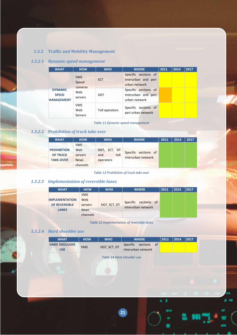
1.3.2 Traffic and Mobility Management
1.3.2.1 Dynamic speed management
WHAT HOW WHO WHERE 2011 2014 2017
DYNAMIC
SPEED
MANAGEMENT
VMS
Speed
cameras
Web
servers
SCT
Specific sections of
interurban and peri
urban network
DGT
Specific sections of
interurban and peri
urban network
VMS
Web
Servers
Toll operators Specific sections of
peri urban network
Table 11 Dynamic speed management
1.3.2.2 Prohibition of truck take over
WHAT HOW WHO WHERE 2011 2014 2017
PROHIBITION
OF TRUCK
TAKE-OVER
VMS
Web
servers
News
channels
DGT, SCT, DT
and toll
operators
Specific sections of
interurban network
Table 12 Prohibition of truck take over
1.3.2.3 Implementation of reversible lanes
WHAT HOW WHO WHERE 2011 2014 2017
IMPLEMENTATION
OF REVERSIBLE
LANES
VMS
Web
servers
News
channels
DGT, SCT, DT Specific sections of
interurban network
Table 13 Implementation of reversible lanes
1.3.2.4 Hard shoulder use
WHAT HOW WHO WHERE 2011 2014 2017
HARD SHOULDER
USE VMS DGT, SCT, DT
Specific sections of
interurban network
Table 14 Hard shoulder use

22
1.3.2.5 Management of high occupancy lanes
WHAT HOW WHO WHERE 2011 2014 2017
MANAGEMENT OF
HIGH OCCUPANCY
LANES
VMS
Web
servers
News
channels
DGT
20-km stretch on the
high capacity A-6
Madrid peri urban
motorway access.
VMS
Web
servers
News
channels
SCT
Finished HOL project
on C-58 (oct.2012:
HOV+3; march 2013
HOV+2; sept. 2014
HOV +2 (1+1 layout).
High
occupancy
pilot with
rear seat
detection
INDRA Some urban network
Table 15 Management of high occupancy lanes
1.3.2.6 Ramp metering
WHAT HOW WHO WHERE 2011 2014 2017
RAMP METERING
VMS
Web
servers
News
channels
Barcelona
City Council
VMS
Web
servers
News
channels
DGT
A-5 and A-1 peri urban
Madrid motorways
M-40 assessment
Table 16 Ramp metering

23
1.3.2.7 Dynamic management of driving restrictions in mass movements and
adverse weather conditions
WHAT HOW WHO WHERE 2011 2014 2017
DYNAMIC
MANAGEMENT
OF DRIVING
RESTRICTIONS
IN MASS
MOVEMENTS
VMS
Web
servers
News
channels
NAP
DGT, SCT, DT,
Madrid and
Barcelona
Councils
Interurban Networks
and ring roads
metropolitan areas of
big cities: Madrid y
Barcelona
DYNAMIC
MANAGEMENT
OF DRIVING
RESTRICTIONS
IN ADVERSE
WEATHER
CONDITIONS
VMS
Web
servers
News
channels
NAP
DGT, SCT, DT,
Madrid and
Barcelona
Councils
Interurban Networks
and ring roads
metropolitan areas of
big cities: Madrid y
Barcelona
Table 17 Dynamic management of driving restrictions in mass movements and adverse weather conditions
1.3.2.8 Tunnel management
WHAT HOW WHO WHERE 2011 2014 2017
TUNNEL
DYNAMIC
MANAGEMENT
Variable
Message
Signs
Web
servers
News
channels
DGT, SCT, DT, toll
operators, Madrid
and Barcelona
Municipalities
Tunnels of the
interurban and
urban network
Incident
detection Toll operators
Tunnels of
some
interurban
network
Table 18 Tunnel management

24
1.3.2.9 Traffic management plans
WHAT HOW WHO WHERE 2011 2014 2017
TRAFFIC
MANAGEMENT
PLANS
In traffic
Management
centres by means
of service levels
algorithms, traffic
conditions,
automatic incident
detection and
travel times.
Variable Message
Signs
Web servers
News channels
Smartphone apps
DGT, SCT, DT
and toll
operators
In all traffic
management
centres, the
interurban
road
network of
Spain
Table 19 Traffic management plans
1.3.2.10 Dynamic management of urban traffic plans
WHAT HOW WHO WHERE 2011 2014 2017
DYNAMIC
MANAGEMENT
OF URBAN
TRAFFIC PLANS
Traffic lights priority
system and urban
Traffic Management
Centres with
adaptative
algorithms.
Municipalities
and
Authorities
that regulate
traffic lights.
Provinces
Centralised
Control
Systems based
on traffic lights
in Spanish
cities
Big Data technology
applied to traffic
management
Málaga City
Council &
Indra
(Transforming
Transport)
High capacity
network in
Malaga
Table 20 Dynamic management of urban traffic plans

25
1.3.2.11 Traffic light priority system for the public transport
WHAT HOW WHO WHERE 2011 2014 2017
TRAFFIC LIGHTS
PRIORITY
SYSTEM FOR
PUBLIC
TRANSPORT
Traffic lights priority
system, exploitation
support systems and
urban traffic
Management Centres
Municipalities
and
municipal
transport
companies
Cities: Donostia-
San Sebastián,
Albacete, Vigo,
Valencia,
Zaragoza, Bilbao,
Malaga, Murcia.
Table 21 Traffic light riority system for the public transport
1.3.2.12 On request public transport
WHAT HOW WHO WHERE 2011 2014 2017
ON-REQUEST
PUBLIC
TRANSPORT
On-board
equipment
exploitation aids,
info screens,
reservation centre,
tool for making
reservations (web,
SMS, telephone).
Municipalities,
authorities of
public
transport and
operators of
public
transportation
Rural
environments or
low density
environment in
cities and/or
metropolitan
areas: Madrid,
Asturias,
Zaragoza, Camp
de Tarragona,
Castilla y León…
Table 22 On request public transport
1.3.2.13 Public bicycles services management
WHAT HOW WHO WHERE 2011 2014 2017
PUBLIC BICYCLES
SERVICES
MANAGEMENT
Equipment
stations – bike
racks–
Conventional and
electrical bicycle;
Contactless card;
Intermodality
with other public
transport modes.
Web servers
News channels-
web portals
Apps
Municipalities
and Municipal
Transport
Companies
Spanish cities:
Madrid, Barcelona,
Valencia, Sevilla,
Bilbao, San
Sebastián, Murcia,
Ciudad Real,
Zaragoza, A
Coruña…
Table 23 Public bicycles services management

26
1.3.2.14 Car pooling and car sharing
WHAT HOW WHO WHERE 2011 2014 2017
CAR – POOLING
Variable
Message
Signs
Web servers
Apps
DGT, SCT, DT
Specific stretches of
the interurban road
network
Smartphone
Apps
Private
providers with
information
provided by
the
administration
or other
servers
Spanish cities: Madrid,
Barcelona, Valencia,
Sevilla, Bilbao, San
Sebastián, Murcia,
Ciudad Real, Zaragoza,
A Coruña…
CAR SHARING
Web servers
Apps
Private
companies in
major cities
Light vehicles, mopeds
and motorcycles
Smartphone
Apps
Private
providers with
information
provided by
the
administration
or other
servers
Spanish cities: Madrid,
Barcelona, Valencia,
Sevilla, Bilbao, San
Sebastián, Murcia,
Ciudad Real, Zaragoza,
A Coruña…
Table 24 Car pooling and car sharing
1.3.3 Safety management, road safety and emergencies
WHAT HOW WHO WHERE 2011 2014 2017
eCALL
Communication
mobile network,
PSAPs (Public Safety
Answering Points)
upgrade and
protocols of
exchange of
information
112 PSAPs,
DGT, MNO
(Mobile
Network
Operators)
In 19
autonomous
regions
Operative in
some regions like
Valencia
Table 25 Safety management, road safety and emergencies

27
1.3.4 Surveillance (Enforcement)
1.3.4.1 Speeding control
WHAT HOW WHO WHERE 2011 2014 2017
SPEEDING
CONTROL
Speed
control
devices
DGT, SCT, DT
and
Municipalities
Specific areas due to
safety reasons
Mean speed
controls
DGT, SCT, DT
and big cities
municipalities
Specific risky stretches
such as tunnels
Table 26 Speeding control
1.3.4.2 Red Light control
WHAT HOW WHO WHERE 2011 2014 2017
RED LIGHT
CONTROL
Camera,
traffic sensor
and traffic
light unit
DGT, SCT, DT
and
Municipalities
Traffic light regulated
intersections with road
safety problems
In interurban roads
with adverse weather
conditions
Table 27 Red Light control
1.3.4.3 Access control due to weather related reasons
WHAT HOW WHO WHERE 2011 2014 2017
ACCESS
CONTROL
Licence Plate
Recognition
(LPR) and
VMS
supported
with
automatic
fee devices
Municipalities
Downtown historical
cities / Air quality
protection on sensitive
areas
Licence Plate
Recognition
(LPR) and
VMS
supported
with
automatic
fee devices
Toll operators Some highway
network
Table 28 Access control due to weather related reasons

28
1.3.4.4 Video surveillance in the public transportation system
WHAT HOW WHO WHERE 2011 2014 2017
VIDEO-
SURVEILLANCE IN
THE PUBLIC
TRANSPORTATION
SYSTEM
Onboard
cameras,
driver
alarm,
control
centre,
operation
support
systems.
Municipalities,
authorities of
public
transport,
operators of
public
transport, taxi
drivers.
Vehicles of the
different modes, in
cities and/or
metropolitan areas:
Madrid, Barcelona,
Valencia, Murcia,
Zaragoza,
Guipúzcoa…
Table 29 Video surveillance in the public transportation system
1.3.5 Telematic payment and ETC
1.3.5.1 ETC offenses
WHAT HOW WHO WHERE 2011 2014 2017
ELECTRONIC TOLL
COLLECTION
OFFENSES
Camera,
offense
sensor, ETC,
DVIT and
automatic
offense device
Toll
operators;
DGT
Toll roadways
(integration with
national fine
management
centre –ESTRADA
centre)
Table 30 ETC offense
1.3.5.2 ETC enforcement
WHAT HOW WHO WHERE 2011 2014 2017
ETC
DSRC antennas
in tolls, on-
board devices
Toll
operators
All Spanish toll
motorways
throughout the
country.
SIGO, prepaid
telematic
payment
Toll
operators
AP46 Málaga – Las
Pedrizas
Interoperability
different ETC
Toll
operators
Some highways
network
Table 31 ETC enforcement

29
1.3.5.3 Mobile phone payment and card verification on public transport
WHAT HOW WHO WHERE 2011 2014 2017
PAYMENT AND
CARD
VERIFICATION OF
PUBLIC
TRANSPORTATION
BY USING THE
MOBILE PHONE
SIM cards,
application of
payment in
the mobile
phone,
onboard
verification
equipment
that use NFC
technology.
Municipalities,
public
transport
authorities
and
operators.
Preliminary and
pilot studies in
some
metropolitan
areas such as:
Madrid, Valencia,
Murcia, Málaga,
Gipuzkoa, Lleida,
Pamplona…
Table 32 Mobile phone payment and card verification on public transport
1.3.6 Freight and fleet
1.3.6.1 Information and reservation services on safe and secure parking places
for lorries
WHAT HOW WHO WHERE 2011 2014 2017
INFORMATION
ABOUT
INTERURBAN
PARKING
SPACES
Variable
Message Signs
Web servers
Parking
operators;
DGT
Intelligent Truck
Parking
INFORMATION
ABOUT URBAN
PARKING
SPACES
Variable
Message Signs
Web servers
Madrid,
Barcelona
and Terrassa
Municipalities
Table 33 Information and reservation services on safe and secure parking places for lorries

30
1.3.6.2 Dangerous goods traffic management
WHAT HOW WHO WHERE 2011 2014 2017
DANGEROUS
GOODS
MANAGEMENT
Variable
Message
Signs
Web servers
LPR
Madrid,
Barcelona
and Terrassa
Municipalities
Web server
Variable
Message
signs
LPR
SCT
Web-based
application to decide
best route for
dangerous goods
Table 34 Dangerous goods traffic management
1.3.6.3 Dangerous goods monitoring
WHAT HOW WHO WHERE 2011 2014 2017
DANGEROUS
GOODS
MONITORING
Variable
Message
Signs
Web servers
Ministry of
Public Works
and
Transport
(DGTT)
All state-dependent
road network
nationwide tunnels
Web
application SCT
“TRESA” application for
special transports
authorizations”
Table 35 Dangerous goods monitoring
1.3.6.4 Special transport management
WHAT HOW WHO WHERE 2011 2014 2017
SPECIAL
TRANSPORT
MANAGEMENT
AND
MONITORING
Web
applications
DGT
TRAZA application for
abnormal size/weight
transport
authorizations.
SCT
TRESA application for
abnormal size/weight
transport
authorizations.
Table 36 Special transport management

31
1.3.6.5 Urban and interurban logistics
WHAT HOW WHO WHERE 2011 2014 2017
URBAN AND
INTERURBAN
LOGISTICS
Technical
department
Ministry of
Public Works
and
Transport
(DGTT)
Nation-wide road
network
Table 37 Urban and interurban logistics
1.3.6.6 Lean and green logistics
WHAT HOW WHO WHERE 2011 2014 2017
URBAN AND
INTERURBAN
LOGISTICS
Logistics
platform
creation.
Ministry of Public
Works and Transport
(DGTT)
Transport operating
companies
Nation-wide road
network
Table 38 lean and green logistics
1.3.7 Transport facilities
1.3.7.1 Explotation Support Systems (ESS)
WHAT HOW WHO WHERE 2011 2014 2017
EXPLOITATION
SUPPORT
SYSTEMS
Follow-up and fleet
control through
geolocalization (GPS)
and wireless voice/data
communication with
mobile units.
Boarding Systems
control. Driver help
interface. Centre of
operation control:
Communication servers
and database, client
positions, geographical
and synoptic
information.
Municipal
Transport
Companies
Interurban
transport
companies
In most
Spanish cities
and in areas
served by
interurban
service
connecting
main urban
nodes
Table 39 Explotation Support Systems (ESS)

32
1.3.7.2 Trip Planning (including door to door planner)
WHAT HOW WHO WHERE 2011 2014 2017
TRIP
PLANNING
Computer tool that
supports the
planning job of
helping operators.
The information
generated is used
by the ESS
(European Social
Survey)
Municipal
Transport
Companies;
Interurban
transport
companies
In most Spanish
cities and in areas
served by
interurban service
connecting main
urban nodes:
Madrid, Barcelona,
Valencia, Sevilla,
Gran Canaria,
Pamplona, Murcia,
Asturias, etc.
TRIP
PLANNING
http://www.fomen
to.es/portalsitranb
us/
Ministry of Public
Works and
Transport (DGTT)
All interurban
Spain´s
concessions.
Smartphone App
DGT + Other
service providers
(based on DGT
sources)
Nation-wide road
trip planning
(including weather,
incidences,
restrictions and
traffic L.O.S)
Table 40 Trip Planning (including door to door planner)

33
1.3.7.3 Intermodal transport management
WHAT HOW WHO WHERE 2011 2014 2017
INTERMODAL
TRANSPORT
MANAGEMENT
Introduction of a
unique transport
card. e-ticketing
harmonizing
systems of
different
operators.
Control and
compensation
centres to make a
distribution
between the
operators and
other system
agents.
Transport
regulation
bodies in
regions
and
provinces
Limited to
separated region
areas
Road-Sea seasonal
intermodality DGT
Information
dissemination for
long-range nation-
wide road trips to
Access sea ports
(traffic levels, ports
occupation,
estimated
departures times,
en-route rest areas,
etc).
Table 41 Intermodal transport management

34
1.3.7.4 E-ticketing
WHAT HOW WHO WHERE 2011 2014 2017
E-TICKETING
Magnetic,
contactless, or bar-
code technology.
Sale systems
Control Systems
for card usage,
centre of e-
ticketing control
and management.
Municipal
transport
companies.
Interurban
transport
companies
(urban and
interurban)
Areas served by
interurban service
connecting main
cities. cities and/or
metropolitan areas:
Madrid, Comunitat
Valenciana, Murcia,
Andalucía,
Asturias, Mallorca,
Gran Canaria,
Zaragoza, Gipuzkoa,
Camp de
Tarragona, Lleida,
Pamplona, Vigo, A
Coruña…
Table 42 E-ticketing
1.3.7.5 Exchange
WHAT HOW WHO WHERE 2011 2014 2017
EXCHANGE
Apps and required
servers for
multimodal
information
Public Transport
Authorities in
regions and
provinces
Service providers
Big cities
and peri
urban
areas
Table 43 Exchange

35
1.3.7.6 Traveller information
WHAT HOW WHO WHERE 2011 2014 2017
INFORMATION
TO TRAVELLERS
Systems for visually
impaired people.
Wireless or fixed
communication
between the control
centre (SAE) and
info screens in real
time,
Apps for info
dissemination
through different
channels and
formats for users
Transport
Municipal
Companies
Interurban
transport
companies
Areas served by
interurban service
connecting main
cities. Cities
and/or
metropolitan
areas: Comunitat
Valenciana,
Murcia, Andalucía,
Asturias, Mallorca,
Gran Canaria,
Zaragoza,
Gipuzkoa, Camp
de Tarragona,
Lleida, Pamplona,
Vigo, A Coruña…
Table 44 Traveller information

36
2 Projects, activities and initiatives
On the following sections, the most significant initiatives and progresses are
described and included into the priority areas, as shown below:
Figure 3 Projects, activities and initiatives
Depending on the subject, the activities will be classified regarding the priority
actions according to the priority areas and in accomplishment with Directive
2010/40/EU.
2.1 Priority area I. Optimal use of road, traffic and travel data
The objective of the projects of this priority area is mainly focus on the enhancement of the provision of traffic and travel information services, in order to provide more accurate and reliable journeys with pre-trip and in-trip traffic and travel information which can reach their smartphone apps, navigation devices or on board units in cars and trucks. This information includes planned roadworks, sport events, expected time of arrival and warnings about hazardous weather or road conditions ahead in the route.

37
2.1.1 Description of the national activities and projects
The optimal use of road, traffic and travel data involves many ITS projects which
can be structured in three (3) different priority actions:
• Priority action (a): Multimodal Travel Information Services
• Priority action (b): Real-Time Traffic Information Services
• Priority action (c): Safety related Universal Traffic Information
However, there are other activities and initiatives associated with these topics
which do not match exactly with any of these priority actions. These activities are
mainly related to the “National Plan for Air Quality and Protection of the
Atmosphere 2013-2016” which includes actions to control the emissions related
with road transport and apply restrictions in order to reduce the severe effects on
human health and ecosystems that air pollution can cause.
Figure 4 Priority Area I

38
2.1.2 Reporting under the Draft Delegated Regulation with regard to the
provision of EU-wide multimodal travel information services (priority
action a)
2.1.2.1 Long distance travels
According to road administration data, the percentage of cross-border demand
related to long-range travels within the European Union, continues being
considerably high (around 14%), which highlights the relevance of a proper
connectivity of the network and the seamless provision of services and
traffic/road safety information.
Figure 5. Vilar de Formoso - Portugal Border Crossing
Figure 6 Le Perthus. Spain - France Border Crossing

39
2.1.2.2 Land transport management
2.1.2.2.1 Provision of information services
on multimodal movements
Within the context of Ministry of
Public Works and Transport ITS
Program3
, an “Intermodal Transport
Catalogue” is being developed with
the purpose of collecting all the
information of routes and schedules
of passengers’ regular transport for
medium and long distance for all
modes of transport, including rail and
regular road transport.
A “Transport Information Portal”
(accessible through the website:
http://www.fomento.es/portalsitran
bus/) is also being implemented,
(from the aforementioned
Catalogue), which enable citizens to
easily access this information on
intermodal transport alternatives for
medium and long distance journeys in
a complete and reliable way, through
a multimodal system that will allow
to analyse and search the different
transport alternatives to make
specific route, detailing the possible
options and schedules in each mode
of transport available. In addition, the
portal will contain updated
information on incidents that may
occur. The aim is to contribute to the
promotion of intermodal transport,
facilitating access to information and
3
Report on ITS Action Plan 2012-2024. Ministry of Public Works and Transport.
reducing costs, and ultimately helping
to improve territorial cohesion.
2.1.2.2.2 SIRDE
Ministry of Public Works and
Transport developed in November
2016 an application called “SIRDE”
(Sistema de Información para
Registro de Datos de Expediciones –
Management Information System for
Recording Data of Dispatches) for the
improvement of the management
road passenger transport
concessions, which is the
responsibility of the General State
Administration.
This Application can be downloaded
for free in a device located on the
buses. SIRDE collects the exploitation
data of the concessions by reading a
QR code printed on the tickets. At the
same time, the positioning of buses is
collected.
All these passengers’ data and routes
are sent in real time to a data
warehouse of Ministry of Public
Works and Transport where they are
managed and analysed for the
development of O/D (origin and
destination) matrices.
For the approval of this system, the
Ministry has carried out numerous
tests in some routes, with the
collaboration of diverse
concessionary companies. Some

40
resolutions that oblige public service
contractors of regular general road
transport to implement and use
SIRDE have already been signed. On
1st November of 2017, 20 companies
with a transport service contract will
have incorporated SIRDE into their
fleet.
The remaining concessions will
incorporate the obligation to
implement the application in the
contract as they are being renewed.
2.1.2.2.3 “Paso del Estrecho” Special Traffic
Operation
General Directorate for Traffic (DGT)
has implemented a dispositive to
offer assistance and information to
users on their trips through the main
routes in Spain to the departure
harbours to North Africa.4
This operation involves that more
than 1.200.000 vehicles pass across
the border between France and Spain
(Irun and La Jonquera) and use these
corridors to arrive final destination.
This special operation integrates rest
areas, information points, emergency
areas and variable message panels
located in the two main national
corridors: Central Corridor and
Mediterranean Corridor.
4
Operación Paso del Estrecho (OPE) 2016 - General Directorate of Traffic - Ministry of the Interior

41
Figure 7 Central Corridor and Mediterranean Corridor
The operative number of rest areas and information points and the services
offered are detailed in the following table:
OPERATING
PERIOD AREA PROVINCE SITUATION
OFFER
SERVICES
REST
AREA
INFORMATION
POINT
Departure Oiartzun Guipúzkoa AP-8, PK 7,5 Rendering I.P.
Departure/Return Horcajo Madrid A-1, PK 83 Toilet and
rendering R.A.
Departure Valdepeñas Ciudad Real A-4, Pk.
211,5
Toilet and
rendering R.A.
Departure Ribera de
Cabanes
Castellón AP-7, Pk. 404 Rendering I.P.
Departure Villajoyosa Alicante AP-7, Pk. 654 Rendering I.P.
Departure Loja Granada A-92 P.K. 189 Rendering I.P.
Table 45 Operative number of rest areas and information points “Operación Paso del Estrecho”
The traffic information and management system is based on the monitoring in the
main borders in La Jonquera and in Irún and through DGT VMS, which, among
other things, provide information about the occupancy rate and the waiting time
from departure harbours.

42
The messages displayed on VMS are
intended for users in transit through
Spain with main destination North
Africa. This signalling reports about
multimodal information regarding the
occupancy (high or very high) of the
harbours of Algeciras, Tarifa, Motril
and Almería, the average waiting
time from the departure harbour of
Algeciras to Ceuta or Tánger, and
some recommendations regarding
the purchase of boarding tickets.
Figure 8 Multimodal information on VMS
In emergency situations, the panels
are also used to give warnings and
recommendations to the citizen.
In relation to the transit of vehicles
that take place during the period of
“Operación Paso del Estrecho, OPE”
in the Spanish territory, it is very
important to have continuous
knowledge of traffic intensity on the
borderlines of Irún, La Jonquera and
Algeciras harbour.
For this reason, a Borderline
Information System (“Sistema de
Información de Frontera, SIF”) has
been implemented for the integration
of all the data necessary for
calculations and estimations of mass
movements, regarding the reading
and identification of vehicles’
nationalities on the border post,
having in an automated way the
traffic of vehicles from the borderline
until their arrival, mainly to Algeciras
harbour.
For the OPE, the reading and
identification of vehicles’ nationalities
on the border post and a selection of
vehicle measurement points of the
main corridors, were implemented
from the SIF, having automated data
from the borderline until their arrival
to the different embarkation
harbours.
The data supplied by the SIF
corresponding to the time evolution
of the intensity movements of the
boardline points of Irún (AP-8) and La
Jonquera (AP-7) shows the diversity
of nationalities accessing and crossing
our country (vehicles registered in
Italy, Great Britain, Belgium,
Netherlands, Germany and France.)

43
In the figure below, the location of the automatic License Plate Recognition (LPR)
and Closed Circuit Television (CCTV) cameras used during the development of the
OPE is detailed: During the “OPE Campaign”, a leaflet with advice,
recommendations and indication of the location of rest areas and information
points is included on the DGT website.
Figure 9 Location of LPR and CCTV used during the OPE
Figure 10. Example of DGT website “OPE” advice

44
This leaflet is published in French and Arabic with information of the main
corridors to cross Spain, authorized service areas, emergency telephone numbers,
etc.
Figure 11 Example of front page of the triptych
Figure 12 Example of the backside of the triptych
In addition, up-to-date data of interest to Arabic speaker drivers have been
published regularly on the DGT website.

45
2.1.3 Reporting obligation under
Delegated Regulation (EU)
2015/962 on the provision of EU-
wide real-time traffic
information services (priority
action b)
2.1.3.1 National Access Point (NAP)
Directive 2010/40/EU of the
European Parliament and of the
Council of 7 July 2010 on the
framework for the deployment of
Intelligent Transport Systems in the
field of road transport and for
interfaces with other modes of
transport Text with EEA relevance,
includes among its priority areas the
optimum use of road network, traffic
and travel data. In this sense, there is
a high growing demand in the use
and implementation of information
and communication technologies in
the automotive world, which will
support new services and
technological advances in road safety.
Within the framework that configures
the abovementioned Directive and its
delegated regulations, it should set a
common access point that allows the
information coming from different
sources be available for everybody
and with a standard format.
In compliance with above, the
General Directorate for Traffic has
put into operation a neutral Common
Point for traffic information (from
now on, NAP): Spain National traffic
Access Point- http://nap.dgt.es
provides high quality EU-wide real-
time traffic information.

46
Figure 13 NAP - Homepage

47
2.1.3.2 LINCE
LINCE is the acronym for “Localizador
de INcidencias en las Carreteras de
España - Events locator on Spanish
Roads”, is one of the applications
which is contributing to the NAP.
Used by DGT, is a centralized web
system designed to allow joint
management of traffic events and
traffic conditions on all roads
controlled by the TMCs distributed
nationwide.
LINCE use VEOS (Visualizador
Geolocalizado de Sucesos - Events
Geolocated Display) to visualize,
represent and search traffic events
information on the web map in real
time.
Figure 14. LINCE Homepage
Figure 15 VEOS – Homepage

48
2.1.3.3 Winter Road Dashboard (WRD)
With the purpose of providing real
time information related to winter
road conditions, a new application
was developed in Spain under the
name of “Winter Road Dashboard
(WRD)”. This tool is conceived as a
living instrument, a composition of
key aspects related to each other,
which must be updated regularly, and
through their consultation, will
facilitate the decision making on
mobility and road safety during the
winter.
The WRD was programmed as an
interface in LINCE, to complete the
information provided by this
platform. This web service has a
limited access to certain users with
competence in the matter. This
information may be sent, likewise, to
everyone concerned, for the correct
dissemination of the information and
the measures or actions to be carried
out.
Figure 16. WRD - Access icon
The combination of quantitative and
qualitative characteristics of the
roads is the best way to describe a
specific scenario in a concise and
detailed way. A graphical alternative
that allows to provide this
information in a compact way, is
based on the creation of a mosaic of
tables that initially include concepts
such as:
• Levels of restriction by colour
coding.
• Number of kilometres of road
network associated with each
Level of Restriction.
• Number of events related to
Winter Road.
• Information aggregated by road
type, province, TMC, etc.

49
Figure 17 Kilometres of affected roads
Figure 18 Number of events

50
Figure 19 Occupancy rate of emergency parking areas
In conclusion, WRD is a very simple scheme but with great added value, as it
provides enough information to make decisions and make judgments about road
conditions in adverse weather episodes.

51
2.1.3.4 IGLÚ
The purpose of IGLU is to facilitate road operators the direct feeding of the NAP
with real time information of the road conditions during winter, to provide better
information and facilitate traffic management.
Figure 20 IGLU - Main menu
The list displays for each incident the following features:
• LOS: icon that indicates the incident type and road impact
• Incident: describe the event type, among the followings:
52
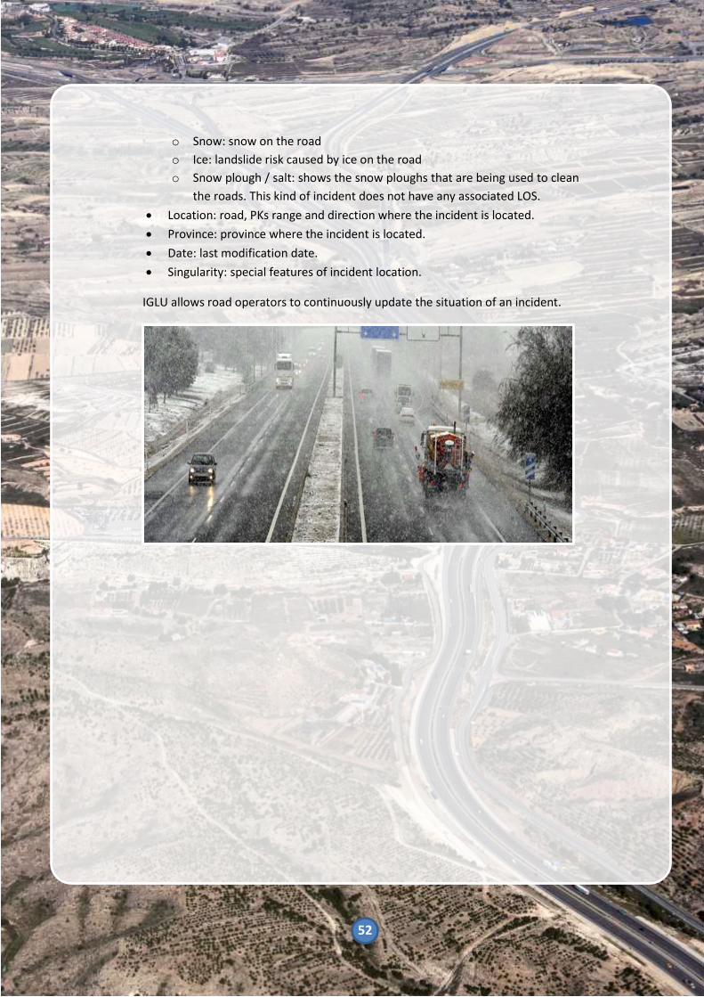
o Snow: snow on the road
o Ice: landslide risk caused by ice on the road
o Snow plough / salt: shows the snow ploughs that are being used to clean
the roads. This kind of incident does not have any associated LOS.
• Location: road, PKs range and direction where the incident is located.
• Province: province where the incident is located.
• Date: last modification date.
• Singularity: special features of incident location.
IGLU allows road operators to continuously update the situation of an incident.

53
2.1.3.5 Mobility map
Mobility map is a web application link to the NAP which offers static and dynamic
traffic information of all Spanish roads (state, regional and local).
Figure 21 Mobility map – National Roads
The Mobility Map provides an interactive map where users can visualize the
following information:
• Kilometre Points
• Accident Concentration Sections (TCAs)
• Restrictions
• Special surveillances areas
• Roads
o Information related to adverse weather conditions:
▪ Elevation
▪ Emergency parking areas
o Other layers of interest:
▪ Level - crossings
▪ RIMP (Red de Itinerarios para Mercancías Peligrosas – Itineraries
Network for Dangerous Goods)
▪ Safe cycle routes
• Warnings caused by adverse weather conditions

54
Mobility Map makes easier to search for precise information regarding the
parameters mentioned before.
Figure 22 Restriction search on Mobility Map
Figure 23 Weather conditions on Mobility Map

55
2.1.3.6 Infocar – eTraffic
This service, developed by DGT is an example of the integration of the information
provided by the NAP in a traffic map in which is possible to visualize:
• Updated real-time incidents on national roads from the information
registered in the NAP.
• Scheduled road works and restrictions (height and mass).
• Traffic data
• Personalised services:
o Storage of more frequent routes.
o Personalization of the most relevant services for the user (cameras,
panels, etc).
Figure 24. Infocar - Homepage and My queries page

56
2.1.3.7 MeteoRuta
MeteoRuta is a specific tool of AEMET for road traffic, through which it is possible
to find information of meteorological variables that affect the driving (rain, snow,
wind, low temperature), and its temporal evolution for the next 24 hours.
It consists of an interactive map viewer that displays the meteorological
conditions of the roads with the current warning layer of AEMET.
This information is generated automatically by the statistical treatment of the
results of the numerical prediction models.
It is possible to visualize all the information related to the different meteorological
phenomena which define the status of the road.
Figure 25 MeteoRuta - Homepage
Figure 26 MeteoRuta - Map Viewer

57
2.1.3.8 DGT APP
This APP developed by DGT is in line
with the accomplishment of Directive
2010/40/UE requirements, regarding
to RTTI and RSTI.
The information currently provided to
users by this tool can be classified in
the following way:
• Traffic incidents:
o Congestion
o Road works
o Mountain passes
o Meteorology
o Events (sport events,
festivals, etc)
o Other
• Traffic cameras
• Radars
For each of the previous events, the
application provides the following
contents:
• Location of the event: Based on
“road kilometre point”, initial
and final point indicated by the
name of the town, flow
direction, etc.
• Category of the event (see
previous list).
• Driving behaviour advice:
Enforcement and advice is
undertaken by Traffic
Management Centres in
compliance with “Resolución de
1 de Junio de 2009, Manual de
Señalización Variable”
norm, which establishes criteria
and structure for variable
message sign info provision
covering all the previous
categories (see an example in
next figure).
• Date and hour of the incident.
2.1.3.9 Sport events and traffic
restrictions
According to the Spanish regulation
every sport event should be
communicate to DGT in case
interurban roads are affected. The
duration of the event and the routes
where it is valuable traffic
information. It is included at the NAP
and is available to all users.
In addition, at the beginning of the
year it is published at the DGT
website a calendar of scheduled sport
events which interurban roads are
affected.
Since 2014, at the beginning of the
year is been publishing a regulation
about traffic restrictions. This
regulation takes into account road
safety, mobility and efficiency during
the dates when the forecast of traffic
is higher and considering the danger
of some specific vehicles, as heavy
vehicles. This information is also
available at the NAP.

58
2.1.3.10 Coverage of EU-wide real-time traffic information services in Spain
Spain will apply the specifications of the provision of EU-wide real-time traffic information services beyond the trans-European road network and the motorway network.
Regarding the inventory of Trans-European roads reflected on the “TENtec Interactive Map Viewer” of the European Comission:
https://ec.europa.eu/transport/themes/infrastructure/ten-t-guidelines/maps_en
It is possible to identify some relevant motorways that are not included in the Comprehensive network which should be covered with ITS services.
After this analysis, some of the roads that constitute the main road network in Spain, and which are not included in the Comprehensive classification are listed below.
Anyway these specifications will cover the whole network of Spanish roads, independently of their category.

59
2.1.3.11 Important Roads not included in Trans – European Networks
In the next table are showed the roads not included in Trans – European
Networks:
TIPOLOGY ROAD ITINERARY
Motorway A-11 Valladolid - Tudela del Duero
Motorway A-11 Aranda del Duero
Motorway A-11 El burgo de Osma
Motorway A-12 Rioja
Motorway A-13 Rioja
Motorway A-14 Lleida
Motorway A-2 Madrid - Barcelona
Motorway A-2 Sils (enlace N-II con C-63) - Fornells de la Selva (enlace E-15)
Motorway A-26 Besalú (Enlace N260 con C-66) - Olot
Motorway A-27 Tarragona
Motorway A-32 Bailén (enlace A-44) - Úbeda (enlace N-322)
Motorway A-33 Estación de Blanca (A-30) - (enlace N-344)
Motorway A-38 Valencia
Motorway A-4 jerez de la frontera - Polígono tres caminos
Motorway A-42 Madrid - Toledo
Motorway A-45 Antequera (A-92/N-331) - Malaga (A-7)
Multi Lane A-45 Málaga
Motorway A-48 Cádiz (CA-33) - Vejer de la frontera (N-340)
Motorway A-51 Ávila
Motorway A-58 Trujillo (E-90) -Cáceres (N521)
Motorway A-6 Betanzos - A Coruña
Motorway A-60 Valladolid - León
Motorway A-66 Onzonilla - Benavente
Motorway A-67 Aguilar de Campo - Palencia
Multi Lane A-68
Motorway A-7 Marbella - Fuengirola
Motorway A-7 Estepona - Marbella
Motorway A-70 San Juan de Alicante - Bonavista
Motorway A-77 Alicante
Motorway A-79 Alicante
Motorway A-91 Murcia
Motorway A-40 Cuenca – Tarancón - Ocaña
Motorway A-44A Granada

60
TIPOLOGY ROAD ITINERARY
Motorway A-5R Madrid
Motorway A-66R Gijón
Motorway A-68 Tudela
Motorway A-7N Murcia
Motorway
A-7/N-
340 Tarragona
Motorway A-7S Málaga
Motorway A-7S Cádiz – Málaga, Granada, Almería, Murcia
Motorway AC-14 A Coruña
Motorway AI-81 Avilés
Motorway AI-82 Avilés
Motorway AP-2 Lleida - Villafranca de Ebro
Motorway AP-36 Ocaña-La Roda
Motorway AP-36 Ocaña-La Roda
Motorway AP-4 Jerez de la Frontera - Sevilla
Motorway AP-41 Madrid - Toledo
Motorway AP-46 Puerto de las Pedrizas - Málaga
Motorway AP-4R Sevila
Motorway AP-53 Santiago - Dozón
Motorway AP-61 Segovia - El Espinar
Motorway AP-66 Campomanes - Rioseco de Tapia
Motorway AP-71 Astorga - León
Motorway B-22 Barcelona
Motorway B-23 Barcelona
Motorway B-23 Barcelona
Motorway B-24 Barcelona
Motorway B-30 Barcelona
Motorway B-40 Barcelona
Motorway BU-11 Burgos
Motorway CA-32 Cádiz
Motorway Ca-33 Cádiz
Motorway CA-35 Cádiz
Motorway CA-36 Cadiz
Motorway CO-32 Enlace A-45 - Enlace N437 (Cordoba)
Motorway CS-22 Castello de la Plana (Castellón)
Motorway CT-31 Enlace RM-332 - Enlace AP-7 (Cartagena, Murcia)
Motorway CT-32 Cartagena (Murcia)

61
TIPOLOGY ROAD ITINERARY
Motorway CV-80 Finaliza en el enlace con A-7. Alicante
Motorway EL-20 Desde la AP-7. Elx. (Alicante)
Motorway GJ-81 Hasta enlace con A-8 (Gijón, Asturias)
Motorway GR-14 Enlace A-7 - Enlace N-340 (Motril, Granada)
Motorway H-30 Enlace HU-3101 - Enlace N-442 (Huelva)
Motorway H-31 Enlace A-49 - Enlace H-30 (Huelva)
Motorway LE-11 Enlace N-630 - Enlace A-231 (León)
Motorway LE-30 Enlace LE-20 - Enlace AP-71 (León)
Motorway LL-12 Enlace AP-2- Enlace LL-11 (Lleida)
Motorway LO-20 Desde Enlace N-232 (Logroño, Rioja)
Motorway LU-12 Lugo
Motorway M-11 Enlace M-30 - Enlace M-111 (Madrid)
Motorway M-12 Enlace E-5 - Enlace A-1 (Madrid)
Motorway M-13 Enlace M-12 - Enlace M-110 (Madrid)
Motorway M-14 Enlace E-5 - Aeropuerto de Barajas (Madrid)
Motorway M-21 Enlace M-40 - Enlace A-2
Motorway M-23 Madrid
Motorway M-31 Enlace M-40 - Enlace M-50 (Madrid)
Motorway M-40 Enlace A-1. Entero (Madrid)
Motorway M-50 Enlace R-2 (Madrid)
Motorway M-50 Enlace A-1 - Enlace A-6 (Madrid)
Motorway MA-20 Malaga
Motorway MA-23 Malaga
Motorway MA-24 Enlace A-7S (Málaga)
Motorway MU-30 Enlace A-7S - Enlace N-301 (Murcia)
Motorway MU-31 Enlace MU-30 - Enlace A-30 (Murcia)
Motorway N-122A Zamora
Motorway N-2 Enlace Z-40 (Zaragoza) - Enlace N-2R
Motorway R-2 Madrid
Motorway R-3 Madrid
Motorway R-4 Madrid
Motorway R-5 Madrid
Motorway Z-40 Zaragoza
Motorway A-1 De Miranda de Ebro (L.P. Burgos) a Treviño oeste (L.P. Burgos)
Motorway A-1 De Treviño este (L.P. Burgos) a Ziordia (L.P. Navarra)
Motorway A-1 De Pto. Etxegárate (L.P. Navarra) a San Sebastián (AP-8)
Motorway A-1 De Ziordia (L.P. Alava) a Pto. Etxegárate (L.P. Guipúzcoa)

62
TIPOLOGY ROAD ITINERARY
Motorway A-10 De Irurtzun (AP-15 y A-15) a Alsasua (A-1) (Autovía de la Barranca)
Motorway A-12 De Pamplona (A-15) a Viana (L.P. La Rioja)
Motorway A-15 De Areso (L.P. Navarra) a Villabona (N-I)
Motorway A-15
De Noáin (AP-15 y PA-30) a Berriozar (AP-15 y PA-34) (Ronda de Pamplona
Oeste)
Motorway A-15 De Irurtzun (AP-15 y A-10) a Areso (L.P. Guipúzcoa) (Autovía de Leitzarán)
Motorway A-21 De Noáin (AP-15) a Yesa (N-240 L.P. Zaragoza) (Autovía del Pirineo)
Motorway A-231 De Osorno (L.P. Palencia) a Villalbilla de Burgos (BU-30)
Motorway A-231 De Onzonilla (N-630 y A-66r) a Sahagún (L.P. Palencia)
Motorway A-231 De Sahagún (L.P. León) a Osorno (L.P. Burgos)
Motorway A-316 De Úbeda oeste (A-401) a Martos oeste (Autovía del Olivar)
Motorway A-318 De Lucena (A-45) a Cabra (A-339) (Autovía del Olivar)
Motorway A-334 De Fines a Albox
Motorway A-357 De Casapalma a Málaga (Autovía del Guadalhorce)
Motorway A-376 De Montequinto a Utrera norte
Motorway A-381 De Jerez de la Frontera (AP-4) a Los Barrios (A-7) por Medina Sidonia
Motorway A-382 De Jerez de la Frontera (AP-4) a Arcos de la Frontera (A-384, A-372 y A-393)
Motorway A-383 De A-7 a La Línea de la Concepción (norte)
Motorway A-395 De Granada sur (A-44) a túneles del Serrallo (Ronda sur de Granada)
Motorway A-480
De Sanlúcar de Barrameda (Camino de la Reyerta) a Jerez de la Frontera (N-
IV)
Motorway A-483 De Bollullos del Condado (A-49) a Almonte sur (A-474)
Motorway A-491 De Base de Rota (P.K 15) a El Puerto de Santa María (A-4)
Motorway A-497 De Huelva a Punta Umbría (A-5050)
Motorway A-601 De Viloria (L.P. Valladolid) a Segovia (SG-20 y CL-601)
Motorway A-601 De Valladolid (VA-30) a Viloria (L.P. Segovia)
Motorway A-610 De Palencia a Magaz de Pisuerga (N-620)
Motorway A-68 De Castejón (AP-15 y N-232) a Cortes de Navarra (N-232)
Motorway A-7056 De A-357 a Parque Tecnológico de Andalucía (A-7054)
Motorway A-8 De Basauri (AP-8) a Ontón (L.P. Cantabria)
Motorway A-8009 De Sevilla (SE-20) a La Rinconada (A-8004)
Motorway A-8028 De SE-30 a Torreblanca de los Caños (A-92) (vía borde de "El Pino")
Motorway A-8062 De Bormujos (A-474) a Gines (A-8076)
Motorway A-92 De Huéneja (L.P. Granada) a Tabernas (N-340a)
Motorway A-92 De L.P. Málaga a Huéneja (L. P. Almería) por Loja y Granada
Motorway A-92 De La Roda de Andalucía (L.P. Sevilla) a L.P. Granada por Archidona
Motorway A-92 De Sevilla (SE-30) a La Roda de Andalucía (L.P. Málaga)

63
TIPOLOGY ROAD ITINERARY
Motorway A-92G De Santa Fe (A-92) a Granada (A-44)
Motorway A-92M De Estación de Salinas (A-92) a Villanueva de Cauche (A-45)
Motorway A-92N De Puerto de El Contador (L.P.Granada) a L.P. Murcia (A-91) por Vélez Rubio
Motorway A-92N De Guadix (A-92) a Puerto de El Contador (L.P. Almería) por Baza y Cúllar
Motorway AG-11 De Padrón (N-550) a Ribeira (AC-550) (Autovía del Barbanza)
Motorway AG-13 De O Castelo (VG-1.3) a Coiro (N-VI Km 583,200)
Motorway AG-31 De San Cibrao das Viñas (A-52) a Celanova sur
Motorway AG-41 De Curro (AP-9) a Sanxenxo (VG-4.1 y PO-504)
Motorway AG-51 De Lira (A-52 salida 291 y EP-4102) a Currás (PO-402)
Motorway AG-53 De Piñor (L.P. Pontevedra) a Barbantes (A-52)
Motorway AG-53 De Dozón (AP-53) a Piñor (L.P. Ourense)
Motorway AG-54 De Maside (AG-53) a O Carballiño (N-541)
Motorway AG-55 De A Coruña (AC-552) a Carballo oeste (AC-552)
Motorway AG-55 De Carballo oeste (AC-552) a Baio (AC-430 y VG-1.5)
Motorway AG-55 De Baio norte a Santa Irene (AC-552)
Motorway AG-56 De Santiago de Compostela sur (SC-20 y AP-9) a Brión (AC-543)
Motorway AG-57 De Baiona (PO-552) a Vigo sur (VG-20) (Autopista do Val Miñor)
Motorway AG-57N De AG-57 a Nigrán
Motorway AG-58 De Penelas (AG-59 Km 1) a Cacheiras (AC-841)
Motorway AG-59 De Ostilos (AC-537) a A Ramallosa (AC-841)
Motorway AG-64 De Ferrol a L.P. Lugo por As Pontes de García Rodríguez (Autovía)
Motorway AG-64 De L.P. A Coruña a Vilalba (A-8 y LU-861) por Cabreiros (Autovía)
Motorway AP-1 De Etxabarri-Ibiña (N-622 y N-624) a Léniz (L.P. Gipuzkoa)
Motorway AP-1 De Léniz (L.P. Alava) a Eibar (AP-8)
Motorway AP-15 De Tudela (AP-68) a Noáin (A-15 y PA-30)
Motorway AP-15 De Berriozar (A-15 y PA-34) a Irurtzun (A-15 y A-10)
Motorway AP-8 De Eibar (L:P. Gipuzkoa) a Basauri (A-8)
Motorway AP-8 De Bilbao sur (A-8 y BI-631) a Valle de Trápaga (A-8)
Motorway AP-8 De Behovia (Frontera Francia) a Eibar (L.P. Bizkaia)
Motorway ARA-A1 De Villafranca de Ebro (N-II) a El Burgo de Ebro (N-232) (Autopista)
Motorway AS-117 De Riaño (AS-I y AS-116) a Sama de Langreo
Motorway AS-17 De Posada sur (Pol. Ind. Asipo) a Lugones (AS-266)
Motorway AS-17 De Meres (A-64) a Riaño (acceso 37)
Motorway AS-I De Mieres (A-66) a Gijón por Pola de Siero (Autovía Minera)
Motorway AS-II De Oviedo a Gijón (Autovía Industrial)
Motorway BI-626 De Puente La Salve a (N-637)
Motorway BI-627 De Ugazko a BI-626

64
TIPOLOGY ROAD ITINERARY
Motorway BI-644 De Kareaga (N634) a Sestao (BI-3739)(por Vega Vieja)
Motorway C-13 De Lleida sur (LL-12) a Els Magraners (C-13B)
Motorway C-13 De Vilanova de la Barca sur (C-13Z) a Termens sur
Motorway C-13B De C-13 y N-240 a LL-11
Motorway C-16 De Barcelona a Terrassa sur (C-58)
Motorway C-16 De Terrassa sur (C-58) a Viladecavals
Motorway C-16 De Viladecavals a Sant Fruitos de Bagès (C-25)
Motorway C-16 De Sant Fruitòs de Bages (C-25) a Berga sur
Motorway C-17 De Centelles sur a Montesquiu (L.P. Girona)
Motorway C-17 De Montesquiu (L.P. Barcelona) a Ripoll (C-26)
Motorway C-25 De Ferran (L.P. Lleida) a Manresa (BV-4501)
Motorway C-31 De Castelldefels (C-32) a L'Hospitalet de Llobregat
Motorway C-31 De Barcelona (plaza Les Gloriès) a El Masnou (C-32 y B-20)
Motorway C-31C Sant Boi de Llobregat (A-16) - El Prat de Llobregat (B-17)
Motorway C-32 De Cubelles (L.P. Tarragona) a Castelldefells
Motorway C-32 De Montgat (B-20 y C-31) a Palafolls (N-II)
Motorway C-32 De Castelldefells a Barcelona (Av. Diagonal)
Motorway C-32 De El Vendrell (AP-7) a Cubelles (L.P. Barcelona)
Motorway C-33 De Barcelona (Avda. Río de Janeiro) a Montmeló (A-7)
Motorway C-35 De Maçanet de la Selva (AP-7) a Llagostera (C-65)
Motorway C-58 De Barcelona (C-33) a Terrassa (C-16)
Motorway C-60 De Mataró (C-32 y B-40) a La Roca del Vallés (AP-7) (Autovía de La Roca)
Motorway C-65 De Santa Cristina d'Aro a Llagostera (C-35)
Motorway CL-631 De Cubillos del Sil a Toreno
Motorway CM-10 Ronda norte de Guadalajara (de A-2 km 59 a N-320 por Río Henares)
Motorway CM-40 Ronda suroeste de Toledo (de Bargas (A-40) a Nambroca (CM-42 y N-401))
Motorway CM-41 De Valmojado (A-5) a Illescas (A-42 y CM-43) (Autovía de la Sagra)
Motorway CM-42
De Villafranca de los Caballeros (L.P. Toledo) a Villafranca de los Caballeros
(L.P. Toledo)
Motorway CM-42 De Alcázar de San Juan (L.P. Toledo) a Tomelloso (A-43)
Motorway CM-42 De Toledo (N-401 y A-42) a Herencia (L.P. Ciudad Real)
Motorway CM-42
De Alcázar de San Juan (L.P. Ciudad Real) a Alcázar de San Juan (L.P. Ciudad
Real)
Motorway CM-43 De Illescas (A-42 y CM-41) a Añover de Tajo (CM-4004)
Motorway
CM-
45 De Ciudad Real (A-41 y CM-4111) a Almagro (CM-412)
Motorway
CM-
9420 De A-41 a Aeropuerto de Ciudad Real

65
TIPOLOGY ROAD ITINERARY
Motorway CV-13 De Benlloch (CV-10) a Aeropuerto de Castellón
Motorway CV-30 De V-30 a CV-31 por Ronda Norte de Valencia
Motorway CV-336 De San Antonio de Benagéber (CV-35) a Bétera
Motorway CV-35 De Valencia (CV-30) a Casinos por Lliria
Motorway CV-36 De Valencia (V-30) a Torrent (A-7) por Picanya
Motorway CV-50 De Alzira (CV-42 y CV-43) a L'Alcúdia (A-7)
Motorway CV-50 De Benaguasil (CV-364) a Llíria (CV-35)
Motorway CV-500 De puerto de Valencia (V-30) a El Saler
Motorway CV-80 De Sax (A-31) a Castalla norte (CV-806 y CV-815)
Motorway EX-A1 De Navalmoral de la Mata oeste (A-5) a Moraleja (EX-108)
Motorway EX-A2 De Miajadas (A-5) a Vivares (L.P. Badajoz)
Motorway GC-1
De Las Palmas de Gran Canaria (GC-1 AM) a Arguineguín (GC-200) (Autovía
Marítima)
Motorway
GC-1
AM
Avda. Marítima Las Palmas de Gran Canaria (Hoya de la Plata (GC-1) a Pza.
Belén María)
Motorway GC-10 De La Garita (rotonda de las Tazas) a Telde (GC-41) (Autovía de Telde)
Motorway GC-2 De Las Palmas de Gran Canaria (GC-1) a Bañaderos (GC-330)
Motorway GC-2 De Gáldar (GC-75) a Las Cruces (GC-220 y GC-293)
Motorway GI-11 De Lasarte (N-I) a San Sebastián (GI-20)
Motorway GI-20 Variante de San Sebastián (de Errentería (AP-8 a Aritzeta (AP-8))
Motorway GI-41 De Astigarraga (AP-8) a San Sebastián (Autovía del Urumea)
Motorway GI-632 De Beasain (N-I) a Urretxu - Legazpi
Motorway
GIV-
6546 Palafrugell a Calella y Llafranc
Motorway M-100 De Alcalá de Henares (M-203 y M-300) a Alcalá de Henares (M-118)
Motorway M-100 De M-111 y M-106 a A-1 (km 23)
Motorway M-407 De Leganés (M-406) a Griñon (M-404 y M-415)
Motorway M-45 De M-40 (Km 29) a San Fernando de Henares (M-50 y acceso A-2) por Leganés
Motorway M-500 De A-6 (km 9) a Pte. de los Franceses (Calle 30)
Motorway M-501 De M-40 (km 36,500) a Navas del Rey (M-855) por Brunete
Motorway M-503 De Majadahonda (M-50) a Villanueva de la Cañada (M-600)
Motorway M-607 De Madrid (M-40) a Colmenar Viejo norte (M-609)
Motorway M-609 De M-607 a Soto del Real (Centro penitenciario)
Motorway Ma-1 De Cala Major a Peguera
Motorway Ma-13 De Palma de Mallorca (Ma-20) a Sa Pobla (Ma-2200 y Ma-3420)
Motorway Ma-19 De Palma de Mallorca (C/ Manuel Azaña) a Llucmajor
Motorway Ma-20 Circunvalación de Palma de Mallorca (de Ma-19 a Ma-1)

66
TIPOLOGY ROAD ITINERARY
Motorway
MA-
3101 De A-45 a Casabermeja por Los Gámez
Motorway N-240 De Vitoria (A-1) a Legutio
Motorway N-634 De Amorebieta este a Amorebieta oeste
Motorway N-634 De Galdakao este a Bilbao (Atxuri)
Motorway N-644 De A-8 a puerto de Santurtzi (Autovía del Puerto)
Motorway N-I De Pto. Etxegárate (L.P. Navarra) a Lasarte (AP-8)
Motorway PO-010 De Balsa (VG-20) a Polígono industrial de Balaídos
Motorway RM-1 De San Javier (AP-7) a Zeneta (RM-F16)
Motorway RM-11 De Lorca (N-340 enlace 541) a Aguilas (RM-333 y RM-D14)
Motorway RM-15
De Alcantarilla (A-7 y MU-30) a Caravaca de la Cruz (RM-730) (Autovía Río
Mula)
Motorway RM-16 De A-30 (P.K.-161) a Aeropuerto de Corvera
Motorway RM-17 De los Martínez del Puerto (A-30) a RM-16 y RM-E7
Motorway RM-19 De Puerto de la Cadena (A-30) a San Javier (AP-7) (Autovía)
Motorway RM-2 De Alhama de Murcia (A-7) a A-30 (enlace 171 a Torre Pacheco) y RM-F14
Motorway RM-23 De Alhama de Murcia (RM-2 y RM-603) a Canal del Taibilla (RM-3) (Autovía)
Motorway RM-3 De Totana (A-7 salida 611) a Mazarrón (RM-332)
Motorway T-315 De Reus (C-14) a Vila-seca (N-340a) (Autovía de Bellisens)
Motorway TF-1 De Santa Cruz de Tenerife (TF-5) a Santiago del Teide (TF-375)
Motorway TF-11 De Santa Cruz de Tenerife (Dique del Este) a San Andrés
Motorway TF-1VE De Añaza (TF-1) a Santa María del Mar (TF-28)
Motorway TF-5 De Santa Cruz de Tenerife a Los Realejos
Motorway V-14 De AG-55 a As Rañas (AC-14)
Table 46 Important Roads not included in Trans – European Networks

67
2.1.4 Reporting obligation under
Delegated Regulation (EU) No
886/2013 on data and
procedures for the provision,
where possible, of road safety-
related minimum universal
traffic information free of charge
to users (priority action c)
2.1.4.1 National Access Point (NAP)
National Access Point aggregates
from different data sources, real-time
traffic information. It seeks that the
information in real time would help
the user to improve the driving on a
particular route or to advance
situations of adversity that could put
their safety at risk.
This information is provided by the
NAP through the VMSs or the
periodic reports in different media.
Information may include changes in
speed limits, road closures or suggest
alternative routes.
2.1.4.2 Road safety-related minimum
universal traffic information free
of charge to users
Considering the list of road safety-related events or conditions which are describe at the COMMISSION DELEGATED REGULATION (EU) No 886/2013 the Spanish provision of information was done using different tools as is said, although most of the information is available at the NAP. Anyway, other applications and websites try to make easier the access to final users and also feed the
NAP to get relevant information. Following it is explain how it is provided and how it would be provided this information in the near future.
Besides with the app COMOBITY final
users can inform if a car is stopped on
the road giving its coordinates. DGT is
launching a platform where the
information about safety events can
be included by other platforms,
Service Providers and final users.

68
2.1.4.3 Slippery road
The information related to these
events is taken from specific sensors
in determined locations, users direct
reporting and from AEMET. In short
time, TMC would be possible to get
this information through different
ways; for instance, cooperative
communication among vehicles,
floating car data, etc…
2.1.4.4 Accident area
Nowadays most information about
accidents is got through cameras,
police reporting and 112 emergency
services. Currently also some Service
Providers feed the NAP with events
related to accident or breakdowns.
2.1.4.5 Short-term road works
Knowing accurate and reliable data
about road works is key for road
safety and taking into account that
with this information drivers will be
aware of the road situation and then
they will comply with the limitations
and safety measures was developed
the app RENO.
Every maintenance or construction
company informs DGT about the
scheduled road works, the area
affected (kilometres, lanes,
shoulders, ...). Once they access
RENO, they can inform the exact
moment when the work begins,
pauses or finishes every day. This
data is transmitted in real time to the
NAP and everybody can get updated
information continuously.
2.1.4.6 Reduced visibility
The reduced visibility phenomenon is
critical for safety road. In specific
locations, where reduced visibility is
identified as recurrent situation, has
been deployed ITS that identify the
reduced visibility, close the affected
lanes, divert the traffic flow and
forecast the duration of the episode.
Also with AEMET, DGT is working to
integrate, at the Mobility Map,
information related to reduced
visibility forecast due to fog, heavy
precipitations, winds…

69
2.1.4.7 Wrong-way driver
This situation is extremely dangerous
and DGT is really concern about this
kind of event. Therefore different
pilots using video cameras, loops or
access control to identify a wrong-
way driver had tried but
unfortunately none of them worked
without failure, so they are used as
conditional warnings. Anyway, DGT
keep working on it, bearing in mind
solutions with geo positioning by
GPS. One of them is the collaboration
with a Service Provider to receive
notifications if a user identifies a
wrong way driver.
2.1.4.8 Unmanaged blockage of a road
This event can be controlled by
cameras and police reporting. As
abovementioned with the NAP, LINCE
informs of all those incidents that
occurred in the different ways of the
Spanish frame of traffic, and it is
when there is an unmanaged
blockage road. Also, other users and
Service Providers can inform of it
through LINCE via NAP.
2.1.4.9 Exceptional weather
conditions
As in case of reduced visibility,
information related to forecast of
exceptional weather conditions is
being including at the Mobility Map
and available to the final users.
In addition, the WRD was
programmed as an interface in LINCE,
to complete the information provided
by this platform. This web service has
a limited access to certain users with
competence in the matter. This
information may be sent, likewise, to
everyone concerned, for the correct
dissemination of the information and
the measures or actions to be carried
out.
All these aspects are intended to
provide a snapshot of the road
condition in real time, so that it is
easy to make a gross assessment of
the need to establish lines of action
aimed at improving traffic or
preventing it for safety reasons.

70
2.1.5 Other: Environmental initiatives
and projects
2.1.5.1 Environmental data and air
quality monitoring
The improvement of air quality is
regarded as a priority action line for
the Ministry of Environment.
In line with the “National Plan for Air
Quality and Protection of the
Atmosphere 2013-2016”, ITS
technology becomes essential for
proper dynamic traffic management
which allows to develop all kind of
measures or actions based on traffic
enforcement, restrictions,
information, or surveillance.
In this document road traffic was
considered because its high level of
pollution into the environmental. In
order of that, government is changing
traffic laws, even these related with
traffic and safety. There are twelve
specific objectives, where TRA 6 and
TRA 9 are the most important:
• TRA 1: Reduction of emissions from
unpaved roads.
• TRA 2: Establishment of the concept
of pollution episode and the
regulatory framework for the
adoption of specific measures.
• TRA 3: Support for the use of bicycles
as an alternative way of transport.
• TRA 4: Carrying out control
campaigns of the compliance of the
regulation of technical inspection of
vehicles.
• TRA 5: Creation of the national state
regulatory framework for the
implementation of Low Emission
Zones (LEZ).
• TRA 6: Implementation of a vehicle
classification system according to its
potential level of pollution.
• TRA 7: Establishment of special road
lines (BUS-VAO)
• TRA 8: Improving driver information
about air quality and mobility.
• TRA 9: Regulation of speed and traffic
flows in urban and metropolitan
areas.
• TRA 10: Improvements in the car
park.
• TRA 11: Improvements in the public
transport systems.
• TRA 12: Identification of high levels
polluting vehicles.
2.1.5.1.1

71
2.1.5.1.2 Surveillance, prediction and
information of air quality system
In the period between 2014-2017,
many cites had different initiatives in
order to improve the air quality. One
significant example has been the
implementation by the City of Madrid
of an Information of Air Quality
System, which allows knowing, in
every moment and real time, the
concentrations of pollutants, with the
aim of protecting the health of the
population and reducing risky
situations.
The high concentrations are mainly
caused by traffic emissions, and they
take place usually with high pressures
or stable atmosphere, which require
the implementation of measures in
order to reduce contamination levels
and duration of episodes, avoiding
the overcoming of hourly limit values
and alert threshold.
For this reason, a division is
established in the municipal territory,
in such a way that in alert situations,
measures can be defined depending
on the population density of each
area. Also, depending on the levels
achieved and the duration of
episodes, traffic restrictions in the
city and in its accesses can be
implemented in order to reduce
contamination levels.
The last protocol related to these
measures, is taking effect since 1st
February 20165
.
The zoning of the municipality (Figure
27 Municipal division for pollution
management) is made considering:
• Population distribution.
• Type and distribution of vigilance air quality stations.
• Traffic infrastructure, in order to facilitate the implementation of the restrictions.
5
Measurement protocol during high nitrogen
dioxide concentration episodes. Madrid City
Council.

72
Figure 27 Municipal division for pollution management
There are three action levels depending on the nitrogen dioxide concentrations:
• Pre-warning: when in two stations of the same zone, concentration levels
overcome 180 micrograms/m3 during two consecutive hours.
• Warning: when in two stations of the same zone, concentration levels
overcome 200 micrograms/m3 during two consecutive hours.
• Alert: when in three stations of the same zone (or two if it is zone four),
concentration levels overcome 400 micrograms/m3 during three consecutive
hours.
Once one of these levels has been overcome and, if the meteorological
prediction is not favourable, an episode of contamination will be considered as
started. The measures for each scenario are explained on the following page:

73
• Scenario 1. One day with overcoming pre-warning level. o Informative measures 1
6
o Traffic speed restriction to 70
km/h in M-30 and accesses. o Promotional measures of
public transport.
• Scenario 2. Two consecutive days with overcoming pre-warning level or one day with overcoming of warning level. o Informative measures 1 and
27
o Traffic speed restriction to 70
km/h in M-30 and accesses. o Prohibition of parking in SER
(regulating parking service) places inside M-30.
o Promotional measures of public transport.
• Scenario 3. Two consecutive days with overcoming warning level. o Informative measures 1 and 2 o Traffic speed restriction to 70
km/h in M-30 and accesses o Prohibition of parking in SER
(regulating parking service) places inside M-30
o Traffic restrictions inside the central core (interior area of M-30) of the 50% of all vehicles
6 The information will be accessible for the
population, with simultaneous warnings to politicians, municipal departments and organizations related to health and environment. It will inform about the values achieved, the hour and the place where the levels have been registered, as well as a prediction of the evolution and recommendations. In the same way, traffic restrictions and promotional measures of public transport will be announced.
7 In addition to informative measures 1, Health
Environmental Alert System will be activated.
o Promotional measures of public transport
o It is not recommended the circulation of free taxis, except Ecotaxis and Eurotaxis inside the central core, being these vehicles authorised to park in SER places in addition to in its habitual stops.
• Scenario 4. Three consecutive days with overcoming warning level or one day with alert level. o Informative measures 1 and 2 o Traffic speed restriction to 70
km/h in M-30 and accesses o Prohibition of parking in SER
(regulating parking service) places inside M-30
o Traffic restrictions inside the central core (interior area of M-30) of the 50% of all vehicles
o Traffic restrictions in M-30 for the 50% of all vehicles
o Promotional measures of public transport
o It is not recommended the circulation of free taxis, except Ecotaxis and Eurotaxis inside the central core, being these vehicles authorised to park in SER places in addition to in its habitual stops
All these measures are applied as
soon as possible after being achieved
any of the described scenarios.
Promotional measures of public
transport are applied simultaneously
to traffic restrictions. And finally, all
these actions are deactivated when
the concentrations achieve normal
values.

74
2.1.5.1.3 Vehicle classification according to its polluting potential
Since April 2016, there is a resolution of the DGT which includes the complete
classification of the vehicle fleet regarding to the level of emission of the fleet
vehicle. The 50% with lower emissions (about 16 million) were identified with a
badge.
This classification has its origin on the National Air Quality and Air Protection Plan
(specific objective in transport – traffic and mobility TRA6) which states that the
main emission source of particulates and nitrogen dioxide is road traffic and
proposes the classification of vehicles according to the levels of pollution they
emit.
The Royal Decree 100/2011, by which update the list of potentially polluting
activities in the atmosphere and establish the basic provisions for its application,
includes a list of vehicles in the annexes, taking into account the technology and
the standardization rules.
The categorization of the vehicle fleet aims to discriminate positively the vehicles
more respectful with the environment and to be an effective instrument in
municipal policies. The classification of the vehicles is recorded in the national
registry of vehicles of the DGT and its access is available in real time to the bodies
with competence in terms of mobility, road safety, environment, etc.
This is the categorization of the vehicle fleet currently implemented: with badge:

75
ZERO EMISSIONS
• Mopeds
• Tricycles
• Quadricycles
• Motorcycles
• Cars
• Light vans
• Vehicles with more than 8 seats
• Vehicles for the transport of goods classified in the DGT Vehicle Register as:
- Electric battery vehicles (BEVs) - Extended autonomous electric vehicle (REEV) - Plug-in hybrid electric vehicle (PHEV) with A minimum
range of 40 kilometers - Fuel cell vehicles
ECO
• Cars
• Light vans
• Vehicles with more than 8 seats
• Vehicles for the transport of goods classified in the DGT Vehicle Register as:
- Hybrid plug-in vehicles with a range of < 40 km - Non-plug hybrid vehicles (HEV) - Natural gas powered vehicles - Natural gas powered vehicles (CNG and LNG) or
liquefied petroleum gas (LPG) In any case, they must comply with the criteria of label C.
C
• Cars and gasoline light vans registered since January 2006 and diesel since 2014
• Vehicles with more than 8 seats and freight transport, both gasoline and diesel, registered since 2014. Therefore, the gasoline ones must comply with Euro 4,5 and 6 standard and the diesel ones with Euro 6.
B
• Cars and gasoline light vans registered since January 2000 and diesel since January 2006
• Vehicles with more than 8 seats and freight transport, both gasoline and diesel, registered since 2005. Therefore, the gasoline ones must comply with Euro 3 standard and the diesel ones with Euro 4 and 5.

76
The criteria for classifying the vehicle fleet are the result of a long and deliberate
work led by the DGT and in which had participated the Madrid City Hall, the
Barcelona City Hall, the Royal Automobile Club of Catalonia (RACC), The National
Association of Manufacturers of Automobiles and Trucks (ANFAC), the Ministry of
Agriculture, Food and Environment and the Ministry of Industry, Energy and
Tourism.
Each authority with competence in terms of taxation, mobility or environment
may decide at any time what incentives offers to less polluting vehicles within its
sphere of competence. For example, the DGT already allows to circulate in the bus
lane VAO to vehicles "Zero emissions".

77
2.2 Priority area II. Continuity of traffic and freight management
ITS services
The projects and activities described at this Priority area aims to improve the
competitiveness and safety of the freight transport by road. It is focus on
speeding up the administrative processes using IT’s and to track the freight
transports, mainly for euro modulars transport system, special transports and
high occupancy of vehicles (in case of adverse weather conditions).
2.2.1 Description of the national activities and projects
The ITS Directive states that the specifications and standards for the continuity
and interoperability of traffic and freight management in services, shall include:
• The definition of the necessary measures to develop an EU ITS Framework
Architecture.
• The definition of the minimum necessary requirements for the continuity of
ITS services.
• The definition of the minimum necessary requirements for the continuity of
ITS services for the management of freight along transport corridors and
across different modes of transport.
• The definition of the necessary measures in the realisation of ITS
applications.
• The definition of the necessary interfaces to ensure interoperability and
compatibility between the urban ITS architecture and the European ITS
architecture.
There are some activities and initiatives associated with these topics:
Figure 28 Priority Area II

78
2.2.1.1 TRAZA
TRAZA is an application developed by
the Ministry of the Interior for the
telematic management of
authorizations for the rapid freight
transport through the Spanish
national road network and for the
management of requests for road
cuts for works. It is a way to speed up
the administrative process and
communication of the trips to the
Traffic Police in case an escort is
required or if required by regulation.
Link to this administrative process it
is possible to track the position of the
fleets of especial vehicles (oversized
and exceed mass limit)
2.2.1.2 Digital Tachograph
In accordance with European
regulations, the use of the digital
tachograph has been implemented
for new registration in 1st of January
on 2006 and the inclusion in older
vehicles has been encouraged.
Analog tachograph discs have been
replaced by smart cards, based on a
chip, which store the driving
information and give access to certain
functions according to the user
profile (driver, company, control body
or workshop). The information stored
will be the same in terms of times
and speeds that currently appears in
analog tachographs, but will be
virtually impossible to manipulate.
The vehicle unit will be installed
inside the driver's cab so driver can
visualize and operate it. This is
communicated with the sensor,
which is installed in the gearbox,
connected to the unit by a cable. The
installation is sealed so that it can not
be replaced by unauthorized persons.

79
2.2.2 Progress since 2014
2.2.2.1 Transport monitoring
In relation with the special freight
transport authorization, as above-
mentioned there is a national work
about communication about the GPS
reference of these transports to other
users. The tracking of these big
vehicles in the way it is available to
predict possible incidents, traffic
congestions, advice users making it
available in the NAP and by
advertising with the use of VMS.
2.2.2.2 Transport Information Portal
The use of new technologies in the
management of traffic for road
transport continues being extended,
optimizing existing capacities and
LOS.
As explained on section 2.1.2.2 Land
transport management specifically on
the first subsection, 2.1.2.2.1
Provision of information services on
multimodal movements, and within
the context of the Ministry of Public
Works and Transport, the “Transport
Information Portal” is the key for the
proper operation and management of
all modes of transport.
In addition to the “Transport
Information Portal”, more initiatives
are being considered for optimizing
the continuity of traffic. Some of
these ideas or potential
functionalities are explained on the
following paragraphs.
The Authorities are giving support to
multimodal initiatives developing the
creation of “Integrated Multimodal
Tickets” and boosting the
implementation of the "Spanish
Contactless Card” for the payment of
public transport and "NFC
Technology" for payment.
Besides, the so-called "Last Mile” will
be incorporated into the integrated
ticket sale. Metropolitan areas have
already introduced, through the
Consortia, the integrated transport
titles. It will promote the
formalization of agreements between
the main intercity transport
operators and the Consortia or
metropolitan transport authorities
(ATM), for the incorporation in the
purchase of the long-distance ticket
of a metropolitan transport title.
Regarding the "electronical
administration", the remove of
physical documents and the
incorporation of telematic
processing, both authorizations and
licenses, is being implemented, and
also the development of electronic
communications between
administrations and companies with
an automatic verification of the
existence of first registrations in
transport authorizations.

80
With regard to the "Promotion of
I+D+i”, series of measures have been
prepared to promote innovation and
implementation of NNTTs in the land
transport sector with a "NNTT Impact
Action Plan". Also, measures in the
short and medium term which will
contribute to a more rational and
efficient use of the transmission
networks, which have a direct impact
on the reduction of emissions,
increased safety and cost reduction.
Finally, the PITVI8
introduces the
"NNTT in the Road Infrastructures"
that allow to improve the efficiency
of the operation of the road
infrastructures. It will improve the
service to the user in particular and
to the citizen in general as in the case
of the implementation of "Safe car
parks for trucks" in the Trans-
European high-capacity network.
2.2.2.2.1 Spanish Contactless
Card
For the implementation of “Spanish
Contactless Card” (TES), the “Spanish
Contactless Card Committee” (TESC),
holds periodic meetings. Its objective
is to facilitate the interoperability of
the many existing cards and the
incorporation of new Transport
Authorities that do not have it.
8
PITVI: https://www.fomento.gob.es/MFOM/LANG_CASTELLANO/PLANES/PITVI/
The “Spanish Contactless Card” used
is a M Card / Fidesmo with Maifare
Classic, loaded with minimum
information. It needs an Identifier of
the Managing Entity (TESC) and a
verification firm. Cards includes a
MAC algorithm D accompanied by an
NXP list to make the interoperability
of the cards.
The use of this card would integrate
private companies, including taxis or
school transportation, in order to add
new travelers to the network. TES is
currently being implemented in
several Spanish regions. In the “País
Vasco” interoperability has been
achieved between the three
provincial cards.
2.2.2.2.2 NFC Technology
In the case of NFC technology, mobile
phone certification protocols are
used which, through an approval
process, allows them to download an
App with the Móbilis9
virtual
transport card. This technology is
implemented in Valencia.
The law draft was published in
September 2016, as a regulation of
the communication of mobile phones
with NFC technology with the public
transportation environment.
9
Móbilis: http://www.tarjetamobilis.es/

81
2.3 Priority area III. ITS road safety and security applications
Advances in the field of road safety in Spain have made it possible to achieve
figures in 2016 that place it at the third country in the European Unión with lower
rate of fatalities per million capita in traffic accident, 37 against the 50 of the EU
average. However, the current trend is sustaining the numbers of accidents, so it
is required to continue looking for solutions that alter this trend towards the
decline of victims and reach the goal of zero fatalities in traffic accidents.
In this framework, ITS have a key role and therefore, since Spain is committed to
the deployment of these systems that will without doubt continue facilitating
citizen trips in a safe way.
2.3.1 Description of the national activities and projects
This priority area is focused in describe the specifications and standards for ITS
road safety and security applications. This priority area includes the following
priority actions:
• Priority action (d): definition of the necessary measures for the harmonised
provision of an interoperable EU-wide eCall.
• Priority action (e): definition of the necessary measures to provide ITS based
information services for safe and secure parking places for trucks and commercial
vehicles, in particular in service and rest areas on roads.
• Priority action (f): definition of the necessary measures to provide ITS based
reservation services for safe and secure parking places for trucks and commercial
vehicles.
Figure 29 Priority Area III

82
2.3.1.1 Comobity
As an example of road safety
applications that had been
introduced in Spain during the last 3
years, Comobity is an application
developed by DGT in 2015, whose
main objective is to provide
intelligent connectivity services to
move towards safe and healthy
sustainable mobility.
Figure 30 Comobity - Application Logotype
In a simple and free way, the driver is
informed sufficiently in advance by
voice announcements (avoiding any
interference in driving) of the
presence of vulnerable users (cyclists
and pedestrians) and traffic incidents
(works, stationary vehicles, etc).
Figure 31 Comobity - Functionalities
The application is simple, intuitive,
anonymous (guaranteeing at all times
the privacy of the users) and free for
both Android and IOS. It can be used
on any interurban roads throughout
the country.
This new service is the first step
towards intelligent mobility based on
new technologies, in which all the
actors involved in a joint and
collaborative way, the users
(pedestrian, driver, cyclist…), cars and
the mobility manager, providing
added value traffic information in
real.

83
2.3.2 Progress since 2014
2.3.2.1 DGT APP
In parallel with Comobity, and with the purpose of contributing incident detection
improvement, incident info dissemination, supporting traffic supervision and
providing safety related information to road users, the DGT APP continues
working nowadays.
Figure 32 DGT APP - Main interface

84
2.3.3 112 eCall (priority action d)
For Spain, the harmonized provision
for an interoperable EU-wide eCall
service constitutes a priority action
and shares the vision that it would
contribute to the reduction of the
number of fatalities in the European
Union as well as the severity of
injuries caused by road accidents by
reducing the response time of the
emergency services.
Regarding the status of deployment,
the nineteen (19) 112 regional PSAPs
(Public Service Answering Points) had
expressed their commitment in
fulfilling the requirements for eCall
PSAPs included in the Commission
Delegated Regulation (EU) No
305/2013 of 26 November 2012
supplementing Directive 2010/40/EU
of the European Parliament and of
the Council regarding the harmonized
provision for an interoperable EU-
wide eCall, subject to the compliance
of the other stakeholders involved
(mobile network operators, car
manufactures, ...)
112 regional PSAPs are currently
working in their projects of
deployment.
It is envisaged an approach in which
the conformity of the operations
eCall PSAPs is assessed but avoiding
extra costs for the Spanish Public
Authorities.
112 Regional PSAPs had expressed
their commitment of a self-assessing
of the conformity operations of each
eCall PSAP, in the same way as they
currently work with E112 calls
handling. The list will be provided, in
any case, no later than 1st October
2017.
eCall PSAP’s will be deployed in the
17 autonomous regions and the
autonomous cities of Ceuta y Melilla,
which means a complete coverage of
the Spanish territory:
• Andalucía
• Aragón
• Asturias
• Baleares
• Canarias
• Cantabria
• Castilla-La Mancha
• Castilla y León
• Cataluña
• Extremadura
• Galicia
• La Rioja
• Madrid
• Murcia
• Navarra
• País Vasco
• Valencia
• Ceuta
• Melilla
All of these PSAPs’ infrastructure are
being upgraded in order to allow the
proper receipt and handling of eCalls
(automatic and manual) using the 112
number.

85
The geographical coverage of each eCall PSAP includes the respective territory of
the Autonomous Region or Autonomous City.
The description of the conformance tests has not been defined yet, but the work
is in progress to be available by 1st October 2017.
This conformity assessment will be based on the part of the standard Intelligent
transport systems -eSafety- eCall end to end conformance testing (EN 16454) that
relates to PSAPs conformance to pan-European eCall.
eCall procedures in Spain related to privacy and data protection included in
Delegated Regulation 305/2013 article 6 will comply with the Spanish Law on
Personal Data Protection (LOPD.- Ley Orgánica de Protección de Datos de Carácter
Personal de España) approved on 13th December 1999, in the same way as they
currently work with E112 calls handling.
Figure 33 eCall Logotype

86
2.3.4 Reporting obligation under
Delegated Regulation (EU) No
885/2013 on the provision of
information services for safe and
secure parking places for trucks
and commercial vehicles
(priority action e)
As part of the framework for
deployment of intelligent transport
systems on roads, pursuant to ITS
Directive 2010/40/EU and Directive
2008/96/EC on the management of
road network safety, respectively
transposed to the Spanish legal
system with Royal Decree 662/2012
of April 13, establishing the
framework for deployment of
Intelligent Transport Systems in the
field of road transport and for
interfaces with other modes of
transportation and Royal Decree
345/2011, of March 11, on the
management of road network safety
in the National Road Network of
Spain, in order to avoid unsuitable
parking, contribute to the safety of
drivers and freight, aid compliance
with mandatory rest periods, the
aforementioned EU regulation
established the priority action “e” on
the provision of information services
for safe and secure parking places.
Pursuant to Commission Delegated
Regulation (EU) 885/2013 with regard
to the provision of information
services for safe and secure parking
places for trucks and commercial
vehicles, and Law 37/2015, of
September 29, on Roads, in Articles
26 and 27.5, the General Director of
Roads resolved to implement the
National Access Point for information,
managed by D. D. of Road
Management and Operation, on the
current safe and secure parking
places in the National Road Network
of Spain.

87
Actually, the list of safe and secure parking is:
PARKING MUNICIPALITY VERIFIED
Centro Benaventano de Transportes, S.A Benavente Yes
Ciudad del transporte de Molina de Segura Molina de Segura Yes
Ciudad del Transporte de Pamplona Imarcoain Yes
La Tortuga Service Area La Jonquera Yes
Parking Exit 3 AP-7 Llers NO No
Repsol Security Parking Albatera San Isidro de Albatera Yes
Repsol Security Parking Fontioso Fontioso Yes
Repsol Security Parking Guarromán Guarromán Yes
Repsol Security Parking La Junquera La Junquera Yes
Repsol Security Parking Mirabueno Mirabueno Yes
Repsol Security Parking Mérida Mérida Yes
Repsol Security Parking Valdecarpinteros Valdecarpinteros Yes
Repsol Security Parking Venta del Moro Caudete de las Fuentes Yes
Repsol Security Parking Zaragoza Plaza Zaragoza Yes
Truck Park Montseny Llinars del Valles Yes
Truck Park Porta Barcelona Castellbisbal Yes
Table 47 List of safe and secure parking places in the National Road Network of Spain
Figure 34 Safe and secure parking locations
The information showed of these parking is:
• Name of facility.
• Location.
• Access road.
• Longitude/latitude coordinates.
• Number of parking places.
• Parking rate.

88
• LABEL security and service levels.
• Available security equipment.
• Available service equipment.
• Phone number.
• Facility website.
The owners of facilities who want information on their parking areas to be
accessible on the National Point can request they be included:
• Affidavit.
• Self-assessment form.
To classify facilities, a dual-classification system has been adopted, Service Levels
and Security Levels, which is established as part of the European project Label.
On the other hand, the application WRD has the singularity to reflect the
occupancy rate of emergency parking areas. These areas are intended to store
vehicles diverted by cuts on roads affected by severe winter episodes. This
information, in addition to providing a clear view of the adverse weather
conditions in relation to the road network, makes it possible to optimize journeys
and decisions in emergency situations.

89
2.3.5 Registration of services for safe
and secure parking places for
trucks and commercial vehicles
(priority action f)
2.3.5.1 Current status as overview
Regarding specifications for priority
action (f) on the provision of
reservation services for safe and
secure parking places for trucks and
commercial vehicles, the Commission
conducted several consultations with
Member State experts and the main
stakeholders. The discussions
highlighted that there is a low
number of parking areas that could
offer reservation services, and that
there was, therefore, currently no
need for specifications and standards
on reservation of parking areas.
However, further developments will
be monitored and, if appropriate, the
issue reconsidered in this
perspective. Should standardisation
activities be needed, they might be
considered in the broader context of
the forthcoming e-Freight initiative.
In Spain, with respect to reserved
places as parking spaces, it evolves in
line with Priority Action E. One first
phase of short-term deployment is
carried out, followed by a phase of
improvement of all certified parking
areas.
Actually, almost 6% of the heavy
traffic vehicles that circulate on
Spanish national roads are vehicles
from other EU countries, usually
occupied by drivers who don´t know
the itinerary or the situation of the
road, so they are in a situation of
vulnerability. It is therefore sought to
provide a reservation service that
allows to provide a safety to all these
drivers.
The offer of parking places does not
cover all the existing demand, so
what is sought is to expand this
service and create a common
reservation platform to facilitate
access to the service without the
need to use different access points
according to the provider.

90
2.3.5.2 New parking areas in Spain
A new provider is in undertaking a deployment of a series of safe and secure
parking areas under the umbrella of LABEL UE project.
Projects in this area are being carried out under the framework of the EU LABEL
project. New suppliers are expected to provide new services, so seek to create a
standardization for all companies so that they all meet a minimum level in the
service offered.
Figure 35 New parking sites for heavy and commercial vehicles in Spain
2.3.5.3 Reservation services scheme
There are currently companies that can make reservations from their website by
streamlining the service utilization process, such as REPSOL:
Figure 36 Reservation web (source: REPSOL)
Figure 37 Information of free places (source: autopistas)

91
Other companies provide to the user a list of free places that exist in their service
areas. By means of this information user can organize his route in the short term
to be able to use this specialized area.
This website does not allow reservations but there, user can purchase a card
linked to the user bank account that allows to access without waiting for the
parking area.

92
2.4 Priority area IV. Linking the
vehicle with the transport
infrastructure.
According to the 2014 report of the
information society in Spain, Spanish
people are the most connected in
Europe, being eight of every 10
Mobile smartphones, living in
addition more than 23 million active
users of Apps making 3.8 million
downloads of application, customers
per day.
And a definitive fact, Spanish people
give the vehicle the place of honour
as a favourite device of connection to
Internet. In consequence, the society
is demanding, and technology is
enabling, that the concept of
connected vehicle ceases to be a goal
to conquer, to start to become a daily
reality.In this context, where the new
technologies offer exchange capacity
of large amount of data in real time,
contrasting security mechanisms and
possibilities of absolute
personalization of services, it is
necessary to accept the challenge of
becoming digital and personal
partner for every citizen, offering new
use cases which will enhance
transport safety and efficiency.
This priority area describes the
specifications and standards for
linking vehicles with the transport
infrastructure.
These specifications shall include:
• The definition of necessary
measures to integrate different
ITS applications on an open in-
vehicle platform.
• The definition of necessary
measures to further progress the
development and
implementation of cooperative
(vehicle-vehicle, vehicle-
infrastructure, infrastructure-
infrastructure) systems.
Figure 38 Priority Area IV

93
2.4.1.1 DGT 3.0
Based on a collaborative environment, this project will analyse the
implementation of Day 1 and Day 1,5 C-ITS services through an IoT platform,
allowing the interconnection of all actors involved in the traffic and mobility
ecosystem.
DGT 3.0 aims to provide road safety and mobility services based on cellular 3G
and 4G/LTE communication technologies. Promoted by the General Directorate of
Traffic includes the participation of different stakeholders.
Figure 39 DGT 3.0 ecosystem
This project will analyse the real-time performance capacity requirements that
enable the reception and processing of large amounts of data and the
introduction of logics that will benefit road safety, thereby disseminating them by
making them available to road users which may be interested because of its direct
impact on the prevention and reduction of accident figures.
In the development, planning, analysis, design, codification and implementation
of “Day 1” and “Day 1.5” use cases development will take place. These are
necessary to create the algorithms that will allow, based on the information
generated in the Spanish road network, real-time decision-making and the
dissemination of road information to other road users affected by it.

94
The following figure shows the structure of the platform:
Figure 40 DGT 3.0 - Structure of the pilot
DGT 3.0 will be developed in the entire road network of the Member State. It will consider the following services:
• Day 1 o Slow and stationary vehicle(s) o traffic ahead warning o Road works warning o Weather conditions o Emergency vehicle
approaching o Other hazardous notifications o In-vehicle speed limits o Probe vehicle data: CAM
Aggregation o Shockwave Damping
• Day 1.5 o Information on fuelling &
charging stations for alternative fuel vehicles
o Vulnerable Road user protection
o On street parking management & information
o Off street parking information o Park & Ride information o Traffic information &smart
routing
• Communication technologies used: cellular 3G and 4G/LTE
• The use cases will address the following end-users: o Long distance transit road
users, both cars and HGV -Heavy Goods Vehicles-
o Local commuters, notably in the access to big cities
o Cyclists and pedestrians o Emergency vehicle fleets
• Estimated number of users considered in the pilot: 10.000
• Sections covered: all roadnetwork in Spain.

95
2.5 Other initiatives / highlights
2.5.1 Description of other national initiatives / highlights and projects not
covered in priority areas 1-4:
Spain contributes to other projects, initiatives and platforms, related with the four
priorities areas:
Figure 41 Other Initiatives

96
2.5.1.1 EU EIP
The EU ITS Platform (EU EIP) is the
place where National Ministries, Road
Authorities, Road Operators and
partners from the private and public
sectors of almost all EU Member
States and neighbouring countries,
cooperate in order to foster,
accelerate and optimize current and
future ITS deployments in Europe in a
harmonized way.
The EU ITS Platform is co-financed by
European Union under the CEF call
2014-EU-TM-0317-S. In order to
foster cooperation and the necessary
consensus between EU Member
States, the EU ITS Platform looks for
the establishment of a commonly
understood state of the art as well as
the promotion of the actual take-up
of EU specifications, guidelines, best
practices and/or methodologies.
Nowadays, DGT as a representation
of Spain, is actively participating in
some of the working groups which
comprise the EU EIP project,
specifically on the following ones
which are underlined:
• Activity 1 – EU ITS Platform
Governance and Management
o Sub-Activity 1.1: Member
State Supervision Assembly
o Sub-Activity 1.2: Project
Management
• Activity 2 – Monitoring and
Dissemination (including ITS
Deployment Guidelines)
• Activity 3 – Feasibility study East-
West Corridor and first pilot
implementation.
Figure 42 European ITS Platform - Logotype
• Activity 4 – Harmonization Cluster
o Sub-Activity 4.1: Determining
Quality of European ITS
Services
The scope of this sub-activity
is the development of quality
requirements and quality
assessment practices for all
ITS Directive priority services
involving the road authorities
and operators in a major role,
building up on results from
EIP and EIP+, widening the
scope to other priority
services than for priority
actions b) and c).
o Sub-Activity 4.2: Facilitating
automated driving
With the current growth and
investment in automated
driving it is important that

97
road authorities and
operators are participating
and informed. The scope of
this activity is to prepare road
authorities and operators to
make decisions on facilitating
automated driving and
automating their own core
business.
o Sub-Activity 4.3: ITS
Deployment Road Map
Update
o Sub-Activity 4.4: Cooperative
ITS Services Deployment
Support
o Sub-Activity 4.5: Liaison and
harmonization on interfaces
for data exchange
o Sub-Activity 4.6: Monitoring
and Harmonisation of Single
Point of Access
o Sub-Activity 4.7: Provision of
updates of ITS spatial road
data
• Activity 5 – Evaluation
2.5.1.2 SCOOP@F Part 2
SCOOP@F is a Cooperative ITS pilot
deployment project that intends to
connect approximately 3000 vehicles
with 2000 kilometres of roads. Its
objective is to improve the safety of
road users and road operating staff. It
must also help to improve traffic
management and multimodality.
SCOOP@F Part 2 includes the
validations of C-ITS services in open
roads, cross border tests with other
EU Member States (Spain, Portugal
and Austria) and development of a
hybrid communication solution (3G-
4G/ITS G5). SCOOP@F Part 2 will
cooperate with ongoing European
pilot projects and the EU C-ITS
platform.
The project, co-financed by European
Union under the CEF call 2014-EU-TA-
0669-S, aims at reaching a critical
mass in the number of tested
vehicles, roads and services, in order
to provide a representative
evaluation of C-ITS. It also intends to
stimulate the collaboration between
automotive manufacturers and road
operators, the exchange of best
practice and innovation in solving
common problems.
Figure 43 SCOOP@F - Logotype.

98
2.5.1.3 SISCOGA
SISCOGA (SIStemas COoperativos
Galicia), launched by DGT and the
Technological Automotive Centre of
Galicia, proposes the creation of
intelligent infrastructures, which
provide in real time information
adapted to each vehicle, improving
road safety in journeys.
SISCOGA is part of two European pilot
projects:
• Compass4D, which aims to improve
safety and energy efficiency for
sustainable mobility in urban
environments, especially in
intersections.
• CO-GISTICS, which analyses how to
improve truck logistics in cities in
terms of energy efficiency using
cooperative systems.
For the development of the tests and
the prototypes, 20 vehicles have been
equipped with custom-made
computer devices (on-board
communication units, HMI and GPS
systems with specific maps) and a
motorway zone in the surroundings
of Vigo has been chosen (AP9, A55
and A52). Along these roads, the
project considers the deployment of
a fibre optic ring, 30 vehicle-road
communication units, 21 cameras, 19
information panels and 10 weather
stations.
All this technological infrastructure
provides information, which once
treated by the technological systems,
can display in an information panel
placed in each vehicle varied
information of interest for the
drivers: the incorporation of cars in
accesses, the optimum speed of
approach to traffic lights, variable
speed limits, approaching emergency
vehicles, or any notice related to
congestion and weather conditions.
Figure 44 SISCOGA - Logotype

99
2.5.1.4 AUTOCITS
Another European project in which Spain is involved is Auto C-ITS. The aim of this
study is to contribute to the deployment of C-ITS in Europe by enhancing
interoperability for autonomous vehicles as well as to boost the role of C-ITS as
catalyst for the implementation of autonomous driving. This Project is co-financed
by European Union under the CEF call 2015-EU-TM-0243-S.
For achieving these goals, pilots will be implemented in three major Core Urban
nodes: Paris, Madrid, Lisbon, the three of them located along the Core network
Atlantic Corridor in different Member States.
The Action consists of Analysis and design, Pilots deployment and assessment,
Dissemination and communication as well as Project Management and
Coordination.
The three pilots will test and evaluate C-ITS services for autonomous vehicles
under the applicable traffic regulation, study its extension to other European
countries and contribute to the C-Roads and C-ITS platform as well as to other
European standards organizations.
Figure 45 Auto C-ITS - Logotype

100
2.5.1.5 CONCORDA
The CONCORDA (CONnected
CORidors Driving Automation)
project, initiated by EATA (European
Automotive Telecom Alliance), aims
at enhancing and upgrading the
environment for existing pilot
projects for three main use cases:
automated highway chauffeur, truck
platooning and automated collision
avoidance functionalities. CONCORDA
is co-financed by European Union
under the CEF call 2016-EU-TM-0327-
S.
The concept is to integrate
communication services in practical,
real-life and complex environments
adapted for connected automated
driving services with hybrid
communication architecture,
including the newest communication
technologies and guarantee their
coexistence
This study is supported by the EU’s
ambition to share best practices by
providing large-scale, cross border
test options in Europe, for example
by facilitating the exchange of best
practices between and within the
Member States emphasising the
added-value of the coordinated
approach amongst all stakeholders
and investments along a common
roadmap and shared learnings.
The communication technologies
available into the project will be used
for feeding the AD functionalities in
order to improve their performances
in terms of robustness. The
information received through the
wireless interface will be fused with
those provided by different on-board
sensors (like, e.g., camera, RADAR,
LIDAR, …) with the aim of creating a
map of the surrounding obstacles,
the so-called Local Dynamic Map
(LDM).
In addition, the telecommunication
infrastructure will contribute to the
improvement of accuracy and
integrity of the car localization by
broadcasting offset factors.
Spain, as a partner of this activity,
looks for an active participation in
order to address the practical,
organisational and technical
challenges faced by connected and
automated vehicles.

101
2.5.1.6 C-ROADS
C-Roads Platform is an initiative of
different Member States and road
operators wishing to collaborate in
order to achieve the deployment of
harmonised and interoperable C-ITS
services throughout Europe. C-Road
is a project co-financed by European
Union under the CEF call 2016-ES-TM-
0272-S.
Figure 46 C-Roads - Logotype
The official launch of the C-Roads
Platform took place in Brussels on
12th of December 2016, and a first
wave of 8 Member States have joined
the initiative so far (Austria, Belgium,
Czech Republic, France, Germany,
The Netherlands, United Kingdom
and Slovenia), but it is open for
interested authorities in all Member
States.
The main objectives of C-Roads
Platform are:
• Demonstrations of C-ITS
deployment through national
pilots
• Harmonisation of initiatives
• Advance to large-scale
deployment
Spain presented a proposal with the
intention of being an active
participant of this platform earlier
this year. The proposed action
consists of several studies in 5 local
test sites along the TEN-T core
network in several Spanish areas
(regions of Galicia, Madrid, and
Cantabrian and Mediterranean
coasts), including parts of the
Mediterranean and Atlantic TEN-T
corridors and urban nodes. It also
considers launching a test IoT
Platform to provide common C-ITS
services to the whole road network
and the development of cross-border
tests conducted with other C-Roads
Member States (like France or
Portugal).
The resolution with the acceptance or
the refusal of the request it has been
published in June 2017. The proposal
has been accepted by the Connecting
Europe Facility Coordination
Committee.

102
2.5.1.7 DATEX II
DATEX II is a standardised e-language
for traffic and travel data exchange
between traffic control centres,
traffic information centres and
service providers. The European
Commission describes the DATEX II
standard as preferred in several
Delegated Acts supporting the ITS
Directive and ITS Action Plan.
Datex II is part of the Program Suport
Action co-financed by European
Union under the CEF call 2015
CEF/PSA/SI2.733309
The DATEX II organisation is hosted
by CEDR. CEDR is the platform of the
European National Road
Administrations. In their aim to
develop a sustainable ITS
infrastructure, supporting their
responsibilities as road operator,
providing DATEX II a home was a
natural step. The DATEX II
organisation is open to all
stakeholders in the ITS industry.
Depending on the level of active
contribution each organisation can
find a natural status in the DATEX II
organisation.
Figure 47 Datex II - Logotype
Spain is a member state of this
European platform, active participant
in the Steering Group and in the
Technical Management Group,
assisting to the meetings and
cooperating in some tasks of Datex II
activities.
These activities are:
• Activity 0: Project Management
• Activity 3: Enhance location
referencing
• Activity 4: Integrate the urban
dimension of ITS
• Activity 6: Enhanced usability of
DATEX II
• Activity 7: C-ITS harmonisation
• Activity 8: Maintenance and input
to standardisation
The aim is to improve the
interoperability between traffic
centres (national, international,
urban, public and private) across
Europe while reducing the costs and
providing extra business
opportunities for service providers
and ITS industries. The DATEX II
modelling of its parameters also
enhances the ITS systems as such, not
only the exchange of data between
them. I.e. the same definition of
parameters is used in centres all over
Europe. This enables and improves
the European wide harmonisation
and coordination of ITS measures and
ITS developments. Standardisation of
the data model for both the data

103
exchange and the parameters within
ITS systems enables many more ITS
industries to enter this market and
thus create a level playing field.
2.5.1.8 MedTIS II
MedTIS II is a deployment project
with objective to implement Traveller
Information Services on the TEN-T
Mediterranean Corridor. MedTIS II
takes onboard TEN-T priorities and EC
policy objectives to deliver high-level
Travel Time Services and enhanced
Traveller Information services
including road user awareness to
European travellers. MedTIS II is
confinanced by European Union
under the CEF call 2014-EU-TM-0588-
W.
Along six thousand and eight hundred
kilometres (6.800 km) Corridor
MedTIS II Action involves four (4)
Member States from the European
Union: France, Italy, Spain and
Portugal. Twenty two (22) road
operators from these four (4)
countries are in charge of the onsite
deployments of services and systems.
MedTIS II supports the following
objectives:
• Well informed travellers: pre-trip
and on-trip, with positive impacts
on bottlenecks
• Support road-user decision
making: displaying alternative
roads and solutions to support
wise decisions making
• Enhanced road users safety in
normal and abnormal situations
• Coordinated road operators
supporting operational excellence
• Interoperability through the
implementation of ITS standards
among which DATEX II, Mare
Nostrum and the EasyWay 2012
Deployment Guidelines
• Continuity of service on strategic
bottlenecks such as cross-border
areas
• Maintain network efficiency in all
conditions once users’ safety is
ensured
• Enhanced freight traffic
management: optimised use of
truck park infrastructures
Figure 48 MedTIS Logotype
2.5.1.9 Arc Atlantique II
The Arc Atlantique II Corridor delivers
improvements to the Trans-
European Road Network stretching
from Ireland to Spain through the
wider deployment of ITS systems and
services. The deployments will consist
of a series of proven ITS technologies
and services which have known and
proven impacts on the efficiency of
the road network. It will include
traffic management systems and

104
services, and traffic information
services that support traffic managers
in directing traffic operations. The
services implemented along the
corridor will support all traffic users
including HGV’s as well as addressing
cross-border issues and traffic
bottlenecks. Arc Atlantique II is co-
financed by European Union under
the CEF call 2014-EU-TM-0597-W.
The deployments will be in
accordance with the EasyWay ITS
Deployment Guidelines and achieved
through mutual cooperation of
neighbouring National Road
Authorities and operators to establish
a coordinated traffic management
corridor.The Arc Atlantique II Action
involves six (6) Member States:
Ireland, United Kingdom, France,
Belgium (Flanders and Wallonia),
Netherlands and Spain.
The main objectives of the Project are
to:
• Improving interoperability that will
impact the continuity of travel on the
corridor network, at the urban / inter
urban interface and at nodes ;
• Further developing harmonised
services across Europe from the end
user perspective ;
• Increasing the operational and cost
efficiency of network from both the
road user and traffic manager
perspectives.
Figure 49 Arc Atlantique Logotype
2.5.1.10 National database for
traffic information
DGT has a national database for
traffic information called
“Intercentros”, where each Traffic
Management Centre dumps traffic
and meteorological data from all the
ITS equipment installed on the road
network.
This information is stored taking into
account the guidelines established for
each device and considering the type
of data collected.
Nowadays, the DGT is working in a
new version of this database, with
the aim of improving it and providing
better information of what is going
on in our road networks. To develop
this improvement DGT is working on
two PNE:
• PNE 1: This standard has been
developed by the Subcommittee 15
"Data quality" of the AEN / CTN 199
"Equipment for traffic management"
with the objective of providing a
standardized platform to store traffic

105
parameters, meteorology and real-
time signaling, as well as any other
information likely to be used in traffic
management. This will allow various
systems to exchange information and
consult historical and statistical
information.
• PNE 2: This standard has been
elaborated by Subcommittee 15
"Data quality" of AEN / CTN 199
"Equipment for traffic management"
and defines a method for the
exchange of information between
traffic control centers in an area or
region (Zonal Center ) and a central
traffic control center (Center of
Centers) with the aim that the
operators, as well as the other users
susceptible to exploit this information
of the Zonal Centers as of the Center
of Centers, have more information of
support For traffic management.
The continuous development of new
technologies (new features in
sensors, new equipment, etc) and the
emergence of new ways of being
connected (Bluetooth, 4G, 5G, etc),
makes necessary the inclusion of
more tables and fields on the
database with the purpose of
guaranteeing that, after data
processing, the parameters reflect a
correct view of reality.

106
3 Key Performance Indicators (KPIs)
3.1 Deployment KPIs
3.1.1 Information gathering infrastructures / equipment (road KPI)
Information gathering infrastructures / equipment means any road based or
mobile ITS enabling traffic monitoring, weather or environmental conditions
monitoring, emissions monitoring, or forecasting of traffic conditions. It includes
for instance sensors, cameras / CCTV, traffic control centers, floating car data.
It is acknowledged that technologies can differ from one country / network / area
to another.
It is acknowledged that such infrastructures / equipment can serve several
purposes (from traffic measures to information services).
Figure 50 Equipment for Information gathering infrastructures - KPI. TEN-T Core and Comprehensive

107
3.1.1.1 TEN-T Core
• Length of road network type /road sections (in km) equipped with information
gathering infrastructures: 4529 Km.
• Total length of this same road network type (in km): 5794 Km.
• KPI = (kilometres of road network type equipped with information gathering
infrastructures / total kilometres of same road network type) x 100: 78%.
3.1.1.2 TEN-T Comprehensive
• Length of road network type /road sections (in km) equipped with information
gathering infrastructures: 3017 Km.
• Total length of this same road network type (in km): 6152 Km.
• KPI = (kilometres of road network type equipped with information gathering
infrastructures / total kilometres of same road network type) x 100: 49%.
3.1.1.3 Other national roads
• Length of road network type /road sections (in km) equipped with information
gathering infrastructures: 6885 Km.
• Total length of this same road network type (in km): 34337 Km.
• KPI = (kilometres of road network type equipped with information gathering
infrastructures / total kilometres of same road network type) x 100: 20%.

108
3.1.2 Incident detection (road KPI)
Incident detection means any ITS used to detect traffic incidents (e.g. accidents,
congestion) on a section of road network that can be used to trigger actions to
manage the incident.
Figure 51 Equipment for Incident detection - KPI. TEN-T Core and Comprehensive
3.1.2.1 TEN-T Core
• Length of road network type / road sections (in km) equipped with ITS to detect
incident: 2664 Km.
• Total length of this same road network type (in km): 5794 Km.
• KPI = (kilometres of road network type equipped with ITS to detect incident / total
kilometres of same road network type) x 100: 46%.
3.1.2.2 TEN-T Comprehensive
• Length of road network type / road sections (in km) equipped with ITS to detect
incident: 1467 Km.
• Total length of this same road network type (in km): 6152 Km.
• KPI = (kilometres of road network type equipped with ITS to detect incident / total
kilometres of same road network type) x 100: 24%.

109
3.1.2.3 Other national roads
• Length of road network type / road sections (in km) equipped with ITS to detect
incident: 2153 Km.
• Total length of this same road network type (in km): 34337 Km.
KPI = (kilometres of road network type equipped with ITS to detect incident / total
kilometres of same road network type) x 100: 6%.
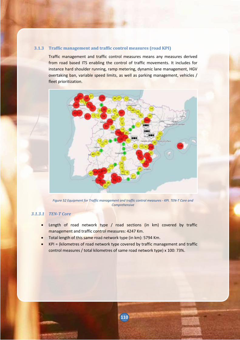
110
3.1.3 Traffic management and traffic control measures (road KPI)
Traffic management and traffic control measures means any measures derived
from road based ITS enabling the control of traffic movements. It includes for
instance hard shoulder running, ramp metering, dynamic lane management, HGV
overtaking ban, variable speed limits, as well as parking management, vehicles /
fleet prioritization.
Figure 52 Equipment for Traffic management and traffic control measures - KPI. TEN-T Core and Comprehensive
3.1.3.1 TEN-T Core
• Length of road network type / road sections (in km) covered by traffic
management and traffic control measures: 4247 Km.
• Total length of this same road network type (in km): 5794 Km.
• KPI = (kilometres of road network type covered by traffic management and traffic
control measures / total kilometres of same road network type) x 100: 73%.

111
3.1.3.2 TEN-T Comprehensive
• Length of road network type / road sections (in km) covered by traffic
management and traffic control measures: 3221Km.
• Total length of this same road network type (in km): 6152 Km.
• KPI = (kilometres of road network type covered by traffic management and traffic
control measures / total kilometres of same road network type) x 100: 52%.
3.1.3.3 Other national roads
• Length of road network type / road sections (in km) covered by traffic
management and traffic control measures: 6814 Km.
• Total length of this same road network type (in km):34337 Km.
• KPI = (kilometres of road network type covered by traffic management and traffic
control measures / total kilometres of same road network type) x 100: 20%.

112
3.1.4 Cooperative-ITS services and
applications (road KPI)
Cooperative-ITS services or
applications means road based ITS
infrastructure enabling services or
applications using infrastructure to
vehicle or vehicle to infrastructure
communication.
3.1.4.1 TEN-T Core
• Length of road network type / road
sections (in km) covered by C-ITS
services or applications: 616 Km.
• Total length of this same road
network type (in km): 5794 Km.
• KPI = (kilometres of road network
type covered by C-ITS services or
applications / total kilometres of
same road network type) x 100: 11%.
3.1.4.2 TEN-T Comprehensive
• Length of road network type / road
sections (in km) covered by C-ITS
services or applications: 174 Km.
• Total length of this same road
network type (in km): 6152 Km.
• KPI = (kilometres of road network
type covered by C-ITS services or
applications / total kilometres of
same road network type) x 100: 3%.
3.1.4.3 Other national roads
• Length of road network type / road
sections (in km) covered by C-ITS
services or applications: 10 Km.
• Total length of this same road
network type (in km): 34337 Km.
• KPI = (kilometres of road
network type covered by C-ITS
services or applications / total
kilometres of same road network
type) x 100: 0%.

113
3.1.5 Real-time traffic information
(road KPI)
Real-time traffic information means
information derived from any road
and traffic data, or their combination
thereof, provided by any road
authorities, road operators or service
providers to road users through usual
communication channels.
Real time traffic information relates
to current traffic conditions on the
road network. Such information
includes for instance accident
locations, incident warnings (incl.
safety related events / conditions),
road works, congestion hotspots,
travel times / delays. Such services
fall within the scope of delegated
Regulations 886/2013 & 962/2015.
3.1.5.1 TEN-T Core
• Length of road network type / road
sections (in km) with provision of
real-time traffic information services:
5794 Km.
• Total length of this same road
network type (in km): 5794 Km.
• KPI = (kilometres of road network
type with provision of real-time
traffic information services / total
kilometres of same road network
type) x 100: 100%.
3.1.5.2 TEN-T Comprehensive
• Length of road network type /
road sections (in km) with
provision of real-time traffic
information services: 6083 Km.
• Total length of this same road
network type (in km): 6152 Km.
• KPI = (kilometres of road
network type with provision of
real-time traffic information
services / total kilometres of
same road network type) x 100:
99%.
3.1.5.3 Other national roads
• Length of road network type /
road sections (in km) with
provision of real-time traffic
information services: 34337 Km.
• Total length of this same road
network type (in km): 34337 Km.
• KPI = (kilometres of road
network type provision of real-
time traffic information services
/ total kilometres of same road
network type) x 100: 100%.

114
3.1.6 Dynamic travel information (multimodal KPI)
Dynamic travel information means up to date information derived from any travel
data provided by any transport operators or service providers through usual
communication channels. Such services fall within the scope of delegated
Regulation on multimodal travel information services currently in preparation.
Dynamic travel information relates to pre-trip and on-trip information to any
travelers. Such information includes for instance disruptions, travel times / delays,
vehicles positioning, accessibility of nodes and vehicles. Any information available
to users should be provided in such a form so that it can be received in full also by
users might have specific requirements related to the data, for example people
with reduced mobility, orientation and/or communication.
Figure 53 Equipment for Dynamic travel information - KPI. TEN-T Core and Comprehensive
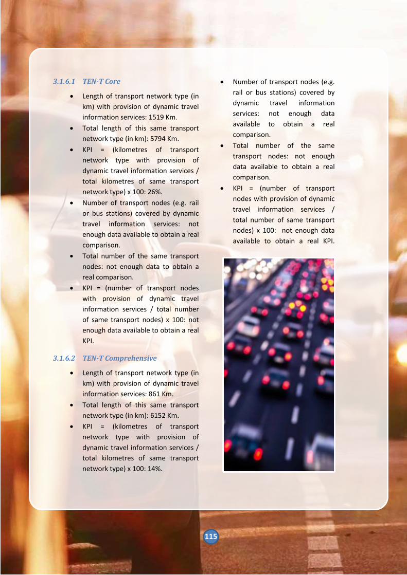
115
3.1.6.1 TEN-T Core
• Length of transport network type (in
km) with provision of dynamic travel
information services: 1519 Km.
• Total length of this same transport
network type (in km): 5794 Km.
• KPI = (kilometres of transport
network type with provision of
dynamic travel information services /
total kilometres of same transport
network type) x 100: 26%.
• Number of transport nodes (e.g. rail
or bus stations) covered by dynamic
travel information services: not
enough data available to obtain a real
comparison.
• Total number of the same transport
nodes: not enough data to obtain a
real comparison.
• KPI = (number of transport nodes
with provision of dynamic travel
information services / total number
of same transport nodes) x 100: not
enough data available to obtain a real
KPI.
3.1.6.2 TEN-T Comprehensive
• Length of transport network type (in
km) with provision of dynamic travel
information services: 861 Km.
• Total length of this same transport
network type (in km): 6152 Km.
• KPI = (kilometres of transport
network type with provision of
dynamic travel information services /
total kilometres of same transport
network type) x 100: 14%.
• Number of transport nodes (e.g.
rail or bus stations) covered by
dynamic travel information
services: not enough data
available to obtain a real
comparison.
• Total number of the same
transport nodes: not enough
data available to obtain a real
comparison.
• KPI = (number of transport
nodes with provision of dynamic
travel information services /
total number of same transport
nodes) x 100: not enough data
available to obtain a real KPI.

116
3.1.6.3 Other national roads
• Length of transport network type (in km) with provision of dynamic travel
information services: 1504 Km.
• Total length of this same transport network type (in km): 34337 Km.
• KPI = (kilometres of transport network type with provision of dynamic travel
information services / total kilometres of same transport network type) x 100: 4%.
• Number of transport nodes (e.g. rail or bus stations) covered by dynamic travel
information services: not enough data available to obtain a real comparison.
• Total number of the same transport nodes: not enough data available to obtain a
real comparison.
• KPI = (number of transport nodes with provision of dynamic travel information
services / total number of same transport nodes) x 100: not enough data
available to obtain a real KPI.

117
3.1.7 Freight information (multimodal
if possible or road KPI)
Freight information means static and
dynamic information tailored to the
needs of the freight industry. Such
information includes for instance
parking / loading availability and cost,
access restrictions, incident warnings
and disruptions, travel times / delays,
vehicles positioning.
3.1.7.1 TEN-T Core
• Length of road network type / road
sections (in km) with provision of
freight information services: 5794
Km.
• Total length of this same road
network type (in km): 5794 Km.
• KPI = (kilometres of road network
type with provision of freight
information services / total
kilometres of same road network
type) x 100: 100%.
• Total number of the same freight
nodes: not enough data available to
obtain a real comparison.
• KPI = (number of freight nodes with
provision of freight information
services / total number of same
freight nodes) x 100: not enough data
available to obtain a real KPI.
3.1.7.2 TEN-T Comprehensive
• Length of road network type / road
sections (in km) with provision of
freight information services: 6152
Km.
• Total length of this same road
network type (in km): 6152 Km.
• KPI = (kilometres of road
network type with provision of
freight information services /
total kilometres of same road
network type) x 100. 100%.
• Number of freight nodes (e.g.
ports, logistics platforms)
covered by freight information
services: not enough data
available to obtain a real
comparison.
• Total number of the same freight
nodes: not enough data available
to obtain a real comparison.
• KPI = (number of freight nodes
with provision of freight
information services / total
number of same freight nodes) x
100: not enough data available
to obtain a real KPI.

118
3.1.7.3 Other national roads
• Length of road network type / road
sections (in km) with provision of
freight information services: 34337
Km.
• Total length of this same road
network type (in km): 34337 Km.
• KPI = (kilometres of road network
type with provision of freight
information services / total
kilometres of same road network
type) x 100: 100%.
• Number of freight nodes (e.g. ports,
logistics platforms) covered by freight
information services: not enough
data available to obtain a real
comparison.
• Total number of the same freight
nodes: not enough data available to
obtain a real comparison.
• KPI = (number of freight nodes with
provision of freight information
services / total number of same
freight nodes) x 100: not enough data
available to obtain a real KPI.
3.1.8 112 eCalls (road KPI)
Automatic and manual 112 eCalls as
defined by EU Legislation.
False calls as defined in COCOM
questionnaire on 112: False calls are
calls which are not followed up with
intervention or assistance from the
PSAP or the emergency services. Calls
that report an emergency event
which has already triggered
intervention or assistance from the
part of the PSAP, therefore not
triggering separate intervention or
assistance, will not be considered
false calls.
N.a. – will be provided through the
COCOM 112 questionnaire.

119
3.2 Benefits KPIs
3.2.1 Change in travel time (road KPI)
% change in peak period travel time
along routes / within areas where ITS
has been implemented or improved.
Peak period means the hour with the
highest traffic flow during a week
day. It is defined for each route / area
individually. An aggregated average
can be calculated for estimation of
consolidated results at road network
level.
Routes / areas where ITS has been
implemented or improved should be
specified. Length along / area within
which the change in travel time is
measured should be long / wide
enough to be representative.
KPI = ((travel time before ITS
implementation or improvement –
travel time after ITS implementation
or improvement) / travel time before
ITS implementation or improvement)
x 100: not enough information
available to obtain a real KPI.
3.2.2 Change in road accident resulting
in death or injuries numbers
(road KPI)
Annually, DGT makes an inventory
with the number of accidents on
national roads. These accidents are
classified according to the route
where they happen and the severity
of the accident.
In addition to this data, accidents are
listed according to the kind of
accident suffered and the personal
characteristics of the victim:
• Personal characteristics:
o Age of the victim
o Gender of the victim
o Pedestrian/Driver/Passenger
• Accident characteristics:
o Province where the accident
happens
o Infringement committed
o Luminosity and atmospheric
factor
o Status and kind of vehicle
involved
o Antiquity of vehícles involved

120
3.2.2.1 Interurban roads
3.2.2.1.1 Accident with victims
• Number of road accident resulting in
death or injuries before ITS
implementation or improvement:
49820.
• Number of road accident resulting in
death or injuries after ITS
implementation or improvement:
34558.
• KPI = ((Number of road accident
resulting in death or injuries before
ITS implementation or improvement
– Number of road accident resulting
in death or injuries after ITS
implementation or improvement) /
number of road accident resulting in
death or injuries before ITS
implementation or improvement) x
100: 30,63%.
3.2.2.1.2 Accident victims
• Number of accidental victims
resulting in death or injuries before
ITS implementation or improvement:
146344.
• Number of accidental victims
resulting in death or injuries after ITS
implementation or improvement:
136144.
• KPI = ((Number of accidental victims
resulting in death or injuries before
ITS implementation or improvement
– Number of accidental victims
resulting in death or injuries after ITS
implementation or improvement) /
Number of accidental victims
resulting in death or injuries before
ITS implementation or improvement)
x 100: 6,97%.
3.2.2.1.3 Fatalities
• Number of fatalities before ITS
implementation or
improvement: 3823.
• Number of fatalities after ITS
implementation or
improvement: 1689.
• KPI = ((Number of fatalities
before ITS implementation or
improvement – Number of
fatalities after ITS
implementation or
improvement) / Number of
fatalities before ITS
implementation or
improvement) x 100: 55,82%.
3.2.2.1.4 Seriously injuries
• Number of seriously injured
before ITS implementation or
improvement: 19295.
• Number of seriously injured
before after ITS implementation
or improvement: 9495.
• KPI = ((Number of seriously
injured before ITS
implementation or improvement
– Number of seriously injured
after ITS implementation or
improvement) / Number of
seriously injured before ITS
implementation or
improvement) x 100: 50,79%.

121
3.2.2.1.5 Minor injuries
• Number of slightly injured before ITS
implementation or improvement:
123226.
• Number of slightly injured before
after ITS implementation or
improvement: 124960.
• KPI = ((Number of slightly injured
before ITS implementation or
improvement – Number of slightly
injured after ITS implementation or
improvement) / Number of slightly
injured before ITS implementation or
improvement) x 100: (-1,41%).
3.2.2.2 Urban roads
3.2.2.2.1 Accident with victims
• Number of road accident resulting in
death or injuries before ITS
implementation or improvement:
50668.
• Number of road accident resulting in
death or injuries after ITS
implementation or improvement:
63918.
• KPI = ((Number of road accident
resulting in death or injuries before
ITS implementation or improvement
– Number of road accident resulting
in death or injuries after ITS
implementation or improvement) /
number of road accident resulting in
death or injuries before ITS
implementation or improvement) x
100: (-24,64%).
3.2.2.2.2 Accident victims
• Number of accidental victims
resulting in death or injuries
before ITS implementation or
improvement: 66474.
• Number of accidental victims
resulting in death or injuries
after ITS implementation or
improvement: 82116.
• KPI = ((Number of accidental
victims resulting in death or
injuries before ITS
implementation or improvement
– Number of accidental victims
resulting in death or injuries
after ITS implementation or
improvement) / Number of
accidental victims resulting in
death or injuries before ITS
implementation or
improvement) x 100: (-23,53%).

122
3.2.2.2.3 Fatalities
• Number of fatalities before ITS
implementation or improvement:
441.
• Number of fatalities after ITS
implementation or improvement:
741.
• KPI = ((Number of fatalities before ITS
implementation or improvement –
Number of fatalities after ITS
implementation or improvement) /
Number of fatalities before ITS
implementation or improvement) x
100: 40,49%.
3.2.2.2.4 Seriously injured
• Number of seriously injured before
ITS implementation or improvement:
6094.
• Number of seriously injured before
after ITS implementation or
improvement: 4751.
• KPI = ((Number of seriously injured
before ITS implementation or
improvement – Number of seriously
injured after ITS implementation or
improvement) / Number of seriously
injured before ITS implementation or
improvement) x 100: 22,04%.
3.2.2.2.5 Slightly injured
• Number of slightly injured before ITS
implementation or improvement:
59639.
• Number of slightly injured before
after ITS implementation or
improvement: 76924.
• KPI = ((Number of slightly injured
before ITS implementation or
improvement – Number of
slightly injured after ITS
implementation or
improvement) / Number of
slightly injured before ITS
implementation or
improvement) x 100: (-23,53%).

123
3.2.3 Change in traffic-CO2 emissions
(road KPI)
Traffic CO2 emission means the
amount of CO2 emitted collectively
by road vehicles utilising a route /
circulating within an area. This should
be aggregated up to produce an
annual figure. CO2 emissions are
typically estimated based upon traffic
flows and speeds coupled with
assumptions regarding fuel
consumption and/or average vehicle
efficiency per kilometre for the
different vehicle types using a route /
circulating within an area.
Routes / areas where ITS has been
implemented or improved should be
specified. Length along / area within
which the change in CO2 emissions is
calculated should be long / wide
enough to be representative.
KPI = ((traffic CO2 emissions before
ITS implementation or improvement
– traffic CO2 emissions after
implementation or improvement) /
traffic CO2 emissions before ITS
implementation or improvement) x
100: not enough data available to
obtain a real KPI.

124
3.3 Financial KPIs
ITS includes any types of systems and services altogether.
• Annual investment in road ITS: 8,60 M€.
• Annual operating & maintenance costs of road ITS (in euros per kilometre of
network covered):
o Annual cost: 60,00 M€
o Total kilometres network: 15000 km
o KPI = 4000 €/km

125
4 References
- DIRECTIVE 2010/40/EU OF THE
EUROPEAN PARLIAMENT AND OF THE
COUNCIL of 7th July 2010 on the
framework for the deployment of
Intelligent Transport Systems in the field
of road transport and for interfaces with
other modes of transport
- Commission Delegated Regulation (EU)
No 962/2015 supplementing Directive
2010/40/EU of the European Parliament
and of the Council with regard to the
provision of EU-wide real-time traffic
information services
- Commission Delegated Regulation (EU)
No 886/2013 supplementing Directive
2010/40/EU of the European Parliament
and of the Council with regard to data
and procedures for the provision, where
possible, of road safety-related minimum
universal traffic information free of
charge to users
- Commission Delegated Regulation (EU)
No 305/2013 supplementing Directive
2010/40/EU of the European Parliament
and of the Council with regard to the
harmonised provision for an
interoperable EU-wide eCall
- Commission Delegated Regulation (EU)
No 885/2013 supplementing Directive
2010/40/EU of the European Parliament
and of the Council with regard to the
provision of information services for safe
and secure parking places for trucks and
commercial vehicles
- ROYAL DECREE 662/2012 of April 13th,
establishing the framework for
deployment of Intelligent Transport
Systems in the field of road transport and
for interfaces with other modes of
transportation
- ROYAL DECREE 362/2017, of April 8th,
which develops the basic organic
structure of the Ministry Public Works
and Transport
- ROYAL DECREE 400/2012, of February
17th, which develops the basic organic
structure of the Ministry of the Interior
- Spanish Road Safety Strategy 2011-
2020. General Directorate of Traffic.
Ministry of the Interior
- Infrastructure, Transport and Housing
Plan 2012 – 2024. Ministry of Public
Works and Transport
- National Plan for Air Quality and
Protection of the Atmosphere 2013 –
2016. Ministry of Agriculture, Food and
Environment
- Measurement protocol during high
nitrogen dioxide concentration
episodes. Madrid City Council
- Report on ITS Action Plan 2012-2024.
Ministry of Public Works and Transport
- Paso del estrecho Special Operation
Report 2016. General Directorate of
Traffic. Ministry of the Interior
- Resolution of April 13th, of General
Directorate of Traffic, which establishes
special traffic regulation measures
during 2016
- LINCE - User Manual. General Sub-
Directorate of Mobility. General
Directorate of Traffic. Ministry of the
Interior
- LINCE – Winter Road Dashboard User
Manual. General Sub-Directorate of
Mobility. General Directorate of Traffic.
Ministry of the Interior
- LINCE - Winter Road Conditions –
Events model. General Sub-Directorate
of Mobility. General Directorate of
Traffic. Ministry of the Interior

126
- IGLU - User Manual. General Sub-
Directorate of Mobility. General
Directorate of Traffic. Ministry of the
Interior
- TRAZA - User Manual. General Sub-
Directorate of Mobility. General
Directorate of Traffic. Ministry of the
Interior
- Report on the state of implementation of
the Decision Nº 585/2014/UE of the
European Parliament and of the Council
of 15th May 2014 on the deployment of
the interoperable EU-wide eCall service.
- General Directorate of Traffic. Ministry of
the Interior
- Deployment of eCall system in Spain,
2017. General Directorate of Traffic.
Ministry of the Interior
- Connected vehicle Platform (DGT 3.0).
General Sub-Directorate of Mobility.
General Directorate of Traffic. Ministry of
the Interior
- SCOOP@F PART 2 Information sheet.
European Commission
- AUTOCITS Information sheet. European
Commission
- CONCORDA. General description of the
global project including needs, objectives
and financial information. European
Automotive Telecom Alliance (EATA)
- Operación Paso del Estrecho (OPE) 2016 -
General Directorate of Traffic - Ministry
of the Interior
- NAP implementation in Spain. General
Sub-Directorate of Mobility. General
Directorate of Traffic. Ministry of the
Interior
Web pages
- http://nap.dgt.es/
- http://mapamovilidad.dgt.es/
- http://meteoruta.aemet.es/
- http://infocar.dgt.es/etraffic/
- https://eip.its-platform.eu/
- http://ctag.com/espanol-uso-del-
corredor-inteligente-siscoga-en-
proyecto-europeos/
- https://www.c-roads.eu/platform.html
- http://www.datex2.eu/
- http://arcatlantique.its-platform.eu/
- https://medtis.its-platform.eu/
- https://ec.europa.eu/transport/themes/i
nfrastructure/ten-t-guidelines/maps_en
