directions in modeling land registration and cadastre · pdf filedirections in modeling land...
TRANSCRIPT

Directions in modeling Land Registration and Cadastre Domain
Aspects of EULIS glossary approach, semantics and information services
Joint ‘FIG Commission 7’ and ‘COST Action G9’ Workshop on Standardization in the Cadastral Domain Bamberg, Germany - 9 December 2004
Esa Tiainen, National Land Survey of Finland [email protected]

Contents of presentation
EULIS Resultsu Framework and method in terminology standardization of
property rights, experiences
n Harmonization and standardization
n Ontology approaches
n Quality assurance
n Modeling processu Evaluation

“…the legal aspects make up the 5th dimension in the cadastral domain”
« ”The thesis that an analysis of property rights is essential to an adequate analysis of the state is a mainstay of political philosophy.”
« “The economy of many countries suffers, for example, due to the fact that those countries espouse property systems in which some basic ontological, geographical or cognitive aspect is flawed in such a way as to make an intelligible and efficient method of land registration impossible.”
Barry Smith, Department of Philosophy, Center for Cognitive Science and NCGIA, SUNY at Buffalo (NY), USA &Leo Zaibert, Department of Philosophy, University of Wisconsin-Parkside, USA,“The Metaphysics of Real Estate” (pp. 1,8)

Pre-standardization--- Process-based approach with uniform diagram descriptions - legal effects included
Action Conveyance / deed of sale
Application for a title or mortgage
Registration of a title or mortgage
Land survey
Client action
Notary public informs the sale to SO (Survey
Office)
Authority activities
Legal effects
Registration
Register activities
X X X X
Land transaction and registration process – Finland
Deed of sale attested by a notary public
SO gives the conveyed land area an ID and
enters it in cadastre
Apply for a title within six months from the
date of deed of sale and property transfer tax
paid in sale
DC (District Court) registers the application
The next weekday from the first entry the
conveyance is deemed public knowledge as regards mortgages.
The mortgage has priority over later
applications from the day it was applied.
The registered title owner in good faith has guarantee against claims. In case of errors the customer gets compensation from the
state.
DC registers the new title or
mortgage and informs Survey
Office
SO makes land survey and
registration in cadastre
Transfer of title by DC to a new
register unit
Enforcement of servitudes
and other rights
established in land survey
Establishment of easements and rights on
land
Transfer of part can be mortgaged
(pending)
Action Conveyance -deed of sale
Application for a title Application for a mortgage
Client action
Stamp Duty Land Tax must be paid before registration.
Authority activities
Legal effects
Registration
Register activities
X X X
Land transaction and registration process – England and Wales
Application entered on daylist; new proprietor entered on register.
Application must be made within two months of conveyance or mortgage if land is unregistered, otherwise no time limit.
New title number allocated. Application entered on daylist. Register prepared.
Registration vests title in the proprietor. State
guarantees title.
Grant of first legal mortgage against unregistered land induces first registration (of title).
Legal representatives make enquiries and ‘Searches’, prepare contract and deed of
sale.
Registration vests title in the proprietor. State
guarantees title.
Application entered on daylist. Mortgage entered on the register.
Mortgage must be completed by
registration which vests title in the mortgagee. State guarantees title.
Title mapped.
Mapping of title (Land survey)
Action Conveyance -deed of sale
Application for a mortgage or easement
Registration of a mortgage or easement
Land survey in subdivision
Client action
Notary investigates that the seller is the
registered owner
Authority activities
Legal effects
Registration
Register activities
X X X
Land transaction and registration process – The Netherlands
The sale contract authenticated by a
notarial deed
The registrar sends a proof of receipt (the
notary can transfer the remittance)
Survey Office makes land survey and registration in
cadastre
The ownership is acquired A new legal parcel created
The contract authenticated by a
notarial deed
The registrar verifies the formalities; sends a proof of registration
to the notary
Ownership also by entrance of a notarial deed or
declaration of acquisitive prescription by reason of
lapse of time
Notary investigates that the assignor is the
registered owner
The registrar sends a proof of receipt (the
notary can transfer the remittance)
The registrar verifies the formalities; sends a proof of registration
to the notary
Mortgage or easement is established and effective upon registration of the
notarial deed. Older registration has priority
to a new one.
Property and cadastre information modeling method
Metamodel level –Identifying basic similarities to define the common (domain generic) definitions
Conceptual level – Recognizing the differences - country specific features -versus common definitions

Metamodel - framework for finding similarities
Approach:Land transactions and registration process
n Uniform process diagram – dynamic view:§ Identical phases§ Authorities / other parties involved (public/private)§ Essential (temporal) stages and legal effects
n Conformity of legal effects:§ Priorities and rights gained through registration§ Which property can be mortgaged and when (whether
registration be required for property objects)§ Public knowledge - security against third parties§ State guarantee; responsibility of register authorities to
compensate for losses incurred - trustworthiness
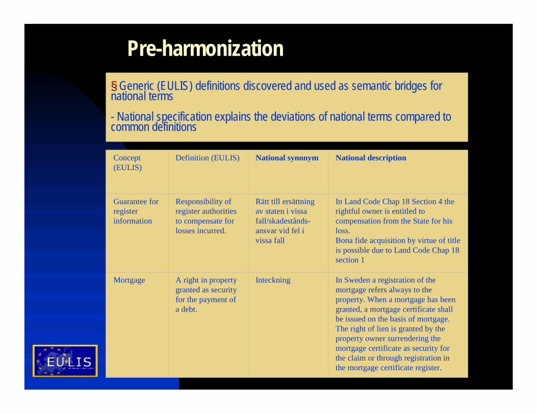
Pre-harmonization§ Generic (EULIS) definitions discovered and used as semantic bridges for national terms- National specification explains the deviations of national terms compared to common definitions
Concept (EULIS)
Definition (EULIS) National synonym National description
Guarantee for register information
Responsibility of register authorities to compensate for losses incurred.
Rätt till ersättning av staten i vissa fall/skadestånds-ansvar vid fel i vissa fall
In Land Code Chap 18 Section 4 the rightful owner is entitled to compensation from the State for his loss. Bona fide acquisition by virtue of title is possible due to Land Code Chap 18 section 1
Mortgage A right in property granted as security for the payment of a debt.
Inteckning In Sweden a registration of the mortgage refers always to the property. When a mortgage has been granted, a mortgage certificate shall be issued on the basis of mortgage. The right of lien is granted by the property owner surrendering the mortgage certificate as security for the claim or through registration in the mortgage certificate register.

Method for specifying differences
n From similarities to “semantic bridges”
u Similarities of different implementations identified to semantically harmonic and common concepts
Also u Level of semantic integration recognizedu Description of property right transactions made in an
objective wayu Semantic translations of national legislation for generic
concepts and definitions produced
>> A roadmap to universal glossary?

Contents of EULIS Glossary
EULIS Glossary consists so far about 50 terms and their definitions as well as national descriptions concerning issues like
§Real property and register units, and their identifiers§Land survey acts and reallotments§State guarantee for register information§Different qualities of ownership or title§Restrictions of possession or ownership§Unregistered interests§Routines in conveyance§Routines in mortgaging

Problems and information gaps
n Conceptual view inadequate – insufficient analysis
n Difficult to recognize the differences?n Short of consistencyn Deficiency of comparative viewn Difficult to update?

Tasks for terminology standardization
n Including a semantic model through conceptualization (analysis and iteration circles)
n Defining the actual level of harmonization in legislation
n Multipurpose (-use) cadastre -view

Stepwise standardization-harmonizationINSPIRE steps
“The fourth and last step will build upon the previous steps and concentrate on completing the common models and on providing the services to fully integrate data from various sources and various levels…”(http://inspire.jrc.it/)
§ Cadastral Domain Model, INSPIRE and EULIS… Need of continuity ... Implying:
§ The cadastral development …incremental in societies. Swift changes are not possible because of legal, structural, financial, information service and other reasons.
§…harmonization needs to be of technical nature in the initial stage
§ Interoperability is achieved by explicitly considering contextual knowledge in the (translation) process of data exchange
§Hence need for semantic translators and ontology approaches emerge

Semantic translators and interoperability
The three possible ways for using ontology for content explication (Visser, Stuckenschmidt, Schlieder, Wache and Timm 2002 p.2 or Stuckenschmidt, Harmelen 2004)
Simple features as semantic elements(Visser, Stuckenschmidt, Schuster & Vögele 2002)
Ø Correct initialization needed !

OGC semantic modeling approachn The approach of OGC is useful in (high-level) semantic
standardization in specifying how to handle different user views
n It is using concepts (notions) of information communities, project worlds and sub-worlds, where integrity is achieved by testing (the unambiguity of) properties or property/value pairs
Definition: Let S1 and S2 be two Project Worlds in A. Let S2* be the Project World obtained by extending the physical extent of Project S2 (if necessary) until it covers the extent of Project S1. We say S1 is a subworld of S2 if there are three functions, R1, R2, and R3, that behave as follows:
i. R1 is a one-to-one change-of-spatial-reference from the reference system of S1 to that of S2*
ii. R2 is a mapping from the feature instances of S1 into those of S2* such that F is a feature of S1 occupying a point P if and only if R2(F) is a feature of S2* occupying R1(P),
iii. R3 is a mapping from the set of property/value pairs of all features in S1 into the set of property/value pairs of all features of S2* that preserves semantics, and is canonical with R2.

Quality labeling of informationn A challenging task is to identify specific user views as
universal standards (through necessary user surveys)
n Properties and property values also reflect quality if the semantic explication displays objectivity adequately, so It is possible to measure the quality against user needs
n The examples in table offer only a hint of the possibilities of using property/property value categories for evaluation:
Concept
Property/value Concept Property/value
Mortgage - No mortgages - Transferable - Priority / 1…n - …
Owner - Not yet registered (buyer) - Registered titleholder - Reg. cad. unit owner / not yet titled, title transferred... - (Registered leasehold / temporal extend of lease, classification for other extend of lease) - …
Parcel (Register unit)
- Not yet registered (transfer of part) - Titled, not yet registered as cadastral unit - Cadastral unit with valid title / not yet valid title / title transferred… - (Registered leasehold unit) - With other holding rights…
Boundary type - General boundaries - Boundary marks fixed, coordi-nate approximation / ISO classi-fication for positional accuracy estimation - Coordinate fixed / ISO classifi-cation for positional accuracy estimation - …

Quality labeling of servicesn Another stage of quality labeling might be giving quality
labels for cadastral information services based on the predefined standard views of different user communities or user segments
n In this manner the user would be able to determine immediately if a certain logical set of information is available online, through data transfer or some other way
n The table below shows an extract of such a predefined standard view:
Parcel (Register unit)
- Titled, not yet registered as cadastral unit, or - Cadastral unit with valid title, or - (Registered leasehold unit)
Mortgage - No mortgages, or - Transferable mortgages

Roadmap to semantic harmonization; steps 1-3…
1. Semantic pre-standardizationn A high-level semantic pre-standardization view shall be developed and
agreed upon and on sufficiently high objectivity level (meta-model level). The level of objectivity can be improved by high-level description of services or the very technology processes.
2. Semantic pre-harmonizationn This step is to compile a shared and harmonized vocabulary (respectively
the EULIS Glossary as a simple example). This step provides the basis for universal modeling and explication and may result in the standardization or (semantic) harmonization of data.
3. Semantic translation process§ Annotation of information sourcesw Annotation means here that the conceptual space or hierarchy of an information source is extracted and each concept is described and analyzed, even on property/value level.An annotation tool applicable with different repositories of vocabularies according to different domains of interest is needed.Step 3 to continue...

Roadmap to semantic harmonization, steps 3… - 6
Step 3...continue§ Semantic translation of information entities w The new concept term describing the type of an information entity in the target information source is determined automatically by a classifier that uses ontology of source and target structures as classification knowledge. In this way ontology may be used as a surrogate for information sources.
4. Quality labeling for cadastral information (Standardization stage) n This step implies explication for classification of data quality with labels by
properties or property values adapting the OGC semantic modelingapproach. User surveys for evaluation are valuable.
5. Quality labeling for information servicesn Quality labeling for information services is made based on standard views
of different user communities or segments and multi-purpose cadastre. User participation and (reusable) surveys for evaluation may be added.
6. Conceptual integration – Harmonization stage§ Conceptual integration methods can be used for harmonization
and to enhance steps 4 and 5, and the results of all previous steps.

Modeling inter-discipline domain
REAL WORLD
INFORMATION CONCEPTUAL
MODEL
DATA
MODEL
• Information contents often predefined and application specific
• Concepts and terms used are often predefined

Modeling cross-discipline domains
REAL WORLD
INFORMATION
(CONCEPTION)
CONCEPTUAL
MODEL(s)
CONCEPTUAL SCHEMA /
DATA MODEL
Pre-standardization
Pre-harmonization
Evaluate and standardize by
• Quality labeling
Harmonize by
• Service labeling
ØModeling steps introduced

Modeling cross-discipline domains
REAL WORLD
INFORMATION
(CONCEPTION)
CONCEPTUAL
MODEL(s)
CONCEPTUAL SCHEMA /
DATA MODEL
Pre-standardization
Pre-harmonization
Using high-level models: • Services
• Functions
Base on• User needs
Base on• Generic view(s)
Using: • Semantic identification and bridging
• Terminology methods
Evaluate and standardize by
• Quality labeling
Harmonize by
• Service labeling
ØModeling methods introduced
Using user surveys

Modeling cross-discipline domains
REAL WORLD
INFORMATION
(CONCEPTION)
CONCEPTUAL
MODEL(s)
CONCEPTUAL SCHEMA /
DATA MODEL
Pre-standardization
Pre-harmonization
Conceptual integration
Using high-level models: • Services
• Functions
Standardize by§Modeling
Base on• User needs
Base on• Generic view(s)
Using: • Semantic identification and bridging
• Terminology methods
Using: • UML, Quality labeling of features / properties (OGC app..)
•Ontology methods
Conceptual integration & User surveys for
• Service labeling
• Quality labeling
Harmonize and evaluate using:

Contextual framework
n The product is service – including the semantics of multiuse cadastre
n Possibility and necessity to base on real world and essential user needs
n Widen the scope to cross-discipline domain
n Better transparency and trustworthinessØ Harmonization implies conceptual integration

Ontology or metaphysics of modern cadastre
« ”European” institution in modern times
« Originates to Egypt, China (?) in their golden era« From fiscal background to support permanency of property rights and
economical growth / decline« Supporting stability in societies « Economical integration in Europe / globalization implies better
transparency of property rights
« Task for standardization consequently
• Legal dimension constitutes the profound context of a cadastre – registration carries the legislation
• Make this dimension a visible and comprehensible, easy-to-understand part in the information community & domain model – national systems might feel like one system
• User needs represent the real world – tool for evaluation!
