digital twin finland
TRANSCRIPT

© Etteplan Group
e-mail: [email protected] www.etteplan.com
BUSINESS
FINLAND
DIGITAL TWIN FINLAND
Project proposal for HX
industrial participa-
tion
PRE-STUDY
Author: Sitowise – Kari Tuukkanen, Jukka Erkkilä
Date: 18.12.2019
PRE-STUDY 18.12.2019
2 (28)
VERSION MANAGEMENT
Version Checked Approved Date Change history
1.0 JEr MLe 18.12.2019 Document created
1.1 JEr MLe 18.12.2019 Revised
Appendicies
Item Number of pages

PRE-STUDY 18.12.2019
3 (28)
Table of Contents
ACRONYMS AND ABBREVIATIONS ........................................................................ 5
1 INTRODUCTION ................................................................................................. 6
1.1 HX industrial participation (HXIP) .................................................................. 6
1.2 HX system needs .......................................................................................... 6
1.2.1 Minimum requirement ............................................................................... 6
1.2.2 Common requirements of different defence branches .............................. 7
1.3 Need for joint situational awareness by Finnish security authorities .............. 7
1.4 Methodology and purpose of this pre-study ................................................... 8
2 SOLUTION PROPOSED ................................................................................... 10
2.1 The concept of Digital Twin ......................................................................... 10
2.1.1 Background ............................................................................................ 10
2.1.2 Static and dynamic information .............................................................. 10
2.2 The globally leading Finnish expertise ......................................................... 10
2.2.1 Digital twin concept developed in urban development ............................ 11
2.2.2 Earth observation capabilities ................................................................. 12
2.3 Global standardization of real-world modeling ............................................. 12
2.4 Target .......................................................................................................... 13
2.4.1 Business vision ....................................................................................... 13
2.4.2 Process flow ........................................................................................... 13
3 CONSORTIUM MEMBERS AND ROLES ......................................................... 14
3.1 Coordinator / prime ...................................................................................... 14
3.2 The triple helix model .................................................................................. 14
3.3 Source data providers.................................................................................. 14
3.3.1 National level data .................................................................................. 15
3.3.2 Public and non-public data ..................................................................... 15
3.3.3 City level data ......................................................................................... 16
3.4 Solution providers for data aggregation and management .......................... 16
3.5 Solution providers for complementary data capture .................................... 17
3.6 Data managers and distributors ................................................................... 18
3.7 Users of the data ......................................................................................... 18
3.7.1 Command and control (C2) system providers ........................................ 18
3.7.2 HX system, including fighter cockpit ....................................................... 19
PRE-STUDY 18.12.2019
4 (28)
3.7.3 Simulator and training system providers ................................................ 19
3.7.4 Other use cases ..................................................................................... 20
3.8 Research institutes ...................................................................................... 20
3.8.1 VTT ........................................................................................................ 20
3.8.2 The Finnish Geospatial Research Institute (FGI) ................................... 21
3.8.3 Aalto University, Department of Built Environment, Geoinformatics ....... 21
3.8.4 Other research institutes ........................................................................ 22
3.9 The Finnish Defence Forces ........................................................................ 22
3.9.1 Processes ............................................................................................... 22
3.9.2 Links to other governmental authorities .................................................. 22
3.9.3 Data security .......................................................................................... 23
3.10 OEM ............................................................................................................ 23
4 BENEFITS ......................................................................................................... 23
4.1 For the Finnish Defense Forces .................................................................. 23
4.2 For the Finnish society................................................................................. 24
4.3 For Finnish companies ................................................................................ 24
4.3.1 Generic benefits of HXIP ........................................................................ 24
4.3.2 Concrete opportunities identified by the companies ............................... 24
4.4 For Finnish research institutes ..................................................................... 25
4.5 For the OEM and its partners ...................................................................... 25
5 INITIAL BUSINESS PLAN ................................................................................. 26
5.1 Business targets .......................................................................................... 26
5.2 Action points 2020 ....................................................................................... 26
SITOWISE IN SHORT .............................................................................................. 27
BIBLIOGRAPHY ...................................................................................................... 28
PRE-STUDY 18.12.2019
5 (28)
ACRONYMS AND ABBREVIATIONS
AFDA Association of Finnish Defence and Aerospace Industries (PIA in Finnish)
BF Business Finland
BIM Building Information Modeling.
bSI buildingSMART International, a global authority driving the digital transformation of the built asset environment.
C2 Command and control system
CoE-LaSR The Centre of Excellence in Laser Scanning Research under FGI/NLS
ESA European Space Agency
ETL Extract, transform, load
FDF The Finnish Defence Forces
FGI The Finnish Geospatial Research Institute (FGI), part of the Na-tional Land Survey Finland
FLIC The Finnish Location Information Cluster, a cluster of Finnish companies in GEO-ICT business.
FTIA The Finnish Transport Infrastructure Agency
GIS Geographic Information System.
HXIP HX industrial participation
HX-OEM The HX fighter bidders (OEM, Original Equipment Manufacturer) Boeing, BAES, Dassault, Lockheed Martin and Saab
IFC The Industry Foundation Classes (IFC) data model is intended to describe architectural, building and construction industry data. It is a platform neutral, open file format specification that is not con-trolled by a single vendor or group of vendors
LOD level of detail (0-4), determining the detail level of a 3d spatial da-taset
LVC Live Virtual Construct solutions
NLS The National Land Survey
OEM Original Equipment Manufacturer
OGC Open Geospatial Consortium, an international consortium creat-ing standards for geospatial community.
PTAL Geospatial Platform of the National Land Survey (Paikkatietoal-usta in Finnish)
SDI Spatial Data Infrastructure: a data infrastructure implementing a framework of geographic data, metadata, users and tools that are interactively connected in order to use spatial data in an efficient and flexible way
Traficom The Finnish Transport and Communications Agency
VTT VTT Technical Research Centre of Finland Ltd
VR Virtual reality
WCS
Web Coverage Service, defines Web-based retrieval of digital ge-ospatial information representing space/time-varying phenomena.
WFS Web Feature Service interface
WMS Web Map Service

PRE-STUDY 18.12.2019
6 (28)
1 INTRODUCTION
1.1 HX industrial participation (HXIP)
Finland will replace its Hornet fighters by 2030. The bidding process for the pro-curement is now ongoing. The procurement includes an obligation for industrial participation: the winning bidder and its partners will cooperate with Finnish companies, with the value of the participation being 30 percent of the purchase price.
Successful participation in HXIP can result into growth of competence, net-works and technological capability of the Finnish defense, safety and ICT in-dustries.
The industrial participation in the HX fighter program is open to Finnish compa-nies and research organizations. The participation projects must involve tech-nologies that are critical to national safety or related to strategic industrial know-how
The HX fighter bidders (OEM, Original Equipment Manufacturer) include Boe-ing, BAES, Dassault, Lockheed Martin and Saab. Finnish participants can pro-pose their projects to all these companies, their partners or only to the parties of the Finnish participant's choosing.
Finland is committed to open, equal and non-discriminatory bidding process. The industrial participation solutions offered to Finland will be evaluated care-fully and equally in the course of the procurement process
Business Finland (BF) has appointed a HXIP team, led by Markku Lehikoinen, for activating and coordinating the Finnish companies and research organiza-tions in formulating relevant project proposals for the HXIP.
This document describes one concrete project proposal for the HXIP.
Further information about HXIP can be found in the document Industrial partici-pation in defence procurements by the Finnish Ministry of Defence (see Bibliog-raphy i), and in Business Finland website https://www.businessfinland.fi/en/for-finnish-customers/services/programs/hx-fighter-program/.
1.2 HX system needs
1.2.1 Minimum requirement
The acquired fighter system in any case will need 3D map material from Fin-land and the surrounding areas. For training, simulation and operation planning purposes, this kind of modern, standardized 3D representation of the terrain and infrastructure is a necessity. There must also be a process for updating the material, enriching it from specific areas of interest, and for expanding the geo-graphical coverage of it.

PRE-STUDY 18.12.2019
7 (28)
1.2.2 Common requirements of different defence branches
On the other hand, the “Preliminary Assessment for Replacing the Capabilities of the Hornet Fleet” ii(2015) emphasizes “the use of common standardized in-formation systems and communication services for the defense branches” and, more generally, the use of a common knowledge base for snapshots.
Furthermore, the “Preliminary Assessment for Replacing the Capabilities of the Hornet Fleet” (see Bibliography iii) says e.g. the following: “…the availability of information has been significantly improved by moving to common standard-ized information systems and data communication services of the defense branches . This allows for efficient and mutually supportive use of the systems of different branches of defense, creating the conditions for increasing the pace of operations .”
ivThis is in favor of creating the 3D map of Finland and neighboring areas uni-versal and compatible with other branches of defense and other safety & secu-rity authorities.
1.3 Need for joint situational awareness by Finnish
security authorities
In the meetings with multiple key officers of FDF and the Finnish Ministry of In-ternal Affairs, it has become clear that there is a need to create and maintain a Digital Twin of the physical world to be used as a foundation for joint multi do-main (land, sea, air, police, fire & rescue, etc.) situational awareness.
The need for creating a common spatial data platform for security authori-ties is strongly written in the “Report on spatial data policyv” published by the Ministry of Agriculture and Forestry in 2018.The report has been approved in the Finnish Parliament in November 2018. The vision of the report is: Finland
Figure 1-1: A vision of a joint operational picture for all defence branches. Source: FDF, Ruotuväki magazine 4/2018 (See Bibliography)
PRE-STUDY 18.12.2019
8 (28)
has the most innovative and secure spatial data ecosystem in the world. The aim of the report is to oblige all actors in the public sector to see to the interop-erability of spatial data and access to it in a way that they can be used by the public authorities and companies as efficiently as possible. At the same time a high standard of information security and personal data protection must be en-sured. The report describes a natural shift from maps towards a joint 3d repre-sentation of the world.
1.4 Methodology and purpose of this pre-study
This pre-study has been prepared in 2019 as a joint effort of a large number of companies, authorities and research institutes, which together form a Finnish business-driven ecosystem that has co-operated already for decades in creat-ing the national and municipal spatial data infrastructures (SDI), geospatial so-lutions for multiple business vertical including planning & construction, forestry, defence and fire & rescue.
Information for this pre-study has been collected in a series of meetings and workshops with selected key stakeholders and potential members of the sug-gested ecosystem. The following meetings, discussions and workshops have been held:
• The Finnish Defence Forces:
− meetings with multiple branches and key stakeholders including the CDO of the Defence Command and the Head of the Topographic Service.
• Ministry of Interior:
− Director General of Rescue: 30/09/2019
• National Land Survey of Finland:
− Director General, 03/12/2019
− Head of the Finnish Geospatial Research Institute (FGI), 10/12/2019
− Project Director of the Geospatial Platform Project, 26/11/2019
• The City of Helsinki:
− Chief of ICT development at the Division of Urban Environment until 9/2019
• The companies:
− Finnish Location Information Cluster (FLIC) workshop with 8 compa-nies: 26/11/2019. The aim of the workshop was to discuss the Digital Twin Finland initiative for HXIP, focusing in the role of FLIC member companies. These companies participated: Sitowise (https://www.sitowise.com/en), Spatineo (https://www.spatineo.com/), Terratec Finland (https://www.terratec.fi/), Karttakeskus / Tapio (https://tapio.fi/briefly-in-english/), CGI Finland (https://www.cgi.fi/fi), Gispo (https://www.gispo.fi/en/home/), Geotrim (https://geotrim.fi) and Mitta (https://www.mitta.fi/en/home/). All 8 companies expressed high motivation and intent to participate in the proposal.
− Insta DefSec Oy: 25/09/2019
PRE-STUDY 18.12.2019
9 (28)
− Other individual companies: Fleetonomy 27/11/2019, Varjo 9/12/2019, Iceye: 12/12/2019, Inplace Systems (multiple dates).
• Research institutes:
− VTT, 13/12/2019
− FGI, 10/12/2019
In addition to bilateral meetings, information has been gathered from websites and other written materials.
The purpose of this pre-study is to outline a vision for the concrete project pro-posal that is going to be written in co-operation with the cluster and stakehold-ers in early 2020. The project proposal will combine the Finnish know-how with the expertise of the HX-OEM and result into clear measurable benefits for a) the FDF, b) the Finnish authorities and largely for the whole society, c) the HX-OEM and d) the business ecosystem.
PRE-STUDY 18.12.2019
10 (28)
2 SOLUTION PROPOSED
2.1 The concept of Digital Twin
2.1.1 Background
The concept of Digital Twin has been originally created for mechanical engi-neering and production, but with the rapid development of IoT and ICT in gen-eral it has quickly become a viable vision also in other industries, including ur-ban development and construction.
In his master’s thesisvi “Digital twin – from mechanical engineering to designing smart cities”, Leo Ouni has analyzed how digital twin can be implemented from mechanical engineering and production into GIS environment, urban planning and smart city solutions.
There are many definitions for Digital Twin, including “A dynamic virtual repre-sentation of a physical object or system across its lifecycle, using real-time data to enable understanding, learning and reasoning” by Bolton, McColl-Kennedy, Cheung, Gallen, Orsingher, Witell & Zaki, (2018).vii
The concept of Digital Twin has been recognized as a potential vision also in defence sector, especially in command & control systems, training (including LVC solutions) and in decision support.
2.1.2 Static and dynamic information
When discussing Digital Twin, it is important to understand that there are two categories of information in Digital twin: static and dynamic. Both of these have to be managed in order to achieve the real digital twin of anything.
In this project proposal the goal is to create an automated process that results into a digital twin of the static world: terrain, infrastructure (above ground and underground) and buildings. Weather, road conditions, traffic and locations of vehicles or individuals are dynamic information that must be captured via IoT systems. A combination of static and dynamic results into a digital twin.
2.2 The globally leading Finnish expertise
The Finnish companies and research institutes unquestionably have the world's leading capability to model, manage and share built environment and terrain in a standard and consistent way. The concept of “Digital Twin of the physical en-vironment” has been created by Finnish GIS and BIM centers of excellence and there is a global demand for this expertise in the construction industry and many other business verticals.
PRE-STUDY 18.12.2019
11 (28)
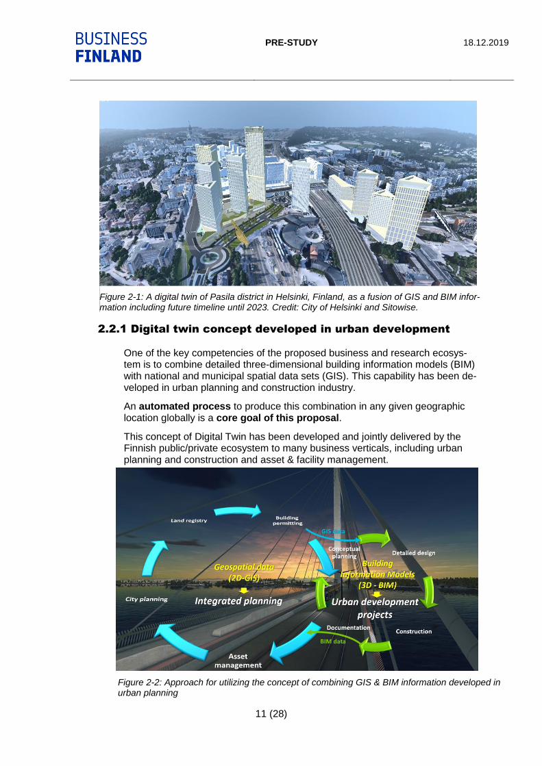
2.2.1 Digital twin concept developed in urban development
One of the key competencies of the proposed business and research ecosys-tem is to combine detailed three-dimensional building information models (BIM) with national and municipal spatial data sets (GIS). This capability has been de-veloped in urban planning and construction industry.
An automated process to produce this combination in any given geographic location globally is a core goal of this proposal.
This concept of Digital Twin has been developed and jointly delivered by the Finnish public/private ecosystem to many business verticals, including urban planning and construction and asset & facility management.
Figure 2-2: Approach for utilizing the concept of combining GIS & BIM information developed in urban planning
Figure 2-1: A digital twin of Pasila district in Helsinki, Finland, as a fusion of GIS and BIM infor-mation including future timeline until 2023. Credit: City of Helsinki and Sitowise.

PRE-STUDY 18.12.2019
12 (28)
The core of the proposed approach is in utilizing data that already exists and enriching it from where data does not exist. On national and city level there are plenty of geospatial GIS datasets that are generated and used in public pro-cesses and GIS systems on national and municipal level. Some of the compa-nies specialized in providing these solutions, and working with geospatial data are Spatineo, Karttakeskus, CGI, Gispo, InPlace and Sitowise, among others.
In processes of urban development (conceptual planning, detailed design and construction) the concept of Building Information Modeling (BIM) is globally used. Majority of all new buildings and infrastructure are planned and con-structed by using BIM data. In other words, there is a lot of detailed, well-struc-tured and growingly standardized 3d data about built environment available, but it is not used for other purposes than planning and construction. Some compa-nies specialized in this include Sitowise, Infrakit, Novatron and Destia.
2.2.2 Earth observation capabilities
In Finland there is a very active network of companies and research institutes that focus in earth observation, space technology, LiDAR and other reality cap-ture technologies. In addition, there is a lot of research and development in ap-plying AI/ML for automated object recognition and modeling. Companies work-ing on this field include ICEYE, Terratec, Mitta and Geotrim.
The Finnish research institutes, e.g. the Finnish Geospatial Research Institute (FGI) are recognized as global thought leaders in modeling or physical environ-ment with LiDAR technology.
VTT is the leading innovation center e.g. for Remote Sensing and Artificial In-telligence based solutions for Earth Observation. With over 2000 researchers, and over 75 years of experience of top-level research and science-based re-sults VTT s part of Finland's innovation system and operates under the man-date of the Ministry of Employment and the Economy.
2.3 Global standardization of real-world modeling
This process of creating Digital Twins of physical environment is based on in-ternational standards for spatial and building data management. There are two important organizations creating these standards: Open Geospatial Consortium (OGC, https://www.opengeospatial.org/) and buildingSMART International (bSI, https://www.buildingsmart.org/). OGC’s standardization focuses in geospatial data (GIS), and bSI in BIM (building information model) data. During the last 2-3 years OGC and bSI have started to specify standards with a holistic ap-proach, aiming at a joint standard for storing and exchanging GIS and BIM in-formation globally. The latest standardization development include extension for the IFC (Industry Foundation Classes) data model.
Figure 2-3: The global organizations leading the way for built environment in-formation standardization

PRE-STUDY 18.12.2019
13 (28)
2.4 Target
2.4.1 Business vision
Short-term (ca. 2021-2023): The ecosystem will supply the Digital Twin Fin-land data and its maintenance process, essential for the use of the new HX system purchased in Finland, as part of HXIP or industrial cooperation, en-riched with the added value of OEM. The end result will be a joint reference data for situational awareness systems of all security authorities, crucial for na-tional security.
The longer-term target (2022-2030) is to export the Digital Twin concept to the global market by integrating it with the portfolio of the HX-OEM. The aim is also to enrich the concept with OEM expertise and products. The target is at least € 1 billion in business for Finnish companies.
2.4.2 Process flow
As shown in Figure 3-3, the process flow can be divided into the following phases:
• Source data provision
• Source data aggregation and management
• Complementary data collection
• Sharing data via interfaces
• Using the data
Figure 2-4: a process flow of the Digital Twin Finland proposal

PRE-STUDY 18.12.2019
14 (28)
Each phase and the consortium in contribution to it is described in the next Chapter 4 “Consortium, stakeholders and their roles”.
3 CONSORTIUM MEMBERS AND ROLES
3.1 Coordinator / prime
The consortium needs a lead company that will work as a prime and/or coordi-nator in all actions related to the project. This company needs to be a partner of the Finnish defense forces. This company should be interested in investing in developing new technology and solutions for modeling of nature and built envi-ronment.
3.2 The triple helix model
The triple helix model of innovation refers to a set of interactions between aca-demia, industry and governments, to foster economic and social develop-mentviii.
In Digital Twin Finland project, this model is a very natural framework, within which the necessary research, business development and role of governmental authorities have a mutual goal: to result into a new concept for the benefit of whole Finnish society and for the HX project and its stakeholders.
Figure 3-1: The triple helix model
3.3 Source data providers
As building blocks for the Digital Twin, the plan is to use all existing public and non-public spatial data that is relevant for security authorities and the HX sys-tem. In Finland much of the spatial data is open and can be accessed on
Digital Twin Finland
Govern-ment
BusinessAcademia

PRE-STUDY 18.12.2019
15 (28)
national and regional level from open interfaces (WCS, WMS, WFS) and geo-portals (file downloads).
3.3.1 National level data
On national level some of the most relevant data providers for this proposal are:
3.3.1.1 The National Land Survey
The National Land Survey (NLS, https://www.maanmittauslaitos.fi/en) manages topographic data from the entire Finland. NLS datasets contain, for example, place names, roads, buildings, waterways, fields, topographic features and ele-vations as well as administrative boundaries.
NLS provides all their data for the benefit of whole society via different chan-nels, re-sellers and platforms.
NLS has expressed interested in participating in the project as provider of the national spatial data, and the digital framework including the open interfaces to access the national spatial data, and the new Geospatial Platform (“Paik-katietoalusta” or PTAL in Finnish). PTAL could act as a national framework in terms of data aggregation from municipalities and other national and regional spatial data providers to a national platform. NLS sees this initiative as the first step towards a joint spatial data platform of Finnish safety & security authori-ties, which was highlighted in the “Report on spatial data policy” by the Ministry of Agriculture and Forestry, as referred to in chapter 2.3.
In addition to spatial data content, NLS can provide national frameworks, guide-lines and standards for data and metadata model and implementation, as well as for data quality control.
3.3.1.2 The Finnish Transport Infrastructure Agency (FTIA)
FTIA (https://vayla.fi/web/en) provides the most comprehensive data about traf-fic networks and their attributes and status, including road, railway and water-way network and infrastructure.
3.3.1.3 The Finnish Transport and Communications Agency
(Traficom)
Traficom, https://www.traficom.fi/en/, is an authority in licence, registration and approval matters. It promotes traffic safety and the smooth functioning of the transport system and ensures that everyone in Finland has access to high-quality and secure communications connections and services. Traficom hosts and further developes a national database of critical infrastructure such as elec-tricity, water and communication networks.
3.3.2 Public and non-public data
Part of required spatial data from Finland and the neighboring countries is pub-lic and available as open data. However, data outside of Finland, and espe-cially data about critical infrastructure is non-public. These non-public data

PRE-STUDY 18.12.2019
16 (28)
should be accesses with separate data sharing agreements with the data own-ers.
Management of non-public data within FDF, and the framework for granting ac-cess to it must be considered and solved during the implementation of this pro-ject.
3.3.3 City level data
Cities host major spatial data assets of the terrain and infrastructure within their territories. For example, cities of Helsinki, Espoo, Vantaa and Tampere publish their 3d city model via open interfaces.
For example, City of Helsinki offers over 600 layers of open spatial data via ge-oportal https://kartta.hel.fi/, including LiDAR data for the city and the City Model as two versions: structured CityGML model and as a triangle mesh model.
3.4 Solution providers for data aggregation and man-
agement
As described in Chapter 3.2, the source spatial data is aggregated into a cen-trally organized spatial database “Digital Twin Finland” with an ETL (extract, transform, load) process.
The “Digital Twin Finland” database will have a data model that is compatible with the national and international standards specified by the Open Geospatial Consortium and buildingSMART International.
This process makes use of all relevant national and municipal frameworks (e.g. Land Survey’s Geospatial Platform, and open data services of the cities).
Figure 3-2: Map service of City of Helsinki, providing 600 open data layers as source data for the Digi-tal Twin

PRE-STUDY 18.12.2019
17 (28)
It is important to emphasize that there is a need to automate this process, to be able to run it with any given frequency.
This part of the process is going to be developed by the companies of the Finn-ish Location Information Cluster (Flic), and some other companies with special-ized capabilities: Sitowise (https://www.sitowise.com/en), Spatineo (https://www.spatineo.com/), Karttakeskus / Tapio (https://tapio.fi/briefly-in-english/), CGI Finland (https://www.cgi.fi/fi), Gispo (https://www.gispo.fi/en/home/), Trimble (https://www.trimble.com/, https://lo-calgov.trimble.com/trimble-locus.html) as well as other member companies of Flic Other potential companies include Fleetonomy (https://fleetonomy.io), with focus in automated creation of digital twins.
The Finnish Location Information Cluster (FLIC)
Finnish Location Information Cluster (https://www.flic.fi/in-english/) is founded in 2013 as a co-operative body for companies in GEO-ICT business. The aim of the cluster is to encourage businesses in the field, to ensure the development of competence, support the internationalization and clarify the roles of the pub-lic and private offering of services. FLIC is a member of the Technology Indus-tries of Finland (Teknologiateollisuus, https://teknologiateollisuus.fi/en/technol-ogy-finland).
3.5 Solution providers for complementary data cap-
ture
With rapid development of earth observation technology including new sensors, LiDAR, SAR, micro-satellites, and drones, it is possible and straightforward to map any area of interest anywhere in the world quickly, reliably, precisely, cost-efficiently and frequently. As the business plan is to ramp up the concept in Fin-land, and then deliver it together with the HX-OEM to other markets globally, this capability is crucial. The Finnish research institutes and companies are forerunners in this domain.
Some key competencies of the Finnish ecosystem include:
• globally leading research in LiDAR applications
• expertise in SAR technologies; hi-resolution and frequent reality capture
• fast, flexible and frequent satellite EO capability
• accurate and detailed satellite SAR data
• ability to automatically detect objects from LiDAR, photogrammetry & SAR
Some of the companies focusing in this domain are:
• ICEYE (https://www.iceye.com/)
• Terratec Finland (https://www.terratec.fi/)
• Geotrim (https://geotrim.fi)
• Mitta (https://www.mitta.fi/en/home/)
• Space Systems Finland (https://www.ssf.fi/)
A strong support for this part of the process is provided by the Finnish research institutes including FGI, VTT, Aalto University and University of Helsinki.

PRE-STUDY 18.12.2019
18 (28)
3.6 Data managers and distributors
Managing access to different data (public, non-public, classified) will have to be solved. Between different stakeholders of FDF and of other security authorities it must be agreed on which organization will host the data and provide access to it. This pre-study does not provide a solution for that challenge, but it must be discussed and agreed on when starting to plan and implement Digital Twin Finland.
Another issued to be discussed and agreed on is where and by which organiza-tion the Digital Twin Finland database will be hosted.
3.7 Users of the data
For each use case, a certain content with a certain level of detail (LOD) is needed. The aim is to have a portal with a web coverage service (WCS) show-ing what kind of data (which LOD level) is available spatially. For example, if there will be a map display in the HX cockpit, LOD0 or LOD1 data will serve the purpose. But it there is a rescue operation in a specific building, LOD4 is needed.
If the required LOD level is not available, there should be a standard operating procedure (SOP) for acquiring one with a given delivery time and cost.
3.7.1 Command and control (C2) system providers
The Finnish defence, aerospace and security industry is represented by AFDA, the Association of Finnish Defence and Aerospace Industries (https://pia.teknologiateollisuus.fi/fi/node/60). AFDA covers almost all the de-fence related industries in Finland with ca. 120 member companies. AFDA has close relations with the Finnish Ministry of Defence and Defence Forces. AFDA is the focal point to defence industries in Finland.
Under AFDA there are many companies providing command & control sys-tems, including Insta (https://www.insta.fi/en/industries/defence), InPlace Sys-tems (https://www.inplace.fi/), Patria and many others.
The Digital Twin Finland project provides consistent base data for new kind of live, virtual and constructive (LVC) simulations, which are provided by Finnish C2 providers such as Insta.
Figure 3-3: Concept of LOD (level of de-tail)

PRE-STUDY 18.12.2019
19 (28)
In addition, there are C2 systems used also in fire, rescue and police opera-tions. These systems can benefit from the same data.
There is strong synergy between Digital Twin Finland cluster/project and a new business cluster for Situational Awareness solutions coordinated and ramped up during 2019 by Business Finland. These two clusters complement each other.
3.7.2 HX system, including fighter cockpit
Obviously for operation planning, operation, navigation, training and simulation purposes, a comprehensive 3d map material is needed. This is one, but not the only one, use case for the Digital Twin Finland solution.
3.7.3 Simulator and training system providers
3.7.3.1 Existing simulator systems
Different branches of FDF have existing simulator environments that would benefit from a systematic content provision system. Some examples of current simulator platforms in FDF are:
• Virtual Battlespace (https://www.bisimulations.com/products/vbs3)
• Saab Ground Combat Indoor Trainer (https://saab.com/land/training-and-simulation/virtual-training/ground-combat-idt/)
In addition, navy, air force and army all have multiple other branch specific sim-ulation systems.
With help of Digital Twin Finland project, all these systems could consume the same, joint source data, which would add to increased cross-domain situa-tional awareness and cost-efficiency.
3.7.3.2 New, revolutionary VR technology providers
Since Finnish companies produce some of the globally most popular games, there is substantial game and virtualization competence in Finland.
For example, Varjo (https://varjo.com/) is a Finnish company that develops hu-man-eye resolution VR and XR products. Varjo creates new kind of immersive computing, where virtual, augmented and physical realities become one.
Another example is Imagesoft (https://imagesoft.fi/), providing high quality mari-time simulation systems.
From the perspective of VR system providers, the Digital Twin Finland initiative offers a solution for automated production of high-resolution virtual models of the physical world, thus providing content VR equipment not only in defence in-dustry but for all other businesses such as urban planning and construction.
PRE-STUDY 18.12.2019
20 (28)
3.7.4 Other use cases
In addition to needs in C2 systems, HX system and in simulation & training ac-tivities, all defence branches (land, sea, air) have other processes and needs where a joint Digital Twin Finland would be a valuable asset
In fire & rescue preparations, planning and operations, there is a natural need for accurate (LOD4) 3d models of buildings. Digital Twin Finland will offer a standard framework for accessing relevant data for these processes, all the way to LOD4.
3.8 Research institutes
As mentioned in chapter 3.2.2., there are world class research institutes that focus in earth observation, space technology, LiDAR and other reality capture technologies. In addition, there is a lot of research in applying AI/ML for auto-mated object recognition and modeling.
Additionally, in the past few years the NewSpace sector has emerged fast and Finland has become one of the leading countries with range of start-ups and growth companies developing innovative space businesses.
Among others, the following institutes do business-driven world-class research:
3.8.1 VTT
3.8.1.1 Capabilities
With over 2000 researchers, VTT (https://www.vttresearch.com/) is the leading innovation center e.g. for Remote Sensing and Artificial Intelligence based solu-tions for Earth Observation.
VTT has been in space business more than 30 years. VTT is a strategic partner for European Space Agency (ESA) to develop e.g. beyond 5G terrestrial and satellite integration.
In November, 2019, VTT announced partnership with Viasat, the leading GEO satellite broadband operator. VTT will develop with Viasat 5G Non-terrestrial and terrestrial integration. Focus is in Norther European markets and Applica-tions like Autonomous Systems and Solutions for the Arctic region.
Two satellites are orbiting currently with VTT’s Hyperspectral payloads. The Reaktor Hello World has the first infrared hyperspectral ever to be flown on a nanosatellite. VTT delivers the World’s smallest commercial advanced hyper-spectral imager enabling, e.g. Earth Observation of mineral compositions, waste & ocean monitoring, agriculture and geology.
VTT also develops Hypersepctral solution to the HERA-mission, i.e. part of the international ‘Asteroid Impact Deflection Assessment’ experiment.

PRE-STUDY 18.12.2019
21 (28)
3.8.1.2 Potential role in the project
• To collaborate with Finland based industrial and advanced technology provid-ers in developing novel AI, analytics, and e.g. next generation Positioning, Navigation and Timing solutions meeting the most demanding needs.
• VTT is leading the 5G & Beyond Non-terrestrial/Terrestrial Pre-Commercial development in Europe, which could be a core technology for Ultra Low La-tency and Standards based Secure Wide Area Networking.
• VTT has advanced sensors, which we could tailor or further develop to meet the sensing needs and specified use cases, e.g. Radars, Hyperspectral Imag-ing.
• Testing and measurements development using VTT’s unique R&D infrastruc-tures and world leading knowhow.
• Connectivity technologies complementing existing solutions could be made commercially available, e.g. Silicon Photonics based 100+Tbit/sec cloud pro-cessing new ICT solutions.
• VTT has been the leading contributor to e.g. LuxTurrim5G, an unique Smart Cities Platform concept, incl. UAVs and Surveillance. The new phase (Neu-tralhost) studies new business models and could be relevant to further de-velop.
VTT is a close partner of FDF.
3.8.2 The Finnish Geospatial Research Institute (FGI)
The Finnish Geospatial Research Institute (FGI, https://www.maanmittauslai-tos.fi/en/research) conducts innovative research and expert work within the field of spatial data. The esteemed international research institute offers reliable information for the benefit of society.
Regarding Digital Twin Finland project, some of the most relevant research do-mains of FGI are:
• Centre of Excellence in Laser Scanning Research (CoE-LaSR, https://la-serscanning.fi/): indisputably one of the world’s leading competence cen-ters that create new knowledge, science, openings and breakthroughs in the emerging field of laser scanning. CoE-LaSR is home of more than 30 Dr.Sc and PhD’s and is funded from Academy of Finland Centres of Ex-cellence programme.
• DroneFinland (https://dronefinland.fi/in-english/): a research and innova-tion center for drone remote sensing.
• Pointcloud (https://pointcloud.fi/in-english/): focuses on the use of 3D measuring technique known as laser scanning, and thereby creates pre-conditions for the growth of the Finnish 3D industry.
FGI is a close partner of FDF.
3.8.3 Aalto University, Department of Built Environment, Geoin-
formatics
The Department of Built Environment is an active research partner of FDF, hav-ing conducted extensive research e.g. about situational awareness and use of geoinformatics in it.

PRE-STUDY 18.12.2019
22 (28)
The research areas of the Geoinformatic group include:
• Geodesy
• Geoinformation technology
• Digital photogrammetry
• Laser scanning and Remote sensing.
More information and reference studies can be found in: https://www.aalto.fi/en/department-of-built-environment/geoinformatics.
3.8.4 Other research institutes
Relevant research for the context of this pre-study is conducted by many other institutes including the University of Helsinki (e.g. spatiotemporal data analyt-ics), and University of Oulu (BIM research).
3.9 The Finnish Defence Forces
3.9.1 Processes
HX project will have impact to multiple branches of FDF. The following is to clarify the roles of some branches and processes of FDF:
• Training and simulation: In the Defence Command there is an existing cross-domain strategy and roadmap for training and simulation systems and processes. In order to maximize the benefits of Digital Twin Finland project, the concrete objectives of it should be aligned with existing roadmap of FDF.
• Command and control in different branches (air force, navy, army, cyber, space): The Defence Command coordinates the C2 development in FDF, and provides a joint service architecture for it. Within the architecture, topo-graphic data is one of the core datasets that is utilized in many processes.
• The Air Force has a key role in operating the HX system. Roles and re-sponsibilities in data management and dissemination must be discussed and agreed on during the implementation of Digital Twin Finland project.
3.9.2 Links to other governmental authorities
To maximize the impact of Digital Twin Finland, link to other governmental au-thorities is crucial. Especially two links are important: 1) Fire & rescue & po-lice & border security & customs: the goal should be a joint solution for all security authorities and 2) the roadmap of National Land Survey as the official producer and aggregator of nationwide spatial data should be closely linked with Digital Twin Finland roadmap, to avoid duplicate investments. As stated in chapter 2.3, the “Report on spatial data policy1” published by the Ministry of Ag-riculture and Forestry and approved by the Finnish Parliament in 2018, calls for governmental co-operation.
PRE-STUDY 18.12.2019
23 (28)
3.9.3 Data security
As the plan is to include both public and non-public data in Digital Twin Finland, it is crucial to have a plan for data governance and security. Security can be an issue for specific source data, or for an algorithm-processed data even when it is built from open data.
Additionally, the non-public data must be transferred via restricted network, which adds to complexity and must be taken into account in planning and im-plementation of Digital Twin Finland.
3.10 OEM
It is expected that the selected original equipment manufacturer (OEM) has val-uable intellectual knowhow they can provide for the project.
The proposed project should be seen as a joint effort to which each party has a contribution. For the context of this project proposal, all five OEM candidates have strong capabilities and resources. For example, software and technolo-gies for “rapid mapping” and earth observation can be seen as added value from the OEM to the project.
In addition, all five OEM candidates have a strong global market position, not only in defence business. This can provide new market opportunities for the Finnish ecosystem globally. Virtual reality and simulation technologies com-bined with the Finnish VR/AR/XR competence could be mutually beneficial.
A more comprehensive benefit analysis should be made during the first quarter of 2020 when this pre-study is developed to a more concrete commercial pro-posal.
4 BENEFITS
It must be emphasized that this is a pre-study, and the benefit analysis at this point is not complete. During the bidding process in 2020 this pre-study and its added value to the consortium and stakeholders must be given a deeper analy-sis. The benefits identified at the pre-study phase can be summarized as fol-lows.
4.1 For the Finnish Defense Forces
Already the preliminary study on the replacement of Hornet fleet performance (2015) says e.g. the following: “…the availability of information has been signifi-cantly improved by moving to common standardized information systems and data communication services of the defense branches. This allows for efficient and mutually supportive use of the systems of different branches of defense, creating the conditions for increasing the pace of operations”.
In other words, the FDF sees this project initiative of high value, and it has been confirmed by multiple key stakeholders of FDF in the discussions related to this pre-study.
PRE-STUDY 18.12.2019
24 (28)
4.2 For the Finnish society
As mentioned in the Introduction chapter, the need for creating a common spatial data platform for security authorities is strongly written in the “Re-port on spatial data policyix” published by the Ministry of Agriculture and For-estry and approved by the Finnish Parliament in 2018. Goals of the Digital Twin Finland project proposed in this pre-study are exactly the same as what the re-port calls for.
In other words: if project Digital Twin Finland will be included in HXIP, it will di-rectly benefit the Finnish security authorities (military, police, fire & rescue, bor-der control etc.) by providing a digital asset that is significant for national secu-rity and would have to be invested in regardless of HXIP contribution.
4.3 For Finnish companies
4.3.1 Generic benefits of HXIP
As stated in Business Finland HXIP websitex, the industrial participation in the HX fighter program will provide Finnish companies and research organizations with new, international business opportunities. In addition, the participation will strengthen the competence and abilities of the selected project partners and Finland in terms of technologies that are critical to national safety.
Among other things, the benefits to the participants may include:
• Long-term, global partnerships and customers
• New markets, licenses and certificates
• Additional competence and training provided by world-class professionals
• Differentiating from the competitors
• Access to latest research
• Software and technologies as technology transfers
• Profiling as industry forerunners to entice more skilled people
4.3.2 Concrete opportunities identified by the companies
• Many governmental authorities need exactly this project, which means busi-ness opportunities largely in the Finnish society. Concretely, this could become “The Spatial Data Infrastructure for Safety & Security Authorities”, as stated in the “Report on spatial data policy1” published by the Ministry of Agriculture and Forestry and approved by the Finnish Parliament in 2018
• The cluster is already tested in other business verticals, it is not only ramped up for HXIP nor only for defence sector. This means there is a cred-ible consortium already in place, which can expand internationally to many business verticals. This growth plan could potentially be speeded up with a Business Finland funding instrument.
• As all HX-OEM candidates have business also in other verticals than de-fence (e.g. smart city, urban planning, intelligent and autonomous traffic), the door is open to co-operation between the OEM’s and the Finnish eco-system in any business vertical and in any geographic market area.
• This Digital Twin Finland project can potentially ignite development of com-pletely new products and services that cannot be yet foreseen.

PRE-STUDY 18.12.2019
25 (28)
• By applying the latest satellite/drone/photogrammetry/LiDAR technology & AI/ML, the consortium could create a fully automated global workflow for “digital twinning”, which would revolutionize the production and create a strong competitive edge for the consortium globally.
• This project should not only be seen as a data processing challenge, but in-stead as an opportunity to deploy automation, AI/ML, real digital twin un-derstanding from other verticals, and many other value-added services.
• The concept should be immediately global.
4.4 For Finnish research institutes
With help of OEM, the Finnish research institutes have access to additional ap-plicable state-of-the-art research, as well as wider global networks and partner-ships.
In addition, almost all of the opportunities identified by the companies (see 5.1.2) are very applicable to the research institutes.
4.5 For the OEM and its partners
The OEM can take advantage of Finnish excellence described in this pre-study, thereby strengthening the overall HX supply and its export opportunities to other countries globally.
As all OEM candidates have business also in other verticals than defence (e.g. smart city, urban planning, intelligent and autonomous traffic), the door is open to apply the joint competence of the consortium into any business vertical and in any geographic market area.
The closer the co-operation with the OEM and the Finnish business ecosystem is, the more OEM can benefit from it. One way for the OEM to join closely the Finnish business ecosystem could be establishing a branch in Finland.
After this pre-study the benefits for stakeholders must be analyzed on a more concrete level in early 2020.
PRE-STUDY 18.12.2019
26 (28)
5 INITIAL BUSINESS PLAN
5.1 Business targets
Chapter 5.1.2 lists concrete business opportunities for the companies. Including all targeted business verticals, the consortium Digital Twin Finland should aim at a revenue level of 1 Billion USD globally, together with the HX-OEM.
5.2 Action points 2020
During 2020 HXIP proposals will be developed into concrete and detailed enough project proposals. The following steps can be seen for the Digital Twin Finland proposal:
1) Introduce this pre-study to all HX-OEM’s. (Q1)
2) A joint workshop to specify concrete goals and launch plan for the business ecosystem, focus in all business verticals and market areas. (Q1)
3) Process the pre-study into a detailed commercial proposal, including a pro-ject plan with budgets and timetables. (Q1)
4) Initiate an ongoing dialogue about this pre-study with the HX-OEM’s, FDF, BF and the consortium. (Q1-Q2)
5) Create a high-level business plan covering all business verticals and tar-geted market areas. (Q1-Q2)
6) Commercial negotiations and contract agreements. (Q3-Q4)
This initial plan will be incrementally refined in 2020 as the HXIP process moves on.
PRE-STUDY 18.12.2019
27 (28)
SITOWISE IN SHORT
Sitowise is a specialist consulting company with 1,700 personnel that provides its customers the full range of built environment services from planning to expert and digital services under the same roof. We are one of the largest planning and consulting agencies in the construction industry in Finland, the leading expert in diversified urban projects, and a pioneer in data-driven management and data modelling. Our comprehensive ser-vices generate new and repair old - thus creating a sustainable and intelli-gent living environment.
Our actions are based on a deep understanding of our customers’ require-ments, wishes and expectations. We offer comprehensive services from a sin-gle address throughout the entire construction life cycle:
• Planning and consultancy services for entities that develop infrastructure and the living environment
• Extensive advisory services for new-build and renovation sites in the house-building sector
• Comprehensive project management services for planning, initiating, imple-menting and maintaining building projects
• Cost-efficient asset management and mobility processes with digital ser-vices including GIS and BIM competencies.
We have offices close to our customers at 27 locations in Finland, Sweden, Es-tonia and Latvia. We have the strongest project expertise in the sector and a wide-ranging, high-quality service offering, enabling us to create the solutions that will build a sustainable future.
Facts about Sitowise:
• The fourth largest design and consultancy company in the field of the built environment in Finland
• More than 40 years’ experience and 90,000 successful projects
• 1,700 infrastructure and house-building experts in Finland, Sweden and Baltic countries
• Operations in 21 locations in Finland: Espoo, Helsinki, Joensuu, Jyväskylä, Kotka, Kouvola, Kuopio, Lahti, Lappeenranta, Mikkeli, Oulu, Pori, Pornai-nen, Raisio, Rovaniemi, Salo, Savonlinna, Seinäjoki, Tampere, Turku, Vaasa
• Subsidiaries in Sweden, Estonia, and Latvia
• Owned by personnel working for the company and by Intera Partners, a pri-vate equity investor
Questions related to report? Contact: Kari Tuukkanen, [email protected], +358504688636
www.sitowise.com
PRE-STUDY 18.12.2019
28 (28)
BIBLIOGRAPHY
i Industrial participation in defence procurements; https://tem.fi/documents/1410877/10579391/Indus-trial+Participation+in+defence+procurements/0d7a2367-8ac5-46c4-81b6-101e3377fc39/Indus-trial+Participation+in+defence+procurements.pdf ii ii Preliminary Assessment for Replacing the Capabilities of the Hornet Fleet: https://www.defmin.fi/files/3182/HX-ENG.pdf iv Ruotuväki magazine 4/2018: https://ruotuvaki.fi/-/2030-luvulla-taistelijaparin-sijainnin-voi-tarkistaa-nayttopaatteesta v v Report on spatial data policy, The Finnish Ministry of Agriculture and Forestry (2018): http://julka-isut.valtioneuvosto.fi/bitstream/han-dle/10024/160909/MMM%204a%202018%20Paikkatietopoliittinen%20selonteko%20FINAALI.pdf?sequence=1&isAllowed=y vi Masters thesis ”Digital twin – from mechanical engineering to designing smart cities”, Leo Ouni, 2019: https://aaltodoc.aalto.fi/handle/123456789/39030 vii Bolton, Ruth N.; McColl-Kennedy, Janet R.; Cheung, Lilliemay; Gallan, Andrew; Orsingher, Chiara; Witell, Lars; Zaki, Mohamed (2018). "Customer experience challenges: Bringing together digital, phys-ical and social realms". Journal of Service Management. 29 (5): 776–808. doi:10.1108/JOSM-04-2018-0113. viii "The Triple Helix Concept". Stanford University Triple Helix Research Group. 11 July 2011. x Business Finland HXIP website: https://www.businessfinland.fi/en/for-finnish-customers/ser-vices/programs/hx-fighter-program/