development of the oil palm plantation sector in south
TRANSCRIPT
― 1 ―
NGADI* and NAGATA Junji**
*Research Center for Population, Indonesian Institute of Sciences**Department of Human Geography, University of Tokyo
Key words oil palm, plantation, Indonesia, South Sumatra, PIR
Komaba Studies in Human GeographyVol.23 1-12 2020
Introduction
Rapid expansion of the oil palm plantation sector in Indonesia over the last four decades is nothing short of eye-opening and has had a huge impact on the ecological and socioeconomic conditions in the Outer Islands of Indonesia. The sector covers a vast area, right from Sumatra to Kalimantan and further to Papua. As a result, it has been hypothesized that there exists regional variation in its development pattern. To better understand the structure and dynamics of the sector in Indonesia, and its social and ecological meaning, it is necessary to pay attention to this regional variation.
Considering this, Nagata and Arai (2013) examined the sector’s development in Riau Province, the largest oil palm producer among Indonesia’s provinces since the mid-2000s, after overtaking North Sumatra Province. They pointed out until the late 1990s, the estate sector (perkebunan besar) had led the development, but later, the smallholding sector (perkebunan rakyat) took over; they discussed the nature of this dramatic change as “indigenization” and “from external expansion to internal expansion.”
There are rational grounds for taking a province as a unit when examining the regional variation in the development pattern of the oil palm plantation sector. First, the territory of a province is defined based on a certain degree of integration of historical, geographical, socioeconomic, and cultural backgrounds. Second, local politics and government policies at the provincial level play a significant role in implementing the policies targeted at the sector’s development, especially after the late 1990s (Nagata & Arai 2013).
Examining the development of the sector in each province and delving into the similarities and differences therein vis-à-vis the general factors and regional backgrounds are considered inevitable for an in-depth understanding of the structure and dynamics of the sector in Indonesia, and for clarifying its socioeconomic implications. This article takes the case of South Sumatra Province; it first clarifies its regional backgrounds, and then examines how the sector has developed against them, from the early 1980s to the mid-2010s1). Finally, it tries to reveal the basic characteristics of the development pattern of the sector in South Sumatra Province compared with that in Riau Province, which is located in central Sumatra.
Development of the Oil Palm Plantation Sector in South Sumatra Province
Ngadi and Nagata,J.
― 2 ―
South Sumatra Province and the Plantation Sector
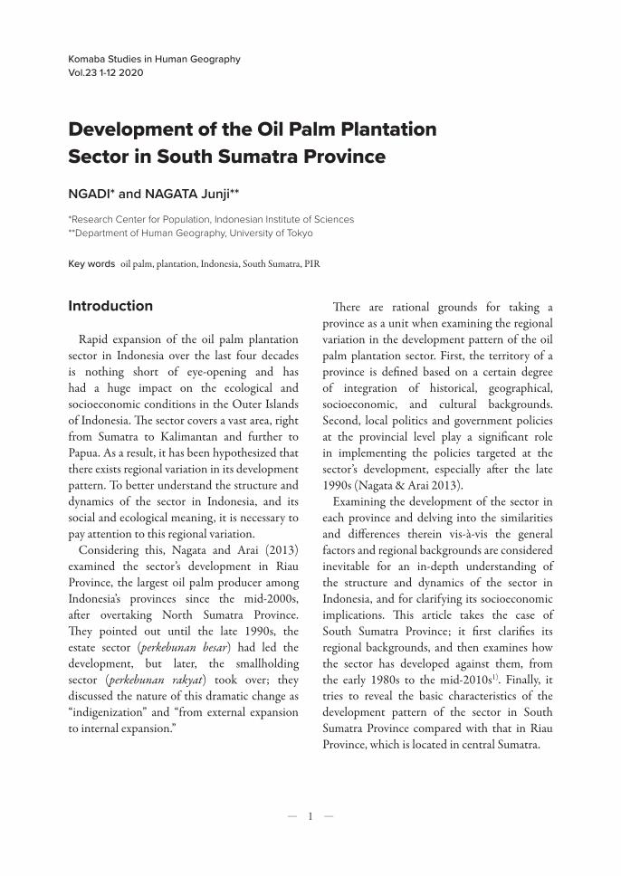
LandSouth Sumatra Province, with its capital in
Palembang City, is located between 1° and 4° south latitude and 102° and 106° east longitude; it has an area of 87,421.24 km2. It borders Jambi Province to the north, Bengkulu Province to the west, Lampung Province to the south, and Bangka Belitung Islands Province to the east across the Bangka Strait (Figure 1).
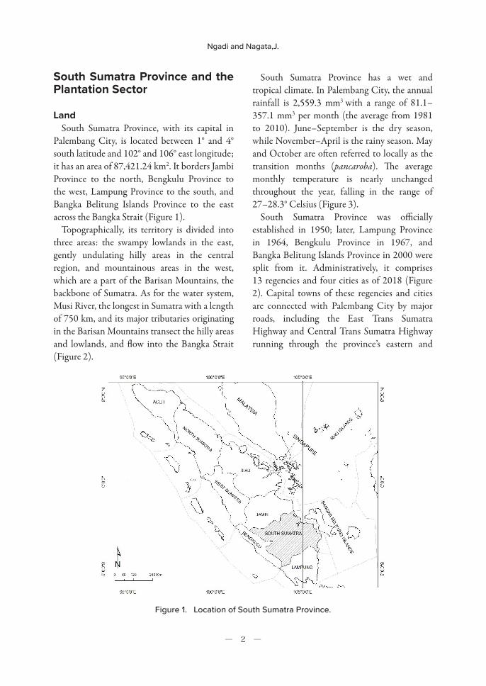
Topographically, its territory is divided into three areas: the swampy lowlands in the east, gently undulating hilly areas in the central region, and mountainous areas in the west, which are a part of the Barisan Mountains, the backbone of Sumatra. As for the water system, Musi River, the longest in Sumatra with a length of 750 km, and its major tributaries originating in the Barisan Mountains transect the hilly areas and lowlands, and flow into the Bangka Strait (Figure 2).
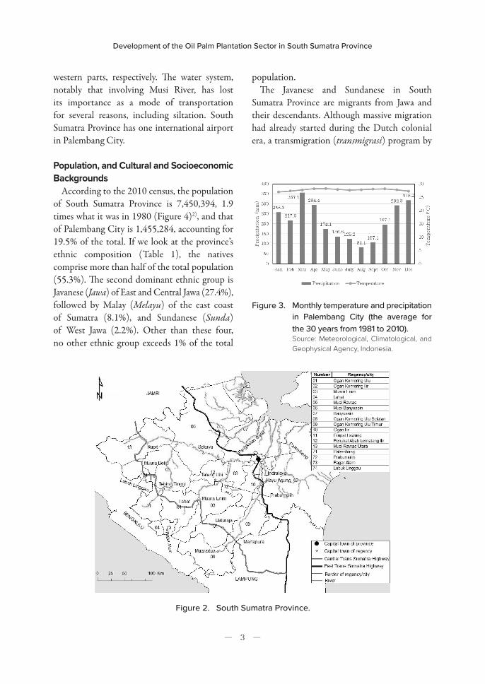
South Sumatra Province has a wet and tropical climate. In Palembang City, the annual rainfall is 2,559.3 mm3 with a range of 81.1–357.1 mm3 per month (the average from 1981 to 2010). June–September is the dry season, while November–April is the rainy season. May and October are often referred to locally as the transition months (pancaroba). The average monthly temperature is nearly unchanged throughout the year, falling in the range of 27–28.3° Celsius (Figure 3).
South Sumatra Province was officially established in 1950; later, Lampung Province in 1964, Bengkulu Province in 1967, and Bangka Belitung Islands Province in 2000 were split from it. Administratively, it comprises 13 regencies and four cities as of 2018 (Figure 2). Capital towns of these regencies and cities are connected with Palembang City by major roads, including the East Trans Sumatra Highway and Central Trans Sumatra Highway running through the province’s eastern and
Figure 1. Location of South Sumatra Province.
Development of the Oil Palm Plantation Sector in South Sumatra Province
― 3 ―
western parts, respectively. The water system, notably that involving Musi River, has lost its importance as a mode of transportation for several reasons, including siltation. South Sumatra Province has one international airport in Palembang City.
Population, and Cultural and Socioeconomic Backgrounds
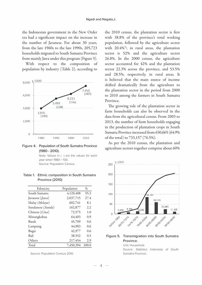
According to the 2010 census, the population of South Sumatra Province is 7,450,394, 1.9 times what it was in 1980 (Figure 4)2), and that of Palembang City is 1,455,284, accounting for 19.5% of the total. If we look at the province’s ethnic composition (Table 1), the natives comprise more than half of the total population (55.3%). The second dominant ethnic group is Javanese (Jawa) of East and Central Jawa (27.4%), followed by Malay (Melayu) of the east coast of Sumatra (8.1%), and Sundanese (Sunda) of West Jawa (2.2%). Other than these four, no other ethnic group exceeds 1% of the total
population. The Javanese and Sundanese in South
Sumatra Province are migrants from Jawa and their descendants. Although massive migration had already started during the Dutch colonial era, a transmigration (transmigrasi) program by
Figure 2. South Sumatra Province.
Figure 3. Monthly temperature and precipitation in Palembang City (the average for the 30 years from 1981 to 2010).Source: Meteorological, Climatological, and Geophysical Agency, Indonesia.
Ngadi and Nagata,J.
― 4 ―
the Indonesian government in the New Order era had a significant impact on the increase in the number of Javanese. For about 30 years, from the late 1960s to the late 1990s, 205,723 households migrated to South Sumatra Province from mainly Jawa under this program (Figure 5).
With respect to the composition of population by industry (Table 2), according to
Ethnicity Population %South Sumatra 4,120,408 55.3Javanese (Jawa) 2,037,715 27.4Malay (Melayu) 602,741 8.1Sundanese (Sunda) 162,877 2.2Chinese (Cina) 72,575 1.0Minangkabau 64,403 0.9Batak 45,709 0.6Lampung 44,983 0.6Bugis 42,977 0.6Bali 38,552 0.5Others 217,454 2.9Total 7,450,394 100.0
Source: Population Census 2010.
the 2010 census, the plantation sector is first with 38.8% of the province’s total working population, followed by the agriculture sector with 20.4%3); in rural areas, the plantation sector is 52% and the agriculture sector 26.8%. In the 2000 census, the agriculture sector accounted for 42% and the plantation sector 22.3% across the province, and 53.5% and 28.5%, respectively, in rural areas. It is believed that the main source of income shifted dramatically from the agriculture to the plantation sector in the period from 2000 to 2010 among the farmers in South Sumatra Province.
The growing role of the plantation sector in farm households can also be observed in the data from the agricultural census. From 2003 to 2013, the number of farm households engaging in the production of plantation crops in South Sumatra Province increased from 630,665 (64.9% of the total) to 733,157 (76.5%).
As per the 2010 census, the plantation and agriculture sectors together comprise about 60% Figure 4. Population of South Sumatra Province
(1980 - 2010).Note: Values in ( ) are the values for each year when 1980 = 100.Source: Population Census.
Table 1. Ethnic composition in South Sumatra Province (2010)
Figure 5. Transmigration into South Sumatra Province.Unit: Household.Source: Statistics Indonesia of South Sumatra Province.
Development of the Oil Palm Plantation Sector in South Sumatra Province
― 5 ―
IndustryProvince Rural area
Persons % Persons %Agriculture 683,020 20.4 633,583 26.8Plantation 1,299,418 38.8 1,228,873 52.0Fishery 41,792 1.3 37,308 1.6Manufacture 278,251 8.3 94,401 4.0Trade 387,771 11.6 155,216 6.6Services 601,008 17.9 191,069 8.1Others 59,807 1.8 22,104 0.9 Total 3,351,067 100.0 2,362,554 100.0
Source: Population Census 2010.
of the total working population of the province and about 80% of the rural areas, constituting the province’s key industries in terms of labor absorption; compared with these two, the role of the manufacturing sector remains limited, accounting for only 8.3% of the province and 4% of the rural areas.
The Plantation SectorSouth Sumatra Province has four major
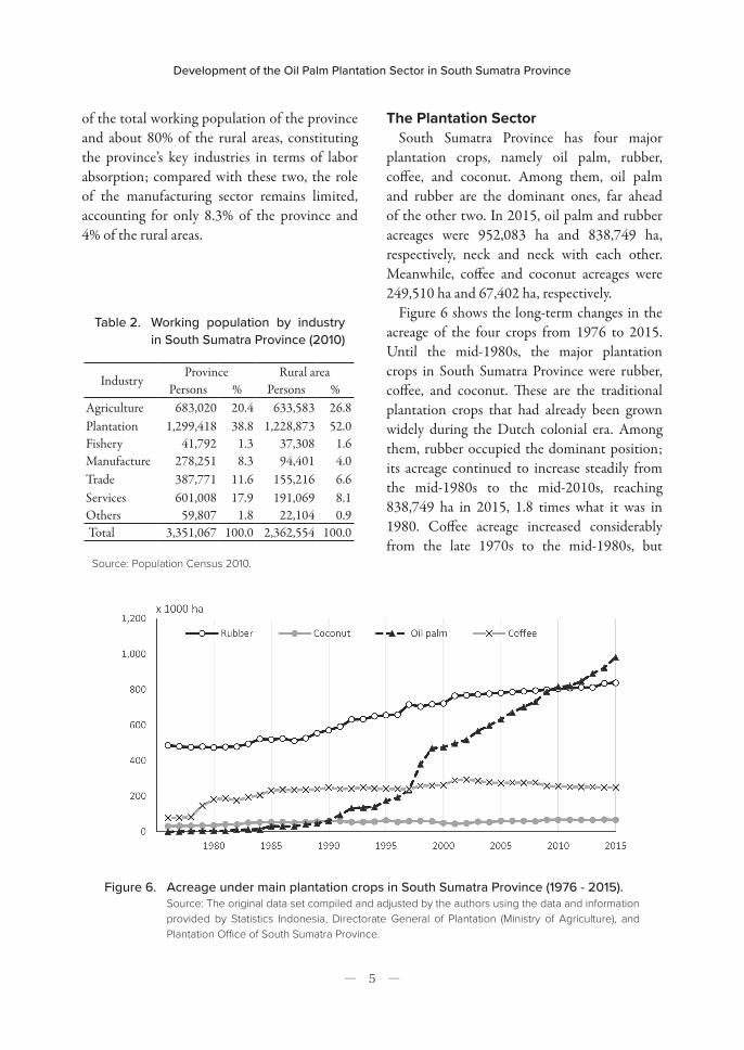
plantation crops, namely oil palm, rubber, coffee, and coconut. Among them, oil palm and rubber are the dominant ones, far ahead of the other two. In 2015, oil palm and rubber acreages were 952,083 ha and 838,749 ha, respectively, neck and neck with each other. Meanwhile, coffee and coconut acreages were 249,510 ha and 67,402 ha, respectively.
Figure 6 shows the long-term changes in the acreage of the four crops from 1976 to 2015. Until the mid-1980s, the major plantation crops in South Sumatra Province were rubber, coffee, and coconut. These are the traditional plantation crops that had already been grown widely during the Dutch colonial era. Among them, rubber occupied the dominant position; its acreage continued to increase steadily from the mid-1980s to the mid-2010s, reaching 838,749 ha in 2015, 1.8 times what it was in 1980. Coffee acreage increased considerably from the late 1970s to the mid-1980s, but
Table 2. Working population by industry in South Sumatra Province (2010)
Figure 6. Acreage under main plantation crops in South Sumatra Province (1976 - 2015).Source: The original data set compiled and adjusted by the authors using the data and information provided by Statistics Indonesia, Directorate General of Plantation (Ministry of Agriculture), and Plantation Office of South Sumatra Province.
Ngadi and Nagata,J.
― 6 ―
after that, it remained at almost the same level, although there was a slight increase in the early 2000s. Coconut acreage remained at a low level for long periods of time.
In contrast, oil palm emerged in South Sumatra Province from the mid-1980s. Its acreage, only 5,078 ha in 1980, increased rapidly from the latter half of the 1980s to the latter half of the 1990s—it particularly saw a sharp rise between 1997 and 1999; although it stagnated around 2000, it soon started to increase again, reaching rubber acreage’s level around 2010. In 2015, the production of crude palm oil (CPO) in South Sumatra Province reached 2.82 million tons, accounting for 9.1% of the national production. The development of the plantation sector in South Sumatra Province in terms of working population between 2000 and 2010, as mentioned above, has been
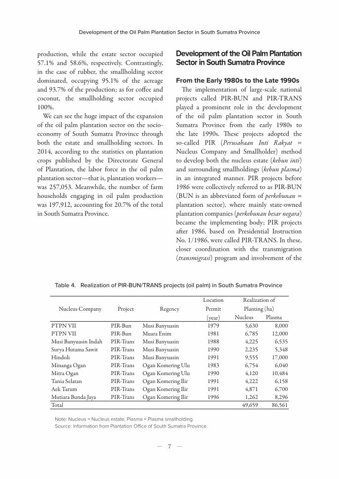
Crop Operational sectorArea Production Productivity
(A) (ha) (%) (B) (t) (%) (B)/(A) (t)
Oil Palm
Smallholding 321,681 42.9 1,168,810 41.4 3.63
Estate(State) 38,642 5.1 132,371 4.7 3.43
(Private) 390,284 52.0 1,520,758 53.9 3.90Total 750,607 100.0 2,821,939 100.0 3.76
Rubber
Smallholding 678,936 95.1 884,166 93.7 1.30
Estate(State) 6,958 1.0 11,806 1.3 1.70
(Private) 27,651 3.9 47,993 5.1 1.74Total 713,545 100.0 943,965 100.0 1.32
CoffeeSmallholding 207,303 100.0 110,351 100.0 0.53
Estate 0 0.0 0 0.0 -Total 207,303 100.0 110,351 100.0 0.53
CoconutSmallholding 52,620 100.0 61,985 100.0 1.18
Estate 0 0.0 0 0.0 -Total 52,620 100.0 61,985 100.0 1.18
Note: * Production of oil palm is production of crude palm oil (CPO).* Area in this table covers only the land planted with mature tree. On the other hand, in Figure 6 and Figure 7 the acreage includes the land planted with immature tree and damaged land.Source: Tree Crop Estate Statistics of Indonesia 2015.
attributed to the rapid expansion of the oil palm plantation sector during this period.
In Indonesia, the plantation sector is divided into two operational sectors in terms of management agency and management size—the estate sector, in which mainly corporations manage areas of 25 ha and above, and the smallholding sector, in which mainly individuals manage areas less than 25 ha. The estate sector is often further divided into two—the state sector and the private sector, in which state-owned companies and private companies, respectively, are the management agencies.
The operational structures of each plantation crop differ significantly—in particular, that of oil palm is different from those of other traditional plantation crops (Table 3). In 2015, in the case of oil palm, the smallholding sector occupied 42.9% of the acreage and 41.4% of the
Table 3. Area and production of main plantation crops by operational sector in South Sumatra Province (2015)
Development of the Oil Palm Plantation Sector in South Sumatra Province
― 7 ―
production, while the estate sector occupied 57.1% and 58.6%, respectively. Contrastingly, in the case of rubber, the smallholding sector dominated, occupying 95.1% of the acreage and 93.7% of the production; as for coffee and coconut, the smallholding sector occupied 100%.
We can see the huge impact of the expansion of the oil palm plantation sector on the socio-economy of South Sumatra Province through both the estate and smallholding sectors. In 2014, according to the statistics on plantation crops published by the Directorate General of Plantation, the labor force in the oil palm plantation sector—that is, plantation workers—was 257,053. Meanwhile, the number of farm households engaging in oil palm production was 197,912, accounting for 20.7% of the total in South Sumatra Province.
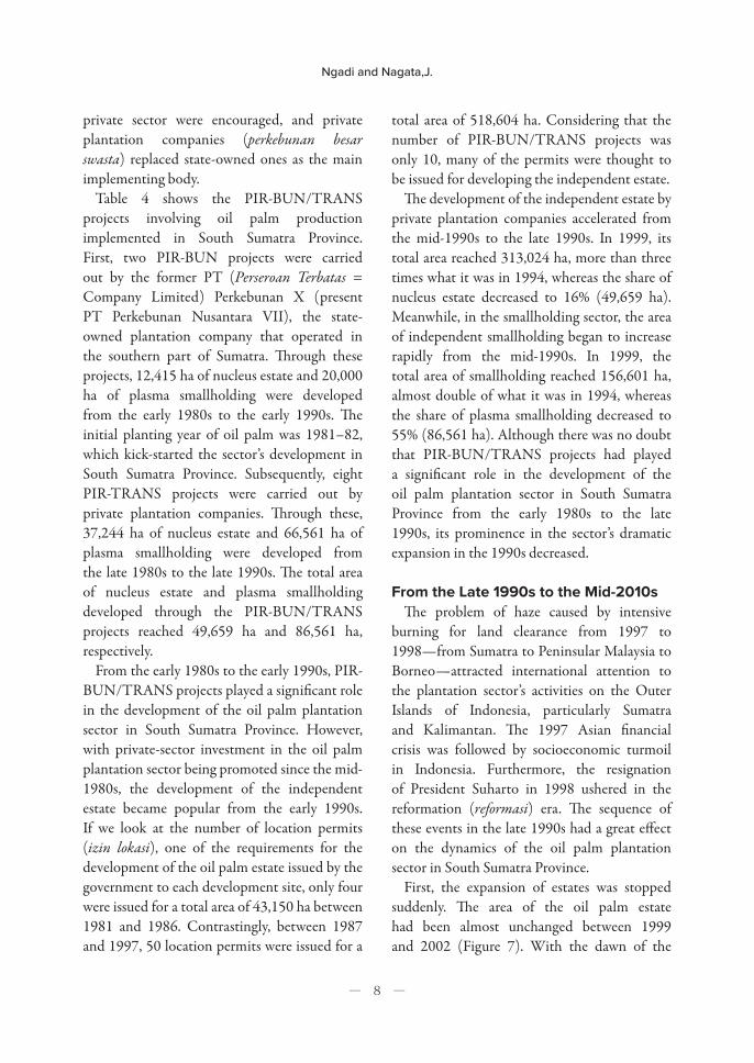
Nucleus Company Project RegencyLocation
Permit(year)
Realization of Planting (ha)
Nucleus PlasmaPTPN VII PIR-Bun Musi Banyuasin 1979 5,630 8,000PTPN VII PIR-Bun Muara Enim 1981 6,785 12,000Musi Banyuasin Indah PIR-Trans Musi Banyuasin 1988 4,225 6,535Surya Hutama Sawit PIR-Trans Musi Banyuasin 1990 2,235 5,348Hindoli PIR-Trans Musi Banyuasin 1991 9,555 17,000Minanga Ogan PIR-Trans Ogan Komering Ulu 1983 6,754 6,040Mitra Ogan PIR-Trans Ogan Komering Ulu 1990 4,120 10,484Tania Selatan PIR-Trans Ogan Komering Ilir 1991 4,222 6,158Aek Tarum PIR-Trans Ogan Komering Ilir 1991 4,871 6,700Mutiara Bunda Jaya PIR-Trans Ogan Komering Ilir 1996 1,262 8,296Total 49,659 86,561
Note: Nucleus = Nucleus estate, Plasma = Plasma smallholding. Source: Information from Plantation Office of South Sumatra Province.
Development of the Oil Palm Plantation Sector in South Sumatra Province
From the Early 1980s to the Late 1990sThe implementation of large-scale national
projects called PIR-BUN and PIR-TRANS played a prominent role in the development of the oil palm plantation sector in South Sumatra Province from the early 1980s to the late 1990s. These projects adopted the so-called PIR (Perusahaan Inti Rakyat = Nucleus Company and Smallholder) method to develop both the nucleus estate (kebun inti) and surrounding smallholdings (kebun plasma) in an integrated manner. PIR projects before 1986 were collectively referred to as PIR-BUN (BUN is an abbreviated form of perkebunan = plantation sector), where mainly state-owned plantation companies (perkebunan besar negara) became the implementing body; PIR projects after 1986, based on Presidential Instruction No. 1/1986, were called PIR-TRANS. In these, closer coordination with the transmigration (transmigrasi) program and involvement of the
Table 4. Realization of PIR-BUN/TRANS projects (oil palm) in South Sumatra Province
Ngadi and Nagata,J.
― 8 ―
private sector were encouraged, and private plantation companies (perkebunan besar swasta) replaced state-owned ones as the main implementing body.
Table 4 shows the PIR-BUN/TRANS projects involving oil palm production implemented in South Sumatra Province. First, two PIR-BUN projects were carried out by the former PT (Perseroan Terbatas = Company Limited) Perkebunan X (present PT Perkebunan Nusantara VII), the state-owned plantation company that operated in the southern part of Sumatra. Through these projects, 12,415 ha of nucleus estate and 20,000 ha of plasma smallholding were developed from the early 1980s to the early 1990s. The initial planting year of oil palm was 1981–82, which kick-started the sector’s development in South Sumatra Province. Subsequently, eight PIR-TRANS projects were carried out by private plantation companies. Through these, 37,244 ha of nucleus estate and 66,561 ha of plasma smallholding were developed from the late 1980s to the late 1990s. The total area of nucleus estate and plasma smallholding developed through the PIR-BUN/TRANS projects reached 49,659 ha and 86,561 ha, respectively.
From the early 1980s to the early 1990s, PIR-BUN/TRANS projects played a significant role in the development of the oil palm plantation sector in South Sumatra Province. However, with private-sector investment in the oil palm plantation sector being promoted since the mid-1980s, the development of the independent estate became popular from the early 1990s. If we look at the number of location permits (izin lokasi), one of the requirements for the development of the oil palm estate issued by the government to each development site, only four were issued for a total area of 43,150 ha between 1981 and 1986. Contrastingly, between 1987 and 1997, 50 location permits were issued for a
total area of 518,604 ha. Considering that the number of PIR-BUN/TRANS projects was only 10, many of the permits were thought to be issued for developing the independent estate.
The development of the independent estate by private plantation companies accelerated from the mid-1990s to the late 1990s. In 1999, its total area reached 313,024 ha, more than three times what it was in 1994, whereas the share of nucleus estate decreased to 16% (49,659 ha). Meanwhile, in the smallholding sector, the area of independent smallholding began to increase rapidly from the mid-1990s. In 1999, the total area of smallholding reached 156,601 ha, almost double of what it was in 1994, whereas the share of plasma smallholding decreased to 55% (86,561 ha). Although there was no doubt that PIR-BUN/TRANS projects had played a significant role in the development of the oil palm plantation sector in South Sumatra Province from the early 1980s to the late 1990s, its prominence in the sector’s dramatic expansion in the 1990s decreased.
From the Late 1990s to the Mid-2010sThe problem of haze caused by intensive
burning for land clearance from 1997 to 1998—from Sumatra to Peninsular Malaysia to Borneo—attracted international attention to the plantation sector’s activities on the Outer Islands of Indonesia, particularly Sumatra and Kalimantan. The 1997 Asian financial crisis was followed by socioeconomic turmoil in Indonesia. Furthermore, the resignation of President Suharto in 1998 ushered in the reformation (reformasi) era. The sequence of these events in the late 1990s had a great effect on the dynamics of the oil palm plantation sector in South Sumatra Province.
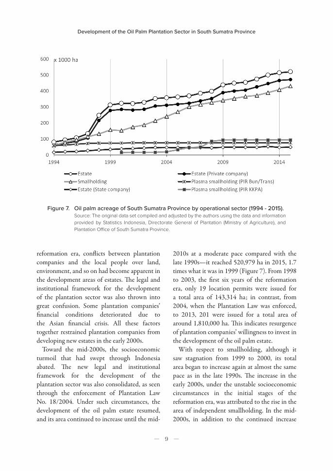
First, the expansion of estates was stopped suddenly. The area of the oil palm estate had been almost unchanged between 1999 and 2002 (Figure 7). With the dawn of the
Development of the Oil Palm Plantation Sector in South Sumatra Province
― 9 ―
reformation era, conflicts between plantation companies and the local people over land, environment, and so on had become apparent in the development areas of estates. The legal and institutional framework for the development of the plantation sector was also thrown into great confusion. Some plantation companies’ financial conditions deteriorated due to the Asian financial crisis. All these factors together restrained plantation companies from developing new estates in the early 2000s.
Toward the mid-2000s, the socioeconomic turmoil that had swept through Indonesia abated. The new legal and institutional framework for the development of the plantation sector was also consolidated, as seen through the enforcement of Plantation Law No. 18/2004. Under such circumstances, the development of the oil palm estate resumed, and its area continued to increase until the mid-
2010s at a moderate pace compared with the late 1990s—it reached 520,979 ha in 2015, 1.7 times what it was in 1999 (Figure 7). From 1998 to 2003, the first six years of the reformation era, only 19 location permits were issued for a total area of 143,314 ha; in contrast, from 2004, when the Plantation Law was enforced, to 2013, 201 were issued for a total area of around 1,810,000 ha. This indicates resurgence of plantation companies’ willingness to invest in the development of the oil palm estate.
With respect to smallholding, although it saw stagnation from 1999 to 2000, its total area began to increase again at almost the same pace as in the late 1990s. The increase in the early 2000s, under the unstable socioeconomic circumstances in the initial stages of the reformation era, was attributed to the rise in the area of independent smallholding. In the mid-2000s, in addition to the continued increase
Figure 7. Oil palm acreage of South Sumatra Province by operational sector (1994 - 2015).Source: The original data set compiled and adjusted by the authors using the data and information provided by Statistics Indonesia, Directorate General of Plantation (Ministry of Agriculture), and Plantation Office of South Sumatra Province.
Ngadi and Nagata,J.
― 10 ―
in the area of independent smallholding, the implementation of PIR-KKPA projects raised the total area of smallholding, creating a considerable amount of plasma smallholding.
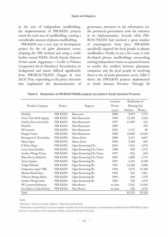
PIR-KKPA was a new type of development project for the oil palm plantation sector, adopting the PIR method and using a credit facility named KKPA (Kredit kepada Koperasi Primer untuk Anggotanya = Credit to Primary Cooperative for its Members). Nevertheless, its background and nature differed significantly from PIR-BUN/TRANS (Nagata & Arai 2013). First, responding to the policy direction that emphasized the decentralization of
governance structures in the reformation era, the provincial government took the initiative in its implementation. Second, while PIR-BUN/TRANS had involved a great number of transmigrants from Jawa, PIR-KKPA specifically targeted the local people as plasma smallholders. Finally, in not a few cases, it only developed plasma smallholdings surrounding existing independent estates as a practical means to resolve the conflicts between plantation companies and the local people by involving them in the oil palm plantation sector. Table 5 shows the PIR-KKPA projects implemented in South Sumatra Province. Through 20
Nucleus Company Project RegencyLocation
Permit(year)
Realization of Planting (ha)
Nucleus PlasmaHindoli PIR-KKPA Banyuasin 2006 9,979 1,752Panca Tirta Budi Agung PIR-KKPA Musi Banyuasin 1996 12,128 3,163Guthrie Pecconino Indo PIR-KKPA Musi Banyuasin 1997 12,409 445Hindoli PIR-KKPA Musi Banyuasin 2000 - 594PP Lonsum PIR-KKPA Musi Banyuasin 2003 1,721 86Pinago Utama PIR-KKPA Musi Banyuasin 2008 10,000 12,034Roempoen E. Bersaudara PIR-KKPA Muara Enim 2000 2,515 4,047Mitra Ogan PIR-KKPA Muara Enim 2004 2,368 866P. Mitra Ogan PIR-KKPA Ogan Komering Ulu 2010 1,924 1,876Lerna Astra Kartika PIR-KKPA Ogan Komering Ulu Timur 1996 909 1,972Sumber Wangi Timur PIR-KKPA Ogan Komering Ulu Timur 1997 824 643Wana Karya Mulya K. PIR-KKPA Ogan Komering Ulu Timur 2003 1,888 1,753Tania Sepakat PIR-KKPA Ogan Komering Ilir 1991 4,181 8,188Telaga Hikmah PIR-KKPA Ogan Komering Ilir 1991 14,106 3,006Sampoerna Agro TBK PIR-KKPA Ogan Komering Ilir 1994 3,078 21,308Mutiara Bunda Jaya PIR-KKPA Ogan Komering Ilir 1994 562 1,861Trikreasi Marga Mulya PIR-KKPA Ogan Komering Ilir 1995 608 1,378Sumber Wangi Alam PIR-KKPA Ogan Komering Ilir 1998 236 1,876PP. Lonsum Indonesia PIR-KKPA Musi Rawas no data 3,261 21,945Dwi Reksa Usaha Perkasa PIR-KKPA Musi Rawas no data 528 4,745Total 83,225 93,538
Table 5. Realization of PIR-BUN/TRANS projects (oil palm) in South Sumatra Province
Note:* Nucleus = Nucleus estate, Plasma = Plasma smallholding.* Realization of planting of nucleus estate includes the area developed as independent estate before PIR-KKPA project. Source: Information from Plantation Office of South Sumatra Province.
Development of the Oil Palm Plantation Sector in South Sumatra Province
― 11 ―
projects, 93,538 ha of plasma smallholding were developed mainly between 2004 and 2007 (Figure 7), which surpassed its total area developed through PIR-BUN/TRANS projects.
From the mid-2000s to the mid-2010s, the total area of smallholding continued to increase at a slower pace than in the first half of the 2000s. The increase in this period was mainly attributed to the rise in the area of independent smallholding. In this article, all smallholding other than plasma smallholding developed through PIR-BUN/TRANS and PIR-KKPA projects are classified as independent smallholding. Government regulations on plantation business permits that were enforced after the mid-2000s, that is, Ministerial Regulation of Agriculture No. 26/2007 and Ministerial Regulation of Agriculture No. 98/2013, stipulated the obligation of plantation companies to facilitate the construction of smallholding for the local people (Nagata & Koizumi 2018). However, we could not secure reliable information on how much land was developed for smallholding based on these regulations. The total area of smallholding was 431,104 ha in 2015, 2.7 times what it was in 1999 (Figure 7), when it had occupied only 33% of the total area of oil palm. In 2015, smallholding’s share increased to 45%.
Concluding Remarks
The basic development pattern of the oil palm plantation sector in South Sumatra Province was almost the same as that in Riau Province, which was examined in a previous study (Nagata & Arai 2013). From the early 1980s to the late 1990s, PIR-BUN/TRANS projects played a prominent role—particularly in the early stage of the sector’s development, these large-scale national projects had a significant presence. In the 1990s, the development of the independent
estate was actively pursued; it accelerated in the late 1990s, which increased the oil palm area substantially. From the mid-1990s, independent smallholding also began to increase.
The socioeconomic turmoil in the initial stages of the reformation era from the late 1990s to the early 2000s had halted the rapid expansion of the oil palm estate. With the stabilization of society and establishment of a new legal and institutional framework for the development of the plantation sector, the development of this estate was resumed, and its area continued to increase toward the mid-2010s at a moderate pace. Meanwhile, smallholding continued to increase, from the initial stages of the reformation era to the mid-2010s, and secured a presence comparable with the estate sector. This increase was mainly attributed to that of independent smallholding, although PIR-KKPA projects targeted at the local people in the mid-2000s made a meaningful contribution as well.
The similarities in the basic development pattern of the oil palm plantation sector between the two major provinces in Indonesia suggest that the sector’s structure and dynamics at the provincial level were heavily affected by the political and socioeconomic environments at the national and international levels. With respect to the intensity and timing of individual phenomena, however, we can observe significant differences between the two provinces.
For example, although PIR-BUN/TRANS projects played a significant role in the sector’s development from the early 1980s to the late 1990s in both provinces, the development of individual estates from the late 1980s to the late 1990s was more intense in Riau Province than in South Sumatra Province. As a result, the former faced shortage of land that could be used to develop the oil palm estate or for large-scale projects in the mid-2000s, much earlier than South Sumatra Province did. If we look
Ngadi and Nagata,J.
― 12 ―
at the increase in individual smallholding in the reformation era, that too was much more intense in Riau Province than in South Sumatra Province, and the smallholding area surpassed the estate area early in the mid-2000s. In South Sumatra Province, such an inversion has not occurred yet. It is also worth noting that rubber still holds great importance as a plantation crop in the smallholding sector, like oil palm in South Sumatra Province.
Bearing in mind these similarities and differences with respect to the development of the oil palm plantation sector in South Sumatra Province, we will be able to gain a better understanding of specific case studies that we carry out at research sites in South Sumatra Province and situate their findings in the broader context of discussions on the nature of the oil palm plantation sector in Indonesia.
Acknowledgements
We would like to thank Statistics Indonesia (BPS = Badan Pusat Statistik) and the Plantation Office (Dinas Perkebunan) of South Sumatra Province for providing us with various kinds of useful data and information. This research was supported by the JSPS RONPAKU (Dissertation PhD) Program 2015–2017.
Notes
1. Nagata et al. (2014) and Koizumi and Nagata (2018)
tried to clarify the cultural and socioeconomic
characteristics of the population of Riau Province and
their change through the analysis of unpublished or
raw data of the population census vis-à-vis the rapid
expansion of the oil palm plantation sector.
2. The former South Sumatra Province was divided into
South Sumatra Province and Bangka Belitung Islands
Province in 2000. This article covers only the current
territory. All the statistics and information on South
Sumatra Province mentioned herein exclude the Bangka
Belitung Islands Province.
3. The plantation sector refers to the economic activities
that produce so-called plantation crops such as oil
palm, rubber, coffee, coconut, and tea. Meanwhile, the
agriculture sector refers to the economic activities that
produce crops other than plantation crops, most typically
rice and vegetables.
References
Koizumi, Y. and Nagata, J. 2018. Population by birthplace and ethnicity and employment structure by industry in Riau Province, Indonesia: An analysis of the raw data of the 2000 and 2010 population censuses. Japanese Journal of Southeast Asian Studies, 56(1): 3-32. ( J)
Nagata, J. and Arai, S. W. 2013. Evolutionary change in the oil palm plantation sector in Riau Province, Sumatra. In The palm oil controversy in Southeast Asia: A transnational perspective, ed. O. Pye and J. Bhattacharya, 76-96. Singapore: Institute of Southeast Asian Studies.
Nagata, J., Arai, S. W. and Manurung, G. M. 2014. Social map of Riau, Indonesia: Frontier development and its outcomes. Komaba Studies in Human Geography, 21: 101–134.
Nagata, J. and Koizumi, Y. 2018. Historical shift in regulations on plantation business permits in Indonesia. Japanese Journal of Southeast Asian Studies, 55(2): 240-255. ( J)
( J) written in Japanese