development of dholpur-rajakhera upto state boarder sh...
TRANSCRIPT

Development of Dholpur-Rajakhera upto State Boarder
SH-2A Road from km 0.000 to km 43.300, in the state of
Rajasthan (Highway 3 – Package 13)
PRE-FEASIBILITY REPORT
JUNE-2016
EXECUTIVE SUMMARY
This Prefeasibility Report (PFR) is submitted in accordance with the requirements of ToR of
MoEFCC for the subsequent project of “Development of Dholpur-Rajakhera upto State
Boarder SH-2A Road from km 0.000 to km 43.300, in the state of Rajasthan (Highway
3 – Package 13) (the “Highway III”) Package – 13 initiated by Rajasthan PWD, PPP
division.
Govt. of Rajasthan has announced development of 20,000 km highways during next 5 years.
Projects and schemes are being identified for implementation. This is the 7th
(KD7) of 9
required deliverables, earlier 6 reports – Inception Report, Supplementary Inception Report,
Report on Alignment and First Traffic Survey, Report on Land Plan Schedule and Utility
Relocation, Report on Indicative GAD of Structures and Report on Environment and Social
Impact Assessment have been submitted.
The project road starts at km 0.000 at junction of NH-3 (Dholpur) and ends at km 43.300 at
Rajasthan/UP Border in Rajakhera. The design length is 43.300 km.
The project road is passing through Karauli district, and two Tehsils Dholpur and Rajakhera,
and 11 villages. All villages are come under semi arid climatic conditions.
Appreciation of traffic and road geometry, and road condition is the first step in Technical
Feasibility Study. Extensive surveys of classified traffic Survey (2 stations), road inventory
& road condition survey, alignment survey, pavement investigations, Benkelman Beam
Deflects, surface pavement conditions, axle load survey and inventory of culverts & bridges
have been carried out.
There are two locations where traffic survey is held first at km 11.000 and other is km
32.000. The Total PCUs varies from 3896 to 4649.
The ADT so obtained at all the traffic survey locations are projected at a uniform growth rate
of 5% for all categories of vehicles as mentioned in the TOR. The year in which the project
road reaches its design service volume at LOS-B is worked out for 2-lane and 2-lane with
paved shoulder configuration.
The terrain along the highway is plain. There is ribbon development with a mix of
commercial/residential and industrial activities.
The type of shoulders is earthen and width varies from 0.5m to 1.0m on either side. The
condition of the shoulder varies from fair to very poor, with edge drops and rain cuts.
The development along the road has been uncontrolled. Therefore, at certain locations
encroachment within ROW has been observed in the form of shops, Dhabas and various
other commercial establishments.
At certain locations Low-tension overhead electrical lines are running along the highway and
cross the highway. While widening the road, the utility lines located on the new carriageway
or widening portion would need shifting. There is a need for relocation of 154 electric poles,
18 transformers, 3 Telephone poles, and 13 hand pumps. Around 357 trees are to be
removed.
Entire length of SH-2A has bituminous surface except (built up sections with cc pavement)
19% of project road length is in good condition, 20% in fair condition and 61% in poor
condition.
The existing pavement consists of bituminous layers, WBM and granular sub-base. A broad
variation in pavement thickness along the project road was observed. The bituminous part
varies from 25mm to 80mm. While non-bituminous depth varies from 230mm to 345mm.
Pavement Deflection and sub grade strength: The BBD values vary between 0.67 mm to 0.92
mm along the project road.
Base and sub base layers have been designed for 15 years and surface layers have been
designed for 8 years (including construction period of 18 months)
There are no major & minor bridge and 17 culverts consisting of 7 hume culverts, 1 RC slab
culvert, 1 RC Box culvert, 7 stone culvert and 1 Brick arch culvert. There is one railway
ROB in Dholpur.
01 toll plazas are proposed along the entire project road. In order to provide rest and
amenities for travelling public, the locations is at km 28.450 are identified. The private
entrepreneurs will be called to develop restaurants, workshops, toilet facilities, shops, first
aid etc. Avenue plantation and development of certain sites as recreational areas will been
envisaged in-consultation with the client.
The estimated total construction cost of the Project is Rs. 66.07Crores Concession period is
25 years. Total Project Cost (including financing cost on Debt & IDC) is Rs. 75.98Crores,
Project IRR 13.27 % and Equity IRR is 15.03 %. Average Debt service coverage ratio
(DSCR) is 1.14.
CHAPTER 1
PROJECT INTRODUCTION
1.1 INTRODUCTION
The Governor of Rajasthan acting through the Chief Engineer (Roads), Public Works
Department, Government of Rajasthan (the “Authority”) is engaged in the development of state
highways and as part of this endeavor, the Authority has decided to undertake two-laning of
Dholpur-Rajakhera (the “Project”) through Public Private Partnership (the “PPP”) on ANNITY
basis.
Authority has decided to conduct feasibility studies for determining the technical feasibility and
financial viability of all highways comprising the Project. The project If found technically
feasible and financially viable, may be awarded on ANNITY basis to a private entity (the
“Concessionaire”) selected through a competitive bidding process. The Project would be
implemented in accordance with the terms and conditions stated in the concession agreement to
be entered into between the Authority and the Concessionaire (the “Concession Agreement”)
In pursuance of the above, the Authority has decided to carry out the process for selection
of a Technical Consultant, a Financial Consultant and a Legal Adviser for preparing the
Feasibility Report and bid documents. The Financial Consultant will develop the revenue
model and assist the Authority in the bidding process. The Legal Adviser will review the
draft concession agreement based on the Model Concession Agreement for State
Highways through Public Private Partnership (the “MCA”) read with the Manual of
Standards and Specifications. The Technical Consultant shall prepare the Feasibility
Report in accordance with the Terms of Reference specified (“TOR”).This is the 8th
(KD8) of 9 required deliverables, earlier 7 reports :– (i) Inception Report, (ii)
Supplementary Inception Report, (iii) Report on Alignment and First Traffic Survey, (iv)
Report on Land Plan Schedule and Utility Relocation, (v) Report on Indicative GAD of
Structures, (vi) Report on Environment and Social Impact Assessment and(vii) Draft
Feasibility Report have been submitted. This Final Feasibility Report is presented.
1.2 OBJECTIVES
The main objective of the consultancy services is to establish the technical feasibility and
financial viability of the selected project road.
To prepare separate Feasibility Reports for all highways comprising the project for the
purpose of firming up the Authority’s requirements in respect of development and
construction of the project, Project Facilities and enabling the prospective bidders to

assess the Authority’s requirements in a clear and predictable manner with a view to
ensuring:
I. Enhanced safety and level of service for the road users.
II. Superior operation and maintenance enabling enhanced operational efficiency of the
Project;
III. Minimal adverse impact on the local population and road users due to road construction.
IV. Minimal adverse impact on environment.
V. Minimal additional acquisition of land.
VI. Phased development of the project for improving its financial viability consistent with the
need to minimize frequent inconvenience to traffic that may be caused if additional works
are undertaken within a period of seven years from the commencement of construction of
the Project.
1.3 STRUCTURE OF PRE FEASIBILITY REPORT
1: Executive Summary
2: Project Introduction
3: Project Description.
4: Site Analysis
5: Planning Brief
6: R&R Plan
7: Project Cost and Cost Estimate
8: Analysis of Proposal (Final Recommendations)

CHAPTER 2
PROJECT DESCRIPTION
Rajasthan is located in the north western part of the Indian subcontinent. It is bounded on the
west and northwest by Pakistan, on the north and northeast by the states of Punjab,
Haryana, and Uttar Pradesh, on the east and southeast by the states of Uttar Pradesh and Madhya
Pradesh, and on the southwest by the state of Gujarat. The state has an area of 132,140 square
miles (342,239 square kilometers). The Project road lies in the North-East to North-West part of
Rajasthan state.
The project road starts at km 0.000 at junction of NH-3 (Dholpur) and ends at km 43.300 at
Rajasthan/UP Border in Rajakhera. The design length is 43.300 km.
Due to 10 km eco-sensitive zone of Kesarbagh and National Chambal Wildlife Sanctuaries,
this project road falls under Category A of MOEFCC as written in EIA guidelines, and
Wildlife Protection Act 1972 is also applicable for this project, so prior environment
clearance from MoEFCC and wildlife clearance from National Board for Wildlife are
necessary.
The original project highway alignment which is started as Dholpur-Rajakhera (as per Contract
Agreement) under gone many changes in its route course due to the clients decision during
several site visits and discussions with the Advisor to Government, Infrastructure development
and other higher officials. The route course was to include the existing SH-2A stretch from
Dholpur-Rajakhera. The section from Dholpur-Rajakhera via Dholpur, Dukapur, Luhari,
Bebalpur, Deholi, Indrav, Muraina, mahajeepura, Dighi, Rajakheda and Singhwali Khurd villages
is notified as SH-2A. (Vide Location Map).

Figure 1.1 Location Map of Project Road
The project corridor has a two lane carriageway section. In general the terrain is plain. In
some built-up sections, higher road width was observed. The land use pattern is mainly
agricultural and remaining is commercial and residential. Existing earthen shoulder width
varies from 0.5m to 1.0m.
The existing two-lane carriageway alignment has a number of horizontal and vertical
curves which require geometric improvement and the existing gradient of the highway is
within acceptable limits as per IRC: 73 in the stretch of the highway where it passes
through plain terrain.
CHAPTER: 3
SITE ANALYSIS
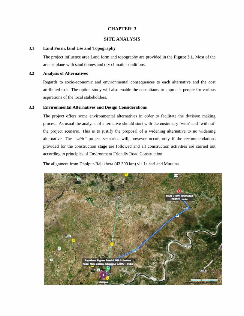
3.1 Land Form, land Use and Topography
The project influence area Land form and topography are provided in the Figure 3.1. Most of the
area is plane with sand domes and dry climatic conditions.
3.2 Analysis of Alternatives
Regards to socio-economic and environmental consequences to each alternative and the cost
attributed to it. The option study will also enable the consultants to approach people for various
aspirations of the local stakeholders.
3.3 Environmental Alternatives and Design Considerations
The project offers some environmental alternatives in order to facilitate the decision making
process. As usual the analysis of alternative should start with the customary ‘with’ and ‘without’
the project scenario. This is to justify the proposal of a widening alternative to no widening
alternative. The “with” project scenarios will, however occur, only if the recommendations
provided for the construction stage are followed and all construction activities are carried out
according to principles of Environment Friendly Road Construction.
The alignment from Dholpur-Rajakhera (43.300 km) via Luhari and Muraina.
Figure 3.1: Topographical Map of Site
For working out the proper feasibility of the project and alignment options, the site of
complete road was inspected by the entire team ACE PPP, SE PPP and PD PPP on 17-
10-2014 and it was decided that entire road taken up with a construction period of 18
months. We started preparation of project accordingly.
3.4 Proposed Bypasses/Realignment
The existing road passing through Dholpur, Dukapur, Luhari, Bebalpur, Deholi, Indrav,
Muraina, Mahajeepura, Dighi, Rajakheda and Singhwali Khurd built-up sections. There
is no bypass along the project road. The details are presented in Table 3.1.
Table 3.1: Proposed New Sections and Bypasses
Section Length Remarks
-Nil-
3.5 EXISTING LAND USE PATTERN
land use use patten in the project influence area is given in the Figure 3.2. Predoninnet
land use in this area is open barren land with sandy soil.

Figure 3.2: Land Use along the Existing Road and Proposed land Use-
3.6 SOIL
The nature of the soil is generally alluvial in nature which prone to water logging. Rests
in parts of Bonli & Bamanvas block. These are derived from alluvium. They are non-
calcareous, more clayey, semi consolidated to unconsolidated brown soils with high
percentage of kankar, loamy sand to sandy loam in texture. They are well drained and
occupy gently sloping terrains
3.7 Climate
The Rajasthan state falls under the Sub-tropical arid (desert) climate. Rajasthan is one of
the hottest states of India. In Rajasthan, climatic conditions vary throughout the year.
Rajasthan weather is usually hot and dry, yet one can see four distinct seasons in this
state. These can be classified as summers, Monsoons, autumn (Post-monsoon) and
winters. Winter commences from late November to end of February and characterized by
heavy dew, thick fog and associated cold wave. Summer extends from March to middle
of June The rainy season commences from the last weak of June and continues till the
end of September. Karauli district is characterized by sub-tropical dry climate with
distinct cold (November-February), hot (March-June) and rainy (July-September)
seasons. October is a transition period.

Chapter 4
Planning Brief
4.1 GENERAL
The Improvement proposals for the proposed up-gradation to 2-Lane with earthen
shoulder configuration system includes the provision for the following major items:
Geometric Improvements and realignments
Pavement – strengthening and reconstruction
Bridges and Cross-Drainage Structures
Safety and
Road Appurtenances
4.2 GEOMETRIC DESIGN PROPOSALS
The proposal for the improvement of the geometric elements of the existing highway
includes:-
Improvement to cross-sectional elements
Alignment Design
4.2.1 Improvement to Cross-Sectional Elements
Proposed Cross Sectional Elements
Lane Width
The lane width is proposed to be 3.5m and the carriageway width 7.0m with 2.5m
Shoulder on either side.
Utility Corridor
All utilities to be provided in the outermost 2m width of ROW edge on either side
Side Slopes
For fill sections, the following side slopes are proposed:
Embankment height up to 3.0m - 2H:1V and Considering the Embankment
Material propertyEmbankment height from
3.0m to 6.0m
Embankment height from 3.0m to 6.0m- 2.5H:1V and Considering the Embankment
Material property

Embankment height exceeding 6.0m - To be designed as per material property and
as per IRC:75
Cutting Sections - 1H: 1V and with considering the material
Property of the cutting material
Cross-fall
For Two laning the cross-fall for the pavement will be 2.5% with a crown in the centre
and for gravel shoulders will be 3.0%.
For Four laning the cross-fall for the pavement will be 2.5% on either side of divided
carriageway and for gravel shoulders will be 3.0%.
Right of Way (ROW)
Typical Cross Section
The typical cross sections to be followed in the project stretch are detailed in (Drawings)
7000
Proposed Carriageway
CL
2.5%
RECONSTRUCTION SECTIONS - BT 10.0 m
7000
Existing Carriageway
Width Varies
(Scale 1 : 75)
1500
Paved
Shoulder
3.0%
21
2.5%
1500
Paved
Shoulder
3.0%
21
1000
Earthen
Shoulder/Drain
TCS - 3:
Scarification/Milling (avg 100mm)
Existing Road (width varies)
BC
DBM
WMM
Subgrade
GSB
GSB
1000
Earthen
Shoulder/Drain
CL
2.5%
WIDENING & STRENGTHENING SECTIONS - BT 7.0 m
(Scale 1 : 75)
3.0%
21
2.5%3.0%
21
2500
Earthen
Shoulder
TCS - 1:
Existing Road (width varies) PCC
BC
DBMWMM-II
Subgrade
GSB
2500
Earthen
Shoulder
WMM-I
7000
Proposed Carriageway
CL
2.5%
RECONSTRUCTION SECTIONS - BT 7.0 m
(Scale 1 : 75)
3.0%
21
2.5%3.0%
21
2500
Earthen
Shoulder
TCS - 2:
Existing Road (width varies) PCC
BC
DBMWMM-II
Subgrade
GSB
2500
Earthen
Shoulder
WMM-I
CL2.5%
7000
Proposed Carriageway
CC PAVEMENT WIDENING IN BUILT_UP SECTIONS
(Scale 1 : 75)
1500
Paved
Shoulder
2.5%2.5%
1500
Paved
Shoulder
Existing Road (width varies)
PQCDLC
Subgrade
GSB
TCS - 4:
Drain Drain
2.5%
Existing CC Road (width varies)
CL
2.5%
7000
Proposed Carriageway
WIDENING & STRENGTHENING IN BUILT-UP SECTIONS - BT 10.0 m
(Scale 1 : 75)
2.5%2.5%
1500
Paved
Shoulder
2.5%
1500
Paved
Shoulder
Paved
Shoulder
TCS - 5:
DrainDrain
PCC
BC
DBM
BC
DBM
WMM-II
WMM-I
Subgrade
GSBExisting Road (width varies)
GSB

Typical Cross Sections
4.2.2 Widening Scheme
The existing project roads have multidimensional facets in terms of geometry, pavement
condition, existing utilities, religious structures etc. Considering all these aspects the section-wise
policy is adopted for widening Two Lane with Earthen Shoulders standard from Dholpur-
Rajakhera. The widening scheme can generally be summarized as concentric widening except at a
few locations like culverts, populated urban area etc.
The scheme conforms to general policy decision and is finally designed on the precise
geometric configuration, realignment, re-sectioning, environmental consideration and
availability of exact land widths etc.
4.2.3 Truck Lay byes
Truck Lay byes is not proposed.
4.2.4 Road Markings
The location and type of marking lines, material and color is followed using IRC: 35-
1997 – “Code of Practice for Road Markings.”
The road markings were carefully planned on carriageways, intersections and bridge
locations.
CL2.0%
7000
Proposed Carriageway
CC PAVEMENT WIDENING IN BUILT_UP SECTIONS
(Scale 1 : 75)
1500
Paved
Shoulder
2.0%2.0%
1500
Paved
Shoulder
Existing Road (width varies)
PQCDLC
Subgrade
GSB
TCS - 4:
Drain Drain
2.0%
Existing CC Road (width varies)
CL2.0%
7000
Proposed Carriageway
CC PAVEMENT NEW IN BUILT_UP SECTIONS
(Scale 1 : 75)
1500
Paved
Shoulder
2.0%2.0%
1500
Paved
Shoulder
PQCDLC
Subgrade
GSB
TCS - 3:
Drain Drain
2.0%
Existing CC Road (width varies)
4.2.5 Cautionary, Mandatory and Informatory Signs
Cautionary, Mandatory and Informatory Signs have been provided depending on the
situation and function they perform in accordance with the IRC: 67-2001 guidelines for
Road Signs.
4.2.6 Kilometer Stone Details
The details of kilometer stones are in accordance with IRC: 8-1980 guidelines, Kilometer
stones are located on the left-hand side of the road as one proceeds from the station from
which the Kilometer count starts. On divided roads with a central median, kilometer
stones would be provided at the left on both sides of the road i.e independently for each
direction of travel. Kilometer stones shall be fixed at right angles to the centre line of the
carriageway.
4.2.7 200m Stones and Boundary Stones
The details of 200m stones and boundary stones conform to IRC: 26-1967 and IRC: 25-
1967. 200m stones are located on the same side of the road as the kilometer stones. The
inscription on the stones shall be the numerals 2, 4, 6 and 8 marked in an ascending order
in the direction of increasing chain age away from the starting station. The numerals shall
be black on a white background. Boundary stones shall be located on either side of the
road opposite every 200m stone and kilometer stone. In addition these shall be fixed at all
angular points of the boundary. Where the boundary is on a curve or the land is of
significant value and likely to be encroached upon, the boundary stones, as required, shall
be installed at closer intervals.
4.2.8 Delineators and Object Markers
Roadway delineators are intended to mark the edges of the roadway so as to guide drivers
on the alignment ahead. Object markers are used to indicate hazards and obstructions
within the vehicle flow path, for example, channeling islands close to the intersections.
Delineators and object markers are provided as per the details given in the drawings and
are provided in accordance with the provisions of IRC: 79-1981. They are basically
driving aids and should not be regarded as substitutes for warning signs, road markings or
barriers. Delineators are provided for all curves of radius less than 600m. They are not
provided at locations where Chevron sign boards are provided.

4.2.9 Retaining Walls
Certain stretch of the project highway requires retaining walls in order to confine & retain
the embankment slopes.
4.2.10 Design of Toll Plaza
Toll plaza location is one of the most important aspects of any toll scheme. The key
factors that govern the optimum location of toll plaza are:
Minimum traffic diversion from project road to surrounding road network
Revenue collection
Local issues and local toll able traffic
Compatibility with National Highways Act
Engineering issues
4.2.11 Toll Plaza Locations
Location of toll plazas has been proposed based on the traffic dispersal pattern at the
respective homogenous sections, road geometry and vertical profile of the road and the
surrounding area.
Also while fixing the toll plazas for this project, the proposed Toll Plaza locations for the
preceding and succeeding packages were considered.
The location of the toll plazas is based on the following:
Distance between the toll plazas
Distance from nearest major settlements and municipal limits
Maximum capture of tollable traffic to increase financial viability
Avoidance of bridges and culverts
Avoidance of junctions
Avoidance of sharp curves
4.2.12 Toll Plaza Design
A width of 3.2m between two up-standing kerbs of tollbooth islands is considered
optimum in order to channel vehicles and to ensure they stop close enough to the toll
collector.

One extra lane 4.5m width should be provided in each direction, in addition to toll lanes,
for Non-Toll-able/exempt vehicles and oversized (extra wide) vehicles, which cannot
pass through regular toll lanes.
Number of Toll Lanes
The minimum toll lanes required with semi-automatic toll system for the projected peak
hour traffic is considered as per manual, with a provision of adding toll lanes as per
future requirements.
Chapter 5
Rehabilitation and Resettlement (R&R) Plan
5.1 INTRODUCTION
This chapter of the report discusses about the existing laws and regulations of the country
and those applicable to the proposed project. It is imperative to analyze the Acts and
bylaws to understand the legalities and procedures in implementing project and
identifying the gaps and area where there is a need for strengthening on resettlement and
rehabilitation of project affected persons and indigenous population development plan.
The Government of India has brought in to force a new Act viz., the "Right to Fair
Compensation and Transparency in Land Acquisition, Rehabilitation and Resettlement
Act, 2013" (RFCTLARRA) with effect from l-l-2014. Section 103 of the said Act
provides that it shall be in addition to and not in derogation of any other law for time
being in force and that Section 107 provides that the Act shall not prevent any State from
enacting any law to enhance or add to the entitlements enumerated under the said Act
which confers higher compensation than payable: and made provisions for R&R which is
more beneficial than benefits under the RFCTLARRA Act-2013.
5.2 RIGHT TO TRANSPARENCY AND FAIR COMPENSATION IN LAND
ACQUSITION AND RESETTLEMENT AND REHABILITATION ACT, 2013
AND RTFCLARR ORDINANCE, 2014
RFCT in LARR, 2013 is a first national/central law that addresses land acquisition and
rehabilitation and resettlement.
This new Act provides an enhanced frame work for providing compensation and
resettlement and rehabilitation assistances through a participative and transparent process
for land acquisition in the public interest. The Right to Transparency and Fair
Compensation in Land Acquisition and Resettlement and Rehabilitation Act, 2013
(RFCTLARRA) is adopted and it is applicable to all states in India (Except the state of
Jammu and Kashmir). It is drawn on similar lines as adopted by Rajasthan state for this
project, by suitably amending the Policy Framework and Entitlement Matrix, ensuring
that the compensation and R&R assistance are equal or higher than e quantum prescribed
in the RFCTLARRA Act, 2013.
The Act lays down procedures for estimating fair compensation of the affected families
(and not just the title holders) due to land acquisition, rehabilitation and resettlement.
Some of the key features include the following: (i) Preliminary Investigations/Preparation
of Social Impact Assessment (SIA) and prepare Social Impact Management Plan (SIMP).
(ii) Preliminary Notification stating :project/public purpose ;reasons necessitating and
acquisition; summary of SIA; and particulars of the Administrator appointed for the
purpose of rehabilitation and resettlement; receipt of Objections and Hearing after the
approval of SIA and within 12 months from the date of SIA approval ;(iii) Preparation of
Rehabilitation and Resettlement Scheme and its Declaration by the District Collector
after the same is approved by the Commissioner- Rehabilitation and Resettlement.(iv)
Public Notice and Award of compensation and R&R assistances by DC within a period of
twelve months from the date of the Award publication.
The objectives of Act are as follows:
To minimize displacement and to promote, as far as possible, non-displacing or
least- displacing alternatives;
To ensure adequate rehabilitation package and expeditious implementation of the
rehabilitation process with the active participation of the affected families;
To ensure that special care is taken especially for protecting the rights of the
members of the Scheduled Castes and Scheduled Tribes, and to create obligations
on the State for their treatment with concern and sensitivity;
To provide a better standard of living, making concerted efforts for providing
sustainable income to the affected families;
To integrate rehabilitation concerns into the development planning and
implementation process; and
Where displacement is on account of land acquisition, to facilitate harmonious
relationship between the requiring body and affected families through mutual
cooperation.

Salient features of the RFCTLARRA, Act, 2013 are listed below:
1. The Act provides for land acquisition as well as rehabilitation and resettlement. It
replaces the Land Acquisition Act, 1894 and National Rehabilitation and Resettlement
Policy, 2007.
2. The act provides for the baseline for compensation and has devised a sliding scale
which allows States to fix the multiplier (which will determine the final award)
depending on distance from urban centers;
3. Under the new Act, Social Impact Assessment is a key requirement; the Social Impact
Assessment report shall be examined by an independent multi-disciplinary expert
group, which will also include social science and rehabilitation experts;
4. The affected communities shall be duly informed and consulted at each stage,
including public hearings in the affected areas for social impact assessment, wide
dissemination of the details of the survey to be conducted for R&R plan or scheme.
5. Compensation in rural areas would be calculated by multiplying market value by up to
two and adding assets attached to the land or building and adding a solatium. In urban
areas it would be market value plus assets attached to the land and solatium;
6. The Collector shall take possession of land only after ensuring that full payment of
compensation as well as rehabilitation and resettlement entitlements are paid or
tendered to the entitled persons; families will not be displaced from land till their
alternative R&R sites are ready for occupation;
7. The benefits to be offered to the affected families include; land-for-land, to the extent
Government land would be available in the resettlement areas; preference for
employment in the project to at least one person from each nuclear family subject to
the availability of vacancies and suitability of the affected person; training and
capacity building for taking up suitable jobs and for self-employment;; preference to
groups of cooperatives of the affected persons in the allotment of other economic
opportunities in or around the project site; wage employment to the willing affected
persons in the construction work in the project; housing benefits including houses to
the landless affected families in both rural and urban areas; and other benefits;
8. Financial support to the affected families for construction of cattle sheds, shops, and
working sheds; transportation costs, temporary and transitional accommodation, and

comprehensive infrastructural facilities and amenities in the resettlement area
including education, health care, drinking water, roads, electricity, sanitation, religious
activities, cattle grazing, and community resources, etc.;
9. Special provision for the STs and SCs include preference in land-for-land; a Tribal
Development Plan (TDP) for settling land rights due, restoring titles of the Scheduled
Tribes as well as the Scheduled Castes on the alienated land; community consultations;
upfront payment of one-third of the compensation amount the affected families
initially as first installment; payment of additional twenty-five percent id relocated
outside district. Rehabilitation and resettlement benefits to which they are entitled in
monetary terms along with a one-time entitlement of fifty thousand rupees;
10. For ensuring transparency, provision has been made for mandatory dissemination of
information on displacement, rehabilitation and resettlement, with names of the
affected persons and details of the rehabilitation packages. Such information shall be
placed in the public domain on the Internet as well as shared with the concerned Gram
Sabhas and Panchayats etc. by the project authorities;
11. No income tax shall be levied and no stamp duty shall be charged on any amount that
accrues to an individual as a result of the provisions of the new law;
12. The final award has to include damage to any standing crops and trees which might
have been harmed due to the process of acquisition (including the preliminary
inspection).
A. ENTITLE ASSISTANCE & BENEFITS
Based on the above analysis of government provisions the broad resettlement principle for
this project shall be the following:
The involuntary resettlement and adverse impacts on persons affected by the project
would be avoided or minimized as much as possible exploring viable alternative
project design;
Where it is not feasible to avoid resettlement, resettlement activities should be
conceived and executed as sustainable development programs, providing sufficient
investment resources to enable the persons displaced by the project to share in project
benefits;

Efforts should be made to improve their livelihoods and standards of living or at least
to restore them, in real terms, to pre-displacement levels or to levels prevailing prior
to the beginning of project implementation, whichever is higher;
Displaced persons should be meaningfully consulted and should have opportunities to
participate in planning and implementing resettlement programs;
Replacement land shall be an option for compensation in the case of loss of land. In
case of unavailability of replacement land, cash-for-land with compensation on
replacement cost option will be made available to the PAPs;
Compensation for loss of land, structures and other assets will be based on full
replacement cost and will be paid before physical displacement of PAPs including
transaction costs;
In the event of necessary relocation, PAPs shall be assisted to integrate into host
communities;
All land acquisition for the project would be done as per RFCTLARRA, Act 2013.
Additional assistance would be provided to the PAPs for meeting the replacement
cost of the property;
Compensation and all R&R assistance shall be disbursed except skill enhancement
entitlements before initiating civil works;
The uneconomic residual land remaining after land acquisition will be acquired by the
project. The owner of such land/property will have the option to seek acquisition of
his entire contiguous holding/ property provided the residual land is less than the
average land holding of the district;
Any structure/asset rendered unviable/unsafe because of the project shall also be
considered as affected and entitlements shall be extended accordingly;
The affected persons who does not own land or other properties, but have economic
interests or lose their livelihoods will be assisted as per the policy principles
described in this document;
Cut-off date for titleholders will be the date of publication of notification
RFCTLARRA, Act, 2013. For non-titleholders who has not any legal holding of the

occupied land such as squatters and encroachers the date of project census survey or
a similar designated date declared by the executing agency will be considered as cut-
off date;
An entitlement matrix for different categories of people affected by the project has
been prepared and provisions will be kept in the budget for those who were not
present at the time of census survey. However, people moving in the project area after
the cut-off date will not be entitled to any compensation or assistance;
Vulnerable groups (PAPs below poverty line (BPL), the landless, disabled, elderly
persons, women and children, indigenous peoples) will be identified and given
additional support and assistance under the project;
All common property resources (CPR) lost due to the project will be reconstructed or
compensated by the project;
Information related to the preparation and implementation of resettlement plan will be
disclosed to all stakeholders and people’s participation will be ensured in planning
and implementation;
Appropriate grievance Redressal mechanism will be established at sub-project, state
and central levels to ensure speedy resolution of disputes;
An effective monitoring and evaluation mechanism will be established to ensure
consistent implementation of resettlement activities planned under the project
including third party monitoring.
B. ENTITLEMENT MATRIX
This entitlement matrix has been developed in accordance with the RFCTLARRA, Act, 2013
and analysis of initial identification of project impacts.
In case where a State Government through any Act or Gazette Notification or as approved by
any authority of State Government (duly authorized for the purpose) as per their approved
procedure has fixed a rate for compensation of land and is higher than the provisions under
the project, the same may be adopted by the Competent Authority in determining the
compensation for land.

Similarly, in case where a State Government through any Act or Gazette Notification or as
approved by any authority of State Government (duly authorized for the purpose) as per their
approved procedure has fixed a rate for resettlement and rehabilitation assistance and is
higher than the provisions under the project, the same may be adopted by the Project
Authority.

CHAPTER 6
PROJECT SCHEDULE AND COST ESTIMATION
6.1 PROJECT SECHEDULE AND FINANCIAL ANALYSIS:
These items are provided in the Table 6.1 and results of financial analysis are shown in
Table 6.2.
Table 6.1: PROJECT SECHEDULE AND FINANCIAL ANALYSIS
Particulars Details
Total Estimated Cost Rs.66.07Crores
Project Cost with Financial overheads (15%) –
TPC
Rs. 75.98Crores
Construction starts at October 2016
Construction period 18 Months
Road opens to traffic March 2018
Phasing of Project Cost
1st Year 2016 – 15%
2nd Year 2017 – 70%
3rd Year 2018 – 15%
RESULTS OF FINANCIAL ANALYSIS - RETURNS FOR CONCESSION PERIOD
Table 6.2.: Results of Financial Analysis
25 years
IRR on Equity Investment 15.03%
IRR on Project Investment 13.27%
Average DSCR 0.93
6.2 MAINTENANCE COST
Table 6.3: Maintenance Cost
Particulars Details
Annual Maintenance Costs 0.0175 Crores Per km
Periodic Maintenance Cost (Every 5th
Year)
0.30 Crores Per km
Annual Toll Plaza O&M Cost 0.75 Crores Per toll Plaza
Electrical & Petroleum Cost 0.003 Crores km Per Annum
Insurance Cost Rs. 0.15%
Chapter 7
Analysis of Proposal (Final Recommendations)
Basically this is state highway so it is comes under Cat. B2 but due to the general conditions
mentioned in the EIA notification 2006 this project road come under Cat.” A” Project.
Environmental examination ascertains that it is unlikely to cause any significant environmental
impacts except Kesarbagh Wildlife and National Chambal Wildlife Sanctuary. Few impacts
were identified attributable to the project, most of which are localized and temporary in nature
and easy to mitigate. Widening and improvement will be mostly accommodated within available
land. Land acquisition is restricted for geometric corrections and in the stretches with inadequate
right of way.
There are the two wildlife sanctuaries within the 10 km radius so there are requirement of prier
environment and wildlife clearances are required.
Significant environmental impacts attributable to the project pertains to tree cutting, temporary
deterioration of environmental attributes/ambient conditions due to construction and site
clearance activities, earthworks, borrowing and quarrying, operation of hot mix plants, some
deterioration of surface water quality due to silt run-off and spillage from vehicles and
discharge from labour camps, health impacts from labour camps;, disruption to access/traffic
and occupational health and community safety. These impacts can be mitigated by adopting
good construction practices and effective implementation of Environmental Management Plan
(EMP). During operation stage, the main impacts are increase in mobile emissions, noise level,
accident risk to motorist, pedestrian and animals. Road safety measures are proposed as per
IRC: SP: 44-1996 like road delineators, signage, and metal beam crash barriers and guide posts
etc. Retaining walls has been proposed where ponds are abutting to avoid seepage into sub
grade and erosion of road embankment.
Climate risk assessment indicates that the project is at medium risk and it is mainly flooding
(increased storminess), which can affect the roads, bridges and embankments. Key engineering
measures taken to address these risks in the design are: i) increase in embankment height, ii)
construction of new side and lead away drains, iii) construction of new culverts or widening of
existing ones and iv) increase in waterway including vertical clearance of bridges.
In general, the subproject received immense support from local people. The local people
appreciated that improved connectivity will bear out several socio-economic positive benefits
resulting to improved quality of life.

The Environment Impact Assessment Study of the subproject as curtains that the project road
may be affect the wild life sanctuary and additional study will be taken for further study. Some
protection measures as per suggestion of wild life warden and CCF will be mention in EMP
study. The Executing Agency shall ensure that EMP and EMoP are included in Bill of Quantity
(BOQ) and forms part of bid document and civil works contract. The same shall be revised if
necessary during project implementation or if there is any change in the project design and with
approval of MoEFCC.