development of a navigation system using smartphone and
TRANSCRIPT
Development of a Navigation System Using Smartphone and Bluetooth
Technologies to Help th e Visually ImpaireNavigate Work Zones Safely
Chen-Fu Liao, Principal InvestigatorDepartment of Civil Engineering
University of Minnesota
February 2014
Research ProjectFinal Report 2014-12
d

To request this document in an alternative format call 651-366-4718 or 1-800-657-3774 (Greater Minnesota) or email your request to [email protected]. Please request at least one week in advance.

Technical Report Documentation Page 1. Report No. 2. 3. Recipients Accession No. MN/RC 2014-12 4. Title and Subtitle Development of a Navigation System Using Smartphone and Bluetooth Technologies to Help the Visually Impaired Navigate Work Zones Safely
5. Report Date February 2014 6.
7. Author(s) 8. Performing Organization Report No. Chen-Fu Liao CTS Project #2013027 9. Performing Organization Name and Address 10. Project/Task/Work Unit No. Department of Civil Engineering University of Minnesota 500 Pillsbury Drive, SE Minneapolis, MN 55455
11. Contract (C) or Grant (G) No.
(C) 99008 (WO) 66
12. Sponsoring Organization Name and Address 13. Type of Report and Period Covered Minnesota Department of Transportation Research Services & Library 395 John Ireland Boulevard, MS 330 St. Paul, MN 55155
Final Report 14. Sponsoring Agency Code
15. Supplementary Notes http://www.lrrb.org/PDF/201412.pdf 16. Abstract (Limit: 250 words) According to statistics from the Federal Highway Administration (FHWA), each year approximately 17% of all work zone fatalities are pedestrians. People who are visually impaired often encounter physical and information barriers that limit their accessibility and mobility. A survey was conducted among 10 visually impaired participants as a starting point to understand their challenges and what types of information are helpful in providing bypass or routing instructions to them around work zones. The survey results were incorporated into development of guiding documents in determining information elements that are essential and useful for providing routing instructions to the visually impaired around work zones. Building on our previous efforts to provide geometry and signal timing to the visually impaired at signalized intersections, a smartphone-based navigation system was developed and integrated with navigational audible information to alert pedestrians at decision points prior to their arrival at a work zone. The recommended message elements from survey results were implemented in a smartphone app that uses GPS and Bluetooth technologies to determine a user’s location. When a work zone is detected, the smartphone will vibrate to alert users and the app will then announce a corresponding audible message to users. The visually impaired users can perform a single tap on the smartphone to repeat the messages, if needed. Functionality testing and system validation of the smartphone app were performed by attaching four Bluetooth beacons to light posts near a construction site in St. Paul, MN. Additional research is needed to conduct experiments with visually impaired users and evaluate system reliability and usefulness.
17. Document Analysis/Descriptors Audible warning devices, Work zones, Visually impaired persons, Smartphones, Bluetooth technology
18. Availability Statement No restrictions. Document available from: National Technical Information Services, Alexandria, Virginia 22312
19. Security Class (this report) 20. Security Class (this page) 21. No. of Pages 22. Price Unclassified Unclassified 87
Development of a Navigation System Using Smartphone and Bluetooth Technologies to Help the Visually Impaired
Navigate Work Zones Safely
Final Report
Prepared by:
Chen-Fu Liao Minnesota Traffic Observatory Laboratory
Department of Civil Engineering
February 2014
Published by:
Minnesota Department of Transportation Research Services & Library
395 John Ireland Boulevard, MS 330 St. Paul, Minnesota
This report documents the results of research conducted by the authors and does not necessarily represent the views or policies of the Minnesota Department of Transportation or the University of Minnesota. This report does not contain a standard or specified technique.
The authors, the Minnesota Department of Transportation, and the University of Minnesota do not endorse products or manufacturers. Trade or manufacturers’ names appear herein solely because they are considered essential to this report.

ACKNOWLEDGEMENTS
This work was supported by the Minnesota Department of Transportation (MnDOT). The author would like to thank members of the Technical Advisory Panel (TAP) for providing feedback and guidance on this project. The author thanks the visually impaired participants for their survey. The author also would like to recognize the following people and organizations for their invaluable assistance in making this research possible.
• Kaushiki Nag and Kaustubh Duraphe, Department of Computer Science, University of Minnesota (UMN)
• Ken Johnson, MnDOT • Monica Beeman, City of St. Paul Public Works • Rik Myhre, JE Dunn Construction • Gordon Legge, Department of Psychology, UMN • Vision Loss Resources (VLR), Inc., Minneapolis • Minnesota Traffic Observatory (MTO), UMN • Center for Transportation Studies (CTS), UMN

TABLE OF CONTENTS
CHAPTER 1. INTRODUCTION ...................................................................................... 1 1.1 Research Objectives .................................................................................................. 1 1.2 Literature Review ...................................................................................................... 1
1.2.1 Work Zone Mobility for People with Disabilities.............................................. 2 1.2.2 Auditory Navigation........................................................................................... 4 1.2.3 Verbal Guidance and Usability for the Blind ..................................................... 5
1.3 Report Organization .................................................................................................. 6 CHAPTER 2. SURVEY .................................................................................................... 7
2.1 Audible Messages ..................................................................................................... 7 2.2 Survey Results ........................................................................................................... 9 2.3 Recommended Elements for Audible Work Zone Messages ................................. 13
CHAPTER 3. SYSTEM DESIGN AND DEVELOPMENT ........................................... 14
3.1 Spatial Database ...................................................................................................... 14 3.2 Audible Messages ................................................................................................... 16 3.3 Smartphone App ..................................................................................................... 16 3.4 Bluetooth Beacons .................................................................................................. 17
CHAPTER 4. SYSTEM TESTING AND VALIDATION.............................................. 21
4.1 Functionality Testing .............................................................................................. 21 4.2 System Validation ................................................................................................... 22
4.2.1 Testing of Bluetooth Communication Range ................................................... 22 4.2.2 North Construction Site (9/9/13 – 10/2/13) ..................................................... 23 4.2.3 South Construction Site (10/7/13 – 10/25/13) ................................................. 25
CHAPTER 5. FUTURE WORK ...................................................................................... 28
5.1 Proposed System Architecture for Future Implementation ..................................... 28 5.1.1 PC Based Data Entry ........................................................................................ 28 5.1.2 Smartphone-Based Data Entry ......................................................................... 29
5.2 Future Work ............................................................................................................ 30 CHAPTER 6. SUMMARY AND CONCLUSION ......................................................... 31 REFERENCES .................................................................................................................. 33 Appendix A: Participant Recruitment Ad and Consent Form Appendix B: Experiment Protocol and Interview Questionnaires Appendix C: Database Interface for Work Zone Bluetooth Beacons Appendix D: Java Code Structure Examples Appendix E: ConnectBlue™ Programming Interface Appendix F: Other Hardware Components
LIST OF FIGURES
Figure 2-1 Self-Reported Travel Skills .............................................................................. 9 Figure 2-2 Importance of Work Zone Information .......................................................... 10 Figure 2-3 Clearness of Message ..................................................................................... 10 Figure 2-4 Understanding of the Message ....................................................................... 11 Figure 2-5 Remembrance of Intersection or Street Name ............................................... 11 Figure 2-6 Likelihood to Try Suggested Route................................................................ 12 Figure 3-1 Bluetooth Database System ............................................................................ 15 Figure 3-2 Flowchart of Work Zone Navigation Smartphone App ................................. 17 Figure 3-3 Illustration of Bluetooth Beacon Placement at Decision Points around a Work Zone................................................................................................................................... 18 Figure 3-4 A Bluetooth Beacon Prototype Powered by 3 AA Batteries .......................... 19 Figure 3-5 tōd Smart Beacon using Bluetooth 4.0 Technology ....................................... 19 Figure 4-1 Testing locations on UMN campus ................................................................ 21 Figure 4-2 Bluetooth Beacon Prototype and Enclosure ................................................... 22 Figure 4-3 Configuration of Bluetooth Communication Range Testing ......................... 23 Figure 4-4 Testing at State Capitol North Construction Site ........................................... 24 Figure 4-5 Installation of Bluetooth Beacon and Field Testing (North Sidewalk) .......... 25 Figure 4-6 Testing at State Capitol South Construction Site ........................................... 26 Figure 4-7 Installation of Bluetooth Beacon and Field Testing (South Sidewalk) .......... 26 Figure 5-1 Proposed System Architecture for Future Implementation ............................ 28 Figure 5-2 Proposed Smartphone App to Update Bluetooth Database ............................ 29 Figure C-1 Bluetooth Database Editing Interface .......................................................... C-1 Figure E-1 Connectblue USB Programming Interface .................................................. E-1 Figure E-2 ConnectBlue™ Graphical User Interface – Select Product ......................... E-1 Figure E-3 ConnectBlue™ Graphical User Interface – Connection .............................. E-2 Figure E-4 ConnectBlue™ Graphical User Interface – Programming .......................... E-2
LIST OF TABLES
Table 1-1 Linguistic Forms and Guidance Functions ........................................................ 4 Table 3-1 Data Scheme of Spatial Database .................................................................... 16 Table 4-1 Test Results of Bluetooth Communication Range (OBS410i Module)........... 23 Table C-1 Data Fields of Tables in MySQL Database .................................................. C-4
LIST OF ACRONYMS AND ABBREVIATIONS
ADA American Disability Act ALF Automatic Location Finder App Application Software for Mobile Device APS Accessible Pedestrian Signal ATSSA American Traffic Safety Services Association BT Bluetooth CALTRANS California Department of Transportation COMS Certified Orientation and Mobility Specialist CTS Center for Transportation Studies CWA Cognitive Work Analysis DB Database DSCC Disabled Student Cultural Center DSRC Dedicated Short Range Communications DSS Digital Sign System dB Decibels EID Ecological Interface Design FHWA Federal Highway Administration GIS Geographic Information System GPS Global Positioning System GUI Graphical User Interface HAR Highway Advisory Radio IDE Integrated Development Environment IEEE Institute of Electrical and Electronics Engineers IMEI International Mobile Equipment Identity I/O Input / Output IRB Institutional Review Board KB Kilo Byte ITS Intelligent Transportation Systems LBS Location Based Service MAC Media Access Control MAPS Mobile Accessible Pedestrian Signal MAX Maximum MnDOT Minnesota Department of Transportation MTO Minnesota Traffic Observatory MUTCD Manual on Uniform Traffic Control Devices mW Milli-Watts NCHRP National Cooperative Highway Research Program NEMA National Electrical Manufacturers Association

OEM Original Equipment Manufacturer OS Operation System O&M Orientation and Mobility PC Personal Computer RFID Radio Frequency Identification RITA Research & Innovative Technology Administration SD Standard Deviation SQL Structured Query Language TAP Technical Advisory Panel TPAR Temporary Pedestrian Access Route TTC Temporary Traffic Control TTS Text To Speech UI User Interface UMN University of Minnesota USB Universal Serial Bus VA Veteran Affairs VIS Vision Impairment Services VLR Vision Loss Resources VPN Virtual Private Network WDA Work Domain Analysis WZ Work Zone

EXECUTIVE SUMMARY
According to statistics from the Federal Highway Administration (FHWA), each year approximately 17% of all work zone fatalities are pedestrians. People who are visually impaired often encounter physical and information barriers that limit their accessibility and mobility. The Minnesota Department of Transportation (MnDOT), the American Traffic Safety Services Association (ATSSA) and the local Northland Chapter of ATSSA jointly organized a Temporary Pedestrian Access Route (TPAR) Workshop and Demonstration on June 23‐24, 2010. The purposes were to (1) collect information regarding pedestrian work zone detouring experiences from people with disabilities and mobility instructors and (2) use the information to develop guidelines for temporary traffic control planning and design. In June 2011, ATSSA in coordination with the FHWA and the California Department of Transportation also hosted a temporary pedestrian access and mobility demonstration in Sacramento, California. A practitioner guide was published in 2012 to provide state and local practitioners with guidance on how to design temporary traffic control plans that address pedestrian access to better meet the needs of people with disabilities. Key findings from both workshops emphasized the need to provide adequate audible messages for people with vision impairment. The workshops concluded that audible messages for a temporary pedestrian route shall include a complete physical description of the temporary pedestrian route including duration, length of and distance to the by-pass, any restrictions or hazards and project information. The objective of this study is to evaluate the use of a smartphone app and Bluetooth beacons to provide work zone information to visually impaired travelers. Needs analysis was first assessed to understand current challenges and what information may be needed to improve mobility. A smartphone-based accessible pedestrian navigation system was designed to incorporate user needs from survey results. The app was intended to take advantages of sensors already embedded on smartphones and the Bluetooth technology to effectively provide bypass or routing information to the visually impaired while they are approaching a work zone. A survey was conducted among a small group of visually impaired participants as a starting point to understand their challenges and what types of information are helpful in providing bypass or routing instructions to them while approaching work zones. Survey results were analyzed to develop guidelines in determining various message elements that are essential and useful for providing routing instructions to the visually impaired at work zones. Four audible message elements are recommended and summarized as follows.
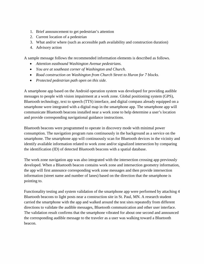
1. Brief announcement to get pedestrian’s attention 2. Current location of a pedestrian 3. What and/or where (such as accessible path availability and construction duration) 4. Advisory action
A sample message follows the recommended information elements is described as follows.
• Attention eastbound Washington Avenue pedestrians. • You are at southeast corner of Washington and Church. • Road construction on Washington from Church Street to Huron for 7 blocks. • Protected pedestrian path open on this side.
A smartphone app based on the Android operation system was developed for providing audible messages to people with vision impairment at a work zone. Global positioning system (GPS), Bluetooth technology, text to speech (TTS) interface, and digital compass already equipped on a smartphone were integrated with a digital map in the smartphone app. The smartphone app will communicate Bluetooth beacons installed near a work zone to help determine a user’s location and provide corresponding navigational guidance instructions. Bluetooth beacons were programmed to operate in discovery mode with minimal power consumption. The navigation program runs continuously in the background as a service on the smartphone. The smartphone app will continuously scan for Bluetooth devices in the vicinity and identify available information related to work zone and/or signalized intersection by comparing the identification (ID) of detected Bluetooth beacons with a spatial database. The work zone navigation app was also integrated with the intersection crossing app previously developed. When a Bluetooth beacon contains work zone and intersection geometry information, the app will first announce corresponding work zone messages and then provide intersection information (street name and number of lanes) based on the direction that the smartphone is pointing to. Functionality testing and system validation of the smartphone app were performed by attaching 4 Bluetooth beacons to light posts near a construction site in St. Paul, MN. A research student carried the smartphone with the app and walked around the test sites repeatedly from different directions to validate the audible messages, Bluetooth communication and other user interface. The validation result confirms that the smartphone vibrated for about one second and announced the corresponding audible message to the traveler as a user was walking toward a Bluetooth beacon.

Additional research is needed to conduct experiment with visually impaired users and evaluate system reliability and usefulness. An implementation study is essential and needs to be robust in terms of numbers of participants and needs to be completed at different work zones with different configurations. Data can be recorded and analyzed in terms of travel time, number of correct/incorrect responses/movement, understanding, safety and user confidence. According to a reserch survey conducted by Pew Research Center in 2013, 55% of cell phone owners say that their phone is a smartphone. Although, the smartphone ownership in the visually impaired community is lower than that in the general population. Five of the ten visually impaired participants we surveyed own a smartphone. It is expected that smartphone ownership will continute to increase as the mobile technology advances in the near future. The work zone nagivation app will become more widely accessible to users as the public agencies advance the implementation.
1
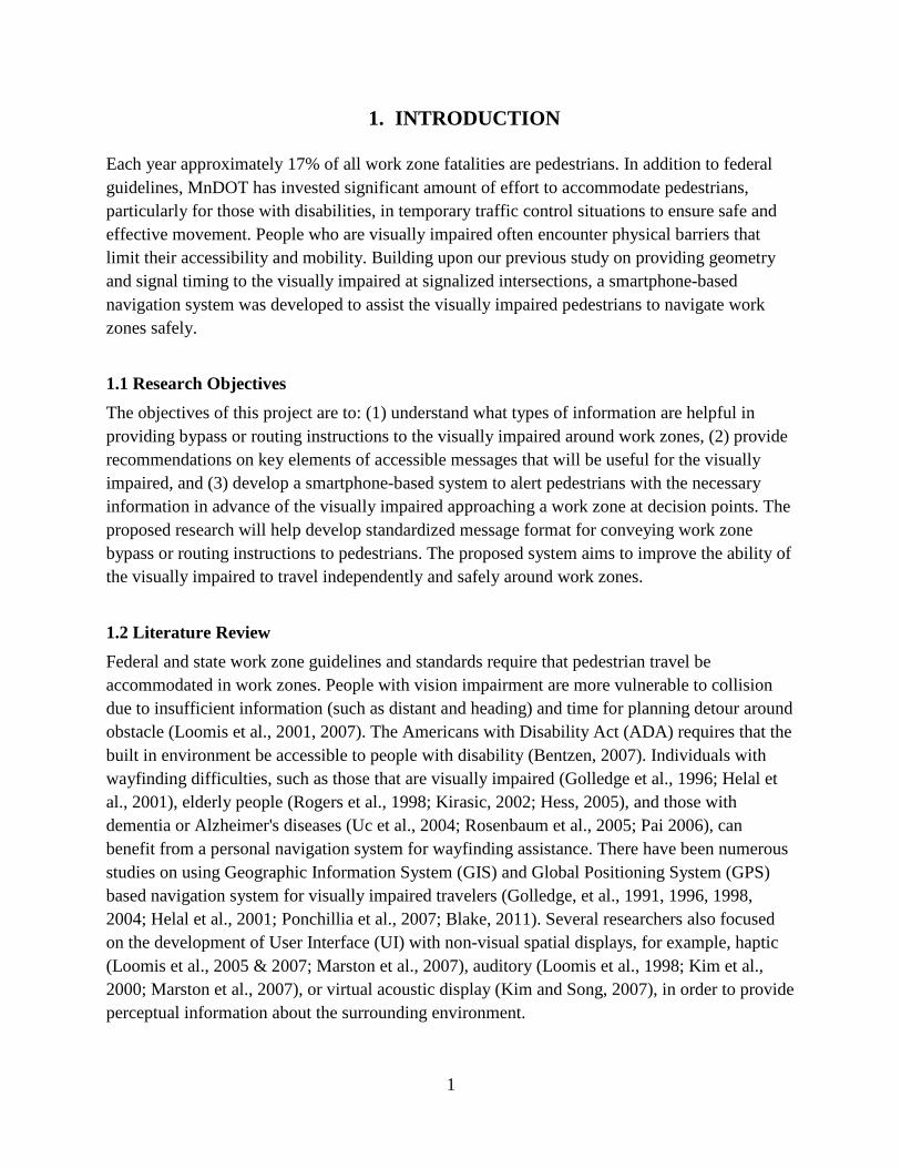
1. INTRODUCTION Each year approximately 17% of all work zone fatalities are pedestrians. In addition to federal guidelines, MnDOT has invested significant amount of effort to accommodate pedestrians, particularly for those with disabilities, in temporary traffic control situations to ensure safe and effective movement. People who are visually impaired often encounter physical barriers that limit their accessibility and mobility. Building upon our previous study on providing geometry and signal timing to the visually impaired at signalized intersections, a smartphone-based navigation system was developed to assist the visually impaired pedestrians to navigate work zones safely.
1.1 Research Objectives The objectives of this project are to: (1) understand what types of information are helpful in providing bypass or routing instructions to the visually impaired around work zones, (2) provide recommendations on key elements of accessible messages that will be useful for the visually impaired, and (3) develop a smartphone-based system to alert pedestrians with the necessary information in advance of the visually impaired approaching a work zone at decision points. The proposed research will help develop standardized message format for conveying work zone bypass or routing instructions to pedestrians. The proposed system aims to improve the ability of the visually impaired to travel independently and safely around work zones.
1.2 Literature Review Federal and state work zone guidelines and standards require that pedestrian travel be accommodated in work zones. People with vision impairment are more vulnerable to collision due to insufficient information (such as distant and heading) and time for planning detour around obstacle (Loomis et al., 2001, 2007). The Americans with Disability Act (ADA) requires that the built in environment be accessible to people with disability (Bentzen, 2007). Individuals with wayfinding difficulties, such as those that are visually impaired (Golledge et al., 1996; Helal et al., 2001), elderly people (Rogers et al., 1998; Kirasic, 2002; Hess, 2005), and those with dementia or Alzheimer's diseases (Uc et al., 2004; Rosenbaum et al., 2005; Pai 2006), can benefit from a personal navigation system for wayfinding assistance. There have been numerous studies on using Geographic Information System (GIS) and Global Positioning System (GPS) based navigation system for visually impaired travelers (Golledge, et al., 1991, 1996, 1998, 2004; Helal et al., 2001; Ponchillia et al., 2007; Blake, 2011). Several researchers also focused on the development of User Interface (UI) with non-visual spatial displays, for example, haptic (Loomis et al., 2005 & 2007; Marston et al., 2007), auditory (Loomis et al., 1998; Kim et al., 2000; Marston et al., 2007), or virtual acoustic display (Kim and Song, 2007), in order to provide perceptual information about the surrounding environment.
2
1.2.1 Work Zone Mobility for People with Disabilities
According to statistics from the Federal Highway Administration (FHWA), each year approximately 17% of all work zone fatalities are pedestrians. Since the ADA was enacted in 1990, there has been growing emphasis from both federal and local transportation agencies to provide safe pedestrian access in and around work zones. The ADA requires that pedestrians with disabilities be accommodated in completed facilities as well as during times of construction. Pedestrian movements around work zone areas require proper planning and consideration in order to avoid conflicts with work site equipment, vehicles and operations. The Manual on Uniform Traffic Control Devices (MUTCD) published by the FHWA and the Minnesota MUTCD (part 6) provide specific guidelines for Temporary Traffic Control (TTC) in work zones and outline specific requirements to accommodate pedestrians with disabilities. One of the requirements is, for example, to provide audible information for the visually impaired. Temporary Pedestrian Access and Mobility The Minnesota Department of Transportation (MnDOT), the American Traffic Safety Services Association (ATSSA) and the local Northland Chapter of ATSSA jointly organized a Temporary Pedestrian Access Route (TPAR) Workshop and Demonstration on June 23‐24, 2010. The purposes were to, (1) collect information regarding pedestrian work zone detouring experiences from people with disabilities and mobility instructors, and (2) use the information to develop guidelines for temporary traffic control planning and design (MnDOT, 2010). In June 2011, ATSSA in coordination with the FHWA and the California Department of Transportation (CALTRANS) also hosted a temporary pedestrian access and mobility demonstration in Sacramento, California. The objective was to provide state and local practitioners with guidance on how to design temporary traffic control plans that address pedestrian access to better meet the needs of people with disabilities. The final guideline is currently under review by the FHWA and is expected to be published in early 2013. Key findings from both workshops emphasize the need to provide adequate audible messages for people with vision impairment. They concluded that audible messages for a temporary pedestrian route shall include a complete physical description of the temporary pedestrian route including duration, length of and distance to the by-pass, any restrictions or hazards and project information. Pushbutton or motion-activated audible devices are also commercially available. For example, Empco-Lite (http://www.empco-lite.com) and the ADA Pedestrian Audible Alert System from MDI Traffic Control Products (http://www.mditrafficcontrol.com/) use pre-recorded messages at selected locations around a work zone to inform approaching pedestrians about the construction and provide specific routing information. The MDI system can automatically adjust volume to compensate ambient noises. However, there are concerns over the consistency of message

3
elements and clarity of audible messages. Ullman & Trout (2009) emphasized the importance of clear audible messages and spatial message elements that are critical in guiding the visually impaired pedestrians along a temporary route and supporting navigation in a less familiar environment. However, information overload could be a concern as most people may have difficulties in memorizing long verbal messages accurately. Transportation engineers and practitioners often face the challenges between verbosity and efficiency of auditory messages. Auditory Messages for the Visually Impaired The MUTCD clearly states that auditory messages should be used in and around work zone for people with disabilities; however, there is limited guidance available on auditory message structure and elements. Currently, there is insufficient guidance on how the audible message should be formatted to support wayfinding for the visual impaired around work zones. For example, Bentzen et al. (2002) recommended speech message structure and wording for Accessible Pedestrian Signals (APS). Hine et al. (2000) developed an auditory location finder (ALF) that involved auditory message content, structure, route choice, orientation, landmarks, and clues. Giudice et al. (2007) studied spatial learning and navigation using dynamically updated verbal messages and employed a geometric-based display consisting of three verbal modes (local, maplet, and global). They concluded that dynamically updated verbal descriptions are an effective medium in describing environmental relations and support spatial learning in unfamiliar environments (Giudice et al., 2007). In addition, Ullman & Trout (2009) explored different audio message elements and investigated how the guidance and warning messages were being understood by the visually impaired. They identified number of units of information in each message based on Highway Advisory Radio (HAR) message guidance as outlined by Hutchingson et al. (1982). Ullman & Trout (2009) first conducted a survey then performed a field test using a motion–activated audible device to evaluate the effectiveness of messages for navigating around a work zone. They concluded that (1) it is important to design a clear, simple and concise message, (2) initial turning or crossing instruction and travel distance (preferably using blocks for long distance and feet for shorter distance) are critical message elements for navigating an alternate route, and (3) there is a concern on information overload. Sample audible messages used by Ullman & Trout (2009) are listed as follows.
• “Attention northbound Clark Avenue pedestrians. Sidewalk closed. To avoid closed area, cross Clark Avenue at next intersection. Turn right and continue six blocks on opposite side of street. Return to original side of street if desired.” – 7 units of information
• “Attention eastbound Orchard Road pedestrians. Construction ahead. To avoid construction area, cross at Green Street and turn left. Continue on opposite side of street for the next 1⁄2 mile.” – 5 units of information

4
Gaunet and Briffault (2005) and Gaunet (2006) studied guidance instructions and spatial information through navigational experiments in both simple structured and complex unstructured urban areas. They used six categories of guidance functions to structure linguistic forms for synthesizing the perceptual and environmental information. They suggested that detail level of description and precision of localization must be improved in order to provide guidance in complex urban environments. Information and instruction guidance functions used by Gaunet and Briffault (2005 & 2006) are outlined as follows.
Information guidance functions: • Location and Orientation (LO) • Goal Location (GL)
Instruction guidance functions: • Orientation (O) • Crossing (C) • Route Ending (RE) • Progress (P)
Examples of linguistic forms and guidance functions (Gaunet, 2006):
Table 1-1 Linguistic Forms and Guidance Functions
Linguistic Forms Guidance Functions You are in front of “XXX Café” LO: Location / Orientation Walk forward P: Progression Turn to the right O: Orientation Arrive at XXX intersection RE: Route Ending
1.2.2 Auditory Navigation
Due to the heavy visual demands on a driving task, auditory route guidance has safety advantage over the visual display. The impact of driver’s performance while obtaining auditory and/or visual guidance has been studied in vehicle navigation (Campbell et al. 1998), in-vehicle display (Campbell et al, 2004), and speed advisory (Shahab et al. 2010). Improved driving performance and reduced driver’s workload were found in route guidance systems (RGS) incorporating both visual and auditory guidance as compared to those using electronic map alone (Srinivasan & Jovanis, 1997). Streeter et al. (1985) reported that auditory navigation in their experiment is easier than the visual format. However, Walker et al. (1990) found that complicated auditory information such as spatial layouts interfered with participants’ information processing capabilities.

5
The human factor design guidelines for advanced traveler information systems (Campbell et al., 1998) suggested presenting the information in the order of importance or relevance and providing a feature for repeating the audio message. Campbell et al. (1998) also recommended that auditory navigation instructions should be limited to 3 or 4 information units for drivers. Morley et al. (1999) designed and evaluated a non-visual hypermedia system for blind users. Hypermedia is a network of information which comprises of text, images, sound recordings (even tactile and olfactory outputs). The World Wide Web is a well-known example of a hypermedia environment. Morley et al. (1999) concluded that user interface should be simple, easy to learn, consistent and provide effective feedback. Boer de (2008) suggested using short auditory messages with natural tone and familiar voices to improve the effectiveness in navigating people with mild dementia.
1.2.3 Verbal Guidance and Usability for the Blind
Gaunet and Briffault (2005) developed a set of verbal guidance rules for assisting visually impaired pedestrians in navigating through urban areas. Gaunet (2006) conducted navigational experiments in simple structured, and complex unstructured urban areas. The findings offer interesting perspectives for guidance rules originating from verbal instructions given to visually impaired pedestrians. Gaunet suggested that these instructions could also be used by sighted users with a few specific modifications. Roentgen et al. (2011) evaluated four electronic navigational devices for the visually impaired. Five-point scale of D-Quest (Wessels & de Witte, 2003) based questionnaire in seven aspects (dimension, weight, adjustment, safety, simplicity, comfort, and effectiveness) was used in combination with open questions to access 18 participants’ subjective experiences. They concluded that participants’ preferences regarding device usability and functionality linked closely with individual’s O&M and computer skills, and their knowledge and expectations of the devices’ functional ability (Roentgen et al., 2011). Havik et al. (2011) evaluated the effectiveness of different types of verbal information provided by electronic travel aids in assisting wayfinding performance among 24 visually impaired users. The results suggested that a combination of route and environmental information are preferred by the participants, even though the combined information did not always result in an optimal wayfinding performance. They recommended including distance information to next information point and more landmarks or information points in the environment. Wilson et al. (2007) developed a wearable audio navigation system to assist blind and visually impaired people getting from origin to destination. The system uses GPS, digital compass, cameras, and a light sensor to transmit 3D audio cues to guide the traveler along a path to destination. They concluded that the auditory interface has proven itself to be simple,
6
straightforward, and effective in guiding uses along both simple and complex paths (Wilson et al., 2007). Davies and Burns (2008) reviewed recent advances in Cognitive Work Analysis (CWA) and Ecological Interface Design (EID) for visual and auditory displays. Davies et al. (2006) developed a prototype design of an auditory interface based on the Work Domain Analysis (WDA) of EID for people who are visually impaired. Usability test of the prototype was performed to evaluate the effectiveness of object identification, direction of obstacle, and determining relative size and distance of an object (Davies et al., 2007). Sanderson et al. (2000) proposed additional hierarchy layer to extend EID for auditory design.
1.3 Report Organization The rest of this report is organized as follows. A questionnaire was designed and discussed in Section 2 to better understand what message elements are important and useful for the visually impaired while navigating around work zones. Design and development of a smartphone app and Bluetooth beacon interface are included in Section 3. System testing and validation are presented in Section 4. Lesson learned and future works are discussed in Section 5. Finally, summary is presented in Section 6.

7
2. SURVEY
To better understand what message elements are important and useful for the visually impaired while navigating around work zones, a survey protocol was designed and reviewed by the University of Minnesota (UMN) Institutional Review Board (IRB). The recruitment ads and survey materials were approved by the UMN IRB with reference code #1209S21382. The research team has been working closely with local blind communities, including the Vision Loss Resources, Inc. (VLR) in Minneapolis, UMN disability student group, and Vision Impairment Service (VIS) group at VA hospital. The recruiting ad (see Appendix A) was announced in VLR’s monthly newsletter and also distributed through email to disability student group though Disabled Student Cultural Center (DSCC) at UMN. The approved consent form, listed in Appendix B, was used to ensure participants understand the objectives of this research and the purposes of the survey prior to their participations in survey discussion. Interview protocol and survey questionnaires (see Appendix C) were used to collect navigational information and comments from the pedestrians who are visually impaired while wayfinding around work zones.
2.1 Audible Messages The research team has interviewed 10 visually impaired pedestrians (in-person) to understand what type of information is helpful in providing work zone routing information to them. In addition to demographic information, four different messages with various level of information content were programmed and announced using synthetic speech voice, i.e., text to speech (TTS), to each participant during the survey.
• Message #1 “Attention eastbound Dolphin Street pedestrians. Construction ahead on sidewalk between 2nd and 6th Avenue. Use alternate route.”
• Message #2 “Attention southbound Lyndale Avenue pedestrians. East sidewalk closed from 22nd to 26th street. Cross Lyndale. Use sidewalk on the other side.”
• Message #3 “Attention southbound Snelling Ave pedestrians. Sidewalk closed from Marshall Ave for 6 blocks. Cross Snelling at Marshall. Use sidewalk on the other side. Return to original side of street if desired”
• Message #4 Part 1 - “Attention southbound Lyndale Avenue pedestrians. You are at southwest corner of Lyndale and Franklin. West sidewalk closed from 22nd to 26th street. Cross Lyndale for more bypassing message.”

8
Part 2 - “Attention southbound Lyndale Avenue pedestrians. You are at southeast corner of Lyndale and Franklin. West sidewalk closed from 22nd to 26th street. Use sidewalk on this side.”
9
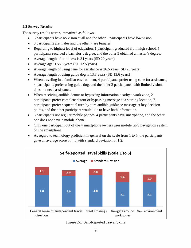
2.2 Survey Results The survey results were summarized as follows.
• 5 participants have no vision at all and the other 5 participants have low vision • 3 participants are males and the other 7 are females • Regarding to highest level of education, 1 participant graduated from high school, 5
participants received a bachelor’s degree, and the other 5 obtained a master’s degree. • Average length of blindness is 34 years (SD 29 years) • Average age is 55.6 years (SD 12.5 years) • Average length of using cane for assistance is 26.5 years (SD 23 years) • Average length of using guide dog is 13.8 years (SD 13.6 years) • When traveling in a familiar environment, 4 participants prefer using cane for assistance,
4 participants prefer using guide dog, and the other 2 participants, with limited vision, does not need assistance.
• When receiving audible detour or bypassing information nearby a work zone, 2 participants prefer complete detour or bypassing message at a starting location, 7 participants prefer sequential turn-by-turn audible guidance message at key decision points, and the other participant would like to have both information.
• 5 participants use regular mobile phones, 4 participants have smartphone, and the other one does not have a mobile phone.
• Only one participant out of the 4 smartphone owners uses mobile GPS navigation system on the smartphone.
• As regard to technology proficient in general on the scale from 1 to 5, the participants gave an average score of 4.0 with standard deviation of 1.2.
Figure 2-1 Self-Reported Travel Skills
10
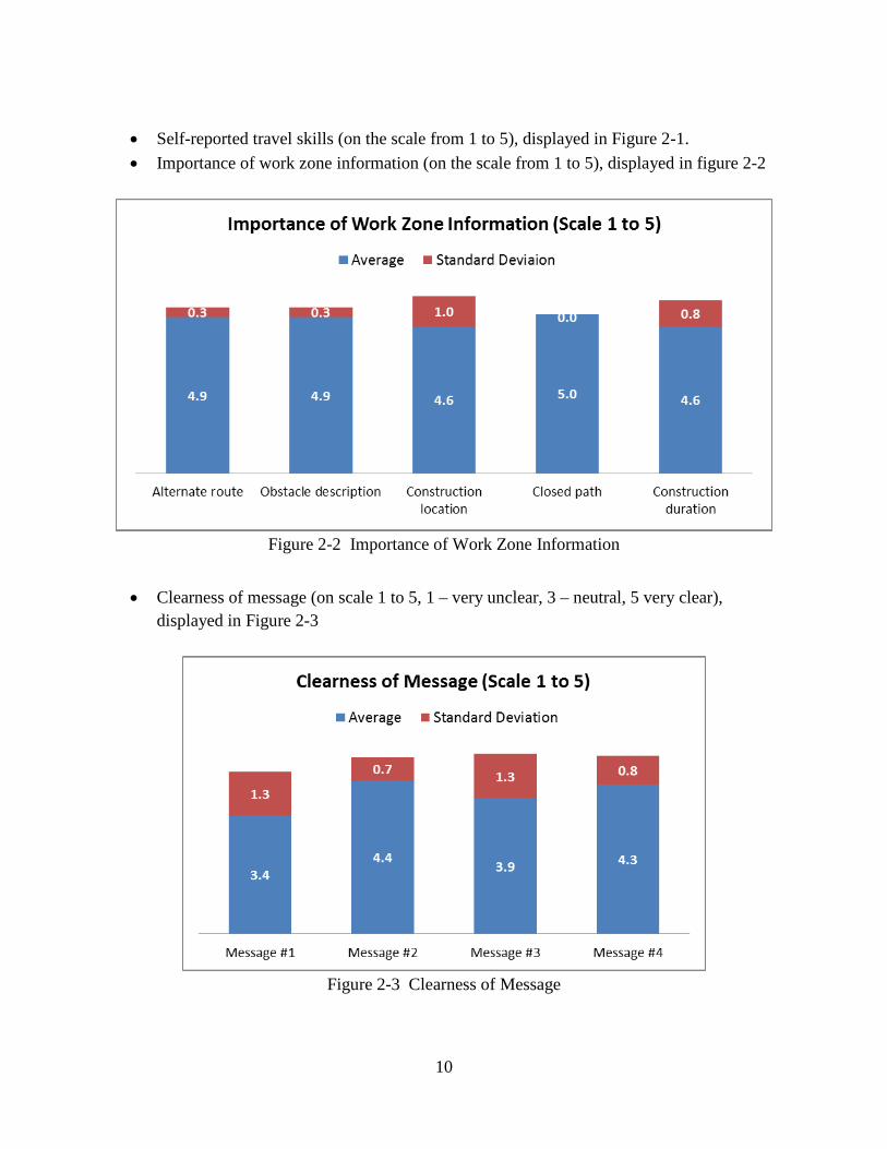
• Self-reported travel skills (on the scale from 1 to 5), displayed in Figure 2-1. • Importance of work zone information (on the scale from 1 to 5), displayed in figure 2-2
Figure 2-2 Importance of Work Zone Information
• Clearness of message (on scale 1 to 5, 1 – very unclear, 3 – neutral, 5 very clear), displayed in Figure 2-3
Figure 2-3 Clearness of Message

11
• Understanding of the message, displayed in Figure 2-4
Figure 2-4 Understanding of the Message
Most of the participants reported that they understood the message as display in Figure 2-4. However, three participants did not remember what street or intersection the message #1 was talking about. As illustrated in Figure 2-5, one participant cannot recall the intersection in message #2 and two participants did not remember which intersection that message #3 referred to.
Figure 2-5 Remembrance of Intersection or Street Name

12
• In all messages, participants were able to identify the sidewalk was closed or there was a
construction in the vicinity. • Try suggested route (on scale 1 to 5, 1 – absolutely no, 3 – neutral, 5 – absolutely yes),
displayed in Figure 2-6.
Figure 2-6 Likelihood to Try Suggested Route
• In general, the participants will follow the detour instruction or try to find an alternate route if no further information was provided in the audible messages. They trust the message and will avoid the construction area as instructed for the sake of their own safety.
• When receiving audible direction information, 6 participants prefer cardinal (such as north, south, east, or west) direction, 2 participants prefer clock phase direction, and the other 2 participants have no preference.
• When receiving audible location information, 2 participants like landmark, 6 participants prefer street name, and the other 2 have no preference.
• When hearing an audible message, 4 participants prefer male voice, 1 prefers female voice, and the other 5 participants have no preference.
• All participants (10) reported that the synthetic voice is clear. 2 participants reported the compute speech is a bit too slow, 2 felt it’s a bit too fast, and the other 6 participants felt the speed is just fine.
• All participants reported that it is extremely important to include a feature for repeating the audible message as many times as needed.
• In addition to work zone information, some participants reported that they also would like to know if the intersection has a stop light or other key landmark around them.
13
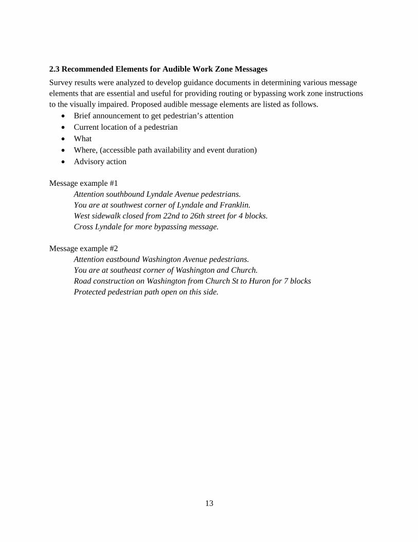
2.3 Recommended Elements for Audible Work Zone Messages Survey results were analyzed to develop guidance documents in determining various message elements that are essential and useful for providing routing or bypassing work zone instruto the visually impaired. Proposed audible message elements are listed as follows.
• Brief announcement to get pedestrian’s attention • Current location of a pedestrian • What • Where, (accessible path availability and event duration) • Advisory action
Message example #1
Attention southbound Lyndale Avenue pedestrians. You are at southwest corner of Lyndale and Franklin. West sidewalk closed from 22nd to 26th street for 4 blocks. Cross Lyndale for more bypassing message.
Message example #2
Attention eastbound Washington Avenue pedestrians. You are at southeast corner of Washington and Church. Road construction on Washington from Church St to Huron for 7 blocks
ctions
Protected pedestrian path open on this side.
14
3. SYSTEM DESIGN AND DEVELOPMENT
A smartphone app based on Android operation system (OS) was developed to provide audible messages to people with vision impairment while approaching a work zone. The purpose is to help the visually impaired pedestrians safely navigate through or around construction areas. Global positioning system (GPS), Bluetooth technology, text to speech (TTS) interface, and motion sensors equipped on a smartphone were integrated with a digital map and Bluetooth beacons to help identify a user’s location and provide navigational guidance. Bluetooth beacons can be easily attached to barricades or traffic cones at decision points to help determine the location of a user. The smartphone app, after detecting a Bluetooth beacon in discovery mode, will provide associated navigation messages to travelers. The navigation program runs continuously in the background as a service on the Android smartphone. It will continuously scan for Bluetooth devices in the vicinity and identify available information related to work zone and signalized intersection by comparing the ID of detected Bluetooth beacons with the spatial database. When any work zone information is detected, the app will alert users with a brief vibration (about 1-sec) and announce corresponding audible messages through the TTS interface. Users can then perform a single-tap on the screen of a smartphone to repeat announced audible message, if desired. The work zone navigation system consists of three key components, i.e., a digital map database for spatial reference, a smartphone app, and Bluetooth smart beacons. User input is implemented by performing a single-tap on the smartphone screen for repeating audible messages. Vibration and audible feedback are provided to users when a Bluetooth beacon is detected. The general geometry information of a work zone area, location of Bluetooth devices, and associated advisory messages can be easily programmed and uploaded to the spatial database through a web interface (See Appendix A). The web interface will allow engineers to deploy accessible audible messages around a work zone quickly and easily. The smartphone app was developed using the open source Java technology in Eclipse-based integrated development environment (IDE). In the future, the same app can be developed for other smartphones (e.g., iPhone iOS, Windows phone, etc.) running on mobile OS other than Android. Several prototypes of Bluetooth beacons were developed and programmed using OEM Bluetooth modules (SPA310i and OBS410i) manufactured by the ConnectBlue Inc. The Bluetooth beacon prototypes are powered by three AA batteries.
3.1 Spatial Database An open source database server, mySQL, is setup and configured to provide digital map reference to smartphone clients based on a user’s current location. Location based spatial information, for example, covers 5-mile radius around a smartphone user, will be periodically
15
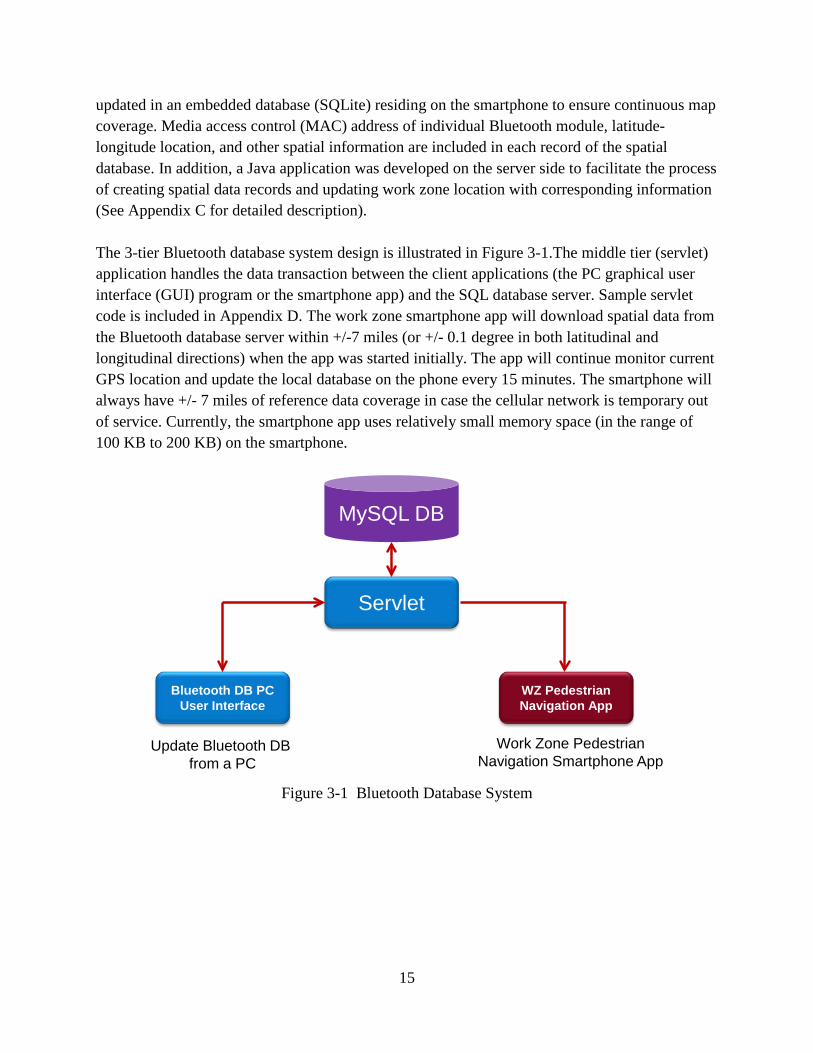
updated in an embedded database (SQLite) residing on the smartphone to ensure continuous map coverage. Media access control (MAC) address of individual Bluetooth module, latitude-longitude location, and other spatial information are included in each record of the spatial database. In addition, a Java application was developed on the server side to facilitate the process of creating spatial data records and updating work zone location with corresponding information (See Appendix C for detailed description). The 3-tier Bluetooth database system design is illustrated in Figure 3-1.The middle tier (servlet) application handles the data transaction between the client applications (the PC graphical user interface (GUI) program or the smartphone app) and the SQL database server. Sample servlet code is included in Appendix D. The work zone smartphone app will download spatial data from the Bluetooth database server within +/-7 miles (or +/- 0.1 degree in both latitudinal and longitudinal directions) when the app was started initially. The app will continue monitor current GPS location and update the local database on the phone every 15 minutes. The smartphone will always have +/- 7 miles of reference data coverage in case the cellular network is temporary out of service. Currently, the smartphone app uses relatively small memory space (in the range of 100 KB to 200 KB) on the smartphone.
Figure 3-1 Bluetooth Database System
Servlet
Bluetooth DB PC User Interface
WZ Pedestrian Navigation App
MySQL DB
Update Bluetooth DB from a PC
Work Zone PedestrianNavigation Smartphone App

16
3.2 Audible Messages Proposed audible message elements resulting from survey in task #2 are listed as follows.
• Brief announcement to get pedestrian’s attention • Current location of a pedestrian • What and where, (accessible path availability and event duration) • Advisory action
The data scheme implemented in the spatial database, as listed in Table 3-1, is based on the proposed message elements. The message ID is the identical MAC address of each Bluetooth module. The latitude/longitude data fields store the latitude and longitude location of a Bluetooth beacon. The message direction describes which direction of travelers will be affected by the construction. The Bluetooth ID location verbally describes the location where the Bluetooth beacon is installed. Description 1, 2 and 3 inform travelers the nature, location, and the scale of the work zone. The advisory message contains the suggested bypassing information for the travelers. The following audible message is used as an example.
Attention southbound Lyndale Avenue pedestrians. [Attention] You are at southwest corner of Lyndale and Franklin. [User location] West sidewalk closed from 22nd to 26th street for 4 blocks. [What & where] Cross Lyndale for more bypassing message. [Advisory action]
Table 3-1 Data Scheme of Spatial Database
Data Field Sample Value Message ID 00:12:F3:0B:4A:11 Latitude 44.98339267 Longitude -93.37697511 Message Direction Southbound Lyndale Avenue Bluetooth ID Location Southwest corner of Lyndale and Franklin Description 1 West sidewalk closed Description 2 22nd to 26th street Description 3 4 blocks Advisory Message Cross Lyndale for more bypassing message
3.3 Smartphone App System design flowchart of the smartphone app is illustrated in Figure 3-2 as follows. Intersection-related features on the left column of Figure 3-2 were previously developed to provide signal timing information to the visually impaired at signalized intersections. For work zone applications, the smartphone app, running as a service in the background, continuously scans for Bluetooth devices in the nearby environment in discovery mode. The Bluetooth

17
functionality on the smartphone will be activated in order to detect Bluetooth beacons in the environment. When a Bluetooth MAC address is detected and identified in the spatial database, the smartphone will vibrate for about 1 second to alert users. The app will then announce corresponding audible message associated with the Bluetooth beacon to smartphone users using the TTS (Text to Speech) technology. After the initial message was announced, users can repeat the message, if needed, by performing a single tap on the smartphone screen. The smartphone app redirects its process to the smartphone screen and waits for potential user input whenever a match in database is found for a Bluetooth device. In case no Bluetooth devices are found from the spatial database, the phone will simply announce “No Information Present”. Please refer to Appendix B for more detail information on the pseudo code of the Android app.
Figure 3-2 Flowchart of Work Zone Navigation Smartphone App
3.4 Bluetooth Beacons The GPS satellite positioning system provides relatively accurate user location in an open space. However, in urban canyons or indoor environments, the position solution is unavailable or
18
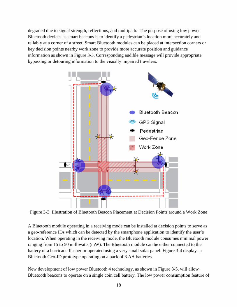
degraded due to signal strength, reflections, and multipath. The purpose of using low power Bluetooth devices as smart beacons is to identify a pedestrian’s location more accurately and reliably at a corner of a street. Smart Bluetooth modules can be placed at intersection corners or key decision points nearby work zone to provide more accurate position and guidance information as shown in Figure 3-3. Corresponding audible message will provide appropriate bypassing or detouring information to the visually impaired travelers.
Figure 3-3 Illustration of Bluetooth Beacon Placement at Decision Points around a Work Zone
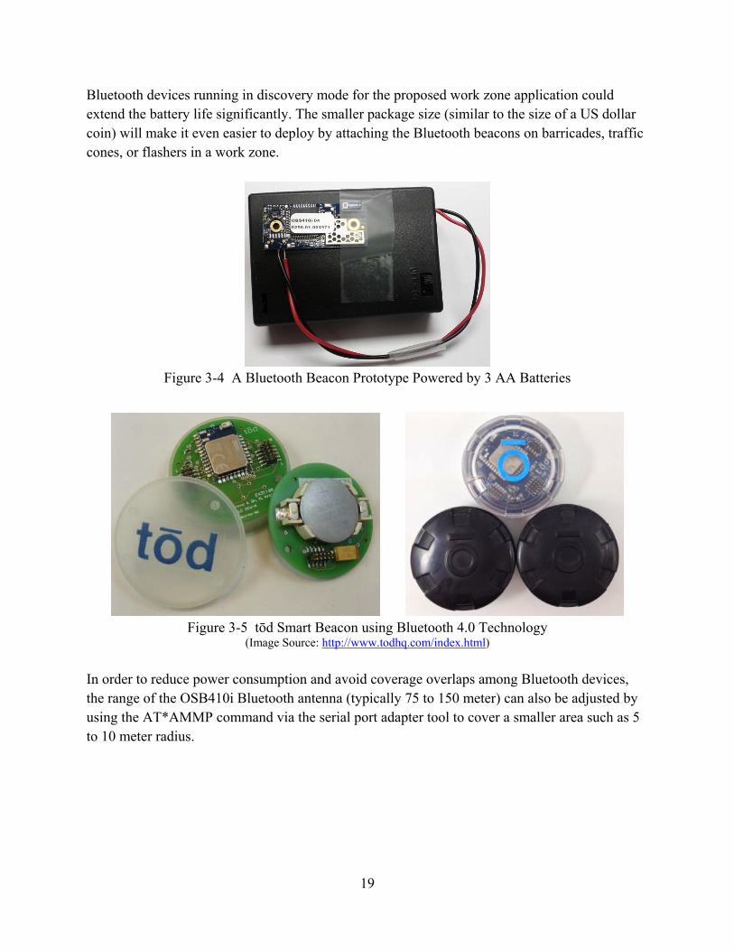
A Bluetooth module operating in a receiving mode can be installed at decision points to serve as a geo-reference IDs which can be detected by the smartphone application to identify the user’s location. When operating in the receiving mode, the Bluetooth module consumes minimal power ranging from 15 to 50 milliwatts (mW). The Bluetooth module can be either connected to the battery of a barricade flasher or operated using a very small solar panel. Figure 3-4 displays a Bluetooth Geo-ID prototype operating on a pack of 3 AA batteries. New development of low power Bluetooth 4 technology, as shown in Figure 3-5, will allow Bluetooth beacons to operate on a single coin cell battery. The low power consumption feature of
19
Bluetooth devices running in discovery mode for the proposed work zone application could extend the battery life significantly. The smaller package size (similar to the size of a US dollar coin) will make it even easier to deploy by attaching the Bluetooth beacons on barricades, traffic cones, or flashers in a work zone.
Figure 3-4 A Bluetooth Beacon Prototype Powered by 3 AA Batteries
Figure 3-5 tōd Smart Beacon using Bluetooth 4.0 Technology
(Image Source: http://www.todhq.com/index.html)
In order to reduce power consumption and avoid coverage overlaps among Bluetooth devices, the range of the OSB410i Bluetooth antenna (typically 75 to 150 meter) can also be adjusted by using the AT*AMMP command via the serial port adapter tool to cover a smaller area such as 5 to 10 meter radius.

20
[AT*AMMP = Max_output_power, Startup_flag] Where,
Max_output_power = 255: Use the highest output power supported by the Serial Port Adapter a
maximum output power (default value). 128 - X: -X dBm (X < 30) 128: 0 dBm 128 + Y: +Y dBm (Y < 30)
Startup_flag = 0: The setting will only be valid for the current power cycle. 1: The ConnectBlue Serial Port Adapter will remember the setting betwee
power cycles. The settings database in the Serial Port Adapter will be updated.
dBm is power ratio in decibels (dB) of the measured power referenced to onemilliwatt (mW).
For example, a value of Max_output_power = 130 means +2 dBm. The prototype Bluetooth devices were configured to a few meters of range using [AT*AMM120, 1]. See Appendix C for more information about the ConnectBlue programming interfacusing Bluetooth serial port adapter toolbox.
s the
n
P = e
21
4. SYSTEM TESTING AND VALIDATION
The research team previously performed functional test of the developed smartphone app on the University of Minnesota east bank campus. Validation of the developed smartphone app at two construction sites on Martin Luther King Boulevard near the state capitol mall were performed and discussed in this report. The validation results confirmed that the smartphone app successfully detects Bluetooth beacons installed about 15 feet away. The smartphone vibrates for about 1 second and announces the corresponding audible message to a test subject as the person is approaching an intersection of crosswalk and sidewalk. The subject was able to validate the audible messages and follow each audible message to bypass the work zone construction.
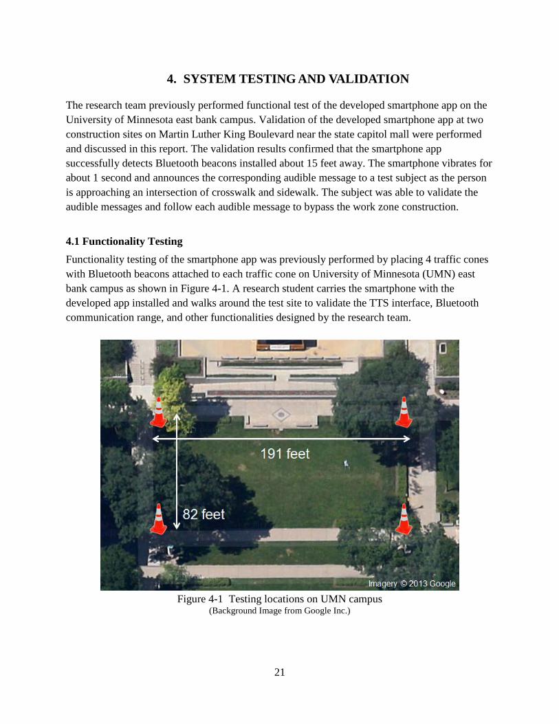
4.1 Functionality Testing Functionality testing of the smartphone app was previously performed by placing 4 traffic cones with Bluetooth beacons attached to each traffic cone on University of Minnesota (UMN) east bank campus as shown in Figure 4-1. A research student carries the smartphone with the developed app installed and walks around the test site to validate the TTS interface, Bluetooth communication range, and other functionalities designed by the research team.
Figure 4-1 Testing locations on UMN campus (Background Image from Google Inc.)

22
4.2 System Validation The repeatability of the Bluetooth communication range was tested and system validation at two sidewalk closure sites was performed and presented as follows.
4.2.1 Testing of Bluetooth Communication Range
A Bluetooth module operating in a receiving mode was programmed and installed at corners of an intersection to serve as a geo-reference tag which can be detected by the work zone smartphone app to identify a user’s location. When operating in the receiving mode, the Bluetooth module consumes minimal power ranging from 15 to 50 milliwatts (mW). The Bluetooth module can be either connected to the battery of a barricade flasher or operated using a very small solar panel. Currently, the Bluetooth beacon prototypes were powered by 3 AA batteries. A prototype and its enclosure are displayed in Figure 4-2.
Figure 4-2 Bluetooth Beacon Prototype and Enclosure
In order to reduce power consumption and avoid coverage overlaps among Bluetooth beacons, the antenna range of the OBS410i Bluetooth module (typically 75 to 150 meter) was programmed (AT*AMMP = 100, see Appendix A for details on AT*AMMP command) to cover a smaller area such as 5 meter radius. Figure 4-3 illustrates the configuration for testing the Bluetooth beacon in four different directions. Table 4-1 listed the results of testing the Bluetooth communication ranges when the smartphone detects the Bluetooth beacon. The average communication distance when approaching the Bluetooth beacon from the left direction is 4.9 feet with standard deviation of 1.8 feet. The average communication distance when approaching the Bluetooth beacon from right direction is 8.7 feet with standard deviation of 5.5 feet. The average communication distance in front of the Bluetooth beacon is 8.7 feet with standard deviation of 3.3 feet. The average communication distance in the rear direction of the Bluetooth beacon is 13.1 feet with standard deviation of 6.3 feet.
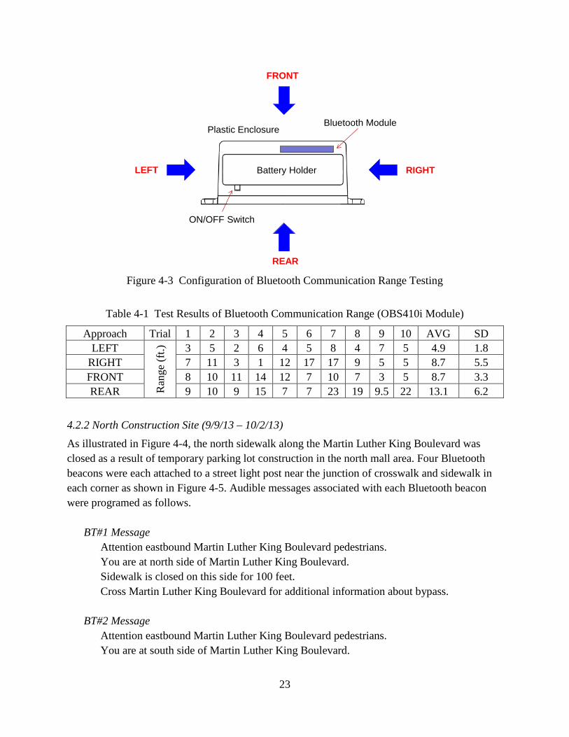
23
Figure 4-3 Configuration of Bluetooth Communication Range Testing
Battery Holder
Bluetooth Module
ON/OFF Switch
Plastic Enclosure
FRONT
REAR
RIGHTLEFT
Table 4-1 Test Results of Bluetooth Communication Range (OBS410i Module)
Approach Trial 1 2 3 4 5 6 7 8 9 10 AVG SD LEFT
Ran
ge (f
t.) 3 5 2 6 4 5 8 4 7 5 4.9 1.8
RIGHT 7 11 3 1 12 17 17 9 5 5 8.7 5.5 FRONT 8 10 11 14 12 7 10 7 3 5 8.7 3.3 REAR 9 10 9 15 7 7 23 19 9.5 22 13.1 6.2
4.2.2 North Construction Site (9/9/13 – 10/2/13)
As illustrated in Figure 4-4, the north sidewalk along the Martin Luther King Boulevard was closed as a result of temporary parking lot construction in the north mall area. Four Bluetooth beacons were each attached to a street light post near the junction of crosswalk and sidewalk in each corner as shown in Figure 4-5. Audible messages associated with each Bluetooth beacon were programed as follows. BT#1 Message
Attention eastbound Martin Luther King Boulevard pedestrians. You are at north side of Martin Luther King Boulevard. Sidewalk is closed on this side for 100 feet. Cross Martin Luther King Boulevard for additional information about bypass.
BT#2 Message
Attention eastbound Martin Luther King Boulevard pedestrians. You are at south side of Martin Luther King Boulevard.
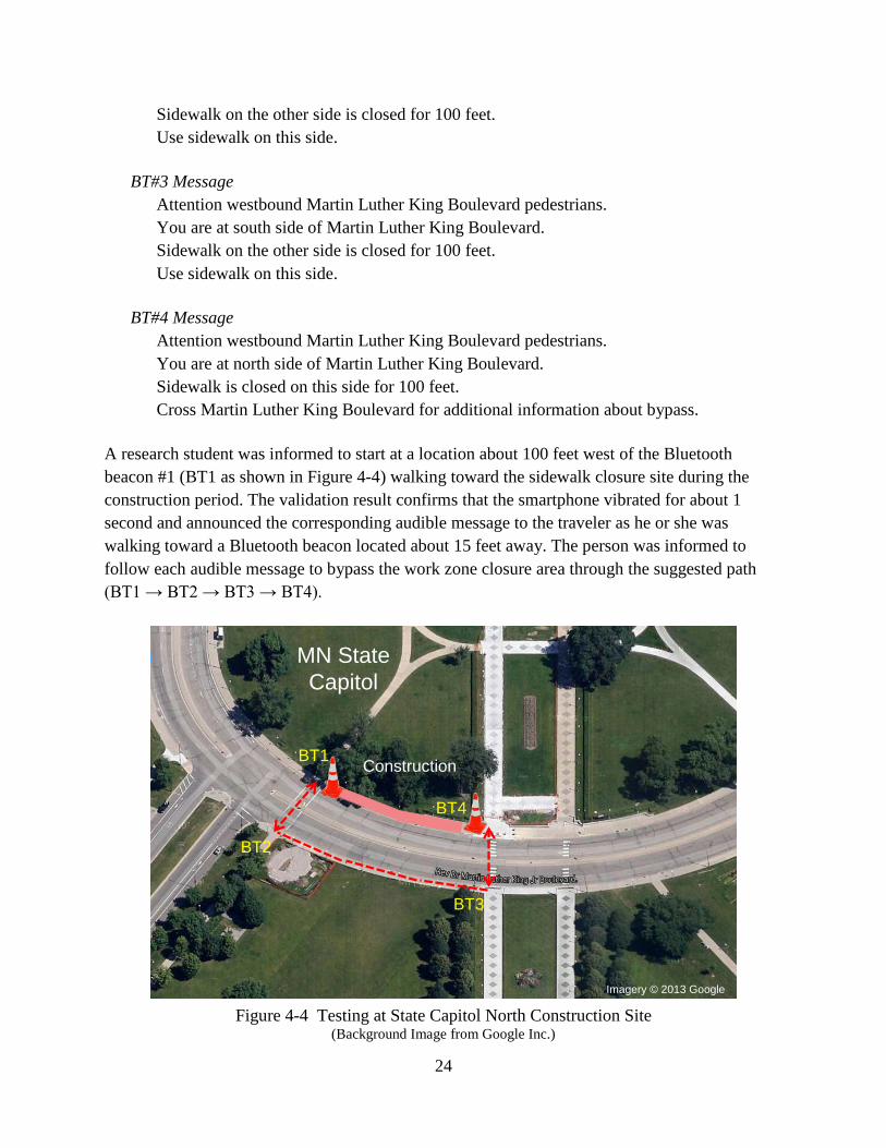
24
Sidewalk on the other side is closed for 100 feet. Use sidewalk on this side.
BT#3 Message
Attention westbound Martin Luther King Boulevard pedestriansYou are at south side of Martin Luther King Boulevard.
.
Sidewalk on the other side is closed for 100 feet. Use sidewalk on this side.
BT#4 Message
Attention westbound Martin Luther King Boulevard pedestrians. You are at north side of Martin Luther King Boulevard. Sidewalk is closed on this side for 100 feet. Cross Martin Luther King Boulevard for additional information about bypass.
A research student was informed to start at a location about 100 feet west of the Bluetooth beacon #1 (BT1 as shown in Figure 4-4) walking toward the sidewalk closure site during the construction period. The validation result confirms that the smartphone vibrated for about 1 second and announced the corresponding audible message to the traveler as he or she was walking toward a Bluetooth beacon located about 15 feet away. The person was informed to follow each audible message to bypass the work zone closure area through the suggested path (BT1 → BT2 → BT3 → BT4).
Figure 4-4 Testing at State Capitol North Construction Site
(Background Image from Google Inc.)
MN StateCapitol
Imagery © 2013 Google
BT1
BT2
BT4
BT3
Construction

25
Figure 4-5 Installation of Bluetooth Beacon and Field Testing (North Sidewalk)
Bluetooth ID
4.2.3 South Construction Site (10/7/13 – 10/25/13)
As illustrated in Figure 4-6, the south sidewalk along the Martin Luther King Boulevard was closed for another parking lot construction after the north sidewalk reopens. Four Bluetooth beacons were each attached to a light post near the junction of crosswalk and sidewalk in each corner as displayed in Figure 4-7. Configuration and installation of the four Bluetooth beacons were placed at the same locations as in the north sidewalk closure scenario. Audible messages associated with each Bluetooth beacon were reprogramed as follows. BT#1 Message
Attention eastbound Martin Luther King Boulevard pedestrians. You are at north side of Martin Luther King Boulevard. Sidewalk on the other side is closed for 100 feet. Use sidewalk on this side.
BT#2 Message
Attention eastbound Martin Luther King Boulevard pedestrians. You are at south side of Martin Luther King Boulevard. Sidewalk is closed on this side for 100 feet. Cross Martin Luther King Boulevard for additional information about bypass.
BT#3 Message
Attention westbound Martin Luther King Boulevard pedestrians. You are at south side of Martin Luther King Boulevard. Sidewalk is closed on this side for 100 feet. Cross Martin Luther King Boulevard for additional information about bypass.

26
BT#4 Message Attention westbound Martin Luther King Boulevard pedestrians. You are at north side of Martin Luther King Boulevard. Sidewalk on the other side is closed for 100 feet. Use sidewalk on this side.
Figure 4-6 Testing at State Capitol South Construction Site (Background Image from Google Inc.)
MN StateCapitol
Imagery © 2013 Google
BT1
BT2
BT4
BT3Construction
Figure 4-7 Installation of Bluetooth Beacon and Field Testing (South Sidewalk)
Bluetooth Beacon

27
A research student was informed to start at a location about 100 feet south of the Bluetooth beacon #2 (BT2 as shown in Figure 4-6) walking toward the sidewalk closure site during the construction period. The validation result confirms that the smartphone vibrated for about 1 second and announced the corresponding audible message to the traveler as the person was approaching each Bluetooth beacon about 15 feet away. The test subject then followed each audible message to bypass the construction closure through the suggested path (BT2 → BT1 → BT4 → BT3).
28
5. FUTURE WORK
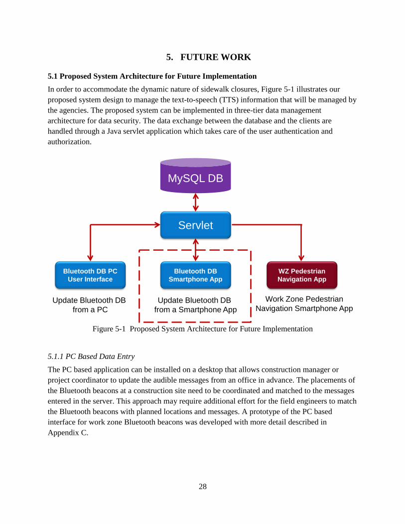
5.1 Proposed System Architecture for Future Implementation In order to accommodate the dynamic nature of sidewalk closures, Figure 5-1 illustrates our proposed system design to manage the text-to-speech (TTS) information that will be managed by the agencies. The proposed system can be implemented in three-tier data management architecture for data security. The data exchange between the database and the clients are handled through a Java servlet application which takes care of the user authentication and authorization.
Figure 5-1 Proposed System Architecture for Future Implementation
Servlet
Bluetooth DB PC User Interface
Bluetooth DB Smartphone App
WZ Pedestrian Navigation App
MySQL DB
Update Bluetooth DB from a PC
Update Bluetooth DB from a Smartphone App
Work Zone PedestrianNavigation Smartphone App
5.1.1 PC Based Data Entry
The PC based application can be installed on a desktop that allows construction manager or project coordinator to update the audible messages from an office in advance. The placements of the Bluetooth beacons at a construction site need to be coordinated and matched to the messages entered in the server. This approach may require additional effort for the field engineers to match the Bluetooth beacons with planned locations and messages. A prototype of the PC based interface for work zone Bluetooth beacons was developed with more detail described in Appendix C.
29
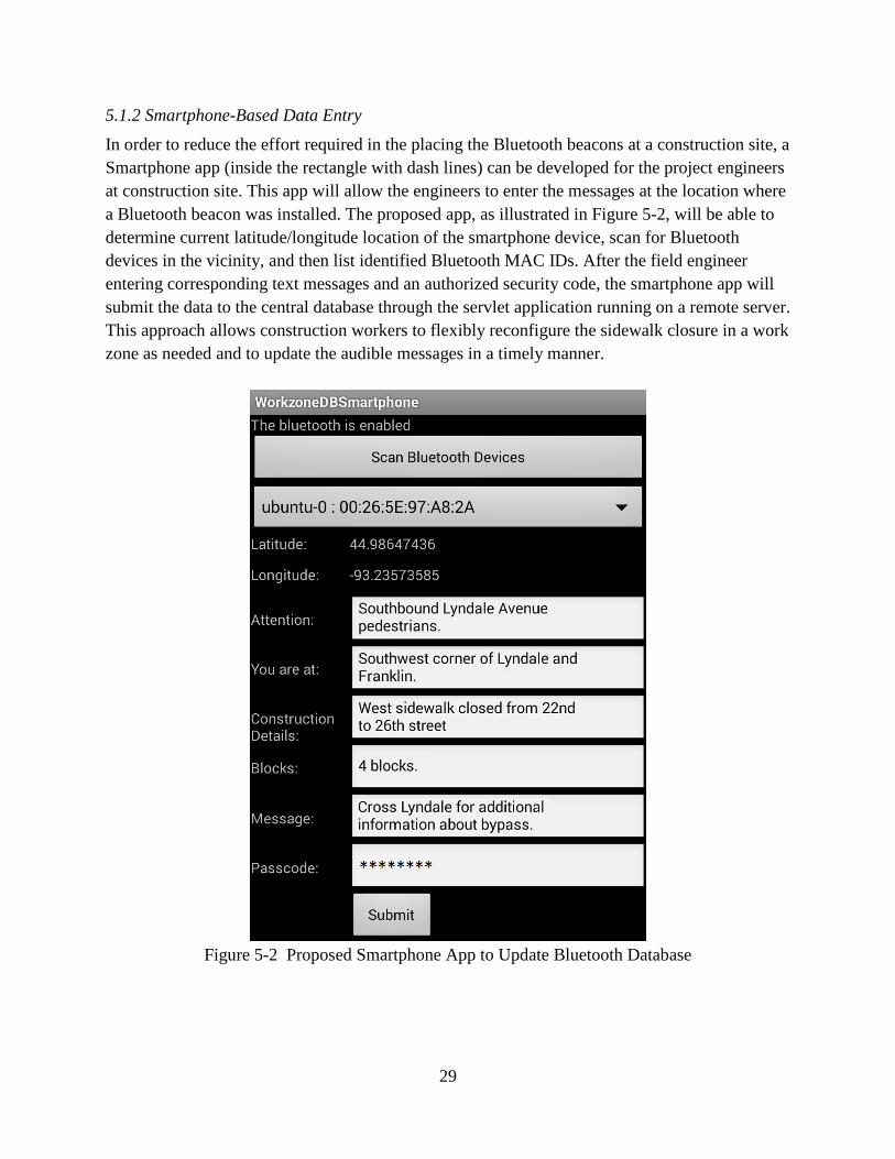
5.1.2 Smartphone-Based Data Entry
In order to reduce the effort required in the placing the Bluetooth beacons at a construction site, a Smartphone app (inside the rectangle with dash lines) can be developed for the project engineers at construction site. This app will allow the engineers to enter the messages at the location where a Bluetooth beacon was installed. The proposed app, as illustrated in Figure 5-2, will be able to determine current latitude/longitude location of the smartphone device, scan for Bluetooth devices in the vicinity, and then list identified Bluetooth MAC IDs. After the field engineer entering corresponding text messages and an authorized security code, the smartphone app will submit the data to the central database through the servlet application running on a remote server. This approach allows construction workers to flexibly reconfigure the sidewalk closure in a work zone as needed and to update the audible messages in a timely manner.
Figure 5-2 Proposed Smartphone App to Update Bluetooth Database

30
5.2 Future Work Two commercial systems, the Empco-Lite and the MDI SpeakMaster® Pedestrian Audible Alert System, are available to provide work zone information to pedestrians. The author would like compare the infrastructure based commercial systems with the smartphone-based system. Thecomparison may focus on the following.
• iPhone version of the App • System performance in different environment with different type of messages • User’s trust, acceptance and satisfaction while using the system • Clearness and understanding of the verbal messages • User’s spatial cognition and knowledge
Some future research and development may include the following features.
• Explore alternatives to make the system hands-free • Include user configurable settings for vibration pattern, frequency and speech rate • Navigation guidance solution such as work zone navigation guidance or bus stop
information by incorporating additional Bluetooth beacons • Develop veering alert algorithm
In the future, when transportation infrastructure is equipped with dedicated short range communications (DSRC) technology, the Bluetooth device in our proposed system may be replaced by a DSRC device where appropriate. The DSRC network can certainly complement
to
and enrich the proposed navigation system. Intersections equipped with DSRC technology will advance the capabilities of the proposed system to more complex mobility and safety applications for people with vision impairment. Our proposed solution can take advantage of the low-latency capability of DSRC to coordinate cooperative communication among pedestrians waiting at the crossing, traffic signal controllers, and approaching vehicles, thereby providing dynamic decision-making support to all travelers, not just individuals with vision impairment.
31
6. SUMMARY AND CONCLUSION
People who are visually impaired often encounter physical and information barriers that limit their accessibility and mobility. Building on our previous study to provide geometry and signal timing to the visually impaired at signalized intersections, a smartphone-based navigation system was developed to assist the visually impaired navigating work zones safely. A survey was proposed as a mean to identify types of information that might be best for navigation around work zones and to assess the views of the visually impaired individuals on four different audible messages. The true test of the usefulness of the content and structure of “ideal messages” as determined by the survey would then later be tested in the real world to determine how well the messages and the app worked. The participants, who all had traveled in work zones before, responded that all five information elements (alternate route, obstacle description, construction location, closed path and construction duration) are important to them while approaching a work zone. In general, the participants understood the four sample messages announced to them and felt the computer voices were clear to them. The survey results indicated that many blind users do not have and use smartphones. With the prevalence of smartphones in the consumer market and the improving accessibility of smartphones for the visually impaired, we believe smartphone ownership will increase in the blind community. Recommended message elements for developing standardized routing and bypass messages at work zones were implemented in a smartphone app. The app integrates GPS, text-to-speech (TTS) interface, Bluetooth and other available sensors on the smartphone. The smartphone app will communicate Bluetooth beacons installed near a work zone to help determine a user’s location and provide corresponding navigational guidance instructions. This effort will lead to improved consistency and quality of providing accessible work zone information to pedestrians and eliminate physical and information barriers for individuals with disabilities, particularly the visually impaired. The work zone navigation app is integrated with the intersection crossing app previously developed. When a Bluetooth beacon contains work zone and intersection geometry information, the app will first announce corresponding work zone messages and then provide intersection information (street name and number of lanes) based on the direction the smartphone is pointing to. Functionality testing and system validation of the smartphone app were performed by attaching four Bluetooth beacons to light posts near a construction site in St. Paul, MN. A research student carried the smartphone with the app and walked around the test sites repeatedly from different directions to validate the audible messages, Bluetooth communication, and other user interface.
32
The validation results confirm that the smartphone vibrated for about one second and announced the corresponding audible message to the traveler as a user was walking toward a Bluetooth beacon located about five to 15 feet away. The researcher had an opportunity to attend the Association for Education and Rehabilitation (AER) Orientation and Mobility (O&M) conference 2013 and shared the development results with O&M instructors. This app aims to provide information assistance to the visually impaired but not to replace their existing wayfinding skills. Many of them like the personal approach of providing work zone information through the smartphone. They like the idea of including intersection signal timing info, transit and work zone information in one app. However, there are concerns about the scale of implementation and smartphone ownship in the visually impaired community. According to a reserch survey conducted by Pew Research Center in 2013, 55% of cell phone owners say that their phone is a smartphone. Although, smartphone ownership in the visually impaired community is lower than that in the general population. Five of the ten visually impaired participants we surveyed own a smartphone. It is expected that smartphone ownership will continute to increase as the mobile technology advances in the near future. The work zone nagivation app will become more widely accessible to users as the public agencies advance the implementation. Additional research is needed to conduct experiment with visually impaired users and evaluate system reliability and usefulness. An implementation study is essential and needs to be robust in terms of numbers of participants and needs to be completed at different work zones with different configurations. Data can be recorded and analyzed in terms of travel time, number of correct/incorrect responses/movement, understanding, safety and user confidence.

33
REFERENCES
AT command, http://support.connectblue.com/display/PRODBTSPA/Bluetooth+Serial+Port+ Adapter+AT+Commands, accessed November 2013.
Bentzen, B.L., Barlow, J.M., & Franck, L. (2002) Determining Recommended Language for Speech Messages used by Accessible Pedestrian Signals. Final Report. Berlin, MA: Accessible Design for the Blind. http://www.ite.org/accessible/APS_speech.pdf, accessed November 2013.
Bentzen, B. L. (2007). “Making the Environment Accessible to Pedestrains Who Are Visually Impaired: Policy Research”. In J. J. Rieser, D. H. Ashmead, F. Ebner, & A. L. Corn (Eds.), Blindness and Brain Plasticity in Navigation and Object Perception (pp. 313-333). New York, NY.: Psychology Press.
Blake, L. (2011). “Proving his point”. Star Tribune article. http://www.startribune.com/local/west/114846184.html? elr=KArksUUUoDEy3LGDiO7aiU, accessed November 2013.
Bluetooth Serial Port Adapter Toolbox, http://support.connectblue.com/display/PRODBTSPA/Bluetooth+Serial+Port+Adapter+Toolbox+-+Getting+Started, accessed November 2013.
Boer de, J. (2008). “Auditory navigation for persons with mild dementia”, Essay (Master), University of Twente, Netherlands. http://essay.utwente.nl/58461/1/scriptie_J_de_Boer.pdf, accessed November 2013.
Campbell, J.L., Carney, C., & Kantowitz, B.H. (1998). Human Factors Design Guidelines for Advanced Traveler Information Systems (ATIS) and Commercial Vehicle Operations (CVO), Technical Report #FHWA–RD–98–057, Washington, DC: U.S. Department of Transportation, Federal Highway Administration. http://www.fhwa.dot.gov/publications/research/safety/98057/toc.cfm, accessed November 2013.
Campbell, J.L., Richman, J.B., Carney, C., & Lee, J.D. (2004). In-Vehicle Display Icons and Other Information Elements: Volume I: Guidelines, Technical Report #FHWA-RD-03-06503-065, Washington, DC: U.S. Department of Transportation, Federal Highway Administration. http://www.fhwa.dot.gov/publications/ research/safety/03065/index.cfm, accessed November 2013.
ConnectBlue®, http://www.connectblue.com/home/, accessed November 2013. Davies, T.C., Burns, C.M., & Pinder, S.D. (2006). “Using ecological interface design to develop
an auditory interface for visually impaired travelers”. Proc. OZCHI 2006, p.309-312, Sydney, Australia.
Davies, T.C., Burns, C.M., & Pinder, S.D. (2007). “Testing a novel auditory interface display to enable visually impaired travelers to use sonar mobility device effectively”. Proc. Human Factors and Ergonomics Society, 51st annual meeting, p.278-282, Baltimore, MD.

34
Davies, T.C. & Burns, C.M. (2008). “Advances in cognitive work analysis and the design of ecological visual and auditory displays”. Cognitive Technology 13 (2), 17-23.
Gaunet, F. (2006). “Verbal guidance rules for a localized wayfinding aid intended for blind-pedestrians in urban areas.” Universal Access in the Information Society, 4(4), 338-353.
Gaunet, F. & Briffault, X. (2005). “Exploring the Functional Specifications of a Localized Wayfinding Verbal Aid for Blind Pedestrians: Simple and Structured Urban Areas”. Human Computer Interaction 20(3), p.267–314.
Giudice, N.A., Bakdash, J.Z., & Legge, G.E. (2007). “Wayfinding with words: Spatial learning and navigation using dynamically-updated verbal descriptions”. Psychological Research, 71(3), 347-358.
Golledge, R. G., Loomis, J. M., Klatzky, R. L., Flury, A., & Yang, X. L. (1991). “Designing a personal guidance system to aid navigation without sight: Progress on the GIS component”. International Journal of Geographical Information Systems 5(4): 373-395.
Golledge, R. G., Klatzky, R. L., & Loomis, J. M. (1996). “Cognitive mapping and wayfinding by adults without vision”. The Construction of Cognitive Maps. J. Portugali. Dordrecht, The Netherlands, Kluwer Academic Publishers: pp. 215-246.
Golledge, R. G., Klatzky, R. L., Loomis, J. M., Speigle, J., & Tietz, J. (1998). “A geographical information system for a GPS based personal guidance system”. International Journal of Geographical Information Science, 12, 727-749.
Golledge, R. G., Marston, J. R., Loomis, J. M., & Klatzky, R. L. (2004). “Stated preferences for components of a Personal Guidance System for non-visual navigation”. Journal of Visual Impairment and Blindness, 98(3), 135-147.
Golledge, R. G. & Gärling, T. (2004). “Cognitive maps and urban travel”, D. A. Hensher, K. J. Button, K. E. Haynes & P. R. Stopher (Eds) Handbook of Transport Geography and Spatial Systems, Ch. 28. Amsterdam: Elsevier.
Havik, E. M., Kooijman, A. C., & Steyvers, J.J.M. (2011). “The Effectiveness of Verbal Information Provided by Electronic Travel Aids for Visually Impaired Persons.” Journal of Visual Impairment & Blindness 105(10): 624-637.
Helal, A., Moore, S., & Ramachandran, B. (2001). “Drishti: An Integrated Navigation System for Visually Impaired and Disabled”. Proceedings of the 5th International Symposium on Wearable Computer, Zurich, Switzerland. http://www.icta.ufl.edu/projects/publications/wearableConf.pdf, accessed November 2013.
Hess, T. M. (2005). “Memory and Aging in Context”. Psychological Bulletin, 131(3), 383-406. Hine, J., Swan, D., Scott, J., Binnie, D., & Sharp, J. (2000). Using Technology to Overcome the
Tyranny of Space: Information Provision and Wayfinding. Urban Studies (Routledge), 37(10), 1757-1770.
Java, http://www.java.com/en/, accessed November 2013. Kim, C.-G. & Song, B.-S. (2007). “Design of a wearable walking-guide system for the blind”.
Proceedings of the 1st international convention on Rehabilitation engineering; assistive
35
technology: in conjunction with 1st Tan Tock Seng Hospital Neurorehabilitation Meeting, Singapore, Singapore.
Kim, Y., Kim, C.-H., & Kim, B. (2000). “Design of an auditory guidance system for the blind with signal transformation from stereo ultrasonic to binaural audio”. Artificial Life and Robotics, 4(4), 220-226.
Kirasic, K. C. (2002). “Age differences in adults' spatial abilities, learning environmental layout, and wayfinding behavior”. Spatial Cognition and Computation, 2(2), 117-134.
Liao, C.F. (2012). Using a Smartphone App to Assist the Visually Impaired at Signalized Intersections, Final Report, Intelligent Transportation Systems Institute, Center for Transportation Studies (CTS 12-25), University of Minnesota, Minneapolis, MN
Loomis, J. M., Golledge, R. G., & Klatzky, R. L. (1998). “Navigation system for the blind: Auditory display modes and guidance”. Presence: Teleoperators and Virtual Environments 7(2): 193-203.
Loomis, J. M., Golledge, R. G., Klatzky, R. L., & Marston, J. R. (2007). “Assisting wayfinding in visually impaired travelers”. In G. L. Allen (Ed.), Applied spatial cognition: From research to cognitive technology. (pp. 179-203). Mahwah, N.J.: Lawrence Erlbaum Associates.
Loomis, J. M., Marston, J. R., Golledge, R. G., & Klatzky, R. L. (2005). “Personal guidance system for people with visual impairment: A comparison of spatial displays for route guidance”. Journal of Visual Impairment & Blindness, 99(4), 219-232
Loomis, J. M., Klatzky, R. L., & Golledge, R. G. (2001). “Navigating without vision: Basic and applied research”. Optometry and Vision Science, 78(5), 282-289.
Marston, J. R., Loomis, J. M., Klatzky, R. L., & Golledge, R. G. (2007). “Nonvisual Route Following with Guidance from a Simple Haptic or Auditory Display”. Journal of Visual Impairment & Blindness, 101(4), 203-211.
MnDOT, Minnesota Manual on Uniform Traffic Control Devices (MN MUTCD). Minnesota Department of Transportation, Saint Paul, MN, 2011.
MnDOT (2010). 2010 Temporary Pedestrian Access Route (TPAR) Study – Work Zone Mobility Market Research with People Who Are Disabled. Final Report, MnDOT Office of Traffic, Safety and Technology (OTST) and MnDOT Market Research, St. Paul, MN. http://www.dot.state.mn.us/trafficeng/workzone/tpar.html, accessed November 2013.
Morley, S., Petrie, H., O’Nell, A.-M., & Mcnally, P. (1999). “Auditory Navigation in Hyperspace: Design and Evaluation of a Non-visual Hypermedia System for Blind Users”, Behavior & Information Technology, Vol. 18, No. 1, 18-26.
MySQL, http://www.mysql.com/, accessed November 2013. Pai, M.C. (2006). “The neuropsychological studies of dementias in Taiwan: focus on way-
finding problems in Alzheimer's patients”. Acta Neurol Taiwan, 15(1), 58-60. Ponchillia, P., MacKenzie, N., Long, R., Denton-Smith, P., Hicks, T., & Miley, P. (2007).
“Finding a Target with an Accessible Global Positioning System”. Journal of Visual Impairment & Blindness, 101(8), 479-488.

36
Ponchillia, P., Rak, E., Freeland, A., & LaGrow, S.J. (2007). “Accessible GPS: Reorientation and Target Location Among Users with Visual Impairments”. Journal of Visual Impairment & Blindness, 101(7), 389-401.
Roentgen, U. R., Gelderblom, G. J., & de Witte, L.P. (2011). “Users' Evaluations of Four Electronic Travel Aids Aimed at Navigation for Persons Who Are Visually Impaired.” Journal of Visual Impairment & Blindness 105(10): 612-623.
Rogers, W. A., Meyer, B., Walker, N., & Fisk, A. D. (1998). “Functional limitations to daily living tasks in the aged: a focus group analysis”. Human Factors, v40(n1), pp.111-115.
Rosenbaum, R.S., Gao, F., Richards, B., Black, S.E., & Moscovitch, M. (2005). “Where to? Remote Memory for Spatial Relations and Landmark Identity in Former Taxi Drivers with Alzheimer's Disease and Encephalitis”. Journal of Cognitive Neuroscience, 17(3), The MIT Press.
Sanderson, P, Anderson, J., & Watson, M. (2000). “Extending ecological interface design to auditory displays”. Proc . OZCHI 2000, p.259-266, Sydney, Australia.
Shahab, Q., Terken, J., & Eggen, B. (2010). “Auditory messages for speed advice in advanced driver assistance systems”. Proceedings of the 2nd International Conference on Automotive User Interfaces and Interactive Vehicular Applications, Pittsburgh, PA
SQLite is a popular embedded database for local/client storage in application software, http://www.sqlite.org/, accessed November 2013.
Srinivasan, R. & Jovanis, P.P. (1997). “Effect of selected in-vehicle route guidance systems on driver reaction times”. Human Factors, 39(2), p.200-215.
Streeter, L.A., Vitello, D., & Wonziewicz, S.A. (1985). “How to tell people where to go: Comparing navigational aids”. International Journal of Man Machine Studies, 22(5), p.549-562.
Tauchi, M., Sawai, H., Takato, J., Yoshiura, T., & Takeuchi, K. (1998). “Development and Evaluation of a Novel Type of Audible Traffic Signal for the Blind Pedestrians”, The 9th International Mobility Conference Proceedings. Rehabilitation Research and Development Center, Veterans Administration Medical Center, Decatur, GA, pp 108–109.
The Eclipse Foundation, http://www.eclipse.org/, accessed November 2013. Uc, E.Y., Rizzo, M., Anderson, S.W., Shi, Q., & Dawson, J.D. (2004). “Driver route-following
and safety errors in early Alzheimer disease”. Neurology, 63(5), 832-837. Ullman, B.R. & Trout, N.D. (2009). “Accommodating Pedestrians with Visual Impairments In
and Around Work Zones”. Journal of the Transportation Research Board, 2140(-1), 96-102.
USDOT, Manual on Uniform Traffic Control Devices (MUTCD). U.S. Department of Transportation, Federal Highway Administration, Washington D.C., December 2009.
Walker, J., Alicandri, E., Sedney, C., & Roberts, K. (1990). In-vehicle navigation devices: Effect on the safety of driver performance, Technical Report #FHWA-RD-90-053, Washington, DC: U.S. Department of Transportation, Federal Highway Administration.

37
Wessels, R.D. & de Witte, L.P. (2003). “Reliability and validity of the Dutch version of QUEST 2.0 with users of various types of assistive devices.” Disability and Rehabilitation. 25, 267-272
Wilson, J., Walker, B. N., Lindsay, J., Cambias, C., & Dellaert, F. (2007). “SWAN: System for Wearable Audio Navigation”. Proceedings of the 11th International Symposium on Wearable Computers, Boston, MA. http://sonify.psych.gatech.edu/publications/pdfs/2007ISWC-Wilson-et-al-submitted.pdf, accessed November 2013.

Appendix A: Participant Recruitment Ad and Consent Form
A-1
A.1 Recruitment Ad
BLIND AND LOW-VISION VOLUNTEERS NEEDED Researchers at the University of Minnesota are recruiting participants to be interviewed on issues relating to pedestrian access around work zone area. Participants will have one-on-one discussions with a researcher to better understand how blind and low vision individuals orient/navigate as a pedestrian, what types of information they need, and issues relating to pedestrian access in and around work zones. Interviews will be conducted at the Vision Loss Resources offices in Minneapolis (alternative interview locations are available upon request). We will require approximately 1 hour for this interview and participants will be paid $20 to participate. To participate, individuals must:
• Be 18 to 64 years of age, • Have at best 20/70 acuity with correction in their better eye, • Have completed Orientation and Mobility training, • Be proficient in using a cane or guide dog, • Be willing to have audio and/or video recorded during the interview.
If you fit these criteria, you may be eligible to participate in the study. If you are interested, please contact Chen-Fu Liao by phone at (612) 626-1697 or email at [email protected] (include “pedestrian study” in the subject line). Please provide your name and a phone number where you can be reached during the day. If you are eligible to participate, we will work with you to schedule an appointment and give you further instructions.

A-2
A.2 Consent Form Title of Study: Using Smartphone App to Help the Visually Impaired Navigate Work Zones Safely You are invited to participate in a research study to design usable audible messages for the visually impaired pedestrians around work zones. You were selected because you are considered legally blind or to have low vision, you have completed orientation and mobility training, and have experience orienting on your own. We ask that you listen to/read this form and ask any questions you may have before agreeing to be in the study. This study is being conducted by Chen-Fu Liao who is a research staff at the University of Minnesota. This study is sponsored by Minnesota Department of Transportation. Background Information The purposes of this study are to, (1) understand what types of information are helpful in providing bypass or routing instructions to the visually impaired around work zones, (2) provide recommendations on key elements of accessible messages that will be useful for the visually impaired, and (3) develop a smartphone-based system to alert pedestrians with the necessary information in advance of the visually impaired approaching a work zone at decision points. Procedures If you agree to be in this study, we would ask you to participate in an interview discussdiscussion will focus on your past experiences while navigating around work zones. Tdiscussion will allow for follow-up questions and will cover the following topics:
1. Your vision, 2. Your ability to orient by yourself, 3. Your experience navigating around work zones, 4. Your usage and opinions of the new technology, 5. Your opinions of the smartphone-based pedestrian information system, 6. Demographic information.
The interview should last approximately one hour. The interview may be recorded usi
ion. This he
ng video and/or audio equipment to record your responses, and if this occurs you will be notified by the interviewer. Risks and Benefits of being in the Study There are no direct risks or benefits associated with this interview. Research Related to Injury In the event that this research activity results in an injury, treatment will be available, including first aid, emergency treatment and follow-up care as needed. Care for such injuries will be billed in the ordinary manner to you or your insurance company. If you think that you have suffered a research related injury, let the study staffs know right away.
A-3
Compensation You will receive $20 for participating in the interview. Confidentiality The records of this study will be kept private. In any report we might publish, we will not include any information that will make it possible to identify participants. Research records will be stored securely and only researchers will have access to the records. Audio and video recordings will only be accessible to researchers on this project. Portions of these recordings may be used when presenting findings at internal project meetings or at scientific meetings. Your name and identifying information will never be linked to these recordings. Voluntary Nature of the Study Participation in this study is voluntary. Your decision whether or not to participate will not affect your current or future relations with the University of Minnesota or with Vision Loss Resources. If you decide to participate, you are free to not answer any question or withdraw at any time without affecting those relationships. Contacts and Questions The researcher conducting this study is: Chen-Fu Liao. You may ask any questions you have now. If you have questions later, you are encouraged to contact Chen-Fu Liao at 500 Pillsbury Drive SE, Minneapolis, MN 55455, (612) 626-1697, or [email protected]. If you have any questions or concerns regarding this study and would like to talk to someone other than the researcher(s), you are encouraged to contact the Research Subjects’ Advocate Line, D528 Mayo, 420 Delaware St. Southeast, Minneapolis, Minnesota 55455; (612) 625-1650. You will be given a copy of this information to keep for your records. Statement of Consent I have listened to/read the above information. I have asked questions and have received answers. I consent to participate in the study. Signature: ___________________________ Date: ______________________________ Signature of Investigator: ____________________________________ Date: ______________________________
IRB Code Number: 1209S21382
Approved on Oct. 3, 2012

A-1
Appendix B: Experiment Protocol and Interview Questionnaires
B-1
Experiment Protocol Thank you for agreeing to help us with our research on technology that may assist the mobility of blind and low vision pedestrians. Today you will be asked a series of questions about how you navigate around a work zone. We would like to design audible messages and technology that helps meet your needs on a daily basis and because of this your participation and input is important. Your answers will be completely confidential. If you feel uncomfortable answering any question, you may pass (leave it blank). For multiple-choice options, please select one answer per question. If at any time you would like a break or to stop, please let the interviewer know.

B-2
I. General Background Information A. Vision Background
1. With the best correction possible, what is your visual acuity? Please provide both measurements or indicate if N/A.
Without Glasses: 20 / _______________________
With Glasses: 20 / _______________________ a. Do any of these describe your state of vision? (select more than one)
Central blindness Peripheral blindness Left / Right eye blindness (circle one) Night blindness
b. How long have you been visually impaired? Since birth Since ...............................................
2. Do you use any assistive equipment to improve your vision? (can select more than one) Magnifying glass Non-impaired, low-vision Readers (screen reader for your computer) Blind candidate Magnifiers (screen magnifier for your computer)
Low-vision candidate Other _______________________________________________
Circle examples of “Other” by candidate type:
Blind Low-Vision Jaws, Windoweyes, Talking Clock, Braille Writer, [Trekker Breeze, StreetTalk VIP, Mobile Geo, BrailleNote GPS, Loadstone GS, Wayfinder Access]
Monacular, Closed Circuit TV, Glasses to Magnify, Larger Print
3. Aside from your vision, do you have any ailments or pathologies that affect your ability to walk on street safely? For example, balance (vestibular) issues, hearing impairment, etc.
No Yes: Please describe .........................................................

B-3
B. Demographic information.
4. Age: ___________ years
5. Gender: Male Female
6. What is the highest level of education you have completed?
Some high school – no diploma
High school graduate or equivalent
Some college or Associate degree
Bachelor’s degree
Advanced degree (MBA, PhD, etc.)
Other, please specify ______________________________________
C. Navigation and Mobility 7. How long have you been using the following methods of assistance (if at all)?
Cane __________________________ years Guide dog _______________________ years Other ____________________________ years
8. What is your preferred method of assistance while navigating to a destination in an area you are familiar with?
Cane Guide dog Asking other pedestrians I pass No outside assistance Other _______________________________

B-4
9. How proficient are you are at each of these travel skills (scale from 1 to 5)
(Golledge et al. 2004) Well below
average 1
Below average
2
Average 3
Above
Average 4
Well above
average 5
General sense of direction Independent travel Street crossings Navigate around work zones New environment
10. How important is it to obtain the following information while approaching a work zone (on the
scale from 1 to 5)
Very Un-important
1
Un-
important 2
Neutral
3
Important 4
Very
important 5
Alternate route Obstacle description Construction location Closed path Construction duration
11. When receiving audible detour or bypassing information nearby a work zone, do you prefer,
A complete detour or bypassing message at a starting location, or
Sequential turn-by-turn audible guidance message at key decision points D. Self-ratings: Technology
12. Do you currently use a mobile phone?
No
Yes Smartphone Non-Smartphone
13. Do you currently use a mobile navigation assistant / GPS?
No
Yes
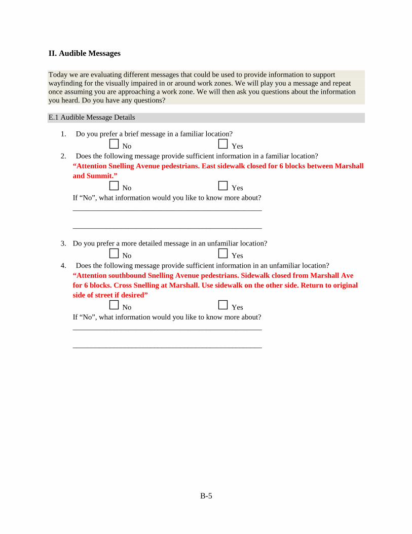
B-5
II. Audible Messages Today we are evaluating different messages that could be used to provide information to support wayfinding for the visually impaired in or around work zones. We will play you a message and repeat once assuming you are approaching a work zone. We will then ask you questions about the information you heard. Do you have any questions? E.1 Audible Message Details
1. Do you prefer a brief message in a familiar location?
No Yes 2. Does the following message provide sufficient information in a familiar location?
“Attention Snelling Avenue pedestrians. East sidewalk closed for 6 blocks between Marshall and Summit.”
No Yes If “No”, what information would you like to know more about? ___________________________________________________
___________________________________________________
3. Do you prefer a more detailed message in an unfamiliar location?
No Yes 4. Does the following message provide sufficient information in an unfamiliar location?
“Attention southbound Snelling Avenue pedestrians. Sidewalk closed from Marshall Ave for 6 blocks. Cross Snelling at Marshall. Use sidewalk on the other side. Return to original side of street if desired”
No Yes If “No”, what information would you like to know more about? ___________________________________________________
___________________________________________________
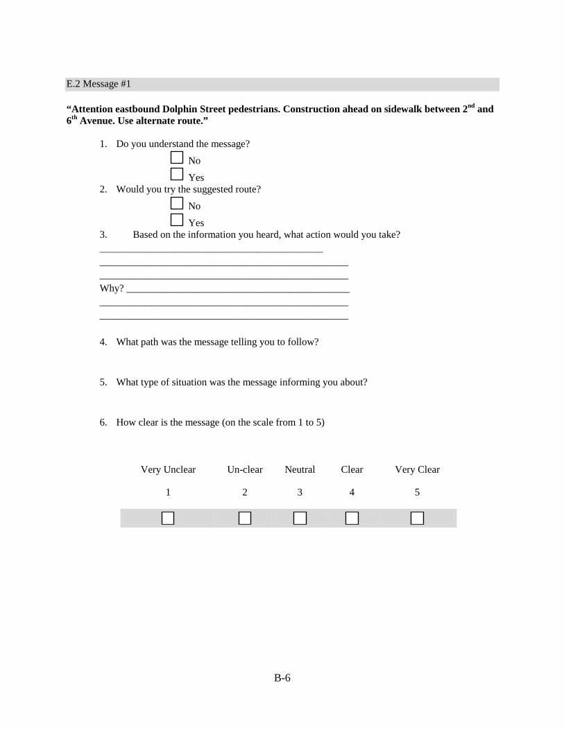
B-6
E.2 Message #1 “Attention eastbound Dolphin Street pedestrians. Construction ahead on sidewalk between 2nd and 6th Avenue. Use alternate route.”
1. Do you understand the message?
No
Yes 2. Would you try the suggested route?
No
Yes 3. Based on the information you heard, what action would you take? ____________________________________________ _________________________________________________ _________________________________________________ Why? ____________________________________________ _________________________________________________ _________________________________________________ 4. What path was the message telling you to follow?
5. What type of situation was the message informing you about?
6. How clear is the message (on the scale from 1 to 5)
Very Unclear
1
Un-clear
2
Neutral
3
Clear
4
Very Clear
5
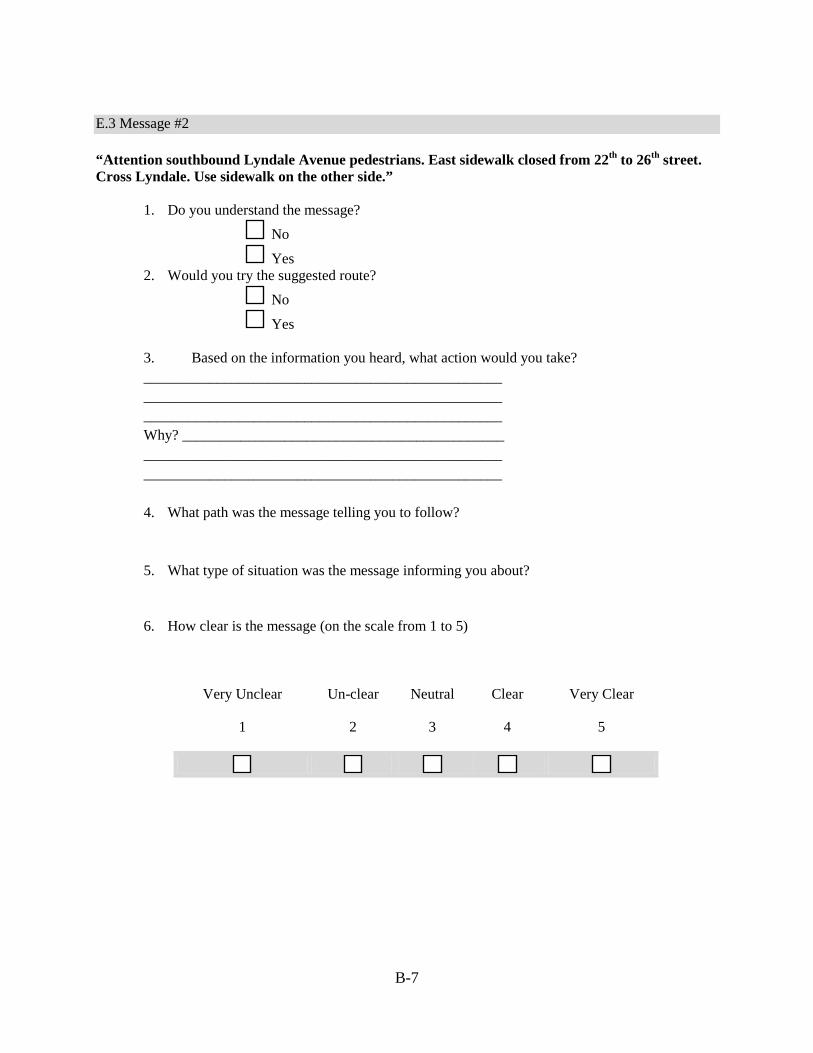
B-7
E.3 Message #2 “Attention southbound Lyndale Avenue pedestrians. East sidewalk closed from 22th to 26th street. Cross Lyndale. Use sidewalk on the other side.”
1. Do you understand the message?
No
Yes 2. Would you try the suggested route?
No
Yes
3. Based on the information you heard, what action would you take? _________________________________________________ _________________________________________________ _________________________________________________ Why? ____________________________________________ _________________________________________________ _________________________________________________ 4. What path was the message telling you to follow?
5. What type of situation was the message informing you about?
6. How clear is the message (on the scale from 1 to 5)
Very Unclear
1
Un-clear
2
Neutral
3
Clear
4
Very Clear
5
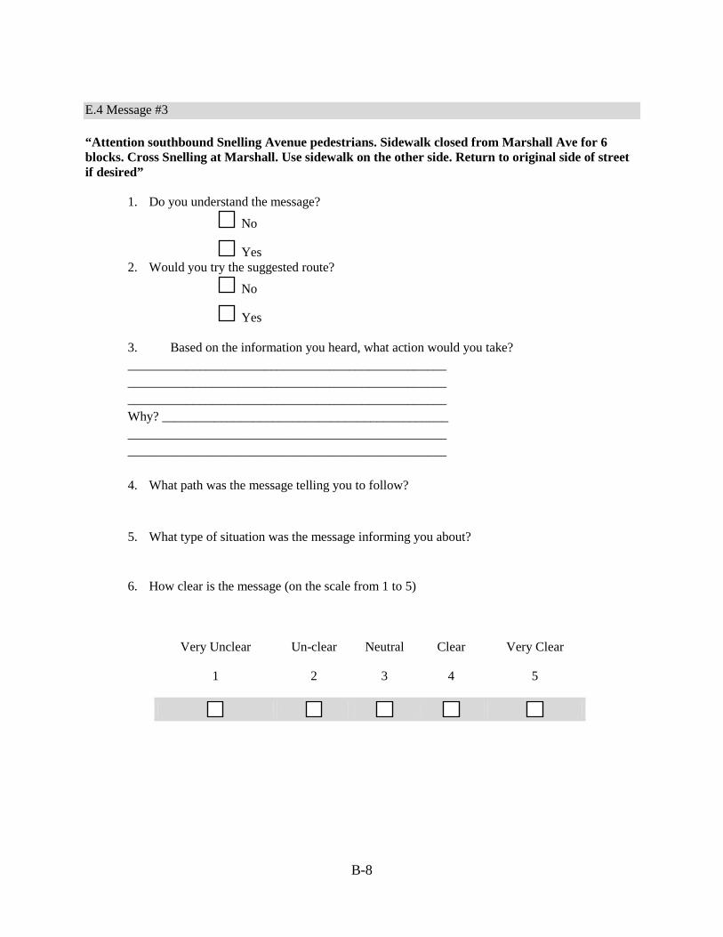
B-8
E.4 Message #3 “Attention southbound Snelling Avenue pedestrians. Sidewalk closed from Marshall Ave for 6 blocks. Cross Snelling at Marshall. Use sidewalk on the other side. Return to original side of street if desired”
1. Do you understand the message?
No
Yes 2. Would you try the suggested route?
No
Yes
3. Based on the information you heard, what action would you take? _________________________________________________ _________________________________________________ _________________________________________________ Why? ____________________________________________ _________________________________________________ _________________________________________________
4. What path was the message telling you to follow?
5. What type of situation was the message informing you about?
6. How clear is the message (on the scale from 1 to 5)
Very Unclear
1
Un-clear
2
Neutral
3
Clear
4
Very Clear
5

B-9
E.5 Message #4 “Attention southbound Lyndale Avenue pedestrians. You are at southwest corner of Lyndale and Franklin. West sidewalk closed from 22th to 26th street. Cross Lyndale for more bypassing message.” After crossing, receive another update … “Attention southbound Lyndale Avenue pedestrians. You are at southeast corner of Lyndale and Franklin. West sidewalk closed from 22th to 26th street. Use sidewalk on this side.”
1. Do you understand the message?
No Yes 2. Would you try the suggested route?
No Yes 3. Based on the information you heard, what action would you take? _________________________________________________ _________________________________________________ _________________________________________________ Why? ____________________________________________ _________________________________________________ _________________________________________________ 4. What path was the message telling you to follow?
5. What type of situation was the message informing you about?
6. How clear is the message (on the scale from 1 to 5)
Very Unclear
1
Un-clear
2
Neutral
3
Clear
4
Very Clear
5

Appendix C: Database Interface for Work Zone Bluetooth Beacons
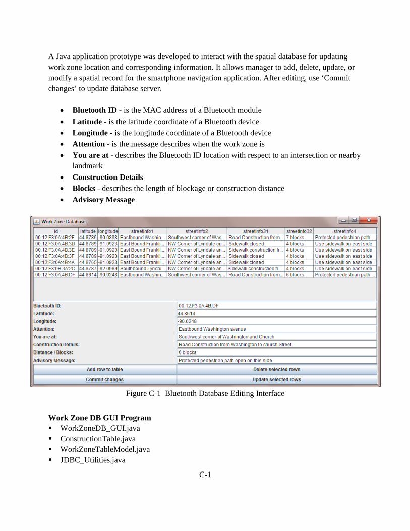
C-1
A Java application prototype was developed to interact with the spatial database for updating work zone location and corresponding information. It allows manager to add, delete, update, or modify a spatial record for the smartphone navigation application. After editing, use ‘Commit changes’ to update database server.
• Bluetooth ID - is the MAC address of a Bluetooth module • Latitude - is the latitude coordinate of a Bluetooth device • Longitude - is the longitude coordinate of a Bluetooth device • Attention - is the message describes when the work zone is • You are at - describes the Bluetooth ID location with respect to an intersection or nearby
landmark • Construction Details • Blocks - describes the length of blockage or construction distance • Advisory Message
Figure C-1 Bluetooth Database Editing Interface
Work Zone DB GUI Program WorkZoneDB_GUI.java ConstructionTable.java WorkZoneTableModel.java JDBC_Utilities.java

Pedestrian Navigation Database (MySQL) Intx_geo table – Intx_ID text PK, Walk_Phase smallint(6) PK, Walk_Time smallint(6), Cross_Street text, Num_Lane smallint(6)
Intx_xing_phase table – Intx_ID text, Bluetooth_ID text PK, Dir varchar(50) PK, Phase smallint(6)
Signal_state table – ID bigint(20) unsigned PK, Date date, TimeStamp decimal(25,3), Signal_State smallint(5) unsigned zerofill, Time_Left decimal(10,3), Intx_ID text
Pushbutton_requests table – Intx_ID varchar(50) PK, Phase smallint(6) PK, PB_State tinyint(4)
ConstructionDB table (for work zone navigation) – id varchar(255) PK, latitude float, longitudefloat, streetinfo1varchar(255), streetinfo2varchar(255), streetinfo31 varchar(255), streetinfo32 varchar(255), streetinfo4varchar(255)
C-2

C-3
Table C-1 Data Fields of Tables in MySQL Database
Intx_geo Intx_xing_phase Signal_state Pushbutton_request ConstructionDBIntx_ID Intx_ID ID Intx_ID id Walk_Phase Bluetooth_ID Date Phase latitude Walk_Time Dir TimeStamp PB_State longitude Cross_Street Phase Signal_State streetinfo1 Num_Lane Time_Left streetinfo2 Intx_ID streetinfo31 streetinfo32 streetinfo4

Appendix D: Java Code Structure Examples

D-1
D.1 Navigation App Sample public class Navigation Service { createNavigationService () { Services created …
} ; // Service onStart () {
Initialization and configuration … } ; // onStart onReceive_Bluetooth_Device () {
if (BluetoothDevice.ACTIONFOUND) { if (BT_ID_Matched) {
Get_Message_From_Spatial_DB () ; System_Vibrator_Service (1000) ; TTS_Speak(message) ;
} // if ID matched } // if BT found
} // onReceive
} // Navigation Service public class Bluetooth { /* Initializes the BT device list */ Bluetooth() { dev_address_list = new ArrayList<String>(); } // Create a BroadcastReceiver for ACTION_FOUND It stores _id (MAC address) // of the device in the device list protected final BroadcastReceiver mReceiver = new BroadcastReceiver() { public void onReceive(Context context, Intent intent) { String action = intent.getAction(); // When discovery finds a device if (BluetoothDevice.ACTION_FOUND.equals(action)) { // Get the BluetoothDevice object from the Intent if (PedestrianNavigation.str_list.contains(device.getAddress()) == true) { found = true; } } } // onReceive }; // BroadcastReceiver } // Bluetooth Class

D-2
// Announce message to user public void perform_action (String s) { opener = Dbinterface.getInstance(this);
sqliteDatabase = opener.getDatabase(); querySQLiteDatabase () ; processQueryResults() ; textToSpeech() ; } // perform_action() ; // Speak out a text string public void textToSpeech (String s) { if (_ttsActive1 == true) { System.out.println("speaking :"+s); While (true) { if (_tts1.isSpeaking()==false) break; } // end of while _tts1.speak(s, TextToSpeech.QUEUE_FLUSH, null); } // end if } //textToSpeech ();
D.2 Workzone DB GUI Sample /* WorkZoneDB_GUI.java */ public class WorkZoneDB_GUI extends JFrame implements RowSetListener { /* Declare variables */ private static final long serialVersionUID = 1L; JDBC_Utilities settings; Connection connection; JTable table; // The table for displaying data JButton button_ADD_ROW; JButton button_MODIFY_ROW; JButton button_UPDATE_DATABASE; JButton button_DELETE_ROWS; WorkZoneTableModel myWorkZoneTableModel; public static void main(String[] args) throws Exception { JDBC_Utilities myJDBC_Utilities; try { myJDBC_Utilities = new JDBC_Utilities(); } catch (Exception e) { System.err.println("Problem reading properties file " + args[0]); e.printStackTrace();
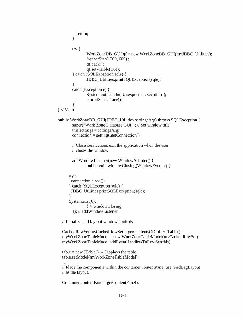
D-3
return; } try { WorkZoneDB_GUI qf = new WorkZoneDB_GUI(myJDBC_Utilities); //qf.setSize(1200, 600) ; qf.pack(); qf.setVisible(true); } catch (SQLException sqle) { JDBC_Utilities.printSQLException(sqle); } catch (Exception e) { System.out.println("Unexpected exception"); e.printStackTrace(); } } // Main public WorkZoneDB_GUI(JDBC_Utilities settingsArg) throws SQLException { super("Work Zone Database GUI"); // Set window title this.settings = settingsArg; connection = settings.getConnection(); // Close connections exit the application when the user // closes the window addWindowListener(new WindowAdapter() { public void windowClosing(WindowEvent e) { try { connection.close(); } catch (SQLException sqle) { JDBC_Utilities.printSQLException(sqle); } System.exit(0); } // windowClosing }); // addWindowListener // Initialize and lay out window controls CachedRowSet myCachedRowSet = getContentsOfCoffeesTable(); myWorkZoneTableModel = new WorkZoneTableModel(myCachedRowSet); myWorkZoneTableModel.addEventHandlersToRowSet(this); table = new JTable(); // Displays the table table.setModel(myWorkZoneTableModel); … // Place the components within the container contentPane; use GridBagLayout // as the layout. Container contentPane = getContentPane();
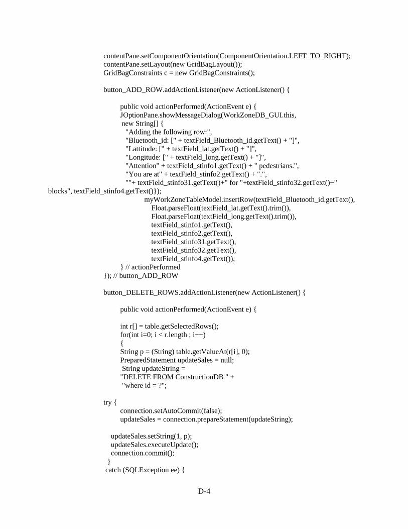
D-4
contentPane.setComponentOrientation(ComponentOrientation.LEFT_TO_RIGHT); contentPane.setLayout(new GridBagLayout()); GridBagConstraints c = new GridBagConstraints(); button_ADD_ROW.addActionListener(new ActionListener() { public void actionPerformed(ActionEvent e) { JOptionPane.showMessageDialog(WorkZoneDB_GUI.this, new String[] { "Adding the following row:", "Bluetooth_id: [" + textField_Bluetooth_id.getText() + "]", "Lattitude: [" + textField_lat.getText() + "]", "Longitude: [" + textField_long.getText() + "]", "Attention" + textField_stinfo1.getText() + " pedestrians.", "You are at" + textField_stinfo2.getText() + ".", ""+ textField_stinfo31.getText()+" for "+textField_stinfo32.getText()+" blocks", textField_stinfo4.getText()}); myWorkZoneTableModel.insertRow(textField_Bluetooth_id.getText(), Float.parseFloat(textField_lat.getText().trim()), Float.parseFloat(textField_long.getText().trim()), textField_stinfo1.getText(), textField_stinfo2.getText(), textField_stinfo31.getText(), textField_stinfo32.getText(), textField_stinfo4.getText()); } // actionPerformed }); // button_ADD_ROW button_DELETE_ROWS.addActionListener(new ActionListener() { public void actionPerformed(ActionEvent e) { int r[] = table.getSelectedRows(); for(int i=0; i < r.length ; i++) { String p = (String) table.getValueAt(r[i], 0); PreparedStatement updateSales = null; String updateString = "DELETE FROM ConstructionDB " + "where id = ?"; try { connection.setAutoCommit(false); updateSales = connection.prepareStatement(updateString); updateSales.setString(1, p); updateSales.executeUpdate(); connection.commit(); } catch (SQLException ee) {

D-5
JDBC_Utilities.printSQLException(ee); if (connection != null) { try { System.err.print("Transaction is being rolled back"); connection.rollback(); } catch (SQLException excep) { JDBC_Utilities.printSQLException(excep); } } // if } // catch finally { if (updateSales != null) { try { updateSales.close(); } catch (SQLException e1) { // TODO Auto-generated catch block e1.printStackTrace(); } } // if try { connection.setAutoCommit(true); } catch (SQLException e1) { // TODO Auto-generated catch block e1.printStackTrace(); } } // finally try { createNewTableModel(); } catch (SQLException sqle) { displaySQLExceptionDialog(sqle); } } // for i } // actionperformed }); // button_DELETE_ROWS button_MODIFY_ROW.addActionListener(new ActionListener() { public void actionPerformed(ActionEvent e) { int r[] = table.getSelectedRows(); for(int i=0; i < r.length ; i++) { String p = (String) table.getValueAt(r[i], 0); String s=(String) table.getValueAt(r[i],1); Float f1=Float.parseFloat(s.trim()); s=(String) table.getValueAt(r[i],2); Float f2=Float.parseFloat(s.trim()); String s1 = (String) table.getValueAt(r[i], 3); String s2 = (String) table.getValueAt(r[i], 4);

D-6
String s3 = (String) table.getValueAt(r[i], 5); String s4 = (String) table.getValueAt(r[i], 6); String s5 = (String) table.getValueAt(r[i], 7); PreparedStatement updateSales = null; String updateString = "update ConstructionDB " + "set latitude = ?, longitude = ?, streetinfo1 = ?, streetinfo2 = ?, "+ "streetinfo31 = ?, streetinfo32 = ?, streetinfo4 = ?"+ "where id = ?"; try { connection.setAutoCommit(false); updateSales = connection.prepareStatement(updateString); updateSales.setFloat(1, f1); updateSales.setFloat(2, f2); updateSales.setString(3, s1); updateSales.setString(4, s2); updateSales.setString(5, s3); updateSales.setString(6, s4); updateSales.setString(7, s5); updateSales.setString(8, p); updateSales.executeUpdate(); connection.commit(); } catch (SQLException ee) { JDBC_Utilities.printSQLException(ee); if (connection != null) { try { System.err.print("Transaction is being rolled back"); connection.rollback(); } catch (SQLException excep) { JDBC_Utilities.printSQLException(excep); } } } finally { if (updateSales != null) { try { updateSales.close(); } catch (SQLException e1) { // TODO Auto-generated catch block e1.printStackTrace(); } } try { connection.setAutoCommit(true); } catch (SQLException e1) { // TODO Auto-generated catch block e1.printStackTrace(); } } } }
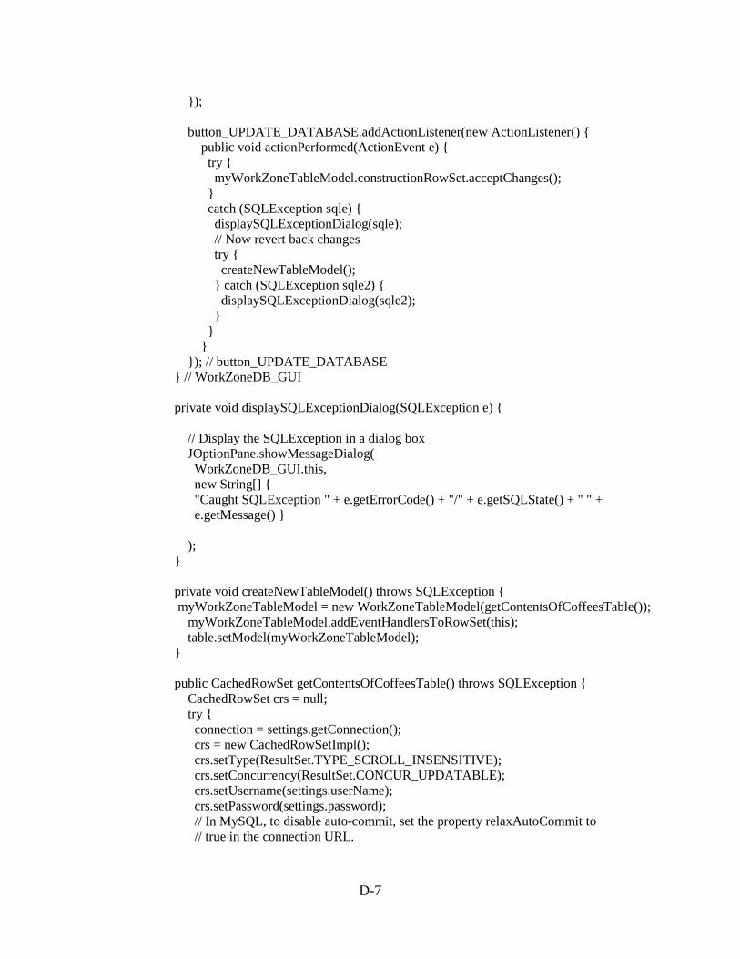
D-7
}); button_UPDATE_DATABASE.addActionListener(new ActionListener() { public void actionPerformed(ActionEvent e) { try { myWorkZoneTableModel.constructionRowSet.acceptChanges(); } catch (SQLException sqle) { displaySQLExceptionDialog(sqle); // Now revert back changes try { createNewTableModel(); } catch (SQLException sqle2) { displaySQLExceptionDialog(sqle2); } } } }); // button_UPDATE_DATABASE } // WorkZoneDB_GUI private void displaySQLExceptionDialog(SQLException e) { // Display the SQLException in a dialog box JOptionPane.showMessageDialog( WorkZoneDB_GUI.this, new String[] { "Caught SQLException " + e.getErrorCode() + "/" + e.getSQLState() + " " + e.getMessage() } ); } private void createNewTableModel() throws SQLException { myWorkZoneTableModel = new WorkZoneTableModel(getContentsOfCoffeesTable()); myWorkZoneTableModel.addEventHandlersToRowSet(this); table.setModel(myWorkZoneTableModel); } public CachedRowSet getContentsOfCoffeesTable() throws SQLException { CachedRowSet crs = null; try { connection = settings.getConnection(); crs = new CachedRowSetImpl(); crs.setType(ResultSet.TYPE_SCROLL_INSENSITIVE); crs.setConcurrency(ResultSet.CONCUR_UPDATABLE); crs.setUsername(settings.userName); crs.setPassword(settings.password); // In MySQL, to disable auto-commit, set the property relaxAutoCommit to // true in the connection URL.
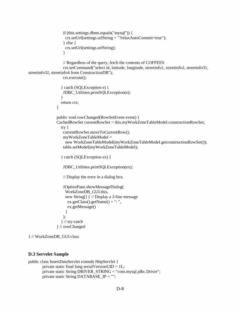
D-8
if (this.settings.dbms.equals("mysql")) { crs.setUrl(settings.urlString + "?relaxAutoCommit=true"); } else { crs.setUrl(settings.urlString); } // Regardless of the query, fetch the contents of COFFEES crs.setCommand("select id, latitude, longitude, streetinfo1, streetinfo2, streetinfo31, streetinfo32, streetinfo4 from ConstructionDB"); crs.execute(); } catch (SQLException e) { JDBC_Utilities.printSQLException(e); } return crs; } public void rowChanged(RowSetEvent event) { CachedRowSet currentRowSet = this.myWorkZoneTableModel.constructionRowSet; try { currentRowSet.moveToCurrentRow(); myWorkZoneTableModel = new WorkZoneTableModel(myWorkZoneTableModel.getconstructionRowSet()); table.setModel(myWorkZoneTableModel); } catch (SQLException ex) { JDBC_Utilities.printSQLException(ex); // Display the error in a dialog box. JOptionPane.showMessageDialog( WorkZoneDB_GUI.this, new String[] { // Display a 2-line message ex.getClass().getName() + ": ", ex.getMessage() } ); } // try-catch } // rowChanged } // WorkZoneDB_GUI class
D.3 Servelet Sample public class InsertDataServlet extends HttpServlet { private static final long serialVersionUID = 1L; private static String DRIVER_STRING = "com.mysql.jdbc.Driver"; private static String DATABASE_IP = "";

D-9
private static String DATABASE_PORT = ""; private static String DATABASE_SCHEMA_NAME = "pedestriannavigation"; private static String CONSTRUCTION_DATABASE_NAME = "constructiondb"; private static String USERS_DATABASE_NAME = "users"; private static String DRIVER_URL = "jdbc:mysql://" + DATABASE_IP + ":" + DATABASE_PORT + "/" + DATABASE_SCHEMA_NAME; private static String USERNAME = ""; private static String PASSWORD = ""; private static String CONSTRUCTION_DB_INSERT_QUERY = "INSERT into " + DATABASE_SCHEMA_NAME + "." + CONSTRUCTION_DATABASE_NAME + " values (?,?,?,?,?,?,?,?)"; private static String CONSTRUCTION_DB_SELECT_QUERY = "SELECT * from " + DATABASE_SCHEMA_NAME + "." + CONSTRUCTION_DATABASE_NAME + " where id = 'AAA'"; private static String CONSTRUCTION_DB_UPDATE_QUERY = "UPDATE " + DATABASE_SCHEMA_NAME + "."+ CONSTRUCTION_DATABASE_NAME + " SET latitude = ?, longitude = ?, streetinfo1 = ?, streetinfo2 = ?, streetinfo31 = ?, streetinfo32 = ?, streetinfo4 = ?"+ "WHERE id = ?"; private static String DEVICE_VALIDATION_QUERY = "SELECT * from " + DATABASE_SCHEMA_NAME + "." + USERS_DATABASE_NAME + " where IMEI = 'AAA'"; protected void doGet(HttpServletRequest request, HttpServletResponse response) throws ServletException, IOException { doPost(request, response); } protected void doPost(HttpServletRequest request, HttpServletResponse response) throws ServletException, IOException { try { //PrintWriter out = response.getWriter(); String attentionTxt = request.getHeader(ATTENTION_TXT).trim(); String youAreAtTxt = request.getHeader(YOU_ARE_AT_TXT).trim(); String constructionDetailsTxt = request.getHeader( CONSTR_DETAILS_TXT).trim(); String blocksTxt = request.getHeader(BLOCKS_TXT).trim(); String messageTxt = request.getHeader(MESSAGE_TXT).trim(); String passcodeTxt = request.getHeader(PASSCODE_TXT).trim(); String deviceIMEINum = request.getHeader(IMEI).trim(); String bluetoothMACAddr = request.getHeader(BLUETOOTH_MAC).trim(); Double latitude = Double.parseDouble(request.getHeader(LATITUDE)); Double longitude = Double.parseDouble(request.getHeader(LONGITUDE)); if (isRequestValid(deviceIMEINum, passcodeTxt)) { boolean isInsertedSuccessfully = insertValuesInDataBase( attentionTxt, youAreAtTxt, constructionDetailsTxt, blocksTxt, messageTxt, bluetoothMACAddr, latitude, longitude); if (!isInsertedSuccessfully) {
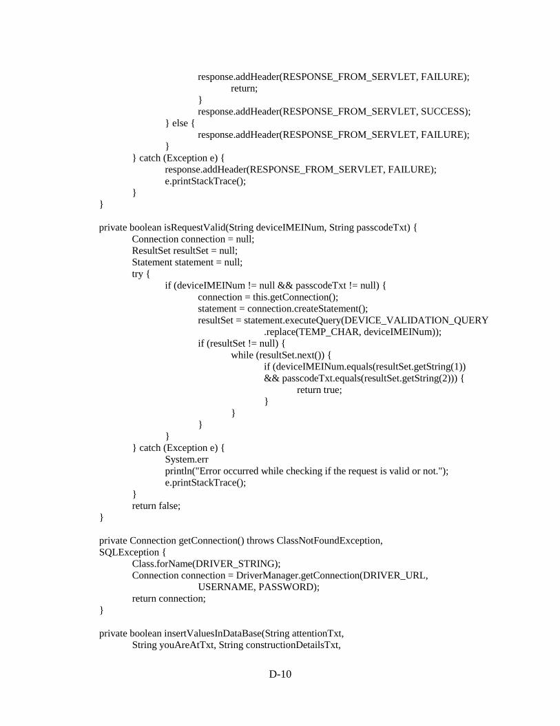
D-10
response.addHeader(RESPONSE_FROM_SERVLET, FAILURE); return; } response.addHeader(RESPONSE_FROM_SERVLET, SUCCESS); } else { response.addHeader(RESPONSE_FROM_SERVLET, FAILURE); } } catch (Exception e) { response.addHeader(RESPONSE_FROM_SERVLET, FAILURE); e.printStackTrace(); } } private boolean isRequestValid(String deviceIMEINum, String passcodeTxt) { Connection connection = null; ResultSet resultSet = null; Statement statement = null; try { if (deviceIMEINum != null && passcodeTxt != null) { connection = this.getConnection(); statement = connection.createStatement(); resultSet = statement.executeQuery(DEVICE_VALIDATION_QUERY .replace(TEMP_CHAR, deviceIMEINum)); if (resultSet != null) { while (resultSet.next()) { if (deviceIMEINum.equals(resultSet.getString(1)) && passcodeTxt.equals(resultSet.getString(2))) { return true; } } } } } catch (Exception e) { System.err println("Error occurred while checking if the request is valid or not."); e.printStackTrace(); } return false; } private Connection getConnection() throws ClassNotFoundException, SQLException { Class.forName(DRIVER_STRING); Connection connection = DriverManager.getConnection(DRIVER_URL, USERNAME, PASSWORD); return connection; } private boolean insertValuesInDataBase(String attentionTxt, String youAreAtTxt, String constructionDetailsTxt,

D-11
String blocksTxt, String messageTxt, String bluetoothMACAddr, Double latitude, Double longitude) { Connection connection = null; ResultSet resultSet = null; PreparedStatement preparedStatement = null; Statement statement = null; try { connection = this.getConnection(); statement = connection.createStatement(); resultSet = statement.executeQuery(CONSTRUCTION_DB_SELECT_QUERY .replace(TEMP_CHAR, bluetoothMACAddr)); /* * preparedStatement = connection * .prepareStatement(CONSTRUCTION_DB_SELECT_QUERY.replace(BT, * bluetoothMACAddr.trim())); */ if (resultSet == null || !resultSet.next()) { preparedStatement = connection .prepareStatement(CONSTRUCTION_DB_INSERT_QUERY); preparedStatement.setString(1, getValue(bluetoothMACAddr)); preparedStatement.setDouble(2, latitude); preparedStatement.setDouble(3, longitude); preparedStatement.setString(4, getValue(attentionTxt)); preparedStatement.setString(5, getValue(youAreAtTxt)); preparedStatement.setString(6, getValue(constructionDetailsTxt)); preparedStatement.setString(7, getValue(blocksTxt)); preparedStatement.setString(8, getValue(messageTxt)); } else { preparedStatement = connection .prepareStatement(CONSTRUCTION_DB_UPDATE_QUERY); preparedStatement.setString(8, getValue(bluetoothMACAddr)); preparedStatement.setDouble(1, latitude); preparedStatement.setDouble(2, longitude); preparedStatement.setString(3, getValue(attentionTxt)); preparedStatement.setString(4, getValue(youAreAtTxt)); preparedStatement.setString(5, getValue(constructionDetailsTxt)); preparedStatement.setString(6, getValue(blocksTxt)); preparedStatement.setString(7, getValue(messageTxt)); } preparedStatement.execute(); } catch (Exception e) { e.printStackTrace(); return false; } return true; } private String getValue(String obj) {

D-12
if (obj.equals(null)) { return EMPTY_STRING; } return obj; } }

Appendix E: ConnectBlue™ Programming Interface

E-1
A USB programming interface board of the ConnectBlue™ module is illustrated in Figure E-1.
Figure E-1 Connectblue USB Programming Interface
ConnectBlue™ Bluetooth programming software interface is displayed in Figure E-2 to E-4 as follows.
Figure E-2 ConnectBlue™ Graphical User Interface – Select Product
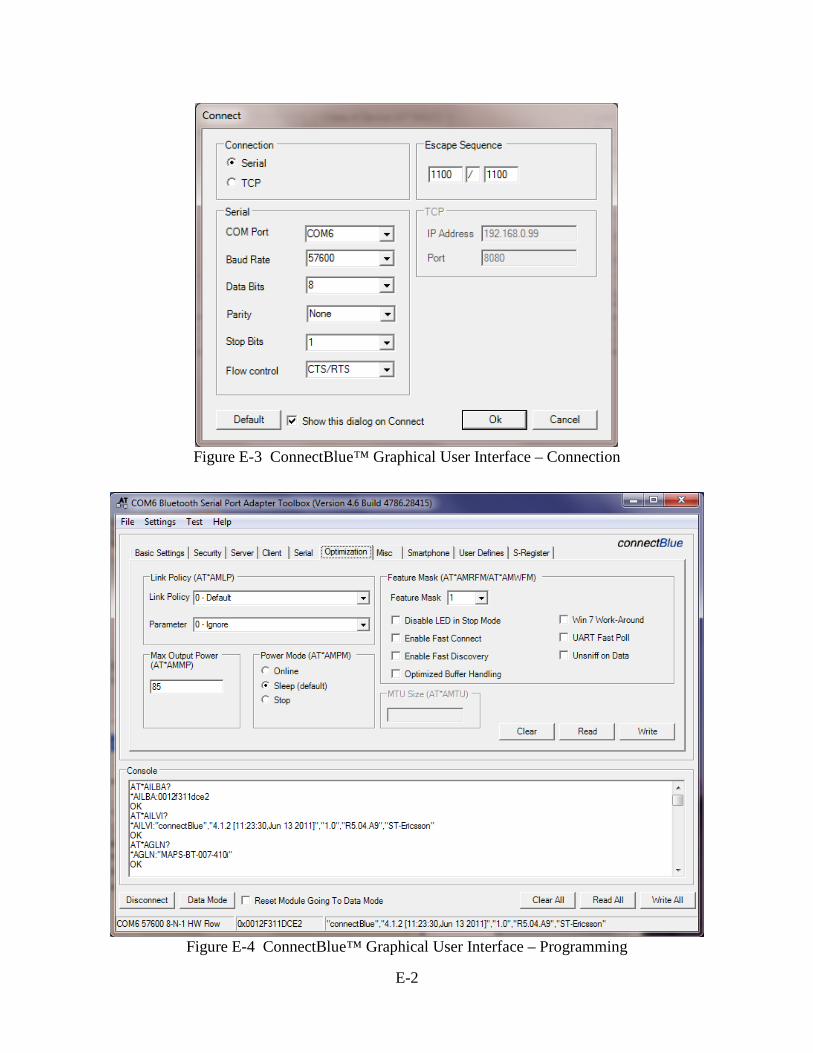
E-2
Figure E-3 ConnectBlue™ Graphical User Interface – Connection
Figure E-4 ConnectBlue™ Graphical User Interface – Programming

Appendix F: Other Hardware Components
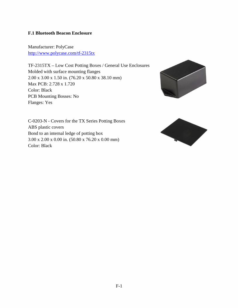
F-1
F.1 Bluetooth Beacon Enclosure Manufacturer: PolyCase http://www.polycase.com/tf-2315tx TF-2315TX – Low Cost Potting Boxes / General Use Enclosures Molded with surface mounting flanges 2.00 x 3.00 x 1.50 in. (76.20 x 50.80 x 38.10 mm) Max PCB: 2.728 x 1.720 Color: Black PCB Mounting Bosses: No Flanges: Yes C-0203-N - Covers for the TX Series Potting Boxes ABS plastic covers Bond to an internal ledge of potting box 3.00 x 2.00 x 0.00 in. (50.80 x 76.20 x 0.00 mm) Color: Black
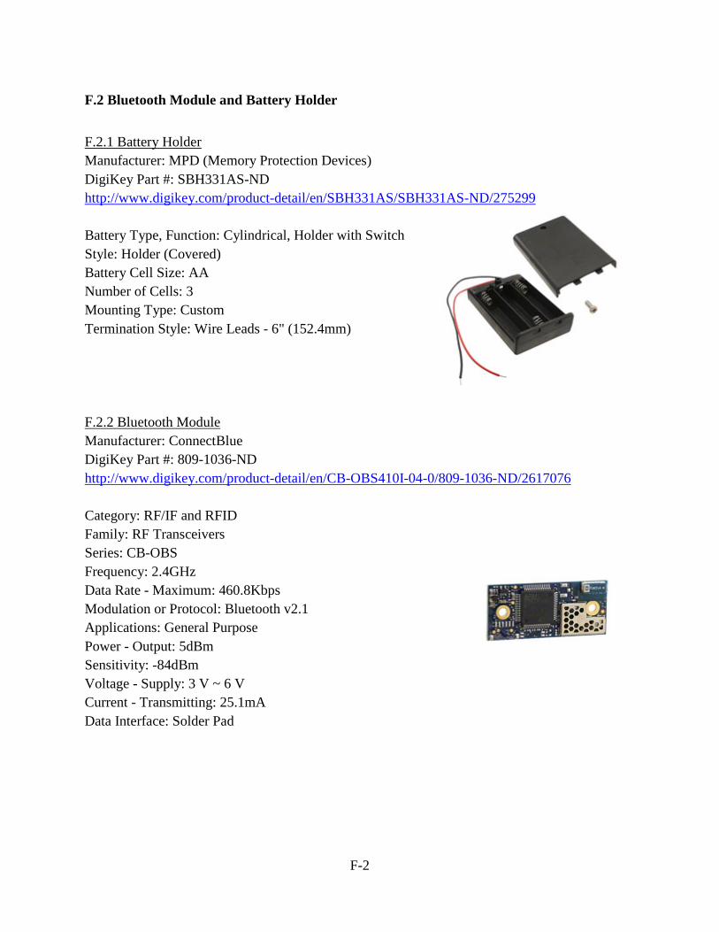
F-2
F.2 Bluetooth Module and Battery Holder F.2.1 Battery Holder Manufacturer: MPD (Memory Protection Devices) DigiKey Part #: SBH331AS-ND http://www.digikey.com/product-detail/en/SBH331AS/SBH331AS-ND/275299 Battery Type, Function: Cylindrical, Holder with Switch Style: Holder (Covered) Battery Cell Size: AA Number of Cells: 3 Mounting Type: Custom Termination Style: Wire Leads - 6" (152.4mm) F.2.2 Bluetooth Module Manufacturer: ConnectBlue DigiKey Part #: 809-1036-ND http://www.digikey.com/product-detail/en/CB-OBS410I-04-0/809-1036-ND/2617076 Category: RF/IF and RFID Family: RF Transceivers Series: CB-OBS Frequency: 2.4GHz Data Rate - Maximum: 460.8Kbps Modulation or Protocol: Bluetooth v2.1 Applications: General Purpose Power - Output: 5dBm Sensitivity: -84dBm Voltage - Supply: 3 V ~ 6 V Current - Transmitting: 25.1mA Data Interface: Solder Pad