developing an improved soil moisture dataset by blending...
TRANSCRIPT

Hydrol. Earth Syst. Sci., 15, 425–436, 2011www.hydrol-earth-syst-sci.net/15/425/2011/doi:10.5194/hess-15-425-2011© Author(s) 2011. CC Attribution 3.0 License.
Hydrology andEarth System
Sciences
Developing an improved soil moisture dataset by blending passiveand active microwave satellite-based retrievals
Y. Y. Liu 1,2,4, R. M. Parinussa2, W. A. Dorigo3, R. A. M. De Jeu2, W. Wagner3, A. I. J. M. van Dijk 4, M. F. McCabe1,and J. P. Evans5
1School of Civil and Environmental Engineering, University of New South Wales, Sydney, Australia2Department of Hydrology and Geo-Environmental Sciences, Faculty of Earth and Life Sciences,Vrije Universiteit Amsterdam, Amsterdam, The Netherlands3Institute for Photogrammetry and Remote Sensing, Vienna University of Technology, Vienna, Austria4CSIRO Land and Water, Black Mountain Laboratories, Canberra, Australia5Climate Change Research Centre, University of New South Wales, Sydney, Australia
Received: 2 August 2010 – Published in Hydrol. Earth Syst. Sci. Discuss.: 2 September 2010Revised: 18 January 2011 – Accepted: 25 January 2011 – Published: 1 February 2011
Abstract. Combining information derived from satellite-based passive and active microwave sensors has the potentialto offer improved estimates of surface soil moisture at globalscale. We develop and evaluate a methodology that takes ad-vantage of the retrieval characteristics of passive (AMSR-E)and active (ASCAT) microwave satellite estimates to pro-duce an improved soil moisture product. First, volumetricsoil water content (m3 m−3) from AMSR-E and degree ofsaturation (%) from ASCAT are rescaled against a referenceland surface model data set using a cumulative distributionfunction matching approach. While this imposes any biasof the reference on the rescaled satellite products, it adjuststhem to the same range and preserves the dynamics of orig-inal satellite-based products. Comparison with in situ mea-surements demonstrates that where the correlation coefficientbetween rescaled AMSR-E and ASCAT is greater than 0.65(“transitional regions”), merging the different satellite prod-ucts increases the number of observations while minimallychanging the accuracy of soil moisture retrievals. These tran-sitional regions also delineate the boundary between sparselyand moderately vegetated regions where rescaled AMSR-Eand ASCAT, respectively, are used for the merged product.Therefore the merged product carries the advantages of bet-ter spatial coverage overall and increased number of obser-vations, particularly for the transitional regions. The com-bination method developed has the potential to be applied
Correspondence to:Y. Y. Liu([email protected])
to existing microwave satellites as well as to new missions.Accordingly, a long-term global soil moisture dataset can bedeveloped and extended, enhancing basic understanding ofthe role of soil moisture in the water, energy and carbon cy-cles.
1 Introduction
Passive and active microwave satellites have been shown toprovide useful retrievals of near-surface soil moisture varia-tions at regional and global scales (Wagner et al., 2003; Wenet al., 2003; Njoku et al., 2003; Owe et al., 2008; Gao etal., 2006; McCabe et al., 2005). They can penetrate cloudcover and are sensitive to soil water. A series of opera-tional satellite-based passive microwave sensors have beenavailable since 1978, including the Scanning MultichannelMicrowave Radiometer (SMMR) (1978–1987), the SpecialSensor Microwave Imager (SSM/I) of the Defense Meteo-rological Satellite Program (since 1987), the microwave im-ager from the Tropical Rainfall Measuring Mission (TRMM)(since 1997), and more recently the Advanced MicrowaveScanning Radiometer – Earth observing system (AMSR-E)onboard the Aqua satellite (since 2002). In terms of activemicrowave sensors, the European Remote Sensing (ERS-1)scatterometer began its operation from 1992, ERS-2 startedcollecting data from March 1996, and the Advanced Scat-terometer (ASCAT) onboard the Meteorological Operationalsatellite programme (MetOp) was launched in October 2006.
Published by Copernicus Publications on behalf of the European Geosciences Union.

426 Y. Y. Liu et al.: Developing an improved soil moisture dataset
The Soil Moisture and Ocean Salinity (SMOS) satellitelaunched in November 2009 carries the low frequency L-band sensor. While currently at the calibration stage, it is ex-pected to continue the developing record of globally retrievedsoil moisture data. In the coming years, numerous new satel-lite missions with microwave instruments are scheduled forlaunch (e.g., Soil Moisture Active Passive (SMAP), Aquar-ius, Deformation, Ecosystem Structure and Dynamics ofIce (DESDynI), and the Argentine Microwaves ObservationSatellite (SAOCOM)). These are expected to bring soil mois-ture retrievals with further enhanced accuracy.
Various retrieval algorithms have been developed to esti-mate soil moisture from microwave observations (e.g., Oweet al., 2008; Njoku et al., 2003; Jackson, 1993; Wagner et al.,1999). Here we consider soil moisture products derived fromtwo algorithms, one using passive microwave and the otheractive microwave observations. The algorithm developed byVU University Amsterdam in collaboration with the NationalAeronautics and Space Administration (VUA-NASA) can beused for all bands in the passive microwave domain (Owe etal., 2008), allowing data collected by different satellites to becombined. The change detection algorithm developed by Vi-enna University of Technology (TU-Wien) has been appliedon ERS-1/2 and ASCAT (Wagner et al., 1999; Bartalis et al.,2007), and provides a global satellite-based active microwavesoil moisture product starting 1992.
A number of previous studies (Vischel et al., 2008; Broccaet al., 2010; Albergel et al., 2009; Gruhier et al., 2010;Rudiger et al., 2009; Draper et al., 2009; Wagner et al.,2007) evaluated these passive and active microwave soilmoisture products against in situ measurements and foundthat VUA-NASA passive microwave product performs betterover sparsely vegetated regions, whereas the TU-Wien activemicrowave product shows better agreement for regions ofmoderate vegetation density. Over the sparsely to moderatelyvegetated regions, both products have similar performances.Scipal et al. (2008) and Dorigo et al. (2010) applied the triplecollocation approach with VUA-NASA passive microwave,TU-Wien active microwave and model simulated soil mois-ture products to estimate the relative error of each product atglobal scale. These three products are derived from differ-ent approaches and can be considered as having independenterror characteristics, the key requirement for this approach.The results confirmed that the errors of VUA-NASA pas-sive microwave are smaller than those of the TU-Wien activemicrowave product for sparsely vegetated regions and largerover moderately vegetated regions. Their errors are compara-ble over the regions with low to moderate vegetation density.
Theoretically, passive and active microwave instrumentswith similar frequencies should give similar response overthe same region regardless of vegetation density. Theprimary reason for different performances between VUA-NASA and TU-Wien soil moisture products lies in differ-ent ways that they account for vegetation influence on thesignal. Empirical evidence suggests that the TU-Wien soil
moisture performs reasonably well over regions with appar-ent seasonal vegetation variations (e.g., south France, Spainand southern Great Plains, see Rudiger et al., 2009; Wagneret al., 2007; Crow et al., 2010). The VUA-NASA algorithmuses a radiative transfer model to extract soil moisture andvegetation density simultaneously. Within this algorithm, thevegetation is considered to behave like a one-layered semi-transparent medium (Owe et al., 2008). With increasing veg-etation density, the accuracy of soil moisture would be ex-pected to decrease, as is confirmed by empirical evidence(e.g., Gruhier et al., 2010; Draper et al., 2009; De Jeu et al.,2008).
There may be value in developing an approach that com-bines both passive and active microwave soil moisture prod-ucts over these varying vegetation types to develop an im-proved global satellite-based soil moisture product. The po-tential of combining passive and active microwave soil mois-ture was also noted by Njoku et al. (2002), Piles et al. (2009)and Das et al. (2010). Their studies were conducted usingairborne data collected at small scales and short time periodsat the microwave measurement level, whereas our study areconducted using multiple established satellite-based datasetsat global scale and for a long time period at the soil moistureproducts level.
It is noted that apart from satellite observation, soil mois-ture can also be simulated using models (e.g., Rodell et al.,2004), based on an understanding of (simplified) physicalprocesses (e.g., Dai et al., 2003) and observed meteorology.Data assimilation is an approach to incorporate remotelysensed soil moisture into model simulations to improve soilmoisture estimates, but the final product remains primarilya modeled product. It is not clear whether the final productretains key characteristics (e.g., inter-annual variations andlong term trends) detected by remotely sensed soil moisture.In any case, data assimilation is beyond the scope of thisstudy. The objective of our study is to generate a satellite-based long term global soil moisture product by combiningTU-Wien active and VUA-NASA passive microwave prod-ucts.
There are some challenges. First, no single satellite cov-ers the entire period. Differences in sensor specifications(e.g., different microwave frequencies and resolutions) pre-vent merging soil moisture estimates from different instru-ments directly. Second, the currently available VUA-NASApassive and TU-Wien active microwave products representdifferent quantities, that is, volumetric soil moisture and de-gree of saturation, respectively. Third, the accuracy of pas-sive or active microwave products varies as a function of veg-etation cover, making the selection of the better retrieval anontrivial task, particularly where both products have com-parable performances.
As a first step towards a long term global soil moisturedataset, we developed a methodology that can address thelatter two challenges. That is, to adjust two products that, re-spectively, represent volumetric soil moisture and degree of
Hydrol. Earth Syst. Sci., 15, 425–436, 2011 www.hydrol-earth-syst-sci.net/15/425/2011/

Y. Y. Liu et al.: Developing an improved soil moisture dataset 427
saturation to the same range, and to delineate regions overwhich passive, active microwave products or combination ofboth are used in the final product. More details about VUA-NASA and TU-Wien products are described in Sect. 2, aswell as model simulated and in situ measured soil moisturethat were used. The Sect. 3 is the primary part of this method-ology paper, demonstrating how both microwave soil mois-ture products are adjusted to the same range and then mergedfor an improved product. In addition, the differences andsimilarities between original products and the merged prod-uct are displayed. The last section summarizes the method-ology and puts forward suggestions for future research.
2 Data sources
2.1 AMSR-E (VUA-NASA product)
The AMSR-E sensor onboard NASA Aqua satellite has pro-vided passive microwave measurements at 6.9 GHz (C-band)and five higher frequencies (including 36.5 GHz Ka-band)since May 2002, with daily ascending (13:30 equatorial localcrossing time) and descending (01:30 equatorial local cross-ing time) overpasses, over a swath width of 1445 km.
The VUA-NASA algorithm uses the Land Parameter Re-trieval Model (LPRM), requiring horizontal (H) and verti-cal (V) polarization C-band brightness temperatures (Tb),and V polarization Ka-bandTb from which soil surface tem-perature is estimated (Owe et al., 2008; Holmes et al., 2009).The vegetation optical depth (dimensionless, an indicator ofvegetation density) and soil dielectric constant are derived si-multaneously. The soil moisture (m3 m−3) is solved from thedielectric constant using the Wang-Schmugge mixing model(Wang and Schmugge, 1980).
We used soil moisture and vegetation optical depth re-trievals acquired by descending passes (01:30 equatorial lo-cal crossing time) as the minimal temperature gradients atmidnight are more favourable for the retrievals (De Jeu,2003). The C-band soil moisture represents the top few cen-timetres of soil, depending on the wetness. The AMSR-Eproducts (soil moisture and vegetation optical depth) werere-sampled into 0.25◦ (about 25 km) resolution for the periodfrom 1 January through 31 December 2007.
2.2 ASCAT (TU-Wien product)
The ASCAT onboard the MetOp is a real aperture radarinstrument operating at 5.255 GHz (C-band) since Octo-ber 2006. Three antennas on each side of the satellite groundtrack measure the backscatter from the earth surface in two550 km wide swaths. The three antennas on each side are ori-ented to broadside and±5◦ of broadside, respectively, mak-ing sequential observations of the backscattering coefficientof each point of interest from three directions.
Soil moisture variations are adjusted between the histor-ically lowest (0%) and highest (100%) values, producing a
time series of relative soil moisture for the topmost centime-tres of the soil. This TU-Wien change detection algorithm,originally developed for soil moisture retrievals from ERS-1 and 2 (Wagner et al., 1999) was applied to ASCAT withminor adaptations (Naeimi et al., 2009).
The descending and ascending equatorial crossing time ofASCAT are respectively 09:30 and 21:30. To allow compari-son with AMSR-E descending (01:30) product, the morningswaths and the evening swaths of the day before were aver-aged. ASCAT soil moisture was also re-sampled into 0.25◦
resolution for the period from 1 January through 31 Decem-ber 2007.
2.3 Land surface model product
Noah is a land surface model that forms a component ofthe Global Land Data Assimilation System (GLDAS). TheNoah model product with 3-h time interval and 0.25◦ reso-lution is available for 2000 onwards (ftp://agdisc.gsfc.nasa.gov/data/s4pa/). The model was forced by combinationof NOAA/GDAS atmospheric analysis fields, spatially andtemporally disaggregated NOAA Climate Prediction CenterMerged Analysis of Precipitation (CMAP) fields, and obser-vation based downward shortwave and longwave radiationfields derived using the method of the Air Force WeatherAgency’s Agricultural Meteorological system (see Rodell etal., 2004 for further details).
Noah model uses a four-layered soil description with a 10-cm thick top layer and takes into account the fractions ofsand and clay. Soil moisture dynamics of the top layer aregoverned by infiltration, surface and sub-surface runoff, gra-dient diffusion, gravity and evapotranspiration.
2.4 In situ measurements
In situ soil moisture measurements used for comparison withthe estimates from AMSR-E, ASCAT and Noah, include ob-servations from the:
– OZNET network in south-east Australia(Young et al., 2008; Rudiger et al., 2007);
– REMEDHUS network in central Spain(Martınez-Fernandez and Ceballos, 2005);
– SMOSMANIA network in southern France(Albergel et al., 2008; Calvet et al., 2007); and
– CNR-IRPI network in Italy(Brocca et al., 2008, 2009).
Data were downloaded from the International Soil MoistureNetwork website (Dorigo et al., 2011). The shallowest mea-surements represent approximately the top 5–10 cm, compa-rable with estimates derived from microwave observationsand Noah simulations. Some characteristics of these differ-ent networks are listed in Table 1. Predominant land cover
www.hydrol-earth-syst-sci.net/15/425/2011/ Hydrol. Earth Syst. Sci., 15, 425–436, 2011

428 Y. Y. Liu et al.: Developing an improved soil moisture dataset
Table 1. Comparison of major characteristics of in situ soil moisture measurements used in this study. The OZNET network includesmeasurements within five catchments or basins. Numbers of in situ stations and grid cells covered are shown (more than one in situ stationlocated within the same 0.25◦ grid cell in some networks).
Network Location in situ 0.25◦ Climate Major Vegetation Soil Moisture Instrumentsstations grid cel
REMEDHUS central Spain 21 5 Semi-arid Crops Stevens Hydra ProbeMediterranean
CNR-IRPI central Italy 4 1 Semi-humid Grass EnviroSCAN SentekMediterranean sensor technology
SMOSMANIA southern France 12 12 Atlantic (east) to Natural fallow Theta Probe ML2XMediterranean (west)
OZNET southeastern Australia 52 30 Semi-arid (inland) Pasture, Grass, Campbell Scientific(Murrumbidgee, Yanco to temperate (east) Crops and Oats 615 & 616,Kyeamba, Adelong, Stevens Hydra Probeand Goulburn)
types around the measurement stations are grasslands, cropsand pasture, which may be considered representative for lowto moderate vegetation density.
2.5 Data pre-processing
A snow mask was developed based on ERA-Interim reanaly-sis data. ERA-Interim is the latest global atmospheric reanal-ysis produced by the European Centre for Medium-RangeWeather Forecasts (ECMWF), covering the data-rich periodsince 1989 (Simmons et al., 2007a, b; Uppala et al., 2008;Dee and Uppala, 2009). ERA-Interim products are publiclyavailable on the ECMWF Data Server and have 1.5◦ resolu-tion (http://data-portal.ecmwf.int/data/d/interimdaily/). Soilmoisture and vegetation optical depth from AMSR-E andsoil moisture from ASCAT were masked when the reanaly-sis indicated surface temperature below 0◦ or non-zero snowdepth.
The original unit of Noah soil moisture is kg m−2. Consid-ering that the top soil layer depth is 10 cm, Noah soil mois-ture (kg m−2) could be converted to volumetric soil moisture(m3 m−3). The 3-hourly Noah simulated soil moisture wasaggregated to daily averages.
Where there were multiple in situ monitoring stations lo-cated in one 0.25◦ grid cell, their average was taken. Timeseries of in situ soil moisture for grid cells with more thanthree (inclusive) monitoring stations are shown in Fig. 1,illustrating the spatial heterogeneity of soil moisture varia-tions. Given this, absolute numerical agreement in satellite-based and in situ soil moisture values should not be expected.Relative patterns are similar among in situ stations, however.
Fig. 1. Time series of in situ soil moisture for the eight 0.25◦ gridcells within which more than three (inclusive) in situ stations werelocated. Blue represents measurement from individual in situ sta-tions and black is the average value. Location, latitude and lon-gitude (center of the grid cell), and number of in situ stations arelisted.
3 Methods and results
In the merged product, the VUA-NASA and TU-Wien prod-ucts were used over sparsely and moderately vegetated re-gions, respectively. Since passive and active products per-form similarly well, both products were used over thesparsely to moderately vegetated regions (hereafter referredto as “transitional regions”). Over transitional regions, both
Hydrol. Earth Syst. Sci., 15, 425–436, 2011 www.hydrol-earth-syst-sci.net/15/425/2011/

Y. Y. Liu et al.: Developing an improved soil moisture dataset 429
Fig. 2. Time series of soil moisture estimates from(a) Noah, (b)AMSR-E and(c) ASCAT for a grid cell (centered at 41.375◦ N,5.375◦ W) in 2007. Circles represent days when Noah, AMSR-Eand ASCAT all have valid estimates.
products are expected to be well correlated due to their sim-ilar performance. The challenge is to determine an appro-priate threshold of correlation coefficient, above which animproved soil moisture product can be produced by combin-ing both products.
To determine this threshold, we first adjusted both originalproducts (having units of m3 m−3 and % respectively) to acommon range and then compare the resulting estimates toin situ measurements. Details on the method followed arepresented below.
3.1 Cumulative distribution function matching
To combine VUA-NASA AMSR-E (m3 m−3) and TU-WienASCAT (%) soil moisture products, we adjust both againstone reference data set. The reference data set requires globalcoverage with a spatial resolution and temporal interval thatare comparable with the AMSR-E and ASCAT products(e.g., roughly 25 km resolution and daily interval); a longtime record; and reasonable surface soil moisture estimatesfor all land cover types (e.g., representative soil layer is notdeeper than 10 cm).
The GLDAS-Noah model was identified as satisfyingthese requirements and therefore selected as the referencedata set against which both satellite-based observations arerescaled. The Noah model and the VUA-NASA algorithmalso use a common soil property dataset (i.e., soil poros-ity and fractions of clay and sand) (http://ldas.gsfc.nasa.gov/gldas/GLDASsoils.php), based on the Food and AgricultureOrganization (FAO) Soil Map of the World that was devel-oped from a global database of over 1300 soil samples.
The cumulative distribution function (CDF) matching ap-proach was used to adjust microwave satellite observedagainst the Noah simulated soil moisture. This approachwas used in a number of previous studies. Reichle andKoster (2004) used it to merge satellite soil moisture observa-tions with model data. Both Lee and Anagnostou (2004) and
Fig. 3. Example illustrating how the cumulative distribution func-tion (CDF) matching approach was implemented to rescale originalAMSR-E and ASCAT against Noah soil moisture product in thisstudy. (a, b, c) CDF curves of AMSR-E, Noah and ASCAT soilmoisture estimates for the grid cell shown in Fig. 2.(d) Linear re-gression lines of AMSR-E against Noah for 12 segments.(e) Sameas (d), but for ASCAT and Noah.(f) CDF curves of Noah (black),rescaled AMSR-E (blue) and rescaled ASCAT (red) soil moistureproducts.
Atlas et al. (1990) established reflectivity-rainfall relation-ships for the calibration of radar or satellite observations ofprecipitation, and Liu et al. (2009) produced a 29-year satel-lite soil and vegetation moisture data set over Australia bymerging several passive microwave products using the CDFmatching technique.
CDF matching was applied for each grid cell individually.An example grid cell (centered at 41.375◦ N, 5.375◦ W) isshown in Fig. 2, where time series of soil moisture estimatesfrom Noah, AMSR-E and ASCAT are plotted. Soil mois-ture values from days when Noah, AMSR-E and ASCAT areall available are marked with circles. It is expected that theCDF curves of these circled soil moisture values from differ-ent products are more directly comparable than those of allavailable values. The CDF curves of these circled values areshown in Fig. 3a, b and c. A piece-wise linear CDF matchingapproach was applied: dividing the CDF curve into severalsegments, performing linear regression analysis for each seg-ment, and finally using the linear equations (slope and inter-cept) to rescale data falling into different segments.
We used the 0, 5, 10, 20, 30, 40, 50, 60, 70, 80, 90, 95and 100 percentiles of the CDF curves to define 12 seg-ments (see Fig. 3a–c). The 13 percentile values from theAMSR-E and ASCAT CDF curves are plotted against thoseof Noah (Fig. 3d and e) and the scaling linear equations (e.g.,
www.hydrol-earth-syst-sci.net/15/425/2011/ Hydrol. Earth Syst. Sci., 15, 425–436, 2011
430 Y. Y. Liu et al.: Developing an improved soil moisture dataset
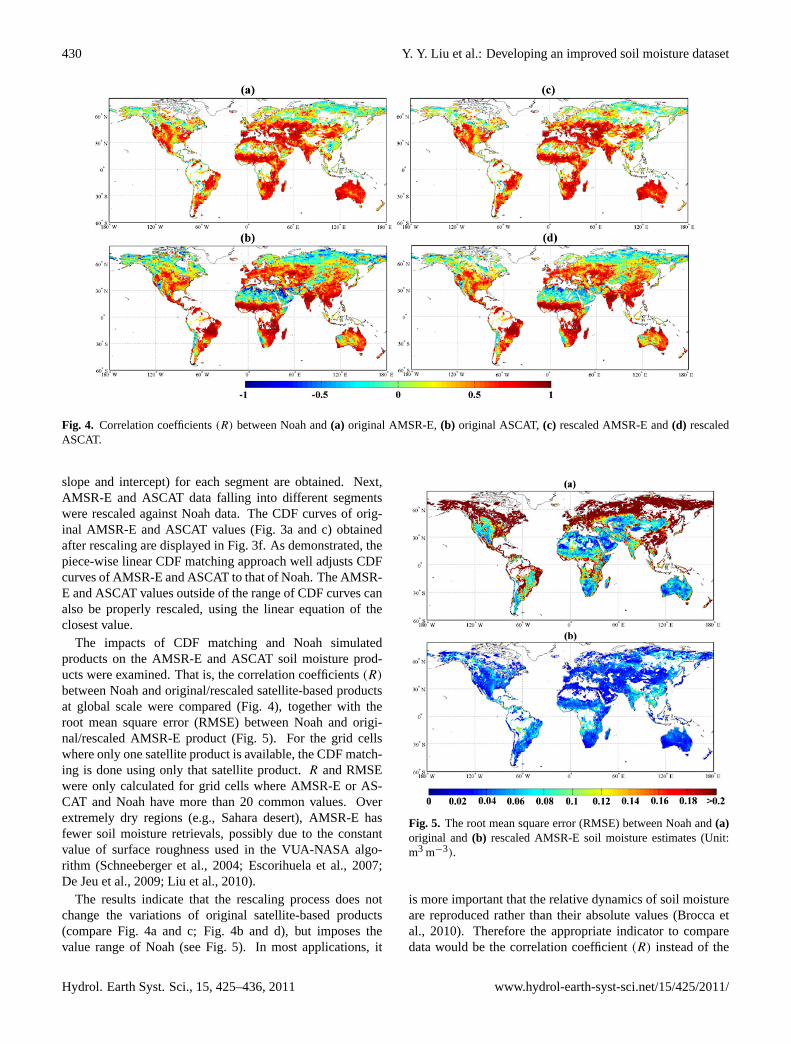
Fig. 4. Correlation coefficients(R) between Noah and(a) original AMSR-E,(b) original ASCAT, (c) rescaled AMSR-E and(d) rescaledASCAT.
slope and intercept) for each segment are obtained. Next,AMSR-E and ASCAT data falling into different segmentswere rescaled against Noah data. The CDF curves of orig-inal AMSR-E and ASCAT values (Fig. 3a and c) obtainedafter rescaling are displayed in Fig. 3f. As demonstrated, thepiece-wise linear CDF matching approach well adjusts CDFcurves of AMSR-E and ASCAT to that of Noah. The AMSR-E and ASCAT values outside of the range of CDF curves canalso be properly rescaled, using the linear equation of theclosest value.
The impacts of CDF matching and Noah simulatedproducts on the AMSR-E and ASCAT soil moisture prod-ucts were examined. That is, the correlation coefficients(R)
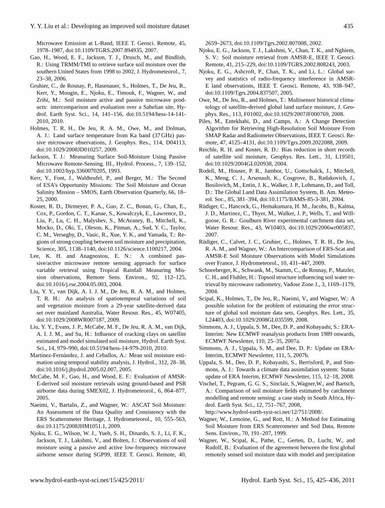
between Noah and original/rescaled satellite-based productsat global scale were compared (Fig. 4), together with theroot mean square error (RMSE) between Noah and origi-nal/rescaled AMSR-E product (Fig. 5). For the grid cellswhere only one satellite product is available, the CDF match-ing is done using only that satellite product.R and RMSEwere only calculated for grid cells where AMSR-E or AS-CAT and Noah have more than 20 common values. Overextremely dry regions (e.g., Sahara desert), AMSR-E hasfewer soil moisture retrievals, possibly due to the constantvalue of surface roughness used in the VUA-NASA algo-rithm (Schneeberger et al., 2004; Escorihuela et al., 2007;De Jeu et al., 2009; Liu et al., 2010).
The results indicate that the rescaling process does notchange the variations of original satellite-based products(compare Fig. 4a and c; Fig. 4b and d), but imposes thevalue range of Noah (see Fig. 5). In most applications, it
Fig. 5. The root mean square error (RMSE) between Noah and(a)original and(b) rescaled AMSR-E soil moisture estimates (Unit:m3 m−3).
is more important that the relative dynamics of soil moistureare reproduced rather than their absolute values (Brocca etal., 2010). Therefore the appropriate indicator to comparedata would be the correlation coefficient(R) instead of the
Hydrol. Earth Syst. Sci., 15, 425–436, 2011 www.hydrol-earth-syst-sci.net/15/425/2011/

Y. Y. Liu et al.: Developing an improved soil moisture dataset 431
Fig. 6. Comparisons of in situ and rescaled/merged satellite-basedsoil moisture were conducted. The grid cell is the same as Fig. 2.Relationships between in situ and(a) rescaled AMSR-E (AMSR-E*), (b) ASCAT (ASCAT*) and (c) merged AMSR-E* and AS-CAT* (AMSR-E*/ASCAT*). (d) Relationship between AMSR-E*and ASCAT*.
RMSE. The CDF matching approach does not change rela-tive patterns in the AMSR-E and ASCAT products.
3.2 Comparison with in situ measurements
In this section, we compare in situ measurements with therescaled and merged satellite-based estimates to decide anappropriate threshold for the combination of both microwavesoil moisture products. Figure 6 shows that combinationof both satellite-based products can improve the number ofobservations. All in situ measurements are compared withAMSR-E* (hereafter * refers to rescaled values) and AS-CAT* (as example in Fig. 6) in terms ofR and shown inFig. 7. At least one satellite product agrees reasonably well(R > 0.5) with in situ measurements for all grid cells. Whenboth satellite products are highly correlated, their correlationwith in situ data is similar (Fig. 7b). WhenR betweenAMSR-E* and ASCAT* is greater than 0.65, the differ-ence between their individualR with in situ measurements issmaller than 0.1. A high correlation coefficient between twosatellite-based products does not directly prove that both arehighly correlated with in situ data, but the fact that two fullyindependent datasets capture very similar temporal variationsprovides more confidence in both. In addition, we plot theR
between the merged product and in situ data (cf. Fig. 6c) withtheir individualR with in situ data before merging (cf. Fig. 6aand b) in Fig. 8. In general,R values between the merged
Fig. 7. (a) Plot of R between AMSR-E* and ASCAT* (horizon-tal axis) against their individual correlation coefficient with in situmeasurement (vertical axis). Different catchments or basins aremarked with different colors. Triangle and square symbols, re-spectively, representR between in situ and ASCAT* and AMSR-E* soil moisture. The larger the symbol, the more in situ stationslocated within one 0.25◦ grid cell. (b) Plot of R between AMSR-E* and ASCAT* (horizontal axis) against the absolute differencebetween their individual correlation coefficient with in situ mea-surement (vertical axis). First-order and second-order polynomialregression lines are also shown.
product and in situ data are intermediate between their indi-vidualR with in situ data. However, for cases where the twoproducts are well correlated (inset in Fig. 8), merging themfrequently leads to higherR values as well as an increasednumber of observations.
Given these results, we conclude that merging both prod-ucts increase the number of observations while minimallydegrading or improving the accuracy of soil moisture esti-mates, whenR between AMSR-E* and ASCAT* is higherthan 0.65. Therefore the threshold of 0.65 was chosen;AMSR-E* and ASCAT* were combined where their corre-lation coefficient was greater than 0.65.
3.3 Spatial coverage
The correlation analysis between AMSR-E* and ASCAT*soil moisture products was carried out globally to delineateregions with a correlation coefficient(R) above 0.65, i.e.,transitional regions (Fig. 9). The AMSR-E vegetation optical
www.hydrol-earth-syst-sci.net/15/425/2011/ Hydrol. Earth Syst. Sci., 15, 425–436, 2011

432 Y. Y. Liu et al.: Developing an improved soil moisture dataset
Fig. 8. Relationships between correlation coefficients(R) between AMSR-E* (square), ASCAT* (triangle), and AMSR-E*/ASCAT* (i.e.,merged product) (blue closed circles) with in situ observations, respectively.
Fig. 9. Regions with high correlation coefficient (R > 0.65) be-tween rescaled AMSR-E and rescaled ASCAT for 2007.
depth, retrieved simultaneously with AMSR-E soil moisture,is an indicator of vegetation density (Fig. 10). The aver-age vegetation optical depth over the “transitional regions” is0.42±0.18. The VUA-NASA AMSR-E soil moisture prod-uct is used to cover the regions with lower vegetation density,whereas the TU-Wien ASCAT soil moisture product is usedfor regions with higher vegetation density. The spatial dis-tribution of regions covered by AMSR-E, ASCAT and themerged product is shown in Fig. 11, and the average vege-tation optical depth for these regions is, respectively, 0.20,0.65 and 0.42. This spatial distribution corresponds with theresults of Dorigo et al. (2010) who used the triple colloca-tion technique with VUA-NASA AMSR-E, TU-Wien AS-CAT, and Noah soil moisture to determine areas where eitherAMSR-E or ASCAT had a smaller error value.
3.4 Temporal resolution and overall performance
The temporal coverage of the individual and merged prod-ucts can be expressed as the fraction of the total numberof days within the observation period. On average, this ra-tio is around 50% for the descending overpass of AMSR-E(Fig. 12a), that is, it takes two days to achieve the global
Fig. 10. Annual average of global vegetation density (via opticaldepth) derived from AMSR-E C-band using VUA-NASA algorithmfor 2007.
Fig. 11.Spatial coverage by AMSR-E (blue), ASCAT (red) and themerged product (orange). Tropical rain forests are masked out dueto their high vegetation density.
coverage. The same frequency is achieved by the ascendingand descending overpass of ASCAT combined (Fig. 12b).Over the transitional regions where AMSR-E and ASCATproducts are combined, this increases data frequency to 80%(Fig. 12c).
Hydrol. Earth Syst. Sci., 15, 425–436, 2011 www.hydrol-earth-syst-sci.net/15/425/2011/

Y. Y. Liu et al.: Developing an improved soil moisture dataset 433
Table 2. Comparisons of overall performance between final merged product and individual products over different in situ soil moisturenetworks.
NetworkAMSR-E* ASCAT* Final Product
AverageR with in situ AverageR with in situ AverageR with in situ(Average Temporal Ratio) (Average Temporal Ratio) (Average Temporal Ratio)
SMOSMANIA 0.44 (69%) 0.67 (56%) 0.67 (56%)Goulburn 0.79 (48%) 0.67 (51%) 0.72 (59%)Italy 0.71 (60%) 0.61 (44%) 0.70 (67%)Murrumbidgee 0.66 (65%) 0.59 (55%) 0.67 (79%)Spain 0.72 (73%) 0.76 (55%) 0.74 (88%)Yanco, Kyeamba and Adelong 0.73 (62%) 0.73 (54%) 0.76 (79%)
Fig. 12. Temporal coverage (i.e., fraction of days with observa-tions) of(a) original AMSR-E,(b) original ASCAT and(c) mergedproduct, for 2007.
Comparisons of overall performance between final mergedproduct and individual products over different in situ net-works are displayed in Table 2. In general, the final mergedproduct has higher number of observations while retaininggood temporal patterns of individual products.
4 Discussions and conclusions
We developed a methodology to rescale and merge VUA-NASA AMSR-E and TU-Wien ASCAT C-band retrievalsand produce an improved soil moisture dataset. The AMSR-E and ASCAT products were rescaled against GLDAS-Noahsimulated soil moisture using a CDF matching approach.This method does not effectively change the temporal patternof the original products. Comparison with in situ measure-ments showed that provided both satellite products are wellcorrelated (R > 0.65), merging can improve the temporal res-olution of the data. In addition, the rescaled AMSR-E andASCAT products were used for sparsely and moderately veg-etated regions, respectively.
This approach would be applicable to both past and cur-rent microwave satellites, as well as new missions that areexpected to bring higher accuracy of soil moisture retrievals.This allows for a long term global satellite-based soil mois-ture product to be generated and extended. The transitionalregions delineated here largely correspond with the regionsdefined by Koster et al. (2004) where strong coupling be-tween soil moisture and precipitation are expected. Theenhancement of information by combining passive and ac-tive microwave products may help understand land surface-atmosphere interactions and improve weather and climateprediction skill over these regions.
There are a number of opportunities for improvements.One potential issue is the effect of radio frequency interfer-ence (RFI) on the AMSR-E C-band retrievals and is observedin United States, Japan, the Middle East and elsewhere(Njoku et al., 2005). A possible solution might be the use ofAMSR-E X-band instead of C-band soil moisture retrievalsover these regions, although these data will correspond to
www.hydrol-earth-syst-sci.net/15/425/2011/ Hydrol. Earth Syst. Sci., 15, 425–436, 2011

434 Y. Y. Liu et al.: Developing an improved soil moisture dataset
a reduced penetration depth. When soil moisture retrievalsfrom new missions (e.g., SMOS and SMAP) are available,blending them with existing products should provide a fur-ther improved merged product as L-band radiometer andscatterometer would bring more accurate estimates of sur-face soil moisture (Kerr et al., 2000; Entekhabi et al., 2010).
Spatial and temporal gaps still exist in our merged product,primarily due to satellite orbits and swath widths. This mayaffect the application of satellite-based soil moisture, particu-larly for analyses on short time basis (e.g., daily and weekly).Filling the gaps in satellite-based soil moisture products in areasonable manner will be one of the emphases in the futureanalysis.
Acknowledgements.This work was undertaken as part of the Euro-pean Space Agency STSE Water Cycle Multi-mission ObservationStrategy (WACMOS) project (ESRIN/Contr. No. 22086/08/I-EC).We would like to thank Bob Su and Diego Fernandez-Prieto fortheir support. The development of the long term soil moisturedataset was also supported by the European Union (FP7) fundedFramework Programme for Research and Technological Devel-opment Carbo Extreme (Contr. No. 226701). Yi Liu is fundedby a University of New South Wales International PostgraduateAward (UIPA) and a scholarship from the CSIRO Water for aHealthy Country Flagship Program.
Edited by: P. van Oevelen
References
Albergel, C., Rudiger, C., Pellarin, T., Calvet, J.-C., Fritz, N., Frois-sard, F., Suquia, D., Petitpa, A., Piguet, B., and Martin, E.: Fromnear-surface to root-zone soil moisture using an exponential fil-ter: an assessment of the method based on insitu observationsand model simulations, Hydrol. Earth Syst. Sci., 12, 1323–1337,doi:10.5194/hess-12-1323-2008, 2008.
Albergel, C., Rudiger, C., Carrer, D., Calvet, J.-C., Fritz, N.,Naeimi, V., Bartalis, Z., and Hasenauer, S.: An evaluation ofASCAT surface soil moisture products with in-situ observationsin Southwestern France, Hydrol. Earth Syst. Sci., 13, 115–124,doi:10.5194/hess-13-115-2009, 2009.
Atlas, D., Rosenfeld, D., and Wolff, D. B.: Climatologically TunedReflectivity Rain Rate Relations and Links to Area Time Inte-grals, J. Appl. Meteorol., 29, 1120–1135, 1990.
Bartalis, Z., Wagner, W., Naeimi, V., Hasenauer, S., Sci-pal, K., Bonekamp, H., Figa, J., and Anderson, C.: Ini-tial soil moisture retrievals from the METOP-A AdvancedScatterometer (ASCAT), Geophys. Res. Lett., 34, L20401,doi:10.1029/2007GL031088, 2007.
Brocca, L., Melone, F., and Moramarco, T.: On the estimation ofantecedent wetness conditions in rainfall-runoff modelling, Hy-drol. Process., 22, 629–642, doi:10.1002/Hyp.6629, 2008.
Brocca, L., Melone, F., Moramarco, T., and Morbidelli, R.: An-tecedent wetness conditions based on ERS scatterometer data, J.Hydrol., 364, 73–87, doi:10.1016/j.jhydrol.2008.10.007, 2009.
Brocca, L., Melone, F., Moramarco, T., Wagner, W., and Hasenauer,S.: ASCAT soil wetness index validation through in situ and
modeled soil moisture data in central Italy, Remote Sens. Env-iron., 114, 2745–2755, doi:10.1016/j.rse.2010.06.009, 2010.
Calvet, J.-C., Fritz, N., Froissard, F., Suquia, D., Petitpa,A., and Piguet, B.: In situ soil moisture observationsfor the CAL/VAL of SMOS: the SMOSMANIA network,International Geoscience and Remote Sensing Symposium,IGARSS, Barcelona, Spain, 23–28 July 2007, 1196–1199,doi:10.1109/IGARSS.2007.4423019, 2007.
Crow, W. T., Wagner, W., and Naeimi, V.: The Impact of Radar In-cident Angle on Soil-Moisture-Retrieval Skill, IEEE Geosci. Re-mote S., 7, 501–505, doi:10.1109/LGRS.2010.2040134, 2010.
Dai, Y., Zeng, X., Dickinson, R. E., Baker, I., Bonan, G. B.,Bosilovich, M. G., Denning, A. S., Dirmeyer, P. A., Houser, P.R., Niu, G., Oleson, K. W., Schlosser, C. A., and Yang, Z.: TheCommon Land Model, B. Am. Meteorol. Soc., 84, 1013–1023,2003.
Das, N., Entekhabi, D., and Njoku, E.: An algorithm formerging SMAP radiometer and radar data for high resolu-tion soil moisture retrieval, IEEE T. Geosci. Remote, doi:10.1109/TGRS.2010.2089526, in press, 2010.
De Jeu, R. A. M.: Retrieval of Land Surface Parameters UsingPassive Microwave Observations, VrijeUniversiteit Amsterdam,Amsterdam, 120 pp., 2003.
De Jeu, R. A. M., Wagner, W., Holmes, T. R. H., Dolman, A. J.,Giesen, N. C., and Friesen, J.: Global soil moisture patterns ob-served by space borne microwave radiometers and scatterom-eters, Surv. Geophys., 29, 399–420, doi:10.1007/s10712-008-9044-0, 2008.
De Jeu, R. A. M., Holmes, T., Panciera, R., and Walker, J.: Param-eterization of the Land Parameter Retrieval Model for L-BandObservations Using the NAFE’05 Data Set, IEEE Geosci. Re-mote S., 6, 630–634, doi:10.1109/LGRS.2009.2019607, 2009.
Dee, D. P. and Uppala, S.: Variational bias correction of satelliteradiance data in the ERA-Interim reanalysis, Q. J. Roy. Meteor.Soc., 135, 1830–1841, doi:10.1002/qj.493, 2009.
Dorigo, W. A., Scipal, K., Parinussa, R. M., Liu, Y. Y., Wagner,W., De Jeu, R. A. M., and Naeimi, V.: Error characterisationof global active and passive microwave soil moisture data sets,Hydrol. Earth Syst. Sci., 14, 2605–2616, doi:10.5194/hess-14-2605-2010, 2010.
Dorigo, W. A., Van Oevelen, P., Wagner, W., Drusch, M., Meck-lenburg, S., Robock, A., and Jackson, T.: The International SoilMoisture Network: A new data hosting facility for in-situ soilmoisture data, EOS Transactions, American Geophysical Union,in review, 2011.
Draper, C. S., Walker, J. P., Steinle, P. J., De Jeu, R. A. M.,and Holmes, T. R. H.: An evaluation of AMSR-E derived soilmoisture over Australia, Remote Sens. Environ., 113, 703–710,doi:10.1016/j.rse.2008.11.011, 2009.
Entekhabi, D., Njoku, E. G., O’Neill, P. E., Kellogg, K. H.,Crow, W. T., Edelstein, W. N., Entin, J. K., Goodman, S.D., Jackson, T. J., Johnson, J., Kimball, J., Piepmeier, J. R.,Koster, R. D., Martin, N., McDonald, K. C., Moghaddam, M.,Moran, S., Reichle, R., Shi, J. C., Spencer, M. W., Thurman,S. W., Leung T., van Zyl, J.: The Soil Moisture Active Pas-sive (SMAP) Mission, Proceedings of the IEEE, 98, 704–716,doi:10.1109/JPROC.2010.2043918, 2010.
Escorihuela, M. J., Kerr, Y. H., de Rosnay, P., Wigneron, J. P., Cal-vet, J. C., and Lemaitre, F.: A Simple Model of the Bare Soil
Hydrol. Earth Syst. Sci., 15, 425–436, 2011 www.hydrol-earth-syst-sci.net/15/425/2011/
Y. Y. Liu et al.: Developing an improved soil moisture dataset 435
Microwave Emission at L-Band, IEEE T. Geosci. Remote, 45,1978–1987, doi:10.1109/TGRS.2007.894935, 2007.
Gao, H., Wood, E. F., Jackson, T. J., Drusch, M., and Bindlish,R.: Using TRMM/TMI to retrieve surface soil moisture over thesouthern United States from 1998 to 2002, J. Hydrometeorol., 7,23–38, 2006.
Gruhier, C., de Rosnay, P., Hasenauer, S., Holmes, T., De Jeu, R.,Kerr, Y., Mougin, E., Njoku, E., Timouk, F., Wagner, W., andZribi, M.: Soil moisture active and passive microwave prod-ucts: intercomparison and evaluation over a Sahelian site, Hy-drol. Earth Syst. Sci., 14, 141–156, doi:10.5194/hess-14-141-2010, 2010.
Holmes, T. R. H., De Jeu, R. A. M., Owe, M., and Dolman,A. J.: Land surface temperature from Ka band (37 GHz) pas-sive microwave observations, J. Geophys. Res., 114, D04113,doi:10.1029/2008JD010257, 2009.
Jackson, T. J.: Measuring Surface Soil-Moisture Using PassiveMicrowave Remote-Sensing. III., Hydrol. Process., 7, 139–152,doi:10.1002/hyp.3360070205, 1993.
Kerr, Y., Font, J., Waldteufel, P., and Berger, M.: The Secondof ESA’s Opportunity Missions: The Soil Moisture and OceanSalinity Mission – SMOS, Earth Observation Quarterly, 66, 18–25, 2000.
Koster, R. D., Dirmeyer, P. A., Guo, Z. C., Bonan, G., Chan, E.,Cox, P., Gordon, C. T., Kanae, S., Kowalczyk, E., Lawrence, D.,Liu, P., Lu, C. H., Malyshev, S., McAvaney, B., Mitchell, K.,Mocko, D., Oki, T., Oleson, K., Pitman, A., Sud, Y. C., Taylor,C. M., Verseghy, D., Vasic, R., Xue, Y. K., and Yamada, T.: Re-gions of strong coupling between soil moisture and precipitation,Science, 305, 1138–1140, doi:10.1126/science.1100217, 2004.
Lee, K. H. and Anagnostou, E. N.: A combined pas-sive/active microwave remote sensing approach for surfacevariable retrieval using Tropical Rainfall Measuring Mis-sion observations, Remote Sens. Environ., 92, 112–125,doi:10.1016/j.rse.2004.05.003, 2004.
Liu, Y. Y., van Dijk, A. I. J. M., De Jeu, R. A. M., and Holmes,T. R. H.: An analysis of spatiotemporal variations of soiland vegetation moisture from a 29-year satellite-derived dataset over mainland Australia, Water Resour. Res., 45, W07405,doi:10.1029/2008WR007187, 2009.
Liu, Y. Y., Evans, J. P., McCabe, M. F., De Jeu, R. A. M., van Dijk,A. I. J. M., and Su, H.: Influence of cracking clays on satelliteestimated and model simulated soil moisture, Hydrol. Earth Syst.Sci., 14, 979–990, doi:10.5194/hess-14-979-2010, 2010.
Martınez-Fernandez, J. and Ceballos, A.: Mean soil moisture esti-mation using temporal stability analysis, J. Hydrol., 312, 28–38,doi:10.1016/j.jhydrol.2005.02.007, 2005.
McCabe, M. F., Gao, H., and Wood, E. F.: Evaluation of AMSR-E-derived soil moisture retrievals using ground-based and PSRairborne data during SMEX02, J. Hydrometeorol., 6, 864–877,2005.
Naeimi, V., Bartalis, Z., and Wagner, W.: ASCAT Soil Moisture:An Assessment of the Data Quality and Consistency with theERS Scatterometer Heritage, J. Hydrometeorol., 10, 555–563,doi:10.1175/2008JHM1051.1, 2009.
Njoku, E. G., Wilson, W. J., Yueh, S. H., Dinardo, S. J., Li, F. K.,Jackson, T. J., Lakshmi, V., and Bolten, J.: Observations of soilmoisture using a passive and active low-frequency microwaveairborne sensor during SGP99, IEEE T. Geosci. Remote, 40,
2659–2673, doi:10.1109/Tgrs.2002.807008, 2002.Njoku, E. G., Jackson, T. J., Lakshmi, V., Chan, T. K., and Nghiem,
S. V.: Soil moisture retrieval from AMSR-E, IEEE T. Geosci.Remote, 41, 215–229, doi:10.1109/TGRS.2002.808243, 2003.
Njoku, E. G., Ashcroft, P., Chan, T. K., and Li, L.: Global sur-vey and statistics of radio-frequency interference in AMSR-E land observations, IEEE T. Geosci. Remote, 43, 938–947,doi:10.1109/Tgrs.2004.837507, 2005.
Owe, M., De Jeu, R., and Holmes, T.: Multisensor historical clima-tology of satellite-derived global land surface moisture, J. Geo-phys. Res., 113, F01002, doi:10.1029/2007JF000769, 2008.
Piles, M., Entekhabi, D., and Camps, A.: A Change DetectionAlgorithm for Retrieving High-Resolution Soil Moisture FromSMAP Radar and Radiometer Observations, IEEE T. Geosci. Re-mote, 47, 4125–4131, doi:10.1109/Tgrs.2009.2022088, 2009.
Reichle, R. H. and Koster, R. D.: Bias reduction in short recordsof satellite soil moisture, Geophys. Res. Lett., 31, L19501,doi:10.1029/2004GL020938, 2004.
Rodell, M., Houser, P. R., Jambor, U., Gottschalck, J., Mitchell,K., Meng, C. J., Arsenault, K., Cosgrove, B., Radakovich, J.,Bosilovich, M., Entin, J. K., Walker, J. P., Lohmann, D., and Toll,D.: The Global Land Data Assimilation System, B. Am. Meteo-rol. Soc., 85, 381–394, doi:10.1175/BAMS-85-3-381, 2004.
Rudiger, C., Hancock, G., Hemakumara, H. M., Jacobs, B., Kalma,J. D., Martinez, C., Thyer, M., Walker, J. P., Wells, T., and Will-goose, G. R.: Goulburn River experimental catchment data set,Water Resour. Res., 43, W10403, doi:10.1029/2006wr005837,2007.
Rudiger, C., Calvet, J. C., Gruhier, C., Holmes, T. R. H., De Jeu,R. A. M., and Wagner, W.: An Intercomparison of ERS-Scat andAMSR-E Soil Moisture Observations with Model Simulationsover France, J. Hydrometeorol., 10, 431–447, 2009.
Schneeberger, K., Schwank, M., Stamm, C., de Rosnay, P., Matzler,C. H., and Fluhler, H.: Topsoil structure influencing soil water re-trieval by microwave radiometry, Vadose Zone J., 3, 1169–1179,2004.
Scipal, K., Holmes, T., De Jeu, R., Naeimi, V., and Wagner, W.: Apossible solution for the problem of estimating the error struc-ture of global soil moisture data sets, Geophys. Res. Lett., 35,L24403, doi:10.1029/2008GL035599, 2008.
Simmons, A. J., Uppala, S. M., Dee, D. P., and Kobayashi, S.: ERA-Interim: New ECMWF reanalysis products from 1989 onwards,ECMWF Newsletter, 110, 25–35, 2007a.
Simmons, A. J., Uppala, S. M., and Dee, D. P.: Update on ERA-Interim, ECMWF Newsletter, 111, 5, 2007b.
Uppala, S. M., Dee, D. P., Kobayashi, S., Berrisford, P., and Sim-mons, A. J.: Towards a climate data assimilation system: Statusupdate of ERA Interim, ECMWF Newsletter, 115, 12–18, 2008.
Vischel, T., Pegram, G. G. S., Sinclair, S.,Wagner,W., and Bartsch,A.: Comparison of soil moisture fields estimated by catchmentmodelling and remote sensing: a case study in South Africa, Hy-drol. Earth Syst. Sci., 12, 751–767, 2008,http://www.hydrol-earth-syst-sci.net/12/751/2008/.
Wagner, W., Lemoine, G., and Rott, H.: A Method for EstimatingSoil Moisture from ERS Scatterometer and Soil Data, RemoteSens. Environ., 70, 191–207, 1999.
Wagner, W., Scipal, K., Pathe, C., Gerten, D., Lucht, W., andRudolf, B.: Evaluation of the agreement between the first globalremotely sensed soil moisture data with model and precipitation
www.hydrol-earth-syst-sci.net/15/425/2011/ Hydrol. Earth Syst. Sci., 15, 425–436, 2011

436 Y. Y. Liu et al.: Developing an improved soil moisture dataset
data, J. Geophys. Res., 108, 4611, doi:10.1029/2003jd003663,2003.
Wagner, W., Naeimi, V., Scipal, K., De Jeu, R., and Martınez-Fernandez, J.: Soil moisture from operational meteorologicalsatellites, Hydrogeol. J., 15, 121–131, doi:10.1007/s10040-006-0104-6, 2007.
Wang, J. R. and Schmugge, T. J: An Empirical-Model for the Com-plex Dielectric Permittivity of Soils as a Function of Water Con-tent, IEEE T. Geosci. Remote, 18, 288–295, 1980.
Wen, J., Su, Z. B., and Ma, Y. M.: Determination of land surfacetemperature and soil moisture from Tropical Rainfall Measur-ing Mission/Microwave Imager remote sensing data, J. Geophys.Res., 108, 4038, doi:10.1029/2002JD002176, 2003.
Young, R., Walker, J., Yeoh, N., Smith, A., Ellett, K., Merlin, O.,and Western, A.: Soil moisture and meteorological observationsfrom the murrumbidgee catchment, Department of Civil and En-vironmental Engineering, The University of Melbourne, 2008.
Hydrol. Earth Syst. Sci., 15, 425–436, 2011 www.hydrol-earth-syst-sci.net/15/425/2011/