developing a performance review questionnaire for hong
TRANSCRIPT
TS07A – Transparency and Security in Land Administration, 8119
Haodong Zhang and Conrad Tang
Developing a Performance Review Questionnaire for Hong Kong Cadastral Survey System
FIG Working week 2016
Recovery from Disaster
Christchurch, New Zealand, May 2-6, 2016
1/12
Developing a Performance Review Questionnaire for Hong Kong Cadastral
Survey System
Haodong ZHANG and Conrad TANG, Hong Kong SAR, CHINA
Key words: Fit-for-Purpose, Cadastral Surveying, Land Administration, Performance Review
SUMMARY
Performance review facilitates an organization to meet its user demands and achieve planned
goals. Evaluation on the performance of a cadastral survey system helps decision makers
understand the current development of cadastral survey industry and the way forward to
enhance its performance. As an indispensable function of a land administration system, the
cadastral survey and mapping activities provide spatial related descriptions on cadastral
interests. A fit-for-purpose cadastral survey system should meet the requirements of the
society. To evaluate how well the cadastral survey industry fulfills its professional
responsibility, a set of pre-established criteria and organizational objectives and the
corresponding questions for performance review are required. Certainly, each cadastral survey
system has its own unique characteristics. A developed self-assessment model for cadastral
survey systems was introduced during the FIG conferences in the past two years. Here, based
on the previously established structured performance assessment model, we further developed
a set of appraisal questions for Hong Kong cadastral survey stakeholders to review the system
performance. With sufficient feedbacks, we aim to investigate the status of the Hong Kong
cadastral survey system in fulfilling its internal land surveying responsibilities and external
duties in supporting a fit-for-purposes land administration system and a sustainable society.

TS07A – Transparency and Security in Land Administration, 8119
Haodong Zhang and Conrad Tang
Developing a Performance Review Questionnaire for Hong Kong Cadastral Survey System
FIG Working week 2016
Recovery from Disaster
Christchurch, New Zealand, May 2-6, 2016
2/12
Developing a Performance Review Questionnaire for Hong Kong Cadastral
Survey System
Haodong ZHANG and Conrad TANG, Hong Kong SAR, CHINA
1. INTRODUCTION
Cadastral surveying is an essential function of a modern land administration system. Cadastral
survey and mapping activities support various types and levels of land administrative
procedures by providing spatial-related cadastral datasets. Producing different types of
cadastral plans is the most perceived contributions of a cadastral survey system to the society.
In a modern land administration system, the cadastral mapping framework serves as the
backbone platform to visualize and manage the rights, responsibilities and restrictions of the
land.
The current survey and mapping technology is undergoing evolutionary change. Theoretically,
the technology capability of cadastral survey and mapping activities are significantly
improved. However, the development of a cadastral survey system always needs to consider
the backgrounds and current conditions of the jurisdiction. The societal requirements of a
cadastral survey system decide the practicing survey and mapping technology in the system.
Thus, cadastral survey systems are still different from each other.
All cadastral survey systems under different topographical, economic, legal and institutional
settings have same purpose which is to support land administrative activities efficiently and
effectively. To serve this purpose, the regulations and procedures may vary from one
jurisdiction to another jurisdiction. As a type of professional service, a cadastral survey
system is constituted by the cadastral survey infrastructure, cadastral survey service provider
and the user. Cadastral surveyors are the key service provider and the key operator in the
cadastral survey infrastructure. The user of the system can be land-related professions in both
public and private sector, and also the general public. A fit-for-purpose cadastral survey
system should meet the demands of its system users in an effective way.
To check how well each cadastral survey system operates, opinions on the system
performance are required to be collected from its stakeholders. A structured performance
assessment was introduced during the International Federation of Surveyors (FIG)
conferences (Zhang and Tang, 2014; Zhang and Tang, 2015). The general assessment
framework is shown in Figure 1. A case study on the Hong Kong cadastral survey system
performance has been conducted locally based on the established assessment model.
Questionnaire has been distributed to local land surveyors to measure their opinions on the
constitution of an ideal cadastral survey system performance and their satisfaction level on the
achievements of the current Hong Kong cadastral survey system.

TS07A – Transparency and Security in Land Administration, 8119
Haodong Zhang and Conrad Tang
Developing a Performance Review Questionnaire for Hong Kong Cadastral Survey System
FIG Working week 2016
Recovery from Disaster
Christchurch, New Zealand, May 2-6, 2016
3/12
Fig.1 General framework of the established model
Results on the relative importance of the proposed assessment criteria and achieved
performance level of current Hong Kong cadastral survey system have been collected from
local land surveyors and now is distributing to stakeholders other than land surveyors. The
next step in comprehensively evaluating the performance of Hong Kong cadastral survey
system is to collect more detailed performance information of the system from its
stakeholders. Again, to review the performance of local cadastral survey and mapping
activities are twofold. One is from the side of local land surveyors who are the key service
provider of the system. The other is from the side of the users of the system. Comments on the
development of local cadastral survey infrastructures are needed from land surveyors.
Opinions on the outputs of local cadastral survey system are sought from land users.
This paper introduces a further step in designing a questionnaire to collect information on the
performance of Hong Kong cadastral survey system from both local land surveyors and land
stakeholders other than surveyor. Data collected by this performance review questionnaire
aims to attach to the previously established assessment criteria set and to correlate with
currently acquired performance scores of the local cadastral survey system. The structure of
this paper is as follows. First, the assessment strategy is briefly introduced. Then, a review of
previously established evaluation model is represented. Next, the principles of the
questionnaire design for Hong Kong land stakeholders are discussed. At last, this paper
introduces how to implement the questionnaire survey to the local cadastral survey industry;
and concludes with the expected outcomes of the proposed questionnaire and the entire
evaluation project on the cadastral survey systems.

TS07A – Transparency and Security in Land Administration, 8119
Haodong Zhang and Conrad Tang
Developing a Performance Review Questionnaire for Hong Kong Cadastral Survey System
FIG Working week 2016
Recovery from Disaster
Christchurch, New Zealand, May 2-6, 2016
4/12
2. STRATEGY ON CADASTRAL SURVEY SYSTEM EVALUATION
In the field of cadastre and land management, the elements of a fit-for-purpose approach (FIG
and World Bank, 2014) may not be regarded as brand-new concepts individually (see, Ting
and Williamson, 1999; and Robertson, 2002). Nonetheless, it provides a comprehensive
framework to instruct jurisdictions to build and develop their cadastral infrastructures with
reference to the dramatically developed technology in the geo-informatics industry. The
expeditious development of Information and Communication Technology (ICT) enables land
users to have more demands on the land industry. This also urges the policy maker and
service provider to re-evaluate and then enhance the existing institutional framework and the
services they provide. Certainly, an inspired and attentive vision on how to build and sustain
the infrastructures is required and the Declaration on Fit-for-Purpose Land Administration
(FIG and World Bank, 2014) fills the gap timely.
Cadastral surveyor is always an active participant in the field of land administration. In this
project, we evaluate the cadastral survey system instead of a land administration system. As
an indispensable function, how well the cadastral survey and mapping activities meet the
demands of the land industry and the society is checked. Cadastral surveyor is the key service
provider in a cadastral survey system. Their opinions and judgments are required to be
summarized and analyzed.
To evaluate the design of each individual cadastral survey system needs extensive resources
and exhaustive research on every perspectives of each specific system. Evaluation on the
performance of a system is more practical and widely applied in the field of cadastre and land
management (Haldrup and Ktubkjær, 2013). In this research project, a set of assessment
criteria has been proposed to measure the performance of cadastral survey systems from the
technical, economic, legal and institutional perspectives as shown in Figure 1.
The key evaluation criteria on the general fitness of a cadastral survey system are: 1) whether
the cadastral survey products are trusted by the land users; and 2) whether the cadastral survey
services are widely used by land professions. This set of key evaluation criteria is first
summarized by Williamson (2000) in assessing the successfulness of land administration
systems. Here, then general assessment scheme is listed in Figure 2.

TS07A – Transparency and Security in Land Administration, 8119
Haodong Zhang and Conrad Tang
Developing a Performance Review Questionnaire for Hong Kong Cadastral Survey System
FIG Working week 2016
Recovery from Disaster
Christchurch, New Zealand, May 2-6, 2016
5/12
Figure 2. General assessment scheme
Case study is the selected methodology to evaluate the performance of individual cadastral
survey systems. Here, a pilot study on the current Hong Kong cadastral survey system has
been conducted to test the capabilities of established assessment model.
3. PERVIOUSLY ESTABLISHED ASSESSMENT FRAMEWORK
This research project aims to evaluate the general successfulness or fitness of the current
cadastral survey systems. A structured assessment framework has been established based on a
set of assessment criteria as shown in Figure 1. Here, the contents of the framework are
briefly reviewed.
A set of performance indicators is proposed based on four general performance aspects of a
cadastral survey system. They are Capability, Cost, Security and Service. Certainly, those
performance perspectives are interrelated. In the established assessment, Capability more
focuses on the technical performance of the system. Cost highlights the economic
performance of the system. Security tests the reliability of the system more from the legal
perspective. And the Service evaluates the performance of the institutional arrangements.
Assessments on the aspects of Capability and Security are applied to measure the trustability
of the current cadastral survey services. Assessments on the aspects of Cost and Service are
conducted to test the extensiveness of the current cadastral survey services.
The assessment framework has been build based on a Multi-Criteria Decision Analysis
(MCDA) model. Specifically, we adopted one of the most widely applied MCDA, Analytic
Hierarchy Process (AHP), as the fundamental analyzing algorithm. This methodology is
extensively used in the management level of almost every field (Vaidya and Kumar, 2006) to
help people make decisions. In a general AHP based framework, there are three hierarchies:
Goal, Criteria and Alternatives. Here, the Goal of the assessment project is an ideal cadastral
survey system performance that best meets the demands of its stakeholders. The Criteria are
the proposed key performance aspects and indicators of a cadastral survey system. The

TS07A – Transparency and Security in Land Administration, 8119
Haodong Zhang and Conrad Tang
Developing a Performance Review Questionnaire for Hong Kong Cadastral Survey System
FIG Working week 2016
Recovery from Disaster
Christchurch, New Zealand, May 2-6, 2016
6/12
Alternatives for each individual cadastral survey system are the Should-be Performance (best-
fits current societal requirements) and the Achieved Performance (actually achieved system
performance).
Questionnaire survey is the main data collection methodology to acquire opinions from
cadastral survey stakeholders on: 1) the relative importance of each criterion; and 2) the
performance level of the current system on each criterion. Questions for land surveyors and
land stakeholders other than land surveyors are designed based on the same framework. Since
stakeholders other than land surveyors normally do not have deep understandings on the
detailed performance aspects of the cadastral survey and mapping activities, questions on the
sub-criteria set are not required to be asked by them. Figure 3 shows the difference on the
contents of questions for land surveyors and land stakeholders.
Figure 3. Assessment contents for land surveyors and other land stakeholders
Generally, there are two sets of questions are needed to be answered. The first set of questions
asks participants on the relative importance of each criterion and the participant’s satisfaction
level of current system performance under each criterion. A questionnaire of this set of
questions has already been distributed to the Hong Kong land surveyors under the
coordination of the Land Surveying Division of the Hong Kong Institute of Surveyors. The
second set of questions aims to collect information on the achieved performance of the current
Hong Kong cadastral survey system. Compared with the first set of questions, this set of
performance review questions aims to evaluate the local cadastral survey system in a closer
view based on the same set assessment criteria. Feedbacks will be correlated with previously

TS07A – Transparency and Security in Land Administration, 8119
Haodong Zhang and Conrad Tang
Developing a Performance Review Questionnaire for Hong Kong Cadastral Survey System
FIG Working week 2016
Recovery from Disaster
Christchurch, New Zealand, May 2-6, 2016
7/12
collected evaluations on the weights of the assessment criteria and the participants’
satisfaction level on each criterion.
4. THE DESIGN OF PERFORMANCE REVIEW QUESTIONS FOR HONG KONG
CADASTRAL SURVEY SYSTEM
4.1 Backgrounds on the Hong Kong Cadastral Survey System Design
To design a performance review questionnaire for a specific cadastral survey system,
understandings on the backgrounds of the system is required. Here, the backgrounds on the
Hong Kong cadastral survey system will be briefly introduced.
Hong Kong has a land area around 1100 square kilometers. Most of the population dwells in
the highly dense Hong Kong Island, Kowloon Peninsula and the flat land in the New
Territories and outskirt islands. New Territories consists more than 80% of the total area of
Hong Kong and much of the area are still rural areas. Hong Kong used to be a British Colony
before its sovereignty transfer to the People’s Republic of China in 1997. After that, Hong
Kong maintains its autonomy as a special administrative region of the People’s Republic of
China. The legal system of Hong Kong continues based on the common law that follows the
English system.
The Land Registration Ordinance was first enacted in 1844 and still in use to date. Land Titles
Ordinance was enacted in 2004 but still not into effect. Strictly speaking, there is no cadastre
in Hong Kong. The cadastral system has long been criticized by local land survey industry for
its weakness in secure the cadastral survey results and the boundary rights. Enhancements on
the functions and capabilities of the local cadastral system are progressively deployed. Yet,
there is no cadastre law in Hong Kong. Laws covered on cadastral issues are regarded as
insufficient by local land surveyors.
The Hong Kong cadastral system deals with basically land registration and cadastral survey.
The contemporary exercised leasehold registration system started in 1842. The purpose of the
system is mainly for the transaction of land ownership, and has remained largely unchanged
since then. The land register is only an index of the registered documents and the property
may be subjected to unregistered interests. The land register and memorial are kept in
database and lease documents are stored in scanned image files by the Land Registry. The
Survey and Mapping Office of the Lands Department keeps the graphic components of the
cadastral survey records.
4.2 Previously Collected Assessment Elements
Currently, the established assessment framework mainly collects opinions from local land
surveyors. Those land surveyors are divided into three groups: Public Sector (land surveyors
from public sector), Private Sector (land surveyors from private sector) and Young Surveyor.

TS07A – Transparency and Security in Land Administration, 8119
Haodong Zhang and Conrad Tang
Developing a Performance Review Questionnaire for Hong Kong Cadastral Survey System
FIG Working week 2016
Recovery from Disaster
Christchurch, New Zealand, May 2-6, 2016
8/12
The collected results show their recognition on the relative importance of the performance
aspects of the Hong Kong cadastral survey system. Also their satisfaction level on the current
achieved performance is assessed. Figure 4 shows the flowchart of these two assessment
elements.
Figure 4. Flowchart of two previously assessed elements
As shown in Figure 4, Element 1 asks assessor to give his/her judgements on the relative
importance of every pair of assessment criteria. By standard AHP weights determination
algorithm (Satty, 1980), these pairwise comparisons forms the weights or relative importance
of each performance aspects in constitution of a desired cadastral survey system performance.
Element 2 collects opinions on the fulfillment level of the current system under each
performance indicators. Both these two assessment elements are focused on the generalized
satisfaction perception on the cadastral survey system performance. A further step to collect
actual datasets on the performance of current cadastral survey system is essential to explorer
the development of the system and shed the lights on further system enhancements. Thus a set
of performance review questions are designed to meet this purpose.
4.3 Contents on the Designed Performance Review Questionnaire

TS07A – Transparency and Security in Land Administration, 8119
Haodong Zhang and Conrad Tang
Developing a Performance Review Questionnaire for Hong Kong Cadastral Survey System
FIG Working week 2016
Recovery from Disaster
Christchurch, New Zealand, May 2-6, 2016
9/12
Performance questions are designed under four proposed performance aspects: Capability,
Cost, Security and Service. Those selected questions are attached to the established
performance indicators of the cadastral survey system. Ideally, more questions attract more
information to be collected on the system performance. In practice, more questions in a
questionnaire often lead to a less feedback rates. Thus, to balance this, only highly relevant
survey questions are listed in the final questionnaire. Overall, twenty multiple choice
questions are proposed in this performance review questionnaire to collect actual performance
datasets that relevant to the assessment criteria. All those questions are available online
(http://goo.gl/forms/qJxD8xS4s6). Here, the general dimensions are briefly discussed.
4.3.1 Performance Questions on Capability
There are three sub-criteria under Capability: Plan Accuracy, Surveying Technology, and
System Automation. Plan Accuracy intends to measure the positional accuracy of the currently
produced cadastral survey plans. Surveying Technology measures the technical capability and
efficiency in survey and mapping required rights, responsibilities and restrictions by currently
adopted surveying methodology. System Automation measures the automation level of the
cadastral survey system with a focus on the database and data model approach.
4.3.2 Performance Questions on Cost
There are three sub-criteria under Cost: Customer Cost, System Maintenance, and Time
Efficiency. Customer Cost measures the individual burden to use the cadastral survey services.
System Maintenance measures the government burden in maintaining the current cadastral
survey operations. Time Efficiency considers the cost in time dimension by measuring the
time efficiency on using or providing cadastral survey services.
4.3.3 Performance Questions on Security
There are three sub-criteria under Security: Boundary Reliability, Legal Basis, and Survey
Regulation. Boundary Reliability measures the stability of the boundary system and efficiency
of the currently surveyed boundaries. Legal Basis intends to exam the performance of the
updated legislation for the operation of cadastral survey services and authorization of legal
boundary for surveying. Survey Regulation measures the appropriateness of the technical and
administrative guidance for the cadastral survey industry.
4.3.4 Performance Questions on Service
There are three sub-criteria under Service: Product Applicability, Professional Competence,
and User Perspective. Product Applicability measures the level of adopting cadastral survey
outputs by land professions and the involvement of those products for further system
development. Professional Competence considers the efficiency of professional services in
fulfilling the requirements of the system end-users; it also aims to test the appropriateness of
current licensing and practicing system for the cadastral surveyors. User Perspective
measures the quality of the cadastral survey outputs from the perspective of system end-users.
TS07A – Transparency and Security in Land Administration, 8119
Haodong Zhang and Conrad Tang
Developing a Performance Review Questionnaire for Hong Kong Cadastral Survey System
FIG Working week 2016
Recovery from Disaster
Christchurch, New Zealand, May 2-6, 2016
10/12
5. IMPLEMENTATION OF QUESTIONNAIRE SURVEY AND FURTHER STEPS
Under the coordination of the Land Surveying Division (LSD) of The Hong Kong Institute of
Surveyors (HKIS), this performance review questionnaire has been distributed to the local
land surveyors in both public sector and private sector. A consultancy panel is established.
These panel members are mainly from the Council Member of the LSD of the HKIS.
Currently, 18 completed questionnaires are collected through interview of the panel members
individually.
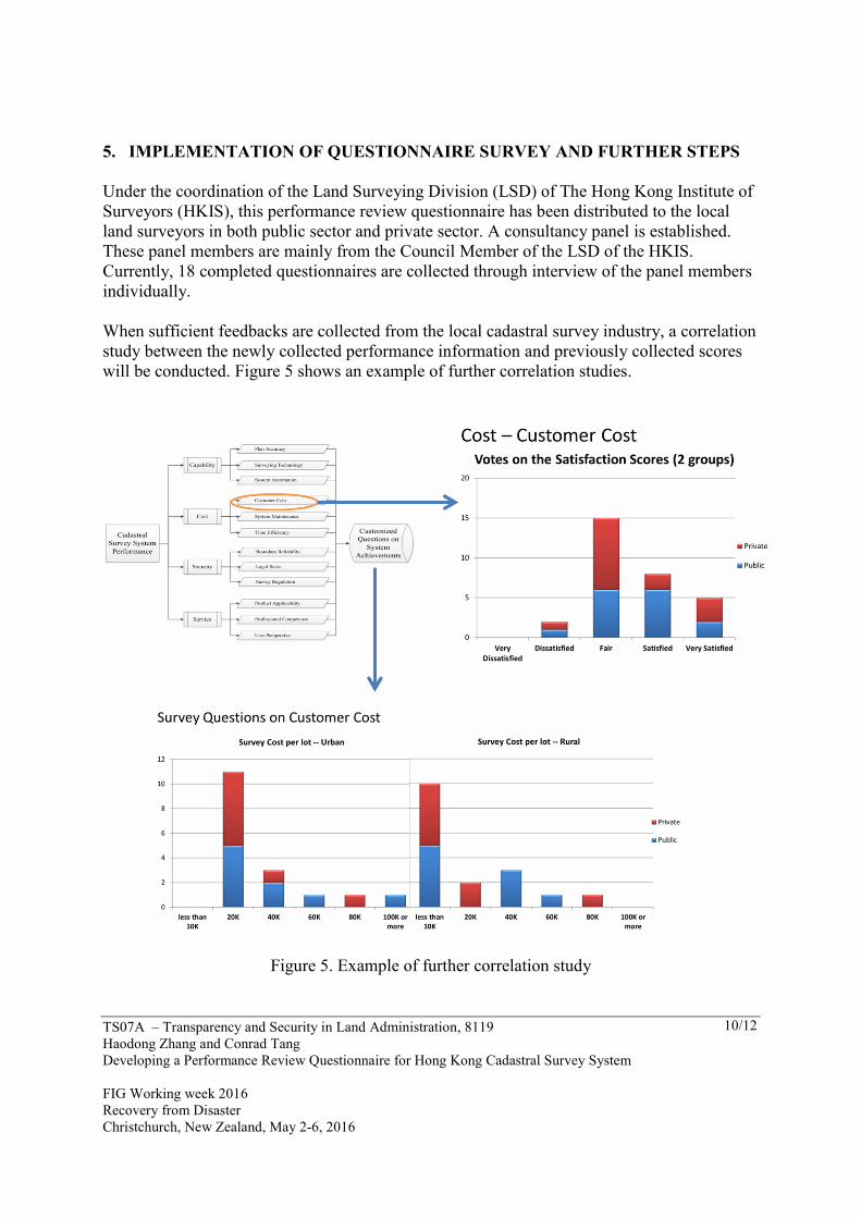
When sufficient feedbacks are collected from the local cadastral survey industry, a correlation
study between the newly collected performance information and previously collected scores
will be conducted. Figure 5 shows an example of further correlation studies.
Figure 5. Example of further correlation study

TS07A – Transparency and Security in Land Administration, 8119
Haodong Zhang and Conrad Tang
Developing a Performance Review Questionnaire for Hong Kong Cadastral Survey System
FIG Working week 2016
Recovery from Disaster
Christchurch, New Zealand, May 2-6, 2016
11/12
6. CONCLUSIONS
Performance review facilitates an organization to meet its user demands and achieve planned
goals. Evaluation on the performance of a cadastral survey system helps decision makers
understand the current development of cadastral survey industry and the way forward to
enhance its performance. This study based on a previously established structured performance
assessment model developed a set of appraisal questions for Hong Kong cadastral survey
stakeholders to review the system performance. With sufficient feedbacks, robust correlations
between the newly collected performance information of local cadastral survey system and
preciously collected performance scores can be established. The proposed results aim to
reflect the current status of the Hong Kong cadastral survey system in fulfilling its internal
land surveying responsibilities and external duties in supporting a fit-for-purposes land
administration system and a sustainable society.
ACKNOWLEDGEMENT
This paper is supported by PolyU B-Q32N funding (RGC Ref No. 525712) and HKIS 2016
research funding.
REFERENCES
FIG. (2014). Fit-for-Purpose Land Administration, Copenhagen: The International Federation
of Surveyors.
FIG-World Bank. (2014). FIG-World Bank Declaration on Fit-for-Purpose Land
Administration, World Bank, March, Washington, USA.
Haldrup, K. & Stubkjær, E. (2013). Indicator scarcity on cadastre and land registration in
cross-country information sources. Land Use Policy, 30, 652-664.
Robertson, W. A. (2002). Anticipating the further development of cadastral systems.
Computers, Environment and Urban Systems, 26(5), 383-402. doi:10.1016/S0198-
9715(02)00010-8
Saaty, T. L. (1980). The analytic hierarchy process: planning, priority setting, resource
allocation. Texas: Mcgraw-Hill.
Ting, L. & Williamson, I.P. (1999). Cadastral trends: a synthesis. The Australian Surveyor,
4(1), 46-54.

TS07A – Transparency and Security in Land Administration, 8119
Haodong Zhang and Conrad Tang
Developing a Performance Review Questionnaire for Hong Kong Cadastral Survey System
FIG Working week 2016
Recovery from Disaster
Christchurch, New Zealand, May 2-6, 2016
12/12
Vaidya, O. S. & Kumar, S. (2006). Analytic hierarchy process: An overview of applications.
European Journal Operational Research, 169 , 1-29.
Williamson, I.P. (2000). Best practices for land administration systems in developing
countries. International Conference on Land Policy Reform, 25-27 July, Jakarta
Indonesia.
Zhang, H. & Tang, C. (2014). A multi-criteria performance assessment model for cadastral survey
systems. Proceedings of the XXV FIG International Congress, 16-21 June, Kuala Lumpur
Malaysia.
Zhang, H. & Tang, C. (2015). The development of a performance assessment model for cadastral
survey systems. Proceedings of the FIG Working Week 2015, 17-21 May, Sofia Bulgaria.
CONTACTS
Mr. Haodong ZHANG
Department of Land Surveying and Geo-Informatics
The Hong Kong Polytechnic University
Hung Hom, Kowloon
HONG KONG
Tel. +852 3400 8151
Fax + 852 2330 2994
Email: [email protected]
Dr. Conrad TANG
Department of Land Surveying and Geo-Informatics
The Hong Kong Polytechnic University
Hung Hom, Kowloon
HONG KONG
Tel. +852 2766 5963
Fax + 852 2330 2994
Email: [email protected]